Content:
Presentation type:
BG – Biogeosciences

EGU23-8898 | Orals | MAL32 | Vladimir Ivanovich Vernadsky Medal Lecture

River ecosystems: A tale of superlatives and hidden beauty 

Tom J. Battin

River ecosystems are superlatives in many respects. Their networks represent the largest biogeochemical nexus between the continents, oceans and atmosphere. River networks span multiple catchments, even biomes, and are highly dynamic in space and time. The world’s rivers contribute relatively little by areal extent, but their CO2 emissions are of the same magnitude as the CO2 sequestration flux by the world’s oceans. Rivers figure among the most heterotrophic ecosystems on Earth, metabolizing terrestrial organic carbon. Owing to their dendritic structure, the biodiversity that river networks host is exceptionally high. Finally, needless to emphasize how critical the ecosystem services are that rivers provide. Central to many of these river superlatives are microbial biofilms that abundantly coat the sedimentary surfaces of the river beds. A microbiome, encompassing all three domains of life, shapes, in conjunction with the turbulent nature of water flow, intriguing biofilm architectures. Biofilms, a hidden beauty emanating from the interactions between biology, physics and chemistry, regulate ecosystem energetics and are therefore an important linchpin between river biodiversity and biogeochemistry.

In my lecture, I will attempt to provide the state-of-the-art of global river carbon biogeochemistry and biofilm ecology. An emphasis will be given on the rivers that literally drain the roof of our planet, now at risk because of climate change. It is my hope, that soon we will appreciate the world’s river networks as we do appreciate the oceans and various terrestrial ecosystems.

How to cite: Battin, T. J.: River ecosystems: A tale of superlatives and hidden beauty, EGU General Assembly 2023, Vienna, Austria, 23–28 Apr 2023, EGU23-8898, https://doi.org/10.5194/egusphere-egu23-8898, 2023.

EGU23-9859 | ECS | Orals | MAL32 | BG Division Outstanding Early Career Scientist Award Lecture

Causes and consequences of environmental perturbations through the Phanerozoic 

Hana Jurikova

Study of past carbon cycle perturbation events is fundamental for assessing Earth’s climatic and ecological sensitivities, and our planet’s overall biogeochemical functioning and responses. Major hindrance to our understanding is the lack of reliable CO2 estimates from Earth’s ‘deeper’ geologic past. I will summarize my work on CO2 reconstruction from the rock record and make the case that boron isotope values of brachiopod shells serve as a robust CO2 proxy. I will first present evidence from culturing experiments and natural marine settings demonstrating that the boron isotope composition of recent brachiopod shells responds predictably to the coupled ocean pH and CO2 system, and provide a calibration that enables its accurate quantification. Next, I will showcase ocean pH and CO2 records for some of most crucial yet enigmatic events in Earth’s evolutionary history, including the Permian-Triassic mass extinction, and discuss the causes and consequences of CO2 change and its biogeochemical impacts during extinctions and events of abrupt environmental change. Finally, I will highlight recent progress and new capabilities to lay out a roadmap towards robust record of Phanerozoic CO2.

How to cite: Jurikova, H.: Causes and consequences of environmental perturbations through the Phanerozoic, EGU General Assembly 2023, Vienna, Austria, 23–28 Apr 2023, EGU23-9859, https://doi.org/10.5194/egusphere-egu23-9859, 2023.

BG1 – General Biogeosciences

EGU23-412 | ECS | Orals | BG1.2

Assessing changes in post-fire vegetation resilience in Mediterranean basin over the past 22 years 

Tiago Ermitão, Célia Gouveia, Ana Bastos, and Ana Russo

Fire is an integral component of ecological dynamics, playing an important role in biome distribution and biomass variability. Nonetheless, fires can also pose a  threat to both ecosystems and humans, by imposing severe economic and social consequences, and potentially contributing to biodiversity loss, carbon loss and soil erosion, whose effects can last from months to years.

The Mediterranean basin is a fire-prone region where vegetation is in general well adapted to fire, with several species showing resistance to fire itself or being able to recover quickly following fire events. However, as a consequence of climate change, more intense and frequent summer hot and dry conditions are expected to occur, which can promote more frequent and severe wildfires, with return periods potentially outpacing recovery times. Understanding recovery dynamics is therefore crucial to assess the impact of changing fire regimes in ecological dynamics and stability of ecosystems. 

In our study, we use the “Enhanced Vegetation Index” (EVI), remotely-sensed by MODIS sensor with a temporal span of 22 years, to evaluate vegetation dynamics before, during and following large fire seasons. We use a mono-parametric recovery model to assess recovery times in different burn scars across the Mediterranean basin, covering different fire regimes and land cover types. We find a tendency for slower recovery in areas that burned more often, which may indicate a decrease in ecosystems’ resilience in the past 22 years.

This study was performed under the frameworks of the 2021 FirEUrisk project (funded by European Union’s Horizon 2020 research and innovation programme under the Grant Agreement no. 101003890) and of the PhD MIT Portugal MPP2030-FCT programme (Grant no.22405886350).

How to cite: Ermitão, T., Gouveia, C., Bastos, A., and Russo, A.: Assessing changes in post-fire vegetation resilience in Mediterranean basin over the past 22 years, EGU General Assembly 2023, Vienna, Austria, 23–28 Apr 2023, EGU23-412, https://doi.org/10.5194/egusphere-egu23-412, 2023.

EGU23-1406 | ECS | Orals | BG1.2 | Highlight

Large-scale fire events substantially impact plant-soil water relations across ecosystem types 

Martin J. Baur, Andrew D. Friend, and Adam F. A. Pellegrini

Wildfire is a global scale ecosystem phenomenon with substantial impact on the carbon cycle, climate warming, and ecosystem resilience. Fire and the hydrological cycle are strongly interlinked, with water availability determining the amount and combustibility of fuel, and fire influencing infiltration, runoff rates and evapotranspiration. Consequently, understanding soil moisture (SM) and vegetation water content (VWC) dynamics pre- and post-fire is fundamental for predicting fire occurrence, fire severity, and ecosystem recovery. Fire can modulate SM and VWC dynamics by influencing interception of rainfall, soil porosity, plant water uptake, and runoff; however, much evidence for fire effects on the hydrological cycle is obtained at the field- to watershed-scale. Therefore, we ask the following research question: What are the effects of large-scale fire events on SM and VWC dynamics across biomes globally?

Here we use over six years of global SM, VWC and vapor pressure deficit (VPD) derived from different remote sensing datasets to investigate the effects of large-scale fires on SM and VWC dynamics. We apply a dry down framework, only analyzing consecutive observations of decreasing soil moisture, to describe post-fire response rates for SM, VWC and VPD relative to a pre-fire reference state.

We find large scale evidence that the post-fire rate of change of SM over time is more negative, indicating faster water loss. Vegetation recovery, indicated by a positive change in VWC over time, exceeds the pre-fire reference state, which suggests that post-fire recovery is predominantly faster than undisturbed seasonal vegetation growth, likely due to succession of fast-growing plant species. Furthermore, fire affects ecosystem hydrology on shorter timescales as well, reducing diurnal VWC variation over a wide range of SM and VWC conditions. Our findings confirm several trends previously only observed at smaller scales and suggest global remote sensing of SM and VWC can substantially contribute to understanding the dynamics of post-fire plant and soil water status.

How to cite: Baur, M. J., Friend, A. D., and Pellegrini, A. F. A.: Large-scale fire events substantially impact plant-soil water relations across ecosystem types, EGU General Assembly 2023, Vienna, Austria, 23–28 Apr 2023, EGU23-1406, https://doi.org/10.5194/egusphere-egu23-1406, 2023.

EGU23-1412 | Posters on site | BG1.2

PyroCbs from Australia Fires and its Impact Study Using Satellite Observations from CrIS and TROPOMI and Reanalysis Data 

Xiaozhen Xiong, Xu Liu, Wan Wu, Liqiao Lei, Qiguang Yang, Daniel Zhou, and Allen Laura

Australia’s unprecedented fire disasters at the end of 2019 to early 2020 emitted huge amounts of carbon monoxide (CO) and fire aerosol particles to the atmosphere, particularly during the Pyrocumulonimbus (pyroCb) outbreak that occurred in southeast Australia between 29 December 2019 and 4 January 2020. It was estimated that at least 18 pyroCbs were generated during this episode, and some of them injected ice, smoke, and biomass burning gases above the local tropopause.  An unprecedented abundance of H2O and CO in the stratosphere, and the displacement of background ozone (O3) and N2O from rapid ascent of air from the troposphere and lower stratosphere were found from satellite observations. Some other studies also found that the fire emissions and their long-range transport resulted in stratospheric aerosol, temperature, and O3 anomalies after the 2020 Australian bushfires and altered the Antarctic ozone and vortex, posing great impact to local air qality and climate change.

            This study will focus on the thermodynamic state of atmosphere associated with these pyroCbs, and its impact on the change of the cloud properties and trace gases during this unprecedented Australia fires, mainly based on a new single Field of View (SFOV) Sounder Atmospheric Products (SiFSAP) and TROPOMI. SiFSAP was developed by NASA using the Cross-track Infrared Sounder (CrIS) and Advanced Technology Microwave Sounder (ATMS) onboard SNPP and JPSS-1, and will soon be available to the public at NASA DAAC. Since this product has a spatial resolution of 15 km at nadir, which is better than most global weather and climate models and other current operational sounding products, a process-oriented analysis of the dynamic transport of CO and fire plumes during this unprecedented fire disasters will be made in this study.  Based on a Principal Component Radiative Transfer Model (PCRTM) and an optimized estimation retrieval algorithm, a simultaneously retrieval is made using the whole spectral information measured by CrIS,  and the derived SiFSAP include temperature, water vapor, trace gases (such as O3, CO2, CO, CH4 and N2O), cloud properties and surface properties. Use of ATMS together with CrIS allows SiFSAP to get accurate retrieval products under thick pyroCb conditions. An algorithm to detect pyroCb based on the hyperspectral infrared sounder spectrum from CrIS will be developed and verified. In addition to SiFSAP sounding products,  CO, O3, NO2 from TROPOMI and O3 from OMPS will be used. The wind fields from the NASA’s Modern-Era Retrospective Analysis for Research and Applications Version-2 (MERRA-2) and ERA5 will be used to characterize the transport, and the SiFSAP temperature and water vapor profiles within and around pyroCbs will be compared with MERRA-2 and ERA5 products.     

How to cite: Xiong, X., Liu, X., Wu, W., Lei, L., Yang, Q., Zhou, D., and Laura, A.: PyroCbs from Australia Fires and its Impact Study Using Satellite Observations from CrIS and TROPOMI and Reanalysis Data, EGU General Assembly 2023, Vienna, Austria, 23–28 Apr 2023, EGU23-1412, https://doi.org/10.5194/egusphere-egu23-1412, 2023.

EGU23-1975 | ECS | Orals | BG1.2

Drivers of spatial and temporal variability in savanna fire emission factors 

Roland Vernooij, Tom Eames, Jeremy Russel-Smith, Cameron Yates, Robin Beatty, Jay Evans, Andrew Edwards, Natasha Ribeiro, Martin wooster, Tercia Strydom, Marcos Giongo, Marco Borges, Carol Barradas, Maximo Menezes, Dave van Wees, and Guido van der Werf

Roughly half of global fire emissions originate from savannas, and emission factors (EF) are used to quantify the amount of trace gases and aerosols emitted per unit dry matter burned. It is well known that these EFs vary substantially even within a single biome but so far quantifying their dynamics has been hampered by a lack of EF measurements. Therefore, global emission inventories currently use a static averaged EF for the entire savanna biome. To increase the spatiotemporal coverage of EF measurements, we collected over 4500 EF bag measurements of CO2, CO, CH4 and N2O using an unmanned aerial system (UAS) and measured fuel parameters and fire severity proxies during 129 individual landscape fires. These measurements spanned various widespread savanna ecosystems in Africa, South America and Australia, with early and late dry season campaigns. We trained random forest (RF) regressors to estimate daily dynamic EFs for CO2, CO, CH4 and N2O at 500×500-meter resolution based on satellite and reanalysis data. The RF models reduced the difference between measured and modelled EFs by 60-85% compared to static biome averages. The introduction of EF dynamics resulted in a spatial redistribution of CO, CH4 and N2O emissions compared to the Global Fire Emissions Database version 4 (GFED4s) with higher emissions in higher rainfall savanna regions. While the impact from using dynamic EFs on the global annual emission estimates from savannas was relatively modest (+2% CO, -5% CH4 and -18% N2O), the impact on local EFs may exceed 60% under dry seasonal conditions.

How to cite: Vernooij, R., Eames, T., Russel-Smith, J., Yates, C., Beatty, R., Evans, J., Edwards, A., Ribeiro, N., wooster, M., Strydom, T., Giongo, M., Borges, M., Barradas, C., Menezes, M., van Wees, D., and van der Werf, G.: Drivers of spatial and temporal variability in savanna fire emission factors, EGU General Assembly 2023, Vienna, Austria, 23–28 Apr 2023, EGU23-1975, https://doi.org/10.5194/egusphere-egu23-1975, 2023.

EGU23-2097 | Orals | BG1.2

Linked fire activity and climate whiplash in California during the early Holocene 

Jessica Oster, Julia Homann, Cameron de Wet, Sebastian Breitenbach, and Thorsten Hoffmann

Recent wildfire activity in semi-arid regions like western North America exceeds the range of historical records. High-resolution paleoclimate archives such as stalagmites could illuminate the link between hydroclimate, vegetation change, and fire activity in pre-anthropogenic climate states beyond the timescale of existing tree-ring records. Here we present an analysis of levoglucosan, a combustion-sensitive anhydrosugar, and lignin oxidation products (LOPs) in a stalagmite from White Moon Cave in the California Coast Range in order to reconstruct fire activity and vegetation composition across the 8.2 kyr event. Elevated levoglucosan concentrations suggest increased fire activity while altered LOP compositions indicate a shift toward more woody vegetation during the event, with the shift in vegetation preceding the increase in fire activity. These changes are concurrent with increased hydroclimate volatility as shown by carbon and calcium isotope proxies. Together, these records suggest that climate whiplash (oscillations between extreme wetness and aridity) and fire activity in California, both projected to increase with anthropogenic climate change, were tightly coupled during the early Holocene.

How to cite: Oster, J., Homann, J., de Wet, C., Breitenbach, S., and Hoffmann, T.: Linked fire activity and climate whiplash in California during the early Holocene, EGU General Assembly 2023, Vienna, Austria, 23–28 Apr 2023, EGU23-2097, https://doi.org/10.5194/egusphere-egu23-2097, 2023.

EGU23-2233 | ECS | Orals | BG1.2

Fire impacts on soil carbon in a non-fire adapted alpine forest 

Melissa Torres, Caroline Poyntner, Sampriti Chaudhuri, Marc Pignitter, Hannes Schmidt, Thilo Hofmann, and Gabriel Sigmund

An increase in fire-prone conditions in non-fire adapted regions is rooted in climatic and anthropogenic changes. Such pyrogeographical shifts are observable, for example, in alpine regions. In 2021, Austria, experienced a fire larger than 100 ha for the first time in a century in the Schneeberg-Rax mountain region. In depth understanding of post-fire effects on carbon cycling at such non-fire adapted sites is still scarce. To help close this knowledge gap, post-fire changes were investigated at the abovementioned site, including soil organic matter composition and soil chemical conditions. 

Samples were taken immediately after the fire, 3 months, 6 months and 12 months thereafter from four sampling sites. Selected sites consisted of 1. a pine forest affected by a crown fire, 2. a pine and beech mixed forest affected by a surface fire, and two non-fire affected controls with similar site conditions (vegetation, slope, altitude, and exposition). Samples were analyzed for pH, carbon content, elemental composition, leachable dissolved organic carbon and trace elements, organic matter composition, and environmentally persistent free radical concentrations. 

pH increased after the fire at both sites investigated. This increase was the strongest (up to 1.5 units) immediately after the fire but was still substantial 1 year after the fire. Carbon contents decreased approximately 2fold in the crown fire affected soil compared to the control soil, but remained similar between surface fire affected soil and the respective control. However, aromaticity of bulk carbon and the leachable fraction increased in both fire-affected soils, which can be related to the formation of pyrogenic carbon during the fire. Pyrogenic carbon is a highly aromatic and recalcitrant carbon pool produced during incomplete combustion of biomass. Pyrogenic carbon can also contain substantial amounts of environmentally persistent free radicals (EPFR), which can form reactive oxygen species, which can induce oxidative stress on microbiota. Our EPFR measurements showed an increase by at least 1.5 orders of magnitude of EPFR in fire affected soils. This study suggests that changes in soil carbon cycling can be expected following fires in non-adapted alpine forests. 

How to cite: Torres, M., Poyntner, C., Chaudhuri, S., Pignitter, M., Schmidt, H., Hofmann, T., and Sigmund, G.: Fire impacts on soil carbon in a non-fire adapted alpine forest, EGU General Assembly 2023, Vienna, Austria, 23–28 Apr 2023, EGU23-2233, https://doi.org/10.5194/egusphere-egu23-2233, 2023.

EGU23-2932 | Posters on site | BG1.2

Hydrological conceptual model for reconstructing fire history from cave stalagmites 

Pauline Treble, Campbell Micheline, Andy Baker, McDonough Liza, and Kosarac Nevena

Cave stalagmites (speleothems) are highly-valued archives of environmental information owing to their preservation of climate sensitive proxies and well-defined chronologies.  Yet the reconstruction of fire history from stalagmites is a relatively unexplored approach, with some advantages over traditional fire proxy archives.  For example, stalagmites may contain annual laminae (visible or chemical) which can be exploited for seasonal to annual proxy information with precise chronologies.  Thus stalagmites have the potential to yield annually-resolved records of fire and climate that could be used to (1) better understand the fire-climate relationship, (2) fire recurrence interval information, (3) understand ecosystem resilience and (4) inform land management policy.

The development of fire proxies from stalagmites is still in its infancy. Robust interpretations of any proxy information relies on an understanding of the environmental processes that lead to the preservation of proxies in the archive.  Cave stalagmites may record fire history via dripwater, or via the cave entrance as aerosols.  The focus here is on the transportable constituents in dripwater such as solutes, colloids and suspended matter.  A fire event produces ash (a source of leachates) and can alter soil properties (hydrophobicity, pH, organic matter etc) producing temporary enrichments (or depletions) in transported constituents via dripwater.  The resulting signal may be detected in stalagmites using high-resolution methods such as laser ablation mass spectrometry, fluorescence and infrared microscopy techniques.  Cave depth is an important factor in the preservation process with the detection of a fire signal more likely to be observed in dripwater from shallow caves (e.g. 5-10 m) owing to the potential for attenuation and mixing that may occur in deeper caves (Campbell et al., 2022).  However, owing to the karstification of carbonate rocks which host caves, there commonly exists different flow types: diffuse/slow flow through the matrix, preferential/fast flow through fractures and conduits.  Fracture (or conduit) influenced flowpaths have higher permeability and enhance rapid and deep percolation of water from the surface towards the cave.  Several studies have shown that stalagmites fed by dripwater with a fracture-flow component contain higher concentrations of soil-derived trace metals and organics indicating a stronger hydrological connection with the surface.  It logically follows that fracture-influenced flowpaths are more likely to transmit proxies for fire.  Furthermore, flowpaths may be a more important factor than cave depth in some settings, e.g., Campbell et al. (2022) presented a case study of a historical fire event recorded in a stalagmite that was located ~40 m below the surface.  

Understanding the hydrological setting of a cave system including rainfall recharge and flowpaths is valuable in the interpretation of speleothem records in general.  This contribution presents a conceptual model illustrating how these factors influence the preservation of fire proxies in stalagmites and makes recommendations for ideal sample selection for fire proxy records based on cave characteristics as well as stalagmite attributes such as morphology and colour.

Campbell. M. et al., Speleothems as Archives for Palaeofire Proxies. ESS Open Archive. July 24, 2022. DOI:10.1002/essoar.10511989.1

How to cite: Treble, P., Micheline, C., Baker, A., Liza, M., and Nevena, K.: Hydrological conceptual model for reconstructing fire history from cave stalagmites, EGU General Assembly 2023, Vienna, Austria, 23–28 Apr 2023, EGU23-2932, https://doi.org/10.5194/egusphere-egu23-2932, 2023.

EGU23-3238 | ECS | Orals | BG1.2

Feeding the flames: how colonialism led to unprecedented wildfires across SE Australia 

Michela Mariani, Simon Connor, Michael-Shawn Fletcher, Simon Haberle, Janelle Stevenson, Peter Kershaw, Annika Herbert, Martin Theuerkauf, and David Bowman

The Black Summer bushfires (2019-2020) cost the Australian economy over 100 billion dollars and burnt a total of 18 million hectares. In just one season, around 20% of Australia's Eucalyptus forests burnt down and billions of animals perished. Recent catastrophic fires in Australia and North America have made scientists and policymakers question how the disruption of First Nations' burning practices has impacted fuel loads. For instance, we have learnt from modern Australian Indigenous communities, historical literature, and art works that Indigenous peoples have used cultural burning to rejuvenate patches of land and preserve open vegetation for hunting and cultural purposes. The advent of British invasion brought a change in the type of fire regimes and landscape management across much of the continent, which may have led to an increase in flammable fuels in forest settings. However, the actual degree of land-cover modification by early settlers has only been often debated in the academic literature and within management stakeholders.

The quantification of past land cover is needed to address such debates. Pollen is the key proxy to track past vegetation changes, but pollen spectra suffer from some important biases e.g. taphonomy, pollen productivity, dispersal capability. Estimating past vegetation cover from sedimentary pollen composition requires to correct for productivity and dispersal biases using empirical-based models of the pollen-vegetation relationship. Such models for quantitative vegetation reconstruction (e.g. REVEALS) have yet been mostly applied in the Northern Hemisphere in the last 15 years - here we present recent applications of this methodology from Australia. We show the quantification of land cover changes through pre- and post- British invasion on multiple records (n=51) across the southeastern Australian region. This represents the first regional application of REVEALS within the Australian continent.

We provide the first empirical evidence that the regional landscape before British invasion was a cultural landscape with limited tree cover as it was maintained by Indigenous Australians through cultural burning. Our findings suggest that the removal of Indigenous vegetation management has altered woodland fuel structure and that much of the region was predominantly open before colonial invasion. The post-colonial land modification has resonance in wildfire occurrence and management under the pressing challenges posed by climate change.

How to cite: Mariani, M., Connor, S., Fletcher, M.-S., Haberle, S., Stevenson, J., Kershaw, P., Herbert, A., Theuerkauf, M., and Bowman, D.: Feeding the flames: how colonialism led to unprecedented wildfires across SE Australia, EGU General Assembly 2023, Vienna, Austria, 23–28 Apr 2023, EGU23-3238, https://doi.org/10.5194/egusphere-egu23-3238, 2023.

EGU23-3310 | ECS | Orals | BG1.2

PEAT-FWI: Improving the Fire Weather Index for peatlands with Hydrological Modeling and L-band Microwave Observations 

Jonas Mortelmans, Anne Felsberg, Gabriëlle De Lannoy, Sander Veraverbeke, Robert Field, Niels Andela, and Michel Bechtold

The Fire Weather Index (FWI) is used worldwide to estimate the danger of wildfires. The FWI system integrates meteorological parameters and empirically combines them into several moisture codes, each representing a different fuel type. These moisture codes are then used in combination with wind speed to estimate a fire danger. Originally, the FWI system was developed for a standard jack pine forest, however, it is widely used by fire managers to assess the fire danger in different environments as well. Furthermore, it is often also used to assess the vulnerability of organic soils, such as peatlands, to ignition and depth of burn. The utility of which is often questioned.


This research aims at improving the original FWI for northern peatlands by replacing parts of the original, purely weather-based FWI system with satellite-informed model estimates of peat moisture and water level. These come from a data assimilation output combining the NASA catchment model, including the peat modules PEATCLSM, and Soil Moisture and Ocean Salinity (SMOS) L-band brightness temperature observations. The predictive power of the new, peat-specific FWI (PEAT-FWI) is evaluated against the original FWI against fire data of the global fire atlas from 2010 through 2018 over the major northern peatlands areas. For the evaluation, the fires are split up in early and late season fires, as it is hypothesized that late fires are more hydrological driven, and the predictive power of the PEAT-FWI will thus differ between the two types of fires. Our results indeed indicate that the PEAT-FWI improves the predictive capability of estimating fire risk over northern peatlands in particular for late fires. By using a receiver operating characteristics (ROC) curve to evaluate the predictive power of the FWI against a random estimate, the area under the curve increases by up to 10% for the PEAT-FWI compared to the original FWI. The recent version 7 release of the operational Soil Moisture Active Passive (SMAP) Level-4 Soil Moisture Data Assimilation Product now includes PEATCLSM, thus, the proposed PEAT-FWI is straightforward to include in operational FWI products.

How to cite: Mortelmans, J., Felsberg, A., De Lannoy, G., Veraverbeke, S., Field, R., Andela, N., and Bechtold, M.: PEAT-FWI: Improving the Fire Weather Index for peatlands with Hydrological Modeling and L-band Microwave Observations, EGU General Assembly 2023, Vienna, Austria, 23–28 Apr 2023, EGU23-3310, https://doi.org/10.5194/egusphere-egu23-3310, 2023.

EGU23-3332 | ECS | Orals | BG1.2

How changes in ignition sources influence fire probability in the Amazon and Cerrado biomes: a perspective based on frontier age 

Andreia F. S. Ribeiro, Lucas Santos, Maria R. Uribe, Rafaella A. Silvestrini, Ludmila Rattis, Marcia N. Macedo, Douglas C. Morton, James T. Randerson, Sonia I. Seneviratne, Jakob Zscheischler, and Paulo M. Brando

Agricultural expansion and ongoing climate change are rapidly altering the fire regime of natural ecosystems along the Cerrado-Amazon biome boundary. While agricultural intensification has driven a decrease in fire ignitions in some regions, agricultural expansion has increased fire usage in other landscapes for deforestation and managing pasturelands. These contrasting patterns of fire activity across different land-use frontiers limits our ability to accurately predict where and when fires may occur, particularly under the context of climate change.

To predict fire activity with land-use transitions, we modelled fire probability as a function of the age of different land-use transitions across the Amazon and Cerrado. We investigated annual land-use and associated burned areas based on the MapBiomas Collection 6.0 and MapBiomas Fire Collection 1.0 data, respectively, from 1986 to 2020. This allowed us to quantify how the time-since conversion of native vegetation (forest, savanna, and grassland) to pasture and farming influence fire occurrence. Additionally, we explored the joint impact of land-use change and climate extremes in fire activity in terms of estimated vapor pressure deficit (VPD) and maximum cumulative water deficit (MCWD), two common measures of flammability and drought impact. 

Our results confirm that transition age is a strong predictor of fire probability. They also suggest that fire probability increases (decreases) at different rates before (after) clearing in Amazon and Cerrado. The role of climate extremes in modulating burning activity associated with land-use transitions varied by biome, post-fire land use, and the size of the burned area associated with the conversion. These findings provide insight into incorporating the effect of land-use transition age on ignition probability for fire modelling in combination with climate drivers. From an operational point of view, our results aim to contribute to environmental policies capable of sustaining ecosystem integrity at the ecotone between the Amazon and Cerrado biomes.

How to cite: Ribeiro, A. F. S., Santos, L., Uribe, M. R., Silvestrini, R. A., Rattis, L., Macedo, M. N., Morton, D. C., Randerson, J. T., Seneviratne, S. I., Zscheischler, J., and Brando, P. M.: How changes in ignition sources influence fire probability in the Amazon and Cerrado biomes: a perspective based on frontier age, EGU General Assembly 2023, Vienna, Austria, 23–28 Apr 2023, EGU23-3332, https://doi.org/10.5194/egusphere-egu23-3332, 2023.

EGU23-3632 | ECS | Posters virtual | BG1.2

BPCA-derived PyC may reflect fire signals over regional scales from the western Amazon Basin fire record 

Jing Lyu, Andrew Zimmerman, Mark Bush, and Crystal McMichael

Fire alters the biogeochemical cycling of important elements, plays a role in climate change, and shapes the composition of global biological communities. Detection of past fires has long been used to reconstruct human settlement and climate records. Charcoal and phytolith abundance has been the most commonly used paleofire proxies but may only represent evidence of local fires. Chemical analyses of pyrogenic carbon (PyC) have been more recently used, but are also not without controversy. Thus far, very few intercomparisons of these proxies have been conducted. Here, the fire records contained in soil and lake sediments of Western Amazon (at lakes Ayauchi, Parker, Gentry, and surrounding regions) were determined by charcoal microscopy, chemical thermal oxidation (CTO), and benzene polycarboxylic acids (BPCA) molecular biomarkers. Charcoal represented a smaller portion of PyC and, with its patchy distribution, likely indicated local or larger regional fire events. With a median value of about 15% of organic carbon, PyC via CTO oxidation was of the highest concentrations, which suggests a larger PyC detection window and lower sensitivity of reflecting regional fire. With a median value of about 3% of organic carbon, the BPCA-derived PyC distributions bore the closest resemblance to both spatial and temporal regional fire variations, established via archeological, pollen and phytolith records, thus may be a more sensitive indicator of fire over larger regional scales. Molecular ratios of BPCA molecules in Lake Ayauchi soils indicated higher temperature fires (> 600°C) and suggested a history of more human occupation and human-caused fire in the Lake Ayauchi region compared with the Lake Gentry & Parker region. However, our findings suggest that the use of a combination of fire proxy methods provides a fuller picture of the fire history of a region than any single approach. Establishing a better understanding the differences in the information provided by various paleofire proxies will allow a more complete understanding of the drivers, history and ecological and biogeochemical effects of fire, both regionally and globally.

How to cite: Lyu, J., Zimmerman, A., Bush, M., and McMichael, C.: BPCA-derived PyC may reflect fire signals over regional scales from the western Amazon Basin fire record, EGU General Assembly 2023, Vienna, Austria, 23–28 Apr 2023, EGU23-3632, https://doi.org/10.5194/egusphere-egu23-3632, 2023.

EGU23-3695 | ECS | Orals | BG1.2

Wildfires alter nitrifier communities and increase soil emissions of NOx but not N2O in California chaparral 

Elizah Stephens, Aral Greene, Alexander Krichels, and Peter Homyak

Background:

Fires burn roughly 3% of Earth’s land surface each year and are predicted to become more frequent and severe as human-caused climate change progresses. Fires can drive ecosystem N loss by volatilizing N bound in plant biomass to the atmosphere and by leaving behind ash rich in ammonium (NH4+) and organic N that can run off when it rains. While N volatilization and runoff account for a large fraction of N loss after fires, budget imbalances suggest soil emissions of nitric oxide (NO) and nitrous oxide (N2O) may also be significant N loss pathways after fire. Identifying sources of NO and N2O is important because NO is a precursor for tropospheric O3 which causes high rates of asthma hospitalizations,and N2O is a powerful greenhouse gas with 300× the warming potential of CO2. Soil emissions of NO and N2O are largely governed by the microbial processes of nitrification and denitrification. Under aerobic conditions typical of dry soils, nitrifying organisms such as ammonia-oxidizing bacteria (AOB) and ammonia-oxidizing archaea (AOA) oxidize NH4+ to nitrate (NO3-) and release NO and N2O as byproducts. AOA and AOB process N with different efficiencies, suggesting shifts in AOA:AOB ratios may change N emissions. Specifically, AOB are dominant in soils with high NH4+and pH and produce higher NO and N2O emissions. Since such soil conditions are frequently observed after fires, we hypothesize NO and N2O emissions will increase as AOB communities become dominant. To test this, we collected soil cores from 5 plots in the Sequoia National Park, CA over a time series starting two weeks after a high severity chaparral fire. We selectively inhibited AOA and AOB communities to measure their contributions to NO and N2O emissions. We also measured the isotopic composition of N2O emissions from these soils using an LGR isotopic N2O analyzer to better understand the processes responsible for post-fire N2O production.

Results/Conclusions

One month after the fire, soil bulk emissions of NO over 72hrs were 1.5 times higher in the burned plots (101.4 ± 22.4 µg N-NO/g soil burned; 67.1 ± 19.3 µg N-NO/g soil unburned; ±SE). Bulk soil emissions of N2O over 72hrs were 7.5 times lower in burned plots compared to before the fire (0.0616 ± 0.04 ng N-N2O/g soil burned; 0.463 ± 0.19 ng N-N2O/g soil unburned; ±SE). Although the effects of fire on nitrifier communities were not significant at one month post-fire (Control: p=0.14, AOA: p=0.09, AOB: p=0.162), both AOA and AOB contributions to NO emissions increased in response to fire. Results for nitrifier contributions to N2O emissions were highly variable and non-significant with no clear trends as all N2O emissions were near zero. Further analysis over the time series may yield clearer results as microbial communities have more time to recover. Pairing these data with isotopic information (in progress) may yield one of the most in-depth understandings of post-fire NO and N2O emissions to date.

How to cite: Stephens, E., Greene, A., Krichels, A., and Homyak, P.: Wildfires alter nitrifier communities and increase soil emissions of NOx but not N2O in California chaparral, EGU General Assembly 2023, Vienna, Austria, 23–28 Apr 2023, EGU23-3695, https://doi.org/10.5194/egusphere-egu23-3695, 2023.

EGU23-4520 | ECS | Orals | BG1.2

Examining the response of different wildfire properties to changes in climate and CO2 levels at the Last Glacial Maximum 

Olivia Haas, Iain Colin Prentice, and Sandy P. Harrison

Climate change and atmospheric CO2 levels can influence wildfire properties through separate and potentially contrasting impacts on vegetation and climate. One way to examine the sensitivity of global wildfire properties to changes in climate and CO2 levels is using an out-of-sample experiment, such as the Last Glacial Maximum (LGM; 21 ka BP). Charcoal records show reduced burning at the LGM, when CO2 levels were ~ 185 ppm and the climate was cooler and drier. In this analysis, we isolated out the potential effects of LGM CO2 levels and LGM climate on the spatial patterns of global wildfire properties.

Using three statistical models, we conducted simulations of the spatial distribution of global burnt area, fire size and fire intensity under four scenarios: modern climate/modern CO2 levels, LGM climate/LGM CO2 levels, modern climate/LGM CO2 levels and LGM/ modern CO2 levels. We used outputs from three coupled ocean–atmosphere models representative of the range of simulated LGM climates. The ecophysiological effect of CO2 levels was explicitly accounted for through vegetation inputs. Gross primary productivity (GPP) and land cover were derived for the LGM and modern climate keeping either CO2 levels at 395 ppm (modern), or setting them to 185 ppm, using the P Model, a first-principles model of GPP which allows continuous acclimation of photosynthetic parameters to environmental variations, and the BIOME4 equilibrium global vegetation model.

Our results show a reduction in burnt area under LGM CO2 levels, both with modern and LGM climate inputs. In the case of the warmest of the LGM climate scenarios, this reduction was of the same magnitude as the combined LGM climate/LGM CO2 levels scenario. However, the driest and coldest LGM climate scenario produced a reduction in burnt area even with modern CO2 levels, and the largest reduction in burnt area with LGM CO2.  The reduction was primarily driven by changes in vapour pressure deficit (VPD). Fire size increased under LGM climates, due to changes in wind and VPD. The lower CO2 values at the LGM had no impact on fire size. Fire intensity increased under LGM climates and LGM CO2 levels, with both effects of similar amplitude and changes driven primarily by VPD, GPP and diurnal temperature range. 

We compared our outputs with sedimentary charcoal records from the Reading Palaeofire Database (RPD). Overall, the burnt area LGM CO2 levels/LGM climate scenario showed the greatest agreement, though depending on how cold and dry the LGM climate was, this agreement was either equal to LGM CO2 levels or LGM climate alone. These results suggest that whilst there was reduced global burning at the LGM, there may have been larger and more intense fires. They also highlight the importance of the ecophysiological effect of CO2 levels on fuels, a major control of burnt area and fire intensity regardless of climate. They point to the importance of including this effect in process-based fire models, as well as the importance of accurately estimating the amplitude of projected change for different climate variables in order to increase the reliability of future projections.

How to cite: Haas, O., Prentice, I. C., and Harrison, S. P.: Examining the response of different wildfire properties to changes in climate and CO2 levels at the Last Glacial Maximum, EGU General Assembly 2023, Vienna, Austria, 23–28 Apr 2023, EGU23-4520, https://doi.org/10.5194/egusphere-egu23-4520, 2023.

EGU23-5113 | ECS | Orals | BG1.2

Speleothem organic biomarkers trace last millennium fire history at near-annual resolution in northwestern Australia 

Elena Argiriadis, Rhawn F. Denniston, Stefania Ondei, and David Bowman

Recent developments in speleothem science are showing their potential for paleofire reconstruction through a variety of inorganic and organic proxies including trace metals (1) and the pyrogenic organic compound levoglucosan (2). Previous work by Argiriadis et al. (2019) presented a method for the analysis of trace polycyclic aromatic hydrocarbons (PAHs) and n-alkanes in stalagmites (3). These compounds reflect biogeochemical processes occurring at the land surface, in the soil, and in the cave. PAHs are primarily related to combustion of biomass while n-alkanes, with their potential for vegetation reconstruction (4), provide information on fuel availability and composition, as well as fire activity. These organic molecules are carried downward by infiltrating water and incorporated into speleothems (5), thereby creating the potential to serve as novel paleofire archives.

Using this approach, we developed a high-resolution stalagmite record of paleofire activity from cave KNI-51 in tropical northwestern Australia. This site is well suited for high resolution paleofire reconstruction as bushfire activity in this tropical savanna is some of the highest on the continent, the cave is shallow and overlain by extremely thin soils, and the stalagmites are fast-growing (1-2 mm yr-1) and precisely dated. We analyzed three stalagmites which grew continuously in different time intervals through the last millennium - KNI-51-F (CE ~1100-1620), KNI-51-G (CE ~1320-1640), and KNI-51-11 (CE ~1750-2009). Samples were drilled continuously at 1-3 mm resolution from stalagmite slabs, processed in a stainless-steel cleanroom to prevent contamination.

Despite a difference in resolution between stalagmites KNI-51-F and -G, peaks in the target compounds show good replication in the overlapping time interval of the two stalagmites, and PAH abundances in a portion of stalagmite KNI-51-11 that grew from CE 2000-2009 are well correlated with satellite-mapped fires occurring proximally to the cave.

Our results suggest an increase in the frequency of low intensity fire in the 20th century relative to much of the previous millennium. The timing of this shift is broadly coincident with the arrival of European pastoralists in the late 19th century and the subsequent displacement of Aboriginal peoples from the land. Aboriginal peoples had previously utilized “fire stick farming”, a method of prescribed, low intensity burning, that was an important influence of ecology, biomass, and fire.  Prior to the late 1800s, the period with the most frequent low intensity fire activity was the 13th century, the wettest interval of the entire record. Peak high intensity fire activity occurred during the 12th century.

Controlled burn and irrigation experiments capable of examining the transmission of pyrogenic compounds from the land surface to cave dripwater represent the next step in this analysis. Given that karst is present in many fire-prone environments, and that stalagmites can be precisely dated and grow continuously for millennia, the potential utility of a stalagmite-based paleofire proxy is high.


(1) L.K. McDonough et al., Geochim. Cosmochim. Acta. 325, 258–277 (2022).

(2) J. Homann et al., Nat. Commun., 13:7175 (2022).

(3) E. Argiriadis et al., Anal. Chem. 91, 7007–7011 (2019).

(4) R.T. Bush, F. A. McInerney, Geochim. Cosmochim. Acta. 117, 161–179 (2013).

(5) Y. Sun et al., Chemosphere. 230, 616–627 (2019).

How to cite: Argiriadis, E., Denniston, R. F., Ondei, S., and Bowman, D.: Speleothem organic biomarkers trace last millennium fire history at near-annual resolution in northwestern Australia, EGU General Assembly 2023, Vienna, Austria, 23–28 Apr 2023, EGU23-5113, https://doi.org/10.5194/egusphere-egu23-5113, 2023.

EGU23-5429 | ECS | Posters on site | BG1.2

Smoke self-lofting towards the lower stratosphere: an alternative process to pyroCb-lofting 

Kevin Ohneiser, Albert Ansmann, Jonas Witthuhn, Hartwig Deneke, Alexandra Chudnovsky, Gregor Walter, and Fabian Senf

Wildfire smoke is known as a highly absorptive aerosol type in the shortwave wavelength range. The absorption of Sun light by optically thick smoke layers results in heating of the ambient air. This heating is translated into self-lofting of the smoke up to more than 1 km in altitude per day. The main goal is to demonstrate that radiative heating of intense smoke plumes is capable of lofting them from the lower and middle free troposphere (injection heights) up to the tropopause without the need of pyrocumulonimbus (pyroCb) convection. The further subsequent ascent within the lower stratosphere (caused by self-lofting) is already well documented in the literature. Simulations of heating rates which are then converted into lofting rates are conducted by using the ECRAD (European Centre for Medium-Range Weather Forecasts Radiation) scheme. As input parameters thermodynamic profiles from CAMS (Copernicus Atmosphere Monitoring Service) reanalysis data, aerosol profiles from ground-based lidar observations, radiosonde potential temperature profiles, CALIOP (Cloud Aerosol Lidar with Orthogonal Polarization) aerosol measurements, and MODIS (Moderate Resolution Imaging Spectroradiometer) aerosol optical depth retrievals were used. 


The sensitivity analysis revealed that the lofting rate strongly depends on aerosol optical thickness (AOT), layer thickness, layer height, and black carbon (BC) fraction. We also looked at the influence of different meteorological parameters such as cloudiness, relative humidity, and potential temperature gradient. Lofting processes in the stratosphere observed with CALIOP after major pyroCb events (Canadian fires, 2017, Australian fires 2019-2020) are compared with simulations to demonstrate the applicability of our self-lofting model. We analyzed long-term CALIOP observations of Siberian smoke layers and plumes evolving in the troposphere and UTLS (upper troposphere and lower stratosphere) region over Siberia and the adjacent Arctic during the summer season of 2019 and found several indications (fingerprints) that self-lofting contributed to the vertical transport of smoke. We hypothesize that the formation of a near-tropopause aerosol layer, observed with CALIOP over several months, was the result of self-lofting processes because this is in line with the self-lofting simulations. 


We will show a detailed analysis of tropospheric and stratospheric smoke lofting rates based on simulations and observations.

How to cite: Ohneiser, K., Ansmann, A., Witthuhn, J., Deneke, H., Chudnovsky, A., Walter, G., and Senf, F.: Smoke self-lofting towards the lower stratosphere: an alternative process to pyroCb-lofting, EGU General Assembly 2023, Vienna, Austria, 23–28 Apr 2023, EGU23-5429, https://doi.org/10.5194/egusphere-egu23-5429, 2023.

EGU23-5803 | ECS | Orals | BG1.2 | Highlight

Which is the role of post-fire SOC erosion in the C cycle? 

Antonio Girona-García, Cristina Santín, Diana Vieira, and Stefan Doerr

Wildfires burn on average 448 million hectares globally every year, releasing around 2.2 Pg of carbon (C) into the atmosphere [1, 2]. The net effect of wildfires in the C cycle goes, however, beyond emissions and involves many other interacting processes. Among those, there is a significant knowledge gap on the role of post-fire soil organic carbon (SOC) erosion as a carbon sink mechanism.

Post-fire erosive response is greatly enhanced by the direct and indirect effects of wildfires on soil and vegetation, such as the loss of protective cover and soil structure or the development of a water-repellent layer [3]. In addition, biomass and soil organic matter undergo quantitative and qualitative changes during wildfires, such as the formation of pyrogenic carbon, highly resistant to degradation. The resulting PyC and non-PyC carbon fractions, with contrasting physical properties and chemical stability, will be differently redistributed and mineralized during the erosion process [4]. Ultimately, post-fire SOC erosion will act as a carbon sink when the post-fire burial and stabilization of eroded carbon, together with the recovery of net primary production and soil organic carbon content, exceed the SOC losses during its post-fire transport [5]. All these processes have been scarcely investigated and poorly quantified to the date. In this presentation, we will provide new insights into this potential C sink mechanism, critically reviewing the state of the art and highlighting key research gaps.

References

[1] Boschetti et al., 2021. Global Wildfire Information System (GWIS). https://gwis.jrc.ec.europa.eu/apps/country.profile/downloads

[2] Randerson et al., 2012. J Geophys Res. https://doi.org/10.1029/2012JG002128

[3] Shakesby & Doerr, 2006. Earth-Sci Revs. https://doi.org/10.1016/j.earscirev.2005.10.006

[4] Doetterl et al., 2016. Earth-Sci Revs. https://doi.org/10.1016/j.earscirev.2015.12.005

[5] Santín et al., 2015. Glob Change Biol. https://doi.org/10.1111/gcb.12800

How to cite: Girona-García, A., Santín, C., Vieira, D., and Doerr, S.: Which is the role of post-fire SOC erosion in the C cycle?, EGU General Assembly 2023, Vienna, Austria, 23–28 Apr 2023, EGU23-5803, https://doi.org/10.5194/egusphere-egu23-5803, 2023.

EGU23-6083 | ECS | Posters on site | BG1.2

Representing Northern High Latitude Peat Fires in the JULES-INFERNO Fire Model 

Katie Blackford, Apostolos Voulgarakis, Colin Prentice, Chantelle Burton, and Matthew Kasoar

Anthropogenic activities and climate change are increasing the vulnerability of carbon rich peatlands to wildfires. Peat fires, which are dominated by smouldering combustion, are some of the largest and most persistent wildfires on Earth. Across the northern high latitudes, peat fires have the potential to release vast amounts of long term stored carbon and other greenhouse gases and aerosols. Consequently, peat fires can have huge implications on the carbon cycle and result in a positive feedback effect on the climate system. Peat fires also impact air quality and can lead to haze events, with major impacts on human health. Despite the importance of peat fires they are currently not represented in most fire models, leading to large underestimations of burnt area and carbon emissions in the high latitudes. Here, I present a representation of peat fires in the JULES-INFERNO fire model (INFERNO-peat). INFERNO-peat improves the representation of burnt area across the high latitudes, with notable areas of improvement in Canada and Siberia. INFERNO-peat also highlights a large amount of interannual variability in carbon emissions from peat fires. The inclusion of peat fires into JULES-INFERNO demonstrates the importance of representing peat fires in models, and not doing so may heavily restrict our ability to model present and future fires and their impacts across the northern high latitudes.

How to cite: Blackford, K., Voulgarakis, A., Prentice, C., Burton, C., and Kasoar, M.: Representing Northern High Latitude Peat Fires in the JULES-INFERNO Fire Model, EGU General Assembly 2023, Vienna, Austria, 23–28 Apr 2023, EGU23-6083, https://doi.org/10.5194/egusphere-egu23-6083, 2023.

EGU23-6184 | ECS | Orals | BG1.2 | Highlight

A global model for estimating fuel consumption and fire carbon emissions at 500-m spatial resolution 

Dave van Wees, Guido R. van der Werf, James T. Randerson, Brendan M. Rogers, Yang Chen, Sander Veraverbeke, Louis Giglio, and Douglas C. Morton

Fires constitute a key source of emissions of greenhouse gasses and aerosols. Fire emissions can be quantified using models, and these estimates are influenced by the spatial resolution of the model and its input data. Here we present a novel global model based on the Global Fire Emissions Database (GFED) modelling framework for the estimation of fuel consumption and fire carbon emissions at a spatial resolution of 500 m. The model was primarily based on observation-derived data products from MODIS, reanalysis data for meteorology, and an updated field measurement synthesis database for constraining fuel load and fuel consumption. Compared to coarser models, typically with a resolution of 0.25°, the 500-m spatial resolution allowed for increased spatially resolved emissions and a better representation of local-scale variability in fire types. The model includes a separate module for the calculation of emissions from fire-related forest loss, using 30-m Landsat-based forest loss data. We estimated annual carbon emissions of 2.1 Pg C yr-1, of which around 24% was from fire-related forest loss. Fuel consumption was on average a factor 10 higher in case of fire-related forest loss compared to fires without forest loss. Up to now, emission estimates from our new model are based on MODIS burned area with a 500-m resolution, leading to global emissions similar to GFED4s. However, novel high-resolution burned area datasets based on the Landsat and Sentinel-2 missions reveal substantially more global burned area. Our 500-m global fire model provides a suitable framework for converting these burned area products to emissions, with the prospect of substantially higher global emissions.

How to cite: van Wees, D., van der Werf, G. R., Randerson, J. T., Rogers, B. M., Chen, Y., Veraverbeke, S., Giglio, L., and Morton, D. C.: A global model for estimating fuel consumption and fire carbon emissions at 500-m spatial resolution, EGU General Assembly 2023, Vienna, Austria, 23–28 Apr 2023, EGU23-6184, https://doi.org/10.5194/egusphere-egu23-6184, 2023.

EGU23-6286 | ECS | Posters on site | BG1.2

Hysteresis of fire-prone weather to CO2 forcing 

Jin-Soo Kim, Hyo-Jeong Kim, and Soon-Il An

CO2 emission from biomass burning (BB) is one of the essential elements of the global carbon budget, with its annual mean of about 2.0 PgC/year equivalent to 15 % of 2020 fossil fuel emissions. However, while a global increase in fire-prone weather is projected alongside climate change, a quantitative understanding of how much carbon will further be released due to increased fires is highly limited, which could result in large uncertainty in meeting the net zero target. Thus, in this study, we evaluate future changes in fire-prone weather based on the fire weather index (FWI) and estimate the potential fire-induced emissions on a global scale that could be induced by climate change. To this end, 28 ensembles of idealized CO2 reduction simulations with the CESM climate model were analyzed. The results show that when CO2 in the atmosphere is doubled (2xCO2) from 367 ppm by 1 % per year, the additional emission due to increased fire weather could reach about 1.7 PgC/year, which corresponds to 82% of the current BB emission. Moreover, even if the atmospheric CO2 concentration further peaks and is reduced back to 2xCO2, the lagged response of the climate system can cause fire-prone weather and its resulting C emissions to remain higher than its previous state in many countries. These results highlight that more focus is required on the climate-fire-carbon feedback not only for more accurate future predictions but also for achieving net zero emissions in each country through a proper wildfire management strategy.

How to cite: Kim, J.-S., Kim, H.-J., and An, S.-I.: Hysteresis of fire-prone weather to CO2 forcing, EGU General Assembly 2023, Vienna, Austria, 23–28 Apr 2023, EGU23-6286, https://doi.org/10.5194/egusphere-egu23-6286, 2023.

EGU23-6777 | ECS | Posters on site | BG1.2

Characterisation of large-scale urban fire emissions by inverse modelling 

Emilie Launay, Virginie Hergault, Marc Bocquet, Joffrey Dumont Le Brazidec, and Yelva Roustan

Large-scale fires such as warehouse fires that have occurred in recent years or dramatic accidents like the Paris Notre-Dame Cathedral fire in 2019 have stressed the need to develop means of assessing the toxicity risks to the population and the environment of smoke plumes. A key challenge is to quickly provide the authorities with information on the areas impacted by the plume and the pollutant concentration levels to which the population is likely to be or to have been exposed. The Laboratoire Central de la Préfecture de Police (LCPP) aims to deploy a number of devices for measuring pollutants and tracers of smoke combustion during a fire. Subsequently, the application of an atmospheric dispersion model within the framework of a data assimilation approach should provide a source characterisation and a finer estimate of the concentration levels at points of interest.

To characterise the source, noticeably the released mass of pollutants and the emission height linked to a plume rise, an inverse problem method has been implemented. It is based on a Bayesian Markov Chain Monte Carlo (MCMC) technique meant to quantify the uncertainties associated with the emission estimation. Since the emission height strongly influences the atmospheric dispersion in the vicinity of the source, two approaches are used to estimate it. The first one consists in finding the emission time rate for each considered height and the second one consists in focussing on a single emission height and its associated emission time rate using a discrete distribution to describe the vertical profile. We use the Lagrangian Parallel Micro Swift Spray (PMSS) model developed by AriaTechnologies fed with meteorological fields provided by Météo-France to represent the atmospheric dispersion of smoke.

Our inverse method is applied to a large warehouse fire that occurred in Aubervilliers near Paris in 2021 using real observations. Abnormal concentrations of particulate matter were recorded, with a peak at 160 µg.m-3, located in the centre of Paris about 6 km from the source. They were collected by the LCPP and AirParif, the local air quality agency, and are used to retrieve the emission with a quantification of uncertainties and a sensitivity analysis of model error. The resulting emission height of the source, mainly between 200 and 300 m, coincides with the terrain observation for an emission rate of less than 1000 kg/h throughout the duration of the fire. A sensitivity analysis to the initial approximation of the source (the prior) shows its importance. It suggests to improve our method by incorporating the statistical parameters of the observation error into the MCMC method.

How to cite: Launay, E., Hergault, V., Bocquet, M., Dumont Le Brazidec, J., and Roustan, Y.: Characterisation of large-scale urban fire emissions by inverse modelling, EGU General Assembly 2023, Vienna, Austria, 23–28 Apr 2023, EGU23-6777, https://doi.org/10.5194/egusphere-egu23-6777, 2023.

EGU23-6797 | ECS | Posters on site | BG1.2

Variability of CO and aerosols plumes from wildfires in the Northern Hemisphere in 2008-2022 using satellite observations. 

Antoine Ehret, Solène Turquety, Maya George, and Cathy Clerbaux

Wildfires are responsible for significant emissions of greenhouse gases, pollutants and aerosols. In addition to being a large source of carbon monoxide (CO) and carbon dioxide (CO2), they alone account for more than half of black carbon emissions and the majority of primary organic aerosol emissions.

Despite proactive fire suppression policies in the Northern Hemisphere (NH), allowing a decrease in fires, especially in Europe, an increase in the number of extreme fires can be noted in recent years. In the NH, this increase is mainly in Western America and boreal regions. The pollution plumes produced during extreme fires can be transported over thousands of kilometers, impacting background pollutant levels on a hemispheric scale. Thus, variability in fire intensity may explain a large part of the spatial and temporal variability of many atmospheric pollutants. For longer lived pollutants, wildfires may significantly increase background levels.

In this study, the link between extreme fire weather (high temperature), large fires and background pollution in the Northern Hemisphere is analyzed based on satellite observations. The impact of large wildfires on background levels of CO and aerosols above Europe is studied more specifically. We present the variability of fire frequency in the NH, their intensity and the related emissions using 20 years (2003-2022) of MODIS fire observations analyzed with the APIFLAME model. The link between large events and fire weather is studied using the ERA5 reanalyses and the Canadian Fire Weather Index (FWI). The related impact on the variability of total CO and AOD in the NH is analyzed using 15 years (2008-2022) of satellite observations from IASI/Metop and MODIS/Terra and Aqua, respectively. Finally, plume retro trajectories are computed in order to assess the contribution of the different geographical areas of the NH on the CO and AOD variability.

How to cite: Ehret, A., Turquety, S., George, M., and Clerbaux, C.: Variability of CO and aerosols plumes from wildfires in the Northern Hemisphere in 2008-2022 using satellite observations., EGU General Assembly 2023, Vienna, Austria, 23–28 Apr 2023, EGU23-6797, https://doi.org/10.5194/egusphere-egu23-6797, 2023.

EGU23-7379 | Orals | BG1.2 | Highlight

Changes in global fire regimes under idealized overshoot scenarios 

Lars Nieradzik, Hanna Lee, Paul Miller, Jörg Schwinger, and David Wårlind

Within the framework of the project IMPOSE (Emit now, mitigate later? IMPlications of temperature OverShoots for the Earth system) six idealized emission-overshoot simulations have been performed with the Earth System Model NorESM2-LM2 and used as forcing for the 2nd generation dynamic global vegetation model LPJ-GUESS with its fire-model SIMFIRE-BLAZE to investigate the impact of different CO2 overshoots on global wildfire regimes.

The simulations describe a set of scenarios with high, medium, and low accumulative CO2 emissions and each of which has a short (immediate) and a long (100 years) peak of accumulative CO2 emissions before declining towards a baseline simulation of 1500 PgC accumulatively emitted within the first 100 years.

The results show that the height of the overshoot has an impact on global fire regimes while its duration does not seem to play a significant role 200 years after peak CO2. Overall, we can see that changes in vegetation composition following the temperature anomaly are the main driver for changes in global wildfire frequency. While in the low overshoot scenarios burnt area has almost converged towards the baseline simulation, the extremest scenarios show the lowest burnt area at the end of the simulation period, indicating that vegetation changes, especially in low latitudes, have been most significant and/or are still ongoing.

How to cite: Nieradzik, L., Lee, H., Miller, P., Schwinger, J., and Wårlind, D.: Changes in global fire regimes under idealized overshoot scenarios, EGU General Assembly 2023, Vienna, Austria, 23–28 Apr 2023, EGU23-7379, https://doi.org/10.5194/egusphere-egu23-7379, 2023.

EGU23-7449 | ECS | Orals | BG1.2

The role of vegetation in UK upland wildfires: Risk, Resilience, and Remote Sensing 

Kirsten Lees and Tim Lenton

Wildfires are becoming a growing concern in the UK, as climate change increases the occurrence and persistence of periods of hot, dry weather. Vegetation type and management play an important but contested role in UK fire risk and resilience, and questions remain over the best ways to prevent large fires developing. Remote sensing can provide vital data on fire size, severity, and recovery times, but method effectiveness is dependent on understanding specific ecosystems. This research uses ground validation of four wildfires in the UK Peak District National Park to deliver insights which improve interpretation of satellite data in wildfire monitoring. These insights are then applied to a three-year remote sensing database of large wildfires in England and Wales, to give novel results on the links between vegetation type and management, and fire size and severity. Ecosystem resilience and recovery is further explored through analysing the vegetation growth post-fire at three of the four Peak District study sites. This project therefore develops and validates remote sensing methodology in wildfire research by combining field data with satellite imagery to yield new understandings of the relationships between vegetation and fire. 

How to cite: Lees, K. and Lenton, T.: The role of vegetation in UK upland wildfires: Risk, Resilience, and Remote Sensing, EGU General Assembly 2023, Vienna, Austria, 23–28 Apr 2023, EGU23-7449, https://doi.org/10.5194/egusphere-egu23-7449, 2023.

EGU23-7853 | Posters on site | BG1.2

Current Operational Implementation of the Canadian Forest Fire Weather Index System in the Republic of Ireland 

Klara Finkele, Padraig Flattery, Ciaran Nugent, and Paul Downes

Since 2006 the Canadian Forest Fire Weather Index System (FWI) has been employed operationally at Met Éireann to predict the risk of forest fires in Ireland (Walsh, S, 2006). Around 11% or 770,000 ha of the total land area of Ireland is afforested, but there are also large areas of open mountain and peatlands covered in grasses, dwarf-shrub and larger woody shrub type vegetation which can provide fuel for spring wildfires under suitable conditions. Following winter, vegetation can be dead or have a very low live moisture content, and the flammability of this vegetation can be readily influenced by prevailing weather, especially following prolonged dry periods.

The Department of Agriculture, Food and Marine is the Forest Protection authority in Ireland responsible for issuing Fire Danger Notices. These notices improve preparedness for fire responses and are based on information provided by Met Éireann who calculate the FWI and FWI components using observation data at synoptic stations, and the predicted FWI for the next five days ahead based on numerical weather prediction data.

The FWI is determined based on the types of forest fuel and how quickly they dry out/get rewetted, and components of fire behaviour. The FWI represents the fire intensity as the rate of energy per unit length of fire front (kW/m). The components which provide the most accurate indication of risk under Irish conditions are the Fine Fuel Moisture Code and Initial Spread Index, based on the fuels involved and ignition patterns observed to date. Since 2022 Met Eireann provide the FWI as well as the individual components Fine Fuel Moisture Content and Initial Spread Index via the public website for synoptic stations. These indices are based on observations and a seven-day forecast into the future using ECMWF predictions. This allows all county councils responsible for wildfire preparedness to access this information swiftly and directly.

Met Éireann also use the ANYWHERE multi-hazard warning tool which allows for visualisation of multiple fire-related risk factors and warning indices to be viewed simultaneously. The ANYWHERE system, in combination with our station-based forecast and antecedent conditions, provide fire managers and response teams with excellent information with which to make decisions. 

How to cite: Finkele, K., Flattery, P., Nugent, C., and Downes, P.: Current Operational Implementation of the Canadian Forest Fire Weather Index System in the Republic of Ireland, EGU General Assembly 2023, Vienna, Austria, 23–28 Apr 2023, EGU23-7853, https://doi.org/10.5194/egusphere-egu23-7853, 2023.

EGU23-7913 | ECS | Posters on site | BG1.2

Fate of Fire altered Organic Carbon in the arctic river-to-ocean continuum: Resolving Mackenzie River Black Carbon in the Beaufort Sea 

Linn G. Speidel, Lisa Bröder, Julie Lattaud, Negar Haghipour, Timothy I. Eglinton, and Alysha I. Coppola

Keywords: Black carbon, Dissolved organic carbon, BPCAs, Mackenzie River, Beaufort Sea, Climate change

Climate change is amplified in the arctic and boreal regions. This causes higher average temperatures and less precipitation in the summer months and is resulting in longer wildfire seasons, severity, frequency and extent. This increases the relies of carbon into the atmosphere as greenhouse gases and aerosols, amplifying climate change even further. Black carbon (BC) is a fraction of organic carbon, resulting from the incomplete combustion of biomass and fossil fuels. BC may be inaccessible for biodegradation, because of its highly condensed aromatic molecular structure and therefore stores carbon on long timescales on land and in the ocean. BC is produced on land, but is transported as dissolved BC (DBC) by the rivers to the oceans, where it cycles on millennial timescales, sequestering BC. Thus, it is important to understand the significance of BC in the context of increased fires in this vulnerable region in the face of climate change.

The Mackenzie River is a major source of terrestrial dissolved organic carbon (DOC) and the largest source of sediments to the Arctic Ocean. Here, we resolve the cycling of riverine DBC from the Mackenzie River to its fate in the Beaufort Sea, and the influence of mixing with Pacific water masses entering from the Chukchi Sea. We present DBC concentration data in ocean water, which was collected on two cruises in the Beaufort Sea in 2021 and 2022 covering the outflow of the Mackenzie River.

For DBC concentrations, we digested solid phase extracts of DOC with nitric acid to oxidize BC molecules into benzenepolycarboxylic acids (BPCAs), which were then quantified on High Performance Liquid Chromatography (HPLC). We compare the concentrations of the DBC and DOC to trace the mixing of DBC river outflow with the ocean water. Since DBC originates on land and is relatively stable to biodegradation we can resolve the pathways of DBC from the Mackenzie River to the Arctic Ocean.


How to cite: Speidel, L. G., Bröder, L., Lattaud, J., Haghipour, N., Eglinton, T. I., and Coppola, A. I.: Fate of Fire altered Organic Carbon in the arctic river-to-ocean continuum: Resolving Mackenzie River Black Carbon in the Beaufort Sea, EGU General Assembly 2023, Vienna, Austria, 23–28 Apr 2023, EGU23-7913, https://doi.org/10.5194/egusphere-egu23-7913, 2023.

EGU23-7937 | ECS | Orals | BG1.2

A New Method for Nowcasting Wildfire Risk 

Theodore Keeping, Sandy Harrison, and Iain Prentice

Wildfire risk prediction relies on the often-heuristic assessment of diverse fire potential indices, fuel maps, fire weather indices and prior fire activity data. Here we present a model nowcasting daily wildfire genesis probability and expected wildfire sizes in the contiguous US.

Predictors were selected and developed to account for climate, vegetation, topographic and human effects on wildfire genesis. Climate factors are represented by multiple fuel wetting and drying processes at daily to seasonal-scale antecedences, snowpack, and wind. We use GPP to predict fuel mass and recent growth, and dominant vegetation type. Human factors include population, landscape accessibility and ignition sources such as powerlines.

The first stage of the model predicts wildfire genesis probability as a zero-inflated process with an explicit probability of fire preclusion, whilst the second stage models fire sizes according to a generalised extreme value distribution. Nonlinear effects are accounted for via global optimisation for the domain for which each variable drives changes in fire genesis behaviour and the appropriate variable transform.

The model has good predictive and explanatory power, as shown by various performance metrics and the meaningful nonlinear relationships identified in the optimisation process. We show that this method can resolve seasonal wildfire risk dynamics well over smaller ecoregions than the observational record permits, allowing us to quantify the extent to which fire risk is determined by seasonal-scale versus daily-scale effects.

How to cite: Keeping, T., Harrison, S., and Prentice, I.: A New Method for Nowcasting Wildfire Risk, EGU General Assembly 2023, Vienna, Austria, 23–28 Apr 2023, EGU23-7937, https://doi.org/10.5194/egusphere-egu23-7937, 2023.

EGU23-8075 | Posters on site | BG1.2

Impact of socio-economic factors in burnt area for future climate scenarios 

João Teixeira, Chantelle Burton, Douglas I. Kelley, Gerd Folberth, Fiona M. O'Connor, Richard Betts, and Apostolos Voulgarakis

Fire processes are a complex component of the Earth System processes and their full representation has proven to be difficult to represent Earth System Models (ESM). Because of this, these processes are often simplified in fire enabled ESMs, for instance ignitions are usually modelled to increase at low population densities up to a threshold, and reduce thereafter, as suppression effects become dominant with the increase of population density. However, socio-economic, and cultural factors can play a significant role in shaping the behaviour of fire ignitions. This study aims to address this by implementing a socio-economic factor in the fire ignition and suppression parametrisation in the INteractive Fire and Emission algoRithm for Natural envirOnments (INFERNO) based on the Human Development Index (HDI). The inclusion of this factor reduced a large long-standing positive bias found in regions of Temperate North America, Central America, Europe, and Southern Hemisphere South America. This change also leads to improvements in the model representation of fire weather and anthropogenic drivers in tropical regions, by reducing the influence of population density changes. Therefore, this framework can be used to improve understanding of the anthropogenic impacts of fire in future scenarios based on different Shared Socioeconomic Pathways.

How to cite: Teixeira, J., Burton, C., Kelley, D. I., Folberth, G., O'Connor, F. M., Betts, R., and Voulgarakis, A.: Impact of socio-economic factors in burnt area for future climate scenarios, EGU General Assembly 2023, Vienna, Austria, 23–28 Apr 2023, EGU23-8075, https://doi.org/10.5194/egusphere-egu23-8075, 2023.

EGU23-9361 | ECS | Posters on site | BG1.2

Investigating Emergency Room Visits for Cardiorespiratory Diseases in Alberta and Ontario, Canada in Relation to Wildfires 

Victoria Flood, Kimberly Strong, Rebecca Buchholz, Sheryl Magzamen, and Grace Kuiper

Carbon monoxide (CO) is released during biomass burning events, resulting in decreased air quality and leading to the formation of climate forcing pollutants. An increase in wildfires has resulted in a change to the CO seasonal cycle of the North American Pacific Northwest, when comparing 2012-2018 to 2002-2011. This trend was reported using data from the Measurements of Pollution in the Troposphere (MOPITT) instrument on NASA’s Terra satellite. Similarly, an increase in summertime CO values was identified with the Fourier Transform Infrared (FTIR) spectrometer at the University of Toronto Atmospheric Observatory (TAO), over the same time period. Studies have shown correlations between wildfire smoke exposure and healthcare utilization for cardiovascular and respiratory conditions. Monthly counts of Emergency Department admissions for cardiovascular and respiratory diseases for Alberta and Ontario are investigated in relation to wildfire events in Canada and the USA. MOPITT and TAO FTIR CO columns, the Moderate Resolution Imaging Spectroradiometer (MODIS) burned area product, and provincial burned areas from Natural Resources Canada are assessed to estimate wildfire smoke exposure in the study region. This work aims to evaluate if CO can be used as a complementary tracer for health impacts from wildfire smoke exposure. 


How to cite: Flood, V., Strong, K., Buchholz, R., Magzamen, S., and Kuiper, G.: Investigating Emergency Room Visits for Cardiorespiratory Diseases in Alberta and Ontario, Canada in Relation to Wildfires, EGU General Assembly 2023, Vienna, Austria, 23–28 Apr 2023, EGU23-9361, https://doi.org/10.5194/egusphere-egu23-9361, 2023.

EGU23-9575 | Orals | BG1.2

FRYv2.0 : a global fire patch morphology database from FireCCI51 and MCD64A1 

Florent Mouillot, Wentao Chen, Manuel Campagnolo, and Philippe Ciais

The assessment of global burned area from remote sensing is an essential climate variable driving land surface GHG emissions and energy/water budget. Gridded 0.25° or 0.5° monthly burned area have been largely used for biosphere/atmosphere interactions modelling, while recent fire/weather analysis or model developments increasingly request fire events, defined as a fire patch with intrinsic fire spread properties. Pixel level information, the finest resolution from global burned area, defined by their burn date, can be aggregated within a spatio-temporal threshold and delineate these fire events. Uncertainties in burn date, the coarse resolution of pixel resolution, multiple ignition points, or the specified values in spatio-temporal thresholds can however lead to various final fire event delineation. Currently, three major global fire event database exist (FRY, Fire Atlas, GlobFire), mostly derived from MCD64A1 pixel level 500m-resolution burned area. We propose here a new version of FRY, based on MCD64A1 and FireCCI51 at 250m, with an updated pixel aggregation method allowing for single ignition fire patches. Fire patch morphology indicators as elongation, direction, complexity have been conserved from v1.0, with additional information as ignition points from minimum burn date from burned area and more timely-accurate hotspots (VIIRS and MCD14ML), rate of spread, fire Radiative power and burn severity, as well as fraction of land cover affected, based on user requirements. The dataset is delivered as a yearly shapefile, with an attribute table referencing all information on ignition, spread and final shape. Global comparison of major information from FRYv2.0 (fire size distribution, fire number, ROS) will illustrate the effects of increasing spatial resolution and better timing from hotspots provided in this new version, freely available for the scientific community for the period 2001-2020.

How to cite: Mouillot, F., Chen, W., Campagnolo, M., and Ciais, P.: FRYv2.0 : a global fire patch morphology database from FireCCI51 and MCD64A1, EGU General Assembly 2023, Vienna, Austria, 23–28 Apr 2023, EGU23-9575, https://doi.org/10.5194/egusphere-egu23-9575, 2023.

EGU23-9791 | Orals | BG1.2 | Highlight

Lightning in a changing climate and its impacts on fire area burned 

Cynthia Whaley, Courtney Schumacher, Montana Etten-Bohm, Vivek Arora, David Plummer, Jason Cole, Michael Lazare, and Ayodeji Akingunola

Lightning is an important atmospheric process for igniting forest fires – often in remote locations where they are not easily suppressed – which results in potentially large emissions of many pollutants and short-lived climate forcers. Lightning also generates reactive nitrogen, resulting in the production of tropospheric ozone, the third most important greenhouse gas. Furthermore, the changing climate is expected to change the frequency and location of lightning. As such, lightning is an important component of climate models. The Canadian Atmospheric Model, CanAM, is one such climate model that did not contain an 'online' lightning parameterization. Fire ignition in CanAM was done via an unchanging climatological lightning input. In this study, we have added a new logistical regression lightning model (Etten-Bohm et al, 2021) into CanAM, creating the capacity for future lightning predictions with CanAM under different climate scenarios. The modelled lightning and fire area burned were evaluated against measurements in a historical period with good results. Then we simulate lightning and fire area burned in a future climate scenario in order to provide an estimate on how lightning and its impacts will change in the future. This study also presents the first time that CanAM’s land fire model was used online with its atmosphere to fully simulate fires in the global earth system.

Reference:

Etten-Bohm, M., J. Yang, C. Schumacher, and M. Jun : Evaluating the relationship between lightning and the large-scale environment and its use for lightning prediction in global climate models, JGR-atmospheres, 126, e2020JD033990, 2021.

How to cite: Whaley, C., Schumacher, C., Etten-Bohm, M., Arora, V., Plummer, D., Cole, J., Lazare, M., and Akingunola, A.: Lightning in a changing climate and its impacts on fire area burned, EGU General Assembly 2023, Vienna, Austria, 23–28 Apr 2023, EGU23-9791, https://doi.org/10.5194/egusphere-egu23-9791, 2023.

EGU23-10336 | Posters on site | BG1.2

A hybrid deep learning framework for predicting point-level Alaskan fires 

Hocheol Seo and Yeonjoo Kim

Fires in high latitudes are becoming more critical in terrestrial ecosystem modeling. With climate warming and dry weather condition, the fires have spread more, and widespread burning has severely damaged the ecosystem. As the fire dynamics cannot be described with the mass or energy balance equations, the fire models have been developed with different input variables, linked with different vegetation models, and widely coupled with the earth system models (ESMs) or land surface models (LSMs) with different complexities of parameterization. Here, we designed a new approach using hybrid deep learning [Long Short-Term Memory (LSTM) - Artificial Neural Network (ANN)] for predicting Alaskan natural fires and aimed to understand the impacts of fires with from the NCAR community land model 5 – biogeochemistry (CLM5-BGC). This study was conducted based on fire information provided by Alaska Interagency Coordination Center (AICC), which provides the data for each fire point, start date, end date, and total burned area from 2016-2020. As the fire duration was identified as the most important in predicting the burned area, we first trained the LSTM for predicting fire duration (i.e., fire ignition and fire persistence period) with ERA5 atmospheric forcings. Also, we trained ANN to predict the burned area with both ERA5 atmospheric forcings and fire duration. Then, we combined two models (LSTM and ANN) to simultaneously predict the fire days and burned area with climate and vegetation datasets. This hybrid model has the strength to capture large fires (>10000ha), comparing the burned area from CLM5-BGC (Correlation: 0.79). When this hybrid model is coupled with CLM5-BGC, we found that the carbon fluxes changed over Alaska. In particular, total net ecosystem exchange (NEE) increased by more than two times that of only CLM5-BGC, which could primarily affect terrestrial carbon exchanges.

Acknowledgement

This work was supported by the Korea Polar Research Institute (KOPRI, PE22900) funded by the Ministry of Oceans and Fisheries and the Basic Science Research Program through the National Research Foundation of Korea, which was funded by the Ministry of Science, ICT & Future Planning (grant no. 2020R1A2C2007670) and by the Ministry of Education (2022R1A6A3A13073233).

How to cite: Seo, H. and Kim, Y.: A hybrid deep learning framework for predicting point-level Alaskan fires, EGU General Assembly 2023, Vienna, Austria, 23–28 Apr 2023, EGU23-10336, https://doi.org/10.5194/egusphere-egu23-10336, 2023.

EGU23-10389 | Orals | BG1.2

Towards mechanistic representation of wildfire effects on soil – downscaling to quantify subsurface heat fluxes 

Dani Or, Hamid Vahdat-Aboueshagh, Eden Furtak-Cole, and Sean A. McKenna

Advances in wildfire modeling have focused on refining atmospheric interactions for obvious links between local airflows, combustion dynamics, fire line advance and smoke plume transport. Yet, lasting impacts of wildfires on landscapes are linked primarily with changes in soil characteristics and alteration of ecological and hydrologic processes. Quantitative assessment of wildfire impacts requires metrics for fire-surface thermal interactions beyond qualitative surrogates such as burn severity used for ecological assessment. The highly transient and localized nature of wildfire intensity and its coarse spatial and temporal representation hinder quantitative translation of wildfire dynamics to soil heat fluxes even with the most advanced wildfire models (e.g., QuicFire, WRF-Fire, WFDS). Inspired by the pioneering works of Byram, Rothermel and Albini, we seek to derive high resolution information on fire line intensities from highly resolved fuel maps informed by fire line dynamics derived from numerical wildfire model representation. This hybrid downscaling approach (limited by the quality and resolution of fuel maps) offers a means for constraining soil surface heat fluxes at resolutions relevant to quantifying critical temperatures and duration at depth to estimate pyrolysis of soil organic carbon and the degree of soil structure alteration. Examples will be presented and discussed. 

How to cite: Or, D., Vahdat-Aboueshagh, H., Furtak-Cole, E., and A. McKenna, S.: Towards mechanistic representation of wildfire effects on soil – downscaling to quantify subsurface heat fluxes, EGU General Assembly 2023, Vienna, Austria, 23–28 Apr 2023, EGU23-10389, https://doi.org/10.5194/egusphere-egu23-10389, 2023.

EGU23-10651 | ECS | Posters on site | BG1.2

An annually resolved stalagmite record of fire frequency for the last 250 years in south west Australia 

Liza McDonough, Pauline Treble, Andy Baker, Andrea Borsato, Silvia Frisia, Micheline Campbell, Gurinder Nagra, Katie Coleborn, Michael Gagan, Jian-xin Zhao, and David Paterson

Stalagmites provide records of past changes in climate, vegetation, and surface events, which can be identified through variability in their chemical composition over time. This variability is the result of changes in surface environmental properties, which are reflected in the physical and chemical properties of the water that percolates into the cave, ultimately affecting the composition of the speleothem calcite. Wildfires have the potential to alter soil properties and soluble element concentrations. Consequently, stalagmite compositions have been shown to respond to increases in soil nutrients, trace metal concentrations, and changes in soil/karst bedrock hydraulic conductivity. It is, therefore, likely that stalagmites, and particularly those grown in shallow caves for which transmission of the surface signal is rapid, capture the environmental effects of wildfires in their chemical and physical properties.

We analysed a stalagmite from a shallow cave in a region known to be affected by wildfires in south-west Western Australia. Fire proxies were assessed using a multi-proxy approach. This includes water isotopes via stable-isotope ratio mass spectrometry and trace element analyses via synchrotron X-ray fluorescence microscopy and laser ablation inductively coupled plasma mass spectrometry. This approach shows that the timing of known fire events coincided with a multi-proxy response in stalagmite chemistry, including increased concentrations of phosphorus, copper, aluminium, lead, and zinc, which are interpreted to be derived from leaching of ash from burned vegetation above the cave. We also identified lower and less variable peaks in phosphorus concentrations during the pre-colonisation period, suggesting that Indigenous land management resulted in more frequent but low intensity burning. This contrasted with less frequent but more intense fires associated with post-colonisation land-management. A particularly large paleo-fire identified in 1897 appears to coincide with a peak in 𝛿18O, interpreted to have resulted from evaporation of sub-surface water during the heat of the fire. This large fire was preceded by a multi-decadal dry period identified by trace element proxies. The intensity of the 1897 fire was then exacerbated by the combination of a multi-decadal drought and a transition away from cultural burning practices by Indigenous Australians, which resulted in build-up of vegetation and dry combustible material on the forest floor.

This research is a world-first demonstration of fire events recorded in stalagmites and shows their potential to provide accurate records of both fire frequency intervals and changes in climate. Further records of past fire events from stalagmites will help to understand how past fire regimes have varied with climate, land-use change and colonisation, and will help to better guide land management practices in the future.

How to cite: McDonough, L., Treble, P., Baker, A., Borsato, A., Frisia, S., Campbell, M., Nagra, G., Coleborn, K., Gagan, M., Zhao, J., and Paterson, D.: An annually resolved stalagmite record of fire frequency for the last 250 years in south west Australia, EGU General Assembly 2023, Vienna, Austria, 23–28 Apr 2023, EGU23-10651, https://doi.org/10.5194/egusphere-egu23-10651, 2023.

EGU23-11016 | ECS | Posters on site | BG1.2

Speleothems as archives for palaeofire proxies 

Micheline Campbell, Liza McDonough, Pauline Treble, Andy Baker, Nevena Kosarac, Katie Coleborn, Peter Wynn, and Axel Schmitt

Environmental proxy archives such as tree rings, sediment cores, and ice cores are commonly used to investigate past fire regimes. Speleothems, naturally forming cave decorations mainly comprising of stalagmites, stalactites, and flowstones, have been extensively used as palaeoenvironmental archives as their physical attributes and chemical composition change with changed environment. Research has shown that cave drip water chemistry responds to fire events, and more recently, that speleothems can record past fire events due to physical and chemical processes which alter speleothem composition. These processes include changes to water stores due to evaporation, fracturing of the host rock, changed soil hydrophobicity, production of highly soluble lime, changes in soil CO2 production, destruction of vegetation and deposition of ash above the cave. These changes can result in shifts in δ18O and δ13C, altered concentrations of vegetation, soil and bedrock-derived elements, and incorporation of soluble ash derived elements (including phosphorus, aluminium, copper, zinc, and lead) in speleothems (McDonough et al., 2022; Campbell et al., 2022).

Changes in speleothem chemistry are typically determined using micro-analytical techniques (such as Synchrotron X-ray Fluorescence Microscopy and laser ablation inductively coupled plasma mass spectrometry) and isotope ratio mass spectrometry. These changes can be precisely and absolutely dated via uranium-series and carbon dating, and can often be resolved at high resolution via manual counting of seasonal fluctuations in organic matter and trace element concentration. This makes speleothems, particularly those grown in shallow caves in highly seasonal climates, ideal for identifying both short-lived events such as wildfires, and longer-term changes such as shifts in climate. This novel application of speleothems as archives for coupled climate and palaeofire proxies is still in its infancy but holds great potential.

Here, we present a review of this new sub-discipline. We cover its origins in cave dripwater monitoring, discuss site and sample selection, and describe the current analytical and statistical approaches used to extract fire information from speleothems. Such records will enable land managers to develop improved methods for managing fire regimes.

McDonough, L.K., Treble, P.C., Baker, A., Borsato, A., Frisia, S., Nagra, G., Coleborn, K., Gagan, M.K., Zhao, J., Paterson, D., 2022. Past fires and post-fire impacts reconstructed from a southwest Australian stalagmite. Geochimica et Cosmochimica Acta. https://doi.org/10.1016/j.gca.2022.03.020
 
Campbell, M., McDonough, L., Treble, P., Baker, A., Kosarac, N., Coleborn, K., Wynn, P.M., Schmitt, A., 2022. Speleothems as Archives for Palaeofire Proxies [preprint], https://www.authorea.com/doi/full/10.1002/essoar.10511989.1
 

How to cite: Campbell, M., McDonough, L., Treble, P., Baker, A., Kosarac, N., Coleborn, K., Wynn, P., and Schmitt, A.: Speleothems as archives for palaeofire proxies, EGU General Assembly 2023, Vienna, Austria, 23–28 Apr 2023, EGU23-11016, https://doi.org/10.5194/egusphere-egu23-11016, 2023.

EGU23-11297 | Orals | BG1.2

Effects of land use, fuel loads and fuel moisture on fire intensity and fire emissions in South America derived by reconciling bottom-up and top-down satellite observations 

Matthias Forkel, Niels Andela, Vincent Huijnen, Christine Wessollek, Alfred Awotwi, Daniel Kinalczyk, Christopher Marrs, and Jos de Laat

Emissions from vegetation fires in tropical forests have the potential to turn the global land carbon sink into a source, affect atmospheric chemistry, and hence air quality. While natural forest fires are a rare phenomenon in tropical forests of South America and are usually of rather low intensity, deforestation fires and small land clearings in systems with high fuel loads can cause intense fires and high emissions. However, the high moisture content in tropical forests causes incomplete combustion and higher emissions of carbon monoxide (CO) than of carbon dioxide. The interacting effects of land use change, fuel load and moisture on fire intensity and emissions is, however, difficult to quantify at large scales because not all of those components are readily available from Earth observations in a consistent way. 

Here, we make use of several satellite products on vegetation, fire activity and atmospheric composition to quantify the effects of land use, fuel loads, fuel moisture on fuel consumption, emission factors and hence on emissions and atmospheric trace gas concentration. First, we use observations of active fires and fire radiative power from the VIIRS and Sentinel-3 SLSTR sensors to map different fire types (forest fires, deforestation fires, small land clearing and agricultural fires, savannah fires). Second, we integrate satellite products of canopy height, above-ground biomass, leaf area index, land cover and soil moisture in a novel data-model fusion framework to estimate fuel loads and moisture in vegetation, surface litter and woody debris. We then combine in a bottom-up approach the fire types with fuel loads and moisture to estimate fuel consumption and fire emissions using default emission factors. Third, we use observations from Sentinel-5p TROPOMI and the Integrated Forecast Systems (IFS) of the Copernicus Atmosphere Monitoring Service to compare the bottom-up estimates with distributions of CO and NOx in the atmosphere, which allows optimising emissions and associated emission factors.

Our reconciled estimates of fire emissions outperform previous CO estimates e.g. from the Global Fire Assimilation System, which demonstrates an improved estimation of fire carbon emissions. The results show that the high fire intensity and emissions in tropical deforestation fires originate from the burning of high loads of woody biomass and coarse woody debris. The high fuel moisture content causes higher emission factors of CO in tropical forests than in savannah fires and hence higher absolute emissions of CO. Our new model approaches and satellite products allow to provide an integrated assessments on the effects of fuel and fire behaviour on fire emissions.

How to cite: Forkel, M., Andela, N., Huijnen, V., Wessollek, C., Awotwi, A., Kinalczyk, D., Marrs, C., and de Laat, J.: Effects of land use, fuel loads and fuel moisture on fire intensity and fire emissions in South America derived by reconciling bottom-up and top-down satellite observations, EGU General Assembly 2023, Vienna, Austria, 23–28 Apr 2023, EGU23-11297, https://doi.org/10.5194/egusphere-egu23-11297, 2023.

EGU23-11559 | ECS | Orals | BG1.2

Identifying the limits to fire growth in Eastern Siberia 

Thomas Janssen and Sander Veraverbeke

Boreal forests store about one third of the world’s forest carbon and may store even more carbon in the future because of the positive effects of rising atmospheric CO2 concentrations on photosynthesis and plant growth. However, fire frequency and severity have also been increasing in boreal forests in the last decades, which might offset their carbon sink potential. In Eastern Siberia, the dry and hot summers of 2020 and 2021 showed exceptionally high fire activity. However, even large fires that can spread for several months, eventually come to an end. This can be because of a change in the weather or because fires run out of fuels. Here, we aim to quantify the controls of fire growth in Eastern Siberia using high resolution landscape variables and hourly ERA-5 meteorological variables. We harmonized the burned area product from the Fire Climate Change Initiative and active fire product from the Visible Infrared Imaging Radiometer Suite, and derived fire perimeters from them for the period between 2012 and 2021. Along these fire perimeters, we then identified spatial changes in landscape variables (i.e. a decline in tree cover or increase in surface water) and temporal changes in hourly vapor pressure deficit and wind. By doing so, we could attribute causes of why fires stopped spreading.

How to cite: Janssen, T. and Veraverbeke, S.: Identifying the limits to fire growth in Eastern Siberia, EGU General Assembly 2023, Vienna, Austria, 23–28 Apr 2023, EGU23-11559, https://doi.org/10.5194/egusphere-egu23-11559, 2023.

EGU23-11992 | Orals | BG1.2

Assessing the feasibility of prescribed burning as a fire risk reduction tool for The Netherlands 

Niels van Manen, Albert Buxó, Linde Egberts, Laura Houwaard, Lennard Jacobsen, Jip Keesom, Martijn Reijners, David van Slooten, Anneloes Teunisse, and Anoek van Tilburg

Climate change is expected to cause prolonged and more severe droughts in Europe, increasing landscape fire occurrence. Since The Netherlands has a high population density in areas typified as ‘Wildland-Urban Interface’, a genuine risk for Dutch society arises. Landscape management, such as prescribed burning, can reduce fire risk. Prescribed burning is executed by intentionally burning the low and understory vegetation, limiting fuel for a landscape fire, under controlled conditions. In this interdisciplinary research, conducted by a team of (early career) researchers from climate science, cultural studies, hydrology, mathematics and spatial economics, we aim to assess whether prescribed burning can be used in The Netherlands as a fire risk reduction tool in natural areas with a high fire risk.


The Netherlands has a well-developed flood management system. However, it lacks such holistic approaches to landscape fire management. Landscape managers and researchers can learn from Dutch flood management by applying the secondary objective, improvement of spatial quality, to prescribed burning. In this research we assess the potential for improving spatial quality through prescribed burning, by adapting the spatial quality framework of the Dutch Room for the River project. Our framework looks at the three pillars burning effectiveness, ecological robustness, and cultural meaning at the potential prescribed burning sites. Burning effectiveness is highest in natural areas (Natura 2000 sites), with high fire risk and the presence of low vegetation. Ecological robustness measures the disturbance prescribed burning could cause in a landscape. Disturbance depends on the burning frequency and intensity, as well as on the type of vegetation that is burned and the usage of the area. In groundwater protection areas, seepage of harmful elements could cause more disturbance. These areas are therefore excluded from the analysis. From the perspective of cultural meaning, social perceptions influence the measure’s performance. Cultural significance and landscape identification provide various perspectives on fires and prescribed burning. Categorizing the different levels of engagement, based on an engagement pyramid, can deliver a basis for implementing prescribed burning.


Preliminary analyses result in a selection of 15 Natura 2000 sites in The Netherlands where prescribed burning could be feasible, varying from the Voornes Duin (14 km2) to the Veluwe (885 km2). These areas are mostly vegetated with coniferous and mixed forests. Prescribed burning potentially causes more disturbance in grasslands. However, since none of the 15 areas contain more than 24% grassland, prescribed burning could still be feasible at all locations. In the area of the Veluwe, qualitative interviews with the local population indicate support for fire management, such as prescribed burning, as they are aware of the risks imposed by landscape fires.


The final research results can contribute to the improvement of fire management in both The Netherlands and other North-Western European countries with similar vegetation and climate change effects.

How to cite: van Manen, N., Buxó, A., Egberts, L., Houwaard, L., Jacobsen, L., Keesom, J., Reijners, M., van Slooten, D., Teunisse, A., and van Tilburg, A.: Assessing the feasibility of prescribed burning as a fire risk reduction tool for The Netherlands, EGU General Assembly 2023, Vienna, Austria, 23–28 Apr 2023, EGU23-11992, https://doi.org/10.5194/egusphere-egu23-11992, 2023.

EGU23-12559 | ECS | Posters on site | BG1.2

High-latitude wildfires, atmospheric composition, and climate 

Eirini Boleti, Katie Blackford, Stelios Myriokefalitakis, and Apostolos Voulgarakis

In high-latitude regions, larger and more frequent fires have been occurring over recent years, a tendency that is expected to continue in the coming decades due to warmer temperatures and regionally decreased precipitation imposed by climate change (IPCC,2019). Boreal wildfires in general are a significant source of CO2 emissions, as well as other greenhouse gases and aerosols (Akagi et al. 2011; Van Der Werf et al. 2010), e.g. emissions from boreal forests between 1997 and 2016 accounted for 7.4% of the global emissions (van der Werf et al. 2017). The effects of boreal fires on future climate have not been investigated and are potentially of great importance since climate change is occurring more rapidly in those high-latitude areas. More flammable forests in addition to the large carbon-rich peatlands, will potentially lead to devastating consequences.

The overall goal of our project is to quantify the effects of high-latitude wildfire emissions on atmospheric composition as well as climate. For this purpose, simulations with the EC Earth Earth System Model (ESM) are being employed to characterize the past, present and future variability and changes of wildfires especially in high latitudes. In the results presented here, we demonstrate how the EC Earth model performs when forced with prescribed fire emissions (GFED4) and with a more detailed peat fire module developed by our team. The mean state, seasonality, and interannual variability of fire emissions and key atmospheric constituent abundances (black carbon, organic carbon, NOx, CO, ozone, amongst others) are validated in the model, using a range of observational datasets. This validation exercise is a key step before employing the EC-Earth model for quantifying future impacts of high-latitude fires on atmospheric composition and climate.


IPCC,2019: Jia, G., E. Shevliakova, P. Artaxo, N. De Noblet-Ducoudré, R. Houghton, J. House, K. Kitajima, C. Lennard, A. Popp, A. Sirin, R. Sukumar, L. Verchot, 2019: Land–climate interactions. In: Climate Change and Land: an IPCC special report on climate change, desertification, land degradation, sustainable land management, food security, and greenhouse gas fluxes in terrestrial ecosystems [P.R. Shukla, J. Skea, E. Calvo Buendia, V. Masson-Delmotte, H.-O. Pörtner, D.C. Roberts, P. Zhai, R. Slade, S. Connors, R. van Diemen, M. Ferrat, E. Haughey, S. Luz, S. Neogi, M. Pathak, J. Petzold, J. Portugal Pereira, P. Vyas, E. Huntley, K. Kissick, M, Belkacemi, J. Malley, (eds.)]. In press.

Akagi, S.K. et al., 2011: Emission factors for open and domestic biomass burning for use in atmospheric models. Atmos. Chem. Phys., 11, 4039–4072, doi:10.5194/acp-11-4039-2011.

Van Der Werf, G.R. et al., 2010: Global fire emissions and the contribution of deforestation, savanna, forest, agricultural, and peat fires (1997–2009). Atmos. Chem. Phys., 10, 11707–11735, doi:10.5194/acp-10-11707-2010.

Van Der Werf, G.R. et al., 2010: Global fire emissions and the contribution of deforestation, savanna, forest, agricultural, and peat fires (1997–2009). Atmos. Chem. Phys., 10, 11707–11735, doi:10.5194/acp-10-11707-2010.

How to cite: Boleti, E., Blackford, K., Myriokefalitakis, S., and Voulgarakis, A.: High-latitude wildfires, atmospheric composition, and climate, EGU General Assembly 2023, Vienna, Austria, 23–28 Apr 2023, EGU23-12559, https://doi.org/10.5194/egusphere-egu23-12559, 2023.

EGU23-12604 | Orals | BG1.2

Causes of uncertainty in simulated burnt area by fire-enabled DGVMs 

Matthew Forrest, Chantelle Burton, Markus Drüke, Stijn Hantson, Fang Li, Joe Melton, Lars Nieradzik, Sam Rabin, Stephen Sitch, Chao Yue, and Thomas Hickler

Fire-enabled dynamic global vegetation models (DGVMs) can be used to study how fire activity responds to its main drivers, including climate/weather, vegetation and human activities, at coarse spatial scales. Such models can also be used to examine the effects of fire on vegetation, and, when embedded in Earth system models, investigate the feedback of fire on the climate system. Thus they are valuable tools for studying wildfires. Accordingly, the Fire Model Intercomparison Project (FireMIP) was established to evaluate and utilise these models using consistent protocols.

Here we present the second round of FireMIP simulations to focus historic wildfire drivers (1901 to present). A six-member ensemble of simulations from fire-enabled DGVMs was compared to remotely-sensed burnt area observations and to the previous round of historical FireMIP simulations. We found that the model skill when simulating spatial patterns of burnt area shows modest improvements compared to the previous FireMIP round, and that the simulations mostly reproduce the decreasing trend in global burnt area found over the last two decades. However, whilst the broad global patterns are reasonable, there are considerable discrepancies with regards to regional agreement and timing of burnt area. Furthermore, the models show diverging trends in the pre-satellite era.

To investigate further and inform future model development, we explored the residuals between simulated burnt area from the FireMIP models and remotely-sensed burnt area as a function of climate, vegetation, anthropogenic and topographic variables using generalised additive models (GAMs). We found some common responses across the models, with many over-predicting fire activity in arid/low productivity areas and all models under-predicting at low road density. However, with respect to other variables, such as wind speed and cropland fraction, the models residuals showed divergent responses. It is anticipated that these results should aid further development of global fire models in terms of driving variables, process representations and model structure.

How to cite: Forrest, M., Burton, C., Drüke, M., Hantson, S., Li, F., Melton, J., Nieradzik, L., Rabin, S., Sitch, S., Yue, C., and Hickler, T.: Causes of uncertainty in simulated burnt area by fire-enabled DGVMs, EGU General Assembly 2023, Vienna, Austria, 23–28 Apr 2023, EGU23-12604, https://doi.org/10.5194/egusphere-egu23-12604, 2023.

EGU23-12731 | ECS | Posters on site | BG1.2

Quantifying the direct influence of climate change on the rate of spread of wildfires in the Iberian Peninsula 

Martín Senande-Rivera, Damián Insua-Costa, and Gonzalo Míguez-Macho

Due to its strong connection with meteorological conditions and vegetation structure, fire activity is affected by anthropogenic climate change. As a direct effect, climate regulates fuel moisture, so warmer and drier conditions are linked to higher fuel flammability, increasing fire risk. We use data from ERA5 and different CMIP6 models to build a database of fuel moisture (for both live and dead fuels) under real conditions (factual) and modified conditions without the influence of global warming (counterfactual). We then calculate the rate of spread of some observed wildfires in the Iberian Peninsula from 2001 to 2021, from both factual and counterfactual data. We find that climate change influence is already noticeable and significant. We also identify the areas most vulnerable to the impacts of climate change and the time of the year when these impacts are strongest. 

How to cite: Senande-Rivera, M., Insua-Costa, D., and Míguez-Macho, G.: Quantifying the direct influence of climate change on the rate of spread of wildfires in the Iberian Peninsula, EGU General Assembly 2023, Vienna, Austria, 23–28 Apr 2023, EGU23-12731, https://doi.org/10.5194/egusphere-egu23-12731, 2023.

Tropospheric ozone (O3) is a key greenhouse gas and pollutant that is receiving increasing attention globally.  While there are many sources of tropospheric O3, precursors from human activity (Anthro) and open biomass burning (BB) are the only ones that can be controlled. As such, it is crucial for policymakers to understand the relative contributions of the two. However, determining the contribution of O3 can be challenging as it cannot be directly observed. It must be calculated by chemical transportation model (CTM) simulation which could be biased for unreal emission inventory, or estimated by real observations that assumes too simple chemical and transportation processes.

In this paper, we propose a solution by developing a deep learning (DL) model that combines both CTM simulations and observations. The DL model is able to learn a generalized relationship between unobservable O3 contribution from Anthro or BB sectors and observable mixing ratio of tracers simulated by CTM with full chemistry and transportation processes. The DL model then, when applied to observed tracers, could avoid the bias from model to provide an accurate estimation of the contributions in reality.

Our results indicate the contribution from BB to tropospheric remote ozone mixing ratio is no larger than that from Anthro emission from a global perspective, even when uncertainties are deliberately tuned to bias BB. Therefore, the reduction of anthropogenic emissions should be the top priority for controlling global background O3 levels, at least for the time period of 2016-2018 studied.

How to cite: Ma, C., Cheng, Y., and Su, H.: Biomass Burning Contributes Less to Remote Tropospheric Ozone than Human Activity, Indicated by a Deep Learning Approach, EGU General Assembly 2023, Vienna, Austria, 23–28 Apr 2023, EGU23-13307, https://doi.org/10.5194/egusphere-egu23-13307, 2023.

EGU23-13544 | ECS | Posters on site | BG1.2

Seasonal skew of tropical savanna fires 

Tom Eames, Jeremy Russell-smith, Cameron Yates, Roland Vernooij, and Guido van der Werf

Tropical savannas and grasslands are the most frequently burned biome in the world, and fire constitutes an important part of the ecosystem. In this ecosystem it can have both rejuvenating and destructive effects, depending on several factors including fuel conditions, weather conditions, and time of year. For centuries humanity has used fire in these landscapes for hunting, land clearance, agriculture, and most recently carbon offsetting. Land managers in locations with a monsoonal climate and frequent fire regimes such as tropical savannas use prescribed burning as a management tool in the ‘early dry season’ (EDS) shortly after the last rains of the year. Fires at this time tend to be cooler, restricted to surface level and less severe, meaning they can be controlled more easily and tend to go out at night without external input. Commonly a specific, fixed date is used to indicate when this window of safe burning has expired, set based on experience of the local or regional authority. In this work, we have defined a method of determining when this window expires on the basis of active fire hotspot data from the twin MODIS instruments from 2001 through to 2021. By using the relationship between day and night-time active fire detections, we set a flexible date for the transition between the early and late dry seasons in fire-prone savannas globally in the five major tropical savanna regions - Northern & Southern hemisphere South America (NHSA & SHSA), Northern & Southern hemisphere Africa (NHAF & SHAF), and Australia (AUST). The variability across each region was high (lowest mean standard deviation annually was 24 days in NHAF and highest was 56 in AUST). The fraction of area burned in the late dry season ranged from 15% (SHSA) to as high as 85% (AUST) on average, with many parts of Africa and Australia especially showing a significant skew towards the late dry season. This suggests potential for implementation of prescribed burning programmes to increase the amount of desirable fire in the global savanna ecosystems.

How to cite: Eames, T., Russell-smith, J., Yates, C., Vernooij, R., and van der Werf, G.: Seasonal skew of tropical savanna fires, EGU General Assembly 2023, Vienna, Austria, 23–28 Apr 2023, EGU23-13544, https://doi.org/10.5194/egusphere-egu23-13544, 2023.

EGU23-13603 | ECS | Orals | BG1.2

Simulating wildfire impacts on boreal forest structure over the past 20,000 years since the Last Glacial Maximum in Central Yakutia, Siberia 

Ramesh Glückler, Josias Gloy, Elisabeth Dietze, Ulrike Herzschuh, and Stefan Kruse

Even though wildfires are an important ecological component of larch-dominated boreal forests in eastern Siberia, intensifying fire regimes may induce large-scale shifts in forest structure and composition. Recent paleoecological research suggests that such a state change, apart from threatening human livelihoods, may result in a positive feedback on intensifying wildfires and increased permafrost degradation [1]. Common fire-vegetation models mostly do not explicitly include detailed individual-based tree population dynamics. However, setting a focus on patterns of forest structure emerging from interactions among individual trees in the unique forest system of eastern Siberia may provide beneficial perspectives on the impacts of changing fire regimes. LAVESI (Larix Vegetation Simulator) has been previously introduced as an individual-based, spatially explicit vegetation model for simulating fine-scale tree population dynamics [2]. It has since been expanded with wind-driven pollen dispersal, landscape topography, and the inclusion of multiple tree species. However, until now, it could not be used to simulate effects of changing fire regimes on those detailed tree population dynamics.

We present simulations of annually computed tree populations during the past c. 20,000 years in LAVESI, while applying a newly implemented fire module. Wildfire ignitions can stochastically occur depending on the monthly fire weather. Within the affected area, fire intensity is mediated by surface moisture. Fire severity depends on the intensity, with scaled impacts on trees, seeds and the litter layer. Each tree has a chance to survive wildfires based on a resistivity estimated from its height and species-specific traits of bark thickness, crown height, and their ability to resprout. The modelled annual fire probability compares well with a local reconstruction of charcoal influx in lake sediments. Simulation results at a study site in Central Yakutia, Siberia, indicate that the inclusion of wildfires leads to a higher number of tree individuals and increased population size variability compared to simulations without fires. In the Late Pleistocene forests establish earlier when wildfires can occur. The new fire component enables LAVESI to serve as a tool to analyze effects of varying fire return intervals and fire intensities on long-term tree population dynamics, improving our understanding of potential state transitions in the Siberian boreal forest.

References:

[1] Glückler R. et al.: Holocene wildfire and vegetation dynamics in Central Yakutia, Siberia, reconstructed from lake-sediment proxies, Frontiers in Ecology and Evolution 10, 2022.

[2] Kruse S. et al.: Treeline dynamics in Siberia under changing climates as inferred from an individual-based model for Larix, Ecological Modelling 338, 101–121, 2016.

How to cite: Glückler, R., Gloy, J., Dietze, E., Herzschuh, U., and Kruse, S.: Simulating wildfire impacts on boreal forest structure over the past 20,000 years since the Last Glacial Maximum in Central Yakutia, Siberia, EGU General Assembly 2023, Vienna, Austria, 23–28 Apr 2023, EGU23-13603, https://doi.org/10.5194/egusphere-egu23-13603, 2023.

EGU23-13941 | Orals | BG1.2 | Highlight

Wildfires, chromium and freshwater quality at tropical ultramafic catchments : A prospective study on laboratory-heated soils from New Caledonia 

Farid Juillot, Gael Thery, Cecile Quantin, Quentin Bollaert, Michael Meyer, Thomas Quiniou, Philippe Jourand, Marc Ducousso, Emmanuel Fritsch, and Guillaume Morin

During the last decade, the world faced record-breaking giant fires as observed in Australia and California, a trend that is expected to increase in the forthcoming years due to climate change (Palinkas, 2020; Sharples et al., 2016; van Oldenborgh et al., 2021). In addition to their large ecological impacts, wildfires are more and more regarded for their potential threat to human health through air pollution (Xu et al., 2020). However, water pollution resulting from wildfires represents an underestimated pathway for wildfires-induced health risk (Abraham et al., 2017). This latter impact is related to the heat generated by wildfires that can propagate towards several centimeters in the soil and transform/destroy soil components. In addition to weakening soil physical stability, such transformation/destruction can change the speciation of potentially toxic elements (PTEs) that are associated with these soil components, leading to enhanced mobility towards waterways (Abraham et al., 2017; Terzano et al., 2021). One notable PTE is chromium, which is naturally present in soils mostly as trivalent Cr(III), but can represent an environmental and health issue when occurring as hexavalent Cr(VI). Recent studies reported Cr(III) oxidation to Cr(VI) upon laboratory-heating of Cr(III)-doped Fe-oxyhydroxides (Burton et al., 2019a; 2019b). Besides, Cr(III) oxidation to Cr(VI) upon controlled heating was also demonstrated for different types of soils (Burton et al., 2019b; Rascio et al., 2022; Thery et al., 2023). All these considerations suggest a significant effect of wildfires on Cr(III) oxidation to Cr(VI) in soils, with a possible influence on Cr mobility that could further impact freshwater quality. This risk of freshwater Cr(VI) pollution is expected to particularly concern ultramafic catchments because of the related occurrence of Cr-rich soils.

We have tried to address this question by performing laboratory-heating of several soils types (Ferralsols, Cambisols and Vertisols) developed on various geological settings (ultramafic, mafic and volcano-sedimentary) in New Caledonia, a French overseas territory which is a good representative of wildfires-threatened tropical ultramafic catchments (Toussaint, 2020). The results obtained revealed a significant influence of soil heating on Cr(III) oxidation to Cr(VI), followed by an enhanced Cr(VI) mobility, in all soil types. However, the magnitude of Cr(III) to Cr(VI) oxidation and Cr mobility depended on the actual nature of the soil, Ferralsols showing the highest Cr(VI) release compared to Cambisols and Vertisols. These differences were further interpreted on the basis of the changes in Cr speciation (including redox) induced by laboratory-heating of the investigated soils, as revealed by synchrotron-based X-ray absorption spectroscopy analyses. Finally, a simple risk assessment relying on the hypothesized concentration of suspended particulate matter (SPM) issued from burned soils in the related waterways allowed to emphasize a risk of wildfires-induced freshwater Cr(VI) pollution for ultramafic catchments composed of Ferralsols (Thery et al., 2023). Beyond the single case of New Caledonia, the results of this study point to the need to foster collaborative studies in order to further evaluate this risk of wildfires-induced freshwater Cr(VI) pollution at tropical ultramafic catchments on a global scale.

How to cite: Juillot, F., Thery, G., Quantin, C., Bollaert, Q., Meyer, M., Quiniou, T., Jourand, P., Ducousso, M., Fritsch, E., and Morin, G.: Wildfires, chromium and freshwater quality at tropical ultramafic catchments : A prospective study on laboratory-heated soils from New Caledonia, EGU General Assembly 2023, Vienna, Austria, 23–28 Apr 2023, EGU23-13941, https://doi.org/10.5194/egusphere-egu23-13941, 2023.

EGU23-14211 | ECS | Posters on site | BG1.2

Impact of biomass burning on the chemical composition of Arctic aerosols using mass spectrometry 

Yvette Gramlich, Karolina Siegel, Sophie L. Haslett, Radovan Krejci, Paul Zieger, and Claudia Mohr

Biomass burning releases numerous aerosol particles into the air, influencing the radiative budget by scattering or absorbing solar radiation and by influencing cloud properties through acting as cloud condensation nuclei. These aerosol particles contain black and organic carbon and can be transported over large distances, reaching also pristine environments such as the Arctic. Due to the rising global temperature the fire activity has increased, and record-breaking black carbon concentrations have been observed in the Arctic (Stohl et al., 2007). Biomass burning events reaching the Arctic have been observed to increase the aerosol number concentration by about one to two orders of magnitude (Lathem et al., 2013). Although a lot of attention has been drawn to the physical characteristics of fire plumes, changes in chemical composition, specifically in the Arctic, are studied to a lesser extent. In this study we report molecular-level information on the chemical characteristics of biomass burning aerosol particles measured during different plumes reaching the island of Svalbard during 2020. These measurements were part of the year-long NASCENT (Ny-Ålesund aerosol cloud experiment; Pasquier et al., 2022) campaign, and were conducted using a filter inlet for gases and aerosols coupled to a high-resolution time-of-flight mass spectrometer (FIGAERO-CIMS) using iodide as reagent ion. We use the particle-phase levoglucosan, a well-known tracer for biomass burning released from cellulose combustion, obtained from the FIGAERO-CIMS to identify biomass burning events, and will discuss the chemical characteristics of the properties of the events compared to non-events and implications for aerosol radiative and hygroscopic properties. In addition to a better understanding of the chemical composition of aged fire plumes reaching the Arctic, our study will also give insights on the time scales on which the background Arctic air can be disturbed by fire activity. 

References:
Stohl et al., Atmospheric Chem. Phys., 7, 511–534, 2007
Lathem et al., Atmospheric Chem. Phys., 13, 2735–2756, 2013
Pasquier et al., Bull. Am. Meteorol. Soc., 103, E2533–E2558, 2022

How to cite: Gramlich, Y., Siegel, K., Haslett, S. L., Krejci, R., Zieger, P., and Mohr, C.: Impact of biomass burning on the chemical composition of Arctic aerosols using mass spectrometry, EGU General Assembly 2023, Vienna, Austria, 23–28 Apr 2023, EGU23-14211, https://doi.org/10.5194/egusphere-egu23-14211, 2023.

EGU23-15549 | ECS | Posters on site | BG1.2

Regional precipitation variability modulates Holocene fire history of Iceland 

Nicolò Ardenghi, Gifford H Miller, Áslaug Geirsdóttir, David J Harning, Jonathan H Raberg, Thor Thordarson, and Julio Sepúlveda

We present the first continuous Holocene fire record of Iceland from a lacustrine archive in the northeast region. We use pyrogenic PAHs (polycyclic aromatic hydrocarbons) to trace shifts in fire regimes, paired to a continuous record of n-alkanes, faecal sterols, perylene, biogenic silica, and 13C, as proxies for soil erosion, lake productivity, and human presence.

Paleoclimate research across Iceland provides a template for changes in climate across the northern North Atlantic. The role of orbitally driven cooling, volcanism, and human impact as triggers of local environmental changes, such as fire and soil erosion, is debated. While there are indications that human impact could have reduced environmental resilience in a context of deteriorating climatic conditions, it is still difficult to resolve to what extent human and natural factors affected Iceland landscape instability, due also to a lack of data on natural fire regime prior and during human colonisation.

Pyrogenic PAHs can be formed during the incomplete combustion of biomass initiated by humans or natural wildfires. Factors such as fire temperature, biomass typology, and source distance can strongly affect pyrogenic PAH molecular weight and spatial distribution.
Faecal sterols/stanols and their ratios have been used in archaeological and paleoclimate studies to detect human and/or livestock/herbivore waste. The absence of large herbivorous mammals and humans in Iceland prior to settlement means that increases in the occurrence of faecal sterols and bile acids over natural background values should mark the arrival of humans and associated livestock in the catchment, which could be traced regionally.

Our results indicate that the Icelandic fire regime during the Holocene followed four main phases. Among these, a very long period centred around the Holocene climatic optimum (ca 9.5 – 4.5 ka BP) was characterised by a generally low frequency fire regime, both in the lake catchment as in the whole north-eastern Iceland. This same period was also marked by relatively low background levels of faecal sterols/stanols. At 4.5 ka BP a new phase started, with a general increase of all PAHs values. According to both our PAH and sterol data, there is no apparent human signal around the 9th century C.E., where an increase in man-made fires would likely be expected in connection to the historical data of Viking colonisation of Iceland (870s C.E.), suggesting that fire regimes have primarily been controlled by natural factors.
In addition, the pyrogenic PAHs record also differs from the trend of a general stepwise climatic “deterioration” previously highlighted by other lake proxies throughout Iceland, linked to decreasing summer insolation and related cooling, as highlighted also by our other proxies.

A comparison to recent palynological data from a nearby site and to δD data from the NW region suggest shifts in NAO regimes as the main forcing behind shifting fire regimes in Iceland. Changes in precipitation regimes would have determined shifts in the composition of the regional vegetational community, increasing fuel availability and flammability with decreasing precipitation, leading to widespread low temperature fires, easily trigged by frequent volcanic episodes.

How to cite: Ardenghi, N., Miller, G. H., Geirsdóttir, Á., Harning, D. J., Raberg, J. H., Thordarson, T., and Sepúlveda, J.: Regional precipitation variability modulates Holocene fire history of Iceland, EGU General Assembly 2023, Vienna, Austria, 23–28 Apr 2023, EGU23-15549, https://doi.org/10.5194/egusphere-egu23-15549, 2023.

EGU23-15670 | ECS | Orals | BG1.2 | Highlight

Identifying tipping points and threshold values for ecosystem functioning in northern peatlands during the climate crisis (PEATFLAMES) 

Luke Andrews, Michał Słowiński, Harry Roberts, Katarzyna Marcisz, Piotr Kołaczek, Agnieszka Halaś, Dominika Łuców, and Mariusz Lamentowicz

Peatlands are globally important carbon sinks and stores. Climate change threatens to alter carbon cycling in some regions of the Northern Hemisphere, causing them to become net sources of atmospheric carbon, exerting a positive feedback upon global climate. Furthermore, enhanced drying, increased human activity and vegetation succession in response to a warming climate have increased the frequency of wildfires in some peat-bearing regions, including areas underlain by permafrost. Such events can cause thousands of years’ worth of formerly stable carbon to be rapidly released into the atmosphere, imparting further climate warming.


The future response of peatlands to climate warming and wildfire remains uncertain, and as a result peatlands are rarely included in Earth System Models, despite their importance in the global carbon system. Understanding how changes in climate and anthropogenic activity in the past affected peatland ecosystem functioning will improve our understanding of how these sensitive ecosystems may respond to future projected changes and thus reduce this uncertainty.


Our project aims to assess how warming, drought and wildfire have impacted the resilience of peatlands and permafrost in the Northern Hemisphere over the past c. 2000 years. Several peat cores spanning a latitudinal gradient covering several regions including Russia, Poland, the Baltic states and Scandinavia will be analysed using multiple palaeoecological proxies at high resolution to reconstruct past changes in wildfire frequency, hydrology and vegetation. This will allow us to define baselines and threshold values for ecosystem shifts relevant to future projected changes in climate.


How to cite: Andrews, L., Słowiński, M., Roberts, H., Marcisz, K., Kołaczek, P., Halaś, A., Łuców, D., and Lamentowicz, M.: Identifying tipping points and threshold values for ecosystem functioning in northern peatlands during the climate crisis (PEATFLAMES), EGU General Assembly 2023, Vienna, Austria, 23–28 Apr 2023, EGU23-15670, https://doi.org/10.5194/egusphere-egu23-15670, 2023.

EGU23-16152 | Posters on site | BG1.2

Temporal analysis of wildfire emissions in the Northwest of Spain using ESA CCI data 

Patricia Oliva and César Quishpe

The Northwest of the Iberian Peninsula is one of the European regions with the highest frequency of forest fires. However, in the last decade fires in this region have burned larger areas and later in the fire season. Assessing the damage caused by fire and the pollutants released in the burning process is important to understand the effects on ecosystems and the carbon cycle, the recurrence of fires, and the effect on human health. In this work, we performed the estimation of emissions released in Galicia (Northwest Spain) in the last six years combining existing ESA CCI products. To quantify the area burned, we used the products from the Burned Area Algorithm developed within the Fire Climate Change Initiative (FireCCI) project. Then, the characterization and quantification of the total biomass were obtained from the Biomass CCI project at 100 m resolution by extracting the mean biomass by vegetation type from CORINE Land cover 2018. The burning efficiency factor was fitted using burn severity estimates from the dNBR calculation on the Sentinel-2 data. The emissions factors were selected from the literature. Our results show that during the last few years, there is a positive trend of annual emissions in Galicia. The sporadic maximums were registered in the years 2017 and 2022 when the climatic conditions aggravated the fire behaviour. In addition, Galicia is the region of Spain that registers the highest average estimates of emissions from fires since a high percentage of the affected area is occupied by pine and eucalyptus forests. These emissions contribute to a drastic decrease in air quality influencing the climate and affecting public health. Finally, we verified that adapting the burning efficiency factors to the specific conditions of the affected ecosystem generates more precise emission estimates.

How to cite: Oliva, P. and Quishpe, C.: Temporal analysis of wildfire emissions in the Northwest of Spain using ESA CCI data, EGU General Assembly 2023, Vienna, Austria, 23–28 Apr 2023, EGU23-16152, https://doi.org/10.5194/egusphere-egu23-16152, 2023.

EGU23-16241 | ECS | Posters virtual | BG1.2

Characterizing the fire regime evolution and land-use change in the Dry and Wet Chaco between 2001 and 2019 

Rodrigo San Martin, Catherine Ottle, and Anna Sörensson

Wildfires play an essential role in the biogeophysical cycles of different world ecosystems, from dry savannas to humid wetlands. During the last decades, fire regimes of several global regions began to present significant alterations due to climate change and human land-use pressure. The South American Gran Chaco ecoregion contains one of the most important reservoirs of native forests and biodiversity in the world, including the largest continuous dry tropical forest and some of the most extensive wetlands. The area presents a marked precipitation gradient from the East (wet) to the West (dry), which is manifested in vegetation (from wetlands to dry forests and shrublands). In this work, we mapped natural vegetation with the European Space Agency (ESA) Climate Change Initiative (CCI) medium-resolution land cover maps (MRLC v2.0.7; annual - 300m) and fires with the ESA CCI Fire product (FireCCI51; monthly - 250m) in the Gran Chaco between 2001 and 2019 to establish the past and current effects and dynamics of fires in the area (which are primarily human ignited). To assess the region’s climatology, we used the ERA5 bias-corrected reanalysis dataset (WFDE5; daily - 0.5º). Our results highlight the distinct dynamics of fires in the wet and dry areas of the Gran Chaco, showing two fire seasons - summer and winter - in the wet areas (where grasses predominate) and one fire season - winter - in the dry areas (where shrubs and trees are more abundant). Examining the correlations between annual rain anomalies and burnt area, we find that precipitation anomalies have different effects in dry and wet areas throughout the region’s precipitation gradient. Correlations change from positive in the drier areas to negative in the wetter areas. These results may reflect that summer and winter fires do not have the same drivers and the key role of the available biomass limiting the fire expansion. Since biomass is more dependent on precipitation in dry areas compared to wetter ones, the correlation of winter fires with precipitation is positive in the drier regions. The negative correlations obtained in the summer season could be explained by the fact that summer fires essentially occurred in the wetter part of the Chaco and are intended (through human ignition) to increase the grasslands’ productivity; this practice could be more frequent during negative precipitation anomalies compared to positive ones. Further analysis will try to confirm these findings with biomass satellite data.   

How to cite: San Martin, R., Ottle, C., and Sörensson, A.: Characterizing the fire regime evolution and land-use change in the Dry and Wet Chaco between 2001 and 2019, EGU General Assembly 2023, Vienna, Austria, 23–28 Apr 2023, EGU23-16241, https://doi.org/10.5194/egusphere-egu23-16241, 2023.

EGU23-16504 | Posters on site | BG1.2

History of fire regime shifts during the last 1000 years in Northeastern Mongolia 

Michał Słowiński, Milena Obremska, Dashtseren Avirmed, Michał Woszczyk, Saruulzaya Adiya, Dominika Łuców, Agnieszka Mroczkowska, Agnieszka Halaś, Witold Szczuciński, Andrzej Kruk, Mariusz Lamentowicz, Joanna Stańczak, and Natalia Rudaya

Recent years have seen rapid climatic changes in Central Asia, particularly Mongolia. An increase in the thickness of the active layer above permafrost and considerable changes to the vegetation structure are likely outcomes of the long-term temperature rise and precipitation changes. The management of future habitats or the biodiversity of northern Mongolia faces significant difficulties from rising temperatures, prolonged and frequent droughts, and gradual permafrost degradation. Our knowledge of the historical processes involved in permafrost degradation and the ensuing ecological effects is still mostly incomplete. These connections may be used to explain changes in the fire regime, permafrost melting, and plant distribution in the Khentii mountains region. Therefore, based on a multiproxy study of peat archive data, we provide the first high-resolution fire history from northeastern Mongolia over the last 1000 years (micro- and macroscopic charcoals, charcoal size classes and morphotypes, peat geochemistry). We examined microscopic and macroscopic charcoal particles as a proxy for fire activity. We also tracked changes in regional and local plant composition using pollen data. To investigate how changes in fire regimes and the climate affect the functioning of the peatland ecosystem, we also conducted a geochemical analysis.

Additionally, to better comprehend the changes in earlier fire regimes and fire-vegetation connections, we employed the morphotypes of macrocharcoal to pinpoint vegetation burning. This study's primary objective is to evaluate the impact of human behavior, vegetation, and prolonged droughts on the incidence of fire regime transitions during the past 1000 years in Central Asia permafrost marginal zone (Mongolia). The findings showed that most of the fires in the area were probably started by natural causes, presumably connected to heatwaves that resulted in prolonged droughts. We have established a connection between increased fires and the local weather phenomena known as "dzud", a catastrophic confluence of winter snowfall and droughts that impacts fire intensity.

The study is the result of research project No. 2017/01/X/ST10/01216 and 2018/31/B/ST10/02498 funded by the Polish National Science Centre.

How to cite: Słowiński, M., Obremska, M., Avirmed, D., Woszczyk, M., Adiya, S., Łuców, D., Mroczkowska, A., Halaś, A., Szczuciński, W., Kruk, A., Lamentowicz, M., Stańczak, J., and Rudaya, N.: History of fire regime shifts during the last 1000 years in Northeastern Mongolia, EGU General Assembly 2023, Vienna, Austria, 23–28 Apr 2023, EGU23-16504, https://doi.org/10.5194/egusphere-egu23-16504, 2023.

EGU23-16912 | ECS | Posters on site | BG1.2

Fire, Work with Me: A PAH record from a Southwestern US speleothem 

Jonathan Smolen, Isabel Montañez, and Michael Hren

Polycyclic aromatic hydrocarbons (PAHs) are molecules produced during incomplete combustion of organic matter and have been increasingly utilized as paleo-proxies for wildfires. More recently, their incorporation from drip water into speleothems has been utilized in conjunction with the stable isotopic and trace elemental measurements of host carbonate and fluid inclusions in order to assess a coupled record of fire and hydroclimate. Numerous studies have focused on cave systems in the Southwestern U.S., which has experienced highly variable hydroclimate and massive wildfires with past climate changes. Here, we present a PAH record covering ~19-11.5 ka obtained from a precisely dated and well-studied ML-1 stalagmite obtained from McLean’s Cave in the central Sierran foothills, CA. Total concentrations of four-ring PAHs reach maximum values from ~16.8-15 ka, associated with the first stage (1a) of Heinrich Stadial 1 (HS1) interval – this is interpreted as increased levels of soil PAHs produced from regional wildfires. Covariance of isomeric diagnostic ratios with total concentration indicates a shift in the nature of the associated fires, separating effects of PAH mobility in altered soils as well as shifts in soil water transport, stalagmite growth rates, and precipitation amounts. Paired climate signals from independent regional proxies are discussed, as well as factors affecting the interpretation of PAH signals in speleothems. Considerations and methods using small (~1g) speleothem samples are presented, with a focus on simultaneous extraction of useful paleoenvironmental information from other molecular biomarkers entombed within speleothems.

How to cite: Smolen, J., Montañez, I., and Hren, M.: Fire, Work with Me: A PAH record from a Southwestern US speleothem, EGU General Assembly 2023, Vienna, Austria, 23–28 Apr 2023, EGU23-16912, https://doi.org/10.5194/egusphere-egu23-16912, 2023.

EGU23-17450 | ECS | Orals | BG1.2 | Highlight

First results of a field campaign focused on overwintering zombie fires 

Thomas D. Hessilt, Sander Veraverbeke, Emily Ogden, Jason Paul, Merritt Turetsky, Max van Gerrevink, Raquel Alfaro-Sanchez, Oleg Melnik, Rebecca C. Scholten, and Jennifer Baltzer

Fire is a major disturbance in the boreal forests of the high northern latitude. Fire extent and severity have been increasing in recent decades, and the occurrence of overwintering ‘zombie’ fires has been linked to recent fire extremes. Overwintering fires are fires which were seemingly extinguished at the end of the boreal fire season yet smolder during winter to re-emerge as a flaming fire in the subsequent spring. So far, overwintering fires have only been investigated using satellite imagery. Here, for the first time, we show preliminary results from a field campaign that measured in situ impacts of fires that overwintered from 2014 to 2015 in the Canadian Northwest Territories. We measured among other the burn depth in organic soils, and characterized micro-topography. We also qualitatively assessed how fires may have overwintered. We compared nine overwintering fire sites, which burned during both 2014 and 2015, with six sites that only burned in 2014 and five nearby unburned sites. The average burn depth (±SD) of the overwintering fires was 6.8 ± 1.6 cm and significantly deeper compared to 6.1 ± 1.2 cm in the single fire sites (P < 0.01). Somewhat surprisingly, the majority of overwintering fires occurred in mesic sites with large productive trees. Only two overwintering sites were sampled in mesic-subhygric to subhygric sites dominated by black spruce (Picea mariana). The unburned control sites often featured a micro-topography of hummocks and hollows. This micro-topography was leveled in overwintering fires sites because of severe burning in organic soils. In overwintering sites, most of the organic layer was consumed. This may have led to prolonged smoldering in the root systems of trees. Our results are the first to quantify the burn depth of overwintering fires, and also show that overwintering does not only happen through deep smoldering in organic soils, yet can also occur from smoldering in tree boles and root systems of burned and fallen trees.

How to cite: Hessilt, T. D., Veraverbeke, S., Ogden, E., Paul, J., Turetsky, M., van Gerrevink, M., Alfaro-Sanchez, R., Melnik, O., Scholten, R. C., and Baltzer, J.: First results of a field campaign focused on overwintering zombie fires, EGU General Assembly 2023, Vienna, Austria, 23–28 Apr 2023, EGU23-17450, https://doi.org/10.5194/egusphere-egu23-17450, 2023.

EGU23-703 | ECS | Posters on site | BG1.3

How will Solar Radiation Modification affect Cropland Suitability in West Africa? 

Temitope Samuel Egbebiyi, Christopher Lennard, Izidine Pinto, Romaric Odoulami, Piotr Wiolski, Simone Tilmes, and TEMITOPE SAMUEL EGBEBIYI

Cropland suitability, a process of evaluating the capability of a piece of land in relation to the growing conditions of a given crop, is highly essential for agricultural planning. Projected changes in the future climate are expected to significantly affect the agricultural sector, notably agricultural production which include cropland suitability. Although, previous studies have shown Solar Radiation Modification (SRM), which involves the injection of sulfur into the stratosphere to reduce insolation of the sun and cool the planet, could mitigate the impact of climate change (hereafter GHG) on agricultural production, however there is still a lack of understanding on how Stratospheric Aerosol Injection (SAI) intervention (an SRM technique) will affect cropland suitability in West Africa. The present study examines the impact of GHG and SAI on Legumes (Cowpea, Soyabean and Groundnut) and Root and Tuber (Cassava, Potato and Yam) suitability and planting season over West Africa. The Stratospheric Aerosol Geoengineering Large Ensembles (GLENS) simulation for the historical, GHG and SAI experiments for the period 1980-2009 and 2060-2089. Ecocrop, a crop suitability model was used to investigate the impact of GHG and SAI on the over West Africa owing to their economic importance to the region. Our findings shows while SAI offset the impact of GHG on temperature it leads to a reduction in rainfall over West Africa. Crop suitability decreases northwards over the region. SAI intervention will lead to an increase (over 12%) in highly suitable area for Cassava and Potato compared to GHG but leads to 3% decrease compared to historical period. In contrast, SAI results in decrease (6%) in suitable area for Legumes when compared to GHG impact over West Africa. In addition, SAI intervention will lead to a 1-2month early planting season for all legumes crops and Yam over West Africa but delay of about 2months for Cassava and Potato. The study will assist to improve our understanding on SAI intervention at mitigating GHG impact on Legumes and Root & Tuber crop production over West Africa. It will also help inform policy maker in their decision making of adaptation strategies to ensure food security and zero hunger and healthy nutrition in West Africa.

How to cite: Egbebiyi, T. S., Lennard, C., Pinto, I., Odoulami, R., Wiolski, P., Tilmes, S., and EGBEBIYI, T. S.: How will Solar Radiation Modification affect Cropland Suitability in West Africa?, EGU General Assembly 2023, Vienna, Austria, 23–28 Apr 2023, EGU23-703, https://doi.org/10.5194/egusphere-egu23-703, 2023.

EGU23-3775 | ECS | Orals | BG1.3 | Highlight

Aerosol-induced radiation effect and the potential influence of stringent emission control on terrestrial carbon uptake in China 

Lingfeng Li, Bo Qiu, Xin Huang, Weidong Guo, Xin Miao, Jiuyi Chen, Yueyang Ni, and Xiaohui Tian

Atmospheric aerosols can scatter and absorb the incident solar radiation, and thus impact the land carbon cycle by perturbating the radiation required for photosynthesis. Atmospheric aerosols inhibit the carbon uptake by terrestrial ecosystems through reducing the total amount of incident radiation, while the increased proportion of diffuse irradiance is known to promote photosynthesis. In the past few decades, with the rapid industrialization and urbanization, China has suffered from frequent haze pollution episodes, which have brought up severe environmental problems and ecological impacts. Here, we use a regional climate model, WRF-Chem, along with the offline driven Simplified Simple Biosphere Model (SSiB4) to investigate the impact of aerosol radiation effects on land biosphere carbon uptake capacity. The results show that the current aerosol loading has led to significant decrease in the incident solar radiation in China, which severely suppresses the gross primary production (GPP) and net primary production (NPP). Then, we assessed the influences of stringent emission and pollution control policies on terrestrial ecosystem carbon fluxes. By comparing the simulation results based on China’s ambitious carbon neutrality policies with the reference scenario with negligible emission control, we found that the carbon neutrality scenario with rigorous pollution control increases the incident solar radiation and thereby enhancing the carbon uptake of land biosphere. Under the current state of aerosol loading, the decrease of total amount of incident radiation dominates the suppression of terrestrial carbon uptake, while aerosol diffuse fertilization effect can only partly offset the inhibition of decreased solar radiation on plant photosynthesis. Our findings improve the understanding of the interactions between aerosol pollution and the land carbon cycle, and suggest an appreciable ecological benefit and a potential terrestrial carbon sink enhancement of stringent emission and pollution control actions.

How to cite: Li, L., Qiu, B., Huang, X., Guo, W., Miao, X., Chen, J., Ni, Y., and Tian, X.: Aerosol-induced radiation effect and the potential influence of stringent emission control on terrestrial carbon uptake in China, EGU General Assembly 2023, Vienna, Austria, 23–28 Apr 2023, EGU23-3775, https://doi.org/10.5194/egusphere-egu23-3775, 2023.

EGU23-3823 | ECS | Orals | BG1.3

Trait-based ozone plant sensitivity to assess global vegetation damage risks 

Yimian Ma, Xu Yue, Stephen Sitch, Nadine Unger, Johan Uddling, Lina Mercado, Cheng Gong, and Zhaozhong Feng

A major limitation in modeling global O3 vegetation damage has long been the reliance on empirical O3 sensitivity parameters derived from a limited number of species and applied at the level of plant functional types (PFTs), which ignore the large interspecific variations within the same PFT. Here, we present a major advance in large-scale assessments of O3 plant injury by linking the trait leaf mass per area (LMA) and plant O3 sensitivity in a broad and global perspective. Application of the new approach and a global LMA map in a dynamic global vegetation model reasonably represents the observed interspecific responses to O3 with a unified sensitivity parameter for all plant species. Simulations suggest a contemporary global mean reduction of 4.8% in gross primary productivity by O3, with a range of 1.1%-12.6% for varied PFTs. Hotspots with damages > 10% are found in agricultural areas in the eastern U.S., western Europe, eastern China, and India, accompanied by moderate to high levels of surface O3. Furthermore, we reveal an inherent plant sensitivity spectrum for O3 which is highly linked with plant leaf trait trade-off strategy, revealing high risks for fast-growing species with low LMA, such as crops, grasses and deciduous trees.

How to cite: Ma, Y., Yue, X., Sitch, S., Unger, N., Uddling, J., Mercado, L., Gong, C., and Feng, Z.: Trait-based ozone plant sensitivity to assess global vegetation damage risks, EGU General Assembly 2023, Vienna, Austria, 23–28 Apr 2023, EGU23-3823, https://doi.org/10.5194/egusphere-egu23-3823, 2023.

EGU23-5157 | Posters on site | BG1.3

Ozone damage in plants: 7 years of study in a free-air experimental facility (FO3X) 

Barbara Baesso Moura, Jacopo Manzini, Yasutomo Hoshika, and Elena Paoletti

Ozone (O3) is a toxic oxidative air pollutant with significant detrimental effects on natural vegetation and crop species. Free-air controlled exposure (FACE) facilities provide an ideal tool for O3 effect studies, producing realistic results. The O3 Free-Air Controlled Exposure (FO3X - FACE) facility, located in Sesto Fiorentino, Italy, and established in 2015, is an AnaEE (Analysis and Experimentation on Ecosystems) European research platform. The facility permits the exposure of plants to three levels of O3 concentrations (1.0, 1.5, and 2.0 times the ambient concentration, denoted as AA, x1.5AA, x2.0AA, respectively), with main environmental variables continuously monitored. Over the years, the accumulated exposure over 40 ppb hourly concentrations (AOT40) was calculated and used as an exposure-based O3 index. The stomatal conductance (gsto) model, based on the multiplicative algorithm, was used to parameterize the gsto of 12 species (7 deciduous: Oxford poplar, Quercus robur, Quercus pubescens, Sorbus aucuparia, Alnus glutinosa, Vaccinium myrtillus, I-214 poplar, and 5 evergreens: Quercus ilex, Phillyrea angustifolia, Arbutus unedo, Pinus halepensis, Pinus pinea), in order to calculate the hourly stomatal O3 flux (Fst), and thus the phytotoxic O3 dose above an hourly threshold y of uptake (y = 1, POD1) used as a flux-based O3 index. Our studies have evaluated the effect of O3 in gas exchange parameters as light-saturated photosynthesis (Asat / R2 POD1 = 0.46 vs. AOT40 = 0.20) and stomatal conductance (gsto /R2 POD1 = 0.18 vs. AOT40 = 0.18), as well as for the induction of specific visible foliar injury (VFI / R2 POD1 =0.40 vs. AOT40 = 0.32) and biomass loss (Bloss / R2 POD1 = 0.50 vs. AOT40 = 0.22). We demonstrate that species-specific flux-based O3 index POD1 is more relevant compared to the exposure-based O3 index AOT40, showing the importance of comprehending the mechanism of O3 damage to plants after the uptake through stomata. Our research has also been improving the derivation of experimentally based critical levels (CLs) for the protection of forests and crops vegetation from O3 damage.

How to cite: Baesso Moura, B., Manzini, J., Hoshika, Y., and Paoletti, E.: Ozone damage in plants: 7 years of study in a free-air experimental facility (FO3X), EGU General Assembly 2023, Vienna, Austria, 23–28 Apr 2023, EGU23-5157, https://doi.org/10.5194/egusphere-egu23-5157, 2023.

EGU23-5313 | Posters on site | BG1.3

Water-food-energy nexus: Progress, challenges and prospect 

Zhihui Lin
The water- food- energy nexus (WFE) plays a key role in achieving sustainable development. In this study, we systematically analyzed the concept of the WFE nexus and review its recent progress. We found that the academic communities have not reached a unanimous understanding of the concept of the WFE nexus and research framework. The evaluation methodology of the WFE nexus presents a transition from the traditional sectoral research paradigm to the human-environment system paradigm that considers the intersection of natural science and social science. These methods can also be grouped into three categories:an evaluation based on a critical process, an evaluation based on the whole system, and a comprehensive evaluation that involves coupling the internal and external elements of the WFE nexus. A bibliometric analysis shows that the number of research papers concerning the WFE nexus increased exponentially during 2000 to 2019, and the increase was particularly significant after 2015. Environmental science, food science, and nutrition science are the three main disciplines in WFE nexus research. More important, we need to strengthen the application of geography thinking, that is, comprehensive and systematic thinking, to study the WFE nexus in the future. Based on the literature review, we found that existing research lacked a quantitative understanding of the mutual feedback among the WFE nexus and its evolution.Therefore, we suggest the following five priority areas for future research: establishing a multi-source database of the WFE nexus, revealing the mutual feedback mechanism of the WFE nexus, developing a coupling model of the WFE nexus, establishing a decision- making platform for the WFE nexus, and promoting the collaboration of multiple sectors related to the WFE nexus. This will help to achieve a synergetic sustainable development of the WFE nexus through system governance and scientific management.

How to cite: Lin, Z.: Water-food-energy nexus: Progress, challenges and prospect, EGU General Assembly 2023, Vienna, Austria, 23–28 Apr 2023, EGU23-5313, https://doi.org/10.5194/egusphere-egu23-5313, 2023.

EGU23-6562 | ECS | Orals | BG1.3 | Highlight

Near Real-Time Distribution of Ozone in China from 2013 to 2020 and Agricultural Impacts 

Liangke Liu, Guannan Geng, Junting Zhong, Yuxi Liu, Qingyang Xiao, Xiaoye Zhang, and Qiang Zhang

Air pollution is one of the most important environmental problems in China. As a major air pollutant, ozone (O3) will endanger human health and terrestrial ecosystems. It is of great practical significance to obtain a continuous full-coverage dataset of ozone with high spatio-temporal resolution to conduct mechanism research from its causes, development, diffusion, impact and other aspects. In this study, a 3-stage machine learning model was developed through multiple data fusion, and the LightGBM method is used to obtain the hourly spatio-temporal distribution dataset of the O3 concentration in China from 2013 to 2020, with a resolution of 0.25 °× 0.25°. We first revise the meteorological reanalysis data using ground observation and propose a data fusion algorithm to achieve the ground level distribution of ozone, which combines ground observation of pollutants, population data, revised reanalysis meteorological conditions, reanalysis of radiation, land and vegetation data, emission inventory and results of chemical transport model simulation.  In addition, due to the common phenomenon that the previous prediction models underestimate the extreme value of the pollution periods,therefore, we redefined the heavy pollution event and assimilated it into the 0.25 grid by using the synthetic minimum oversampling technique (SMOTE) method to improve the model performance during the extreme pollution periods.

Our model, with the 10-fold CV result of R2 = 71% and RMSE= 25.1μg·m-3, and our hourly O3 concentration results are spatially and spatially continuous with a similar distribution compare to the observation, which proves the reliability of our model. With higher time resolution, various exposure response indicators can be obtained. AOT40 calculated by high-resolution hourly ozone concentration further, which is far more accurate than it when directly predicted by daily indexs modeling.

In addition, based on the distribution of AOT40, we assessed the agricultural damage and ecological damage caused by the change of surface ozone pollution during 2013-2020. Our estimation considered the planting area and phenological period of crops that the overestimation of crop RYL in the region can be avoided. The annual avrage production loss of wheat, rice and maize in China from 2013 to 2020 is 55.0, 57.4 and 23.6 Mt, respectively. Besides, The loss of gross primary productivity was also estimated. During 2013-2020, the ozone pollution in China caused an annual average loss of 2.1%, and the loss in the south was much higher than that in the north.

How to cite: Liu, L., Geng, G., Zhong, J., Liu, Y., Xiao, Q., Zhang, X., and Zhang, Q.: Near Real-Time Distribution of Ozone in China from 2013 to 2020 and Agricultural Impacts, EGU General Assembly 2023, Vienna, Austria, 23–28 Apr 2023, EGU23-6562, https://doi.org/10.5194/egusphere-egu23-6562, 2023.

EGU23-7323 | ECS | Posters on site | BG1.3

A new modeling method to quantify aerosol-induced vegetation-climate biophysical feedbacks 

Yuan Zhang, Philippe Ciais, Laurent Li, and Olivier Boucher

Atmospheric aerosols can strongly affect vegetation through their cooling effect and changing diffuse radiation. The changes of vegetation further alter the climate through biophysical and biochemical feedbacks. Previous studies either investigate aerosol impacts in offline simulations to understand the vegetation response, or in fully coupled simulations to quantify the full impacts on the climate, including through atmospheric physics. So far there has been no experiment designed to separate the aerosol-induced vegetation-climate feedback from the aerosol impact itself. Existing studies on vegetation-climate feedbacks (not necessarily due to aerosol) often prescribe vegetation properties, so that the climate altered by vegetation can no longer affect the vegetation, leading to an incomplete feedback estimation. To quantify the full vegetation-climate feedback due to aerosols, we propose a new modeling framework in coupled Earth system models (ESM). In this new framework, the atmosphere module simulates the climate under both preindustrial and historical aerosol scenarios at each time step. The climates simulated under the two scenarios are both passed to the land surface module. All processes in the land surface module are separated into an organic (vegetation, part of soil) and an inorganic (energy budget, hydrology) part. The organic part is driven by the preindustrial aerosol climate, while the inorganic part is driven by the historical aerosol climate and affected by the organic part. The land surface processes provide the feedback variables for atmosphere to simulate the next time step. The feedback can be evaluated by comparing this experiment to fully coupled simulations under preindustrial and historical aerosol scenarios. Here we first introduce this framework and apply it to IPSL-CM6A-LR ESM. This new framework can have more general usages and provide opportunities to understand the land surface feedbacks in the Earth system.

How to cite: Zhang, Y., Ciais, P., Li, L., and Boucher, O.: A new modeling method to quantify aerosol-induced vegetation-climate biophysical feedbacks, EGU General Assembly 2023, Vienna, Austria, 23–28 Apr 2023, EGU23-7323, https://doi.org/10.5194/egusphere-egu23-7323, 2023.

EGU23-9331 | ECS | Posters on site | BG1.3

Multi-site analysis of the impact of surface ozone on European forests 

Inês Vieira, Félicien Meunier, Stephen Sitch, Flossie Brown, Giacomo Gerosa, Ivan Janssens, Pascal Boeckx, Marijn Bauters, and Hans Verbeeck

Tropospheric Ozone (O3) is a secondary pollutant with a positive radiative forcing and many negative effects on air quality, human health and ecosystems at different scales. In fact, O3 acts as a strong oxidant in plants, negatively impacting many cellular and molecular processes, such as modifying rubisco activity, reducing stomatal conductance and inducing early leaf senescence. Furthermore, when the O3 levels at the surface are high (typically above 40 ppb), these combined effects may decrease the photosynthetic carbon gains, mainly detectable at the leaf level but also important at the tree and stand scales. In this study, we intend to evaluate the effects of O3 on Gross Primary Production (GPP) at four European forest sites (Belgium, France and Italy) using local measurements, both for O3, eddy-covariance (GPP) and meteorological variables (including air temperature (TA), relative humidity (RH), vapour pressure deficit (VPD), short-wave radiation (SW), wind and precipitation). We first applied a series of statistical analyses to identify the impact of O3 and meteorological variables on GPP for each site. In a second step, we used a process-based model that simulates GPP using the Farquhar equations parameterised for each site to quantify O3-induced GPP reductions. Our results showed that the dominant meteo factor is site dependent. The SW appears to be the most important variable for predicting GPP at all sites, contrary to TA and VPD. The Belgium and Italian sites show a correlation of 0.51(0.55) for TA and 0.38(0.48) for VPD, respectively. Whereas in the French site, the TA correlation of 0.55 exceeds the VPD correlation of 0.38. Consequently, the GPP reduction varies along the different sites. This study shows the necessity of long-term monitoring datasets to understand better the O3 impacts at several ecosystems combined with process-based models.


How to cite: Vieira, I., Meunier, F., Sitch, S., Brown, F., Gerosa, G., Janssens, I., Boeckx, P., Bauters, M., and Verbeeck, H.: Multi-site analysis of the impact of surface ozone on European forests, EGU General Assembly 2023, Vienna, Austria, 23–28 Apr 2023, EGU23-9331, https://doi.org/10.5194/egusphere-egu23-9331, 2023.

EGU23-10119 | ECS | Orals | BG1.3

The development and application of a mechanistic photosynthetic-stomatal conductance canopy model (DO3SE-crop) 

Pritha Pande, Sam Bland, Nathan Booth, Jo Cook, and Lisa Emberson

The impact of elevated ozone concentration on crop yield, like wheat, plays a significant role yet is poorly studied in Asian countries like China and India. We have developed, calibrated, and tested a mechanistic photosynthetic-stomatal conductance canopy model (DO3SE-crop) with an integrated ozone module (Anet-gsto+O3) for the region of Xiaoji, China. The key component of the model development involves phenology, leaf scale processes, leaf-to-canopy upscaling, and carbon allocation. The calibrated model for Xiaoji simulated the difference in yield losses for ambient and elevated ozone treatments for the years 2008 for four cultivars (Y2, Y15, Y16, Y19), ranging from 21-24%, compared with the observed dataset, giving R2 of 0.74 and RMSE of 0.003. The model was tested for 2009 and gave yield losses of 24-27%, with R2 of 0.60 and RMSE of 0.12, against the observed dataset. Further, our findings suggest that the difference in yield loss is due to the early decline in carbon assimilation in elevated treatment.This happens because of the early senescence in elevated treatment, which brings leaf senescence forward by 9-11 days.

How to cite: Pande, P., Bland, S., Booth, N., Cook, J., and Emberson, L.: The development and application of a mechanistic photosynthetic-stomatal conductance canopy model (DO3SE-crop), EGU General Assembly 2023, Vienna, Austria, 23–28 Apr 2023, EGU23-10119, https://doi.org/10.5194/egusphere-egu23-10119, 2023.

EGU23-12046 | ECS | Orals | BG1.3

Can the atmospheric aerosol impact on the functioning of a peatland? 

Kamila Harenda, Krzysztof Markowicz, Patryk Poczta, Iwona Stachlewska, Jędrzej Bojanowski, Bartosz Czernecki, Alasdair Mac Arthur, Dirk Schüttemeyer, and Bogdan Chojnicki

The productivity of terrestrial ecosystems is determined, among other things, by solar radiation and its degree of scattering can increase or reduce it. The intensity of scattering is determined by the optical properties of the atmosphere due to the presence of particles suspended in the atmosphere, i.e. clouds and aerosols. Additionally, the amount of these substances and also the physical properties affect the radiation transfer and thus the plants ability of CO2 absorption. In the presented research, an attempt to quantify the impact of the different types of aerosols presence in the atmosphere on the amount of gross ecosystem production (GEP) in a transitional peatland in northwestern Poland was made. Three classes of cloudiness were assumed in the simulations: cloudless, medium and full cloud conditions, and an atmosphere-ecosystem model was used to assess the peatland productivity under these conditions. It was found that changes in the physical parameters of aerosols in the atmosphere can both increase and decrease the amount of CO2 uptake by peatlands by up to 8.2% and 6%, respectively. Thus, the research is extremely relevant to the global carbon balance, as peatlands are one of the largest reservoirs of organic carbon in the biosphere.

How to cite: Harenda, K., Markowicz, K., Poczta, P., Stachlewska, I., Bojanowski, J., Czernecki, B., Mac Arthur, A., Schüttemeyer, D., and Chojnicki, B.: Can the atmospheric aerosol impact on the functioning of a peatland?, EGU General Assembly 2023, Vienna, Austria, 23–28 Apr 2023, EGU23-12046, https://doi.org/10.5194/egusphere-egu23-12046, 2023.

EGU23-12811 | Orals | BG1.3

Towards a better understanding of the physical risks and tradeoffs of solar geoengineering. 

Matthew Henry, Jim Haywood, and Andy Jones

Solar climate intervention using Stratospheric Aerosol Injection (SAI) is a proposed method of reducing global-mean temperatures to temporarily offset some of the effects of global warming while we cut greenhouse gas emissions and remove CO2 from the atmosphere. While the scientific, moral, and ethical questions surrounding solar geoengineering are undoubtedly complex, rigorous and unbiased information on its advantages and pitfalls will help us make better decisions in the future. Recent research has shown that some of the negative physical side-effects of SAI can be moderated by designing a better intervention strategy. I will present a comparison between a previously published ensemble of climate model simulations using the Community Earth System Model 2 (CESM2) and a new ensemble using the United Kingdom Earth System Model 1 (UKESM1). This set of simulations is based on a moderate greenhouse gas emission scenario and start injection of stratospheric aerosols in year 2035 to keep the global-mean surface temperature at 1.5 degrees above preindustrial. The injection occurs at four different latitudes and a controller algorithm is used to maintain the latitudinal gradient and inter-hemispheric difference in surface temperature, thus moderating the side effects of previous injection methods. We compare the behavior of the algorithm between the two models, as well as the climate response, with a particular focus on tropical precipitation.

How to cite: Henry, M., Haywood, J., and Jones, A.: Towards a better understanding of the physical risks and tradeoffs of solar geoengineering., EGU General Assembly 2023, Vienna, Austria, 23–28 Apr 2023, EGU23-12811, https://doi.org/10.5194/egusphere-egu23-12811, 2023.

EGU23-14543 | Posters on site | BG1.3

Characterizing the O3 yield gap in the sugarcane production of SE Brazil 

Alexander Cheesman, Flossie Brown, Rafael Ribero, Gerd Folberth, Felicity Hayes, Barbara Moura, Elena Paoletti, Yasutomo Hoshika, Lucas Cernusak, Colin Osborne, and Stephen Sitch

Sugarcane a vitally important crop across many tropical and subtropical regions. São Paulo (SP) state, Brazil the largest single regional producer of both raw sugar and the production of bioethanol has experienced large-scale conversion of pasture to sugarcane production in recent decades. This predominantly rain-fed agricultural area is exposed to seasonal drought and periodic high tropospheric ozone (O3) pollution at levels known elsewhere to be detrimental to plant productivity. Given the large current extent, and planned expansion of sugarcane production to meet global demand for ‘green’ biofuels there is a pressing need to characterize the risk of current tropospheric O3 to the sugarcane industry. This is a key step towards limiting the O3 yield gap under future climate and land use change scenarios. In this study, we therefore sought to a) derive realistic sugarcane O3 dose response functions across a full range of O3 exposure and b) model the implications of this observed O3 response across the globally important production area of SE Brazil.

We found a significant and substantial impact of O3 on a range of sugarcane cultivars, including a number of commercially relevant varieties. When combined with biologically relevant predictions of O3 exposure across Brazil this allows us to predict the current regional impact of O3 on sugarcane production. We find that up to 25 million tonnes of total crop productivity a year may be lost across São Paulo alone due to the direct impacts of O3 exposure – but that substantial differences in O3 sensitivity of different cultivars highlights the need for future work to elucidate the true impacts of O3 in this important tropical cropping system.

How to cite: Cheesman, A., Brown, F., Ribero, R., Folberth, G., Hayes, F., Moura, B., Paoletti, E., Hoshika, Y., Cernusak, L., Osborne, C., and Sitch, S.: Characterizing the O3 yield gap in the sugarcane production of SE Brazil, EGU General Assembly 2023, Vienna, Austria, 23–28 Apr 2023, EGU23-14543, https://doi.org/10.5194/egusphere-egu23-14543, 2023.

EGU23-15314 | ECS | Posters on site | BG1.3

Interannual variability in ozone damage to tropical forests 

Flossie Brown, Stephen Sitch, Gerd Folberth, and Alexander W. Cheesman

Fire emissions include the ozone precursor NOx, which is often the limiting precursor in remote locations such as the tropical forests. In fact, interannual variability in tropical fire activity, which depends on meteorology and human activity, is highly correlated with variability in surface ozone concentration over the tropics. Additionally, drought years in Asia and South America show consistently higher fire activity and surface ozone concentrations compared to years without droughts. Since surface ozone is known to decrease plant productivity, higher ozone concentrations during drought events may reduce strength of the land carbon sink. On the other hand, drought events may protect plants from ozone damage by causing a decrease in stomatal conductance. Thus, the net impact will be the balance of these opposing effects, and will likely vary by region. As climate change may increase the frequency of drought events in the tropics, an understanding of present-day relationships between drought events, fire activity and surface ozone concentrations will help inform of current and future risks of plant-ozone damage in the tropics.

Using climate model predictions of surface ozone concentration from 1996 – 2015, we show that annual mean ozone concentrations over the Amazon are up to 10 ppb higher during drought years compared to years without drought due to variability in fire activity. We then use a land surface model to show that net primary productivity loss due to plant-ozone damage in the Amazon is largest during drought years at the basin scale. The majority of the productivity loss occurs around the arc of deforestation in the Southern Hemisphere, whereas a reduction in stomatal conductance protects the Northern Hemisphere Amazon from ozone damage during drought years. Given that the interannual variability in carbon lost from plant-ozone damage is predicted to be of similar magnitude to that from direct fire emission (~ 200 Tg C), we highlight a need to consider plant sensitivity to ozone, especially for agriculture and secondary forests in the arc of deforestation. 

How to cite: Brown, F., Sitch, S., Folberth, G., and Cheesman, A. W.: Interannual variability in ozone damage to tropical forests, EGU General Assembly 2023, Vienna, Austria, 23–28 Apr 2023, EGU23-15314, https://doi.org/10.5194/egusphere-egu23-15314, 2023.

EGU23-15707 | Orals | BG1.3 | Highlight

Ozone impacts on tropical forest productivity 

Stephen Sitch, Alexander W Cheesman, Flossie Brown, Paulo Artaxo, Lucas A Cernusak, Gerd Folberth, Felicity Hayes, Tim Hill, Lina Mercado, and Johan Uddling

Tropospheric ozone (O3) reduces plant productivity by entering leaves, generating reactive oxygen species and causing oxidative stress which in turn increases respiration, decreases photosynthesis, plant growth, biomass accumulation, and consequently reduces the land carbon sink. Tropical forests are potentially most vulnerable to future O3 scenarios given their high productivity, generally high stomatal conductance and environmental conditions conducive to O3 uptake (eg precursor emissions during biomass burning).

Here we present the first comprehensive set of measurements of O3 effects on plant physiology and biomass accumulation in tropical forests. We exposed twelve tropical tree species to elevated O3 concentrations in Open Top Chambers (OTCs) based at the James Cook University O3 experimental facility in Cairns, Australia, from which we generate O3 dose-response functions for each species. We test the importance of Leaf Mass per unit Area (LMA) as an indicator of O3 sensitivity.

We use these relationships to parameterize the global land-surface model JULES, and apply the model over the pan-tropical region using contemporary near-surface O3 concentration fields. For the first time we quantify the impact of O3 on contemporary tropical productivity.

How to cite: Sitch, S., Cheesman, A. W., Brown, F., Artaxo, P., Cernusak, L. A., Folberth, G., Hayes, F., Hill, T., Mercado, L., and Uddling, J.: Ozone impacts on tropical forest productivity, EGU General Assembly 2023, Vienna, Austria, 23–28 Apr 2023, EGU23-15707, https://doi.org/10.5194/egusphere-egu23-15707, 2023.

EGU23-17057 | ECS | Orals | BG1.3 | Highlight

Marine cloud brightening, could it mitigate coral bleaching on the Great Barrier Reef? 

Daniel Harrison

For over 30 years scientists and engineers have theoretically pondered whether it was possible to mitigate global warming by atomising seawater over the ocean in a bid to favourably manipulate aerosol-cloud-radiation processes. Given the current plight of the coral ecosystem of the Great Barrier Reef, marine cloud brightening is under considereation as a regional strategy to reduce environmental stress on coral reefs during marine heatwaves. Atmospheric, biogeochemical and ecological modelling suggest that the potential exists to reduce light and thermal stress during marine heatwaves causing coral bleaching. Results from recent field campaigns, the first to empirically test the concept of marine cloud brightening, support the foundational assumptions. From its inception the research program has involved consultation and participation of indigenous traditional custodians of the reef and has proceeded within the regulatory oversight of one of the world’s most actively managed marine estates. This talk will give an overview of the Australian research program including the scientific basis which underpins it and a summary of the most recent results and future directions.

How to cite: Harrison, D.: Marine cloud brightening, could it mitigate coral bleaching on the Great Barrier Reef?, EGU General Assembly 2023, Vienna, Austria, 23–28 Apr 2023, EGU23-17057, https://doi.org/10.5194/egusphere-egu23-17057, 2023.

Both the quantity and quality of radiation could be altered by aerosols and cloud, and thus changing ecosystem carbon and water fluxes, as well as their coupling relationship. Although the importance of radiation quantity to ecosystems has been well studied, how radiation quality (characterized by diffuse radiation fraction, the proportion of diffuse to total radiation, Kd) affects ecosystem carbon and water cycles remains unclear due to the lack of diffuse radiation observations. In this work, taking advantage of a newly derived Kd dataset, we comprehensively explored the impact of Kd on ecosystem carbon uptake (net ecosystem exchange, NEE), carbon flux (gross primary production, GPP), water flux (evapotranspiration, ET), and water-use efficiency (GPP/ET, WUE) based on measurements at 201 global FLUXNET sites. We found that diffuse radiation is more efficient to improve NEE, GPP and ET than direct radiation at the same radiation level for all vegetation types, leading to increased ecosystem carbon uptake and water loss with Kd at the low and middle Kd levels. Furthermore, the enhancement of GPP is stronger than ET, leading to improved ecosystem WUE by diffuse radiation. By separating radiation into diffuse and direct components, we found that diffuse radiation is the most important factor for GPP, while ET is more dominated by direct radiation, indicating the complex process underlying the response of WUE to changes in Kd. This research helps improve our understandings of the responses of ecosystem carbon and water cycle to aerosol/cloud changes.

How to cite: Wang, B. and Yue, X.: Relationships between radiation quality and ecosystem carbon and water fluxes, EGU General Assembly 2023, Vienna, Austria, 23–28 Apr 2023, EGU23-17190, https://doi.org/10.5194/egusphere-egu23-17190, 2023.

EGU23-17374 | Orals | BG1.3

Understanding the combined effects of ozone pollution and climate change on crop yield and nutritional quality 

Lisa Emberson, Sam Bland, Pritha Pande, Jo Cook, Nathan Booth, and Divya Pandey

Ozone pollution and climate change are extremely likely to threaten future crop production in important agricultural regions around the World with the Mediterranean, South and East Asia and mid-West US being particularly at risk with implications for food security. Modelling methods used to assess risk of ozone pollution have developed in recent years away from empirical approaches based on dose-response relationships towards more process-based models. The DO3SE-Crop model has developed from an ozone deposition and effects model (having used flux-response relationships to assess damage) to a crop model capable of assessing the effect of ozone on photosynthesis and carbon allocation. Working within the AgMIP-ozone activity, DO3SE-Crop has been calibrated and evaluated against experimental ozone fumigation datasets for wheat cultivars from Spain (Mediterranean Europe), China and India and is able to assess the influence of climate variables on crop growth and yield as well as the effect of ozone on instantaneous photosynthesis and senescence. We find that the ozone effect on senescence is the primary determinant for yield loss in wheat. We are further developing the model to assess ozone effects on nutritional quality since we know that ozone is an important limiter of translocation of nitrogen to the grains. The establishment of DO3SE-Crop will allow assessments of the future impacts resulting form the combined effects of ozone and climate change on supply and nutritional aspects of food security. Importantly, this can include an assessment of the yield improvements between current and near- to mid-term future conditions for a range of adaptation options proposed for wheat in response to climate change including management of irrigation, growing season and development of new varieties from crop breeding with targeted physiological traits such as enhanced gas exchange and improved water use efficiency.

How to cite: Emberson, L., Bland, S., Pande, P., Cook, J., Booth, N., and Pandey, D.: Understanding the combined effects of ozone pollution and climate change on crop yield and nutritional quality, EGU General Assembly 2023, Vienna, Austria, 23–28 Apr 2023, EGU23-17374, https://doi.org/10.5194/egusphere-egu23-17374, 2023.

Moisture is a key factor governing soil nitrogen (N) biogeochemistry; it controls microbial activity and, therefore, the cycling of N. Ongoing climate change is altering precipitation regimes, increasing the frequency and intensity of droughts with implications for ecosystem N retention and loss. In particular, wetting dry soils can produce large emission pulses of nitrous oxide (N2O), a potent greenhouse gas, but the mechanisms governing the N losses remain elusive. Especially because denitrification, arguably the most important process producing N2O, is thermodynamically unfavorable in dry soils. Disentangling how drought can alter the balance between ecosystem N retention and loss is further challenged by the multiple biotic and abiotic processes that interact to control N availability and emissions, requiring multiple analytical approaches.


To advance understanding of N cycling in dry soils, we studied drylands in southern California that can experience >6 months without rain and whose contrasting soils developing under shrub canopies (soils known as “islands of fertility”), or in the bare interspaces between shrubs, allow us to interrogate biotic–abiotic interactions. Using isotopologues of N2O coupled with chloroform fumigations to slow microbial activity, we found that N retention and loss trade off as dry conditions intensify. In particular, N2O emissions were undetectable from soils in the interspaces between plants, but exceeded 1000 ng N-N2O m-1 s-1 in islands of fertility, rivaling emissions observed in global hotspots like tropical forests and temperate agroecosystems. Despite the hot and dry conditions, isotope tracers and natural abundance isotopologues of N2O indicated NO3- was reduced to N2O within 15 minutes of wetting dry desert soils, and that both denitrification and N2O reduction to N2 contributed to the observed patterns, with δ15NSP-N2O values averaging 12.8 ± 3.9 ‰. Consistent with isotope values, fumigating soils in the lab with chloroform decreased NO3--derived N2O emissions by 59%, suggesting denitrifiers were able to reduce NO3- immediately after wetting these summer-dry desert soils. In contrast to NO3-, the 15N-NH4+ tracer was not found in N2O, suggesting nitrification is not an important pathway governing N2O emissions in these systems. Despite the hot and dry conditions known to make denitrification thermodynamically unfavorable in many drylands, denitrifiers can endure through hot and dry summers and are key to producing the surprisingly large N2O emissions when dry desert soils wet up.

How to cite: Homyak, P.: Denitrification in dry soils: Unexpected N emissions under environmental extremes, EGU General Assembly 2023, Vienna, Austria, 23–28 Apr 2023, EGU23-2124, https://doi.org/10.5194/egusphere-egu23-2124, 2023.

EGU23-2623 | Posters on site | BG1.4

Which N2O production processes are relevant when converting from grassland to cropland? 

Caroline Buchen-Tschiskale, Dominika Lewicka-Szczebak, Greta Nicolay, Mirjam Helfrich, Heinz Flessa, and Reinhard Well

During the last decades, large areas of grassland were converted to cropland across Europe, mainly due to the increasing demand of cropland following the expansion of biogas plant production (e.g. maize). However, the conversion to cropland bears a risk of nitrous oxide (N2O) emission due to enhanced nitrogen (N) mineralization. Until now, knowledge about N2O production pathways due to grassland conversion and in particular N2O reduction to N2 is very limited (Buchen et al., 2018), even though understanding of N2O processes and identification of sources are needed in order to devise mitigation options.

N2O samples were collected periodically from manual chambers following chemical and mechanical conversion from permanent grassland to cropland (maize) at two sites with different texture (clayey loam and sandy loam) and fertilization regime (with and without mineral N-fertilization) in north-western Germany (Helfrich et al., 2020). Samples were analysed for natural abundance stable isotope signatures of soil-emitted N2O (δ15NbulkN2O, δ18ON2O and δ15NSPN2O = intramolecular distribution of 15N in the N2O molecule) by isotope ratio mass spectrometry (IRMS) and dual-isotope of N2O isotopic signatures (plotting δ15NSPN2O vs. δ18ON2O) were used for data evaluation (Lewicka-Szczebak et al., 2017). Although, isotopic signatures were very variable throughout the year at both sites, the clayey loam site exhibited a close correlation between δ15NspN2O and δ18ON2O suggesting that values were mainly controlled by N2O reduction to N2. At the sandy loam site this pattern was less pronounced, possibly because processes other than bacterial denitrification (e.g. fungal denitrification and nitrification) also significantly influence isotopocule values. Altogether, bacterial denitrification was found to be the most important process following grassland conversion to maize cropping.

References:

Buchen, C., Lewicka‐Szczebak, D., Flessa, H., Well, R., 2018. Estimating N2O processes during grassland renewal and grassland conversion to maize cropping using N2O isotopocules. Rapid Communications in Mass Spectrometry 32, 1053-1067.

Helfrich, M., Nicolay, G., Well, R., Buchen-Tschiskale, C., Dechow, R., Fuß, R., Gensior, A., Paulsen, H., Berendonk, C., Flessa, H., 2020. Effect of chemical and mechanical grassland conversion to cropland on soil mineral N dynamics and N2O emission. Agriculture, Ecosystems & Environment 298, 106975.

Lewicka-Szczebak, D., Augustin, J., Giesemann, A., Well, R., 2017. Quantifying N2O reduction to N2 based on N2O isotopocules – validation with independent methods (helium incubation and 15N gas flux method). Biogeosciences 14, 711-732.

How to cite: Buchen-Tschiskale, C., Lewicka-Szczebak, D., Nicolay, G., Helfrich, M., Flessa, H., and Well, R.: Which N2O production processes are relevant when converting from grassland to cropland?, EGU General Assembly 2023, Vienna, Austria, 23–28 Apr 2023, EGU23-2623, https://doi.org/10.5194/egusphere-egu23-2623, 2023.

EGU23-3413 | Posters on site | BG1.4 | Highlight

Hot-spots of denitrification in soil depending on crop residue and liquid manure incorporation – models and experiments 

Reinhard Well, Rene Dechow, and Balazs Grosz

Soil denitrification is known to be affected by incorporation of crop residues due to supply of reductants and oxygen (O2) consumption by decomposition. The formation of anoxic microsites where denitrification can occur thus depends on quality, particle size and spatial distribution of incorporated residues in interaction with physical and chemical soil properties. Current biogeochemical models typically assume homogeneity of soil layers and thus don’t consider the size and distribution of crop residue particles. Until now, dinitrogen (N2) and nitrous oxide (N2O) fluxes related to residue incorporation patterns have been rarely studied and are poorly represented by current models. Here we present synergetic concepts and results of two projects addressing the spatial modelling of anoxic hot-spots („Modeling the impact of liquid organic fertilization and associated application techniques on N2O and N2 emissions from agricultural soils”, MOFANE) and measures to mitigate denitrification in soil („Measures to reduce direct and indirect climate-impacting emissions caused by denitrification in agriculturally used soils”, MinDen).

To test the incorporation of harvest residues and catch crops on denitrification, a full-factorial laboratory incubation will be carried out in MinDen, assessing incorporation methods and pre-crushing of catch crops, and how these interact with soil type and water content.


Based on a static model to take into account spatial hot-spots induced by liquid manure (Baral et al., 2016)  a dynamic model was developed in MOFANE and tested using lab experiments (Grosz et al., 2022). This model can also be applied to evaluate the aforementioned crop residue effects.

We present a conceptual model of denitrification in dependence of size and distribution of crop residues, soil type, soil moisture and soil structure. It predicts that pre-shredding and homogenous incorporation favours denitrification at low gas diffusivity given by high moisture and/or high clay content or bulk density, since small organic hot-spots suffice to create anoxia. For high gas diffusivity (e.g. due to sandy texture and/or dry conditions) it predicts that denitrification is favoured if incorporated crop residues are large, since anoxic microsites can only develop if the size of organic hot-spots is large enough so that the O2 sink strength exceeds O2 diffusion from the atmosphere.

Scenarios of the conceptual model will be tested using the dynamic hot-spot model and results will be presented.


Baral, K.R., Arthur, E., Olesen, J.E., Petersen, S.O., 2016. Predicting nitrous oxide emissions from manure properties and soil moisture: An incubation experiment. Soil Biology & Biochemistry 97, 112-120.

Grosz, B., Kemmann, B., Burkart, S., Petersen, S.O., Well, R., 2022. Understanding the Impact of Liquid Organic Fertilisation and Associated Application Techniques on N2, N2O and CO2 Fluxes from Agricultural Soils. Agriculture 12, 692.

How to cite: Well, R., Dechow, R., and Grosz, B.: Hot-spots of denitrification in soil depending on crop residue and liquid manure incorporation – models and experiments, EGU General Assembly 2023, Vienna, Austria, 23–28 Apr 2023, EGU23-3413, https://doi.org/10.5194/egusphere-egu23-3413, 2023.

EGU General Assembly 2023

23-28 April 2023


THE EFFECT OF FERTILISATION AND CROPS ON NITROGEN SEQUESTRATION BASED ON MICROBIAL ANALYSIS AND N2O EMISSIONS

Laura Kuusemets1, Ülo Mander1, Jordi Escuer Gatius2, Alar Astover 2, Mikk Espenberg1

1 University of Tartu, Institute of Ecology and Earth Sciences, Vanemuise 46, 51014 Tartu, Estonia

2 Estonian University of Life Sciences, Institute of Agricultural and Environmental Sciences, Kreutzwaldi 5, 51014 Tartu, Estonia

Contact: laura.kuusemets@ut.ee


Nitrogen (N) is an essential nutrient in crop production as N is used to make amino acids (make the proteins that construct cells), is one of the building blocks for DNA, and is a significant component of chlorophyll (photosynthesis). The input of N in the form of fertilisers increases crop yield. On the other hand, agricultural nitrogen inputs can cause N leaching and the loss of biologically active N to the atmosphere, contributing to global warming. Thus, excessive and inefficient use of N fertiliser results in enhanced crop production costs and pollution of water bodies and the atmosphere. Agricultural landscapes are an important source of nitrous oxide (N2O), a highly active greenhouse gas and stratospheric ozone depleter. The main objectives of the study were to evaluate whether and how different crop species and fertilisation norms affect nitrous oxide (N2O) emissions and soil microbiome using the closed chamber method and quantitative polymerase chain reaction (qPCR) analysis.

The study was done in the IOSDV (International Organic Nitrogen Long-term Fertilisation Experiment) experimental field located in the southern part of Estonia. The crop species studied were barley (cultivar “Elmeri”), sorgo (cultivar “Susu”), and wheat (cultivar “Mistral”). The fertiliser treatment is constituted of mineral nitrogen fertilisation and fertilisation with farmyard manure. Three nitrogen fertiliser treatment rates were used: 0, 80 and 160 kg ha−1. Samples were collected over seven months, from April 2022 to October 2022. qPCR was used to quantify the abundance of bacteria- and archaea-specific 16S rRNA, nitrification (bacterial, archaeal and comammox (complete ammonia oxidation) amoA) denitrification (nirK, nirS, nosZI and nosZII) and dissimilatory nitrate reduction to ammonium (DNRA; nrfA gene) marker genes from the soil samples.

The results of this study indicate that different fertilisation influence N2O emissions and the highest N2O emissions are emitted from the highest N fertilizer treatment (160 kg ha−1). On average, sorgo fields fertilised with farmyard manure had slightly higher N2O emissions compared to fertilisation with mineral fertiliser. In addition, on average, the highest and smallest N2O emissions occurred with wheat and barley, respectively. The N2O emissions among all crop species decreased during drought in the summer. The preliminary microbial analysis shows that nitrification was the primary process resulting in N2O emissions, but the different groups of nitrifiers showed different trends under different fertilisation and crops.


How to cite: Kuusemets, L.: The effect of fertilisation and crops on nitrogen sequestration based on microbial analysis and N2O emissions, EGU General Assembly 2023, Vienna, Austria, 23–28 Apr 2023, EGU23-4359, https://doi.org/10.5194/egusphere-egu23-4359, 2023.

Ammonia oxidation contributes to global N2O emissions both by direct production and by fueling denitrification (provision of nitrite or nitrate to denitrifiers). Urea or ammonia-based fertilizers account for approximately 70% of annual nitrogen fertilizer inputs globally. This means that the subsequent coupling processes driven by ammonia oxidation are of great significance to N2O emissions. However, for this important source of N2O production, direct evidence at the process- and microorganism- level is highly lacking, leading to that the systematic mechanism of the coupling processes and microbial activities in response to environmental changes (especially O2 changes) remains unknown. Here, we investigated ammonia oxidation, other soil N transformation processes, N2O emissions and related environmental changes (e.g., O2 consumption) and microbial activities in a calcareous upland soil in Northern China, which has a strong ammonia oxidizing rate and is a global N2O hotspot, by combining field observations, microcosm, molecular and isotope techniques. The results showed that the soil has a far (5-30 times) higher nitrification potential and gross nitrification rate than other cropland soils in the world. The strong ammonia oxidation led to rapid O2 consumption and NO2- accumulation in soil matrix, causing strong emission peaks of N2O, which was in line with the N2O yield from denitrifiers. The N2O 15N site preference and 15N labeling data further revealed a major role of nitrification-induced denitrification in high N2O emissions. A higher AOB/AOA gene abundance ratio correlated the higher nitrification potential, higher NO2- transition and higher N2O emissions. A coupling expression of nitrifying and denitrifying genes (amoA, narG, nirS, nirK, nosZ) and a significant structural alteration of the soil microbiota along with the O2 consumption driven by ammonia oxidation linked to higher N2O emissions. All the evidence points to ammonia oxidation-linked denitrification being the major process generating N2O. In consequence, reducing N surplus, slowing down nitrification rate using nitrification inhibitors, and avoiding high ammonium microzones using slow-release or organic fertilizers are main measures to reduce N2O emissions per unit of urea or NH4+-based N input in intensively managed alkaline soils globally.

How to cite: Ju, X. and Song, X.: Ammonia oxidation as the engine to induce denitrification to produce N2O in alkaline agricultural soils, EGU General Assembly 2023, Vienna, Austria, 23–28 Apr 2023, EGU23-4780, https://doi.org/10.5194/egusphere-egu23-4780, 2023.

EGU23-4849 | ECS | Orals | BG1.4 | Highlight

Importance of in-situ measurements of both N2O and N2 emissions to calibration of biogeochemical models to simulate N budgets 

Naoya Takeda, Johannes Friedl, David Rowlings, Clemens Scheer, Edwin Haas, David Kraus, and Peter Grace

Denitrification is a key process in the global nitrogen (N) cycle, causing nitrous oxide (N2O) and dinitrogen (N2) emissions. Even though denitrification is assumed to be a major N loss pathway from agroecosystems, field-scale estimates of both N2O and N2 are scarce, reflecting methodological difficulties in measuring and upscaling N2 emissions. Mechanistic biogeochemical models allow estimates of seasonal denitrification losses at the field scale, extrapolating important yet often limited experimental results. However, such predictions rely mostly on N2O data, meaning that the lack of N2 data hinders the validation of overall denitrification rates, which remain a major uncertainty for N budgets.

This study investigated denitrification losses and N budgets in two subtropical sugarcane systems using Agricultural Production Systems sIMulator (APSIM) with unique datasets of both N2O and N2 emissions measured in the field with the 15N gas flux method and upscaled over the growing season. Five key soil N parameters in APSIM were identified as influential on N2O and N2 emissions via global sensitivity analysis, followed by generalised likelihood uncertainty estimation to determine their posterior distributions using (i) both N2O and N2 data and (ii) N2O data only.

For both approaches, the calibration of APSIM led to larger denitrification (N2O+N2) losses and a shift towards N2 compared to the use of default parameters. Simulated N2O emissions did not differ between the different calibration approaches. However, simulated N2 emissions were larger and agreed better with the observed values when calibrated with both N2O and N2 consistently across sites. This approach also improved the simulation of fertiliser N losses via denitrification, leaching and runoff, compared to the observed fertiliser 15N loss at harvest.

These findings indicate that biogeochemical models commonly used with default soil N parameters or calibration limited to N2O data are likely to underestimate denitrification losses, producing a bias in simulations of N budgets. Our findings also highlight the importance to integrate in-situ measurements of N2O and N2 in simulation exercises, and demonstrate how innovative isotope methods can be used to inform biogeochemical models, ensuring more accurate N budget estimates across scales.

How to cite: Takeda, N., Friedl, J., Rowlings, D., Scheer, C., Haas, E., Kraus, D., and Grace, P.: Importance of in-situ measurements of both N2O and N2 emissions to calibration of biogeochemical models to simulate N budgets, EGU General Assembly 2023, Vienna, Austria, 23–28 Apr 2023, EGU23-4849, https://doi.org/10.5194/egusphere-egu23-4849, 2023.

EGU23-5282 | Posters on site | BG1.4

Shifting China’s rice fields from nitrogen source to sink by innovative agricultural management 

Weichen Huang, Wenjun Jiang, and Feng Zhou

Rice field has been traditionally considered as a nonpoint source of reactive nitrogen (N) for the environment, while it, with surrounding ditches and ponds, also contributes to receiving N inputs from atmosphere and waterbodies and intercepting N outputs from rice field. However, due to the paucity of multi-site, long-term observation and control experiment data, as well as robust process-based model for nitrogen budget, a comprehensive assessment of the N source (i.e., outputs > inputs) or sink (i.e., inputs > outputs) of rice field for the environment, from site to regional scale, is lacking. Here, a 2-year systematic observation and process-based simulations of N budget across China, covering typical annual rice cropping systems including single rice, double rice and rotation, were conducted to identify the roles of rice field in nitrogen cycling in China. The cost-benefit analysis for shifting China’s rice fields from nitrogen source to sink in different climatic scenarios (wet, normal and dry year) by innovative agricultural management, without compromising crop yield or soil fertility, were further evaluated. Rice fields, with surrounding ditches and ponds, perform as a nitrogen sink for atmosphere but a source for waterbody, which was confirmed by both the observational data and regional assessment by process-based model, regardless of rice types or climatic scenarios. With the adoption of sustainable N and water regulation measures, single rice field across China could be shifted to N sink (12.9-29.9 kg N ha-1) while the N source of double rice would be reduced by 51%-66%. For middle rice field (rotation with other crops), N sink would be achieved in dry year, while 31%-55% would shift to sink in wet and normal year. However, with such great benefits, the costs only accounted for 41%-49% of the expenditure for waste water treatment. Furthermore, through sorting all the measures and adopting economic ones (lower cost with higher benefit) in priority, we found that rice fields across China have great space for source-to-sink regulation with zero cost, which means the benefits would exceed the regulation costs, and even achieve overall N sink in dry year. Together these findings help us to update scientific knowledge to the role of rice fields in ecosystems, as well as highlight the significance and possibility for achieving environmental-friendly rice field, by improving agricultural management technologies.

How to cite: Huang, W., Jiang, W., and Zhou, F.: Shifting China’s rice fields from nitrogen source to sink by innovative agricultural management, EGU General Assembly 2023, Vienna, Austria, 23–28 Apr 2023, EGU23-5282, https://doi.org/10.5194/egusphere-egu23-5282, 2023.

EGU23-5324 | ECS | Posters on site | BG1.4

Low-cost in-field determination of soil ion concentration using a portable 3D printed device based on ion-selective electrodes and textile threads 

Ernesto Saiz, Yafei Guo, Sami Ullah, Sameer Sonkusale, and Aleksandar Radu

Population keeps growing so as the need for food production. The increase in energy prices is putting a lot of pressure in energy intensive industrial processes such as the production of fertilizers. Farmers need to fine-tune the amount of fertilizer needed by the soil, so that they do not add in excess, elevating costs and polluting the environment, or do not fall short, suffering sub-optimal crop yields.

This work reports the fabrication and characterization of a low-cost device for the continuous monitoring of the concentration of plant nutrients based on ion-selective electrodes and textile threads that work in direct contact with soils. Here, as proof of concept, we developed a thread-based, microfluidic sensor platform. We utilized traditional polymer membrane-based ion-selective electrodes (ISEs) for potassium, nitrate, ammonium and pH were drop-casted directly on top of a miniaturized, 3D-printed holder. Electrical contact is established via graphite-based contacts link to the electrochemical signal reader via electrical wires. The sensor platform was enhanced by the addition of five 30 cm long textile threads connected to an absorption pad on the opposite side. This is the key innovation as these threads mimic the roots and via capillary action wick the moisture from the soil to the sensing area. The entire sensor platform contained 4 ISEs for each chemical species and one reference electrode and was encased into a 3D printed housing. The device is placed next to the soil that is going to be analysed inserting the threads in the soil sampling area.

Preliminary results show that thread-based sensor system is reproducible and consistently provides a near-Nernstian sensitivity of 55±5 and 50±3 for potassium, -58±1 and -63±2 for nitrate, and 60±1 and 60±12 (mV/decade) for ammonium between 2.8x10⁻⁶ and 1.3x10⁻² M without (directly in solution) and with textile threads respectively. Analysis of soil samples with different soil moisture content (100%, 75%, 50% and 40%) using our low cost device gave a correlation coefficient of R2 = 0.91 for potassium and R2 = 0.92 for ammonium when compared to the values measured using traditional methods such as inductively coupled plasma optical emission spectroscopy (ICP-OES) and flow injection analysis (FIA), respectively. The promising performance of this low-cost device is encouraging towards its use as an extended network to measure soil ion concentration at high temporal and spatial resolution.

How to cite: Saiz, E., Guo, Y., Ullah, S., Sonkusale, S., and Radu, A.: Low-cost in-field determination of soil ion concentration using a portable 3D printed device based on ion-selective electrodes and textile threads, EGU General Assembly 2023, Vienna, Austria, 23–28 Apr 2023, EGU23-5324, https://doi.org/10.5194/egusphere-egu23-5324, 2023.

EGU23-5440 | ECS | Posters on site | BG1.4

Microbial and environmental factors affecting nitrate removal in bio-electrochemical systems (BES) 

Sharvari Sunil Gadegaonkar, Ülo Mander, and Mikk Espenberg

Excess nitrogen has caused environmental issues by polluting the air and water. Many different processes help remove nitrogen compounds from contaminated soils and waters, and the presence of oxygen is one of the most decisive factors. Denitrification in anaerobic conditions is considered the main removal processes of excessive nitrogen, although lately discovered anaerobic ammonium oxidation (ANAMMOX) and dissimilatory nitrate reduction to ammonium (DNRA) may also have an important role in nitrogen elimination of different systems. To a lesser extent, also nitrification can contribute to nitrogen elimination in watery systems. All previously pointed out removal mechanisms occur in the constructed wetlands and could even be enhanced with the bio-electrochemical systems (BES). BES exploit the ability of the electroactive microorganisms to reduce the oxides of nitrogen.

We analyzed various articles treating nitrate (NO3) polluted water in BES and normalized their NO3 removal efficiencies to a common unit (mg liter−1 day−1). We analyzed the effect of various factors such as electrode materials, working mode, type of inoculum, number of chambers, systems’ capacity and the microbial community structure on the NO3 removal efficiencies. The highest removal efficiencies were displayed by granular carbon and carbon cloth used as cathode and anode material, respectively. The electrode materials and operational parameters, such as working mode and number of chambers, were deemed important by the random forest classification algorithm. Continuous mode of operation, denitrifying microbes as inoculum type, and two chamber systems have displayed optimum NO3 removal efficiencies. Feature selection using random forest classification showed the type of inoculum and capacity of the BES were unimportant factors. Proteobacteria and Firmicute were the prominent phyla observed in BES treating NO3 polluted water. Besides the denitrification (abundance of narG, nirS, nirK, nosZI, and nosZII genes) process in BES, there is evidence of electrochemical support for anaerobic ammonium oxidation (ANAMMOX) (abundance of hzsB or ANAMMOX specific 16S rRNA gene) and dissimilatory NO3 reduction to ammonium (DNRA) (abundance of nrfA gene) processes. The results of this work aid in understanding the prevalent processes in the BES and help to build efficient BES for optimum NO3 removal.

How to cite: Gadegaonkar, S. S., Mander, Ü., and Espenberg, M.: Microbial and environmental factors affecting nitrate removal in bio-electrochemical systems (BES), EGU General Assembly 2023, Vienna, Austria, 23–28 Apr 2023, EGU23-5440, https://doi.org/10.5194/egusphere-egu23-5440, 2023.

EGU23-5615 | Posters on site | BG1.4 | Highlight

Crop plant effects on denitrification – what have we learned in six years DASIM project? 

Pauline Sophie Rummel, Reinhard Well, Johanna Pausch, Paulina Englert, Amanda Matson, Lukas Beule, Sebastian Floßmann, Jonas Eckei, Birgit Pfeiffer, and Klaus Dittert

Denitrification in agricultural crop production is one of the main sources of gaseous N2O and N2 losses to the environment. To successfully develop mitigation strategies, it is crucial to understand N2O production pathways, but also to quantify all other gaseous N losses, especially N2 emissions. Therefore, this project aimed (1) to identify the main drivers of denitrification during plant growth and in the post-harvest period, (2) to quantify denitrification derived N2O and N2 losses during the cropping season, and (3) to assess the interactions between plant litter quality, initial litter degradation, and formation of hotspots of N2O and N2 production. We conducted experiments on the laboratory, greenhouse, and field plot scale using the 15N gas flux method and HeO2 atmosphere to directly measure N2O and N2 losses and to determine the fraction of denitrification derived N losses. We worked with soils, crops, temperature and moisture conditions that are typical for our central German humid-temperate climate.

Plant growth affected all controlling factors of denitrification, especially soil moisture, NO3 and Corg availability. Crop species differed in their growing patterns and N uptake throughout the growing season controlling both N and C availability in soil. Accordingly, N2O and N2 emission patterns differed between crop species. Overall, emissions were highest when plant N uptake was low, i.e., during early growth stages and ripening, and after harvest. On the field scale, soil moisture and temperature were major controls of N2O+N2 losses.

In a climate chamber study under controlled temperature conditions, N2O and N2 fluxes mainly derived from denitrification of labeled 15NO3 in anoxic microsites, while nitrification simultaneously occurred in more oxic parts of the soil, potentially contributing to formation of unlabeled N2O. Increasing soil moisture with irrigation increased denitrification rates in anoxic hotspots, which corresponded with increasing N2O and especially N2 fluxes. At the same time, it restricted nitrification and thus decreased the share of nitrification-dependent processes contributing to N2O formation.

Incorporation of plant litter increased CO2, N2O, and N2 losses irrespective of litter quality, soil moisture or soil type/SOM content. We found that under O2 limiting conditions (70 % WFPS), the fraction of easily degradable C controlled the magnitude of N2O and N2 losses after litter incorporation. Under moderate soil moisture (50-60 % WFPS), interactions between litter degradation and SOM turnover affected the time course and processes contributing to N2O formation. Overall, our high-resolution gas flux measurements showed that N2O+N2 emissions from harvest residues can contribute significantly to the total N loss. 

How to cite: Rummel, P. S., Well, R., Pausch, J., Englert, P., Matson, A., Beule, L., Floßmann, S., Eckei, J., Pfeiffer, B., and Dittert, K.: Crop plant effects on denitrification – what have we learned in six years DASIM project?, EGU General Assembly 2023, Vienna, Austria, 23–28 Apr 2023, EGU23-5615, https://doi.org/10.5194/egusphere-egu23-5615, 2023.

EGU23-5834 | ECS | Posters on site | BG1.4

Prolonged Flooding followed by drying increase greenhouse gas emissions differently from soils under grassland and arable land uses 

Yafei Guo, Ernesto Saiz, Aleksandar Radu, and Sami Ullah

Abstract

    Under the predicted climate change scenarios, heavy precipitation could result in prolonged flooding (PF) and flooding-drying (FD) of soils in agriculture. The influence of PF and FD on soil greenhouse gas fluxes and nitrogen (N) dynamics of arable and grassland soils, which are the dominant land use types in UK soil, is still unclear. Two months of soil incubation experiments were conducted to find out the impact of PF and FD on soil nitrogen dynamics and greenhouse gas fluxes from arable and grassland soil. The result showed the developed ion selective electrodes (ISE) sensor was working to measure NH4+ in the first 5 days of real-life application under both grassland and arable soil. There were less N2O-N emissions in grassland and arable soil when soil moisture was higher than 100% water-holding capacity (WHC). Arable soil had more N2O-N emissions when soil moisture was higher than 100% WHC compared to grassland soil due to a low pH. Grassland soil had more N2O-N emissions when soil moisture was lower than 100% WHC compare to arable soil due to a high carbon and nitrogen source. When soil moisture was greater than 100% WHC, the available NO3--N in the soil controlled N2O-N emissions of grassland more effectively. The N2O-N emissions of grassland soil were more controlled by soil stable NH4+-N and NO3--N when soil moisture was lower than 100% WHC. The emissions of N2O-N and CO2-C were increased with the time of FD. FD significantly increased N2O-N, CO2-C, and CH4-C emissions in grassland soil compared to arable soil by 0.93, 2.15, and 37.29 times, respectively. Converting arable land use to grassland could increase the greenhouse gas (GHG) emissions under climate change (heavy rain). Further research needs to be done to find out how to reduce the GHG emissions under climate change after transfer arable to grassland.

How to cite: Guo, Y., Saiz, E., Radu, A., and Ullah, S.: Prolonged Flooding followed by drying increase greenhouse gas emissions differently from soils under grassland and arable land uses, EGU General Assembly 2023, Vienna, Austria, 23–28 Apr 2023, EGU23-5834, https://doi.org/10.5194/egusphere-egu23-5834, 2023.

EGU23-6382 | ECS | Orals | BG1.4

Modeling coupled nitrification-denitrification in manure-amended soil 

Jie Zhang, Elisabeth Larsen Kolstad, Wenxin Zhang, Per-Erik Jansson, Iris Vogeler Cronin, and Søren O. Petersen

The flux of nitrous oxide (N2O) from the soil to the atmosphere is an important contributor to the global greenhouse effect. Spatial variation in the distribution of factors that drive N2O producing processes often creates hotspots within soil that are difficult to quantify and model, and this is particularly the case after manure amendment. In the stagnant soil matrix, solute diffusion is crucial in supplying the nitrate (NO3-)to nearby zones, i.e., hotspots, to maintain a locally high NO3- reduction. To provide detailed insight into the spatiotemporal variability of nitrogen (N) transformations around N2O hotspots, we propose a multi-species, reactive transport model containing kinetic reactions of soil respiration, nitrification, nitrifier denitrification, and denitrification, built on a system of partial differential equations. The model was used to simulate the amount of N2O, dinitrogen (N2) and carbon dioxide (CO2) emitted from a 10 cm soil profile with time, and concentration profiles of crucial intermediates. The measured N2O and N2 fluxes correlate well with the model simulations, with a simulated stratification of growing nitrifying and denitrify activities in and around the manure hotspot which is consistent with previous incubation experiments. N2O evolution was sensitive to the initial setup of oxygen (O2) availability, and anaerobic condition was maintained in the saturated manure zone throughout the simulation period, demonstrating the necessity of simulating the heterogeneity within soil in N2O models. Simulation experiments will be conducted to assess the effects of solute diffusion on N transformations. We anticipate that diffusive NO3- transport to be crucial to facilitate the coupled nitrification-denitrification around the manure zone. Neglecting such a process in process models may make it difficult to reflect the rapid turnover of nitrogen pool around organic hotspots and underestimate N2O emissions. The model and its parameters allows for new detailed insight into N2O formation processes in heterogeneous environments.

How to cite: Zhang, J., Kolstad, E. L., Zhang, W., Jansson, P.-E., Cronin, I. V., and Petersen, S. O.: Modeling coupled nitrification-denitrification in manure-amended soil, EGU General Assembly 2023, Vienna, Austria, 23–28 Apr 2023, EGU23-6382, https://doi.org/10.5194/egusphere-egu23-6382, 2023.

EGU23-6652 | ECS | Orals | BG1.4

The production of N2O from sheep urine patches is influenced by soil properties. 

Danielle Hunt, Laura Cardenas, Davey Jones, and David Chadwick

The urine patch from livestock creates an active hotspot of soil nitrogen (N) cycling due to the intrinsically high N and carbon (C) loading rates. These N hotspots frequently result in N losses to the atmosphere or leaching from soil. N losses vary due to climate conditions, soil conditions, and management practices. However, we do not fully understand how these factors influence N cycling and nitrous oxide (N2O) emissions from urine patches. Intensive lowland grazing systems on mineral soils have been relatively well studied in this context, however, other grazing systems such as extensive upland systems on organic soils have been much less studied.

To investigate the effect of soil type on N cycling and N2O emissions in the urine patch, soil was collected from pastures in an altitudinal gradient, from an improved lowland mineral soil with coastal influence to unimproved organic soil under acid grassland.  Depending on the position along the gradient, the soils change in properties such as pH, bulk density, organic matter content, cation exchange capacity and nutrient availability. Soil was collected for a laboratory incubation study from four sites including two lowland sites (Cambisol and Cambisol with coastal influence) and two upland sites (Podzol and Histosol). Soils were sieved and divided into four replicates of each treatment. Sheep urine from Welsh Mountain ewes was applied at an equivalent loading rate of 150 kg N ha-1 to half of the soil and the remaining half received the equivalent volume of water as a control. All the treatments were held at 70% water-filled pore space to optimise both moisture conditions for nitrification and denitrification to occur. Over 100 days, greenhouse gas emissions were monitored along with soil pore water nitrate and ammonium concentrations.

Soil type had an overall significant effect on N2O emissions with the highest cumulative emissions during this period being from the Podzol and the lowest cumulative emissions being from the Histosol. The two lowland sites showed no significant differences. There was a delay in nitrification in the Podzol, with the majority of the N2O being emitted a month after urine application. The Histosol showed no evidence of nitrification as there was no build-up of nitrate concentrations over the experiment. This was probably due to differences in soil pH in the soils. There were no differences in carbon dioxide or methane emissions from the four soils, but there was a spike in methane flux on the Podzol which corresponded with increases in N2O fluxes from this soil type.

This experiment has shown that certain upland soils have the potential to produce N2O emissions and cycle N under optimal conditions, although this is at a much slower rate than the lowland sites. Results from this incubation study helps improve our understanding of how soil properties in organic soils affect N cycling and contribute to knowledge gaps on the sustainability of upland grazing systems.

How to cite: Hunt, D., Cardenas, L., Jones, D., and Chadwick, D.: The production of N2O from sheep urine patches is influenced by soil properties., EGU General Assembly 2023, Vienna, Austria, 23–28 Apr 2023, EGU23-6652, https://doi.org/10.5194/egusphere-egu23-6652, 2023.

Soil microbial processes in drylands are limited by multiple abiotic factors, the most important being water and macronutrients (nitrogen (N) and phosphorus (P)). Understanding of relative importance of different abiotic factors for soil microbial processes is important because drylands are important regulators of global carbon (C) cycle and there is close connection between water, N, and C cycles. To assess how soil activity is affected by removing multiple nutrient limitations and manipulating water availability we conducted a short-term, multifactorial field experiment. We manipulated water, N, and P availability by application of the nutrients and water in the field. We evaluated how soil respiration, nitrous oxide, and nitric oxide emissions responded to increasing water, N and P availability individually and interactively in the Negev Desert. We hypothesized that neither water nor nutrient addition alone will enhance the activity of desert soils. On the other hand, removing multiple limitations will accelerate soil nutrient cycling. Further we hypothesized that acceleration of soil nutrient cycling will be reflected in high soil emissions of N2O, NO, and CO2 as proxies for the N cycle and respiration, respectively. We found that increasing water availability in desert soils significantly accelerated soil respiration rates but not the N cycle. Nitrogen availability affected soil NO production but not soil respiration. Soil emissions of N2O were unaffected by neither water nor nutrients additions. Phosphorus additions had no effect on soil microbial activity either alone or synergistically together with N and water.

How to cite: Gelfand, I. and Osei-Yeboah, M.: Contrasting effects of increase in water and nutrients availability on soil respiration and soil nitric and nitrous oxide emissions in desert., EGU General Assembly 2023, Vienna, Austria, 23–28 Apr 2023, EGU23-7971, https://doi.org/10.5194/egusphere-egu23-7971, 2023.

EGU23-8168 | ECS | Orals | BG1.4

Cross-Comparisons of Sediment Incubation Methods to Bound Stochastic Influences on Denitrification of Natural Waters from Mississippi River Floodplain Wetlands 

Stony S. Samberg, Marjorie L. Brooks, Scott D. Hamilton-Brehm, Joseph M. Krienert, and Jonathan W.F. Remo

Flood regimes in large river systems such, as the Mississippi River, are inherently stochastic meaning that floodplain wetlands experience varying hydrostatic pressures of groundwater upwelling (exfiltration) and infiltration from overland flooding. Distinctions in water delivery can drastically alter the oxygen levels and groundwater delivery into wetland sediments where anaerobic microbes remove nitrates through denitrification. Our findings bound conditions for modeling denitrification rates across oxic flood waters versus exfiltration by anoxic groundwaters. Four-by-four factorial laboratory incubation treatments included oxic versus anoxic waters (degassed with helium) introduced by exfiltration or infiltration (Figs. 1A, 1B).

Sediments collected in triplicate from four floodplain wetlands located along Dogtooth Bend segment of the Mississippi River near the Ohio River confluence were incubated with river water. Sediments were incubated at 29 oC for 96 h. Nitrogen gas production was measured by membrane inlet mass spectrometry (MIMS). Inflow and outflow waters were analyzed for nitrate, ammonia, phosphate, and dissolved organic carbon while sediments were characterized for their physical traits. In contrast to most studies, that estimate denitrification relative to surface area in incubations only (i.e. address conditions of surface flooding), we also present our findings relative to sediment volumes (i.e. evaluate denitrification rates from exfiltration of groundwater). Regression analyses compared denitrification from surface area versus volume calculations (R2 values > 0.89); consequently providing an excellent tool for converting estimates from surface area alone to varying sediment saturation for more rigorous assessments of subsurface interactions.

Average denitrification rates relative to sediment volume were significantly higher in anoxic-deep-injection cores (“AD cores”; 23.83 + 1.94 N mg/m3/d) compared to anoxic-surface-delivery cores (“AS cores”; 19.98 + 1 N mg/m3/d), that also exceeded oxic-deep-injection cores (“OD cores"; 14.96 + 1.78 N mg/m3/d) and oxic-surface-delivery cores (“OS cores”; 10.23 + 1.04 N mg/m3/d). Thus, average denitrification followed an anoxic-injection hierarchy of AD > AS > OD > OS (p-values < 0.003), which was maintained for denitrification relative to surface area. Regarding site-specific distinctions, for sandy sites this hierarchy persisted, and each treatment differed significantly. Sites with clayey sediments had very-low permeability regardless of injection type; thus only oxic versus anoxic treatments differed significantly irrespective of water delivery. By contrast sites with loamy sediments, injection type significantly influenced denitrification rates while neither oxic nor anoxic water treatments differed. An AICc model showed that phosphate, ammonia, temperature variation, dissolved oxygen, and sand content explained 33% (p-value < 0.05) of the variation in denitrification rates across all cores and treatments.

Our findings highlight the greater insights provided from cross-comparison incubation designs to better inform landscape-scale models of denitrification rates across floodplain wetlands depending on the magnitude and duration of flooding.

How to cite: Samberg, S. S., Brooks, M. L., Hamilton-Brehm, S. D., Krienert, J. M., and Remo, J. W. F.: Cross-Comparisons of Sediment Incubation Methods to Bound Stochastic Influences on Denitrification of Natural Waters from Mississippi River Floodplain Wetlands, EGU General Assembly 2023, Vienna, Austria, 23–28 Apr 2023, EGU23-8168, https://doi.org/10.5194/egusphere-egu23-8168, 2023.

EGU23-8878 | ECS | Posters on site | BG1.4

Low vs. upland - copper addition regulates denitrification in cropland soils from N2O emissions hotspots in Denmark 

Yujia Liu, Daniel Mika-Nsimbi Poultney, Florian Wichern, Per Ambus, and Carsten W. Müller

Agricultural land-use makes up around 38% of the total global land surface. Farming activities are a major source of greenhouse gas emissions (carbon dioxide, methane and nitrous oxide) worldwide. Nitrous oxide (N2O) emissions from agricultural land are an important contributor to the overall greenhouse gas budget. The high spatial and temporal variation of N2O emissions in agricultural lands makes it more challenging and important to quantify the actual emissions. Denmark’s glacial landscape is characterized by a high abundance of topographic depressions. These are typically flooded for 1-3 months per year, mainly during late winter and spring season. As these depressions are frequent in agricultural areas, their soils are exposed to an increased nitrate availability due to regular fertilization. The combination of high-water saturation and high nitrate availability results in distinct landscape denitrification and thus N2O emission “hotspots”.

The reduction of N2O to N2 by N2O reductase can be an important mechanism to mitigate N2O emissions. The N2O reductase is both Cu and pH sensitive. Studies have showed Cu-modified organic fertilizer have the potential to enhance the reduction from N2O to N2, and therefore decrease N2O emissions from fields.

In this study, we aimed to elucidate if Cu addition alters the emission of N2O from upland and depression soils in a different way. Therefore, we conducted an incubation experiment with both upland and depression soils, testing how different levels of Cu addition and two different water levels affect the emission of N2O. In order to differentiate the N2O production pathways (nitrification or denitrification), we applied 15N tracer in the form of 15NH415NO3 or 14NH415NO3. We also added 13C labelled maize residues to be able to trace the consumption of fresh substrate in the course of denitrification as affected by different Cu and water levels.

Interestingly, although the soils were homogenized and incubated at the same water availability, we demonstrated a clearly higher N2O emission from the depression soils compared to the upland soils. In general, we were able to demonstrate that Cu addition clearly reduces the level of N2O emissions from upland soils, which is clearly more pronounced at higher soil water levels.

How to cite: Liu, Y., Poultney, D. M.-N., Wichern, F., Ambus, P., and Müller, C. W.: Low vs. upland - copper addition regulates denitrification in cropland soils from N2O emissions hotspots in Denmark, EGU General Assembly 2023, Vienna, Austria, 23–28 Apr 2023, EGU23-8878, https://doi.org/10.5194/egusphere-egu23-8878, 2023.

The COVID-19 global pandemic has significantly affected air quality due to changes in human behavior. Gaseous nitrous acid (HONO) is a significant precursor of the hydroxyl radicals (OH), powerfully influencing atmospheric oxidization capacity and air quality. However, the impacts on the sources and sinks of HONO during COVID-19 are not well understood. Here, we observed the concentrations of HONO, nitric oxide (NO), and nitrogen dioxide (NO2) in the suburb of Shanghai during May 2020 (P1), August 2020 (P2), and April 2021 (P3) to analyze seasonal variations of HONO chemistry and also clarify how different pandemic phases influence HONO sources and sinks. The average concentration of HONO during P1, P2 and P3 showed an increasing trend (0.292 ± 0.0078、0.358 ± 0.0115, and 0.415 ± 0.0115 ppb, respectively), with direct emission from vehicles was the most essential source of the nocturnal HONO concentration (38.14%, 47.52%, and 50.95%, respectively), followed by heterogeneous conversion of NO2. The daytime HONO sources presented noticeable discrepancy among three study periods. In spring, homogeneous reaction was the primary HONO source with a mean production rate of 0.2 ppb h−1, while there was almost no unknown source (Punknown). In summer, however, the average production rate of homogeneous reaction decreased to 0.15 ppb h−1, while Punknown was up to 58% of the whole HONO production, demonstrating some strongly enhanced source(s) in the summer season. By comparing HONO budgets between different pandemic phases, the contributions of vertical and horizontal transport doubled from P1 to P3, with the average production rates increasing from 0.03 to 0.06 ppb h−1. Our results also showed that the strict lockdown measures reduced the unknown sources of HONO (P1), and correspondingly, as Shanghai implemented regular epidemic prevention and control measures, the relatively high rate of Punknown was observed during P3, making up 35% of the whole HONO production. What is more, through the strong correlation with J(HNO3) (r = 0.9) and J(NO2) (r = 0.89), it can be argued that the photolysis of nitric acid and photo-enhanced heterogeneous conversion may be a vital production pathway. The HONO photolysis was the major loss pathway, occupying approximately 85% of HONO loss during all campaigns. During noontime, the average photolysis loss rate was 1.07、2.40 and 1.86 ppb h−1, accounting for up to 96% of the HONO sinks. Dry deposition was the second important loss pathway, especially in the morning and before sunset. This study indicates remarkable seasonal variations of HONO and the effects of COVID-19, and has significant implications on controlling measures of air pollutants in megacity.

How to cite: Wang, Y. and Wu, D.: Sources and sinks of atmospheric nitrous acid (HONO) in the megacity of Shanghai during COVID-19, EGU General Assembly 2023, Vienna, Austria, 23–28 Apr 2023, EGU23-11088, https://doi.org/10.5194/egusphere-egu23-11088, 2023.

Reactive nitrogen from anthropogenic inputs such as fertilizers and its changes in the transport and fate in the environment as a consequence of changes in land management may alter the nitrogen balance of a catchment and thus its concentrations in water bodies. This can be enhanced by increased wet and dry deposition of nitrogen from anthropogenic activities. In the Mau Forest Complex in Kenya, the annual export of nitrogen from a catchment dominated by smallholder agriculture was reported to be almost double those from the native forest. Fertilization and livestock management are assumed to have contributed to this shift, but no empirical evidence is available to support this. Furthermore, the contribution of the nitrogen wet deposition through rainfall and throughfall to the nitrogen balance has not been quantified yet. This study aims at determining the contribution of nitrogen wet deposition and anthropogenic inputs to the nitrogen balance of a 27 km² headwater catchment characterized by smallholder farming in the Mau Forest Complex. Rainfall and throughfall samples were collected from precipitation collectors in 10 different locations within 24 hours after 11 rainfall events in the span of 9 weeks. Anthropogenic inputs were estimated from a household survey (n=185). 

Median and Interquartile range (IQR) concentrations of total dissolved nitrogen (TDN) were slightly higher in rainfall i.e. 0.7 (0.4–0.9) mg N L−1 than in throughfall i.e. 0.6 (0.4–0.8) mg N L−1, resulting in median wet deposition of 0.04 (0.02–0.06) kg N ha−1 from rainfall and 0.03 (0.01–0.06) kg N ha−1 from throughfall per sampled rainfall event (4.7 mm; 2.5–8.1 mm). Extrapolated to the full year, this leads to an estimated nitrogen input from wet deposition of 11.7 (9.5-12.5) kg N ha−1 yr−1 from rainfall and 6.4 (5.7-9.6) kg N ha−1 yr−1 from throughfall, although this estimate does not consider seasonal changes in TDN concentrations in rain- and throughfall. Median inputs of nitrogen from inorganic fertilizer was 25 (15.2–40.2) kg N ha−1 yr−1, whereas annual inputs from livestock were 76 (49-125) kg N ha-1 yr−1.

Reactive nitrogen inputs from farming and livestock are higher than the estimated wet deposition and could therefore significantly impact the catchment nitrogen balance. It follows therefore that a continual and increase use of nitrogen inputs from manures and fertilization with inorganic fertilizers, as well as further forest cover loss for agricultural expansion may lead to future elevated levels of nitrogen in the environment, leading to risks of progressive enrichment of water bodies and further nitrogen imbalances. To keep these in check, appropriate manure management strategies, fertilizer application and control of forest conversion cannot be overemphasized.

How to cite: Kasebele, M., Jacobs, S., and Breuer, L.: Inputs of reactive nitrogen from wet deposition and fertilization in a tropical montane catchment characterised by smallholder farming., EGU General Assembly 2023, Vienna, Austria, 23–28 Apr 2023, EGU23-11325, https://doi.org/10.5194/egusphere-egu23-11325, 2023.

EGU23-12416 | ECS | Orals | BG1.4

Nitrogen losses from food production in the North China Plain compared to environmental targets 

Fanlei Meng, Mengru Wang, Reinder Ronda, Maryna Strokal, Carolien Kroeze, Lin Ma, Wen Xu, and Fusuo Zhang

North China Plain (NCP) is a region in China, with highly intensive food production and a hotspot of nitrogen (N) losses to the environment. Region-specific N management is, therefore, required to effectively reduce agricultural N losses. For this it is important to identify the N flows and environmental targets in the food chain (including crop production, animal production, food processing, and human consumption) at the county scale. We developed an integrated assessment N framework. It combines a food chain approach with an air quality model and groundwater model. We apply this method to quantify the relative contributions from parts of the food chain to N losses. We identify environmental targets to air and water in Quzhou, a typical agricultural county in the NCP. We found that N losses to the environment from the food chain were ~11 kt  in Quzhou in 2017. Approximately 80% of this amount is from crop and animal production, which is primarily caused by the low N use efficiency in crop production (28%) and animal production (18%). Ammonia (NH3) emissions to air (4.1 kt N) and N leaching (2.1 kt N), and direct discharges of manure to water (1.9 kt N) are the main contributors to the N losses in Quzhou. To meet the environmental targets for air quality (PM2.5) and groundwater quality, the NH3 emissions and N leaching need to be reduced by 55%, and 21-50%, respectively. Our findings indicate that better nutrient management is urgently needed to reduce agricultural N losses and to support Agriculture Green Development in NCP.

How to cite: Meng, F., Wang, M., Ronda, R., Strokal, M., Kroeze, C., Ma, L., Xu, W., and Zhang, F.: Nitrogen losses from food production in the North China Plain compared to environmental targets, EGU General Assembly 2023, Vienna, Austria, 23–28 Apr 2023, EGU23-12416, https://doi.org/10.5194/egusphere-egu23-12416, 2023.

EGU23-13010 | Posters on site | BG1.4

Advancing the realistic simulations of N2O emissions in cold climate watersheds using Soil and Water Assessment Tool 

Prasad Daggupati, Uttam Ghimere, and Asim Biswas

Nitrous Oxide (N2O) emissions in Soil and Water Assessment Tool (SWAT) is heavily dependent on soil temperature and moisture. However, SWAT has been known to highly under-estimate soil temperature which limits movement of water and nutrients throughout the soil profile and does not replicate freeze-thaw cycles which is of paramount importance in the N2O emissions. Thus, we integrated modules developed by individual researchers pertaining to energy balanced snow melt, rain-on-snow, energy balanced soil temperature and N2O emission into a single SWAT model and termed in SWAT Cold Climate N2O (SWAT-CCN2O). SWAT-CCN2O was then tested for flows, sediments, soil temperature and N2O emission simulation in a representative watershed in Ontario, Canada, the Speed River basin. Compared with the unaltered SWAT model, SWAT-CCN2O was able to significantly capture the pre-spring snowmelt induced flows. A more realistic simulation of soil temperature (soil temperatures did not go below -4oC) and a satisfactory simulation of sediments and N2O emissions were observed in the basin, which highlights the potential to use SWAT-CCN2O for streamflow and N2O simulation in cold climatic catchments. This version of SWAT is made publicly available for further improvements and applications in similar watersheds.


How to cite: Daggupati, P., Ghimere, U., and Biswas, A.: Advancing the realistic simulations of N2O emissions in cold climate watersheds using Soil and Water Assessment Tool, EGU General Assembly 2023, Vienna, Austria, 23–28 Apr 2023, EGU23-13010, https://doi.org/10.5194/egusphere-egu23-13010, 2023.

EGU23-13162 | Posters on site | BG1.4

Modeling hot-spot of N2 and N2O production in agricultural soils as introduced by liquid organic fertilization 

Balázs Grosz, Rene Dechow, and Reinhard Well

Prediction of liquid organic fertilizer effects by biogeochemical models on denitrification and associated N2O and N2 fluxes in soils is inappropriate, because previous studies mostly excluded N2, and the calibration of the models without N2 data is inaccurate. Besides, the models mostly homogenize the substrate content of the applied manure with the corresponding substrate pools of the soil, without the consideration of the effects of the liquid manure induced hot-spots in the soil. Therefore, the main goal of the MOFANE Project was to develop a new approach dealing with hot spot effects in manure amended soils. A simple and static model approach (Sommer et al., 2004) was improved and developed for a dynamic model to consider the effect of the manure induced hot-spots in the soils. It contemplates the effect of the application technique of the liquid manure (surface or injected), the ammonium and labile organic carbon content of the manure, the water content and the structure of the soil to calculate the NH3 loss, the N mineralization and O2 consumption of the degradable organic content, the nitrification and the denitrification in the manure-soil hot-spot region. The substrate exchange and flow are calculated based on the water potential difference between the liquid manure and soil. A laboratory experiment was conducted to provide proper input and output data for the model testing.  A sandy (Grosz et al., 2022) and a loamy arable soil were investigated in 10 days laboratory incubations. The temperature was constant 15oC and the water-filled pore space (WFPS) were constant 40% and 60%. The soils were amended with and without artificial slurry in three manure treatments (control, surface-applied, injected). N2O and CO2 fluxes were quantified by gas chromatography. N2 and source-specific N2O flux was quantified by isotope-ratio mass spectrometry. The results of laboratory experiments will be used for testing the model accuracy. 

Grosz, B., Kemmann, B., Burkart, S., Petersen, S. O., and Well, R.: Understanding the Impact of Liquid Organic Fertilisation and Associated Application Techniques on N2, N2O and CO2 Fluxes from Agricultural Soils, Agriculture, 12, 692, https://doi.org/10.3390/agriculture12050692, 2022.

Sommer, S. G., Petersen, S. O., and Møller, H. B.: Algorithms for calculating methane and nitrous oxide emissions from manure management, Nutrient Cycling in Agroecosystems, 69, 143–154, https://doi.org/10.1023/B:FRES.0000029678.25083.fa, 2004.


How to cite: Grosz, B., Dechow, R., and Well, R.: Modeling hot-spot of N2 and N2O production in agricultural soils as introduced by liquid organic fertilization, EGU General Assembly 2023, Vienna, Austria, 23–28 Apr 2023, EGU23-13162, https://doi.org/10.5194/egusphere-egu23-13162, 2023.

EGU23-13402 | ECS | Orals | BG1.4 | Highlight

In situ measurement of denitrification (N2 and N2O) and greenhouse gas emissions (CO2, N2O, CH4) in conservation agriculture 

Gianni Micucci, Fotis Sgouridis, Stefan Krause, Iseult Lynch, Niall P. McNamara, Gloria Dos Santos Pereira, Felicity Roos, and Sami Ullah

Over the last 80 years, intensive agriculture has had numerous consequences globally. In particular, it has led to a loss of soil organic carbon (SOC) and a decline in soil fertility, resulting in higher nitrogen (N) fertilizer application. Excess of fertilizer has driven the emissions of N2O, a greenhouse gas (GHG) 298 times more potent in inducing global warming than CO2. Under the UK target of net zero emissions by 2050 and considering the recent increase in fertilizer price, conservation agriculture appears a viable solution to sustain food production whilst reducing global warming. Along with species diversification and reduction (or absence) of tillage, a permanent soil organic cover is the third pillar of conservation agriculture. In particular, “leys” consist in temporary pastures planted in between crops or to restore exhausted soils. These leys are planted with a mix of N fixing plants, which have a unique symbiotic relationship with soil bacteria collectively called “Rhizobia” that transform atmospheric N2 into organic nitrogen. The mineralization of this organic nitrogen is expected to reduce dependence on N fertilizer. In contrast with the traditional grass/clover mix, herbal leys have recently gained popularity amongst UK farmers. They consist in a more complex mixture of grasses, legumes and herbs, bringing a range of benefits to forage, livestock health and soil fertility.

Here we report a year’s worth of measurement of soil mineral N and SOC contents, N mineralization potential, in situ measurement of denitrification (which transforms N fertilizer into N2O and N2) and total GHG emissions (CO2, N2O, CH4) from a 4-year-old herbal ley in comparison with an arable field. We measured denitrification with our newly developed method (see Micucci et al., 2022) and GHG with conventional GHG chambers. First results show that during the early growing season (April to June), total N2O emissions measured from GHG chambers were 10 to 60 times higher in the arable field than in the herbal ley, due to N fertilizer application. Similarly, a high loss of this N fertilizer was observed during April in the form of denitrified N2.

Micucci, G., Sgouridis, F., Krause, S., Lynch, I., McNamara, N. P., Dos Santos Pereira, G., Roos, F., and Ullah, S. (2022). Towards enhanced sensitivity of the 15N Gas Flux method for quantifying denitrification in soil, EGU General Assembly 2022, Vienna, Austria, 23–27 May 2022, EGU22-585, https://doi.org/10.5194/egusphere-egu22-585


How to cite: Micucci, G., Sgouridis, F., Krause, S., Lynch, I., McNamara, N. P., Dos Santos Pereira, G., Roos, F., and Ullah, S.: In situ measurement of denitrification (N2 and N2O) and greenhouse gas emissions (CO2, N2O, CH4) in conservation agriculture, EGU General Assembly 2023, Vienna, Austria, 23–28 Apr 2023, EGU23-13402, https://doi.org/10.5194/egusphere-egu23-13402, 2023.

EGU23-14663 | ECS | Posters on site | BG1.4

Effect of various fertilizer doses on soil N2O and CO2 emissions in cropland soils in Hungary 

Ádám Mészáros, Boglárka Magyar, Nicholas Omoding, János Balogh, Szilvia Fóti, Krisztina Pintér, Attila Percze, Giulia De Luca, and Zoltán Nagy

Quantifying greenhouse gas emissions has been a priority for climate scientists for decades. As a result, the spatial and temporal dynamics of emissions have been widely studied, but to date, we still do not fully understand the main drivers of the variation in patterns. The aim of our research is to quantify the spatio-temporal variability of these greenhouse gases under various nutrient supply conditions and different tillage practices (plow or cultivator) on sandy-clay and loam soils.

Our measurements took place near Kartal on loam soil and near Gödöllő on sandy-clay soil, in Central Hungary, in 2022 on winter wheat. CO2 and N2O fluxes are analyzed with Li-cor gas analyzers (LI-870 CO2/H2O Analyzer and LI-7820 N2O/H2O Trace Gas Analyzer) connected to the 8200-01S Smart Chamber. We can track both modest changes brought on by natural factors (precipitation, temperature variations) and the impact of more significant artificial factors (fertilization, type of tillage) on the N2O and CO2 flux using these rather sensitive devices. In Kartal, 24, and in Gödöllő 40 KG-PVC rings with a diameter of 20 cm were placed in the study areas and measured on a weekly basis. In Kartal half of the collars received fertilizer, and the other half was covered during the application. In Gödöllő, 8 different treatments can be distinguished, resulting from a combination of 3 different fertilizer doses (0kg/ha, 75kg/ha, and 150kg/ha), 2 tillage methods (plow and cultivator), and soil conditioners. The collars protrude 4 cm from the soil and the inner soil surface has been cleared of vegetation. The gas exchange between soil and air is measured for 3 minutes on each collar, while simultaneously measuring soil moisture, temperature, and vegetation cover (LAI) near the collars. Soil samples were taken monthly to a depth of 15 cm, and 50 cm from the collars.

Based on our observation, in the case of N2O emission, there are significant differences between the two study areas. On average N2O emissions in Gödöllő were higher than in Kartal. Cumulative N2O emissions were significantly higher in areas receiving higher doses of fertilizer. For 150kg/ha, the highest value was 42 g N m2, while for 0kg/ha and 75kg/ha, lower values of around 16-20 g N m2 were observed. With average emissions of 420–500 g C m2, there are no discernible variations in cumulative CO2 emission across treatments. However, the temporal variation of both GHG emissions shows differences due to the persistent drought in summer. During the rainy season, spring and autumn, a more intense N2O and CO2 flux were observed due to soil respiration.

How to cite: Mészáros, Á., Magyar, B., Omoding, N., Balogh, J., Fóti, S., Pintér, K., Percze, A., De Luca, G., and Nagy, Z.: Effect of various fertilizer doses on soil N2O and CO2 emissions in cropland soils in Hungary, EGU General Assembly 2023, Vienna, Austria, 23–28 Apr 2023, EGU23-14663, https://doi.org/10.5194/egusphere-egu23-14663, 2023.

EGU23-14831 | ECS | Posters on site | BG1.4

Microscale oxygen distribution to predict denitrification in structured soil 

Maik Lucas, Lena Rohe, Hans-Jörg Vogel, Reinhard Well, and Steffen Schlüter

Different microbial species are capable of producing N2O through multiple pathways, and these can coexist within short distances due to different microenvironmental conditions in the heterogeneous soil structure. Denitrification in soil occurs predominantly in microbial hotspots where denitrifiers use nitrate as an alternative electron acceptor. Soil water content has a profound influence on denitrification because it determines the diffusion lengths of oxygen through air- and water-filled pores, as well as the diffusion of denitrification products from the source in the soil to the atmosphere. Predicting N2O emissions resulting from denitrification, however, is notoriously difficult without quantifying microscale hotspots.

In this experiment we evaluated results from an incubation experiment with undisturbed cores from two different soils having contrasting structures (cropland vs. meadow) at three different water contents. In addition to high-resolution gas chromatography, 15N-labeled nitrate solution allowed information on denitrification and its product ratios to be gained through IRMS measurements at selected time points. On the other hand, 7 needle-type optodes per core in combination with image analysis of images derived by X-ray tomography are used to quantify small scale diffusion distances and hotspots around POM. Last, a previous experiment, with the same but sieved soil and without particulate organic matter (POM), is used as a comparison to further investigate the influence local structure heterogeneity and POM on denitrification.

First results indicate that the reduction of diffusion pathways during sieving in the arable soil resulted in significantly lower emissions after sieving compared to the structured soil, while N2O+N2 emissions in the meadow soil were only slightly affected by sieving. For the first time, we were able to generate 3D images of O2 saturation by combining image-derived diffusion length information with the measured O2 concentrations. These allowed to explain high variabilities of N2O+N2 emissions from the field structured cores.

How to cite: Lucas, M., Rohe, L., Vogel, H.-J., Well, R., and Schlüter, S.: Microscale oxygen distribution to predict denitrification in structured soil, EGU General Assembly 2023, Vienna, Austria, 23–28 Apr 2023, EGU23-14831, https://doi.org/10.5194/egusphere-egu23-14831, 2023.

EGU23-15598 | Orals | BG1.4 | Highlight

Effect of residue management and nitrification inhibitor on N2O and N2 emissions from an intensive sugarcane cropping system in sub-tropical Australia 

Clemens Scheer, Johannes Friedl, Daniel Warner, David Rowlings, Weijin Wang, and Peter Grace

Sugarcane is typically produced under conditions that are known to stimulate soil denitrification, i.e. high fertiliser inputs in combination with high levels of crop residue (trash) retention and a warm and humid climate, and high levels of fertiliser N losses from intensive sugarcane systems have been reported. However, there is still insufficient reliable data on N2 losses from sugarcane soils based on field measurements since it is inherently challenging to measure N2 emissions against the high atmospheric N2 background. This study investigated the effect of cane trash removal and the use of the nitrification inhibitor 3,4-dimethylpyrazole phosphate (DMPP) on N2 and N2O emissions on a commercial sugarcane farm in sub-tropical Australia using the 15N gas flux method. Substantial gaseous N losses were observed under current management practice where cane trash retention and N fertiliser application (145 kg N ha-1 as urea) resulted in elevated losses of N2O and N2 from a subsurface N fertiliser band, with more than 50% of these gaseous N losses emitted as N2O. Cane trash retention increased the magnitude of N2O and N2 emissions reflecting overlapping effects of increased soil water content and labile C supply from residues, but had no effect on the N2O/(N2+N2O) ratio. The NI DMPP was extremely effective in reducing overall N2O and N2 losses and also promoted complete denitrification of N2O to environmentally benign N2, with only 4% of total N2O and N2 losses emitted as N2O. This shows that DMPP might be especially effective in reducing N2O emissions from banded fertiliser were localized zones of high NO3- concentration around the fertiliser band are created that are particularly vulnerable to denitrification. Consequently, the use of DMPP in sugarcane systems with banded fertiliser does not only offer environmental benefits by reducing N2O emissions but also substantially reduces overall denitrification losses, providing an effective strategy to improve NUE and reduce N2O emissions for the Australian sugarcane industry.

How to cite: Scheer, C., Friedl, J., Warner, D., Rowlings, D., Wang, W., and Grace, P.: Effect of residue management and nitrification inhibitor on N2O and N2 emissions from an intensive sugarcane cropping system in sub-tropical Australia, EGU General Assembly 2023, Vienna, Austria, 23–28 Apr 2023, EGU23-15598, https://doi.org/10.5194/egusphere-egu23-15598, 2023.

Specific nitrification inhibitors (NIs) have been widely used to disentangle the contribution of ammonia-oxidizing archaea (AOA), ammonia-oxidizing bacteria (AOB) as well as nitrite oxidizers to the nitrification process in specific environments. However, if these previously reported NIs can also be used to evaluate the activity of the newly discovered complete ammonia oxidizers (comammox) Nitrospira, remains understudied. Here we evaluated various NIs for their impact and specificity regarding inhibition of comammox Nitrospira in batch cultures of pure and mixed strains of AOA, AOB and comammox. Using these batch cultures, we observed that chlorate could specifically inhibit the ammonia oxidation and nitrite oxidation activity of comammox Nitrospira, while it had no effect on the tested AOA and AOB strains. This inhibitory effect of chlorate on comammox Nitrospira was subsequently confirmed based on 13CO2-DNA-stable isotope probing (13C-DNA-SIP) analysis. Furthermore, by applying a set of specific NIs, the nitrification and nitrous oxide (N2O) production rates of comammox Nitrospira in coastal wetlands were estimated as 17.45 ng N g-1 h-1(26.9 % of the total rate) and 0.0083 µmol-1 L h-1 (28.5%). Altogether, we identified and applied an effective and specific inhibitor of comammox Nitrospira, which allowed quantifying comammox activity in wetlands of the Yangtze Estuary, shedding new light on the ecological roles of comammox bacteria in coastal wetland environments.

How to cite: Han, P. and Sun, D.: Comammox Nitrospira contributed nitrification and N2O production activity in coastal wetland, EGU General Assembly 2023, Vienna, Austria, 23–28 Apr 2023, EGU23-17035, https://doi.org/10.5194/egusphere-egu23-17035, 2023.

Tropical forests in southern China have been suffering high level of acid rain in recent decades, which may alter soil phosphorus (P) supply capacity and thus affect ecosystem productivity. We conducted a 10-yr field experiment of simulated acid rain (SAR) to examine how acidification impacts seasonal changes of soil P fractions in a tropical forest with highly-acidic soils in south China. The results showed that SAR significantly reduced soil P bioavailability, with increased occluded P pool but reduced the other more labile P pools in the dry season. The decreased soil P bioavailability was primarily related to the repressed P desorption capacity and enhanced P sorption during soil acidification, which regulated by acid-activated soil iron/aluminum minerals and soil organic matter. However, in the wet season, SAR did not change microbial P, soluble P and labile organic P pools. Different from the decline of microbial abundance in the dry season, SAR increased ectomycorrhizal fungi and its ratio to arbuscular mycorrhiza fungi in the wet season, which significantly stimulated phosphomonoesterase activities and likely promoted the dissolution of occluded P. Our results suggest that, even in already highly-acidic soils, the acidification-induced P limitation could be alleviated by stimulating ectomycorrhizal fungi and phosphomonoesterase activities. The differential responses and microbial controls of seasonal soil P transformation revealed here should be implemented into ecosystem biogeochemical model for predicting plant productivity under future acid deposition scenarios.

How to cite: Hu, Y., Chen, J., and Deng, Q.: Mycorrhizal fungi alleviate acidification-induced phosphorus limitation: Evidence from a decade-long field experiment of simulated acid deposition in a tropical forest in south China, EGU General Assembly 2023, Vienna, Austria, 23–28 Apr 2023, EGU23-2919, https://doi.org/10.5194/egusphere-egu23-2919, 2023.

EGU23-3112 | ECS | Orals | BG1.5

Can we account for the “missing” phosphorus in simulated low phosphorus agricultural systems? 

Jennifer Davies, Victoria Janes-Bassett, Martin Blackwell, Andrew Burgess, Jessica Davies, and Philip Haygarth

Long term total phosphorus (P) concentration, inorganic P and / or organic P concentration in agricultural soils is not commonly measured. As a consequence, computer-based models, that have been developed to predict P responses to changing management practices, are typically tested against soil “agronomically available” P data (as measured by tests such as; Olsen-P, Morgan’s-P, Mehlich-3, etc.) and those that do test against total P are limited to a few agricultural experimental sites across the world. While there is some correlation with total soil P, the term “available P” is arguably a functional concept, influenced by a large number of biotic and abiotic factors, rather than a direct soil measurement. This highlights a developmental gap in P modelling which could help to further unlock our understanding of P biogeochemical cycling when used in conjunction with contemporary empirical P research. 

Investigating P cycling in agricultural systems using the computer-based model N14CP has demonstrated that the model can predict carbon and nitrogen cycling and crop yields well for systems receiving abundant fertiliser. However, in systems where there is no P applied, predicted yield responses are greatly underestimated, with “missing” P input concentrations equivalent to annual fertiliser application rates. To date, the testing of N14CP has not included the P pools due to a lack of soil total P and/or soil organic P data from long-term field trials. Using recent total, organic and inorganic phosphate concentrations in the topsoil and yield data from two contrasting long-term field trial sites in the UK and the USA, this research will test P outputs and modelled yields from N14CP. It is hypothesised that the model will underestimate soil P concentrations, and crop yield, in the absence of P fertiliser inputs. This study will then apply changes to the mode model inputs, outputs and control processes to investigate whether these are sufficient to supply the crops and soil with the “missing” P. 

Understanding this source of “missing” P in N14CP will not only be useful for developing our understanding of P processes in computer-based models but could also further understanding of P processes linked to P draw-down in agricultural systems that have a history of high legacy P concentrations. 

How to cite: Davies, J., Janes-Bassett, V., Blackwell, M., Burgess, A., Davies, J., and Haygarth, P.: Can we account for the “missing” phosphorus in simulated low phosphorus agricultural systems?, EGU General Assembly 2023, Vienna, Austria, 23–28 Apr 2023, EGU23-3112, https://doi.org/10.5194/egusphere-egu23-3112, 2023.

EGU23-7187 | Posters on site | BG1.5

Phosphorus Bioavailability and Speciation dynamics within fluvial suspended sediments 

David O'Connell, Qingzin Zhang, Diogo Ferreira, Sara Sandstrom, Robbie Goodhue, Laurence Gill, and Yongfeng Hu

Eutrophication of agricultural catchment streams remains a global problem despite increasingly stringent regulations. Long term, sustained release of bioavailable phosphorus (P) from legacy P stored in fluvial sediments may impact downstream water quality, hence greater understanding is required regarding P speciation dynamics and potential release mechanisms from fluvial sediments to the water column.

This study examined the dynamic P fractions, speciation and bioavailability of suspended fluvial sediments from two geologically contrasting agricultural catchment streams (Ballyboughal (BB) and Tintern Abbey (TTA)) using a combination of complimentary techniques including sequential chemical  fractionations (SCF), Dual Culture Diffusion Apparatus mesocosm experiments (DCDA), X-ray fluorescence spectroscopy (XRF) and X-ray Absorption Near-edge Structure (XANES) spectroscopy. Results from the SCF of fluvial suspended sediments pre- and post DCDA microcosm experiment’s revealed that loosely bound P (PH2O), exchangeable P against OHions (PNaOH), and organic P (POrg) are the major P fraction contributors to the bioavailable P fraction which would promote algal growth. Other P fractions including acid-soluble P principally associated with calcium phosphate compounds (PHCl) and ferric bound P (PCBD) showed relatively lower mineralisation to bioavailable P. Significantly, P K-edge XANES spectra enabled identification of seasonal and spatial P speciation dynamics and the existence of major P fractions including Fe-P and Ca-P associated mineral phases along with organic P compounds. Additionally, SCF, XRF and Ca K-edge XANES show contrasting Ca associated phases between both catchments, with calcite dominant in the BB sediments and Ca humic-complexes predominant in the TTA sediments. Contrasting Ca-P fraction transformation mechanisms of the two catchments are indicated by P redistributions in SCF and the reduction of elemental Ca amounts from XRF analysis. Calcium (Ca) K-edge XANES shows the BB catchment has a large amount of calcite while TTA was shown to contain organic Ca compounds, likely in the form of Ca-humic-complexes. This study provides a conjunctive method for future studies and validation of P speciation and bioavailability assessment associated with fluvial suspended sediments from agricultural catchments streams. The results contribute to future catchment scale sedimentary fluvial P modelling and enhanced catchment management strategies to improved water quality.


How to cite: O'Connell, D., Zhang, Q., Ferreira, D., Sandstrom, S., Goodhue, R., Gill, L., and Hu, Y.: Phosphorus Bioavailability and Speciation dynamics within fluvial suspended sediments, EGU General Assembly 2023, Vienna, Austria, 23–28 Apr 2023, EGU23-7187, https://doi.org/10.5194/egusphere-egu23-7187, 2023.

EGU23-7734 | Orals | BG1.5 | Highlight

Land plant evolution and volcanism led to the Late Devonian mass extinction 

Gabriel Filippelli, Matthew Smart, William Gilhooly, Kazumu Ozaki, Christopher Reinhard, Jessica Whiteside, and John Marshall

The evolution of land plants in terrestrial environments brought about one of the most dramatic shifts in the history of the Earth system — the birth of modern soils — and likely stimulated massive changes in marine biogeochemistry and climate. In particular, multiple marine mass extinctions characterized by widespread anoxia, including the Late Devonian mass extinction around 375 million years ago (Ma), may have been linked to terrestrial nutrient release driven by newly-rooted landscapes. Here, we use recently generated constraints from Earth’s lacustrine rock record as variable inputs in an Earth system model of the coupled C-N-P-O2-S biogeochemical cycles in order to evaluate whether recorded changes to phosphorus fluxes would be adequate to sustain Devonian marine biogeochemical perturbations and extinction dynamics. Results show that globally scaled riverine phosphorus export during the Late Devonian mass extinction generates widespread marine anoxia and produces carbon isotope, temperature, oxygen, and carbon dioxide perturbations generally consistent with the geologic record. Similar results for a competing extinction mechanism, large scale volcanism, suggest the Late Devonian mass extinction was likely multifaceted with both land plants and volcanism as contributing factors.

How to cite: Filippelli, G., Smart, M., Gilhooly, W., Ozaki, K., Reinhard, C., Whiteside, J., and Marshall, J.: Land plant evolution and volcanism led to the Late Devonian mass extinction, EGU General Assembly 2023, Vienna, Austria, 23–28 Apr 2023, EGU23-7734, https://doi.org/10.5194/egusphere-egu23-7734, 2023.

EGU23-12271 | ECS | Posters on site | BG1.5

The impact of changing freeze-thaw dynamics under recent climatic changes on nutrient leaching in a Swedish agricultural field 

Anna Lackner, Tobias Klöffel, and Jennie Barron

Agriculture can be a significant contributor of nutrients, such as phosphorus (P) and nitrogen (N) to surface water, increasing the risk of eutrophication. Soil frost and freeze-thaw (FT) cycles impact both the transport of nutrients through changes in the hydrologic regime of the field and the mobility/availability of nutrients through changes in the biogeochemistry of the field.  With a changing climate, changes in the frequency and duration of FT cycles are expected in regions of higher latitudes and altitudes. However, there is a knowledge gap related to the response of nutrient leaching with changing FT patterns in a changing climate.

The aim of this study was to investigate the impact of soil freezing and thawing on nutrient leaching (N, P) from an agricultural field in northern Sweden for the period 1989-2021. The FT dynamics were modelled in terms of a soil temperature profile using an explicit soil moisture and energy-based process model – the COUP, at an hourly time step. Long term environmental monitoring data of surface and drainage runoff, combined with soil temperature and soil moisture data were used for model calibration and validation. Finally, the modelled FT dynamics and measured nutrient concentrations and runoff were statistically related to each other.

Our preliminary findings confirm the importance of soil frost occurrence for the separation of surface runoff and drainage. However, no clear relationship between soil FT dynamics and nutrient loads (or concentrations) in surface or drainage water could be observed. This suggests that changes in the hydrological regime through freezing and thawing are most important for the amount and export pathways of nitrogen and phosphorous as compared to alternative mechanisms of nutrient mobilisation.

How to cite: Lackner, A., Klöffel, T., and Barron, J.: The impact of changing freeze-thaw dynamics under recent climatic changes on nutrient leaching in a Swedish agricultural field, EGU General Assembly 2023, Vienna, Austria, 23–28 Apr 2023, EGU23-12271, https://doi.org/10.5194/egusphere-egu23-12271, 2023.

EGU23-12467 | ECS | Orals | BG1.5

Human-caused increases in phosphorus burials in global lake sediments during the Holocene 

Luyao Tu, Madeleine Moyle, John Boyle, Paul Zander, Tao Huang, Lize Meng, Changchun Huang, Martin Grosjean, and Xin Zhou

Human activities have contributed to significant disruptions of the phosphorus (P) cycle on Earth’s surface.  Yet, there is little information about when and how humans started to influence the global P cycle in the past. In this study, we reconstruct lake-wide P burial rates during the Holocene based on sediment-P data of 108 lakes across the globe. The results indicate the first distinct increases in lake P burial rates after the mid-late Holocene (at around 4000 years before present BP) at global scales and in Europe. Yet, different land-use histories have caused different timings of the first increases in lake P records in other regions, with ~2000 BP in China and ~550 BP in North America. We further show that global lake P-sequestration rate from ~4000 BP to 1850 Common Era (CE) has doubled compared with that in the period before 4000 BP. Since 1850 CE, the value increased ~six-fold compared with the period before 4000 BP. These findings indicate that anthropogenic activities have been affecting the global P cycle over a pre-industrial background for millennia.

How to cite: Tu, L., Moyle, M., Boyle, J., Zander, P., Huang, T., Meng, L., Huang, C., Grosjean, M., and Zhou, X.: Human-caused increases in phosphorus burials in global lake sediments during the Holocene, EGU General Assembly 2023, Vienna, Austria, 23–28 Apr 2023, EGU23-12467, https://doi.org/10.5194/egusphere-egu23-12467, 2023.

EGU23-13516 | Posters on site | BG1.5

P-TRAP – Reducing diffuse phosphorus input to surface waters 

Thilo Behrends and Sylvia Walter

In 2019 the EU Marie Sklodowska-Curie Training Network P-TRAP has been launched and is now approaching its end. The project has been targeting the diffuse flux of phosphate (P) into surface waters, i.e. the problems of understanding and controlling environmental P fluxes. P-TRAP has been aiming to develop new methods and approaches to trap P in drained agricultural areas and in the sediments of eutrophic lakes. The P-TRAP technologies have in common that they rely on the naturally strong connection between the biogeochemical cycling of P and iron (Fe). Trapping of P involved the application of Fe-containing by-products from drinking water treatment. P-TRAP aspired the ideas of a circular economy and aimed at recovering the retained P in agricultural systems and to convert it into valuable products for agricultural applications. In order to direct and support the development of the technologies, process-orientated investigations on the behaviour of P during the transformation of Fe minerals have been conducted. The poster will highlight some results from the project and will present conclusions, which can be drawn based on the current achievements.

How to cite: Behrends, T. and Walter, S.: P-TRAP – Reducing diffuse phosphorus input to surface waters, EGU General Assembly 2023, Vienna, Austria, 23–28 Apr 2023, EGU23-13516, https://doi.org/10.5194/egusphere-egu23-13516, 2023.

EGU23-13631 | Posters on site | BG1.5

Fe solid phase chemistry and its effect on P retention in the sediment of a eutrophic peat lake 10 years after Fe amendment 

Melanie Münch, Rianne van Kaam, Karel As, Stefan Peiffer, Gerard ter Heerdt, and Andreas Voegelin

Globally, surface water quality and ecosystem functioning are challenged by anthropogenic P inputs. While sterner legislation has led to lower external P loading, internal loading fed by legacy P accumulated in the sediment has become the controlling factor of surface water P concentrations in many European freshwater systems. Fe amendment is a treatment method to control internal P loading, but is not always successful on the long term. In Lake Terra Nova, a polymictic shallow peat lake in the Netherlands, treatment with FeCl3 only led to a temporary decrease in sedimentary P release. Two years after treatment seasonal peaks in surface water P concentrations started to appear and have been increasing in intensity for the past 8 years. Depth-resolved solid phase analysis by sequential Fe and P extractions was combined with bulk X-ray absorption spectroscopy (XAS) at the Fe K-edge and high-resolution micro-X-ray fluorescence spectrometry (µ-XRF) and µ-XAS. At spots with distinctively high Fe contents, pyrite and silicate-bound Fe are identified by microscopic and spectroscopic analyses. The spectroscopic data, however, also point to a finely dispersed Fe species in the sediment matrix which most likely corresponds to Fe complexed by OM in the surface sediment. The correlation of the distribution of P and Fe suggests that P is bound to these Fe-OM complexes. This interpretation is supported by the sequential extraction results which showed that the Fe treatment induced a shift in the dominant P pool from Ca-bound P to Fe- and OM-bound P. Overall, the results indicate that FeCl3 application caused a change in sediment P dynamics towards a highly redox sensitive system in which P bound to Fe-OM is released to the surface water during seasonally low bottom water oxygen concentrations. The results of this study therefore indicate that FeCl3 may not be the ideal additive for the remediation of internal P loading in peaty water bodies due to the high affinity of Fe to OM.

How to cite: Münch, M., van Kaam, R., As, K., Peiffer, S., ter Heerdt, G., and Voegelin, A.: Fe solid phase chemistry and its effect on P retention in the sediment of a eutrophic peat lake 10 years after Fe amendment, EGU General Assembly 2023, Vienna, Austria, 23–28 Apr 2023, EGU23-13631, https://doi.org/10.5194/egusphere-egu23-13631, 2023.

EGU23-16011 | Orals | BG1.5

Speciation of soil organic phosphorus: Steps from NMR spectra to bioavailability 

Jürgen Schleucher, Lenny Haddad, Marina Paneque, David Wardle, Andrea Vincent, and Reiner Giesler

Phosphorus (P) is an essential element for all life on Earth. Understanding P cycling is in the context of global change crucial both for modelling of global biogeochemical cycles and for agricultural productivity. Recently, concerns about the future of P fertilizer supply have prompted much research on soil P and method development. 31P Nuclear Magnetic Resonance (NMR) Spectroscopy has been used to analyse speciation of inorganic and of organic P species (Po), using in alkaline soil extracts1. The region containing signals from phosphomonoesters is particularly important because these compounds are considered biologically active, but there are still significant problems to be resolved particularly for this region of P NMR spectra, including: 1. Poor signal resolution often makes quantification of Po species in this region very challenging. 2. It is unclear if observed signals are due to free P species, or originate from P compounds bound to high-molecular weight soil matter. 3. The question needs to be addressed how signals observed in alkaline extracts relate to P species that were originally present in the soil. Here we present two approaches to address these problems:

In a study of a 5000-year soil chronosequence in Northern Sweden2, we found that humus P composition barely changed, although time since fire varied up to 5000 years. We will present a new method to back-calculate original Po speciation from the observed composition. Results of this method indicate absence of “recalcitrant” Po species, and instead indicate that most Po was originally present as biologically active P metabolites, probably present in live soil organisms. We will discuss implication of these findings for P biogeochemistry.

Second, we studied a diverse group of soils to address how the poorly resolved phosphomonoester region should best be analysed. Deconvolution techniques are required to handle the overlap, but a better understanding of the nature of the signals is required for reliable quantification. Based on combined analysis of 1D 31P NMR, 2D 1H-31P NMR and 31P linewidth measurements, we present a strategy for quantification of phosphomonoester species, as next step in linking observed Po speciation to P bioavailability.


(1) Cade-Menun BJ, Preston CM (1996) A comparison of soil extraction procedures for 31P NMR spectroscopy. Soil Sci 161:770–785

(2) Andrea G. Vincent, Jürgen Schleucher, Reiner Giesler, David A. Wardle (2022) Soil phosphorus forms show only minor changes across a 5000‑year‑old boreal wildfire chronosequence. Biogeochemistry (2022) 159:15–32  https://doi.org/10.1007/s10533-022-00910-2

(3) Vestergren J, Vincent AG, Jansson M et al (2012) High-resolution characterization of organic phosphorus in soil extracts using 2D 1H–31P NMR correlation spectroscopy. Environ Sci Technol 46:3950–3956. https:// doi. org/ 10. 1021/ es204016h

How to cite: Schleucher, J., Haddad, L., Paneque, M., Wardle, D., Vincent, A., and Giesler, R.: Speciation of soil organic phosphorus: Steps from NMR spectra to bioavailability, EGU General Assembly 2023, Vienna, Austria, 23–28 Apr 2023, EGU23-16011, https://doi.org/10.5194/egusphere-egu23-16011, 2023.

EGU23-16254 | ECS | Posters on site | BG1.5

Phosphate pools and oxygen signature in the hyper-arid Atacama Desert 

Xiaolei Sun, Wulf Amelung, Federica Tamburini, Erwin Klumpp, Ramona Morchen, and Roland Bol

The Atacama Desert is a temperate desert restricted by the Pacific Ocean and the Andeans, which is an ideal place to study the biogeochemical phosphate-water dynamics in the conditions with extreme limited water and biomass. We hypothesized that phosphate pools and oxygen signature change along with the increasing distance to the coast and thus aridity. The surface soils (0-10 cm) were sampled along the transect with distance to coast in Paposo region (~25°S) which is located in the Coastal Cordillera nearby the Pacific Ocean from 2.3 to 22.9 km, including 9 altitude sites (600 m, 900 m, 880 m, 920 m, 1000 m, 1200 m, 1450 m, 1700 m, 2110 m). Each site involved 3 samples surrounding the plant with a distance of 0-10 cm and other 3 samples far from the plant with 1 m. The Ca-bound P (HCl-extracted P followed the Hedley sequential P fractionation) accumulated along the increasing distance to coast within 37.9 km and could be described by a mono-exponential regression mode. However, an initial declining trend was detected for phosphate 18O of HCl-Pi and it reached a steady-state condition beyond 10 km from the coastline, which was the maximum distance that advective fog could penetrate inland. Only the nearest site at 2.3 km (600 m.a.s.l) to coast showed an isotope value within the range of full isotopic equilibrium with biologically cycled phosphate. Furthermore, the effects of the present plant distribution on surface soil Hedley P stocks and phosphate 18O signatures were very limited. We concluded that both P stocks and phosphate 18O signatures followed primarily the aridity gradient but phosphate 18O signatures could work as a tracer for long-term climate conditions.

How to cite: Sun, X., Amelung, W., Tamburini, F., Klumpp, E., Morchen, R., and Bol, R.: Phosphate pools and oxygen signature in the hyper-arid Atacama Desert, EGU General Assembly 2023, Vienna, Austria, 23–28 Apr 2023, EGU23-16254, https://doi.org/10.5194/egusphere-egu23-16254, 2023.

EGU23-17064 | ECS | Orals | BG1.5

Formation and aging of Fe(III) and Ca precipitates in exfiltrating anoxic groundwater and effects on phosphate retention 

Ville Nenonen, Ralf Kaegi, Stephan J. Hug, Stefan Mangold, Jörg Göttlicher, Lenny H.E. Winkel, and Andreas Voegelin

The oxidation of dissolved Fe(II) upon exfiltration of anoxic groundwaters into oxic surface waters leads to precipitation of poorly crystalline Fe(III)-solids that strongly bind phosphate (PO4) and thereby can attenuate eutrophication. Fresh Fe(III)-precipitates may transform into more crystalline phases over time, which may lead to the release of initially co-precipitated PO4. The formation and transformation of Fe(III)-precipitates in natural waters is strongly affected by other solutes (Ca, Mg, PO4, silicic acid (SiO4)) that interfere with Fe(III) precipitation and transformation, and thereby also affect PO4 binding. Furthermore, in Ca-containing waters, the repartitioning of PO4 released from Fe(III)-precipitates into Ca-carbonates or –phosphates, could limit PO4 release.

For better understanding the fate of PO4 in aquatic environments, there is a need for a mechanistic understanding of coupled Fe(III)- and Ca-precipitate formation and transformation processes induced by groundwater exfiltration, and their effects on PO4 sequestration. In this laboratory study, we examined the effects of Ca, Mg, and SiO4 on the formation and transformation of Fe(III)- and Ca-precipitates in bicarbonate-buffered aqueous solutions upon Fe(III)-precipitate formation by Fe (II) oxidation in the presence of PO4, over aging periods up to 100 d. Changes in precipitate structures were probed with spectroscopic and microscopic techniques and linked to changes in the retention or release of PO4 over time.

The results show that especially Ca and SiO4 contribute to effective PO4 retention via multiple interdependent processes, and thereby strongly attenuate PO4 release over extended periods of time.


REFERENCES

Senn, A.-C.; Kaegi, R.; Hug, S. J.; Hering, J. G.; Mangold, S.; Voegelin, A., Composition and structure of Fe(III)-precipitates formed by Fe(II) oxidation in near-neutral water: Interdependent effects of phosphate, silicate and Ca. Geochim. Cosmochim. Acta 2015, 162, 220–246.

Senn, A.-C.; Kaegi, R.; Hug, S. J.; Hering, J. G.; Mangold, S.; Voegelin, A., Effect of aging on the structure and phosphate retention of Fe(III)-precipitates formed by Fe(II) oxidation in water. Geochim. Cosmochim. Acta 2017, 202, 341–360.


How to cite: Nenonen, V., Kaegi, R., Hug, S. J., Mangold, S., Göttlicher, J., Winkel, L. H. E., and Voegelin, A.: Formation and aging of Fe(III) and Ca precipitates in exfiltrating anoxic groundwater and effects on phosphate retention, EGU General Assembly 2023, Vienna, Austria, 23–28 Apr 2023, EGU23-17064, https://doi.org/10.5194/egusphere-egu23-17064, 2023.

EGU23-17071 | ECS | Posters on site | BG1.5

Impact of agricultural land use and management on available soil phosphorus content in agricultural catchments of Ireland 

Ognjen Zurovec, Daniel Hawtree, Simon Leach, and Bridget Lynch

The build-up of soil phosphorus (P) in agricultural soils exceeding crop requirements can lead to diffuse P losses that could impair surface water quality. Therefore, adequate spatial information is required to develop viable tools and recommendations for sustainable P management at the local scale. Here, we present a database of nearly 8.000 samples, collected over a 12-year period in four meso-scale (~10 km2) agricultural catchments in Ireland. The agricultural area of each catchment is divided into sampling units (up to 2 ha) and soil samples are repeatedly taken from each sampling unit every 4 years. Four soil sampling campaigns were carried out to date. The results were analysed in the context of soil test P values (Morgan’s P) and classified according to the P index system as defined in the Ireland’s Nitrates Action Programme.

Overall, levels of soil test P did not show substantial changes, with the exception of the most recent sampling campaign. However, when the collected data are considered in a spatial context and accompanied with soil data and land use information, they reveal a more complex story. Notable differences in soil P trends are observed at the individual catchments scale and impacted by land use, agricultural management intensity and some soil properties across and within the catchments. Similarly to the overall soil test P trends, the total area under P index 4 soils (above optimal) decreased in the period preceding the most recent sampling campaign. The most notable decreases in P index 4 soils are found in tillage and drystock fields, but also in the catchment dominated by highly stocked dairy farms availing of a nitrate derogation.

Recent increases in soil test P and consequently areas under P index 4 may not be linked to increased organic or mineral P inputs, but rather come as a result of an overall increase in soil pH from increased lime application observed over the most recent period, which had an impact on the extractable Morgan’s P content. On-farm redistribution of fertilizer P inputs to soils with lower P index status has the potential to increase P use efficiency and decrease P loss risk to surface water.

How to cite: Zurovec, O., Hawtree, D., Leach, S., and Lynch, B.: Impact of agricultural land use and management on available soil phosphorus content in agricultural catchments of Ireland, EGU General Assembly 2023, Vienna, Austria, 23–28 Apr 2023, EGU23-17071, https://doi.org/10.5194/egusphere-egu23-17071, 2023.

EGU23-17121 | ECS | Posters virtual | BG1.5

Strategies for optimizing the scalable microbial synthesis of vivianite 

Lordina Eshun, Victoria Coker, Sam Shaw, and Jonathan Lloyd

Vivianite (Fe3(PO4)2·8H2O) has been reported to form as a secondary mineralization product during the microbial reduction of phosphate-containing Fe(III) minerals [1 – 3]. The phosphate-rich nature of vivianite makes it a suitable sink for phosphorus, which is a scarce and irreplaceable resource, and a major contributor to eutrophication in surface water bodies. There is, therefore, interest in synthesizing vivianite by Fe(III) reducing bacteria such as Geobacter sulfurreducens and Shewanella putrefaciens, to treat phosphate-rich waters, recovering the phosphate for re-use in agriculture. In this study, factors including the presence and absence of phosphate and electron shuttle, the buffer system, pH, microbial load, and the type of Fe(III)-reducing bacteria that influence the formation of vivianite under laboratory batch systems have been investigated. The rate of Fe(II) production, and its interaction with the residual Fe(III) and other oxyanions (e.g., PO43-, CO32-) was found to be the main driving factor for secondary mineral formation. Magnetite was formed in treatments with zero phosphates whereas vivianite and green rust were formed in treatments containing phosphate. The rate and extent of Fe(III) bioreduction were higher in Shewanella putrefaciens than in Geobacter sulfurreducens. Vivianite and green rust were both identified as the dominant endpoints in treatments with Geobacter sulfurreducens and Shewanella putrefaciens.


[1] Fredrickson, Zachara, Kennedy, Dong, Onstott, Hinman, & Li (1998). Geochimica et Cosmochimica Acta 62, 3239-3257.

[2] O’Loughlin, Boyanov, Gorski, Scherer, & Kemner (2021). Minerals 11, 149

[3] Zachara, Kukkadapu, Fredrickson, Gorby, & Smith (2002). Geomicrobiology Journal 19, 179–207. 

How to cite: Eshun, L., Coker, V., Shaw, S., and Lloyd, J.: Strategies for optimizing the scalable microbial synthesis of vivianite, EGU General Assembly 2023, Vienna, Austria, 23–28 Apr 2023, EGU23-17121, https://doi.org/10.5194/egusphere-egu23-17121, 2023.

Internal phosphorus (P) loading from sediments is an important component of total P supply to the water column of many eutrophic lakes.  A long-standing paradigm states that the magnitude of internal loading through diffusion of P is limited in the presence of iron (Fe) oxides at the sediment-water-interface, due to efficient sorption and co-precipitation of P with oxide minerals. Iron-rich sediments underlying oxic water columns in shallow lake areas are thus expected to retain, rather than release P. However, recent statistical investigations have suggested that oxic epilimnetic areas of stratifying lakes may be responsible for a significant fraction of the internal P loading in these systems [1], implying a "leaky" seal of Fe oxides even under oxic conditions. Here we study the mechanisms of internal P loading in two Fe-rich eutrophic lakes in southern Finland through geochemical analysis of porewaters, over one annual cycle at five study sites per lake. Diffusive flux calculations using Fick's Law, and upscaling to whole-lake areal estimates, confirm that shallow (approx. <10 m) areas dominate internal P loading even during stratified conditions in summer. Furthermore, the highest instantaneous fluxes of the study were observed in shallow sites in late summer. The results suggest in shallow eutrophic settings with a high organic matter flux to sediments and elevated summer temperatures, remineralization reactions at the sediment-water interface regenerate P efficiently enough to escape capture by Fe oxides, even under sediment molar Fe/P ratios >20.     


[1] Tammeorg, O., Möls, T., Niemistö, J., Holmroos, H., & Horppila, J. (2017). The actual role of oxygen deficit in the linkage of the water quality and benthic phosphorus release: potential implications for lake restoration. Science of the Total Environment, 599, 732-738.

How to cite: Jilbert, T., Zhao, S., and Hermans, M.: The paradox of internal phosphorus loading from oxic areas of iron-rich eutrophic boreal lakes: insights from porewater geochemistry, EGU General Assembly 2023, Vienna, Austria, 23–28 Apr 2023, EGU23-17179, https://doi.org/10.5194/egusphere-egu23-17179, 2023.

EGU23-17209 | Posters on site | BG1.5

Effect of increased sulfate reduction on the stability of authigenic vivianite in lake sediment 

Harm van Kuppevelt and Michael Hupfer

The presence of high levels of phosphorus (P) in surface waters can negatively impact the functioning of ecosystems and water quality. Despite efforts to decrease P concentrations, the accumulation of P reservoirs in sediment from past high external inputs still poses a problem. This legacy P can contribute to internal P loading, which has been shown to extent eutrophication in many freshwater systems. To effectively restore these systems, it is important to understand the geochemical processes that control the fixation and release of P in the sediment. While it is known that under anoxic conditions, P can be stored in the form of the mineral vivianite, it is not well understood if the vivianite reservoir can also act as a source of P. In a field study, mixed sediment from Lake Arendsee, Germany that naturally contained vivianite was placed in the sediment floor of the same lake, in both sulfate reduction depths and below (0-45cm). After three months, the sediment was retrieved and analyzed to investigate the effect of sulfide production on the vivianite pool. Sequential extraction and XRD analysis of the sediment solid phase showed that at shallower depths where sulfide concentrations were higher, there was a significant reduction of the vivianite reservoir and a decrease of P bound to Fe relative to S bound Fe forms. This suggests that P bound in vivianite can act as a P source in sulfidic sediment. Further research is needed to determine the extent of this phenomenon in lakes with increased sulfide production.

How to cite: van Kuppevelt, H. and Hupfer, M.: Effect of increased sulfate reduction on the stability of authigenic vivianite in lake sediment, EGU General Assembly 2023, Vienna, Austria, 23–28 Apr 2023, EGU23-17209, https://doi.org/10.5194/egusphere-egu23-17209, 2023.

EGU23-95 | ECS | Orals | BG1.6 | Highlight

Global warming beyond 1.5–2⁰C multiplies the rainforests' tipping risk 

Chandrakant Singh, Ruud van der Ent, Ingo Fetzer, and Lan Wang-Erlandsson

Tropical rainforests invest in their root systems to store soil moisture from water-rich periods for use in water-scarce periods. An inadequate root-zone soil moisture storage predisposes or forces these forest ecosystems to transition to a savanna-like state, devoid of their native structure and functions. Yet changes in soil moisture storage and its influence on the rainforest ecosystems under future climate change remain uncertain. Using a mass-balance-based (empirical) understanding of root zone storage capacity, we assess the future state of the rainforests and the forest-savanna transition risk in South America and Africa. For this, we analyse the hydroclimatic estimates of 33 Earth System Models under four different shared socioeconomic pathway scenarios (i.e., SSP1-2.6, SSP2-4.5, SSP3-7.0 and SSP5-8.5). We find that by the end of the 21st century, nearly one-third of the total forest area will be influenced by climate change. Furthermore, beyond 1.5-2⁰C warming, ecosystem recovery reduces gradually, whereas the forest-savanna transition risk increases several folds. For Amazon, this risk can grow by about 1.5-6 times compared to its immediate lower warming scenario, whereas for Congo, this risk growth is not substantial (0.7-1.65 times). The insight from this study underscores the urgent need to limit global surface temperatures below the Paris agreement.

How to cite: Singh, C., van der Ent, R., Fetzer, I., and Wang-Erlandsson, L.: Global warming beyond 1.5–2⁰C multiplies the rainforests' tipping risk, EGU General Assembly 2023, Vienna, Austria, 23–28 Apr 2023, EGU23-95, https://doi.org/10.5194/egusphere-egu23-95, 2023.

EGU23-357 | ECS | Posters on site | BG1.6

Is priming influenced more by in situ or incubation temperatures? Evidence from a 1500 m elevation gradient in the Amazon 

Angela Katherine Martin Vivanco, Outi-Maaria Sietiö, Aino Seppänen, Bruno Glaser, Oona Uhlgren, Kevin Mganga, Subin Kalu, Andrew Nottingham, and Kristiina Karhu

Abstract

Growing attention has been paid to the significance of microbial metabolism for soil carbon (C) and nutrient cycle as well as their feedback effects on global warming. The estimated annual release of carbon dioxide from soil microbial respiration is 60 petagrams, and because aged native soil organic matter (SOM) has higher temperature sensitivity, the anticipated warming is expected to speed up its C release. Warming might increase litter and root exudate C inputs to hasten the decomposition of older SOM through priming effects. Microorganisms, however, have a rapid rate of growth and turnover and the new SOC formation from labile C inputs may be able to partly counteract the C losses through primed SOM decomposition. We are examining how temperature and the availability of C and nutrients affect the size and direction of priming effects. We conducted an incubation experiment on intact soil cores collected from altitudes ranging from 1500 to 3050 m a.s.l, and that were part of the Kosñipata gradient in the Peruvian Amazon. We incubated the soils for seven months, at two different temperatures to evaluate the impact of temperature, on the magnitude of priming effect caused by added 13C-labeled glucose, which was used as a model compound for labile root derived C inputs. At the end of the incubation, we determined the amount of 13C integrated into the microbial biomass and amino sugars, as well as the 13C remaining in bulk SOM.

Keywords 

Soil organic carbon, Priming effect, Soil respiration, Microbial residues, Elevational (altitudinal) gradient, Amazon

How to cite: Martin Vivanco, A. K., Sietiö, O.-M., Seppänen, A., Glaser, B., Uhlgren, O., Mganga, K., Kalu, S., Nottingham, A., and Karhu, K.: Is priming influenced more by in situ or incubation temperatures? Evidence from a 1500 m elevation gradient in the Amazon, EGU General Assembly 2023, Vienna, Austria, 23–28 Apr 2023, EGU23-357, https://doi.org/10.5194/egusphere-egu23-357, 2023.

EGU23-1307 | Orals | BG1.6

CloudRoots-Amazonia22: Integrating clouds with photosynthesis by crossing scales 

Jordi Vila-Guerau de Arellano and Oscar Hartogensis and the CloudRoots and collaborators from Brasil and Germany

How are carbon dioxide assimilation by photosynthesis and (shallow) cumulus clouds connected? What is the local interaction between rainforest evapotranspiration and cloud formation modulated by incoming regional air masses? These interrelated questions were the main drivers of the experimental campaign CloudRoots-Amazonia22 that took place at the ATTO/Campina supersites in the pristine Amazon rainforest during August 2022 (dry season). CloudRoots-Amazonia22 collected observational data to derive relationships between leaf level processes to canopy scales and connected them to the diurnal evolution of the clear to cloudy atmospheric boundary layer. At leaf level, first results indicate a diurnal asymmetry of the leaf conductance with maximum openings before midday. These observations are related to radiative energy fluxes to study the partitioning into sensible and latent heating and of plant-soil carbon dioxide exchnages. By coupling measurements of carbon and water stable isotopologues by fast laser instruments to turbulence measurements we aim to quantify flux variations related to the radiation fluctuations driven by clouds. These observations are integrated with 75 soundings of state variables and greenhouse gas profiles taken by flights below, through and above the cloud layers. We investigate what controls the transition from shallow to deep convection and the causality between the surface-cloud shear and the moisture transport at the interface between the different atmospheric layers. The observational analysis is completed with conceptual modelling and systematic large-eddy simulation experiments, which include dynamic vegetation models to advance our understanding of the diurnal energy, water and carbon cycles over the Amazon rainforest.

How to cite: Vila-Guerau de Arellano, J. and Hartogensis, O. and the CloudRoots and collaborators from Brasil and Germany: CloudRoots-Amazonia22: Integrating clouds with photosynthesis by crossing scales, EGU General Assembly 2023, Vienna, Austria, 23–28 Apr 2023, EGU23-1307, https://doi.org/10.5194/egusphere-egu23-1307, 2023.

EGU23-4410 | Posters on site | BG1.6

Intra- and inter-annual changes in isoprene emission from central Amazonia 

Eliane Gomes Alves, Raoni Aquino Santana, Cléo Quaresma Dias-Junior, Santiago Botía, Tyeen Taylor, Ana Maria Yáñez-Serrano, Jürgen Kesselmeier, Pedro Ivo Lembo Silveira de Assis, Giordane Martins, Rodrigo de Souza, Sergio Duvoisin Junior, Alex Guenther, Dasa Gu, Anywhere Tsokankunku, Matthias Sörgel, Bruce Nelson, Davieliton Pinto, Shujiro Komiya, Bettina Weber, and Diogo Martins Rosa and the Cybelli Barbosa

Isoprene emissions are a key component in biosphere-atmosphere interactions, and the most significant global source is the Amazon rainforest. However, intra- and inter-annual variations in biological and environmental factors that regulate isoprene emission from Amazonia are not well understood and, thereby, poorly represented in models. Here, with datasets covering several years of measurements at the Amazon Tall Tower Observatory (ATTO) in central Amazonia, Brazil, we (1) quantified canopy profiles of isoprene mixing ratios across seasons of normal and anomalous years and related them to the main drivers of isoprene emission – solar radiation, temperature, and leaf phenology; (2) evaluated the effect of leaf age on the magnitude of the isoprene emission factor (Es) from different tree species and scaled up to canopy with intra- and inter-annual leaf age distribution derived by a phenocam; and (3) adapted the leaf age algorithm from MEGAN with observed changes in Es across leaf ages. Our results showed that the variability in isoprene mixing ratios was higher between seasons (max. during the dry-to-wet transition seasons) than between years, with values from the extreme 2015 El-niño year not significantly higher than in normal years. In addition, model runs considering in-situ observations of canopy Es and the modification on the leaf age algorithm with leaf-level observations of Es presented considerable improvements in the simulated isoprene flux. This shows that MEGAN estimates of isoprene emission can be improved when biological processes are mechanistically incorporated into the model.  

How to cite: Gomes Alves, E., Aquino Santana, R., Quaresma Dias-Junior, C., Botía, S., Taylor, T., Yáñez-Serrano, A. M., Kesselmeier, J., Lembo Silveira de Assis, P. I., Martins, G., de Souza, R., Duvoisin Junior, S., Guenther, A., Gu, D., Tsokankunku, A., Sörgel, M., Nelson, B., Pinto, D., Komiya, S., Weber, B., and Martins Rosa, D. and the Cybelli Barbosa: Intra- and inter-annual changes in isoprene emission from central Amazonia, EGU General Assembly 2023, Vienna, Austria, 23–28 Apr 2023, EGU23-4410, https://doi.org/10.5194/egusphere-egu23-4410, 2023.

EGU23-4499 | ECS | Posters on site | BG1.6

Top-down constraint of net carbon exchange in tropical South America 

Santiago Botía, Saqr Munassar, Thomas Koch, Amir Hossein Abdi, Luana S. Basso, Shujiro Komiya, Jost Lavric, David Walter, Luciana V. Gatti, Emanuel Gloor, John Miller, Wouter Peters, Christian Rödenbeck, and Christoph Gerbig

The contribution of vegetation to the South American carbon balance is critical for understanding the regional dynamics in net carbon exchange. Of particular interest is the role of the Amazon region as a sink or source of carbon to the atmosphere. Recent evidence indicate a weakening of the Amazon carbon sink, and when taking fires into account, the region represents a source of carbon to the atmosphere. In this study we use a regional atmospheric inversion system together with data from the Amazon Tall Tower Observatory (ATTO) and airborne profiles of CO2, to constrain the Net Biome Exchange (NBE) in tropical South America. At the domain-wide scale we find that the atmospheric observations can constrain 64% of the land mass, with uncertainty reductions in most of the Amazon region, and the adjacent Cerrado and Caatinga biomes. Furthermore, we provide a sub-regional-specific analysis showing the effect of assimilating the Amazon Tall Tower Observatory CO2 time series on the mean seasonal cycle of NBE for four areas within the Amazon, the Cerrado and the Caatinga. An emerging sink-source gradient between the Amazon region (sink) and the integrated effect of the Cerrado and Caatinga (source) is found, but the source is located in the boundaries and outside the eastern border of the legal Amazon. Optimized NBE estimates at regional and subregional scales are shown and the importance of the continuous measurements at ATTO is highlighted. Finally, we indicate the areas with a limited data constraint in our system and conclude that the observational network has to be further expanded for reducing the remaining uncertainty in top-down inverse approaches for this region.

How to cite: Botía, S., Munassar, S., Koch, T., Abdi, A. H., Basso, L. S., Komiya, S., Lavric, J., Walter, D., Gatti, L. V., Gloor, E., Miller, J., Peters, W., Rödenbeck, C., and Gerbig, C.: Top-down constraint of net carbon exchange in tropical South America, EGU General Assembly 2023, Vienna, Austria, 23–28 Apr 2023, EGU23-4499, https://doi.org/10.5194/egusphere-egu23-4499, 2023.

Tropical rainforests in the Amazon play a vital role in absorbing atmospheric CO2, yet there remains a significant degree of uncertainty surrounding the process, magnitude, and potential future changes. In this study, we used outputs of Earth System Models (ESMs) to explore the impacts of dry-season precipitation changes on the terrestrial carbon cycle, with a specific focus on Gross Primary Production (GPP), which has yet to be thoroughly examined. The seasonal amplitude of GPP over the Amazon rainforests from the CMIP6 ensemble displayed significant variations among models resulting from dry-season decline, and these are much higher amplitude compared to reference data from 1981-2000. The regions with less precipitation are particularly vulnerable in the models, and this dry-season decline is anticipated to significantly intensify by the end of the 21st century due to the drying associated with global warming.

How to cite: Taguchi, T. and Ichii, K.: Analyzing the sensitivity of gross primary production to the water stress in the Amazon rainforest using CMIP6 models, EGU General Assembly 2023, Vienna, Austria, 23–28 Apr 2023, EGU23-6496, https://doi.org/10.5194/egusphere-egu23-6496, 2023.

EGU23-9165 | ECS | Posters on site | BG1.6

Soil fertility and drought stress episodes explain the variations in diameter growth of the hyperdominant Amazon tree species Eschweilera coriaceae 

Flavia Durgante, Niro Higuchi, Shinta Ohashi, John Ethan Householder, Florian Wittmann, and Susan Trumbore and the collaborators

Amazonian forest productivity is related to gradients in climate and soil fertility, and impacted by extreme climate events such as drought. However, interactions between soil fertility and drought in influencing regional and interannual variations in tree diameter growth are still poorly explored. To fill this gap, we used radiocarbon measurements to evaluate the variation in tree growth rates over the past decades for 30 individual trees from an important hyperdominant species, Eschweilera coriacea (Lecythidaceae). Trees were sampled from six sites in the state of Amazonas, Brazil, spanning a range of soil properties and climate. Using a linear mixed model, we show that temporal variations in mean annual diameter increment for a specific time period reflects interactions between soil fertility and SPEI drought index (Standardized Precipitation and Evapotranspiration Index). Overall differences between sites in mean tree growth, wood density and biomass production primarily reflected soil fertility, while temporal variations in growth response to drought also strongly dependence on soil fertility. Whereas drought strongly limited tree growth in fertile environments, its impact on tree growth was attenuated in poorer soils. Our results suggest that the growth response of trees to drought is strongly dependent on soil conditions, a facet of Amazon forest productivity that is still underexplored. As the Eschweilera coriacea is a hyperdominant species in the Amazon and is ranked second for highest biomass production in the basin, the pattern of tree growth in response to soil-climate interactions influences the carbon balance of the entire Amazon basin. This result has a large potential to improve predictions of how tropical tree growth affect the global carbon cycle in the face of climate change.

How to cite: Durgante, F., Higuchi, N., Ohashi, S., Householder, J. E., Wittmann, F., and Trumbore, S. and the collaborators: Soil fertility and drought stress episodes explain the variations in diameter growth of the hyperdominant Amazon tree species Eschweilera coriaceae, EGU General Assembly 2023, Vienna, Austria, 23–28 Apr 2023, EGU23-9165, https://doi.org/10.5194/egusphere-egu23-9165, 2023.

EGU23-10412 | Orals | BG1.6

Turbulent Fluxes Within and Above the Amazon Roughness Sublayer 

Cléo Quaresma Dias-Junior, Nelson Dias, Otávio Acevedo, Luca Mortarini, Daiane Brondani, Pablo Oliveira, Alessandro Araújo, Leonardo Oliveira, Rosaria Ferreira, Ricardo Acosta, Bruno Takeshi, and Carlos Alberto Quesada

For tropical forests, such as the Amazon Forest, the turbulence intensity at the forest-atmosphere interface is high since in this region there is strong convective activity during the day and the aerodynamic roughness of the forest canopy is high. Heat and other scalar properties are exchanged between the flow and the canopy. Understanding these exchange mechanisms is essential for a variety of applications in various fields of science. Furthermore, it is known that the Amazon region has a strong influence on the transport of heat and water vapor to regions located at higher latitudes and plays an important role in the carbon cycle. Measurements carried out in micrometeorological towers are crucial for the correct quantifications of the turbulent fluxes. However, the use of micrometeorological towers in the Amazon is recent. High frequency measurements (eg Eddy covariance systems) in the Amazon rainforest were usually performed at a single point, often above the forest canopy. The first analyses from the fast response data clearly showed the existence of what is now known as the roughness sublayer (RSL). In these works, it was speculated that the surface boundary layer, was higher up. Within Amazonian RSL, important discoveries have already been made, for example: (i) the Monin-Obuhkov similarity functions are not the most appropriate for estimating turbulent fluxes in the region immediately above the forest canopy. (ii) The Amazonian nocturnal boundary layer is often populated by submeso phenomena, which create episodes of intermittent turbulence and increase the complexity of exchange processes between the forest and the atmosphere during the night. (iii) Above the Amazonian RSL, it was possible to verify that there is no evidence of a classic inertial layer. Since July 2021, the ATTO (Amazon Tall Tower Observatory) tower has been performing continuous measurements, carried out by nineteen 3D-sonic installed from 5 m (inside the forest canopy) to 316 m (above the RSL). Therefore, in this work we will show the profiles of different turbulent fluxes measured since mid-2021 under different stability conditions and at different periods of the year (dry and rainy season). These new measurement profiles, with high vertical resolution, are unique and they will allow us to understand the turbulent exchange processes in regions of the Amazon planetary boundary layer that have not been previously explored.


How to cite: Dias-Junior, C. Q., Dias, N., Acevedo, O., Mortarini, L., Brondani, D., Oliveira, P., Araújo, A., Oliveira, L., Ferreira, R., Acosta, R., Takeshi, B., and Quesada, C. A.: Turbulent Fluxes Within and Above the Amazon Roughness Sublayer, EGU General Assembly 2023, Vienna, Austria, 23–28 Apr 2023, EGU23-10412, https://doi.org/10.5194/egusphere-egu23-10412, 2023.

EGU23-10522 | Posters on site | BG1.6

Unique Tall Tower Greenhouse Gas Measurements in the Amazon Rainforest: observed patterns and daily cycles 

Hella van Asperen, Shujiro Komiya, Sam Jones, Santiago Botia, Jost Lavric, Thorsten Warneke, David Griffith, and Susan Trumbore

The ATTO (Amazon Tall Tower Observatory) tower is a 325m tall tower located in the middle of the pristine Amazon rainforest. Since 2022, continuous greenhouse gas concentrations at different heights (4m, 42m, 81m, 150m, 273m, 321m) are monitored by use of a Spectronus FTIR-spectrometer, measuring CO2, CH4, CO, N2O and del13CO2 hourly, compliant to WMO/GAW standards. This unique measurement system is the first set up which measures greenhouse gases continuously until 325m above a tropical rainforest, which fill an important gap in the global continous observation network. The measurements can be used for regional and global modelling, and can be used for biosphere-atmosphere exchange flux estimates. In this presentation, we will show the main observations of the first year of data collection, and will present the typical daily cycles observed for the different gases at different heights.

How to cite: van Asperen, H., Komiya, S., Jones, S., Botia, S., Lavric, J., Warneke, T., Griffith, D., and Trumbore, S.: Unique Tall Tower Greenhouse Gas Measurements in the Amazon Rainforest: observed patterns and daily cycles, EGU General Assembly 2023, Vienna, Austria, 23–28 Apr 2023, EGU23-10522, https://doi.org/10.5194/egusphere-egu23-10522, 2023.

EGU23-10954 | Posters on site | BG1.6

Continuous water vapor isotope measurements at the Amazon Tall Tower Observatory site during a dry season: Insights into diel atmospheric moisture sources 

Shujiro Komiya, Sam Jones, Hella van Asperen, Jost Lavric, Getachew Adnew, Robbert Moonen, Santiago Botia, Cléo Quaresma Dias-Júnior, Ricardo Acosta Gotuzzo, Rosaria Rodrigues Ferreira, Fumiyoshi Kondo, and Susan Trumbore

The recent development and improvement of commercially available laser-based spectrometers have expanded onsite continuous water vapor (H2O) stable isotope composition (e.g. δ18O, δ17O and δ2H) measurements in a variety of sites across the world in the last decade. However, we still lack continuous observations in the Amazon basin region, a region that significantly influences atmospheric and hydrological cycles on local to global scales.

The Amazon Tall Tower Observatory (ATTO) site is located in well-preserved central Amazon upland rainforest. In August 2022, a commercial cavity-ring down (CRDS) analyzer (L2140-i model, Picarro, Inc., USA) was installed to continuously measure water vapor isotope compositions at four levels (79, 38, 24, and 4 m above ground) of the 80 m walk-up tower. Also, deuterium excess (hereinafter called d-excess; d-excess = δ2H–8δ18O) was assessed to trace processes that contribute to diel variation in atmospheric moisture inside and above canopy.

During the dry season, d-excess generally decreased during the nighttime, reaching minimum values at 6 am to 8 am local time (LT), followed by an increase to maximum values at 12 pm to 4 pm. The diel d-excess variation indicates that atmospheric entrainment occurred in the early morning and evapotranspiration was a dominant moisture source in the afternoon. Further results will be analyzed and discussed in the presentation.  

How to cite: Komiya, S., Jones, S., van Asperen, H., Lavric, J., Adnew, G., Moonen, R., Botia, S., Quaresma Dias-Júnior, C., Acosta Gotuzzo, R., Rodrigues Ferreira, R., Kondo, F., and Trumbore, S.: Continuous water vapor isotope measurements at the Amazon Tall Tower Observatory site during a dry season: Insights into diel atmospheric moisture sources, EGU General Assembly 2023, Vienna, Austria, 23–28 Apr 2023, EGU23-10954, https://doi.org/10.5194/egusphere-egu23-10954, 2023.

EGU23-11005 | ECS | Orals | BG1.6 | Highlight

Regional ecotypes structure biogeography of Amazon forest drought resilience and vulnerability 

Shuli Chen, Scott Stark, Antonio Nobre, Luz Cuartas, Diogo Amore, Natalia Restrepo-Coupe, Marielle Smith, Rutuja Chitra-Tarak, Hongseok Ko, Bruce Nelson, and Scott Saleska

Amazonia contains the most extensive tropical forests on Earth, but the role of the region as a carbon appears to be declining. Increasing deforestation, fire and climate change-associated increases in drought, threaten to push forests past a tipping point. However, forests are complex, exhibiting drought responses indicative of both resilience (photosynthetic “greening”) and vulnerability (browning and tree mortality) that are difficult to explain by climate variation alone. Still needed is a framework for understanding and predicting how different regions will respond to different kinds of future drought. Here, we combine remotely-sensed photosynthetic vegetation indices (enhanced vegetation index, EVI, corrected for sun-sensor geometry; and solar-induced chlorophyll fluorescence, SIF) with ground-based tree demography to test recent ecological hypotheses about forest drought resilience and vulnerability for different forest ecotypes across the basin, defined by their water-table depth, soil fertility and vegetation characteristics. In high-fertility southern Amazonia, drought response was importantly structured by water-table depth, with resilient greening in shallow-water-table-forests (where greater water availability heightened responsiveness to excess sunlight) contrasting with vulnerability (“browning” and excess tree mortality) over deeper water tables. Notably, shallow-water-table-forest resilience weakened as droughts lengthened. By contrast, low-fertility northern Amazonia, with slower-growing but drought-hardy trees (or tall trees, with deep-rooted water access), supported more drought-resilient forests independent of water-table depth. This work reveals a new biogeography of forest drought response that provides a framework for conservation decisions and improved prediction of heterogeneous forest responses to future climate changes, but warns that longer/more frequent droughts undermine these multiple ecohydrological strategies of Amazon forest resilience.

How to cite: Chen, S., Stark, S., Nobre, A., Cuartas, L., Amore, D., Restrepo-Coupe, N., Smith, M., Chitra-Tarak, R., Ko, H., Nelson, B., and Saleska, S.: Regional ecotypes structure biogeography of Amazon forest drought resilience and vulnerability, EGU General Assembly 2023, Vienna, Austria, 23–28 Apr 2023, EGU23-11005, https://doi.org/10.5194/egusphere-egu23-11005, 2023.

EGU23-11140 | Posters on site | BG1.6

Modelling soil phosphorus cycle feedbacks in old-growth and regrowing tropical forests in Amazonia 

Katrin Fleischer, Lin Yu, Lucia Fuchslueger, Carlos A. Quesada, and Sönke Zaehle

Soil nutrient availability is a key constraint on tropical forest growth. On highly weathered soils, intact forests' carbon-nutrient cycles have developed over pedogenic time scales, leading to tight nutrient cycling of some depleted elements, such as phosphorus. Ecosystem nutrient recycling and plant nutrient limitation are predominant in lowland Amazonia, controlling the forests' response to disturbance and climate change. Deforestation, biomass removal, and fire lead to the loss of carbon and nutrients previously stored in vegetation, potentially enforcing nutrient limitation and reducing carbon storage in regrowing forests.   

Here, we employ the process-based terrestrial biosphere model QUINCY (Thum et al., 2019), coupled with the microbial-explicit soil model JSM (Yu et al., 2020) to simulate carbon and nutrient cycling rates at intact Amazonian forest sites, which span a natural gradient of 30 to 727 mg phosphorus g dry soil-1, and from 2 to 81% clay. The model QUINCY-JSM accounts for dynamic plant carbon investment in growth and nutrient acquisition, and microbial-explicit growth, turnover, and nutrient cycling. We confront the ecosystems with historical changes in atmospheric CO2 and climate, and simulate an experimental harvest of the entire forest stand to assess the consequences of that nutrient loss on the regrowing forest stand. Simulations of the Amazon forest sites are in good agreement with forest census data on vegetation carbon dynamics. Biologically-driven nutrient mineralization represents the main source of nutrients for plants, with negligible contribution of inorganic nutrient cycling in highly weathered sites. After experimental deforestation, we find that the inorganic nutrient supply is insufficient and restricts forest growth, leading to lower vegetation biomass equilibrium after deforestation. Our simulations suggest that forest degradation may occur through biomass removal in tropical forests.

Thum, T., Caldararu, S., Engel, J., Kern, M., Pallandt, M., Schnur, R., et al. (2019). A new model of the coupled carbon, nitrogen, and phosphorus cycles in the terrestrial biosphere (QUINCY v1.0; revision 1996). Geoscientific Model Development, 12(11), 4781–4802. https://doi.org/10.5194/gmd-12-4781-2019

Yu, L., Ahrens, B., Wutzler, T., Schrumpf, M., & Zaehle, S. (2020). Jena Soil Model (JSM v1.0; Revision 1934): A microbial soil organic carbon model integrated with nitrogen and phosphorus processes. Geoscientific Model Development, 13(2), 783–803. https://doi.org/10.5194/gmd-13-783-2020

How to cite: Fleischer, K., Yu, L., Fuchslueger, L., Quesada, C. A., and Zaehle, S.: Modelling soil phosphorus cycle feedbacks in old-growth and regrowing tropical forests in Amazonia, EGU General Assembly 2023, Vienna, Austria, 23–28 Apr 2023, EGU23-11140, https://doi.org/10.5194/egusphere-egu23-11140, 2023.

EGU23-11315 | ECS | Orals | BG1.6

Creating virtual forests to understand fragmentation in tropical ecosystems 

Eleanor Downie, Rico Fischer, Nikolai Knapp, Erone Ghizoni Santos, Fabian Fassnacht, José Luis Camargo, Ana Andrade, and Eduardo Maeda

The study of forest fragmentation, the break-up of forests into smaller patches, has become increasingly important due to increases in human-induced forest clearance, with 12 million hectares of forest being lost per year and 32% of this loss being tropical. There is substantial evidence showing that edge effects can alter the ecology structure and vertical profile of remaining forests, even hundreds of meters from the forest edge.  However, implementing empirical experiments (for example in the framework of the Biological Dynamics of Forest Fragments Project (BDFFP)) to understand the effects of fragmentation on forest structural traits can be logistically and scientifically challenging and limited to smaller areas.  The use of forest models may help overcome these limitations, as they are able to quickly reproduce long-term data, as well as simulate a broad range of geographical conditions. This study aimed to reproduce the vertical distribution of plants in Amazonian forests affected by fragmentation using the forest model FORMIND. To achieve this, we optimized parameters driving plant demography and mortality, as well as their response to edge effects. FORMIND is an individual and process-based gap model suited for species rich vegetation communities, with the option of a fragmentation module. We modified processes and parameters in FORMIND to mimic the dynamics observed in the BDFFP experiment. Forest structural traits extracted from the FORMIND model output were compared with those obtained from terrestrial laser scans of the BDFFP fragments. The resulting simulations demonstrated that, after 40 years of edge effects, the optimized model was able to reproduce similar results to those observed using the terrestrial LiDAR system. Total plant area index (PAI), and PAI at varying height intervals (PAI 0-10m, PAI 10-20m, PAI 20-30m), showed consistent responses from edge effects, thus resulting in an adequate vertical plant distribution. Results demonstrate that, forest models such as FORMIND have strong potential to study the mechanisms and the impact of environmental changes on forests. Models can also expand the possibilities of in-situ studies, which are limited in time and space, when calibrated carefully with suitable in-situ data, here delivered by terrestrial LiDAR.

How to cite: Downie, E., Fischer, R., Knapp, N., Ghizoni Santos, E., Fassnacht, F., Camargo, J. L., Andrade, A., and Maeda, E.: Creating virtual forests to understand fragmentation in tropical ecosystems, EGU General Assembly 2023, Vienna, Austria, 23–28 Apr 2023, EGU23-11315, https://doi.org/10.5194/egusphere-egu23-11315, 2023.

EGU23-11338 | Orals | BG1.6 | Highlight

AmazonFACE: A Free Air CO2 Enrichment Experiment in the Amazon rainforest is ready to launch 

Rammig Anja and Lapola David and the AmazonFACE Team

Atmospheric CO2 concentrations are still rising due to land-use change and fossil fuel burning, and have unambiguously influenced Earth’s climate system and terrestrial ecosystems. Plant responses to rising atmospheric CO2 concentrations may have induced an increase in biomass and thus, increased the carbon sink in forests worldwide. Rising CO2 directly stimulates photosynthesis (the so-called CO2-fertilization effect) and tends to reduce stomatal conductance, leading to enhanced water-use efficiency, which may provide an important buffering effect for plants during adverse climate conditions. For these reasons, current global climate simulations consistently predict that tropical forests will continue to sequester more carbon in aboveground biomass. However, several lines of evidence point towards a decreasing carbon sink strength of the Amazon rainforest in the coming decades, potentially driven by nutrient limitation, droughts or other factors. Mechanistically modelling the effects of rising CO2 in the Amazon rainforest are hindered by a lack of direct observations from ecosystem scale CO2 experiments. To address these critical issues, we are currently building a free-air CO2 enrichment (FACE) experiment in an old-growth, highly diverse, tropical forest in the Brazilian Amazon and we here present our main hypotheses that underpin the AmazonFACE experiment.  We focus on possible effects of rising CO2 on carbon uptake and allocation, phosphorus cycling, water-use and plant-herbivore interactions, and discuss relevant ecophysiological processes, which need to be implemented in dynamic vegetation models to estimate future changes of the Amazon carbon sink. We also report on baseline measurements at the AmazonFACE site and show the progress on model development with regard to phosphorus uptake strategies.

How to cite: Anja, R. and David, L. and the AmazonFACE Team: AmazonFACE: A Free Air CO2 Enrichment Experiment in the Amazon rainforest is ready to launch, EGU General Assembly 2023, Vienna, Austria, 23–28 Apr 2023, EGU23-11338, https://doi.org/10.5194/egusphere-egu23-11338, 2023.

EGU23-14926 | Orals | BG1.6

Topography influence on turbulent profiles over the ATTO site 

Raissa de Oliveira, Daiane Brondani, Luca Mortarini, Umberto Giostra, Eliane Alves, Carlos Alberto Quesada, and Cléo Quaresma Dias-Junior

The spatial representativeness of anemometric tower measurements and the underlying hypothesis of horizontal homogeneity of the atmospheric flows have long being questioned in the literature. Further, forest are rarely situated on uniform and flat terrain in which the horizontally homogeneity of turbulence holds. The orography around the Amazon Tall Tower Observatory (ATTO) site makes no exception. The measurement site is located on a narrow plateau SW-NE oriented, surrounded by lower hills. It is then natural to investigate the spatial variability of the turbulent field around the ATTO and the INSTANT towers to understand the role played by gentle topography. The Parallelized Large-Eddy Simulation Model (PALM) is used to simulate the atmospheric flow over the Amazon Forest and to investigate the effect of topography on the Atmospheric flow within and above the roughness sublayer. The real topography of the ATTO site is considered, while a horizontally homogeneous leaf area density (LAD) profile is assumed for the canopy over the whole area. Hence, the flow variability can be totally ascribed to spatial orography gradients. The influence of orography is assessed comparing the profiles of the turbulent kinetic energy components and fluxes evaluate over flat terrain and over the real topography at different position on the horizontal plane. The dependence of the orography influence on the wind direction is investigated considering two different wind directions.


How to cite: de Oliveira, R., Brondani, D., Mortarini, L., Giostra, U., Alves, E., Quesada, C. A., and Dias-Junior, C. Q.: Topography influence on turbulent profiles over the ATTO site, EGU General Assembly 2023, Vienna, Austria, 23–28 Apr 2023, EGU23-14926, https://doi.org/10.5194/egusphere-egu23-14926, 2023.

EGU23-16898 | Posters on site | BG1.6

Rainfall-Particle Feedback in the Amazon Forest 

Luiz Augusto Toledo Machado and the Gabriela R. Unfer, Christopher Pohlker , Jonathan Williams, Harder Hartwig, Meinrat O. Andreae, Paulo Artaxo, Yafang Cheng, Joachim Curtius, Marco A. Franco, Micael A. Cecchini, Achim Edtbauer, Bruna Holanda, Leslie A. Kremper, Bruno B. Meller, Eva Pfanne

 Atmospheric aerosol particles are essential for the formation of clouds and precipitation, thereby impacting
the global energy budget and the water cycle. However, particle production in pristine environments like the
Amazon rainforests are not yet well understood. New particle formation can occur in the outflow of high
convective clouds and be transported downward (top-down) or they may form and grow from oxidized
biogenic volatile organic compounds at low altitudes before entering the largescale vertical circulation
(bottom-up). In this study, we examine a comprehensive measurement dataset of aerosols, trace gases,
and meteorological parameters to examine new particle formation and growth in the Amazon rainforest.
The results reveal that rain events are important not only for the downdraft of particles from aloft but
also for the injection of ozone into the forest canopy. While near-ground particle enhancements by
downdrafts were modest, .another less frequent but more efficient process acted to increase sub-40 nm
particle concentrations nearly one hour after the maximum precipitation. This phenomenon occurs due to
downdrafts of ozone-rich air entering the canopy containing reactive organic species and initiating particle
production. Particularly on days when the previous night has a high ozone concentration, these particles
grow in the early morning to form cloud condensation nuclei in the early afternoon
 

How to cite: Toledo Machado, L. A. and the Gabriela R. Unfer, Christopher Pohlker , Jonathan Williams, Harder Hartwig, Meinrat O. Andreae, Paulo Artaxo, Yafang Cheng, Joachim Curtius, Marco A. Franco, Micael A. Cecchini, Achim Edtbauer, Bruna Holanda, Leslie A. Kremper, Bruno B. Meller, Eva Pfanne: Rainfall-Particle Feedback in the Amazon Forest, EGU General Assembly 2023, Vienna, Austria, 23–28 Apr 2023, EGU23-16898, https://doi.org/10.5194/egusphere-egu23-16898, 2023.

EGU23-16945 | ECS | Posters on site | BG1.6

Wet deposition of sub-micron aerosol particles in an urban area of the Amazon central 

Glauber Cirino, Márcio Matheus, Henrique Barbosa, Courtney Schumacher, Aaron Funk, Joel Brito, Luciana Rizzo, Rafael Palácios, Simone Silva, Breno Imbiriba, Jost Lavric, Scot Martin, and Paulo Artaxo

Aerosol particles impact health, ecosystems, and climate, especially when in high concentrations in urban environments. Wet deposition is one of the most critical limiting mechanisms of particulate matter in the atmosphere.  This mechanism captures particles inside clouds (rain-out) or below the cloud due to precipitation (washout). In the Amazon basin, the physical mechanisms and scavenging rates remain unknown in many regions. Several studies over the last decades have empirically ascertained the impact of wet deposition to develop local atmospheric models or to estimate the contribution of its effects. Here, we analyzed some of the physical and chemical properties of aerosols: nucleation mode (NU, 10-30 nm), Aitken (30-100 nm), accumulation mode (AC, 100-430 nm), total particle number (10-430 nm), Black Carbon equivalent (BCe), and chemical properties, such as organic aerosols (OA), sulfate (SO42−) and nitrate (NO3). We obtained the data set from the Intensive Observation Periods (IOPs) of the GoAmazon2014 experiment, Iranduba-AM (T2 sampling site), ~ 9 km NE of Manaus city. We conducted three analyzes from these data: (I) daily cycles on dry and rainy days; (II) scavenging rates (TS), i.e., the difference in the concentration of aerosol one hour before and the first hour of rainfall events, generally, during local thunderstorms or Mesoscale Convective Systems - MCS; and (III) scavenging coefficients (λ). We verified significant statistics decreases at both NU and AIT modes, as well SO42− and NO3. In TS analysis, we observed a similar decline (NU: -21%, AIT: -17%, AC: -22%), contributing to an overall removal of up to -13% (on average). The soluble fractions were removed easily (OA: -21%, SO42−: -16%, and NO3: -16%) compared to insoluble fractions (BCe: -11%). In λ analysis, a substantial decrease in all size classes (NU: 2.0 × 10⁻⁴ s−1, AIT: 7.8 × 10⁻⁴ s−1, AC: 1.3 × 10⁻⁴ s−1, CN: 5.4 × 10⁻⁴ s−1) was also observed, with unexpected prominence to the AIT. We've attributed this result to introducing aerosol particles of 10-50 nm by deep convection, which may counteract the washout. Measurements of cloud properties might help confirm this hypothesis. Our preliminary findings are helpful for the local modeling of pollutant dynamics and provide evidence that wet deposition substantially removes sub-micron particles in the Amazon region. The wet deposition rates for other storms and clouds in the atmosphere, however, remain unknown.

How to cite: Cirino, G., Matheus, M., Barbosa, H., Schumacher, C., Funk, A., Brito, J., Rizzo, L., Palácios, R., Silva, S., Imbiriba, B., Lavric, J., Martin, S., and Artaxo, P.: Wet deposition of sub-micron aerosol particles in an urban area of the Amazon central, EGU General Assembly 2023, Vienna, Austria, 23–28 Apr 2023, EGU23-16945, https://doi.org/10.5194/egusphere-egu23-16945, 2023.

EGU23-17108 | Orals | BG1.6

Forest conversion cuts off biogeochemical connections of the subsoil to the top 

Simone Kilian Salas, Alberto Andrino, Elisa Díaz García, Diana Boy, Marcus A. Horn, Jens Boy, Georg Guggenberger, and Hermann F. Jungkunst

Losses in above- and belowground biodiversity are linked to changes in land use practices and immediately affect processes in the upper soil horizons. Theoretically, these superficial changes are reversible unless a tipping point on an ecosystem level was crossed. This safety net of functional redundancy facilitates the return of vital soil functions and processes to the initial state. Little is known about how deep these changes have reached into the subsoil over time, because early warning indicators of a tipping point being about to be crossed are still sparse. This is especially important for the tropics, as soils are typically intensively weathered and nutrient depleted, therefore, plants relying largely on nutrients from below. Net nitrous oxide (N2O) emission rates from the soil surface have proved to be valid proxies for detecting the crossing of tipping points in soil biogeochemistry. Here, we advanced this approach by looking deeply into the soil and reveal that potential greenhouse gas (GHG) production and consumption are useful proxies to estimate how deep the loss of aboveground biodiversity has already impacted soil microbial processes. We performed incubation experiments on forest and pasture soils stemming from shallow as well as 1 m deep profiles from the Peruvian Amazon Basin to determine the production and consumption potential of the GHGs at different water holding capacities. We expected pasture soils to have lost direct carbon(C)-related connections to deeper soil horizons. In forests, roots with different and greater depths also connect deeper soil layers. Therefore, in greater depth, carbon dioxide (CO2) production declined faster under pastures than under forests because C limitations are reached sooner. In the surface, grasses are well known for their input of C and increased CO2 production. Since old pastures are limited in nitrogen (N), almost no N2O should be produced, possibly increasing the potential to take up N2O. However, denitrification is a heterotrophic process also dependent on available C, therefore, the potentials of N2O production and consumption in deeper forest soils were larger with increasing water holding capacity. These findings could indicate that losses in aboveground biodiversity due to forest conversion can have profound impacts on soil microbial processes, extending also to deeper soil layers while altering the connection of the subsoil to the top.

How to cite: Kilian Salas, S., Andrino, A., Díaz García, E., Boy, D., Horn, M. A., Boy, J., Guggenberger, G., and Jungkunst, H. F.: Forest conversion cuts off biogeochemical connections of the subsoil to the top, EGU General Assembly 2023, Vienna, Austria, 23–28 Apr 2023, EGU23-17108, https://doi.org/10.5194/egusphere-egu23-17108, 2023.

EGU23-17534 | ECS | Posters on site | BG1.6

Effects of deforestation events on atmospheric dynamics using Lagrangian reanalysis data 

Lucie Bakels, Silvia Bucci, and Andreas Stohl

Deforestation in the Amazon basin has the potential to affect regional atmospheric circulations, possibly causing changes in the moisture transport by altering the regional Hadley and Walker cells (Zhang et al.1996). Previous studies that modelled the atmosphere under different extreme deforestation scenarios have shown that deforestation in the Amazon basin could increase the length and frequency of dry seasons in the Southern Amazon, while an increase of rain is expected in the Northern Amazon (e.g. Espinoza et al., 2019; Ruiz-Vasquez et al., 2020). Beyond climate models, it is also possible to trace the effect of past deforestation on the atmosphere using a Lagrangian transport model applied on atmospheric reanalysis data. Using the FLEXPART global simulations on the ERA-5 ECMWF reanalysis dataset (1959-2022), we are able to track air parcels through time and space, making it possible to locate the origin of moisture and latent heat, and quantify how global atmospheric circulation is affected by air transport from deforested areas.

How to cite: Bakels, L., Bucci, S., and Stohl, A.: Effects of deforestation events on atmospheric dynamics using Lagrangian reanalysis data, EGU General Assembly 2023, Vienna, Austria, 23–28 Apr 2023, EGU23-17534, https://doi.org/10.5194/egusphere-egu23-17534, 2023.

EGU23-606 | Orals | BG1.7

The African greenhouse gases budget: flux trends and uncertainties for the 2009-2019 period 

Yolandi Ernst and Sally Archibald and the RECCAP2 Africa team

Africa contributes significantly to the global greenhouse gases (GHG) budget through extensive land use change that is driven by rapid population growth and low human development status. As part of the REgional Carbon Cycle Assessment and Processes Phase 2 (RECCAP2) project, we developed a comprehensive GHG budget for the period 2009-2019 for Africa. We considered bottom-up process-based models, data-driven remotely sensed products, and national greenhouse gas inventories in comparison with top-down atmospheric inversions, accounting also for lateral fluxes. We incorporated emission estimates derived from novel methodologies for termites, herbivores, and fire, which are of particular importance in Africa. We further constrained global biomass change products with high-quality local observation data. During the RECCAP2 period, Africa remains a net sink for carbon. Emissions from land cover change represents the largest contribution to the African budget. However, land cover change emissions in the drier savanna regions were largely offset by increased vegetation growth in the wet tropics. Additionally, fire emissions decreased as suggested by strong reductions in burned area. Burning of fuelwood has however increased. As expected, an upward trend in anthropogenic fossil fuel emissions was evident, ascribed to an increasing demand for energy by a growing and developing population. For all the component fluxes, uncertainty and interannual variability is large, which highlights the need for increased efforts to address Africa-specific data gaps. However, for RECCAP2, we have improved our overall understanding of many of the important components of the African GHG budget that will help to inform climate policy and action.

How to cite: Ernst, Y. and Archibald, S. and the RECCAP2 Africa team: The African greenhouse gases budget: flux trends and uncertainties for the 2009-2019 period, EGU General Assembly 2023, Vienna, Austria, 23–28 Apr 2023, EGU23-606, https://doi.org/10.5194/egusphere-egu23-606, 2023.

EGU23-1333 | Orals | BG1.7

Synthesis, homogenisation and regionalisation of inland water greenhouse gas budget estimates for the RECCAP2 initiative 

Ronny Lauerwald, George H. Allen, Bridget R. Deemer, Shaoda Liu, Taylor Maavara, Pete Raymond, Lewis Alcott, David Bastviken, Adam Hastie, Meredith A. Holgerson, Matthew S. Johnson, Bernhard Lehner, Peirong Lin, Alessandra Marzadri, Lishan Ran, Hanqin Tian, Xiao Yang, Yuanzhi Yao, and Pierre Regnier

Inland waters are important sources of the greenhouse gasses (GHGs) carbon dioxide (CO2), methane (CH4) and nitrous oxide (N2O) to the atmosphere. While a growing number of global estimates of inland water GHG emissions exists, the integration of inland waters into regional GHG budgets is often hampered by the lack of adequate geo-spatial datasets. Moreover, existing estimates diverge substantially, in part due to persisting uncertainties related to the size and distribution of effective inland water surface areas.  In the framework of the 2nd phase of the REgional Carbon Cycle Assessment and Processes (RECCAP-2) initiative, we synthesize existing estimates of GHG emissions from streams, rivers, lakes and reservoirs, and homogenize them with regard to underlying global maps of inland water surface areas and the effects of seasonal ice cover. We then produce estimates of inland water GHG emissions for 10 extensive land regions that are used for the regional land budgets of RECCAP2. According to our synthesis, global inland waters emit 5.6 (3.5-9.1) Pg CO2 yr-1, 101 (83-135) Tg CH4 yr-1 and 326 (254-592) Gg N2O yr-1. South American rivers contribute about one third of global inland water CO2 emissions. North-American and Russian lakes contribute together one third of global inland water CH4 emissions. Finally, North America alone contributes one fourth of global inland water N2O emissions.

The global inland water emissions sum up to a global warming potential (GWP) of an equivalent emission of 13.6 (10.0-20.3) and 8.3 (5.8-12.7) Pg CO2 yr-1 at a 20- and 100-year horizon, respectively. At 100-year horizon, the contribution of CO2 dominates the GWP of global inland water GHG emissions, with rivers being the largest emitters. At the 20-year horizon, on the contrary, lakes and rivers are equally important emitters, and the contributions of CH4 to the GWP of inland water GHG emissions even exceed those of CO2. Contributions of N2O to the GWP appear to be less significant at both time horizons. Normalized to the area of the RECCAP-2 land regions, South America and South East Asia show the highest inland water emission rates in terms of GWP, dominated by riverine CO2 emissions.

How to cite: Lauerwald, R., Allen, G. H., Deemer, B. R., Liu, S., Maavara, T., Raymond, P., Alcott, L., Bastviken, D., Hastie, A., Holgerson, M. A., Johnson, M. S., Lehner, B., Lin, P., Marzadri, A., Ran, L., Tian, H., Yang, X., Yao, Y., and Regnier, P.: Synthesis, homogenisation and regionalisation of inland water greenhouse gas budget estimates for the RECCAP2 initiative, EGU General Assembly 2023, Vienna, Austria, 23–28 Apr 2023, EGU23-1333, https://doi.org/10.5194/egusphere-egu23-1333, 2023.

EGU23-1609 | Posters on site | BG1.7

The Qinghai-Tibet Plateau may have already shifted to carbon source: Evidence from OCO-2 satellite XCO2 observations 

Wei He, Fei Jiang, Weimin Ju, Hengmao Wang, Ngoc Tu Nguyen, and Jing M. Chen

As one of the most sensitive regions to climate change on the Earth's surface, the Qinghai-Tibet Plateau is experiencing lasting warming, which has been evidenced to enhance surface carbon uptake but also could lead to carbon emission due to accelerated permafrost degradation and ecosystem respiration. Due to the difficulties of limited observations and imperfect modeling techniques, whether the Qinghai-Tibet Plateau is a carbon sink or source has been an ongoing debate. The recent satellite XCO2 Observations could provide some useful constraints on the carbon budget in this region.  Here, based on the recent OCO-2 XCO2 observations and the inversion results from the OCO-2 v10 MIP, we estimated the net biome carbon fluxes for the Qinghai-Tibet Plateau. Our results suggest that this region has become a carbon source (around -0.10 PgC/year) already, which is supported by an upscaling estimate with intensified eddy covariance flux measurements over China. Meanwhile, we found this carbon source signal is not detected by either in-situ CO2 inversions or terrestrial biosphere model simulations. Currently, although some studies based on flux measurements report this region is a carbon sink and even keeps increasing recently, many others hold opposite viewpoints about it. Our result provides an important piece of evidence supporting that the Qinghai-Tibet Plateau becomes a carbon source, albeit additional evidence is needed, especially from in-situ CO2 observations and aerial CO2 observations (e.g., by aircraft, unmanned aerial vehicle, and AirCore). In principle, atmospheric CO2 measurements could provide a more complete picture of the carbon budget in this region compared to discrete and limited eddy flux measurements. In the future, enhanced in-situ and aerial CO2 observations are expected to disentangle the puzzle of this carbon budget issue in this region.

How to cite: He, W., Jiang, F., Ju, W., Wang, H., Nguyen, N. T., and Chen, J. M.: The Qinghai-Tibet Plateau may have already shifted to carbon source: Evidence from OCO-2 satellite XCO2 observations, EGU General Assembly 2023, Vienna, Austria, 23–28 Apr 2023, EGU23-1609, https://doi.org/10.5194/egusphere-egu23-1609, 2023.

EGU23-2813 | ECS | Orals | BG1.7

Is destabilisation risk increasing in land carbon sinks? 

Marcos Fernández-Martínez, Josep Peñuelas, Frederic Chevallier, Philippe Ciais, Michael Obersteiner, Christian Rödenbeck, Jordi Sardans, Sara Vicca, Hui Yang, Stephen Sitch, Pierre Friedlingstein, Vivek K. Arora, Daniel Goll, Atul K. Jain, Danica L. Lombardozzi, and Patrick C. McGuire

Global net biome production (NBP), or net land carbon uptake, has been repeatedly shown to increase during recent decades. However, whether the temporal variability and autocorrelation of NBP has changed during this period remains elusive. Answering this question is particularly relevant given that an increase in both could indicate destabilising C sinks and potentially lead to abrupt changes. We investigated the trends and controls of net land C uptake and its temporal variability and autocorrelation, from 1981 to 2018, using two atmospheric inversion models, the amplitude of the seasonal cycle of atmospheric CO2 derived from nine monitoring stations distributed across the Pacific Ocean, and 12 dynamic global vegetation models. Spatially, we found that plant biodiversity presented a convex parabolic relationship with NBP and its temporal variability at the global scale while nitrogen deposition generally increased annual NBP. We also found that annual NBP and its interdecadal temporal variability globally increased, but temporal autocorrelation decreased. Regions characterized by increasingly variable NBP were usually with warmer and with increasingly variable temperatures, and lower and weaker trends in NBP compared to those where NBP variability did not increase, where NBP became stronger. Annual temperature increase and its increasing temporal variability were the most important drivers of declining NBP and increasingly its variability. Our results show that increasing regional NBP variability can be mostly attributed to climate change.

How to cite: Fernández-Martínez, M., Peñuelas, J., Chevallier, F., Ciais, P., Obersteiner, M., Rödenbeck, C., Sardans, J., Vicca, S., Yang, H., Sitch, S., Friedlingstein, P., Arora, V. K., Goll, D., Jain, A. K., Lombardozzi, D. L., and McGuire, P. C.: Is destabilisation risk increasing in land carbon sinks?, EGU General Assembly 2023, Vienna, Austria, 23–28 Apr 2023, EGU23-2813, https://doi.org/10.5194/egusphere-egu23-2813, 2023.

EGU23-3228 | ECS | Orals | BG1.7 | Highlight

The contemporary Amazon Forest carbon budget 

Thais M. Rosan, Stephen Sitch, Michael O’Sullivan, Christopher Wilson, Luana S. Basso, Dominic Fawcett, Viola A. Heinrich, Jefferson G. Souza, Celso von Randow, Lina M. Mercado, Emanuel Gloor, Luciana Gatti, Pierre Friedlingstein, Andy Wiltshire, Julia Pongratz, Clemens Schwingshackl, and Luiz E.O.C. Aragão and the TRENDY-v11 Team

The Amazon is the largest continuous tropical forest in the world and plays a key role in the global carbon cycle. Human-induced disturbances (e.g., deforestation and wildfires) in combination with climate change have impacted its carbon cycling. However, uncertainties remain on the magnitude of carbon fluxes associated with human-induced disturbances and the old-growth forest sink, and thus the net land carbon balance of the Amazon. Here we synthesize state-of-the-art estimates of the land carbon flux components in the Amazon. To quantify the human-disturbance fluxes from deforestation, land use and land cover changes and degradation, we use a set of bookkeeping models. The annual intact sink was quantified using a set of 16 Dynamic Global Vegetation Models (DGVMs). We then combine the carbon flux estimates from disturbances with the intact sink estimates to provide a bottom-up estimate of the net land carbon flux and compare them alongside top-down estimates from atmospheric model inversions. Between 2010 and 2018, the net land carbon flux in the Brazilian Amazon estimated with the bottom-up approach was -59 (±160) Tg C yr-1 and +36 (±125) Tg C yr-1 with the top-down approach. Despite disagreeing on the sign of the flux, this analysis suggests that the Brazilian Amazon was on average near carbon neutral over the 2010-2018 period, given the large uncertainties underlying both methods. The net land carbon fluxes for the years 2019 and 2020 based on the bottom-up approach were larger than for 2010-2018. This is likely primarily due to direct emissions related to an increase in deforestation although it may possibly be partly caused by a weakening of the forest carbon sink, both in response to deforestation and a warming climate. Spatially, both methodologies agree that the south-eastern Amazon was a net carbon source over the whole study period. These results have important implications for the mitigation potential of Brazilian ecosystems within the goals of the Paris Agreement. 


How to cite: Rosan, T. M., Sitch, S., O’Sullivan, M., Wilson, C., Basso, L. S., Fawcett, D., Heinrich, V. A., Souza, J. G., von Randow, C., Mercado, L. M., Gloor, E., Gatti, L., Friedlingstein, P., Wiltshire, A., Pongratz, J., Schwingshackl, C., and Aragão, L. E. O. C. and the TRENDY-v11 Team: The contemporary Amazon Forest carbon budget, EGU General Assembly 2023, Vienna, Austria, 23–28 Apr 2023, EGU23-3228, https://doi.org/10.5194/egusphere-egu23-3228, 2023.

EGU23-3303 | ECS | Orals | BG1.7

Near-real-time global gridded daily CO2 emissions 

Xinyu Dou, Zhu Liu, Philippe Ciais, Jinpyo Hong, Frédéric Chevallier, Yilong Wang, Feifan Yan, Steven J. Davis, Monica Crippa, Greet Janssens-Maenhout, Diego Guizzardi, Efisio Solazzo, Xuanren Song, Da Huo, Piyu Ke, Hengqi Wang, and Zhu Deng

Timely, fine-grained gridded carbon emission datasets are particularly important for global climate change research. Often, fine-grained datasets are challenging to visualize over the globe, and clear visualization tools are also needed. Therefore, we present a near-real-time global gridded daily CO2 emissions dataset (GRACED). GRACED provides gridded CO2 emissions at a 0.1° × 0.1° spatial resolution and 1-day temporal resolution from cement production and fossil fuel combustion over seven sectors, including power, industry, residential consumption, ground transportation, domestic aviation, international aviation, and international shipping. GRACED is prepared from the near-real-time daily national CO2 emissions estimates (Carbon Monitor), multi-source spatial activity data and satellite NO2 data for time variations of those spatial activity data. Here, we examined the spatial patterns of sectoral CO2 emission changes from January 1, 2019, to December 31, 2021. In 2021, most regions showed rapid rebounds in carbon emissions compared with 2020, reflecting the continuing challenges to accelerate climate mitigation in the post-COVID era. GRACED provides the most timely and more refined overview than any other previously published datasets, which enables more accurate and timely identification of when and where fossil CO2 emissions have rebounded and decreased as the world recovers from COVID-19 and witnesses contrasted efforts to decarbonize energy systems. Uncertainty analysis of GRACED gives a grid-level two-sigma uncertainty of value of ±19.9%, indicating the reliability of GRACED was not sacrificed for the sake of higher spatiotemporal resolution that GRACED provides. In addition, we also examined the distribution of emission in a grid-wise perspective for major emission datasets, and compared it with GRACED. The similarity in emission distribution was observed in GRACED and other datasets. One of the advantages of our dataset is that it provides worldwide near-real-time monitoring of CO2 emissions with different fine spatial scales at the sub-national level, such as cities, thus enhancing our comprehension of spatial and temporal changes in CO2 emissions and anthropogenic activities. With the continued extension of GRACED time series, we present crucial daily-level input to analyze CO2 emission changes in the post-COVID era, which will ultimately facilitate and aid in designing more localized and adaptive management policies for the purpose of climate change mitigation in the post-COVID era.

How to cite: Dou, X., Liu, Z., Ciais, P., Hong, J., Chevallier, F., Wang, Y., Yan, F., Davis, S. J., Crippa, M., Janssens-Maenhout, G., Guizzardi, D., Solazzo, E., Song, X., Huo, D., Ke, P., Wang, H., and Deng, Z.: Near-real-time global gridded daily CO2 emissions, EGU General Assembly 2023, Vienna, Austria, 23–28 Apr 2023, EGU23-3303, https://doi.org/10.5194/egusphere-egu23-3303, 2023.

Determining the temperature dependence of wetland CH4 and CO2 emissions is critical for predicting the impacts of climate change on greenhouse gas (GHGs) emissions in wetland ecosystems. However, the spatial variation for temperature dependence of wetland CH4 and CO2 emissions is poorly understood, especially at the global scale. Here, we investigate the temperature dependencies of wetland CH4 and CO2 emissions across large-scale climatic gradients using 56,271 daily paired observations of ecosystem-level CH4 and CO2 emissions in 45 widely distributed wetlands from the FLUXNET-CH4 database. The temperature dependencies of CH4 and CO2 emissions show contrasting spatial patterns across globally geographic climate gradients. Specifically, the temperature dependence of CH4 emissions  increased with increasing mean annual temperature (MAT), but the opposite was true for that of CO2 emissions. The ratio of CH4 to CO2 emissions was positively dependent on temperature when only MAT and mean annual precipitation were greater than 4.7 °C and 483 mm, respectively. Our results imply that the relative contribution of CH4 to total GHG emissions increases with ambient temperature increases in a warmer and wetter climate region and could act as a positive feedback mechanism in the future. 

How to cite: Chen, H. and Zhou, X.: Contrasting patterns in the temperature dependence of wetland CH4 and CO2 emissions across globally geographic climate gradients, EGU General Assembly 2023, Vienna, Austria, 23–28 Apr 2023, EGU23-4684, https://doi.org/10.5194/egusphere-egu23-4684, 2023.

India is primarily concerned with comprehending regional carbon source-sink response in tandem with changes in atmospheric carbon dioxide (CO2) concentrations or human-caused anthropogenic emissions. Atmosphere CO2 is the most significant greenhouse gas contributing to climate change and global warming. To develop a countrywide mitigation policy, it is therefore critical to identify underlying source-sink locations and their mechanisms at various temporal scales and regional levels. To better understand the variability of CO2 and its relationship with the climate variables requires long-term observations. Recent advancements in high-resolution satellite measurements provide a viable opportunity to examine CO2 variability at a regional level. In this work, we presented the long-term variations and growth rates of the Greenhouse Gas Observing Satellite (GOSAT) and Orbiting Carbon Observatory-2 (OCO-2) satellite retrieved column-averaged dry-air mole fraction of CO2 (XCO2 ) and the relationship of XCO2 growth rate with ENSO and climate parameters (temperature, precipitation, soil moisture, and NDVI) over India for the period 2010 to 2021. Results revealed an increase of 2.54 (2.43) ppm/yr of XCO2 in GOSAT (OCO-2) retrievals during overlapping measurement period (2015-2021). In addition, a wavelet analysis shows an increase in XCO2 every year for GOSAT; however, OCO-2 decreases and increases in XCO2 every 5-6 months. This is attributable to high resolutions measurements of OCO-2 favouring better capture of source (high XCO2)-sink (low XCO2) signal than GOSAT. The Principal Component Analysis (PCA) analysis on XCO2 anomalies showed EOF-1 contributed mainly by the south and southeast of India. Further analysis demonstrated that the trend and seasonal cycle of XCO2 regulates the variability. The XCO2 growth rates strongly correlate with ENSO and NDVI (clear during major ENSO events), whereas precipitation and temperature show a weak correlation. Further, lag correlation analysis reveals that ENSO and climate parameters precede the GOSAT XCO2 growth rates, with soil moisture, NDVI, and ENSO having a good correlation with 8,4 and 3 months of leads, respectively.

How to cite: Das, C. and Kunchala, R. K.: Understanding long-term carbon dioxide (CO2) variability and its link with ENSO and climate parameters over India using satellite retrievals, EGU General Assembly 2023, Vienna, Austria, 23–28 Apr 2023, EGU23-4738, https://doi.org/10.5194/egusphere-egu23-4738, 2023.

EGU23-5420 | ECS | Posters on site | BG1.7

A global tracer release experiment to help estimate OH tropospheric concentrations and benchmark chemistry-transport models 

Joel Thanwerdas, Dominik Brunner, and Stephan Henne

Despite the urgent need for reduction of greenhouse gas concentrations, their emissions remain at high levels worldwide. Atmospheric inverse modelling allows to quantify these emissions by leveraging observations of greenhouse gas mole fractions and chemistry-transport models. However, this technique largely relies on models with an imperfect representation of transport and chemical processes and the resulting errors propagate to emission estimates. Atmospheric scientists can improve their models by comparing simulated processes against available observational data.

One efficient, although challenging, way of acquiring such validation data is to perform a tracer release experiment. It consists of releasing one or multiple decaying tracers into the atmosphere at one or multiple locations in the world, and then observe their time-evolving mixing ratios to understand transport pathways, mixing and decay rates. To the best of our knowledge, tracer release experiments have only been performed at local or regional scales to study transport processes, but never at the global scale. A global tracer release experiment could generate invaluable data against which to compare model outputs. However, modelers must be able to disentangle transport and chemical processes from the data, which requires that the experiment be carefully designed. Subject to this requirement being met, it could help to better quantify and even reduce 1) transport errors by investigating inter- and intra-hemispheric transport and 2) chemistry errors by constraining OH tropospheric concentrations. These data could also help to create a benchmarking methodology to highlight the strengths and weaknesses of the regional and global models that are currently used to quantify greenhouse gas emissions.

Here, we present design considerations for such a global tracer release experiment based on simulations with the 3-D chemistry-transport model ICON-ART. Our first results indicate that releasing several hundred tons of two tracers with different lifetimes as pulses could be sufficient to obtain a good estimate of OH concentrations along the parcel trajectories. This method could be applied at different locations in order to sample a large part of the world and at different times, e.g., to account for seasonal variations in OH concentrations. However, we also show that many parameters influence the results and therefore we enumerate the benefits but also the limits of such an experiment.

How to cite: Thanwerdas, J., Brunner, D., and Henne, S.: A global tracer release experiment to help estimate OH tropospheric concentrations and benchmark chemistry-transport models, EGU General Assembly 2023, Vienna, Austria, 23–28 Apr 2023, EGU23-5420, https://doi.org/10.5194/egusphere-egu23-5420, 2023.

EGU23-6152 | ECS | Posters on site | BG1.7

The seasonal cycle of atmospheric CO2 in South America over the last ten years seen by GOSAT 

Lukas Artelt, Eva-Marie Metz, Sanam Vardag, Sourish Basu, and André Butz

The number of in-situ CO2 measurements in the Southern Hemisphere is very limited. This leads to large 
uncertainties in estimates of regional carbon fluxes by in-situ based inverse models. Satellite-based CO2 
measurements, on the other hand, are available in the Southern Hemisphere with a dense spatial 
coverage. By evaluating these, the regional carbon cycle can be studied in more detail and the results of 
carbon cycle models can be validated against the satellite data.

Here, we present a comparison of atmospheric CO2 data provided by the Greenhouse gases Observing 
SATellite (GOSAT) and in-situ based inverse models for South America from 2009 to 2019. The seasonal 
cycle of atmospheric CO2 concentrations measured by the GOSAT satellite shows differences in both,
amplitude and timing, compared to in-situ based atmospheric inversions. To determine the reason for
these discrepancies, we use the TM5-4DVar atmospheric inversion model assimilating GOSAT satellite 
data to obtain GOSAT based land-surface fluxes. This allows us to identify sub-regions responsible for the 
differences. In order to gain a deeper understanding of the underlying processes, we also analyse various 
climate parameters, fire emission data, and vegetation proxies (for example Solar Induced Fluorescence, 
SIF). By doing so, we aim at improving our understanding of the mechanisms that influence the seasonal 
carbon cycle in South America.

How to cite: Artelt, L., Metz, E.-M., Vardag, S., Basu, S., and Butz, A.: The seasonal cycle of atmospheric CO2 in South America over the last ten years seen by GOSAT, EGU General Assembly 2023, Vienna, Austria, 23–28 Apr 2023, EGU23-6152, https://doi.org/10.5194/egusphere-egu23-6152, 2023.

EGU23-6173 | ECS | Orals | BG1.7

Carbon fluxes from different fire types in the Amazon and Cerrado biomes quantified using Earth-observation based modelling 

Dominic Fawcett, Leo Ng, Amos Tai, Xiaoyu Yan, Thais Rosan, Celso Silva Junior, Ana Bastos, Philippe Ciais, Clément Albergel, Luiz Aragão, and Stephen Sitch

Fires in the tropics are linked to both climate and land-use change. While in the Amazon, deforestation-related fires decreased following a substantial reduction in deforestation activities until 2012, there have been recent upturns in deforestation and forest fires. Furthermore, earth system models predict a further increase in the intensity of dry seasons in this region in the 21st century. Therefore, carbon emissions from drought-induced forest fires can counteract further pledged deforestation reductions in the following decades, yet they are only partially accounted for in national carbon emission estimates. Improved assessments of fire impacts, including the carbon fluxes arising from post-fire mortality and regrowth, are therefore highly important. 
Combining a range of available satellite products enables spatially specific fire emissions estimations. We developed a remote sensing based approach where biomass maps, observed forest loss, burned area and active fire data are combined to generate updated fuel load and emission estimates. In addition, space-for-time methods are employed to derive estimates of post-fire mortality as a function of pre-fire biomass. This high-resolution model guarantees an improved separation of fire types, and we can report emissions associated with deforestation, forest degradation and savanna fires for the entire Amazon basin and the Brazilian Cerrado at monthly intervals. 
Results show that over 2015-2020 fires cause annual gross emissions of ~300 Tg C over the Amazon and Cerrado. While instantaneous emissions from forest fires are small, the fire-induced mortality and subsequent decomposition cause legacy fluxes which are closer to deforestation fire emissions in magnitude, highlighting their importance. Recent upturns in deforestation fire emissions were observed, including in conservation areas established before 2004. There is overall good agreement with previous instantaneous fire emission estimates from other approaches (GFED4s, GFED 500 m) while remaining disagreements highlight areas of uncertainties, such as combustion completeness values, which could benefit from additional field measurements and spatial modelling supported by EO products.
Outputs from this work can further be used to improve regional greenhouse gas budgets and inform emission reduction and mitigation efforts.

How to cite: Fawcett, D., Ng, L., Tai, A., Yan, X., Rosan, T., Silva Junior, C., Bastos, A., Ciais, P., Albergel, C., Aragão, L., and Sitch, S.: Carbon fluxes from different fire types in the Amazon and Cerrado biomes quantified using Earth-observation based modelling, EGU General Assembly 2023, Vienna, Austria, 23–28 Apr 2023, EGU23-6173, https://doi.org/10.5194/egusphere-egu23-6173, 2023.

Increasing extreme events and drastic shifts in the variability, intensity and frequency of droughts, heavy precipitation and frost are predicted to accompany further climate change. It is most likely that an increasing occurrence of such events will be accompanied by soil feedback of GHG emissions, particularly of nitrous oxide (N2O) known to be an extremely sensitive GHG. The increase in extreme events can lead to an increased occurrence of short-term emission pulses, referred to as ‘hot moments’, which can contribute significantly to the total annual N2O emission balance.
To account for this potential feedback to the climate system, biogeochemical models driven by climate projections of multi-model ensembles (CPM) can be used to generate scenarios observing future trends in N2O emission behavior.
Most commonly, the CPM average is used as climate input in biogeochemical models. While averaging CPM’s may provide the best overall comparison with real mean climate change, it poses the risk of ‘averaging out’ expected extreme events, thereby biasing soil-atmosphere feedbacks and future N2O emission trends! 

We follow the hypothesis, that for nitrogen-saturated soils as common in industrialized countries, the annual N2O emissions simulated by the averaged CPM differ from the average annual N2O emissions simulated by the individual CPM’s, as hot moment inducing extreme climate events are averaged as well.

For our biogeochemical model simulations, we used weather data from ten selected individual climate-projections based on the multi-model ensemble of the EURO-CORDEX initiative. To focus on the effects of climate and to exclude possible biases, remaining input parameters were unified, i.e., homogeneous soil horizons and a single crop rotation were assumed. In addition, each simulation period was initialised with the same parameters to exclude possible changes in fluxes resulting from soil carbon and nitrogen cycling.

First results with CANDY and LDNDC seem to support our hypothesis, showing that annual N2O emissions simulated with the averaged CPM differ clearly from those resulting from the output mean of the individual CPM’s.

This emphasises to consider using the averaged output based on individual CPM’s rather than relying solely on averaged CPM’s for predicting future N2O emission trends.

How to cite: Hey, L., F. Jungkunst, H., and H. E. Meurer, K.: A potential bias using averaged climate projection multi model ensembles when forecasting nitrous oxide emissions from soils under climate change, EGU General Assembly 2023, Vienna, Austria, 23–28 Apr 2023, EGU23-8208, https://doi.org/10.5194/egusphere-egu23-8208, 2023.

EGU23-8372 | Orals | BG1.7

Why atmospheric methane surged in 2020? 

Shushi Peng, Xin Lin, Rona Thompson, Yi Xi, Gang Liu, Xin Lan, Didier Hauglustaine, Benjamin Poulter, Michel Ramonet, Marielle Saumois, Yi Yin, Zhen Zhang, Bo Zheng, and Philippe Ciais

Methane (CH4) levels in the atmosphere increased by 15.1 ± 0.4 ppb in 2020, the highest annual increase from 1984 to 2020, despite a likely decrease in anthropogenic CH4 emissions during COVID-19 confinements. Here, we used bottom-up and top-down methods to quantify the changes in different sources of CH4, and in its atmospheric sink due to the hydroxyl radical (OH) in 2020 compared to 2019. Bottom-up methods showed that, globally, total anthropogenic emissions slightly decreased by ~1.2 Tg CH4 yr-1, fire emissions were lower than in 2019 by ~6.5 Tg CH4 yr-1, and wetland emissions increased by 6.0 ± 2.3 Tg CH4 yr-1. In addition to higher wetland emissions in 2020 than 2019 from bottom-up, we found a decrease of 1.6–1.8% in tropospheric OH concentration relative to 2019, mainly due to lower anthropogenic NOx emissions and associated lower free tropospheric ozone during the confinements. Based on atmospheric CH4 observations from the surface network, and considering the decrease in OH, using top-down inversions, we infer that global net emissions increased by 6.9 ± 2.1 Tg CH4 yr-1 in 2020 relative to 2019, while the global CH4 removal from reaction with OH in the atmosphere decreased in 2020 by 7.5 ± 0.8 Tg CH4 yr-1. Therefore, we attribute the positive growth rate anomaly of atmospheric CH4 in 2020 relative to 2019 to lower OH sink (53 ± 10%) and higher natural emissions (47 ± 16%), mostly from wetlands. Warmer and wetter climate conditions in the Northern Hemisphere promoted wetland emissions, but fires decreased in the Southern Hemisphere, compared to the previous year. Our study highlights that northern microbial emissions of CH4 are highly sensitive to a warmer and wetter climate and could act as a positive feedback in the future. Our study also hints that the global CH4 pledge must be implemented by taking into account NOx emissions trend, whose reduction lengthens the lifetime of atmospheric CH4.

How to cite: Peng, S., Lin, X., Thompson, R., Xi, Y., Liu, G., Lan, X., Hauglustaine, D., Poulter, B., Ramonet, M., Saumois, M., Yin, Y., Zhang, Z., Zheng, B., and Ciais, P.: Why atmospheric methane surged in 2020?, EGU General Assembly 2023, Vienna, Austria, 23–28 Apr 2023, EGU23-8372, https://doi.org/10.5194/egusphere-egu23-8372, 2023.

EGU23-9695 | ECS | Orals | BG1.7

Biomass recovery after fires dominates the carbon sink of boreal forests over the last three decades 

Yidi Xu, Philippe Ciais, Wei Li, Sassan Saatchi, Maurizio Santoro, Alessandro Cescatti, Dmitry Shchepashchenko, Guojin He, Ceccherini Guido, Jiaying He, Lei Fan, Martin Brandt, Rasmus Fensholt, Jean-Pierre Wigneron, Heather Kay, Stephen Sitch, Ana Bastos, Simon Bowing, François Ritter, and Ibrahim Fayad

Wildfires are an integral part of boreal forest dynamics. Understanding the carbon loss/recovery associated with fires is crucial to assess the stability of these slow-growing forests.  Yet, the carbon balance from fires and post-fire forest recovery remain uncertain at the biome scale due to the lack of spatial details about rates of forest regrowth. Here, we quantify carbon losses from fire emissions and gains from post-fire regrowth using high spatial-resolution satellite data and a bookkeeping model. We combined a 35-year long record of burned area from the Landsat satellites since 1985 with local biomass-age regrowth curves derived from high-resolution satellite-based above ground biomass (AGB) datasets. We found that forests in Eurasia tend to recover faster and reach higher biomass levels than those in North America. Young forests recovering from post-1985 wildfires produced a carbon sink of 652±200 TgC during the period 1985 to 2020. The additional recovery of older secondary forests that burned before 1985 further adds a cumulative sink of 1659±346 TgC. Comparatively, old-growth forests that did not burn accumulated 930±233 TgC during the period 1985-2020. This result shows 71% of the contemporary carbon sink in AGB is contributed by recovery from fires. After accounting for fire emissions each year and for the slow decay of coarse woody debris after burning, the net AGB carbon sink in boreal forests is 2108±234 TgC during 1985-2020. This study provides the first spatially explicit aboveground observation-based carbon budget of boreal forests and provides insights on the key factors that will control its future evolution.

How to cite: Xu, Y., Ciais, P., Li, W., Saatchi, S., Santoro, M., Cescatti, A., Shchepashchenko, D., He, G., Guido, C., He, J., Fan, L., Brandt, M., Fensholt, R., Wigneron, J.-P., Kay, H., Sitch, S., Bastos, A., Bowing, S., Ritter, F., and Fayad, I.: Biomass recovery after fires dominates the carbon sink of boreal forests over the last three decades, EGU General Assembly 2023, Vienna, Austria, 23–28 Apr 2023, EGU23-9695, https://doi.org/10.5194/egusphere-egu23-9695, 2023.

EGU23-10462 | Posters virtual | BG1.7

An assessment of sea-air CO2 flux in the Arctic Ocean from 1985 to 2018 

Sayaka Yasunaka, Manfredi Manizza, Jens Terhaar, Are Olsen, Ryohei Yamaguchi, Peter Landschützer, Eiji Watanabe, Dustin Carroll, Hanani Adiwira, Jens Müller, and Judith Hauck

As a contribution to the Regional Carbon Cycle Assessment and Processes phase 2 (RECCAP2) project, we present synthesized estimates of the Arctic Ocean CO2 uptake and their uncertainties from state-of-the-art surface ocean pCO2-observation products, global and regional ocean biogeochemical models and atmospheric inversions. For the period of 1985−2018, the Arctic Ocean represents a net sink of CO2 of 103 ± 19 TgC yr−1 in the pCO2 products and 92 ± 30 TgC yr−1 in the ocean biogeochemical models. While the long-term mean CO2 uptake in the Arctic Ocean is primarily caused by steady-state fluxes of natural carbon, it is enhanced 28% by the atmospheric CO2 increase and 15% by climate change. Moreover, the climate effect in the Arctic Ocean has become more important in recent years. The CO2 uptake peaks in late summer and early autumn, and is low in winter because the sea ice cover inhibits sea-air fluxes. The annual mean of CO2 uptake increased due to the decreasing sea ice concentration both in the pCO2 products and the ocean biogeochemical models. Both, the mean CO2 uptake and the trend, is substantially weaker in the atmospheric inversions. Uncertainty across all estimates is large especially in the estimated surface ocean pCO2 values in the East Siberian Sea and the Laptev Sea, due to scarcity of observations and missing processes in models, such as land-sea fluxes and sediment dynamics.

How to cite: Yasunaka, S., Manizza, M., Terhaar, J., Olsen, A., Yamaguchi, R., Landschützer, P., Watanabe, E., Carroll, D., Adiwira, H., Müller, J., and Hauck, J.: An assessment of sea-air CO2 flux in the Arctic Ocean from 1985 to 2018, EGU General Assembly 2023, Vienna, Austria, 23–28 Apr 2023, EGU23-10462, https://doi.org/10.5194/egusphere-egu23-10462, 2023.

An increasing trend is observed in the frequency of climate extremes. Drought is a widely observed extreme event that has a significant influence on the terrestrial ecosystem functioning and carbon balance. Interannual variability in the Indian summer monsoon (ISM) rainfall, an important meteorological phenomenon providing 90 percent of the country’s annual precipitation, also significantly influences the vegetation carbon processes and carbon balance. Identifying the changes in vegetation greenness and terrestrial carbon fluxes to droughts and variability in ISM is essential for planning mitigation strategies and policy making. The main objective of this study is to identify the impact of drought and ISM variability in terrestrial biosphere carbon processes and their impact on the national carbon budget. Here we attempt a comprehensive study using different meteorological datasets available and CO​2 flux data prescribed from inversion, process-based, and LUE-based models to quantify the impact of extreme events and monsoonal variability on the ecosystem behavior and, thereby, on the atmosphere-biosphere  CO​2 exchange fluxes over the Indian region while considering prominent vegetation classes. We also use the inference from the satellite-derived  Solar Induced Fluorescence (SIF) and eddy covariance flux observations over the region. Preliminary results will be presented and discussed. 

How to cite: Ravi P, A. and K Pillai, D.: Assessing the impact of climate extremes and Indian summer monsoon variability on terrestrial biosphere carbon fluxes over Indian region using satellite observations and modeling., EGU General Assembly 2023, Vienna, Austria, 23–28 Apr 2023, EGU23-10881, https://doi.org/10.5194/egusphere-egu23-10881, 2023.

EGU23-10894 | Orals | BG1.7

Seasonal variabiltiy of the surface ocean carbon cycle: a global synthesis 

Keith Rodgers and the RECCAP2 coauthors: seasonal variabiltiy in surface ocean carbon cycle

Here we present a synthesis of surface ocean pCO2 and air-sea CO2 flux seasonality for a modern climatology and      their decadal trends between the 1980s and 2010s, as part of the REgional Carbon Cycle Assessment and Processes Phase 2 (RECCAP2) project. Working with both surface ocean pCO2-observation products (pCO2 products) and global ocean biogeochemistry models (GOBMs), our main findings are: (i) Over biome scales, both pCO2 products and GOBMs confirm increases in the seasonal amplitude of pCO2 and integrated CO2 fluxes between 1985-1989 and 2014-2018. (ii) For the 2014-2018 climatology, GOBMs exhibit a systematic bias with too-weak biologically-driven seasonal variability in surface dissolved inorganic carbon (DIC), such that the pCO2 seasonal cycle in subtropical biomes is spuriously large and both the amplitude and phase of seasonal pCO2 variations diverge from those in the pCO2 products in subpolar and circumpolar biomes. (iii) Decadal increases in pCO2 seasonal cycle amplitude in subtropical biomes are attributed to being largely driven by reducing CO2 buffering capacity and increasing sensitivity to temperature due to increasing anthropogenic carbon (Cant) content insurface waters for both the pCO2 products and GOBMs. In subpolar and circumpolar biomes, the seasonality change for GOBMs is dominated by Cant invasion, whereas for pCO2 products modulations of the climate state are equally important. (iv) Considered together, the subtropical biomes exhibit decadal increases in CO2 flux seasonality that are larger during winter than summer, consistent with the mechanism described by Fassbender et al. (2022) and potentially promoting a negative feedback in the climate system by increasing the CO2 uptake in winter, by virtue of surface winds being stronger in winter than summer. (v) Large ensemble simulations with ESMs were applied to confirm the validity of biomes as aggregation domains for identifying forced signals. Despite compromises to DIC seasonality impacting pCO2 seasonality, the chosen biome-scale is appropriate for representing the decadal rate of increase of pCO2 seasonality for both GOBMs  and pCO2 products.

How to cite: Rodgers, K. and the RECCAP2 coauthors: seasonal variabiltiy in surface ocean carbon cycle: Seasonal variabiltiy of the surface ocean carbon cycle: a global synthesis, EGU General Assembly 2023, Vienna, Austria, 23–28 Apr 2023, EGU23-10894, https://doi.org/10.5194/egusphere-egu23-10894, 2023.

EGU23-11163 | ECS | Posters on site | BG1.7

A new gap-filling method to avoid systematic bias in carbon balance estimates in northern ecosystems 

Henriikka Vekuri, Juha-Pekka Tuovinen, Liisa Kulmala, Dario Papale, Pasi Kolari, Mika Aurela, Jari Liski, Tuomas Laurila, and Annalea Lohila

Climate change mitigation requires – besides greenhouse gas emission reductions – actions to increase carbon sinks and storages in terrestrial ecosystems. However, quantification of sources and sinks of carbon depends on reliable estimates of the net ecosystem exchange of carbon dioxide (CO2). This also involves the eddy covariance technique (EC), a key method to directly measure the CO2 fluxes between ecosystems and the atmosphere. Various methods have been used to impute, or gap-fill, missing EC data and previous comparisons have shown that the accuracy of the best-performing methods, e.g. the widely-used marginal distribution sampling (MDS), is reaching the noise limit of measurements. However, knowledge on the performance of gap-filling methods is lacking from northern ecosystems.

By analyzing an extensive global data set, we show that MDS causes significant carbon balance errors for northern ecosystems. MDS systematically overestimates the carbon dioxide (CO2) emissions of carbon sources and underestimates the CO2 sequestration of carbon sinks. We discuss reasons for the errors and show how a machine learning method called extreme gradient boosting or a modified version of MDS can be used to minimize the northern site bias.

How to cite: Vekuri, H., Tuovinen, J.-P., Kulmala, L., Papale, D., Kolari, P., Aurela, M., Liski, J., Laurila, T., and Lohila, A.: A new gap-filling method to avoid systematic bias in carbon balance estimates in northern ecosystems, EGU General Assembly 2023, Vienna, Austria, 23–28 Apr 2023, EGU23-11163, https://doi.org/10.5194/egusphere-egu23-11163, 2023.

EGU23-11303 | ECS | Posters on site | BG1.7

Recent methane trends derived from S5P/TROPOMI data 

Jonas Hachmeister, Oliver Schneising, Michael Buchwitz, John P. Burrows, Justus Notholt, and Matthias Buschmann

Methane (CH4) has a relatively long tropospheric lifetime and is consequently a well-mixed greenhouse gas. CH4, released by several
types of human activity and natural processes, is one important driver of climate change. The global mean concentration of CH4 has
increased by 156% between the beginning of the industrial revolution around 1750 and 2019, reaching roughly 1866 ppb in 2019 (IPCC).
The time dependence of this increase is not well understood. For example, it is not entirely clear why CH4 growth rates reached record 
high values in 2020 and 2021. Furthermore, the number of published growth rates (annual methane increases) is limited and includes data
from NOAA and the Copernicus Climate Change Service. Hence the rate of increase of CH4 calculated from independent data sources are
valuable for cross-verification and in furthering our understanding of the methane cycle.
The TROPOMI instrument onboard the Sentinel-5P satellite provides daily CH4 data with a spatial resolution of roughly 7x7 km²
and global coverage. We analyze the TROPOMI CH4 data with the goal of determining robust values of the annual methane increases (AMI)
for both global and zonally resolved data. For this we utilize a dynamic linear model approach to separate the underlying methane level,
the seasonal and short-term variations. The AMIs are defined as the difference in the underlying (i.e. fitted) methane level between
the first and last day of a year. In this contribution, we present first results for global and zonal TROPOMI AMIs for the years 2019-2022.
We compare the resulting global TROPOMI AMIs with data from NOAA and Copernicus and discuss the distribution of zonal AMIs for the given years.

How to cite: Hachmeister, J., Schneising, O., Buchwitz, M., Burrows, J. P., Notholt, J., and Buschmann, M.: Recent methane trends derived from S5P/TROPOMI data, EGU General Assembly 2023, Vienna, Austria, 23–28 Apr 2023, EGU23-11303, https://doi.org/10.5194/egusphere-egu23-11303, 2023.

EGU23-12203 | ECS | Posters on site | BG1.7

Fire emission estimates for Australian extreme fire season 2019/2020 using FLEXPART  

Ines Dillerup, Christopher Lüken-Winkels, Eva-Marie Metz, Sanam Vardag, Nicholas Deutscher, David Griffith, and André Butz

In Australia, increasing temperatures and prolonged drought periods lead to an intensification of wildfires. In particular, severe fires are expected to occur more frequently in Southeast Australia’s eucalyptus forests leading to strongly enhanced CO2 emissions and preventing the renewed uptake of the released CO2 by vegetation. However, current fire emission estimates presented by conventional fire emission databases show significant discrepancies in their emission estimates of extreme fire events like the Australian fire season 2019/2020.

Here, we investigate the fire emissions released during the Australian summer 2019/2020 based on total column measurements of CO2 and CO using the Lagrangian Particle Dispersion Model FLEXPART. We calculate footprints and backward trajectories of trace gases to inversely retrieve carbon emission estimates. In a first case study we focus on TCCON total column measurements of CO and CO2 taken in Wollongong located close to the hot-spot of eucalyptus fires. As the measurements show a significant enhancement of all mentioned tracers during the fire event, FLEXPART is used to calculate emission estimates for southeast Australia. Furthermore, we retrieve emission factors between the trace gases. Our results are compared to the conventional databases like GFED, GFAS and FINN and emission estimates published by other studies.

How to cite: Dillerup, I., Lüken-Winkels, C., Metz, E.-M., Vardag, S., Deutscher, N., Griffith, D., and Butz, A.: Fire emission estimates for Australian extreme fire season 2019/2020 using FLEXPART , EGU General Assembly 2023, Vienna, Austria, 23–28 Apr 2023, EGU23-12203, https://doi.org/10.5194/egusphere-egu23-12203, 2023.

EGU23-12424 | ECS | Posters on site | BG1.7

Constraining land surface CO2 fluxes by ecosystem and atmospheric observations using atmospheric transport 

Samuel Upton, Wouter Peters, Markus Reichstein, Santiago Botia, Fabian Gans, Basil Kraft, and Ana Bastos

The growth rate of atmospheric CO2 mole fractions can be measured with high accuracy, but there are still large uncertainties in our ability to separate anthropogenic and natural sources and sinks. One major source of uncertainty is the net flux of carbon from the biosphere to the atmosphere, or Net Ecosystem Exchange (NEE). There are two major approaches to quantifying NEE; top-down approaches that typically use atmospheric inversions, and bottom-up estimates using process-based or data-driven terrestrial biosphere models, upscaled to the regional or global scale. Both approaches have known limitations. A system that harmonizes these approaches, providing a high-quality estimate of the spatial distribution of NEE, and an accurate integral of NEE at regional and global scales, would improve our ability to model the full carbon budget. With other component fluxes, a harmonized product could help improve our monitoring of regional and national greenhouse gas budgets, and thus verify the trajectory towards CO2 emission goals.

This study builds upon our previous work that connected the bottom-up eddy-covariance model to top-down estimates of regional NEE from atmospheric inversions using fixed regional linear oper-ators. That work demonstrated that top-down estimates of atmospheric CO2 provide an important additional constraint to a data-driven bottom up model. The use of top-down constraints improved the regional and global upscaling of NEE, leveraging the strengths of the two different approaches. However, the previous work had a simplified computational link between the top-down and bottom-up fluxes of NEE, and did not access the very large volume of atmospheric observations of atmospheric CO2. Here, we replace the regional atmospheric inversion estimates of NEE with direct observations of the atmospheric mole fractions of CO2. The fixed regional linear operators are replaced by estimating the near-field sources of an observation using an atmospheric transport model. For training, the bottom-up model is run for the source locations. We apply this technique to observations from to tropical, extra-tropical and boreal tall-tower sites over different meteorological conditions where we infer NEE from the observed atmospheric mole fraction, corrected for CO2 background and non-biogenic CO2 fluxes. This inference is combined in the objective function with tower-level inferences, and directly used to update the bottom-up model. The model can ‘see’ more varied inputs in the dynamic footprints, and the size of our pool of training data is increased. The new process improves our ability to accurately infer the regional and global distribution of NEE by directly learning across spatial scales, using diverse observations of CO2.

How to cite: Upton, S., Peters, W., Reichstein, M., Botia, S., Gans, F., Kraft, B., and Bastos, A.: Constraining land surface CO2 fluxes by ecosystem and atmospheric observations using atmospheric transport, EGU General Assembly 2023, Vienna, Austria, 23–28 Apr 2023, EGU23-12424, https://doi.org/10.5194/egusphere-egu23-12424, 2023.

EGU23-12786 | Orals | BG1.7

Constraining regional and global ocean carbon fluxes in RECCAP2 

Judith Hauck, Nicolas Gruber, Masao Ishii, and Jens Daniel Müller and the RECCAP2 ocean chapter leads

Keeping global warming in line with the Paris Agreement requires rapid reductions in CO2 emissions. Tracking these reductions demands a thorough bookkeeping of natural and anthropogenic carbon fluxes. The second REgional Carbon Cycle Assessment and Processes (RECCAP2) activity of the Global Carbon Project aims to accurately assess land and ocean CO2 sources and sinks through the efforts of hundreds of scientists around the globe. 

For the ocean component, regional budgets are developed for the global ocean and five large regions for the period 1980-2018. In addition, four ‘special focus’ themes, namely the biological carbon pump, the seasonal cycle, the coastal ocean and model evaluation are addressed. We use state-of-the-art ocean models and observation-based datasets to provide robust estimates of regional CO2 budgets and constrain their uncertainties. Here, we will provide an overview of RECCAP2 activities, and showcase key results focusing on mean ocean carbon fluxes, and their trends and variability.

How to cite: Hauck, J., Gruber, N., Ishii, M., and Müller, J. D. and the RECCAP2 ocean chapter leads: Constraining regional and global ocean carbon fluxes in RECCAP2, EGU General Assembly 2023, Vienna, Austria, 23–28 Apr 2023, EGU23-12786, https://doi.org/10.5194/egusphere-egu23-12786, 2023.

EGU23-12963 | ECS | Posters on site | BG1.7

High-resolution quantification of aboveground carbon change over the tropics 

Yu Feng, Philippe Ciais, Yidi Xu, Jean-Pierre Wigneron, Xiaojun Li, and Lei Fan

Tropical ecosystems play an important role in regulating the global carbon balance. Existing studies have extensively analyzed the carbon dynamics of tropical forests, the largest terrestrial component of the global carbon budget, showing a likely neutral contribution of tropical forests to the global carbon cycle. However, high-resolution dynamics of aboveground carbon (AGC) change of the whole tropical terrestrial ecosystem and its processes remain rarely investigated. In this study, we first used low-frequency L-band passive microwave observations to derive wall-to-wall maps of annual AGC stocks over the tropics at 25-km spatial resolution. Using high-resolution satellite observations of land-cover change and biomass maps and random forest models, we separated the AGC stock into various ecosystems, including forest, shrub, and short-vegetation (grass and crop), and attributed the change to different degradation processes such as fires and deforestation at 100-m resolution. Our preliminary results show that total AGC stocks in tropical ecosystems increased by  +2.25 [+1.19,+3.29] PgC (the range represents the minimum and maximums of the multiple estimates) from 2010 to 2020. The coast of Brazilian Mata Atlantica, Central African Republic, and east Tanzania are the hotspots of net increase, while the Arc of Deforestation in the Amazon basin and the Congo Basin show substantial net losses. Gross losses from non-fire deforestation and fire totaled -1.62 [-1.38,-1.86] PgC yr-1. We also observed strong recovery in African burned regions, possibly due to post-fire regrowth and additional recovery resulting from declining fires in the region. Our results highlight the importance of explicit temporal and spatial mapping of tropical carbon dynamics at high resolution, which can help us better understand the role of tropical terrestrial ecosystems in the global carbon cycle.

How to cite: Feng, Y., Ciais, P., Xu, Y., Wigneron, J.-P., Li, X., and Fan, L.: High-resolution quantification of aboveground carbon change over the tropics, EGU General Assembly 2023, Vienna, Austria, 23–28 Apr 2023, EGU23-12963, https://doi.org/10.5194/egusphere-egu23-12963, 2023.

EGU23-13759 | Orals | BG1.7

An assessment of CO2 storage and sea-air fluxes for the Atlantic Ocean and Mediterranean Sea between 1985 and 2018  

Fiz F. Perez, Marion Gehlen, Jerry Tjiputra, Are Olsen, Meike Becker, Marta Lopez-Mozos, Jens D. Müller, Nadine Goris, and Judith Hauck

The dynamic and thermohaline characteristics of the Atlantic Ocean linked to the Atlantic Meridional Overturning Circulation (AMOC) give it a specific role in the accumulation of heat and CO2, either of natural or anthropogenic origin (Cant), from the surface layer to the deep waters, significantly mitigating the impacts of anthropogenic climate change. Here, we evaluate the annual mean, long-term trends, seasonal cycle and interannual variability of net sea-air CO2 fluxes (FCO2) between 1985 and 2018 based on observation products (pCO2-products) and global ocean biogeochemical models (GOBMs) for the Atlantic from 30ºS to the Nordic Seas (~79ºN) and the Mediterranean. The mean contemporary FCO(sum of anthropogenic and natural components) is estimated to be 0.362 ± 0.067 and 0.47 ± 0.15 Pg C yr-1 using pCO2-products and GOBMs, respectively. The GOBMs show consistent growth trends in CO2 uptake with rates similar to the atmospheric CO2 growth, however trends obtained from CO2-products show a sharp increase from the pre-2000 period to the post-2000 period. There is overall agreement between pCO2-products and GOBMs results for mean values, seasonal cycle and interannual variability in all biomes, except for the North Atlantic subpolar biome, where pCO2-products show lower mean values, larger trends, and a different seasonal cycle than GOBMs. The GOBMs and pCO2-products show very concordant values in equatorial and subtropical regions, where CO2 variability is strongly determined by temperature. For the period 1994-2007, GOBMs show concordant values in annual Cant storage rate with carbonate marine system observations (Gruber et al., 2019) with values of 0.506 ± 0.106 Pg C yr-1 vs 0.673 ± 0.066 Pg C yr-1, respectively. The Cant storage rate agreement between GOBMs and observations are also registered in the different biomes, although in both permanently stratified subtropical in North and South Atlantic biomes, the storage rates in GOBMs show a larger spread with their mean values 30 and 40% lower than those estimated from observations. In general, the Atlantic accumulates more Cant than that inferred from the cumulative FCO2 changes, partly due to a significant lateral Cant transport from the Southern Ocean (about 30%).

How to cite: Perez, F. F., Gehlen, M., Tjiputra, J., Olsen, A., Becker, M., Lopez-Mozos, M., Müller, J. D., Goris, N., and Hauck, J.: An assessment of CO2 storage and sea-air fluxes for the Atlantic Ocean and Mediterranean Sea between 1985 and 2018 , EGU General Assembly 2023, Vienna, Austria, 23–28 Apr 2023, EGU23-13759, https://doi.org/10.5194/egusphere-egu23-13759, 2023.

EGU23-13792 | Orals | BG1.7

Impacts of land use and environmental change on the Eastern European land carbon sink 

Karina Winkler, Hui Yang, Raphael Ganzenmüller, Richard Fuchs, Guido Ceccherini, Grégory Duveiller, Giacomo Grassi, Julia Pongratz, Ana Bastos, Anatoly Shvidenko, Arnan Araza, Martin Herold, and Philippe Ciais

Land-based mitigation is essential in reducing carbon emissions. Yet, the attribution of land carbon fluxes to their sinks and sources remains highly uncertain, in particular for the forest-rich but data-poor region of Eastern Europe. Here we integrate various data sources (from top-down and bottom-up modelling, earth observation, inventories) to show that Eastern Europe accounted for an annual aboveground biomass (AGB) carbon sink of ~0.49 GtC in 2010‑2019, or about 75% of the entire European carbon uptake. However, we find that the land-based carbon sink is declining. This declining trend is mainly driven by changes in land use and land management, but also by increasing natural disturbances due to ongoing climate change. Despite the high overall importance of environmental factors such as soil moisture, nitrogen and CO2 for enhancing the land-based carbon sink, we find indicators of a saturation effect of the regrowth in abandoned former agricultural areas, combined with an increase in wood harvest, particularly in European Russia. Our results contribute to a better understanding of the regional carbon budget of Eastern Europe and its trend. This study sheds light on land use and management as drivers of the land-based carbon sink and their role for climate mitigation.

How to cite: Winkler, K., Yang, H., Ganzenmüller, R., Fuchs, R., Ceccherini, G., Duveiller, G., Grassi, G., Pongratz, J., Bastos, A., Shvidenko, A., Araza, A., Herold, M., and Ciais, P.: Impacts of land use and environmental change on the Eastern European land carbon sink, EGU General Assembly 2023, Vienna, Austria, 23–28 Apr 2023, EGU23-13792, https://doi.org/10.5194/egusphere-egu23-13792, 2023.

EGU23-14171 | ECS | Posters on site | BG1.7

Numerical simulation of the atmospheric CH4 increase and the corresponding decrease of δ13C(CH4) after 2007 

Anna-Leah Nickl, Franziska Winterstein, and Patrick Jöckel

The global atmospheric CH4 growth rate stagnated between 2000 and 2007, and has continued to grow since 2007. This renewed CH4 rise has been analysed with respect to a 2007 onward decline in  δ13C(CH4), indicating changes in the relative contribution of CH4 sources. However, this is still subject to debate and a variety of hypotheses have been put forward. In our work, we present numerical sensitivity simulations that investigate the impact of different inventories of methane emission fluxes on the globally averaged δ13C(CH4) signature. We apply the state-of-the-art global chemistry-climate model EMAC and use a simplified approach to simulate methane loss. We include methane isotopologues and take the kinetic isotope effects in physical and chemical processes into account. We further consider regional differences in the isotopic signatures of individual emission source categories, such as, for example, the differences between signatures of tropical and boreal wetlands emissions. Based on recent emission inventories and isotopic source signatures from the literature, our chemistry climate model reproduces the actual atmospheric methane and δ13C(CH4) distribution adequately. We show that our setup is suitable to constrain the individual influence of different CH4 sources on the global average δ13C(CH4). We further present an approach to optimize the global methane level with respect to station measurements probing for a strategy to include the isotopic information into such an optimization process.

How to cite: Nickl, A.-L., Winterstein, F., and Jöckel, P.: Numerical simulation of the atmospheric CH4 increase and the corresponding decrease of δ13C(CH4) after 2007, EGU General Assembly 2023, Vienna, Austria, 23–28 Apr 2023, EGU23-14171, https://doi.org/10.5194/egusphere-egu23-14171, 2023.

EGU23-15006 | ECS | Orals | BG1.7

A comprehensive synthesis of anthropogenic and natural sources and sinks of Australasia carbon budget (2010-2019) 

Yohanna Villalobos, Pep Canadell, Peter Briggs, Ian Harman, Elizabeth D. Keller, Beata Bukosa, Sara E. Mikaloff-Fletcher, Ben Smith, Miko UF. Kirschbaum, Donna Giltrap, Liyin Liang, Ronny Lauerwald, Judith Rosentreter, Taylor Maavara, Laure Resplandy, Peter J. Rayner, Eva Schöemann, and Sourish Basu

Accurate national carbon budget assessments allow nations to evaluate their progress in cutting carbon emissions and therefore be aligned with the Paris Climate Agreement goals. To support the initiative of The REgional Carbon Cycle Assessment and Processes (RECCAP-2), we built a synthesis of the Australasia (Australia and New Zealand) terrestrial carbon budget for 2010-2019 based on top-down and bottom-up approaches. Major carbon flux components in the bottom-up budget (e.g., net primary productivity and heterotrophic respiration) were simulated by CABLE model, Biome-BGC model and Cewn simulations. In addition, this budget include carbon flux components from the land-ocean aquatic continuum, such as inland waters, estuaries, blue carbon ecosystems, and continental shelves and carbon fluxes embodied in trade (export and import) of crops, woods, livestock and fossil fuel. We reconciled Australia and New Zealand bottom-up budgets separately with fluxes derived from regional and global OCO-2, GOSAT flux inversions, as well as fluxes obtained from in-situ measurement only (CarbonWatchNZ). We found that annual mean budgets for Australia agree relatively well (within the uncertainty range) with regional and global top-down GOSAT and OCO-2 flux estimates. New Zealand's annual bottom-up carbon budget also agrees relatively well with fluxes derived from CarbonWatchNZ inversion and GOSAT but disagrees with global flux estimates from OCO-2.

How to cite: Villalobos, Y., Canadell, P., Briggs, P., Harman, I., Keller, E. D., Bukosa, B., Mikaloff-Fletcher, S. E., Smith, B., Kirschbaum, M. UF., Giltrap, D., Liang, L., Lauerwald, R., Rosentreter, J., Maavara, T., Resplandy, L., Rayner, P. J., Schöemann, E., and Basu, S.: A comprehensive synthesis of anthropogenic and natural sources and sinks of Australasia carbon budget (2010-2019), EGU General Assembly 2023, Vienna, Austria, 23–28 Apr 2023, EGU23-15006, https://doi.org/10.5194/egusphere-egu23-15006, 2023.

EGU23-15146 | ECS | Orals | BG1.7

A new approach for estimating anthropogenic carbon relying on an observational back-calculation method 

Marta López-Mozos, Fiz F. Pérez, Lidia I. Carracedo, Geoffrey Gebbie, and Antón Velo

Around 31% of carbon dioxide derived from human activities (Canth) has been absorbed by the ocean (DeVries, 2014; Gruber et al., 2019; Sabine et al., 2004). This accumulation helps to mitigate atmospheric carbon dioxide (CO2), but in turn leads to severe consequences on marine systems (IGBP, IOC, SCOR, 2013). Both components of CO2, i.e. anthropogenic and natural, present high variability and uncertainties difficult to observe and quantify. In particular, the Canth signal represents a small fraction of the total dissolved inorganic carbon pool (CT) and it is not directly distinguishable from the natural component, resulting in the emergence of back-calculation techniques (Brewer 1978; Chen and Millero, 1979) to derive it indirectly. Over the years, back-calculation techniques have undergone remarkable improvements (Gruber et al., 1996; Sabine et al., 2004; Touratier et al., 2004, 2007; Vázquez-Rodríguez et al., 2009a, 2009b, 2012), resulting in different methods for estimating Canth that, despite providing helpful and advanced results, show various biases and limitations. Here, we present a new approach for estimating Canth that relies on a back-calculation methodology, purely based on carbon data, and provides results that show good agreement with previous global Canth climatologies. Our approach mainly differs from previous methodologies by pioneering using the transport matrix output from a data‐assimilating ocean circulation inverse model (TMI: Total Matrix Intercomparison; Gebbie and Huybers, 2010) to obtain preformed properties, instead of the historical use of Optimum Multiparameter analysis (OMP). This improvement prevents from the need to use (sub)surface-property linear regressions to estimate preformed alkalinity or air-sea CO2 disequilibrium, and allows introducing different corrections for denitrification and, as a novelty, oxygen disequilibrium.

How to cite: López-Mozos, M., Pérez, F. F., Carracedo, L. I., Gebbie, G., and Velo, A.: A new approach for estimating anthropogenic carbon relying on an observational back-calculation method, EGU General Assembly 2023, Vienna, Austria, 23–28 Apr 2023, EGU23-15146, https://doi.org/10.5194/egusphere-egu23-15146, 2023.

EGU23-15166 | ECS | Posters virtual | BG1.7

Significance of biological forcing on the spatio-temporal variability of carbon dioxide fluxes over the Northern Indian Ocean 

Lekshmi Krishna, Rishikesh Bharti, and Chandan Mahanta

The oceanic uptake and release of carbon dioxide (CO2) play a critical role in global carbon cycle since oceans can act both as sink and source of CO2 which vary spatially and temporally. The ocean primary productivity has significant effects on the CO2 flux, as it consumes the dissolved CO2 at the sea surface for the photosynthetic carbon production, reducing the surface carbon content, while higher production rates at surface layers cause higher respiration rates in the subsurface layers, thereby increasing the sea water CO2 partial pressures (pCO2) in these layers. Northern Indian Ocean is found to be a perennial source of CO2 and also one of the most productive regions of Indian Ocean, however, while the western sub basin acts as an annual source, the eastern counterpart is a seasonal sink, especially during the monsoon and winter seasons. The major factors contributing to its high productivity is the summer and winter blooms caused by the wind-driven upwelling and winter cooling as well as convective mixing. The present study attempts to understand the relation between the CO2 fluxes and primary productivity in the western and eastern sub basins of the northern Indian Ocean. The study divides the Sea in to North, West, East and Central parts based on the productivity and analyses the spatial and temporal variation of the CO2 exchange between the sea and atmosphere in connection with the primary production. Satellite as well as climatological data were used to derive the monthly CO2 fluxes and ocean primary productivity. Both sub basins exhibited high rates of productivity during the monsoon and winter seasons; high monsoon and winter CO2 outfluxes were observed over the western sub basin in the northern waters towards the coast, while the eastern basin was found to have strong influxes in both the seasons over the northern waters. Towards the open ocean part, both fluxes and productivity showed decreasing trends in the western basin, whereas, the eastern sub basin showed an increasing trend of CO2 outflux over the open ocean waters in the south. Surface stratification and limited nutrient availability have resulted in the low productivity rates during the pre- and post-monsoon seasons in both basins, while the absence of the surface mixing resulting from the stratification along with photosynthetic consumption lowered the fluxes. The primary production was observed to have a significant influence over the western basin fluxes while the fluxes over the eastern basin were primarily affected by the physical forcing i.e., the thermohaline stratification.

How to cite: Krishna, L., Bharti, R., and Mahanta, C.: Significance of biological forcing on the spatio-temporal variability of carbon dioxide fluxes over the Northern Indian Ocean, EGU General Assembly 2023, Vienna, Austria, 23–28 Apr 2023, EGU23-15166, https://doi.org/10.5194/egusphere-egu23-15166, 2023.

EGU23-16001 | Orals | BG1.7

The land-to-ocean loops of the global carbon cycle: How much do we know about long-term trends and drivers of changes in CO2 fluxes ? 

Pierre Regnier, Laure Resplandy, Judith Rosentreter, Raymond Najjar, and Philippe Ciais

This contribution presents a new view of the global carbon cycle which accounts for the land-to-ocean transport of carbon through inland waters, estuaries, tidal wetlands and continental shelf waters—the ‘land-to-ocean aquatic continuum’ (LOAC). We highlight how biogeochemical and ecological processes from land-to-ocean have been perturbed by human interventions, including atmospheric composition change, climate change and land-use change. The extend to which these anthropogenic perturbations have altered regional and global CO2 budgets and trends along the LOAC are also presented and the knowledge gaps that are key to reduce uncertainties in future assessments of LOAC fluxes are identified. Finally, broader implications regarding the quantification of the terrestrial and open ocean sinks of anthropogenic carbon are briefly discussed 

How to cite: Regnier, P., Resplandy, L., Rosentreter, J., Najjar, R., and Ciais, P.: The land-to-ocean loops of the global carbon cycle: How much do we know about long-term trends and drivers of changes in CO2 fluxes ?, EGU General Assembly 2023, Vienna, Austria, 23–28 Apr 2023, EGU23-16001, https://doi.org/10.5194/egusphere-egu23-16001, 2023.

EGU23-16482 | Posters on site | BG1.7

Measurement of the isotopic signature of boreal wetland methane emissions 

Rebecca Fisher, Ceres Woolley Maisch, David Lowry, James France, Thomas Rockmann, Carina van der Veen, C. Mary R. Fowler, and Euan G. Nisbet

The use of δ2H as well as δ13C methane isotope measurements will help improve regional and global source apportionment and understanding of reasons for methane’s continued and accelerating growth. However more data on regional variability in isotopic signatures of the main sources is required as well as regular measurements of both isotopes in methane in background air.

Field campaigns across Canada in June 2022 and to northern Finland and Norway in August 2022 were carried out to collect air samples for methane δ13C and δ2H isotopic characterisation from boreal wetlands.

In Finland and Norway a road campaign with continuous measurements of methane mole fraction was carried out from Södankyla, Finland to Aidejavri, Norway, with a generally decreasing gradient in methane from south to north and this has been compared with land cover maps. Air samples for isotopic analysis were collected at Södankyla, Kaamanen and Lompolojänkkä fens in Finland and Aidejavri and Suossjavri degrading palsa mires in Norway. In Canada δ2H and δ13C isotopic signatures were determined in methane emitted by wetlands in northern Ontario including at Fraserdale, and northern Saskatchewan (East Trout Lake).

Overall the mean signatures of emissions from the boreal samples collected were -67‰ for δ13C and -320‰ for δ2H, but there was significant local variability when sampling air close to ground level. Aircraft campaigns would be a better way of identifying the integrated isotopic signature of regional wetland emissions (as demonstrated previously for δ13C signatures across northern European wetlands). Weekly sampling for methane δ13C and δ2H was started at Pallas Sammaltunturi in northern Finland in August 2022. These data will be used to identify the regional source signature of emissions.

How to cite: Fisher, R., Woolley Maisch, C., Lowry, D., France, J., Rockmann, T., van der Veen, C., Fowler, C. M. R., and Nisbet, E. G.: Measurement of the isotopic signature of boreal wetland methane emissions, EGU General Assembly 2023, Vienna, Austria, 23–28 Apr 2023, EGU23-16482, https://doi.org/10.5194/egusphere-egu23-16482, 2023.

EGU23-16842 | Orals | BG1.7

Magnitude, trends, and variability of the global ocean carbon sink from 1985-2018 

Timothy DeVries, Kana Yamamoto, and Rik Wanninkhof and the RECCAP2 Global Ocean Team

The RECCAP2 global ocean project provides an assessment of the mean, trends, and variability of the global ocean carbon sink for the period 1985-2018. The analysis is based on a comprehensive assessment of models and observation-based products, including global ocean biogeochemical models (GOBMs), pCO2 observation-based air-sea CO2 flux products, ocean data assimilation models, and DIC-observation based products. We find that the mean ocean CO2 sink from 1985-2018 is -1.7±0.3 PgC yr-1 as diagnosed by pCO2-observation based air-sea CO2 flux products. The dominant component of the global air-sea CO2 flux is the oceanic uptake of anthropogenic CO2, which is estimated at between -2.0 to -2.6 PgC yr-1 using a range of GOBMs, assimilation models and DIC-based products. The second largest component of the global air-sea CO2 flux is the outgassing of terrestrially-derived CO2, which is estimated at 0.65±0.3 PgC yr-1 but is not yet fully resolved by RECCAP2 models. The trend in the global air-sea CO2 flux from 1985-2018 ranges from -0.26 PgC yr-1 decade-1 in the GOBMs to -0.39 PgC yr-1 decade-1 in the pCO2 products. Over the 2001-2018 period, when the pCO2-based estimates benefit from improved data coverage, they predict a strengthening trend in the ocean carbon sink of -0.63 PgC yr-1 decade-1. This is driven primarily by the trend in anthropogenic carbon uptake of -0.41 PgC yr-1 decade-1, and secondarily by a climate-forced trend of -0.28 PgC yr-1 decade-1. This climate-forced strengthening of the ocean carbon sink since 2001 is not diagnosed in the GOBMs, and the reasons for this trend remain unclear. We find that the interannual to decadal variability of the global carbon sink is mainly driven by climate variability, with the climate-driven variability exceeding the CO2-forced variability by 2-3 times. GOBMs suggest that the climate-driven variability is about 4-8% of the global mean carbon sink, while the climate-driven variability is about 9-14% of the global mean flux in the observation-based pCO2 products. In all, the RECCAP2 analysis provides a state-of-the-art summary of our current knowledge of the ocean carbon sink, and the mechanisms driving its magnitude, trends, and variability over time.

How to cite: DeVries, T., Yamamoto, K., and Wanninkhof, R. and the RECCAP2 Global Ocean Team: Magnitude, trends, and variability of the global ocean carbon sink from 1985-2018, EGU General Assembly 2023, Vienna, Austria, 23–28 Apr 2023, EGU23-16842, https://doi.org/10.5194/egusphere-egu23-16842, 2023.

EGU23-16920 | Orals | BG1.7

Greenhouse gas budget for South Asia region 

Atul Jain, Jatin Anand, Naveen Chandra, and Prabir Patra

Understanding climate change and possible solutions to recent increases in concentrations of major GHG concentrations dependent upon quantifying the emission inventory of these gases. The objective of this study, which is part of the Regional Carbon Cycle Assessment and Processes-2 (RECCAP2) project, is to estimate the country-specific GHGs budget (sources and sinks) for the South Asia (SA) region for the 2010s. The region comprises seven countries: Afghanistan, Bangladesh, Bhutan, India, Nepal, Pakistan, and Sri Lanka. Each country in the region is experiencing rapid changes due to the continuous development of agriculture, deforestation, reforestation, afforestation, and the increased demand for land for people to live in. In this study, we synthesize top-down (TD) and bottom-up (BU) model results and ground-based and other data sets to estimate the GHG emissions for carbon dioxide (CO2), methane (CH4), and nitrous oxide (N2O) due to anthropogenic and natural biospheric activities. Major contributing factors include net biome productivity, fossil fuel emissions, inland waters, and wetland and wet/dry soils. Our study shows that the SA region was the net source of atmospheric CO2 for the 2010s. BU estimates for CO2, CH4, and N2O emissions were 1974, 1047, and 715 Tg CO2eq, and TD estimates were 2010, 1247, and 799 Tg CO2 eq. The total GHG emission for the region based on BP and TD were 3736 and 4056 Tg CO2 eq. Among SA countries, India was the most significant contributor to the total GHG emission.

How to cite: Jain, A., Anand, J., Chandra, N., and Patra, P.: Greenhouse gas budget for South Asia region, EGU General Assembly 2023, Vienna, Austria, 23–28 Apr 2023, EGU23-16920, https://doi.org/10.5194/egusphere-egu23-16920, 2023.

EGU23-17328 | Orals | BG1.7

RECCAP2 – Southern Ocean carbon fluxes and storage 

Lavinia Patara, Judith Hauck, and Luke Gregor and the RECCAP2 Southern Ocean team

Cool temperatures, vigorous overturning circulation, and high biological productivity make the Southern Ocean a key region for the air-sea CO2 exchanges. It is also the main gateway for anthropogenic CO2 into the ocean owing to the upwelling of old water masses with low anthropogenic CO2 concentration, and the transport of the newly equilibrated surface waters into the ocean interior. Here we present results from the Southern Ocean chapter of RECCAP2, which is the Global Carbon Project’s second systematic study on Regional Carbon Cycle Assessment and Processes. We analyse Southern Ocean contemporary carbon fluxes and anthropogenic carbon accumulation in 1985-2018 from a wide range of global ocean biogeochemical models (GOBMs), surface ocean pCO2-based data products (pCO2-products), and data-assimilated models, with the aim of identifying patterns of regional and temporal variability, model limitations and future challenges. Our results highlight agreement of GOBMs and pCO2-products on the mean Southern Ocean contemporary CO2 uptake (0.75 ± 0.28 PgC yr-1 and 0.74 ± 0.07 PgC yr-1 respectively). Compared with RECCAP1 (where the database of model- and observation-based estimates was significantly smaller), the new estimates suggest a weaker sink, possibly due to better representation of winter outgassing. Strong discrepancies exist between GOBMs and pCO2-products in seasonality and trend estimates between 1985-2018. The pCO2-products show the presence of a stagnation in uptake through the 1990’s followed by a rapid increase in uptake, while GOBMs show consistent uptake throughout the 1985-2018 period. On a regional level, the subtropical seasonally stratified (STSS) biome has the largest air-sea CO2 flux with uptake of CO2 peaking in winter, whereas the ice (ICE) biome is characterised by a generally small magnitude of fluxes into and out of the ocean and a pronounced seasonal cycle with the largest ocean uptake of CO2 in summer. Connecting these two, the subpolar seasonally stratified (SPSS) biome has intermediate flux magnitude, with GOBMs showing spread in the strength of winter outgassing and difficulties in simulating the strongest CO2 uptake in summer. The biases in GOBMs originate mainly from the non-thermal component of air-sea CO2 flux, and in particular from the difficulty in simulating the competing effects of circulation and biology on carbon draw-down in summer. Our analysis reveals a distinct zonal asymmetry (secondary to the latitudinal gradient) between the Atlantic, Pacific and Indian sectors. The zonal asymmetry is observed in the mean uptake and amplitude of the seasonal cycle rather than the phasing of the seasonal cycle. GOBMs show a 20% spread and an overall underestimate of their simulated anthropogenic carbon accumulation, pointing to insufficient water mass formation and interior ventilation. These first results confirm the global relevance of the Southern Ocean carbon sink and highlight the strong regional and interannual variability of the Southern Ocean carbon uptake in connection to physical and biogeochemical processes. 

How to cite: Patara, L., Hauck, J., and Gregor, L. and the RECCAP2 Southern Ocean team: RECCAP2 – Southern Ocean carbon fluxes and storage, EGU General Assembly 2023, Vienna, Austria, 23–28 Apr 2023, EGU23-17328, https://doi.org/10.5194/egusphere-egu23-17328, 2023.

EGU23-391 | ECS | Posters on site | BG1.8

Temporal factors in the high latitude eddy covariance network design 

Martijn Pallandt, Martin Jung, and Mathias Goeckede

High latitude regions are increasingly affected by climate change, where large stocks of carbon sequestered in permafrost are at risk of being released. Monitoring this change is therefore vital for our understanding of  the Arctic and global climate, but adverse conditions and the heterogeneity of Arctic landscapes make it exceptionally challenging to gain a comprehensive observational view of the carbon cycle. In this work we explore the growth of the high latitude eddy covariance (EC) network, and evaluate ways to improve its design both from a spatial and temporal aspect to better monitor this vital region. We utilise the relative extrapolation index (EI) metric, a method to assess upscaling errors as a factor of a location's distance in predictor variable space to the EC network. Our EC site survey, last updated in 2022, identified 213 site locations in the Arctic, of which 124 are currently active. Of these active sites, 79% intend to remain active for 5 years or longer, although on average these sites only have 3.1 years of funding. We investigated the effect of limited site activity periods on the network, and found that if sites only stayed active for a maximum of 36 month (3 full years) or 18 month (3 full summers), the network’s mean EI would increase by 27.3 and 24.5 percentage points, respectively. This deterioration in network data coverage is similar to setting the network back to 2012 and 2008, i.e. a time when fewer sites by far were active. In addition, we investigated the effect of long time series of data, and the optimal configuration of the network in depth versus breadth. For the former, our results show that even for time series that are already long, adding more data years still contributes to increasing network performance overall. For the latter, we find that with total site-months remaining constant, many sites with fewer site-months results in a lower EI than a few sites with many site-months. Summarising, our findings demonstrate that a top-down network management should ideally combine long-term monitoring sites with observations that are rotated between multiple observation sites, to capture both long-term trends and spatial heterogeneity in exchange flux rates. 

How to cite: Pallandt, M., Jung, M., and Goeckede, M.: Temporal factors in the high latitude eddy covariance network design, EGU General Assembly 2023, Vienna, Austria, 23–28 Apr 2023, EGU23-391, https://doi.org/10.5194/egusphere-egu23-391, 2023.

Groundwater is one of the largest continental carbon reservoirs and tightly linked to globally significant carbon fluxes such as uptake on land, evasion from inland waters and delivery to oceans. Despite emerging evidence that these fluxes are sensitive to environmental changes, long-term trends in groundwater carbon dynamics remain widely unknown. Here I show that dissolved inorganic carbon and carbon dioxide concentrations in groundwater have increased on average by 29% and 48%, respectively, across Sweden (55−68°N) during 1980−2020. I attribute these changes mainly to a partial recovery from historic atmospheric sulfate deposition and associated shifts in weathering pathways in acid-sensitive bedrock, but also to enhanced soil respiration as a likely consequence of climate and land use changes. The results highlight previously neglected significant long-term and large-scale dynamics in groundwater carbon cycling and have implications for the pathways and time scales through which carbon is cycled through the land - inland water - ocean continuum. The observed dynamics should be included in carbon cycle models for accurate evaluations and predictions of the effects of environmental changes on regional and global carbon fluxes.

How to cite: Klaus, M.: Rising carbon dioxide concentrations in Swedish groundwater during 1980−2020, EGU General Assembly 2023, Vienna, Austria, 23–28 Apr 2023, EGU23-1265, https://doi.org/10.5194/egusphere-egu23-1265, 2023.

EGU23-1744 | Posters on site | BG1.8

Carbon dioxide and methane fluxes measurement for tundra ecosystem with ponds in High Arctic 

Namyi Chae, Hyewon Hwang, Taejin Choi, and Bang Yong Lee

In this study, CO2 and CH4 fluxes were measured in the tundra ecosystem in order to evaluate the potential future sensitivity of the carbon cycle to climate change using chamber systems and eddy covariance methods during summer in 2019 and 2022 in Canada. The study site is located on dry tundra with ponds in high-arctic near Cambridge Bay, Nunavut, Canada (69°7'47.7"N, 105°3'35.3"W). The vegetation cover around the site is mainly covered with dwarf-shrubs, graminoids, and lichens. CO2 and CH4 fluxes were examined to understand the mechanism of the carbon cycle over the tundra ecosystems with the pond. From chamber methods, the variability of net CO2 exchange was more sensitive to grass of wet condition than vegetation of dry condition and the variability and magnitude of CH4 emission near the pond was larger than that of dry condition. The emission CO2 and CH4 fluxes were examined positive relationship at almost bare soil of wet condition and negative relationship at various vegetation at dry condition. Net ecosystem exchange, ecosystem respiration, and gross primary production were measured or calculated using the both methods to investigate the influence of the ecosystem with ponds in the tundra carbon cycle. This study was supported by a National Research Foundation of Korea grant from the Korean government (MSIP) (NRF-2021M1A5A1065679 and NRF-2021R1I1A1A01053870).  

How to cite: Chae, N., Hwang, H., Choi, T., and Lee, B. Y.: Carbon dioxide and methane fluxes measurement for tundra ecosystem with ponds in High Arctic, EGU General Assembly 2023, Vienna, Austria, 23–28 Apr 2023, EGU23-1744, https://doi.org/10.5194/egusphere-egu23-1744, 2023.

Wetlands play an important role in the carbon balance of the Arctic. All wetland types are characterized by an individual combination of hydrological conditions, soils, vegetation cover, etc. These characteristics influence their feedback with current and future climate conditions, and therefore also their greenhouse gas exchange processes. While most climate models distinguish only one or two types of wetlands, biogeographical approaches define at least ten types of wetlands in the Arctic.

Improving the representation of wetland ecology in carbon upscaling studies in the Arctic requires finding the balance between the diversity of wetlands, including their variability in responses to climate forcing, and the information that is commonly available to represent them in modelling frameworks. On the one hand, a larger number of classes allows a more precise description of the conditions and characteristics of the fluxes within each class. On the other hand, more classes also mean less information per class, and thus more gaps that need to be interpolated.

To support the development of a refined classification scheme, we first built a database on Arctic wetland characteristics, including measured carbon pools and fluxes, based on the available information from published studies. Our database covers the period 1988 – 2019, with observations for all seasons available. Most data was taken from flux chamber studies, since this technique allows to resolve the highly heterogeneous mosaic of landcover, environmental conditions, vegetation and consequently GHG fluxes that characterize large fractions of the Arctic. For all plots, general (coordinates, time of measurements, etc.), physical (pH, vegetation composition, water table, etc.) site characteristics and CH4 and CO2 fluxes were collected. However, for some of these parameters, data coverage turned out to be too sparse to complete analyses. For example, permafrost depth, pH, and water table level cover only 45, 15 and 34% of all available plots. To improve this situation, remotely-sensed data was included, allowing to equally cover all measurement points, albeit often with less accuracy.

Based on statistical processing using agglomerative hierarchical cluster analysis, we divided all observations into wetland categories based on their CO2 and CH4 flux signatures and the response to dominant environmental factors. We present the most successful classifications for different total numbers of classes, allowing to base the choice of scheme on the information that is available for a specific modelling study.

How to cite: Ivanova, K. and Goeckede, M.: Optimization of a classification scheme for Arctic wetlands to support carbon and energy flux upscaling, EGU General Assembly 2023, Vienna, Austria, 23–28 Apr 2023, EGU23-1905, https://doi.org/10.5194/egusphere-egu23-1905, 2023.

Wildfire is the most important disturbance agent in boreal forests. These disturbances play a major role in the boreal forest carbon cycle. They lead to direct CO2 and CH4 emissions during the active fire phase and to long-lasting post-fire impacts on net CO2 and CH4 fluxes through changes in forest structure and in microclimatic conditions. For example, a forest’s ability to minimise differences between land surface and air temperature can preserve permafrost and can lower soil temperatures and thus soil respiration. Fire and post-fire succession are linked to diverse changes in ecosystem function and structure shaping land-atmosphere interactions and, thus, forest microclimate for decades after the disturbance event. However, the mechanisms behind changes in boreal forest microclimate remain uncertain hampering our understanding of carbon cycle impacts of wildfires. Here, we analyse surface energy balance observations from 17 eddy covariance flux tower sites across fire disturbance chronosequences in the North American boreal biome to identify the main drivers of post-fire changes in land surface-air temperature gradients. We use 102 years of observations to quantify winter and summer changes in important ecosystem properties such as evaporative fraction, aerodynamic conductance, and albedo following stand-replacing fire disturbances. Then, we link changes in ecosystem properties to decadal changes in surface-air temperature gradients.

We find that the summer daytime surface-air temperature gradient increases after the fire disturbance indicating reduced ability to cool the land surface during the warm summer months. However, in the winter, the daytime temperature gradient becomes smaller. Decreased aerodynamic conductance contributes mainly to the post-fire surface heating in the summer while increasing albedo mainly explains winter cooling. Evaporative fraction increases initially in the first few decades after the post-fire disturbance. However, during drought years, the evaporative fraction declines rapidly. Our results provide important insights into fire impacts on microclimatic conditions and ground thermal regimes in boreal forests and highlight the reduced capacity of post-fire forests to reduce land surface temperatures during heatwave events. The findings have the potential to contribute to a better mechanistic understanding of post-fire permafrost thaw and soil respiration changes.

How to cite: Helbig, M. and Daw, L.: Boreal forests on fire - Decadal wildfire impacts on boreal forest microclimate, EGU General Assembly 2023, Vienna, Austria, 23–28 Apr 2023, EGU23-3533, https://doi.org/10.5194/egusphere-egu23-3533, 2023.

EGU23-4338 | ECS | Orals | BG1.8

Greenhouse gas dynamics across a latitudinal gradient of thermokarst lakes 

Nicolas Valiente, Oriol Grau, Victoria Martin, Ivan Janssens, Inge Van de Putte, Peter Dörsch, Hannes Schmidt, and Andreas Richter

The Arctic is warming at a faster rate than the rest of the planet due to climate change. The warmer temperatures are causing, among other effects, the permafrost to thaw. When ice-rich permafrost thaws, thermokarst features form due to subsidence of the ground surface and the creation of dynamic depressions, basins, and lakes. As a result, the hydrological cycle in these latitudes is intensifying, causing an increase of nutrients and organic carbon in surface waters. Such impacts on freshwaters affect microbial community composition, and thus, these systems are good sentinels to study processes in primary ecological succession related to ecosystem processes such as productivity and greenhouse gas (GHG) emissions. This study aims to improve the current understanding of microbial processes leading to release of GHG in thermokarst lakes. To that end, we sampled a total of 12 thermokarst basins in August 2022 along a latitudinal gradient (67ºN - 69ºN) in the Northwestern Territories (Canada). The basins were selected so that half were in the taiga biome and half in the tundra biome. In addition, based on satellite images and in-field observations, half of the lakes sampled were in expansion and the other half were undergoing drainage. Water samples were collected for the analysis of GHGs (CH4, CO2, N2O), major ions, dissolved nutrients (organic C, δ13C-DOC, organic and inorganic -N) and microbial community composition (16S rRNA gene metabarcoding). We used Ar-corrected gas saturation of each GHG as a proxy of net metabolic changes. Our first results show that both expanding and shrinking lakes were strongly oversaturated in CH4 andCO2, slightly saturated in N2O, and slightly undersaturated in O2, pointing out higher respiration activity than primary production. Microbial mineralization of organic matter was used as a proxy for GHG production. We found higher concentrations of dissolved organic C in shrinking lakes compared to expanding ones. Following the latitudinal gradient (i.e. biomes), higher temperatures were found in lakes sampled in the taiga compared to those located in tundra, together with deeper permafrost table depths. In surface waters, pH values and dissolved O2 concentrations were significantly higher in tundra lakes compared to taiga lakes, probably as a result of lateral DOM fluxes in more productive ecosystems (i.e. boreal forests). Differences between microbial communities in both biomes are therefore expected, which we will verify once the ongoing sequencing analyses are available. Our study advances the current knowledge of GHG dynamics in thermokarst lakes and helps to predict future effects of climate change impacts in northern latitudes.

How to cite: Valiente, N., Grau, O., Martin, V., Janssens, I., Van de Putte, I., Dörsch, P., Schmidt, H., and Richter, A.: Greenhouse gas dynamics across a latitudinal gradient of thermokarst lakes, EGU General Assembly 2023, Vienna, Austria, 23–28 Apr 2023, EGU23-4338, https://doi.org/10.5194/egusphere-egu23-4338, 2023.

EGU23-5011 | ECS | Orals | BG1.8

Impact of the Long-Term Drainage on the Eddy-Covariance Fluxes in Northern High Latitude Permafrost Regions 

Abdullah Bolek, Mark Schlutow, Tarek El-Madany, Olaf Kolle, Martin Heimann, and Mathias Goeckede

In the context of global climate change, permafrost thaw in northern high-latitude territories is becoming a major concern due to the vast amount of organic carbon that is stored within this region. To accurately predict the feedback between Arctic permafrost carbon pools and future climate change, detailed insight into current carbon cycle processes and their environmental controls is imperative. A highly valuable data source for this purpose are continuous observations of turbulent exchange fluxes of carbon (e.g. CO2 and CH4 fluxes) and energy (e.g. fluxes of sensible and latent heat) with the eddy-covariance technique, in combination with the monitoring of environmental parameters such as e.g. air or soil temperature and moisture, radiation,  atmospheric turbulence, water table levels, precipitation, and snow depth.

In this study, we evaluate the effect of drainage on vertical carbon fluxes and environmental parameters within a Northeast Siberian wet tundra permafrost ecosystem. Our experiment includes two co-located eddy-covariance sites, one reflecting disturbed conditions affected by a drainage system which was built in 2004, and the other as an undisturbed control site. Both towers were identically outfitted with eddy covariance instruments mounted on 5 m tall towers on the floodplain of the Kolyma River near Chersky (68.75 º N, 161.33º E) in Northeast Siberia, Russia. The dataset analyzed here covers the period from July 2013 to December 2021, including continuous coverage throughout the winter seasons. We present a statistical analysis of the long-term trends in the environmental parameters and surface-atmosphere exchange fluxes at both sites. In addition, we relate the carbon and heat fluxes at both sites in the spectral and temporal domain to the inter-annual variability in climate conditions, which include extremes in both summer (temperature, precipitation) and winter (snow cover) conditions. Finally, we show the annual carbon budget of both sites, with a specific focus on the long-term impact of the drainage on carbon cycle process.

How to cite: Bolek, A., Schlutow, M., El-Madany, T., Kolle, O., Heimann, M., and Goeckede, M.: Impact of the Long-Term Drainage on the Eddy-Covariance Fluxes in Northern High Latitude Permafrost Regions, EGU General Assembly 2023, Vienna, Austria, 23–28 Apr 2023, EGU23-5011, https://doi.org/10.5194/egusphere-egu23-5011, 2023.

Gas hydrates are known to be an enormous potential energy resource that are accumulated worldwide, especially in the polar regions, and yet the estimates for this resource remain uncertain. In the Arctic region, methane emissions into the atmosphere are a substantial factor in global warming that poses a great danger to the environment. Previously, several studies have been conducted to estimate the gas hydrates in the Arctic to ease such problems despite the need for more data compared to conventional reserves. In the western continental margin of the Chukchi Plateau, the sea mound morphologies were first discovered, and gas hydrate samples were obtained via gravity coring during the first expedition in 2016. In the following expedition in 2018, an intensive gas hydrate exploration including the single-channel seismic survey was conducted in the area of mound morphologies and identified the local bottom simulating reflectors. Consequently, an extensive multichannel seismic survey was conducted in 2019 to investigate the geophysical characteristics of widely distributed gas hydrates in the western continental margin of the Chukchi Plateau. The objective of this study is to estimate the potential volume of gas hydrate resources in the Chukchi Plateau based on the geophysical data. From this study, the distribution of bottom-simulating reflectors and local gas hydrate saturations were derived from the geophysical data. The gas hydrate saturation model in this study area was constructed using the kriging method with few geological assumptions. Then, the total volume of gas hydrates in the western continental margin of the Chukchi Plateau was proposed. The results of this study will provide basic information on the estimates of gas hydrates in the western continental margin of the Chukchi Plateau and contribute to assessing the size of the associated volume of methane emissions due to global warming.

How to cite: Choi, Y., Kang, S.-G., Choi, Y., and Hong, J. K.: Estimation of potential gas hydrate resources based on the geophysical data in the western continental margin of the Chukchi Plateau, the Arctic Ocean, EGU General Assembly 2023, Vienna, Austria, 23–28 Apr 2023, EGU23-5019, https://doi.org/10.5194/egusphere-egu23-5019, 2023.

EGU23-6128 | Orals | BG1.8

Rhizosphere priming in a warming Arctic: Are peatlands insusceptible? 

Birgit Wild, Sylvain Monteux, Bernd Wendler, Gustaf Hugelius, and Frida Keuper

Rapid warming is currently accelerating Arctic carbon cycling, including increased permafrost thaw and CO2 production from soil organic matter decomposition, but also CO2 uptake by plants. Plants can additionally stimulate soil organic matter decomposition near their roots, via the rhizosphere priming effect. In a recent modeling study, we showed that priming can accelerate Arctic soil carbon loss at a globally relevant rate, and spatial analysis pointed to large potential contributions from carbon-rich permafrost peatlands. At the same time, the high carbon content of peatlands might render them insusceptible to input of easily available organic compounds by plant roots, which is considered a key component of priming. We here investigated the susceptibility of permafrost peat soils to priming by plant compounds under aerobic conditions that resemble the dominant rooting zone. To that end, we combined a 30-week laboratory incubation of peat soils from five circum-Arctic locations, with a literature meta-analysis of priming studies of Arctic peat and mineral soils. The combined experimental and literature data showed substantially and significantly weaker priming susceptibility of peat than mineral soils. Organic carbon addition increased CO2 production from soil organic matter in mineral, but not in peat soils. Organic nitrogen addition had a significant effect on both sample types, but that of peat was much weaker. These observations point at fundamental, mechanistic differences in the response of peat and mineral soil organic matter decomposition to changing carbon and nitrogen availability. In a new model sensitivity analysis, we show that insusceptibility of peatlands to priming would substantially reduce estimates of priming-induced carbon loss from the circum-Arctic. While our study suggests a limited effect of plant-released organic compounds on peat decomposition, it does not preclude a vegetation effect on decomposition under natural conditions. The large carbon stocks of circum-Arctic peatlands and expected changes in vegetation and drainage, call for increased efforts to quantify the combined effect of living plants on soil processes beyond carbon input.

How to cite: Wild, B., Monteux, S., Wendler, B., Hugelius, G., and Keuper, F.: Rhizosphere priming in a warming Arctic: Are peatlands insusceptible?, EGU General Assembly 2023, Vienna, Austria, 23–28 Apr 2023, EGU23-6128, https://doi.org/10.5194/egusphere-egu23-6128, 2023.

EGU23-6610 | ECS | Posters on site | BG1.8

ARCLIM: bioclimatic atlas of the terrestrial Arctic 

Mika Rantanen, Matti Kämäräinen, Pekka Niittynen, Gareth K Phoenix, Jonathan Lenoir, Ilya Maclean, Miska Luoto, and Juha Aalto

The warming of the Arctic and its consequences for the global climate system have become one of the strongest manifestations of human-induced climate change. Over the four decades, the Arctic has warmed three to four times faster than globally. In addition to the long-term trend in average temperatures, extreme weather events are becoming increasingly frequent causing disturbances to the Arctic terrestrial ecosystems. 

Many existing datasets primarily concentrate on seasonal precipitation and temperature at coarse spatial (10-100 km) and temporal (30-year average climatologies) resolutions forming the basis of current understanding of how Arctic ecosystems will respond to climate change. For this reason, the conventional datasets likely leave out many ecologically significant aspects of the Arctic climate relevant for biological or biogeochemical processes. For instance, snow cover duration, rain-on-snow events, or extreme wind events are known to be important variables for Arctic ecology that may not be adequately represented by the more widely used climate statistics.

Here, we introduce a new dataset of bioclimatic indices relevant for investigating the changes of Arctic terrestrial ecosystems. The dataset, called ARCLIM, consists of several climate and event-type indices for the northern high-latitude land areas. The indices are calculated from the hourly ERA5-Land reanalysis data for 1950-2021 in a spatial grid of 0.1 degree (~9 km) resolution. We provide the indices in three subsets: (1) the annual values during 1950-2021; (2) the average conditions for the 1991-2020 climatology; and (3) temporal trends over 1951-2021. 

The 72-year time series of various climate and event-type indices draws a comprehensive picture of the Arctic bioclimate variability. We hope that the ARCLIM dataset opens new research opportunities aiming to better understand the impacts of climate change in Arctic terrestrial ecosystems.

How to cite: Rantanen, M., Kämäräinen, M., Niittynen, P., Phoenix, G. K., Lenoir, J., Maclean, I., Luoto, M., and Aalto, J.: ARCLIM: bioclimatic atlas of the terrestrial Arctic, EGU General Assembly 2023, Vienna, Austria, 23–28 Apr 2023, EGU23-6610, https://doi.org/10.5194/egusphere-egu23-6610, 2023.

EGU23-7504 | ECS | Orals | BG1.8 | Highlight

Increasing methane emissions from the North Slope of Alaska since 2000 and late Autumn-Winter emissions from multiple Arctic regions 

Rebecca H. Ward, Anita L. Ganesan, Colm Sweeney, John Miller, Mathias Goeckede, Tuomas Laurila, Juha Hatakka, Viktor Ivakhov, and Alexander Makshtas

Large stores of carbon frozen in the Arctic as permafrost are under threat of thawing as temperatures in the Arctic increase at a rate four times that of the global mean. This study uses recent atmospheric data from the North Slope of Alaska and Northeast Siberia to provide the most up-to-date assessment of emissions and trends from these two major high-latitude regions.

We use two methods to quantify emissions and assess trends across different seasons: 1) Using 35 years of data from Barrow, Alaska, a wind sector method that quantifies trends in emissions by calculating concentration enhancements over background using wind direction to identify the land sector (first used in Sweeney et al., 2016), and 2) using Barrow data and recent data from three Siberian stations, an inversion method with the high-resolution atmospheric transport model NAME that quantifies both emissions and trends from these regions. We use results from these two approaches to quantify the temperature sensitivity (Q10) of soils based on correlations between surface air and ground temperatures with methane emissions.

With the inclusion of atmospheric concentration data after 2015, we now show that land emissions from the North Slope of Alaska have been increasing since 2000, reflecting a change from previous analyses, which showed no significant increase in summertime methane emissions between 1986-2014 (Sweeney et al., 2016). We find significant emissions from the late shoulder season (Autumn-Winter), which has historically been undermeasured and underrepresented in models and emissions inventories, in this region of Alaska as well as two North-eastern Siberian locations, the Taymyr Peninsula and the East Siberian Lowlands. We show that emissions during this late-season have been growing over the past two decades at a rate similar to summer-time emissions.

Our results based on long-term atmospheric data can be used to show that important change is happening in the Arctic, with an increasing emissions trend and the presence of late shoulder season emissions.

How to cite: Ward, R. H., Ganesan, A. L., Sweeney, C., Miller, J., Goeckede, M., Laurila, T., Hatakka, J., Ivakhov, V., and Makshtas, A.: Increasing methane emissions from the North Slope of Alaska since 2000 and late Autumn-Winter emissions from multiple Arctic regions, EGU General Assembly 2023, Vienna, Austria, 23–28 Apr 2023, EGU23-7504, https://doi.org/10.5194/egusphere-egu23-7504, 2023.

EGU23-8337 | Posters on site | BG1.8

Remineralization of soil-derived dissolved organic carbon in the high Arctic fjord (Kongsfjorden) 

Katarzyna Koziorowska-Makuch, Laura Bromboszcz, Przemysław Makuch, Izabela Pałka, Aleksandra Winogradow, and Karol Kuliński

Ongoing climate change has a significant impact on marine and terrestrial polar ecosystems. The increased melting, and retreat of glaciers, as well as the permafrost thawing, intensify the transport of dissolved organic matter from land to Arctic fjords. It has been estimated that the permafrost surface layer contains as much as 1035 ± 150 Pg of organic carbon (Hugelius et al., 2014), so even a small release can significantly change the carbon loads reaching the fjords. Although there are quantitative estimations of the dissolved organic carbon (DOC) delivered from land, the fate of the soil-derived DOC in fjords remains highly unknown. It is still unclear to what extent this DOC pool is bioavailable and how fast can it be remineralized. Therefore, the following research objectives have been formulated: (1) to quantify the shares of labile, semi-labile, and refractory fractions in the soil-derived DOC, and (2) to estimate remineralization rate constants and half-life times for different bioavailable fractions of DOC. This has been done through the 180-days-lasting incubation experiments of the DOC released from soils (soil leachates) mixed with the seawater from adjacent fjord. At the beginning and after 1, 2, 3, 5, 9, 19, 29, 65, 90, and 180 days of incubation, the individual samples were collected to measure DOC concentrations. For the study site, the catchments of two rivers in Kongsfjorden (West Spitsbergen, Svalbard) - Bayelva River and Londonelva River were selected. Bayelva River is 4 km long, with a glacierised catchment area of 32 km2, which is almost entirely underlain by permafrost with a seasonal active layer (Killingtveit, 2004). Londonelva River is located on Blomstradøya (small island in Kongsfjorden) and is characterized by a small (0.7 km2) de-glacierised catchment area. The results indicate that the soil leachates contain a lot of DOC (420 μmol L-1 in the Bayelva catchment and 2730 μmol L-1 in the Londonelva catchment), which is highly bioavailable - 61% and 66% of DOC was remineralized during the incubation experiment, respectively. This high bioavailability of terrestrial DOC indicates that its supply has the potential to play an essential role in sustaining the bacterial loop in the fjord and, through the CO2 release, to amplify ocean acidification in the coastal zone. The obtained results contribute to a better understanding of the processes shaping the carbon cycling in the Arctic fjords (and likely in other polar regions).

How to cite: Koziorowska-Makuch, K., Bromboszcz, L., Makuch, P., Pałka, I., Winogradow, A., and Kuliński, K.: Remineralization of soil-derived dissolved organic carbon in the high Arctic fjord (Kongsfjorden), EGU General Assembly 2023, Vienna, Austria, 23–28 Apr 2023, EGU23-8337, https://doi.org/10.5194/egusphere-egu23-8337, 2023.

EGU23-10051 | ECS | Posters on site | BG1.8

The impacts of regional Arctic lake change on remotely sensed methane emission hotspots in Alaska, USA 

Clayton D. Elder, David R. Thompson, Latha Baskaran, Ingmar Nitze, Guido Grosse, Nicholas Hasson, Katey M. Walter Anthony, and Charles E. Miller

Arctic and boreal wetlands and lakes are experiencing complex ecological changes as a result of warming. The potential for rapidly thawing permafrost to promote large increases in methane (CH4) emissions via ground subsidence and ponding (thermokarst), and permafrost carbon mineralization is of particular concern for accelerating the permafrost carbon feedback (PCF) [Turetsky et al. 2020]. However, complex hydrological dynamics produce large uncertainties regarding the sign and magnitude of carbon loss in modeling and forecasting efforts. Determining CH4’s current and future contributions to the PCF is challenging due to sparse observations, high spatiotemporal variability, and heterogeneous Arctic landscapes. As a result, top-down (observation-based) and bottom-up (model/inventory-based) evaluations of annual Arctic and boreal CH4 emissions disagree by 50-200% [McGuire et al. 2012; Peltola et al. 2019]. Constraining the current budget and forecast uncertainty in future Arctic emissions will require scale-bridging approaches that reconcile fine spatiotemporal variability and regional to continental scale coverage. To this end, we compiled multiple large remote sensing datasets to study relationships between Arctic lake and thermokarst landscape morphology trends with remotely-sensed (AVIRIS-NG) CH­4 emission hotspot detections. Preliminary analyses from a lake-and-wetland-rich 1,750 km2 study area of the Yukon Kuskokwim Delta, AK, USA reveal discrete correlations between recently wetted areas and CH4 hotspot detections. However, in an analysis of over 1,200 lakes > 1 ha, hotspots were detected in greater abundance surrounding lakes that have shrunk in area since 1999 (p < 0.05) (Fig. 2). Our preliminary results imply a complex response of CH4 emissions surrounding dynamic permafrost environments. Ongoing analyses seek to further elucidate patterns related to waterbody size, permafrost ice and carbon contents, and relationships between terrestrial and limnetic hotspot detections. 

How to cite: Elder, C. D., Thompson, D. R., Baskaran, L., Nitze, I., Grosse, G., Hasson, N., Walter Anthony, K. M., and Miller, C. E.: The impacts of regional Arctic lake change on remotely sensed methane emission hotspots in Alaska, USA, EGU General Assembly 2023, Vienna, Austria, 23–28 Apr 2023, EGU23-10051, https://doi.org/10.5194/egusphere-egu23-10051, 2023.

EGU23-10145 | Posters on site | BG1.8 | Highlight

Seasonal increase of methane emissions linked to warming in Siberian tundra 

Torsten Sachs, Norman Rößger, Christian Wille, Julia Boike, and Lars Kutzbach

Methane (CH4) is a strong greenhouse gas that accelerates climate change, yet its emissions from wetlands in general and Arctic permafrost-affected wetlands in particular remain very uncertain in the global CH4 budget. Arctic CH4 sources and the expected effect of permafrost thaw on these sources have gained much attention by the public, media, policy makers, and researchers during the past decade, but neither inversion nor process-based models provide clear trends in emissions and there has not been any observational evidence for increasing CH4 emissions from Arctic permafrost ecosystems.

Here, we provide this observational evidence. 

Based on the longest record of direct Arctic CH4 flux observations acquired since 2002 at a Siberian tundra site using the eddy covariance method, we found an increase in the early summer (June and July) CH4 emissions by 1.9 ± 0.7 % yr-1 since 2004 along with a strong increase in June air temperatures of 0.3 ± 0.1 °C yr-1. Although the tundra’s maximum source strength in August has not yet changed and the overall mean annual emissions of 171.5 ± 12.3 mmol m−2 yr−1 remain in the lower half of the published range, the increase in early summer methane emissions shows that atmospheric warming has begun to affect the methane flux dynamics of permafrost-affected ecosystems in the Arctic. This is especially noteworthy, given the very thick and cold continuous permafrost in the study area compared to most other observational sites.
While the observed changes clearly happen in the early warm season, we also estimate 39 % of the annual emission to originate from the re-freezing and frozen period, highlighting the importance of the cold season for annual permafrost CH4 emission estimates and the substantial challenges in achieving continuous data coverage in the Arctic winter.

How to cite: Sachs, T., Rößger, N., Wille, C., Boike, J., and Kutzbach, L.: Seasonal increase of methane emissions linked to warming in Siberian tundra, EGU General Assembly 2023, Vienna, Austria, 23–28 Apr 2023, EGU23-10145, https://doi.org/10.5194/egusphere-egu23-10145, 2023.

EGU23-10192 | ECS | Orals | BG1.8

Sea animals promote carbonyl sulfide (OCS) emissions from Antarctic tundra 

Wanying Zhang, Renbin Zhu, Yi Jiao, Robert C. Rhew, Bowen Sun, Riikka Rinnan, and Zeming Zhou

Carbonyl sulfide (OCS), the most abundant atmospheric sulfur-carrying gas, can contribute to regulating Earth’s radiative balance through forming sulfate aerosols. The bryophyte-dominated tundra lying over the ice-free Antarctica is an important terrestrial carbon sink and provides colonies for sea animals, such as penguins and seals, which remains hitherto unexplored concerning OCS biogeochemistry. Here, we measured OCS fluxes from the Antarctic tundra and coupled their fluxes to soil biogeochemical properties to explore OCS production and degradation processes. The bryophyte-dominated normal upland tundra was an OCS sink at -0.97 ± 0.57 pmol m-2 s-1, resulting from both bryophytes and OCS-metabolizing enzymes (e.g., carbon anhydrase, nitrogenase) secreted by soil microbes, such as Acidobacteria, Verrucomicrobia, Chloroflexi, and Mortierellomycota. In comparison, tundra within sea animal colonies was an OCS source up to 1.35 ± 0.38 pmol m-2 s-1, due to the input of organosulfur from sea animals and the animal-induced anaerobic soil environment, which promoted simultaneous abiotic OCS production in soil, and outweighed the biogenic OCS uptake by bryophytes and soil microbes. Furthermore, sea animal colonization shaped the soil microenvironment, affecting nutrient levels, pH and moisture, which may have reduced the abundances of OCS-metabolizing microbes and thereby OCS degradation and further unveiled concurrent OCS production. Basic calculation suggested that sea animals contribute about 107 metric tons yr-1 of OCS-S to the atmosphere. The strength of this OCS source is expected to increase in response to Antarctic warming. Overall, tundra ecosystems are important interfaces for OCS exchange and sea animals exert an impact on the sulfur cycle in coastal Antarctica.

How to cite: Zhang, W., Zhu, R., Jiao, Y., Rhew, R. C., Sun, B., Rinnan, R., and Zhou, Z.: Sea animals promote carbonyl sulfide (OCS) emissions from Antarctic tundra, EGU General Assembly 2023, Vienna, Austria, 23–28 Apr 2023, EGU23-10192, https://doi.org/10.5194/egusphere-egu23-10192, 2023.

EGU23-10643 | ECS | Orals | BG1.8

Strategic expansion of the Arctic-Boreal carbon flux network 

Kyle Arndt and Susan Natali and the Permafrost Pathways Flux Steering Committee

Permafrost soils store vast amounts of carbon, twice as much as the atmosphere. With climate warming occurring at a rate three to four times the global average in Arctic-boreal ecosystems this carbon is at risk of being released to the atmosphere in the form of carbon dioxide or methane (hereby, carbon fluxes) exacerbating global climate warming. However, gaps in carbon flux data in high latitude ecosystems limit our ability to understand, upscale, model, and project carbon fluxes, which in turn limit our ability to set accurate emissions reduction targets to stay within globally agreed upon temperature thresholds such as 1.5 or 2°C. To address this, we are strategically expanding the informal Arctic-boreal carbon flux network through the installation of ~10 new eddy covariance sites and supporting expanded measurements (during winter and for CH4) at existing sites. To guide site selection decision making, we are using a representativeness analysis of the current eddy covariance network, determining the Euclidean distance in environmental data space using key carbon flux drivers at a 1 km2 resolution across the Arctic-boreal region (Pallandt et al., 2022). Analyses show a lack of representation in the high Arctic, Siberia, and Eastern Canada, and representation is substantially lower when considering only sites with year-round measurement or that measure methane, limiting our ability to estimate the full impact of carbon fluxes from the Arctic-boreal region. Additional consideration is given to logistical constraints, partnerships, and modeling gaps. Work has begun including a re-installation in Churchill, MB, and upgrades for year-round and additional instrumentation for 4 towers in Alberta and the Northwest Territories and a site in Iqaluit, NU. We will further synthesize existing network data to inform the Dynamic Vegetation [Model] Dynamic Organic Soil Terrestrial Ecosystem Model (DVM-DOS-TEM) model and use machine learning approaches to upscale Arctic-boreal carbon fluxes.

How to cite: Arndt, K. and Natali, S. and the Permafrost Pathways Flux Steering Committee: Strategic expansion of the Arctic-Boreal carbon flux network, EGU General Assembly 2023, Vienna, Austria, 23–28 Apr 2023, EGU23-10643, https://doi.org/10.5194/egusphere-egu23-10643, 2023.

EGU23-10711 | ECS | Orals | BG1.8

Characterization of atmospheric methane release at hotspots in the outer Mackenzie River Delta 

Daniel Wesley, Scott Dallimore, Roger MacLeod, Torsten Sachs, and Dave Risk

Spatio-temporal patterns of methane (CH4) and carbon dioxide (CO2) release from natural sources needs to be better understood across the Arctic region. Climate change in the Arctic is occurring at a pace that may be 2 to 4 times the global average, and existing measurements derive from a limited number of field sites, and most originate during the growing season although important studies show that release continues during winter. The Mackenzie River Delta in the western Canadian Arctic holds thin and destabilizing permafrost, high organic content soils, a high proportion of wetlands, and vast natural gas occurrences at depth, all of which create high methane potential. In the present study, we conducted atmospheric CH4 and CO2 measurements using a mobile laboratory equipped with a greenhouse gas analyzer during the summer and winter. We also visited known aquatic and terrestrial CH4 flux hotspots, including pingos, lakes, river channels and wetlands, where we measured concentration transects and stable carbon isotope (13C-CH4) values to characterize CH4source and spatial pattern. Source stable carbon isotope (δ13C-CH4) signatures at hotspots ranged from -42 to -88 ‰ δ13C-CH4. Active surface microbial production was responsible for at least 4 of the 8 hotspots investigated, indicating that microbial production may be responsible for a greater number of CH4 hotspots than is indicated by previous studies in the region. Mobile surveys showed that shrubland, grassland and deep water were the most important ecosystems for CH4 and CO2 production during the wintertime and that low lying areas of the Delta had the highest atmospheric mixing ratios of CH4.

How to cite: Wesley, D., Dallimore, S., MacLeod, R., Sachs, T., and Risk, D.: Characterization of atmospheric methane release at hotspots in the outer Mackenzie River Delta, EGU General Assembly 2023, Vienna, Austria, 23–28 Apr 2023, EGU23-10711, https://doi.org/10.5194/egusphere-egu23-10711, 2023.

EGU23-11027 | Orals | BG1.8

From Archaea to the atmosphere: linking above and belowground communities to scale methane and isotopic emissions across the Arctic 

Ruth Varner, Patrick Crill, McKenzie Kuhn, Dylan Cronin, Michael Palace, Carmody McCalley, Sophia Burke, Jia Deng, Scott Saleska, and Virginia Rich and the A2A and EMERGE project teams

High latitude peatlands are a significant source of atmospheric methane. Production, consumption and emission rates are spatially and temporally heterogeneous, resulting in a wide range of global estimates for the atmospheric budget of methane. Increasing temperatures in Arctic regions cause degradation of underlying permafrost, changing hydrology, vegetation and microbial communities, but the consequences of this for methane cycling, including stable methane isotopes, are poorly understood. We provide evidence of direct linkages between below ground methanogen communities and above ground plant communities that can be remotely sensed and used in model simulations to effectively predict methane and isotopic fluxes across the landscape. Combining remote sensing with biogeochemical modeling can be used to predict methane dynamics, including the fraction derived from hydrogenotrophic versus acetoclastic microbial methanogenesis. Applying this approach across heterogeneous discontinuous permafrost peatlands enables us to accurately predict isotopic emissions, which will help constrain the global role of Arctic methane emissions.

How to cite: Varner, R., Crill, P., Kuhn, M., Cronin, D., Palace, M., McCalley, C., Burke, S., Deng, J., Saleska, S., and Rich, V. and the A2A and EMERGE project teams: From Archaea to the atmosphere: linking above and belowground communities to scale methane and isotopic emissions across the Arctic, EGU General Assembly 2023, Vienna, Austria, 23–28 Apr 2023, EGU23-11027, https://doi.org/10.5194/egusphere-egu23-11027, 2023.

EGU23-11216 | Posters on site | BG1.8

Process-based simulation of nutrient (N, P, Si, Ca) effects on permafrost carbon cycling under present and future climate conditions 

Mathias Göckede, Fabrice Lacroix, Jörg Schaller, Peter Stimmler, and Sönke Zaehle

Many aspects regarding biogeochemical cycles in carbon-rich permafrost ecosystems remain poorly constrained to date, resulting in a major source of uncertainty for prognostic simulations of the global greenhouse gas budget, and the associated design of effective future climate policies. Only very few studies have investigated the role of nutrients on carbon cycle processes in Northern ecosystems, and existing data is particular limited for elements beyond nitrogen (N) and phosphorus (P). Consideration of their impacts may be particularly relevant for simulating a warmer future Arctic with substantially increased thaw depths, and associated input of nutrients from currently deep-frozen permafrost pools.

For the presented study, we enhanced a high-latitude version of the terrestrial ecosystem model QUINCY, which fully couples carbon (C), nitrogen (N) and phosphorus (P) cycles in vegetation and soil, with an additional first-order factor derived from soil incubation experiments that accounts for stabilization and mobilization of soil organic matter through Calcium (Ca) and Silicon (Si). In a preparation step, based on thaw depths of CMIP6 models we first computed the pan-Arctic scale magnitude of Si and Ca susceptible to release to the active layer under different climate warming scenarios. Subsequently, considering changes in the active layer depth computed by QUINCY, we calculated historical and future changes in active layer Ca and Si contents at selected sites. Element availability and associated effects on carbon cycle processes were simulated for three Siberian permafrost observatories, Chersky, Spasskaya Pad and Chokurdakh.

For a historical time period, testing the Ca/Si relationship at the Chersky site for the carbon cycle resulted in a slightly improved agreement between model results and eddy covariance flux data, mainly linked to an increase in organic matter stabilization induced by higher Ca content in the soil. To illustrate the potential future implications of Ca and Si on the permafrost carbon cycle, we then compared a historical (2000 – 2020) against a future (2060 – 2080) period, with the simulations for the latter based on RCP 4.5 emissions. The substantial increase in active layer depth (0.5 – 0.8m) between these periods led to various changes in Ca/Si availability across our three study sites, including neutral to positive trends for Si and both increases and decreases for Ca. Since Ca dominated the net effect on carbon cycling, accordingly we observed both increases and decreases in GPP and ecosystem respiration linked to the consideration of Ca/Si effects, with mean changes in component fluxes reaching up to ±24 g m-2 yr-1. This implies that considering stabilization factors induced by Ca/Si, and potentially other soil minerals, could be important for a process-based reproduction of present-day permafrost carbon cycles, and projections of future scenarios.

How to cite: Göckede, M., Lacroix, F., Schaller, J., Stimmler, P., and Zaehle, S.: Process-based simulation of nutrient (N, P, Si, Ca) effects on permafrost carbon cycling under present and future climate conditions, EGU General Assembly 2023, Vienna, Austria, 23–28 Apr 2023, EGU23-11216, https://doi.org/10.5194/egusphere-egu23-11216, 2023.

EGU23-11626 | ECS | Orals | BG1.8

Mapping Drained Lake Basins on a circumpolar scale 

Helena Bergstedt, Benjamin Jones, Annett Bartsch, Louise Farquharson, Juliane Wolter, Amy Breen, Mikhail Kanevsiy, Guido Grosse, Pascale Roy-Léveillée, and Clemens von Baeckmann

Lakes and drained lake basins (DLB) are ubiquitous landforms in permafrost lowland regions, covering 50% to 75% of permafrost lowlands in parts of Alaska, Siberia, and Canada. Depending on the time passed since the drainage event, surface characteristics within the DLB such as surface roughness, vegetation, moisture and abundance of ponds may vary. The mosaic of vegetative and geomorphic succession within DLBs and the distinct differences between DLBs and surrounding areas can be discriminated with remote sensing and used to derive a landscape-scale classification. Previously published local and regional studies have demonstrated the importance of DLBs regarding carbon storage, greenhouse gas and nutrient fluxes, hydrology, geomorphology, and habitat availability. To help quantify these processes on a circumpolar scale and improve the representation of Arctic landscapes in large scale models, a circumpolar data set of DLBs distribution and DLB properties is needed.  Due to the inherent temporal characteristics of DLBs, such a data set also has the potential for space-for-time applications regarding landscape models. A pan-Arctic scale effort to map and further the understanding of DLBs in permafrost-regions is the outcome of work conducted within the International Permafrost Association (IPA) Action Group on DLBs, a bottom-up effort led by the scientific community that includes developing a first pan-Arctic drained lake basin data product based on multispectral remote sensing data (Landsat-8). Comprehensive mapping of DLBs areas across the circumpolar permafrost landscape and including field data into this approach will allow for future utilization of these data in pan-Arctic models, aid upscaling efforts and greatly enhance our understanding of DLBs in the context of permafrost landscapes. This will improve quantitative studies on landscape diversity, wildlife habitat, permafrost, hydrology, geotechnical conditions, high-latitude carbon cycling, and landscape vulnerability to climate change.

How to cite: Bergstedt, H., Jones, B., Bartsch, A., Farquharson, L., Wolter, J., Breen, A., Kanevsiy, M., Grosse, G., Roy-Léveillée, P., and von Baeckmann, C.: Mapping Drained Lake Basins on a circumpolar scale, EGU General Assembly 2023, Vienna, Austria, 23–28 Apr 2023, EGU23-11626, https://doi.org/10.5194/egusphere-egu23-11626, 2023.

EGU23-12327 | ECS | Orals | BG1.8

First measurement of methane emissions from Canadian glaciers in the Yukon 

Sarah Elise Sapper, Christian Juncher Jørgensen, Moritz Schroll, Frank Keppler, and Jesper Riis Christiansen

Land-terminating glaciers in Greenland and Iceland are sources of methane (CH4) to the atmosphere1,2,3. CH4 is produced through microbial methanogenesis underneath the ice, transported dissolved in subglacial meltwater to the margin where the gas is emitted to the atmosphere via degassing4. However, sparse empirical data exist about the spatial distribution of subglacial CH4 production and emission in other glaciated regions of the world, limiting our understanding of its regional and global importance in atmospheric carbon budgets and its possible role in the climate system.

In August 2022, we conducted fieldwork at three outlet glaciers - Dusty, Kluane and Donjek glaciers - of the St. Elias Icefields in Yukon, Canada, to investigate if these alpine glaciers are also sources of CH4 emissions to the atmosphere. The glaciers were chosen due to the absence of proglacial lakes and the presence of meltwater upwellings at the glacier termini, which were accessed via helicopter.

In-situ extracted dissolved CH4 and CO2 concentrations were measured in the field with a portable greenhouse gas analyzer. Additionally, extracted gas was collected in exetainers for concentration measurements via gas chromatography and in Tedlar gas bags for stable carbon and hydrogen isotope analyses of CH4 to decipher its origin. Further, water samples were collected for geochemical analyses. At Dusty glacier, we performed a high-intensity sampling campaign over 10 hours and continuous measurements of dissolved CH4 concentrations with a custom-made low-cost and low-power dissolved CH4 sensor5 to study changes in dissolved gas concentrations, stable isotopic signatures and water chemistry during the rising limb of the diurnal discharge curve.

In-situ measured CH4 and CO2 concentrations yielded significantly elevated CH4 and depleted CO2 levels in the meltwater of all three glaciers. Discrete gas samples confirmed dissolved CH4 concentrations 45x, 135x and 250x above the atmospheric equilibrium concentration (3.6 nmol L-1) in the meltwater of Dusty, Kluane and Donjek glaciers, respectively. First measurements of stable carbon and hydrogen isotope values of CH4 showed enrichment in 13C, while 2H was depleted compared to atmospheric CH4, at all sites, likely originating from a thermogenic source or caused by bacterial CH4 oxidation. Water analyses showed an alkaline environment enriched in carbonates and DOC, in contrast to more acidic waters from glaciers in Greenland and Iceland.

These first measurements demonstrate that the subglacial meltwaters from glaciers in the St. Elias Icefields are net sources of CH4 and net sinks of CO2 to the atmosphere. Our findings indicate that CH4 emissions from subglacial environments under alpine glaciers may be a more common phenomenon than previously thought, and a potential cause for remotely sensed CH4 concentrations anomalies over glaciated regions. However, more alpine glaciers and outlets from the Greenland Ice Sheet need to be studied to evaluate this link and provide the needed ground truthing for satellite sensors in high latitudes.


1. Christiansen & Jørgensen (2018) DOI 10.1038/s41598-018-35054-7

2. Lamarche-Gagnon et al. (2019) DOI 10.1038/s41586-018-0800-0

3. Burns et al. (2018) DOI 10.1038/s41598-018-35253-2

4. Christiansen et al. (2021) DOI 10.1029/2021JG006308

5. Sapper et al. (2022) DOI:10.5194/egusphere-egu22-9972

How to cite: Sapper, S. E., Juncher Jørgensen, C., Schroll, M., Keppler, F., and Riis Christiansen, J.: First measurement of methane emissions from Canadian glaciers in the Yukon, EGU General Assembly 2023, Vienna, Austria, 23–28 Apr 2023, EGU23-12327, https://doi.org/10.5194/egusphere-egu23-12327, 2023.

EGU23-13301 | Orals | BG1.8 | Highlight

CoMet 2.0 Arctic: Carbon Dioxide and Methane Mission for HALO 

Andreas Fix, Heinrich Bovensmann, Christoph Gerbig, Sven Krautwurst, Michal Gałkowski, Quatrevalet Mathieu, Christian Fruck, Sebastian Wolff, Friedemann Reum, Paul Waldmann, Florian Ewald, Bernhard Mayer, Patrick Jöckel, Christoph Kiemle, Charles E. Miller, and and the CoMet 2.0 Arctic team

In order to reliably predict the climate of our planet, and to help inform political conventions on greenhouse gas emissions such as the Paris Agreement of 2015, adequate knowledge of both natural and anthropogenic sources of the greenhouse gases Carbon dioxide (CO2) and methane (CH4) and their feedbacks is needed. Despite the recognized importance of this issue, our current understanding about sources and sinks of CO2 and CH4 is still inadequate. This is particularly true for the Arctic, where large wetlands and permafrost areas constitute the most relevant but least quantified ecosystems for the global carbon budget.

The CoMet 2.0 Arctic mission wants to help remedy this deficiency with a multi-disciplinary approach providing relevant measurements from Arctic regions using a suite of sophisticated scientific instrumentation onboard the German research aircraft HALO (High Altitude and LOng Range Research Aircraft, https://halo-research.de) to support state-of-the-art Earth System Models. At the same time, CoMet intends to support and improve current and future satellite missions, which still struggle to make high-quality measurements given the low sun elevation, low albedo, and adverse cloud conditions in the Arctic.

CoMet 2.0 Arctic (https://comet2arctic.de/) has successfully been conducted within a six-week intensive operation period from August 10th to September 16th, 2022 targeting greenhouse gas emissions from boreal wetlands and permafrost areas in the Canadian Arctic, from wildfires, and from anthropogenic emission sources such oil, gas, and coal extraction sites and landfills.

For that mission, HALO was equipped with a suite of remote sensing and in-situ instruments for the measurement of greenhouse gases and meteorological parameters. The remote sensing package comprised the CH4 and CO2 lidar CHARM-F (operated by DLR), the imaging spectrometer MAMAP2D-Light (operated by University of Bremen) and the hyperspectral imager specMACS (operated by LMU Munich). The remote sensors were supported by several in-situ instruments (operated by MPI Jena and DLR) to measure the main greenhouse gases and related trace species as well as an air sampler that collects air samples at flight level for later analysis (e.g. w.r.t. isotopes) in the laboratory. Furthermore, instruments to provide detailed information about the standard meteorological parameters (pressure, wind, humidity) were operated and several small meteorological sondes were launched in order to link those in-flight data to profiles.

A total of 135 flight hours including a test flight to landfills in Spain and transfer flights from Europe have been performed. 16 scientific flights took place out of Edmonton, Alberta, to various regions all over Canada.

CoMet 2.0 Arctic has partly been coordinated with the Arctic-Boreal Vulnerability Experiment field program by NASA (ABoVE, https://above.nasa.gov/). Both missions, ABoVE and CoMet 2.0 Arctic, are linked through the transatlantic initiative AMPAC (Arctic Methane and Permafrost Challenge, https://www.ampac-net.info/) that has recently been inaugurated by the US and European Space Agencies, NASA and ESA.

Thus, a valuable data set was acquired to help better understand the methane and carbon dioxide cycles in the Arctic and emissions from natural and anthropogenic sources.

How to cite: Fix, A., Bovensmann, H., Gerbig, C., Krautwurst, S., Gałkowski, M., Mathieu, Q., Fruck, C., Wolff, S., Reum, F., Waldmann, P., Ewald, F., Mayer, B., Jöckel, P., Kiemle, C., Miller, C. E., and the CoMet 2.0 Arctic team, A.: CoMet 2.0 Arctic: Carbon Dioxide and Methane Mission for HALO, EGU General Assembly 2023, Vienna, Austria, 23–28 Apr 2023, EGU23-13301, https://doi.org/10.5194/egusphere-egu23-13301, 2023.

Future warming of the Arctic not only threatens to destabilize the enormous pool of organic carbon accumulated in permafrost soils, but may also mobilize elements such as calcium (Ca) or silicon (Si). Little is known about the effects of Si and Ca on carbon cycle processes in soils from Siberia, the Canadian Shield or Alaska. We incubated five different soils for six months with different Ca and amorphous Si (ASi) concentrations. Our results show a strong decrease in soil CO2 production for all soils with increasing Ca concentrations. The ASi effect was not clear across the different soils used, with soil CO2 production increasing, decreasing or not being significantly affected depending on the soil type and if the soils were initially drained or waterlogged. Including Ca as a controlling factor for Arctic soil CO2 production rates may therefore reduce uncertainties in modelling future scenarios on how Arctic regions may respond to climate change. To project how biogeochemical cycling in Arctic ecosystems will be affected by climate change, there is a need for data on element availability. For this we analysed ASi, Si, Ca, iron (Fe), phosphorus (P), and aluminium (Al) availability from 574 soil samples from the circumpolar Arctic region. We show large differences in element availability among different lithologies and Arctic regions. We summarized these data in pan-Arctic element maps focussing on the top 100 cm of Arctic soil. Furthermore, we provide values for element availability for the organic and the mineral layer of the seasonally thawing active layer as well as for the uppermost permafrost layer. Our spatially explicit data on differences in the availability of elements between the different lithological classes and regions now and in the future will improve Arctic Earth system models for estimating current and future carbon and nutrient feedbacks under climate change.

How to cite: Stimmler, P. and Schaller, J.: Calcium and amorphous silica in Arctic soils: Estimating Pan-Arctic availabilities and importance for CO2 production, EGU General Assembly 2023, Vienna, Austria, 23–28 Apr 2023, EGU23-13563, https://doi.org/10.5194/egusphere-egu23-13563, 2023.

EGU23-13894 | ECS | Orals | BG1.8

Natural methane emissions at high latitudes: A study through the MAGIC2021 measurements campaign 

Félix Langot, Cyril Crevoisier, Thomas Lauvaux, Axel Guedj, Jérôme Pernin, Antoine Berchet, Isabelle Pison, and Sophie Wittig

Methane is a potent greenhouse gas that plays a significant role in the global climate system. High latitude methane is a particularly sensitive subject due to the uncertainty in future gas release due to multiple factors such as the thawing of permafrost and the evolution of wetland cover. Thus, these regions have the potential to significantly contribute to global warming. In this study, we present the results of the MAGIC2021 campaign, which was conducted in Lapland around Kiruna, Sweden in August 2021. The campaign included measurements with atmospheric air sampler AirCores on board weather balloons, three research aircraft equipped with in-situ sensors, and ground-based measurements of gas total columns using EM27/SUNs. We focus here on the combined measurements of 0-30 km profiles by AirCore and by ATR42 research aircraft to investigate sources of methane in the region. To this end, we employed back-trajectory Lagrangian models and conducted an in-depth comparison between model (ERA5, CAMS) and campaign data in a multi-species approach combining CH4, CO2 and CO. Our findings provide insight into the sources and transport of methane at high latitudes. They show that in order to properly study local sources of methane, it is mandatory to account for transported methane originating from regions as far as Northern Canada. Our work also highlights the importance of conducting in situ measurement campaigns like MAGIC2021, which provide valuable data for improving our understanding of atmospheric processes at high latitudes and informing the development of more accurate models and validate satellite retrievals. Plans for next campaigns will also be detailed.

How to cite: Langot, F., Crevoisier, C., Lauvaux, T., Guedj, A., Pernin, J., Berchet, A., Pison, I., and Wittig, S.: Natural methane emissions at high latitudes: A study through the MAGIC2021 measurements campaign, EGU General Assembly 2023, Vienna, Austria, 23–28 Apr 2023, EGU23-13894, https://doi.org/10.5194/egusphere-egu23-13894, 2023.

EGU23-14008 | Posters on site | BG1.8

Modeling influence of CH4 ebullition on carbonate system in the East Siberian Arctic Shelf 

Evgeniy Yakushev, Anfisa Berezina, Matvey Novikov, Richard. Bellerby, and Igor Semiletov

Progressive permafrost thawing leads to excessive transport of organic matter (OM) from the land and massive bubbling methane (CH4) release from degrading subsea permafrost in the Arctic shelf. The “extreme” aragonite under-saturation in the vast East Siberian Arctic Shelf (ESAS) reflects seawater acidity levels much higher than those projected in this region for the end of this century, as these are currently based only on atmospheric CO2.(Semiletov et al., 2016). The changes in the carbonate system can be explained by an excessive production of carbon dioxide connected due to mineralization of land origin OM or /and oxidation of methane in the areas of intensive seeping.

Here, we analyze consequences of CH4 oxidation on the carbonate system state in the methane seepage areas. We used biogeochemical model BROM coupled with a vertical 2 Dimensional Benthic-Pelagic Model 2DBP and bubble fate model (Yakushev et al., 2021). BROM is a detailed biogeochemical model for the water column, benthic boundary layer (BBL), and sediments. BROM considers interconnected transformations of species (N, P, Si, C, O, S, Mn, Fe) and resolves OM in nitrogen currency. BROM includes a module describing the carbonate equilibrium; this allows BROM to be used to calculate pH and carbonates saturation states, as well as processes of formation and dissolution of carbonates. The model's alkalinity variations take into account changes connected with redox reaction consuming or releasing proton. Methanogenesis and aerobic and anaerobic methane oxidation are also parameterized. The gas bubble fate module parameterizes bubbles rising and dissolution.  An application of the model allowed to estimate connection between an intensity of CH4 release in the area (Shakhova et al., 2015) and changes in the carbonate system and to evaluate a volume of water affected. This research was funded by the Research Council of Norway: 315317 BEST-Siberian.

References:

Semiletov et al. (2016) Acidification of East Siberian Arctic Shelf waters through addition of freshwater and terrestrial carbon. Nat. Geosci., 9 (2016), pp. 361-365, 10.1038/NEGO2695

Shakhova N et al . ( 2015) The East Siberian Arctic Shelf: towards further assessment of permafrost-related methane fluxes and role of sea ice. Phil. Trans. R. Soc. A373: 20140451.http://dx.doi.org/10.1098/rsta.2014.0451

Yakushev E., Blomberg A.E.A., Eek E., Protsenko E., Totland C., Staalstrøm A., Waaru I.-K. Modeling of biogeochemical consequences of a CO2 leak in the water column with bottom anoxia. International Journal of Greenhouse Gas Control. 2021. 111: 103464.

How to cite: Yakushev, E., Berezina, A., Novikov, M., Bellerby, R., and Semiletov, I.: Modeling influence of CH4 ebullition on carbonate system in the East Siberian Arctic Shelf, EGU General Assembly 2023, Vienna, Austria, 23–28 Apr 2023, EGU23-14008, https://doi.org/10.5194/egusphere-egu23-14008, 2023.

EGU23-14205 | Posters on site | BG1.8 | Highlight

In situ measurements of greenhouse gas mole fractions over North American high-latitude regions during CoMet 2.0 Arctic mission 

Michal Galkowski, Christoph Gerbig, Uwe Schultz, and Andreas Fix

As a second most abundant anthropogenic greenhouse gas, methane has been an object of intense study over the past years. Despite a good overall knowledge of the sources contributing to the increase of its atmospheric abundance, the precise constrain of the global methane budget remains elusive, with large uncertainties still characterizing both anthropogenic and natural emissions, especially in the regions poorly constrained by observations, such as tropical wetlands or northern high-latitude regions.

CoMet 2.0 Arctic mission, executed in August and September 2022 aimed at characterizing the distribution of CH4 and CO2 over significant regional sources with the use of a German Research Aircraft HALO (High Altitude Long-range Observatory), as well as to validate remote sensing measurements from state-of-the-art instrumentation installed on-board against a set of independent in-situ observations. These sources included both anthropogenic (oil, gas and coal industries) as well as natural sources that represent large-scale methane-emission regions (including wetlands and major deltas in the region).

We will present results of in-situ observations performed across 15 research flights performed over a variety of environments. High-precision mole fractions of CO2, CH4 and CO were measured with the the JIG (Jena In-Situ Greenhouse gas sensor, based on Picarro 2401-m) instruments, while JAS (Jena Air Sampler) allowed collection of 155 spot samples to additionally characterize N2O, H2, SF6, O2/N2, Ar/N2 and stable isotopes (not presented).

Flight strategies were adopted in order to balance the needs of different types of instrumentation aboard HALO aircraft, while simultaneously sample the atmospheric constituents in the optimal manner. These strategies included a) high- to mid-altitude horizontal legs during transfers from Base of Operations (Edmonton, Alberta) towards the specific target areas, b) local vertical profiles, c) low-altitude sections with detailed scanning of the mole fractions of atmospheric constituents across the PBL and residual layers. With the appropriate selection of strategies for targeting particular emission sources, we were able to gather a rich observation suite that demonstrates importance of interplay between regional fluxes and atmospheric dynamics on spatio-temporal ranges larger than usually considered.

How to cite: Galkowski, M., Gerbig, C., Schultz, U., and Fix, A.: In situ measurements of greenhouse gas mole fractions over North American high-latitude regions during CoMet 2.0 Arctic mission, EGU General Assembly 2023, Vienna, Austria, 23–28 Apr 2023, EGU23-14205, https://doi.org/10.5194/egusphere-egu23-14205, 2023.

EGU23-15346 | Orals | BG1.8

Airborne in-situ observations of natural methane emissions in Scandinavia during MAGIC 2021 

Klaus-Dirk Gottschaldt, Cyril Crevoisier, Alina Fiehn, Andreas Fix, Kerstin Hartung, Heidi Huntrieser, Patrick Jöckel, Bastian Kern, Julian Kostinek, Tiina Markkanen, Mariano Mertens, Callum Middleton, Magdalena Pühl, Mathieu Quatrevalet, Martin Wooster, and Anke Roiger

Wetlands in the high northern latitudes are a major, yet poorly known contributor to the global methane (CH4) budget. In wetlands, peat bogs and lakes, CH4 is produced by organic degradation processes. These natural emissions are affected by climate change though, e.g. by changing temperatures and permafrost thaw. A better understanding is essential also for discussing the human role in the budget of this important greenhouse gas and mitigation options.

However, the data coverage in the region is still thin: accessibility is limited, satellite sensors struggle with the high solar zenith angle, difficult surface and thermodynamic conditions, or clouds. Corresponding emission inventories and models differ significantly, in the distribution as well as in the amount of emissions. Based in Kiruna/Sweden, the French MAGIC initiative addressed these knowledge gaps by bringing together a multitude of instruments on three research aircraft (Safire ATR-42, BAS Twin Otter, DLR Cessna) and various other platforms for measurements in northern Scandinavia in August 2021.

Here we focus on airborne in-situ measurements with the DLR Cessna. The suite of instruments aboard the aircraft included a meteorological sensor package, a Picarro, and an Aerodyne QCLS, providing CH4,CO2, C2H6, 13C(CH4), temperature, H2O, 3d-wind, all along the flight track.

The Cessna conducted 12 scientific flights in the region, which mostly targeted and scouted hotspots of CH4 emissions indicated by wetland emission inventories. The flights were coordinated as often as possible with other airborne, ground-based and satellite platforms to allow for intercomparisons and for providing ground truth for remote sensing instruments. Estimating CH4 emission fluxes is another major objective, which is challenging because of spatial and temporal heterogeneity of these area sources. To this end we tried a combination of different methods and flight patterns. We provide an overview of the measurements, discuss the different flight strategies and show first results of the analyses that are ongoing in the frame of the ESA MAGIC4AMPAC project.

How to cite: Gottschaldt, K.-D., Crevoisier, C., Fiehn, A., Fix, A., Hartung, K., Huntrieser, H., Jöckel, P., Kern, B., Kostinek, J., Markkanen, T., Mertens, M., Middleton, C., Pühl, M., Quatrevalet, M., Wooster, M., and Roiger, A.: Airborne in-situ observations of natural methane emissions in Scandinavia during MAGIC 2021, EGU General Assembly 2023, Vienna, Austria, 23–28 Apr 2023, EGU23-15346, https://doi.org/10.5194/egusphere-egu23-15346, 2023.

EGU23-17361 | Orals | BG1.8

MethaneCAMP project – first results 

Johanna Tamminen and the MethaneCAMP project team

The ESA funded two-year MethaneCAMP project addresses specifically satellite observations of methane (CH4) in the Arctic in support of the collaborative ESA-NASA Arctic Methane and Permafrost Challenge (AMPAC) initiative.  Up to now, satellite retrievals of methane have not been optimised for the high latitude conditions. Known challenges are caused by high solar zenith angles, low reflectivity over snow and ice, frequent cloudiness, varying polar vortex conditions and limited number of validation data sets. The goal of MethaneCAMP is to improve the observation capacity over polar regions by assessing and optimising methane retrievals at high northern latitudes. Furthermore, MethaneCAMP aims to demonstrate the potential of using satellite observations of methane together with modelling and surface observations in analysing spatial and temporal changes of the Arctic methane. Specifically, we will focus on Sentinel 5P/TROPMI, GOSAT, GOSAT-2 and IASI XCH4 observations and on few case studies of high spatial resolution instruments. In this presentation we review the preliminary results of MethaneCAMP project which are achieved in the first year and discuss how the outcomes can be utilised in the AMPAC working group activities.

How to cite: Tamminen, J. and the MethaneCAMP project team: MethaneCAMP project – first results, EGU General Assembly 2023, Vienna, Austria, 23–28 Apr 2023, EGU23-17361, https://doi.org/10.5194/egusphere-egu23-17361, 2023.

In criminal cases of clandestine homicide graves, the criminal behavior and mental map of an offender may be influenced by several geographical, botanical, and geological features. Among these factors, diggability assumes for a concealer a predominating role in the concealment act because an easy and efficient digging of a hole requires that the ground is diggable. The diggability (the ease and efficiency with which soils and sediments may be dug and reinstated in a grave) may vary from very easy to difficult, and forensic geologists may qualitatively and relatively evaluate it by using a T-metal bar for offensive and defensive search purposes. Results of a diggability survey were processed in the GIS platform, reconstructing contour maps, Inverse Distance Weighting, Kriging, and Thin Plate Spline with Tension maps of a crime scene. The interpolation of the data by Thin Plate Spline with Tension rendered the best results. The diggability survey demonstrated that the pit fell in a suitable area for concealment, being one of the easiest diggable and thick sectors of the search area.

How to cite: Somma, R.: Diggability field survey for the assessment of the most suitable site for a clandestine homicide grave, EGU General Assembly 2023, Vienna, Austria, 23–28 Apr 2023, EGU23-20, https://doi.org/10.5194/egusphere-egu23-20, 2023.

EGU23-70 | Posters virtual | ITS4.2/BG1.12

Procedures for the documentation and collection of physical evidence from human and animal envenomization cases. 

Jason Byrd, Daniela Sapienza, Michael Schaer, Adam Stern, Roberta Somma, Lerah Sutton, and Domenico Trombetta

Legal cases involving human and animal envenomizations may be encountered by the medicolegal investigator.  Such cases are often difficult due to lack of physical evidence and analytical difficulty.  The development and use of an interdisciplinary approach and standardized protocol involving experts in environmental and life sciences (toxicology, legal medicine, entomology, veterinary forensic science, biology, geography, geology, and meteorology) may improve the documentation, collection, and presentation of physical evidence in court.  This information can be utilized to develop and optimize new protocols for toxicological screenings for application in human and animal cases.  In such cases, the scientific background of coroners and police experts may not be sufficient to correctively delineate the environmental features of the territory that may be typical of certain species of venomous fauna present in the scene of the events. Therefore, protocols providing complete information concerning the environment of the scene and detail of the events together with exam protocols, sample collection, tissue preservation, and testing/analysis are needed. This holistic approach could enhance the ability to detect toxins involved in envenomizations to better manage forensic science and legal cases. 


How to cite: Byrd, J., Sapienza, D., Schaer, M., Stern, A., Somma, R., Sutton, L., and Trombetta, D.: Procedures for the documentation and collection of physical evidence from human and animal envenomization cases., EGU General Assembly 2023, Vienna, Austria, 23–28 Apr 2023, EGU23-70, https://doi.org/10.5194/egusphere-egu23-70, 2023.

EGU23-145 | ECS | Posters virtual | ITS4.2/BG1.12

The unique contextual situation of the Ca’ Granda burial ground: from taphonomic observations towards a new type of anthropogenic soil 

Giulia Tagliabue, Anna Masseroli, Mirko Mattia, Carlotta Sala, Elena Belgiovine, Daniele Capuzzo, Gaia Giordano, Paolo Maria Galimberti, Fabrizio Slavazzi, Cristina Cattaneo, and Luca Trombino

Soil is a dynamic matrix that can rapidly respond to disturbance events, such as the death and the subsequent deposition of an organism. Concurrently, it can be considered an archive of evidence due to its ability to record the signals of disturbance events. Such a condition turns the biogeochemical analysis of geopedological samples into a valuable tool for the study of decomposition processes, especially when they are flanked with the examination of the remains. The aim of the present research is to present the unique contextual situation of the Sepolcreto (i.e., burial ground) under the crypt of the ancient Ospedale Maggiore of Milan Ca’ Granda (Italy). The sepulchre hosted an estimated amount of 150000 buried individuals, 10000 of which are still buried in one of the underground chambers, named “chamber O”, and whose remains underwent various type of post-mortem transformative processes, both disruptive and preservative. In this study microscopic and ultramicroscopic analysis have been carried out in order to detect any evidence of material exchange between the bone tissue, from three skeletal remains collected from the “chamber O” of the Sepolcreto, and the surrounding pedosedimentary matrix. The specimens were analysed by the mean of a polarizing microscope and a SEM-EDS, which pointed out the presence of a mutual exchange of material between the two substrates, underlying the intensity of the interaction between organisms (even after their death) and the environment. Finally, this burial context permitted to observe an inedited type of soil, mainly composed of organic matter transformed by thanatological processes, bone tissue fragments and some other evidence of anthropic origin and/or activity. Therefore, it has been considered a new type of anthropogenic soil named “Thanatogenic soil”.

How to cite: Tagliabue, G., Masseroli, A., Mattia, M., Sala, C., Belgiovine, E., Capuzzo, D., Giordano, G., Galimberti, P. M., Slavazzi, F., Cattaneo, C., and Trombino, L.: The unique contextual situation of the Ca’ Granda burial ground: from taphonomic observations towards a new type of anthropogenic soil, EGU General Assembly 2023, Vienna, Austria, 23–28 Apr 2023, EGU23-145, https://doi.org/10.5194/egusphere-egu23-145, 2023.

Contrarily to land plants, which display complex anatomical features useful in diagnostics, algae are problematic to identify at the species level. Taxonomic identifications classically are focused on morphological observations at the light microscopy, but current research showed extensive phenotypic plasticity and cryptic diversity resulting in different phylogenetic assemblages. Modern taxonomic approaches also include ultrastructural (SEM and/or TEM), phylogenetic and phylogenomics information, all methodologies that may be expensive and need the involvement of skilled experts. In criminal investigations, such methodologies may not be always applicable by the judicial system because of the costs, and morphological identification of algae at the light microscope is usually the standard method. Consequently, scientific data coming from algae are often neglected in forensic investigations, with the notable exceptions of the diatoms in drowning victims.

This research deals with a traditional morphological investigation on the detection and identification of soil microalgae in a case of disappearance. The method was useful in forensic investigations to associate control samples from the scene of the events to detected traces of unknown origin found on the victims.

Morphological characteristics (shape, size, color, taking into consideration the different state of conservation of the algae) and cellular characteristics (wall, unicellular, colonial, multicellular organization) were observed at the light microscopy.  Where species identification was not achievable with certainty, the smallest identifiable taxonomic level was recorded. A comparison of identified morphotypes as well as of the peculiar associations of taxonomic entities was made between sample of unknown origin to those of known origin and was used to evaluate similarity degree.

Observations of microalgae, in association with other geological (shape, size, color, composition of mineral grains) and botanical (shape, size, color of leaves and seeds) analyses, allowed investigators to: i) associate the walking of a person under investigation in specific sites of the scene of the events; ii) exclude that the bodies of two victims were submerged under water; iii) exclude the contact of any surface of the persons’ belongings, other than the soles of their shoes, with water basins of any kind.

The present investigation proved how a traditional light microscopic approach could be decisive to associate field samples to detected traces, basing on the identification of associations of morpho-types of microalgae.

How to cite: Morabito, M. and Somma, R.: May light microscopy observations of algae play a significative role in forensic investigations of soils?, EGU General Assembly 2023, Vienna, Austria, 23–28 Apr 2023, EGU23-1336, https://doi.org/10.5194/egusphere-egu23-1336, 2023.

EGU23-2692 | Orals | ITS4.2/BG1.12 | Highlight

Pesticide use under the influence of socio-economic and climate change: Pest-Agri-SSPs 

Stefan Dekker, Poornima Nagesh, Oreane Edelenbosch, Hugo de Boer, Hermine Mitter, and Detlef P. van Vuuren

Pesticide use is a crucial human-driven change in the Anthropocene that negatively impacts the environment and ecosystems. While pesticides are essential to agriculture to sustain crop production and ensure global food security, they also lead to significant environmental impacts. The export of pesticides after application from the agricultural fields threatens the soil, groundwater and surface water quality in many world regions. Pesticide use is constantly increasing globally, driven mainly by agricultural intensification, despite stricter regulations and higher pesticide effectiveness. To enhance the understanding of future pesticide use and emissions and make informed farm-to-policy decisions, we developed Pesticide Agricultural Shared Socio-Economic Pathways (Pest-Agri-SSPs) in six steps. The Pest-Agri-SSPs are based on an extensive literature review and expert knowledge, considering significant climate and socio-economic drivers from farm to continental scale in combination with multiple actors impacting them. In the literature, pesticide use is associated with farmer behaviour and agricultural practices, pest damage, technique and efficiency of pesticide application, agricultural policy and demand for agricultural products. Here, we developed Pest-Agri-SSPs upon this understanding of pesticide use drivers and relating them to plausible sectoral developments, as described by the Shared Socio-economic Pathways for European agriculture and food systems (Eur-Agri-SSPs).

The Pest-Agri-SSPs present European pesticide use in five scenarios with low to high challenges to climate change adaptation and mitigation up to 2050. The most sustainable scenario (Pest-Agri-SSP1) shows a decrease in pesticide use owing to sustainable agricultural practices, technological advances and a pro-environmental orientation of agricultural policies. On the contrary, the Pest-Agri-SSP3 and Pest-Agri-SSP4 show an increase in pesticide use resulting from high challenges from pest pressure, resource depletion and relaxed agricultural policies. Pest-Agri-SSP2 presents a stabilised pesticide use resulting from strict policies and slow transitions by farmers to sustainable agricultural practices. Pest-Agri-SSP5 shows a decrease in pesticide use for most drivers, influenced mainly by rapid technological development and the application of sustainable agricultural practices. However, Pest-Agri-SSP5 also shows a relatively low rise in pesticide use driven by agricultural demand, production, and climate change. Our results highlight the need for a holistic approach to tackle pesticide use and emissions, considering the identified drivers and future developments. The storylines and qualitative assessment provide a platform to make quantitative assumptions for numerical modelling and evaluating policy targets.

Keywords: Farm characteristics, pest damage, technology, policy, socioeconomic, agriculture and food systems

Adapted version of this work has been submitted to Journal of Environmental Management: Nagesh P, Edelenbosch OY , Dekker SC, de Boer HJ, Mitter H, van Vuuren DP. Pesticide use under the influence of socio-economic and climate change: Pest-Agri-SSPs


How to cite: Dekker, S., Nagesh, P., Edelenbosch, O., de Boer, H., Mitter, H., and van Vuuren, D. P.: Pesticide use under the influence of socio-economic and climate change: Pest-Agri-SSPs, EGU General Assembly 2023, Vienna, Austria, 23–28 Apr 2023, EGU23-2692, https://doi.org/10.5194/egusphere-egu23-2692, 2023.

EGU23-3869 | Posters virtual | ITS4.2/BG1.12

Overview in forensic purpose and application of plant DNA 

Daniela Sapienza, Gennaro Baldino, Irene Lo Piccolo, Roberta Somma, Elvira Ventura Spagnolo, Cristina Mondello, Patrizia Gualniera, and Alessio Asmundo

The multidisciplinary approach in forensic science led to the development of geology and botany as predictive forensic applications (forensic geology – forensic botany) aimed at analyzing and studying the crime scene for the "solving" of the criminal hypothesis. Over the past fifteen years, the study of plant DNA has been used in forensics science to discriminate the place of origin of plant material found at a crime scene, to identify poisonous vegetable species, as a forensic marker in all cases where determining geographic origin is essential to investigative leads, missing person cases, and intelligence application (Bell et al., 2015), in the identification of Cannabis as support of law authorities in fighting drug abuse and global trafficking. These specific topics to date made it possible to: distinguish a primary crime scene from a secondary one, link a suspect to the crime scene, and determine the date of death. Findings of plant material can be examined through chemical analysis, morphological analysis, DNA analysis, PCR and electrophoresis. Comparative studies may be carried out among the plant remains collected from the victim and suspect and plant sampled on the event scene in order to trace the place where the plant transfer occurred. The analysis of the international literature presented through this review shows the importance of further developments in plant DNA analysis, growing and expanding a global database containing the plant DNA barcode, and implementing specific guidelines for the collection and sampling procedures of forensic samples.

How to cite: Sapienza, D., Baldino, G., Lo Piccolo, I., Somma, R., Ventura Spagnolo, E., Mondello, C., Gualniera, P., and Asmundo, A.: Overview in forensic purpose and application of plant DNA, EGU General Assembly 2023, Vienna, Austria, 23–28 Apr 2023, EGU23-3869, https://doi.org/10.5194/egusphere-egu23-3869, 2023.

One pillar of the protection of groundwater established by the EU legislation is the “polluter pays principle”. Following this principle, the costs for the remediation of contaminated sites must be in charge of the responsible of the environmental crime. Compound Specific Isotope Analysis (CSIA), also known as “isotopic fingerprinting”, is a robust tool to apportion the source of groundwater contamination and eventually the polluter. The isotopic composition of the contaminant molecule may reflect the production process of a compound or the origin of the raw materials used in the production. Here we present the effective and decisive application of isotopic fingerprinting of carbon stable isotopes in the molecule of chlorinated hydrocarbons (chlorinated ethenes PCE-Perchloroethylene and TCE-Trichloroethylene) for the source apportionment in two contaminated sites in Italy, namely Ferrara (Emilia-Romagna region, Northern Italy) and Bussi sul Tirino (Abruzzo region, Central Italy). In both cases, industrial wastes from a production of chloromethanes, using methane and chlorine, were disposed illegally in unlined dumps resulting in a severe contamination of groundwater. The companies responsible for the contamination are different in the two sites but the production process is the same, resulting in a similar isotopic signature of the wastes. In both cases, the isotopic fingerprinting was critical to identify the chlorometane production as the source of contamination among other possible sources, despite two different hydrogeological settings (a large alluvial plain in the Ferrara site and a narrow valley with macroclastic alluvial deposits and travertines in the Bussi site). In both cases, PCE and TCE showed strongly depleted values of δ13C (isotopic ratio of the fraction of 13C respect to 12C isotopes of carbon) ranging between  -87 and -65‰ for PCE and between -79 and -64‰ for TCE. The very depleted isotopic values are related to the use of methane in the production process instead of coal, this last one being commonly adopted in the synthesis of PCE and TCE for commercial use (e.g. for laundry of textiles or metal degreasing). The groundwater contamination in the two sites had serious implications in terms of sanitary risk due to vapour intrusion into residential buildings (Ferrara site) or water ingestion by local citizens (Bussi site) from a public water supply well field site serving about 300.000 inhabitants and affected for more than 20 years by the contamination (from the opening in 1984 to the decomissioning in 2007). In both cases, complex legal issues arose either below penal or civil jurisdiction and the isotopic fingerprinting was used as the most relevant proof in order to identify the polluters.

How to cite: Gargini, A. and Filippini, M.: Isotopic fingerprinting as an effective tool for polluter apportionment in environmental crimes involving groundwater, EGU General Assembly 2023, Vienna, Austria, 23–28 Apr 2023, EGU23-4120, https://doi.org/10.5194/egusphere-egu23-4120, 2023.

EGU23-4457 | ECS | Posters virtual | ITS4.2/BG1.12

No chance for doubts: a multidisciplinary approach for solving a criminal case. 

Gennaro Baldino, Elvira Ventura Spagnolo, Stefano Vanin, Roberta Somma, Filippo Cucinotta, Cristina Mondello, Patrizia Gualniera, Michele Gaeta, Alessio Asmundo, and Daniela Sapienza

In a forensic context, the criminal case evaluation is often challenging, and the only autopsy may not be exhaustive to determine the cause and the time of death, mainly when the corpse is dismembered, charred, or putrefied. Moreover, the conditions of an altered corpse and the recovered places of the cadaver (countryside, forests, rivers, beaches, etc.), outdoors, or in burnt buildings and ruins, can raise challenges not only in terms of victim identification but also in terms of acquisition of additional information aimed at elucidating the dynamics of death, like the detection of the corpse transfer after the death, especially in cases of suspected homicides. In such complex cases, it is, therefore, of paramount importance to provide a multidisciplinary approach involving the collaboration of ultra-specialized forensic experts. In this context, experts in criminalistic disciplines, such as forensic geology, botany, and entomology, may provide their contribution, as well as the engineers applying to medicine new technologies for the 2D and 3D reconstructions of crime scenes and evidence. We consider helpful to report a court case that came to our attention, involving forensic pathology experts together with forensic biologists, geologists, botanists, naturalists, entomologists, veterinarians, physicists, computer scientists, and engineers whose collaboration based on a multidisciplinary approach contributed to the management and the solving of a suspect crime.

How to cite: Baldino, G., Ventura Spagnolo, E., Vanin, S., Somma, R., Cucinotta, F., Mondello, C., Gualniera, P., Gaeta, M., Asmundo, A., and Sapienza, D.: No chance for doubts: a multidisciplinary approach for solving a criminal case., EGU General Assembly 2023, Vienna, Austria, 23–28 Apr 2023, EGU23-4457, https://doi.org/10.5194/egusphere-egu23-4457, 2023.

EGU23-5269 | ECS | Orals | ITS4.2/BG1.12 | Highlight

Environmental issues of self-heating coal waste dumps in Poland 

Ádám Nádudvari, Mariola Jabłońska, and Monika Fabiańska

During coal mining, an enormous amount of economically not used humic or sapropelic coals, coal shales are deposited as wastes nearby the coal mines in urbanised areas, e.g. Upper Silesia, Katowice – Rybnik Industrial Region, in Upper Silesian Coal Basin, Poland. These wastes start to oxidise or lose out weathering immediately; in the worst cases, they will undergo self-heating. During exothermic reactions, the heavy metals contained in these rocks, especially sulfur compounds of  Pb, Cd, Cr, Cu, Zn, Ni, Hg, As are mobilised to the environment due to their high volatility at elevated temperatures and due to low pH levels (2 – 4) occurring on the dumps (Nádudvari et al., 2021, 2022). Amongst them, the Hg mobilisation and enrichment make such coal waste dumps more dangerous. Nádudvari et al. (2021, 2022) reported >1000 mg/kg enrichment of Hg in crusts of expelled bitumen and in gases from thermally affected wastes Hg concentration reached ~100 times higher than in polluted urban air from Upper Silesia. Additionally, the MeHg formation - Methylmercury (10 – 30 μg/kg) was also significant and probably formed via chemical reactions. Furthermore, other toxic gases emitted from the vents like benzene, formaldehyde, NH3, HCl, H2S, CO, Cl2, NH3, SO2, and NO were detected, and many of their average annual concentrations exceeded numerous times the permissible Polish norms limits (Nádudvari et al., 2022). The formation of PAHs – Polycyclic Aromatic Hydrocarbons is also very common due to the burning processes, therefore, the lifetime cancer risks due to PAHs and heavy metals accumulations in the dumps are significant. Thus access to these dumps should be prohibited (Nádudvari et al., 2021). Abundant phenols are typical products of self-heating dumps, and their occurrence shows the coking conditions inside the dumps (Nádudvari et al., 2020). The potential ecological and human health risks of these dumps are moderate to very high due to the significant influence of the high Hg concentrations (Nádudvari et al., 2022).

How to cite: Nádudvari, Á., Jabłońska, M., and Fabiańska, M.: Environmental issues of self-heating coal waste dumps in Poland, EGU General Assembly 2023, Vienna, Austria, 23–28 Apr 2023, EGU23-5269, https://doi.org/10.5194/egusphere-egu23-5269, 2023.

Land reclamation is a significant environmental and economic issue. Nowadays, there is a need to restore industrial areas to a state as close to nature as possible. Therefore, it is essential to monitor the condition of soils in a quick and non-invasive way. In southern Poland, the mining industry led to the creation of diverse waste dumps like post-mining waste, tailings from flotation, or Zn-Pb wash waste dumps. The research area covers the industrial waste dumps in Olkusz, Bytom and Piekary Śląskie. For the study, soil samples were taken from 1 m soil pits to determine the migration of pollutants into the soil profile. Additionally, waste dumps contacting the soils were sampled (from 0.5 m deep pits). The total organic carbon and sulphur were determined using Eltra Elemental Analyser CS530, while the composition of the total extracts was analyzed using Agilent gas chromatograph 7890A, with a DB-5 column coupled with a mass spectrometer 5975 C XL MDS. The total concentration of trace elements was determined using atomic absorption spectrometry in an acetylene-air flame (Analyst 400, Perkin Elmer). The ERT measurements were performed using LUND electrical imaging system with SAS 4000 Terrameter produced by ABEM Malå (Guideline Geo).

The samples contain av. 3.7 wt. % TOC and 0.4 wt. % TS. In GC-MS chromatograms, the Bytom and Piekary Śląskie samples show a higher PAHs abundance than the Olkusz samples. In soil profiles near waste dumps, a higher abundance of PAHs was found not only in the surface layer but also in samples to 0.75 m depth. In soil profiles away from the landfill, a higher abundance of PAHs was found only to 0.5 m depth. The PAHs abundance was decreased below 0.5 m depth, and even some of the PAHs weren't found. The high PAHs abundance even at a depth of up to 1m was observed in soil profiles under a waste layer. In samples, the concentrations of trace elements are higher than the limit values (Cd 1.1 to 135.7, Pb 17 to 12407 and Zn 19 to 28903 mg/kg). Soil contamination and its spatial diversity with trace elements in the mining area can be successfully located and studied using ERT measurements. The impact of soil pollution was observed on the geoelectric cross-sections in the form of reduced electrical resistivity associated with an elevated trace element content compared to the unpolluted area. The differentiation of the electrical resistivity was related in particular to the sites of surface runoff from the waste dump. The sediment washed out from the waste dump changed the physical characteristics of the soil and lowered the electrical resistivity of the native geology. The results suggest that the trace elements and toxic organic compounds in wastes are mobilised by surface runoff and the infiltration of rainwater into the ground.

Acknowledgements

The financial support of the National Science Centre, grant No 2017/27/B/ST10/00680 is gratefully acknowledged.

Presentation preference: poster on-site in Vienna


How to cite: Szram, E., Kondracka, M., Fabiańska, M., and Marynowski, L.: Soil degradation caused by post-mining and post-metallurgical waste - detection using gas chromatography–mass spectrometry (GC-MS) and electrical resistivity tomography (ERT), EGU General Assembly 2023, Vienna, Austria, 23–28 Apr 2023, EGU23-5477, https://doi.org/10.5194/egusphere-egu23-5477, 2023.

EGU23-5500 | Posters virtual | ITS4.2/BG1.12

Find the culprit 

Francesco Crea, Chiara Alessandrello, Francesco Parello, Roberta Somma, and Sebastiano Ettore Spoto

In Forensic Geology, Environmental Forensics is devoted to ascertaining contaminants in the soil/subsoil, surface waters, and groundwaters. In such cases, forensic geologists usually accomplish activities concerning geological, hydrogeological, geochemical, and geophysical research to individuate the source of the contaminant substance and discover if this latter depends on anthropogenic or natural origins.

Preliminary chemical data on groundwaters from some areas of the Peloritani Mountains showed anomalous high contents of fluoride F-, a halogen element in the atmosphere, sea, fresh waters, and minerals. Natural sources of fluoride in the groundwaters are volcanic gas, the sea, and minerals. Fluoride is an essential component in around 300 minerals, among which the most diffused are fluorite and fluorapatite. A significant chemical feature of the ions of fluoride is that they have the same charge as the hydroxyl group OH- and present an ionic radius very similar to OH-. These chemical characteristics make it possible that F- may readily substitute the hydroxyl group in minerals such as micas, X2Y4-6Z8O20(OH,F)4.

Most of the collected groundwaters in the present research were hosted in aquifers formed by Variscan high-grade metamorphic rocks provided with fracture permeability and in aquifers made up of Tertiary to Quaternary siliciclastic deposits with porosity permeability. These aquifers have a silicate composition and are rich in biotite. Among micas, biotite is the most diffused mafic mineral in the high-medium grade metamorphic rocks (augen gneiss, gneiss, mica schists) of the Peloritani Mountains. This mineral is also widespread in weathered monomineralic lithoclasts of siliciclastic deposits (Miocene, middle to upper Pleistocene, Holocene to Actual clastic deposits) deriving from dismantling the chain's metamorphic rocks.

Previous studies on biotite from acid plutonic rocks of India demonstrated that fluoride contents might reach a concentration up to 7 wt%. Biotite mica may be likely responsible for the natural fluoride contamination of some of the studied groundwaters, in some cases also commercially exploited in the past.

WHO suggests that the F- concentration in the drinking waters must range between 700 and 1500 µg/l depending on the different climatic zones. Concentrations over 1500 µg/l in Italian drinking waters are prohibited and dangerous for public health.

The present research carried out in the Peloritani Mountains is devoted to: i) defining the actual geographical extent of the identified F- anomaly; ii) studying the water/rock interactions to ascertain if the leaching of F- from biotite mica, present in the high-grade metamorphic rocks and siliciclastic deposits, may be the natural phenomenon responsible for the ascertained fluoride contamination; iii) search for possible other causes of F- contamination as the salt wedge intrusion in the groundwaters of the coastal areas.

How to cite: Crea, F., Alessandrello, C., Parello, F., Somma, R., and Spoto, S. E.: Find the culprit, EGU General Assembly 2023, Vienna, Austria, 23–28 Apr 2023, EGU23-5500, https://doi.org/10.5194/egusphere-egu23-5500, 2023.

EGU23-5737 | Orals | ITS4.2/BG1.12

Self-heating-generated compounds release to water phase simulated by hydrous pyrolysis 

Monika Fabiańska, Ewa Szram, Dariusz Więcław, Magdalena Misz-Kennan, and Justyna Ciesielczuk

            Spontaneous heating of coal waste rocks stored within the dumps is the worldwide phenomenon. It occurs in oxygen-deficient conditions that can be well simulated by hydrous pyrolysis. The process leads to production of new, relatively well water soluble compounds. They should be considered a hazard to the aquatic systems, both to the surface and groundwater since many older coal waste dumps are not isolated from below. However, the amounts of water soluble compounds produced and their fingerprint are not well recognized. In this project we aimed to identify types of compounds produced using hydrous pyrolysis as laboratory simulation of self-heating carried out in controlled conditions. This will allow for identification of distribution patterns of self-heating-produced compounds also in natural waters.

            Four mudstones from two coal mines, the Janina (subbituminous) and Marcel (bituminous) (Upper Silesia Coal Basin, Poland) were selected for hydrous pyrolysis. The experiments were conducted in 1-liter reactors (Parr Co.) in temperatures 250, 360, and 400oC during 72 h. the procedure details are presented by Lewan et al. (2008). Amount of water added ranged from 200-380 mL. Dissolved organic compounds were isolated using solid phase extraction on C18 PolarPlus columns (BAKERBOND, 3g). Compounds were eluted with dichloromethane (HPLC grade). The compositions of SPE extracts was investigated with an Agilent 6890 gas chromatograph coupled with an Agilent Technology 5973 mass spectrometer.

            Hydrous pyrolysis released compounds such as phenols, carboxylic acids, aldehydes, and ketones, including numerous aromatic ketones and quinones, and S-heterocyclic compounds such as dibenzothiophenes. Phenolic derivatives, dominating in pyrolytic water phase (up to 60% of the total extract composition), comprised compounds from phenol (C0) to C4 phenols. The minimal temperature of phenol release, caused by the macromolecule cracking, was 360oC. Water phase from 250oC pyrolysis contained phenols in minor amounts only, and vitrinite, the main source of them, was not changed. The general composition of organic phase at this temperature corresponds to water leachates of Upper Silesia coal.

            Thus the major hazard to the aquatic environment is sites in coal waste dumps with self-heating temperature exceeding 250oC and compounds indicating this pollution origin are phenols with cresols and xylenols domination in the distribution.


Acknowledgements

The financial support of the National Science Centre, grant No 2017/27/B/ST10/00680 is gratefully acknowledged.

Lewan, M.D., Kotarba, M.J., Więcław, D., Piestrzyński, A., 2008. Evaluating transition-metal catalysis in gas generation from the Permian Kupferschiefer by hydrous pyrolysis. Geochim. Cosmochim. Acta 72, 4069-4093.

How to cite: Fabiańska, M., Szram, E., Więcław, D., Misz-Kennan, M., and Ciesielczuk, J.: Self-heating-generated compounds release to water phase simulated by hydrous pyrolysis, EGU General Assembly 2023, Vienna, Austria, 23–28 Apr 2023, EGU23-5737, https://doi.org/10.5194/egusphere-egu23-5737, 2023.

In the 1978, Gianni Lombardi and Valerio Giacomini, two Italian experts in forensic geology and botany, respectively, were involved by the judicial authority for analysing the sands and plant remains found in the clothing and moccasins of the honorable Aldo Moro, kidnapped and killed by terrorists. Experts had to determine the site where this material transfer occurred.

As demonstrated by the analyses carried out by these experts, plant taxonomists can give useful information in forensic analyses especially for events occurring outdoor. Small plant traces spread in quantity, like pollens, spores, thorns, seeds and small fruits, may easily transfer to the clothing and footwear of people or to the same human body, moving outdoor in the countryside.

In 2020, 42 years later, the authors of this research were involved by the judicial systems to reconstruct the events related to the disappearance of two persons, in the Sicilian countryside, found cadavers a few days after in a site near the last sighting of them.

The research focused on the morphological description of thorns, other pointed structures, and seeds produced by plants thriving in the scene of events. For simplicity, it was chosen to use the generic term "thorns" to indicate pointed plant structures, although aware that the term "prickle" should have been used for epidermal structures, “thorns” strictly for stem-derived structures, and "spines" for other structures derived from leaves, petioles or stipules.

A photographic atlas of thorns and seeds was produced with the species found in the scene of the events. A comprehensive description of plants as they appeared in situ as well as of their thorny appendices was made, and explanatory pictures were captured, both in situ and under the stereoscopic microscope in the laboratory. The extensive biometric analysis made on thorns and seeds of all collected species in the scene of events was recorded.

Soil traces and microtraces of forensic samples of unknown origin (from the victims’ bodies and their belongings) were investigated for the presence of thorns or thorn fragments and seeds, which were then compared with those recorded in the atlas.

The organic component (vegetal elements) of the forensic geological traces from victims and their belongings was predominant in quantity over the inorganic one.

Comparative observations allowed to identify hundreds of thorns and thorn fragments and several hundreds of seeds found on the clothes and footwear of both victims, as plants thriving in the area under investigations. Basing on the punctual distribution of individual plants, the analysis of thorn traces and seeds was useful, together with geological analyses on sands and clay minerals, in reconstructing the path of the victims in the hours immediately preceding their death and, therefore, provided valuable information to the investigating authorities.

How to cite: Mondello, F., Morabito, M., and Somma, R.: Holistic approach in the forensic analysis of geological trace evidence: as Forensic Botanists and Geologists may help judicial investigations , EGU General Assembly 2023, Vienna, Austria, 23–28 Apr 2023, EGU23-6304, https://doi.org/10.5194/egusphere-egu23-6304, 2023.

EGU23-6763 | Orals | ITS4.2/BG1.12

Contaminants in continental shelf sediments, a way to reconstruct a source to sink pathway (Naples Bay, Italy) 

francesco paolo buonocunto, alfonsa milia, matilda mali, santina giandomenico, antonella di leo, lucia spada, luciana ferraro, and laura giordano

In areas characterized by geologic variability and high demographic pressure, seafloor sediment characteristics and the study of contaminants are important to reconstruct the origin and pathway of both contaminants and the sediments from source to sink.

The area off-shore the alluvial Sarno plain (Naples Bay, Eastern Tyrrhenian Sea) is bounded by the Vesuvius volcano in the northern part and by the carbonates relief of the Sorrento Peninsula in the southern part, and it is affected by metals contamination due the outflow of industrial vast.

A Geochemical and physical parameters of the sediments were analysed along a transect moving from the coast until the 100 m of water depth with the aim to explore how the onshore documented contamination affect the offshore counterpart. Surface sediment samples collected from the offshore Sarno plain, were analysed for grain size, nutrients (TOC, TN, TP) and heavy metals (Hg, Cd, As, Cr, Ni, Cu, Zn, and Pb) to evaluate the contamination status, and processed using multivariate statistical analysis. A sediment survey along the transect has been used to evaluate: 1) the relative influences of parent lithology and anthropogenic effects offshore the Sarno river; and 2) the extension of the influence of the river in the submarine area.

Four clusters are identified through PCA analysis: 1) the first resulted associated to the presence of As and Fe, low TOC content and prevalence of sandy fraction reflecting a geogenic contribution from Vesuvius Plan; 2) the second mainly include Cr, Cu, Zn, Pb and partially Cd and Hg, high TOC content and finest granulometry, reflecting the influence of the Sarno River discharges in the marine area; 3) the third include a variability in the Mn, Fe and TOC content. This area might reflect the Sorrento-Peninsula influence; 4) the forth include samples of the distal area in which a low contamination rate is displayed and irregular Hg and Cd pattern are verified, probably due to diffuse contamination origin and other coupling factors

Results indicate that 1) the area offshore Vesuvius displays physical and geochemical association mainly related to the natural origin of volcanoclastic sediments; 2) in the central area, the association of contaminants suggests their anthropogenic origin from the Sarno Plain, whereas the distal area, characterized by low rate of contamination, are mainly influenced by sediment from Sorrento Peninsula. Finally based on the contaminant and nutrient distribution it is possible to individuate the distribution of terrigenous sediments and organic matter of the Sarno delta deposits. The results show that the river should account as one of the main contribution sources of anthropogenic contaminants.  Some metals contamination anthropogenic in origin and TOC in general decreased gradually with distance from the coast and in particular is limited to the area of deposition of the river discharge.

Individuation of several marine sector with different geochemical associations permitted the reconstruction of source to sink contaminants pathway on the continental shelf.

How to cite: buonocunto, F. P., milia, A., mali, M., giandomenico, S., di leo, A., spada, L., ferraro, L., and giordano, L.: Contaminants in continental shelf sediments, a way to reconstruct a source to sink pathway (Naples Bay, Italy), EGU General Assembly 2023, Vienna, Austria, 23–28 Apr 2023, EGU23-6763, https://doi.org/10.5194/egusphere-egu23-6763, 2023.

EGU23-8174 | ECS | Orals | ITS4.2/BG1.12 | Highlight

Searching for the bomb spike in Danube river sediments: Extracting the anthropogenic impact of Vienna 

Diana Hatzenbühler, Michael Weißl, Christian Baumgartner, and Michael Wagreich

The Anthropocene, the strongly debated potential new unit of the Geological Time Scale, describes the intensified anthropogenic influence on the environment and geological processes, and its traces in geological archives. Regional studies characterizing the growth of human impact, the Anthropocene transformation, are scarce, especially for urban or per-urban environments.

In this project, we investigate the anthropogenic impact of the metropolis Vienna on its peri-urban environment and the proposed beginning of the Anthropocene epoch in the 1950s CE by applying sedimentological and geochemical methods. In previous studies (Wagreich et al. 2022), the authors were able to successfully detect the human influence in urban sedimentary archives of Vienna (anthropogenic coarse sediments) using artificial isotopes and anthropogenic trace metals. For our project, we extend the study area from Vienna to the city of Hainburg to investigate Vienna’s anthropogenic impact in both anthropogenic and natural sediments downstream the Danube river. In this area, direct human intervention in the environment, such as ground excavations, backfill and damming, is highly variable, from locally strong (e.g., hydro-power dams, airport constructions), to not existing (National Park Donau-Auen), thus offering a suitable location to trace and quantify the extent of anthropogenic impact.

Within petrographic facies, sedimentological and geochemical markers are applied to characterize the anthropogenic strata in this area: The archive of fine-grained natural Danube deposits, i.e. erosional profiles and sediment cores, is analysed for trace metals, artificial radiogenic isotopes, and microplastics with the aim (i) to disentangle the anthropogenic fingerprint of Vienna from the sediment, (ii) to identify and evaluate the proposed Anthropocene geological boundary around 1950 CE, and (iii) to evaluate a potential correlative stratigraphic reference section section/ point for the Anthropocene downstream of Vienna. Finally, the Carnuntum-Vienna Anthropocene field lab offers the opportunity to integrate environmental systems modelling with an Anthropocene equation approach for the temporal and spatial growth of the anthropogenic layers (iv).           

How to cite: Hatzenbühler, D., Weißl, M., Baumgartner, C., and Wagreich, M.: Searching for the bomb spike in Danube river sediments: Extracting the anthropogenic impact of Vienna, EGU General Assembly 2023, Vienna, Austria, 23–28 Apr 2023, EGU23-8174, https://doi.org/10.5194/egusphere-egu23-8174, 2023.

EGU23-8685 | ECS | Posters virtual | ITS4.2/BG1.12

The application of soil analysis in forensic taphonomy: using pigs as analogues for human corpses 

Giulia Tagliabue, Cristina Cattaneo, and Luca Trombino

Many studies have shown how Environmental Sciences can contribute to the forensic and medico-legal investigations on murder and body concealment dynamics. Nonetheless, most of the research is generally limited to botanical, entomological and anthropological fields leaving out the observation of the active interaction between a decomposing body and the surrounding environment, such as soil. Indeed, a clandestine grave can destroy the valuable forensic evidence as well as prevent the identification of the offender or the victim itself and even the determination of the post-mortem interval (PMI), post-burial interval (PBI) and, overall, the dynamics of the crime act. Therefore, the present experiment, built on the basis of a previous pioneer project carried out in the same area between 2009 and 2011, will be based on the re-enactment of real cases of body disposal, consisting in a combination of multiple methods of concealment, all of them including the inhumation of the remains in a woodland setting. It will consist of the excavation of 32 burials, all dug on the same day, at a depth between 40 and 60 cm involving just as many piglet cadavers (Sus scrofa) weighing between 3 and 5 kg. They will be divided into four different groups, each of which will undergo peculiar treatments: eight will be buried naked; eight clothed; eight will be buried in quicklime and the last eight will be previously hurt. The experiment will be conducted for a total of 730 days and the exhumations of the specimens will be performed in eight increasing time intervals, to achieve different PBIs for each group of subjects (15, 30, 60, 120, 240, 365, 545 and 730 days). At the time of each exhumation biological material, commodities and soil will be sampled and investigated from a geochemical, microscopic (polarizing microscope) and ultramicroscopic (SEM-EDS) point of view, aiming to underline any evidence of mutual exchange of material between the different substrates, as well as any symptom of disturbance, both biochemical and mechanical. As focusing on a multidisciplinary approach, not only this study will allow to reach a standardization for the right reading of trace evidence in real cases of clandestine burials inquiry, but it also will contribute to draw up some guidelines for the exploitation of the parameters registered by the geopedological analytical techniques, which have been neglected for years in the forensic and medico-legal context.

How to cite: Tagliabue, G., Cattaneo, C., and Trombino, L.: The application of soil analysis in forensic taphonomy: using pigs as analogues for human corpses, EGU General Assembly 2023, Vienna, Austria, 23–28 Apr 2023, EGU23-8685, https://doi.org/10.5194/egusphere-egu23-8685, 2023.

EGU23-8782 | Posters on site | ITS4.2/BG1.12

Forensic geosciences investigations on experimental fields 

Sebastiano D’Amico, Jason H Byrd, Emanuele Colica, Saviour Formosa, Roberta Somma, Giulia Tagliabue, and Luca Trombino

The search for homicide graves is a very strenuous activity that may lead to the identification of the burial site if it is planned based on articulated scientific approaches considering several aspects of forensic sciences. Moreover, another difficult task in such criminal cases may be the estimation of the Post-Mortem Interval (PMI) of the victim. Discrepancies between PMI estimation through entomological studies and other evaluations may be. This inconsistency is at the base of the necessity to examine and well understand the human decay process of human beings and the decay consequences in the surrounding environmental context. It is noteworthy that several processes may occur on the surrounding site the burial. Phenomena as a depression, a different growth of plants, or the occurrence of peculiar insect associations may be observed on the grave, due to the body’s decay, and the body fluids release in the underground. These aspects may be analysed in experimental fields where pig carcasses, usually used as analogues for the human cadavers, are inhumated in holes dug by means of hand instruments (pick and shovel) or mechanical excavators. These sites may be monitored by applying geological, geophysical, geochemical, and geomatic methods, as well as entomological and botanical characterization of the insects and flora, respectively. The present research is devoted to plan, analyse and monitoring of a simulated experimental field in Malta, where a simulated grave containing a pig carcass will be prepared. The research project is dedicated to geophysical and geomatic surveys to be realized before the excavations and during the project for monitoring the depression development and the shape and dimensions of the leachate plume. Geophysical methods consist of ERT tomographies, seismic and georadar profiles, parallel and orthogonal to the graves. Geological investigations are focused on characterizing the pedogenic profile and the composition, texture, and structure of the soil/sediment. Entomological research is devoted to identifying insect species typically related to body decay. Ideally and in addition to the above, botanical surveys are aimed at defining the main species and differences in the plant growth. The reconstructed evolution of the burial environment may be investigated to better assist criminal investigations into the definition of the PMI in recognition of a burial site and other significative criminological and criminalistic data.

How to cite: D’Amico, S., Byrd, J. H., Colica, E., Formosa, S., Somma, R., Tagliabue, G., and Trombino, L.: Forensic geosciences investigations on experimental fields, EGU General Assembly 2023, Vienna, Austria, 23–28 Apr 2023, EGU23-8782, https://doi.org/10.5194/egusphere-egu23-8782, 2023.

EGU23-13026 | ECS | Posters on site | ITS4.2/BG1.12 | Highlight

Old and modern challenges of Forensic Gemmology 

Sebastiano Ettore Spoto

Forensic Gemmology is a branch of Forensic Science where the analysis of gemstones has legal implications, which cannot be set aside, improvised, or, even worse, done with approximation. Local and world markets and archaeological sites can currently encounter a wide range of gemmological objects that are incorrectly declared, treated, or classified. Materials in question are made by also using the latest technologies. Occasionally, cases are brought to court regarding the value of a precious gem in addition to its "authenticity," which often, to be resolved, require complex preparation. Therefore, keeping in mind the significance of gemstone identification, here are specific methodologies discussed to test the authenticity of the gemstones and to find out whether the gemstones are authentic or not. Modern challenges also concern determining whether gemstones were extracted under ethical conditions and determining whether gemstones are of synthetic or natural origins. Thus, forensic examination of gemstones becomes very difficult if proper procedures are not outlaid. The problems that need to be addressed at the international level remain relevant, for instance, creating a standard scheme for determining the ethical origin of colored gemstones, similar to the one existing in the diamond market.

How to cite: Spoto, S. E.: Old and modern challenges of Forensic Gemmology, EGU General Assembly 2023, Vienna, Austria, 23–28 Apr 2023, EGU23-13026, https://doi.org/10.5194/egusphere-egu23-13026, 2023.

BG2 – Methods in Biogeosciences

EGU23-1093 | Orals | BG2.1

Lithium isotopes potential in (paleo)ecology 

Fanny Thibon, Jean Goedert, Nicolas Séon, Lucas Weppe, Jeremy E. Martin, Romain Amiot, Sylvain Adnet, Olivier Lambert, Paco Bustamante, Philippe Telouk, Christophe Lécuyer, and Nathalie Vigier

Life evolution has been shaped by marine and continental environmental dichotomy. Particularly, the ecological history of vertebrates is divided into several aquatic and terrestrial phases. Even today, some species spend time in both marine and continental environments during their lifetime. Nevertheless, the timing and location of past ecological transitions, as well as the monitoring of current migration, are still challenging to trace.

To reconstruct the aquatic environments of vertebrates (i.e. seawater vs freshwater), stable (δ13C, δ18O, δ34S) and radiogenic (87Sr/86Sr) isotope systems applied to mineralized tissues have been commonly used in the past decades1–6. Nevertheless, these methods hold some limitations as they cannot be applied universally.

Here, we measured the lithium stable isotope composition of mineralized tissues (δ7Li) from extant vertebrates living in various aquatic environments (seawater, freshwater/terrestrial, and "transitional environments”). We highlight the potential of δ7Li to decipher vertebrates that live in these different environments, in contrast to δ34S and δ18O that cannot distinguish – in some cases – species living in intermediate waters from those living in seawater. Furthermore, we measured the δ7Li values of fossil apatites from extinct vertebrates and obtained values that fall within the range of aquatic environment of their extant relatives7. This new proxy may therefore profit studies in ecology, archaeology and palaeontology.


1 M. T. Clementz, A. Goswami, P. D. Gingerich and P. L. Koch, Journal of Vertebrate Paleontology, 2006, 26, 355–370.

2  J. Fischer, S. Voigt, M. Franz, J. W. Schneider, M. M. Joachimski, M. Tichomirowa, J. Götze and H. Furrer, Palaeogeography, Palaeoclimatology, Palaeoecology, 2012, 353–355, 60–72.

3 J. Goedert, C. Lécuyer, R. Amiot, F. Arnaud-Godet, X. Wang, L. Cui, G. Cuny, G. Douay, F. Fourel, G. Panczer, L. Simon, J.-S. Steyer and M. Zhu, Nature, 2018, 558, 68–72.

4 J. Goedert, R. Amiot, D. Berthet, F. Fourel, L. Simon and C. Lécuyer, Sci Nat, 2020, 107, 10.

5 L. Kocsis, A. Ősi, T. Vennemann, C. N. Trueman and M. R. Palmer, Palaeogeography, Palaeoclimatology, Palaeoecology, 2009, 280, 532–542.

6 B. Schmitz, S. L. Ingram, D. T. Dockery and G. Åberg, Chemical Geology, 1997, 140, 275–287.

7 F. Thibon, J. Goedert, N. Séon, L. Weppe, J. E. Martin, R. Amiot, S. Adnet, O. Lambert, P. Bustamante, C. Lécuyer and N. Vigier, Earth and Planetary Science Letters, 2022, 599, 117840.

How to cite: Thibon, F., Goedert, J., Séon, N., Weppe, L., Martin, J. E., Amiot, R., Adnet, S., Lambert, O., Bustamante, P., Telouk, P., Lécuyer, C., and Vigier, N.: Lithium isotopes potential in (paleo)ecology, EGU General Assembly 2023, Vienna, Austria, 23–28 Apr 2023, EGU23-1093, https://doi.org/10.5194/egusphere-egu23-1093, 2023.

EGU23-2055 | Posters on site | BG2.1

Silver stable isotopic ratios determined in contaminated soils 

Ales Vaněk, Maria Vaňková, Martin Mihaljevič, and Vojtěch Ettler

Silver isotopic fractionation(s) during metallurgical processes (or other high-T processes) and its fate in mining- and smelter-affected environments, Ag-contaminated soils/sediments remain entirely unknown. Regarding the Ag-ore processing (roasting/smelting technologies), it can be assumed that, similarly to other isotopic systems (e.g., Tl and Cu), the isotopically lighter Ag (enriched in 107Ag) enters the smelter emissions (fly ash), and isotopically heavier Ag (enriched in 109Ag) remains in the residual metal phase. Our preliminary data from the Ag-contaminated soils around a former primary Ag-smelter at Příbram (Czech Rep.) indicate an apparent variability of ε109Ag within soil profiles. The identified ε109Ag values presented for the forest soil profile (Fig. 1) recorded ~0 in the organic horizon (O), ~0-+1 in the organo-mineral horizons (A1 and A2), and up to +7 in the mineral horizon (B). This finding suggests both the isotopically-lighter Ag fraction present in the topsoil (Fig. 1), as well as enhanced 107Ag release during high-T smelting operations, i.e., relative to geogenic Ag (local ore). However, the question that clearly remains to date is to which degree the alteration/chemical processes in soil could have produced the Ag isotopic fractionation and which type of mechanisms (e.g. Ag(I)→Ag0) could represent the key geochemical controls.

Fig. 1 An example of vertical evolution of Ag isotopic signatures (ε109Ag, relative to the NIST SRM 978a Ag standard) and Ag concentrations in a forest soil profile, ~1 km away from a former primary Ag-smelter (Příbram, Czech Rep.). The Ag isotopic data are assigned an estimated error of ±0.7 ε109Ag (2sigma), which is based on our long-term reproducibility of multiple separate analyses (n = 6) of NIST SRM 2782 (Industrial Sludge) (Vaněk et al., unpublished data).

How to cite: Vaněk, A., Vaňková, M., Mihaljevič, M., and Ettler, V.: Silver stable isotopic ratios determined in contaminated soils, EGU General Assembly 2023, Vienna, Austria, 23–28 Apr 2023, EGU23-2055, https://doi.org/10.5194/egusphere-egu23-2055, 2023.

EGU23-4677 | ECS | Orals | BG2.1

Equilibrium and kinetic controls contribute to nitrogen and oxygen isotope effects during anammox in a wastewater treatment system 

Paul Magyar, Damian Hausherr, Robert Niederdorfer, Kun Huang, Joachim Mohn, Helmut Bürgmann, Adriano Joss, and Moritz Lehmann

Anammox plays a pivotal role in both natural and engineered systems as a process that simultaneously converts fixed nitrogen to N2 and regenerates NO3. In aquatic and terrestrial ecosystems, isotopic measurements, especially of the NO3pool, provide an essential constraint on the processes that regulate the supply and elimination of fixed nitrogen, but the isotope effects of anammox remain poorly constrained.

We present measurements of the δ15N and δ18O of NO3, NO2, and NH4+ as processed by anammox in a mixed microbial community enriched for N removal from wastewater. We find that oxygen isotope effects expressed in NO2include a substantial contribution from equilibration reactions with water superimposed on kinetic isotope effects. Equilibrium between water and NO2during processing by anammoxis greatly accelerated above rates observed under abiotic conditions even during growth phases when NO2 is rapidly being consumed. In turn, δ18O of NO3 nearly completely reflects the incorporation of O atoms derived from water with little additional isotopic fractionation. The δ15N values of NO3 and NO2 also show evidence for an equilibrium isotope exchange reaction between these molecules, which raises the possibility that nitrite oxidation is partially reversible, while introducing a high degree of variability into the δ15N of NO3 generated by anammox. Finally, variation observed in the δ15N of NH4+ consumed by anammox can be connected to physiological limitations within the anammox cell.

Despite this complexity, we were able to use NO2 and NO3isotope measurements to diagnose changes in the activity of anammox and related processes within the wastewater treatment system during a low-temperature perturbation experiment. These results provide new constraints for interpreting the variability in δ15N and δ18O of NO3in natural systems, with implications for estimating relative rates of fixed N turnover processes.

How to cite: Magyar, P., Hausherr, D., Niederdorfer, R., Huang, K., Mohn, J., Bürgmann, H., Joss, A., and Lehmann, M.: Equilibrium and kinetic controls contribute to nitrogen and oxygen isotope effects during anammox in a wastewater treatment system, EGU General Assembly 2023, Vienna, Austria, 23–28 Apr 2023, EGU23-4677, https://doi.org/10.5194/egusphere-egu23-4677, 2023.

EGU23-5210 | ECS | Posters on site | BG2.1

Fractionation of nitrogen and oxygen isotopic composition in N2O produced by bacterial denitrification 

Noémy Chénier, Paul M. Magyar, Lukas Emmenegger, Moritz F. Lehmann, and Joachim Mohn

The isotopic composition of nitrous oxide (N2O) reveals valuable information on the biological production sources that contribute to N2O accumulation in the atmosphere, i.e. denitrification, nitrifier-denitrification and nitrification1. Isotopic fingerprints for each of these microbial pathways have been identified in past work, however, overlapping signatures of co-occurring N2O production processes2, and limitations in the robustness of associated fractionation factors under varying growth/environmental conditions3 still pose significant challenges.

We will present data from the initial phase of our project, where we study N2O production and associated N and O isotopic fractionation by the denitrifier Pseudomonas aureofaciens, grown in the laboratory under different growth conditions and thus different reaction kinetics. N2O production was quantified on-line by Fourier-Transformation IR-spectroscopy (FTIR), and the isotopic composition of produced N2O was determined by quantum cascade-laser-absorption spectroscopy (QCLAS). The combination of N2O production and isotope data (continuously measured) allowed us to elucidate changes in N and O isotope fractionation in response to changing reaction kinetics.

In a later phase of the project, we will expand our isotope-analytical capability by including also the doubly-substituted molecules of N2O, 15N15N16O (556), 14N15N18O (458) and 15N14N18O (548). More specifically, we will interrogate the symmetry of N – N bond formation, verify combinatorial effects during N2O production, and we will test whether Δ556, Δ458, and Δ548 (and the preference for 15N substitution in the central/terminal N-position) can be applied as proxies for reaction kinetics4, 5.  

1 Yu, L., Harris, E., Lewicka Szczebak, D., Barthel, M., Blomberg, M.R., Harris, S.J., Johnson, M.S., Lehmann, M.F., Liisberg, J., Müller, C. and Ostrom, N.E., 2020. What can we learn from N2O isotope data?–Analytics, processes and modelling. Rapid Communications in Mass Spectrometry, 34(20), p.e8858.

2 Kantnerová, K., Tuzson, B., Emmenegger, L., Bernasconi, S.M. and Mohn, J., 2019. Quantifying isotopic signatures of N2O using quantum cascade laser absorption spectroscopy. Chimia, 73(4), pp.232-232.

3 Haslun, J.A., Ostrom, N.E., Hegg, E.L. and Ostrom, P.H., 2018. Estimation of isotope variation of N2O during denitrification by Pseudomonas aureofaciens and Pseudomonas chlororaphis: implications for N2O source apportionment. Biogeosciences, 15(12), pp.3873-3882.

4 Yeung, L.Y., 2016. Combinatorial effects on clumped isotopes and their significance in biogeochemistry. Geochimica et Cosmochimica Acta, 172, pp.22-38.

5 Kantnerová, K., Hattori, S., Toyoda, S., Yoshida, N., Emmenegger, L., Bernasconi, S.M. and Mohn, J., 2022. Clumped isotope signatures of nitrous oxide formed by bacterial denitrification. Geochimica et Cosmochimica Acta, 328, pp.120-129.

How to cite: Chénier, N., Magyar, P. M., Emmenegger, L., Lehmann, M. F., and Mohn, J.: Fractionation of nitrogen and oxygen isotopic composition in N2O produced by bacterial denitrification, EGU General Assembly 2023, Vienna, Austria, 23–28 Apr 2023, EGU23-5210, https://doi.org/10.5194/egusphere-egu23-5210, 2023.

EGU23-6603 | ECS | Orals | BG2.1

Uniquely low stable iron isotopic signatures in deep marine sediments caused by Rayleigh distillation 

Male Köster, Michael Staubwasser, Anette Meixner, Simone A. Kasemann, Hayley R. Manners, Yuki Morono, Fumio Inagaki, Verena B. Heuer, Sabine Kasten, and Susann Henkel

Microbially mediated iron (Fe) reduction is suggested to be one of the earliest metabolic pathways on Earth and Fe(III)-reducing microorganisms might be key inhabitants of the deep and hot biosphere [1, 2]. Since microbial Fe cycling is typically accompanied by Fe isotope fractionation, stable Fe isotopes (δ56Fe) are used as tracer for microbial processes in modern and ancient marine sediments [3, 4]. Here we present Fe isotope data for dissolved and sequentially extracted sedimentary Fe pools from subseafloor sediments that were recovered during International Ocean Discovery Program Expedition 370 from a 1,180 m deep hole drilled in the Nankai Trough off Japan where temperatures of up to 120°C are reached at the sediment-basement interface. The expedition aimed at exploring the temperature limit of microbial life and identifying geochemical and microbial signatures that differentiate the biotic and abiotic realms [5, 6]. Dissolved Fe (Fe(II)aq) is isotopically light throughout the ferruginous sediment interval but some samples have exceptionally light δ56Fe values. Such light δ56Fe values have never been reported in natural marine environments and cannot be solely attributed to microbially mediated Fe(III) reduction. We show that the light δ56Fe values are best explained by a Rayleigh distillation model where Fe(II)aq is continuously removed from the pore water by diffusion and adsorption onto Fe (oxyhydr)oxide surfaces. While the microbially mediated Fe(II)aq release has ceased due to an increase in temperature beyond the threshold of mesophilic microorganisms, the abiotic diffusional and adsorptive Fe(II)aq removal continued, leading to uniquely light δ56Fe values. These findings have important implications for the interpretation of Fe isotope records especially in deep subseafloor sediments.


References:

[1] Vargas, M. et al., 1998. Nature 395: 65-67.

[2] Kashefi, K. and Lovley, D.R., 2003. Science 301: 934-934.

[3] Beard, B.L. et al., 1999. Science 285: 1889-1892.

[4] Anbar, A.D. and Rouxel, O., 2007. Annu. Rev. Earth Planet. Sci. 35: 717-746.

[5] Heuer, V.B. et al., 2017. In Proc. IODP Volume 370.

[6] Heuer, V.B. et al., 2020. Science 370: 1230-1234.

How to cite: Köster, M., Staubwasser, M., Meixner, A., Kasemann, S. A., Manners, H. R., Morono, Y., Inagaki, F., Heuer, V. B., Kasten, S., and Henkel, S.: Uniquely low stable iron isotopic signatures in deep marine sediments caused by Rayleigh distillation, EGU General Assembly 2023, Vienna, Austria, 23–28 Apr 2023, EGU23-6603, https://doi.org/10.5194/egusphere-egu23-6603, 2023.

EGU23-7883 | ECS | Posters on site | BG2.1

Effects of different slurry application techniques on Nitrogen Use Efficiency (NUE) in an extensive grassland 

Sebastian Floßmann, Kaiyu Lei, Sigrid van Grinsven, Jörg Völkel, Ingrid Kögel-Knabner, and Michael Dannenmann

Optimized slurry management targeted to increase nitrogen use efficiency (NUE) can be fundamental for limiting fertilizer N losses from agricultural grasslands causing eutrophication of ground- and surface water as well as air pollution. However, a holistic assessment of both agronomic and environmental impacts including key soil functions is still missing. This study aims to provide such information by assessing the impacts of traditional vs. modern slurry application techniques on NUE, hydrological and gaseous N losses, productivity and fodder quality, soil organic nitrogen formation and total N balances.  In a plot-scale grassland experiment 15N enriched slurry was applied after the first cut in early summer. The application treatments included: (1) traditional slurry broadcast spreading under dry weather; (2) application like (1) followed by a heavy rainfall event to increase slurry infiltration into soil; (3) broadcast spreading of slurry diluted with water; (4) injection of slurry into soil via shallow slits; and (5) injection of slurry into soil via deep slits. Variant (4) and (5) represent modern trailing shoe injections requiring extensive machinery. Fates of fertilizer N such as plant uptake, immobilization in soil and microbial biomass as well as NO3 leaching were investigated by 15N tracing approaches in order to create full N balances. For this, biomass harvest and soil sampling were conducted after a growth period of 2 months. Here, we will present first results of our work that are expected to provide highly relevant decision support for grassland management. 

How to cite: Floßmann, S., Lei, K., van Grinsven, S., Völkel, J., Kögel-Knabner, I., and Dannenmann, M.: Effects of different slurry application techniques on Nitrogen Use Efficiency (NUE) in an extensive grassland, EGU General Assembly 2023, Vienna, Austria, 23–28 Apr 2023, EGU23-7883, https://doi.org/10.5194/egusphere-egu23-7883, 2023.

EGU23-8103 | ECS | Orals | BG2.1

Lysimeter-based full N balance as a tool to test field N2 flux measurements 

Irina Yankelzon, Lexie Schilling, Nicole Wrage-Moennig, Arne Tenspolde, Ulrike Ostler, Klaus Butterbach-Bahl, Lorenz Hartl, Rainer Gasche, Amanada Matson, Reinhard Well, Clemens Scheer, and Michael Dannenmann

Measuring soil dinitrogen (N2) emissions is notoriously challenging under field conditions. Hence, N2 emissions represent a significant uncertainty in the nitrogen mass balance of terrestrial ecosystems. The 15N gas flux (15NGF) method is the only method currently available for directly quantifying N2 emissions in situ. However, this method has rarely undergone independent validation under field conditions. In this study, our objectives were to: (1) Quantify N2 emissions and their role in the fertilizer N mass balance of a wheat rotation using the 15NGF method (2) Verify the obtained quantities of N2 emissions using a mass balance approach and (3) Verify the temporal N2 emission dynamics at the soil-atmosphere interface using vertical soil profiles of 15N2 enrichment.

To achieve these objectives, we grew winter wheat in lysimeters and applied 15N enriched mineral fertilizers via fertigation in three doses (sum 170 kg N ha-1). We then analyzed gaseous (NH3, N2O, N2) and hydrological N losses, as well as fertilizer N fates in plant and soil, and 15N2 enrichment in soil air.

Our results showed that N2 emissions directly measured using the 15NGF method amounted to 30 ± 4 kg N ha-1, which was equivalent to 18 ± 3 % of the applied fertilizer N. These measurements agreed with unrecovered fertilizer N obtained from the 15N fertilizer mass balance, although the latter had large inherent uncertainty (21 ± 21 kg N ha-1). N2O emissions, however, were negligible (0.14 ± 0.02 kg N ha-1). The temporal variability of measured N2 emissions after fertilizer additions was generally well explained by 15N2 enrichment in soil gas.

Overall, we provide independent validation of the 15NGF method in measuring N2 emissions in the field and highlight the significant role of these emissions in the nitrogen balance of crop systems. Our data also suggest that soil gas measurements in combination with diffusion modeling could serve as an alternative method for quantifying N2 emissions. These results should encourage a wider application of the 15NGF method in order to improve our understanding of N2 emissions and reduce the current uncertainties in estimates of these emissions.

How to cite: Yankelzon, I., Schilling, L., Wrage-Moennig, N., Tenspolde, A., Ostler, U., Butterbach-Bahl, K., Hartl, L., Gasche, R., Matson, A., Well, R., Scheer, C., and Dannenmann, M.: Lysimeter-based full N balance as a tool to test field N2 flux measurements, EGU General Assembly 2023, Vienna, Austria, 23–28 Apr 2023, EGU23-8103, https://doi.org/10.5194/egusphere-egu23-8103, 2023.

Identifying and quantifying sources and cycling of nitrogen is important for understanding not only aquatic ecosystems but also planning water resource management, mitigating urban and agricultural pollution, and optimizing government policy. Stable isotopes of dissolved nitrate and nitrite (δ15N, δ18O and δ17O) have been useful in distinguishing between the diverse nitrogen sources and sinks and help understand large scale global ocean processes as well as revealing major changes in agricultural land use and urbanization. 

Despite the strength of dissolved nitrate and nitrite stable isotope analysis, the strong barrier for uptake using the favored contemporary methods (bacterial denitrifier and Cd-azide reaction) due to the laborious multi-step methods, maintenance of anerobic bacterial cultures and use of highly toxic chemicals has limited the analysis to highly specialized laboratories. We evaluate the performance of the Elementar EnvirovisION using the new Titanium (III) reduction method (Altabet et al., 2019) for one step conversion of nitrate into N2O for IRMS analysis.   

The EnvirovisION has been developed for high performance analysis of CO2, N2O and CH4 and dissolved nitrate. The system has the capacity to be rapidly customized for specific needs with options for dual GC columns supporting the Weigand ‘heart-cut’ N2O method (Weigand et al., 2016) and sequential N2 and N2O analysis from a single atmospheric sample. 

How to cite: Barker, S., Preece, C., Berstan, R., and Seed, M.: Analysis of dissolved nitrate stable isotopes using the one-step Ti (III) reduction method and Elementar EnvirovisION System  , EGU General Assembly 2023, Vienna, Austria, 23–28 Apr 2023, EGU23-8338, https://doi.org/10.5194/egusphere-egu23-8338, 2023.

EGU23-9366 | Posters on site | BG2.1

Temporal and spatial variations in the isotope hydrobiogeochemistry (H, C, O, S, Ra) of a managed river draining a lowland towards the Baltic Sea 

Michael E. Böttcher, Cátia M. Ehlert von Ahn, Christoph Malik, Julia Westphal, Benjamin Rach, Carla Nantke, Anna-Kathrina Jenner, Rhodelyn Saban, Vera Winde, and Iris Schmiedinger

The flow path of a river draining a lowland in the southern Baltic Sea, the Warnow River, was investigated to evaluate its freshwater composition as a source of dissolved substances to regional coastal waters. A spatial study was carried out once to follow the variations from the source to the estuary. A temporal study in the composition as a function of the season, during 6 years (2017-2022), was carried out at a site just before the river reaches the estuary. Surface water was sampled to analyze major and tracer elements, stable (H, C, O, S), and unstable (Ra) isotopes. The results show that the composition of the Warnow River along the flow path is controlled by a complex interplay between in-situ processes, exchange with the atmosphere, diffuse groundwater, and surface water inlets. On a temporal scale, pH, nutrient, and redox sensitive trace element concentrations are strongly impacted by pelagic primary production in spring. During summer and autumn, influences occurred by benthic microbial activity, associated diffusive release from soils/sediments, and surface water inlets. Throughout the investigation period, the Warnow River was a source of isotopically light CO2 to the atmosphere and DIC to the estuarine waters. The delivered DIC concentrations seem to vary with the season due to changes in biological pelagic and benthic activity. DOC was derived from a mixture of C3 organic sources and fertilizers. From concentration-discharge relationships, examples of dilution, mobilization, and chemostasis trends were found. Discharge-controlled seasonal trends are superimposed by system-internal processes and the hydrological consequences of river and drainage management. Our analysis thus provides new insights into the controls on the variations of water and solutes in a managed river at the land-sea interface as part of the regional hydrological cycle of a lowland catchment coastal water system.


The study was supported by the DFG research training group BALTIC TRANSCOAST, DAAD ,  and the BMBF project CARBOSTORE/COOLSTYLE

How to cite: Böttcher, M. E., Ehlert von Ahn, C. M., Malik, C., Westphal, J., Rach, B., Nantke, C., Jenner, A.-K., Saban, R., Winde, V., and Schmiedinger, I.: Temporal and spatial variations in the isotope hydrobiogeochemistry (H, C, O, S, Ra) of a managed river draining a lowland towards the Baltic Sea, EGU General Assembly 2023, Vienna, Austria, 23–28 Apr 2023, EGU23-9366, https://doi.org/10.5194/egusphere-egu23-9366, 2023.

EGU23-10139 | ECS | Posters on site | BG2.1 | Highlight

The influence of high evaporative conditions on peat-forming mosses in the Antarctic Peninsula 

Danielle Jones, Dulcinea Groff, and David Beilman

Low-elevation coastal ecosystems of the northern Antarctic Peninsula are responding to rapid climate change by expansion of ice-free areas and increased vegetation cover. The record-setting air temperatures during the austral summer of 2020 provided an opportunity to evaluate the sensitivity of peat-forming and carbon accumulating mosses to conditions with high evaporative demand, a departure from the typical wet, cold, and windy conditions of the northern Antarctic Peninsula. Mosses are sensitive to environmental change and have been used as archives of paleoclimate information where few terrestrial records exist. However, it is still unclear how much of an influence increased evaporative demand, source water variation, or microclimate can have on moss leaf cellulose. We collected environmental waters and moss surface samples to explore the influence of microclimate, persistent snowmelt, and evaporation on moss tissue waters and cellulose for two moss species, Chorisodontium aciphyllum and Polytrichum strictum. Using the δ18O isotope values of moss tissue waters and leaf alpha-cellulose from surface samples, we compared the enrichment found in mosses to the enrichment in local water sources.  

δ2H and δ18O isotopes of moss tissue waters ranged from -87 to -23 and -10.6 to 0.6, respectively, indicating significant enrichment relative to our environmental water samples (δ2H values of -98.3 to -48.7 and δ18O values of -12.1 to -5.21) and long-term summer precipitation (February, δ2H values of -66.9 ± 15.9‰ and δ18O values of -8.11 ± 2.20‰, Vernadsky Station). Negative correlations between δ18O of moss water and the daily average and maximum relative humidity (on the day of collection) (r = -0.44; p < 0.001 and r = -0.62; p < 0.001, respectively) suggest that conditions resulting in high evaporative demand may have a dominant effect and imprint on the δ18O of moss cellulose. We found no relationship between δ13C values of alpha-cellulose, which reflect changes in CO2 diffusivity with moisture conditions, and microclimate variables or average temperature and relative humidity on the day of sample collection. This is possibly the result of discrepancies between peak growth and seasonal peaks in cumulative evaporation leading the tissues to incorporate multiple seasons. The isotope values of moss waters likely reflect the anomalously warm summer on the Antarctic Peninsula, as indicated by the divergence from moss water lines published in non-record-setting summers. Although the δ18O values of moss tissue waters are a proxy for the composition of δ18O values of summer precipitation, it is critical to consider the imprint of high evaporative conditions, in addition to summer precipitation composition, when reconstructing past environmental conditions using cellulose from peat archives. 

How to cite: Jones, D., Groff, D., and Beilman, D.: The influence of high evaporative conditions on peat-forming mosses in the Antarctic Peninsula, EGU General Assembly 2023, Vienna, Austria, 23–28 Apr 2023, EGU23-10139, https://doi.org/10.5194/egusphere-egu23-10139, 2023.

EGU23-11001 | ECS | Orals | BG2.1

Development of new proxies for sulfurization and paleo-environmental conditions using a Rock-Eval coupled to MC-ICPMS 

Hadar Cohen-Sadon, Yoav Oved Rosenberg, Shimon Feinstein, and Alon Amrani

The sulfur (S) cycle is directly linked to the global carbon and iron cycles. Sulfur plays an important role in the preservation of organic matter (OM) over geological time scales. Assimilatory and dissimilatory sulfate reductions (ASR and DSR, respectively) are the main processes shaping the sulfur cycle and carry different sulfur isotopic fractionation (-1 to -3 ‰, and -20 to -75 ‰, respectively). The reduced S species produced by DSR react during early diagenesis with OM (sulfurization) to form organic-S, and/or with iron (Fe) to form pyrite. Although in most cases organic- and pyritic-S have a common origin (i.e., DSR), organic-S in marine sediments is typically 34S enriched relative to its co-existing pyrite by up to 40 ‰ (global average is ~10‰). This isotopic difference is assumed to depend on specific paleo-environmental conditions and different sulfurization pathways (open-closed system for sulfate, Fe availability, redox state, OM type, etc.). Different sulfurization pathways may affect the type and distribution of S-bonds in sedimentary OM and thus can strongly affect the structure and character of sedimentary OM.

Recently, new instrumentations and methods were developed for the rapid determination of organic- and pyritic-S concentrations and δ34S values using a Rock-Eval analyzer (RE) coupled to a MC-ICPMS. A new parameter, Tmax-S (the temperature at maximum peak of organic-S generation), was suggested to represent the organic-S thermal stability in pyrolysis conditions. Applying this parameter to thirteen organically rich and thermally immature samples of various geological settings and paleo-environmental origins revealed several interesting empirical correlations. The Tmax-S value was found to differ among the rocks and to linearly correlate (R2=0.98) with the percentage of pyrolyzed organic-S out of the total organic-S in the rock. Moreover, Tmax-S was strongly correlated with the distribution of sulfidic and thiophene compounds in the rock (R2=0.87). This suggests that Tmax-S may be used as a tool to evaluate the distribution of different S-bonds in the organic molecule, and, as a proxy, their sulfurization and paleoenvironmental conditions.

The rock samples' Tmax-S values also correlate with their isotopic difference between organic- and pyritic-S (Δ34Sorganic-pyrite; R2=0.76). The Δ34Sorganic-pyrite values of the rocks extended between 1 to 40‰ where marine samples characterized by low Tmax-S values (~400-450 °C) and large Δ34Sorganic-pyrite values (~20-40‰) and lacustrine samples by high Tmax-S values (~450-480 °C) and small Δ34Sorganic-pyrite values (~1-5‰). This correlation further supports the link between paleo-environmental conditions, specific sulfurization pathways, and the organic-S structures (represented by Tmax-S). It may shed light on some fundamental questions regarding the role of S isotopic distribution between pyrite and OM during deposition and diagenesis.

How to cite: Cohen-Sadon, H., Rosenberg, Y. O., Feinstein, S., and Amrani, A.: Development of new proxies for sulfurization and paleo-environmental conditions using a Rock-Eval coupled to MC-ICPMS, EGU General Assembly 2023, Vienna, Austria, 23–28 Apr 2023, EGU23-11001, https://doi.org/10.5194/egusphere-egu23-11001, 2023.

EGU23-12808 | Orals | BG2.1

Exploring new protocols for bulk off-line fluid inclusion extraction for the analysis of δ13C-CH4 using a Cavity Ring-Down Spectroscopy (CRDS) analyzer. 

Orlando Sébastien Olivieri, Alberto Vitale Brovarone, Jens Fiebig, Francesco Ressico, Valentina Marassi, Sonia Casolari, and Olivier Sissmann

For decades, the search for terrestrial abiotic CH4 has been a central quest in geology and astrobiology. Most of this research has focused on crustal fluid samples collected at surface seeps, hydrothermal vents, and wells. Nonetheless, in such open systems processes like mixing with shallow biotic CH4, oxidation, and diffusion can lead to large uncertainties in the initial composition of deeply originated CH41. Extracting natural CH4 from fluid inclusions entrapped in minerals could overcome the effects of shallow contamination occurring in natural open systems and shed light on the origin of deep CH4 in a wide variety of geodynamic settings2,3.  

In this abstract, we present a novel approach for bulk off-line fluid inclusion extraction for the analysis of δ13C-CH4 using a Cavity Ring-Down Spectroscopy (CRDS) analyzer (Picarro G2201-i). Two fluid extraction techniques were compared: ball milling in ZrO2 jars and sample crushing in a stainless-steel sealed tube under a piston. The accuracy and precision of the different protocols was evaluated with blanks, CH4 isotopic labelling and interlaboratory comparisons.   

Blanks and isotopically labelled tests with the ball milling technique suggested that milling speed, and duration, and sample mass and type may strongly affect the CH4 concentrations and isotopic compositions measured by the CRDS analyser. These effects are mainly ruled by the blank production of CH4 –demonstrated by gas chromatography analyses– and potentially other molecules induced by frictional heating. The blank gases may cause interference effects on the absorption bands detected by the CRDS analyser. This effect was marked by a large offset in the δ13C-CH4 measured in the high-range analytical modes of the Picarro G2201-i. The magnitude of the interference was inversely correlated to the CH4 concentration.Other processes such as CH4 diffusion and adsorption may play a role in the observed changes in CH4 concentrations and isotopic compositions. Experimental conditions involving high CH4 concentrations and sample mass could well reproduce CH4 isotopic composition. 

Crushing in a sealed stainless-steel tube produces lower blank levels compared to ball milling, nevertheless the crushing efficiency and CH4 release is lower due to smaller rock sample size.   

The presented ball milling protocol provides a simple and fast way to extract and accurately analyse CH4 hosted in fluid inclusions even if great care should be considered for samples with low CH4 concentrations where contamination and interferences can potentially alter the CH4 isotopic signature of natural samples.   


References 

  • 1 - Young et al. (2017). 10.1016/j.gca.2016.12.041 
  • 2 - Klein et al. (2019). 10.1073/pnas.1907871116 
  • 3 - Grozeva et al. (2020). 10.1098/rsta.2018.0431 


This work is part of project that has received funding from the European Research Council (ERC) under the European Union’s Horizon 2020 research and innovation programme (Grant agreement No. 864045).    

How to cite: Olivieri, O. S., Brovarone, A. V., Fiebig, J., Ressico, F., Marassi, V., Casolari, S., and Sissmann, O.: Exploring new protocols for bulk off-line fluid inclusion extraction for the analysis of δ13C-CH4 using a Cavity Ring-Down Spectroscopy (CRDS) analyzer., EGU General Assembly 2023, Vienna, Austria, 23–28 Apr 2023, EGU23-12808, https://doi.org/10.5194/egusphere-egu23-12808, 2023.

EGU23-13490 | ECS | Posters on site | BG2.1

New insights into benthic nitrogen cycling using natural-abundance stable isotopes measurements 

Alessandra Mazzoli, Cameron M. Callbeck, Tim J. Paulus, Claudia Frey, Jakob Zopfi, Sergei Katsev, Donald E. Canfield, and Moritz F. Lehmann

Marine and lacustrine benthic habitats represent hotspots of nitrogen (N) turnover, with many N transformation processes occurring simultaneously, and at high rates. More specifically, sedimentary microbial reduction of nitrate to dinitrogen (N2), and other modes of N2 production (e.g., anammox), are the most important sinks of fixed N in aquatic environments. Natural abundance stable isotope ratio measurements can be employed to help disentangling N-loss mechanisms, given that the isotope effects (e) associated with each process are well studied.

In our study, we surveyed an array of lacustrine and marine benthic environments and assessed the isotopic composition (d15N and d18O) of porewater ammonium (NH4+) and nitrate (NO3-) – the key substrates driving the various N transformation pathways, such as denitrification, anammox, nitrification and dissimilatory nitrate reduction to ammonium (DNRA). We further examined how benthic N isotope dynamics vary in different sedimentary regimes, with distinct organic matter (OM) mineralization rates. We expect the relative importance of the various N pathways to affect the NH4+ and/or NO3- isotope pools differentially.

Our preliminary porewater d15N-NH4+ results suggest a diverse pattern with regard to the isotope enrichments between oligotrophic lakes, characterized by relatively strong depth gradients, and eutrophic lakes, where no significant depth gradient was observed. We hypothesize that this distinction could be attributed to different organic N availability and/or anammox contributions in the surveyed environments. Furthermore, we compared rate measurements (based on 15N addition experiments) to the N and O nitrate isotopic signatures to quantify processes, such as denitrification and DNRA. To investigate N isotope fractionation within the narrow nitracline, we employed the whole-core squeeze method, which provided a high-resolution porewater NO3-profile. Using this method, we found that the calculated community nitrate consumption e values at the nitracline (eelim_porewater) showed strong variability among the surveyed settings. We attribute such variation to shifts in the relative importance of denitrification versus DNRA and anammox between lakes of different trophic states. Overall, eelim_porewater wasconsiderably below 25‰ – the value generally reported for the biological isotope effect of denitrification (edenit).

How to cite: Mazzoli, A., Callbeck, C. M., Paulus, T. J., Frey, C., Zopfi, J., Katsev, S., Canfield, D. E., and Lehmann, M. F.: New insights into benthic nitrogen cycling using natural-abundance stable isotopes measurements, EGU General Assembly 2023, Vienna, Austria, 23–28 Apr 2023, EGU23-13490, https://doi.org/10.5194/egusphere-egu23-13490, 2023.

EGU23-13891 | ECS | Orals | BG2.1

There and back again: Combining hydrogen and strontium isotopes refines the trans-Saharan migratory patterns of the butterfly Vanessa cardui 

Megan Reich, Sana Ghouri, Samantha Zabudsky, Gerard Talavera, and Clement Bataille

Migratory insects serve an important role to ecosystems and economies as they participate in the long-distance transfer of nutrients, pollen, and biomass. However, migratory insects are understudied, especially compared to birds and mammals, partially because traditional tracking techniques (e.g. mark-recapture, biologgers) are often ineffective for insects because insects are small, short-lived, and numerous. Thus, isotope geolocation has become an effective tool for studying dispersing insects. The painted lady butterfly (Vanessa cardui (L.)) is a virtually cosmopolitan species that was recently found to make regular, annual multi-generational migrations across the Sahara Desert. Previous work geolocating painted ladies with hydrogen isotopes has shown early spring migratory movements of painted ladies from sub-Saharan Africa to Mediterranean Europe and autumn movements to the sub-Sahara from Europe. However, these previous works using hydrogen isotopes were unable to offer refined estimates of natal origin due to the inherent limitations of the technique. Here, we update previous hydrogen isotope-based geographic assignment by (1) using an updated model of hydrogen isotope variations across the landscape (i.e., isoscape), (2) combining with strontium isotope-based geographic assignment, and (3) expanding the number of geolocated butterflies to include capture locations on both sides of the Sahara Desert across different years. Using this method, we spatially refine previous estimates of the natal origins of successful trans-Saharan migrants and estimate the distances that successful migrants travelled. Overall, this study demonstrates the advantages of combining hydrogen and strontium isotopes for the geographic assignment of migratory butterflies and further advances our understanding of long-distance insect migration.

How to cite: Reich, M., Ghouri, S., Zabudsky, S., Talavera, G., and Bataille, C.: There and back again: Combining hydrogen and strontium isotopes refines the trans-Saharan migratory patterns of the butterfly Vanessa cardui, EGU General Assembly 2023, Vienna, Austria, 23–28 Apr 2023, EGU23-13891, https://doi.org/10.5194/egusphere-egu23-13891, 2023.

EGU23-14655 | ECS | Posters on site | BG2.1

Unravelling the formation paths of amorphous hydroxyaluminosilicates and hydrous ferric silicates: Evidence from silicon isotopes 

Franziska M. Stamm, Andre Baldermann, Daniel A. Frick, Dorothee Hippler, and Martin Dietzel

Silicate mineral weathering and the resulting formation of clay minerals are key processes at the Earth’s surface. Reverse weathering reactions regulate the evolution of ocean pH and chemistry, atmospheric carbon dioxide budget, soil formation and associated nutrient and element transfer within local and global biogeochemical cycles. A key element released during weathering processes is silicon (Si), that enters the biogeochemical cycle as dissolved silicic acid (Si(OH)4 or DSi). During the transport of DSi through the hydro-, bio-, pedo- and lithosphere towards the ocean, DSi is involved in the formation of new silicate minerals (i.e., clay minerals) in particular in the critical zone (CZ). Here, DSi is frequently precipitating as gel-like, amorphous phases such as short range ordered hydroxyaluminosilicate phases (HAS: e.g., allophane) or as hydrous ferric silicates (HFS: e.g., hisingerite). These highly reactive minerals are known precursors to the formation of important soil clay minerals e.g., within the smectite group.

The individual reaction pathways and the environmental controls underlying HAS and HFS formation within the CZ are not yet well constrained. Si isotope fractionation throughout HAS and HFS formation is a key tool to decode and assess such enigmatic reaction mechanisms. Therefore, a series of allophane-hisingerite precipitation experiments has been performed to investigate Si isotope fractionation to potentially resolve mechanisms and conditions underlying the formation of HAS and HFS phases. Kinetic and equilibrium Si isotope fractionation between reactive fluid and solid phases are studied at high temporal resolution. Isotope exchange mechanisms are investigated using the three-isotope method, which is a novel proxy to trace the direction and the progress of low-temperature water-mineral/rock interactions.

How to cite: Stamm, F. M., Baldermann, A., Frick, D. A., Hippler, D., and Dietzel, M.: Unravelling the formation paths of amorphous hydroxyaluminosilicates and hydrous ferric silicates: Evidence from silicon isotopes, EGU General Assembly 2023, Vienna, Austria, 23–28 Apr 2023, EGU23-14655, https://doi.org/10.5194/egusphere-egu23-14655, 2023.

EGU23-15191 | Orals | BG2.1

Determining the relevance of common mycelial networks in the nitrogen nutrition of plants adapted to semi-arid ecosystems 

Alberto Andrino, Asunción Morte, Francisco Arenas, Aline Figueiredo, Leopold Sauheitl, Alfonso Navarro, Ángel L. Guarnizo, Georg Guggenberger, and Jens Boy

Plants in semi-arid environments have adapted to scarce nitrogen (N) resources by becoming more efficient at using and taking it up, or by relying on symbiotic organisms. Common mycelial/mycorrhizal networks (CMNs) may help plants access and assist to a spatio-temporal redistribution of resources in soil. While CMNs have been extensively investigated in temperate forests and grasslands, their importance in semi-arid environments is still uncertain. This study evaluates the existence and importance of CMNs in N translocation in semiarid environments, using Helianthemmum almeriense as the host plant mycorrhized with Terfezia claveryi. We hypothesize that the presence of CMNs is a response mechanism to N scarcity due to soil heterogeneity. Through this mechanism, host plants and mycorrhizal fungi provide redistribution of N, playing a determinant role at all spatial scales, from the facilitation of seedling establishment to the persistence and coexistence of different plant communities. To test our hypothesis, we designed a mesocosm that allowed only hyphae to cross into an adjacent compartment. Three different tests were used to assess the existence and directionality of CMN. In the first test (T1), an adult plant was labeled with 15N and on the other side, only unlabeled soil was present. In this way, we could check if the mycorrhizal fungus tends to homogenously distribute the 15N to places where there is no other plant. In the second test (T2) we had an adult plant and in the adjacent compartment, four-week-old seedlings that were already mycorrhized with mycelium coming from the compartment with the adult plant. In this case, the 15N marker was applied where the adult plant was located, and we checked whether there was a transfer of 15N to the seedlings. In T3, we used a set of mesocosms equal to T2, but this time 15N was applied on the side where the seedlings were located. The idea was to determine whether the distribution of the 15N was proportional to the size of the plant that could receive it. The three types of mesocosms were sampled before labeling (day 0), 7 and 14 days after labeling. Our results reveal that 15N translocation to adjacent compartments occurred in all three tests, but in significantly different amounts. The translocation of 15N was significantly higher in those tests where there was a plant in the adjacent compartment (Tests 2 and 3) compared to T1. We also found that the contribution (%) of 15N to the total plant N pool was significantly higher for one-month-old seedlings in both T2 and T3, compared to adult plants. Under controlled greenhouse conditions, we have shown that the mycelium seems to act as an effective hub for N translocation, but we have not found the amounts transferred under our experimental conditions to be nutritionally remarkable. Our results should be further evaluated under natural conditions, to verify whether this N transfer has a greater nutritional significance than that found under controlled conditions, and also whether this CMN may play a more important role in signaling between plants adapted to semi-arid regions.

How to cite: Andrino, A., Morte, A., Arenas, F., Figueiredo, A., Sauheitl, L., Navarro, A., Guarnizo, Á. L., Guggenberger, G., and Boy, J.: Determining the relevance of common mycelial networks in the nitrogen nutrition of plants adapted to semi-arid ecosystems, EGU General Assembly 2023, Vienna, Austria, 23–28 Apr 2023, EGU23-15191, https://doi.org/10.5194/egusphere-egu23-15191, 2023.

EGU23-16065 | Posters on site | BG2.1

Isotopic tracking of condensation, infiltration and interstitial water to detect microbial activity in caves 

Angel Fernandez-Cortes, Tamara Martin-Pozas, Soledad Cuezva, Fernando Gazquez, David Benavente, Juan Carlos Cañaveras, Cesareo Saiz-Jimenez, and Sergio Sanchez-Moral

Water plays a key role in the colonization and ecology of microorganisms in natural subterranean environments since it controls their metabolic activity and the microbe-mineral interactions. In turn, microbial activity leaves its signature in groundwater. For instance, the aerial hyphae of Actinobacteria colonizing cave-rock surfaces and sediments act as vapour condensation nuclei and facilitate the retention of interstitial water in the porous system of rocks, sediments and speleothems.

Here, we present the results of exhaustive monitoring of cave waters from Pindal Cave (northern Spain), a shallow and well-ventilated cave on the coastline, with extensive microbial colonization on the sediments and walls surfaces. This study sheds light on the detection of biosignatures based on stables isotopes of cave waters and controlled by underground-dwelling microorganisms. The isotopic composition (d18O and dD) of seepage waters (fast drips, soda straws and gours) and condensation droplets were determined by cavity ring-down spectroscopy (CRDS). An analytical set-up based on a CRDS analyser coupled to an Induction Module enabled the step-heating of moonmilk deposits and other substrates with distinct degrees of microbial colonization, and the selective release of their interstitial water for isotope analyses.

The δ18O and δD values of the in-cave waters correlate linearly (δD=7.71·δ18O+12.28; R2=0.97), like the Local Meteoric Water Line (δD=7.00·δ18O+6.77; R2=0.92, based on the of isotopes composition of regional rain). The offset of d-excess between the cave waters and the LMWL would indicate a significant recharge by occult precipitation linked to local coastal fogs. The isotopic composition of dripping water,  -5.7‰ [-6.7 to -4.8 ‰] for  d18O and -31.3‰ [-39.0 to -22.7 ‰] for dD, agree with the water samples from the gours located far from the cave entrance, with some slight deviations indicating evaporation processes or sudden contributions of meteoric water due to flash-flood events.

The δ18O and δD values of condensation water collected from non-colonized surfaces are -5.4‰ [-5.9 to -4.5 ‰] and –28.4‰ [-32.9 to -21.3 ‰], respectively. This isotope composition is similar to the contemporary infiltration water, which suggests that condensation mostly comes from autochthonous vapour generated from in-cave waters. The Actinobacteria mats quickly absorb the condensation water and it is then retained during long periods on the rock surface. Thus, in the case of microbial induced deposits like moonmilk, condensate water becomes a reservoir of interstitial water exposed to isotopes fractionation linked to the microbial metabolism processes. Indeed, the δ18O and δD values of this interstitial water correlate linearly with the rest of the in-cave waters but show a distinctive composition with higher δ18O and δD values compared to the infiltration water and condensation droplets; -3.6‰ [-4.4 to -2.0 ‰] and –18.9‰ [-27.2 to -10.8 ‰], respectively. These findings lead to exploring the potential use of water isotopes as a tool for indirectly assessing microbial activity and its role in the water balances in underground ecosystems.

Research funded by PID2019-110603RB-I00 – SUBSYST and PID2020-114978GB-I00 projects

How to cite: Fernandez-Cortes, A., Martin-Pozas, T., Cuezva, S., Gazquez, F., Benavente, D., Cañaveras, J. C., Saiz-Jimenez, C., and Sanchez-Moral, S.: Isotopic tracking of condensation, infiltration and interstitial water to detect microbial activity in caves, EGU General Assembly 2023, Vienna, Austria, 23–28 Apr 2023, EGU23-16065, https://doi.org/10.5194/egusphere-egu23-16065, 2023.

EGU23-16235 | ECS | Orals | BG2.1 | Highlight

Isotope biogeochemistry of the carbon-iron-sulfur cycle in a temperate coastal peatland after flooding by brackish seawater 

Rhodelyn Saban, Michael Ernest Boettcher, Anna Kathrina Jenner, Sara Elizabeth Anthony, Gerald Juransinski, Catia Ehlert von Ahn, Patricia Roeser, and Iris Schmiedinger

Soils from a coastal peatland (Drammendorf,  southern Baltic Sea) were investigated for the biogeochemical impact of flooding with brackish seawater. The peatland was rewetted in late 2019 through the partial removal of a dyke and brackish water with high sulfate concentration from a lagoon (Kubitzer Bodden) allowed to intrude into the peatland. Soil cores were retrieved about 2 and 3 years after the initial rewetting event. Pore waters were extracted from soil cores using rhizons and samples were analyzed besides physical parameters for major ions, nutrients, water stable isotopes, dissolved inorganic carbon (DIC) concentrations, and stable isotopes in C and S species. Solid phase samples were analyzed for contents of CNS and acid-extractable metal and nutrient species, and the stable isotope composition of acid-volatile sulfide (AVS), chromium-reducible sulfide (CRS, pyrite).Results from the post-event campaigns are compared with pre-flooding conditions. Poree water generally showed a trend towards freshening with depth as remains from the pre-flooding conditions. . Different sites are furthermore characterized by different amounts of diagenetically released dissolved inorganic carbon (DIC). A mixing evaluation of ẟ13C-DIC signatures together with major ion concentrations reveals potential DIC sources, like organic matter/methane oxidation, carbonate dissolution and mixing with seawater-derived DIC. DIC from the dissolution of minor soil carbonates may lead to a relative enrichment of 13C in DIC. Brackish water intrusion and cation exchange are reflected by the downward gradients in pore water compositions, with Na and Mg decreasing and Ca increasing with depth. Soil organic carbon is dominating with inorganic carbon being a minor fraction in most parts. Dissolved pore water sulfate and high total sulfur in the top soils with decrease downward trends further reflect the importance of post-event enhanced sulfur cycling leading to characteristic sulfur isotope signatures. AVS is depleted in the top soils with highest contents at about 5 cmbsf. Pyrite sulfur dominates and show different enrichment zones with the sediment columns. Contents in CRS contents covary with TOC, indicating that the benthic diagenetic system is controlled by organic matter availability, as in normal marine sediments.  The study demonstrates the role of electron acceptor availability for benthic carbon cycling, and the kinetics of biogeochemical interactions upon oxidation of reduced carbon, mineral authigenesis/dissolution, and ion exchange processes. The results of implications for coastal processes in the humid climate zone during times of increasing seawater level rise.


How to cite: Saban, R., Boettcher, M. E., Jenner, A. K., Anthony, S. E., Juransinski, G., Ehlert von Ahn, C., Roeser, P., and Schmiedinger, I.: Isotope biogeochemistry of the carbon-iron-sulfur cycle in a temperate coastal peatland after flooding by brackish seawater, EGU General Assembly 2023, Vienna, Austria, 23–28 Apr 2023, EGU23-16235, https://doi.org/10.5194/egusphere-egu23-16235, 2023.

EGU23-16361 | ECS | Posters on site | BG2.1

Comparison of two isotope-based methods to quantify nitrification rates in estuaries 

Vanessa Russnak, Sophie Kache, Maren Voss, and Kirstin Dähnke

Estuaries are important biogeochemical reactors that can remove dissolved inorganic nitrogen (DIN, mostly nitrate) from the water column, but can also generate nitrate via remineralization and subsequent nitrification of organic matter in the water column. To assess this regeneration of nitrate, an important nutrient source for phytoplankton that contributes to eutrophication, various isotope-based laboratory methods are in use.

In this study, we compare two commonly used stable-isotope-based techniques to measure nitrification in estuarine water, the isotope dilution method and the addition of 15N-ammonium. Both measure the isotope enrichment in nitrate but have drastically different incubation times. We apply both methods in the estuary of the Elbe River and evaluate the drawbacks and advantages of each method to develop application recommendations.

Our results indicate that nitrification measurements using isotope dilution are less variable between stations, but suggest that rates are overestimated at high phytoplankton activity. On the counter side, the addition of 15N-ammonium as a tracer apparently overestimates nitrification in heterotrophic settings, probably because substrate addition stimulates nitrification. The adequate measurement technique must this be carefully chosen depending on the selected study site.

Funding information  - This study has been carried out and was financially supported by the BMBF “Blue-Estuaries” project (grant no. 03F0864C)

How to cite: Russnak, V., Kache, S., Voss, M., and Dähnke, K.: Comparison of two isotope-based methods to quantify nitrification rates in estuaries, EGU General Assembly 2023, Vienna, Austria, 23–28 Apr 2023, EGU23-16361, https://doi.org/10.5194/egusphere-egu23-16361, 2023.

EGU23-16727 | ECS | Posters on site | BG2.1

The isotope effect of benthic N removal in two Swiss lakes 

Tim J. Paulus, Alessandra Mazzoli, Claudia Frey, Jakob Zopfi, Cameron Callbeck, and Moritz F. Lehmann

Aquatic sediments play a critical role in moderating the availability of fixed nitrogen (N) in the biosphere. Microbial N cycling processes, such as denitrification and anammox, contribute to fixed‑N removal as N2 gas from lakes and the ocean. N‑isotopic measurements of dissolved inorganic N (e.g., nitrate (NO3-)) can provide insights into the different sources, sinks, and pathways of N, if the associated N isotope signatures/effects are constrained. While substantial work has been done to resolve N‑loss using microbial metagenomic‑based approaches and rate measurements, how nitrogen‑loss processes imprint natural‑abundance isotopes of 15N and 18O of NO3- remains largely understudied in freshwater lake sediments. Current marine evidence suggests that water column denitrification involves high NO3- isotope effects (>20‰). In contrast, the marine NO3- isotope effect of sedimentary denitrification is suppressed at the level of the sediment‑water interface (apparent N/O isotope effect, εapp <5‰). How anammox affects εapp in either marine or freshwater systems, is completely unknown. This study aims to achieve a deeper understanding of NO3- N and O isotope fractionation during benthic N transformation and sedimentary N‑loss (including anammox), and its ultimate expression in the water column of freshwater lakes. We also investigate how εapp values may vary with environmental conditions (e.g., trophic state) that affect the reactivity and amount of organic matter in the sediments, as well as the balance between benthic N‑cycle reactions.

The two study sites Lake Baldegg (eutrophic) and Sarnen (oligotrophic), were chosen because of their contrasting trophic states. We conducted a suite of experiments with sediment cores collected at different times of the year to assess the sedimentary εapp in these two lakes. More specifically, we carried out whole‑core incubations under oxic/anoxic conditions and examined the change 15N/14N and 18O/16O of NO3- with net NO3- depletion in the overlying water. We integrated natural‑abundance N and O isotope measurements with 15N‑label based N transformation‑rate measurements, to understand how the phenology and differential combination of the different N transformation pathways may modulate εapp. We demonstrate that nitrification, DNRA, denitrification, anammox and organic matter remineralization overlap spatially in the sediments of Lake Sarnen. In contrast, these processes are, in parts, spatially decoupled in Lake Baldegg. Moreover, the relative importance of anammox versus denitrification is significantly greater in Lake Baldegg. In both lakes the net N isotope effect of sedimentary NO3- consumption is strongly underexpressed at the ecosystem level, with NO3-‑N εapp values systematically below 4‰. In Lake Sarnen the NO3- N‑vs.‑O isotope signature followed a 1:1 trend, whereas in Lake Baldegg a systematically higher ratio was observed. This suggests that, while in Lake Sarnen, the NO3- N and O isotope signatures are dominated by NO3- reduction, NO3- regeneration (e.g., by nitrification or anammox) overprints the NO3- isotopic signature of net denitrification under the more eutrophic conditions in Lake Baldegg.

How to cite: Paulus, T. J., Mazzoli, A., Frey, C., Zopfi, J., Callbeck, C., and Lehmann, M. F.: The isotope effect of benthic N removal in two Swiss lakes, EGU General Assembly 2023, Vienna, Austria, 23–28 Apr 2023, EGU23-16727, https://doi.org/10.5194/egusphere-egu23-16727, 2023.

EGU23-144 | ECS | Posters on site | BG2.2

Calibration of an optical methane clumped isotope thermometer 

Ivan Prokhorov, Béla Tuzson, Nico Kueter, Malavika Sivan, Maria Elena Popa, Thomas Röckmann, Lukas Emmenegger, Stefano M. Bernasconi, and Joachim Mohn

Methane clumped isotope thermometry relies on accurate measurements of relative abundances of the doubly-substituted isotopologues 12CH2D2 and 13CH3D. Calibration of the thermometer requires, regardless of the applied technique, i.e., laser absorption spectroscopy or high-resolution mass spectrometry, routine preparation of thermally re-equilibrated samples spanning the temperature and bulk isotopic composition (δ13C-, δD-CH4) range of the target applications.

Here we present a practical method for methane isotopologue re-equilibration over activated γ-Al2O3. We demonstrate complete and reproducible re-equilibration of clumped isotope signatures with minimal alteration of the bulk isotope composition, almost complete sample recovery, and no detectable formation of decomposition products. Samples spanning a range in δD-CH4 of 100 ‰ were equilibrated between 100 °C and 500 °C and used to calibrate a high-resolution quantum cascade laser absorption spectrometer. In addition, we report on a comparison between the spectroscopic measurements carried out at Empa and an independently calibrated high-resolution mass spectrometric technique using a Thermo MAT253 Ultra at IMAU, Utrecht University.

This study is supported by the European Commission under the Horizon 2020 – Research and Innovation Framework Programme, H2020-INFRAIA-2020-1 (grant no. 101008004) and the Swiss National Science Foundation project no. 200021_200977.

How to cite: Prokhorov, I., Tuzson, B., Kueter, N., Sivan, M., Popa, M. E., Röckmann, T., Emmenegger, L., Bernasconi, S. M., and Mohn, J.: Calibration of an optical methane clumped isotope thermometer, EGU General Assembly 2023, Vienna, Austria, 23–28 Apr 2023, EGU23-144, https://doi.org/10.5194/egusphere-egu23-144, 2023.

EGU23-1424 | Posters on site | BG2.2

Satellite-based dry-wet seasonal changes of OCS surface budgets over the Amazon rainforests 

Lin Tan, King-Fai Li, Xun Jiang, Le Kuai, and Danie Liang

Carbonyl sulfide (OCS) is the most dominant sulfur-containing species in the atmosphere and is an important tracer of the terrestrial gross primary productivity as it is involved only in photosynthesis. Biomass burning and terrestrial uptakes by plants and soil is the primary terrestrial source and sink of OCS, respectively.  The Amazon basin alone accounts for 10% of the global biomass burning emission and 33% of the global plant/soil uptake. However, both terms are sensitive to water stress, heat stress, and the associated wildfires in the dry seasons. Here, we estimate the dry-wet seasonal difference of the terrestrial OCS budget over the Amazon region by constraining the NCAR MOZART4 chemistry-transport model with the mid-tropospheric OCS abundances retrieved from NASA’s Thermal Emission Spectrometer (TES) measurements during 2004 and 2012.  Our perturbative calculations show that biomass-burning emissions that are predominant in the south rim of the Amazon have more influence on the mid-tropospheric OCS over the southeast subtropical Amazon. In comparison, the plant/soil uptakes that are predominant in the tropical Amazon have more influence over the northwest tropical Amazon.  This dipole spatial pattern helps distinguish the mid-tropospheric OCS seasonal variability due to biomass-burning emissions and plant/soil uptakes.

How to cite: Tan, L., Li, K.-F., Jiang, X., Kuai, L., and Liang, D.: Satellite-based dry-wet seasonal changes of OCS surface budgets over the Amazon rainforests, EGU General Assembly 2023, Vienna, Austria, 23–28 Apr 2023, EGU23-1424, https://doi.org/10.5194/egusphere-egu23-1424, 2023.

Combining measurements, modeling and machine learning to improve N2O accounting for sustainable agricultural development in sub-Saharan Africa


  • Ouma1,2, E. Harris1, M. Barthel2, J. Six2, A. Otinga3, R. Njoroge3, F. Perez-Cruz1, S. Leitner4


1 Swiss Data Science Centre, ETH Zurich, 8092 Zurich, Switzerland

2 Department of Environmental Systems Science, ETH Zurich, Switzerland

3 Department of Soil Science, University of Eldoret, Eldoret, Kenya

4 International Institute of Livestock Research (ILRI), Nairobi, Kenya


Sub-Saharan Africa continues to grapple with food insecurity due to low crop yields. While an increase in synthetic fertilisers could potentially increase agricultural productivity in the region, it would lead to an increase in emissions of nitrous oxide (N2O). Moreover, in this region, the lack of quantification of parameters and documentation of the processes relevant to N2O emissions have hampered the adoption of climate-smart agricultural practices and advancement of N2O inventories. This study aims to conduct the first online measurements of N2O fluxes and isotopic composition from agricultural soils in Uasin Gishu County, Kenya, using the TREX-QCLAS system: quantum cascade laser absorption spectrometer (QCLAS) coupled to a preconcentration unit-TRace gas EXtractor (TREX). The isotopic measurements obtained will be useful in the inference of N2O production and consumption rates for different pathways and will improve understanding of the key drivers of variability in tropical cropland N2O fluxes. Further, a collation and analysis of available N2O flux and isotope data along with campaign measurements and data science approaches will enhance the potential to predict future emissions and promote the development of targeted mitigation strategies.


A pilot phase of initial flux measurements set at the plant research station in Eschikon, Switzerland in early 2023 using the TREX-QCLAS system coupled with automated dynamic chambers optimised for continuous unattended N2O flux measurements will be conducted before deployment in Kenya. Using clover and grass plots, we aim to understand N2O fluxes and drivers in a simple system. N2O measurements will be based on a three-stage calibration protocol (preconcentrated ambient air, preconcentrated compressed air, and calibration of the instrumental concentration dependence using progressive dilution of the anchor standard) followed by measurement of chamber air. Preliminary results of automated quality control and data analysis procedures will be key to ensure success of the instrumental deployment in Kenya in late 2023.


References:

  • Harris, E., Diaz-Pines, E., Stoll, E., Schloter, M., Schulz, S., Duffner, C., Li, K., Moore, K. L., Ingrisch, J., Reinthaler, D., Zechmeister-Boltenstern, S., Glatzel, S., Brüggemann, N., & Bahn, M. (2021). Denitrifying pathways dominate nitrous oxide emissions from managed grassland during drought and rewetting. Science advances, 7(6), eabb7118. https://doi.org/10.1126/sciadv.abb7118


  • Ibraim, E., Denk, T., Wolf, B., Barthel, M., Gasche, R., Wanek, W., … Mohn, J. (2020). Denitrification is the main nitrous oxide source process in grassland soils according to quasi‐continuous isotopocule analysis and biogeochemical modeling. Global Biogeochemical Cycles, 34(6), e2019GB006505 (19 pp.). https://doi.org/10.1029/2019GB006505


How to cite: Ouma, T.: Combining measurements, modeling and machine learning to improve N2O accounting for sustainable agricultural development in sub-Saharan Africa, EGU General Assembly 2023, Vienna, Austria, 23–28 Apr 2023, EGU23-1731, https://doi.org/10.5194/egusphere-egu23-1731, 2023.

EGU23-1754 | ECS | Orals | BG2.2

Stratospheric observations of carbonyl sulfide using AirCore and LISA 

Alessandro Zanchetta, Steven van Heuven, Michel Ramonet, Thomas Laemmel, Jin Ma, Maarten Krol, and Huilin Chen

Carbonyl sulfide (COS) is a long-lived sulfur compound present in the atmosphere with an average mole fraction of around 450-500 ppt, and has been suggested as a potential tracer to partition gross primary production (GPP) and net ecosystem exchange (NEE) in plants’ photosynthesis, possibly by satellite observations. However, its sources and sinks have not been fully understood, and remote sensing observations of COS still require validation and to be linked with a reference measurement scale, e.g., NOAA’s. In this work, we have made vertical profiles of COS mole fractions using AirCore at Trainou, France (47°58' N, 2°6' E), in June 2019, and at Kiruna, Sweden (67°53' N, 21°04' E) in August 2021, using both AirCore and a new version of lightweight stratospheric air (LISA) sampler. Besides COS, simultaneous measurements of CO2, CO, CH4 and N2O have also been made. These results will be compared with COS simulations from the TM5-4DVAR modeling system to get a better understanding of the behavior of this species in the stratosphere, i.e., the sources and the sinks COS, as well as vertical structures due to atmospheric transport. These will be helpful to improve our understanding of the budget and the variabilities of COS in the stratosphere, and advance the use of remote sensing observations of COS from satellite and ground-based spectrometers to study the carbon cycle.  

How to cite: Zanchetta, A., van Heuven, S., Ramonet, M., Laemmel, T., Ma, J., Krol, M., and Chen, H.: Stratospheric observations of carbonyl sulfide using AirCore and LISA, EGU General Assembly 2023, Vienna, Austria, 23–28 Apr 2023, EGU23-1754, https://doi.org/10.5194/egusphere-egu23-1754, 2023.

Isotopocules of the greenhouse gas nitrous oxide (N2O), i.e. δ18O, average δ15N (δ15Nbulk), and 15N site preference (SP) values were used to distinguish between N2O production pathways in soil. However, as many N2O production pathways coexist and N2O can be reduced to N2, it is not possible to distinguish pathways based only on the natural abundance of N2O. This applies especially to nitrification and fungal denitrification, where the specific high SP values overlap. Combining 15N tracer approaches and natural abundance approaches (especially using SP values) could serve to disentangle such pathways, but with the disadvantage that both approaches have to be carried out as parallel experiments.

With this contribution, we present an experimental concept based on the theory, that low level labelling with 15N of N2O precursors may allow both, a clear distinction of nitrate or ammonium (NO3- or NH4+, respectively) derived N2O fluxes by 15N tracing, and the use of SP values of N2O as additional constraint. This could potentially expand possibilities to evaluate and validate current natural abundance isotopocule mapping approaches.

We will present first results of three experiments to investigate the impact of low labelled precursors on SP values of N2O produced. Each experiment included treatments with unlabeled and low labelled 15N precursors to test if low labelling with 15N affects N2O isotopocules. In one incubation experiment (i) various levels of 15N labelling of NO3- (between 0.6 and 5 at% 15N) were used for incubations with Pseudomonas aureofaciens. In another experiment (ii) two pure bacterial (P. aureofaciens and Paracoccus denitrificans) and one pure fungal culture (Fusarium oxysporum) known to be capable of reducing NO3- or NO2-, respectively, were used. In all experiments, isotopocules of N2O were unaffected by N2O reduction as this reduction step could be excluded with selected species. To further investigate isotopocules of N2O affected by co-occuring processes as well as N2O reduction a third incubation experiment with two repacked soils was conducted. For this approach, nitrification and/or denitrification was induced by applying NH4SO4 and KNO3 as N2O precursors, either unlabeled in one treatment or with 15N labelled KNO3 (max. 1.1 at% 15N) in another treatment, both under dry (40% water filled pore space (WFPS)) or wet (80% WFPS) soil conditions.

Based on the results presented, we will be able to give an outlook whether this method can be used to distinguish between nitrification and fungal denitrification.

How to cite: Rohe, L. and Well, R.: Combining low level labelling with 15N and 15N site preference to distinguish N2O production by nitrification and fungal denitrification, EGU General Assembly 2023, Vienna, Austria, 23–28 Apr 2023, EGU23-4990, https://doi.org/10.5194/egusphere-egu23-4990, 2023.

EGU23-5286 | ECS | Orals | BG2.2

Carbon and water fluxes of the boreal evergreen needleleaf forest biome constrained by assimilating ecosystem carbonyl sulfide flux observations 

Camille Abadie, Fabienne Maignan, Marine Remaud, Kukka-Maaria Kohonen, Wu Sun, Linda Kooijmans, Timo Vesala, Ulli Seibt, Nina Raoult, Vladislav Bastrikov, Sauveur Belviso, and Philippe Peylin

Boreal forests absorb a significant amount of atmospheric CO2 through gross primary production (GPP), representing about 20% of the global GPP. However, direct observations of GPP over the whole boreal region are not available as plant photosynthetic rate cannot be measured at scales larger than the leaf scale. At large scales, Land Surface Models (LSMs) can simulate GPP but the lack of direct GPP measurements makes it challenging to evaluate and improve the GPP representation in LSMs. In addition, boreal forests are highly sensitive to environmental changes, impacting gas exchanges and leading to high uncertainties in GPP estimates simulated by LSMs or obtained from data driven methods. Carbonyl sulfide (COS) has emerged as a promising proxy to infer GPP estimates or to better constrain GPP representation in LSMs. Because COS is absorbed by vegetation following the same diffusion pathway as CO2 during photosynthesis and not emitted back to the atmosphere, implementing a mechanistic representation of vegetation COS uptake in LSMs allows using COS data to constrain GPP representation. In this study, we performed ecosystem COS flux and GPP assimilations to constrain the COS and GPP related parameters in the ORCHIDEE LSM. We focused on Hyytiälä forest, where the longest time-series of ecosystem COS flux measurements was reported. We found that assimilating ecosystem COS fluxes increases the estimated net ecosystem COS uptake by 14%. However, a persistent underestimation of the ecosystem COS flux seasonal amplitude after data assimilation points towards structural errors in the COS model, possibly related to COS internal conductance representation. In comparison with an assimilation of GPP only, adding ecosystem COS flux assimilation leads to a stronger reduction in the stomatal conductance, highlighting the potential of COS to inform stomatal diffusion. Consequently, including COS data in the assimilations also impacts the resulting latent heat flux and water use efficiency. Finally, we scaled up this assimilation framework to the boreal region and found that the joint assimilation of COS and GPP fluxes increased the modeled vegetation COS uptake up to 18%, but not the GPP budget. This contrasts with previous inversion studies that simultaneously increase vegetation COS uptake and GPP budgets based on a linear relationship relating the two. 

How to cite: Abadie, C., Maignan, F., Remaud, M., Kohonen, K.-M., Sun, W., Kooijmans, L., Vesala, T., Seibt, U., Raoult, N., Bastrikov, V., Belviso, S., and Peylin, P.: Carbon and water fluxes of the boreal evergreen needleleaf forest biome constrained by assimilating ecosystem carbonyl sulfide flux observations, EGU General Assembly 2023, Vienna, Austria, 23–28 Apr 2023, EGU23-5286, https://doi.org/10.5194/egusphere-egu23-5286, 2023.

EGU23-5713 | ECS | Orals | BG2.2

Sources of oceanic carbonyl sulfide revealed by sulfur isotopes measurements 

Chen Davidson, Yasmin Avidani, Alon Angert, Sinikka Lennartz, and Alon Amrani

Carbonyl sulfide (COS) is the major long-lived sulfur gas in the troposphere, and an important precursor for stratospheric sulfate aerosols, which increases earth’s albedo. The main sink of COS is the uptake by terrestrial plants, in a similar pathway to CO2. Therefore, COS is used as a promising proxy for CO2 removal by terrestrial plants (gross primary production, GPP), which regulates the earth’s climate. Currently, COS budget estimates have large uncertainties associated with the magnitude of COS sources and sinks. The COS ocean-atmosphere flux is the largest natural source of tropospheric COS, however, its magnitude is at the heart of a scientific debate with estimates ranging between  200 to 800 Ggr S Yr-1 [1-2].

Sulfur isotopes measurements (34S/32S; δ34S) are recently used in an isotopic mass-balance to constrain the COS budget, assuming each end-member has a unique isotopic signature [3]. However, in our previous work [3], we estimated the isotopic signature of the ocean-atmosphere COS flux, based on limited samples from the Mediterranean and Red Seas, which may not be representative of the oceans. In the current work, we present measurements of photochemistry experiments and natural samples from the Atlantic Ocean, sampled during dawn, afternoon, and sunset. Atlantic Ocean samples that were taken during dawn (min COS concentrations) show δ34S value of 14±2‰ (n=8, one outlier with δ34S value of 19.2‰ was excluded). However, samples taken during the afternoon (max concentration) show heavier δ34S values of 18±1‰ (n=6).  This significant difference in δ34S values between dawn and afternoon (P-value 0.0003) indicates that COS “dark production” is associated with an isotopic fractionation that produces isotopically lighter COS, supporting the hypothesis that COS “dark production” is related to biotic processes. While COS photoproduction is associated with heavier isotopic values, which we assume are closer to the δ34S value of its biogenic source. This assumption is also supported by our photochemistry experiments, which indicate a small isotopic fractionation of COS photoproduction from cysteine (≤1‰). The isotopic signatures we present here will be used to better understand the main processes controlling oceanic COS production, and better constrain the ocean-atmosphere COS flux.   


[1] Lennartz, Sinikka T., et al. "Marine carbonyl sulfide (OCS) and carbon disulfide (CS2): a compilation of measurements in seawater and the marine boundary layer." Earth system science data 12.1 (2020): 591-609.

[2] Berry, Joe, et al. "A coupled model of the global cycles of carbonyl sulfide and CO2: A possible new window on the carbon cycle." Journal of Geophysical Research: Biogeosciences 118.2 (2013): 842-852.

[3] Davidson, Chen, Alon Amrani, and Alon Angert. "Tropospheric carbonyl sulfide mass balance based on direct measurements of sulfur isotopes." Proceedings of the National Academy of Sciences 118.6 (2021): e2020060118.

How to cite: Davidson, C., Avidani, Y., Angert, A., Lennartz, S., and Amrani, A.: Sources of oceanic carbonyl sulfide revealed by sulfur isotopes measurements, EGU General Assembly 2023, Vienna, Austria, 23–28 Apr 2023, EGU23-5713, https://doi.org/10.5194/egusphere-egu23-5713, 2023.

EGU23-6222 | ECS | Posters on site | BG2.2

The formation and transport of nitrogen-containing species in aerosols over central mountain area of Taiwan using isotope analysis 

Ming-Hao Huang, Ting-Yu Chen, Haojia Ren, and Hui-Ming Hung

Particulate matter (PM) is one major air pollutant that affects human health and the radiation balance of the earth. Thus, it is essential to identify the sources of air pollutants to provide feasible control strategies. In this study, we investigated the size-dependent 15N and 18O isotope ratio of N-containing species in aerosols to specify their sources, transport, and formation processes. Aerosol samples of different size ranges were collected using a micro-orifice uniform deposit impactor (MOUDI) on a half-day basis over Xitou Experimental Forest of National Taiwan University (23.40°N, 120.47°E, 1178 m a.s.l.) site at the valley southwest to the central Metropolitan of Taiwan in April 2021. Due to its location and topography, Xitou is downstream of the local circulation, which is dominated by the land-sea breeze and mountain-valley wind and brings the pollutants from the coastal industrial and agricultural activities to the forest during the daytime. Therefore, the samples collected at Xitou are a mixture of complex information. Chemical functional groups measurement was performed using Fourier-transform infrared spectroscopy with attenuated total reflection (FTIR-ATR) technique beforehand to provide a grasp of the concentration-size distribution for both nitrate and ammonium as a reference to ensure sufficient nitrogen requirement for further isotope analysis at gas chromatography–isotope ratio mass spectrometer (GC-IRMS). The daily average concentration is 3.78±1.82 and 2.47±2.47 ug/m3 for ammonium (NH4+) and nitrate (NO3), respectively. The concentration during daytime is higher than at nighttime by a factor of 1.3-1.8. The result suggests that pollutants brought by the sea breeze windward contribute to nitrogen-containing aerosols. During a persistent 24-hour weak wind fog event, a significant concentration decreases for both substances (NH4+: 5.34 to 2.12 ug/m3 and NO3: 4.62 to 0.56 ug/m3) in PM10, likely due to sedimentation. The observed δ15N in NO3 increasing with diameter suggests NO3 at larger particles formed at the upper stream and NO3 at finer particles formed locally. On the other hand, δ18O in nitrate shows a similar trend which might be the contribution of RO2 as the oxidant locally. As NH4+ in aerosols is contributed by ammonia partitioning, δ15N-NH4+ only reflects the fractionation process during phase change and initial emission. The size-dependent trend of δ15N-NH4+ shows similar behavior to our previous study in December 2018 and reflects the time points of partitioning. Furthermore, the quantitative analysis of the transport and formation processes based on the size-dependent isotope will be deconvoluted to understand the partitioning of N-containing species in aerosols, which would be necessary for the pollution control strategy and their impact evaluation.

How to cite: Huang, M.-H., Chen, T.-Y., Ren, H., and Hung, H.-M.: The formation and transport of nitrogen-containing species in aerosols over central mountain area of Taiwan using isotope analysis, EGU General Assembly 2023, Vienna, Austria, 23–28 Apr 2023, EGU23-6222, https://doi.org/10.5194/egusphere-egu23-6222, 2023.

EGU23-6260 | Posters on site | BG2.2

Tracking Biogenic Carbon in Liquid Fuel Blends using Conventional Mass Spectrometry and Infrared Spectroscopy 

Scott Herndon, David Nelson, Sophie Lehmann, Alejandro Heredia-Langner, James Moran, and J. Timothy Bays

This work demonstrates the analytical basis for an IR (isotope ratio) laser measurement system with the potential to perform routine quantification of biogenic carbon content in liquid fuel products at working refineries. We will present the performance potential for routine quantification for mixtures of C3 and C4 biogenic carbon sources mixed with fossil feedstock.  We will show the progress toward an operational on-line portable monitor. Initial work employed a predilution stage that required challenging transfer techniques to suppress fractionation.  More recent work has explored the potential for the IR based apparatus to directly quantify stable isotopologues that are isobaric in IRMS (isotope ratio mass spectrometry) instruments. The IR system results for 13CO2/12CO2 compare favorably with gold-standard IRMS. 

How to cite: Herndon, S., Nelson, D., Lehmann, S., Heredia-Langner, A., Moran, J., and Bays, J. T.: Tracking Biogenic Carbon in Liquid Fuel Blends using Conventional Mass Spectrometry and Infrared Spectroscopy, EGU General Assembly 2023, Vienna, Austria, 23–28 Apr 2023, EGU23-6260, https://doi.org/10.5194/egusphere-egu23-6260, 2023.

EGU23-6847 | ECS | Posters on site | BG2.2

Isotopic fractionation of sulfur during COS hydrolysis 

Yasmin Avidani, Chen Davidson, Alon Angert, and Alon Amrani

Carbonyl Sulfide (COS) is the most abundant sulfur-containing gas in the atmosphere, and it is used as a proxy for terrestrial gross primary productivity (GPP). There are uncertainties in the COS fluxes estimations that limit this approach. Oceans are the major source of COS to the atmosphere. In the oceans, the COS is produced by photochemical reactions and "dark production", whose mechanism is not well understood. Hydrolysis is the major process that removes COS from the ocean's surface. Identifying the sulfur isotope values (δ34S) and the isotopic fractionation (e) associated with these major sources and sinks could decrease the uncertainties in the fluxes, based on an improved COS global model with an isotopic mass balance [1]. In the current study, we aim to determine the e  during the hydrolysis process of COS (eh).  We use a purge and trap system coupled to a GC/MC-ICPMS to measure δ34S values during hydrolysis under different pH, salinity (S), and temperature, representing various oceanic conditions. We calculate from our δ34S and COS concentration measurements a eh of −2.6 ± 0.3‰ in natural seawater from the Gulf of Aqaba (pH 8.2, 22 , S=41‰). Using an artificial solution at similar pH and temperature conditions (pH 8.0, 22 , S=0.2‰) we found eh of −2.3 ± 0.2‰, hence, salinity has no significant effect on the fractionation. Using the same artificial solution at 4   we found eh  of −3.9 ± 0.2‰, thus fractionation increases with decreasing temperatures, as can be expected from theory. We will also report the effect of acidity on eh from experiments in pH of 4 and 9 (at 22 ). This information on the eh will help us to understand the contribution of COS hydrolysis to the oceanic source and in the future to establish an isotope mass balance model to decrease the uncertainty of this major source.

[1] Davidson, Chen, Alon Amrani, and Alon Angert. "Tropospheric carbonyl sulfide mass balance based on direct measurements of sulfur isotopes." Proceedings of the National Academy of Sciences 118.6 (2021): e2020060118. 

How to cite: Avidani, Y., Davidson, C., Angert, A., and Amrani, A.: Isotopic fractionation of sulfur during COS hydrolysis, EGU General Assembly 2023, Vienna, Austria, 23–28 Apr 2023, EGU23-6847, https://doi.org/10.5194/egusphere-egu23-6847, 2023.

EGU23-6955 | ECS | Posters on site | BG2.2

Quantifying the COS fluxes from plane, willow, beach and oak litter 

Florian Kitz, Herbert Wachter, and Georg Wohlfahrt

Flux partitioning, the quantification of photosynthesis and respiration, is a major uncertainty in modelling the carbon cycle and in times when robust models are needed to assess future global changes a persistent problem. A promising new approach is to derive gross primary production (GPP) from measurements of the carbonyl sulfide (COS) flux, the most abundant sulfur-containing trace gas in the atmosphere, with a mean concentration of about 500 pptv in the troposphere. The method is based on the observation that COS and CO2 enter the leaf via a similar pathway and are processed by the same enzyme (carbonic anhydrase), in case of COS a unidirectional process, allowing researchers to use COS uptake as a proxy for the gross CO2 uptake by plants. A prerequisite for using COS as a proxy for photosynthesis is a robust estimation of all non-living-leaf sources and sinks in an ecosystem. One major uncertainty in this regard is the contribution of soils and their respective litter layers to the overall ecosystem COS flux.

COS and CO2 fluxes from litter were measured in real-time using a quantum cascade laser (QCL). The plant litter from four different broadleaf tree species (plane, willow, beech and oak), collected a maximum of one hour before measurements started in the lab (to retain in situ moisture and the microbial biome), was measured under alternating dark and light (UV-A) conditions.

COS litter fluxes varied between the tree species, with plane primarily emitting COS, beech consuming COS and oak and willow being on average neutral (willow with a huge variance). COS litter fluxes within a species seem to correlate with litter moisture. The COS flux was ranging between -4 and 4 pmol kg DW-1 s-1, which is relevant in magnitude compared to the overall ecosystem COS flux and shouldn’t be neglected in future assessments of the global COS budget. 

How to cite: Kitz, F., Wachter, H., and Wohlfahrt, G.: Quantifying the COS fluxes from plane, willow, beach and oak litter, EGU General Assembly 2023, Vienna, Austria, 23–28 Apr 2023, EGU23-6955, https://doi.org/10.5194/egusphere-egu23-6955, 2023.

EGU23-7308 | ECS | Posters on site | BG2.2

First principles model of isotopic fractionation in formaldehyde photolysis: wavelength and pressure dependence 

Luisa Pennacchio, Andreas E. Hillers-Bendtsen, Kurt V. Mikkelsen, and Matthew S. Johnson

Experimental studies show large isotope-dependent effects in the photolysis rates of formaldehyde isotopologues, that are both wavelength and pressure dependent. These effects are on the order of 10-20% for 13C and 18O (L. Feilberg et. al, J. Phys. Chem. A, 109, 8314-8319, 2004), and 60% for CHDO (E. J. K Nilsson et. al, ACP, 14, 551–558, 2014). We have made a model of the elementary processes involved in the photodissociation including unimolecular dissociation, collisional quenching and crossing between excited state surfaces. Computational chemistry is used to characterize some of these processes. The model is validated by comparison to all existing experimental data and is then used to make predictions about the isotopic fractionation in additional isotopicules (and for conditions not yet addressed by experiment) including fractionation in clumped molecules. The following isotopologues of formaldehyde have been investigated; HCHO, DCHO, DCDO, D13CHO, H13CHO, HCH17O, HCH18O, H13CH17O and H13CH18O. Rice–Ramsperger–Kassel–Marcus (RRKM) theory was used to calculate the rates for decomposition of the S0, S1 and T1 states with CCSD(T)/aug-cc-pVTZ, ωB97X-D/aug-cc-pVTZ and CASPT2/aug-cc-pVTZ levels of theory. Furthermore, the rates and likelihood of intersystem crossing were investigated by including the spin-orbit coupling between the excited states. The model was able to replicate the experimental pressure trends accurately, however, the kinetic isotope effect was one order of magnitude too small for the non-deuterated isotopologues. We predict a large clumped isotope anomaly in 13C18O produced by formaldehyde photolysis.

How to cite: Pennacchio, L., E. Hillers-Bendtsen, A., V. Mikkelsen, K., and S. Johnson, M.: First principles model of isotopic fractionation in formaldehyde photolysis: wavelength and pressure dependence, EGU General Assembly 2023, Vienna, Austria, 23–28 Apr 2023, EGU23-7308, https://doi.org/10.5194/egusphere-egu23-7308, 2023.

EGU23-9030 | Orals | BG2.2 | Highlight

ISAMO (Iron Salt Atmospheric Methane Oxidation) 

Matthew S. Johnson, Maarten M. J. W. van Herpen, Berend v/d Kraats, Qinyi Li, Alfonso Saiz-Lopez, Jesper B. Liisberg, Luisa Pennacchio, and Thomas Röckmann

Methane is a well-mixed greenhouse gas responsible for >1/3 of global warming since pre-industrial times whose atmospheric burden continues to increase with a new record set in 2022. Active chlorine in the atmosphere is poorly constrained and so is its role in the oxidation of methane. This uncertainty propagates into methane source budgets through isotope-constrained top-down models, in which the observed abundance of 13C in tropospheric methane (commonly expressed as δ13C-CH4) is used to constrain the sources of methane using their characteristic δ13C-CH4 values. These models need to account for the change in the observed δ13C-CH4 by the Cl and OH sinks, which shift the observed isotope towards higher δ13C-CH4 values of fossil fuel sources, and away from 13C depleted biological sources. The ISAMO project focuses on the hypothesis that Cl atoms are produced naturally by the action of sunlight on particles containing iron and chloride and these chlorine atoms oxidize atmospheric methane. To study this, we use the sensitive and selective indirect quantification of the concentration of atomic Cl through the strong carbon kinetic isotope effect (KIE) in the CH4 + Cl reaction, which leaves the remaining CH4 enriched in 13C, and producing extremely 13C-depleted CO. We will present field and laboratory observations and global modelling, including CO isotope measurement from flasks samples across the North Atlantic. We show how this mechanism affects 13C depletion in atmospheric CO and how the corresponding 13C enrichment in CH4 affects global methane emission estimates.

How to cite: Johnson, M. S., van Herpen, M. M. J. W., v/d Kraats, B., Li, Q., Saiz-Lopez, A., Liisberg, J. B., Pennacchio, L., and Röckmann, T.: ISAMO (Iron Salt Atmospheric Methane Oxidation), EGU General Assembly 2023, Vienna, Austria, 23–28 Apr 2023, EGU23-9030, https://doi.org/10.5194/egusphere-egu23-9030, 2023.

EGU23-10234 | ECS | Posters on site | BG2.2

Interannual variability and seasonality of carbonyl sulfide fluxes of an Austrian Scots pine forest 

Felix M. Spielmann, Albin Hammerle, Katharina Scholz, and Georg Wohlfahrt

The gross primary productivity (GPP), that is the gross uptake of carbon dioxide (CO2) by plants, cannot be measured on ecosystem level but must be inferred by either applying models or measuring proxies. One of those proxies is the trace gas carbonyl sulfide (COS), which is of particular interest, because it shares a very similar pathway into plant leaves as CO2 and is, contrary to the latter, generally not re-emitted.

Due to the need of expensive and sensitive instrumentation, e.g., quantum cascade lasers, only a limited amount of ecosystem measurements and even fewer long-term studies at this scale have been conducted. Consequently, more data focusing on the seasonality and the interannual variability of COS ecosystem fluxes are needed to understand the relationship of the COS to CO2 uptake, i.e., the leaf relative uptake (LRU), for reliable GPP calculations.

To investigate the impact of environmental changes on the LRU we conducted COS, CO2 and H2O eddy covariance flux (EC) measurements at our newly established forest field site in Mieming (Austria) for the last two years. The field site's dominating tree species is Scots pine (Pinus sylvestris) with Juniper trees (Juniper communis) in the understory.
In addition to the EC measurements, we conducted branch chamber measurements within the crown of the Scots pine, two at the treetop and one within the canopy.

Our EC measurements indicate a strong interannual variability of the COS fluxes. While we observed the highest COS uptake in 2021 during May, the COS uptake in 2022 was higher in the period from June to August. We also observed this pattern for the net CO2 fluxes. The fluxes of COS and CO2 concurrently decreased during the winter month and the forest turned into a net source for CO2, while COS was taken up continuously.

The mean LRU across all branch chamber measurements was 1.67 (-) with the chambers within the canopy generally having lower LRUs (1.39 (-)).

How to cite: Spielmann, F. M., Hammerle, A., Scholz, K., and Wohlfahrt, G.: Interannual variability and seasonality of carbonyl sulfide fluxes of an Austrian Scots pine forest, EGU General Assembly 2023, Vienna, Austria, 23–28 Apr 2023, EGU23-10234, https://doi.org/10.5194/egusphere-egu23-10234, 2023.

EGU23-10454 | ECS | Posters virtual | BG2.2

Sulfate aerosol formation mechanisms constrained by oxygen and sulfur isotopes at coastal Hong Kong 

Qianjie Chen, Allison Moon, Andrew Schauer, Tao Wang, and Becky Alexander

Sulfate plays a key role in the formation and growth of aerosol particles and cloud droplets in the troposphere and is thus important for air quality and climate. The formation mechanisms of sulfate vary with oxidant levels and environmental conditions and can be partially revealed by its isotopic signatures. Here we measure oxygen (16O, 17O, 18O) and sulfur isotopes (32S, 34S) of the sulfate aerosol samples collected at coastal Hong Kong, downwind of the highly urbanized Pearl River Delta region. Based on ion measurements, most (95%) of the sulfate collected is non-sea-salt sulfate. The δ34S of sulfate is on average 4.0±2.0 ‰ (range 0.7 – 8.0 ‰), at an average sulfur oxidation ratio of 79±9%. The average oxygen-17 excess (Δ17O) is -0.1±0.3 ‰, suggesting an important role of OH / transition metals / reactive halogens. The δ18O of sulfate is on average 4.9±2.1 ‰. The Markov-Chain Monte Carlo model will be used to further constrain sulfate formation mechanisms.

How to cite: Chen, Q., Moon, A., Schauer, A., Wang, T., and Alexander, B.: Sulfate aerosol formation mechanisms constrained by oxygen and sulfur isotopes at coastal Hong Kong, EGU General Assembly 2023, Vienna, Austria, 23–28 Apr 2023, EGU23-10454, https://doi.org/10.5194/egusphere-egu23-10454, 2023.

EGU23-11890 | Posters on site | BG2.2

Tracing N2O production pathways in aqueous ecosystems by quasi-simultaneous online analysis of 15N in reactive nitrogen species and gaseous emissions 

Joachim Mohn, Kun Huang, Wolfram Eschenbach, Jing Wei, Damian Hausherr, Claudia Frey, André Kupferschmid, Jens Dyckmans, Adriano Joss, and Moritz F. Lehmann

Natural and engineered nitrogen (N) removal processes in aqueous systems represent important sources of nitrogenous gas emissions, including the potent greenhouse gas nitrous dioxide (N2O). The relevance of microbial and abiotic formation pathways can be assessed using 15N tracing techniques. While 15N-N2O analysis using optical analyzers is straightforward, quantification of 15N fractions in inorganic N compounds, ammonium (NH4+), nitrite (NO2-), and nitrate (NO3-), is typically time-consuming and labor-intensive.

In this study, we developed an automated sample-preparation unit coupled to a membrane-inlet quadrupole mass spectrometer (3n-ASSP-MIMS) for the online quasi-simultaneous analysis of 15N fractions in NH4+, NO2-, and NO3-. The technique was designed and validated for applications at moderate (100 - 200 μmol L-1) to high (2 – 3 mmol L-1) N, as found in sewer systems, wastewater in treatment plants, or eutrophic surface waters, and 15N spiking (f15) between 1 and 33%.

The potential of 3n-ASSP-MIMS was demonstrated in a feasibility study, where the technique, in conjunction with 15N-N2O analyses by FTIR spectroscopy, was applied to pinpoint nitrifier denitrification as the primary N2O formation pathway during partial NH4+ oxidation to NO2- in a lab-scale sequencing batch reactor.

How to cite: Mohn, J., Huang, K., Eschenbach, W., Wei, J., Hausherr, D., Frey, C., Kupferschmid, A., Dyckmans, J., Joss, A., and Lehmann, M. F.: Tracing N2O production pathways in aqueous ecosystems by quasi-simultaneous online analysis of 15N in reactive nitrogen species and gaseous emissions, EGU General Assembly 2023, Vienna, Austria, 23–28 Apr 2023, EGU23-11890, https://doi.org/10.5194/egusphere-egu23-11890, 2023.

N2O isotopic composition, i.e., δ15N-N2O, δ18O-N2O and especially site preference (SP; difference of substitution frequencies at terminal or central position in N-N-O molecule) has been shown to provide information on N2O source processes, and allows for source partitioning of N2O emissions to nitrification and denitrification. The advent of laser spectrometers more than a decade ago has spawned first datasets of N2O isotopic composition in daily resolution, but they have remained scarce. This is because until recently, the precision of commercially available spectrometers did not allow direct determination of N2O isotopic composition without technically challenging liquid nitrogen free cryogenic preconcentration of N2O. The specifications of the latest commercially available spectrometers promised preconcentration free in-situ determination of N2O isotopic composition, but a recent instrument intercomparison showed that for most of the analyzers, specific correction functions are still necessary. While some available instruments were thoroughly characterized with regard to short term precision, repeatability, drift, amount effects, matrix effects and spectral interferences, instrument performance during field deployment and on the time scale of long measurement campaigns has not been analysed so far.

Here we present a setup and results of an automated chamber system in conjunction with a laser spectrometer that was installed in the field and in use for a period of approx. two years. Initially, amount dependence was in the range of 4 to 2 ‰ ppm N2O-1 for the various isotopic species, but instrument optimizations reduced this dependence to less than 1 ‰ ppm N2O-1. CH4 dependence was constant through the whole period and in the range of 1 to 2 ‰ ppm CH4-1, with affecting only δ15Nα and δ18O. In contrast, CO2 dependence was variable and in the same range as N2O amount dependence. The uncertainty budget was dominated by instrument noise, calibration and N2O amount dependence, indicating that improvements of instrument precision and availability of more suitable reference materials have a high potential to further decrease uncertainty of measurements. Analysis of the effect of uncertainty on the error of determined soil air N2O isotopic composition based on Keeling plots resulted in an error of 2 ‰ and 1 ‰ at N2O concentration increases of 70 and 140 ppb, respectively. Consequently, source partitioning based on SP will be associated with an error of 17 and less than 12% at the moment. Compared to growing-season emissions, SP and δ18O-N2O during freeze-thaw cycles were distinctly different. SP was ~0, indicating that N2O reduction to N2 was negligible during freeze-thaw events.

How to cite: Wolf, B., Xia, L., Smerald, A., Mohn, J., and Kiese, R.: Intramolecular N2O isotopic composition using laser spectrometers: Correction functions, uncertainty budget, freeze-thaw events and source process identification, EGU General Assembly 2023, Vienna, Austria, 23–28 Apr 2023, EGU23-12962, https://doi.org/10.5194/egusphere-egu23-12962, 2023.

EGU23-13488 | ECS | Orals | BG2.2

What drives the variability in isotopic fractionation of O2 during enzymatic reactions? 

Carolina F. M. de Carvalho, Moritz F. Lehmann, and Sarah G. Pati

Molecular oxygen (O2) is one of the most important electron acceptors for a large variety of biotic and abiotic processes in the environment. A wide range of oxygen isotopic fractionation associated with biological O2 consumption (e.g., respiration) has been reported in field and laboratory studies (18ɛO2 from -29 to -1 ‰). The observed variability in 18ɛO2 values has mainly been attributed to the different types of respiring organisms. But, to better understand what ultimately causes the variation in isotopic fractionation of O2, it is necessary to start investigating at the lowest level of biological complexity. All biological O2 consumption, including respiration, detoxification, and biosynthesis, occurs at the enzyme-level. A few 18ɛO2 values have been reported for isolated enzymatic O2 reduction reactions. However, these laboratory-scale studies also displayed a wide range of O-isotope effects (18ɛO2 from -33 to -10 ‰), without any systematic correlation between 18ɛO2 values and the type of enzyme, substrate, or O2-reduction mechanism. In this study, we aimed at applying O2 stable isotope analysis to a systematic selection of O2 consuming enzymes, to improve our molecular understanding of isotopic fractionation of O2 at the enzyme-level. In a first series of experiments, we have determined kinetic parameters, as well as 18ɛO2 (and 17ɛO2) values of O2 reduction for a series of copper- and flavin-dependent oxidase enzymes. O2 reduction by these oxidase enzymes occurs separately from substrate oxidation, i.e., O2 is reduced to water (four-electron reduction) or to hydrogen peroxide (two-electron reduction), independently from the type of substrate. Thus, the variability in observed O isotopic fractionation should only depend on the active-site structure and/or the O2 reduction mechanism. Our experimental 18ɛO2 values covered the same range as those previously reported for laboratory-scale studies with other enzymes. Most of the studied flavin- and copper-dependent oxidases displayed no deviation from mass-dependent fractionation (17ɛO2/18ɛO2 ≈ 0.52). We demonstrate that 18ɛO2 values systematically correlate with a given enzyme’s affinity for O2 in flavin-dependent oxidases. Furthermore, our data suggest that the range of 18ɛO2 and 17ɛO2 values differs significantly between flavin- and metal-dependent O2 consuming enzymes. These results represent an important first step towards an improved understanding and generalization of the isotopic fractionation of O2 at the enzyme- and, ultimately, at the organism-level.

How to cite: F. M. de Carvalho, C., Lehmann, M. F., and Pati, S. G.: What drives the variability in isotopic fractionation of O2 during enzymatic reactions?, EGU General Assembly 2023, Vienna, Austria, 23–28 Apr 2023, EGU23-13488, https://doi.org/10.5194/egusphere-egu23-13488, 2023.

EGU23-14266 | ECS | Orals | BG2.2

Sulfur and carbon isotope measurements of carbonyl sulfide (COS) from small air samples; an overview and recent findings 

Sophie Baartman, Maarten Krol, Thomas Röckmann, and Maria Elena Popa

Carbonyl sulfide (COS) is the most abundant sulfur-containing trace gas in the atmosphere, with an average mixing ratio of 500 parts per trillion (ppt). It has a relatively long lifetime of about 2 years, which permits it to travel into the stratosphere. There, it likely plays an important role in the formation of stratospheric sulfur aerosols (SSA), which have a cooling effect on the Earth’s climate. Furthermore, during photosynthetic uptake by plants, COS follows essentially the same pathway as CO2, and therefore COS could be used to estimate gross primary production (GPP). Unfortunately, significant uncertainties still exist in the sources, sinks and global cycling of COS, which need to be overcome. Isotopic measurements of COS could be a promising tool for constraining the COS budget, as well as for investigating its role in the formation of stratospheric sulfur aerosols.

Within the framework of the COS-OCS project, we developed a GC-IRMS based measurement system at Utrecht University that can measure δ33S, δ34S and δ13C from S+ and CO+ fragment ions of COS from small air samples of 2 to 5 L. With this system, we have measured various types of air samples, including outside air, firn air from Greenland, and air from the upper troposphere – lower stratosphere region. We conducted photosynthesis experiments using a plant gas exchange chamber and we are also planning to measure firn air from Antarctica. Here, we will present an overview of the COS isotope measurements conducted within the COS-OCS project, and we will highlight the most interesting findings.

How to cite: Baartman, S., Krol, M., Röckmann, T., and Popa, M. E.: Sulfur and carbon isotope measurements of carbonyl sulfide (COS) from small air samples; an overview and recent findings, EGU General Assembly 2023, Vienna, Austria, 23–28 Apr 2023, EGU23-14266, https://doi.org/10.5194/egusphere-egu23-14266, 2023.

EGU23-14497 | ECS | Posters virtual | BG2.2

Isotopic and chemical characterization of saline lake and playa salts: Implication for climate on Earth and Mars 

Yuxin Hao, Yuhe Qiu, Lanxiadi Chen, Jun Li, Wanyu Liu, Mingjin Tang, Xiying Zhang, Zhenchuan Niu, Jan Pettersson, Sen Wang, and Xiangrui Kong

Evaporite salts from saline lakes and playas play active roles in the atmospheric cycles and the climate system, especially in the context of changing climate. Similar processes also occurred on Mars, where large water bodies dried up and formed saline lakes and then salt evaporites and deposits. In this study, various salt samples (brines, lakebed salts, crust salts, playa surface salts, and a series of salts collected at different depths) were collected from two Martian analogue sites (Mang’ai and Dalangtan, MA and DLT) in Qaidam Basin. The salt samples were measured for their ionic compositions and pH as the fundamental characterization, and the effects of sample types and sampling sites are discussed. The hygroscopic properties of solid salts, including crystalized brines, were experimentally determined. The results show strong connections between the ionic composition and hygroscopic properties though discrepancy exists, indicating that the hygroscopicity is sensitive to the molecular forms and the hydrate degrees of salts. Sulfur and chlorine isotopes were measured, and the results are presented as δ34S and δ37Cl. The δ34S values of samples from MA and DLT show great difference. The δ34S values of MA samples are comparable to previously reported fresh water, brines and local precipitation, indicating that the MA samples are strongly influenced by materials exchanged from local environments. The DLT samples have higher δ34S values, which suggest that the material exchanges with surrounding environments are limited. The δ37Cl values are confined within a relatively narrow window compared to literature values. A trend is that the δ37Cl values vary with sample types, i.e., crust > lakebed > brine. This is likely caused by the isotopic fractionation during evaporite precipitation, where the heavier 37Cl isotope is preferably precipitated. The study of salt samples from MA and DLT areas improves the understanding of the active role of evaporite salts in the material cycle and climate system of both Earth and Mars.

Keywords: δ34S, δ37Cl, hygroscopicity, climate, Mars, Qaidam Basin

How to cite: Hao, Y., Qiu, Y., Chen, L., Li, J., Liu, W., Tang, M., Zhang, X., Niu, Z., Pettersson, J., Wang, S., and Kong, X.: Isotopic and chemical characterization of saline lake and playa salts: Implication for climate on Earth and Mars, EGU General Assembly 2023, Vienna, Austria, 23–28 Apr 2023, EGU23-14497, https://doi.org/10.5194/egusphere-egu23-14497, 2023.

EGU23-14514 | ECS | Orals | BG2.2

Measurements of the clumped isotopic composition of atmospheric methane 

Malavika Sivan, Thomas Röckmann, Carina van der Veen, Caroline P. Slomp, and Maria Elena Popa

Atmospheric methane (CH4) is the second most important anthropogenic greenhouse gas after CO­2. Global scale measurements of CH4 mole fraction show an increasing trend since pre-industrial times. Various studies have attempted to attribute the temporal change to variations in the balance between different CH4 sources and atmospheric sink reactions. Measurements of bulk isotopic composition (δ13C and δD) are used for this purpose, but due to the overlap of source signatures, it is difficult to distinguish between biogenic, thermogenic, and pyrogenic CH4. With the advancement of high-resolution mass spectrometry, it is now possible to measure the two most abundant clumped isotopologues of CH4: 13CDH3 and CD2H2. The clumping anomalies denoted as Δ13CD and ΔDD can be used as an additional tool to constrain CH4 sources.

Most of the clumped isotope studies so far, have focused on high-concentration samples, which can easily deliver the large quantity of pure CH4 (several mL) needed to measure the clumped isotopologues. But these measurements could be particularly interesting for atmospheric CH4, for which the explanations of the recent variations are still under debate. As shown by a recent modeling study (1), clumping anomalies, especially ΔDD, have the potential to help distinguish between the main drivers of change in the atmospheric CH4 burden.

In our laboratory, we use the 253-Ultra mass spectrometer to measure the clumped isotopologues of CH4. These measurements require 4-5 mL of pure CH4 to achieve a precision of 0.3 ± 0.1 ‰ for Δ13CD and 2.4 ± 0.8 ‰ for ΔDD. For atmospheric air at 2 ppm, this translates to extracting CH4 from at least 2000 L of air.

We have recently developed a method for extracting and purifying CH4 from this large quantity of air, without modifying its isotopic composition. We will present the current capabilities of this extraction system, and the first results of the clumped isotopic composition of the ambient air.

Reference:

1. Chung, E & Arnold, T 2021, 'Potential of Clumped Isotopes in Constraining the Global Atmospheric Methane Budget', Global Biogeochemical Cycles, vol. 35, no. 10, https://doi.org/10.1029/2020GB006883

How to cite: Sivan, M., Röckmann, T., van der Veen, C., Slomp, C. P., and Popa, M. E.: Measurements of the clumped isotopic composition of atmospheric methane, EGU General Assembly 2023, Vienna, Austria, 23–28 Apr 2023, EGU23-14514, https://doi.org/10.5194/egusphere-egu23-14514, 2023.

I will present a newly developed method for analyzing major air components and their isotopic composition, using the high resolution Thermo Ultra mass spectrometer. The main characteristics of this instrument that are interesting in this context are the high resolution, stability and sensitivity.  The high resolution results in fewer isobaric interferences; low abundance compounds (e.g. multiply substituted molecules) can be observed due to the high resolution and high sensitivity; and the instrument stability allows long measurements, as needed for obtaining high precision for the low abundance compounds.

The species that can be analyzed so far with useful precision are:

- O2/N2 and Ar/N2 (precision in permeg range)

- O2 isotopologues, including clumped: 16O2, 16O17O, 16O18O, 17O18O, 18O2

- N2 isotopologues, including clumped: 14N2, 14N15N, 15N2

- Ar isotopes: 36Ar, 38Ar, 40Ar

The whole suite of measurements uses about 10 ml of dry air, and takes up to two days for one sample.

The first application of this method is planned for stratospheric and icecore samples.

How to cite: Popa, M. E.: Direct air measurements using the high resolution Thermo Ultra mass spectrometer: O2/N2 and Ar/N2 ratios, and O2, N2 and Ar isotopic composition, EGU General Assembly 2023, Vienna, Austria, 23–28 Apr 2023, EGU23-15560, https://doi.org/10.5194/egusphere-egu23-15560, 2023.

EGU23-15737 | ECS | Posters on site | BG2.2

Evaluation of nine years of continuous δ13CO2 measurements in Heidelberg, Germany 

William Cranton, Henrik Eckhardt, Antje Hoheisel, and Martina Schmidt

Measurements of atmospheric CO2 mole fraction in combination with δ13CO2 contain additional information on the CO2 source mixture at a measurement station. Instrumental developments, such as cavity ring-down spectroscopy (CRDS), have facilitated the conduction of continuous in-situ measurements of CO2 mole fraction and δ13CO2 with a high temporal resolution. This has enabled a robust and detailed local time series to be established at an urban station in Heidelberg in south-western Germany, where a CRDS G2201-i analyser has been used to measure the CO2 mole fraction and 13C/12C ratio from 2014 to 2023. This nine year time series is analysed for seasonal variations and trends in regional and local CO2 sources. We applied different approaches based on the Keeling/Miller-Tans method to identify δ13CO2 source signatures within the Heidelberg catchment area. Doing this gave δ13CO2 source values that were less depleted in the summer and more depleted in the winter, indicating a stronger biogenic effect in summer and stronger fossil fuel contributions in winter.

How to cite: Cranton, W., Eckhardt, H., Hoheisel, A., and Schmidt, M.: Evaluation of nine years of continuous δ13CO2 measurements in Heidelberg, Germany, EGU General Assembly 2023, Vienna, Austria, 23–28 Apr 2023, EGU23-15737, https://doi.org/10.5194/egusphere-egu23-15737, 2023.

EGU23-16104 | Orals | BG2.2

Sedimentary and dark production sources of COS and CS2 identified by their sulfur isotopic values 

Alon Amrani, Chen Davidson, Sinikka T. Lennartz, and Alon Angert

Carbonyl sulfide (COS) is a long-lived trace gas, and an important precursor for stratospheric sulfate aerosols, which reduce solar radiation reaching earth surface and may regulates earth's climate. The main sink of COS is the uptake by terrestrial plants similar to CO2. Thus, COS is used as a proxy for CO2 removal by terrestrial plants (gross primary production, GPP). Oceans are the major source of COS to the atmosphere , either directly or indirectly by emitting other volatile sulfur compounds such as CS2 and DMS that partially oxidize to COS in the atmosphere.  In the surface ocean, COS is produced by photochemical reactions and by "dark production" deeper in the water column and from sediments. In the present study we aim to determine and quantifying the COS and CS2 “dark production” by using sulfur isotopes measurements (34S/32S; δ34S) of surface, deep water and sediment samples. In addition, laboratory experiments were conducted to follow the productions of COS and CS2 by direct reactions with CO and HS-/SX2- and by incubations experiments of seawater. Our preliminary results from the Atlantic Ocean, the Mediterranean, North, Wadden, and Red Seas show surface δ34S values in the range of -4 to 20‰ for COS, and -10 to 22‰ for CS2 while DMS was 18-21‰. The δ34S values of DMS are in line with previous measurements of the surface ocean and reflect its biological source with small isotopic fractionation relative to marine sulfate (21‰). This was also expected for COS and CS2 that also produced from biological sources. However, their δ34S values extended over large ranges up to 30‰, while their heaviest δ34S value are closed to DMS. There are clear mixing lines for COS and CS2 between the surface ocean sources (heavy) and the sedimentary sources (light) in shallow water. The isotopic values of sedimentary-production are calculated as -4‰ for COS and -10‰ for CS2, based on the samples from the sediment rich waters of the Wadden Sea. These values suggest abiotic sulfurization of light organic compounds by 34S depleted HS-/SX2- from the microbial sulfate reduction (MSR) in the sediment. Indeed, the intertidal sands of the Wadden Sea are known to host intense MSR activity and produce large amounts of H2S and polysulfides. The specific organic precursors are still unknown and will be the subject of our upcoming experiments. Also, the “dark production” isotopic signals of the surface water is not yet well resolved, but seems also to be isotopically lighter then DMS and marine sulfate. These new findings show that the COS/CS2 sources in the ocean are complex combining contributions from several biotic and abiotic processes which seem to have unique isotopic signatures.   

How to cite: Amrani, A., Davidson, C., T. Lennartz, S., and Angert, A.: Sedimentary and dark production sources of COS and CS2 identified by their sulfur isotopic values, EGU General Assembly 2023, Vienna, Austria, 23–28 Apr 2023, EGU23-16104, https://doi.org/10.5194/egusphere-egu23-16104, 2023.

EGU23-16611 | Orals | BG2.2

Seasonal and spatial variation in 13C signature of emitted methane and pore water methane in northern mires 

Janne Rinne, Xuefei Li, Patryk Łakomiec, Patrik Vestin, Per Weslien, Julia Kelly, Lukas Kohl, Lena Ström, Timo Vesala, and Leif Klemedtsson

Methane emission from northern mires shows typically strong spatial and seasonal variations. These variations have been assigned to e.g. differences in methane production due to variation in substrate input, transport pathways, methane oxidation in aerobic peat layers, and temperature variations. Stable isotope signatures of the emitted methane and methane in pore water can help us to constrain our hypotheses of these variations.

We have measured δ13C of methane emission in Mycklemossen mire in Sweden by automated chamber system for two years. We also have measured δ13C of methane in pore water in three depths in Siikaneva mire in Finland by an automated diffusion tube system for one seasonal cycle. At both sites ecosystem scale δ13C of emitted methane was measured using nocturnal boundary layer accumulation (NBLA) approach.

We observed systematic spatial variation in δ13C of emitted methane at Mycklemossen site, which mostly indicated the importance of substrate availability in explaining the spatial variability. At Siikaneva we observe systematic differences in the depth distribution of δ13C of pore water methane. Interestingly, this distribution is different in summer and winter.  The ecosystem scale δ13C of emitted methane derived by chambers and NBLA approach very close to each other. We will discuss the observations, their implications, and future integration of the data and new measurement.


How to cite: Rinne, J., Li, X., Łakomiec, P., Vestin, P., Weslien, P., Kelly, J., Kohl, L., Ström, L., Vesala, T., and Klemedtsson, L.: Seasonal and spatial variation in 13C signature of emitted methane and pore water methane in northern mires, EGU General Assembly 2023, Vienna, Austria, 23–28 Apr 2023, EGU23-16611, https://doi.org/10.5194/egusphere-egu23-16611, 2023.

Where do oxygen and hydrogen atoms of organic matter from terrestrial plant, such as O and H in cellulose, come from? We already know that O in cellulose originates from water within plants, instead of CO2 taken in via leaf stomata, and stable isotope tracers gave an answer to this question (Deniro & Epstein 1979, Science).

 We know that all vascular plants acquire water from the soil via their roots. However, in recent years, we have learned that plants can also acquire significant amount of water directly through their leaves (Burgess and Dawson 2004, Plant, Cell & Environment; and others) and foliar-absorbed water can be a source of oxygen atoms of sugars in leaves (Lehmann et al. 2018, New Phytologist). Then, an interesting question comes up to our mind: where does the water that eventually become O and H in cellulose come from? Until recently, these water sources were thought to only be taken up by roots, as we have learned from our introductory biology textbook (Dawson 2022, Tree Physiology). However, validity of this common perception has recently been questioned, when, using hydrogen and oxygen isotope tracer in vapour or mist form, two researchers have demonstrated that foliar-absorbed water can be assimilated into organic matter (Studer et al. 2015, Biogeosciences; Lehmann et al. 2018). However, relative contributions of foliar-absorbed water and root-absorbed water assimilation into O and H in cellulose have remained an open question.

I therefore devised a labelling method that utilizes two different water sources, one enriched in deuterium and one enriched in oxygen-18, to simultaneously label both foliar-absorbed and root-absorbed water and quantify their relative contributions to plant organic matter (Kagawa 2022, Tree Physiology, https://doi.org/10.1093/treephys/tpac055). Using this new method, I will present evidence that, in the case of well-watered Cryptomeria japonica, hydrogen and oxygen incorporated into new leaf cellulose in the rainy season derives mostly from foliar-absorbed water (69% from foliar-absorbed water and 31% from root-absorbed water), while that of new root cellulose derives mostly from root-absorbed water (20% from foliar-absorbed water and 80% from root-absorbed water), and new branch xylem is somewhere in between (55% from foliar-absorbed water and 45% from root-absorbed water, see figure below). The novel dual labelling method first implemented in this study enables separate and simultaneous labelling of foliar-absorbed and root-absorbed water, and offers a new tool to study the uptake, transport, and assimilation processes of these waters in terrestrial plants. Thanks to our recent methodological breakthroughs, this new tool will soon be publicly available, as it has become easy to enclose wet tissue samples from labelled trees into smooth wall tin capsules without significant leaks, and our laboratory can now routinely analyze H and O isotope ratios of 200 samples that are labelled with heavy water per week.


How to cite: Kagawa, A.: Foliar water uptake as a source of hydrogen and oxygen in cellulose of vascular plants, EGU General Assembly 2023, Vienna, Austria, 23–28 Apr 2023, EGU23-1769, https://doi.org/10.5194/egusphere-egu23-1769, 2023.

EGU23-2218 | Posters on site | BG2.3

Does metabolic water control the isotopic composition of water in microbial cells? 

Alon Angert, Tal Weiner, Federica Tamburini, Hagit Zer, and Nir Keren

Metabolic water, the water that is produced from O2 during respiration, carries an isotopic signature that can be different from that of the water the cell is growing in. It has been well known that for large land organisms, like birds and mammals, metabolic water contributes significantly to the water balance and has an important control on the signature of the oxygen-stable-isotopes of the water inside the organism. This isotopic signature is then carried over through isotopic equilibrium to other oxygen-bearing species like phosphate. However, for small organisms like bacteria, it has been widely assumed for decades, that the large surface area to volume ratio enables a fast exchange of the cell water with the ambient water. As a result, the isotopic signature of the metabolic water will be heavily diluted and erased. In contrast, a recent work reported indirect evidence of significant control of metabolic water on the oxygen isotopes inside microbial cells. This indirect evidence is based on deviations of oxygen isotopes in phosphate from the expected equilibrium with the ambient water. Here we report the results of experiments that directly tested the possible contribution of metabolic water to phosphate oxygen isotopes in bacteria. We found that ambient water did control the oxygen isotopes in the phosphate. However, there were large deviations from the expected equilibrium. Nevertheless, we found that these deviations were not correlated with the isotopic composition of metabolic water. Hence, other mechanisms, which will be discussed, are responsible for these deviations.

How to cite: Angert, A., Weiner, T., Tamburini, F., Zer, H., and Keren, N.: Does metabolic water control the isotopic composition of water in microbial cells?, EGU General Assembly 2023, Vienna, Austria, 23–28 Apr 2023, EGU23-2218, https://doi.org/10.5194/egusphere-egu23-2218, 2023.

EGU23-2967 | ECS | Posters on site | BG2.3

Novel insights into the biochemical drivers shaping hydrogen isotope values of sugar and cellulose within a plants’ leaf 

Philipp Schuler, Oliver Rehmann, Valentina Vitali, Matthias Saurer, Nina Buchmann, Arthur Gessler, and Marco Lehmann

Recent methodological achievements in determining the non-exchangeable hydrogen isotopic composition (δ2Hne) of non-structural carbohydrates such as sugars allow to disentangle of so far hidden hydrogen isotope (2H) fractionation processes influencing δ2Hne of plant carbohydrates. We conducted two climate chamber experiments to have a closer look at the basic biochemical drivers of the photosynthetic 2H fractionation between water and sugar and the post-photosynthetic 2H fractionation between sugars and cellulose in leaves: First, we studied the impact of the different biochemical reactions in 10 species with C3, 7 species with C4, and 8 species with CAM carbon fixation pathways, and their response to changes in temperature and vapor pressure deficit (VPD). Second, we investigated the impact of a temperature increase from 10 to 40°C in 5°C steps under a constant VPD on leaf level photosynthesis and metabolic functioning of 7 plant species. The first experiment revealed distinct differences in the photosynthetic 2H fractionation between C3, C4, and CAM plants. In addition, the observed intensity and direction of the shifts in δ2Hne in response to changes in temperature and VPD in C3 plants was species specific, absent in C4 plants, and again species-specific in CAM plants. However, post-photosynthetic 2H fractionation was very similar among the three types of carbon fixation. We demonstrate that, in contrary to widespread believes, the 2H enrichment during post-photosynthetic 2H fractionation is driven by the carbohydrate metabolism, and not by an isotopic exchange with surrounding water. The results of the second experiment identified a plants’ metabolic activity, and its response to changes in temperature, as a major driver of the post-photosynthetic 2H fractionation of leaf sugars in C3 species. Our results clearly demonstrate that δ2Hne of plant carbohydrates are driven by plants metabolism and its response to the environment, which are species-specific. This will help to improve our current ability to interpret δ2Hne chronologies in tree rings and other plant archives, and to use 2H fractionation in carbohydrates as a novel proxy to study a plants’ metabolic properties.

How to cite: Schuler, P., Rehmann, O., Vitali, V., Saurer, M., Buchmann, N., Gessler, A., and Lehmann, M.: Novel insights into the biochemical drivers shaping hydrogen isotope values of sugar and cellulose within a plants’ leaf, EGU General Assembly 2023, Vienna, Austria, 23–28 Apr 2023, EGU23-2967, https://doi.org/10.5194/egusphere-egu23-2967, 2023.

The 18O/16O ratio of a-cellulose in land plants has proved of interest for climate, environmental, physiological and metabolic studies. Reliable application of such ratio may be compromised by the presence of hemicellulose impurities in the a-cellulose product obtainable with current extraction methods, as the impurities are known to be isotopically different from that of the a-cellulose. We firstly compared the quality of hydrolysates of “a-cellulose products” obtained with four repre-sentative extraction methods (JAYME and WISE; BRENDEL; ZHOU; LOADER) and quantified the hemicellulose-derived non-glucose sugars in the “a-cellulose products” from 40 land grass species using GC/MS. Secondly, we performed com-pound-specific oxygen isotope analysis for the hydrolysates using GC/Pyrolysis/IRMS. These results were then compared with the bulk isotope analysis using EA/Pyrolysis/IRMS of the “a-cellulose products”. We found that the ZHOU method afforded overall the highest purity a-cellulose as judged by the minimal presence of lignin, and the second lowest presence of non-glucose sugars in the investigated grass species. Isotopic analysis then showed that the O-2~O-6 of the a-cellulose glucosyl units were all depleted in 18O by 0.0-4.3 mUr (with an average of 1.9 mUr) in a species-dependent manner relative to the a-cellulose products. The positive isotopic bias of using a-cellulose product instead of the glucosyl units stems mainly from the fact that the pentoses that dominate hemicellulose contamination in the a-cellulose product are relatively enriched in 18O (compared to hexoses) as they inherit only the relatively 18O-enriched O-2~O-5 moiety of sucrose, the common bio-chemical precursor of pentoses and hexoses in cellulose, and are further enriched in 18O by the (incomplete) hydrolysis. Failure to prepare a-cellulose with the highest possible purity, free from lignin and hemicellulose contamination, can bias predictions based on mechanistic models linking a-cellulose oxygen isotope composition to plant growth conditions.

How to cite: Zhou, Y.: On the chemical purity and oxygen isotopic composition of a-cellulose extractable from higher plants and the implications for climate, metabolic and physiological studies, EGU General Assembly 2023, Vienna, Austria, 23–28 Apr 2023, EGU23-3902, https://doi.org/10.5194/egusphere-egu23-3902, 2023.

Stable oxygen isotope composition of tree ring cellulose (d18Ocell) has been increasingly used as a tool for reconstruction of environmental conditions (e.g. air temperature, precipitation, relative humidity) and ecophysiological variables (e.g. leaf temperature, stomatal conductance) that prevail during the period of tree growth. The current tree-ring d18Ocell mechanistic model assumes no oxygen exchange/biochemical fractionation effect during sucrose loading from the source leaf to the phloem, but is has been debated as to whether or not such an assumption is valid. Here, we performed an experimental study to quantify the possible extent of carbonyl-water exchange of oxygen during phloem loading. Towards this goal, we used a custom-made multiple-channel water vapor isotope signal labeling system to expose experimental plants to a range of water vapor d18O compositions under physiologically stable conditions; this in turn allowed the creation of a large gradient in d18O of leaf water, leaf sucrose, and phloem sucrose without disrupting plant physiology. We will present data collected from this experiment to examine the d18O relationships among the various water and sucrose pools, which may provide some insights into the possible isotope effects associated with sucrose translocation from leaf to the phloem. 

How to cite: Song, X.: Does carbonly-water exchange of oxygen occur during phloem loading of sucrose? An exploratory study involving vapor 18O labelling techniques.    , EGU General Assembly 2023, Vienna, Austria, 23–28 Apr 2023, EGU23-4036, https://doi.org/10.5194/egusphere-egu23-4036, 2023.

EGU23-5629 | ECS | Posters on site | BG2.3

Hydrogen isotopes in leaf and tree-ring organic matter as potential indicators of drought-induced tree mortality 

Haoyu Diao, Marco M. Lehmann, Shengnan Ouyang, and Arthur Gessler

Drought-induced tree mortality is occurring more frequently in the world, with both the direct impact of drought (i.e., heat and drought events) and the mortality predisposition (e.g., tree nutrition status) influencing death or survival of trees. The oxygen and hydrogen isotopic compositions (δ18O and δ2H) of plant water are widely used as hydrological indicators. Both elements in water are tightly correlated and are the key source for the isotopic composition of plant organic matter. Yet, recent studies show that the relationship between δ18O and δ2H values in organic matter is weaker and more divergent. This is probably caused by physiological and metabolic processes (i.e., assimilation, assimilate allocation, use of reserves) that are integrated into δ2H but not into δ18O. This let us hypothesize that δ2H can function as a useful tool in tree mortality research to study assimilate and storage related reason (i.e., carbon starvation) of tree death, but more knowledge is urgently needed.

To test our hypothesis, we studied the pre-disposal fertilization and drought effects on δ18O and δ2H values in plant water and organic matter in a greenhouse experiment. We planted three years old saplings of Abies alba, Acer pseudoplatanus, Picea abies, Pinus sylvestris and Quercus petraea, half of which were treated with a slow-release formula fertilizer (control (F0) and fertilization (F+)); one year later, half of the F0 and half of the F+ plants were selected for a lethal drought treatment (control (D0) and drought (D+)), i.e., D0 plants were watered to field capacity, while D+ plants received no more water until they died. After 6 weeks of drought, leaf and twig samples were collected for δ18O and δ2H analyses of plant water. After the D+ plants died (i.e., 9-15 weeks after start of drought), additional leaf and stem material were collected from a same number of D0 and D+ plants. Organic matter of leaf and tree-ring of the recent year were prepared for δ18O and δ2H analyses. Additional physiological and metabolic factors were measured to examine the treatment effects.

Across all species, we found that the pre-disposal fertilization had no significant effect on δ18O and δ2H values of plant water and organic matter. On the other hand, the drought treatment significantly increased both δ18O and δ2H values of leaf and twig water, while it only significantly increased δ2H values of leaf and tree-ring organic matter. These results indicate that δ2H in leaf and tree-ring organic matter in dying trees can capture drought-induced tree mortality signals. We propose that the 2H-enrichment in the drought-exposed trees might be related to (i) the imprint of 2H-enriched signal of plant water; (ii) drought-induced changes in the metabolic processes of sugar biosynthesis; (iii) drought-induced changes in the use of carbon reserves. In summary, our study supports the idea that hydrogen isotopes can function as a potential diagnostic tool in tree mortality studies.

How to cite: Diao, H., Lehmann, M. M., Ouyang, S., and Gessler, A.: Hydrogen isotopes in leaf and tree-ring organic matter as potential indicators of drought-induced tree mortality, EGU General Assembly 2023, Vienna, Austria, 23–28 Apr 2023, EGU23-5629, https://doi.org/10.5194/egusphere-egu23-5629, 2023.

EGU23-6301 | ECS | Orals | BG2.3

Recent progress in the application of hydrogen isotopes from tree-ring lignin methoxy groups as a climate proxy 

Anna Wieland, Markus Greule, Philipp Roemer, Jan Esper, Nemiah Ladd, Marco Lehmann, Philipp Schuler, and Frank Keppler

Stable hydrogen isotope values of tree-lignin methoxy groups (δ2HLM) are increasingly applied to reconstruct the stable hydrogen isotope composition of precipitation (δ2Hprecip) and mean annual temperatures in mid-latitude regions. The climate reconstructions are typically derived considering an isotope fractionation from -200 mUr to -216 mUr between lignin methoxy groups and tree source water (Keppler et al. 2007, Anhäuser et al. 2017, Greule et al., 2021, Porter et al. 2022, Wieland et al. 2022). This empirical relationship was derived from different tree species collected along a European north-south transect at elevations below 1000 m above sea level. However, it is so far unknown how environmental and physiological factors such as tree age, tree species, salinity, elevation, or precipitation amount influence the biochemical hydrogen isotope fractionation between lignin methoxy groups and precipitation.

We here present several recent investigations that show how environmental and tree physiological factors might influence δ2HLM values. For example, potential amount effects of precipitation are analysed using tree cores from the Carpathians, where the mountain barrier led to large precipitation events at the Luv site. In addition, potential age trends are studied using trees from Greece that are over 500 years old, and the phylogenetical range of δ2HLM values is assessed by comparing 70 different tree species grown under uniform climatic conditions. Finally, the influence of salinity is evaluated by analysing different mangrove tree species from Australia.

The improvements and limitations of δ2HLM values as a climate proxy at different spatial and temporal scales will be discussed. In order to better reconstruct long-term climate variations, additional gain is expected from the cross-comparison of multiple isotope proxies, including stable carbon isotope values of cellulose and lignin methoxy groups, as well as stable oxygen isotopes of cellulose.

References:

Anhäuser, T., Greule, M., Polag, D., Bowen, G. J., and Keppler, F.: Mean annual temperatures of mid-latitude regions derived from δ2H values of wood lignin methoxyl groups and its implications for paleoclimate studies, Sci. Total Environ., 574, 1276–1282, https://doi.org/10.1016/j.scitotenv.2016.07.189, 2017.

Greule, M., Wieland, A., and Keppler, F.: Measurements and applications of δ2H values of wood lignin methoxy groups for paleoclimatic studies, Quaternary Sci. Rev., 268, 107107, https://doi.org/10.1016/j.quascirev.2021.107107, 2021.

Keppler, F., Harper, D. B., Kalin, R. M., Meier-Augenstein, W., Farmer, N., Davis, S., Schmidt, H. L., Brown, D. M., and Hamilton, J. T. G.: Stable hydrogen isotope ratios of lignin methoxyl groups as a paleoclimate proxy and constraint of the geographical origin of wood, New Phytol., 176, 600–609, https://doi.org/10.1111/j.1469-8137.2007.02213.x, 2007.

Porter, T. J., Anhäuser, T., Halfar, J., Keppler, F., Csank, A. Z., and Williams, C. J.: Canadian Arctic Neogene temperatures reconstructed from hydrogen isotopes of lignin‐methoxy groups from sub‐fossil wood, Paleoceanogr. Paleoclimatology, 37, https://doi.org/10.1029/2021pa004345, 2022.

Wieland, A., Greule, M., Roemer, P., Esper, J., and Keppler, F.: Climate signals in stable carbon and hydrogen isotopes of lignin methoxy groups from southern German beech trees, Clim. Past, 18, 1849–1866, https://doi.org/https://doi.org/10.5194/cp-18-1849-2022, 2022.

How to cite: Wieland, A., Greule, M., Roemer, P., Esper, J., Ladd, N., Lehmann, M., Schuler, P., and Keppler, F.: Recent progress in the application of hydrogen isotopes from tree-ring lignin methoxy groups as a climate proxy, EGU General Assembly 2023, Vienna, Austria, 23–28 Apr 2023, EGU23-6301, https://doi.org/10.5194/egusphere-egu23-6301, 2023.

EGU23-6353 | Posters on site | BG2.3

Effects of vapour pressure deficit, temperature and soil drought on triple isotope patterns of assimilates and tree-ring cellulose 

Marco M. Lehmann, Philipp Schuler, Leonie Schönbeck, Oliver Rehmann, Haoyu Diao, Valentina Vitali, and Charlotte Grossiord

Stable isotope compositions of carbon (δ13C) and oxygen (δ18O) in plant carbohydrates such as photosynthetic assimilates or cellulose are widely applied tools to reconstruct climate and plant physiological responses. In contrast, applications of hydrogen isotope composition (δ2H) in plant carbohydrates are limited because of previous methodological constrains and limited knowledge on processes causing hydrogen isotope fractionations. To better understand the individual climatic drivers of isotopic variations in tree rings, particularly for δ2H, we performed a controlled experiment over one growing season in climate chambers with saplings of broadleaf and conifer tree species. The growing conditions resembled conditions that can be typically found in the field: vapor pressure deficit (VPD; 1.0, 1.6, and 2.2 kPa), air temperature (T; 25 and 30 °C), and soil drought (D, well-watered and extreme dry).  After 5 months of treatment, δ13C, δ18O, and δ2H of water, sugars and starch in stems and leaves, as well as in cellulose of the recent year tree rings were measured. For δ2H analyses of plant carbohydrates, we applied a newly developed hot water vapour equilibration method (Schuler et al., 2022, doi.org/10.1111/pce.14193). Across all species, first results show that the three elements in tree-ring cellulose respond differently to the climatic drivers: both δ2H and δ13C values increased with increases in D and VPD, but the VPD responses were more pronounced under high than under low T conditions. In contrast, δ18O values were affected by T and VPD, while the VPD response was more pronounced under wet than under dry soil D conditions. Thus, the combination of δ2H and δ13C values could be used to identify D occurrences independent of VPD conditions, while δ18O value is a better indicator for T and VPD responses. In the following steps, the isotopic variations in tree-ring cellulose will be linked to those in water, sugars, and starch and their concentrations in leaf and stem material, as well as to various other structural and functional traits which have been measured throughout the experiment (Schönbeck et al., 2022, doi.org/10.1111/pce.14425). With this unique experimental design, we aim to provide new knowledge facilitating the interpretation of stable isotope patterns in tree rings under field conditions.

How to cite: Lehmann, M. M., Schuler, P., Schönbeck, L., Rehmann, O., Diao, H., Vitali, V., and Grossiord, C.: Effects of vapour pressure deficit, temperature and soil drought on triple isotope patterns of assimilates and tree-ring cellulose, EGU General Assembly 2023, Vienna, Austria, 23–28 Apr 2023, EGU23-6353, https://doi.org/10.5194/egusphere-egu23-6353, 2023.

EGU23-7297 | Orals | BG2.3

Hydrogen isotope offsets between palmitic acid and phytol increase during cyanobacterial blooms 

Nemiah Ladd, Antonia Klatt, Cindy de Jonge, Marta Reyes, Carsten Schubert, and Daniel Nelson

Hydrogen isotope fractionation between source water and lipids is highly variable among different taxonomic groups, and also among different compound classes within individual organisms. This variability results in lipid δ2H values that often span as much as two orders of magnitude more variability than that of environmental waters within typical ecosystems, indicating that lipid δ2H values may provide valuable biochemical and ecological information. These applications of lipid δ2H values remain underexplored.

Recent results from algal batch cultures indicate that hydrogen isotope fractionation by cyanobacteria differs significantly compared to eukaryotic algae. In particular, in single species cultures with constant water δ2H values, cyanobacteria tend to produce fatty acids that are slightly 2H-enriched compared to those from most eukaryotic algae, while phytol from cyanobacteria is very 2H-depleted compared to phytol from eukaryotes. This results in larger offsets between the δ2H values of phytol and fatty acids for cyanobacteria than those observed in eukaryotic algae. In order to determine if δ2H offsets between fatty acids and phytol change in freshwater lakes with variable abundance of cyanobacteria, we collected algal biomass from two depths in the water column of Rotsee, a small lake in central Switzerland, every second week from January 2019 to February 2020. During this time the percentage of algal biovolume from cyanobacteria ranged from 0 to 82 %, with two distinct cyanobacterial blooms occurring in July and October.

Water isotopes in the lake were relatively stable throughout the year, with water δ2H values varying by < 10 ‰. Lipid δ2H values, on the other hand, displayed extreme variability throughout the year. Palmitic acid (C 16:0) δ2H values varied by nearly 100 ‰ (–282 to –192 ‰), while those of phytol varied by more than 200 ‰ (–417 to –168 ‰). Consistent with expectations based on the results of cultures of single algal species, cyanobacterial blooms were characterized by larger offsets between the δ2H values of palmitic acid and phytol, and these offsets were positively correlated with the percentage of total algal biovolume attributable to cyanobacteria (R2 = 0.29; p < 0.01). These results suggest that hydrogen isotope offsets between palmitic acid and phytol in sediments have the potential to be developed as proxies for past cyanobacterial blooms, and demonstrate that hydrogen isotopes of lipids in the geologic record that are produced by many different types of aquatic organisms are more likely to be driven by ecological changes rather than changes in water isotopes.

How to cite: Ladd, N., Klatt, A., de Jonge, C., Reyes, M., Schubert, C., and Nelson, D.: Hydrogen isotope offsets between palmitic acid and phytol increase during cyanobacterial blooms, EGU General Assembly 2023, Vienna, Austria, 23–28 Apr 2023, EGU23-7297, https://doi.org/10.5194/egusphere-egu23-7297, 2023.

EGU23-9401 | Posters on site | BG2.3

Identifying sources of hydrogen isotope fractionation in plant carbohydrates and lipids under low carbohydrate supply 

Meisha Holloway-Phillips, Anina Wacker, Günter Hoch, Daniel B. Nelson, Marco Lehmann, and Ansgar Kahmen

Appreciation for the influence of plant metabolism on the hydrogen isotope composition (δ2H) of plant compounds has increased in recent years, adding new opportunities to understand how plants respond to environmental change. In general, where carbon supply is limited (e.g. at the beginning of the growth season, in darkness, under low CO2), the resulting δ2H of newly produced plant compounds tends to be 2H-enriched. The source of the 2H-enrichment has yet to be identified but hypotheses include: 1) a direct effect of reduced photosynthesis; 2) change in the partitioning of photoassimilates to sucrose/transitory starch; 3) use of longer-term starch reserves; and/or, 4) increased isotopic exchange with water suggesting increased metabolite cycling. To test these ideas, we utilised samples collected from a study which grew tree saplings under 100% and 6% of ambient sunlight in the field (Weber et al. 2018, New Phytologist, 222: 171-182).  In general, relative growth rate was attenuated by a species-specific amount that ensured homeostasis of non-structural carbohydrate (NSC) concentrations; however, not before an initial two-fold reduction in NSC levels – the time period the current study focussed on. Cellulose was purified and n-alkanes extracted from leaves of six deciduous species (Betula pendula, Carpinus betulus, Fagus sylvatica, Prunus avium, Quercus petraea and Tilia platyphyllos) in July 2016, around one year after the shade treatment began. The isotopic difference of cellulose between shaded and full sunlit grown leaves (εshade-sun) was significantly different from zero, with species-specific offsets ranging between 20 to 70‰. In comparison, the treatment effect was minimal for the C-chain length concentration weighted δ2H values of n-alkanes, ranging between -7 to +10‰. To narrow down the source of 2H-enrichment in leaf cellulose, the δ2H of sucrose and starch are currently being analysed in samples collected from stem wood (without bark) before bud-break in March 2016, and in leaf and stem material sampled after leaf-out in July 2016. An increase in sucrose δ2H values from shade leaves relative to controls would support Hypothesis 1 and 2; 2H-enriched storage starch relative to leaf sucrose would support Hypothesis 3; and an increase in the δ2H of sucrose in stem wood relative to storage starch (before bud-break), would support Hypothesis 4. Our study has important implications for interpreting 2H-enrichment of plant compounds with respect to reduced C supply.

How to cite: Holloway-Phillips, M., Wacker, A., Hoch, G., Nelson, D. B., Lehmann, M., and Kahmen, A.: Identifying sources of hydrogen isotope fractionation in plant carbohydrates and lipids under low carbohydrate supply, EGU General Assembly 2023, Vienna, Austria, 23–28 Apr 2023, EGU23-9401, https://doi.org/10.5194/egusphere-egu23-9401, 2023.

In contrast to tree-ring width, oxygen isotope ratio (δ18O) of tree-ring cellulose does not usually show clear age trend, indicating that it can be utilized to reconstruct past climate variation not only for the high frequency domain but also for the low frequency domain. However, in some conifer trees growing in dense forests, there are predominant trends in the tree-ring cellulose δ18O decreasing with age as well as the tree-ring width, making the long-term climate reconstruction difficult. In such trees, hydrogen isotope ratios (δ2H) of tree-ring cellulose usually show the opposite trend to that of δ18O, suggesting that the age trend in tree-ring δ18O and δ2H are owing to age-related changes in the rate of post-photosynthetic isotope exchanges between carbohydrate and xylem water before the cellulose synthesis.

Based on an assumption that tree-ring cellulose δ18O and δ2H vary in positive and negative relationships due to climatological and physiological factors respectively, Nakatsuka et al (2020) proposed a simple method to separate climatological and physiological components in original tree-ring cellulose δ18O time-series by integrating the δ18O and δ2H data in order to reconstruct past climate variation for all frequency domains seamlessly. In this method, it is very important to fix the quantitative relationship between the long-term age-related changes in δ18O and δ2H due to the post-photosynthetic process. However, it is quite difficult to elucidate the physiological relationship between δ18O and δ2H quantitatively by investigating the tree-ring δ18O and δ2H time-series solely because they are influenced not only by the physiological mechanism but also by climate variations.

Here, we propose a new strategy to study physiological controls on the tree-ring cellulose δ18O and δ2H quantitatively. It is based on vertical changes in tree-ring isotope ratios along trunks, those have been seldom investigated in previous dendrochronological studies. We measured inter-annual variations in tree-ring cellulose δ18O and δ2H at different heights in individual trunks of cypress (Chamaecyparis obtusa) and cedar (Cryptomeria japonica) in central Japan and found that the cellulose isotope ratios showed clear vertical trends together with the ring width. From top to bottom along the trunk, the δ18O decreased and the δ2H increased, suggesting that we can monitor the age trend in tree rings not only in the horizontal direction but also in the vertical direction, such that “the top is youngest and the bottom is oldest”, without being influenced by the climate variation. Based on the fact that leaves are located only at the top of trunk in the dense conifer forest, we will discuss the effects of post-photosynthetic isotopic exchanges quantitatively and elucidate the mechanism underlying the apparent age trends in the tree-ring cellulose δ18O and δ2H.

How to cite: Nakatsuka, T., Kato, M., Kato, Y., and Li, Z.: Vertical changes in cellulose oxygen and hydrogen isotope ratios along conifer trunks: Implications for physiological controls on tree-ring isotopes, EGU General Assembly 2023, Vienna, Austria, 23–28 Apr 2023, EGU23-10378, https://doi.org/10.5194/egusphere-egu23-10378, 2023.

EGU23-11722 | Posters virtual | BG2.3

Beyond traditional summer air temperature signals in subarctic tree rings using hydrogen and oxygen isotopes 

Marina Fonti, Matthias Saurer, Trevor Porter, Mikhail Zharkov, Valentin Barinov, Anna Taynik, Alexander Kirdyanov, Anastasya Knorre, Martin Wegmann, Tatyana Trushkina, Nataly Koshurnikova, Eugene Vaganov, Vladimir Myglan, Rolf Siegwolf, and Olga Churakova (Sidorova)

Classical tree-ring parameters like tree-ring width, maximum latewood density and cell wall thickness record summer air temperature at high latitudes well and allow for the reconstruction of summer temperature over centuries and millennia. However, information about other climatic factors (e.g. moisture and sunshine duration) is limited in these proxies, especially for temperature-limited environments in subarctic forests growing on permafrost soils. The application of stable hydrogen and oxygen isotopes can provide complementary information about moisture changes and solar irradiation.

Solar irradiation and its seasonal distribution play an important role for trees in terms of photosynthesis and carbohydrate production, which can influence deuterium variations in organic matter in addition to hydrological processes. We found that hydrogen and oxygen isotopes in larch tree-ring cellulose from Siberia show a strong link with summer sunshine duration during the growth season. Negative correlations with sunshine duration during autumn of the previous year and winter of the current year can be related to the lack of light during polar nights at subarctic sites (> 60º N) and lack of needles in larch trees to produce photosynthates in a cold environment. Indirect effects might also arise as a high amount of winter sunshine means persistent high-pressure systems with low precipitation, therefore negatively affecting snow accumulation, which is an important water source after snow melt.

Uptake of winter precipitation is possible in the warming spring and summer months after snowmelt and thawing of the active soil layer, resulting in significant correlations between tree-ring oxygen values and winter-spring air temperatures. Oxygen isotopes in organic matter are influenced by variations in the isotopic composition of source water, which is closely related to that of precipitation and soil water (though modified by evaporation at the soil surface).

Furthermore, we observed that summer vapor pressure deficit is positively and significantly recorded in stable oxygen isotopes from northeastern Siberia, while continuously represented through spring-summer months in western Canada. Hydrogen tree-ring isotopes from the Canadian subarctic recorded a negative significant correlation with summer relative humidity, opposite to northeastern Siberia.

The application of dual hydrogen and oxygen stable isotopes in tree rings can expand our knowledge beyond traditional summer air temperature reconstructions and will help to improve climate reconstructions over the past millennia.

Acknowledgements: This work was supported by the project RSF 21-17-00006.

How to cite: Fonti, M., Saurer, M., Porter, T., Zharkov, M., Barinov, V., Taynik, A., Kirdyanov, A., Knorre, A., Wegmann, M., Trushkina, T., Koshurnikova, N., Vaganov, E., Myglan, V., Siegwolf, R., and Churakova (Sidorova), O.: Beyond traditional summer air temperature signals in subarctic tree rings using hydrogen and oxygen isotopes, EGU General Assembly 2023, Vienna, Austria, 23–28 Apr 2023, EGU23-11722, https://doi.org/10.5194/egusphere-egu23-11722, 2023.

EGU23-12998 | Posters on site | BG2.3

Long-term physiological responses of herbaceous plants to global change from carbon and oxygen isotopes in herbarium specimen 

David Basler, Daniel B. Nelson, Jurriaan de Vos, Cristina Moreno-Gutiérrez, and Ansgar Kahmen

The analysis of the isotopic composition in herbarium specimens gives insight into the physiological responses of plants to environmental change. Specifically, the carbon isotope composition of plants is linked to the time-integrated, leaf-level intrinsic water use efficiency (i.e., the ratio of net photosynthesis over stomatal conductance), while the oxygen isotope composition is linked to leaf stomatal conductance. Thus, by combining stable isotope analyses of carbon and oxygen, trends in integrated values for net photosynthesis and stomatal conductance can be determined. Here, we present results from analyses of carbon and oxygen isotope values from over 3000 sampled herbarium specimens, that have been collected across Switzerland over the past century covering more than 80 herbaceous plant species and a wide range of habitats. While plants across most taxa and habitats have increased their intrinsic water use efficiency over the last decades, the contribution of net photosynthesis or stomatal conductance to changes in intrinsic water use efficiency differs among different plant functional groups (herbs, legumes, grasses, and sedges). Applying a multi-model approach, our study demonstrates that the carbon and water relations of plants respond to long-term changes in the environment but that the physiological nature of these responses differs among plant functional groups and the plant’s ecological niche.

How to cite: Basler, D., Nelson, D. B., de Vos, J., Moreno-Gutiérrez, C., and Kahmen, A.: Long-term physiological responses of herbaceous plants to global change from carbon and oxygen isotopes in herbarium specimen, EGU General Assembly 2023, Vienna, Austria, 23–28 Apr 2023, EGU23-12998, https://doi.org/10.5194/egusphere-egu23-12998, 2023.

EGU23-14059 | Posters on site | BG2.3

Unlocking the physiological and climatic hydrogen isotope signal in tree rings and leaf n-alkanes in a boreal forest 

Charlotte Angove, Marco Lehmann, Matthias Saurer, Guido Wiesenberg, Giles Young, and Katja Rinne-Garmston

It is essential to comprehensively understand past climate and tree response to climate change because trees are directly exposed to rapid, intensifying, and widespread climate change. Both tree rings and leaf n-alkanes are long-term biomarkers which can help to better understand past climate and/or tree response to climate change. For example, interpreting carbon and oxygen stable isotopes in tree rings contribute to understanding past climate and tree response to climate change. However, greater insight could be achieved if hydrogen stable isotopes can also be clearly interpreted. To clearly interpret hydrogen isotopes in tree rings it is necessary to discover which aspects of climatic variability and tree physiology are most clearly expressed by hydrogen isotopes in tree rings. Additionally, the climatic signal of hydrogen stable isotopes in leaf n-alkanes can be deposited to soil and sediments from plants, and their climatic soil record can date back to thousands to millions of years ago. However, there are still aspects of plant physiology that have not been accounted for in leaf n-alkane hydrogen isotope interpretation, which limits the reliability of their interpretation. While data from tree rings and leaf n-alkanes are rarely combined, both tree rings and leaf n-alkanes contain a hydrogen isotope signal that originates from a hydrogen isotope signal in source water that is changed by physiological processes and interacting climatic factors during their biosynthesis. This project aims to improve our understanding of the physiological and climatic signals contained in the hydrogen isotope signal in both tree rings and leaf n-alkanes. It helps increase the useability of the hydrogen isotope signal in tree rings and helps improve the reliability of interpreting climatic signals from leaf n-alkanes. It uses a unique dataset from a field survey with samples collected multiple times during a growing season, with high temporal resolution, at one to two boreal forests in southern Finland (e.g., Leppä et al. 2022; Tang et al., 2022). This dataset is rich with information from multiple sources, such as multiple element isotope concentrations in various plant tissues and water isotope pools, as well as leaf gas exchange data, meteorological data, and eddy covariance data. The hydrogen isotope signal is traced from the climatic signal in source water, to the physiological and climatic signal in leaf water, sugars and starches and leaf n-alkanes, then from the same leaf water, sugars, and starches to bark and stem phloem sugars and starches, to high-resolution intra-annual tree ring α-cellulose. This presentation gives the project outline and some main findings.

Leppä et al. (2022) doi:10.1111/nph.18227

Tang et al. (2022) doi: 10.1093/treephys/tpac079

How to cite: Angove, C., Lehmann, M., Saurer, M., Wiesenberg, G., Young, G., and Rinne-Garmston, K.: Unlocking the physiological and climatic hydrogen isotope signal in tree rings and leaf n-alkanes in a boreal forest, EGU General Assembly 2023, Vienna, Austria, 23–28 Apr 2023, EGU23-14059, https://doi.org/10.5194/egusphere-egu23-14059, 2023.

EGU23-14146 | ECS | Posters on site | BG2.3

A new solid phase extraction method for purifying plant sugars for compound-specific hydrogen isotope analysis 

Selina Hugger, Meisha Holloway-Phillips, Ansgar Kahmen, and Daniel B. Nelson

As plant organic compounds are formed, their hydrogen isotopic composition (δ2H) is influenced by the hydrology of the environment as well as by the plant metabolism, and hence contains information about both. Until recently, cellulose has been the only plant carbohydrate routinely measured, because it persists in tissues over long time scales and can therefore be used to understand time-integrated signals preserved in tissues like tree rings. However, knowledge gaps about how environmental and metabolic signals are imprinted in the cellulose δ2H value currently limit the interpretation of cellulose δ2H variation with respect to plant metabolism. Measuring δ2H values of biosynthetic intermediates like sugar molecules from fresh tissue offers a possibility of filling some of these knowledge gaps to better understand the cellulose δ2H signal.

Measuring δ2H values in carbohydrates is complicated by the presence of hydroxyl hydrogen. This is because this hydrogen pool can isotopically exchange with surrounding liquid water or water vapor (e.g., during sample processing and analysis), obscuring the primary plant hydrological and metabolic information contained in the isotopic values of carbon-bound hydrogen. The contribution of exchangeable hydrogen can be accounted for using dual equilibration techniques, but in most cases, these permit only analyses of bulk leaf extracted sugars. Thus, another difficulty lies in obtaining individual sugar compounds from plants. An alternative to dual equilibration is therefore to derivatize the plant sugars prior to analysis with hydrogen of known isotopic composition to form new compounds that no longer contain exchangeable hydrogen, e.g., by acetylation. Acetylation makes sugar compounds amenable to gas chromatography (GC), so this technique also allows for compound-specific analyses of multiple compounds in the same sample, such as different sugar types. GC analysis also has the advantages of requiring smaller sample amounts and providing better assurances of sample purity than are possible for bulk sample measurement approaches.

Here, we present results on streamlining our acetylation approach to facilitate rapid and cost-effective purification from sample matrices of water-soluble plant carbohydrate extracts. We acetylate whole carbohydrate extracts, and then compare recovering sugar acetates from the sample matrix by liquid-liquid separation with recovery by reverse-phase solid phase extraction (SPE) using a C18 sorbent. The liquid-liquid separation yields a higher recovery than SPE but is much more labor-intensive, whereas the SPE method can be scaled easily for higher sample throughput. Both methods proved successful for purifying water-soluble sugar samples as well as digested starch (glucose) from plant leaf, wood, and root material, yielding GC amenable sugar acetates that are soluble in acetone. Sucrose octaacetate is well resolved under normal GC measurement conditions on commonly available GC columns (e.g., DB-5), without requiring instrument modification as is the case for halogenated sample compounds.

How to cite: Hugger, S., Holloway-Phillips, M., Kahmen, A., and Nelson, D. B.: A new solid phase extraction method for purifying plant sugars for compound-specific hydrogen isotope analysis, EGU General Assembly 2023, Vienna, Austria, 23–28 Apr 2023, EGU23-14146, https://doi.org/10.5194/egusphere-egu23-14146, 2023.

EGU23-14386 | Orals | BG2.3

Terrestrial and aquatic leaf wax hydrogen isotope proxy system models: Recent advances and remaining gaps 

Elizabeth Thomas, Allison Cluett, Owen Cowling, Devon Gorbey, Kayla Hollister, Sofia Kjellman, and Kurt Lindberg

Constraining the hydrological response to past climate change can improve climate model predictions. These constraints are most useful when provided in variables that are native to climate models (e.g., precipitation or soil water isotope values during a defined season). Leaf wax hydrogen isotopes extracted from lake sediments are valuable proxies to reconstruct the hydrological cycle. In some lakes, multiple leaf wax compounds may provide information about different aspects of the climate system (e.g., precipitation isotope seasonality, growing season evaporation, etc.), increasing the amount of information we obtain from a single measurement. Yet, the pathway by which climate signals are recorded in leaf wax hydrogen isotopes can be complex, as the isotope signal is filtered through the environment (lake or soil water) and the sensor (integrating waxes from aquatic plants and from terrestrial plants throughout the lake’s catchment). This presentation will summarize our recent and ongoing research examining how climate signals are filtered through both the environment and sensor, with the goal of providing reconstructions in terms native to isotope-enabled climate models. We will highlight studies examining lake water isotope systematics and leaf wax sources to lake sediments, emphasizing aspects of these frameworks that are applicable to other stable water isotope proxies. We will also discuss outstanding questions and avenues for future research.

How to cite: Thomas, E., Cluett, A., Cowling, O., Gorbey, D., Hollister, K., Kjellman, S., and Lindberg, K.: Terrestrial and aquatic leaf wax hydrogen isotope proxy system models: Recent advances and remaining gaps, EGU General Assembly 2023, Vienna, Austria, 23–28 Apr 2023, EGU23-14386, https://doi.org/10.5194/egusphere-egu23-14386, 2023.

Plant organic compounds such as cellulose or n-alkanes are often utilized as recorders of oxygen (δ18O) or hydrogen (δ2H) isotopic signals to inform on past climate or environmental conditions, or on plant physiological changes. This is because these compounds can persist in the geologic record for decades to millennia or longer in select cases. Yet, large differences have often been observed among plant organic compound δ2H or δ18O values for species growing in a single location due to the balance between variable leaf water isotopic enrichment and variable biochemical isotopic effects among species. Distinguishing between these sources of variability and making use of these signals is an ongoing challenge, in part because of the limited number of studies that have explored the extent to which the different drivers influence the isotopic composition of each compound class and element within a single location.

We present a detailed assessment of isotopic variation in relevant plant water pools and cellulose δ2H and δ18O values, in combination with n-alkane δ2H values in 192 eudicot species grown in a botanical garden in a single growing season, as well as year-to-year comparisons for consecutive years (2019-2020). Our results show that variation in leaf water δ2H values were not a strong driver for the observed variation in organic compound δ2H values across eudicot species. Additionally, while correlation between δ2H and δ18O values found in plant source water and leaf water was transferred to cellulose, the explanatory power of this correlation was strongly diminished. This indicates that additional biochemical isotope fractionation caused substantial variation in organic compound δ2H and/or δ18O values across species. Moreover, variation in cellulose δ2H values were poorly correlated with δ2H values from n-alkanes, suggesting that the biochemical pathways associated with different compounds were accompanied by varying isotope effects. Lastly, cellulose δ2H and δ18O values changed more than n-alkane δ2H values from one year to the next. This implies that, cellulose δ2H and δ18O values are more sensitive to environmental differences between growing seasons compared to δ2H values from n-alkanes, and thus that the environmental forcing effects on isotope values are not equal between compounds. Overall, we found that variation in organic compound δ2H, and possibly also δ18O, values across species and between growing seasons was substantially more strongly driven by biochemical isotope fractionation than by isotope values of plant water. Therefore, to the extent that it is possible, biochemical responses to environmental changes should be considered in interpretations of organic compound δ2H and δ18O values to reconstruct the past. Furthermore, there is potential to recover plant responses to environmental changes from plant organic compound δ2H and/or δ18O values when the measurements are incorporated into multi-compound or multi-proxy paleoenvironmental and paleophysiological inquiries.

How to cite: Nelson, D. B., Baan, J., Holloway-Phillips, M., and Kahmen, A.: Biochemically driven isotope effects differ for n-alkane hydrogen and for cellulose hydrogen and oxygen among eudicot plant species and between years, EGU General Assembly 2023, Vienna, Austria, 23–28 Apr 2023, EGU23-15357, https://doi.org/10.5194/egusphere-egu23-15357, 2023.

EGU23-16142 | ECS | Posters on site | BG2.3

Investigating the "mixoplankton" paradigm using hydrogen isotope ratios 

Marc-Andre Cormier, Jean-Baptiste Berard, Kevin Flynn, Gael Bougaran, and Rosalind Rickaby

Since micro-organisms were first visualised by Robert Hooke and Antoni van Leeuwenhoek, bacteria and protists were quickly categorised as either primary producers or consumers and thus forming the base of the marine food web. New conceptual understanding sees this traditional dichotomy between autotrophs and heterotrophs in the marine food web replaced by one that recognises that mixotrophy is widespread. Many "phytoplankton" eat, while 50% of "microzooplankton" perform photosynthesis. This mixotrophic behaviour affects the cycling of nutrients, enhances primary production, biomass transfer to higher trophic levels, and the marine sequestration of atmospheric CO2. Moreover, the mixotrophic behaviour of many toxic protists could also be partly responsible for their ecological success and the occurrence of Harmful Agal Blooms (HABs).

While science requires a tool to measure the contributions of phototrophy and heterotrophy in plankton to help in biogeochemical modelling, my colleagues and I have already shown that hydrogen (H) isotopic signature (i.e. d2H) of lipids is uniquely sensitive to the expression of heterotrophy relative to photosynthesis in terrestrial plants and bacteria. This presentation will discuss groundwork experiments performed with Chlorella sorokiniana, Prymnesium parvum and Emiliania huxleyi that had for objective to explore whether d2H values of diverse compounds produced by protists are similarly sensitive to their central metabolic pathway. Hydrogen isotope analyses performed on organic compounds from these experiments, using an isotope ratio mass spectrometer (IRMS) coupled to a gas chromatograph (GC), suggest that H isotopic signature of lipids is indeed sensitive to the level of heterotrophic growth in diverse protists.

If this relation can be confirmed and calibrated, compound specific hydrogen isotope analyses could provide a powerful means to study the role of mixotrophy on the global carbon cycle, the cycling of nutrients and the occurrences of HABs.

How to cite: Cormier, M.-A., Berard, J.-B., Flynn, K., Bougaran, G., and Rickaby, R.: Investigating the "mixoplankton" paradigm using hydrogen isotope ratios, EGU General Assembly 2023, Vienna, Austria, 23–28 Apr 2023, EGU23-16142, https://doi.org/10.5194/egusphere-egu23-16142, 2023.

EGU23-16430 | Orals | BG2.3

Paleohygrometry and reconstruction of lake evaporation history based on compound-specific hydrogen and oxygen isotope analyses of biomarkers – principle of the coupled isotope approach, advances and limitations 

Michael Zech, Johannes Hepp, Mario Tuthorn, Bruk Lemma, Lucas Bittner, Roland Zech, Kazimierz Rozanski, and Bruno Glaser

The oxygen and hydrogen isotopic composition δ2H and δ18O of leaf and lake water reflects the isotopic composition of source water/precipitation modified by evapo(transpi)rative enrichment. This later enrichment can be illustrated and quantified using δ2H- δ18O diagrams and the deuterium-excess. The enrichment of leaf water thereby depends primarily on relative air humidity (RH) and can be investigated using biomarkers being produced in leaves. The enrichment of lake water depends on lake evaporation and can be investigated using biomarkers being produced by aquatic macrophytes or algae. Provided that unambiguous terrestrial and aquatic biomarkers can be identified in lake sediments, the coupling of δ2H and δ18O hence allows reconstructing RH (paleohygrometry approach) and lake evaporation history. In our contribution, we discuss the potential, the advances and the limitation of the coupled isotope approach based on leaf wax-derived n-alkane and hemicellulose-derived sugar biomarkers (δ2Hn-alkanes-  δ18Osugars).


References

Hepp, J., Mayr, C., Rozanski, K., Schäfer, I., Tuthorn, M., Glaser, B., Juchelka, D., Stichler, W., Zech, R. and Zech, M., 2021. Validation of a coupled δ2Hn-alkane18Osugar paleohygrometer approach based on a climate chamber experiment. Biogeosciences 18, 5363-5380.

Hepp, J., Wüthrich, L., Bromm, T., Bliedtner, M., Schäfer, I. K., Glaser, B., Rozanski, K., Sirocko, F., Zech, R., and Zech, M., 2019. How dry was the Younger Dryas? Evidence from a coupled δ2H-δ18O biomarker paleohygrometer applied to the Lake Gemündener Maar sediments, Western Eifel, Germany, Climate of the Past 15, 713-733.

Zech, M., Tuthorn, M., Detsch, F., Rozanski, K., Zech, R., Zöller, L., Zech, W. and Glaser, B., 2013. A 220 ka terrestrial δ18O and deuterium excess biomarker record from an eolian permafrost paleosol sequence, NE-Siberia. Chemical Geology 360-361, 220-230.

How to cite: Zech, M., Hepp, J., Tuthorn, M., Lemma, B., Bittner, L., Zech, R., Rozanski, K., and Glaser, B.: Paleohygrometry and reconstruction of lake evaporation history based on compound-specific hydrogen and oxygen isotope analyses of biomarkers – principle of the coupled isotope approach, advances and limitations, EGU General Assembly 2023, Vienna, Austria, 23–28 Apr 2023, EGU23-16430, https://doi.org/10.5194/egusphere-egu23-16430, 2023.

Stable hydrogen isotope may provide evidence to identify the botanical origin of exogenous sugars added to honey, due to a combination of factors such as the systematic global variation of meteorological waters and morphological differences affecting rates of evapotranspiration prior to water incorporation into plant carbohydrate prior to photosynthesis. Here we report an simplified method, which involves the preparation of hexamethylenetetramine (HMT), produced through chemical transformation of sugar molecules, to allow direct analysis of the carbon-bound non-exchangeable hydrogen (CBNE) by elemental analyser high temperature chromium reduction coupled to Isotope Ratio Mass Spectrometry (EA-Cr/HTC-IRMS). We have optimized the reaction conditions for oxidation and derivatisation in terms of reaction time and pH of solution. A two month-monitoring for of the repeatability of δ2H values of an HMT standard  has demonstrated stable and reliable results of this technique. The procedure is relatively straightforward, convenient and easy to apply compared with alternative reported CBNE analysis methods for foodstuffs, particularly those where isolating sugars is challenging and consensus over dual-water equilibration conditions are contentious.  Moreover, it has the advantage over other methods by avoiding the use of corrosive and explosive reagents such as sugar nitro-derivatives.  This study has also demonstrated the potential to identify from the presence of rice syrup, which is currently a significant challenge for the honey industry.

How to cite: Li, A., Abrahim, A., and Kelly, S.: Stable Isotope Analysis of Non-exchangeable Hydrogen in Sugars by Oxidation/Derivatisation to hexamethylenetetramine and Elemental Analyzer-Chromium/High Temperature Conversion- Isotope Ratio Mass Spectrometry, EGU General Assembly 2023, Vienna, Austria, 23–28 Apr 2023, EGU23-16499, https://doi.org/10.5194/egusphere-egu23-16499, 2023.

Polysaccharides, e.g. starch, are the most abundant biopolymers on earth. They are long chain monosaccharides linked by glycosidic bonds and are playing different important roles in plants such as energy storage (e.g. starch and glycogen) structure and growth (e.g. cellulose and pectin).The determination of carbon bound non-exchangeable (CBNE) hydrogen isotope ratios in polysaccharides are of great interest in a broad range of research areas, as they contain intrinsic information about the metabolic pathway and geographical origin of the plant, derived from water incorporated during photosynthesis. Measuring non-exchangeable hydrogen isotope ratios in starch is challenging using methods such as the dual water-equilibration technique, which are labour intensive and open to a certain degree of contention of over equilibration times, temperatures, proportions of exchangeable hydrogen and fractionation factors. We report on a new approach, to determine non-exchangeable hydrogen isotopes in starch, after hydrolysis of the biopolymer into monosaccharides followed by conversion into volatile trifluoroacetamide (TFA) derivatives and analysis by GC-CrAg/HTC-IRMS.

This new methodology (Figure.01) is rapid and simple compared to current available methods and should allow CBNE hydrogen isotope analysis to be more easily and widely used.


How to cite: Abrahim, A. and Kelly, S.: Determination of carbon bound non-exchangeable (CBNE) hydrogen isotope ratios in starch by Microwave Assisted Hydrolysis (MAH) and GC-CrAg/HTC-IRMS, EGU General Assembly 2023, Vienna, Austria, 23–28 Apr 2023, EGU23-16747, https://doi.org/10.5194/egusphere-egu23-16747, 2023.

EGU23-17216 | Posters on site | BG2.3

DOH! – The interface of isotope hydrology, ecology, and organic geochemistry 

Travis Blake Meador, Stanislav Jabinski, Anna Mičanová, Niclas Zehetner, Karelys Umbria-Salinas, Matthias Pilecky, and Leonard Wassenaar

Dissolved organic matter (DOM) cycling is essential to understanding energy flow in aquatic ecosystems and their role as a source or sink of CO2 in the global carbon cycle. Quantifying DOM turnover and reactivity have been confounded by the barely detectable changes in the molecular composition and 13C & 15N stable-isotope compositions. We hypothesized that significant seasonal isotopic changes in environmental waters and primary biological productivity might be reflected in the H & O stable-isotope composition of DOM, providing an alternative way to assess the accumulation, turnover, and transport of DOM in aquatic environments. H & O stable-isotope analyses of DOM from lakes showed temporal coupling of water isotopes with organic molecules that accumulate in natural aquatic environments, which varied between catchments and by molecular size components of DOM. An in-situ stable-isotope labelling (HDO) experiment revealed (microbial) turnover of DOM occurred on a weekly timescale. Further development of δ2H- and δ18O-DOM analyses may improve our understanding of the provenance and processing of DOM and help better constrain unknowns in the metabolic balance of inland waters.

How to cite: Meador, T. B., Jabinski, S., Mičanová, A., Zehetner, N., Umbria-Salinas, K., Pilecky, M., and Wassenaar, L.: DOH! – The interface of isotope hydrology, ecology, and organic geochemistry, EGU General Assembly 2023, Vienna, Austria, 23–28 Apr 2023, EGU23-17216, https://doi.org/10.5194/egusphere-egu23-17216, 2023.

Understanding biogeochemical processes in groundwater is paramount for safety management of our water supplies. The AquaDiva project has been investigating a groundwater probing site in central Germany to monitor hydrology, biology and dissolved organic matter (DOM) chemistry in a multiannual project (Küsel et al., 2016). As part of this, we are addressing how deep surface-derived signals can be traced on their passage through the critical zone and into the groundwater.

We acquired a multiannual DOM data set from an untargeted liquid chromatography coupled to mass spectrometry (LC-MS) monitoring and have previously shown that fingerprints from mass-signals associate with water flows (Zerfaß et al., 2022). Using tandem mass spectrometry, we have now identified DEET (N,N-diethyl-m-toluamide) and 7-ODAA (7-oxodehydroabietic acid, putative) in groundwater samples, compounds that are released to aerosols as insect repellent sprays and through conifer wood burning for heating, respectively. We show that these signals are found in groundwater throughout the year, but with elevated intensities in summer (DEET) and winter (7-ODAA), respectively, corresponding to their primary seasons of release.

This demonstrates by the counter-periodic DEET and 7-ODAA patterns how surface-derived (aerosol) organic matter signals arrive in groundwater down to 88 m of sampling depths with intra-annual dynamics.


References

Küsel, K., Totsche, K.U., Trumbore, S.E., Lehmann, R., Steinhäuser, C., Herrmann, M., 2016. How Deep Can Surface Signals Be Traced in the Critical Zone? Merging Biodiversity with Biogeochemistry Research in a Central German Muschelkalk Landscape. Front. Earth Sci. 4. https://doi.org/10.3389/feart.2016.00032

Zerfaß, C., Lehmann, R., Ueberschaar, N., Sanchez-Arcos, C., Totsche, K.U., Pohnert, G., 2022. Groundwater metabolome responds to recharge in fractured sedimentary strata. Water Res. 223, 118998. https://doi.org/10.1016/j.watres.2022.118998

How to cite: Zerfass, C., Ueberschaar, N., and Pohnert, G.: Aerosols to groundwater: DEET (N,N-diethyl-m-toluamide) and 7-ODAA (7-oxodehydroabietic acid) as markers for anthropogenic emissions in the Hanich CZO, EGU General Assembly 2023, Vienna, Austria, 23–28 Apr 2023, EGU23-1007, https://doi.org/10.5194/egusphere-egu23-1007, 2023.

EGU23-1634 | Posters on site | BG2.4

Quinone-Mediated Electrochemical Reduction of Ferrihydrite: Effect of Sorption and Redox Potential 

Guo-Xiang Li and Stefan B. Haderlein

Natural Organic Matter (NOM) shows both oxidizing and reducing capabilities through its quinone/hydroquinone functional groups and takes part in various geochemically redox reactions. Here four natural and synthetic quinone model compounds (anthraquinone-2,6-disulfonate, AQDS; anthraquinone-2-sulfonate, AQS; 2-hydroxyl-1,4-naphthoquinone, Lawsone; and anthraquinone-2,3-dicarboxylic acid, AQDC) were used to study the effect of adsorption of redox active organic matter on mediating ferrihydrite reduction. The studied quinone compounds varied regarding reduction potential and their tendency to adsorb at ferrihydrite. An electrochemical setup rather than iron reducing bacteria was used to circumvent potential inhibitory effects of the model quinones on microbial activity. Iron speciation, dissolved and adsorbed quinone concentrations and their redox state were monitored to elucidate controlling factors in mediated ferrihydrite reduction. Results show that all model quinones present at 100 µM total concentration enhanced the initial iron reduction rate of ferrihydrite, however, to very different extents. At -0.45 V (vs. Ag/AgCl) redox potential applied, the initial reduction rates increased compared to quinone free systems by factors of 62.53, 43.11, 32.26 and 2.91 for AQDS, AQS, Lawsone and AQDC, respectively. In contrast to AQDC and Lawsone, AQDS and AQS did not show significant adsorption at ferrihydrite under the conditions of our study. Due to the high sorption, the initial dissolved AQDC concentration was only 3.60 μM. The initial dissolved concentration of Lawsone was 85.70 µM and decreased further during ferrihydrite reduction. Adsorbed Fe(II) promoted the adsorption of Lawsone on ferrihydrite thereby decreasing the rate of iron reduction. Our findings demonstrate that the rate of ferrihydrite reduction correlated with dissolved quinone concentrations. As a result, AQDS and AQS showed the highest acceleration of ferrihydrite reduction. At the redox conditions applied (-0.45 V vs. Ag/AgCl) the fraction of reduced quinone species was higher for AQDS than for AQS, consistent with the higher efficiency of AQDS in mediating ferrihydrite reduction.

The possibility of conducting experiments at defined redox potentials and precisely controllable experimental conditions reveals the perspectives of an electrochemical setup for the investigation of biogeochemical redox reactions.

How to cite: Li, G.-X. and Haderlein, S. B.: Quinone-Mediated Electrochemical Reduction of Ferrihydrite: Effect of Sorption and Redox Potential, EGU General Assembly 2023, Vienna, Austria, 23–28 Apr 2023, EGU23-1634, https://doi.org/10.5194/egusphere-egu23-1634, 2023.

EGU23-1987 | Orals | BG2.4 | Highlight

Molecular characterization of coral reef exometabolites 

Andreas Haas, Craig Nelson, Milou Arts, Benjamin Mueller, Ellen Hopmans, and Linda Kelly

Marine DOM constitutes one of the most complex chemical mixtures on earth containing hundreds of thousands of different compounds. In nearshore systems like coral reefs metabolites exuded by primary producers comprise a significant fraction of this marine DOM pool. To learn more about the chemical composition we performed untargeted molecular analysis of exudates released by coral reef primary producers (corals and algae) using liquid chromatography–tandem mass spectrometry. Of 10,568 distinct ion features recovered from reef waters, 1,667 were primary producer exudates; the majority (86%) of these exudates were organism specific, reflecting a clear divide between coral and algal exometabolomes. The stoichiometric analyses of the exudates revealed a significantly reduced nominal carbon oxidation state of algal- compared to coral exometabolites, illustrating an ecological mechanism by which algal phase shifts engender fundamental changes in the biogeochemistry of reef biomes. Coral exometabolomes were enriched in diverse sources of nitrogen and phosphorus, including tyrosine derivatives, oleoyltaurines, and acyl carnitines. In contrast DOM released by algae was dominated by nonnitrogenous compounds, including diverse prenol lipids and steroids. Additional experiments indicate that exudates, specifically exudates unique to the respective treatment, were the main substrate used by heterotrophic microbes exposed to the respective exometabolome. This data provides molecular-level insights into biogeochemical cycling on coral reefs and illustrates how changing benthic cover on reefs influences reef water chemistry with implications for microbial metabolism.

How to cite: Haas, A., Nelson, C., Arts, M., Mueller, B., Hopmans, E., and Kelly, L.: Molecular characterization of coral reef exometabolites, EGU General Assembly 2023, Vienna, Austria, 23–28 Apr 2023, EGU23-1987, https://doi.org/10.5194/egusphere-egu23-1987, 2023.

EGU23-2572 | ECS | Posters on site | BG2.4

Dissolved organic matter characteristics and composition of small saline lakes in the Badain Jaran Desert, China 

Qiang Zhang, Yinghui Wang, Xiaolang Zhang, Hailong Li, Jiu Jimmy Jiao, Qinglong Fu, and Junjian Wang

Elucidating the characteristics and molecular composition of dissolved organic matter (DOM) is critical to understanding carbon cycling in increasingly saline lakes in arid and hyper-arid areas; however, the ages and molecular signatures of DOM in these widely distributed saline lakes remain poorly understood. Here, variations in DOM ages and other characteristics with salinity were investigated across 10 small saline lakes within the Badain Jaran Desert based on 14C-isotopic analysis, absorption and fluorescence spectroscopy, in addition to Fourier transform ion cyclotron resonance mass spectrometry. The results showed that brine lakes had dissolved organic carbon (DOC) levels 3-fold higher than brackish lakes, and the 14C age of DOC in brine lakes was twice as old. Compared to brackish lake DOM, brine lake DOM had more significant signatures of microbial contributions, as indicated by the higher fluorescence index values and greater relative abundances of microbial humic-like fluorescent components, in addition to sulfur-containing compounds. Moreover, brine lakes showed lower relative abundances of aromatic lignin-like components, as well as higher relative abundances of lipid- and condensed-aromatics-like components. Regarding halogen-containing DOM, the brine lakes showed higher abundances of halogen-containing lignin- and lipid-like components, supporting the preferential transformation of aromatic compounds into halogenated lignin- and lipid-like components. This study demonstrates the strong impacts of salinization on DOM aging, accumulation, and halogenation in inland saline lakes and highlights the critical role of brine lakes as a persistent carbon pool.

How to cite: Zhang, Q., Wang, Y., Zhang, X., Li, H., Jiao, J. J., Fu, Q., and Wang, J.: Dissolved organic matter characteristics and composition of small saline lakes in the Badain Jaran Desert, China, EGU General Assembly 2023, Vienna, Austria, 23–28 Apr 2023, EGU23-2572, https://doi.org/10.5194/egusphere-egu23-2572, 2023.

EGU23-2631 | ECS | Posters on site | BG2.4 | Highlight

Erosion regime controls sediment eDNA-based community reconstruction 

Marina A. Morlock, Saúl Rodriguez-Martinez, Doreen Yu-Tuan Huang, and Jonatan Klaminder

Environmental DNA (eDNA) analysis from lake sediments shows promise to become a great paleoecological technique. Nevertheless, our knowledge regarding catchment processes that influence the eDNA signal preserved in sediments creates uncertainties when interpreting temporal changes in reconstructed biodiversity. Are changes in species composition the result of ‘real’ changes in species abundances or simply the result of altered DNA transport processes in the catchment?

In this presentation, we investigate the role of erosion for sediment eDNA-based reconstructions. We utilize sediment records from the Central Alps and compare the plant and mammal DNA pools in lake sediments of similar age but deposited under different erosion regimes: detrital event layers formed during heavy precipitation events vs. hemi-pelagic background sedimentation.

We find strong differences in the reconstructed plant and mammal communities both across space and time. Temporal changes across the Holocene were the main drivers of change for reconstructed plant communities, but sediment type -and thus erosion regime- was the second most important factor of variance. Around 30% of all plant and mammal taxa were uniquely detected in event layers. Our results highlight that the two sediment types preserved their unique assembly of plant and animal DNA, suggesting that post-depositional mobility of terrestrial DNA is insignificant on Holocene timescales. However, our results also highlight the challenge when attributing changes in erosion regimes to the appearance of new species in an eDNA-based paleo-record because increased erosion will also increase the representation of taxa already present in the lake’s catchment. In our case, this mechanism was an important factor for DNA-inferred species composition and taxonomic richness recorded in the sediments.

How to cite: Morlock, M. A., Rodriguez-Martinez, S., Huang, D. Y.-T., and Klaminder, J.: Erosion regime controls sediment eDNA-based community reconstruction, EGU General Assembly 2023, Vienna, Austria, 23–28 Apr 2023, EGU23-2631, https://doi.org/10.5194/egusphere-egu23-2631, 2023.

EGU23-2837 | Orals | BG2.4

A temporal graph to predict chemical transformations in complex dissolved organic matter 

Oliver Lechtenfeld, Philipp Plamper, Peter Herzsprung, and Anika Groß

Dissolved organic matter (DOM) is a complex mixture of thousands of natural molecules that undergo constant transformation in the environment, such as sunlight induced, photochemical reactions. Despite molecular level resolution obtained by ultra-high resolution mass spectrometry, the mechanistic understanding of DOM transformations is still hampered due to a multitude of simultaneous reactions. Temporal trends of mass peak intensities are currently the only way to follow photochemical induced molecular changes in DOM, but are often limited by low temporal resolution or the necessity to apply monotonic regression models. Here, we present a novel computational approach using a temporal graph (a temporal molecular network) to model the transformation of DOM molecules in a photolysis experiment by employing a predefined set of basic molecular transformation units (like oxidation, decarboxylation, etc.). The new algorithm focuses on the temporal changes of mass peak intensities of molecular formulas by simultaneously considering educt removal and product formation for molecules linked by a transformation unit (e.g. -CO2). The transformations and molecules are further weighted by the extent of intensity change and grouped by unsupervised machine learning algorithms to find clusters of similar reactivity. The temporal graph thus allows to simultaneously identify relevant molecules subject to similar reactions and to study their time course. The graph can be constructed for low and high temporal resolution data without presumptions on reaction kinetics and with different sets of transformation units according to the experimental design. Our approach overcomes previous data evaluation limitations for mechanistic studies of DOM transformation and leverages the potential of temporal graphs to study the reactivity of complex DOM by means of ultra-high resolution mass spectrometry.

How to cite: Lechtenfeld, O., Plamper, P., Herzsprung, P., and Groß, A.: A temporal graph to predict chemical transformations in complex dissolved organic matter, EGU General Assembly 2023, Vienna, Austria, 23–28 Apr 2023, EGU23-2837, https://doi.org/10.5194/egusphere-egu23-2837, 2023.

The organic-rich mudstones and dolostones of the Permian Fengcheng Formation (Fm.) are typically alkaline lacustrine source rocks, which are typified by impressively abundant β-carotane. Abundant β-carotane has been well acknowledged as an effective indicator of biological sources or depositional environments. However, the coupling control of biological precursors and environmental factors on the enrichment of β-carotane in the Fengcheng Fm. remains obscure. Based on a comprehensive investigation of the bulk and molecular geochemistry of sedimentary rocks and the biochemistry of phytoplankton in modern alkaline lakes, we proposed a new understanding of the biological precursors of β-carotane and elucidated the coupling control of biological precursors and environmental factors on the enrichment of β-carotane in the Fengcheng Fm. The results show that the biological precursors crucially control the enrichment of β-carotane in the Fengcheng Fm. The haloalkaliphilic cyanobacteria are the primary biological sources of β-carotane, which is suggested by a good positive correlation between 7-+8- methyl heptadecanes/Cmax and β-carotane/Cmax in sedimentry rcoks and the predominance of cyanobacteria with abundant β-carotene in modern alkaline lakes. Land plants and algae do not significantly contribute to the enrichment of β-carotane, which is indicated by negative or weak correlations between terrigenous/aquatic ratio, C19 tricyclic terpene/C23 tricyclic terpene ratio, the concentration of C27 sterane, and β-carotane/Cmax. The environmental facors such as paleoclimate, paleoredox, paleosalinity, and thermal maturity are the indirect factors that control the enrichment of β-carotane by affecting the precursor supply from cyanobacteria and the preservation conditions in the Fengcheng Fm.

How to cite: Hou, M., Zha, M., and Liu, H.: The coupling control of biological precursors and environmental factors on β-carotane enrichment in alkaline lacustrine source rocks: a case study from the Fengcheng Formation in the western Junggar Basin, NW China, EGU General Assembly 2023, Vienna, Austria, 23–28 Apr 2023, EGU23-4100, https://doi.org/10.5194/egusphere-egu23-4100, 2023.

EGU23-4329 | ECS | Orals | BG2.4 | Highlight

Molecular signatures of soil-derived dissolved organic matter constrained by mineral weathering 

Yinghui Wang, Peng Zhang, Chen He, Quan Shi, Randy Dahlgren, Robert Spencer, and Junjian Wang

  Dissolved organic matter (DOM) in soil consists of a diverse mixture of water-soluble soil organic matter (SOM) molecules that are highly mobile and reactive. These molecules play various roles with different capacities in biogeochemical processes. Theoretically, the persistence of DOM molecules in soils is controlled by interactions between i) DOM leaching and desorption that release DOM from plant residues and SOM and ii) sorption and decomposition that remove DOM. However, there is still no consensus on the dominant factor(s) or dimension(s) driving the yield and molecular signatures of DOM in soil environments.

  Molecular variations of soil DOM from distinct geographical regions are primarily attributed to variations in geographical climate conditions and soil clay content. Soil weathering condition is highly related to geographical climate conditions, such as temperature and precipitation, and could be a reflection of the soil mineral characteristics. However, there is a distinct paucity of information concerning how the molecular signatures of soil DOM vary with different degrees of weathering across wide geographic scales.

  Herein, we resolved the DOM molecular signatures from 22 diverse Chinese reference soils and linked them with soil organic matter and weathering-related mineralogical properties. The mixed-effects models revealed that the yields of DOM were determined by soil organic carbon content, whereas the molecular signature of DOM was primarily constrained by the weathering-related dimension. The soil weathering index showed a positive effect on the lability and a negative effect on the aromaticity of DOM. Specifically, DOM in highly weathered acidic soils featured more amino sugars, carbohydrates, and aliphatics, as well as less O-rich polyphenols and condensed aromatics, thereby conferring a higher DOM biolability and lower DOM aromaticity. This study highlights the dominance of the weathering-related dimension in constraining the molecular signatures and potential functions of DOM in soils across a wide geographic scale.

How to cite: Wang, Y., Zhang, P., He, C., Shi, Q., Dahlgren, R., Spencer, R., and Wang, J.: Molecular signatures of soil-derived dissolved organic matter constrained by mineral weathering, EGU General Assembly 2023, Vienna, Austria, 23–28 Apr 2023, EGU23-4329, https://doi.org/10.5194/egusphere-egu23-4329, 2023.

The vital role played by soil microbial communities, including bacteria, fungi, and other microorganisms, in the provision of several essential terrestrial ecosystem services cannot be overstated. To gain a more comprehensive understanding of their multifaceted ecosystem services, it is essential to identify and examine the functional role of these microbial communities and of the pathways by which they facilitate soil organic matter and plant necromass decomposition and nutrient cycling. The determination of microbial community composition in soils, and extending this to the complex decomposer soil food web, has remained a significant challenge. To address this challenge, various techniques such as 16S and 18S rRNA gene sequencing and phospholipid fatty acid (PLFA)-based biomarker analysis have been applied. While PLFA analysis has been used to characterize these communities for over three decades, recent advancements in liquid chromatography (LC) and high-resolution mass spectrometry (HRMS) now enable comprehensive analysis of the soil lipidome based on intact polar lipids, providing greater though unknown opportunities to discover biomarkers of soil microbes and other food web members. In light of this, we developed an untargeted lipidomics workflow using reverse phase liquid chromatography and electrospray ionization tandem mass spectrometry (RPLC ESI MSMS) for the analysis of lipidomes in soil and pure cultures of archaeal, bacterial, and fungal organisms, to be extended to soil fauna and plants. This workflow includes techniques for the rapid and accurate identification and quantification of lipid molecules in complex samples, utilizing internal standards, quality control strategies, Orbitrap based instrument setups, and an advanced data processing pipeline. Key features of the pipeline include compound annotation for unknowns based on SMILES generation, retention time prediction, feature-based molecular networking, as well as the relative quantification of these compounds using ionization efficiency prediction models. The developed method was capable of analyzing and identifying over 2000 unique intact polar lipid molecules from more than 12 classes in a variety of samples, covering Archaea, Gram-positive and Gram-negative bacteria, fungi, arthropods, algae and higher plants. Thus, our method can provide valuable insights into the complex and diverse soil food web by accurately identifying and quantifying a wide range of intact polar lipid molecules and further can be used for biomarker analysis and isotope tracing in soil microbial communities.

How to cite: Samrat, R. and Wanek, W.: Soil Lipidomics: A LC-MS/MS based workflow with advanced data processing for biomarker discovery in soil communities, EGU General Assembly 2023, Vienna, Austria, 23–28 Apr 2023, EGU23-6106, https://doi.org/10.5194/egusphere-egu23-6106, 2023.

EGU23-6233 | Posters on site | BG2.4

Thermal maturity and depositional conditions in the Orava part of Central Carpathian Palaeogene Basin 

Leszek Marynowski, Dorota Staneczek, and Dariusz Więcław

Central Carpathian Palaeogene Basin (CCPB) is a wedge-top basin that opened in the Central Western Carpathians in Lower Palaeogene. Orava sub-basin (OSB), located in N-Slovakia, comprises the NW remnants of CCPB. Based on previous studies (Środoń et al., 2006), OSB is the least mature part of CCPB. Yet, the estimated palaeotemperatures are relatively high and reach 95-100oC. Obtained results based on biomarkers study show differences in thermal maturity depending on the location of sampling sites and lithostratigraphy. Generally, maturation increases from N to S and Biely Potok (Upper Oligocene) to Huty Fm (Lower Oligocene). The occurrence of ββ-hopanes, hopenes, oleanenes, and low values of 22S/(22S+22R) homohopane ratio (~0.4), as well as 20S/(20S+20R) sterane ratio (~ 0.1 - 0.2), suggests low thermal maturity of organic matter in N and NE part of OSB. On the contrary, the S part is characterized by relatively high values of 22S/(22S+22R) ratio (>0.5), the 20S/(20S+20R) ratio (>0.4) and lack of unsaturated compounds, indicating that these units have reached the oil window stage. Rock-Eval analysis reveals the dominance of III-type kerogen in both Lower and Upper Oligocene due to terrestrial organic matter input. Biomarkers of terrestrial origin were detected in all samples including both angiosperm and gymnosperm affinity. Moreover, in less mature samples perylene is present as one of the major compound. This compound is interpreted as derived from soil and/or wood degrading fungi (Marynowski et al., 2013). In the Lower Oligocene, dysoxic to euxinic depositional environments are prevalent, which is manifested by the occurrence of isorenieratane and its derivatives, as well as small (<5µm) pyrite framboid diameters in many samples. However, a change of sedimentary conditions to oxic/dysoxic was found in Upper Oligocene samples. The results show larger framboid diameters (>5µm), a lack of isorenieratane and homohopanes with more than 33 carbon atoms in the molecule. In summary, sedimentary conditions in the Oligocene of CCPB changed from predominantly anaerobic to aerobic, with increased input of terrestrial organic matter.


This work was supported by the National Science Centre, Poland (grant 2018/31/B/ST10/00284 to LM).


Środoń, J., Kotarba, M., Biroń, A., Such, P., Clauer, N., Wojtowicz, A., 2006. Diagenetic history opf the Podhale-Orava Basin and the underlying Tatra sedimentary structural units (Western Carpathians): evidence from XRD and K-Ar of illite-smectite. Clay Miner. 41, 751–774.

Marynowski, L., Smolarek, J., Bechtel, A., Philippe, M., Kurkiewicz, S., Simoneit, B.R.T. 2013. Perylene as an indicator of conifer fossil wood degradation by wood-degrading fungi. Org. Geochem. 59, 143–151.

How to cite: Marynowski, L., Staneczek, D., and Więcław, D.: Thermal maturity and depositional conditions in the Orava part of Central Carpathian Palaeogene Basin, EGU General Assembly 2023, Vienna, Austria, 23–28 Apr 2023, EGU23-6233, https://doi.org/10.5194/egusphere-egu23-6233, 2023.

EGU23-7912 | ECS | Posters on site | BG2.4

Tag jumping may produce major distortion of paleoecological reconstructions derived using metabarcoding approaches 

Saúl Rodriguez-Martinez, Marina Morlock, Doreen Y-T. Huang, and Jonatan Klaminder

Abstract

Analysis of DNA fragments preserved in natural archives, such as lake sediments and buried soil layers, has increased our understanding of past environments and their organism communities.  High throughput sequencing of genetic material from these matrixes and the linkage of DNA barcode databases (e.g. metabarcoding) has played, and still play, an important role for palaeoecological reconstructions. Yet, scrutinization of results derived using metabarcoding approaches – methods that fairly recently have become common within environmental science – is critical. Tag jumping is a process where sample-specific labels (tags), added to DNA sequences to allow identification of individual samples in a pooled DNA library, are unintentionally changed during sampling handling (during the end repair step). If occurring, tag jumping can result in DNA sequences being associated with the wrong sample. Nevertheless, tag jumping is rarely discussed within the paleoecological community, and the importance of the process remains largely unquantified.

Using example datasets from lake sediments and soils, we assessed the impact of tag jumping on metabarcoding data and how it affects paleo-reconstructions. We find that tag jumping can lead to substantial false positive detection of taxa in sedimentary samples. That tag jumping generated a very characteristic topological sample cross-contamination pattern allowed us to estimate that up to 80% of data in some data sets was distorted by this process(Rodriguez‐Martinez et al., 2023). We further compared a set of sedimentary DNA samples processed according to commonly applied, tag-jumping sensitive protocols with the same set of samples processed following a tag jumping free protocol. Our results suggest that tag jumping can affect paleoecological interpretations by: i) masking significant environmental change at a Holocene time-scale by making samples more similar; and; ii) adding species to sediment samples where they were not originally present (false positive detections). Our data clearly shows that tag jumping can represent a major source of bias for paleoecological reconstructions based on metabarcoding techniques. Importantly, the problem is easily circumvented if the right protocols are used.


References

Rodriguez‐Martinez, S., Klaminder, J., Morlock, M.A., Dalén, L., Huang, D.Y., 2023. The topological nature of tag jumping in environmental DNA metabarcoding studies. Mol. Ecol. Resour. 1755–0998.13745. https://doi.org/10.1111/1755-0998.13745

How to cite: Rodriguez-Martinez, S., Morlock, M., Huang, D. Y.-T., and Klaminder, J.: Tag jumping may produce major distortion of paleoecological reconstructions derived using metabarcoding approaches, EGU General Assembly 2023, Vienna, Austria, 23–28 Apr 2023, EGU23-7912, https://doi.org/10.5194/egusphere-egu23-7912, 2023.

EGU23-8125 | Posters on site | BG2.4

Insights into NOM quality changes by combination of easy designed experiments close to nature and monitoring using FT-ICR-MS 

Peter Herzsprung, Wolf von Tümpling, Norbert Kamjunke, and Oliver J. Lechtenfeld

Natural organic matter (NOM) is often still a black box considering its isomeric composition. From the analytical point of view the highest resolution of NOM can be achieved by Fourier-transform ion cyclotron resonance mass spectroscopy (FT-ICR-MS). This analytical tool generates elemental compositions of thousands of NOM components (molecular formulas, MFs) which can be extracted from aqueous samples (e.g., via solid phase extraction) and which are ionizable (e.g. via electrospray ionization). The comparison of NOM quality in waters of different ecosystems has generated useful insights about ecosystem-specific molecular differences. However, NOM is not an inert mixture of compounds and can undergo chemical changes by photochemical or microbial reactions or adsorptive fractionation. By following the relative intensity changes of single MFs during simple experiments close to nature or monitoring, elucidation of the reactivity of the underlying NOM compounds is possible.

We have combined a photochemical degradation experiment close to nature with monitoring results from two German drinking water reservoirs with the perspective to disentangle photochemical and microbial reactions in the reservoirs. Bacterial induced transformations were widely excluded in the photo degradation experiment by filtration of the sample water before irradiation. During the reservoir monitoring, both microbial and photochemical reactions can be suggested from relative intensity differences of single MFs during lake stratification (between epi- and hypolimnion). MFs show intensity changes both in the photo experiment and in the lake monitoring are regarded as photo labile or photo products. Those MFs with intensity differences only in the lake monitoring can be regarded as microbial reactive.

A great number of highly reactive MFs were found to be present in all samples of both the photo degradation experiment and the lake monitoring. MFs like C9H12O6, C10H14O6, C10H14O7, C11H16O5 were photo products, MFs like C20H16O14, C19H14O13, C18H12O12 were photo degraded. MFs like C10H10O7 and C9H10O7 could be suggested to be microbial products because they showed elevated intensity in epilimnetic waters but minor reactivity in the photo experiment.

Our studies (1, 2, 3) provide the attempt to follow NOM reactivity by visualization of single MFs relative intensities versus time and / or space.

1) Wilske, C.et al.,Water MDPI (2020) 12 (2).

2) Herzsprung P. et al., Environ. Sci. Technol. (2020), 54, 13556-13565

3) Wilske C. et al., Water MDPI (2021), 13, 1703.

How to cite: Herzsprung, P., von Tümpling, W., Kamjunke, N., and Lechtenfeld, O. J.: Insights into NOM quality changes by combination of easy designed experiments close to nature and monitoring using FT-ICR-MS, EGU General Assembly 2023, Vienna, Austria, 23–28 Apr 2023, EGU23-8125, https://doi.org/10.5194/egusphere-egu23-8125, 2023.

EGU23-8474 | Posters on site | BG2.4

Sedimentary ancient DNA reveals plankton community shifts in subarctic western Bering Sea back to the Eemian interglacial 

Kathleen Stoof-Leichsenring, Stella Buchwald, Dirk Nürnberg, Lars Harms, and Ulrike Herzschuh

Understanding past ecosystems in the Arctic and subarctic oceans is important to project ecosystem development under enhanced warming. Sedimentary ancient DNA (sedaDNA) is a fantastic proxy providing information with sufficient taxonomic width and depth to comprehensively reconstruct past ecosystems. This study uses shotgun metagenomics of 42 sediment samples to decipher phyto- and zooplankton community changes over the last glacial-interglacial cycle back to the Eemian in the subarctic western Bering Sea. We aim to understand the sensitivity of plankton community composition to climate changes and its consequences on food web dynamics and carbon export. Our results indicate that micro- phytoplankton, like sea-ice associated diatoms, and cold-adapted chlorophytes, along with crustaceous zooplankton (copepods) dominated during the last glacial period. Contrarily, pico/nano-sized phytoplankton and the diatom family Chaetocerotaceae accompanied by heterotrophic protists and reduced abundance of copepods characterized the interglacial plankton communities. Further, we identified profound differences between the Holocene and Eemian. Particularly, the Holocene records a pronounced increase of pico-sized cyanobacteria, whereas in the Eemian, cold-water related taxa like Bathycoccaceae and Triparmaceae sub-dominate the community, supporting unique communities in both interglacials, challenging an analogy to future warming scenarios. In summary, our study shows evidence for a shift from micro-sized towards pico-sized phytoplankton with climate warming in the Holocene, accompanied by a more diverse zooplanktonic community dominated by bacterial grazing heterotrophic protists. Under future warming, decreased phytoplankton cell size and shifts in the grazing communities could affect food web linkages and result in reduced potential carbon sequestration and export in the subarctic Bering Sea, weakening its function as an effective carbon sink.

How to cite: Stoof-Leichsenring, K., Buchwald, S., Nürnberg, D., Harms, L., and Herzschuh, U.: Sedimentary ancient DNA reveals plankton community shifts in subarctic western Bering Sea back to the Eemian interglacial, EGU General Assembly 2023, Vienna, Austria, 23–28 Apr 2023, EGU23-8474, https://doi.org/10.5194/egusphere-egu23-8474, 2023.

EGU23-8793 | ECS | Orals | BG2.4 | Highlight

Plant sedaDNA reveals grassland change on the Northeastern Tibetan Plateau during the past 17 ka 

Ying Liu, Kathleen Stoof-Leichsenring, Bernhard Diekmann, and Ulrike Herzschuh

Grasslands on the northeastern Tibetan Plateau are particularly sensitive to changes in climate and herbivory. As two main compositions, Poaceae and Cyperaceae supply forage and support herbivory survival. However, to taxonomic resolution restriction of traditional plant proxies, the plant composition and richness change of vegetation in particular of Poaceae and Cyperaceae are still largely unknown. Here, we reconstruct the vegetation using Lake Donggi Cona sediment ancient DNA metabarcoding, targeting chloroplast trnL P6 loop (g h primer). To increase Poaceae and Cyperaceae taxonomic resolution we currently also investigate ITS1 of nuclear ribosomal DNA in Poaceae and Cyperaceae. A total of 257 terrestrial higher plant taxa, 14 Pteridophyta taxa and 9 aquatic taxa were detected. Before ca. 12.6 cal ka BP, Asteraceae dominate terrestrial plant communities, which are commonly associated with cold and arid conditions during the late glacial; after 12.6 cal ka BP, Asteraceae abundance decline, Poaceae, Rosaceae, and Salicaceae abundance increase likely related to an increase in precipitation and temperature. At 6.5 cal ka BP, the Asteraceae abundance increase, Poaceae and Salicaceae abundance decrease, which is possibly related to cold and dry environments. The plant richness increase sharply since 6.5 cal ka BP and continually maintain relatively high richness values, which may be related to herbivory. Our analyses combine different plant sedaDNA markers will help to elucidate vegetation shifts in the past with deeper taxonomic resolution and provide reference on grassland protection under future climate change scenarios.

How to cite: Liu, Y., Stoof-Leichsenring, K., Diekmann, B., and Herzschuh, U.: Plant sedaDNA reveals grassland change on the Northeastern Tibetan Plateau during the past 17 ka, EGU General Assembly 2023, Vienna, Austria, 23–28 Apr 2023, EGU23-8793, https://doi.org/10.5194/egusphere-egu23-8793, 2023.

EGU23-9168 | ECS | Orals | BG2.4 | Highlight

Assessing the fate of polycondensed aromatic natural organic matter (NOM) in a high-alpine aquatic system 

Philipp Maurischat, Michael Seidel, Oliver Donnerhack, and Georg Guggenberger

With the Anthropocene, thermogenic organic carbon, also known as black carbon (BC) is increasingly introduced to ecosystems worldwide. BC is formed by incomplete combustion or pyrolysis of fossil fuels, at wildfires or by the intentional burning of biomass, emitted to the atmosphere and hydrosphere or remaining in the bio-/pedosphere. With its high molecular proportion of elemental carbon, BC is regraded to be protected from fast microbial degradation by its inherent molecular properties. In aquatic systems, BC is partly sedimented or buried when reaching endorheic lakes or the ocean, where it is withdrawn from the carbon cycle. The biogeochemical implications of BC or its degradation products in aquatic systems have therefore not received much attention. Especially in sensitive oligotrophic alpine systems, such as the treeless Tibetan Nam Co catchment, part of the biggest connected alpine pasture system in the world, which is exposed to increasing anthropogenic pressure, any nutrient and carbon surplus can threaten the ecological status.

This was studied by an ultra-high resolution mass spectrometry approach that identifies several thousands of molecular formulae in dissolved organic matter (DOM). Including polycondensed aromatics (pcAro) that are considered to include thermogenic DOM.

Incubation experiments of water samples indicated that pcAro DOM was transformed by microbes to a comparable degree such as other natural organic matter (NOM) in the samples, removing pcAro DOM by defunctionalization or metabolization. In the environmental samples we found that pcAro DOM discharged to the endorheic Nam Co Lake was transformed by photodegradation along with other aromatic compounds. For DOM of streams and the lake of the high-alpine Nam Co watershed, most pcAro is likely of local origin, i.e. derived from burning of yak faeces by pastoralist households. This pcAro formed from cellulose-rich and lignin-poor Cyperaceae fodder is chemically distinct from low-land natural biomass, usually including the burning of wood.

Thus pcAro DOM appeared to be a more viable part of the carbon cycle than previously assumed. Our data support the hypothesis that the fate of polycondensed aromatic DOM depends on several environmental factors, such as catchment characteristics, water opacity, solar irradiation and actual light penetration into the water column, as well as on the carbon source, driving the molecular composition of thermogenic NOM.


How to cite: Maurischat, P., Seidel, M., Donnerhack, O., and Guggenberger, G.: Assessing the fate of polycondensed aromatic natural organic matter (NOM) in a high-alpine aquatic system, EGU General Assembly 2023, Vienna, Austria, 23–28 Apr 2023, EGU23-9168, https://doi.org/10.5194/egusphere-egu23-9168, 2023.

EGU23-9304 | ECS | Orals | BG2.4

A procedure to characterize physical and chemical molecular properties of individual organic matter particles 

Edurne Estévez, Sophia Mützel, Rubén del Campo, Roland Stalder, and Gabriel Singer

Rivers are important contributors to the global carbon cycle as they actively transform terrestrial organic matter (OM) during transport to the oceans. The efficient OM processing results from a diverse assemblage of consumers including heterotrophic microbes (i.e., fungi, bacteria and protists) and macroinvertebrates, which interact with an equally diverse pool of OM. Ecologically, OM can be understood as forming a multidimensional resource space for consumers, whose understanding, however, requires an advanced capability to describe relevant dimensions (i.e., traits of OM) at a level that matches the resolution of consumer diversity, where significant advancement is generated by molecular biological means (i.e., DNA sequencing). This implies moving beyond proxy-based indirect descriptors (e.g., indices derived from absorbance or fluorescence spectroscopic analyses), integrative bulk property measures (e.g., C, N, P, lignin, tannins and fibre content) or bulk amounts of operational size fractions (e.g., dissolved, fine and coarse particulate OM). Recent technological advances such as size-exclusion, liquid or ion chromatography coupled to mass spectrometry have allowed to describe dissolved OM (DOM) on a molecular species level, setting a great step forward in the highly resolved description of DOM properties. However, particulate OM (POM) characterization remains behind significantly. Here, a per-particle basis description with regard to physical features and macromolecular composition is needed. We propose a procedure to asses both physical and chemical molecular properties of individual POM particles by combining (i) photometrical techniques, which are based on image processing and particle analysis (e.g., ImageJ) of pictures obtained with microscopes or cameras, and (ii) attenuated total reflectance infrared spectroscopy (ATR-FTIR) to measure particle-specific chemical composition. We apply this method to POM samples collected along large-scale environmental gradients in river networks.

How to cite: Estévez, E., Mützel, S., del Campo, R., Stalder, R., and Singer, G.: A procedure to characterize physical and chemical molecular properties of individual organic matter particles, EGU General Assembly 2023, Vienna, Austria, 23–28 Apr 2023, EGU23-9304, https://doi.org/10.5194/egusphere-egu23-9304, 2023.

EGU23-9999 | ECS | Orals | BG2.4

Comparative metagenomics of terrestrial organic matter degradation in the Western Arctic 

Zakhar Kazmiruk and Eric Collins

The Arctic Ocean receives more terrestrial dissolved organic matter (tDOM) on a per volume basis than any other ocean, resulting in Arctic coastal waters harboring the highest concentration of tDOM among the world’s oceans. Due to climate change induced intensification of the hydrological cycle, permafrost thaw, and coastal erosion, tDOM input into Arctic coastal waters has been steadily increasing. Nguyen et al. (2022) have speculated that the increasing presence of tDOM in the Arctic Ocean is causing a shift in the local microbiological communities. This may significantly affect CO2 fluxes and food web dynamics in the ocean. Despite recent incubation experiments reporting substantial biodegradation of tDOM in Arctic coastal waters, very few studies have attempted to examine the genetic capacity of Arctic marine microorganisms to process lignocellulose and other recalcitrant aromatic compounds of terrestrial origin. In this study, we perform comparative metagenomics in order to assess the diversity and distribution of microbial genes responsible for tDOM degradation in the Western Arctic. We searched 361 seawater metagenomes from the Bering Shelf, Bering Strait, and Chukchi Shelf for orthologs responsible for ring-opening reactions associated with degradation of tDOM (Grevesse et al., 2022). Like others, we identified Rhodobacterales as important contributors to microbial communities encoding the ring-opening reactions required for degradation of aromatic compounds such as tDOM and petroleum products, including members of the Roseobacteraceae (Sulfitobacter, Roseomonas) and Rhodobacteraceae (Planktomarina, Ascidiaceihabitans, and uncultured taxa). We found the presence of degradation genes to be widely distributed across temperature-, salinity-, depth-, and latitudinal gradients, with no clear patterns in the richness of genes. Future work will investigate the relative abundance of these functional genes among metagenome assembled genomes derived from these samples. Doing so, we hope to elucidate the environmental factors supporting the presence of tDOM degrading microorganisms. This study will contribute to the accumulating knowledge on adaptability of marine microorganisms to inputs of recalcitrant organic compounds.

How to cite: Kazmiruk, Z. and Collins, E.: Comparative metagenomics of terrestrial organic matter degradation in the Western Arctic, EGU General Assembly 2023, Vienna, Austria, 23–28 Apr 2023, EGU23-9999, https://doi.org/10.5194/egusphere-egu23-9999, 2023.

EGU23-10354 | Orals | BG2.4 | Highlight

Floral analysis of a ~140 yr sediment record using sedaDNA and diatoms, Summit Lake Nevada, USA 

Paula Noble, Sarah Crump, Amelia Muscott, Darren Larsen, Ana Carolina Ruiz Fernandez, Sudeep Chandra, James Simmons, Ayowole Fifo, and Adam Csank

The sediment fill at Summit Lake shows strong potential for reconstructing past changes (Holocene to present) in the paleoecology and regional paleoclimate for the subalpine region of the Black Rock Range, northwestern Nevada, USA. Summit Lake is a high desert terminal lake with a surface elevation of 1780m.a.s.l. and is a eutrophic, alkaline (~8.4), dimictic lake with a maximum depth of ~10 m and a small surface area (2.8 km2). There is abundant growth of macrophytes, including Polygonium (smartweed), Myriophyllum (milfoil), and Ceratophyllum (coon tail), and growth progresses throughout the summer months. The lake falls within the domain of the Summit Lake Paiute Tribe, who has an inextricable cultural connection to the lake via the native Lahontan cutthroat fishery. The tribe’s original name, Agai Panina Ticutta, translates as the Summit Lake Fish Eaters.

In 2021 and 2022 C.E., we collected a series of surface and long sediment cores from multiple sites in the lake. This study focuses on sediments collected from the lake’s central depocenter. Preliminary age control of Summit Lake sediments is determined by 210Pb-dating (corroborated by the stratigraphic profiles of the man-made radionuclides 137Cs, 241Am) for the upper ~40 cm, and the Mount Mazama tephra (~7.6 ka) at 410cm depth. The age model suggests high and increasing sedimentation rates between early 1900 C.E. and 2021 C.E. (from 0.05 to 1.87 cm/yr). In comparison, the mean sedimentation rate between the Mazama tephra and ~1900 C.E. is low (0.05 cm/yr). We present preliminary sedaDNA and diatom data for the last ca. 140 years. Plant sedaDNA shows good preservation, with a stable alpha diversity of ~40 ASVs. The plant record is dominated by the aquatic plants Myriophyllum and Potamogeton (pondweed) in the upper 40cm, and terrestrial plants are also represented, including sagebrush, willow, aspen, and a variety of herbaceous plants, including aster, rose, primrose, buckwheat, borage, lupin, and saxifrage. The diatom flora of the upper 40cm is dominated by the benthic epiphyte Cocconeis placentula, which is consistent with a large macrophyte community seen in the modern system and indicated by the plant sedaDNA. Modern sampling shows the epiphytic relationship between C. placentula and milfoil. Future work will include pairing and harmonizing the diatom record derived from traditional morphotaxonomy and eDNA, contextualizing the plant eDNA with the modern plant community, and refining the age model to better discern Holocene climate events that may be driving the changes in sediment flux and the floral community. These data will be extended down-core to reconstruct the past climate and lake levels, informing the Tribe’s management efforts for a resilient watershed and fishery in the future.

How to cite: Noble, P., Crump, S., Muscott, A., Larsen, D., Ruiz Fernandez, A. C., Chandra, S., Simmons, J., Fifo, A., and Csank, A.: Floral analysis of a ~140 yr sediment record using sedaDNA and diatoms, Summit Lake Nevada, USA, EGU General Assembly 2023, Vienna, Austria, 23–28 Apr 2023, EGU23-10354, https://doi.org/10.5194/egusphere-egu23-10354, 2023.

EGU23-11962 | ECS | Orals | BG2.4

Molecular transformation of dissolved organic matter in soils of contrasting tropical rainforest ecosystems is similar to temperate regions suggesting common processes 

Dan Frederik Lange, Carsten Simon, Yago Rodrigues Santos, Elaine Pires, Jonismar Souza da Silva, Sávio José Filgueiras Ferreira, Carlos Alberto Quesada, Thorsten Schäfer, and Gerd Gleixner

The variability of the molecular composition of dissolved organic matter (DOM) in soils is predominantly explained by microbial mineralization and assimilation as well as interactions with mineral surfaces and soil organic matter (SOM). From a temperate site with calcareous soil it is established that the molecular composition of DOM shifts from plant-derived towards microorganism-derived signals in soil depth profiles. This variability is largely explained by microbial activity and only to a minor degree by soil-derived parameters like texture and SOM. Here we analyze the molecular composition of DOM in depth profiles of tropical rainforest soils in order to compare its variability to the temperate site as the tropical ecosystems have larger variability in soil texture and mineralogy and lower SOM content. We collected porewater in soil profiles of four ecosystems belonging to two major Amazon rainforest types, terra firme forest on clay soils and white-sand forest on sandy soils. We analyzed the molecular composition of DOM using solid-phase extraction and ultrahigh resolution mass spectrometry.

The concentration and composition of DOM differed strongly between the sandy white-sand and clayey terra firme sites. DOM concentration in white-sand soils was much higher and decreased less with depth compared to the terra firme forests. Topsoil DOM in white-sand forests was characterized by high abundance of aromatic plant-derived compounds, whereas it reflected a stronger microbial imprint in terra firme sites. The molecular composition of DOM changed significantly with depth at all sites. In both terra firme and one white-sand forest the transformation was consistent with the expected shift from plant-derived signals towards increasing microbial reworking. The Bray-Curtis dissimilarity between topsoil and greater depth was considerably higher in terra firme compared to white-sand soils with values of 0.32 +- 0.06 and 0.14 +- 0.04, respectively, suggesting much slower DOM transformation in sandy soils. The dissimilarity was correlated similarly to pH, clay content and mineralogy (Pearson R2 = 0.27, 0.21 and 0.23, respectively). The high dissimilarity in the terra firme sites that vary strongly in clay content and mineralogy was only significantly correlated to pH (R2 = 0.16). This suggests that clay content and mineralogy, likely linked to DOM adsorption, were less important for the observed depth trend, which aligns with results from the temperate site. The significant effect of soil pH on the molecular transformation is in line with the importance of microorganisms for DOM transformation as soil pH is a major control on microbial community structure. Overall, our results suggest that similar processes control DOM transformation in temperate and tropical ecosystems, which are likely linked to microbial processing and formation of DOM.

How to cite: Lange, D. F., Simon, C., Santos, Y. R., Pires, E., da Silva, J. S., Ferreira, S. J. F., Quesada, C. A., Schäfer, T., and Gleixner, G.: Molecular transformation of dissolved organic matter in soils of contrasting tropical rainforest ecosystems is similar to temperate regions suggesting common processes, EGU General Assembly 2023, Vienna, Austria, 23–28 Apr 2023, EGU23-11962, https://doi.org/10.5194/egusphere-egu23-11962, 2023.

EGU23-12378 | ECS | Posters on site | BG2.4

Microbial Dissolved Organic Matter utilisation at the nearsediment waters in the Baltic Sea Deeps 

Alexandra Loginova, Kinga Hoszek, and Piotr Kowalczuk

Recent studies suggested that sediment pore waters may serve as a source of bioavailable DOM to the overlying water column, which may stimulate microbial activity in the nearbottom waters. However, a combination of DOM measurements with proxies of heterotrophic activity was not a priority of those studies. In this study, we aim to assess the bioavailability of DOM, released by sediments, and whether it may stimulate an increase in heterotrophic cell number. For this, we conduct the measurements of dissolved organic carbon (DOC) and DOM optical properties, such as chromophoric (CDOM) and fluorescent (FDOM) DOM, from the sediment pore waters of the Baltic Sea Deeps and in the water column in order to evaluate the initial supply flux (return flux) to the bottom waters and provide essential insights on the starting composition of DOM. We combine those measurements with the temporal changes of DOC, CDOM and FDOM during ex-situ incubations of the sediment cores with overlying water to infer quantitative and qualitative transformations of DOM during the incubation time. We discuss those data in combination with microbial abundance, oxygen and nutrient consumption as a proxy for sediment released DOM to serve as a substrate for heterotrophic communities to grow and function.

How to cite: Loginova, A., Hoszek, K., and Kowalczuk, P.: Microbial Dissolved Organic Matter utilisation at the nearsediment waters in the Baltic Sea Deeps, EGU General Assembly 2023, Vienna, Austria, 23–28 Apr 2023, EGU23-12378, https://doi.org/10.5194/egusphere-egu23-12378, 2023.

EGU23-13174 | ECS | Posters on site | BG2.4

Characterization of dissolved organic matter composition along the terrestrial-aquatic continuum in the Oren Mountains, Germany 

Livia Vieira Carlini Charamba, Tobias Houska, Klaus-Holger Knorr, and Karsten Kalbitz

In forested catchments, soil organic matter leaching leads to the transport of dissolved organic matter (DOM) into deeper soil horizons and surface waters, directly affecting the composition and functions of surface water DOM undergoing microbial decomposition and photochemical reactions. The knowledge of the amounts and composition of DOM in the soil is, thus, fundamental for characterizing its role in aquatic ecosystems. Differences in DOM composition might be used to identify major DOM sources in streams, e.g. to distinguish the influence of peatland and upland mineral soils, considering that each source has its own typical DOM fingerprint. Furthermore, a deeper understanding of the complex interactions at the terrestrial-aquatic interface could shed a light on the role of DOM composition in nutrient cycling in surface water, which is so far not well described in the literature. Thus, the aim of this study is to present a preliminary analysis of DOM composition along the terrestrial-aquatic continuum as the basis for source identification in streams characterized by long-term increasing dissolved organic carbon concentrations.

Soil water samples from different depths and stream water samples were taken biweekly for roughly a year in the catchment area of the Sosa drinking water reservoir located in the Ore Mountains (Saxony, Germany). Four different sub-catchments were analyzed. Two of them consisted mainly of peatland and degraded peatland soils (P1 and P2, respectively) and the remaining two of mineral soils such as Podzols and Cambisols (M1 and M2). The aqueous samples (soil and surface water) and soil solid phase samples (forest floor and topsoil peat horizons) from the four sub-catchments were analyzed by pyrolysis gas chromatography mass spectrometry (Py-GC-MS) and the results were further processed in Rstudio to facilitate and standardize the chemical identification of the pyrolysates. A principal component analysis (PCA) was applied to the Rstudio results.

With the PCA results we can clearly differentiate soil samples from soil water and stream water samples in principal component 1, i.e. PC1 (25.6%). Even different layers within the soil can be separated, with the deepest layer being most similar to the stream water. Lignin-derived compounds were mainly responsible to distinguish the different sample types (i.e. soil, soil water and stream water), e.g. vanillin lactoside, guaiacol, creosol, apocynin, trans-m-propenylguaiacol, and 4-ethylguaiacol. From those, only guaiacol was found to be present in stream water of P1 and P2 and in soil water of P1, with decreasing concentration along the terrestrial-aquatic continuum (i.e. from soil to stream water). PC2 (7.2%) accounted for differences i) in soil type, i.e., peatland vs. mineral soil and ii) between soil and stream water, including the different sampling sites.

In conclusion, our research indicates that DOM composition clearly changes along the terrestrial-aquatic continuum. These differences can be used to separate two important potential DOM sources, i.e. DOM from peatlands and DOM from the forest floor horizon of mineral soils. Py-GC-MS coupled with a semiautomatic data processing routine and PCA is a very promising tool for identifying DOM from different sources in stream water samples.

How to cite: Vieira Carlini Charamba, L., Houska, T., Knorr, K.-H., and Kalbitz, K.: Characterization of dissolved organic matter composition along the terrestrial-aquatic continuum in the Oren Mountains, Germany, EGU General Assembly 2023, Vienna, Austria, 23–28 Apr 2023, EGU23-13174, https://doi.org/10.5194/egusphere-egu23-13174, 2023.

EGU23-13403 | ECS | Orals | BG2.4 | Highlight

Lake ecology and catchment vegetation changes reconstructed for the last 18,400 years in South-Western Yakutia, Siberia 

Izabella Baisheva, Boris K. Biskaborn, Kathleen R. Stoof-Leichsenring, Andrei A. Andreev, Stefano Meucci, Lena Ushnitskaya, Luidmila A. Pestryakova, Elisabeth Dietze, and Ulrike Herzschuh

Since many lakes in Yakutia, eastern Siberia, are of thermokarst origin, it can be challenging to reach ages of paleorecords beyond the Holocene, hence limiting the understanding of long-term key interactions between climate change, vegetation dynamics, biodiversity shifts, and lake development. However, with a new paleoenvironmental multiproxy project at an intermontane basin we aim to reconstruct lake-vegetation feedbacks since the Late Glacial Maximum (LGM). For that purpose, a 10.8 m long sediment core has been extracted from the deepest part (22.3 m) of the Lake Khamra (59.99095° N, 112.98345° E) and dated back to 18.4 cal ka BP. Lake Khamra is situated in South-Western Yakutia, the transitional zone of discontinuous to continuous permafrost, it is also in the zone of mixed evergreen-deciduous forest. We applied sedimentological and XRF-derived geochemical parameters in addition to palynological analyses of plant fossils and metabarcoding analyses of diatoms and plants sedimentary ancient DNA (sedaDNA). Our genetic analyses of diatoms revealed 45 unique sequence types. A high distribution of several small fragilarioid types indicates the initial formation of the lake, started in the LGM (15.4 cal ka BP), and high abundance of planktonic taxa since 8 cal ka BP indicates lake deepening in the Mid-Holocene. SedaDNA composition of 38 unique sequence types of aquatic and 155 unique sequence types of terrestrial plants revealed the agreement with pollen and non-pollen palynomorph derived vegetation composition. LGM vegetation was represented as wet tundra and both analyses revealed refugia of Larix. Tundra vegetation only appeared in LGM. The Holocene warming led to the forest establishment and therefore lake vegetation feedback intensification, seen from the turnover of diatoms. Diatoms assemblages of LGM which were represented by only few epiphytic taxa significantly increased the richness, as well as increasing of planktonic and benthic diatom assemblages. The lake expansion resulted in a diversification of emergent aquatic plants. And again, because the lake is not of thermokarst origin it shows more stable insight to environmental variability. This study provides a better understanding of the climate, lake system dynamics, and vegetation in Siberia, and simultaneously fills in the very scarce paleolimnological data in eastern Siberia.

How to cite: Baisheva, I., Biskaborn, B. K., Stoof-Leichsenring, K. R., Andreev, A. A., Meucci, S., Ushnitskaya, L., Pestryakova, L. A., Dietze, E., and Herzschuh, U.: Lake ecology and catchment vegetation changes reconstructed for the last 18,400 years in South-Western Yakutia, Siberia, EGU General Assembly 2023, Vienna, Austria, 23–28 Apr 2023, EGU23-13403, https://doi.org/10.5194/egusphere-egu23-13403, 2023.

EGU23-13604 | Posters on site | BG2.4

Improving solid-phase extraction of dissolved organic matter (DOM) 

Hannelore Waska, Jessika Füssel, Katharina Paetz, Marit Renken, and Thorsten Dittmar

In current dissolved organic matter (DOM) research, solid-phase extraction (SPE) with Bond Elut PPL resins is the gold standard for desalination and concentration. This method routinely recovers 50-65% of marine and terrestrial DOM. However, in unusual samples, for example from hydrothermal vents, early-stage microalgal cultures, the sea-surface microlayer, or sediment leachates, DOM recovery drops to 20% or less, presumably because the prevalent organic compounds are outside the polarity or molecular size window of the PPL sorbent. Here, we adjusted individual steps of the standard protocol, such as acid type, acid strength, and solvent polarity to increase DOM yields in notoriously low-recovery samples. We compared acidification of a coastal marine sample with either HNO3 or HCl at pH 1 and pH 2. From samples of the sea-surface microlayer, the underlying seawater, and macroalgal and intertidal sediment leachates, we performed two subsequent extractions at environmental pH and at pH 2. Following DOM extraction, we compared several eluents, including methanol, acidic methanol, tetrahydrofuran, and dichloromethane. We evaluated the different approaches by determining dissolved organic carbon (DOC) and dissolved black carbon (DBC) yields as well as changes in molecular DOM composition using ultra-high resolution mass spectrometry.

Lowering the pH from 2 to 1 increased the DBC yield but resulted in slightly lower DOC recoveries, indicating a shift in molecular composition of the retained compounds rather than expansion of the SPE window. HNO3 may furthermore cause nitration, nitrosation and oxidation of DOM. However, combining sequential extraction at neutral and acidic pH with a series of eluents increased DOC recoveries substantially in comparison to the standard protocol. The inter-sample differences in the molecular composition (as detected via ultrahigh-resolution mass spectrometry on a molecular formula level) of the extracted DOM exceeded those caused by variations in the protocol and followed similar trends compared to the standard procedure. The co-variance of molecular degradation indicators with PPL performance emerged as a general trend: Recoveries with the standard protocol increased with the DOM degradation state. We conclude that PPL is much more versatile than its regular use indicates and encourage exploring a larger bandwidth of experimental setups for a better representation of natural DOM from a wide variety of sources.

How to cite: Waska, H., Füssel, J., Paetz, K., Renken, M., and Dittmar, T.: Improving solid-phase extraction of dissolved organic matter (DOM), EGU General Assembly 2023, Vienna, Austria, 23–28 Apr 2023, EGU23-13604, https://doi.org/10.5194/egusphere-egu23-13604, 2023.

EGU23-14571 | Orals | BG2.4

Alkenones, as tool for reconstructing surface water temperature and salinity changesduring the Miocene-Pliocene transition in the northern Mediterranean basin 

Francesco Pilade, Iuliana Vasiliev, Daniel Birgel, Marcello Natalicchio, Francesco Dela Pierre, Alan Mancini, Francesca Lozar, and Rocco Gennari

Alkenones are unsaturated long-chained ketones produced by haptophyte algae living in the photic zone of the water column. In cultures of Emiliania huxleyi, the alkenones’ degree of unsaturation between C37 alkenone isomers (UK37’) is proportional to thetemperature of the water in which this haptophyte lives. Besides the UK37’ providing a paleotemperature proxy in the marine realm, the identification of long-chain alkenones in modern lacustrine waters and sediments allowed the recognition of non-marinehaptophyte algae able to produce alkenones. At different salinities, the haptophytes produce a different measure of alkenones molecules in particular: the abundance of C37:4 against the other C37 isomers; the different C38Et/C38Me ratio, and the differentratio between ∑C37/∑C38 isomers.

One of the best laboratories to explore and extend the usage of alkenones as a tool for reconstructing changes in sea surface temperature (SST) and salinity (SSS) is the Mediterranean domain during the Miocene - Pliocene, a boundary marked by the abrupt transition from uppermost Messinian brackish and shallow waters of the Lago-Mare event (5.55-5.33 Ma) to lower Pliocene open marine (Zanclean; 5.33 Ma). Here, we will further address the challenge of using alkenones coupled with a novel combination of commonly used proxies to reconstruct the highly varying water surface condition affecting the Mediterranean Sea during the Miocene to Pliocene transition. Therefore, we studied three time-equivalent sections from the northern part of the basin.

The integration of micropaleontological data with inorganic and organic geochemical ones allowed to evaluate of the changes of the alkenones producers across the Miocene to Pliocene transition and to test the reliability of the C37/C38 ratio, the C37:4% andC38Et/C38Me ratio as paleoenvironmental proxies.

Our results indicate that alkenone-based proxies can be confidently used for tracing SSS changes at the Miocene-Pliocene transition. Their reliability is supported by comparison with the micropaleontological assemblages (body fossils). In particular, the Pliocene sediments are dominated by alkenone marine producers, which records limited SSSs variations, confirmed by the abundant anddiversified calcareous plankton assemblage. For the marine Pliocene, our calculated SSTs (average 20 °C) and SSSs (35-38 PSU) are in the range of the values for that time.

In contrast, for the Lago Mare phase, the scarcity or absence of in situ body fossils of marine calcareous plankton and the mixing of freshwater and marine alkenones producers suggest more significant salinity fluctuations, with a general increase in salinity approaching the Miocene-Pliocene boundary. For the Lago Mare event, our reconstructed SSTs are in the range of those in Pliocene, and the reconstructed salinities for the latestMiocene samples (33 to 36 PSU) are not so different from the ones in Pliocene. Although the presence of marine primary producers inthe Lago Mare sediments is not conclusive concerning establishing a marine-typical salinity environment before the Pliocene in the Mediterranean, the calculated SSSs reflect the reconstruction proposed by alkenones. The high SSSs values and the presence of marine primary producers in the latest Lago Mare may suggest sporadic influxes of oceanic waters.

How to cite: Pilade, F., Vasiliev, I., Birgel, D., Natalicchio, M., Dela Pierre, F., Mancini, A., Lozar, F., and Gennari, R.: Alkenones, as tool for reconstructing surface water temperature and salinity changesduring the Miocene-Pliocene transition in the northern Mediterranean basin, EGU General Assembly 2023, Vienna, Austria, 23–28 Apr 2023, EGU23-14571, https://doi.org/10.5194/egusphere-egu23-14571, 2023.

EGU23-14893 | ECS | Posters on site | BG2.4 | Highlight

DOM accumulation in oligotrophic surface waters: new insights from the Mediterranean Sea 

Giancarlo Bachi, Marta Furia, Cecilia Balestra, Raffaella Casotti, Giuseppe Civitarese, Gianpiero Cossarini, Mirco Guerrazzi, Daniel Repeta, Maurizio Ribera d'Alcalà, and Chiara Santinelli

Dissolved Organic Matter (DOM), the largest pools of reduced carbon on Earth, represents the major source of energy for micro-heterotrophs, starting the microbial loop. In the open ocean, most of the autochthonous DOM is labile and is therefore respired within days, but a small fraction, called recalcitrant, persists for years to millennia. There are large oligotrophic areas in the oceans, such as the North Atlantic subtropical gyre and the Mediterranean Sea, where the decoupling between production and consumption of DOM leads to its accumulation with implications for the microbial loop.

The main goal of this study is to investigate the putative functioning of the microbial loop all across the Mediterranean Sea following the main path of the Atlantic water entering through the Gibraltar Strait. Dissolved Organic Carbon (DOC) concentration and fluorescence of chromophoric DOM were measured together with heterotrophic prokaryotes, nanoflagellates and virus abundance by flow cytometry. Samples were collected during the MSM72 oceanographic cruise carried out in March-April 2018. Results show that in the western Mediterranean Sea the heterotrophic prokaryotes are relatively abundant and DOM is efficiently removed, suggesting an active transfer of carbon to the higher trophic levels. In contrast, in the eastern Mediterranean Sea DOM accumulates, prokaryote abundance is low and low nucleic acid prokaryotes dominates, suggesting a malfunctioning of the microbial loop leading to a less efficient carbon transfer to the food web. Following the core of the Atlantic Water flowing eastward, as the nutricline deepens, an ecological succession in the phytoplankton communities (from picoeukaryotes to cyanobacteria) is observed, together with a depletion of the fluorescent components in the DOM pool, reflecting changes in the DOM quality.

Different hypotheses can be formulated to explain these observations: the microbial communities could be limited by nutrient availability, by an enhanced top-down pressure by grazers or viruses or by the quality of DOM that could be recalcitrant due to abiotic processes such as photobleaching or to the progressive use of its labile fraction by micro-heterotrophs.

With the upcoming increase in water column stratification, a change in the quality of DOM due to the combined effect of abiotic (e.g., photobleaching) and biotic (e.g., change in the phytoplankton community) is expected with consequences for the functioning of the microbial loop. The questions about the malfunctioning of the microbial loop and its implications in a global change scenario have puzzled the scientists for years and the Mediterranean Sea is a well-suited natural laboratory to answer them.

How to cite: Bachi, G., Furia, M., Balestra, C., Casotti, R., Civitarese, G., Cossarini, G., Guerrazzi, M., Repeta, D., Ribera d'Alcalà, M., and Santinelli, C.: DOM accumulation in oligotrophic surface waters: new insights from the Mediterranean Sea, EGU General Assembly 2023, Vienna, Austria, 23–28 Apr 2023, EGU23-14893, https://doi.org/10.5194/egusphere-egu23-14893, 2023.

EGU23-15566 | ECS | Posters on site | BG2.4 | Highlight

Does vertical mobility of eDNA in old soils affect the reconstruction of past environments? 

Doreen Yu-Tuan Huang, Nick Cutler, Saúl Rodriguez, Marina Morlock, and Jonatan Klaminder

Environmental DNA (eDNA) in sediments (soils, lake and marine sediments) can – in principle - be used to reconstruct past environments, provided the DNA is readily preserved and is relatively immobile within the sedimentary sequence (to allow accurate dating). Concerns over the mobility of DNA in soils have meant that these sediments have not been considered a reliable source of eDNA for palaeo-reconstruction. However, eDNA in soils could be preserved and immobilized through adsorption to secondary minerals (predominantly clays) in sediments. The potential of clay minerals to immobilize DNA is poorly understood; to address this knowledge gap, we conducted an experiment to evaluate the vertical mobility of eDNA between soil layers.

Our experiment involved the application of spiked (non-indigenous) DNA to an experimental plot in eastern Greenland over a period of two years. During this period, we took soil samples at different depths below the plot and sequenced the samples to detect the spiked DNA. In addition to our experiment, we analyzed plant DNA from sequences of paleosols at a site in west Greenland and a site in south Iceland, to attempt to reconstruct long-term changes in vegetation cover.

Our Greenland experiment indicated that faint traces of alien DNA can be transported to deep (thus old) soil horizons by percolating rainwater and can remain intact for at least two years. We suspect this occurred in Greenland because a) rainfall is high and b) the soils are skeletal and exceptionally porous. Despite this result, we observed changes in plant DNA with depth at our other two sites; these changes seemed to track century-scale environmental changes. We could not date the changes in the Greenlandic record due to the scarcity of macrofossils for radiocarbon dating. However, macroscopic tephra layers at the site in Iceland provided isochrons (time parallel marker beds) that allowed us to assign approximate dates using tephrochronology.

Our results indicate that most of the spiked eDNA was either retained at the surface or degraded in the soil profile: only very tiny quantities leached to deep soil horizons. Therefore, we propose that eDNA in paleosols, especially those on tephra beds, possesses great potential in palaeo-reconstruction, especially when other archives (fossils, lake sediments) are not available. However, we recommend that more studies are required to examine how mineralogy and soil types govern eDNA mobility and longevity in soils.

How to cite: Huang, D. Y.-T., Cutler, N., Rodriguez, S., Morlock, M., and Klaminder, J.: Does vertical mobility of eDNA in old soils affect the reconstruction of past environments?, EGU General Assembly 2023, Vienna, Austria, 23–28 Apr 2023, EGU23-15566, https://doi.org/10.5194/egusphere-egu23-15566, 2023.

EGU23-15884 | Posters on site | BG2.4

Spatial dynamics of marine dissolved organic matter in the Benguela upwelling system 

Gonzalo V Gomez-Saez, Ömer K Coskun, Yanik Oertel, Jutta Niggemann, Thorsten Dittmar, Timothy G Ferdelman, and William D Orsi

Marine dissolved organic matter (DOM) is one of the largest active carbon pools on Earth, storing one thousand times more carbon than all living organisms in the ocean combined, and similar amounts of carbon than all CO2 in the atmospheric reservoir. Coastal upwelling systems are extremely productive marine regions where surface waters mix with nutrient-rich waters from below, generating hotspots for carbon cycling with highly active microbial communities in the surface and low dissolved oxygen concentration in the deep waters. However, there is a lack of mechanistic understanding with respect to DOM accumulation in upwelling systems, and the sources and processing of DOM within these productive systems are an understudied topic. Here, we performed a novel spatial analysis of the DOM dynamics in the Benguela upwelling system off Namibia both regionally (from shelf to open ocean) and vertically (from surface ocean to subseafloor). To do so, we applied state-of-the-art molecular characterization of DOM using Fourier transform ion-cyclotron resonance mass spectrometry (FT-ICR-MS). By FT-ICR-MS, we identified 29,769 DOM molecular formulas from 75 water column and 8 pore water samples. Molecular DOM analyses were complemented by organic and inorganic quantitative geochemical data and microbial 16S rRNA gene-based diversity coupled with shotgun metagenomic analyses. Furthermore, we performed a set of incubation experiments onboard to test the biodegradability of DOM, with special focus on the dissolved organic sulfur compounds and potential genes involved in sulfur cycling. Preliminary results showed highest differences in the molecular analyses between the sediment pore water DOM and the water column DOM. Most of the variability in the DOM dataset could be explained by the high proportion of compounds containing heteroatoms different than oxygen in the sediments (N, S and P), while oxygen concentrations did not show a clear effect on the DOM molecular composition in the water column. In addition, metagenomic sequencing revealed that marker genes involved in sulfur oxidation and reduction such as periplasmic sulfur-oxidizing proteins (sox), dissimilatory sulfite reductase (dsr), reverse dissimilatory sulfite reductase (rDsr), and adenylyl-sulfate reductase (apr) present throughout the water column and subseafloor. Remarkably, the highest abundance of sulfur-reducing genes was observed in sulfidic sediments whereas sulfur-oxidation genes showed minimal differences in abundance along the water column profile. Further statistical analyses (in progress) will allow us to identify connections between the microbial biosphere and the chemical diversity of DOM, which will help to better understand the mechanisms of biodegradation and accumulation of DOM in coastal upwelling systems and deoxygenated regions.

How to cite: Gomez-Saez, G. V., Coskun, Ö. K., Oertel, Y., Niggemann, J., Dittmar, T., Ferdelman, T. G., and Orsi, W. D.: Spatial dynamics of marine dissolved organic matter in the Benguela upwelling system, EGU General Assembly 2023, Vienna, Austria, 23–28 Apr 2023, EGU23-15884, https://doi.org/10.5194/egusphere-egu23-15884, 2023.

EGU23-16424 | ECS | Orals | BG2.4

Dissolved organic sulfur utilization by marine benthic microbial communities revealed by quantitative DNA stable isotope probing 

Ömer Kürsat Coskun, William D. Orsi, Steve D'Hondt, and Gonzalo V. Gomez-Saez

Microbial metabolisms are directly responsible for the production, degradation and recycling of dissolved organic matter (DOM) in the ocean. Many compounds within the DOM contain sulfur (dissolved organic sulfur, DOS) and in sum they represent the largest reservoir of organic sulfur in the ocean. Recent studies indicated an abundant and diverse suite of marine bacteria with the genetic capacity for DOS transformation. However, there is currently very little experimental data regarding the marine sediment microbial communities that are actively using DOS substrates as a source of carbon. Here, we use quantitative 13C DNA stable isotope probing (qSIP) to provide the first quantitative measurements of DOS (taurine and methionine) utilization by specific operational taxonomic units in seafloor sediments from continental shelf of Puerto Rico (493 meter below sea surface). Immediately after sampling, seafloor sediments were amended with 500 µg / g 13C-labeled taurine or methionine as well as natural-abundant (12C) substrates as a control and were incubated in gas-tight glass flasks with no headspace in the dark over two different timepoints (30 hours and 10 days) to unravel the active microbial communities. Our preliminary results by gas-chromatography mass spectrometry showed that there was 6 – 10% of 13CO2-remineralization compared to control samples. This indicates that taurine and methionine are important DOS substrates supporting the activity of benthic microbial populations. Notably, the rate of taurine remineralization was five-fold higher than glucose and 50-fold higher than methionine over the first 30-hours of incubation, suggesting that taurine is an underappreciated, yet important DOS substrate for microbial activity at the seafloor. Oxygen was rapidly consumed to anoxic levels over the first 12 hours in all incubations, indicating that the taurine was utilized via anaerobic microbial metabolism. This was reflected by changes in the initial microbial community that was dominated by Thaumarchaeota (29%), Gammaproteobacteria (15%) and Planctomycetes (13%), which changed to being enriched by Firmicutes (8%-43%), Deltaproteobacteria (10%-26%), and Gammaproteobacteria (10%-29%) in the presence of taurine and methionine. Further quantitative DNA isotope probing study (in progress) will reveal the specific anaerobic microbial taxa that are responsible for driving the biogeochemical cycling of these important, yet overlooked DOS substrates at the seafloor.

How to cite: Coskun, Ö. K., Orsi, W. D., D'Hondt, S., and Gomez-Saez, G. V.: Dissolved organic sulfur utilization by marine benthic microbial communities revealed by quantitative DNA stable isotope probing, EGU General Assembly 2023, Vienna, Austria, 23–28 Apr 2023, EGU23-16424, https://doi.org/10.5194/egusphere-egu23-16424, 2023.

EGU23-16616 | ECS | Orals | BG2.4

Towards semi-quantification of DOM: isomer separation with LC-FT-ICR-MS combined with a post-column infusion of standard. 

Rebecca Rodrigues Matos, Elaine Jennings, Boris Koch, and Oliver Lechtenfeld

Ultrahigh-resolution mass spectrometry like FT-ICR MS has greatly expanded our view of the complexity and reactivity of complex dissolved organic matter (DOM) in the environment. However, both the structural characterization and (semi)-quantification DOM are methodologically not fully resolved, despite recent advances with coupling liquid chromatography (LC) to FT-ICR-MS that allows isomeric separation. Likewise, matrix effects and the existence of multiple isomers with largely varying – but unknown – ionization efficiencies that are simultaneously ionized and detected in direct infusion (DI)-FT-ICR MS prevents (semi)-quantification of DOM compounds and has limited the comparability of samples. Finally, common normalization strategies applied for non-targeted DOM analysis with DI cannot be easily transferred to LC-type DOM data. Here we present a new method that combines a post-column infusion of internal standard (PCI-IS) with LC-FT-ICR MS in order to reduce and compensate matrix effects as well as to provide a robust and reliable way to normalize MS peak intensities and compare samples measured with LC-FT-ICR MS. To this end, DOM samples were analyzed and the peak intensity data normalized by the internal standard and other frequently used normalization methods (e.g. sum of intensity, base peak), and absolute intensity indicating that PCI-IS normalization provides superior precision and accuracy. The potential of this method to provide semi-quantitative information on polarity fractions of DOM is assessed by testing the precision, accuracy, and linearity of PCI-IS normalization of model compounds spiked into DOM samples. Our results indicate that the use of LC separation reduced matrix effects (as compared to DI) and, in combination with the internal standard, improved to potential to obtain reliable peak intensity information.

How to cite: Rodrigues Matos, R., Jennings, E., Koch, B., and Lechtenfeld, O.: Towards semi-quantification of DOM: isomer separation with LC-FT-ICR-MS combined with a post-column infusion of standard., EGU General Assembly 2023, Vienna, Austria, 23–28 Apr 2023, EGU23-16616, https://doi.org/10.5194/egusphere-egu23-16616, 2023.

EGU23-16877 | Orals | BG2.4

Characterization and microbial degradation of polysaccharides in high molecular weight dissolved organic matter. 

Daniel J. Repeta, Benjamin N. Granzow, Andrew Burger, and Edward F. DeLong

A large fraction of marine primary production is directed towards the synthesis of polysaccharides, most of which are rapidly degraded by heterotrophs, including heterotrophic microbes. However, a novel class of polysaccharides characterized by high N-acetyl aminosugar and 6-deoxysugar content, escapes rapid degradation and accumulates as a constituent of marine dissolved organic matter (DOM). These polysaccharides, which comprise ~25% of total dissolved organic carbon, also represent a large reservoir of the potentially bioavailable organic N and P stored in DOM.   To better understand the accumulation and microbial degradation of DOM polysaccharides we used size-exclusion chromatography and diffusion-ordered NMR spectroscopy to examine the size-distribution and composition of DOM recovered from seawater by ultrafiltration. Our results show that DOM polysaccharides are relatively small, with a molecular weight range of 1.3–7.7 kD and an average molecular weight of ~6 kD in surface waters decreasing to ~3 kD at 900m. Acid hydrolysis of DOM polysaccharides releases a suite of characteristic neutral sugars (glucose, galactose, mannose, rhamnose, fucose and xylose), but most of the polysaccharide (80-90%) resists hydrolysis and undergoes Maillard-like reactions between amino- and reducing sugars. To circumvent this, we modified our hydrolysis conditions to promote sugar-sugar cleavage. With this approach, we were able to generate a suite of oligosaccharides with molecular weights between 0.3-1.8 kD that carry the same spectral characteristics as DOM polysaccharides. We are using transposon insertion sequencing (Tn-seq) of marine bacteria cultured on these oligosaccharides to identify genes and degradation pathways responsible for DOM polysaccharide degradation.


How to cite: Repeta, D. J., Granzow, B. N., Burger, A., and DeLong, E. F.: Characterization and microbial degradation of polysaccharides in high molecular weight dissolved organic matter., EGU General Assembly 2023, Vienna, Austria, 23–28 Apr 2023, EGU23-16877, https://doi.org/10.5194/egusphere-egu23-16877, 2023.

EGU23-16956 | Orals | BG2.4

Characterization and potential impacts of active nitrifier host–virus interactions in soil 

Christina Hazard, Sungeun Lee, and Graeme W. Nicol

While the complexity of prokaryotic communities in soil is relatively well understood, we are currently ignorant of the role of viruses in influencing their ecology. Viruses infect every living organism and affect rates of biogeochemical processes by killing active cells via cell lysis, or augmenting function through the transfer of auxiliary metabolic genes. The microbially-mediated process of nitrification is central to nitrogen losses and emissions of the greenhouse gas nitrous oxide, contributing to global warming and stratospheric ozone depletion, and viruses may impact this central step of the global N cycle. However, challenges remain in identifying active interactions with specific host or functional groups and virus populations within structurally complex and diverse soil environments. To address this, discrete active interactions between individual hosts and viruses in soil microcosms were examined using the transfer of assimilated carbon from autotrophic prokaryotes to viruses. Microcosms were established with amendments of urea to fuel nitrification and 13C carbon dioxide, followed by DNA stable-isotope probing (SIP) combined with metagenomic analyses. Hybrid analysis of GC mol% fractionation and 13C-DNA-SIP resulted in the identification of active ammonia oxidizing archaea (AOA) hosts and viruses only. To enable characterization of viruses actively infecting all active ammonia- and nitrite oxidizing bacteria (AOB, NOB), a second approach was used where incubations were performed using filtration of virus-like particles to increase the recovery of virus metagenomes. This included differential inhibition of specific nitrifier groups to alleviate competition and potentially increase the abundance of viruses infecting non-inhibited groups. Applications of DMPP or octyne were added to preferentially inhibit AOB and encourage growth of AOA, or acetylene to inhibit all ammonia oxidizing activity as a negative control. This approach dramatically increased the recovery of high-quality virus contigs, with 225 contigs associated with those infecting AOA, AOB or NOB including 69 complete or near-complete genomes. Viruses of ammonia-oxidizers contained auxiliary metabolic genes involved in central metabolic pathways, and analysis of viral hallmark genes revealed that they were distinct from previously cultivated viruses. Results demonstrate that virus infection of nitrifiers and propagation of viruses is a dynamic process during soil nitrification, providing insights into potential impacts of viruses on a specific functional process in soil.

How to cite: Hazard, C., Lee, S., and Nicol, G. W.: Characterization and potential impacts of active nitrifier host–virus interactions in soil, EGU General Assembly 2023, Vienna, Austria, 23–28 Apr 2023, EGU23-16956, https://doi.org/10.5194/egusphere-egu23-16956, 2023.

EGU23-17137 | ECS | Orals | BG2.4

The effect of flow velocity on eDNA and eRNA concentration 

Jelle A. Dercksen, Laura Maria Stancanelli, and Astrid Blom

Across the globe, freshwater ecosystems have experienced a decline in biodiversity resulting from increasing anthropogenic pressure. Over the past decennia the scientific community has developed new and efficient biomonitoring techniques to register these shifts in biodiversity. A promising technique is the capture and analysis of eDNA and eRNA (environmental DNA and RNA; i.e. eNA). eNA constitutes the genetic material released by a host species into the environment in different forms, such as mucous, skin tissue, scales and saliva. However, in lotic ecosystems, such as streams and rivers, detected eNA concentrations can currently not be translated into the spatial and temporal distribution of the associated species. This is due to the lack of knowledge about the processes (e.g. transport and degradation) that influence eNA presence between the moment of release by its host, and the capture of the eNA by the practitioner.

The authors have conducted a set of laboratory experiments to shed light on these processes (i.e. transport and degradation). The objective was to test the influence of flow velocity on concentrations of both eDNA and eRNA. In an annular flume (depth = 19.7 cm; Ø = 3.7 m), which features counter-rotating bottom and top components, we performed eDNA and eRNA degradation experiments under four different flow rates, each with a duration of seven days. The source of eNA originated from water previously inhabited by wildtype zebrafish (Danio rerio). The tested angular velocities of the top lid (νt top lid) are 0.00, 0.35, 1.05 and 1.80 m/s with corresponding velocities of the bottom component in a constant ratio (νt top lidt bottom) as to reduce secondary circulations in the cross section of the flume. Flow velocity measurements were taken using an acoustic Doppler velocimeter (ADV) across the depth of the flume. During the experiment, abiotic measurements (of pH, temperature and conductivity) as well as water samples were taken. eDNA and eRNA concentrations (in copy numbers per volume) were gathered from these water samples by means of ddPCR, targeting a species-specific 73 base pair fragment in the Cytochrome c Oxidase subunit 1 gene. The abiotic measurements are consistent over the duration of the experiment (average conductivity of 520.1 µS, average temperature of 20.3 °C, average pH of 8.3). Concerning the eNA results, a decrease in both eDNA and eRNA concentrations can be noted over the span of the experiment regardless of the rotation speed. Additionally, eRNA concentrations generally decreased in concentration at a higher rate than eDNA concentrations. These experiments advance the understanding of eNA degradation in lotic ecosystems, and bring forth new directions of research to improve inference in eNA-based biomonitoring.

How to cite: Dercksen, J. A., Stancanelli, L. M., and Blom, A.: The effect of flow velocity on eDNA and eRNA concentration, EGU General Assembly 2023, Vienna, Austria, 23–28 Apr 2023, EGU23-17137, https://doi.org/10.5194/egusphere-egu23-17137, 2023.

EGU23-17175 | Posters on site | BG2.4

Depth trends revisited: Source-induced fragmentation of soil dissolved organic matter 

Gerd Gleixner, Vanessa-Nina Roth, Markus Lange, and Carsten Simon

Although representing only a small portion of all the organic matter being present in soils, dissolved organic matter (DOM) is its most mobile and reactive fraction. Along its transport down the soil profile, DOM interacts with minerals via sorption and aggregation phenomena, and with organisms via uptake, exudation or internal recycling. During this downward passage DOM composition changes too, shifting from a dominant plant/ plant decomposition product character to a more decomposer-driven signature. Such trends have been documented well by ultrahigh resolution mass spectrometry (FT-MS) which reveals thousands of molecular compositions (formulas) in one DOM sample (Roth et al. 2019). However, complementary properties of the molecules that constitute these signatures are largely missing. To test if the downward trend in molecular composition would also affect DOM’s fragmentation sensitivity, and if these effects could obscure the final ecological interpretation, we obtained direct injection FT-MS data with and without source-induced fragmentation (SID) at 45 eV. As a test dataset, we used samples from suction plates installed in three soil profiles (at 5, 10, 20, 30 and 60 cm depth) developed on aeolian sand deposits (podzols, cambisols) in Linde, Brandenburg (Germany). These three sites vary mainly in vegetation cover (grassland, oak, pine). All sites showed a clear depth trend as reported earlier, especially without SID turned on. SID clearly decreased the ion abundance of signals in the molecular weight range 300-500 Da (center ~350), while signals in the range 150-400 Da (center ~ 225) increased; more formulas were detected with SID on. With depth, the population of molecules decreasing/ increasing changed significantly, especially between 30 and 60 cm depth, across all sites. At 60 cm depth, decreasing formulas were more aliphatic while increasing formulas were more confined to a narrow area in the center of the van Krevelen space (“island of stability”). Interestingly, the formulas decreasing significantly across all sites were largely CHO (no other heteroatoms, at all depths), S-containing (at 5, 10, 20 and 30 cm) or P-containing (30 and 60 cm), while formulas increasing were CHO (at all depths) and N-containing ones (at all depths, but mainly at 20 and 30 cm), thereby indicating depth-dependent differences and ionization of new N-containing molecules. In ordination space, sites were clearly differentiated according to SID status, depth and site (in this order), but SID did not affect the separation in terms of depth or site, i.e., the ecological interpretation of DOM fingerprints remained similar independent of the SID status. This means that trends in soil DOM studies are likely not obscured by differences in fragmentation during the electrospray ionization process.

Reference: Roth, V.-N., Lange, M., Simon, C., Hertkorn, N., Bucher, S., Goodall, T., Griffiths, R. I., Mellado-Vázquez, P. G., Mommer, L., Oram, N. J., Weigelt, A., Dittmar, T., Gleixner, G. (2019): Persistence of dissolved organic matter explained by molecular changes during its passage through soil. Nat. Geosci. 12: 755–761.

How to cite: Gleixner, G., Roth, V.-N., Lange, M., and Simon, C.: Depth trends revisited: Source-induced fragmentation of soil dissolved organic matter, EGU General Assembly 2023, Vienna, Austria, 23–28 Apr 2023, EGU23-17175, https://doi.org/10.5194/egusphere-egu23-17175, 2023.

EGU23-17392 | ECS | Posters on site | BG2.4

FTICR-mass spectrometry reveals shifts in plant-microorganism interactions over time 

Akanksha Rai, Markus Lange, Oliver Lechtenfeld, and Gerd Gleixner

A plethora of experimental studies manipulating plant diversity have shown a positive effect of biodiversity on ecosystem functions (aboveground biomass, microbial biomass etc.), which strengthens over time. Tightening of the interactions between plant and soil microorganisms over time is considered to be one of the mechanisms responsible for the observed strengthening of the biodiversity-ecosystem functioning (BEF) relationship. Belowground plant-microorganism interactions occur via the exchange of molecules present in the dissolved organic matter (DOM). Hence, an untargeted ultrahigh resolution mass spectrometric analysis of DOM provides an opportunity to understand the mechanisms of interaction between plants and microorganisms in soil. To investigate if and how plants-soil interactions changed over time, we took advantage of the highly replicated DBEF experiment of the Jena Experiment (JE) (Roscher et al., 2004, Vogel et al., 2019). In this experiment, the duration of plant-soil interactions (“history”) and the respective effects of plant diversity on ecosystem functioning were manipulated. Here, we analyzed the water extractable organic matter fraction of topsoil (WEOM; analogous to DOM in this study) using online nano solid phase extraction FTICR-mass spectrometry. While the molecular composition of the WEOM was not impacted by soil history, plant diversity effect differs among the soil history treatments. Specifically, plant diversity had a significant impact on the molecular composition of WEOM in treatments with plant and soils history. In addition, the molecular composition of WEOM in this treatment held a large number of molecular formulae that significantly correlated with plant diversity. This suggests that the strengthening of the biodiversity-ecosystem functioning over time is reflected in the WEOM molecular composition. Thus, the molecular composition of WEOM potentially provides insight into the mechanism underlying the strengthening of biodiversity-ecosystem functioning.


Roscher, C., Schumacher, J., Baade, J., Wilcke, W., Gleixner, G., Weisser, W. W., ... & Schulze, E. D. (2004). The role of biodiversity for element cycling and trophic interactions: an experimental approach in a grassland community. Basic and Applied Ecology, 5(2), 107-121.

Vogel, A., Ebeling, A., Gleixner, G., Roscher, C., Scheu, S., Ciobanu, M., ... & Eisenhauer, N. (2019). A new experimental approach to test why biodiversity effects strengthen as ecosystems age. In Advances in ecological research (Vol. 61, pp. 221-264). Academic Press.

How to cite: Rai, A., Lange, M., Lechtenfeld, O., and Gleixner, G.: FTICR-mass spectrometry reveals shifts in plant-microorganism interactions over time, EGU General Assembly 2023, Vienna, Austria, 23–28 Apr 2023, EGU23-17392, https://doi.org/10.5194/egusphere-egu23-17392, 2023.

EGU23-17512 | Orals | BG2.4 | Highlight

Heterocyte glycolipids: novel tools to obtain high-resolution climate and ecosystem data from lacustrine archives 

Thorsten Bauersachs, James M. Russell, and Lorenz Schwark

Lacustrine sediment sequences represent highly valuable, continuous records of continental climate and ecosystem change. As such, they provide vital information on both the timing and magnitude of long-term climate trends as well as abrupt climate change events and associated biotic responses. Assessing this information, however, is often not straight forward as many conventional lipid-based temperature proxies are affected not only by temperature but also other environmental parameters. Here, we show that the distribution of heterocyte glycolipids (HGs), which are synthesized by N2-fixing heterocytous cyanobacteria and abundantly present in modern freshwater environments, are strongly correlated to lake surface water temperatures. We used these components, in form of the novel organic temperature proxy HDI26, to reconstruct climate variations in tropical East Africa and simultaneously study the impact of climate change on the frequency and intensity of cyanobacterial blooms using a sediment record from Lake Tanganyika (Tanzania). HDI26-reconstructed surface water temperatures varied from ~22 °C to 26 °C in Lake Tanganyika over the last 40,000 years. Lowest temperatures were observed during the Last Glacial Maximum, which is followed by a 3 to 4 °C deglacial warming to yield highest temperatures in the Late Holocene. This general warming trend is interrupted by up to 1 °C cooling during abrupt climate change events (e.g. Younger Dryas). Lipid-based reconstructions of past cyanobacterial activity indicate that although continuously present in Lake Tanganyika, cyanobacteria only became bloom-forming in the late Holocene and in particular during the last 200 years. Our data thus provides new insights and quantitative estimates on Pleistocene to Holocene climate changes in tropical East Africa and associated ecological responses. Given that heterocyte glycolipids are present ubiquitously in polar to tropical lakes and that they have been identified in lacustrine sediments of Early Cenozoic age, the HDI26 and other HG-based indices provide valuable novel tools to extract the highly sensitive climate and ecosystem information that is stored in sediments of lakes worldwide.

How to cite: Bauersachs, T., Russell, J. M., and Schwark, L.: Heterocyte glycolipids: novel tools to obtain high-resolution climate and ecosystem data from lacustrine archives, EGU General Assembly 2023, Vienna, Austria, 23–28 Apr 2023, EGU23-17512, https://doi.org/10.5194/egusphere-egu23-17512, 2023.

EGU23-123 * | Orals | GMPV1.3 | Highlight

Dating a world-unique Pacific ruin: Nan Madol 

Chuuan-Chou (River) Shen, Felicia Beardsley, Shou-Yeh Gong, Osamu Kataoka, Minoru Yoneda, Yusuke Yokoyama, Leilei Jiang, Albert Yu-Min Lin, James Fox, Jason Barnabas, Gus Kohler, Zoe T. Richards, and Jean-Paul A. Hobbs

Great Holocene civilizations on Pacific islands were created by Homo sapiens. However, most of the construction histories remain uncertain due to the lack of developed writing system and the limitation of dating techniques. Nan Madol (0.7 km in width and 1.5 km in length), an abandoned city called the “Venice of the Pacific” with over 100 artificial islets, is located on the southeastern coast of island Pohnpei in Micronesia. This world-unique ruin, inscribed onto UNESCO’s World Heritage List in 2016, was built with basalt megaliths and scleractinian coral cobbles. Oral histories and previous charcoal 14C ages suggested that the main construction of Nan Madol of Pohnpei could begin in the 13th or 14th century and ceased at the 16th or 17th century, associated with the rise and fall of the Saudeleur Dynasty. However, after 150 years or more of studies, the timing of construction and the dynasty, and the probable influence of environmental factors, remain unresolved. High-precision U-Th dating techniques, developed at the High-Precision Mass Spectrometry and Environment Change Laboratory (HISPEC), Department of Geosciences, National Taiwan University, were used to date the selected pristine coral infills and reveal the construction time of the two ruins. With over 150 coral ages determined, results show a peak of construction activity during the middle 11th century could be related to the rise of the Saudeleur Dynasty. In the early 15th century, construction activities ceased, associated with the dynasty’s downfall. Our study shows that Nan Madol construction and the rise and fall of the dynasty occurred 2-3 centuries earlier than previously estimated. Moreover, the entire development was dominated by El Niño-Southern Oscillation variability and tectonic-related sea level rise.

How to cite: Shen, C.-C. (., Beardsley, F., Gong, S.-Y., Kataoka, O., Yoneda, M., Yokoyama, Y., Jiang, L., Lin, A. Y.-M., Fox, J., Barnabas, J., Kohler, G., Richards, Z. T., and Hobbs, J.-P. A.: Dating a world-unique Pacific ruin: Nan Madol, EGU General Assembly 2023, Vienna, Austria, 23–28 Apr 2023, EGU23-123, https://doi.org/10.5194/egusphere-egu23-123, 2023.

EGU23-265 | Orals | GMPV1.3

Mineral/Fluid interaction as a potential bias in calcite U-Pb dating 

Riccardo Lanari, Anda Buzenchi, Alessandro Bragagni, Bruno Dhuime, Mauro Brilli, Chiara Del Ventisette, Massimo Mattei, Sandro Conticelli, and Riccardo Avanzinelli

The application of U-Pb dating method performed on calcite has exponentially increased over the last years, since constraining the age of the crystallization for such syn-kinematic minerals, would provide a specific timing of faults movement. The potential gain of this approach is evident but the robustness of the U-Pb method performed on calcites has been not yet systematically tested.  Here, we firstly demonstrated that a mineral/fluid interaction indeed affects the regression of the 238U/206Pb and 207Pb/206Pb data-points and therefore the age; and secondly, we propose an innovative application of U-Pb dating method and a new strategy to identify and reject analytically robust isochrons.

We explore 36 samples, combining U-Pb dating performed with different methods along with carbon and oxygen stable isotopes compositions measured on the same fibres of calcite. The extremely high precision 207Pb/206Pb measured by Thermal Ionisation Mass Spectrometry  revealed that every sample experienced a certain degree of fluid interaction. We find no correlation between 238U/206Pb and the spread in δ18O. The higher spread in δ18O is instead coupled with a remarkable scattered data-points that yield U-Pb ages calculated with the different methods on the same samples with a large variability. In conclusion, our study demonstrates that great care must be taken when considering radiometric ages made on calcite since LA-ICP-MS large uncertainties might obscure the isotopic reorganization.

How to cite: Lanari, R., Buzenchi, A., Bragagni, A., Dhuime, B., Brilli, M., Del Ventisette, C., Mattei, M., Conticelli, S., and Avanzinelli, R.: Mineral/Fluid interaction as a potential bias in calcite U-Pb dating, EGU General Assembly 2023, Vienna, Austria, 23–28 Apr 2023, EGU23-265, https://doi.org/10.5194/egusphere-egu23-265, 2023.

EGU23-4234 | Orals | GMPV1.3

Application of carbonate U-Pb geochronology in dating of diagenesis and hydrothermal activity 

Zhongwu Lan, Nick M W Roberts, Shitou Wu, Fangyue Wang, Hao Wang, Rong Cao, Zhensheng Li, Ying Zhou, Kaibo Shi, and Bo Liu

Laser ablation inductively coupled plasma mass spectrometry (LA-ICP-MS) U–Pb geochronology of calcite has been an emerging research direction in recent years that has been widely applied to various disciplines, such as dating of brittle deformation, biological biomineralization, oceanic crust alteration, and hydrocarbon migration. The method has the advantage of quickly locating regions of relatively high uranium content and radiogenic lead that avoids the time-consuming procedures traditionally required for isotope dilution methods. Herein, we show how this method is successfully applied to dating of diagenesis and hydrothermal activity in Precambrian-Phanerozoic sedimentary rocks, but with a note of caution that the susceptibility of the calcite U-Pb isotope system to fluid activities means interpretation of calcite U-Pb data and selection of calcite standard should be cautioned. We demonstrate the following case studies: LA-ICP-MS calcite U-Pb geochronology has aided in defining the Mesoproterozoic-Neoproterozoic boundary (ca. 1010 Ma) in North China Craton. It also constrains the timing of calcite infillings in the Ediacaran cap carbonate to be ca. 636 Ma, indicating an early diagenetic origin and thus confirming a methane seepage hypothesis. Two episodes of hydrothermal activity (ca. 290 Ma and ca. 250 Ma) have been recognized from the Cambrian carbonate in the Tarim region, which was induced by the Permian Tarim Large Igneous Province (LIP) and Indosinian orogeny, respectively.

How to cite: Lan, Z., M W Roberts, N., Wu, S., Wang, F., Wang, H., Cao, R., Li, Z., Zhou, Y., Shi, K., and Liu, B.: Application of carbonate U-Pb geochronology in dating of diagenesis and hydrothermal activity, EGU General Assembly 2023, Vienna, Austria, 23–28 Apr 2023, EGU23-4234, https://doi.org/10.5194/egusphere-egu23-4234, 2023.

The global-scale glacial events recorded by diamictite and cap carbonate couplets occurred in the late Neoproterozoic and has been recognized on at least 15 paleo-continents. Diamictite and cap carbonate couplets play a pivotal role in establishing regional stratigraphic correlations and understanding the extreme climatic conditions and glacial-interglacial cycles of the Neoproterozoic glaciation. Here we report newly discovered Neoproterozoic glaciogenic diamictite and cap carbonate couplet in the Longshoushan area at the southwestern margin of the Alxa Block, NW China. Based on detailed stratigraphic and sedimentologic studies, we identified massive and stratified diamictites at the bottom of the Hanmushan Group, both with poorly sorted and rounded gravels. The presence of glacial striations and ice-rafted dropstones in stratified diamictites supports a glaciogenic origin. The upward transition from massive diamictites to stratified diamictites indicates the process of glacier retreat. The occurrence of thin-bedded phyllites in the stratified diamictites suggests a short-term deglaciation during the glaciation. The 2- to 2.6-m-thick cap carbonates cover the stratified diamictites and consist of thinly laminated microcrystalline dolomites. The basal cap carbonates contain closely linked sheet cracks, cemented breccias, tepee-like structures and cavities. The cap carbonates show high-resolution 13CPDB chemostratigraphy and negative δ13C values (ca. −2.9 to −4.1‰), typical of the Marinoan cap carbonates. Regional sedimentary characteristics and the C-O isotope values suggest that the diamictites and cap carbonate couplet in the Alxa Block likely correspond to the Marinoan glaciation and subsequent deglaciation (ca. 635 Ma), not the previously assumed Ediacaran glaciation. Thus, the diamictite and cap carbonate sequence marks the Cryogenian-Ediacaran boundary in the Alxa Block and provides evidence for further stratigraphic correlation and investigation. This work was financially supported by NSFC projects (grants 42072264, 41730213, 41902229, 41972237) and Hong Kong RGC GRF (17307918).

How to cite: Shao, D., Han, Y., Li, M., Lu, L., Cao, X., and Ju, P.: Discovery of Neoproterozoic glaciogenic diamictites and cap carbonate couplet in the Alxa Block, NW China: Evidence from stratigraphic, sedimentologic and geochemical studies, EGU General Assembly 2023, Vienna, Austria, 23–28 Apr 2023, EGU23-4758, https://doi.org/10.5194/egusphere-egu23-4758, 2023.

There has been considerable debate as to whether the Korean peninsula has evolved as part of the Sino-Korean Craton since Neoarchean or whether it is a product of the amalgamation of several continental fragments in the early Mesozoic Era. The relationship between the Neoproterozoic Okcheon Metamorphic Belt (OMB) and the Early Paleozoic Tabaeksan Basin (TB) in the central region of the Korean Peninsula has the potential to provide an answer to this question. Various carbonate rocks appear in OMB, showing unique carbon isotope values ​​according to their geologic age.

The Hyangsanni Dolomite is distributed around the Gyemyeongsan Formation with metavolcanics of about 860 Ma. The Hyangsanni Dolomite has δ13C values between +2.9 ‰ and +6.2 ‰, markedly higher than the Cambro-Ordovician values, and are consistent with the Neoproterozoic values. Considering the low values ​​of 86Sr/87Sr, the deposition period of the Hyangsanni Dolomite is judged to be Tonian before the Sturtian Glaciation.

The Geumgang Limestone has a maximum thickness of several tens of meters adjacent to the diamictite layer proposed as a glacial deposit but shows a very extensible distribution. The δ13C values ​​of the Geumgang Limestone range from -12.25 to -7.88 ‰, suggesting that they may be cap carbonates. However, whether their deposition was related to the Sturtian Glaciation or the Marinoan Glaciation is not yet known.

Between the Cryogenian Seochangri Formation of OMB and the Cambrian Jangsan Formation of TB are carbonate rocks previously considered Ordovician. However, carbon and oxygen isotope values analyzed in this study require different interpretations. Zones with δ13C values ​​ranging from -3.4 to +1.3 ‰ agree with Ordovician seawater values. However, over a larger area, δ13C values ​​show mostly positive values ​​from +1.9 to +7.8 ‰. Also, a significant negative excursion of δ13C values ​​down to -6.9 ‰ occurs near the highest values ​​measured. These values correlate with Ediacaran or Early Cambrian carbonates better than Ordovician seawater. It is the first to discover the possible carbonate rocks of Ediacaran or Early Cambrian in South Korea, supporting that the Neoproterozoic OMB and Early Paleozoic TB have a tectonic evolutionary history of continuous deposition rather than an assembly of different continental fragments.

How to cite: Park, K.-H. and Ha, Y.: Carbon Isotopic Composition of Carbonates of the Okcheon Metamorphic Belt in South Korea from Neoproterozoic to Early Cambrian Potential: Geological and Tectonic Significance, EGU General Assembly 2023, Vienna, Austria, 23–28 Apr 2023, EGU23-5196, https://doi.org/10.5194/egusphere-egu23-5196, 2023.

EGU23-5345 | ECS | Posters virtual | GMPV1.3

Calcite TLM and LSJ07: two natural reference materials for micro-beam U-Pb geochronology and C, O isotope ratio measurements 

Shitou Wu, Yueheng Yang, Rolf Romer, Nick M W Roberts, and Zhongwu Lan

U-Pb geochronology of calcite using laser ablation-inductively coupled plasma-mass spectrometry (LA-ICP-MS) is an emerging method, with potential applications to a vast array of geological issues. Accurate LA-ICP-MS calcite U-Pb dating requires matrix-matched RMs for the correction of instrumental mass bias of Pb/U ratios. Several materials are currently being used as RMs, including WC-1, Duff Brown Tank, ASH-15, JT, and AHX-1A. In this study, we will give a brief introduction of LA-ICP-MS lab at IGGCAS for carbonate U-Pb dating. Meanwhile we further characterized two calcite reference materials for micro-beam U-Pb geochronology and and C, O isotope ratio measurements. LA-ICP-MS multiple spot analyses (> 400) at different regions of materials reveal that calcite TLM and LSJ07 are homogeneous for the U-Pb age with 220.72 +/-0.98 Ma and 26.54+/-0.41 Ma respectively. SIMS multiple spot analyses (> 100) reveals calcite TLM is homogeneous for the O isotope ratio at mm special resolution. MAT 253 gives a bulk result of δ18O =-14.20 ‰. LA-MC-ICP-MS multiple spot analyses (> 200) reveals calcite TLM and LSJ07 are homogeneous for the C and O isotope ratio at mm special resolution. MAT 253 gives bulk results of δ13C =-1.53 ‰ andδ13C =-0.33 ‰ for TLM and LSJ07 respectively. These two materials represent a useful addition to the currently distributed WC-1, Duff Brown Tank, ASH-15, JT, and AHX-1A for micro-analytical techniques of U-Pb geochronology and C, O isotope ratio measurements.

How to cite: Wu, S., Yang, Y., Romer, R., Roberts, N. M. W., and Lan, Z.: Calcite TLM and LSJ07: two natural reference materials for micro-beam U-Pb geochronology and C, O isotope ratio measurements, EGU General Assembly 2023, Vienna, Austria, 23–28 Apr 2023, EGU23-5345, https://doi.org/10.5194/egusphere-egu23-5345, 2023.

EGU23-5865 | ECS | Posters virtual | GMPV1.3

Dating and characterizing carbonate rocks in Upper Permian reef-dolostone reservoir systems in Sichuan Basin, southwest China: implications for porosity evolution 

Binsong Zheng, Renjie Zhou, Chuanlong Mou, Jianxin Zhao, and Daryl Howard

Large gas fields are hosted in Upper Permian reef-dolostone bodies in Sichuan Basin, southwest China, among which the Puguang gasfield is the largest marine-carbonate gas system in China. The reservoir rocks are mainly composed of intensively dolomitized sponge-reefs constructed within platform margin reef facies in northern Sichuan Basin. Although major reservoir spaces consist of intercrystal pores, dissolved pores and vugs, the knowledge regarding the evolution of porosities is still limited. Using multiple methods, this study focuses on characterising different phases of carbonates (calcite and dolomite) to understand the dolomitization model and porosity evolution of the Upper Permian Panlongdong reef cropped out in northeastern Sichuan Basin. Two-dimensional high-resolution visualization of element contents in reef dolostones was provided by synchrotron-radiation Micro X-ray fluorescence elemental mapping. O and Sr isotope analysis was carried out to trace the nature of fluids during dolomitization. Laser ablation ICP-MS U-Pb dating was performed on dolomite minerals and secondary calcite cements. Our results suggest that: (1) dolomitization of the reef occurred in the early Middle Triassic (~245 Ma) due to the downward reflux of hypersaline seawater rich in Mg2+, accompanied by a significant increase in porosity because of the selective dissolution of low-Mg calcites; (2) in the Late Triassic, continental collision between South and North China plates induced uplifting and formation of a large quantity of (micro)fractures in northern South China, followed by Sr-depleted freshwater passing through the reef, leading to precipitation of secondary calcite cements (~206 Ma).

How to cite: Zheng, B., Zhou, R., Mou, C., Zhao, J., and Howard, D.: Dating and characterizing carbonate rocks in Upper Permian reef-dolostone reservoir systems in Sichuan Basin, southwest China: implications for porosity evolution, EGU General Assembly 2023, Vienna, Austria, 23–28 Apr 2023, EGU23-5865, https://doi.org/10.5194/egusphere-egu23-5865, 2023.

EGU23-7797 | ECS | Orals | GMPV1.3

H2O-present melting curve of magnesite and trace element distribution during melting of (dry) magnesite and calcite in the upper mantle 

Melanie J. Sieber, HansJosef Reichmann, Robert Farla, Oona Appelt, Marcus Oelze, Christian Lathe, and Monika Koch-Müller

The presence of magnesite (MgCO3) in the Earth’s mantle plays a fundamental role in reducing the melting point of the mantle [1] and forming carbonate‑rich melts such as kimberlites and carbonatites [2]. The melting curve of (dry) magnesite is well constrained [3, 4], but melting of magnesite in the presence of H2O, providing the basis for more complex (natural) systems, is poorly understood from some quenched experiments [5]. Also, the distribution of trace elements such as Li, Sr, Pb, and rare earth elements during melting of magnesite is poorly considered in models that evaluate the trace element budget of carbonate‑rich melts parental to kimberlites [6].

Here we report, first, the H2O‑present melting curve of magnesite between 2 and 12 GPa. The melting curve of magnesite mixed with 16 wt% brucite was established by in ‑ situ X‑ray diffraction measurements using the large volume press at P61B at PETRA III (DESY). Second, we report trace element partitioning data for congruent melting of calcite and incongruent melting of magnesite producing carbonate melt and periclase between 6 and 9 GPa. Those results were obtained from quenched experiments using a rocking multi‑anvil press at the GFZ overcoming equilibrium and quenching problems in previous studies [7].


1          Dasgupta and Hirschmann, The deep carbon cycle and melting in Earth's interior. Earth and Planetary Science Letters, 2010. 298(1-2): p. 1-13.

2          Jones, Genge, and Carmody, Carbonate Melts and Carbonatites. Reviews in Mineralogy and Geochemistry, 2013. 75(1): p. 289-322.

3          Solopova, Dubrovinsky, Spivak, Litvin, and Dubrovinskaia, Melting and decomposition of MgCO3 at pressures up to 84 GPa. Physics and Chemistry of Minerals, 2014. 42(1): p. 73-81.

4          Müller, Koch-Müller, Rhede, Wilke, and Wirth, Melting relations in the system CaCO3-MgCO3 at 6 GPa. American Mineralogist, 2017. 102(12): p. 2440-2449.

5          Ellis and Wyllie, Carbonation, hydration, and melting relations in the system MgO-H2O-CO2 at pressures up to 100 kbar. American Mineralogist, 1979. 64(1-2): p. 32-40.

6          Girnis, Bulatov, Brey, Gerdes, and Höfer, Trace element partitioning between mantle minerals and silico-carbonate melts at 6–12GPa and applications to mantle metasomatism and kimberlite genesis. Lithos, 2013. 160-161: p. 183-200.

7          Buob, Experiments on CaCO3-MgCO3 solid solutions at high pressure and temperature. American Mineralogist, 2006. 91(2-3): p. 435-440.

How to cite: Sieber, M. J., Reichmann, H., Farla, R., Appelt, O., Oelze, M., Lathe, C., and Koch-Müller, M.: H2O-present melting curve of magnesite and trace element distribution during melting of (dry) magnesite and calcite in the upper mantle, EGU General Assembly 2023, Vienna, Austria, 23–28 Apr 2023, EGU23-7797, https://doi.org/10.5194/egusphere-egu23-7797, 2023.

EGU23-9499 | Orals | GMPV1.3

TILDAS measurement of multiple clumped isotope ratios in carbonates: progress and new horizons 

David Nelson, Scott Herndon, Zhennan Wang, Jay Quade, and David Dettman

Isotopic analysis using high resolution Isotope Ratio Laser Spectroscopy (IRLS) has been shown to be advantageous to multiple geochemical applications during the last decade.  These advances include isotopic analysis of the bulk isotopic compositions of water, carbon dioxide, methane and nitrous oxide.  More recently, laser spectroscopy has been used by several groups to examine the isotopic compositions of methane, carbon dioxide and nitrous oxide when carrying two rare isotopes (so called clumped isotopes).   Our recent work using Tunable Infrared Laser Direct Absorption Spectroscopy (TILDAS) has demonstrated highly accurate (~0.01 ‰) measurements of the clumped (16O13C18O or 638 in HITRAN isotope notation) isotopic composition of carbon dioxide derived from carbonate samples with spectroscopic measurement times of ~30 minutes using a dual laser spectrometer.  That spectrometer is optimized for the measurement of the four isotopologues required to calculate Δ638 (or Δ47).  We present here our parallel project to develop a novel dual laser isotope analyzer capable of measuring multiple carbon dioxide isotopic signatures simultaneously.   Specifically, we simultaneously measure the isotopic abundances of the three most abundant clumped isotopologues (Δ638, Δ637 and Δ828) as well as 17O oxygen excess or Δ17O.  Δ638 and Δ828 correspond to the quantities Δ47 and Δ48 when measured by isotope ratio mass spectroscopy (IRMS).   Δ17O is very difficult to measure with IRMS and Δ637 has not been previously measured with any technique to the best of our knowledge.  The new instrument utilizes carefully chosen spectral windows, operates at low sample pressure and exploits automated laser frequency hopping.  This prototype instrument simultaneously measures seven isotopologues of carbon dioxide: 626, 636, 628, 627, 638, 637 and 828.  Our preliminary results for Δ828 (or Δ48) are displayed as an Allan-Werle plot which shows that the precision in the measurement of Δ828 is ~0.09‰ for a single 3 minute sample measurement referenced to a working reference gas.  The plot shows that instrumental drift is very small over periods of several hours and that the precision can be improved to 0.03‰ by processing 10 sub-samples or to 0.01‰ by processing 100 sub-samples.  These measurements are preliminary and somewhat idealized but show promise for this new technique.

How to cite: Nelson, D., Herndon, S., Wang, Z., Quade, J., and Dettman, D.: TILDAS measurement of multiple clumped isotope ratios in carbonates: progress and new horizons, EGU General Assembly 2023, Vienna, Austria, 23–28 Apr 2023, EGU23-9499, https://doi.org/10.5194/egusphere-egu23-9499, 2023.

For fundamental thermodynamic reasons, 13C-18O bonds in carbonate minerals formed under isotopic equilibrium conditions are more abundant than predicted for a random distribution of isotopes, yielding positive Δ47 clumped-isotope signatures which decrease as a function of formation temperature [1]. Although most Earth-surface carbonates are unlikely to achieve complete isotopic equilibrium, Δ47 values of many biogenic and abiotic calcites formed under very different crystallization conditions (and with irreconcilable water-calcite oxygen-18 fractionation laws) appear to follow indistinguishable temperature calibrations, as independently documented by various groups over the years [e.g., 2-4]. That is not to say that all groups agree on a single calibration linking Δ47 and temperature, and a recent comparison of 14 reprocessed calibration studies still found evidence for statistically significant inter-laboratory discrepancies [3]. Rigorous statistical tests aiming to prove or disprove consistency between Δ47 calibrations are particularly challenging because of potentially large and non-independent analytical errors associated with standardization procedures [5], and even in some cases by large correlations in the uncertainties of estimated formation temperatures, making classical least-squares regression approaches ill suited to model these calibration data sets.

Here I propose a new formulation for least-squares regression of data with an arbitrarily complex covariance structure linking all predictor and response observations, generally applicable to all sorts of geochemical data. I use this “Omnivariant Generalized Least-Squares” (OGLS) approach to compare 7 published Δ47 calibration data sets which have been (re)processed according to the newly established InterCarb Carbon Dioxide Equilibrium Scale (I-CDES), supposedly allowing robust comparisons between Δ47 measurements across laboratories [6]. None of these reprocessed calibration data sets are found to deviate significantly from a single, unified regression line, with an overall reduced chi-squared statistic (adjusted for data covariance according to OGLS) of 0.8 consistent with slightly overestimated uncertainties on temperature constraints. This finding marks another milestone in the 17-year-long progress of Δ47 thermometry, which has now solved most of the methodological challenges standing in the way of its widespread application to many scientific issues. In short: carbonate clumped-isotope thermometry is all grown up now.

[1] Schauble et al. (2006) 10.1016/j.gca.2006.02.011
[2] Kele et al. (2015) 10.1016/j.gca.2015.06.032
[3] Petersen et al. (2019) 10.1029/2018GC008127
[4] Anderson et al. (2021) 10.1029/2020GL092069
[5] Daëron (2021) 10.1029/2020GC009592
[6] Bernasconi et al. (2021) 10.1029/2020GC009588

How to cite: Daëron, M.: Making the Case for Reconciled Δ47 Calibrations Using Omnivariant Generalized Least-Squares Regression, EGU General Assembly 2023, Vienna, Austria, 23–28 Apr 2023, EGU23-10066, https://doi.org/10.5194/egusphere-egu23-10066, 2023.

EGU23-10706 | ECS | Posters virtual | GMPV1.3

Geochemical and geochronologic investigations into carbonate veins from historical drill cores in undercover Mt Isa, NW Queensland 

Xingyu Chen, Renjie Zhou, David Wood, Daniel Stirling, Kamalendra Jhala, Ira Friedman, Matt Valetich, and Lizzy Philippa

This study investigates carbonate veins in five drill cores archived at Geological Survey of Queensland from NW Queensland, ~100 km south of Mt Isa, with geochemical and geochronologic approaches in order to characterise origins of fluids and their mineralisation potentials. Carbonate veins are mostly hosted in Proterozoic age (approximately 1800-1650 Ma) supra-crustal rocks, which are inferred from geophysics to be covered by 350 to 2,000 m of younger sedimentary rocks of the Eromanga and Georgina basins. Data regarding the nature of fluid activities is important for comparison between the undercover southern Mt Isa and outcropped Mt Isa mineral district, which is a world-class mineral province.

Multiple-phase carbonate veins (mostly calcite and dolomite) are identified, including late formed brittle veins, pyrite/chalcopyrite mineralisation-bearing carbonate veins, and calcite hosted in crackle breccias. Samples are prepared into one-inch polished mounts and studied with SEM-EDS, and in situ laser ablation ICP-MS for geochemical and U-Pb geochronological studies. Relatively pure calcite phases are also prepared with microdrill for stable isotope C and O analysis. Trace element datasets suggest enrichments in rare earth elements and ytterbium (REE+Y) with distinct negative Eu anomalies. Stable isotopes range ~-5 to – 15 (δ13CVPDB‰) and ~10 to 25 (δ18OVSMOW‰). Trace element data, Yb/La and Yb/Ca ratios, and stable isotope signatures imply that these carbonate veins have hydrothermal origins. 206Pb/238U geochronology data has indicated multi-phase calcite formation ranging from the late Neoproterozoic to Cretaceous. Our results provide a novel dataset to demonstrate the use of carbonate veins in revealing fluid activities in a mineral district and help the future exploration of critical mineral deposits in undercover southern Mt Isa when interpreted against regional structural data and well-documented mineralisation events in the northern Mt Isa district.


How to cite: Chen, X., Zhou, R., Wood, D., Stirling, D., Jhala, K., Friedman, I., Valetich, M., and Philippa, L.: Geochemical and geochronologic investigations into carbonate veins from historical drill cores in undercover Mt Isa, NW Queensland, EGU General Assembly 2023, Vienna, Austria, 23–28 Apr 2023, EGU23-10706, https://doi.org/10.5194/egusphere-egu23-10706, 2023.

EGU23-12216 | ECS | Orals | GMPV1.3

Triple oxygen isotope analyses of carbon dioxide, water and carbonates by VCOF-CRDS technique 

Justin Chaillot, Mathieu Daeron, Mathieu Casado, Amaelle Landais, Marie Pesnin, and Samir Kassi

Oxygen-17 excess (Δ17O) in carbonate minerals can provide valuable insights into past continental and marine environments, long-term trends in the temperature and oxygen-isotope composition of ancient oceans, isotopic disequilibrium effects in biogenic and abiotic carbonates, and cryptic diagenesis. Triple oxygen isotope analyses of carbonates and/or CO2 using isotope-ratio mass spectrometers (IRMS) remain challenging, however, because of isobaric interference between 16O13C16O and 16O12C17O. Using spectroscopic methods, the abundance of each CO2 isotopologue may be directly quantified, potentially providing simple, non-destructive measurements of δ13C, δ18O and Δ17O on small samples of CO2.

Here we report new data characterizing the application of VCOF-CRDS (V-shaped Cavity Optical Feedback - Cavity Ring Down Spectroscopy [1]) to the analysis of small samples (<40 μmol) of pure CO2, as typically produced by phosphoric acid digestion of carbonate minerals.

Instrumental drifts from various sources are observed to bias apparent isotopic abundances by a few tens of ppm, but these drifts are slow enough that they may be precisely monitored and corrected for by repeated analyses of a working gas interspersed between other analyses, requiring only ~8 mn per aliquot and 30 mn between consecutive “unkown” analyses. This approach was tested by analyzing repeated aliquots of another CO2 tank with a different isotopic composition, yielding instrumental repeatabilities of 12 ppm, 13 ppm and 7.4 ppm for δ13C, δ18O and Δ17O, respectively (95 % CL, Nf = 66).

The accuracy of our measurements was tested over a wide range of Δ17O values spanning 130 ppm, by analyzing CO2 equilibrated at 25 °C with different waters whose triple oxygen compositions were independently constrained in the SMOW-SLAP scale by IRMS measurements and by simple nonlinear mixing predictions. We find that our Δ17O measurements are well within analytical uncertainties of predicted values (RMSE = 1.2 ppm), with analytical repeatabilities (including isotopic equilibration and gas manipulation) of 8.6 ppm (95 % CL, Nf = 27).

We will also report the results of our ongoing investigation regarding the isotopic fractionation and analytical noise associated with different acid digestion protocols at different reaction temperatures, and the triple oxygen composition of various international reference materials already used for δ13C, δ18O, and clumped-isotope measurements.

Based on these results, we conclude that VCOF-CRDS offers excellent accuracy, along with state-of-the-art levels of analytical precision/linearity, for straightforward analyses of 17O excess in CO2, water, and carbonate minerals.

[1] Stoltmann et al. (2017) 10.1021/acs.analchem.7b02853

How to cite: Chaillot, J., Daeron, M., Casado, M., Landais, A., Pesnin, M., and Kassi, S.: Triple oxygen isotope analyses of carbon dioxide, water and carbonates by VCOF-CRDS technique, EGU General Assembly 2023, Vienna, Austria, 23–28 Apr 2023, EGU23-12216, https://doi.org/10.5194/egusphere-egu23-12216, 2023.

EGU23-12645 | Posters on site | GMPV1.3

The onset of the Ediacaran Nama Group sedimentation in Namibia? 

Inigo Andreas Müller, Fabio Messori, Marcel Guillong, Giovan Peyrotti, Michael Schirra, Elias Samankassou, Ulf Linnemann, Mandy Hofmann, Johannes Zieger, Agathe Martignier, Anne-Sophie Bouvier, Torsten Venneman, Kalin Kouzmanov, and Maria Ovtcharova

The final stage of the Proterozoic, the Ediacaran, shields fascinating insights on the development and dispersal of complex metazoans related to dramatic compositional changes in the atmosphere and hydrosphere.  Alternating sequences of siliciclastic and carbonate rocks of the Namibian Nama basin record the final stage of the Ediacaran and contain a vast amount of soft-bodied fauna, as well as some of the first biocalcifying organisms. However, the sparsity of ash beds at the base of the Nama group, preclude accurate and precise constraints on the onset of the Ediacaran biota in Nama group and correlation with chemo stratigraphic records worldwide.  

Due to the scarcity of ash layers, we apply U-Pb dating to carbonate rocks especially from the lower stratigraphic sections of the Nama Group combining the spatial resolution of LA-ICP-MS and the high-precision ID-TIMS U-Pb dating. The combination with mineralogical and geochemical techniques (d13C, d18O, XRD, SEM, EPMA, CL imaging, LA trace element transects, Raman spectroscopy, clumped isotope thermometry, QEMSCAN, SIMS) enables us to better understand the nature of the analyzed carbonates to distinguish between more pristine and diagenetic phases.

This study elaborates on the potential and limitations of carbonate U-Pb dating for improved stratigraphic correlation on these ancient pre-Cambrian marine carbonates from the Nama Group.

How to cite: Müller, I. A., Messori, F., Guillong, M., Peyrotti, G., Schirra, M., Samankassou, E., Linnemann, U., Hofmann, M., Zieger, J., Martignier, A., Bouvier, A.-S., Venneman, T., Kouzmanov, K., and Ovtcharova, M.: The onset of the Ediacaran Nama Group sedimentation in Namibia?, EGU General Assembly 2023, Vienna, Austria, 23–28 Apr 2023, EGU23-12645, https://doi.org/10.5194/egusphere-egu23-12645, 2023.

Carbonate veins are ubiquitous in many ore deposits and are often interpreted as a late stage or cross cutting fluid flow events in the ore deposit history. Faults accommodate rock displacement and the resulting zones of weakness act as conduits for magma and localised magmatic-hydrothermal fluid flow, leading to the formation of ore deposits. Dating of both low temperature veins and brittle fault material has been notoriously difficult because of a lack of ‘datable’ material. Using innovative techniques, it is now possible to date carbonate with the U-Pb isotopic system.

Here we use in-situ U-Pb carbonate geochronology to date a variety of fault material and mineralised and unmineralised veins within a major fault-controlled Cu-Au-Mo porphyry system in the central Yukon, Canadian Cordillera. Over 50 samples have been dated, revealing a long history of faulting and fluid flow in the deposit spreading over 10s of millions of years between ~75 Ma and <20 Ma. We combine petrography, U-Pb carbonate geochronology, trace element geochemistry, and clumped isotope analysis to interpret the full temperature-time evolution of the fluids within the deposit. Our results show the carbonate veins crystallised during the main ore-forming event at ~75 Ma. Subsequently, there was a prolonged period of fault-controlled fluid pulsing that likely concentrated metallic minerals in the deposit. The findings show that carbonate veins are not always late features within ore deposits and are an underutilised resource for understanding the full temporal and fluid evolution of a system. Carbonate U-Pb geochronology is therefore potentially incredibly useful for telling the previously untold and long history of fluid flow in a variety of deposit types.

How to cite: Mottram, C., Kellett, D., Dennis, P., and Clog, M.: Longevity of fault-controlled fluid flow within a Cu-Au-Mo porphyry (Yukon, Canada) revealed by coupled U-Pb carbonate geochronology and clumped isotope analysis, EGU General Assembly 2023, Vienna, Austria, 23–28 Apr 2023, EGU23-13236, https://doi.org/10.5194/egusphere-egu23-13236, 2023.

EGU23-13798 | ECS | Posters virtual | GMPV1.3

Evolution of the hydrothermal fluids of the Yolindi Fe-Cu skarn deposit, Biga peninsula, NW Turkiye: Evidence from carbon-oxygen isotopic variations of calcite minerals 

Mustafa Kaya, Mustafa Kumral, Amr Abdelnasser, Cihan Yalçın, Sercan Öztürk, Hatice Nur Bayram, and Beril Tanç-Kaya

This work deals recently with the carbon (δ13C) and oxygen (δ18O) isotopic variations in the calcite associated with the hydrothermal mineralization to comprehend the nature of the ore fluid and its source and the evolution of the Yolindi Fe-Cu skarn deposit at North of Biga peninsula (NW Turkiye). The Yolindi area is made up of Torasan Formation (marble, hornfels, phyllite, and schist) which was intruded by Oligocene Hallaçlar volcanic rocks and later early Miocene Şaroluk plutonic rocks. The Yolindi Fe-Cu skarn deposit has been formed along the eastern contact of Şaroluk pluton with the Torasan Formation having widespread prograde and/or retrograde skarn, silicic, and carbonate (calcite) alteration. The prograde skarn is less observed and characterized by formation of garnet with subordinate magnetite. While, the retrograde skarn is highly extensive having epidote, actinolite, chlorite, and carbonate including pyrite, magnetite, chalcopyrite, and specular hematite with subordinate sphalerite and galena. Malachite, azurite, goethite, hemimorphite, and cerussite represent the supergene minerals which locally replaced Fe-oxide and Fe-Cu±Zn±Pb sulfide minerals. At the Yolindi Fe-Cu skarn deposit, carbon and oxygen isotope ratios of calcite minerals from the exoskarn zone are -15.5 to -2.0 ‰ relative to PDB and 0.9 to 17.9 ‰relative to V-SMOW, respectively. Furthermore, it was inferred from the calculated carbon isotopic composition of an ore-forming fluid (δ13CCO2 = -12.7 to +0.8 ‰) that the carbon in the fluid is identical to the reduced carbon in sedimentary and metamorphic rocks. However, the calculated fluid's δ18OH2O values—which vary from 0.9 to 17.2 ‰VSMOW—indicate a mixture of metamorphic and magmatic origins for the hydrothermal fluid. This fluid mixing which has high range of C-O isotopic compositions has been due to a temperature effect along with either CO2 outgassing or fluid/rock interactions. Additionally, the mineralizing fluid is most likely derived from the metamorphic dehydration of carbonate rocks in the Torrasan Formation during Yolindi skarn formation.

Keywords: carbon (δ13C) and oxygen (δ18O) isotope; Fe-Cu Yolindi skarn deposit; Biga peninsula; NW Turkiye

How to cite: Kaya, M., Kumral, M., Abdelnasser, A., Yalçın, C., Öztürk, S., Bayram, H. N., and Tanç-Kaya, B.: Evolution of the hydrothermal fluids of the Yolindi Fe-Cu skarn deposit, Biga peninsula, NW Turkiye: Evidence from carbon-oxygen isotopic variations of calcite minerals, EGU General Assembly 2023, Vienna, Austria, 23–28 Apr 2023, EGU23-13798, https://doi.org/10.5194/egusphere-egu23-13798, 2023.

EGU23-15731 | ECS | Posters on site | GMPV1.3

Variability of (234U/238U) in surface water and tufa deposits: A study in the Mono Basin, California, USA 

Ke Lin, Sidney R. Hemming, Guleed Ali, In-Tian Lin, Chih-Chieh Su, Scott W. Stine, N. Gary Hemming, and Xianfeng Wang

Uranium concentrations and 234U/238U activity ratios (δ234U) of Earth’s surface waters can provide independent and complementary information on changes in weathering regime and hydroclimate. The response of δ234U variation in surface waters in US Great Basin to climate change however remains unclear, which brings ambiguities in interpreting δ234U in aquatic carbonate deposits. Here, we analysed U concentration and δ234U in a suite of surface waters (creeks, springs and lake) as well as tufa deposits from the last glacial lake highstands in the Mono Basin, California, USA to assess the modern uranium budget in the lake water and the controlling factors on its δ234U. We find that U concentrations in groundwater springs are about one order of magnitude higher than those of creek waters. Hence, even though springs only deliver about 15% of annual inflow to the lake, they contribute 70% of U in the lake water. The residence time of U in lake water is calculated to be approximately 15,000 years, on the same order as those of Li, Na, and Cl, but significantly longer than those of alkaline earth elements. The δ234U in Mono Lake water is 180‰, same as in modern-day tufa deposits. The δ234U in lake highstand tufas is ~ 220‰, suggesting much more enhanced physical weathering associated with mountain glacial activities in the basin, even though chemical weathering was also stronger due to increased precipitation. On the other hand, the higher δ234U values (~ 250‰) in modern creeks and springs is consistent with the overall dry environment and stronger physical weathering in the basin. The 40‰ decrease in δ234U of lake water however cannot be explained by radiative decay. We hypothesis that lake water was more frequently stratified in the past, during the last glacial in particular, and the resulted anoxic environment in deep lake water has probably facilitated precipitations more enriched in 234U. 

How to cite: Lin, K., Hemming, S. R., Ali, G., Lin, I.-T., Su, C.-C., Stine, S. W., Hemming, N. G., and Wang, X.: Variability of (234U/238U) in surface water and tufa deposits: A study in the Mono Basin, California, USA, EGU General Assembly 2023, Vienna, Austria, 23–28 Apr 2023, EGU23-15731, https://doi.org/10.5194/egusphere-egu23-15731, 2023.

EGU23-15952 | ECS | Posters on site | GMPV1.3

Crack-seal veins: records of 600-million-year complex tectonic and fluid flow evolution in Saudi Arabia 

Adhipa Herlambang, Ardiansyah Koeshidayatullah, Chaojin Lu, Abduljamiu Amao, Abdulwahab Bello, Faisal Al-Ghamdi, Muhammad Malik, and Khalid Al-Ramadan

The Ediacaran Period (635-538 Ma) was marked by considerable tectonic activity, including the end of the Pan-African episode – a long interval of mountain building, rifting, and reorganization spanning most of the Neoproterozoic Era. In Saudi Arabia, the Ediacaran outcrops were developed and preserved in several isolated half-grabens linked to the Ediacaran to early Cambrian Najd strike-slip fault system. This fault system manifested, particularly in the study area, as intensive fractures with a distinctive crack-seal veins morphology. Understanding the mechanism and origin of such fractures could provide unique insights into the structural evolution and paleo fluid flow throughout the history of the Arabian Plate. However, no studies have focused on different structural-controlled diagenetic processes in the Neoproterozoic sequences across the Arabian Plate. Here, we examined precipitated veins along a well-exposed 300 m thick Ediacaran host rock exposure by integrating high-resolution geochemical analyses, carbonate clumped isotopes, fluid inclusions, advanced petrography analysis of Cathodoluminescence microscopy to unravel the structural diagenesis of these Ediacaran strata. The δ18O and δ13C of the carbonate host rocks vary from -11.79 to -7.83‰, and -0.58‰ to 1.1‰, respectively. The estimated paleotemperature of the host rock derived from the clumped isotope is 47-60°C. Furthermore, the current results show that the calcite veins appear in different stages, orientations, geometries, and mineralogy. The δ18O and δ13C of the crack-seal veins vary between -11.2 to -7.8 ‰ and -2.9 to 1.9‰, respectively. The estimated clumped-derived paleotemperature of this vein is 95°C, even higher up to 136°C by utilizing the fluid inclusions. On the other hand, the Mn-rich later phase veins, which cross-cut the crack-seal veins, indicate an isotopic composition of -10.9 to -10.6‰ for δ18O and -18.2 to -15‰ for δ13C, with the estimated paleotemperature of 74-84°C. Hence, we argue that the structural diagenesis history in the study area comprises several distinct tectonic events and fluid circulation members along the fractures associated with different stages of basin evolution. Our findings, for the first time, offer a new understanding of paleo fluid circulation and also highlight the multi-proxy’s potential for investigating the structural diagenesis of calcite veins in the Ediacaran host rock in Arabia.

How to cite: Herlambang, A., Koeshidayatullah, A., Lu, C., Amao, A., Bello, A., Al-Ghamdi, F., Malik, M., and Al-Ramadan, K.: Crack-seal veins: records of 600-million-year complex tectonic and fluid flow evolution in Saudi Arabia, EGU General Assembly 2023, Vienna, Austria, 23–28 Apr 2023, EGU23-15952, https://doi.org/10.5194/egusphere-egu23-15952, 2023.

EGU23-15974 | ECS | Orals | GMPV1.3 | Highlight

LA-ICP-MS U-Pb carbonate geochronology and its geological applications 

Shitou Wu, Nick Roberts, and Zhongwu Lan

Laser ablation inductively coupled plasma mass spectrometry (LA-ICP-MS) U-Pb geochronology for carbonate minerals, calcite in particular, is rapidly gaining popularity as an absolute dating method. In this study, we review the latest technical progress in LA-ICP-MS carbonate geochronology, including the pre-screening strategies (on-line spot selection with a threshold, image-guided approach, and image-based approach), preferred instrumentation (Q-ICP-MS, SF-ICP-MS and MC-ICP-MS), calibration methods, common Pb corrections and the development of reference materials, with the aim of further improving the precision and accuracy of this technique. We emphasized the characterization of two calcite reference materials (TLM and LSJ07) for micro-beam U-Pb geochronology and C, O isotope ratio measurements. The latest geological applications of LA-ICP-MS U-Pb carbonate geochronology in dating of diagenesis and hydrothermal activity were reviewed.

How to cite: Wu, S., Roberts, N., and Lan, Z.: LA-ICP-MS U-Pb carbonate geochronology and its geological applications, EGU General Assembly 2023, Vienna, Austria, 23–28 Apr 2023, EGU23-15974, https://doi.org/10.5194/egusphere-egu23-15974, 2023.

EGU23-16279 | ECS | Posters on site | GMPV1.3

Interpreting hydrothermal clumped isotope temperatures in the Irish Zn-Pb ore field 

Aileen Doran, Steven Hollis, Julian Menuge, Alina Marca, Paul Dennis, and David van Acken

With the introduction of climate action plans by many countries globally, the development of green technologies like electric vehicles and renewable infrastructure is expected to increase. These technologies are resource intensive, meaning we will require increased production of metals to meet the growing demands of society. However, discovery and exploration rates are not increasing at the same rate as demand. Improving understanding of ore system formation and evolution is a crucial step in aiding future exploration, to help supply these critical resources.

In hydrothermal systems, carbonate minerals (e.g., calcite and dolomite) are often associated with all stages of ore formation, with fluid inclusion thermometry and carbon-oxygen (C-O) isotope ratios traditionally used to study fluid temperature and composition. However, there are several challenges still remaining with these techniques, with fluid inclusions often too small, ruptured or deformed for adequate study. In carbonate minerals, the rare, heavy isotopes 13C and 18O bond or clump more frequently at lower temperatures, with the magnitude of clumping inversely temperature-dependent. Measurement of clumped C-O isotope ratios, using gas source isotope spectrometry, simultaneously yields carbonate δ13C and δ18O values and generates mineral precipitation temperatures, allowing fluid δ18O to be directly calculated. While traditionally applied to low temperate environments, recent applications have included hydrothermal ore systems to study fluid temperature and mixing. When combined with other techniques, such as strontium isotopes, new understanding of the sources, movement and compositional evolution of fluids can be deciphered.

Recent clumped C-O and strontium isotope analyses of ore-related carbonates from the Lisheen and Galmoy deposits, southern Irish Zn-Pb ore field, have facilitated the study of fluid sources, temperatures, mixing, and modification. Lisheen and Galmoy are  hosted in a belt of regionally dolomitized Lower Carboniferous (Mississippian) marine limestones, cut by a series of NE-SW-trending ramp-relay normal faults. Study of these deposits reveals that early dolomitizing and later hydrothermal fluids are part of a complex multistage continuum, with phases of fluid mixing, compositional buffering due to dissolution, and isotope resetting. Consequently, studies of carbonates in other deposits may yield new insights into ore formation, ultimately helping exploration for crucial resources.  

How to cite: Doran, A., Hollis, S., Menuge, J., Marca, A., Dennis, P., and van Acken, D.: Interpreting hydrothermal clumped isotope temperatures in the Irish Zn-Pb ore field, EGU General Assembly 2023, Vienna, Austria, 23–28 Apr 2023, EGU23-16279, https://doi.org/10.5194/egusphere-egu23-16279, 2023.

EGU23-1225 | Posters on site | GI5.7

Experiments of arsenic (V) adsorption on birnessite: implications on arsenic cycling 

Hao Wei Huang, Huai-Jen Yang, Li-Yun Huang, and Chia-Ju Chieh

Birnessite occurs as a major manganese oxide in sediments. It is characterized by a high adsorption capacity for trace elements, including arsenic. However, the effects of birnessite on arsenic cycling were less intensively investigated than that of goethite, a commonly recognized arsenic host. Therefore, this study utilizes arsenic-bearing solutions containing 0.1–50 ppm arsenic to synthesize birnessite and uses arsenic sequential extraction procedure (SEP) analysis to quantify its arsenic co-precipitation and adsorption capacity.
    SEPs showed that adsorbed/structural arsenic ratio grew from 0:100 to 60:40, with arsenic concentration increasing from 0.1–50 ppm, implying saturation of structural arsenic. SEPs quantify the adsorbed and structural As of birnessite being 0.831 and 1.308 mg/g, respectively. However, the low arsenic concentrations of < 1% in residual solutions indicate nonattainment of the maximum adsorption capacity. Subsequent adsorption experiments using higher initial arsenic concentrations reaching 250 ppm determined the maximum arsenic adsorption capacity to be 19.81 mg/g at pH 7, comparable to the values of 15.3–22.5 mg/g at pH 6.5 (Manning et al., 2002; Singh et al., 2010) and that of 3.79–15.73 mg/g for goethite. It then appears that birnessite adsorption/desorption is more effective than precipitation/dissolution in controlling arsenic cycling. However, the consideration based on the maximum adsorption capacity might overrate the controls of adsorption/desorption relative to precipitation/dissolution because the natural water generally contains less arsenic than that used for the adsorption experiments. Therefore, we conducted adsorption experiments with low arsenic concentrations of 0.5 ppm and a solid/liquid ratio of 0.01 to 0.001. The results showed that adsorption capacity rose abruptly to 1.416 mg/g in two weeks and then slowly increased to 1.523 mg/g after three months. This feature indicated incomplete filling of the adsorption sites on the surface of birnessite at low As concentration despite its large specific surface area. Another controlling factor was the abundance of birnessite in sediments. If 10% of MnO (0.05–0.15%) in the Chianan sediments in southern Taiwan occurred as birnessite, the adsorbed arsenic was calculated to be 0.0005–0.022 mg, corresponding to < 2 % of adsorbed arsenic in 1 g sediments, based on the SEP data of Yang et al. (2016). In the extreme case that all the Mn occurred as birnessite, birnessite could account for up to 25% of the adsorbed arsenic. Apparently, birnessite is not a major contributor to surface arsenic cycling. However, this inference must be evaluated by considering the adsorption and co-precipitation data from goethite and goethite proportions in sediments.

How to cite: Huang, H. W., Yang, H.-J., Huang, L.-Y., and Chieh, C.-J.: Experiments of arsenic (V) adsorption on birnessite: implications on arsenic cycling, EGU General Assembly 2023, Vienna, Austria, 23–28 Apr 2023, EGU23-1225, https://doi.org/10.5194/egusphere-egu23-1225, 2023.

EGU23-4067 | Orals | GI5.7

Application of ion-exchange resin sachets and XRF-CS in heavy metal pollution sources monitoring 

Yu-Chen Jian, Ludvig Löwemark, and Alice Chien-Yi Liao

For the past decades, scientists have endeavored to develop efficient and suitable approaches to monitor heavy-metal pollution through technological development. Conventional monitoring methods for heavy metals are still complicated, relatively expensive, and time-consuming. This research aims to develop an innovative heavy-metal monitor, the novel approach of ion-exchange resin sachets combined with X-ray fluorescence core scanner (XRF-CS), to achieve an efficient way to effectively monitor vast areas for contamination. The resin sachets, which have a large capacity to quickly take up heavy metals, were deployed in the river weekly to capture heavy metals and then analyzed using the non-destructive, fast, and cost-efficient Itrax XRF core scanner. Two four-week sampling sessions, performed during the dry and wet periods, respectively, were conducted in northeastern Taiwan, where the environment was contaminated by a copper smelter and coal mine activities in the late twentieth century. The results suggest that ion-exchange resins are useful as long-term monitors of heavy metals in a low pollution-level settings (metal concentration <1 mg/L), and that XRF core scanner data truly reflect metal pollution concentrations as measured by inductively coupled plasma-optical emission spectrometry (ICP-OES). This approach allows us to pinpoint pollution sources along the studied river. Especially, Zn, Ni, Mn, Fe, Cu, Ca, and Sr could be detected near pollution sources, where cps values were 1.8 to 3430.6 times higher than in unpolluted areas. Zn shows the largest difference between polluted and non-polluted areas, with the cps values of the samples in polluted areas 3528 times higher than their non-polluted counterparts. Ni, Mn, Fe, Cu, Ca, and Sr’s cps values were 1.8, 29.2, 46.1, 2.4, 6.2, and 5.9 times higher, respectively, than the corresponding counts measured in non-polluted areas. In addition, our results demonstrate that the intensity of precipitation influences the amount of metal adsorption in the resins; resins showed less adsorption in the dry period, and cps values slightly dropped to 81 to 84 percent of the wet period. In summary, ion-exchange resins are a sensitive tool that can be applied in pollution monitoring at various pollution levels due to their high performance in adsorbing heavy metals. Consequently, ion-exchange resin sachets in combination with XRF core scanner analysis is a cost-effective way to monitor large areas of potentially polluted aquatic systems quickly.

How to cite: Jian, Y.-C., Löwemark, L., and Liao, A. C.-Y.: Application of ion-exchange resin sachets and XRF-CS in heavy metal pollution sources monitoring, EGU General Assembly 2023, Vienna, Austria, 23–28 Apr 2023, EGU23-4067, https://doi.org/10.5194/egusphere-egu23-4067, 2023.

EGU23-6351 | ECS | Orals | GI5.7

Geochemical baseline values of chalcophile and siderophile elements in soils around the former mining area of Abbadia San Salvatore (Mt. Amiata, Southern Tuscany, Italy). 

Federica Meloni, Barbara Nisi, Caterina Gozzi, Jacopo Cabassi, Giordano Montegrossi, Valentina Rimondi, Daniele Rappuoli, and Orlando Vaselli

Determining the background values of chemical components in environmental matrices is a difficult task. This is particularly true in regions where the human impact due to industrial, mining, agricultural and urban activities coexists with a geological (geogenic) anomaly, which influences the concentration of certain elements in soils, waters and air. In these cases, the term geochemical baseline (GB) is preferable, since it considers the actual content of that element in the superficial environment at a given point in time, including both geogenic and anthropogenic contribution. In this study, a total of 102 top- and sub-soil (collected at 10-50 cm and 50-154 cm depth, respectively) samples and seven rocks, onto which the soils developed, were collected for the determination of GBs for selected chalcophile (As, Cu, Hg and Sb) and siderophile (Co, Cr, Ni, and V) elements in 25.6 km2 around the former mining area of Abbadia San Salvatore (Mt. Amiata, Southern Tuscany, Italy). For about one century, cinnabar (HgS) ore deposits have been exploited to produce liquid mercury from the Mt. Amiata volcanic system and its surroundings, which represents a world-class mercury district. The < 2 mm (as required by the national regulamentation) fraction of the samples was pulverized and analysed by ICP-MS (As, Hg and Sb) and ICP-AES (Co, Cr, Ni, and V) after aqua regia digestion. The compositional data analysis of multivariate compositional vectors, based on the log-ratio approach was used to assess the nature of the geochemical . According to our findings, the centred log-ratio (clr) opposed to that of raw/log transformation, enhances the spatial mapping. This also allowed to obtain better-separated variables in the robust Principal Component Analysis (rPCA). Log-ratio geographical maps evidenced that the underlying bedrock geology (parent lithologies), rather than anthropogenic causes, controls the distribution of the  great majority of the elements in the top- and sub-soils. The resulting clr-PCA approach, associated with the geological features, indicates that the geochemical pattern of Hg-As is to be related to the volcanic rocks and ore-deposits, although an anthropogenic influence due to the past mining activity in the topsoils cannot be ruled out. Sb, Co, Cr, Ni, and V distribution patterns are in most cases attributed to calcareous and clay lithologies. The anomalous content of Sb found within the volcanic rocks was likely due to the presence of previously undetected old mining dump. The two data populations (volcanic and calcareus-clay lithologis) were separated into two different databases and the outliers were removed when necessary. By processing the two datasets, the US-EPA’s ProUCL software was used for calculating the GBs for the selected suite of elements. The obtained values are paramount for establishing specific guidelines and quality standards in environmental legislation and policy-making to be applied by the Municipality of Abbadia San Salvatore

How to cite: Meloni, F., Nisi, B., Gozzi, C., Cabassi, J., Montegrossi, G., Rimondi, V., Rappuoli, D., and Vaselli, O.: Geochemical baseline values of chalcophile and siderophile elements in soils around the former mining area of Abbadia San Salvatore (Mt. Amiata, Southern Tuscany, Italy)., EGU General Assembly 2023, Vienna, Austria, 23–28 Apr 2023, EGU23-6351, https://doi.org/10.5194/egusphere-egu23-6351, 2023.

EGU23-7980 | ECS | Posters on site | GI5.7

A transect of mercury concentrations in fish (Black bass, Micropterus salmoides) from the Valdeazogues river, Almadén Hg mining district, South Central Spain. 

José Ignacio Barquero, Pablo Higueras, Jesus J. Hidalgo, Jose M. Esbri, Saturnino Lorenzo, and Efren Garcia-Ordiales

The Almadén district has been the World’s largest producer of mercury (Hg), for more than 2000 years. The mining activity in the district ceased some 10 years ago; however, the generalized pollution of soils and stream sediments, as well as the atmospheric emissions from these and other sources, still represent possibilities to toxify the human food chain. The Valdeazogues river crosses completely the district, with some 150 km2 extension, and including a huge mine, three mines of median importance, and up to 60 points where cinnabar (HgS) has been recognized.

Largemouth bass (Micropterus salmoides) is a carnivorous freshwater gamefish, very common along the Valdeazogues river. For years it was fished to complement the diet of the local inhabitants, although nowadays is not so common to consume it. We obtained 28 specimens, with sizes between 69 and 335 mm and weight between 11 and 552 gr, in a transect from the El Entredicho open pit to downstream the district (some 36,3 km). The specimens were analyzed using atomic absorption spectrometry with Zeeman effect.

Results show important variations throughout the transect; the largest fish in terms of weight and length had the highest Hg concentration (5246 ng/g), much higher than the fish with the lowest concentration (473.2 ng/g), which was not the specimen with the lowest size. Besides, as we go downstream the Valdeazogues River, moving away from the Entredicho Mine (considered to be the main source of contamination), Hg concentrations drops considerably until stabilizing at approximately 1200 - 1500 ng/g.

How to cite: Barquero, J. I., Higueras, P., Hidalgo, J. J., Esbri, J. M., Lorenzo, S., and Garcia-Ordiales, E.: A transect of mercury concentrations in fish (Black bass, Micropterus salmoides) from the Valdeazogues river, Almadén Hg mining district, South Central Spain., EGU General Assembly 2023, Vienna, Austria, 23–28 Apr 2023, EGU23-7980, https://doi.org/10.5194/egusphere-egu23-7980, 2023.

EGU23-8217 | ECS | Orals | GI5.7

Assessing the impact of both a forest and a waste fire on the soil chemistry of two areas in Campania region 

Lucia Rita Pacifico, Annalise Guarino, Antonio Pizzolante, and Stefano Albanese

In the last decades, intentional illegal burnings increased in the numbers and became a problem of a global interest. As a consequence, human beings can be exposed to potentially toxic elements (PTEs) released during the combustion, dispersed by the wind, and accumulated in the fire’s ashes (Dimitrios, 2020).

Several studies highlighted that PTEs content in the deposited ashes can modify the chemical and the physical characteristics of the soil and, therefore, it can influence the development and growth of local microorganisms and vegetation (Raison, 1979). The geochemical characteristics of ashes depend on the nature of burned material (Dermibas et al. 2003) and on many other variables such as the intensity of combustion, the composition of the underlying soil, the bedrock type, etc.

The aim of the study was to verify at two different sites the environmental impact related with the on-set of two fire events occurred in Campania region (Southern Italy) during the 2017 summer season. One of the fires involved a forest (on the slopes of Mt. Somma-Vesuvius) and one affected a waste disposal site, known as Ilside (close to the city of Caserta). The variation occurred to concentration of PTEs in topsoil was used for the purpose.

Specifically, at both locations, 30 topsoil samples were collected before and right after the fire events. In total 60 samples were collected at the surroundings of Mt. Somma-Vesuvius slopes and 60 at the surroundings of Ilside. The post-fire samples were collected in correspondence of pre-existing sampling sites along the main wind directions recorded at the time of the fires.

To explore the potential elemental contamination occurred in soils due to the fire events, the Enrichment Factor (EFs) of a selection of PTEs was determined and mapped for individual samples. A predominant enrichment of Hg was identified for both areas.

Further, a combined application of multivariate statistics and geospatial analysis was also performed on the calculated EFs.

For the Ilside site (where special waste and e-waste were involved in burning) the association of Hg, Tl, Cu and Co was identified as the main responsible of data variability; for the Vesuvian area, the association of Hg, Cu and Cr was found to be quite strong and possibly associated with forest biomass burning.

This study highlighted how different can be the chemical evidence left by fires occurring in the environment depending on the nature of the burnt materials. At same time, result showed that even the burning of biomasses proceeding from a natural area can input in the environment PTEs which can potentially generate an increase of the pre-existing degree of environmental hazard.

References

Dermibas, A., 2003. Toxic Air Emissions from Biomass Combustion, Energy Sources, 25:5, 419-427.

Dimitrios E. A., 2020. Suburban areas in flames: Dispersion of potentially toxic elements from burned vegetation and buildings. Estimation of the associated ecological and human health risk. Environmental Research, Volume 183, ISSN 0013-9351.

Raison, R.J., 1979. Modification of the soil environment by vegetation fires, with particular reference to nitrogen transformations: a review. Plant Soil 51, 73–108.

How to cite: Pacifico, L. R., Guarino, A., Pizzolante, A., and Albanese, S.: Assessing the impact of both a forest and a waste fire on the soil chemistry of two areas in Campania region, EGU General Assembly 2023, Vienna, Austria, 23–28 Apr 2023, EGU23-8217, https://doi.org/10.5194/egusphere-egu23-8217, 2023.

EGU23-8374 | Orals | GI5.7

Geochemical transport through the critical zone: Statistics and reconstruction 

Karl Fabian, Clemens Reimann, and Belinda Flem


Detecting and quantifying geochemical transport through the critical zone at the continental to regional scale requires reliable  statistical procedures that can be uniquely interpreted. We present methods that provide different views on the same data sets and  formulate rules for their application and interpretation. The statistical analysis of cumulative distribution functions (CDFs) uses cumulative probability (CP) plots for spatially representative multi-element and multi-media data sets, preferably containing >1000 sites.
Mathematical models demonstrate how contamination can influence elemental CDFs of different  sample media. For example large-scale diffuse soil contamination leads to a distinctive shift of the low-concentration end of the distribution of the studied element in its top-soil CP plot, whereas high local contamination influences the high-concentration end. But also bio-geochemical processes can generate recognizable changes in elemental CDFs.
A related and partly unsolved problem is the correct interpretation of compositional data in terms of their transport through  the critical zone. 


How to cite: Fabian, K., Reimann, C., and Flem, B.: Geochemical transport through the critical zone: Statistics and reconstruction, EGU General Assembly 2023, Vienna, Austria, 23–28 Apr 2023, EGU23-8374, https://doi.org/10.5194/egusphere-egu23-8374, 2023.

In 2015, an environmental monitoring plan (http://www.campaniatrasparente.it) was launched with the aim of assessing the conditions of all environmental compartments (air, water, top and bottom soils, vegetables, biological samples) of the Campania region. A total of 5,333 topsoil samples were collected and analysed to determine the concentration of 52 chemical elements by means of Aqua Regia followed by ICP-MS. The main aim of prospecting campaign was to establish the ranges of the natural geochemical background for a few potentially toxic elements (PTEs) to be used as reference to define the degree of contamination of anthropized areas.

In the study area (about 13,600 km2) four volcanic areas are present and their pyroclastic products are spread across the regional territory due to a common (Plinian) explosive behaviour.

Due to the natural enrichment in some PTEs of soil developed on pyroclastic products, to discriminate the anthropic signals from the natural ones using geochemical data it is not a simple task when dealing with Campania soils. Therefore, as a preparatory work, to precisely identify regional areas mantled by “volcanic” soils we trained five machine learning algorithms (MLAs) to recognize when soil geochemistry is linked with the presence of volcanic products. All MLAs were implemented on centered log-ratio transformed data to reduce the closure and scaling effect commonly affecting geochemical data. In total, 1277 volcanic soils (VS) and 353 non-volcanic soils (NVS), respectively, were selected for the training phase. Data related with VS were selected based on the proximity of the samples with the volcanic centres, excluding highly anthropized areas. Data related with NVS were selected by consulting available detailed geological maps of those areas located faraway from volcanic areas where pyroclastic covers are completely absent. During the training phase, a cross-validation procedure was applied for parameters optimization. In the test phase all the MLAs showed an accuracy greater than 98% and the Random Forest algorithm proved to be the most accurate for the prediction of the remaining 3903 unlabelled soils. Therefore, a total of 1739 samples were classified as NVS and 2164 as VS. A subsequent comparison of the results with the existing distribution models of volcanic products has shown that samples classified as VS mainly fall in areas characterized by a high thickness of the pyroclastic fall deposits normally related to i) eruptions occurred in the last 10 Ky; ii) Campanian Ignimbrite eruption (ca. 39 ky BP); iii) Codola eruption (ca. 25 ky BP).

The MLAs results suggested that the most important chemical variables for the specific classification purpose were Ni, Cs, Ca, Co, Rb, Sc, Mn, U, Na. It is also evident that a first classification could be made by using few of these elements, as well. Our findings could be used as a valuable tool to better discriminate soil nature and geochemical characteristic aiming at a more effective assessment of natural background ranges for those elements sourced by both natural processes and human activities.

How to cite: Ambrosino, M., Albanese, S., Lucadamo, A., and Cicchella, D.: Combining compositional data analysis and machine learning to recognize where soil geochemistry is influenced by the presence of pyroclastic covers in Campania region (Southern Italy), EGU General Assembly 2023, Vienna, Austria, 23–28 Apr 2023, EGU23-8484, https://doi.org/10.5194/egusphere-egu23-8484, 2023.

The contamination of groundwater by geogenic sources is a major problem in many nations, especially those in the developing world. Fluoride (F) is one of the most pervasive and well-documented geogenic contaminants because of the severe health risks it poses due to its toxicity. F contamination in groundwater in India has been the subject of intense research over the past many decades. In this article, we describe the underlying geochemical process liable for F contamination as well as the factors controlling its spatiotemporal distribution in the Sedimentary Alluvial Plain (SAP) of Bankura District, West Bengal, India. To achieve the desired objective, representative groundwater samples were collected from tube wells and hand pumps at different locations of the study region during pre- and post-monsoon seasons. Collected samples were subjected to F and other hydrochemical analysis following standard test methods. Analysis shows that 37% of all groundwater samples collected during the pre-monsoon period have fluoride levels over 1.5 ppm (the limit specified by the World Health Organization, Geneva, 2004); however, the contamination level dropped to 30% during the post-monsoon period. The investigation of groundwater level changes indicates that, as water levels rise during the post-monsoon, F concentrations decrease due to the dilution effect. Piper trilinear diagram suggested Na-Ca-HCO3 type of groundwater for both seasons. According to Gibbs diagrams, rock-water interactions (mineral dissolution) are responsible for major ion chemistry in groundwater samples. Factor analysis (FA) of hydrochemical parameters revealed that the occurrence of F in groundwater was due to the weathering and dissolution of fluoride-containing minerals. X-ray diffraction (XRD) analysis of SAP sediments further confirmed the presence of fluoride-bearing minerals (muscovite and fluorite) in the subsurface lithology of the region. A substantial positive loading (> 0.75) of F with pH and bicarbonate for FA demonstrates that F is being leached from the host material by an alkaline-dominated environment. To account for the spatial variability and seasonality to the spatial change of F concentration in groundwater of the SAP, geographical information systems tools and inverse distance weighting interpolation method were used. The results revealed that significant spatiotemporal variability of F contamination was mainly influenced by the recharging rainwater and the average recharge altitude of groundwater in the area under study. The contamination level is significant in the elevated region where replenishing rainwater is more likely to come into contact with fluoride-bearing minerals when it infiltrates and percolates through the vadose zone. This phenomenon increases the F leaching through chemical weathering along groundwater flow pathways. The findings of this study can serve as a scientific foundation for the efficient management of F-contaminated groundwater in the SAP.


How to cite: Ghosh, A., Gogoi, N., Kartha, S. A., and Mondal, S.: Geochemical Evaluation and Spatiotemporal Distribution of Fluoride in Groundwater of the Sedimentary Alluvial Plain of Bankura District, West Bengal, India, EGU General Assembly 2023, Vienna, Austria, 23–28 Apr 2023, EGU23-9327, https://doi.org/10.5194/egusphere-egu23-9327, 2023.

Dichlorodiphenyltrichloroethane (DDT) and its metabolites are highly toxic and pose chronic effects to the biosphere. As a natural storage pool, forests have great potential to capture them from the atmosphere and migrate them to the forest soil, which, in turn, influences the safety of the forest ecological environment. In this study, a systematical survey of DDT and its metabolites has been carried out to measure their spatial variations in Chinese forest soils. The main objectives of this study were to (1) investigate the levels, distribution and sources of DDT and its metabolites, and further estimate their mass inventories in Chinese forest soils, (2) explore the impact of soil properties on their distribution, and (III) assess the ecological and health risks of DDT and its metabolites. The research results were as follows. The average concentration of ΣDDTs reached up to 9.75 ng/g, and p,p’-DDT is the main component. Significant difference in the concentration of ΣDDTs was observed between the southeast and northwest regions (p<0.01), which may be related to multiple factors such as pesticide use, rainfall and altitude. The forest soil quality inventory is about 0.58×10³ tons, which is lighter than that of domestic farmland soil. 56.1% of soil samples were less than the low value of risk assessment (ERL). The concentration of ΣDDTs in the East and middle is higher than that in the West, and the high value is mainly distributed in the coastal areas. DDTs were mainly from the input of the mixed source composed of industrial DDT and dicofol, of which at least 97% came from industrial DDT and up to 4% from dicofol. ΣDDTs was only positively correlated with precipitation and population density (p<0.05). The degradation of DDT in soil occured from primary stage to high stage. The possible degradation pathways involved in DDTs entering forest soil were preliminarily deduced. Firstly, the surrounding pollution sources volatilize DDTs from soils to the atmosphere through secondary emission. In this process, DDT was continuously transformed into DDE through photodecomposition. The atmosphere rich in DDTs were transported to the forest area and then into the forest surface soil through atmospheric dry and wet deposition. Then, DDT transported continuously accumulated and degraded in forest soil. In the alternation of anaerobic and aerobic process, the main degradation pathways are DDT→DDD→DDMU, DDT→dicofol+DBP, DDT→DDE→DDMU, DDMU→DDNU.

How to cite: Qu, C., Wang, R., and Sun, W.: The occurrence of dichlorodiphenyltrichloroethanes (DDT) and its metabolites in Chinese forest soils: Implications for sources and environmental processes, EGU General Assembly 2023, Vienna, Austria, 23–28 Apr 2023, EGU23-13317, https://doi.org/10.5194/egusphere-egu23-13317, 2023.

EGU23-15671 | ECS | Posters virtual | GI5.7

Spatio-temporal variations of phosphorus (P) fractions in surface sediments of the southern Caspian Sea 

Pooria Ebrahimi, Mohammad Javad Nematollahi, Hassan Nasrollahzadeh Saravi, Rolf David Vogt, Fariba Vahedi, and Mahdie Baloei

Sediments act as a sink and a secondary source of contaminants, accounting for a central part of coastal and marine biogeochemical cycles. Phosphorus (P) is a macronutrient that governs primary productivity and phytoplankton growth, but excess P influx results in algae bloom and deteriorates aquatic ecosystems. This study assesses seasonal fluctuations, spatial distribution and fractions of P in the sediments of the southern Caspian Sea. In this study, at eight sampling points, composite samples of the surface (from 0 to 10 cm) seabed sediments were collected at 10 and 30 m water depths. The sampling campaigns were carried out in the four seasons and a total of 64 sediment samples were obtained. Total organic matter (TOM), total P (TP) concentration and particle size distribution were determined. Then, P was fractionated using a four-step sequential procedure to quantify the loosely bound P (LP), the reductant soluble P (FeP), the metallic oxide-bound P (AlP) and the calcium carbonate (CaCO3) bound P (CaP). The inorganic P (IP) pool refers to the sum of LP, FeP, AlP and CaP, while the organic P (OP) was calculated by subtracting IP from TP.

The results show that seasonal fluctuations of mean TP were statistically insignificant (p-value > 0.05). Still, the highest levels were recorded in autumn (1555 mg kg-1), followed by winter (1405 mg kg-1), spring (1378 mg kg-1) and summer (1130 mg kg-1). These minor temporal variations in P levels are associated with the seasonal differences in the amount of runoff and the intensity of rivers discharging into the Caspian Sea, and thereby their sediment load and the physicochemical characteristics. The large riverine influx resulted in TP contamination hotspots in the river deltas of Anzali wetland, Babolrood and Sefidrud (northern Iran), where high loadings of suspended particles are discharged into the sea. The spatial TP distribution is thus site-specific and uneven. The main P fraction was CaP, reflecting the phosphate (PO43-) strong affinity for, and association with, calcium-bearing minerals. Only a minor fraction of P was determined as LP. The fraction of the mud-size particles was the main explanatory factor for the spatial distribution of overall low levels of non-residual (or bioavailable) P forms (i.e., LP, FeP and AlP) during spring and summer, while the sand fraction had the greatest explanatory value for the distribution of residual (non-bioavailable) P form (CaP) during autumn and winter. This study demonstrates that P bioavailability in sediments is mostly controlled by the physicochemical characteristics of the sediment material, which again is steered by seawater chemistry. A low content of bioavailable P fractions could therefore be related to the relatively low content of fine-grained (i.e. below 63 µm) particles in sediments of the southern Caspian Sea.

How to cite: Ebrahimi, P., Nematollahi, M. J., Nasrollahzadeh Saravi, H., Vogt, R. D., Vahedi, F., and Baloei, M.: Spatio-temporal variations of phosphorus (P) fractions in surface sediments of the southern Caspian Sea, EGU General Assembly 2023, Vienna, Austria, 23–28 Apr 2023, EGU23-15671, https://doi.org/10.5194/egusphere-egu23-15671, 2023.

This study reports on the unique results of the recently concluded Sediment-quality Information, Monitoring and Assessment System to Support Transnational Cooperation for Joint Danube Basin Water Management (SIMONA) project, the largest of its kind in Europe, which was carried out in 2018-2022 as a project of the EU DTP aiming at delivering a ready-to-deploy sediment-quality monitoring system for the effective and comparable measurements and assessment of sediment quality in surface waters in the Danube River Basin in accordance with the EU Water Framework Directive (WFD). The project has developed, tested, demonstrated an innovative environmental geochemical monitoring platform of fluvial (suspended, river bottom and floodplain) sediments using state-of-the-art automated and passive sampling technology for the contamination risk assessment according to the EU WFD in the Danube Basin. Time series analysis and signal processing of one year multi-variate and multi-matrice monitoring data could be used to identify the geochemical background, temporal trends, periodicities and contamination events in the studied EU-defined Hazardous Substances. Since the applied technology, methods and data interpretation is fully consistent with EU legislation risk assessment, results may provide a ‘best solution’ for the spatial and temporal discrimination of contamination. Results of biological contamination assessment of sediments using microbial tests are also presented.

Keywords: data analysis, geochemistry, mobility, speciation, enrichment, time series analysis

How to cite: Kovács, Z., Jordán, G., Szabó, P., and Bálint, M. and the SIMONA Project Team: Development, data modelling of environmental geochemical monitoring of fluvial (suspended, river bottom, floodplain) sediments using unique automated and passive sampling for the contamination risk assessment according to the EU WFD in the Danube Basin, EGU General Assembly 2023, Vienna, Austria, 23–28 Apr 2023, EGU23-15997, https://doi.org/10.5194/egusphere-egu23-15997, 2023.

EGU23-16075 | ECS | Orals | GI5.7

Assessing the soil baseline values of a geologically complex territory: the case study of Basilicata region. 

Annalise Guarino, Lucia Rita Pacifico, Antonio Iannone, Andrea Gramazio, and Stefano Albanese

The middle and lower reaches of the Basento river and the whole basin of the Cavone river, in Basilicata region (Italy), underwent to a geochemical prospecting involving soil and stream sediments. Specifically, 190 topsoils were collected within a depth range between 10-15 cm from the ground level and 10 bottom soils were sampled within the depth range between 80-100 cm. 

Samples were analysed at the Life Analytics laboratory (Battipaglia, Italy), by ICP-MS following an aqua regia digestion, to determine the concentrations of 16 potentially toxic inorganic substances (As, Be, Cd, Co, Cr, CrIV, Cu, Hg, Ni, Pb, Sb, Se, Tl, V, Zn, SO4).  

The purpose of the study has been the definition of the upper background limits (UBLs) for the investigation area. An exploratory data analysis (EDA) was conducted on the dataset to outline the main data structural characteristics. Due to the huge number of samples below detection limits (BDL) for Cd, CrIV, Hg, Se, Tl, only As, Be, Co, Cr, Ni, Pb, Cu, V, Zn and SO4 were considered for the UBLs definition. 

The estimate of the above-mentioned values has been conducted following a series of rigorous statistical tests in line with the "Guidelines for the determination of background values for soils and groundwater" released by the Italian National System for Environmental Protection (SNPA).  

In detail, after imputing the few BDL values found in the selected variables by means of K-nearest neighbors (k-NN) algorithm, topsoil and bottom soils data were considered as a whole. Indeed, the dataset was subdivided into 7 subsets according the geopedological units identified based on the local pedological and geological features. 

The BoxCox algorithm was applied to the single subsets to normalize data distribution before any statistical treatment. Outliers were identified by mean of the Dixon’s or Rosner’s Outlier tests depending on the sample size, the observation of boxplots and Q-Q plots and the spatial location of some samples considered as hotspots.  

For each variable and for each subset, two statical indices (i.e.:  95th upper tolerance limit with 95% coverage (95UTL95) and the 95th upper prediction limit (UPL95)) were calculated. The more conservative among them was chosen as representative for the UBLs.

Results showed that the UBLs found are much lower than the guideline values set by the Italian Environmental Law (Legislative Decree 152/2006). Our findings emphasized how the use of guideline values established at a national level is often inadequate to administrate a geologically and pedologically complex territory such as Italy, favoring the chance of running into a wrong identification of local environmental hazards.  

How to cite: Guarino, A., Pacifico, L. R., Iannone, A., Gramazio, A., and Albanese, S.: Assessing the soil baseline values of a geologically complex territory: the case study of Basilicata region., EGU General Assembly 2023, Vienna, Austria, 23–28 Apr 2023, EGU23-16075, https://doi.org/10.5194/egusphere-egu23-16075, 2023.

EGU23-16151 | Posters on site | GI5.7

Potentially toxic elements (PTEs) in the soils of a densely populated active volcanic area: the Campi Flegrei case study in Italy. 

Stefano Albanese, Pooria Ebrahimi, Antonio Aruta, Domenico Cicchella, Fabio Matano, Benedetto De Vivo, and Annamaria Lima

The line of research on potentially toxic elements (PTEs) is of growing interest to the scientific community for protecting society against adverse health issues. The Campi Flegrei caldera in southern Italy is an active volcanic area where above two million people live, making it an ideal study area for investigating PTEs of natural and anthropogenic origin through the latest advances in geochemical data analysis. Therefore, a total of 394 topsoil samples (0 to 15 cm) were collected for determining the “pseudo-total” concentrations of elements in the <2 mm fraction using a combination of inductively coupled plasma-atomic emission spectrometry (ICP-AES) and inductively coupled plasma-mass spectrometry (ICP-MS), following aqua regia digestion.

The median values show that concentrations of Zn, Cu, Pb, V and As are greater (>10 mg/kg) than Cr, Co, Ni, Tl, Sb, Se, Cd and Hg. The geochemical maps generated by the Empirical Bayesian Kriging interpolation technique indicate that the higher concentrations of Pb, Zn, Cd, Cr, Hg, Ni and Sb are related to the greater population density (>6500 persons per Km2) in the urban area, but the elevated levels of As, Tl, Co, Cu, Se and V are observed in the other parts. In the context of compositional data analysis, the correlation diagram and robust principal component analysis detected: (1) the Pb–Zn–Hg–Cd–Sb–Cr–Ni association that likely shows anthropogenic activities such as heavy traffic load and fossil fuel combustion in the urban area; (2) the Al–Fe–Mn–Ti–Tl–V–Co–As–U–Th association that mostly represents the contribution of pyroclastic deposits; and (3) the Na–K–B association that probably reveals the weathering degree.

To choose the PTEs with potential health risks for the local inhabitants, the PTE quantities in soil are compared with the corresponding contamination thresholds established by the Italian legislation for residential land use. The Tl, Pb and Zn contents exceed the threshold in more than 15% of the collected samples, but Tl which derives from a natural source (e.g., leucite) is culled before evaluation. Then, children (0-6 years old) are considered for health risk assessment because: (1) Pb has significant adverse health effects in children; and (2) the more frequent hand-to-mouth behavior in children under 6 years old is linked to the higher chance of exposure. The probabilistic health risk modeling for the children <6 years old highlights negligible (hazard quotient below 1) Pb and Zn non-carcinogenic risk and unexpected (cancer risk ≤1E-06) Pb carcinogenic risk for exposure through soil ingestion. However, for the inhalation pathway, the children aged <1 year old have the highest chance (90%) of acceptable (i.e. from 1E-6 to 1E-4) Pb carcinogenic health risk. This should not be overlooked because Naples is under high environmental pressure and previous studies reported increased Pb and Zn quantities in soil between 1974 and 1999. Overall, the results of geostatistical interpolation, compositional data analysis and probabilistic health risk modeling potentially uncover the link between soil geochemistry and human health in densely populated active volcanic areas.

How to cite: Albanese, S., Ebrahimi, P., Aruta, A., Cicchella, D., Matano, F., De Vivo, B., and Lima, A.: Potentially toxic elements (PTEs) in the soils of a densely populated active volcanic area: the Campi Flegrei case study in Italy., EGU General Assembly 2023, Vienna, Austria, 23–28 Apr 2023, EGU23-16151, https://doi.org/10.5194/egusphere-egu23-16151, 2023.

EGU23-16341 | ECS | Orals | GI5.7

87Sr/86Sr as an efficient tool to investigate environmental processes in winemaking: a Campania (Italy) case study. 

Piergiorgio Tranfa, Mariano Mercurio, Massimo D'Antonio, Valeria Di Renzo, Carmine Guarino, Rosaria Sciarrillo, Daniela Zuzolo, Francesco Izzo, Alessio Langella, and Piergiulio Cappelletti

In the last few years Sr isotope geochemistry has contributed substantially to environmental and food traceability research. This is achievable because soils, plants and waters all have a peculiar Sr isotopic signature (87Sr/86Sr) inherited from the local geological substratum and affected by geological processes as well as the age and initial rubidium concentration of the rocks. Strontium ions released from the bedrock by weathering processes deriving by the interaction of circulating fluids with rocks, enter the environment and accumulates in water and soils. This reservoir of bioavailable Sr may represent a reliable tracer useful to determine the geographical origin of wines as it is known that strontium is taken first by plant roots, then by grapes, and lastly by wine, with no isotope fractionation when compared to the original 87Sr/86Sr ratio in the soil and rocks. As a result, the study of the Sr isotope ratio in the final product (wine) links directly to its geological origin thus representing a specific geofingerprint for any selected wine. Based on these premises this work aims at confirming the strong link between the product (wine) and its territory, with the final purpose to make it recognizable and distinguishable from similar products and protecting it from possible fraud and adulteration. In this work the 87Sr/86Sr systematics has been used to analyze a total of 39 samples (37 soil samples and 2 wine samples) from Campania (Italy). For a better understanding, both total Sr fraction and bioavailable Sr fraction were analyzed in soil samples (rhizospheric soils, bulk soils and samples collected from different horizons) in order to better investigate the environmental processes involved during the wine production cycle.

How to cite: Tranfa, P., Mercurio, M., D'Antonio, M., Di Renzo, V., Guarino, C., Sciarrillo, R., Zuzolo, D., Izzo, F., Langella, A., and Cappelletti, P.: 87Sr/86Sr as an efficient tool to investigate environmental processes in winemaking: a Campania (Italy) case study., EGU General Assembly 2023, Vienna, Austria, 23–28 Apr 2023, EGU23-16341, https://doi.org/10.5194/egusphere-egu23-16341, 2023.

EGU23-515 | ECS | Posters on site | HS1.2.1

Estimating sheet flow velocities using quinine as a fluorescent tracer in low luminosity conditions: laboratory and field experiments 

Soheil Zehsaz, João L. M. P. de Lima, M. Isabel P. de Lima, Jorge M. G. P. Isidoro, and Ricardo Martins

This study presents a technique based on the use of quinine as a fluorescent tracer, to estimate sheet flow velocities over various surface coverings (e.g., bare; mulched; vegetated; paved) in low luminosity conditions (e.g., night; twilight; shielded environments). Quinine glows when exposed to UVA light and in the concentrations used is not harmful to the environment. Experimental work was conducted for studying sheet flows in the i) laboratory (using a soil flume), over bare and mulched surfaces, and ii) field, over vegetated and paved surfaces. Flow velocities were estimated based on the injection of a quinine solution into the water flow.  In these experiments, dye and thermal tracer techniques were used as a benchmark for assessing the performance of the quinine tracer. Optical and infrared cameras were used to record the movement of the tracers’ plumes in the flow. The surface velocity of the flow was estimated by tracking the tracers’ plumes leading-edge and calculating their travel distance over a certain time lapse. Overall, the visibility of the quinine tracer was better in comparison to the dye tracer. However, under some circumstances, lower than the visibility of the thermal tracer. Nonetheless, the results show that all three tracers yielded similar estimations of the flow velocities. Therefore, when exposed to UVA light the quinine tracer can be useful to estimate sheet flow velocities over a wide variety of soil and urban surfaces in low luminosity conditions. Despite some inherent limitations of this technique (e.g., invisible under bright light conditions or heavy mulched/vegetated cover; need of a UVA lamp), its main advantage is the high visibility of the quinine fluorescent tracer under UVA light for fade light conditions (e.g., night; twilight; shielded environments such as close conduits), which creates new opportunities for tracer-based surface flow velocity measurements in surface hydrology studies.

How to cite: Zehsaz, S., de Lima, J. L. M. P., de Lima, M. I. P., Isidoro, J. M. G. P., and Martins, R.: Estimating sheet flow velocities using quinine as a fluorescent tracer in low luminosity conditions: laboratory and field experiments, EGU General Assembly 2023, Vienna, Austria, 23–28 Apr 2023, EGU23-515, https://doi.org/10.5194/egusphere-egu23-515, 2023.

EGU23-649 | ECS | Posters on site | HS1.2.1

Near Real-Time Depth Change Monitoring on Inland Water Bodies Using Sentinel-1 and Dynamic World Data 

Utku Berkalp Ünalan, Onur Yüzügüllü, and Ayşegül Aksoy

Monitoring the depth changes in lakes is crucial to understanding hydrological dynamics and water quality changes. In developed countries, the authorities monitor the lake depths regularly; however, it might be different in developing and underdeveloped countries. In this study, we aim to develop a near-real-time SAR-based depth change monitoring system for lakes by focusing on shoreline pixels. For this purpose, we developed a framework using the Sentinel-1 GRD and Sentinel-2 Dynamic World land cover datasets available on the Google Earth Engine. Sentinel-1 data provides us with the necessary temporal resolution for frequent monitoring. For the initial development phase, we consider five ground monitoring stations in Sweden and one in Turkey. The approach starts by detecting water bodies within a selected area of interest using Sentinel-1. Then it extracts shoreline pixels to calculate the change in the VV and VH sigma naught and VV-VH and VV+VH Pauli vectors. Extracted differences are further classified according to the temporally closest Dynamic World data to handle the temporal difference for each land cover type. Next, we eliminate outlier values based on the percentiles, and from the remaining data, we sample each landcover class for modeling. From many of the tested frameworks, we obtained an R2 of 0.79 with Gaussian Process Regression. Currently, in this framework, we observed an underestimation of higher values and an overestimation of lower values within a range of ±0.4 cm. Furthermore, considering the chosen six lakes, we observed a negative correlation between depth change and polarimetric features obtained from samples taken from land covers of grass and flooded vegetation, which is typical for natural lakes. In the second step of the development, we will increase the number of samples by including lakes from Switzerland and further develop the model.

How to cite: Ünalan, U. B., Yüzügüllü, O., and Aksoy, A.: Near Real-Time Depth Change Monitoring on Inland Water Bodies Using Sentinel-1 and Dynamic World Data, EGU General Assembly 2023, Vienna, Austria, 23–28 Apr 2023, EGU23-649, https://doi.org/10.5194/egusphere-egu23-649, 2023.

Monitoring dissolved methane in aquatic ecosystems contributes significantly to advancing our understanding of the carbon cycle in these habitats and capturing their impact on methane emissions. Low-cost metal oxide semiconductors (MOS) gas sensors are becoming an increasingly attractive tool to perform such measurements, especially at the air-water interface. However, the performance of MOS sensors in aquatic environmental sciences has come under scrutiny because of their cross-sensitivity to temperature, moisture, and sulfide interference. In this study, we evaluated the performance and limitations of a MOS methane sensor when measuring dissolved methane in waters. A MOS sensor was encapsulated in a hydrophobic ePTFE membrane to impede contact with water but allow gas perfusion. Therefore, the membrane enabled us to submerge the sensor in water and overcome cross-sensitivity to humidity. A simple portable, low-energy, flow-through cell system was assembled that included an encapsulated MOS sensor and a temperature sensor. Waters (with or without methane) were injected into the flow cell at a constant rate by a peristaltic pump. The signals from the two sensors were recorded continuously with a cost-efficient Arduino UNO microcontroller.. Our experiments revealed that the lower limit of the sensor was in the range of 0.1-0.2 uM and that it provided a stable response at water temperatures in the range of 18.5-28oC. More information at Butturini, A., & Fonollosa, J. (2022). Use of metal oxide semiconductor sensors to measure methane in aquatic ecosystems in the presence of cross‐interfering compounds. Limnology and Oceanography: Methods20(11), 710-720.

How to cite: Butturini, A. and Fonollosa, J.: Metal oxide semiconductor (MOS) sensors to measure methane in aquatic ecosystems. An eficient DIY low  cost application., EGU General Assembly 2023, Vienna, Austria, 23–28 Apr 2023, EGU23-1221, https://doi.org/10.5194/egusphere-egu23-1221, 2023.

EGU23-1636 | Posters virtual | HS1.2.1

Using the hydrological model for filling the missing discharge data by using multi-site calibration 

Ankit Singh, Hemant Kumar Dhaka, Pragati Prajapati, and Sanjeev Kumar Jha

The river discharge data is one of the most important pieces of information to regulate various water resources, including flood frequency analysis, drought and flood prediction, etc. The missing observer discharge data, even a short gap, influences the whole analysis and gives a totally different result. Filling data gaps in streamflow data is thus a critical step in any hydrological study. Interpolation, regression-based analysis, artificial neural networks, and modeling are all methods for generating missing data. While using the hydrological model to generate the data, we first need to calibrate the hydrological model. The single-site calibration of the hydrological model has its own limitations, due to which it does not correctly predict the streamflow at intermediate gauge locations. This is because, while calibrating the model for the final outlet, we tune the parameters that affect the results for the final outlet only and neglect the intermediate sites' output. In this study, we demonstrate the importance of multi-site calibration and use the calibrated hydrological model to generate the missing data at intermediate sites.

For this study, we selected the Godavari River basin and calibrated it at the final outlet (single-site calibration) and at 18 + 1 outlets (multi-site calibration). The whole basin is divided into 103 subbasins, and the Soil and Water Assessment Tool (SWAT) hydrological model is used for this study. After the successful multi-site calibration, we generated the missing data at 25 different gauging locations. The initial results from single-site calibration (NSE (0.57) and R2 (0.61)) show good agreement between observed and simulated discharge for the final outlet. The multi-site calibration analysis is in progress, and full results will be presented at the conference.

How to cite: Singh, A., Dhaka, H. K., Prajapati, P., and Jha, S. K.: Using the hydrological model for filling the missing discharge data by using multi-site calibration, EGU General Assembly 2023, Vienna, Austria, 23–28 Apr 2023, EGU23-1636, https://doi.org/10.5194/egusphere-egu23-1636, 2023.

EGU23-2681 | Posters on site | HS1.2.1

A low cost real-time kinematic dGPS system for measuring glacier movement 

Kirk Martinez, Jane Hart, Sherif Attia, Graeme Bragg, Marcus Corbin, Michael Jones, Christian Kuhlmann, Elliot Weaver, Richard Wells, Ioannis Christou, and Emily James

Glacier movement has been measured over the years using commercial units such as those from Leica. The aim is to measure point movements on the glacier surface in order to capture fine-grained data about its movement. This can also help to calibrate satellite-based approaches which have much lower resolution. Commercial dGPS recorders cost thousands of Euros so our project is creating a solution using new lower cost dGPS boards which could enable their use by more earth scientists.

The u-blox Zed-F9P based boards from Sparkfun can be used as a base station to send dGPS corrections to “rover” units on the glacier via a radio link. Each measurement is accurate to about 2cm depending on conditions. In our design the radio is used by the rovers to forward good fixes back to the base station, which then uses off-site communications to send the data home. Two types of internet link have been enabled: using a nano-satellite board (by SWARM) and a more traditional GSM mobile phone board (for locations with coverage). Both these boards are also available from Sparkfun – making most of the modules off-the-shelf. However our power supply is optimised to save power and charge the lithium ion battery from a solar panel. A real-time clock chip is used to wake up the system to take readings and transmit data, so the sleep power is only 0.03 mW enabling a year-long lifetime. The whole system is controlled by a Sparkfun Thing Plus SAMD51 which provides the required four serial connections and a circuitpython  environment. The full system will be installed in Iceland in the summer of 2023 and replace the previous prototype based on Swift Piksi Multi units which had shown the measurement principle to be sound.

How to cite: Martinez, K., Hart, J., Attia, S., Bragg, G., Corbin, M., Jones, M., Kuhlmann, C., Weaver, E., Wells, R., Christou, I., and James, E.: A low cost real-time kinematic dGPS system for measuring glacier movement, EGU General Assembly 2023, Vienna, Austria, 23–28 Apr 2023, EGU23-2681, https://doi.org/10.5194/egusphere-egu23-2681, 2023.

EGU23-4844 | Posters on site | HS1.2.1

Quality control of stream water-stage using Hilbert-Huang Transform 

Yen- Chang Chen and Wu-Hsien Hsiao

Hydrological data, especially water stage and discharge, is very important for water resources planning and development, hydraulic structure design, and water resources management. Thus the hydrological data has to be observed and collected regularly and continuously. The hydrological data can be affected by many factors such as people, instruments, and climate. Therefore, the collected hydrological data still need to be subject to quality control and inspection to eliminate unreasonable data to ensure the accuracy and reliability. Traditionally, the quality control and inspection of stream water-stage is mainly manual. The verification of water stage data needs experienced hydrologists to judge the correctness of the data, and cannot be processed automatically. It is time consumed, costly, and labor intensive to process the quality control of stream water stage. Therefore, it is necessary to develop a feasible model to automatically check stream water-stage for providing reliable and accurate hydrological data.

This study applies Hilbert-Huang Transform (HHT) to process stream water-stage. The HHT is composed of Empirical Mode Decomposition (EEMD) and Hilbert transform (HT). The EEMD decomposes stream water-stage into many intrinsic mode functions (IMFs) and a residual. The first IMF component is used for Hilbert transform conversion to obtain the time amplitude energy relationship diagram. The amplitude fluctuation of the corresponding component of the stream water-stage, the amplitude value of the outliers can be revealed. When the amplitude value is larger than usual, there may be outliers, and vice versa. It depends on the threshold that is established in this study as the basis for filtering the incorrect water-stage. Therefore automatically inspecting the water-stage data can be achieved. The model for automatic inspecting procedure developed by this study will greatly reduce the manual quality control, not only shorten the checking time, save manpower, but also provide reliable and correct river water stage data.

How to cite: Chen, Y.-C. and Hsiao, W.-H.: Quality control of stream water-stage using Hilbert-Huang Transform, EGU General Assembly 2023, Vienna, Austria, 23–28 Apr 2023, EGU23-4844, https://doi.org/10.5194/egusphere-egu23-4844, 2023.

EGU23-4878 | Posters on site | HS1.2.1

Trials and design iterations experienced developing a low-cost depth trawl to sample macroplastic through the water column of a tidal river. 

David Higgins, Renata Correia, Hooi Siang Kang, Lee Kee Quen, Tan Lit Ken, Andre Vollering, Stijn Pinson, Thaine H. Assumpção, and Thomas Mani

Understanding the transport behaviour of mismanaged plastic waste in riverine and estuarine environments is growing. However, many studies to date focus on the surface layer transport while a limited number look to measure the vertical distribution of plastic waste within these systems. Factors such as density, shape, the influence of wind and flow velocity can determine the vertical distribution of the plastic waste in a river, but many knowledge gaps remain. With this, and as technology developers move to create innovative river surface focused interception solutions to extract plastic waste, a greater understanding of the transport behaviour of sub-surface plastic debris is required. Here, we present a comprehensive overview of the development stages required to build and deploy a low-cost depth trawl tool designed to sample plastic waste at a depth of up to 5m in a heavily polluted river in Malaysia. Topics covered include tool design concepts, manufacturing methods, onsite testing, river deployment learnings and sampling results. Field data is compiled from over 60 sampling surveys conducted over 14 days in several locations along the Klang River, Malaysia. The depth trawl is mounted to a locally available fishing boat (sampan) and consists of two steel horizontal arms, a steel frame, two winches, cables, weights, five nets, and is operated manually with the assistance of a solar-powered motor. The dimensions of each net are 30cm (W) x 50cm (H) x 100cm (L) with a mesh size of 30mm x 30mm. To ensure that the nets remain aligned vertically during deployment, a weight of 15kg is tied to the bottom of the net system on both sides. Samples were collected every 1 metre to a depth of 5 metres. Each sampling was conducted for 15 minutes, six times per day with an interval of 1 hour between samples to allow for changes in the tide and river flow direction. An ADCP was deployed in parallel to the depth trawl to provide measurements of flow velocity variation at the river surface and with depth. In addition, this paper reviews the depth trawl system’s capabilities and recommendations for further studies and applications in the field.

How to cite: Higgins, D., Correia, R., Kang, H. S., Quen, L. K., Ken, T. L., Vollering, A., Pinson, S., H. Assumpção, T., and Mani, T.: Trials and design iterations experienced developing a low-cost depth trawl to sample macroplastic through the water column of a tidal river., EGU General Assembly 2023, Vienna, Austria, 23–28 Apr 2023, EGU23-4878, https://doi.org/10.5194/egusphere-egu23-4878, 2023.

EGU23-5922 | Posters on site | HS1.2.1

Effectiveness-assessment of nature-based flood mitigation using networked, low cost DIY environmental monitoring from FreeStation 

Sophia Burke, Arnout van Soesbergen, and Mark Mulligan

FreeStations are mature low-cost, networked, DIY environmental sensors and data loggers, developed since 2014  and now deployed around the world.  Build instructions are open source at www.freestation.org and based on high availability, low cost but accurate and robust components (with builds typically 3% the parts-cost of an equivalent proprietary monitoring systems).  This allows investment in a network of environmental loggers at the cost of a single, proprietary logger.  

FreeStations have been widely deployed in the DEFRA Natural Flood Management (NFM) national trials in the UK, and analytical methods developed to examine the performance of leaky dams, retention ponds, regenerative agricultural practices and other nature based solutions in mitigating flood risk at downstream assets.

These deployments usually consist of FreeStation weather stations: recording rainfall volume, rainfall intensity, air temperature, humidity and pressure as well as solar radiation, wind speed and direction.  The rainfall volume and instantaneous intensity are the most important for NFM studies.  Alongside weather stations, FreeStation sonar-based stage sensors are used, alongside river profile scan from a FreeStation LIDAR, to monitor change in river discharge due to an NFM intervention, relative to discharge at a downstream asset at risk.  Readings are taken at 10-minute intervals over multiple years.

A series of web based methods have been built as part of the FreeStation //Smart: platform to monitor and manage data from deployments and to analyse data to better understand flood mitigation by the key types of intervention.  In testing at more than 10 sites in the UK over a period of 2-3 years per site, large volumes of data have been collected at low cost and in support of local stakeholders during the H2020NAIAD and H2020ReSET projects.  

The data indicate the importance of careful design in leaky debris dams, the limited impact of inline retention ponds and the significant capacity of low-till farming methods to mitigate downstream flooding.  The effectiveness of NFM depends upon the number and scale of interventions, the proportion of the discharge at the downstream asset at risk which they affect (i.e. the downstream proximity of the asset at risk) and the capital and maintenance costs of the interventions. 

Low-cost approaches to environmental monitoring will be critical for developing the evidence base needed to better understand what nature based solutions work, where for water.  Low cost, internet-connected devices are easy to monitor and maintain, low risk and capable of extensive deployment to address the challenge of geographical variability which means that the impacts of specific NFM interventions are highly site specific. 

How to cite: Burke, S., van Soesbergen, A., and Mulligan, M.: Effectiveness-assessment of nature-based flood mitigation using networked, low cost DIY environmental monitoring from FreeStation, EGU General Assembly 2023, Vienna, Austria, 23–28 Apr 2023, EGU23-5922, https://doi.org/10.5194/egusphere-egu23-5922, 2023.

EGU23-8165 | Posters on site | HS1.2.1

Developing a smart sensor network for soil moisture monitoring in forests 

Nikita Aigner, Christine Moos, and Estelle Noyer

Forests play a crucial role in regulating the water content of soils and thus influence runoff formation, but also the susceptibility to drought or forest fires. However, the extent to which forests influence soil moisture is difficult to quantify and depends on several parameters, such as precipitation intensity and duration, and terrain or soil properties. To capture the temporal and spatial variability of soil moisture in forests, large-scale and long-term measurements are necessary. Currently, such measurements are relatively expensive and complex and thus generally lacking or restricted to agricultural areas.  

Our current work focuses on the development of a low-cost soil moisture sensor that uses off the shelf parts and can be deployed at scale to provide continuous long-term measurements. To increase adoption and ensure the digital sustainability of our concept, the project will be released open source to the general public.  

The sensor design is based around an ESP32 microcontroller to manage measurements with capacitive soil moisture sensors. For communication, we leverage the LoRa protocol and use infrastructure provided by the Things Network (TTN). Herein, we present the soft- and hardware architecture of a sensor prototype and results obtained from a proof-of-concept deployment. In addition, we discuss the calibration procedure and evaluation of capacitive soil moisture sensors (in comparison to time-domain reflectometry (TDR) sensors). Finally, we provide an outlook on future developments of our measurement system. The final goal of this project is to deploy sensors in several areas of interest that will allow for gathering data for a better understanding of the interaction of forests and soil moisture content.  

How to cite: Aigner, N., Moos, C., and Noyer, E.: Developing a smart sensor network for soil moisture monitoring in forests, EGU General Assembly 2023, Vienna, Austria, 23–28 Apr 2023, EGU23-8165, https://doi.org/10.5194/egusphere-egu23-8165, 2023.

EGU23-10497 | ECS | Posters virtual | HS1.2.1

Synchronized mapping of water quantity and quality of a reservoir through an unmanned surface vehicle: A case study of the Daljeon reservoir, South Korea 

Kwang-Hun Lee, Shahid Ali, Yena Kim, Ki-Taek Lee, Sae Yun Kwon, and Jonghun Kam

This study developed a synchronized mapping technique for water quantity and quality via an unmanned surface vehicle (USV). The USV with the acoustic doppler current profiler (ADCP) and the multiparameter sonde of water quality sensors (YSI EXO2) was used for identifying spatial and seasonal patterns of the Daljeon reservoir in South Korea. With this technique, we measured bathymetry and nitrate concentration from August 2021 through July 2022 at the high resolution spatial resolution and tested the sensitivity of estimated nitrate loads to spatial variations of input variables (water volumes and nitrate concentrations). Results showed that measured bathymetry and nitrate concentration varies over the water surface of the reservoir and time, which are associated with seasonal variations of temperature and precipitation. Despite weak spatial variations of the nitrate concentration, the water level of the reservoirs showed strong spatiotemporal variations depending on the topography of the reservoir and the  rainfall occurrence. Furthermore, we figured out using the mean for nitrate load was underestimated by -20% of the nitrate load estimates by considering spatial variation. High-resolution bathymetry measurement play a role in estimating nitrate loads with a minor impact of spatial variations of measured nitrate concentrations. We found that rainfall occurrences more likely increase estimated nitrate loads when it accounts for spatially variations of input variables, particularly water volumes. This study proved the potential utility of USV in simultaneously monitoring water quantity and quality for integrative water resource management for sustainably development of our communities.

How to cite: Lee, K.-H., Ali, S., Kim, Y., Lee, K.-T., Kwon, S. Y., and Kam, J.: Synchronized mapping of water quantity and quality of a reservoir through an unmanned surface vehicle: A case study of the Daljeon reservoir, South Korea, EGU General Assembly 2023, Vienna, Austria, 23–28 Apr 2023, EGU23-10497, https://doi.org/10.5194/egusphere-egu23-10497, 2023.

EGU23-11411 | Posters on site | HS1.2.1

Automated ablation stakes to constrain temperature-index melt models 

Andrew D. Wickert, Katherine R. Barnhart, William H. Armstrong, Matías Romero, Bobby Schulz, Gene-Hua Crystal Ng, Chad T. Sandell, Jeff D. La Frenierre, Shanti B. Penprase, Maximillian Van Wyk de Vries, and Kelly R. MacGregor

We developed automated ablation stakes to measure colocated in-situ changes in ice-surface elevation and climatological drivers of ablation. The designs implement open-source hardware, including the Margay data logger, which records information from a MaxBotix ultrasonic rangefinder as well as a sensor to detect atmospheric temperature and relative humidity. The stakes and sensor mounts are assembled using commonly available building materials, including electrical conduit and plastic pipe. The frequent (typically 1–15 minute) measurement intervals permit an integral approach to estimating temperature-index melt factors for ablation. Regressions of ablation vs. climatological drivers improve when relative humidity is included alongside temperature. We present all materials required to construct an automated ablation stake, alongside examples of their deployment and use in Alaska (USA), Ecuador, Patagonia (Argentina), and the Antarctic archipelago.


a: Alaska, 2012
b: Alaska, 2013
c: Ecuador, 2016
d: Argentina, 2020
e: Antarctica, 2021

How to cite: Wickert, A. D., Barnhart, K. R., Armstrong, W. H., Romero, M., Schulz, B., Ng, G.-H. C., Sandell, C. T., La Frenierre, J. D., Penprase, S. B., Van Wyk de Vries, M., and MacGregor, K. R.: Automated ablation stakes to constrain temperature-index melt models, EGU General Assembly 2023, Vienna, Austria, 23–28 Apr 2023, EGU23-11411, https://doi.org/10.5194/egusphere-egu23-11411, 2023.

EGU23-11777 | Posters on site | HS1.2.1

A low cost multi-chamber system (“Greenhouse Coffins”) to monitor CO2 and ET fluxes under semi-controlled conditions: Design and first results 

Mathias Hoffmann, Wael Al Hamwi, Matthias Lück, Marten Schmidt, and Maren Dubbert

Determining greenhouse gas (GHG) fluxes, water (ET) fluxes and their interconnectivity within the soil-plant-atmosphere-intersphere is crucial, not only when aiming to find solutions for current agricultural systems to mitigate the global climate crises but also to adapt them to related challenges ahead, such as more frequent and severe droughts. In a first attempt for a better understanding, often laboratory and/or greenhouse pot experiments are performed, during which gas exchange is predominately measured using especially manual closed chamber systems. Commercially available systems to determine gas exchange in terms of CO2 and ET are, however, costly and measurements itself labour-intensive. This limits the amounts of variables to be studied as well as possible repetitions during a study. Additionally, it resulted in the long-term focus on agroecosystems of the northern hemisphere while agroecosystems of sub-Saharan Africa as well as Southeast Asia are still being underrepresented.

We present an inexpensive (<1.000 Euro), Arduino based, multi-chamber system to semi-automatically measure 1) CO2 and 2.) ET fluxes. The systems consists of multiple, self-sufficient, closet-shaped PVC “coffins”. The “coffins” a closed by a frontal door and periodically ventilated through a sliding window. Relays connected to the microcontroller are used to steer closure/opening (linear actuator) and ventilation (axial fans). CO2 and ET fluxes are determined through the respective concentration increase during closure by a low-cost NDIR CO­2 (K30FR; 0-10,000 ppm, ± 30 ppm accuracy) and rH sensor (SHT-41). Parallel measurements of relevant environmental parameters inside and outside the “coffins” are conducted by DS18B20 (temperature) and BMP280 (air pressure) sensors. Sensor control, data visualization and storage, as well as steering closure/opening and ventilation is implemented in terms of a wifi and bluetooth enabled, socket powered (9V), compact microcontroller (D1 RS32) based logger unit. Here, we present the design, and first results of the developed, low-cost multi-chamber system. Results were validated against results of customized CO2 and ET measurement systems using regular scientific sensors (LI-COR 850) and data logger components (CR1000), connected to each “coffin” by a multiplexer.  Flow-meter were used for measurement synchronization.

How to cite: Hoffmann, M., Al Hamwi, W., Lück, M., Schmidt, M., and Dubbert, M.: A low cost multi-chamber system (“Greenhouse Coffins”) to monitor CO2 and ET fluxes under semi-controlled conditions: Design and first results, EGU General Assembly 2023, Vienna, Austria, 23–28 Apr 2023, EGU23-11777, https://doi.org/10.5194/egusphere-egu23-11777, 2023.

EGU23-12622 | ECS | Posters on site | HS1.2.1

Water user Fab Labs: co-design of low-tech sensors for irrigated systems 

Paul Vandôme, Crystele Leauthaud, Simon Moinard, Insaf Mekki, Abdelaziz Zairi, and Gilles Belaud

Mediterranean agriculture is facing the challenge to produce sustainably with a water resource under pressure. As irrigated areas expand in response to increasing vulnerability to drought, it is essential to support water users towards better agricultural water management. We set up two Fab Labs on the shores of the Mediterranean (France and Tunisia) to bring together water users around a collective project: co-constructing innovations to address local water management issues. A range of low-tech, low-cost and open source IoT-based sensors emerged from this process. The technologies were tested with users during the 2022 irrigation season. The aim of this study is to provide feedback on this participatory method as a facilitator for creating and sharing innovation in rural territories and to discuss the opportunities, benefits and limitations related to the use of these new technologies. We believe that this work contributes to make the measurement of water flows - and thus their understanding and better management - more accessible to the agricultural sector.     

How to cite: Vandôme, P., Leauthaud, C., Moinard, S., Mekki, I., Zairi, A., and Belaud, G.: Water user Fab Labs: co-design of low-tech sensors for irrigated systems, EGU General Assembly 2023, Vienna, Austria, 23–28 Apr 2023, EGU23-12622, https://doi.org/10.5194/egusphere-egu23-12622, 2023.

EGU23-13072 | ECS | Posters on site | HS1.2.1

Precipitation Measurement from Raindrops’ Sound and Touch Signals 

Seunghyun Hwang, Jinwook Lee, Jeemi Sung, Hyochan Kim, Beomseo Kim, and Changhyun Jun

This study proposes a novel method for rainfall intensity estimation from acoustic and vibration data with low-cost sensors. At first, a precipitation measurement device was developed to collect sound and touch signals from raindrops, composed of Raspberry Pi, a condenser microphone, and an accelerometer with 6 degrees of freedom. To figure out whether rainfall occurred or not, a binary classification model with the XGBoost algorithm was considered to analyze long-term time series of vibration data. Then, high-resolution acoustic data was used to investigate the main characteristics of rainfall patterns at a frequency domain for the period when it was determined that rainfall occurred. As a result of the Short Time Fourier Transform (STFT), the highest frequency, mean and standard deviation of amplitudes were selected as representative values for minute data. Finally, different types of regression models were applied to develop the method for rainfall intensity estimation from comparative analysis with other precipitation measurement devices (e.g., PARSIVEL, etc.). It should be noted that the new device with the proposed method functions reliably under extreme environmental conditions when the estimated rainfall intensity was compared with measured data from ground-based precipitation devices. It shows that low-cost sensors with sound and touch signals from raindrops can be effectively used for rainfall intensity estimation with easy installation and maintenance, indicating a strong possibility of being considered in a wide range of areas for precipitation measurement with high resolution and accuracy

Acknowledgement

This work was supported by the National Research Foundation of Korea(NRF) grant funded by the Korea government(MSIT) (No. NRF-2022R1A4A3032838).

How to cite: Hwang, S., Lee, J., Sung, J., Kim, H., Kim, B., and Jun, C.: Precipitation Measurement from Raindrops’ Sound and Touch Signals, EGU General Assembly 2023, Vienna, Austria, 23–28 Apr 2023, EGU23-13072, https://doi.org/10.5194/egusphere-egu23-13072, 2023.

EGU23-14370 | Posters on site | HS1.2.1

Monitoring an ephemeral stream with a Teensy 3.2 + audio shield to determine water level only from the noise of a stream 

Linus Fässler, Natalie Ceperley, Peter Leiser, and Bettina Schaefli

River networks in the Alps are very complex and hold many unanswered research questions. For example, various assumptions must be made to when studying tributaries and small rivers. Namely, there is not a widely accepted tool to measure streamflow in small, mountain streams that can overcome their specific challenges affordably without large installations. For example, alteration between extremely high and no discharge volume is characteristic of intermittent rivers and ephemeral streams (IRES). Conventional measuring devices all require streambed installation, which exposes them to displacement or destruction by abruptly rising water levels. One solution, thus, is to remove the sensor from the streambed and measure from a distance. We have experimented with an acoustic sound recorder mounted above the stream as an alternative tool to assess water level. We designed a low-cost audio sensor powered by a microcontroller with an audio shield specifically for recording IRES. To ensure reproducibility, we used Arduino for programming the Teensy 3.2. Images of the water level in an IRES were simultaneously captured when possible (daylight) and used for calibration. The water level visible in the images correlated well with that determined from the audio recordings from our self-developed audio sensor (R2 = 95%). Based exclusively on the audio recording of an IRES, we can obtain a time series of the water level, at least when water was present. We are currently unable to determine consistently whether water is present nor state with certainty when the streambed is dry based solely on acoustic data. Nevertheless, this new sensor allows us to measure an alpine channel network at more locations and over longer time periods than previously feasible.

How to cite: Fässler, L., Ceperley, N., Leiser, P., and Schaefli, B.: Monitoring an ephemeral stream with a Teensy 3.2 + audio shield to determine water level only from the noise of a stream, EGU General Assembly 2023, Vienna, Austria, 23–28 Apr 2023, EGU23-14370, https://doi.org/10.5194/egusphere-egu23-14370, 2023.

The development of artificial reservoirs plays a considerable role in regulating the spatial and temporal distribution of irrigated rainfall and guaranteeing sustainable agricultural development. Many studies have used the area-storage relationship to obtain the storage capacity of on-farm reservoirs (OFRs), but it does not work for OFRs with persistent water surface area. In this study, we proposed an effective method to estimate the water storage of irrigated OFRs by combining multi-source remote sensing data and ground observation. We quickly derived the location of irrigated OFRs by using seasonal characteristics of irrigated OFRs and obtained high-precision water surface area using an object-oriented segmentation. We estimated water storage of irrigated OFRs by combining three different ways (i.e., Lidar-based, ground observation-based (photos), and surface area-based). The method performs well in three aspects, i.e., identifying on-farm reservoirs, extracting water surface area, and calculating water storage. The accuracy of identification reaches 94.1%, and the derived water area agrees well with the surveyed results, i.e., an overall accuracy of 97.8%, the root mean square error (RMSE) and the mean absolute errors (MAE) are 962 m2 and 766 m2, respectively. The obtained water storage is reliable using three different ways (i.e., the area-storage, Lidar-based, and photo observations-based methods), with accuracy of 98.8%, 95.2%, and 94.1%, respectively. The proposed method enables monitoring of the storage of multiple types of irrigated OFRs, particularly the photo observation-based method can deal with the storage of OFRs with persistent water areas, showing huge potential to promote irrigated water resource utilization efficiency.

How to cite: wang, Y.: Monitoring water storage of on-farm reservoirs using remote sensing and ground observation, EGU General Assembly 2023, Vienna, Austria, 23–28 Apr 2023, EGU23-15372, https://doi.org/10.5194/egusphere-egu23-15372, 2023.

Hydrology is still one of the most data scarce natural sciences. The large number of variables to measure, their extreme spatiotemporal gradients, and the often harsh and hostile environmental conditions all contribute to this issue. This challenge is even more pronounced in remote and extreme environments such as the tropics, and mountain regions, where the need for robust data is most acute.

Many new and emergent technologies can help with building more cost-effective, robust, and versatile hydrological monitoring systems. However, the speed at which these new technologies are being incorporated in commercially available systems is slow and dictated by commercial interests and bottlenecks.

An alternative solution is for scientists to build their own systems using off the shelf components. Open-source hardware and software, such as the Arduino and Raspberry Pi ecosystems, make this increasingly feasible. As a result, a plethora of global initiatives for open-source sensing and logging solutions have emerged.

But despite these new technologies, it remains a major challenge to build open-source solutions that equal the reliability and robustness of the high-end commercial systems that are available on the market. Sharing experiences, best practices, and evidence on the real-world performance of different designs may help with overcoming this bottleneck.

In this contribution, I summarize the experience gained from developing and operating over 300 open-source data loggers, built around the Riverlabs platform. This platform is mostly a compilation of existing open-source hardware and software components and solutions, which were refined further and tweaked for robustness and reliability in extreme environments. Our loggers have been installed in locations as diverse as Arctic Norway, the high Andes of Peru and Chile, the Nepalese and Indian Himalayas, the Somali desert, and the Malaysian rainforest, providing a wide range of real-world test-cases and performances.

How to cite: Buytaert, W.: Towards a robust, open-source logging platform for environmental monitoring in challenging environments: the Riverlabs toolbox, EGU General Assembly 2023, Vienna, Austria, 23–28 Apr 2023, EGU23-15989, https://doi.org/10.5194/egusphere-egu23-15989, 2023.

EGU23-17527 | ECS | Posters on site | HS1.2.1

Design of an affordable and highly flexible IoT station for multiple gas concentration monitoring 

Francesco Renzi, Flavio Cammillozzi, Giancarlo Cecchini, Alessandro Filippi, and Riccardo Valentini

The air quality monitoring is a core topic for European environmental policies and worldwide. At the same time technologies such as electrochemical or NDIR gas sensors became affordable and easy to implement in a customized design. A highly flexible monitoring station has been designed and build in order to obtain a customizable and affordable device. It is composed of two boards, one in charge of connectivity and processing while the other allows to insert up to 11 gas sensors. Such number is achieved through the use of three multiplexers that allow to spare input pins of the processor. Moreover the flexibility at the moment is achieved using sensors with the same form factor but adapters are under development to increase the adaptability of the system, both hardware and software. An Arduino MKR zero runs the application that can be run in three different modes: single measurement, time driven or position driven. The last feature is obtained through an optional on-board U-blox GNSS module that allows to georeference the performed measurements. This mode is mainly used when the measurement cell is applied on moving object, such as drones. The system is able to send the data collected and receive commands using MQTT protocol (HiveMQ broker) through a NB-IoT connection and interact with the user from an online dashboard created using Thingsboard. The use of the MQTT protocol allows to send the data to multiple endpoints if the data should be provided also to third parties. Moreover, the data and some parameters are also saved on a sd card. All the system is built on stand alone boards to achieve easy maintaince of the system and to allow a rapid change in the used technology (a plug and play LoRaWan module is under development). Being a multi-application platform, price of the device is of course highly dependent on the chosen set of sensors thus, in the end, on the application itself (i.e. Air pollution or gas emission in barns). To sum up, the device described is a possible solution for an affordable gas concentration measurement system that can be adapted to fit a large variety of use cases combining software and hardware solutions.

How to cite: Renzi, F., Cammillozzi, F., Cecchini, G., Filippi, A., and Valentini, R.: Design of an affordable and highly flexible IoT station for multiple gas concentration monitoring, EGU General Assembly 2023, Vienna, Austria, 23–28 Apr 2023, EGU23-17527, https://doi.org/10.5194/egusphere-egu23-17527, 2023.

The so-called sea spray effect is known to considerably influence the stable isotope fingerprint of coastal samples (plants, soil, bones, teeth). However, the impact of sea spray on radiocarbon analyses in environmental samples from coastal sites has not been investigated, yet. Sea spray aerosols, containing, e.g., HCO3- or CO32- of marine origin, enter the terrestrial environment, shifting stable isotope values of terrestrial samples towards a seemingly marine isotope signature. Moreover, the sea spray is always accompanied by physiological effects in the sprayed plants, e.g., due to the salinity of the incorporated water, also visible in, e.g., stable carbon isotope data. A terrestrial herbivore, never consuming any marine food, can show a marine isotope signal due to the sea spray effect. While the marine reservoir effect, resulting from the consumption of marine food sources, can be investigated by calculating isotopic mixing models based on the δ13Ccollagen and δ15Ncollagen values of archaeological animal and human bones, the sea spray effect remains undetected in the δ13Ccollagen and δ15Ncollagen values of individuals consuming terrestrial protein (i.e., plant sources) influenced by marine aerosols. Therefore, it is important to investigate the influence of the sea spray on the radiocarbon signature.

The impact of either the direct or the accompanied, indirect sea spray effect can be visualized by an artificial sea spray experiment which was performed in a greenhouse. European beach grass (Ammophila arenaria, L.) was sprayed with mineral salt solution of different ion concentration but only traces of NaCl, with salty water from the Schlei inlet, collected next to the archaeological site of Haithabu (Germany), and with seawater from the Baltic Sea, collected at the western coast of Fehmarn island (Germany), respectively. Plants of all treatment groups were irrigated with Munich tap water (mainly originating from Mangfall valley). Radiocarbon analyses (F14C), stable as well as radiogenic isotope analyses (δ13CDIC, δ13Cbulk, δ13Ccellulose, δ18Ocellulose, δ18Osulfate, δ34Ssulfate, δ34Stotal S, 87Sr/86Sr), and (trace) elemental analyses were conducted on the plant, soil, and water samples (spray water, irrigation water) using mass spectrometry (AMS, IRMS, TIMS, ICP-MS, IC).

Radiocarbon analyses of the plants showed an impact due to the artificial sea spray. The indirect sea spray effect, resulting from either salinity (NaCl) or HCO3- stress, has an impact on plants’ F14C. The study demonstrates that a substantial proportion of 14C, which is taken up by the sprayed plants, originates from either irrigation or spray water. Stomatal conductance is markedly reduced due to both salinity and bicarbonate stress. Accordingly, less atmospheric 14CO2 can enter the plants via their stomata, while H14CO3-/14CO32-/14CO2 (aq.) can still be incorporated via the roots.

A multi-dimensional approach with a combined analysis of stable (δ13C, δ18O, δ34S), radiogenic (87Sr/86Sr), and radiocarbon isotopes in environmental samples allows to depict a detailed image of biochemical and physiological processes associated with the sea spray effect and will help to reveal new insights into the sea spray impact on the isotopic fingerprint of plants, animals, and humans, including potential caveats for radiocarbon analyses in coastal regions.

How to cite: Göhring, A., Hüls, C. M., Hölzl, S., Mayr, C., and Strauss, H.: Indirect sea spray effects on radiocarbon data of coastal plants – how physiological reactions in plants can be visualized by a combined investigation of stable, radiogenic, and radiocarbon isotopes in a greenhouse experiment, EGU General Assembly 2023, Vienna, Austria, 23–28 Apr 2023, EGU23-128, https://doi.org/10.5194/egusphere-egu23-128, 2023.

Last glacial loess in Poland was deposited under periglacial conditions nearby to the regional maximum advance of the Scandinavian Ice Sheet during the Weichselian glaciation. Its glacier advance and retreat stages are expected to be mirrored in Loess-Paleosol Sequences (LPS) calling for reliable and exact dating. In the Bayreuth luminescence laboratory (BT) established modern SAR protocols of optical dating (OSL, pIRSL) were applied to the 4-11µm fine grain fraction of 38 loess samples from four LPS, distributed from Silesia to the Volhynian upland. Results were compared to published results from the Gliwice luminescence laboratory. Pleasing basic agreement even for surprising results is overshadowed however by somewhat differing apparent ages complicating a sound palaeoclimatic interpretation. A comparison of OSL and pIRIR ages obtained in BT poses a similar problem. OSL ages from quartz are prone to dose-dependent age underestimates but the critical absorbed dose may be grainsize-dependent. Experiences in BT resulted in favoring the fine grains from quartz, allowing for higher credible ages. Nevertheless, our quartz ages > ca. 50 ka are possibly but not necessarily underestimated, obviously dependent on the site and the providence of the quartz grains. In contrast, pIRIR ages turn out to be prone to overestimates due to incomplete bleaching leaving an unknown residual dose at deposition, a serious problem for beds with strong periglacial reworking.

Loess stratigraphy in Poland is well-based mainly on lithostratigraphy, palaeopedology, and periglacial geomorphology. Apart from – often problematic – radiocarbon dating and contradictory previous TL and OSL ages there is a lack however of independent physical dating methods and also of tephrostratigraphic markers. But at least the age of a prominent interstadial soil (or soil complex) now labelled L1SS1 at the end of the Middle Pleniglacial can now be fixed between ca. 30 and ca. 40 ka. Interpretation of dating results from samples older than L1SS1 is challenging. The observed diverging ages (OSL, pIRIR) are critical for the accurate time bracketing of geomorphologic and pedostratigraphic features such as ice wedging, thermokarst erosion events and interstadial soil formations and for their attribution to marine isotope stages. Alternative interpretations are discussed including possible periglacial mirroring of pre-LGM regional ice advances (Ristinge and Klintholm advances) in the southwestern Baltic Sea area.

I suggest that the strange behavior of quartz ages from different grain sizes is caused by various sources (ranging from Paleozoic crystalline rocks to Quaternary glacial drift) with very different geological and thermal histories, stored due to the very high resistance of quartz against weathering. Local and remote sources contribute to individual sedimentary beds of LPSs to varying extents. Thus, fine grains and coarser grains from an individual sample may be derived from diverse sources. In spite of the addressed uncertainties, for honesty reasons it is so far recommended aiming at age bracketing as narrowly as possible, simultaneously using OSL from different quartz fractions and pIRIR from fine polymineral grains. A refinement of this approach remains challenging as far as the sole reliable dating protocol is not ensured.

How to cite: Zoeller, L.: Ambiguity of luminescence ages from periglacial loess in Poland – “As you like it” or honesty with users?, EGU General Assembly 2023, Vienna, Austria, 23–28 Apr 2023, EGU23-1003, https://doi.org/10.5194/egusphere-egu23-1003, 2023.

EGU23-1396 | ECS | Posters on site | CL5.2

Tephra compositional data: are we doing it right? 

Simon Larsson and Matthew Bolton

Tephrochronology is often used for dating of natural archives and for correlation between study sites. Volcanic ashes (tephra) extracted from cores used for climate reconstructions function as common time-marker horizons and become anchor points in comparisons of age models from different studies. Given these uses, tephrochronology is well placed to help overcome the chronological challenges that hinder sufficiently precise dating of palaeoclimate records.

Tephras are identified based on their geographic and stratigraphic contexts, glass shard morphology, and geochemical composition. The geochemistry is most commonly analysed by electron probe microanalyser and presented as weight percentages of oxides of the nine or ten most abundant elements, often normalised to a 100 % total for ease of comparison. A simple exploration of such results and comparison to published data of previous tephra findings is usually enough for confident identification. However, compositional data of tephra findings from new studies continuously add to the complexity of tephrochronological investigations by increasing the amount of data available for comparison, including the addition of new potential candidates for identification. The increased likelihood of multiple candidates—sometimes with overlapping geochemistries—means that statistical data analyses are increasingly necessary.

Tephrochronologists have used principal component analysis and discriminant function analysis in situations needing statistical approaches, but these methods’ validity often requires certain assumptions not to be violated. A rarely considered example of such an issue is that compositional data suffers from the constant-sum constraint and must be converted by log-ratio transformations for some statistical analyses to function properly. As there is presently no consensus on a tephra compositional data curation procedure including log-ratio transformations, we have explored several variations and compared the results to see if a formal recommendation for such a procedure is relevant for the tephra community.

How to cite: Larsson, S. and Bolton, M.: Tephra compositional data: are we doing it right?, EGU General Assembly 2023, Vienna, Austria, 23–28 Apr 2023, EGU23-1396, https://doi.org/10.5194/egusphere-egu23-1396, 2023.

EGU23-1481 | Orals | CL5.2

How accurate are marine Δ14CDIC modelling approaches? 

Martin Butzin, Peter Köhler, Christoph Völker, Ying Ye, and Gerrit Lohmann

It has been estimated that Δ14C values of marine dissolved inorganic radiocarbon (Δ14CDIC) are primarily governed by transport and radioactive decay. This implies that Δ14CDIC can be considered as a radioconservative tracer which can be implemented into Earth system models without a full marine carbon cycle model. Here we evaluate the accuracies of the radioconservative modelling approach and of a further modelling approach which considers a different simplified representation of the marine radiocarbon cycle, presenting simulation results obtained with the ocean general circulation model FESOM and the marine biogeochemistry model REcoM. The relative uncertainties between the two simplified and the comprehensive treatments of the marine radiocarbon cycle are less than 5%. Therefore, the simplified Δ14CDIC modelling approaches should be sufficiently accurate for many marine radiocarbon studies. 

How to cite: Butzin, M., Köhler, P., Völker, C., Ye, Y., and Lohmann, G.: How accurate are marine Δ14CDIC modelling approaches?, EGU General Assembly 2023, Vienna, Austria, 23–28 Apr 2023, EGU23-1481, https://doi.org/10.5194/egusphere-egu23-1481, 2023.

EGU23-1551 | ECS | Posters on site | CL5.2

Continuous Radiocarbon Records by Laser Ablation – Status Report 

Melina Wertnik, Lukas Wacker, Nicolas Brehm, and Caroline Welte

The unique laser ablation (LA) setup at ETH Zurich (Switzerland), coupled to a MICADAS accelerator mass spectrometer (AMS), enables rapid 14C analyses and has been successfully employed for a broad range of carbonate archives such as stalagmites (Welte et al., 2021), otoliths (Andrews et al., 2019), and shells of Arctica islandica. An 193 nm ArF excimer laser is used to liberate CO and CO2 from the sample surface by ablation. The gas is then flushed with helium into the gas ion source of the AMS for online measurement.

Advantages of the novel techniques are a significant reduction in labour-intensive sample preparation and the speed of measurement, which minimises the expensive beam-time of the AMS. However, as a transient signal is measured where each sampling location is only measured for a short duration, uncertainties associated with LA-AMS are significantly higher than for conventional measurement techniques. Still, it is possible to locate strong signals such as a growth stop or the bomb spike very rapidly and precisely using only two scans of the sample. Here we present the status of the setup and progress on data reduction aimed at reducing the larger uncertainties. Preliminary results from comparisons of parallel tracks on a stalagmite allow testing the data reduction strategy and will be shown.

Andrews, A. et al. (2019), Marine and Freshwater Research, https://doi.org/10.1071/mf18265

Welte, C. et al. (2021), Climate of the Past, 17(5), 2165–2177, https://doi.org/10.5194/cp-17-2165-2021

How to cite: Wertnik, M., Wacker, L., Brehm, N., and Welte, C.: Continuous Radiocarbon Records by Laser Ablation – Status Report, EGU General Assembly 2023, Vienna, Austria, 23–28 Apr 2023, EGU23-1551, https://doi.org/10.5194/egusphere-egu23-1551, 2023.

EGU23-2836 | ECS | Orals | CL5.2

The Role of Aged Organic Carbon in North Atlantic Fjord Sediments 

Craig Smeaton, Negar Haghipour, William Austin, and Timothy Eglington

Fjords are recognised as important hotspots for the burial and storage of organic carbon (OC) within their sediment, which potentially provides a long-term climate regulation service. Annually, it is estimated that 18 Mt of OC is buried within fjord sediments with between 55 – 62% of the OC originating from the terrestrial environment. The transfer of OC from the terrestrial environment to the fjord sediments is likely a significant pathway for aged OC to reach the coastal ocean. By estimating the quantity and mapping the spatial distribution of aged OC within the fjord sediments, we can develop a better understanding of the processes that govern the transfer of terrestrial OC from the catchment to the sediment of fjords, further constraining their role in long-term climate regulation.

Here we bring together radiocarbon analysis with isotopic and biomarker measurements to investigate the age of the surficial sediments within 46 fjords across the North Atlantic. The fjords in this study range from Scottish systems with catchments dominant with OC rich peat to the glaciated systems of Svalbard and Greenland.  The results from this analysis highlight that a multiple natural and anthropogenic processes govern the quantity and distribution of aged OC across North Atlantic fjords ranging between glacial input of fossil OC to the erosion of aged terrestrial material facilitated by deforestation.  This study highlights the fundamental need to understand the processes that govern the transfer of OC across the land-ocean interface to allow the role these marine sedimentary systems play in long-term climate regulation to be constrained.    

How to cite: Smeaton, C., Haghipour, N., Austin, W., and Eglington, T.: The Role of Aged Organic Carbon in North Atlantic Fjord Sediments, EGU General Assembly 2023, Vienna, Austria, 23–28 Apr 2023, EGU23-2836, https://doi.org/10.5194/egusphere-egu23-2836, 2023.

EGU23-2934 | ECS | Posters on site | CL5.2

Novel methods for determining the 14C age of microbially assimilated soil carbon 

Kari Finstad, Erin Nuccio, Katherine Grant, Jennifer Pett-Ridge, and Karis McFarlane

Soils are a significant component of the Earth’s carbon (C) cycle, yet a mechanistic understanding of what controls the turnover of this large C pool remains elusive. Microbial respiration of organic C accounts for roughly half of the total CO2 production from soils, though limited options exist for accurately identifying the source of C assimilated by microbial communities. Currently, radiocarbon (14C) analysis of evolved CO2 from soil incubations is the most common laboratory method for this, however they can introduce artifacts due to sample disruption and processing and can take months to produce sufficient CO2 for analysis. We present novel extraction methods which allow for the direct 14C analysis of microbial biomolecules and compare the results to laboratory incubations. Preliminary results suggest that in the upper 50 cm soil depths, the Δ14C from incubations is indistinguishable from that of extracted microbial biomass. Below 50 cm, the Δ14C of the microbial biomass is more depleted than that of the incubations, either due to the stimulation of labile C decomposition in the incubations, or the inclusion of biomolecules from non-living cells in the biomass extractions. Work is ongoing to identify the source of the extracted biomass pool and additional methods for isolating specific, short-lived biomolecules such as RNA, are underway to unambiguously determine the Δ14C of organic molecules being assimilated by active microbial communities.

How to cite: Finstad, K., Nuccio, E., Grant, K., Pett-Ridge, J., and McFarlane, K.: Novel methods for determining the 14C age of microbially assimilated soil carbon, EGU General Assembly 2023, Vienna, Austria, 23–28 Apr 2023, EGU23-2934, https://doi.org/10.5194/egusphere-egu23-2934, 2023.

EGU23-4545 | Orals | CL5.2

Evaluating the accuracy of the Greenland Ice-Core Chronology (GICC) 

Sune Olander Rasmussen, Giulia Sinnl, Anders Svensson, and Bo Møllesøe Vinther

The full potential of palaeoclimate data relies on reliable time scales, i.e., a relation tying the physical dimension of the palaeoclimate archive with age. For many records, including ice cores, identification and counting of annual layers is the most direct and accurate way to obtain a time scale provided that high-resolution measurements of parameters showing annual variability are available. Annual-layer counting can provide very precise estimates of event durations and rates of change, but as errors accumulate with age, the accuracy decreases with depth/time. In contrast, radiometric methods often have good accuracy, and in principle, the two approaches can be combined to form highly accurate and precise time scales provided that the archives and their time scales can be robustly aligned. This can be done based on e.g. volcanic markers, common and correlatable features in cosmogenic isotope records, or on climatic wriggle-matching when the possible leads and lags between records is considered.

The Central Greenland ice cores are drilled in the interior areas of the ice sheet where precipitation rates are appropriate for the formation and preservation of annual layers, thereby allowing annual layers to be identified in the Holocene period and well into the last glacial period. The Greenland Ice-Core Chronology (GICC) is an attempt to derive a consistent, common time scale for the Greenland ice cores by combining data from multiple cores, using for each time period all available annually resolved data and then applying the time scale to the other cores by means of matching patterns of volcanic eruptions and other reference horizons. In this way, data from all the ice cores can be interpreted together on a common time scale (i.e., with very small relative dating uncertainty), greatly reducing the risk of artificial offsets due to misinterpretation of individual records. The first version of GICC, named GICC05, was published in 2006 and 2008, where the dating covered the time period back to 60 ka b2k, at which point the layers had thinned too much to continue with continuous annual layer counting.

Since then, high-resolution data from the newer Greenland ice cores NEEM and EGRIP have appeared, and comparisons to other palaeoclimate records on radiometric time scales have shown that in some sections, GICC05 was not as accurate as initially estimated, motivating a revision on the time scale. The top 3.8 ka of the time scale was recently revised, leading to changes in age of 10-15 years for the section older than 2500 years (see presentation by Giulia Sinnl). Here, we review the older sections of GICC05 in the context of other well-dated palaeoclimate archives and cosmogenic isotope records, as well as model-based estimates of climate leads and lags relevant when aligning climate records, and outline a plan for how to continue the revision of GICC05.

How to cite: Rasmussen, S. O., Sinnl, G., Svensson, A., and Vinther, B. M.: Evaluating the accuracy of the Greenland Ice-Core Chronology (GICC), EGU General Assembly 2023, Vienna, Austria, 23–28 Apr 2023, EGU23-4545, https://doi.org/10.5194/egusphere-egu23-4545, 2023.

EGU23-6028 | Posters on site | CL5.2

Radiocarbon signatures of carbon phases exported by swiss rivers in the Anthropocene 

Timo Rhyner, Lisa Bröder, Margot White, Benedict Mittelbach, Florian Storck, Lucas Passera, Negar Haghipour, and Timothy Eglinton

Lateral carbon mobilization processes are particularly prone to anthropogenic perturbations due to human intervention of the land surface as well as aquatic corridors yet remain poorly constrained despite their importance as a key component of the C-cycle. A major source of this uncertainty involves processes modulating the sources and fate of carbon along the freshwater aquatic continuum. This study examines the radiocarbon (14C) signatures of particulate and dissolved organic carbon (POC, DOC, respectively) and dissolved inorganic carbon (DIC) transported by Swiss rivers with a view to assessing controls on the origin and cycling of carbon within corresponding watersheds. Twenty-one rivers were selected that span a range of watershed properties and are monitored by the National Long-Term Surveillance of Swiss Rivers (NADUF) program, enabling radiocarbon data to be interpreted within a broader hydrological and geochemical context.  Samples were collected during high-flow conditions in summer 2021, a year of extreme rain events. Average discharge of our sample set (n=21) was 299.76 +/- 513.87 m3/s, while the annual average discharge of all stations was 184.90 ± 264.92 m3/s. The range of D14C values of POC was -158‰ to - 446‰ (n = 21), while corresponding ranges of  D14C values for DOC and DIC were - 43‰ to - 377‰ and - 40‰ to - 301‰, respectively, indicating the presence of pre-aged carbon in all three pools. Hydrological properties such as discharge, runoff and precipitation did not appear as major significant controlling factors. Except for DI14C where annual average runoff of the past decade showed a significant negative correlation. Instead, based on Multivariate Regression Analysis, “alpine” variables such as mean basin elevation, slope, and barren areas were negatively correlated with D14C values of all three D14C-phases, while rivers draining lower elevation terrain, where agricultural land-use is more extensive were associated with higher D14C values in -the organic carbon pools (POC, DOC). Repeated sampling under different hydrological conditions and associated 14C (and 13C) measurements are being used to provide additional insights into the controls on the amount and nature of carbon exported by Swiss rivers, the interconnectivity between different carbon pools within the corresponding drainage basins and ecoregions, as well as to predict long-term trends in the context of changing climate and anthropogenic forcing.

How to cite: Rhyner, T., Bröder, L., White, M., Mittelbach, B., Storck, F., Passera, L., Haghipour, N., and Eglinton, T.: Radiocarbon signatures of carbon phases exported by swiss rivers in the Anthropocene, EGU General Assembly 2023, Vienna, Austria, 23–28 Apr 2023, EGU23-6028, https://doi.org/10.5194/egusphere-egu23-6028, 2023.

EGU23-6579 | Posters on site | CL5.2

An empirical study on the variability of luminescence ages for coeval loess samples 

Daniela Constantin, Robert Begy, Dimitri Vandenberghe, Daniel Veres, and Alida Timar-Gabor

An increasing number of studies exploit the advantages of a single-aliquot regenerative-dose protocol (SAR) for equivalent dose determination with sampling at relatively closely-spaced vertical intervals (of the order of 10-30 cm). The resulting ages are, at least in principal, ideally suited for age-depth modelling. The modelling, however, is made difficult owing to the variety and complex combination of uncertainties associated with luminescence dating. Moreover, we previously reported on a variability in age results for coeval loess samples that is significantly larger than expected and remains to be understood.

In this study, we examine this problem explicitly by observing the degree of precision and accuracy that can be achieved by luminescence dating of multiple coeval loess samples of known age. The main goal is to improve our understanding of how luminescence ages are to be incorporated into age-depth models, thus increasing their robustness and accuracy.

Fourteen samples were taken at closely-spaced horizontal intervals from loess deposits immediately over- and underlying the Campanian Ignimbrite/Y5 tephra layer (40Ar/39Ar dated to 39.2±0.1 ka), as exposed at a section in the Lower Danube Basin in southeastern Europe. Luminescence analyses were carried out using the single-aliquot regenerative-dose (SAR) protocol and OSL signals from 63-90 µm quartz fraction. We report an average age of 46 ka for the samples collected below the tephra layer and 40 ka for the samples collected above it. The individual random and systematic uncertainties contributing to the individual ages vary from 1.9 % to 5.4 % and from 6.0 % to 6.1 %, respectively. We obtain an improved overall precision on the age of the sedimentary context by calculating the weighted average age and combining the individual random and systematic uncertainties following Aitken (1985, Appendix B). Thus we report weighted average ages of 46 ka and 40 ka for the horizontally sampled sediment layers intercalating the ash layer and associated overall random uncertainties of 1.3 % and 1.1 %. The overall systematic uncertainties are 6.1 % and 6.0 %. The insights gained from this are discussed in relation to age-modelling studies of luminescence-dated paleoclimate archives, and loess deposits in particular.

Keywords: luminescence dating; precision; random uncertainty; quartz

How to cite: Constantin, D., Begy, R., Vandenberghe, D., Veres, D., and Timar-Gabor, A.: An empirical study on the variability of luminescence ages for coeval loess samples, EGU General Assembly 2023, Vienna, Austria, 23–28 Apr 2023, EGU23-6579, https://doi.org/10.5194/egusphere-egu23-6579, 2023.

EGU23-7006 | ECS | Posters on site | CL5.2

A global synthesis of speleothem radiocarbon data – is it a sensitive proxy for past ecosystem processes? 

Franziska A. Lechleitner, Christopher Day, Jens Fohlmeister, Sophie Warken, Norbert Frank, Heather Stoll, and Caroline Welte

Speleothems, secondary cave carbonate precipitates, can serve as tools to reconstruct past terrestrial ecosystem processes, particularly related to soil and vegetation. Radiocarbon, often in conjunction with other geochemical proxies, has been increasingly used for this purpose, as the speleothem reservoir effect retains useful information on local ecosystem conditions. On the other hand, speleothems are also of interest to the radiocarbon community as they can be dated very precisely with the U-Th method, which may allow the reconstruction of atmospheric radiocarbon levels in time if the reservoir effect remained constant.

Over the past decades, a growing number of speleothem radiocarbon records have been generated from vastly different climate zones and ecosystem types. While much progress has been made in the interpretation of these records, a unified and global view of the factors driving variability in speleothem radiocarbon is still lacking. We compiled a global dataset of averaged speleothem radiocarbon measurements, and provide a critical evaluation of the applicability of the radiocarbon reservoir effect as a proxy for past ecosystem conditions. We compare our dataset to geographic (latitude, elevation), climatic (temperature and precipitation), and ecosystem and geological parameters (soil and bedrock thickness, soil age, vegetation type, and land cover). Our preliminary results show that it is difficult to extract a strong globally relevant driving factor for the mean absolute value in the reservoir effect at the investigated cave sites, and highlights the importance of detailed reporting of local conditions.

To provide insight into the amplitude range of processes affecting published speleothem radiocarbon records we perform a series of numerical forward modeling experiments. We test how the effects of changing soil age, soil pCO2, carbonate dissolution regime, and pyrite oxidation affect carbon isotopes in stalagmites.

Together, the global synthesis and modeling experiments provide us with the first global overview of how cave site parameters and climate and ecosystem processes affect speleothem radiocarbon records, and allow us to assess the sensitivity of this proxy as a tool for past ecosystem conditions.

How to cite: Lechleitner, F. A., Day, C., Fohlmeister, J., Warken, S., Frank, N., Stoll, H., and Welte, C.: A global synthesis of speleothem radiocarbon data – is it a sensitive proxy for past ecosystem processes?, EGU General Assembly 2023, Vienna, Austria, 23–28 Apr 2023, EGU23-7006, https://doi.org/10.5194/egusphere-egu23-7006, 2023.

EGU23-7936 | ECS | Posters on site | CL5.2

Sources of cave CO2 at Milandre cave, Switzerland constrained through multipool analysis of 14C and δ13C. 

Sarah Rowan, Marc Luetscher, Sönke Szidat, Thomas Laemmel, Oliver Kost, and Franziska Lechleitner

The cycling of subsurface karst CO2 is not well constrained in terms of its source and transportation pathway. The classical model suggests that cave CO2 is produced by the respiration of soils and vegetation in the catchment. In contrast, several new studies have proposed that the dominant source of CO2 is from the respiration of older organic matter situated deeper within the karst, or from the degassing of supersaturated drip water.

We present over a year of monitoring data from Milandre cave, northern Switzerland, whereby we evaluated the 14CO2 and δ13CO2 composition of the atmosphere in the cave catchment, catchment soil gas, well gas, and cave air. Drip waters located throughout the cave also underwent various analysis. The cave 14CO2 is more depleted compared to the soil and gas samples. The Keeling plot intercept of atmospheric and cave δ13CO2 is ~-26‰, indicating a dominant contribution from biological respiration. The dissolved inorganic carbon from various cave drips have an F14C from ~ 0.84 to 0.96 and δ13C from ~ -16‰ to -11‰. F14C and δ13C are inversely correlated.  Considering both the 14C and δ 13C results, this suggests either a source of CO2 from an aged reservoir of respiring organic matter contributing to the cave gas or substantial influence from degassing of 14C fossil carbonate CO2 from drip water. These results have implications for the understanding of the subterranean carbon cycle and the interpretation of speleothem carbon isotope records for paleoclimate studies.

How to cite: Rowan, S., Luetscher, M., Szidat, S., Laemmel, T., Kost, O., and Lechleitner, F.: Sources of cave CO2 at Milandre cave, Switzerland constrained through multipool analysis of 14C and δ13C., EGU General Assembly 2023, Vienna, Austria, 23–28 Apr 2023, EGU23-7936, https://doi.org/10.5194/egusphere-egu23-7936, 2023.

The surficial 10 cm of Scotland’s saltmarshes are estimated to store 1.35 ± 0.33 Mt CO2 equivalent, approximately 3.37% of Scotland’s national greenhouse gas emissions in 20201,2. This is largely achieved through effective preservation of organic matter (OM) in low oxygen, sulphidic soils1. Saltmarshes gain organic carbon (OC) through in-situ (autochthonous) production by vegetation and benthic microalgae, and the accumulation of marine and terrestrial material during tidal inundation (allochthonous)3.

A key blue carbon challenge is to empirically understand, under current and predicted warmer conditions, the sources of OC accreted into and respired from saltmarshes. This can determine the proportion of the total OC pool which is additional through in-situ sequestration or from increased preservation of allochthonous OM3. Alongside 13C and 15N isotopes, radiocarbon (14C) analysis/dating can be used to determine the sources of saltmarsh surficial soil OC4.

We hypothesise that at ambient temperatures the younger and more labile, and predominantly autochthonous OM, will be preferentially decomposed.  But at elevated temperatures the aged, and predominantly allochthonous, OM pool will increasingly contribute to the respired greenhouse gases.

To test this hypothesis, we collected soil cores and surficial sediment samples from three contrasting Scottish saltmarshes. We analysed them for 14C to gain an understanding of the age and sources of the autochthonous and allochthonous OM accumulating. We also aerobically incubated sub-samples of the soil in temperature-controlled experiments at 11.1 ± 1°C (ambient) and 20 ± 1°C (elevated). The evolved CO2 was collected on molecular sieve traps and analysed for 14C content/age.

Our results will facilitate comparison of the age of the bulk OM and the respired CO2 to the thermogravimetrically measured reactivity of the OM determined using the recently developed Carbon Reactivity Index5. We will present our findings and introduce our ongoing work on anaerobic incubations of the same soils, which includes the novel measurement of the evolved 14CH4.

Our research contributes to a growing evidence base for emissions from saltmarshes, and the sources of OC accreting in their soils, which is vital for understanding how they cycle carbon and their ability to mitigate climate change. It will contribute to the creation of saltmarsh carbon cycle models and inform work to include saltmarshes in the UK’s Nationally Determined Contributions.

References

  • Smeaton C, Burden A, Ruranska P, et al. Using citizen science to estimate surficial soil Blue Carbon stocks in Great British saltmarshes. Front Mar Sci. 2022;9. Accessed November 28, 2022. https://www.frontiersin.org/articles/10.3389/fmars.2022.959459
  • Scottish Goverment. Scottish Greenhouse Gas Statistics 2020.; 2022. https://www.gov.scot/publications/scottish-greenhouse-gas-statistics-2020/
  • McTigue ND, Walker QA, Currin CA. Refining Estimates of Greenhouse Gas Emissions From Salt Marsh “Blue Carbon” Erosion and Decomposition. Front Mar Sci. 2021;8. Accessed January 26, 2022. https://www.frontiersin.org/article/10.3389/fmars.2021.661442
  • Hajdas I, Ascough P, Garnett MH, et al. Radiocarbon dating. Nat Rev Methods Primer. 2021;1(1):1-26. doi:10.1038/s43586-021-00058-7
  • Smeaton C, Austin WEN. Quality Not Quantity: Prioritizing the Management of Sedimentary Organic Matter Across Continental Shelf Seas. Geophys Res Lett. 2022;49(5):e2021GL097481. doi:10.1029/2021GL097481

How to cite: Houston, A., Austin, W., and Garnett, M.: A Novel Method for Radiocarbon Dating Greenhouse Gas Emissions from Saltmarsh Soils to Address Key Blue Carbon Challenges, EGU General Assembly 2023, Vienna, Austria, 23–28 Apr 2023, EGU23-8033, https://doi.org/10.5194/egusphere-egu23-8033, 2023.

EGU23-8148 | ECS | Posters on site | CL5.2

Using the radiocarbon bomb spike to constrain the age of soil organic carbon delivered to Lake Constance sediments. 

Benedict V.A. Mittelbach, Margot E. White, Timo Rhyner, Stephan Wartenweiler, Negar Haghipour, Martin Wessels, Thomas M. Blattmann, Nathalie Dubois, and Timothy I. Eglinton

The residence time of carbon in terrestrial ecosystems, such as soils and freshwater, sets the pace of the terrestrial carbon cycle. Understanding export pathways and turnover times of soil organic carbon (OCSoil) is crucial to assess responses to climate and land use changes. Our study aims to quantify the average turnover time of OCSoil in the catchment of perialpine Lake Constance. Lake sedimentary sequences integrate organic carbon from their catchment and aquatic primary productivity. They act as both burial sites of organic carbon (OC) and time series archives of catchment processes. Thus, they can bridge the gap between plot scale observations, e.g., on soil carbon turnover, and observations made at the outlet of major river systems.

Sedimentary organic carbon sources include aquatic primary productivity, OCSoil, and rock-derived (petrogenic) OC. Stable carbon isotopes (δ13C) can be used to identify the relative contribution of these pools. The 5700-year half-life of radiocarbon (14C) coupled with the atmospheric nuclear bomb spike in the early 1960s can be used to infer the age and turnover rate of the OC pools on millennial to annual timescales. Bulk OC isotope analysis of a varved sediment core spanning the past ca. 110 years at quasi-annual resolution was used to constrain the age of soil carbon delivered to Lake Constance. We combined the geochemical data with a Markov-Chain-Monte-Carlo-based approach to identify the most probable age structure of aquatic and soil-derived OC components and to quantify their respective contributions in addition to petrogenic OC.

Radiocarbon analysis of sedimentary bulk OC reveals a well-defined but muted bomb spike in the early 1960s. However, bulk Δ14COC values remain below 0‰, implying a predominance of aged OC. Based on the δ13C-based three-component linear mixing model, we found these values to be the result of an OC mixture containing approx. 40% pre-aged soil carbon and up to 20% fossil petrogenic carbon.  Accounting for these inputs, we estimated that soil-derived OC delivered to Lake Constance is centennial in age, implying interim storage prior or subsequent to erosion from the landscape.

How to cite: Mittelbach, B. V. A., White, M. E., Rhyner, T., Wartenweiler, S., Haghipour, N., Wessels, M., Blattmann, T. M., Dubois, N., and Eglinton, T. I.: Using the radiocarbon bomb spike to constrain the age of soil organic carbon delivered to Lake Constance sediments., EGU General Assembly 2023, Vienna, Austria, 23–28 Apr 2023, EGU23-8148, https://doi.org/10.5194/egusphere-egu23-8148, 2023.

EGU23-8195 | Orals | CL5.2

Lateglacial to interglacial sediment infills in Alpine valleys: timing, sediment provenance and paleo-environmental conditions 

Pierre Valla, Yann Rolland, Romain Delunel, Julien Carcaillet, and Christian Crouzet

Glacial/interglacial transitions in mountainous areas are marked by significant glacier retreat from forelands to inner massifs, resulting in large-scale and ephemeral lake formation that are subsequently filled (or not) by sediment transfer during lateglacial to postglacial times. When valley paleo-infills are preserved, they form precious archives to investigate (1) Alpine erosion dynamics and paleo-environmental conditions during key transition periods from full glacial stages to interglacials, and (2) glacial erosion patterns during susbequent glaciation.

In this contribution, we investigate such sedimentary deposits (locally called as "banquettes") in the French western Alps, and more precisely along the Isère valley and Val du Bourget. Previous research have attributed these deposits to the Riss – Würm transition due to their position under a basal compact till and to the MIS 6/5 transition up to early MIS 4 from palynological constraints, although no absolute ages has been available so far. Based on existing mapping of their spatial distribution and stratigraphic reconstructions, we sampled coarse-sand and sandy-gravel layers within these deposits for constraining both sediment deposition time (OSL dating) and provenance (glacial/postglacial origin, using terrestrial cosmogenic nuclide TCN 10Be in quartz). In addition, their spatial distribution provides estimates of maximum glacial erosion during the last glacial cycle, which can be subsequently used as spatial constraints for ice model predictions.

Our results confirm deposition times of these sedimentary units at the MIS 6/5 transition, with dating constraints from the late MIS 6 (ca. 145 ka) to the early MIS 5 (Eemien, 115-130 ka) for sandy layers. Upper sandy-gravel layers have younger deposition ages of ca. 80 ka, illustrating sediment fluxes at the transition from late MIS 5 to early MIS 4. We compare this temporal sequence to more recent sediment infills of the Isère valley (14C and OSL dating) during the Lateglacial to Holocene (MIS 2/1) transition. TCN data from sand samples also illustrate the sharp transition from full glacial to interglacial conditions, with a significant increase in 10Be concentrations from Lateglacial to post-glacial sediments. We propose that the observed signal can reflect changes in erosion rates, but also in glacier expansion or in paleo-environmental conditions, with export of stored subglacial sediments as well as the re-establishment of sediment/soil production and transfer along the catchment routing system following glacier retreat.

How to cite: Valla, P., Rolland, Y., Delunel, R., Carcaillet, J., and Crouzet, C.: Lateglacial to interglacial sediment infills in Alpine valleys: timing, sediment provenance and paleo-environmental conditions, EGU General Assembly 2023, Vienna, Austria, 23–28 Apr 2023, EGU23-8195, https://doi.org/10.5194/egusphere-egu23-8195, 2023.

EGU23-8323 | ECS | Orals | CL5.2

Using radiocarbon to identify the impact of climate and mineralogy on soil organic matter turnover 

Margaux Moreno Duborgel, Luisa Isabell Minich, Negar Haghipour, Beatriz González-Domíngez, Timothy Eglinton, and Frank Hagedorn

Soils are the largest carbon (C) reservoir in terrestrial ecosystems. There are still numerous uncertainties concerning the fate of soil organic carbon and its feedback on climate change. Radiocarbon is a useful approach to better understanding the carbon cycle. The nuclear weapon testing in the 1960s induced a peak in 14C atmospheric concentration – a signal that can be used to trace the incorporation and turnover of C in soil. By separating the soil in different fractions and measuring the 14C in them, we can quantify how much C and for how long is stored in soils, and where soil organic carbon is stabilised.

Our study aimed at identifying the impact of climate and mineralogy on soil organic matter turnover on a regional scale. We analysed C pools and 14C contents in the organic layer, mineral soil (0-20cm) and its fractions from 54 sites across Switzerland. These 54 sites are systematically spread across natural climatic and geological gradients and were repeatedly sampled in the 1990s and 2014. The mineral soil was incubated for 181 days and 14C was measured in the respired CO2. The mineral soil was fractionated according to density into particulate organic matter (POM) and mineral-associated organic matter (MAOM). We then oxidised the mineral-associated organic matter with hydrogen peroxide to remove its labile fraction of carbon. Our 14C dataset was analysed together with ancillary data comprising soil properties and climatic variables from the studied sites.

Our radiocarbon dataset showed that the carbon that was respired from the mineral soil originated predominantly from particulate organic matter. The bomb spike signal was incorporated in the organic layer and in the particulate organic matter, while the mineral-associated organic matter had turnover times on centennial to millennial time scales (from 94 to 3060 years). Further chemical oxidation of MAOM using hydrogen peroxide revealed a stronger depletion in radiocarbon of the residual fraction with Δ14C values ranging between -173 ‰ and -47 ‰. This indicates that the MAOM is a mixture of 14C-enriched organic matter and very old material.

With respect to the controlling factors of soil organic matter turnover time, the radiocarbon signature of the POM is most strongly affected by climatic variables such as mean annual temperatures. In contrast to POM, the mineral-associated organic matter, comprising the greatest pool of soil organic carbon is driven by chemical soil properties. For instance, older 14C ages are found in acidic soils with low pH values ranging between 3 and 4. In these soils, Al and Fe oxides concentrations are high. We showed that the concentrations of pedogenic oxides in the soil correlate with soil organic carbon concentrations in the mineral-associated organic matter. In soils with higher pH (>7), we can also find old 14C ages. In these soils, C is stabilised by interactions with calcium ions and carbonates.

Overall, our regional scale dataset shows that the net accumulation of labile soil organic matter seems to be climate sensitive, while mineralogy and weathering contribute most significantly to the stabilisation of organic carbon in the soil.


How to cite: Moreno Duborgel, M., Minich, L. I., Haghipour, N., González-Domíngez, B., Eglinton, T., and Hagedorn, F.: Using radiocarbon to identify the impact of climate and mineralogy on soil organic matter turnover, EGU General Assembly 2023, Vienna, Austria, 23–28 Apr 2023, EGU23-8323, https://doi.org/10.5194/egusphere-egu23-8323, 2023.

EGU23-8974 | Posters on site | CL5.2

New developments in techniques for the sampling and analysis of atmospheric 14CO2 and 14CH4 at ETHZ and UNIBE, Switzerland 

Soenke Szidat, Thomas Laemmel, Dylan Geissbühler, Sarah Rowan, Philip Gautschi, Franziska Lechleitner, and Lukas Wacker

Radiocarbon (14C) measurements of atmospheric greenhouse gases such as carbon dioxide (CO2) and methane (CH4) are central in our capability to identify their provenance. The 14C content of these gases provides more insight into the age of their sources and mainly allows the distinction between fossil and modern ones. 14CO2 measurements can be used to analyze the nature of anthropogenic emissions (mostly fossil), or to discern on what organic matter pool respiration is taking place in a given environment. 14CH4 can also be used to detect anthropogenic emissions (from leaks of natural gas, for example) as well as natural emissions produced by methanogenesis, for example from ruminants or in wetlands.

The 14C analysis of atmospheric gases is made challenging due to their usual low concentration. Thus making the use of appropriate sampling methods, preconcentration and extraction techniques necessary to reach a sufficient amount of carbon for Accelerator Mass Spectrometry (AMS) analysis. We propose here a general view of the techniques that were developed at the Laboratory for Ion Beam Physics (ETHZ, Zurich), and at the Laboratory for the Analysis of Radiocarbon with AMS (UNIBE, Bern) for the purpose of analyzing CO2 and CH4 in atmospheric samples. We then discuss the practicability and the potential bias introduction of each of them.

The techniques are as follows :

  • Automated Graphitization Equipment with Automated Loading Facility (AGE-ALF)
  • Automated Graphitization Equipment with Cryogenic Trap (AGE-CT)
  • Methane Preconcentration and Purification System (MPPS)

Generally, samples were collected in sampling bags, either in 5-15L capacity for CO2 or larger than 60L for CH4. Types of samples that are considered are atmospheric CO2 and CH4 samples, CO2 from soil respiration, and CO2 from cave air. The different techniques are presented, and 14C results from standard gases are compared between the extraction lines and two MICADAS AMS systems at ETHZ and UNIBE.

How to cite: Szidat, S., Laemmel, T., Geissbühler, D., Rowan, S., Gautschi, P., Lechleitner, F., and Wacker, L.: New developments in techniques for the sampling and analysis of atmospheric 14CO2 and 14CH4 at ETHZ and UNIBE, Switzerland, EGU General Assembly 2023, Vienna, Austria, 23–28 Apr 2023, EGU23-8974, https://doi.org/10.5194/egusphere-egu23-8974, 2023.

EGU23-9064 | ECS | Orals | CL5.2

Paleoclimate and weathering on volcanic islands: insights from well-dated paleosols spanning the last Myr in the Central Azores 

Francisco Hevia-Cruz, Anthony Hildenbrand, Nathan D. Sheldon, François Chabaux, Fernando O. Marques, Julie Carlut, and Vittorio Zanon

Paleosols (PSs) contain valuable information about the climatic conditions under which they formed and constitute an outstanding archive of past weathering processes. Nevertheless, paleosol dating over most of the Quaternary remains challenging. Volcanic environments are unique sites for such purposes, as precise radiometric age determination can be achieved on volcanic units ‘bracketing’ PSs. Here, we present a combined geochemical and geochronological study of PSs spanning the last Myr in the Central Azores archipelago (Pico, Faial and São Jorge Islands; central North Atlantic). Precise K-Ar dating of lava flows on groundmass separates (unspiked Cassignol-Gillot technique) yield ages with a typical uncertainty of a few kyr, allowing us to tightly constrain PS ages and weathering rates near key paleoclimatic transitions. PS geochemistry further allowed us to reconstruct weathering conditions and estimate Mean Annual Precipitation and Temperature (MAP & MAT) by two proxies previously validated for other volcanic terranes (CIA-K and Clayeyness).

Four periods of PSs formation are constrained at 870-845 ka, ~725 ka, 320-280 ka and 130-45 ka. Most PSs formed just after interglacial peaks, with a few exceptions. Our MAP reconstructions are variable (600-1,500 mm/yr), but generally lower than current annual precipitations (~1,000 mm/yr). MAT estimates (14-28°C) are higher than present-day annual temperatures (~17.5°C). MAP & MAT variations are in general agreement with global climatic curves; the highest values (28°C, 1,500 mm/yr) are reached at ~855 ka, coinciding with an interglacial peak. The younger PSs (130-45 ka) indicate more stable MAP & MAT in the ranges 650-1,000 mm/yr and 15-20°C, respectively and seem to show a temperature decrease after the MIS5e interglacial stage.

Most paleosols were formed in a few kyr under high MAT (>17°C) and moderate to high MAP (>700 mm/yr), supporting a major influence of temperature on weathering kinetics. Parental material texture also had an important role, as several PSs formed upon pyroclastic deposits over most of their depth, whereas those developed on lava flows were generally restricted to the highly fragmented upper brecciated parts. Minimum vertical soil formation rates are in the range of ~0.3-4.5 cm/kyr, with a mean of ~1.7 cm/kyr and an outlier around ~10 cm/kyr. Those generally high values can be explained by the highly vesicular parental material, and by an exceptionally feldspar-rich (easily weathered) parental rock for the outlier.

As current precipitation and temperatures are higher than the threshold values of ~700 mm/yr and ~17°C under which most PSs formed, enhanced soil formation is expected for the near future, especially in the context of global warming and particularly in volcanic contexts. This may have important and fast impacts on local human activities, but also regarding CO2 consumption by rock weathering and geological hazards.

How to cite: Hevia-Cruz, F., Hildenbrand, A., Sheldon, N. D., Chabaux, F., Marques, F. O., Carlut, J., and Zanon, V.: Paleoclimate and weathering on volcanic islands: insights from well-dated paleosols spanning the last Myr in the Central Azores, EGU General Assembly 2023, Vienna, Austria, 23–28 Apr 2023, EGU23-9064, https://doi.org/10.5194/egusphere-egu23-9064, 2023.

EGU23-10967 | ECS | Posters on site | CL5.2

Initial radiocarbon (14C) results of compound class persistence across a climate gradient in California grassland soils 

Katherine Grant, Marisa Repasch, Kari Finstad, Taylor Broek, Jennifer Pett-Ridge, and Karis McFarlane

Soils mediate the rapid cycling of carbon through the critical zone. Soil organic carbon (SOC) is composed of a complex mixture of plant and microbial derived organic compounds with distinct cycling timescales. The residence time of individual SOC components depends on a combination of factors, including compound reactivity, mineral association, and climate conditions, making it difficult to accurately quantify. However, radiocarbon analysis of specific compound classes can disentangle the mixture of SOC ages within a single sample. We modified methods to measure the Δ14C of distinct compound classes (lipids, amino acids, and carbohydrates) from bulk and physically fractionated grassland soils. Additionally, we measured the Δ14C of the water-extractable fraction (WEOC) and the residual acid-insoluble fraction. Samples were collected from a series of grassland meadows across California ranging in climatic conditions including temperature and precipitation. Sites include grassland meadows in Angelo Coast Range Reserve, Hopland Extension Reserve and Sedgwick reserve, and which receives 2160, 940, and 380 mm yr-1 of rainfall and is dominated by Avena spp. We sampled 1m soil pits by ~10cm intervals to study changes in SOC persistence with depth. We used solid state 13C-NMR to measure the relative abundance of the target compound classes in soil. The Δ14C of bulk soil decreased from about +50‰ to about +10‰ in the O-horizons to a range of about -150‰ to about -650‰ in the deepest horizons. At the Hopland site, the clay fraction (<63μm) had higher Δ14C values than both the bulk (<2mm) and sand (<2mm to >63μm) fractions. WEOC Δ14C values ranged from modern to about -45.6‰. Δ14C values of total extracted lipids ranged from 36±4‰ at the surface to -215±3‰ at depth. Quantifying the age distribution of distinct compound classes gives a direct measurement of the persistence between these phases.

How to cite: Grant, K., Repasch, M., Finstad, K., Broek, T., Pett-Ridge, J., and McFarlane, K.: Initial radiocarbon (14C) results of compound class persistence across a climate gradient in California grassland soils, EGU General Assembly 2023, Vienna, Austria, 23–28 Apr 2023, EGU23-10967, https://doi.org/10.5194/egusphere-egu23-10967, 2023.

EGU23-11287 | ECS | Orals | CL5.2

14C-based deconvolution of relationships between carbon pools in Icelandic rivers and streams 

Nora Gallarotti, Lisa Bröder, Julie Lattaud, Negar Haghipour, and Timothy Eglinton

Rivers are important agents in the lateral transfer of carbon from terrestrial to the marine realm, thus forming a key component of the global carbon cycle. Carbon sources and transformations along the land-ocean aquatic continuum are dynamic with a complex interplay between dissolved and particulate, and inorganic and organic carbon pools. Elucidating interrelationships between these pools is hindered by multiple sources and processes that influence the carbon signatures of these pools in a dissimilar fashion. Icelandic streams and rivers offer an opportunity to directly assess the fluvial carbon pool dynamics due to the virtual absence of sedimentary rocks (e.g., shales, carbonates with a radiocarbon dead signature) that otherwise “muddy the waters” with respect to apparent sources and turnover times.

In order to characterize carbon transport patterns of Icelandic rivers and streams, we collected water samples from 43 river systems with watersheds that cover a wide range of catchment properties such as size, water discharge, climate as well as landcover. Here we assess the concentrations as well as the isotopic composition (13C, 14C) of particulate and dissolved organic carbon (POC; DOC, respectively) as well as dissolved inorganic carbon (DIC) alongside stable water isotopes (δ2H, δ18O) and major ion geochemistry.
Radiocarbon content (reported as fraction modern; F14C) of POC, DOC and DIC show similar patterns: lower F14C values (i.e., highest radiocarbon ages) are mostly associated with glacial runoff while higher F14C values (younger carbon) correspond to higher soil organic carbon content within the respective catchment. This dataset is but a first glimpse at carbon transport patterns in Icelandic rivers. Biomarker concentrations and isotopic compositions such as leaf waxes (n-alkanes, n-alkanoic acids) and soil derived lipids (branched glycerol dialkyl glycerol tetraether) will be used to further investigate provenance, transport and storage mechanisms in the diverse suite of Icelandic catchments.

How to cite: Gallarotti, N., Bröder, L., Lattaud, J., Haghipour, N., and Eglinton, T.: 14C-based deconvolution of relationships between carbon pools in Icelandic rivers and streams, EGU General Assembly 2023, Vienna, Austria, 23–28 Apr 2023, EGU23-11287, https://doi.org/10.5194/egusphere-egu23-11287, 2023.

EGU23-11860 | Posters on site | CL5.2

A new UV-Oxidation set up for AMS radiocarbon analysis for small dissolved organic carbon in marine and fresh water samples 

Negar Haghipour, Maarten Lupker, Lukas Wacker, Margot White, Lisa Bröder, and Timothy I. Eglinton

Radiocarbon measurements of dissolved organic carbon (DOC) can give us valuable information about origin and age of DOC, a major, yet little understood component in the global carbon cycle. One way to measure DOC in water is to remove dissolved inorganic carbon first, oxidize organic carbon with UV irradiation and ultimately analyses the formed inorganic CO2 for 14C. The main challenge of UV-Oxidation (UVox) methods is to extract the typically low concentrations of DOC with low blanks required for relatively high precision 14C measurements. A disadvantage of currently used UVox methods is that only one sample can be oxidized in a laborious process at the same time in large volume. Here we present a UV-Oxidation system where up to 12 water samples can be oxidized simultaneously in 12 separate quartz reactors arranged around a single UV lamp in a compact setup. The simple setup further uses helium instead of vacuum typically used by conventional extraction lines to speed up the extraction of the formed CO2 after oxidation. The key improvements of the new UVox setup are: 1) Reduced amount of water needed (30- 60 ml) as samples are measured for 14C with the Micadas gas ion source., 2) UV oxidation efficiency for standards is high (96%), 3) No KI trap is needed, 4) Required time for sample preparation of up to 12 samples is 4-6 h, 5) combined the CO2 from different reactors to one trap.  We obtained 2.6 ± 0.6 µgC with F14C= 0.27±0.05 for processing blank.  We will present the first measurments of DOC samples from Swiss lakes, Canadian Beaufort Sea and the reproducibility of the line.

How to cite: Haghipour, N., Lupker, M., Wacker, L., White, M., Bröder, L., and Eglinton, T. I.: A new UV-Oxidation set up for AMS radiocarbon analysis for small dissolved organic carbon in marine and fresh water samples, EGU General Assembly 2023, Vienna, Austria, 23–28 Apr 2023, EGU23-11860, https://doi.org/10.5194/egusphere-egu23-11860, 2023.

EGU23-12735 | Orals | CL5.2

14C analysis of atmospheric methane: development of a portable sampling system 

Giulia Zazzeri, Lukas Wacker, Negar Haghipour, Philip Gautschi, and Heather Graven

Measurements of radiocarbon (14C) in atmospheric methane (CH4) provide a powerful tool to distinguish fossil from biogenic methane emissions, because fossil methane is completely devoid of 14C. However, these measurements are particularly challenging as CH4 is at low concentration in the atmosphere and large volumes of air must be sampled.

At the Laboratory of Ion Beam Physics (LIP), ETH, we developed a portable sampler based on the laboratory prototype in Zazzeri et al. 2021 [1]. The new system enables extraction of carbon from CH4 while sampling in the field, reducing the sample processing in the laboratory and allowing collection of a hundred liters of air onto a 0.5 g zeolite trap.

Here we present an overview of the sampling system and the technical developments that have been implemented at LIP. The relatively small size of the sampler and its interface with the gas ion source of the AMS system make 14CH4 measurements much easier to perform. Its portability will enable collection of CH4 samples in any environment, with the potential of assessing the radiocarbon signature of methane emissions that have not been yet characterized.

[1] Zazzeri, G., Xu, X., & Graven, H. (2021). Environmental Science & Technology, 55(13), 8535-8541.

How to cite: Zazzeri, G., Wacker, L., Haghipour, N., Gautschi, P., and Graven, H.: 14C analysis of atmospheric methane: development of a portable sampling system, EGU General Assembly 2023, Vienna, Austria, 23–28 Apr 2023, EGU23-12735, https://doi.org/10.5194/egusphere-egu23-12735, 2023.

EGU23-14183 | ECS | Posters on site | CL5.2

Radiocarbon constraints on lateral export of soil organic carbon in rivers of Switzerland 

Alexander Brunmayr, Heather Graven, Timo Rhyner, Margaux Moreno Duborgel, and Negar Haghipour

Lateral carbon transport through inland waters plays a critical yet often overlooked role in the delicate balance of carbon exchanges controlling the net uptake and storage of anthropogenic carbon in terrestrial ecosystems. Though new terrestrial carbon cycle models are increasingly making an effort to explicitly represent these traditionally neglected lateral fluxes, the parameters governing lateral carbon transport, particularly the composition and ages of exported soil carbon, remain ill-constrained. In this study, we explore the power of combined river and soil 14C datasets as a parameter constraint when calibrating a novel carbon cycle model connecting the terrestrial and riverine systems in catchments of Switzerland. For the riverine data, we use 14C measurements of particulate organic carbon (POC), dissolved organic carbon (DOC) and dissolved inorganic carbon (DIC) for water samples collected during high-discharge events in 2021 across Switzerland. Within those river catchments, we have forest soil 14C data at various depths down to 60cm for up to three samples in time (mid 1990s, 2014, and 2022). The soil samples were split into the following representative fractions: soil dissolved organic carbon (soil-DOC), particulate organic carbon (soil-POC), and mineral-associated organic carbon (soil-MOC), which represents the older and more recalcitrant component of soil carbon. This study investigates to what extent using these fraction-specific 14C measurements together with 13C and nitrogen data for both rivers and soils allows us to not only distinguish the different sources of riverine carbon but further analyze the composition and age of the soil organic carbon ending up in Swiss rivers.

How to cite: Brunmayr, A., Graven, H., Rhyner, T., Moreno Duborgel, M., and Haghipour, N.: Radiocarbon constraints on lateral export of soil organic carbon in rivers of Switzerland, EGU General Assembly 2023, Vienna, Austria, 23–28 Apr 2023, EGU23-14183, https://doi.org/10.5194/egusphere-egu23-14183, 2023.

EGU23-297 | ECS | Orals | SSS9.1

Pedophysics: a python package for soil geophysics. 

Gaston Mendoza Veirana, Philippe de Smedt, Jeroen Verhegge, and Wim Cornelis

Near surface geophysical electromagnetic techniques are proven tools to support ecosystem services such as agriculture, soil remediation, nutrient management, and heritage conservation. Key influencing geophysical properties are electrical conductivity (σ, or resistivity (ρ)), dielectric permittivity (𝜀) or magnetic susceptibility (μ), that are targeted to model soil properties and state variables such as texture, bulk density, cation exchange capacity (CEC) or water content. To translate geophysical properties into quantitative information on the targeted soil properties, relationships between these have to be considered in appropriate models. These so-called pedophysical models can then be integrated into interpretation schemes (e.g., after inversion, or through incorporating this into forward modelling procedures). This modelling step, translating geophysical properties into soil properties (and vice versa), thus constitutes a key aspect of near surface exploration.

While hundreds of pedophysical models exist to perform this task, these often depend on many properties and parameters defined within a specific range e.g., electromagnetic frequency, texture, and salinity; impeding applications to cases where information about the studied soil is scarce. Therefore, selecting an appropriate pedophysical model for a given scenario is often a very complex task.

To facilitate solutions for pedophysical modelling we present pedophysics, an open source python package for soil geophysical characterization. The package implements up-to-date models from the literature and, based on the user’s needs, automatically provides an optimal solution given a set of input parameters and the targeted output.

First, a virtual soil is defined by inputting any of its available properties. This soil can be defined in discrete states to simulate the evolution of its properties over time. Secondly, a module (predict) is called to predict the target property of interest. Following this workflow, for example, a soil with a given texture and changing water content could be defined to obtain its 𝜀 or σ at a predefined frequency, or, inversely, its water content could be predicted based on changing σ.

However, as soil properties required as input parameters for pedophysical models are often unknown, it can, in such cases, be impossible to obtain a viable prediction outcome. The pedophysics package accounts for such limitations by implementing pedotransfer functions, that allow obtaining the missing properties from the available ones. For example, if CEC is unknown, it is determined based on soil texture and a location.

In summary, the package synthesizes specific pedophysical modeling knowledge. Time-varying properties can be calculated in a straightforward way, and, through the integration of pedotransfer functions, target properties can be predicted with a minimum of information about the studied soil. Thus, by translating known properties to targeted ones, pedophysics is contributing to improve interpretability of near surface modeling schemes; enhancing soil electromagnetic geophysical exploration techniques in ecosystem services applications.  

How to cite: Mendoza Veirana, G., de Smedt, P., Verhegge, J., and Cornelis, W.: Pedophysics: a python package for soil geophysics., EGU General Assembly 2023, Vienna, Austria, 23–28 Apr 2023, EGU23-297, https://doi.org/10.5194/egusphere-egu23-297, 2023.

EGU23-2251 | ECS | Orals | SSS9.1

Sensor-based mapping of Danish peatlands 

Triven Koganti, Diana Vigah Adetsu, Martin Larsen, Kristoffer Skovgaard Mohr, Amélie Beucher, and Mogens H. Greve

Pristine peatlands are precious for their Carbon (C) storage ability and the vast range of ecosystem services they provide. Globally, peatlands were heavily altered over the years especially by draining the water table for meeting energy and agricultural needs. Draining the peat results in its enhanced microbial decomposition, increased dissolved C leaching and increased susceptibility to peat fires, thus turning peatlands into C-source ecosystems. Currently, the carbon dioxide (CO2) released from degraded peatlands amounts to approximately 5% of global anthropogenic emissions. Climate change concerns have sparked an interest to reduce these emissions and different initiatives are put forward for the protection, proper management, and restoration of the peatlands. Denmark has its own national goal of reducing CO2 emissions by 70% by 2030; of which agriculture is expected to be a significant contributor. Comprehensive characterization of peat inventory providing status on the C stocks, water table depths and emissions is required for improved land use planning as almost 4.8 million tonnes of CO2 per annum is released from cultivated organic lands (~ 170,000 ha in total). To achieve this, measurements of peat depth (PD) for volume characterization are invaluable. The conventional mapping approach of PD using peat probes is laborious, time-consuming, and provides only localized and discrete measurements. In addition, these manual probing measurements are also prone to errors as occasionally the probes are obstructed by stones, wood and human artefacts causing underestimation and other times they might easily penetrate the soil underlying the actual peat causing overestimation. In Denmark, we are comparing and contrasting the suitability of different electromagnetic sensors, precisely, working on electromagnetic induction (EMI), ground penetrating radar (GPR), and gamma-ray radiometric (GR) principles to accurately characterize the Danish peatlands. We are testing the sensors on both ground-based and air-borne configurations to improve the feasibility, increase accessibility and save costs. A novel drone-based transient EMI sensor is being designed in this direction. So far the results suggest that the EMI and GR techniques are promising to demarcate the peatland boundaries and estimate the PDs up to a certain extent; depending on the gradient in transition between the mineral and organic soils. Ground penetrating radar provided unequivocal results in high-resistive ombrotrophic peat while failing in low-resistive minerotrophic peat due to low signal penetration. In the drone-borne configuration, GR proved superior due to its ease of use and less to no success was achieved using a GPR. Moving forward, we plan on fusing the multisensor datasets using machine learning to improve the prediction accuracy of PDs, find a means for mapping water table depths and perform advanced modelling for comprehending the effects of different management scenarios on CO2 emissions.

How to cite: Koganti, T., Vigah Adetsu, D., Larsen, M., Skovgaard Mohr, K., Beucher, A., and H. Greve, M.: Sensor-based mapping of Danish peatlands, EGU General Assembly 2023, Vienna, Austria, 23–28 Apr 2023, EGU23-2251, https://doi.org/10.5194/egusphere-egu23-2251, 2023.

Farms in Western Australia (WA) are highly variable in soil texture and water retention capacity; therefore, spatial information of soil moisture status in the field is important for crop management. In practice, farmers often rely on point sensors to determine soil moisture in their fields for crop planning. The limitation of point measurements to account for spatial variability highlights the need to develop methods to assess soil moisture across variable broadacre fields. This information could be used for more effective site-specific crop management practices. In this study, we used a mobile nonintrusive electromagnetic induction (EMI) sensor to map soil apparent electrical conductivity (ECa) and to predict soil moisture levels across the field at three depths (0 – 0.5, 0.5 – 0.8 and 0.8 – 1.6m). The predicted soil moisture was compared with the point measurements of soil moisture sensors and soil samples. The inverted electrical conductivity (EC) from EMI surveys was converted into soil moisture using calibrations between electrical resistivity tomography (ERT) to volumetric moisture, which were developed for the different soil textural classes of the field, with R2 of 0.97 to 0.99. The soil moisture variability of the field was also compared with the spatial distribution of 2019 barley yield production. No significant difference was found between the EMI estimated soil moisture values and the point moisture measurements, as well as moisture extracted from soil samples for 0 – 0.5m and 0.5 – 0.8 m depths with Pearson R values of 0.62 and 0.73 respectively. Barley yield was not correlated with mapped soil moisture or soil texture, which may be due to relatively high initial moisture levels following two years of fallow rotation. This study successfully demonstrated spatial soil moisture estimation using EMI sensor in a field with horizontally and vertically variable soil texture.

How to cite: Shaukat, H., Flower, K., and Leopold, M.: Comparing quasi-3D soil moisture derived from electromagnetic induction with 1D moisture sensors and correlation to barley yield in variable duplex soil, EGU General Assembly 2023, Vienna, Austria, 23–28 Apr 2023, EGU23-4650, https://doi.org/10.5194/egusphere-egu23-4650, 2023.

EGU23-5601 | ECS | Posters on site | SSS9.1

Monitoring soil status in an irrigated saline reclaimed marsh area in SW Spain using multi-receiver electromagnetic induction sensing and inversion 

Mario Ramos, Mohammad Farzamian, José Luis Gómez Flores, and Karl Vanderlinde

Multi-receiver electromagnetic induction (EMI) shows increasing potential for effective depth-specific monitoring of shallow soil properties as EMI sensors become available that provide simultaneous apparent electrical conductivity (ECa) measurements for small depths of exploration (DOE). Inversion of such ECa data results in more detailed soil profile EC estimates that can provide a completer understanding the soil hydrology and chemistry near the surface (<1 m depth). We demonstrated this by monitoring the soil status weekly at eight measurement locations in an irrigated cotton field in a saline reclaimed and tile-drained marsh area in SW Spain using a multi-receiver EMI instrument that provided ECa for 12 different DOEs. Soil water content and water table depth and conductivity were monitored at the eight locations. Inversion of the ECa data at the eight locations yielded characteristic EC profiles that depended on soil water content, irrigation and salt leaching, and water table depth. A depth-specific correlation analysis of the EC profiles and their first derivative elucidated the depths where the correlations were strongest and for which the best estimates of water content and water table depth and salinity could be obtained. The established relationships were then used to estimate these properties along two transects that contained each four of the monitoring locations. This approach allowed the detection of areas where a shallow water table emerged during the irrigation season which led to topsoil and crop salinization and can therefore assist decision-making in soil, water and crop management in this area.


Acknowledgement

This work is funded by the Spanish State Agency for Research through grant PID2019-104136RR-C21/AEI/10.13039/501100011033 and by IFAPA/FEDER through grant AVA2019.018.

How to cite: Ramos, M., Farzamian, M., Gómez Flores, J. L., and Vanderlinde, K.: Monitoring soil status in an irrigated saline reclaimed marsh area in SW Spain using multi-receiver electromagnetic induction sensing and inversion, EGU General Assembly 2023, Vienna, Austria, 23–28 Apr 2023, EGU23-5601, https://doi.org/10.5194/egusphere-egu23-5601, 2023.

EGU23-5663 | Posters on site | SSS9.1

Development of a non-invasive modular electromagnetic induction (EMI) system with spatial high resolution for agricultural applications 

Markus Dick, Egon Zimmermann, Johan Alexander Huisman, Achim Mester, Martial Tchantcho Amin Tazifor, Peter Wüstner, Michael Ramm, and Stefan van Waasen

The acquisition of high-resolution soil information is essential for more environmentally friendly and efficient management of agricultural areas in the context of precision farming. The electrical conductivity (EC) of the soil can be measured quickly and without direct contact using electromagnetic induction (EMI) systems. The EC can be related to soil properties such as soil water content, pore water electrical conductivity, nutrition, clay content and salinity. EMI devices provide an apparent conductivity value that averages electrical conductivity variations with depth. To reconstruct the depth-dependent conductivity from measured data, EMI devices with different coil separations between transmitter and receiver or coil orientations are required. For the measurement with different coil separations, measurements with several commercial devices are commonly combined. However, mutual interference between devices is problematic here, so that measurements with the individual devices must be carried out either one after the other or with sufficient spatial separation, which complicates data acquisition substantially. To simplify EMI data acquisition and to improve depth resolution, an EMI device is required that provides simultaneous measurements with a larger number of freely selectable coil distances. To achieve this, a modular scalable multi-coil system (SELMA) with one transmitter and 12 receiver coils was developed. In the first test configuration, the receiver coils are arranged in a coplanar configuration and equally distributed from 0.3 to 3.6 m in a straight line. The system currently operates at a transmission frequency of 20 kHz and is designed for a measurement range from 2 mS/m to 100 mS/m. The noise of the measured apparent electrical conductivity is below 1 mS/m at a measurement rate of 10 Hz. To achieve modularity, decentralised System-on-Chip modules are used for the data acquisition, which are connected to the control unit (PC) via Ethernet. In addition to the apparent conductivity values, temperatures, pressure, and acceleration are recorded. The reliability of the EMI measurements was checked by repeatedly measuring a transect using a custom-made sled.

How to cite: Dick, M., Zimmermann, E., Huisman, J. A., Mester, A., Tchantcho Amin Tazifor, M., Wüstner, P., Ramm, M., and van Waasen, S.: Development of a non-invasive modular electromagnetic induction (EMI) system with spatial high resolution for agricultural applications, EGU General Assembly 2023, Vienna, Austria, 23–28 Apr 2023, EGU23-5663, https://doi.org/10.5194/egusphere-egu23-5663, 2023.

EGU23-5785 | ECS | Posters on site | SSS9.1

Optimisation of an ERT acquisition for soil-plant interaction in presence of biochar 

Marco D. Vasconez-Maza, Julien Thiesson, Roger Guerin, Frederic Delarue, Aida Mendieta, and Damien Jougnot

In the mitigating strategies of human impact on environments, the biochar addition to shallow soil horizon represents a promising way among the existing Carbon Dioxide Removal technique. This study is part of a project that aims at evaluating the impact of the presence of biochar in soils on the growth of roots. Geophysical techniques are a good candidate for non-invasive investigation and field monitoring. Among the existing techniques, Electrical Resistivity Tomography (ERT) has already shown great potential for detecting the presence and growth of roots in agricultural soils.

In this study, our goal is to test whether ERT is able to track changes in root growth in a technosol. The field experiment takes place on a setup consisting of 20 plots of 2 meters by 3 meters where the first 0.3 meters were disturbed and for half of them biochar has been incorporated (ca. 2% wt.). As we are expecting 3D effect on this specific field (effects of the limits of the plot, effects of the roots), we design a numerical study to determine the best experimental setup for a 2D ERT profile using pyGIMLi, an open-source software library for geophysical inversion.

We conducted several numerical simulations to determine the optimal dimensions of a meshed body, which was considered as a semi-infinite space, to simulate profiles of 48 and 96 electrodes separated by 0.1 meters. Field measurements on plots with and without biochar showed electric resistivity values of 45 ohm m and 56 ohm m, respectively, suggesting that ERT might be able to detect the biochar presence. Using this information, we focus our numerical simulations on a suitable configuration to assess the effect of biochar onto root growth.

How to cite: Vasconez-Maza, M. D., Thiesson, J., Guerin, R., Delarue, F., Mendieta, A., and Jougnot, D.: Optimisation of an ERT acquisition for soil-plant interaction in presence of biochar, EGU General Assembly 2023, Vienna, Austria, 23–28 Apr 2023, EGU23-5785, https://doi.org/10.5194/egusphere-egu23-5785, 2023.

EGU23-5921 | ECS | Posters on site | SSS9.1

Remote sensing techniques to assess the weeds adaptability to salinity stress induced by soil changes 

Nebojša Nikolić, Sara Cucchiaro, Eugenio Straffelini, Paolo Tarolli, and Roberta Masin

Weeds pose one of the major threats to plant production, as they can reduce yield, interfere with harvest, and host different harmful organisms. Unlike crops, weeds are characterized by great plasticity and adaptability to agroecosystem changes, making them an even more critical threat in a constantly changing environment. The influence of climate change in the form of different stresses to which plants are being more and more exposed is being extensively studied in crops, yet there are few studies concerning weeds. Still, considering the adaptability potential of weeds, they can represent an even more significant threat to agricultural production when abiotic stress, such as salinity, is introduced in the agroecosystem. Currently, remote sensing techniques may be exploited to derive useful, frequent, and low-cost information at different spatial scales. In this work, the Structure from motion (SfM) technique paired with Unmanned Aerial Vehicles (UAV) was used to map the distribution changes of Abutilon theophrasti in July and August 2022 in three different crop fields in the Po river delta, North-Eastern Italy. The multi-temporal orthomosaics obtained by two various SfM surveys had an image resolution of 2 cm, allowing an accurate photo interpretation and the realization of precise maps of species distribution. In the meantime, different soil samples have been taken from the fields above, and their position was measured by a Global Navigation Satellite System (GNSS), GeoMax Zenith 40. The salinity level of soil samples has been determined by measuring the electrical conductivity using XS Instruments COND 80 electrical conductivity meter (Giorgio Bormac s.r.l, Carpi, Italy) at a sensitivity of 1 µS. Salinity values were spatialized in the study areas, realizing salinity maps through the spatial interpolation tools of the Geographic information system (GIS) software. The salinity maps overlapped the maps of single plants of A. theophrasti. In both of the multi-temporal surveys performed, results show that plants of A. theophrasti can be found in areas where the soil salinity is higher than 8 dS/m, where most of the crop plants have perished.  Considering that the weed plants were present at the same place in both surveys, this indicates that A. theophrasti can tolerate the rise of salinity in the fields better than the crop plants and can therefore outcompete them. These results suggest that soil salinization can have a double negative effect on crop production, both causing abiotic stress and increasing competition.

Acknowledgments: This study was carried out within the Agritech National Research Center and received funding from the European Union Next-GenerationEU (PIANO NAZIONALE DI RIPRESA E RESILIENZA (PNRR) – MISSIONE 4 COMPONENTE 2, INVESTIMENTO 1.4 – D.D. 1032 17/06/2022, CN00000022).

How to cite: Nikolić, N., Cucchiaro, S., Straffelini, E., Tarolli, P., and Masin, R.: Remote sensing techniques to assess the weeds adaptability to salinity stress induced by soil changes, EGU General Assembly 2023, Vienna, Austria, 23–28 Apr 2023, EGU23-5921, https://doi.org/10.5194/egusphere-egu23-5921, 2023.

EGU23-7128 | ECS | Orals | SSS9.1

Electrical Resistivity Tomography (ERT) to assess the drip irrigation water in a field cultivated with melon 

Agnese Innocenti, Veronica Pazzi, Marco Napoli, Riccardo Fanti, and Simone Orlandini

Characterization of agricultural soils using geophysical techniques makes it possible to study the heterogeneity of a soil and the preferential pathways of water flows without causing disturbances to soil and plants. Increased knowledge of soil heterogeneity allows the most optimal management of the water resource in terms of crop, yield and sustainability. In this study, time lapse monitoring, using electrical resistivity tomography (ERT), is proposed as a reliable and non-invasive technique to quantify the movement of water flows during the irrigation process.

ERT surveys were conducted in melon cultivated land in southern Tuscany (Italy). Four survey campaigns were carried out between June and August 2022, in which ERT data were collected by taking measurements, before, during, and after the irrigation phase. The investigation was conducted with a 3-D grid in which the 72 electrodes were spaced 0.3 m apart and arranged in three parallel lines, 0.3 m apart and 6.9 m long, for a total of 24 electrodes in each line. The plants were located above a ridge having a height of 20 cm with respect to the ground level and the electrodes were positioned to incorporate 5 melon plants in the configuration. A dipole-dipole configuration was adopted for the acquisition of electrical resistivity data. Commercial ViewLab 3D software was used to process the geoelectrical data.

The interpretation of the ERT results provided information on the spatial and temporal distribution of water flows in the soil and in the root zone of melons during the irrigation phases. The investigation made it possible to identify the preferential ways of infiltration of the irrigation water, the points where the water is absorbed by the roots, and the points where the water instead follows a preferential way distributing itself entirely below the area of root growth. During the investigations, the irrigation time underwent changes dictated by the climatic conditions, therefore the irrigation time and frequency were increased. This manifested itself in the ERT sections with an increase in the conductivity below the roots, i.e., at a depth of about 35 - 40 cm with respect to the ground level. This phenomenon can be explained by the fact that over time the water has developed a greater preferential path, completely bypassed the root system and collected below it, in the zone delimiting the worked soil with the unworked soil.

In the present case study, the ERT technique proved to be a valid survey and monitoring method for mapping the preferential paths of water flows in agricultural land. The ERT sections made it possible to study the distribution of water along the soil profile, highlighting the presence of preferential paths that produce an accumulation of water below the root zone and therefore in an area that is not very usable for cultivation. This technique can therefore be used in this context to study a better irrigation system and an optimal management of the water resource, avoiding preferential paths of the flows which lead to a lower availability of water for the plant.

How to cite: Innocenti, A., Pazzi, V., Napoli, M., Fanti, R., and Orlandini, S.: Electrical Resistivity Tomography (ERT) to assess the drip irrigation water in a field cultivated with melon, EGU General Assembly 2023, Vienna, Austria, 23–28 Apr 2023, EGU23-7128, https://doi.org/10.5194/egusphere-egu23-7128, 2023.

EGU23-7736 | Orals | SSS9.1

Geophysical monitoring of the fresh-saline groundwater interface in Belgian polders 

Guillaume Blanchy, Ali Mehmandoostkotlar, Bert Everaert, Dominique Huits, Sarah Garré, Thomas Hermans, and Frédéric Nguyen

Polders are areas reclaimed on the sea thanks to hydraulic structures like dikes. To prevent flooding, these low-lying areas are constantly drained by a network of ditches that release excess water in the sea (e.g. at low tide). The use of subsurface drainage pipes connected to existing drainage ditches further enabled the drainage of the lands and made them suitable for agriculture. While the groundwater remains saline water from its seaborn nature, with years and precipitation, a fresh water lens, lighter than the deeper saline water, developed near the soil surface, on top of the saline water. This fresh water lens is essential for most conventional crops that would suffer from saline conditions. The thickness of freshwater lenses varies throughout the year as a function of the recharge from rainfall and evapotranspiration.

However, intensive rainfall events and prolonged summer droughts are becoming more frequent with Climate Change and lead to decreasing freshwater lens thickness, endangering crop yield. Controlled drainage systems that enable to regulate the water level in the subsurface drains has the potential to mitigate this issue by imposing a temporary higher water level, hence increasing recharge of the freshwater lens. 

To better understand the dynamics of the fresh/saline water interface throughout the year, we equipped two fields with multilevel piezometers with both head and salinity sensors replicated three times in each field. Along each multilevel piezometer we also installed 1D resistivity sticks with 16 electrodes to obtain a vertical electrical resistivity profile. In addition, electromagnetic induction surveys enabled us to expand the local observations to the entire area (4 ha in total).

The datasets collected in the two fields in the conventional scenario (i.e. without controlled drainage) during the first year, showcase the usual dynamics of the interface, its lateral as well as vertical variability. The use of geoelectrical techniques enable us to distinguish fresh and saline water boundaries and its variability per soil layers. The electromagnetic induction surveys reveal old paleochannels that influence the dynamics of the freshwater lens at the field-scale. Moreover, the dataset also demonstrates how different crops (grass and flax) lead to different ground water and salinization dynamics. In this work, we present our first year of collected field data and related interpretation before the installation of the controlled drainage system.

How to cite: Blanchy, G., Mehmandoostkotlar, A., Everaert, B., Huits, D., Garré, S., Hermans, T., and Nguyen, F.: Geophysical monitoring of the fresh-saline groundwater interface in Belgian polders, EGU General Assembly 2023, Vienna, Austria, 23–28 Apr 2023, EGU23-7736, https://doi.org/10.5194/egusphere-egu23-7736, 2023.

EGU23-8126 | ECS | Orals | SSS9.1

Impact of drought on the water status of vines in a Bordeaux vineyard 

Quentin Chaffaut, Myriam Schmutz, and Jehanne Cavailhes

France is one of the largest producer of wine in the world. Thus, viticulture is a major activity area, particularly in south-west of France where vineyards occupy as much as 42% of the agricultural surface. Vineyards worldwide are being subjected to stress brought about by changes in average temperatures, precipitation, seasonal timing that drives phenology, as well as extreme weather events (van Leeuwen, 2004). Specifically, the Bordeaux vineyards are submitted to strong climate change impact, due to the increase in the duration of heat waves (i.e., increase in evaporative demand), and the decrease in summer precipitations (i.e., decrease in water availability in the soils; Soubeyroux et al., 2020). These stressors contribute to Grape yield and quality.

Our approach consists of identifying the factors that control water availability in vineyard soils in order to adapt cultivation practices.

For this purpose, we have instrumented a vineyard plot (~1 ha) in Medoc. This observatory allows the monitoring of water fluxes within the soil-vine-atmosphere continuum on two rows of vines located in areas with contrasting soil types: one is located in a sandy area, while the other is located in a clayey area. The observatory combines:

  • Soil water status monitoring with
  • Spectral Induced Polarization (SIP) measurement campaigns carried out along the two selected rows of vines and repeated at a bi-monthly rhythm,
  • two permanent multi-level soil water content probes
  • Vines water status monitoring using sap flow sensors, together with water potential measurement campaigns repeated on a monthly basis
  • Ground water level continuous measurement sensors
  • Meteorological parameters monitoring

Our observations show that during the drought of the summer 2022, the vines in the sandy row suffer of greater water stress than the vines in the clay row, and that the soil in the sandy row dries out more quickly and to a greater depth than the soil in the clay row. This highlights the impact of soil type on soil water availability. Our early results suggest that in the case of a prolonged drought period, the vines located on clay plots would thus suffer less from water stress than in the case of plots with more draining soil.

Références:

Soubeyroux, JM, Bernus, S, Corre, L, Gouget, V, Kerdoncuff, M, Somot, S, Tocquer, F, 2020. Le nouveau jeu de simulations climatiques régionalisées sur la France pour le service DRIAS, XXXIIIeme colloque de l’Assoc Internat de Climatologie, pp 637-642.

Van Leeuwen, Cornelis, Philippe Friant, Xavier Choné, Olivier Tregoat, Stephanos Koundouras, and Denis Dubourdieu. 2004. Influence of Climate, Soil, and Cultivar on Terroir. American Journal of Enology and Viticulture 55(3):207–17. doi: 10.5344/ajev.2004.55.3.207.

How to cite: Chaffaut, Q., Schmutz, M., and Cavailhes, J.: Impact of drought on the water status of vines in a Bordeaux vineyard, EGU General Assembly 2023, Vienna, Austria, 23–28 Apr 2023, EGU23-8126, https://doi.org/10.5194/egusphere-egu23-8126, 2023.

EGU23-9070 | ECS | Posters on site | SSS9.1

Wet grassland biomass yield prediction considering species composition dynamic 

Valeh Khaledi, Gunnar Lischeid, Bahareh Kamali, Ottfried Dietrich, and Claas Nendel

Introduction

Every grassland has considerable annual vegetation composition dynamics, especially in sites with shallow water levels (Toogood & Joyce, 2009). These wet grasslands, where the vegetation is regularly consuming capillary water, are very sensitive to water availability and respond rapidly by changing their species composition. As different species produce different biomass, the biomass yield is constantly altering alongside species composition change (White et al., 2000). These dynamics limit the use of mechanistic models for the prediction of biomass yields, especially in response to the water supply. Grassland models have been developed to simulate vegetation growth since the late 1980s (Coffin & Lauenroth, 1990; Thornley & Verberne, 1989). However, none of the existing models can deal with capillary water ascending from shallow groundwater considering the vegetation composition change. In this study, we demonstrate that mechanistic plant growth models for grassland productivity would benefit from the consideration of vegetation composition change in wet grasslands.

Material and method

The data from an extensively agriculturally used wet grassland lysimeter station in Germany, Spreewald (SPW, 51◦52´ N, 14◦02´ E, 50.5 m above sea level) (Dietrich & Kaiser, 2017) was used in this study. In this study, we followed an analytical approach and a modeling approach to reveal the importance of vegetation composition change impact on biomass yield prediction. First, we did a Pearson correlation analysis between vegetation composition indices and biomass. In the modeling approach, the mechanistic process-based simulation model MONICA (MOdel for NItrogen and Carbon dynamics in Agroecosystems) was employed to simulate water fluxes in the soil. In the model, an empirical approach was used for ascending water in the capillary fringe above the groundwater table, using daily rise rates from the German Soil Survey Manual ("Bodenkundliche Kartieranleitung. ," 2005)

Results

The correlation analysis showed a significant association between the vegetation index and biomass yield, with a time lag of one year between the groundwater level and the respective response in the vegetation index. The results from the modeling approach showed that the model did not reproduce the year-to-year variation in biomass well. However, when we removed the effect of the groundwater level on the vegetation composition from the biomass data, the simulation model agreed much better with the remaining pattern. As a result, we conclude that long-term biomass patterns can only be reproduced with mechanistic simulation models when vegetation composition dynamics are considered, e.g. by using it alongside a species competition model.

Keywords: Wet grassland, vegetation composition, capillary rise, process-based model

Reference

Dietrich, O., & Kaiser, T. (2017). Impact of groundwater regimes on water balance components of a site with a shallow water table [RESEARCH A R T I C L E]. Ecohydrology.

Toogood, S., & Joyce, C. (2009). Effects of raised water levels on wet grassland plant communities. Applied Vegetation Science, 12, 283-294.

White, R., Murray, S., & Rohweder, M. (2000). PILOT ANALYSIS OF GLOBAL ECOSYSTEMS (Grassland Ecosystems).

How to cite: Khaledi, V., Lischeid, G., Kamali, B., Dietrich, O., and Nendel, C.: Wet grassland biomass yield prediction considering species composition dynamic, EGU General Assembly 2023, Vienna, Austria, 23–28 Apr 2023, EGU23-9070, https://doi.org/10.5194/egusphere-egu23-9070, 2023.

EGU23-11597 | ECS | Posters on site | SSS9.1

Comparison of vegetation indices using measurement techniques on a scale from plant leaves to plots 

Tibor Zsigmond, Imre Zagyva, and Ágota Horel

In agricultural systems, rapid information from data collection and processing is an important factor for stakeholders and researchers to correctly account for the spatial and temporal variability of crop and soil factors. The aim of the present study was to investigate soil-plant-water systems and interactions using manual and remote sensing techniques in a small agricultural catchment. Four land use types of forest, grassland, vineyard, and cropland (sunflower) were investigated in different slope positions. At the same time, three different tillage practices were applied in the vineyard between the rows: grassed (NT), cover cropped (CC), and tilled (T) inter rows. We evaluated NDVI measurements from three different sources (PlantPen - PP, Meter Group - MG, Sentinel-2 - S2) representing different scales (leaves, 0.33m2, and 100m2). We also compared ground and satellite measurements of varying vegetation indices.

Spectral reflectance sensors were used on the slopes of grassland, cropland, and three vineyard sites. The Normalized Difference Vegetation Index (NDVI) and Photochemical Reflectance Index (PRI) sensors were used to measure leaf reflectance. A hemispherical sensor set was used for each measurement. Hand-held instruments were used to measure the topsoil soil water content (SWC) and temperature, leaf NDVI and chlorophyll concentrations, and Leaf Area Index (LAI) every two weeks. Satellite data, such as NDVI, green (GCI) and red edge (RECI) chlorophyll indices, and soil-adjusted vegetation index (SAVI), were obtained from the Sentinel-2 database on days when both ground and satellite overpass occurred within 24 hours.

Land use types and slope position have a strong influence on vegetation growth. The highest overall NDVI and leaf chlorophyll values were observed in vineyard and forest samples, and the lowest in grassland. SWC and temperature were the lowest in the forest and vineyards. SWCs were significantly different for T and CC samples (p<0.05) based on slope positions, while soil temperatures were not significantly different between upper and lower slope positions (p>0.05). For the other three land use types, there were no significant differences in values between slope positions. Chlorophyll data showed a very strong correlation between Sentinel-2 retrieved data and hand-held measurements, with r=0.84 for grassland (GCI), r=0.83 for NT (GCI), and r=0.87 for T (RECI). Strong correlations were found between the different sources of NDVI for the grassland samples (e.g. r=0.97, p<0.05 for S2 and MG). Weaker correlations were observed between different inter-row managed vineyard samples (e.g. for tilled inter-row r=0.70 between S2 and PP and r=0.35 between S2 and MG). Since inter-row management strongly influences the overall values of S2, adjustments are needed.

How to cite: Zsigmond, T., Zagyva, I., and Horel, Á.: Comparison of vegetation indices using measurement techniques on a scale from plant leaves to plots, EGU General Assembly 2023, Vienna, Austria, 23–28 Apr 2023, EGU23-11597, https://doi.org/10.5194/egusphere-egu23-11597, 2023.

EGU23-12699 | ECS | Orals | SSS9.1

On the use of seismic geophysical methods to characterize different soil compaction levels 

Alberto Carrera, Mirko Pavoni, Ilaria Barone, Jacopo Boaga, Nicola Dal Ferro, Giorgio Cassiani, and Francesco Morari

To address the non-invasive way of studying soil structure and its dynamics at different scales, several geophysical techniques can complement traditional characterization methodologies. In this context, the most widespread methods for soil investigations rely on the different electrical properties of earth materials which change with the content and salinity of the incorporated fluids. Although the use of seismic methods in soil science studies is not as common as for geotechnical and reservoir characterization, seismic wave fields contain information about the mechanical properties of the subsurface and may offer insights about soil compaction that other geophysical methods cannot provide.

In this work, we evaluate the ability of seismic techniques to assess the differences between small and strong degrees of compaction in soils, relating and validating them with traditional direct measurements. The experiment was conducted at the Experimental Farm “L. Toniolo” of the University of Padova in Legnaro (northeastern Italy), under controlled conditions. The acquisition scheme was designed to resolve small-scale seismic velocity contrasts. Three different levels of induced compaction were investigated with indirect (i.e. geophysics) and direct (i.e. bulk density, texture, volumetric water content) measures.

Preliminary results of refraction and surface waves seismic analysis clearly agree with traditional direct measurements. We demonstrate that this approach is not only sensitive to the compaction phenomenon, but it allows to observe both its lateral and in-depth variability. This study opens up interesting future scenarios for geophysics to highlight the different mechanical responses caused both by soil plastic deformation and soil water distribution due to increasing compaction.


How to cite: Carrera, A., Pavoni, M., Barone, I., Boaga, J., Dal Ferro, N., Cassiani, G., and Morari, F.: On the use of seismic geophysical methods to characterize different soil compaction levels, EGU General Assembly 2023, Vienna, Austria, 23–28 Apr 2023, EGU23-12699, https://doi.org/10.5194/egusphere-egu23-12699, 2023.

EGU23-13024 | Orals | SSS9.1

Electrical resistivity tomography and sap flow measurements on date palm stems to support irrigation management 

Tarig Bukhary, Johan Alexander Huisman, Haoran Wang, Egon Zimmermann, and Naftali Lazarovitch

The cultivation of date palms (Phoenix dactylifera) is widespread in hyper-arid regions and relies on high-frequency irrigation to achieve satisfactory yields. Adequate irrigation management is of great importance, and requires understanding of the dynamics of sap flow and water storage within the date palm stem. Traditionally, sap flow estimates are obtained using heat dissipation probes. This method provides point estimates that may not represent the spatial distribution of sap flow within the date palm stem. The aim of this study is to investigate whether electrical resistivity tomography (ERT) measurements on date palm stems can be used to obtain information on the spatial distribution of sap flow in order to obtain improved estimates of transpiration. In a first step, laboratory experiments were used to improve understanding of the electrical and hydraulic properties of date palm stems. A laboratory set-up was developed that induced flow in a date palm stem segment using vacuum pressure while making time-lapse ERT measurements. It was found that such ERT monitoring allows to visualize changes in radial flow variability due to different flow conditions. In addition, the electrical conductivity of the outflow was considerably higher than that of the introduced solution, which suggest the presence of stored salt in the stem segment. The relationship between bulk electrical conductivity and water content of date palm stem segments was investigated on smaller samples using multi-step-outflow experiments combined with bulk electrical conductivity measurements. The results showed that the water redistribution in the sample was slow after the initial desaturation, which suggests that the water is tightly bound as in a clay soil. The observed relationship between bulk electrical conductivity and saturation could be described with models established for porous media. In a second step, field experiments were performed that combined ERT and sap flow measurements on both juvenile date palm trees growing in lysimeters and mature date palm trees. For this, a custom-made measurement system was used to acquire high-speed ERT measurements with a temporal resolution of several minutes. The high-resolution monitoring of both the juvenile and mature date palms showed a high spatial variability in electrical conductivity within both the juvenile and mature date palm stems. This has obvious implications for the installation of sap flow sensors, where low-conductivity areas likely indicating regions without flow should be avoided. ERT monitoring also revealed diurnal changes in the spatial distribution of the electrical conductivity that are associated with the tree response to irrigation. An induced drought period for the juvenile date palm in the lysimeter also resulted in a noticeable decrease in the mean electrical conductivity on the second day after irrigation was stopped, suggesting that ERT may also provide an early indicator of water stress.

How to cite: Bukhary, T., Huisman, J. A., Wang, H., Zimmermann, E., and Lazarovitch, N.: Electrical resistivity tomography and sap flow measurements on date palm stems to support irrigation management, EGU General Assembly 2023, Vienna, Austria, 23–28 Apr 2023, EGU23-13024, https://doi.org/10.5194/egusphere-egu23-13024, 2023.

EGU23-13502 | ECS | Posters on site | SSS9.1

In-situ effect of Si fertilization on Soil-plant-water relation for different soil erosion states 

MHD Wael Al Hamwi, Mathias Hoffmann, Joerg Schaller, Mathias Stein, Michael Sommer, Shrijana Vaidya, Katja Kramp, Valerie Pusch, Reena Macagga, Gernot Verch, Norbert Bonk, Peter Rakowski, and Maren Dubbert

Crop production is affected by drought duration and severity, which become more frequent with climate change. Several studies reported the positive effect of Silicate (Si) fertilization on soil and plant water balance. However, the relation between soil type and the impact of Silicate (Si) fertilization on plant performance, as well as the underlying mechanism for water stress tolerance, is poorly understood. To investigate the effect of Si fertilization on soil-plant-water relation in different soil types, we set up a Si fertilization experiment in an arable landscape of Northeast Germany (Uckermark region, 53° 23' N, 13° 47' E) using Barley (Hordeum vulgare) at three different sites with different soil types and erosion stages: 1) Haplic luvisol (non-eroded), 2) Haplic Regesol (extremely eroded) and 3) Endogleyic colluvic regosol (deposition). 3 Kg "Aerosil 300"   are applied to the soil (~1% ASi in topsoil) compared to control plots (no fertilization), with four replicates per treatment at each site. A campaign of 2-3 consecutive days was conducted throughout the experiment period (from April to July 2022) every two weeks. During these campaigns, we measured leaf water potential, gas fluxes (CO2 and Evapotranspiration), NDVI (normalized difference vegetation index) and biomass sampling. Soil water content and temperature were continuously monitored by soil sensors planted in situ at each plot. We harvested Barley at the end of the growing season and measured each plot's plant biomass and seed production. Our data showed that Si fertilization significantly increased the soil water content in the different soil erosion stages by 2-3%. At the plant's early growth stage, the increase in the soil water content related to Si fertilization significantly affected drought mitigation, balancing leaf water potential decrease during drought. Moreover, while plant development was not generally affected by Si fertilization, germination was delayed in non-fertilized plots. However, the vegetation period in 2022 was rather wet and a drought occurred only during the early phenological development of the plant, and no significant effects of Si fertilization on plant performance were visible (leaf water potential, net ecosystem exchange, evapotranspiration, NDVI and yield) after the early stages. Thus, no lasting effect of Si fertilization on drought mitigation on Barley could be detected, as Barley recovered quickly from drought during the early vegetation stage, irrespective of Si fertilization. All things considered, Si fertilization as an approach to enhance plant tolerance during drought is more complex than previously expected. Our results suggest that the timing and duration of drought, as well as soil type, are important factors to consider.

Keywords: Si fertilization, Drought, Soil erosion, Water Stress, Soil water content, Leaf water potential, NDVI, Gas fluxes, Plant performance.

How to cite: Al Hamwi, M. W., Hoffmann, M., Schaller, J., Stein, M., Sommer, M., Vaidya, S., Kramp, K., Pusch, V., Macagga, R., Verch, G., Bonk, N., Rakowski, P., and Dubbert, M.: In-situ effect of Si fertilization on Soil-plant-water relation for different soil erosion states, EGU General Assembly 2023, Vienna, Austria, 23–28 Apr 2023, EGU23-13502, https://doi.org/10.5194/egusphere-egu23-13502, 2023.

EGU23-14364 | ECS | Posters on site | SSS9.1

Soil phosphorus prediction by visNIR could be dependent on the conversional P determination method 

Tadesse Gashaw Asrat, Stephan M Haefele, Ruben Sakrabani, Kirsty L Hassall, Fassil Kebede, Timo Breure, and Ron Corstanje

Proximal soil spectroscopy can be useful to estimate relevant soil properties in real time and cheaply for agricultural decision support and soil health monitoring. However, prediction performance of plant available soil phosphorus by the visNIR has been unsatisfactory as it is considered among the least spectrally active soil properties. Hence, we compared prediction performance among plant available soil phosphorus (Olsen P), extractable soil phosphorus (ammonium-oxalate extract of P - AmOxP), total soil phosphorus (Aqua regia extract of P - TP) and phosphorus buffer index (PBI) using visNIR soil spectral sensing instrumentations (Neospectra and Fieldspec-4) using East African agricultural soils. The comparison was made by scanning 360 archived soil samples which were collected from 0-20cm soil depth in Ethiopia, Kenya and Tanzania. The spectra data was pre-treated with SavitskyGolay smoothing + first derivative and a PLSR was used to develop the predictive models from a 75% of the dataset (#270) subsampled by a conditioned Latin Hypercubic sampling (cLHS) method using the spectra space. The model performance was evaluated by an independent set of samples (#90) by calculating the concordance correlation coefficient (CCC), ratio of performance to interquartile range (RPIQ), bias and root mean square error of prediction (RMSEP).  The most important wavelengths for all soil P indicators in the NIR instrument ranged between 2150 -2400 nm whereas it included 500-570 nm for the visNIR instrument. PBI was predicted with higher CCC value of 0.94 and 0.89 for visNIR and NIR, respectively, however it has the least RPIQ (0.4 and 0.3, respectively) values when compared to other soil P prediction by both instruments. TP and AmOxP were predicted with higher accuracy and model consistency when compared to OlsenP and PBI. The visNIR range gave better prediction accuracy and model consistency for all soil P indicators than the NIR range. Hence, our findings indicated that TP and AmOxP could be preferred to predict soil phosphorus status for any agricultural and soil health monitoring using soil spectroscopic techniques.

Keywords: proximal soil spectroscopy, PLSR model, Savitzky-Golay smoothing filter, first derivative, Neospectra, Fieldspec-4, East Africa.

How to cite: Asrat, T. G., Haefele, S. M., Sakrabani, R., Hassall, K. L., Kebede, F., Breure, T., and Corstanje, R.: Soil phosphorus prediction by visNIR could be dependent on the conversional P determination method, EGU General Assembly 2023, Vienna, Austria, 23–28 Apr 2023, EGU23-14364, https://doi.org/10.5194/egusphere-egu23-14364, 2023.

EGU23-15692 | Posters on site | SSS9.1

UAV-based heterogeneity analysis of soil-plant-water system of small-plot experiment with different oat genotypes under Si and S foliar fertilization treatments 

Erika Budayné Bódi, Erika Kutasy, József Csajbók, Solange Paola Acosta Santamaría, Tamás Magyar, Nikolett Szőllősi, Zsolt Zoltán Fehér, Péter Tamás Nagy, Attila Nagy, and Tamás János

Five winter oat (Avena sativa L.) varieties were set in a small-plot field experiment to examine the abiotic stress considering silicone and sulphur foliar fertilization treatments under temperate and dry climatic conditions in Hungary. Numerous in situ and laboratory measurements were performed to describe the crop's condition at various phenological stages. Drones with multispectral, thermal and LiDAR payloads monitored the field both with high temporal and spatial resolution. A high level of GIS data assimilation was performed in order to handle the different spatial-related parameters in one interface.

It is a multi-purpose experiment, and for all of them it is an important criterion whether the study was carried out in a truly homogeneous area. Practically, it means that we ignore the patterns of the crop or the soil. If this is not the case, the various parameters measured should be evaluated accordingly. Hence, our study's main goal here is to reveal the soil and crop heterogeneity level. For this, all the measured parameters are involved in the multi-parameter analysis by which the heterogeneity level of the site can be assessed.

Practically, by this, we can answer the main question: is the field suitable to carry out analysis such as abiotic stress studies or yield prediction modelling on it or shall we handle certain parts differently?

Based on the example of our experiment we design a workflow by which the heterogeneity level of a small-plot field can be assessed and provide a solution for how to handle it in order not to involve data which may mislead analysis.

How to cite: Budayné Bódi, E., Kutasy, E., Csajbók, J., Acosta Santamaría, S. P., Magyar, T., Szőllősi, N., Fehér, Z. Z., Nagy, P. T., Nagy, A., and János, T.: UAV-based heterogeneity analysis of soil-plant-water system of small-plot experiment with different oat genotypes under Si and S foliar fertilization treatments, EGU General Assembly 2023, Vienna, Austria, 23–28 Apr 2023, EGU23-15692, https://doi.org/10.5194/egusphere-egu23-15692, 2023.

EGU23-16030 | Orals | SSS9.1

Geophysics for managing Norwegian agrohydrological threats 

Esther Bloem, Robert Barneveld, Dominika Krzeminska, and Jannes Stolte

Norwegian agriculture is challenged by increased production demand and climate change while being faced with tight restrictions to its environmental impact. Due to climate change, an increase in extreme weather events is expected. High intensity rainfall events lead to flooding and water-logged conditions, which have negative impacts on yield and operational conditions related to tillage and transport (trafficability of the soil). Two thirds of Norway's agricultural area is drained to prevent water logging, but at times these drained soils have problems with too high water content, leading to delayed tillage in spring time resulting in lower yields. About 10% of the cultivated land is considered poorly drained.

Saturation and infiltration excess overland flow leads to sheet erosion. Erosion rates often follow a seasonal pattern with the highest soil losses during late autumn and early spring. For most of the total soil loss only a few runoff events are responsible each year. Soil loss from agricultural areas in Norway is not only harmful because of the loss of nutrient rich topsoil, but also because of off-site effects, especially in freshwater systems.

Poorly drained soils are prone to deterioration of its structure. In areas where overland flow concentrates, this may lead to the development of gullies. Ephemeral gullies make up a considerable part of the sediment losses from agricultural areas. In addition, they are shortcuts for sediment transport, forming a connection between the hillslope and the surface water system.

Seasonal saturation excess because of snow melt and rain also leads to high flow rates in Norway’s stream and river network. Flooding problems at the intersection between streams and roads occur even in first order streams.

While many soil conservation and water retention measures complement each other, they sometimes affect each other adversely. Intensification of tile drainage, for example, may reduce sheet and gully erosion risk levels, but will have an adverse effect on peak flow rates and flood risk. Other measures, like buffer zones, serve both purposes. But when, how and under which circumstances water retention and soil conservation measures function remains a complex question.

Understanding the spatio-temporal dynamics of water in the vadose and groundwater zones therefore is a key component of integrated agro-ecological management strategy at low (farm) and high (regional) levels. While the mechanics of overland water movement and infiltration are generally well understood, there are many significant challenges for system understanding at larger spatial scales, especially under increasingly non-normal weather conditions.

NIBIO endeavors to reconcile measurements and observations with agrohydrological system understanding. Complexity and scale (time and space) are the main challenges in this endeavor. In this presentation we will present how NIBIO uses geophysics for understanding agrohydrological threats and solutions, with focus on drainage, erosion and buffer zones.

How to cite: Bloem, E., Barneveld, R., Krzeminska, D., and Stolte, J.: Geophysics for managing Norwegian agrohydrological threats, EGU General Assembly 2023, Vienna, Austria, 23–28 Apr 2023, EGU23-16030, https://doi.org/10.5194/egusphere-egu23-16030, 2023.

To improve the efficiency of irrigation water application it is necessary to understand 3 important aspects. The depth of wetting reached by each irrigation episode, the overlap between irrigation emitters and the depth where the largest root volume is found. The joint use of electrical resistivity tomography (ERT) with mechanistic hydrological model allows establishing an appropriate irrigation schedule for the particular condition of each irrigation sector, considering aspects for intra-farm soil variability and variations in the root volume of the orchard. For a correct characterization of the existing soil variability in a field, we propose the use of high-resolution ERT (several measurements per hectare) and clustering using k-means for the definition of sites of interest where it is necessary to obtain a petrophysical relationship. (Waxman & Smits, 1968) that allows obtaining the moisture content of the soil from the electrical resistivity of the soil. For the calibration of the mechanistic hydrological model in these same sites, the use of disk infiltrometers measurements is proposed. Through time-lapse ERT measurements in periods between irrigation, it is possible to observe areas of greater water absorption and define areas where there is a greater root volume. Through time-lapse ERT measurements in irrigation episodes, it is possible to determine the depth of wetting reached and use this information to calibrate model parameters of the mechanistic hydrological model. Finally, the use of computer simulations in the defined clusters makes it possible to establish irrigation times and frequencies that ensure a correct overlap between emitters and a wetting depth that reaches the areas of greatest water absorption.

How to cite: Cabrera, D., Faundez, C., and Diaz, P.: The use of high resolution electrical resistivity tomography (ERT) and mechanistic hydrological models to increase the efficiency of the wáter applied by irrigation., EGU General Assembly 2023, Vienna, Austria, 23–28 Apr 2023, EGU23-16173, https://doi.org/10.5194/egusphere-egu23-16173, 2023.

EGU23-17083 | Orals | SSS9.1

Determination of upward/downward soil water fluxes using soil thermal profile series : two field case studies 

Sailhac Pascal, Harrouet Titouan, Rivière Agnès, Maugis Pascal, Léger Emmanuel, and Zeyen Hermann

Water transfer through the unsaturated zone, in terms of upward or downward water fluxes, is a critical term for estimation of the water budget. As fluid flow modifies diffusive heat transfer through advective processes, since the early 90s several studies have attempted to deduce vertical water flow from soil temperature series. Likewise, if information on the water content profiles is known, bulk thermal properties can be inferred from thermal time series at different depths.

In this study we compare two field sites in the Paris Basin Area, with two different types of soil and vegetation. We present our preliminary results from two approaches aiming at retrieving inferring soil bulk thermal parameters, namely heat capacity and conductivity, as well as vertical water flow.

On the one hand, thermal measurements until a depth of 1.8 m have been carried out in a managed crop field. Using frequency decomposition of the thermal series, the upward and downward flows are determined. The water fluxes are compared with high-frequency EM time-lapse maps in an attempt to spatialize the variations.

On the other hand, the thermal properties of a wetland area are inferred from soil thermal time series inversion using the thermo-hydrodynamic code suite Ginette, and are compared with spatial distribution of vegetation derived from remote sensing imagery.

The two approaches are compared and discussed with their respective caveats and abilities.

How to cite: Pascal, S., Titouan, H., Agnès, R., Pascal, M., Emmanuel, L., and Hermann, Z.: Determination of upward/downward soil water fluxes using soil thermal profile series : two field case studies, EGU General Assembly 2023, Vienna, Austria, 23–28 Apr 2023, EGU23-17083, https://doi.org/10.5194/egusphere-egu23-17083, 2023.

BG3 – Terrestrial Biogeosciences

EGU23-1310 | ECS | Orals | BG3.1 | Highlight

The evidence and global extent of alternative stable states in forest leaf phenology 

Yibiao Zou, Constantin Zohner, Colin Averill, Haozhi Ma, Julian Merder, Miguel Berdugo, Lalasia Bialic-Murphy, Lidong Mo, and Thomas Crowther

Whether forests are composed of evergreen or deciduous species largely affects biogeochemical cycles and the functioning, structure and biodiversity of ecosystems. These leaf phenology types may be self-promoted through positive plant-soil feedbacks, which may shift the distribution of forest types towards alternative stable states. However, we still lack empirical evidence of phenological alternative stable states and a spatial understanding of where they might be present. Here, we test the presence of alternative stable states using forest inventory data at the continental (North America and Europe) and global scale. We show that the distribution of forest leaf phenology types is bimodal, and demonstrate the presence of positive feedbacks in recruitment, growth and mortality. Data-driven simulations show that the observed positive feedbacks are sufficient and necessary to produce the alternative stable states, which also lead to hysteresis during ecosystem transition. Spatial random forest models further reveal hotspots of alternative stable states in evergreen-deciduous ecotones and the poleward range limit of forests, which appear largely driven by soil feedbacks. Given the close connection between forest leaf phenology and ecosystem biogeochemical processes, our insights on evergreen vs. deciduous alternative stable states inform our understanding of the distribution of forest biomes, allowing more accurate quantification of carbon turnover and terrestrial climate feedbacks.

How to cite: Zou, Y., Zohner, C., Averill, C., Ma, H., Merder, J., Berdugo, M., Bialic-Murphy, L., Mo, L., and Crowther, T.: The evidence and global extent of alternative stable states in forest leaf phenology, EGU General Assembly 2023, Vienna, Austria, 23–28 Apr 2023, EGU23-1310, https://doi.org/10.5194/egusphere-egu23-1310, 2023.

EGU23-1469 | ECS | Orals | BG3.1

Field and satellite-estimated seasonal ground vegetation patterns in boreal ecosystems 

Yuwen Pang, Aleksi Räsänen, Teemu Juselius, Mika Aurela, Sari Juutinen, Minna Väliranta, and Tarmo Virtanen

Boreal ecosystems, in particular peatlands, are one of the most essential terrestrial carbon pools. Aboveground biomass (AGB) and leaf area index (LAI) are key plant traits widely used to characterise their ecosystem processes. However, it has remained poorly understood how these variables develop over seasons among different vegetation types (VTs) and plant functional types (PFTs), and how well their seasonal spatiotemporal patterns can be detected by satellite images.

To address these gaps, we carried out field measurements between May and September during one growing season to investigate the seasonal development of ground vegetation AGB and LAI in seven VTs and PFTs within three peatland and forest study areas in northern Finland. We linked field-based AGB and LAI estimations to Sentinel-2 (S2) multi-temporal images via Random Forest (RF) regressions, yielding seasonal AGB and LAI maps.

Although AGB and LAI followed a clear unimodal curve in most VTs, their seasonal trajectories were more stable in forests and fen lawns than in fen strings and flarks. AGB peaked around the first week of August in about 900 DD5 (the sum of degree days above 5 °C), and, in most cases, one to two week(s) later than LAI. Besides evergreen shrubs, other three vascular PFTs presented clear unimodal seasonal patterns in AGB and LAI, while the AGB of mosses remained steady over the season. When upscaling to the landscape-level, the R2 of regressions was 24.2-50.2% (RMSE: 78.8-198.7 g*m-2) for AGB and 48.5-56.1% (RMSE: 0.207-0.497 m2*m-2) for LAI. The S2-estimated AGB and LAI had unimodal seasonal patterns, though peaking dates were one to three week(s) earlier than in the corresponding field-based estimates.

Our findings suggest that S2 data which has relatively high spatial and temporal resolution has potential to monitor ground vegetation seasonality in boreal landscapes, especially in areas with sparse or no tree cover.

How to cite: Pang, Y., Räsänen, A., Juselius, T., Aurela, M., Juutinen, S., Väliranta, M., and Virtanen, T.: Field and satellite-estimated seasonal ground vegetation patterns in boreal ecosystems, EGU General Assembly 2023, Vienna, Austria, 23–28 Apr 2023, EGU23-1469, https://doi.org/10.5194/egusphere-egu23-1469, 2023.

EGU23-2415 | ECS | Orals | BG3.1 | Highlight

Citizen science observations capture global patterns of plant traits 

Sophie Wolf, Miguel Mahecha, Francesco Maria Sabatini, Christian Wirth, Helge Bruelheide, Jens Kattge, Álvaro Moreno Martínez, Karin Mora, and Teja Kattenborn

As global change accelerates, the urgency for a solid understanding of biosphere-environment interactions grows. However, we need more data on plant functional traits to test such relationships reliably across ecosystems. The TRY database contains an impressive collection of plant trait measurements for thousands of species already, and there have been some approaches to spatially extrapolate them using geospatial predictors and remote sensing data; however, the original data is spatially sparse so that extrapolations come with substantial uncertainties. At the same time, citizen scientists have collected increasingly dense observations of species occurrences around the globe. Here, we test if we can link species occurrences from the citizen science project iNaturalist with trait observations from TRY to produce global trait maps without the need for spatial extrapolation. We generated spatial grids for 18 traits, calculating a mean for each grid cell by averaging trait values associated with observations within that cell. We compared mean trait values from iNaturalist observations to community-weighted mean traits from sPlotOpen, a globally sampled dataset of vegetation plot data. 

Our results show correlations between the two datasets of up to r = 0.69, especially in biomes with higher iNaturalist observation density and those not dominated by trees. Also, we show that iNaturalist-derived maps have higher correlations to sPlotOpen-derived maps than previously published trait maps. This strong correlation between two fundamentally different datasets is astounding and unexpected. iNaturalist is noisy and heterogenous, sampled by citizen scientists who share the species they encounter and find interesting; sPlotOpen is a data collection of vegetation plots that were measured and recorded within the framework of specific research questions. The fact that these two datasets exhibit such a strong resemblance opens up a promising avenue for using the data treasure trove that is crowd-sourced data to help fill the gaps in plant trait data and demonstrates that crowd-sourced data, such as the iNaturalist observations, can be used to complement professional data collection efforts.

How to cite: Wolf, S., Mahecha, M., Sabatini, F. M., Wirth, C., Bruelheide, H., Kattge, J., Moreno Martínez, Á., Mora, K., and Kattenborn, T.: Citizen science observations capture global patterns of plant traits, EGU General Assembly 2023, Vienna, Austria, 23–28 Apr 2023, EGU23-2415, https://doi.org/10.5194/egusphere-egu23-2415, 2023.

EGU23-2530 | ECS | Orals | BG3.1

An open-field multifactor experiment to simulate extreme climate events for observation of soils and plants 

Gwang-Jung Kim, Heejae Jo, Min Seok Cho, Nam Jin Noh, Seung Hyun Han, and Yowhan Son

Extreme climate events, generally defined as inordinately hotter, drier, or wetter compared to the historical period, are showing an increasing trend in terms of their frequency, intensity, and magnitude. They can impair the recovery system of plants, and thus, there is a need to understand their effects on plants. Here, we constructed a temperature and precipitation manipulation system to simulate extreme climate events for plants in the open field in April, 2020. We applied a factorial combination of three temperature levels (control, +3 °C, and +6 °C) and three precipitation levels (control, drought, and heavy rainfall) with six replicates (i.e., 54 plots of 1.5 m × 1.0 m) from April to June, 2020. Infrared heaters were adopted for simulating extreme heat since they are able to provide a realistic heating mechanism. The targeted temperature was automatically maintained by the data loggers and relays. For the extreme drought simulation, automatic rainout shelters intercepted ambient rainfall, closing only when detecting rainfall to avoid a disturbance of light absorption and passive warming. The rainfall simulator sprayed water from a height of 1.6 m above the ground using spraying nozzles and, the spraying time and pressure were set by the hooked-up pump and control panel to generate realistic rainfall. An infrared thermometer and a soil moisture and temperature sensor per plot measured the soil surface temperature and soil water content, respectively. As a result, the infrared heaters increased the mean soil surface temperature (°C ± standard error) by 2.7 ± 0.2 and 5.7 ± 0.5 in the +3 °C and +6 °C plots, respectively, compared to that in the control. The rainout shelter and rainfall simulator successfully produced extreme drought and heavy rainfall conditions, showing higher mean soil water contents (vol. %) of 4.44 ± 0.01 in the drought plots and 8.45 ± 0.03 in the heavy rainfall plots than that in the control (7.19 ± 0.03). Our multifactor manipulation system can provide a mechanistic understanding of the combined extreme stresses on soils and plants (e.g., soil microbial activity, seed germination, and growth of seedlings) through the comparison between the impact of single and multiple factors. Furthermore, the system has the advantage of applying diverse intensities of extreme climate events without restrictions on regions and scenarios by altering the settings of data loggers or the control panel. The system in this study can aid in investigating and modeling the mechanisms between extreme climate events, and soils and plants.

Acknowledgment: This study was carried out with the support of the National Research Foundation, Republic of Korea (Project No. 2022R1A2C1011309) and Korea Forest Service (Project No. 2020181A00-2222-BB01).

How to cite: Kim, G.-J., Jo, H., Cho, M. S., Noh, N. J., Han, S. H., and Son, Y.: An open-field multifactor experiment to simulate extreme climate events for observation of soils and plants, EGU General Assembly 2023, Vienna, Austria, 23–28 Apr 2023, EGU23-2530, https://doi.org/10.5194/egusphere-egu23-2530, 2023.

Leaf angle distribution (LAD) is an important plant structural trait that determines radiation interception, biomass production, rainfall interception, and evapotranspiration. Assessment of LAD is a challenging task and a significant source of uncertainty in ecological models. So far, the information on leaf inclination angle distributions of different plant species is scarce in literature and databases (e.g. TRY). Approximate quantification of LAD is often made by means of modeling.

The aim of this study is to find a user-friendly and accessible method to estimate leaf angle distribution type. We used Google’s TensorFlow convolutional neural network (CNN) to test for the first time the possibility of using machine learning for automatically classifying LAD types from leveled digital photographs. We used different combinations of five LAD distribution types (planophile, erectophile, spherical, plagiophile and uniform). The highest training accuracy of 95% and validation accuracy of 91% were achieved by using the two most distinct leaf angle distribution types – planophile and erectophile. As expected, the accuracy subsequently decreased with the addition of other leaf angle distribution types (spherical, plagiophile, uniform). However, our results indicate that the involvement of machine learning may indeed hold the potential to remove the current bottleneck in retrieving the information on leaf angle distribution and its better quantification in ecosystem modeling.

How to cite: Aun, M. and Pisek, J.: Exploring the potential of machine learning for leaf angle distribution estimation from leveled digital photography, EGU General Assembly 2023, Vienna, Austria, 23–28 Apr 2023, EGU23-3783, https://doi.org/10.5194/egusphere-egu23-3783, 2023.

EGU23-4831 | ECS | Posters virtual | BG3.1

Encroaching Mongolian oak aggravates nitrogen limitation in southern Asian boreal forest 

Yang Tang and Enzai Du

Mitigation of temperate broadleaved trees into southern boreal forest has occurred in response to rapid climatic warming, consequently resulting in profound changes in species composition and ecosystem functions of southern boreal forest. However, the biogeochemical effect of migrating temperate trees on boreal forest trees remains poorly understood. Here we performed a 52-sites survey along the temperate-boreal forest ecotones in Northeastern China to uncover that the encroaching Mongolian oak, dominant trees in temperate forest, has affected N nutrition of Dahurian larch, the dominant trees of regional boreal forest. Specifically, we tested following hypotheses: (i) encroaching Mongolian oak affects N availability for Dahurian larch via modifying soil N availability; (ii) Mongolian oak directly affects N dynamic of Dahurian larch via competing for available N against Dahurian larch. Our results show that the foliar 15N is significantly lower in Mongolian oak than in co-occurring Dahurian larch. Soil 15N is negatively correlated with soil C:N ratio and stand slope but is not affected by the encroachment of Mongolian oak. Both foliar 15N abundance and difference (δ15Nfoliage15Nsoil) of Dahurian larch are significantly affected by the dominance of Mongolian oak, suggesting that encroaching Mongolian oak aggravates N limitation of boreal Dahurian larch. Our findings highlight an unexpected biogeochemical effect of migrating temperate trees on boreal forest.

How to cite: Tang, Y. and Du, E.: Encroaching Mongolian oak aggravates nitrogen limitation in southern Asian boreal forest, EGU General Assembly 2023, Vienna, Austria, 23–28 Apr 2023, EGU23-4831, https://doi.org/10.5194/egusphere-egu23-4831, 2023.

EGU23-5362 | Posters on site | BG3.1

Impact of evolutionary populations on soil organic matter characteristics 

Cornelia Rumpel, Charlotte Vedere, Giovanna Visioli, Laura Gazza, and Gianni Galaverna

In Mediterranean areas, agricultural systems have to adapt to an environment presenting few water resources with severe drought events, which are expected to increase in frequency and intensity due to global warming. Therefore, these regions are particularly exposed to climate change and need to implement solutions in order to maintain food production.           
Our objective is to assess the benefits of innovative cropping systems capable to face these constraints. Evolutionary population are mixtures of plants of the same species presenting a high degree of crop genetic diversity needing lower inputs while allowing higher buffering capacities to adapt environmental stress like water shortage. In this study, we investigated the influence that these plants can have on organic matter quality and dynamics and hypothesised that the abilities of the crop to face drought can participate at increasing soil carbon storage in soil.     
We conducted a field experiment with five different evolutionary populations of wheat, i.e. a bread wheat (Monnalisa), an einkorn wheat (Norberto) and 2 evolutionary populations (Furat-Li Rosi, Furat-Floriddia and BIO2), cultivated following four other plants species (Wheat, Pea, Cickpea or Clover) on two different sites in Italy presenting contrasted conditions (hot-summer Mediterranean climate in Roma and humid subtropical climate in Parma). Bulk soil and rhizosphere soils were sampled and C, N contents as well as organic matter functional groups using Mid Infrared Spectroscopy (MIRS) were assessed.  
We observed that the infrared signatures differed between our two sites and depending on the previous cropping species. Evolutionary population of wheat showed different signatures than durum and bread wheat. Our results demonstrate that evolutionary population in particular pedoclimatic conditions can influence the fate of soil organic matter.

How to cite: Rumpel, C., Vedere, C., Visioli, G., Gazza, L., and Galaverna, G.: Impact of evolutionary populations on soil organic matter characteristics, EGU General Assembly 2023, Vienna, Austria, 23–28 Apr 2023, EGU23-5362, https://doi.org/10.5194/egusphere-egu23-5362, 2023.

EGU23-6385 | ECS | Orals | BG3.1

Investigating the spatial and temporal variation of plants traits across flux sites using a trait-based dynamic vegetation model 

Dushyant Kumar, Simon Scheiter, Liam Langan, Sujan Koirala, Mirjam Pfeiffer, Carola Martens, Ulrich Weber, and Nuno Carvalhais

The study of plant trait variability is critical for understanding ecosystem dynamics and predicting the response of vegetation to varying climatic conditions. Understanding the factors controlling the spatial and temporal variability in vegetation traits is key for addressing the ecosystem responses and feedbacks to changes in climate. In this study, we used the adaptive dynamic global vegetation model version 2 (aDGVM2) to simulate the temporal evolution and spatial distribution of plant traits across a wide range in edapho-climatic conditions. For such, we select locations of existing different ecosystem types and where in situ meteorological and eddy covariance flux measurements are taken.

We forced the aDGVM2 with FAO soil and flux site climate data, extended until 2020 and gap-filled with ERA5 data. To ensure that the simulated vegetation had sufficient time to adapt to prevailing local environmental conditions we conducted simulations for 500 years, split into a 400-year spin-up phase and a 100-year transient phase. For the spin-up phase, we randomly sampled years of the first 30 years of daily climate. Stochasticity in the selection-driven assembly of plant communities within the model can lead to multiple potential state; therefore, 10 replicate runs were conducted for each site with same model configuration.

We examine the differences in the 25 simulated trait values across sites, replicates and time via an analysis of variance (ANOVA). The analysis shows significant differences in trait values between sites, with some traits showing higher variability than others. In particular, we find that traits related to plant structural support (height, stem counts) were highly variable across sites, while traits related to resource acquisition (e.g., specific leaf area, leaf nitrogen content) are more stable. These results provide important insights into the factors that influence trait variability in space, and will be valuable for predicting the response of terrestrial ecosystems to environmental change. Further understanding the factors driving trait variability is of essential value in the design of mitigation and adaptation strategies and guide conservation efforts in the face of a rapidly changing world.

How to cite: Kumar, D., Scheiter, S., Langan, L., Koirala, S., Pfeiffer, M., Martens, C., Weber, U., and Carvalhais, N.: Investigating the spatial and temporal variation of plants traits across flux sites using a trait-based dynamic vegetation model, EGU General Assembly 2023, Vienna, Austria, 23–28 Apr 2023, EGU23-6385, https://doi.org/10.5194/egusphere-egu23-6385, 2023.

EGU23-6596 | Posters on site | BG3.1

The atmosphere as an inoculator of a functional phyllosphere microbiota 

Frédéric Mathonat, Anne-Catherine Lehours, Antoine Vergne, Barbara Ervens, and Pierre Amato

The aerial parts of plants constituting the phyllosphere are in constant interaction with the atmosphere and the microorganisms it transports. Some plants have specialized structures that allow them to collect rainwater, the phytotelms. Dipsacus fullonum is a pioneer plant found in the Auvergne region of France that forms water reservoirs around its stem, called phytotelms. Rainfall feeds these reservoirs with water and inoculate them with a particular microbiota, including a high population of anoxygenic phototrophic bacteria (APB), i.e. bacteria capable of utilizing light to generate energy, without fixing carbon dioxide and releasing oxygen. These bacteria often have an impressive capacity to fix atmospheric nitrogen, which is likely beneficial to the plant, which stimulates their development through specialized molecules and structures found inside the phytotelms: glandular hairs. A high concentration of bacteriochlorophyll, a photosynthetic pigment typical of APBs, has been identified by HPLC in reservoir’s water. The pufM gene coding for the small subunit of the photosynthetic reaction centre of APBs was detected by PCR in DNA extracted from phytotelm water, and it was also found prevalent in cloud and rain water samples. Living APB strains were also cultured and isolated from cloud water samples. The prevalence of these bacteria in the atmosphere suggests that anoxygenic photosynthesis could represent a strong selective advantage for survival, and so for long distance microbial dispersion. These bacteria could participate to the fixation of nitrogen in clouds and wet aerosols, and contribute to the biogeochemical cycle of nitrogen by reducing atmospheric N2 into NH3/NH4+ to an unsuspected extent globally.

How to cite: Mathonat, F., Lehours, A.-C., Vergne, A., Ervens, B., and Amato, P.: The atmosphere as an inoculator of a functional phyllosphere microbiota, EGU General Assembly 2023, Vienna, Austria, 23–28 Apr 2023, EGU23-6596, https://doi.org/10.5194/egusphere-egu23-6596, 2023.

EGU23-6949 | ECS | Posters on site | BG3.1

The temperature effect on the Intrinsic quantum yield at the ecosystem level 

David Sandoval, Victor Flo, Catherine Morfopoulos, and Iain Colin Prentice

The intrinsic quantum yield (φ0) is a measure of the efficiency of photosynthesis at low light levels and it is a crucial parameter for modelling gross primary productivity using “light use efficiency” (LUE) models. These models often assume that φ0 is constant, but there is evidence retrieved at leaf level in the lab, that it may depend on temperature in a bell-shaped curve, with a peak around 30°C. This temperature dependence of φ0(T) is still not fully understood, thus, it is still unknown if the shape of φ0(T) is universal or if the responses at the leaf and ecosystem levels widely differ. Here we derived φ0(T) at the ecosystem level for different sites during their growing season. We used sub-daily above and below-canopy measurements of photosynthetic flux density, long-wave radiation measurements to derive surface canopy temperature, and eddy covariance measurements of CO2 exchange. We then compared our estimations with empirical models found in the literature and propose a new empirical equation. We found that φ0(T) at the ecosystem level also follows a bell-shaped curve, with a rapid increase after 5 °C to peak around 20 °C to 25 °C, and a slight decrease with further increasing temperature. Overall, our estimations show lower values than previous leaf-level observations reported in the literature.  The results suggest that this new formulation for φ0(T) may improve the predictions of current LUE models, but further testing is needed.

How to cite: Sandoval, D., Flo, V., Morfopoulos, C., and Prentice, I. C.: The temperature effect on the Intrinsic quantum yield at the ecosystem level, EGU General Assembly 2023, Vienna, Austria, 23–28 Apr 2023, EGU23-6949, https://doi.org/10.5194/egusphere-egu23-6949, 2023.

EGU23-7428 | ECS | Orals | BG3.1 | Highlight

Global patterns of plant functional traits and their relationships to climate 

Jiaze Li and Iain Colin Prentice

Plant functional traits (FTs) determine the survival strategies of plants and their adaptations to the environment, which affect the structure and productivity of vegetation. However, global patterns of many FTs remain uncertain. Currently available global maps of FTs generated by different upscaling approaches show considerable divergence. Potentially different trait responses could be induced by climate change in herbaceous, evergreen and deciduous taxa. Better understanding of these variations should improve our ability to predict global trait patterns and the consequences of global environmental change for vegetation.

We compiled a global data set for 18 FTs, including 42,676 species from 89,478 natural vegetation plots. All FTs in the data set have community-weighted mean values for each plot; seven also have species-mean values. We grouped the species into non-woody, woody deciduous and woody evergreen categories according to their life form and leaf phenology. Then we calculated community-weighted mean values of the seven FTs having species-mean records for the three plant groups. We selected three bioclimatic variables: a moisture index (MI, representing plant-available moisture), mean temperature of the coldest month (MTCO, representing winter cold), and mean growing season temperature (MGST, representing summer warmth) to create a three-dimensional global climate space and define global climate classes. Principal Component Analysis (PCA) was used to estimate the main functional continua on which FTs converge for each plant group. Redundancy Analysis (RDA) was used to describe the extent to which variation in trait combinations can be explained by bioclimatic variables. Correlations between each trait and bioclimatic variables for the three plant groups were described by Generalized Additive Models (GAMs). We used the GAMs to visualise the trait distribution in global climate space for all seven FTs, group by group. We finally fitted new comprehensive GAMs considering bioclimatic variables and remotely-sensed global cover of the three plant groups in order to predict global patterns for all 18 FTs at 0.1° spatial resolution.

Bioclimatic variables explain more trait variance for woody than non-woody plants. Two trait combinations are common to all plant groups: one is plant height (H) – diaspore mass (DM), positively associated with seasonal temperatures; the other is leaf mass per unit area (LMA) – leaf nitrogen content per unit area (Narea), decreasing with moisture availability. Stem specific density (SSD) of non-woody plants is correlated with the LMA–Narea axis, but SSD of woody evergreen plants is correlated with the H–DM axis. For woody deciduous plants, SSD is correlated with leaf nitrogen content per unit mass (Nmass). Leaf area (LA) is positively correlated with all bioclimatic variables and shows variation in all plant groups that is independent of other traits. FTs within the same trait combination tend to present similar patterns in the global climate space. GAMs based on bioclimatic variables and vegetation cover explain up to three-quarters (on average about a half) of global trait variation.

Our study reveals universal relationships among traits and between traits and climates, highlights certain key differences between within non-woody, woody deciduous and woody evergreen taxa, and produces high-resolution global maps for plant functional traits.

How to cite: Li, J. and Prentice, I. C.: Global patterns of plant functional traits and their relationships to climate, EGU General Assembly 2023, Vienna, Austria, 23–28 Apr 2023, EGU23-7428, https://doi.org/10.5194/egusphere-egu23-7428, 2023.

EGU23-8794 | ECS | Orals | BG3.1

Global patterns of tree wood density 

Hui Yang, Vitus Benson, Yahai Zhang, Rackhun Son, Siyuan Wang, Weijie Zhang, Yuzhen Zhang, Claire Robin, Dmitry Schepaschenko, Zbigniew Karaszewski, Sterenczak Krzysztof, Álvaro Moreno-Martínez, Cristina Nabais, Thomas Ibanez, Ghislain Vieilledent, Ulrich Weber, and Nuno Carvalhais

Wood density is an emergent property resultant of tree growth strategies modulated by local edapho-climatic and stand development conditions. It is associated with the biomechanical support of trees and hydraulic conductivity or safety, directly and indirectly influencing a range of ecological processes, including, among others, tree growth, tree resistance to disturbances, and mortality. Tree wood density is also crucial for assessing vegetation carbon stocks by supporting the link between a volumetric retrieval and a mass estimate. Earlier studies based on tree-level wood density measurements have reported significant relationships between wood density, environmental conditions, and tree growth strategies. However, these were either regionally focused or suffering from data availability, lacking a representative large-scale and spatially explicit representation of factors influencing tree wood density. This study collects and collates information from several sources to construct a global database of 28,822 tree-level wood density measurements alongside with a wide set of climate, soils, topography, and Earth observation covariates to support the development of statistical models for wood density. The dataset, consisting of more than 3,000 global covariates, is used for training different machine learning models, including random forest model (RF), light gradient boosting model (LGBM), extreme gradient boosting model (XGBoost), and bagged trees models. The experimental design considers six cross-validation approaches: either random 5-fold; according to two sets of climate classifications, land cover types, ecozones, or latitudinal ranges. Model performances are assessed with the coefficient of determination (R2) and Root-mean-square errors (RMSE) when predicting an independent test subset of wood density. The top ten models show a prominent performance (R2 > 0.67 and RMSE < 0.09), and their ensemble mean, and standard deviation are considered the best estimation and uncertainty in wood density predictions, respectively. Systematic underestimation biases are observed around the low northern latitudes (0º-20ºN), primarily due to the lack of wood density measurements. Further analysis of sources of uncertainties and their quantification support the generation of a global quantitative and spatially explicit representation of wood density. The ecological interpretation and quantitative assessment of global wood density, and associated uncertainties aim to contribute to improving predictions of vegetation biomass and inferring ecosystem resistance under current and future climate scenarios.

How to cite: Yang, H., Benson, V., Zhang, Y., Son, R., Wang, S., Zhang, W., Zhang, Y., Robin, C., Schepaschenko, D., Karaszewski, Z., Krzysztof, S., Moreno-Martínez, Á., Nabais, C., Ibanez, T., Vieilledent, G., Weber, U., and Carvalhais, N.: Global patterns of tree wood density, EGU General Assembly 2023, Vienna, Austria, 23–28 Apr 2023, EGU23-8794, https://doi.org/10.5194/egusphere-egu23-8794, 2023.

EGU23-8897 | ECS | Orals | BG3.1

Nitrogen reallocation during alpine plant senescence contributed to plant nutrient conservation and ecosystem nitrogen retention 

Qingzhou Zhao, Gabriel Smith, Peng Wang, Lingyan Hu, Miaojun Ma, Colin Averill, Thomas Crowther, and Shuijin Hu

To conserve limiting nitrogen (N) in alpine ecosystems, herbaceous plants resorb and reallocate N from senescing tissues. However, the extent of N resorption and reallocation in aboveground tissues, coarse roots, fine roots and their relative contributions to whole-plant N conservation and ecosystem N retention remain poorly understood. Utilizing N stable isotope (15N) as a tracer, we quantified N partitions and N retranslocation efficiencies (NRE, % of N changes for each N pool) during senescence among different plant organs in a Tibetan alpine system. We found that compared to the N pools at the peak biomass stage, substantial 15N infine roots (FR, 39.93%) and aboveground tissues (shoot, 50.94%) was retranslocated primarily to coarse roots (CR, an increase of 79.02% in 15N) and non-extractable soil organic matter (an increase of 37.39% in 15N), corresponding to a temporal shift of plant trait syndrome from poor conservation to strong conservation during senescence. 15N in particulate organic matter and mineral-associated organic matter fractions during the senescence stage increased by 29.80% and 24.30%, respectively, but microbial biomass 15N significantly decreased. Our results illustrate the key role of N retranslocation to coarse roots and organic matter in N retention and the dual role of plant roots and organic matter as N sink and source in the plant-microbe-soil system. These findings suggest that plant N retranslocation and seasonal trait alternation facilitate the spatial and temporal coupling between plant N demand and bioavailable N supply in N-limiting alpine systems.


How to cite: Zhao, Q., Smith, G., Wang, P., Hu, L., Ma, M., Averill, C., Crowther, T., and Hu, S.: Nitrogen reallocation during alpine plant senescence contributed to plant nutrient conservation and ecosystem nitrogen retention, EGU General Assembly 2023, Vienna, Austria, 23–28 Apr 2023, EGU23-8897, https://doi.org/10.5194/egusphere-egu23-8897, 2023.

EGU23-9142 | Orals | BG3.1

Simulating the success of plant hydraulic strategies within a global vegetation model 

Thomas A. M. Pugh, Annemarie Eckes-Shephard, Daijun Liu, Adriane Esquivel-Muelbert, Thomas Matthews, Phillip Papastefanou, Anja Rammig, and Jonathan Sadler

Today’s forest carbon stocks are threatened by climate change through many types of disturbances, including drought. State-of-the-art Dynamic Global Vegetation Models (DGVMs) have hitherto not been able to explicitly simulate the response of tree hydraulic systems to drought, which are ultimately important determinants of tree resilience during drought events. Increasingly, more detailed representations of plant hydraulics, including death by cavitation, are being included in DGVMs, but simulations at the global level have been challenging, partially due to the lack of data for parameterisation. To overcome these issues, we compiled a large dataset of hydraulics-relevant plant traits from the literature (including TRY). To overcome the sparseness of the available trait data, we used literature on the functional relationships between traits to create a hypothesis framework that functionally links multiple traits and their trade-offs together in a network. From this network of traits we can sample parameter sets that reflect coherent plant strategies. We applied these strategies in the plant-hydraulics-enabled DGVM LPJ-GUESS and show how they can be used to provide model-based hypotheses of how both strategies and individual trait values vary across different forest environments. These results provide a basis for global-scale hydraulic model parameterisation, as well as providing verifiable hypotheses for testing in the field. 

How to cite: Pugh, T. A. M., Eckes-Shephard, A., Liu, D., Esquivel-Muelbert, A., Matthews, T., Papastefanou, P., Rammig, A., and Sadler, J.: Simulating the success of plant hydraulic strategies within a global vegetation model, EGU General Assembly 2023, Vienna, Austria, 23–28 Apr 2023, EGU23-9142, https://doi.org/10.5194/egusphere-egu23-9142, 2023.

EGU23-9264 | ECS | Posters on site | BG3.1

Functional traits associated with multiple abiotic stress tolerance strategies in woody plants of the Northern Hemisphere 

Nicola Pavanetto, Carlos P. Carmona, Ülo Niinemets, Lauri Laanisto, and Giacomo Puglielli

Climate change is altering abiotic stress regimes, and thus woody plants performance, at every scale. Functional traits have become a staple for understanding species' resistance to abiotic stressors. However, we still miss consensus on the set of traits defining general woody plant adaptations to tolerate multiple abiotic stresses. We used a dataset of 779 woody species from the Northern Hemisphere to link the key traits defining the global spectrum of plant form and function (GSPFF) with two dimensions summarizing tolerance syndromes to drought, shade, cold and waterlogging. We evaluated these trait-tolerance relationships using generalized additive models at the plant functional type level (PFT, deciduous and evergreen angiosperms, and evergreen gymnosperms). Drought-tolerant angiosperms showed greater specific stem density and seed mass (SSD-SM), and lower specific leaf area and leaf nitrogen content (SLA-LN), compared to the cold/waterlogging tolerant species. Shade-tolerant angiosperms displayed greater SSD-SM and lower SLA-LN compared to intolerant angiosperms. For evergreen gymnosperms, the shade-drought trade-off was the key tolerance strategic axis of differentiation in trait variations. Independently of PFT, specialized tolerance strategies towards considered stressors were associated with different positioning in the GSPFF, and thus to contrasting trait combinations, marking the existence of pervasive functional constraints over polytolerance in woody plants. However, the trait combinations underlying different stress tolerance strategies mostly differed between angiosperms and gymnosperms, suggesting contrasting trait-tolerance relationships only at a broad taxonomic level.

How to cite: Pavanetto, N., Carmona, C. P., Niinemets, Ü., Laanisto, L., and Puglielli, G.: Functional traits associated with multiple abiotic stress tolerance strategies in woody plants of the Northern Hemisphere, EGU General Assembly 2023, Vienna, Austria, 23–28 Apr 2023, EGU23-9264, https://doi.org/10.5194/egusphere-egu23-9264, 2023.

EGU23-9691 | ECS | Posters on site | BG3.1

Global biogeography of the biodiversity-productivity relationship in forests 

Haozhi Ma, Constantin Zohner, Daniel Maynard, Camille Delavaux, Miguel Berdugo, Lalasia Bialic-Murphy, Lidong Mo, Leila Mirzagholi, and Thomas Crowther

The biodiversity-productivity relationship (BPR) is central to our understanding of ecosystem functioning and restoration practices. Quantifying variation in the BPR across environmental gradients is thus critical for a spatially-explicit understanding of this key ecosystem property. Here, by integrating plot-level tree occurrence information from the Global Forest Biodiversity initiative (GFBi), satellite-derived net primary productivity, and environmental covariates, we estimated global variation in the BPR of forests along spatial and environmental gradients. The results show that variation in the forest BPR correlates with temperature and water availability, leading to significant differences in the forest BPR across biomes: the highest positive BPR occurs in arid and boreal forests, the lowest BPR in temperate broadleaved and mixed forests. In addition, forest age played a key role in mediating the BPR, with no BPR found in young forests (<100 years) and an increasingly positive BPR found in older forests. By quantifying the main drivers of global variation in the forest BPR, our study aids to a better understanding of forest ecosystem functioning and carbon storage and the global consequences of biodiversity loss.

How to cite: Ma, H., Zohner, C., Maynard, D., Delavaux, C., Berdugo, M., Bialic-Murphy, L., Mo, L., Mirzagholi, L., and Crowther, T.: Global biogeography of the biodiversity-productivity relationship in forests, EGU General Assembly 2023, Vienna, Austria, 23–28 Apr 2023, EGU23-9691, https://doi.org/10.5194/egusphere-egu23-9691, 2023.

EGU23-10013 | Posters virtual | BG3.1

Design of a joint experimental and modelling platform to improve understanding of mechanisms and impacts of abiotic and biotic stress interactions in cereals 

Reimund P. Rötter, Michaela A. Dippold, Timothy Beissinger, Klaus Dittert, Susanne Neugart, Johannes Isselstein, Stefan Scholten, Michael Rostas, Stefan Siebert, Andreas von Tiedemann, Hans-Peter Piepho, Gennady Bracho-Mujica, Issaka Abdulai, Livia Paleari, Roberto Confalonieri, Dennis Otieno, Stephen G. Agong, and Senthold Asseng

A deeper understanding of the mechanisms underlying the impacts of multiple stresses in crops is direly needed given the climate change-induced risks to achieving food security for a growing world population. Global warming has already led to a higher frequency of multiple stresses occurring concurrently or subsequently and will continue to do so for the next decades. Plant-stress interactions are commonly subdivided into abiotic and biotic stresses and studied separately. Under field conditions, these stress interactions are usually multiple and interactive in character.

To date, the mechanisms determining interactions between abiotic and biotic stresses and their effects on crop performance are unknown for most crops and stress combinations. Field data are particularly scarce as most studies have focused on laboratory model systems using few environmental parameters in controlled conditions, which cannot reflect the dynamics in the field. Adequate modelling approaches capable of describing basic crop growth processes and simultaneously capturing response to abiotic and biotic stress interactions and their impacts on crop yield and quality do not exist so far.

The aim of this paper is to present the design of a joint experimental and modelling platform (MultiStress) capable of creating a deeper understanding of the overall impact of combined (abiotic+biotic) stresses on crop physiology and productivity (grain yield, biomass, grain and stover quality, nutrient/water use efficiency, etc.) using the cereal maize as one of the most important crops globally as a model.

The empirical knowledge gained from the experimental set-up and formalized in an associated modelling platform is utilized to define traits for stress tolerant breeding to be considered in ideotyping cereal cultivars for future target environments. In our example, in a research Pillar I, we describe a field experimental platform (with rainout shelters) applicable under temperate and tropical climate conditions to investigate the interactions of drought and nitrogen deficiency with the foliar disease Northern Corn Leaf Blight caused by Setosphaeria turcica on the one hand, and stem borer caterpillars on the other.  Pillar II is an associated process-based modelling platform enabling integration of new genetic and ecophysiological knowledge and extrapolate the findings in time and space.

Applying a systems approach in conjunction with this platform we can test the following hypotheses: (i) the impact of combined abiotic and biotic stress interactions on crop growth and yield formation and quality is non-additive and thus differs from the sum of individual stress impacts; (ii) while the mechanisms underlying the abiotic and biotic stress interactions are of universal validity, their impacts are modulated by certain environmental conditions (such as temperature, light conditions and soil properties).

Realization and evaluation of such platform will allow consideration of interactions between abiotic and biotic stresses and hence improve the predictive skill of crop growth models.

How to cite: Rötter, R. P., Dippold, M. A., Beissinger, T., Dittert, K., Neugart, S., Isselstein, J., Scholten, S., Rostas, M., Siebert, S., von Tiedemann, A., Piepho, H.-P., Bracho-Mujica, G., Abdulai, I., Paleari, L., Confalonieri, R., Otieno, D., Agong, S. G., and Asseng, S.: Design of a joint experimental and modelling platform to improve understanding of mechanisms and impacts of abiotic and biotic stress interactions in cereals, EGU General Assembly 2023, Vienna, Austria, 23–28 Apr 2023, EGU23-10013, https://doi.org/10.5194/egusphere-egu23-10013, 2023.

EGU23-10049 | ECS | Orals | BG3.1

Using Machine Learning to Reveal the Relationships Between Plant Functional Traits and Flux Regimes at Eddy-Covariance Towers 

Jon Cranko Page, Gab Abramowitz, Martin G. De Kauwe, and Andy J. Pitman
The current-generation of land surface models (LSMs) are powerful tools used in predictions of the future global climate and carbon cycle. Many of these LSMs are parametrised using plant functional types (PFTs), often of a coarse nature with only relatively few possible groups. In turn, extensive use of eddy-covariance data is utilised when calibrating these LSMs, with the model PFT matched to the classification reported by the site owners. Importantly, the PFT group is one of the few site characteristics that is consistently supplied across FLUXNET sites. However, there are issues with this method of LSM calibration. It is well-known that many PFT classification schemes cannot be predicted from climate, and that traits may vary more within species or sites than between them.
Here we present our results assessing the suitability of PFTs for capturing site flux regimes using a suite of machine learning techniques. We explore natural groupings of sites based on the measurements used for LSM calibration and identify potential site characteristics and traits that might allow these natural groupings to be predicted. Our results identify driving characteristics of site flux regime differences, and can be used to direct LSM development and highlight priority locations for future eddy-covariance flux towers.

How to cite: Cranko Page, J., Abramowitz, G., De Kauwe, M. G., and Pitman, A. J.: Using Machine Learning to Reveal the Relationships Between Plant Functional Traits and Flux Regimes at Eddy-Covariance Towers, EGU General Assembly 2023, Vienna, Austria, 23–28 Apr 2023, EGU23-10049, https://doi.org/10.5194/egusphere-egu23-10049, 2023.

EGU23-13087 | ECS | Orals | BG3.1

Plant community changes in the arctic: effects on Carbon and Nitrogen stocks distribution in the environment. 

Hugo M. G. Potier, Xavier Raynaud, Yannick Agnan, Alienor Allain, Maryse Rouelle, and Marie A. Alexis

Arctic environments undergo important climatic changes that affect, among others, hydrology, soil processes, and plant communities of these systems. At large scale, tree-line and shrub cover have been reported to expand northward, although permafrost melting, increased snow cover and raised soil water content can promote herbaceous covers at the local scale. Our study evaluated carbon (C) and nitrogen (N) stocks in diverse environments at Abisko, northern Sweden: a mire site with palsa, bog, and fen and a shrub tundra site with a bog to broad-leaved forest gradient. Based on plant community survey and vegetation and soil C and N analysis, results showed that proportions of ligneous and herbaceous covers do not reflect the total biomass C and N stocks, with 140.1 ± 56.9 and 3.7 ± 1.5 g per square meter of ground-level vegetation on average, respectively. However, differences in the distribution of short-lived (e.g. leaves) and long-lived (e.g. woody) biomasses were found, with an increase of 1% to up to 40% of woody biomass in dryer sites. Those results were even more important in the broad-leaved forest where C and N stocks in wood, leaves and deadwood of birch trees were over thrice the stock of ground-level vegetation and represented 515.0 ± 115.9 and 17.0 ± 3.8 g.m-2, respectively. Regarding soils, C and N stocks varied mainly at large scale between the mire (47.1 ± 9.1 kgC.m-2 and 2.6 ± 0.4 kgN.m-2 for palsa; 20.2 ± 6.9 kgC.m-2 and 0.9 ± 0.4 kgN.m-2 for bog subsites) and other dryer environments (5.8 ± 1.4 kgC.m-2 and 0.21 ± 0.02 kgN.m-2 for shrub tundra and forest) with differences mostly driven by soil density, soil depth, and water content and not by the composition of the plant community. Our results suggest that plant community shrubification at a large scale is likely to increase the overall C and N stocks in these ecosystems, with more important stocks in long-lived biomass such as wood. While plant community composition and proportion of ligneous/herbaceous species seemed to be a good indicator of biomass distribution, soil stocks appeared not to be well predicted by our results. Those results could be used as a base to compute C and N stocks using remote-sensing data, to obtain information at larger scales for which extensive field measurements are harder to conduct.

How to cite: Potier, H. M. G., Raynaud, X., Agnan, Y., Allain, A., Rouelle, M., and Alexis, M. A.: Plant community changes in the arctic: effects on Carbon and Nitrogen stocks distribution in the environment., EGU General Assembly 2023, Vienna, Austria, 23–28 Apr 2023, EGU23-13087, https://doi.org/10.5194/egusphere-egu23-13087, 2023.

EGU23-13211 | Orals | BG3.1

Do fine root morphological and functional adaptations support regrowth success in a tropical forest restoration experiment? 

Florian Hofhansl, Oscar Valverde Barrantes, Eduardo Chacón-Madrigal, Peter Hietz, Anton Weissenhofer, Judith Prommer, Wolfgang Wanek, and Lucia Fuchslueger

In early stages of forest succession plants have a high nutrient demand, but it is still a matter of debate if regrowth success of pioneer species is related to plant functional traits favoring fast soil colonization and nutrient acquisition. In general, we would expect trade-offs between plant growth performance and fine root morphological properties in association with different plant life-history strategies. Hence, we hypothesized that fast growing plants should have a more efficient root system that allows them to outcompete slow-growing neighbors in a resource-limited environment.

To test our hypothesis we monitored plant successional growth dynamics in a tropical lowland rainforest reforestation experiment conducted in southwest Costa Rica. We collected absorptive roots (<2mm diameter) from plant individuals (comprising 20 tree species and 11 plant families) with different growth dynamics (as indicated by measurements of stem diameter and height). For these samples we assessed a suite of fine root morphological traits, such as legume nodulation status, and furthermore quantified fine root nutrient concentration and phosphatase activities, as well as microbial biomass and phosphatase activity in soils in the close vicinity of fine roots.

We found stark differences in fine root characteristics between the tree species investigated in this study, such that fast growing species exhibited relatively larger specific root length and higher turnover, whereas slow growing species tend to rely on mechanical resistance by increasing root tissue density and root life span. Our results suggest that the identified differences in the root trait spectrum between fast and slow growing species reflect plant functional adaptions to resource limitation, edaphic properties and soil microbial symbioses. Our findings further highlight the crucial need to foster our understanding of belowground root morphological and physiological traits during forest succession, especially so when aiming to restore forest ecosystem functioning in formerly intensified land-use systems.

How to cite: Hofhansl, F., Valverde Barrantes, O., Chacón-Madrigal, E., Hietz, P., Weissenhofer, A., Prommer, J., Wanek, W., and Fuchslueger, L.: Do fine root morphological and functional adaptations support regrowth success in a tropical forest restoration experiment?, EGU General Assembly 2023, Vienna, Austria, 23–28 Apr 2023, EGU23-13211, https://doi.org/10.5194/egusphere-egu23-13211, 2023.

EGU23-13427 | ECS | Orals | BG3.1

Environmental niche characterization of plant functional groups 

Julia Joswig and Meredith C. Schuman

Ecosystem functioning is thought to be mediated by traits of organisms living within phylogenetic constraints. Plant groups of similar traits (functional groups) are likely to fit into a similar environmental niche. Characterizing functional groups’ niche space along environmental gradients would allow us to better understand patterns of trait variation.

We aim at defining the global environmental niche, i.e. the trait space filled at a given environment, of different functional groups of plants. 

In particular, we compare the environmental functional diversity (FD) gradients of four functional plant groups. These functional groups represent major differences in size and plant economy, derived from global in situ trait data of the TRY database. We find their gradients to vary in shape and strength. For example, tall-and-slow species’ FD varies more than small-and-slow ones, with a high FD in the Mediterranean. 

This study's findings point to how global change may affect functional groups differently and may ultimately provide valuable insights into ecosystem functioning.

How to cite: Joswig, J. and Schuman, M. C.: Environmental niche characterization of plant functional groups, EGU General Assembly 2023, Vienna, Austria, 23–28 Apr 2023, EGU23-13427, https://doi.org/10.5194/egusphere-egu23-13427, 2023.

EGU23-13750 | ECS | Orals | BG3.1

Comprehensive intercomparison and evaluation of global upscaled foliar trait maps 

Benjamin Dechant, Ryan Pavlick, Fabian Schneider, and Philip Townsend and the sTRAITS working group

Global trait maps of specific leaf area (SLA), leaf nitrogen (N) and phosphorus (P) contents have been generated using a wide range of data-driven upscaling approaches. We comprehensively studied their consistency and agreement with sPlotOpen data at 0.5 degee grid cells. For this, we developed approaches to separate the maps into their plant functional type (PFT) components by taking into account within-grid-cell heterogeneity and stratified sPlotOpen data by PFT.

We found that despite many differences in the upscaling approaches, the maps fall into two groups: One group using remote sensing based, fractional PFT cover  in the upscaling, while the other did not. Spatially, the main differences between the two groups are located in areas of high within-grid-cell trait heterogeneity and these areas dominate global trait variations due to the combined effects of fractional PFT cover and trait differences between-PFTs.

The agreement of upscaled maps with sPlotOpen data strongly depends on the way sPlotOpen data are scaled to the grid cell. When using a similar scaling approach as the upscaling approaches a similar level of agreement can be observed for both groups of maps. However, only the maps that used PFT information could capture main features of between-PFT differences, especially the low values of SLA and N in evergreen needleleaf forests. Within-PFT trait variations of upscaled maps partly showed similar patterns as sPlotOpen data when aggregated to latitudinal averages but considerable differences remain and the evaluation is challenging without having the original maps per PFT. 

We conclude that fractional PFT cover contains essential information for capturing global, top-of-canopy trait patterns using upscaling approaches at moderate to coarse spatial resolution.

How to cite: Dechant, B., Pavlick, R., Schneider, F., and Townsend, P. and the sTRAITS working group: Comprehensive intercomparison and evaluation of global upscaled foliar trait maps, EGU General Assembly 2023, Vienna, Austria, 23–28 Apr 2023, EGU23-13750, https://doi.org/10.5194/egusphere-egu23-13750, 2023.

EGU23-14748 | Orals | BG3.1

Towards ecosystem functionality: the case of sulphide mining tailings colonization. 

Juan Antonio Campos, Jaime Villena, Marta Maria Moreno, and Jesús Daniel Peco

The enormous diversity of variables that come together in the functioning of ecosystems makes it very difficult to establish reliable patterns of functionality, understood as the ability of ecosystems to progress in a balanced way with their own resources. The natural colonization of spaces degraded by mining offers us the opportunity to study the construction of an ecosystem from its beginnings. The scarcity of resources and the geochemical conditions that occur in these spaces carry out a screening of species and, consequently, the communities that establish in these soils are much simpler. In a mining area close to the city of Ciudad Real (Spain), large deposits of fine material, originating from mining processes, have remained untouched for more than 70 years and have become an exceptional place to study the rate of natural colonization and soil formation on a short scale of time and space. The transition between a bare regolithic substratum and a functional soil was monitored and analyzed to find out which are the key factors on which the functionality of the ecosystem is based. The special abilities of some pioneer plant species, the collaboration between them and the climatic factors of the study area, establish a unique path towards the achievement of a viable and functional ecosystem. In our work we have studied the natural colonization process that has occurred in a mining tailings dump (6 ha), analyzing the essential role of the reed (Phragmites australis) as a colonizing plant. Indeed, this species creates a dense network of rhizomes that favors the retention of edaphic resources such as organic matter, water and clay that will help other species to settle. In this way, a process of creating a new ecosystem begins, whose evolution will be conditioned only by the restrictions imposed by climatic patterns of rainfall and extreme temperatures. Plant species specific distribution, the standing biomass the microbial composition and enzymatic activity of the soil have been monitored, as well as the standardized soil parameters such as pH, texture, organic matter characterization, etc.

How to cite: Campos, J. A., Villena, J., Moreno, M. M., and Peco, J. D.: Towards ecosystem functionality: the case of sulphide mining tailings colonization., EGU General Assembly 2023, Vienna, Austria, 23–28 Apr 2023, EGU23-14748, https://doi.org/10.5194/egusphere-egu23-14748, 2023.

EGU23-15379 | ECS | Orals | BG3.1

Global biodiversity patterns of woody and herbaceous flowering plants in space and time 

Ao Luo, Xiaoting Xu, Yunpeng Liu, Yaoqi Li, Xiangyan Su, Yichao Li, Tong Lyu, Dimitar Dimitrov, Markku Larjavaara, Shijia Peng, Yongsheng Chen, Qinggng Wang, Niklaus Zimmermann, Loïc Pellissier, Bernhard Schmid, and Zhiheng Wang

Plant biodiversity can be structured into different growth forms (i.e. woody vs. herbaceous) with divergent distributions, evolutionary histories, and relationships with climate thus they should be separately analyzed to better understand plant diversity. Flowering plants (angiosperms) are the most successful group of plants and have a diversity of growth forms that differs from other groups such as gymnosperms, all of which are woody species. However, there is still a gap in current growth form databases to cover most angiosperms. To fill the gap, this study collect data on growth forms of angiosperm species from published floras, online databases, and peer-reviewed journal articles and compiled a massive database of growth forms (woody and herbaceous, 300,750 species). Combined with distributions of 332,293 species, we mapped the current global geographical patterns in woody and herbaceous species as well as their relative proportion and assess their relationship with climate. This study also reconstructed ancestral states of growth forms through the angiosperm phylogeny to demonstrate the Cenozoic evolutionary dynamics of growth forms and explore the evolutionary transitions between the two growth forms.

How to cite: Luo, A., Xu, X., Liu, Y., Li, Y., Su, X., Li, Y., Lyu, T., Dimitrov, D., Larjavaara, M., Peng, S., Chen, Y., Wang, Q., Zimmermann, N., Pellissier, L., Schmid, B., and Wang, Z.: Global biodiversity patterns of woody and herbaceous flowering plants in space and time, EGU General Assembly 2023, Vienna, Austria, 23–28 Apr 2023, EGU23-15379, https://doi.org/10.5194/egusphere-egu23-15379, 2023.

EGU23-15628 | Orals | BG3.1

Simultaneous O2 and CO2 Flux Measurements with Custom-made Branch Chambers for Fagus sylvatica 

Alexander Knohl, Anne Klosterhalfen, Jan Muhr, Emanuel Blei, Mattia Bonazza, Dietmar Fellert, Andrew Manning, Christian Markwitz, Penelope A. Pickers, Frank Tiedemann, Edgar Tunsch, and Yuan Yan

The O2:CO2 exchange ratio of plants is an only recently explored new plant trait and provides novel insights into the carbon cycle. Measurements of O2 fluxes at field sites are, however, scarce due to a number of technical challenges. This work presents unique field measurements of O2 and CO2 mole fractions and exchange fluxes of tree branches using a custom-made fully automated chamber system for quasi-continuous, high-precision measurements between Fagus sylvatica leaves and the atmosphere. Data from the vegetation period of 2021 in a temperate beech forest in Germany are shown.

Four steady-state, open-throughflow branch chambers were part of a larger chamber measurement set-up that also included four stem and eight soil chambers that were connected via a custom-built valve switching system to a modified FC-2 Differential Oxygen Analyzer (Oxzilla, Sable Systems International), and an LI-820 analyzer (LI-COR Biogeosciences GmbH). Precision was 1.3 ppm for O2 and 0.3 ppm for CO2. Both analyzers were located in an air-conditioned hut. O2 and CO2 mole fractions were measured continuously and logged in 10-sec intervals. Chambers were measured sequentially with typical observation times of 20-45 min per chamber, i.e. long enough for the mole fractions to reach steady state and allowing for at least two full measurement cycles of all sixteen chambers per day. For data processing, a quality check routine was developed for the branch chamber measurements, where spikes and non-steady-state conditions were excluded, and finally leaf exchange fluxes were quantified.

Diel, diurnal, and day-to-day variabilities were related to environmental and meteorological conditions. Further, the O2:CO2 exchange ratio on leaf-level was investigated for day- and nighttime. We could observe that the O2:CO2 exchange ratio varied stronger during nighttime than daytime and was affected mostly by the flux magnitude, the photosynthetically active radiation, and vapor pressure deficit. The exchange ratio was usually between 0.9 and 1.0 μmol μmol-1.

Finally, we evaluated simulated photosynthetical O2 and CO2 fluxes of an extended version of the one-dimensional, multi-layer atmosphere-biosphere gas exchange model CANVEG based on the obtained measurements.

How to cite: Knohl, A., Klosterhalfen, A., Muhr, J., Blei, E., Bonazza, M., Fellert, D., Manning, A., Markwitz, C., Pickers, P. A., Tiedemann, F., Tunsch, E., and Yan, Y.: Simultaneous O2 and CO2 Flux Measurements with Custom-made Branch Chambers for Fagus sylvatica, EGU General Assembly 2023, Vienna, Austria, 23–28 Apr 2023, EGU23-15628, https://doi.org/10.5194/egusphere-egu23-15628, 2023.

EGU23-16063 | ECS | Orals | BG3.1

AngleCam - Tracking leaf angle distributions through time with image series and deep learning 

Teja Kattenborn, Ronny Richter, Claudia Guimarães-Steinicke, Hannes Feilhauer, and Christian Wirth

Vertical leaf angles and their temporal variation are directly related to multiple ecophysiological and environmental processes and properties. However, there is no efficient method for tracking leaf angles of plant canopies under field conditions.

Here, we present AngleCam, a method to estimate leaf angle distributions from horizontal photographs acquired with timelapse cameras and deep learning. The AngleCam is a pattern recognition model based on convolutional neural networks and was trained with leaf angle distributions obtained from visual interpretation of more than 2500 plant photographs across different species and scene conditions.

Leaf angle predictions were evaluated over a wide range of species, plant functional types and scene conditions using independent samples from visual interpretation (R2 = 0.84). Moreover, the method was evaluated using leaf angle estimates obtained from terrestrial laser scanning (R2 = 0.75). AngleCam was successfully tested under field-conditions for the long-term monitoring of leaf angles for two broadleaf tree species in a temperate forest. The plausibility of the predicted leaf angle time series was underlined by its close relationship with environmental variables related to transpiration. Moreover, showed that the variation in leaf angles resembles changes in several leaf-water related traits.

The evaluations showed that AngleCam is a robust and efficient method to track leaf angles under field conditions. The output of AngleCam is compatible and relevant for with a range of applications, including functional-structural plant modelling, Earth system modelling or radiative transfer modelling of plant canopies. AngleCam may also be used to predict leaf angle distributions from existing data, such as curated in PhenoCam networks or citizen science projects.

How to cite: Kattenborn, T., Richter, R., Guimarães-Steinicke, C., Feilhauer, H., and Wirth, C.: AngleCam - Tracking leaf angle distributions through time with image series and deep learning, EGU General Assembly 2023, Vienna, Austria, 23–28 Apr 2023, EGU23-16063, https://doi.org/10.5194/egusphere-egu23-16063, 2023.

EGU23-16466 | ECS | Orals | BG3.1

The Nitrogen Games – the invasive success of Fallopia japonica 

Sierra Grange, Johanna Girardi, Clara Mendoza Lera, Jens Dyckmans, Melanie Brunn, and Hermann Jungkunst

The high invasion success of Fallopia japonica in Europe and North America is related to its niche construction strategy. A hotly debated and prominent possibility is that F. japonica uses weapons for chemical niche construction, which could have considerable consequences for plant nutrition and ecosystem functioning. At least one of its phenolic compounds is capable of inhibiting nitrification and nitrification is actually lower in F. japonica invaded systems. It was assumed that F. japonica has a higher affinity for ammonium and can therefore outcompete native plants that prefer nitrate. However, the uptake of ammonium by F. japonica has only been minimally studied and it has been shown that nitrogen-use efficiency seems to be the main trait. In a lab study using stable isotope labelling we tested nitrogen and carbon uptake of F. japonica against the strongest native competitor in European riparian zones U. dioica. We hypothesized that F. japonica has a greater potential to take up ammonium and that U. dioica would take advantage of the nitrate supply, and that F. japonica would have a slightly better nitrogen-use efficiency than U. .

We performed combined ¹³C-CO2 and ¹⁵N-NO3 and -NH4 labelling on young F. japonica and U. dioica plants. They were pulse labelled with ¹³CO₂ and fertilized with ¹⁵N enriched nitrate or ammonium (44 mg N kg -¹ dry soil). Atom excess of ¹⁵N and ¹³C, was measured after seven days in non-rooted soil, rhizosphere, fine roots, transport roots, and shoots. Contrary to our expectations, F. japonica always utilized less soil mineral N independent of the type of nitrogen.Overall, our data revealed that the ability of F. japonica to inhibit nitrification is not based on an affinity for ammonium. Therefore, it appears that F. japonica constructs its biogeochemical niche in a way to benefit from nitrogen-use efficiency, which we found to be higher, by supressing nitrification in nutrient rich habitats.

How to cite: Grange, S., Girardi, J., Mendoza Lera, C., Dyckmans, J., Brunn, M., and Jungkunst, H.: The Nitrogen Games – the invasive success of Fallopia japonica, EGU General Assembly 2023, Vienna, Austria, 23–28 Apr 2023, EGU23-16466, https://doi.org/10.5194/egusphere-egu23-16466, 2023.

EGU23-1232 | Orals | BG3.2 | Highlight

Carbon storage pools of trees: fixed or flexible? 

Guenter Hoch, Raphael Weber, Cedric Zahnd, and Ansgar Kahmen

Most of the carbon (C) reserves in trees are stored in the living parenchyma of stems and roots and exhibit characteristic variations with phenology, growth and environmental stress. Up to date, it is only partially understood how the formation and re-mobilization of stored C in sapwood is regulated and synchronized over tissues and long distances. Mechanistic concepts of C storage therefore often assume simple bucket-models, where the amount of stored C equals the net-balance between C assimilation and the sum of all C sink activities (e.g., respiration and growth).

Here, we summarize results from previous experimental and observational studies in our group, that tested the reaction of non-structural carbohydrate reserve pools in trees to situations of limited photosynthetic C supply. Overall, these studies suggested that C reserve concentrations in sapwood follow abrupt changes of the net C-source-sink balance in the short-term and at severe C starvation, but they consistently reach homeostatic levels that are very similar across different C-source-sink conditions over longer time periods. According to our findings, we propose that C reserve pool sizes in tree are determined and closely controlled rather than the simple net-result of C source vs. -sink activities. With respect to mechanistic C models of trees, this suggests that C reserves should be rather treated as a fixed C-sink than a variable parameter.

How to cite: Hoch, G., Weber, R., Zahnd, C., and Kahmen, A.: Carbon storage pools of trees: fixed or flexible?, EGU General Assembly 2023, Vienna, Austria, 23–28 Apr 2023, EGU23-1232, https://doi.org/10.5194/egusphere-egu23-1232, 2023.

EGU23-1764 | ECS | Posters on site | BG3.2

Global variation in the ratio of sapwood to leaf area explained by optimality principles 

Huiying Xu, Han Wang, I. Colin Prentice, Sandy P. Harrison, Lucy Rowland, Maurizio Mencuccini, Pablo Sanchez-Martinez, Pengcheng He, Ian J. Wright, Stephen Sitch, and Qing Ye

The sapwood area supporting a given leaf area (vH) reflects a coordinated coupling between carbon uptake, water transport and loss at a whole plant level. Worldwide variation in vH reflects diverse plants strategies adapt to prevailing environments, and impact the evolution of global carbon and water cycles. Why such a variation has not been convincingly explained yet, thus hinder its representation in Earth System Models. Here we hypothese that optimal vH tends to mediate between sapwood conductance and climates so that leaf water loss matches both sapwood hydraulics and leaf photosynthesis. By compiling and testing against two extensive datasets, we show that our hypothesis explains nearly 60% of vH variation responding to light, vapor pressure deficit, temperature, and sapwood conductance in a quantitively predictable manner. Sapwood conductance or warming-enhanced hydraulic efficiency reduces the demand on sapwood area for a given total leaf area and, whereas brightening and air dryness enhance photosynthetic capacities consequently increasing the demand. This knowledge can enrich Earth System Models where carbon allocation and water hydraulics play key roles in predicting future climate-carbon feedback.

How to cite: Xu, H., Wang, H., Prentice, I. C., Harrison, S. P., Rowland, L., Mencuccini, M., Sanchez-Martinez, P., He, P., Wright, I. J., Sitch, S., and Ye, Q.: Global variation in the ratio of sapwood to leaf area explained by optimality principles, EGU General Assembly 2023, Vienna, Austria, 23–28 Apr 2023, EGU23-1764, https://doi.org/10.5194/egusphere-egu23-1764, 2023.

EGU23-2971 | ECS | Orals | BG3.2 | Highlight

Allocation mediates plant drought stress and productivity in a changing climate 

Anna Trugman and Gregory Quetin

The extent to which future climate change will increase forest stress and the amount to which species and forest ecosystems can acclimate or adapt to increased stress is a major unknown. We used high resolution maps of hydraulic traits representing the diversity in tree drought tolerance across the United States combined with a hydraulically-enabled tree model to quantify the ability for within-species changes in allocation and between-species range shifts to mediate climate stress. We found that forests are likely to experience increases in chronic hydraulic stress with climate change, even with expected increases in atmospheric CO2. Based on current species distributions, regional hydraulic trait diversity was sufficient to buffer against increased stress in 86% of forested areas. Importantly, changes in leaf allocation have the potential to substantially decrease stress, reducing the need for biogeographic shifts in species distributions. However, observed trait velocities are not keeping up with the rate required to ameliorate projected future stress.

How to cite: Trugman, A. and Quetin, G.: Allocation mediates plant drought stress and productivity in a changing climate, EGU General Assembly 2023, Vienna, Austria, 23–28 Apr 2023, EGU23-2971, https://doi.org/10.5194/egusphere-egu23-2971, 2023.

EGU23-3944 | ECS | Posters virtual | BG3.2

Variation in ecosystem carbon allocation patterns among different vegetation types in Western Ghats, India 

Subashree Kothandaraman, Javid Dar, Somaiah Sundarapandian, and Mohammed Khan

A major global challenge is the urgent need to bend the curve of rising atmospheric carbon dioxide (CO2) concentration. Carbon (C) pools in forests play an important role in regulating the regional and global C cycles. In this study, C stocks of all the pools {live biomass (trees and non-tree vegetation), detritus (deadwood and forest floor litter), and soil} were assessed from six vegetation types {3 natural forests (tropical dry deciduous, semi-evergreen and evergreen) and 3 plantations (teak, rubber and areca nut)} in Kanyakumari Wildlife Sanctuary, Western Ghats, India. The total ecosystem C stock averaged 262.7 ± 56 Mg C ha-1 and ranged between 94.7 and 506.8 56 Mg C ha-1. Soil was the major C pool in tropical dry deciduous forest and areca nut plantation, whereas biomass was the largest pool in other vegetation types. The C stocks of teak and rubber plantations were comparable with those of dry deciduous and semi-evergreen forest types respectively. The C stocks were significantly positively correlated with stand density, basal area and mean annual precipitation, and negatively correlated with mean annual temperature. The present study would improve our understanding on C allocation patterns at ecosystem-level in different vegetation types of Western Ghats, and can be used for ecosystem restoration and forest management programmes to enhance C sequestration.

How to cite: Kothandaraman, S., Dar, J., Sundarapandian, S., and Khan, M.: Variation in ecosystem carbon allocation patterns among different vegetation types in Western Ghats, India, EGU General Assembly 2023, Vienna, Austria, 23–28 Apr 2023, EGU23-3944, https://doi.org/10.5194/egusphere-egu23-3944, 2023.

Root exudates are an important pathway for plant-microbial interactions and are highly sensitive to climate change. However, how extreme drought affects root exudate and its components, as well as species-specific difference in response magnitude and direction, are poorly understood. In this study, root exudation rates of total carbon (C) and its components (e.g., sugar, organic acid, and amino acid) were measured under the control and drought treatments (i.e., 70% throughfall reduction) by in situ collection of four tree species with different growth rates in a subtropical forest. We also quantified soil properties, root morphological traits, and mycorrhizal infection rates to examine the driving factors underlying variations in root exudation. Our results showed that drought significantly decreased root exudation rates of total C, sugar, and amino acid by 17.8%, 30.8%, and 35.0%, respectively, but increased root exudation rate of organic acid by 38.6%. These changes were largely associated with drought-induced changes in tree growth rates, root morphological traits, and mycorrhizal infection rates. Specifically, trees with relatively high growth rates were more responsive to drought for root exudation rates compared to those with relatively low growth rates, which were closely related to root morphological traits and mycorrhizal infection rates. These findings highlight the importance of plant growth strategy in mediating drought-induced changes in root exudation rates. The trade-offs between root exudation rates, root morphological traits, and mycorrhizal symbioses in response to drought could be incorporated into land surface models to improve the prediction of climate change impacts on rhizosphere C dynamics in forest ecosystems. 

How to cite: Zhou, X., Jiang, Z., and Fu, Y.: Plant growth strategy determines the magnitude and direction of drought-induced changes in root exudates in subtropical forests, EGU General Assembly 2023, Vienna, Austria, 23–28 Apr 2023, EGU23-4097, https://doi.org/10.5194/egusphere-egu23-4097, 2023.

EGU23-4386 | Posters on site | BG3.2

The role of the bole: constraints in the remobilization of stem reserves under experimental carbon limitation 

Simon M. Landhäusser, Coral Fermaniuk, Killian G. Fleurial, and Erin Wiley

Assimilated non-structural carbohydrates (NSC) can be stored as reserves in plants and remobilized during periods of asynchrony between carbon acquisition and carbon demand to fuel essential metabolic functions and growth. However, the framework of NSC allocation to reserves and their remobilization remains unclear, especially for mature trees which potentially can store large quantities of reserves. Here, we explore the role of stem reserves and potential constraints in their remobilization in large Betula papyrifera trees. To explore reserve remobilizations between organs, we use different patterns of phloem girdling to induce carbon stress and to isolate crown, stem, and root NSC storage pools.  Our results suggest that NSC reserves in the stem tissues may not be easily remobilized to other, more distant, organ sinks. However, we also found that some root reserves may be allocated toward the lowermost stem/root collar position, indicating that under carbon limiting conditions the roots might not be the strongest sink for NSC reserves. We suggest this response represents an adaptive recovery strategy for a collar-sprouting species like B. papyrifera, which occupies areas prone to aboveground disturbance. We also found that storage capacity of tissues (here stem wood and crown) can far exceed the concentrations that are normally stored in these trees.  Additionally, we found stem NSC concentrations positively correlated with disease resistance and branch water content.  These relationships suggest that a maintenance of greater stem reserves may be required to support other important roles directly or indirectly, such as defense or spring leaf flush, respectively.  Overall, it appears that the remobilization of different organ reserve storage pools is regulated somewhat autonomously, which, particularly under carbon limiting conditions, could potentially limit the sharing of reserves within a large tree.

How to cite: Landhäusser, S. M., Fermaniuk, C., Fleurial, K. G., and Wiley, E.: The role of the bole: constraints in the remobilization of stem reserves under experimental carbon limitation, EGU General Assembly 2023, Vienna, Austria, 23–28 Apr 2023, EGU23-4386, https://doi.org/10.5194/egusphere-egu23-4386, 2023.

EGU23-5105 | ECS | Posters on site | BG3.2

Implication of carbon allocation in plants for soil organic matter cycling. 

Baptiste Hulin and Samuel Abiven

Plants allocate carbon to roots, shoots, respiration and rhizodeposition. The quantitative partitioning depends on genetic and environmental factors, as well as on the plant’s phenology. The first two or three pools represent most of the carbon input to the soil, depending on the ecosystem considered. Quantifying this partitioning is of major importance as roots, shoots, and rhizodeposition are constituted of several organic compounds differing in residence time. Moreover, besides being carbon inputs, these compounds modify in different ways their surroundings and might slow down or accelerate the cycling of carbon and nutrients.

One frequently used method to quantify this partitioning is the 13C labelling of atmospheric CO2, which allows to trace organic carbon in the soil-plant system. 13C labelling of CO2 can be either continuous, or as single or multiple pulses. It can be combined with gas measurements that estimate the priming effect induced by the plant inputs. This poster aims at synthesizing the literature about experimental quantification of carbon allocation to different plant pools, and comparing the methods used. It allows to identify the plant traits that predict this allocation. Moreover, we show the preliminary results of a continuous 13C labelling experiment that compares plant traits with carbon content variations in soil columns.

Whereas shoots and roots are relatively simple to quantify, rhizodeposition is not. It therefore represents a major incertitude when considering the carbon inputs to soil. Moreover, labile exudates represent an important part of rhizodeposition that induce an increase of older soil carbon mineralisation. Several experiments show that the loss of carbon induced by rhizodeposition priming effect is bigger than the input. These results are often associated to plants with high photosynthetic activity.

A trade-off is to be found when considering 13C labelling. Continuous labelling allows a quantification of net rhizodeposition which is independent of the phenology and that integrates the whole plant growth. On the other side, pulse labelling is easier and less expensive. Regarding priming effect quantification, gas flux measurements are precise but do not integrate the whole plant growth. Mass quantification through carbon content change do, but it requires very accurate estimations of these changes.

How to cite: Hulin, B. and Abiven, S.: Implication of carbon allocation in plants for soil organic matter cycling., EGU General Assembly 2023, Vienna, Austria, 23–28 Apr 2023, EGU23-5105, https://doi.org/10.5194/egusphere-egu23-5105, 2023.

EGU23-5112 | ECS | Posters on site | BG3.2

Experimental investigation of the relationship between root:shoot ratio and soil-plant hydraulics. 

Andrea Cecere and Mathieu Javaux

In a context of global change, it is crucial to understand the factors and processes by which plants respond to drought and by which crops may limit the development of their aboveground biomass.

Experimental studies have showed that soil water status, soil structure and soil texture impact carbon allocation within plant and in particular the root:shoot ratio. We used a conceptual soil-plant hydraulic model to analyze the results of a meta-analysis gathering literature data of root:shoot ratio measured in controlled conditions. For each paper, information on soil water status, soil and plant traits and abiotic factors were collected. Soil hydraulic conductivity was estimated based on pedotransfer functions, when unavailable.

The results feature that the root:shoot ratio is an adaptation strategy that depends on the soil conductance in order to balance the water availability with the transpiration demand. The partitioning response varies between plant types. This study gives an explanation to current observations and shows the necessity to collect accurate soil measurements and information for further experiments.  

How to cite: Cecere, A. and Javaux, M.: Experimental investigation of the relationship between root:shoot ratio and soil-plant hydraulics., EGU General Assembly 2023, Vienna, Austria, 23–28 Apr 2023, EGU23-5112, https://doi.org/10.5194/egusphere-egu23-5112, 2023.

EGU23-5188 | ECS | Orals | BG3.2

Drought intensity controls carbon allocation dynamics within experimental Scots pine-soil systems 

Emily Solly, Astrid Jaeger, Matti Barthel, Roland Werner, Alois Zürcher, Frank Hagedorn, Johan Six, and Martin Hartmann

Climate change is causing negative effects on forests and their functioning through more frequent and intense periods of drought. Repeated conditions of water limitation not only affect the growth and vitality of trees but also feed back on the cycling of carbon (C) at the plant-soil interface. However, the impact of the intensity of drought on the transfer of assimilated C belowground remains quantitatively unresolved. We assessed how increasing levels of soil water limitation affect the growth of Scots pine (Pinus sylvestris L.) saplings and performed a 13C-CO2 pulse labelling experiment to trace the pathway of newly-assimilated C into needles, fine roots, soil pore CO2, and phospholipid fatty acids of soil microbial groups. We hypothesized that increased water stress would reduce tree C uptake, and the magnitude and velocity at which newly-assimilated C is allocated belowground and further metabolized. Moreover, we expected that severe levels of soil water deficit would lead to a build-up of newly-assimilated C in fine roots. Our data indicated that with more intense water limitation, trees reduced their growth despite initially partitioning more biomass to belowground tissues under severe water stress. Moderate levels of water limitation barely affected the uptake of 13C label and the magnitude and transit times of C being allocated from needles to the rhizosphere. In contrast, severe water limitation increased the fraction of 13C label allocated to roots and soil fungi while a lower fraction of 13CO2 was respired from the soil. We conclude that when soil water becomes largely unavailable, C cycling within trees becomes slower, and a major fraction of C allocated belowground is accumulated in roots or transferred to the soil and associated microorganisms without being metabolically used. Our experiment overall demonstrates the relevance of quantifying the level of water limitation at which C allocation dynamics within trees and soils are altered to inform about the trajectory of forests to the environmental pressures they face.

How to cite: Solly, E., Jaeger, A., Barthel, M., Werner, R., Zürcher, A., Hagedorn, F., Six, J., and Hartmann, M.: Drought intensity controls carbon allocation dynamics within experimental Scots pine-soil systems, EGU General Assembly 2023, Vienna, Austria, 23–28 Apr 2023, EGU23-5188, https://doi.org/10.5194/egusphere-egu23-5188, 2023.

EGU23-5410 | Orals | BG3.2

Carbon and nitrogen exchange between trees and mycorrhizal fungi at treeline ecotone 

Boaz Hilman, Emily Solly, Ivano Brunner, Susan Trumbore, and Frank Hagedorn

The formation of high elevation treelines is thought to result from direct low-temperature growth limitation, but the in-direct role of nitrogen (N) in modifying growth has rarely been evaluated. Slow N mineralization rates in cold soils may push trees to rely more on N supplied by symbiotic mycorrhizal fungi. Here, we investigated the carbon (C) and N exchange between trees and mycorrhizal fungi along an Alpine treeline ecotone using bomb 14C and natural abundance isotopes (13C and 15N). We collected fine roots, branches, and needles from two tree species (Larix decidua L. and Pinus mugo spp. uncinata Ramond) and sporocarps of mycorrhizal and free-living (saprotrophic) fungal genera. 14C measurements demonstrated that mycorrhizal fungi rely on new photo-assimilates derived from fine roots, while saprotrophic fungi feed on several years old C (4-10 yr). The C transfer root-fungi seems to have isotopic fractionation that enriches the fungi with 13C in 1-5‰. Mycorrhizal fungi had higher δ15N values and C:N ratio than saprotrophic fungi. Assuming that the two fungi types share the same N source in the soil, the 15N enrichment and the lower N concentration of the mycorrhizal fungi could be explained through preferential transfer of 14N to the hosting trees. The δ15N in the trees generally decreased with increasing elevation, suggesting a greater reliance on N supplied by mycorrhizal fungi in colder soils. However, abrupt increase in the Larix δ15N at the treeline suggests opening of the N cycle for this deciduous tree species, either by a decreasing N demand of slow-growing trees or a reduced competition for N with other plants. Overall, our results indicate that in cold treeline ecotones the sources and availabilities of soil N have a key influence on determing the N uptake pathways of trees and consequently plant growth.

How to cite: Hilman, B., Solly, E., Brunner, I., Trumbore, S., and Hagedorn, F.: Carbon and nitrogen exchange between trees and mycorrhizal fungi at treeline ecotone, EGU General Assembly 2023, Vienna, Austria, 23–28 Apr 2023, EGU23-5410, https://doi.org/10.5194/egusphere-egu23-5410, 2023.

EGU23-5745 | ECS | Orals | BG3.2

Increased belowground tree carbon allocation in a mature mixed forest in a dry vs. a wet year 

Ido Rog, Boaz Hilman, Hagar Fox, Shifra Avital, and Tamir Klein

Climate change is expected to increase the frequency and severity of droughts in Mediterranean forests. Tree survival and storage of atmospheric CO2 in these forests depend on how individual tree species allocate their carbon (C). Here, we measured a complete set of above- and belowground C pools and fluxes in five coniferous and broadleaf species co-existing in a mature evergreen forest. Our study period included a drought year, followed by an above-average wet year, and the seasonal long dry period characterizes Mediterranean climate. To quantify the exact timing and spatial distribution of belowground C allocation, we additionally applied 13CO2 pulse labelling of one of the tree species (Quercus calliprinos). We found that during the dry versus wet year, photosynthetic C uptake decreased, C use in the C sinks remained unchanged and C allocation to belowground sinks increased. Among the five major C sinks, respiration was the main flux (~64%), while smaller fluxes like exudation (~9%) and reproduction (~1%) were those which increased the most in the dry year. To cope with seasonal drought, most trees relied on starch to maintain the C supply, but between years we found no significant differences in starch and sugars in aboveground tissues. Relative to the C storage dynamics, higher water use efficiency was found in conifers, while species-specific differences between dry and wet years were found among the broadleaves. Interestingly, in the wet season, after pulse labelling, C was allocated from the labeled leaves to the roots in two main time-lags: first after 3-5 days and second after 15-20 days. Labeled C reached fine roots at a distance of 0-6 m from the labeled tree. These detailed tree-level observations expose inter-annual and interspecific differences in C allocation among fluxes and tissues, specifically in response to varying water availability.

How to cite: Rog, I., Hilman, B., Fox, H., Avital, S., and Klein, T.: Increased belowground tree carbon allocation in a mature mixed forest in a dry vs. a wet year, EGU General Assembly 2023, Vienna, Austria, 23–28 Apr 2023, EGU23-5745, https://doi.org/10.5194/egusphere-egu23-5745, 2023.

EGU23-6348 | Posters on site | BG3.2

Day-night root dynamics change through the growing season 

Richard Nair, Martin Strube, Marion Schrumpf, and Mirco Migliavacca

Roots are difficult to measure at high temporal resolution but are important as belowground sinks and sources of CO2. Even in an age of automated and remote estimation of many ecosystem properties, belowground plant biomass is opaque at all but the coarsest timescales. Further, root dynamics are not fully predictable from aerial biomass change. Many uncertainties in predicting whole ecosystem function derive from this lack of data belowground.

Using automated minirhizotrons, we captured images of root dynamics four times a day from February to October in a permanent temperate grassland in Germany. We processed all images collected using a trained neural network model and image analysis scripts to extract morphological traits from segmented images. We found root growth occurring continuously, even at sub-zero aboveground air temperatures. As a whole population, most of the root growth was in spring, although turnover and replacement happened at all times. Root length density and extractable root surface area increased through spring but decreased through a dry summer into autumn. Mean rooting depth increased until summer but did not decrease during the study period. Mean root diameter only increased once the dry period began.

We also examined the patterns of growth between day and night. Early in the year roots grew in both day and night time periods, but after initial rapid biomass growth, root growth was at night. We examine the  reasons for this switch relating to source and sink control of plant growth. We also consider implications for an accurate partitioning of carbon budgets in terrestrial ecosystems.


How to cite: Nair, R., Strube, M., Schrumpf, M., and Migliavacca, M.: Day-night root dynamics change through the growing season, EGU General Assembly 2023, Vienna, Austria, 23–28 Apr 2023, EGU23-6348, https://doi.org/10.5194/egusphere-egu23-6348, 2023.

EGU23-6985 | ECS | Posters on site | BG3.2

Modeling the partitioning of assimilated C along the soil-plant-atmosphere continuum based on a 13C labeling experiment 

Ruth Adamczewski, Qiong Liu, Johanna Pausch, and Mohsen Zarebanadkouki

Modeling and quantification of carbon (C) allocation through the soil-plant-atmosphere continuum (SPAC) has received increasing attention in recent years. Although advanced imaging and numerical methods have boosted our knowledge, we still lack an experimental and mechanistic understanding of C flux and its partitioning across the SPAC. Here we combined a 13C pulse labeling technique with modeling of C transport across the SPAC to describe the flow of newly assimilated C from shoots to roots, to soils and then respired back to the atmosphere. To do so, different plants - maize (Zea mays L.), soybean (Glycine max (L.) merr. cv. sohae), and wheat (Triticum aestivum L.) - were exposed to a 13CO2 pulse for 2 hoursduring daytime. A CO2 Isotope Analyzer (CCIA-38d-EP, Los Gatos Research) was used to continuously monitor 13CO2 flux from the soils. Subsequently, after harvest the respective 13C contents of shoot and root biomass and of the soil was quantified.

To model the C fluxes, we developed a simple multi-compartment domain, representing the SPAC. The SPAC was envisioned as four interconnected horizontal compartments namely atmosphere, shoots, roots, and soil compartment. The shoots and roots compartment were further simplified in three vertical compartments (phloem, storage, and structural pool). The C transport between these pools was represented by constant rates. These rates were inversely estimated by adjusting the model parameters to best reproduce the measured C flux and C contents in the various compartments.   

Our model described the allocation and transport of 13C within the shoots, roots, and soil well. The best-fitted coefficients of the model were reproducible among different replications of the same plant species. We also checked the sensitivity of our model to its parameters and observed a good sensitivity to most of the model parameters. In particular, our model was very sensitive to C loading and unloading in the phloem and also root exudation rates. The results of our study show that the combination of tracing 13C and modeling of 13C transport across SPAC is a promising tool to study C flux and its partitioning across SPAC.

How to cite: Adamczewski, R., Liu, Q., Pausch, J., and Zarebanadkouki, M.: Modeling the partitioning of assimilated C along the soil-plant-atmosphere continuum based on a 13C labeling experiment, EGU General Assembly 2023, Vienna, Austria, 23–28 Apr 2023, EGU23-6985, https://doi.org/10.5194/egusphere-egu23-6985, 2023.

Woody plants rely on the remobilization of carbon (C) and nitrogen (N) reserves to support growth and survival when resource demand exceeds supply at seasonally predictable times like spring leaf flush and following unpredictable disturbances like defoliation. Despite their importance, we still have a poor understanding of how reserve remobilization is regulated and whether remobilization and the allocation of mobilized reserves is constrained by distance between source and sink tissues. This leads to uncertainty in which reserves—and how much—are actually available to support plant functions like leaf growth during spring flush or following defoliation. To better understand the source of remobilized reserves and constraints on their allocation, we used stable isotopes (13C,15N) to label C and N reserve pools in aspen (Populus tremuloides Michx.) saplings, and then grafted unlabeled and labelled stems to labelled and unlabeled root stocks, to create organ-specific labelled reserves.  We then tested for differences in reliance on reserves from different organs between 1) upper and lower leaves 2) early and late leaves and 3) early flush and reflush leaves produced after defoliation.  During spring flush, both C and N reserves were preferentially allocated to sinks nearer the reserve source (i.e the roots), but reliance on C reserves was reduced over time.  Additionally, N appeared to be preferentially remobilized from sources closer to the developing leaves.  However, following defoliation, we found that reflush leaves imported the same proportion of N from the roots as spring flush leaves, but that a lower proportion of C was imported from root reserves. The lower import of reserve C suggests reflush leaves must rely more on their own photosynthetic gains to fuel leaf growth, which may explain the reduced total leaf mass of reflush canopies (31% of initial mass).  The reduced import of reserves occurred even though roots retained significant starch reserves (~5% dry wt), suggesting aspen prioritizes the maintenance of root C reserves at the expense of fast canopy recovery.

How to cite: Wiley, E., Hart, A., and Landhäusser, S.: Tracing the origin of imported carbon and nitrogen reserves: remobilization during spring leaf expansion and recovery following defoliation, EGU General Assembly 2023, Vienna, Austria, 23–28 Apr 2023, EGU23-7551, https://doi.org/10.5194/egusphere-egu23-7551, 2023.

EGU23-8002 | ECS | Orals | BG3.2

Carbon allocation to root exudates in a mature mixed F. sylvatica – P. abies forest under drought and one year after drought release. 

Benjamin D. Hafner, Melanie Brunn, Marie J. Zwetsloot, Kyohsuke Hikino, Fabian Weikl, Karin Pritsch, Emma J. Sayer, Nadine K. Ruehr, and Taryn L. Bauerle

In recent years, important processes controlling ecosystem carbon dynamics have been connected to fine-root exudation of soluble carbon compounds. Root exudation patterns may change depending on plant interactions and plant susceptibility to and recovery from drought. Recent investigations suggest that root exudation tends to increase with stress events, but quantification of the amount of carbon released from roots across soil depths with differing water availability and species interactions are missing.

We tested if root exudation rates were negatively correlated with soil water content across soil depths during and after drought. We further tested if species in mixture, often considered to be less stressed under drought, exuded less carbon than species in monospecific environments. Exudates were sampled in a mature Fagus sylvatica L. and Picea abies (L.) Karst. forest at the end of a five-year throughfall exclusion period and again one year after the drought ended. We quantified root exudates and their variation with soil depth for both tree species in monospecific and mixed species zones.

Carbon exudation significantly increased in fine roots exposed to dry soils (< c. 10vol-% SWC), with fine roots growing in driest surface soils exuding the most. Under drought, the proportion of net assimilated carbon allocated to exudates doubled for F. sylvatica and tripled for P. abies, respectively. One year after drought release, carbon allocation to exudates was not different for F. sylvatica between previously drought stressed and control trees, while the proportion was still significantly increased in previously drought stressed P. abies compared to control trees. This indicates long-term disruptions in carbon allocation patterns even after the end of a drought period in evergreen vs. broadleaved temperate tree species. Both species exuded significantly more carbon when in monoculture than when in a mixed zone, especially in the surface soil layer.

Our results demonstrate that carbon is released preferentially in the surface soil layers exposed to more variable soil water contents and exudation amounts are maintained by allocating bigger proportions of net-assimilated carbon into exudates even among variable carbon assimilation rates throughout periods of drought and re-wetting. In addition, plant interactions significantly influenced root exudation patterns. Further studies are planned to understand if differences in exudate quantity correlate to differences in functioning of released exudates in monospecific and mixed environments by analyzing the chemical profile of the exudate metabolome.

How to cite: Hafner, B. D., Brunn, M., Zwetsloot, M. J., Hikino, K., Weikl, F., Pritsch, K., Sayer, E. J., Ruehr, N. K., and Bauerle, T. L.: Carbon allocation to root exudates in a mature mixed F. sylvatica – P. abies forest under drought and one year after drought release., EGU General Assembly 2023, Vienna, Austria, 23–28 Apr 2023, EGU23-8002, https://doi.org/10.5194/egusphere-egu23-8002, 2023.

EGU23-8387 | ECS | Posters on site | BG3.2

Increasing importance of ecosystem respiration for ecosystem carbon exchange dynamics from weekly to interannual timescales 

Nora Linscheid, Miguel D. Mahecha, Anja Rammig, Ana Bastos, Jacob A. Nelson, and Markus Reichstein


Vegetation carbon uptake is a major sink for anthropogenic greenhouse gas emissions, yet inferring longer-term behaviour of ecosystems as carbon sinks or sources is still difficult. Here, using a time series decomposition technique and eddy covariance data, we show that while at subseasonal scales net ecosystem CO2 uptake (NEP) is closely related to photosynthetic uptake, there is an increased importance of ecosystem respiration for determining NEP on longer time scales. 


The interannual evolution of net ecosystem CO2 uptake (NEP) is insufficiently understood and often not well captured in state-of-the-art vegetation models and data products. This lack of understanding may in part be due to different drivers between interannual and seasonal scales affecting the two terms balancing NEP - photosynthetic uptake of CO2 (GPP) and ecosystem respiration (Reco).

Here, we extract timescale specific carbon flux dynamics at 20 long-running FLUXNET eddy covariance sites (>13 years) using time series decomposition to relate variability in GPP and Reco to NEP at subseasonal to interannual timescales. The results indicate that relations between NEP and GPP or Reco, respectively, are not constant across different timescales, but that GPP and Reco exert differential control on NEP between sub-seasonal, seasonal, and longer timescales.

  • Overall, the fraction of variance in NEP explained by GPP variance is decreased at longer timescales, while the fraction of NEP variance explained by Reco variance and by the covariance of GPP and Reco generally increases at longer timescales.

  • Regarding GPP, we find that the slopes between NEP and GPP, which could be interpreted as scale specific apparent carbon use efficiencies (NEP/GPP) are highest and most consistent at subseasonal scales, while generally smaller in magnitude and less constrained at interannual scales. This indicates that GPP and NEP are generally more strongly and directly linked at the subseasonalscale.

  • Regarding Reco, we find a positive relationship between NEP and Reco at the seasonal scale. This is counterintuitive given NEP = GPP – Reco, but similar to spatial relations in other studies and likely related to GPP seasonality as a common driver. In contrast, the subseasonal and interannual NEP-Reco relations are mostly negative, as would be expected since higher respiratory loss would generally indicate lower ecosystem carbon retention, i.e. lower NEP. 

The timescale specific relations extracted here based on direct ecosystem CO2 exchange measurements suggest an increased importance of ecosystem respiration for long-term carbon source or sink behavior for some ecosystems. These results give insight into ecosystem functioning, as well as demonstrate the utility of time series decomposition as a diagnostic of ecosystem dynamics at different timescales. Such information may eventually serve as a basis to infer turnover times of ecosystem carbon pools and better characterize interannual ecosystem carbon dynamics.


How to cite: Linscheid, N., Mahecha, M. D., Rammig, A., Bastos, A., Nelson, J. A., and Reichstein, M.: Increasing importance of ecosystem respiration for ecosystem carbon exchange dynamics from weekly to interannual timescales, EGU General Assembly 2023, Vienna, Austria, 23–28 Apr 2023, EGU23-8387, https://doi.org/10.5194/egusphere-egu23-8387, 2023.

EGU23-8562 | ECS | Posters on site | BG3.2

Temporal decoupling between carbon assimilation and tree growth in temperate oaks 

Mukund Palat Rao, Arturo Pacheco-Solana, Kevin Griffin, Johanna Elizabeth Jensen, Neil Pederson, Bar Oryan, Troy Nixon, Milagros Rocio Rodriguez Caton, Laia Andreu Hayles, Jeremy Hise, Josep Peñuelas, and Troy Magney

The ‘growing season’ of trees is often assumed to be coupled with climatology (e.g., summer vs winter) and visual canopy phenology cues (e.g., leaf emergence in spring and senescence in autumn). However, green leaves are not always photosynthetically active and actual tree radial growth via cambial cell division is ‘invisible’ since it is hard to see and occurs at micrometer resolution. Therefore, despite the presence of apparently green vegetation, trees may not be assimilating carbon or growing. Here, we study photosynthesis and tree-growth at near-instantaneous timescales using in-situ and satellite remote sensing, point dendrometers, quantitative wood anatomy, and Pulse Amplitude Modulated chlorophyll fluorescence. Tree and leaf-level measurements are being made on eight oak (Quercus spp.) trees in a temperate forest in southern New York, USA. We find that oak trees commence radial growth in the first week of April approximately one-month prior to canopy development that is not completed until the first week of May. Additionally, the development of foliar photosynthetic capacity lags leaf expansion by nearly two weeks. Further, we find that oak growth for the season is completed by late July while photosynthetic activity is maintained for three additional months until early November. Finally, we examine the growth climate sensitivity across a network of 16 oak tree-ring width chronologies distributed across the northeastern US. These relationships suggest that oak earlywood growth relies on carbon assimilated in prior year autumn while oak latewood relies on current year assimilated carbon. Therefore, photosynthesis and tree-growth in Northeastern US oaks occurs asynchronously, since trees don’t reach peak photosynthetic performance the moment leaves emerge or grow through the ‘growing season’.

How to cite: Rao, M. P., Pacheco-Solana, A., Griffin, K., Jensen, J. E., Pederson, N., Oryan, B., Nixon, T., Rodriguez Caton, M. R., Andreu Hayles, L., Hise, J., Peñuelas, J., and Magney, T.: Temporal decoupling between carbon assimilation and tree growth in temperate oaks, EGU General Assembly 2023, Vienna, Austria, 23–28 Apr 2023, EGU23-8562, https://doi.org/10.5194/egusphere-egu23-8562, 2023.

Herbaceous dominated ecosystems are found throughout the world representing a wide variety of locations that differ in their mean annual precipitation, annual temperature ranges, light availability, and soil nutrient concentrations. This is reflected in a wide range of annual above- and belowground biomass production, plant diversity and canopy density between these ecosystems worldwide. Our study aims to understand how nutrient availability and disturbance impact species relative abundance, diversity, and annual aboveground production. Here, we present background data on herbaceous dominated ecosystems found in coastal South Carolina, USA that are part of a global network (DragNet) of herbaceous dominated ecosystem study sites distributed across the world. Dominated by both grass species and forbs, we found that within a site, there is variation in the relationship between species diversity and biomass production. Aboveground biomass and accumulated litter are not correlated suggesting that the drivers for carbon assimilation and decomposition are different. This research will serve as the foundation for future research on how nutrients and soil disturbance interact with the amount of carbon assimilation and if some species show trait variation in response to these treatments in different regions of the world.

How to cite: O'Halloran, L.: Aboveground biomass production and litter accumulation in coastal grassland ecosystems: the basis of a global study, EGU General Assembly 2023, Vienna, Austria, 23–28 Apr 2023, EGU23-10322, https://doi.org/10.5194/egusphere-egu23-10322, 2023.

EGU23-11020 | ECS | Posters on site | BG3.2

The relative importance of grassed alleys in C dynamics of open-canopy vineyards 

Torben Oliver Callesen, Leonardo Montagnani, Carina Verónica Gonzales, Flávio Bastos Campos, Massimo Tagliavini, and Damiano Zanotelli

Vineyards have the potential to act as potential carbon sinks due to various characteristics such as low soil disturbance, high biodiversity and long-term carbon reservoirs. In mountainous regions where soil stability and erosion are priorities, grassed alleys are essential to vineyard management. Cover cropping is also frequently employed to improve soil quality and provide various ecosystem services. Among them, these practices are generally considered to have a positive impact on carbon sequestration, although there is still debate over the extent of this. Disentangling the carbon fluxes of grapevines and resident herbaceous vegetation as well as the in-plant allocation is essential for understanding the effects of management decisions and environmental conditions on the fate of sequestered carbon.

To this end, we conducted continuous carbon flux measurements over the growing season of 2021 (15 April – 15 November) using an eddy covariance tower mounted in a grassed and irrigated hillside vineyard in Alto Adige, Italy. The cultivars present were Chardonnay and Sauvingon blanc on SO4 rootstock (average density: 6500 vines ha -1) and the vines were trained in a vertical shoot position manner with Guyot pruning. Eddy covariance measurements were complemented with surveys using soil respiration chambers and biometric measurements of net primary production (NPP).

Results showed that the seasonal gross primary production (GPP) of the vineyard was very high (2409 ± 35 g C m-2) relative to other studies, but was closely matched by the carbon lost as respiration (Reco; 2163 ± 88 g C m-2), of which the majority originated from the soil. The resulting carbon accumulation during the season (NEP, net ecosystem production; 246 ± 54 g C m-2) was moderate, and a large portion was accounted for by the berries exported after harvest. The grassed alleys played an important role carbon assimilation, accounting for roughly half of the above-ground vegetative growth for the season. 25% of the final carbon storage was attributed to the growth of permanent grapevine organs. Periods of summer heat in combination with relatively long absences of rain occurred, during which the NEP decreased and drought stress was observed in the grass cover but not the grapevines.

In comparison with other studies reported in literature, the patterns of observed ecosystem fluxes of our site more closely resembled managed grasslands in the area than forests or other vineyards, possibly due to the open structure of the canopy, which may differ between vineyard training systems. However, literature suggests that the biomass produced by the grasses is more easily decomposed than the grapevine leaf litter and pruning material, so although the ground cover accounts for a large portion of the carbon accumulated, we speculate that it contributes proportionally less to long-term storage by increasing soil organic carbon. Therefore, while changing climate conditions may adversely affect the short-term carbon sequestration of vineyards, they are likely to have less of an impact on long-term accumulation attributable to grapevines.

How to cite: Callesen, T. O., Montagnani, L., Gonzales, C. V., Bastos Campos, F., Tagliavini, M., and Zanotelli, D.: The relative importance of grassed alleys in C dynamics of open-canopy vineyards, EGU General Assembly 2023, Vienna, Austria, 23–28 Apr 2023, EGU23-11020, https://doi.org/10.5194/egusphere-egu23-11020, 2023.

EGU23-11113 | ECS | Orals | BG3.2 | Highlight

A novel mechanistic boreal forest model with dynamical carbon allocation to quantify climate mitigation potential of management scenarios 

Holger Metzler, Samuli Launiainen, and Giulia Vico

Boreal forests have enormous potential to mitigate climate change by taking up and holding back carbon (C) from the atmosphere, but often they are managed to maximize wood productivity. To achieve regional and global climate goals, boreal forest management must consider trade-offs between wood productivity and potential climate change mitigation. Quantifying forests' climate change mitigation potentials requires knowledge of both the amount of C fixed from the atmosphere and how long trees and subsequently soil and wood products withhold it from the atmosphere (C transit time). Despite its importance for climate change mitigation, transit time is often overlooked when focusing on climate change mitigation potential.

We developed a novel mass-balanced and process-based compartmental forest management model comprising trees of different ages and species in a single stand. The model follows the C path from photosynthetical fixation to return to the atmosphere by autotrophic or heterotrophic respiration or by wood-product burning. The fixed C is allocated to different tree organs according to dynamically changing allometries derived from site- and species-specific forest inventory data and affected by the tree's physiological state (healthy or stressed). The compartmental model structure and its mathematical description as a system of ordinary differential equations enable computing stored nonstructural C age as well as age and provenance of C used for tissue growth and respiration. Furthermore, the dynamical implementation of nonstructural C provides a measure of the forest stands' resilience to stressors and a mechanism for tree mortality .

We apply the model to even-aged pure Scots pine and Norway spruce stands as well as to an even-aged mixed-species stand and to a mixed-aged pine stand, under conditions for southern Finland. We compute: 1) wood productivity as the amount of C in harvested wood products, 2) the net balance of C in trees, soil, and wood products, and 3) the amount of fixed C together with its transit time - a key metric to assess climate change mitigation potential. Different metrics entail different conclusions regarding the most beneficial stand structure and management strategy. Even-aged stand management strategies provide more long-lasting wood products than the mixed-aged stand, and the same amount of short-lasting and long-lasting wood products combined. Furthermore, they have substantially better net C balance afters an 80-years rotation. However, it takes them about 40 years to regain the C lost at initial clear cut. Considering also the transit time of C, the even-aged strategies need almost the entire rotation to offset early clear-cut related C losses. While C sequestration assessed by the net C balance evaluates even-aged strategies as beneficial, a trade-off emerges between considering long-lasting wood products and climate change mitigation potential when taking the C transit time into account.

These results show the importance of considering the transit time in the assessment of forest management strategies and highlight that clear-cut based, even-aged management strategies on stand level undermine climate goals on regional and global scale.

How to cite: Metzler, H., Launiainen, S., and Vico, G.: A novel mechanistic boreal forest model with dynamical carbon allocation to quantify climate mitigation potential of management scenarios, EGU General Assembly 2023, Vienna, Austria, 23–28 Apr 2023, EGU23-11113, https://doi.org/10.5194/egusphere-egu23-11113, 2023.

EGU23-12082 | Posters on site | BG3.2

Influence of gross primary productivity and soil carbon content on soil CO2 efflux in dry grasslands 

János Balogh, Szilvia Fóti, Giulia de Luca, Ádám Mészáros, Krisztina Pintér, and Zoltán Nagy

Soil respiration of grasslands is highly variable both in time and space reflecting the topographic characteristics, the changing environmental constrains and biological activity of the vegetation. The aim of this study was to describe the effect of gross primary productivity (GPP) and soil organic carbon content (SOC) on soil respiration under varying environmental conditions in a dry grassland site in Hungary. We made spatially explicit measurements of variables including soil respiration, aboveground biomass, green vegetation index, soil water content, and soil temperature during an 8-year study in the vegetation periods. Sampling was conducted 23 times in 80 x 60 m grids of 10 m resolution with 78 sampling points. Altitude, slope, and soil organic carbon were used as background factors at each sampling position. Site-level GPP data were derived from eddy-covariance measurements and used for the estimation of GPP at every sampling position as a weighted metric on the basis of the biomass and green vegetation index of the positions. Data were analyzed using generalized additive models (GAM). Spatially, soil respiration had negative correlation with soil temperature, altitude and slope, while it was positively correlated with soil water content, aboveground biomass, green vegetation index and SOC. Soil respiration was significantly different between SOC groups (low-medium-high carbon content), mean soil respiration increased with soil carbon content. According to the GAM analysis, the shape of the GPP response was almost linear in each SOC groups and GPP had a strong influence on soil respiration in all of the groups besides temperature and soil water content. The results suggest that GPP and the resulting belowground carbon allocation affecting mainly the autotrophic components of soil respiration have similar influence on soil respiration as the main environmental variables.

How to cite: Balogh, J., Fóti, S., de Luca, G., Mészáros, Á., Pintér, K., and Nagy, Z.: Influence of gross primary productivity and soil carbon content on soil CO2 efflux in dry grasslands, EGU General Assembly 2023, Vienna, Austria, 23–28 Apr 2023, EGU23-12082, https://doi.org/10.5194/egusphere-egu23-12082, 2023.

EGU23-13571 | ECS | Orals | BG3.2

Carbon allocation in banana plants – the effects of drought stress and suckers 

Mathilde Vantyghem, Eline Beelen, Rebecca Hood-Nowotny, Roel Merckx, and Gerd Dercon

Banana is a perennial crop that propagates vegetatively through the formation of so-called suckers. Suckers are photosynthetically active, but remain connected to the mother plant. Their initial formation is driven by a carbon flux from the mother plant, but it is not known to which extent this flux persists once the sucker develops further. Drought stress is one of the most important limitations to banana production. Nonetheless, the effect of drought stress on the integrated system of mother plant and suckers remains unknown. In a greenhouse experiment, we aimed to quantify carbon fluxes in banana plants and assess the effects of drought stress and suckers on carbon allocation. We labeled banana mother plants with and without suckers with 13CO2, while the suckers were sealed gas tight. An optimal and suboptimal watering treatment were applied. The label was then traced in the phloem sap, in the leaves of mother plant and sucker and in the underground corm for a period of two weeks. Most of the label was either lost through respiration (37.5 ± 3.0 %) or allocated to the mother plant leaves (35.6 ± 2.2 %). Plants without suckers did not invest more in the growing mother plant, but instead, had higher respiratory losses. In plants with suckers, 3.1 ± 0.7 % of 13C assimilated by the mother plant was translocated to the sucker. Drought stress reduced the allocation to the sucker. On average, 5.8 ± 0.4 % of the label ended up in the corm, which connects all leaves and plant parts but also serves as a storage organ, by accumulating starch. Both drought stress and sucker presence increased overall translocation to the corm. Starch accumulation also increased under drought stress or in the presence of a sucker. However, when drought stress and a sucker were both present, starch accumulation was severely reduced. Finally, 17.2 ± 1.1 % of the label ended up in the wrapped leaf sheaths of the mother plant, that form the structurally important pseudostem. The pseudostem as well serves as a source of carbohydrates for future fruit and sucker development. Sucker presence increased carbon allocation to the pseudostem. In conclusion, it seems that suckers and drought stress affected carbon dynamics in banana plants similarly, namely by increasing carbon allocation to storage tissues. Their combination, however, resulted in an imbalance between carbon supply and demand and hence the plants’ investment in sucker growth, as well as in long-term storage were reduced.

How to cite: Vantyghem, M., Beelen, E., Hood-Nowotny, R., Merckx, R., and Dercon, G.: Carbon allocation in banana plants – the effects of drought stress and suckers, EGU General Assembly 2023, Vienna, Austria, 23–28 Apr 2023, EGU23-13571, https://doi.org/10.5194/egusphere-egu23-13571, 2023.

EGU23-13662 | ECS | Posters on site | BG3.2

Dynamics of mycorrhizal respiration in relation to GPP in a Central-Hungarian dry grassland 

Giulia De Luca, Marianna Papp, Szilvia Fóti, Krisztina Pintér, Ádám Mészáros, Zoltán Nagy, and János Balogh

Soil respiration is a highly complex process including a wide range of soil biota (autotrophic and heterotrophic functioning) and different pathways of carbon cycling (decomposition, arbon allocation), all being under the control of environmental and biotic drivers. The most important biotic driver is the photosynthetic activity of the vegetation providing supply mainly for the autotrophic component of soil respiration: plant roots and their symbiotic partners - such as arbuscular mycorrhizal fungi (AMF). By acting as a source of CO2 and a pathway of carbon to the SOM, the role of AMF in carbon balance is unquestionable, not to mention that mycorrhizal C allocation could determine the long-term C storage potential of an ecosystem.

The objective of this study was to describe the time-lagged relationship between gross primary production (GPP) and the mycorrhizal soil respiration component, so to determine the amount of carbon derived from GPP appearing as mycorrhizal mycelial respiration. Measurements of CO2 efflux were conducted in three different treatments – i) undisturbed, root and AMF-included (Rs), ii) root-excluded (Rbasal + myc) and iii) root- and AMF-excluded (Rbasal) plots – for three consecutive years in a Central-Hungarian dry sandy grassland between July 2011 and May 2014. GPP data were derived from eddy-covariance (EC) measurements, while an automated soil respiration system (SRS) consisting of ten chambers was used for continuous and long-term measurement of soil CO2 efflux. We analysed the relationship between mycorrhizal mycelial respiration and GPP by using cross-correlation and GAMs (generalized additive models). Besides, we used sine wave models to describe the diel pattern of basal and mycorrhizal fungi respiration in the soil together with the diel patterns of soil temperature and GPP.

Considering the whole dataset correlation between GPP and mycorrhizal fungi respiration was highest at 13.5 hours time lag, while the average difference between peak timing of mycorrhizal fungi respiration and peak timing of GPP was 15 hours. However, the time lag and the peak timing difference varied from 10-24 hours. According to the results, carbon allocation to mycorrhizal fungi is a fast process in dry grasslands and the main driver of this respiration component is the GPP.

How to cite: De Luca, G., Papp, M., Fóti, S., Pintér, K., Mészáros, Á., Nagy, Z., and Balogh, J.: Dynamics of mycorrhizal respiration in relation to GPP in a Central-Hungarian dry grassland, EGU General Assembly 2023, Vienna, Austria, 23–28 Apr 2023, EGU23-13662, https://doi.org/10.5194/egusphere-egu23-13662, 2023.

EGU23-13892 | ECS | Posters on site | BG3.2 | Highlight

Plant water use strategies drive the fate of newly fixed carbon in an experimental rainforest under drought 

Jianbei Huang, Nemiah Ladd, Laura Meredith, Christiane Werner, and Marco Lehmann and the the coauthors

Nonstructural carbohydrates (NSCs) play a crucial role in plant functioning and survival. Nonetheless, substantial knowledge gaps remain regarding NSC mobilization and transport in forests experiencing more frequent extreme droughts. We combined drought manipulation and 13CO2 pulse-labeling in an enclosed rainforest, and assessed changes in tissue NSC content and allocation of recent photosynthates in eight species that represent ecosystem biomass and cover different positions and hydraulic strategies. Drought reduced starch in leaves but not in stem phloem and roots across species. However, soluble sugars remained constant or increased in understory plants and anisohydric trees, and decreased only in leaves of isohydric trees with relatively constant leaf water potential and sap flow. Drought slowed export and transport of recent photosynthates, not only for anisohydric species with a strong decrease in leaf water potential and sap flow but also for isohydric species with a strong decrease in photosynthetic supply and carbohydrate levels.  We provide evidence that tropical plants under drought mobilize starch to buffer carbon deficiency, while regulating local utilization, export and transport of soluble sugars depending on position and isohydricity. We highlight the importance of plant functional types for understanding NSC dynamics and their role in determining forest carbon balance under drought. 

How to cite: Huang, J., Ladd, N., Meredith, L., Werner, C., and Lehmann, M. and the the coauthors: Plant water use strategies drive the fate of newly fixed carbon in an experimental rainforest under drought, EGU General Assembly 2023, Vienna, Austria, 23–28 Apr 2023, EGU23-13892, https://doi.org/10.5194/egusphere-egu23-13892, 2023.

EGU23-13912 | ECS | Orals | BG3.2

Incorporating nonstructural carbohydrate dynamics in the ISBA biomass allocation scheme 

Jan De Pue, José Miguel Barrios, Alirio Arboleda, Rafiq Hamdi, Manuela Balzarolo, Fabienne Maignan, Christine Delire, Ivan Janssens, and Françoise Gellens-Meulenberghs

Within land surface models (LSM), the biomass allocation scheme (BAS) allows to simulate the dynamics of vegetation growth in response to climatic variation and other drivers. It distributes the assimilated carbon across different biomass pools, and consequently determines the spatio-temporal variability of the leaf area index (LAI).

In many LSM, large uncertainties are associated with the BAS, which propagate via the prognostic LAI to the surface fluxes. Here, we propose a revision to the BAS of the ISBA land surface model, by incorporating the dynamics of non-structural carbohydrates (NSC) explicitly. The target of the proposed BAS is the reproduction of LAI as observed with remote sensing, coupled to the modelled surface fluxes. Using in situ eddy covariance observations of the carbon fluxes, and remote sensing observations of the leaf biomass, estimates can be made of the biomass allocation and NSC dynamics. By combining this dataset with other (climatological) variables, a machine-learning based BAS is developed.

The simulated evolution of the biomass pools is evaluated using in situ observations of leaf turnover and remote sensing observations of leaf biomass. The proposed model is compared to the standard photosynthesis-driven BAS of ISBA and the more advanced BAS in ORCHIDEE.

How to cite: De Pue, J., Barrios, J. M., Arboleda, A., Hamdi, R., Balzarolo, M., Maignan, F., Delire, C., Janssens, I., and Gellens-Meulenberghs, F.: Incorporating nonstructural carbohydrate dynamics in the ISBA biomass allocation scheme, EGU General Assembly 2023, Vienna, Austria, 23–28 Apr 2023, EGU23-13912, https://doi.org/10.5194/egusphere-egu23-13912, 2023.

EGU23-1175 | ECS | Orals | BG3.3

Diverse responses of multiple crops to drought and salinity stress  

Wen Wen, Joris Timmermans, Qi Chen, and Peter M. van Bodegom

Food security is threatened by co-occurring stresses (e.g. salinity and drought) under global climate change. To circumvent major impacts on food production, the vulnerabilities and tolerances to these threats need to be characterized. Traditionally, the tolerance of crops is evaluated in highly controlled small-scale experiments involving only a limited number of crop types. To increase our understanding in actual agricultural tolerances, plant functioning, as observed by functional traits, need to be performed in real-life scenarios for as many crops as possible. Remote sensing is presently the only tool capable of monitoring such plant functional traits simultaneously over large areas.

The aim of this research therefore is to evaluate the crop tolerances to combined drought and salinity stress across various plant functions in real-life conditions. We evaluated drought and salinity tolerance impacts on different types of crops across the entire US continent, using five traits representative of different plant functions. Given crop tolerance highly depended on the moments, we evaluated the dominant stress and the onset among individual and combined effects of drought and salinity for five traits from March to October.

We found strong interaction effects between stress and time using two-way ANOVAs. In general, crops were more sensitive to combined drought and salinity, although they differ significantly between species and moments. Of the individual traits, LAI was triggered first by stresses, followed by FAPAR and FVC, and Cab and Cw were the last to respond to stresses. This implies that plants reduce primary production before reducing water content.

Our study provides a way of evaluating the tolerance of diverse crops to co-occurrence stresses both separately and in combination. Through applications to other vegetation types and stresses, our approach creates a quantitative backbone to inform sustainable food production.

How to cite: Wen, W., Timmermans, J., Chen, Q., and van Bodegom, P. M.: Diverse responses of multiple crops to drought and salinity stress , EGU General Assembly 2023, Vienna, Austria, 23–28 Apr 2023, EGU23-1175, https://doi.org/10.5194/egusphere-egu23-1175, 2023.

EGU23-3743 | Posters on site | BG3.3

Developing Tailored Agro-met Predictions for Target Cropping Systems in Vanuatu: tailOred System of Climate services for AgRiculutre (OSCAR) 

Jong Ahn Chun, Sugyeong Park, Imgook Jung, Seongkyu Lee, and Kyungwon Park

Vanuatu as one of Small Island Developing States (SIDS) in the Pacific region is one of the most vulnerable countries to climate impacts including climate-related natural disasters. In order to build the adaptive capacity of vulnerable communities and users of climate information and services. The Climate Information Services for Resilient Development Planning in Vanuatu (Van-CISRDP; Vanuatu Klaemet Infomesen blong Redy, Adapt mo Protekt (Van-KIRAP) in Bislama) project was approved at the Green Climate Fund (GCF) 15th meeting of the board in Apia, Samoa in December 2016 (FP 035). The two implementing entities: Secretariat of the Pacific Environment Program (SPREP) and Geo-Hazard Department (VMGD) and three delivery partners:  APEC Climate Center (APCC), Commonwealth Scientific and Industrial Research Organization (CSIRO) and Australia Bureau of Meteorology are collaboratively conducted the Van-KIRAP project. In the Van-KIRAP project, the major activities of APCC consist of (1) Develop Agro met information portal including new on line IT infrastructure and software (OSCAR prototype), (2) Collecting, modelling, analysis and reporting of agro-met data to determine optimal agriculture crop planning options, (3) Undertaking field trials and validation prior to incorporation into DSS delivery platforms, ground truthing and outreach with target Next/End Users, and (4) Develop the crop-climate diary (CCD) customised for agro-met data collection. In this presentation, we will introduce the APCC portion of the Van-KIRAP project including experimental field trials for major staple crops, various training and education programs in both on-line and on-site, and the development of the OSCAR system incorporating various Artificial Intelligence techniques and modelling approaches. These will provide relevant climate information applied to the agriculture sector. The CCD will serve as a tool to collect data in an efficient streamlined manner from different areas of Vanuatu. Utilizing the data from CCD, OSCAR will be a hub for the interaction of climate information and agriculture.

How to cite: Chun, J. A., Park, S., Jung, I., Lee, S., and Park, K.: Developing Tailored Agro-met Predictions for Target Cropping Systems in Vanuatu: tailOred System of Climate services for AgRiculutre (OSCAR), EGU General Assembly 2023, Vienna, Austria, 23–28 Apr 2023, EGU23-3743, https://doi.org/10.5194/egusphere-egu23-3743, 2023.

Agricultural lands provide a near-term opportunity to address climate change, food, and water security challenges. Addressing these complex challenges will require the integration of empirical data on the natural variation of vegetation traits with computational approaches that can integrate this empirical information toward an understanding of canopy-scale impacts. The relationships between leaf chlorophyll content, leaf optical properties, and biochemical photosynthetic capacity were measured in a collection of soybean (Glycine max) accessions showing large variations in leaf chlorophyll content (Chl). These relationships were integrated into a biophysical model of canopy-scale photosynthesis to simulate the within-canopy light environment, carbon dioxide assimilation and water use. Simulations were conducted for each accession to identify possible opportunities for improving canopy photosynthesis through foliar chlorophyll modification. These simulations demonstrate that canopy photosynthesis may not increase as Chl is reduced due to increases in leaf reflectance and nonoptimal distribution of canopy nitrogen. However, similar rates of canopy photosynthesis can be maintained with a 9% savings in leaf nitrogen resulting from decreased Chl. Additionally, analysis of these simulations indicates that the inability of Chl reductions to increase photosynthesis arises primarily from the connection between Chl and leaf reflectance and secondarily from the mismatch between the vertical distribution of leaf nitrogen and the light absorption profile. These simulations motivated the use of numerical optimization to quantify the extent to which low Chl mutations can be used to improve canopy performance by adapting the distribution of the “saved” nitrogen within the canopy to take greater advantage of the more deeply penetrating light. We conclude with a discussion of the impact of the re-distribution of nitrogen vertically through the canopy to improve photosynthesis and canopy water use.

How to cite: Drewry, D.: Simulating the field-scale potential of natural variation in soybean leaf optical properties on carbon assimilation and water use, EGU General Assembly 2023, Vienna, Austria, 23–28 Apr 2023, EGU23-4045, https://doi.org/10.5194/egusphere-egu23-4045, 2023.

EGU23-5633 | ECS | Orals | BG3.3

From tree-tip to trunk-base: interplay of resistance to embolism formation and wood anatomy in two conifers 

Tadeja Savi, Dario Zambonini, Khristina Zagudaeva, Sabine Rosner, and Giai Petit

Efficient and safe water transport in plants depends on specific wood anatomical structures. Comparing the hydraulic vulnerability among tree species and individuals can be biased by differences in the sampling procedure resulting in unjustified conclusions. In fact, water-transporting conduits of the xylem widen from the tree-tip toward the base potentially influencing xylem vulnerability to embolism formation.

The resistance to cavitation and embolism formation (hydraulic vulnerability curves) was empirically tested at different positions from the tree-tip to the trunk base in a mature Norway spruce and a silver fir tree. Anatomical analyses (conduit diameter, pit traits) were performed on the same material used for hydraulic measurements.

Substantial intra-plant variation in xylem anatomy and vulnerability to embolism was observed in both species scaling with the distance from the apex. The P50 values (i.e. the water potential resulting in 50% loss of hydraulic conductivity) were about 3 MPa more negative at the tip than at the trunk base. Tracheid diameters and pit dimensions increased from the apex downwards, confirming the tip-to-base conduit widening. The highest variability of both anatomical and physiological traits was observed within the first 3 m from the apex. We propose a method for the prediction of drought vulnerability based on hydraulically weighed conduit diameter distribution.

A clear pattern of anatomical traits’ variation along the longitudinal axes of the tree was observed, likely playing a role in the increase of vulnerability to embolism. In comparative studies, we thus recommend to standardize the sampling of material according to the distance from the apex.

How to cite: Savi, T., Zambonini, D., Zagudaeva, K., Rosner, S., and Petit, G.: From tree-tip to trunk-base: interplay of resistance to embolism formation and wood anatomy in two conifers, EGU General Assembly 2023, Vienna, Austria, 23–28 Apr 2023, EGU23-5633, https://doi.org/10.5194/egusphere-egu23-5633, 2023.

EGU23-6187 | ECS | Orals | BG3.3

Species richness and drought-tolerance traits explain opposing tree growth and δ13C responses to climate extremes 

Florian Schnabel, Kathryn E. Barry, Susanne Eckhardt, Joannès Guillemot, Heike Geilmann, Anja Kahl, Heiko Moossen, Jürgen Bauhus, and Christian Wirth

The increasing occurrence and intensity of climate extremes, such as droughts, threaten forests and the many services they provide to society. Mixed-species forests are promoted as a forest management strategy for climate change adaptation, but whether they are generally more resistant to drought than monospecific forests remains unresolved. Particularly, the trait-based mechanisms driving tree resistance to drought remain elusive, making it difficult to predict which functional identities of species best improve tree growth and decrease tree physiological water stress under drought.

Here, we investigated tree growth and physiological stress responses (i.e. increase in wood carbon isotopic ratio; δ13C) to changes in climate-induced water availability (wet-to-dry years) along gradients in neighbourhood tree species richness and drought-tolerance traits. For this purpose, we sampled tree cores in a large-scale forest biodiversity experiment (BEF-China experiment). We tested the overarching hypothesis that neighbourhood species richness increases growth and decreases δ13C. We further hypothesized that the abiotic (i.e. climatic conditions) and the biotic context modulate these biodiversity-ecosystem functioning relationships. We characterized the biotic context using drought-tolerance traits of focal trees and their neighbours. These traits are related to cavitation resistance vs. resource acquisition and stomatal control.

We found that tree growth increased with neighbourhood species richness. However, we did not observe a universal relief of water stress in species-rich neighbourhoods, nor an increase in the strength of the relationship between richness and growth and between richness and δ13C from wet-to-dry years. Instead, these relationships depended on both the traits of the focal trees and their neighbours. At either end of the resistance-acquisition and stomatal control trait gradient, species responded in opposing directions during drought and non-drought years.

We report that the biotic context can determine the nature of biodiversity-ecosystem functioning relationships in experimental tree communities. We derive two key conclusions: (1) drought-tolerance traits of focal trees and their neighbours can explain divergent tree responses to drought and diversity, and (2) contrasting, trait-driven responses of tree species to wet vs dry climatic conditions can promote forest community stability. Mixing tree species with a range of drought-tolerance traits may therefore increase forest productivity and stability but may not universally relieve drought stress.

How to cite: Schnabel, F., Barry, K. E., Eckhardt, S., Guillemot, J., Geilmann, H., Kahl, A., Moossen, H., Bauhus, J., and Wirth, C.: Species richness and drought-tolerance traits explain opposing tree growth and δ13C responses to climate extremes, EGU General Assembly 2023, Vienna, Austria, 23–28 Apr 2023, EGU23-6187, https://doi.org/10.5194/egusphere-egu23-6187, 2023.

EGU23-7239 | ECS | Posters on site | BG3.3

The study of morpho-anatomical and biochemical traits on irradiated microgreens to unlock crop potential in Space  

Chiara Amitrano, Sara De Francesco, Walter Tinganelli, Marco Durante, Ermenegilda Vitale, Carmen Arena, and Veronica De Micco

In the upcoming years, agriculture will have a central role not only in feeding a growing population worldwide, but also in Space-related research, through the implementation of protected cultivation systems. To make it possible, it is fundamental to understand plants’ ability to cope with a dynamic environment, made worst by harsh Space conditions including microgravity and ionizing radiation.

Plant plasticity in adaptation relies on the development of both structural and physiological traits, which are deeply influenced by the environment; therefore, leaf morpho-anatomical traits are critical for balancing plant water and CO2 exchange and determine the efficiency of CO2 diffusion within the mesophyll. Their relationship has been widely studied; however, it remains unclear at what extent leaf anatomical traits may drive leaf hydraulic and photosynthetic acclimation to Space environmental stressors.

Previous studies have proven that ionizing radiation can induce positive, null or negative effects depending on the radiation type, dose and exposure (acute or chronic) as well as plant developmental stage and species.

In this study, we compared functional, anatomical (e.g., leaf area, leaf dry matter content, leaf mass per area, stomatal and vein size and density, mesophyll organization, chloroplast distribution) and biochemical traits (e.g. chlorophyll and carotenoids content, polyphenols, ascorbic acid) of brassica microgreens (Brassica rapa L. subsp. sylvestris var. esculenta) exposed to three different types of radiation (X-rays, Carbon ion 12C, Iron ion 56Fe) at the same doses (0-control, 0.3, 1, 10, 20, and 25 Gy). Irradiation took place at the GSI Helmholtzzentrum für Schwerionenforschung GmbH, and then microgreens were cultivated in a growth chamber under controlled condition. Microgreens were chosen as study model for two main reasons. First, microgreens are good candidates for the diet integration of astronauts because they are rich in nutraceutical compounds and can be cultivated directly in Space with very low input resources. From a fundamental science viewpoint, understanding the morpho-functional responses of microgreens is needed because at this stage of development plants are very vulnerable: overcoming the microgreens stage may represent a bottleneck in the cultivation of adult plants in bioregenerative life support systems.

The results suggest the different radiation type and doses determined alterations in morpo-anatomical and biochemical traits which may determine the limits of crop responses and biomass production. These findings should be considered when studying plant adaptation to Space environment, trying to optimize plant growth in controlled environment to achieve the sustainability of the system.


Part of the results presented here is based on the experiment Bio_08_DeMicco, which was performed at the SIS18 at the GSI Helmholtzzentrum fuer Schwerionenforschung, Darmstadt (Germany) in the frame of FAIR Phase-0. 

How to cite: Amitrano, C., De Francesco, S., Tinganelli, W., Durante, M., Vitale, E., Arena, C., and De Micco, V.: The study of morpho-anatomical and biochemical traits on irradiated microgreens to unlock crop potential in Space , EGU General Assembly 2023, Vienna, Austria, 23–28 Apr 2023, EGU23-7239, https://doi.org/10.5194/egusphere-egu23-7239, 2023.

EGU23-7999 | ECS | Orals | BG3.3

Drought response behavior of risk-taking and conserving spring barley cultivars 

Mercy Appiah, Issaka Abdulai, Elvira S. Dewi, Agata Daszkowska-Golec, Gennady Bracho-Mujica, Alan Schulman, Menachem Moshelion, and Reimund P. Rötter

Breeding drought resilient crops requires understanding the mechanisms underlying plant physiological responses to different drought patterns and how these vary within species.Two main plant water use strategies are distinguished in the literature, referred to as “risk – taking” (anisohydric) and “conserving” (isohydric). Under well-watered conditions, risk takers exhibit a higher transpiration rate (TR) associated with a greater CO2 assimilation rate, and hence, greater dry matter production than conserving plants which have a tighter stomatal control. Depending on the root traits the transpiration-limiting soil moisture level (θcrit) can differ between plants with similar shoot traits. A high θcrit (e.g. due to shallow roots) entails early stomata closure. This study aimed at examining the drought response of four high-yielding European spring barley cultivars considered to exhibit different response behavior.

We collected detailed plant physiological data with a high- throughput functional phenotyping platform (Plantarray®, Plant-Ditech) and analyzed final yield parameters. Around flowering cv. Chanelle (CHAN), RGT Planet (RGT), Formula (FORM), and Baroness (BAR) were exposed to 12 days of drought. Based on higher TR, higher biomass and grain yield under well-watered conditions and the faster TR reduction below θcrit ,CHAN ranked as very risk taking and RGT as risk taking in contrast to conserving FORM and very conserving BAR.

Drought effects on final yield are closely linked to the plants recovery potential, i.e. the ability to increase TR to control plant levels upon re-irrigation. The highest yielding cultivar under ample water supply, CHAN, showed a significantly impaired recovery potential and suffered notable yield penalties under drought (24%). The very conserving response behavior of BAR resulted in good recovery, minimal yield loss (-2% yield) and a final grain yield that was almost similar to very risk taking CHAN (Δ 5g/pot). FORM produced the lowest yields under control and stress conditions yet suffered no drought induced yield penalties, probably due to a better adapted root system. The lower θcrit of FORM delayed stomata closure and the breakdown of assimilation. FORM and RGT had similar recovery rates.

RGT produced the second highest yield under well-watered conditions and drought did not cause any yield losses. Under ample water supply, RGT behaved like a risk taker, whereby the high TR allowed it to be more productive than the conserving cultivars. RGT switched to a more conserving behavior under drought where it only gradually (same slope as FORM) decreased TR below θcrit and was thereby more productive than very risk taking CHAN. This rather dynamic water use behavior made RGT the best performing cultivar in the here examined drought scenario.

A higher number of seeds per spike (along with reduced kernel size) likely contributed to the yield stability observed under drought in FORM and RGT the exact physiological mechanisms of which still require more investigation. Prospective studies will examine different drought patterns and durations and implement the gained knowledge into crop simulation models for upscaling.


Keywords: water-response behavior, isohydric; anisohydric; spring barley, drought

How to cite: Appiah, M., Abdulai, I., Dewi, E. S., Daszkowska-Golec, A., Bracho-Mujica, G., Schulman, A., Moshelion, M., and Rötter, R. P.: Drought response behavior of risk-taking and conserving spring barley cultivars, EGU General Assembly 2023, Vienna, Austria, 23–28 Apr 2023, EGU23-7999, https://doi.org/10.5194/egusphere-egu23-7999, 2023.

EGU23-8395 | ECS | Orals | BG3.3

Morpho-anatomical and biochemical modifications in Lactuca sativa L. plants in response to increasing doses of High-LET ionizing radiation 

Sara De Francesco, Chiara Amitrano, Walter Tinganelli, Marco Durante, Stefania De Pascale, Carmen Arena, and Veronica De Micco

The presence of unique environmental factors such as ionizing radiation (IR) in Space may be a major hindrance to the survival of terrestrial organisms. Therefore, understanding the impact of Space radiation on organisms is an essential part of exploration research to successfully inhabit Moon and Mars.

Given the pivotal role of plants in sustainable closed artificial ecosystems in Space (i.e. Bioregenerative Life Support Systems) as food producers and bio-regenerators of environmental resources such as oxygen and water, and, plant resistance to IR is undoubtedly one of the first trait to consider. Indeed, IR may influence plants growth and development, potentially affecting their bioregenerative performance, jeopardizing astronaut survival and in turn the success of future Space missions. Notwithstanding, available information on plants' responses to IR remain unclear, and intrinsic IR and plant factors (e.g., type of radiation, dose, plant species, cultivar, and developmental stage at the time of irradiation) interactions must be considered.

The purpose of this study was to test the radio resistance of the Salanova® lettuce (Lactuca sativa L. var. capitata) to different doses of high-LET (Linear Energy Transfer) radiation, in terms of morpho-anatomical and nutritional traits. At the GSI Helmholtzzentrum für Schwerionenforschung GmbH, dry seeds were exposed to increasing doses (0-control, 0.3, 1, 10, 20, and 25 Gy) of iron ions (56Fe) (one of the most damaging ions in the galactic cosmic ray spectrum). Following irradiation, plants were grown in a growth chamber under controlled light, temperature, and relative humidity conditions.

Seed germination percentage, as well as plant growth and leaf photosynthesis performances were monitored during cultivation.

Morpho-biometric parameters such as plant total leaf area, number of leaves, and fresh and dry biomass were quantified at harvest. Leaf functional anatomical traits (e.g., lamina thickness, stomatal frequency and size, vein density) were also analyzed using light and epifluorescence microscopy and digital image analysis. Finally, to assess the phytochemical and nutritional profile, the antioxidant capacity, chlorophylls, carotenoid, and mineral composition content were determined.

Results showed that responses of Salanova lettuce from irradiated seeds changed depending on the IR dose delivered, with the occurrence of both hormetic and detrimental outcomes, as well as possible plant radioprotective strategies. This information will be helpful to unveil the mechanisms behind plant radiotolerance and to define the shielding requirements for Space cultivation facilities.

Part of the results presented here is based on the experiment Bio_08_DeMicco, which was performed at the SIS18 at the GSI Helmholtzzentrum fuer Schwerionenforschung, Darmstadt (Germany) in the frame of FAIR Phase-0.

How to cite: De Francesco, S., Amitrano, C., Tinganelli, W., Durante, M., De Pascale, S., Arena, C., and De Micco, V.: Morpho-anatomical and biochemical modifications in Lactuca sativa L. plants in response to increasing doses of High-LET ionizing radiation, EGU General Assembly 2023, Vienna, Austria, 23–28 Apr 2023, EGU23-8395, https://doi.org/10.5194/egusphere-egu23-8395, 2023.

EGU23-9556 | ECS | Orals | BG3.3

Biostimulant applications to mitigate multiple summer stress effects on potted Corylus avellana L. young plants 

Lucia Vanacore, Giuseppe Carlo Modarelli, Christophe El-Nakhel, Antonio Pannico, Youssef Rouphael, and Chiara Cirillo

In the current scenario of decreasing in precipitation and water resources, and increasing in temperature,   it is pivotal to define multiple strategies to cope with the negative consequences on the crop production and food security. Hazelnut (Corylus avellana L.) is an important nut tree crop grown in several countries all over the world and mainly in the Mediterranean Basin area. Among the producer countries Italy is the second main worldwide producer, soon after Turkey. Despite the long-lasting and traditional cultivation of hazelnut in the hilly areas and a recent wider spread of its orchards to newly cultivated fertile plains, hazelnut is well known as a very sensitive species to both water stress and high temperatures. The main aim of this study was to evaluate growth performances and morpho-physiological adaptive responses to prolonged water stress in potted young hazelnut plants. Secondarily, the effect of biostimulant treatments in mitigating the effects of water and heat stresses were evaluated. The research was conducted on one-year-old cultivar micro propagated plants of cv “Tonda di Giffoni” grown in a cold polycarbonate greenhouse at the Department of Agricultural Sciences of the University of Naples “Federico II” during two consecutive growing seasons. Three irrigation levels (i.e. 100, 80, and 60% of the daily water requirement) were applied in combination with two different biostimulant treatments. In particular, they consisted in the application near the roots of protein hydrolysate or mycorrhizae inoculation. The first one was applied every two weeks with a dosage of 2.5 ml/l according to the chemical characteristics of the product, during the whole growing season; instead, the second one was applied with a single-dose of 15 g per plant at the beginning of each growing season. During the two seasons, growth rate (i.e. basal diameter, branch length, leaf number, leaf area, and buds), eco-physiological behaviour (i.e. gas exchanges measurements, Chlorophyll a fluorescence emission, SPAD index, and leaf water potential), and leaf functional traits were investigated. Results   showed that the use of biostimulant and mycorrhizae positively influenced physiological behaviour and growth of plants by counteracting deficit irrigation stress effects. In conclusion, our study demonstrate how these type of treatments help to improve the quality of plants.

How to cite: Vanacore, L., Modarelli, G. C., El-Nakhel, C., Pannico, A., Rouphael, Y., and Cirillo, C.: Biostimulant applications to mitigate multiple summer stress effects on potted Corylus avellana L. young plants, EGU General Assembly 2023, Vienna, Austria, 23–28 Apr 2023, EGU23-9556, https://doi.org/10.5194/egusphere-egu23-9556, 2023.

EGU23-10375 | ECS | Posters on site | BG3.3

Ecosystems threatened by intensified drought with varied vulnerability in Europe 

Qi Chen, Joris Timmermans, Wen Wen, and Peter van Bodegom

With climate change increasing the severity and duration of droughts, ecosystems may not be able to withstand such droughts causing a rapid collapse. However, at present we lack a quantitative understanding of this ‘buffer capacity’ of ecosystems to these deteriorating droughts. Here, we established continental-scale models to quantify the ecosystem vulnerability and associated drought characteristics impacts for different ecosystems in Europe using high spatial and temporal resolution drought and traits data from remote sensing. Specifically, we observed varying vulnerabilities across ecosystems where vegetation damage increases with earlier, longer and more intense droughts. However, we also found that vulnerability of most ecosystems increases disproportionally when drought severity begins to increase. Collectively, the results suggest that the intensified drought under future climate change could threaten a vast range of ecosystem types. The multi-characteristics assessment of ecosystem vulnerability based on traits in our study will help to forecast and quantify vegetation damage to future global climate change challenges and inform drought mitigation policies.

How to cite: Chen, Q., Timmermans, J., Wen, W., and van Bodegom, P.: Ecosystems threatened by intensified drought with varied vulnerability in Europe, EGU General Assembly 2023, Vienna, Austria, 23–28 Apr 2023, EGU23-10375, https://doi.org/10.5194/egusphere-egu23-10375, 2023.

EGU23-12407 | Posters virtual | BG3.3

Monitoring of plant phenological traits in a mixed Mediterranean forest species based on colour vegetation indices 

Carla Cesaraccio, Alessandra Piga, Simone Mereu, Andrea Ventura, Pierpaolo Masia, and Pierpaolo Duce

Phenology reflect the influences of climate change on individual plant biodiversity. Meteorological factors (temperature, precipitation, sunshine period) are reported to have major influence for determining variation of time phenophases through changes in biological activities.

Functional traits are morphological, physiological, and phenological features that show the plant functional response to a specific environmental condition. Traits are therefore connected to physiological functions and mechanisms that allow species to face the climatic changes.

Phenological traits can help explaining variation in plant growth strategies as it is closely associated with carbon gain and nutrient conservation. The beginning of leaf emergence and senescence can maximize plant survival and productivity, as the duration of stages are closely related to resource acquisition and distribution. Intraspecific trait variation, complementarity, and environmental stress are investigated at several hierarchical levels with the final goal of identify the mechanisms through which individuals and species interact and coexist for the use of resources. Therefore, it is fundamental to understanding how species modulate their phenological traits.

In this work, phenological traits for 12 forest species are monitored and studied. The research was conducted on an experimental site in Sardinia, Italy. A selection of monocultures and mixed communities, with different levels of species richness and functional diversity, were under observation over a 2-years period.

Phenological traits were investigated by using automated monitoring systems for recording high-resolution digital images in the visible spectrum. Start and duration of the growing season were monitored to acquire information regarding the plant status in relation to environmental conditions (temperature/drought). The images were collected at daily interval during the period 2017-2019. Six systems were set-up and installed on a metal pole, at 2.5 m height above ground.

The phenological traits for each individual were determined by analysing images visually. Moreover, a digital image processing, for deriving colour vegetation indices, was performed using a routine specifically developed under the software application MATLAB. RGB color channel information were recorded as digital numbers (DN) in a region of interest (ROI). To reduce the effects of scene illumination, the DNs are converted in to chromatic coordinates. Daily values of vegetation indices (ExG, REI, GRVI, etc) were then calculated.

The pattern of vegetation indices during the growing season were analysed for each species, showing how the color index performance works in capturing vegetation phenological change, and the performance of species growing under different levels of richness and functional diversity.

Information from this study can provide a valid contribution to a more detailed understanding on how plant responds to different environmental conditions, in particular in relation to phenological behaviour in response to climatic changes in Mediterranean regions.

How to cite: Cesaraccio, C., Piga, A., Mereu, S., Ventura, A., Masia, P., and Duce, P.: Monitoring of plant phenological traits in a mixed Mediterranean forest species based on colour vegetation indices, EGU General Assembly 2023, Vienna, Austria, 23–28 Apr 2023, EGU23-12407, https://doi.org/10.5194/egusphere-egu23-12407, 2023.

EGU23-12429 | ECS | Posters on site | BG3.3

Self-DNA early exposure in cultivated and weedy Setaria triggers ROS degradation signaling pathways and root growth inhibition 

Alessia Ronchi, Alessandro Foscari, Giusi Zaina, Emanuele De Paoli, and Guido Incerti

The accumulation of fragmented extracellular DNA in decomposing plant litter reduces conspecific seed germination and plantlet growth in a concentration-dependent manner. An inverse relationship between DNA inhibition magnitude and taxonomic distance between the DNA source and the target species has been reported. This phenomenon bears important implications in plant ecology, as the accumulation or removal of DNA in litter can play a fundamental role in determining biodiversity patterns in different ecosystems and could represent a further explanatory process underlying negative plant–soil feedback. In this context, self-DNA has been suggested to act as a stress signaling molecule, possibly as damage-associated molecular pattern (DAMP), triggering plant resistance and growth inhibition in response to environmental stressors (e.g., herbivory, pathogens attack, intraspecific competition) causing death and subsequent release of conspecific DNA in the soil. The underlying mechanisms at cellular and molecular levels are not yet fully clarified, but previous studies reported the induction, in plants, of early innate immune response, ROS production, MAPK activation, extra-floral nectar production, increased intracellular [Ca2+] and plasma membrane depolarization. Moreover, a recent whole-plant transcriptome profiling and confocal microscopy analyses in Arabidopsis thaliana suggested that cells are capable of discriminating self from non-self DNA by specific sensing and highlighted an association between self-DNA exposure and abiotic stress gene response. In the present work we investigated, for the first time, the species-specificity of self-DNA inhibition in cultivated vs. weed congeneric species (respectively, Setaria italica and S. pumila) and carried out a targeted real-time qPCR analysis, under the hypothesis that self-DNA elicits molecular pathways responsive to abiotic stressors. The results of a first cross-factorial experiment on root elongation of plantlets exposed to self-DNA, congeneric DNA and heterospecific DNA from Brassica napus and Salmon salar questioned the species-specificity of the inhibitory effect, possibly related to the confounding effect of contaminants in the treatment solutions. A repeated test after ultra-purification of the treatment solutions confirmed a significantly higher inhibition by self-DNA as compared to non-self treatments, the latter showing a magnitude of the effect consistent with the phylogenetic distance between the DNA source and the target species. Targeted gene expression analysis highlighted an early activation of genes involved in ROS degradation and management (FSD2, ALDH22A1, CSD3, MAPK17) and deactivation of scaffolding molecules acting as negative regulators of stress signaling pathways (WD40-155). While being the first exploration of early response to self-DNA inhibition at molecular level on C4 model plants, our study highlights the need for further investigation of the relationships between DNA exposure and stress signaling pathways, discussing potential applications for species-specific sustainable weed control in agriculture.

How to cite: Ronchi, A., Foscari, A., Zaina, G., De Paoli, E., and Incerti, G.: Self-DNA early exposure in cultivated and weedy Setaria triggers ROS degradation signaling pathways and root growth inhibition, EGU General Assembly 2023, Vienna, Austria, 23–28 Apr 2023, EGU23-12429, https://doi.org/10.5194/egusphere-egu23-12429, 2023.

EGU23-12765 | Posters on site | BG3.3

Trends in plant species-wise abundances with parallel maintenance of community-level diversity in a Hungarian sandy pasture 

Szilvia Fóti, János Balogh, Sándor Bartha, Krisztina Pintér, and Zoltán Nagy

The relative importance or the abundance of plant species in ecosystems shows large spatio-temporal variability due to habitat- and species-related factors. What is more, in Hungary, climate change is accompanied by an increased probability of droughts and heat waves with further consequences on community attributes both in time and space.

The finely undulating (no more than 1.5 m elevation differences within the study site) surface in our sandy grassland study site was formed through the combined effects of wind, water erosion, and drought, and resulted in uneven soil nutrient and water distributions. We surveyed the vegetation of an ~ 1 ha area along 15 campaigns covering spring, summer, and autumn aspects for 7 years in 80 × 60 m grids where the surface cover of plant species within 78 patches of 0.5 × 0.5 m quadrates was recorded. The large spatial and temporal dataset (n=78 × 15=1170 quadrates with an overall species number of 114) enabled us to follow both species-wise (abundances) and community-level (e.g., diversity) patterns along with different terrain attributes for years.

During the study period, the grassland functioned as a carbon sink with a balanced physiological performance with year-to-year variability. The yearly sum of precipitation was very variable without any statistically significant change since the establishment of the study station (2002); however, significant warming was observable since then.

Within the study area, vegetation differentiation was detectable along with the terrain attributes. This vegetation differentiation was temporally variable following the patterns of how species with different environmental requirements split available places/resources through time. At hotter, dryer, more elevated positions, and more on the ridges, we could differentiate a larger ratio and diversity of a group of species favoring such conditions, while another group was more abundant in areas with opposite conditions. The presence of such different species groups and functional types within this relatively small area with a slight surface undulation may have been responsible for the observed balanced physiological performance of the grassland. However, although the diversity of the community as a whole didn’t change significantly during the study period, one of the ecological group diversities, that of species favoring cooler, wetter positions, decreased. So, not only temporal variability but also trend-like shifts were observable in the vegetation composition through time, and the stability of the diversity was found to show a terrain-related pattern.

How to cite: Fóti, S., Balogh, J., Bartha, S., Pintér, K., and Nagy, Z.: Trends in plant species-wise abundances with parallel maintenance of community-level diversity in a Hungarian sandy pasture, EGU General Assembly 2023, Vienna, Austria, 23–28 Apr 2023, EGU23-12765, https://doi.org/10.5194/egusphere-egu23-12765, 2023.

Although evidence of the incidence of foliar water uptake has previously been documented in white spruce (Picea glauca), its eco-physiological importance remains unclear. Our aim was to evaluate the ecological significance of functional differences in foliar water uptake between populations relative to their climate of origin, foliar anatomy, and aquaporin expression.

To investigate needle radial anatomies, micrographs were made using new growth needles collected from 11 provenances growing in a range-wide common garden experiment near Athabasca Alberta. Correlations were then performed to determine relationships between the anatomies and climatic parameters of origin. A foliar water uptake experiment was then conducted on twigs with new growth needles from 6 representative provenances, 3 pairs, each from a different climatic ecozone to best capture a gradient of differences in latitude and marked differences in climate of origin and needle anatomy. The experiment was run using two initial desiccation levels on the 3 ecozones selected—mild, and severe—and mass measurements and tissue samples for RT-qPCR of PIP aquaporins were taken before dehydration, and at t=0, 30, 60, and 240 minutes.

Provenances with thinner Casparian strips and hypodermis layers lost more water during needle dehydration but were also able to take up water faster when wet. Dry climate, Boreal Plains provenances, were anatomically maladapted to drought but had a greater water influx than the others over the first 30 minutes of wetting, which may be explained by their greater aquaporin expression levels during uptake. Expression rates of PIP aquaporins 1;1, and 2;2 were strongly positively correlated with RWC and 1;2 was negatively correlated with the hypodermis thickness.

We conclude that population level differences in foliar water uptake are facilitated by needle anatomy and mediated by aquaporin expression. Our results suggest that there are inherent trade-offs between productivity maintenance in cold climates, drought tolerance, and foliar water uptake. Colder climate populations are anatomically maladapted to drought, but some may be able to compensate with foliar water uptake.

How to cite: Fleurial, K. G., Sebastián Azcona, J., Hamann, A., and Zwiazek, J. J.: Threading the white spruce needle: hydraulic foliar adaptive traits stitch a story of diffusion trade-offs between growth maintenance, drought resistance, and needle water uptake, EGU General Assembly 2023, Vienna, Austria, 23–28 Apr 2023, EGU23-13695, https://doi.org/10.5194/egusphere-egu23-13695, 2023.

EGU23-15576 | ECS | Posters on site | BG3.3

Understanding plant vulnerability to stressors with automated image analysis 

Giorgia Del Cioppo, Simone Scalabrino, Melissa Simiele, Gabriella Stefania Scippa, and Dalila Trupiano

Plants often experience adverse or stressful environments that might have an impact on their growth and development, thus, phenotype. Visible symptoms of stress had been long studied, but their manual scrutiny can be challenging, time-consuming, and error-prone. However, there are currently very few instances of machine learning (ML) models that can automatically predict plant stresses, especially abiotic ones, from image-derived morphological traits. This study aims to fill this gap using digital phenotyping tools for stress detection based on automated image analysis and to further compare them with standard analytical procedures commonly carried out in laboratories. Two preliminary models for classifying salt stress levels have been developed to achieve this goal on Arabidopsis thaliana plants. Seedlings were grown on different substrates (soil and perlite) and exposed to “medium” and “high” salinity stress levels (50 mM and 150 mM NaCl) for 10 days. Biochemical parameters – Electrolyte Leakage (EL), Relative Water Content (RWC), and Dry weight (DW) – were measured, along with morphological traits – colorimetrical and geometrical – obtained from RGB images using both manual and automated approaches. The resulting data was then used to evaluate the performance of decision trees on 2-classes (presence or absence of stress) and 3-classes models (absence, medium, and high-stress levels). We noticed that plants’ development was influenced both by the growing environment and substrate type. Visible symptoms of stress included a reduction in leaf number and rosette size, as opposed to a chlorosis increment. RWC and DW decreased in response to high NaCl concentration, whereas EL increased. Nevertheless, while differences were significant among high-stressed plants and control ones, medium-stressed plants were hard to discern from both conditions. The Principal Component Analysis, which grouped the two levels of stress, also supported this conclusion. These results were further validated by classification algorithms tested: the 3-classes model only achieved 73% accuracy, compared to the binary model’s 90%. EL appears to be one of the key features for stress detection, but other important image-derived functional traits have also emerged from this preliminary study that can be used as indicators of plant health status and to study plant strategy to cope with environmental stressors, thus predicting their vulnerability/resilience to extreme climate conditions. With these findings, we demonstrate the great potential of image analysis methods and we highlight the positive impacts of automation, including increased analysis speed and decreased error rates. Moreover, we emphasize the importance of explainable ML models that can be easily interpreted and indicate essential traits needed for the model’s deployment and improvement. Given the modest size of our dataset, an integrated strategy is still necessary to obtain an adequate degree of classification accuracy. Therefore, in the future, by increasing the number of instances, we aim to enhance the model’s robustness and reliability and generalize it for the detection of various abiotic stresses in diverse species.

How to cite: Del Cioppo, G., Scalabrino, S., Simiele, M., Scippa, G. S., and Trupiano, D.: Understanding plant vulnerability to stressors with automated image analysis, EGU General Assembly 2023, Vienna, Austria, 23–28 Apr 2023, EGU23-15576, https://doi.org/10.5194/egusphere-egu23-15576, 2023.

EGU23-16069 | ECS | Posters on site | BG3.3

Managing climatic risk in cocoa by designing resilient agroforestry systems based on a functional trait approach 

Issaka Abdulai, Munir Hoffman, Michaela Dippold, Richard Asare, and Reimund Rötter

Climate change projections indicate that significant areas of the current cocoa cultivation areas in West Africa are likely to experience unfavorable climatic conditions by 2050. Water use efficient agroforestry systems are considered to be an important option to adapt cocoa to climate change. Water use efficiency and complementary soil water use between cocoa and shade trees have been reported in previous studies in Indonesia but in our previous study in Ghana, popular native shade tree species Albizia ferruginea and Antiaris toxicaria were found to have a strong competitive water use advantage over cocoa plants during an extreme drought experienced during 2015/16. Cocoa plants under no shade were relatively more resilient with higher survival rate and post drought recovery.

While past research studies   were each limited to few selected shade tree species being investigated despite the huge numbers within cocoa landscapes. To overcome this limitation, an approach based on functional traits of trees in terms of water use is proposed to understand their effect on water use efficiency and drought resilience in cocoa agroforestry systems rather than describing individual species. We apply this concept across temporal and spatial scales in a marginally suitable cocoa climate in Ghana. Shade tree species have been categorized into phenological trait groups (evergreen, deciduous, or brevi-deciduous) under which detailed above- and belowground traits interactions with cocoa plant and effect on water use has been evaluated.

The following hypotheses are being tested: (i) shade trees in the three phenological trait groups exhibit significant difference in their root and water uptake depth, and, thus, affect environmental conditions relevant for cocoa, (ii) cocoa plant above- and belowground morphological and physiological traits are influenced by shade tree phenological and morphological traits and their modification by micro-climatic (light, temperature, relative humidity and VPD), and soil (water and nutrients) conditions over different seasons.

Replicated plots of 19 shade tree species distributed across the three phenological trait groups have been established for analysis of functional traits interactions in such a multi-species agroforestry system. We determine root specific traits through direct sampling, stable isotope analysis for assessment of water use portioning between the various shade tree groups and cocoa plants. Soil moisture, temperature and relative humidity and light sensors were installed in each plot. Cocoa plants under different micro-climatic impact zones of the shade trees have been monitored for a full production cycle.  The shade trees impact on the cocoa plant productivity (morphology and yield traits) has been evaluated. Complementary and non-complementary shade tree species with respect to their trait interactions and effect on cocoa plant productivity have been identified.

How to cite: Abdulai, I., Hoffman, M., Dippold, M., Asare, R., and Rötter, R.: Managing climatic risk in cocoa by designing resilient agroforestry systems based on a functional trait approach, EGU General Assembly 2023, Vienna, Austria, 23–28 Apr 2023, EGU23-16069, https://doi.org/10.5194/egusphere-egu23-16069, 2023.

EGU23-17297 | Orals | BG3.3

Fine-root morphological traits may improve understanding of the vulnerability of Fagus sylvatica natural forests to late-fall unusual wildfire 

Antonio Montagnoli, Mattia Terzaghi, Alessio Miali, Donato Chiatante, and Kasten Dumroese

Extraordinary changes in alpine fire regimes have been often associated with heat waves, which are generally regarded as an indication of a changing climate that will lead to new fire regimes in the Alps. Fine roots function of absorbing water and nutrients is crucial to plant survival and their traits such as biomass, length, specific root length, production, death, and decomposition can inform how trees interact with their environments and provide ecological functions in response to exogenous stresses. After an unusual, late-fall wildfire in a European beech (Fagus sylvatica L.) forest in the pre-Alps of northern Italy, the response of fine roots (< 2 mm diameter) was analysed and appeared more evident when fine roots were further subdivided by diameter size and soil depth. The finest roots (0‒0.3 mm diameter) were generally the most responsive to fire, with the effect more pronounced at the shallowest soil depth. While roots 0.3‒1 mm in diameter had their length and biomass at the shallowest soil depth reduced by fire, fire stimulated more length and biomass at the deepest soil depth compared to the control. Fire elevated the total length of dead roots and their biomass immediately and this result persisted through the first spring, after which control and fire-impacted trees had similar fine root turnover. Our results add to the paucity of data concerning fire impacts on beech roots in a natural condition and provide the basis for understanding fine-root morphological traits approach to assess plant species vulnerability and resilience to unusual fire occurrence due to climate changes. Changes in disturbance regimes might be most realized by distribution of the finest of fine roots at differing soil depths, and the dynamics of these roots may provide the most resilience to disturbance.

How to cite: Montagnoli, A., Terzaghi, M., Miali, A., Chiatante, D., and Dumroese, K.: Fine-root morphological traits may improve understanding of the vulnerability of Fagus sylvatica natural forests to late-fall unusual wildfire, EGU General Assembly 2023, Vienna, Austria, 23–28 Apr 2023, EGU23-17297, https://doi.org/10.5194/egusphere-egu23-17297, 2023.

EGU23-1418 | ECS | Posters on site | BG3.4 | Highlight

Digital forest inventory based on UAV imagery 

Steffen Dietenberger, Marlin M. Mueller, Felix Bachmann, Markus Adam, Friederike Metz, Maximilian Nestler, Sören Hese, and Christian Thiel

Data on forest parameters defining the structure, health and condition of a forest stand is essential for forest management and conservation. The increasing frequency of forest changes, such as those caused by climate change-related drought and heat events, highlight the importance of having a forest database with high spatial and temporal resolution. Automated forest parameter extraction based on unmanned aerial vehicle (UAV) imagery is a cost-effective way to address the need for accurate and up-to-date forest data.

The aim of this project is to develop user-friendly tools based on optical data from UAVs that can be applied to accurately and efficiently conduct digital forest inventories. We are using spectral and geometric information from UAV data to create methods for automated derivation of forest parameters such as diameter at breast height (DBH), tree stem positions, individual tree crown delineation, and coarse wood debris. These methods are being designed with the practical needs of potential users from the forestry sector in mind. Different flight configurations, such as nadir and oblique camera angles, as well as different acquisition times, were combined to generate structure from motion (SfM) data products (dense 3D point clouds, orthomosaics and height models) containing both ground and canopy information. For a study site within the Hainich National Park, Germany, we analyzed how leaf-off and leaf-on data can be combined to improve the derivation of stand parameters, such as tree stem positions and individual tree crowns, using point- and raster-based algorithms. Additionally, DBH on an individual tree basis was derived for the same study site using the cast shadows of tree trunks. To do so, a deep learning model was trained to identify stem shadows based on an orthomosaic of only ground points acquired during sunny and leaf-off conditions.

How to cite: Dietenberger, S., Mueller, M. M., Bachmann, F., Adam, M., Metz, F., Nestler, M., Hese, S., and Thiel, C.: Digital forest inventory based on UAV imagery, EGU General Assembly 2023, Vienna, Austria, 23–28 Apr 2023, EGU23-1418, https://doi.org/10.5194/egusphere-egu23-1418, 2023.

EGU23-2212 | Posters on site | BG3.4

Is growth of Swiss stone pine at the alpine treeline impaired or enhanced by competition with N2-fixing green alder? 

Walter Oberhuber, Ethan Salino, Lena Obexer, Gerhard Wieser, and Andreas Gruber

Green alder (Alnus alnobetula (Ehrh.) K. Koch = Alnus viridis (Chaix) DC) is a nitrogen-fixing pioneer species that is widely distributed at high altitude and latitude in the northern hemisphere. Due to changes in land management green alder is currently the most expanding shrub in the European Alps. It forms dense, tall thickets that are thought to impair establishment and growth of trees. The main focus of this study therefore was (i) to compare annual increments of Swiss stone pine (Pinus cembra L.), which is the dominant tree species at high elevation in the Central Eastern Alps, with that of green alder, and (ii) to determine radial growth of Swiss stone pine in competition and in absence of competition with green alder. The study area is situated within the treeline ecotone stretching from c. 1950 up to 2200 m in the Central Tyrolean Alps (Mt. Patscherkofel: 47.21 N, 11.46 E; Kühtai: 47.22 N, 11.04 E). A comparison of radial growth between similar aged stems (c. 20 yrs) revealed that annual increments of Swiss stone pine (2311 ± 628 µm) were more than four-times larger than those of green alder (519 ± 92 µm). This finding can be explained by different carbon allocation strategies, i.e., favouring vertical stem growth in single stemmed Swiss stone pine over preference of horizontal spreading in multi-stemmed green alder. This interpretation is supported by aerial photographs, which show that green alder stands are spreading vigorously within the treeline ecotone on Mt. Patscherkofel, amounting to c. 450 m2 ha−1 decade−1. Radial growth measurements of Swiss stone pine occurring inside and outside green alder thickets (canopy height 2–3 m) revealed that Swiss stone pine individuals with a comparable height to green alder (tree height: 2.9 ± 0.8 m) showed significantly lower growth inside green alder stands than outside, while Swiss stone pine trees taller than green alder thickets (tree height: 6.1 ± 1.6 m) grew better inside than outside green alder thickets. We explain these findings by source limitation of Swiss stone pine growth at low tree height, whereas with increasing tree height carbon assimilation is no longer a limiting factor and the higher N2 availability within green alder thickets can be exploited for stem growth. We conclude from this study that due to its horizontal competition strategy and dense cover of its foliage green alder is able to strongly impede the establishment and growth of co-occurring late-successional Swiss stone pine. Hence, spreading of green alder due to land abandonment and decrease in grazing pressure causes a delay in the development of closed forest stands, and also hampers climate warming induced advance of the alpine treeline.

This research was funded by the Austrian Science Fund (FWF), P34706-B.

How to cite: Oberhuber, W., Salino, E., Obexer, L., Wieser, G., and Gruber, A.: Is growth of Swiss stone pine at the alpine treeline impaired or enhanced by competition with N2-fixing green alder?, EGU General Assembly 2023, Vienna, Austria, 23–28 Apr 2023, EGU23-2212, https://doi.org/10.5194/egusphere-egu23-2212, 2023.

EGU23-2903 | ECS | Orals | BG3.4

Mega-Disturbances and forest decline in the Sierra Nevada of California, USA: Insights for managing disturbance dynamics 

Zack Steel, Gavin Jones, Brandon Collins, Rebecca Green, Alex Koltunov, Kathryn Purcell, Sarah Sawyer, Michele Slaton, Scott Stephens, Peter Stine, and Craig Thompson

Mature forests characterized by high cover of tall trees and complex understories are important habitat for native plant and wildlife species and support critical ecosystem functions globally. In California’s Sierra Nevada a combination of a century of fire exclusion and worsening climate change has led to increasingly severe wildfires and extreme drought that threaten habitats of sensitive species. Using spatially explicit datasets of forest structure and the Ecosystem Disturbance and Recovery Tracker, we quantified the loss of conifer forest cover in the southern Sierra Nevada between 2011 and 2020, a decade and region characterized by unprecedented mega-disturbances. Due to the combination of wildfires, drought, and drought-associated beetle kill, 30% of conifer forest extent was lost (fell below 25% canopy cover) during this period. Of the spatially limited mature forest habitats, 56% of moderate density (40-60% canopy cover) and 84% of high density (>60% canopy cover) forests were degraded. Drought and beetle-kill caused greater cumulative degradation than areas where wildfire mortality overlapped with the other disturbances. However, burned areas resulted in larger patches of forest loss and greater forest fragmentation on average. These results highlight that current conservation approaches are failing to protect mature forest habitats within disturbance-prone ecosystems like the conifer forests of California. We emphasize the need to switch from a static approach to conservation toward one focused on managing healthy disturbance dynamics, especially using frequent low-severity fire to increase forest resilience to future mega-disturbances. Without rapid management interventions, remaining mature forest habitat in the Sierra Nevada may be susceptible to complete loss in the coming decades.

How to cite: Steel, Z., Jones, G., Collins, B., Green, R., Koltunov, A., Purcell, K., Sawyer, S., Slaton, M., Stephens, S., Stine, P., and Thompson, C.: Mega-Disturbances and forest decline in the Sierra Nevada of California, USA: Insights for managing disturbance dynamics, EGU General Assembly 2023, Vienna, Austria, 23–28 Apr 2023, EGU23-2903, https://doi.org/10.5194/egusphere-egu23-2903, 2023.

EGU23-3564 | ECS | Orals | BG3.4

Linking remotely sensed ecosystem resilience with forest mortality across the continental United States 

Xiaonan Tai, Anna Trugman, and William Anderegg

Episodes of forest mortality have been observed worldwide associated with climate change, impacting species composition and ecosystem services such as water re- sources and carbon sequestration. Yet our ability to predict forest mortality remains limited, especially across large scales. Time series of satellite imagery has been used to document ecosystem resilience globally, but it is not clear how well remotely sensed resilience can inform the prediction of forest mortality across continental, multi-biome scales. Here, we leverage forest inventories across the continental United States to systematically assess the potential of ecosystem resilience derived using different data sets and methods to predict forest mortality. We found high resilience was as- sociated with low mortality in eastern forests but was associated with high mortality in western regions. The unexpected resilience–mortality relation in western United States may be due to several factors including plant trait acclimation, insect popula- tion dynamics, or resource competition. Overall, our results not only supported the opportunity to use remotely sensed ecosystem resilience to predict forest mortality but also highlighted that ecological factors may have crucial influences because they can reverse the sign of the resilience–mortality relationships.

How to cite: Tai, X., Trugman, A., and Anderegg, W.: Linking remotely sensed ecosystem resilience with forest mortality across the continental United States, EGU General Assembly 2023, Vienna, Austria, 23–28 Apr 2023, EGU23-3564, https://doi.org/10.5194/egusphere-egu23-3564, 2023.

EGU23-4068 | ECS | Orals | BG3.4

Drought resistance enhanced by tree species diversity in global forests 

Dan Liu, Tao Wang, Josep Peñuelas, and Shilong Piao

Restoring species diversity is proposed as a strategy to improve ecosystem resistance to extreme droughts, but the impact of species diversity on resistance has not been evaluated across global forests. Here we compile a database that contains tree species richness from more than 0.7 million forest plots and satellite-based estimation of drought resistance. Using this database, we provide a spatially explicit map of species diversity effect on drought resistance. We found that higher species diversity could notably enhance drought resistance in about half of global forests but was spatially highly variable. Drought regimes (frequency and intensity) and climatic water deficit were important determinants of differences in the extent that species diversity could enhance forest drought resistance among regions, with such benefits being larger in dry and drought-prone forests. According to a predictive model of species diversity effect, the conversion of current monoculture to mixed-species tree plantations could improve drought resistance, with the large increase in dry forests. Our findings provide evidence that species diversity could buffer global forests against droughts. Restoration of species diversity could then be an effective way to mitigate the impact of extreme droughts on large scales, especially in dry and drought-prone regions.

How to cite: Liu, D., Wang, T., Peñuelas, J., and Piao, S.: Drought resistance enhanced by tree species diversity in global forests, EGU General Assembly 2023, Vienna, Austria, 23–28 Apr 2023, EGU23-4068, https://doi.org/10.5194/egusphere-egu23-4068, 2023.

EGU23-4614 | ECS | Orals | BG3.4

Can process-based BGC models simulate drought-induced tree mortality worldwide? 

Nanghyeon Jo, Casimir Agossou, Eunsook Kim, Jong-Hwan Lim, and Sinkyu Kang

Drought-induced tree mortality has been increasing worldwide under climate change; therefore, forests will become more vulnerable as warming continues. With growing interest in tree decline due to increased climate variability, ecophysiological roles and dynamics of non-structural carbohydrates (NSCs) have drawn wide attention recently. Accordingly, a lot of field data have been collected, but these achievements were not well incorporated in process-based vegetation models yet, where NSCs ecophysiology was implicitly applied or ignored. In this study, we addressed five key modeling issues in simulating spatial and temporal patterns of NSCs dynamics across different scales as follows: (1) interconversion between dual NSCs pools (i.e., rapid soluble sugar and slown starch pools), (2) incorporation of the sink-limited growth allocation strategy, (3) hydraulic limitation of NSCs transports between organs, (4) feedback mechanisms between tree NSCs and root symbionts, and (5) large-scale simulations of NSCs dynamics. In addtion, we applied key issues (1) and (2) of NSCs to the BIOME-BGC model and evlauated across biomes. As a result, modified BGC model (BGC-NSCs) successfully simulated vegetation traits across different biomes, such as seasonal and interannual variations of St (mean R2 of, 0.55, 0.62), and site-specific SS-to-St ratios, while the model did not simulate the SS temporal variation well. Nevertheless, in the factor analysis of several variables for the global tree mortality data, physiological variables such as NSCs and PLC (Percent loss of conductivity) produced in the BGC-NSCs model were important. Despite limitations of the current BGC modeling and simple assumptions of mortality mechanisms, this study demonstrated a potential to use key ecophysiological variables for simulating widespread drought-induced mortality across different biomes and climate regions. 

How to cite: Jo, N., Agossou, C., Kim, E., Lim, J.-H., and Kang, S.: Can process-based BGC models simulate drought-induced tree mortality worldwide?, EGU General Assembly 2023, Vienna, Austria, 23–28 Apr 2023, EGU23-4614, https://doi.org/10.5194/egusphere-egu23-4614, 2023.

EGU23-4657 | ECS | Posters on site | BG3.4

Integration of TreeTalker proximal data with remote sensing for monitoring seasonal phenological dynamics at the species level in Italy 

Alexander Cotrina-Sánchez, Gaia Vaglio Laurin, Jerzy Piotr Kabala, Francesco Niccoli, Jim Yates, Riccardo Valentini, and Giovanna Battipaglia

Over the years, remote sensing and spectroscopy have contributed significantly to vegetation monitoring, primarily to understand the interaction of plants with solar radiation. However, due to spatial and temporal heterogeneity, light availability below and within tree canopies is challenging to estimate or time-consuming. Therefore, it is essential to know the structure of the tree canopy through vertical light transmission profiles, which will allow estimating plant development, biophysical properties throughout the canopy and the seasonal phenology of the species.

Currently, technologies based on the Internet of Things (IoT) are constituted as efficient and low-cost tools for monitoring forest ecology at the individual and species levels. A device applied to ecology and based on IoT is the "TreeTalker" (TT +), which allows measuring in semi-real time, in addition to water transport in trees, diametrical growth, the spectral transmittance of light through the canopy in 12 spectral bands, using spectrometers in the visible range (VIS) between 450 – 650 nm and 610 – 860 nm in the near-infrared (NIR). These parameters are acquired and stored by each TT+ every hour, sent to a node (TT-Cloud), and transmitted and stored on a server.

In this context, our study integrates remote sensing data and those obtained through IoT to evaluate the variability of the spectral response at the population level in forest species: Quercus cerris, Fagus Sylvatica and Pinus pinaster. Cloud computing was used through Google Earth Engine (GEE) to extract multitemporal values from the Sentinel 2 satellite and its subsequent integration with data from the TreeTalker spectrometer, devices installed in trees of 05 plots located in central and southern Italy, precisely in the Rocarespampani sector in Viterbo, Vesuvio National Park and Matese Regional Park in Campania Region.

Preliminary results show the ability of the TT+ spectrometer to store daily information at different wavelengths during the year. The spectral response of the near-infrared (NIR) bands is the most susceptible to foliage changes for deciduous species, mainly in the summer and spring seasons. In the case of visible bands (VIS), it is more susceptible to energy input in coniferous species and in the winter and autumn seasons. Finally, a higher correlation was obtained between the NIR bands of Sentinel 2 and TT+, mainly for the deciduous species Q. cerris and F. Sylvatica.

The seasonal assessment of the species will be continued during the following years at local and regional scales to understand their responses to climate change. Also, light transmission through the forest canopy will contribute to identifying and complementing knowledge of forest-climate interactions, allowing a more detailed understanding of the ecophysiological parameters of forest vegetation and phenological changes at the species and ecosystem level.

How to cite: Cotrina-Sánchez, A., Vaglio Laurin, G., Kabala, J. P., Niccoli, F., Yates, J., Valentini, R., and Battipaglia, G.: Integration of TreeTalker proximal data with remote sensing for monitoring seasonal phenological dynamics at the species level in Italy, EGU General Assembly 2023, Vienna, Austria, 23–28 Apr 2023, EGU23-4657, https://doi.org/10.5194/egusphere-egu23-4657, 2023.

EGU23-5947 | ECS | Posters on site | BG3.4

Responses of Fagus sylvatica growing in Southern Italy to climate change: insight from sap flow continuous monitoring 

Jerzy Piotr Kabala, Francesco Niccoli, and Giovanna Battipaglia

The ongoing climate change, with altered precipitation regimes and altered evaporative demand due to the increase in temperature are affecting hydrological conditions in most forest sites in Europe. This change has strong consequences on the distribution, composition and ecological functioning of forest species . Fagus sylvatica is one of the most important species in Europe, spanning from southern Scandinavia to the Mediterranean region. Species distribution models forecast a reduction of the area of distribution of F. sylvatica in Italy under the climate change scenarios. The hydraulic behaviour and transpiration responses of the beech to climate conditions have been studied in central Europe. However, this has been scarcely addressed in the southernmost part of its distribution area, where this knowledge might be critical in understanding the physiological responses of this species to climate change, and then its capability to persist in the area.

This study aims to understand the responses of the transpiration of a Fagus sylvatica forest to meteorological variables in the southern Apennines (Matese Regional Park, Italy). The forest stand has been continuously monitored for 2 years with the TreeTalker devices, that record sap flux data at an hourly scale, along with several microenvironmental parameters. The monitoring period encompasses the droughty 2022 year, with high temperatures and precipitations well below the average.

The forest stand studied varies its sap flux in response to the environmental conditions, by reducing its transpiration in late summer, when VPD is high, but water availability is low. This conservative hydraulic behaviour seems to protect the trees from immediate damage due to drought periods, as no tree mortality has been observed. These results suggest that even if in the past Fagus sylvatica has been considered an anisohydric species, the southern ecotypes show a more isohydric behaviour than expected. The prosecution of this monitoring might provide further information about long-term trends in the ecophysiology of this forest.

How to cite: Kabala, J. P., Niccoli, F., and Battipaglia, G.: Responses of Fagus sylvatica growing in Southern Italy to climate change: insight from sap flow continuous monitoring, EGU General Assembly 2023, Vienna, Austria, 23–28 Apr 2023, EGU23-5947, https://doi.org/10.5194/egusphere-egu23-5947, 2023.

EGU23-6143 | ECS | Posters on site | BG3.4

Dieback events of Scots pines caused by lack of rain in mid and late summer 

Stefan Hunziker, Michael Begert, Simon C. Scherrer, Andreas Rigling, and Arthur Gessler

Same as other parts of Europe, the inner-Alpine Swiss Rhône valley has been increasingly affected by Scots pine (Pinus sylvestris L.) dieback events since the 1990s. Such events were not confined to years of extreme heat and drought across Switzerland and Europe such as 2003 or 2018, and the severity and frequency of sudden tree mortality varied on relatively small spatial scales. Which are the relevant parameters that changed in time and which factors triggered these dieback events?

We found that sudden mortality events occurred exclusively after periods of below average precipitation between July and September. During this time of the year, soil moisture regularly drops to a minimum while the atmospheric water demand is high. Further factors such as insect infestation or spring frost may increase the magnitude of tree mortality, but they were neither a required contributor nor were they found to trigger dieback events. Consequently, the region with lowest summer precipitation within the Swiss Rhône valley outlines the area most affected by Scots pine dieback.

However, the amount and frequency of the highly variable summer precipitation did not decrease since the 1980s, but the atmospheric water demand in spring and summer increased continuously. As a result of the higher water loss to the atmosphere, the period of low soil moisture has been prolongated and intensified. Therefore, Scots pines have become more dependent on (temporary) water stress relief by precipitation events during mid and late summer.

Many Scots pine died (most likely due to hydraulic failure) within months following severe summer water stress. The effects of such periods appeared faster on tree crown defoliation (i.e., the proportion of needles that should be present on a tree, but which have been lost) than on mortality, as some trees died only after a year or two. We found that these Scots pines exceeded a defoliation threshold of about 75 % and were unable to recover. In such strongly defoliated trees, stress-related metabolites increase in needles, but get depleted in roots, indicating that mortality is linked to belowground carbon starvation negatively affecting functions central for tree survival.

How to cite: Hunziker, S., Begert, M., Scherrer, S. C., Rigling, A., and Gessler, A.: Dieback events of Scots pines caused by lack of rain in mid and late summer, EGU General Assembly 2023, Vienna, Austria, 23–28 Apr 2023, EGU23-6143, https://doi.org/10.5194/egusphere-egu23-6143, 2023.

EGU23-6819 | ECS | Posters on site | BG3.4

Biodiversity threatened by increasing mountain forest loss 

Xinyue He, Zhenzhong Zeng, Joseph Holden, and Dominick Spracklen

Mountain forests are currently experiencing severe losses in many parts of the world because they are sensitive to climate change and anthropogenic pressures. However, the distribution of the world’s mountain forest loss and how it has changed in the 21st century remain unclear. Here, we conducted a global analysis on mountain forest loss by using multiple high-resolution remote sensing datasets. Our results show that the total forest loss over global mountains during 2001–2018 was 78 million ha (7% of the mountain forest area in 2000) and that annual mountain forest loss tripled by 2016. Spatially, the largest loss area occurred in the tropical and boreal mountain forests, particularly in Southeast Asia, Russia, and Canada. We find many mountain regions with considerable losses in forest cover are also biodiversity hotspots, suggesting these areas need more attention and require protection. Our findings indicate that the interaction of mountain forest changes and biodiversity impact should be incorporated into future impact assessments.

How to cite: He, X., Zeng, Z., Holden, J., and Spracklen, D.: Biodiversity threatened by increasing mountain forest loss, EGU General Assembly 2023, Vienna, Austria, 23–28 Apr 2023, EGU23-6819, https://doi.org/10.5194/egusphere-egu23-6819, 2023.

EGU23-7456 | ECS | Posters on site | BG3.4

Resilience and synergism in larch-beech-spruce mixed forests 

Viktória Pipíšková, Jan Světlík, and Soham Basu

The current environmental conditions in Central Europe negatively affect tree growth and forest vitality. Mixing tree species may stabilize or even increase stand productivity and mitigate the effects of drought caused by climate change. However, the effects of mixing European larch (Larix decidua Mill.) with other species have not been assessed by systematic empirical studies. Accordingly, we studied the growth response of larch trees growing in middle-aged mixed stands with European beech (Fagus sylvatica L.) and Norway spruce (Picea abies (L.) Karst.) in the highlands of the Czech Republic - Drahanská vrchovina (around 500 m a.s.l.). Four research sites with similar environmental conditions were selected to observe various forest mixtures: larch-beech-spruce, larch-beech, larch-spruce, and pure larch. 10 wood cores were collected at breast height from each tree species at the site (a total of 80 samples). Cores were measured and cross-dated by the dendrochronological software Past4. The radial increment of target trees with respect to the competition of the 10 nearest neighbouring trees was evaluated. Positions were measured with a Filed-Map system (IFER, Czech Republic). The competition indexes were calculated as the ratio between the DBH of the target tree and of the competitor divided by the distance between them. The resistance (growth reduction during the extreme year), recovery (growth response after the extreme year), and resilience (capacity to reach pre-disturbance growth) of target trees were calculated.

The even-aged stands with a different proportion of larch, beech, and spruce exhibited a different growth response under the same climatic conditions. In 2018 (the year with the most stressful climatic conditions in the last decade), a decrease in the tree-radial increment of spruces and beeches was observed. This did not occur in larches. They had a similar (only marginally better) growth response in monoculture compared to mixed stands. Tree resistance to the environmental conditions in 2018 was lower than a value of 1 for all tree species. However, beeches growing in the triple mixed stand were the most resistant. Surprisingly, larches in a monoculture exhibited a higher resistance compared to mixed stands. The highest recovery after the extreme conditions of 2018 was observed in larches growing in all variations of mixed stands. On the other hand, larches in a monoculture demonstrated nearly their lowest growth in the period 2019 - 2021. Only larches growing with beeches had a wood increment as high as prior to 2018 (higher resilience of larches growing with beeches). The other tree species reached their previous (2015 – 2017) increment in all stands with larches, so we can assume a positive effect of larch presence (increases the resilience of other tree species). We determined that the larches are not significantly influenced by competition with their neighbours. Furthermore, larches in monoculture are more resistant and larches growing in mixtures are more resilient with superior recovery. 

Key words: competition, stem increment, recovery, resilience, resistance, tree-rings, wood cores

How to cite: Pipíšková, V., Světlík, J., and Basu, S.: Resilience and synergism in larch-beech-spruce mixed forests, EGU General Assembly 2023, Vienna, Austria, 23–28 Apr 2023, EGU23-7456, https://doi.org/10.5194/egusphere-egu23-7456, 2023.

EGU23-8249 | Orals | BG3.4

Towards species-level forecasts of drought-induced tree mortality risk 

Martin De Kauwe, Manon Sabot, Belinda Medlyn, Andy Pitman, Patrick Meir, Lucas Cernusak, Anna Ukkola, Sami Rifai, and Brendan Choat

Australia is the driest inhabited continent. Annual rainfall is low and is accompanied by marked inter-annual variability, leading to multi-year droughts. n particular, ​South-East Australia​ ​has recently experienced two of the worst droughts in the historical record (2000–2009 and 2017–2020). Predicting species-level responses to drought at the landscape scale is critical to reducing uncertainty in future terrestrial carbon and water cycle projections. We embedded a stomatal optimisation model in the Community Atmosphere Biosphere Land Exchange (CABLE) land surface model and parameterised the model for 15 canopy-dominant eucalypt tree species across South-Eastern Australia (mean annual precipitation range: 344–1424 mm yr-1). We carried out three experiments: applying CABLE to the recent drought; a theoretical future drier drought (20% reduction in rainfall); and a future drier drought (20% reduction in rainfall) with a doubling of atmospheric carbon dioxide (CO2). The drought's severity was highlighted as at least 25% of their distribution ranges, and 60% of species experienced leaf water potentials beyond the water potential at which 50% of hydraulic conductivity is lost due to embolism. We identified areas of severe hydraulic stress within species’ ranges, but we also pinpointed resilience in species found in predominantly semiarid regions. The importance of the role of CO2 in ameliorating drought stress was consistent across species. Our results represent an important advance in our capacity to forecast the resilience of individual tree species, providing an evidence base for decision-making around the resilience of restoration plantings or net-zero emission strategies.

How to cite: De Kauwe, M., Sabot, M., Medlyn, B., Pitman, A., Meir, P., Cernusak, L., Ukkola, A., Rifai, S., and Choat, B.: Towards species-level forecasts of drought-induced tree mortality risk, EGU General Assembly 2023, Vienna, Austria, 23–28 Apr 2023, EGU23-8249, https://doi.org/10.5194/egusphere-egu23-8249, 2023.

EGU23-8720 | ECS | Posters on site | BG3.4

Fusion of European forest inventories with Sentinel-1 and Sentinel-2 data for improving scalability in estimating forest variables 

Milto Miltiadou, Stuart Grieve, Julian Tijerín Triviño, Julen Astigarraga, Harry Owen, Paloma Ruiz Benito, and Emily Lines

Large scale forest inventory plot data are key to monitor forest ecosystems, but while they provide very detailed information at tree level they are limited in resolution in both space and through time. Earth Observation (EO) data offer the opportunity for scaling up plot data and improving the temporal resolution of monitoring. However, there are significant challenges to this, including small field plot sizes, pre-processing and potential GPS errors in aligning the data, whilst the huge amount and variety of EO data introduce substantial challenges of high dimensionality, in addition to the noise of training and testing data, within any AI system. In this work, we fuse plot and Earth Observation data, demonstrating the value of embedding existing and newly EO derived metrics, and selecting the most important features to improve monitoring of forest properties at large scales. 

In this work we work with Sentinel-1 (SAR) and Sentinel-2 (optical) and inventory data from close to 10,000 plots in Spain, measured from onwards. SAR data require substantial pre-processing due to noise and acquisition, topographic and moisture effects. We used pre-processed SAR data, and filtered for non-shaded slopes, removed plots close to surface water and data collected on days with high precipitation. We masked out clouds from our optical data. After fusing the EO data, we removed disturbed areas using the Global Forest Change Collection and plots with high variability of pixels around them to reduce uncertainty due to the small sizes of the plots. As well as using standard indices (e.g., NDVI, RVI), we derive new metrics of the phenological cycle of the forest from monthly averages of indices and bands by selecting features from peaks and troughs. We reduce dimensionality using principal component analysis and random forest to select the most important features. Chosen features are used for training and evaluating a customized AI system to estimate forest variables such as total basal area, stem density, mean diameter at breast height and forest type. The code implemented in Google Earth Engine JavaScript and Python will be released as open source.

How to cite: Miltiadou, M., Grieve, S., Tijerín Triviño, J., Astigarraga, J., Owen, H., Ruiz Benito, P., and Lines, E.: Fusion of European forest inventories with Sentinel-1 and Sentinel-2 data for improving scalability in estimating forest variables, EGU General Assembly 2023, Vienna, Austria, 23–28 Apr 2023, EGU23-8720, https://doi.org/10.5194/egusphere-egu23-8720, 2023.

EGU23-9237 | ECS | Posters on site | BG3.4

How late spring frosts affect tree-ring growth and wood anatomical traits of European beech in Mediterranean mountain forests? 

Enrico Tonelli, Alessandro Vitali, Julio J. Camarero, Michele Colangelo, Davide Frigo, Francesco Ripullone, Marco Carrer, and Carlo Urbinati

Xylem anatomical traits in series of annual tree rings, allow establishing structure-function relationships and assessing species sensitivity to environmental variability. Extreme events such as late spring frosts (LSF) and drought spells are among the main climate-induced disturbances affecting European beech (Fagus sylvatica L.) forests, especially in the Mediterranean region. In this study we aimed to i) compare chronologies of tree-ring widths and vessel traits of beech trees located along an elevation gradient and ii) determine the variability of tree-ring traits before and after LSF occurrence. The study sites, located in the Italian Apennines and Spanish Pyrenees, were hit by severe LSF in recent years. We investigated how tree growth and vessel traits varied in relation to indicators of spring frost occurrence, i.e., mean minimum temperatures, accumulated degree days and temperatures anomalies. Then, we checked vessel traits in rings formed right after the frost events and compared them to those measured in non-affected trees. Radial growth reductions ranged from 36 % to 84 % and this negative effect of LSF on radial growth was only detected during the same LSF year. Growth fully recovered within 1–2 years after the LSF. We found a decrease of vessels diameter and surface area, and higher vessel density with increasing elevations. Vessel traits did not provide added values for detecting spring frost sensitivity. In fact, LSF caused the formation of very narrow rings but no-significant differences in vessels traits. Our results indicate a good recovery capacity of European beech and no legacy effects caused by LSFs. However, other xylem proxies (e.g., fiber cell wall) could better detect LSF impacts on wood formation.

How to cite: Tonelli, E., Vitali, A., Camarero, J. J., Colangelo, M., Frigo, D., Ripullone, F., Carrer, M., and Urbinati, C.: How late spring frosts affect tree-ring growth and wood anatomical traits of European beech in Mediterranean mountain forests?, EGU General Assembly 2023, Vienna, Austria, 23–28 Apr 2023, EGU23-9237, https://doi.org/10.5194/egusphere-egu23-9237, 2023.

EGU23-9998 | ECS | Posters virtual | BG3.4

Structural overshoot and post-drought recovery depend on site and species-specific characteristics in Mediterranean mixed forests 

Santain Settimio Pino Italiano, Jesús Julio Camarero, Angelo Rita, Michele Colangelo, Marco Borghetti, and Francesco Ripullone

Increasing drought severity can affect the healthy status of forests and determine changes in structural and ecophysiological responses to such extreme climate events. Reduced canopy cover, productivity and tree growth and recent dieback phenomena are widespread responses to drought. However, favourable climatic conditions can improve the post-drought recovery capacity of forests, but also make them vulnerable to drought damage through structural overshoot by altering the root to shoot ratio due to wet conditions. Due to the lack of integrated and retrospective field data, the patterns and responses of forests to wet-dry climate variability are still poorly understood. In this work we used remote sensing data (NDVI) to characterise the canopy conditions and combined them with field and tree-ring width data to assess the effects of the summer 2017 drought on Mediterranean tree species in southern Italy (Fraxinus ornus, Quercus pubescens, Acer monspessulanum, Pinus pinaster). By comparing radial growth and resilience indices we found that growth responses to drought depended not only on tree species but also on site conditions. Overall, the growth decline due to drought was followed by a rapid recovery, while negative legacies to drought were found at lower quality sites, which corresponded to sites with the lowest NDVI values. Indeed, trees at these sites showed high growth rates before drought, in response to wet winter-spring conditions, and then suffered more from drought stress. Our results demonstrated how structural overshoots predisposes to drought damage and induced negative legacies. Specific knowledge on the effects of drought overshoot over time is important for analysing and understanding current forest responses and dynamics.

How to cite: Italiano, S. S. P., Camarero, J. J., Rita, A., Colangelo, M., Borghetti, M., and Ripullone, F.: Structural overshoot and post-drought recovery depend on site and species-specific characteristics in Mediterranean mixed forests, EGU General Assembly 2023, Vienna, Austria, 23–28 Apr 2023, EGU23-9998, https://doi.org/10.5194/egusphere-egu23-9998, 2023.

EGU23-12037 | Posters on site | BG3.4

Thermodynamic Approach to Assessing Ecosystem Integrity of Gwangneung Old-Growth Forest Biosphere Reserve in Korea 

Joon Kim, Hyunyoung Yang, Minseok Kang, and Jung-Hwa Chun

Biodiversity and integrity are the key indicators representing ecosystem’s state. Much attention has been given to the former while less to the latter. This is because (1) the definition of integrity is ambiguous, (2) theoretical framework is lacking for quantitative assessment, and (3) observation data for quantification and validation are in paucity. The review of literature funnels down the definition of integrity to twofold perspectives: normative and thermodynamic. Accordingly, we define integrity as a state of ecosystem whose structure and function self-organize to an extent comparable to its reference state. Here, system’s self-organization can be expressed holistically based on non-equilibrium thermodynamics by quantifying the system’s thermodynamic entropy balance. We have tested this definition and the theoretical framework to assess the integrity of Gwangneung old-growth forest in Korea (GDK), which has been designated as one of the UNESCO’s Biosphere Reserves since 2010. Long-term observation (from 2005 to 2020) of energy, matter (water vapor and carbon dioxide) and information flows in and out of GDK were divided into the reference period (2006-2010) and the test period (2011-2020). These dataset emcompasses a wide range of environmental conditions and disturbances to examine ecosystem response and adaptability. GDK's self-organization was estimated in terms of entropy production (σ) and entropy transfer (J). Also, using information-theoretic approach, the behaviors of σ and J were analyzed in terms of the balance between informational emergence (flexibility) and self-organization (order, thus related to resilience). These results were compared and scrutinized by associating with the analyses of (1) linear cause and effect relationships between key variables representing ecosystem structure and function (e.g., energy capture, energy dissipation, biomass production, respiration, biodiversity) and (2) transfer entropy-based dynamic process network (of subsystems at various spatio-temporal scales, feedback types/loops and delay). Granting the necessity of further test and improvement, we argue that thermodynamic and information-theoretic frameworks are complementary and shed a light to development of more holistic and operational indicators for ecosystem integrity such as maximum complexity and antifragility.

How to cite: Kim, J., Yang, H., Kang, M., and Chun, J.-H.: Thermodynamic Approach to Assessing Ecosystem Integrity of Gwangneung Old-Growth Forest Biosphere Reserve in Korea, EGU General Assembly 2023, Vienna, Austria, 23–28 Apr 2023, EGU23-12037, https://doi.org/10.5194/egusphere-egu23-12037, 2023.

EGU23-12088 | Posters virtual | BG3.4

Assessment of changes in wood anatomical traits to forecast drought-induced dieback in Mediterranean oak forests 

Michele Colangelo, Angelo Rita, Marco Borghetti, J. Julio Camarero, Raúl Sánchez-Salguero, Luis Matias, Osvaldo Pericolo, and Francesco Ripullone

Some tree species have shown to be very vulnerable to drought and heat waves in the Mediterranean Basin, causing a loss of important socio-economic and ecosystem forest services.  In this regard, oaks are important but vulnerable species which are showing losses in terms of productivity and growth and rising mortality rates. Dendroecological studies using retrospective analysis of wood anatomical traits and tree rings have demonstrated their potential to assess long-term patterns of growth and vigor in several Mediterranean oak species. Moreover, the long-term reconstruction of wood anatomical traits such as transversal lumen area, allows investigating hydraulic adjustments of trees through time.

In this study, we reconstructed changes in wood anatomy for a 38-year long period (1980-2017) to investigate how drought impacted the hydraulic functionality and triggered dieback in five ring-porous oak species from Italy and Spain (Quercus robur, Quercus frainetto, Quercus cerris, Quercus canariensis, Quercus pubescens). We compared non-decaying (ND) and decaying (D) coexisting trees of each species showing low and high defoliation levels, respectively. We analyzed earlywood anatomical traits (vessel area, hydraulic diameter, vessel density, theoretical hydraulic conductivity, etc.) in these species and analysed them considering a ranking of increasing drought tolerance: Q. robur, Q. frainetto, Q. cerris, Q. canariensis, and Q. pubescens.

We observed differing growth patterns and xylem conduit area responses in D trees compared with ND trees. The D trees formed narrower EW vessels than ND and the Dh were lower in D trees compared with ND trees. We discuss the relationships between radial growth, changes in wood anatomy and hydraulic functioning of trees focusing on those proved more sensitive to growth decline and mortality in order to highlight the climatic triggers of dieback in ring-porous oak species as related to hydraulic failure.

How to cite: Colangelo, M., Rita, A., Borghetti, M., Camarero, J. J., Sánchez-Salguero, R., Matias, L., Pericolo, O., and Ripullone, F.: Assessment of changes in wood anatomical traits to forecast drought-induced dieback in Mediterranean oak forests, EGU General Assembly 2023, Vienna, Austria, 23–28 Apr 2023, EGU23-12088, https://doi.org/10.5194/egusphere-egu23-12088, 2023.

EGU23-12250 | ECS | Orals | BG3.4 | Highlight

‘The application of a novel IoT driven biosensing platform, the TreeTalker®, for coppice forest monitoring in central Italy’. 

Jim Yates, Shahla Asgharinia, and Riccardo Valentini

Coppicing forest management systems represent the oldest systematic silvicultural practice across the European continent. This simplistic yet sustainable system is well defined by several silvicultural applications which are in general designed to provide a woody crop within a relatively short rotational period. Additionally, the treatment and maintenance of such forests continue to provide a variety of functions and thus ecosystem services. Although the extension of coppice forests is estimated at approximately 20 million hectares across Europe, they are often poorly utilised, undermanaged or altogether abandoned. In systems where management activity is enduring, threats from climate induced mortality remain prevalent. This coupled with poor management, which often promotes over stocking on one hand and unregulated coppice sprout management inducing stool exhaustion on the other, threaten this historical management approach. Consequently, novel monitoring efforts for these forest types and systems merits attention. This study aims to investigate the application of a novel biosensing platform, the TreeTalker, toward the continuous monitoring of individual sprouts on coppice stools and selected standards across three plots in a historically coppiced forest located in central Italy. The TreeTalker is an IoT driven device integrated platform aiming to monitor well established tree ecophysiological processes such as sap flow, stem radial growth and light canopy interactions in quasi real time via LoRa architecture and an inhouse multi sensor infrastructure. We present the results of a two year consecutive monitoring campaign using these devices. Evidently, we observed that competition among sprouts on the same stool is clearly detectable via the TreeTalkers sensors, particularly the radial dendrometer expressing different results both across the seasons monitored and among individuals. Strong signals in reduced stem radial growth across the very dry 2022 season were also observed. The results suggest that the TreeTalker provides high fidelity data on the ecophysiological behaviour of trees throughout the vegetative season. Data from these devices offers an exciting new frontier in forest monitoring. For coppice forests specifically, silvicultural activities such as timing of thinning intervention and sprout selection for standard recruitment can be guided by retrieved information in addition to real time monitoring of stem health. Scaling via more TreeTalker device installation and subsequent spatial and temporal requirements requires further investigation.

How to cite: Yates, J., Asgharinia, S., and Valentini, R.: ‘The application of a novel IoT driven biosensing platform, the TreeTalker®, for coppice forest monitoring in central Italy’., EGU General Assembly 2023, Vienna, Austria, 23–28 Apr 2023, EGU23-12250, https://doi.org/10.5194/egusphere-egu23-12250, 2023.

EGU23-12291 | ECS | Posters on site | BG3.4

Ecophysiological and mechanistic post-fire strategies of Pinus pinaster Aiton growing in an area prone to multi-stress conditions. 

Francesco Niccoli, Marçal Argelich Ninot, Kabala Jerzy Piotr, Giovanna Battipaglia, Eric Verrecchia, and Pierre Vollenweider

The health of Mediterranean forests is seriously threatened by the effects of progressive climate change. Frequent droughts and heat waves induce heavy stress and favor the ignition of large wildfires causing decline in tree growth and mortality. Although trees are often able to survive the impact of fire thanks to their adaptive traits, partial injuries, such as crown defoliation, could compromise their physiology and resilience amplifying pre-existing climatic/site-specific stresses.

Expanding knowledge on the physiological and mechanistic dynamics of burned forests in areas prone to multi-stress conditions is crucial to identify the most resilient species capable of countering future rates of climate change.

In this context, our research aimed to understand the resilience of Pinus pinaster Aiton plantations located in the Vesuvius National Park, a particularly warm and dry area of southern Italy, affected by a large wildfire in 2017, which led to a progressive defoliation of trees in the post-fire years, reaching 50% in 2020. We selected different study sites along a wildfire severity gradient (control, low and medium burning intensity) and we applied a multi-parametric approach studying in the post-fire years (2017-2020): tree growth, intrinsic water use efficiency of the trees, morphological traits and needle nutrients in foliage, as well as the forest soil properties.

Morpho-anatomical analyses of foliage showed that although the burned stands suffered severe defoliation, resilience reactions already started in burned trees during weeks following wildfire, with the formation of larger but also more xeromorphic and defensive foliage (i.e. needles with higher linear weight and increased percentage area of resin ducts) than at the control site. On another hand, the needle nutrient content indicated for all sites severe deficiencies of main macro and micro-nutrients (especially N, P, K). Accordingly, soil analyzes highlighted a forest soil particularly poor in nutrients, and in burned sites the fire seems to have worsened the dystrophy by burning the nutrient pool in topsoil humus layer. Finally, the stem growth never recovered: tree-growth was steadily in decline in the burned versus control sites in the post fire years. Similarly, the intrinsic water use efficiency was reduced in burned stands indicating higher transpiration costs for assimilated carbon. The higher conductance, confirmed by the increase in the density of the stomatal lines found in needles, suggested the need of the burned trees to attempt a higher carbon uptake and counteract the carbon starvation in the stem triggered by the crown reduction.

Our results suggest that the studied burned stands are unlikely to recover their pre-fire performance. Carbon starvation will be difficult to reverse due to carbon retention in foliage to form new, heavier, and more defensive needles, also given the foliar nitrogen concentrations below deficiency level, further impeding assimilation. Therefore, the forest ecosystem reached a high vulnerability, not as a direct consequence of forest wildfire but due to the synergic effect of several stress factors: poor soil nutritional condition (exacerbated by the wildfire), an environment prone to drought stress and partial defoliation due to the fire (that lowered the tree photosynthetic capacity).

How to cite: Niccoli, F., Argelich Ninot, M., Jerzy Piotr, K., Battipaglia, G., Verrecchia, E., and Vollenweider, P.: Ecophysiological and mechanistic post-fire strategies of Pinus pinaster Aiton growing in an area prone to multi-stress conditions., EGU General Assembly 2023, Vienna, Austria, 23–28 Apr 2023, EGU23-12291, https://doi.org/10.5194/egusphere-egu23-12291, 2023.

EGU23-12540 | ECS | Orals | BG3.4

Climate-driven variations in functional strategies of temperate forest ecosystems 

Daijun Liu, Adriane Esquivel-Muelbert, Jonas Fridman, Ruiz Benito Paloma, Zavala Girones Miguel Ángel, Julen Astigarraga, Suvanto Susanne, Andrzej Talarczyk, Emil Cienciala, Georges Kunstler, Mart-Jan Schelhaas, Jon Sadler, Tom Matthews, Chris Woodall, Nezha Acil, Chao Zhang, and Thomas Pugh

Tree functional strategies play a crucial role regulating the fitness and ability of forests to cope with water stress. However, current understanding on community-level functional strategies of forest ecosystems and how they vary with geographic patterns is still limited. We combined eight functional traits (e.g. leaf nitrogen content, xylem conductivity, leaf area to sapwood area ratio, leaf mass area, xylem water potential at 50% loss of conductivity, slope for the curve between P50-P88, leaf turgor loss point and wood density) with forest inventory data across the USA and Europe (12,332 0.25° gridcells) to identify functional strategies with respect to water stress and to analyse their relationships with climate factors and across functional groups. Principal components analysis suggests that functional strategies at species-level could be captured at community-level. Acquisitive-conservative strategies loaded along the first dimension, while the water storage and isohydricity strategies loaded along the second dimension. Spatial patterns of community-level strategies showed more explanatory power with temperature than aridity. Multiple community-level strategies at a grid cell were observed at water-limited sites, which were broadly captured by broad functional groups based on leaf type and phenology. Our findings promote the understanding of forest adaptation to drought and provide a basis for improving the ability of ecosystem models to predict the patterns of tree mortality and forest biomass accumulation.

How to cite: Liu, D., Esquivel-Muelbert, A., Fridman, J., Benito Paloma, R., Miguel Ángel, Z. G., Astigarraga, J., Susanne, S., Talarczyk, A., Cienciala, E., Kunstler, G., Schelhaas, M.-J., Sadler, J., Matthews, T., Woodall, C., Acil, N., Zhang, C., and Pugh, T.: Climate-driven variations in functional strategies of temperate forest ecosystems, EGU General Assembly 2023, Vienna, Austria, 23–28 Apr 2023, EGU23-12540, https://doi.org/10.5194/egusphere-egu23-12540, 2023.

EGU23-13210 | ECS | Posters on site | BG3.4 | Highlight

What future for pollinators in the understorey vegetation under the impact of climate change ? 

Benjamin Lanssens, Louis François, Alain Hambuckers, Merijn Moens, Tim Anders, Merja Tölle, Arpita Verma, and Laura Remy

Although understorey biomass is negligible in comparison to overstorey biomass, understorey vegetation supports the majority of biodiversity within forests. The diversity of  plant species in the understorey is important for pollinators, such as bees and butterflies, which use the available resources for food and shelter. However, the future of understorey vegetation is uncertain due to the impact of climate change and human activities.  Climate change and forest management are known to be among the most important factors affecting the diversity and abundance of understorey plant species. Most studies on understorey vegetation has often been limited in scope, either focusing on a small number of specific plant species or large-scale studies of plant functional types. In this study, we take a more comprehensive approach by combining the results of a species distribution model with a dynamic vegetation model to simulate the evolution of understorey vegetation at the species level. We select a set of 30 species important for pollinators. In order to cover a large climatic gradient, simulations are performed over the Walloon region in Belgium and the Eisenwurzen region in Austria. The climate dataset is provided by the regional climate model COSMO-CLM, which has a 3 km spatial resolution and covers the period from 1980 to 2070 under different greenhouse gas concentration scenarios (RCP 2.6 and RCP 8.5). Additionally, we investigate the effect of different forest management practices (thinning and clear-cutting) on overstorey and how they impact understorey vegetation. Overall, the study aims to provide new insights into the current and future state of understorey vegetation with a focus on the impact of climate change and forest management on key pollinator resources.

How to cite: Lanssens, B., François, L., Hambuckers, A., Moens, M., Anders, T., Tölle, M., Verma, A., and Remy, L.: What future for pollinators in the understorey vegetation under the impact of climate change ?, EGU General Assembly 2023, Vienna, Austria, 23–28 Apr 2023, EGU23-13210, https://doi.org/10.5194/egusphere-egu23-13210, 2023.

EGU23-13234 | ECS | Orals | BG3.4

Global analysis of deviations in climate sensitivity of tree-growth after extreme drought events 

Christopher Leifsson, Allan Buras, Anja Rammig, and Christian Zang

In the course of climate change, forests around the globe will be exposed to more frequent and more severe extreme drought events. Direct and lagging impacts of drought events on forests, so-called drought legacies, are often estimated from tree-ring derived secondary growth measurements which easily translate into biomass and are available globally. However, secondary growth is a result from multiple internal mechanisms and therefore does not reveal potential impacts on the underlying physiology, such as hydraulic dysfunction, repair mechanisms and altered carbon allocation. Instead, the carbon demand of these impacts translates to less carbon being available for secondary growth which therefore results in temporarily altered relationships between climate and growth.

Here, we advance the concept of drought legacies by additionally quantifying simultaneous “functional legacies” as climate sensitivity deviations (CSD) of secondary growth. We quantified legacies in both growth and climate sensitivity after extreme drought events using linear mixed-effects models on a global-scale, multi-species tree-ring dataset. We further differentiated the responses by clade, site aridity and hydraulic safety margins in order to determine common factors which convey heightened or lessened vulnerability to extreme drought events.

Our results show that while depressed growth was common after droughts across most of the analysed groups, although with varying legacy lengths, post-drought climate sensitivity deviations were more nuanced. The climate sensitivity of growth was decoupled for gymnosperms with small hydraulic safety margin, i.e. those with a more risk-prone hydraulic growth strategy. In comparison, the climate sensitivity of growth tightened for angiosperms growing in arid sites, a response which occurred in conjunction with a post-drought growth overshoot. These responses are consistent with current understanding of impaired hydraulic function and increased carbon allocation towards xylogenesis, respectively. In conclusion, climate sensitivity deviations reveal physiological responses not discernible from growth legacies alone and therefore serves as a promising avenue for a more comprehensive identification of drought impacts on tree growth at large scales.

How to cite: Leifsson, C., Buras, A., Rammig, A., and Zang, C.: Global analysis of deviations in climate sensitivity of tree-growth after extreme drought events, EGU General Assembly 2023, Vienna, Austria, 23–28 Apr 2023, EGU23-13234, https://doi.org/10.5194/egusphere-egu23-13234, 2023.

EGU23-14520 | Posters on site | BG3.4

Stress response and transformation processes initiated by the summer drought 2018 – a multi-scale study from the Hainich forest 

Franziska Koebsch, Martina Mund, Anne Klosterhalfen, Steffen Dietenberger, Laura Donfack, Marius Heidenreich, Christian Markwitz, David Montero, Christian Thiel, Frank Tiedemann, and Alexander Knohl

More frequent and intense drought events pose one of the greatest threats to forests under climate change with substantial consequences for tree growth, ecosystem stability, and climate change mitigation. A better understanding of drought-related stress response and adaptation mechanisms is paramount to assess the adaptative capacity of forest ecosystems and deduce supportive management actions.

Here, we report on the stress effects and transformation processes initiated by the 2018 summer drought in the Hainich Nationalpark, an old-growth beech-dominated forest in Central Germany (DE-Hai). We deploy a multi-scale approach encompassing long-term eddy covariance measurements for stand-level CO2 exchange, concurrent surveys of tree increments, and satellite imagery that covers the core zone of the National Park. Thus, we can provide a comprehensive picture of the response mechanisms that occur in a mixed old-growth forest in the wake of a severe drought.

After a 15-year reference period of relatively stable net CO2 uptake of 535±73 g m2 yr-1 on average, the summer drought 2018 persistently lowered the forest’s CO2 sink function down to 333-395 g m2 yr-1 (2019-2021). The lowered CO2 sequestration was primarily due to a sustained reduction in photosynthetic CO2 uptake and went along with an increase in tree mortality from 1 to 6%. We observed a substantial shift in growth patterns among the surviving trees: Fraxinus excelsior, which in its role as competitor tree had contributed substantially to stand-level growth for a long time, showed significantly lower increments from 2018. At the same time, increments of Fagus sylvatica increased markedly after 2018. Especially younger, suppressed Fagus individuals benefitted in the post-drought period and pushed stand-level growth to a new record in 2021. On larger spatial scale encompassing the National Park core zone, drought response was overprinted by topographic effects that reflect landscape water availability, particularly altitude and routing of waterways.

Tree growth response to extreme water stress in a mixed, old-growth forest varies with regard to species-specific drought tolerance levels and/or the tree’s role in the forest structure. The natural growth dynamics emanating from drought events in unmanaged forests are modulated locally by landscape water availability, and can cumulate into profound structural change. At the early stage of transformation captured by our study, a reduction in productivity and climate change mitigation potential must be expected.

How to cite: Koebsch, F., Mund, M., Klosterhalfen, A., Dietenberger, S., Donfack, L., Heidenreich, M., Markwitz, C., Montero, D., Thiel, C., Tiedemann, F., and Knohl, A.: Stress response and transformation processes initiated by the summer drought 2018 – a multi-scale study from the Hainich forest, EGU General Assembly 2023, Vienna, Austria, 23–28 Apr 2023, EGU23-14520, https://doi.org/10.5194/egusphere-egu23-14520, 2023.

EGU23-14740 | ECS | Posters on site | BG3.4

Assessing Resilience Components in Maritime Pine Provenances Grown in Common Gardens 

Concetta Lisella, Serena Antonucci, Giovanni Santopuoli, Marco Marchetti, and Roberto Tognetti

Knowledge acquisition on the response of tree species to drought in the Mediterranean hotspot is an important step to guide adaptation strategies to climate change impacts, e.g., assisted migration.We assessed the resilience components - i.e., resistance, recovery, and resilience - to drought
in 2003 in five provenances of maritime pine planted in four common gardens in Sardinia, and analysed the possible influence of climate variables on these indices. The provenances showed differences in growth rate but not in the components of resilience. Among the provenances, Corsica
was the most productive, while Tuscany was the least. One of the two provenances from Sardinia (Limbara) showed good performance in terms of tree growth in the comparatively drier site. The resilience components were influenced by prevailing environmental conditions at the common garden
sites. In the relatively drier sites, trees showed the lowest resistance but the highest recovery values. However, two sites - which had the lowest stand density - showed the opposite trend during the drought year, probably due to moderate thinning. Predictive models showed different probability in
the response of resilience components to climate variables. Resistance and resilience had a similar pattern, both being positively related to temperature, while recovery showed an opposite trend. The models’ results indicate a noticeable adaptation of maritime pine to the drought conditions of Sardinia, though the age factor should be considered as well. Despite only minor differences among provenances being found, environmental conditions and management practices at the common gardens were important in determining tree growth patterns. This study suggests that the provenance of Corsica may provide appropriate material for forest plantations in Mediterranean conditions with mitigation purposes.

How to cite: Lisella, C., Antonucci, S., Santopuoli, G., Marchetti, M., and Tognetti, R.: Assessing Resilience Components in Maritime Pine Provenances Grown in Common Gardens, EGU General Assembly 2023, Vienna, Austria, 23–28 Apr 2023, EGU23-14740, https://doi.org/10.5194/egusphere-egu23-14740, 2023.

This paper addresses the knowledge gaps on what determines tree responses to drought, their recovery, and survival following drought release, integrating physiological and morphological responses from the rhizosphere to the canopy of mature trees. I summarize 10 years of research on an experimentally induced drought and subsequent recovery in a maturing beech-spruce forest in southern Germany. Study objects 70- to 80-year-old trees that are readily accessible via canopy crane and grow in either mono-specific or mixed stands. We studied about 100 trees in 12 plots of roughly 150 m2 each. Tress were exposed to experimentally induced summer drought for five consecutive years by complete throughfall exclusion during the growing season (Kranzberg forest ROOF experiment, kroof.wzw.tum.de).

During the first two drought summers, when both species were not yet acclimated, drought stress intensity peaked with pre-dawn leaf water potentials near -2.0 MPa and concomitant severe declines in physiological (e.g. leaf gas exchange, phloem transport) and morphological (e.g. growth) responses. After overcoming the critical first two years of drought, significant morphological acclimation in the following three years, e.g. by adjustment of leaf area or rooting depths, resulted in relaxation of physiological stress, as evidenced, for example, by increased stomatal conductance and pre-dawn leaf water potential. Reduced water consumption of spruce and thus higher water availability, also for neighboring beech trees, significantly alleviated drought stress in the trees.

After a total of five years of experimentally induced summer drought, drought release was initiated in early summer 2019 by controlled watering. Physiological parameters such as stomatal conductance or xylem sap flow recovered with hours or days after drought release, including resilience of C allocation, e.g. sugar transport along the stems, as an important prerequisite for the recovery of tree functionality and productivity. Restored coupling between canopy and rhizosphere significantly supported spruce root growth, which recovered within a few days. In contrast, other morphological responses (e.g., leaf area recovery) took years to recover. With future increases in the frequency of drought events under ongoing climate change, tree species that recover more quickly will be favored.

How to cite: Grams, T.: Drought resilience of a mixed beech-spruce forest - an experimental study linking responses from the rhizosphere to the canopy, from physiology to morphology, and from hours to years, EGU General Assembly 2023, Vienna, Austria, 23–28 Apr 2023, EGU23-15805, https://doi.org/10.5194/egusphere-egu23-15805, 2023.

Climate change is expected to increase the duration and severity of heatwaves and droughts in the Mediterranean region. In this climate change hotspot, drought and heat stress have triggered the occurrence of forest mortality events over the past decades. It is thus important detecting those regions in which drought-induced forest mortality events are occurring to advance in the knowledge of why some species and populations are more vulnerable to heat and drought than others.

If localized on time, these declining forests are valuable natural laboratories to attribute potential factors triggering mortality. However, detecting and identifying drought-impacted forest is challenging because forest mortality events in the Mediterranean region are spatially heterogeneous and have a local extent.

Here I summarize the main findings of several studies performed in forests that have been impacted by drought events over the past years aiming to detect how: i) the vitality and growth of shrubs and trees varied between species, and ii) between individuals within species. Further, I discuss how these results can help to increase our capacity in detecting forest mortality hotspots.

How to cite: Gazol, A.: Quantifying the response of shrubs and trees to drought as a tool to detect vulnerable forests in Spain, EGU General Assembly 2023, Vienna, Austria, 23–28 Apr 2023, EGU23-17180, https://doi.org/10.5194/egusphere-egu23-17180, 2023.

EGU23-17203 | ECS | Posters on site | BG3.4

Wildfire impacts on soil characteristics in two Pinus halepensis Mill. stands within a Natura 2000 site (Southern Italy) 

Luigi Marfella, Rossana Marzaioli, Gaetano Pazienza, Paola Mairota, Helen Catherine Glanville, and Flora Angela Rutigliano

Forest fires are a complex disturbance linked to several factors, such as climate conditions, vegetation types and human activities. Their frequency and intensity/severity have increased in recent decades and this trend is projected to continue because of climate change. Particularly critical are wildfires that frequently affect natural areas. In 2020 across Europe about 131474 hectares of surface within the Nature 2000 Network (N2K) were burnt. In addition to causing damage to vegetation, fire can affect soil characteristics influencing the functioning of the whole forest ecosystem. Understanding the influence of fire on the soil system provides information on its resilience and can be a useful tool for supporting forest management.

This research complements a larger multidisciplinary research project monitoring the conservation status, sensu Habitat Directive 92/43/EEC, of the Habitat of Priority Interest 2270*-Wooded dunes with Pinus pinea and/or Pinus pinaster, within the Special Areas of Conservation (SAC) IT9130006-Pinewoods of the Ionian Arch. Here, we explore the relationships between soil and vegetation as a function of different fire conditions considered capable of triggering multiple successional pathways, potentially leading to habitat degradation. In this context, the specific objective of this work was to evaluate the long-term effects of wildfires on the soil properties in two Aleppo pine stands within the “Romanazzi” and “Marziotta” sections of the SAC that have been influenced by fires between 1997-2006 and 2000-2012, respectively. In both stands, three sites were identified: double-fire, single-fire and unburnt (control) sites. In March 2021, a synchronic sampling across sites, covering a period of 9-24 years post-fires, was performed. In each of them, the weight and organic carbon content of the organic layer (O-layer) were measured alongside the physicochemical and biological properties of the underlying topsoil (0-10 cm depth, n=5).

Our results show the absence of the O-layer in double-fire sites, indicating a loss of this organic carbon pool. On the contrary, in both single-fire sites, this layer had successfully recovered. Our data suggest that the recovery in the O-layer in single-fire plots might be independent of the time elapsed since the wildfire. Regarding soil properties, compared to control sites, both single and double-fire sites for each stand exhibited significant alterations in specific soil chemical properties, i.e., pH, electrical conductivity, content in total organic carbon (Corg), extractable organic carbon, nitric and ammoniacal nitrogen, as well as decreases in soil microbial biomass (Cmic), respiration, and Cmic/Corg ratio. Of particular interest was a significant alteration in the N-cycle with increased mineralization and nitrification rates in all burnt sites at both stands. Principal component analysis showed that the impact of multiple fires may not depend only on frequency or time since the last fire, but also on frequency-time interaction.

In conclusion, the burnt sites have not recovered to control levels for many soil characteristics, especially for N-cycle processes. The increase in N mineralization, nitrification and, consequently, in N availability could induce shifts in the plant, fungi, and pedofauna community structure, thus affecting the successional pathways with consequences on the resilience of the target forest ecosystem.

How to cite: Marfella, L., Marzaioli, R., Pazienza, G., Mairota, P., Catherine Glanville, H., and Rutigliano, F. A.: Wildfire impacts on soil characteristics in two Pinus halepensis Mill. stands within a Natura 2000 site (Southern Italy), EGU General Assembly 2023, Vienna, Austria, 23–28 Apr 2023, EGU23-17203, https://doi.org/10.5194/egusphere-egu23-17203, 2023.

EGU23-586 | ECS | Orals | BG3.5 | Highlight

Photosynthetic thermal acclimation capacity of tropical montane rainforest trees in Rwanda and in the Colombian Andes 

Mirindi E Dusenge, Maria Wittemann, Myriam Mujawamariya, Lasse Tarvainen, Elisée Ntawuhiganayo Bahati, Etienne Zibera, Bonaventure Ntirugulirwa, Danielle Way, Donat Nsabimana, Johan Uddling, Göran Wallin, Zorayda Restrepo Correa, Sebastian Gonzalez-Carro, Patrick Meir, and Adriana Sanchez

Tropical montane forests are among the most productive ecosystems within the tropical region and store a significant amount of carbon in live biomass. With ongoing global climate warming, tropical climates are also getting warmer. The productivity and climate feedbacks of future tropical montane forests depend on the ability of trees to acclimate their photosynthetic metabolism to these new, warmer conditions. However, knowledge of acclimation ability of photosynthesis and its underlying biochemical processes to warming in trees grown under natural field conditions is currently limited due to data scarcity. To reduce this knowledge gap, we used two separate field experiments located in Colombia (with 15 species) and Rwanda (16 species), and for each experiment, tree species were grown at three different sites along an elevation gradient differing in ambient air temperature. At all three sites, we measured the responses of net CO2 assimilation at different CO2 concentration (50 to 2000 ppm) and at different leaf temperatures (15 to 40 °C) in ≈ 3 years old trees. We used these data to derive key photosynthetic biochemical parameters (maximum Rubisco carboxylation capacity - Vcmax and maximum electron transport rate - Jmax) and their temperature sensitivity, as well as the thermal optimum of net photosynthesis (ToptA). We show that tropical montane tree species from the two continents are generally able to acclimate their ToptA by increasing in trees grown in warmer conditions, but the magnitude of change in ToptA differs among species from different successional groups (early- versus late succession) and climate of origin (lowland versus montane). Shifts in ToptA are largely driven by concomitant changes in thermal sensitivity parameters of underlying biochemical processes of photosynthesis (Vcmax and Jmax) with warming. We also show that, at a standard temperature of 25 °C, Vcmax is largely constant, while Jmax decreases with warming. Our findings indicate tropical montane tree species from Latin America and Africa can thermally acclimate their photosynthetic physiology, but that this thermal acclimation ability is related to species successional group and their climate of origin.

How to cite: Dusenge, M. E., Wittemann, M., Mujawamariya, M., Tarvainen, L., Ntawuhiganayo Bahati, E., Zibera, E., Ntirugulirwa, B., Way, D., Nsabimana, D., Uddling, J., Wallin, G., Restrepo Correa, Z., Gonzalez-Carro, S., Meir, P., and Sanchez, A.: Photosynthetic thermal acclimation capacity of tropical montane rainforest trees in Rwanda and in the Colombian Andes, EGU General Assembly 2023, Vienna, Austria, 23–28 Apr 2023, EGU23-586, https://doi.org/10.5194/egusphere-egu23-586, 2023.

EGU23-1802 | Orals | BG3.5 | Highlight

Conifer desiccation in the 2021 NW heatwave confirms the role of hydraulic damage 

Tamir Klein, Jose Torres-Ruiz, and John Albers

The unprecedented heatwave that hit the Pacific northwest of North America in late June-early July 2021 impacted ecosystems and communities, yet evidence and analysis of this impact are still missing. Here we bring a unique dataset quantifying the impact on conifer trees, which are keystone species of many northwest ecosystems. Moreover, we take advantage of this exceptional event as a broad, extreme, “field experiment” to test a fundamental theory in plant physiology, and prepare our forests to a harsher future. Overall, the data collected confirm the role of hydraulic vulnerability in drought-induced injury to trees. Among the recorded species, we obtained P50 data for 27 species, represented by 64 cultivars. Plotting needle browning extent by P50 revealed important thresholds of drought sensitivity: (1) species with P50 <-6 MPa were unaffected by drought. (2) species with -6 MPa< P50 <-5 MPa had mild extent of needle browning, up to 25% of the canopy. (3) species with P50 > -5 MPa had browning of up to 95%. The sharp divergence among resistant and vulnerable conifer species according to their xylem vulnerability, all of which simultaneously exposed trees to the same extreme event at the same site, is evidence to the key role of P50, in agreement with previous assessments of drought effects on angiosperms. Among local, NW conifer species, some cultivars proved hardier than others. The aftermath of the 2021 NW heatwave should take advantage of this broad, extreme, “field experiment” to prepare our forests to a harsher future.

How to cite: Klein, T., Torres-Ruiz, J., and Albers, J.: Conifer desiccation in the 2021 NW heatwave confirms the role of hydraulic damage, EGU General Assembly 2023, Vienna, Austria, 23–28 Apr 2023, EGU23-1802, https://doi.org/10.5194/egusphere-egu23-1802, 2023.

EGU23-4761 | ECS | Orals | BG3.5

Does plant ecosystem thermoregulation occur? 

Zhengfei Guo, Christopher Still, Calvin Lee, Youngryel Ryu, Benjamin Blonder, Jing Wang, Timothy Bonebrake, Alice Hughes, Yan Li, Henry Yeung, Kun Zhang, Ying Law, Ziyu Lin, and Jin Wu

To what extent plants thermoregulate their canopy temperature (Tc) in response to environmental variability is a fundamental question in ecology, and influences accurate projections of plants' metabolic response and resilience to climate change. However, debate remains, with opinions ranging from no to moderate plant thermoregulation capacities. Traditionally, it has been hypothesized that if plant thermoregulation occurs (i.e. ‘limited homeothermy’ hypothesis holds): 1) Tc will change more slowly than Ta over time, leading the Tcvs. Ta regression slope < 1; 2) Tc is cooler than Ta when Ta exceeds some threshold, typically during high net radiation conditions (e.g. at midday). Here, with global datasets of Tc, air temperature (Ta), and other environmental and biotic variables from FLUXNET and satellites, we tested the ‘limited homeothermy’ hypothesis across global extratropics, including temporal and spatial dimensions.


Our results demonstrate that across daily to monthly timescales, over 80% of sites/ecosystems have Tcvs. Ta regression slopes≥1 or Tc>Ta around midday, which rejects the ‘limited homeothermy’ hypothesis. For those sites unsupporting the hypothesis, their Tc-Ta difference (ΔT) still exhibits considerable seasonality that is negatively, partially correlated with their canopy structure seasonality (as indicated by leaf area index), implying a certain degree of thermoregulation capability. Across global sites, both site-mean ΔT and slope indicator exhibit considerable spatial variability, with ΔT having greater variability than the slope indicator. Furthermore, this large spatial ΔT variation (0-6°C) can be mainly explained by environmental variables (38%) and, to a lesser extent, by biological factors (15%). Our results suggested that plant thermoregulation patterns are diverse across global extratropics, with most ecosystems rejecting the ‘limited homeothermy’ hypothesis, but their thermoregulation still occurs, implying that slope<1 or Tc<Ta are not necessary conditions for plant thermoregulation.

How to cite: Guo, Z., Still, C., Lee, C., Ryu, Y., Blonder, B., Wang, J., Bonebrake, T., Hughes, A., Li, Y., Yeung, H., Zhang, K., Law, Y., Lin, Z., and Wu, J.: Does plant ecosystem thermoregulation occur?, EGU General Assembly 2023, Vienna, Austria, 23–28 Apr 2023, EGU23-4761, https://doi.org/10.5194/egusphere-egu23-4761, 2023.

EGU23-4771 | Posters on site | BG3.5

Forest management scenarios using Korean dynamic stand growth model considering the new climate change regime 

Mina Hong, Moonil Kim, Youngjin Ko, and Woo-Kyun Lee

Climate change is a global issue affecting our lives, surrounding environments, and socioeconomic sectors. Accordingly, the recently published IPCC sixth assessment report emphasizes the role of forests as a source of greenhouse gas sink and shows the importance of climate resilient development pathways (CRDPs). South Korea is also putting forth policies such as the ‘2030 NDC’ and ‘2050 LED’ and is trying to find sustainable forest management measures to respond to the new climate change regime. Therefore, this study sought strategic measures to solve problems such as age class imbalance and mortality increase due to climate change in forests using the Korean dynamic stand growth model. Furthermore, CRDP was selected through recently announced SSP climate data and policy-based forest management scenarios to respond to the new climate change regime. As a result, the climate scenario is SSP1, the forest management scenario is when clear-cut harvest according to the legal final cutting age and thinning is implemented about 200,000 ha, reforestation of appropriate species to respond to climate change, and access to the forest road is within 1km, it was found that the overall growth of the forest increased. Although the current growth of 4.3m3 ha-1 decreases to 2.39m3 ha-1 in 2050, it is predicted to increase to 3.16m3 ha-1 in 2100 through the growth of species suitable for the climate and balance of age classes. In addition, it was analyzed to contribute to the increase in sequestration and carbon storage in logs due to harvest. In conclusion, this study is meaningful in that it presents a future strategy for responding to the new climate regime by reflecting the environmental and ecological characteristics of South Korea.


How to cite: Hong, M., Kim, M., Ko, Y., and Lee, W.-K.: Forest management scenarios using Korean dynamic stand growth model considering the new climate change regime, EGU General Assembly 2023, Vienna, Austria, 23–28 Apr 2023, EGU23-4771, https://doi.org/10.5194/egusphere-egu23-4771, 2023.

Leaves form the primary interface between plant physiology, CO2 in the atmosphere and energy (light). Plant productivity (i.e. carbon (C) gain) is primarily determined by the amount of leaf area, leaf orientation and distribution in space. Not much attention has been paid to possible changes in leaf orientation and distribution with elevated CO2 (eCO2), but its effect on plant growth could alter the proportions of sunlit and shaded leaf areas and feedback on carbohydrate available for further growth. We report on first measurements of leaf inclination angle distribution, foliage clumping in a native evergreen Eucalyptus woodland - the EucFACE experiment in Western Sydney, New South Wales, Australia - in ambient CO2 and exposed to +150 ppm elevated CO2 (eCO2). We found that a spherical leaf angle distribution, a common assumption in ecosystem modeling, was not an appropriate supposition for present species (Eucalyptus tereticornis Sm.; Eucalyptus amplifolia Naudin) at this site. Our measurements of leaf inclination angles from imagery indicated an erectophile, highly skewed unimodal leaf inclination angle distribution function. We conclude that despite the measured steeper angles under eCO2 concentrations, the leaf angle change is not significant and falls within the expected natural variability and uncertainties connected with the measurement method. The lack of a clear response of leaf orientation and foliage clumping to eCO2 concentration indicates that the previously produced datasets of leaf inclination angles and foliage clumping maps with Earth observation data may be suitable while modelling carbon and water cycles under climate change.

How to cite: Pisek, J., Řezníčková, L., Adamson, K., and Ellsworth, D.: How can elevated CO2 (eCO2) affect the vegetation structure of a mature evergreen Eucalyptus woodland – results from the Eucalyptus Free-Air CO2 Enrichment (EucFACE) experiment in Australia, EGU General Assembly 2023, Vienna, Austria, 23–28 Apr 2023, EGU23-5024, https://doi.org/10.5194/egusphere-egu23-5024, 2023.

EGU23-5561 | ECS | Posters on site | BG3.5 | Highlight

Modeling the effect of elevated CO2 on root exudation and ecosystem carbon storage in mature forests 

Kristian Schufft, Katrin Fleischer, Anja Rammig, Lin Yu, and Sönke Zaehle

Increased atmospheric carbon dioxide (CO2) is known to enhance  leaf-level photosynthesis. Following the carbon fertilization hypothesis, the increased photosynthetic assimilation may lead to an increase in plant biomass, therefore representing a negative feedback mechanism to rising CO2 emissions. The magnitude and limitations of this effect remain one of the major uncertainties in projecting the future influence of increasing atmospheric CO2 on terrestrial biogeochemical cycles and climate change.

Forests contribute strongly to the contemporary terrestrial carbon (C) sink, however, the magnitude of the effect of elevated carbon dioxide (eCO2) on these ecosystems is still not fully understood. While experiments have demonstrated that young forests show increased aboveground biomass production under eCO2, the evidence for the effect on mature forests is still ambiguous. In these ecosystems, enhanced translocation of additional assimilated C belowground instead of investing in aboveground structure may significantly reduce C accumulation due to enhanced photosynthesis. One key mechanism in this process is exudation of C via roots into soil, which can increase nutrient availability to plants but also leads to soil C losses. By using a terrestrial biosphere model (QUINCY), which comprises a representation of the coupled carbon-nitrogen-phosphorus cycles in terrestrial ecosystems, we simulate the effect of elevated CO2 on exudation and its consequences for the C cycling and storage in mature forests. In comparison to other existing models we calculate exudation rates dynamic, based on plant carbon surplus and nutrient demand. We evaluate the effect using alternative representations of soil biogeochemical processes at the example of the EucFACE experiment in a mature Eucalyptus forest. We show that nutrient-stress induced increases in the exudation rate under eCO2 partially explains higher soil respiration and therefore lower C accumulation in this forest ecosystem.

How to cite: Schufft, K., Fleischer, K., Rammig, A., Yu, L., and Zaehle, S.: Modeling the effect of elevated CO2 on root exudation and ecosystem carbon storage in mature forests, EGU General Assembly 2023, Vienna, Austria, 23–28 Apr 2023, EGU23-5561, https://doi.org/10.5194/egusphere-egu23-5561, 2023.

EGU23-5932 | ECS | Posters on site | BG3.5

Influence of climatic variables on forests condition in Poland in the period 2002-2021 

Kinga Kulesza and Agata Hościło

Forest ecosystem stress caused by climate change, in particularly prolonged and severe droughts, has already been manifested in several parts of Europe, including temperate and boreal forests. It is likely that droughts and heatwaves will occur more often, which might result in the ecological transition of the forests and loss of biodiversity. The assessment of climate change impact on forest ecosystems is complex, as response can vary in space (depending on the physiological vulnerability of ecosystems and site conditions), time, and among species (species resilience).

In this project we investigate the influence of several climatic variables (2 m temperature, rainfall, evapotranspiration and climatic water balance) on the forests condition in Poland in the period 2002-2021. To this end we use ERA-5 Land reanalysis data and vegetation indices – NDVI and EVI – derived from the Terra and Aqua Moderate Resolution Imaging Spectroradiometers (MODIS) – MOD13Q and MYD13Q. The remotely sensed indicators on vegetation consist of 8-day composites and have 250-m spatial resolution, while the climatic data is 0.1° x 0.1° spatial and 1-day temporal resolution.

The spatio-temporal trends of NDVI and EVI were computed for forest areas only, and their statistical significance was assessed. The monthly analyses were carried out for growing season (April-October). Multi-annual trends of climatic variables were prepared not only for the period 2002-2021, but also for the longer period 1971-2021, in order to strengthen the information coming from the climate trend analysis. The influence of the variability of climate elements on vegetation indices was assessed with the methods of linear regressions and spatial correlations. The results were broken down into sub-regions of similar physical-geographical features (nature-forest classification).

Identification of the relation between changing climate and forests condition seems crucial, because forests are the important element in the planetary energy balance and CO2 absorption. In Poland almost 30% of country area (9.2 million ha) is covered with forests, but such research have not been conducted so far.

How to cite: Kulesza, K. and Hościło, A.: Influence of climatic variables on forests condition in Poland in the period 2002-2021, EGU General Assembly 2023, Vienna, Austria, 23–28 Apr 2023, EGU23-5932, https://doi.org/10.5194/egusphere-egu23-5932, 2023.

EGU23-6144 | ECS | Orals | BG3.5

Quantifying Tree-species Specific Responses to the Extreme 2022 Drought in Germany 

Yixuan Wang, Yuanyuan Wang, Xiaoxiang Zhu, Anja Rammig, and Allan Buras

In recent decades, forests are increasingly suffering from so-called hotter droughts. This is because rising temperatures increase the atmospheric water demand under drought, thereby amplifying plant-water consumption. As a consequence, soil-water potentials are reaching more extreme values which eventually may result in xylem cavitation and possibly tree die-back. For instance, the extreme 2018 drought resulted in extraordinary die-back frequencies in numerous tree species across Central Europe such as European beech, Norway spruce, and Scots pine. Since forests render an important agent in terms of climate change mitigation, increasing forests' climate-change resilience via forest conversion is essential to preserve their integrity and consequently ecosystem services related to carbon sequestration.


In this context, better knowledge of species-specific drought responses is highly valuable since it allows for determining critical drought thresholds beyond which the functional integrity of trees is at threat. Such knowledge may serve to parameterize dynamic vegetation models, which then can be deployed to project tree-species-specific performance under various climate change scenarios. Eventually, this may guide forest managers to select more climate-resilient tree species portfolios in terms of forest conversion.


Yet, species-specific drought responses are typically derived from plot-based physiological monitoring networks. While this approach provides valuable and highly precise data on tree physiology and it suffers from a relatively low replication. To overcome this low-spatial replication, large-scale assessments using satellite-based remote sensing appear a promising research avenue. For instance, the recently released European forest condition monitor (EFCM) provides information on forest canopy conditions in near real-time, which was shown to successfully quantify drought impacts under previous droughts (Buras et al., 2020, 2021). However, the EFCM currently does not allow for species-specific assessments given a lack of corresponding data, in particular tree-species classifications.


To overcome this research gap and to deepen our knowledge of species-specific drought responses, we here present a machine-learning-based tree-species classification using Moderate Resolution Imaging Spectroradiometer (MODIS) of Germany which is subsequently used to stratify EFCM data to quantify the species-specific response of most abundant tree-species (in particular beech, oak, spruce, and pine) to the extreme 2022 drought. Preliminary results indicated a successful calibration-validation of the tree-species classification, with the corresponding F1-scores in the order of 0.55 – 0.7 and true-skill statistics in the order of 0.6 – 0.78, indicating average to good performance. Once applied to stratify the EFCM data we provide a well-replicated large-scale assessment of tree-species-specific drought response, which will improve our understanding of species-specific climate-change resilience. Corresponding information can then be used further to parameterize dynamic vegetation models, which eventually can be deployed to obtain projections of tree performance under various climate-change scenarios.


Buras A, Rammig A and Zang C S 2020 Quantifying impacts of the 2018 drought on European ecosystems in comparison to 2003 Biogeosciences 17 1655–72

Buras A, Rammig A and Zang C S 2021 The European Forest Condition Monitor: Using Remotely Sensed Forest Greenness to Identify Hot Spots of Forest Decline Frontiers in Plant Science 12 2355

How to cite: Wang, Y., Wang, Y., Zhu, X., Rammig, A., and Buras, A.: Quantifying Tree-species Specific Responses to the Extreme 2022 Drought in Germany, EGU General Assembly 2023, Vienna, Austria, 23–28 Apr 2023, EGU23-6144, https://doi.org/10.5194/egusphere-egu23-6144, 2023.

EGU23-6641 | Orals | BG3.5

The temperature sensitivity of mono- and sesquiterpene emissions from terrestrial vegetation: Insights from a meta-analysis 

Efstratios Bourtsoukidis, Andrea Pozzer, Jonathan Williams, David Makowski, Josep Peñuelas, Vasileios Matthaios, Theo Economou, Georgia Lazoglou, Ana Maria Yañez-Serrano, Anke Nölscher, Jos Lelieveld, Philippe Ciais, Mihalis Vrekoussis, Nikos Daskalakis, and Jean Sciare

The emission of mono- and sesquiterpenes from terrestrial vegetation plays a significant role in ecological interactions and atmospheric chemistry. Previous research has suggested that global emissions of these hydrocarbons are largely driven by responses to abiotic stress and can be simulated using a fixed exponential relationship (β coefficient) between different forest ecosystems and environmental conditions. However, our meta-analysis of published emission data (89 studies/835 β coefficients) reveals that the relationship between mono- and sesquiterpene emissions and temperature is more complex than previously thought. We have found that co-occurring environmental stresses can amplify the temperature sensitivity of monoterpene emissions, which is primarily related to the specific plant functional type (PFT). In contrast, the temperature sensitivity of sesquiterpene emissions decreases over the years. On average, warmer ecosystems appear more sensitive, indicating that plants adjust their emission rates in response to thermal stress. When a PFT-dependent β coefficient for monoterpenes was implemented in a biogenic emission model and coupled with a chemistry-climate model, it was found that atmospheric processes are highly sensitive to this coefficient and subject to amplified variations under rising temperatures.

How to cite: Bourtsoukidis, E., Pozzer, A., Williams, J., Makowski, D., Peñuelas, J., Matthaios, V., Economou, T., Lazoglou, G., Yañez-Serrano, A. M., Nölscher, A., Lelieveld, J., Ciais, P., Vrekoussis, M., Daskalakis, N., and Sciare, J.: The temperature sensitivity of mono- and sesquiterpene emissions from terrestrial vegetation: Insights from a meta-analysis, EGU General Assembly 2023, Vienna, Austria, 23–28 Apr 2023, EGU23-6641, https://doi.org/10.5194/egusphere-egu23-6641, 2023.

EGU23-6833 | Posters on site | BG3.5

High vulnerability of highland Andean forests to warming 

Lina Mercado, Zorayda Restrepo, Sebastian Gonzalez-Caro, Iain Hartley, Juan Villegas Palacio, and Patrick Meir

Tropical forests are expected to be highly vulnerable to climate change. Observations from the tropical montane Andean forests report a change in composition towards a greater relative abundance of warm affiliated species, i.e thermophilic species. These shifts are hypothesised to result from differential responses to warming of cold- and warm-affiliated species, with the former experiencing mortality and the latter migrating upslope. However, the drivers of these changes are poorly understood. Along a 2000m altitudinal gradient/thermosequence in the Colombian Andes, we planted 2-yr old individuals of cold- and warm-affiliated species under common soil and water conditions, exposing them to the hot and cold extremes of their thermal niches, respectively. We show that cold-affiliated species growing outside and on the hotter portion of their thermal ranges decreased their growth. Warm-affiliated species can survive but reduce their growth under the colder portion of their thermal distribution. We demonstrate that growth responses are related to species’ thermal distributions; survival probability increased as species’ distribution optima were warmer than the experimental site and decreased as species’ distribution optima were colder than the study sites. These results can be explained by the negative effects of heat stress on simulated photosynthesis.  Our findings highlight the potential effects of rapid warming on the composition of highland forest species in this biodiversity hotspot.

How to cite: Mercado, L., Restrepo, Z., Gonzalez-Caro, S., Hartley, I., Villegas Palacio, J., and Meir, P.: High vulnerability of highland Andean forests to warming, EGU General Assembly 2023, Vienna, Austria, 23–28 Apr 2023, EGU23-6833, https://doi.org/10.5194/egusphere-egu23-6833, 2023.

EGU23-8437 | ECS | Orals | BG3.5

The strength of CO2 fertilization in forests inferred from the eddy-covariance record 

Chunhui Zhan, René Orth, Hui Yang, Markus Reichstein, Sönke Zaehle, Anja Rammig, and Alexander Winkler

Carbon sequestration, particularly in forests, is assumed to increase with increasing atmospheric CO2 concentrations due to the CO2 fertilization effect on photosynthesis (CFE). Estimating the contemporary effect of increasing atmospheric CO2 on continuous measurements of gross primary production (GPP) in forest stands is still lacking as it is challenging to disentangle the CFE from other effects on GPP acting on long time scales such as climate variability, succession, land-cover change, and nutrient deposition. Here we introduce a statistical method, i.e., the “GPP residual” method, to estimate the effect of climate on GPP based on short-term variability, to remove it from the long-term signal, yielding the GPP residual that can be, at least partly, attributed to CFE.

We validate the applicability of this “GPP residual” method by testing whether it can accurately identify the CFE in simulations of the process-based land surface model QUINCY (QUantifying Interactions between terrestrial Nutrient CYcles and the climate system). We compare (i) the difference in the simulated GPP between historical simulations forced with transient and constant CO2 concentrations with (ii) the non-climatic GPP variations determined when applying the “GPP residual” method to the transient-CO2 simulation, and find encouraging agreement.

We next apply our approach to eddy-covariance derived GPP at 32 forested sites located in Europe and the US to quantify the CFE for each site and month-of-year in growing seasons. The median CFE across all site-months is 22 ± 6 % per 100 ppm change in CO2. We note that other effects, such as nitrogen deposition and land management, also influence the GPP residual and could be incorrectly attributed to CFE. Assuming that these more site-specific effects may partially cancel out across sites as random effects, the estimated median value still reflects the strength of CFE. However, causal research will be needed to disentangle these long-term effects which cannot be separated by time scale.

In summary, our study derives for the first time an observation-based estimation of the CO2 fertilization effect across forested ecosystems based on the eddy covariance record. Our results encourage future work to reconcile the uncertainties of the effect of increasing CO2 on the global carbon cycle as determined from models, experiments and observations.

How to cite: Zhan, C., Orth, R., Yang, H., Reichstein, M., Zaehle, S., Rammig, A., and Winkler, A.: The strength of CO2 fertilization in forests inferred from the eddy-covariance record, EGU General Assembly 2023, Vienna, Austria, 23–28 Apr 2023, EGU23-8437, https://doi.org/10.5194/egusphere-egu23-8437, 2023.

EGU23-8927 | Orals | BG3.5 | Highlight

Record reduction in European forest canopy greenness during the 2022 drought 

Allan Buras, Benjamin Meyer, and Anja Rammig

According to climate projections, extreme summer drought conditions as those striking Central and Southern Europe in 2022 will become more frequent under climate change. Consequently, studying forests’ response to such extreme conditions may reveal important insights on how forests will cope with anticipated climate conditions. Of particular interest are questions related to forest-type specific drought sensitivities (e.g. broadleaved vs. coniferous, Mediterranean vs. temperate) and the existence of legacy effects from previous droughts (e.g. the extreme 2018 drought, see Buras et al 2020).

While many approaches exist to address these questions at local scale, satellite borne remote sensing offers the opportunity to tackle these topics at large scale. Here, the MODIS mission provides a valuable source of information due to a relatively long observational period since the year 2000 at sufficient spatial resolution (250 m x 250 m) and a high sampling frequency (daily images which are used to compute 16-day maximum value composites). In context of monitoring forests' response to environmental conditions, MODIS NDVI renders a frequently considered data source since it reflects canopy greenness and consequently mirrors – among others – early leaf coloration and senescence as direct responses of trees to extreme drought. Yet, MODIS NDVI time-series need to pass a multi-step processing chain to mask poor-quality pixels, remove remaining outliers, gap-fill, and finally apply a pixel-specific standardization to achieve relative measures of canopy greenness. The recently launched European Forest Condition (EFCM, Buras et al 2021) provides correspondingly processed data, which can be used to monitor forest canopy condition in Europe through space and time.

Here, we present first insights on the impact of the 2022 drought on European forest ecosystems based on the EFCM. Preliminary results indicate the drought 2022 to supersede previous droughts with regards to the spatial extent of severely affected pixels, thus breaking the former record from the 2018 drought (Buras et al 2020) just four years later. Our analyses suggest that legacy effects from previous years have contributed to this development. Moreover, we found different drought sensitivities of different forest types. In combination, these factors draw a complex picture of forests climate-change resilience, which we here seek to disentangle. Corresponding knowledge will likely provide valuable empirical information to improve model-based projections of tree-species performance under anticipated climate change.

Buras A, Rammig A and Zang C S 2020 Quantifying impacts of the 2018 drought on European ecosystems in comparison to 2003 Biogeosciences 17 1655–72

Buras A, Rammig A and Zang C S 2021 The European Forest Condition Monitor: Using Remotely Sensed Forest Greenness to Identify Hot Spots of Forest Decline Frontiers in Plant Science 12 2355

How to cite: Buras, A., Meyer, B., and Rammig, A.: Record reduction in European forest canopy greenness during the 2022 drought, EGU General Assembly 2023, Vienna, Austria, 23–28 Apr 2023, EGU23-8927, https://doi.org/10.5194/egusphere-egu23-8927, 2023.

Regional increases in atmospheric O3, mainly produced photochemically from anthropogenic precursor gases, have phytotoxicity due to its strong oxidizing properties. To determine the response of bamboo physiology to elevated O3 levels, three-year-old dwarf bamboo (Indocalamus decorus) clones were exposed to three O3 concentrations (Ambient-AA, 21.3 to 80.9 ppb in the daytime; AA+70, 70 ppb O3 above ambient; AA+140, 140 ppb O3 above ambient) in open-top chambers for one growing season in Beijing, China. Gas exchange, biomass, growth, soluble sugar, and starch contents were examined at the end of the experiment. Our findings indicated that: (1) elevated O3 treatments decreased the photosynthesis rate, total biomass, and bud numbers but increased individual bud biomass and rhizome bud to rhizome biomass ratio. The most severe reduction was observed in new rhizome biomass (35.9% reduction in AA+70 and 57.2%reduction in AA+140), whereas individual bud biomass increased by 50%and 75%in the AA+70
and AA+140 groups compared with AA, respectively; (2) the starch contents in the rhizome decreased by 28.4%, whereas soluble sugar increased by 38.1% in the AA+140 rhizome buds compared to AA; (3) only the culm numbers of pachymorph rhizomes (clumped) decreased, whereas no changes in leptomorph rhizomes were observed. However, the mean distance between two ramets was lengthened by 49.4% and 86.5% in AA+70 and AA+140, respectively. In conclusion, Indocalamus decorus allocated more nonstructural carbohydrates (NSCs) from the rhizome to the buds to form stronger buds and ensure the survival of newer generations as a high priority in response to O3 exposure. Indocalamus decorus may be conducive to escaping from disadvantaged habitats and decreasing resource competition by lengthening the distance between two ramets.

How to cite: Li, L.: Growth reduction and alteration of nonstructural carbohydrate (NSC)allocation in a sympodial bamboo (Indocalamus decorus) under atmospheric O3 enrichment, EGU General Assembly 2023, Vienna, Austria, 23–28 Apr 2023, EGU23-9675, https://doi.org/10.5194/egusphere-egu23-9675, 2023.

EGU23-10187 | Orals | BG3.5

Changes in Tree height–diameter allometry for temperate forests: A large periodical observational study 

Moonil Kim, Taejin Park, Youngjin Ko, Go-Mi Choi, and Woo-Kyun Lee

Forest biomass is used as a representative factor for forest size, forest maturity, and forest productivity, so quantitative evaluation is very important not only for management and harvest but also for the evaluation of ecosystem functions and services including CO2 absorption. The allometric equation is a method of estimating the value of each part through the relative growth rate of plants and is a methodology widely used from the past to the present. Recently, studies have shown that the relative growth system of trees is changing due to the increase in CO2 concentration in the atmosphere and the resulting climate change, raising the need to review the previously developed relative growth and coefficients. In this study, the height-DBH relative growth relationships of four major tree species in Korea [(Pinus densiflora (PD), Larix kaempferi (LK), Quercus variabilis (QV), and Quercus mongolica (QM)] were analyzed using the 5―7th NFI data. Furthermore, these results were compared with the present yield table from the national institute for forest science. As a result of the analysis, it was found that the expected height value for the same DBH increased as the NFI progresses. For example, as a result of model analysis, the expected height for PD, LK, QV, and QM for DBH 25cm were 12.48, 19.17, 14.47, and 13.19m in the 5th NFI data, respectively. From the 7th NFI data, they were estimated as 13.61 (+9.1%), 21.58 (+12.7%), 15.76 (+8.9%), and 13.93 m (+5.6%), respectively. These results indicate that the current growth of major tree species in South Korean forests is more active in height growth than in diameter growth under climate change when compared with the height-DBH development trends by tree species identified through past survey data.

How to cite: Kim, M., Park, T., Ko, Y., Choi, G.-M., and Lee, W.-K.: Changes in Tree height–diameter allometry for temperate forests: A large periodical observational study, EGU General Assembly 2023, Vienna, Austria, 23–28 Apr 2023, EGU23-10187, https://doi.org/10.5194/egusphere-egu23-10187, 2023.

EGU23-11381 | Orals | BG3.5

Assessment of the impact of 2022 extreme climate conditions on European forests 

Mana Gharun, Ankit Shekhar, and Nina Buchmann

The frequency and intensity of extreme climate events is increasing globally. In 2022, Europe experienced extreme heatwaves and prolonged droughts followed by clear indications of a devastating effect across many forest sites. Instrumental measurements show that 2022 contained some of the most extreme heat and dryness conditions ever recorded across Europe, particularly during the forest growing season. Such extreme conditions that follow a number of consecutive extreme years (e.g., 2019, 2018, 2015) with short intervals in between are becoming the new norm and the response of forests in terms of canopy condition, reduced productivity, and potential feedback to the climate is not clear. It is yet not clear how the negative and positive impacts of the most recent extreme temperature and dryness conditions differ from the impact of previous extreme conditions. This study aims to: 1) compare the severity of extreme conditions in 2022 (in terms of heat and dryness) with the preceding extreme years (i.e., 2003, 2015, 2018, 2019) and 2) to quantify forest canopy response (in terms of vegetation browning) and variables responsible for the feedback from forests to the climate (transpiration and solar induced fluorescence as a proxy for photosynthetic activity) across the main classes of forest types in Europe.

For this assessment we use spatially explicit daily modelled top soil water content (0-7 cm), air temperature, and potential transpiration using the ERA5-Land spatial dataset (0.1° × 0.1°) between 1970 to 2022. Reference period for anomaly assessment is set to the 1970-2000 period and MODIS land cover type product is used to aggregate anomalies across forest types. SIF anomalies are extracted using an OCO-2 satellite based SIF dataset, and ground-based ecophysiological measurements collected across a few sites during heatwave and drought events in 2022 are compiled and used to link leaf-level processes to observed canopy response.

Our initial assessment shows that conditions in July 2018 had the largest negative impact on transpiration of European forests, but in June 2022 we observed a far larger spatial extent of positive temperature anomalies across Europe. We compare the impact of 2022 extreme conditions with that of previous extreme years, and discuss our results in the light of underlying ecophysiological mechanisms that control the response and the feedback to climate across different forest types and climate regions.

How to cite: Gharun, M., Shekhar, A., and Buchmann, N.: Assessment of the impact of 2022 extreme climate conditions on European forests, EGU General Assembly 2023, Vienna, Austria, 23–28 Apr 2023, EGU23-11381, https://doi.org/10.5194/egusphere-egu23-11381, 2023.

EGU23-11752 | ECS | Orals | BG3.5

Long-term soil warming changes the quantity but not the composition of primary metabolites of tree fine roots 

Xiaofei Liu, Jakob Heinzle, Ye Tian, Erika Salas, Steve Kwatcho-Kengdo, Werner Borken, Andreas Schindlbacher, and Wolfgang Wanek

Abstract: Climate warming poses major threats to temperate forests, but the response of plant root metabolism has remained unclear. Understanding and predicting the impact of climate warming on the root metabolome represents a grand challenge and a major opportunity to predict the belowground functioning of forests in a warmer climate. We here studied the impact of long-term soil warming (>14 years, ambient versus +4 °C) on the fine root metabolome across three seasons (spring, summer, and autumn) for two years in a spruce-dominated mountain forest in the Austrian Limestone Alps. Root primary metabolites were analyzed with a liquid chromatography-mass spectrometry metabolomics platform (LC-Orbitrap MS). A total of 44 primary metabolites were identified in roots (19 amino acids, 12 organic acids, and 13 sugars). Warming and season had significant effects on total primary metabolite concentration, but no interaction effect. Warming increased the amino acid and sugar concentrations but did not affect organic acids. This may be explained by increased activity of the protein amino acid (such as arginine, glycine, and lysine) biosynthesis and metabolism and/or of root carbohydrate metabolism and transport under warming. The non-metric multidimensional scaling (NMDS) showed that soil warming was not significantly affecting the primary metabolite profiles, but year and season had significant effects. Season impacted primary metabolite profiles through changing soil temperature and years by effects on the soil environment (soil temperature and soil moisture) and root morphology (root length, specific root area, specific root length, and root diameter). In addition, we found that the root metabolism activity in warmed plots was lower than in control plots at the same soil temperature. Our data indicated that root metabolism in long-term warmed soil undergoes thermal acclimation, which may help match root metabolism with the required nutrient uptake and assimilation.

Keywords: Soil warming, root metabolism, primary metabolites, temperate forest.

How to cite: Liu, X., Heinzle, J., Tian, Y., Salas, E., Kwatcho-Kengdo, S., Borken, W., Schindlbacher, A., and Wanek, W.: Long-term soil warming changes the quantity but not the composition of primary metabolites of tree fine roots, EGU General Assembly 2023, Vienna, Austria, 23–28 Apr 2023, EGU23-11752, https://doi.org/10.5194/egusphere-egu23-11752, 2023.

EGU23-11920 | ECS | Orals | BG3.5 | Highlight

Nitrogen cycling in forest soils under elevated CO2: response of a key soil nutrient to global change 

Manon Rumeau, Rob Mackenzie, Yolima Carillo, Fotis Sgouridis, Michaela Reay, and Sami Ullah

Forests under elevated atmospheric CO2 concentration as a result of climate change are expected to require more available nitrogen (N) to sustain the enhanced CO2 uptake for photosynthesis and C storage. Therefore, it is essential to evaluate how CO2 fumigation of forests will affect availability of N to trees. Main pathways to sustain the high N demand are increasing biological N fixation (BNF), increasing N turn-over and reducing N losses. The purpose of this research is to explore the effects of elevated CO2 on soil N cycling in a temperate forest under the Birmingham Institute of Forest Research (BIFoR) Free Air Carbon Dioxide Enrichment (FACE) facility. We hypothesize that under CO2 fertilization, trees will allocate more carbon belowground to enhance microbial activity resulting in an increase of all nitrogen fluxes (i.e. N mineralisation, N fixation and N gas emissions). Net mineralisation rates were measured in-situ every month over 10 months and gross mineralisation rates were measured in-situ in spring, summer and autumn using the 15N pool dilution method. BNF by free-living organisms was investigated using the 15N assimilation method and N2O production rates were measured using the 15N-Gas flux method. Net mineralisation was increased on average by 30% under elevated CO2, delivering an extra 24 kgN.ha-1.y-1, and by 80% during the budburst period (April). Gross ammonification and NH4+ immobilisation rates were also slightly higher under elevated CO2 by respectively 33% and 19%. Yet, nitrification, NO3 immobilisation and N2O emission rates were not affected, demonstrating that, ammonium and nitrate cycling responded differently to elevated CO2. In addition, under elevated CO2, soils were more concentrated in DOC, DON and ammonium (p<0.05). Soil respiration and fine root biomass were also significantly higher by respectively 25% and 40%. Together, these findings suggest that trees allocate more C belowground through a higher root production and exudation enhancing N mineralisation under elevated CO2. Yet, the effects of elevated CO2 on N cycling are focused on increasing soil NH4+ availability as NO3- availability, N2O emission and N2 fixation were not responsive to eCO2. Collectively, our results suggest that trees are able to control and shape the nitrogen cycling communities to cope with N limitation. Nonetheless, it is difficult to predict if that will be sufficient to delay or alleviate progressive nitrogen limitation under future climate.

How to cite: Rumeau, M., Mackenzie, R., Carillo, Y., Sgouridis, F., Reay, M., and Ullah, S.: Nitrogen cycling in forest soils under elevated CO2: response of a key soil nutrient to global change, EGU General Assembly 2023, Vienna, Austria, 23–28 Apr 2023, EGU23-11920, https://doi.org/10.5194/egusphere-egu23-11920, 2023.

EGU23-11921 | ECS | Orals | BG3.5

Trait-based, spatial, and temporal variation in leaf temperature of tropical trees. 

Olivier Jean Leonce Manzi, Maria Wittemann, Myriam Mujawamariya, Aloysie Manishimwe, Jacques Habimana, Eric Mirindi Dusenge, Etienne Zibera, Lasse Tarvainen, Donat Nsabimana, Göran Wallin, and Johan Uddling

Current estimates of temperature effects on plants are usually based on air temperature (Tair), although it is well known that leaf temperature (Tleaf) can deviate considerably from Tair. In some studies, to overcome the problem of Tair often being a poor proxy of Tleaf, measurements of canopy temperature (Tcan) have been used instead. However, Tcan data do not capture the spatial variation in Tleaf among leaves with different thermoregulatory traits. This may be particularly problematic for highly diverse and heterogeneous tropical forest canopies. In this study, we used infrared thermometers to study Tleaf and Tcan in multispecies tropical tree plantations established at three sites along an elevation gradient from 2,400 m a.s.l. (17.1°C mean daytime temperature) to 1,300 m a.s.l. (24.0°C) in Rwanda.  Measurements of chlorophyll fluorescence were also conducted to study the photosynthetic heat tolerance of these species. Our results showed high Tleaf (up to ~50°C) and leaf-to-air temperature differences (ΔTleaf; on average 8-10°C and up to 24°C) of sun-exposed leaves. Both leaf size and stomatal conductance were important traits in controlling Tleaf. The Tleaf (and thus ΔTleaf) of sun-exposed leaves greatly exceeded the simultaneously measured values of Tcan (and ΔTcan). Photosynthetic heat tolerance partially acclimated to increased growth temperature; on average 0.31°C increase in heat tolerance per 1°C increase in growth temperature. Consequently, thermal safety margins were narrower for species at the warmer, lower-elevation sites. Our findings highlight the importance of leaf traits for leaf thermoregulation and show that monitoring of canopy temperature is not enough to capture the peak temperatures and heat stress experienced by individual leaves in diverse tropical forest canopies. They also suggest that tropical trees have limited abilities to thermally acclimate to increasing temperatures.

Keywords: Canopy temperature, elevation gradient, fluorescence, heat tolerance, leaf area, leaf temperature, stomatal conductance, thermoregulation, tropical forest.

How to cite: Manzi, O. J. L., Wittemann, M., Mujawamariya, M., Manishimwe, A., Habimana, J., Dusenge, E. M., Zibera, E., Tarvainen, L., Nsabimana, D., Wallin, G., and Uddling, J.: Trait-based, spatial, and temporal variation in leaf temperature of tropical trees., EGU General Assembly 2023, Vienna, Austria, 23–28 Apr 2023, EGU23-11921, https://doi.org/10.5194/egusphere-egu23-11921, 2023.

EGU23-12072 | ECS | Posters on site | BG3.5

Does elevated CO2 alter root architecture and biomass after 5 years in a mature temperate woodland? 

Angeliki Kourmouli, Liz Hamilton, Rebecca Bartlett, Rosemary Dyson, James Gore, Robert Grzesik, Iain Hartley, Iain Johnston, Alexandra Kulawska, Carolina Mayoral, Susan Quick, Michaela Reay, Zongbo Shi, Andy Smith, Sami Ullah, Clare Ziegler, and A. Rob Mackenzie

Anthropogenic CO2 emissions have resulted in elevated CO2 (eCO2) in the atmosphere, and this rise is predicted to continue1. Increases in CO2 have fertilised forest ecosystems and led to an uptake of CO2 into plant and soil biomass. Early findings at BIFoR FACE (Free-Air Carbon Dioxide Enrichment) showed increased photosynthetic uptake2, fine root net primary productivity3 and soil respiration4, indicating increased carbon (C) allocation belowground and mirroring previous forest FACE experiments. Roots play a key role in whole-plant functions, biogeochemical cycling and interactions with biotic factors, thus based on the early findings we expect that the increased C allocation belowground will have an impact on root biomass and architecture. Root biomass combined with root architecture (such as root diameter and length) are of high importance to elucidate the impacts of eCO2 on primary productivity, interactions in the rhizosphere, carbon sequestration and nutrient cycling5,6. This study assesses the impact of elevated CO2 on root biomass and architecture at the BIFoR FACE the first 5 years of operation (2017-2022). 


Changes in root biomass and architecture were monitored via soil coring three times a year (spring, summer and autumn) to 30 cm (per horizon). The root biomass in assessed as per dry weight in four different root diameter classes (<1, 1-2, 2-5 and >5 mm) and the root architecture was assessed via fresh root scanning.


Root biomass exhibited a prompt and sustained increase under eCO2 during the first 5 years of CO2 fumigation, with the increase being more pronounced for the three smaller diameter classes (<1, 1-2 and 2-5 mm). Moreover, the increase was relatively higher in the O and B soil horizons. Due to limited abundance of larger roots in the top soil layers, no clear patterns have been observed for the largest root class (>5 mm). Increases in root biomass could suggest increases in total root length, root diameter and tissue density, enhancing trees’ capacity to acquire more soil resources such as water and nutrients, or resource storage.


References

1Intergovernmental Panel on Climate Change; Core Writing Team; Pachauri, R.K.; Meyer, L.A. (Eds.) Climate Change 2014: Synthesis Report, Contribution of Working Groups I, II and III to the Fifth Assessment Report of the Intergovernmental Panel on Climate Change; Intergovernmental Panel on Climate Change: Geneva, Switzerland, 2014; 151p.

2Gardner, A., Ellsworth, D., Crous, K., Pritchard, J., Mackenzie, A.R. (2021). Is photosynthetic enhancement sustained through three years of elevated CO2 exposure in 175-year-old Quercus robur? Tree Physiology, 42 (1), 130-144

3Ziegler, C., Kulawska, A., Kourmouli, A., Hamilton, L., Shi, Z., MacKenzie, A.R., Dyson, R.J., Johnston, I.G. (2022). Quantification and uncertainty of root growth stimulation by elevated CO2 in mature temperate deciduous forest. Science of the Total Environment, 854,

4Kourmouli, A., Hamilton, L., Pihlblad, J., Barba, J., Bartlett, R., MacKenzie, AR., Hartley, I., Shi, Z. (2023). Initial carbon and nutrient responses to free air CO2 enrichment in a mature deciduous woodland. (submitted)

5Norby, R. J., & Jackson, R. B. (2000). Root dynamics and global change: Seeking an ecosystem perspective. New Phytologist, 147, 3–12.

6Wilson, S. D. (2014). Below-ground opportunities in vegetation science. Journal of Vegetation Science, 25, 1117–1125.

How to cite: Kourmouli, A., Hamilton, L., Bartlett, R., Dyson, R., Gore, J., Grzesik, R., Hartley, I., Johnston, I., Kulawska, A., Mayoral, C., Quick, S., Reay, M., Shi, Z., Smith, A., Ullah, S., Ziegler, C., and Mackenzie, A. R.: Does elevated CO2 alter root architecture and biomass after 5 years in a mature temperate woodland?, EGU General Assembly 2023, Vienna, Austria, 23–28 Apr 2023, EGU23-12072, https://doi.org/10.5194/egusphere-egu23-12072, 2023.

EGU23-12108 | ECS | Orals | BG3.5

Photosynthesis acclimates to warming through predictable changes in photosynthetic capacities, stomatal sensitivity and enzyme kinetics 

Pascal D. Schneider, Arthur Gessler, and Benjamin D. Stocker
Acclimation of photosynthesis allows plants to adjust to seasonal environmental changes and gradual long-term changes of similar magnitude. However, current global photosynthesis models diverge in their representation of temperature acclimation. Here, we applied fundamental principles of acclimation to identify key processes for predicting the response of photosynthesis to global warming.
 
We investigated how the instantaneous temperature response of photosynthesis changes due to acclimation of the photosynthetic capacities (changes in base rates of carboxylation, electron transport and respiration), the stomatal response (sensitivity to changes in vapour pressure), and the enzymatic response (changes in the enzyme kinetics of carboxylation and electron transport). Using a dataset of gas exchange measurements from globally distributed sites, we compared predicted and observed relationships between prevalent growth temperature (Tgrowth) and the optimal temperature of photosynthesis (Topt), the photosynthesis rate at Topt (Aopt), and the temperature sensitivity (width of the temperature response curve, Tspan).
 
The observational data showed a significant linear increase of  Topt with Tgrowth (0.74 °C/°C) and no correlations between Tgrowth and Aopt, respectively Tspan. To accurately predict Topt, all acclimation processes were required (R2 = 0.74). Acclimation of the enzymatic response was a key driver but caused an underestimation of Topt in tropical climates. This underestimation was resolved through acclimation of the base rate of respiration and the stomatal sensitivity to vapour pressure changes. Both decreased with increasing Tgrowth, resulting in an upwards shift of Topt and accurate predictions in tropical climates. Additionally, acclimation of the photosynthetic capacities was necessary to avoid an otherwise falsely predicted increase of Aopt with Tgrowth. The model predicted a linear decrease of Tspan with Tgrowth, indicating an incomplete formulation for the acclimation of the enzymatic response.
 
Our results demonstrate that the thermal acclimation of Topt and Aopt is predictable from the environment across species and that global photosynthesis models should adopt acclimation of the photosynthetic capacities, stomatal sensitivity and enzymatic response to predict the response of photosynthesis to global warming accurately.

How to cite: Schneider, P. D., Gessler, A., and Stocker, B. D.: Photosynthesis acclimates to warming through predictable changes in photosynthetic capacities, stomatal sensitivity and enzyme kinetics, EGU General Assembly 2023, Vienna, Austria, 23–28 Apr 2023, EGU23-12108, https://doi.org/10.5194/egusphere-egu23-12108, 2023.

EGU23-13959 | ECS | Orals | BG3.5

More realistic CO2 fertilisation in a revised big-leaf model 

Simon Jones and Peter Cox

The observed increase in forest productivity over the industrial period is largely attributed to a stimulation of photosynthesis by increasing atmospheric CO2 concentrations. The extent to which this fertilisation effect will persist in the future, however, is uncertain as competing limitations such as the availability of nutrients and soil moisture may prevent plants from making use of the carbon they assimilate, which may dominate the future photosynthesis response.

Many early studies of the CO2 fertilisation effect use simulations that make use of the classical ‘big-leaf’ approach for scaling leaf photosynthesis to the canopy described by Sellers et al., (1992), which has been shown to produce unrealistically low sensitivities to light. Light limitation has the potential to significantly weaken the CO2 fertilisation effect relative to these early predictions. More realistic multi-layer canopy schemes have since been developed that produce more accurate light responses, however, the impact that this has on predicted CO2 fertilisation seems to have gone unstudied.

In this presentation we present a modified version of the big-leaf canopy scheme. This new version produces more realistic sensitivities to light while remaining more computationally efficient than modern multi-layer canopy schemes. We examine the effect that the new big-leaf scheme has on predictions of future CO2 fertilisation and demonstrate the importance of correctly simulating the dominant limitations of photosynthesis.

How to cite: Jones, S. and Cox, P.: More realistic CO2 fertilisation in a revised big-leaf model, EGU General Assembly 2023, Vienna, Austria, 23–28 Apr 2023, EGU23-13959, https://doi.org/10.5194/egusphere-egu23-13959, 2023.

Elevated atmospheric carbon dioxide (CO2) concentrations can have a positive effect on plant growth, and are also expected to alter the plant belowground allocation of photosynthetically fixed carbon (C). The release of root-derived exudates can potentially stimulate soil microbial activity and the turnover of existing soil C. However, soil organic matter decomposition response to elevated CO2 may vary depending on the level of available nutrients, particularly nitrogen (N), which is the most limiting nutrient. To investigate the combined effect of COand available N on rhizodeposition and soil C turnover, a greenhouse mesocosm experiment was conducted. A total of 64 hornbeam (Carpinus betulus L.) trees were exposed to ambient (400 ppm, aCO2) or elevated (580 ppm, eCO2) concentrations of CO2 at 13C-enrichment of 100 permil, in order to trace C in the system. Two levels of N were applied to the soils in the form of 15N-labelled ammonium nitrate (NH4NO3). Above and belowground C fluxes were continuously monitored for partitioning of soil heterotrophic and autotrophic respirations. After one growing season, the trees and soils were destructively harvested. The trees were separated into buds, leaves, branches, stem and roots, which were analysed for CN and their respective isotopic compositions. Soils were separated into rhizosphere and bulk soils, and were analysed for CN, isotopic compositions, microbial biomass and enzyme activities. We observed an increase in the belowground C allocation under eCO2 and trees showed a higher active fine root growth response to eCO2. Consequently, the overall microbial biomass in the rhizosphere as well as the fraction of microbial biomass C derived from roots increased under eCO2. Enzyme activities, especially those of β-Glucosidase and N-acetyl-β-d-glucosaminidase, increased, while phosphatase and peroxidase activities decreased under eCO2. Despite the stimulated microbial activities, changes in soil C were not observed. Furthermore, we did not find any interactive effect of available N with eCO2, which suggested that N availability did not strongly influence belowground C allocation by trees.

How to cite: Yang, H. I., Schrumpf, M., and Zaehle, S.: Effect of elevated CO2 and soil nitrogen availability on plant C allocation and soil C turnover from a whole-plant mesocosm experiment, EGU General Assembly 2023, Vienna, Austria, 23–28 Apr 2023, EGU23-14149, https://doi.org/10.5194/egusphere-egu23-14149, 2023.

EGU23-14587 | ECS | Posters virtual | BG3.5

Biogenic volatile organic compound emissions from Scots pine seedlings under prolonged heat and drought 

Ugo Molteni, Arun Bose, Celia Faiola, Jonan Gisler, Shan Gu, Stefan Hunziker, Markus Kalberer, Na Luo, Tatiana Nazarova, Simone Maria Pieber, and Arthur Gessler

Biogenic volatile organic compounds (BVOCs) comprise the largest, most highly complex, and diverse fraction of the volatile organic compounds (VOCs) emitted into the atmosphere (Sindelarova et al., 2014). By emitting BVOCs, plants communicate, fight herbivores and attract pollinators (Niinemets and Monson, 2013). Atmospheric oxidation of BVOCs affects the concentration of methane, carbon monoxide, and tropospheric ozone and leads to the formation of Secondary Organic Aerosol (SOA). Atmospheric aerosol load plays a crucial role in defining the radiative balance and negatively impacts air-quality standards (Seinfeld, John H. and Pandis, Spyros N., 2016). 

Climate models project an increase in the average global temperature for the next decades, with Alpine regions expected to be over-proportionally more affected. Drought, heat, and insects feeding on plants cause stress in the organism, which the organism reacts to by changing the BVOCs emissions: certain compounds can be promoted, and others reduced. This may lead to subsequent changes in atmospheric chemistry and SOA properties depending on the cause of stress and the plant’s reaction (Smith et al., 2021). 

Within the experimental project "Acclimation and environmental memory” in 2022, we studied the impact of prolonged heat and drought on BVOC emission from Scots pine (Pinus Sylvestris) seedlings. Seedlings were grown from seeds collected from selected mother trees from the long-term irrigation experiment Pfynwald, with different long-term water availability. This allowed us also to examine the additional consequence of transgenerational memory on BVOC emissions (Bose et al., 2020). Our results combine data from samples collected on sorbent tubes and analyzed by Thermal Desorption GC-MS with online BVOC measurements using  PTR-ToF-MS and provide a well-resolved picture of terpene compositions as well as diurnal trends in emission levels.


Bibliography 

Bose, A. K., Moser, B., Rigling, A., Lehmann, M. M., Milcu, A., Peter, M., Rellstab, C., Wohlgemuth, T., and Gessler, A.: Memory of environmental conditions across generations affects the acclimation potential of scots pine, Plant Cell Environ., 43, 1288–1299, https://doi.org/10.1111/pce.13729, 2020.

Niinemets, Ü. and Monson, R. K. (Eds.): Biology, Controls and Models of Tree Volatile Organic Compound Emissions, Springer Netherlands, Dordrecht, https://doi.org/10.1007/978-94-007-6606-8, 2013.

Seinfeld, John H. and Pandis, Spyros N.: Atmospheric Chemistry and Physics: From Air Pollution to Climate Change, 3rd Edition., Wiley, 1152 pp., 2016.

Sindelarova, K., Granier, C., Bouarar, I., Guenther, A., Tilmes, S., Stavrakou, T., Müller, J.-F., Kuhn, U., Stefani, P., and Knorr, W.: Global data set of biogenic VOC emissions calculated by the MEGAN model over the last 30 years, Atmospheric Chem. Phys., 14, 9317–9341, https://doi.org/10.5194/acp-14-9317-2014, 2014.

Smith, N. R., Crescenzo, G. V., Huang, Y., Hettiyadura, A. P. S., Siemens, K., Li, Y., Faiola, C. L., Laskin, A., Shiraiwa, M., Bertram, A. K., and Nizkorodov, S. A.: Viscosity and liquid–liquid phase separation in healthy and stressed plant SOA, Environ. Sci. Atmospheres, 1, 140–153, https://doi.org/10.1039/D0EA00020E, 2021.

How to cite: Molteni, U., Bose, A., Faiola, C., Gisler, J., Gu, S., Hunziker, S., Kalberer, M., Luo, N., Nazarova, T., Pieber, S. M., and Gessler, A.: Biogenic volatile organic compound emissions from Scots pine seedlings under prolonged heat and drought, EGU General Assembly 2023, Vienna, Austria, 23–28 Apr 2023, EGU23-14587, https://doi.org/10.5194/egusphere-egu23-14587, 2023.

EGU23-14858 | Orals | BG3.5

Warming responses of tropical trees and forest stands explored in an elevation gradient experiment 

Johan Uddling, Mirindi E. Dusenge, Aloysie Manishimwe, Olivier J. L. Manzi, Myriam Mujawamariya, Bonaventure Ntirugulirwa, Lasse Tarvainen, Maria Wittemann, Etienne Zibera, Donat Nsabimana, and Göran Wallin

The responses of tropical forests to climate change depends on the ability of trees to acclimate to warming, as well as how interspecific variation in these responses affect tree community composition. In a unique tropical elevation gradient experiment in Rwanda, Rwanda TREE, we examine the sensitivity of tropical trees and forest stands to warming and altered water supply. Mixed multi-species plantations (20 tree species, 1800 trees per site) have been established at three sites with large variation in elevation (1300-2400 m) and climate (17-24 °C mean daytime temperature), with additional water and nutrient manipulation treatments being applied at each site. Here we present an overview of results obtained this far regarding: (1) leaf gas exchange physiology; (2) photosynthetic heat tolerance; (3) water-use traits; (4) tree growth and mortality; (5) stand-level tree community composition. We also discuss the potential implications of our findings for the biodiversity and carbon storage of tropical forests in a changing climate.

How to cite: Uddling, J., Dusenge, M. E., Manishimwe, A., Manzi, O. J. L., Mujawamariya, M., Ntirugulirwa, B., Tarvainen, L., Wittemann, M., Zibera, E., Nsabimana, D., and Wallin, G.: Warming responses of tropical trees and forest stands explored in an elevation gradient experiment, EGU General Assembly 2023, Vienna, Austria, 23–28 Apr 2023, EGU23-14858, https://doi.org/10.5194/egusphere-egu23-14858, 2023.

EGU23-15088 | ECS | Posters virtual | BG3.5

Biogenic volatile organic compounds emitted by European Temperate forests: How do broadleaf species react to frost and drought? 

Simone M. Pieber, Ugo Molteni, Na Luo, Markus Kalberer, Celia Faiola, and Arthur Gessler

Biogenic volatile organic compounds (BVOCs) are a highly complex and diverse set of chemicals emitted into the atmosphere by the Earth's biosphere [1]. Atmospheric oxidation of BVOCs affects atmospheric mixing ratios of CH4, CO, and tropospheric O3, and leads to the formation of Secondary Organic Aerosol (SOA) (i.e., submicron particulate matter). Atmospheric aerosol plays a crucial role in defining Earth's radiative balance and impacts air-quality [2]. Climate models project a further increase in the average global temperature for the next decades. Warm winters appear to lead to earlier leaf-out which may put trees at higher risks of late frost in spring and summer droughts are increasing in frequency and extent. The probability that a late frost and an extreme summer drought occurs in the same year is expected to increase and thus, how trees respond to and recover from the (double) stress will be important in determining changes in BVOC emissions composition and quantities. Climate warming may thus lead to changes in atmospheric chemistry, including SOA properties [3]. During 2022, we studied the impact of spring frost and summer drought on BVOC emissions from broadleaf seedlings. We exposed 2-year-old seedlings of 3 species (Quercus petraea, Quercus robur, Fagus sylvatica) to an artificial spring frost by keeping seedlings with leaves that were fully out at -5.5℃ for 3 hours at the beginning of May 2022. Subsequently we simulated a summer drought from early July through the end of August (50% water reduction). The BVOC emissions of QP, QR, and FS, were measured deploying a PTR-ToF-MS alongside a newly developed plant chamber system [4] in August 2022.

We address the following research questions in our conference contribution: 

  • How do BVOC emissions composition and quantities of broadleaf control trees (QP, QR, FS) compare to coniferous ones (studied during AccliMemo 2022 [4])?
  • How are the BVOC emissions of QP and FS modulated in response to a) late spring frost, b) summer drought,  and c) double stress?


References:

[1] Sindelarova et al. Global data set of biogenic VOC emissions calculated by the MEGAN model over the last 30 years, ACP, 14, 9317–9341, https://doi.org/10.5194/acp-14-9317-2014, 2014

[2] Seinfeld, John H. and Pandis, Spyros N.: Atmospheric Chemistry and Physics: From Air Pollution to Climate Change, 3rd Edition., Wiley, 1152 pp., 2016

[3] Smith, N. R. et al.: Viscosity and liquid–liquid phase separation in healthy and stressed plant SOA, Environ. Atmospheres, 1, 140–153, https://doi.org/10.1039/D0EA00020E, 2021

[4] Molteni, U. et al., 2023, EGU23 GA Abstract Nr. EGU23-14587


Acknowledgements:

SMP acknowledges funding by the Swiss National Science Foundation (SNSF) grant no. P400P2_194390.

How to cite: Pieber, S. M., Molteni, U., Luo, N., Kalberer, M., Faiola, C., and Gessler, A.: Biogenic volatile organic compounds emitted by European Temperate forests: How do broadleaf species react to frost and drought?, EGU General Assembly 2023, Vienna, Austria, 23–28 Apr 2023, EGU23-15088, https://doi.org/10.5194/egusphere-egu23-15088, 2023.

EGU23-16015 | Posters virtual | BG3.5

The future of forests: thermal acclimation in the JULES land surface model 

Rebecca Oliver, Lina Mercado, Doug Clark, Phil Harris, and Belinda Medlyn

A key driver of the terrestrial carbon sink is photosynthesis. Accurate representation of this process in Earth System models is important to help understand and quantify the resilience of the global carbon sink to future climate change. In the JULES land surface model (the land surface component of the UK Earth System model - UKESM), we implement thermal adaptation and acclimation of photosynthesis using the latest scheme from Kumarathunge et al., (2019), which is based on data from 141 C3 species covering a diverse range of biomes from tropical rainforest to arctic tundra. Additionally, we explore the sensitivity of photosynthetic acclimation to rising atmospheric CO2 concentrations. In model simulations using forcing based on RCP8.5 to explore the model response to increasing temperatures, we show that thermal adaptation and acclimation has a positive effect on GPP that persists to 2050, but the size of the response diminishes over time. Broken down by biome, this effect is most notable in the tropics. Additionally, opposite effects of temperature adaptation and acclimation are seen in tropical (adaptation effect decreases GPP over time, whereas acclimation increases GPP) versus temperate and boreal regions (adaptation effect is constant, whereas acclimation decreases GPP over time). The attenuation of the adaptation effect in the tropics is because high temperatures in this region cause a shift in the Jmax:Vcmax ratio such that photosynthesis becomes light-limited earlier (in contrast to simulations where thermal adaptation and acclimation is not activated). The light-limited rate of photosynthesis is less sensitive to increasing atmospheric CO2 concentrations, therefore photosynthetic rates are reduced. This effect is not seen in the temperate/boreal regions because of the cooler temperatures here. Thermal acclimation results in seasonal shifts in the optimum temperature for photosynthesis. In the tropics, the optimum temperature for photosynthesis increases compared to control simulations without acclimation allowing for higher photosynthetic rates at leaf temperatures around the optimum. This increases the resilience of tropical vegetation to higher temperatures and heat extremes. In the temperate and boreal region, thermal acclimation lowers the optimum temperature for photosynthesis to adjust photosynthetic capacity to cooler spring temperatures. Acclimation of the Jmax:Vcmax ratio to increasing atmospheric CO2 concentration results in large decreases in GPP as CO2 concentrations rise across all biomes. Enabling thermal adaptation and acclimation in the JULES land surface model therefore leads to a lower CO2 fertilisation response of tropical vegetation as photosynthesis transitions from CO2-limited to light-limited earlier, however vegetation productivity benefits from adjustment of its thermal sensitivity of photosynthesis to local temperatures.

How to cite: Oliver, R., Mercado, L., Clark, D., Harris, P., and Medlyn, B.: The future of forests: thermal acclimation in the JULES land surface model, EGU General Assembly 2023, Vienna, Austria, 23–28 Apr 2023, EGU23-16015, https://doi.org/10.5194/egusphere-egu23-16015, 2023.

EGU23-16874 | ECS | Orals | BG3.5 | Highlight

Impacts of climate warming on biomass proportion of global forest carbon stocks 

Zelalem Mekonnen and William Riley

A large amount of carbon is stored in global forests. However, the fraction of carbon stored as plant biomass vs. soil organic carbon (SOC) varies among forest types. The extent to which biomass and SOC pools may change over the 21st century is uncertain, yet important to carbon cycle interactions with climate change. Here, we used data derived from inventories and remote sensing and CMIP6 models to examine the current and 21st century dynamics in the proportion of biomass and SOC across global forests. Our results show contrasting ecosystem carbon pools of forests in colder vs. moist warmer climates. Boreal forests currently store only 14±7% of their ecosystem carbon as plant biomass compared to 50 ±18% for moist tropical forests. We found that annual precipitation, topography, soil, and wildfire were the primary controls of these differences in forest carbon pool fractions. Under the Shared Socioeconomic Pathway (SSP5-8.5) climate scenario, CMIP6 models project that the ratio of biomass to ecosystem carbon in global forests will increase across the 21st century, with the largest increases in boreal forests compared to moist tropical forests. Changes in forest ecosystem carbon pools resulting in greater biomass fraction will affect the surface energy balance, disturbance regime, wildfire fuel loads, and ecosystem carbon balances, all of which interact with the climate system.

How to cite: Mekonnen, Z. and Riley, W.: Impacts of climate warming on biomass proportion of global forest carbon stocks, EGU General Assembly 2023, Vienna, Austria, 23–28 Apr 2023, EGU23-16874, https://doi.org/10.5194/egusphere-egu23-16874, 2023.

EGU23-17442 | ECS | Posters on site | BG3.5

Integrating UAV thermal individual-based images and functional traits to investigate thermal sensitivity of Amazonian forestsE 

Calil Amaral, Emma Docherty, Emmanuel Gloor, and David Gailbraith

Ongoing global warming threatens to exceed the physiological limits of forests, especially in the tropics, where species operate close to their thermal limits of photosystems. Understanding the relationship between leaf temperature, climatic variables and functional traits is therefore essential to predict the impacts of warming on forest ecology. The climatic safety margins  can be defined as the range of climatic values within which a species in a given environment maintains its physiological functions without risk of severe damage that can ultimately lead to death and are typically computed as the difference between an operational variable of physiological tolerance (e.g. temperature that corresponds to a 50% drop in the quantum photosynthetic efficiency of photosystem II) and a variable of exposure to physiological stress (e.g. maximum leaf temperature). Here, we aim to understand how thermal safety margins vary in response to increased air temperature and water stress at multiple spatial and temporal scales and relate these to species-level functional traits. We present an unprecedented set of surface temperature data measured with Unmanned Aerial Vehicle (UAV) thermal imaging in long-term forest plots in regions subjected to strong seasonal drought and rising temperatures in the southern edge of the Amazon and also for a 20-year drought experiment in northern Amazonia. The data collected includes diurnal patterns of crown temperature collected with UAVs in the dry and wet seasons, climatic variables and functional traits related to thermal and hydraulic tolerance. We examine seasonal variations in canopy temperatures and thermal safety margins and evaluate the extent to which these vary according to canopy structure, leaf size, soil properties and soil moisture availability. Our data provides insights into leaf resilience to warming and factors controlling leaf temperatures in tropical forests. Our results will ultimately help indicate which forest types and species will be better able to cope with future temperature increases.

How to cite: Amaral, C., Docherty, E., Gloor, E., and Gailbraith, D.: Integrating UAV thermal individual-based images and functional traits to investigate thermal sensitivity of Amazonian forestsE, EGU General Assembly 2023, Vienna, Austria, 23–28 Apr 2023, EGU23-17442, https://doi.org/10.5194/egusphere-egu23-17442, 2023.

EGU23-17522 | Posters on site | BG3.5

Detecting Climate-Driven Increases in Interannual Net Primary Productivity of Forest Ecosystems 

Sukyoung Kim, Jaeyeon Choi, and Chan Park

Under Paris Agreement, carbon sink at the national level has been reported to the international community. There are various attempts to improve the accuracy of reporting on the national carbon sink. Especially, IPCC has discussed the necessity of reports distinguished by artificial and natural factors’ effects on the carbon sink based on the Interannual variability (IAV) (IPCC, 2019). However, there are no clear methods to identify the effect of artificial factors. The forest, which has a high density of vegetation, is important as the place that absorbs carbon. The accelerated photosynthesis process of forests by climate change can lead to changes in vegetation productivity and carbon sink. Forest net primary productivity is representative of carbon sink in vegetation which retains the amount of carbon based on aboveground biomass.

The main purpose of this study is to suggest a method to extract climate-driven changes in the carbon sink of forest ecosystems in order to increase the accuracy of carbon sink reported to the international community. The suggested method is composed of three steps: 1) This study estimated annual forest net primary productivity change due to climate change using the Carnegie-Ames-Stanford Approach (CASA) model. 2) The variability of FPAR and temperature affected by climate change was extracted through the Empirical mode decomposition (EMD) algorithm, which decomposes a time-series signal. Then, this value was applied to the CASA model to estimate the change in the net primary production of forest ecosystems. 3) The forest productivity due to the climate effect was derived by comparing the above two results.

This assessment approach is expected to understand the variability of forest carbon sink and to support the decision-making of the greenhouse gas reduction report system by assessing climate-driven changes in forest net primary productivity.

How to cite: Kim, S., Choi, J., and Park, C.: Detecting Climate-Driven Increases in Interannual Net Primary Productivity of Forest Ecosystems, EGU General Assembly 2023, Vienna, Austria, 23–28 Apr 2023, EGU23-17522, https://doi.org/10.5194/egusphere-egu23-17522, 2023.

EGU23-1712 | ECS | PICO | BG3.8 | Highlight

Evaluation of Hargreaves method for calculation of reference evapotranspiration in selected stations of Slovakia 

Viera Rattayová, Marcel Garaj, Mirowslav Kandera, and Kamila Hlavčová

Evapotranspiration has an essential role in the hydrological cycle by affecting the volume of surface runoff and the amount of available water on the land. It is an input parameter for many hydrological models based on water balance; it is an important parameter for calculating agricultural land irrigation and water management. In the current hydrology, the role of evapotranspiration is increasingly important because of global warming and the increasing occurrence of drought. Many methods for evaluating drought are based on the value of Actual evapotranspiration, which is not directly measured, and data about this variable are not available from a national database. For this reason, the Reference evapotranspiration, which can be calculated from more frequently measured meteorological variables, is gaining in importance. FAO Penman-Monteith (P-M) method is a method for the calculation of Reference Evapotranspiration recommended by many international organizations and worldwide used by researchers like reference method in research. However, the high demand for required P-M method input meteorological parameters caused its difficult usability in the case of research covering large regions. For this reason, the methods less demanding on inputs for reference evapotranspiration calculation were derived. The accuracy of this method is necessary to verify in local conditions.

This research aims to describe the spatial and temporal distribution of reference evapotranspiration and evaluate the Hargreaves method accuracy in the selected stations of Slovakia. The punctuality of the Hargreaves method showed a positive correlation with the increasing altitude of the Climatological station. The correlation coefficient of P-M and Hargreaves reaches more accuracy in comparing monthly values for all Climatological stations. The results bring information about the usability of the Hargreaves method in different conditions, which is mainly essential for hydrological modelling.

This publication is the result of the project implementation: „Scientific support of climate change adaptation in agriculture and mitigation of soil degradation” (ITMS2014+ 313011W580) supported by
the Integrated Infrastructure Operational Programme funded by the ERDF; and was supported by the Slovak Research and Development Agency under Contract No. APVV-18-0347; and grant number VEGA 1/0782/21.

How to cite: Rattayová, V., Garaj, M., Kandera, M., and Hlavčová, K.: Evaluation of Hargreaves method for calculation of reference evapotranspiration in selected stations of Slovakia, EGU General Assembly 2023, Vienna, Austria, 23–28 Apr 2023, EGU23-1712, https://doi.org/10.5194/egusphere-egu23-1712, 2023.

Forests are increasingly exposed to extreme global warming-induced climatic events. However, the immediate and carry-over effects of extreme events on forests are still poorly understood. Using eddy covariance data from 34 forest sites in the Northern Hemisphere, we analyzed the responses of ecosystem gross primary productivity capacity under light saturation (GPP2000) of forest ecosystems to late spring frost (LSF) and growing season drought. The immediate and carry-over effects of frost and droughts on needle-leaf (NF) and broadleaf (BF) forests were analyzed. Path analysis was applied to reveal the plausible reasons behind the varied responses of forests to extreme events. The results show that LSF had clear immediate effects on the GPP2000 of both NF and BF. However, GPP2000 of NF was more sensitive to drought than that of BF. There was no interaction between LSF and drought in either NF or BF; instead, drought effects were masked by the LSF effect in NF. Path analysis further showed that the response of GPP2000 to drought differed between NF and BF, mainly due to the difference in the sensitivity of canopy conductance. Moreover, LSF had a more severe and long-lasting carry-over effect on forests compared to drought. These results enrich our understanding of the mechanisms of forest response to extreme events across forest types.


How to cite: Chen, L.: Immediate and carry-over effects of late spring frost and growing season drought on forests in the Northern Hemisphere, EGU General Assembly 2023, Vienna, Austria, 23–28 Apr 2023, EGU23-2442, https://doi.org/10.5194/egusphere-egu23-2442, 2023.

EGU23-3342 | PICO | BG3.8 | Highlight

What are the effects of forests on the hydrological cycle in connection with the changing climate? 

Bence Bolla and Bálint Horváth

In the effort to successfully sustain the forests in Hungary: the most important limitation factors are the available water sources and the climate conditions. As the expected effects of the climate change (e.g.: decrease of precipitation in the vegetation period, the increase in frequency of the extreme intensity precipitation events, increase of the length of drought periods, increase of the evapotranspiration due to the mean temperature increase) this will be an increasing challenge to the forest managers in future. The forest stands have an ability to reduce the temperature, increase the humidity and soften the drying effect of the strong wind. So, the protection of our forest stands will become the one of most important tasks in our future. Thus, the research of the interconnection between the forests and the hydrological cycles is an urgent meanwhile difficult task due to the complexity of these systems. Our recent work presents the main conclusions of the recent drought period by our hydro-meteorological system.

Acknowledgements:

This article was made in frame of the project TKP2021-NKTA-43 which has been implemented with the support provided by the Ministry of Innovation and Technology of Hungary (successor: Ministry of Culture and Innovation of Hungary) from the National Research, Development and Innovation Fund, financed under the TKP2021-NKTA funding scheme.

How to cite: Bolla, B. and Horváth, B.: What are the effects of forests on the hydrological cycle in connection with the changing climate?, EGU General Assembly 2023, Vienna, Austria, 23–28 Apr 2023, EGU23-3342, https://doi.org/10.5194/egusphere-egu23-3342, 2023.

The combination of flash droughts and high temperature may have a significant effect on the ecosystem because of the soil and atmospheric moisture deficits. However, the stress of soil and atmospheric moisture deficits on carbon and water use of the ecosystem during flash droughts, particularly during the drought periods with hot conditions, are unclear over a large region. In this study, we decoupled the atmospheric and soil water stress over eastern China by using vegetation remote sensing products during flash droughts and their sub-periods that are accompanied by high temperature and intense radiation. The results showed that soil moisture (SM) stress on gross primary productivity (GPP) was significantly greater than the vapor pressure deficit (VPD) stress over eastern China, especially in humid area. In contrast, the atmospheric water stress in the North China Plain was more significant. By excluding the radiation effect, high VPD dominated the water stress on light use efficiency (LUE) in over 55% of the areas during flash droughts. For the hot periods of flash droughts, the GPP subject to VPD stress increased from 8% to 36% of the areas, especially in semi-arid and semi-humid regions. The concurrent hot and drought conditions also increased water use efficiency (WUE) for most areas. Moreover, the effect of water stress on LUE and WUE was similar to that during flash droughts. The reason may be that during hot periods of flash drought, the rise in VPD led to a decrease in vegetation stomatal conductance, which further reduced GPP, photosynthetically active radiation absorbed by vegetation and evapotranspiration at the similar rate.

How to cite: Xi, X. and Yuan, X.: Atmospheric and soil water stress on ecosystem carbon and water use during flash droughts, EGU General Assembly 2023, Vienna, Austria, 23–28 Apr 2023, EGU23-4061, https://doi.org/10.5194/egusphere-egu23-4061, 2023.

EGU23-5311 | ECS | PICO | BG3.8

Evaluating the erosion risk using the USLE tool in a small agricultural area 

Matúš Tomaščík, Michaela Danáčová, Jana Grečnárová, Roman Výleta, and Kamila Hlavčová

Abstract

USLE (Universal Soil Loss Equation) was used as a standard tool for evaluating Slovakia's water erosion risk. Understanding interactions between land cover, land use management, and topographical properties of the land are essential to effectively control soil erosion by implementing best management practices. Two ways for LS factor calculation are recommended for use in practice. The first way is in the computing method based on the USLE 2D software, and the second is the other computing algorithms. Various forms can assess the LS factor but with different results. This article aimed to show the differences in LS factor assessment methods in the Myjava Hills – Sobotište study area, a small agricultural area strongly threatened by water erosion. All in two variants before and after the application of anti-erosion measures (water retention grass ditch). Changes in the LS factor were directly indicated in calculating the long-term average soil loss by water erosion. After applying a complex system of anti-erosion measures, results show a significant reduction of the mean long-term soil loss by water erosion in both comparisons.

Keywords: USLE, LS factor, anti-erosion measures, soil loss

Acknowledgement: This study was supported by PhD student project LABEX. The study was also supported by the VEGA grant agency under the contract numbers VEGA 1/0632/19.

How to cite: Tomaščík, M., Danáčová, M., Grečnárová, J., Výleta, R., and Hlavčová, K.: Evaluating the erosion risk using the USLE tool in a small agricultural area, EGU General Assembly 2023, Vienna, Austria, 23–28 Apr 2023, EGU23-5311, https://doi.org/10.5194/egusphere-egu23-5311, 2023.

EGU23-5669 | PICO | BG3.8

Analysis of changes in long-term mean annual discharge in Slovakia 

Katarina Jeneiova, Jana Poorova, Zuzana Danacova, Katarina Melova, and Katarina Kotrikova

As the climate change and the research surrounding it intensifies, the assessment of the hydrological regime for the decision making processes also gains significance, as the design values are directly used for example for floods and droughts management.

In this contribution we have analysed changes in the long-term mean annual discharges at 113 water gauging stations with long term observations in the period 1961-2020 over different time periods. To identify potential changes in the hydrological regime, the analysis was focused on the comparison of the 10, 20, 30, 40, 50-year long moving averages of the long-term mean annual discharges in the period 1961-2020 in comparison with the 1961-2000 reference period currently used in Slovakia for calculation of design values.

The results point out that the new reference period to be used for calculating design values in Slovakia should include the time period after the year 2000, but to determine its precise length, more detailed analysis, especially in the area of the low flows, is needed.

Acknowledgement: This work was supported by the Slovak Research and Development Agency under the Contract no. APVV-20-0374.

How to cite: Jeneiova, K., Poorova, J., Danacova, Z., Melova, K., and Kotrikova, K.: Analysis of changes in long-term mean annual discharge in Slovakia, EGU General Assembly 2023, Vienna, Austria, 23–28 Apr 2023, EGU23-5669, https://doi.org/10.5194/egusphere-egu23-5669, 2023.

EGU23-5986 | ECS | PICO | BG3.8 | Highlight

Effect of biochar application on soil hydrophysical properties and erosion potential 

Peter Roncak, Zuzana Nemetova, Justina Vitkova, Natalia Botkova, and Lucia Tokova

Biochar application is considered a beneficial strategy for improving soil ecosystem services and also takes place in carbon sequestration, decreasing greenhouse gas emissions, renewable energy, elimination of waste, and as a soil remedy. The literature reports that, in general, biochar application reduces runoff by 5-50% and soil loss by 11-78%, suggesting that it may be effective in reducing water erosion, but the extent of erosion reduction is highly variable. The main mechanism by which biochar can reduce water erosion is by improving soil properties (i.e., organic carbon, hydraulic conductivity, aggregate stability) that affect soil erodibility.
The subject of this study is the application of a relatively new approach to estimating soil erosion in small catchment using the physically-based erosion Erosion-3D model. The model has been developed as a physically-based model for predicting soil erosion by water on agricultural land, amount of runoff and sediment concentration.  Erosion-3D model is predominantly built on physical principles and simulates surface runoff, erosion, deposition and separation of soil particles for individual events and provides a beneficial tool for simulating and quantifying soil erosion.
The impact of biochar application on soil water erosion was determined for several scenarios in order to cover various condition and reflect the answer of biochar application to different soil properties. Based on the results, it can be concluded that the application of biochar has a positive effect on erosion activity to a certain extent.
The positives and negatives of biochar application to different soil properties were identified and provide a useful basis for further research.

Keywords: Erosion 3D model, biochar, soil water erosion, physically-based model

This article was created with financial support from the project of the Scientific Grant Agency VEGA 2/0155/21.

How to cite: Roncak, P., Nemetova, Z., Vitkova, J., Botkova, N., and Tokova, L.: Effect of biochar application on soil hydrophysical properties and erosion potential, EGU General Assembly 2023, Vienna, Austria, 23–28 Apr 2023, EGU23-5986, https://doi.org/10.5194/egusphere-egu23-5986, 2023.

EGU23-6179 | ECS | PICO | BG3.8 | Highlight

A vine copula-based approach for constructing nonparametric synthetic design flood hydrographs 

Anna Liová, Roman Výleta, Kamila Hlavčová, Silvia Kohnová, Tomáš Bacigál, and Ján Szolgay

Reliable flood risk management needs to correctly estimate and design the size of volumes in reservoirs, spillways of dams and flood levees. To design secure and well-serving hydraulic structures, we often need to use design flood hydrographs that allow a sufficient description of the impacts of flood events in many cases.

In this study, a methodology is proposed based on using both empirical and statistical approaches for constructing nonparametric synthetic design flood hydrographs. It is based on flood hydrographs that are observed in the hourly discharge time series, in which is respected the dependence among the peaks, volumes and duration of a set of observed seasonal flood hydrographs. The method consists of seasonality analysis of floods, sampling of seasonal flood hydrographs, normalization of the hydrographs into flood fragments, dependence modelling of peaks, volumes and durations using the vine copulas, rescaling of hydrograph fragments with the appropriate design flood into synthetic design hydrographs and determining the joint conditional return period of the flood volume and the duration conditioned on the flood peak for each synthetic hydrograph.

By that, the designer is furnished with a set of design flood hydrographs, which have diverse shapes, volumes, and durations for a selected design discharge with a known joint conditional return period of the volumes and durations for flood risk analysis.  The method was tested and carried out on gauged discharge data from the Horné Orešany reservoir in the watershed of the Parná river in Slovakia. Using flood regionalization approaches can be this method also applicable to ungauged catchments.


Acknowledgements:

This study was supported by PhD student project SYLUETI.  The study was also supported by the Slovak Research and Development Agency under Contract No. APVV-20-0374.

How to cite: Liová, A., Výleta, R., Hlavčová, K., Kohnová, S., Bacigál, T., and Szolgay, J.: A vine copula-based approach for constructing nonparametric synthetic design flood hydrographs, EGU General Assembly 2023, Vienna, Austria, 23–28 Apr 2023, EGU23-6179, https://doi.org/10.5194/egusphere-egu23-6179, 2023.

EGU23-6181 | PICO | BG3.8 | Highlight

Comparison of spatial and temporal future changes of hydrological regime in selected river basins of Slovakia 

Zuzana Sabová, Zuzana Németová, and Silvia Kohnová

Changes in the hydrological cycle are increasingly influenced by climate change. Every year, droughts and floods increase and strongly threaten the landscape, buildings, human settlements and lives. Climate data from climate scenarios are used to predict extreme events in the future. Many methods can process the climate data and evaluate the hydrological characteristics, according to which it is possible to determine the changes in the hydrological regime in the landscape.

The paper aims to characterize future changes in the hydrological regime for eight selected basins of Slovakia, which were divided into four groups according to location, i.e., eastern Slovakia, northern Slovakia, central Slovakia, and western Slovakia. The input data include mean daily discharges and are divided into four groups. The first group consists of observed daily discharges provided by the Slovak Hydrometeorological Institute and represents the reference period from 1981 to 2010. The second group generates mean daily discharges using the HBV type TUW rainfall-runoff model in 1981-2010. The third and fourth groups simulate mean daily discharges using the meteorological inputs from the KNMI and MPI climate scenarios, containing data from 1981 to 2100. The available data were inputs to The Indicators of Hydrologic Alteration program, and subsequent analyses are focused on mean monthly discharges, M-day minimum and maximum discharges, the occurrence of maximum and minimum discharge, and baseflow index. For assessing the future changes in hydrological regime characteristics, the reference and future period 2070-2100 were compared.

The results indicated that the spring's most significant decrease in mean monthly discharges occurred in eastern Slovakia. Summer is characterized by a decrease in mean monthly discharges throughout Slovakia, especially in eastern Slovakia. In eastern Slovakia, a decrease in selected M-day minimum discharges is also expected. Minor changes are expected in the characteristics of the 90-day minimum discharge Q90d in the Topľa – Hanušovce and Topľou gauging station. The most significant changes can be expected in the Laborec - Humenné gauging station, where the 90-day minimum discharge Q90d can decrease by up to 38% compared to the reference period. The results show a rise of M-day maximum discharges of up to 50% in the gauging stations in the eastern part of Slovakia. The minimum discharge is shifted from November/January to October and the maximum from March to February/March.

According to the increasing base flow index, the Váh River basin will have the best conditions for maintaining minimum discharges in drier periods. In the other basins, the values of the baseflow index decrease.

An increase in mean monthly discharges may indicate future, increasing precipitation in given basins, predominantly in liquid form, or, on the other hand, increasing temperatures that can eliminate snow cover.


Acknowledgement:

This study was supported by PhD student project ARPMP. The study was also supported by the Slovak Research and Development Agency under Contract No. APVV-20-0374.

How to cite: Sabová, Z., Németová, Z., and Kohnová, S.: Comparison of spatial and temporal future changes of hydrological regime in selected river basins of Slovakia, EGU General Assembly 2023, Vienna, Austria, 23–28 Apr 2023, EGU23-6181, https://doi.org/10.5194/egusphere-egu23-6181, 2023.

EGU23-6334 | ECS | PICO | BG3.8

Exploring the impact of satellite products on the calibration of the conceptual hydrological model 

Milica Aleksić, Martin Kubáň, Lynda Paulíková, Kamila Hlavčová, and Ján Szolgay

The observations made from satellite technology enable more and more scientific communities to test and rely on this kind of product. Moreover, data acquired from satellite products is of great use regarding conceptual hydrological modeling. This study represents the process of testing the advanced scatterometer (ASCAT) remote sensing product-ASCAT SWI. In regions with little or no data, soil moisture products have significant value. They represent the relationship between surface and root zone soil moisture as a function of time. SWI represents the soil moisture content equal to a soil depth of 1 meter represented in percentage (%), with a minimum of 0% and a maximum value of soil moisture at 100% of soil capacity. In this study, the tested data in focus are soil moisture data with changing values of modeled water infiltration into the different soil layers (T). In addition to these data, the hydrometeorological data are used for hydrological modeling. These are data from water gauge stations such as runoff values (Q), precipitation (P), air temperature (T), and potential evapotranspiration (PET). All the data used in the hydrological model represent the time series from 01.01.2007 to 31.12.2019. The spatial resolution of the datasets is 500x500 meters, and the temporal resolution is one day. Calibration was performed using the lumped hydrological model developed at Technical University in Vienna-TUWdual. Areas of interest in modeling are selected catchments in Slovakia with various land use and height above sea level. Another aim of this study is to test the correlation between the measured soil moisture and the modeled one using the TUWdual model. The expected outcome of the study should point out the catchment areas that would benefit more from the additional data on satellite soil moisture in Slovakia.


Acknowledgment: This study was supported by a Ph.D. student project HYDRODIAĽ.

How to cite: Aleksić, M., Kubáň, M., Paulíková, L., Hlavčová, K., and Szolgay, J.: Exploring the impact of satellite products on the calibration of the conceptual hydrological model, EGU General Assembly 2023, Vienna, Austria, 23–28 Apr 2023, EGU23-6334, https://doi.org/10.5194/egusphere-egu23-6334, 2023.

EGU23-6366 | ECS | PICO | BG3.8

The elimination of climatic extremes using vertical gardens in densely urbanised areas 

Martina Majorošová and Miriam Zaťovičová

This case study focuses on climate change adaptation strategy for densely urbanised areas. The phenomenon of heavy urbanization has significantly intensified during the last decades. Building constructions are still expanding, resulting in the decline or even elimination of green spaces. Not only does it cause the eradication of green spaces, but it also prevents unbuilt areas from the further development of green infrastructure. The pressure of developers urges the maximum use of urban areas for financial profit at the expense of greenery, which does not generate such profit. However, the benefits of greenery on human health are more significant, hence it is necessary to educate the public about these positive aspects and create and promote adaptation strategies for climate change. Furthermore, hydrological extremes are increasingly and more regularly repeating during the year, and it is necessary to create a green infrastructure to mitigate the impacts of these extremes. In severely and densely urbanised spaces, such as the historic city centres, there is no longer an option to provide areas for the possible further creation of green spaces. Therefore, in this case study we focused on the possibility of creating green infrastructure using the vertical gardens and bringing all the benefits of green spaces to vertical dimension, which does not require any land space. The example of the Old Town district of Bratislava, Slovakia was used in this case study. This proposal presents a selection of possible spaces for the creation of vertical gardens, which are also designed as an information system for visitors navigating them from major transport hubs to the city centre.

How to cite: Majorošová, M. and Zaťovičová, M.: The elimination of climatic extremes using vertical gardens in densely urbanised areas, EGU General Assembly 2023, Vienna, Austria, 23–28 Apr 2023, EGU23-6366, https://doi.org/10.5194/egusphere-egu23-6366, 2023.

EGU23-7340 | PICO | BG3.8

Analysis of erosion drivers in the Hydrological Open Air Laboratory Petzenkirchen 

Gerhard Rab, Carmen Krammer, Thomas Brunner, Elmar Schmaltz, Borbála Széles, Günter Blöschl, and Peter Strauss

Soil erosion and sediment loading are mainly caused by extreme events with rare occurrence. Thus, long term observation is necessary for identification of causes and factors that trigger the erosion process and lead to the generation of river sediment.

To investigate the main drivers of erosion in the catchment of the Hydrological Open Air Laboratory (HOAL) Petzenkirchen, we performed time series analyses for the period of 2002-2022, including agricultural land use, precipitation, discharge and sediment load with high temporal and spatial resolution. The HOAL Petzenkirchen, located in the alpine forelands of Lower Austria, extends to 66 ha and is mainly used for intensive agriculture.

To highlight the effect of heavy precipitation events, a 100-year flood event that occurred in 2021 is analysed in detail to demonstrate the immense impact of such events on the sediment loading.

How to cite: Rab, G., Krammer, C., Brunner, T., Schmaltz, E., Széles, B., Blöschl, G., and Strauss, P.: Analysis of erosion drivers in the Hydrological Open Air Laboratory Petzenkirchen, EGU General Assembly 2023, Vienna, Austria, 23–28 Apr 2023, EGU23-7340, https://doi.org/10.5194/egusphere-egu23-7340, 2023.

EGU23-8592 | ECS | PICO | BG3.8 | Highlight

Isotopic hydrograph separation in the Hydrological Open Air Laboratory, Austria 

Borbála Széles, Ladislav Holko, Juraj Parajka, Stefan Wyhlidal, Katharina Schott, Christine Stumpp, Michael Stockinger, Patrick Hogan, Lovrenc Pavlin, Gerhard Rab, Peter Strauss, and Günter Blöschl

The rainfall-runoff process transforms a precipitation input to a catchment into runoff output and is an important indicator for river water quality and quantity. Since runoff events are comprised of precipitation event water and stored pre-event water of the catchment, exploring the event and pre-event components of runoff events using the stable isotopes of water (δ18O, δ2H) and two-component and ensemble isotopic hydrograph separation may further our insights into overall catchment behaviour and the origin of water. The aim of this study is to investigate the origin of water for different streamflow gauges in a small agricultural catchment that represent different runoff generation mechanisms. The analysis is performed at the Hydrological Open Air Laboratory (HOAL) in Austria, which is a 66 ha experimental catchment dominated by agricultural land use. One of the main features of this research catchment is that several tributaries of the catchment representing different runoff generation mechanisms are gauged. Two-component and ensemble isotopic hydrograph separations (for both δ18O and δ2H) are conducted for three streamflow gauges (the catchment’s inlet and outlet and a tile drainage system) for multiple events in the warm periods of 2013-2018. The results of the two methods are compared and discussed for different runoff generation mechanisms.

How to cite: Széles, B., Holko, L., Parajka, J., Wyhlidal, S., Schott, K., Stumpp, C., Stockinger, M., Hogan, P., Pavlin, L., Rab, G., Strauss, P., and Blöschl, G.: Isotopic hydrograph separation in the Hydrological Open Air Laboratory, Austria, EGU General Assembly 2023, Vienna, Austria, 23–28 Apr 2023, EGU23-8592, https://doi.org/10.5194/egusphere-egu23-8592, 2023.

EGU23-8647 | PICO | BG3.8 | Highlight

Assessment of climate change impacts and anthropogenic activities on the eastern part of the Nile Delta of Egypt 

Hany Abd-Elhamid, Martina Zeleňáková, Abd Elnaby Kabeel, Mohamed Mahdy, Jacek Barańczuk, and Katarzyna Barańczuk

Abstract 

Climate change and anthropogenic activities could have extensive impacts of coastal areas especially Deltas and lowlands that may be extremely affected by sea level rise and different human activities. According to the IPCC reports, the mean sea levels have been raised between 10 to 20 cm over the last century and expected to rise between 20 to 88 cm at the end of the current century. If no actions are taken, this rise could have extensive effects on coastal areas such as shoreline erosion, submergence of coastal cities and increasing the seawater intrusion into coastal aquifers. Also, anthropogenic activities including changes in the land use could increase such effects. This study aims to highlight the effect of climate change and anthropogenic activities on the Nile Delta of Egypt. The study focusses on the eastern part of the Nile Delta (Port Said governorate) where many changes in the land use have been observed in the last decades. The effect of climate change and anthropogenic activities on the Nile Delta are detected using GIS, RS data and numerical models. The Digital Shoreline Analysis System (DSAS) with ArcGIS are used in monitoring the shoreline change (SLC) based on satellite images for 50 years from 1974 to 2023. GIS is used to monitor shoreline changes and forecast future changes for the next 10 and 20 years. The results indicated that the shoreline had shifted inland with varying values along the coasts between 1974 and 2023, and the predictions indicated that it would continue to shift in 2034 and 2044. The rate of shoreline loss was 14 m/year from 1974 to 2000 and 16 m/year from 2001 to 2023 and predicted to be 12 m/year from 2023 to 2044. RS and GIS are used for investigating the land use changes (LUC) over the last 50 years for the period from 1974 to 2023 based on satellite images that were geometrically corrected by Supervised Classification to identify LUC in the Nile Delta. The results for the study period from 1974 to 2023 (50 years) reveal that urbanization has increased 18%, vegetation cover has increased 22%, water bodies and fish farms increased 40% and the bare land decreased 60% due to the development of the area in the studied period. The Eastern part of the Nile Delta is enormously affected by climate change and anthropogenic activities which require application of protection measures. Significant changes in shoreline and land cover for the study area were observed in the period from 1974 to 2023. Policy makers may use the results of this study to develop adaptation plans to safeguard the Nile Delta from anthropogenic activities and climate change.

Keywords: Climate change, anthropogenic activities, shoreline change (SLC), land use change (LUC), RS and GIS, Nile Delta of Egypt.

How to cite: Abd-Elhamid, H., Zeleňáková, M., Kabeel, A. E., Mahdy, M., Barańczuk, J., and Barańczuk, K.: Assessment of climate change impacts and anthropogenic activities on the eastern part of the Nile Delta of Egypt, EGU General Assembly 2023, Vienna, Austria, 23–28 Apr 2023, EGU23-8647, https://doi.org/10.5194/egusphere-egu23-8647, 2023.

In recent years, the changing weather patterns caused by climate change have already impacted the population, but in 2022, these weather extremes surpassed the ones of previous years. Severe droughts across Europe posed significant challenges, primarily through water scarcity and caused severe (security of supply and economic) damages to different societal sectors. Drier summers and warmer, snow-less winters significantly change the water cycle and thus the amount of naturally retained rainwater on site. A long-term, sustainable solution is the widespread implementation of nature-based solutions.

The Lake Velence watershed in Hungary has been showing signs of drying up for years. To implement nature-based solutions, the catchment's natural features, the stakeholders' general requirements, the economic opportunities, and possible benefits must be incorporated. Small- and large-scale agricultural activities face a growing deficit in irrigation water, while the surrounding settlements of Lake Velence can collect a significant amount rainwater. The research focuses on the potential amount of rainwater that can be collected in the selected hilly settlements, it’s uses, and its ability to generate additional income. We evaluated the costs and benefits of implementing or non-implementing nature-based solutions based on the extent of rainwater usage. Using basic calculations of the area's present and possible future cultivation/agricultural activities, we examined the impacts of blue-green infrastructures on local GDP through a lost profit versus available surplus income comparison.

How to cite: Kalman, A. and Bene, K.: Financial benefits from the implementation of nature-based solutions in the settlements – a case study on a catchment of Lake Velence, EGU General Assembly 2023, Vienna, Austria, 23–28 Apr 2023, EGU23-9476, https://doi.org/10.5194/egusphere-egu23-9476, 2023.

EGU23-12726 | ECS | PICO | BG3.8

Increasing ENSO variability synchronizes tree growth in subtropical forests 

Jiajia Su, Xiaohua Gou, Janneke HilleRisLambers, David Zhang, Wuji Zheng, Mingmei Xie, and Rubén Manzanedo

Rising El Niño–Southern Oscillation (ENSO) variability is expected to influence Earth’s forest ecosystems, through changes in how coordinated annual tree growth is across large spatiotemporal scales. However, the mechanisms by which changes in ENSO variability affect tree growth remains poorly understood, especially in understudied subtropical forests. We use a newly built tree ring network collected from 4,028 trees at 144 forest locations across East Asian subtropical forests (EASF) at subcontinental scales (∼2,000 km), to assess long-term influences of ENSO on the spatiotemporal variability in tree radial growth across China. Our results demonstrate a west-east dipole pattern of synchronized tree growth in EASF moisture-limited tree populations, with positive growth responses to El Nino in southeastern China, and negative growth responses in the southwestern China. Specifically, trees grew more in El Niño years in eastern populations, but less in western populations. This pattern likely results from the contrasting effects of ENSO on drought limitation along a longitudinal gradient. Our results also show that increasingly severe El Niño/La Niña years have caused a sharp rise in tree growth coherence over past 150 years in these moisture-limited populations. A further increase in climate variability, as is expected with climate change, could destabilize subtropical forest ecosystems by synchronizing tree growth to an unprecedented level. In all, our results highlight the need for further research on the ecological implications of rising synchrony, given its increasing relevance to global forest ecosystems in a time of rising climate variability.

How to cite: Su, J., Gou, X., HilleRisLambers, J., Zhang, D., Zheng, W., Xie, M., and Manzanedo, R.: Increasing ENSO variability synchronizes tree growth in subtropical forests, EGU General Assembly 2023, Vienna, Austria, 23–28 Apr 2023, EGU23-12726, https://doi.org/10.5194/egusphere-egu23-12726, 2023.

EGU23-13019 | ECS | PICO | BG3.8

Groundwater transpiration of a salt steppic oak forest in the extreme dryness of 2022 

Zsombor Kele, Csaba László Kiss, Zoltán Gribovszki, Zsolt Pinke, Tamás Ács, Zsolt Kozma, and Péter Kalicz

Groundwater use of a lowland forest is especially important from the point of view forest ecosystem survival as drought periods become more severe, and the groundwater is going deeper in the Great Hungarian Plain. Diurnal methods using high frequency water table data are more and more popular nowadays to quantify groundwater consumption of groundwater dependent ecosystems. 

Riparian forest ecosystems were typical natural vegetation form alongside Great Hungarian Plain Rivers. These ecosystems were supplied by the river inundation of the river. Nowadays these forests are very rare and generally groundwater dependent. A representative of the rest of this ecosystem is a salt steppic oak forest in Ohat, on the edge of Hortobágy. Maps from the 18. century proof, that this area was continuously covered by forests before the great levee-building and water-regulation of Hungary, which drained the significant part of the Hungarian Great Plain.

The hydrological year of 2021-2022 is particularly interesting in terms of water uptake analysis because of its extreme dryness and heat.

Two groundwater wells settled in this research area and were instrumented by pressure transducers. The groundwater time series shows strong diurnal water table fluctuations, which we used for the calculation of oak forest groundwater transpiration. We found significant relationship

Forest groundwater transpiration was significant at the first part of the growing season despite the relatively deep water table. When the water table sank to a depth of 4.7-4.8 m transpiration from the groundwater reduced very significantly. The relationship between water table depth and groundwater transpiration is significantly different when comparing the years 2021 and 2022. Results showed that drought caused lowering of the water table poses a threat to the groundwater dependent forest ecosystem.

This article was made in frame of the project TKP2021-NKTA-43 which has been implemented with the support provided by the Ministry of Innovation and Technology of Hungary (successor: Ministry of Culture and Innovation of Hungary) from the National Research, Development and Innovation Fund, financed under the TKP2021-NKTA funding scheme.

How to cite: Kele, Z., Kiss, C. L., Gribovszki, Z., Pinke, Z., Ács, T., Kozma, Z., and Kalicz, P.: Groundwater transpiration of a salt steppic oak forest in the extreme dryness of 2022, EGU General Assembly 2023, Vienna, Austria, 23–28 Apr 2023, EGU23-13019, https://doi.org/10.5194/egusphere-egu23-13019, 2023.

EGU23-13030 | ECS | PICO | BG3.8

Soil moisture dynamic in the regeneration gap cutting of a hornbeam-oak stand 

Luca Félegyházi, Csenge Veronika Horváth, Bence Kovács, Péter Kalicz, and Zoltán Gribovszki

The “Pilis Lék Experiment” is taking place since 2018 as a join project of the MTA Centre for Ecological Research and Pilisi Parkerdő Zrt. A 90-year old oak-hornbeam forest is under investigation in the experimental area near Pilisszentkereszt.

Gap-cutting was applied with different sizes and shapes of gaps. The purpose of the experiment is to investigate how the shape (circular/elongated), size (small/large), method of cutting (in one/two steps) affect the microclimate of gaps and the regrowth in them. Also researched, which of the listed sizes and shape characteristics helps the preservation of biodiversity and habitat conditions of the forest the most.

In this study we analyzed the soil moisture conditions of two selected gaps and their effects.We chose gaps with the same size, but different shapes. We started working with a large circle and a large elongated gap.

The manual soil moisture mapping frequency was monthly.The field measurements were carried out with a Field Scout TDR300 soil moisture meter at the points of test transects already established.

In addition to the evaluation of soil moisture measurements and regional meteorological data, the experiment is completed by laboratory tests on soil physical parameters taken at several measurement points in the gaps.

The research investigates whether there are differences between the soil moisture conditions of the two gaps. How these differences manifest themselves and relate to the shape of gaps. The analysis also examines how dynamics of soil moisture affects the growth of oak seedlings, the composition of vegetation and the intensity of vegetation cover.

ACKNOWLEDGEMENTS: This article was made in frame of the project TKP2021-NKTA-43 which has been implemented with the support provided by the Ministry of Innovation and Technology of Hungary (successor: Ministry of Culture and Innovation of Hungary) from the National Research, Development and Innovation Fund, financed under the TKP2021-NKTA funding scheme.

How to cite: Félegyházi, L., Horváth, C. V., Kovács, B., Kalicz, P., and Gribovszki, Z.: Soil moisture dynamic in the regeneration gap cutting of a hornbeam-oak stand, EGU General Assembly 2023, Vienna, Austria, 23–28 Apr 2023, EGU23-13030, https://doi.org/10.5194/egusphere-egu23-13030, 2023.

EGU23-13412 | ECS | PICO | BG3.8

API and AWBI calculation based on precipitation data between 2017 – 2022 in the Hidegvíz Valley experimental catchment, Hungary 

Csenge Nevezi, Zoltán Gribovszki, András Herceg, Katalin Anita Zagyvai-Kiss, and Péter Kalicz

Hydro-meteorological data collection has started with automated data loggers and manual devices in the Hidegvíz Valley experimental catchment in the early 1990s. The automated instruments have been operating daily, and mostly measured three important factors: precipitation, air temperature, and air humidity. We used for calibration manual devices: a Hellmann-type ombrometer for measuring the precipitation, and a Fieldscout TDR 300 for the surface soil moisture. For further statistical analyses and future modeling, we compared daily precipitation, daily temperature, and weekly surface soil moisture datasets of two different surface covers (a riparian forest and a wet meadow) in the last five years. After pre-processing and correcting, daily precipitation and daily temperature data has been used for calculating antecedent precipitation index (API), and antecedent water balance index (AWBI), and they were compared to the surface soil moisture data. Our goal with these calculations was to determine, which index is more accurate for soil moisture estimation in case of different surface covers.

key words: data processing, tipping bucket rain gauge, API, AWBI, soil moisture

ACKNOWLEDGEMENTS: This article was made in frame of the project TKP2021-NKTA-43 which has been implemented with the support provided by the Ministry of Innovation and Technology of Hungary (successor: Ministry of Culture and Innovation of Hungary) from the National Research, Development and Innovation Fund, financed under the TKP2021-NKTA funding scheme.

How to cite: Nevezi, C., Gribovszki, Z., Herceg, A., Zagyvai-Kiss, K. A., and Kalicz, P.: API and AWBI calculation based on precipitation data between 2017 – 2022 in the Hidegvíz Valley experimental catchment, Hungary, EGU General Assembly 2023, Vienna, Austria, 23–28 Apr 2023, EGU23-13412, https://doi.org/10.5194/egusphere-egu23-13412, 2023.

EGU23-13698 | ECS | PICO | BG3.8 | Highlight

Water supply impacts on forest’s groundwater levels with water-balance analysis: a case study at Szentai forest (Hungary) 

Péter Kalicz, András Herceg, László Horváth, and Zoltán Gribovszki

Climate change can be characterized by a definite warming trend with its most significant impact on the water cycle through altering precipitation and evapotranspiration processes. The anticipated changes induce the higher water consumption of plants, thus a lower groundwater table may appear and the regeneration of groundwater-dependent forest communities are called into question. In Hungary, woodlands on the plains with high water requirements and wetlands are particularly affected.

Kaszó LIFE project is a respectable example of positive water supply interventions (for groundwater-dependent forest ecosystems). This project aimed the water supply’s improvement of the forests, small fens and grasslands at West Inner-Somogy micro-region, in the Szentai forest, utilizing log weirs and lake rehabilitation to restore the degraded habitats.

The goal of this study is the analysis of the hydrological impacts of water supply interventions on the groundwater level. In case of three different forest ecosystems water balance modeling was also carried out to analyze in a complex way the effects of the interventions.

The main conclusion of this work is that, however, the rehabilitation of lakes and the construction of new ones significantly affected the water levels in the surrounding groundwater wells, but the effects of the log weirs were undetectable.

Acknowledgement: This article was made in frame of the project TKP2021-NKTA-43 which has been implemented with the support provided by the Ministry of Innovation and Technology of Hungary (successor: Ministry of Culture and Innovation of Hungary) from the National Research, Development and Innovation Fund, financed under the TKP2021-NKTA funding scheme.

How to cite: Kalicz, P., Herceg, A., Horváth, L., and Gribovszki, Z.: Water supply impacts on forest’s groundwater levels with water-balance analysis: a case study at Szentai forest (Hungary), EGU General Assembly 2023, Vienna, Austria, 23–28 Apr 2023, EGU23-13698, https://doi.org/10.5194/egusphere-egu23-13698, 2023.

EGU23-13980 | PICO | BG3.8

Spatial and temporal water table dynamic of a common alder riparian forest 

Zoltán Gribovszki, András Herceg, Blanka Holik, Csenge Nevezi, Péter Kalicz, Tamás Bazsó, Gábor Brolly, and Katalin Anita Zagyvai-Kiss

Forested riparian areas are valuable because they are rich in biodiversity and more productive than their adjacent upland areas, but they could be threatened by drought. The groundwater level of the riparian zone is an important parameter to quantify the forest hydrological processes thus for their survival. This study examines the influence of riparian zone groundwater level dynamics on the water balance of an alder forest. 

Our research area is a streamside alder ecosystem at the eastern foothills of the Alps, in Hidegvíz Valley (Hungary) experimental catchment. We analysed the water table dynamics in the period 2017-2022 using seven manually detected groundwater wells data. In the case of a selected well, we measured groundwater levels using an automatic pressure probe with high frequency. The related meteorological parameters were also collected in the immediate vicinity of the area.

Using manually measured groundwater level data we found that in summer dry periods streamside water table fall below the level of the streambed causing the stream status changes from effluent to influent. 

Using high frequency water table data we analysed groundwater temporal dynamic and relationship with other environmental parameters seasonally. According to our calculations alder forest ecosystem groundwater transpiration is great in hot rainless periods. As a conclusion these riparian forest types can be characterised as a vulnerable ecosystem  in the changing climate because long dry periods will become more and more common in the future.

Acknowledgement: This article was made in frame of the project TKP2021-NKTA-43 which has been implemented with the support provided by the Ministry of Innovation and Technology of Hungary (successor: Ministry of Culture and Innovation of Hungary) from the National Research, Development and Innovation Fund, financed under the TKP2021-NKTA funding scheme.

How to cite: Gribovszki, Z., Herceg, A., Holik, B., Nevezi, C., Kalicz, P., Bazsó, T., Brolly, G., and Zagyvai-Kiss, K. A.: Spatial and temporal water table dynamic of a common alder riparian forest, EGU General Assembly 2023, Vienna, Austria, 23–28 Apr 2023, EGU23-13980, https://doi.org/10.5194/egusphere-egu23-13980, 2023.

EGU23-13990 | PICO | BG3.8

Assessment of the impact of expected changes in the frequency of weather patterns on extreme flows in the Upper Danube basin 

Peter Valent, Jürgen Komma, Korbinian Breinl, Miriam Bertola, Klaus Haslinger, Annemarie Lexer, Selina Thanheiser, Markus Homann, and Günter Blöschl

Several major flood events of recent years have encouraged research focused on a better understanding of climatological and hydrological causes of floods. In practice, these findings can be used in flood risk management, and in the light of ongoing climate change, also in preparing effective adaptation strategies. This study builds on the results of the Wetrax+ research project which combined a stochastic weather generator and a high-resolution fully-distributed rainfall-runoff model to produce a unique dataset of 10 000 years of hourly simulations of air temperatures, precipitations and river discharges in the Upper Danube River basin. As the generated dataset accounted for the expected changes in the frequencies and persistence of the identified weather patterns, it was used to assess the possible changes in the very extreme flows in the study basin. The length of the dataset maintained that numerous flood events that were larger than the most extreme observed floods occurred in the dataset and were available for analysis. The results indicated that on average the floods should occur sooner in the year in most of the Upper Danube sub-basins. Moreover, the frequency of floods associated with weather patterns related to heavy precipitation also increased. Despite the predictions about the future, changes in weather pattern frequencies cannot be taken for granted the results of the study can be useful in identifying the sources and causes of the most extreme floods helping those responsible to focus their mitigation efforts on certain sub-basins.

How to cite: Valent, P., Komma, J., Breinl, K., Bertola, M., Haslinger, K., Lexer, A., Thanheiser, S., Homann, M., and Blöschl, G.: Assessment of the impact of expected changes in the frequency of weather patterns on extreme flows in the Upper Danube basin, EGU General Assembly 2023, Vienna, Austria, 23–28 Apr 2023, EGU23-13990, https://doi.org/10.5194/egusphere-egu23-13990, 2023.

EGU23-14221 | ECS | PICO | BG3.8

Carbon stock of the Gemenc forest (Hungary) 

Adrienn Horváth, Dániel Szász, Pál Balázs, Péter Végh, and András Bidló

We made our investigation in the Gemenc forest, which is situated beside the Danube river near the southern border of Hungary. Mainly the Danube and in the last decades, watercourse management played a significant role in landscape evolution. Most of the area is on the saved side today, so it doesn’t get flooded. The Danube usually brings calcium carbonate to this area with its sediment. The flooded areas are built from fine sediment materials. Meadow soils rich in calcium carbonate are characteristic, and the forests of this land grow healthy here (assuming that are high-quality forest types). Farther away from the river, higher plains have sand with humus soils and Chernozem soils.

Forest ecosystems of this area are probably one of the most important members of the continental vegetation that stores carbon. Because of their size, they take huge part of the global carbon cycle. The amount of carbon stored in the soil – similar to the carbon stored in wood- and the consequences of human activities on this carbon are less known in Hungary. The reason for this is the small amount of information we have about this topic. During our examinations, we visited six Quercus petraea and Robinia pseudoacacia forests and measured the carbon stock of those forest soil besides the determination of water holding capacity. The humus content of the examined soil samples varied between 0.7 and 6.9 %. Since the study areas are no longer or rarely affected by flooding, the highest organic matter content was found in the topsoil layer for each sample. SOM content gradually decreased with depth. The effect of flooding is clearly shown by the fact that we found organic matter in the samples even in the layer below 100 cm, and in several cases, we found buried humus levels. Accordingly, the organic carbon stock of these soils may be higher than average. However, the decreasing number of floods endangers the vitality of forest stands. With less flooding, decreasing groundwater level, and an increase in the temperature at night, dew formation becomes more limited, and evaporation increases. These changes also affect the decomposition processes taking place in the soil, the circulation of nutrients, and soil respiration. Increasing temperature, the speed of decomposition, and the intensity of soil respiration increase, which can further increase the decrease in the soil's C pool.

This article was made in frame of the project TKP2021-NKTA-43 which has been implemented with the support provided by the Ministry of Innovation and Technology of Hungary (successor: Ministry of Culture and Innovation of Hungary) from the National Research, Development and Innovation Fund, financed under the TKP2021-NKTA funding scheme.

How to cite: Horváth, A., Szász, D., Balázs, P., Végh, P., and Bidló, A.: Carbon stock of the Gemenc forest (Hungary), EGU General Assembly 2023, Vienna, Austria, 23–28 Apr 2023, EGU23-14221, https://doi.org/10.5194/egusphere-egu23-14221, 2023.

EGU23-14513 | ECS | PICO | BG3.8

Historical land cover changes of the Erebe-islands forest reserve (Hungary) and their effects on carbon cycle 

Pál Balázs, Adrienn Horváth, Péter Végh, and András Bidló

In our study, we analysed the long-term land cover changes and soils of the Erebe-islands forest reserve (Hungary). The historical land cover investigation is based on digitized military survey maps dating back to the 18th century and the lately finished national ecosystem basemap. Based on the analysed map series in the core area forests first appeared in the middle of the 20th century. The buffer zone was covered by water and grassland until the first half of the 20th century. Results can contribute to the investigation of interrelations between historical land use and actual soil and vegetation properties, especially carbon storage.

This article was made in frame of the project TKP2021-NKTA-43 which has been implemented with the support provided by the Ministry of Innovation and Technology of Hungary (successor: Ministry of Culture and Innovation of Hungary) from the National Research, Development and Innovation Fund, financed under the TKP2021-NKTA funding scheme.

How to cite: Balázs, P., Horváth, A., Végh, P., and Bidló, A.: Historical land cover changes of the Erebe-islands forest reserve (Hungary) and their effects on carbon cycle, EGU General Assembly 2023, Vienna, Austria, 23–28 Apr 2023, EGU23-14513, https://doi.org/10.5194/egusphere-egu23-14513, 2023.

EGU23-14570 | ECS | PICO | BG3.8

Hydrogeological, physicochemical, and thermal conditions as drivers of faunal diversity in an urban groundwater ecosystem 

Julia Becher, Konstantin Gardt, Laura Meyer, Christian Griebler, Martina Hermann, and Peter Bayer

Shallow urban groundwater is habitat of microorganisms as well as invertebrate fauna. Both communities are assumed to be strongly influenced by multiple stressors, such as increased groundwater temperatures and enhanced local hydraulic fluctuations, acting in the urban subsurface. To date, ecological studies mainly focused on natural and arable environments, with little attention to biodiversity and the role of anthropogenic factors in urban groundwater habitats. Our project targets the subterranean regime of the city of Halle (Saale) as an ideal benchmark to explore spatial and temporal dynamics of subsurface biodiversity on the urban scale. The unique hydrogeological setting of Halle, which covers a broad range of different aquifer types, with characteristic subsurface urban warming, allows for the evaluation of selected abiotic factors related to hydraulics, hydrochemistry and temperature trends. We expect new insight into the individual and concerted role of these factors on groundwater microorganisms and fauna.

First data were collected within a field campaign in June/July 2022. Physico-chemical parameters in groundwater were recorded with a multiparameter probe at each sampling point. Hydrochemical analysis including major anions and dissolved organic carbon (DOC) was conducted with the water samples from the wells and freshly pumped groundwater. Groundwater animals were collected from the bottom of the wells with a net sampler. Animals were sorted and counted at the level of higher taxonomic groups (e.g. amphipods, copepods, isopods, ostracods, oligochaetes, nematodes, and mites). In the presentation, first results on the hydrogeology, hydrochemistry, microbiology and faunal diversity of the urban center and surroundings of Halle are introduced. We show major spatial trends and how faunal abundance and diversity relates to direct urban temperature effects and zones of anoxic conditions. Moreover, research activities planned for the near future will be discussed.

How to cite: Becher, J., Gardt, K., Meyer, L., Griebler, C., Hermann, M., and Bayer, P.: Hydrogeological, physicochemical, and thermal conditions as drivers of faunal diversity in an urban groundwater ecosystem, EGU General Assembly 2023, Vienna, Austria, 23–28 Apr 2023, EGU23-14570, https://doi.org/10.5194/egusphere-egu23-14570, 2023.

EGU23-14941 | PICO | BG3.8

Impact of climate change on the water balance of the Thaya basin 

Juraj Parajka, Adam Vizina, Jürgen Komma, Peter Valent, Petr Štepánek, Klaus Haslinger, Theresa Schellander-Gorgas, Marek Viskot, Milan Fischer, Walter Froschauer, Mirek Trnka, and Günter Blöschl

The Thaya is a trans-national river basin that is situated in the Czech Republic and Austria. Different human activities in the basin and multiple water uses increase the water demand. This increase, combined with the recent droughts events in 2017 and 2018, has recently resulted in reconsidering the water management strategies for future climates. This contribution aims to evaluate the effect of climate change on the water balance of the Thaya. The aim is to apply two different hydrological models in an identical setting (the same model inputs, scenarios, and regional and water use data) and to identify water availability and its change under various climate and water use scenarios. The assessments compare BILAN and TUWmodel hydrological models coupled with the WATERRES water use module and a large sample of climate projections (the CMIP5 and CMIP6 models), which represent various socioeconomic pathways combined with projections of possible changes in water use. The results will demonstrate an insight into how the water balance in different parts of the Thaya basin has changed in the past and what are the possible effects of climate change on these water resources in the future.

How to cite: Parajka, J., Vizina, A., Komma, J., Valent, P., Štepánek, P., Haslinger, K., Schellander-Gorgas, T., Viskot, M., Fischer, M., Froschauer, W., Trnka, M., and Blöschl, G.: Impact of climate change on the water balance of the Thaya basin, EGU General Assembly 2023, Vienna, Austria, 23–28 Apr 2023, EGU23-14941, https://doi.org/10.5194/egusphere-egu23-14941, 2023.

EGU23-17067 | ECS | PICO | BG3.8

Divergence of ecosystem functioning and stability under climatic extremes in a 24-year long-term grassland experiment 

Md Lokman Hossain, Jianfeng Li, Samuel Hoffmann, and Carl Beierkuhnlein

Ecosystem functioning is impacted by the rising intensity and frequency of climatic extremes. Given the substantial evidence of the impacts of climatic extremes on ecosystem productivity, plant ecologists have been fascinated by the role of species richness in sustaining ecosystem functioning and stability under climatic extremes. Using the above-ground net primary productivity (ANPP) and climate data of a long-running (1997-2020) biodiversity experiment in Bayreuth, Germany, we examined the (i) effects of climatic conditions on species richness and ANPP, and (ii) role of species richness on resistance and resilience of ecosystem under different climatic conditions. Bayreuth Biodiversity Experiment was established in 1996, which comprises 64 plots (each plot is 2m×2m in size). Biomass was harvested twice a year (June and September) at 5 cm above the ground within the centre of each plot. We employed the Standardized Precipitation Evapotranspiration Index (SPEI) to classify the growing season (3-month SPEI) and annual (12-month SPEI) climatic conditions (ranging from extreme wet to extreme dry conditions) into a 5-class and 7-class climatic conditions classifications. A number of pairwise tests (ANOVA and post-hoc) were used to assess the differences in species richness and ANPP among various climatic conditions. We utilized generalized linear models to assess the relationships between species richness and ANPP, and linear mixed-effects models to examine the relationships between species richness and resistance and resilience under different directions (e.g., dry or wet) and intensities (e.g., extreme, moderate and mild) of climatic conditions. Results show that ANPP varied greatly with respect to climatic intensity and direction, peaking in extreme wet conditions and declining in extreme dry ones. Species richness and ANPP formed a concave-up (unimodal) pattern for the dry conditions and a negative linear (positive linear) pattern for the wet conditions in June (September) harvests. Species richness increased ecosystem resistance regardless of intensity, direction and classification of climatic conditions, while decreased ecosystem resilience towards dry climatic conditions. Ecosystem resilience remained steady towards wet climatic conditions. Our study stresses the importance of maintaining a community with higher species richness to stabilize ecosystem functioning and enhance resistance to various climatic conditions.

How to cite: Hossain, M. L., Li, J., Hoffmann, S., and Beierkuhnlein, C.: Divergence of ecosystem functioning and stability under climatic extremes in a 24-year long-term grassland experiment, EGU General Assembly 2023, Vienna, Austria, 23–28 Apr 2023, EGU23-17067, https://doi.org/10.5194/egusphere-egu23-17067, 2023.

EGU23-3682 | ECS | Orals | BG3.9

Climate-smart forest management may decrease vulnerability of forest carbon to disturbances 

Natalie Piazza, Edoardo Nevola, and Giorgio Vacchiano

Natural disturbances like windthrows or forest fires have an effect on the provision of ecosystem services like timber production, protection from natural hazards or carbon sequestration. After a disturbance, forests release large amounts of carbon and therefore change their status from carbon sinks to carbon source. However, forest management may improve the forest capacity to absorb carbon by decreasing the vulnerability to disturbances. In this study we used simulation tools ForestGALES (windthrow) and FlamMap (forest fire) to model the vulnerability to the two disturbances. We analysed forest stands prone to windthrow (in the Carnic Alps) and forest fire (in the Apennines) and proposed forest management in the most vulnerable forest stands, increasing their resistance to the respective disturbance. We simulated the future carbon stock and sink under two scenarios: (1) business-as-usual management, and (2) forest improved using climate-smart forest management to decrease the vulnerability to disturbances. Forest under business-as-usual management led to a decrease in total carbon. Using climate-smart management compared to business-as-usual resulted to an increase of carbon stocks (with additional increase in case of no disturbance). We showed that using disturbance simulation tools may help in decision making process to analyse the most vulnerable forest stands. In combination with simulations of future scenarios of carbon we may be able to direct the climate-smart forestry.

How to cite: Piazza, N., Nevola, E., and Vacchiano, G.: Climate-smart forest management may decrease vulnerability of forest carbon to disturbances, EGU General Assembly 2023, Vienna, Austria, 23–28 Apr 2023, EGU23-3682, https://doi.org/10.5194/egusphere-egu23-3682, 2023.

EGU23-5182 | ECS | Orals | BG3.9 | Highlight

Ecosystem services at risk from disturbances in European forests 

Judit Lecina-Diaz, Cornelius Senf, Marc Grünig, and Rupert Seidl

In Europe, forest ecosystems are facing increasing disturbances such as wildfires, insect-outbreaks and windthrows, and the impacts of such events are likely to increase under ongoing climate change. Increasing disturbances can challenge forest resilience and vulnerability, resulting in higher risks of losing forest ecosystem services. However, quantifying risk across large spatial scales such as Europe is still a fundamental research challenge, since it requires understanding and evaluating the main elements of risk. In this study, we aim to assess the risk of losing forest ecosystem services due to the most common forest disturbances in Europe (wildfires, windthrows and insect-outbreaks – mainly spruce bark beetle). To do so, we mapped the risk components across European forests: exposed values, hazard magnitude, susceptibility and lack of adaptive capacity. Exposed values were quantified in terms of the ecosystem services provided by forests (i.e., timber volume, carbon stocks, soil erosion control, protection against gravitational hazards, and outdoor recreation), that could be lost if the disturbance occurs. The magnitude of the hazard and its probability distribution was quantified using integrative hazard indices (e.g., the Fire Weather Index for wildfires). Susceptibility was based on characteristics that modulate the immediate impacts of the hazard, such as tree height for windthrows or forest continuity for spruce bark beetle. Lack of adaptive capacity was assessed using historical post-disturbance canopy recovery of forests. We integrated and harmonized different indicators, datasets and maps for each risk component and disturbance. Then, we combined the risk components to obtain a risk map for each ecosystem service and disturbance considered, which allowed us to identify the areas with the highest risk. This study is the first ecosystem services’ risk assessment of European forests, which provides critical spatial information for these forests. Given that climate change could amplify forest disturbances, the results of this study could be used to anticipate and adapt to future conditions, as well as to guide efficient forest management.

How to cite: Lecina-Diaz, J., Senf, C., Grünig, M., and Seidl, R.: Ecosystem services at risk from disturbances in European forests, EGU General Assembly 2023, Vienna, Austria, 23–28 Apr 2023, EGU23-5182, https://doi.org/10.5194/egusphere-egu23-5182, 2023.

EGU23-5651 | ECS | Posters on site | BG3.9

Forest disturbance detection using deep learning approaches 

Franziska Müller, Laura Häbold, Vitus Benson, Markus Reichstein, and Ana Bastos

Fire, wind, drought, and insect outbreaks are causing rapid forest decline worldwide. In recent years, the number of forest losses due to such disturbance events has reportedly increased in the temperate and southern boreal regions. However, there is a lack of large-scale and long-term observational records of different disruption types that would link forest stress and mortality to a specific cause of disturbance. Therefore, it is difficult to understand the temporal development of the various forest disturbances and to attribute these signs with certainty to climate change. The increase in quantity and quality of remote sensing data at high spatial and temporal resolutions, along with advances in machine learning for environmental applications, hold great promise for distinguishing between these different disturbance types.

Our conceptual plan for implementing the research is centered on using Sentinel 2 reflectance data and constructing different deep-learning models to identify disturbance types over a case-study region in North America. We focus on large wind throw and bark beetle outbreaks in the construction of a comprehensive data set. The relevance of different features for distinguishing between these two disturbance types is evaluated by comparing spatial and temporal patterns, as well as the relative importance of different reflectance bands.   

How to cite: Müller, F., Häbold, L., Benson, V., Reichstein, M., and Bastos, A.: Forest disturbance detection using deep learning approaches, EGU General Assembly 2023, Vienna, Austria, 23–28 Apr 2023, EGU23-5651, https://doi.org/10.5194/egusphere-egu23-5651, 2023.

EGU23-6326 | ECS | Posters virtual | BG3.9

Digging up into windstorms aftermath: understanding the effect of harvesting systems on salvage logging wood residues spatial distribution 

Alberto Udali, Sara Cucchiaro, Emanuele Lingua, and Stefano Grigolato

Extreme disturbance events, such as climate change-driven ones, have increased their frequency, upsetting the ordinary management of forests, and impacting large areas with severe damage. As a consequence, when productive forests are hit, salvage logging operations represent the common way to recover part of the economic loose. However, salvage logging can lead to negative impacts in terms of soil erosion as well in terms of variation of soil carbon stock and nutrients. Commonly, in the European Alps, salvage logging operations in largely damaged forest areas can be referred generally to as two harvesting systems: i) Cut-to-Length (CTL) and ii) Full-Tree (FT) extraction systems.

The application of the two harvesting systems can have a different effect on the type and quantity of logging residues and deadwood left on the forest ground, which in the short-medium term it can be reflected in terms of quantity and distribution of organic carbon and nutrients in the soil.

To evaluate and gather more detailed information on the effects of forest operations, a valuable option is to rely on the use of precision forestry approaches, such as the use of remote sensing (RS) and Artificial Intelligence applications, for example, machine learning (ML). In the realm of forest operations, ML techniques and algorithms are the most used and can be fed with data directly extracted from the machines operating live on sites, and also with data retrieved through RS. Drone-borne data, for example, is now becoming the most used for its large potential and applicability, providing both large coverage and a high level of detail oversampled areas.

The aim of this study is thus comparing two salvage logging areas and find any difference in terms of logging residue type, quantity, and spatial distribution according to the used harvesting system.

Drone flights over two logging areas in the northeastern Alps to retrieve logging residues data were performed in 2022, the sites were windthrown in 2018 and harvested in 2021. A random forest model was built using RGB bands derived from the drone images, textural variables, and information from the surface model to classify elements in a clear-felled site. After the classification and noise removing operations, residues mass per hectare and distribution were estimated.

Preliminary results will show the strengths and weaknesses of the method adopted in assessing the type of residues and their spatial distribution. Moreover, this application will highlight the different impacts of the two systems adopted in salvage logging operations with respect to residue type and quantity left on site.

How to cite: Udali, A., Cucchiaro, S., Lingua, E., and Grigolato, S.: Digging up into windstorms aftermath: understanding the effect of harvesting systems on salvage logging wood residues spatial distribution, EGU General Assembly 2023, Vienna, Austria, 23–28 Apr 2023, EGU23-6326, https://doi.org/10.5194/egusphere-egu23-6326, 2023.

EGU23-8478 | Orals | BG3.9

Large-scale remote sensing exploration of the resilience of Iberian holm oak woodlands to extreme droughts 

Mariano Moreno de las Heras, Esther Bochet, Sergio Vicente-Serrano, Tiscar Espigares, María José Molina, Vicente Monleón, José Manuel Nicolau, Jaume Tormo, and Patricio García-Fayos

The organization and function of forest ecosystems is changing at an unprecedent rate under the influence of external drivers, such as climate change and human uses. In this context of change, the increasing frequency, intensity and duration of droughts that affect the Mediterranean basin urges to evaluate forest vulnerability to drought and their effects for the long-term stability of these ecosystems. In this study, we explore the responses and factors that control the resilience of holm oak (Quercus ilex) woodlands to recent extreme droughts during 2000-2019, using a remote sensing approach over a broad scale climate aridity gradient that extends from sub-humid to semi-arid climate conditions over 100,000 km2 in eastern Spain. Overall, our results indicated that climate aridity and forest structure largely control the resistance, recovery and resilience of the studied holm oak woodlands to drought, which are also affected by drought intensity and both pre- and post-drought hydric conditions. We found that Q. ilex woodlands located in the dry edge of the explored climate aridity gradient showed a high sensitivity to extreme drought. Their resistance, assessed as the capacity of the woodlands to maintain primary production during drought, was low. They also showed a poor resilience, characterized by a low capacity to fully recover their pre-drought production levels. Contrarily, holm oak woodlands in sub-humid areas of the study region, where wetter climate conditions may alleviate water stress during dry periods, showed a high resistance and resilience to the effects of droughts. Drought vulnerability was particularly high for dense holm oak stands developed under semi-arid climate conditions, where strong competition for scarce water resources largely increased the negative effects of extreme drought on landscape-level ecosystem production. We also discuss the implications of these results for adaptive management of holm oak forests in the present context of climate change.

How to cite: Moreno de las Heras, M., Bochet, E., Vicente-Serrano, S., Espigares, T., Molina, M. J., Monleón, V., Nicolau, J. M., Tormo, J., and García-Fayos, P.: Large-scale remote sensing exploration of the resilience of Iberian holm oak woodlands to extreme droughts, EGU General Assembly 2023, Vienna, Austria, 23–28 Apr 2023, EGU23-8478, https://doi.org/10.5194/egusphere-egu23-8478, 2023.

Canada’s boreal forests provide many important ecosystem services, including but not limited to biomass production, habitat provisioning, and soil and water protection. As forests are an important part of Canada’s economy and landscape, it is crucial that they are managed sustainably. In the province of Ontario, sustainable forest management is largely based on emulating natural disturbances. With respect to stream biogeochemistry, beaver ponds are one of the most common and significant disturbances against which to compare.  

Thus, there is a need to further our understanding of how beaver ponds and forest management interact and modify the effects of one another. This study examined a suite of surface water chemistry variables, with a focus on the bioaccumulative neurotoxin methylmercury, in 28 headwater catchments across 3 years in northwestern Ontario. Some were undisturbed; some were impacted by active or abandoned beaver ponds; some were undergoing active harvest, while others were harvested previously; and some were impacted by active or abandoned beaver ponds and new or previous harvest. 

Forest harvest impacts on organic carbon, suspended sediments, and mercury fell largely within the range of natural variation seen at undisturbed sites, except where significant soil and water disturbance from stream crossings occurred upstream. Pond impacts were highly variable, but more strongly related to catchment characteristics (such as mean slope and channel length) than to pond characteristics (such as shape and in-pond vegetation cover). Though downstream impacts were found to be greatest at a new pond in a catchment undergoing active harvest, pond and harvest impacts were not consistently additive in catchments where both occurred. Understanding the impacts of beaver ponds in conjunction with forest harvest is important for predicting the ultimate effectiveness of management decisions aimed at protecting terrestrial-aquatic ecosystems commonly affected by both disturbances.  

How to cite: Lam, W. Y. and Mitchell, C.: Cumulative Effects of Beaver Ponds and Forest Harvest on Streamwater Chemistry in Boreal Watersheds , EGU General Assembly 2023, Vienna, Austria, 23–28 Apr 2023, EGU23-8928, https://doi.org/10.5194/egusphere-egu23-8928, 2023.

EGU23-9351 | ECS | Posters on site | BG3.9

Vulnerability assessment to wind damage in a protective forest stand in the Alps. 

Maximiliano Costa, Barry Gardiner, Tommaso Locatelli, Tommaso Baggio, Niccolò Marchi, and Emanuele Lingua

The risk of wind damage to European forests is expected to increase due to the changed climate. Therefore, research efforts in forestry have been focussing on the development of analytical and modelling tools to improve the prediction of forests' susceptibility to wind damage, and ultimately to support forest management decisions in increasing wind resistance in forest stands. Recent catastrophic wind damage to European forests has shown that wind damage risk applies also to montane forests. Some of them are of particular importance for the various ecosystem services they provide, including protection from gravitational hazards and defence against soil erosion. At present, the available forest wind risk models have been tested and used mainly on production or planted forests in different countries, but never in the complexity of mountainous terrains. The aim of this study is to introduce a methodology for the validation of a new parametrization of ForestGALES wind risk model for the alpine environment. The parameterisation was developed through field tests (e.g., pulling tests on trees) and validated based on the observed wind damage caused by the storm Vaia, which occurred in northern Italy in October 2018, and the pre-disturbance forest characteristics. The use of this parameterisation can allow the construction of wind vulnerability maps starting from LiDAR data. Mapping vulnerability to natural disturbances, in this case, wind, is an essential tool for forest planning and management. The frequency of natural disturbances is expected to increase, as is their severity and forest management needs to target interventions to obtain more resistant and resilient forest stands. Management should aim to apply strategies to prevent future damage in a way that ensures continued protective effectiveness, guaranteeing the preservation of local communities and infrastructures.

How to cite: Costa, M., Gardiner, B., Locatelli, T., Baggio, T., Marchi, N., and Lingua, E.: Vulnerability assessment to wind damage in a protective forest stand in the Alps., EGU General Assembly 2023, Vienna, Austria, 23–28 Apr 2023, EGU23-9351, https://doi.org/10.5194/egusphere-egu23-9351, 2023.

EGU23-10774 | ECS | Posters on site | BG3.9

Assessing spatiotemporal resolution of variables in landscape-scale species distribution models 

Nicolò Anselmetto, Matthew Betts, Matthew Weldy, Marie Tosa, Joseph LaManna, Hankyu Kim, Damon Leismeister, Clinton Epps, David Bell, Mark Schulze, Christopher Daly, and Matteo Garbarino

The strategic importance of biodiversity conservation is increasing all over the world to face the threats that the global change bring to forest ecosystems. To accomplish that, Species Distribution Models (SDMs) stand as the most employed statistic models in ecological conservation. Nevertheless, explanatory predictors in these correlative models usually consist in free-air climate variables with coarse spatial (>1 km) and temporal (average of several years) resolution. This approach neglects the real habitat conditions experienced by most of the organisms on their life span. Hence, improving the reliability of these ecological models is crucial for biologists, land managers, and policymakers.

Our aim was to compare microclimate temperatures derived from 13 years (2010-2022) of below-canopy hourly data loggers to free-air macroclimate derived from a mechanistic downscaling of global reanalysis data at 30 arcsec (CHELSA). We also tested the role of LiDAR-derived vegetation metrics to improve fine-scale SDMs. We developed three sets of predictors based on their temporal resolution: 1) an average across the years of observation based on the general presence or absence of the species, 2) an ensemble of year models (i.e., the average of the probability for each year weighted on its accuracy), and 3) a random year of observation.

Using Bayesian Additive Regression Tree (BART) algorithms, we built SDMs for different species of birds, plants, insects, and mammals in a temperate rainforest landscape of the Pacific Northwest (HJ Andrew Experimental Forest, Oregon, United States). We built 12 different modeling frameworks based on the combination between climate input data (microclimate vs macroclimate), vegetation (with vs without), and temporal resolution (average vs ensemble vs random).

We measured the distance between the probability distribution obtained from the different combinations using the Kolmogorov-Smirnov distance. We evaluated and compared three accuracy metrics of the models (AUC, TSS, MCS) through a 5-fold spatial block cross-validation. We tested for differences in distance and accuracy both at the taxa level and on ecological traits of the different species (mobility, prevalence, specialization).

Preliminary results for bird species showed that temporal resolution was more important than climate datasets when including vegetation variables in the models. Some insect species showed a greater improvement in accuracy for models trained with microclimate compared to models trained with CHELSA.

How to cite: Anselmetto, N., Betts, M., Weldy, M., Tosa, M., LaManna, J., Kim, H., Leismeister, D., Epps, C., Bell, D., Schulze, M., Daly, C., and Garbarino, M.: Assessing spatiotemporal resolution of variables in landscape-scale species distribution models, EGU General Assembly 2023, Vienna, Austria, 23–28 Apr 2023, EGU23-10774, https://doi.org/10.5194/egusphere-egu23-10774, 2023.

EGU23-10878 | ECS | Posters on site | BG3.9

Assessing net primary productivity in tree nursery points of North Korea using biogeochemistry model 

Cholho Song, Stephan A. Pietsch, Jiwon Kim, Hyun-Ah Choi, and Woo-Kyun Lee

Forests of North Korea are important ecological corridors of the east side of the Mid-Latitude Ecotone (MLE) connecting to South Korea, but they have been degraded in the 1990s-2000s. Although recent increasing trends in forest areas were reported by quantitative land cover classification using remote sensing data, the quality of the forest ecosystem such as net primary productivity (NPP) was not evaluated appropriately because of limited field surveys, forest management, and reforestation activities under the complex political situation in North Korea. Therefore, process-based modeling can contribute to understanding the qualitative changes in the North Korean forest. This study selected 14 tree nursery points close to deforestation, considering land cover maps from the Korean Ministry of Environment and recent AI-based forest degradation classification. The tree species of each point were checked by the 2008 North Korean vegetation map and grouped by Maple (Acer mono), Oak (Quercus mongolica), Fir (Abies nephrolepis), and Pine (Pinus densiflora) trees. This study configured current climate data (1960-2010), RCP 4.5, and 8.5 climate scenarios (2011-2100). In addition, vegetation characteristics, soil properties, deforestation information, and reforestation assumptions were selected and fit the Biogeochemistry Management (BGC-MAN) model. In the results, the NPP values were around 3.879-7.169 Mg C ha-1 in 2020, and they changed to 4.774-9.595 in 2100 in both RCP scenarios at each point. The annual average NPP values of 2020 were evaluated at 5.174 and 5.179 Mg C ha-1 in RCP 4.5 and 8.5 scenarios, and the values of 2100 were evaluated at 6.135 and 6.148 in each scenario. Considering the NPP values from the satellite, the overall values were in the range of the NPP data from the satellite-based assessment. The potential net primary productivities were as good as South Korea, which had successful reforestation history. Therefore, proper ecological management planning was necessary using the process-based model, and more in-depth research would be required for North Korean forest management.

How to cite: Song, C., Pietsch, S. A., Kim, J., Choi, H.-A., and Lee, W.-K.: Assessing net primary productivity in tree nursery points of North Korea using biogeochemistry model, EGU General Assembly 2023, Vienna, Austria, 23–28 Apr 2023, EGU23-10878, https://doi.org/10.5194/egusphere-egu23-10878, 2023.

EGU23-11425 | ECS | Posters on site | BG3.9

Forest fires simulation in the Alpine region. New data and innovative approaches needed 

Luca Mauri, Flavio Taccaliti, and Emanuele Lingua

Among the predominant natural disturbances affecting Mediterranean regions, nowadays forest fires frequently occur in Central and Northern Europe, potentially leading to several issues in ecological, geomorphological, economic and social terms. In this regard, local authorities are becoming gradually confident with their management even where forest fires were historically scarce. In this context, semi-empirical models are particularly useful in estimating fire behaviour, in order to predict key factors related with wildfires risk (e.g., flames length, fire type, rate of spread). At the same time, accurate estimation of models inputs actually represents the principal limitation to outputs reliability, mainly due to the difficulty in retrieving specific data like canopy fuel characteristics or fire behaviour fuel models. In light with the above, there is a growing need to find new methods able to infer such simulation variables, for example starting from remote sensing data acquisition and elaboration, as well as by adapting already existing equations and workflows to European specific contexts. The project RETURN aims therefore to enhance the spatial mapping of fire simulators inputs layers within the Alpine region by coupling an extensive field data collection with high-resolution Light Detection and Ranging (LiDAR) and Unmanned Aerial Vehicle (UAV)-based data collection. The results of the Project could be useful in increasing the amount of information available for local administrations of the Alpine region, aiming to ease the application of fire behavior simulators to manage such a natural disturbance increasingly frequent in this mountain area.

How to cite: Mauri, L., Taccaliti, F., and Lingua, E.: Forest fires simulation in the Alpine region. New data and innovative approaches needed, EGU General Assembly 2023, Vienna, Austria, 23–28 Apr 2023, EGU23-11425, https://doi.org/10.5194/egusphere-egu23-11425, 2023.

EGU23-11707 | Orals | BG3.9

Modeling post-fire regeneration patterns under different restoration scenarios to improve forest recovery in degraded ecosystems 

Giulia Mantero, Nicolò Anselmetto, Donato Morresi, Fabio Meloni, Paola Bolzon, Emanuele Lingua, Matteo Garbarino, and Raffaella Marzano

Applied nucleation (AN) is a nature-based solution alternative to traditional regular plantations. It is a cost-effective technique that integrates artificial seedlings and natural regeneration dynamics to enhance forest recovery, mimicking successional processes. Given the current shift of disturbance regimes caused by global change, this technique will likely be a valuable active restoration approach for many forest ecosystems affected by extreme disturbance events. Indeed, AN is suitable for ecological restoration after stand-replacing events, improving seed availability and microsite conditions supporting natural regeneration. AN has been mostly applied in tropical forests, but its use in Mediterranean forests should be increasingly considered since a higher occurrence of large and severe fires has been observed over the last decades and further increases are expected in the future. These changes are raising concerns about regeneration recruitment, particularly for obligate seeders in mountain ecosystems. In these ecosystems, it is crucial to reconsider current post-fire policies to identify strategies that promote and maintain the ecosystem services of degraded forests, particularly when natural regeneration is ineffective. The main aim of this study was to define the best methodology for implementing AN in a mountain area affected by a large stand-replacing fire that occurred in 2005 in the Aosta Valley Region (North-Western Italy). After the fire salvage logging was performed, increasing ecosystem degradation, and, 16 years later, natural regeneration is still scarce and struggling to settle. Hotspots for AN were identified based on post-fire natural regeneration response to a series of site characteristics, such as topography, fire severity, and distance from seed trees. We assessed the drivers of post-fire regeneration through a machine learning correlative model (Bayesian Regression Tree, BART). The probability of regeneration presence across the landscape was then predicted under the current situation and a set of AN scenarios. Starting from the current scenario, we reclassified the prediction raster into three levels, according to the probability of presence and uncertainty. Polygons with low uncertainty and probability (< 0.3) were included in level one and considered hotspots for AN. From these predictions, it was possible to assess the most efficient active management scenario to speed up the regeneration process. Our results showed that AN could be a promising post-fire management technique for promoting natural regeneration while limiting anthropic interventions and their related economic and ecological costs.  

How to cite: Mantero, G., Anselmetto, N., Morresi, D., Meloni, F., Bolzon, P., Lingua, E., Garbarino, M., and Marzano, R.: Modeling post-fire regeneration patterns under different restoration scenarios to improve forest recovery in degraded ecosystems, EGU General Assembly 2023, Vienna, Austria, 23–28 Apr 2023, EGU23-11707, https://doi.org/10.5194/egusphere-egu23-11707, 2023.

EGU23-11708 | ECS | Posters on site | BG3.9

Assessment of the impact of the Italian National Forest Strategy on carbon sequestration in the Lazio region up to 2030 

Ekaterina Tarasova, Maria Vincenza Chiriacò, and Lucia Perugini

The sustainable policies and practices such as agricultural, forestry and land management are crucial for ensuring the long-term provision of ecosystem services. According to the European Green Deal strategy, at least 3 billion more trees should be planted in the European Union by 2030. In support of this target, the Italian National Forest Strategy proposes actions aimed at reforestation, afforestation and agroforestry. Enhancing forest density and cover enhances the capacity to remove CO2 and store it as organic carbon in the global terrestrial biosphere. Spatial decision support tools can support policy makers in addressing these challenges and relevant assessment of land-based mitigation options to reduce emissions in the land sector. Despite the specific goal set in the European Green Deal strategy, there is still no clear understanding of which territory in Italy will be involved in the planned actions. Therefore, there is a need to build suitability maps to determine the future change of the land cover in connection with the European strategies and planned actions up to 2030. This study suggests not only possible future land cover maps for the Lazio region, compiled in accordance with the land use policy, but also an assessment of the planned carbon sequestration based on the proposed maps.

How to cite: Tarasova, E., Chiriacò, M. V., and Perugini, L.: Assessment of the impact of the Italian National Forest Strategy on carbon sequestration in the Lazio region up to 2030, EGU General Assembly 2023, Vienna, Austria, 23–28 Apr 2023, EGU23-11708, https://doi.org/10.5194/egusphere-egu23-11708, 2023.

EGU23-12981 | ECS | Posters on site | BG3.9

Overall analysis of protective effects of forest on shallow landslides triggered by storm Vaia in Agordino (Italy) 

Lorenzo Faes, Andrea Rizzi, Maximiliano Costa, Paul Richter, and Emanuele Lingua

Shallow landslides are one of the most frequent gravitative natural hazards in the Alpine region that could affect human infrastructures. Forests can play a direct protective function, preventing the triggering of such events thanks to the role they play in water regulation and mechanical effects, in particular with root reinforcement. Few studies, however, report empirical assessments, based on after-events shallow landslides inventory, of the protective effects given by the presence of the forest on this natural hazard. With this study, an attempt was made to assess the possible influence of the presence of the forest on the topographic triggering conditions and the magnitude of the landslides respect to those triggered in open lands. A comparison was then developed between the structural characteristics of forest stands, in which landslides were recorded, and the reference parameters of the protection forests guidelines. In addition, it has been evaluated how root reinforcement can have an influence at a local scale on the location of shallow landslide triggering. Finally, a subsample of the forest landslides was selected for field surveys, in order to analyze the influence of stand structure on the magnitude of landslides. The study area corresponds to the territory of upper Agordino valley (405 km2), in the Veneto Region (Italy), which was severely affected by storm Vaia in October 2018 that caused widely the trigger of numerous shallow landslides and large windthrows. Through the analysis of the orthophotos pre and post-event and the Dem of Difference of DTMs, overall 469 (116 triggered in the forest) shallow landslides were identified with median values of area of 177 m2 and volume of 163 m3. In terms of density, forest landslides are less frequent than those in open lands and are triggered on slopes with higher inclination. Forest stands where landslides were recorded show median values of coverage of 60%, gap area of 551 m2, gap length of 18 m, and gap width of 16 m. It turned out that comparing to the silvicultural guidelines on the management of protection forests, the most important parameter appears to be the gap length. Such gaps represent the weakest zone in terms of root reinforcement where the landslides can be triggered more easily. This has been confirmed by the application, at the plot scale, of the SOSlope model (Cohen and Schwarz, 2017) which results that most of the landslide scarps (42 out of 53) were located in the zones with the lowest lateral root reinforcement. A multivariate analysis carried out on data collected in the field on a subsample of 20 forest landslides highlights that landslides with higher volume and area were recorded mostly in young forests with high density. A stand with a good amount of large trees and an uneven-aged structure seems to be the most effective in these terms. These results emphasize the protective effects of forests against shallow landslides and suggest the need for their optimal silviculture management, taking also into account the increasing susceptibility to other natural disturbances which could compromise the protective function.

How to cite: Faes, L., Rizzi, A., Costa, M., Richter, P., and Lingua, E.: Overall analysis of protective effects of forest on shallow landslides triggered by storm Vaia in Agordino (Italy), EGU General Assembly 2023, Vienna, Austria, 23–28 Apr 2023, EGU23-12981, https://doi.org/10.5194/egusphere-egu23-12981, 2023.

EGU23-13264 | ECS | Orals | BG3.9

Novel indices for analysis of protection against snow avalanches in wind-disturbed forest 

Tommaso Baggio, Natalie Piazza, Alexander Bast, Peter Bebi, and Vincenzo D'Agostino

Windthrows are natural disturbances affecting the structure of forests. Such events are predicted to increase in magnitude and frequency due to climate change. The altered forest structure influences forests’ protection capacity against the release of snow avalanches. Previous studies investigated windthrown forest characteristics and their recovery time in study areas smaller than 10 ha, not accounting for larger spatial scales. In this study, we developed a new method for the spatial assessment and monitoring of forests affected by large-scale windstorms to evaluate the protection against the release of snow avalanches. We propose the use of two indices: (1) stored volume height, assessing the uniformity of the biomass on the ground, and (2) adapted tree parameters, evaluating the characteristics of the standing trees. We implemented the algorithm in the R environment and published the scripts on https://github.com/TommBagg/Wind-disturbed_forest_analysis.

The developed indices were applied in two unmanaged windthrow areas periodically surveyed with photogrammetric techniques (deriving dense point clouds) to investigate the long-term changes in protective effects (Disentis, Switzerland) and the short-term influence of snow cover (Franza, Italy). The first area was affected by the storm Vivian in 1990 and four surveys have been performed (1991, 2001, 2009 and 2019), while the storm Vaia hit the Franza area in 2018 and three surveyed were performed (October 2019, October 2020 and December 2020). Analyzing the Disentis area, over 29 years, the minimum level of protective capacity was observed ten years after the storm event. As forest recovery proceeded, forest protective capacity increased again and natural regeneration has progressively provided an anchoring effect against the release of snow avalanches, 29 years after the windthrow event. However, a careful evaluation of the gaps between growing trees (outcome of the adopted tree parameters index) should be performed, as deadwood in these gaps decays, facilitating the potential avalanche formation. The stored volume height was further used to evaluate the forest protection in relation to the snow cover height in the Franza (IT) area, evaluating the necessary snow amount to smooth the rough surface created by the biomass on the ground. This study provided new insights into the long-term protective efficiency of windthrow forests, introducing two new indices to spatially assess and monitor their development over time.

How to cite: Baggio, T., Piazza, N., Bast, A., Bebi, P., and D'Agostino, V.: Novel indices for analysis of protection against snow avalanches in wind-disturbed forest, EGU General Assembly 2023, Vienna, Austria, 23–28 Apr 2023, EGU23-13264, https://doi.org/10.5194/egusphere-egu23-13264, 2023.

EGU23-13435 | Posters on site | BG3.9 | Highlight

Increasing the value of windstorm damaged forest: combining restoration practices and agroforestry 

Davide Marangon, Emanuele Lingua, Claudio Betetto, Luca Cadez, and Giorgio Alberti

After stand-replacing windstorm salvage logging is the most common practice for recovering economic losses in managed forests and for reducing the risk of subsequent disturbances (e.g. bark beetle outbreaks). To restore forest cover timely after these interventions is therefore necessary, in order to limit the reduction of forest ecosystem services (ES) provision. In the first years following the disturbance and subsequent interventions, there is a need to monitor natural regeneration dynamics in damaged areas, in order to implement active restoration activities if necessary. In this study, we analyze the natural regeneration dynamics in 148 areas damaged by storm Vaia (2018) and salvage logged with different techniques in Northeast of Italy. Results show that regeneration species composition is driven mainly by previous stand composition, with some exceptions depending on seed dispersal strategy. Distance from the edge significantly influences the regeneration occurrence in large gaps and affects the browsing damage percentage, together with deadwood presence. Moreover, site factors, disturbance legacies, and logging methods reveal to be key points to consider in the post-disturbance management strategies definition. To reduce economic losses and exploit the windthrown areas in the short-term, it is possible to integrate reforestation with agroforestry practices (e.g. berries and honey production). This is the framework of the LIFE VAIA project, which aims to integrate innovative local agroforestry practices with artificial regeneration to restore forest cover, increasing the value of forest ecosystems and the ecological and socio-economical resilience of damaged forest ecosystems under future climate changes.

How to cite: Marangon, D., Lingua, E., Betetto, C., Cadez, L., and Alberti, G.: Increasing the value of windstorm damaged forest: combining restoration practices and agroforestry, EGU General Assembly 2023, Vienna, Austria, 23–28 Apr 2023, EGU23-13435, https://doi.org/10.5194/egusphere-egu23-13435, 2023.

EGU23-13775 | ECS | Orals | BG3.9

Canopy gap creation and closure in temperate mountain forests identified from multi-temporal lidar data 

Kirsten Krüger, Dirk Pflugmacher, Cornelius Senf, Tommaso Jucker, and Rupert Seidl

Canopy gaps are the fingerprint of forest disturbances, with forest disturbances being the driving force of forest dynamics. Forest gaps can substantially vary in size, from small groups of trees to several hundreds to thousands of hectares being disturbed by windthrow, outbreaks of tree-killing insects or fire. Gap creation is a complex process, because individual disturbance agents can interact, eventually forming larger gaps from linked disturbance events. We still know little about the emergence of gaps: I.e., do small gaps beget large gaps by continuously growing larger, or are small gaps staying small, and large gaps are created large? Furthermore, in order to understand the effect of gaps on forest dynamics, it is equally important to consider gap closure, as the interplay between gap creation and closure determines how persistent gaps are. To address these issues, we here investigated natural patterns of canopy gap creation and closure in an unmanaged temperate mountain forest ecosystem in the Berchtesgaden National Park. Three repeated lidar acquisitions from 2009, 2017 and 2021, covering 3543 ha of closed forest enabled the analysis of gap creation, pervasiveness and closure rates. We delineated gaps from lidar derived Canopy Height Models by thresholding vegetation < 5m and applying a minimum gap size of 400 m2 (i.e., approximately the size of one large canopy tree). The identification of gap creation, expansion and closure was done by subtracting each year’s individual gap layers. New and expanding gaps were classified by the presence of gaps in the same geographical location in the previous time step. Crown plasticity leading to lateral closure of gaps vs. ingrowth of regenerating trees are differentiated by the distance to the forest edge and a maximum vertical vegetation height gain during the respective observation period. First results indicate a higher annual gap closure rate (0.66% per year) than annual gap creation rate (0.38% per year), reducing the total gap area across the study area from 22.8% in 2009 to 19.1% in 2021. With increasing elevation, both gap creation and closure increase. Gap expansion is the dominant process of gap creation, underlining the spatially contagious nature of the dominant disturbance agents in the area, such as bark beetles and windthrow. Wind creates edges, which are again more susceptible to wind and provide abundant breeding material for bark beetles that can infest neighboring stands, again creating edges susceptible to wind. Regeneration is the dominating process of gap closure, while lateral crown expansion plays a crucial role mainly in broadleaved forests dominated by European beech. Smaller gaps close disproportionally faster than larger gaps and mixed forests close gaps faster than pure forests, likely due to niche complementarity. Overall, our study presents the first landscape-scale assessment of canopy gap creation and closure in temperate mountain forests and adds to our understanding of forest dynamics.

How to cite: Krüger, K., Pflugmacher, D., Senf, C., Jucker, T., and Seidl, R.: Canopy gap creation and closure in temperate mountain forests identified from multi-temporal lidar data, EGU General Assembly 2023, Vienna, Austria, 23–28 Apr 2023, EGU23-13775, https://doi.org/10.5194/egusphere-egu23-13775, 2023.

EGU23-14563 | ECS | Posters on site | BG3.9 | Highlight

Reconstructing forest dynamics in the European Alps through a high-dimensional analysis based on Landsat time series 

Donato Morresi, Hyeyoung Maeng, Raffaella Marzano, Emanuele Lingua, Renzo Motta, and Matteo Garbarino

Natural disturbances are increasingly threatening forest ecosystems due to climate change globally. In
Europe, disturbance regimes have intensified over the last decades, leading to increased size, frequency
and severity of disturbance events. Satellite remote sensing data acquired over the past decades are crucial
for assessing changes in disturbance regimes as they provide wall-to-wall spatial information from the
landscape to the global scale. In particular, Landsat imagery has been continuously acquired since 1984,
and it offers an unprecedented opportunity for mapping land cover changes thanks to its spatial and
spectral consistency. Following the opening of the USGS Landsat archive, dense time series have been
exploited through automated algorithms for targeting forest dynamics. Currently, the most widely used
algorithms aim to detect abrupt and gradual changes by performing a temporal segmentation of Landsat
time series at the pixel level. The sensitivity of automated algorithms has been enhanced by including
multiple spectral and spatial information in the time series though their combined usage is still limited.
Here, we present an automated algorithm for detecting forest dynamics named High-dimensional detection
of Land Dynamics (HILANDYN), which exploits the temporal, spatial and spectral dimensions of inter-annual
Landsat time series. We tested HILANDYN to map forest disturbances that occurred during the last four
decades in the European Alps. HILANDYN builds upon a statistical procedure for detecting changepoints in
high-dimensional time series through a bottom-up segmentation procedure. Our results showed that the
algorithm is sensitive toward a wide range of disturbance severities and can detect stand-replacing events,
e.g. windthrows and wildfires, and non-stand-replacing ones, e.g. insect outbreaks and drought-induced
dieback. Moreover, we were able to map disturbances occurring in consecutive years, such as windthrows
followed by salvage logging. We obtained the best results in terms of accuracy metrics using a combination
of original bands and indices that included the heterogeneous spectral information provided by the
multispectral sensors of the Landsat missions. In particular, we achieved an F1 score equal to 83% for the
disturbed class, corresponding to a user’s accuracy of 84,3% and a producer’s accuracy of 82%. Accurate
disturbance maps of the European Alps will enable a thorough analysis of the shifts in the disturbance
regimes over the last four decades, alongside the assessment of forest recovery patterns under different
management practices and environmental conditions.

How to cite: Morresi, D., Maeng, H., Marzano, R., Lingua, E., Motta, R., and Garbarino, M.: Reconstructing forest dynamics in the European Alps through a high-dimensional analysis based on Landsat time series, EGU General Assembly 2023, Vienna, Austria, 23–28 Apr 2023, EGU23-14563, https://doi.org/10.5194/egusphere-egu23-14563, 2023.

Within the forested karstic alpine water protection zones of various water suppliers in Austria like e.g. those of the Cities of Vienna and Waidhofen/Ybbs, strong precipitation events have triggered erosion processes in ditch sites, causing forest decline and turbidity in the related karstic aquifers. Both processes are intended to be mitigated or avoided, as forest cover and water supply are negatively influenced by these natural disturbances. As response strategy an outstanding precipitation event from the year 2013 on Mount Rax was analyzed both on the level of (A) the meteorological characteristics of this event and (B) it’s impacts on ditch sites and forest cover within the part of the water protection zone affected by this rainfall event (WPZ).

The meteorological characteristics of the event from 9th of August 2013 define it as outstanding strong precipitation event, yielding 79,2 mm of rainfall within the first 2 hours and 119,2 mm within the whole event (10 hours). It was a thunderstorm event including hail, which became visible by soil temperature analysis. The inclusion of hail lowered the temperature of the water moving in and on the forest soils, by the way increasing its erosive potential through boosting its drag force for any given substances, in our context soil materials. The data stem from high temporal resolution hydro-meteorological stations (10 minutes measurement interval) within the WPZ. The precipitation event caused major impacts on ditch sites, like deep v-notch erosion or erosion of the upper soil substances and forest roads.

Therefore, the ditch sites within the WPZ were analyzed both through interpretation of aerial orthophotos and a field mapping survey leading to the GIS-based processing of the yielded data. It was possible to show that especially ditch sites beneath rock areas showed strong erosion dynamics affecting both forest vegetation cover and soil substances. Deep v-notch erosion occurred in such ditch types. Also totally new ditch sites were created through the analyzed event. In the course of the mapping survey, the soil type, vegetation cover and percentage of the site affected through erosion processes were analyzed.

The only chance to mitigate the impacts of the natural disturbance category “outstanding strong precipitation events” is a stable, vital and dense vegetation cover on ditch sites, including both ground vegetation and tree cover. Especially stable tree species like Sycamore Maple (Acer pseudoplatanus) or European larch (Larix decidua) can facilitate the stability of vegetation cover on ditch sites. The mitigation of the erosion processes has positive effects on forest cover, and above all, on water supply systems, as increased turbidity is one of the main causes for water quality issues in karstic alpine watersheds. Because of this fact it is necessary to avoid processes which damage the natural regeneration dynamics of forest ecosystems, like e.g. browsing damages on tree species. Strategical efforts of forest management have to focus on the stabilization of vegetation cover on such ditch sites. Those are supported through the Forest Hydrotope Model (a forest site model) data base which was elaborated for the WPZ.

How to cite: Koeck, R., Suppan, F., and Hochbichler, E.: Ditch Erosion Processes triggered through Strong Precipitation Events: Implications for Forest Ecosystem Stability and Water Resources Protection, EGU General Assembly 2023, Vienna, Austria, 23–28 Apr 2023, EGU23-15197, https://doi.org/10.5194/egusphere-egu23-15197, 2023.

EGU23-15667 | ECS | Posters on site | BG3.9 | Highlight

Microsite amelioration by post-fire deadwood in a Pinus nigra planted  forest in central Italy 

Flavio Taccaliti, Davide Marangon, Alessandro Vitali, Carlo Urbinati, Raffaella Marzano, and Emanuele Lingua

The widespread role of fire in shaping ecosystem composition and distribution, as well as its evolutionary importance, are nowadays fully recognized by scientists. In contemporary ecosystems, forest fires can induce different kinds of effects, depending on species characteristics, with the presence of fire-related traits often allowing full ecoystems recovery also after stand replacing or high severity events.
By modifying growing space conditions (e.g. exposed bare soil, reduced competition), forest fires may trigger ecological processes such as forest regeneration. In the absence of specific fire adaptations, biological legacies persisting after the event have been proven crucial to drive regeneration dynamics. Indeed, deadwood can create safe sites and favourable microsite conditions for seedling establishment and survival. Despite the potential increase in coarse dead fuel load resulting from post-disturbance deadwood, its removal (e.g. through salvage logging activities) can cause long lasting negative effects on the ecosystems and the services they provide, often delaying or altering forest recovery.
Studies are needed to assess the importance of facilitation mechanisms in different post-fire conditions, in order to provide suitable information on deadwood management and Assisted Natural Regeneration  approaches to forest planners and managers.
In a xeric Pinus nigra planted forest in central Italy (Marche Region) affected by a large crown fire in 2017, soil temperature and moisture were measured in the topmost  5 cm of soil at various distances (n = 5) from downed logs (n = 14). Values were recorded in nine time steps during the summer of 2022.
A significative positive effect of downed logs on microsite conditions (lower summer temperature, higher soil moisture) was observed. Based on these first results, a long-term monitoring project has been set up to evaluate if regeneration has actually a better performance in the identified microsites. An extensive natural regeneration sampling was performed in the burnt area, and artificial regeneration, both from seeds and trasplanted seedlings, was placed at different positions around the deadwood, trying to mimic the patterns of natural regeneration.
The preliminary otuputs of this study will be integrated with other case studies and further field sampling campaigns, but they suggest that post-fire deadwood can facilitate natural regeneration  and should not be completely removed from burnt areas.

How to cite: Taccaliti, F., Marangon, D., Vitali, A., Urbinati, C., Marzano, R., and Lingua, E.: Microsite amelioration by post-fire deadwood in a Pinus nigra planted  forest in central Italy, EGU General Assembly 2023, Vienna, Austria, 23–28 Apr 2023, EGU23-15667, https://doi.org/10.5194/egusphere-egu23-15667, 2023.

EGU23-15925 | ECS | Posters on site | BG3.9

Evaluating the consistency of different forest disturbance datasets 

Laura Häbold and Ana Bastos

Forest health and disturbance data are crucial to improve our understanding about impacts of climate change on the multiple services forests provide (CO2 sequestration, water cycling, timber production, recreation and culture, etc.). Recently, several new datasets with different acquisition methods and at different spatial and temporal scaleshave become available. While such datasets provide invaluable information, the consistency of the information they provide needs to be evaluated.

The aim of this study is to evaluate the consistency of three publicly available tree mortality and disturbance datasets. We compared the consistency of the datasets in terms of their reported timing and the driving disturbance agents for events occurring from 2000 to 2021. Preliminary results indicate some overlap of disturbance events, but with important temporal lags between different datasets. An exact overlap in space and time is rare, which might be due to different acquisition methods as well as the spatial scale and magnitude of the disturbance.

How to cite: Häbold, L. and Bastos, A.: Evaluating the consistency of different forest disturbance datasets, EGU General Assembly 2023, Vienna, Austria, 23–28 Apr 2023, EGU23-15925, https://doi.org/10.5194/egusphere-egu23-15925, 2023.

EGU23-16997 | Orals | BG3.9

Mosaic landscape restoration after wildfire under Mediterranean-continental conditions 

José Manuel Nicolau Ibarra and Ramón Reiné

Wildfire is a natural disturbance in the Iberian Range, often caused by lightning. After the 7,600 ha fire in the Cuencas Mineras de Teruel region in 2009, a restoration project is being carried out on 1,234 ha with the aim of developing a forest adapted to challenges as a) new climate scenario; b) future fires; c) wild ungulate expansion/livestock management. Four ecosystem services have been prioritized: water supply, carbon storage, livestock feeding, and biodiversity.

Forest recovery has been promoted by means of plantations as well as spontaneous revegetation (26% and 11,5% respectively of the pre-fire forest surface). Plantation has been made in scattered stands in order to create fire discontinuity. Trees density has been lowered (750-1.100 trees/ha) to reduce fuel in the forest and increase water availability per tree. Resprouting and seeding species have been introduced. Pinus halepensis has been planted above 1,000 m of altitude because conditions are getting drier and warmer. Since 2014 71,75 ha have been planted with a survival rate of around 63,5%. The least successful species has been Pinus sylvestris (50% on average) with the lowest records in sunny exposures and convex landforms due to the new climatic scenario. The sustainable stocking density has been estimated at 700 ewes to promote livestock activity. In order to enhance the sheep flock activity a livestock pen has been built that allows the grazing season to be extended over time. We assume that in planted stands, rainwater will be consumed by the vegetation (evapotranspiration: green water). In non-planted areas, livestock activity is encouraged, thus acting as firebreaks and as producers of blue water, since part of the rainwater will recharge aquifers and watercourses.

Biodiversity results favored by spontaneous revegetation as well as by the protection of the Natura 2000 habitat 6210 “Semi-natural dry grasslands and scrubland facies on calcareous substrates (Festuco-Brometalia)”, which has not been planted. In practice, a mosaic landscape has been constructed.

The water supply (blue/green water ratio) has been estimated by applying Zhang's hydrological model.  Barandica and Berzosa model was used for carbon storage estimation. Four scenarios have been considered: a) traditional land uses before rural depopulation (the year 1956); b) pre-fire landscape (the year 2009); c) post-fire landscape (the year 2012); d) restored forest (the year 2050). Results show an increase of about 4,5% in water supply and a decrease of about 40% in carbon storage when comparing the pre-fire scenario with the restored forest. An integrative approach including the management of water, carbon, livestock, and biodiversity is necessary in order to develop mosaic landscapes resilient to the main disturbances in the Mediterranean-continental environments.

How to cite: Nicolau Ibarra, J. M. and Reiné, R.: Mosaic landscape restoration after wildfire under Mediterranean-continental conditions, EGU General Assembly 2023, Vienna, Austria, 23–28 Apr 2023, EGU23-16997, https://doi.org/10.5194/egusphere-egu23-16997, 2023.

EGU23-86 | Posters on site | BG3.11

Ferruginibacter paludis and Polaromonas aquatica as biosignatures of high-altitude mountain snowpacks of the Northern Caucasus, Arkhyz and Dombai 

Sergey Bulat, Maxim Doronin, Oxana Anosova, Victoria Gorbova, Danyl Sumbatyan, Victor Khablyuk, and Jean Martins

The objective was to investigate the diversity, abundance, and comparative structure of the microbial communities of the multiannual snowpacks of the Northern Caucasus at two distantly (~40km apart) locations – Arkhyz (two spots – ‘pristine’ at 2546m and ‘touristic’ at 2826m) and Dombai (‘touristic’ spot at 3131m) by implementing high-throughput Oxford Nanopore sequencing. The study aims to discover microbial markers that would be useful in tracking ‘icy’ microbial communities’ structure in response to ongoing and past climate changes.

Two snowpacks of Arkhyz and one snowpack of Dombai were cleanly sampled, and the snow was processed under clean room conditions. The genomic DNA was isolated, the v3-v5 (~590 bp) (Arkhyz) and v3-v4 regions (~485 bp) (Dombai) of bacterial 16S ribRNA genes were amplified, and amplicons generated were nanopore barcode sequenced using MinIon device following Trim barcodes and Fast Basecalling options.  

For Arkhyz samples, the following results were obtained. The ‘touristic’ snow sample (Ark1) generated about 1140000 reads (92% accuracy) which were classified (17% of total) in 30 phylotypes (Beta-Proteobacteria (~54%), Actinobacteria (~24%), Bacteroidetes (~13%), Alpha-Proteobacteria (~9%)) at 0.5% abundance and 97% similarity levels. Of them, six phylotypes (Ferruginibacter paludis (~9.1%) of Bacteroidetes, Massilia psychrophila, Rhizobacter profundi, Polaromonas aquatica and Aquaspirillum arcticum of Beta-Proteobacteria and Novosphingobium gossypii of Alpha-Proteobacteria) dominated (in the range of 5.2-9.1%).

The pristine less altitudinal snow sample (Ark2) generated about 1160000 reads (92% accuracy) which were classified (23% of total) in 27 phylotypes (Actinobacteria (~40%), Beta-Proteobacteria (~24%), Bacteroidetes (~20%), Alpha-Proteobacteria (~14%)) at 0.5% abundance and 97% similarity levels. Of them, four phylotypes (Articella aurantiaca (12.7%) and Ferruginibacter paludis of Bacteroidetes, Polaromonas aquatica of Beta-Proteobacteria and Methylobacterium goesingense of Alpha-Proteobacteria) dominated (in the range of 5.1-12.7%).

It is worth noting that two dominant taxa Ferruginibacter paludis and Polaromonas aquatica, inhabiting wetlands and water, respectively, were present in both samples. At the same time, there was a surprising find - the presence of alpha-proteobacteria in both Arkhyz snow samples.

For the Dombai snow sample, about 33500 reads (90% accuracy) were obtained, resulting in 22 phylotypes (Bacteroidetes (~60%), Beta-Proteobacteria (~32%), Actinobacteria (~8%)) at 0.5% abundance and 97% similarity levels (38% classified). Of them, the same two phylotypes (Ferruginibacter paludis of Bacteroidetes and Polaromonas aquatica of Beta-Proteobacteria) dominated (13.2% and 12.2%, respectively).

When comparing the microbial communities of the snowpacks of Arkhyz and Dombai, the overlapping in the structure is clear – dominant Phyla Beta-Proteobacteria, Actinobacteria, and Bacteroidetes. Two species, Ferruginibacter paludis of Bacteroidetes and Polaromonas aquatica of Beta-Proteobacteria, dominate all the samples. It seems that the human presence, as well as the thickness and the age of the snowpacks, do not affect the icy microbial community’s structure. Thus, the discovered dominant bacteria could serve as a biosignature of ‘healthy’ high-altitude terrestrial mountain snowpacks and, in the form of a specific assay (e.g., PCR-based), could be used in their monitoring. In addition, it would be worth looking for these bacteria in the nearest past – searching for them inside terrestrial glaciers.

The reported study was funded by RFBR and DFG according to the research project №20-55-12006.

How to cite: Bulat, S., Doronin, M., Anosova, O., Gorbova, V., Sumbatyan, D., Khablyuk, V., and Martins, J.: Ferruginibacter paludis and Polaromonas aquatica as biosignatures of high-altitude mountain snowpacks of the Northern Caucasus, Arkhyz and Dombai, EGU General Assembly 2023, Vienna, Austria, 23–28 Apr 2023, EGU23-86, https://doi.org/10.5194/egusphere-egu23-86, 2023.

EGU23-1302 | Posters on site | BG3.11

CO2 and CH4 soil exchanges in managed woody species of Sierra Nevada mountains (Spain) 

Daniel Agea Plaza, Sergio Aranda-Barranco, Enrique, P Sanchez-Cañete, Ignacio García-Berro, Angela L, Valverde-Amor, Regino Zamora, Domingo Alcaraz-Segura, and Penelope Serrano-Ortiz

To avoid tree mortality, biodiversity losses and maintain the ecosystem services under climate change context, the management of forests is essential. A common practice in Mediterranean mountains is clearing and thinning, leaving the main branches lopped off and the wood left in situ. These activities generate bare soil and vegetation pruning patches in the ecosystem creating different microhabitat conditions and, therefore, affecting carbon dioxide (CO2) and methane (CH4) soil exchanges. This study is focused on oak and holm oak groves and pine reforestation, dominant woody species in Sierra Nevada mountains (Spain) that have problems of adaptation to climate change fostered by a long history of human management. 

On this subject, we are monitoring both with biophysical field measurements and satellite products on the experimental managed forests. Concretely, we are measuring for one year CO2 and CH4 soil fluxes of the different patches. For this purpose, a portable gas analyzer system (Smart chamber + Li7810, Li-Cor) is used biweekly over 24 collars (2 treatments [vegetation pruning vs immediate bare soil] x 3 replicas x 4 collars [sub-replicas]) on each one of the 4 experimental forests (Quercus pyrenaica, Quercus ilex, Pinus halepensis and Pinus sylvestris). At the same time, soil water content, soil temperature and litter are measured in each campaign.  On the other hand, Landsat products (NDVI, LST and LSWI) were evaluated before and after the establishment of the treatments for temporal follow-up. Additionally, since January 2023 we are starting to characterize microclimatic conditions (velocity and direction wind, air temperature, soil water content and precipitation) and continuous CO2 concentration in soils (GMP252, Vaisala).

The preliminary results show that oaks with vegetation respires more (soil CO2 emissions) than oak grove bare soil. Although both patches are methane sinks, the CH4 flux is enhanced with vegetation presence. A relationship with soil temperature and moisture was found. We hypothesize that these variations could be due to autotrophic respiration, and more prolonged activity of microorganisms in the soil enhanced by litter input. Regards pines sites, no significant differences in fluxes of the different microclimate’s patches were found (no relationship with soil variables was detected) which seems to indicate that the management leaving vegetation pruning does not affect soil fluxes.

This work was supported by the projects B-RNM-60-UGR20 (OLEAGEIs) and LifeWatch-2019-10-UGR-01, co-funded by the MICINN through the FEDER funds.

How to cite: Agea Plaza, D., Aranda-Barranco, S., Sanchez-Cañete, E. P., García-Berro, I., Valverde-Amor, A. L., Zamora, R., Alcaraz-Segura, D., and Serrano-Ortiz, P.: CO2 and CH4 soil exchanges in managed woody species of Sierra Nevada mountains (Spain), EGU General Assembly 2023, Vienna, Austria, 23–28 Apr 2023, EGU23-1302, https://doi.org/10.5194/egusphere-egu23-1302, 2023.

EGU23-1690 | ECS | Posters on site | BG3.11

Spatiotemporal changes in communities of snow-ice microbes living on Gulkana Glacier, Alaska 

Masato Ono, Nozomu Takeuchi, Akane Tsushima, Yukihiko Onuma, Kino Kobayashi, Daiki Seto, Suzunosuke Usuba, Fuki Konishi, and Jun Uetake

Snow-ice microbes, which adapted to harsh conditions such as low temperature and high dose of UV, inhabit the cryospheric environments. They cause unique phenomena represented by colored snow and ice occurring with blooms of snow and glacier ice algae, and cryoconite holes formed by filamentous cyanobacteria with inorganic matter. These phenomena also darken glacial surface and have a significant effect on the albedo of snow and ice. It is important to understand factors controlling the abundance of all microbes including consumers of algae and cyanobacteria (tardigrades and rotifers) for evaluating the collective influence of biological communities on albedo (biological albedo reduction: BAR). However, most studies have focused only on each taxon (algae, cyanobacteria, fungi or heterotrophic bacteria), and there is a lack of information on whole microbial communities. In this study, we aimed to describe spatiotemporal changes of microbial communities, and discuss the process of their growth and the factors determining their distribution.          

The fieldworks were carried out from June to September of 2022 on Gulkana Glacier in the Alaska Range, Alaska. Three different types of samples (snow, bare-ice, cryoconite) were collected spatially at maximum 51 points across the glacier. Microscopic observation and analysis of Chlorophyll a concentration, which is a proxy for the total abundance of snow and glacier ice algae, revealed that the algae were most abundant around the snow line and that their maximum occurred in the end of July (1.0 × 10³ μg/m2) and in the middle of August (7.8 × 10³ μg/m2) on the snow and ice surfaces, respectively. Their distribution in the ice area showed a similar spatial pattern throughout the season, higher abundance in the upper right side and lower in the left side. Consumers of algae (tardigrades and rotifers) were found only in the upper parts of the glacier. These results suggest that each microbial species on the glacier have different distribution and that their growth is associated with local characteristics such as microtopography of the glacier surfaces. In this presentation, we will show more data of spatial distribution of chemical composition, total impurities, and concentration of each microbe in all three surface types and discuss the factors of their growth and distribution.  

How to cite: Ono, M., Takeuchi, N., Tsushima, A., Onuma, Y., Kobayashi, K., Seto, D., Usuba, S., Konishi, F., and Uetake, J.: Spatiotemporal changes in communities of snow-ice microbes living on Gulkana Glacier, Alaska, EGU General Assembly 2023, Vienna, Austria, 23–28 Apr 2023, EGU23-1690, https://doi.org/10.5194/egusphere-egu23-1690, 2023.

EGU23-2069 | ECS | Orals | BG3.11

Arctic extreme winter warming events lead to microbial N immobilization and evergreen shrub N limitation 

Laura Helene Rasmussen, Birgitte Kortegaard Danielsen, Bo Elberling, Michael Kurczy, Elias Ranjbari, and Louise Andresen

In Arctic soils, wintertime usually means subzero ground temperatures and only little unfrozen water available below a snow cover. While this period has less active nutrient cycling by microbes, some activity means that winter mineralization of e.g., nitrogen (N) can release a pulse of mineral N (ammonium, nitrate) into the soil solution, which can become biological available upon spring thaw. 

In springtime, plants may compete with microbes for the N pulse, but if thaw happens during winter, the N pulse could be immobilized by active microbes, which can decrease the size of the springtime N pulse, and therefore decrease the growing season N addition to the ecosystem.

Many parts of the Arctic have with climate change seen an increase in the frequency of extreme winter warming events (WW events), which are periods of positive temperatures lasting 5-7 days and causing snow to melt and the upper soil layer to thaw. 

In a field scale experiment, we quantified the amount of mineral N released into solution upon soil thaw during a simulated WW event in Disko island, Western Greenland (69.28ᵒN, 53.48ᵒW). We used 15N tracing to determine which parts of the ecosystem that benefited from this N during the WW event. We further returned the following summer to test whether vegetation was more N limited the summer after a WW event.

Our results show that after 6 days of thaw, 50-60 % of WW-released N was found either in active microbial biomass or stored in the soil, whereas none had been assimilated by the plants. The following summer, we saw that evergreen shrubs subject to the WW event had acquired less N than if they had experienced a stable winter. This indicates that evergreen shrubs are especially sensitive to a smaller spring N pulse, which is in line with studies showing that evergreen shrubs rely more on springtime N uptake. As evergreen shrubs are an important functional plant type in the tundra, increased frequency of WW events could therefore change tundra plant community composition. Our results also indicate that N immobilization during WW events could be a mechanism linking WW events to Arctic browning and decrease in photosynthetic C uptake rates.

Our research sheds light on the little studied impact of climate change-related WW events on the nutrient cycling of Arctic soils and the plant-root competition for N in the future, and we develop methods for studying this phenomenon in the broader Arctic.

How to cite: Rasmussen, L. H., Danielsen, B. K., Elberling, B., Kurczy, M., Ranjbari, E., and Andresen, L.: Arctic extreme winter warming events lead to microbial N immobilization and evergreen shrub N limitation, EGU General Assembly 2023, Vienna, Austria, 23–28 Apr 2023, EGU23-2069, https://doi.org/10.5194/egusphere-egu23-2069, 2023.

EGU23-2703 | ECS | Posters on site | BG3.11

Predicting the global response of the glacier-fed streams and their bacterial microbiome to climate change 

Massimo Bourquin, Hannes Peter, Andrew Lean Robison, Grégoire Michoud, Leïla Ezzat, Tyler J Kohler, Matthias Huss, Susheel Bhanu Busi, Stilianos Fodelianakis, and Tom J Battin


Glaciers are receding worldwide because of climate change, and as a consequence, glacier-fed streams are expected to undergo deep physical and chemical changes in the future, potentially inducing dramatic ecological shifts. At the base of glacier-fed stream ecosystems are bacteria, which, along with eukaryotic algae, form biofilms that drive biogeochemical transformations and fluxes of global relevance. Despite this importance, relatively little is known about the glacier-fed stream microbiome and even less on how it may be affected by climate change. The Vanishing Glaciers Project offers a novel and powerful opportunity to investigate this idea, with 16S rRNA amplicon data, shotgun metagenome sequencing, and physicochemical parameters assessed for glacier-fed streams distributed globally. Here, using data from 161 of the sampled streams, combined with glaciological modelling, we examined a) how the environmental template of these ecosystems will change according to several scenarios of climate change; b) how these changes will alter species distributions for the most prevalent bacterial community members; and c) how the ecological properties of abundant taxa vary along the gradient of glacier influence. We predict, that glacier-fed streams will undergo a process analogous to the “greening” of terrestrial alpine ecosystems, as benthic algal abundance is forecasted to significantly increase. Models based on 16s rRNA amplicon data predict the total bacterial abundance to greatly expand, but differences across taxa reveal unique responses to the modelled environmental changes. Corroborative evidence for shifts in bacterial communities along the gradient of glacier influence was found using metagenome assembled genomes, where we identified genomic features putatively adaptive to cryospheric conditions. Within these changes in taxa abundance, we highlight the shifting role of specialists within the community. Overall, this work sheds light on how bacteria adapt to the extreme environmental conditions of glacier-fed streams, and how climate change will impact these unique communities.

How to cite: Bourquin, M., Peter, H., Robison, A. L., Michoud, G., Ezzat, L., Kohler, T. J., Huss, M., Busi, S. B., Fodelianakis, S., and Battin, T. J.: Predicting the global response of the glacier-fed streams and their bacterial microbiome to climate change, EGU General Assembly 2023, Vienna, Austria, 23–28 Apr 2023, EGU23-2703, https://doi.org/10.5194/egusphere-egu23-2703, 2023.

EGU23-2757 | ECS | Orals | BG3.11

Global biogeography of the glacier-fed stream microbiome 

Leila Ezzat, Hannes Peter, Massimo Bourquin, Grégoire Michoud, Stilianos Fodelianakis, Tyler Kohler, Thomas Lamy, Susheel Busi, Daniele Daffonchio, Nicola Deluigi, Vincent De Staercke, Ramona Marasco, Paraskevi Pramateftaki, Martina Schön, Michail Styllas, Matteo Tolosano, and Tom Battin


Glacier-fed streams (GFSs) serve as headwaters to many of the world’s largest river networks. Although being characterized by extreme environmental conditions (i.e., low water temperatures, oligotrophy) GFSs host an underappreciated microbial biodiversity, especially within benthic biofilms which play pivotal roles in downstream biogeochemical cycles. Yet, we still lack a global overview of the GFS biofilm microbiome. In addition, little is known on how environmental conditions shape bacterial diversity, and how these relationships drive global distribution patterns. This is particularly important as mountain glaciers are currently vanishing at a rapid pace due to global warming. Here, we used 16S rRNA gene sequencing data from the Vanishing Glaciers project to conduct a first comprehensive analysis of the benthic microbiome from 148 GFSs across 11 mountain ranges. Our analyses revealed marked biogeographic patterns in the GFS microbiome, mainly driven by the replacement of phylogenetically closely related taxa. Strikingly, the GFS microbiome was characterized by pronounced level of endemism, with >58% of the Amplicon Sequence Variants (ASVs) being specific to one mountain range. Consistent with the marked dissimilarities across mountain ranges, we found a very small taxonomic core including only 200 ASVs, yet accounting for >25% of the total relative abundance of the ASVs. Finally, we found that spatial effects such as dispersal limitation, isolation and spatially autocorrelated environmental conditions overwhelmed the effect of the environment by itself on benthic biofilm beta diversity. Our findings shed light on the previously unresolved global diversity and biogeography of the GFS microbiome now at risk across the world’s major mountain ranges because of rapidly shrinking glaciers.

How to cite: Ezzat, L., Peter, H., Bourquin, M., Michoud, G., Fodelianakis, S., Kohler, T., Lamy, T., Busi, S., Daffonchio, D., Deluigi, N., De Staercke, V., Marasco, R., Pramateftaki, P., Schön, M., Styllas, M., Tolosano, M., and Battin, T.: Global biogeography of the glacier-fed stream microbiome, EGU General Assembly 2023, Vienna, Austria, 23–28 Apr 2023, EGU23-2757, https://doi.org/10.5194/egusphere-egu23-2757, 2023.

EGU23-2809 | Orals | BG3.11

Aboveground growth responses of mature Picea sitchensis forest stand at different levels of soil warming 

Bjarni D. Sigurdsson, Páll Sigurðsson, Antonia Lindau, and Ólafur E. Eggertsson

Climate warming is occurring faster in high latitudes and that trend is predicted to continue. How vegetation responds to past warming or to manipulation experiments has proven to be quite site-specific. To better understand the underlying reasons for contrasting responses it is important to study both the direct and the indirect responses to warming that are often mediated through the underlying soil processes.

The ForHot site in Iceland offers possibilities to look at the indirect warming effects that are mediated through soil processes. There, a natural soil warming experiment was created in May 2008 by a major earthquake that shifted geothermal bedrock channels to previously cold areas. In this study we use an experimental site with 50-year-old Sitka spruce (Picea sitchensis) and soil warming gradient ranging from 0 to +6 °C between 2008 to 2018. The main objective is to get deeper insights into how rising soil temperatures will affect aboveground growth dynamics in sub-Arctic forest ecosystems.

For this paper we used tree-ring analysis of dominant trees from 1988 to 2018, measurements of their height increment from 2000 to 2018, as well as forest stand measurements on permanent inventory plots and litter trap data from 2013 to 2018 and foliar chemical analysis done in 2016.

Here we present results on the radial- and height growth before and after the warming was initiated and the consequent changes in tree mortality, stand volume and aboveground primary productivity (ANPP) under different soil warming levels.

How to cite: Sigurdsson, B. D., Sigurðsson, P., Lindau, A., and Eggertsson, Ó. E.: Aboveground growth responses of mature Picea sitchensis forest stand at different levels of soil warming, EGU General Assembly 2023, Vienna, Austria, 23–28 Apr 2023, EGU23-2809, https://doi.org/10.5194/egusphere-egu23-2809, 2023.

EGU23-3146 | ECS | Orals | BG3.11

Numerical modeling of biological processes on snow and ice surfaces on the Greenland Ice Sheet 

Yukihiko Onuma, Masashi Niwano, Rigen Shimada, and Nozomu Takeuchi

Biological processes on snow and glacier surfaces in the Arctic region play a key role causing albedo reduction called as “Bio-albedo effect” due to blooms of snow and glacier phototrophs. Because the bio-albedo effect varies temporally and spatially due to their biological properties including growth, death and migration, the biological processes need to be separated from accumulation processes of the other impurities such as aeolian mineral dust and black carbon. In addition, different processes causing the bio-albedo effect, which are known as red snow, dark ice and cryoconite holes, are observed in the Arctic snowpacks and glaciers. To understand the bio-albedo effect quantitatively, a numerical model to reproduce such biological processes as well as a physically based albedo model should be established. We recently established several numerical models: the snow algae model to simulate red snow phenomena caused by snow algal blooms (Onuma et al., 2020; 2022a), the glacier algae model to simulate dark ice phenomena caused by glacier algal blooms (Onuma et al., 2022b) and the cryoconite hole model to simulate vertical dynamics of cryoconite holes (Onuma et al., In prep.). In this study, we simulate spatio-temporal changes in algal abundance and bio-albedo effect in Greenland Ice Sheet since 2000 using regional climate or land surface models coupling with the established models. The simulated spatio-temporal changes are evaluated using a polar-orbit satellite, Global Change Observation Mission for Climate (GCOM-C) which carries an optical sensor capable of multi-channel observation at wavelengths from near-UV to thermal infrared wavelengths (380nm to 12µm). In addition, we also use GCOM-W satellite with a microwave sensor to discuss relationship between snow/ice surface melt periods and algal blooms. The detailed discussion will be presented at the meeting.

References
[1] Y. Onuma, N. Takeuchi, S. Tanaka, N. Nagatsuka, M. Niwano and T. Aoki, Physically based model of the contribution of red snow algal cells to temporal changes in albedo in northwest Greenland. The Cryosphere, 14, 2087-2101. doi:10. 5194/tc-14-2087-2020 (2020)

[2] Y. Onuma, K. Yoshimura and N. Takeuchi, Global simulation of snow algal blooming by coupling a land surface and newly developed snow algae models, Journal of Geophysical Research: Biogeosciences, 127 (2), e2021JG006339. doi:10.1029/2021JG006339 (2022a).

[3] Y. Onuma, N. Takeuchi, J. Uetake, M. Niwano, S. Tanaka, N. Nagatsuka and T. Aoki, Modeling seasonal growth of phototrophs on bare ice on the Qaanaaq Ice Cap, northwestern Greenland. Journal of Glaciology, 1-13. doi:10.1017/jog.2022.76 (2022b)

How to cite: Onuma, Y., Niwano, M., Shimada, R., and Takeuchi, N.: Numerical modeling of biological processes on snow and ice surfaces on the Greenland Ice Sheet, EGU General Assembly 2023, Vienna, Austria, 23–28 Apr 2023, EGU23-3146, https://doi.org/10.5194/egusphere-egu23-3146, 2023.

EGU23-3248 | ECS | Posters on site | BG3.11

Reductions in land surface temperature induced by forest management in Fennoscandia revealed by machine learning models 

Bo Huang, Yan Li, Yi Liu, Xiangping Hu, Wenwu Zhao, and Francesco Cherubini

Forests affect the local climate through a variety of biophysical mechanisms. Observational and modelling studies have investigated the effects of forested vs. non-forested areas, but the influence of forest management on surface temperature has received far less attention owing to the inherent challenges to adapt climate models to cope with forest dynamics. Further, climate models are complex and highly parameterized, and the time and resource intensity of their use limit applications. The availability of simple yet reliable statistical models based on high resolution maps of forest attributes at various development stages can link individual forest management practices to local temperature changes, and ultimately support the design of improved strategies. In this study, we investigate how forest management influences local surface temperature (LST) in Fennoscandia through a set of machine learning algorithms. We find that more developed forests are typically associated with higher LST than young or undeveloped forests. The mean multi-model estimates from our statistical system can accurately reproduce the observed LST. Relative to the present state of Fennoscandian forests, an ideal scenario with fully developed forests is found to induce an annual mean warming of 0.26 ℃ (0.03/0.69 ℃ as 5th/95th percentile), and an average cooling effect in the summer daytime from -0.85 to -0.23 ℃ (depending on the model). On the contrary, a scenario with undeveloped forests induces an annual average cooling of -0.29 ℃ (-0.61/-0.01 ℃), but daytime warming in the summer that can be higher than 1 ℃. A weak annual mean cooling of -0.01 ℃ is attributed to historical forest harvest that occurred between 2015 and 2018, with an increased daytime temperature in summer of about 0.04 ℃. Overall, this approach is a flexible option to study effects of forest management on LST that can be applied at various scales and for alternative management scenarios, thereby helping to improve local management strategies with consideration of effects on local climate.


  • A machine learning based statistical system is used to predict effects of forest management on LST
  • The system can accurately reproduce the observed LST in Fennoscandian forests
  • More developed forests are typically associated with higher LST than young or undeveloped forest
  • Historical forest management had a light mean annual cooling, but increased LST in the summer
  • The approach is flexible and can be applied at various scales and different management scenarios


Keywords

Forest management, climate change, surface temperature, machine learning, statistical model

How to cite: Huang, B., Li, Y., Liu, Y., Hu, X., Zhao, W., and Cherubini, F.: Reductions in land surface temperature induced by forest management in Fennoscandia revealed by machine learning models, EGU General Assembly 2023, Vienna, Austria, 23–28 Apr 2023, EGU23-3248, https://doi.org/10.5194/egusphere-egu23-3248, 2023.

EGU23-3806 | ECS | Orals | BG3.11

Long and medium-term interannual assessment of sub-Arctic grassland aboveground biomass at different soil warming levels 

Ruth P. Tchana Wandji, Niki Leblans, Niel Verbrigghe, Iolanda Filella, Peter Lootens, Agathe Merand, Ivan Janssens, and Bjarni D. Sigurdsson

Climate change affects ecosystems considerably worldwide, but as warming is happening at an accelerated pace at higher latitudes, it is essential to study how warming affects ecosystem structure and function in Arctic and sub-Arctic ecosystems.

In this research, we looked at changes in the aboveground biomass (AGB) of two Icelandic sub-Arctic grasslands located at the ForHot site. The ForHot site is an exceptional studying site where the soils are naturally warmed. Thus, making it an important natural laboratory to assess and learn more about the long-term effect of global warming. At the research site, one grassland ecosystem has soils that have been warmed for over 60 years (long-term warming; LTW) and the other since 2008 (medium-term warming; MTW), when an earthquake disrupted geothermal channels in the underlying bedrock. Fifty permanent survey plots were established in the autumn of 2012 along the two grassland soil temperature gradients (ranging from 0 to +18°C).

We assessed how vegetation structure (non-vascular; AGBnon-vasc and vascular plants; AGBvasc) and the ecosystem's maximum aboveground total biomass(AGBtot) were affected by different levels of soil warming over multiple studied years (i.e. 2013, 2016, 2018, 2020, 2021 and 2022).

Our preliminary results showed unexpectedly relatively small changes in AGBtot with warming. We hypothesise that changes in AGBvasc would typically induce opposite changes in AGBnon-vasc, probably because of light competition. When looking separately at the vegetation structures, for AGBvasc, the duration of soil warming induced contrasted responses between MTW and LTW grasslands. That is, in the MTW grassland, there were no changes for most years (p > .05) and strong negative responses (p < .05) with warming in seasonally maximum AGBvasc for other years. Whereas in the LTW grassland, warming generally increased AGB for most years (p < .05), and also a strong negative response as observed in the MTW for the respective years despite statistically not significant. This strong negative response could be because of untypically high AGB production in control (unwarmed) plots during those years and less positive reactions with different levels of soil warming. We will show some potential drivers (environmental variables) for those unexpected temporal variations in the warming response. AGBnon-vasc, such as lichens and mosses, have an unclear pattern across the soil warming gradient in both grassland ecosystems.

How to cite: Tchana Wandji, R. P., Leblans, N., Verbrigghe, N., Filella, I., Lootens, P., Merand, A., Janssens, I., and D. Sigurdsson, B.: Long and medium-term interannual assessment of sub-Arctic grassland aboveground biomass at different soil warming levels, EGU General Assembly 2023, Vienna, Austria, 23–28 Apr 2023, EGU23-3806, https://doi.org/10.5194/egusphere-egu23-3806, 2023.

EGU23-4408 | ECS | Orals | BG3.11

Analyzing the effect of the duration of soil warming on subarctic grasslands using high-resolution multispectral images 

Amir Hamedpour, Bjarni D. Sigurdsson, Josep Peñuelas, Iolanda Filella, Hafsteinn Einarsson, Steven Latré, and Tryggvi Stefánsson

Climate change is causing rapid changes in sub-Arctic and Arctic terrestrial ecosystems compared to the other biomes. As these ecosystems are so sensitive to climate change, more research on how the rising of temperature affects these ecosystems is essential.

This study is implemented in the ForHot research site located in Iceland encompassing geothermally heated natural grasslands. This research site contains two areas, one that has been warmed geothermally for over 60 years (long-term warming; LTW) and the other since 2008 (medium-term warming; MTW). The LTW area contains 24 plots and the MTW contains 30 plots, with the mean annual soil temperature ranging between 5 to 21 °C for LTW and 6 to 46 °C for MTW in 2022. 

The main goal of this study was to understand how the warming level and the duration of warming (MTW vs. LTW) have affected the average seasonal Normalized Difference Vegetation Index (NDVI) during 2022.

For this study, we repeatedly collected high-resolution multispectral data using Micasense dual camera system and DJI Matrice 600 drone each month from April 2022 to October 2022 as well as soil temperature data of each plot, and some other parameters such as precipitation, air temperature, wind speed, and soil water content.

Here we present the results on how the warming level and the duration of warming affected the monthly and seasonal average NDVI in the MTW and LTW grassland ecosystems.

How to cite: Hamedpour, A., D. Sigurdsson, B., Peñuelas, J., Filella, I., Einarsson, H., Latré, S., and Stefánsson, T.: Analyzing the effect of the duration of soil warming on subarctic grasslands using high-resolution multispectral images, EGU General Assembly 2023, Vienna, Austria, 23–28 Apr 2023, EGU23-4408, https://doi.org/10.5194/egusphere-egu23-4408, 2023.

Arctic permafrost degradation and carbon decomposition do not occur homogeneously across Arctic ecosystems due to the rich landscape diversity and the high amount of small-scale heterogeneities. Traditionally, Earth system models (ESM) are deployed to investigate future climate change in the northern permafrost areas. The typical heterogeneous landscape characteristics of the Arctic are however in scale well below the usual ESM resolutions of several hundred kilometers. To take in-depth account of small-scale heterogeneous landscapes, a higher land surface model resolution is advantageous.

To investigate whether and why resolution matters in simulating the interactions of soil physics, hydrology, and vegetation in the Arctic, we develop a high-resolution version of the land surface model (LSM) JSBACH3 on the scale of 5 km for a case study in the Chersky region in eastern Siberia. We then compare the results with the output of the same model in a low ESM resolution of about 200 km. The LSM simulations are performed in standalone mode (without feedbacks to climate) using the same climate forcing for both, high- and low- resolution setups. Our analysis shows that small-scale soil characteristics are more relevant regarding resolution than vegetation properties. We found that the formulation of supercooled water processes in the soil has a major impact on the differences between low and fine resolutions, as well as soil organic matter fractions. Other soil parameters such as hydraulic conductivity, soil porosity or heat conductivity have relatively minor effects on differences between model resolutions.

We show the relevance of model resolution in the simulation of Arctic land physical and biogeochemical interactions and thus argue that the development of a high-resolution pan-Arctic LSM would be a major advancement in modelling future Arctic permafrost and carbon projections.

How to cite: Schickhoff, M., de Vrese, P., and Brovkin, V.: Analysis of resolution-induced differences in soil - hydrology - vegetation interactions in the Arctic using state-of-the-art land surface model, EGU General Assembly 2023, Vienna, Austria, 23–28 Apr 2023, EGU23-5276, https://doi.org/10.5194/egusphere-egu23-5276, 2023.

EGU23-5848 | ECS | Posters on site | BG3.11

Greenhouse-gas balance of a drained peatland in western Iceland 

Asra Salimi, Brynhildur Bjarnadóttir, Hlynur Óskarsson, Helena M.Stefánsdóttir, Sunna Áskelsdóttir, and Bjarni D.Sigurðsson

The uptake and emissions of the greenhouse gasses (GHGs) CO2, CH4, and N2O are strongly linked to terrestrial land use. According to Iceland’s National Inventory Report to the UNFCCC, the single largest component of Iceland‘s overall greenhouse gas (GHG) emissions is the release of GHGs from drained peatland. On the other hand, foreign studies have shown peatland restoration to be a promising measure for reducing emissions of drained areas. Therefore, studies on the GHG-balance of drained and rewetted peatlands are now a very hot topic internationally.

Within Iceland, the use of peatland- and other wetland restoration as a GHG mitigation measure is hampered by a lack of more country-specific data on GHG balances of such ecosystems. Therefore, there is an urgent need to increase the research on this topic in Iceland.

In this project, the main aim is to gather high-quality data on the GHG dynamics of a drained and restored peatland. The site is located at the farm Lækjarnes in W-Iceland and was drained ca. 50 years ago, but has never been cultivated. That is the land use category of most drained peatland in Iceland, they mostly remain uncultivated and are used for livestock grazing. 

In this Research, we are using an Eddy covariance system to collect CO2 and CH4 flux data, while N2O fluxes are measured with a static chamber method. The eddy covariance technique has become a “standard method” in ecosystem flux- and process-based research worldwide. We are also measuring auxiliary parameters, such as full energy balance, climatic variables, groundwater levels, soil water and temperature, and more. Our eddy system was installed at the research site in Jan 2023. 

The site is currently drained and will remain so for the first two years, but then it will be rewetted and the measurements will continue after the rewetting. The specific research goals I have chosen to address in my PhD project are: a) Determine the diurnal, seasonal, and annual CO2, CH4, N2O, water, and energy balances of a drained wetland and b) Determine the initial change in those fluxes following ecosystem restoration (rewetting).  The first preliminary data on CO2, H2O, and CH4 winter fluxes from the drained peatland will be presented at the conference.

How to cite: Salimi, A., Bjarnadóttir, B., Óskarsson, H., M.Stefánsdóttir, H., Áskelsdóttir, S., and D.Sigurðsson, B.: Greenhouse-gas balance of a drained peatland in western Iceland, EGU General Assembly 2023, Vienna, Austria, 23–28 Apr 2023, EGU23-5848, https://doi.org/10.5194/egusphere-egu23-5848, 2023.

EGU23-7001 | Posters on site | BG3.11

Impact of active layer thickening on vertical soil organic matter GHG emissions in a dynamic vegetation model 

David Wårlind, David Martín Belda, Paul A. Miller, Lars Nieradzik, Stefan Olin, and Alexandra Pongrácz

With climate change happening at a faster rate at high-latitudes than the global average, it is important to understand the warming-induced permafrost thaw effect on high-latitude GHG emissions. As permafrost soils contain nearly half of the global soil C pool a change to active layer depths could substantially increase GHG emissions from the soil and hence the concentrations in the atmosphere. Here we present a version of the dynamic vegetation model LPJ-GUESS updated to include a new multi-layer soil organic matter scheme that makes it possible to simulate organic matter dynamics at all soil depths. Together with improved soil physics, hydrology, and snow representation, this new version of LPJ-GUESS can closely simulate the current best estimates of Arctic soil C at depths (e.g. NCSCDv2.2) making it possible to simulate emissions of CO2, CH4, and N2O as the active layer thickens. We also present preliminary estimates of how the Arctic soil thermodynamics and biogeochemistry could change under different future scenarios, including overshoot scenarios, to see if the Arctic C balance will act as a net source or sink of greenhouse gases.

How to cite: Wårlind, D., Martín Belda, D., Miller, P. A., Nieradzik, L., Olin, S., and Pongrácz, A.: Impact of active layer thickening on vertical soil organic matter GHG emissions in a dynamic vegetation model, EGU General Assembly 2023, Vienna, Austria, 23–28 Apr 2023, EGU23-7001, https://doi.org/10.5194/egusphere-egu23-7001, 2023.

EGU23-9119 | Orals | BG3.11

Effects of climate change on microbial taxonomy and metabolic processes in Alaskan permafrost-affected soils 

Robyn Barbato, Stacey Doherty, Robert Jones, Chris Baker, Komi Messan, Amanda Barker, and Thomas Douglas

Permafrost is thawing at unprecedented rates, significantly altering landscapes and ecosystem trajectories by changing subsurface conditions and vegetation characteristics. The combination of in situ and laboratory analysis is important to understand microbial heterogeneity and to simulate the effects of thaw.  Dormant microbes become active as temperatures rise and permafrost soils warm and thaw, suggesting that sub-surface ecosystem processes will be altered. The extent of microbial change throughout seasons and thaw periods remain poorly understood.  We collected permafrost-affected soils at two Alaskan sites to determine the effects of sample location and warming on the permafrost microbiome.  In situ analysis of northern Alaskan soils revealed that surface communities were highly variable throughout the growing season.  In two laboratory thaw studies, we assessed permafrost microbiome taxonomy and metabolic function during thaw.  Under frozen conditions, microbial respiration rates from different PT locations were similar, ranging from 2 to 12 mg C–CO2 per kg soil per day and permafrost microorganisms were heterogeneously distributed in space.  Following thaw, metabolomes from different locations were highly similar.  However, the trajectory of dominant taxa and potential function in a given PT sample was more strongly influenced by sample location than by incubation temperature. This indicates a differential response of permafrost microbes based on their origin. These findings have important implications for developing accurate forecasts of microbial community assemblages during thaw in that location should be considered as a strong influencing factor.  

How to cite: Barbato, R., Doherty, S., Jones, R., Baker, C., Messan, K., Barker, A., and Douglas, T.: Effects of climate change on microbial taxonomy and metabolic processes in Alaskan permafrost-affected soils, EGU General Assembly 2023, Vienna, Austria, 23–28 Apr 2023, EGU23-9119, https://doi.org/10.5194/egusphere-egu23-9119, 2023.

EGU23-11725 | Orals | BG3.11

Dense spatial variation of the eukaryotic and prokaryotic communities on the Gulkana Glacier, Alaska 

Jun Uetake, Masato Ono, Suzunosuke Usuba, Akane Tsushima, and Nozomu Takeuchi

Glacier retreat due to the warming climate is remarkable all over the world. In addition to climate warming, the “biological albedo reduction”, which the pigmented algae reduce the albedo of the glacier, enhances ice melting. Therefore, the spatial distribution of those algae is important for the glacier's mass balance. Although the altitude result in the air temperature and the duration of snow cover is recognized as the factor to affect the spatial distribution, the distribution pattern is more heterogeneous in the same altitude area. To understand the heterogeneity of snow algae and associating microbes and their effects on the glacier albedo, both eukaryotic and prokaryotic communities were analyzed using an amplicon sequencing approach in the dense coverage of the ablation area of a single glacier (total 54 sites over Gulkana Glacier, AK, USA). Furthermore, microbial diversities were analyzed with environmental factors such as carbon contents and nutrients. As a result, we found the green algae amplicon sequence variants (ASVs) closely related to the pigmented algae, Sanguina nivaloides, and Chlainomonas sp. from the surface ice and cryoconite and will show the spatial variation of microbial community structures and diversities and the relationship between the environmental factors.

How to cite: Uetake, J., Ono, M., Usuba, S., Tsushima, A., and Takeuchi, N.: Dense spatial variation of the eukaryotic and prokaryotic communities on the Gulkana Glacier, Alaska, EGU General Assembly 2023, Vienna, Austria, 23–28 Apr 2023, EGU23-11725, https://doi.org/10.5194/egusphere-egu23-11725, 2023.

EGU23-11774 | ECS | Posters on site | BG3.11

Metagenomes reveal purple non-sulfur bacteria linked to bare ice habitats on the Greenland Ice Sheet 

Christoph Keuschnig, Christopher B. Trivedi, Helen Feord, Rey Mourot, Athanasios Zervas, Marie Bolander, Katie Sipes, Laura Perini, Martyn Tranter, Alexandre M. Anesio, and Liane G. Benning

Phototrophic organisms blooming during the summer melt season on snow and ice surfaces are dominated by eukaryotic green algae (Chlorophytes and Streptophytes, respectively), with Cyanobacteria restricted to cryoconite habitats. However, the role and interactions between the algae and other light-harvesting organisms are largely understudied in these ecosystems.

We searched metagenomes of snow and ice samples collected from the Greenland Ice Sheet during the summer melting season for signatures indicating anoxygenic photosystems, which are used by certain groups of bacteria to gain energy from light without releasing oxygen. Two metagenome assembled genomes (MAGs) carrying all genes necessary to perform anoxygenic photosynthesis and carbon-fixation were found. Whole-genome phylogenetic comparison placed the MAGs within the Alpha- and Gamma-proteobacteria, which was confirmed by alignment of the respective functional marker genes pufL and pufM to known sequences from cultured anoxygenic phototrophic bacteria. The identified functions and phylogeny suggest that the MAGs belong within the group of purple non-sulfur bacteria, a pigmented and metabolically versatile group of bacteria often found in shallow aqueous environments, but very little is documented in cryogenic environments. Our data show that these procaryotic organisms are preferably linked to glacial ice algae habitats and, to a lesser extent, to algae in snow habitats. Our results pose intriguing ecological questions for supraglacial habitats, such as the contribution of these procaryotes to the ongoing biological darkening of ice surfaces or the potential mutualistic light-harvesting strategies on ice, as the used wavelength of purple non-sulfur bacteria are complementary to those used by indigenous high abundant glacial ice algae.

How to cite: Keuschnig, C., Trivedi, C. B., Feord, H., Mourot, R., Zervas, A., Bolander, M., Sipes, K., Perini, L., Tranter, M., Anesio, A. M., and Benning, L. G.: Metagenomes reveal purple non-sulfur bacteria linked to bare ice habitats on the Greenland Ice Sheet, EGU General Assembly 2023, Vienna, Austria, 23–28 Apr 2023, EGU23-11774, https://doi.org/10.5194/egusphere-egu23-11774, 2023.

EGU23-12296 | Orals | BG3.11

The dark side of the moon: A glimpse into the future of the microbiome structure and function of glacier-fed streams 

Gregoire Michoud, Tyler Kohler, Leila Ezzat, Hannes Peter, Juliet Nattabi, Rosemary Nalwang, Massimo Bourquin, Susheel Busi, and Tom Battin

Glaciers are receding at an unprecedented rate with expected losses of up to half their masses by 2100. Such changes will profoundly effect the physicochemical characteristics of glacier-fed stream (GFS) water, such as the composition of organic matter, turbidity, conductivity, and patterns in discharge. Hence, direct effects are anticipated for the microbial communities and assemblages inhabiting these environments. High-elevation tropical glaciers are already responding to these enhanced changes (e.g. temperature) and thus are a proxy to study the ecology of GFSs in the future. Here, we sampled and studied the Mt Stanley glacier in Africa’s ‘Mountains of the Moon’ (Rwenzori National Park, Uganda). We showed that the benthic microbiome from this GFS is distinct at several levels from other GFSs worldwide. Specifically, several novel taxa were present, and usually, common groups such as Chrysophytes and Polaromonas exhibited lower relative abundances compared to higher-latitude GFSs, while cyanobacteria and diatoms were more abundant. The rich primary producer community in this GFS likely results from the greater environmental stability of the Afrotropics, and accordingly, heterotrophic processes dominated in the bacterial community. Metagenomics revealed that almost all prokaryotes in the Mt. Stanley GFS are capable of organic carbon oxidation, while >80% have the potential for fermentation and acetate oxidation. Our findings suggest a close coupling between photoautotrophs and other microbes in this GFS and provide a glimpse into the future for high-latitude GFSs globally where primary production is projected to increase with ongoing glacier shrinkage.

How to cite: Michoud, G., Kohler, T., Ezzat, L., Peter, H., Nattabi, J., Nalwang, R., Bourquin, M., Busi, S., and Battin, T.: The dark side of the moon: A glimpse into the future of the microbiome structure and function of glacier-fed streams, EGU General Assembly 2023, Vienna, Austria, 23–28 Apr 2023, EGU23-12296, https://doi.org/10.5194/egusphere-egu23-12296, 2023.

EGU23-12951 | Posters on site | BG3.11

Non-structural carbohydrates in fine roots and rhizomes in warmed subarctic grasslands 

Biplabi Bhattarai, Andreas Richter, Dennis Metze, Bjarni D. Sigurdsson, Páll Sigurdsson, Niki Leblans, Ivan Janssens, and Ivika Ostonen

Climate predictions for subarctic regions show a higher rise in surface temperature than the global average, which will subsequently raise the soil temperature (Ts) in those regions. In response to soil warming, an increase in photosynthetically active aboveground biomass is expected, which will modify the amount of carbon assimilated. This will impact the amount of carbon allocated to aboveground and belowground growth, to root exudations and surplus carbon that might be stored as non-structural carbohydrates (NSCs). We here ask the question if soil warming affects NSCs concentration and pools in fine roots and rhizomes in subarctic grasslands.

We investigated the effects of soil warming duration (medium-term (11-yr) vs. long-term (>60-yr) warmed grassland) and magnitude from 0 to +8.4 °C on community-level soluble NSCs (glucose, fructose and saccharose) in short-living fine roots and long-living rhizomes. Additionally, we determined NSCs in fine roots and rhizomes of three dominating species- Anthoxanthum odoratum, Ranunculus acris and Equisetum spp. along the soil warming gradient.

We saw a significant increase in community-level total NSCs in rhizomes driven by an increase in the amount of saccharose under medium-term warming. The community-level saccharose concentration in rhizomes was positively related to the abundance of grasses in both grasslands. Both changes in concentration of NSCs and biomass of fine roots and rhizomes at the community level contributed to a significant change in NSCs pool in belowground plant organs along the soil warming gradient. At the species level, the amount of NSCs was significantly higher in Ranunculus acris; the significant difference in fine roots and rhizomes in their NSCs was observed in Equisetum spp. and the significant effect of soil warming on NSCs in fine roots and rhizomes was observed in Anthoxanthum odoratum.

We highlight the species-specific differences in NSCs concentrations and analyze the effects of soil warming duration and magnitude on the community-level change in NSCs reserves in belowground plant organs.

How to cite: Bhattarai, B., Richter, A., Metze, D., Sigurdsson, B. D., Sigurdsson, P., Leblans, N., Janssens, I., and Ostonen, I.: Non-structural carbohydrates in fine roots and rhizomes in warmed subarctic grasslands, EGU General Assembly 2023, Vienna, Austria, 23–28 Apr 2023, EGU23-12951, https://doi.org/10.5194/egusphere-egu23-12951, 2023.

EGU23-13495 | ECS | Orals | BG3.11

Effect of root exclusion on the soil microbial community response to warming 

Coline Le Noir de Carlan, Caroline de Tender, Dennis Metze, Biplabi Bhattarai, Argus Pesqueda, Bjarni Sigurdsson, Josep Penuelas, Andreas Richter, Ivan Janssens, and Erik Verbruggen

World temperature has been steadily increasing over the past century, resulting in alterations of most ecosystems. Particularly, high latitudes regions are expected to undergo severe climate changes. Soil microbes are key actors of the terrestrial system, fulfilling major functions such as nutrient cycling and therefore considerable efforts are made to understand their response to warming. Besides, they can be in tight interaction with roots, and the effect of such interactions are well documented, however, whether soil microbial community response to warming is mediated by plants through roots remains unclear.

Here, we took advantage of a geothermal temperature gradient (reaching a warming intensity of up to +6°C) located in two Subarctic grasslands to study the effect of middle (12 years) and long term (>60 years) warming on the root associated soil microbes. For this, we installed two differently mesh sized cores along the thermal gradient of both grasslands allowing us to compare portions of local soil either containing (1 mm mesh size) or excluding roots (30 µm mesh size).

We investigated the response of fungal and bacterial communities to warming under both root inclusion and exclusion over the seasons using a metabarcoding approach targeting the 16S rRNA gene and the ITS1 fungal region. We found that warming shifted both bacterial and fungal communities, and that this response was depending on the warming duration. However, root exclusion did not alter the overall microbial community. Surprisingly, we did not find an effect of season on the fungal community while it had a slight effect on bacteria. In addition, we found that Carbon and Nitrogen content were altered differently by warming when roots were excluded.

Overall, this study shows that, despite modifying soil conditions, root exclusion had low effect on the general soil fungal and bacterial communities response to warming.

How to cite: Le Noir de Carlan, C., de Tender, C., Metze, D., Bhattarai, B., Pesqueda, A., Sigurdsson, B., Penuelas, J., Richter, A., Janssens, I., and Verbruggen, E.: Effect of root exclusion on the soil microbial community response to warming, EGU General Assembly 2023, Vienna, Austria, 23–28 Apr 2023, EGU23-13495, https://doi.org/10.5194/egusphere-egu23-13495, 2023.

EGU23-14026 | ECS | Orals | BG3.11

Permafrost soil organic matter (de)composition in times of global warming 

Cornelia Rottensteiner, Victoria Martin, Alberto Canarini, Hannes Schmidt, Leila Hadžiabdić, Julia Horak, Moritz Mohrlok, Carolina Urbina Malo, Willeke A'Campo, Luca Durstewitz, Julia Wagner, Rachele Lodi, Niek Speetjens, George Tanski, Michael Fritz, Hugues Lantuit, Gustaf Hugelius, and Andreas Richter

The Arctic warms four times faster than the global average, resulting in widespread permafrost thaw. Organic matter that was stored in permanently frozen soil for up to millennia now becomes available to microbial decomposition. Warming might also alter microbial community composition and physiology and thus change the decomposition potential of soils. Our current knowledge about permafrost soil organic matter (SOM) composition and decomposition is limited, particularly in regard to the heterogeneity of permafrost landscapes, thus hampering our ability to predict possible permafrost soil feedbacks to climate change. The objective of this study was to characterize SOM and microbial community composition of the active layer and the upper permanently frozen soil from permafrost-affected polygonal lowland tundra.

We collected more than 80 soil samples from four different soil layers (organic, mineral, cryoturbated, permanently frozen) from three developmental stages of ice-wedge polygons (low-center, flat-center, high-center polygons) in NW Canada, and analyzed organic matter composition by a pyrolysis-GC/MS fingerprinting approach and microbial community composition by amplicon sequencing of the 16S rRNA gene (bacteria, archaea) and the ITS1 region (fungi).

Our results suggest that the spatial heterogeneity of permafrost soils is not only reflected in soil physical parameters, but also in the chemical composition of organic matter and the composition of microbial communities. The organic soil layer comprised both the highest microbial diversity and the most diverse SOM composition. The distribution of major compound classes (carbohydrates, lignins, lipids, N-compounds, phenols & aromatics) differed between organic, mineral, cryoturbated and permanently frozen organic matter. This pattern followed a gradient from low to high organic matter degradation with soil depth. Soil organic matter composition also differed among polygon types, indicating different decomposition pathways, likely depending on differences in vegetation and soil water availability. We also found distinct microbial communities for soils from low-center polygons, possibly driven by prevailing anoxic conditions in this landscape unit. Bacterial and archaeal communities differed among all soil layers, while only fungal communities from the organic soils differed from the other layers.

The observed differences in SOM and microbial community composition among soil layers and polygon types highlight the importance of considering spatial heterogeneity when studying permafrost soils. Moreover, our results might help to explain observed differences in microbial decomposition patterns on different spatial scales and emphasize the need to include aspects of permafrost soil heterogeneity to finetune current ecosystem and climate models.

This study is part of the EU H2020 project “Nunataryuk”.

How to cite: Rottensteiner, C., Martin, V., Canarini, A., Schmidt, H., Hadžiabdić, L., Horak, J., Mohrlok, M., Urbina Malo, C., A'Campo, W., Durstewitz, L., Wagner, J., Lodi, R., Speetjens, N., Tanski, G., Fritz, M., Lantuit, H., Hugelius, G., and Richter, A.: Permafrost soil organic matter (de)composition in times of global warming, EGU General Assembly 2023, Vienna, Austria, 23–28 Apr 2023, EGU23-14026, https://doi.org/10.5194/egusphere-egu23-14026, 2023.

EGU23-14182 | Orals | BG3.11

Impact of mosses and lichens on future carbon emissions from permafrost soils 

Philipp Porada and Christian Beer

Mosses and lichens may play an important role for the future release of carbon from permafrost soils in high-latitude ecosystems. They significantly increase ecosystem carbon sequestration through productivity, and they also reduce soil temperature through insulation, thereby preventing permafrost carbon from being emitted as CO2. However, quantitative, large-scale estimates of the contribution of mosses and lichens to the future state of soil carbon at high latitudes are rare so far. Here, we use a processed-based model of mosses and lichens, which is integrated into a global land surface model, to predict the overall effect of these organisms on the soil carbon balance. We find that mosses and lichens double the increase in total soil carbon by the year 2100 compared to a simulation without the organisms, which can be explained by two factors: First, the cooling effect of mosses and lichens on soil temperature increases by around 1 degree C from today to 2100. Secondly, increased productivity of mosses and lichens due to CO2-fertilisation results in a larger carbon flux into the soil. Hence, we predict that mosses and lichens will contribute substantially to the future carbon balance of northern ecosystems and should not be neglected in simulations of the future carbon cycle.

How to cite: Porada, P. and Beer, C.: Impact of mosses and lichens on future carbon emissions from permafrost soils, EGU General Assembly 2023, Vienna, Austria, 23–28 Apr 2023, EGU23-14182, https://doi.org/10.5194/egusphere-egu23-14182, 2023.

EGU23-14504 | ECS | Posters on site | BG3.11

A novel approach for cryobiome functional analysis with metaproteomics 

Helen Feord, Anke Trautwein-Schult, Christoph Keuschnig, Christopher B. Trivedi, Rey Mourot, Athanasios Zervas, Dörte Becher, Alexandre M. Anesio, Martyn Tranter, and Liane G. Benning

Algal blooms occur during the summer melt on the Greenland Ice Sheet and on other melting supraglacial environments globally. Snow habitats are mostly inhabited by chlorophytes (Chlorophyceae and Trebouxiophyceae), while bare ice is dominated by streptophytes (Zygnematophyceae). These eukaryotes thrive at low temperatures and under high light and low nutrients, and they have specialised cellular mechanisms allowing for life under extreme conditions. However, little empirical data exists about the cellular adaptations of snow and glacial ice algae under these conditions, despite our growing knowledge of species diversity and associated abiotic conditions. We address this knowledge gap by identifying protein groups essential for the maintenance of cellular homeostasis under relevant environmental conditions from samples rich in snow and glacial ice algae from the Greenland Ice Sheet. Samples collected during summer algal blooms were subjected to a metaproteomics workflow using an established protein extraction protocol and LC-MS/MS analysis. Proteins were identified using a predicted protein database built from RNA sequencing data comprising of sequences from algae, but also other microorganisms present in the community such as bacteria and fungi. We assigned 35% of the recorded MS2 spectra to predominantly algal proteins, as well as bacterial and fungal proteins, corresponding to more than 5800 protein groups. This large dataset provides a starting point for dissecting cellular functions of cryogenic algae in these environments and allows us, for example, to evaluate the relative abundance of proteins linked to specific cellular pathways such as photosynthesis or lipid metabolism.

How to cite: Feord, H., Trautwein-Schult, A., Keuschnig, C., Trivedi, C. B., Mourot, R., Zervas, A., Becher, D., Anesio, A. M., Tranter, M., and Benning, L. G.: A novel approach for cryobiome functional analysis with metaproteomics, EGU General Assembly 2023, Vienna, Austria, 23–28 Apr 2023, EGU23-14504, https://doi.org/10.5194/egusphere-egu23-14504, 2023.

EGU23-14549 | ECS | Posters on site | BG3.11

Biogeographical drivers of supraglacial microbial communities 

Rey Mourot, Christopher B. Trivedi, Christoph Keuschnig, Matthias Winkel, James A. Bradley, Catherine Larose, Bartlomiej Luks, Helen Feord, Alexandre M. Anesio, Martyn Tranter, and Liane G. Benning

Pigment-producing microorganisms are prevalent on glacier surfaces, decreasing the snow and ice albedo. This impacts the absorption of solar radiation and accelerates rates of glacier surface melting. Studying the glacier surface ecosystem is important to understand the effects of anthropogenic climate change, and to further our knowledge of how glacier-dwelling organisms and their evolution impact downstream ecosystems. Recent studies have revealed links between habitat type, seasonality, physicochemical characteristics and the microbial composition of the supraglacial environment. However, these studies are limited in number, time points and locations. Thus, global drivers of supraglacial microbial community composition remain unknown. To fill this gap, we used data produced by our team over the last five years, as well as gathered from public repositories, to investigate the prokaryotic and eukaryotic composition of supraglacial environments worldwide.

We used 18S and 16S rRNA gene amplicon sequencing to study the microbial composition and diversity of more than eight hundred surface snow, ice and cryoconite samples from glaciers and snowfields all over the world, including Arctic, Antarctic and temperate glaciers. Results reveal a worldwide core microbiome specific to this environment, composed of generalist, freshwater and cold-adapted taxa. Distance-decay and latitudinal patterns can be identified, but key factors in determining microbial community diversity and composition rest on local to regional biogeographical scales. Habitat biology shows different responses to biogeographical drivers, likely influenced by their structure: cryoconite communities present a higher distance-decay and location specialization than snow and ice communities. In addition, communities of prokaryotes are less location-specific than those of eukaryotes. This study highlights the need for further investigation into the drivers of microbial dissemination onto glaciers and their response to local biogeography.    

How to cite: Mourot, R., Trivedi, C. B., Keuschnig, C., Winkel, M., Bradley, J. A., Larose, C., Luks, B., Feord, H., Anesio, A. M., Tranter, M., and Benning, L. G.: Biogeographical drivers of supraglacial microbial communities, EGU General Assembly 2023, Vienna, Austria, 23–28 Apr 2023, EGU23-14549, https://doi.org/10.5194/egusphere-egu23-14549, 2023.

EGU23-14644 | ECS | Orals | BG3.11

Estimating future permafrost carbon-climate feedbacks using a coupled Earth System Model 

Rémi Gaillard, Bertrand Guenet, Philippe Peylin, Patricia Cadule, Frédérique Chéruy, Josefine Ghattas, and Nicolas Vuichard

Permafrost soils located in high latitudes contain about 1500 petagrams of carbon. The strong and rapid warming of the Arctic climate threatens this important carbon stock. Permafrost thaw exposes previously frozen organic matter to decomposition by microorganisms, resulting in CO2 and CH4 emissions into the atmosphere that contribute to strengthening the initial warming. On the other hand, rising atmospheric CO2 concentration increases vegetation primary productivity in a feedback known as fertilization effect. In addition, the melting of permafrost may also likely provide more nitrogen in the soil that could stimulate plant growth. The balance between these competing processes is thought to be the primary driver of future permafrost carbon stocks. However, both the amplitude and timing of future net carbon emissions of permafrost areas remain highly uncertain. Reducing the uncertainty on net carbon balance in high latitudes would help improve the accuracy of carbon budget, and thus would impact political and social decisions towards the net zero target.

Up to then, the impact of different future climate scenarios (RCP, SSP or similar) on permafrost have been largely explored with offline Land Surface Model simulations but feedbacks with the atmosphere and ocean cannot be represented in such configurations. Using the IPSL Earth System Model that couples the atmosphere, the ocean and continental surfaces (i.e., ORCHIDEE model), the future evolution of climate-carbon feedbacks in permafrost regions is assessed. In particular, the feedback between climate change and the carbon cycle and the fertilization effect are analyzed with the C4MIP formalism (γ and β parameters). A particular focus is put on the role of the nitrogen cycle through its interactions with the carbon cycle. In addition, the impact of soil insulation by soil organic carbon and surface mosses on thermal transfers is also analyzed in the context of coupled land - atmosphere simulations. The importance of surface insulation i) to maintain realistic surface air temperature, especially during spring time, avoiding large surface - atmosphere feedbacks with unrealistic cooling in the arctic and ii) to sustain large permafrost extent (close to observations) is highlighted.

How to cite: Gaillard, R., Guenet, B., Peylin, P., Cadule, P., Chéruy, F., Ghattas, J., and Vuichard, N.: Estimating future permafrost carbon-climate feedbacks using a coupled Earth System Model, EGU General Assembly 2023, Vienna, Austria, 23–28 Apr 2023, EGU23-14644, https://doi.org/10.5194/egusphere-egu23-14644, 2023.

EGU23-14861 | ECS | Orals | BG3.11

Seasonal dynamics and temperature sensitivity of soil CO2 efflux in a medium-term warmed subarctic grassland 

Fabrizzio Protti Sanchez, Ivan Janssens, Bjarni D. Sigurdsson, Páll Sigurdsson, and Michael Bahn

Climate warming is expected to occur stronger and faster in high-latitude terrestrial ecosystems compared to other regions of the world. It has been suggested that high-latitude systems are characterized by large soil C stocks which are highly vulnerable to warming. Warmer conditions can stimulate soil microbes to decompose more soil organic matter and increase the activity of plant roots, therefore, increasing soil CO2 emissions. However, our current understanding of soil warming effects on soil CO2 efflux is largely restricted to short-term warming observations which could over- or under-estimate warming effects. Additionally, the warming effects could vary seasonally, and it is important to consider this variation to better predict how natural ecosystems will respond to prolonged warming.

In this study, we aim to assess the seasonal dynamics of soil CO2 efflux in a subarctic grassland under medium-term warming (>10 years) and examine how soil warming modifies the temperature sensitivity of soil CO2 efflux. We take advantage of a geothermally heated grassland in Iceland for 13 years that is part of the ForHot and FutureArctic Research Network. We measured soil CO2 efflux in ambient and warmed plots (from +1°C to +10°C above ambient soil temperature) between mid-2020 and early 2022 and during various field campaigns, we analysed the isotopic composition (δ13C) of soil CO2 efflux for partitioning between biogenic and geogenic soil CO2 and disentangle the soil respiration (a biological process) response to medium-term warming. We found strong seasonality in soil CO2 efflux, with particularly higher fluxes during the growing season. After accounting for the geogenic soil CO2 efflux, we found that long-term warming increases soil respiration during winter, spring, and fall. That means that warmer conditions keep microbes more active during the colder months. However, during summer the response was the opposite and soil respiration was unexpectedly lower in warmed plots. This can be related to decreasing soil C stocks in the topsoil during the first years of warming and lower root biomass and soil microbial biomass, limiting soil CO2 efflux under warming during the growing season. Additionally, we found that the apparent temperature sensitivity of soil CO2 efflux (Q10) decreases with warming in a non-linear way, inducing thresholds at different soil warming levels. From these results, we conclude that medium-term warming effects on soil CO2 efflux vary seasonally and warming decreases the temperature sensitivity of soil respiration.

How to cite: Protti Sanchez, F., Janssens, I., Sigurdsson, B. D., Sigurdsson, P., and Bahn, M.: Seasonal dynamics and temperature sensitivity of soil CO2 efflux in a medium-term warmed subarctic grassland, EGU General Assembly 2023, Vienna, Austria, 23–28 Apr 2023, EGU23-14861, https://doi.org/10.5194/egusphere-egu23-14861, 2023.

EGU23-15735 | ECS | Orals | BG3.11

Biogeography of Larches in North-East Siberia - using Single Nucleotide Polymorphisms derived by Genotyping by Sequencing 

Sarah Haupt, Stefano Meucci, Ulrike Herzschuh, Dörte Harpke, Nadine Bernhardt, Stefanie Killing, Luidmila A. Pestryakova, Evgenii S. Zakharov, and Stefan Kruse

The present distribution pattern of Siberian boreal forests that are dominated by larches is to an unknown extent influenced by the glacial history. Here, we investigated whether we can observe patterns in the genetic variability of Siberian larches (Larix spp.) that can help us to unravel biogeographic migration routes since the Last Glacial Maximum (LGM). We revealed the spatial distribution of 14,003 Single Nucleotide Polymorphisms (SNPs) derived by Genotyping by Sequencing (GBS) in a subset of 148 larch individuals with a cluster analysis. To shed light on Larix’ postglacial migration routes, we applied an Approximate Bayesian Computation (using the software DIYABC). The results of the cluster analysis revealed the presence of three to four statistically verified clusters from Western to Eastern Eurasia that match well to the already expected distinction into the main larch species Larix sibirica, L. gmelinii and L. cajanderi. It can be discussed that under the light of ecological aspects and the spatial assignment to geographic regions, six clusters are plausible instead of the statistically derived most probable optimum of three to four main clusters. The tested hypotheses in DIYABC show that all present existing populations seem to be initiated far before the LGM. We presume that the different populations originate from larch populations that survived the glacial periods. Having the complex terrain in mind, we deduce that those individuals rather survived in refugia in the North, than migrated through complete recolonization from the South. The northernmost expansion during the Holocene seems to have benefitted from refugial populations ahead of the treeline, which explains the existence of Larix in the Far North although the treeline migration rates were slow. From our results, we expect that the present migration is probably slow at first, as there are currently no refugial populations far north, as there were probably in Holocene. But in the future, isolated trees in the tundra could become a starting point for rapid dispersal of boreal forests in the course of current climate warming.

How to cite: Haupt, S., Meucci, S., Herzschuh, U., Harpke, D., Bernhardt, N., Killing, S., Pestryakova, L. A., Zakharov, E. S., and Kruse, S.: Biogeography of Larches in North-East Siberia - using Single Nucleotide Polymorphisms derived by Genotyping by Sequencing, EGU General Assembly 2023, Vienna, Austria, 23–28 Apr 2023, EGU23-15735, https://doi.org/10.5194/egusphere-egu23-15735, 2023.

EGU23-15744 | ECS | Posters virtual | BG3.11

Belowground growth responses of mature Picea sitchensis forest stand at different levels of soil warming 

Páll Sigurðsson, Ivika Ostonen, Edda S. Oddsdóttir, and Bjarni D. Sigurdsson

Climate warming is predicted to be more pronounced in higher latitudes. As climate warms, it results in higher surface temperatures, subsequently raising the soil temperature, thus affecting soil processes, such as root growth and belowground C input. To improve our predictions of the response of boreal forests to climate change, it is important to better understand the effects the warming has on fine root production and mortality and how belowground NPP changes as compared to aboveground NPP. The ForHot research site in Iceland is a natural soil warming experiment, created in May 2008 by a major earthquake, after which the geothermal bedrock channels became warm in previously cold areas. In this study we use an experimental site with a stand of 50 year old Sitka spruce (Picea sitchensis), growing in soils, with a warming gradient from 0 to +6°C between 2008 and 2018.

For this study we used soil coring to assess fine root biomass (FRB), and minirhizotron technique to assess the fine root longevity. By combining these data, we were able to estimate the absolute values of fine root turnover, and thus the belowground litter input as well as belowground NPP along the soil warming gradient. By assessing the aboveground litter input with litter traps, we were as well able to estimate the ratio of above- and belowground litter inputs into the soil along the warming gradient. Our results showed a decrease in the fine root biomass with higher soil temperature, higher fine root turnover rate, and a higher ratio of above/belowground litter input.

How to cite: Sigurðsson, P., Ostonen, I., Oddsdóttir, E. S., and Sigurdsson, B. D.: Belowground growth responses of mature Picea sitchensis forest stand at different levels of soil warming, EGU General Assembly 2023, Vienna, Austria, 23–28 Apr 2023, EGU23-15744, https://doi.org/10.5194/egusphere-egu23-15744, 2023.

EGU23-15903 | Orals | BG3.11

Thawing permafrost in retrogressive thaw slumps leads to higher N availability 

Claudia Fiencke, Maija E. Marushchak, Rica Wegner, and Christian Beer

Currently, 20% of the Northern Hemisphere is affected by thermokarst, with an increase expected in future. In particular, ice-rich Yedoma sediments are susceptible to abrupt thaw, which leads to the formation of retrogressive thaw slumps (RTS). These erosion processes result in loss of vegetation, expose long-term frozen permafrost sediments at the surface, and makes soil organic matter (SOM) available for mineralization. Permafrost-affected soils of RTS exhibited higher N availability, as indicated by higher δ15N content of bulk soil, higher nitrate content and higher microbial N turnover (N mineralization especially net nitrification and denitrification) associated with high abundance of functional N genes compared to undisturbed soils. This elevated N availability results in significant emission of the greenhouse gas N2O, especially from exposed permafrost. Based on measured N2O emissions, N2O loss could be as high as 54.8 mg N2O-N per year, which is 0.14% of the initial inorganic N content of exposed Yedoma. The higher N availability of eroded permafrost-affected soils might affect C mineralization because eroded soils had lower aerobic CO2 production than undisturbed soils and CH4 production was detectable in laboratory incubations only in the absence of N2O production.

How to cite: Fiencke, C., Marushchak, M. E., Wegner, R., and Beer, C.: Thawing permafrost in retrogressive thaw slumps leads to higher N availability, EGU General Assembly 2023, Vienna, Austria, 23–28 Apr 2023, EGU23-15903, https://doi.org/10.5194/egusphere-egu23-15903, 2023.

EGU23-17471 | Posters on site | BG3.11

High temporal resolution measurements of subarctic carbon exchange following natural soil temperature manipulation 

Linsey Avila, Fabrizzio Protti, Pall Sigurdsson, Amir Hamedpour, Bjarni D. Sigurdsson, and Klaus Steenberg Larsen

According to contemporary research, mass greening of the northern latitudes is likely to take place as global temperatures continue to rise. While this could support an overall increase in autotrophic uptake of CO2, rising temperatures could also expose a higher CO2 emission potential as reparation rates respond to our changing climate. Thus, the future carbon balance in high-latitude ecosystems remains uncertain. Utilizing high-frequency measurements of ecosystem-level carbon exchange in these regions could unearth a valuable understanding of just how rising temperatures will affect the soil-plant continuum under varying future climate scenarios.

Over the course of a two year study period, we measured in-situ carbon exchanges using four ECO2flux automated chambers at one of the geothermal grasslands sites within the FutureArctic network. The chambers were placed at different locations along a soil temperature gradient with treatments covering an average of 0, 2.5, 8.5, and 15.0 degree warming. The major aim was to investigate the underlying carbon exchange processes in order to garner better insight into how future climate change induced temperature increases could affect comparable ecosystems under long-term warming. Following a detailed analysis of carbon uptake (gross primary production, GPP) and carbon release (ecosystem respiration, RE) along the temperature gradient would likely expose a positive net plant carbon uptake with increasing temperature as a direct response to the greening effect while respiration could remain lower than GPP, follow a similar trajectory, or offset this increase in uptake entirely depending on length of exposure to soil warming.

Preliminary analysis from a subset within the two-year study period was conducted. The fluxes of CO2 showed evident heterogeneity between our four treatments with increasing totals of GPP moving up the temperature gradient. However, during this period, GPP was highest in the treatment with warming around 8.5 degrees above ambient, which suggests that there is likely a temperature threshold for increased uptake with greening between 8.5 to 15 degrees soil warming for this ecosystem. The observed temperature response appears non-linear where both GPP and RE start to decline after reaching this temperature threshold. Knowledge of these non-linear temperature responses for GPP and RE will be of great importance when trying to predict future changes to the carbon balance in Arctic and Sub-Arctic ecosystems.

How to cite: Avila, L., Protti, F., Sigurdsson, P., Hamedpour, A., Sigurdsson, B. D., and Larsen, K. S.: High temporal resolution measurements of subarctic carbon exchange following natural soil temperature manipulation, EGU General Assembly 2023, Vienna, Austria, 23–28 Apr 2023, EGU23-17471, https://doi.org/10.5194/egusphere-egu23-17471, 2023.

EGU23-17542 | Posters on site | BG3.11

Benthic microbial community structure and ecological functions along the salinity gradient in the East Siberian Sea 

Yung Mi Lee, Yerin Park, Dong-Hun Lee, Binu Mani Tripathi, Ji-Hoon Kim, Yeonjin Choi, Chung Yeon Hwang, Young Keun Jin, and Jong Kuk Hong

The rising temperature in the Arctic changes marine environments such as sea ice fluctuation, primary production, and riverine input and these changes, in turn, impact on benthic ecosystems. East Siberian Sea (ESS) represents shallow shelf seas with three to seven times higher river discharge than other seas of Russian Arctic. However, studies on the microbial composition and functions according to the environmental parameters have not been performed in the ESS. In this study, the benthic microbial community structure with the environmental parameters and their ecological functions were investigated. Bacterial community was dominated by the phyla Proteobacteia (51.1±6.6%) followed by Bacteroidetes (16.4±9.5%), Planctomycetes (8.9±3.8%), Acidobacteria (6.5±4.2%), Actinobacteria (2.6±2.0%). In the archaeal community, Thaumarchaeota (70.9±11.1%) and Euryarchaeota (27.7±11.4%) were predominant. There are some microbial taxa showing significant changing pattern along the latitude. The proportion of Alphaproteobacteria and Acidobacteria increased while that of Bacteroidetes and Deltaproteobacteria and Thaumarchaeota decreased along the latitude. Microbial community composition and function of major taxa were clearly differentiated according to the latitude and concurrent environmental parameters such as salinity and concentration of ammonium and sulfate. In addition, the function of major microbial taxa including ammonium oxidation and sulfate reduction inferred from 16S rRNA identity also changed across the salinity gradient. These results imply that environmental changes in the benthic ecosystems accelerated from the climate change may impact a significant change on benthic microbial community composition and their functions.

How to cite: Lee, Y. M., Park, Y., Lee, D.-H., Tripathi, B. M., Kim, J.-H., Choi, Y., Hwang, C. Y., Jin, Y. K., and Hong, J. K.: Benthic microbial community structure and ecological functions along the salinity gradient in the East Siberian Sea, EGU General Assembly 2023, Vienna, Austria, 23–28 Apr 2023, EGU23-17542, https://doi.org/10.5194/egusphere-egu23-17542, 2023.

EGU23-2012 | ECS | Posters on site | BG3.13

Dynamic Surface Tensions of Nanobubbles in Plant Xylem: When are they Stable? 

Stephen Ingram, Yann Salmon, Anna Lintunen, Teemu Hölttä, Timo Vesala, and Hanna Vehkamaki

Xylem sap exists in a state some have described as “doubly” metastable[1]: liquid water is transported from root to leaf under negative pressure, and, in some climates, below its freezing point. Sub-100 nm nanobubbles may be injected into the xylem liquid through pit membranes[2], becoming coated with Phospho- and Glycolipids in the process. Their surface properties, and therefore fate within the tree hydraulic system, remain largely unexplored.

In this work, we have used molecular dynamics simulations to produce surface tension – area isotherms of biologically relevant lipid monolayers, as a function of both temperature and negative pressure (i.e. dynamic surface tensions).

We find that glycolipid monolayers resist expansion proportionally to the rate of expansion[3]. Their surface tension increases with the tension applied, stabilising the bubble with respect to embolism. In contrast, a typical phospholipid rapidly condenses into more dense lamellar-like phase, rendering it highly resistant to tensions as high as -3.5 MPa. Mixed monolayers of the two exhibit hybrid behavior, as the glycolipids' larger head group disrupts the more ordered phase of the phospholipid. Finally, it is observed that increasing temperature also increases surface tension, at a given surface area.

[1] Lintunen, A., Hölttä, T., & Kulmala, M. (2013). Anatomical regulation of ice nucleation and cavitation helps trees to survive freezing and drought stress. Scientific Reports, 3, 1–7. https://doi.org/10.1038/srep02031

[2] Schenk, H. J., Steppe, K., & Jansen, S. (2015). Nanobubbles: a new paradigm for air-seeding in xylem. Trends in Plant Science, 20(4), 199–205. https://doi.org/10.1016/j.tplants.2015.01.008

[3] Ingram, S., Salmon, Y., Lintunen, A., Hölttä, T., Vesala, T., & Vehkamäki, H. (2021). Dynamic Surface Tension Enhances the Stability of Nanobubbles in Xylem Sap. Frontiers in Plant Science, 12. https://doi.org/10.3389/fpls.2021.732701

How to cite: Ingram, S., Salmon, Y., Lintunen, A., Hölttä, T., Vesala, T., and Vehkamaki, H.: Dynamic Surface Tensions of Nanobubbles in Plant Xylem: When are they Stable?, EGU General Assembly 2023, Vienna, Austria, 23–28 Apr 2023, EGU23-2012, https://doi.org/10.5194/egusphere-egu23-2012, 2023.

EGU23-2321 | Posters on site | BG3.13

AGROFLUX: An innovative sensor platform to study high-frequency responses in water, carbon and greenhouse gas fluxes in a complex arable landscape 

Maren Dubbert, Shrijana Vaidya, Adrian Dahlmann, Marten Schmidt, Gernot Verch, Michael Sommer, Jürgen Augustin, and Mathias Hoffmann

Improved agricultural practices increasing the water use efficiency (WUE), reducing greenhouse gas emissions (GHG) and/or improving atmospheric C sequestration rates within the soil are crucial for an adaptation and/or mitigation to the global climate crisis. However, processes driving water (H2O), carbon (C) and GHG fluxes within the soil-plant-atmosphere continuum of agricultural used landscapes are complex and flux dynamics differ substantially in time and space. Hence, to upscale and evaluate the effects/benefits of any new agricultural practice aiming towards improving WUE, soil C sequestration and/or GHG emissions, accurate and precise information on the complex spatio-temporal H2O, C and GHG flux pattern, their drivers and underlying processes are required.

Current approaches to investigate H2O, C and GHG (CH4, N2O and CO2) dynamics as well as underlying processes driving them, are usually laborious and have to choose between high spatial or temporal resolution due to methodological constraints. On the one hand, often used eddy covariance systems are not suitable to account for small scale spatial heterogeneities, despite growing evidence of their importance. On the other hand, chamber systems either lack temporal resolution (manual chambers) or strongly interfere with the measured system (static automatic chambers). Hence, none of these systems enable a proper upscaling and evaluation of effects/benefits of new farming practices for WUE, C sequestration and GHG emissions at especially heterogeneous agricultural landscapes, such as present within inter-alia the also globally widespread hummocky ground moraine landscape of NE-Germany.

In an effort to overcome this, a novel, fully automated robotic field sensor platform was established and combined with an IoT network and remote sensing approaches. Here, an innovative, continuously operating automated robotic field sensor platform is presented. The platform was mounted on fixed tracks, stretching over an experimental field (size) which covers three different, distinct soil types. It carries multiple sensors to measure GHG and water vapor concentrations and isotope signatures of d18O and dD of water vapor. Combined with two chambers which can be accurately positioned in three dimensions at the experimental field below, this system facilitates to detect small-scale spatial heterogeneity and short-term temporal variability of H2O, C and GHG flux dynamics as well as crop and soil conditions over a range of possible experimental setups. The automated, continuous estimation of d18O and dD of evapotranspiration further provides the basis to partition water fluxes alongside the flux based partitioning of C and GHG fluxes. This particularly promotes to assess not only ecosystem but component specific water use efficiencies. Hence, this platform produces a detailed picture of H2O, C and GHG dynamics across different treatments and crop cycles, with a high-degree of accuracy and reproducibility.

How to cite: Dubbert, M., Vaidya, S., Dahlmann, A., Schmidt, M., Verch, G., Sommer, M., Augustin, J., and Hoffmann, M.: AGROFLUX: An innovative sensor platform to study high-frequency responses in water, carbon and greenhouse gas fluxes in a complex arable landscape, EGU General Assembly 2023, Vienna, Austria, 23–28 Apr 2023, EGU23-2321, https://doi.org/10.5194/egusphere-egu23-2321, 2023.

EGU23-5195 | ECS | Orals | BG3.13

PiecewiseInference.jl: a machine learning framework for inverse ecosystem modelling 

Victor Boussange, Pau Vilimelis Aceituno, and Loïc Pellissier

In contrast to purely data-driven statistical models, process-based ecosystem models have the potential to extrapolate beyond observed dynamics and predict their response to global change. Yet, the predictive power of process-based ecosystem models has been limited in practice because of issues with the estimation of the model parameter values and because of model inaccuracies. While inverse modelling techniques can make use of observation data to improve the estimation of parameters and, combined with model selection techniques, improve model inaccuracies, process-based ecosystem models are dependent on numerous parameters, are strongly nonlinear, and their numerical integration is computationally expensive. These characteristics, together with the nature of available observation data that may consist of shallow, incomplete and noisy time series, as well as the difficulty to obtain the model sensitivity to the parameters, have challenged the use of inverse modelling and model selection techniques in ecosystem modelling. Here, we present a machine learning (ML) framework relying on a segmentation method combined with state-of-the-art optimizers and automatic differentiation to perform inverse ecosystem modelling. The segmentation method regularizes the likelihood landscape, while the latter techniques, traditionally used in the field of artificial intelligence, greatly improve the efficiency of the inference process. We introduce PiecewiseInference.jl, a software package written in the Julia programming language that implements the ML framework, and evaluate its performance in recovering the dynamics of simulated chaotic food-webs. We show that it can efficiently estimate parameters and subsequently provide reliable forecasts based on noisy, incomplete and independent time series. Using model selection techniques, we further show that the ML framework can provide accurate statistical support for the true generating model among several candidates. We plan on utilizing PiecewiseInference.jl with long-term fish and invertebrate abundance time series to better understand the dynamical processes regulating marine communities in the Northeast Atlantic and Mediterranean Sea.

How to cite: Boussange, V., Vilimelis Aceituno, P., and Pellissier, L.: PiecewiseInference.jl: a machine learning framework for inverse ecosystem modelling, EGU General Assembly 2023, Vienna, Austria, 23–28 Apr 2023, EGU23-5195, https://doi.org/10.5194/egusphere-egu23-5195, 2023.

EGU23-5508 | ECS | Orals | BG3.13

Mechanistic modelling of gross primary production and latent heat flux using SIF observations in different water and light limitation conditions 

Quentin Beauclaire, Simon De Cannière, François Jonard, and Bernard Longdoz

One of the most efficient ways to estimate carbon assimilation at the ecosystem scale is based on the observations of sun-induced chlorophyll fluorescence (SIF) from satellites coupled with empirical relationships between SIF and gross primary production (GPP). However, there is still a lack of knowledge about the influence of physiological and environmental factors on these relationships. Recently, a process-based light response (MLR) model was developed from the perspective of the light reactions of photosynthesis to mechanistically determine the ecosystem photosynthetic activity from SIF measurements above the canopy. In addition to GPP, the MLR model can also be used to predict the latent heat (LE) flux when coupled with a stomatal conductance model like the unified stomatal optimality (USO) model. The goal of this research is to calibrate and test the MLR-USO model, as well as evaluate its performance at the field scale.

The MLR-USO model was used to estimate GPP and LE at the ICOS station in Lonzée, Belgium (BE-Lon), which was equipped with a field spectrometer (Fluorescence box –FLOX) installed above a winter wheat crop to measure SIF between February and July 2022. The application and evaluation of the coupled MLR-USO model at the canopy scale requires (i) to determine the value of the MLR model parameters, (ii) to calibrate the USO model on previous cropping seasons of winter wheat at BE-Lon, (iii) to calculate the broadband (640-850 nm) SIF emitted by all photosystems II (PSII) from in-situ measurements of directional observed SIF at 760 nm, and (iv) to compare GPP and LE estimates from the MLR-USO model with eddy covariance (EC) flux tower GPP and LE.

The results of this study demonstrate that SIF at the canopy scale captured the dynamics of both water and carbon exchanges over a wide range of environmental conditions, including light and water limiting conditions. Consequently, the MLR-USO model performed well when compared to EC data (RMSEGPP=6.56 μmolm-2s-1 / RMSELE=22.79 Wm-1 at half hourly timescales and RMSEGPP=4.61 μmolm-2s-1 / RMSELE=26.75 Wm-1 at daily timescales). These results support the use of this integrated model containing both a stomatal conductance and a photosynthesis module as an important step towards a better understanding and quantification of carbon and water fluxes at the ecosystem scale, providing also key information for the interpretation of satellite-based SIF.

How to cite: Beauclaire, Q., De Cannière, S., Jonard, F., and Longdoz, B.: Mechanistic modelling of gross primary production and latent heat flux using SIF observations in different water and light limitation conditions, EGU General Assembly 2023, Vienna, Austria, 23–28 Apr 2023, EGU23-5508, https://doi.org/10.5194/egusphere-egu23-5508, 2023.

EGU23-7439 | Orals | BG3.13

Physics-Aware Machine Learning for Carbon Fluxes at High Spatio-Temporal Resolution and Scales 

Álvaro Moreno-Martínez, Laura Martínez-Ferrer, Jordi Muñoz-Marí, Emma Izquierdo-Verdiguier, John S. Kimball, Steven W. Running, Nicholas Clinton, and Gustau Camps-Valls

Carbon captured via photosynthesis by vegetation is known as gross primary production (GPP). It is an important variable related to climate regulation and determines ecosystem carbon sources and sinks. GPP is routinely estimated globally by operational algorithms that combine remote sensing data at coarse spatial scales (e.g., MODIS, 500 m) and meteorological information. The need for global high-resolution operational products arises from the requirement of capturing GPP variability, which co-occurs at finer resolutions and over large areas. These specifications demand gap-free remote sensing data to obtain continuous maps, high spatial and temporal resolution, and realistic uncertainty quantification. Machine learning (ML) methods are widely used but sometimes do not fit real-world physics restrictions. Therefore, we propose a physics-aware machine learning methodology that combines 1) high spatial resolution spectra at 30m and gap-free observations derived from blending Landsat and MODIS with the HISTARFM algorithm, 2) meteorological information, and 3) in situ eddy covariance GPP estimates as reference data. The ML model further incorporates an extra regularizer that constrains the GPP estimates for improved consistency with ancillary data and covariates closely related to photosynthesis (e.g., SIF). Moreover, we rely on the HISTARFM methodology to provide well-calibrated data uncertainty estimates, which allows us to yield both epistemic and aleatoric uncertainty for the GPP estimates. The processing pipeline is fully implemented in Google Earth Engine (GEE), allowing us to estimate carbon fluxes over Europe at 30m. The methodology enables more precise and real-world carbon studies and opens the door to deriving other key fluxes at an unprecedented spatiotemporal resolution. 


How to cite: Moreno-Martínez, Á., Martínez-Ferrer, L., Muñoz-Marí, J., Izquierdo-Verdiguier, E., Kimball, J. S., Running, S. W., Clinton, N., and Camps-Valls, G.: Physics-Aware Machine Learning for Carbon Fluxes at High Spatio-Temporal Resolution and Scales, EGU General Assembly 2023, Vienna, Austria, 23–28 Apr 2023, EGU23-7439, https://doi.org/10.5194/egusphere-egu23-7439, 2023.

Eddy covariance techniques are widely used to measure the net exchange of greenhouse between the surface and the atmosphere, providing high resolution, instantaneous flux measures and long-term observations, which in turn allows more accurate assessments of the ecosystem’s state. However, gaps in eddy covariance time series reduce the statistical efficiency and increase bias estimates, hampering predictions of ecosystem function. Although, several imputation techniques have been proposed to overcome these difficulties, including Marginal Distribution Sampling (MDS), the standard method of FLUXNET, MDS has limitations for filling long gaps (weeks to months). In this study, we combine MDS and machine learning imputation techniques to fill an 18-year time series of carbon fluxes. Our objective was to evaluate whether Random Forest algorithms are able to fill long-gaps and detect seasonality, as well as to identify the best predictors of ecosystem exchange, gross primary productivity, and ecosystem respiration. The eddy covariance raw-data were obtained from an experiment in an upland semi-natural grassland in the Auvergne region of France that has been managed by continuous cattle grazing under low animal stocking rate.  After raw-data processing using EddyPro software, we applied the MDS technique to half-hour data to fill the short-gaps, and then used a Random Forest (RF) algorithm to daily data to fill longer gaps. The time series was split into a training and testing dataset, and all variables describing atmospheric conditions, solar radiation, and energy fluxes were used to predict C fluxes. Random Forest models with high R2 and low prediction error increases were used to impute the long-gaps.  The cross-validation between observed and predicted values in the test dataset obtained R2 of greater than 0.85 for all carbon flux variables. Our analysis also revealed that the daily carbon flux values could be estimated using the basic meteorological variables, i.e., air temperature, precipitation, atmospheric pression, friction velocity, and wind speed, but also by energy fluxes. Finally, the imputed dataset presented similar seasonality along the years, with the highest C sequestration and respiration in the summer and spring. These results highlight the value of machine learning techniques for producing robust, long-term eddy flux data time series.

How to cite: WINCK, B., BLOOR, J., and KLUMPP, K.: Random forest algorithm for long-gap imputation in Eddy Covariance data: a case study in an upland semi-natural grassland in the Auvergne region, EGU General Assembly 2023, Vienna, Austria, 23–28 Apr 2023, EGU23-8031, https://doi.org/10.5194/egusphere-egu23-8031, 2023.

Natural undisturbed peat lands act as a net carbon sink while drainage and subsequent aeration of the peat layers leads to oxidation of the organic material and the release of greenhouse gases. In Germany emissions from peatlands make up over 7 % of the country’s total annual carbon emissions. However, continuous observations with a high temporal resolution in German peatlands are still rather sparse. Due to the heterogeneity of peatland ecosystem characteristics and their relations to GHG fluxes, it is a major challenge to understand and model emissions across the wider category of peatlands. Some of the frequently used models (for example in interpolation of chamber-based measurements) are straightforward and easy to implement but leave potentially valuable information aside. In this study we use high-frequency (10Hz) CO2 and H2O exchange measured with eddy covariance at a drained bog, along with a suite of meteorological, hydrological and phenological measurements to disentangle the roles of biotic and abiotic variables in peatland CO2 emissions. The site is a highly drained but intact bog with a peat body of roughly 3 m and a groundwater depth of around 60 cm, located in northwestern Germany. Preliminary results collected with manual chambers show that methane fluxes are negligible. First, we test the model performance of the commonly used rectangular hyperbolic light response curve for GPP. We then extend this model by including a greenness index derived from a time series of daily Phenocam images, allowing us to evaluate the impact of biotic drivers and their seasonality. Similarly, for Reco we test the performance of the classical exponential Lloyd & Taylor model and modify it by accounting for the underlying hysteresis observed in the response of respiration to soil temperature changes, by including hydrological drivers such as soil moisture, precipitation and water table depth. Our results advance our capacity for understanding and predicting how peatland ecosystems respond and contribute to changes in the Earth´s future climate. 

How to cite: Behrens, N. and Gharun, M.: Disentangling biotic and abiotic drivers of CO2 flux in a drained German peatland using eddy covariance flux measurements and modelling techniques, EGU General Assembly 2023, Vienna, Austria, 23–28 Apr 2023, EGU23-8466, https://doi.org/10.5194/egusphere-egu23-8466, 2023.

EGU23-9115 | Orals | BG3.13

Understanding drought dynamics of carbon and water fluxes from leaf to ecosystem scales in an experimental tropical forest 

Christiane Werner, Laura Meredith, and S. Nemiah Ladd and the B2WALD Team

Ecosystem response to drought present a complex interplay between regulation at the leaf, plant, and ecosystem scale as well as soil-plant-atmosphere interactions and feedbacks. While single leaf or tree fluxes can be continuously measured, other processes such as changes in below ground carbon allocation or shifts in root-water uptake depth under drought are difficult to assess.

To trace ecosystem scale interactions, we implemented a whole-ecosystem labelling approach in the Biosphere 2 Tropical Rainforest. In the Biosphere 2 Water, Atmosphere, and Life Dynamics (B2-WALD) experiment, we applied an ecosystem scale drought and tracing carbon allocation and dynamics of volatile organic compounds (BVOC), CO2 and H2O fluxes and their isotopes from leaf, root, trunks, soil and atmospheric scales.

Drought sequentially propagated through the vertical forest strata, with a rapid increase in vapor pressure deficit in the top canopy layer and early dry-down of the upper soil layer but delayed depletion of deep soil moisture. Gross primary production (GPP), ecosystem respiration (Reco), and evapotranspiration (ET) declined rapidly during early drought and severe drought. Interactions between plants and soil led to distinct patterns in the relative abundance of atmospheric BVOC concentrations as the drought progressed, serving as a diagnostic indicator of ecosystem drought stress.

Ecosystem 13CO2-pulse-labeling showed that drought enhanced the mean residence times of freshly assimilated carbon, indicating down-regulation of carbon cycling velocity and delayed transport form leaves to trunk and roots. Despite reduced ecosystem carbon uptake and total VOC emissions, plants continued to allocate a similar proportion of fresh carbon to de novo VOC synthesis, as incorporation of 13C into both isoprene and monoterpenes remained high.

A 2H-labelled deep-water label during severe drought provided a unique opportunity to evaluate transit times and legacy effects during the recovery phase. Combined with an in situ approaches allowed to monitor the isotopic composition in soils, tree xylem and transpiration at high temporal resolution. Drought-sensitive canopy trees strongly reduced water fluxes during early drought, while drought-tolerant trees increased their relative contribution to total water flux. Interestingly, all deep-rooted canopy trees taped into deep-water reserves, but spared deep water reserves until severe drought and exhibited long transit times of 2-6 weeks until d2H-labelled water was transpired. This was partially due to stem water refill exceeding the onset of transpiration after drought release.

These data highlight the importance of quantifying drought impacts on forest functioning beyond the intensity of (meteorological) drought, but also taking dynamics response of hydraulic regulation of different vegetation and soil compounds into account. Such data set can be used for carbon and water partitioning from the metabolic to ecosystem scale and help disentangling belowground processes to better parameterize models.

Werner et al. 2021, Science 374, 1514 (2021), DOI: 10.1126/science.abj6789

How to cite: Werner, C., Meredith, L., and Ladd, S. N. and the B2WALD Team: Understanding drought dynamics of carbon and water fluxes from leaf to ecosystem scales in an experimental tropical forest, EGU General Assembly 2023, Vienna, Austria, 23–28 Apr 2023, EGU23-9115, https://doi.org/10.5194/egusphere-egu23-9115, 2023.

EGU23-9278 | ECS | Posters on site | BG3.13

An objective estimate of water stress - going beyond PDSI 

Wenli Zhao, Alexander J. Winkler, Markus Reichstein, Rene Orth, and Pierre Gentine

Drought detection is crucial for water resources management and global food security. Drought is typically detected using empirical indices, such as the Palmer Drought Severity Index (PDSI). However, those indices lack objectivity and are therefore suboptimal. Machine learning has been proven to be a powerful tool to define objective and optimal regressions, especially in hydrology. Here, we developed a machine learning (ML) model using Long Short-Term Memory (LSTM), which include memory effects, to predict the Evaporative Fraction (EF), an indicator of water stress at the surface, based on FLUXNET2015 Tier 1 eddy-covariance dataset. Compared to the widely used PDSI, EF is a more direct drought index to indicate water stress conditions. The results show that, firstly, with some routinely available variables, e.g., precipitation, net radiation, air temperature, relative humidity and other static variables like, Plant Functional Type (PFT) and soil property, the model can capture the EF dynamics, especially during the dry season. Secondly, we found there were different LSTM memory lengths across different Plant Functional Types. This indicates different rooting depth and different plant water use strategies that regulate the time scales of droughts. Our results have important implications for future water stress estimation, e.g., drought detection, in order to obtain a more direct and more accurate estimate of water stress.

How to cite: Zhao, W., Winkler, A. J., Reichstein, M., Orth, R., and Gentine, P.: An objective estimate of water stress - going beyond PDSI, EGU General Assembly 2023, Vienna, Austria, 23–28 Apr 2023, EGU23-9278, https://doi.org/10.5194/egusphere-egu23-9278, 2023.

EGU23-9819 | Orals | BG3.13

Evaluation of global water, energy, and carbon fluxes in ECLand and ISBA models 

Emanuel Dutra, Francisco Lopes, Jean-Christophe Calvet, Bertrand Bonan, Anna Agusti-Panareda, Souhail Boussetta, and Martin Jung

Biogenic fluxes play a fundamental role in the carbon cycle and are crucial for the land-surface water and energy cycles. These three cycles, water/energy/carbon, are coupled and interact on time-scales ranging from minutes to centuries. Among different aspects of the processes involved, Land Use and Land Cover (LULC) are extremely relevant in the estimation of biogenic carbon. Moreover, the errors found in the model’s representation of LULC effects on the lower troposphere have also been shown to limit the progress in weather and climate predictability. In this work we evaluate different configurations of two land surface models: the ECMWF ECLand and Meteo-France ISBA within the SURFEX modelling platform. The evaluation is focused on the surface energy, water and carbon fluxes using FLUXCOM as reference, as well as land surface temperature using LSA SAF satellite product. The surface offline simulations evaluation identified the added value of a revised land cover and Leaf Area Index (LAI) in ECLand in terms of Gross Primary Production (GPP) when combined with a model configuration using the Farquhar photosynthesis model. The results also suggest that time-varying LAI, prescribed in ECLand and via data assimilation in SURFEX are relevant to GPP estimates during large-scale extreme events. Limitations in the evaluation of Net Ecosystem Exchanges and terrestrial respiration arising from model uncertainties, as well as in the reference data used, suggests that flux adjustments are paramount to mitigate biases in global CO2 analysis. Finally, coupled atmosphere weather forecasts with the ECMWF model show a clear improvement of the 2-meter temperature in Eurasia during spring following the revised land cover and LAI with a negative impact during summer in the tropics, which requires further developments.

This work was developed in the framework of the CoCO2 project that has received funding from the European Union’s Horizon 2020 research and innovation programme under grant agreement No 958927.

How to cite: Dutra, E., Lopes, F., Calvet, J.-C., Bonan, B., Agusti-Panareda, A., Boussetta, S., and Jung, M.: Evaluation of global water, energy, and carbon fluxes in ECLand and ISBA models, EGU General Assembly 2023, Vienna, Austria, 23–28 Apr 2023, EGU23-9819, https://doi.org/10.5194/egusphere-egu23-9819, 2023.

EGU23-9948 | ECS | Posters on site | BG3.13

Improving ecosystem model development with machine learning: a full hybrid approach 

Phillip Papastefanou, Adriane Esquivel-Muelbert, Susanne Suvanto, Stefan Olin, Thomas Crowther, Mart-Jan Schelhaas, and Thomas Pugh

Making projections of ecological systems under environmental change is central to many disciplines. Process-based models aim to represent core ecological mechanisms governing ecosystem dynamics, which can then be valuable for projecting change under novel environmental conditions. Yet, as our ecological understanding evolves, updating parameter information can be challenging. In addition, classical statistical approaches to fitting functional relationships often miss the complexity of interacting, non-linear dynamics, which can limit the predictive capacity of models. As such, a growing body of work suggests that the integration of modern machine learning might help to improve the representation of key ecological dynamics within such process-based models.  Here, we present a case study, using machine learning to identify key relationships between relative growth, biomass and mortality compared to classical regression methods. Our results suggest that the inclusion of a deep neural network (DNN) into a “theory-driven” process based global vegetation model can greatly improve model predictions of patch level forest structure and vegetation dynamics. This hybrid approach offers both the benefits of interpretability and physically-realistic structure, combined with the depth of information contained in big datasets and the flexibility of model machine learning.

How to cite: Papastefanou, P., Esquivel-Muelbert, A., Suvanto, S., Olin, S., Crowther, T., Schelhaas, M.-J., and Pugh, T.: Improving ecosystem model development with machine learning: a full hybrid approach, EGU General Assembly 2023, Vienna, Austria, 23–28 Apr 2023, EGU23-9948, https://doi.org/10.5194/egusphere-egu23-9948, 2023.

EGU23-10141 | ECS | Posters on site | BG3.13

Predicting Vegetation Phenology using Machine Learning based on Wavelet Transform of Meteorological Drivers 

David Hafezi Rachti, Christian Reimers, Guohua Liu, and Alexander J. Winkler

Climate change and extreme weather events have far reaching consequences for terrestrial ecosystems, particularly for vegetation phenology. However, the effects of meteorological variations on phenology are still not well understood, rendering phenology modeling a major challenge. Here we adapt explainable machine learning (ML) techniques from computer vision to investigate the role of meteorological variability and its multi-scale memory on phenology.
Specifically, we develop a modelling framework using convolutional neural networks trained on wavelet transformed key meteorological variables to predict vegetation greenness. The wavelet transformation of the meteorological time series (temperature, soil moisture, and shortwave radiation) yields two-dimensional images that reflect their different frequencies across a broad spectrum from multi-year variability to synoptic time scales. We use the green and red chromatic coordinate (GCC and RCC) from the ground-based PhenoCam network as proxies for the daily state of vegetation phenology. Additionally, to compensate for calibration artifacts across the sites, we use the satellite-based normalized difference vegetation index (NDVI) for normalisation.
Explainable ML techniques, such as Integrated Gradients, in combination with the wavelet images give us insight into the importance of the various meteorological factors as well as the length and timing of the weather events for the prediction of phenology. We present first results of our modelling framework and illustrate the effects of meteorological variability, with an emphasis on spring phenology, at different time scales. In particular, we use the interpretability of our model architecture to develop hypotheses and test them with manipulation experiments. In addition, we explore the model's ability to spatially extrapolate to unseen locations during training.
Such studies are important to understand the impact of climate change on the seasonal cycle of terrestrial ecosystems and to find out whether ML with explainable techniques can lead to a better understanding and thus improvements in modelling phenology.

How to cite: Hafezi Rachti, D., Reimers, C., Liu, G., and Winkler, A. J.: Predicting Vegetation Phenology using Machine Learning based on Wavelet Transform of Meteorological Drivers, EGU General Assembly 2023, Vienna, Austria, 23–28 Apr 2023, EGU23-10141, https://doi.org/10.5194/egusphere-egu23-10141, 2023.

EGU23-10692 | Posters on site | BG3.13

Machine learning for accelerating process-based computation of land biogeochemical cycles 

Yan Sun, Daniel S. Goll, Yuanyuan Huang, Philippe Ciais, Ying-Ping Wang, Vladislav Bastrikov, and Yilong Wang

Global change ecology nowadays embraces ever-growing large observational datasets (big-data) and complex mathematical models that track hundreds of ecological processes (big-model). The rapid advancement of the big-data-big-model has reached its bottleneck: high computational requirements prevent further development of models that need to be integrated over long time scales to simulate the distribution of ecosystems carbon and nutrient pools and fluxes. Here we introduce a machine-learning acceleration (MLA) tool to tackle this grand challenge. We focus on the most resource-consuming step in terrestrial biosphere models (TBMs): the equilibration of biogeochemical cycles (spin-up), a prerequisite that can take up to 98% of the computational time. Through three members of the ORCHIDEE TBM family part of the IPSL Earth System Model, including versions that describe the complex interactions between nitrogen, phosphorus and carbon that do not have any analytical solution for the spin-up, we show that MLA reduced the computation demand by 77-80%  for global studies via interpolating the equilibrated state of biogeochemical variables for a subset of model pixels. Despite small biases in the MLA-derived equilibrium, the resulting impact on the predicted regional carbon balance over recent decades is minor. Our tool is agnostic to gridded models (beyond TBMs), compatible with existing spin-up acceleration procedures, and opens the door to a wide variety of future applications, with complex non-linear models benefit most from the computational efficiency.

How to cite: Sun, Y., Goll, D. S., Huang, Y., Ciais, P., Wang, Y.-P., Bastrikov, V., and Wang, Y.: Machine learning for accelerating process-based computation of land biogeochemical cycles, EGU General Assembly 2023, Vienna, Austria, 23–28 Apr 2023, EGU23-10692, https://doi.org/10.5194/egusphere-egu23-10692, 2023.

Quantitative assessment of the carbon cycle for terrestrial ecosystem is significant to improve our understanding on climate change, as it absorbs about 30% of annual global anthropogenic CO2 emission. To refine the carbon flux estimation, we construct a data-based model named CArbon Simulator from Space (CASS), motivated by the representative Light Use Efficiency (LUE) model VPRM. The model simply estimates carbon flux with the information of air temperature, relative humidity, photosynthetically active radiation (PAR), Enhanced Vegetation Index (EVI), and Land Surface Water Index (LSWI). CASS construct the hourly NEP dataset in 250m resolution for the Seoul Metropolitan Area using refined datasets, including PAR from the HIMAWARI8, geostationary satellite. Notably, CASS does not have Plant function type (PFT) dependency by replacing empirical coefficients with the machine learning regressor. The result confirms the increased ability to capture the spatiotemporal variation at local scale for NEP especially in the urban area. Our refined estimation of carbon flux is expected to help understanding the role of terrestrial ecosystem in climate crsis.

How to cite: Kim, J. and Jeong, S.: Estimating high spatiotemporal terrestrial carbon flux using geostationary and polar-orbiting satellites: CArbon Simulator from Space (CASS), EGU General Assembly 2023, Vienna, Austria, 23–28 Apr 2023, EGU23-10842, https://doi.org/10.5194/egusphere-egu23-10842, 2023.

EGU23-10918 | ECS | Orals | BG3.13

Constraining carbon, water, and energy cycling using diverse Earth observations across scales: the CARDAMOM 3.0 approach 

Paul Levine, Eren Bilir, Anthony Bloom, Renato Braghiere, Caroline Famiglietti, Alexandra Konings, Marcos Longo, Shuang Ma, Elias Massoud, Victoria Meyer, Alexander Norton, NIcholas Parazoo, Gregory Quetin, Luke Smallman, Mathew Williams, John Worden, Matthew Worden, Sarah Worden, and Yan Yang

Predicting the fate of the terrestrial ecosystems and their role in the Earth system requires a quantitative and mechanistic understanding of carbon, water, and energy exchanges between the land surface and the atmosphere. While the current generation of land surface models show skill in representing many ecosystem processes, they largely disagree in the integrated response of the terrestrial biosphere to climatic change. These disagreements may be reconciled by confronting models with the diverse and expanding suite of Earth system observations in order to better constrain the underlying processes. In light of this goal, we have implemented substantial developments to the CARbon DAta-MOdel FraMework (CARDAMOM)—a data assimilation system that optimally estimates parameters of a parsimonious ecosystem model—which expand its original scope as a diagnostic tool for estimating carbon states and fluxes into a system that can infer and predict the response of carbon, water and energy cycles to climate and CO2 concentrations at seasonal-to-decadal timescales. CARDAMOM 3.0 retains all functionality and model structures of previous versions, but now features a flagship model which includes coupled carbon, water, and energy cycles, along with semi-mechanistic representations of photosynthetic assimilation, allocation, phenology, autotrophic and heterotrophic respiration, snow and cold-weather processes, and soil hydrology. Additionally, the underlying framework was substantially updated in order to facilitate community use of CARDAMOM by simplifying the interface and increasing the ease with which users can integrate new observations and develop new model structures. With these new developments, CARDAMOM 3.0 provides a versatile tool for applying information from a broad array of Earth observation data to investigate carbon, water, and energy cycles and their responses to climate and atmospheric CO2 across the full range of terrestrial ecosystems, from leaf level to continental scales.

How to cite: Levine, P., Bilir, E., Bloom, A., Braghiere, R., Famiglietti, C., Konings, A., Longo, M., Ma, S., Massoud, E., Meyer, V., Norton, A., Parazoo, N., Quetin, G., Smallman, L., Williams, M., Worden, J., Worden, M., Worden, S., and Yang, Y.: Constraining carbon, water, and energy cycling using diverse Earth observations across scales: the CARDAMOM 3.0 approach, EGU General Assembly 2023, Vienna, Austria, 23–28 Apr 2023, EGU23-10918, https://doi.org/10.5194/egusphere-egu23-10918, 2023.

EGU23-11596 | Posters on site | BG3.13

Monitoring daily cropland CO2-exchange at field scale with Sentinel-2 satellite imagery 

Pia Gottschalk, Aram Kalhori, Zhan Li, Christian Wille, and Torsten Sachs

The cropland carbon (C) balance at regional scale still contains high uncertainties not the least due to the problem of up-scaling C fluxes of temporarily and spatially highly divers ecosystems. The C-exchange between the terrestrial ecosystem and the atmosphere constitute the largest and most uncertain flux of the cropland C balance, as opposed to C import from organic (manure) and C export through harvest which are lower and less uncertain.

Combining satellite data with local eddy covariance CO2-flux data is commonly used to up-scale the C-exchange signal from point to regional scale across global ecosystems. Low spatial resolution products like MODIS limit their applicability and accuracy to larger homogeneous areas involving a high degree of uncertainty rather than detecting and tracing highly dynamic (farm-)field scale CO2-fluxes from space. We are using eddy-covariance CO2-flux data of an arable field in conjunction with Sentinel-2 derived vegetation indices (VI) to assess the ability of the satellite data to monitor daily net-ecosystem exchange (NEE), gross-primary productivity (GPP) and ecosystem respiration (Reco) based on a matched footprint. Simple linear regression models are built to test the ability of a range of VIs (NDVI, GNDVI, EVI, EVI2, SAVI, MNDWI, NDWI, SR, S2REP) to monitor and predict CO2-exchange for croplands. We analyze the correlation between measured CO2-fluxes and VIs over the course of the growing seasons to assess the suitability and accuracy of the VIs along the phenological year. We present a single site analysis to zoom into short-comings of this approach and how the satellite signal relates to vegetation CO2-exchange. VIs generally show a high variability in their predictive power. Still, results suggest a similarly high accuracy as mechanistic modelling approaches for suitable VIs, e.g. the cumulative C-exchange (NEE) of winter wheat of one growing season based on NDVI and GNDVI is over- and under-estimated by only 33 (15%) and 41 (18%) g C m-2 respectively.

How to cite: Gottschalk, P., Kalhori, A., Li, Z., Wille, C., and Sachs, T.: Monitoring daily cropland CO2-exchange at field scale with Sentinel-2 satellite imagery, EGU General Assembly 2023, Vienna, Austria, 23–28 Apr 2023, EGU23-11596, https://doi.org/10.5194/egusphere-egu23-11596, 2023.

EGU23-12005 | ECS | Orals | BG3.13

Seven Frozen Trees in Sodankyla: Relating ASCAT slope to water and carbon processes over a Boreal forest using in-situ, model and reanalysis data 

Mariette Vreugdenhil, Susan Steele-Dunne, Xu Shan, Thomas Kaminski, Mika Aurela, Emanuel Bueechi, Wouter Dorigo, Wolfgang Knorr, Juha Lemmetyinen, Nemesio Rodriguez-Fernandez, Marko Scholze, Tea Thum, and Mathew Williams

Combining data from in situ measurements, remote sensing and models can provide new insights on global vegetation dynamics, specifically on the role of vegetation in the carbon and water cycles. Here we will demonstrate the benefits of combining Metop Advanced SCATterometer (ASCAT) C-band radar backscatter observations with in-situ and model data for monitoring vegetation dynamics and constraining parameters in terrestrial carbon stock and flux simulations. 

The slope of the relation between backscatter and incidence angle of Metop ASCAT data is sensitive to vegetation dynamics over the Amazon region and North-American grasslands, as demonstrated in previous studies by Petchiappan et al. (2022) and Steele-Dunne et al. (2018).  Here we use the slope in combination with in-situ observations to analyze vegetation dynamics over the ICOS site in Sodankyla. Results from this boreal forest region in Northern Finland show that slope dynamics are influenced by freezing temperatures and snow, hindering monitoring of vegetation dynamics during these times. During periods without freezing temperatures and snow, the slope reveals phenological changes both in terms of seasonal changes and anomalies. During the 2018 drought, positive anomalies in slope were found, consistent with results found by Bastos et al., (2020), who demonstrated that increased temperature, drier than average conditions and increased radiation led to increased vegetation growth as modelled with several vegetation models and observed with SMOS Vegetation Optical Depth.

To benefit terrestrial carbon cycle modelling and science, ASCAT slope can be assimilated directly into land surface models to constrain states and parameters related to the fast and slow water and carbon fluxes. Results from the ESA Land Carbon Constellation project will be presented to demonstrate that the measurement operator required for assimilation can be determined using several approaches. 

Bastos, A., Ciais, P., Friedlingstein, P., Sitch, S., Pongratz, J., Fan, L., Wigneron, J.P., Weber, U., Reichstein, M., Fu, Z., Anthoni, P., Arneth, A., Haverd, V., Jain, A.K., Joetzjer, E., Knauer, J., Lienert, S., Loughran, T., McGuire, P.C., Tian, H., Viovy, N., Zaehle, S., 2020. Direct and seasonal legacy effects of the 2018 heat wave and drought on European ecosystem productivity. Science Advances 6, eaba2724. https://doi.org/10.1126/sciadv.aba2724

Petchiappan, A., Steele-Dunne, S.C., Vreugdenhil, M., Hahn, S., Wagner, W., Oliveira, R., 2022. The influence of vegetation water dynamics on the ASCAT backscatter-incidence angle relationship in the Amazon. Hydrology and Earth System Sciences 26, 2997–3019. https://doi.org/10.5194/hess-26-2997-2022

Steele-Dunne, S.C., Hahn, S., Wagner, W., Vreugdenhil, M., 2019. Investigating vegetation water dynamics and drought using Metop ASCAT over the North American Grasslands. Remote Sensing of Environment 224, 219–235.

How to cite: Vreugdenhil, M., Steele-Dunne, S., Shan, X., Kaminski, T., Aurela, M., Bueechi, E., Dorigo, W., Knorr, W., Lemmetyinen, J., Rodriguez-Fernandez, N., Scholze, M., Thum, T., and Williams, M.: Seven Frozen Trees in Sodankyla: Relating ASCAT slope to water and carbon processes over a Boreal forest using in-situ, model and reanalysis data, EGU General Assembly 2023, Vienna, Austria, 23–28 Apr 2023, EGU23-12005, https://doi.org/10.5194/egusphere-egu23-12005, 2023.

EGU23-12640 | ECS | Posters on site | BG3.13

Analysing the sensitivity of Sentinel-1 SAR to vegetation water dynamics using a combined model approach 

Johanna Kranz, Matthias Forkel, Christian Bernhofer, Matthias Mauder, and Ronald Queck

Changes in plant phenology as for example earlier leaf unfolding and delayed autumn senescence can result in variations in the carbon and water cycle. Studies investigating the impact of phenological shifts on biophysical processes such as water availability are still limited. Due to the sensitivity of radar satellite observations to both, structural and dielectric properties of the scattering materials, microwave remote sensing offers the potential to analyse structural (i.e. canopy biomass) and physiological (i.e. water status) dynamics in vegetation.

Here, we aim to derive annual water dynamics of vegetation canopies from the Sentinel-1 C-band radar backscatter signal by removing the influence of vegetation structure on the backscatter seasonality. To decouple the phenology of vegetation structure from the moisture content dynamics, a semi-empirical backscattering model (Water Cloud Model, WCM) is combined with a canopy water balance model. The WCM aims to separate contributions of soil and vegetation to the total backscatter. When introducing physical parameters for vegetation structure like leaf area index (LAI) and and moisture like leaf fresh moisture content (LFMC) to describe the vegetation backscatter, the effect of the seasonal variability of both variables on the radar signal can be assessed. The canopy water balance model estimates interception and changes in the canopy saturation and storage capacity of the vegetation using precipitation and throughfall measurements. Both models are combined to iteratively estimate measures of vegetation moisture. To calibrate the two models, we use measurements of LFMC and of canopy interception for the Tharandt ecosystem site in Germany in 2022, which is part of the ICOS and FLUXNET network. The calibrated model is then used to analyse the individual effects of both vegetation descriptors, LAI and LFMC, by fixing either one and looking at the changes in the seasonality of the S1 signal. The combined use of both models will allow to remove the structural-related changes in the Sentinel-1 radar backscatter to finally retrieve vegetation water dynamics over larger areas.

How to cite: Kranz, J., Forkel, M., Bernhofer, C., Mauder, M., and Queck, R.: Analysing the sensitivity of Sentinel-1 SAR to vegetation water dynamics using a combined model approach, EGU General Assembly 2023, Vienna, Austria, 23–28 Apr 2023, EGU23-12640, https://doi.org/10.5194/egusphere-egu23-12640, 2023.

EGU23-13394 | Posters on site | BG3.13

Tracking phloem carbon isotopic composition to reconcile water-use efficiency estimates across scales in beech trees, under future climate change scenarios 

Teresa E. Gimeno, Ane Umerez, Usue Pérez-López, Jon Miranda-Apodaca, Javier Porras, and Guillermo López-Castro

Plant water-use efficiency (WUE) describes the intimate link between the carbon and water cycles. WUE can be estimated using multiple methodologies concerning different spatial and temporal scales, but empirical evidence has shown that these estimates do not always agree. Two of the most widely used methodologies to estimate WUE are measurements of the ratio of photosynthesis to stomatal conductance to water, using gas-exchange, and analyses of the carbon isotopic composition (δ13C) of plant material, most often measured on plant tissues (leaves and woody stems mainly), reflecting the signal of the plant physiological status all along the organ ontogeny. In addition, in tall trees, δ13C varies greatly among leaves and thus individual measurements cannot capture whole-tree physiological status. In contrast, analyses of the phloem δ13C collected at the base of the trunk should reflect the whole-tree physiological performance. To test this novel approach under contrasting climate change scenarios, we estimated WUE: from measurements of gas-exchange, from δ13C of leaf and woody tissues, as well as from δ13C of phloem samples collected along the whole plant pathway. We measured gas-exchange and collected samples for analyses of δ13C from European beech (Fagus sylvatica) saplings grown under controlled conditions and from adult trees in the field. Saplings were subjected to four climate change scenarios, resulting from a combination of two atmospheric CO2 levels and two watering regimes. In the field, we measured WUE on adult beech trees during the unusually hot and dry growing season of 2022. Preliminary results show that phloem δ13C could serve as a good proxy of whole-plant WUE, provided that the internal leaf conductance is incorporated into the calculations.

How to cite: Gimeno, T. E., Umerez, A., Pérez-López, U., Miranda-Apodaca, J., Porras, J., and López-Castro, G.: Tracking phloem carbon isotopic composition to reconcile water-use efficiency estimates across scales in beech trees, under future climate change scenarios, EGU General Assembly 2023, Vienna, Austria, 23–28 Apr 2023, EGU23-13394, https://doi.org/10.5194/egusphere-egu23-13394, 2023.

EGU23-13425 | Posters on site | BG3.13

Species-specific ecophysiology within a flux tower footprint in an evergreen wet tropical forest in Costa Rica 

Milagros Rodriguez-Caton, Ulrike Seibt, Johen Stutz, Nicholas Parazoo, Sol Cooperdock, Julia Bigwood, Mukund Palat Rao, Zoe Pierrat, Christopher YS Wong, Diego Dierick, Orlando Vargas, and Troy Magney

Tropical forests are responsible for approximately one third of the global terrestrial carbon dioxide uptake. However, the ability of tropical forests to continue to sequester carbon is threatened by climate change. Some species may adapt and become more dominant while less resilient species may not be able to adapt. These changes may ultimately impact overall ecosystem carbon gain. A better understanding of species specific traits related to leaf physiology can potentially help us predict how forest carbon uptake might change in the future. Additionally, to gain a wholistic understanding of forests carbon assimilation and tree stress it is important that we make simultaneous and complementary measurements at different temporal and spatial scales under different climatic conditions. Here we combine leaf-, canopy- and ecosystem- scale measurements to assess plant-environment interactions in the tropical forest of Costa Rica (Tower 2 of La Selva Biological Station). At the leaf scale, we evaluated seasonal and species-specific changes in chlorophyll fluorescence and reflectance-based vegetation indices [the Photochemical Reflectance Index (PRI), the Chlorophyll-Carotenoid Index (CCI) and Normalized Difference Vegetation Index (NDVI)]. We collected sun-exposed leaves from six tree species within the flux tower footprint: Pentaclethra macroloba, Virola koschnyi, Virola sebifera, Goethalsia meiantha, Sacoglottis trichogyna, and Warszewiczia coccinea. Preliminary results for the first sampled years (2022-2023) show that P. macroloba, the dominant species in this forest, has likely the highest photosynthetic capacity due to its higher electron transport rates (ETR), followed by V. koschnyi, the second most dominant. Using different metrics of photosynthetic activity, we found that most species do not show photosynthetic seasonality. However, one species, V. koschnyi, showed decreased reflectance in the visible part of the spectrum during the wetter season (35-45%), indicating increased pigment concentration and, likely, increased photosynthetic activity. G. meiantha had the lowest ETR of all species, as well as the lowest PRI, CCI and NDVI, especially during the drier season, which is coincident with a visually unhealthy colouration during this season. Our results will help improve our understanding of how different species are responding to environmental stress, in particular to increased evaporative demand, ultimately advancing our knowledge of the tropical forest carbon cycle.

How to cite: Rodriguez-Caton, M., Seibt, U., Stutz, J., Parazoo, N., Cooperdock, S., Bigwood, J., Rao, M. P., Pierrat, Z., Wong, C. Y., Dierick, D., Vargas, O., and Magney, T.: Species-specific ecophysiology within a flux tower footprint in an evergreen wet tropical forest in Costa Rica, EGU General Assembly 2023, Vienna, Austria, 23–28 Apr 2023, EGU23-13425, https://doi.org/10.5194/egusphere-egu23-13425, 2023.

The benefits of the application of weather radar observations for aeroecological research are already well known to the scientific community. The advantages of long-term polarimetric weather radar observations for the detection of bird and insect migration or estimation of their abundances are used by different teams all over the world. In this context, a correct, timely, and meaningful interpretation of polarimetric weather radar observations is an important part of these studies. This interpretation requires a well-developed technique that automates the recognition of separate classes in both spatial and temporal dimensions of the data.

The study presents a novel data-driven technique for identifying different classes in Quasi-Vertical Profiles (QVPs) and in Columnar Vertical Products (CVP) based on observations made by a dual-polarization Doppler weather radar. The top-down optimal clustering is applied to the detection and identification of aeroecological classes in the QVPs and CVPs. We demonstrate its application to the NCAS X-band dual-polarization Doppler weather radar (NXPol) data and the potential of its application to the C-band data of the Met Office radar network. This technique is generally applicable to similar multivariate data from other observational instruments and will improve quantitative observation and monitoring of biodiversity in the UK.

How to cite: Lukach, M.: Potential of AI classification of the weather radar observations for aeroecological research, EGU General Assembly 2023, Vienna, Austria, 23–28 Apr 2023, EGU23-16397, https://doi.org/10.5194/egusphere-egu23-16397, 2023.

EGU23-16693 | Orals | BG3.13

A differentiable ecosystem modeling framework for large-scale inverse problems: demonstration with photosynthesis simulations 

Doaa Aboelyazeed, Chonggang Xu, Forrest M. Hoffman, Alex W. Jones, Chris Rackauckas, Kathryn Lawson, and Chaopeng Shen

Photosynthesis plays an important role in carbon, nitrogen, and water cycles. Ecosystem models for photosynthesis are characterized by many parameters that are obtained from limited in-situ measurements and applied to the same plant types. Previous site-by-site calibration approaches could not leverage big data and faced issues like overfitting or parameter non-uniqueness. Here we developed a programmatically differentiable (meaning gradients of outputs to variables used in the model can be obtained efficiently and accurately) version of the photosynthesis process representation within the Functionally Assembled Terrestrial Ecosystem Simulator (FATES) model. This model is coupled to neural networks that learn parameterization from observations of photosynthesis rates. We first demonstrated that the framework was able to recover multiple assumed parameter values concurrently using synthetic training data. Then, using a real-world dataset consisting of many different plant functional types, we learned parameters that performed substantially better and dramatically reduced biases compared to literature values. Further, the framework allowed us to gain insights at a large scale. Our results showed that the carboxylation rate at 25°C (Vc,max25), was more impactful than a factor representing water limitation, although tuning both was helpful in addressing biases with the default values. This framework could potentially enable a substantial improvement in our capability to learn parameters and reduce biases for ecosystem modeling at large scales.

How to cite: Aboelyazeed, D., Xu, C., Hoffman, F. M., Jones, A. W., Rackauckas, C., Lawson, K., and Shen, C.: A differentiable ecosystem modeling framework for large-scale inverse problems: demonstration with photosynthesis simulations, EGU General Assembly 2023, Vienna, Austria, 23–28 Apr 2023, EGU23-16693, https://doi.org/10.5194/egusphere-egu23-16693, 2023.

EGU23-16789 | Orals | BG3.13

An Ecohydrologically-informed Machine Learning Approach for Understanding Dryland Carbon Dynamics 

Mallory Barnes, Matthew Dannenberg, Steven Kannenberg, Rubaya Pervin, and Natasha MacBean

Drylands have tightly coupled water and carbon cycles due to persistent water scarcity, making them valuable systems for understanding coupled ecohydrological and biogeochemical processes. In addition, dryland ecosystems contribute significantly to the interannual variability of the terrestrial carbon sink. To better characterize dryland carbon dynamics, we present DryFlux, a machine learning upscaled product based on a dense network of eddy covariance sites in the North American Southwest. This product combines in-situ fluxes with remote sensing and meteorological data to estimate gross primary productivity in drylands while explicitly accounting for water limitation during the model development process. DryFlux outperforms existing products in capturing interannual and seasonal variation in carbon uptake when used globally. We specifically explore how machine learning techniques can accurately upscale fluxes at multiple spatial (1 km and 9 km) and temporal (daily, weekly, monthly) scales to find the best resolution for capturing spatial and temporal heterogeneity in carbon and water fluxes. In addition, we discuss how remotely sensed soil moisture from satellites can help capture biogeochemical 'hot spots' and 'hot moments' in drylands. Our findings can help us better understand dynamic carbon fluxes in drylands, as well as the spatiotemporal resolution needed to resolve water-carbon dynamics in these and other systems. Machine learning methods that explicitly incorporate water limitation in model development can contribute to a more comprehensive understanding of carbon, energy, and water fluxes at multiple scales.

How to cite: Barnes, M., Dannenberg, M., Kannenberg, S., Pervin, R., and MacBean, N.: An Ecohydrologically-informed Machine Learning Approach for Understanding Dryland Carbon Dynamics, EGU General Assembly 2023, Vienna, Austria, 23–28 Apr 2023, EGU23-16789, https://doi.org/10.5194/egusphere-egu23-16789, 2023.

EGU23-16830 | ECS | Posters on site | BG3.13

Year-round forest-floor greenhouse gas fluxes in a subalpine coniferous forest: drivers and budgets 

Luana Krebs, Susanne Burri, Iris Feigenwinter, Philip Meier, Mana Gharun, and Nina Buchmann

Forest ecosystems play an important role in the global carbon (C) cycle by sequestering a large fraction of anthropogenic carbon dioxide (CO2) emissions and by acting as important methane (CH4) sinks. Nevertheless, how the forest C sink will respond to climate change is still largely unknown. The forest-floor GHG flux is one of the major processes to consider when determining the C balance of forests. Although winter fluxes are essential to determine the annual C budget of forests, there have been very few studies that have examined long-term, year-round forest-floor GHG fluxes in high elevation forests. Especially during snowy periods, forest floor GHG fluxes are difficult to measure and are therefore often missing from studies. In this study, we used four years of forest-floor CO2, CH4 and nitrous oxide (N2O) fluxes (2017, 2020, 2021 and 2022; N2O not available for years 2021, 2022). Fluxes were measured year-round with four automatic chambers at the ICOS Class 1 station Davos, located in a subalpine coniferous forest in Switzerland. We applied random forest models to investigate the environmental drivers and to gap-fill the flux time series for calculating annual sums of CO2 and CH4 fluxes. More specifically, the aims of this study were to i) investigate the seasonal and annual variations in climate variables and forest-floor CO2, CH4 and N2O fluxes; ii) evaluate the environmental drivers of forest-floor GHG fluxes including the effect of snow cover and snow melt, and iii) calculate annual budgets of the forest-floor GHG fluxes. We hypothesized that the main drivers of soil CH4, CO2 and N2O fluxes are soil temperature and soil moisture (e.g., higher CH4 uptake in warmer and drier soils). Additionally, we hypothesized that winters with little snow and early melting can lead to reduced soil moisture later in the year, which could lead to higher CH4 uptake. First results show that the forest-floor CO2 efflux generally follows soil temperature. However, the dynamics in the CO2 efflux cannot be entirely explained by soil temperature, e.g., a large increase in CO2 efflux in 2022 compared to other years. Furthermore, we found that the forest-floor is a consistent sink for CH4, however with large short-term dynamics, and that the magnitude of the sink is mainly driven by air temperature and snow cover. N2O fluxes are very low, i.e., probably below the detection limit of our method, which is why we consider them negligible for the overall forest-floor GHG budget at our site.

How to cite: Krebs, L., Burri, S., Feigenwinter, I., Meier, P., Gharun, M., and Buchmann, N.: Year-round forest-floor greenhouse gas fluxes in a subalpine coniferous forest: drivers and budgets, EGU General Assembly 2023, Vienna, Austria, 23–28 Apr 2023, EGU23-16830, https://doi.org/10.5194/egusphere-egu23-16830, 2023.

EGU23-17094 | Posters on site | BG3.13

The role of REddyProc's friction velocity filter in determining the carbon budget of croplands 

Joachim Ingwersen, Arne Poyda, Pascal Kremer, and Thilo Streck

In Poyda et al. (2019), we determined the carbon balance of six cropland sites in Southwest Germany on the basis of half-hourly net ecosystem exchange (NEE) fluxes measured with the eddy covariance (EC) method over a period of eight years from 2010 to 2017. We came up with the finding, that the sites lost on average about one ton of carbon per hectare and year. This huge loss was surprising, because the sites have been used as croplands already over several decades, and one would expect that the sites should be close to steady-state. In April 2022, we performed a soil organic carbon inventory at one of the six sites, and compared it with carbon data collected in April 2009. The soil inventory data do not give any evidence for a carbon loss in the order of one ton of carbon per hectare and year. Based on the data collected in April 2009, the carbon stock size of the plowing horizon at that time was 39.1 t C ha-1 yr-1. The carbon stock size determined in April 2022 was in the same range and amounted 39.9 t C ha-1 yr-1 with a standard error of 1.9 t C ha-1 yr-1, what means that these data indicate that the carbon budget of the cropland is indeed in or close to steady-state. In Poyda et al. (2019), the NEE flux data were gap-filled with the widely used software tool REddyProc. In REddyProc, the user has the option to apply or not to apply the friction velocity  (u*) filter before gap-filling. In Poyda et al. (2019), the u* filter was applied before gap-filling. We reprocessed the data for the year 2016, the only year with no winter time gaps, because a methanol fuel cell supplied the station with additional power, without applying the u* filter. Without applying the u* filter the cumulated annual NEE was ‑2080 kg C ha-1. Applying the u* filter increased the NEE by 836 kg C ha-1 to -1244 kg C ha-1. We did the same comparison for NEE fluxes measured at the same site over the years 2019, 2020 and 2021, and we got a similar result. The application of the u* filter increased the mean NEE by +730 kg C ha-1. The cumulated NEE was -2832 kg C ha-1 without u* filter and -2102 kg C ha-1 with u* filter. This positive bias is in the range of the EC based derived carbon loss and is able to explain a major part of the suspected positive bias. We recommend all REddyProc users to check their NEE data for this phenomena simply by processing the data once with and once without enabling the u* filter and comparing both results.

How to cite: Ingwersen, J., Poyda, A., Kremer, P., and Streck, T.: The role of REddyProc's friction velocity filter in determining the carbon budget of croplands, EGU General Assembly 2023, Vienna, Austria, 23–28 Apr 2023, EGU23-17094, https://doi.org/10.5194/egusphere-egu23-17094, 2023.

EGU23-1422 | Orals | BG3.14 | Highlight

Increasing water limitation of global ecosystems in a changing climate 

Rene Orth, Jasper M.C. Denissen, Wantong Li, and Sungmin Oh

The ongoing and projected climate change involves changes in temperatures and precipitation in many regions. These changes in turn affect terrestrial ecosystems that require sufficient water and energy to provide essential services such as food security and the uptake of human-caused CO2 emissions.

This presentation will introduce the concept of ecosystem water and energy limitation, and identify areas where each limitation prevails. These areas are characterised by different sensitivities of evapotranspiration and vegetation productivity to long-term changes in temperature and precipitation. A special focus will be on the global trends of ecosystem water limitation through time, where our results show increased water sensitivity across recent and future decades in many regions. This implies an increasing ecosystem vulnerability to water availability which can lead to reductions in vegetation carbon uptake in the future, consequently amplifying climate change. In this context, near-surface soil moisture is found to be the most relevant water reservoir for vegetation functioning, while deeper soil moisture is less relevant for the investigated multi-decadal time periods.

The presentation will also illustrate that the increasing water limitation can affect the consequences of droughts in related regions. These ecosystems become more vulnerable to droughts such that disruptions in vegetation functioning are more pronounced. Also evaporative cooling will decrease more strongly which promotes hotter temperatures during drought. At the same time, decreased vegetation productivity could lead to reduced availability of fuel for wildfires.

These analyses are based on (i) observation-based data including reanalyses, satellite-based datasets and gridded data derived from upscaling in-situ observations, and (ii) simulations from land surface and Earth system models. Building upon this, the presentation will discuss the related model performance as well as opportunities for model development to more accurately capture and predict ecosystem water limitation. 

How to cite: Orth, R., Denissen, J. M. C., Li, W., and Oh, S.: Increasing water limitation of global ecosystems in a changing climate, EGU General Assembly 2023, Vienna, Austria, 23–28 Apr 2023, EGU23-1422, https://doi.org/10.5194/egusphere-egu23-1422, 2023.

Recent decades have been characterized by increasing temperatures worldwide, resulting in an exponential climb in vapor pressure deficit (VPD). Heat and VPD have been identified as increasingly important drivers of plant functioning in terrestrial biomes and are significant contributors to recent drought-induced tree mortality. Despite this, few studies have isolated the physiological response of plants to high VPD, heat, and soil drought, thus limiting our understanding and ability to predict future impacts on terrestrial ecosystems. I will present diverse experimental approaches to disentangle atmospheric and soil drivers of plant functions across scales. I will further discuss recent findings suggesting that high temperature and VPD can lead to a cascade of impacts, including reduced photosynthesis, foliar overheating, and higher risks of hydraulic failure, independently of soil moisture changes.

How to cite: Grossiord, C.: Disentangling the impact of co-varying changes in soil moisture, vapor pressure deficit, and temperature on plant carbon and water relations, EGU General Assembly 2023, Vienna, Austria, 23–28 Apr 2023, EGU23-1952, https://doi.org/10.5194/egusphere-egu23-1952, 2023.

EGU23-2596 | ECS | Orals | BG3.14

Improving stomatal optimization models for accurate prediction of photosynthesis under drought conditions. 

Victor Flo, Jaideep Joshi, Manon Sabot, David Sandoval, and Iain Colin Prentice

Accurate estimation of stomatal regulation is crucial for understanding how plants respond to changing environmental conditions, particularly under climate change. While stomatal optimization models have made significant progress in predicting instantaneous plants' carbon and water exchange, they often do not account for biochemical acclimation to drought over long time scales. In this study, we investigated the impact of incorporating photosynthetic acclimation on the accuracy of six stomatal optimization models in predicting carbon and water exchange in terrestrial C3 plants. By introducing the cost of maintaining a certain level of photosynthetic capacity into the stomatal optimization process, we incorporated photosynthetic acclimation to the previous seven days of environmental conditions. Using experimental data from 37 plant species, we found that accounting for photosynthetic acclimation improved the prediction of carbon assimilation in most of the tested models. Additionally, we found that non-stomatal mechanisms significantly contributed to photosynthesis limitation under drought conditions compared to well-watered conditions in all tested models. The hydraulic impairment functions of the stomatal models were unable to accurately account for drought effects on photosynthesis, indicating the need to consider photosynthetic acclimation to improve estimates of carbon assimilation under drought conditions.

How to cite: Flo, V., Joshi, J., Sabot, M., Sandoval, D., and Prentice, I. C.: Improving stomatal optimization models for accurate prediction of photosynthesis under drought conditions., EGU General Assembly 2023, Vienna, Austria, 23–28 Apr 2023, EGU23-2596, https://doi.org/10.5194/egusphere-egu23-2596, 2023.

EGU23-3491 | Posters on site | BG3.14 | Highlight

Discrepant decadal trends in global land-surface and air temperatures controlled by vegetation biophysical feedbacks 

Fei Kan, Xu Lian, Jiangpeng Cui, Anping Chen, Jiafu Mao, Mingzhu He, Hao Xu, and Shilong Piao

Satellite-based land surface temperature (Ts) with continuous global coverage is increasingly used as a complementary measure for air temperature (Ta), yet whether they observe similar decadal trends remains unknown. Here, we systematically analyzed the trend of the difference between satellite-based Ts and station-based Ta (Ts–Ta) over 2003–2018. We found the global land warming rate based on Ts was on average 56.7% slower than that on Ta (Ts–Ta trend: -0.0166℃ yr-1, p<0.01) during daytime of boreal summer. This slower Ts-based warming was attributed to recent Earth greening, which effectively cooled canopy surface through higher evapotranspiration and turbulent heat transfer. However, Ts showed faster warming than Ta during boreal summer nighttime (0.0159℃ yr-1, p<0.01) and boreal winter daytime (0.011℃ yr-1, p=0.14), when vegetation activity is limited by temperature and radiation. Our results indicate potential biases when using Ts in assessments of atmospheric warming and the vegetation-air temperature feedbacks.

How to cite: Kan, F., Lian, X., Cui, J., Chen, A., Mao, J., He, M., Xu, H., and Piao, S.: Discrepant decadal trends in global land-surface and air temperatures controlled by vegetation biophysical feedbacks, EGU General Assembly 2023, Vienna, Austria, 23–28 Apr 2023, EGU23-3491, https://doi.org/10.5194/egusphere-egu23-3491, 2023.

EGU23-3554 | ECS | Orals | BG3.14

Land-cover and management modulation of ecosystem resistance to drought stress 

Chenwei Xiao, Sönke Zaehle, Jean-Pierre Wigneron, Hui Yang, Christiane Schmullius, and Ana Bastos

Drought events are projected to become more severe and frequent across many regions in the future, but their impacts will likely differ among ecosystems depending on the capability of ecosystem to maintain functioning during droughts, i.e., the ecosystem resistance. Different plant species have diverse strategies to cope with drought. As a result, responses of different vegetation types have been found to be divergent for similar levels of drought severity. However, it remains unclear whether such divergence is also caused by different drought duration, climatological settings, or co-occurring compound events, etc.

Here, we evaluate vegetation resistance using different proxies for vegetation condition, namely the Vegetation Optical Depth (SMOS L-VOD) data from ESA’s Soil Moisture and Ocean Salinity (SMOS) passive L-band mission and EVI and kNDVI from NASA MODIS. L-VOD has the advantage over more commonly used vegetation indices (such as kNDVI, EVI) in that it provides more information on vegetation structure and biomass and suffers from less saturation over dense forests compared (Wigneron et al., 2020). We apply a linear autoregressive model accounting for drought, temperature and memory effects to characterize ecosystem resistance by their sensitivity to drought duration and temperature anomalies. We analyze how ecosystem resistance varies with land cover across the globe and investigate the modulation effect of forest management and irrigation. Furthermore, estimates of ecosystem resistance obtained from a similar methodology are compared between L-VOD, kNDVI and EVI.

We find that regions with higher forest fraction show stronger ecosystem resistance to extreme droughts than cropland for all three vegetation proxies. L-VOD indicates that primary forests tend to be more resistant to drought events than secondary forests, but this phenomenon cannot be detected in EVI and kNDVI. This is possibly related to their saturation in dense forests. In tropical evergreen deciduous forests, old-growth trees tend to be more resistant to drought than young trees from L-VOD and kNDVI. Irrigation increases the drought resistance of cropland substantially.

These results suggest that ecosystem resistance can be better monitored using L-VOD in dense forests and highlight the role of forest cover, forest management and irrigation in determining ecosystem resistance to droughts.


Wigneron, J.-P., Fan, L., Ciais, P., Bastos, A., Brandt, M., Chave, J., Saatchi, S., Baccini, A., and Fensholt, R.: Tropical forests did not recover from the strong 2015–2016 El Niño event, Science Advances, 6, eaay4603, https://doi.org/10.1126/sciadv.aay4603, 2020.

How to cite: Xiao, C., Zaehle, S., Wigneron, J.-P., Yang, H., Schmullius, C., and Bastos, A.: Land-cover and management modulation of ecosystem resistance to drought stress, EGU General Assembly 2023, Vienna, Austria, 23–28 Apr 2023, EGU23-3554, https://doi.org/10.5194/egusphere-egu23-3554, 2023.

EGU23-3651 | ECS | Orals | BG3.14

Observed Global Photosynthesis Response to Changing Storm Frequency and Magnitude 

Andrew Feldman, Benjamin Poulter, Joanna Joiner, Mitra Asadollahi, Joel Biederman, Abhishek Chatterjee, Pierre Gentine, Alexandra Konings, William Smith, and Lixin Wang

Rain events are becoming less frequent, but stronger in many global locations under a changing climate. These intra-seasonal rainfall features have received less attention than changes in mean temperature and total annual rainfall in their influence on the global carbon cycle. Field rainfall manipulation experiments consistently show non-negligible changes to annual photosynthesis in response to rainfall frequency alterations while holding total annual rainfall constant. However, field and modeling experiments show little consensus on the sign and magnitude of change of annual photosynthesis due to changing storm frequency and magnitude. In this study, we ask: based on satellite observations, how is global photosynthesis changing due to shifts in storm frequency and magnitude? What are the soil-plant-atmosphere drivers of the response?

Using several global satellite-based photosynthesis proxies, we find that the annual photosynthesis response to storm frequency is as high in magnitude and global spatial extent as its response to total annual rainfall. The satellite-based photosynthesis proxies and field tower sites indicate that years with fewer, stronger storms tend to show decreased photosynthesis in humid ecosystems and increased photosynthesis in drylands. The absolute magnitudes of annual photosynthesis trends show 10-20% per century changes due to rainfall frequency trends over nearly half of vegetated surfaces, which is consistent with the magnitude and extent of total annual rainfall trend effects. The contrasting responses observed in humid locations and drylands are shown to be driven by patterns of plant pulse response, soil texture, and mean atmospheric aridity response to rain frequency. Ultimately, our results indicate that intra-seasonal rainfall variability drives global photosynthesis interannual variability similarly to interannual rainfall variability.

How to cite: Feldman, A., Poulter, B., Joiner, J., Asadollahi, M., Biederman, J., Chatterjee, A., Gentine, P., Konings, A., Smith, W., and Wang, L.: Observed Global Photosynthesis Response to Changing Storm Frequency and Magnitude, EGU General Assembly 2023, Vienna, Austria, 23–28 Apr 2023, EGU23-3651, https://doi.org/10.5194/egusphere-egu23-3651, 2023.

EGU23-4319 | Posters on site | BG3.14 | Highlight

Compound drought slow down the greening of the Earth 

Xianfeng Liu, Gaopeng Sun, Zheng Fu, Philippe Ciais, Xiaoming Feng, Jing Li, and Bojie Fu

Vegetation response to soil and atmospheric drought has raised extensively controversy, however, the relative contributions of soil drought, atmospheric drought and their compound drought on global vegetation growth remain unclear. Combining the changes in soil moisture (SM), vapor pressure deficit (VPD) and vegetation growth (NDVI) during 1982-2015, here we evaluated the trends of these three drought types and quantified their impacts on global NDVI. We found that global VPD has increased 0.22±0.05 kPa·decade-1 during 1982-2015, and this trend was doubled after 1996 (0.32±0.16 kPa·decade-1) than before 1996 (0.16±0.15 kPa·decade-1). Regions with large increase in VPD trend generally accompanied with decreasing trend in SM, leading to a widespread increasing trend in compound drought across 37.62% land areas. We further found compound drought dominated the vegetation browning since late 1990s. Earth system models agree with the dominant role of compound drought on vegetation growth, but their negative magnitudes are considerably underestimated, with half of the observed results (34.48%). Our results provided the evidence of compound drought induced global vegetation browning, highlighting the importance of correctly simulating the ecosystem-scale response to the under-appreciated exposure to compound drought as it will increase with climate change.

How to cite: Liu, X., Sun, G., Fu, Z., Ciais, P., Feng, X., Li, J., and Fu, B.: Compound drought slow down the greening of the Earth, EGU General Assembly 2023, Vienna, Austria, 23–28 Apr 2023, EGU23-4319, https://doi.org/10.5194/egusphere-egu23-4319, 2023.

EGU23-4622 | ECS | Posters on site | BG3.14

Significant drought legacy effects on gross primary productivity detected in terrestrial ecosystems across the globe 

Xin Yu, René Orth, Markus Reichstein, Michael Bahn, Ulisse Gomarasca, Mirco Migliavacca, Dario Papale, Christian Reimers, and Ana Bastos

The frequency, intensity, and duration of drought are expected to increase in many regions under climate change. A large number of studies have shown that droughts influence terrestrial ecosystems. Yet, assessments of drought impacts on ecosystem carbon cycling usually focus on instantaneous effects during drought, while legacy effects following drought can be important as well. 

Here, we provide the first synthesis about drought legacy effects on gross primary productivity (GPP) based on 90 long-term (>=7 years) eddy covariance sites across the globe. We predict the ‘potential’ GPP in the 2 years following drought (considered legacy years) based on a random forest model trained by data in non-legacy time periods. Legacy effects are inferred based on the difference between actual and ‘potential’ GPP in legacy periods. Results show widespread drought legacy effects on GPP across the globe. The change in GPP due to legacy effects is of the same order of magnitude as instantaneous effects. Furthermore, using the unconditional dependence test on many different potential factors, we find legacy effects unconditionally depend on aridity, instantaneous impact intensity, and species richness in forests. The conditional dependence test further reveals aridity primarily modulates legacy effects in forests.  These findings highlight the significance of drought legacy effects on ecosystem carbon cycling across the globe. We find a dominant role of climatic controls on drought legacy effects, while species diversity effects did not explain variability in drought legacy effects. 

How to cite: Yu, X., Orth, R., Reichstein, M., Bahn, M., Gomarasca, U., Migliavacca, M., Papale, D., Reimers, C., and Bastos, A.: Significant drought legacy effects on gross primary productivity detected in terrestrial ecosystems across the globe, EGU General Assembly 2023, Vienna, Austria, 23–28 Apr 2023, EGU23-4622, https://doi.org/10.5194/egusphere-egu23-4622, 2023.

EGU23-6416 | ECS | Posters on site | BG3.14

Accelerating the understanding of plant response to drought stress 

Fakhereh Alidoost, Yang Liu, Bart Schilperoort, Zhongbo Su, and Yijian Zeng

Climate extremes like droughts and heatwaves impact how water, energy, and carbon move through ecosystems. Soil-water-plant-energy interactions can be represented by SCOPE (vegetation photosynthesis model) and STEMMUS (soil water and heat model). SCOPE simulates the radiative transfer of incident light and thermal and fluorescence radiation emitted by soil and plants, temperatures of leaves and soil in the sun and shade, photosynthesis and turbulent heat exchange whereas STEMMUS traces soil moisture and soil heat dynamics and root water uptake.  

The integrated model, “STEMMUS-SCOPE”, thus links vegetation dynamics to soil moisture and soil temperature variability. This helps to simulate evaporation, transpiration and carbon fluxes better, especially under water stress conditions. With STEMMUS-SCOPE, we can model variables like moisture levels in deeper soil (root-zone-soil moisture) and the amount of carbon that is stored underground (carbon sequestration) at a global scale.  

However, applying STEMMUS-SCOPE across ecosystems at a global scale faces numerical problems and computational challenges, such as numerical convergency of the model, optimization issues in calibration, and expensive computational cost. To overcome the challenges, we are developing tools for efficient computing and data handling within the context of EcoExtreML project. The project aims to improve the coupling of STEMMUS and SCOPE models, approximate the integrated model by a machine learning approach, and estimate uncertain model states and parameters using data assimilation techniques. The results of STEMMUS-SCOPE are currently prepared for 170 flux tower sites representing 1040 site-years of data with a half-hour time step across most of the world’s climate zones and representative biomes. 

In this talk, we will give you an overview of STEMMUS-SCOPE, show how the model can be used, and introduce EcoExtreML project. 

References:  

SCOPE: https://doi.org/10.5194/bg-6-3109-2009,  https://github.com/Christiaanvandertol/SCOPE 

STEMMUS: https://doi.org/10.1007/978-3-642-34073-4, https://github.com/yijianzeng/STEMMUS 

STEMMUS–SCOPE : Integrated modeling of canopy photosynthesis, fluorescence, and the transfer of energy, mass, and momentum in the soil–plant–atmosphere continuum (STEMMUS–SCOPE v1.0.0), https://doi.org/10.5194/gmd-14-1379-2021  

EcoExtreML project: Accelerating process understanding for ecosystem functioning under extreme climates with Physics-aware machine learning, https://research-software-directory.org/projects/ecoextreml, https://github.com/EcoExtreML  

How to cite: Alidoost, F., Liu, Y., Schilperoort, B., Su, Z., and Zeng, Y.: Accelerating the understanding of plant response to drought stress, EGU General Assembly 2023, Vienna, Austria, 23–28 Apr 2023, EGU23-6416, https://doi.org/10.5194/egusphere-egu23-6416, 2023.

EGU23-6909 | ECS | Posters on site | BG3.14

The role of stream heterogeneity in gas emissions from headwater streams 

Nicola Durighetto, Anna Carozzani, Paolo Peruzzo, and Gianluca Botter

Headwater streams as hotspots of carbon dioxide evasion from surface water, and therefore represent a key component of the global carbon cycle. The gas transfer velocity at the water-air interface, k, modulates gas emissions from rivers and streams and is physically related to the energy dissipated by the flow field, ε. Here, we developed mathematical tools for quantifying the fraction of carbon emissions that can be related to localized height drops in the riverbed (e.g. in steps or step-pool formations, which constitute localized energy losses). Direct measures of stream CO2 outgassing in an Italian headwater catchment and numerical simulations are also part of the study. Our results show that high energy heterogeneous streams are characterized by significantly higher gas transfer velocities than that of an homogeneous stream. The empirical data also suggests the presence of a pronounced heterogeneity of outgassing along a river network. In particular, in many settings the total gas evasion may be dominated by localized gas emissions in correspondence of hydraulic discontinuities. These results offer a clue for the interpretation of empirical data about stream outgassing in heterogeneous reaches, and provides insight into the development of more advanced models for the large-scale estimation of CO2 outgassing from mountain rivers.

How to cite: Durighetto, N., Carozzani, A., Peruzzo, P., and Botter, G.: The role of stream heterogeneity in gas emissions from headwater streams, EGU General Assembly 2023, Vienna, Austria, 23–28 Apr 2023, EGU23-6909, https://doi.org/10.5194/egusphere-egu23-6909, 2023.

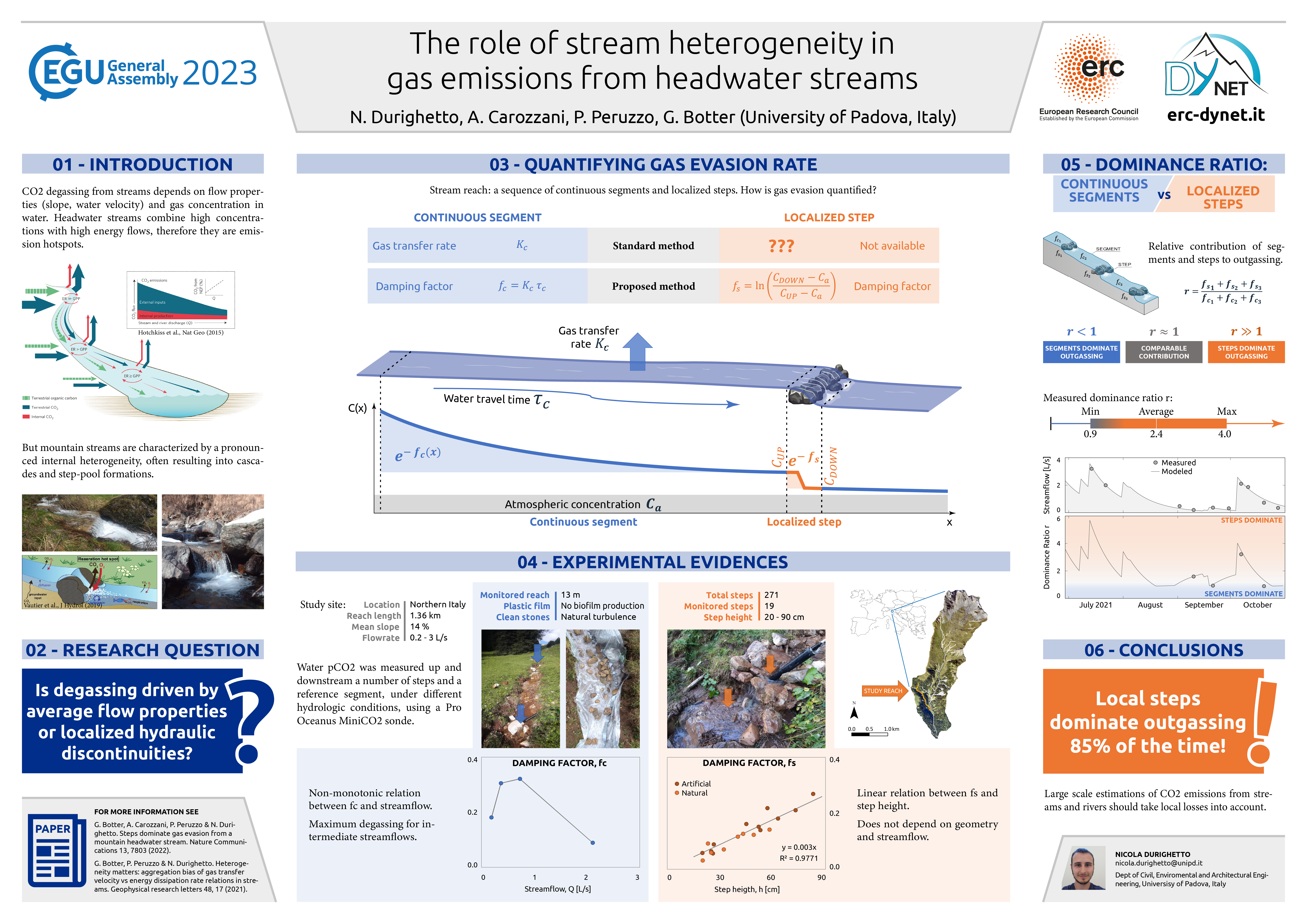
EGU23-7670 | Posters on site | BG3.14

Near-surface vs. sub-surface soil moisture impacts on vegetation functioning 

Prajwal Khanal, Anne Hoek van Dijke, Yijan Zeng, and René Orth

Soil water availability is a critical requirement for vegetation functioning in a water-limited regime. Vegetation takes up water from varying soil depths depending on their rooting location and soil moisture availability. The uptake depth varies spatially across climate regimes and vegetation types and temporally between seasons. Yet, a scientific consensus on the global relevance of near-surface and sub-surface soil moisture for vegetation functioning is still lacking and is the focus of this study. 

In particular, we calculate the correlation between the Near-Infrared Reflectance of Vegetation (NIRv) with both satellite-derived near-surface soil moisture from ESA-CCI and terrestrial water storage from GRACE. This is done globally and with monthly data during the growing season at each grid cell and accounting for the confounding effects of temperature and radiation. We analyze how these correlations vary spatially across varying vegetation types and climatic regimes, and temporally between all growing season months and particularly dry months. Finally, we repeat the analyses using Sun-induced fluorescence (SIF) data instead of NIRv. 

We find that NIRv and SIF correlate more strongly with near-surface soil moisture compared to terrestrial water storage in semi-arid regions with low tree cover. This suggests that the vegetation preferentially takes up water from near-surface soil moisture whenever available to meet its transpiration demand.   In contrast, in regions with more tree cover and in drier regions, the correlation with terrestrial water storage is comparable to or even higher than with near-surface soil moisture. This indicates that trees can make use of their deep rooting systems to access deeper soil moisture resources, similar to vegetation in arid regions. In particularly dry months, correlations with near-surface soil moisture increase while this is even more the case with terrestrial water storage, highlighting the relevance of deeper water resources during rain-scarce periods.

Overall, while direct observations of sub-surface soil moisture are scarce, this study employs different satellite-based data streams in order to estimate the relevance of near-surface versus sub-surface soil moisture for vegetation functioning. This can inform the representation of vegetation-water interactions in land surface models to support more accurate climate change projections.


How to cite: Khanal, P., van Dijke, A. H., Zeng, Y., and Orth, R.: Near-surface vs. sub-surface soil moisture impacts on vegetation functioning, EGU General Assembly 2023, Vienna, Austria, 23–28 Apr 2023, EGU23-7670, https://doi.org/10.5194/egusphere-egu23-7670, 2023.

EGU23-7820 | Orals | BG3.14

When do plant hydraulics matter in ecosystem modelling? 

Athanasios Paschalis, Simone Fatichi, Manon Sabot, and Martin de Kauwe

 The dynamics of the ascent of water from the soil to the leaves of vascular plants determine ecosystem responses to environmental forcing and their recovery from periods of water stress. Recently several models that describe the dynamics of plant hydraulics have been proposed. In this study we introduce four different configurations of a plant hydraulics model in an existing terrestrial biosphere model T&C. The model configurations in increasing order of complexity introduce the basics of the cohesion-tension theory, plant water storage dynamics and long-term damage and repair of the plant's water conducting system. Using the model configurations at six case studies spanning semi-arid to tropical ecosystems we quantify how plant hydraulics can modulate overall ecosystem responses to environmental forcing. As droughts develop, models with plant hydraulics predict a slower onset of plant water stress and can reproduce diurnal patterns of water and carbon fluxes that models that incorporate empirical stomatal conductance only cannot capture. However, when the complex variability of the environmental forcing (i.e., observed hourly meteorological forcing driving the models) is considered, plant hydraulics alone cannot significantly improve model performance. Models that only have simple empirical stomatal conductance models can adequately capture most of the variability of the observed ecosystem responses without explicitly simulating plant hydraulics. Most of the time, the gain from introducing plant hydraulics in ecosystem modelling is limited compared to the possible model improvements from correct representation of other processes such as plant phenology. Nevertheless, during periods of water stress, only models that explicitly simulate plant hydraulics can reproduce observed ecosystem responses to stress and the dynamics of ecosystem recovery. Finally, sensitivity analyses highlight that accurately modelling plant hydraulics relies on good knowledge of plant hydraulics traits, particularly at the leaf level, as stomata are usually the hydraulic bottleneck in the water flow from the soil to the atmosphere.

How to cite: Paschalis, A., Fatichi, S., Sabot, M., and de Kauwe, M.: When do plant hydraulics matter in ecosystem modelling?, EGU General Assembly 2023, Vienna, Austria, 23–28 Apr 2023, EGU23-7820, https://doi.org/10.5194/egusphere-egu23-7820, 2023.

EGU23-8013 | ECS | Orals | BG3.14

Contrasting responses of vegetation to intraseasonal rainfall in Earth System Models 

Bethan L. Harris, Christopher M. Taylor, Tristan Quaife, and Phil P. Harris

The response of vegetation productivity to water availability provides a key link between the carbon and water cycles. Correctly representing this response in Earth System Models (ESMs) is essential for accurate modelling of the terrestrial carbon cycle and the evolution of the climate system. To investigate how well models capture this relationship at intraseasonal timescales, we use global datasets based on satellite observations to assess the land surface response to intraseasonal precipitation events, and evaluate the performance of CMIP6 ESMs in representing this response in the recent historical period. Whereas models are able to capture the observed surface soil moisture (SSM) response with reasonable agreement, there are large inter-model discrepancies in the response of Gross Primary Productivity (GPP), both in magnitude and timing, even in regions where land cover is similar between models. In particular, ACCESS-ESM and NorESM produce much lower-amplitude GPP responses to rainfall than UKESM and CNRM-ESM. All the models studied are able to represent that the regional amplitude of the GPP response is positively correlated with the amplitude of the SSM response, and negatively correlated with the amplitude of the vapour pressure deficit (VPD) response. All models except NorESM also capture that stronger SSM responses are associated with faster GPP responses. However, the models differ in their sensitivity to these drivers, and can produce very different GPP responses from similar variations in SSM and VPD, particularly in climatologically dry regions. This highlights the need for a better understanding of the uncertainties in the representation of water-vegetation relationships in ESMs, such as the effect of atmospheric vapour pressure deficit on stomatal conductance and the control of soil moisture stress on GPP.

How to cite: L. Harris, B., M. Taylor, C., Quaife, T., and P. Harris, P.: Contrasting responses of vegetation to intraseasonal rainfall in Earth System Models, EGU General Assembly 2023, Vienna, Austria, 23–28 Apr 2023, EGU23-8013, https://doi.org/10.5194/egusphere-egu23-8013, 2023.

EGU23-8747 | ECS | Orals | BG3.14

Modeling global vegetation processes and hyperspectral canopy radiative transfer using CliMA Land 

Yujie Wang, Renato Braghiere, Anthony Bloom, and Christian Frankenberg

Recent progress in satellite observations has provided unprecedented opportunities to monitor vegetation activity at global scale. However, a major challenge in fully utilizing remotely sensed data to constrain land surface models (LSMs) lies in inconsistencies between simulated and observed quantities. For example, gross primary productivity (GPP) and transpiration (T) that traditional LSMs simulate are not directly measurable from space, although they can be inferred from spaceborne observations using assumptions that are inconsistent with those LSMs. In comparison, canopy reflectance and fluorescence spectra that satellites can detect are not modeled by traditional LSMs. To bridge these quantities, we presented an overview of the next generation land model developed within the Climate Modeling Alliance (CliMA), and simulated global GPP, T, and hyperspectral canopy radiative transfer (RT; 400--2500 nm for reflectance, 640--850 nm for fluorescence) at hourly time step and 1 degree spatially resolution using CliMA Land. CliMA Land predicts vegetation indices and outgoing radiances, including solar-induced chlorophyll fluorescence (SIF), normalized difference vegetation index (NDVI), enhanced vegetation index (EVI), and near infrared reflectance of vegetation (NIRv) for any given sun-sensor geometry. The modeled spatial patterns of CliMA Land GPP, T, SIF, NDVI, EVI, and NIRv correlate significantly with existing data-driven products (mean R2 = 0.777 for 9 products). CliMA Land would be also useful in high temporal resolution simulations, e.g., providing insights into when GPP, SIF, and NIRv diverge.

How to cite: Wang, Y., Braghiere, R., Bloom, A., and Frankenberg, C.: Modeling global vegetation processes and hyperspectral canopy radiative transfer using CliMA Land, EGU General Assembly 2023, Vienna, Austria, 23–28 Apr 2023, EGU23-8747, https://doi.org/10.5194/egusphere-egu23-8747, 2023.

Expanding access to remotely sensed Earth observations provides us with an opportunity to examine the underlying spatiotemporal coupling between vegetation, both natural and managed, and the hydroclimate. Applying approximately 20 years of satellite records, we demonstrate a method to quantify the sensitivity and stability of land-atmosphere interactions. Here we evaluate the predictability of vegetation via the Normalized Difference Vegetation Index (NDVI) across croplands, shrublands, grasslands, and woodlands of East Africa as it relates to fluctuations in precipitation, soil moisture, evapotranspiration, and land surfaced temperature. In this study, we detect the strength of state dependency among these variables at the dekadal (10-day) to monthly scale using a data-driven approach known as Empirical Dynamic Modeling (EDM). There is notable spatial variability in NDVI predictability, with equatorial areas generally expressing the poorest skill, which can be attributed to the inconsistent rainfall seasonality and high aridity. Woodlands exhibit strong predictability throughout the region while vegetation response to environmental drivers in grasslands is less reliable. Our results suggest water availability, uptake and storage are important factors influencing the NDVI cycle. For a one-month lead time, high predictive skill can be retrieved from the time series, though skill weakens by a four- to sixth-month lead, at which point the overall seasonality appears to play a dominant role. One contribution to highlight is the advancement in our understanding of the relationship between vegetation and land surface temperature, which is particularly valuable in drought-prone East Africa. In this presentation, we introduce an application of EDM for biogeosciences, assess how historical seasonal information of the hydroclimate and vegetation across various land use and land covers can inform future environmental patterns, and identify critical areas of inquiry with a changing climate and extending agricultural production.

How to cite: Green, R. and Caylor, K.: Measuring the Sensitivity and Stability of Vegetation in Response to the Hydroclimate Across East Africa with an Empirical Dynamic Modeling Approach, EGU General Assembly 2023, Vienna, Austria, 23–28 Apr 2023, EGU23-9480, https://doi.org/10.5194/egusphere-egu23-9480, 2023.

EGU23-10417 | ECS | Orals | BG3.14

Disentangling the influence of vegetation structure and physiology on land-atmosphere coupling 

Wantong Li, Mirco Migliavacca, Alexandra G. Konings, Gregory Duveiller, Markus Reichstein, and René Orth

Terrestrial vegetation is a key component of the Earth system as it mediates the exchange of carbon, water and energy between the land and the atmosphere. Thereby, the vegetation affects the climate through changes in its structure (such as leaf area index, LAI) and its physiology (such as stomatal conductance); However, their relative contributions and respective processes on the land-atmosphere coupling are not yet understood. For instance, increased LAI, referred to as structural changes, promotes transpiration and vegetation productivity, and increases the surface albedo in most cases. In contrast, decreased surface conductance, referred to as physiological changes, could reduce transpiration and productivity. Therefore, the overall feedback of vegetation to climate change via water, carbon and energy exchange will depend on the relative importance of structural and physiological responses. Here we study to what extent dynamic changes in global vegetation structure and physiology modulate land-atmosphere coupling using satellite remote-sensing, data-driven, and earth system modelled vegetation data, as well ashydro-meteorological reanalysis. The land-atmosphere coupling is quantified through the correlation between soil moisture and lagged vapor pressure deficit determined with a moving time window. We employ random forests to quantify vegetation physiology by accounting for functional variability (e.g. GPP and ET) explained by hydro-meteorological data but not by the vegetation structure. Then using an explainable machine learning approach (SHAP), we determine the contributions of vegetation structure and physiology where we find overall larger contributions of structure on regulating land-atmosphere coupling during the growing season. The relative importance of vegetation structure differs across ecosystems, with stronger contributions in dry ecosystems. Furthermore, we analyze the variations of the relevance of vegetation structure over time and in particular during warm and dry periods. The results are partially backed up by using in-situ measurements of physiological traits to interpret the large-scale observed physiological patterns.

How to cite: Li, W., Migliavacca, M., Konings, A. G., Duveiller, G., Reichstein, M., and Orth, R.: Disentangling the influence of vegetation structure and physiology on land-atmosphere coupling, EGU General Assembly 2023, Vienna, Austria, 23–28 Apr 2023, EGU23-10417, https://doi.org/10.5194/egusphere-egu23-10417, 2023.

EGU23-10949 | ECS | Orals | BG3.14

Understanding vegetation drought legacy effects on carbon cycling using observations from multiple platforms 

Yitong Yao, Yujie Wang, Yi Yin, and Christian Frankenberg

Drought legacy effects refer to the lasting impacts on the carbon cycle from droughts, being a prime uncertainty in predicting future land carbon sink in a changing climate. While previous studies have been focusing on the drought legacy effects on tree growth using tree ring chronologies, the rapid developments of site and satellite observations over the past decades provide us new opportunities to investigate the effects with improved temporal and spatial coverage. For example, retrievals of canopy structure, photosynthesis, evapotranspiration, and vegetation water content would allow for evaluating the differences in recovery processes in magnitude, timing and duration of the legacy effects. Potential asynchrony and divergence among these multiple legacy indicators result in large uncertainties in understanding the full range of vegetation responses to drought. To address this issue, this study aims to leverage the development of a new generation Earth system model (CliMA) in combination with site and satellite observations to understand the various legacy effects on carbon sink responses from site to regional scales. Through investigating the temporal and spatial patterns of legacy effects, our work will gain a comprehensive understanding of drought related carbon cycle feedback and benefit science-based decision making facing changing climate, especially extreme events. 

How to cite: Yao, Y., Wang, Y., Yin, Y., and Frankenberg, C.: Understanding vegetation drought legacy effects on carbon cycling using observations from multiple platforms, EGU General Assembly 2023, Vienna, Austria, 23–28 Apr 2023, EGU23-10949, https://doi.org/10.5194/egusphere-egu23-10949, 2023.

EGU23-11271 | ECS | Posters on site | BG3.14

Water use efficiency differs for mixed and monospecific boreal forests in Sweden 

Alisa Krasnova, Peng Zhao, Anne Klosterhalfen, Jinshu Chi, Tim Schacherl, Mats B. Nilsson, and Matthias Peichl

Ecosystem water use efficiency (WUE) is a key characteristic that describes the coupling of carbon and water exchange and can be used as an indicator of a forest's adaptability to varying climatic conditions. Mixed forests, characterized by the coexistence of two or more dominant tree species, may potentially exhibit higher productivity and greater resistance to extreme weather events due to possible niche differentiation among dominant species, leading to more efficient nutrient utilization. However, the increased productivity may also result in higher evapotranspiration demand, resulting in lower WUE compared to monospecific forests. 
In this study, we aim to assess the variation in WUE of mixed and monospecific boreal forests in response to different environmental factors using eddy-covariance measurements. The two study sites are represented by forest stands of similar age, growing under the same climatic conditions and located in close proximity (~10km distance) in Northern Sweden. The Rosinedalsheden site is a ~100-year-old monospecific pine (Pinus sylvestris) forest stand with sandy soils. The Svartberget site is a mixed ~110-year-old forest featuring pine (Pinus sylvestris, 61%), spruce (Picea abies, 34%), and birch (Betula sp., 5%) species, with soils dominated by till and sorted sediments. Our study spans a period of seven years (2014-2020) and covers a wide range of weather conditions, including the 2018 heatwave.

How to cite: Krasnova, A., Zhao, P., Klosterhalfen, A., Chi, J., Schacherl, T., B. Nilsson, M., and Peichl, M.: Water use efficiency differs for mixed and monospecific boreal forests in Sweden, EGU General Assembly 2023, Vienna, Austria, 23–28 Apr 2023, EGU23-11271, https://doi.org/10.5194/egusphere-egu23-11271, 2023.

EGU23-11564 | ECS | Orals | BG3.14

Vegetation optical depth reveals changes in ecosystem-level water stress for global forests 

Samuli Junttila, Adrià Descals, Iolanda Filella, Josep Peñuelas, Martin Brandt, Jean-Pierre Wigneron, and Mikko Vastaranta

Plant water stress due to climate change is posing a threat to various ecosystem services such as carbon sequestration, food and wood production, and climate regulation. To address this issue, methods are needed to assess and monitor plant water stress at various spatial and temporal scales. Passive microwave emission observations from satellites have proven useful in monitoring changes in vegetation water content and assessing plant water stress at a low spatial resolution (> 9 km). In this study, we used vegetation optical depth (VOD) and measurements of hydraulic vulnerability to create a novel model for assessing ecosystem-level water stress. We used L-band VOD and global measurements of xylem water potential at 88% loss of stem hydraulic conductivity (P88) from the TRY database (including 1103 measurements of P88 from 463 species and nine different vegetation biomes) to create a linear regression model between L-band VOD and biome-level P88. We used monthly mean values of L-band VOD and calculated ratios of yearly minimum and maximum VOD (L-VODmin/max) for each pixel to describe average variability in ecosystem-level water content. The developed L-VODmin/max metric explained 75% of the variation in P88 at the biome level (R2=0.75) indicating that the novel L-VODmin/max metric is capable of capturing changes in plant water status. We then used the L-VODmin/max metric and daily climate data from the ERA5 to see if water stress has increased over time in the world's forests that are more water limited (aridity index below 1.5). For these areas, we found a positive trend in maximum daily vapour pressure deficit, which correlated negatively (p<0.05) with L-VODmin/max trend for the same time period further confirming that L-VODmin/max is capable of explaining differences in plant water status. Additionally, we examined the trend in L-VODmin/max for global forests for the same 2011-2020 period and found a significant negative trend (increasing water stress, p<0.05) for forests in central Africa, southeast Asia, and eastern Australia, and a positive trend (decreasing water stress) for boreal forests in North America and rainforests in Indonesia. Further studies are required to confirm our results suggesting that some of the world's largest carbon sinks are experiencing rapid changes in water stress as a result of climate change.

How to cite: Junttila, S., Descals, A., Filella, I., Peñuelas, J., Brandt, M., Wigneron, J.-P., and Vastaranta, M.: Vegetation optical depth reveals changes in ecosystem-level water stress for global forests, EGU General Assembly 2023, Vienna, Austria, 23–28 Apr 2023, EGU23-11564, https://doi.org/10.5194/egusphere-egu23-11564, 2023.

EGU23-11630 | Posters on site | BG3.14

Optimal stomatal control in the presence of leaf-atmosphere coupling 

Stan Schymanski, Milan Milenovic, and Gitanjali Thakur

Plant leaves absorb solar radiation and carbon dioxide (CO2) from the atmosphere while releasing water vapour, oxygen and heat to the atmosphere. The leaf-atmosphere interface is hence the primary determinant of water-carbon interactions, where stomata control transpiration according to soil water availability, but at the cost of reducing carbon uptake by photosynthesis. It has been proposed that stomata not only respond to water stress, but function in a way to maximise a plant's long-term carbon gain by dynamically economising plant available water according to varying environmental conditions (Cowan and Farquhar, 1977). While the search for the relevant costs of stomatal opening focuses more and more on the costs of the infrastructure needed to supply water to the leaves, the consequences of opening stomata in the presence of leaf-atmosphere feedbacks, potentially resulting in a cooling and humidification of the air at the diurnal scale, hence reducing evaporative demand (Cowan, 1978), and/or depletion of atmospheric CO2, hence reducing CO2 uptake, have so far not been considered in stomatal optimality modelling. It has been shown that optimal response of vegetation to even small long-term variations in atmospheric CO2 can lead to substantial changes in land-atmosphere exchange (Schymanski et al., 2015), while the effect of trends in atmospheric vapour pressure concentration and temperature has also been documented widely. However, little research has been conducted on the optimal behaviour of plants in the presence of land-atmosphere feedbacks.

Here we present a theoretical analysis and preliminary experimental results of (optimal) stomatal control in the presence of leaf-atmosphere coupling. The coupling strength is represented theoretically by adding an additional control volume representing the leaf boundary layer or canopy air space, and experimentally by varying the flow rate of dry and CO2-rich air into a leaf cuvette. We discuss the positive and negative effects of a de-coupled canopy air space for leaf gas and energy exchange, and present experimental and mathematical methods to put them into relation to each other.

Literature:

Cowan, I. R.: Water use in higher plants, in: Water: planets, plants and people, edited by: McIntyre, A. K., Australian Academy of Science, Canberra, 71–107, 1978.

Cowan, I. R. and Farquhar, G. D.: Stomatal Function in Relation to Leaf Metabolism and Environment, in: Integration of activity in the higher plant, edited by: Jennings, D. H., Cambridge University Press, Cambridge, 471–505, 1977.

Schymanski, S. J., Roderick, M. L., and Sivapalan, M.: Using an optimality model to understand medium and long-term responses of vegetation water use to elevated atmospheric CO2 concentrations, AoB Plants, 7, plv060, https://doi.org/10.1093/aobpla/plv060, 2015.

How to cite: Schymanski, S., Milenovic, M., and Thakur, G.: Optimal stomatal control in the presence of leaf-atmosphere coupling, EGU General Assembly 2023, Vienna, Austria, 23–28 Apr 2023, EGU23-11630, https://doi.org/10.5194/egusphere-egu23-11630, 2023.

EGU23-12444 | Orals | BG3.14

Using machine learning to quantify multi-scale soil moisture controls on water and carbon fluxes at the land surface 

Rafael Rosolem, Daniel Power, Miguel Rico-Ramirez, Pierre Gentine, David McJannet, Humberto da Rocha, Martin Schrön, and Corinna Rebmann

Knowledge of fluxes of water vapor and carbon at the land surface are paramount to our understanding of the Earth system. Large-scale network initiatives such as the Fluxnet allow us to better understand the environmental controls on the evapotranspiration and gross primary productivity. An important aspect of such initiatives is that its large number of sites allow for localized knowledge to be upscaled to a region or even globally. This can be either done by employing physics-based global land models or empirically, via data-driven approaches. Particularly, we have seen a significant increase of data-driven approaches with the use of machine learning techniques more recently. Here, we use a similar structure employed in the FLUXCOM initiative to focus particularly on the role of soil moisture information in predicting evapotranspiration and gross primary productivity at several flux sites encompassing a wide range of hydroclimates and biomes around the globe. Our analyses employ a machine learning method to a predictive model of evapotranspiration and gross primary productivity, while focusing primarily on how changes in the way soil moisture is incorporated into the methodology affects such predictions. First, we evaluate the predictive power of this model when soil moisture is directly estimated via observations against more indirect estimates via bucket-type models. Secondly, we evaluate the role of the spatial resolution of different soil moisture estimates in predicting both fluxes. We do this by using three sets of direct estimates covering distinct spatial footprints co-located at all flux sites: (1) point-scale time-domain reflectometers, (2) field-scale cosmic-ray neutron sensors, and (3) regional-scale satellite remote sensing products. In this talk, we summarize which hydroclimatic regions benefit from having direct estimate of soil moisture for evapotranspiration and gross primary productivity, while also providing some insights on the possible role of spatial scale mismatches between the fluxes and soil moisture.

How to cite: Rosolem, R., Power, D., Rico-Ramirez, M., Gentine, P., McJannet, D., da Rocha, H., Schrön, M., and Rebmann, C.: Using machine learning to quantify multi-scale soil moisture controls on water and carbon fluxes at the land surface, EGU General Assembly 2023, Vienna, Austria, 23–28 Apr 2023, EGU23-12444, https://doi.org/10.5194/egusphere-egu23-12444, 2023.

EGU23-12507 | Orals | BG3.14

A review of Water Use Efficiency across space and time 

Simone Fatichi, Athanasios Paschalis, Sara Bonetti, Gabriele Manoli, and Christoforos Pappas

Water Use Efficiency (WUE) is the variable linking assimilation and storage of carbon in plants with the release of water through transpiration. In this study, we combine multiple datasets including global scale leaf-level gas exchange measurements, tree-ring isotopes, flux-tower observations, and remote sensing products with mechanistic terrestrial biosphere modeling to evaluate whether WUE depends on precipitation or aridity levels and how changes in vapor pressure deficit affect ecosystem scale WUE and intrinsic water use efficiency (IWUE). A constrained range of WUE values across ecosystems and climates are observed with few noticeable exceptions. Observations and model simulations converge towards a weak WUE dependency on precipitation or aridity conditions.

Numerical simulations with a mechanistic model reveal two distinct signatures of VPD on site level WUE and IWUE, with high VPD resulting in increased IWUE, but decreased WUE. Relations with soil moisture are instead more complex and non-monotonic. Multiple data sources in combination with mechanistic modeling offer new insights on WUE variability across spatial and temporal scales and provide reference WUE values for future comparisons.

How to cite: Fatichi, S., Paschalis, A., Bonetti, S., Manoli, G., and Pappas, C.: A review of Water Use Efficiency across space and time, EGU General Assembly 2023, Vienna, Austria, 23–28 Apr 2023, EGU23-12507, https://doi.org/10.5194/egusphere-egu23-12507, 2023.

EGU23-12846 | ECS | Posters on site | BG3.14

The role of water table depth and plant functional type in energy partitioning 

Francesco Giardina, Sonia I. Seneviratne, Benjamin D. Stocker, Jiangong Liu, and Pierre Gentine

Energy partitioning between surface latent (LE) and sensible (H) heat fluxes is a key factor in the development of the boundary layer and the regulation of the hydrological cycle. Climate factors and surface cover are commonly considered the major controlling effects on energy partitioning. However, the influence of other drivers such as water table depth and groundwater convergence has rarely been considered.

Here, we use an extensive dataset of eddy covariance and global remote-sensing data to show that not only climate, but also water table depth and plant functional type (PFT) play an important role in energy partitioning across different biomes. Our findings illuminate the understanding of plant water stress in terrestrial ecosystems.

How to cite: Giardina, F., Seneviratne, S. I., Stocker, B. D., Liu, J., and Gentine, P.: The role of water table depth and plant functional type in energy partitioning, EGU General Assembly 2023, Vienna, Austria, 23–28 Apr 2023, EGU23-12846, https://doi.org/10.5194/egusphere-egu23-12846, 2023.

EGU23-13093 | ECS | Orals | BG3.14

Peatlands methane origin and fluxes to the atmosphere: towards an integrative conceptual model of a temperate French peatland 

Alexandre Lhosmot, Adrien Jacotot, Marc Steinmann, Laure Gandois, Philippe Binet, Marie-Laure Toussaint, Sébastien Gogo, Daniel Gilbert, Jean-Sébastien Moquet, Sarah Coffinet, Anne Boetsch, Christophe Loup, Fatima Laggoun-Défarge, and Guillaume Bertrand

Peatlands cover only 3 % of emerged lands, but their carbon stock represents about 30 % of the global soil organic carbon. Climate change and local anthropogenic disturbances deeply affect the hydrological functioning of peatlands. This may trigger carbon fluxes to surface waters and the atmosphere, thus leading to a positive feedback for global warming. It is therefore crucial to better estimate carbon fluxes between peatlands and the atmosphere and to delineate their major controlling constraints. To achieve this goal, we studied the functioning of a temperate mid-mountain peatland located in the French Jura Mountains, named the Frasne peatland.

The methane (CH4) dynamics of the Frasne peatland appear to be constrained by a range of hydrological, physical, biogeochemical, and biotic factors. From a hydrological point of view, the system is fed by local rainwater and injection of carbonated groundwater at the bottom of the peatland, which provides a major input of dissolved inorganic carbon (DIC) to the system. Values of the δ13CDIC were high (even reaching positive values up to 8.1 ‰) compared to the expected values in a limestone and C3 plant-dominated area such as the Jura Mountains, supporting biotic CH4 production within the peatland. Consistently, high-frequency eddy-covariance monitoring during 2.5 years allowed us to show that the site acted as a source of CH4 to the atmosphere (23.9 ± 0.6 g C m-2 year-1) with interannual, seasonal, and diurnal time scale dynamics. In particular, we found an outstanding diurnal cycle for CH4 with the highest fluxes at night and lower ones at mid-day. In addition, the mid-day fluxes were negative in spring, highlighting larger oxidative processes than CH4 production attributed to photosynthesis activity (i.e., soil oxygen penetration and endosymbiotic methanotrophs of Sphagnum). The range of CH4 emissions was also controlled by the interannual variation in precipitation amounts and by the seasonal temperature variation.

This conceptual production-emission model highlights that water-carbon interactions in the peatland depend on local biotic and abiotic factors but also on hydrological processes at the watershed scale. This also highlights the need to further constrain carbon transfers between the production and the emission zones (i.e., peatland-atmosphere interface and surface water exports). For this purpose, we will soon carry out a field campaign to measure the concentrations and isotopic values of dissolved gases in peat pore water along with an upstream downstream and a vertical gradient.

How to cite: Lhosmot, A., Jacotot, A., Steinmann, M., Gandois, L., Binet, P., Toussaint, M.-L., Gogo, S., Gilbert, D., Moquet, J.-S., Coffinet, S., Boetsch, A., Loup, C., Laggoun-Défarge, F., and Bertrand, G.: Peatlands methane origin and fluxes to the atmosphere: towards an integrative conceptual model of a temperate French peatland, EGU General Assembly 2023, Vienna, Austria, 23–28 Apr 2023, EGU23-13093, https://doi.org/10.5194/egusphere-egu23-13093, 2023.

EGU23-13401 | Posters on site | BG3.14

Drought effect on urban plane tree ecophysiology and its isoprene emissions 

Ruben Puga Freitas, Alice Claude, Alice Maison, Luis Leitao, Anne Repellin, Paul Nadam, Carmen Kalalian, Christophe Boissard, Valérie Gros, Karine Sartelet, Andrée Tuzet, and Juliette Leymarie

Urban trees emit a wide range of biogenic Volatile Organic Compounds (bVOC). Some of these bVOC, like isoprene can react with atmospheric oxidants to form secondary compounds, such as ozone (O3) and secondary organic aerosols (SOA), which have impacts on air quality and climate. In addition, isoprene emissions are strongly influenced by environmental factors and urban sites are known as stressful environment, characterized for example by water scarcity. However, little is known on the contribution of urban trees to air quality, notably during drought periods. In a semi-controlled experiment, fourteen young plane trees (Platanus x hispanica, known as a strong isoprene emitter) were grown in containers, in an urban site (at Vitry-sur-Seine, near Paris), since 2020. In June 2022, half the trees were subjected to drought by total rainfall exclusion and by withholding watering. A comprehensive characterization of tree response to drought, including plant morphology (leaf density and area), water status (i.e., leaf water potential, δ13C isotopic composition) and physiology (stomatal conductance, net photosynthesis, leaf pigment contents, stress molecular markers, chlorophyll fluorescence) analyses, was undertaken along with the characterization of bVOC emissions by an original leaf scale method (portable GC-MS coupled to a leaf chamber). All together, these parameters provided relevant information on the relation between bVOC emissions and plant morphology, its water use efficiency and photosynthetic energy conversion.

Shortly after the onset of drought, the isoprene emissions of the plane trees remained unchanged even though typical responses to drought stress were observed, such as partial stomatal closure leading to a decrease in carbon assimilation. With the progression of drought stress, progressive leaf shedding occurred. When almost completely defoliated, the trees emitted lower amounts of isoprene emissions likely due to disruption of the photosynthetic energy conversion process. Despite the moderate decrease in absolute isoprene emissions rates (as expressed per dry leaf mass) induced by the drought treatment on plane trees with nearly zero gas exchange, total emissions were strongly affected because defoliation significantly reduced the total leaf area. We emphasize that this phenomenon should be taken into account in atmospheric models especially in species highly subjected to drought induced defoliation. Here, a simple parameterisation of this effect on plane tree-bVOC emissions is proposed.

How to cite: Puga Freitas, R., Claude, A., Maison, A., Leitao, L., Repellin, A., Nadam, P., Kalalian, C., Boissard, C., Gros, V., Sartelet, K., Tuzet, A., and Leymarie, J.: Drought effect on urban plane tree ecophysiology and its isoprene emissions, EGU General Assembly 2023, Vienna, Austria, 23–28 Apr 2023, EGU23-13401, https://doi.org/10.5194/egusphere-egu23-13401, 2023.

EGU23-13448 | ECS | Posters on site | BG3.14

Shifting consensus in moisture modifier of decomposition towards the optimum in well-drained mineral soils instead of mid- or high- moisture levels of organic soils in boreal forest 

Boris Tupek, Aleksi Lehtonen, Alla Yurova, Rose Abramoff, Stefano Manzoni, Bertrand Guenet, Samuli Launiainen, Mikko Peltoniemi, Kari Minkkinen, and Raisa Mäkipää

The lack of consensus of functional dependency of soil respiration on moisture among the Earth system models (ESMs) contributes significantly to uncertainties in their projections.

Based on data of soil organic C stocks and CO2 emissions from the boreal ecotone between mineral soil forests and adjacent peatlands with organic soils in Finland, we derived the field-based moisture response of respiration in a maximum range of moisture conditions (extending from xeric and mesic forests to water saturated mires). Using Bayesian data assimilation technique, we coupled Yasso07 soil carbon model with the heuristic bell shape moisture function, approximating the enzyme and oxygen limitations. As expected, the Yasso07 model fitted with the revised moisture modifier on data from catena of organic-mineral soils outperformed the previous model version in peatlands.

Unlike the most found optimum of decomposition in ESM in mid- or high- moisture levels, our optimum or the highest rate of decomposition correspond to well-drained conditions of mineral soils.

We speculated that the reason for the shift in the moisture optimum of the functional form was its accounting for long-term processes leading to a larger C mineralization in mineral soils related to extreme events, such as prolonged elevated moisture or rewetting after droughts, which enhance microbial access to previously protected or labile C pools and may not be detected in short-term incubation studies.

Although, the moisture modifier derived here improved the match between the modelled and measured SOCs of peatlands, a shift in consensus from current decomposition rate modifiers used in ESMs requires further evaluation before it can be largely applied for the landscape level semiempirical processed-based modelling of the mineral and organic soil C stocks and CO2 emissions.

How to cite: Tupek, B., Lehtonen, A., Yurova, A., Abramoff, R., Manzoni, S., Guenet, B., Launiainen, S., Peltoniemi, M., Minkkinen, K., and Mäkipää, R.: Shifting consensus in moisture modifier of decomposition towards the optimum in well-drained mineral soils instead of mid- or high- moisture levels of organic soils in boreal forest, EGU General Assembly 2023, Vienna, Austria, 23–28 Apr 2023, EGU23-13448, https://doi.org/10.5194/egusphere-egu23-13448, 2023.

EGU23-14027 | Orals | BG3.14

Variability of the photosynthetic and fluorescence response of high mountain plants to climate change. 

Salvador Aljazairi, M.-Teresa Sebastià, Daniel Agea, Enrique P. Sánchez-Cañete, Andrew Kowalski, Regino Zamora, and Penelope Serrano-Ortiz

Alpine ecosystems have a high ecological value, high biodiversity, and provide important ecosystem services. However, alpine communities are highly vulnerable to climate changes. Changes in biodiversity and its distribution will affect the goods and services that these ecosystems provide. Also, it can affect climate regulation by altering the exchanges of greenhouse gases (GHG) and the cycles of carbon (C) and nitrogen (N), in feedback processes. Due to their ecological importance and vulnerability, alpine meadows deserve special attention. In this regard, the main objective of the IBERALP project is the analysis of the interactions between components of biodiversity, mainly plant and soil microbial diversity, and their relationship with GHG fluxes; and how these interactions are affected by climate change.


IBERALP is focused on the alpine communities of five Iberian mountain National Parks: Picos de Europa, Ordesa and Monte Perdido, Aigüestortes i Estany de Sant Maurici, Sierra Nevada, and Sierra de Guadarrama. In each National Park, we selected two different altitudes and two different alpine community types based on soil conditions (mesic and xeric). Here we study leaf physiological and fluorescence parameters assimilation, respiration, the quantum yield of photosystem II (PhiPSII), maximum quantum efficiency (Fv`/Fm`) and photochemical quenching (qP) in two representative plant species (a legume (Trifolium repens) and a grass (Nardus strita)) present in each National Park. In addition, we recorded altitude and humidity soil condition using a portable photosyntheic system (Li-cor 6800; Li-Cor Inc.) with an integrated fluorescence chamber head.


Multiple factors affect the ability of plants to assimilate CO2 and photoprotect themselves from solar radiation excess, so there was no common pattern for all Parks. However, in general, plants at higher altitudes showed a greater photosynthetic and photoprotection capacity against high irradiances compare to those at lower altitudes. Similar behaviour was found in mesic versus xeric communities. Exceptions were found, such as, for example, in Picos de Europa National Park, where the intense fog and grazing (with continuous contribution of N to the soil) modified these patterns of photosynthesis and photoprotection. 

This work was supported by the OAPN through the project PN2021-2820s (IBERALP).

How to cite: Aljazairi, S., Sebastià, M.-T., Agea, D., Sánchez-Cañete, E. P., Kowalski, A., Zamora, R., and Serrano-Ortiz, P.: Variability of the photosynthetic and fluorescence response of high mountain plants to climate change., EGU General Assembly 2023, Vienna, Austria, 23–28 Apr 2023, EGU23-14027, https://doi.org/10.5194/egusphere-egu23-14027, 2023.

EGU23-15472 | Orals | BG3.14

Soil hydraulic conductivity defines minimum Root:Shoot surface ratio in moisture-limited environments 

Mathieu Javaux, Andrea Cecere, Louis Delval, Fabian Wankmüller, and Andrea Carminati

In drying soils, root water uptake is limited by the low soil hydraulic conductance. The magnitude of this conductance drop and its temporal dynamics are function of soil texture, soil water status, root hydraulic architecture, atmospheric demand and canopy conductance.  Under dry climates, in order to survive, plants can adapt their carbon allocation by maximizing their root:shoot surface ratio, thereby decreasing their transpiration surface while increasing their root surface.

Thanks to a simple soil-plant hydraulic model, we show that soil hydraulic conductivity controls the minimum root:shoot surface ratio. A meta-analysis of shoot:root surface ratio is combined with a database of soil hydraulic properties to demonstrate how the minimum root:shoot surface value changes with soil conductivity across soil textural classes for dry biomes. We discuss the mechanisms by which plants can control their carbon allocation in such conditions and investigate the sensitivity of this minimum root:shoot surface ratio to future shifts in evaporative demand.

How to cite: Javaux, M., Cecere, A., Delval, L., Wankmüller, F., and Carminati, A.: Soil hydraulic conductivity defines minimum Root:Shoot surface ratio in moisture-limited environments, EGU General Assembly 2023, Vienna, Austria, 23–28 Apr 2023, EGU23-15472, https://doi.org/10.5194/egusphere-egu23-15472, 2023.

EGU23-15565 | ECS | Orals | BG3.14

Reducing uncertainty in extreme weather vegetation stress modeling using satellite-model approach at high resolution 

Arpita Verma, Louis Francois, Ingrid Jacquemin, Benjamin Lanssens, Alain Hambuckers, Alessandro Ugolotti, Merja Tölle, and Eric Hallot

Vegetation is a key driver for carbon uptake from the atmosphere to the land. Yet episodes of plant stress and mortality associated with drought and heat waves due to persistent lack of precipitation have been reported over the last decades and are expected to increase under ongoing climate change. It is presumed that climate-related vegetation stress results in progressively worsening plant health and rising mortality. However, the mechanisms driving such mortality are still up for debate because of the complex interconnections between the processes and the factors. Monitoring plant stress and mortality at the ecosystem level remains challenging to quantify since long-term, tree-individual, reliable observations are uncertain. For this reason, here we adapted a satellite-model approach to work on regional forests, before up scaling the results to the global forest.

In Belgium, the Wallonia region is covered by 30% forests which are the highest among all the three regions. While with the consecutive recent extreme events especially the droughts and heat waves of 2018, 2019, 2020, and 2022 caused water stress and bark beetle attack. According to the 35 years (1985-2022), land use land cover change extracted by LANDSAT 5,7, and 8 satellites, there is no significant change in forest land in Wallonia, Belgium. Meanwhile, in the current years 2021-2022, there is a decrease in the tree canopy with intensive forest management due to tree plant stress. On the other hand, in Wallonia, the forest is distributed in a significant patch of broadleaves, coniferous leaves, and mixed forest. However, we found that consecutive drought events cause water stress on specific plant species like Norway spruce which are in vulnerable states. For example: in a mixed forest when bark beetle or Scolytinae attacked the spruce tree it is more attracted to the other trees and in this consequence tree species –like  birch and oak –are now also in premature death or deteriorating tree health. In this study, we are using a high spatial resolution (25cm) remote sensing images using Artificial Intelligence and machine learning techniques to find out pixel-based individual plant stress or mortality. In addition, the high-resolution tree mortality extracted data will be used to calibrate CARAIB dynamic vegetation model and analyze the impact of extreme events on trees during the recent past and the future (until 2070). In conclusion, from this study, we plan to improve our model regarding the implementation of plant traits and species mortality aspects towards a better prediction of forest tree species' vulnerability to future extreme weather events.

How to cite: Verma, A., Francois, L., Jacquemin, I., Lanssens, B., Hambuckers, A., Ugolotti, A., Tölle, M., and Hallot, E.: Reducing uncertainty in extreme weather vegetation stress modeling using satellite-model approach at high resolution, EGU General Assembly 2023, Vienna, Austria, 23–28 Apr 2023, EGU23-15565, https://doi.org/10.5194/egusphere-egu23-15565, 2023.

EGU23-16495 | ECS | Posters on site | BG3.14

Development of a portable, distance-based paper analytical sensor for carbonate detection. 

Zakia Tebetyo, Samantha Richardson, Leigh Madden, Mark Lorch, and Nicole Pamme

Development of a portable, distance-based paper analytical sensor
for carbonate detection.


Zakia Tebetyo1, Samantha Richardson1, Leigh Madden2, Mark Lorch1, Nicole Pamme1,3

1Schoolof Natural Sciences, University of Hull.

2 Centre for Biomedicine, Hull York Medical School, University of Hull, UK

3Department of Materials and Environmental Chemistry, Stockholm University, Sweden

In this study we transferred a laboratory-based titration reaction for carbonate determination onto a portable paper-based analytical device (PAD). The carbonate quantity can be read out by measuring the distance of a colour change along a paper-based reaction channel. Device dimensions and detection reagent constituents were optimized to enable detection of carbonate ions in the range of 0 – 1000 mg L-1. The PAD featured a reaction channel in hydrophilic filter paper defined by a hydrophobic wax barrier. The detection reagent consisted of citric acid/citrate buffer (0.5 M, pH 2.5), bromocresol green (BCG) indicator (0.10% w/v) and PDADMAC (5.0 % v/v) dissolved in 20% ethanol. The base of the device was sealed with tape to prevent reagents leaking. Sixty microlitres of carbonate sample were added to the base of the channel and the liquid was allowed to wick up the channel. Colour development occurred as the carbonate ions reacted with the hydronium ions in the detection reagent resulting in a colour change of the BCG indicator from yellow to blue.

To optimise the reaction channel, two dimensions were compared, 1 mm x 30 mm and 2 mm x 30 mm. The device with the wider channel gave a higher colour intensity between carbonate concentrations 0 – 200 mg L-1. In this range the sensor gave a linear response. The effect of filter paper pore size was investigated to study wicking time. Whatman 4 paper (pore size 23 µm) had a six times faster wicking rate of 7 min compared to Whatman 1 (11 µm) with 42 min. Reproducibility studies (100, 200, 400, 500, 600, 800 and 1000 ppm carbonate, n = 6) gave a maximum RSD of 2.4% showing consistency across the range of samples tested. Interference tests were conducted with 500 ppm  with additional environmentally occurring ions, i.e. 250 ppm , 250 ppm  or 50 ppm of  (F=1.924<Fcrit=3.411, no significant difference). There was no significant interference found from these ions.

Future work will focus on packaging and sealing the devices for on-site use, benchmarking with real environmental samples and in-the-field use with by minimally trained personnel.

How to cite: Tebetyo, Z., Richardson, S., Madden, L., Lorch, M., and Pamme, N.: Development of a portable, distance-based paper analytical sensor for carbonate detection., EGU General Assembly 2023, Vienna, Austria, 23–28 Apr 2023, EGU23-16495, https://doi.org/10.5194/egusphere-egu23-16495, 2023.

EGU23-16633 | Orals | BG3.14

STEMMUS-SCOPE for PLUMBER2: Understanding Water-Energy-Carbon Fluxes with a Physically Consistent Dataset Across the Soil-Plant-Atmosphere (SPAC) Continuum 

Yunfei Wang, Yijian Zeng, Fakhereh (Sarah) Alidoost, Zengjing Song, Danyang Yu, Enting Tang, Qianqian Han, Retsios Bas, Girgi Serkan, Christiaan van der Tol, and Zhongbo (Bob) Su

High-quality and long-term measurements of water, energy, and carbon fluxes between the land and atmosphere are critical for eco-hydrological monitoring and land surface model (LSM) benchmarking. Eddy Covariance has become the most widely used method for theory development and LSM evaluation. On the other hand, flux tower data as measured (even after site post-processing and gap-filling based on empirical formulation) cannot be used directly for validating LSMs, and most of time, lacking physically-consistent measurement across the soil-plant-atmosphere continuum (SPAC) (e.g., other than surface fluxes, lacking the measurement of soil moisture, soil water potential, leaf water potential, fluorescence, and reflectance). Here we present high-quality and long-term fluxes and corresponding above/below-ground hydrological, physiological, photosynthetic data derived from the STEMMUS-SCOPE model simulations for PLUMBER2 project with 170 FLUXNET sites. Fluxes data from PLUMBER2 and SM data from FLUXNET2015 are used to further validate the effectiveness of the STEMMUS-SCOPE dataset. Results show that the simulated fluxes and SM dataset have reasonable agreements with the in-situ measurements, using the available global input/forcing datasets without any model tunning. This dataset adds to the existing ecosystem flux and SM network to help increase our understanding of ecosystem responses to extreme events.

How to cite: Wang, Y., Zeng, Y., Alidoost, F. (., Song, Z., Yu, D., Tang, E., Han, Q., Bas, R., Serkan, G., van der Tol, C., and Su, Z. (.: STEMMUS-SCOPE for PLUMBER2: Understanding Water-Energy-Carbon Fluxes with a Physically Consistent Dataset Across the Soil-Plant-Atmosphere (SPAC) Continuum, EGU General Assembly 2023, Vienna, Austria, 23–28 Apr 2023, EGU23-16633, https://doi.org/10.5194/egusphere-egu23-16633, 2023.

EGU23-203 | ECS | Posters on site | BG3.15

Climate-driven changes to the long-range fluctuations in vegetation production: Consequences for the global carbon cycle 

Dilip Naidu, Ashwin Seshadri, and Sumanta Bagchi

Climate plays a vital role in the carbon (C) uptake through vegetation productivity (Gross Primary Production; GPP) that is crucial to the persistence of the land as a carbon sink, thereby resulting in negative land-climate feedbacks. Large uncertainties persist in understanding the role of climate variability on this C flux, which influence future projections using Earth System Models (ESMs). One important source of uncertainty arises from the temporal variability in the carbon influx, and this includes effects of autocorrelation—i.e., similarity in observations with time-lag due to temporal structuring (“memory”) in the underlying dynamics. Evidence of the presence of memory in C uptake through GPP arises from field-based measurements through eddy covariance flux towers, but these lack widespread spatial distribution across environmental conditions and ecosystems. Therefore, estimating memory in the C cycle and its drivers on the global scale is important to our understanding of the global C cycle. For this, we used remotely sensed long-term GPP data from MODIS over the past two decades (2001-2021), to estimate long-term memory in C cycling through C-uptake by vegetation. Additionally, we also examined how the climate variables – temperature and precipitation- that are known to drive C influx, influenced the memory in C-uptake. We find that memory occurs in satellite-based estimates of GPP, corroborating field-based measurements. Interestingly, the memory in the C cycle was not limited to either short- or long-term but consisted of both these characteristics across different timescales. Climate variability through temperature and precipitation influenced memory and their effects are heterogeneous across ecosystems. With climate variability predicted to increase in the near future, our results suggest that these effects are likely to be consequential for the memory in C-uptake and, ultimately on the dynamics of the global C cycle. Therefore, estimating the memory in C cycle and its variation, is crucial for understanding as well as predicting the C-influx, under present and future climate change scenarios. 

How to cite: Naidu, D., Seshadri, A., and Bagchi, S.: Climate-driven changes to the long-range fluctuations in vegetation production: Consequences for the global carbon cycle, EGU General Assembly 2023, Vienna, Austria, 23–28 Apr 2023, EGU23-203, https://doi.org/10.5194/egusphere-egu23-203, 2023.

Soil carbon (C) and nitrogen (N) cycles and their complex responses to environmental changes have received increasing attention. However, large uncertainties in model predictions remain, partially due to the lack of explicit representation and parameterization of microbial processes. One great challenge is to effectively integrate rich microbial functional traits into ecosystem modeling for better predictions. Here, using soil enzymes as indicators of soil function, we developed a competitive dynamic enzyme allocation scheme and detailed enzyme-mediated soil inorganic N processes in the Microbial-ENzyme Decomposition (MEND) model. We conducted a rigorous calibration and validation of MEND with diverse soil C-N fluxes, microbial C:N ratios, and functional gene abundances from a 12-year CO2×N grassland experiment (BioCON) in Minnesota, USA. In addition to accurately simulating soil CO2 fluxes and multiple N variables, the model correctly predicted microbial C:N ratios and their negative response to enriched N supply. Model validation further showed that, compared to the changes in simulated enzyme concentrations and decomposition rates, the changes in simulated activities of eight C-N associated enzymes were better explained by the measured gene abundances in responses to elevated atmospheric CO2 concentration. Our results demonstrated that using enzymes as indicators of soil function and validating model predictions with functional gene abundances in ecosystem modeling can provide a basis for testing hypotheses about microbially-mediated biogeochemical processes in response to environmental changes. Further development and applications of the modeling framework presented here will enable microbial ecologists to address ecosystem-level questions beyond empirical observations, toward more predictive understanding, an ultimate goal of microbial ecology.

How to cite: Wang, G.: Soil enzymes as indicators of soil function: a step toward greater realism in microbial ecological modeling, EGU General Assembly 2023, Vienna, Austria, 23–28 Apr 2023, EGU23-1576, https://doi.org/10.5194/egusphere-egu23-1576, 2023.

EGU23-2202 | Orals | BG3.15

Using leaf chlorophyll observations to improve carbon cycle modelling at a temperate mixed forest 

Tea Thum, Outi Seppälä, Holly Croft, Silvia Caldararu, Amanda Ojasalo, Cheryl Rogers, Ralf Staebler, and Sönke Zaehle

Understanding the interactions between atmosphere and vegetation in changing climatic conditions is important so that we can predict the carbon sequestration potential of ecosystems. Helpful tools here are the terrestrial biosphere models (TBMs), since they include detailed ecophysiological process descriptions, e.g. the manifold interactions between the carbon and nitrogen cycles. However, the modelling of the nitrogen cycle poses challenges and having observational constraints on nitrogen cycle is crucial. Current remote sensing products offer estimates of leaf chlorophyll (Cab), that is related to the nitrogen cycle. In this study we want to assess how useful Cab observations are at site scale to constrain a TBM.


In this work we are studying a temperate mixed forest, Borden, located in Canada. We use a TBM QUantifying Interactions between terrestrial Nutrient Cycles, QUINCY, to model this site. From the site we have long-term (20 years) flux tower and LAI (from PAR measurements) observations together with leaf level observations of leaf chlorophyll (Cab), leaf nitrogen, and photochemical parameters of maximum carboxylation rate (Vcmax) and maximum potential electron transport rate (Jmax). 


The QUINCY model was predicting too late leaf senescence, which we tuned using the site level data. The amount of leaf nitrogen was originally quite successfully simulated by QUINCY, but the amount of simulated Cab was too low. Matching the simulated Cab values with the observations did not have a pronounced effect on the GPP. Additionally, the development of LAI and Cab were originally fully coupled in QUINCY, whereas the observations showed a delayed development of Cab compared to LAI. When we implemented this decoupling between LAI and Cab, an improvement of simulated GPP compared to the observations was found. Also then the simulated Vcmax and Jmax showed better correspondence to the observations. 


Assessment of the long-term behaviour of the model at the site showed that the model was able to capture the drought-induced drawdown of carbon fluxes taking place in 2007. The observations showed an increase in the component fluxes of carbon during the time period, but this was not replicated by the model. The start of season (SOS) and end of season (EOS) were estimated from both the simulated and observed GPP and LAI using a simple threshold method. The model was more successful in capturing the changes in the growing season metrics estimated by LAI than by GPP. The model was predicting too late onset of GPP in many years, but captured largely the interannual variation of SOS in observed GPP. 


This study paves the way for work using remotely sensed leaf chlorophyll in evaluation and improvement of the QUINCY model.

How to cite: Thum, T., Seppälä, O., Croft, H., Caldararu, S., Ojasalo, A., Rogers, C., Staebler, R., and Zaehle, S.: Using leaf chlorophyll observations to improve carbon cycle modelling at a temperate mixed forest, EGU General Assembly 2023, Vienna, Austria, 23–28 Apr 2023, EGU23-2202, https://doi.org/10.5194/egusphere-egu23-2202, 2023.

EGU23-2939 | ECS | Posters on site | BG3.15

Mercury methylation and demethylation on impacted wetland soils: effects of temperature 

Sayuri Sagisaka and Carl P. Mitchell

The methylation of mercury by anaerobic microbes in wet soils and sediment significantly increases its bioaccumulation potential into wildlife. Methylation is also counter-acted by demethylation processes, with the balance between methylation and demethylation processes ultimately controlling the amount of methylmercury in a system. Given that microbial activities are intricately linked with temperature, climatic changes should impact mercury methylation and demethylation processes, but this is not well-characterized in mercury research. In this presentation, I will discuss the outcome of better understanding mercury methylation and demethylation processes and rates in boreal wetland soils, as affected by temperature. To examine this, we have included a series of controlled, closed-system, flow-through experiments using boreal wetland soils from both forest-impacted and unimpacted wetlands in dark growth chambers across a range of realistic temperatures (5, 10, 15, 20, 25 °C). Mercury methylation and demethylation processes were examined in soil cores using enriched mercury isotope incubations and analyzed against measures of microbial activity and soil/water chemistry. Results from this study are expected to allow us to begin modeling mercury cycling processes with respect to climate and other environmental changes.

How to cite: Sagisaka, S. and Mitchell, C. P.: Mercury methylation and demethylation on impacted wetland soils: effects of temperature, EGU General Assembly 2023, Vienna, Austria, 23–28 Apr 2023, EGU23-2939, https://doi.org/10.5194/egusphere-egu23-2939, 2023.

EGU23-2946 | ECS | Orals | BG3.15

­­Carbon Costs of Plant Nutrient Acquisition Improve Present-Day Carbon Cycle Estimates and Limit CO2 Fertilization Effect 

Renato K. Braghiere, Joshua Fisher, Kara Allen, Edward Brzostek, Mingie Shi, Xiaojuan Yang, Daniel Ricciuto, Rosie Fisher, Qing Zhu, Richard Phillips, Benjamin Sulman, Brian Steidinger, Nadejda Soudzilovskaia, Jing Liang, Kabir Peay, and Thomas Crowther

Most Earth system models (ESMs) do not explicitly represent the carbon (C) costs of plant nutrient acquisition, which leads to uncertainty in predictions of the current and future constraints to the land C sink. While plants acquire nutrients through different uptake pathways, such as from mycorrhizae, direct root uptake, retranslocation from senescing tissues, and biological fixation in the case of nitrogen (N), they usually have different associated C costs. Determining the amount of nutrients acquired through each uptake pathway and the associated C cost could increase understanding of the global C and nutrient cycles, as well as the predictive skills of ESMs.

Here, we integrate a plant productivity-optimizing nutrient (N and phosphorus (P)) acquisition model (Fixation & Uptake of Nutrients, FUN) into the Energy Exascale Earth System (E3SM) Land Model (ELM) to simulate the global C and nutrient cycles (Braghiere et al., 2022). We benchmarked the model with observations (in-situ, remotely sensed, and integrated using artificial intelligence), and other ESMs from CMIP6; we found significant improvements in present C cycle variables estimates. We also examine the impact of mycorrhizal spatial distributions on the global C cycle, since most plant species predominantly associate with a single type of mycorrhizal fungi and uncertainties in mycorrhizal distributions are non-trivial, with current estimates disagreeing in up to 50% over 40% of the land area (Braghiere et al., 2021). Global Net Primary Productivity (NPP) is reduced by 20% with N costs and 50% with NP costs, while modeled and observed nutrient limitation agreement increases when N and P are considered together. Even though NPP has been growing globally in response to increasing CO2, as soil nutrient progressively becomes more limiting, the costs to NPP for nutrient acquisition have increased at a faster rate. This suggests that nutrient acquisition will increasingly demand a higher portion of assimilated C to support the same productivity.

Braghiere, et al. (2022) doi.org/10.1029/2022MS003204

Braghiere, et al. (2021) doi.org/10.1029/2021GL094514

How to cite: Braghiere, R. K., Fisher, J., Allen, K., Brzostek, E., Shi, M., Yang, X., Ricciuto, D., Fisher, R., Zhu, Q., Phillips, R., Sulman, B., Steidinger, B., Soudzilovskaia, N., Liang, J., Peay, K., and Crowther, T.: ­­Carbon Costs of Plant Nutrient Acquisition Improve Present-Day Carbon Cycle Estimates and Limit CO2 Fertilization Effect, EGU General Assembly 2023, Vienna, Austria, 23–28 Apr 2023, EGU23-2946, https://doi.org/10.5194/egusphere-egu23-2946, 2023.

Understanding how terrestrial ecosystem water use efficiency (WUE) responds to climate change is critical to accurately representing the carbon-water cycle processes. However, the dynamics of WUE under seasonal climate variations and biome-specific characteristics remain still unclear. In this study, we integrated two satellite-based retrieval algorithms to estimate gross primary productivity (GPP) and evapotranspiration (ET). Such indexes served as input to quantify ecosystem WUE (GPP/ET) and explore its dynamics during the dry and wet seasons from 2001 to 2018 in China’s key tropical to subtropical transitional zones, i.e., Yunnan Province. Results show large spatial heterogeneity and seasonal difference in WUE over the observational period. During the dry season, the increasing trends in GPP and ET have led to contrasting WUE patterns in forest and non-forest biomes, leading to positive and negative WUE trends, respectively. During the wet season, the declining trends in GPP occurring in combination with opposite trends in ET, have caused decreasing WUE consistently across all biomes except croplands, likely further modulated by human factors. The observed changes in WUE appear primarily driven by variations in air temperature (Ta) and vapor pressure deficit (VPD) during both dry and wet seasons. Overall, these results provide a valuable case for a better understanding of the carbon-water interplay in tropical-subtropical transitional zones and provide new insights to improve our capacity to predict the terrestrial ecosystem’s response to climate change.

How to cite: Liu, L., Zhang, K., and Forzieri, G.: Recent variations in ecosystem water use efficiency to seasonal climate variability in China's key tropical-subtropical transitional zones, EGU General Assembly 2023, Vienna, Austria, 23–28 Apr 2023, EGU23-2953, https://doi.org/10.5194/egusphere-egu23-2953, 2023.

EGU23-3712 | ECS | Orals | BG3.15 | Highlight

Confronting models with data: carbon-phosphorus interaction under elevated CO2 in a mature forest ecosystem (EucFACE) 

Mingkai Jiang, Belinda Medlyn, David Wårlind, Jürgen Knauer, Daniel Goll, Lin Yu, Katrin Fleischer, Haicheng Zhang, Xiaojuan Yang, Sönke Zaehle, David Ellsworth, and Benjamin Smith

The importance of phosphorus (P) in plant function and ecosystem biogeochemistry has led to the addition of a P cycle to a range of vegetation models, but the predictions of these P-enabled models have rarely been evaluated with ecosystem-scale data. Here, we confronted eight state-of-the-art, P-enabled models with data from EucFACE, a P-limited Eucalyptus forest subject to long-term Free-Air CO2 Enrichment. We evaluated the capability of the models to capture the observed elevated CO2 responses in this ecosystem. We show that the inclusion of phosphorus-cycle is necessary to more realistically simulate ecosystem function and biogeochemistry, but this enhanced capacity did not directly translate into improved prediction accuracy. Specifically, models diverged in capturing the observed CO2 responses, with simulation accuracy depending upon model assumptions about plant physiology, allocation, plant-soil interactions and soil nutrient processes. Confronting models with experimental responses observed at EucFACE represents a valuable opportunity to improve our understanding of the carbon-phosphorus interaction under rising CO2, and is an important step towards more accurate predictions of the future land carbon sink under climate change.

How to cite: Jiang, M., Medlyn, B., Wårlind, D., Knauer, J., Goll, D., Yu, L., Fleischer, K., Zhang, H., Yang, X., Zaehle, S., Ellsworth, D., and Smith, B.: Confronting models with data: carbon-phosphorus interaction under elevated CO2 in a mature forest ecosystem (EucFACE), EGU General Assembly 2023, Vienna, Austria, 23–28 Apr 2023, EGU23-3712, https://doi.org/10.5194/egusphere-egu23-3712, 2023.

EGU23-3822 | ECS | Orals | BG3.15

Higher climate sensitivities weaken negative climate feedbacks of terrestrial ecosystem through carbon sequestration and nitrous oxide emissions 

Cheng Gong, Silvia Caldararu, Jan Engel, Julia Nabel, and Sönke Zaehle

Terrestrial ecosystem acts as important carbon dioxide (CO2) sinks and nitrous oxide (N2O) sources. Ecosystem green-house-gas fluxes could further lead to a climate feedback, which are highly correlated with the C-N coupling. However, magnitudes of such composited feedbacks as well as contributions by individual ecological processes remained certain uncertainties. Here, we applied a terrestrial biosphere model QUINCY with fully C-N-coupling to comprehensively examine responses of CO2 and N2O fluxes to future climate changes and quantify contributions by individual processes. Our results showed that the trade-offs in CO2 and N2O still led a negative feedback (-3386.9 Tg CO2 yr-1) averaged over 2050-2100 under the SSP 5-8.5 scenario relative to SSP 1-2.6 scenario, however, which varies from -1761.7 Tg CO2 yr-1 to -5012.1 CO2 yr-1 with a high or low climate sensitivity to CO2 increases.  Further process analysis showed that the CO2 fertilization effects on ecosystem climate feedbacks were equivalent for high and low climate sensitivity, but the higher climate sensitivity led to less carbon sequestration on tropical plants as well as higher N2O emissions. The climate feedbacks attributed to individual soil processes, including decomposition, nitrification, denitrification and nitrogen biological fixation, were also comprehensively quantified. This finding suggests that reducing the uncertainties in climate sensitivity estimates could be of great significance to better predict future terrestrial ecosystem green-house-gas fluxes as well as corresponding climate feedbacks.

How to cite: Gong, C., Caldararu, S., Engel, J., Nabel, J., and Zaehle, S.: Higher climate sensitivities weaken negative climate feedbacks of terrestrial ecosystem through carbon sequestration and nitrous oxide emissions, EGU General Assembly 2023, Vienna, Austria, 23–28 Apr 2023, EGU23-3822, https://doi.org/10.5194/egusphere-egu23-3822, 2023.

EGU23-3858 | Orals | BG3.15

Divergent responses of mountain forests and grasslands to heat and drought events 

Marta Galvagno, Ludovica Oddi, Edoardo Cremonese, Gianluca Filippa, Mirco Migliavacca, and Georg Wohlfahrt

Both natural and managed ecosystems contribute to mitigating climate change through the process of CO2 sequestration from the atmosphere. However, projections of future global climate indicate that extreme weather events will become more frequent and more intense in the coming years. And since heat waves and droughts can alter the ecosystems functioning, and increase the vulnerability of carbon sinks, this trend represents a potential risk for their contribution to reaching global climate change mitigation goals. Further efforts are therefore needed to assess the resistance and resilience of different ecosystems and land uses to climate change. In this context, Alpine mountain ecosystems face a double challenge, on the one hand, warming in the Alps is occurring twice as fast as in other regions of the planet and drought events are increasingly frequent, on the other, socio-economic changes have led to partial land abandonment, with effects on the composition and distribution of plant species.

The main objective of this study is to analyze the impacts of extreme heat and drought events on the functioning of two different ecosystems in the Alps, a European larch forest (Larix decidua Mill.) and an abandoned subalpine pasture dominated by Nardus stricta, both located in the Aosta Valley region (Italy) at about 2100 m asl and thus experiencing the same climate conditions. The eddy covariance method was used to measure the carbon and water fluxes between the ecosystem and the atmosphere. Radiometric vegetation indices (eg. NDVI), and field observations related to plant phenology were used to explain the role of timing in determining the carbon and water fluxes impacts. Finally, functional traits of plant species were used to interpret the divergent ecosystem responses from an adaptive perspective. The results show that the different heat and drought events observed during the ten-year study period (2012-2022) had a variable impact on the different ecosystems monitored, also based on the timing of the extreme event in relation to the phenology of the vegetation and the presence/absence of the snowpack, with impacts generally more severe for the grassland compared to the forest. The contrasting responses observed will be discussed by exploring the linkage between the functioning of the whole ecosystem and the adaptive strategies of individual plant species.

How to cite: Galvagno, M., Oddi, L., Cremonese, E., Filippa, G., Migliavacca, M., and Wohlfahrt, G.: Divergent responses of mountain forests and grasslands to heat and drought events, EGU General Assembly 2023, Vienna, Austria, 23–28 Apr 2023, EGU23-3858, https://doi.org/10.5194/egusphere-egu23-3858, 2023.

EGU23-3972 | Posters on site | BG3.15

Exotic invasive trees affect germination and growth of understory plants via soil modifications 

Silvia Medina Villar, Ana de Torre Sáez, Antonio Manuel Montoya Ruíz, Paloma de las Heras Puñal, and M. Esther Pérez Corona

Biological invasions may affect diversity in different ways. In the case of exotic invasive plants, as soon as they arrive to a new ecosystem they may directly compete for resources with native plants, make the native environment toxic for native plants or modify soil properties in a way that hinder native plants. The exotic invasive trees, Ailanthus altissima and Robinia pseudoacaica, are listed as 20 of the most harmful exotic invasive species in Spain, but their mechanisms of impact are still not clear. In this study we investigated the extent to which these exotic invasive trees may affect understory native plants via soil modifications. In a riparian forest, we collected soils around exotic (A. altissima and R. pseudoacaica) and native trees (Populus alba) trees. Half of the soils were supplemented with activated carbon (AC) to reveal possible effects via the release of phytotoxic compounds from the invasive trees to the soil. We added seeds of native herb species (target species), Trifolium repens and Dactylis glomerata, to pots containing the different soils. We moistened the soils to favor seed germination. The emergence of plants was counted daily, and the aerial biomass reached by the plants was also measured. Independently of the addition of AC, compared to native soils, those of the exotic invasive trees negatively affected the target species. The biomass of T. repens and the emergence speed of D. glomerata was lower in A. altissima soils than in native soils. The emergence speed of T. repens was affected by both exotic soils. The effects produced by the exotic trees may be attributed to changes in soil properties but not to the release of phytotoxic compounds.

How to cite: Medina Villar, S., de Torre Sáez, A., Montoya Ruíz, A. M., de las Heras Puñal, P., and Pérez Corona, M. E.: Exotic invasive trees affect germination and growth of understory plants via soil modifications, EGU General Assembly 2023, Vienna, Austria, 23–28 Apr 2023, EGU23-3972, https://doi.org/10.5194/egusphere-egu23-3972, 2023.

EGU23-5716 | ECS | Orals | BG3.15

Harnessing enhanced rock weathering in a forestry context 

Gregory Jones, Athanasios Paschalis, and Bonnie Waring

Currently, few scalable, cost-effective CO2 removal (CDR) strategies exist to mitigate anthropogenic climate change. Enhanced rock weathering (ERW) is a strategy in which finely ground silicate rock reacts with atmospheric CO2 and produces weathering products that are transported to the ocean for long-term storage. Despite detailed knowledge of chemical weathering and its role in the carbon cycles at geologic timescales, few data display the efficacy of ERW for CDR at timescales appropriate for climate mitigation. To address this, we use the first large-scale field trial of ERW combined with tree planting at an afforestation experiment in mid-Wales. A factorial experimental design will enable us to determine the influence of basalt application and tree functional type on rock weathering and nutrient cycling parameters, such as soil pore water pH, alkalinity, cation concentrations and soil carbon. Here, we focus on the description and installation of the experiment, its monitoring protocol, and data analysis from the first two years of the site observations. We also outline how the data can be introduced into a mechanistic eco-hydrological model. Ultimately, we aim to synthesize these findings to inform predictions of global regions where ERW could be most effective for CDR.

How to cite: Jones, G., Paschalis, A., and Waring, B.: Harnessing enhanced rock weathering in a forestry context, EGU General Assembly 2023, Vienna, Austria, 23–28 Apr 2023, EGU23-5716, https://doi.org/10.5194/egusphere-egu23-5716, 2023.

EGU23-5871 | ECS | Posters on site | BG3.15

Advances and limitations in carbon and water cycle modeling using the Biome-BGCMuSo biogeochemical model in a Central European beech forest 

Laura Dobor, Peter Petrík, Ina Zavadilová, Ladislav Šigut, Dóra Hidy, Nándor Fodor, Zoltán Barcza, Tomas Hlásny, and Katarína Merganičová

Approximately 30% of anthropogenic carbon dioxide emissions are removed from the atmosphere annually by land-based carbon sinks, mainly forests. Extreme weather events such as droughts and heatwaves are expected to be more frequent and severe in the future affecting the carbon-water balance of ecosystems. Although empirical studies elucidate many of these processes, some questions cannot be addressed directly and require constructing in silico representations of real ecosystems. Process-based ecosystem models have recently received increased recognition due to their structural improvements and the increasing success of reproducing complex feedback mechanisms of carbon and water cycles.

We used the Biome-BGCMuSo biogeochemical model to simulate pools and fluxes of carbon, water, and nitrogen in vegetation, litter, and soil on a daily scale. The model is under continuous development and in the last few years, the hydrological cycle submodel went through substantial improvements. We examined the model performance regarding water and carbon cycle simulation using the data from an ecosystem station covered by a circa 100-year-old unmanaged beech forest. The site is included in the FLUXNET global network of micrometeorological tower sites and is operated by the Global Change Research Institute of the Czech Academy of Sciences. The extensively tested model can help to understand complex feedback mechanisms under drought events as well as future climatic conditions and estimate future carbon sink potentials in Central Europe. 

In particular, we (i) evaluated the model performance using biomass, leaf area index (LAI) measurements, five-year-long eddy-covariance measurements of net ecosystem exchange (NEE) and evapotranspiration (ET), (ii) developed an efficient benchmark framework that highlighted structural and/or functional errors in the model, (iii) analyzed the simulated carbon and water cycle under drought events (consecutive dry days) occurring different time of the year and (iv) projected the effects of climate change on the forest carbon and water cycle up to 2100 using climate change scenarios from the FORESEE climatological dataset.

We found that the simulated biomass and LAI values are in the range of the observations, NEE and ET are overestimated by 5% and 11% during the vegetation period, respectively. Simulation runs assuming 30-days drought events at different months in five different years caused immediate NEE decrease compared to simulations without drought events. We found the largest NEE difference (up to 10% on the average of five years) in the cases when the drought occurred in July, August, or in September. Simulations driven by climate change scenarios showed that NEE is expected to increase by the of the century, while the ET does not show any significant change in the future. 

How to cite: Dobor, L., Petrík, P., Zavadilová, I., Šigut, L., Hidy, D., Fodor, N., Barcza, Z., Hlásny, T., and Merganičová, K.: Advances and limitations in carbon and water cycle modeling using the Biome-BGCMuSo biogeochemical model in a Central European beech forest, EGU General Assembly 2023, Vienna, Austria, 23–28 Apr 2023, EGU23-5871, https://doi.org/10.5194/egusphere-egu23-5871, 2023.

EGU23-6448 | ECS | Orals | BG3.15

Using parameter estimation to reduce future climate-carbon cycle projection uncertainty 

Nina Raoult, Philippe Peylin, and Peter Cox

Predicting the responses of terrestrial ecosystems to future global change strongly relies on our ability to accurately model global scale vegetation dynamics and surface CO2 fluxes. However, terrestrial biosphere model carbon cycle processes remain subject to large uncertainties, partly because of unknown or poorly calibrated parameters. 

We can use the unprecedented amount of in situ and Earth Observation data to optimize these model parameters, as well as the considerable advances in parameter estimation techniques. Most of these techniques use Bayesian data assimilation approaches, which allow for objective calibrations of key model processes and parameters against observations, reducing the associated uncertainty. However, calibrating against present-day observations does not necessarily give us confidence in the future projections of the model, given that they are likely to exceed historical and present-day conditions. The relatively shorter timescales of present-day observations mean these cannot be directly used to create constraints on changes in the Earth System over the next century. Instead, we need to develop methods to translate short-term constraints into reductions in long-term projection uncertainty, bridging the gap between contemporary model optimisations and future predictions.

In this presentation, we will discuss two experiments highlighting how we can use parameter estimation to reduce model uncertainty and translate this information into constraints on future climate.

The first demonstrates how we can use manipulation experiments to increase our confidence in optimized parameters. We use data from two nitrogen-limited sites from the Free Air CO2 Enrichment experiment to optimize model parameters. The optimization is performed against ambient and elevated CO2 conditions simultaneously, giving us a better insight into nitrogen limitations on CO2 fertilization at these sites.

The second demonstrates how we can combine local model calibration with the emergent constraint approach. Using a parameter perturbation ensemble, we identify an emergent relationship between the optimal temperature for photosynthesis in tropical forests, and the projected amount of atmospheric CO2 at the end of the century. We combine this with a constraint on the optimum temperature for photosynthesis in tropical forests derived from eddy-covariance measurements and parameter estimation techniques to reduce the likely range of future atmospheric CO2 in a coupled climate-carbon cycle model under a common emissions scenario.

How to cite: Raoult, N., Peylin, P., and Cox, P.: Using parameter estimation to reduce future climate-carbon cycle projection uncertainty, EGU General Assembly 2023, Vienna, Austria, 23–28 Apr 2023, EGU23-6448, https://doi.org/10.5194/egusphere-egu23-6448, 2023.

EGU23-6649 | ECS | Orals | BG3.15

The seasonal cycles of land biosphere N2O fluxes and atmospheric N2O 

Qing Sun, Sebastian Lienert, and Fortunat Joos

Nitrous oxide (N2O) is a greenhouse gas and ozone-depleting agent that is predominately emitted from the land biosphere, linking to the yet only poorly understood carbon-nitrogen cycle. The seasonal cycle of the tropospheric N2O mixing ratio (aN2O), measured at globally distributed air sampling sites, offers an observational model constraint. Recent studies attribute the aN2O seasonality to exchange with N2O-depleted stratospheric air. Yet, how land biosphere N2O fluxes contribute to the seasonal amplitude, phasing, and amplitude growth of aN2O has not been well understood at global scales.

Here we apply surface-atmosphere fluxes from global simulations of the Nitrogen/N2O Model Inter-comparison Project (NMIP) and the Bern3D ocean model to atmospheric transport matrices to simulate aN2O at air sampling sites. Land N2O fluxes from eight NMIP models show broad agreement on seasonal phasing. In contrast, seasonal amplitudes of regionally averaged fluxes differ severalfold across models. For example, seasonal amplitudes range from 2.2 to 5.4 TgN yr­-1 (median: 3.7) for 20oN-40oN and from 1.1 to 4.5 TgN yr­-1 (2.3) for 40oN-60oN during 2001 to 2020. The amplitudes for these two regions increased on average by 155% and 84%, respectively, over the industrial period. The increase predominantly results from anthropogenic activities, e.g, fertilizer application. The seasonal amplitude of regional ocean-atmosphere fluxes (0.2 to 1.1 TgN yr-1) and their changes are comparably small.

The NMIP land fluxes result in seasonal amplitudes of aN2O on average ranging from 0.27 to 0.84 ppb (observed: 0.23 to 0.91 ppb) at six selected stations (Alert and Barrow, Ascension Island, Ragged Point, and Samoa, and Cape Grim). The model spread in aN2O amplitude is up to 0.55 ppb and, thus, large in comparison with observations. The contributions from Bern3D ocean fluxes to aN2O seasonality at the six stations (0.13 to 0.26 ppb) are generally smaller than from land. Substantial data-model mismatches in aN2O seasonal amplitudes and phasing are likely due to neglecting stratospheric fluxes in our models.

Our results demonstrate significant contributions of land biosphere N2O emissions to aN2O seasonality. Model uncertainties in land biosphere fluxes translate into large uncertainties in aN2O seasonality, calling for land biosphere model improvements. In situ aN2O observations, in combination with atmospheric transport and chemistry models, potentially provide a novel top-down constraint for global land biosphere models towards improved projections of C-N coupling, the land carbon sink, and atmospheric CO2 and N2O.

How to cite: Sun, Q., Lienert, S., and Joos, F.: The seasonal cycles of land biosphere N2O fluxes and atmospheric N2O, EGU General Assembly 2023, Vienna, Austria, 23–28 Apr 2023, EGU23-6649, https://doi.org/10.5194/egusphere-egu23-6649, 2023.

EGU23-6684 | Orals | BG3.15

Overestimated water-use efficiency responses to rising CO2 revealed by tree-ring 13C record 

Xiao Ying Gong, Wei Ting Ma, Yong Zhi Yu, and Xuming Wang

Water-use efficiency (WUE) is a key determinant of carbon and water fluxes at scales ranging from individual plants to continents and thus a key driver of hydro-climatic changes and carbon models. Multiple lines of evidence suggest that WUE of plants increases with atmospheric CO2, pointing to potential changes in physiological forcing of global carbon and hydrological cycles. Although the increase in forest WUE with atmospheric CO2 is widespread, declines in tree growth have been observed in different forests. These controversial results highlight the need to re-evaluate the historical trend of forest WUE.

13C signatures (i.e., δ13C) of plant organic matter is a useful tool for estimating WUE at temporal scales ranging from days to centuries. This estimation relies on photosynthetic 13C discrimination models that have different assumptions about the components of isotope discrimination. Mesophyll conductance is a key uncertainty in estimated WUE owing to its influence on diffusion of CO2 to sites of carboxylation.

We developed a 13C-based WUE model that takes into account the effect of mesophyll conductance and tested its performance with experimental data. We applied this model to 464 δ13C chronologies in tree-rings of 143 species spanning global biomes. Adjusted for mesophyll conductance, mean sensitivity of WUE to atmospheric CO2 (0.15 ppm ppm-1) was considerably smaller than those estimated from conventional modelling (0.23-0.30 ppm ppm-1). Our results showed a 10-ppm gain in WUE during the 20th century. Ratios of internal-to-atmospheric CO2 (ci/ca) in leaves maintained constant over time but differed among biomes and plant taxa. Our results also suggest that ratios of chloroplastic-to-atmospheric CO2 (cc/ca) are constrained over time, but this result is associated with the sensitivity of gs /gm ratio to CO2 which need further evaluation.

Over the last century, a general increase in forest WUE across the globe has been confirmed. However, our study shows that forest WUE may have not increased as much as previously suggested and that projections of CO2 fertilization may need to be adjusted accordingly.

How to cite: Gong, X. Y., Ma, W. T., Yu, Y. Z., and Wang, X.: Overestimated water-use efficiency responses to rising CO2 revealed by tree-ring 13C record, EGU General Assembly 2023, Vienna, Austria, 23–28 Apr 2023, EGU23-6684, https://doi.org/10.5194/egusphere-egu23-6684, 2023.

EGU23-7213 | ECS | Posters on site | BG3.15

Plant roots are also hungry for nitrogen in winter 

Emil Andersen, Josefine Walz, Niki LeBlans, Anders Michelsen, Johan Olofsson, and Ellen Dorrepaal

In the Arctic, much of the year is cold and dark and often snow cover is present. Due to these limitations for active photosynthetic growth during such extended period, plants are challenged. However, while their aboveground parts have a clear seasonal bound by available light, the same may not be the case belowground. Here, temperature, moisture, and nutrient availability may be more important for their activity, which may benefit from a thick snow cover. Recent studies have shown that even after senescence aboveground, plant roots continue to grow in arctic ecosystems, but it is not known for how long into the winter they can remain active in nutrient uptake.

To better understand the year-round variation in potential plant N-uptake during a full year in the Arctic, we set up an experiment with non-fertilising 15N-addition (applied as NH4NO3) each month, followed by destructive harvests the month after. 15N-recovery was then measured in aboveground and (attached) belowground parts (separated into plant functional groups), in (unattached) coarse and fine roots, and in microbial biomass as well as in extractable inorganic N. This was done for two sites in northern Sweden differing in precipitation regime and thus snow cover thickness and duration.

Overall, our results show that there is clear potential for plants to take up N all year round, with winter potential for N-uptake matching or exceeding summer levels for evergreen and deciduous shrub as well as graminoid species. Shrubs have slightly reduced uptake of 15N during the autumn (beginning of snowfall) and spring (snowmelt). Difference in 15N-uptake between the sites differing in snow depth was smaller than expected, possibly because snow fall was high for both sites during the measurement year causing the snow depth to reach a critical threshold for decoupling soil from air temperature fluctuations.

Our results suggest that if N is available in the soil and mobile enough to reach the roots, arctic plants will be able to acquire these resources irrespective of the season. It is therefore important to also consider the period outside of the “active growing” season for understanding plant activity and N-relations. Furthermore, the arctic winters are more sensitive to climate change and increasing temperatures will especially impact this season. Without understanding belowground activity in winter, it is therefore hard to predict future outcome of a changing planet.

How to cite: Andersen, E., Walz, J., LeBlans, N., Michelsen, A., Olofsson, J., and Dorrepaal, E.: Plant roots are also hungry for nitrogen in winter, EGU General Assembly 2023, Vienna, Austria, 23–28 Apr 2023, EGU23-7213, https://doi.org/10.5194/egusphere-egu23-7213, 2023.

EGU23-8333 | Posters on site | BG3.15

Net acidification preserves phytoliths over a century in a bare fallow soil 

Bruno Delvaux and Zimin Li

Acid soils cover approximately 40% of the world's land area and 50% of potential arable land. Net acidification is a natural process occurring wherever annual precipitation exceeds evapotranspiration. It can be accelerated or blocked by the use of fertilizers and amendments. Phytoliths are fine-sized biogenic silica particles that can either dissolve to contribute to the global cycle of silicon (Si) or persist in soils and sediments over millennia

Here, we study the resilience of phytoliths in a loess derived Luvisol maintained as a bare fallow for nearly one century (1929-2019). We compared a control with plots affected by the prolonged use of ammonium sulfate [(NH4)2SO4] or calcium carbonate [CaCO3]. A diachronic dynamic of the kinetic release of dissolved Si (DSi), aluminum (Al) and germanium (Ge) was carried out using a dilute saline solution. Molar Al/Si and Ge/Si ratios were used to identify the DSi source and pH was measured at each kinetic step. Phytolith content was assessed by heavy liquid separation. Extracted phytoliths were separated as not-, little- and highly-weathered by counting dissolution cavities per 100 µm2.

Over the period 1929-2019, pH decreases from 6.0 to 5.7 with no input, from 6.0 to 3.5 under prolonged use of (NH4)2SO4, but increased from 6.0 to 8.5 under systematic liming with CaCO3. Using the total reserve in bases (TRB) as a proxy for the soil Acid Neutralizing Capacity (ANC), we observed that TRB was 110 cmol(+)kg-1 in 1929. TRB (cmol(+)kg-1) decreased to 94 and 84 with no input and (NH4)2SO4, respectively, while it increased to 160 with CaCO3 indicating, respectively: net acidification, accelerated net acidification and net alkalinization.

Clay minerals and phytoliths were the privileged source of DSi under prolonged use of (NH4)2SO4 and CaCO3, respectively. Phytolith content was around 14 g kg-1 in 1929. It slightly decreased over a century with no input and CaCO3 supply, but not under prolonged use of (NH4)2SO4. In addition, the proportions of not-little-highly weathered phytoliths were 26-36-38 % with no input, 21-37-42% with CaCO3 and 42-33-25% with (NH4)2SO4 indicating a better resilience of phytoliths under accelerated acidification.

How to cite: Delvaux, B. and Li, Z.: Net acidification preserves phytoliths over a century in a bare fallow soil, EGU General Assembly 2023, Vienna, Austria, 23–28 Apr 2023, EGU23-8333, https://doi.org/10.5194/egusphere-egu23-8333, 2023.

EGU23-8575 | Orals | BG3.15

Accurate evaluation of the Birch effect requires continuous CO2 measurements and relevant controls 

Tchodjowiè Israel Kpemoua, Pierre Barré, Sabine Houot, and Claire Chenu

The influence of dry-wet cycles (DWC) on soil organic carbon (SOC) decomposition is still debated given the somehow controversial results observed in the literature. The objective of this study was to evaluate the effects of DWC on SOC mineralization relative to various moisture controls in 7 treatments from two long-term French field experiments presenting contrasted SOC concentrations. We conducted a laboratory incubation to quantify CO2 emissions upon four soil moisture scenarios: continuously wet (WET), continuously moderately wet (MWET), continuously dry (DRY) and dry-wet cycles (DWC). We also calculated the SOC mineralization that would correspond to the average water content in DWC (mean_DWC). Our results showed that across all treatments the daily carbon mineralization rate increased with soil moisture (WET>MWET>DRY). In DWC scenario, mineralization rates fluctuated with the changes in soil moisture. As soils dried, daily mineralization rates decreased and the subsequent soil rewetting, to pF 1.5, caused a rapid mineralization flush or "Birch effect". However, these flushes did not compensate for the low mineralization rates in the drying phase as the cumulative mineralization was not higher in the DWC scenario compared to the mean_DWC which was the scenario with equivalent water content as the DWC. We also observed that not accounting the CO2 emissions in the drying phase could lead to an overestimation of the effect of DWC. We recommend to measure continuously the soil respiration during dry-wet experiments and to compare the CO2 emitted in DWC with a control that has a water content equivalent to the average water content in DWC. In addition, we questioned the importance of the effect of dry-wet cycles on overall soil respiration.

How to cite: Kpemoua, T. I., Barré, P., Houot, S., and Chenu, C.: Accurate evaluation of the Birch effect requires continuous CO2 measurements and relevant controls, EGU General Assembly 2023, Vienna, Austria, 23–28 Apr 2023, EGU23-8575, https://doi.org/10.5194/egusphere-egu23-8575, 2023.

EGU23-9160 | ECS | Posters on site | BG3.15

Impacts of soil aggregation on the mobility of silicon in model variable charge soils 

Zimin Li and Bruno Delvaux

Phytoliths are considered by biogeochemists and soil scientists as an important reservoir of mobile Si in the soil-plant system due to their relatively high dissolution rate. However, they are used in other disciplines as microfossils to reconstruct paleoenvironments because of their stability over millennia. Thus, on one side, phytoliths contribute massively to the continental export of dissolved silica to rivers and oceans, hence to the global silicon (Si) cycle, and, on the other side, they persist in soils and sediments. In addition to phytolith properties, soil processes can enhance their resilience, e.g., surface passivation through aluminum (Al) loading or redox-dependent iron (Fe) coating, pH buffering and aggregation.

Here, we highlight the impact of aggregation on the release of dissolved Si (DSi) from aggregates built up from assemblages including organic matter, phytolith, quartz, clay mineral and Fe oxide. The source of DSi was assessed using Al/Si and Ge/Si ratios in aqueous extracts obtained kinetically.

Aggregation significantly reduced the release of DSi particularly when variable charge components were amorphous. In this case, the source of DSi was unequivocally allophane, the dissolution of which was enhanced by pH below 5 (3.7-4.9). In contrast, in aggregates involving crystalline variable charge, DSi was released from phytoliths. In this case, Fe oxide had a significant effect on DSi release through both the aggregation process and pH control above 5 (5-8). Phytolith preservation in aggregates was effective at low oxide content (20 g kg-1). Yet, the increase in pH enhanced phytolith dissolution.

Soil and sediments may thus contain two pools of phytoliths: fresh and stabilized phytoliths. The first reservoir is an important source of aqueous Si, and contributes actively to the Si soil-to-plant cycle and the DSi transfer to the hydrosystem. Yet, Si can be retrieved from the global Si cycle through phytolith entrapment in aggregates. This process contributes to the second pool of stabilized phytoliths. However, pH buffering significantly affects the impact of aggregation and the source of DSi. Indeed, acidic conditions enhance the dissolution of clay minerals while they decrease the dissolution rate of phytoliths

How to cite: Li, Z. and Delvaux, B.: Impacts of soil aggregation on the mobility of silicon in model variable charge soils, EGU General Assembly 2023, Vienna, Austria, 23–28 Apr 2023, EGU23-9160, https://doi.org/10.5194/egusphere-egu23-9160, 2023.

EGU23-9973 | Orals | BG3.15

Responses of mature forests to nitrogen deposition: insights from a nitrogen manipulation experiment in Italy 

Rossella Guerrieri, Alessandra Teglia, Dario Ravaioli, Matteo Bucci, Emma Scisci, Enrico Muzzi, and Federico Magnani

The ability of forests to continue absorbing atmospheric CO2, and hence mitigating climate change, is constrained by global change drivers, such as increasing nitrogen deposition induced by anthropogenic activities. N input from atmospheric deposition can positively affect forest productivity in N-limited temperate and boreal ecosystems. However, under N saturation conditions, a cascade of negative effects can be observed, leading to tree growth decline, increase in soil acidification and N loss pathways, and nutrient imbalance. Experimental simulations of N deposition have been extensively used to directly determine whether atmospheric N input contributes to alleviating N limitation and to understand ecosystem responses. However, the majority of these experiments have considered soil N applications, often applying N doses several order of magnitude higher than ambient deposition, thus not mimicking realistic changes in atmospheric deposition. Moreover, soil applications exclude a priori atmosphere-canopy exchange processes, including direct canopy N uptake. In this context, the experiment established in a mature and eutrophic Fagus sylvatica L. forest in Italy represents a unique resource for advancing understanding on forest responses to global change. At this site, four different treatments have been carried out since 2015: control, canopy (30 kg ha-1 yr-1) and soil (30 and 60 kg ha-1 yr-1) N applications, with doses reflecting more realistic changes in atmospheric deposition (about twice and three times as much as ambient deposition). We asked whether the two experimental approaches (canopy vs. soil applications) can lead to different responses in terms of i) tree growth and intrinsic water-use efficiency (the ratio between photosynthesis and stomatal conductance) and ii) ecosystem nitrogen processes (including plant-microbe interactions). For this purpose, we combined dendroecological analyses (the measure of ring widths and stable carbon isotope composition, δ13C) with the measure of foliar nutrient concentrations and stable nitrogen isotope composition (δ15N) in different forest samples, including foliar, litter, soil main root and ectomycorrhizal root tips. On-going δ13C analyses will provide insight regarding the physiological mechanisms underpinning growth changes in relation to different treatments. Whereas, δ15N in different forest samples will help to elucidate differences in ecosystem N processes between the two approaches, i.e., N retention within the system or increasing N loss pathways and other nutrient limitations due to N saturation. 

How to cite: Guerrieri, R., Teglia, A., Ravaioli, D., Bucci, M., Scisci, E., Muzzi, E., and Magnani, F.: Responses of mature forests to nitrogen deposition: insights from a nitrogen manipulation experiment in Italy, EGU General Assembly 2023, Vienna, Austria, 23–28 Apr 2023, EGU23-9973, https://doi.org/10.5194/egusphere-egu23-9973, 2023.

Current models of soil biogeochemistry are facing difficulties to match the observed amount and composition of soil organic carbon (SOC). An important omission is that nitrogen (N) can directly and interactively affect microbial decomposition processes, rather than merely being a nutrient for plant production and a passive subordinate of C flow based on stoichiometric coupling. In the past decades, many litter manipulation studies have shown that SOC stocks do not increase significantly in response to experimental increases of litter C input. Moreover, many N fertilization studies showed that SOC accrual is predominantly driven by changes in heterotrophic respiration instead of litter production; i.e., soluble N directly affects multiple processes such as the activities of various C-cycling enzymes, microbial growth (e.g., via carbon use efficiency, CUE), and necromass production.

In order to reconcile empirical insights with simulated patterns of SOC and N dynamics, we developed variants of the Century soil submodel coupled with the stand-scale forest gap model ForClim. We implemented equations to capture neglected processes, including 1) the effect of available N on lignin decomposition; 2) the effect of available N on low C:N substrates (e.g., protein) degradation; 3) the effect of available N on microbial CUE dynamics. We tested the full combination of model variants comprising new or alternative equations against multi-level observational patterns, over large gradients of climate and fertility in Swiss forests.

The models reconcile that factors affecting C output (decomposition) predominantly control the site-to-site variation of equilibrium SOC stocks, instead of factors affecting litter C input. We further identified the individual processes essential for shaping the geographical pattern (across different climates, forests, and soil types) of the amount and composition of SOC. We conclude that taking into account the direct effects of available N on microbial processes is essential to improve the realism and accuracy of soil models under global change (i.e., reconciling the mainstream theory of plant-derived vs. microbial-derived SOC accumulation pathways), thus avoiding the need of frequent parameter tuning inherent in “C-centric” models.

How to cite: Yeung, C. C., Diaz Yanez, O., and Bugmann, H.: Nitrogen availability as a master control of plant-derived vs. microbial-derived soil carbon accumulation – insights from a novel model, EGU General Assembly 2023, Vienna, Austria, 23–28 Apr 2023, EGU23-10109, https://doi.org/10.5194/egusphere-egu23-10109, 2023.

Climate change is increasingly affecting crop production, boosting crop yields in some parts of the world whilst decreasing them in others. The UK is a prime, albeit condensed example of this variability. This is due to the UK’s noticeable regional heterogeneity when it comes to present and projected future climate. Subsequently, the impact of climate change on UK crop yields is likely to be spatially non-uniform as well as crop-specific. Thus, any blanket approach to agricultural adaptation in light of climate change is likely to be sub-optimal. In light of this, we here propose a quantitative assessment to support regional agricultural policy. We examine how crop-specific yields (e.g., Maize, Wheat, Potatoes…) are likely to vary spatially in the UK towards the end of the 21st century under a worst case RCP 8.5 climate change scenario. To achieve this we use the latest generation convection permitting model projections offered by the Met Office (UKCP18) which allow for climate projections at ecohydrological relevant spatiotemporal scales. These climate projections are then used to drive T&C-Crop, a recently developed process-based ecosystem model with a novel agricultural module.

How to cite: Buckley Paules, J., Paschalis, A., Fatichi, S., and Warring, B.: UK crop yields towards the end of the 21st century under a worst case RCP 8.5 climate change scenario: Using the UKCP18 convection permitting model to drive T&C-Crop, a recently developed process-based ecosystem model with a novel agricultural module., EGU General Assembly 2023, Vienna, Austria, 23–28 Apr 2023, EGU23-10120, https://doi.org/10.5194/egusphere-egu23-10120, 2023.

EGU23-10124 | Orals | BG3.15

Vineyard water and carbon dioxide exchange during a heat wave 

Damiano Zanotelli, Dolores Asensio, Michaela Schwarz, Fadwa Benyahia, Albin Hammerle, Ahmed Ben Abdelkader, Flavio Bastos Campos, Torben Callesen, Carlo Andreotti, Leonardo Montagnani, Massimo Tagliavini, and Georg Wohlfahrt

Heat waves are predicted to increase in frequency and intensity, endangering the productivity of agroecosystems including grapevines. In this work, we analyzed the effects of the long and intense heat wave (HW) occurring in July 2022 on the eco-physiological performance of a vineyard located in northern Italy (Caldaro, Province of Bolzano). The vineyard hosts two white grape cultivars (Sauvignon Blanc and Chardonnay on SO4 rootstock) with an average planting density of 6,500 vines ha-1 and is equipped with a drip irrigation system. The interrow alleys are covered by grasses or cover crops. Summer 2022 showed a continuous daily temperature increase from the second week of July and peaked in a heat wave lasting 8 days (DOYs 196-203) with maximal Tmax= 38 and average Tmax= 36°C. The HW period was then interrupted by summer storms and rain. 

The methodology included continuous monitoring of NEE (-NEP), Reco, GPP, ET and energy fluxes by eddy covariance method. Continuous measurements at the plant scale included sun-induced chlorophyll fluorescence, active chlorophyll fluorescence, and sap-flow rates. Periodically, leaf gas exchange, leaf water potential and chlorophyll content were also recorded. The period considered for the analysis stretched from July 1 to August 11.

There was a general mild decreasing trend of GPP when the air temperature increased in July, reaching the minimum values during the HW (< 10 g C m-2d-1). Leaf photosynthesis also slightly decreased during the HW in both varieties down to values of 6-7 µmol CO2 m-2s-1. Interestingly, even during the HW, GPP always markedly increased the day after irrigation water was supplied (5 irrigation events were performed in July with a total of approximately 45 L/vine).

Reco decreased when the air temperature increased, but a few days before the end of the HW it increased again, a process that was even more pronounced following the rainy period after the HW when negative values of NEP were recorded.

Vineyard ET and vine transpiration did not show a clear response to the HW, while they both increased each time vines were irrigated, suggesting that most ET in that period derived from vine transpiration and not from the vineyard alleys. Interestingly, after the end of the HW, vineyard ET did not increase despite the increased soil moisture occurring also in the alleys. The energy partitioning was unaffected by the HW, with the Bowen ratio dropping below 0.4 after the irrigations. Continuous monitoring of active chlorophyll fluorescence showed a slight increase in NPQ parameter (measured only on Chardonnay leaves) in the last and hotter days of the HW, while Fv/Fm was not affected by the higher temperatures.

In conclusion, despite the exceptional (for the cultivation area) intensity of the 2022  HW, the vines showed good tolerance to heat stress. We speculate that irrigation played an important role in the vines’ performance. The NEP, however, decreased during the HW and especially after its end due to soil-moisture triggered increasing Reco, which shifted the vineyard from sink to source of atmospheric CO2.

How to cite: Zanotelli, D., Asensio, D., Schwarz, M., Benyahia, F., Hammerle, A., Ben Abdelkader, A., Bastos Campos, F., Callesen, T., Andreotti, C., Montagnani, L., Tagliavini, M., and Wohlfahrt, G.: Vineyard water and carbon dioxide exchange during a heat wave, EGU General Assembly 2023, Vienna, Austria, 23–28 Apr 2023, EGU23-10124, https://doi.org/10.5194/egusphere-egu23-10124, 2023.

EGU23-10303 | ECS | Orals | BG3.15

Divergent phenology response to nitrogen addition between a Mediterranean and a boreal forest 

Yunpeng Luo, Petra D`Odorico, Sung-Ching Lee, Xuanlong Ma, Mirco Migglivacca, Matthias Peichl, Benjamin Stocker, and Arthur Gessler

Anthropogenic nitrogen (N) deposition and fertilization in the past decades shifted the ecosystem stoichiometry with potentially profound impacts on vegetation activity and ecosystem functioning. Current N-addition experiments mostly focus on leaf-level or individual plants at the plot scale, whereas studies investigating the responses of vegetation dynamics to N-addition at the landscape level are lacking. It is especially unclear how ecosystems with different water availability (water-limited versus water-surplus) respond to elevated N input. We compared vegetation dynamics and ecosystem functioning in two unique ecosystem-scale N addition experiments – one Mediterranean tree-grass ecosystem and one boreal evergreen forest. At each site, one pair of landscape-scale N addition was set up by adding N onto the footprint area of one eddy covariance (EC) tower, with another EC tower without N addition used as a control. We hypothesize that their different water availability can exert different responses in vegetation phenology and gross primary productivity (GPP).  Since the start of the experiments, we found that the fertilized treatments in both experimental sites have had higher amplitudes of GPP and more rapid green-up and leaf senescence compared to the control. However, phenological transition dates (PTDs) defining the start and end of the growing seasons (SOS, EOS), derived from GPP at the two sites show different patterns. During the green-up period, SOS was similar between the fertilized and control treatments at the Mediterranean site since the vegetation green-up here was mainly controlled by the timing of precipitation. In the boreal forest, however, the fertilized treatment was greening slightly later than the control. In the leaf senescence period, the fertilized treatment senesced earlier in the Mediterranean ecosystem compared to the control. In contrast, the fertilized treatment delayed in EOS compared to the control in boreal forests.  We propose that increased leaf area index and canopy greenness in the fertilized (based on the observed increasing evapotranspiration) compared to the control treatment in both ecosystems, along with different vegetation composition, probably contributes to the divergent response of EOS at the two sites with different water availability. This study underscores the necessity to take different water availability into account when evaluating the effects of N addition on vegetation dynamics. 

How to cite: Luo, Y., D`Odorico, P., Lee, S.-C., Ma, X., Migglivacca, M., Peichl, M., Stocker, B., and Gessler, A.: Divergent phenology response to nitrogen addition between a Mediterranean and a boreal forest, EGU General Assembly 2023, Vienna, Austria, 23–28 Apr 2023, EGU23-10303, https://doi.org/10.5194/egusphere-egu23-10303, 2023.

EGU23-11200 | ECS | Orals | BG3.15

Inter-annual variability in the response of soil respiration to elevated CO2 concentrations in the atmosphere 

Nine Douwes Dekker, Elise Pendall, Liz Hamilton, Josep Barba, Johanna Pihlblad, Robert Mackenzie, Angeliki Kourmouli, Sirwan Yamulki, Vincent Gauci, and Sami Ullah

In this research we consider the response of soil respiration under elevated CO2 (eCO2) in an oak-dominated temperate forest. We hypothesised that under elevated CO2 (550 ppm) soil moisture would increase as a result of reduced stomatal conductance, which would in turn lead to higher soil respiration. Continuous measurements were performed on three pairs of plots near Stafford (United Kingdom). Respiration was measured diurnally for 2 minutes each time, using the LI-COR 8100A set-up, and the rate of respiration (flux rate) was calculated SoilFluxPro software. Next, an empirical model was fitted to the dataset based on hourly averages of the flux rates, soil temperature, and soil moisture. Three respiration collars per plot were averaged, thus accounting for spatial variability within the site. Model parameterization and gap filling were conducted on individual plots to calculate annual rates for 2019-2021. Cross-validation was performed by using 80% (randomly selected) of each dataset for training and the remaining 20% for testing the data against the parameters obtained by the empirical models. Preliminary results suggest that annual respiration rates were significantly higher for the eCO2 across all pairs in 2019. However, 2 out of 3 pairs in 2020 and 2021 showed significantly higher respiration for the aCO2 plots compared to eCO2, which is not in line with our hypothesis. Relationships with soil moisture and temperature help to explain what drives the difference in these fluxes. Our findings show that the relationship between higher CO2 concentrations in the atmosphere and soil respiration is not a straightforward one, which is of interest when considering the role of forest C-cycling on a global scale.

How to cite: Douwes Dekker, N., Pendall, E., Hamilton, L., Barba, J., Pihlblad, J., Mackenzie, R., Kourmouli, A., Yamulki, S., Gauci, V., and Ullah, S.: Inter-annual variability in the response of soil respiration to elevated CO2 concentrations in the atmosphere, EGU General Assembly 2023, Vienna, Austria, 23–28 Apr 2023, EGU23-11200, https://doi.org/10.5194/egusphere-egu23-11200, 2023.

EGU23-13968 | Posters on site | BG3.15

Dynamics of Sundarbans mangroves under climate extremes and changing soil nutrient composition 

Tejasvi Chauhan and Subimal Ghosh

Mangroves are vital for resilience of coastal communities against climate extremes. They have high carbon densities and sequestration rates which makes them a promising tool for carbon removal from atmosphere using terrestrial vegetation. However, human activities like deforestation and rapid urbanisation pose a major threat to mangroves globally. Sundarbans in South Asia are the largest continuous mangrove forest in the world and due to rampant degradation by human activities, they have been classified as ‘endangered’ under the Red List of Ecosystems. In addition to physical damage to mangroves caused by climate extremes, human activities change the chemical composition of soil leading to changing nutrient availability for mangroves. The ratio of carbon to nitrogen to phosphorous (also called the Redfield ratio) is critical for coastal vegetation productivity and has an optimum value of 106:16:1. While nutrient availability around most mangroves across the globe has changed because of anthropogenic activities, it is projected to further deteriorate in the future augmenting anthropogenic stress on mangroves. The physiological mechanism of mangrove’s resistance to extreme events and changing nutrient supply is poorly understood. The present study fills this gap by advancing our understanding of the dynamics of Sundarbans mangroves in South Asia under climate extremes and changing soil nutrient composition.

How to cite: Chauhan, T. and Ghosh, S.: Dynamics of Sundarbans mangroves under climate extremes and changing soil nutrient composition, EGU General Assembly 2023, Vienna, Austria, 23–28 Apr 2023, EGU23-13968, https://doi.org/10.5194/egusphere-egu23-13968, 2023.

EGU23-14235 | Posters on site | BG3.15

Changes in Indian vegetation productivity under increasing CO2 concentration 

Nivedita Dubey and Subimal Ghosh

Higher CO2 concentration improves vegetation's water use efficiency by CO2 fertilization effects. However, anthropogenic climate change increases temperature and thus atmospheric water demand and Evapotranspiration globally, which may cause more intense frequent agricultural and ecological droughts. India is an agriculture-dependent country, with most of the population working in the agriculture and allied sector. India is also the second-highest contributor to global greening, having two of the eight global hottest biodiversity hotspots. Studies have shown that the land-atmospheric feedbacks are strong in India, and climate drivers of Indian vegetation productivity vary from those of global tropical regions. However, the effects of changing climate on Indian vegetation are unclear. Here, using the Coupled Model Intercomparison Project, phase 6 (CMIP6) Earth System Models (ESMs), we project the changes in Indian vegetation productivity over India under Increasing CO2 concentrations. We partition the radiative and biogeochemical effects of increasing CO2 concentration and how these effects drive the changes in eco-hydrological processes over India. We also investigate the sensitivity of Indian vegetation in future drought scenarios.

How to cite: Dubey, N. and Ghosh, S.: Changes in Indian vegetation productivity under increasing CO2 concentration, EGU General Assembly 2023, Vienna, Austria, 23–28 Apr 2023, EGU23-14235, https://doi.org/10.5194/egusphere-egu23-14235, 2023.

EGU23-14426 | ECS | Orals | BG3.15 | Highlight

The Rising Pulse of Land Carbon Uptake 

Clara Steller, Vincent Humphrey, Erich Fischer, and Reto Knutti

Because long-term observations are sparse and heavily affected by inter-annual variability, the detection of forced trends in land carbon uptake has been remarkably difficult. While changes in aggregated monthly or yearly carbon uptake have been heavily studied, changes in the diurnal cycle of carbon uptake remain uninvestigated. Here, we evaluate long-term changes in three-hourly Net Ecosystem Production (NEP) and the contribution of different times of the day to long-term changes in the terrestrial carbon sink. We first show that between 1950 and 2014, five CMIP6 models show a significant increasing trend in the diurnal NEP amplitude (DNA). Second, we show that DNA trends have a much higher signal-to-noise ratio compared to trends in NEP itself, and linearly scale with long-term annual NEP. Evaluating these model-based results against observations, we show that positive DNA trends are also found at a majority of observational eddy-covariance sites between 1990 and 2022. The positive correlation between DNA and long-term NEP is also confirmed by these observations. Our results reveal a widespread but previously undocumented emergent climate signal in terrestrial carbon exchange at the diurnal scale with the potential to serve as a new observational constraint for Earth system models.

How to cite: Steller, C., Humphrey, V., Fischer, E., and Knutti, R.: The Rising Pulse of Land Carbon Uptake, EGU General Assembly 2023, Vienna, Austria, 23–28 Apr 2023, EGU23-14426, https://doi.org/10.5194/egusphere-egu23-14426, 2023.

EGU23-14993 | ECS | Orals | BG3.15

The increasing effect of temperature on vegetation productivity under climate manipulation and water table depth alteration in a temperate peatland. 

Mar Albert-Saiz, Marcin Strozecki, Anshu Rastogi, and Radoslaw Juszczak

The global carbon cycle is highly affected by peatlands as they accumulate up to 40% of the soil carbon (C) stored globally. Gross primary productivity (GPP) is a key driver of this accumulation, it determines the amount of atmospheric CO2 sequestered into biomass. One of the most widespread techniques to measure CO2 exchange with the atmosphere are closed-chamber method, however, this technique is limited to small-scale studies and is dependent on spatial and temporal interpolations. A multi-model approach combining a water table depth (WTD) based model, classic rectangular hyperbolic (RH) models, modified RH models with temperature factors and an exponential model is used to study the effect of climate manipulation in a temperate peatland, selecting in each timestep the best model based on the Akaike Information Criterion corrected, p-value, root mean square error (RMSE) and R2 results.

Climatic conditions are changing rapidly, affecting the peatlands’ capability to sequester and store C, enhancing decomposition and changing vegetation cover and performance. Temperature and precipitation highly impact vegetation performance inducing stress, which is why climate manipulation experiments have increased over time following our concerns about climate change. The effect of temperature on vegetation productivity under warming and reduced precipitation conditions was observed after 3 years of climate manipulation in a temperate peatland. As shown by the partial least-squares regression while during the first year, the variance of GPP explained by temperature was 51% and 59% respectively, it increased to 73% for warming (W) and warming plus reduced precipitation (WP) sites and equally, the correlation between temperature and GPP rose from -0.81 (W) and -0.76 (WP) to -0.85. Additionally, when the annual average values of WTD increased from -19.3 ± 7.4 cm in 2018 to -16.7 ± 6.8 cm in 2021, the effect of 15-day average WTD oscillations in vegetation productivity became minor, from 63% of GPP variance explained by WTD to just 18% as more water was available. The effects are also visible in GPP annual cumulative values, increasing from -671 g CO2-C m-2y-1 and -672 g CO2-C m-2 y-1 in 2019 to -883 g CO2-C m-2 y-1 and -963 g CO2-C m-2 y-1 in 2021 respectively for W and WP sites. It is undeniable that the effect of climate manipulation has induced changes in vegetation composition which produce the changes in temperature and WTD response of GPP and at the same time, the cumulative GPP yearly. The changes in vegetation composition can be observed through the comparison with control plots where the WTD effect remained significant, explaining still in 2021 24.5% of the GPP variance while it is 16% and 13% for W and WP, probably with vegetation less adapted to climate extremes and more WTD-dependent.

This work was supported by the National Science Centre of Poland (NCN) under projects No. 2016/21/B/ST10/02271 and 2020/37/B/ST10/01213.

How to cite: Albert-Saiz, M., Strozecki, M., Rastogi, A., and Juszczak, R.: The increasing effect of temperature on vegetation productivity under climate manipulation and water table depth alteration in a temperate peatland., EGU General Assembly 2023, Vienna, Austria, 23–28 Apr 2023, EGU23-14993, https://doi.org/10.5194/egusphere-egu23-14993, 2023.

EGU23-15382 | ECS | Posters on site | BG3.15

The importance of meso-scale anoxic spots and events in oxic environments for carbon dynamics and greenhouse gas emissions from terrestrial, riparian and aquatic ecosystems 

Sigrid van Grinsven, Michael Dannenmann, Jürgen Geist, Rebecca Höß, Ingrid Kögel-Knabner, Kaiyu Lei, and Jörg Völkel

Local environments such as soils and waterways, but also landscape-scale environments such as agricultural areas, are often classified as oxic based on the dominant conditions in such systems. Still, anoxic conditions do occur within these “oxic” landscapes, their upland and lowland soils, sediments and creeks at a wide range of spatiotemporal scales, and can represent hot spots and hot moments for greenhouse gas emissions but also carbon storage due to their strongly deviating biogeochemical character.

Within the project “Bavarian landscapes under climate change”, located in the crystalline Bavarian Forest, Germany, we characterize and quantify the role of anoxic spots for greenhouse gas emissions and carbon storage at the scale of agricultural landscapes, including managed grassland and cropland soils, riparian soils and creeks including their special features such as beaver dams. Our focus is on mesoscale anoxic events, at the 1-10 m2 scale, that are the result of temporary conditions, such as flooding or fine sediment deposition. We place these mesoscale events into the context of the whole agricultural landscape and watershed, and characterize the carbon species, gaseous emissions, carbon stocks, and organic carbon degradation dynamics in the different oxic and anoxic parts of our larger system, both aquatic and terrestrial. First results indicate that the enhanced greenhouse gas emissions, but also carbon storage, can be large enough to be relevant offsets of the larger scale (whole stream, riparian zone) carbon dynamics. Ignoring these spatially or temporally relatively small events or locations in upscaling or modeling can thus lead to important underestimations of carbon storage, as well as to offsets of the greenhouse gas balance of an area.

How to cite: van Grinsven, S., Dannenmann, M., Geist, J., Höß, R., Kögel-Knabner, I., Lei, K., and Völkel, J.: The importance of meso-scale anoxic spots and events in oxic environments for carbon dynamics and greenhouse gas emissions from terrestrial, riparian and aquatic ecosystems, EGU General Assembly 2023, Vienna, Austria, 23–28 Apr 2023, EGU23-15382, https://doi.org/10.5194/egusphere-egu23-15382, 2023.

EGU23-15918 | Orals | BG3.15

Individual versus combined effects of elevated CO2, warming and drought on grassland productivity and stoichiometry 

Michael Bahn, David Reinthaler, Hans-Peter Piepho, Erich Pötsch, Andreas Schaumberger, Markus Herndl, Kathiravan Meeran, Rüdiger Kaufmann, Jesse Radolinski, and Maud Tissink and the ClimGrass-Team

In a future world, ecosystems will be affected by a concomitant increase in atmospheric CO2 concentrations, temperature and drought events. While the individual effects of elevated CO2, warming and drought on plant and ecosystem productivity are comparatively well understood, there is a major lack of experimental studies testing for their interactive effects. In a multifactor experiment (ClimGrass) established in 2013 on a managed montane grassland in Central Austria we tested how elevated CO2 (eCO2), warming (eT) and drought individually and interactively affect productivity and tissue stoichiometry.

Treatment effects varied and amplified across the eight treatment years, partly related to shifts in species composition. Above-ground net primary productivity (ANPP) was generally increased when eT and eCO2 were combined, while it was not consistently affected by the individual treatments. Drought and drought recovery effects on ANPP, gross primary productivity (GPP) and belowground carbon allocation were amplified when drought was combined with eT and eCO2. Both under current and future (eT, eCO2) scenarios drought altered tissue stoichiometry by decreasing phosphorus concentrations during drought and increasing nitrogen and potassium concentrations post-drought. Overall, our study suggests that in the temperate grassland studied drought had an overriding effect on productivity and tissue stoichiometry, which was amplified by warming, but only weakly altered by elevated CO2

How to cite: Bahn, M., Reinthaler, D., Piepho, H.-P., Pötsch, E., Schaumberger, A., Herndl, M., Meeran, K., Kaufmann, R., Radolinski, J., and Tissink, M. and the ClimGrass-Team: Individual versus combined effects of elevated CO2, warming and drought on grassland productivity and stoichiometry, EGU General Assembly 2023, Vienna, Austria, 23–28 Apr 2023, EGU23-15918, https://doi.org/10.5194/egusphere-egu23-15918, 2023.

EGU23-980 | Orals | BG3.16

Multi-Level Ecosystem Response to Climate Change 

Ehud Meron

Ecosystem response to drier climates is likely to employ stress-relaxation mechanisms operating at different levels of ecological organization. At the individual level, a plant can change its phenotype, e.g., from a shallow root plant to a deep root plant to reach a moister soil layer. At the population level, plants can self-organize in spatial patterns, a process that involves partial plant mortality and increased water availability to remaining plants. At the community level, shifts from fast-growing species to stress-tolerant species can occur. These mechanisms are naturally coupled, but their interplay has hardly been studied. In this talk, I will present model studies of the interplay between phenotypic changes and vegetation patterning and between vegetation patterning and community re-assembly.  I will show that phenotypic transitions from shallow-roots to deep-roots plants can result in multiscale vegetation patterns and increased resilience to drier climates. I will further show that spatial patterning can result in a homeostatic plant community that keeps its composition and diversity unchanged, despite the development of a drier climate, because of spatial re-patterning. Understanding pathways of ecosystem response, where mechanisms operating at different organization levels act in concert, is essential for assessing the actual resilience of ecosystems at risk and devising management practices to evade tipping points.

How to cite: Meron, E.: Multi-Level Ecosystem Response to Climate Change, EGU General Assembly 2023, Vienna, Austria, 23–28 Apr 2023, EGU23-980, https://doi.org/10.5194/egusphere-egu23-980, 2023.

EGU23-1595 | ECS | Orals | BG3.16

I'm a Survivor : Acacia trees ability to cope with extremely hot and dry environments 

Daphna Uni, Tamir Klein, Gidon Winters, and Efrat Sheffer

Among living tree species, Acacia raddiana (Savi) and Acacia tortilis (Forssk), species of the legume family, populate some of the hottest and driest places on Earth. Our research investigates the physiological processes underlying the unique survival of trees in extreme environmental conditions. We measured Acacia trees in their natural habitat together with a controlled experiment under scenarios of drought and low N on a lysimeters system to unravel their water use strategies and growth dynamics. In the field, temperature positively influenced the growth rate of the trees, daily and annual gas-exchange curves showed higher gas exchange during noon and in summer, when temperature and radiation are maximal (44°C, 2000 µmol m-2 s-1), and the air is dry (21% RH). Furthermore, in the controlled experiment, Acacia saplings keep transpiring water (180 g per day), especially at noontime (0.08 gwater/gplant/ min), and therefore continue growing in low soil water content of 5%. These findings suggest a strong potential for acacia trees to contribute to ecosystem carbon sequestration in warming and drying climates.

How to cite: Uni, D., Klein, T., Winters, G., and Sheffer, E.: I'm a Survivor : Acacia trees ability to cope with extremely hot and dry environments, EGU General Assembly 2023, Vienna, Austria, 23–28 Apr 2023, EGU23-1595, https://doi.org/10.5194/egusphere-egu23-1595, 2023.

EGU23-2320 | ECS | Orals | BG3.16

Are Global Drylands Self-Expanding? 

Akash Koppa, Jessica Keune, and Diego G. Miralles

Aridification threatens not only water availability but also adversely affects ecosystem health, and energy security. Using the (atmospheric) aridity index (AI) – defined as precipitation, (P) over potential evaporation (Ep) – several studies have shown that global drylands are either expanding or will expand in the future. Expansion is defined as the reduction of AI below 0.65, i.e., a change from a humid to a dry region may be owed to deficits in P and/or increases in Ep. However, the actual mechanisms and processes driving dryland expansion remain less explored. Here, we use an observationally-constrained Lagrangian transport model to test if expansion of drylands is self-fuelled: can reductions in moisture transport from existing drylands result in aridification of existing humid regions and thus lead to dryland expansion?

To estimate the spatial extent of drylands, we calculate AI using P from the Multi-Source Weighted-Ensemble Precipitation (MSWEP) (Beck et al 2019) and Ep from the hPET dataset (Singer et al. 2021). To quantify the changes in moisture and heat transport into newly expanded drylands, we use global simulations of the FLEXPART version 10.4, forced with the ERA-Interim reanalysis for a period of 38 years (1981–2018). The FLEXPART outputs include the properties of the air parcels at 3-hourly time steps, which are then post-processed using the Heat and Moisture Tracking Framework (HAMSTER v1.2.0) described by Keune et al. (2022) and bias-corrected using evaporation from the GLEAM-Hybrid dataset (Koppa et al. 2022).

Preliminary results show that between 1981 and 2018, ~5.5 million km2 of the terrestrial land surface underwent aridification (humid to dryland transition). Further, our results indicate that, on an average, ~45% of the reduction in AI can be attributed to reduction in P, out of which ~32% can be traced to reduction in moisture transport from existing drylands. Preliminary findings support our hypothesis that drylands are indeed self-expanding. 

References:

Beck, H. E., Wood, E. F., Pan, M., Fisher, C. K., Miralles, D. G., van Dijk, A. I. J. M., McVicar, T. R., & Adler, R. F. (2019). MSWEP V2 Global 3-Hourly 0.1° Precipitation: Methodology and Quantitative Assessment, Bulletin of the American Meteorological Society, 100(3), 473-500.

Keune, J., Schumacher, D. L., & Miralles, D. G. (2022). A unified framework to estimate the origins of atmospheric moisture and heat using Lagrangian models. Geoscientific Model Development, 15(5), 1875–1898. doi:10.5194/gmd-15-1875-2022.

Koppa, A., Rains, D., Hulsman, P., Poyatos, R., & Miralles, D. G. (2022). A deep learning-based hybrid model of global terrestrial evaporation. Nature Communications, 13(1), 1912. doi:10.1038/s41467-022-29543-7.

Singer, M. B., Asfaw, D. T., Rosolem, R., Cuthbert, M. O., Miralles, D. G., MacLeod, D., … Michaelides, K. (2021). Hourly potential evapotranspiration at 0.1° resolution for the global land surface from 1981-present. Scientific Data, 8(1), 224. doi:10.1038/s41597-021-01003-9

How to cite: Koppa, A., Keune, J., and Miralles, D. G.: Are Global Drylands Self-Expanding?, EGU General Assembly 2023, Vienna, Austria, 23–28 Apr 2023, EGU23-2320, https://doi.org/10.5194/egusphere-egu23-2320, 2023.

The belowground component of the grassland has abrupt changes with increasing aridity. However, the effects and driving pathways of aridification on different dimensions of the belowground component (such as specific root length, belowground biomass and soil organic carbon) before and after the aridity threshold have not been fully elucidated. This research gap is addressed by evaluating changes in soil and plant attributes with aridity along a 2600 km aridity gradient in the arid and semiarid grasslands of Inner Mongolia. Results showed an overall aridity threshold for grassland ecosystems of 0.67, where abrupt changes in belowground components were observed. Structural equation models results showed that the effect of aridity on specific root length was negative (-0.18) before the threshold and positive (0.24) after the threshold, due to a shift of plant strategies from drought tolerance to avoidance. The effect of aridity on belowground biomass was always negative and increased from -0.24 to -0.55 after the threshold without grass regulation. The effect of aridity on soil organic carbon exhibited a subtle change, but the driving pathway changed from soil loss to aridity and vegetation cover at plot scale. These findings highlight the changes in effect and dominant pathways of aridity on belowground components in grassland ecosystems before and after the aridity threshold, which provides a basis for understanding the impact of plant drought resistance strategies, vegetation type and spatial scale when protecting grasslands at different aridity levels.

How to cite: Li, C.: Driving effects of aridity on three dimensions of belowground components in grasslands change at aridity threshold, EGU General Assembly 2023, Vienna, Austria, 23–28 Apr 2023, EGU23-2807, https://doi.org/10.5194/egusphere-egu23-2807, 2023.

EGU23-2955 | ECS | Orals | BG3.16

Tree tissue nitrogen concentration in boreal and temperate forests - Controls and implications for the vegetation carbon cycle 

Martin Thurner, Kailiang Yu, Stefano Manzoni, Anatoly Prokushkin, Melanie A. Thurner, Zhiqiang Wang, and Thomas Hickler

The rate at which forests take up atmospheric CO2 is critical because of their potential to mitigate climate change and their value for wood production. The allocation of carbon fixed through photosynthesis into biomass can be quantified through the tree carbon (C) use efficiency (CUE), which is determined by gross primary production (GPP) and plant respiration (Ra) via the relation CUE=(GPP-Ra)/GPP. The effect of future climate on CUE is unclear due to the highly uncertain response of plant respiration to the expected increases in temperature and possible changes in tissue nitrogen (N) concentrations that also affect GPP and Ra.


Within the project Improving tree carbon use efficiency for climate-adapted more productive forests” (iCUE-Forest), we aim to develop novel data-driven estimates of plant respiration, net primary production (NPP=GPP-Ra) and tree CUE covering the northern hemisphere boreal and temperate forests. These will be based on recent satellite-driven maps of tree living biomass, databases of N concentration measurements in tree compartments (leaves, branches, stems, roots) and the relationships between respiration rates and tissue N concentrations and temperature. Such estimates will enable the detection of spatial relationships between CUE and environmental conditions and facilitate the parameterization of dynamic global vegetation models to predict the change in CUE in response to future climate and forest management.


Here we compile an unprecedented database of N concentration measurements in tree stems, branches and roots covering all common boreal and temperate tree genera together with data available mainly for leaves from databases like TRY. We apply this database to test different hypotheses on the controls of tree tissue N concentration and allocation. We find that the variation in tree tissue N concentrations of boreal and temperate trees is controlled by their leaf type (broadleaf deciduous, needleleaf deciduous, needleleaf evergreen), growth rate (fast- vs. slow-growing), tree age/size and climate conditions. These relationships have important implications on the coupling of the C and N cycles in the vegetation, since tissue N concentrations determine photosynthesis, growth and plant respiration. Thus, by altering tissue N concentrations, changes in the distribution of tree species, in tree age/size or in climate, induced by climate change, forest management or disturbances, can affect the C sequestration potential of boreal and temperate forests.


Subsequently, we combine the derived tree-level relationships between tissue N concentrations and underlying drivers, tree species distribution maps, and estimates of tree compartment biomass based on satellite remote sensing products. In this way, we derive novel estimates of the spatial distribution of N content in northern boreal and temperate forests that will in turn be used to assess CUE variations.

How to cite: Thurner, M., Yu, K., Manzoni, S., Prokushkin, A., Thurner, M. A., Wang, Z., and Hickler, T.: Tree tissue nitrogen concentration in boreal and temperate forests - Controls and implications for the vegetation carbon cycle, EGU General Assembly 2023, Vienna, Austria, 23–28 Apr 2023, EGU23-2955, https://doi.org/10.5194/egusphere-egu23-2955, 2023.

EGU23-3802 | Posters on site | BG3.16

Stomatal conductance invalidated not very far from boiling 

Andrew Kowalski and Óscar Pérez-Priego

Limits to the validity for the stomatal conductance (gs) model of leaf gas exchanges, including CO2 gain for photosynthesis and water loss by transpiration, become evident when applying the laws of physics to the case of evaporation at the boiling point (BP). Very far from the BP, water vapor is a trace gas whose direct influence is negligible, both on air composition and dynamics; the gs paradigm is valid under such conditions. At or very near the BP, however, Dalton's law says that water vapor crowds out dry air species and thereby starves photosynthesis for CO2, and Newton's laws define gas transport as having a non-diffusive nature that is visible in the form of a steam jet. Proximity to the BP thus reduces the water-use efficiency both by impeding the ingress of CO2 and enhancing the egress of water vapor, versus the classical diffusion-only assumption of plant physiology. A derivation from first principles shows that the fraction of vapor transport that is non-diffusive is determined by water vapor's mass fraction, or specific humidity (q). Thus q is a useful measure of proximity to the BP, and ranges from <1%  (very far from the BP) in temperate environments where gs is valid, to ~100% very near the BP where gs is meaningless. Importantly in the context of global warming, with increasing frequency and intensity of heat waves, gs fails to accurately describe plant functioning for conditions that are not very far from the BP. These include very high temperatures and/or low ambient pressure (sub-stomatal q ~ 5-10%), situations that require amendment of the gs paradigm to account for the effects of non-diffusive transport.

This work was supported by the projects PID2020-117825GB-C21 (INTEGRATYON3), B-RNM-60-UGR20 (OLEAGEIs) and P18-RT-3629 (ICAERSA) including European Union ERDF funds.

How to cite: Kowalski, A. and Pérez-Priego, Ó.: Stomatal conductance invalidated not very far from boiling, EGU General Assembly 2023, Vienna, Austria, 23–28 Apr 2023, EGU23-3802, https://doi.org/10.5194/egusphere-egu23-3802, 2023.

EGU23-3835 | Posters on site | BG3.16

Environmental responses of gross primary production: emerging knowledge gaps 

Keith Bloomfield, Benjamin Stocker, Trevor Keenan, and Colin Prentice

Accurate simulations of gross primary production (GPP) are vital in our efforts to model the global carbon cycle.  The instantaneous controls of leaf-level photosynthesis, which can be studied in manipulative experiments, are well established; but there is no consensus on how canopy-level GPP depends on spatial and temporal variation in the environment.  Models make a variety of assumptions when ‘scaling-up’ the standard model of photosynthesis. These assumptions are consequential, leading to large differences in the apparent environmental dependencies of modelled GPP.

We have attempted to understand and resolve these inconsistencies using both theoretical analysis of the processes involved in scaling-up from photosynthesis to GPP, and empirical analysis by generalized linear modelling of GPP inferred from eddy-covariance flux measurements.  Theoretical analysis has explained why ‘light-use efficiency’ (LUE) models work – and has led to the ‘P model’, a notably parsimonious model that coordinates capacities for CO2 fixation, water- and electron-transport to simulate GPP. For empirical analysis we used eddy-covariance data from over 100 sites worldwide.  We combined these flux data with in situ radiation measurements and the MODIS FPAR product.  Soil moisture data were estimated using the SPLASH model, with appropriate meteorological inputs, and soil water-holding capacity derived using SoilGrids.

In arriving at a preferred statistical model, we showed that daytime air temperature and vapour pressure deficit, and soil moisture content are salient predictors of LUE. Despite taking LUE (GPP normalised for absorbed light) as our response variable, we found that the diffuse fraction of solar radiation has a strong influence on production: second only to VPD in predictive power.  That finding challenges the idea, dating back 50 years to studies of crop yield, that time-averaged carbon assimilation is simply proportional to the amount of absorbed light. 

Our empirical analysis of GPP data has led us to seek ways to improve the performance of the P model without sacrificing its simplicity and transparency. Differential canopy penetration by diffuse and direct radiation is one line of development. Also needed is an improved representation of the temperature dependency of GPP. The empirical analysis suggested a generally increasing (asymptotic) trend over the observed range in growth temperature rather than the temperature optimum of 15°C displayed by the current P model simulations.

Our analysis suggests it is feasible to predict GPP using a single model structure, common across vegetation categories.  But the goal of a model design that is at once simple, theoretically well-founded and robust continues to generate scientific challenges.

How to cite: Bloomfield, K., Stocker, B., Keenan, T., and Prentice, C.: Environmental responses of gross primary production: emerging knowledge gaps, EGU General Assembly 2023, Vienna, Austria, 23–28 Apr 2023, EGU23-3835, https://doi.org/10.5194/egusphere-egu23-3835, 2023.

EGU23-3984 | ECS | Posters on site | BG3.16 | Highlight

Global environmental controls of land nitrous oxide emissions inferred from field and experimental measurements 

Yunke Peng, Iain Colin Prentice, Qing Sun, Fortunat Joos, Nina Buchmann, and Benjamin D. Stocker

Nitrous oxide (N2O) is a greenhouse gas that causes both global warming and ozone depletion in the stratosphere. Global N2O fluxes are likely to change rapidly with global environmental changes (increasing CO2, warming and changes in soil moisture) and are also influenced by nitrogen (N) fertilizer use in agriculture and managed grasslands, atmospheric N deposition, and soil organic carbon (SOC) levels. Environmental dependencies of N2O emissions have been investigated through both field measurements and experimental studies, but disparate results have been obtained. A confrontation of model-simulated N2O emissions against a diversity of observations, from flux measurements and experiments, has not yet been performed.

We compiled data on annual total N2O emissions from published field (n = 214 sites, 835 observations) and experimental (n = 55 sites, 142 observations) studies, and used these data to develop statistical models to model the responses of N2O emission to local N fertilization, climate variables, green vegetation cover and SOC. Using field measurements, we found that N2O emissions from forest soils increase with growth temperature (Tg) and observed soil moisture, likely reflecting higher nitrification and denitrification rates in warmer and wetter soils. In grasslands, we found that N2O emissions increase with N fertilization, and with the seasonal minimum value of fraction of absorbed photosynthetically active radiation (min fAPAR). Lower min fAPAR is associated with grasslands in dry or cold climates that constrain both productivity and the rate of organic matter turnover. In croplands, N2O increases with N fertilization, temperature, and humidity, consistent with the above, but also increases with SOC, and with total incident photosynthetic photon flux density over the growing season (total PPFD) and max fAPAR – two important controls of total annual primary production. The partial response of cropland N2O emission to min fAPAR however is negative, likely reflecting enhanced N2O emission from soil during periods when the crop cover is absent.

In the experimental database, N2O response to elevated CO2 (eCO2) varies strongly across experiments, with log response ratios ranging from ­–2.2 to 1.8. Overall, N2O tends to decrease with eCO2, which is likely due to mineralized N being taken up by more rapidly by faster-growing plants. Response ratios also increase with N fertilization and total PPFD. In warming experiments, response ratios increase with SOC and temperature, consistent with what we found in field measurements.

We have constructed data-driven models that shows significant responses of N2O emission to climate, N fertilization and SOC. We plan to use these as benchmarks for the evaluation of emergent N2O responses to global environmental changes in Earth System models. We will use LPX-Bern, and other models participating in the Global N2O Model Intercomparison Project (NMIP), to compare simulated environmental dependencies of N2O emission with our data-driven models. The data-driven models will also allow us to independently quantify N2O emission factors in croplands, and to compare global N2O-climate and N2O-CO2 feedbacks with previously published values.

How to cite: Peng, Y., Prentice, I. C., Sun, Q., Joos, F., Buchmann, N., and Stocker, B. D.: Global environmental controls of land nitrous oxide emissions inferred from field and experimental measurements, EGU General Assembly 2023, Vienna, Austria, 23–28 Apr 2023, EGU23-3984, https://doi.org/10.5194/egusphere-egu23-3984, 2023.

EGU23-4168 | ECS | Posters on site | BG3.16

Testing the space-for-time substitution on the temperature sensitivity of terrestrial vegetation 

Naixin Fan, Matthias Forkel, and Nuno Carvalhais

Space-for-time substitution has been used to infer long-term ecological processes such as vegetation dynamics, turnover of species, nutrient cycling, etc. The theory of space-for-time substitution was established to understand temporal processes from contemporary spatial patterns or gradients due to the lack of long-term temporal observations on the response of vegetation to climate change. However, the validity of this theory has been largely debated mostly due to the fact that the fundamental assumption, a climate or an environmental driver of the spatial gradient also drive its temporal change, has not been systematically tested. There is still lack of quantitative understanding of the interaction between climate and vegetation at different spatial and temporal scales. In this study, we used global observations of spatiotemporal changes in several proxies of vegetation (e.g., NDVI) to investigate the link between space and time in the responses of vegetation to climate. We show that the temperature sensitivities of vegetation derived from large scale spatial gradient (space) are highly correlated with the temporal temperature sensitivity (time). Our goal of this study is not only providing quantitively analysis on the spatiotemporal linkage in terrestrial vegetation but also to provide a broader perspective on the methodology that links space and time in understanding the variability of global vegetation. 

How to cite: Fan, N., Forkel, M., and Carvalhais, N.: Testing the space-for-time substitution on the temperature sensitivity of terrestrial vegetation, EGU General Assembly 2023, Vienna, Austria, 23–28 Apr 2023, EGU23-4168, https://doi.org/10.5194/egusphere-egu23-4168, 2023.

EGU23-4507 | ECS | Posters on site | BG3.16

Global critical soil moisture thresholds of plant water stress 

Zheng Fu and Philippe Ciais and the Authors

During extensive periods without rain, known as dry-downs, decreasing soil moisture (SM) induces plant water stress at the point when it limits transpiration, defining a critical SM threshold (θcrit). Better quantification of θcrit is needed for understanding recent dryness trends and improving future projections of climate and water resources, food production, and ecosystem vulnerability. Here we combine systematic satellite observations of the diurnal amplitude of land surface temperature (dLST) and SM during dry-downs, corroborated by in-situ data from flux towers, to generate the first observation-based global map of θcrit. We find an average global θcrit of 0.19 m3/m3, with a large gradient ranging from 0.12 m3/min arid ecosystems to 0.26 m3/min humid ecosystems. Compared to observations, θcrit simulated by Earth System Models is underestimated in wet areas and overestimated in dry areas, leading to an erroneous spatially uniform pattern. The global observed pattern of θcrit reflects plant adaptation to soil available water and atmospheric demand. Using explainable machine learning, we show that aridity index, leaf area and soil texture are the most influential drivers. Moreover, we show that the annual fraction of days with water stress, when SM stays below θcrit, has increased in the past four decades. Our results have key implications for improving the representation of water stress in models and identifying SM tipping points that could result in impaired ecosystem functioning during prolonged dry-downs.

How to cite: Fu, Z. and Ciais, P. and the Authors: Global critical soil moisture thresholds of plant water stress, EGU General Assembly 2023, Vienna, Austria, 23–28 Apr 2023, EGU23-4507, https://doi.org/10.5194/egusphere-egu23-4507, 2023.

EGU23-5960 | Posters on site | BG3.16

Impact of parent material, pedogenesis and plant cover on various P forms in soils developed in the foreland of the Uisu glacier in the Eastern Pamir, Tajikistan 

Malgorzata Suska-Malawska, Witold Galka, Bogdan Gądek, Bartosz Korabiewski, Monika Mętrak, Marcin Sulwiński, and Cezary Kabała

Global models of ecosystem limitation maintain that in the early stages of pedogenesis, low nitrogen availability limits the earliest stages of primary succession. However, high-altitude arid and hyperarid areas are underrepresented in these models. Significantly, the areas combining aridity with glaciation/deglaciation processes (i.e. Himalayas, Eastern Pamir, dry Antarctic), where soil development and ecological succession are still challenging for research. Therefore, our studies focused on the deposition of various forms of phosphorus in soil chronosequence developed in the foreland of the Uisu glacier in the Eastern Pamir in relation to soil physiochemical properties and vegetation cover. Our previous studies performed on a sequence of terraces, alluvial cones, and terminal moraines developed later from the late Pleistocene in the foreland of the Uisu glacier showed extreme cold and dryness noticeably slowed down soil development in the area, even if permafrost was not preserved in the soil profiles. Thus, soil development, manifested in the transformation of physicochemical soil properties and diagnostic horizons, had very low intensity and led to relatively little spatial soil differentiation in the foreland. In the presented research, soils from the locations mentioned above were sampled, and a modified Hedley fraction extraction technique was used to separate phosphorus into (1) an easily bioavailable fraction extracted with NaHCO3 (NaHCO3- Pt), (2) a moderately bioavailable fraction extracted with NaOH (NaOH-Pt) and (3) a fraction unavailable for plants extracted with HCl (CHCl- Pt).

Moreover, total nitrogen (TN), total carbon (TC) and total organic carbon (TOC) contents were analyzed in the samples with standard analytical methods. We found shallow P content in all studied soil samples. For the samples from the terraces with high vegetation cover, we found significant solid positive correlations between both bioavailable phosphorus fractions and TN (r2=0.78 for NaHCO3- Pt and r2=0.80 for NaOH-Pt, in both cases p<0.001);  and between these fractions and TOC (r2=0.49 for NaHCO3- Pt and r2=0.53 for NaOH-Pt, in both cases p<0.001). For the samples from the moraine located 14 kilometres from the glacier and covered with sparse desert plants, we recorded no significant correlations between any bioavailable fractions of phosphorus and TN or TOC. However, the fraction of phosphorus unavailable for plants (CHCl- Pt) was strongly positively correlated with TOC (r2=0.70, p<0.01). It seems that the availability of P depends more on the decomposition process of organic matter than on the biochemical mineralization of minerals. 

This work was supported by the Polish National Science Centre (Grant No 2017/ 25/B/ST10/00468)

How to cite: Suska-Malawska, M., Galka, W., Gądek, B., Korabiewski, B., Mętrak, M., Sulwiński, M., and Kabała, C.: Impact of parent material, pedogenesis and plant cover on various P forms in soils developed in the foreland of the Uisu glacier in the Eastern Pamir, Tajikistan, EGU General Assembly 2023, Vienna, Austria, 23–28 Apr 2023, EGU23-5960, https://doi.org/10.5194/egusphere-egu23-5960, 2023.

EGU23-5972 | Orals | BG3.16

Hydraulic-trait diversity increases tropical forest resistance to water deficits. 

Liam Langan, Simon Scheiter, Thomas Hickler, and Steven Higgins

Amazon rainforests host a unique biodiversity, store vast amounts of carbon, and are an essential component of the Earth System. Future water balance changes put the Amazon's carbon storage potential at risk. Evidence from grasslands indicates that diversity can mediate responses to drought; however, it remains unclear how tropical forests will respond. We show that functional diversity increases forest resistance to biomass loss during sudden catastrophic drought and chronic climate change-associated precipitation reductions by up to 25%. Using a model capable of simulating drought responses and functional diversity, we found that distinct strategies emerged along hydraulic and carbon allocation axes of trait variation. Climate change and elevated CO2 caused the re-assembly of communities towards increased water-triggered phenological strategy dominance, whereas climate change alone negatively influenced biomass stored across all strategies. By removing water-triggered evergreen and deciduous strategies, we show that more biomass is lost in the absence of these strategies and thus clearly illustrate that higher diversity buffers the impacts of water balance changes. Our results demonstrate that a predictive understanding of trait diversity and plant hydraulic traits is essential to understand the complexity of diversity-biomass relations under future climate. 

How to cite: Langan, L., Scheiter, S., Hickler, T., and Higgins, S.: Hydraulic-trait diversity increases tropical forest resistance to water deficits., EGU General Assembly 2023, Vienna, Austria, 23–28 Apr 2023, EGU23-5972, https://doi.org/10.5194/egusphere-egu23-5972, 2023.

EGU23-5976 | ECS | Posters on site | BG3.16

Changes in satellite-derived vegetation growth trend in the Tibetan Plateau from 2000 to 2021 

Nazhakaiti Anniwaer and Songbai Hong

Understanding how vegetation growth responds to climate change is a critical requirement for projecting future ecosystem dynamics, yet the temporal dynamics of vegetation growth on the Tibetan Plateau (TP) remain unclear. Using dataset of satellite-derived Normalized Difference Vegetation Index (NDVI) and solar-induced chlorophyll fluorescence (SIF), we investigated spatio-temporal changes in vegetation growth, the similarities and differences on relative trends of NDVI and SIF growing season mean value on the TP from 2000 to 2021. Results indicate that the east part of TP was greening, but the west part was browning in past 22 years. A piecewise linear regression approach shows that the trend in vegetation growth is not continuous through the 22-year period in two parts. The two satellite products produced different spatial patterns of relative trend, likely indicate changes in light-use efficiency (LUE). Our study highlights the importance of observing vegetation dynamics from multiple datasets and provides insights into investigating LUE dynamics.

How to cite: Anniwaer, N. and Hong, S.: Changes in satellite-derived vegetation growth trend in the Tibetan Plateau from 2000 to 2021, EGU General Assembly 2023, Vienna, Austria, 23–28 Apr 2023, EGU23-5976, https://doi.org/10.5194/egusphere-egu23-5976, 2023.

EGU23-6064 | ECS | Orals | BG3.16

Leaf transpiration compared with tree stem sap flux and water usage of old growth Quercus robur under elevated CO2 at BIFoR FACE, UK 

Susan Quick, Giulio Curioni, Stefan Krause, and Rob MacKenzie

Leaf-level transpiration is an indicator of tree species’ response to soil water status and atmospheric conditions and is known to vary in response to photosynthetic radiation at a sub minute timescale. Here we report results from replicate measurement of stomatal conductance to water over 30 second intervals using a porometer, and leaf vapour pressure deficit (VPDleaf), requiring measurement of abaxial leaf temperature. At Birmingham Institute of Forest Research (BIFoR) Free-Air CO2 Enrichment (FACE) forest in Staffordshire UK, we use leaf-level transpiration data during leaf-on season (May to October) to explore diurnal tree water usage results from 18 mature oaks (Quercus robur L.) under elevated CO2 conditions. In six of our nine experimental arrays (3 patches with elevated CO2 infrastructure (eCO2); 3 with infrastructure but ambient CO2 (aCO2)) we accessed the top tree canopy of one tree per array during full leaf-on months over three years from 2019-2021 to measure stomatal conductance using a porometer and pre-measurement of abaxial leaf temperature. We compare the results between treatments to determine the effects of elevated CO2 on stomatal regulation, to predict the dynamics of leaf level transpiration and the relationship to whole tree water usage determined from sap flux measurements, underpinning previously reported results of both water usage, and of carbon assimilation measured at leaf level using a Licor chamber method. An alternative porometric transpiration measurement method, using cut twig samples, was adopted for three trees in the final three control arrays (3 ‘ghosts’ (no treatment, no infrastructure)) during 2018-2021 as limited in-situ access to top canopy was available via arborists. Cut twig samples from infrastructure arrays were also measured during 2019-2021. We compare leaf-level stomatal conductance results sub-diurnally to our previously reported stem sap flux and water usage responses from stem sap transducers (whole canopy) measures in the same trees. Maximum sap flux rates (ca. 0.04 litres s-1) occur around midday (UTC) and predict that tree radius and canopy area determine variability of total water usage per tree per day across this tree radius range (ca. 2.4 litres per millimetre radius, range; 274mm £ radius £ 465 mm). We report a delayed response in the water flows in the stem relative to the leaf (from the in-situ measurements), implying a buffering factor relating to the height and age of the trees studied and use of stored water at branch level. We note the differences and limitations of measuring transpiration by porometry from cut twigs. Interpretation of these results, from our tree-centred forest view, provide further understanding of future-forest tree-based water usage which can be expanded to predict responses at ecosystem levels, contribute to development of more realistic vegetation models and identify optimum methods for canopy leaf transpiration measurement in forest wide experiments.

How to cite: Quick, S., Curioni, G., Krause, S., and MacKenzie, R.: Leaf transpiration compared with tree stem sap flux and water usage of old growth Quercus robur under elevated CO2 at BIFoR FACE, UK, EGU General Assembly 2023, Vienna, Austria, 23–28 Apr 2023, EGU23-6064, https://doi.org/10.5194/egusphere-egu23-6064, 2023.

EGU23-6616 | ECS | Orals | BG3.16 | Highlight

Mechanisms of nocturnal soil CO2 uptake influenced by a succession of biological soil crusts in drylands 

Minsu Kim, Clément Lopez-Canfin, Roberto Lázaro, Enrique P. Sánchez-Cañete, and Bettina Weber

Many dryland soils absorb atmospheric CO2 at night. Despite the relatively small annual carbon (C) uptake, ranging locally from 1 to 10 g C m-2, it may have large-scale effects, as drylands cover almost 45% of the Earth’s land surface. This process might contribute to the global missing C sink of 3.1 ± 0.9 Pg C year-1. As dryland soils have high inorganic C contents compared to organic C, mechanisms of the nocturnal CO2 uptake likely involve both biotic and abiotic processes that are tightly coupled to water availability. Biological soil crusts (hereafter, biocrusts) cover about 30% of global drylands and provide favourable physico-chemical hotspots for this C exchange mechanism. In this study, we present a mechanistic model of inorganic C binding that is enhanced by the activity of biocrust communities. The model results show good agreement with field measurements of the soil-atmosphere CO2 exchange dynamics under contrasting conditions of water availability and temperature in the Tabernas Desert (Spain). We further show that inorganic C sequestration rates at night vary, depending on the successional stages of biocrusts. Our findings have the potential to substantially improve the often-overlooked processes of dryland systems in the global C cycle. By unravelling the mechanisms occurring along the succession of biocrusts, this study highlights the roles of soil biological agents in mitigating CO2 emissions in a drier future.

How to cite: Kim, M., Lopez-Canfin, C., Lázaro, R., Sánchez-Cañete, E. P., and Weber, B.: Mechanisms of nocturnal soil CO2 uptake influenced by a succession of biological soil crusts in drylands, EGU General Assembly 2023, Vienna, Austria, 23–28 Apr 2023, EGU23-6616, https://doi.org/10.5194/egusphere-egu23-6616, 2023.

EGU23-7533 | ECS | Posters on site | BG3.16

What can we learn from observational data about vegetation resistance to increasing aridity? 

Christin Abel, Miguel Berdugo, Abdulhakim M. Abdi, Torbern Tagesson, Stéphanie Horion, Rasmus Fensholt, and Fernando T. Maestre

Natural ecosystems are under increasing pressure from environmental changes such as climate change, natural disasters, or anthropogenic disturbances. Prolonged droughts, heat waves and increasing aridity are generally considered major consequences of ongoing global climate change and are expected to produce widespread changes in key ecosystem attributes, functions and dynamics. Drylands are especially vulnerable to potential adverse consequences of climate change. Recent research documented the existence of three major thresholds in aridity associated with distinct changes in multiple ecosystem attributes and a gradual reduction in vegetation productivity when a threshold is crossed. We hypothesise that different environmental conditions such as climate, drought intensity and topography, as well as specific soil and plant related attributes impact the vegetation resistance to disturbances. Here, we define disturbance as a crossing of an aridity threshold and vegetation resistance as the inverse of the magnitude of disturbance, which is measured as a reduction in vegetation productivity when crossing the threshold.

We used a generalised linear model on observational data from the BIOCOM (Biotic community attributes and ecosystem functioning: implications for predicting and mitigating global change impacts) and BIODESERT (Biological feedbacks and ecosystem resilience under global change: a new perspective on dryland desertification) databases complemented with remote sensing-based data to test our hypothesis.

Generally, a field site’s slope, nitrogen content, soil texture and pH, as well as changes in rainfall are significantly related to the magnitude of disturbance. Preliminary results further suggest that the magnitude of disturbance is negatively related to drought intensity in years prior to crossing a threshold. Interactions of some soil properties with drought intensity may also play an important role in explaining the magnitude of disturbance.

How to cite: Abel, C., Berdugo, M., Abdi, A. M., Tagesson, T., Horion, S., Fensholt, R., and Maestre, F. T.: What can we learn from observational data about vegetation resistance to increasing aridity?, EGU General Assembly 2023, Vienna, Austria, 23–28 Apr 2023, EGU23-7533, https://doi.org/10.5194/egusphere-egu23-7533, 2023.

Photosystem II quantum yield (φPSII) measures the efficiency with which photosystem II converts absorbed light to photochemistry, and thus variation in φPSII directly affects leaf CO2 assimilation. Given the sensitivity of photosystem II to temperature stress, increasing our understanding of the φPSII temperature response could improve model estimates of terrestrial carbon cycling in an increasingly warm and erratic climate. We reviewed the literature to establish what is known of the φPSII temperature response and highlighted potential underlying physiological and molecular mechanisms. We then used φPSII temperature response data collated from our review to generate a new and improved temperature response function for φPSII. After examining how a subset of land surface models currently represent φPSII and its temperature response, we incorporated our new temperature response function into the Farquhar, von Caemmerer, and Berry C3 photosynthesis model. The model output showed that RuBP-limited photosynthesis is most affected by the φPSII temperature response as leaf temperatures increase or decrease further from the optimum temperature of φPSII. In addition to providing a new φPSII temperature response function, we also highlight key unanswered questions surrounding the φPSII temperature response that, if addressed, could bolster efforts to predict the effects of temperature on photosynthesis.

How to cite: Posch, B. and Smith, N.: The temperature response of photosystem II quantum yield is an important driver of leaf photosynthesis: a review and data synthesis, EGU General Assembly 2023, Vienna, Austria, 23–28 Apr 2023, EGU23-8547, https://doi.org/10.5194/egusphere-egu23-8547, 2023.

EGU23-8953 | Orals | BG3.16 | Highlight

Ecosystem temperature management under water scarcity 

Dan Yakir, Jonathan Muller, and Eyal Rotenberg

Efficient heat dissipation under high radiation load is critical to plant functioning. It includes processes that are clearly observed in dry ecosystems but likely extend to other environments where it will be further enhanced by climate change. We observed that despite near-zero evaporation during the seasonal drought in a semi-arid pine forest, leaf temperatures were within the physiological range at about 35C. At the same time, exposed soil at the same site reached temperatures up to 70C. These leaf temperatures were also similar to that in an irrigated plot where evapotranspiration (ET) was enhanced by x10. A detailed energy budget demonstrates that heat dissipation under drought relies on a large sensible heat flux (H) that must depend, in turn, on reducing aerodynamic resistance to heat transfer. At the canopy scale, a “convector effect” of the high-roughness dry canopies generates a massive H that increases the depth of the planetary boundary layer and induces secondary circulations. Model simulation at larger scales indicated that such a process could modify local and regional climatic conditions. Assessing the global FLUXNET data from different environments further indicates that relying on H as a major heat dissipation process is not limited to dry ecosystems and is not dictated solely by the radiation load.  

How to cite: Yakir, D., Muller, J., and Rotenberg, E.: Ecosystem temperature management under water scarcity, EGU General Assembly 2023, Vienna, Austria, 23–28 Apr 2023, EGU23-8953, https://doi.org/10.5194/egusphere-egu23-8953, 2023.

EGU23-9374 | Orals | BG3.16

Ecosystem C and N cycle interactions – diverse model representations and divergent model predictions versus collective empirical constraints 

Benjamin D. Stocker, Hugo de Boer, Ning Dong, Sandy P. Harrison, Evan A. Perkowski, I. Colin Prentice, Karin T. Rebel, Pascal Schneider, Nicholas G. Smith, Kevin Van Sundert, Han Wang, and Huiying Xu

Representations of interactions between the C and N cycles in terrestrial ecosystems are now implemented in a majority of state-of-the-art Dynamic Global Vegetation Models (C-N models). Standard models for simulating the response of individual processes to changes in N availability have not yet emerged and widely used models have not been tested against the full diversity of empirical data. Large remaining model structural uncertainty has important implications for projections and hindcasts of the land C uptake.

Here, we summarise the current state of global land C balance simulations by comparing C-N models to C-only models; summarise data from field surveys and experiments to elucidate the role of soil N in controlling photosynthesis and its acclimation, stoichiometry, allocation, and growth; and demonstrate how optimality principles can guide the representation of acclimation and allocation for simulating ecosystem responses to experimental treatments of CO2 and soil N – consistent with observations. Promising model results are achieved by assuming that the atmospheric environment, including CO2, is the principal driver for photosynthetic capacities and leaf N following optimality theory of photosynthetic acclimation (Prentice et al., 2014). In turn, the functional balance hypothesis (Bloom et al., 1985) yields accurate predictions for how soil N availability and CO2 influence allocation and growth in different tissues.

Our results show how confronting new theoretical approaches to simulating ecosystem C-N interactions against the collective constraints from diverse types of observations can guide model development and potentially reduce the large uncertainty in global carbon cycle projections.

References

Bloom, Arnold J, F Stuart Chapin, and Harold A Mooney. “Resource Limitation in Plants--An Economic Analogy” Annual Review of Ecology and Systematics, 16, no. 1 (1985): 363–92. https://doi.org/10.1146/annurev.es.16.110185.002051.

Prentice, I. Colin, Ning Dong, Sean M. Gleason, Vincent Maire, and Ian J. Wright. “Balancing the Costs of Carbon Gain and Water Transport: Testing a New Theoretical Framework for Plant Functional Ecology.” Ecology Letters 17, 1 (2014): 82–91. https://doi.org/10.1111/ele.12211.

How to cite: Stocker, B. D., de Boer, H., Dong, N., Harrison, S. P., Perkowski, E. A., Prentice, I. C., Rebel, K. T., Schneider, P., Smith, N. G., Van Sundert, K., Wang, H., and Xu, H.: Ecosystem C and N cycle interactions – diverse model representations and divergent model predictions versus collective empirical constraints, EGU General Assembly 2023, Vienna, Austria, 23–28 Apr 2023, EGU23-9374, https://doi.org/10.5194/egusphere-egu23-9374, 2023.

EGU23-9525 | Orals | BG3.16 | Highlight

Impacts of severe droughts on species interaction in forests 

Christiane Werner, Simon Haberstroh, Thomas Seifert, Andreas Christen, and Maria Caldeira

Global change-type droughts increasingly endanger sustainable forest functioning in semi-arid and also in temperate European forests. Generally, mixed forests comprising different tree species are considered more resistant towards droughts, however, little is known about changes in species interactions (i.e. facilitation and competition) under increasing drought severity. In particular, knowledge on the regulation of ecohydrological processes, such as tree water fluxes, is lacking. We investigated responses during both natural extreme drought in 2018 and 2022 in a pine forest and experimental drought and competition treatment in a cork-oak forest between 2017 and 2020.

The heavily impacted Scots pine (Pinus sylvestris L.) forest at the ICOS ecosystem site Hartheim in the upper Rhine valley, Germany, hit a tipping-point during the 2018 drought showing very negative leaf water potentials, and over 47 % tree mortality in 2019. Net carbon exchange indicated slow recovery of NEE and a vegetation shift to broadleaved understory trees.

The combined precipitation exclusion and shrub invasion (Cistus ladanifer L.) experiment in a Mediterranean cork oak (Quercus suber L.) ecosystem in Portugal showed that the combination of imposed drought and shrub invasion amplified stress effects during an extreme drought, with strongly reduced tree transpiration. Contrarily, the imposed drought reduced the competitiveness of the shrubs in the following recovery period, which buffered the negative effects of shrub invasion on Q. suber.

Further a literature review on the impact of species interactions on tree resilience underlined that interactions can shift with increasing drought severity: beneficial species interactions, i.e. improved water relations, were prevalent under mild droughts. However, with increasing drought, negative effects, such as interspecific competition increased. These prevailed under extreme droughts, where even trees with complementary resource use strategies competed for water resources.

Moreover, under extreme droughts, competition effects and reduced recovery of some species were observed, which can strongly compromise tree resilience. Our results demonstrate the highly dynamic and non-linear effects of interacting stressors on ecosystems and urges for further investigations on biotic interactions in a context of climate change induced alteration.

How to cite: Werner, C., Haberstroh, S., Seifert, T., Christen, A., and Caldeira, M.: Impacts of severe droughts on species interaction in forests, EGU General Assembly 2023, Vienna, Austria, 23–28 Apr 2023, EGU23-9525, https://doi.org/10.5194/egusphere-egu23-9525, 2023.

EGU23-9563 | Orals | BG3.16 | Highlight

Quantifying water use resilience from sap flow data to better understand post-drought effects on tree functioning 

Rafael Poyatos, Brenda Fatecha, Jacob A. Nelson, Víctor Flo, Víctor Granda, Miquel De Cáceres, William R.L. Anderegg, Paulo R.L. Bittencourt, Rosie A. Fisher, Samuli Junttila, Alexandra Konings, Mirco Migliavacca, Diego G. Miralles, Kimberly A. Novick, Lucy Rowland, Weijie Zhang, Maurizio Mencuccini, and Jordi Martínez-Vilalta

Drought impacts on vegetation function have been widely assessed globally but our understanding of the global patterns of drought recovery and its mechanistic underpinnings is comparatively less understood. The quantification of vegetation resilience to drought has been mostly based on the analysis of time series of remotely-sensed vegetation indices, tree-ring data or ecosystem-level fluxes. While useful, these approaches have not provided a mechanistic link between resilience patterns and post-drought effects on plant hydraulics because they lack sufficient temporal and spatial resolution. Resilience quantified from tree-level sap flow can provide these mechanistic insights on post-drought effects but its estimation using classical resilience metrics requires defining a reference sap flow, unaffected by drought. Here, we compare two different approaches to estimate tree water use resilience to soil drought for >500 drought events using global, tree-level sap flow data in the SAPFLUXNET database (Poyatos et al. 2021). For both approaches, soil droughts were defined using the same criteria based on soil relative extractable water (REW), ensuring a minimum intensity and duration (10 days) and the presence of well-defined pre- and post-drought periods with REW values sustainedly above the threshold. In the first approach, we apply classical resilience metrics obtained from the comparison of pre- and post-drought sap flow. We show that water use resilience is related to soil drought characteristics such as intensity and duration and also to atmospheric vapour pressure deficit. In the second approach, we present a model-based resilience framework in which actual sap flow during and after a drought is compared against a reference sap flow modelled using a random forest regression with hydrometeorological drivers, but excluding potential drought legacy effects. This latter approach is tested in two Mediterranean forests in SAPFLUXNET where additional data on tree water status (leaf water potentials or tree water deficit derived from automatic dendrometry) are also available. We show that the model-based resilience framework applied to sap flow data is a promising avenue to better understand the global patterns of drought recovery and the underlying hydraulic mechanisms.

Poyatos, R. et al.: Global transpiration data from sap flow measurements: the SAPFLUXNET database, Earth System Science Data, 13, 2607–2649, https://doi.org/10.5194/essd-13-2607-2021, 2021.


How to cite: Poyatos, R., Fatecha, B., Nelson, J. A., Flo, V., Granda, V., De Cáceres, M., Anderegg, W. R. L., Bittencourt, P. R. L., Fisher, R. A., Junttila, S., Konings, A., Migliavacca, M., Miralles, D. G., Novick, K. A., Rowland, L., Zhang, W., Mencuccini, M., and Martínez-Vilalta, J.: Quantifying water use resilience from sap flow data to better understand post-drought effects on tree functioning, EGU General Assembly 2023, Vienna, Austria, 23–28 Apr 2023, EGU23-9563, https://doi.org/10.5194/egusphere-egu23-9563, 2023.

EGU23-9757 | ECS | Orals | BG3.16

Roles of diversity and adaptation in the eco-evolutionary responses of biodiverse plant communities to climate change 

Jaideep Joshi, Florian Hofhansl, Shipra Singh, Benjamin Stocker, Åke Brännström, Toyo Vignal, Carolina Casagrande Blanco, Izabela Aleixo, David Lapola, Iain Colin Prentice, and Ulf Dieckmann

Climate change is projected to cause not only higher mean temperatures but also higher climate variability. Although elevated CO2 concentrations can potentially increase the productivity of some ecosystems, higher temperatures and more frequent droughts may lead to increased respiration and mortality, possibly negating these productivity gains. The capacity of global forests to adjust to climate change depends on their functional diversity and the ecosystem’s adaptive capacity.

The Plant-FATE eco-evolutionary model describes vegetation responses to altered environmental conditions, including CO2 concentrations, temperatures, and droughts. It represents functional diversity by modelling species as points in trait space and incorporates ecosystem adaptations at three levels: 1) to model acclimation of plastic traits of individual plants, we leverage the power of eco-evolutionary optimality principles, 2) to model shifts in species composition via demographic changes and species immigration, we implement a trait-size-structured demographic vegetation model, and 3) to model the long-term genetic evolution of species, we have developed new evolutionary theory for trait-size-structured communities.

First, we show that with just a few calibrated parameters, the Plant-FATE model accurately predicts the fluxes of CO2 and water, size distributions, and trait distributions for a tropical wet site in the Amazon Forest. Second, we show that under elevated CO2 conditions and in the absence of nutrient limitation, our model predictions are broadly consistent with observations, namely: an increase in leaf area, productivity and biomass, and a decrease in stomatal conductance and photosynthetic capacity. Third, we simulate the calibrated model with hypothetical future drought regimes to investigate three key features of ecosystem responses: 1) the change in species composition and ecosystem functioning in response to altered conditions, 2) the timescales of ecosystem response to new regimes, 3) the influence of functional diversity on the timescale of ecosystem adaptation and its consequences for ecosystem collapse.

Our eco-evolutionary vegetation modelling strategy presents a powerful approach to leverage the power of natural selection to simulate ecosystem dynamics under novel conditions that plants may have never experienced before.

How to cite: Joshi, J., Hofhansl, F., Singh, S., Stocker, B., Brännström, Å., Vignal, T., Casagrande Blanco, C., Aleixo, I., Lapola, D., Colin Prentice, I., and Dieckmann, U.: Roles of diversity and adaptation in the eco-evolutionary responses of biodiverse plant communities to climate change, EGU General Assembly 2023, Vienna, Austria, 23–28 Apr 2023, EGU23-9757, https://doi.org/10.5194/egusphere-egu23-9757, 2023.

EGU23-10535 | Posters on site | BG3.16

Re-examining phosphorus limitations on photosynthesis and productivity in forests around the world 

Ning Dong and Iain Colin Prentice

Tropical forests have played a key role in absorbing anthropogenic emissions of carbon dioxide, yet too little is known about (present or potential) phosphorus (P) limitation on carbon (C) uptake. We have re-examined a recently published data set that was designed to quantify the dependence of photosynthetic capacities (Vcmax25, Jmax25) on leaf N and P concentrations – from an alternative perspective, considering leaf nutrients as consequences, rather than causes, of leaf function. We found that leaf N per unit area can be expressed a linear combination of components related to leaf mass per area and Vcmax25, whereas leaf P per unit area can be expressed a linear function of Jmax25. Globally, both Vcmax25 and Jmax25 increase with light intensity, but decrease with temperature – both responses supported by experiments. Vcmax25 decreases with soil C:N ratio, while Jmax25 increases with soil pH. Together, these various environmental factors explain almost 50% of global variation in photosynthetic capacities. These findings provide a promising route towards an optimality-based approach to modelling leaf traits and their relationships to properties of climate and soils.

How to cite: Dong, N. and Prentice, I. C.: Re-examining phosphorus limitations on photosynthesis and productivity in forests around the world, EGU General Assembly 2023, Vienna, Austria, 23–28 Apr 2023, EGU23-10535, https://doi.org/10.5194/egusphere-egu23-10535, 2023.

EGU23-12168 | ECS | Orals | BG3.16

Abiotic and biotic dryland mechanisms controlling litter decomposition in rainless periods 

Shai Schechter, Alon Angert, and Jose Gruenzweig

Decomposition of plant litter is a key process in the carbon cycle, controlled mainly by environmental factors, litter quality and the decomposer community, at least in mesic and humid regions. In drylands representing ~40% of the global terrestrial area, water as a crucial environmental factor is scarce, thus limiting the classic pathway of microbial degradation of plant litter. In the past two decades, there has been an effort to study litter decompositions under dry conditions, focusing on different decay mechanisms that operate without rain or snow as water sources. These mechanisms include abiotic processes, mainly photodegradation driven by solar radiation and thermal degradation driven by heat, and humidity-enhanced microbial degradation enabled by non-rainfall water sources, such as fog, dew and atmospheric water vapor. However, the involvement of these dryland decay mechanisms in litter decomposition is not well constrained. The objective of this study was to quantify the relative contribution of dryland decay mechanisms to mass loss and CO2 flux under rainless conditions. In a full-factorial semi-controlled study with quartz tubes, we exposed six litter species from tropical, temperate, and Mediterranean regions to all combinations of high and low radiation, heat and humidity for 90 days. Our results suggest that in the early stage of decomposition, CO2 fluxes are more affected by climate factors than by litter traits, with the combination of high solar radiation, low heat and high air humidity resulting in the highest fluxes for all species. Interactions between two or three decay drivers contribute to additional mass loss compared to the effect of each separate decay mechanism. The results from this experiment indicate the importance of the interaction between decay mechanisms to achieve significant mass loss and CO2 flux. To assess the contribution of different dryland decay mechanisms on litter decomposition under field conditions, we conducted a litterbag experiment in 12 sites and two microsites per site (under and between shrubs), which widely diverged in microclimatic conditions during the rainless summer season. Decay of a more recalcitrant litter (oak leaves) was primarily related to solar radiation, while decay of a more labile litter (wheat straw) was related to both humidity and solar radiation. The shrub microsite was characterized by less heat and lower solar radiation, higher humidity, and generally lower mass loss than the intershrub microsite. The results from both experiments indicate that a combination of solar radiation and humidity is essential for litter decomposition in rainless periods, and that heat alone is insufficient to induce significant litter decay. Moreover, the more extreme the abiotic climate factors (warmer and drier) in our experiments, the slower the decay process, suggesting that under climate change, we should expect a lower litter decomposition rate. Hence, carbon and nutrient cycles might slow down ecosystem productivity in a future climate.

How to cite: Schechter, S., Angert, A., and Gruenzweig, J.: Abiotic and biotic dryland mechanisms controlling litter decomposition in rainless periods, EGU General Assembly 2023, Vienna, Austria, 23–28 Apr 2023, EGU23-12168, https://doi.org/10.5194/egusphere-egu23-12168, 2023.

EGU23-12941 | ECS | Posters on site | BG3.16

Increasing aridity reduces carbon sequestration in drylands by markedly lowering production but maintaining high rates of decomposition 

Laura Bigio, Yael Navon, Irit Konsens, Edwin Lebrija-Trejos, Jaime Kigel, Marcelo Sternberg, and José M. Grünzweig

Ecosystems in many regions worldwide are projected to experience increasingly dry conditions caused by warming, often associated with lower rain amounts. These trends are expected to result in a reduction in carbon stocks, as carbon sequestration declines with increasing aridity. However, it is unclear how some of the main processes controlling carbon sequestration add up to the decrease in carbon sequestration. Here, we investigated aboveground net primary production (ANPP) and litter decomposition in ephemeral herbaceous Mediterranean plant communities as affected by various degrees of aridity. The experimental design included four sites along a steep aridity gradient between dry-subhumid and hyperarid regions, and rainfall manipulations of -30% and +30% of ambient rain amounts.

Results showed a progressively steeper decline in the carbon-related fluxes with increasing aridity. However, this decline was more pronounced for ANPP than for decomposition, a result supported by lower values for plant growth traits and higher values for litter decay traits at the drier compared with the wetter sites. Litter decomposition rate was more affected by litter quality and than by climate, as supported by a long-term transplantation study. Furthermore, litter quality increased with aridity and consequently litter from the most arid site decomposed faster than litter from the other sites.

The combined outcome of reduced carbon input by less production and relatively quick decay of newly acquired biomass carbon was reflected by a steep decline in soil organic carbon (SOC) stock over most of the precipitation gradient. However, SOC at the most arid site was higher than expected from the combination of production and decomposition, potentially indicating efficient soil organic matter formation and stabilization.

How to cite: Bigio, L., Navon, Y., Konsens, I., Lebrija-Trejos, E., Kigel, J., Sternberg, M., and M. Grünzweig, J.: Increasing aridity reduces carbon sequestration in drylands by markedly lowering production but maintaining high rates of decomposition, EGU General Assembly 2023, Vienna, Austria, 23–28 Apr 2023, EGU23-12941, https://doi.org/10.5194/egusphere-egu23-12941, 2023.

EGU23-13032 | Posters on site | BG3.16

Evaluating a generic parameterization approach for modelling photosynthesis across eddy-covariance sites 

Ranit De, Shanning Bao, Ulrich Weber, Sujan Koirala, Hui Yang, and Nuno Carvalhais

Earth’s climate is strongly influenced by global biogeochemical cycles. Atmospheric carbon dioxide (CO2) is the main component of one of the most crucial biogeochemical cycles, i.e., the carbon cycle. Terrestrial ecosystems can regulate the atmospheric CO2 concentration, and absorb a substantial fraction of anthropogenic emissions via photosynthesis. Quantifying and understanding the rate of carbon assimilation through photosynthesis, or gross primary production (GPP), at different spatial and temporal scales, is of utmost importance.

In this direction, the development of an eco-evolutionary optimality (EEO) perspective on ecophysiological plant parameters has been proposed as a robust theoretical framework to capture GPP dynamics. Its translation into modelling frameworks has been proposed by combining the least-cost and coordination principles and implemented in big leaf light use efficiency models. These models have been contrasted against in situ observations of carbon fluxes from FLUXNET at daily and sub-daily scales, distinguishing between instantaneous (fast) and acclimated (long-time) biochemical and stomatal response of leaf for the latter case. A fundamental assumption and difference to many other modelling approaches is the constant parameterization across all plant-functional-types (PFT) in this case. We further investigate the applicability of the approach in this study.

We simulate half-hourly GPP across 191 FLUXNET sites, representing a wide variety of vegetation and climatic zones to evaluate the extent of observational support to a global EEO approach as implemented in the P-model (Mengoli et al., 2022). Model assessment metrics such as Nash-Sutcliffe efficiency (NSE), root mean squared error (RMSE), and coefficient of determination (R2) were calculated between observed and simulated GPP at various timescales for this purpose. The analysis is performed globally, but also within PFT and bioclimatic regimes. Furthermore, we relax the acclimation time-periods, gradually from 1 to 80 days, to identify potential changes in acclimation windows between sites and how it varies across PFTs.

Negative values of NSE, suggesting poor model performance, were found for almost 50% of sites at half-hourly, daily, weekly, and monthly timescales. Specifically, inter-annual variability of GPP cannot be reproduced for most of the sites when sub-daily GPP was aggregated to annual values. It was observed that the model performs better in croplands, followed by mixed and deciduous broadleaf forests, and then grasslands and savannas. The model can perform better at boreal and temperate sites than at tropical and arid sites. Moreover, we found different time-period of acclimation across different PFT, for example, croplands have an average timescale of 10-15 days for acclimation whereas it is 75-80 days for evergreen needle leaf forests.

One known limiting aspect in the current implementation is the lack of the effects of soil water limitation on photosynthesis. As a consequence, we found that model performance was positively correlated with the aridity index of sites. Specifically, model fails to capture annual GPP at arid sites. We further analyse and discuss how exploring soil moisture effects on photosynthesis parameters may lend support to this framework although model performance across some of the energy demand driven sites suggests a cautionary remark on the applicability of the approach.

How to cite: De, R., Bao, S., Weber, U., Koirala, S., Yang, H., and Carvalhais, N.: Evaluating a generic parameterization approach for modelling photosynthesis across eddy-covariance sites, EGU General Assembly 2023, Vienna, Austria, 23–28 Apr 2023, EGU23-13032, https://doi.org/10.5194/egusphere-egu23-13032, 2023.

EGU23-13232 | ECS | Orals | BG3.16 | Highlight

A systematic exploration of biodiversity-ecosystem function relationship using remote sensing and eddy covariance networks 

Ulisse Gomarasca, Gregory Duveiller, Guido Ceccherini, Alessandro Cescatti, Marco Girardello, Javier Pacheco-Labrador, Markus Reichstein, Christian Wirth, and Mirco Migliavacca

Biodiversity positively affects vegetation productivity and the ability of ecosystems to withstand disturbance events and invasions of alien species (ecosystem stability). However, the relationship between biodiversity and ecosystem functioning remains understudied at the landscape or whole ecosystem scales.

In particular, biodiversity can not be easily monitored at large spatial scales or frequent intervals. Therefore, confronting measurements of biodiversity and ecosystem functioning at the same spatial and temporal scales remains challenging. In this work, we present new methods to systematically bridge these scale gaps. We focus on collecting ecosystem data and developing metrics able to decypher the effect of plant biodiversity on ecosystem functioning. Based on eddy covariance fluxes from 78 NEON and ICOS sites, we compute key ecosystem functional properties related to ecosystem productivity and stability. Moreover, we calculate biodiversity indices from field surveys of species abundances, functional traits, and structural properties at these sites. Finally, we compute remote sensing metrics of biodiversity based on Sentinel 2 measurements. These metrics exploit the fine scale multispectral information from different and complementary perspectives, and are adapted to match the footprint of typical eddy covariance sites.

We investigate the relationship between ground- and satellite-based biodiversity metrics to understand the capability of remote sensing to contribute to biodiveristy-ecosystem function analyses that may one day be scaled globally. Despite dominant environmental and climatic constraints, we hypothesize that ecosystem functional properties covary with biodiversity metrics. To elucidate this point, we analyze the multivariate relationship between the different biodiversity estimates, ecosystem functional properties related to water, carbon, and energy fluxes, structural variables of the vegetation, and climate.

Assessing whether biodiversity effects apply to the functioning and stability of ecosystems is pivotal to understanding ecosystem processes and developing appropriate forecast models and climate change mitigation strategies.

How to cite: Gomarasca, U., Duveiller, G., Ceccherini, G., Cescatti, A., Girardello, M., Pacheco-Labrador, J., Reichstein, M., Wirth, C., and Migliavacca, M.: A systematic exploration of biodiversity-ecosystem function relationship using remote sensing and eddy covariance networks, EGU General Assembly 2023, Vienna, Austria, 23–28 Apr 2023, EGU23-13232, https://doi.org/10.5194/egusphere-egu23-13232, 2023.

EGU23-13278 | ECS | Orals | BG3.16

Characterizing drought response patterns of Central European grasslands based on four decades of Landsat and Sentinel-2 data 

Katja Kowalski, Cornelius Senf, Akpona Okujeni, and Patrick Hostert

Climate change will lead to more frequent, longer, and more severe drought and heat periods, with unforeseen consequences for ecosystems globally. In Central Europe, for instance, grasslands deteriorated immediately in response to unprecedented drought and heat in recent years with major impacts on vegetation productivity. However, drought impacts can vary considerably in space and time, suggesting a complex network of underlying drivers. Factors such as soil characteristics, topography, species composition, and land-use modify the severity and duration of vegetation drought in grasslands on local to regional scales, yet our understanding is still underdeveloped. To better understand the complex drivers of grassland response to drought, it is indispensable to characterize drought impacts covering large environmental gradients in a spatially explicit way. While challenging, this task can be addressed with dense satellite-borne multispectral time series. In this study, we investigated how grasslands respond to meteorological and soil moisture drought and how this relationship varies with environmental and land management gradients in Central Europe. We used four decades of remote sensing time series from Landsat/Sentinel-2 to quantify vegetation drought at 30m spatial resolution across all grasslands in Germany. We applied a modeling approach developed in previous studies (Kowalski et al., 2023, 2022) for estimating time series of green vegetation, dry vegetation and soil ground cover percentages. We then derived monthly time series of the Normalized Difference Fraction Index (NDFI), which contrasts dry vegetation and soil relative to green vegetation, thereby providing a physically grounded indicator tracking grass dieback over the growing season. We calculated mean NDFI anomalies from June to September for each growing season from 1984-2021 using the 1984-2021 average as a baseline. We assessed the relation of NDFI anomalies to vapor pressure deficit, climatic water balance, and soil moisture anomalies derived from monthly ERA-5 Land time series. Moreover, we investigated how these relations varied spatially by stratifying grasslands according to environmental (e.g., precipitation, temperature, topographic derivatives, soil available water capacity) and land management factors. For the 38-year timespan, we found several single- and multi-year vegetation drought events including the strongest events in 2003 and 2018. The 2018 event featured the most severe NDFI anomaly of +0.32, translating into 32% higher than average dry vegetation and soil cover across all grasslands in Germany. NDFI anomalies varied spatially with a tendency for highest anomalies in the central uplands and northern lowlands, while grasslands in the southern Alpine region were less affected. NDFI anomalies had consistent moderate to strong correlations with meteorological and soil moisture drought. The overall highest correlations occurred in July and August indicating short time lags of NDFI anomalies. Our results confirm strong and spatially heterogenous impacts of meteorological and soil moisture droughts on grasslands. Drought periods in the next decades will thus pose substantial challenges for grassland vitality and productivity in Central Europe. Our study further shows the value of remote sensing for analyzing vegetation dynamics across grassland ecosystems, thereby enhancing our knowledge on fundamental processes in these complex systems.


Kowalski et al. 2022. https://doi.org/10.1016/j.rse.2021.112781

Kowalski et al. 2023. https://doi.org/10.1016/j.rse.2022.113449

How to cite: Kowalski, K., Senf, C., Okujeni, A., and Hostert, P.: Characterizing drought response patterns of Central European grasslands based on four decades of Landsat and Sentinel-2 data, EGU General Assembly 2023, Vienna, Austria, 23–28 Apr 2023, EGU23-13278, https://doi.org/10.5194/egusphere-egu23-13278, 2023.

The ability to simulate vegetation dynamics and their feedback with nutrient cycling to affect ecosystem productivity underpins our prediction of the land carbon sink under climate change. Predictive models are now capable of simulating complex ecosystem processes, including the recent advancement in simulating vegetation dynamics and ecosystem phosphorus cycling, but there is a general lack of empirical evidence to form a systematic evaluation of the model predictions, especially how functional diversity affect ecosystem nutrient cycling and its consequence for productivity. Here, we developed a dataset based on 9 permanent plots (20 x 20 m) along an elevation gradient (300 – 1200m a.s.l.) in a subtropical forested mountain in eastern China. We measured vegetation growth, estimated forest structure and species composition, and compiled ecosystem-scale carbon (C), nitrogen (N) and phosphorus (P) budgets based on concentration, pool and flux data collected from dominant canopy trees, understorey herbaceous plants, and soil organic and inorganic components in these forested plots. Our aims are three-fold: 1) to understand how C, N and P are distributed along the plant-microbe-soil continuum; 2) to disentangle how different growth and nutrient use strategies of plant and soil microbes affect ecosystem productivity and regulate the rate nutrient cycling; and 3) to benchmark predictive models in simulating ecosystem vegetation dynamics and their interaction with C, N, and P cycle processes. Our research will contribute towards better understanding of the functional diversity and productivity relationship, and will contribute towards an improved predictive capacity to simulate vegetation dynamics and the land carbon sink under climate change.

How to cite: Jiang, M., Wang, Z., and Wang, Z.: Benchmarking models with data: ecosystem carbon and nutrient budget along an elevation gradient in a subtropical forest ecosystem, EGU General Assembly 2023, Vienna, Austria, 23–28 Apr 2023, EGU23-13646, https://doi.org/10.5194/egusphere-egu23-13646, 2023.

EGU23-14168 | ECS | Orals | BG3.16

Simulated tree-grass competition in drylands is modulated by CO2 fertilization 

Wim Verbruggen, Guy Schurgers, Félicien Meunier, Hans Verbeeck, and Stéphanie Horion

Interannual variability in climatic drivers can have a strong impact on dryland ecosystem functioning globally. While interannual variations in dryland ecosystem processes are mainly driven by rainfall, other global change drivers such as CO2 fertilization and rising temperatures can play an increasingly important role for these ecosystems. Yet, the high complexity of dryland ecosystems makes it difficult to unravel the individual and compound impacts of these different drivers. In this work we study the impacts of interannual climatic variability on the dryland ecosystems of the Sudano-Sahel region for the period 1981–2019. By using a dynamic vegetation model (LPJ-GUESS v4.0), we show that the year-to-year variability in dryland ecosystems that originates from interannual variability in rainfall is modulated by effects of CO2 fertilization, which can strongly impact woody encroachment and resource competition between vegetation types. We also show that this response varies with aridity subtype, depending on the amount and type of woody cover. By untangling the impacts of climatic drivers on dryland vegetation, this study helps us to understand the different sensitivities of dryland ecosystems to climatic variability.

How to cite: Verbruggen, W., Schurgers, G., Meunier, F., Verbeeck, H., and Horion, S.: Simulated tree-grass competition in drylands is modulated by CO2 fertilization, EGU General Assembly 2023, Vienna, Austria, 23–28 Apr 2023, EGU23-14168, https://doi.org/10.5194/egusphere-egu23-14168, 2023.

EGU23-15751 | ECS | Orals | BG3.16

Resilience of productivity and water use of montane grassland in response to drought intensity under current and future climate conditions 

Lisa Capponi, Gilbert Neuner, Christopher Still, Andreas Schaumberger, Markus Herndl, and Michael Bahn

Multiple global change factors, such as elevated atmospheric CO2 concentrations, warming, and drought, are progressively affecting ecosystems worldwide. Future drought events will likely intensify, possibly leading to strongly non-linear threshold responses of ecosystem functioning. However, while of high ecological relevance, ecosystem responses to drought intensity have rarely been studied, and even less is known about whether future conditions involving a combination of elevated CO2 and warming can alter such responses. In an in-situ multifactor experiment in managed montane grassland, we studied the drought responses of ecosystem productivity, water use, and related canopy surface temperatures along with leaf-level stomatal conductance and photosystem II quantum yield. We analyzed whether and how resistance to and recovery from drought changed in response to drought intensity under current versus future (+300 ppm CO2, + 3° C) climate conditions. With increasing drought intensity, productivity and water use were increasingly reduced and were associated with increasing canopy temperatures, the effects being more pronounced in the future compared to current conditions. Our results suggest that the additional heat stress triggered by drought under future conditions can strongly reduce ecosystem resilience under scenarios of more extreme droughts.

How to cite: Capponi, L., Neuner, G., Still, C., Schaumberger, A., Herndl, M., and Bahn, M.: Resilience of productivity and water use of montane grassland in response to drought intensity under current and future climate conditions, EGU General Assembly 2023, Vienna, Austria, 23–28 Apr 2023, EGU23-15751, https://doi.org/10.5194/egusphere-egu23-15751, 2023.

EGU23-351 | ECS | Orals | BG3.17

Assessing the Cooling Potential of Land Restoration in Africa with Google Earth Engine 

Jessica Ruijsch, Adriaan J. Teuling, and Ronald W.A. Hutjes

The African continent, although having one of the lowest per-capita contribution to greenhouse gas emissions, is already experiencing the effects of global climate change, resulting in biodiversity loss, droughts, reduced food production, reduced economic productivity and loss of lives. Land restoration and greening practices, such as active reforestation, natural regeneration, and water harvesting are seen as one of the major solutions to mitigate climate change through the carbon sequestration potential of trees. However, land restoration practices can also directly affect the local climate through changes in the biophysical properties of the earth surface (e.g. albedo, evapotranspiration and surface roughness) and can therefore be used as adaptation strategy to reduce the impact of climate change in Africa. Yet, it is currently unknown to what extend land restoration can be used to reduce local temperatures in Africa through biophysical processes, because the net cooling or warming effect of vegetation changes depends on latitude, scale and atmospheric conditions.

In this study, we aim to bridge this gap by determining the biophysical cooling and warming effects of land restoration in Africa. To this end, we use MODIS satellite imagery in Google Earth Engine to analyse the effects of vegetation changes (NDVI) in the twenty-first century on albedo and land surface temperature, after which we apply the found relations to predict the cooling effect of potential large-scale land restoration in Africa. Preliminary results show that increases in vegetation cause biophysical cooling in large parts of Africa and especially in dryland areas. Using these relations, we predict that large scale land restoration can decrease the land surface temperature in some areas up to 5 degrees Celsius. With these results we hope to provide more insight in the climate change adaptation potentials of land restoration projects in Africa, as well as other parts of the world.

How to cite: Ruijsch, J., Teuling, A. J., and Hutjes, R. W. A.: Assessing the Cooling Potential of Land Restoration in Africa with Google Earth Engine, EGU General Assembly 2023, Vienna, Austria, 23–28 Apr 2023, EGU23-351, https://doi.org/10.5194/egusphere-egu23-351, 2023.

EGU23-1934 | ECS | Posters on site | BG3.17

Deforestation intensifies daily temperature variability in the northern extratropics 

Jun Ge, Qi Liu, Beilei Zan, Zhiqiang Lin, Sha Lu, Bo Qiu, and Weidong Guo

While the biogeophysical effects of deforestation on average and extreme temperatures are broadly documented, how deforestation influences temperature variability remains largely unknown. To fill this knowledge gap, we investigate the biogeophysical effects of idealized deforestation on daily temperature variability at the global scale based on multiple earth system models and in situ observations. Here, we show that deforestation can intensify daily temperature variability (by up to 20%) in the northern extratropics, particularly in winter, leading to more frequent rapid extreme warming and cooling events. The higher temperature variability can be attributed to the enhanced near-surface horizontal temperature advection and simultaneously is partly offset by the lower variability in surface sensible heat flux. We also show responses of daily temperature variability to historical deforestation and future potential afforestation. This study reveals the overlooked effects of deforestation or afforestation on temperature variability and has implications for large-scale afforestation in northern extratropic countries.

How to cite: Ge, J., Liu, Q., Zan, B., Lin, Z., Lu, S., Qiu, B., and Guo, W.: Deforestation intensifies daily temperature variability in the northern extratropics, EGU General Assembly 2023, Vienna, Austria, 23–28 Apr 2023, EGU23-1934, https://doi.org/10.5194/egusphere-egu23-1934, 2023.

EGU23-2749 | ECS | Posters on site | BG3.17

Understanding the Effects of Revegetated Shrubs on Energy, Water and Carbon Fluxes in a Semiarid Steppe Ecosystem Using STEMMUS-SCOPE Model 

Enting Tang, Yijian Zeng, Yunfei Wang, Zengjing Song, Danyang Yu, Hongyue Wu, Chenglong Qiao, Christiaan van der Tol, Lingtong Du, and Zhongbo Su

The revegetation practice is one of the most efficient ways to alleviate soil erosion and desertification. However, the land cover change can considerably disturb ecohydrological processes, particularly in arid and semiarid regions where ecosystems are fragile and suffer intense water stress. This study evaluated the effects of revegetation on the energy, water and carbon fluxes in a desert steppe in Yanchi County, Ningxia Province, Northwest China, by simulating two scenarios of shrubs-grassland and grassland ecosystem with the STEMMUS-SCOPE model. The STEMMUS-SCOPE model integrates canopy photosynthesis, fluorescence, energy balance model and soil water and heat transfer model in the soil-plant-atmosphere continuum system. The model was validated by field observations from May to September of 2016-2019, and showed good performances in simulating the energy, water and carbon fluxes. It indicated that the revegetation facilitated carbon fixation (+69.34%). Latent heat flux was the primary consumer of the available energy and was stronger in the shrubs-grassland ecosystem (+16.76%). With the remarkably increased transpiration of the shrubs-grassland ecosystem (+86.72%), revegetation intensified the soil water losses, especially the soil water content within the 0-200 cm depth (−18.97%). Moreover, the water consumption of the shrubs-grassland ecosystem tended to exceed the received precipitation over the growing seasons. These results emphasized the necessity of considering the adverse impacts of revegetation in future ecological restoration, especially the irreversible soil water depletion and imbalance of energy, water and carbon cycles.

How to cite: Tang, E., Zeng, Y., Wang, Y., Song, Z., Yu, D., Wu, H., Qiao, C., van der Tol, C., Du, L., and Su, Z.: Understanding the Effects of Revegetated Shrubs on Energy, Water and Carbon Fluxes in a Semiarid Steppe Ecosystem Using STEMMUS-SCOPE Model, EGU General Assembly 2023, Vienna, Austria, 23–28 Apr 2023, EGU23-2749, https://doi.org/10.5194/egusphere-egu23-2749, 2023.

EGU23-3159 | ECS | Posters on site | BG3.17

Integrating cover crops with no-tillage benefits crop yields, increases soil carbon storage while reducing nitrogen leaching in global croplands 

Jianyong Ma, Peter Anthoni, Stefan Olin, Sam Rabin, Anita Bayer, and Almut Arneth

Increasing crop productivity while keeping detrimental side-effects on the environment low is a major challenge for global agriculture. Cover crops (CCs), mostly grown during the fallow period and incorporated in soils, are expected to improve soil fertility and crop yields while reducing chemical fertilizer use, with climate change mitigation co-benefits. However, quantifying these ecosystem services across global agricultural lands remains uncertain. In this study we investigate how the use of herbaceous CCs with and without biological nitrogen (N) fixation affects yields and cropland carbon and nitrogen balances using the dynamic global vegetation model LPJ-GUESS. Model performance is evaluated against observations from field trials worldwide as well as other published model-based estimates. LPJ-GUESS generally captures the observed enhanced soil carbon, reduced N leaching, and yield changes caused by CCs. We found that the combination of N-fixing CCs with no-tillage management could potentially increase soil carbon storage by 7% (+0.32 Pg C yr-1 in global croplands) while reducing N leaching by 41% (-7.3 Tg N yr-1) compared with bare fallows after 36 years of simulation. This integrated practice is accompanied by a 2% increase in total crop production (+37 million tonnes yr-1 including wheat, maize, rice, and soybean) in the last decade of the simulation. Legume cover cropping is found to contribute more to increasing the subsequent crop yields than non-legumes. The effects of CCs on crop productivity are highly dependent on the main food crop types, chemical fertilizer use, and management duration, with smallest yield changes found in soybean systems and highly fertilized agricultural soils. Our results demonstrate the possibility of conservation agriculture when targeting long-term environmental sustainability without compromising crop production in global croplands.

How to cite: Ma, J., Anthoni, P., Olin, S., Rabin, S., Bayer, A., and Arneth, A.: Integrating cover crops with no-tillage benefits crop yields, increases soil carbon storage while reducing nitrogen leaching in global croplands, EGU General Assembly 2023, Vienna, Austria, 23–28 Apr 2023, EGU23-3159, https://doi.org/10.5194/egusphere-egu23-3159, 2023.

EGU23-3539 | ECS | Posters on site | BG3.17

Land-use following a middle-road socio-economic pathway (SSP2) is not enough to recover mammal populations in Southern-Asia 

André Pinto da Silva, Filip Thörn, Anne-Kathleen Malchow, Damaris Zurell, and Juliano Cabral

Land use is the main direct driver of biodiversity loss and Southern-Asia is, globally, one of the regions under the highest land-use change. Here we estimate how mammals that play a key role in the ecosystem functioning will cope with landscape transformations. We used the a state-of-the-art spatially-explicit agent-based model (RangeShifter) combining local density-dependence on fecundity, stage-structured demographics and dispersal to predict the occupancy and abundance for large-body size carnivorous species (Panthera tigris, Panthera pardus) mid-sized and small carnivorous (Cuon alpinus, Felis chaus, Vulpes vulpes and Prionailurus bengalensis) and two Cetartiodactyla species (Sus scrofa and Gazella benetti) in Southern Asia. In addition, we estimated how species-richness changed through time. The model was projected to the period 1850 to 2100 under two socio-economic pathways, representing an intermediate scenario (SSP2-4.5) and a fossil-fueled development scenario (SSP5-8.5). We found mixed-response to land-use across species. We estimate the mean total proportion of remaining individuals to be 0.60 (SD = 0.24) under SSP2 and 0.64 (SD = 0.37) under SSP5 compared to baseline land use in 1850. The drop in the total number of occupied cells is of lower magnitude (SSP2: mean = 0.82, SD = 0.27; SSP5: mean = 0.84, SD = 0.32). Mean species richness per cell followed a decline throughout the 20th century (mean = 0.90, SD = 0.15) followed by increase from current time up to 2100 under both scenarios (SSP2: mean = 0.95, SD = 0.18; SSP5: mean = 0.97, SD = 0.22). Our results support biotic homogenization with spread of widespread species and restriction of forest-specialists. We confirm a disproportionate and negative influence of loss of non-disturbed patches, and lower landscape permeability in large mammals, potentially leading to considerable change in mammalian biomass in the ecosystem. These findings suggest that a middle-road socio-economic pathway (SSP2) is not enough to maintain or recover populations compared to pre-disturbance levels.

How to cite: Pinto da Silva, A., Thörn, F., Malchow, A.-K., Zurell, D., and Cabral, J.: Land-use following a middle-road socio-economic pathway (SSP2) is not enough to recover mammal populations in Southern-Asia, EGU General Assembly 2023, Vienna, Austria, 23–28 Apr 2023, EGU23-3539, https://doi.org/10.5194/egusphere-egu23-3539, 2023.

EGU23-3754 | ECS | Posters on site | BG3.17

The Biophysical Impacts of Idealized Afforestation on Surface Temperature in China: Local and Nonlocal Effects 

Chaorong Chen, Jun Ge, Weidong Guo, Yipeng Cao, Yu Liu, Xing Luo, and Limei Yang

Afforestation can impact surface temperature through local and nonlocal biophysical effects. However, the local and nonlocal effects of afforestation in China have rarely been explicitly investigated. In this study, we separate the local and nonlocal effects of idealized afforestation in China based on a checkerboard method and the regional Weather Research and Forecasting (WRF) Model. Two checkerboard pattern–like afforestation simulations (AFF1/4 and AFF3/4) with regularly spaced afforested and unaltered grid cells are performed; afforestation is implemented in one out of every four grid cells in AFF1/4 and in three out of every four grid cells in AFF3/4. The mechanisms for the local and nonlocal effects are examined through the decomposition of the surface energy balance. The results show that the local effects dominate surface temperature responses to afforestation in China, with a cooling effect of approximately −1.00°C for AFF1/4 and AFF3/4. In contrast, the nonlocal effects warm the land surface by 0.14°C for AFF1/4 and 0.41°C for AFF3/4. The local cooling effects mainly result from 1) enhanced sensible and latent heat fluxes and 2) decreases in downward shortwave radiation due to increased low cloud cover fractions. The nonlocal warming effects mainly result from atmospheric feedbacks, including 1) increases in downward shortwave radiation due to decreased low cloud cover fractions and 2) increases in downward longwave radiation due to increased middle and high cloud cover fractions. This study highlights that, despite the unexpected nonlocal warming effect, afforestation in China still has great potential in mitigating climate warming through biophysical processes.

How to cite: Chen, C., Ge, J., Guo, W., Cao, Y., Liu, Y., Luo, X., and Yang, L.: The Biophysical Impacts of Idealized Afforestation on Surface Temperature in China: Local and Nonlocal Effects, EGU General Assembly 2023, Vienna, Austria, 23–28 Apr 2023, EGU23-3754, https://doi.org/10.5194/egusphere-egu23-3754, 2023.

In comparison to naturally developed cities, a new town is strategically built in a short period of time according to development plans. It is considered as an appropriate study area for analyzing the urban climate issues such as Local Climate Zone (LCZ) and Urban Heat Islands (UHIs) phenomenon that are differently generated according to urban planning and development. However, there are few research on comparative investigation of new towns based on urban planning due to several external variables such as environmental considerations and economic situations. In this study, we suggest comprehensive method for determining and comparing changes in LCZ distribution and UHI phenomenon in two new towns in South Korea  with different urban planning. The LCZ distribution for each new town was analyzed using Sentinel 1&2 imagery as the main material, and Convolutional Neural Networks (CNN) method, a one of the deep learning algorithms. In addition, the UHI phenomenon was analyzed using Landsat imagery and the constructed LCZ map. These results have the potential to improve knowledge of the thermal environmental implications of urbanization and give guidance for sustainable urban development and maintenance when combined with architectural evaluation models.

How to cite: Lee, K. and Park, S.: Analysis of changes in Local Climate Zone and Urban Heat Island phenomenon of new towns in South Korea according to urban planning, EGU General Assembly 2023, Vienna, Austria, 23–28 Apr 2023, EGU23-4131, https://doi.org/10.5194/egusphere-egu23-4131, 2023.

EGU23-5354 | Posters on site | BG3.17

The influence of canopy structural traits on the understorey air temperature of tropical forests in Borneo 

Erone Ghiznoni Santos, Martin Svátek, Matheus Henrique Nunes, and Eduardo Eiji Maeda

Changes in vegetation structure caused by selective logging have direct impacts on energy exchange and ecosystem functioning, which may result in altered microclimate. In this study, we investigated how selective logging affected microclimate temperatures in tropical forests of Malaysian Borneo. We used structural metrics derived from Terrestrial Laser Scanner (TLS) obtained in 16 permanent forest plots distributed over a logging intensity gradient. The plots were located within the Stability of Altered Forest Ecosystems (SAFE) Project, the world’s largest forest fragmentation experiment. TLS point clouds were used to calculate the following forest structural traits: Canopy Ratio (CR), Effective Number of Layer (ENL), Foliage Height Diversity (FHD), total Plant Area Index (PAI) and PAI layered for each 5 m height, Relative Height (RH) at 25, 50, 75, 95 and 98 percentiles. TOMST-TMS-4 microclimate dataloggers were installed in the centre of each plot to monitor air temperature at 15 cm above ground every 15 minutes during the year 2019. We then tested whether canopy traits derived from TLS point clouds could explain the variability of minimum, mean and maximum air temperature. We found that not recently logged forest plots had consistently lower understory temperatures and lower daily variability in comparison with heavily logged forest plots. Mean daily temperatures decreased by 0.9 °C for each PAI unit. PAI alone, however, could capture only 21% of the microclimate variability between plots, suggesting that structural metrics accounting for the vertical distribution of vegetation are key for a comprehensive understanding of how disturbances arising from logging affect energy dissipation in tropical forests.

How to cite: Ghiznoni Santos, E., Svátek, M., Henrique Nunes, M., and Eiji Maeda, E.: The influence of canopy structural traits on the understorey air temperature of tropical forests in Borneo, EGU General Assembly 2023, Vienna, Austria, 23–28 Apr 2023, EGU23-5354, https://doi.org/10.5194/egusphere-egu23-5354, 2023.

EGU23-5938 | ECS | Orals | BG3.17

Observed and simulated local climate responses to tropical deforestation 

Callum Smith, Jessica Baker, Eddy Robertson, Robin Chadwick, Douglas Kelley, Arthur Argles, Caio Coelho, Dayana Castilho, Paulo Kubota, Isabella Talamoni, and Dominick Spracklen

Tropical deforestation causes local and regional changes in climate through complex biophysical and biogeochemical processes. These processes must be accurately represented in Earth System models for reliable predictions of how future land-use change will impact climate. The impacts of tropical deforestation in the sixth Coupled Model Intercomparison Project (CMIP6) group of models have yet to be fully assessed and evaluated. Here, we use satellite observations to evaluate the local land-surface temperature and precipitation responses to tropical forest loss within CMIP6 simulations analysed at consistent spatial scales. Remote sensed observations show consistent local warming and drying responses to tropical forest loss across all analysed scales from 25 to 200 km. The multi-model mean broadly agrees with observations, although some models simulate increased rainfall and local cooling due to tropical deforestation, opposite to the observed response. We explore potential reasons for this discrepancy within the models. This work provides key insights for specific model improvement in relation to real-world observations. 

How to cite: Smith, C., Baker, J., Robertson, E., Chadwick, R., Kelley, D., Argles, A., Coelho, C., Castilho, D., Kubota, P., Talamoni, I., and Spracklen, D.: Observed and simulated local climate responses to tropical deforestation, EGU General Assembly 2023, Vienna, Austria, 23–28 Apr 2023, EGU23-5938, https://doi.org/10.5194/egusphere-egu23-5938, 2023.

EGU23-6294 | ECS | Orals | BG3.17

Expansion of soybean plantations into new agricultural frontiers may worsen the climatic impacts of deforestation in the Amazon Basin 

Jie Zhang, Jin Wu, Alice Catherine Hughes, Jed Kaplan, and Eduardo Maeda

Over the past 20 years, soybean cultivation has expanded rapidly across the Amazon Basin. There has been growing evidence that the conversion from forest to croplands can worsen the climatic impacts of deforestation, in comparison to other land use conversions, such as forest to rural settlements, or pastures. This research applied process model simulations to clarify the biophysical mechanisms of regional climatic changes associated with the most common land use transitions in the Amazon Basin.  Our results suggest that soybean plantations, due to their minimal vegetation cover and/or seasonal bare land at harvest or planting periods, transmit more longwave radiation to the atmosphere than pastures or forests, leading to an increase in atmospheric temperature. Although the vegetation properties of the soybean plantations tend to increase the surface heat flux, resulting in a stronger surface heat lifting effect, due to the reduction of the water vapor content in the boundary layer, the regional precipitation will also be affected and reduced. Changes in atmospheric boundary layer elements are more pronounced over soybean plantations than in pastures, thereby confirming previous research that large-scale commodity crops will exacerbate regional climatic change in the Amazon Basin. Furthermore, we provide evidence that large-scale soybean plantations have more pronounced climatic impacts in the northern and western Amazon Basin, suggesting that as large-scale soybean plantations continue to expand into new agricultural frontiers, climatic changes associated with it are likely to be magnified. 

How to cite: Zhang, J., Wu, J., Hughes, A. C., Kaplan, J., and Maeda, E.: Expansion of soybean plantations into new agricultural frontiers may worsen the climatic impacts of deforestation in the Amazon Basin, EGU General Assembly 2023, Vienna, Austria, 23–28 Apr 2023, EGU23-6294, https://doi.org/10.5194/egusphere-egu23-6294, 2023.

EGU23-6863 | Posters on site | BG3.17

Adaptation strategies in Europe: the biophysical impact of forest cover change on climate simulated at high spatial resolution 

Luca Caporaso, Matteo Piccardo, Emanuele Massaro, Gregory Duveiller, and Alessandro Cescatti

Forests can significantly influence local climate both by altering the carbon cycle (biogeochemical effects) and changing the surface energy budget (biophysical effects). Recent debates on the impacts of forestry and deforestation on the climate have focussed on trees' capacity to store carbon, but usually, the biogeophysical implications are not taken into account. In this study, we explore how regional-scale forestation and deforestation affect the Earth's energy balance, which in turn affect temperature and precipitation. We perform simulations where the vegetation cover is either increased or decreased while the carbon dioxide mixing ratio is kept constant, at a convection-permitting grid spacing of 5 km over the larger European domain using the regional climate model (RegCM4) coupled with CLM4.5. Over a time window of 11 years from 2004 to 2014, we study how the change in the forest cover affects the main atmospheric variables both at local level (local effects) and in the neighborhood (non-local effects). The need for a comprehensive understanding of how forests and climate impact each other is nowadays particularly relevant for Europe, and our analysis is one step forward in the direction of supporting the design of new policies and adaptation plans by pointing out the areas where afforestation efforts could mitigate the effects of climate change. This would improve the design of ambitious environmental policies like the European Green Deal project.

How to cite: Caporaso, L., Piccardo, M., Massaro, E., Duveiller, G., and Cescatti, A.: Adaptation strategies in Europe: the biophysical impact of forest cover change on climate simulated at high spatial resolution, EGU General Assembly 2023, Vienna, Austria, 23–28 Apr 2023, EGU23-6863, https://doi.org/10.5194/egusphere-egu23-6863, 2023.

Afforestation is an important mitigation strategy to climate change due to its carbon sequestration potential. Besides this positive biogeochemical effect on global CO2 concentrations, afforestation also affects the regional climate by changing the biogeophysical land surface characteristics. In this study, we investigate the effects of an idealized global CO2 reduction to pre-industrial conditions by a Europe-wide afforestation experiment on the regional longwave radiation balance, starting in the year 1986 from a continent entirely covered with grassland. Results show that the impact of biogeophysical processes on the surface temperatures is much stronger than of biogechemical processes. Furthermore, biogeophysically induced changes of the surface temperatures, atmospheric temperatures and moisture concentrations are as important for the regional greenhouse effect as the global CO2 reduction. While the greenhouse effect is strengthened in winter, it is weakened in summer. On annual total, a Europe-wide afforestation has a regional warming effect, despite reduced CO2 concentrations. Thus, even for an idealized reduction of the global CO2 concentrations to pre-industrial levels, the European climate response to afforestation would still be dominated by its biogeophysical effects.

How to cite: Breil, M., Krawczyk, F., and Pinto, J.: The response of the regional longwave radiation balance and climate system in Europe to an idealized afforestation experiment, EGU General Assembly 2023, Vienna, Austria, 23–28 Apr 2023, EGU23-7539, https://doi.org/10.5194/egusphere-egu23-7539, 2023.

EGU23-7863 | ECS | Posters on site | BG3.17

Measures of effectiveness to compare the climate mitigation potential of afforestation and BECCS 

Sabine Egerer, Stefanie Frank, and Julia Pongratz

The climate mitigation potential of terrestrial carbon dioxide removal (CDR) methods remains highly uncertain depending on the timing and magnitude of climate mitigation but also due to model uncertainty in the underlying Earth System models. In addition to these uncertainties, there are different approaches to measuring the effectiveness of CDR methods for climate change mitigation. In our study, we introduce various measures of effectiveness and evaluate the climate mitigation potential of afforestation and bioenergy plants under the low-emission scenario ssp126. To do this, we use the land component JSBACH3 of the Earth System Model MPI-ESM; afforestation is represented as the spatial increase of four forest plant functional types. Bioenergy plants are represented as highly efficient C4 plants (miscanthus and panicum). There are various assumptions concerning fossil fuel substitution and carbon capture and storage. Measuring effectiveness over time, we show how bioenergy plants become more effective over the long term compared to afforestation. In addition to this temporal measure, the climate mitigation potential of bioenergy plants depends significantly on the rate of fossil fuel substitution. Lastly, the spatial extent that is needed to match a given CDR amount in time by afforestation and BECCS can be quantified. Our study thus asses and compares the potentials of the two CDR methods highlighting the various perspectives of assessment.

How to cite: Egerer, S., Frank, S., and Pongratz, J.: Measures of effectiveness to compare the climate mitigation potential of afforestation and BECCS, EGU General Assembly 2023, Vienna, Austria, 23–28 Apr 2023, EGU23-7863, https://doi.org/10.5194/egusphere-egu23-7863, 2023.

EGU23-8607 | ECS | Orals | BG3.17

Importance of land cover scenarios in a low warming world 

Steven De Hertog, Felix Havermann, Suqi Guo, Julia Pongratz, Iris Manola, Fei Luo, Dim Coumou, Edouard Léopold Davin, Sonia Isabelle Seneviratne, Quentin Lejeune, Inga Menke, Carl-Friedrich Schleussner, Florian Humpenöder, Peter Lawrence, Louise Chini, George Hurtt, Wim Thiery, and Alexander Popp

Land cover and land management changes (LCLMC) have often been highlighted as crucial regarding climate change, both for mitigation (e.g. afforestation) and adaptation (e.g. irrigation). In order to understand this role we present fully coupled Earth System Model (ESM) simulations using external forcing conditions from the SSP1-1.9 scenario, except for land cover and land management scenarios that follow differing trajectories. First we conduct a short 30-year historical simulation (histCTL) and a future (years 2015-2100) simulation under SSP1-1.9 conditions but with present day land cover kept at constant end of 2014 conditions (futCTL). These allow us to isolate climate changes in response to the SSP1-19 forcing, but in the absence of land cover changes. Secondly we conduct two simulations under SSP1-1.9 forcing, but with land cover and land management following two different trajectories. These trajectories are derived from the scenarios presented in Humpenöder et al. (2022) and represent two strongly diverging worlds with regard to socio-economic development, environmental protection, and land-based mitigation: (i) the future sustainability scenario (futSust) in which the land sector experiences sustainable development and application of mitigation strategies (such as greenhouse gas emission pricing) in all countries, (ii) the future inequality scenario (futIneq) in which these developments mostly happen in OECD countries, with the rest of the world continuing on current trends (including massive tropical deforestation). Each of these simulations have been run with three different ESMs (CESM, MPI-ESM and EC-EARTH) in order to identify how robust these results are over different ESMs.

The results of these simulations can be used to increase our understanding of the role of land cover scenarios within a low-warming future as prescribed by the Paris agreement. We can compare the effects of all other forcings (futCTL- histCTL; CO2, aerosols etc.) to the effects of land cover changes in the different scenarios (futSust – futCTL or futIneq-futCTL) as well as to the difference between the future sustainability and the inequality narratives (futSust-futIneq). These results will be analysed for temperature and moisture fluxes, mainly focusing on warm and dry extremes and how land cover scenarios affect these.


References

Humpenöder, F., Popp, A., Schleussner, C. F., Orlov, A., Windisch, M. G., Menke, I., Pongratz, J., Havermann, F., Thiery, W., Luo, F., Jeetze, P. V., Philipp Dietrich, J., Lotze-Campen, H., Weindl, I. & Lejeune, Q. (2022). Overcoming global inequality is critical for land-based mitigation in line with the Paris Agreement. Nature Communications, 13(1), 1-15.

How to cite: De Hertog, S., Havermann, F., Guo, S., Pongratz, J., Manola, I., Luo, F., Coumou, D., Davin, E. L., Seneviratne, S. I., Lejeune, Q., Menke, I., Schleussner, C.-F., Humpenöder, F., Lawrence, P., Chini, L., Hurtt, G., Thiery, W., and Popp, A.: Importance of land cover scenarios in a low warming world, EGU General Assembly 2023, Vienna, Austria, 23–28 Apr 2023, EGU23-8607, https://doi.org/10.5194/egusphere-egu23-8607, 2023.

EGU23-9625 | ECS | Orals | BG3.17

The effect of agricultural intensification and population growth in the local climate. A case study of the Ecuadorian Amazon. 

Doris Álvarez-Lozano, David Rivas-Tabares, and Andrea Urgilez-Clavijo

Among the most important transitions in land use change detected in the Ecuadorian Amazon, two stand out: i) agricultural intensification/rotation and ii) the expansion of populated areas. Both are the result of rural development in recent decades on the slope hills of Ecuador towards the Amazon. The changes registered in the landscape are the consequence of an intensification of forestry, agricultural, livestock and mining activities, which has negatively impacted ecosystems, causing loss/mobilization of fauna and biodiversity. Consequently, ecosystems have also been affected by changes in local climatic characteristics with different degrees of affectation. Local changes in temperature, soil moisture, relative humidity, and wind speed are studied in detail in order to improve decision-making regarding conservation and remediation actions for the Amazon biome. In this study, based on land use and cover maps, spatiotemporal analysis of the evolution of the two transitions was carried out, coupled with an analysis of time series of climatic variables. Contrast analysis with long persistence was carried out in the surroundings of changed patches to confirm the climatic variation because of the transition according to LULCC. A landscape ecology approach was used to support and characterise the analysis of transitions and their relationship with the dynamic characteristics and trends of climatic variables. As a preliminary result, a detected set of points with the greatest territorial dynamics associated with local climate change. This set of patches is valuable to prioritize actions in the short term.

Acknowledgements

The authors acknowledge the support of the Master in Climate Change, Agriculture and Sustainable Rural Development (MACCARD), co-funded by the Erasmus + Programme of the European Union. The authors also acknowledge support from European Union NextGenerationEU and RD 289/2021 and the support of Project No. PGC2018-093854-B-I00 of the Ministerio de Ciencia, Innovación y Universidades de España.
 

References

  • Urgilez-Clavijo, A., de la Riva, J., Rivas-Tabares, D. A., & Tarquis, A. M. (2021). Linking deforestation patterns to soil types: A multifractal approach. European Journal of Soil Science, 72(2), 635-655.
  • David Rivas-Tabares, Ana M. Tarquis, Ángel de Miguel, Anne Gobin, Bárbara Willaarts. Enhancing LULC scenarios impact assessment in hydrological dynamics using participatory mapping protocols in semiarid regions. Sci. Total Environ., 803, 149906, 2022. https://doi.org/10.1016/j.scitotenv.2021.149906
  • Urgilez-Clavijo, A., Rivas-Tabares, D. A., Martín-Sotoca, J. J., & Tarquis Alfonso, A. M. (2021). Local Fractal Connections to Characterize the Spatial Processes of Deforestation in the Ecuadorian Amazon. Entropy, 23(6), 748.

How to cite: Álvarez-Lozano, D., Rivas-Tabares, D., and Urgilez-Clavijo, A.: The effect of agricultural intensification and population growth in the local climate. A case study of the Ecuadorian Amazon., EGU General Assembly 2023, Vienna, Austria, 23–28 Apr 2023, EGU23-9625, https://doi.org/10.5194/egusphere-egu23-9625, 2023.

EGU23-9741 | Orals | BG3.17

Carbon losses and gains from agricultural ecosystems – what happened, where are we, and where do we go from here? 

Carl Bernacchi, Bethany Blakely, Taylor Pederson, Caitlin Moore, Nuria Gomez-Casanovas, Christy Gibson, Anya Knecht, Tilden Meyers, Kaiyu Guan, Evan DeLucia, Emily Heaton, and Andy VanLoocke

A generally accepted understanding of carbon in agricultural fields is that (1) a significant amount of carbon was lost from soils when land was converted from natural vegetation to agricultural ecosystems, (2) over time a steady-state soil carbon concentration is reached with standard agronomic practices, and (3) that improved management practices or optimal crop species selection can result in increased carbon storage over time.  The extent of the carbon lost from conversion from native to agricultural ecosystems is variable, but multiple studies show that carbon losses were large and consistent (supporting point 1).  While an assumption of steady state is generally accepted (point 2), there are significant challenges in measuring whether mature agroecosystems are gaining or losing carbon.  Multiple strategies are continually proposed to increase soil carbon storage (point 3), yet data is sparce given the plentitude of potential opportunities being considered.  Furthermore, direct analysis of soil carbon is prone to substantial heterogeneity, leading to challenge in detecting signals relative to noise in heterogeneous soil environments.  Eddy covariance measurements, while unable to measure pools of carbon in the soil directly, can infer changes in ecosystem carbon storage when measurements are integrated over time.  Here, long-term eddy covariance datasets were used to measure carbon and water fluxes over agricultural ecosystems in the Central Midwestern United States over multiple years for different crop and management practices.  The measurements show that conventionally tilled Midwestern row crops, maize and soybean, integrated on a rotational basis typical for this region represents a large carbon source to the atmosphere, counter to point 2 above.  However, similar measurements over the same agroecosystem but with conservation tillage practices indicate long-term carbon storage, even after 20+ years of conservation tillage with significant climate variability.  These results suggest that large-scale adoption of no-till practices can significantly reduce the large-scale losses of carbon associated with conventional tillage and, potentially, lead to small but meaningful increases in soil carbon storage, supporting point 3.  Similar measurements were also collected over perennial grass ecosystems with potential for bioenergy production, including Miscanthus giganteus, Panicum virgatum, and high species diversity prairie.  While these agricultural ecosystems show promise for offsetting fossil carbon emissions, they are also predicted to be better at storing carbon than annual row crops.  Multiple years of analysis from these ecosystems show that perennial bioenergy crops are much more likely to lead to ecosystem carbon storage than minimally-tilled annual row crops as early as the first year of transition, but the amount of storage varies based on which species is planted.  While this research is focused on one location, the results suggest that the assumptions of steady-state and increases in storage over time may not hold for all agricultural ecosystems and in all locations.

How to cite: Bernacchi, C., Blakely, B., Pederson, T., Moore, C., Gomez-Casanovas, N., Gibson, C., Knecht, A., Meyers, T., Guan, K., DeLucia, E., Heaton, E., and VanLoocke, A.: Carbon losses and gains from agricultural ecosystems – what happened, where are we, and where do we go from here?, EGU General Assembly 2023, Vienna, Austria, 23–28 Apr 2023, EGU23-9741, https://doi.org/10.5194/egusphere-egu23-9741, 2023.

Vegetation change is one of the essential indices of global change. In the past 30 years, based on the remote sensing records, the whole world has shown an overall greening phenomenon, accompanied by regional browning. How to identify the drivers of regional-scale vegetation change, especially to distinguish between climate change and human activities remains a great challenge. Modeling studies show that the CO2 fertilization effect plays a dominant role, but the significant greening contribution of farmland areas at the global scale seems to indicate that human land management (LMC) activities have a huge impact. Methods can be divided into two categories: model and observation statistics. Models are easy to quantify contributions but lack descriptions of LMC processes, and regional-scale statistical methods are difficult to identify driving factors. This study proposes the theory of Paired Land Use Experiment (PLUE), which selects areas with large differences in land management and consistent climate change to achieve "control" of climate change and attribute the difference in vegetation change to on the LMC. The PLUE theory was applied in two selected regions around the world. First, the Khabur River plain on the border between Syria and Turkey was selected. The two countries occupy roughly the same area of the plain. The climate conditions on both sides are consistent with the changes, and the interannual time series correlation coefficient of the Enhanced Vegetation Index (EVI) after detrending exceeds 0.8 (p <0.01). For multi-year trends, this difference can be attributed to LMC. Combined with relevant reports on Syrian social development, social unrest has caused serious degradation of land management capabilities. Therefore, social unrest and occasional severe natural disasters have led to a continuous decline in land management capabilities in the region, further contributing to the "browning" of Syrian vegetation. Secondly, the Sanjiang Plain was selected. China and Russia roughly divided the plain into two, with farmland and temperate savannah as the main vegetation types on both sides. The temperature and precipitation changes in the two places were basically the same, and the leaf area index (LAI) showed a significant growth trend with the same magnitude. However, the seasonal characteristics of the LAI trend in the two regions are significantly different. Using the PLUE method, it can be seen that this difference is caused by land management, including the expansion of paddy fields and the increase in farmland management intensity (mechanization, pesticide and fertilizer application). At the same time, it is found that the climate residual method will give false conclusions in the attribution of interannual changes. In summary, the PLUE method can directly identify land management activities other than climate elements from observations at the regional scale, which is helpful for further research on the driving forces of long-term vegetation change trends.

How to cite: Chen, T.: the Paired Land Use Experiments (PLUE) theory in driver identification of regional vegetation change, EGU General Assembly 2023, Vienna, Austria, 23–28 Apr 2023, EGU23-10578, https://doi.org/10.5194/egusphere-egu23-10578, 2023.

EGU23-10587 | Posters virtual | BG3.17

Future Land Use Change projection under SSP-RCP scenarios over Ethiopia 

Ermias Sisay Brhane and Koji Dairaku

Land use land cover (LULC) data are crucial for modeling a wide range of environmental conditions. So far, access to high-resolution LULC products at a global and regional scale for public use has been difficult, especially in developing countries/regions (Doelman et al., 2018). Land Use Land Cover (LULC) change simulation models are a powerful tool for analyzing the causes and effects of LULC dynamics under different scenarios. Scenario-based simulations of future land-use change can provide important information for evaluating the impacts of land strategies under different conditions. In this study, we project the future land use data at a 1-km resolution that comprises six land use types, adopting the newest integrated scenarios of the shared socioeconomic pathways and the representative concentration pathways (SSPs-RCPs) over Ethiopia. To generate this high-resolution land-use product, we use the FLUS model to simulate future land-use dynamics. The process of developing a future land dataset for Ethiopia can be divided into two parts. The first part is the estimation of the future area demands of different land use types under different SSP-RCP scenarios extracted from the LUH2 (Land-Use Harmonization 2) datasets which is available for free at http://luh.umd.edu/index.shtml. This dataset comprises a global projection of multiple land types for successive years from 2015 to 2100 under different SSP-RCP scenarios with a 0.25° resolution (approximately 25 km at the equator). The second part is conducting a 1-km spatial land simulation using the future land use simulation (FLUS) model under the macro constraints of the demands. In this sense, we select a series of relevant spatial driving factors, such as socioeconomic (GDP, population), distance factors (urban center, roads, and rivers), and natural factors (climate, topography, and soil quality). On this basis, a new set of land use projections, with a temporal resolution of 10 years and a spatial resolution of 1km, in eight SSP-RCP scenarios, comprising six land use types in Ethiopia is produced. This dataset shows good performance compared to remotely sensed ESA CCI-LC data. The results show that our land use simulation yields a satisfactory accuracy (Kappa = 0.8, OA = 0.9, and FoM = 0.1). Because of the advantages of the fine resolution, current scenarios, and multiple land types, our dataset provides powerful data support for environmental impact assessment and climate research, including but not limited to climate models.

How to cite: Brhane, E. S. and Dairaku, K.: Future Land Use Change projection under SSP-RCP scenarios over Ethiopia, EGU General Assembly 2023, Vienna, Austria, 23–28 Apr 2023, EGU23-10587, https://doi.org/10.5194/egusphere-egu23-10587, 2023.

EGU23-11572 | ECS | Posters on site | BG3.17

Effects of forest management on stand structural variability and microclimate in boreal forests 

Iris Aalto, Juha Aalto, Steven Hancock, Sauli Valkonen, and Eduardo Maeda

In boreal forests, uneven-aged management has recently become an attractive alternative to even-aged rotation forestry. These different management types, based on selection felling and clear-cutting, respectively, can result in substantial differences in the structural characteristics of  forest stands. Therefore, management modifies net surface radiation and heat fluxes and further regulates microclimatic variability important for forest organisms and ecosystem processes. Yet, the magnitude and structural drivers of microclimate variability in managed boreal forests have remained poorly understood. Here, we studied the stand structure and microclimate of 20 study plots including even-aged and uneven-aged forest stands in the Vesijako Research Forest in southern Finland. We used terrestrial laser scanning (TLS) to quantify the structural characteristics of the sites and measured soil and air temperature with 80 microclimate loggers in 2021–2022. The TLS data showed that the total amount of plant material did not differ between the management types. However, there were significant structural differences in vertical layering and horizontal heterogeneity of vegetation. Our preliminary results show significant differences in microclimate temperatures depending on stand age category. These differences were clearest at the hottest and coldest times of the year. Air and soil temperature variability in uneven-aged stands resembled at stand level the variability that is encountered in even-aged management only across larger areas including young, immature and mature stands. Uneven-aged stands may therefore support more diverse habitats than even-aged forests. We show that the total amount of plant material was a stronger structural modifier of air temperatures than the vertical arrangement of vegetation. We expect our results to clarify how forest management contributes to shaping microclimates experienced by organisms, which has potential consequences on biodiversity and ecosystem resiliency.  

How to cite: Aalto, I., Aalto, J., Hancock, S., Valkonen, S., and Maeda, E.: Effects of forest management on stand structural variability and microclimate in boreal forests, EGU General Assembly 2023, Vienna, Austria, 23–28 Apr 2023, EGU23-11572, https://doi.org/10.5194/egusphere-egu23-11572, 2023.

Changes in land cover deeply affect the surface properties and therefore the direction and magnitude of the energy, water and carbon fluxes between the atmosphere and the land, ultimately impacting the local and global climate. The processes underlying biophysical and biogeochemical vegetation properties are themselves strongly influenced by the background climate and therefore affected by climate change in a complex and circular manner. For these reasons, deepening our understanding and prediction capacity of the ongoing changes in the land-climate nexus is of paramount importance to developing land-based climate mitigation strategies and policies that are robust and achievable.

The high complexity of the land-based climate interaction is driven by its bi-directional nature that involves multiple positive and negative feedbacks, and by the co-occurrence of processes with opposite climate impacts (i.e. climate cooling and warming) both for biophysical and biogeochemical processes (e.g. radiative vs. non-radiative effects, respiration versus photosynthesis). These specific features of the land system lead to an extremely high sensitivity of the net climate impact of land cover change to management practices and environmental drivers.

Because of the inherent complexities of the land-climate systems, simulations performed with land-atmosphere coupled models proved to be rather uncertain and strongly affected by knowledge gaps, weak assumptions and oversimplistic parameterization. On the other hand, disentangling the signals of the different processes from Earth observations is particularly complex and leads to uncertain attribution of causality. Even more challenging is using experimental signals derived under present climate conditions to project the future direction and magnitude of biophysical and biogeochemical impacts of land cover change on climate. To this scope, among the key limitations of the widely used “space for time” substitution we can list the role played by unaccounted factors (e.g CO2 fertilization), the speed and span of ecosystem adaptation, the assumption of steady state and the temporal and spatial dependence of the processes. Given the importance of this research topic in the current fight to mitigate climate warming, new approaches and methodological advances are required to benefit from the increasing computational capacity and by the expanding observation of the Earth system. To address the issue, in this presentation I will review the most recent progress of data-driven and hybrid analyses, and report on a recent attempt to investigate the impact of land transformation on the climate trajectory under future climatic conditions. Additional discussion points will deal with the emerging research needs related to non-linearity in the system and tipping points (e.g. related to plant mortality rates), and the possible way forward on the ingestion of knowledge derived from Earth observation in process-oriented modelling frameworks.

How to cite: Cescatti, A.: Assessing the climate impacts of land cover change under present and future environmental conditions, EGU General Assembly 2023, Vienna, Austria, 23–28 Apr 2023, EGU23-13017, https://doi.org/10.5194/egusphere-egu23-13017, 2023.

EGU23-14584 | ECS | Posters on site | BG3.17

Irrigation-expansion-induced impacts model-intercomparison project (IRRMIP) 

Yi Yao, Kjetil Schanke Aas, Pedro Arboleda Obando, Mats Bentsen, Liang Chen, Benjamin Cook, Narayanappa Devaraju, Agnès Ducharne, Simon Gosling, Andrew Hartley, Jonas Jägermeyr, Colin Jones, Hyungjun Kim, David Lawrence, Peter Lawrence, Ruby Leung, Min-Hui Lo, and Sonali McDermid and the IRRMIP members

As the most dominant freshwater-use practice, irrigation plays an important role in global and regional environmental changes. Its extent experienced a substantial increase during the 20th century, from less than 100 mha before 1950 to about 300 mha around the year 2000. To advance the scientific understanding of the irrigation-expansion-induced impacts during the last century, we launched a model-intercomparison project (MIP), through which we intend to discover its effects on different sectors, i.e. water, climate, and agriculture, with Earth system models. In the protocol, two experiments are designed, i) simulation with transient irrigation extent and ii) simulation with the irrigation extent fixed at the level of the year 1901. For every experiment, three ensemble members are required to reduce the uncertainty. Currently, the analysis of outputs will be focused on climate extremes, the water cycle, vegetation-carbon interactions and some social implications. In the next phase of IRRMIP, we plan to combine the Earth system model community with both the hydrological model and crop model communities.

How to cite: Yao, Y., Aas, K. S., Arboleda Obando, P., Bentsen, M., Chen, L., Cook, B., Devaraju, N., Ducharne, A., Gosling, S., Hartley, A., Jägermeyr, J., Jones, C., Kim, H., Lawrence, D., Lawrence, P., Leung, R., Lo, M.-H., and McDermid, S. and the IRRMIP members: Irrigation-expansion-induced impacts model-intercomparison project (IRRMIP), EGU General Assembly 2023, Vienna, Austria, 23–28 Apr 2023, EGU23-14584, https://doi.org/10.5194/egusphere-egu23-14584, 2023.

EGU23-15474 | Posters on site | BG3.17

Modeling the effect of land-based mitigation technologies on the carbon cycle and climate 

Florian Wimmer, Etienne Tourigny, Isabel Martinez Cano, Benjamin Stuch, and Rüdiger Schaldach

The H2020 research project LANDMARC1 (Land Use Based Mitigation for Resilient Climate Pathways) will enhance understanding of the realistic potential of land-based negative emission solutions in agriculture, forestry, and other land use sectors. An important component of LANDMARC is modeling the effects of land-based mitigation technologies (LMT) on carbon fluxes and climate on the global scale.

We will present the development of a coupled modeling system consisting of the EC-Earth3-CC Earth System Model (ESM) and the LandSHIFT-G land use model. In this model system, LandSHIFT-G models sequences of land-use maps on a spatial resolution of 5 arc-minutes by integrating assumptions on the future development of the agricultural sector (e.g. crop/livestock production, changes in average crop yields) and assumptions on the implementation of a selection of LMTs as specified in global or regional scaling scenarios. Based on these land-use/land-cover changes (LULCC), EC-Earth3-CC simulates potential effects on vegetation (both natural and managed) and atmospheric CO2 concentrations and climate variables on a spatial resolution of approximately 70 km. Changes in potential crop yields due to climate change are fed back to the land-use model, potentially affecting subsequent land-use patterns. Carbon fluxes between the atmosphere, vegetation, and soils as well as crop yields are modeled by the dynamic vegetation model LPJ-GUESS, which is a component of EC-Earth3-CC. Hence, the system addresses three feedback loops between land-use, vegetation and climate. Land-use change is impacted by crop yields and pasture productivity. Carbon fluxes as well as crop yields and pasture productivity are impacted by land-use change and climate while climate is influenced by changes in atmospheric CO2 and land surface properties.

In the first version of the model system, it is foreseen to cover six different LMTs building on the capabilities of the models that are coupled. The set consists of (i) enhancement of carbon in vegetation and soils by afforestation, increasing soil carbon by (ii) no/reduced tillage agriculture and (iii) organic farming, combination of fossil fuel substitution and medium to long-term storage of carbon by (iv) BECCS (bio-energy and carbon capture and storage) and (v) application of biochar on cropland, as well as (vi) avoiding deforestation by  enhanced cropland irrigation.

In the current implementation, a simulation is done with a simplified modeling system, in which LandSHIFT-G is only coupled to LPJ-GUESS which is driven by atmospheric forcings from a previous EC-Earth3-CC model run, thus neglecting the dynamic effects under which the carbon cycle and land cover change impact the climate. As a proof of concept, we will present results of preliminary experiments simulating the effect of selected LMTs, e.g. afforestation, on the total carbon storage on land.


1 The LANDMARC project has received funding from the European Union’s Horizon 2020 Research and Innovation Programme under grant agreement No 869367.

How to cite: Wimmer, F., Tourigny, E., Martinez Cano, I., Stuch, B., and Schaldach, R.: Modeling the effect of land-based mitigation technologies on the carbon cycle and climate, EGU General Assembly 2023, Vienna, Austria, 23–28 Apr 2023, EGU23-15474, https://doi.org/10.5194/egusphere-egu23-15474, 2023.

EGU23-16740 | Orals | BG3.17

A 29-year time series of annual 300-metre resolution plant functional type maps for climate models 

Celine Lamarche, Kandice Harper, Andrew Hartley, Philippe Peylin, Catherine Ottlé, Vladislav Bastrikov, Rodrigo San Martín, Sylvia Bohnenstengel, Grit Kirches, Martin Boettcher, Roman Shevchuk, Carsten Brockmann, Olivier Arino, and Pierre Defourny

The existing CCI Medium Resolution land cover (MRLC) product delineates 22 primary and 15 secondary land cover classes at 300-meter resolution with global coverage and an annual time step extending from 1992 to the present. Previously, translation of the land cover classes into the plant functional types (PFTs) used by the Earth system and land surface models required the use of the CCI global cross-walking table that defines, for each land cover class, an invariant PFT fractional composition for every pixel of the class regardless of geographic location. Here, we present a new time series data product that circumvents the need for a cross-walking table. We use a quantitative, globally consistent method that fuses the 300-meter MRLC product with a suite of existing high-resolution datasets to develop spatially explicit annual maps of PFT fractional composition at 300 meters. The new PFT product exhibits intraclass spatial variability in PFT fractional cover at the 300-meter pixel level and is complementary to the MRLC maps since the derived PFT fractions maintain consistency with the original land cover class legend. This was only possible by ingesting several key 30m resolution global binary maps like the urban, the open water, the tree cover, and the tree height while controlling their compatibility thanks to the MRLC maps. This dataset is a significant step forward towards ready-to-use PFT descriptions for climate modelling at the pixel level. For each of the 29 years, 14 new maps are produced (one for each of 14 PFTs: bare soil, surface water, permanent snow and ice, built, managed grasses, natural grasses, and trees and shrubs each split into broadleaved evergreen, broadleaved deciduous, needleleaved evergreen, and needleleaved deciduous), with data values at 300-meter resolution indicating the percentage cover (0–100%) of the PFT in the given year. Based on land surface model simulations (ORCHIDEE and JULES models), we find significant differences in simulated carbon, water, and energy fluxes in some regions using the new PFT data product relative to the global cross-walking table applied to the MRLC maps. We additionally provide an updated user tool to assist in creating model-ready products to meet individual user needs (e.g., re-mapping, re-projection, PFT conversion, and spatial sub-setting).

How to cite: Lamarche, C., Harper, K., Hartley, A., Peylin, P., Ottlé, C., Bastrikov, V., San Martín, R., Bohnenstengel, S., Kirches, G., Boettcher, M., Shevchuk, R., Brockmann, C., Arino, O., and Defourny, P.: A 29-year time series of annual 300-metre resolution plant functional type maps for climate models, EGU General Assembly 2023, Vienna, Austria, 23–28 Apr 2023, EGU23-16740, https://doi.org/10.5194/egusphere-egu23-16740, 2023.

EGU23-17287 | Orals | BG3.17

Offsetting climate and land use effects on wetland methane emissions over 1901-2020 

Etienne Fluet-Chouinard, Zhen Zhang, Robert Jackson, Benjamin Poulter, Lukas Gudmundsson, and Sonia Seneviratne

Atmospheric methane (CH4) concentration has more than doubled since per-industrial time. The contribution of natural wetland ecosystems, currently the largest natural emitters of CH4, to this increase is not well known. While temperature may have contributed to an growth in emissions, the extent wetlands has declined over this period due to drainage and land use conversion. In this study, we combine a new reconstruction of global wetland extent with simulated CH4 flux from nine land surface model to estimate wetland CH4 emissions over 1901-2020. Our analysis evaluates: 1) the uncertainty of modelled emissions over the century timescale, 2) the separate and combined effects of climate and land use change on emissions, and 3) the global and regional trends of wetland CH4 emissions. We show that prognostic outputs from model of wetland extent are highly uncertain over the century timescale although most prognostic models suggest an emission increase. We find that inclusion of wetland drainage reducing wetland area primarily in temperate latitudes is sufficient to offset the increase in modeled emission in the absence of land use, with an ensemble mean displaying no significant trend between 1901-1920 and 2001-2020. We evaluate the contribution of individual land uses to the decline in global emissions, in particular the conversion to irrigated rice and wet cultivation which are also methane emitting areas. These results diverge from previous source attributions at the century timescale and may require upward revisions to other biogenic sources to balance the budget and remain within δ13C isotope constraints.  In the future, we will investigate the effect of wetland drainage on CO2, CH4 and aquatic carbon export for a more complete accounting of this land use change on global carbon fluxes.

How to cite: Fluet-Chouinard, E., Zhang, Z., Jackson, R., Poulter, B., Gudmundsson, L., and Seneviratne, S.: Offsetting climate and land use effects on wetland methane emissions over 1901-2020, EGU General Assembly 2023, Vienna, Austria, 23–28 Apr 2023, EGU23-17287, https://doi.org/10.5194/egusphere-egu23-17287, 2023.

EGU23-17586 | Posters on site | BG3.17

Detection of land cover changes based on the Sentinel-2 multitemporal data on the GEE platform 

Alicja Rynkiewicz, Agata Hoscilo, Milena Chmielewska, Aneta Lewandowska, Linda Aune-Lundberg, and Anne Nilsen

The world around us is constantly changing, and humans contribute to many of these changes. Land cover and land use (LCLU) changes over time have a significant impact on the functioning of the Earth, particularly climate change and global warming. Spatial data of LCLU changes find important applications in land management, monitoring the sustainable development of agriculture, forestry, rural areas, assessing the state of biodiversity and urban planning.

In the frame of the InCoNaDa project "Enhancing the user uptake of Land Cover / Land Use information derived from the integration of Copernicus services and national databases”, the maps of land cover (LC) changes were developed for two study areas - the Łódź Voivodeship in Poland and the Viken County in Norway. The detection of LC changes was performed on the annual bases for the period 2018-2021 based on the analysis of multitemporal optical data from the Sentinel-2 mission. The Google Earth Engine (GEE) platform was used, which allows to analyze satellite data and to perform spatial analyses anywhere in the World while providing computing power. The LC change detection method was divided into two phases. The first phase is based on the analysis of spectral signatures, and the second phase applies the machine learning Random Forest algorithm. The classification was performed separately for each time interval: 2018-2019, 2019-2020, 2020-2021. In this way, three independent classification models were developed for each study area. The following three LC change classes were distinguished:  a) no-change, b) forest loss, and c) construction sites and newly built-up areas. The minimum mapping unit (MMU) was 0.2 ha. The LC change detection models reached high accuracy - in both study areas for all time intervals, the overall accuracy was equal to or greater than 0.97 and the Kappa coefficient than 0.95. The independent verification carried out based on the aerial orthophotos proved that the overall accuracy of the LC changes is pretty good for both study areas (around 0.9). The changes occurring in the construction sites and newly built-up area class reached slightly lower accuracy and has the lowest precision. The presented method showed its universality and adaptability, giving the possibility for further development. We will present the method, algorithm, results and their verification for Poland and Norway.

How to cite: Rynkiewicz, A., Hoscilo, A., Chmielewska, M., Lewandowska, A., Aune-Lundberg, L., and Nilsen, A.: Detection of land cover changes based on the Sentinel-2 multitemporal data on the GEE platform, EGU General Assembly 2023, Vienna, Austria, 23–28 Apr 2023, EGU23-17586, https://doi.org/10.5194/egusphere-egu23-17586, 2023.

EGU23-1032 | Posters on site | BG3.18

Impact of LAI assimilation by LDAS-Monde on modelled photosynthesis and respiration in the ISBA land surface model 

Bertrand Bonan, Bertrand Decharme, Christine Delire, and Jean-Christophe Calvet

Land Data Assimilation Systems (LDASs) aim to monitor the evolution of land surface variables (LSVs). They were initially designed with a focus on soil moisture and temperature. Since then, the focus has increasingly expanded towards vegetation monitoring with the assimilation of Leaf Area Index (LAI) or other vegetation-related data. LDAS-Monde, the offline land data assimilation system (LDAS) developed by Météo-France’s research centre (CNRM), has been a pioneer in that domain, as it can assimilate LAI while updating directly soil moisture especially in the root-zone area. This approach has also demonstrated several times its ability to improve the simulation of Gross Primary Production (GPP) by the ISBA (Interactions Soil-Biosphere-Atmosphere) land surface model, included in LDAS-Monde.

In this work, the impact of assimilating LAI on GPP and net ecosystem exchange (NEE) is assessed with two versions of the ISBA land surface model: the classical ISBA A-gs involved currently in LDAS-Monde and the more sophisticated ISBA-Carbon Cycle (ISBA-CC) version. ISBA A-gs simulates the assimilation of carbon by photosynthesis following the work of Goudriaan et al. (1985) and Jacobs et al. (1996) while the ecosystem respiration is emulated with a simple Q10 formulation (Rivalland et al., 2005). ISBA-CC uses the same approach for photosynthesis but by modelling all biomass reservoirs (such as roots or wood) can calculate more accurately autotrophic respiration. ISBA-CC also involves a heterotrophic respiration calculated by a soil carbon module. The comparison and the impact assessments are carried out at site levels using the PLUMBER2 datasets and at larger spatial scales using a new version of FLUXCOM GPP and NEE products.

How to cite: Bonan, B., Decharme, B., Delire, C., and Calvet, J.-C.: Impact of LAI assimilation by LDAS-Monde on modelled photosynthesis and respiration in the ISBA land surface model, EGU General Assembly 2023, Vienna, Austria, 23–28 Apr 2023, EGU23-1032, https://doi.org/10.5194/egusphere-egu23-1032, 2023.

EGU23-1466 | Orals | BG3.18

Decay of deadwood carbon – current knowledge and opportunities for modelling 

Mathias Neumann, Christoph Pucher, and Hubert Hasenauer

Deadwood is a prominent part of forest ecosystems. It is important for multiple forest functions, including habitat, water storage, nutrient cycling and carbon storage. Deadwood volume is now routinely measured in many large-scale inventory programs, including the national forest inventory or inventory of nationalparks or nature reserves. Policy changes, increasing climatic stress, more frequent and more intense disturbances and/or abandoning forest management will likely lead to increasing deadwood volumes in the next decades. We will explore here the available knowledge on decay of deadwood in Central Europe, focussing on carbon (C) and nitrogen (N) content and release.

Decay classes can be assessed in the field and provide a potent proxy for deadwood density, pore volume and C:N ratios, based on pilot studies in Eastern Austria. Using C:N as proxy for decomposability suggest that decomposition is non-linear and that advanced decay stages have faster decomposition. Our results highlight that smaller sized deadwood (2-10 cm diameter) can store substantial amounts of C and N. Additional field work, non-destructive methods and modelling can link decay stages with time since death and allow estimating mass and volume loss by decomposing organisms.

For understanding the dynamics between standing and lying deadwood we will need models that are able to predict the disintegration of trees, considering loss of less stable stem parts, like bark or sapwood. We will need continuous deadwood monitoring as well as more complex models to understand the main pathways for deadwood decay, the effects of climate on decomposition and the role of management in deadwood accumulation and dynamics. Complementing available data with new methods and models will allow us to quantify the capacity of managed and unmanaged forests for deadwood, the carbon sequestration in deadwood and its persistance in the future.

References:

Gschwantner T (2019) Totholz-Zunahme ausschließlich positiv? BFW Praxisinformation 20:

Müller-Using S, Bartsch N (2009) Decay dynamic of coarse and fine woody debris of a beech (Fagus sylvatica L.) forest in Central Germany. European Journal of Forest Research 128, 287–296. doi:10.1007/s10342-009-0264-8.

Neumann M, Hasenauer H (2021) Thinning Response and Potential Basal Area — A Case Study in a Mixed Sub‐Humid Low‐Elevation Oak‐Hornbeam Forest. Forests 12:. https://doi.org/10.3390/f12101354

Neumann M, Hasenauer H (in review) A simple concept for estimating deadwood carbon in forests. Carbon Management

Oettel J, Lapin K, Kindermann G, et al (2020) Patterns and drivers of deadwood volume and composition in different forest types of the Austrian natural forest reserves. For Ecol Manage 463:118016. https://doi.org/10.1016/j.foreco.2020.118016

Pietsch SA, Hasenauer H (2006) Evaluating the self-initialization procedure for large-scale ecosystem models. Glob Chang Biol 12:1658–1669. https://doi.org/10.1111/j.1365-2486.2006.01211.x

How to cite: Neumann, M., Pucher, C., and Hasenauer, H.: Decay of deadwood carbon – current knowledge and opportunities for modelling, EGU General Assembly 2023, Vienna, Austria, 23–28 Apr 2023, EGU23-1466, https://doi.org/10.5194/egusphere-egu23-1466, 2023.

Identifying vegetation changes and the associated driving forces provides a valuable reference for developing ecological restoration strategies. However, it remains a challenge to disentangle the impacts of climate, vegetation, and human interference impacts on vegetation changes. In this study, the temporal variations of the Normalized Difference Vegetation Index (NDVI) during 2000 ~ 2015 in space were used to identify the greening (restoration) and browning (degradation) areas in southwest China. The Random Forest (RF) approach was applied to distinguish the main driving forces of the greening and browning areas. Results showed that the RF approach can be effectively used to learn the complex non–linear interactions between vegetation change, local climate, and human interferences. Vegetation greening was prominent in 85.90% of the study area, while 5.59% of the area still experienced significant vegetation degradation. Population pressure was an important factor to alter the sign of long-term vegetation trends. The greening trends are mainly observed in the high elevation areas with low population density (e.g., population density lower than 180 people/km2 and altitudeabove 1000m), which are attributed to both artificial reforestation measures and climate warming. In contrast, the browning trend was concentrated in the low elevation areas with high and temporally intensified population density due to urbanization with a high population density (over 1000 people/km2) and an increased rate (over 20 people/km2 per year). The results of this study strengthen our understanding of the complex convolutions among climate, human activities, and vegetation in southwest China.

How to cite: Wang, Y. and chen, X.: The use of random forest to identify climate and human interference on vegetation NDVI changes in Southwest China, EGU General Assembly 2023, Vienna, Austria, 23–28 Apr 2023, EGU23-2315, https://doi.org/10.5194/egusphere-egu23-2315, 2023.

EGU23-2436 | ECS | Posters on site | BG3.18

Unveiling the Mechanisms and Implications of Vegetation Carbon Dynamics for the last two decades in India 

Rahul Kashyap and Jayanarayanan Kuttippurath

Abstract

In recent decades, vegetation cover and productivity exhibit substantial variability around the globe. Both climate drivers and human induced changes significantly impact vegetation, which is not adequately explored for the Indian region. Here, we use satellite and reanalysis data to unravel the phenomena driving the greening/browning of India. The analysis shows that India is largely greening (62.5%) and marginally browning (14.1%). This greening is predominantly by the contribution of croplands (72.3%), led by Zaid (70.1%), followed by Kharif (59.5%) and Rabi (54.8%) agricultural seasons of India. Among the climate drivers, soil moisture (44%) has the major influence followed by temperature (32%) and precipitation (23%). Greening is predominantly observed in the north west due to positive influence of both increased soil moisture and decreased temperature, termed as the ‘moisture induced greening’. The Indo-Gangetic plain (IGP) is the most extensively irrigated region in the world, which results in greening. Drying due to warming and increased soil heat flux, termed as the ‘warming induced moisture stress’, suppresses Gross Primary Productivity (GPP) (i.e., browning), mainly in the croplands of southern India and eastern IGP. Granger causality test reveals that warming induced moisture stress is taking place at a lag of 1 month in these areas. We also examined the Carbon Use Efficiency (CUE), a metric to define the ability of plants to sequester carbon from atmosphere, of vegetation in different regions. Water availability as soil moisture (32%) and precipitation (26%) has strong positive influence on CUE, establishing its importance in driving vegetation carbon dynamics (VCD) for cropland dominated India. Our analysis shows enhanced productivity (greening) in regions of lower (< 0.3) CUE in western India (moisture induced greening) and IGP (irrigation induced agricultural boom). However, a reduced productivity (browning) is found in the northeast, east (deforestation and extreme events) and south (warming induced moisture stress) India in regions of higher (> 0.6) CUE, which is a concern. Effective management of croplands and conservation of forest resources is the key to achieve sustainable development goals (SDGs). Furthermore, it serves as a tool to counter the challenges of food security, global warming and climate change.

Keywords: Greening; Browning; Vegetation carbon dynamics (VCD); Soil Moisture; Food security; Climate Change

How to cite: Kashyap, R. and Kuttippurath, J.: Unveiling the Mechanisms and Implications of Vegetation Carbon Dynamics for the last two decades in India, EGU General Assembly 2023, Vienna, Austria, 23–28 Apr 2023, EGU23-2436, https://doi.org/10.5194/egusphere-egu23-2436, 2023.

There are broad impacts of vegetation changes on water cycle, regional climate, carbon budget and ecosystems productivity. Hence, further understanding of the drivers of future vegetation changes are crucial. The El Niño–Southern Oscillation (ENSO) is a main mode of interannual climate variability and is expected to influence vegetation at a global scale. Nevertheless, little is known about the causal impacts of ENSO on future vegetation cover under warming environment and changes in land use. Here, we investigated the links between ENSO and vegetation using leaf area index (LAI) data over the 2015-2100 period from Coupled Modeling Intercomparison Project Phase 6 (CMIP6). Our results show that the vegetated areas influenced by ENSO are projected to increase by 3% and 1% of total land areas in the 21st century of the scenarios SSP2-4.5 and SSP5-8.5, respectively. These results suggest that the impacts of ENSO on global vegetation may increase in the future. While uncertainty remains in several regions for the causal link between ENSO and vegetation changes, this study provides insights on the future impacts of ENSO on global vegetation dynamics.

How to cite: Le, T.: Increased impact of the El Niño–Southern Oscillation on global vegetation under future warming environment, EGU General Assembly 2023, Vienna, Austria, 23–28 Apr 2023, EGU23-2758, https://doi.org/10.5194/egusphere-egu23-2758, 2023.

EGU23-2763 | ECS | Posters on site | BG3.18

From vegetation to soil: Organic matter dynamics in young temperate riparian forests 

Lila Siegfried, Pascal Vittoz, and Eric Verrecchia

The future of wetland forests in temperate regions interests many nature conservationists. Indeed, due to a mosaic of environments influenced by the availability and the dynamics of water, these ecosystems have a specific biological diversity and a potential to store carbon. Sadly, wetland forests are threatened and increasingly rare in Europe, due to human pressure on land, in a context of biodiversity loss and climate change. An important part of these ecosystems is now only semi-wild, and the dynamics of their organic matter is still poorly known. This study focuses on the riparian forests in nature reserves along the lake of Neuchâtel (Switzerland). These forests colonised newly available areas, emerged from the lake after a 3-m drop of the water level at the end of the 19th century.

The aim of the project is to better understand the dynamics of different types of wetland forests along a gradient of water level. Vegetation communities, organic matter and soil were studying in four forest types: wet black alder forests, humid alluvial white alder forests, ash forests and summer dry pine forests. Measured factors include water table fluctuations, soil litter inputs, organic matter decomposition rate, soil respiration, and soil organic matter characteristics, in relation to vegetation type. The first results show a difference in the organic matter pathways between the four habitats. Water dynamics appears to be one of the main drivers in the fate of organic matter. Wet black alder forests have low soil respiration, but a high rate of organic matter decomposition, as contrarily to the drier ash forests. This project will contribute to improve the conservation of these threatened ecosystems.

How to cite: Siegfried, L., Vittoz, P., and Verrecchia, E.: From vegetation to soil: Organic matter dynamics in young temperate riparian forests, EGU General Assembly 2023, Vienna, Austria, 23–28 Apr 2023, EGU23-2763, https://doi.org/10.5194/egusphere-egu23-2763, 2023.

EGU23-3016 | ECS | Posters on site | BG3.18

Future reversal of warming-enhanced vegetation productivity in the Northern Hemisphere 

Yichen Zhang, Shilong Piao, Yan Sun, Brendan M. Rogers, Xiangyi Li, Xu Lian, Zhihua Liu, Anping Chen, and Josep Peñuelas

Climatic warming has greatly increased vegetation productivity in the extratropical Northern Hemisphere since the 1980s, but how long this positive relationship will continue remains unknown. Here we show changes in the effect of warming on Northern Hemisphere summer gross primary productivity for 2001–2100 using Earth system model outputs. The correlation between summer gross primary productivity and temperature decreases in temperate and boreal regions by the late twenty-first century, generally becoming significantly negative before 2070 in regions <60° N, though Arctic gross primary productivity continues to increase with further summer warming. The time when the correlation becomes negative is generally later than the time when summer temperature exceeds the optimal temperature for vegetation productivity, suggesting partial mitigation of the negative vegetation impacts of future warming with photosynthetic thermal acclimation. Our findings indicate that vegetation productivity could be impaired by climate change in the twenty-first century, which could negatively impact the global land carbon sink.

How to cite: Zhang, Y., Piao, S., Sun, Y., Rogers, B. M., Li, X., Lian, X., Liu, Z., Chen, A., and Peñuelas, J.: Future reversal of warming-enhanced vegetation productivity in the Northern Hemisphere, EGU General Assembly 2023, Vienna, Austria, 23–28 Apr 2023, EGU23-3016, https://doi.org/10.5194/egusphere-egu23-3016, 2023.

EGU23-3362 | Orals | BG3.18

Simulating forest drought legacy-effects from tree hydraulic damage: An integrated modelling approach 

Rüdiger Grote, Daniel Nadal-Sala, Peter Petrík, and Nadine Ruehr

The inclusion of tree hydraulic processes into ecosystem models provides opportunities to better capture instantaneous tree drought responses as well as drought legacy effects. Here we are presenting a simple tree hydrologic approach implemented into a process-oriented ecosystem model that simulates instantaneous tree water potential dynamics based on soil water availability and transpiration demand. Reductions in tree water potential are then calculated into a loss of hydraulic functioning leading to sap wood and leaf area losses. This affects within-tree allocation as tissue becomes damaged, and finally may result in tree death if either hydraulic function is impaired beyond repair or tissues for resource acquisition cannot be sufficiently recovered anymore. This approach further provides potential explanations for various medium- and long-term legacy effects of drought, as well as mortality rates in dependence on environmental conditions.

Here we describe the model and evaluate the approach at a number of different sites over several decades, illustrating the species-specific sensitivity to drought stress and the dependency on precipitation pattern, potential soil water storage, and specific tree physiological traits such as xylem vulnerability. The importance of considering stem water storage and depletion as well as the possibility to link this water pool to micro-dendrometer measurements for evaluation is emphasized. Also, we indicate a possible way to integrate the hydraulic failure hypothesis with the theory of carbon starvation and discuss which process may be dominating under specific environmental conditions.

How to cite: Grote, R., Nadal-Sala, D., Petrík, P., and Ruehr, N.: Simulating forest drought legacy-effects from tree hydraulic damage: An integrated modelling approach, EGU General Assembly 2023, Vienna, Austria, 23–28 Apr 2023, EGU23-3362, https://doi.org/10.5194/egusphere-egu23-3362, 2023.

Soil heterotrophic respiration (Rh) refers to the flux of CO2 released from soil to atmosphere as a result of organic matter decomposition by soil microbes and fauna. As one of the major fluxes in the global carbon cycle, large uncertainties still exist in the estimation of global Rh, which further limits our current understanding of carbon accumulation in soils. Here, we applied a Random Forest algorithm to create a global dataset of soil Rh, by linking 761 field observations with both abiotic and biotic predictors. We estimated that global Rh was 48.8 ± 0.9 Pg C yr-1 for 1982-2018, which was 16% less than the ensemble mean (58.6 ± 9.9 Pg C yr-1) of 16 terrestrial ecosystem models. By integrating our observational Rh with independent soil carbon stock datasets, we obtained a global mean soil carbon turnover time of 38.3 ± 11 yr. Using observation-based turnover times as a constraint, we found that terrestrial ecosystem models simulated faster carbon turnovers, leading to a 30% (74 Pg C) underestimation of terrestrial ecosystem carbon accumulation for the past century, which was especially pronounced at high latitudes. This underestimation is equivalent to 45% of the total carbon emissions (164 Pg C) caused by global land use change at the same time. Our analyses highlight the need to constrain ecosystem models using observation-based and locally adapted Rh values to obtain reliable projections of the carbon sink capacity of terrestrial ecosystems.

How to cite: He, Y., Ding, J., Dorji, T., Wang, T., Li, J., and Smith, P.: Observation-based global soil heterotrophic respiration indicates underestimated turnover and sequestration of soil carbon by terrestrial ecosystem models, EGU General Assembly 2023, Vienna, Austria, 23–28 Apr 2023, EGU23-3764, https://doi.org/10.5194/egusphere-egu23-3764, 2023.

EGU23-4189 | ECS | Posters on site | BG3.18

Modelling the trends and drivers of the CO2 seasonal cycle amplitude in northern high latitudes 

Wenjia Cai and Iain Colin Prentice

Seasonal variations in  atmospheric carbon dioxide (CO2) reflect the responses of terrestrial ecosystems to environmental variations. Accurate estimation of the spatial distribution of global CO2 fluxes would improve our ability to close the global carbon budget and predict the effect of climate change on the terrestrial carbon sink. A large increase in the seasonal cycle amplitude (SCA) of CO2 in northern high latitudes since the 1950s has been observed. However current vegetation models generally fail to reproduce the magnitude of this increase, while the underlying mechanisms are still debated. Using an eco-evolutionary optimality model (the P model) we simulated global gridded atmosphere-ecosystem CO2 exchange from the 1950s onwards and converted the results to atmospheric CO2 concentration variations using the global chemistry-transport model TM5. Our modelled global CO2 flux and derived carbon sink are comparable with that derived from TRENDY models as used in the Global Carbon Project’s annual assessment. The P model could capture the trend of SCA in northern high latitudes, as shown both at remote monitoring stations and in aircraft campaigns. We evaluated the contribution of potential drivers in SCA trends, including atmospheric CO2, climate, land use change and agricultural practices. Our analysis demonstrated that a parameter-sparse model can capture the observed CO2 SCA trend and provide useful insights for carbon cycle dynamics.

How to cite: Cai, W. and Prentice, I. C.: Modelling the trends and drivers of the CO2 seasonal cycle amplitude in northern high latitudes, EGU General Assembly 2023, Vienna, Austria, 23–28 Apr 2023, EGU23-4189, https://doi.org/10.5194/egusphere-egu23-4189, 2023.

EGU23-5251 | ECS | Orals | BG3.18

Stepwise calibration of age-dependent biomass in the Integrated Biosphere Simulator (IBIS v2.6) model 

Rui Ma, Yuan Zhang, Philippe Ciais, Jingfeng Xiao, and Shunlin Liang

The carbon sequestration capacity of forest ecosystems is closely related to their stand age. However, land surface models (LSMs) usually omit the impact of stand age and calibrate the carbon fluxes from equilibrated states after the model spin-up followed by a perturbation of biomass only resulting from environmental factors such as CO2 and climate. The mismatch between modelled and real forest stand ages will bring large uncertainties in the simulation of carbon stocks and the projection of future carbon sequestration potential. In this study, we implemented and calibrated age-dependent biomass in the Integrated Biosphere Simulator (IBIS) model using forest age and biomass information at 13 representative forests across the world. Specially, to avoid error compensation in model processes, we developed a stepwise optimization framework that integrates remotely sensed gross primary productivity (GPP), leaf area index (LAI), and age-dependent biomass curves into the IBIS model in three calibration steps. The modified adaptive surrogate modelling optimization (MASM) algorithm was applied in our framework to accelerate the parameterization based on surrogate modelling. Compared with the original model, our improved model leads an average error reduction (AER) in GPP, LAI and biomass by 23.7%, 28.6% and 65.7%, respectively, after each calibration step. The new parameters decreased the mean annual net biomass productivity (NBP) during 2000-2020 by 23.1 and 35.7 gC/m2/year in the mixed forests and deciduous broad-leaved forests, respectively, and increased NBP by 36.1-68.7 gC/m2/year in coniferous forests and evergreen broad-leaved forests. Our work highlights the necessity of considering forest age in LSMs, and provides a new framework for better calibrating LSMs under the constraints of multiple satellite products.

How to cite: Ma, R., Zhang, Y., Ciais, P., Xiao, J., and Liang, S.: Stepwise calibration of age-dependent biomass in the Integrated Biosphere Simulator (IBIS v2.6) model, EGU General Assembly 2023, Vienna, Austria, 23–28 Apr 2023, EGU23-5251, https://doi.org/10.5194/egusphere-egu23-5251, 2023.

EGU23-5917 | ECS | Orals | BG3.18 | Highlight

Mapping and characterising tree mortality in California at individual tree level using deep learning 

Yan Cheng, Stefan Oehmcke, Martin Brandt, Adrian Das, Lisa Rosenthal, Sassan Saatchi, Fabien Wagner, Wim Verbruggen, Anton Vrieling, Claus Beier, and Stephanie Horion

Tree mortality caused by natural disturbances, such as droughts, insects, and wildfires, is a global issue due to increased frequency and severity of extreme weather. California has been a major hotspot of large-scale tree mortality since 2012-2015 drought. Despite many local studies, there is no confident count of dead trees at the state level. Here we mapped all individual dead trees in California using submeter aerial images and Conventional Neural Network (i.e. EfficientUnet architecture). The model accuracy is about 96% and 83% when comparing to visually interpreted samples from aerial photos and in-situ observations, respectively. In total, we found more than 80 million dead trees from NAIP imagery in 2020, which accounts for 2% of trees reported in 2011. About half of the dead trees belongs to California mixed conifer group. North coast and central and southern Serrie Nevada are the most affected regions. Based on the localization and segmentation of every single dead tree, we retrieved mortality traits (i.e. dead tree density, dead crown size, and classification of old or recent death) and identified hotspots that have emerging mortality and high wildfire fuel load. The mortality traits, along with individual dead tree location at the state scale, provides unprecedented detailed information for forest management and improved carbon accounting, helping to understand dynamics and causes of tree mortality in a changing climate.

How to cite: Cheng, Y., Oehmcke, S., Brandt, M., Das, A., Rosenthal, L., Saatchi, S., Wagner, F., Verbruggen, W., Vrieling, A., Beier, C., and Horion, S.: Mapping and characterising tree mortality in California at individual tree level using deep learning, EGU General Assembly 2023, Vienna, Austria, 23–28 Apr 2023, EGU23-5917, https://doi.org/10.5194/egusphere-egu23-5917, 2023.

EGU23-6395 | ECS | Posters virtual | BG3.18

Improving crop dynamics in the CLM5 land surface model 

K Narender Reddy, Somnath Baidya Roy, Bimal K Bhattacharya, and G Venkateswara Varma

The land surface is an essential component of the Earth's System that interacts with the atmosphere via mass, momentum, and energy exchange. Croplands are one of the most common types of land use. Therefore, a comprehensive understanding of land-atmosphere interactions requires understanding the biogeochemical and biogeophysical processes and interactions in agroecosystems.

Earth System Models (ESMs) can simulate the complex physical, chemical, and biological processes within and between the earth's land, atmosphere, ocean, and other spheres. Croplands have not received adequate attention in ESMs and were previously represented as grasslands. Land components in ESMs, such as the Community Land Model version 5 (CLM5) in the Community Earth System Model (CESM), have recently begun to include specific crops. The addition of crops to land models improved the simulation of energy, carbon, and water fluxes from land. CLM5 can represent a wide range of crops all over the world. However, there are significant errors in crop representation for the Indian region, including cropping areas, cropping season, irrigation, and crop characteristics. CLM5's estimated annual yield of wheat and rice has significant biases compared to UN-FAO estimates due to differences in growing seasons. Furthermore, observational data on the phenology of spring wheat and rice are scarce in the Indian region. As a result, crop growth model simulations in the Indian region suffer from poor calibration and validation.

India is the world's second-largest producer of wheat and rice. Rice and wheat croplands cover more than 70 million ha combined. The current study aims to improve CLM5's representation of spring wheat and rice crops. This is accomplished by incorporating a crop planting window based on observations, wheat and rice cultivated area and irrigated cropland maps from district-level data. To further improve the crop models, we digitized historical crop phenology data and used them for model calibration and validation.

Correcting the spring wheat and rice growing seasons in CLM5 over India has greatly improved crop phenology, yield, and irrigation pattern. As a result, the energy, carbon, and water fluxes are better estimated than the default CLM5 model. If the improved CLM5 is incorporated into the CESM, this can also improve the simulation of atmospheric phenomena.


How to cite: Reddy, K. N., Baidya Roy, S., Bhattacharya, B. K., and Varma, G. V.: Improving crop dynamics in the CLM5 land surface model, EGU General Assembly 2023, Vienna, Austria, 23–28 Apr 2023, EGU23-6395, https://doi.org/10.5194/egusphere-egu23-6395, 2023.

EGU23-6679 | ECS | Posters on site | BG3.18

Diagnosing spatial and temporal variations in the response of carbon use efficiency to vegetation states and climate across terrestrial ecosystems 

Yahai Zhang, Sujan Koirala, Aizhong Ye, Hui Yang, and Nuno Carvalhais

        Carbon use efficiency (CUE) of vegetation is a property emerging from physiological processes, a key parameter to determine vegetation growth, which ultimately reflects the relative potential of terrestrial ecosystems to store atmospheric carbon in biomass. Large uncertainties were found in global CUE estimated by remote sensing data models or process-based models, especially across plant functional types (PFTs) and regarding seasonal variations. This study explores the specific effects of climate and vegetation state on CUE based on a model-data integration approach by analyzing outputs from a terrestrial ecosystem model driven with local meteorological variables and constrained by in situ observations of vegetation biomass, as well as carbon and water fluxes from eddy covariance measurements. We leverage on a modular model-data-integration framework – SINDBAD – that allows for an integrated model selection, parameterization and evaluation approach based on in situ observations. In addition, various other simulations based on global observations and global modeling approaches, including MODIS, GLASS, Trendy, MsTMIP, and CMIP6, are further explored with the aim of examining spatial and temporal patterns of CUE to better understand the modelled biological and climate controls of CUE.

        The range of global annual CUE values for the 50 models between 2001 and 2010 is 0.3083 to 0.5920. Our study shows that adding constraints on modelled vegetation biomass, in general, brings slight deterioration to the simulation of carbon fluxes but significantly changes the patterns of CUE. In general, biomass constraints decrease the emerging CUE estimates, even in non-forested sites in the Northern Hemisphere. The vegetation state constraints increase 14.42% of sites distributed at 0.2-0.4 median CUE yearly values and decrease 14.92% of sites distributed at 0.4-0.6. Constraints on vegetation carbon stocks result in changes in modelled autotrophic respiration, which change more significantly across sites than gross primary productivity. The information provided by the vegetation state variables results generally in lower wood and slow litter turnover rate, and an increased sensitivity of CUE to moisture and adaptation to temperature. Ultimately, here we provide model-based results for investigating the mechanisms behind the spatial and temporal variability of CUE, potentially contributing to a better quantified CUE variation globally.

How to cite: Zhang, Y., Koirala, S., Ye, A., Yang, H., and Carvalhais, N.: Diagnosing spatial and temporal variations in the response of carbon use efficiency to vegetation states and climate across terrestrial ecosystems, EGU General Assembly 2023, Vienna, Austria, 23–28 Apr 2023, EGU23-6679, https://doi.org/10.5194/egusphere-egu23-6679, 2023.

EGU23-7261 | ECS | Posters on site | BG3.18

Synthetic data experiment to test the accuracy of methods estimating carbon uptake period from atmospheric CO2 time-series 

Theertha Kariyathan, Ana Bastos, Markus Reichstein, Wouter Peters, and Julia Marshall

Atmospheric CO2 measurements from background sites across the Northern Hemisphere have been used to study the changes in the carbon uptake period (CUP) i.e., when plants are able to grow and assimilate carbon from the atmosphere. Previous studies that use CO2 dry air mole fraction data diagnosed CUP using zero-crossing dates (ZCD, when the detrended seasonal cycle switches from positive to negative sign and vice versa). The CUP can also be estimated using the first derivative of the CO2 seasonal cycle. In previous work we show that applying the first derivative method to an ensemble of fitted CO2 mole fraction curves provides better constraints to the CUP by considering year-to-year uncertainty in estimates across the ensemble members. We call this the ensemble of first derivative method (EFD method).  In addition to curve fitting uncertainty and year-to-year flux variability, atmospheric transport might explain a significant portion of observed CO2 variations at various surface stations, affecting the interpretation of the CUP and similar metrics.

Hence, in this study we examine how atmospheric transport of fluxes, and spatial variations in the start and ending dates of carbon uptake, smooth the signal in atmospheric CO2 and affect the CUP estimates when using remote background observation sites to interpret actual fluxes. We use a synthetic data experiment where idealized NEE fluxes are transported forward (with atmospheric transport model TM3 (Heimann and Körner, 2003) and fixed year meteorology) and the atmospheric concentrations are sampled at the location of the measurement sites. A fixed year from the Jena CarboScope Inversion (Rödenbeck et al., 2003, doi:10.17871/CarboScope-sEXTocNEET_v2022) was used to generate an idealized NEE flux time series with no interannual variability in the CUP at any given pixel. Then, we prescribe changes in the CUP of NEE flux to Northern Hemisphere land pixels with clear seasonal cycles and evaluate the accuracy of the ZCD and EFD methods in capturing this known change from CUP in the surface fluxes, from the resulting CO2 mixing ratio obtained from the forward transport run.

We find that CUP changes estimated by both EFD and ZCD based on CO2 measurements are smaller by a factor of 2-4 than the perturbations applied in NEE space, and that the EFD method is more sensitive to surface CUP changes than the ZCD. This " dampening" factor varies across sites, depending on the mixing of spatially varying NEE signals with differing CUP timing which integrate to a reduced atmospheric expression of CUP. We further analyse the contribution of 1) atmospheric transport by comparing simulation that uses inter annually varying meteorology 2) different TransCom-3 regions to CUP variations by selectively manipulating NEE flux from a region and repeating the experiment.

References:

Heimann, H. and Körner, S. (2003). The global atmospheric tracer model tm3. Technical Reports- Max-Planck-Institut f ̈ur Biogeochemie 5, 5:131.

Rödenbeck, C., Houweling, S., Gloor, M., and Heimann, M. (2003). Co2 flux history 1982–2001 inferred from atmospheric data using a global inversion of atmospheric transport. Atmospheric Chemistry and Physics, 3(6):1919–1964. doi: 10.17871/CarboScope-sEXTocNEET_v2022.

How to cite: Kariyathan, T., Bastos, A., Reichstein, M., Peters, W., and Marshall, J.: Synthetic data experiment to test the accuracy of methods estimating carbon uptake period from atmospheric CO2 time-series, EGU General Assembly 2023, Vienna, Austria, 23–28 Apr 2023, EGU23-7261, https://doi.org/10.5194/egusphere-egu23-7261, 2023.

EGU23-8073 | ECS | Posters on site | BG3.18 | Highlight

Simulating the impacts of drought on the carbon dynamics in African rainforests 

Qiao-Lin Gu, Phillip Papastephanou, and Anja Rammig

The trend of hotter and drier climate and the increasing intensity and duration of extreme drought events is affecting African tropical rainforests and could induce higher mortality of tropical evergreen trees. The result may be the forest structure shifting towards a more open type. Such a structural shift would lead to smaller carbon stocks in the rainforests and potentially reduced photosynthetic carbon uptake. To understand the relationships between drought and carbon dynamics in the African rainforests, the newly developed version of the dynamic vegetation model LPJ–GUESS including plant hydraulic features was employed to simulate vegetation growth over the past decades. The results showed that the net carbon flux going into the vegetation decreased during the drought events. Especially in the late 1990s, the net carbon flux decreased to the level before 1960 and remained low until ten years after the consecutive extreme drought. This decrease in the net carbon flux was dominated by the decrease in net primary production rather than the instantaneous loss from tree mortality. Simultaneously, the carbon stock in the rainforests continued to grow but the growth decelerated during and after the drought. To conclude, the drought affected the African rainforests primarily by reducing vegetation productivity rather than causing instantaneous mortality. Such long-term effects are of vital importance since they could easily increase the vulnerability of the forests to other disturbances such as wind throw or pathogens, thus provoking the forest mortality further in the future. This implies that future field experiments should draw special attention to the potential long-term or delayed effects of climate change on trees.

How to cite: Gu, Q.-L., Papastephanou, P., and Rammig, A.: Simulating the impacts of drought on the carbon dynamics in African rainforests, EGU General Assembly 2023, Vienna, Austria, 23–28 Apr 2023, EGU23-8073, https://doi.org/10.5194/egusphere-egu23-8073, 2023.

EGU23-9322 | ECS | Posters on site | BG3.18

Assessing Global Disturbance Regimes based on High-resolution biomass observations 

Siyuan Wang, Hui Yang, Sujan Koirala, Matthias Forkel, Markus Reichstein, and Nuno Carvalhais

Different disturbance events lead to varied response patterns in terrestrial biomass, while regulating the terrestrial ecosystems' short- and long-term carbon cycle dynamics. Quantifying the disturbance regimes is essential for understanding and reducing the uncertainty of climate factors affecting vegetation mortality and its responses on the carbon cycle. Based on model-based exercise, we built a machine learning model to predict three disturbance regime parameters, μ (probability scale), α (clustering degree), β (intensity slope) using the spatial pattern of emergent biomass. Here, relying on the model relationships, we utilize Earth observation data of high-resolution biomass, the GlobBiomass with a spatial resolution of 25m, to infer regional disturbance regime statistics.

We first conduct a series of comparison exercises to test whether the current framework is robust for retrieving realistic disturbance regimes, including varying factors controlling: (i) the impacts of disturbance shape setting; (ii) the recovery pattern after perturbation; and (iii) the downsampling process for the biomass simulation. It was found that different model settings mainly lead to the inconsistency of texture features, and the disturbance regime prediction accuracy was maintained with different shape settings,  or even higher after downsampling with a mean of 0.98 for Nash-Sutcliffe model efficiency coefficient (NSE).

Given the robustness in the framework for retrieving disturbance regimes statistics from modelled biomass results we contrasted these spatial patterns with local GlobBiomass patterns across the world. The comparison between model and observations show data aggregation needs that provide information on aspects of scale and spatial resolution required for simulations. Finally, we provide a sparse, but globally distributed, characterization of disturbance regimes based on remote sensing observations and discuss potential climate links, and mechanisms behind, the spatially continuous distribution of disturbance regime.

Given the novelty of the assessment of disturbance regimes with high-resolution biomass data, our study provides opportunities to evaluate and improve the representation of disturbance dynamics in dynamic vegetation and Earth System models.

How to cite: Wang, S., Yang, H., Koirala, S., Forkel, M., Reichstein, M., and Carvalhais, N.: Assessing Global Disturbance Regimes based on High-resolution biomass observations, EGU General Assembly 2023, Vienna, Austria, 23–28 Apr 2023, EGU23-9322, https://doi.org/10.5194/egusphere-egu23-9322, 2023.

EGU23-9795 | ECS | Posters virtual | BG3.18

Agricultural remote sensing boosting advances in pasture monitoring: Case of Tarqui river basin 

Paul Calle-Bermeo, Andrea Urgilez-Clavijo, and David Rivas-Tabares

Agricultural remote sensing provides valuable information on various characteristics of vegetation states and processes that cannot be simultaneously surveyed over large areas of the territory or with high frequency. Grasslands are recognized worldwide as strategic vegetation in ecosystems and especially in southern Ecuador in South America, due to their extension and importance in the configuration of the social fabric. This area presents an interesting area for studying grassland dynamics since there is a complex mosaic of natural, semi-natural and managed grasslands in which ranchers, indigenous and farmers share a bounding and fragmented landscape. This work aims to validate the use of specific remote sensing tools for monitoring grassland dynamics and in the improvement in identifying the general management rules under fragmented landscape features. To do this, indices and metrics of historical series of satellite images are used, this facilitates the development of biomass production evaluation procedures with greater spatiotemporal precision. The vegetation indices coupled with advanced window timing record sensitivity points allow correlating a set of interested plots reducing the uncertainty in similar biogeographic conditions such as soil properties, slope and vegetation management. The preliminary results show that a reduced number of sensitive monitoring points is suitable for stakeholders in monitoring local and regional areas for estimates of grassland impacts in terms of high/low production, drought, and excess rains. Thus, this work supports the advancement towards optimizations in monitoring vegetation dynamics.  Besides, it develops a common methodological framework that can be used as a reference for the monitoring of pastures in mountainous fragmented landscapes and is useful for parameterising/calibrating vegetation and hydrological models.

Acknowledgements
The authors acknowledge the support of Master in Climate Change, Agriculture and Sustainable Rural Development (MACCARD), co-funded by the Erasmus + Programme of the European Union. The authors also acknowledge support from European Union NextGenerationEU and RD 289/2021 and the support of Project No. PGC2018-093854-B-I00 of the Ministerio de Ciencia, Innovación y Universidades de España.

References

  • David Rivas-Tabares, Ana M. Tarquis, Ángel de Miguel, Anne Gobin, Bárbara Willaarts. Enhancing LULC scenarios impact assessment in hydrological dynamics using participatory mapping protocols in semiarid regions. Sci. Total Environ., 803, 149906, 2022. https://doi.org/10.1016/j.scitotenv.2021.149906
  • Rivas-Tabares, A. de Miguel, B. Willarts and A.M. Tarquis. Self-organising map of soil properties in the context of hydrological modeling. Applied Mathematical Modelling, 88,175-189, 2020. https://doi.org/10.1016/j.apm.2020.06.044
  • Rivas-Tabares, D. A., Saa-Requejo, A., Martín-Sotoca, J. J., & Tarquis, A. M. (2021). Multiscaling NDVI Series Analysis of Rainfed Cereal in Central Spain. Remote Sensing13(4), 568.
  • Urgilez‐Clavijo, A., de la Riva, J., Rivas‐Tabares, D. A., & Tarquis, A. M. (2021). Linking deforestation patterns to soil types: A multifractal approach. European Journal of Soil Science72(2), 635-655.

How to cite: Calle-Bermeo, P., Urgilez-Clavijo, A., and Rivas-Tabares, D.: Agricultural remote sensing boosting advances in pasture monitoring: Case of Tarqui river basin, EGU General Assembly 2023, Vienna, Austria, 23–28 Apr 2023, EGU23-9795, https://doi.org/10.5194/egusphere-egu23-9795, 2023.

EGU23-9939 | ECS | Orals | BG3.18

Mapping storm damage across the world’s forests 

Nezha Acil, Joseph Wayman, Susanne Suvanto, Cornelius Senf, Jonathan Sadler, and Thomas Pugh

Storms are natural weather events, varying greatly in frequency and intensity across the world. They are characterised by strong winds that can disturb forests via tree defoliation, breakage and uprooting. Despite close monitoring of forest disturbance occurrences in recent years, we still lack information on the contribution of storms in driving forest dynamics worldwide. Here, we build a machine learning classification model to identify wind-related forest disturbances at the global scale. Forest disturbance patches detected between 2002 and 2014 were associated with multiple covariates as potential indicators of wind damage. These covariates include structural metrics inherent to the disturbances, such as patch size, elongation and spatiotemporal clustering, as well as environmental variables describing topography, weather, and soil conditions. We used these data for 20,000 reference patches (10,000 wind and 10,000 non-wind), widely distributed across forest biomes, to train a random forest classifier. Cross-validation with 20,000 other reference patches over 10 runs showed that the model achieved satisfactory performance scores. It yielded omission errors of ca. 20% and commission errors of ca. 5%, mostly associated with harvest, selective logging and biotic outbreaks.  The most important variable was maximum wind speed, followed by patch temporal clustering. Model deployment at the global scale will provide quantitative insights into storm damage biogeography, regime characteristics and relative contributions to global carbon fluxes and forest dynamics.

How to cite: Acil, N., Wayman, J., Suvanto, S., Senf, C., Sadler, J., and Pugh, T.: Mapping storm damage across the world’s forests, EGU General Assembly 2023, Vienna, Austria, 23–28 Apr 2023, EGU23-9939, https://doi.org/10.5194/egusphere-egu23-9939, 2023.

EGU23-10546 | ECS | Posters virtual | BG3.18

Carbon stocks in cool temperate forests with different stand structure due to deer overgrazing 

Hayato Abe, Tomonori Kume, and Ayumi Katayama

Recently, an overpopulation of large herbivorous mammals has been observed in the Northern Hemisphere. Their overgrazing can degrade eatable understory vegetation, enhance establishment of unpalatable species, and increase overstory trees mortality. It is still unknown how these vegetation changes affect carbon (C) stock capacity in forest ecosystems. We aimed to evaluate the effects of forest vegetation changes on C stocks due to over 20-years grazing of Japanese sika deer in southern Kyushu, Japan. The study area was divided into less grazed forests (LG) and heavily grazed forests (HG). The HG was further divided into three treatments: forests with no understory vegetation (HG-nu), forests with dominance of unpalatable shrubs (HG-ud), and forests with gap areas created by overstory trees mortality (HG-gap). Four 100-400 m2 survey plots were established for each treatment. We evaluated differences in vegetation structure (e.g., stem density) and C stocks, including overstory trees (height <2 m), understory vegetation, leaf litter, fine woody debris (FWD), and coarse woody debris (CWD) between the LG and HG treatments. We also separated overstory trees into eatable and unpalatable trees for sika deer diet. Stem density in LG, HG-nu, HG-ud, and HG-gap were 2548 ± 1813, 1544 ± 1145, 15619 ± 5326, and 63 ± 75 stems ha-1, respectively. Lower stem density was found in HG-nu compared to that in LG resulting from low density of small-diameter eatable trees (i.e., individuals with the diameter of < 10 cm). Instead, higher stem density was found in HG-ud compared to that in LG resulting from high density of small-diameter unpalatable trees. C stocks of overstory trees in HG-nu (12526.1 ± 5367.0 g C m-2) was comparable to that in LG (10771.4 ± 3351.3 g C m-2). C stocks of overstory trees in HG-ud (5118.2 ± 5656.3 g C m-2) and HG-gap (2028.9 ± 2343.4 g C m-2) were 50% and 81% lower compared to that in LG, respectively. C stocks of overstory trees in these treatments was dominated by few large-diameter trees, and differences in the stem density driven by small-diameter trees of each treatment did not contribute to the difference of C stocks. Understory vegetation C stocks in three HG treatments (i.e., HG-nu, HG-ud, and HG-gap) were >96% lower compared to LG. C stocks of leaf litter and FWD in HGs was also 36-68% lower compared to LG. The understory vegetation biomass was positively correlated with the total amount of leaf litter and FWD, suggesting that understory contributes to litter production and holdings. C stocks of CWD in HG-nu and HG-ud were comparable to LG whereas HG-gap showed 6.8-fold higher C stocks of CWD than that of LG due to the death of large-diameter trees that occurred gap formation. Our results highlight that deer-induced vegetation changes decrease in C stocks due to the mortality of large diameter trees and the loss of understory vegetation, and changes contribution of their components.

How to cite: Abe, H., Kume, T., and Katayama, A.: Carbon stocks in cool temperate forests with different stand structure due to deer overgrazing, EGU General Assembly 2023, Vienna, Austria, 23–28 Apr 2023, EGU23-10546, https://doi.org/10.5194/egusphere-egu23-10546, 2023.

EGU23-11134 | Orals | BG3.18

Climate succession: a framework for predicting vegetation dynamics driven by climate change 

Belinda Medlyn, Laura Williams, Juergen Knauer, Assaf Inbar, Clare Stephens, Rachael Gallagher, Rachael Nolan, Brendan Choat, Matthias Boer, and Ben Smith

Climate change, driven by rising atmospheric CO2 concentrations, is well under way, and we are already starting to see significant shifts in the function and distribution of vegetation as a result. Dynamic vegetation models, the main platform used to predict the likely magnitude, rate and nature of these shifts, were originally rooted in theories of successional dynamics following disturbance. A key question for these models is how well they can capture vegetation responses to climatic change, which includes both press and pulse disturbances. Here we develop a general framework for representing climate-driven successional dynamics in vegetation models. The framework is illustrated with a series of case studies from Australia of vegetation responses to the major global change drivers of rising CO2, warming, drought and fire. The Australian environment, intrinsically characterized by high climate variability, has experienced increasingly challenging climate extremes in recent years and thus provides an excellent testbed for predictive models.

How to cite: Medlyn, B., Williams, L., Knauer, J., Inbar, A., Stephens, C., Gallagher, R., Nolan, R., Choat, B., Boer, M., and Smith, B.: Climate succession: a framework for predicting vegetation dynamics driven by climate change, EGU General Assembly 2023, Vienna, Austria, 23–28 Apr 2023, EGU23-11134, https://doi.org/10.5194/egusphere-egu23-11134, 2023.

EGU23-11573 | ECS | Orals | BG3.18

Nature-based solutions in savanna-grasslands can be both uncertain and unstable 

Adam Pellegrini, Sarah Hobbie, and Peter Reich

Altering management of disturbances in savanna-grasslands, a biome spanning >20 million km2 and under extensive human management, can offset a substantial proportion of anthropogenic carbon emissions. Quantifying the long-term carbon accrual and storage can be challenging because much of the change occurs belowground and it requires an understanding of ecological processes in a diverse set of environmental conditions. Here, we focus on the role of altered fire regimes given ca. 3 million km2 of savanna-grasslands burn annually. Combining repeated measurements of total ecosystem carbon stocks in a 58-yearlong fire-manipulation experiment with a global dataset, we demonstrate that while fire management leads to large changes in carbon sequestration, its magnitude and persistence over time is highly variable. In the experiment, fire exclusion resulted in large increases in carbon in soil organic matter via increased aboveground biomass inputs and faster decomposition. Increased burning frequency decreased carbon but this was partly offset by increased inputs from fine root turnover. However, repeated measurements illustrated both the magnitude of the sequestration within a plot and the differences across treatments changed—and even reversed—through time due to changes in tree inputs following a disease outbreak. The global dataset revealed that in wet sites, carbon sequestered in trees is most important but in drier sites the sequestration in soil organic matter is most important. Within soils, much of the variability in carbon accrual was due to variability in how much woody biomass inputs changed, with drier sites experiencing large changes. Consequently, much of the variability in carbon accrual is due to variability in the amount of woody biomass inputs and decomposition into soils. Because trees can be highly sensitive to changing disturbance regimes in drylands we propose that using fire management to sequester carbon in soils can be highly uncertain and unstable through time.

How to cite: Pellegrini, A., Hobbie, S., and Reich, P.: Nature-based solutions in savanna-grasslands can be both uncertain and unstable, EGU General Assembly 2023, Vienna, Austria, 23–28 Apr 2023, EGU23-11573, https://doi.org/10.5194/egusphere-egu23-11573, 2023.

EGU23-11629 | Orals | BG3.18

Parameter sensitivity analysis of vegetation and carbon dynamics using land surface model (CLM5-FATES) at European forest sites. 

Bibi S. Naz, Christian Poppe, and Harrie-Jan Hendricks Franssen

Changing environmental conditions impact ecosystem dynamics which have important implications for the land–atmosphere carbon and water exchanges. Land surface models coupled with dynamic vegetation models can be used to understand the impact of changes in terrestrial ecosystems on carbon and water cycles and their interactions with climate. However, process-based vegetation models are highly parameterized and have a large number of uncertain parameters, which lead to uncertainties in the model outputs. Here, we use a dynamic vegetation model, the Functionally Assembled Terrestrial Simulator (FATES) coupled to the Community Land Model (CLM v5) to analyze parameter sensitivities and its effects on forest growth, carbon storage and fluxes. We first calibrate allometry parameters to accurately describe plant functional types, representative of most abundant tree species across Europe (such as Norway spruce and European Beach), at three different European sites. Further, an ensemble of model simulations with perturbed parameters were performed and compared against observations to explore uncertainties in simulated vegetation structure and distributions (forest density, tree basal areas and above ground biomass) and their effects on ecosystem functioning (carbon, water and energy fluxes). Comparison with observation shows that the CLM5-FATES model is able to capture the interannual variability well for water and carbon fluxes (such as ET and GPP), but shows larger uncertainties for simulated forest structure (growth, establishment, and mortality). Future work will focus on parameter optimization to further improve model performance in simulating vegetation growth and composition for different vegetation distributions and climate conditions.

How to cite: Naz, B. S., Poppe, C., and Hendricks Franssen, H.-J.: Parameter sensitivity analysis of vegetation and carbon dynamics using land surface model (CLM5-FATES) at European forest sites., EGU General Assembly 2023, Vienna, Austria, 23–28 Apr 2023, EGU23-11629, https://doi.org/10.5194/egusphere-egu23-11629, 2023.

EGU23-11686 | ECS | Orals | BG3.18

Beyond single tree mortality: understanding biomass allocation and turnover of twigs and branches in forest FACE experiments 

Klaske van Wijngaarden, Benjamin Smith, Belinda Medlyn, Joshua Larsen, and Thomas Pugh

Rising carbon dioxide (CO2) levels can lead to more carbon sequestration in plant biomass, and forests’ natural ability to store carbonin long-lived woody tissue is of particular interest. However, the extent of CO2-fertilization in trees varies across age, species and the availability of other resources. Woody tissue encompasses more than just the tree’s trunk, and a critical knowledge gap lies in the allocation of carbon to the other woody components like branches and twigs. In addition, the flux of woody carbon from the tree to the forest floor (turnover) is more than events of single tree mortality. These fluxes come in the form of litterfall, breakage of whole branches or complete tree mortality. The goal of this study is to quantify biomass allocation patterns and subsequent turnover rates within the woody carbon pool of two contrasting forest FACE experiments, BIFoR FACE in Staffordshire UK, and EucFACE in Sydney, Australia and answer the following questions: how do these allocation patterns determine the potential for carbon sequestration and how do patterns shift with elevated CO2 concentrations?

Terrestrial laser scanning provided the tools to determine canopy structure on a stand scale, and the use of algorithms on the resulting point cloud trees supplied data on the partitioning of biomass among twigs, branches and stems. These results were then used to test general hypotheses about canopy structure and how it changes with elevated CO2. The fluxes from the different wood components were quantified with monthly observations and collections, litter traps to collect the smallest material and transects to make an inventory of larger compartments like branches. The results of these studies will be combined with the canopy structure partitioning fractions to determine if the allocation patterns vary over time and between two contrasting forest types. It is worthwhile to increase our understanding of the dynamics of all woody components within forests and on a global scale beyond single tree mortality to improve the accuracy of predictive carbon budget models.

How to cite: van Wijngaarden, K., Smith, B., Medlyn, B., Larsen, J., and Pugh, T.: Beyond single tree mortality: understanding biomass allocation and turnover of twigs and branches in forest FACE experiments, EGU General Assembly 2023, Vienna, Austria, 23–28 Apr 2023, EGU23-11686, https://doi.org/10.5194/egusphere-egu23-11686, 2023.

EGU23-12028 | ECS | Posters on site | BG3.18

The two towers: CO2 fluxes after wildfire in managed Swedish boreal forest stands 

Julia Kelly, Stefan H. Doerr, Claudio D'Onofrio, Thomas Holst, Irene Lehner, Anders Lindroth, Cristina Santín, Margarida Soares, and Natascha Kljun

Wildfires have been effectively suppressed in the managed boreal forests of Fennoscandia for over a century. However, recent extremely hot and dry summers have highlighted the vulnerability of these forests to increasing wildfire frequency as a result of climate change. The carbon stored by managed forests plays a key role in many national climate mitigation strategies and more data is needed to assess how forest management shapes the carbon balance of these forests, including those recovering from wildfire. We established two eddy covariance towers in the area burnt by the Ljusdal fire, which affected over 9000 ha during the extreme 2018 wildfire season in Sweden. The two towers measured CO2 fluxes during the first four growing seasons after the fire at two Pinus sylvestris stands with contrasting fire impacts and forest management schemes. At one site, a mature stand had survived low severity fire but was then salvage-logged and reseeded (6 months after the fire), whilst the other site represented a young stand that was killed by high severity fire and replanted with Pinus sylvestris seedlings (2 years after the fire). After the fire, both sites were net CO2 sources at the annual scale. However, the site with dead young trees and replanted seedlings showed a faster recovery towards becoming a CO2 sink, with days of net CO2 uptake during the peak of the growing season three years after the fire. Preliminary results suggest that similar magnitudes of carbon were emitted as CO2 in the first 4 years after the fire compared to the carbon emitted during the fire itself, underlining the importance of monitoring forest CO2 fluxes and the impacts of management decisions during the initial post-fire years.

How to cite: Kelly, J., H. Doerr, S., D'Onofrio, C., Holst, T., Lehner, I., Lindroth, A., Santín, C., Soares, M., and Kljun, N.: The two towers: CO2 fluxes after wildfire in managed Swedish boreal forest stands, EGU General Assembly 2023, Vienna, Austria, 23–28 Apr 2023, EGU23-12028, https://doi.org/10.5194/egusphere-egu23-12028, 2023.

Knowledge about the state of the vegetation at fire occurrence is essential for estimating fire behavior and fire emissions. The spatial distribution and the temporal dynamics of the biomass in various vegetation components, surface litter and woody debris are important controls on fire spread and emissions. So far, no large-scale product exists that combines all these requirements. Maps of canopy height and above ground biomass (AGB) from satellite retrievals provide information on the regional variability of forest biomass, but they have a limited use for fire-related applications because they do not provide information on different fuel components such as biomass in the canopy, wood, grass or litter. Fire-targeted products like the global fuelbed database and the North American Wildland Fuel Database (NAWFD) combine land cover maps with representative values or statistical distributions of fuel properties such as biomass values for trees, shrubs, grass, woody debris and litter. However, those maps do not provide information on the spatial variability of fuel loads within one vegetation type (fuelbed). In addition, information on the temporal dynamics of the fuels is missing. Temporal dynamics of fuels can be approximated by satellite-derived time series of vegetation indices or biophysical parameters. 

Here, we aim to develop an approach that combines the spatial information from remotely-sensed AGB and canopy height maps, the annual temporal information from land cover maps with the high temporal information from leaf area index (LAI) time series to retrieve information on the spatial variability and temporal dynamics of fuel loads. Therefore, we developed a data-model fusion approach that uses the 10-daily LAI product from Sentinel-3 OLCI and Proba-V and land cover maps as input. We apply the approach to a spatial resolution of 333 x 333 m across different study regions in the Amazon, southern Africa, Siberia and the United States. In a first step, the temporal dynamics in tree height is computed from long-term changes in mean LAI and the fractional tree cover by taking observation of canopy height from GEDI as reference. Since canopy height is closely related to AGB through allometric relations between tree height and biomass, the estimated tree height is then used to estimate stem biomass and consecutively branches and leaf biomass, which is calibrated against maps of AGB. The Biomass and Allometry Database is used to calibrate model parameters that regulate the relationships between canopy height, leaf and woody biomass. Estimated temporal changes in tree height directly translate into changes in stem, branches and leaf biomass and hence result in a carbon turnover (e.g. leaf fall, transfer of woody biomass). Based on a simple decomposition model we then compute the dynamics of surface litter and woody debris. The estimates of litter, fine and coarse woody debris correspond well with databases of in situ observations. Our fuel data-model fusion approach allows estimating spatial patterns and temporal dynamics of vegetation and surface carbon pools for the analysis of carbon turnover and pools and as input into fire behaviour and emission models.

How to cite: Wessollek, C. and Forkel, M.: Estimating biomass compartments and surface fuel loads by integrating various satellite products with a data-model fusion approach, EGU General Assembly 2023, Vienna, Austria, 23–28 Apr 2023, EGU23-12187, https://doi.org/10.5194/egusphere-egu23-12187, 2023.

EGU23-13177 | ECS | Posters on site | BG3.18

Tropical leaf phenology characterization by using an ecologically-constrained deep learning model with PlanetScope satellites 

Guangqin Song, Jing Wang, Michael Liddell, Patricia Morellato, Calvin K.F. Lee, Dedi Yang, Bruna Alberton, Matteo Detto, Xuanlong Ma, Yingyi Zhao, Henry C.H. Yeung, Hongsheng Zhang, Michael Ng, Bruce W. Nelson, Alfredo Huete, and Jin Wu

Tropical leaf phenology signals leaf-on/off status and exhibits strong variability from individual tree crowns to forest ecosystems, which importantly regulates carbon and water fluxes. The availability of daily PlanetScope data with high spatial resolution offers a new chance to monitor phenology variability at both the fine scale and the ecosystem scale across pan-tropics. However, a scalable method for tropical leaf phenology monitoring from PlanetScope with clear biophysical meaning still needs to be developed. To advance tropical leaf phenology monitoring, we developed an index-guided, ecologically constrained autoencoder (IG-ECAE) method to automatically generate a deciduousness metric (percentage of upper tree canopies with leaf-off status within an image pixel) from PlanetScope. The IG-ECAE includes three steps: (1) extracting the initial reflectance spectra of leafy/leafless canopies based on their spectral indices characteristics; (2) training an autoencoder deep learning method with the guidance of derived reflectance spectra and additional ecological constraints to refine the reflectance spectra; and (3) estimating the relative abundance of leafless canopies (or deciduousness) per PlanetScope image pixel with the integration of refined spectra reflectance and linear spectral unmixing method. To test the IG-ECAE method, we compared the PlanetScope-derived deciduousness to the corresponding measures derived from WorldView-2 (n = 9 sites) and local phenocams (n = 9 sites) at 16 tropical forest sites spanning multiple continents and a large precipitation gradient (1470-2819 mm year-1). Our results show that PlanetScope-derived deciduousness agrees: 1) with WorldView-2-derived deciduousness at the patch level (90 m × 90 m) with r2 = 0.89 across all sites; and 2) with phenocam-derived deciduousness to quantify ecosystem-scale seasonality with r2 ranging from 0.62 to 0.96. These results demonstrate that IG-ECAE can accurately characterize the wide variability in deciduousness across scales from pixels to forest ecosystems, and from a single date to the entire annual cycle, indicating the feasibility of tracking the large-scale phenological patterns and responses of tropical forests to climate change with high-resolution satellites.

How to cite: Song, G., Wang, J., Liddell, M., Morellato, P., Lee, C. K. F., Yang, D., Alberton, B., Detto, M., Ma, X., Zhao, Y., Yeung, H. C. H., Zhang, H., Ng, M., Nelson, B. W., Huete, A., and Wu, J.: Tropical leaf phenology characterization by using an ecologically-constrained deep learning model with PlanetScope satellites, EGU General Assembly 2023, Vienna, Austria, 23–28 Apr 2023, EGU23-13177, https://doi.org/10.5194/egusphere-egu23-13177, 2023.

EGU23-13184 | ECS | Orals | BG3.18 | Highlight

Releasing global forests from management: how much more carbon could be stored? 

Caspar Roebroek, Gregory Duveiller, Sonia Seneviratne, Edouard Davin, and Alessandro Cescatti

Global forests play a key role in the global carbon cycle and are a cornerstone in international policy-making to prevent global warming from exceeding 1.5°C and reach carbon neutrality. In line with recent climate science, the actions taken in the current decade are crucial for obtaining the goals laid out in international agreements. One forest-based strategy with high short-term climate benefits is the return of global forests to their carbon storage potential, by ceasing forest management, but the ecological boundaries of increasing biomass in existing forests remain poorly quantified. Recent studies preferentially focus on the mitigation potential of reforestation, without explicitly accounting for the carbon dynamics in existing forests, thus providing an incomplete evaluation of the possible expansion of the forest carbon stock. Here we integrate satellite remote sensing estimates of current forest biomass with a machine learning framework to show that existing global forests could increase their above-ground biomass by 44.1 PgC at most (an increase of 16% over current levels) if allowed to reach their natural equilibrium state. In total, the maximum carbon storage potential in this hypothetical scenario equates to just about 4 years of global anthropogenic CO2 emissions (at the 2019 rate). This maximum potential would require the complete stop of forest management and harvesting for decades. Therefore, without first strongly reducing CO2 emissions, this strategy holds low climate change mitigation potential. This urges to view storing additional carbon in existing forests as an effective strategy to offset carbon emission from sectors that will be hard to decarbonise, rather than as a tool to compensate all business-as-usual emissions.

How to cite: Roebroek, C., Duveiller, G., Seneviratne, S., Davin, E., and Cescatti, A.: Releasing global forests from management: how much more carbon could be stored?, EGU General Assembly 2023, Vienna, Austria, 23–28 Apr 2023, EGU23-13184, https://doi.org/10.5194/egusphere-egu23-13184, 2023.

EGU23-13377 | ECS | Orals | BG3.18

Attributing trends in the land carbon cycle using process-based DGVMs and global scale observations 

Michael O'Sullivan, Pierre Friedlingstein, and Stephen Sitch

The global land carbon sink has increased in parallel with anthropogenic CO2 emissions over the last several decades, taking up ~25% of these emissions, and acting as a strong negative feedback to mitigate climate change. However, we have a limited ability to confidently attribute past changes. Here we use the suite of Dynamic Global Vegetation Models (DGVMs) from the Global Carbon Budget to develop a process-attribution framework to identify where models agree and, just as importantly, disagree, and thus guide future modelling efforts. We take a holistic approach to answer the following questions:

What are the 1) external drivers (concurrent rises in atmospheric CO2 and nitrogen deposition, climate, land-use and land-cover change (LULCC)), 2) main regions (tropics, extra tropics), and 3) processes (production vs turnover) primarily responsible for the changes in the net land carbon sink?

We find the observed global net land carbon sink is captured by current land models. However, there is a lack of consensus in the partitioning of the sink between vegetation and soil, where models do not even agree on the direction of change in carbon stocks over the past 60 years. This uncertainty is driven by plant productivity, allocation, and turnover response to atmospheric CO2 (and to a smaller extent to LULCC), and the response of soil to LULCC (and to a lesser extent climate). Overall, differences in turnover explain ~70% of model spread in both vegetation and soil carbon changes.

Using a top-down constraint of net land-atmosphere carbon exchange from atmospheric inversions and remote-sensed products of vegetation functioning, we show that DGVMs underestimate carbon uptake in northern latitudes. A large portion of model error can be explained by the simulated LULCC flux. In tropical lands, models likely overestimate net carbon uptake due to too strong CO2 fertilisation, which can, in part, beexplained by too high modelled forest area and carbon densities.

How to cite: O'Sullivan, M., Friedlingstein, P., and Sitch, S.: Attributing trends in the land carbon cycle using process-based DGVMs and global scale observations, EGU General Assembly 2023, Vienna, Austria, 23–28 Apr 2023, EGU23-13377, https://doi.org/10.5194/egusphere-egu23-13377, 2023.

EGU23-13458 | Orals | BG3.18

VODCA v2: An updated long-term vegetation optical depth dataset for ecosystem monitoring 

Wouter Dorigo, Ruxandra Zotta, Robin van der Schalie, Leander Moesinger, and Richard de Jeu

Vegetation optical depth (VOD), derived from space-borne microwave radiometers, is a parameter that quantifies the attenuation of surface microwave emissions by the overlaying vegetation. VOD depends on several factors, such as the water content and density of the vegetation, and the specifications of the satellites and wavelengths used. VOD has been used in various applications such as phenology analysis, drought and biomass monitoring, and the estimation of the likelihood of fire occurrence, leaf moisture, and gross primary productivity. Most of these applications require consistent long-term measurements, while single sensor timeseries are typically too short.  

To bridge this gap, the global, long-term Vegetation Optical Depth Climate Archive (VODCA)[1] combines VOD retrievals from multiple passive microwave sensors spanning from 1987 to 2019, derived through the Land Parameter Retrieval Model (LPRM)[2]. VODCA harmonises these retrievals from various satellites and periods for differences in microwave frequencies, measurement incidence angles, orbit characteristics, radiometric quality, and spatial footprints. VODCA v1 provides separate VOD products in different spectral bands, namely the Ku-band (period 1987–2017), X-band (1997–2018), and C-band (2002–2018). Despite the relatively short time since its publication, VODCA v1 has already been taken up by many researchers and climate reports as an indicator of vegetation condition [3].  

Here, we introduce a new and improved version of the VODCA dataset. VODCA v2 includes a multi-frequency product called VODCA CXKu, obtained by merging the C-, X-, and Ku-band observations. This product, which spans over 30 years of observations (1987-2022), is suitable for canopy dynamics monitoring and, due to the merging process, exhibits less random error than the individual frequency datasets. VODCA v2 also includes an L-band product obtained by merging LPRM-derived VOD from SMOS (Soil Moisture and Ocean Salinity) and SMAP (Soil Moisture Active Passive) missions, covering the period 2010-2022. We explore the properties of the new products in comparison to independent vegetation datasets, and present new insights in ecosystem dynamics facilitated by VODCA. 

[1] Moesinger, L., Dorigo, W., de Jeu, R., van der Schalie, R., Scanlon, T., Teubner, I., and Forkel, M.: The global long-term microwave Vegetation Optical Depth Climate Archive (VODCA), Earth Syst. Sci. Data, 12, 177–196, https://doi.org/10.5194/essd-12-177-2020, 2020. 

[2] Van der Schalie, R., de Jeu, R.A., Kerr, Y.H., Wigneron, J.P., Rodríguez-Fernández, N.J., Al-Yaari, A., Parinussa, R.M., Mecklenburg, S. and Drusch, M., 2017. The merging of radiative transfer based surface soil moisture data from SMOS and AMSR-E. Remote Sensing of Environment189, pp.180-193. 

[3] Dorigo, W. , Moesinger, L., van der Schalie, R., Zotta, R. M., Scanlon, T. and de Jeu, R. A. M. (2021), [State of the Climate in 2020] Long-term monitoring of vegetation state through passive microwave satellites. Bulletin of the American Meteorological Society, 102(8), S110-S112. doi:10.1175/2021BAMSStateoftheClimate.1. 

How to cite: Dorigo, W., Zotta, R., van der Schalie, R., Moesinger, L., and de Jeu, R.: VODCA v2: An updated long-term vegetation optical depth dataset for ecosystem monitoring, EGU General Assembly 2023, Vienna, Austria, 23–28 Apr 2023, EGU23-13458, https://doi.org/10.5194/egusphere-egu23-13458, 2023.

EGU23-13746 | ECS | Orals | BG3.18 | Highlight

Reduced carbon uptake by European forests during the summer drought of 2022 

Auke van der Woude and Wouter Peters and the 2022 Drought Task Force

Recent years have seen repeated record breaking temperatures and high impact events such as floods, storms, and droughts
across Europe, in line with the expected consequences of its +1.5 oC of warming over the past thirty years. In many metrics
the 2018 summer drought has ranked top of the list for severity and impacts, including in reductions of carbon exchange by
forests. Drought conditions thought unprecedented over the past 500 years trigger strong responses in forest, suffering
from leaf-level vapor-pressure deficits and root-level moisture deficits simultaneously. We report here that in the summer of
2022 close to 30% of the European continent was again under severe or exceptional drought, with temperatures exceeding
those even of 2018 and a similarly large size of area affected (3.4 million km2). Although a stationary blocking atmospheric
pressure pattern over the Atlantic was responsible for both droughts, the 2018 event mostly affected northwestern Europe while
the 2022 drought was centered over France. The more southerly centering exposed more drought resilient semi-arid vegetation
which dampened the peak loss of carbon uptake by forests relative to 2018. Observations and models suggest that vapor
pressure deficits rather than lack of soil moisture played a dominant role in reducing photosynthesis in 2022. Nevertheless we
find a similar cumulative reduction of net ecosystem carbon exchange (~50 TgC less uptake) in 2022, with specifically high
impacts in southern France where widespread summertime carbon release by forests, as well as extensive wildfires (emitting
close to 5 TgC) occurred. Our analysis demonstrates a much improved capacity in our community to rapidly quantify drought
impacts from the atmospheric and ecosystem monitoring network. However, strong impacts on eastern European broadleaf
forests suggested from observed near-infrared reflection by vegetation and simulated by terrestrial carbon cycle models can
not be confirmed currently through in-situ observations, signaling an important gap in our capacity to track carbon exchange in
the European terrestrial biosphere.

How to cite: van der Woude, A. and Peters, W. and the 2022 Drought Task Force: Reduced carbon uptake by European forests during the summer drought of 2022, EGU General Assembly 2023, Vienna, Austria, 23–28 Apr 2023, EGU23-13746, https://doi.org/10.5194/egusphere-egu23-13746, 2023.

EGU23-14120 | ECS | Orals | BG3.18

Can we model forest demography globally? Benchmarking of state-of-the-art Demographic DGVMs 

Annemarie Eckes-Shephard, Arthur Argles, Bogdan Brzeziecki, Peter Cox, Martin G. De Kauwe, Adriane Esquivel Muelbert, Rosie A. Fisher, Jürgen Knauer, Charles D. Koven, Aleksi Lehtonen, Marcos Longo, Sebastiaan Luyssaert, Laura Marqués, Jon Moore, Jessica F. Needham, Stefan Olin, Mikko Peltoniemi, Steven Sitch, Benjamin Stocker, Ensheng Weng, Daniel Zuleta, and Thomas Pugh

Forests in Dynamic Global Vegetation Models (DGVMs) have historically been simulated as area-averaged plant functional types in each gridcell instead of representing communities of trees of different sizes and ages (demography). Just as the behaviour of a tree differs according to its ontogeny, so the behaviour of forests is known to differ depending on their demography. Accurately simulating demography is therefore key in order to address questions on afforestation and management strategies, as well as assessments of resilience of forests to disturbances such as drought and fire or diversity changes after a disturbance. Ultimately, demography determines the overall forest biomass in natural forests and is a key arbiter of growth and mortality rates. DGVMs are now able to simulate size and age structure of the trees in forests. 
However, these models have so far not been benchmarked alongside each other.
We evaluate 6 DGVMs (BiomeE, CABLE-POP, FATES, LPJ-GUESS, JULES-RED, ORCHIDEE) against observations on regrowth dynamics as well as natural forests at boreal, temperate and tropical sites. We examine whether the models capture observed regrowth dynamics after disturbance, well-known stand size structure and well-established processes such as self-thinning. We outline the planned route forward towards a standardised international benchmarking framework for demographic DGVMs.

How to cite: Eckes-Shephard, A., Argles, A., Brzeziecki, B., Cox, P., De Kauwe, M. G., Esquivel Muelbert, A., Fisher, R. A., Knauer, J., Koven, C. D., Lehtonen, A., Longo, M., Luyssaert, S., Marqués, L., Moore, J., Needham, J. F., Olin, S., Peltoniemi, M., Sitch, S., Stocker, B., Weng, E., Zuleta, D., and Pugh, T.: Can we model forest demography globally? Benchmarking of state-of-the-art Demographic DGVMs, EGU General Assembly 2023, Vienna, Austria, 23–28 Apr 2023, EGU23-14120, https://doi.org/10.5194/egusphere-egu23-14120, 2023.

EGU23-14228 | Orals | BG3.18

Responses of European forest fluxes to the 2022 heatwave and drought recorded by ICOS Eddy-covariance stations 

Emilie Joetzjer, Sebastien Lafont, Benjamin Loubet, Gabriel Destouet, Adrien Jacotot, Matthias Cuntz, Philippe Ciais, Zheng Fu, Pedro Herig-Coimbra, Jean-Christophe Domec, and Denis Lousteau

In 2022, Europe experienced a widespread severe summer edaphic drought and heat event, as well as abnormally hot autumn temperatures. By contrasting year 2022 with previous ones and using high-frequency Eddy-covariance and meteorological monitoring from 16 ecosystem ICOS forest stations across Europe, we(i) characterized the impact on carbon uptake and evapotranspiration rates, and (ii) disentangled the effects of soil water deficit from effects of atmospheric dryness on the forest fluxes.

Reduction of observed CO2 uptake and evapotranspiration varied across Europe relative to drought intensity. Scandinavian forests were minimally affected in 2022, unlike the 2018 drought. On the contrary, several sites in southern Europe became a carbon source during the 2022 drought. Specifically, in southern France, some sites experienced a reduction of GPP of up to 70% relative to 2015-2021. Using artificial neural networks to analyze the responses of forests' CO2 uptake to soil water content and atmospheric dryness, showed the very high vapor pressure deficit experienced in 2022 was the major driver of the ecosystem responses in southern France this particular year.  

How to cite: Joetzjer, E., Lafont, S., Loubet, B., Destouet, G., Jacotot, A., Cuntz, M., Ciais, P., Fu, Z., Herig-Coimbra, P., Domec, J.-C., and Lousteau, D.: Responses of European forest fluxes to the 2022 heatwave and drought recorded by ICOS Eddy-covariance stations, EGU General Assembly 2023, Vienna, Austria, 23–28 Apr 2023, EGU23-14228, https://doi.org/10.5194/egusphere-egu23-14228, 2023.

EGU23-14276 | Orals | BG3.18

Demography DGVMs, Forest Management, Reforestation, and Afforestation: Evaluations of JULES-RED at a Sitka Spruce Plantation 

Arthur Argles, Eddy Robertson, Anna Harper, James Morison, Georgios Xenakis, Astley Hastings, Jon Mccalmont, Jon Moore, Ian Bateman, Kate Gannon, Richard Betts, Stephen Bathgate, Justin Thomas, Matthew Heard, and Peter Cox

Afforestation and reforestation are necessary for many countries to meet their Nationally Determined Contributions (NDC) and Net Zero targets (Seddon, N. et al 2019). Many countries estimate carbon sequestered using simple land-based transitions (IPCC, 2006) or have more complicated empirical estimations of carbon sequestered through forestry (Thomson, A. et al. 2020). This often leads to differences between NDC inventory submissions and bio-geophysical land surface modelling (Grassi, G. et al 2022).   The increasing representation of plant/tree demography within the latest Dynamic Global Vegetation Models (DGVMs) (Argles, A. et al 2022) and the availability of higher resolution regional climate datasets, provides new scope to evaluate modelled estimates against national inventories and Net Zero policies. As much afforestation is likely to be in the form of managed forests (Bateman, I.J, et al. 2022), the impact of management needs to be represented within models. We evaluate the JULES-RED model (Argles, A. et al 2020) against measured C stocks and fluxes at Harwood Forest, a Sitka spruce plantation in the UK. Planted in 1973, we will show that the inclusion of thinning in JULES-RED contributes to a more realistic representation of the 2018 carbon stocks and tree size-structure. We estimate a non-linear initial age-effect followed by a linear divergence between fixed and varying CO2 simulations, highlighting the need for better understanding of the effect of CO2 fertilisation in even-age stands and plantations.

How to cite: Argles, A., Robertson, E., Harper, A., Morison, J., Xenakis, G., Hastings, A., Mccalmont, J., Moore, J., Bateman, I., Gannon, K., Betts, R., Bathgate, S., Thomas, J., Heard, M., and Cox, P.: Demography DGVMs, Forest Management, Reforestation, and Afforestation: Evaluations of JULES-RED at a Sitka Spruce Plantation, EGU General Assembly 2023, Vienna, Austria, 23–28 Apr 2023, EGU23-14276, https://doi.org/10.5194/egusphere-egu23-14276, 2023.

EGU23-14417 | ECS | Posters on site | BG3.18

Modelling forest SOC change – calibration and validation challenges 

Doroteja Bitunjac, Maša Zorana Ostrogović Sever, Katarína Merganičová, and Hrvoje Marjanović

Soil organic carbon (SOC) is the largest terrestrial carbon (C) pool with a vital role in the global C cycle. Considering it is one of five mandatory pools in national greenhouse gas (GHG) inventory reports, it is important to accurately assess SOC stocks and changes. Measuring SOC stock changes is challenging due to costly and destructive soil sampling, the high spatial variability of soil carbon and the slow process of soil C accumulation or loss. In order to reduce the uncertainty of SOC stock changes estimates, repeated national soil inventory is required. In the absence of repeated national inventories, SOC stock changes could be estimated using a modelling approach. The aim of our research is to calibrate and validate the terrestrial ecosystem model Biome-BGCMuSo for the simulation of SOC stock changes in lowland forests as an additional tool for use in national GHG inventory reporting.

In our work, we combine different data sources (chronosequence experiment and eddy-covariance (EC) site) and different data types and frequencies (long-term C stocks and high-frequency C fluxes) of various ecosystem variables (aboveground live wood C (AGC), forest floor C, SOC, Net Ecosystem Exchange (NEE), Gross Primary Productivity (GPP) and Ecosystem Respiration (RECO)). The model calibration was performed using the daily values of main ecosystem C fluxes from the EC tower in the Jastrebarsko pedunculate oak forest and annual data on AGC, forest floor C and SOC from permanent measurement plots in the footprint of the EC tower. For model validation, we used annual data on C stocks in the aboveground live wood biomass, forest floor and mineral soil in the top 30 cm from seven stands of pedunculate oak chronosequence in Jastrebarsko forest. All analyses were performed in R software.  

Measured SOC showed no age trend and high between-stand spatial variability of 19-30%, while for modelled SOC between-stand spatial variability was only 6% and a negative age trend was observed. The calibration using solely daily NEE fluxes resulted in a better overall agreement of model output with observations for this variable, but at the cost of the reduction in intra-seasonal variability. The calibration using aboveground and soil C stocks improved the agreement for these variables but caused greater discrepancies between measured and modelled daily NEE fluxes. The model validation showed a good agreement for C stock change in aboveground live wood biomass and mineral soil for most of the chronosequence stands, but with high disagreement between measured and modelled C stocks in the forest floor in general. Obtained results emphasize the importance of multi-variable calibration and validation to improve model accuracy and robustness across all simulated pools, fluxes and processes.

How to cite: Bitunjac, D., Ostrogović Sever, M. Z., Merganičová, K., and Marjanović, H.: Modelling forest SOC change – calibration and validation challenges, EGU General Assembly 2023, Vienna, Austria, 23–28 Apr 2023, EGU23-14417, https://doi.org/10.5194/egusphere-egu23-14417, 2023.

EGU23-473 | ECS | Orals | BG3.19

Extreme drought influences N2O hot moment intensity and duration 

Emma Withers, Laura Cardenas, Davey L. Jones, and Dave R. Chadwick

Extreme weather events such as prolonged flooding and extended drought are predicted to increase in frequency and intensity due to climate change. Drying and rewetting influence soil nutrient cycling and greenhouse gas emissions, particularly where nutrient inputs are high such as in agricultural systems. Flooding and drought events therefore directly influence climate change, nutrient fate and nutrient use efficiency. Soil wetting events can stimulate nitrous oxide (N2O) hot moments (disproportionately high emission rates over a short temporal period). Antecedent soil moisture conditions influence these hot moments, however this relationship and the mechanisms underlying it are not yet fully understood.

Characterisation of N2O hot moments in response to current and future climatic conditions is essential to inform land management practices and nutrient application regimes. This work explores the relationship between hydrological events and resultant hot moment dynamics, and aims to elucidate the mechanisms fundamental to these processes.

In this study, soil samples were subjected to four treatment conditions (n=5) for a 14-day dry period: 5%, 20%, 35% and 50% water filled pore space (WFPS). After this period, all soils were fertilised (100 kg N ha-1 ammonium nitrate) and simultaneously wetted to 90% WFPS for a further 14 days, to stimulate an N2O hot moment. Gas emissions (N2O, CO2, CH4) and soil chemistry (NO3-, NH4+, dissolved organic carbon) were analysed throughout the 28-day incubation, and untargeted metabolomics analysis was conducted on day 14 of the dry period.

Our results showed hot moments to intensify under pre-drought conditions, with 5% and 20% WFPS considered a drought, versus 35% and 50% WFPS considered moist. For the first time, we showed extreme drought (5% WFPS) to significantly influence hot moment dynamics compared with moderate drought and moist conditions, with emissions occurring more abruptly and to a greater intensity over a 3-day, versus > 14-day, timeframe. Possible explanations for this shift include microbial osmolyte accumulation during drought and secretion upon rewetting, resulting in a labile C pool (immediate C availability); microbial cell death during drought or rewetting (immediate C availability via necromass); or shifts in microbial community structure, or gene expression rate, following rewetting. Untargeted metabolomics analysis is being conducted to determine the extent of osmolyte accumulation between treatments, including the nature of said osmolytes for indication of species likely involved in accumulation, and to probe any disparities in active microbial metabolic pathways, and therefore function, between treatments.

In summary, our results indicate antecedent conditions to significantly influence N2O hot moments following wetting, with extreme droughts appearing to shift biogeochemical process dynamics compared with dry-to-moist conditions. Microbial activity, function and substrate availability may play explanatory roles in this shift, with untargeted metabolomics promising a powerful tool to probe underlying functional mechanisms.

How to cite: Withers, E., Cardenas, L., Jones, D. L., and Chadwick, D. R.: Extreme drought influences N2O hot moment intensity and duration, EGU General Assembly 2023, Vienna, Austria, 23–28 Apr 2023, EGU23-473, https://doi.org/10.5194/egusphere-egu23-473, 2023.

Permafrost thaw can stimulate microbial decomposition and induce soil carbon (C) loss, potentially triggering a positive C-climate feedback. However, earlier observations have concentrated on bulk soil C dynamics upon permafrost thaw, with limited evidence involving soil C fractions. Here, we explore how the functionally distinct fractions, including particulate and mineral-associated organic C (POC and MAOC) as well as iron-bound organic C (OC-Fe), respond to permafrost thaw using systematic measurements derived from one permafrost thaw sequence and five additional thermokarst-impacted sites on the Tibetan Plateau. We find that topsoil POC content substantially decreases, while MAOC content remains stable and OC-Fe accumulates due to the enriched Fe oxides after permafrost thaw. Moreover, the proportion of MAOC and OC-Fe increases along the thaw sequence and at most of the thermokarst-impacted sites. The relatively enriched stable soil C fractions would alleviate microbial decomposition and weaken its feedback to climate warming over long-term thermokarst development.

How to cite: Yang, Y. and Liu, F.: Divergent changes in particulate and mineral-associated organic carbon upon permafrost thaw, EGU General Assembly 2023, Vienna, Austria, 23–28 Apr 2023, EGU23-1443, https://doi.org/10.5194/egusphere-egu23-1443, 2023.

EGU23-1496 | ECS | Orals | BG3.19 | Highlight

Soil carbon and nitrogen responses to global change are informed by soil organic matter fractions 

Katherine S. Rocci and M. Francesca Cotrufo

As the largest terrestrial carbon (C) pool, the feedbacks of soil C to global environmental change have significant implications for our future climate. It is increasingly recognized that studying solely bulk soil C and nitrogen (N) responses to global change is not sufficient. Because different fractions of soil organic matter (SOM) have distinct controls, they likely respond differently to global changes. To investigate the responses of SOM fractions to global change we must combine data synthesis with mechanistic experiments. We investigated the responses of particulate and mineral-associated organic matter (POM and MAOM) to global change through a global meta-analysis and an increased precipitation experiment. In our meta-analysis we found that POM was more strongly influenced by global change than MAOM and that these fractions responded uniquely to global changes. In particular, increased precipitation caused opposing, but non-significant, responses of POM and MAOM C (decrease and increase, respectively) when investigated with meta-analysis. In investigating POM and MAOM responses to an increased precipitation experiment, we find greater support for changes in plant biomass and diversity driving changes in SOM fractions than changes in microbial necromass. Unique, statistically stronger, and plant- and microbially-informed responses of SOM fractions as compared to bulk SOM suggest these fractions are useful for understanding SOM responses to global change. Altogether, our work provides strong evidence that fractionating SOM into POM and MAOM will help determine whether soil C will feed back positively or negatively to climate change.

How to cite: Rocci, K. S. and Cotrufo, M. F.: Soil carbon and nitrogen responses to global change are informed by soil organic matter fractions, EGU General Assembly 2023, Vienna, Austria, 23–28 Apr 2023, EGU23-1496, https://doi.org/10.5194/egusphere-egu23-1496, 2023.

EGU23-2619 | Orals | BG3.19

Seasonal variation of nitrous oxide flux and aeration/water stress at different water table levels 

Mansonia Politi Moncada, Matteo Longo, Nicola Dal Ferro, and Francesco Morari

Patterns of nitrous oxide (N2O) emissions related to water-filled pore space and gas diffusivity have been described as evidence of denitrification activity. However, the complexity of factor combinations in managed agroecosystems calls for comprehensive studies relating to N2O emissions and water content dynamics, both spatially and temporally. This study examined the impact of two water table levels and free drainage (60 cm, 120 cm and free drainage, WT60, WT120 and FD) in combination with land management (conservation and conventional agriculture) on the seasonal variation of surface N2O flux and aeration/water stress on the soil profile. N2O emissions and volumetric water content dynamics were measured on a lysimeter experiment over three years (2018-2020). Preliminary results show that N2O emissions were driven by fertilization over time irrespective of water table level and land management. In the topsoil, WT60 and WT120 promoted longer periods of aeration stress under conservation agriculture compared to conventional, whereas FD increased water stress days under conventional agriculture. At 30 and 60 cm depth, water content under FD remained mostly within the range of nonlimiting for plant growth, and under WT60 and WT120 was generally above the aeration limit in-season and over time. Correspondently, calculated relative gas diffusivity was limiting for conservation agriculture in the topsoil compared to conventional agriculture, and below the anoxia threshold for both land management at 30 and 60 cm depth. This suggests that the subsoil could become a potential hotspot for N2O production under shallow water levels. Cumulative surface N2O appears to be related to the cumulative number of aeration stress days derived from the nonlimiting water range, with variation across years and land management.

How to cite: Politi Moncada, M., Longo, M., Dal Ferro, N., and Morari, F.: Seasonal variation of nitrous oxide flux and aeration/water stress at different water table levels, EGU General Assembly 2023, Vienna, Austria, 23–28 Apr 2023, EGU23-2619, https://doi.org/10.5194/egusphere-egu23-2619, 2023.

EGU23-2845 | ECS | Orals | BG3.19

Dynamics of pyrogenic carbon in permafrost-affected soils on short- and long-timescales 

Marcus Schiedung, Philippa Ascough, Severin-Luca Bellè, Robert G. Hilton, Carmen Hoeschen, Steffen A. Schweizer, and Samuel Abiven

Wildfires occur regularly in boreal forests of Northern Canada and are increasing in frequency and intensity due to the impacts of projected global climate change. A by-product of these forest fires is pyrogenic carbon (PyC) as a residue of incomplete combustion. The short-and long-term dynamics of this important soil organic carbon (SOC) pool in permafrost-affected mineral soils, however, is largely unknown. Here we studied eleven boreal forest soils at distinct landscape positions under continuous (northern sites) and discontinuous (southern sites) permafrost. In these we assessed the short-term fate of 13C-labeled PyC and its precursor grass organic matter over two year in-situ soil core incubations. Further, we isolated PyC by hydrogen pyrolysis (PyCHyPy) for quantification and radiocarbon measurements to investigate long-term pools across the landscape.

Losses of PyC after two years were dominated by decomposition with up to three times more PyC losses at northern sites (36%) compared to the southern sites (11%). The losses of the grass organic matter were substantial (69-84%) but losses were larger in southern soils. The PyC persistence depended on site and soil specific properties and not solely on its chemical resistance. Fresh PyC was increasingly decomposition in nutrient limited mineral soils under continuous permafrost, indicating that polyaromatic compounds can act as a nutrient source. Mineral interactions were important and contributed to the stabilization of ~40% of recovered PyC. Mineral-associated PyC mainly remained in particulate forms as identified on the microscale using NanoSIMS. Beside large grass organic matter losses, remaining fractions were recovered predominantly as particles in northern soils but highly dispersed on mineral surfaces in the southern soils on the microscale. Our results highlight that permafrost-affected boreal forest soils are sensitive to fresh PyC and organic matter inputs with substantial losses by decomposition even under continuous permafrost conditions with unique stabilisation mechanisms at the organo-mineral interface.

On the long-term, we identified that the native PyCHyPy represents a millennial age carbon pool with significantly higher ages in continuous (5.5-7.8 cal. ka BP; F14C=0.44-0.54) than in discontinuous (1.2-2.2 cal. ka BP; F14C=0.76-0.88) permafrost soils in 0-15 cm soil depth. The PyCHyPy was markedly older than the bulk SOC (modern with F14C=0.65-1.11). With soil depths, PyCHyPy ages increased to >18 cal. ka BP (F14C<0.10) in cryoturbated soils. In accordance with the age, the PyCHyPy stocks were larger at northern (3.4 ± 0.3 Mg PyCHyPy ha-1) compared to southern (1.4 ± 0.1 Mg PyCHyPy ha-1) sites. The PyCHyPy stocks were found to be independent of permafrost intensity and landscape position within the regions and did not reflect observed SOC variability. By considering the results of the two-year incubation with the long-term observations, we identified that the processes on different temporal scales are not directly linked. A better understanding of PyC dynamics along temporal and spatial scales is required to evaluate soil carbon feedbacks of high-latitude soils with global warming and associated permafrost thaw and shifts in vegetation and wildfire regimes.

How to cite: Schiedung, M., Ascough, P., Bellè, S.-L., Hilton, R. G., Hoeschen, C., Schweizer, S. A., and Abiven, S.: Dynamics of pyrogenic carbon in permafrost-affected soils on short- and long-timescales, EGU General Assembly 2023, Vienna, Austria, 23–28 Apr 2023, EGU23-2845, https://doi.org/10.5194/egusphere-egu23-2845, 2023.

EGU23-2863 | Posters on site | BG3.19

"Global Deep Soil 2100" network - an update 

Michael W. I. Schmidt and the Deep Soil 2100

“Global Deep Soil 2100” is a network for whole-ecosystem warming experiments. The aim of DeepSoil 2100 is to bring together researchers working on long-term experiments. The year ‘2100’ was chosen because IPCC scenarios run until 2100. We welcome whole ecosystem manipulations, warming down to one meter, with or without other manipulations such as water and carbon dioxide concentrations, and studying responses of plants, soil biogeochemistry, ecology, etc.

There are less than a dozen whole-ecosystem warming experiments but not all researchers know about each other. To introduce experiments and involved scientists, we started video meetings end of 2020. This effort brought together experimentalists, modelers and data users into this “whole-ecosystem warming network”, to share practical experience on field experiments, data reporting, discuss observations and results and explore synergies regarding tools, knowledge, and data sharing and interpretation. You can view previous meeting recordings here:  https://tube.switch.ch/channels/ed725365

A first workshop to further data compilation and meta analysis and modeling is scheduled for March 2023. Further details and contact can be found on the webpage of the “International Soil Carbon Network”  

https://iscn.fluxdata.org/network/partner-networks/deepsoil2100/

How to cite: Schmidt, M. W. I. and the Deep Soil 2100: "Global Deep Soil 2100" network - an update, EGU General Assembly 2023, Vienna, Austria, 23–28 Apr 2023, EGU23-2863, https://doi.org/10.5194/egusphere-egu23-2863, 2023.

EGU23-3380 | Orals | BG3.19 | Highlight

Estimating the effect of past century global warming on agricultural topsoil carbon stocks 

Christopher Poeplau and Rene Dechow

Estimating the effect of past century global warming on agricultural soil carbon stocks


Christopher Poeplau, Rene Dechow


Climate change is likely to affect soil organic carbon (SOC) stocks across the globe. Therefore, modelling efforts are undertaken to estimate the effect of future climate change on SOC stocks at different spatial scales and for various climate change scenarios. However, global average air temperature already increased by more than 1°C, which most likely already affected and affects global SOC stocks. Agricultural soils were observed to lose SOC in many parts of the world, which is partly interpreted as climate-driven. For deconfounding management and climate change effects, the latter needs to be estimated comprehensively. In this study, an established FAO framework, including the global SOC map as well as the RothC and MIAMI models, was used to model global agricultural topsoil SOC stock dynamics from 1919 to 2018 as attributable to climate change.

On average, global agricultural topsoils lost 2.5±2.3 Mg C ha-1 with constant net primary production (NPP) or 1.6±3.4 Mg C ha-1 when NPP was modified by temperature and precipitation. These loss rates per °C were comparable to those observed in long-term geothermal warming experiments, which are also presented as a source of validation. Regional variability in SOC stock changes was explained by the complex patterns of alterations in temperature and moisture, as well as initial SOC stocks as major drivers of mineralisation and partly also C inputs in the models. On average, SOC losses have been a persistent feature of climate change in all climatic zones during the past century. This needs to be taken into consideration in reporting or accounting frameworks and halted in order to mitigate climate change and secure soil health. At the same time, the estimated climate-driven loss rates were partly much smaller than observed SOC losses from agricultural soils, indicating that other management-related drivers have been more important. 

How to cite: Poeplau, C. and Dechow, R.: Estimating the effect of past century global warming on agricultural topsoil carbon stocks, EGU General Assembly 2023, Vienna, Austria, 23–28 Apr 2023, EGU23-3380, https://doi.org/10.5194/egusphere-egu23-3380, 2023.

The forest ecosystem plays a key role in mitigating global climate change through carbon sequestration in its biomass and soils to limit the rising atmospheric concentration of CO2. However, the combined overall interaction of climate and forest type on the quantities and forms of soil carbon (organic vs. inorganic) has not yet been sufficiently investigated. In this study, the contents of soil total carbon (STC), soil organic carbon (SOC) and soil inorganic carbon (SIC) were measured along the 4000 km North-South Transect of Eastern China. We sampled 252 soil samples (6 replicates for each site, 3 depths for each site) from four long-term ecosystem  experimental stations in Dinghushan, Shennongjia, Beijing and Changbaishan, along the transect from south to north, including 14 different forest types. The contents of STC, SOC, and SIC in the upper 60 cm soil layer varied in different types of forest with 34–107 g C kg−1, 31–104 g C kg−1, and 1.5–8 g C kg−1, respectively. The northern fir and birch forest, most notably in Changbaishan, had the highest STC and SOC contents. The higher SIC contents were found in the southern evergreen broad-leaved forests in Dinghushan and Shennongjia. The contents of STC, SOC and SIC differed significantly in terms of mean annual temperature (MAT), mean annual  precipitation (MAP), forest type, and soil depth. In the upper 60 cm soil layer, the most significant correlations occurred between SOC (or STC) and MAT (R2SOC = −0.62, R2STC =−0.60) when compared with the correlation between SOC (or STC) and MAP (R2SOC= −0.45, R2STC=−0.45) or elevation (R2SOC=0.48, R2STC=0.48). The soil stratification ratio (SR) of STC and SOC were typically ~2–3 in most forests and even reached 5–7 in Changbaishan forest, indicating a well-functioning ecosystem overall. We concluded that on the near-continental scale (4000 km), forest soil carbon contents and forms (SOC, STC, SIC) were controlled most strongly by temperature (MAT). Therefore, an innovative selection of a specific forest type (fir or broad-leaved forest) within set temperature regimes can better contribute to maximizing soil carbon content and thus optimize its sequestration on the national to near-continental scale to mitigate climate change.

How to cite: Gu, J., Bol, R., Sun, Y., and Zhang, H.: Soil carbon quantity and form are controlled predominantly by mean annual temperature along 4000 km North-South transect of Eastern China, EGU General Assembly 2023, Vienna, Austria, 23–28 Apr 2023, EGU23-4172, https://doi.org/10.5194/egusphere-egu23-4172, 2023.

EGU23-4782 | ECS | Orals | BG3.19

Temperature sensitivity of soil organic carbon decomposition responses to warming and elevated CO2 in the tidal marsh ecosystem 

Jaehyun Lee, Yerang Yang, Hojeong Kang, Genevieve Noyce, and Patrick Megonigal

Tidal marsh is a large reservoir of soil organic carbon (SOC), considered one of the most efficient natural carbon sinks. However, the future carbon pool of this ecosystem has large variability and uncertainty due to climate change such as temperature rise and elevated atmospheric CO2 concentration. Microbial-mediated SOC decomposition is a key process that regulates the carbon cycle of tidal marsh. This process is largely temperature-dependent, thus understanding the response of temperature sensitivity (Q10) of SOC decomposition to climate change is critical to improving our prediction capability of the tidal marsh carbon cycle and the climate feedback. However, the response of Q10 of SOC decomposition on climate change in tidal marsh ecosystem is yet to be revealed, hampering our prediction capability of the future tidal marsh carbon cycle. Here, we elucidate the effect of warming and elevated CO2 concentration on the Q10 of SOC decomposition at a Salt Marsh Accretion Response to Temperature eXperiment (SMARTX). Surface sediments were collected in 2022 (6 years after manipulation started) from ambient, +5.1℃ (W), elevated CO2 (750ppm, eCO2), and +5.1℃+elevated CO2 (W+eCO2) plots and the Q10 of SOC decomposition was determined. W significantly decreased aerobic SOC decomposition rate most likely due to the labile carbon depletion and thermal adaptation, whereas eCO2 and W+eCO2 increased the aerobic decomposition rate at high temperatures (25 and 30℃). Anaerobic SOC decomposition rate was not affected by W whereas eCO2 and W+eCO2 significantly increased anaerobic decomposition rate at all temperatures. Q10 of aerobic SOC decomposition was not affected by W whereas eCO2 and W+eCO2 significantly increased. Q10 of anaerobic SOC decomposition was not affected by climate change. Overall, our finding demonstrates that elevated CO2 concentration increases the vulnerability of soil carbon stock to warming in tidal marshes, with implications for modeling the future carbon cycle of the ecosystem.

How to cite: Lee, J., Yang, Y., Kang, H., Noyce, G., and Megonigal, P.: Temperature sensitivity of soil organic carbon decomposition responses to warming and elevated CO2 in the tidal marsh ecosystem, EGU General Assembly 2023, Vienna, Austria, 23–28 Apr 2023, EGU23-4782, https://doi.org/10.5194/egusphere-egu23-4782, 2023.

EGU23-4785 | ECS | Orals | BG3.19

The long-term effects of elevated atmospheric CO2 and warming on soil microbial communities in a tidal marsh ecosystem 

Yerang Yang, Jaehyun Lee, Genevieve Noyce, Patrick Megonigal, and Hojeong Kang

Tidal marshes are an important transition zone connecting marine, freshwater, and terrestrial ecosystems. Tidal marshes are known to be sensitive to global climate change such as elevated CO2 and warming. In particular, it is yet to be revealed whether the such change may increase or decrease carbon stock in tidal marshes. Although soil microorganisms play an important role in carbon storage in tidal marshes by determining carbon mineralization, little is known about the interactive effects of elevated CO2 and warming on soil microbial communities in field conditions. Here, we elucidate the effects of 6-year experiment of climate manipulation on soil microbial communities in a tidal marsh. The manipulation experiment included 4 treatments of 1) elevated atmospheric CO2 concentrations (750 ppm) only, 2) warming (+5.1 °C) only, 3) both elevated CO2 and warming, and 4) ambient conditions. Elevated CO2 significantly changed the structure of the RNA-derived (active) and DNA-derived (total) soil microbial community, but warming did not affect either. The relative abundances of Acidobacteria, Actinobacteria, Chloroflexi, and Planctomycetes were higher in the DNA-derived soil microbial communities than in the RNA-derived soil microbial communities, whereas those of Campilobacterota, Desulfobacteria, Gammaproteobacteria, Myxococcota, and Spirochaetota were higher in the RNA-derived soil microbial communities. In addition, elevated CO2 changed the microbial communities from r- to K-strategists in both RNA and DNA-derived communities, suggesting that this may offset additional C input by roots in a future elevated atmospheric CO2 environment. This study provides a better understanding of microbial response to the combined effects of elevated atmospheric CO2 concentrations and global warming in the tidal marsh ecosystems.

How to cite: Yang, Y., Lee, J., Noyce, G., Megonigal, P., and Kang, H.: The long-term effects of elevated atmospheric CO2 and warming on soil microbial communities in a tidal marsh ecosystem, EGU General Assembly 2023, Vienna, Austria, 23–28 Apr 2023, EGU23-4785, https://doi.org/10.5194/egusphere-egu23-4785, 2023.

EGU23-5070 | ECS | Orals | BG3.19 | Highlight

Climate and mineral controls on global soil radiocarbon profiles 

Sophie F. von Fromm, Alison M. Hoyt, Sebastian Doetterl, and Susan E. Trumbore

Radiocarbon measurements provide a powerful tool to assess the persistence of soil organic carbon (SOC). While soil depth is generally one of the most important predictors of soil radiocarbon age, it remains unclear whether this relationship is due to an overall decrease in C input with depth or to changing importance of climatic or mineralogical constraints on SOC decomposition. Due to this lack of mechanistic understanding, we argue that the relationship between soil radiocarbon age and SOC abundance may be a better proxy than depth to investigate SOC persistence. To test this hypothesis, we use globally collected soil radiocarbon data from the International Soil Radiocarbon Database (ISRaD) to examine the influence of climate and soil mineralogy on the relationship between SOC concentration and radiocarbon age at the profile level. Our analysis includes about 600 soil profiles covering all major climatic zones and soil types (except aridisols). We show that extreme climatic and mineralogical constraints can lead to a similar accumulation of old SOC throughout the soil profile but for very different reasons. Climatic extremes include soils from tundra/polar regions where C input and decomposition are constrained by low temperatures and water availability. Mineralogical extremes include volcanic soils (andisols) that are dominated by highly reactive amorphous minerals that limit SOC accessibility. Across all climate zones and for a given SOC concentration, arid soils tend to have younger radiocarbon ages compared to temperate soils. Tropical soils have the youngest SOC at the surface due to high C input and show a relatively uniform distribution of SOC and radiocarbon ages globally. In terms of mineralogy, soils dominated by low-activity clays (oxisols and ultisols) show younger radiocarbon ages than soils dominated by high-activity clays (all other soil types except andisols) for a given SOC concentration. These first results have far-reaching implications for better understanding SOC vulnerability and benchmarking soil carbon models for representing SOC turnover and persistence across climate zones and soil types.

How to cite: von Fromm, S. F., Hoyt, A. M., Doetterl, S., and Trumbore, S. E.: Climate and mineral controls on global soil radiocarbon profiles, EGU General Assembly 2023, Vienna, Austria, 23–28 Apr 2023, EGU23-5070, https://doi.org/10.5194/egusphere-egu23-5070, 2023.

EGU23-6072 | Posters on site | BG3.19

Irrigation decision support unit 

Adam Tejkl, Petr Kavka, Martin Hanel, and Michal Kuraz

Efficiency of irrigation is curtailing for lowering water consumption in intensive agriculture. High water consumption for irrigation of vegetables is driver of small catchments water disbalance and creates problems in proper and efficient running of irrigation systems. High energy consumption also lowers the economical efficiency of small farms.

Ongoing project aims to develop simple and reliable, yet easy to reproduce decision support device. Core part of the device are measuring of the soil moisture content in field in cheap way. 3D printed design in combination with open-source low-cost electronics is utilized. Methodology and results of the ongoing research project will be presented. Project investigates the affordable and simple technical measures that have a potential to increase the number of opportunities for the measuring of soil moisture content.

Device consist of six soil moisture humidity sensors, air temperature and humidity sensor. Rainfall gauge and wind speed gauge is being currently developed. Centerpiece of the device is Arduino Mega board. This microcontroller serves as a control unit of the device, writes measured data to the microSD card, do all the necessary calculations and communicates with the user. Unit is powered via the two 6V solar panels. These solar panels also serve as an indirect solar radiation measuring device. Measuring step 10 minutes is chosen.

Continuously the theories are developed and tested, subsequently conclusions are implemented into the next generation of the device. Durability and reliability of the device is tested in laboratory setup and in a field. Laboratory setup consists of a growing tent with four planting pots. In each planting pot one tomato plant is grown. Growing tent is also equipped with UV lights and ventilation to allow all year-round testing. Planting pots are filled with soil from outdoor experimental plots, this allows us to simulate different scenarios without a need to wait for suitable weather conditions. Two and two planting pots are placed in a common basins, this enables draining and flooding of the soil and comparative testing of two different scenarios. In field developed unit is placed alongside professional meteorological station EMS Brno, which measures soil moisture in four depths, rainfall height, wind speed, solar radiation and air temperature and humidity.

The laboratory setup is placed in the building of CTU Faculty of Civil Engineering in Dejvice, the experimental sites are located roughly 30 km to the north and north-west from Prague. In the fields near villages Libiš and Hlavenec. Both places have different soil type and irrigation method. Libiš has Fluvisols and is irrigated via large scale river supplied sprinkler irrigation system, Hlavenec has Phaeozems and irrigation is done via drip or small sprinkler fed from a small on-site reservoir. Water balance is monitored in all testing localities.

The research is funded by the Technological Agency of the Czech Republic (research project SS01020052 – Utility and risk of irrigation over the Czech Republic in changing climate

How to cite: Tejkl, A., Kavka, P., Hanel, M., and Kuraz, M.: Irrigation decision support unit, EGU General Assembly 2023, Vienna, Austria, 23–28 Apr 2023, EGU23-6072, https://doi.org/10.5194/egusphere-egu23-6072, 2023.

EGU23-6390 | Orals | BG3.19

Rapid Lignin Degradation in a Laboratory Incubation Experiment 

Dario Püntener, Tatjana C. Speckert, and Guido L.B. Wiesenberg

Alpine and sub-alpine areas react very sensitive to global climate change and carbon cycling therein has been understudied, so far. A major component of plant litter that is commonly regarded as hardly decomposable is lignin. Consequently, the improved knowledge on degradation of lignin and soil organic carbon in alpine areas is of great importance to better understand their response to climate change. Therefore, we conducted a closed-jar incubation experiment under controlled conditions. 13C labelled plant litter (above ground litter from Lolium perenne) was added to two different soils from a sub-alpine area, one pasture soil and one forest soil originating from Jaun, Switzerland. To investigate the effect of increasing temperatures, the incubation was conducted under three different temperature regimes (average growing season temperature of 12.5°C, +4°C (16.5°C) and +8°C (20.5°C)) for the period of one year with five consecutive destructive samplings.

Lignin phenols were extracted using the CuO oxidation method, subsequent sample clean-up and quantification by GC-FID. Compound-specific stable carbon (δ13C) isotope composition of the lignin phenols was measured by GC-IRMS.

For all treatment groups, lignin concentrations decreased over the period of one year. The average decrease across all treatment groups was -22.7%. The decrease was slightly higher for the forest soil (-24.9%) than for the pasture site (-20.5%). No significant difference was observed between the control soil with and without added labelled litter. Average lignin decrease for the pasture soil was highest for the lowest temperature (-27.1%). For the two higher temperature treatments the decreases were identical with -17.1% and -17.3%. For the forest soil, the decrease was highest for a temperature of 16.5 °C (26.9%) and slightly lower for 12.5°C (25.7%). Surprisingly, the lowest decrease was observed for 20.5°C (22.1%).

The evolution of the 13C labelled litter signal enables the assessment of the degradation of fresh litter in the soils. For all different soils and incubation temperatures, the amount of litter-derived lignin phenols decreased by more than 50% already within two weeks after litter addition. In the further course of time, the 13C signal decreased much more slowly but remained considerably different from control soils. A possible explanation for this is a high availability of easily degradable carbon within the litter, providing enough energy to produce enzymes for lignin degradation.

Over the course of a year, also older lignin in the control samples degraded in a similar range as in the samples with litter addition, with a strong decrease in the initial phase and a slower decomposition in the later phase. This can be explained by the better availability of carbon at the beginning of the experiment and missing fresh litter during the later course.

Contrary to expectations, the degradation of lignin did not increase with rising temperature. This could be due to a lower temperature optimum of the current microbial community which is adapted to the current sub-alpine temperature regime. A complementary field incubation will show whether and how the laboratory results can be transferred to field conditions.


How to cite: Püntener, D., Speckert, T. C., and Wiesenberg, G. L. B.: Rapid Lignin Degradation in a Laboratory Incubation Experiment, EGU General Assembly 2023, Vienna, Austria, 23–28 Apr 2023, EGU23-6390, https://doi.org/10.5194/egusphere-egu23-6390, 2023.

EGU23-7743 | Posters on site | BG3.19

The promotion of decomposition of root-derived biomass by warming is depth dependent in a temperate forest 

Binyan Sun, Cyrill Zosso, Guido Wiesenberg, Margaret Torn, and Michael Schmidt

IPCC climate scenarios (RCP 8.5) suggest 4°C warming until 2100, which could accelerate soil carbon loss, greenhouse gas release, and further promote global warming. Despite low carbon concentrations, subsoils (> 30 cm) store more than half of the total global soil organic carbon stocks. However, it remains largely unknown, how deep soil carbon will respond to warming and how root-derived carbon as a potential recalcitrant part of soil carbon could contribute to carbon stabilization in subsoils. After three years of root-litter incubation, we aim to i) quantify decomposition of root-litter at different depths in a +4°C warming field experiment, ii) assess whether specific plant polymers will degrade differently in warmed and control plots, iii) identify decomposition products of plant biomass remaining.

In a field experiment in a temperate forest (Blodgett Forest, Sierra Nevada, CA, USA), 13C labelled root-litter was incubated at three soil depths (10-14, 45-49, 85-89 cm) in soil cores for one and three years. For bulk soil, we measured carbon and nitrogen concentrations, and δ13C isotope composition. For individual molecular analysis, we quantified and determined the δ13C isotope composition of microbial biomarkers (PLFA), and plant-derived biomarkers (mainly suberin monomers released after base hydrolysis). We also explored suberin monomers as biomarkers for root-derived biomass (here ω-hydroxy fatty acids).

We observed the following:
i) In the plots without additional labelled root-litter, warming led to heavier suberin biomarker δ 13C values compared with control plots, especially in the topsoils. This indicates a more advanced degradation due to warming.
ii) In plots with added labelled root-litter, bulk soil δ13C values become heavier with soil depth. For individual suberin markers, we find less excess 13C with warming especially in topsoils, indicating more advanced decomposition in topsoils with warming. This advanced decomposition was not found in subsoils.

We conclude that the decomposition of root organic matter is depth dependent, and warming promotes the loss of suberin in topsoils, which contradicts the present assumption of suberin as a slowly degrading part of plant-derived organic matter.

How to cite: Sun, B., Zosso, C., Wiesenberg, G., Torn, M., and Schmidt, M.: The promotion of decomposition of root-derived biomass by warming is depth dependent in a temperate forest, EGU General Assembly 2023, Vienna, Austria, 23–28 Apr 2023, EGU23-7743, https://doi.org/10.5194/egusphere-egu23-7743, 2023.

EGU23-7749 | ECS | Orals | BG3.19 | Highlight

Effects of soil carbon management and drought on grassland root systems and soil microbial communities 

Daniela Guasconi, Sara Cousins, Petra Fransson, Stefano Manzoni, and Gustaf Hugelius

Grasslands are often water-limited ecosystems with high belowground carbon allocation. Their root systems and soil microbial communities play an important role in regulating the soil carbon pool, and properly managed, grasslands may contribute to climate change mitigation via sequestration of carbon (C) in soils. However, it is still uncertain how roots and microbial communities are affected by drought and changes in precipitation patterns in combination with management for soil C sequestration. Expected longer dry periods and more intense precipitation events will evoke soil microbial responses that may feed-back on soil carbon storage.

We set up an experiment in southern Sweden in 2019 to investigate the response of belowground biodiversity to chronic drought (via partial rainfall exclusion) and carbon amendments in the form of a compost addition. We sampled belowground plant biomass, root traits and soil microbial communities from two grasslands with different land use history and over several depths. We extracted and sequenced fungal and bacterial DNA using metabarcoding, and carried out vegetation inventories at the sites - including plant biomass and relative abundance of plant functional types. At the same time, we monitored changes in soil moisture and soil organic matter from topsoil to deep soil, to assess the effect of the treatments throughout the soil profile.

After three years of treatment, we expected to observe changes in the root systems and soil microbiota in response to decreased precipitation, as well as interactions between soil moisture and the organic matter added through the compost amendment. In addition, we expected to see shifts in the composition of fungal functional groups involved in organic matter decomposition and mycorrhizal symbionts limited to the rooting zone. The analyses suggest that changes in soil C and soil moisture affect only the topsoil. While overall root biomass did not change significantly in the treatment plots over the course of the experiment, we observed a slight increase in rooting depth and root mass density and a decrease in fine root length under drought. The results of this study will contribute to assess ecosystem responses to drought, and to evaluate the potential for soil carbon sequestration in grasslands and its possible impacts on belowground biodiversity.

How to cite: Guasconi, D., Cousins, S., Fransson, P., Manzoni, S., and Hugelius, G.: Effects of soil carbon management and drought on grassland root systems and soil microbial communities, EGU General Assembly 2023, Vienna, Austria, 23–28 Apr 2023, EGU23-7749, https://doi.org/10.5194/egusphere-egu23-7749, 2023.

Soil respiration is a measure of the flux of greenhouse gases and accounts for the release and uptake of CO2, CH4 and N2O. It is a function of heterotrophic microbial activity through the mineralisation and immobilisation of organic matter and the symbiotic relations formed in the rhizosphere, contributing to the autotrophic component. It is a primary process within woodlands that contribute to the efflux of CO2, the sink capacity of CH4 and the variable flux of N2O. Understanding how woodland soils will react to rising atmospheric CO2 levels is critical for budgeting, modelling, and providing insightful management strategies for global forests. The Birmingham Institute of Forest Research is a Free Air Carbon Enrichment facility (BIFoR-FACE), whereby the seasonal and diurnal fumigation of CO2 is closely controlled. Providing localised and enriched atmospheric CO2 levels across the canopy of a mature temperate Oak dominant woodland that is representative of 2050 levels.

The flux of CO2 from the soil has been continuously measured within fumigated treatment (eCO2) and ambient control (aCO2) arrays since 2017, with capabilities to additionally measure CH4 and N2O being added in 2020. Across all arrays, CO2 fluxes showed significant negative correlations with soil moisture but significant positive correlations with soil temperature. Initial trends from 2017 - 2020 indicated that eCO2 arrays had a higher efflux of CO2 relative to paired aCO2 arrays, with this pattern switching in 2021. During the 2021 and 2022 fumigation seasons, eCO2 arrays have seen a decline in the efflux of CO2, to levels lower than aCO2 plots. Mean values during 2022 for the efflux of CO2 within eCO2 arrays were 2.63 μmol m-2 s-1 (n = 18762) versus 3.62 μmol m-2 s-1 (n = 22856) for aCO2 arrays. Uptake of CH4 and efflux of N2O were not significantly different between arrays, although eCO2 arrays had lower CH4 uptake and N2O efflux. Indicating a potential decline in the efflux of CO2 but a reduced uptake of CH4 from temperate woodlands under future atmospheric conditions. Further investigation will now look to understand the mechanistic drivers behind these changes, focusing on the microbial heterotrophic contribution as a potential mediator of these noted flux rates changes under eCO2

How to cite: Armstrong, A.: How will forest soils ‘breathe’ in 2050? Soil respiration of CO2, CH4 and N2O under elevated atmospheric CO2., EGU General Assembly 2023, Vienna, Austria, 23–28 Apr 2023, EGU23-8621, https://doi.org/10.5194/egusphere-egu23-8621, 2023.

EGU23-8625 | ECS | Posters virtual | BG3.19

Wheat Cover Crop Management Impacts Corn Yield, Soil Nitrogen Dynamics, and Nitrous Oxide Emission 

Oladapo Adeyemi and Amir Sadeghpour

Agricultural soil  management is the main source of nitrous oxide (N2O) emission, contributing 78% of total N2O emissions. Winter cereal cover crops (WCCCs) are recommended as the best in-field management practice to minimize nutrient loss to Illinois water and the Gulf of Mexico. WCCCs including wheat (Triticum aestivum L.) are often terminated 3-4 weeks prior to planting corn. Delaying termination increases nitrogen (N) uptake and decreases N leaching potential. Literature is scant on the effect of wheat termination (early vs. late or cover crop removal) on corn yield and N2O emission during corn growing season. The objective of the study includes evaluating effect of wheat termination management vs. a no-cover crop control on (I) corn leaf area index (LAI) and grain yield; (II) soil nitrate-N, ammonium-N, and total N dynamics; (III) soil volumetric water content (VWC) and temperature trends; (IV) soil N2O emission; and (V) yield-scaled N2O emissions. We found that Corn yield was higher in Fallow and explained by peak LAI values. Majority of N2O emissions occurred after N fertilization prior to corn V10 growth stage. Soil nitrate-N had its peak period after sidedressing N coinciding with peak N2O emissions for most of cover crop treatments. Yield-scaled N2O emission were lowest in the fallow in both years and varies across other cover crop treatments in 2020 and 2021 reflecting on lower N balances in that treatment. Average soil VWC prior to corn V10 growth stage explained 74% of soil N2O-N emissions indicating when N is supplied in high amount, soil VWC drives N2O-N emissions. Gram + bacteria was negatively related to cumulative N2O-N emissions.

How to cite: Adeyemi, O. and Sadeghpour, A.: Wheat Cover Crop Management Impacts Corn Yield, Soil Nitrogen Dynamics, and Nitrous Oxide Emission, EGU General Assembly 2023, Vienna, Austria, 23–28 Apr 2023, EGU23-8625, https://doi.org/10.5194/egusphere-egu23-8625, 2023.

EGU23-9252 | ECS | Orals | BG3.19

Drivers of soil microbial activities and greenhouse gas emissions along an elevational gradient 

Xingguo Han, Anna Doménech Pascual, Joan Pere Casas-Ruiz, Jonathan Donhauser, Karen Jordaan, Jean-Baptiste Ramond, Anders Priemé, Anna M. Romaní, and Aline Frossard

Mountain ecosystems contribute substantially to global carbon and nitrogen biogeochemical cycles. Although soil respiration, and microbial biomass, activities and diversity have been extensively studied at different altitudes worldwide, little is known on causal link between environmental drivers, microbial functions and emissions of greenhouse gases (GHGs) in soils of different elevation. Here, by measuring in-situ GHG fluxes, soil properties, organic matter (OM) quality, microbial enzyme activities, biomass and gene abundances, we investigate factors that control long-term GHG fluxes (carbon dioxide (CO2), methane (CH4) and nitrous oxide (N2O)) in natural soils with an elevational gradient of ~2400 m across Switzerland with different vegetation covers. Results showed that CO2 and N2O fluxes increased significantly with elevation from top to the treeline, but slightly decreased from the treeline to bottom. Contrastingly, no significantly patterns of CH4 fluxes across the whole elevation were observed. Spearman correlations revealed that the increased CO2 and N2O fluxes were highly correlated to the significant increases in soil temperature, moisture, organic matter (OM) quantity and quality (increases in the relative contribution of humic-like vs. fresh-like OM), bacterial and fungal biomass and gene abundances. Structural equation model, hierarchical partitioning and random forest regression further confirmed that, in addition to soil temperature and moisture, SOM quantity and quality are the most driving factors of microbial activity and respiration. Our study highlights the importance of OM quality as a driving factor of soil microbial metabolic activities in Alpine soils across the elevation, and predicts a potential increase in GHG emissions in high-altitudinal soils with the expected upwarding-shifting treeline under climate warming.

How to cite: Han, X., Pascual, A. D., Casas-Ruiz, J. P., Donhauser, J., Jordaan, K., Ramond, J.-B., Priemé, A., Romaní, A. M., and Frossard, A.: Drivers of soil microbial activities and greenhouse gas emissions along an elevational gradient, EGU General Assembly 2023, Vienna, Austria, 23–28 Apr 2023, EGU23-9252, https://doi.org/10.5194/egusphere-egu23-9252, 2023.

EGU23-9883 | Orals | BG3.19

(Intra-event) dynamics of the total mobile inventory in soil - importance for carbon balances and coupling of subsurface ecosystems 

Katharina Lehmann, Robert Lehmann, Martina Herrmann, Simon Schroeter, and Kai Uwe Totsche

A diverse and broad range of sizes and materials – the total mobile inventory (TMI) – is mobile in soil (Lehmann et al., 2021). Constituting matter exchange between surface and subsurface ecosystems, it is still almost unknown how dissolved, colloidal to particulate fractions (>0.45 µm) fluctuate in seepage of undisturbed soil in both the short (intra-event scale) and long terms (seasons and multiannual periods). In the topographic groundwater recharge area of the Hainich Critical Zone Exploratory (NW-Thuringia), we monitor TMI dynamics using tension-controlled lysimeters in topsoil and subsoil under forest, pasture, and cropland. Soil seepage and precipitation were sampled on a regular (biweekly) and event-scale cycle and analyzed by physico-/hydrochemical, spectroscopic, and molecular biological methods. Within >6.5 years, fluctuations in the TMI were mainly driven by atmospheric conditions (precipitation, temperature), showing pronounced seasonality in the signature of dissolved components (e.g., sulphate) and the seepage pH. In hydrological winter, the total export of bacteria from soil was 1.5-fold higher compared to summer. However, episodic, and strong infiltration events, for instance after snowmelts or heavy rain storms, resulted in increased mobilization of particles. Noteworthy, the export of particulate organic carbon (POC) during winter infiltration events accounted for ~80% of the total annual translocation. Taking >20% of the total mobile OC on average, mobile POC, thus, must be taken into account in carbon balances and for ecosystem interactions. Against the background of increasing climate variability and extreme conditions due to climate change, we furthermore investigated intra-event dynamics of the TMI by increased temporal resolution to improve the understanding of the factors influencing the translocation. During a snow melt event (February 2021) and a simulated heavy rain event (artificial irrigation, August 2021), strong intra-event fluctuations of the TMI (e.g., nitrate, DOM, microorganisms) were also caused by effects of preferential flow. Besides improving our understanding of the soil carbon balance, our long-term monitoring identifies possible controlling factors for the coupling and supply of subsurface ecosystems (aeration zone, groundwater) and for their chemical, biological and functional fluctuations.

Lehmann, K., Lehmann, R., & Totsche, K. U. (2021). Event-driven dynamics of the total mobile inventory in undisturbed soil account for significant fluxes of particulate organic carbon. Science of The Total Environment, 143774.

How to cite: Lehmann, K., Lehmann, R., Herrmann, M., Schroeter, S., and Totsche, K. U.: (Intra-event) dynamics of the total mobile inventory in soil - importance for carbon balances and coupling of subsurface ecosystems, EGU General Assembly 2023, Vienna, Austria, 23–28 Apr 2023, EGU23-9883, https://doi.org/10.5194/egusphere-egu23-9883, 2023.

EGU23-10207 | Posters on site | BG3.19

Coupled soil biogeochemical and plant responses to experimental warming control emergent soil carbon stocks 

William Riley, Jing Tao, and Margaret Torn

Soil organic carbon (SOC) responses to atmospheric warming depend on soil biogeochemical and plant responses and their interactions. These processes occur over a wide range of time scales and are spatially heterogeneous, leading to difficulties in predicting emergent ecosystem carbon dynamics. Here we explore coupled soil and plant responses to warming using a mechanistic model (ecosys) and observations from a whole-soil warming experiment in the Sierra Nevada mountains of California (Blodgett Forest Whole Soil Warming Experiment). ecosys represents the coupled hydrological, thermal, soil biogeochemical, and plant processes that affect ecosystem carbon cycling, and has been applied and tested in dozens of ecosystems. We briefly describe the model components relevant to the warming study and then show that it accurately simulates observed soil moisture and temperature, SOC stocks, root biomass, and experimental warming effects on soil T and moisture. Using the simulations, we then show that the emergent short-term effect of warming on respiration losses is dominated by heterotrophic respiration vs changes in plant inputs. However, multi-season to multi-year responses strongly depend on changes in N availability and plant N uptake, leading to increased soil surface CO2 emissions from heterotrophic and autotrophic respiration, increases in aboveground biomass, and relatively small changes in SOC stocks from increased litter inputs. We also explore the roles of microbial thermal adaptation and soil moisture on the SOC stock changes. Finally, we compare the short- and long-term responses to warming to evaluate how well experimental soil warming manipulations directly inform ecosystem carbon dynamics under expected long-term climate change warming. Our work highlights the need to evaluate climate change impacts on the carbon cycle for the integrated plant-soil system, and points to needed improvements in current large-scale land models.

How to cite: Riley, W., Tao, J., and Torn, M.: Coupled soil biogeochemical and plant responses to experimental warming control emergent soil carbon stocks, EGU General Assembly 2023, Vienna, Austria, 23–28 Apr 2023, EGU23-10207, https://doi.org/10.5194/egusphere-egu23-10207, 2023.

EGU23-10327 | Posters on site | BG3.19

The effect of altered moisture availability on greenhouse gas emissions in sub-alpine peatlands in southern Australia 

Vanessa Wong, Rory Ferguson, and Joslin Moore

Peatlands store amongst the highest proportion of soil carbon in terrestrial ecosystems, but there is significant concern surrounding the effect climate change, and in particular, altered soil moisture regimes have on carbon cycling in these ecosystems. While greenhouse gas dynamics of boreal and high-elevation peatlands are well-studied in the northern hemisphere, less is known about peatlands in an Australian context. Soils were sampled from Lake Mountain, a sub-alpine peatland in south-eastern Australia at along a transect at four sites; sphagnum, wet peat, mid slope and woodland sites. The soils were incubated for 31 days to determine the effect of altered moisture content on CO2, CH4 and N2O fluxes under controlled conditions. Three moisture scenarios were assessed, a wet, dry and a 14-day wet-dry cycle examined over four sites, with three replicate cores per site. The Lake Mountain peatlands were estimated to store 114.52 Mg ha-1 in the top 20 cm, which is lower than other estimates of high elevation peatlands in south-eastern Australia. There was no effect of treatment on greenhouse gas fluxes, but higher carbon to nitrogen ratio was found to increase CO2 and CH4 fluxes. Some N2O sequestration was also identified. The results suggest that over the short term where soils do not dry out completely, site characteristics have a larger influence on GHG emissions compared to altered moisture availability.

How to cite: Wong, V., Ferguson, R., and Moore, J.: The effect of altered moisture availability on greenhouse gas emissions in sub-alpine peatlands in southern Australia, EGU General Assembly 2023, Vienna, Austria, 23–28 Apr 2023, EGU23-10327, https://doi.org/10.5194/egusphere-egu23-10327, 2023.

EGU23-11241 | ECS | Orals | BG3.19

Post-drought root exudation defines soil organic matter stability in a temperate mature forest 

Melanie Brunn, Benjamin D. Hafner, Tobias Bölscher, Kyohsuke Hikino, Hermann F. Jungkunst, Jiří Kučerík, Janina Neff, Karin Pritsch, Emma J. Sayer, Fabian Weikl, Marie J. Zwetsloot, and Taryn L. Bauerle

Forest soils are crucial for many ecosystem services that rely on soil organic matter (SOM) stability. Carbon allocated to roots and released as exudates to the rhizosphere plays a key role in SOM stabilization. Under periodic drought, elevated root exudation and SOM accumulation have been reported. Yet, whether root exudates control SOM formation and stability in mature forests once the drought ends is largely unknown. We examined whether root exudates from P. abies and F. sylvatica trees relate to SOM formation and stability in soil depth profiles one year following five years of experimental drought (Kroof experiment, Germany). We collected root exudates throughout the rooting zone and combined the data with thermogravimetric analysis of SOM in the rhizosphere and non-rooted soil. We found that the rhizosphere of both species was characterized by stable SOM fractions that did not decrease post-drought, suggesting potential protection of SOM due to rhizodeposition and root exudates. In contrast, stable SOM fractions decreased relative to controls in non-rooted topsoil below P. abies, indicating a loss of stabilized SOM from drought-affected and re-wetted soil. Our measurements provide valuable insights into post-drought SOM formation and mechanisms of SOM stabilization in forest ecosystems under climate change.

How to cite: Brunn, M., Hafner, B. D., Bölscher, T., Hikino, K., Jungkunst, H. F., Kučerík, J., Neff, J., Pritsch, K., Sayer, E. J., Weikl, F., Zwetsloot, M. J., and Bauerle, T. L.: Post-drought root exudation defines soil organic matter stability in a temperate mature forest, EGU General Assembly 2023, Vienna, Austria, 23–28 Apr 2023, EGU23-11241, https://doi.org/10.5194/egusphere-egu23-11241, 2023.

EGU23-11793 | Orals | BG3.19 | Highlight

Soil moisture manipulation in a semi-arid pine forest demonstrates large changes in carbon turnover time with no change in soil carbon stock 

David Yalin, Rafat Qubaja, Fedor Tatarinov, Eyal Rotenberg, and Dan Yakir

Soil carbon turnover time (tSOC), the ratio between soil organic carbon stocks (SOC), and soil heterotrophic respiration (Rh), is a critical factor in determining soil carbon storage and a key parameter in terrestrial carbon models. While tSOC is generally expected to increase with drying conditions, its interactions with the carbon fluxes and soil moisture are still poorly constrained. Our study centered on a five-year manipulation experiment in the Yatir semi-arid pine forest in Israel, where supplement irrigation eliminated the summer drought. Soil CO2 fluxes (Fs) and soil organic carbon (SOC) stocks were measured under trees and in open areas in a "control" forest plot (CTRL) and an 0.1 ha “irrigated” plot (IRRI). During the dry period (May-November), daily average Fs in the open areas was near zero in the CTRL but significant in the IRRI plots (0.06 and 2.02 µmol CO2 m-2 s-1 respectively, with a similar trend under the trees). Annual-scale fluxes in the open areas were 82 and 321 g C m-2 yr-1 in the CTRL and IRRI plots, respectively (with similar trends under trees). Using published results from the same site enabled us to partition Fs and estimate Rh, which indicated that under the drought conditions (CTRL) tSOC was x5 longer in the open area (and x2 longer under trees) compared with the non-droughted (IRRI) plot. However, no significant changes in the SOC stock down to 40 cm (the typical soil depth at this site) were observed.  Furthermore, there were no differences between treatments in regard to the ratio between the stable mineral-associated organic carbon fraction and the particulate organic carbon fraction. The stability of SOC stocks, despite the large changes in tSOC suggests that carbon inputs must have increased proportionally to match the changes in carbon outputs and provided the main source for the increased Fs. The results indicate that changes in the intensity of the seasonal drought can result in large changes in fluxes and tSOC values with little impact on soil carbon storage and its stability.

How to cite: Yalin, D., Qubaja, R., Tatarinov, F., Rotenberg, E., and Yakir, D.: Soil moisture manipulation in a semi-arid pine forest demonstrates large changes in carbon turnover time with no change in soil carbon stock, EGU General Assembly 2023, Vienna, Austria, 23–28 Apr 2023, EGU23-11793, https://doi.org/10.5194/egusphere-egu23-11793, 2023.

EGU23-12055 | ECS | Posters on site | BG3.19

Snow insulation effects on soil surface temperatures in a snow-fence manipulation experiment 

Yijing Liu, Birger U. Hansen, Bo Elberling, and Andreas Westergaard-Nielsen

Seasonal snow cover is a key control on winter soil temperature (Tsoil) in the Arctic because of its insulating effects. It is still uncertain how variations in soil moisture, climate warming, and vegetation types affect this insulating effect and thus the difference between Tsoil and air temperature (ΔT). In this study, we present an analysis of 8 years (2012–2020) of snow dynamics in an Arctic ecosystem manipulation experiment (using snow fences) on Disko Island, West Greenland. We explore the snow insulation effects under four different treatments ((1) mesic tundra heath as a dry site and fen area as a wet site, (2) snow addition because of the snow fence, (3) summer warming using open-top chambers, and (4) shrub removal) on a plot level scale. The ΔT at 5-cm soil depth (ΔT5) was higher on the snow addition side than on the control side of the snow fences. The ranges of maximum weekly ΔT5 and annual mean accumulated daily ΔT5 were from 11.2 to 19.3 ℃ and 1297 to 1631 ℃ on the control side, and from 14.4 to 22.1 ℃ and 1372 to 1830 ℃ on the snow addition side across all study years, respectively. Based on linear mixed-effects models, we conclude that the snow depth was the decisive factor affecting ΔT5 (p < 0.0001) with a coefficient of 0.05, and found the ΔT5 to be 1.93 ℃ higher (p < 0.0001) in the wet site than in the dry site during the snow cover season. The change rate of ΔT5 as the function of snow depth varies with the evolution of snow cover, it is quicker during the period between the day with maximum snow depth to the last day with snow in most experimental plots. During the snow-free season, there were certain lagged effects of the snow cover on Tsoil and they offset the warming effects from open-top chambers and shrub removal, i.e., the combination of warming and removal treatments could increase ΔT5 by 1.71 ℃ on the control side but only 0.83 ℃ on the snow addition side in the dry site. However, the effects of warming and removal treatments on Tsoil are limited in the wet site because of a higher soil water content. This study quantifies important dynamics in soil-air temperature offsets linked to both snow and ecosystem changes mimicking climate change and provides a reference for future surface process simulations.

How to cite: Liu, Y., U. Hansen, B., Elberling, B., and Westergaard-Nielsen, A.: Snow insulation effects on soil surface temperatures in a snow-fence manipulation experiment, EGU General Assembly 2023, Vienna, Austria, 23–28 Apr 2023, EGU23-12055, https://doi.org/10.5194/egusphere-egu23-12055, 2023.

EGU23-12388 | ECS | Orals | BG3.19

Electron transfer to peat particulate organic matter in ombrotrophic bogs and implications for methane formation: a combined field and laboratory study 

Nikola Obradović, Saskia Läubli, Rob Schmitz, Martin Schroth, and Michael Sander

Ombrotrophic bogs are rainwater-fed, water-logged, anoxic, and carbon-rich ecosystems with low concentrations of dissolved inorganic terminal electron acceptors (TEAs), such as nitrate and sulfate. Consequently, methanogenesis is expected to dominate carbon turnover in many of these systems and to result in an approximatively equimolar formation of CO2 and CH4. Yet, numerous studies have reported elevated molar CO2:CH4 formation ratios in peat bog soil incubations, indicating that anaerobic respiration prevails over methanogenesis despite the apparent scarcity of inorganic TEAs. To explain anaerobic respiration, particulate organic matter (POM) was proposed to act as previously unrecognized TEA. Here, we present results from combined in situ field studies and laboratory peat soil incubations to assess electron transfer to oxidized POM (POMox) and its effects on CO2 and CH4 formation. In situ studies consisted of deploying litter mesh bags containing POMox in the anoxic, water saturated subsurface of three ombrotrophic bogs – Lungsmossen (LM), Storhultsmossen (SM), and Björsmossen (BM) – for one year. The electron accepting capacity (EAC) of the retrieved POM decreased by 0.16±0.02 mmol e-/g dry POM in LM, 0.15±0.02 in SM, and by 0.17±0.01 mmol e-/g dry POM in BM, as compared with the buried POMox, demonstrating extensive electron transfer to the buried POM over the course of one year. Extents of POMox reduction were similar for different depths, as tested in BM bog. Exposure of the reduced POM to air (i.e. O2)resulted in an increase in its EAC, supporting that POM acts as a reversible TEA at the oxic-anoxic interface of peat soils. We complemented these in situ field studies with laboratory incubations of reduced POM collected from the same three bogs. Methanogenic conditions were observed in BM peat soil incubations, which were used for further studies. Amending BM soils with POMox and glucose resulted in increases in CO2:CH4 formation ratios of several orders of magnitude. These findings pointed towards anaerobic respiration using POMox as TEA, thereby suppressing methanogenesis. Taken together, our work provides evidence for POMox reduction in situ and substantiates the important role of POM as TEA in controlling CH4 formation in ombrotrophic bogs.

How to cite: Obradović, N., Läubli, S., Schmitz, R., Schroth, M., and Sander, M.: Electron transfer to peat particulate organic matter in ombrotrophic bogs and implications for methane formation: a combined field and laboratory study, EGU General Assembly 2023, Vienna, Austria, 23–28 Apr 2023, EGU23-12388, https://doi.org/10.5194/egusphere-egu23-12388, 2023.

Global warming effects on soil organic carbon (SOC) stocks are expected to be site specific but current process-based models still struggle to forecast spatially explicit long-term trends properly. This study estimated such long-term effects of global warming on European SOC stocks using a novel data-driven space-for-time approach. In principle, this approach estimated site-specific SOC stocks under future climate from SOC stocks in comparable soils but in regions that are already exposed to such climate today. About 20k observations of the LUCAS soil dataset were used to train a machine learning model that predicted SOC stocks from current climate as well as static environmental properties (e.g. geology, soil type, soil texture). Then, this SOC model was used to forecast future SOC stocks in Europe under various CMIP6 climate scenarios. Preliminary results suggest Europe’s top 20 cm of mineral soil to loose on average 2 to 6 Mg SOC ha-1 by the end of this century. But global warming-induced changes in SOC showed pronounced regional differences. SOC was anticipated to even rise under global warming in some areas, particularly in Northern European forest ecosystems. In vast parts of southern Europe, unprecedented future climate limited the applicability of the data-driven SOC model. This was the case for up to 49% of all sites in the most extreme climate scenario. In contrast, for the remaining 51% of sites in all climatic scenarios, equivalent "soil-climate twins" could be successfully located elsewhere in contemporary Europe. It is proposed that outcomes from data-driven space-for-time models could complement and act as cross-checks for process-based modelling outputs to gain confidence in long-term projections of SOC stocks under global warming.

How to cite: Schneider, F.: How does global warming affect European SOC stocks? A data-driven space-for-time approach, EGU General Assembly 2023, Vienna, Austria, 23–28 Apr 2023, EGU23-12926, https://doi.org/10.5194/egusphere-egu23-12926, 2023.

The rise in atmospheric CO2 concentrations, and the associated increase in global warming and likelihood of severe droughts, is altering terrestrial carbon (C) and nutrient cycling, with potential feedback to climate change. Soil microbial communities and their functioning represent a major research area in this context. Microbes regulate important biogeochemical functions, including C fluxes between the biosphere and atmosphere and the availability of essential nutrients for plant growth, such as nitrogen (N) and phosphorous (P). Thus, improving our ability to quantify microbial responses to climate change is of utmost importance. While each climate change factor has been widely studied individually, it was shown that their combined effect is difficult to predict from the simple knowledge of each single factor.

In 2013, a climate change experiment (“ClimGrass”) was set up on a montane grassland in Austria, with the aim to assess the potential interaction of multiple climate change factors (warming, elevated CO2 and drought) on the functioning of managed grasslands. The experimental design followed a response surface model approach for warming and elevated CO2, with each factor having two levels of increase above ambient (+1.5 and +3°C for warming and +150 and +300ppm for elevated CO2). Drought was nested on this experimental design within a subset of treatments and implemented in multiple years. This design, combined with multiple harvests across seasons and years, allowed us to test the potential for interactive, non-linear and seasonal effects of multiple climate change factors.

Across multiple years and seasons, we analyzed parameters related to soil microbial communities and their functions in relation to the biogeochemical cycles of C, N and P. By using a large range of approaches, from in situ stable isotope labelling to the analyses of functional genes, we covered different aspects related to the cycling and stability of C in soil and to major processes involved in nutrient cycling.

In this talk, I will provide an overview of the multiple experiments carried out in ClimGrass. I will show that combined elevated CO2 and warming can have minor but important interactive and non-linear responses that cannot be predicted by studying each factor individually. Seasonality represents a major mediator of climate change effects on important microbial functions, an aspect that is often overlooked. I will also focus on the response of soil microbial communities to drought and the implications of combined warming and elevated CO2 treatments.

How to cite: Canarini, A. and the ClimGrass: Effects of multiple climate change factors and their seasonal variation on the soil microbial community and its functions, EGU General Assembly 2023, Vienna, Austria, 23–28 Apr 2023, EGU23-13067, https://doi.org/10.5194/egusphere-egu23-13067, 2023.

EGU23-13256 | ECS | Orals | BG3.19

Litter mixing leads to the formation of a common decomposition pattern in a bog ecosystem 

Raphael Müller, Apoline Zahorka, Franz Holawe, and Stephan Glatzel

Peat accumulation is the result of a small imbalance between the formation and decomposition of plant litter. Changing environmental conditions alter the vegetation cover in peatlands and therefore litter quality inputs. Litter mixing effects, describing variable interactions between different litter types and decomposition rates, have been studied, but observations and directions of non-additive effects are not consistent. To better understand litter mixture effects of an ombrotrophic bog, where the encroachment of vascular plants has been observed, we incubated pure litter (Sphagnum (S), Betula (B), Calluna (C)) and three resultant mixtures (SB, SC, BC) over 70 days.

We hypothesized that decomposition pattern of pure substrates differs from mixtures. Also, substrate specific decomposition patterns develop at the beginning of the experiment, which should harmonize with increasing time. Mixtures containing S litter have lower decomposition rates than their pure constituents, while mixtures without S (i.e. BC) show higher decomposition rates.

For our incubation study, we collected three litter types (Calluna vulgaris (L.) Hull., Sphagnum capillifolium (Ehrh.) Hedw., Betula pubescens Ehrh.) from an ombrotrophic bog (Pürgschachen Moor, Austria). Oven-dried (60 °C) and sieved (< 2 mm) litter was used for litter bags containing 1 g of pure litter (S, B, C) or mixtures (SB, SC, BC). Bags were inoculated with bog water for 24 h and incubated in 50 mL conical tubes containing 4.5 mL of saturated K2SO4 (glass marbles were used to avoid contact) to ensure constant relative humidity. For every sampling day (0, 2, 14, 28, 70) four replicates of each substrate were prepared. Three bags per day were used for measurements of CO2 production rates, water extractable organic carbon (WEOC) and nitrogen (TN-L), mass loss and total carbon analysis. We measured the specific ultraviolet absorbance at 254 nm (SUVA254) to monitor aromaticity of organic compounds in WEOC. In addition, one litter bag was used for the analysis of C-, N-, P-degrading enzymes using a fluorometric microplate assay. Cube root transformed data was used for k-means clustering to detect litter specific decomposition pattern over time.

As hypothesized, results show that S litter has a constant, low decomposition pattern over the whole experimental time. Other substates share a similar (low decomposition) pattern on day 0 and day 2 (high decomposition). After 14 days, pure substrates develop a specific pattern, while all mixtures share a common pattern. S containing mixtures (SB, SC) behave similar over time but remarkably different than related pure components only on day 28. Our results indicate that, especially in the beginning, patterns of decomposition are mainly time depend, possibly covering litter specific decomposition patterns. In conclusion, whole decomposition patterns showed no clear litter mixing effects, although some measured variabales indicate shifts with increasing time.

How to cite: Müller, R., Zahorka, A., Holawe, F., and Glatzel, S.: Litter mixing leads to the formation of a common decomposition pattern in a bog ecosystem, EGU General Assembly 2023, Vienna, Austria, 23–28 Apr 2023, EGU23-13256, https://doi.org/10.5194/egusphere-egu23-13256, 2023.

EGU23-13536 | Orals | BG3.19 | Highlight

Soil warming accelerates above-ground litter decomposition and soil organic carbon turnover 

Lucia Fuchslueger, Niel Verbrigghe, Jennifer L. Soong, Kathiravan Meeran, Sara Vicca, Francesca M. Cotrufo, Bjarni D. Sigurdsson, Michael Bahn, and Ivan Janssens

The terrestrial soil organic matter (SOM) pool size depends on the balance between SOM formation and stabilization of decomposing plant litter relative to mineralization as CO2.  Decomposition and mineralization processes are to large extents mediated by microbial decomposer communities. In addition, labile fractions released by decomposing litter can be stabilized in mineral associations (MAOM). High latitude ecosystems are particularly affected by global warming. Increasing temperatures can stimulate litter decomposition and increase nutrient mineralization, thereby increasing nutrient (e.g. nitrogen) availability for plants allowing higher productivity and subsequent plant organic matter inputs. On the other hand, if warming accelerates SOM decomposition stronger than formation processes it can cause large carbon and nutrient losses.

Tracing 13C/15N labelled above-ground litter we aimed to disentangle if soil warming changes the balance between litter derived SOM formation through microbial communities, over particulate organic matter (POM) and MAOM stabilization across a decadal geothermal soil warming gradient (from ambient up to +5 °C) in a grassland in Iceland. In addition, we added three levels of inorganic N to disentangle potential direct warming from indirect (over plant feedbacks) effects of increased warming on SOM dynamics.  We found that over the course of two years warming accelerated litter decomposition rates and litter-derived carbon turnover by the microbial community,  and we could recover more litter-derived carbon recovered in particulate organic matter (POM) nor MAOM. Nitrogen additions triggered a faster decomposition of structural above-ground litter compounds, but did not influence carbon turnover in different soil fractions. On the other, hand we found that overall the absolute amount of soil carbon decreased in response to warming. We therefore conclude that direct warming not only increased SOM formation, but also decomposition and mineralization processes, and – at least in the studied grassland – plant inputs may not have counterbalanced warming induced losses.   

How to cite: Fuchslueger, L., Verbrigghe, N., Soong, J. L., Meeran, K., Vicca, S., Cotrufo, F. M., Sigurdsson, B. D., Bahn, M., and Janssens, I.: Soil warming accelerates above-ground litter decomposition and soil organic carbon turnover, EGU General Assembly 2023, Vienna, Austria, 23–28 Apr 2023, EGU23-13536, https://doi.org/10.5194/egusphere-egu23-13536, 2023.

EGU23-13638 | ECS | Orals | BG3.19

Soil carbon in CMIP6 Earth System Models 

Rebecca Varney, Sarah Chadburn, Eleanor Burke, and Peter Cox

The response of soil carbon represents one of the key uncertainties in future climate change due to competing soil carbon driven feedbacks. The ability of Earth System Models (ESMs) to simulate both present day and future soil carbon is therefore vital for reliably estimating global carbon budgets required for Paris agreement targets. In this presentation, the simulation of both present day and future soil carbon is investigated within CMIP6 ESMs.

The ability of CMIP6 ESMs to simulate present day soil carbon is evaluated against empirical datasets, where a lack of consistency in modelled soil carbon remains from the previous generation of models (CMIP5). This underestimation is particularly dominant in the northern high latitude soil carbon stocks. The results suggest much of the uncertainty associated with modelled soil carbon stocks can be attributed to the simulation of below ground processes, and greater emphasis is required on improving the representation of below ground soil processes in future developments of models.

Projections of soil carbon during the 21st century are also evaluated to quantify future soil carbon changes in CMIP6 ESMs and to assess the uncertainty of the soil carbon induced feedback to climate change. The response of soil carbon is broken down into changes due to increases in Net Primary Productivity (NPP) and reductions in soil carbon turnover time (τs), with the aim of isolating the differing responses which influence changes in future soil carbon storage. A reduction in the spread of soil carbon projections is identified in CMIP6 compared to CMIP5. However, similar reductions are not seen in the components due respectively to changes in NPP and τs. The relationship between the induced soil carbon changes due to NPP and τs is investigated and their overall effect on the future soil carbon response is presented.

How to cite: Varney, R., Chadburn, S., Burke, E., and Cox, P.: Soil carbon in CMIP6 Earth System Models, EGU General Assembly 2023, Vienna, Austria, 23–28 Apr 2023, EGU23-13638, https://doi.org/10.5194/egusphere-egu23-13638, 2023.

EGU23-13855 | ECS | Posters on site | BG3.19

Soil organic carbon in alpine environments under a warming climate 

Annegret Udke, Michael Zehnder, Christian Rixen, Markus Egli, and Frank Hagedorn

Climate warming is most pronounced in cold regions impacting plant-soil system with counteracting effects on ecosystem carbon storage. Whereas upward migration of plants (alpine greening) in a warmer climate potentially results in carbon uptake from the atmosphere and sequestration in the soil, increased decomposition at higher temperatures can enhance carbon release from the soil. Carbon losses from soils might be particularly high in soils where large amounts of carbon have accumulated under past climatic conditions. To infer soil organic carbon (SOC) changes of alpine soils in a warming climate, we assessed SOC stocks and their stability change along elevational gradients in the Swiss Central Alps. In our study, we excavated 21 soil pits to the parent material along elevational gradients (2000 to 3100 m a.s.l.) on three different bedrock types (calcareous, amphibolitic and siliceous) and analyzed their SOC stocks, stable isotope composition, and C stability by a soil incubation experiment. First results show a distinct elevation pattern with a strong decline in SOC storage with decreasing vegetation cover above 2700 m a.s.l.. However, soils on amphibolitic bedrock still contained substantial amounts of SOC even at elevations above 3000 m a.s.l. (0.8% SOC; >1.4 kg C/m2). As soils at this high elevation were buried under a few decimeter thick debris layer and no plants were present, it seems likely that these are remnants of fossil soils. In support, the buried soil organic matter (OM) had rather high δ13C values of -23.2‰ and narrow CN ratios of 10.7, indicating that they consist of strongly transformed OM. Analysis of their radiocarbon contents and CN analysis of stones will provide further information on the origin of these high elevation soils. Regardless of their origin, these soils represent a CO2 source. Soils released 0.2-0.5% of their SOC contents within one month upon incubation at 10 and 22°C in the laboratory. Moreover, in situ chamber measurements at the end of August 2022 showed a mean CO2 efflux of approximately 3.6 mg CO2-C/m2h to the atmosphere. Along the studied gradient, the δ13C values of surface soils strongly decreased with decreasing elevation. At the same time, the SOC mineralizability and soil C/N ratios showed a pronounced increase towards the soils at lower elevation having a dense grassland cover. This indicates that along with increasing SOC stocks, the contribution of relatively fresh OM with high turnover rates increases. Overall, our results show that there is a transition from the accumulation of SOC with alpine greening, reflected by alpine soils at lower elevations (< 2700 m a.s.l.), to buried SOC releasing C (possibly ancient C) at high elevation. Future measurements will provide further insight into the rapidity and magnitude of SOC stock changes in alpine terrain with ongoing climate warming. 

How to cite: Udke, A., Zehnder, M., Rixen, C., Egli, M., and Hagedorn, F.: Soil organic carbon in alpine environments under a warming climate, EGU General Assembly 2023, Vienna, Austria, 23–28 Apr 2023, EGU23-13855, https://doi.org/10.5194/egusphere-egu23-13855, 2023.

EGU23-13944 | Orals | BG3.19 | Highlight

Hydrological extremes shift controls on and pathways of carbon loss from mountainous watersheds 

Marco Keiluweit and Cam Anderson

Floodplain soils within mountainous watersheds are dynamic reservoirs of carbon (C), and experience seasonal flooding due to snowmelt and drainage. Climate change is shifting snowpack levels, making these ecosystems vulnerable to more frequent extreme flood and drought years. Here we show how extreme flooding or drought events, and associated variations in redox conditions, impact the dominant controls on microbial C cycling within and export from floodplain soils. Employing in-field monitoring with advanced analytical and molecular tools in the subalpine East River watershed (Gothic, Colorado) we compared seasonal flooding impacts in extremely low and high river discharge years (2018 and 2019, respectively), foreshadowing climate change projections. Our results show that reduced conditions during flooded periods caused reductive dissolution of Fe oxide minerals, mobilizing previously mineral-bound organic C and enhancing export of dissolved organic carbon (DOC). At the same time, flooding decreased CO2 production and selectively preserved chemically reduced DOC, likely due to metabolic constraints on microbial respiration. Upon drainage and re-oxygenation of floodplain soils, however, COproduction increased, but was limited by the concurrant entrapment of DOC by newly precipitated Fe oxides within the soils. Compared to the low discharge year, extreme flooding during high dicharge years underminded mineral protection and heightened mineral constraints, suppressing CO2 production and enhanced DOC export from floodplain soils. We conclude that seasonal flooding events shift the relative and interactive impacts of mineral and metabolic constraints on microbial C cycling in floodplains, altering the balance between CO2 and DOC export. Our results suggest that extreme hydrological events expected with climate change will shift the control on and pathways of C loss from floodplains.

How to cite: Keiluweit, M. and Anderson, C.: Hydrological extremes shift controls on and pathways of carbon loss from mountainous watersheds, EGU General Assembly 2023, Vienna, Austria, 23–28 Apr 2023, EGU23-13944, https://doi.org/10.5194/egusphere-egu23-13944, 2023.

EGU23-14019 | ECS | Posters on site | BG3.19

Nutrient dynamics along the forest floor – mineral soil continuum 

Lexie Schilling, Lars Vesterdal, Jörg Prietzel, Helmer Schack-Kirchner, and Friederike Lang

Slow turnover of the forest floor (FF) is often assumed to be related to immobilization of nutrients within the organic matter. However, the FF is also assumed to be an important nutrient source at sites with low nutrient concentrations of the mineral soil. Climate change could threaten FF mediated tree nutrition due to higher turnover rates of the FF. Yet, little is known about on the (de)coupling of nutrient and FF mass turnover and their controls, nor about future responses to a changing climate.

Within the research unit FOREST FLOOR (FOR 5315) we aim to identify processes that control the relevance of the FF for tree nutrition as compared to the mineral topsoil. We test the hypotheses that (1) at nutrient poor sites the turnover of C is lower than the turnover of P and N, (2) admixture of minerals to FF material and subsequent biotic formation of mineral-organic associations decreases the pool of organically bound P+N and of easily mobilizable P+N, and (3) that in Norway spruce (Picea abies), FF will contribute more to N and P uptake than in maple (Acer pseudoplatanus), while beech (Fagus sylvatica) will take an intermediate position.

Within a natural P and temperature gradient (12 sites), we will test our hypotheses by studying availability to plants and mobilization kinetics of the macronutrients from FF and A horizons using ion exchange resins and membranes. Preliminary tests showed a good suitability of exchanger-resin application to assess P – availability. Moreover, we will benefit from litter bag experiments, and analyze the mobilization of N from labeled litter in a mesocosm approach. Our results will reveal the role of FF for the nutrition of beech, maple and spruce depending on the nutrient status of the mineral soil as well as how climate change is impacting tree nutrition services of the FF.

How to cite: Schilling, L., Vesterdal, L., Prietzel, J., Schack-Kirchner, H., and Lang, F.: Nutrient dynamics along the forest floor – mineral soil continuum, EGU General Assembly 2023, Vienna, Austria, 23–28 Apr 2023, EGU23-14019, https://doi.org/10.5194/egusphere-egu23-14019, 2023.

EGU23-14122 | ECS | Posters virtual | BG3.19

Adaptive management of Mediterranean Pinus halepensis forests in the face of climate change 

Asunción Díaz Montero, Esther Peña Molina, Álvaro Fajardo Cantos, Javier González Romero, Raúl Botella Bou, Daniel Moya Navarro, Jorge Antonio de las Heras Ibáñez, Manuel Esteban Lucas Borja, Santiago Martín Alcón, José Luis Tomé Morán, Esteban Jordán Gonzalez, Lluis Coll Mir, Aitor Ameztegui González, Antonio del Campo García, and María González Sanchís

The main objective of this project is to investigation and develop new tools aimed at adapting Iberian Aleppo pine forests to climate change, as well as their demonstrative application through forest management actions. will focus on the early detection of decay processes and on the improvement of the resilience of this ecosystem by increasing its vigour, its capacity to adapt to climatic aridification and the ability to recover its functions after natural disturbances. The geographical scope of the project will cover the potential area of distribution of the habitat subtype in the Iberian Peninsula, across sub-humid and semi-arid ecological gradient, including the Mediterranean slopes of the Catalan mountains and the Iberian System, the Ebro basin and the pre-Baetic mountain ranges. This will facilitate an integrated implementation of the methodology that involving the main stakeholders that are responsible for the regulation of forest management throughout the area:

- To implement silvicultural treatments aimed at improving vitality and reducing the effects of reduced water availability in a scenario of recurrence of droughts and increased evapotranspiration.

- To implement adaptive treatments to improve the resilience and adaptive capacity of Aleppo pine post-fire regeneration in a scenario of higher frequency and severe wildfires.

After the implementation of ecohydrology and post-fire treatments, a monitoring program will be carried out in the forest stands where the treatments have been executed. We measure physicochemical and biologic parameters of soil and vegetation. Measurements will be realized after the execution and annually to study if the treatments have had the desired effects or not.

How to cite: Díaz Montero, A., Peña Molina, E., Fajardo Cantos, Á., González Romero, J., Botella Bou, R., Moya Navarro, D., de las Heras Ibáñez, J. A., Lucas Borja, M. E., Martín Alcón, S., Tomé Morán, J. L., Jordán Gonzalez, E., Coll Mir, L., Ameztegui González, A., del Campo García, A., and González Sanchís, M.: Adaptive management of Mediterranean Pinus halepensis forests in the face of climate change, EGU General Assembly 2023, Vienna, Austria, 23–28 Apr 2023, EGU23-14122, https://doi.org/10.5194/egusphere-egu23-14122, 2023.

ABSTRACT

Temperature has a vital effect on the survival of microorganisms. Microorganisms synthesize diverse lipid structures with widely varying biophysical properties for adapting those changing conditions because the membrane lipids play a key role in energy conservation and the maintenance of homeostasis. Temperature not only affects the microbial diversity, but has a significant impact on the composition and degradation of lipids. The predominant core lipids (CLs) of archaea are isoprenoid glycerol dialkyl glycerol tetraethers (iGDGTs) and bacteria can synthesize branched GDGTs (brGDGTs). H-shaped iGDGTs, also called glycerol monoalkyl glycerol tetraethers (iGMGTs), are a unique group found in several archaea. In living archaea, iGDGTs occurs with polar head groups, such as monohexose (MH) or dihexose (DH). Upon cell death, most of these intact polar lipids (IPLs) are transformed to CLs via hydrolysis of the polar head groups. Both pure culture and environmental surveys indicate that the number of cyclopentyl rings (Ring Index, RI) per iGDGT correlates with the temperature of their living environment. To study the effect of temperature on the microbial diversity and its membrane lipid composition, three sedimentary cores, named core1 (20cm, 64.2-90.8°C), core2 (36cm, 42.3-72.6°C) and core3 (28cm, 66.5-73.2℃) were sampled from Tengchong hot spring in Yunnan Province, China. We detected iGDGTs-0~8, crenarchaeal and its isomer (crenarchaeol’), iGMGTs-0~5 and brGDGT-Ia~IIIc of CLs and MH/DH-iGDGTs-0~4, MH/DH-crenarchaeal and MH/DH-crenarchaeal’ of IPLs in three cores. Then we calculated RIi of iGDGTs, RIH of iGMGTs and RIIPL of MH-iGDGTs. For all three cores, the absolute abundances of archaeal and bacterial lipids decrease with increasing temperature. However, the relative abundances of archaeal lipids increase with temperature. It means microbial diversity decreases in high-temperature environment, while archaea are more adaptable than bacteria. For lipids, temperature had no significant effect on RIi and RIIPL in core1 and core2, but they had positive correlation in core3. RIH had no correlation with temperature in core1 and core3. In core2, RIH is almost zero above 14cm where temperature increases with depth, while the high value appears in the rest of deeper layers where temperature doesn’t change. The reason of those phenomena may be that: (1) the composition and distribution of microorganisms and their tetraether lipids are influenced by other environmental factors except temperature; (2) different layers have different microbial diversity so that they have different membrane lipids. Besides, we put forward a hypothesis that the influence of temperature on H-RI has a critical temperature value. When the environmental temperature is lower than this value, temperature has no effect on H-RI. Conversely, when the environmental temperature is above this critical value, the effect of temperature on the composition of iGMGTs is unusually significant. As there are few studies on H-RI currently, further studies are needed to confirm this hypothesis or we can find out this critical value in different environment.

Key words: Temperature, Microbial diversity, membrane lipids, Ring index

How to cite: Zhang, J. and Yang, Q.: Effect of temperature on the composition and distribution of archaea and its membrane lipids, EGU General Assembly 2023, Vienna, Austria, 23–28 Apr 2023, EGU23-15543, https://doi.org/10.5194/egusphere-egu23-15543, 2023.

EGU23-15615 | ECS | Orals | BG3.19

Effects of earthworm functional traits on CO2 and N2O emissions from casts 

Yacouba Zi, Marie-France Dignac, Nicolas Bottinelli, Yvan Capowiez, Alessandro Florio, and Cornelia Rumpel1

Earthworm species are grouped into three ecological categories, endogeic, epigeic and anecic from their nutritional behaviors, their strategies of morpho-functional adaptations and localization in the soil profile. These earthworms play a major role in the biogeochemical cycling of carbon and nitrogen through their bioturbation activity and cast production that have specific physical, chemical and biological characteristics. They affect the sequestration of soil C through their influence on soil organic matter (SOM) protection processes. However, CO2 and N2O emissions from cast depend on earthworm species with different physical, chemical and microbiological properties even when these species belong to the same ecological category. Hence the importance of investigating their functional traits to see how they affect greenhouse gas emissions. To do this, we measured the emissions of N2O and CO2 in earthworm cast, then we characterized the physical-chemical properties from elemental and spectroscopic analyses. Finally, these results were related to different morphological (pigmentation, color, size), anatomical (gizzard, pharynx, morren's gland size) and physiological traits. Our hypothesis is that the casts of pigmented and colored earthworms, with a large pharynx and gizzard, morren's gland, secreting a lot of mucus and water produce more CO2, N2O.

How to cite: Zi, Y., Dignac, M.-F., Bottinelli, N., Capowiez, Y., Florio, A., and Rumpel1, C.: Effects of earthworm functional traits on CO2 and N2O emissions from casts, EGU General Assembly 2023, Vienna, Austria, 23–28 Apr 2023, EGU23-15615, https://doi.org/10.5194/egusphere-egu23-15615, 2023.

EGU23-16164 | ECS | Orals | BG3.19

Climate change unbalances biogeochemical cycles of C, N and P in Mediterranean forests 

Elena Villa-Sanabria, Antonio Gallardo, Eduardo Gutiérrez, María S. Serrano, Pablo Homet, and Lorena Gómez-Aparicio

Mediterranean forests are considered to be highly vulnerable ecosystems to climate change because they are water- and nutrient-limited. However, experimental evidence of the combined effects of increasing drought and warming on biogeochemical cycles in these ecosystems is still extremely scarce. To fill this gap, we analyzed during four consecutive years the impacts of rainfall reduction (RE; ambient vs. ~30% reduction in rainfall), soil warming (W; ambient vs. ~ 1 °C increase) and their interaction on biogeochemical cycling of C, N and P in Mediterranean forests. Rainfall exclusion translated into quick significant reductions of soil organic matter (SOM), enzymatic activity (β-glucosidase, urease and acid phosphatase activities) and nutrient availability (ammonium, nitrate and phosphorus) one year after the application of the treatments. These effects were consistent over time. Warming acted synergistically with rainfall reduction to further decrease C-related variables (SOM and β-glucosidase). SOM reduction in forest soils might be the result of delayed leaf senescence as a drought tolerant trait in the forest trees. Warming also had direct positive effects on N- and P- related variables that partially counteracted the negative effects of rainfall reduction on these variables. Overall, our results showed that the different components of climate change (drought and warming) have complex direct and interactive effects on biogeochemical cycles of Mediterranean forests that differ among soil nutrients (C, N, P). Consequently, drought and warming might cause an unbalance in natural biogeochemical cycles of Mediterranean forests, with important consequences for ecosystem functioning.

How to cite: Villa-Sanabria, E., Gallardo, A., Gutiérrez, E., Serrano, M. S., Homet, P., and Gómez-Aparicio, L.: Climate change unbalances biogeochemical cycles of C, N and P in Mediterranean forests, EGU General Assembly 2023, Vienna, Austria, 23–28 Apr 2023, EGU23-16164, https://doi.org/10.5194/egusphere-egu23-16164, 2023.

EGU23-16676 | Orals | BG3.19

Soil and plant nutrient status in temperate forests as affected by long-term drying-rewetting conditions 

Jörg Luster, Antonia Ulmann, Angélique Herzig, and Lorenz Walthert

The increasingly warmer and drier climate will change the geographic distribution of tree species. Here, apart from direct effects of changes in temperature and soil moisture on tree physiology, indirect effects via interactions between soil environmental conditions and the bioavailability of nutrients may play an additional role. Specifically, this comprises effects of desiccation and rewetting on soil properties, and of drought and drought release on root-soil interactions in the rhizosphere. Such effects may be particularly strong for phosphorus, considering its low solubility and mobility in soils.

For this study, we considered data from 44 forest sites across Switzerland representing soil moisture gradients for each of the four major tree species beech (Fagus sylvatica L.), oak (Quercus sp.), pine (Pinus sylvestris L.) and spruce (Picea abies Karst). First, we explored the relations between the nutrient status of the soil (total N, hydrogencarbonate extractable inorganic and organic P, microbial P, exchangeable K, Mg, Ca) and soil environmental conditions during four years before soil sampling (average water potential and temperature, number of dry days and drying-rewetting [DRW] cycles as defined by a given water potential threshold). Second, we performed the same analysis using the nutrient status of mature trees (as indicated by nutrient concentrations in bark) instead of the soil nutrient status.

Results indicate a strong influence of DRW on the soil’s P status, whereas other nutrients in the soil are only little affected. On beech and oak sites, the N and P status of the trees increased with increasing moisture and decreasing temperature, and the P status was in addition negatively affected by the length and number of DRW cycles during which high drought stress levels were reached. By contrast, the Ca status of the trees increased with temperature and soil dryness.

Considering observations by others regarding positive effects of high plant nutrient status on a plant’s resilience to drought, our results call for more in-depth studies on the feedback-loops between soil water supply, soil nutrient availability, plant-physiology and root-soil interactions.

How to cite: Luster, J., Ulmann, A., Herzig, A., and Walthert, L.: Soil and plant nutrient status in temperate forests as affected by long-term drying-rewetting conditions, EGU General Assembly 2023, Vienna, Austria, 23–28 Apr 2023, EGU23-16676, https://doi.org/10.5194/egusphere-egu23-16676, 2023.

EGU23-17160 | ECS | Orals | BG3.19

Long-term responses of soil and forest floor respiration to increasing temperature in a mixed deciduous forest 

Liliana Scapucci, Luana Krebs, Susanne Burri, and Nina Buchmann

Forests play a crucial role in the carbon biogeochemical cycle. A significant amount of carbon is lost every year through soil respiration (SR). SR is known to respond exponentially to soil temperature (ST), but it is still unclear how SR responded to the long-term increases in temperature. Hence, we currently cannot predict if global warming would result in an overall increase or decrease of CO2 release from forest soils. 
In this context, our study aims to understand how SR has changed over time in a mixed deciduous forest in Switzerland. The study site is located in the Lägeren (CH-LAE) forest at 689 m a.sl., which is mainly composed by European beech trees (Fagus sylvatica) and Norway spruce (Picea abies). SR was measured with a closed chamber through survey campaigns in 2006, 2007, 2021 and 2022. In addition, continuous measurements of forest floor Net Ecosystem Exchange (NEEff) with a below-canopy Eddy covariance system have been running since 2014. We then partitioned these fluxes to obtain forest floor respiration (Rff). A random forest analysis was performed to investigate SR and Rff drivers; SR responses to ST were analysed with the Lloyd-Taylor (1994) equation.  
The aims of this research are (1) to compare the magnitude of SR and Rff, (2) to evaluate the drivers of SR and Rff, and finally (3) to investigate the change of ST, SR and Rff over time. We expect that ST is the main driver, and that the magnitude of SR and Rff is comparable. Moreover, we hypothesize a long-term acclimation of SR and Rff to the increasing air and soil temperatures recorded at the study site. We indeed found ST driving SR and Rff, except for drought conditions when soil moisture becomes a limiting factor. We also observed that the sensitivity of SR to ST has increased over time, suggesting higher CO2 fluxes from the forest soil with increasing temperature due to climate change.

How to cite: Scapucci, L., Krebs, L., Burri, S., and Buchmann, N.: Long-term responses of soil and forest floor respiration to increasing temperature in a mixed deciduous forest, EGU General Assembly 2023, Vienna, Austria, 23–28 Apr 2023, EGU23-17160, https://doi.org/10.5194/egusphere-egu23-17160, 2023.

EGU23-17332 | ECS | Orals | BG3.19

Bacterial and fungal communities along temperature and aridity gradients are linked with soil functions across global biomes 

Jonathan Donhauser, Karen Jordaan, Xingguo Han, Anna Doménech Pascual, Joan Pere Casas-Ruiz, Anna M. Romaní, Aline Frossard, Jean-Baptiste Ramond, and Anders Priemé

Changes in temperature and water availability under global warming will alter soil bacterial and fungal community structures and thus ecosystem functioning across the globe. We sampled large-scale temperature and aridity gradients across Greenland, Europe, Spain, the Swiss Alps and South Africa to understand microbial long-term adaptation to climatic conditions in soils and to predict microbial responses to climate change. We found that bacterial communities from South African soils were distinct from those in European and Greenlandic soils, largely explained by high relative abundances of Firmicutes. Conversely, fungal communities additionally differed between European and Greenlandic soils and thus seem to be more affected by oceans acting as geographical barrier compared to bacteria. Interestingly, bacterial communities in hyperarid soils from Northern Greenland clustered with hyperarid soils from Southern Spain and South Africa indicating that these communities share taxa adapted to low water availability despite their distinct geographical origin and temperature regimes. Within regional gradients in Europe and Greenland microbial community structures sequentially shifted along the gradients of temperature and aridity, whereas in the South African gradient soil physicochemical properties such as pH and texture that were not related with aridity were important drivers of microbial community structures. Shifts in fungal and bacterial community structures along climatic gradients occurred in parallel with changes in microbial functions, such as extracellular enzyme activities, greenhouse gas fluxes as well as abundances of functional genes involved in soil carbon and nitrogen cycling. Collectively, our results suggest that alterations in microbial community structures along climatic gradients, which serve as a proxy for climate change over time, translate into an alteration in ecosystem services provided by the community members. Moreover, at the global scale our study indicates that bacterial communities are mainly controlled by environmental conditions whereas fungal communities are more influenced by geographic barriers.

How to cite: Donhauser, J., Jordaan, K., Han, X., Doménech Pascual, A., Casas-Ruiz, J. P., Romaní, A. M., Frossard, A., Ramond, J.-B., and Priemé, A.: Bacterial and fungal communities along temperature and aridity gradients are linked with soil functions across global biomes, EGU General Assembly 2023, Vienna, Austria, 23–28 Apr 2023, EGU23-17332, https://doi.org/10.5194/egusphere-egu23-17332, 2023.

The development of new affordable sensors and hardware, and the ability to log high-resolution data for long periods of time can enhance the ability to capture soil gas process-related heterogeneity. The use of novel open-source sensors, defined as hardware whose design is made publicly available, lowers the cost dramatically compared to commercial solutions and allows implementing higher spatiotemporal resolution sensor grids that are imperative for modeling and mechanistic understandings. Here, I will present the basic concepts, advantages, and challenges of using open-source, low-cost, do-it-yourself hardware for soil gas monitoring (mainly O2, CO2, CH4, and N2O), including examples in which this type of sensors was utilized to solve soil-related research questions. For example, the development of a low-cost wireless underground sensor network for O2/CO2 monitoring under waterlogged conditions using the relatively new low-power long-range (LoRa) communication protocol. Another example is a portable, low-cost incubation chamber for quantifying soil microbial activity using in-situ sensors for measuring O2, CO2, CH4, and air temperature at high temporal resolution (<1 min). In all the presented studies, only readily buyable hardware is used, and complete technical guides on design, assembly and installation are provided. By doing so, the adoption and cost barriers can be reduced, allowing easier reproducibility and opening the technology for new applications in soil gas monitoring studies.

How to cite: Levintal, E.: The use of open-source, affordable hardware in soil gas research, EGU General Assembly 2023, Vienna, Austria, 23–28 Apr 2023, EGU23-4787, https://doi.org/10.5194/egusphere-egu23-4787, 2023.

EGU23-6568 | ECS | PICO | BG3.21

Comparing the loss of polycyclic hydrocarbons (PAHs) in soil and the atmosphere 

Zeina Bourhane, Pierre Amato, and Barbara Ervens

Gases can partition between soil and the atmosphere, depending on their physicochemical properties. They can be degraded in both compartments by chemical or microbial processes. Polycyclic aromatic hydrocarbons (PAHs) are among such gases that are ubiquitous in the atmosphere and soils. They result mainly from the incomplete combustion or pyrolysis of organic matter; they are of concern due to their toxic, mutagenic and carcinogenic properties. PAHs are semivolatile, highly lipophilic and persistent organic pollutants.

The biodegradation of PAHs and other semivolatile compounds in soil has been extensively studied. Their chemical processing in the atmosphere has also been addressed by means of many model studies. However, even though the existence of bacteria in the atmosphere is well known, the role of atmospheric biodegradation has not been extensively studied.

We present a new model that includes explicit chemical processes in the atmospheric gas and aqueous phases, as well as by biodegradation in fog droplets, coupled to a soil module by volatilization and deposition processes. PAHs in soil are transported between three aerobic layers where they can be degraded by chemical and bacterial processes.

Even though PAH lifetimes in soil and the atmosphere might be similar, our initial model results suggest that degradation in soil represents the major sink for PAHs. While biodegradation in soil is predicted to be the main loss process of PAHs, oxidation processes in the atmospheric gas phase also contribute significantly to overall PAH loss.

Our model represents a new tool to assess the relative and absolute sink strengths of pollutants and other compounds in soil and the atmosphere. We will give an outlook on planned model studies for other compounds and discuss reasons for their choice.

How to cite: Bourhane, Z., Amato, P., and Ervens, B.: Comparing the loss of polycyclic hydrocarbons (PAHs) in soil and the atmosphere, EGU General Assembly 2023, Vienna, Austria, 23–28 Apr 2023, EGU23-6568, https://doi.org/10.5194/egusphere-egu23-6568, 2023.

EGU23-6786 | ECS | PICO | BG3.21

Soil uptake of VOCs exceeds production when ambient VOCs are readily available 

Yi Jiao, Magnus Kramshøj, Cleo L. Davie-Martin, Christian Nyrop Albers, and Riikka Rinnan

Volatile organic compounds (VOCs) is a group of highly reactive gaseous species in the atmosphere with significant environmental implications, such as influencing air quality and Earth’s radiation balance. Natural ecosystems constitutes a large part of VOCs inventory with vegetation as well-known sources and soils as potential unidirectional interface yet relatively less studied. Here, we collected soil samples from two representative temperate ecosystems: beech forest and heather heath, and incubated them under manipulated conditions, such as at different temperatures,  and/or exposed to different ambient VOC levels, using a dynamic flow-through system coupled with a PTR-ToF-MS, from which production and/or uptake rates of some selected VOCs were measured and calculated. Results showed that these soils were natural sources of a variety of VOCs, and their emission strength and profile were influenced by soil biogeochemical properties (e.g., soil organic matter, moisture) and temperature. These soils were switched to natural sinks of most VOCs when supplying VOC substrates to the headspace of the enclosed soils at parts per billions level, and the sink size positively responded to the amount of VOCs available in the ambient air. Further analysis indicated that the observed VOC uptake by soils were likely driven by microbial metabolism plus a minor contribution from physical adsorption to soil particles. Overall, our study suggests that soil uptake of VOCs may conceal the simultaneous production and turn it into VOC sinks when ambient VOCs become readily available, such as significant VOC sources existing near surface, thereby regulating the net performance of ecosystem exchange of these environmentally important trace gases.

How to cite: Jiao, Y., Kramshøj, M., Davie-Martin, C. L., Albers, C. N., and Rinnan, R.: Soil uptake of VOCs exceeds production when ambient VOCs are readily available, EGU General Assembly 2023, Vienna, Austria, 23–28 Apr 2023, EGU23-6786, https://doi.org/10.5194/egusphere-egu23-6786, 2023.

A fundamental question for any sampling design is identifying where and when to measure. Technological advances allow us to measure multiple greenhouse gases (GHGs) simultaneously, and now it is possible to provide complete GHG budgets from soils (i.e., CO2, CH4, and N2O fluxes). We present a data-driven method for identifying optimized samples from times series (1D approach) or spatial arrays (2D approach) of information on soil gases. The autocorrelated conditioned Latin Hypercube Sampling (acLHS) combines a conditioned Latin Hypercube (cLHS) to obtain a representative sample of the joint probability distribution function and an autocorrelation model to ensure a reproducible spatial or temporal dependency function (i.e., temporal or spatial variability). The results show a conflict between the convenience of simultaneously measuring multiple soil GHG fluxes at fixed time intervals (e.g., once or twice per month) and the intrinsic temporal variability in and patterns of different GHG fluxes. Furthermore, the acLHS is more efficient than other sampling methods (i.e., fixed sampling, cLHS) as it can better reproduce the joint probability distribution and the temporal or spatial variability of the variables of interest. We test this approach using time series and spatial arrays to evaluate the relationship between soil CO2 efflux and temperature. These results have implications for assessing gas fluxes from soils and consequently reduce uncertainty in the role of soils in biogeochemical cycles.

How to cite: Vargas, R. and Le, H.: When and where to measure soil gases: an optimization approach for time series and spatial information, EGU General Assembly 2023, Vienna, Austria, 23–28 Apr 2023, EGU23-8257, https://doi.org/10.5194/egusphere-egu23-8257, 2023.

EGU23-9145 | PICO | BG3.21

Estimating subsoil diffusivity and respiration by inverse modelling: results from first case studies 

Martin Maier, Laurin Osterholt, Hubert Jochheim, and Helmer Schack-Kirchner

Soils are important terrestrial biological reactors and play a central role in the global carbon (C) and nitrogen (N ) cycle. Soils can store large amounts of C and N, but they also can be a major source (or sink) of greenhouse gases. The highest C and N concentrations are usually found in the topsoil, which is also the biologically most active soil layer, and the origin of most soil respiration. Subsoil (>0.5m depth) usually has lower C and N contents, and the contribution to the soil surface gas fluxes, e.g. soil respiration is low. Nevertheless, the total amount of C and N stored in the subsoil (e.g. 0.5-3m) can be large. Slow changes due to global climate change (e.g. in subsoil moisture or temperature) might affect subsoil respiration, i.e. subsoil C mineralization, and thus, might have a substantial long-term effect on subsoil C and N storage.

While gas fluxes from soil surfaces are usually measured by chamber methods or the Eddy-covariance method, these methods are not suitable to assess subsoil gas fluxes. The gradient method allows calculation of gas fluxes in a soil profile, that means also in the subsoil, based on a measured soil gas profile and a known soil gas diffusivity (Maier & Schack-Kirchner, 2014). Estimating the latter is a major challenge, especially in subsoils, and the (unreflective) application of a general soil gas diffusivity model without prior knowledge of the soil physical characteristics of the subsoil can result in large uncertainties.

We present soil CO2 data from a deep soil profile (1m) of a forest site (Jochheim et al., 2022) from which we chose special and typical situations of daily CO2 cycles at different soil depths. We used time-dependent Finite Element Modelling (COMSOL) to run different scenarios to investigate the phase shift and damping of diurnal CO2 cycles in the atmosphere/topsoil and subsoil, which allows to derive soil gas diffusivity of the subsoil. We tested the susceptibility of the approach to misinterpretation due to possible inaccurate assumptions by further scenarios. To evaluate the effect on the derived subsoil gas flux, we will use diffusivity values from this new in situ approach and known general soil gas diffusion models as well.

How to cite: Maier, M., Osterholt, L., Jochheim, H., and Schack-Kirchner, H.: Estimating subsoil diffusivity and respiration by inverse modelling: results from first case studies, EGU General Assembly 2023, Vienna, Austria, 23–28 Apr 2023, EGU23-9145, https://doi.org/10.5194/egusphere-egu23-9145, 2023.

EGU23-9590 | ECS | PICO | BG3.21

Temporal and vertical variation of in-situ methane turnover from stable isotope studies at a boreal peatland 

Xuefei Li, Maxim Dorodnikov, Lukas Kohl, and Timo Vesala

Boreal peatlands emit a substantial amount of CH4, a potent greenhouse gas, to the atmosphere. Despite decades of effort made on studying CH4 efflux to the atmosphere, understanding the dynamics of the different co-occurring processes underlying CH4 emission remains a challenge in peatland CH4 modeling, especially during the non-growing seasons. Stable isotope signatures of the soil pore water and emitted CH4 can provide information on these processes. To this end, we conducted a first systematic study using stable isotope methods on in-situ major CH4 turnover processes along a peat profile in a typical boreal peatland (Siikaneva fen) in Southern Finland.

We run a cavity ring-down spectrometer continuously in 2022 to capture the dynamics of belowground dissolved CH4 and CO2 concentrations and their δ13C natural abundance signatures at 10, 30 and 50cm. Same variables were measured at 40cm above peatland surface to estimate ecosystem-scale average δ13C value of the emitted CH4 using nocturnal boundary-layer accumulation approach. These data were used to indicate CH4 production pathways, in-situ CH4 oxidation and transport pathways on an annual basis. Additionally, 13C pulse labelling experiments targeting acetoclastic methanogenesis, hydrogenotrophic methanogenesis and methanotrophy were performed both in-situ and in the lab condition to trace all these processes which cannot be separated by the isotope natural abundance approach alone.

Preliminary results indicated a successful implementation of these novel methods. Continuous measurement of soil gas showed systematic differences in the vertical profile of soil pore water isotopes between winter and summer. δ13C-CH4 values were highest in the deepest layer during winter but they were the lowest in summer. As expected, CH4 production pathway moved towards acetoclastic methanogenesis through winter-summer transition. In winter, the δ13C-CH4 values from emitted CH4 was higher than those from the soil which indicating CH4 oxidation, while in summer the opposite was found due to CH4 diffusive plant transport. CH4 concentrations were higher in summer than in winter from all the depths, while at -30cm had the highest concentration. In-situ labelling experiments showed a higher rate of acetoclastic methanogenesis at -30cm than at -50cm, while hydrogenotrophic methanogenesis was similar at both depths. Experiments also demostrated that there was substantial methanotrophy in the soil as deep as 50cm belowground.


How to cite: Li, X., Dorodnikov, M., Kohl, L., and Vesala, T.: Temporal and vertical variation of in-situ methane turnover from stable isotope studies at a boreal peatland, EGU General Assembly 2023, Vienna, Austria, 23–28 Apr 2023, EGU23-9590, https://doi.org/10.5194/egusphere-egu23-9590, 2023.

EGU23-9913 | ECS | PICO | BG3.21

Linking subsurface biogeochemical nitrogen cycling to surface fluxes over a range of soil moisture conditions 

Elizabeth Lunny, Joseph Roscioli, and Joanne Shorter

Soil biogeochemical processes produce greenhouse gases which can have significant environmental impacts when exchanged with the atmosphere. The magnitude of surface fluxes is driven by vertical concentration gradients, thus understanding drivers of below-ground N2O production and consumption pathways is critical to atmospheric greenhouse gas mitigation strategies. We present subsurface gas composition and surface flux measurements in laboratory soil mesocosms to understand how depth-dependent soil processes impact surface fluxes over a range of soil moisture conditions. Diffusive gas probes are buried at three depths in three mesocosms of Northeastern agricultural soil and the columns are capped for surface flux measurements. We measure N2O (14N15NO, 15N14NO, 14N14NO, N218O), NO, CO2 (12CO2, 13CO2), and O2 coupled with soil moisture and temperature measurements using a Tunable Infrared Laser Direct Absorption Spectrometer (TILDAS). Isotopically resolved maps of trace gases in response to 15N-labled N2O dosing under a range of soil moisture conditions at various subsurface depths provides insight into the impact of soil moisture and oxygen content on subsurface transport, abiotic transformations and biological processes impacting surface fluxes.

How to cite: Lunny, E., Roscioli, J., and Shorter, J.: Linking subsurface biogeochemical nitrogen cycling to surface fluxes over a range of soil moisture conditions, EGU General Assembly 2023, Vienna, Austria, 23–28 Apr 2023, EGU23-9913, https://doi.org/10.5194/egusphere-egu23-9913, 2023.

EGU23-11650 | ECS | PICO | BG3.21

The role of soil methanotrophy in offsetting methane emissions at farm level – the potential contribution of silvopastoral systems and biochar additions 

Anna Walkiewicz, Adrianna Rafalska, Adam Kubaczyński, Victor Rolo, Maria Vivas, Gerardo Moreno, and Bruce Osborne

Soils may act as a biological sink for methane (CH4) through methanotrophic activity. This process is particularly important in the farming sector, as CH4 emissions from livestock and manure storage often dominate the greenhouse gas (GHG) budget. This places a particular emphasis on the identification of management practices that may increase the capacity of soils to absorb CH4. In this study we examined  practices with the potential to improve the CH4 balance at farm level, including the effect of biochar as a soil additive, and the potential of silvopasture systems. Experiments conducted under controlled laboratory conditions revealed that the addition of biochar increased the rate of CH4 oxidation in the mineral and manure-fertilized silty soil, although such effect has not been confirmed in all soil types. Using biochar produced from crop by products  may also provide a way of managing agricultural wastes with concomitant practical benefits. Silvopastoral systems can also alter the CH4 balance of farms because of the effect of the presence of trees on microclimate and soil conditions. However, relatively few studies have assessed the potential of trees to improve CH4 budgets at the farm level in Mediterranean silvopastoral systems. In-situ measurements of soil-atmosphere CH4 fluxes were undertaken to evaluate the CH4 uptake potential of pastures below and beyond tree canopies. Preliminary results showed CH4 emissions in open tree-less pastures, but not under trees, which showed mainly CH4 uptake. This result highlights the potential of silvopastoral systems to improve the CH4 balance at farm level perhaps in combination with biochar additions. Nevertheless, the mitigation potential of different soil additives and silvopastoral  practices at farm level are still a subject of research in need of further studies.

This work was funded by the National Centre for Research and Development within GHG Manage (ERA-GAS/I/GHG-MANAGE/01/2018) and ReLive (CIRCULARITY/61/ReLive/2022); Joint Call of the Co-fund ERA-Nets Programme, SusCrop (Grant N° 771134), FACCE ERA-GAS (Grant N° 696356), ICT-AGRI-FOOD (Grant N° 862665) and SusAn (Grant N° 696231), Spanish Ministry of Science and Education (PCI2021-122100-2A).

How to cite: Walkiewicz, A., Rafalska, A., Kubaczyński, A., Rolo, V., Vivas, M., Moreno, G., and Osborne, B.: The role of soil methanotrophy in offsetting methane emissions at farm level – the potential contribution of silvopastoral systems and biochar additions, EGU General Assembly 2023, Vienna, Austria, 23–28 Apr 2023, EGU23-11650, https://doi.org/10.5194/egusphere-egu23-11650, 2023.

EGU23-11821 | PICO | BG3.21

The soil CO2 emission at the three most common forest habitat types in Poland 

Bogdan Chojnicki, Patryk Poczta, Kamila Harenda, Paweł Dłużewski, and Damian Józefczyk

The soil CO2 emission is one of the most important parts of forest carbon balance, and accurate estimation of this flux is fundamental for appropriate forest management aimed at adaptation and mitigation of climate change. The soil carbon dioxide flux density is determined by different factors, e.g. soil temperature, humidity, and C-content. The Polish forest habitats classification (based on the climate and soil conditions) provides the practical basis for the effective extrapolation of local carbon dioxide emission observations to larger areas. Thus, the main goal of this study was the estimation of the annual dynamics of the soil CO2 emission at three of the most common forest habitats and to select the most reliable model that can be commonly applied to managed forests. There were three experimental sites selected for this study, and they represented the following forest habitats: optimal conditions for pine forest (OP), rich conditions for pine forest (RP) optimal conditions for mixed oak and pine forest (OOP). These three habitats represent 66% of forested areas in Poland. The sites were located in Oborniki Forest Inspectorate in the Greater Poland Voivodship, Western Poland. The CO2 emission was measured by means of the manual dynamic opaque chamber attached to the infrared gas analyzer (LI-840 LI-COR, USA). There were 3 collars (25 cm diameter) inserted about 15 cm depth into the ground at each site, and the measurement campaigns were carried out from 16th of March 2022 8th of March 2023, at 3-week intervals. The soil measurement system (TMS-4, TOMST, Czechia) was applied for discrete (15-minute interval) measurements of the air and soil temperature and soil water content at each collar. Additionally, soil analysis was made at each site. The initial analysis of obtained results shows that the model based on both soil temperature and soil water content can be considered the most accurate and reliable. The richest forest habitat (OOP) with the highest soil C-content is characterized by the highest annual soil CO2 emission.

How to cite: Chojnicki, B., Poczta, P., Harenda, K., Dłużewski, P., and Józefczyk, D.: The soil CO2 emission at the three most common forest habitat types in Poland, EGU General Assembly 2023, Vienna, Austria, 23–28 Apr 2023, EGU23-11821, https://doi.org/10.5194/egusphere-egu23-11821, 2023.

EGU23-13572 | ECS | PICO | BG3.21

What is the source of CO2 and CH4 at 150 meters depth? Studying CO2, CH4 and N2O concentrations and carbon isotopic signatures in the air of the Vadose Zone in Spain 

Enrique Echeverría Martín, Ángel Fernández-Cortés, Andrew S. Kowalski, Penélope Serrano-Ortiz, and Enrique Pérez Sánchez-Cañete

It is crucial to understand the cause-effect relationships of greenhouse gas (GHG: CO2, CH4 and N2O) concentrations and quantify their sources and sinks in natural systems, including their main reservoirs. This is particularly important when it comes to the vadose zone, which has the potential to store large amounts of GHGs in its pores. Currently, GHG measurements are mainly limited to the top few meters of soil, ignoring transport and storage processes in deeper areas. As a result, the vadose zone, with high concentrations of GHGs and a significant capacity for gas storage, is an enormous but unknown GHG reservoir.  

To improve knowledge of GHGs in the vadose zone, the air column of boreholes, soils and the atmosphere were sampling over the course of a year, with three sampling campaigns, generating depth profiles of GHG concentrations down to 150 meters. This study shows the behavior of GHG concentrations found in the vadose zone of several sampling campaigns carried out in boreholes of different aquifers in the south of Spain. Also, we focus on two with results showing fluctuating concentrations of CO2 (419-8452 ppm), CH4 (0.56-63 ppm) and N2O (0.33-1504 ppm). The carbon isotopic signature for CO2 was -9 and -10 ‰ for the atmosphere, between -22 and -25 ‰ for the soil and between -10 and -22 depending of the air column of the borehole. The isotopic composition of CO2 from sectors closer to surface results from a mixing process between the soil-derived CO2 and the local atmosphere. The 13C enrichment of CO2 in some deeper sector of the air columns denotes the CO2 contribution by outgassing of water reservoirs within the vadose zone that has experienced a high interaction with the host-rock. The carbon isotopic signature for CH4 was especially surprising with values fluctuating between -9.76 and -100 ‰. The 13C enrichment of CH4 with concentrations above 50 ppm CH4 may indicate a particular case in which intense production coexists with a high consumption by methanotrophic bacteria and the 13C depletion of CH4 shows a biotic generation of methane. Although the complexity of these values may involve other processes that will be discussed.

These results reveal great variability in concentration and origin of the underground atmosphere, indicating the need for further investigation in order to accurately characterize this significant reservoir of greenhouse gases.

This work was supported by the OAPN through the project PN2021-2820s (IBERALP).

How to cite: Echeverría Martín, E., Fernández-Cortés, Á., Kowalski, A. S., Serrano-Ortiz, P., and Pérez Sánchez-Cañete, E.: What is the source of CO2 and CH4 at 150 meters depth? Studying CO2, CH4 and N2O concentrations and carbon isotopic signatures in the air of the Vadose Zone in Spain, EGU General Assembly 2023, Vienna, Austria, 23–28 Apr 2023, EGU23-13572, https://doi.org/10.5194/egusphere-egu23-13572, 2023.

EGU23-16463 | PICO | BG3.21

Extracting peat oxidation from ecosystem respiration with the PEATLAND-VU model 

Ype van der Velde, Merit van der Berg, Jim Boonman, Tanya Lippman, and Jacobus van Huissteden

Measuring carbon dioxide (CO2) exchange between ecosystem and atmosphere is a widely used method to determine peat oxidation from drained peat soils. The net ecosystem carbon balance (NECB), which is the net CO2 flux over a year with accounting for harvest (C-export), is taken as an estimate for peat oxidation. This might be the case if the short-term carbon cycle, dominated by vegetation, is in balance within one year. Carbon processes are, however, often complex determined by weather conditions and interactions between different carbon pools. To better estimate the contribution of the soil carbon pools, including peat oxidation, to the measured CO2 fluxes within a season or a year, a reliable model is needed. 

PEATLAND-VU is a 1D process based model, consisting of four submodels for 1) soil physics (water table, soil temperature and soil moisture), 2) biomass production, 3) CH4 production, oxidation and transport, and 4) CO2 production. CO2 production is the sum of decomposition from different soil organic matter (SOM) pools, like litter, root exudates, microbial biomass and peat. We improved the PEATLAND-VU model and calibrated it for two intensively used drained peat meadows in the Netherlands, that are equipped with sensors for measuring continuously CO2 fluxes and all environmental variables related to that. These sites have a reference field and a field with elevated groundwater level.

In this presentation, we discuss the model performance on these sites. We will show the contribution of the different sources to the ecosystem respiration, and how the modelled peat oxidation relates to the measured NECB.

How to cite: van der Velde, Y., van der Berg, M., Boonman, J., Lippman, T., and van Huissteden, J.: Extracting peat oxidation from ecosystem respiration with the PEATLAND-VU model, EGU General Assembly 2023, Vienna, Austria, 23–28 Apr 2023, EGU23-16463, https://doi.org/10.5194/egusphere-egu23-16463, 2023.

EGU23-17596 | PICO | BG3.21

Methanotrophic bacteria in forest soils – should I stay or should I go? 

Verena Lang, Peter Hartmann, Alexander Schengel, and Martin Maier

Methanotrophic bacteria are capable to uptake methane (CH4) from the atmosphere. They are mainly found in forest soils, making them the most important terrestrial sink for methane. While agricultural soils have partially lost their methane sink function due to the negative effect of nitrogen fertilization on methanotrophy, the methane sink function of forest soils is considered to be intact. Differences in sink capacity of different land use types and short-term factors influencing methane uptake are well studied. Since the most commonly used methodology to measure methane fluxes are energy- and personnel-intensive chamber measurements, there are only few long-term measurements, especially of forest soils. Therefore, little is known about long-term effects and climate change impacts on methane sink function.

In the long-term forest environmental monitoring of the Forest Research Institute (FVA-BW), soil air including methane content has been measured at different depth levels at a monthly interval on 13 forest monitoring plots (ICP Forest Level II) in southwestern Germany for more than 20 years. This method, which is well suited for long-term monitoring, allowed continuous sampling since 1998 and 2010, respectively. From the concentration gradients, the methane flux can be determined using the gradient method. To make these calculated fluxes more precise, chamber measurements were carried out over 1.5 years in 2021/2022 in parallel with the collection of gas samples. By comparing the fluxes of both measurement methods, a validation of the long-term measurement series is possible.

First evaluations of our sites show so far insignificant changes in methane fluxes over the last 20 years. This contrasts our results with study results (Ni & Groffman, 2018), which report a dramatic 53-89% decrease in methane uptake in forest soils observed at four sites in the USA over the last 20 years. Trend estimates of our monitoring sites and the analysis of significant factors influencing long-term methane trends are presented.

References:

Ni, X., Groffman P.M.2018. Declines in methane uptake in forest soils. PNAS 115 (34) 8587-.

How to cite: Lang, V., Hartmann, P., Schengel, A., and Maier, M.: Methanotrophic bacteria in forest soils – should I stay or should I go?, EGU General Assembly 2023, Vienna, Austria, 23–28 Apr 2023, EGU23-17596, https://doi.org/10.5194/egusphere-egu23-17596, 2023.

EGU23-1673 | Posters on site | BG3.23

Impacts of Rewetting Degraded Peatlands on Greenhouse Gas fluxes in West Kalimantan, Indonesia 

Nisa Novita, Adibtya Asyhari, Adi Gangga, Samantha Yeo, Gusti Anshari, Evi Gusmayanti, Rasis Ritonga, Israr Albar, Chandra Putra, Eko Yuono, Tryan Budiarna, and Velyn Claristhya

Indonesia has more than 13 million hectares of peatlands, however almost half of them are degraded or drained, thereby emitting significant amounts of greenhouse gases (GHG). Peatland restoration is recognized as one of the main mitigation strategies in achieving Indonesia’s emission reduction target by 2030. Unfortunately, there is considerable uncertainty surrounding emissions from peatland restoration, primarily from rewetting efforts.  Therefore, our study aims to refine the science surrounding the impact of rewetting on GHG fluxes in drained peatlands in three ecosystems: secondary forest, oil palm plantation, and shrublands. We monitored CO2 and CH4 fluxes biweekly using LiCOR LI-7810 Trace Gas Analyzer from January to December 2022 in five sites in Mempawah Regency, West Kalimantan, Indonesia. We deployed two transects (both rewetted and drained) in oil palm and shrublands, and one transect in secondary forest. Each transect had five pairs (both trenched-non-trenched) of collars, with 50 chambers total to measure total soil and heterotrophic respiration and CH4 emissions. GHG fluxes were measured concomitantly with water table depth, soil temperature, air temperature, and soil moisture. Soil samples were collected (0–10 cm soil depth) to determine physicochemical properties, including bulk density, soil organic C content, nitrogen content, and other relevant parameters. In rewetted oil palm plantations, total CO2 emissions were reduced by 30% (29 tons CO2/ha/yr) compared to drained areas (41.9 tons CO2/ha/yr). The emissions from the secondary forest (29.2 tons CO2/ha/yr) were relatively similar compared to that of rewetted oil palm plantations, even though the water table level in the rewetted oil palm plantation site was higher (44cm below the surface) than in the secondary forest (60cm below the surface), indicating the importance of the role of vegetation in controlling CO2 emissions. We did not detect a significant difference in the total soil CO2 emissions in rewetted (55.5 tons CO2/ha/yr) and drained shrublands (60.8 tons CO2/ha/yr), which we attributed to improperly installed canal blocks as the water table level is relatively similar between two transects. Heterotrophic respiration contributed 53%, 77%, and 84% of the total soil CO2 emissions in shrublands, secondary forests, and oil palm plantations, respectively. In addition, we did not observe any significant difference in CH4 emissions from drained and rewetted areas either in shrub or oil palm sites. A dependency of soil CO2 emissions on changes in water table level and vegetation cover was demonstrated in all sites. The findings of this research indicate that, if properly installed, canal blocking employed as a rewetting approach can reduce CO2 emissions in tropical drained peatlands. However, they don’t have a measurable impact on CH4 emissions

How to cite: Novita, N., Asyhari, A., Gangga, A., Yeo, S., Anshari, G., Gusmayanti, E., Ritonga, R., Albar, I., Putra, C., Yuono, E., Budiarna, T., and Claristhya, V.: Impacts of Rewetting Degraded Peatlands on Greenhouse Gas fluxes in West Kalimantan, Indonesia, EGU General Assembly 2023, Vienna, Austria, 23–28 Apr 2023, EGU23-1673, https://doi.org/10.5194/egusphere-egu23-1673, 2023.

EGU23-2854 | Posters on site | BG3.23

Using JULES to Model the Congo Peatlands 

Peter Anthony Cook, Richard Betts, Sarah Chadburn, and Eleanor Burke

The Cuvette Centrale swamp forest around the Congo river has the most extensive peatland complex in the tropics, but due to its remoteness the peat was only recently discovered.  The international project CongoPeat, which includes scientists from the Republic of the Congo and the Democratic Republic of the Congo and works with the local people of the Cuvette Centrale, is studying the peatlands to determine how they formed and the possible threats since it is vital that the peat is preserved.  While the peatlands are at least 20,000 years old the peat is thin compared to other tropical peatlands of similar age.  The JULES land surface model has been used with a reconstruction of the past annual rainfall and a simulation of other climate variables with the HadCM3 model to simulate the development of the peatlands.  The model results support the hypothesis that a long period of reduced rainfall a few thousand years ago lead to a large loss of peat and recreate the age-depth profiles of the peat in measured soil cores including the feature called a “ghost interval”.  This confirms that a constant high water table is needed to keep decomposition of the peat to a minimum and hence preserve the peatlands.  JULES was then run with future climate projections from five global climate models to simulate how the peatlands could change up to 2100.  In most projections the increased temperatures lead to increased evapotranspiration, lower water tables and increased decomposition of peat.  In most cases peat is lost overall, particularly when rainfall is also reduced further lowering the water tables, in-spite of increased CO2 concentration increasing the amount of vegetation and litterfall while reducing the amount of plant transpiration. The risk to the peatland Carbon is greater at higher levels of global warming.


How to cite: Cook, P. A., Betts, R., Chadburn, S., and Burke, E.: Using JULES to Model the Congo Peatlands, EGU General Assembly 2023, Vienna, Austria, 23–28 Apr 2023, EGU23-2854, https://doi.org/10.5194/egusphere-egu23-2854, 2023.

EGU23-5386 | Posters on site | BG3.23

Environmental controls over greenhouse gas production from the Central African peatland complex 

Nicholas T. Girkin, Hayley Curran, Martha Ledger, Hannah Cooper, Greta Dargie, Bart Creeze, Corneille Ewango, Emmanuel Mampouya, Mackline Mbemba, Ifo Suspense, Pierre Bola, Joseph Kanyama, Ovide Emba, Christopher Vane, Arnoud Boom, Simon Lewis, and Sofie Sjogersten

The Cuvette Centrale peatland complex is one of the world’s most important carbon stores, and spans the Republic of Congo and Democratic Republic of Congo, storing approximately 30.6 Pg C. However, despite significant carbon storage, the role of environmental controls over the production and emission of greenhouse gases including carbon dioxide (CO2), methane (CH4) and nitrous oxide (N2O) remain poorly understood, and in situ flux measurements were only undertaken for the first time in 2019. This hampers our ability to understand the likely responses of emissions to future environmental change.

We conducted an ex-situ incubation experiment to investigate the roles of inundation and oxygen availability (flooded aerobic, flooded anoxic, and mesic conditions), vegetation type (palm versus hardwood dominated peat swamp). We concurrently assessed the role of vegetation in regulating peat organic chemistry using a combination of Fourier Transformed Infrared Spectroscopy (FTIR) and Rock-Eval Pyrolysis, and used regression models to assess controls over potential greenhouse gas production.

We found that CO2 fluxes were consistently highest across sites under mesic conditions, and flooded anoxic conditions were associated with lowest fluxes. CH4 production were highest under anoxic conditions, followed by the flooded oxic and the mesic treatments. Inundation and oxygen availability had more variable impacts on N2O production. 

CO2 fluxes were greatest from hardwood and mixed forest for the mesic and flooded oxic treatments, and the highest anoxic CO2 fluxes were from the mixed forest. The were no significant differences in CH4 fluxes among the three vegetation types for any of the treatments. N2O fluxes were greatest from the hardwood sites under the mesic treatment but there were no significant differences among forest types for the flooded aerobic and anoxic treatments.

We used regression models to link a range of peat inorganic and organic chemical properties across flooding treatments to greenhouse gas production, highlighting important potential controls over emissions. We concurrently assessed changes in emissions with peat depth (0 – 1.7 m), identifying broad declines in potential production with peat depth, matched by concurrent changes in organic chemistry.

Taken together our results indicate that the inundation represents a key control over emissions, alongside peat organic chemistry, which in turn is closely related to dominant vegetation type which controls inputs. Collectively these findings imply that any changes in peatland inundation through future climate change or alterations in land management (for example drainage) will have significant implications for greenhouse gas fluxes. Moreover, changes in dominant vegetation or ecosystem productivity will alter the balance of plant inputs into the peat, with subsequent implications for greenhouse gas dynamics.

How to cite: Girkin, N. T., Curran, H., Ledger, M., Cooper, H., Dargie, G., Creeze, B., Ewango, C., Mampouya, E., Mbemba, M., Suspense, I., Bola, P., Kanyama, J., Emba, O., Vane, C., Boom, A., Lewis, S., and Sjogersten, S.: Environmental controls over greenhouse gas production from the Central African peatland complex, EGU General Assembly 2023, Vienna, Austria, 23–28 Apr 2023, EGU23-5386, https://doi.org/10.5194/egusphere-egu23-5386, 2023.

EGU23-6930 | ECS | Orals | BG3.23

High but variable CH4 emissions post-fire is associated with stochastic recruitment and assembly of methanogens 

Aditya Bandla, Hasan Akhtar, Massimo Lupascu, Rahayu S. Sukri, and Sanjay Swarup

Frequent fires in tropical Peat Swamp Forests (PSFs) that have been repurposed for forestry and agriculture result in substantial emissions of locked carbon. Fire-affected PSFs emit double the amount of CH4 compared to intact ones over extended periods of time. CH4 production is largely driven by communities of microorganisms (microbiomes – archaea in particular), thus, our ability to reduce emissions hinges on (i) identifying those with the capacity to generate CH4, (ii) ecological processes that shape their composition and functioning, and (iii) environmental variables which drive them. Ecological processes are particularly important as they determine our ability to predict the trajectory of communities and their functioning. Trajectories of communities shaped by deterministic processes can be predicted based on environmental variables as opposed to those shaped by stochastic processes whose trajectories are difficult to predict. We fill this knowledge gap by sequencing and comparing the ecological processes shaping peat microbiomes from a fire-impacted PSF to an intact PSF that occur within the same peat dome in Brunei. The composition of archaeal communities were significantly different between the fire-impacted and intact PSFs and strongly stratified by depth. The largest difference was observed between communities from the surface (0-5 cm) and those from below the water table (95-100 cm). In the fire-impacted PSF, archaea doubled in abundance in the anoxic zone compared to the surface, while, no such change was detected in the intact PSF. Archaeal communities occurring in the anoxic layers of the fire-impacted PSF were dominated by methanogens from the class Methanomicrobia and Bathyarchaeia, both of which occur in high-methane flux habitats. We determined ecological processes shaping the assembly of these methanogenic populations using bin-based phylogenetic null models. This showed that methanogenic populations in the fire-impacted PSF were largely shaped by stochastic processes, whereas, similar populations, albeit at lower abundances, were shaped by deterministic processes in the intact PSF. Changes in pH and dissolved oxygen correlated strongly with differences in assembly processes. Our work shows that changes in the environment resulting from fires can set methanogenic communities on unpredictable trajectories, which in turn correlate strongly with both increased and non-homogeneous CH4 emissions. Altering these key environmental correlates could form the basis for developing nature-based solutions for reducing emissions from fire-impacted peatlands.

How to cite: Bandla, A., Akhtar, H., Lupascu, M., S. Sukri, R., and Swarup, S.: High but variable CH4 emissions post-fire is associated with stochastic recruitment and assembly of methanogens, EGU General Assembly 2023, Vienna, Austria, 23–28 Apr 2023, EGU23-6930, https://doi.org/10.5194/egusphere-egu23-6930, 2023.

EGU23-6991 | ECS | Orals | BG3.23

Insights into the hydrology of the Congo peatlands through land surface modeling and data assimilation 

Sebastian Apers, Gabriëlle De Lannoy, Alexander R. Cobb, Greta C. Dargie, Rolf H. Reichle, and Michel Bechtold

The 16.8 million ha of peatlands in the Cuvette Centrale wetland complex in the Congo Basin is one of the largest peatland regions on Earth but still highly understudied. Understanding the hydrological functioning of these peatlands and the effects of external disturbances thereon remains a major challenge. Recent research suggested fundamental hydrological differences between the Congo peatlands and the well-studied Southeast Asian peatlands. The Congo peatlands have a doming gradient that is up to ten times smaller, and they are influenced by river hydrology to some extent.

In this study, we explore the Congo peatland hydrology through land surface modeling and data assimilation. We build upon our recently developed tropical PEATCLSM module (Apers et al., 2022) that was parameterized based on data from Southeast Asian peatlands due to the lack of field data from other tropical peatland regions. In a first step, we derive Congo-specific peat hydraulic and discharge function parameters from a scalar parametrization of water level dynamics in the Congo peatlands, using observed water level data at two locations. These Congo-specific parameters differ considerably from the original literature-based parameters from Southeast Asian peatlands. In a second step, we apply our original and Congo-specific parameters in an assimilation scheme for L-band brightness temperature (Tb) data from the Soil Moisture and Ocean Salinity (SMOS) mission. The data assimilation results are used in two ways. First, the effect of these parameters on the simulated peatland hydrology and the observation-minus-forecast Tb residuals is evaluated. It is hypothesized that the new parameters reduce the previously reported modeling errors over the Congo peatlands and reduce the residuals in Tb as well. Second, we analyze the data assimilation diagnostics to learn about other model improvement possibilities. In preliminary results, we found long periods of temporally autocorrelated total water storage increments (difference of pre- and post-update) that coincided with anomalies in river stages measured upstream of the peatlands. Since PEATLCSM neglects possible river influence, this concurrence suggests that the typically used grid-based approach of land surface models should be combined with a river routing scheme over the Congo peatlands.

Apers, S., De Lannoy, G. J. M., Baird, A. J., Cobb, A. R., Dargie, G. C., del Aguila Pasquel, J., ... & Bechtold, M. (2022). Tropical peatland hydrology simulated with a global land surface model. Journal of advances in modeling earth systems, 14(3), e2021MS002784.

How to cite: Apers, S., De Lannoy, G., Cobb, A. R., Dargie, G. C., Reichle, R. H., and Bechtold, M.: Insights into the hydrology of the Congo peatlands through land surface modeling and data assimilation, EGU General Assembly 2023, Vienna, Austria, 23–28 Apr 2023, EGU23-6991, https://doi.org/10.5194/egusphere-egu23-6991, 2023.

EGU23-7960 | Posters virtual | BG3.23

Identifying burnt areas and flood monitoring based on multi-spectral passive and microwave active remote sensing in tropical peatlands. 

Magdalena Mleczko, Karen Anderson, Teuntje Hollaar, Angela Gallego-Sala, Claire Belcher, Mark Edward Harrison, Susan Page, Darmae Nasir, Kitso Kusin, Nomeritae Nomeritae, and Rahmad Ade Arianto

Destabilisation of hydrological conditions and associated fire occurrence are the most significant barriers hindering degraded tropical peatland revegetation. For this reason, the monitoring of fires and hydrological conditions is crucial for guiding drained tropical peatland restoration. One of the best tools for large-scale monitoring of the natural environment, especially when access and in situ information are limited, is satellite remote sensing, and fusion of active and passive remote sensing data can provide new insights into dynamic systems such as peatlands. There is usually a relationship between automation, complexity and processing time leading to variations in the method's effectiveness, including reliability and accuracy. The main goal of this work was to develop a rapid method for ease of use by non-specialist users, which has capability to deliver reliable results describing the mapping of the burnt and flooded areas. In this case, two types of data, from multi-spectral passive and microwave active remote sensing sensors, were combined to monitor fires and floods in a 5,000 km² area of tropical peatland of varying land use and level of degradation in Central Kalimantan. Both imaging techniques provide different information. The vegetation index of the differenced Normalised Burn Ratio (dNBR), calculated based on Sentinel-2 and Landsat-8 data, delivers information for mapping burned areas. The backscattering coefficient from Sentinel-1 data can identify permanent and ephemeral water bodies. These methods were effective for detection of burnt areas and water bodies, but there were limitations of the passive sensors' image availability due to cloud cover. In addition, using dNBR and backscattering coefficient separately in some cases caused false positive results (e.g. burnt areas classified as water bodies, or burnt areas detected in the main river bed). The fusion of two data sources increased fire and flood mapping accuracy by eliminating misclassification errors, compared to using them separately, thus indicating their strong complementarity. This combined method allowed analysis of the history of fires and flooding in 2015-2022, and the relationship between these; preliminary results to be presented.

How to cite: Mleczko, M., Anderson, K., Hollaar, T., Gallego-Sala, A., Belcher, C., Harrison, M. E., Page, S., Nasir, D., Kusin, K., Nomeritae, N., and Ade Arianto, R.: Identifying burnt areas and flood monitoring based on multi-spectral passive and microwave active remote sensing in tropical peatlands., EGU General Assembly 2023, Vienna, Austria, 23–28 Apr 2023, EGU23-7960, https://doi.org/10.5194/egusphere-egu23-7960, 2023.

EGU23-8972 | ECS | Posters on site | BG3.23

Processes Controlling Methane Emissions from a Tropical Peatland Drainage Canal 

Lauren Somers, Alison Hoyt, Alexander Cobb, Suhailah Isnin, Muhammad Asri Suhip, Rahayu Sukri, Laure Gandois, and Charles Harvey

Most peat domes in Southeast Asia are crisscrossed by networks of drainage canals. These canals are a potentially important source of methane to the atmosphere because the groundwater that discharges into them carries high concentrations of dissolved methane that is produced within peat. In this study, we present an isotope-enabled numerical model that simulates transport, degassing, and oxidation of methane and DIC (dissolved inorganic carbon) along a drainage canal. We then estimate methane fluxes through a five-kilometer canal that crosses a disturbed, forested, but undeveloped, peat dome in Brunei Darussalam by applying this model to field data: concentrations and stable carbon isotopic ratios of both methane and dissolved inorganic carbon from both peat porewater and canal water. We estimate that approximately 70% of the methane entering the canal is oxidized within the canal, 26% is degassed to the atmosphere, and 4% is transported towards the ocean, under low to moderate flow conditions. The flux of methane to the atmosphere is lowest at the maximum elevation of the canal, where flow is stagnant and methane concentrations are highest. Downstream, as flow velocity increases, methane emissions plateau even as methane concentrations decrease. The resulting methane emissions from the canal are large compared to emissions from the peat surface and vegetation on a per-area basis. However, since the canal covers only a small portion of the catchment area, the canal may be a substantial but not dominant source of methane from the peatland.

How to cite: Somers, L., Hoyt, A., Cobb, A., Isnin, S., Suhip, M. A., Sukri, R., Gandois, L., and Harvey, C.: Processes Controlling Methane Emissions from a Tropical Peatland Drainage Canal, EGU General Assembly 2023, Vienna, Austria, 23–28 Apr 2023, EGU23-8972, https://doi.org/10.5194/egusphere-egu23-8972, 2023.

EGU23-9363 | ECS | Posters on site | BG3.23 | Highlight

Identifying a seasonally inundated, nutrient-poor peat swamp forest type in the central Congo Basin 

Bart Crezee, Greta Dargie, Corneille Ewango, Timothy Baker, Pierre Bola, Ovide Emba, Nicholas Girkin, Joseph Kanyama, Jean-Bosco Ndjango, and Simon Lewis

The Cuvette Centrale wetland area in the central Congo Basin is home to the most extensive peatland complex in the tropics, which covers an estimated 167,600 km2 and stores approximately 29.0 petagrams of carbon belowground (Crezee et al., 2022). However, relatively little is known about these peat swamp forests, which span both the Republic of the Congo (ROC) and the Democratic Republic of the Congo (DRC). In ROC, peatlands are mostly found in interfluvial basins, where they form wide but shallow peat domes (Davenport et al., 2020), which are largely rain-fed, have ombrotrophic (low-nutrient) status and are covered by distinct hardwood- or palm-dominated forest vegetation types (Dargie et al., 2017). In contrast, peatlands in DRC can be found in different hydro-geomorphological settings, including relatively narrow river valleys along the Congo River’s eastern tributaries.

Here, we present insights from in situ measurements of water table depths, peat and water chemistry, and vegetation characteristics along three of these tributaries, the Ruki, Busira and Ikelemba Rivers. Peat deposits (≥ 30 cm of ≥ 65% organic matter) were found in seasonally inundated swamp forests close to rivers, which are characterised by large (>1 m) wet season inundations. This shows that peat formation in the central Congo Basin is not only confined to permanently waterlogged swamps with relatively stable water tables year-round, predominating in ROC’s interfluvial basins, but also occurs in swamp forests that experience greater water table seasonality. Seasonal inundations are due to riverbank overflow during the wet season, and potentially upland runoff from higher terra firme ground. Since the Congo River’s eastern tributaries are highly acidic (blackwater) rivers, the seasonally inundated, river-fed swamps are still of low nutrient status, allowing peat to form. Nonetheless, they are typically characterised by shallower peat deposits than permanently waterlogged swamp forests. Comparison of vegetation plot data identifies a distinct forest type in the seasonally inundated, river-fed peat swamps: a hardwood swamp forest dominated by Oubanguia africana and Guibourtia demeusei. This vegetation type was previously described by Evrard (1968), but was not known to overlie peat soils.

Our findings identify distinct rain-fed and river-fed peatlands in the central Congo Basin. These two peatland types may face different threats to their integrity. While rain-fed peatlands will be susceptible to future climate change if rainfall levels decrease, those that are also maintained by riverbank overflow, may be susceptible to changes in upstream rainfall patterns. This, as well as infrastructure projects that affect river dynamics, will likely have larger impacts on peatland functioning than previously thought.

How to cite: Crezee, B., Dargie, G., Ewango, C., Baker, T., Bola, P., Emba, O., Girkin, N., Kanyama, J., Ndjango, J.-B., and Lewis, S.: Identifying a seasonally inundated, nutrient-poor peat swamp forest type in the central Congo Basin, EGU General Assembly 2023, Vienna, Austria, 23–28 Apr 2023, EGU23-9363, https://doi.org/10.5194/egusphere-egu23-9363, 2023.

EGU23-10738 | ECS | Posters on site | BG3.23

Has peat rewetting reduced and prevented fires in West and Central Kalimantan? 

Miguel Castro, Nisa Novita, Rasis Ritonga, James Erbaugh, Samantha Yeo, Yuta Masuda, Adibtya Asyhari, Adi Gangga, and Grace Cheptoo

Introduction

After the devastating fires in 2015 in Kalimantan, fueled by having around 70% of peatlands degraded, the government, private sector and international organizations have invested significant resources and time to restore over 2.5 Mha of peat since 2016 (Miettinen et al, 2016; Carrasco et al, 2022). Thus, it is strategic to evaluate the impact and effectiveness of peat restoration via rewetting on fire occurrence and intensity in West and Central Kalimantan.


Previous works in Indonesia have assessed the impact of behavioral change interventions such as incentives, performance-based payments, in-kind support for fire-free agriculture, awareness raising, trainings on fire prevention, and deterrents on reducing fire occurrence (Carmenta et al, 2021; Falcon et al, 2022). Rather, our key contribution is to evaluate the effectiveness of peat restoration via canal blocking on fire occurrence and intensity from 2016 to 2021 using a counterfactual scenario based on impact evaluation methodologies.


Methods

We assess the reduction in fire occurrence and intensity in rewetted areas with canal blockings (treatment) with respect to untreated or control areas based on the blockings built between 2016-2019 in West and Central Kalimantan and registered in the PRIMS database. We define the treated areas as the 250m radius semicircles in the upstream of the blocked canal and the control areas as the remaining area within a 2 km buffer. We determine the impact by using regression adjustment on a matched sample that allows us to create a credible counterfactual of what would have happened had the blockings never been built (Gertler et al, 2016; Wooldridge, 2010).


We use a combination of satellite and administrative records from 2015-2021: fire brightness and radiative power from VIIRS-NASA, fire occurrence from the Indonesian Ministry of Forestry (MoEF), the Indonesian PRIMS data on canal blockings, peat canals and administrative units, and Google Earth Engine data on oil palm concessions, climate, intensity of night lights and terrain. Our panel data, generated from rasters, has 4.8 million observations for 15 variables.


Results and conclusions

We find strong heterogeneity of the effectiveness of rewetting: canal blockings reduced fires in certain districts up to two years after their construction. Moreover, the concrete blockings built in 2017 reduced the fire intensity (VIIRS data) by more than half, on average, for 28% of the rewetted area during the dry 2019 El Niño year.


Based on the binary (fire/no fire) MoEF data, the concrete blockings built in 2018 prevented the fires in the rewetted areas from becoming 18 and 2.6 times larger in 2018 and 2019 respectively. Also, the concrete blockings built in 2017 completely avoided fires in the rewetted zone during 2019. On the other hand, the wood blockings increased fires up to 24% in the treated sector. For the fire intensity VIIRS data, the wood structures show no significant impact, highlighting the importance of appropriate building materials. A simple comparison without a counterfactual (matching and regression) would lead to a wrong attribution of reductions and increases in fires.


How to cite: Castro, M., Novita, N., Ritonga, R., Erbaugh, J., Yeo, S., Masuda, Y., Asyhari, A., Gangga, A., and Cheptoo, G.: Has peat rewetting reduced and prevented fires in West and Central Kalimantan?, EGU General Assembly 2023, Vienna, Austria, 23–28 Apr 2023, EGU23-10738, https://doi.org/10.5194/egusphere-egu23-10738, 2023.

EGU23-11544 | Orals | BG3.23

Optimizing the Multifunctionality of Tropical Peatland Ecosystem 

Annuri Rossita, Rizaldi Boer, Lars Hein, Akhmad Riqqi, and Dodik Nurrochmat

Ecosystem Services (ES) study, which initially intended to capture externalities produced by economic activity, currently has been developed and expanded into numerous global frameworks. The multidimensional approach made the ES study applicable to a wide-ranging ecosystem, including peatland. While abundant research on spatial peatland ES has been carried out, only a fewest that attempted to use common drivers in deriving multiple ES. This study set out to value and map four peatland ES: provisioning, carbon regulating, water storage, and fire prevention services, using the common driver of land cover and peatland soil moisture. We exclusively apply the ES mapping concept to the status quo condition (2017), regional spatial planning (RTRW), and Indonesia’s Long Term Strategy (LTS) scenario for the peatland ecosystem unit of Gaung-Batang Tuaka KHG in Riau, Indonesia. Our results revealed provisioning services were at the highest to be produced under the RTRW scenario, particularly in the cultivation zone, with an additional USD 37.03 million in benefits for provisioning services compared to the status quo. However, the RTRW scenario failed to increase the carbon services, both in the ecological zones for cultivation and protection. For the Indonesia LTS scenario, immediate restoration using peat native commodity potentially add benefit from provisioning services amounted to USD 9.23 million while generating lower total emissions. However, spatially, negative carbon services were still dominating the study area in all three scenarios, which indicates ecosystem failure to regulate carbon. Omitting the peat subsidence factor, both RTRW and LTS scenarios are able to increase water storage services, while for the fire prevention services, changes in future rainfall due to climate change cause an increasing peatland burning area. While ecologically the LTS scenario performs the most optimum condition for both market and non-market benefit, the current system of valuing environmental benefits that neglects other essential ES beyond carbon is not aligned with the country's attempt to decarbonize the land sector.

How to cite: Rossita, A., Boer, R., Hein, L., Riqqi, A., and Nurrochmat, D.: Optimizing the Multifunctionality of Tropical Peatland Ecosystem, EGU General Assembly 2023, Vienna, Austria, 23–28 Apr 2023, EGU23-11544, https://doi.org/10.5194/egusphere-egu23-11544, 2023.

EGU23-11667 | ECS | Posters on site | BG3.23

Tracing soil respiration and its source across tropical peatland microtopographies and vegetation covers 

Sigit Sasmito, Pierre Taillardat, Jared Moore, Muhardianto Cahya, Tiara Alfina, Letisha Fong, Sophie Lok, Jonathan Ren, Suria Tarigan, Muh Taufik, Dedi Mulyadi, David Taylor, and Massimo Lupascu

Soil respiration (CO2 effluxes) is a critical component for land-based greenhouse gas (GHG) monitoring, reporting and modelling. In organic matter-rich tropical peatlands, soil respiration magnitudes and variability are driven by belowground live root density (autotrophic) with substantial contribution of peat oxidation via microbial activity (heterotrophic). Moreover, other seasonally characterised environmental factors affect soil respiration dynamics such as hydrological condition, temperature and soil moisture. Yet, the respective contribution of autotrophic and heterotrophic to total soil respiration may vary between sites, vegetation covers, and microtopography profiles in tropical peatlands, leading to GHG reporting uncertainty. Clarifying the contribution heterotrophic activity will therefore provide a better understanding of the effect of peatland restoration or drainage on soil CO2 effluxes reduction or increase, respectively. Here, we present and discuss soil respiration measurements taken across two different microtopography (hummock and hollow) and three land covers (natural forest, retired Acacia plantation, and shrubland) in tropical peatlands of Tri Pupa Jaya, South Sumatra, Indonesia over wet and dry seasons of 2022. We used a trenching approach (live root free peat plot) and complementary with carbon stable isotope (13C-CO2) sampling across 27 paired measurement plots to determine the proportion of their autotrophic and heterotrophic contributions. Our preliminary findings suggest that autotrophic and heterotrophic soil respiration substantially vary across plots located in the hummock compared to hollow microtopography, with higher soil respiration observed at hummock compared to hollow microtopography, suggesting dominant root distribution forming higher elevations and generating higher autotrophic respiration in the hummock microtopography. Soil respiration from the trenched plots, was typically lower by 14–42% compared to untrenched plots and this pattern is consistent with the carbon stable isotope signatures. This study will help improve the current understanding of the driving mechanism and factors controlling magnitudes of soil respiration in tropical peatlands, particularly in assessing the impacts of both peatland restoration and drainage toward soil CO2 efflux dynamics.

How to cite: Sasmito, S., Taillardat, P., Moore, J., Cahya, M., Alfina, T., Fong, L., Lok, S., Ren, J., Tarigan, S., Taufik, M., Mulyadi, D., Taylor, D., and Lupascu, M.: Tracing soil respiration and its source across tropical peatland microtopographies and vegetation covers, EGU General Assembly 2023, Vienna, Austria, 23–28 Apr 2023, EGU23-11667, https://doi.org/10.5194/egusphere-egu23-11667, 2023.

EGU23-13485 | ECS | Posters on site | BG3.23

Plant wax n-alkane distributions, concentrations, carbon and hydrogen isotope compositions in modern plants from the central Congo peatlands 

Mélanie Guardiola, Gaël Bouka, Carolia Abaye, Johanna Menges, Frauke Rostek, Guillaume Leduc, Edouard Bard, Enno Schefuß, and Yannick Garcin

The central Congo Basin in central Africa hosts the world largest tropical peatland complex, which is covered by tropical swamp forest. Understanding the factors that determine the nature and dynamics of the peatland vegetation cover is an important issue in the face of climate change and ongoing/planned human activities in the region.

Studying lipid biomarkers preserved in environmental archives and peat, such as plant wax n-alkanes, allows the reconstruction of past vegetation changes and environmental conditions. Long-chain n-alkanes are recalcitrant molecules not affected by low temperature decomposition processes of organic matter and represent robust palaeo-environmental and palaeo-climatic proxies.

However, there is little information on how the production of plant waxes by different plant types may influence the abundance and isotopic composition of sedimentary n-alkanes in peat and sediment archives in the Congo Basin. A sound interpretation of the sedimentary data requires knowledge of the distribution, concentration, stable carbon isotope composition (δ13C) and hydrogen isotope composition (δD) of plant wax n-alkanes from the current vegetation in the region. Therefore, calibration studies of these proxies in the central Congo Basin region are needed.

To fill this knowledge gap, we sampled the dominant plant types (trees, shrubs, herbs) in the peatlands from the Cuvette Department, Republic of the Congo. In total, 53 samples were collected from 13 families, 27 species and across five different environments. Environmental meteoric waters (e.g., river waters, channels, standing ponds) were also sampled for their isotopic composition to identify the isotopic composition of hydrogen used during lipid biosynthesis. In this study we assess the variation of plant wax n-alkane δ13C and δD values according to photosynthetic pathways (C3 vs. C4), plant types (dicots, monocots) and source water δD values. It provides a framework for detailed paleo-environmental and paleo-climatic reconstructions in the central Congo Basin.


How to cite: Guardiola, M., Bouka, G., Abaye, C., Menges, J., Rostek, F., Leduc, G., Bard, E., Schefuß, E., and Garcin, Y.: Plant wax n-alkane distributions, concentrations, carbon and hydrogen isotope compositions in modern plants from the central Congo peatlands, EGU General Assembly 2023, Vienna, Austria, 23–28 Apr 2023, EGU23-13485, https://doi.org/10.5194/egusphere-egu23-13485, 2023.

EGU23-13963 | ECS | Orals | BG3.23 | Highlight

A new data-driven map of peat distribution predicts substantial unknown peatland areas in Amazonia. 

Adam Hastie and the Amazonian peatlands consortium

Tropical peatlands, the most carbon dense terrestrial ecosystems in the world, are a substantial but highly uncertain component of the global carbon cycle with wide-ranging estimates of their total area (441,025 -1,700,000 km2), and total below-ground carbon (105-215 Pg C). Protecting and restoring tropical peatlands can make a significant contribution to limiting CO2 emissions and global warming, but policy instruments such as REDD+ and Nationally Determined Contributions to the Paris Agreement must be informed by high resolution maps of peatland distribution if they are to be effective.

In regions such as South East Asia, we have relatively high confidence in existing peatland estimates, supported by decades of research and field data. There have also been recent intensive field efforts in regions such as the Congo basin and Peruvian Amazonia, which have driven the development of more accurate regional peatland and below-ground carbon maps. However, substantial gaps remain in our understanding of the distribution of peatlands and their carbon store in some key tropical regions, including most of tropical South America.

Here we collate around 2,000 ground reference points in and around Amazonian peatlands, including data from Peru, Colombia, Brazil and Ecuador. These data are used to drive a high-resolution machine learning model predicting peatland distribution across the Amazon basin. We estimate a total peatland extent of approximately 200,000 km2, greater for example than that of the Congo basin, with Brazil hosting the greatest predicted area. However, a lack of field data, particularly across some regions of Brazil, Bolivia and Venezuela, means that substantial uncertainties remain. We predict large areas of peatland in the Rio Negro basin which overlap with predicted maps of Campinarana or white sand forest habitats, but we do not know what proportion of these ecosystems represent true peatlands and how deep and carbon dense their peat could be. We discuss remaining uncertainties and call for expanding sampling in these ecosystems to better understand these potentially extensive peatlands. The past response of tropical peatlands to climate and land-use change, particularly in terms of carbon accumulation, also requires urgent investigation given that the central and eastern Amazon is projected to undergo more significant climatic change than the western basin.

How to cite: Hastie, A. and the Amazonian peatlands consortium: A new data-driven map of peat distribution predicts substantial unknown peatland areas in Amazonia., EGU General Assembly 2023, Vienna, Austria, 23–28 Apr 2023, EGU23-13963, https://doi.org/10.5194/egusphere-egu23-13963, 2023.

EGU23-13984 | Orals | BG3.23 | Highlight

The vulnerability of tropical peatlands to oil and gas exploration and production 

Ian Lawson, Euridice Honorio, Luis Andueza, Lydia Cole, Greta Dargie, Althea Davies, Nina Laurie, Ifesinachi Okafor-Yarwood, Katherine Roucoux, Michael Simpson, and Christopher Schulz

The oil and gas industry has a long history of operating in peat-forming regions in the tropics, but the extent to which peatland ecosystems are vulnerable to those operations is not well understood. This knowledge gap is concerning given the continuing drive to explore peatland areas for hydrocarbons. Here we present an analysis of the exposure of tropical peatlands to the oil and gas industry and review what is known of the peatlands’ sensitivity to that exposure. We show that across the tropics, oil and gas infrastructure is more concentrated in peat-forming regions than we would expect by chance alone, which we suggest is likely due to the persistence over geological timescales of basins which can be suitable both for forming oil and gas source rocks, and for encouraging the poorly-drained conditions that support peat accumulation. Focusing on a case study from Peru, we discuss the extent to which peatlands as ecosystems are known to be sensitive to oil industry activities. These sensitivities may include deforestation and habitat degradation/disturbance during survey and exploration work, and contamination by produced water and by oil spills. Drawing on interdisciplinary research, we also explore the socio-economic and cultural consequences of the oil industry on local communities over the past fifty years. In some cases, enhanced immigration and cultural change (e.g. integration into markets) appear to have had profound effects not just on the members of those communities, but also on the extent to which they have used and altered the surrounding peatland ecosystems. We go on to explore the development of environmental safeguards, which have tended to become more stringent over time but which have not yet succeeded in preventing (e.g.) oil spills. We conclude by identifying key areas where further research is needed, notably in exploring the direct effects of oil and gas industry activities on the carbon storage function of peatlands.

How to cite: Lawson, I., Honorio, E., Andueza, L., Cole, L., Dargie, G., Davies, A., Laurie, N., Okafor-Yarwood, I., Roucoux, K., Simpson, M., and Schulz, C.: The vulnerability of tropical peatlands to oil and gas exploration and production, EGU General Assembly 2023, Vienna, Austria, 23–28 Apr 2023, EGU23-13984, https://doi.org/10.5194/egusphere-egu23-13984, 2023.

EGU23-14036 | ECS | Orals | BG3.23

­­­­Environmental evolution of fluvial peatlands in the Cuvette Centrale, Congo Basin 

Johanna Menges, David Sebag, Judicaël Lebamba, Chris Kiahtipes, Hans-Peter Wotzka, Johannes Preuß, Ferdinand Bokomba Bwamangele, Roger Kidebua Lutonadio, Mélanie Guardiola, Thierry Adatte, Yannick Stroobandt, Steven Bouillon, Yannick Garcin, and Enno Schefuß

The Cuvette Centrale is one of the largest wetlands in the world covering about 30% of the Congo Basin, the second largest river system on the Earth. Below these wetlands, the world’s largest tropical peatlands store approximately 30 billion tons of carbon. Despite the enormous size and importance of these peatlands their development and vulnerability to past and future disturbances remain largely unknown.

The first studies from interfluvial basins revealed that peat formation started mainly during the last deglaciation, and that large domes developed. Between 7.5 and 2 ka BP an interval of intense peat decomposition occurred, potentially impacting the whole peat complex. However, along many left‑bank tributaries of the Congo River peat occurs in a different hydro-geomorphical setting spread along the dendritic hydrographic network. Thus, formation and stability of those peatlands potentially differ from the large interfluvial peatlands in the northern Cuvette Centrale.

Here, we assessed the development of such a fluvial peat deposit, located closely to the Momboyo River, a headwater tributary of the Ruki River (DRC Congo), and compared the characteristics of the peat formation and potential decomposition to the previously published peat record from the northern interfluvial peatland. We established an age model based on 15 radiocarbon ages and reconstructed the peat formation with a multiproxy approach employing bulk organic carbon and nitrogen concentrations and their stable isotopic composition, standard compositional and advanced thermal indices derived from Rock-Eval® thermal analysis as well as plant-wax n‑alkane distributions and their carbon isotopic composition.

The lowermost sequence of the core is a sedimentary deposit dating back to 28 ka BP. Rock-Eval® compositional parameters and n-alkane distributions reveal a substantial contribution of aquatic organic matter. Around 11 ka BP, the accumulation rate of organic matter increased markedly and a marshland developed indicated by Rock-Eval® compositional parameters and bulk δ13C values. Rock-Eval® compositional parameters still suggest a contribution of aquatic organic matter during this period whereas n-alkane distributions and n-alkane δ13C values around -33 ‰ point towards a rainforest vegetation. Around 9 ka BP this marshland evolved into a minerotrophic peatland, suggested by a strong shift in Rock-Eval® compositional parameters indicating a fully terrestrial setting. A shift in n-alkane δ13C to -36 ‰ suggests a transition towards rainforest vegetation with a more closed canopy cover at that time. Within the uppermost sequence of the core a break in the age-depth relation occurs between 7 and 2 ka BP. Rock-Eval® thermal parameters indicate very similar characteristics to those observed in the northern interfluvial peatland during the previously identified period of intense peat decomposition.

This study reveals that initation and development of the fluvial peatlands along the left-bank tributaries of the Congo River differs from the evolution of the northern interfluvial peatland and was strongly influenced by river flooding in its early phase. It also shows that the period of intense peat decomposition during the Mid- to Late Holocene was widespread in the Cuvette Centrale peatlands.

How to cite: Menges, J., Sebag, D., Lebamba, J., Kiahtipes, C., Wotzka, H.-P., Preuß, J., Bokomba Bwamangele, F., Kidebua Lutonadio, R., Guardiola, M., Adatte, T., Stroobandt, Y., Bouillon, S., Garcin, Y., and Schefuß, E.: ­­­­Environmental evolution of fluvial peatlands in the Cuvette Centrale, Congo Basin, EGU General Assembly 2023, Vienna, Austria, 23–28 Apr 2023, EGU23-14036, https://doi.org/10.5194/egusphere-egu23-14036, 2023.

EGU23-14224 | Posters on site | BG3.23

Assessing the effect of water table level on carbon dioxide and methane exchange from a tropical peatland mesocosm experiment using automated soil flux chambers 

Massimo Lupascu, Pierre Taillardat, Sigit Sasmito, Jared Moore, Suria Tarigan, Muh Taufik, Dedi Mulyadi, Hamdani Sbawi, Varian Triantomo, David Taylor, Al Hooijer, and Sanjay Swarup

The majority of tropical peatlands located in Southeast Asia are being affected by artificial drainage, which lowers the water table level (WTL) to provide conditions suitable for establishing profitable plantation crops, such as Acacia crassicarpa. Nevertheless, drawdown of the WTL also exposes peat organic matter to belowground heterotrophic microbial activity, subsequently generating greenhouse gas (GHG) emissions. Over the recent years, a consensus has emerged in the scientific community suggesting that reversing drainage effects through rewetting peatlands is the key to mitigating GHG emissions: higher WTLs lead to lower GHG emissions overall. In this study, we tested this emerging paradigm by constructing a mesocosm experiment comprising duplicates of three different WTLs in a degraded tropical peatland near Jambi, South Sumatra. Instead of directly controlling the WTL, peat surfaces were excavated to different depths (i.e., no removal as control, -25cm and -50cm of surface peat removed) with an area of 100 m2 for each plot. All plots were subject to similar seasonal WTL fluctuations but the respective WTL distance from the surface varied depending on how much peat was removed at each plot. A total of eight automated chambers monitored the carbon dioxide (CO2) and methane (CH4) soil fluxes at hourly intervals for the period August 1st 2022 to December 8th 2022. A Random Forest model was developed for each of the eight chambers to identify the driving environmental variables (including WTL) and gap-fill the missing data when technical problems prevented data collection. Our results show that the WTL-CO2 emissions relationship at our study site was close to linear with greater emissions (mean ± stdev; 3.85 ± 1.87 µmol m-2 s-1) at the plots where distance of WTL from the surface was lowest, and lower emission (1.44 ± 1.21 µmol m-2 s-1) at the control plots. The effect of WTL on CH4 fluxes was, however, more complex and ranged between -18.01 and 1692.36 nmol m-2 s-1, with the greatest mean emission rate and variability (0.88 ± 1.25 nmol m-2 s-1) in one of our control sites with standing Acacia. Differences in vegetation and root-mediated gas release thus seem to influence CH4 emissions at a greater rate than WTL at our study site. Additionally, our Random Forest model determined that soil surface temperature was a better explanatory variable than WTL in predicting both CO2 and CH4 spatial and temporal variability. Our results suggest that effectively managing GHGs from degraded peatlands may be more complicated than looking at WTL alone. Consequently, we recommend running long-term continuous time series and adding other environmental variables, such as soil temperature, in models to better understand, predict and manage GHGs exchange from tropical peatlands.

How to cite: Lupascu, M., Taillardat, P., Sasmito, S., Moore, J., Tarigan, S., Taufik, M., Mulyadi, D., Sbawi, H., Triantomo, V., Taylor, D., Hooijer, A., and Swarup, S.: Assessing the effect of water table level on carbon dioxide and methane exchange from a tropical peatland mesocosm experiment using automated soil flux chambers, EGU General Assembly 2023, Vienna, Austria, 23–28 Apr 2023, EGU23-14224, https://doi.org/10.5194/egusphere-egu23-14224, 2023.

EGU23-14538 | Orals | BG3.23

Sociocultural and ecological perspectives on the peatlands of Peruvian Amazonia 

Katherine H. Roucoux, Nina D. Laurie, Althea L. Davies, Edward T.A. Mitchard, Euridice N. Honorio Coronado, Manuel Martín Brañas, Nallarett Davila, Christopher Schulz, Luis Andueza, Lydia E.S. Cole, Charlotte E. Wheeler, Ian T. Lawson, Jhon del Aguila Pasquel, and Dennis del Castillo Torres

The recently described peatlands of northern Peruvian Amazonia are relatively intact compared with peatlands elsewhere in the tropics. They make an important contribution to regional biodiversity and, by sequestering carbon, to climate change mitigation. Research to date has focused on their physical and biological aspects, but peatlands are not simply natural phenomena: they are used, valued and understood socially and culturally in profoundly different ways by different groups of people.

This research project used an interdisciplinary participatory approach, working with peatland communities and stakeholders in Peru, to bring together the different perspectives needed to produce a comprehensive understanding which the natural sciences cannot achieve alone. The three central aims of the project were to 1) characterise the ecology and sociocultural values of the ecosystem types identified by local communities; 2) identify the strategies and challenges around community management of natural resources; and 3) identify opportunities for peatland conservation and maintenance of livelihoods. We worked with five peatland forest communities, three mestizo and two indigenous, in the Pastaza-Marañón Basin, which is the largest peat-forming area in lowland Peru. To address our aims we used a range of methods, both ecological (plot-based vegetation survey, measuring peat properties) and sociological (participatory mapping, interviews, focus groups).

A key outcome of this work is a better understanding of the multifaceted importance of peatlands to local communities. The resources and spaces provided by peatland ecosystems were important culturally and socioeconomically to all five communities, but with pronounced differences relating to the communities’ different sociocultural and economic experiences and contexts. Another striking finding was that the nature of communities’ relationships with external actors, and their exposure to different opportunities and challenges, varied very markedly from one community to the next. For example, our study communities have experienced different interventions, some more successful and enduring than others, by government agencies and NGOs focusing mainly on biodiversity conservation; the success or otherwise of these past projects is likely to shape the willingness of communities to engage with future conservation efforts. Some communities have been more heavily influenced than others by the expansion of regional markets and value chains for timber and non-timber forest products into remote peatland areas over recent decades; other communities have been profoundly affected by activities of multinational extractive industries, including the oil industry and plantation agriculture.

We conclude that future peatland conservation efforts and sustainable development projects in Peruvian Amazonia will need to recognize the significant variations from one community to the next in terms of the ways in which they use and value the peatlands, and in terms of their wider socio-economic and cultural contexts. Long-term protection of the peatlands will only be possible by engaging with communities individually, taking into account the concerns, needs, desires, threats, and opportunities particular to each one.

How to cite: Roucoux, K. H., Laurie, N. D., Davies, A. L., Mitchard, E. T. A., Honorio Coronado, E. N., Martín Brañas, M., Davila, N., Schulz, C., Andueza, L., Cole, L. E. S., Wheeler, C. E., Lawson, I. T., del Aguila Pasquel, J., and del Castillo Torres, D.: Sociocultural and ecological perspectives on the peatlands of Peruvian Amazonia, EGU General Assembly 2023, Vienna, Austria, 23–28 Apr 2023, EGU23-14538, https://doi.org/10.5194/egusphere-egu23-14538, 2023.

EGU23-14646 | ECS | Orals | BG3.23

Influence of flooding variability on the vegetation development of Amazonian peatlands 

Dael Sassoon, Katherine H. Roucoux, Ian T. Lawson, William J. Fletcher, Peter Ryan, Euridice N. Honorio Coronado, John del Aguila Pasquel, Thomas Bishop, and Christine Åkesson

Over the past two decades, the existence of intact peatlands in lowland Amazonia has been demonstrated, including a vast area of potential peat-forming vegetation of around 43,617 km2 in the Pastaza-Marañón Foreland Basin (PMFB), in the Loreto Department of north-east Peru. Peat sampling and floristic assessments have revealed the presence of peat in four ecosystem types in the PMFB: palm swamps, peatland pole forests, open peatlands, and, more rarely, in seasonally flooded forests. However, recent field investigations and palynological studies show that temporal changes in vegetation in peatlands may have been driven by changes in the degree of flooding, suggesting greater complexity in the controls on peatland development and in the spatiotemporal relationships between ecosystems than current conceptual models allow. Here we present new high-resolution palynological, geochemical and radiocarbon data from an open peatland sampled in the PMFB near San Roque village on the Marañón river. Our study aims to: (1) reconstruct past vegetation changes; (2) investigate the interaction between the fluvial system and the peatland’s vegetation dynamics over time; (3) determine how patterns of ecological and fluvial change at San Roque compare with records from other peatland types in the wider PMFB. Downcore palynology on the dated SAR_T3_03_B peat core provides a vegetation record spanning the last 4,300 years documenting changes in ecological associations over time. Between 4,300 and 3,180 cal yr BP, prior to peat accumulation, our data shows  pronounced fluvial influence with high amounts of inorganic material and pollen assemblages from taxa related to open water conditions. Since the beginning of peat accumulation around 3,180 Cal yr BP, palynological and geochemical data suggest conditions related to predominantly herbaceous communities. Core scanning micro-XRF provides proxy evidence for episodes of fluvially-derived minerogenic input during the period of peat accumulation (3,180–440 Cal yr BP). Simultaneous increases in flood-tolerant taxa (e.g. Symmeria paniculata, Alchornea sp., Myrtaceae) support the inference of intervals with increased frequency and depth of river flooding. From around 440 Cal yr BP, we infer the establishment of M. flexuosa palms linked to lower flooding, which persists today. Compared with other regional sequences, the San Roque record is distinctive because of this notable influence of flooding regime on the ecosystem, which impacted on the vegetation succession through changes in flood levels and nutrient inputs. The dynamics of the sediment-laden Marañón River therefore emerges as a major driver in vegetation change and trajectory of peatland development during the last four millennia.

How to cite: Sassoon, D., Roucoux, K. H., Lawson, I. T., Fletcher, W. J., Ryan, P., Honorio Coronado, E. N., del Aguila Pasquel, J., Bishop, T., and Åkesson, C.: Influence of flooding variability on the vegetation development of Amazonian peatlands, EGU General Assembly 2023, Vienna, Austria, 23–28 Apr 2023, EGU23-14646, https://doi.org/10.5194/egusphere-egu23-14646, 2023.

EGU23-14750 | ECS | Orals | BG3.23

Tree stem and soil CH4 and N2O fluxes from peat soils of the tropical cloud forest of Réunion Island 

Reti Ranniku, Fahad Ali Kazmi, Mikk Espenberg, Kuno Kasak, Maarja Öpik, Ülo Mander, Claudine Ah-Peng, and Kaido Soosaar

Tropical peatlands are important sources or sinks of greenhouse gases CH4 and N2O. However, comprehensive greenhouse gas flux assessments that incorporate different compartments of the ecosystem are scarce. The sensitivity of peatland greenhouse gas fluxes to hydrologic variability adds to the large uncertainty. Greenhouse gas dynamics of tropical Réunion Island peatland forests has not been previously studied. In addition, tree stems in tropical peatlands have been shown to emit CH4 under waterlogged soil conditions, but further knowledge of these fluxes under different environmental and hydrological conditions is needed.

We aimed to quantify the fluxes of CH4 and N2O from tree stems and soil in high-altitude (1500-1600 m a.s.l.) cloud forest areas on peat soil on Réunion Island. Two study sites were examined during the dryer season – Plaine des Cafres and Forêt de Bébour. Stem fluxes were determined from tree heather Erica reunionensis (both study sites) and tree fern Alsophila glaucifolia (Plaine des Cafres) using static chamber systems mounted on tree stems, connected to trace gas analysers LI-COR LI-7810 (CH4) and LI-7820 (N2O), which measured gas concentration changes in chamber headspace during 10 minutes. Soil gases were sampled using static soil chamber systems at 20-minute intervals during one-hour sessions and analysed with gas chromatography (Shimadzu GC-2014). Soil environmental parameters were measured simultaneously with gas measurements at each site.

Preliminary results show that stems of Erica emitted negligible amounts of CH4 (0.3 ± 2.71 (mean ± standard error) µg C m2 h1 at Plaine des Cafres and 0.58 ± 0.26 µg C m2 h1 at Forêt de Bébour) and small amounts of N2O (6.25 ± 2.37 µg N m2 h1 and 1.43 ± 4.65 µg N m2 h1, respectively). Tree ferns took up CH4 from the atmosphere (−21.45 ± 10.75 µg C m2 h1) but had negligible N2O fluxes. Soils at both study sites were sinks of CH4 (−12.41 ± 11.37 µg C m2 h1 and −21.5 ± 5.91 µg C m2 h1) and small sources of N2O (1.06 ± 0.38 µg N m2 h1 and 0.37 ± 0.72 µg N m2 h1).

Our results indicate that stems of Erica reunionensis and Alsophila glaucifolia do not emit significant amounts of CH4 and N2O to the atmosphere in the tropical peatlands of Réunion Island during the dryer season. Nevertheless, it is crucial to further monitor greenhouse gas emissions for a longer period to clarify spatio-temporal dynamics in different environmental conditions. In addition, the consumption of CH4 by tree ferns shows that variability of  greenhouse gas fluxes from stems of different tree species needs further attention to determine the contribution of trees to total ecosystem greenhouse gas budgets for improved global assessments.

How to cite: Ranniku, R., Ali Kazmi, F., Espenberg, M., Kasak, K., Öpik, M., Mander, Ü., Ah-Peng, C., and Soosaar, K.: Tree stem and soil CH4 and N2O fluxes from peat soils of the tropical cloud forest of Réunion Island, EGU General Assembly 2023, Vienna, Austria, 23–28 Apr 2023, EGU23-14750, https://doi.org/10.5194/egusphere-egu23-14750, 2023.

EGU23-15487 | ECS | Posters on site | BG3.23

The effect of canal blocking on aquatic carbon dynamics in a retired Acacia plantation on tropical peatland 

Pierre Taillardat, Jared Moore, Sigit Sasmito, Sophie Lok, Tiara Alfina, Muhardianto Cahya, Jonathan W. F. Ren, Suria Tarigan, Muh Taufik, Dedi Mulyadi, Massimo Lupascu, and David Taylor

Tropical peatlands are among the greatest terrestrial carbon stores on Earth, able to influence the contemporary global carbon budget. Despite the necessity to protect those large carbon stocks, tropical peatlands are increasingly being exposed to degradation as a result of climate and land use change. Canal blocking is a prerequisite to restoring degraded peatlands. This physical action has the potential to increase water table level in the upstream catchment and minimize carbon loss along the aquatic continuum and toward the atmosphere. However, the impact of canal blocking on aquatic carbon exchange has yet to be quantified – and particularly so in tropical settings. Here, we compare the hydrodynamics, fluvial carbon concentrations and fluxes between a flowing and a stagnant (blocked) canal in a retired Acacia plantation in South Sumatra, Indonesia. The two canals were hydrologically and biogeochemically monitored using a combination of automated long-term sensors and manual discrete samples over the year 2022. Our results show that one direct consequence of canal blocking is the decrease in water flow and dissolved oxygen which enhanced dissolved CH4 concentrations and CH4 evasion, including from ebullition. No significant difference in dissolved organic carbon (DOC) and dissolved carbon dioxide (CO2) concentrations between the two canals was observed, which suggests that canal blocking does not alter the quantity of carbon available for mineralization. The evasion of CO2 was higher from the flowing canal, particularly from the spillways that were narrower and generated higher water flow. The main benefit of canal blocking was related to the absence of surface downstream carbon export. However, undocumented subsurface flow may still be occurring. Considering the ambivalence of these findings, we argue that a mass balance model that integrates the exchange of water and carbon at the catchment scale is the only way to accurately determine by how much canal blocking minimizes aquatic carbon losses. We conclude that the benefit of canal blocking on aquatic carbon losses from peatlands may be more complex than conventionally assumed, and recommend management responses aimed at minimising aquatic carbon losses from degraded and restored tropical peatlands.

How to cite: Taillardat, P., Moore, J., Sasmito, S., Lok, S., Alfina, T., Cahya, M., Ren, J. W. F., Tarigan, S., Taufik, M., Mulyadi, D., Lupascu, M., and Taylor, D.: The effect of canal blocking on aquatic carbon dynamics in a retired Acacia plantation on tropical peatland, EGU General Assembly 2023, Vienna, Austria, 23–28 Apr 2023, EGU23-15487, https://doi.org/10.5194/egusphere-egu23-15487, 2023.

EGU23-16299 | Orals | BG3.23

N2O emission dominates greenhouse-gas budgets of current and former peat swamp forests in Borneo and the Peruvian Amazon under disturbed water regimes 

Jaan Pärn, Mikk Espenberg, Kaido Soosaar, Katerina Machacova, Thomas Schindler, Reti Ranniku, Kuno Kasak, Sandeep Thayamkottu, Lulie Melling, Lizardo Fachin, and Ülo Mander

Biogeochemistry of tropical peatlands is vital for planet Earth, while little is known about their functioning under various water regimes and human disturbances. We ran measurement campaigns of soil respiration, methane (CH4) and nitrous oxide (N2O) fluxes in three pristine peat swamp forests around Iquitos (the Peruvian Amazon), in Maludam (Sarawak, Borneo, Malaysia) and Klias (Sabah, Borneo, Malaysia), manioc field in Iquitos, and oil palm plantations on peat soil in Sarawak and Sabah in dry seasons between 2017 and 2022. We extracted gross primary production values from the MODIS Terra satellite data for the field campaign days. Most of our sites were net carbon sinks. In a CO2-equivalent greenhouse gas (GHG) budget, the carbon sinks were, however, offset by large N2O emissions from the manioc field, oil palm plantations, as well as the Peruvian peat swamp forest, turning them into net GHG sources. Surprisingly for peat swamp forests, CH4 comprised only a minor share of the GHG budgets. CH4 may still be more important in wet seasons. Neither do our GHG budgets account for potential canopy effects, such as N2O sinks in canopy air space (Mander et al., 2021) and respiration in trees.

To explain the high N2O production, we collected peat samples from the Peruvian and Sabah sites, and used qPCR analysis to measure abundances of bacteria- and archaea-specific 16S rRNA, nitrification (AOA, AOB and COMAMMOX amoA), denitrification (nirK, nirS, nosZI and nosZII), nitrogen fixation (nifH) and DNRA (nrfA) marker genes in the peat samples. The N2O emissions were positively correlated to archaeal amoA and nrfA gene abundances. This suggested that, contrary to expectation, nitrifiers produced much of N2O emissions in the peatlands. The finding agrees with the global peatland microbiome study showing the importance of nitrifiers for N2O emissions in disturbed soils (Bahram et al. 2022).

Further annual monitoring is needed to fully understand the GHG fluxes in the scarcely studied tropical peatlands.

How to cite: Pärn, J., Espenberg, M., Soosaar, K., Machacova, K., Schindler, T., Ranniku, R., Kasak, K., Thayamkottu, S., Melling, L., Fachin, L., and Mander, Ü.: N2O emission dominates greenhouse-gas budgets of current and former peat swamp forests in Borneo and the Peruvian Amazon under disturbed water regimes, EGU General Assembly 2023, Vienna, Austria, 23–28 Apr 2023, EGU23-16299, https://doi.org/10.5194/egusphere-egu23-16299, 2023.

EGU23-1382 | Orals | BG3.24

Mosses as biofilters for ditch methane emissions from forestry drained peatlands 

Tuula Larmola, Antti J. Rissanen, Paavo Ojanen, Leena Stenberg, Lukas Kohl, and Raisa Mäkipää

In drained peatland forests, drainage ditches cover ca. 3% of the area, but contribute to up to 100% of methane (CH4) emission. The drained peat soils, in contrast, can act as a CH4 sink especially under efficient drainage. Therefore, emissions from ditches will impact whether drained peatland is a net CH4 sink or source. The net CH4 flux is likely to be impacted by the conditions in the ditches such as the extent and type of plant cover and the time since drainage. In order to provide more accurate ditch CH4 emission factors for national greenhouse gas (GHG) inventory, we examined the fluxes and the underlying CH4 cycling processes in a nutrient rich peatland forest in Ränskälänkorpi, Southern Finland during May-October 2021. We compared the ecosystem-atmosphere CH4 fluxes and their δ13C values from moss dominated and open water ditches. We determined CH4 and CO2 mixing ratios and their δ13C values in water and in sediment by gas chromatography and cavity ring-down spectroscopy (Picarro G2201-i), respectively. We also assessed the role of CH4 as a carbon source for Sphagnum mosses growing in ditches by analyzing δ13C values in submerged and partly submerged Sphagnum using elemental analysis - isotope ratio mass spectrometry. We found that mean seasonal CH4 emissions from moss dominated ditches were 90% lower than from open water surfaces. In this dry summer, moss-dominated ditches were occasionally net sinks of atmospheric CH4. These results can be explained by CH4 consuming microbes inhabiting surface water, moss layer or sediment below the moss layer and using CH4 as a source of carbon and energy. Isotopic mass balance calculations accounting for the measured δ13C values of Sphagnum moss, dissolved CO2 and CH4 as well as fractionation against 13C during (mass-transfer-limited) moss CO2 fixation indicated that 10-28% of carbon in ditch Sphagnum mosses potentially originated from oxidized CH4. Ditch network maintenance, including removing mosses, is likely to decrease along with changing peatland forest management, e.g., continuous cover forestry. Our results suggest that ditches overgrown by mosses have potential to reduce CH4 emissions from drained peatland forests and could serve as an additional GHG mitigation measure to management practices that maintain a continuous forest cover, attenuate the changes in water table level and thus reduce CH4 emissions from peat soils.


How to cite: Larmola, T., Rissanen, A. J., Ojanen, P., Stenberg, L., Kohl, L., and Mäkipää, R.: Mosses as biofilters for ditch methane emissions from forestry drained peatlands, EGU General Assembly 2023, Vienna, Austria, 23–28 Apr 2023, EGU23-1382, https://doi.org/10.5194/egusphere-egu23-1382, 2023.

Peatlands are a vast and vulnerable carbon stock. Although they cover only 3% of the land area, globally the organic matter stored in peat accounts for 20% of soil carbon. In peat-rich countries, peat soils contribute much to the carbon dioxide (CO2) emissions from croplands and grasslands in the national greenhouse gas (GHG) budgets. This may seriously diminish any possible net carbon sink of the land use sector. Owing to their high emission reduction potential per area, cultivated peat soils are often considered as a very effective target for GHG mitigation measures in the agriculture and land use sector. This goal can be achieved by rewetting. Rewetting often comes with synergies such as water protection, as peat soils are also high sources of dissolved organic matter and nutrient efflux. In wet soil transformation is driven by anaerobic processes and the resulting methane emissions can be considered a tradeoff of CO2 savings by wet management. How groundwater table raise influences GHG emissions depends e.g. on peat properties, environmental conditions and site management. The goal of the EU project EJP Soil INSURE, to which our research project belongs, is to evaluate the significance of different factors regulating the GHG balance of wet cultivated peat soils at different European sites and to seek for indicators of successful GHG mitigation. We contribute to this goal by analyzing the organic matter of peat profiles. We study the molecular composition of the different peats using analytical pyrolysis GC-MS, in conjunction with organic matter stoichiometry. Our aim is to better understand the role of peat properties for the biogeochemical cycles in rewetted peatlands and their GHG balance. By using different classes of compounds, we were able to distinguish between transformed organic matter and peat that is relatively rich in undecomposed plant material. We identified marker compounds that were highly specific for fresh plants, transformed plant material or microbial abundance. For example, the abundance of undecomposed plants can be linked to levosugars, decomposed plant material is pictured by low weight polysaccharides such as 5-methyl-2-furalaldehyde and microbial matter is displayed by specific nitrogen compounds, as pyridines, pyrroles and indene’s, such as 1H-indene, 3-methyl. In addition, we studied the correlation between peat stoichiometry, compound abundance and the degree of transformation. We find that for example a high C/N ratio is negatively correlated with a high amount of low weight polysaccharides and compounds indicative for microbial abundance. We conclude that our method gives a detailed insight of peat composition. Further, it enhances our knowledge of peat quality and could therefore help to gain insights into the dependency of GHG emissions on peat quality.

How to cite: Groß-Schmölders, M. and Leifeld, J.: Analyzing the degree of organic matter transformation of rewetted European peatlands in the context of their greenhouse gas emission potential, EGU General Assembly 2023, Vienna, Austria, 23–28 Apr 2023, EGU23-2244, https://doi.org/10.5194/egusphere-egu23-2244, 2023.

EGU23-2639 | Orals | BG3.24

Fast recovery of suppressed Norway spruce trees after selection harvesting on a drained peatland forest site 

Aleksi Lehtonen, Kersti Leppä, Katja Rinne-Garmston, Elina Sahlstedt, Pauliina Schiestl-Aalto, Juha Heikkinen, Giles Young, Mika Korkiakoski, Mikko Peltoniemi, Sakari Sarkkola, Annalea Lohila, and Raisa Mäkipää

Continuous cover forestry (CCF) has been promoted as an environmentally sustainable option for drained peatlands. The CCF management has been challenged due to potentially lower tree growth compared to traditional even-aged management, especially with suppressed trees that are released during a selection harvesting under CCF management.

Our objective was to quantify the time lag of stem diameter growth response of suppressed Norway spruce trees (Picea abies Karst.) after a selection harvesting compared to that of dominant trees. We also tested if the carbon assimilation of the trees increased immediately after selection harvesting. We used radial increment cores from suppressed Norway spruce trees to estimate the impact of selection harvesting on the diameter growth and intrinsic water use efficiency (iWUE). We measured carbon isotope composition (δ13C) of wood, to quantify how the reduced competition between trees altered iWUE and its components, the photosynthetic rate (A) and stomatal conductance (g).

The study was conducted in the Lettosuo experimental site on fertile forestry drained peatland area in southern Finland. Approximately 70 % of the initial stand area (18.5 ha) was harvested according to CCF principles by applying selection harvesting, and the rest of the area was divided to intact control area and to clear-cut area. In the study site, by selection harvest, trees were removed from multiple age classes, but especially mature trees individually or in a small groups were taken away to maintain uneven-aged structure of the forest. All the target trees grew in the similar competitive position before selection harvesting.

Our results show that there was a delay with the diameter growth of the suppressed trees to selection harvesting, whereas the most significant growth-enhancing effect occurred three-four years after selection harvesting. In contrast to the delay in the increment, the photosynthetic rate relative to stomatal conductance increased immediately after selection harvesting, as shown by the instant 2.5‰ increase in δ13C to a post-harvest level.

Our results show that carbon uptake increased immediately for suppressed Norway spruce trees after selection harvesting, but the harvest did not induce a clear increase in stem diameter growth during the first years after the harvest.

How to cite: Lehtonen, A., Leppä, K., Rinne-Garmston, K., Sahlstedt, E., Schiestl-Aalto, P., Heikkinen, J., Young, G., Korkiakoski, M., Peltoniemi, M., Sarkkola, S., Lohila, A., and Mäkipää, R.: Fast recovery of suppressed Norway spruce trees after selection harvesting on a drained peatland forest site, EGU General Assembly 2023, Vienna, Austria, 23–28 Apr 2023, EGU23-2639, https://doi.org/10.5194/egusphere-egu23-2639, 2023.

EGU23-2645 | ECS | Posters on site | BG3.24

Observations of climate impacts of cutover peatland afforestation, and peatland forest restoration, in Finland 

Olli-Pekka Siira, Tuula Aalto, Ellinoora Ekman, Sami Haapanala, Angelika Kübert, Kari Laasasenaho, Markus Lampimäki, Risto Lauhanen, Tiina Markkanen, Hannu Marttila, Kari Minkkinen, Paavo Ojanen, Tuukka Petäjä, Lassi Päkkilä, Maarit Raivonen, Helena Rautakoski, Erkka Rinne, Harri Vasander, Markku Kulmala, and Annalea Lohila and the ACCC, RESPEAT & TURNEE Research Team

To achieve the ambitious goals for carbon neutrality, countries ought to, not only reduce the greenhouse gas emissions of the energy, industry, and traffic sectors, but also enhance the carbon sinks of the Land Use, Land Use Change, and Forestry sector (LULUCF). According to the national inventory of Finland under the Kyoto Protocol (United Nations Framework Convention on Climate Change), for the first time in 2021, the LULUCF sector seems to have turned from a net sink to a net source of greenhouse gases (GHG).

There are approximately 4.84 Mha of drained peatlands for forestry, 0.250 Mha of drained peatlands for agriculture, and 0.100 Mha of areas for industrial peat extraction purposes, in Finland. Yearly emissions from the forestry-drained peatlands are 6.0 Mt CO2-eq and from the wetlands 2.2 Mt CO2-eq.

The TURNEE project, funded by The Ministry of Agriculture and Forestry of Finland, investigates the climate impacts of afforestation of cutover peatlands and restoration of fertile peatland forests. Quantification of the total climate impacts of the LULUCF sector, accounting for GHG balances, albedo, aerosol-cloud-climate and water cycle effects, and feedback to ecosystems, is one of the scientific objectives of the Academy of Finland Flagship: Atmosphere and Climate Competence Center (ACCC). The RESPEAT project, funded by the Academy of Finland, focuses on quantifying the potential of boreal peatland rewetting for climate change mitigation including changes in local microclimates through biophysical impacts.

To study the net ecosystem exchange (NEE), we have established two new observation stations: one in 2021 on a cutover peatland at Naarasneva in central Finland; and one in 2022 on a peatland forest at Rottasniitunsuo in southern Finland, which will be rewetted in 2024. The functional idea is based on the SMEAR (Station for Measuring Earth surface – Atmosphere Relations) concept.  

At both sites, carbon dioxide as well as sensible and latent heat fluxes, are measured using the eddy covariance (EC) technique. Methane fluxes are measured utilizing in-situ chamber technique, and with EC method at the rewetted peatland. Biogenic particle formation is measured with neutral cluster and air ion spectrometer. Supporting measurements include upward and downward radiation, soil temperatures, soil heat flux, relative humidity, and air temperature. Geochemical properties and hydrological changes are monitored by extensive field sampling. The vegetation growth is monitored by fieldwork with the assistance of unmanned aerial vehicle based RGB photographing. Long-term climate impacts of peatland afforestation and peatland forest restoration are scaled and modeled using the LDNDC and JSBACH-HIMMELI land surface process models.

The ongoing research projects deliver in-situ data on peatland greenhouse gas fluxes, biogenic particle formation, and surface energy balance providing information on climate impacts of different land use measures of managed peatlands. The results could also steer and prioritize rewetting and restoration actions for maximum impact. This knowledge is crucial in tackling the climate crisis by mitigating the LULUCF sector emissions.

How to cite: Siira, O.-P., Aalto, T., Ekman, E., Haapanala, S., Kübert, A., Laasasenaho, K., Lampimäki, M., Lauhanen, R., Markkanen, T., Marttila, H., Minkkinen, K., Ojanen, P., Petäjä, T., Päkkilä, L., Raivonen, M., Rautakoski, H., Rinne, E., Vasander, H., Kulmala, M., and Lohila, A. and the ACCC, RESPEAT & TURNEE Research Team: Observations of climate impacts of cutover peatland afforestation, and peatland forest restoration, in Finland, EGU General Assembly 2023, Vienna, Austria, 23–28 Apr 2023, EGU23-2645, https://doi.org/10.5194/egusphere-egu23-2645, 2023.

EGU23-3563 | ECS | Posters on site | BG3.24

Water quality dynamics of an extracted peatland and pond treatment 

Lipe Renato Dantas Mendes and Florence Renou-Wilson

Peatlands comprise a significant share of the land surface in Ireland, i.e. 21%. Degradation of these ecosystems for horticultural industry purposes has exerted pressure on the water quality of surface waters. This occurs due to the removal of hydrophytic vegetation, drainage and exposure of the peat to aerobic conditions, in which the latter disturb the local water regime and accelerate decomposition processes. This subsequently results in significant leaching of carbon and nitrogen compounds such as dissolved organic carbon and ammonia. Despite the above, little study has focused on understanding the effects of peatland degradation on the waters leaving such catchments and therefore adequate mitigation measures.

We hypothesize that the water quality of effluents from such extracted peatlands is highly dynamic, and these effluents are harmful to surface waters all year round. Here we compare the results with environmental thresholds and studies testing the effect of effluents in surface waters. We hypothesize that prolonging the hydraulic residence time of the effluents in situ does not suffice for treatment due to high proportion of soluble nutrients and lack of necessary biogeochemical conditions.

The results presented here are based on long-term monitoring (c. 2 years to date) of an extracted degraded Irish raised bog (53°41'54.9"N 7°24'53.7"W). The site was drained for the extraction of horticultural peat. The drainage network allowed the water to flow into a pond for water treatment including particle sedimentation. Hereby, nutrient discharge from the site to surface waters downstream was expected to be minimised. A YSI EXO2 Multiparameter Sonde installed at the outlet and then at the inlet of the pond allowed continuous (up to 30-min interval) measurements of temperature, pH, conductivity, turbidity, fluorescent dissolved organic matter and ammonium concentration during most of the monitoring period. An area velocity flow meter paired with the Sonde allowed continuous (5-min interval) measurements of flow rate. In addition, a Teledyne ISCO Sampler 6712 installed at the pond outlet ensured time-proportional samplings during 11 storm events to date, i.e. when the pond water level exceeded a threshold. Finally, grab samplings have been periodically conducted at the pond inlet and outlet during the monitoring period. These samplings have been analysed for a series of water quality parameters including carbon, nitrogen, phosphorus and ionic compounds.

Analyses of the data carried out to date corroborate the hypotheses. This includes acidic discharges, and variable and significant outflow concentrations of nutrients in different seasons, as well as minimal treatment in the pond. This subsequently highlights the need of proper mitigation measures in degraded peatland catchments in order to regulate the water quality of the effluents and ensure good ecological status of surface waters downstream.

How to cite: Dantas Mendes, L. R. and Renou-Wilson, F.: Water quality dynamics of an extracted peatland and pond treatment, EGU General Assembly 2023, Vienna, Austria, 23–28 Apr 2023, EGU23-3563, https://doi.org/10.5194/egusphere-egu23-3563, 2023.

EGU23-3576 | Posters on site | BG3.24

Managing UK upland peat for greenhouse gas removal 

Martin Evans, Jonny Ritson, Rebecca Self, Fred Worrall, Chris Evans, and Richard Lindsay

Much of UK upland peat is in a drained and/or degraded state, meaning it is a net source of CO2 emissions to the atmosphere. Typical restoration methods, such as rewetting, can improve this, however most restoration projects only achieve a lowering or cessation of emissions with few achieving a net-negative carbon balance. In this new demonstrator project, Greenhouse Gas Reduction – Peat, we are trialling methods of supressing methane emissions as well increasing carbon sequestration so that carbon negative restoration projects can be achieved.

The projects aims to accelerate the transition from degraded, burn-managed heather (Calluna vulgaris) bog to actively peat-forming bog, while minimising wildfire risk and CH4 emissions. We will present preliminary results and further plans for three techniques, trialled alongside typical gully blocking:

1) Sphagnum planting: This ‘nature-based’ intervention will involve Sphagnum (a peat forming moss species) establishment using micropropagated assemblages of hummock-forming species which show the highest rates of C accumulation. During the first years of Sphagnum growth, CO2 sequestration may be in excess of long-term peat accumulation rates as a functional upper ‘acrotelm’ layer re-establishes. Sphagnum can also act as a CH4 biofilter, improving the net greenhouse gas balance.

2) Heather mowing and biochar production: As an alternative to managed burning, we will harvest old heather biomass using low-ground pressure vehicles, followed by biochar production and re-application. Biomass removal will reduce wildfire risk, while controlled pyrolysis will avoid damage to Sphagnum/peat from burning, and enhance biomass conversion to biochar above that achieved in uncontrolled burns.

3) Suppression of methane production: CaSO4  can supress methane formation by offering a more energetically favourable metabolic pathway to microbes, meaning sulphate reducing bacteria are more active than methanogenic bacteria. This essentially ‘nudges’ the bacterial population in a direction more favourable for greenhouse gas balances.

How to cite: Evans, M., Ritson, J., Self, R., Worrall, F., Evans, C., and Lindsay, R.: Managing UK upland peat for greenhouse gas removal, EGU General Assembly 2023, Vienna, Austria, 23–28 Apr 2023, EGU23-3576, https://doi.org/10.5194/egusphere-egu23-3576, 2023.

EGU23-3889 | ECS | Orals | BG3.24

Eddy covariance observations of CO2, CH4 and N2O fluxes of a drained boreal peatland forest after clear-cutting 

Olli Peltola, Olli-Pekka Tikkasalo, Pavel Alekseychik, Samuli Launiainen, Aleksi Lehtonen, Qian Li, Mikko Peltoniemi, Janne Rinne, Antti Rissanen, Sakari Sarkkola, and Raisa Mäkipää

Clear-cutting of drained peatland forests, as a part of the conventional even-aged rotation forestry, significantly disturbs peat soil biogeochemistry due to changes in soil physical characteristics and microbial activity. Achieving spatially representative estimates of GHG emissions from such a complex area is a challenging task. Accurate estimates of GHG fluxes following clear-cutting are sorely needed for national greenhouse gas reporting and devising more climate-friendly forestry practices for these production ecosystems, abundant in the Nordic countries.

In December 2021 we initiated continuous eddy covariance (EC) measurements of carbon dioxide (CO2), methane (CH4) and nitrous oxide (N2O) fluxes on a nutrient-rich drained boreal peatland forest (ca. 6.1 ha) in southern Finland. The mature tree stand dominated by Norway spruce (Picea abies) was clear cut in March 2021. The measurements are part of a larger research effort aimed at understanding climatic impacts of forest management practices on drained peatlands. Here we focus on interpreting the spatiotemporal variability of GHG fluxes from the clear-cut site using the EC measurements.

The clear-cut area was emitting N2O to the atmosphere throughout the measurement period, including the winter period. The emissions increased after snow melt and peaked during late July 2022. Despite CO2 uptake offsetting approximately one third of ecosystem respiration, the clear-cut area was a strong source of CO2 to the atmosphere during the year 2022 (2.0 kg(CO2) m-2 yr-1). CH4 emissions were small, yet clearly positive. The observed GHG fluxes showed clear wind-direction dependency indicative of spatial variability of GHG fluxes within the clear-cut. The spatial variability will be analysed based on detailed mapping of the clear-cut surface and footprint (i.e. source area) modelling, in combination with further scrutiny of the EC fluxes. Overall, these results provide the much-needed information on the GHG fluxes from such ecosystems and serve as a baseline for this site in the future.

How to cite: Peltola, O., Tikkasalo, O.-P., Alekseychik, P., Launiainen, S., Lehtonen, A., Li, Q., Peltoniemi, M., Rinne, J., Rissanen, A., Sarkkola, S., and Mäkipää, R.: Eddy covariance observations of CO2, CH4 and N2O fluxes of a drained boreal peatland forest after clear-cutting, EGU General Assembly 2023, Vienna, Austria, 23–28 Apr 2023, EGU23-3889, https://doi.org/10.5194/egusphere-egu23-3889, 2023.

EGU23-5352 | ECS | Orals | BG3.24

Mapping vegetation cover on rewetted fen peatlands using hyperspectral spaceborne images from DESIS and PRISMA 

Arasumani Muthusamy, Fabian Thiel, Vu Dong Pham, Christina Hellmann, and Sebastian van der Linden

Undisturbed peatlands constitute relevant carbon sinks. However, drained or degraded peatlands cause carbon emissions and more than 90 % of the peatlands in Mecklenburg-Western Pomerania, Germany, have been drained. In order to achieve the goals for climate change mitigation, several initiatives have been taken to restore drained and degraded peatlands by rewetting. Previously, drained peatlands were used for agricultural and grassland production, which led to significant carbon emissions. The Paludiculture scheme was introduced to allow sustainable and climate-friendly agricultural production under permanently wet conditions, which allow carbon sequestration of the soil. Phragmites australis (Reed) and Typha spp. (Cattail) are key plants for paludicluture in rewetted areas of north-east Germany.

It is necessary to regularly monitor the plant communities in rewetted areas, as this can be an indicator of rewetting success. Distinguishing peatland vegetation communities require high spectral resolution images, whereas multispectral images may show comparable spectral signatures in different peatland vegetation types. Recently launched hyperspectral sensors offer new possibilities regarding accurate vegetation monitoring in rewetted peatlands. In this study, we investigated multi-date hyperspectral images from DESIS, mounted on the International Space Station (ISS), and satellite-based PRISMA for peatland vegetation mapping. In addition to the increased spectral information, both sensors allow multiple observations per year, which was not the case for airborne hyperspectral data. The 30-m spatial resolution of both sensors, however, brings along multiple peatland vegetation communities within single pixels; hence we used a sub-pixel classification strategy using a Regression-based unmixing approach with synthetic training data. Our analyses focussed on the influence on map accuracy by i) the hyperspectral information and ii) the observation dates. 

We observed that combining April and June PRISMA (MAE = 16.4%) and April and June DESIS (MAE = 17.3%) datasets produced the best results for mapping the peatland vegetation fractions. Analysis of single dates showed that June data leads to slightly better results than April. We found that PRISMA images produced slightly better results than DESIS, which may be caused by the shortwave infrared information missing in the DESIS data. In contrast, DESIS has only visible and near-infrared bands (400-1000 nm) despite having a higher spectral resolution (2.55 nm) than PRISMA (10 nm). 

In conclusion, the hyperspectral information, especially from the short wave infrared > 1 µm, together with the multi-date observation could be shown to contribute to sub-pixel mapping accuracy. In the future, PRISMA and DESIS images can be coupled with EnMAP and the forthcoming SBG and CHIME missions to further improve the space-borne monitoring of rewetted peatlands.

How to cite: Muthusamy, A., Thiel, F., Pham, V. D., Hellmann, C., and van der Linden, S.: Mapping vegetation cover on rewetted fen peatlands using hyperspectral spaceborne images from DESIS and PRISMA, EGU General Assembly 2023, Vienna, Austria, 23–28 Apr 2023, EGU23-5352, https://doi.org/10.5194/egusphere-egu23-5352, 2023.

EGU23-5553 | ECS | Orals | BG3.24

Floating Sphagnum moss mats as a tool to lower methane emissions in restored peatlands 

Jonathan Ritson, Rebecca Self, Chris Evans, and Martin Evans

In the new demonstrator project, Greenhouse Gas Removals – Peat, we aim to improve the greenhouse gas balance of peatland restoration projects so that net-negative carbon projects can be achieved. To do this, we are trialling a suite of methods including gully blocking, Sphagnum planting, biomass harvesting coupled with biochar production, and methane suppression via gypsum dosing. Through these methods, we hope to increase the input of recalcitrant carbon whilst minimising methane emissions.

We present the results of a survey of 17 peatland pools across four sites in the south Pennines, UK. The pools were created via different restoration methods and have either been colonised naturally by Sphagnum or have been planted with commercially available mixes. Our data show that floating Sphagnum mats create a poorly mixed zone in the restoration pools where temperature and dissolved oxygen levels are elevated, resulting in lower dissolved methane concentrations beneath the Sphagnum mats compared to the rest of the pool. When accounting for higher methane emission rates due to the elevated temperature, our results suggest an overall ~40% lowering of diffusive methane flux in areas colonised by Sphagnum.

Modelling of water quality parameters from the pools suggest methane flux is controlled via different mechanisms in the two areas of the pools. In the clearwater areas, redox potential and nitrogen availability are the dominant controls on methane flux, whereas under Sphagnum, dissolved oxygen concentration was the only significant driver. We interpret this as a switch in relative activity between methanogens and methanotrophs in the two areas. Taken together, our results provide real world evidence of the role of Sphagnum in creating a habitat niche favourable for methanotrophs and thereby lowering methane flux from peatland restoration projects.

In this presentation we will also discuss preliminary findings from the other treatments being trialled at our sites.

How to cite: Ritson, J., Self, R., Evans, C., and Evans, M.: Floating Sphagnum moss mats as a tool to lower methane emissions in restored peatlands, EGU General Assembly 2023, Vienna, Austria, 23–28 Apr 2023, EGU23-5553, https://doi.org/10.5194/egusphere-egu23-5553, 2023.

EGU23-5712 | ECS | Orals | BG3.24

Impact of soil moisture changes on nitrogen cycle microbiome during the experiment of thaw-freeze cycle in a drained peatland forest 

Fahad Ali Kazmi, Mikk Espenberg, Mohit Masta, Sharvari Sunil Gadegaonkar, Sandeep Thayamkottu, Reti Ranniku, Jaan Parn, and Ülo Mander

Freezing and thawing are common phenomena and potential sources of N2O emissions in ecosystems at high latitudes. Earlier it was hypothesized that the frozen soil layer might trap the underlying production of N2O and release this as the top layer is thawed. However, newer research has found other factors playing role in the de novo emissions such as fluctuating availability of organic matter, nitrates, and ammonia, microbial activity, and changing oxic conditions of the soil. But, the variation in the abundance of genes involved in the nitrogen cycle during these events is rarely explained thus, a generally accepted theory of the impact of freeze-thaw on N2O fluxes is still missing.
To further investigate the relationships between physical, chemical, and microbial parameters with N2O emissions, we conducted a two-week experiment of three thaw-freeze events in March 2022 using artificial heating with electrical cables installed in collars of greenhouse gas sampling chambers conducted in a drained Downy birch peatland forest. Gas and soil samples were obtained on three non-consecutive days from these collars. Soil temperature, soil water content (SWC), NH4-N, and NO3-N were measured in the soil. Also, the abundances of functional genes involved in the nitrification (bacterial, archaeal, and comammox (complete ammonia oxidation) amoA) and denitrification (nirS, nirK, nosZI, and nosZII) were known using qPCR.
Our results show that artificial heating induced the thawing of the frozen top layer of soil during our experiment. The increase in soil surface temperature positively correlated with the soil water content in the top layer (R=0.58, p<0.01). N2O emissions also increased with heating and correlated with SWC (R=0.38, p<0.01). Ammonia in soil decreased and was negatively associated with N2O emissions (R=−0.28, p<0.05), suggesting active nitrification as the amount of nitrates also increased during heating. The abundance of all functional genes significantly increased during the heating except for those responsible for the consumption of N2O (nosZ genes) during
denitrification. Although we found evidence of both active nitrification and denitrification, the multiple regressions between N2O emissions and the proportion of different functional genes suggest that the nirK-type denitrifiers dominated in the denitrification as well as in the overall production of the N2O (p<0.001). Meanwhile, the inactivation of N2O consumers (nosZ) at thawing temperatures resulted in the emission of N2O during the thawing events in the drained peatland’s nitrogen-rich soil.

How to cite: Kazmi, F. A., Espenberg, M., Masta, M., Gadegaonkar, S. S., Thayamkottu, S., Ranniku, R., Parn, J., and Mander, Ü.: Impact of soil moisture changes on nitrogen cycle microbiome during the experiment of thaw-freeze cycle in a drained peatland forest, EGU General Assembly 2023, Vienna, Austria, 23–28 Apr 2023, EGU23-5712, https://doi.org/10.5194/egusphere-egu23-5712, 2023.

EGU23-5792 | ECS | Posters on site | BG3.24

What is the effect of ley or perennial fallow on the flux of greenhouse gases from arable organic soils? 

Alena Holzknecht, Örjan Berglund, Jacynthe Dessureault-Rompré, Lars Elsgaard, Magnus Land, and Kristiina Lång

Approximately 8.6% of Swedish agricultural soils are classified as organic soils (Berglund et al. 2010). In the early 19th century, the Swedish government drained peatlands to make land suitable for agricultural production (Berglund 2008). When drained, organic soils are a significant source of CO2 because of the breakdown of organic materials (Ballantyne et al. 2014). In order to reach climate national and international climate goals, the agricultural sector has the important task of reducing its climate impact and thus greenhouse gas (GHG) emissions. For this purpose, the European Union and some Nordic countries see potential in changing land use on organic soils to ley production or perennial green fallow as an alternative to rewetting peatlands. However, there is lacking scientific consensus about the effectiveness of reducing GHG emissions using these interventions. In many studies, different sites or years are compared, which limits the comparability between land uses because of the many variables that influence the outcome (Kasimir-Klemedtsson et al. 1997; Maljanen et al. 2001; Lohila et al. 2004; Beetz et al. 2013), and thus the conclusions that can be taken for future policies. This systematic review aims to answer the question of which land use(s) can be suggested as a valid alternative for decreased GHG emissions on organic soils in temperate and boreal climates. 

The review will be conducted by establishing a detailed review protocol, following the Collaboration for Environmental Evidence (CEE) guidelines (Pullin et al. 2022), including a methodology for literature search, eligibility screening, data extraction, and critical appraisal. After implementation of the protocol, and if enough valid data can be found, data synthesis, interpretation and a scientific publication about the outcomes will follow.


Sources:

Beetz, S., Liebersbach, H., Glatzel, S., Jurasinski, G., Buczko, U., & Höper, H. (2013). Effects of land use intensity on the full greenhouse gas balance in an Atlantic peat bog. Biogeosciences, 10(2), 1067–1082. https://doi.org/10.5194/bg-10-1067-2013

Berglund, K. (2008). Torvmarken, en resurs i jordbruket igår, idag och även i morgon. In Svensk mosskultur - Odling, torvanvändning och landskapets förändring. (Vol. 41, pp. 483–498). Runefelt, Leif.

Berglund, Ö., & Berglund, K. (2010). Distribution and cultivation intensity of agricultural peat and gyttja soils in Sweden and estimation of greenhouse gas emissions from cultivated peat soils. Geoderma, 154(3), 173–180. https://doi.org/https://doi.org/10.1016/j.geoderma.2008.11.035

Andrew S Pullin, Geoff K Frampton, Barbara Livoreil, & Gillian Petrokofsky. (2022). Guidelines and Standards for Evidence Synthesis in Environmental Management. Guidelines and Standards for Evidence synthesis in Environmental Management. Version 5.1. https://environmentalevidence.org/information-for-authors/ [5-01-23]

Kasimir-Klemedtsson, Å., Klemedtsson, L., Berglund, K., Martikainen, P., Silvola, J., & Oenema, O. (1997). Greenhouse gas emissions from farmed organic soils: a review. Soil Use and Management, 13(s4), 245–250. https://doi.org/https://doi.org/10.1111/j.1475-2743.1997.tb00595.x

Lohila, A., Aurela, M., Tuovinen, J.-P., & Laurila, T. (2004). Annual CO2 exchange of a peat field growing spring barley or perennial forage grass. Journal of Geophysical Research: Atmospheres, 109(D18). https://doi.org/https://doi.org/10.1029/2004JD004715

Maljanen, M., Martikainen, P. J., Walden, J., & Silvola, J. (2001). CO2 exchange in an organic field growing barley or grass in eastern Finland. Global Change Biology, 7(6), 679–692. https://doi.org/https://doi.org/10.1111/j.1365-2486.2001.00437.x

How to cite: Holzknecht, A., Berglund, Ö., Dessureault-Rompré, J., Elsgaard, L., Land, M., and Lång, K.: What is the effect of ley or perennial fallow on the flux of greenhouse gases from arable organic soils?, EGU General Assembly 2023, Vienna, Austria, 23–28 Apr 2023, EGU23-5792, https://doi.org/10.5194/egusphere-egu23-5792, 2023.

EGU23-5809 | ECS | Orals | BG3.24

Can thin peats sequester carbon? 

Lou Goodger, Naomi Gatis, Pia Benaud, Karen Anderson, and Richard Brazier

Definitions of peatlands based on peat thickness often exclude areas of shallow peat such as those found across Bodmin Moor, southwest UK.  Although thin, in areas, these peats support Sphagnum rich vegetation communities. 

We are continuously (every 30 minutes) measuring net ecosystem exchange and methane fluxes, using automated chambers, in four vegetation communities along a wetness gradient.  We hypothesis despite the thin peat, these communities are carbon sequestering, and therefore require protection and/or restoration.

These peatlands are heterogeneous on meter spatial scales, chamber measurements enable us to capture that variability and quantify the difference between the vegetation communities present.  The temporal resolution of the data gives us certainty in the carbon budgets not previously possible using survey techniques.

How to cite: Goodger, L., Gatis, N., Benaud, P., Anderson, K., and Brazier, R.: Can thin peats sequester carbon?, EGU General Assembly 2023, Vienna, Austria, 23–28 Apr 2023, EGU23-5809, https://doi.org/10.5194/egusphere-egu23-5809, 2023.

EGU23-5930 | Orals | BG3.24

Temporal phases of GHG emissions in rewetted fen sites using multiyear ecosystem carbon flux measurements 

Aram Kalhori, Christian Wille, Pia Gottschalk, and Torsten Sachs

Rewetting drained peatlands is recognized as a leading and effective natural climate solution to curbing greenhouse gas (GHG) emissions. However, CO2 source-to-sink transition is not necessarily detected in years immediately following rewetting and temporal dynamics in carbon budgets can be seen in rewetted systems. Here, we investigate long-term (2008 & 2013 - present) ecosystem flux measurements using the eddy covariance technique, revealing the temporal patterns of annual carbon dioxide (CO2) and methane (CH4) fluxes, in a rewetted peatland site in northeastern Germany. We show that site-level annual emissions presented in this study are only approaching the IPCC default Tier 1 emission factors (EFs) and those suggested for the German national inventory report after 13-16 years of rewetting when the optimum range of water level (close to the soil surface) is reached during the vegetation period. Overall, our results indicate that in addition to annual variation in soil temperature, vegetation development (post-rewetting successional vegetation dynamics) along with water table depth have the greatest effect on the carbon sink function. We further observe a transitional change into a new phase in the ecosystem carbon status throughout the study period that includes a source-to-sink transition of annual CO2 fluxes in 2020. The decreasing trend for CO2 fluxes is estimated at -0.37 t CO2-C ha-1 yr-1 and -44 kg CH4 ha-1 yr-1 for CH4 emissions for the period until 2021.  While we found a strong reduction in CH4 emissions in 2019 (following a severe drought), the negative trend in CH4 emissions in the years before the drought event is still statistically significant (-17 kg CH4 ha-1 yr-1). Accordingly, a considerable reduction of the 100-year annual global warming potential (GWP) and sustained-flux global warming potential (SGWP) was observed during the course of the study and potentially approaching a new steady-state phase within the last few years. In Germany, the published long-term datasets from rewetted peatlands only cover a period of ≤10 years after rewetting, thus, the duration of potential phases and development of future emissions are still unclear. This outlines the need for more long-term datasets to cover the source-to-sink transition in rewetted peatlands that also capture the impacts of likely future climate extremes. Here, we aim to establish a baseline to contribute a better understanding of the transitioning, complexity, and climate sensitivity of rewetted systems by analyzing the dynamics within the site and the inter-annual variability via their respective drivers. The introduction, monitoring, and targeted management of an ensemble of site characteristics (coverage/type of dominant vegetation, average water level along with microclimate and microtopographic conditions) is necessary in understanding the transient nature of such systems and further refine the existing static default EFs.

How to cite: Kalhori, A., Wille, C., Gottschalk, P., and Sachs, T.: Temporal phases of GHG emissions in rewetted fen sites using multiyear ecosystem carbon flux measurements, EGU General Assembly 2023, Vienna, Austria, 23–28 Apr 2023, EGU23-5930, https://doi.org/10.5194/egusphere-egu23-5930, 2023.

EGU23-6364 | Orals | BG3.24

Effect of drainage intensity on lateral carbon fluxes in forested peatlands 

Annamari Laurén, Petri Kiuru, Mari Könönen, Elina Peltomaa, Jukka Pumpanen, Anne Ojala, Eliza Hasselquist, Hjalmar Laudon, Ivika Ostonen, Florence Renou-Wilson, Aaron Petty, and Marjo Palviainen

Planning of peatland management under contrasting economic and environmental targets requires application of ecosystem models that can account for complex interactions and feedbacks between biogeochemical, hydrological and forest-related processes. Here we present a further developed version of Peatland simulator SUSI (Lauren et al. 2021) that calculates formation, transport and biodegradation of dissolved organic carbon (DOC). We tested the new model structure against laboratory incubation results containing peat columns from Finland, Estonia, Sweden and Ireland. The drainage strategy (distance between ditches and ditch depth) is considerably different in all these countries: In Finland the ditch network forms a dense fish-bone pattern with an average ditch distance of 40 m, in Estonia the ditch distance is longer but the ditches are arranged to square blocks, in Sweden the network is often irregular, and in Ireland shallow ditches are spaced densely. Then we applied SUSI and assessed the impacts of changing ditch depth and distance on stand and soil C balance, lateral C flux and forest growth. We found that DOC export originated mainly from the close proximity of the ditches because the rate of decomposition is highest and the transport time is shortest. Further from the ditches, water residence time can be several months or even longer enabling biodegradation of a large part of DOC during the transport. The results revealed that even small slopes had a remarkable impact on WT, residence time and DOC export; and that the effect of the slope could exceed that of drainage dimensions per se. Overall results indicated that drainage strategy in Finland was particularly sensitive to changes in ditch depth and distance. In contrast, changes in irregular, sparse ditch network in Sweden caused only minor effects on forest growth, C balance and lateral C fluxes. 

How to cite: Laurén, A., Kiuru, P., Könönen, M., Peltomaa, E., Pumpanen, J., Ojala, A., Hasselquist, E., Laudon, H., Ostonen, I., Renou-Wilson, F., Petty, A., and Palviainen, M.: Effect of drainage intensity on lateral carbon fluxes in forested peatlands, EGU General Assembly 2023, Vienna, Austria, 23–28 Apr 2023, EGU23-6364, https://doi.org/10.5194/egusphere-egu23-6364, 2023.

EGU23-6367 | Orals | BG3.24

Processes affecting lateral carbon fluxes from drained forested peatlands 

Marjo Palviainen, Mari Könönen, Elina Peltomaa, Jukka Pumpanen, Anne Ojala, Eliza Hasselquist, Hjalmar Laudon, Ivika Ostonen, Florence Renou-Wilson, Ain Kull, Gert Veber, Virginia Mosquera, and Annamari Laurén

Lateral carbon (C) flux results from complex interplay of formation, transport and biodegradation of dissolved organic carbon (DOC), and is an important but rather scarcely studied component of the C balance in peatlands. Temperature and water table (WT) are the primary factors regulating peat CO2 emissions and the release of DOC. DOC dynamics in soil is complicated because the DOC storage is continuously increased by the decomposition of solid organic matter, but simultaneously decreased by biodegradation. Any upscaling of lateral C fluxes requires understanding these coinciding processes. We studied the effect of temperature and WT on CO2 emission and DOC concentration in pore water while incubating peat columns (diameter 0.2 m height 0.5 m) in laboratory conditions for eight months. Peat columns were extracted from drained forested peatlands in Finland, Estonia, Sweden and Ireland. WT was set to -0.2 m and -0.4 m distance from the column upper end. During the incubation, the temperature ranged between 18  and 34 ⁰C. DOC samples were extracted in monthly intervals from the columns using Rhizon soil water samplers. At the same time CO2 emission was measured from the headspace of the column. DOC biodegradation to CO2 and its temperature sensitivity was studied by incubating soil water samples in controlled conditions. The quality (aromaticity) of DOC was investigated with a UV-VIS spectrophotometer. The effect of temperature on DOC concentration was not straightforward unlike in the case of CO2 emission. DOC concentration increased steepest when the temperature exceeded 25  ⁰C, whereas with lower temperatures DOC was unchanged or slightly decreased. This can be due to different temperature sensitivities of DOC release and its biodegradation. Low WT resulted in high CO2 emissions and DOC concentrations. These results are important in developing ecosystem models accounting for lateral C fluxes and the effects of forest management, drainage and climate change in managed peatlands.

How to cite: Palviainen, M., Könönen, M., Peltomaa, E., Pumpanen, J., Ojala, A., Hasselquist, E., Laudon, H., Ostonen, I., Renou-Wilson, F., Kull, A., Veber, G., Mosquera, V., and Laurén, A.: Processes affecting lateral carbon fluxes from drained forested peatlands, EGU General Assembly 2023, Vienna, Austria, 23–28 Apr 2023, EGU23-6367, https://doi.org/10.5194/egusphere-egu23-6367, 2023.

EGU23-7044 | ECS | Orals | BG3.24

Effect of hydrological and vegetation restorations on the C sink function of the disturbed La Guette peatland. 

Rima Bou Melhem, Line Jourdain, Sébastien Gogo, Fabien Leroy, Adrien Jacotot, Benoît D'Angelo, Fatima Laggoun-Défarge, and Christophe Guimbaud

Natural peatlands represent 1/3 of the world C soils and contribute significantly to sequestration of atmospheric CO2 by assimilation and storage of non-well decomposed organic C, due to their specific predominant vegetation such as Sphagnum species. However, they are encountering anthropogenic-induced pressures that disturb their structure (implying shift of vegetation), with potential consequences on their carbon sink function. In an attempt to mitigate this effect, restoration experiments were undertaken at La Guette peatland, a hydrologically disturbed temperate Sphagnum-peatland invaded by vascular plants, which is now a carbon source. Hydrological restoration was performed by blocking drains with dams and vegetation restoration was undertaken by either i) removing first 5 cm of peat (bare plots) or ii) removing first 5 cm of peat and transferring Sphagnum mosses (Sphagnum plots). To study the effect of these experiments, CO2 and CH4 fluxes together with environmental variables and vegetation indices were monitored from 2014 to 2017 in 24 2mx2m plots. The annual carbon budget for each plot was estimated using empirical models. Preliminary results show that the hydrological restored site presented lower annual mean CO2 emissions than the undisturbed site. In addition, Sphagnum plots had the lowest annual mean CO2 emissions followed by bare peat plots then by intact plots. Hence, the results of these models provide evidence that hydrological and vegetation restorations favour the return to the C sink function of the peatland. However, there is still a need for larger-scale studies to better estimate the effect of restoration activities on peatland greenhouse carbon budgets.

How to cite: Bou Melhem, R., Jourdain, L., Gogo, S., Leroy, F., Jacotot, A., D'Angelo, B., Laggoun-Défarge, F., and Guimbaud, C.: Effect of hydrological and vegetation restorations on the C sink function of the disturbed La Guette peatland., EGU General Assembly 2023, Vienna, Austria, 23–28 Apr 2023, EGU23-7044, https://doi.org/10.5194/egusphere-egu23-7044, 2023.

EGU23-7536 | Orals | BG3.24

Soil CO2, CH4 and N2O concentrations and fluxes in peatland forests are associated with water table level - implications of selection harvesting on soil emissions 

Mikko Peltoniemi, Qian Li, Pauliina Turunen, Boris Tupek, Päivi Mäkiranta, Kersti Leppä, Mitro Müller, Antti J. Rissanen, Raija Laiho, Jani Anttila, Markku Koskinen, Aleksi Lehtonen, Paavo Ojanen, Mari Pihlatie, Sakari Sarkkola, Elisa Vainio, and Raisa Mäkipää

Greenhouse gas (GHG) emissions from peatland forest soils are associated with ground water table (WT) level, which controls the vertical distribution of aerobic and anaerobic processes in soil. It has been suggested that transition from rotation forestry with ditch network maintenance (DNM) to selection harvesting would be a feasible alternative to reduce negative GHG and water impacts of peatland forestry as it raises WT and reduces aerobic decomposition of deep peat compared to mature forests. Transpiration from remaining trees would keep WT low enough for stand growth and natural regeneration without DNM. We measured vertical CO2, CH4, N2O and O2 concentration profiles in two peatland forests to provide insights on the controls of processes producing and consuming gases in the soil after harvest-induced hydrological change. The sites located on nutrient-rich peatland soils in Southern Finland, were dominated by Norway spruce, and parts of the sites were selection harvested. Selection harvesting raised WT by 14 cm relative to non-harvested controls, on average. All soil gas concentrations were associated with the proximity to the WT, but their patterns and in-soil fluxes were decoupled. CH4 and CO2 showed remarkable vertical concentration gradients, with very high values in the deepest layer due to low gas permeability of wet peat. However, CH4 was efficiently consumed in the peat layers above the WT where it reached sub-atmospheric concentrations, indicating oxidation of CH4 from both atmospheric and deeper origins. Soils maintained these functions after selection harvest. Surface peat contributed the most to soil-atmosphere CO2 flux, but harvest treatment also modestly increased the source in deeper soil. No consistent differences were observed in N2O emissions, which were the least associated with other gases. Based on our results, selection harvesting in drained nutrient-rich peatland forests without other hydrological measures limitedly reduces soil net emissions compared to non-harvested mature stands.

How to cite: Peltoniemi, M., Li, Q., Turunen, P., Tupek, B., Mäkiranta, P., Leppä, K., Müller, M., Rissanen, A. J., Laiho, R., Anttila, J., Koskinen, M., Lehtonen, A., Ojanen, P., Pihlatie, M., Sarkkola, S., Vainio, E., and Mäkipää, R.: Soil CO2, CH4 and N2O concentrations and fluxes in peatland forests are associated with water table level - implications of selection harvesting on soil emissions, EGU General Assembly 2023, Vienna, Austria, 23–28 Apr 2023, EGU23-7536, https://doi.org/10.5194/egusphere-egu23-7536, 2023.

EGU23-8556 | ECS | Orals | BG3.24

Peatland methane emissions in a changing climate: A 13-year time series of a boreal fen in Northern Finland 

Angelika Kübert, Mika Aurela, Juha Hatakka, Tuomas Laurila, Juuso Rainne, Juha-Pekka Tuovinen, Henriikka Vekuri, and Annalea Lohila

Boreal peatlands are a major source of global wetland methane emissions. With ongoing climate change, these emissions could rise sharply in future, further enhancing climate change. Yet, long-term studies evaluating the impact of climate change on boreal peatlands are scarce. We have monitored methane emissions at a boreal fen in Lompolojänkkä, Northern Finland (ICOS ecosystem class II site) for 13 years (2007-2019) using the eddy covariance technique, accompanied by measurements of abiotic and biotic variables, such as peat temperature, water level, and vegetation parameters. Peat temperatures strongly drove methane emissions, that is, methane emissions increased significantly with peat temperature. Year-to-year variation in CH4 emissions was correlated to year-to-year variation in peat temperatures. Annual variation in water levels had no significant impact. Our results confirm that peat temperature explains CH4 variation to a large extent. In this presentation, we will further evaluate the role of snow cover and melt on CH4 emissions in spring.

How to cite: Kübert, A., Aurela, M., Hatakka, J., Laurila, T., Rainne, J., Tuovinen, J.-P., Vekuri, H., and Lohila, A.: Peatland methane emissions in a changing climate: A 13-year time series of a boreal fen in Northern Finland, EGU General Assembly 2023, Vienna, Austria, 23–28 Apr 2023, EGU23-8556, https://doi.org/10.5194/egusphere-egu23-8556, 2023.

EGU23-8872 | ECS | Posters on site | BG3.24

Environmental impacts and mitigation options on cultivated peatland with shallow peat depth in northern Finland – NorPeat platform 

Maarit Liimatainen, Liisa Kulmala, Miika Läpikivi, Timo Lötjönen, Markku Yli-Halla, Jaana Nieminen, Jarkko Kekkonen, Juho Kinnunen, Stephanie Gerin, Henriikka Vekuri, Tung Pham, Iida Höyhtyä, Hannu Marttila, Björn Klöve, Toni Liedes, Tuomas Laurila, Annalea Lohila, Jari Liski, and Erkki Joki-Tokola

To use peatlands for agriculture or forestry, they need to be drained. Lowered water table and increased oxygen concentration in the soil profile alter soil biogeochemistry, enhancing peat decomposition and mineralization processes. After the drainage, peatland changes from carbon sink to carbon source into the atmosphere and watercourses. The drainage affects the greenhouse gas (GHG) fluxes and runoff water quality depending on soil nutrient status and the new water table depth. Usually, carbon dioxide ad nitrous oxide fluxes increase, and methane fluxes decrease.

In Finland, approximately 10% of cultivated fields are on organic soils but they are responsible for a larger share of agricultural GHG emissions. Finland has set a challenging goal for carbon neutrality by 2035, thus the pressure to mitigate GHG emissions from cultivated peatlands is high. However, if the cultivation of drained peatlands was heavily restricted, their local importance creates socio-economic challenges, due to their uneven distribution in Finland. At the same time, recent global and economic circumstances as well as the increased occurrence of extreme weather events have underlined the importance of national food security. During dry growing seasons, cultivated peatlands produce decent crop yields more reliably than mineral soils.

NorPeat research platform (26 ha) located at Ruukki, Finland (64.68°N, 25.11°E) and governed by Natural Resources Institute Finland (Luke) is a cultivated peatland under normal silage grass rotation for beef cattle feed production. The platform was established in 2017 to study various environmental effects of cultivated peatlands monitoring year-round GHG fluxes, as well as flow and the quality of subsurface drainage water and overflow. The field is divided into 8 plots and the peat depth varies from 15 to 75 cm. Water storage reservoir (0.7 ha) located next to the field is connected to the subsurface drainage system and it allows subsurface irrigation and manipulation of the water table level in the individual plots. Environmental conditions are monitored with multiple sensors to supplement the datasets of GHG emissions and leaching. Along with field experiments, we are running column experiments in controlled conditions in the laboratory to study environmental impacts in more detail. In addition, the technical usability of sub-irrigation systems as a tool for GHG mitigation via water table control is studied in the field and laboratory. These are carried out with the aim to add automated features to the system to optimize the operation of the sub-irrigation.

How to cite: Liimatainen, M., Kulmala, L., Läpikivi, M., Lötjönen, T., Yli-Halla, M., Nieminen, J., Kekkonen, J., Kinnunen, J., Gerin, S., Vekuri, H., Pham, T., Höyhtyä, I., Marttila, H., Klöve, B., Liedes, T., Laurila, T., Lohila, A., Liski, J., and Joki-Tokola, E.: Environmental impacts and mitigation options on cultivated peatland with shallow peat depth in northern Finland – NorPeat platform, EGU General Assembly 2023, Vienna, Austria, 23–28 Apr 2023, EGU23-8872, https://doi.org/10.5194/egusphere-egu23-8872, 2023.

EGU23-8941 | Posters on site | BG3.24

Methanogenic Pathways in Pürgschachen Moor 

Stephan Glatzel and Bagó Mari-Liis

Microbially mediated methanogenesis is a considerable source of methane (CH4) and has a major role in the global carbon cycle. In peatlands, acetate, CO2 and methylated compounds are precursors for CH4 and different substrates are used by different microorganisms. CH4 may be produced by a) acetate disproportionation (acetoclastic/acetotrophic methanogenesis), b) reduction of carbon dioxide by dihydrogen (hydrogenotrophic methanogenesis), and c) using methylated compounds (methylotrophic methanogenesis). As different methane sources have different carbon isotopic ratios, those signatures may be used to divide emissions from different sources, although these can vary temporally and spatially. Here, we hypothesize that CH4 production pathways from Sphagnum peat with clipped vascular vegetation (Callluna Vulgaris) significantly differs from CH4 production pathways from peat cores with vascular plant cover.

In order to test this hypothesis, six undisturbed peat mesocosms from Pürgschachen Moor were sampled to determine the CO2 and CH4 efflux and its 12C/13C signature for four weeks. Three control cores were left unclipped as control and in three cores, vascular vegetation was clipped to assess the significance of vascular vegetation to CH4 emissions. Ancillary parameters examined were dissolved organic carbon and acetate concentrations in peat pore water as well as hot water soluble carbon from peat.

CO2 fluxes ranged in clipped cores between 2.4 to 12.2 g m-2 h-1 and in control cores between 4.13 to 14.6 g m-2 h-1. CH4 fluxes ranged from 0.058 to 0.16 g m2 h-1 in the clipped cores and from 0.046 to 0.751 g m2 h-1 in the control group. For both CO2 and CH4, treatment had a significant effect on the fluxes.  δ13C for CH4 values in the experiment group (-55.6 ± 2.45‰) were in the same range as the control group, whereas after the clipping the experiment group values slightly decreased to -54.1 ± 2.65‰. For the control group, δ13C values were -55 ± 2.2‰. δ13CO2 was -11.2 ± 0.72‰ before and -10.8 ± 0.67‰ after clipping in the experiment group. In the control group, the average was -11.2 ± 0.71‰.

Taking into consideration the aforementioned results and other parameters measured throughout this study, it can be acclaimed that the presence of vascular vegetation changes the ability of the peat profile to produce and emit both CO2 and CH4. Even though no significant difference found between the control and the experiment group for δ13CH4, it can be acclaimed that in Pürgschachen Moor the hydrogenotrophic pathway is dominant, with average δ13CH4 values of -55 ± 2 ‰, although both pathways coexist.

How to cite: Glatzel, S. and Mari-Liis, B.: Methanogenic Pathways in Pürgschachen Moor, EGU General Assembly 2023, Vienna, Austria, 23–28 Apr 2023, EGU23-8941, https://doi.org/10.5194/egusphere-egu23-8941, 2023.

Horticultural peat harvesting is expanding in Canada with the potential to negatively impact downstream water quality. Previous studies have reported variable responses in outflow nitrogen (N) and phosphorus (P) concentrations associated with peat harvesting operations, which may be due to unaccounted differences in biogeoclimatic setting or harvesting phase. Within a given peatland, major changes occur to its hydrological and physicochemical properties as it transitions through sequential harvesting phases: from a natural peatland, to an extraction field, and finally to a restored peatland. The linkage between hydrology and nutrient export, and the impact on water quality associated with each phase, have not been studied in relation to geology, relief, and climate across the Canadian boreal. This knowledge is crucial to account for the variability in exported nutrient concentrations, accurately determine the relative risk to downstream waterways, and direct best management practices. The objective of this study was to understand the linkages between peatland hydrological connectivity, ditch substrate, and peat harvesting phase on nutrient mobility at two peatlands in the sub-humid, glaciated, boreal region in Alberta, Canada. Water level, volumetric flow rate, ice and aeration depth, electrical conductivity (EC) and pH were measured at natural, newly opened, extracted, and restored peatlands. Chemical analyses of dissolved and particulate N and P were assessed in surface water, groundwater, and at outflow locations approximately once per month from March through October in 2019 and 2021. In situ ion availability was measured in surface peat layers, alongside surface and below ground temperature, soil moisture, and peat aeration in 2021. Compared to natural peatland areas, the results show that harvesting activities greatly decreased natural water storage capacity, encouraged ice formation, and increased spring runoff in a summer runoff dominated landscape. Drainage ditches further increased hydrological connectivity and outflow from extracted peatlands throughout the year. When ditches reached underlying mineral sediments, EC and pH values differed drastically from natural peatland drainage waters. The effect of extraction and ditching on in situ moisture and aeration in extracted surface layers was minimal compared to the natural peatland, despite lowered water tables. In contrast, N and P values varied drastically between the three harvest phases. During extraction, surface peat had elevated ammonium and nitrate availability compared to natural and restored peatlands. Nitrate remained available in the surface peat throughout the year; however, exports were only detected at the outflow when the peat fields were frozen or following large rainfall events. Nitrate was not detected if the hydrological connectivity between the peat field and its outflow was severed. Extracted and restored peatlands had elevated particulate P at field outflow locations compared to natural sites, likely from ditch clearing or loose peat in the process of settling. Clearly, ditch substrate has a major influence on water quality. Further, hydrological connectivity differs with each harvest phase, resulting in contrasting nutrient transformations and export that will continue to evolve as additional peat fields are opened, extracted, and restored.

How to cite: Little-Devito, M., Devito, K., and Shotyk, W.: Influence of hydrological connectivity and ditch substrate on nutrient transformations and export during peat harvesting phases in a sub-humid, glaciated, boreal landscape, EGU General Assembly 2023, Vienna, Austria, 23–28 Apr 2023, EGU23-11041, https://doi.org/10.5194/egusphere-egu23-11041, 2023.

EGU23-11048 | Orals | BG3.24

Paludiculture in temperate fens to combat eutrophication, biodiversity loss, and climate change 

Jürgen Kreyling and Franziska Tanneberger

Draining temperate fen peatlands created multiple problems such as greenhouse gas emissions, eutrophication and subsidence due to peat mineralization, but also loss of highly specialized biodiversity. Based on recent own publications and (not yet published) studies, we here explore the potential of paludiculture, i.e. the wet use of peatlands, in tackling the multiple challenges mentioned above. Rewetting effectively curbs carbon losses (Tanneberger et al. 2020, 2021), but rewetted fens are more enriched in nutrients and differ in vegetation composition compared to natural fens (Kreyling et al. 2021). Brown mosses, for instance, are outcompeted by tall helophytes (Jaszczuk et al. 2022). Harvesting aboveground plant biomass can effectively reduce nutrient loads (Hinzke et al. 2021a), while belowground production leading to peat formation is even enhanced by high nutrient loads (Hinzke 2021b). Paludiculture with productive species such as Typha, however, is possible even with low nutrient availability (Haldan et al. 2022). If productive species such as Phragmites are actively introduced for paludiculture, genotypes should carefully be selected as they differ strongly in performance (Haldan et al. unpublished). Paludiculture has the potential to foster conservation targets across multiple taxa such as plants, arthropods, and birds (Martens et al. unpublished). Drought events occur with increasing intensity and frequency idue to climate change. High decomposition under these circumstances, however, is balanced by increased root production (Schwieger et al. 2020) due to an elongated belowground growing season (Schwieger et al. 2022). We conclude that paludiculture is a viable management option for rewetted fens that can curb multiple environmental challenges such as greenhouse gas emissions, eutrophication and biodiversity loss.


Haldan K, et al. (2022) Typha for paludiculture—Suitable water table and nutrient conditions for potential biomass utilization explored in mesocosm gradient experiments. Ecology and Evolution 12: e9191. https://doi.org/10.1002/ece3.9191

Hinzke T, et al. (2021a) Can nutrient uptake by Carex counteract eutrophication in fen peatlands? Science of the Total Environment 785: 147276.

Hinzke T, et al. (2021) Potentially peat-forming biomass of fen sedges increases with increasing nutrient levels. Functional Ecology 35, 1579-1595. I

Jaszczuk I, et al. (2022) Physiological responses of fen mosses along a nitrogen gradient point to competition restricting their fundamental niches. Oikos DOI: 10.1111/oik.09336

Kreyling J, et al. (2021) Rewetting does not return drained fen peatlands to their old selves. Nature Communications 12: 5693.

Schwieger S, et al. (2020) Wetter is better: rewetting of minerotrophic peatlands increases plant production and moves them towards carbon sinks in a dry year. Ecosystems 24: 1093–1109.

Schwieger S, et al. (2022) Rewetting prolongs belowground growing season in minerotrophic peatlands and mitigates negative drought effects. Journal of Applied Ecology DOI 10.1111/1365-2664.14222.

Tanneberger F., et al. (2020) The power of nature-based solutions: how peatlands can help us to achieve key EU sustainability objectives. Advanced Sustainable Systems 20000146, DOI 10.1002/adsu.202000146

Tanneberger F., et al. (2021) Towards net zero CO2 in 2050: An emission reduction pathway for organic soils in Germany. Mires and Peat 27, Article 05, doi: 10.19189/MaP.2020.SNPG.StA.1951.

How to cite: Kreyling, J. and Tanneberger, F.: Paludiculture in temperate fens to combat eutrophication, biodiversity loss, and climate change, EGU General Assembly 2023, Vienna, Austria, 23–28 Apr 2023, EGU23-11048, https://doi.org/10.5194/egusphere-egu23-11048, 2023.

EGU23-11812 | ECS | Posters on site | BG3.24

Implementation and evaluation of Landscape-DNDC model for forestry management methods in a nutrient-rich peatland site in southern Finland. 

Ahmed Shahriyer, Tiina Markkanen, Henri Kajasilta, Mika Korkiakoski, Helena Rautakoski, Yao Gao, Suvi Orttenvuouri, Istem Fer, Edwin Haas, David Kraus, Ruediger Grote, Mika Aurela, Annalea Lohila, and Tuula Aalto

Draining peatlands for forestry and agriculture has been a common practice in Nordic countries in the last century. In drained peatland forests, trees act as carbon sink, while well-aerated peat soil is a source of carbon. Traditionally in even aged forestry all the trees are removed in clear-cut harvesting, whereas the continous cover forestry, with partial removal of a stand in selection cuttings, have been suggested to serve as climate wise option for peatlands.


A process-based model ‘Landscape De-Nitrification De-Composition’ (LDNDC) was used to simulate fluxes of matter and energy of a drained nutrient-rich peatland forest ecosystem in southern Finland. LDNDC utilizes several sub-models for physiology, biogeochemistry, hydrology and microclimate and it simulates ecosystem water, energy and carbon balances including methane balance along with vegetation structure development. Multiple species can be simulated simultaneously as a mixed forest cohort, and contributions of the ground vegetation can be included. Different management methods of the forestry industry, e.g clear cutting or selection cutting have been simulated successfully.


Local meterological data from 2010-2018 was used to drive the model and this data was cycled through several times to start the simulation run from 1969. The amount of carbon storage in the soil was set according to the measurements at nutrient-rich peatlands. Three different simulation runs were made for a clear-cut or a selection cutting taking place in 2016 and a reference forest with no cutting. Pine was simulated as a dominant tree species prior to the management actions along with spruce and birch as a secondary canopy and alpine meadows as ground vegetation. Eddy covariance and chamber measurements from both management and reference sites were used to evaluate model performance.


The model captured the net ecosystem exchange, gross primary production, terrestrial ecosystem respiration and methane fluxes well. The model also captured the changes in soil moisture and water-table level caused by the applied forest management methods. Leaf area index (LAI) of the combined vegetation cohort represented the measured LAI quite well along with the growth of the individual species. Successful implementation of the model resulted in extension of simulations until 2100 using different climate drivers to investigate effects of future management scenarios on various ecosystem balances. These model results can be utilized to provide recommendations for peatland forest management, which can ensure reduction in forestry related emissions and improve the possibilities for the peatland forest to act as a sink of carbon.

How to cite: Shahriyer, A., Markkanen, T., Kajasilta, H., Korkiakoski, M., Rautakoski, H., Gao, Y., Orttenvuouri, S., Fer, I., Haas, E., Kraus, D., Grote, R., Aurela, M., Lohila, A., and Aalto, T.: Implementation and evaluation of Landscape-DNDC model for forestry management methods in a nutrient-rich peatland site in southern Finland., EGU General Assembly 2023, Vienna, Austria, 23–28 Apr 2023, EGU23-11812, https://doi.org/10.5194/egusphere-egu23-11812, 2023.

EGU23-11939 | ECS | Posters on site | BG3.24

Baltic raised bog carbon dioxide balance dynamics and its biophysical determinants - Kusowo case study 

Patryk Poczta, Kamila Harenda, Mariusz Lamentowicz, and Bogdan Chojnicki

Peatlands are ecosystems with relatively low net productivity but a long-term carbon storage period (thousands of years). This carbon stock is continuously related to its hydrogenic origin, resulting in the high sensitivity of peatlands to hygrothermal factors such as temperature and precipitation. Changing the balance of temperature and wetness in peatlands may stimulate higher ecosystem respiration and/or reduce the photosynthetic capacity of plants and consequently shift the peatland from net sinks to sources of CO2 to the atmosphere. Thus, the peatland-climate interaction study is crucial for understanding and predicting their faith in the future.

Since July 2019, the eddy covariance (EC) technique has been used to monitor CO2/H2O net fluxes at a baltic raised bog in Bagno Kusowo Nature Reserve, northern Poland (53.82 N, 16.59 E, 144 m a.s.l.). This peatland started formatting thousands of years ago and currently reaches up to 8 m of peat depth. The measurement tower works in collocation with the meteorological station, thus the standard meteorological parameters are measured along with flux observations. These common measurements were the basis for estimating peatland carbon dioxide balance and its relation to biophysical factors.

An early start of vegetation (March-April) on the baltic raised bog was noted, as well as predominant emissions from the peatland in mid-summer (August). During 2.5 years of measurements, the peatland in Kusowo was both a net sink and a source of CO2 on an annual basis. The negative impact of lowering the water table level on the CO2 balance (higher emissions) is more noticeable during the growing season when higher temperatures intensify the respiration processes.

How to cite: Poczta, P., Harenda, K., Lamentowicz, M., and Chojnicki, B.: Baltic raised bog carbon dioxide balance dynamics and its biophysical determinants - Kusowo case study, EGU General Assembly 2023, Vienna, Austria, 23–28 Apr 2023, EGU23-11939, https://doi.org/10.5194/egusphere-egu23-11939, 2023.

EGU23-12066 | ECS | Orals | BG3.24

Nutrient dynamics in fen peat in relation to water level management: a mesocosm experiment 

Annick van der Laan, Jerry van Dijk, Karin Rebel, and Martin Wassen

Peatlands are valuable ecosystems that hold a high biodiversity and provide many ecosystem services such as carbon sequestration, water storage and water purification. However, a large part of the peatlands are drained, often for agricultural purposes, resulting in CO2 emissions, soil subsidence and biodiversity loss. To combat these negative effects, various rewetting measures are being installed which can be combined with varying land-uses such as intensive dairy farming, extensive agriculture, semi-natural grasslands, paludiculture (farming on moist/wet soils) and nature restoration. This broad applicability implies that the extent by which the groundwater level is raised can be fine-tuned to the intended land use. In our study, we conducted a mesocosm experiment in which we exposed intact fen peat cores (80cm, 20cm Ø) to five different water levels (0, 20, 40, 60 cm and variable - surface), two nutrient application levels and two water qualities. For an eight-month period, monthly samples from each peat core were taken at two depths and chemically analyzed. Further, the vegetation in the cores was cut five times throughout the growing season. Above-ground biomass was measured as well as nutrient concentrations in the vegetation. Our results show increased phosphate and ammonium availability upon fully rewetting (0 cm – surface), in contrast to partially rewetted circumstances (20cm – surface) where nutrient availability was lowest. Above-ground biomass was strongly affected by nutrient application and, except for early spring growth, less by water levels. Nitrogen concentrations in the vegetation decreased with increasing water levels indicating stronger nitrogen limitation. This is likely the result of increased denitrification rates under wet circumstances. We conclude that in order to achieve nature restoration under fully rewetted conditions, additional steps must be taken to remove nutrients, particularly phosphorus, from the system. Further, we conclude that partial rewetting can be a solution to slow down the adverse effects of drainage, although agricultural production will decrease. 

How to cite: van der Laan, A., van Dijk, J., Rebel, K., and Wassen, M.: Nutrient dynamics in fen peat in relation to water level management: a mesocosm experiment, EGU General Assembly 2023, Vienna, Austria, 23–28 Apr 2023, EGU23-12066, https://doi.org/10.5194/egusphere-egu23-12066, 2023.

EGU23-12279 | ECS | Posters virtual | BG3.24

Velocity dependent contact angle hysteresis of Rhamnolipid biosurfactant on peat 

ReddyPrasanna Duggireddy and Gilboa Arye

Of all organic materials employed in soilless culture systems, peat is commonly employed as a substrate for crop production. However, the properties of peat may not provide optimal water availability and aeration conditions due to the development of substrates water repellency (WR). Although synthetic surfactants are used to ameliorate WR, their negative environmental impacts demand for an alternative approach. In the past decade, biosurfactants have drawn attention due to their low toxicity, biodegradability and, could potentially be used as an alternative. However, to the best of our knowledge, the rate and extent to which biosurfactant may reduce the contact angle (CA) form on peat surface is currently not investigated. The main objective is this study is to quantify the interplay between Rhamnolipid biosurfactant and WR peat. The study is involved with measurements of dynamic advancing and receding CA of aqueous biosurfactant on peat surface at different velocities and aqueous concentrations, using Wilhelmy plate method. For concentration ranged from 20 to 200 mg/l, the results clearly demonstrated a velocity dependence in the first cycle of advancing/receding CA, and significant reduction in CA hysteresis at higher velocities. In the four subsequent cycles, further reduction in CA and CA hysteresis could be observed for the Rhamnolipid demonstrating its aid to peat wettability. However, for water, higher advancing and receding CA was observed even after five consecutive cycles. In our presentation, the results of advancing and receding CA of Rhamnolipid and water on peat surface will presented and possible mechanism will be discussed.

Keywords: Peat, water repellency, Biosurfactant, advancing and receding contact angle, velocity

How to cite: Duggireddy, R. and Arye, G.: Velocity dependent contact angle hysteresis of Rhamnolipid biosurfactant on peat, EGU General Assembly 2023, Vienna, Austria, 23–28 Apr 2023, EGU23-12279, https://doi.org/10.5194/egusphere-egu23-12279, 2023.

EGU23-12374 | Posters on site | BG3.24

Modelling interranual variability of methane emissions from a temperate degraded peatland 

Line Jourdain, Elodie Salmon, Christophe Guimbaud, Chunjin Qiu, Sebastien Gogo, Bertrand Guenet, Fabrice Jégou, Fattima Lagoun Défarge, and Philippe Ciais

Wetlands are the largest natural source of methane in the atmosphere. How the methane emissions from wetlands will evolve with global change is a subject of debate. In this study, we investigate the interannual variability of methane emissions from a temperate degraded peatland located in the Sologne region (French Region Centre) and test the ability of the land surface model ORCHIDEE to reproduce this variability. The site is instrumented for long term monitoring of the hydrological parameters, greenhouse gas emissions, dissolved organic content and biodiversity. The peat has undergone several perturbations due to the urbanization of the site that led to drainage and invasion by vascular plants (Molinia Caerula, Erica Tretalix). Our study focuses on the 2014-2020 period after a hydrological restoration was undertaken. The model, driven by meteorological data and constrained by in situ hydrological data, primary productivity and total soil carbon, is able to reproduce the general temporal trend in methane emissions. The model is used to investigate the effect of climatological conditions (droughts) and vegetation changes (invasion by vascular plants) on the observed trend of methane fluxes. The model is also used to study the relative contributions of different methane transport processes (by the plants, from ebullition and diffusion) to the methane flux observed in La Guette peatland.

How to cite: Jourdain, L., Salmon, E., Guimbaud, C., Qiu, C., Gogo, S., Guenet, B., Jégou, F., Lagoun Défarge, F., and Ciais, P.: Modelling interranual variability of methane emissions from a temperate degraded peatland, EGU General Assembly 2023, Vienna, Austria, 23–28 Apr 2023, EGU23-12374, https://doi.org/10.5194/egusphere-egu23-12374, 2023.

EGU23-12916 | Orals | BG3.24

A Bayesian approach to gapfilling fluxes from heterogenous Dutch peatlands measured by eddy covariance 

Alexander Buzacott, Merit van den Berg, Bart Kruijt, Laurent Bataille, and Ype van der Velde

Peatlands are commonly a mosaic of vegetation types, ditches, and open water. Eddy covariance provides a useful way to measure fluxes at the ecosystem scale, however comparing fluxes and annual balances from different source areas in heterogenous field sites can be challenging. Separating fluxes based on wind direction is a commonly used approach to study different source areas, but this method may exclude a substantial amounts of data points that contain some information about flux behaviour, such as when the flux source area covers multiple land cover classes, and as a result the gapfilled timeseries contains greater uncertainty. In this presentation, we present a Bayesian approach that utilises the flux footprint to gapfill CO2 and CHfluxes. A flux footprint model was used to predict the flux source area and the relative contribution for each land cover class is calculated for each timestep. The net ecosystem exchange (NEE) of a scalar is then assumed to be the linear combination of the different land cover classes weighted by the contribution within the flux footprint. A Bayesian framework was used to estimate model parameters for gapfilling each land cover class for the NEE of CO2 and CH4, where the non-linear model approaches were used in both cases. For CO2, the framework estimated the parameters for the gross primary production (GPP) light response curve and Reco via the Lloyd-Taylor respiration function, where the NEEof CO2 was then calculated as the sum of GPP and Reco. For CH4, a non-linear temperature dependence model was used.  We show results from multiple eddy covariance towers on peatlands in the Netherlands, including a mixed paludiculture pasture site, natural vegetation sites, and a pasture site with subsurface drainage. We demonstrate that this approach is useful for constraining flux behaviour and obtaining annual balances for each land cover class within the flux footprint.

How to cite: Buzacott, A., van den Berg, M., Kruijt, B., Bataille, L., and van der Velde, Y.: A Bayesian approach to gapfilling fluxes from heterogenous Dutch peatlands measured by eddy covariance, EGU General Assembly 2023, Vienna, Austria, 23–28 Apr 2023, EGU23-12916, https://doi.org/10.5194/egusphere-egu23-12916, 2023.

EGU23-13069 | ECS | Posters on site | BG3.24

Controls of soil functions and greenhouse gas emissions in rewetted peatlands 

Emilie Gios, Willem-Jan Emsens, Inge van de Putte, Ruurd van Diggelen, Erik Verbruggen, and Hanna Silvennoinen

Extensive peatland rewetting efforts have recently been proposed to restore these key terrestrial carbon storage systems in order to mitigate greenhouse gas (GHG) emissions. However, little is known about the effects of rewetting on peat microbial functions that are linked to GHG fluxes. A better understanding of which biotic and abiotic factors control these processes in rewetted peatlands is crucial to help guide restoration decisions with maximum climate benefits. Here, we present results exploring the effects of peat nutrient status (nutrient-rich vs. nutrient-poor) and N loading on microbial processes and GHG (carbon dioxide, methane, and nitrous oxide) production and consumption patterns in two rewetted fens. We used an automated incubation system coupled with a gas chromatograph to monitor microbial functions and GHG dynamics in rewetted peat samples under different treatments. Samples were collected at the start of a running year-long mesocosm experiment, where peat is incubated with controlled N concentrations and vegetation composition.

The start point incubation data show that N loading, but not the inherent peat nutrient status, promoted N related processes such as nitrification and denitrification. Both methane production and consumption were higher in nutrient-rich peat, and were inhibited by the presence of nitrate and ammonium respectively. Methane production kinetics displayed variable patterns between nutrient-rich and -poor peat (higher initial production rate in nutrient-rich peat), yet the total amount of methane produced was similar between fens. Results also suggest that the availability of other electron acceptors than oxygen tended to increase anoxic carbon dioxide production rates in rewetted peatlands. Overall, these findings indicate that differences in chemical composition between the two similar peatland types (fens) can lead to variable GHG dynamics after rewetting, and that controls of soil functions are site-specific.

We aim to use results from the endpoint of the mesocosm experiment (after 1 year of incubation) to investigate the impact of vegetation composition on soil functions, and whether N loading leads to acclimatization of GHG-related microbial functions in rewetted fens using transcriptomics combined with targeted incubations.

How to cite: Gios, E., Emsens, W.-J., van de Putte, I., van Diggelen, R., Verbruggen, E., and Silvennoinen, H.: Controls of soil functions and greenhouse gas emissions in rewetted peatlands, EGU General Assembly 2023, Vienna, Austria, 23–28 Apr 2023, EGU23-13069, https://doi.org/10.5194/egusphere-egu23-13069, 2023.

EGU23-13134 | ECS | Posters on site | BG3.24

Annual greenhouse gas fluxes from drained transitional bog and raised bog forest soils with different tree species composition 

Joosep Truupõld, Reti Ranniku, Muhammad Kamil Sardar Ali, Ülo Mander, Thomas Schindler, and Kaido Soosaar

Peat bogs are terrestrial wetland ecosystems where waterlogging prevents the complete decomposition of plant material. Therefore, organic matter production exceeds its decomposition, resulting in net peat accumulation. However, anthropogenic pressures, such as drainage for forestry, significantly affects those systems' biogeochemistry. Drainage lowers the originally high water table, increasing the oxic peat layer depth, which changes the dynamics of peat soil greenhouse gas (GHG) fluxes. Moreover, change dynamics can differ in peatland types. While GHG fluxes from drained minerotrophic and ombrotrophic peatlands are relatively well studied, drained transitional peatlands require additional accurate data for different spatio-temporal conditions.
This study aims to estimate the magnitude and temporal variability of soil GHG fluxes in three drained transitional bog forests in southeastern Estonia with different tree compositions, dominated respectively by Downy Birch (Betula pubescens), Norway Spruce (Picea abies) and Scots Pine (Pinus sylvestris), in addition to one drained raised bog forest dominated by Scots Pine. Ongoing sampling campaigns run twice a month from April 2022 to March 2023. Soil CO2 fluxes (heterotrophic soil respiration; n=6) are measured using a dark dynamic chamber connected to EGM-5 Portable CO2 Gas Analyzer. To estimate soil CO2 (forest floor respiration), N2O and CH4 fluxes, gas concentration samples are collected at 20-minute intervals during an hour-long session using manual static chambers (n=6) and are analyzed with Shimadzu GC-2014 gas chromatography. Soil environmental parameters (water table depth, soil temperature and moisture) are measured simultaneously with GHG measurements at each site.
Preliminary results (April 2022 – December 2022) show that sites with greater depth of oxic peat layer were, on average, stronger emitters of CO2 (forest floor respiration) and net CH4 sinks. The birch site had the highest average CO2 flux (103.6 ± 9.96 mg C m−2 h−1, mean ± SE), while the drained raised bog pine forest site had the lowest (59.9 ± 4.82 mg C m−2 h−1). The transitional bog sites were net CH4 sinks, with the birch site being the largest (−85.85 ± 7.41 μg C m−2 h–1), in contrast to the drained raised bog pine forest being a net source (33.92 ± 20.38 μg C m−2 h−1). The nitrogen-rich spruce site had the largest N2O emissions (27.64 ± 9.88 μg N m−2 h−1), with the highest fluxes in April and May (with a maximum of 309.84 μg N m−2 h−1). Further analysis of soil GHG fluxes and linkage to soil chemical, physical and environmental parameters will help determine and explain the magnitude and temporal variability of drained transitional bog forest's GHG fluxes and, consequently, highlight the importance of disturbance of these sensitive ecosystems.

How to cite: Truupõld, J., Ranniku, R., Sardar Ali, M. K., Mander, Ü., Schindler, T., and Soosaar, K.: Annual greenhouse gas fluxes from drained transitional bog and raised bog forest soils with different tree species composition, EGU General Assembly 2023, Vienna, Austria, 23–28 Apr 2023, EGU23-13134, https://doi.org/10.5194/egusphere-egu23-13134, 2023.

EGU23-13555 | ECS | Orals | BG3.24

Use of biochar to enhance carbon sequestration in peatlands 

Emily Fearns-Nicol, Fred Worrall, and julia Knapp

Although peatlands are a great store of terrestrial carbon they are only a small sink compared to other nature-based or technological approaches to carbon sequestration. So as to exploit the considerable carbon storage potential of peatlands is it possible to enhance the magnitude of the peatland carbon sink with additional inputs of carbon? Biochar is refractory form of carbon that can be sourced from natural woody materials including biomass that may grow on peatlands. Biochar’s refractory nature means that it has commonly been proposed for nature-based carbon storage. The advantage of using biochar on peatlands is that natural accumulation of peat means that the growth of peat may absorb the added biochar where on mineral soils biochar may come to dominate with repeated additions of char. However, the fate and impact of biochar on the natural function of peat soils is not known – this study has aimed to fill this knowledge gap and assess whether biochar could be applied to peatlands?

This study has conducted a random-block design based upon two different application rates of biochar to a former lowland raised bog in Yorkshire. The trial consisted of triplicated plots considered within the water table frame of the peatland and plots visited at least monthly for more than a year. The plots were monitored for: gross primary productivity; net CO2 exchange; ecosystem respiration; soil water quality; albedo; and vegetation coverage alongside measurement of water table depth and weather parameters.

The study shows:

  • that although biochar is alkali, and that there was an initial difference in pH due to biochar treatment, this difference did not last;
  • the soil water conductivity was dominated by changes in depth to water table and not biochar treatment;
  • after 10 months the DOC in soil water on treated plots was significantly higher on biochar treated plots;
  • vegetation had recovered from biochar treatment within 6 months; and
  • there was no significant difference in NER between treatments showing no ready decomposition of the biochar.

The limitations of biochar to enhance carbon storage in peatlands are more likely to be economic than biogeochemical.

How to cite: Fearns-Nicol, E., Worrall, F., and Knapp, J.: Use of biochar to enhance carbon sequestration in peatlands, EGU General Assembly 2023, Vienna, Austria, 23–28 Apr 2023, EGU23-13555, https://doi.org/10.5194/egusphere-egu23-13555, 2023.

EGU23-13705 | ECS | Orals | BG3.24

Predicting biomass production of Typha spec. on a rewetted paludiculture site over time using multitemporal and multispectral UAS data 

Christina Hellmann, Bernd Bobertz, Fabian Hübner, Nora Köhn, Jürgen Kreyling, and Sebastian van der Linden

Peatlands, drained for agriculture and peat extraction, are carbon sources contributing 5% to global greenhouse gas emissions. In order to combat climate change and to meet carbon neutrality, peatlands need to be rewetted right away. Sustainable land-use alternatives such as paludiculture are needed for these rewetted sites. Paludiculture enables the production of biomass on rewetted peatlands while lowering emissions and further enhancing ecosystem services. Still, the applicability of paludiculture needs to be investigated in pilot schemes. To track the effectiveness of rewetting and crop growth, monitoring concepts are required. Data from Unmanned Aerial Systems (UAS) can help in predicting biomass by contributing information on spatial patterns of crop growth while keeping the workload of harvesting samples realistic. Here, the ability of optical UAS systems to provide both, spectral and structural information appears especially promising.

On a test site of 8 ha in Mecklenburg-Western Pomerania, Germany, a pilot scheme was established in 2019 (Paludi-PRIMA project) using Typha latifolia and T. angustifolia as target species. We monitored biomass production of Typha sp. using multispectral imagery (Blue, Green, Red, Red Edge, Near Infrared) and a Digital Surface Model (DSM), obtained from the UAS data with structure for motion.

We predicted Typha biomass for three different months (Jul, Aug, Sep), to evaluate the influence of phenology on prediction accuracy. In order to make best use of the different data properties, we combined a Typha mask from the multispectral imagery from all three dates (Random Forest classification with 82.5% overall accuracy and above) with structural information from the DSM.

Biomass was predicted by regression models using training data from in-situ harvests of Typha in 1-m2 square plots. For these plots, spatial metrics were derived for selected UAS data derivates, e.g. the median of vegetation height from the DSM or of the NDVI. The resulting regression models were then applied to rasters representing the same metrics for the full study area. Results were validated using R2, RMSE and MAE and reference information that was independently predicted from field measurements (height and shoots) for the respective observation dates.

Biomass prediction worked best with the DSM max throughout the months, with highest accuracies in August (R2=0.68 and above, RMSE<150 g/m2). The application of the Typha mask improved results for all regression models, not only for Typha-free but also surfaces with mixed vegetation cover.

We conclude that UAS data contributes essentially to biomass monitoring on experimental paludiculture sites. The combination of structural and spectral information, e.g. in the form of structural metrics and a spectral-based species mask, uses the advantages of UAS data. For larger areas the present findings need to be integrated with spaceborne data, e.g. hyperspectral satellites that add further information to the modelling.

How to cite: Hellmann, C., Bobertz, B., Hübner, F., Köhn, N., Kreyling, J., and van der Linden, S.: Predicting biomass production of Typha spec. on a rewetted paludiculture site over time using multitemporal and multispectral UAS data, EGU General Assembly 2023, Vienna, Austria, 23–28 Apr 2023, EGU23-13705, https://doi.org/10.5194/egusphere-egu23-13705, 2023.

EGU23-13830 | ECS | Orals | BG3.24

Nitrogen losses from drained temperate agricultural peatland after mineral soil coverage 

Yuqiao Wang, Sonja Paul, Christine Alewell, and Jens Leifeld

Drainage for agriculture induces peatland decomposition, subsidence, and nitrogen (N) losess, thereby contributing to climate change. In order to maintain the productivity of agricultural managed peatland, and to counteract soil subsidence, mineral soil coverage is becoming an increasingly used practice in Switzerland and other European countries. Mineral soil coverage may change the N balance from the corronsponding organic soil. To explore the effect of this practice on the N flow within the plant – soil system and the N loss, we carried out a field experiment on a peatland in the Swiss Rhine Valley that was managed as an intensive meadow. The peatland was divided into two parts, either without (Ref) or with mineral soil coverage, thickness ~ 40 cm (Cov). In this experiment, 15NH415NO3 were applied on field plots to follow the recovery of 15N in grass, root, and soil over 11 months. The 15N that was not recovered was designated as lost via leaching or gaseous emissions. Soil N mineralization was measured in a laboratory incubation. And the gaseous N loss as N2O was determined by automatic time integrating chamber systems (ATIC) over two years. The experimental results showed that the total 15N loss from Cov was lower (p < 0.05) than from Ref, even though plant 15N uptake did not vary between the two sites. The lower net N loss from the Cov site was accompanied by higher soil 15N retention in the soil. The laboratory incubation revealed a ~2 times higher specific N release per unit soil N at Cov than at Ref, suggesting a faster SOM turnover rate at Cov. Regarding the N loss as N2O, emissions from Ref were at the upper end of previously measured fluxes in drained peatland. In contrast, N2O emissions from Cov were reduced by a factor of nine over two years. Overall, the mineral soil cover increased the retention of fertilizer-N in the soil, thus reducing the system N losses, especially N loss as N2O emissions. Our results indicate agricultural production on drained peatland is less harmful to the environment with mineral soil coverage than using drained peatland directly. 

How to cite: Wang, Y., Paul, S., Alewell, C., and Leifeld, J.: Nitrogen losses from drained temperate agricultural peatland after mineral soil coverage, EGU General Assembly 2023, Vienna, Austria, 23–28 Apr 2023, EGU23-13830, https://doi.org/10.5194/egusphere-egu23-13830, 2023.

EGU23-13920 | ECS | Posters on site | BG3.24

Greenhouse gas exchange of different fen paludicultures during establishment 

Philipp Köwitsch, Bärbel Tiemeyer, Sonia Antonazzo, and Ullrich Dettmann

Conventional agriculture on peatlands requires drainage, but this practice causes high emissions of the greenhouse gases (GHG) carbon dioxide (CO2) and nitrous oxide (N2O). Paludiculture is an option to mitigate these adverse environmental effects while maintaining productive land use. Whereas the GHG exchange of paludiculture on rewetted bog peat, i.e. Sphagnum farming, is relatively well examined, data on GHG emissions from fen paludicultures is still very scarce. As typical fen paludiculture species are aerenchymous plants, the release of methane (CH4) is of particular interest when optimising the GHG balance of such systems. Topsoil removal is an option to reduce the CH4 emissions upon rewetting but retaining a nutrient rich topsoil might foster the biomass growth.

In this project, Typha angustifoliaTypha latifolia, and Phragmites australis are grown at a fen peatland formerly used as grassland. Water levels will be kept at the surface or slightly above it. In parts of the newly created polder surrounded by a peat dam, the topsoil is removed. Four smaller sub-polders are installed to separate the effects of topsoil removal and water level. Here, the water levels can be adjusted independently from the main polder. Greenhouse gas exchange is measured for all three species with and without topsoil removal. Additionally, a reference grassland site close by and a site on the dam are included in the measurements. GHG measurements are carried out every two to four weeks on a campaign basis using manual chambers and a portable analyser for both CH4 and CO2. Here we present GHG balances of the first two years after planting the paludicultures.

Despite of imperfect water management during the first year after planting, all paludiculture species were both a net CO2 and GHG sink regardless the topsoil treatment. During this period, fluctuating water levels resulted in low CH4 emissions while N2O emissions were of greater importance regarding the GHG balance. Due to more stable water levels in the second year, higher methane emissions are expected. Carbon export by the first biomass harvest will also be taken into account.

How to cite: Köwitsch, P., Tiemeyer, B., Antonazzo, S., and Dettmann, U.: Greenhouse gas exchange of different fen paludicultures during establishment, EGU General Assembly 2023, Vienna, Austria, 23–28 Apr 2023, EGU23-13920, https://doi.org/10.5194/egusphere-egu23-13920, 2023.

EGU23-13951 | ECS | Orals | BG3.24

Seasonal and diurnal patterns in Greenhouse Gas fluxes from re-wetted European peatlands 

Kyle Boodoo, Jonas Niese, Enys Herbst, Katharina Fischer, and Stephan Glatzel

Peatlands represent 2.5% of all agricultural land in the EU, yet they account for ~ 25% of agricultural greenhouse gas (GHG) emissions, and ~ 5% of total EU-wide GHG emissions. Several studies have shown that peatland rewetting can reduce, or even reverse, the net GHG emissions from previously drained peatlands. We investigated GHG emissions from 14 different European peatland sites (Germany [6], Poland [4] and Netherlands [4]) across a landuse (3 levels) and water table (2 levels) gradient during a 2 year period (July 2021 – June 2023). GHG flux measurements utilizing closed, non-flow-through, dark, non-steady-state chambers were implemented to estimate ecosystem respiration from the study sites. Ecosystem respiration represents the largest share of carbon export to the atmosphere from terrestrial ecosystems. Within the study, landuse gradient was represented by the level of paludiculture (harvest frequency/ soil nitrogen levels), and water table level indicated by Typha- and Carex- dominated vegetation. Initial study results indicate that overall, CO2 fluxes varied across seasons (ANOVA, p<0.001, n = 1738, F = 14.08), with the highest fluxes occurring in summer (0.402 ± 0.342 g CO2 m-2h-1), and lowest in winter (0.233 ± 0.368 g CO2 m-2h-1). Similarly, CH4 fluxes varied seasonally, with the highest CH4 fluxes in summer (6.95 ± 8.07 mg CH4 m-2h-1) and lowest in winter (1.98 ± 4.07 mg CH4 m-2h-1). Average CO2 fluxes decreased with the increasing level of paludiculture intensity for both Typha and Carex dominated sites, while CH4 fluxes typically increased with increasing harvest frequency/ soil nitrogen levels. While CO2 and CH4 fluxes were generally higher in the early morning (as compared to afternoons), particularly during summer and autumn, we could not show an overall significant diurnal difference in GHG fluxes. Seasonal variability in CO2 and CH4 was likely an indicator of the effect of temperature and water table level on GHG fluxes. GHG fluxes at the Typha dominated sites were consistently higher than those of complimentary Carex dominated sites for each landuse class, highlighting the importance of water table and vegetation species on GHG emissions. This research was conducted as part of the Peatland Rewetting In Nitrogen-Contaminated Environments: Synergies and trade-offs between biodiversity, climate, water quality & Society (PRINCESS) project, investigating rewetting of drained, nitrogen contaminated peatlands and their potential role in reducing EU-wide greenhouse gas emissions and improving wetland biodiversity.

How to cite: Boodoo, K., Niese, J., Herbst, E., Fischer, K., and Glatzel, S.: Seasonal and diurnal patterns in Greenhouse Gas fluxes from re-wetted European peatlands, EGU General Assembly 2023, Vienna, Austria, 23–28 Apr 2023, EGU23-13951, https://doi.org/10.5194/egusphere-egu23-13951, 2023.

EGU23-14384 | ECS | Orals | BG3.24

Does vascular plant encroachment affect parameter importance for modelling carbon dioxide fluxes in temperate raised bogs? 

Claas Voigt, Arndt Piayda, Samuli Launiainen, Maren Dubbert, Kersti Leppä, and Jan Oestmann

Undisturbed raised bogs are characterised by permanent water saturation which prevents decomposition of peat, limits the spread of vascular plants and makes the ecosystem a peat moss dominated sink of carbon. Lower water levels e.g. due to climate change or drainage endanger ecosystem functions and lead to an altered vegetation composition. In particular, encroaching vascular plant species are a growing thread to natural or restored peatlands in Central Europe. While previous work often focussed on how greenhouse gas emissions or ecosystem functions of raised bogs respond to changing environmental conditions, the impact of encroaching vascular plants is only sparsely covered. As process-based SVAT models are able to simulate different vegetation compositions and their respective water and carbon fluxes, they are an optimal tool to answer this relevant question. However, this requires the relevant processes of a vegetation shift impacting the system’s water and carbon relations to be correctly implemented.

Models capable of simulating bryophyte processes are sparse. We use the process-based SVAT model 'pyAPES' including a bryophyte layer, developed and tested for boreal peatlands, at a bog site in northern Germany. The overall objective of this study is to identify whether pyAPES is able to simulate carbon fluxes of a temperate raised bog under a changing vegetation composition. We addressed four research questions: (i) Does model parametrization need to be changed when using pyAPES for temperate conditions? (ii) How do these changes affect modelled gross primary production (GPP) and ecosystem respiration (Reco)? (iii) Which photosynthetic and respiratory parameters are most crucial for model performance? (iv) Does the order of crucial parameters depend on vegetation composition and on environmental conditions?

We answer these questions by calibrating pyAPES to measured soil temperature (Ts), water table depth (WTD), seasonal dynamics of vascular plant leaf area index (LAI) and GPP and Reco fluxes. Morris sensitivity analysis (MSA) is conducted with the calibrated model to investigate parameter impacts on modelled GPP and Reco.

Preliminary results show that pyAPES performs well for a temperate raised bog after adaptation of the model parameters. Most important parameters for calibrating pyAPES were parameters of the unimodal Van-Genuchten-Mualem water retention model for both moss and peat and Farquhar parameters, which are sparse in literature.

MSA is conducted for GPP and Reco using annual sums. Boundaries for MSA are set to ± 20% around initial parametrisation in order to derive a standardized rank of parameter importance as well as to observed boundaries from literature to cover the whole range of possible site conditions. Subsequent analysis will give evidence whether meaningful parameter inference with respect to ecosystem carbon fluxes is possible under different site conditions.

Further, we investigate the impact of changing vascular plant LAI and moss biomass due to encroachment on ecosystem carbon fluxes by applying full factorial parameter combinations inferring possible shifts in model sensitivities. In a last step, we investigate intraannual shifts of sensitivities in half-hourly resolution to assess the impact of dynamic environmental conditions like WTD and moss surface temperature.

How to cite: Voigt, C., Piayda, A., Launiainen, S., Dubbert, M., Leppä, K., and Oestmann, J.: Does vascular plant encroachment affect parameter importance for modelling carbon dioxide fluxes in temperate raised bogs?, EGU General Assembly 2023, Vienna, Austria, 23–28 Apr 2023, EGU23-14384, https://doi.org/10.5194/egusphere-egu23-14384, 2023.

EGU23-14397 | ECS | Orals | BG3.24

Greenhouse gas emissions and global warming potentials of five paludiculture plants in fen peatlands in southern Germany 

Carla Bockermann, Tim Eickenscheidt, and Matthias Drösler

The concept of paludicultures is growing in importance as a promising climate mitigation measure and a sustainable alternative to current agricultural use of organic soils. Besides agricultural and economic viability, quantifying the climatic effects of paludicultures is essential to give reliable policy advice and facilitate sustainable management decisions with regard to climate change. Emission factors (EFs) of the relevant greenhouse gases (GHG) carbon dioxide (CO2), methane (CH4) and nitrous oxide (N2O) for a variety of potential paludiculture plants are still rare, especially from comparable treatments and site conditions.

Five different temperate fen plant species (Carex acutiformis, Phragmites australis, Phalaris arundinacea, Typha latifolia and T. angustifolia) were established as paludicultures with one or two-cut harvest frequencies at three former grassland or arable sites on fen peatland in southern Germany. Ground water levels (gwl) were manipulated to generate a water table gradient spanning annual mean gwl between +4 to −22 cm to derive an optimum gwl for GHG mitigation. One to five years after plant establishment, we measured fluxes of CO2, CH4 and N2O to obtain annual budgets (n=81 / 43 rewetted: gwl +4 to −10 cm, 38 moderately rewetted: gwl −11 to −22 cm) using manual and automatic closed chambers. Besides gas flux measurements, we observed vegetation growth parameters (LAI, NDVI) and biomass yield from harvests. The resulting mean global warming potentials are −13.0 ± 13.9 t CO2-eq ha−1 yr−1 under rewetted conditions (annual mean gwl ≥ −10 cm) and −1.0 ± 9.8 t CO2-eq ha−1 yr−1 under moderately rewetted conditions (annual mean gwl < −10 cm). Our dataset revealed that a maximum mitigation potential of paludicultures is achieved at a gwl of −7 cm. These values represent the first EFs of paludicultures for potential integration into the German national GHG inventory.

How to cite: Bockermann, C., Eickenscheidt, T., and Drösler, M.: Greenhouse gas emissions and global warming potentials of five paludiculture plants in fen peatlands in southern Germany, EGU General Assembly 2023, Vienna, Austria, 23–28 Apr 2023, EGU23-14397, https://doi.org/10.5194/egusphere-egu23-14397, 2023.

EGU23-15114 | Orals | BG3.24

Changes of greenhouse gas fluxes and corresponding microbial communities upon rewetting of a coastal peatland with brackish seawater 

Gerald Jurasinski, Cordula Nina Gutekunst, Susanne Liebner, Anna-Kathrina Jenner, Erwin Don Racasa, Klaus-Holger Knorr, Sara Elizabeth Anthony, Daniel Lars Pönisch, Michael Ernst Böttcher, Manon Janssen, Jens Kallmeyer, Franziska Koebsch, and Gregor Rehder

Rewetting of drained peatlands reduces the emissions of carbon dioxide (CO2) and nitrous oxide (N2O) substantially. However, elevated methane (CH4) emissions can occur, at least in the short-term. The impact of rewetting coastal peatlands with brackish water remains yet unclear, although beneficial effects such as lower CH4 emissions seem likely, due to high sulfate availability. Here, we compare pre- and post-rewetting greenhouse gas fluxes, biogeochemical parameters and the abundance of specific microbial groups in a coastal peatland at the German Baltic Sea coast that was formerly drained and used as an agricultural grassland and recently rewetted with brackish water. 

We hypothesized that flooding with brackish seawater reduces CO2 emissions despite favoring sulfate-reducers. It should also limit CH4 production and favor anaerobic methane and thus keep CH4 emissions low although aerobic methane oxidation may decrease. We measured CH4 and CO2 fluxes along a soil wetness gradient before rewetting and along a water level gradient after rewetting with brackish seawater and estimated cumulative CH4, CO2 net ecosystem exchange (NEE), and ecosystem respiration (Reco). Soil cores for biogeochemical and microbial analyses were taken at seven locations along the transect pre- and post-rewetting. We used quantitative polymerase chain reaction (qPCR) on 16S rRNA, mcrA, pmoA and dsrB genes to quantify the abundances of total prokaryotes, methanogens, aerobic methanotrophs and sulfate-reducing bacteria.

After rewetting, cumulative CH4 net fluxes and NEE increased at locations that were previously dry, while Reco halved compared to before rewetting. This correlated with the absolute abundances of specific microbial groups and the surface/pore water biogeochemistry. Under the newly created water-logged conditions, the abundances of methanogenic as well as of sulfate-reducing bacteria (SRB) increased at previously dry sampling locations, but remained constant at the former ditch location. At the same time, the abundance of the aerobic methanotroph community on previously dry locations decreased, which indicates lower aerobic methane oxidation potentials. Pore water CH4 and CO2 concentrations suggest that gas production most likely increased at the former terrestrial locations and stable carbon isotope measurements support an increase of methanogenesis in the peat at some locations. Isotopic analyses also provide some support for persistent methane oxidation either through anaerobic or aerobic taxa at one location.

Brackish water rewetting strongly modified the dominant methane-cycling processes but resulted in higher greenhouse gas emissions of both CO2 and CH4 in the first year after rewetting. As expected, CH4 emissions after rewetting were lower than in freshwater rewetted fens, while NEE was unexpectedly high. Since Reco strongly decreased, we assume that peat mineralization was successfully prevented and that ongoing CO2 emissions rather derived from strongly reduced CO2 uptake, supply of terminal electron acceptors (especially sulfate), and excess substrate availability from decaying vegetation. There is great potential for reduction of both, CH4 and CO2 emissions after the initial boost when readily available substrate is depleted. However, our study also reveals the complexity of peatland restoration and the possibility of transient effects upon rewetting, and therefore the value of undrained, pristine peatlands as well as their importance in sequestering carbon.

How to cite: Jurasinski, G., Gutekunst, C. N., Liebner, S., Jenner, A.-K., Racasa, E. D., Knorr, K.-H., Anthony, S. E., Pönisch, D. L., Böttcher, M. E., Janssen, M., Kallmeyer, J., Koebsch, F., and Rehder, G.: Changes of greenhouse gas fluxes and corresponding microbial communities upon rewetting of a coastal peatland with brackish seawater, EGU General Assembly 2023, Vienna, Austria, 23–28 Apr 2023, EGU23-15114, https://doi.org/10.5194/egusphere-egu23-15114, 2023.

EGU23-15213 | ECS | Orals | BG3.24

Biogeochemistry and Peat Properties of Restored Wetlands 

Jacob Smeds, Mats Nilsson, Ulf Skyllberg, Erik Björn, Stefan Bertilsson, Kevin Bishop, and Mats Öquist

The major objective behind peatland restoration is to improve ecosystem services, such as increased biodiversity, increased carbon sequestration, increased groundwater storage, and improved surface water quality. However, a century or more of drained conditions has drastically changed the soil properties in relation to natural wetlands and this is likely to profoundly influence the potential for various biogeochemical peat processes. Thus, peatland restoration may result in undesired impacts and potential environmental threats. Two such undesired effects are increased methane production and increased mercury methylation.

In this study, we investigated how nine boreal peatlands across a latitudinal gradient in Sweden have been affected by rewetting after up to a century of drained conditions. Each peatland was sampled for three 50 cm deep peat cores that were analyzed for carbon, nitrogen, δ13C, δ15N, bulk density, and organic matter proportion. Adjacent to each restored peatland, we sampled a corresponding pristine (natural) peatland to facilitate a comparison of how the peat properties have been affected by drainage and subsequent rewetting of the peatlands. Groundwater depth was monitored at all peatland locations to confirm restored conditions at the rewetted peatlands.

The results indicate that a long period of drained conditions and subsequent rewetting have changed the peat properties, with differences shown in C/N ratio, dry bulk density, and organic matter content. Rewetting will thus not regenerate a pristine environment. Instead, it creates new conditions to which various biogeochemical processes will respond and these do not necessarily represent conditions prior to disturbance. Our study will provide background information to understand the biogeochemical dynamics in peatlands after restoration, especially since the study covers a large span of nutrient conditions and catchment settings. This understanding will be fundamental for the development of strategies to minimize undesired biogeochemical responses following peatland restoration.


Presentation preference: Oral, virtually

Billing address:

SLU Fakturamottagning

Box 7090

750 07 Uppsala

Referens: 241MOT 


How to cite: Smeds, J., Nilsson, M., Skyllberg, U., Björn, E., Bertilsson, S., Bishop, K., and Öquist, M.: Biogeochemistry and Peat Properties of Restored Wetlands, EGU General Assembly 2023, Vienna, Austria, 23–28 Apr 2023, EGU23-15213, https://doi.org/10.5194/egusphere-egu23-15213, 2023.

EGU23-15518 | Posters on site | BG3.24

Hot or not – How do we want to rate the climate effects of peatland rewetting? 

Anke Günther, Franziska Koebsch, Huth Vytas, and Gerald Jurasinski

The climate effect accomplished through peatland rewetting is primarily assessed via the global warming potential (GWP), as it evolves from the emissions of greenhouse gases CO2 and CH4. The GWP aggregates the various radiative efficiencies and atmospheric lifetimes of the involved greenhouse gases into a single metric and forms the base of existing accounting approaches to incorporate peatland-based land use measures in climate reporting under LULUCF.

Building on the work of Neubauer and Megonigal (2015) on the relevance of the continuous emission behavior of peatlands, we propose additional metrics based on the radiative forcing (RF) dynamics that occur after rewetting. These metrics, unlike GWP, are not tied to fixed reference time horizons and can add further aspects to the climate assessment of rewetting:

  • The switch over time: the time when the net RF trajectory approaches zero, which marks the turning point for the peatland to exert a net cooling effect
  • Total radiative forcing: the total heat energy released until switch over time is reached.
  • Pay-off time: the time when mitigation effects occur, i.e., a rewetting measure becomes climatically beneficial compared to ongoing drainage as business-as-usual land use scenario. The pay-off time requires emission data from the drainage state, but can also be estimated in reference to established inventory approaches such as Tiemeyer et al. (2020).

Our literature review revealed that most rewetted peatlands fall in one out of three main categories: (i) cases with instant mitigation effects that exert a net cooling effect within few decades (ii) cases where mitigation is reached within 10-20 years, but cause persistent warming, and (iii) cases in which mitigation is unlikely to be achieved.  

We want to discuss, whether the metrics introduced can be a scientifically substantiated and intuitive complement to the established GWP. We think, that our approach can further structure and facilitate the communication on the climate prospects of peatland rewetting. A systematic analysis of available literature values within the assessment framework presented can help to prioritize implementation actions and tailor future research activities.

References

Neubauer, Scott C., and J. Patrick Megonigal. "Moving beyond global warming potentials to quantify the climatic role of ecosystems." Ecosystems 18.6 (2015): 1000-1013.

Tiemeyer, Bärbel, et al. "A new methodology for organic soils in national greenhouse gas inventories: Data synthesis, derivation and application." Ecological Indicators 109 (2020): 105838.

How to cite: Günther, A., Koebsch, F., Vytas, H., and Jurasinski, G.: Hot or not – How do we want to rate the climate effects of peatland rewetting?, EGU General Assembly 2023, Vienna, Austria, 23–28 Apr 2023, EGU23-15518, https://doi.org/10.5194/egusphere-egu23-15518, 2023.

EGU23-15534 | Orals | BG3.24

Comparing greenhouse gas balances from three paludiculture crops after rewetting peat: Typha latifolia, Typha angustifolia and Azolla filiculoides 

Merit van den Berg, Renske Vroom, Thomas Gremmen, Jacobus van Huissteden, Jim Boonman, and Bas van de Riet

With the increasing demand to reduce greenhouse gas (GHG) emissions to meet the climate goals, rewetting of peatlands has gained attention as a promising measure. To reduce or stop peat oxidation, peat should be brought in anoxic conditions again by elevating the groundwater table. With this action, land becomes less suitable for traditional agriculture. Paludiculture would be a form in which wetland plants are grown and biomass is commercially used.
In a field experiment, we studied the effect on GHG emissions from three different paludiculture species: Typha latifolia, Typha angustifolia and Azolla filiculoides. In this presentation we will focus on the following research questions: 1) Can CO2 emission reduction compensate increased CH4 emission when peatland is rewetted for paludiculture purposes? 2) What is contribution of ebullition and diffusive fluxes to the total CH4 flux of the different crop types? 3) What is the contribution of CO2 and CH4 to the total GHG balance with different crop types?

From our results we show that all paludiculture crops reduce GHG emission compared to a drained peat meadow, with highest reduction for Azolla and lowest for Typha latifolia. CH4 emission in CO2-eq is as high or higher than the CO2 emission from drained peatland, but is compensated by net CO2 uptake. Typha roots in the sediment (resulting in plant mediated gas transport), which leads to lower contribution of ebullition to the total CH4 flux. Azolla had the highest ebullition rate, but has nevertheless the lowest total CH4 emission. Most probably because Azolla is a floating plant without roots in the soil. This means that less easily degradable carbon is brought into the soil by e.g. root exudates, and that there is also no CH4 transport through the plants.

How to cite: van den Berg, M., Vroom, R., Gremmen, T., van Huissteden, J., Boonman, J., and van de Riet, B.: Comparing greenhouse gas balances from three paludiculture crops after rewetting peat: Typha latifolia, Typha angustifolia and Azolla filiculoides, EGU General Assembly 2023, Vienna, Austria, 23–28 Apr 2023, EGU23-15534, https://doi.org/10.5194/egusphere-egu23-15534, 2023.

EGU23-15706 | Posters on site | BG3.24

Greenhouse gas emissions from bog peatlands subjected to (potential) mitigation meausures 

Bärbel Tiemeyer, Christian Brümmer, Ullrich Dettmann, Dominik Düvel, Sebastian Heller, Jan Oestmann, Liv Offermanns, Arndt Piayda, and Carla Welpelo

Drained organic soils are large sources of anthropogenic greenhouse gases (GHG) in many European and Asian countries. In Germany, they account for more than 7% of the national GHG emissions. Carbon dioxide (CO2) forms the vast majority of emissions from these soils and is thus the main target for mitigation measures. Bog peatlands are mainly found in North-Western Germany and frequently used for high-intensity grassland use. Further, former peat extraction areas are restored for nature protection. While restoration has decades of tradition, paludiculture and active water management in agriculture are comparatively new.

Here, we will compile data on GHG exchange of bog peatlands and highlight recent results on water management by ditch blocking and subsurface irrigation, on Sphagnum paludiculture and on restored bog peatlands. Groundwater levels are usually considered as the major control for both CO2 and methane (CH4) emissions. The effects of water management on CO2 emissions are strongly depending on the site. Surprisingly, raising the groundwater level by subsurface irrigation in a grassland under bog peat to levels considered as acceptable even in restoration projects did not only fail to reduce CO2 emissions, but raised them compared to deeply drained control parcel. These results might be explained by an interaction of increased soil moisture in the topsoil and improved nutrient retention during phases of high soil temperatures and, at the same time, by limitations of microbial activity due to low soil moisture at the control parcels. However, at a second grassland site with subsurface irrigation, this did not occur, but a combination with grassland renewal caused extremely high nitrous oxide emissions. In contrast, both re-wetting for restoration purposes and Sphagnum farming reliably reduce GHG emission or may even lead to a carbon sink. Here, the effects of the groundwater level on CO2 and, even more, on CH4 emissions in a Sphagnum farming experiment were partially overridden by vegetation development dynamics.

How to cite: Tiemeyer, B., Brümmer, C., Dettmann, U., Düvel, D., Heller, S., Oestmann, J., Offermanns, L., Piayda, A., and Welpelo, C.: Greenhouse gas emissions from bog peatlands subjected to (potential) mitigation meausures, EGU General Assembly 2023, Vienna, Austria, 23–28 Apr 2023, EGU23-15706, https://doi.org/10.5194/egusphere-egu23-15706, 2023.

EGU23-15754 | ECS | Orals | BG3.24

Carbon dynamics of a controlled peatland restoration experiment in Norway 

Michael Bekken, Norbert Pirk, Astrid Vatne, Lena Tallaksen, Sebastian Westermann, Poul Larsen, Andreas Ibrom, Klaus Steenberg Larsen, Jacqueline Knutson, and Peter Dörsch

Norway has the third greatest extent of peatlands in Europe, after Finland and Sweden. Norwegian peatlands cover nearly 30 000 km2 or 7.7 percent of Norway’s land area. However, 6500 km2 of these peatlands have been drained for forestry or agriculture and are estimated to emit approximately 6 Mton CO2 annually, accounting for 11 percent of Norway’s total carbon emissions. In 2016, the Norwegian Environment Agency and the Norwegian Directorate of Agriculture embarked on a peatland restoration plan to reduce greenhouse gas emissions and improve the ecological conditions of drained and degraded peatlands in Norway. Since then, over 100 peatland sites have been restored. However, only one of these sites is being actively monitored to determine the effect of restoration on carbon fluxes, making this site critical to understanding carbon dynamics of restored peatlands in Norway. The site, located in the Regnåsen and Hisåsen Nature Reserve (Trysil Municipality, Innlandet county) consists of two study areas that are sub-catchments of the same watershed, cover approximately 0.5 km2, and are separated by 0.5 km. Both areas were drained in the 1960s, with a network of drainage ditches totaling approximately 4000m. One of the areas was restored in 2021 by constructing 318 dams in the drainage ditches, while the other area remains drained as a control. In 2019 eddy covariance towers were installed to track vertical CO2 and CH4 fluxes on each site. In addition, DOC, DIC and water discharge measurements were taken to estimate lateral carbon transport, and soil samples were taken to estimate carbon stocks. Preliminary results indicate that COfluxes have decreased and CH4 fluxes have increased in the restored site as compared to the drained site, and that vertical carbon fluxes account for over 90% of carbon transport on both sites. This project is coordinated by the LATICE (Land-ATmosphere Interactions in Cold Environments) project at University of Oslo. The results of this study will assist the Norwegian Environment Agency in shaping the next phase of the peatland restoration work in Norway.

How to cite: Bekken, M., Pirk, N., Vatne, A., Tallaksen, L., Westermann, S., Larsen, P., Ibrom, A., Steenberg Larsen, K., Knutson, J., and Dörsch, P.: Carbon dynamics of a controlled peatland restoration experiment in Norway, EGU General Assembly 2023, Vienna, Austria, 23–28 Apr 2023, EGU23-15754, https://doi.org/10.5194/egusphere-egu23-15754, 2023.

EGU23-16021 | ECS | Orals | BG3.24

Drainage Impact on Greenhouse Gas Emissions from Grasslands and Croplands on Nutrient-rich Organic Soils in Baltic Countries 

Hanna Vahter, Muhammad Kamil Sardar Ali, Thomas Schindler, Andis Lazdiņš, Ain Kull, Ieva Līcīte, Ülo Mander, Aldis Butlers, Jyrki Jauhiainen, Dovile Ciuldiene, and Kaido Soosaar

Organic soils are one of the largest natural terrestrial carbon stores, especially in boreal, temperate, and tropical wet climates. In these environments, scarcity of oxygen due to soil wetness has enabled the accumulation of organic carbon deposits over the past millennia. In Europe, organic soils account for only 3% of total agricultural land. Yet, they play a significant role in meeting Europe's 2030 and 2050 climate change mitigation targets. However, drainage of these soils, as a common management practice aiming for higher agricultural productivity, transforms these carbon-rich soils into a significant GHG source.

Water-level management practices are critical in agriculture to minimize soil degradation and nutrient leaching. Fluctuations in water levels may alter soil physical and chemical conditions and potentially cause GHG emissions. Deep draining leads to an increase in carbon dioxide (CO2) and nitrous oxide (N2O) emissions due to increased soil mineralization. On the other hand, methane (CH4) emissions are lower compared to natural wetlands where soil drainage and tillage do not occur. Land use, climate zone, soil nutrient status, fertilization, and drainage status are closely related to estimating GHG budgets from managed sites on organic soils.

Available data on actual GHG emissions from drained and nutrient-rich organic soils under different management practices show considerable variation. Therefore our study's main objectives are: (I) to update GHG emission factors for organic soils in drained croplands and grasslands and (ii) to calculate soil carbon and nitrogen budgets applicable to the Baltic countries. A two-year study was conducted from January 2021 to December 2022 to assess the impact of drainage and land use on GHG fluxes in the Baltic countries.

Fluxes in croplands and perennial grassland on nutrient-rich organic soils with different drainage conditions were determined by groups: (I) excessively drained croplands, (II) excessively drained grasslands, (III) moderately drained grasslands, (IV) rewetted grasslands, and (V) non-managed fens as reference sites. Measurements were done monthly (Latvia and Lithuania) or twice per month (Estonia) using the manual static dark chamber method (N2O, CH4), the dynamic transparent chamber method for net ecosystem exchange, and the dynamic dark chamber for soil heterotrophic respiration (CO2). In addition, we measured associated environmental parameters (water table level, soil moisture and temperature, and solar radiation). For biomass analyses, we took samples once in the measurement period.

Our preliminary results show that all grasslands were annual CH4 sinks, while fens soils in natural status were a source of CH4. All studied sites were N2O sources on an annual basis, and croplands were the strongest emitters, as was expected. Higher N2O emissions and temporal variability were associated with sites characterized by high groundwater levels with high seasonal fluctuations. Soil heterotrophic respiration fluxes peaked over all the study sites during the summer. As the last field campaign shortly ended, more detailed data analyses will be presented at the conference.

This research was supported by the LIFE programme project "Demonstration of climate change mitigation potential of nutrients rich organic soils in Baltic States and Finland", (2019-2023, LIFE OrgBalt, LIFE18 274CCM/LV/001158).

How to cite: Vahter, H., Sardar Ali, M. K., Schindler, T., Lazdiņš, A., Kull, A., Līcīte, I., Mander, Ü., Butlers, A., Jauhiainen, J., Ciuldiene, D., and Soosaar, K.: Drainage Impact on Greenhouse Gas Emissions from Grasslands and Croplands on Nutrient-rich Organic Soils in Baltic Countries, EGU General Assembly 2023, Vienna, Austria, 23–28 Apr 2023, EGU23-16021, https://doi.org/10.5194/egusphere-egu23-16021, 2023.

Canada is a leading producer, and exporter of peat used for horticultural purposes. Nevertheless, in that context, peat extraction requires the removal of vegetation and the drainage of Sphagnum-dominated peatlands causing disturbances of hydrological regimes and the disappearance of biodiversity as well as most ecosystems services. Moreover, when peat extraction is over, the formerly extracted peatlands become a source of greenhouse gases due to the oxidation of residual peat. Without human intervention, horticultural post-extracted peatlands will almost never return to their original pre-disturbance state. In order to solve this ecological problem, the Peatland Ecology Research Group (PERG) developed in the late 1990s an active ecological restoration method better known as the Moss Layer Transfer Technique (MLTT). Thus, the MLTT allows not only to restore the specific hydrology, but also to restore the Sphagnum carpet as well as typical peatland vegetation communities. Given the effectiveness of the MLTT to restore Sphagnum-dominated peatlands in a short period of time, it is now necessary to clarify and define the notion of a successful peatland restoration work. To achieve this, the present research project uses a fundamental tool of the science of ecological restoration embodied by the reference ecosystem. Consequently, the use of a reference set perform by natural peatlands makes it possible, through the intermediary of the vegetation communities, to appreciate the similarity or the ecological distance of the restored peatlands according to the time up since the restoration. This research work thus underlines the capacity of the MLTT to restore functional peatlands ecosystems on the basis of certain foundations taught by ecological restoration in the context of global climate change and erosion of biodiversity.

How to cite: Breton, G., Guêné-Nanchen, M., and Rochefort, L.: Ecological restoration of post-extracted peatland in Canada. A comparative approach of the vegetation community between restored and natural peatland, EGU General Assembly 2023, Vienna, Austria, 23–28 Apr 2023, EGU23-17384, https://doi.org/10.5194/egusphere-egu23-17384, 2023.

EGU23-948 | ECS | Posters on site | BG3.25

Diurnal greenhouse gas emissions and substrate temperatures from green roofs in north-eastern Italy during summer season 

Alexandra Lugo-Arroyo, Giampaolo Zanin, Aaron Thompson, Carmelo Maucieri, and Maurizio Borin

Covering building rooftops with vegetation [Green roofs (GR)] holds promise for lowering building temperatures, reducing stormwater runoff, and other ecosystem services, but it is unclear how this will impact greenhouse gas (GHG) emissions. GHG emissions may also be influenced by vegetation type, substrate depth, and irrigation level and we sought to test this by comparing daytime greenhouse gas (GHG) emissions (CH4, CO2, and N2O) and daily temperatures, from 48 GR microcosms in North-eastern Italy during a dry-hot summer season (June to September). The microcosms were planted with Sedum spp., cold season grasses, warm season grasses, or wildflowers to a substrate depth of 8 cm or 14 cm, and with an average irrigation level of 1 or 2 mm d-1 for a total of 16 treatments with 3 replicates. We found that vegetation type had a significant effect on temperature [median temp. of 24.8 °C (Sedum) vs 25.5 °C (warm season grasses)] and CH4, CO2, and N2O emissions. While all species emitted net CO2 (median values from 147 to 671 mg m-2  h-1) and captured net N2O (median values were negative from -0.06 to -0.28 mg m-2  h-1)— highlighting a potential GR ecosystem service with a beneficial effect on the environment— CH4 had net negative values (capture) only in microcosms with wildflowers (-0.07 mg m-2  h-1) whereas other treatments had a median emission of 0.09 mg m-2  h-1 . Substrate depth significantly affected CO2 and N2O fluxes with deeper substrate leading to higher CO2 emission (+ 60.7%) and greater N2O uptake (+ 30.8%). Irrigation level only significantly influenced N2O fluxes with a significantly higher uptake supplying 2 mm  (-0.20 mg m-2  h-1) than in the 1 mm  (-0.09 mg m-2  h-1) irrigation treatments. Our study suggests that, in a hot summer season, GRs can improve N2O and CH4 capture, but will likely increase CO2 emissions and that vegetation type and substrate depth can significantly alter emissions and are thus important design parameters.

How to cite: Lugo-Arroyo, A., Zanin, G., Thompson, A., Maucieri, C., and Borin, M.: Diurnal greenhouse gas emissions and substrate temperatures from green roofs in north-eastern Italy during summer season, EGU General Assembly 2023, Vienna, Austria, 23–28 Apr 2023, EGU23-948, https://doi.org/10.5194/egusphere-egu23-948, 2023.

EGU23-1139 | Orals | BG3.25

Photocatalysis in agricultural soils: Mineralogy and soil properties control the fixation and emission of NOx and other trace gases of N 

Antonio Rafael Sánchez-Rodríguez, Elena Gómez-Álvarez, Jose María Méndez, Ute Skiba, Davey L Jones, Dave R Chadwick, María del Carmen del Campillo, Raphael BA Fernandes, Jörg Kleffmann, and Vidal Barrón

Trace gases of nitrogen (N), such as NOx (nitric oxide, NO + nitrogen dioxide, NO2) have a negative impact on human health and the environment. Although NOx are naturally produced in volcanic eruptions, forest fires and biotic nitrification and denitrification in soils, human activity is a major source of these contaminants via e.g. the combustion of fossil fuels. Additionally, N fertilization in agricultural soils is also an important source of NOx emissions. These emissions involve a loss of soil N to the atmosphere and have a negative impact in air quality. The abiotic part of the N cycle in terrestrial ecosystems has not received as much attention as the biotic part and certain abiotic reactions could play a key role in regulating NOx emissions. Photocatalysis is an example as this is used to abate NOx gases in urban and industrial areas. This reaction requires the presence of a catalyst (e.g. titanium oxide), oxygen, water, and energy from the sun (UV-visible light) to transform NO from the atmosphere into innocuous inorganic N forms (mainly nitrate, NO3-). There is a continuous investment in the production of catalysts by the industry. However, a variety of soil minerals such as anatase or rutile (titanium oxides), hematite and goethite (iron oxides), are found in soils and they could act as catalysts; however, the occurrence of photocatalysis in soils has not been evaluated so far. In this study, we assess (i) the potential of a selection of soils with different mineralogy and a wide variety of soil properties to fix or emit NOx through photocatalysis, and (ii) the possible alterations in the fixation or emission of other N gases from the soil, i.e., nitrous oxide (N2O) and ammonia (NH3), when photocatalysis is induced. Around thirty agricultural soils were selected to meet the first objective and irradiated for 1 hour with UV-visible light under a constant flux of air and NO (100 ppm). Similar experiments were carried out with a selection of soils, whose potential to fix NO was different and tested in the previous experiment, to satisfy the second objective. However, only air (without NO) was pumped within the soil chamber in this case and the soils were previously fertilized with different N fertilisers (urea or KNO3-) and rates (0 to 250 mg N kg-1 soil). Our experiments show that weathered soils (with a high content in titanium and iron oxides) were able to fix more atmospheric NO through photocatalysis (objective i), and that NO and NH3 fixation and emissions after N fertilization depended not only on the N fertilizer and rate but also on soil properties, mainly soil pH and N content (objective ii). Soil mineralogy and properties play a key role in soil photocatalysis, and this abiotic reaction should be considered in order to design more sustainable strategies for agriculture.

How to cite: Sánchez-Rodríguez, A. R., Gómez-Álvarez, E., Méndez, J. M., Skiba, U., Jones, D. L., Chadwick, D. R., del Campillo, M. C., Fernandes, R. B., Kleffmann, J., and Barrón, V.: Photocatalysis in agricultural soils: Mineralogy and soil properties control the fixation and emission of NOx and other trace gases of N, EGU General Assembly 2023, Vienna, Austria, 23–28 Apr 2023, EGU23-1139, https://doi.org/10.5194/egusphere-egu23-1139, 2023.

EGU23-1783 | ECS | Orals | BG3.25

Tree methane: Getting to the root of it. 

Holly Blincow, Sunitha Pangala, Niall McNamara, and Alison Hoyt

Trees are understood to emit large quantities of methane, particularly in tropical wetland environments; however, little is known about the source of tree methane emissions. We aim to understand the form of methanogenesis behind tree methane in the Brazilian Amazon and the source of this methane. In order to compare methanogenesis between different systems, isotope samples were taken from trees, soil and flood water at two sites. Initial isotopic analysis shows that there is no significant difference between soil and tree methane samples, whereas water-sampled methane was significantly different from both soil and tree samples. Hydrogen isotope analysis will further our understanding of the specific methanogenesis process in the soil-tree-atmosphere continuum. These preliminary results suggest tree methane is soil derived, which is critical in enhancing our understanding of both the global methane budget and the role trees play in methane emissions.

How to cite: Blincow, H., Pangala, S., McNamara, N., and Hoyt, A.: Tree methane: Getting to the root of it., EGU General Assembly 2023, Vienna, Austria, 23–28 Apr 2023, EGU23-1783, https://doi.org/10.5194/egusphere-egu23-1783, 2023.

EGU23-2632 | Posters on site | BG3.25

Analysing the capacity of two Mediterranean semiarid ecosystems located in the southeast Spain as methane sinks 

German Cabrera Carillo, Sergio Aranda-Barranco, Daniel Agea, Enrique Echeverría-Martín, Enrique P Sánchez-Cañete, Penelope Serrano-Ortiz, Cecilio Oyonarte, Luis Villagarcía, and Francisco Domingo

For the last decade there has been a continuous increase in atmospheric methane. Methane (CH4) is the second most important greenhouse gas (after carbon dioxide, CO2). However, despite the recent international effort to quantify global CH4 fluxes, such information is still limited, with a significant source of uncertainty (from 51% to 82%) mainly attributed to emissions from wetlands and other inland waters. On the other hand, some research in arid ecosystems (drylands) has shown that they play an important role in the CH4 cycle as CH4 sinks. These uncertainties in quantifying potential methane sinks highlight the need to increase our understanding of this effect of dryland ecosystems.


In this study we have quantified the capacity of two Mediterranean ecosystems as methane sinks. A lowland site located at 200 m.a.s.l and 6 km from the coast, in Cabo de Gata Natural Park (Almería, Spain; N36°56′26.0″, W2°01′58.8). This lowland is dominated by Stipa tenacissima at 60 % cover. And a subalpine site located at 1,600 m.a.s.l. and 25 km from the coast, in Sierra de Gádor (Almería; 36º55′41.7″N; 2º45′ 1.7″W). This site is a shrubland plateau derived from an open forest and its climate is Mediterranean with hot summers. Both study sites are included in the international network FLUXNET (https://fluxnet.org/about/).


For this purpose, two techniques have been used, the Eddy covariance technique to measure CH4 fluxes at the ecosystem scale and a standardized camera system composed by an infrared gas analyser (LI-7810, Li-Cor, Lincoln, NE, USA) connected to a Smart Chamber (8200-01S, Li-Cor, Lincoln, NE, USA), to measure soil CH4 fluxes in intensive campaigns. The Eddy covariance technique was applied for several weeks during the dry season, while the camera system was used to measure fluxes during the rainy season and in the middle of the growing season. Thanks to this study we will be able to establish an approximate range of CH4 assimilation by these ecosystems, comparing this value with those obtained in other studies; additionally, we will analyse the effect of the different soil conditions (humidity, temperature, porosity, texture...) on CH4 fluxes in these "drylands".

This work was supported by the projects P20_00016 (BAGAMET) and LifeWatch-2019-10-UGR-01, co-funded by the MICINN through the FEDER funds.

How to cite: Cabrera Carillo, G., Aranda-Barranco, S., Agea, D., Echeverría-Martín, E., Sánchez-Cañete, E. P., Serrano-Ortiz, P., Oyonarte, C., Villagarcía, L., and Domingo, F.: Analysing the capacity of two Mediterranean semiarid ecosystems located in the southeast Spain as methane sinks, EGU General Assembly 2023, Vienna, Austria, 23–28 Apr 2023, EGU23-2632, https://doi.org/10.5194/egusphere-egu23-2632, 2023.

EGU23-2693 | Posters on site | BG3.25

Stems of mature European hornbeam trees are low consumers of methane and low emitters of nitrous oxide 

Katerina Machacova, Kaido Soosaar, Reti Ranniku, and Hannes Warlo

Floodplain forests play an important role in the exchange of greenhouse gases - methane (CH4) and nitrous oxide (N2O) - with the atmosphere. However, due to climate change and anthropogenic activities related i.a. to the construction of retention basins, the water regime of these forests has often changed (groundwater table lowering, severe decrease in flood events). Resulting alternations of various environmental parameters can also affect the greenhouse gas exchange.

Soils are well-known as substantial sources and sinks of CH4 and N2O. However, besides soils, tree stems can also emit or take up these greenhouse gases under certain conditions. But due to limited knowledge of the role of trees in forest CH4 and especially N2O fluxes under varying conditions, the calculations of the forest ecosystems CH4 and N2O exchange have mostly been limited to trace gas exchange at the level of soil–atmosphere interface, thus excluding the exchange activity of trees. This approach can lead to a severe under- or overestimation of the CH4 and N2O ecosystem fluxes.

We aimed to investigate the contribution of trees to the CH4 and N2O exchange of floodplain forests in danger of gradual drying. We determined CH4 and N2O fluxes of stems of mature European hornbeam (Carpinus betulus), and adjacent soil in a temperate floodplain forest in Southern Moravia, Czech Republic, in May and June 2022, using non-steady-state chamber methods and spectroscopic gas analysis. The measurements were accompanied by a parallel determination of stem and soil CO2 exchange and numerous tree and environmental characteristics (internal heartwood concentrations of CH4, N2O and CO2; soil CH4, N2O, CO2,and O2 concentrations and water content in vertical soil profiles; soil and air temperature).

Our preliminary results identified hornbeam stems as net sinks of CH4 (−6.83 ± 0.53 µg CH4 m−2 stem area h−1, mean ± standard error) and very low net emitters of N2O (0.241 ± 0.337 µg N2O m−2 h−1). The adjacent soil was a strong sink of CH4 (−41.8 ± 2.96 µg CH4 m−2 soil area h−1) and a source of N2O (2.16 ± 0.95 µg N2O m−2 h−1). Even though the forest is classified as a floodplain forest, the soil volumetric water content was very low (0.281 ± 0.012 m3 m−3) and the soil O2 concentration was similar to the ambient concentration (19.1 ± 0.095%; both parameters at 10 cm soil depth).

The European hornbeam, a native and widely spread tree species in Central Europe, seems to contribute markedly to the CH4 uptake of the studied floodplain forest under low soil water content.


 Acknowledgement

This research was supported by the Ministry of Education, Youth and Sports of CR within the CzeCOS program (LM2018123) and project SustES - Adaptation strategies for sustainable ecosystem services and food security under adverse environmental conditions (CZ.02.1.01/0.0/0.0/16_019/0000797). We thank Marian Pavelka and Manuel Acosta for field station access.

How to cite: Machacova, K., Soosaar, K., Ranniku, R., and Warlo, H.: Stems of mature European hornbeam trees are low consumers of methane and low emitters of nitrous oxide, EGU General Assembly 2023, Vienna, Austria, 23–28 Apr 2023, EGU23-2693, https://doi.org/10.5194/egusphere-egu23-2693, 2023.

EGU23-3397 | ECS | Posters on site | BG3.25

Number of Chamber Measurement Locations for Accurate Quantification of Landscape-Scale Greenhouse Gas Fluxes: Importance of Land Use, Seasonality, and Greenhouse Gas Type 

Elizabeth Wangari, Ricky Mwanake, David Kraus, Christian Werner, Gretchen Gettel, Ralf Kiese, Lutz Breuer, Klaus Butterbach-Bahl, and Tobias Houska

Accurate quantification of landscape soil greenhouse gas (GHG) exchange from chamber
measurements is challenging due to the high spatial-temporal variability of fluxes, which results in large
uncertainties in upscaled regional and global flux estimates. We quantified landscape-scale (6 km2 in central
Germany) soil/ecosystem respiration (SR/ER-CO2), methane (CH4), and nitrous oxide (N2O) fluxes at
stratified sites with contrasting landscape characteristics using the fast-box chamber technique. We assessed
the influence of land use (forest, arable, and grassland), seasonality (spring, summer, and autumn), soil
types, and slope on the fluxes. We also evaluated the number of chamber measurement locations required to
estimate landscape fluxes within globally significant uncertainty thresholds. The GHG fluxes were strongly
influenced by seasonality and land use rather than soil type and slope. The number of chamber measurement
locations required for robust landscape-scale flux estimates depended on the magnitude of fluxes, which varied
with season, land use, and GHG type. Significant N2O-N flux uncertainties greater than the global mean
flux (0.67 kg ha−1 yr−1) occurred if landscape measurements were done at <4 and <22 chamber locations
(per km2) in forest and arable ecosystems, respectively, in summer. For CO2 and CH4 fluxes, uncertainties
greater than the global median CO2-C flux (7,500 kg ha−1 yr−1) and the global mean forest CH4-C uptake rate
(2.81 kg ha−1 yr−1) occurred at <2 forest and <6 arable chamber locations. This finding suggests that more
chamber measurement locations are required to assess landscape-scale N2O fluxes than CO2 and CH4, based on
these GHG-specific uncertainty thresholds.

How to cite: Wangari, E., Mwanake, R., Kraus, D., Werner, C., Gettel, G., Kiese, R., Breuer, L., Butterbach-Bahl, K., and Houska, T.: Number of Chamber Measurement Locations for Accurate Quantification of Landscape-Scale Greenhouse Gas Fluxes: Importance of Land Use, Seasonality, and Greenhouse Gas Type, EGU General Assembly 2023, Vienna, Austria, 23–28 Apr 2023, EGU23-3397, https://doi.org/10.5194/egusphere-egu23-3397, 2023.

EGU23-4564 | Orals | BG3.25

Measurements of ammonia in ambient air and over a controlled artificial source during the AMICA field campaign at a rural site in the Ile-de-France region 

Pascale Chelin, Sylvain Caville, Nadir Guendouz, Vincent Michoud, Antonin Bergé, Alain Fortineau, Céline Decuq, Pauline Buysse, Benjamin Loubet, Baptiste Esnault, Sophie Génermont, Raluca Ciuraru, Michel Burban, Jérémie Depuydt, Brigitte Durand, Camille Viatte, Cristelle Cailteau-Fischbach, Jean-Eudes Petit, Sabine Crunaire, Pablo Espina, Nathalie Redon, Lilian Joly, Julien Cousin, Florian Parent, Jean-Louis Bonne, Christophe Flechard, Yannick Fauvel, Anne-Claude Romain, and Marie Scheuren

Ammonia is an atmospheric pollutant precursor of inorganic fine particles (sulphate and ammonium nitrate particles) that are particularly harmful to human health. Ammonia and particulate matter (PM) are responsible for severe pollution outbreaks over Europe (LCSQA, LCSQA 2019), during springtime of 2012 (Kutzner et al., 2021), 2014 (Fortems-Cheiney et al., 2016), 2015 (Petit et al., 2017), 2016 (Tournadre et al., 2020: Viatte et al., 2020) and 2020 (Viatte et al., 2021). Despite this major societal and scientific interest, there is a crucial lack of routine ammonia and aerosol speciation observations. One of the scientific reasons comes from the difficulty to measure atmospheric ammonia due to its sticky, volatile, and reactive nature (von Bobrutzki et al., 2010).

The objective of the Multi-Instrumental Analysis of Ammonia Concentrations (AMICA) project is to compare the response of different available systems for measuring atmospheric ammonia at a rural site in the Île-de-France region. The 14 instruments based on different NH3 measurement techniques are compared over a wide range of ammonia concentrations from ambient atmospheric to boosted concentrations (10 to 600 ppbv) using an innovative 400 m2 ammonia emission system. They are all synchronized with a cross-correlation function based on the median value. At elevated concentrations all inlet-based instruments sampling to the same manifold performed very well on precision, even at high temporal resolution monitoring (1 min) that highlights a great progress for current in situ NH3 analysers. By comparing with the data from a mini Differential Optical Absorption Spectrometer (miniDOAS) and a sequential acid trap-IC (ROSAA), we demonstrated that inlet design perturbs the response time of the instruments connected to the manifold, which was already mentioned in literature. This measurement campaign is part of a series of ammonia projects that have recently taken place in France.

References

Fortems-Cheiney, A., et al., Geophys. Res. Lett., 43, 5475–5482, https://doi.org/10.1002/2016GL069361, 2016.

Kutzner, R. D., et al., Atmos. Chem. Phys., 21, 12091–12111, https://doi.org/10.5194/acp-21-12091-2021, 2021.

LCSQA, Le Laboratoire Central de Surveillance de la Qualité de l'Air, Bilan des travaux 2018-2019 du programme CARA, Ref. INERIS : DRC-19-181155-02828A, 2019.

Petit, J.-E. , et al., T, Atmospheric Environment, Volume 155, 2017, Pages 68-84, ISSN 1352-2310, https://doi.org/10.1016/j.atmosenv.2017.02.012.

Tournadre, B., et al., Atmos. Meas. Tech., 13, 3923–3937, https://doi.org/10.5194/amt-13-3923-2020, 2020.

Viatte, C., et al., Atmos. Chem. Phys., 20, 577–596, https://doi.org/10.5194/acp-20-577-2020, 2020.

Viatte C., et al., Atmosphere, 2021, 12, 160, https://doi.org/10.3390/atmos12020160.

von Bobrutzki, et al., Atmos. Meas. Tech., 3, 91–112, https://doi.org/10.5194/amt-3-91-2010, 2010.


How to cite: Chelin, P., Caville, S., Guendouz, N., Michoud, V., Bergé, A., Fortineau, A., Decuq, C., Buysse, P., Loubet, B., Esnault, B., Génermont, S., Ciuraru, R., Burban, M., Depuydt, J., Durand, B., Viatte, C., Cailteau-Fischbach, C., Petit, J.-E., Crunaire, S., Espina, P., Redon, N., Joly, L., Cousin, J., Parent, F., Bonne, J.-L., Flechard, C., Fauvel, Y., Romain, A.-C., and Scheuren, M.: Measurements of ammonia in ambient air and over a controlled artificial source during the AMICA field campaign at a rural site in the Ile-de-France region, EGU General Assembly 2023, Vienna, Austria, 23–28 Apr 2023, EGU23-4564, https://doi.org/10.5194/egusphere-egu23-4564, 2023.

EGU23-5752 | ECS | Orals | BG3.25

Are crops significant sources of Volatile Organic Compounds? A bi-compartmented chamber setup for investigating VOC emissions from aboveground and belowground 

Auriane Voyard, Raluca Ciuraru, Michael Staudt, Benjamin Loubet, and Frédéric Rees

Plants are the primary worldwide source of Volatile Organic Compounds (VOCs) on Earth and therefore play a significant role in the atmosphere's gas composition. While emissions from foliage have been well documented for decades, emissions from soils with living roots and associated microorganisms are not well understood. In particular, field studies show a wide and inconsistent range of soil-derived VOC net fluxes, possibly due to the variable abiotic and biotic conditions during measurements. In order to figure out the main drivers of soil VOC exchanges, studies under controlled experimental conditions are necessary. 

We developed a new experimental dynamic chamber, allowing to monitor the gas emissions from 1-9 plants simultaneously, both in the aboveground and belowground compartments. Aside from providing controlled experimental conditions, this setup allows to compare the net VOC, CO2, and H2O flux dynamics from soil to that from the aboveground plant organs at a high time resolution.

Using a Proton Transfer Reaction – Time Of Fly – Mass Spectrometer, constitutive emissions from soil-grown rapeseed and tomato plants were recorded over 24h. Methanol was the main VOC emitted by both species, followed by, at one order of magnitude lower, methanethiol and monoterpenes for rapeseed and tomato plants, respectively. Although root-derived VOC emissions were generally much lower than shoot-derived ones, belowground DMDS emissions from rapeseed plants were twice higher than those from aboveground.  Interestingly, a negative correlation was observed between several root-derived VOC and root/soil respiration, suggesting a shift in the carbon allocation to specific metabolic pathways in roots or root-associated microorganisms. This experimental approach opens new perspectives for understanding the specific contributions of VOC emissions from soils and roots in agricultural ecosystems, and how these emissions may be linked to plant carbon budget.

How to cite: Voyard, A., Ciuraru, R., Staudt, M., Loubet, B., and Rees, F.: Are crops significant sources of Volatile Organic Compounds? A bi-compartmented chamber setup for investigating VOC emissions from aboveground and belowground, EGU General Assembly 2023, Vienna, Austria, 23–28 Apr 2023, EGU23-5752, https://doi.org/10.5194/egusphere-egu23-5752, 2023.

EGU23-6417 | ECS | Orals | BG3.25

Ecosystem-scale floodplain forest methane exchange 

Natalia Kowalska, Georg Jocher, and Adam Bednařík

Floodplain forests as wetlands are characterized by methane (CH4) emission. Methane, after carbon dioxide (CO2) is the second main driver of global climate change. The magnitude of CH4 emission is site specific and depends on environmental factors like water table level and soil temperature. The standard method to quantify ecosystem-scale CH4 exchange is the eddy covariance (EC) method. Gap-filling procedures, however, are manifold and not standardized yet.

The main aim of our study was to quantify the CH4 emission on the floodplain forest ecosystem level using the EC method, with special emphasis on environmental conditions, turbulence development and footprint. Furthermore, the ecosystem-scale CH4 fluxes shall be analysed with regards to the CH4 emissions of water bodies within the EC footprint.

The studied floodplain forest represents nowadays relatively dry conditions. Consequently, we initially hypothesized that ecosystem-scale CH4 exchange will be negligible.

First results, however, showed, that the whole ecosystem is a small but constant CH4 source as we observed an average emission flux of 11.7 mg CH4 m-2 day-1 over the period June to December 2021.  In parallel, CH4 fluxes from a stream located within the footprint of the EC tower were measured using the floating chambers and bubble traps. Stream was substantial source of CH4 with mean CH4 fluxes of 260 ± 107 mg CH4 m-2 day-1, respectively, over the period from April to December 2021. Both, the EC and floating chamber measurements of CH4 were conducted also in 2022 and results will be presented.

In the future, the ecosystem-scale CH4 measurements shall be connected not only with the CH4 measurements from the water bodies, but also with stem CH4 efflux measurements conducted at the study site. Finally, an overview of all relevant CH4 sources in the studied ecosystem shall evolve including their relative importance for ecosystem CH4 exchange.


How to cite: Kowalska, N., Jocher, G., and Bednařík, A.: Ecosystem-scale floodplain forest methane exchange, EGU General Assembly 2023, Vienna, Austria, 23–28 Apr 2023, EGU23-6417, https://doi.org/10.5194/egusphere-egu23-6417, 2023.

EGU23-7381 | ECS | Orals | BG3.25

Low-cost sensor system for measuring ambient nitrogen compounds in agricultural areas 

Jasper H. Fabius, Burcu Celikkol, Upasna Rai, Jan Vonk, Remco Suer, and Shaojie Zhuang

Nitrogen compounds such as nitrogen dioxide (NO2) and ammonia (NH3) contribute significantly to air pollution and environmental degradation. Fine-grained networks of sensors for ambient nitrogen compounds can be used to inform policy makers and farmers about the effectiveness of techniques to reduce emissions of nitrogen compounds. We are developing a low-cost self-sustaining sensor system that can be deployed outdoors in large numbers in and around agricultural areas to measure the concentration of NH3, NO2, temperature and humidity with a high spatiotemporal resolution. We use off-the-shelf electrochemical sensors to measure nitrogen compounds. A preliminary comparison between the NH3 measurements taken by our sensor system and by a differential optical absorption spectroscopy instrument (miniDOAS) demonstrate encouraging results. After calibration, the measurements from our system show fairly good agreement with hourly-averaged miniDOAS measurements, at concentrations down to ~20 µg/m3. We are currently setting up a larger validation study to further assess the performance and robustness of our system in different outdoor agricultural environments. Our sensor system has the potential to greatly expand the availability and affordability of NH3 monitoring across wide areas, enabling farmers and policymakers to gain insights on the effectiveness of potential nitrogen reduction measures.

How to cite: Fabius, J. H., Celikkol, B., Rai, U., Vonk, J., Suer, R., and Zhuang, S.: Low-cost sensor system for measuring ambient nitrogen compounds in agricultural areas, EGU General Assembly 2023, Vienna, Austria, 23–28 Apr 2023, EGU23-7381, https://doi.org/10.5194/egusphere-egu23-7381, 2023.

EGU23-7822 | ECS | Orals | BG3.25

Impact of weather and management practices on GHG dynamics on an agricultural grassland in southern Finland 

Laura Heimsch, Julius Vira, Istem Fer, Henriikka Vekuri, Juha-Pekka Tuovinen, Olli Nevalainen, Karla Kuvaja, Annalea Lohila, and Liisa Kulmala

Agricultural management has recently drawn substantial attention as regenerative practices are showing their potential in enhancing soil quality and fertility, biodiversity, and carbon uptake from the atmosphere into the soil. In Nordic countries, there is a great number of farmers farming regeneratively. However, they are still a minority, and we are lacking scientific studies on the effects of various improved practices and their combination and use in practice in northern growing conditions.

We conducted a long-term study of an agricultural grassland ecosystem in southern Finland where regenerative management practices were implemented from 2018 onwards. We monitored H2O and CO2 fluxes with the eddy covariance method, and additionally, CH4, N2O and CO2 with flux chambers. We also measured meteorological variables and several soil and vegetation parameters. We studied the impacts of different cutting heights for the silage grass on the ecosystem carbon sequestration. Furthermore, we utilised the data in model simulations with the grassland model BASGRA to study the carbon dynamics of the agricultural ecosystem in various weather conditions and with different management decisions. Our results indicate that the studied years, which were differing greatly from the long-term average weather, may have had a great impact on carbon dynamics on the grassland. Both empirical data and modelling demonstrated net carbon accumulation into the ecosystem under the selected improved practices.

How to cite: Heimsch, L., Vira, J., Fer, I., Vekuri, H., Tuovinen, J.-P., Nevalainen, O., Kuvaja, K., Lohila, A., and Kulmala, L.: Impact of weather and management practices on GHG dynamics on an agricultural grassland in southern Finland, EGU General Assembly 2023, Vienna, Austria, 23–28 Apr 2023, EGU23-7822, https://doi.org/10.5194/egusphere-egu23-7822, 2023.

EGU23-8205 | Orals | BG3.25

Can improved fertilization strategies reduce N2O emissions from winter wheat? 

Cecilie Skov Nielsen, Nanna Schrøder Baggesen, Drishya Nair, Arezoo Taghizadeh-Toosi, and Ann Britt Værge

Nitrous oxide (N2O) is a strong greenhouse gas, and its atmospheric concentration is rising. Anthropogenic N2O emissions stem mostly from agricultural activities, especially the fertilization of fields. There is an urgent need to reduce the emissions of N2O from agriculture, but so far well documented mitigation options remain scarce.

Here we present data from the first year of a series of field trials which aim to test if N2O emissions from Danish winter wheat fields can be reduced by optimizing the fertilization strategy. The field trials were located at three different locations in Denmark with different soil types and climatic conditions. All treatments received 200 kg N/ha except the 0 N treatment (giving the background N2O emissions). The treatments were: (1) ammonium nitrate split in three applications, (2) ammonium nitrate coated with a nitrification inhibitor (3,4-Dimethylpyrazole phosphate, DMPP) split in three applications, (3) ammonium sulfate coated with DMPP split in three applications, (4) liquid fertilizer split in three applications, and (5) ammonium nitrate split in four applications. Nitrous oxide emissions were measured by manual chambers throughout the growing season in 2022 (22 days of measurements).

The highest emissions and cumulative emissions were observed in the treatment with liquid fertilizer, and in two of the trials the emissions from the liquid fertilizer treatment were higher than emissions from the treatment with ammonium sulfate coated with DMPP. However, the nitrification inhibitor did not significantly decrease N2O-emissions when compared to the same fertilizer type without inhibitor. In the treatment with ammonium nitrate split in four applications, we did not find significant reductions in N2O emissions. Generally, nitrous oxide emissions from all sites were low (cumulative fluxes of 0.14 – 0.31 kg N2O-N/ha for the growing season) due to a dry spring with a few peaks mainly due to precipitation events. Therefore a preliminary conclusion after the first year of field trials is that in a dry year, with low emissions, the selected fertilization strategies seem to have limited capacity for reducing N2O emissions.

How to cite: Skov Nielsen, C., Schrøder Baggesen, N., Nair, D., Taghizadeh-Toosi, A., and Værge, A. B.: Can improved fertilization strategies reduce N2O emissions from winter wheat?, EGU General Assembly 2023, Vienna, Austria, 23–28 Apr 2023, EGU23-8205, https://doi.org/10.5194/egusphere-egu23-8205, 2023.

EGU23-8790 | ECS | Posters on site | BG3.25

Methane flux measurements above a Scots Pine forest in Austria 

Katharina Scholz, Albin Hammerle, and Georg Wohlfahrt

Forests play an important role in the exchange of greenhouse gases like CO2 and CH4 between the biosphere and the atmosphere. Although fluxes vary depending on biotic and abiotic factors like ecosystem composition and climatic conditions, forests generally are a sink for CO2. For CH4, forests with well-drained soils are considered a sink due to the oxidation of CH4 within those soils. However, recent study results indicate that CH4 emissions from trees may offset this soil CH4 sink, resulting in a lower sink strength or even source at the ecosystem level.

To quantify the net CH4 ecosystem exchange of a temperate needleleaf forest, we started CH4 flux measurements above a Scots Pine forest at the ‘FAIR’ research site in Austria in August 2022 using the eddy covariance method. The results show very small fluxes with nighttime fluxes close to zero while fluxes during the day are more variable. Overall, the site is a very small sink for CH4 at most. This site is temporally snow-covered during winter. As snowmelt increases soil moisture, we hypothesize that snowmelt in spring may further reduce the ecosystem CH4 sink strength. Here, besides presenting flux results, we will also discuss methodical challenges of measuring very small fluxes.

How to cite: Scholz, K., Hammerle, A., and Wohlfahrt, G.: Methane flux measurements above a Scots Pine forest in Austria, EGU General Assembly 2023, Vienna, Austria, 23–28 Apr 2023, EGU23-8790, https://doi.org/10.5194/egusphere-egu23-8790, 2023.

EGU23-9406 | ECS | Orals | BG3.25

N2O emissions from emission hotspots in agricultural soils – linking crop root growth and distribution with soil moisture and nitrate dynamics 

Daniel Mika-Nsimbi Poultney, Yujia Liu, Per Ambus, Bo Elberling, Kristian Thorup-Kristensen, and Carsten W. Müller

Agricultural soils are a major source of the potent greenhouse gas nitrous oxide (N2O). However, these emissions have high spatial variability and are highly heterogeneous in their distribution in agricultural landscapes. In Eastern Denmark, N2O “hotspots” or disproportionately high emission zones, have been observed in the vicinity of glacial depressions. These depressions form a topographical slope, where the base of the slope is typically inundated for 1-3 months over the winter and spring seasons. Preliminary work showed that the highest N2O emissions have been observed at the base of the slope, along the perimeter of the ponding zone of these depressions. In the present study we now aim to identify the mechanistic drivers of these N2O hotspots.

N2O emissions were measured weekly at four positions along a gradient from upslope to the centre of a glacial depression over a winter to spring wheat growth season, at a farm in Eastern Denmark. The potential driving factors were  measured weekly along the slope: soil moisture at depths of 10 cm, 20 cm and 100 cm; soil solution nitrates and DOC at these same depths; and root growth using photographs at different depths using minirhizotrons to a depth of 100 cm. Additionally the groundwater level was monitored using a well and pressure logger. To underpin the results of this core site, further N2O measurements and soil samples were taken along the slope of three additional glacial depressions nearby with comparable topography and soil properties .

The N2O emissions were found to be highest at the base of the slope, around the perimeter of the depression. We were able to demonstrate that root growth is directly linked to the moisture regime and thus the overall fate of nitrate and N2O emissions.

Given the locally high N2O emissions of these hot spots, this study provides a lens into an important source of N2O emission heterogeneity in the Danish agricultural landscape.

How to cite: Poultney, D. M.-N., Liu, Y., Ambus, P., Elberling, B., Thorup-Kristensen, K., and Müller, C. W.: N2O emissions from emission hotspots in agricultural soils – linking crop root growth and distribution with soil moisture and nitrate dynamics, EGU General Assembly 2023, Vienna, Austria, 23–28 Apr 2023, EGU23-9406, https://doi.org/10.5194/egusphere-egu23-9406, 2023.

EGU23-9734 | ECS | Posters on site | BG3.25

Combined application of urea and cow manure results in similar cumulative N2O emissions relative to conventional fertilization, in two types of soil. 

Elpida Pasvadoglou, George Kourtidis, Andreas Mamolos, George Menexes, Efimia Papatheodorou, and Georgios Giannopoulos

Agriculture is the second-largest contributor of greenhouse gasses (GHGs) globally, after fossil fuels combustion. The excessive application of mineral fertilizers and the inadequate disposal of large amounts of livestock waste in agricultural soils result in elevated N2O and CO2 emissions, which surpass 17% of the global GHG emissions.

Approximately 1.4 billion tons of cow manure (CM) are produced every year in the EU and current EU policies promote CM incorporation into the soil, as a cost-efficient and sustainable agronomic practice. The European Green Deal urges a 20% reduction in chemical fertilization by 2030 and reuse of organic fertilizers, i.e. cow manure The beneficial use of CM is linked to enhanced soil fertility, soil organic matter content and carbon sequestration. However, soil organic amendments may fuel soil nutrient transformations and potentially increase nutrient losses i.e. GHG emissions.

To test the short-term effects of combined organic and inorganic fertilization on GHG emissions, we conducted a mesocosm experiment using two soil types (Sandy-loam (SL) & Loamy (L)) and including five treatments: Control (C: No fertilization), Urea as Chemical Fertilization in two rates (100U:200 kg/ha & 80U:160 kg/ha), Cow Manure (CM:50 Mg/ha) and the combination of 80U and CM (80U-CM:160 kg/ha Urea & 50 Mg/ha Cow Manure). During a 90-days incubation period, CO2 and N2O flux rates and soil NO-3, NO-2 and NH+4 were measured regularly. 

Soil type was the only significant factor (p≤0.05) driving cum. CO2 emissions. A 20% increase of cum. CO2 was found for L soil treatments than SL. The combined treatment 80U-CM had similar emissions to conventional fertilization (100U) that were on average 762 mg/kg C-CO2, approx. 28.5% greater than C (591 mg/kg). CM incorporation led to 19% increase in cum. CO2 emissions than C.

Contrary to CO2, soil (p<0.001), fertilization (p<0.001) and their interaction (p=0.002) were significant factors explaining cum. N2O emissions. The SL soil had 60% higher cum. N2O emissions compared to L. The use of CM in L soil decreased (39%), while in SL soil increased (5%) cum N2O emissions, relative to C. A 20% reduction in urea application resulted in 90% and 19% reduction for SL and L soil, respectively when compared to 100U. The combined application 80U-CM increased cum. N2O emissions than CM and 80U and had lower cum. N2O emissions than 100U, for both soils. Soil, fertilization, and their interaction were accounted for statistically significant (p≤0.05) differences in soil NO3- , NO2- and NH4+ availability (AUC) .

According to our study, the combined application of 80U-CM cannot be an effective alternative to conventional fertilization (100U), as it generates similar levels of GHG emissions and has lower nutrient (N) supply potential. Furthermore, our preliminary research indicates the need to further quantify the effects of different organic amendments on GHG soil emissions and soil microbial communities.

Funding: The BSc and MSc research work by George Kourtidis and Elpida Pasvadoglou, respectively, was supported in part by the Hellenic Foundation for Research and Innovation (HFRI) Post-Doctoral Grant #1053 awarded to Principal Investigator Dr. Georgios Giannopoulos.

How to cite: Pasvadoglou, E., Kourtidis, G., Mamolos, A., Menexes, G., Papatheodorou, E., and Giannopoulos, G.: Combined application of urea and cow manure results in similar cumulative N2O emissions relative to conventional fertilization, in two types of soil., EGU General Assembly 2023, Vienna, Austria, 23–28 Apr 2023, EGU23-9734, https://doi.org/10.5194/egusphere-egu23-9734, 2023.

EGU23-9893 | ECS | Orals | BG3.25

A comparison of DNDC and DayCent to evaluate GHG emissions from China’s main cropping systems 

Junyi Wang, Matthias Kuhnert, Mohamed Abdalla, Pete Smith, Weixin Ding, Xiaoyuan Yan, Jianwen Zou, Shiwei Guo, Jianling Fan, Yanbin Jiang, Ronggui Hu, Fusheng Li, Yanbin Guo, Zengming Chen, Xu Zhao, and Yingxin Xie

China contributes the largest share of cropland’s greenhouse gas (GHG) emissions globally. Processed-based biogeochemical models are useful tools to simulate GHG emissions from cropping systems. However, model comparisons are necessary to provide information for the application of models under different climate, soil, and crop conditions. In this study, two widely-used models (DayCent and DNDC) were evaluated and compared under four main cropping systems in China. The field observations from nine experiments were used for model calibration and validation.  The DayCent and DNDC models simulated daily and seasonal CH4 emissions from early rice-late rice and rice-wheat cropping systems reasonably well (r2≥0.49 for daily simulation and nRMSE≤52.9% for seasonal simulation). Both models were able to satisfactorily predict seasonal N2O emissions from maize-wheat fields (0.6≤d≤0.8), but overestimated most daily N2O fluxes at fertilisation and irrigation events. Significantly positive relationships were found between simulated and observed cumulative N2O fluxes in spring maize growing season (0.61≤ r2≤0.85). The DNDC showed smaller differences in simulated and observed cumulative GHG emissions for spring maize and double rice, while DayCent showed better performance on estimating N2O and CH4 for maize-wheat and rice-wheat. This study shows that both models have strengths and weaknesses under a variety of cropping systems and growing regions, which are important to consider when choosing a model for a crop/region-specific simulation.

How to cite: Wang, J., Kuhnert, M., Abdalla, M., Smith, P., Ding, W., Yan, X., Zou, J., Guo, S., Fan, J., Jiang, Y., Hu, R., Li, F., Guo, Y., Chen, Z., Zhao, X., and Xie, Y.: A comparison of DNDC and DayCent to evaluate GHG emissions from China’s main cropping systems, EGU General Assembly 2023, Vienna, Austria, 23–28 Apr 2023, EGU23-9893, https://doi.org/10.5194/egusphere-egu23-9893, 2023.

EGU23-9990 | ECS | Orals | BG3.25

Stem-methane emissions from the Amazon floodplains: controls and variability 

Sunitha Pangala, Rodrigo Nunes-Sousa, Holly Blincow, Carla Gomez, and Leonardo Pequeno Reis

Methane emission from wetland trees is an overlooked source of methane, with poor resolution of their global significance and mechanisms. Our ongoing work in the Amazon basin has revealed that wetland trees are the largest source of methane, emitting the equivalent of all the methane emitted from the Arctic. Factors controlling and mechanisms driving these emissions remain unclear. Tree stem surfaces are no longer considered passive conduits for soil-produced methane; instead, they are active surfaces driving both methane production and oxidation.

Over the past five years, using methane flux measurements, wood incubation experiments, stable carbon isotopic composition of methane measurements and wood structure and traits analysis, we attempt to unravel the following questions:  Where is methane produced? How is methane transported and emitted from the tree stems? What controls the flux strength of methane eventually released at the stem surface?

So far, results suggest that soil is the predominant source of tree stem-released methane; however, certain tree species display strong internal methane production, increasing from the wet to dry season. The methane transport pathway is also tree species-specific, with some trees showing strong evidence of diel variability and others displaying minimal to zero diel variability. Internal wood methane concentration and stable isotopic measurements corroborate this. A strong presence of tree-methane oxidation was observed, which again was tree species-specific, despite the net fluxes measured at the stem surface always being positive. Methane oxidation within the tree stems was dominant, with methane oxidation in the bark only playing a minor role. Wood structure and traits analysis revealed that wood density could be used as a proxy to predict stem methane fluxes at an ecosystem level. However, species-level variability was controlled by other species-specific wood traits, making it harder to fully explain the variability we observe in methane emitted at the stem surface. 

How to cite: Pangala, S., Nunes-Sousa, R., Blincow, H., Gomez, C., and Reis, L. P.: Stem-methane emissions from the Amazon floodplains: controls and variability, EGU General Assembly 2023, Vienna, Austria, 23–28 Apr 2023, EGU23-9990, https://doi.org/10.5194/egusphere-egu23-9990, 2023.

EGU23-10270 | ECS | Posters on site | BG3.25

Influence of Azolla incorporation and/or dual cropping on CH4 and N2O emissions from flooded rice paddy systems 

Samuel Munyaka Kimani, Putu Oki Bimantara, Valensi Kautsar, Satoshi Hattori, Keitaro Tawaraya, Shigeto Sudo, Takeshi Tokida, and Weiguo Cheng

Azolla, a common aquatic fern has been used successfully as a dual crop with lowland rice. It grows rapidly and fixes atmospheric nitrogen for rice paddy. However, its ecological significance especially on greenhouse gases emissions remains unclear. Three independent experiments -two pot (2016 and 2017), and one field in 2019- were conducted to investigate the effects Azolla (A. filiculoides Lam.) either or both as dual cropping and green manure along with rice plant on simultaneous methane (CH4) and nitrous oxide (N2O) emissions from constantly flooded paddy soil. Under pot setups, dual cropping Azolla as a cover with rice plant significantly decreased seasonal CH4 emission by 34.7%, with no effect on N2O emissions. Suppressed CH4 emission was likely due to an increase in dissolved oxygen concentration and redox potential at the soil-water interface simulating CH4 oxidation. However, incorporation of Azolla as green manure into the soil plus dual crop in conjunction with chemical fertilizers significantly increased CH4 emission by 37.5% but decreased N2O emission by 74.5%. The significantly higher CH4 and lower N2O emissions were attributed to the readily decomposable incorporated Azolla, acting both as a source of CH4 production and N2O reduction. Contrary to the pot observations, application of Azolla as a dual crop in conjunction with chemical fertilizer or incorporated as green manure plus dual cropping in the field did not significantly affect seasonal CH4 emissions, but significantly increased cumulative N2O emissions at the middle rice growth stages by 645%—816%, and the total seasonal emission 3.4-fold. The higher N2O emissions were partly attributed to large quantities of exogenous organic carbon resulting from the accelerated growth and subsequent senescence of Azolla cover applied as a dual crop as impacted by higher summer air temperatures. Our observations suggest that dual cropping of Azolla with rice has the potential to reduce CH4 emissions from flooded rice paddies. Conversely, incorporation of Azolla as green manure into the paddy soil plus dual cropping in conjunction with or without chemical fertilizers indicates an inconsistent relationship between CH4 and N2O emissions. Long-term studies are needed to evaluate the relationship between leguminous cover crops and their effects on factors influencing CH4 and N2O emissions from continuously flooded rice paddies.

How to cite: Kimani, S. M., Bimantara, P. O., Kautsar, V., Hattori, S., Tawaraya, K., Sudo, S., Tokida, T., and Cheng, W.: Influence of Azolla incorporation and/or dual cropping on CH4 and N2O emissions from flooded rice paddy systems, EGU General Assembly 2023, Vienna, Austria, 23–28 Apr 2023, EGU23-10270, https://doi.org/10.5194/egusphere-egu23-10270, 2023.

EGU23-11378 | Orals | BG3.25

How to select Best Available Techniques to reduce NH3 emissions from the agricultural sector? Results from integrating the pillars of sustainability into a Bayesian Belief Network model 

Nicola Dal Ferro, Marta Mencaroni, Giorgia Fabbri, Flaviana Gottardo, Barbara Lazzaro, and Francesco Morari

Concerns about ammonia (NH3) emission from agriculturre have increased in recent years due to its contribution to atmospheric fine particulate matter formation (PM2.5 and PM10). To reduce NH3 losses a wide range of techniques has been reported, from the management of livestock and storage of excreted animal manure to the types and methods of application of organic and mineral fertilizers. The successful implementation of such techniques requires following a collaborative bottom-up approach that engages farmers and practitioners to the full technology valuation. Bayesian Belief Networks (BBNs) are probabilistic models that represent expert knowledge in any particular situation –e.g. in the agroecosystem– and evaluate the potential effects of different management scenarios. By linking multiple variables in a cause-and-effect relationship, BBNs can provide both diagnosis and prognosis aiding the decision-making process. In this work, a BBN was built to integrate quantitative experimental data and quali-quantitative stakeholder assessment. The aim was to provide recommendations to policy makers and practitioners about the most promising best available techniques (BAT) that combine environmental effectiveness in reducing NH3 emissions with economic and sociocultural acceptability by farmers at the regional scale. The variability of the livestock sector (swine, cattle and dairy cows) and agricultural systems (climate, soils, crops, etc.) across the Veneto region, NE Italy, was included in the BBN model. For the livestock sector management practices such as those related to feeding (e.g., precision feeding), overcrowding (e.g., breeding density), healthcare (e.g., infirmary spaces), etc. were considered. Estimates of NH3 losses from N fertilizer application techniques (e.g., closed slot injection Vs. surface distribution, N fertilizer in conservation vs conventional tillage) came from the integration of experimental, literature, and modelling data by using the modified version of DNDC v.CAN biogeochemical model. Stakeholders were engaged in evaluating the NH3 mitigation effectiveness of the proposed techniques. Perceptions about economic attractiveness and sociocultural acceptability were enquired, and results were introduced in the BBN as utility nodes to determine BATs. Results showed that the BBN model was able to embed into a single network quantitative outcomes from technical solutions with quali-quantitative assessment by stakeholders. By combining social and economic valuation with the technical potential of NH3 reduction, the BBN model acted as an effective tool to recommend the most promising BAT that should be supported by policy makers. The greatest room for improvement was found in the livestock supply chain, from the stable management to the manure distribution in the field. In contrast, stakeholders were unfamiliar with the most innovative techniques (e.g. precision farming, closed slot injection of mineral fertilizers), whose uncertainty in the costs and difficulties in the implementation would hinder their application despite their environmental benefits.

How to cite: Dal Ferro, N., Mencaroni, M., Fabbri, G., Gottardo, F., Lazzaro, B., and Morari, F.: How to select Best Available Techniques to reduce NH3 emissions from the agricultural sector? Results from integrating the pillars of sustainability into a Bayesian Belief Network model, EGU General Assembly 2023, Vienna, Austria, 23–28 Apr 2023, EGU23-11378, https://doi.org/10.5194/egusphere-egu23-11378, 2023.

EGU23-11584 | ECS | Posters on site | BG3.25

Nitrous oxide flux dynamics on agricultural grasslands in Western Finland 

Heidi Aaltonen, Noora Manninen, Markku Koskinen, Saana Hakkola, Virpi Kling, Juha Nousiainen, and Mari Pihlatie

Agricultural grasslands may act as carbon sinks, counteracting emissions caused by agricultural practices. Contrastingly, grasslands may also act as sources of Nitrous oxide (N2O). For example, in Finland, N2O emissions from grasslands total up to 30 % of the climate impact of milk production. The N2O emissions from grasslands are induced by the use of nitrogen fertilizers, crop management and various environmental factors. However, the dynamics of N2O production are complex and not yet fully understood. Successful mitigation of N2O fluxes from agricultural soils calls for better understanding of these dynamics and the finding of practical solutions for farmers.

We measured greenhouse gas fluxes (N2O, carbon dioxide (CO2) and methane (CH4)) in May-September on five Finnish grasslands with varying soil types (organic and mineral) and vegetation (perennial grasses) in 2022. The grasslands were harvested and fertilized twice during the measurement period. Each grassland had a fertilized and nonfertilized plot. The fluxes were measured every second week, with a dark chamber method by using online gas analysers, from both plots and adjacent soil samples were collected each time for chemical analysis. Soil parameters (temperature, moisture and conductivity) were measured continuously on each plot.

The measured N2O fluxes varied from -22.6 to 928 µg N2O m-2 h-1. All measured grasslands were N2O sources over the measurement period, with organic soils showing higher emissions. Statistical analysis showed that N2O fluxes were affected by soil moisture, soil type and pH, whereas the effect of fertilizers and harvests was not as clear. However, the harvests and fertilizers seemed to have a more profound effect on CO2 respiration. The results indicate, that environmental factors govern the changes of N2O fluxes in these agricultural grasslands, but there is a need for long term, continuous measurements.

How to cite: Aaltonen, H., Manninen, N., Koskinen, M., Hakkola, S., Kling, V., Nousiainen, J., and Pihlatie, M.: Nitrous oxide flux dynamics on agricultural grasslands in Western Finland, EGU General Assembly 2023, Vienna, Austria, 23–28 Apr 2023, EGU23-11584, https://doi.org/10.5194/egusphere-egu23-11584, 2023.

EGU23-11693 | Orals | BG3.25

Emissions of NMVOC from field application of manure measured by PTR-MS 

Anders Feilberg, Yolanda Maria Lemes, Jesper Nørlem Kamp, and Johanna Pedersen

Non-methane volatile organic compounds are important air pollutants that contribute to tropospheric ozone production in combination with nitrogen oxides (NOx) and sunlight. Ozone is an important but often overlooked greenhouse gas with adverse effects on human health and crop yields as well as climate. Due to these indirect effects, there is a need for knowledge on emissions and potential mitigation strategies for NMVOC from key sources. Agricultural activities have recently been assessed to be a major source of non-methane volatile organic compounds (NMVOC) with particular importance in regions with intensive livestock production and manure management. In e.g. Denmark, recent assessments indicate that agriculture is the dominant source of NMVOC exceeding emissions from industry, transportation and residential heating. However, estimates of NMVOC emissions from agriculture are based on very limited realistic data and obtained by e.g. indirect calculations relative to ammonia. According to estimates for 2020 (EMEP Centre on Emission Inventories and Projections), around 25% of NMVOC in EU are from agriculture with livestock production and manure management being the dominant sources. These emission inventories are, however, quite uncertain and only based on measured data to a very low degree. Only very few studies have actually attempted to quantitatively measure NMVOC emissions from agricultural facilities and activities. In addition, little is known about the NMVOC composition and how composition varies with sources and conditions. Here, data on emissions from field application of manure based on a number of wind tunnel experiments are presented and used to estimate the contribution to national NMVOC emissions. NMVOC were quantified by proton-transfer-reaction mass spectrometry (PTR-MS) and simultaneous measurement of ammonia was used to achieve national emission estimates from field application of manure. Measurements were performed by placing a series of wind tunnels with realistic air flow rates in agricultural fields following application of liquid manure (slurry) and analyzing emissions over one week with a time resolution of typically 1 – 2 hours. The results demonstrate that emissions are significant and consist mainly of carboxylic acids with smaller contributions from phenols. Highly dynamic diurnal variations are identified. Impacts of different source types and manure treatments are discussed together with recommendations for future investigations.

How to cite: Feilberg, A., Lemes, Y. M., Kamp, J. N., and Pedersen, J.: Emissions of NMVOC from field application of manure measured by PTR-MS, EGU General Assembly 2023, Vienna, Austria, 23–28 Apr 2023, EGU23-11693, https://doi.org/10.5194/egusphere-egu23-11693, 2023.

EGU23-12510 | ECS | Posters on site | BG3.25

Forest soil and deadwood CH4 fluxes in response to warming, increased precipitation, nitrogen fertilization and biochar addition across a Norwegian spruce age-management gradient 

Carl-Fredrik Johannesson, Klaus Steenberg Larsen, Jenni Nordén, and Hanna Silvennoinen

Methane (CH4) is the second largest contributor to global warming and the importance of reducing net CH4 emissions was recently highlighted through the 2021 Global Methane Pledge. Upland forest soils are most often acting as CH4 sinks, but forest management – for example clear cutting and nitrogen (N) fertilization – carry the potential to turn CH4 sinks into CH4 sources. However, little is currently known about the underlying mechanisms and to what extent forest management affects the fluxes. Furthermore, the role of deadwood in the CH4 cycle is poorly understood and quantified but has recently received increased attention. Deadwood, like soils, can act both as a sink and a source of CH4 and the few available studies indicate that tree species, decay class and wood density are important regulators of CH4 cycling in deadwood.

In the ForBioFunCtioN-project, we utilize state-of-the-art technology (LI-7810 Trace Gas Analyzer, LI-COR®) for in situ measurements of soil-atmosphere and deadwood-atmosphere exchange of CO2 and CH4 in an extensive climate and management manipulation experiment. Treatments include warming with open-top chambers, increased precipitation (on average 25 mm/year during the snow-free period), N fertilization (NH4NO3 150 kg/ha) and biochar addition (10 t/ha) in a total of 12 treatment combinations (n = 144) across five Norwegian spruce dominated bilberry forest sites spanning from a recent clear-cut to mature managed (80 years) and old unmanaged (140 years) stands.

Here, we present the experimental setup of ForBioFunCtioN and soil and deadwood CH4 flux measurements from the snow-free period in 2021 and 2022. Initial results showed that N fertilization decreased net soil CH4 consumption and that, while at rare occasions functioning as a sink, the Norwegian spruce deadwood was almost exclusively a source of CH4. The source strength of deadwood differed substantially between sites but CH4 efflux from deadwood increased by biochar addition at all sites.

How to cite: Johannesson, C.-F., Larsen, K. S., Nordén, J., and Silvennoinen, H.: Forest soil and deadwood CH4 fluxes in response to warming, increased precipitation, nitrogen fertilization and biochar addition across a Norwegian spruce age-management gradient, EGU General Assembly 2023, Vienna, Austria, 23–28 Apr 2023, EGU23-12510, https://doi.org/10.5194/egusphere-egu23-12510, 2023.

EGU23-12677 | ECS | Posters on site | BG3.25

Optimized design of flux chambers for online measurement of NH3 emission after field application of slurry with full-scale farm machinery 

Johanna Pedersen, Sasha D. Hafner, Valthor Ingi Karlsson, Andreas Pacholski, Rodrigo Labouriau, and Jesper N Kamp

Liquid animal manure (slurry) can be utilized as a valuable nutrient source for crop production but is also a significant source of ammonia (NH3) emissions, which negatively affect the environment and human health.

Emission depends on several factors, including application technique, climatic conditions, and slurry and soil properties. Despite increased knowledge there are still important effects and interactions that are not quantitatively understood. Reliable emission measurements and assessment of new low-emission application technologies are needed for emission inventories and research aimed at reducing emission.

Different methods can be used to measure NH3 emission after field application of slurry and can roughly be sorted into two categories: micrometeorological and enclosure methods. Micrometeorological methods yield accurate flux measurements and slurry can be applied by full-scale farm machinery, but replication is impractical and usually omitted, making statistical comparisons difficult. In contrast enclosure methods, such as dynamic chambers, only require a small plot area, making replication possible. However, most dynamic chamber designs can only be used with manual application of the slurry, which is not always representative of application of full-scale machinery, especially when there is an interaction between the slurry application aggregate and the soil.  

A new design of dynamic chambers enabling application of slurry both manually and by full-scale farm machinery has been developed. The dynamic chambers are connected to a cavity ring-down spectrometer for online measurements of NH3, allowing for high time-resolution measurements with a low detection limit, high recovery, and relatively low variation among chambers.

Several configurations of the design were investigated in silico with computational fluid dynamic (CFD) in order to optimize airflow through the chamber and the configuration to ensure turbulence homogeneity of the emitting surface and sufficient mixing of the air within the chamber.

The new dynamic chambers were tested in three field trials where a different method of applying the slurry was used in each trial: manual application, application with a field trial system with 3-m slurry boom, and application by a 30-m farm-scale slurry boom. Statistical power analysis was performed to estimate the number of replicates required for detecting several effect sizes for each application method. Furthermore, the flux measurements from the new chambers will be compared with wind tunnel measurements (manual application) and the backward Lagrangian Stochastic (bLS) dispersion technique (3-m and 30-m boom application).

This new design allows for representative measurements of NH3 flux after application of slurry in the field, making it possible to statistically assess the effect of individual variables affecting flux dynamics and thereby further increase knowledge on NH3 emissions mitigation options.

How to cite: Pedersen, J., Hafner, S. D., Karlsson, V. I., Pacholski, A., Labouriau, R., and Kamp, J. N.: Optimized design of flux chambers for online measurement of NH3 emission after field application of slurry with full-scale farm machinery, EGU General Assembly 2023, Vienna, Austria, 23–28 Apr 2023, EGU23-12677, https://doi.org/10.5194/egusphere-egu23-12677, 2023.

EGU23-12913 | ECS | Orals | BG3.25

Effect of manure separation on ammonia emission during storage and subsequent field application. 

Anna Holm Støckler, Johanna Pedersen, Jesper Nørlem Kamp, Anders Feilberg, and Sasha D. Hafner

Emission of ammonia from agriculture is a problem due to the negative effects on human health and natural ecosystems. Additionally, ammonia is a precursor for production of N2O in the atmosphere and is therefore an indirect greenhouse gas. A large part of ammonia emissions from agriculture originate from manure handling, which also reduces manure fertilizer value. Therefore, more knowledge on emissions from different types of manure and the effect of manure treatments are necessary to develop new measures to reduce ammonia emissions. Separating liquid manure (slurry) into a liquid and solid fraction can be used as a reduction technique for field application. The lower dry matter content of the liquid fraction may increase infiltration and decrease emission. Because separation might influence emissions during the storage period, this period must be considered along with the potential increased emissions from field application of the fiber fraction, when assessing the ammonia mitigation effect of separation. Here, data on ammonia emissions from storage and field application of raw and separated manure is presented. The manure types investigated were anaerobically digested manure and pig manure. Ammonia emissions from storage were measured with 1 m3 tanks constructed as dynamic flow chambers, and emissions after field application were measured with wind tunnels. Online measurements of ammonia concentrations were done with cavity ring-down spectrometry.   
    How the fiber fraction from the manure separation is utilized is important for the overall ammonia loss. Fiber can be stored in a pile and subsequently spread in the field. Another way to treat the fiber is to pyrolyze it into biochar which can be incorporated into the field as a strategy for long term carbon sequestration. It has been suggested to mix the biochar and manure prior to field application to limit operating costs with field driving. Therefore, during the field application experiments, a treatment with biochar added to the liquid fraction of manure was also investigated.

How to cite: Holm Støckler, A., Pedersen, J., Nørlem Kamp, J., Feilberg, A., and D. Hafner, S.: Effect of manure separation on ammonia emission during storage and subsequent field application., EGU General Assembly 2023, Vienna, Austria, 23–28 Apr 2023, EGU23-12913, https://doi.org/10.5194/egusphere-egu23-12913, 2023.

EGU23-12920 | Orals | BG3.25

Measurement methods for ammonia emissions after field application of slurry 

Jesper Nørlem Kamp, Johanna Pedersen, Jan Huijsmans, Hannah Götze, Andreas Pacholski, and Sasha Hafner

Agricultural sources of atmospheric ammonia after slurry application vary over space and time, which makes it difficult to accurately quantify emissions. Different methods for concentration and emission estimation have been used by different institutions for many years, and these differences may contribute to variability in measurements. There is an need for commonly acceptable and reliable measurement methods.

Ammonia emission measurements show a strong connection to the group that conducted them, suggesting effects of local soil properties, application techniques, or measurement method biases. The aim of this work was to clarify one source of these institutional effects related to applied measurement methods. Emission measurements with several common measurement methods were compared by three different research institutions simultaneously in the same field plots. This approach eliminates any variation from soil properties and application technique, making it possible to obtain new insight into the effect of measurement technique on model ammonia flux estimates.

Two joint experiments were conducted at Research Center Foulum, Aarhus University (AU), Denmark, and one at Wageningen University and Research (WUR), the Netherlands. The four measurement methods included in the first experiment in Denmark were the backwards Lagrangian model (bLS) with online concentration measurement and wind tunnel measurements conducted by a AU group, while a group from Thünen Institute for Climate-Smart Agriculture conducted measurements with the Dräger Tube Method (DTM) and ALPHA passive diffusion samplers combined with bLS. The second experiment in the Netherlands included the integrated horizontal flux (IHF) method conducted by a WUR group using impingers as ammonia traps, while AU conducted bLS and wind tunnel measurements again. Furthermore, emission from both experiments were also estimated with the ALFAM2 model (v2.10, https://github.com/sashahafner/ALFAM2) based on the specific slurry and climatic parameters after slurry application.

The difference in season and application method between the two experiments caused large differences in emissions as expected. The low time resolution measurements methods (DTM, ALPHA samplers with bLS, and IHF) tended to have lower emissions compared to the online and high time resolution methods (bLS and WT). More comparative measurements are needed to allow for more complete assessment of different methods.

How to cite: Kamp, J. N., Pedersen, J., Huijsmans, J., Götze, H., Pacholski, A., and Hafner, S.: Measurement methods for ammonia emissions after field application of slurry, EGU General Assembly 2023, Vienna, Austria, 23–28 Apr 2023, EGU23-12920, https://doi.org/10.5194/egusphere-egu23-12920, 2023.

EGU23-13229 | ECS | Posters on site | BG3.25

Analysis of Emissions from Cattle Slurry using Time of FlightChemical Ionisation Mass Spectrometry (TOF-CIMS) 

Emma Galloway, Adrien Gandolfo, Julien Kammer, and John Wenger

The use of animal-based fertilizers in the forms of manure and slurry is widespread throughout Europe. The process of spreading manure and slurry results in large emissions of greenhouse gases as well as inorganic gases and volatile organic compounds (VOCs). The non-methane VOCs emitted from manure and slurry are not well characterized, even though they are expected to result in the formation of important secondary pollutants such as ozone and secondary organic aerosols (SOA).


In this study, we conducted an initial small-scale laboratory measurement of VOCs emitted by cattle slurry using a Time of Flight Chemical Ionisation Mass Spectrometer. Dry purified air was passed through a small chamber containing the slurry and into the instrument, which was operated using both C6H6+ and I- as reagent ions in order to detect a large range of oxygenated and hydrocarbon VOCs.


Using the I- reagent ion, a number of low molecular weight carboxylic acids were detected, along with some phenolic compounds and hydrogen disulfide. A much larger number of compounds was detected using the C6H6+reagent ion, including the same phenolic compounds and a range of nitrogen-containing species. The timescales of the emitted species showed considerable variation, with some, e.g. hydrogen disulfide, being very intense and short-lived, and others, e.g. phenol, being continuously emitted at a roughly constant rate for several hours. Further work is currently underway to understand the factors controlling the nature of these emissions, their reactivity and SOA formation.

How to cite: Galloway, E., Gandolfo, A., Kammer, J., and Wenger, J.: Analysis of Emissions from Cattle Slurry using Time of FlightChemical Ionisation Mass Spectrometry (TOF-CIMS), EGU General Assembly 2023, Vienna, Austria, 23–28 Apr 2023, EGU23-13229, https://doi.org/10.5194/egusphere-egu23-13229, 2023.

EGU23-14100 | ECS | Posters on site | BG3.25

Quantification of ammonia losses from winter wheat using eddy covariance and low-cost samplers 

Sina Kukowski, Hannah Götze, Pascal Wintjen, Jeremy Rüffer, Andreas Pacholski, Heinz Flessa, and Christian Brümmer

Ammonia (NH3)emissions stem mainly from agricultural sources and affect environment, climate and human health, thereby concomitantly reducing fertilizer nitrogen use efficiency. Reliable and representative measurements for typical field conditions as well as for potential mitigation options are needed as a basis for recommendations to policy makers and farmers. However, there is still uncertainty about the reliability of different NH3 measurement methods for emissions from low intensity sources, such as synthetic fertilizers, and a lack of data on simultaneous comparative evaluations of different methods. The joint research project NH3-Min aims at comparing combinations of different NH3 samplers and sensors (e. g. acid traps, dynamic chamber, laser-based techniques), flux calculation approaches (e. g. IHF, ZINST, bLs-Windtrax, eddy covariance), and scales (small scale multi-plots, field scale) to accurately quantify emissions and evaluate mitigation options (e. g. use of inhibitors, injection, form of nitrogen).

This poster focuses primarily on the quantification of NH3 concentrations and fluxes determined by a quantum cascade laser spectrometer (QCL) within an eddy covariance setup and the comparison to low-cost approaches, such as ALPHA passive diffusion samplers in combination with backwards Lagrangian stochastic (bLs) modelling (Windtrax). Measurements were carried out in Central Germany during the vegetation period in 2021 and 2022 in a winter wheat crop field, which received 3 urea fertilizer applications (to a total of 170 kg N) per year.

First results showed that under high ambient NH3 concentrations, time-integrated QCL values compared fairly well with those from ALPHA samplers. Under a low concentration regime, however, a significant underestimation of ALPHA values was observed, thereby providing a basis for an estimation of the method-specific detection limit. High-frequency losses using a co-spectral method in the process of eddy flux calculation were estimated to be in the range of 25 to 30%. We found clear diurnal flux courses and emission peaks after each urea application. The net loss of NH3 summed up to 3.6 kg N ha-1 over the whole measurement period (March – July). In further steps, we will evaluate the performance of the Windtrax model for estimating NH3 losses from field-scale fertilizer applications and investigate the sensitivity of differences in input concentrations on modelled NH3 emissions. Our study is a step towards better comparability and integration of different NH3 measurement techniques and is expected to provide useful tools for robust estimations of NH3 emission factors for synthetic fertilizer applications.

The project is supported by funds of the German Government‘s Special Purpose Fund held at Landwirtschaftliche Rentenbank.

How to cite: Kukowski, S., Götze, H., Wintjen, P., Rüffer, J., Pacholski, A., Flessa, H., and Brümmer, C.: Quantification of ammonia losses from winter wheat using eddy covariance and low-cost samplers, EGU General Assembly 2023, Vienna, Austria, 23–28 Apr 2023, EGU23-14100, https://doi.org/10.5194/egusphere-egu23-14100, 2023.

EGU23-14139 | ECS | Posters on site | BG3.25

Study of biogenic volatile organic compound emissions and depositions over a mixed temperate forest by PTR-TOF-MS and eddy covariance 

Clément Dumont, Bert Verreyken, Niels Schoon, Crist Amelynck, and Bernard Heinesch

Volatile organic compounds (VOCs) play a key role in atmospheric chemistry. These gases impact air quality by participating in the formation of ozone and secondary organic aerosols and extend the lifetime of methane in the atmosphere. Approximately 90% of global VOC emissions are biogenic (BVOCs), and since forests are the main emitters of BVOCs, these ecosystems deserve special attention in order to better characterize BVOCs exchanges with the atmosphere.          

Traditionally, flux measurements were mainly limited to a few dominant BVOC species, such as isoprene, terpenes and methanol, due to technical measurement limitations. Most of the measured species were found to be emitted by vegetation, but some studies detected significant net depositions of compounds such as methanol, driven by environmental factors favouring the formation of surface wetness. This observation supports the need for a more detailed and complete picture of BVOC bidirectional exchanges at forest sites as well as the mechanisms controlling these fluxes, which are essential to better characterize the in-canopy atmospheric chemistry.

To address this gap, BVOC fluxes were measured in spring-summer 2022 using a PTR-TOF-MS instrument (PTR-TOF-4000, Ionicon Analytik GmbH) over a mixed temperate forest in the Belgian Ardenne (Vielsalm), which is part of the ICOS network. The use of a PTR-TOF-MS instrument, deployed at Vielsalm in the framework of ACTRIS, allows for the simultaneous detection of a very wide range of VOC-related ion masses with increased sensitivity (especially for ions at high m/z ratios) and higher mass resolving power compared to conventional PTR-Quad-MS instruments. O3 fluxes were also simultaneously acquired using fast and slow ozone analysers in order to complete the BVOC fluxes dataset and BVOC+O3 concentration profiles were frequently measured at seven levels along the flux tower from ground level up to 51 m.

(Un)calibrated BVOC mixing ratios were first derived from results of the Ionicon Data Analyzer software (IDA, Ionicon Analytik GmbH) obtained on a near-daily basis, and these concentrations were then used in a computational tool based on InnFLUX (Atmospheric Physics and Chemistry Group, University of Innsbruck) to compute fluxes by eddy covariance. Along with these fluxes, uncertainties and limits of detection (LODs) were estimated, and quality control statistical tests were performed. During the whole measurement campaign, about 570 m/z peaks were detected by the IDA software.

Based on this extensive dataset, our goals are to: (1) perform spectral analysis (which often turns out to be trickier for low signal-to-noise ratios), (2) determine the significant fluxes based on LODs, (3) analyse their response to meteorological variables, phenology and O3 concentrations/fluxes, (4) attempt compound attribution based on scientific literature and site-related information, and (5) establish the budget of BVOC emissions and depositions for the forest site. The obtained results will be compared to BVOC studies previously conducted at the Vielsalm ICOS forest site with a PTR-Quad-MS instrument and should improve our previous BVOC budget estimates at the site.

How to cite: Dumont, C., Verreyken, B., Schoon, N., Amelynck, C., and Heinesch, B.: Study of biogenic volatile organic compound emissions and depositions over a mixed temperate forest by PTR-TOF-MS and eddy covariance, EGU General Assembly 2023, Vienna, Austria, 23–28 Apr 2023, EGU23-14139, https://doi.org/10.5194/egusphere-egu23-14139, 2023.

EGU23-14615 | ECS | Posters on site | BG3.25

Fine-scale agricultural fertilizer management promotes global NH3 emission reduction 

Geng Li, Peng Xu, and Jimmy C.H. Fung

Mitigating NH3 emission from cropland soil is crucial for further improving air quality. Despite crop-specific emission factors (EFs) being provided by several studies, the lack of high-resolution EFs under different human management practices limits the further exploration of global cropland NH3 mitigation potential. Agricultural NH3 mitigation potential varies widely depending on where emissions are released. Thus, comprehensively and systematically assessing impacts on a fine scale is useful when developing strategies to efficiently mitigate the effects of NH3 emission. In this study, we performed several machine learning models on a global NH3 emission factors response dataset to find the relationship between EFs and climate conditions, soil properties, and human management. The random forest (RF) model with an R2 of 0.78 and an RMSE of 0.88 showed the best estimation ability. Our data-driven approach indicated that the EFs were mainly affected by temperature, water input, N placement, crop type, and fertilizer type. The combine-effect of N application rate and temperature need to be further studied since these two variables interacted most in our RF model. Using the RF model, we provided five-arcminute high-resolution NH3 emission factor maps under different management practices. The results showed that under proper management, the global NH3 emission of rice, wheat, and maize production has a reduction potential of 44%, 34%, and 37%, respectively. The effects of different human management practices vary everywhere due to the interaction of environmental conditions and management. Our management-specific EFs can provide insights for fine-scale NH3 emission control.

How to cite: Li, G., Xu, P., and Fung, J. C. H.: Fine-scale agricultural fertilizer management promotes global NH3 emission reduction, EGU General Assembly 2023, Vienna, Austria, 23–28 Apr 2023, EGU23-14615, https://doi.org/10.5194/egusphere-egu23-14615, 2023.

EGU23-14773 | ECS | Orals | BG3.25

Traditional livestock enclosures are greenhouse gas hotspots in the African savanna landscape: The case of a rangeland in Kenya 

Sonja Leitner, Victoria Carbonell, Klaus Butterbach-Bahl, Matti Barthel, Rangarirayi Lucia Mhindu, Paul Mutuo, Nina Buchmann, and Lutz Merbold

There is hot debate about whether grassland-based livestock production can be climate-smart or not. Greenhouse gas (GHG) emissions from livestock (primarily from enteric methane [CH4] and manure CH4 and nitrous oxide [N2O]) stand vis-à-vis vegetation CO2 uptake and soil carbon sequestration. In sub-Saharan Africa (SSA), livestock are a precious good that ensures the livelihoods of millions of people, which often belong to marginalized groups such as pastoralists. To protect their animals from predation and theft, livestock are secured in overnight enclosures (“bomas” in Kiswahili), which form the center of many pastoral settlements. However, in these enclosures manure accumulates for months or even years, making them a potential hotspot for GHG emissions. Here, we present the first year-long measurements of GHG emissions from active and inactive (abandoned) bomas from an African rangeland at the ILRI Kapiti Research Station in Kenya.

We found that active bomas were continuous sources for CO2, CH4 and N2O emissions, with flux peaks of up to 1940 mg CO2-C m‑2 h‑1, 1600 μg N2O-N m‑2 h‑1 , and 6690 μg CH4-C m‑2 h‑1. Even after their abandonment, fluxes from bomas continued to be elevated compared to savanna soil background emissions for all GHGs. When calculated over a full year and put in context with manure deposition rates into the bomas (GHG emission factors), we found that 12.6 ± 5.3 % manure-C was emitted as CO2, 2.4 ± 0.4 % manure-N was emitted as N2O, and 0.5 ± 0.1 % manure-C was emitted as CH4. GHG emissions from active bomas were not affected by rainfall seasonality or temperature, presumably because the moisture content of the fresh manure was always high due to urine input, and because temperature did not vary much during the year. In abandoned bomas, GHG emissions were driven by rainfall events that triggered emission pulses, leading to higher emissions during the wet season.

The high N2O and CH4 emissions we found have implications for global GHG inventories, which currently do not have a category for overnight livestock enclosures and therefore do not account for these emissions. Furthermore, hotspots for GHG emissions such as these livestock enclosures need to be included to assess the full GHG budget of pastoral livestock systems and to develop management interventions for low-emission livestock production in developing countries.

How to cite: Leitner, S., Carbonell, V., Butterbach-Bahl, K., Barthel, M., Mhindu, R. L., Mutuo, P., Buchmann, N., and Merbold, L.: Traditional livestock enclosures are greenhouse gas hotspots in the African savanna landscape: The case of a rangeland in Kenya, EGU General Assembly 2023, Vienna, Austria, 23–28 Apr 2023, EGU23-14773, https://doi.org/10.5194/egusphere-egu23-14773, 2023.

EGU23-15717 | ECS | Orals | BG3.25

The outcome of plant-microbial competition for N in a wheat system and the implications for yield and N<sub>2</sub>O mitigation 

James Benjamin Keane, Sarah Lee, Niall McNamara, Jeanette Whitaker, James Moir, Pete Levy, Sam Robinson, Stella Linnekogel, Hannah Walker, Kate Storer, Pete Berry, Mark Bentley, Steve Howarth, and Sylvia Toet

Nitrous oxide (N2O) is a potent greenhouse gas (GHG) with a global warming potential 265 times that of carbon dioxide (CO2) over 100 years. Contributing approximately 70% of global anthropogenic N2O emissions, agriculture represents the largest area of uncertainty for GHG reporting and the most challenging sector for emissions reduction: global N2O emissions are increasing at double the rate estimated by the Intergovernmental Panel on Climate Change (IPCC). The largest source of agricultural N2O emissions is from application of inorganic-N fertilisers, the manufacture of which produces more than 1% of global CO2 emissions and consumes 1% of global energy output.

However, typical crop N uptake efficiency (NupE) means approximately half the fertiliser doesn’t reach the target plant, causing further ecological problems, such as biodiversity loss from eutrophication and atmospheric deposition. The extent to which microbial immobilisation of fertiliser N contributes to the NupE value of ca. 60% is currently unknown. If N immobilisation is found to be a large contributor to reducing N available to crops, this offers new opportunities to better manage fertiliser N inputs. Critically, with a growing global population, it is vital that we can increase food crop yields, and more efficient use of water and nutrients could help close the 70% ‘yield gap’ between potential and actual crop yields. Finally, inorganic N is the largest single cost in gross margins for wheat production and prices are rising. Increased NupE therefore represents a key opportunity for farmers to increase their financial sustainability. 


We hypothesised that under the conventional management of three applications of inorganic N in the spring, crops do not have the ability to outcompete the fast-growing soil microbial community for N, and that by supplying N to the crop in a ‘little and often’ approach, we could increase NupE by reducing immobilisation, and consequentially reduce N2O emissions. We conducted a field study of a winter wheat crop on a northern UK farm to investigate this, which compared conventional N fertiliser management (220 kg N ha-1 over three applications) of ammonium nitrate, to a little and often approach (220 kg N ha-1 over six applications) and an untreated (0 kg N ha-1) control. We followed the crop until harvest, and continuously measured N2O emissions and net ecosystem exchange of CO2 using a skyline2D automated flux system and also measured C and N pools in soil, plants and microbial biomass to assess changes in N uptake and allocation.

We will present data which shows the outcome of plant-microbe competition for N in our agricultural system, and discuss the implications of different N fertiliser management for yield, profitability and GHG mitigation.

How to cite: Keane, J. B., Lee, S., McNamara, N., Whitaker, J., Moir, J., Levy, P., Robinson, S., Linnekogel, S., Walker, H., Storer, K., Berry, P., Bentley, M., Howarth, S., and Toet, S.: The outcome of plant-microbial competition for N in a wheat system and the implications for yield and N<sub>2</sub>O mitigation, EGU General Assembly 2023, Vienna, Austria, 23–28 Apr 2023, EGU23-15717, https://doi.org/10.5194/egusphere-egu23-15717, 2023.

EGU23-15905 | Posters on site | BG3.25

The enigma of a massive carbon imbalance – Two decades of cropland eddy flux measurements at Gebesee, Thuringia, Germany 

Christian Brümmer, Frederik Schrader, Olaf Kolle, Mathias Herbst, Antje Lucas-Moffat, and Werner Kutsch

Agriculture plays an important role in the land surface-atmosphere exchange of greenhouse gases and terrestrial carbon cycling. The determination of carbon budgets with varying system boundaries has been in the focus of environmental research, particularly at agricultural sites, which occupy roughly 50% of the global land surface. Accurate carbon balancing at crop sites is subjected to a number of uncertainties, for example through variations in vegetation cover development, carbon imports and exports by fertilization, harvest, and recurring disturbance by soil and plant management. Since 2001, continuous observations of CO2 and water vapour net ecosystem exchange, meteorological parameters, and field operations have been carried out at the ICOS Class-1 station Gebesee (DE-Geb), located in the Thuringian Basin, Germany, making it the longest operating agricultural eddy-covariance site in Europe. In this contribution, we present two decades of flux measurements under the given land management and bioclimatic conditions. We found two opposing trends between net ecosystem and net biome production, called NEP and NBP, respectively. While the net CO2 exchange resulted in an average annual ecosystem carbon gain of ca. 2.2 t C ha-1 (NEP), including lateral fluxes from harvest and fertilization turned the site into a substantial deficit, indicating a loss of ca. 1.6 t C ha-1 (NBP) per year. The mean values in repeated measurements of soil organic carbon (SOC) stocks in 2004 and 2019, however, did not show any significant changes in any of the soil horizons. Taking conservative uncertainty estimations from all components into account, the carbon loss revealed in the NBP trend over 21 years barely matched the outer ranges of the SOC uncertainty in the 0-60 cm layer. As the soil type at DE-Geb is a black earth with high carbonate content, we speculate that a certain amount of the emitted CO2 is of inorganic origin and may partly explain the site’s carbon imbalance. An additional experiment investigating the δ13C signature of the emitted CO2 to potentially prove this assumption is still ongoing. Our study highlights the importance of long-term continuous biosphere-atmosphere observations within research infrastructures like ICOS for understanding carbon cycling in agricultural landscapes, but also emphasizes the importance of site-specific knowledge to improve sustainable land management.

How to cite: Brümmer, C., Schrader, F., Kolle, O., Herbst, M., Lucas-Moffat, A., and Kutsch, W.: The enigma of a massive carbon imbalance – Two decades of cropland eddy flux measurements at Gebesee, Thuringia, Germany, EGU General Assembly 2023, Vienna, Austria, 23–28 Apr 2023, EGU23-15905, https://doi.org/10.5194/egusphere-egu23-15905, 2023.

EGU23-17103 | ECS | Orals | BG3.25

Greenhouse gas (CO2, N2O, CH4) fluxes from intensively managed grassland during a N2O mitigation experiment 

Iris Feigenwinter, Lukas Johannes Hörtnagl, and Nina Buchmann

Agriculture is the main contributor to anthropogenic emissions of nitrous oxide (N2O) and methane (CH4). Greenhouse gas (GHG) mitigation options in agricultural ecosystems are therefore urgently needed. In contrast to carbon dioxide (CO2), continuous measurements of N2O and CH4 fluxes are still scarce. In this study, we investigated management and environmental drivers of N2O and CH4 fluxes, which were measured using eddy covariance in a predominantly mown temperate grassland. A N2O mitigation experiment took place at the site where two parcels surrounding the eddy station were managed differently: at the experimental parcel, organic fertilizer was replaced by an increased legume (clover) proportion while the other parcel was still fertilized with slurry. Random forest gap-filling models were able to capture intermittent emission peaks well, with a better performance for half-hourly N2O than for CH4 fluxes. The unfertilized clover parcel showed reduced N2O emissions (4.4 and 2.7 kg N2O-N ha-1 yr-1) compared to the fertilized parcel (6.9 and 5.9 kg N2O-N ha-1yr-1) over two years, which confirmed the results from the first years of the experiment. The net ecosystem CO2 exchange (NEE) showed high interannual variability, which had a substantial influence on the grassland GHG budget. Overall, reducing fertilization and increasing the legume proportion were effective N2O reduction measures. N2O and CH4 fluxes play an important role in the GHG budget of agricultural ecosystems as they can partly offset the ecosystem CO2 uptake.

How to cite: Feigenwinter, I., Hörtnagl, L. J., and Buchmann, N.: Greenhouse gas (CO2, N2O, CH4) fluxes from intensively managed grassland during a N2O mitigation experiment, EGU General Assembly 2023, Vienna, Austria, 23–28 Apr 2023, EGU23-17103, https://doi.org/10.5194/egusphere-egu23-17103, 2023.

EGU23-17146 | ECS | Posters on site | BG3.25

Substantial net emissions of reactive nitrogen from intensively managed grassland on bog peat soil 

Pascal Wintjen, Jeremy Rüffer, Liv Offermanns, Christof Ammann, and Christian Brümmer

Drained agriculturally used peatlands are hotspots of greenhouse gas emissions. Their exchange of reactive nitrogen (Nr) with the atmosphere, however, has been less investigated, mainly due to challenges in accurate and feasible flux measurements. In this study, we present data from a two-year field campaign on intensively managed grassland on bog peat soil. We used a modified custom-built converter called TRANC with fast time response connected to a dual-channel chemiluminescence detector (CLD) for eddy flux measurements of total reactive nitrogen (∑Nr) and total odd nitrogen (NOy). The difference of the two channels was taken for an estimation of reduced nitrogen (NHx). We found good agreement between time-integrated Nr concentrations from TRANC and a DELTA denuder sampler system. Over the two-year observation period, roughly two thirds of all recorded half-hourly ∑Nr and NHx fluxes were positive, i.e. indicating ecosystem Nr loss to the atmosphere. Emission peaks occurred after fertilization events and mainly during the warmer months. Monthly median ∑Nr fluxes were ranging between -8 to 57 ng N m-2 s-1. We further found an enhancement of emissions under dry conditions and clear diurnal patterns in all Nr fluxes with peaks occurring around noon and close-to-neutral exchange during nighttime. The net loss of ∑Nr to the atmosphere was calculated to reach 9.3 kg N ha-1 in 2020 and 6.7 kg N ha-1 in 2021. Our setup allowed for an estimation of NHx emission factors, at least for the organic inputs. Taking one week after each fertilization into account by summing up all recorded and gap-filled fluxes, emission factors for NHx were in the range of 1.2 to 2.5% of added fertilizer nitrogen. Our study demonstrates the applicability of the modified TRANC converter for eddy flux measurements and provides useful data for understanding N cycling in agroecosystems to derive sustainable management options for farmers and conservationists.

How to cite: Wintjen, P., Rüffer, J., Offermanns, L., Ammann, C., and Brümmer, C.: Substantial net emissions of reactive nitrogen from intensively managed grassland on bog peat soil, EGU General Assembly 2023, Vienna, Austria, 23–28 Apr 2023, EGU23-17146, https://doi.org/10.5194/egusphere-egu23-17146, 2023.

EGU23-17518 | Posters on site | BG3.25

Insights into the daily emissions and consumptions of methane and nitrous oxide from tropical tree stem surfaces 

Laëtitia M. Bréchet, Roberto L. Salomόn, Warren Daniel, Clément Stahl, Benoît Burban, Jean-Yves Goret, Kathy Steppe, Joost van Haren, Scott Saleska, and Ivan A. Janssens

Methane (CH4) and nitrous oxide (N2O), critical climate-forcing trace gases, are rising sharply in the atmosphere. The estimate for their natural emissions remains uncertain because of mismatches between bottom-up (from flux measurements to process-based models) and top-down (from satellites to inversion models) approaches. Besides soils, trees can exchange CH4 and N2O with the atmosphere (either emitting or taking up), potentially acting as conduits for transporting large amounts of soil-produced CH4 and N2O. However, tree CH4 and N2O fluxes are not included yet in models, mainly because of a lack of detailed understanding of the sources and drivers of their temporal variation. This holds particularly true in tropical forests where high-frequency measurements are rare.

We first hypothesized that, although on well-aerated upland forest soils, trees contribute to ecosystem CH4 and N2O fluxes, with seasonal CH4 and N2O flux dynamics being reversed between the stems and soil. Second, we postulated that, at the daily scale, circadian rhythms of tree physiology affect stem CH4 and N2O fluxes. We investigated these hypotheses by examining the high-temporal-resolution fluxes of CH4 and N2O of three tropical trees. We measured fluxes from their stems (and adjacent soils) with an automated chamber system and tree and environmental variables (i.e. tree growth, sap flux density, tree water deficit, stem and soil temperature, stem and soil water content) over 20 months in a tropical forest, in French Guiana.

Long-term series of stem CH4 and N2O fluxes not only revealed that stems emitted CH4 and consumed N2O but also that flux variability was greater between tree individuals than seasons. We also found that stem CH4 and N2O fluxes were not linked to soil fluxes and exhibited diurnal patterns, with stems being greater emitters of CH4 and lower consumers of N2O in the early morning than at midday. CH4 and N2O peaks at sunrise suggest that gases accumulated in the stem at night when there was no gas flow and were vented out as soon as the pressurized flow started, following daily tree water dynamics. These preliminary results showed clear evidence of the need for continuous CH4 and N2O flux measurements in tropical forests to disentangle tree-mediated CH4 and N2O transport; more study is required to determine the relative importance of wood microbial organisms and tree traits for regulating gas transport through their aboveground parts.

How to cite: Bréchet, L. M., Salomόn, R. L., Daniel, W., Stahl, C., Burban, B., Goret, J.-Y., Steppe, K., van Haren, J., Saleska, S., and Janssens, I. A.: Insights into the daily emissions and consumptions of methane and nitrous oxide from tropical tree stem surfaces, EGU General Assembly 2023, Vienna, Austria, 23–28 Apr 2023, EGU23-17518, https://doi.org/10.5194/egusphere-egu23-17518, 2023.

Hummock-hollow microtopography is common in the northern peatlands of the world, but its effects on soil organic carbon (SOC) components are still poorly understood. In this study, we investigated effects of microtopography on SOC stocks and soil labile organic carbon (LOC) fractions in a sedge peatland in Changbai Mountain in northeast China. We found that SOC and soil LOC fractions had much heterogeneity in microtopography. SOC concentration in hummocks was significantly higher than under hummocks and in hollows. On average, the total SOC stock to a depth of 0.3 m below the ground surface was 19.00 kg C/m2. 56% of the total SOC stock was stored in soils in and under hummocks, despite the hummock only covering 30% of the total area. Light fraction organic carbon (LFOC), easily oxidizable organic carbon (EOC), microbial biomass carbon (MBC) and dissolved organic carbon (DOC) in hummocks were significantly higher than under hummocks and in hollows. In addition, the cumulative soil CO2 emissions in hummocks were 2.0 and 4.5 times higher than those under hummocks and in hollows. The temperature sensitivity of soil CO2 fluxes (Q10) were 1.55, 1.67, and 1.52 in hummock, under hummock and in hollow, respectively. Redundancy analysis (RDA) identified that SOC explained most variations in soil LOC fractions (59.6%), followed by soil total phosphorus (7.4%) and soil water content (6.6%). Our findings indicate that the hummocks are important carbon pool in the sedge peatland, but they are vulnerable to global warming and human disturbance. Hummock-hollow microtopography creates heterogeneity in hydrological conditions and soil physicochemical properties, and thus influences SOC stocks and soil LOC fractions at a small scale. This study highlights the importance of microtopography in carbon storage and cycling and has direct implications for the assessment of the carbon sequestration function in northern peatlands.

How to cite: Wang, M.: Heterogeneity of soil organic carbon dynamic regulated by microtopography in boreal peatlands, EGU General Assembly 2023, Vienna, Austria, 23–28 Apr 2023, EGU23-1207, https://doi.org/10.5194/egusphere-egu23-1207, 2023.

EGU23-4845 | ECS | Posters on site | SSS5.1

Assessment of thermal analysis techniques for determining organic, black, and inorganic carbon contents in urban soils 

Junge Hyun, Jeehwan Bae, and Gayoung Yoo

Although urban greenery is an important area for soil carbon (C) sequestration in national and international policies, there is a lack of studies on its unique soil C status. Especially the contribution of black carbon (BC) and inorganic carbon (IC), which originated from anthropogenic activities, need to be separated from ecosystem-driven organic carbon (OCeco) to accurately quantify the soil C sequestration in urban ecosystems. However, there is currently no standardized, widely used method to separate various forms of C in this soil. In this study, we suggested a robust and reliable method to discriminate the OCeco, BC, and IC contents and understand the anthropogenic effects on C in urban soils. To achieve this objective, we tested the accuracy of the “EGA with peak deconvolution approach” that derives a CO2 thermogram from an evolved CO2 gas analyzer (EGA) connected to a thermal analyzer and conducts sample-by-sample peak deconvolution. Since we used the model mixtures that had known OCeco, BC, and IC contents, the absolute accuracy of this approach could be tested. As a result, EGA with peak deconvolution approach showed high accuracy (R2 > 0.90), and the regression lines between the known and measured values were close to the 1:1 line.

Using the EGA with peak deconvolution approach, we further investigated the soils in urban greeneries. EGA with peak deconvolution approach was helpful in understanding the impacts of human intervention on the soil C cycle. Surrounding land use significantly altered the soil OCeco/TC and BC/TC but was not soil IC/TC; the OCeco/TC tended to increase with green area, while the BC/TC had a positive relationship with impervious area. The suggested method can be used to evaluate the C sequestration rate of SSM practices in the urban area. Without the information on OCeco and BC, the impacts of human intervention on soil C can be misinterpreted, which overestimates the C sequestration rate.

How to cite: Hyun, J., Bae, J., and Yoo, G.: Assessment of thermal analysis techniques for determining organic, black, and inorganic carbon contents in urban soils, EGU General Assembly 2023, Vienna, Austria, 23–28 Apr 2023, EGU23-4845, https://doi.org/10.5194/egusphere-egu23-4845, 2023.

EGU23-5864 | Posters on site | SSS5.1

New opportunities to unravel the microarchitecture of soil organo-mineral associations by NanoSIMS using the upgraded Oxygen source 

Carmen Höschen, Steffen Schweizer, and Ingrid Kögel-Knabner

Organic matter (OM) and soil mineral constituents interact closely at the submicron scale forming structural units and providing biogeochemical interfaces. Soil structure itself plays a key role for carbon storage, microbial activity and soil fertility and pollutant mitigation. A better understanding to which extent biogeochemical processes and interactions in the soil are driven by the spatial arrangement of OM and mineral constituents requires advanced efforts to apply novel microspectroscopy approaches.

NanoSIMS, allowing unique elemental and isotopic analyses at nanometer spatial resolution, provide valuable insights into the architecture of soil organo-mineral constituents and crucial processes taking place at the microscale.

The instrument is equipped with two ion sources: the Cesium source (Cs+) convenient to detect ions related to organic matter distribution and the Oxygen source (O-) favourable to provide information on mineral phases or metals in samples. With a spatial resolution similar to the Cesium source and high stability, the upgraded radio frequency (RF) plasma Oxygen source  recently installed at the TUM is now best suited for novel analytical approaches to probe elemental and isotopic composition of soil organo-mineral constituents in soils at the microscale.

We will show examples of how the two primary ion sources, single or correlatively applied, enable novel experimental designs in soil biogeochemistry. Novel combinations of the OM distribution (12C, 13C and 14N, 15N) detected by the Cs+ source with the distribution of e.g. Si, Al, Fe, Ca, Mg, K, and Na of minerals as revealed by the O- source are now possible.

Post-processing tools for unsupervised clustering and supervised segmentation facilitate the comparison and quantitative analysis of the spatial architecture within intact soil structures. These ongoing developed tools can contribute to the extent of our understanding of biogeochemical processes taking place at organo-mineral and mineral-mineral interfaces in soil systems at the microscale.

How to cite: Höschen, C., Schweizer, S., and Kögel-Knabner, I.: New opportunities to unravel the microarchitecture of soil organo-mineral associations by NanoSIMS using the upgraded Oxygen source, EGU General Assembly 2023, Vienna, Austria, 23–28 Apr 2023, EGU23-5864, https://doi.org/10.5194/egusphere-egu23-5864, 2023.

EGU23-6871 | ECS | Orals | SSS5.1

Detecting the Disintegration: Insights into soil structure decay following OC depletion 

Franziska B. Bucka, Vincent J.M.N.L. Felde, Stephan Peth, and Ingrid Kögel-Knabner

Aggregate forming and stabilizing processes have been intensively studied as they are closely linked to organic carbon (OC) sequestration. However, soils are no static systems and consequently, their structure is subject to constant breakup and turnover processes.

In order to study soil structure turnover with respect to the loss of OC, we designed an incubation experiment with soil microcosms, allowing OC-loss by leaching and microbial respiration, while preventing any mechanical disturbance.

We incubated intact soil cores of an arable Luvisol derived from Loess-deposits in south-east Germany for 300 days at constant water-tension and 25 °C to promote microbial activity. During the incubation, CO2-release and OC leaching from the microcosms were monitored. A subset of microcosms was sampled each month to assess the effect of progressing OC depletion on the size distribution, OC content and stability of the aggregates.

The incubation led to a reduction of the initial OC (11.2 mg g-1) by 2.2 mg per g soil and a more narrow C:N ratio, which corresponded to a reduced OC coverage of the mineral surfaces (1.7 m² g-1 to 0.9 m² g-1, as determined by N2-BET). Despite the OC reduction, the aggregate size distribution (as determined both by wet- and dry-sieving) did not change significantly, although there was a trend towards a reduced aggregate mean weight diameter (higher reduction after wet-sieving). The aggregates’ mechanical stability (as determined by dry-crushing), even slightly increased with a lower OC-content in the bulk soil.

Those observations highlight that OC depletion, without additional mechanical influence, does not immediately lead to the decay of soil structure. This suggests the existence of OC-storage sites that are not prone to OC-loss by leaching or microbial degradation. In contrast, the sites of initial OC-loss might not contribute to the structural stability of a soil.

How to cite: Bucka, F. B., Felde, V. J. M. N. L., Peth, S., and Kögel-Knabner, I.: Detecting the Disintegration: Insights into soil structure decay following OC depletion, EGU General Assembly 2023, Vienna, Austria, 23–28 Apr 2023, EGU23-6871, https://doi.org/10.5194/egusphere-egu23-6871, 2023.

EGU23-7089 | ECS | Posters on site | SSS5.1

Effects of pedon-scale soil heterogeneity on soil temperature and surface energy fluxes - Does it matter? 

Melanie A. Thurner, Xavier Rodriguez-Lloveras, and Christian Beer

Soil texture, i.e. its composition of clay, silt and sand, as well as organic material, is often very heterogeneous within small distances. State-of the-art land-surface models usually cannot capture this due to their coarse grid. However, neglecting small-scale soil heterogeneity may affect the estimated exchange of energy, water, and carbon between land and atmosphere strongly.

This discrepancy is especially problematic when modelling permafrost soils, where the heterogeneity-induced mismatch can make the difference between frozen and unfrozen soil, as well as waterlogged and unsaturated soil, as soil texture determines physical properties such as heat and water-storage capacity. By that, soil heterogeneity affects the build of soil ice and resulting frost heave, determines pond locations, and ultimately influences soil genesis, e.g. by inducing cryoturbation. The determination of soil geophysics also propagates into biogeochemical dynamics, affecting the arctic carbon cycle by providing the environment for either carbon stabilization or degradation.


To assess the effect of soil heterogeneity in detail, and quantify the potential mismatch, we develop a two-dimensional geophysical soil model with a spatial resolution of less than 10 cm at the region of interest. We apply our model at permafrost sites, because our ultimate aim is to understand cryoturbation as a permafrost-specific soil process and its relevance for the arctic carbon cycle, which will finally allow us to improve predictions of the Arctic carbon budget.

Here we present our first results, where we study the effect of fine-scale soil heterogeneity on soil temperature, water, and implications for the simulated sensible and latent heat fluxes between soil and atmosphere. By comparing simulations with and without soil texture heterogeneity, as well as with and without lateral fluxes of heat, we are able to quantify the effect of soil heterogeneity at small scale and discuss the effect on larger scales.

How to cite: Thurner, M. A., Rodriguez-Lloveras, X., and Beer, C.: Effects of pedon-scale soil heterogeneity on soil temperature and surface energy fluxes - Does it matter?, EGU General Assembly 2023, Vienna, Austria, 23–28 Apr 2023, EGU23-7089, https://doi.org/10.5194/egusphere-egu23-7089, 2023.

EGU23-8300 | Posters on site | SSS5.1

Going with the flow: Initial soil structure development by percolating dissolved organic matter 

Ingrid Kögel-Knabner, Franziska B. Bucka, Vincent J.M.N.L. Felde, and Stephan Peth

Percolating dissolved organic matter (DOM) from the topsoil is considered the main source of subsoil organic carbon (OC) in temperate soils. Although DOM adsorption to minerals has been extensively studied, comprehensive knowledge about its influence on subsoil OC storage and structure development is limited.

We conducted a short-term incubation experiment using artificial model soils without pre-existing aggregates to study the effects of percolating DOM within varying soil textural conditions on OC turnover and initial structure development.

The model soils were designed with contrasting texture (clay loam, loam, sandy loam), but identical mineral composition (quartz, illite, montmorillonite, goethite), mimicking subsoil conditions, where mineral surfaces free of OM come into contact with percolating DOM. The regular application of DOM under a constant suction head (-15 kPa) enabled the DOM to percolate freely through the soil matrix over the course of the experiment.

A higher sand content caused a lower porosity, which was accompanied by a lower moisture content. In contrast, the OC retention (21% of the OC input), and the microbial abundance and activity were unaffected by the soil texture. The percolating DOM created patches of OM covers on 10% of the mineral surfaces (N2-BET) within an otherwise OC-free mineral matrix.

The biochemical processing of the percolating DOM solution induced the formation of large, water-stable aggregates (wet-sieving) in all textures without requiring the presence of physical organic nuclei. Aggregate formation was pronounced in the clay-rich soils (58% mass contribution), which also exhibited a higher mechanical stability of the aggregates.

The results highlight that retention and microbial mineralization of dissolved OM are decoupled from pore sizes and soil solution exchange, but are instead driven by the mineral composition and OC input.

The biochemical processing of percolating DOM can induce large soil aggregates. Here, the presence of fine mineral particles enhances the formation and mechanical stability of the aggregates, irrespective of their surface charge or sorption properties.

How to cite: Kögel-Knabner, I., Bucka, F. B., Felde, V. J. M. N. L., and Peth, S.: Going with the flow: Initial soil structure development by percolating dissolved organic matter, EGU General Assembly 2023, Vienna, Austria, 23–28 Apr 2023, EGU23-8300, https://doi.org/10.5194/egusphere-egu23-8300, 2023.

EGU23-9140 | ECS | Orals | SSS5.1

Small scale soil heterogeneity shows stable subsoil preferential flow paths of water and DOC over a 5 year period in a Dystric Cambisol 

Sebastian Socianu, Hanna Böhme, Timo Leinemann, Patrick Liebmann, Karsten Kalbitz, Robert Mikutta, and Georg Guggenberger

Preferential flow paths (PFPs) are intertwined soil regions that link top and subsoil and through which water and consequently nutrients flow across the soil profile. PFPs enable newly available carbon sources to reach deeper soil layers, enabling soil microorganisms to flourish in an otherwise substrate-poor subsoil. A reliable assessment of organic carbon (OC) translocation into the subsurface requires an understanding of the small scale variability of dissolved organic carbon (DOC) concentrations and fluxes into the subsoil.

Using segmented suction plates over a 5-year period, we measured DOC and water fluxes, and subsequently OC translocation, at three depths in three soil profiles down to 1.5 m in a sandy Dystric Cambisol in Lower Saxony (Germany). DOC fluxes and water fluxes were correlated and decreased with depth. Overall fluxes were dependent on seasonal fluctuations of precipitation, with the winter and spring months bearing the highest water fluxes. We found significant flux variability between suction plates and soil depths. Rank analysis showed stable regions of high and low water and DOC fluxes, suggesting stable subsoil PFPs over these five years. Furthermore, the significance of small scale spatial heterogeneity as estimated by intraclass correlation was higher than the seasonal variability in each hydrological year, strengthening the idea that PFPs in a soil profile persist over years. In addition, SUVA analysis showed a decrease in OM aromaticity with depth in all three profiles and it was moderately correlated with water fluxes, indicating selective retention of complex organic matter along the soil profile.

These findings highlight the potential for long-term stability of PFPs in subsoils and their significance for the development and maintenance of biogeochemical subsoil C hotspots, and that small scale soil heterogeneity plays a major role in controlling water and nutrient movements across the soil profile.

How to cite: Socianu, S., Böhme, H., Leinemann, T., Liebmann, P., Kalbitz, K., Mikutta, R., and Guggenberger, G.: Small scale soil heterogeneity shows stable subsoil preferential flow paths of water and DOC over a 5 year period in a Dystric Cambisol, EGU General Assembly 2023, Vienna, Austria, 23–28 Apr 2023, EGU23-9140, https://doi.org/10.5194/egusphere-egu23-9140, 2023.

Abstract :[Background] The black soil area in northeast China is an important grain production base in China, and soil erosion is serious. Soil aggregate stability has a profound influence on soil erosion process. The purpose of this study was to clarify the fragmentation characteristics of surface and bottom soil aggregates in sloping farmland under different damage mechanisms, and to evaluate the stability characteristics of aggregates under different damage mechanisms, so as to provide theoretical basis for the prevention and control of soil erosion in sloping farmland in rainy season. [Methods] The typical long straight sloping farmland in northeast Black soil region was selected as the study area. Samples were taken every 30 m along the longitudinal section of the slope length, with a sampling depth of 30 cm and a sampling length of 1020 m. The particle size distribution and stability parameters of soil aggregates were determined by Le Bissonnais (LB) method (including fast wetting (FW), slow wetting (SW) and runoff disturbance (WS) treatments. [Results] 1) Under the three treatments of LB method, FW treatment (rainstorm) had the largest damage to soil aggregate structure, SW treatment (light rain) had the least damage to soil aggregate structure, and WS treatment (disturbance) was in the middle. On the whole, the aggregate stability showed MWDSW>MWDWS>MWDFW. 2) Analysis of soil aggregates in the topsoil (0-10 cm) showed that SW treatment (light rain) caused the soil aggregates to break into aggregates of >0.2 mm. WS treatment (disturbance) caused the fragmentation of soil aggregates mainly concentrated in 2-0.2 mm grain size, indicating that the >2 mm grain size aggregates were mainly destroyed by raindrop splashing, which made them split into microaggregates. After FW treatment (rainstorm), the aggregates were broken in <1 mm size, which provided abundant loose aggregates for raindrop splash erosion and runoff erosion process, and became the main source of erosion materials in soil erosion process. 3) The aggregate fragmentation of surface layer (0-30 cm) was more sensitive to 0-10 cm soil layer after light rain. The aggregate fragmentation effect under rainstorm and irrigation was more obvious in 0-20 cm soil layer. The effects of raindrop splashing and runoff disturbance on aggregate fragmentation in 0-30 cm soil layer are similar. MWD0-10cm < MWD10-20cm < MWD20-30cm in different soil layers under the three failure mechanisms. 4) In the three treatments of LB method, 1 mm grain size was taken as the critical, and 1 mm grain size was used as the index to distinguish soil stability. Soil aggregate size >1 mm had a strong resistance to soil dissipation, clay expansion and mechanical oscillation. This result could characterize the factors affecting soil stability structure.

How to cite: Liu, H. and Jia, Y.: Study on the structure and stability characteristics of typical black soil aggregates in Northeast China based on Le Bissonnais method, EGU General Assembly 2023, Vienna, Austria, 23–28 Apr 2023, EGU23-10424, https://doi.org/10.5194/egusphere-egu23-10424, 2023.

EGU23-10958 | ECS | Posters on site | SSS5.1 | Highlight

The thermodynamics of aggregate development, structure, and size 

Thomas Ritschel and Kai Totsche

Soil's aggregated structure is fundamental for the functioning of soil, and aggregation is a crucial process within pedogenesis. While aggregates are often considered stable entities, bonds between aggregate forming materials can form, consolidate, and break over time. Consequently, individual aggregates are subject to permanent restructuring and do not show a final spatial configuration that remains stable. Instead, only the temporal average of aggregate features converges to a constant value and –in case the system comprises a large ensemble of aggregates– a situation of thermodynamic equilibrium will establish over time. The dynamics of disaggregation and restructuring might be equally important for the establishment of aggregate structure as the aggregation mechanisms themselves and should therefore be considered when modeling structure formation. We conducted a comprehensive numerical analysis to reveal the interplay of aggregation mechanisms and the breaking of aggregate bonds in a physicochemical framework that combines three-dimensional transport with DLVO-type surface interactions. The attractive and repulsive energies between aggregate forming materials were used to model the temporal dynamics and stability of bonds in a heuristic manner. Despite the ongoing formation and breaking of bonds, we show that aggregation approaches a thermodynamic equilibrium depending on the physicochemical environment. Specifically, an ensemble of aggregates of sufficient size to provide robust statistical averages converges to a state of constant mean properties, e.g., aggregate size and aggregate morphology. Aggregates and their structure should therefore be considered dynamic entities, where an ensemble might reach a steady-state equilibrium, but each individual aggregate does not.

How to cite: Ritschel, T. and Totsche, K.: The thermodynamics of aggregate development, structure, and size, EGU General Assembly 2023, Vienna, Austria, 23–28 Apr 2023, EGU23-10958, https://doi.org/10.5194/egusphere-egu23-10958, 2023.

EGU23-11593 | Orals | SSS5.1

Elucidating cm-scale heterogeneity in soil biogeochemistry with a 13C pulse-chase assay 

Lukas Kohl, Petri Kiuru, Marjo Palviainen, Maari Raivonen, Markku Koskinen, Laura Matala, Mari Pihlatie, and Annamari Laurén

Spatial heterogeneity in the soil pore network is commonly understood to lead to spatially distinct biogeochemical transformations like the production of methane in anaerobic pockets in unsaturated soils. Yet, demonstrations of this heterogeneity and its linkage to soil structure (e.g., the spatial position in the soil pore network architecture) remains elusive.

We therefore developed an assay to elucidate centimeter-scale differences in biogeochemical reactions within and between peat soil cores. For this, we injects a isotope-labeled substrate (sodium 13C2-acetate) at different locations in intact peat samples (10 cm diameter x 10 cm height) and followed its conversion to 13CO2 and 13CH4 over 5 days time in an automated measurement system using a Picarro G2201-i trace gas analyser. We analyse the ratio of 13CH4 and 13CO2 produced from the amended substrate, the fraction of substrate converted to 13CH4/13CO2, and the time course of 13CH4/13CO2 release. 

To test this approach, we collected seven pairs of peat core samples (15-25cm depths, 10 cm diameter, >30m between apart) at a drained forested peatland in Southern Finland. As one of the goals was to evaluate the effects of water retention hysteresis, half of the samples were set to -15 hPa water potential after draining to -30 hPa water potential, while the other half was set to same water potential after water-saturating the samples. In three experiments per core, we injected 10 nmol sodium acetate in 1mL water at 2, 5, and 8cm depth. We find both fixed effects (of core, injection depth, water treatment) and random effects that might be governed by the position of the injection with the peat core. 

We find, for example, that while a subset of the peat cores emitted (natural abundance) CH4, these cores showed highly heterogeneous conversions of the injected label into CH4 and CO2 that could not be explained by the fixed effects, demonstrating the spatial heterogeneity of methanogenesis and heterotrophic respiration within the peat core.

In our future work, we will explore if pore networks models extracted from microtomographic images can explain these contrasting results. 

How to cite: Kohl, L., Kiuru, P., Palviainen, M., Raivonen, M., Koskinen, M., Matala, L., Pihlatie, M., and Laurén, A.: Elucidating cm-scale heterogeneity in soil biogeochemistry with a 13C pulse-chase assay, EGU General Assembly 2023, Vienna, Austria, 23–28 Apr 2023, EGU23-11593, https://doi.org/10.5194/egusphere-egu23-11593, 2023.

EGU23-11663 | Posters on site | SSS5.1

Spatial variability of Carbon turnover in soil microaggregates and the challenge of combining multi-scale approaches 

Nele Meyer, Jacqueline Kaldun, Andrey Rodionov, Wulf Amelung, and Eva Lehndorff

The long-term stability of soil organic carbon (SOC) is controlled by stabilization mechanisms, among which physical stabilization through microaggregate (<250µm) formation is considered to be critically important. Yet, the turnover of Carbon in aggregates is not well understood. Here, we aimed at unravelling the importance of microaggregates for long-term C storage in a soil subjected to a C3-C4 vegetation change 36 years before sampling. We hypothesized that Carbon in microaggregates is characterized by a longer mean residence time (MRT) than that of bulk soil and that SOC turnover appears predominantly at the outside of aggregates. Free and occluded size fractions (250-53 µm) were obtained by wet sieving and ultrasound. True aggregates were manually isolated from size fractions and analyzed for quantity, C content, and bulk δ13C. Additionally, we used laser ablation isotope ratio mass spectrometry (LA-IRMS) with a resolution of 20 µm to study small-scale patterns of δ13C within aggregates and on their surfaces. The calculated MRT of Carbon in occluded and free aggregates was with 62 and 105 years only slightly longer than that of bulk soil (58 years). Also the low quantity of true aggregates (<5% aggregates in size fraction) questions their importance for soil C storage. The spatial variability of δ13C within individual aggregates was considerable, both in C3 (-18.8±6.4) and C4 (-19.6 ±5.5) soil, but without difference between inside and surface locations. No aggregates being clearly older than 36 years, i.e. with only C3-derived SOC isotope signatures were found, suggesting that on the micro-scale microbial turnover processes control δ13C more than expected. In summary, aggregates seemed to be subjected to high rates of formation and decay. Altogether, it is therefore questionable whether aggregates considerably contribute to overall long-term SOC storage. Yet, results need to be treated with caution and we will present evidence that the concept of source mixing between C3 and C4-derived Carbon is not valid in small-scale approaches where differences in δ13C are dominated by C turnover processes rather than source.

How to cite: Meyer, N., Kaldun, J., Rodionov, A., Amelung, W., and Lehndorff, E.: Spatial variability of Carbon turnover in soil microaggregates and the challenge of combining multi-scale approaches, EGU General Assembly 2023, Vienna, Austria, 23–28 Apr 2023, EGU23-11663, https://doi.org/10.5194/egusphere-egu23-11663, 2023.

EGU23-12421 | ECS | Orals | SSS5.1

Quantifying the impact of 3D pore space morphology on diffusive mass transport in loam and sand 

Matthias Weber, Benedikt Prifling, Nadja Ray, Alexander Prechtel, Maxime Phalempin, Steffen Schlüter, Doris Vetterlein, and Volker Schmidt

Effective diffusion is an important macroscopic property for assessing mass transport in porous media. Numerical computations on segmented 3D CT images yield precise estimates for diffusive properties. On the other hand, geometrical characteristics of pore space like, e.g., porosity, specific surface area and further transport-related descriptors can be easily computed from 3D CT images and are closely linked to diffusion processes. In the present contribution, we consider six different soil samples of loam and sand, whose 3D microstructure is quantitatively investigated using univariate as well as bivariate distributions of geometrical descriptors of pore space. This information is used for investigating microstructure-property relationships by means of empirically derived regression formulas, where a particular focus is put on the differences between loam and sand samples. In this way, it is possible to obtain a deeper understanding for the relationship between the 3D microstructure of the pore space and the resulting diffusive properties due to the analytical nature of the prediction formulas. In particular, it is shown that formulas existing so far in the literature for predicting soil gas diffusion can be significantly improved by incorporating further geometrical descriptors such as geodesic tortuosity, chord length distribution or constrictivity. The robustness of these formulas is investigated by fitting the regression parameters on different data sets as well as by applying the empirically derived formulas to certain data that is not used for fitting. Among others, it turns out that a prediction formula based on porosity as well as mean and standard deviation of geodesic tortuosity performs best with regard to the coefficient of determination and the mean absolute percentage error. Moreover, it is shown that with regard to the prediction of diffusive properties the concept of geodesic tortuosity is superior to geometric tortuosity, where the latter is based on the skeleton of the pore space. 

How to cite: Weber, M., Prifling, B., Ray, N., Prechtel, A., Phalempin, M., Schlüter, S., Vetterlein, D., and Schmidt, V.: Quantifying the impact of 3D pore space morphology on diffusive mass transport in loam and sand, EGU General Assembly 2023, Vienna, Austria, 23–28 Apr 2023, EGU23-12421, https://doi.org/10.5194/egusphere-egu23-12421, 2023.

EGU23-13591 | Posters on site | SSS5.1

Seven years of research on process-based, mechanistic modeling of aggregation and its drivers 

Alexander Prechtel, Simon Zech, and Nadja Ray

Advanced imaging techniques now allow to take snapshots of soils even down to the nanoscale. Nevertheless, assessing the temporal evolution of elemental distributions, distinguishing different liquid phases and identifying dynamic microbial processes is experimentally still challenging. Consequently mechanistic models operating at the pore scale facilitate the study and understanding of phenomena shaping soil structures as, e.g., carbon turnover, and vice versa.

We present an overview of a versatile hybrid discrete continuum modeling approach combining cellular automata and partial differential equations, which integrates the complex coupling of biological, chemical, and physical processes. Dynamic liquid and gaseous phases, diffusive processes for solutes, mobile bacteria transforming into immobile biomass, and ions are prescribed by means of partial differential equations. Furthermore the solid phase is dynamic, e.g. through aggregation of soil particles, the addition and decomposition of particulate organic matter, or the mechanical influence of roots and their exudates. The virtual soil structures rely on micro-CT images or particle libraries derived from dynamic image analysis of water-stable aggregates.

Applications include structure formation of clay minerals, the interplay between soil structural dynamics and organic matter turnover, or the impact/importance of liquid phase connectivity and substrate supply. Finally the mathematical homogenization technique is used to show a way how to incorporate information from the pore scale to macroscale models, e.g. by coupling microscale carbon turnover to profile-scale CO2 transport.

How to cite: Prechtel, A., Zech, S., and Ray, N.: Seven years of research on process-based, mechanistic modeling of aggregation and its drivers, EGU General Assembly 2023, Vienna, Austria, 23–28 Apr 2023, EGU23-13591, https://doi.org/10.5194/egusphere-egu23-13591, 2023.

EGU23-14821 | ECS | Orals | SSS5.1

The functional roles of mucus during aggregation 

Tom Guhra, Arnold Wonneberger, Katharina Stolze, Thomas Ritschel, and Kai Uwe Totsche

Soil organisms influence pedogenesis on a molecular level through the production of biopolymers which potentially interact with soil minerals depending on their molecular properties. Specifically, biopolymers can inhibit aggregation as separation agent or promote aggregation as bridging agent (Guhra et al. 2022). Mucus, a biopolymer excreted by earthworms consisting mainly of proteins, polysaccharides, and, to a lesser extent, lipids, has often been neglected so far, despite earthworm's fundamental contribution to soil quality and structuring via bioturbation. In our study, we investigate the role of cutaneous earthworm mucus (CEM) of L. terrestris during the formation of organo-mineral associations and aggregates. For this purpose, batch experiments were carried out with goethite and CEM at different pH values and increasing CEM concentrations resulting in the formation of mucus-goethite associations. Afterwards, the (homo/hetero) aggregation of these newly formed mucus-goethite associations with quartz particles was investigated in response to mucus-C loadings on mineral surfaces and CEM concentration in solution.

Our experiments showed a pH dependent CEM structure and an adsorption to goethite controlled by concentration and pH. Polysaccharides from CEM adsorb preferentially under acidic conditions (pH 3) and low CEM concentration (6 mg mucus-C/l). In contrast, a stronger adsorption of proteins was observed at higher CEM concentrations (30 mg mucus-C /l). In subsequent aggregation experiments, the hetero-aggregation rate of organo-mineral associations and quartz was decreased at low C-loadings and increased at high loadings in comparison to the CEM-free reference. Furthermore, the aggregation between goethite particles was inhibited by electrostatic/steric repulsion (separation agent) when high CEM concentrations were present in solution (mineral:mucus ratio of 17), while CEM functions as bridging agent at low relative CEM supply (mineral:mucus ratio of > 83).

The formation and the aggregation behavior of mucus-mineral associations contribute to nutrient/carbon storage as well as structure formation in soil. The composition, function, and (im-)mobilization of CEM and corresponding organo-mineral associations in earthworm-influenced soil structures is shaped by CEM availability and the structure/reactivity of CEM affected by environmental parameters.


References:

Guhra, T., Stolze, K. and Totsche, K.U. 2022. Pathways of biogenically excreted organic matter into soil aggregates. Soil Biology and Biochemistry, 164, 108483.

How to cite: Guhra, T., Wonneberger, A., Stolze, K., Ritschel, T., and Totsche, K. U.: The functional roles of mucus during aggregation, EGU General Assembly 2023, Vienna, Austria, 23–28 Apr 2023, EGU23-14821, https://doi.org/10.5194/egusphere-egu23-14821, 2023.

EGU23-15383 | Posters on site | SSS5.1

X-ray imaging demonstrates that air-filled porosity and its connectivity controls carbon mineralisation near saturation in intact soil cores. 

Elsa Coucheney, Emilien Casali, Nicholas Jarvis, and Johannes Koestel

One source of uncertainty in the prediction of soil carbon (C) dynamics is the regulation of microbial activity by soil moisture. This important factor regulates both the survival and the activity of the microbial community through the availability of water, air and substrates. The role of soil structure in the response of C mineralisation to soil moisture is not taken into account in models. We need to better understand how the heterogeneity of the soil pore space and changes in soil structure affect C mineralisation through the regulation of soil water retention and thus the distribution of air and water in the pore system. We hypothesized that soil structure has a predominant effect on the response curve close to saturation by affecting the amount and distribution of the air phase in soil, in which the diffusion of gases takes place: transport of air (O2) to microbes and transport of the mineralisation product (CO2) back to the atmosphere.

To obtain soils of contrasting structure, we sampled 8 intact cores (at a depth of 10-15 cm) from four blocks of an agricultural field experiment located in northern France a under conventional or no-till management. Each core (5 x 6.5 cm) was consecutively incubated over a period of one week after equilibration at water potentials of -2.5, -10, -20 and -30 cm and C mineralisation rates were estimated at day 1, 3 and 7. Air distributions in the soil pore networks were quantified by X-ray tomography between each equilibration/incubation period. Water retention curves, soil dry bulk density and porosity were estimated from water contents (weights) measured at each potential.

The estimated porosity varied from 0.40 to 0.52 and the Van Genuchten parameter alpha (estimated from water retention curves) varied from 0.05 to 0.09 cm-1 and both were slightly smaller under no till compared to conventional management. Air contents varied from zero to 0.09 m3 m-3 and were positively correlated to the C mineralisation rates, which varied from 18 μg CO2 g-1C h-1 near saturation to 65 μg CO2 g-1C h-1 at water potentials of -20 to -30 cm. X-ray analyses carried out at the four different water potentials further showed that C mineralisation rates were positively correlated to the volume fraction of the air-filled porosity connected to the upper surface of the cores.

These results confirm that soil structure is important in the C mineralisation response to soil moisture close to saturation by regulating the air content and its distribution in soil at water potentials ranging from 0 to -30 cm.

How to cite: Coucheney, E., Casali, E., Jarvis, N., and Koestel, J.: X-ray imaging demonstrates that air-filled porosity and its connectivity controls carbon mineralisation near saturation in intact soil cores., EGU General Assembly 2023, Vienna, Austria, 23–28 Apr 2023, EGU23-15383, https://doi.org/10.5194/egusphere-egu23-15383, 2023.

EGU23-15453 | ECS | Orals | SSS5.1

Changes in soil organic matter quality during long-term bare fallow do not affect microaggregate stability 

Alexander Fechner, Robert Mikutta, Klaus Kaiser, Tobias Bromm, Cordula Vogel, Jeroen Zethof, Michaela Aehnelt, Georg Guggenberger, and Stefan Dultz

Organic substances of diverse origins are known to promote the formation of microaggregates in soils. However, their contribution to the resistance of microaggregates against mechanical stress remains unclear. This study tests for possible effects of plant- and microbial-derived organic matter on the stability of microaggregates against ultrasonic dispersion, taking advantage of a 14-year field experiment with either continuous (cropland) or minimum (bare fallow) organic inputs. The idea was that minimum input will result in the depletion of organic matter and, consequently, in decreased microaggregate stability. Microaggregates were separated into three size fractions (<20, 20-53, 53-250 µm) by wet sieving and subjected to ultrasonic disturbance at various energies. The contents of organic C, total N and neutral and amino sugars in microaggregates were determined by thermal combustion and biomarker analyses, and X-ray photoelectron spectroscopy of intact and crushed microaggregates was used to analyse the spatial distribution and oxidative alteration of organic matter. The results show that most microaggregate samples under bare fallow showed little to no decline in organic C concentrations, while bulk soil C decreased from 1.2 to 0.9 %. Amino and neutral sugars, however, decreased significantly, indicating decreased contribution of microbial products. This finding is in conflict with the missing plant C input, which should have promoted microbial processing of organic matter, resulting in declining contents of organic C with increased contributions of microbially derived compounds. Microaggregate surfaces were significantly enriched in C, with no decrease under bare fallow, which might indicate that microaggregates are not built around organic cores but are structural units collecting organic matter from their surroundings. This agrees with the finding that more oxidised and microbially processed material is stored within microaggregates, while organic matter on the outer surfaces is less oxidised, i.e. less strongly processed and thus fresher. This may explain why microaggregates lost very little organic C during fallow, as degrading plant material could have provided organic matter, substituting the loss of mineralized microbial organic matter. All microaggregate size fractions showed little and rather similar resistance against mechanical stress, achieving near complete dispersion after the application of 25 J/ml. Microaggregate stability was, in agreement with organic C contents, similar for both treatments but showed no indication that the varying contribution of amino and neutral sugars was of relevance to microaggregate stability. We conclude that, despite the clear effect of bare fallow on the organic matter composition, it had little effect on microaggregate organic C contents and their resistance to mechanical stress. This indicates that the composition of organic matter may not be the primary factor for the mechanical stability of microaggregates.

How to cite: Fechner, A., Mikutta, R., Kaiser, K., Bromm, T., Vogel, C., Zethof, J., Aehnelt, M., Guggenberger, G., and Dultz, S.: Changes in soil organic matter quality during long-term bare fallow do not affect microaggregate stability, EGU General Assembly 2023, Vienna, Austria, 23–28 Apr 2023, EGU23-15453, https://doi.org/10.5194/egusphere-egu23-15453, 2023.

Soil structure is a dynamic property of soils, which refers to temporal changes in the spatial arrangement of pores, organic matter, and minerals. As for many chemical reactions, also soil structure can be at a state of dynamic equilibrium, in which bulk properties, such as macroporosity, average pore size, and others apparently remain constant even though pores are formed and destroyed continuously. On the long term, the creation and destruction of structural properties are in balance as long environmental conditions, such as climate or cover crops, do not change or no external disturbances, such as tillage, become effective.

The irreversible redistribution of soil constituents, i.e. soil structure turnover, itself determines essential soil functions. For example, the creation and disruption of a pore network affects water flow, water storage, and aeration. Microsites of higher densities limit the accessibility of plant residues and organic amendments for microbiology through pores, and in consequence, increase the capacity of soil to store organic carbon. However, so far there are only few experiments trying to capture these dynamic processes and quantify the contribution of different drivers. Using examples describing the relationship between soil structure and soil functions at different sites, I will show that there is a need for new long-term monitoring experiments to capture these dynamics at temporal resolution.

How to cite: Leuther, F.: Soil structure – a dynamic soil property which effects multiple soil functions, EGU General Assembly 2023, Vienna, Austria, 23–28 Apr 2023, EGU23-15721, https://doi.org/10.5194/egusphere-egu23-15721, 2023.

EGU23-16345 | Orals | SSS5.1

Soil heterogeneity and how it controls ecosystem functions and soil development 

Stephan Peth, Daniel Uteau, Vincent John Martin Noah Linus Felde, and Svenja Roosch

Soil structure is complex and dynamic on various scales. Soil heterogeneity as an expression of soil structural complexity develops over time and is controlled by biological, physical and geochemical processes and their interactions. Biotic and abiotic mechanisms shape the soil (micro)environment by forming interconnected pore spaces and solid particle arrangements. Commonly soil development begins with a more or less homogeneous initial structure which evolves towards an increasingly heterogeneously shaped soil architecture serving as a habitat of living organisms and in turn controlling matter, energy and gas fluxes. The relationship between soil structure and function seems to result in a self-organized system of pores and biogeochemical interfaces that is in equilibrium with its boundary conditions. 

In this presentation, we will demonstrate the interaction between soil heterogeneity and function using imaging approaches. Examples will include (i) root – soil interactions and rhizosphere oxygen distribution, (ii) spatial distribution and mineralization of organic matter in soil aggregates with contrasting architecture, (iii) the effect of initial soil heterogeneity on soil structural evolution and (iv) in-situ deformation patterns upon mechanical stresses. These examples provide an insight into the internal dynamics of soil architectures and their related physical, biological and geochemical processes which are important to understand ecosystem-relevant soil functions.

How to cite: Peth, S., Uteau, D., Felde, V. J. M. N. L., and Roosch, S.: Soil heterogeneity and how it controls ecosystem functions and soil development, EGU General Assembly 2023, Vienna, Austria, 23–28 Apr 2023, EGU23-16345, https://doi.org/10.5194/egusphere-egu23-16345, 2023.

EGU23-17493 | Posters on site | SSS5.1

Are pseudo-sands internal soil biophysical reactors? 

Hermann F. Jungkunst, Simone Kilian Salas, Paul A. Schroeder, Jens Boy, and Georg Guggenberger

Most biogeochemical models commonly obtain their soil input from pedotransfer functions based on soil texture and other crude but widely available soil data. However, soil texture based on single grain size distribution neglects the impact of actual soil structures in the field. Consequently, scientific efforts are being made to correct for this systematic bias in predicting soil functioning. Pronounced discrepancies between field measurements and model predictions occur for tropical soils: overestimated N2O emissions is a prominent example of this mismatch. A well-known characteristic of tropical soils, potentially responsible for the systematic error, are stable aggregates called pseudo-sands. In the field they are perceived as sand, but in the lab measured as clay and silt. The simple assumption that pseudo-sands act just like sands in the field seems to work satisfactorily for certain hydrological predictions, so models were easily adjusted to it. However, here we pursue the hypothesis that, biogeochemically, pseudo-sands do not act like sands. Due to their high internal surface and rough structure, pseudo-sands, unlike sands, provide a wide variety of ecological niches for a diverse community of microorganisms to establish. We will present first evidence for pseudo-sands to act more like a biophysical reactor than just another grain of sand. The long-term goal is to develop a transfer function related to the properties of pseudo-sands that will lead to improved models for tropical soils.

How to cite: Jungkunst, H. F., Kilian Salas, S., Schroeder, P. A., Boy, J., and Guggenberger, G.: Are pseudo-sands internal soil biophysical reactors?, EGU General Assembly 2023, Vienna, Austria, 23–28 Apr 2023, EGU23-17493, https://doi.org/10.5194/egusphere-egu23-17493, 2023.

EGU23-1525 | ECS | Orals | SSS5.3 | Highlight

Carbon preservation in soils: The role of carbon chemistry in soil aggregate formation 

Alba Otero-Fariña, Helena Brown, Ke-Qing Xiao, Juan Antelo, Sarah Fiol, Pippa Chapman, Joseph Holden, Steven Banwart, and Caroline Peacock

To mitigate climate change, it is of vital importance to increase the stocks of global soil organic carbon (SOC), which also improves soil resilience, soil fertility and thus food security. 

The preservation of SOC heavily depends on its vulnerability to microbial degradation. Two processes and their interplay strongly influence carbon protection: the formation of primary organo-mineral (O-M) complexes via the sorption of dissolved organic carbon (DOC) to fine-grained soil minerals, and the aggregation of these to form micro and macroaggregates. To date, research suggests that the chemistry of the SOC and the mineralogy of the soil matrix play a key role in the formation of O-M complexes and their stability against microbial degradation, but whether and to what extent these factors help control micro and macroaggregation are unknown. 

We focus our investigation on how the chemistry of the SOC source affects the stability and aggregation of iron (oxyhydr)oxide O-M complexes. Thus, we determine the sorption behaviour of different SOC sources chosen to represent different functional group chemistries, using sorption isotherm experiments and electrophoretic techniques. We also conduct long-term aggregation experiments to track aggregate particle size using a novel Particle Size and Shape Analyzer technique.  

Our findings suggest that the stability and aggregation modes of O-M complexes are a function of SOC chemistry, and that aggregation patterns are strongly influenced by the presence of microbial exudates and communities. 

How to cite: Otero-Fariña, A., Brown, H., Xiao, K.-Q., Antelo, J., Fiol, S., Chapman, P., Holden, J., Banwart, S., and Peacock, C.: Carbon preservation in soils: The role of carbon chemistry in soil aggregate formation, EGU General Assembly 2023, Vienna, Austria, 23–28 Apr 2023, EGU23-1525, https://doi.org/10.5194/egusphere-egu23-1525, 2023.

EGU23-2051 | ECS | Orals | SSS5.3

Long-term fertilization and PFM changed the accumulation of stalk-derived POM in soil aggregates under field conditions 

Xinxin Jin, Roland Bol, Tingting An, Lihong Zheng, Shuangyi Li, Jiubo Pei, and Jingkuan Wang

Plastic film mulching (PFM) is critical for agricultural planting and production in semi-arid and arid areas. Particulate organic matter (POM) is assumed to be a sensitive indicator of evaluating the effects of different agricultural practices on soil fertility and soil organic carbon (SOC) pool. Soil aggregates are the main storage sites for POM. However, there is limited information regarding how PFM and fertilization influences the dynamic changes of newly added stalk-derived POM in Brown earth. Consequently, a depth-study of the fate of carbon (C) and nitrogen (N) derived from maize stalk residues as the POC and PON fractions in soil aggregates will help in predicting the active organic matter component sequestration in the soil. The dynamics and contribution of the newly added maize stalk C and N as POC and PON in different soil aggregates (using dry sieving method divided to > 2, 1-2, 0.25-1and < 0.25 mm) was analyzed by an in-situ 13C15N-tracing technique under 27-year long term PFM and different fertilization treatments. Over the 360 d cultivation, the POC and PON contents were significantly (P < 0.05) higher in the nitrogen (N) and organic manure (M) treatments than other fertilizer addition treatments. Compared with no PFM, PFM accelerated the decomposition of maize stalk C in the N fertilizer treatment, exhibiting an increase of 64% in stalk-derived POC in the initial cultivation time. In addition, stalk-derived POC tended to accumulate in 1-2 mm aggregates in the summer and fall as a result of long-term PFM coupled with fertilization. However, the stalk-derived PON was decreased with the cultivation time in different four aggregates. Stalk-derived POM was tended to accumulate in the macroaggregate size fraction (> 0.25 mm) over 360 days of cultivation in the field conditions. Accordingly, PFM application and fertilization practices had important effects on accumulation of newly added stalk-derived POM in soil aggregates.

How to cite: Jin, X., Bol, R., An, T., Zheng, L., Li, S., Pei, J., and Wang, J.: Long-term fertilization and PFM changed the accumulation of stalk-derived POM in soil aggregates under field conditions, EGU General Assembly 2023, Vienna, Austria, 23–28 Apr 2023, EGU23-2051, https://doi.org/10.5194/egusphere-egu23-2051, 2023.

EGU23-2255 | ECS | Posters on site | SSS5.3

Molecular characterisation of fire-affected soil organic matter by a 5th generation wildfire in SW-Portugal 

Nicasio T. Jiménez-Morillo, Nuno Guiomar, Ana Z. Miller, José M. De la Rosa, and José A. González-Pérez

Forest fires are a recurrent ecological phenomenon in the Mediterranean basin. They induce molecular changes in soil organic matter (SOM) leading to immediate and long-term environmental consequences [1]. The SOM is of paramount importance as indicator of soil health [2]. Fire-induced changes in SOM include the alteration of biogenic chemical structures and the accumulation of newly formed ones, enhancing dynamics in the complex balance between the different C-types [2,3]. Therefore, understanding SOM molecular composition, before and after fire, is fundamental to monitor changes in soil health, as well as its natural or man-mediated recovery [3,4]. Our aim was to assess the molecular composition of organic matter in fire-affected leptosols, at two depths (0–2 and 2–5 cm) under different vegetation types located in the southwestern of Portugal (Aljezur, Algarve). The SOM characterization was conducted by analytical pyrolysis (Py-GC/MS), a technique based on the thermochemical breakdown of organic compounds in the absence of oxygen at elevated temperatures [5]. The Py-GC/MS has been found suitable for the structural characterization of complex organic matrices [4], providing detailed structural information of individual compounds considered fingerprinting of SOM. However, due to the relative high number of molecular compounds released by analytical pyrolysis, the use of graphical-statistical methods, such as van Krevelen diagrams, are usually applied to help monitoring SOM molecular changes produced by fire [3,4]. This work represents the first attempt to evaluate the fire effects in SOM using a detailed molecular characterisation of SOM under different vegetation canopies, recently affected by wildfire, in southern Portugal.


References:

[1] Naveh, Z., 1990. Fire in the Mediterranean – a landscape ecological perspective. In: Goldammer, J.G., Jenkins, M.J. (Eds.), Fire in Ecosystems Dynamics: Mediterranean and Northern Perspective. SPB Academic Publishing, The Hague.

[2] González-Pérez, J.A., González-Vila, F.J., Almendros, G., Knicker, H., 2004. The effect of fire on soil organic matter—a review. Environ. Int. 30, 855–870.

[3] Jiménez-Morillo, N.T., De la Rosa, J.M., Waggoner, D., et al., 2016. Fire effects in the molecular structure of soil organic matter fractions under Quercus suber cover. Catena 145, 266–273.

[4] Jiménez-Morillo, N.T.; Almendros, G.; De la Rosa, J.M.; et al., 2020. Effect of a wildfire and of post-fire restoration actions in the organic matter structure in soil fractions. Sci. Total Environ. 728, 138715.

[5] Irwin, W.J., 1982. Analytical pyrolysis—a comprehensive guide. In: Cazes, J. (Ed.), Chromatographic Science Series, 22: Chapter 6. Marcel Dekker, New York.


Acknowledgments: This work was funded by national funds through FCT–Fundação para a Ciência e a Tecnologia (EROFIRE project, ref. PCIF-RPG-0079-2018) and by the EU-FEDER co-funded project MARKFIRE (ref. P20_01073) from Junta de Andalucía. This research was also funded by the European Union through the European Regional Development Funds in the framework of the Interreg V A Spain-Portugal program (POCTEP) through the CILIFO (Ref.: 0753_CILIFO_5_E) and FIREPOCTEP (Ref.: 0756_FIREPOCTEP_6_E) projects. A.Z.M. and N.T.J.M. thank the FCT for contracts CEECIND/01147/2017 and 2021/00711/CEECIND, respectively. N.T.J.M. and A.Z.M. were also supported by MCIN “Ramón y Cajal” contracts (RYC2021-031253-I and RYC2019-026885-I, respectively).

How to cite: Jiménez-Morillo, N. T., Guiomar, N., Miller, A. Z., De la Rosa, J. M., and González-Pérez, J. A.: Molecular characterisation of fire-affected soil organic matter by a 5th generation wildfire in SW-Portugal, EGU General Assembly 2023, Vienna, Austria, 23–28 Apr 2023, EGU23-2255, https://doi.org/10.5194/egusphere-egu23-2255, 2023.

EGU23-2423 | Orals | SSS5.3

The subsoil horizons are the preferential location for organic carbon stabilization in chestnut forests 

Mauro De Feudis, Gloria Falsone, William Trenti, Gilmo Vianello, and Livia Vittori Antisari

Forest soils are recognized to be important organic carbon storage, but the role of surface and subsurface soil horizons on such function and its drivers are still field of debate. In this context, we examined the dynamics of soil organic carbon (SOC) for a chestnut forestry system in a temperate area of northern part of Apennine mountain range in Italy. Specifically, we questioned: what are the main i) SOC forms both in mineral surface and subsurface soil horizons? ii) factors affecting SOC stabilization?. Soil samples were collected by horizon and SOC was separated into organic C of the particulate organic matter (POM_C), sand–size aggregates (sand_C) and the mineral–associated organic C (MAOM_C). The easily oxidizable C (EOC), water–soluble organic C (WSOC), the microbial biomass–C and its respiration, and the total and easily extractable glomalin–related soil protein (T–GRSP and E–GRSP, respectively) were also estimated. Then, the E–GRSP–to–T–GRSP and E-GRSP–to–SOC ratios, the metabolic (qCO2) and microbial (qMIC) quotients were calculated. The POM_C, sand_C and MAOM_C showed the highest concentrations in A horizon (26.5, 14.6 and 13.9 g kg–1, respectively) highlighting the importance of the litter floor on the organic matter pools quantity in the topsoil. Further, the A horizon was enriched of the most labile organic C forms (i.e., EOC and WSOC) indicating the key role of A horizon for the development and growth of chestnut forest ecosystems. In fact, the labile organic C forms provide several ecosystem services, such as plant growth and yield. Unlike A horizon, the subsurface horizons preserved SOC mostly in the most stable form (63.8 %, on average). Because of the role of fungal biomass and its exudates to increase SOC capture and stabilization, the great potential of the subsurface horizons to store MAOM_C can be attributed both to the higher release of exogenous GRSP (higher E–GRSP–to–T–GRSP ratio) by mycorrhizal fungi and fungal mycelium expansion (higher E-GRSP–to–SOC ratio) within such horizons (0.504  and 0.061, respectively) compared to the A horizon (0.244 and 0.034, respectively). Therefore, the subsurface soil horizons seemed to have more favourable conditions for microorganisms compared to surface one as shown by the lower qCO2 and the higher qMIC values found in the former than in the latter. Overall, the present investigation highlighted the importance of subsurface soil horizons of chestnut forests on C stabilization processes compared to the A horizon likely due to the better edaphic conditions for the microbial communities. Thus, our results pointed out the key role that the subsurface soil horizons of chestnut forests could have for mitigating the current climate change.

How to cite: De Feudis, M., Falsone, G., Trenti, W., Vianello, G., and Vittori Antisari, L.: The subsoil horizons are the preferential location for organic carbon stabilization in chestnut forests, EGU General Assembly 2023, Vienna, Austria, 23–28 Apr 2023, EGU23-2423, https://doi.org/10.5194/egusphere-egu23-2423, 2023.

Lipids from the wax layers of plant leaves and plant roots as preserved in soils and sediments have been used for decades as proxies for environmental reconstructions. In particular the n-alkanes of higher chain-lengths (ca. C25-C37) are used to this end. The past decade has seen an increased research attention for the use of plant lipids as molecular proxies. This includes an emerging interest in applications aimed at unravelling the dynamics of soil organic matter (SOM) rather than answering purely palaeo-ecological questions[1] as well as in reconstructing multiple environmental factors at once. Here I highlight these developments via two examples of recent work by our group. In the first example we applied analysis of n-alkanes and n-alcohols preserved in plaggic Anthrosols to reconstruct the origin of the plant material that was used as the stable fillings that were applied to fertilize the soils in this unique agricultural system. In the second example we examined plant derived n-alkanes preserved in soils along an altitudinal transect in the Ecuadorian Andes as part of a coupled reconstruction of palaeo-vegetation and palaeo-climate. I discuss both the exciting new insights gained as well as the challenges that still remain.

References

[1] J.M. van Mourik, T.V., Wagner, J.G. de Boer, B. Jansen, (2016). The added value of biomarker analysis to the genesis of plaggic Anthrosols; the identification of stable fillings used for the production of plaggic manure. SOIL, 2, 299-310

[2] B. Jansen, H. Hooghiemstra, S.P.C. de Goede, J.M. van Mourik, (2019). Chapter 5 - Biomarker analysis of soil archives, Eds. J.M. van Mourik, J.J.M. Van der Meer, Developments in Quaternary Sciences, 18: 163-222

[3] M.L. Teunissen van Manen, B. Jansen, F. Cuesta, S. León-Yánez, S., W.D. Gosling, (2020). From leaf to soil: n-alkane signal preservation, despite degradation along an environmental gradient in the tropical Andes. Biogeosciences, 17, 5465-5487

How to cite: Jansen, B.: Plant lipids as proxies to trace the origin and dynamics of soil organic carbon, EGU General Assembly 2023, Vienna, Austria, 23–28 Apr 2023, EGU23-2772, https://doi.org/10.5194/egusphere-egu23-2772, 2023.

ABSTRACT: Global nitrogen (N) deposition has impacted the structure and functioning of soil microbial communities, translating into important changes to the cycling of soil organic matter (SOM). Recent frameworks have proposed that portioning the particulate and mineral-associated organic matter (POM and MAOM) fractions can help us better understand SOM cycling. However, how N deposition affect the fractionation of SOM into MAOM and POM forms, and how soil microbes process these across soil profile all remain unclear. Here we examined the microbial phospholipid fatty acids and determined N and soil organic carbon (SOC) content in POM and MAOM at depths of 0–10, 30–40 and 70–100 cm after 10-year N addition at rates of 0, 2, 10 and 50 g m-2 yr-1 in a temperate steppe. We found that N addition remarkably shifted microbial communities by increasing the relative abundances of bacteria and gram-positive (GP) bacteria, and decreasing gram-negative bacterial across the three soil layers. These effects of N addition tended to increase with the N addition rate but diminished with soil depth probably as pH decreased with the N addition rate but increased with soil depth. Both N addition and soil depth may cause similar microbial community shifts, through which fungi and GP bacteria become dominant, but may through different mechanisms. More than 60% of total SOC and N are stored as MAOM in this grassland. The share of SOC and total N in the MAOM was slightly decreased by N addition in 0-10 cm but significantly increased in deeper soils. The ratios of POM-C/MAOM-C and POM-N/MAOM-N significantly decreased with soil depth regardless of N addition treatments. Moreover, N addition increased the two ratios in 0-10 cm soil, but decreased them in deeper soil layers. N addition increased the stocks of SOC (MAOM: +11 %; POM: +23 %) and total N (MAOM: +10 %; POM: +27 %) in 0–10 cm soil, but increased only in MAOM in 30–40 cm (SOC: +24 %; total N: +24 %) and 70–100 cm (SOC: +15 %; total N: +13 %) soils. Soil physicochemical features exerted stronger controls than microbial properties in the distribution of SOC and total N in the two fractions regardless of soil depth because of eight soil features explaining more of the total variation than eight microbial properties. Our findings imply that increase in N deposition may make more SOC stabilized as MAOM fraction in grassland soils.

Keywords: Nitrogen deposition, Soil microbiome, Mineral-associated organic matter, Subsoil

How to cite: Niu, G., Huang, J., Lu, X., and Rousk, J.: Decadal nitrogen addition enhanced soil C and N storage in mineral-associated organic matter by altering soil abiotic and microbial properties in a temperate grassland, EGU General Assembly 2023, Vienna, Austria, 23–28 Apr 2023, EGU23-3272, https://doi.org/10.5194/egusphere-egu23-3272, 2023.

Subsoils have gained increasing attention due its slower soil organic carbon (SOC) turnover than in topsoil. Thus, subsoil with low content of mineral associated organic matter but a large number of exchange sites on mineral surfaces represents the potential to accumulate and sequester carbon (C). Generally, it has been assumed that the carbon turnover mechanism in topsoil and subsoil is influenced by similar environmental factors, with the difference of a lower C content in subsoil. In contrast, diverse abiotic variables prevalent in subsoils, like low temperature, high moisture, nutrient availability, etc., have been shown to imply different processes influencing C turnover in subsoils. Therefore, differences in processes and factors affecting SOC turnover in topsoil and subsoil are incompletely identified and understood.

Our objective is to investigate whether C decomposition and stabilisation mechanisms in topsoil and subsoil differ given the same added substrate content, as well as how it responds to increasing substrate C content. To assess these questions, a long-term (total duration 20-year) field incubation experiment was conducted at three different locations with varied soil textures in which soil was mixed and labelled with isotopically (13C) enriched beech litter substrate with different C contents of 8, 16, 32, and 64 g substrate kg-1 in topsoil (10 cm) and 2, 4, 8, and 16 g substrate kg-1 in subsoil (60 cm), filled in mesocosms, and buried. Soil samples were collected after one, two, and four years. Soil was fractionated into particulate organic matter (>20µm) and mineral-associated organic matter (<20µm) to find out how carbon is stabilised in these fractions, and stable C isotopes were measured. Our results indicate that the decomposition of the identical litter substrate strongly depends on the soil depth. The results of four years of buried field-microcosms will be presented, which will shed more light on differences in mechanisms responsible for SOC dynamics and the fate of litter substrate into different SOC pools of topsoil and subsoil.


How to cite: Begill, N., Don, A., and Poeplau, C.: Investigating soil organic matter dynamics in topsoil and subsoil by burying isotopically labelled litter substrate for four years, EGU General Assembly 2023, Vienna, Austria, 23–28 Apr 2023, EGU23-3538, https://doi.org/10.5194/egusphere-egu23-3538, 2023.

EGU23-3581 | ECS | Posters on site | SSS5.3

Plastic film mulching combined with manure fertilizer application promotes microbial necromass carbon accumulation within soil macroaggregates 

Xu Liu, Roland Bol, Tingting An, Yaocen Liu, Hongbo Wang, Chang Peng, Shuangyi Li, and Jingkuan Wang

Plastic film mulching is a common agricultural management to increase crop yield in the dry and cold regions. The improved soil hydrothermal environment under mulching conditions could change soil microbial activities and soil aggregation, thereby affecting soil organic carbon (C) sequestration. However, it remains not clear that how mulching regulates microbial necromass C accumulation and distribution within soil aggregates, especially under different fertilizer applications. We analyzed the contents of fungal and bacterial necromass C (taking amino sugar as biomarkers) and their contributions to organic C within soil aggregates under mulching combined with different fertilization treatments (no fertilization, CK; inorganic fertilizer application, IF; and manure fertilizer application, MF) in a 900-day in-situ field experiment. On day 360, the contents of fungal and bacterial necromass C within macroaggregates were 25% and 12% higher in the mulching combined with IF treatment, and were 20% and 32% higher in the mulching combined with MF treatment relative to the corresponding no-mulching treatments, respectively. On day 900, the mulching combined with CK and IF treatments decreased microbial necromass C content within soil aggregates, while the mulching combined with MF treatment promoted microbial and fungal necromass C accumulation within macroaggregates (>0.25 mm), compared with the corresponding no-mulching treatments. Mulching increased the fungal/bacterial necromass C ratio within macroaggregates on day 900, but decreased this ratio within microaggregates during the whole incubation period compared with the corresponding no-mulching treatments. Moreover, microbial necromass C occupied 28%–43% and 40%–56% of organic C within macroaggregates and microaggregates on day 900, respectively. Overall, mulching combined with the application of manure fertilizer greatly promoted microbial necromass C accumulation, and thus increased organic C sequestration within macroaggregates.

How to cite: Liu, X., Bol, R., An, T., Liu, Y., Wang, H., Peng, C., Li, S., and Wang, J.: Plastic film mulching combined with manure fertilizer application promotes microbial necromass carbon accumulation within soil macroaggregates, EGU General Assembly 2023, Vienna, Austria, 23–28 Apr 2023, EGU23-3581, https://doi.org/10.5194/egusphere-egu23-3581, 2023.

EGU23-3868 | ECS | Posters on site | SSS5.3

Alterations of soil organic matter following 130 years of afforestation assessed by molecular markers 

Tatjana Carina Speckert and Guido Lars Bruno Wiesenberg

In alpine areas of the European Alps, many of the pastures are no longer economically profitable and are converted into forests (Bolli et al., 2007). Afforestation on former pastures affects soil organic matter (SOM) dynamics through alteration of quality and quantity of root and aboveground biomass litter input. Compared with pasture OM, forest OM is less decomposable and characterized by increased C:N ratio as well as increased lignin concentration (Hiltbrunner et al., 2013). Therefore, it could be expected that long-term afforestation on a centennial scale may have a severe impact on SOM dynamics, an aspect that remains so far unknown as most of the earlier studies focused on successions between 30 and 50 years (Vesterdal et al., 2002).

In the current study, we aimed to identify the major sources of SOM in a subalpine afforestation sequence (40-130 years) with Norway spruce (Picea abies L.) on a former pasture in Jaun, Switzerland. Therefore, we combined plant- and microorganism-derived molecular proxies from several compound classes such as free-extractable fatty acids and phospholipid fatty acids.

We observed a decline in soil organic carbon (SOC) stock (9.6 ± 1.1 kg m-2) after 55 years and a recovering of the SOC stock 130 years (12.7 ± 0.9 kg m-2) after afforestation. Overall, there is no alteration of the SOC stock in the mineral soil following afforestation of former pasture (13.3 ± 0.9kg m-2) after 130 years. But if we consider the additional SOC stock accumulated in the organic horizons (between 0.8 and 2 kg m-2), the total SOC stock slightly increased, although OM in organic horizons is less stabilized than mineral-bound OM. An increase of the C:N ratio in the Oi-horizon with increasing forest age (40yr: 36.9 ± 2.6; 55yr: 40.9 ± 4.1; 130yr: 42.4 ± 6.6) reflects the alteration in litter quality towards poorly decomposable compounds in older forests. In addition, preliminary results show an increase in the abundance of Gram+ (+3%) and Gram- bacteria (+6%), especially in the young (40yr) forest. Thus, the bacterial community seems to proliferate in the early succession before the fungal-dominated community takes over. Thus, the change in SOM source and quality following afforestation may not result in considerable stock changes, but results in better stability of SOM in the mineral soil.

References

Bolli, J. C., Rigling, A., Bugmann, H. (2007). The influence of changes in climate and land-use on regeneration dynamics of Norway spruce at the treeline in the Swiss Alps. Silva Fennica, 41, 55.

Hiltbrunner, D., Zimmermann, S., Hagedorn, F. (2013). Afforestation with Norway spruce on a subalpine pasture alters carbon dynamics but only moderately affects soil carbon storage. Biogeochemistry, 115, 251-266.

Vesterdal, L., Ritter, E., Gundersen, P. (2002). Change in soil organic carbon following afforestation of former arable land. Forest Ecology and Management, 169, 137-147.

How to cite: Speckert, T. C. and Wiesenberg, G. L. B.: Alterations of soil organic matter following 130 years of afforestation assessed by molecular markers, EGU General Assembly 2023, Vienna, Austria, 23–28 Apr 2023, EGU23-3868, https://doi.org/10.5194/egusphere-egu23-3868, 2023.

Soil organic matter (SOM) is a key player in soil functioning and services in forest lands, which had been subject to accelerated land degradation particularly in karst terrain in Southwest China. So far, there had been poor knowledge of pool and molecular composition of SOM associated with soil aggregates across lithologic origins of karst soil. In this study, undisturbed topsoil (0-10 cm) samples were collected in forest lands on sandstone (SS), dolomite (DS) and limestone (LS) sedimentary rocks in a karst terrain from Guizhou, Southwest China. Changes in SOM pool distribution and molecular composition of water-stable aggregates were explored using size and density fractionation and GC/MS detection of extracted biomarkers. The OC content ranged from 41.05 g kg-1 on SS to 50.94 g kg-1 while the mean weight diameter of sand-free soil water-stable aggregates ranged from 420.9 μm on SS to 544.4 μm on DS, across the lithologic sequence. With biomarker molecular assay, the higher SOC storage was relevant to the higher abundance of plant-derived organics (lignin, cutin, suberin, wax and phytosterols) in macro- and micro- aggregates. Whereas, the higher OC in silt & clay fraction of topsoil on DS and LS could be explained by the higher abundance of microbial lipids plus cutin and suberin. Also, the higher ratio of (Ad/Al)v to (Ad/Al)s of silt-clay fraction pointed to a stronger degradation of lignin thereby. Thus, the forest soil of dolomite and limestone origin preserved a relatively high level of SOC storage in topsoil, mainly with accumulation of POC physically protected in macro- and micro- aggregates. Moreover, the high SOC of topsoil on dolomite could also be attributed to enrichment of SOC in the clay silt fraction, mainly with mineral association of microbially degraded OCs.

How to cite: Lin, Q., Chen, S., Feng, X., and Pan, G.: Pool distribution and molecular composition of organic matter among water-stable aggregate size fractions of karst topsoil across a lithologic sequence from Guizhou, Southwest China, EGU General Assembly 2023, Vienna, Austria, 23–28 Apr 2023, EGU23-3957, https://doi.org/10.5194/egusphere-egu23-3957, 2023.

EGU23-5557 | Orals | SSS5.3

Tracing sources and turnover of soil organic matter in a long-term irrigated dry forest - a non-exchangeable hydrogen isotope approach 

Claudia Guidi, Marco Lehmann, Katrin Meusburger, Matthias Saurer, Valentina Vitali, Martina Peter, Ivano Brunner, and Frank Hagedorn

Soil organic matter (SOM) originates from various sources such as foliar litter, roots and microbial (e.g. fungal) components. The relative sources contribution represents one of the key unknowns in SOM dynamics. Our study aimed to explore whether stable isotope ratios of non-exchangeable hydrogen (Hn) bound to organic matter can be used to differentiate SOM sources, since natural 2Hn abundance can strongly differ between root and foliar tissues. We also investigated if long-term irrigation with 2H-depleted water in a pine forest can be used to track Hn incorporation into organic matter inputs and eventually in the soil pools.

In a 17-year-long irrigation experiment in a dry pine forest, we assessed variations in natural abundance of 2Hn, 13C, and 15N in SOM sources (foliar litter, fine roots, fungal mycelia), decomposing litter, soil (organic layers and uppermost 5 cm-mineral soil) and particle-size fractions. We then applied a Bayesian mixing model (including δ2Hn,δ13C, and δ15N) to estimate the relative sources contribution to SOM.

Natural 2Hn abundance was significantly higher in roots vs. foliar litter (up to +39‰), and in fungal mycelia vs. roots (up to +41‰). Results from Bayesian mixing model suggest that foliar litter contributed to approximately 68 ± 10% of SOM in organic layers and in coarse particulate organic matter (POM). Foliar litter and roots contributed similarly to upper 2 cm of mineral soil (46 ± 11%), while 2-5 cm of mineral soil were largely derived from roots (61 ± 13%). Fungal mycelia contributed to 18 ± 8% of mineral-associated organic matter (MOM), while only to 1-2% of coarse and fine POM. Bayesian mixing models provided only a general indication of the sources contribution to SOM, also considering that isotopic signatures shifted during decomposition. Measurements of isotope signatures in microbial necromass might allow a more accurate assessment of the different SOM sources contribution.

The δ2Hn depletion of soil water under irrigation was paralleled by a comparable decrease in δ2Hn of roots (~12‰). In comparison, the natural 2Hn abundance in fresh needles and foliar litter decreased less strongly (~ 7‰ and 4‰, respectively), likely due to photosynthetic adjustments that may have counterbalanced the irrigation water 2H-depletion. Similar to soil water 2H-depletion, δ2Hn values in coarse POM were 11‰ lower in irrigated vs. dry plots, suggesting that nearly all organic Hn turned over or exchanged with soil water in less than two decades. In contrast, δ2Hn values in fine POM and MOM decreased only by 3‰ under irrigation, which indicate that these fractions comprise slower cycling Hn pools.

Our study showed that the natural 2Hn abundance represents a promising tool to differentiate among SOM sources. While 13C and 15N did not clearly separate between roots and foliar litter, Hn isotopic signatures allowed a good discrimination between SOM sources. In addition, long-term irrigation can provide a potential in situ 2H-labelling of SOM, which may help to examine organic Hn turnover rates across SOM pools.

How to cite: Guidi, C., Lehmann, M., Meusburger, K., Saurer, M., Vitali, V., Peter, M., Brunner, I., and Hagedorn, F.: Tracing sources and turnover of soil organic matter in a long-term irrigated dry forest - a non-exchangeable hydrogen isotope approach, EGU General Assembly 2023, Vienna, Austria, 23–28 Apr 2023, EGU23-5557, https://doi.org/10.5194/egusphere-egu23-5557, 2023.

The sequestration of carbon in the form of organic compounds in the soil is considered one of the main strategies for mitigating climate change. Mountain ecosystems have a great potential to store soil organic carbon (SOC) due to relatively lower temperatures and higher precipitation, which slow down the rate of organic matter decomposition. However, mountains are also regions particularly vulnerable to changes caused by direct and indirect human activity, in particular climate change and land cover change. All these changes have an impact on soil properties and thus on SOC stocks and their stability. One of the changes that has been particularly evident in mountainous regions in recent decades is the rapid succession of forests over grasslands, due to the land abandonment and the effects of global warming. In addition, the soil cover of mountainous regions is characterized by a large natural diversity of soil-forming processes, which is reflected in differences in the SOC sequestration potential. Thus, the aim of this research was to determine the effect of different soil-forming processes compared to different land cover on SOC stock and SOC stability. 
The SOC stock was measured in soils subjected to various soil-forming processes (podzolization, brunification, peat accumulation) and with different land cover (ancient forests, succession forests, meadows) in three similar study areas in the Carpathians (S Poland). The highest SOC stocks in the first 30 cm of soil were found in ancient forests (between 4.2 kg m-1 and 8.8 kg m-1) and the lowest in meadows dominated by tall-grass communities (1.3–2.0 kg m-1). The SOC stock was significantly higher in Podzols than in Cambisols and Histosols; however, most of the soils subjected to podzolization were found in forests. In addition, in mineral soils with contrasting pedogenic pathways (Podzols and Cambisols) soil organic matter fractionation was carried out. The preliminary results indicate that Podzols are characterized by much higher SOC content outside water-stable aggregates and in light fractions (particulate organic matter), which suggests relatively a weaker stability of organic matter in this type of soils than in Cambisols.
This project has received funding from the European Union’s Horizon 2020 research and innovation programme under grant agreement No 952327 (HES-GEO) and has been supported by a grant from the Priority Research Area Antropocene (Young Labs) under the Strategic Programme Excellence Initiative at Jagiellonian University.

How to cite: Musielok, Ł., Stolarczyk, M., Rudnik, A., and Buczek, K.: The role of soil-forming processes and changes in land cover in the storage and stabilization of soil organic carbon - preliminary results from the Carpathians (Southern Poland), EGU General Assembly 2023, Vienna, Austria, 23–28 Apr 2023, EGU23-6229, https://doi.org/10.5194/egusphere-egu23-6229, 2023.

EGU23-6849 | ECS | Posters on site | SSS5.3

Complementarity and drivers of thermal and physical soil organic carbon fractions at the scale of mainland France 

Amicie Delahaie, Lauric Cécillon, Claire Chenu, Dominique Arrouays, Line Boulonne, Claudy Jolivet, Céline Ratié, Nicolas Saby, Marija Stojanova, Antonio Bispo, Manuel Martin, Pierre Arbelet, Jussi Heinonsalo, Christopher Poeplau, Kristiina Karhu, Pierre Roudier, Samuel Abiven, Lorenza Pacini, and Pierre Barré

Assessing soil organic carbon biogeochemical stability is critical for estimating future changes in soil carbon stocks. Several methods for the assessment of soil organic carbon (SOC) biogeochemical stability have been proposed but very few can be implemented on large sample sets. Indeed, to date, only simple physical fractionation protocols (e.g. Lavallee et al., 2020) and Rock-Eval® thermal analysis techniques (Delahaie et al., 2022, SOIL discussion) have been implemented on data sets larger than a few hundred samples. Simple fractionation techniques allow separating a particulate organic carbon fraction (POC; considered labile) and an organic fraction associated with minerals (MaOC; considered more stable). Regarding thermal analyses, Rock-Eval® results associated to the PARTYsoc machine-learning model (Cécillon et al., 2021) provide a measure of the active (mean residence time of ca. 30 years) and centennially stable SOC fractions.

In this study, we present the results of physical fractionations performed on ca. 1000 samples and thermal analyses performed on ca. 2000 samples from French mainland topsoils (RMQS program). We compare the amount and the drivers of each fraction. Our results show that most of the MaOC fraction is not stable at a centennial timescale. However, we show using a Random Forest model that the MaOC content and the centennially stable SOC content are similarly influenced by a common set of drivers: clay, pH and climatic conditions (mean annual temperature and mean annual precipitation). Finally, we discuss the complementarity of these two types of relatively high-throughput fractionation protocols.


References

  • Cécillon, L., Baudin, F., Chenu, C., Christensen, B. T., Franko, U., Houot, S., Kanari, E., Kätterer, T., Merbach, I., van Oort, F., Poeplau, C., Quezada, J. C., Savignac, F., Soucémarianadin, L. N., & Barré, P. (2021). Partitioning soil organic carbon into its centennially stable and active fractions with machine-learning models based on Rock-Eval® thermal analysis (PARTY SOC v2. 0 and PARTY SOC v2. 0 EU). Geoscientific Model Development14(6), 3879-3898.
  • Delahaie, A. A., Barré, P., Baudin, F., Arrouays, D., Bispo, A., Boulonne, L., Chenu, C., Jolivet, C., Martin, M. P., Ratié, C., Saby, N. P. A., Savignac, F., & Cécillon, L. (2022). Elemental stoichiometry and Rock-Eval® thermal stability of organic matter in French topsoils. EGUsphere, 1-31.
  • Lavallee, J. M., Soong, J. L., & Cotrufo, M. F. (2020). Conceptualizing soil organic matter into particulate and mineral‐associated forms to address global change in the 21st century. Global Change Biology26(1), 261-273.

How to cite: Delahaie, A., Cécillon, L., Chenu, C., Arrouays, D., Boulonne, L., Jolivet, C., Ratié, C., Saby, N., Stojanova, M., Bispo, A., Martin, M., Arbelet, P., Heinonsalo, J., Poeplau, C., Karhu, K., Roudier, P., Abiven, S., Pacini, L., and Barré, P.: Complementarity and drivers of thermal and physical soil organic carbon fractions at the scale of mainland France, EGU General Assembly 2023, Vienna, Austria, 23–28 Apr 2023, EGU23-6849, https://doi.org/10.5194/egusphere-egu23-6849, 2023.

EGU23-7186 | ECS | Posters on site | SSS5.3

Soil organic matter as a mediator of energy fluxes - a new perspective 

Anna Gunina and Yakov Kuzyakov

The transformation of “energy to (soil organic) matter’’ has long been the focus of scientific attention, but a definitive conceptual framework does not yet exist. Following the classical definition of energy given by Odum and Odum (1977) and the principles and laws of energy, we have developed an experiment-based review of the complex process of microbial conversion of energy and carbon (C) from litter to soil organic matter (SOM). Based on the transformation rate of plant residues, the amount of plant-derived energy persisting in soil (after one year) ranges from 7 to 20 % of total energy input depending on the plant community (for example, spruce and broadleaf forests and grasslands were taken). This represents 0.8-10 % of the energy already stored in SOM but only adds 0.4-5 % C to the existing SOM pool. We have introduced two new parameters - energy quality representing primarily substance, and energy availability representing the ability of microorganisms to utilize that substance (or pool of substances) under actual soil conditions. According to these parameters, we have assigned the main classes of organic substances to one of the three groups that show the availability of energy stored in microorganisms. When the energy availability is >1, microorganisms gain more energy than invest by the decomposition of organic substances; when energy availability is <1, then energy investment is required for the co-mining of nutrients, and some compounds are unsuitable for energy mining due to low efficiency, and in this case, they will be partially decomposed by co-metabolism (no energy gain). We have estimated the energy investment of soil microorganisms for exoenzyme production and concluded that the disadvantage of enzymatic degradation could explain the ‘stability’ of the SOM because the energy input (investment) required for degradation exceeds the energy gain. Following the linear decrease in energy density (by 106 kJ mol-1 C) of a broad range of organic substances per nominal oxidation state of C (NOSC) unit upon oxidation and experimental data on litter decomposition, we have developed the concept showing changes in the NOSC and the energy content of plant residues during decomposition and formation of SOM. Mineralization, recycling, and accumulation processes control energy and NOSC changes in organic pools. Mineralization processes lead to energy losses and an increase in NOSC, while SOM accumulation increases energy content and decreases NOSC. Recycling can shift both the energy content and NOSC values depending on the environmental conditions of the soil and the quality/quantity of litter input. As a result, the SOM pool is different from the initial litter in the energy content and NOSC. The SOM has a more diverse molecular composition but a narrower range of NOSC values than plant residues, consists of microbial necromass and substances recycled by microorganisms, and contains, on average, substances with a higher energy content than the initial plant residues. Based on the developed concept, we have concluded that plant-derived C and energy that persist in the form of SOM ensure energy fluxes in the soil system.

How to cite: Gunina, A. and Kuzyakov, Y.: Soil organic matter as a mediator of energy fluxes - a new perspective, EGU General Assembly 2023, Vienna, Austria, 23–28 Apr 2023, EGU23-7186, https://doi.org/10.5194/egusphere-egu23-7186, 2023.

EGU23-7318 | ECS | Orals | SSS5.3

Soil organic matter stability decreases with increasing urbanization in highly weathered rainfed tropical arable soils 

Stephen Boahen Asabere, Axel Don, Tino Peplau, and Daniela Sauer

Urbanization is a major land use change factor affecting soils. There is little understanding of how expansions of tropical West African cities have affected soil organic matter (SOM) composition and dynamics. In such cities, urban agriculture is common, playing an essential role in food security and urban sustainability. However, tropical soils tend to have low nutrient contents and cation exchange capacity. Thus, management strategies that enhance soil fertility and carbon (C) sequestration are needed. Developing such strategies requires a thorough understanding of how SOM dynamics alter in response to urban growth. Here, our objective was to assess how urbanization has affected the relatively stable mineral-associated-SOM (MAOM) and the labile particulate-SOM (POM) fractions in rainfed urban arable maize fields of Kumasi, a typical expanding city in Ghana (West Africa).

Using a grid-based satellite approach, and keeping other factors constant (including climate, topography, parent material and soil type), we took topsoil samples (0–10 cm) along an urban-intensity (UI) gradient, distinguishing: (i) low UI, located >400 m away from any primary road and having been under urbanization for <30 years, (ii) mid-low UI, located ≤400 m from a primary road and having been under urbanization for <30 years, (iii) mid-high UI, located >400 m from primary road and having been under urbanization for ≥30 years, (iv) high UI, located within ≤400 m from a primary road and having been under urbanization for ≥30 years. SOM fractions were isolated from the soils using a size separation approach, whereby the sand-sized fraction (0.063 - 2 mm) was regarded as POM and the clay- and silt-sized fraction (<0.063 mm) as MAOM. Prepared samples were ultimately analyzed for SOC using a Leco temperature ramp C analyzer, where a temperature threshold of 600 ºC was used to separate organic from inorganic C.

We found that mean SOC contents of the POM fraction increased markedly from 7.7 g kg-1 in the low UI topsoils to 13 g kg-1 in their high UI counterparts, suggesting an increase in POM with increasing urbanization. This trend was not observed for the MAOM that showed SOC contents of 4.5, 4.1, 4.9, and 4.1 g kg-1 for the low, mid-low, mid-high, and high UI topsoils, respectively. Moreover, the share of SOC contents of POM in the bulk SOC increased from 51% in the low UI topsoils to 64% in the high UI topsoils, whereas that of MOAM decreased by 6% from 31% to 25%, respectively. These findings suggest that while there is evidence of strong anthropogenic contributions of SOM to urban arable soils, urbanization does not seem to promote SOC storage in the relatively stable MAOM fraction. Consequently, rainfed urban arable soils in Kumasi will need management interventions for keeping appropriate long-term SOM levels to maintain soil functions.       

How to cite: Asabere, S. B., Don, A., Peplau, T., and Sauer, D.: Soil organic matter stability decreases with increasing urbanization in highly weathered rainfed tropical arable soils, EGU General Assembly 2023, Vienna, Austria, 23–28 Apr 2023, EGU23-7318, https://doi.org/10.5194/egusphere-egu23-7318, 2023.

EGU23-7982 | ECS | Posters on site | SSS5.3

Formation of organo-Fe (oxyhydr)oxide interactions during the first stages of Martian regolith simulant terraforming 

Beatrice Giannetta, Antonio G. Caporale, Danilo Oliveira De Souza, Paola Adamo, and Claudio Zaccone

Future long-term space missions beyond Low Earth Orbit (e.g., to Mars) depend on the development of bioregenerative life support systems able to produce food crops based on in situ resource utilization. Mars regolith potentially contains most of the essential nutrients for plant growth, except for organic matter (OM). Several strategies and treatments can be applied to improve nutrient deficiency of simulants and enhance their performance as plant growth substrates. Although Mars regolith simulants have been characterized by mineralogical, physico-chemical and hydraulic properties, no data are available to date in the scientific literature about the stabilization of exogeneous OM by minerals, including iron (Fe) oxides, over time.

This study aims at understanding the mineral transformation and OM turnover in the early stages of terraforming. The Mojave Mars Simulant MMS-1, alone (R100) and with a commercial compost 70:30 v:v (R70C30), was compared to a fluvial sand, alone and with compost (S100 and S70C30). Potato was grown on these substrates for 99 days in greenhouse. Samples were fractionated, obtaining particulate OM (POM) and mineral associated OM (MAOM), andcharacterized for total nitrogen and organic carbon (OC), total element concentration (ICP-OES) and by Fe K-edge X-ray absorption near edge structure (XANES) and extended X-ray absorption fine structure (EXAFS).

In the whole medium, OC increased in S70C30 (10×) and R70C30 (25×). As expected, most of the OC accumulated in the POM fraction of both growing media (10× in S70C30 and 20× in R70C30), while OC in the MAOM was 3-times higher in R70C30 than in S70C30. Chlorite, smectite and goethite were the main Fe species in S100, according to XANES, while Fe(III)-OM was found in both fractions of S70C30. Moreover, according to EXAFS, hematite occurred in POM, whereas goethite in MAOM. XANES revealed the occurrence of smectite, maghemite and ferrihydrite in R100, and of nontronite and hematite in the MAOM and POM, respectively.

Revealing Fe species involved in the formation of organo-mineral interactions will help to identify the main critical aspects and future challenges related to sustainable space farming improving the in-situ use of Martian resources.

How to cite: Giannetta, B., Caporale, A. G., Oliveira De Souza, D., Adamo, P., and Zaccone, C.: Formation of organo-Fe (oxyhydr)oxide interactions during the first stages of Martian regolith simulant terraforming, EGU General Assembly 2023, Vienna, Austria, 23–28 Apr 2023, EGU23-7982, https://doi.org/10.5194/egusphere-egu23-7982, 2023.

EGU23-8025 | ECS | Orals | SSS5.3

Is the additional organic carbon stored thanks to alternative cropping systems and organic waste products application predominantly stable at a decadal timescale? 

Tchodjowiè Israel Kpemoua, Pierre Barré, Sabine Houot, François Baudin, Cédric Plessis, and Claire Chenu

The implementation of agroecological practices can lead to an additional soil organic carbon (SOC) storage. The carbon sink effect will be more effective, even in the short and medium term, if the additional storage is realized in the form of persistent organic carbon (OC) and not in labile OC. The objective of this study was to evaluate the biogeochemical stability of additionally C stored by agroecological practices. Biogeochemical stability was assessed using particles size and density fractionation and Rock-Eval (RE) thermal analyses with PARTYsoc machine learning model. Samples were collected from the QualiAgro experiment, where organic wastes products (OWPs) including biowaste compost (BIOW), residual municipal solid waste compost (MSW) and farmyard manure (FYM) were applied, and from the La Cage experiment, where conservation (CA) and organic (ORG) agriculture had been established for 20 years. The plots that received the OWPs showed that 60-66% of the additional C was stored in mineral-associated organic matter (MAOM-C) and 29 - 39% in particulate organic matter (POM-C), whereas in CA and ORG, 77 - 84% of the additional C was stored in MAOM-C versus 15 - 23% in POM-C. While leading to additional C stocks of similar sizes, MSW and FYM exhibited higher proportions of the additionally stored C as POM-C (39 and 29% respectively) compared to CA (15%). This suggests a recalcitrance of POM under OWPs management compared to CA. The PARTYSOC model using RE thermal analysis parameters allows to predict the active (30 - 40 years) and stable (>100 years) carbon pools as defined in the AMG model. The results revealed that most, if not all, of the additional C belonged to the active C pool. These findings suggest that although additional SOC is mainly associated with MAOM-C, it is probably not stored in a form with a mean residence time exceeding ~30 years. The agroecological practices implemented in both long-term field experiments have resulted in substantial short-term additional C storage, but this storage will only be maintained at a high level if these storing practices are continued.

How to cite: Kpemoua, T. I., Barré, P., Houot, S., Baudin, F., Plessis, C., and Chenu, C.: Is the additional organic carbon stored thanks to alternative cropping systems and organic waste products application predominantly stable at a decadal timescale?, EGU General Assembly 2023, Vienna, Austria, 23–28 Apr 2023, EGU23-8025, https://doi.org/10.5194/egusphere-egu23-8025, 2023.

EGU23-8035 | ECS | Posters on site | SSS5.3

13C natural abundance for analysis of steps of organic carbon transformation in soil: application for various ecosystems 

Ying Wang, Anna Gunina, and Yakov Kuzyakov

Following the developed concept of carbon (C) flows during soil organic matter (SOM) formation, from which the probable C pathways between the aggregates and SOM fractions can be suggested based on the natural changes of the 13C/12C ratios, we have prepared the review based on 42 publications. The data were collected from the existing databases using the following keywords: “soil organic matter fractions and 13C”, “density fractionation and 13C”, and “soil aggregates and 13C”; publications contained the data from forest, shrubland, grassland, and cropland ecosystems that were located in the Temperate, Mediterranean, subtropical and tropical climatic zones were chosen; only the top 20 cm were considered. Besides the δ13C data, the main soil properties, including pH, total C and nitrogen contents, texture, and the dominant type of soil minerals, were collected. All data for the isotopic composition of aggregates (>2000, 250-2000, 52-250, and <53 µm) and density fractions (<1.4, 1.4-1.6, 1.8-2.0, and >2.2 g cm-3) were normalized to the δ13C values of bulk soils. The preliminary analyses have shown that the isotopic composition of density fractions separated from the soils allocated in temperate and Mediterranean climates followed the previously established order, namely was getting heavier with the increase of particle densities. In contrast, density fractions separated from the soils of subtropical and tropical zones did not show prominent trends, or isotopic composition showed the enrichment in 12C with increased particle density. The isotopic composition of fractions separated from forest soils was also found with more minor variations compared to cropland and grassland. The data related to the probability of C flow between the density fractions and aggregates during SOM formation were also calculated and will be presented, as well as the concept explaining the effect of land use and climatic variables on the changes of the isotopic composition of density fractions and aggregates.

How to cite: Wang, Y., Gunina, A., and Kuzyakov, Y.: 13C natural abundance for analysis of steps of organic carbon transformation in soil: application for various ecosystems, EGU General Assembly 2023, Vienna, Austria, 23–28 Apr 2023, EGU23-8035, https://doi.org/10.5194/egusphere-egu23-8035, 2023.

EGU23-8543 | ECS | Orals | SSS5.3

Organic carbon stabilisation mechanisms in estuarine marsh soils: Effect of salinity and flooding frequency 

Friederike Neiske, Joscha N. Becker, Maria Seedtke, Daniel Schwarze, and Annette Eschenbach

The capability of coastal wetland soils to store large amounts of organic carbon (OC) has been increasingly recognised. Stabilisation mechanisms (e.g. aggregation or mineral association) and stability of organic matter (OM) (recalcitrant vs. labile) are important features for the long-term storage of soil organic carbon (SOC). In estuarine marshes, SOC storage is dominated by a complex and dynamic interaction of abiotic conditions such as tidal inundation or changes in salinity. However, little is known on OC stabilisation and stability in these transitional ecosystems and how they are affected by system-specific characteristics. Therefore, our aim was to assess the effect of flooding and salinity on (i) OC stabilisation by aggregation and mineral association and (ii) the stability of the OC pool in estuarine marsh soils.

We analysed topsoil (0 – 10 cm) and subsoil (10 – 30 cm) samples from 9 marsh zones along the salinity gradient (salt, brackish and freshwater) and flooding gradient (pioneer zone, low and high marsh) of the Elbe Estuary for their SOC contents, OC stabilisation mechanisms (density fractionation), OC stability (incubation with one- and two-compartment model fits) and dissolved organic carbon (DOC) concentrations.

Total SOC contents were highest in the freshwater marsh and decreased towards topsoils with higher salinity. Flooding frequency had no uniform effect on SOC contents: While there was a positive tendency with decreasing flooding frequency, subsoils of the freshwater marsh showed the opposite trend. Total SOC contents were positively correlated with mineral-associated OC (CMAOM) and pedogenically unprotected particulate OM (CfPOM). The highest proportion of CMAOM was found in topsoils of freshwater marshes and it decreased towards higher salinities in topsoils of high marshes and pioneer zones. The OM protection by aggregation (CoPOM) increased in topsoils of high marshes. The proportion of CfPOM was less directly affected by salinity and flooding than by the CN ratio of the aboveground biomass (CNlitter). Furthermore, CfPOM correlated positively with the potential mineralisable C (Cpot) and labile C (Clabile) and negatively with the recalcitrant C pool (Crecalcitrant) that were derived from the one- and two-compartment models. Labile C, Cpot and Crecalcitrant were also strongly influenced by CNlitter. Moreover, Crecalcitrant was linked to the proportion of CMAOM. Concentrations of DOC increased with total SOC and Cpot but decreased with CoPOM.

We conclude that SOC stabilisation in the Elbe Estuary is mainly related to mineral association of OM. With increasing terrestrial influence, physical protection in aggregates becomes more important. Besides these pedogenic stabilisation mechanisms, recalcitrance is strongly determined by vegetation characteristics.

How to cite: Neiske, F., Becker, J. N., Seedtke, M., Schwarze, D., and Eschenbach, A.: Organic carbon stabilisation mechanisms in estuarine marsh soils: Effect of salinity and flooding frequency, EGU General Assembly 2023, Vienna, Austria, 23–28 Apr 2023, EGU23-8543, https://doi.org/10.5194/egusphere-egu23-8543, 2023.

EGU23-10208 | ECS | Orals | SSS5.3

Assessing soil carbon cycling as a function of intercropped maize-forage systems and nitrogen rates using 13C natural abundance 

Laudelino Vieira da Mota Neto, Marcelo Valadares Galdos, Vladimir Eliodoro Costa, and Ciro Antonio Rosolem

Intercropping maize along with forages fertilized with N can potentially increase soil carbon sequestration, contributing to climate change mitigation. However, there is a lack of knowledge if the input of new C sources in this production system impacts the cycling of the original soil C and SOM fractions, especially in tropical soils. To investigate this, soil samples were taken up to 80 cm depth from a 7-year experiment where ruzigrass (Urochloa ruziziensis), palisadegrass (Urochloa brizantha) and Guinea grass (Megathyrsus maximus) were intercropped with maize fertilized with (270 kg N ha-1) or without N. In these samples, SOM was fractionated by size into particulate (POM) and mineral-associated (MAOM) organic matter and submitted to 13C natural abundance measurements. Intercropping with Guinea grass reduced the δ13C values in comparison to ruzigrass and palisadegrass, especially under N fertilization. Forage grasses reduced the δ13C values up to 40cm, indicating the contribution of the grasses for the cycling of the original carbon of the soil. Nitrogen supply increased the contribution of C from the grasses to the POM fraction if compared to the no N application. Further, 13C  in POM at 0-10 and 10-20 cm differed from deeper layers, probably due the above- and belowground C inputs on the uppermost soil layers. Under N supply, Guinea grass lowered the δ13C value, which did not occur in the palisade and ruzigrass treatments. In contrast to POM, the δ13C values of MAOM decreased in all depths, with the highest change at the uppermost soil layer. Our findings showed that intercropping influenced the cycling of total C and SOM fractions , with differences in the soil profile. However, only Guinea grass changed δ13C values under N supply.

How to cite: Vieira da Mota Neto, L., Valadares Galdos, M., Eliodoro Costa, V., and Antonio Rosolem, C.: Assessing soil carbon cycling as a function of intercropped maize-forage systems and nitrogen rates using 13C natural abundance, EGU General Assembly 2023, Vienna, Austria, 23–28 Apr 2023, EGU23-10208, https://doi.org/10.5194/egusphere-egu23-10208, 2023.

EGU23-10362 | ECS | Orals | SSS5.3

Divergent controls on particulate and mineral-associated organic carbon formation and persistence 

Paige Hansen, Alison King, Jocelyn Lavallee, Meagan Schipanski, and M. Francesca Cotrufo

Identifying global controls on soil carbon (C) storage, as well as where soil C is most vulnerable to loss, are essential to realizing the potential of soils to mitigate climate change via C sequestration. However, we currently lack a comprehensive understanding of the global drivers of soil C storage, especially with regards to particulate (POC) and mineral-associated organic carbon (MAOC). To better understand global controls on these two C fractions, we synthesized climate, and net primary production (NPP), and soils data from 73 published studies and databases. This large dataset is representative of multiple land cover types, including broadleaved and coniferous forests, grasslands, shrublands, wetlands, tundra, and wetlands. We then applied structural equation modeling (SEM) to assess hierarchical, interactive controls on global POC and MAOC pools (i.e., g POC or MAOC per kg soil) in topsoils. Our SEM tested relationships between NPP and climate (i.e., mean annual temperature (MAT) and effective moisture, assessed as mean annual precipitation minus potential evapotranspiration), as well as the extent to which climate and NPP, along with soil texture and pH, govern POC and MAOC storage. We found that NPP is positively related to MAT and effective moisture. Additionally, POC storage is negatively related to both MAT and pH, while MAOC storage is positively related to NPP and effective moisture, but negatively related to soil % sand. Given that temperature and pH impose constraints on microbial decomposition, these results indicate that POC storage is primarily controlled by C output limitations. In contrast, strong relationships with variables related to plant productivity constraints and to mineral surfaces available for sorption indicate that MAOC storage is primarily controlled by climate-driven C input limitations and C stabilization mechanisms. Together, we demonstrate that divergent controls govern C storage in POC and MAOC, and that these controls are consistent across multiple ecosystem types.

How to cite: Hansen, P., King, A., Lavallee, J., Schipanski, M., and Cotrufo, M. F.: Divergent controls on particulate and mineral-associated organic carbon formation and persistence, EGU General Assembly 2023, Vienna, Austria, 23–28 Apr 2023, EGU23-10362, https://doi.org/10.5194/egusphere-egu23-10362, 2023.

A wide range of image-based techniques revealed mounting evidence of a heterogeneous arrangement of mineral-associated organic matter (OM) in soils at the microscale and nanoscale. Spectromicroscopic approaches using such as NanoSIMS, STXM-NEXAFS, AFM, STEM-EELS, and others have provided insights about a patchy and piled-up arrangement of OM. This arrangement is determined by different local OM properties and mineral composition as well as OM-OM interactions. The emerging conceptual framework of the microscale arrangement of OM affects our understanding of soil functions: By compartmentalizing and decoupling local carbon sequestration in the mineral soil matrix, by localizing the mechanical stabilization of soil structure, by altering surface properties and re-distributing ion exchange sites, and by shaping distinct biotic microenvironments. After an overview on the spectromicroscopic evidence, this contribution will illustrate the emerging conceptual framework of localized soil functions, and highlight opportunities for research approaches based on the patchy and piled-up arrangement of OM at the microscale and nanoscale.

How to cite: Schweizer, S.: Taking a closer look: How spectromicroscopic imaging of organo-mineral associations leads to a novel perspective on interrelated soil functions, EGU General Assembly 2023, Vienna, Austria, 23–28 Apr 2023, EGU23-11969, https://doi.org/10.5194/egusphere-egu23-11969, 2023.

EGU23-12085 | ECS | Orals | SSS5.3

Mineral type, land use, and management intensity drive the formation of mineral-associated organic matter in temperate soils 

Susanne Ulrich, De Shorn Bramble, Ingo Schöning, Robert Mikutta, Klaus Kaiser, and Marion Schrumpf

Formation of mineral-associated organic matter (MAOM) supports accumulation and stabilization of carbon in soil, and thus, is a key factor in the global carbon cycle. Little is known about the interplay of mineral type, land use, and management intensity on the extent of MAOM formation. We addressed this research question by exposing mineral containers with pristine minerals (goethite, as a representative of oxide-type mineral phases, and illite, representing layered aluminosilicate minerals) for five years to ambient soil conditions at 5 cm depth in 150 grassland and 150 forest plots in three regions across Germany. After recovery, the content of organic carbon (OC) of the minerals was determined by dry combustion. Results show that irrespective of land use and management intensity, more OC accumulated on goethite than illite (on average 0.23 and 0.06 mg m-2 mineral surface, respectively), demonstrating that mineral type was the most crucial factor for MAOM formation. Carbon accumulation was consistently greater in coniferous forests than in deciduous forests and grasslands. Structural equation models revealed that in grasslands, fertilization had contradictory effects on carbon accumulation, with the positive effect being mediated by enhanced plant productivity and the negative effect by reduced plant species richness. Overall, our results suggest that OC stabilization in soil is primarily driven by mineral type, in particular iron and other metal oxides. The mineral-driven MAOM formation is further modified by land use and management intensity.

How to cite: Ulrich, S., Bramble, D. S., Schöning, I., Mikutta, R., Kaiser, K., and Schrumpf, M.: Mineral type, land use, and management intensity drive the formation of mineral-associated organic matter in temperate soils, EGU General Assembly 2023, Vienna, Austria, 23–28 Apr 2023, EGU23-12085, https://doi.org/10.5194/egusphere-egu23-12085, 2023.

EGU23-12386 | Posters on site | SSS5.3

Hair-ice, fungal guttation droplets, ice ribbons and needle ice from a chemical perspective 

Diana Hofmann, Gisela Preuss, Pietro Fontana, and Christian Mätzler

As a result of global warming, now evident also in temperate latitudes, longer periods of snow-free winters, instead with plenty of precipitation are becoming increasingly common. If the temperatures then fall below freezing point, one can, with a little luck, discover hair ice - hair-like, flexible structures reaching up to 10 cm in length without any ramifications.

This natural phenomenon, already described in 1918 by Alfred Wegener, was a mystery for a long time. Only in the 21st century a fungus (Exidiopsis effusa) was discovered as the causative agent [1].

Hair ice develops exclusively on rotten hardwoods on/in which this fungus is present, at high humidity, preferably windless, and temperatures slightly below freezing. Once infected, corresponding branches can be repeatedly elicited hair-rise growth under optimal conditions (field & climate chamber). Hair ice, unlike frost needles, arises from the base. At the onset of hair-ice melt a very thin fibre becomes apparent, which carries brownish water drops. Melting water samples show complex mass spectra similar to dissolved organic carbon e.g. from terrestrial/ marine waters, soil extracts or aerosols.

Hair ice samples of various tree species were desalted, concentrated by solid phase extraction and subsequently analyzed by flow injection analysis in a Fourier Transform Ion Cyclotron Resonance Mass Spectrometer, equipped with an ESI source and a 7 T supra-conducting magnet (LTQ-FT Ultra, ThermoFisher Scientific) - the key technique for the analysis of complex samples, simultaneously providing molecular level details of thousands of compounds. As main result, complex, but almost identical spectra were found. For their chemical characterization van Krevelen diagrams, typical to classify samples regarding polarity and aromaticity were plotted. By comparison with references biopolymer substance classes were derived. As result, lignin and tannin could be detected as the main hair-ice substance classes, supposed to act as freezing catalyst as well as recrystallization inhibitor.

For the question, if and what happens in summer, we sampled in several years guttation droplets, too – of this fungus and for comparison from a fungus of another family. Both samples were carbon riche, but only the samples from Exidiopsis effusa show such a complex DOC-spectrum, but in contrast to hair ice peak depleted with mainly tannin assignment.

Popular scientific publications have led to an increasing interest in hair ice and related phenomena in recent years. We have received spectacular photos of various ice structures, followed by first samples of needle ice and ice ribbons. After initial measurements for their C content, HPLC-MS investigations still with a triple quadrupole mass spectrometer have been performed. For final analyses a cooperation with a FTICRMS working group is now sought.

[1] D. Hofmann, G. Preuss and C. Mätzler (2015) Biogeosciences 12: 4261–4273

How to cite: Hofmann, D., Preuss, G., Fontana, P., and Mätzler, C.: Hair-ice, fungal guttation droplets, ice ribbons and needle ice from a chemical perspective, EGU General Assembly 2023, Vienna, Austria, 23–28 Apr 2023, EGU23-12386, https://doi.org/10.5194/egusphere-egu23-12386, 2023.

EGU23-12839 | ECS | Orals | SSS5.3

Dynamics and stability of soil organic matter: climate vs. time 

Giorgio Galluzzi, César Plaza, Simone Priori, Beatrice Giannetta, and Claudio Zaccone

This study aims to investigate the mechanisms of soil organic carbon (SOC) sequestration with depth as a function of time and climate. Two chronosequences located along a climate gradient were investigated. The first chronosequence (ADI) consisted of fluvial terraces, whereas the second (LED) of fluvio-glacial terraces. Four sites (Q2, Q3, Q4 and Q5) located in 3 terraces (T1, T2, and T3), with age ranging from about 125,000 to 2,000 yr, were investigated for ADI, while 3 sites (Q1, Q2, and Q3) in 3 terraces (T1, T2, and T3, respectively), with age range from about 16,000 to 10,000 yr, were selected for LED. All sites were grasslands. Soil samples were collected (1 profile and 2 cores per site) by horizon, and each horizon sub-sampled by depth (each 5 cm). The sub-samples were characterized for pH, EC, total organic C, total N, texture, mineralogy, total and extractable elements, and for soil respiration. Particulate organic matter (POM) and mineral-associated organic matter (MAOM) were isolated and characterized by elemental and thermal analyses.

In ADI, the oldest site (ADIQ2) stocks 2 times more C in the topsoil (15 cm) than the youngest site (ADIQ5) (60 and 27 MgC/ha, respectively). Furthermore, in ADIQ3, 38% of the total SOC accumulated between 30 and 80 cm (48 MgC/ha). In LED, the youngest site (LEDQ3) shows the highest SOC stock to both 15 and 30 cm (86 and 138 MgC/ha, respectively). In LEDQ1, 46% of the total SOC accumulated between 30 and 90 cm (94 MgC/ha). Among sites having same age but different climate, LEDQ3 (the wettest and coldest site) stocks ~2 times more carbon than ADIQ3 (the driest and warmest site) to the first 30 cm of depth.

In LED, the ratio between the organic C in MAOM/POM in the topsoil ranges between 0.6 and 1.8, while in ADI between 1.1 and 3.9. Thermal indices (e.g., WL400-550/200-300, TG-T50) show that the stability of bulk SOM and pools generally increased with depth in ADI sites, whereas remained constant in LED. ADI soils had similar cumulative respiration (RHCUM), whereas LEDQ3 exhibited the highest RHCUM along the first 30 cm. Indeed, LEDQ3 had a 3× higher RHCUM than ADIQ3 in topsoil.

Our data show that significant amounts of organic C were accumulated in deeper soils (>30cm). Moreover, soil organic matter (SOM) stability, and especially that of MAOM, in ADI increased with depth. The relative contribution of POM to C storage was more important in LED than in ADI, especially in the topsoil. Overall, our data suggest that climate has a greater influence on the size of SOC stocks than age, which in turn exerts a major influence on the stability of SOM.

How to cite: Galluzzi, G., Plaza, C., Priori, S., Giannetta, B., and Zaccone, C.: Dynamics and stability of soil organic matter: climate vs. time, EGU General Assembly 2023, Vienna, Austria, 23–28 Apr 2023, EGU23-12839, https://doi.org/10.5194/egusphere-egu23-12839, 2023.

EGU23-13410 | ECS | Posters on site | SSS5.3

Turnover of soil organic matter and microbial biomass under C3-C4 vegetation change: implications for carbon sequestration in Mediterranean agricultural soils. 

Layla M. San-Emeterio, José Antonio González-Pérez, Rafael López-Núñez, Lorena M. Zavala, Yakov Kuzyakov, and Anna Gunina

 Carbon isotopic composition of soils subjected to C3–C4 vegetation change can be used to estimate C turnover in bulk soil, but more specifically in soil organic matter (SOM) pools with fast and intermediate turnover rates. Analysis of phospholipid fatty acids (PLFA) has been widely used to evaluate rapid changes in soil microbial populations. In this study we investigated the effect a C3–C4 vegetation change experiment, along with a sustainable practice versus tillage soil microbial community composition as well as their isotopic C composition by compound-specific PLFA 13C analysis.

Soils (Calcaric Cambisol) from an agricultural trial located in Southern Spain were sampled, which are characterized by high carbonate content (~27%) low fertility and low organic matter contents. The experimental trial consisted in replacing former C3 vegetation by maize crop (C4 plant) since February 2017, comprising two different treatments: A) after harvesting, maize surpluses were chopped and applied to surface soil, hereafter known as aboveground biomass “A” treatment; B) the total part of maize plant was left out after harvesting, including the roots, known as belowground biomass “B” treatment. Moreover, untreated soil was taken as control plots, “C”, where soil was tillaged and kept the same isotopic signature as the former land use. Composite soil samples (0-5 cm) were taken.

PLFA profiles revealed a great abundance of bacterial activity, comprising gram-positive and gram-negative, along with branched (i-14:0, i-&a- 15:0, i:16:0, i-&a- 17:0) and mono- and polyunsaturated groups (16:1n7, 18:2n6, 18:1w9c and 18:1w7c). Significant increase of fungal abundance in “B” treatment may indicate decrease of litter decomposability, which facilitates fungal development. The “A” treatment also indicated a greater microbial activity, though intermediate in most of the groups compared to control. Lastly, in control plots, it is observed a significant decrease of G- bacteria, which correlates well with lower C content. indicates the low amount of easily available root exudates (Gütlein et al., 2017), which are the preferred C source for this microbial group. On the other hand, significant 13C enrichment of PLFAs varied across microbial groups. “B” plots showed greater 13C contribution for fungi, whereas the application of aboveground biomass contributes greatly to the gram-positive and gram-negative bacteria. PLFA 13C mean residence times were much longer for bacteria compared to the rest of microbial groups.

Our results indicate that the addition of biomass in SOM-depleted agricultural soils resulted an increase of microbial biomass, denoting a predominant bacterial activity. Over 5 years of C3-C4 vegetation change, fungi and actinobacteria showed the fastest turnover rates compared to bacteria, which appeared to play a major role in the rapid acquisition of C into the soil microbial community. Fungi and actinobacteria appeared to have a delayed utilization of C or to prefer other C sources upon application of grounded biomass. Further discussion will be made on the implications of sustainable practices for enhancing C sequestration under Mediterranean climate.

How to cite: M. San-Emeterio, L., González-Pérez, J. A., López-Núñez, R., M. Zavala, L., Kuzyakov, Y., and Gunina, A.: Turnover of soil organic matter and microbial biomass under C3-C4 vegetation change: implications for carbon sequestration in Mediterranean agricultural soils., EGU General Assembly 2023, Vienna, Austria, 23–28 Apr 2023, EGU23-13410, https://doi.org/10.5194/egusphere-egu23-13410, 2023.

EGU23-13825 | Posters on site | SSS5.3 | Highlight

How does edaphic context affect soil organic matter persistence? 

Karen Vancampenhout, Judith Schellekens, Sascha Nijdam, Keunbae Kim, Maria I.J. Briones, Bart Muys, Ellen Desie, and Boris Jansen

European and Flemish climate-change policies aim to enhance carbon (C) storage in soils of conservation areas, including natural areas such as forests, grasslands and wetlands. Soil capability and condition however may impact C persistence and material cycles in soils, and therefore the sustainability of this policy effort, by making soil C stocks more vulnerable to climatic anomalies, shocks and disturbances. Edaphic limitations in terms of nutrients, acidity, temperature or moisture availability have been shown to affect soil C persistence, but processes behind this effect remain elusive and poorly quantified.

In this contribution, we therefore present several case studies in western European forests and wetlands, where we assess how the molecular composition of several soil organic matter fractions varies along gradients of soil cover, edaphic conditions and perturbation intensity. Furthermore, by comparing different fractions and markers, we evaluate the suitability of different methods to evaluate changes in soil carbon dynamics, as a tool to predict the potential impact of anthropogenic stresses and management interventions on soil carbon persistence.

How to cite: Vancampenhout, K., Schellekens, J., Nijdam, S., Kim, K., Briones, M. I. J., Muys, B., Desie, E., and Jansen, B.: How does edaphic context affect soil organic matter persistence?, EGU General Assembly 2023, Vienna, Austria, 23–28 Apr 2023, EGU23-13825, https://doi.org/10.5194/egusphere-egu23-13825, 2023.

EGU23-13926 | ECS | Orals | SSS5.3

The role of lignin in the saprotrophic degradation of plant biomass in boreal forest soil. 

Aswin Thirunavukkarasu, Mats Öquist, Jurgen Schleucher, Tobias Sparrman, Mattias Hedenstrom, Mats Nilsson, and Stefan Bertilsson

The amount of carbon stored in boreal forests soil as Soil organic matter (SOM) is significant. Carbohydrate polymers such as cellulose and hemicellulose constitute 40-50% of the SOM mass in the surface mor layer, even in SOM that has been decomposed for decades to centuries. This is in contrast to conceptual decomposition models assuming aromatic and aliphatic polymers to constitute the fraction of recalcitrant SOM. One prevailing view for support is that lignin manifest itself as a factor in the stabilization of carbohydrate polymers as SOM. However, detailed elucidation of how the complex array of molecular moieties making up SOM decompose over time is lacking. Here we investigated the effect of lignin content and composition during the progressive degradation of polymeric carbohydrates, lignin, and lipids in the lab during a year-long soil decomposition study using Aspen (Populus tremula) wood as a model substrate. To specifically address lignin decomposition we used a range of Aspen clones that varied naturally in their lignin content (high lignin 30% - low lignin 25%) with boreal coniferous forest soil obtained from the surface moor layer (O-horizon). The decomposition of the different molecular moieties of the model substrate was evaluated by Two-dimensional (2D) liquid state 1H–13C nuclear magnetic resonance (NMR) spectroscopy. In addition, the CO2 production during decomposition was monitored continuously and assays for exo-enzymatic activity was carried out at selected time points.

The NMR spectroscopy revealed that for different periods of decomposition, saprotrophic microorganisms preferred different monomers of polymeric lignin, carbohydrates, and lipids. The relative degradation of resinol, spirodienone, and cinnamyl alcohol were higher among lignin interlinkages and the relative degradation of p-hydroxybenzoate and syringyl were higher among lignin subunits. For carbohydrates, the relative degradation of mannose and glucose were higher than that of e.g. xylose. The relative degradation of unsaturated fatty acids was higher among lipids. The lignin: carbohydrates ratio decreased linearly over the period of decomposition. This showed that the initial degradation of lignin compounds was greater compared to the decomposition of carbohydrate compounds. The significant difference in the relative degradation of mannose among model substrate with different lignin content showed that lignin had no effect on cellulose degradation but may have had an effect on the preferential degradation of hemicelluloses. The high-resolution decomposition patterns we observe are crucial for obtaining a detailed mechanistic understanding of plant polymer decomposition by soil microorganisms during the initial stages of SOM genesis.


Keywords: Soil organic matter (SOM), Lignin, Carbohydrates, 2D NMR, Decomposition

How to cite: Thirunavukkarasu, A., Öquist, M., Schleucher, J., Sparrman, T., Hedenstrom, M., Nilsson, M., and Bertilsson, S.: The role of lignin in the saprotrophic degradation of plant biomass in boreal forest soil., EGU General Assembly 2023, Vienna, Austria, 23–28 Apr 2023, EGU23-13926, https://doi.org/10.5194/egusphere-egu23-13926, 2023.

EGU23-15659 | ECS | Posters on site | SSS5.3

SOC sequestration affected by fertilization in rice-based cropping systems over the last four decades 

Shuhui Wang, Nan Sun, Shuo Liang, Shuxiang Zhang, Jeroen Meersmans, Gilles Colinet, Minggang Xu, and Lianhai Wu

Enhancing soil organic carbon (SOC) stocks through fertilization and crop rotation will contribute to sustaining crop productivity and mitigating global warming. Although it is known that cropping systems may affect SOC stocks by influencing the balance between C input and C decomposition, only few studies focused on the impact of different rice cropping systems on SOC stock changes in paddy soils. In this study, we analyzed the differences in SOC stocks and their driving factors in the topsoil (0–20 cm) with various fertilization measures in two rice-based cropping systems (i.e. rice-wheat rotation and double rice rotation systems) over the last four decades from seven long-term experiments in the Yangtze River catchment. The treatments include no fertilizer application (CK), application of chemical nitrogen, phosphorus and potassium fertilizers (NPK) and a combination of NPK and manure (NPKM). Results showed that during the last four decades, the topsoil SOC stock significantly increased by 8.6 t ha-1 on average under NPKM treatment in rice-wheat system and by 2.5–6.4 t ha-1 on average under NPK and NPKM treatments in double rice system as compared with CK. A higher SOC sequestration rate and a longer SOC sequestration duration were found in NPKM treatment than that in NPK treatment in both cropping systems. The highest relative SOC stock percentage (SOC stock in fertilized treatments to CK) was observed under the NPKM treatment in both cropping systems, though no significant difference was found between these two cropping systems. However, the fertilization-induced relative increase of the SOC stock was 109.5% and 45.8% under the NPK and NPKM treatments, respectively in the rice-wheat system than that in the double rice system. This indicates that the rice-wheat system is more conducive for SOC sequestration. RF and SEM analyses revealed that the magnitude and influencing factors driving SOC sequestration varied between two systems. In the double rice system, continuous flooding weakens the influence of precipitation on SOC sequestration and highlights the importance of soil properties and C input. In contrast, soil properties, C input and climate factors all have important impacts on SOC sequestration in rice-wheat system. This study reveals that the rice-wheat system is more favorable for SOC sequestration despite its lower C input compared to the double rice system in China’s paddies.

How to cite: Wang, S., Sun, N., Liang, S., Zhang, S., Meersmans, J., Colinet, G., Xu, M., and Wu, L.: SOC sequestration affected by fertilization in rice-based cropping systems over the last four decades, EGU General Assembly 2023, Vienna, Austria, 23–28 Apr 2023, EGU23-15659, https://doi.org/10.5194/egusphere-egu23-15659, 2023.

EGU23-15729 | ECS | Orals | SSS5.3

Managed pastures enhance soil carbon stocks from degraded pasture in Ferralsol of Brazilian Cerrado 

Lucas Raimundo Bento, Steffen A. Schweizer, Patrícia P. A. Oliveira, José R. M. Pezzopane, Alberto C. de C. Bernardi, Ingrid Kögel-Knabner, and Ladislau Martin-Neto

The conversion of native vegetation into agricultural lands is often associated with a decrease in soil C. The soils from the Brazilian savannah (named Cerrado), with 200 million hectares, are rich in Fe and Al (hydr)oxides, which could result in more organo-mineral associations and lead to particularly high C storage. The changes in the C stocks from the conversion of native forest into degraded pasture (DP), and the adoption of proper management to recover DP and increase C stocks in such Ferralsols are not well understood. To provide insights into the drivers of C storage, this study compared the C stocks across depth in the top 1m and the distribution of C in the soil fractions 24 years after the adoption of different management systems in degraded pastures in the Brazilian Cerrado.

A DP area located in São Carlos, São Paulo, Brazil was converted into different management systems: (i) RMS: rainfed pasture with moderate animal stocking rate, (ii) RHS: rainfed pasture with higher animal stocking rate, and (iii) IHS:  irrigated pasture with higher stocking rate. As a control, the adjacent native vegetation (FO) was also evaluated. The adoption of management started in 1996 with RMS and in 2002 for RHS and IHS. Except for the DP, all areas were limed and N-fertilized. RMS with 200 kg N ha, RHS 400 kg N ha, and IHS with 600 kg N ha. Soil sampling was carried out in 2020 and the C stocks were evaluated up to 1 m deep. To state vegetation change from C3 (native forest) to C4 (introduced pasture) the isotopic natural abundance of 13C was analyzed. To evaluate the contribution of mineral-associated and particulate organic matter forms to C storage, we performed a physical fractionation by size and density with SPT 1.8 g cm-3, respectively.

Our results showed that the conversion of FO into DP decreased soil C stocks.  Otherwise, the adoption of management in DP with RMS and RHS increased C stocks achieving levels similar to FO. RMS showed the highest C stocks with the lower dosage of N-fertilizer and animal stocking rate. IHS area did not increase their C stocks compared to DP, which may be related to limited root growth after irrigation decreasing the C input. Around 50% of the C stocks in RHS and RMS systems are pasture-derived (C4 plants) according to the 13C abundance. This shows that half of C stocks from rainfed pastures is of preserved organic matter from previous FO. While in the IHS and DP systems, the organic matter composition is mainly pasture-derived. Our preliminary data showed that the RMS topsoil contained more free particulate organic matter than the FO, suggesting that the C stocks were enhanced mainly by pasture-derived biomass input. The contribution of mineral-associated organic matter still will be evaluated.

Our study shows that the recovery of degraded pasture soils by management leads to increased OC stocks derived from fertilized pasture but also higher maintenance of OC from FO.

How to cite: Bento, L. R., Schweizer, S. A., Oliveira, P. P. A., Pezzopane, J. R. M., Bernardi, A. C. D. C., Kögel-Knabner, I., and Martin-Neto, L.: Managed pastures enhance soil carbon stocks from degraded pasture in Ferralsol of Brazilian Cerrado, EGU General Assembly 2023, Vienna, Austria, 23–28 Apr 2023, EGU23-15729, https://doi.org/10.5194/egusphere-egu23-15729, 2023.

Under conservation agriculture (CA), soil aggregates physically protect soil organic C, creating microhabitats with heterogeneities in nutrient availability. These may become rich in microbial taxa with structured interconnections, and thus maintain the equilibrium between C sources and sinks. A long-term experiment on tillage and N fertilization located in the Mediterranean was used to investigate the microbiota within small macroaggregates (sM), and occluded microaggregates (mM). At surface layer N fertilization was the main driver of diversity of prokaryotes and fungi in soil aggregates, whereas at subsurface layer tillage intensity was the primary driver. Moreover, although along the soil profile a conserved core microbial community was found across managements in soil aggregates, some taxa were unique to certain managements. At surface layer, N fertilization significantly modified the prokaryotic community structure in sM and mM under conventional tillage, whereas in the subsurface layer, tillage modified the community structure of prokaryotes in both soil aggregates, and of fungi in mM. The fungal community structure in sM was strongly modified by the interaction between tillage and N fertilization at both soil layers and in mM only at surface layer. Overall sM had a higher diversity of prokaryotes and a lower diversity of fungi than mM. Small macroaggregates and mM had distinctive microbial community structures. Prokaryotic taxa, such as Actinobacteria, Chloroflexi and Thermomicrobia, and fungi, such as Agaricomycetes, Dydimellaceae, and Mortierellaceae, characterized sM, whereas others prokaryotes (Betaproteobacteria, Sphingobacteriia, Blastocatellia) and fungi (Sordariales, Lasiosphaeriaceae and Glomeraceae) characterized mM. Within- and cross-domain network were more complex in mM than sM at surface layer, and the opposite occurred at subsurface. Some prokaryotic and fungal taxa (Chloroflexi and Sordariomycetes), found abundant in hubs within soil aggregate networks, were consistently positively related to C cycling and soil structuring. We can therefore conclude that soil aggregation should be included in a more complete ‘multifunctional’ perspective of soil ecology, and that a full understanding of soil processes requires analyses emphasizing feedbacks between soil structure and soil microbiota, rather than a unidirectional approach simply addressing single members in bulk soil. As CA systems and soil structure were strongly connected to soil microbiome and function, the application of CA practices should be supported for the restoration of disturbed soils, the prevention of soil erosion and the enhancement of SOC storage. Overall, the higher diversity and differentiated soil microbial structures observed in minimum and fertilized tillage systems may offer biological buffering capacity and maintain agriculturally relevant soil functions. This study allows to improve the knowledge on taxa resistant and sensitive to modifications induced by tillage and N fertilization, according to soil aggregation size. We also demonstrate that linking taxonomy to function is a priority for explaining the ecological interactions that promote SOC accumulation in soil aggregates.

How to cite: Ercoli, L., Piazza, G., Helgason, T., and Pellegrino, E.: Microbiome structure and interconnection in soil aggregates across conservation and conventional agricultural practices allow to identify taxa related to soil functioning, EGU General Assembly 2023, Vienna, Austria, 23–28 Apr 2023, EGU23-16928, https://doi.org/10.5194/egusphere-egu23-16928, 2023.

EGU23-17105 | ECS | Orals | SSS5.3

Evidence for the diagenetic formation of fused aromatic ring structures in an organic soil 

Jeewan Gamage, James Longstaffe, Adam Gillespie, Andy Lo, Sameer Al-Abdul-Wahid, and Paul Voroney

Understanding the molecular make-up of recalcitrant organic matter (rSOM) is important to postulate the capability of soil organic matter (SOM) to sequester carbon and mitigate climate change. Humic acid (HA) extracted from the river bed sediment (RS) from the West Holland river was analyzed, aiming to characterize and quantify the fused ring aromatic structures (FRA) portion. FARs can be formed through condensation and polymerization reactions and act as an important skeletal structure of the rSOM which has a mean residence time >1000 years. We conducted a series of nuclear magnetic resonance (NMR) experiments, 13C Direct Polarization Magic Angle Spinning (DP-MAS) NMR spectroscopy, and Dipolar dephased (dd) DPMAS NMR, chemical shift anisotropy (CSA) cross-polarization (CP) total sideband suppression (TOSS) NMR experiment and a dd-CSA filtered CPTOSS to accurately quantify the proportion of FRAs in the sediment HA sample. We compared the proportions of the functional groups of the RS with the surface (0-20 cm, TS) and deep (>90 cm, CS) soil HAs of the nearby Holland Marsh, Muck Crops Research Station to understand the linkages and the transformations of SOM happened while transportation (wind erosion and horizontal seepage) to the muck river sediment. We found that 90% of the aromatic C in the RS is non-protonated, and 32% of the aliphatic region was non-protonated. The DPMAS spectral comparison between RS, TS and CS clearly showed that RS contains characteristic peaks of both TS and CS. Moreover, the proportion of non-protonated aliphatics in RS (32%) is high compared to TS (18%) and CS (29%). Our results indicate that in muck river sediment soil HA, non-protonated aliphatics (CRAM-like structures) contribute to the rSOM more than FRAs, while in TS and CS, FRAs' contribution is higher than the non-protonated aliphatics. Collectively our results show the link between terrestrial organic matter transportation to the river sediment and the transformation that occur in the rSOM fraction in the river sediment SOM. This new knowledge allows us to understand the structural changes that happen in the sequestered carbon in different soil environments.

How to cite: Gamage, J., Longstaffe, J., Gillespie, A., Lo, A., Al-Abdul-Wahid, S., and Voroney, P.: Evidence for the diagenetic formation of fused aromatic ring structures in an organic soil, EGU General Assembly 2023, Vienna, Austria, 23–28 Apr 2023, EGU23-17105, https://doi.org/10.5194/egusphere-egu23-17105, 2023.

EGU23-1122 | PICO | SSS9.9

Impact of climate change on the bioclimatic suitability of different Portuguese grape varieties in Europe 

Filipe Adão, João C. Campos, João A. Santos, Aureliano C. Malheiro, and Hélder Fraga

Viniculture has a long tradition in southern Europe and is an important socioeconomic sector in many countries. Temperate climates allow for this activity, as moderate temperatures and precipitation are key to the proper phenological development of grape vines. However, the onset of climate change has led to increasingly higher temperatures and changing precipitation regimes during the growing season in the last decades. According to the latest report by the Intergovernmental Panel on Climate Change, a continuation of the observed changes is expected in the coming decades, independently of the radiative forcing scenarios that are considered. Wine quality has already been affected in some regions, but the long-term sustainability of wine growing itself is now in question. To better understand what the future could look like, the bioclimatic suitability of Portugal, Spain, France, and Italy for twelve Portuguese grape varieties was modeled using the R BIOMOD2 platform. Ensemble correlative models were made using the current locations of the grape varieties in Portugal and the bioclimatic indexes "Huglin Index", "Cool Night Index", "Growing Season Precipitation Index", and "Temperature Range during Ripening Index" as predictive variables. The indices were calculated with Copernicus’s E-OBS dataset for the recent past (1989-2005) and the EURO-CORDEX datasets for the future (2051-2080), considering the Representative Concentration Pathways 4.5 and 8.5. The models obtained high scores in the evaluation of their predictive performance (ROC > 0.9) and allowed for the identification of the most suitable regions for the different grape varieties across the study area. A clear shift in bioclimatic suitability towards the north was observed, namely towards the north of Spain and France, and in some cases, also towards regions with higher elevation. These shifts were mainly due to the projected overall rise in thermal accumulation and lower precipitation in the southern regions, which is corroborated by the evaluation of the contribution of each of the indexes to the models. Thus, the long-term sustainability of the wine industry in Europe will most likely require measures of adaptation that mitigate the effects caused by the change in these two atmospheric factors.

How to cite: Adão, F., C. Campos, J., A. Santos, J., C. Malheiro, A., and Fraga, H.: Impact of climate change on the bioclimatic suitability of different Portuguese grape varieties in Europe, EGU General Assembly 2023, Vienna, Austria, 23–28 Apr 2023, EGU23-1122, https://doi.org/10.5194/egusphere-egu23-1122, 2023.

EGU23-4431 | PICO | SSS9.9 | Highlight

Multi-scale and multi-disciplinary approach to evaluate the mechanisms for leaf morpho-anatomical and eco-physiological acclimation of Greco grapevine under different canopy and soil management within the Italian GREASE project 

Veronica De Micco, Antonello Bonfante, Carmen Arena, Giovanna Battipaglia, Francesca Petracca, Chiara Amitrano, Ermenegilda Vitale, Simona Altieri, Arturo Erbaggio, Pierpaolo Sirch, and Chiara Cirillo

In the Mediterranean region, climate models forecast an increase in temperature and irregularities in the precipitation patterns which are a challenge for viticulture. The number, type, intensity and duration of stressors induce specific morpho-physiological responses which are cultivar-specific and are reflected on grape yield and quality. A major challenge for vines in southern Mediterranean area is to invest resources to construct leaves capable of efficiently converting carbon into biomass, while controlling evapotranspiration losses, as well as maintaining a balance between vegetative growth and reproduction. Plants have to harmonize structure and function to achieve efficient physiological processes and use of resources. Although it is not clear whether plant anatomical structure is the bottleneck for efficient functioning or vice versa, it is recognized that tissue growth and photosynthesis cannot be decoupled. Therefore, the knowledge of the plasticity in the coordination between morpho-anatomical and eco-physiological traits in vines is needed to forecast how vineyards would respond to climate changes. Moreover, the impact of climate change depends on pedo-climatic spatial variability, and it can be either buffered or intensified by vineyard management.

Within this framework, the aim of this study was to evaluate the combined effect of two types of canopy management (double guyot and double guyot flipped) and three treatments of soil management (cover crops, natural coverage, and soil tillage) on the coordination of morpho-anatomical and eco-physiological traits in the grapevine cultivar 'Greco' (Vitis vinifera L. subsp. vinifera), autochthonous and widely cultivated in the Campania Region (southern Italy). The field trials were conducted at the Feudi di San Gregorio winery premises in southern Italy, within the GREASE project, funded by the Campania Region through the Rural Development Programme 2014-2020, with the general goal of improving grapevine productivity and resilience for the sustainable management of vineyards.

The status of vines was monitored over three years by applying a multidisciplinary approach allowing the analysis of vines behavior at the single plant- and whole-vineyard levels. Indeed, the growth and the eco-physiological traits of vines were monitored by measuring biometrical parameters, leaf gas-exchanges, chlorophyll a fluorescence emission, and leaf water potentials. Leaves were also sampled to quantify carbon stable isotopes as well as functional anatomical parameters (e.g. parenchyma, stomata and vein traits) linked to the efficiency of gas-exchanges and water flow. Proximal sensing techniques were applied to monitor the whole vineyard performances. The meteorological data and soil water content were collected through weather stations and time-domain reflectometry (TDR) technique.

The overall analysis of results showed that the effect of different canopy and soil management is strongly mediated by inter-and intra-annual variability of climatic factors. From a methodological point of view, the multidisciplinary approach proved to be fundamental to go in-depth in the cause-effect relations and mechanisms for vines acclimation. Only a deep understanding of such acclimation mechanisms can furnish the keys to optimize the utilization of the information collected through the novel proximal technologies, for the design of vineyard management strategies to improve yield and quality still assuring environmental sustainability.

How to cite: De Micco, V., Bonfante, A., Arena, C., Battipaglia, G., Petracca, F., Amitrano, C., Vitale, E., Altieri, S., Erbaggio, A., Sirch, P., and Cirillo, C.: Multi-scale and multi-disciplinary approach to evaluate the mechanisms for leaf morpho-anatomical and eco-physiological acclimation of Greco grapevine under different canopy and soil management within the Italian GREASE project, EGU General Assembly 2023, Vienna, Austria, 23–28 Apr 2023, EGU23-4431, https://doi.org/10.5194/egusphere-egu23-4431, 2023.

EGU23-5079 | ECS | PICO | SSS9.9

Belowground hydraulic resistance generates stomatal closure of grapevine in soil water-limited conditions 

Louis Delval, François Jonard, and Mathieu Javaux

Climate change will exacerbate drought events in many regions, increasing the demand on freshwater resources and creating major challenges for viticulture. In viticulture, the terroir governs the hydraulic behavior of the vine. The terroir is defined as the interactions between climate, soil, plant material (vine and rootstock varieties) and human management practices. The knowledge on grapevine drought stress physiology has increased significantly in recent years, but a holistic comprehension on how soil-plant hydraulic resistances develop and are regulated remains poorly understood. In particular, how different soil-rootstock combinations and their plasticity affect the vine hydraulic condition is still an open question.


The objective of this study is to understand the hydraulics of the soil-plant system in grapevines (Vitis vinifera cv. Chardonnay) in situ, for different soil-rootstock combinations in a temperate oceanic climate, and to investigate its influence on vine water status.


The concomitant and automatic monitoring of soil and collar water potentials, as well as sap flow, made it possible to characterize the evolution of the soil-vine hydraulics in situ in real-time, with hourly measurements for two months. In order to investigate the impact of the soil-rootstock combination, two Belgian vineyards with the same variety (cv. Chardonnay) were selected due to their intra-field heterogeneity of soil physico-chemical properties (two study areas per vineyard). The vines of the first vineyard are grafted on the rootstock 3309C and planted on sandy or loamy soils. Those of the second vineyard are associated to the rootstock 101-14Mgt and grow on loamy or silty-clay soils. In each vineyard the soil is therefore the only variable factor, for which hydraulic properties were measured to a depth of 2 m.


The measurements were collected between mid-July and mid-September, during a period of exceptional drought in Belgium leading to soil water-limited conditions (rainfall anomaly of -153,8 mm and -148,4 mm in the first and second vineyard respectively over this period). The mean soil-plant conductances observed over the season were respectively 0,54.10-5 cm.s-1.MPa-1 and 2,18.10-5 cm.s-1.MPa-1 in the sandy and loamy areas of the first vineyard, and 1,79.10-5 cm.s-1.MPa-1 and 2,97.10-5 cm.s-1.MPa-1 in the silty-clay and loamy areas of the second vineyard. Despite this extreme drought, the minimum observed stem water potential (Ψstem) was -1,47 MPa (sandy study area of the first vineyard). This is in line with other studies that have shown in situ vines typically work within a safe range of water potentials (Ψstem > -1,5 MPa) that do not lead to cavitation or turgor loss. These first observations validate the hypothesis that the increase of belowground hydraulic resistance triggers stomatal closure of vine.

How to cite: Delval, L., Jonard, F., and Javaux, M.: Belowground hydraulic resistance generates stomatal closure of grapevine in soil water-limited conditions, EGU General Assembly 2023, Vienna, Austria, 23–28 Apr 2023, EGU23-5079, https://doi.org/10.5194/egusphere-egu23-5079, 2023.

EGU23-5150 | PICO | SSS9.9

Stability of soil moisture and temperature in a rainfed organic vineyard with two cultivars and permanent ground cover of resident vegetation under temperate oceanic climate 

Rosane da Silva-Dias, Manuel López-Vicente, Laura Pereira-Rodríguez, Xiana Raposo-Díaz, Gao-Lin Wu, and Antonio Paz-González

Soil water content (SWC) and temperature (ST) are key parameters in farmland, but are difficult to predict. Under no-tillage (three mowing passes per year) and homogeneous ground (permanent cover of resident vegetation), soil (no significant difference within each soil layer) and topographic (steep and straight slope near the divide) conditions, this study quantified the index of temporal stability (ITS) of the soil hydro-thermic response in a rainfed organic vineyard with humid climate –in Galicia, NW Spain– and two cultivars (Agudelo –Ag– and Blanco Legítimo –BL–). By using 12 capacitance-based technology probes (six per cultivar: 3 per row (R) and 3 per inter-row area (IR)), SWC and ST were measured every 15 min at 5, 15 and 25 cm depth over the crop cycle (242 days). On average, wetter and cooler values appeared in Ag than in BL that may be associated with differences in vine water demand. IR had wetter and cooler conditions than R due to higher water consumption by vines. Time-series analysis was split into three periods: Drying and warming (spring), dry and warm (summer), and wetting and cooling (autumn). The vertical analysis of the relative differences (soil layers) showed that the lowest values of ITSV appeared at 15 cm in all cases for ST, regardless the hydro-thermic periods, vine varieties and field zones, and also at 15 cm for SWC, especially in R over the three periods, and during spring and autumn in IR. The prevailing conditions observed at this layer were the representative conditions of the field during the crop cycle. Conversely, the less representative conditions of the hydro-thermic status of the soil were those obtained in the upper-most layer in all cases of ST and almost all cases of SWC. At 25 cm, the representativeness of SWC and ST was intermediate, but the most representative conditions of SWC appeared at 25 cm during the summer. The horizontal analysis of the relative differences (zones and cultivars) revealed that the values of ITSH showed a homogeneous pattern of soil moisture: R always had more representative values of SWC than IR in the three layers and during the three periods. Regarding ST, the pattern was more variable and R only had more representative values than IR at 15 cm in summer and at 25 cm in spring and summer. The behaviour of SWC and ST differed in terms of temporal stability and spatial representativeness. When the varieties were analysed, BL had more representative values of SWC than Ag, but Ag always had more representative values of ST than BL. These findings explained the low correlation between ITSH-SWC and ITSH-ST. For the first time, ITS was calculated for SWC and ST in a woody crop. These findings prove the complex and distinct spatial and temporal dynamic of SWC and ST in a commercial vineyard, even under homogeneous physiographic conditions, and support the necessity of implementing precision farming practices based on soil water and temperature management.

How to cite: da Silva-Dias, R., López-Vicente, M., Pereira-Rodríguez, L., Raposo-Díaz, X., Wu, G.-L., and Paz-González, A.: Stability of soil moisture and temperature in a rainfed organic vineyard with two cultivars and permanent ground cover of resident vegetation under temperate oceanic climate, EGU General Assembly 2023, Vienna, Austria, 23–28 Apr 2023, EGU23-5150, https://doi.org/10.5194/egusphere-egu23-5150, 2023.

EGU23-5597 | PICO | SSS9.9

Biogeosciences and terroir analysis 

Antonello Bonfante

Terroir is a complex concept aiming to express "collective knowledge of the interactions" between the environment and the vines mediated through human action and "providing distinctive characteristics" to the final product (OIV 2010).

The popular press often treats and communicates it without a proper understanding of the mechanistic relationships between the wine characteristics and the site. These relationships are primarily rooted in the physical environment, particularly in the interactions between the soil-plant and atmosphere system, affecting grapevine physiology, grape composition, and wine (the terroir expression).

Terroir studying and mapping are based on viticultural zoning procedures, realized with different levels of know-how at different spatial and temporal scales, empiricism, and complexity in the description of involved bio-physical processes, integrating or not the multidisciplinary nature of the terroir. The scientific understanding of the mechanisms ruling vineyard variability and the quality of grapes is one of the most important scientific focuses of terroir research. This knowledge can support the analysis of climate change impacts on terroir resilience, the identification of new promise land for viticulture, and drive vineyard management toward a target oenological goal.

In this context, the contribution of biogeosciences is fundamental to producing more accurate and reliable approaches to studying and analysing terroir.

This contribution will show an overview of the current approaches and applied technologies in terroir studies, with special attention to the identification of terroir zones.

How to cite: Bonfante, A.: Biogeosciences and terroir analysis, EGU General Assembly 2023, Vienna, Austria, 23–28 Apr 2023, EGU23-5597, https://doi.org/10.5194/egusphere-egu23-5597, 2023.

EGU23-7792 | ECS | PICO | SSS9.9

Combined effect of basalt dust foliar distribution and water availability on leaf morpho-physiological traits and grape quality in Falanghina 

Francesca Petracca, Chiara Cirillo, Antonello Bonfante, Carmen Arena, Marco Giulioli, Arturo Erbaggio, Chiara Amitrano, and Veronica De Micco

Climate change in the internal areas of the Mediterranean region is causing a decrease in the frequency of rains and an increase in temperatures, leading to dryer and warmer seasons. These conditions, which will become more and more intense in the coming decades, are already affecting viticulture (e.g. photoinhibition, leaf and berry sunburn) influencing the growth and physiology of vines together with the yield and quality of grapes. The sustainability of vine cultivation in these areas is increasingly at risk, thus, the definition of sustainable cultivation techniques is pivotal to stabilize production and maintain high quality standards of the grapes.

The aim of this work is to evaluate the effects of the application of basalt dust on the leaf surface of Vitis vinifera L. subsp. vinifera ‘Falanghina’ grapevine, grown under two different water availability levels over two years characterized by different climatic conditions. The experiment was conducted between 2021 and 2022 in a commercial vineyard of La Guardiense farm at Guardia Sanframondi (Benevento, southern Italy), in the Sannio wine district. The treatment blocks set, localized after geo-physical analysis of the soil, were the following: DI (distribution of basalt dusts and irrigated; Dust-Irrigated), DR (distribution of basalt dusts and rainfed; Dust-Rainfed), NDI (without basalt dusts and irrigated; No Dust-Irrigated), and NDR (without basalt dusts and rainfed; No Dust-Rainfed). The basalt dusts were distributed during the productive-vegetative cycle of the vine (from April to September) and the irrigation was managed according to weather conditions and soil water availability. During the two years of trials, the vegetative growth was monitored through biometric measures, the eco-physiological characteristics through leaf gas-exchanges, chlorophyll “a” fluorescence emission and leaf water potential, during the four main phenological phases: flowering, fruit set, veraison and maturation. Eco-physiological traits were also linked to leaf functional anatomical traits (e. g. lamina thickness, localization of phenolics, stomatal size and frequency) to detect mechanisms for acclimation. After the measurement of fertility, the grapes from each plot were harvested and micro-vinified. The musts and wines were chemically characterized to understand the oenological potential of each one. The analysis of the data from the two seasons 2021 and 2022 allowed us to unravel the effect of inter-annual climatic variability on the potential for photoprotection of the dust distribution. Gained information is useful to evaluate whether the use of basalt dust can be considered a tool for mitigating water stress and rationalizing irrigation protocols.

How to cite: Petracca, F., Cirillo, C., Bonfante, A., Arena, C., Giulioli, M., Erbaggio, A., Amitrano, C., and De Micco, V.: Combined effect of basalt dust foliar distribution and water availability on leaf morpho-physiological traits and grape quality in Falanghina, EGU General Assembly 2023, Vienna, Austria, 23–28 Apr 2023, EGU23-7792, https://doi.org/10.5194/egusphere-egu23-7792, 2023.

EGU23-9176 | PICO | SSS9.9

Seasonal soil moisture response time to rainfall in a rainfed organic vineyard with permanent ground cover under temperate climate 

Xiana Raposo-Díaz, Rosane da Silva-Dias, Manuel López-Vicente, Laura Pereira-Rodríguez, Aitor García-Tomillo, and Antonio Paz-González

This study evaluates the soil moisture response time to rainfall of a small vineyard with two varieties of grapes (Blanco legítimo –BL–, and Agudelo –Ag–) and a permanent ground cover of resident vegetation with numerous plant species (n > 12). No tillage was done and weed control included three mowing passes. The soil –Umbrisol–, is shallow (35 cm depth), stony (36.1% weight of rocks), rich in organic matter (7.2%) –specially in the topsoil (10.0%)– and no difference was observed throughout the field. The study area is located in the municipality of Betanzos (43° 15' 56.20" N; 8° 12' 1.32" W), A Coruña, Spain; under a temperate oceanic climate. The time of response between each precipitation peak and its corresponding peak of soil moisture was calculated for a 242-day period (26th February – 25th October 2021), covering the whole crop cycle. The determined parameters were: (I) volumetric water content (ΔS, %), (II) the peak to peak time (TP2P, min), and (III) the initial response time (Ti, min). A weather station was installed in the field, along with 12 capacitance-based technology soil moisture sensors, 6 in the rows (R) and 6 in the inter-row areas (IR) for the two cultivars. Each probe measured at 5, 15 and 25 cm depth, every 15 minutes. During the study period, a total number of 118 rainfall events were recorded, observing a clear response in 96, 82 and 75 events at 5, 15 and 25 cm depth. No response was observed in 22 events of low rainfall. To refine the analysis, three hydro-thermic periods were identified: Drying and warming (spring), dry and warm (summer), and wetting and cooling (autumn). In the events of longer duration, no defined patterns were observed in responses to moisture between the three layers, but differences were observed in response to rainfall at the depth of 25 cm. In rainfall events of short duration (15-30 min), the pattern in response to soil moisture at 5 and 15 cm was similar in the 3 parameters (ΔS, P2P and Ti). With respect to the minimum values, there was a rise of moisture within the profile, specifically, in R and an interspersed pattern in IR. For the maximum values, there was a descending pattern within the profile regardless the zone or variety with the exception of Ag in IR. In Ag cultivars, both variety and zone were affected by depth, with the lowest correlation at 5 cm. However, in BL cultivars the correlations did not vary clearly between depths or zones. In response to rainfall, the highest correlations were observed at 25 cm and the lowest at 5 cm for variety and zone. On average, Ti was 67, 127 and 160 min at 5, 15 and 25 cm, and P2P was 228, 344 and 378 min at 5, 15 and 25 cm depth. The hydro-thermic periods as well as the intensity and duration of the precipitation events clearly modulated the moisture response to rainfall in the studied soil.

How to cite: Raposo-Díaz, X., da Silva-Dias, R., López-Vicente, M., Pereira-Rodríguez, L., García-Tomillo, A., and Paz-González, A.: Seasonal soil moisture response time to rainfall in a rainfed organic vineyard with permanent ground cover under temperate climate, EGU General Assembly 2023, Vienna, Austria, 23–28 Apr 2023, EGU23-9176, https://doi.org/10.5194/egusphere-egu23-9176, 2023.

EGU23-11177 | PICO | SSS9.9

Counteracting climate change effects on Greco grapevine in the Grease project: soil and canopy management to balance resource use efficiency and wine quality 

Chiara Cirillo, Angelita Gambuti, Martino Forino, Antonello Bonfante, Francesca Petracca, Arturo Erbaggio, Luigi Pagano, and Veronica De Micco

Climate change, causing increasing warming and drought in Mediterranean area, is year by year determining grapevine yield and berry quality reductions, with particular extent in some of the autochthonous grape varieties, as Greco grapevine, cultivated in the Campania Region (southern Italy) and used alone or blend in many quality label wines. Since pedo-climatic conditions affect vineyard productivity and grape quality, the adoption of adequate cultivation techniques, such as soil and canopy management, can support vineyard in counteracting climate change effects, improving grape yield and berry quality, thus allowing to obtain highly valuable wines. The evaluation of the Greco grapes quality by the analysis of primary metabolites of the grape and the secondary ones, with an oenological impact responsible for the organoleptic quality and the longevity of the white wines, is pivotal for understanding whether the adopted cultivation practices might mitigate the negative effects deriving from long-lasting exposure of grapes to drought and/or rainy periods which may determine the onset of organoleptic defects in the wines.

In the framework of the Rural Development Programme 2014-2020, Campania Region funded the Grease project to contribute to the main topic of improving grapevine productivity, resource use efficiency and resilience for the sustainable management of vineyards.

Within the general objective of the Grease project, the aim of this study was to evaluate how different combinations of main cultivation practices, as vine canopy and soil management, can allow to exert a balanced  vegetative and reproductive growth that enhances grape and wine quality, improving farm profitability.

The three-year trial was carried out in a Greco experimental vineyard of Feudi di San Gregorio winery in southern Italy (Avellino, Campania region), aiming to analyze the effects of three soil management practices (cover crops, natural coverage, and soil tillage) and two vine training systems (double guyot and double guyot flipped) on yield, berry and must quality in three vintages.  The meteorological data and soil water content were collected through weather stations and time-domain reflectometry (TDR) technique.

At harvest yield components were determined and berry quality was evaluated by measuring soluble solids, pH, titratable acidity, malic acid, phenolics, assimilable nitrogen etc. Apart usual chemical analytical methodologies, spectrophotometric and chromatographic techniques were used to determine phenolic composition of grapes and wines. Microvinifications were also performed to evaluate the variability of oenological traits under different combination of soil and canopy management.

A great effect of year on primary and secondary metabolites were detected. Soluble solids and total phenolic compounds increased passing from 2020, 2021 and 2023 while a clear trend for titratable acidity and pH was not observed due to a wide variation in malic acid content.  Among soil management practices natural coverage and cover crops resulted in grapes with lower content of soluble solids while the soil tillage determined a lower content of phenolic compounds and hydroxycinnamic acids in grapes. In two years, soil tillage determined higher content of assimilable nitrogen in grapes probably because a lower competition for nitrogen occurred. Trends observed in grapes were confirmed in wines.

How to cite: Cirillo, C., Gambuti, A., Forino, M., Bonfante, A., Petracca, F., Erbaggio, A., Pagano, L., and De Micco, V.: Counteracting climate change effects on Greco grapevine in the Grease project: soil and canopy management to balance resource use efficiency and wine quality, EGU General Assembly 2023, Vienna, Austria, 23–28 Apr 2023, EGU23-11177, https://doi.org/10.5194/egusphere-egu23-11177, 2023.

EGU23-12659 | ECS | PICO | SSS9.9

Mobility of total carbon, nitrogen and polyphenols from grape pomace in the soil column 

Sven Korz, Camilla More, Sullivan Sadzik, Christian Buchmann, Elke Richling, and Katherine Munoz

Grape pomace (GP) can be legally applied as an organic fertilizer in the vineyards in Germany. Some risks are associated with this common practice, since grape pomace is observed to have a high carbon to nitrogen ratio and contains bioactive secondary metabolites. Despite these concerns, up to date little is known about the mobility of substances in the vineyard soil. In this study, our goal was to investigate the mobility of the macronutrient content of GP, derived from four Rhineland palatinate grape varieties, in three different soils in a column model. We used a three-step lab-scale approach that included the analysis of total carbon (C), nitrogen (N) and polyphenolic content (TPC) to analyse the mobility in:

1) the GP, representing the maximum total amount

2) the rainwater, representing the aqueous extractable fraction of the total amount

3) the soil column, as the soil-mobile fraction, as well as the leachate

Our results showed that up to 4 % of the total polyphenolic content of the pomace is leached into the soil. The recovery in the soil strongly depends on the combination of soil type and grape variety investigated. Generally, sandy and acidic soils showed an even distribution of phenolics with a high recovery rate (up to 92 %) of the water extractable amount. Most polyphenols could be recovered from the upper soil layer (0-10 cm). Despite the low pH of GP, there was no effect on soil pH. The same holds true for the C/N ratio. These results give a first impression of the mobility of macronutrients in the soil using a column model, supporting the need for incubation experiments that aim for the effect of the application on biogeochemical processes.

How to cite: Korz, S., More, C., Sadzik, S., Buchmann, C., Richling, E., and Munoz, K.: Mobility of total carbon, nitrogen and polyphenols from grape pomace in the soil column, EGU General Assembly 2023, Vienna, Austria, 23–28 Apr 2023, EGU23-12659, https://doi.org/10.5194/egusphere-egu23-12659, 2023.

EGU23-14155 | ECS | PICO | SSS9.9

Effects of vineyard management and landscape composition on pest control by predatory mites across European wine growing regions 

Stefan Möth, Sylvie Richart-Cervera, Maria Comsa, Rafael Alcalá Herrera, Christoph Hoffmann, Sebastian Kolb, Daniela Popescu, Jo Marie Reiff, Adrien Rusch, Pauline Tolle, Andreas Walzer, and Silvia Winter

Ecosystem services and biodiversity in vineyards are strongly influenced through local edaphoclimatic factors, viticultural practices and landscape composition. Pest control by natural enemies is an important ecosystem service for wine production, contributing to the EU goal to reduce pesticide use by 50 % until 2030. Important natural enemies in this context are predatory mites which are effective in controlling pest mites on vines. In this study, we investigated predatory and pest mite densities in 156 vineyards across five European wine-growing regions ranging from southern Spain to central Romania differing in respect to pesticide use, farming types, inter-row management and landscape composition. We hypothesized that (i) intensive viticultural management practices (e.g. high usage of pesticides and/or intensive vegetation management) would decrease predatory mite populations as well as species richness and that (ii) higher proportions of semi-natural habitats at the landscape scale may mitigate the negative effects of intensive management on predatory mites. Our results showed that only one or two predatory mite species dominated their community composition in the respective wine-growing regions. Furthermore, the farming type was one major factor for predatory mite densities. Conventional and integrated farming resulted in higher population densities compared to organic farming in the Austrian and French study region. The effect of the farming type could be linked to the beneficial impact of a lower pesticide use and lower toxicity for predatory mites in conventional and integrated vineyards. Predatory mite densities also benefited more from spontaneous vegetation cover compared to seeded cover crops in the vineyard inter-row. The increased predatory mite densities in the vineyards with spontaneous vegetation cover could be related to a better supply of pollen as food resource in this inter-row management type compared to seeded cover crops. Contrary to our expectations, predatory mite densities benefited through an increased proportion of vineyards in the surrounding landscape. Our findings showed accordingly, that predatory mites as natural enemies in European vineyards could be promoted through a reduced use of pesticides and extensive vegetation management in the inter-rows. This findings should be considered for European agri-environmental programmes in viticulture to increase natural pest control and at the same time to reduce harmful pesticide use, thereby contributing to the EU pesticide reductions goals.

How to cite: Möth, S., Richart-Cervera, S., Comsa, M., Herrera, R. A., Hoffmann, C., Kolb, S., Popescu, D., Reiff, J. M., Rusch, A., Tolle, P., Walzer, A., and Winter, S.: Effects of vineyard management and landscape composition on pest control by predatory mites across European wine growing regions, EGU General Assembly 2023, Vienna, Austria, 23–28 Apr 2023, EGU23-14155, https://doi.org/10.5194/egusphere-egu23-14155, 2023.

EGU23-16735 | PICO | SSS9.9

Effect of multi-level and multi-scale spectral data source on vineyard state assessment 

Eugenia Monaco, Haitham Ezzy, Anna Brook, Maurizio Buonanno, Rossella Albrizio, Pasquale Giorio, Arturo Erbaggio, Carmen Arena, Francesca Petracca, Chiara Cirillo, Veronica De Micco, and Antonello Bonfante

Leaf water potential (LWP) is widely used to assess plant water status and it is commonly used by growers to make immediate crop and water management decisions. However, LWP measurement via direct method presents challenges as it is labour, time intensive and represents leaf-level conditions for sampling of small vineyard block. An alternative approach is using pigment concentration as a proxy for the canopy’s water status. Spectral data methods have been applied to monitor and evaluate crops’ biophysical variables. In this study, a model to predict LWP using via UAS equipped with a VIS-NIR multispectral camera and trained machine learning algorithm, is developed and tested.  The model was tested on three dates in 2020 in a commercial vineyard in the Tufo Wine Region. Three modelling approaches (partial least square regression PLSR, support vector machine SVM, artificial neural network ANN) and two input datasets (combining spectral data and spectral vegetation indices) were used to estimate LWP. All approaches predicted LWP-based on spectral data classified from high to low; the results were consistent in direct proportion to the laboratory results and performed the best results. This research shows the potential for estimating LWP at a vineyard scale based on UAS information, represents a good and relatively cheap solution to assess plant status spatial distribution and therefore it could provide a direct way to achieve precise agricultural vineyard.

How to cite: Monaco, E., Ezzy, H., Brook, A., Buonanno, M., Albrizio, R., Giorio, P., Erbaggio, A., Arena, C., Petracca, F., Cirillo, C., De Micco, V., and Bonfante, A.: Effect of multi-level and multi-scale spectral data source on vineyard state assessment, EGU General Assembly 2023, Vienna, Austria, 23–28 Apr 2023, EGU23-16735, https://doi.org/10.5194/egusphere-egu23-16735, 2023.

EGU23-17101 | PICO | SSS9.9 | Highlight

A new interpretation of bioclimatic indices at local scale in Italy 

Laura Massano, Giorgia Fosser, and Marco Gaetani

Viticulture is strictly related with weather and climate. Italy is a world leader in the wine business but also a known hot-spot for climate change. In the last decades, Italian winegrowers already experiences the effect of climate change, especially in terms of warmer growing season, more frequent and longer drought periods, increased frequency of weather extremes as well as shifts in phenological phases, that increase the exposure of the plant at frost risk. This study investigates the impact of climate variability and change on grape yield at local scale in three wine consortiums. Using climate variables from the E-OBS observational dataset, we computed a range of bioclimatic indices, selected by the International Organisation of Vine and Wine (OIV), and correlated them to grape yield data from three wine consortiums in in northern and central Italy. The collaboration with consortiums allows to include in the analysis other factors, besides climate, that influences wine productivity like vineyard management, policies and market.
We evaluate how the interannual variability and the changes in the bioclimatic indices impact on grape productivity in the study areas using a single regression approach. We also combined the bioclimatic indices into a multi-regression analysis to investigate if a more complex methodology
increases the portion of total yield variability explained, in comparison with the single regression approach.


Keyword: climate change, agroclimatic service, wine, local scale

How to cite: Massano, L., Fosser, G., and Gaetani, M.: A new interpretation of bioclimatic indices at local scale in Italy, EGU General Assembly 2023, Vienna, Austria, 23–28 Apr 2023, EGU23-17101, https://doi.org/10.5194/egusphere-egu23-17101, 2023.

EGU23-73 | ECS | Posters on site | SSS4.4

Preceding crop history modulates the early growth of winter wheat by influencing root growth dynamics and rhizosphere processes 

Nikolaos Kaloterakis, Mehdi Rashtbari, Bahar S. Razavi, Andrea Braun-Kiewnick, Adriana Giongo, Doreen Babin, Kornelia Smalla, Charlotte Kummer, Sirgit Kummer, and Nicolas Brüggemann

Self-succession of winter wheat (WW) in crop rotations results in substantial yield decline. This decline has been mostly attributed to the soil-borne fungus Gaeumannomyces graminis var. tritici (Ggt; take-all) causing earlier root senescence. A broad shift in the soil microbial community has also recently been proposed to confound this effect even in years without significant Ggt infestation in the field. We aimed to establish a mechanistic basis for the relationship between rotational position of WW and yield decline at an early wheat growth stage. To this end, an outdoor experiment with 1 m deep rhizotrons was set up using a sandy loam soil. WW was grown in soil after oilseed rape (KW1), soil after one season of WW (KW2) and soil after three successive seasons of WW (KW4). The plants were grown until the beginning of stem elongation (BBCH 30). At harvest, both shoot and root dry weight were markedly affected by the preceding crop, with a pronounced reduction of plant biomass of KW2 (-43%) and KW4 (-45%) compared to KW1. At BBCH 30, KW1 soil had much lower mineral N compared to KW2 (-49%) and KW4 (-39%). Non-purgeable organic C, a readily available energy source for soil microorganisms, was further reduced in successive WW rotations compared to KW1. Increased NH4+ and NPOC concentrations were found in root-affected soil compared to root-free bulk soil, indicating a strong hotspot for organic N mineralization in the rhizosphere. At the same time, the markedly higher shoot N concentration led to a lower C:N ratio of 31 for KW1 compared to KW2 and KW4, which had a C:N ratio of 46 and 44, respectively, suggesting a better exploitation of soil mineral N sources by KW1. In contrast, microbial biomass C and N were higher in KW2 and KW4 compared to KW1, pointing to enhanced microbial N immobilization in KW2 and KW4. The higher C:N ratio of WW straw compared to oilseed rape residues that are returned to the soil following harvest, obviously stimulated immobilization of soil N in microbial biomass, thereby limiting the availability of N for WW growth in KW2 and KW4. Root growth traits exhibited a strong response to WW rotational position, with higher root tissue density, root mean diameter and lower specific root length for KW1 compared to KW2 and KW4. Root length density (RLD) was overall higher in KW1 compared to KW2 (-29%) and KW4 (-31%), especially at 0-30 cm soil depth. Interestingly, higher RLD values for KW1 were also observed at the lowest depth of 60-100 cm compared to KW4, suggesting a strong effect of rotational position on nutrient accessibility in the subsoil. Successive WW invested more in acquisitive root traits that did not compensate for the reduction of biomass production. Our results highlight the effect of rotational position of WW on soil and plant properties and provide guidance for management-based adaptations at field level to improve WW productivity.

How to cite: Kaloterakis, N., Rashtbari, M., S. Razavi, B., Braun-Kiewnick, A., Giongo, A., Babin, D., Smalla, K., Kummer, C., Kummer, S., and Brüggemann, N.: Preceding crop history modulates the early growth of winter wheat by influencing root growth dynamics and rhizosphere processes, EGU General Assembly 2023, Vienna, Austria, 23–28 Apr 2023, EGU23-73, https://doi.org/10.5194/egusphere-egu23-73, 2023.

EGU23-1389 | Orals | SSS4.4 | Highlight

Complete thermodynamic characterization of the soil organic matter from forest ecosystems. 

Nieves Barros, Marko Popovic, and César Pérez-Cruzado

Thermodynamic characterization of soils is a developing field that involves the calculation of the enthalpies, Gibbs energy, and entropy of the soil organic matter, SOM. Its achievement would contribute to the development of the bioenergetics of soil systems beyond the existing theoretical models.

This work shows different experimental procedures and theoretical models for the complete thermodynamic characterization of SOM. It was applied to a total of 31 samples representing different soil horizons from different locations.

Thermodynamic characterization of SOM was achieved through the calculation of empirical formulae for SOM from the SOM elemental composition, application of Patel-Erickson, Sandler-Orbey, and Battley methods, as well as direct measurements of the energy content by simultaneous TG-DSC.

The used computational methods belong to a group of approaches modeling thermodynamic properties of SOM as a sum of contributions from its constituent elements. The first computational approaches were those from the Patel-Erickson and Battley equations. Patel-Erickson equation was used to find the standard enthalpy of combustion, ΔCH⁰PE, of SOM based on its elemental composition:

ΔCH⁰PE(SOM) = –111.14 kJ/mol ∙ (4nC + nH – 2nO – 0nN + 5nP + 6nS)

where nJ is the number of atoms of element J in the empirical formula of SOM. The Battley equation gives the standard molar entropy, S⁰m, of SOM:

S⁰m(SOM) = 0.187 ∑J [ S⁰m(J) / aJ ] nJ

where S⁰m(J) and aJ are standard molar entropy and the number of atoms of element J in its standard state elemental form. The enthalpy from the Patel-Erickson equation is combined with entropy from the Battley equation, to find the Gibbs energy of SOM.

The second computational approach handled equations proposed by Sandler and Orbey that allow finding standard enthalpy of combustion ΔCH⁰SO and standard Gibbs energy of combustion, ΔCG⁰, of SOM:

ΔCH⁰SO(SOM) = –109.04 kJ/C-mol ∙ (4nC + nH – 2nO – 0nN + 5nP + 6nS)

ΔCG⁰(SOM) = –110.23 kJ/C-mol ∙ (4nC + nH – 2nO – 0nN + 5nP + 6nS)

The enthalpy and Gibbs energy obtained using the Sandler-Orbey method were combined to find entropy.  

Results obtained by the application of Patel-Erickson and Sandler-Orbey methods to calculate the enthalpy of SOM combustion did not significantly differ when comparing data given by the TG-DSC with those obtained from the SOM empirical formulation. The same results were obtained when comparing the Gibbs energy. These results enabled the calculation of the entropy of SOM and the comparison of those values among different soil layers and sampling sites.

How to cite: Barros, N., Popovic, M., and Pérez-Cruzado, C.: Complete thermodynamic characterization of the soil organic matter from forest ecosystems., EGU General Assembly 2023, Vienna, Austria, 23–28 Apr 2023, EGU23-1389, https://doi.org/10.5194/egusphere-egu23-1389, 2023.

EGU23-1397 | ECS | Orals | SSS4.4

Linking mass balances and thermodynamic energy balances in simplified model systems with artificial soils 

Shiyue Yang, Alina Rupp, Matthias Kästner, Anja Miltner, and Thomas Maskow

Soils represent the largest terrestrial carbon (C) sink and understanding its dynamics is crucial. The metabolic degradation and stabilization of soil organic matter (SOM) follow the rules of thermodynamics. In the catabolic reaction, SOM is oxidized to CO2 and the part of the energy delivered by this reaction is used in anabolism, during which biomass formation and, thereby, energy and C conservation take place. C and energy fluxes are thus linked and contribute to the C transformation and stabilization in natural soil systems. These processes are among others largely influenced by environmental conditions (e.g. temperature, soil moisture, C/N ratio).

Due to the complexity and heterogeneity of soil, thermodynamic models and experimental approaches to study the linkage of C and energy fluxes in soil systems are rare and still in their infancy. To establish it, we use calorimetric and carbon mass balancing methods to study both C and energy fluxes in artificial soil systems in incubation experiments over 64 days with cellulose and over 16 days with glucose as substrates. This simplified system allows reliable measurement and interpretation of energy input, accumulation and output and their interaction with SOM turnover processes. Carbon and Energy Use Efficiency (CUE and EUE) are studied under varying environmental conditions. The heat production rate and the reaction enthalpy of metabolism in artificial soil systems are monitored with isothermal microcalorimeters. C mass balances consist of mineralization (measured using gas chromatography coupled with thermal conductivity detector), changes in total carbon (quantified by elemental analysis - isotope ratio mass spectrometry), and carbohydrates (recorded via a phenol sulphuric acid assay). In addition, biomass and necromass contents are quantified by phospholipid fatty acid and amino sugar analysis.

EUE will be calculated from calorimetric data and further we will build an energy balance model. Furthermore, evolution of carbon input and output measurements will be further utilized for carbon balance model. Calorimetric and respirometric data provide the calorespirometric (CR) ratio of the soil system, which is closely related CUE (Chakrawal et al., 2020; Hansen et al., 2004). Experimentally determined CUE will be compared to that derived theoretically from CR ratio through calorimetric data and biomass yield modelling (Brock et al., 2017). Preliminary results on the linkage between carbon and energy balance in soil systems will be presented.

Brock, A. L., Kästner, M., & Trapp, S. (2017). Microbial growth yield estimates from thermodynamics and its importance for degradation of pesticides and formation of biogenic non-extractable residues. SAR and QSAR in Environmental Research, 28 (8), 629–650. https://doi.org/10.1080/1062936X.2017.1365762

Chakrawal, A., Herrmann, A. M., Šantrůčková, H., & Manzoni, S. (2020). Quantifying microbial metabolism in soils using calorespirometry — A bioenergetics perspective. Soil Biology and Biochemistry, 148 (May), 107945. https://doi.org/10.1016/j.soilbio.2020.107945

Hansen, L. D., MacFarlane, C., McKinnon, N., Smith, B. N., & Criddle, R. S. (2004). Use of calorespirometric ratios, heat per CO2 and heat per O2, to quantify metabolic paths and energetics of growing cells. Thermochimica Acta, 422 (1–2), 55–61. https://doi.org/10.1016/J.TCA.2004.05.033

How to cite: Yang, S., Rupp, A., Kästner, M., Miltner, A., and Maskow, T.: Linking mass balances and thermodynamic energy balances in simplified model systems with artificial soils, EGU General Assembly 2023, Vienna, Austria, 23–28 Apr 2023, EGU23-1397, https://doi.org/10.5194/egusphere-egu23-1397, 2023.

EGU23-2713 | ECS | Posters on site | SSS4.4

Combining the time-lapse amino-mapping and zymography to co-localize spatial distribution of organic N with enzymatic activity in the rhizosphere 

Guoting Shen, Andrey Guber, Sajedeh Khosrozadeh, Negar Ghaderi, and Evgenia Blagodatskaya

As N limitation strongly influences ecosystem functioning, numerous studies explored the transformation process of mineral nitrogen. In contrast, the importance of organic nitrogen, which can short-circuit the mineralization step, for plant nutrition in different ecosystems often overlooked. A spatial link between the sources of organic N and N-acquiring enzymatic activity in soil is still missing due to the lack of suitable techniques. Here we developed a novel approach: in situ amino-mapping and coupled it with time-lapse zymography to quantify distribution of organic nitrogen in the rhizosphere of Zea mays L and tested spatial association of enzymatic activity with organic nitrogen abundance at the root-soil interface. Coupling the two approaches enabled identification the hotspots of amino-N, and revealed their co-occurrence with N-related enzymatic activity in seminal roots and root tips: intensive enzymatic activity was accompanied by large amino-N content, especially in the rhizosphere of seminal root tips. This work was conducted within the framework of the Priority program 2089 “Rhizosphere spatiotemporal organization – a key to rhizosphere functions”, funded by German Research Foundation (DFG – Project number: 403664478). Seeds of the maize were provided by Caroline Marcon and Frank Hochholdinger (University of Bonn).

How to cite: Shen, G., Guber, A., Khosrozadeh, S., Ghaderi, N., and Blagodatskaya, E.: Combining the time-lapse amino-mapping and zymography to co-localize spatial distribution of organic N with enzymatic activity in the rhizosphere, EGU General Assembly 2023, Vienna, Austria, 23–28 Apr 2023, EGU23-2713, https://doi.org/10.5194/egusphere-egu23-2713, 2023.

EGU23-3113 | ECS | Orals | SSS4.4

Development of ultrahigh resolution mass spectrometry techniques to extend the molecular view of soil organic matter in solution and on mineral particles 

Carsten Simon, Paul Pietsch, Konstantin Stumpf, Klaus Kaiser, and Oliver Lechtenfeld

Soil organic matter plays important roles in soil reactivity and fertility as well as soil physics. Nevertheless, we know relatively little about the individual molecules that make up soil organic matter but ultimately determine its properties. Ultrahigh-resolution mass spectrometry like FT-ICR-MS has revealed an enormous molecular diversity yet it often remains limited to the water-soluble fractions (i.e., dissolved organic matter) analyzed with electrospray ionization (ESI) that represent only a small fraction of the total organic matter contained in soils. To extend the analytical window and leverage the value of non-targeted mass spectrometry, parallel analyses of soluble (via ESI) and particle-associated organic matter (PAOM) via laser-desorption ionization (LDI) and FT-ICR-MS detection is a promising approach, that has yet to prove its full potential. Here, we studied the sensitivity and robustness of the LDI technique based on a combination of dried arable soils, their aqueous DOM extracts, reference DOM samples (Suwannee River Fulvic Acid, SRFA), model compounds (syringic acid, sinapic acid, syringaldehyde, vanillic acid and tannic acid) and model mineral phases (goethite, illite). DOM samples were used to study the effects of a mineral matrix and dilution, while model compounds and SRFA were used to test the effects of laser strength and presence of an organic matrix on intact ionization of analytes. Lastly, non-extracted and extracted soil samples were used to assess if DOM composition trends observed in solution are reproduced in PAOM composition. In general, ESI ionized a very different fraction of the DOM mixture, being more polar and more saturated, while LDI ionized rather small, low-to-mid polar, and less saturated ions. Besides clear differences in PAOM and DOM analytical windows, molecular trends such as aromaticity or nominal oxidation state were well-aligned. Although most insight was gained by combining both types of analyses, our results therefore suggest that direct analysis of soil particles is a fast, reproducible, sensitive and less invasive alternative to routine protocols employing FT-ICR-MS detection, and avoids additional extraction or purification steps.

How to cite: Simon, C., Pietsch, P., Stumpf, K., Kaiser, K., and Lechtenfeld, O.: Development of ultrahigh resolution mass spectrometry techniques to extend the molecular view of soil organic matter in solution and on mineral particles, EGU General Assembly 2023, Vienna, Austria, 23–28 Apr 2023, EGU23-3113, https://doi.org/10.5194/egusphere-egu23-3113, 2023.

Vegetation patchiness is hypothesized to affect the spatial heterogeneity of resources and soil nutrient distribution in drylands. Nutrient accumulation under perennial vegetative patches leads to faster nitrogen (N) cycling in times of water availability. Compared to perennials, annual plant patches have a shorter life cycle, and labile nutrient buildup can occur more quickly in these patches due to faster nutrient turnover rates of litterfall and root death. The buildup of these labile nutrient pools, in surface soils under annual plant patches over time, may indirectly facilitate succession by other plants, thus aiding in the establishment of fertility islands. To understand how the establishment of annual plant patches affects soil nutrient dynamics, we planted replicated patches of a widespread local summer annual plant, saltwort (Salsola inermis Forssk.), and assessed how these patches influence the soil N cycle and soil N oxides (N2O and NO) emissions. We also assessed rates of surface litter decomposition of the saltwort plant. We found that rates of soil N transformations and soil N oxides emissions were highest under the plant patch, while they decreased across the patch-to-bare-soil gradient. Water extractable organic carbon (WEOC) accumulation increased in the surface soil beneath the plants and was associated with a large burst in soil N oxides emissions within the patch, following dry soil wetting by the first winter rains. Soil N2O emission pulse increased by 5.2 folds, whiles NO increased by 95.8 folds. Each N-oxide gas, however, had a different post-wetting pattern, with N2O peaking a few hours after wetting and NO after one day. We measured a second pulse in soil N oxide emissions after the third rain event. This pulse occurred only with the plant patch and not outside the patch and was reduced by 54% and 31% for N2O and NO respectively. However, the temporal (peaking) pattern of the second N-oxides pulse was similar to that of the first pulse. Suggesting a reduction in substrate availability as a cause of the reduced pulse. We also found 43% mass loss from the plant litter after 12 months of decomposition. Together, these results suggest that the establishment of saltwort plants affects soil nutrient dynamics and accumulation, thus creating nutrient-rich microsites for potential succession by other annuals and perennials, leading to fertility island establishment in the Negev Desert ecosystem.

How to cite: Yagle, I., Segoli, M., and Gelfand, I.: Patch establishment of the summer annual saltwort plant (Salsola inermis Forssk.) increases N cycling rates and soil N-oxide emissions in Israel’s Negev Desert, EGU General Assembly 2023, Vienna, Austria, 23–28 Apr 2023, EGU23-3645, https://doi.org/10.5194/egusphere-egu23-3645, 2023.

The role of biochar-microbe interaction in plant rhizosphere mediating soil-borne disease suppression has been poorly understood for plant health in field conditions. Chinese ginseng (Panax ginseng C. A. Meyer) is widely cultivated in Alfisols across Northeast China, being often stressed severely by pathogenic diseases. In this study, topsoil of a continuously cropped ginseng farm was amended at 20 t ha-1 respectively with manure biochar (PB), wood biochar (WB) and maize residue biochar (MB) in comparison to conventional manure compost (MC). Post-amendment changes in edaphic properties of bulk topsoil and the rhizosphere, in root growth and quality and in disease incidence were examined with field observations and physicochemical, molecular and biochemical assays. Three years following amendment, increases over MC in root biomass was parallel to the overall fertility improvement, being greater with MB and WB than with PB. Differently, survival rate of ginseng plants increased insignificantly with PB but significantly with WB (14%) and MB (21%) while ginseng root quality unchanged with WB but improved with PB (32%) and MB (56%). For the rhizosphere at harvest following three years growing, total content of phenolic acids from root exudate decreased by 56%, 35% and 45% with PB, WB and MB respectively over MC. For rhizosphere microbiome, total fungal and bacterial abundance was both unchanged under WB but significantly increased under MB (by 200% and 38%), respectively over MC. At phyla level, abundances of arbuscular mycorrhizal and Bryobacter as potentially beneficial microbes was elevated while those of Fusarium and Ilyonectria as potentially pathogenic microbes reduced, with WB and MB over MC. Moreover, rhizosphere fungal network complexity was enhanced insignificantly under PB but significantly under WB moderately and MB greatly, over MC. Overall, maize biochar exerted great impact rather on rhizosphere microbial community composition and networking of functional groups, particularly of fungi, and thus plant defense than on soil fertility and root growth.

How to cite: Liu, C. and Pan, G.: More microbial manipulation and plant defense than soil fertility for biochar in food production: A field experiment of replanted ginseng with different biochars, EGU General Assembly 2023, Vienna, Austria, 23–28 Apr 2023, EGU23-4105, https://doi.org/10.5194/egusphere-egu23-4105, 2023.

EGU23-4926 | Orals | SSS4.4 | Highlight

Biogeochemical consequences of agricultural soil contamination with Sulfamethoxazole (SMX) 

Oleg Menyailo, Heleen Deroo, Corinna Eichinger, and Gerd Dercon

Agricultural soils are increasingly polluted by antibiotics, and this makes them a source of antimicrobial resistance (AMR). However, antibiotics may also change microbial communities in soils, and so alter microbiological processes. Given the knowledge gap on how antibiotics affect soil functioning, in particular soil organic carbon (C) cycling, we conducted an experiment to investigate how different concentrations of the model antibiotic sulfamethoxazole (SMX) alter soil heterotrophic respiration (C mineralization) and priming of soil C.

  We collected Austrian soils rich and poor in soil organic C from Seibersdorf and Grabenegg, respectively. After the samples were sieved at 2 mm, we incubated 80 g of soil in 100 mL jars at room temperature for 30 days. SMX was added at day 1, at six rates (0; 0.01; 0.1; 1; 10 and 100 mg.kg-1) in water solution. Soil moisture was kept constant at 45% of the soil water-filled pore space throughout the incubation experiment. The flux of CO2 and isotopic composition of C in respired CO2 were determined with a Picarro 2201-i laser isotope analyzer using Keeling plots.

In general, SMX negatively affected the CO2 production rate. The negative effect was larger with a higher SMX concentration. The inhibitory effect of SMX followed a logarithmic function, after excluding outliers. The fitted equations may be used to predict how much the microbial activity is inhibited if the concentration of SMX in soil is known. However, it was also observed in our study that when the antibiotic concentration increases, the marginal toxic effect declines at some specific concentrations, and even a stimulation of CO2 production could be found. This observed increase can be related to the following processes: it may be concentration-dependent AMR, or SMX may act as a C source, but the most likely explanation is that bacterial growth is inhibited. This last suggested process may then reduce competition, so that other microbial groups may proliferate and actively decompose soil organic matter.    

The estimated priming of soil C was positively related to SMX concentration. When readily available C source (glucose) was added, mineralization of soil C increased and this effect was accelerated with an increase in SMX concentration. Overall, the incubation experiment with different concentrations of SMX provided important insights on the toxicological effects of SMX on soil microbial life and the soil C cycle in agricultural soils. The SMX was shown to inhibit soil heterotrophic activity, but would increase losses of soil C in the presence of readily available C.


How to cite: Menyailo, O., Deroo, H., Eichinger, C., and Dercon, G.: Biogeochemical consequences of agricultural soil contamination with Sulfamethoxazole (SMX), EGU General Assembly 2023, Vienna, Austria, 23–28 Apr 2023, EGU23-4926, https://doi.org/10.5194/egusphere-egu23-4926, 2023.

EGU23-5193 | Orals | SSS4.4 | Highlight

Bioenergetic control of soil carbon dynamics across depth 

Ludovic Henneron, Jerôme Balesdent, Gaël Alvarez, Pierre Barré, François Baudin, Isabelle Basile-Doelsch, Lauric Cécillon, Alejandro Fernandez-Martinez, Christine Hatté, and Sébastien Fontaine

Soil carbon dynamics is strongly controlled by depth globally, with increasingly slow dynamics found at depth. The mechanistic basis remains however controversial, limiting our ability to predict carbon cycle-climate feedbacks. Combining radiocarbon and thermal analyses with long-term incubations in absence/presence of continuously 13C/14C-labelled plants, we show here that bioenergetic constraints of decomposers consistently drive the depth-dependency of soil carbon dynamics over a range of mineral reactivity contexts. The slow dynamics of subsoil carbon was tightly related to both its low energy density and high activation energy of decomposition, leading to an unfavorable ‘return-on-energy-investment’ for decomposers. We also observed strong acceleration of millennia-old subsoil carbon decomposition induced by roots (‘rhizosphere priming’), showing that sufficient supply of energy by roots is able to alleviate the strong energy limitation of decomposition. These findings demonstrate that subsoil carbon persistence results from its poor energy quality together with the lack of energy supply by roots due to their low density at depth. These findings provide insights into the bioenergetic control of SOC persistence and indicate that an increase in plant rooting depth induced by global change could threaten the storage of millennia-old SOC in deep layers.

How to cite: Henneron, L., Balesdent, J., Alvarez, G., Barré, P., Baudin, F., Basile-Doelsch, I., Cécillon, L., Fernandez-Martinez, A., Hatté, C., and Fontaine, S.: Bioenergetic control of soil carbon dynamics across depth, EGU General Assembly 2023, Vienna, Austria, 23–28 Apr 2023, EGU23-5193, https://doi.org/10.5194/egusphere-egu23-5193, 2023.

EGU23-6404 | Orals | SSS4.4

Microbiome of rhizosphere: from structure and functions 

Yakov Kuzyakov, Ning Ling, and Tingting Wang

Microbial composition and functions in the rhizosphere – an important microbial hotspot – are among the most fascinating yet elusive topics in microbial ecology. Based on the similarity of rhizosphere properties with respect to carbon availability and nutrient depletion, we hypothesized that (i) rhizobacterial populations are recruited from the bulk soil, but are preselected by excess released root carbon, so that bacterial diversity is lower in the rhizosphere and bacterial networks are less stable, (ii) the rhizosphere is home to more abundant copiotrophic bacteria than the bulk soil, and iii) the functional capacity involved in the carbon and nitrogen transformation would be greater in the rhizosphere.

We used 557 pairs of published 16S rDNA amplicon sequences from the bulk soils and rhizosphere in natural and agricultural ecosystems (forests, grasslands, croplands) around the world to generalize bacterial characteristics with respect to community diversity, composition, and functions.

The rhizosphere selects microorganisms from bulk soil to function as a seed bank, reducing microbial diversity. The rhizosphere is enriched in Bacteroidetes, Proteobacteria, and other copiotrophs. Highly modular but unstable bacterial networks in the rhizosphere (common for r-strategists) reflect the interactions and adaptations of microorganisms to dynamic conditions. Dormancy strategies in the rhizosphere are dominated by toxin–antitoxin systems, while sporulation is common in bulk soils. Functional predictions showed that genes involved in organic compound conversion, nitrogen fixation, and denitrification were strongly enriched in the rhizosphere (11–182%), while genes involved in nitrification were strongly depleted. Thus, rhizosphere is the most powerful factor shaping the composition, structure and functions of the soil microbiome and of biogenic element’s cycling.

Reference

Ling N, Wang T, Kuzyakov Y 2022. Rhizosphere bacteriome structure and functions. Nature Communications 13, 836. https://doi.org/10.1038/s41467-022-28448-9

How to cite: Kuzyakov, Y., Ling, N., and Wang, T.: Microbiome of rhizosphere: from structure and functions, EGU General Assembly 2023, Vienna, Austria, 23–28 Apr 2023, EGU23-6404, https://doi.org/10.5194/egusphere-egu23-6404, 2023.

EGU23-6542 | ECS | Orals | SSS4.4 | Highlight

Energy content of soil organic matter in soil profiles investigated by bomb calorimetry and DSC-TG 

Marcel Lorenz, Dörte Diehl, Thomas Maskow, and Sören Thiele-Bruhn

Soil organic matter (SOM) represents a continuum of progressively decomposing organic compounds mainly provided by primary producers and predominantly metabolized by adapted dynamic microbial communities. The carbon (C) in SOM flows through the microbial biomass, which needs – beside C and nutrients – Gibbs energy for growth and maintenance. The microbial metabolism and thus the degradation and stabilization of SOM follow thermodynamic laws. The thermodynamic perspective on soil systems is increasingly becoming the focus of research and has the potential to take us a substantial step towards a mechanistic understanding of SOM turnover and stabilization. An integral part of new bioenergetic concepts and models is the energy content of SOM, but the number of empirical studies dealing with soil C cycling or storage in relation to energy contents and flux is small.

In this study, topsoil profiles (comprising organic forest floor horizons OL, OF, OH and the mineral soil layer 0-5 cm) at an afforested post-mining site were investigated to evaluate the influence of (i) soil depth – representing different stages of organic matter (OM) turnover – and (ii) litter quantity and quality (litterfall and fine root tissues) provided by different tree species (Douglas fir – Pseudotsuga menziesii, black pine – Pinus nigra, European beech – Fagus sylvatica, red oak – Quercus rubra) on the energy contents of SOM. The total energy content stored in soils and plant litter was determined using two calorimetric approaches: bomb calorimetry and differential scanning calorimetry combined with thermogravimetry (DSC-TG).

The results of the litter inputs obtained with both methods showed the same trends: the C cycle in the soil was fueled by aboveground and belowground litter inputs, with energy-richer litterfall tissues (needles > leaves) compared to fine root tissues. However, with bomb calorimetry higher energy contents were generally observed in plant litter but also in the upper two forest floor horizons (OL, OF) of the soil profiles. The energy content per unit C (calorific value) changed with increasing depth due to the progressive turnover and stabilization of organic compounds but surprisingly, we identified opposite depth trends with both methods: bomb calorimetry revealed decreasing calorific values, while with DSC-TG increasing calorific values were determined. The few existing studies reported either the one trend or the other with ongoing decomposition, leading to different interpretations of the energetic driven microbial modulated formation and turnover of SOM.

It is mandatory to overcome this fundamental challenge to achieve a reliable integration of the promising bioenergetic approaches into conceptual and modelling frameworks to assess SOC turnover and persistence based on robust empirical data.

How to cite: Lorenz, M., Diehl, D., Maskow, T., and Thiele-Bruhn, S.: Energy content of soil organic matter in soil profiles investigated by bomb calorimetry and DSC-TG, EGU General Assembly 2023, Vienna, Austria, 23–28 Apr 2023, EGU23-6542, https://doi.org/10.5194/egusphere-egu23-6542, 2023.

EGU23-7293 | ECS | Orals | SSS4.4

Designing of novel hydroxyapatite nanoparticles from fish by-products to be coupled with highly efficient phosphate solubilising bacteria 

Piera Quattrocelli, Elisa Pellegrino, Clara Piccirillo, Robert C. Pullar, and Laura Ercoli

Hydroxyapatite nanoparticles (nHAs) deriving from by-products have gained increasing interest as novel phosphorus (P)-based fertilisers, since they can provide a slow P release, minimising P losses and adverse environmental side-effects, and reducing the dependency of agriculture on mineral fertiliser inputs. Phosphate solubilising bacteria (PSB) have proven to release P available for crop uptake from different inorganic sources (e.g. tricalcium phosphate, TCP, hydroxyapatite, HA). In the present study, nHAs were prepared from salmon (S-nHAs) and tuna (T-nHAs) bones by a calcination process, followed by a high energy ball milling. The obtained fine powders were characterised by scanning electron microscopy (SEM) for size and shape and by X-ray diffraction (XRD) for crystal phase composition. The phosphate solubilisation activity of seven selected PSB strains belonging to Pseudomonas and Paraburkholderia genera was in vitro investigated under acidic (pH = 5.5) and alkaline (pH = 7.5) conditions by a quantitative assessment of the solubilised PO43- from TCP, S-nHAs and T-nHAs over time. Moreover, time trend of pH and organic acids in the liquid media were investigated. Characterization of S-nHAs by XRD and SEM revealed a biphasic composition of the material consisting of TCP and HA – about 50 wt% of each phase - and a heterogeneous rounded-shape (Ø < 50 nm) material. By contrast, XRD pattern of T-nHAs showed a single-phase composition mainly made of pure HA (> 95 wt%) and SEM micrographs exhibiting an elongated shape uniform in size (200 x 30 nm). At day seven, Pseudomonas graminis PG0319 solubilised the highest proportion of the total PO43- in the TCP substrate under acidic pH (83%), followed by Pseudomonas rhodesiae PR0393 and P. graminis PG1211 (79% and 72%, respectively). In S-nHAs under alkaline pH, Paraburkholderia terricola PT0405, PR0393, PG0319 and PG1211 solubilised from 53% to 57% of the total PO43-, whereas in T-nHAs under acidic pH the maximum solubilisation efficiency was 27% by PT0405 at day seven. The difference in the solubilisation of S-nHAs and T-nHAs is due to the lower solubility of HA in comparison with TCP. Values of pH in in the liquid media decreased over the time along with an increasing PO43- solubilisation activity, suggesting an extracellular secretion of organic acids by PSB. Accordingly, differential patterns of organic acids were detected among strains with TCP as well as S-nHAs and T-nHAs. Notably, gluconic, propionic, fumaric and acetic acids played key roles during P solubilisation with all the tested strains, substrates, and pH conditions. Our results indicate that the use of microbial inocula together with P-based nanofertilisers is a promising option for a sustainable agricultural transition.

How to cite: Quattrocelli, P., Pellegrino, E., Piccirillo, C., Pullar, R. C., and Ercoli, L.: Designing of novel hydroxyapatite nanoparticles from fish by-products to be coupled with highly efficient phosphate solubilising bacteria, EGU General Assembly 2023, Vienna, Austria, 23–28 Apr 2023, EGU23-7293, https://doi.org/10.5194/egusphere-egu23-7293, 2023.

EGU23-8157 | ECS | Orals | SSS4.4

Evaluating soil structure and biological activity in soil cores under different management systems 

Frederic Leuther, Dorte Fischer, Naoise Nunan, and Anke Herrmann

Soil structure is a key feature in controlling microbial access to organic matter in soils. The spatial arrangement of solids and pores in agricultural soils is shaped by the used tillage and crop system. However, spatial heterogeneities make it difficult to determine relationships between soil biology and soil structure, and often homogenized, sieved soils are used to evaluate organic matter turnover in soils. In this study, we used heat dissipation as an indicator for biological activity in soils taken from two different tillage systems (conventional vs. reduced tillage) and two different cropping systems (crop rotations with either maize or winter wheat as main crop) running for 12 years. In order to evaluate the impact of soil structure, we investigated the response of both repacked and undisturbed soil cores (3 cm in height, 2.7 cm in diameter) to water and glucose addition. Pore structure indicators and particulate organic matter content were quantified by X-ray computer tomography at a resolution of 15 µm.

We will show that calorimetry is a suitable tool to monitor the biodegradation of C sources in undisturbed soil cores and that both tillage system and crop rotation effect biological activity in soil. In summary, soil under maize cultivation dissipated more heat compared to the wheat crop rotation. In both, repacked and undisturbed samples, conventional tillage promoted heat dissipation in response to water addition, likely due to the annual incorporation of labile organic matter. However, structural and organic matter indicators could only explain the variance in heat dissipation to some extent. Thus, the usage of undisturbed soil cores provides new challenges to evaluate the link between soil structure and microbial activity due to increased variability.

How to cite: Leuther, F., Fischer, D., Nunan, N., and Herrmann, A.: Evaluating soil structure and biological activity in soil cores under different management systems, EGU General Assembly 2023, Vienna, Austria, 23–28 Apr 2023, EGU23-8157, https://doi.org/10.5194/egusphere-egu23-8157, 2023.

EGU23-8238 | ECS | Orals | SSS4.4

Functional traits of Zea mays L. varieties determine drought effects on soil structure and carbon allocation in the rhizosheath 

Franziska Steiner, Andreas J. Wild, Nicolas Tyborski, Shu-Yin Tung, Tina Köhler, Franz Buegger, Andrea Carminati, Barbara Eder, Jennifer Groth, Benjamin D. Hesse, Johanna Pausch, Tillmann Lüders, Wouter Vahl, Sebastian Wolfrum, Carsten W. Mueller, and Alix Vidal

The spatial arrangement of the soil surrounding the root can improve plant resource acquisition under drought and is closely related to the fate of soil organic carbon (SOC). Thus, the formation of soil structure and the establishment of a stable rhizosheath can potentially improve plant drought resistance and contribute to maintained crop yields during drought events. Yet, soil structure formation is a complex process determined by the interaction between various functional plant and soil properties, such as the soil (micro)biome, root exudation, or root morphological characteristics. To date, it is not understood how water scarcity affects soil aggregation in the vicinity of roots, by which functional traits these drought effects can be modified, and how this feedbacks on the cycling of SOC. 

Thus, we investigated drought effects on rhizosheath properties and their link with functional plant traits. We conducted a greenhouse experiment with 38 maize varieties where half of the plants were grown under optimum moisture, while the second half of replicates were subjected to drought stress after an initial establishment phase. For each plant, the rhizosheath soil was sampled and its aggregate size distribution, carbon (C) and nitrogen (N) content, and the proportion of newly maize-derived C were analysed via natural abundance 13C. In addition, we recorded functional plant and rhizosphere traits, such as morphological and chemical root properties, microbial enzyme activities, and plant biomass.

Drought-stressed plants formed lower amounts of rhizosheath, with a decreased physical aggregate stability and increased concentrations of SOC, N, and newly maize-derived C. Furthermore, under drought larger proportions of the elements were allocated into the microaggregate fractions. In particular, maize-derived C, along with N, accumulated under drought stress in the smaller aggregate size classes of the rhizosheath. Maize varieties forming larger amounts of roots under drought stress tended to maintain higher macroaggregate stability in the rhizosheath. In contrast, cultivars that invested little in root growth but promoted higher microbial enzyme activities in the rhizosheath and maintained root N contents under drought were associated with a strong accumulation of maize-C and N in the smaller aggregate size classes. 

Trait-based experimental approaches, such as the one presented here, are deepening our mechanistic understanding of drought effects in the crop rhizosheath and can thus help to guide future crop selection for improved drought resistance.

How to cite: Steiner, F., Wild, A. J., Tyborski, N., Tung, S.-Y., Köhler, T., Buegger, F., Carminati, A., Eder, B., Groth, J., Hesse, B. D., Pausch, J., Lüders, T., Vahl, W., Wolfrum, S., Mueller, C. W., and Vidal, A.: Functional traits of Zea mays L. varieties determine drought effects on soil structure and carbon allocation in the rhizosheath, EGU General Assembly 2023, Vienna, Austria, 23–28 Apr 2023, EGU23-8238, https://doi.org/10.5194/egusphere-egu23-8238, 2023.

EGU23-8627 | ECS | Posters on site | SSS4.4

How do soil mechanical properties and mucilage affect the root penetration resistance to root growth? 

Ravi Kumar Mysore Janakiram, Jan Vanderborght, and Johan Alexander Huisman

Root elongation is affected by biological, physical, and chemical soil properties. Key soil physical properties determining soil strength are water content and bulk density. Highly compacted soils provide strong resistance to root growth. Therefore, it is vital to understand the effects of water content and density on the ability of roots to penetrate soil. Plant roots release a polymeric gel consisting of polysaccharides and lipids called mucilage. Mucilage also affects the physical, chemical, and biological properties of the soil, and thus is expected to have a significant effect on the penetration forces associated with root growth. In this study, penetration resistance is investigated for two soil types (sand and loam) treated with two types of mucilage obtained from flax and chia seeds. To determine penetration forces, a rheometer (MCR 102e, Anton Paar, Germany) equipped with a stainless steel needle with a shaft diameter 1 mm and an apex angle of 60° was used to mimic a root. In all measurements, the needle penetrated the soil with a velocity of 40 µm/s. Soil samples were prepared with various water content (6%, 9%, 12%, and 15%) while keeping the dry density of the soil constant following standard procedures of a mini-compaction test.  To investigate the effect of mucilage concentration, penetration tests were carried out for different concentrations (control, 0.1%, and 0.5%). Results suggest that an increase in water content significantly reduced the penetration forces. A clear effect of the type and the concentration of root exudate on the penetration resistance was also observed. It is concluded that root penetration forces are significantly affected by soil type, water content, and the type and concentration of mucilage in the rhizosphere. 

How to cite: Mysore Janakiram, R. K., Vanderborght, J., and Huisman, J. A.: How do soil mechanical properties and mucilage affect the root penetration resistance to root growth?, EGU General Assembly 2023, Vienna, Austria, 23–28 Apr 2023, EGU23-8627, https://doi.org/10.5194/egusphere-egu23-8627, 2023.

Flavonoids are known to perform complex physiological functions in the plant organism. The synthesis of flavonoids, their quantitative and qualitative composition depends on the genotype, age and habitat of the plant. Flavonoids are predominantly synthesized in assimilating organs and then distributed throughout the plant organism. Part of the flavonoids is released through the roots into the rhizosphere. Depending on the chemical structure, flavonoids in the soil can be ionized, oxidized or form covalent adducts with thiol compounds, complexes with metals or ammonium forms of nitrogen.

Rutin (quercetin-3-O-rutinoside), when excreted by plant roots in a slightly alkaline environment, like most flavonols, is partially ionized, acquiring greater mobility in soil solutions. In combination with ammonium nitrogen, rutin actively spreads in the rhizosphere and is recognized by rhizospheric bacteria. Thus, PGPR (plant growth-promoting rhizobacteria) isolated from the seed coat of soybean (Glycine max (L.) Merr.) reveal high sensitivity to rutin-ammonium complexes. Pseudomonas putida strain PPEP2-SEGM-0220 (GenBank: MW255059.1) stimulated the growth of main and lateral roots in soybean seedlings. The sensitivity of this strain to the rutin-ammonium complex on nutrient medium (King's B) was found at a solution concentration of 5 µg/ml. This indicates that the ionized form of rutin is biologically active and performs the function of a selective attractant for symbiotic microorganisms in the rhizosphere. Obviously, isolated PGPRs have molecular mechanisms for recognition of the rutin-ammonium complex. The presence of positive chemotaxis increases the probability of colonization of the plant with the PGPR strains it needs. Thus, the processes of transformation of quercetin-3-O-rutinoside in the soil are extremely important in the formation of plant-microbial systems.

How to cite: Likhanov, A.: Positive chemotaxis of plant growth-promoting rhizobacteria to the ionized form of rutin, EGU General Assembly 2023, Vienna, Austria, 23–28 Apr 2023, EGU23-8644, https://doi.org/10.5194/egusphere-egu23-8644, 2023.

EGU23-9096 | ECS | Orals | SSS4.4

Isothermal Macrocalorespirometry – Novel Instrument Design to Analysis Microbial Metabolism in Soil Systems 

Eliana Di Lodovico, Maximilian Meyer, Thomas Maskow, Gabriele Schaumann, and Christian Fricke

Isothermal microcalorespirometry is a non-destructive technique widely used to study terrestrial activity in ecosystems by measuring the heat and the carbon dioxide (CO2) released by metabolic reactions of soil organisms. Therefore, microbial communities naturally present in the soil play a key role in the C and N cycle thereby releasing heat and CO2 which are quantitatively related to the matter fluxes via the law of Hess. In order to measure both quantities simultaneously, current methods follow mainly a purely calorimetric approach (absorbent method or GC analysis) [1]. In the absorbent method, CO2 is measured indirectly via the heat released during the absorption reaction in a NaOH-solution (CO2-trap), which is placed in the sample vessel together with the soil sample. This approach presents a few disadvantages, e.g. indirect CO2 measurement, small sample size, low sample throughput, low CO2 partial pressure and oxygen limitation. 

To overcome the drawbacks of the current calorespirometric approach, a newly designed isothermal macrocalorespirometer (IMCR) was developed by combining a classic respirometer and the proven concept of isothermal microcalorimetry. The IMCR is composed of 10 mobile channels placed in a thermally isolated box, water-thermostated at 20°C. Each channel is composed of a heat sink and a heat sensor directly in contact with the sample vessel (calorimetric unit), plus a vessel with a KOH-solution (CO2-trap) in which a pair of electrodes is immersed (respirometric unit) connected to the channel’s lid. The spatial separation between the two units, the use of electrodes and the size of the channel, make it possible to overcome the disadvantages of the absorbent method (NaOH-solution) mentioned above. The new approach has been successfully tested with glucose-induced microbial metabolic activity in soil samples, allowing the quantification of the calorespirometric ratio . Additionally, TGA-DSC-MS and GC-MS analysis will be performed, necessary to close balances of mass and energy fluxes.

This newly designed IMCR will be applied in the wider frame of calorimetric environmental soil studies, aiming at understanding the carbon dynamics in soil, the latter being known as the biggest carbon pool among the natural matrix. New knowledge in this area support potential solutions for climate change, intimately connected to the global carbon fluxes.

[1] Wadsö L., A method for time-resolved calorespirometry of terrestrial samples, Methods 76 (2015) 20–26

How to cite: Di Lodovico, E., Meyer, M., Maskow, T., Schaumann, G., and Fricke, C.: Isothermal Macrocalorespirometry – Novel Instrument Design to Analysis Microbial Metabolism in Soil Systems, EGU General Assembly 2023, Vienna, Austria, 23–28 Apr 2023, EGU23-9096, https://doi.org/10.5194/egusphere-egu23-9096, 2023.

EGU23-9613 | ECS | Orals | SSS4.4 | Highlight

Soil Microorganisms Involved in Glucose Assimilation in Small and Large Pore Micro-habitats of Different Plant Systems 

Zheng Li, Alison Cupples, Andrey Guber, and Alexandra Kravchenko

Background. High plant diversity is known to increase carbon inputs to soils, impact soil microbial community composition and promote soil microbial activity. Large pores are likely to hold more roots residues, provide more efficient oxygen supply, and have more dissolved nutrients and carbon carried by water fluxes. Soil pore structure also impacts the activities of soil microbial communities. The aim of this study was to investigate the effects of 1) plant systems, representing a 9-year gradient of plant diversity (no plants, monoculture switchgrass (Panicum virgatum L.), and high diversity prairie), 2) soil pore size (small (4-10 µm Ø) and large (30-150 µm Ø)), and 3) incubation time (24 hr (short-term) and 30 days (long-term)) on the microbial communities involved in the utilization of a newly added carbon (glucose). This is the first work to explore the influence of soil micro-habitat, as presented by pores of different sizes ranges, on the microbial communities’ responses to new carbon inputs.

Methods. The intact soil cores (5 cm Ø) from the three systems were supplied with either 50 μM C g-1 soil of 13C labeled glucose, unlabeled glucose, or no glucose. Glucose was added to small or large pores based on matrix potential approach. After 24 hr or 30 day incubations stable isotope probing (SIP) was used to identify the phylotypes actively responsible for glucose assimilation in the small and large pore micro-habitats. Both extracted DNA and the fractions separated by SIP were subject to 16S rRNA gene sequencing. PICRUST2 was used to predict the microbial functions of the sequencing data from KEGG orthologs.

Results. The overall microbial communities were affected by multiple years of contrasting vegetation, but not by pore sizes or incubation times. Pseudomonas (Proteobacteria) played an important role in carbon uptake from glucose in all short-term incubations and in the long-term incubations within large pores. In the long-term incubations of both switchgrass and prairie systems’ soils, the community compositions of carbon consumers acting within the small and large pore micro-habitats differed and could be linked to disparate carbon assimilation strategies (r- vs. K-strategists) and to disparate carbon acquisition ecological strategies (plant polymer decomposers, microbial necromass decomposers, predators, and passive consumers). The predicted enriched functional genes indicated the dominance of glucokinase in the soil of the prairie, but not switchgrass system, suggesting a competitive advantage for consuming glucose.

How to cite: Li, Z., Cupples, A., Guber, A., and Kravchenko, A.: Soil Microorganisms Involved in Glucose Assimilation in Small and Large Pore Micro-habitats of Different Plant Systems, EGU General Assembly 2023, Vienna, Austria, 23–28 Apr 2023, EGU23-9613, https://doi.org/10.5194/egusphere-egu23-9613, 2023.

EGU23-9746 | Orals | SSS4.4

Exploring Real-time Oxygen Dynamics in the Rhizosphere of Sorghum with High Spatial and Temporal Resolution 

Joanne Shorter, Joseph R. Roscioli, Elizabeth Lunny, William Eddy, and Wendy Yang

The presence of oxygen in soil controls the occurrence and rates of biogeochemical processes underlying soil nutrient transformations and greenhouse gas dynamics.  Oxygen (O2) levels within the rhizosphere are heavily modulated by both root and microbial respiration.  Thus, a microscopic environment near the root may be a microbial hotspot and not well represented by broader, non-rhizosphere soil.  Here we examine the millimeter-scale oxygen consumption or loss processes in the rhizosphere of sorghum, how they are influenced by irrigation practices, and the relationship between oxygen dynamics and nitrification in the rhizosphere.

In a field study at a research farm at the University of Illinois Urbana-Champaign, sorghum was grown under a rainout shelter with plants undergoing one of 2 irrigation treatments.  Soil O2 concentration and isotopic ratios, nitrous oxide (N2O), and carbon dioxide (CO2) were measured in the rhizosphere of the sorghum via an array of novel microvolume probes coupled to an Aerodyne TILDAS (Tunable Infrared Laser Direct Absorption Spectrometer).  Probes were placed within the rhizosphere or outside the root zone with the aid of root windows installed at the site.

We collected continuous, real-time, in situ measurements of O2, O2 isotopes, CO2 and N2O over the 2022 sorghum growing season.  The high spatial and temporal resolution of the measurements allowed us to observe spatiotemporal heterogeneity of biogeochemical activity in the rhizosphere as a function of agricultural activity.  

We will also report on controlled laboratory incubations to quantify the impact of soil microbial oxygen consumption on 18O enrichment as compared to water displacement in the soil; and controlled greenhouse experiments to measure fine scale gradients of oxygen concentrations and isotopic composition near roots.

The novel microvolume sampling system coupled with the O2 detection method can provide insights into fine scale gradients driven by higher microbial activity in microbial hotspots within the rhizosphere.  Measurements on this mm-scale have further applications for monitoring other trace soil gases and their spatial and temporal heterogeneity in soil systems. 

How to cite: Shorter, J., Roscioli, J. R., Lunny, E., Eddy, W., and Yang, W.: Exploring Real-time Oxygen Dynamics in the Rhizosphere of Sorghum with High Spatial and Temporal Resolution, EGU General Assembly 2023, Vienna, Austria, 23–28 Apr 2023, EGU23-9746, https://doi.org/10.5194/egusphere-egu23-9746, 2023.

The growth-stimulating bacteria (PGPB-group) in the increasing of the plant-microbial interaction potential in the winter wheat agrocenosis


Boroday V.V.1, 2,

Doctor of Agriculture Science,

Yakovenko D.O.1,

1 Institute of Agroecology and Environmental Management, Metrologichna str., 12, Kyiv, 03143, Ukraine

2National University of Life and Environmental Sciences of Ukraine, Heroiv

Oborony str.15, building 3, of. 207, Kyiv, 03041, Ukraine


The use of microorganisms of the PGPB group will contribute to the activation of nitrogen fixation and phosphate mobilization in the soil, and increase the potential of plant-microbial interaction. The purpose of our research was to find out the effect of biological preparations Groundfix® and Azotofit-r® (“BTU-Center”) on the main physiological groups of soil microorganisms during the cultivation of wheat plants of the Bohdana variety in the conditions of the Western Forest-Steppe of Ukraine. The biological preparation Groundfix® includes Bacillus subtilis, B. megaterium var. phosphaticum, Azotobacter chroococcum, Enterobacter spp., Paenibacillus polymyxa. Azotofit-r® contains nitrogen-fixing bacteria A. chroococcum and its biologically active products.

It is established that in the agrocenosis of winter wheat, biological preparations Groundfix® and Azotofit-r® affect the ratio of ecological and trophic groups of microorganisms, in particular nitrogen-fixing, oligotrophic and microorganisms involved in the mineralization of humic substances, and the direction of mobilization processes in the soil. The complex application of biological preparations in different phases of plant development contributed to the slowing down of mineralization processes, the preservation of soil nitrogen in a more accessible form to plants during the period of active growth.

The coefficient of oligotrophicity for the soil with the use of biological preparations in the spring weeding phase was low (<1). This indicates a high supply of soil microbiota with easily digestible organic substances and the formation of optimal conditions for the functioning of the soil microbial complex.

The use of Azotofit and Groundfix (3 l/ha) for pre-sowing cultivation contributed to the abundance of saprotrophic species in these variants within 88.9-90.0% of the total abundance of micromycetes.

Thus, the use of biological preparations Azotofit and Groundfix contributed to reducing the infectious potential of the soil and  increasing its microbiological activity in the agrocenosis of winter wheat.


How to cite: Boroday, V. and Yakovenko, D.: The growth-stimulating bacteria (PGPB-group) in the increasing of the plant-microbial interaction potential in the winter wheat agrocenosis , EGU General Assembly 2023, Vienna, Austria, 23–28 Apr 2023, EGU23-10067, https://doi.org/10.5194/egusphere-egu23-10067, 2023.

EGU23-12829 | ECS | Orals | SSS4.4

Traitbased modeling of microbial distribution and carbon turnover in the rhizosphere 

Ahmet Sırcan, Thilo Streck, Andrea Schnepf, and Holger Pagel

Microorganisms possess the ability to adapt to different environmental conditions through the use of various strategies. This diversity in strategies allows us to categorize them based on their functions in the ecosystem. Copiotrophs have a fast growth rate but a low carbon use efficiency (CUE), while oligotrophs have a slow growth rate but a high CUE. In the rhizosphere, the effect of root exudation on different functional microbial groups is not well understood. Process-based modeling is a useful tool to analyze the complex feedback between roots and soil in the rhizosphere. Here, we present a rhizosphere model that explicitly considers two different microbial groups (oligotrophs and copiotrophs) classified based on their microbial traits that correlates each other due to physiological trade-offs and organic carbon accessibility (dissolved organic carbon, mucilage and sorbed carbon). The model is one-dimensional axisymmetric, simulating a soil cylinder around individual root segments. The model was conditioned using a novel constraint-based Markov chain Monte Carlo parameter sampling method. Applying this approach enabled the identification of parameter sets that led to plausible model results in agreement with experimental findings from a comprehensive literature review. The conditioned model predicts organic matter concentration curves from the root surface into the soil driven by root exudation. Our simulations show a decreasing pattern of dissolved organic carbon, which is utilized by oligotrophs and copiotrophs, away from the root surface. Furthermore, we observe a slightly higher proportion of copiotrophs than oligotrophs near the root surface and dominance of copiotrophic biomass at very high nutrient availability conditions as expected from ecological theory and experimental evidence. However, the model predictions are still highly uncertain. Thus, further experimental data and observations are required for model conditioning.

How to cite: Sırcan, A., Streck, T., Schnepf, A., and Pagel, H.: Traitbased modeling of microbial distribution and carbon turnover in the rhizosphere, EGU General Assembly 2023, Vienna, Austria, 23–28 Apr 2023, EGU23-12829, https://doi.org/10.5194/egusphere-egu23-12829, 2023.

EGU23-14382 | ECS | Orals | SSS4.4

Drought increases the relative contribution of mycorrhiza-mediated mineral N uptake of Sorghum bicolor 

Rosepiah Munene, Osman Mustafa, Sara Loftus, Mutez Ahmed, and Michaela Dippold

Climate change scenarios forecast increasing droughts in large areas globally with significant effects on food production. Nutrient availability is an imperative factor for plant growth and it is greatly modulated by water availability. Nitrogen (N) availability extensively constrains plant growth in most terrestrial ecosystems especially in sub-Saharan Africa, where soils are unfertile and often degraded. How rhizosphere traits at the plant soil-interface affect N uptake in response to drought in N poor tropical soils remains elusive. We used 15N, and 13C pulse labelling to trace and quantify N transport from a root-restricted compartment by AMF across an air gap to the host plants coupled with quantifying the allocation of carbon to below-ground pools. Three sorghum genotypes were grown under optimal and water deficit conditions. By tracer analysis in the plant tissues, we assessed that drought enlarged uptake and delivery 15N by arbuscular mycorrhizal fungi (AMF) from the root restricted compartment across the air gap to the host plant. In addition, drought induced enhanced below-ground incorporation of recently assimilated carbon (C) into the microbial biomass pool both in rhizo-hyphosphere and hyphosphere. Enzyme assays revealed that whereas potential enzymatic reaction (Vmax) of chitinase was reduced under drought, that of leucine amino peptidase (LAP) was upregulated by water scarcity suggesting that N input from protein mineralization was relatively enhanced to that of chitin following moisture limitation. Michaelis-Menten constant (Km) of LAP strongly increased by drought compared to that of chitinase which displayed genotype-specific shifts in rhizosphere enzyme systems. We conclude that in addition to AMF symbiosis, enzyme regulation and enhanced belowground C allocation are key strategies to enhance nitrogen uptake under adverse conditions of resource limitations.

How to cite: Munene, R., Mustafa, O., Loftus, S., Ahmed, M., and Dippold, M.: Drought increases the relative contribution of mycorrhiza-mediated mineral N uptake of Sorghum bicolor, EGU General Assembly 2023, Vienna, Austria, 23–28 Apr 2023, EGU23-14382, https://doi.org/10.5194/egusphere-egu23-14382, 2023.

EGU23-15250 | ECS | Posters on site | SSS4.4

Short-term drought effect on biochemical processes and microbial growth in the rhizosphere of two maize genotypes. 

María Martín Roldán, Roman Hartwig, Monika Wimmer, and Evgenia Blagodatskaya

The rhizosphere is a highly dynamic biological interface where most decomposition processes of soil organics are performed by actively growing microorganisms producing extracellular enzymes. As the rate of enzymatic reactions and affinity of enzymes to the substrate are influenced by plant genotype and water content in soil, we hypothesized to boost genotype effect of wild and root hair deficient maize plants after a short-term drought due to resources limitation. We further hypothesized that (1) maximum enzymatic rates (Vmax) for ß-glucosidase, leucine-aminopeptidase, acid phosphatase, and N-acetylglucosaminidase will decrease due to low accessibility to substrates; and (2) microbial growth will be retarded due to limited nutrients availability. We tested these hypotheses on the Zea mays L. (WT) and a root hair deficient mutant (rth3) grown in soil columns. Drought effect was compared between the brushed soil from roots called root-affected soil, and the rhizosphere soil obtained after the subsequent washing of roots. Microbial growth induced by glucose and nutrients application was determined by microcalorimetry.

Only two of four enzymes tested were sensitive to drought: ß-glucosidase and phosphatase. Maximum enzymatic rates of ß-glucosidase and phosphatase in the rhizosphere were, respectively, 73 and 47 % slower under drought treatment, compared to the well-watered plants. In the rhizosphere of rth3, only ß-glucosidase activity was reduced by 32 % under drought treatment compared to well-watered plants In root-affected soil, drought decreased ß-glucosidase activity by 72 and 57% for WT and rth3 plants, respectively. In the rhizosphere of WT plants, higher affinity for substrates was revealed for ß-glucosidase and phosphatase, respectively, as 31 and 42% lower Michaelis-Menten affinity constant (Km) under drought versus optimal watering. In the root-affected soil of rth3 mutant, only ß-glucosidase showed a 39 % lower Km under drought compared to well-watered plants. Higher enzymatic affinity under drought versus optimal moisture indicated a different set of enzymes either of microbial or plant origin. On the other hand, plant genotype effect was visible under drought for ß-glucosidase activity in rhizosphere soil, when maximum rate was 54 % lower for WT plants compared to rth3, suggesting that ß-glucosidase activity hotspots were not associated to root-hairs.

Glucose-induced microbial growth was retarded for 12 to 14 hours under drought compared to well-watered treatment. A prolonged lag phase could be due to the smaller fraction of active microorganisms, which is driven by a non-optimal moisture of the soil. Moisture appeared to be a more determinant factor for microbial growth and enzymatic activity compared to plant genotype, whose effect was reinforced under drought.

How to cite: Martín Roldán, M., Hartwig, R., Wimmer, M., and Blagodatskaya, E.: Short-term drought effect on biochemical processes and microbial growth in the rhizosphere of two maize genotypes., EGU General Assembly 2023, Vienna, Austria, 23–28 Apr 2023, EGU23-15250, https://doi.org/10.5194/egusphere-egu23-15250, 2023.

EGU23-15947 | ECS | Posters on site | SSS4.4

Role of root hairs in rhizosheath aggregation and in the carbon flow into the soil 

Pedro Paulo de C. Teixeira, Svenja Trautmann, Franz Buegger, Vincent J.M.N.L. Felde, Johanna Pausch, Carsten W. Müller, and Ingrid Kögel-Knabner

Plants' roots promote changes in soil structure, forming a strongly-bound soil layer in the surroundings of the root, which is named as rhizosheath. Rhizosheath formation is attributed mainly to the root hairs' presence, that favors the enmeshment of the soil particles around the roots, and the release of mucilage and exudates, which acts as gluing agents of those soil particles. In the present work, we studied the rhizosheath aggregate formation of two Zea mays L. genotypes with contrasting root hair development: a mutant with root hair defective elongation (rth3) and a corresponding wild type (WT). We also tracked the fate of recently-deposited C in the rhizosheath aggregates using two 13CO2 pulse labeling approaches (single vs. multiple pulse labeling). The sampled rhizosheath aggregates were further separated using dry-sieving fractionation into three aggregate size classes: primary small particles and smaller microaggregates (<53 µm), larger microaggregates (53-250 µm) and macroaggregates (>250 µm). We observed that the aggregate size distribution followed the same pattern in both genotypes. This result reinforces the assumption that other soil properties are more important for rhizosheath aggregation than root hair elongation. We observed that the higher potion of the recently-deposited root-derived C (57%) was accumulated in the macroaggregates. Moreover, the multiple pulse labeling approach proportioned a higher 13C enrichment of the rhizosheath aggregates fractions than applying a single pulse. Despite both single and multiple labeling approaches have resulted in a similar distribution of 13C in the rhizosheath aggregates, multiple pulse labeling provided a higher enrichment in the rhizosheath aggregates, which allowed a better separation of significant differences between the genotypes.

How to cite: de C. Teixeira, P. P., Trautmann, S., Buegger, F., J.M.N.L. Felde, V., Pausch, J., W. Müller, C., and Kögel-Knabner, I.: Role of root hairs in rhizosheath aggregation and in the carbon flow into the soil, EGU General Assembly 2023, Vienna, Austria, 23–28 Apr 2023, EGU23-15947, https://doi.org/10.5194/egusphere-egu23-15947, 2023.

EGU23-16129 | ECS | Orals | SSS4.4

Influence of organic amendments, moisture content and temperature on carbon mineralization of forest soils 

Ina Krahl, Karsten Kalbitz, and Christian Siewert

Predicting soil organic carbon (SOC) mineralization under changing climatic conditions is complicated by the diversity of SOC composition. We combined incubation experiments with continuous respiration measurements and thermal analysis to investigate the informativeness of SOC thermal stability. Thermogravimetry is used in studies to determine soil properties such as total organic C, nitrogen, and clay content and to investigate the relationships between thermally labile and stable SOC and biodegradability. Soil respiration (SR) was measured in forest soils with added organic materials (wood, litter, and weeds with C contents of 49, 10, and 35%, respectively, and N contents of 0.1, 0.6, and 3%, respectively) at 20°C and 10°C and different soil moisture contents (5, 10, 20, 40, and 75% of field capacity). Wood amendments were further subdivided into pine (Pinus sylvestris) and beech (Fagus sylvatica) with three different particle sizes. We used topsoil samples from a pine forest, a beech forest, and a long-term agricultural experiment with different properties (C in %: 1.5, 2, and 4; clay in %: 5, 9, and 25, respectively). Basal respiration increased with soil C content, while Q10 levels decreased with field capacity 10 > 40 > 75% in forest and agricultural soils. This order changed depending on the sampling location when organic material was added. Decreasing wood particle size significantly increased SR. Weed additions caused the highest increase in soil respiration. After 10 weeks of incubation at different moisture and temperature conditions, organic amendments were mineralized faster in beech forest soils than in soils under pine forests. A multifactorial analysis of variance showed a significant influence (p < 0.01) of the interactions between temperature, moisture, site, and wood particle size on SR. Preliminary results from analysis of changes in thermal mass loss (TML) between 200 and 550 °C (reflecting SOC thermal stability) due to added organic material and incubation will be presented. Approaches to determine relationships between TML and carbon mineralization will be discussed.

How to cite: Krahl, I., Kalbitz, K., and Siewert, C.: Influence of organic amendments, moisture content and temperature on carbon mineralization of forest soils, EGU General Assembly 2023, Vienna, Austria, 23–28 Apr 2023, EGU23-16129, https://doi.org/10.5194/egusphere-egu23-16129, 2023.

EGU23-16135 | Orals | SSS4.4

The role of water management technologies in regulating iron-phosphorus interaction in rice rhizosphere 

Luisella Celi, Sara Martinengo, Michela Schiavon, Marco Romani, Daniel Said-Pullicino, Angelia Seyfferth, and Maria Martin

Phosphorus (P) availability to rice plants is influenced by its strong interaction with iron (Fe). In the rhizosphere microenvironment, the soil-plant interactions cause the formation of Fe-plaques that can retain porewater components, such as P. The Fe-P processes have been extensively described in paddy soils managed under continuous flooding, although, due to the increasing water scarcity, new water-saving techniques have been adopted. However, their effects on P retention/release mechanisms are largely unknown.  


In order to assess the impacts of water-saving techniques on the rhizosphere Fe-P dynamics and P availability to rice, a macrocosm experiment was conducted to compare the effects of three different water management practices: continuous water flooding (WFL), alternated wet and dry (AWD), and delayed flooding (DFL). Three P fertilization levels were tested for each water management strategy. The concentrations of Fe and P in porewater were monitored until rice harvesting. The plant tissues were analyzed for P concentration, and the content of amorphous and crystalline Fe (hydr)oxides in root plaque was estimated via oxalate and dithionite extractions at mid-tillering, stem elongation, heading and harvesting.


The molar P/Fe ratio in porewater and the formation of Fe plaques differed as a result of the combined effect of water management and P fertilization.  The WFL and DFL treatments led to a higher Fe plaque formation with respect to AWD, while in all water management treatments, Fe plaque formation was higher without P fertilization. The early rice development stages were characterized by a greater amount of amorphous Fe (hydr)oxides in root plaques. The proportion of crystalline Fe (hydr)oxides increased with plant development, despite the lower amount of total Fe plaques, suggesting a reduction of the poorly ordered fraction, especially when no P was supplied. Rice plants could be supposed to respond to P-limited conditions, exuding protons and/or organic acid anions that increase P availability through Fe plaque dissolution. This was confirmed by the negative correlation between porewater P concentration and the content of crystalline Fe in the plaques. These results indicate the complex spatio-temporal interconnection between P and Fe cycling at the root-soil interface. The amount of Fe plaques formed on the root surface and their crystallinity degree can explain the mechanisms that regulate their potential in P retention/release and the consequent effects on plant uptake.


This study was funded by the PSR Lombardia 2014-2020 (“P-rice Fosforo in risaia: equilibrio tra produttività e ambiente nell'ottica delle nuove pratiche agronomiche”)


How to cite: Celi, L., Martinengo, S., Schiavon, M., Romani, M., Said-Pullicino, D., Seyfferth, A., and Martin, M.: The role of water management technologies in regulating iron-phosphorus interaction in rice rhizosphere, EGU General Assembly 2023, Vienna, Austria, 23–28 Apr 2023, EGU23-16135, https://doi.org/10.5194/egusphere-egu23-16135, 2023.

EGU23-16304 | Posters on site | SSS4.4 | Highlight

SoilSystems, a research program on systems ecology of soils – energy discharge modulated by microbiome and boundary conditions 

Sören Thiele-Bruhn, Matthias Kästner, Anja Miltner, Thomas Maskow, and Marcel Lorenz

Large fluxes of solar energy conserved in organic matter pass through soil as conduit from primary production to mineralisation. Soil organisms are channelling the flux, are fuelled by the energy, and contribute by their bio- and necromass. Previous research targeted either biogeochemical turnover processes or the microbiome but rarely linked both. Microbial biomass and its necromass were identified as major constituents of soil organic matter (SOM) and highly counterintuitive results were found on the relation of the microbiome to the systems boundary conditions provided by water, oxygen, nutrients, and minerals etc. A major deficit is that soils are currently not considered as energy driven open systems. Energy is the `fuel´ of all animate systems including soils in which microbial biomass consume the organic matter and energy input. With the necromass plus other SOM it constitutes carbon and energy containing intermediates.

The general aim of SoilSystems is to link energy and matter turnover and fluxes in soils to functional and structural biodiversity. SoilSystems proposes a systems ecology concept for linking balances of changes of Gibbs energy and heat production to organic matter turnover and the microbiome. This concept will be applied in model experiments with various bulk soils and isotope labelled substrates with defined energy supply and molecular structures in order to evaluate losses, efficiencies, and the modes of energy and matter retention.

This presentation gives an overview on the recently started research priority program SoilSystems, funded by the German Research Foundation. The planned research will be outlined that is aimed to elucidate microbial processes driving organic matter along energy use channels, thereby converting easily degradable detritus molecules to microbial biomass and finally long-term stabilised necromass. Thermodynamic principles are generally valid for the Earth system and thus also for soils; however, only few studies exist regarding energy use and maintenance (energy budgets) of microbiomes related to carbon use and ecosystems in soil.

SoilSystems aims to answer the key-question: What drives the interrelated energy and matter fluxes in soil systems exemplified by carbon turnover and storage? The microbiome, energy input, mineral and boundary conditions, and how do they interact?

How to cite: Thiele-Bruhn, S., Kästner, M., Miltner, A., Maskow, T., and Lorenz, M.: SoilSystems, a research program on systems ecology of soils – energy discharge modulated by microbiome and boundary conditions, EGU General Assembly 2023, Vienna, Austria, 23–28 Apr 2023, EGU23-16304, https://doi.org/10.5194/egusphere-egu23-16304, 2023.

EGU23-16674 | Posters on site | SSS4.4

Enzymatic kinetics and microbial growth in the rhizosphere of maize: visualization and quantification of the functions 

Evgenia Blagodatskaya, Maria Martin Roldan, and Guoting Shen

Biochemical processes in the rhizosphere are distributed heterogeneously and depend on biotic and abiotic factors such as root morphology and physiology which affect the allocation of substrates, nutrients and water availability. In the frame of Priority Program ‘Rhizosphere Spatiotemporal Organisation – a Key to Rhizosphere Functions ’ we aim to visualize and quantify enzymatic activity related to C, N and P turnover in order to link them with microbial functional traits in space and time. To do that, we apply a time-lapse zymography of hydrolytic and oxidative enzymes coupled to micro-sampling of rhizosphere hotspots for enzymatic kinetics determination at the early vegetation stage of maize. Kinetic parameters of microbial growth will be estimated by micro-calorimetry. Traditional approaches of rhizosphere sampling will be compared with novel methodology at the level of individual soil aggregates. Specific strategies of two plant genotypes (wild type and root hair deficient mutant) in response to limiting conditions of water and nutrients content will be tested on two soil substrates of contrasting texture (loam and sand). Field experiments in a long-term maize monoculture will help disclose the interactions between rhizosphere and detritusphere from decaying roots of previous years.

How to cite: Blagodatskaya, E., Martin Roldan, M., and Shen, G.: Enzymatic kinetics and microbial growth in the rhizosphere of maize: visualization and quantification of the functions, EGU General Assembly 2023, Vienna, Austria, 23–28 Apr 2023, EGU23-16674, https://doi.org/10.5194/egusphere-egu23-16674, 2023.

EGU23-802 | ECS | Orals | SSS4.7

Adaptation dampens the response of microbial community respiration to temperature 

Rebecca Millington, Francisca C. García, and Gabriel Yvon-Durocher

Microbial respiration in soils controls a key flux in the global carbon cycle, yet its sensitivity to warming remains uncertain. Respiration rates increase exponentially with rapid warming, but the response is dampened over time. Several possible mechanisms have been suggested to explain the response: taxon-level adaptation, changes to community composition and changes to community biomass. However, the role played by each mechanism has not been resolved. Here, we separate the relative importance of these mechanisms, finding that taxon-level adaptation has a larger role in controlling the dampening of the temperature sensitivity of community respiration rather than changes to community composition. We used a novel dataset of five taxa incubated simultaneously in monoculture and as a community across a range of temperatures in a controlled laboratory environment, which showed the expected dampening of community respiration. Taxon-level adaptation, changes to community composition and changes to community biomass were all observed, with a new mathematical model of taxon-level adaptation revealing that the dampening of taxon-level respiration was due to changes in maintenance respiration and cell mass. The importance of taxon-level adaptation in the dampening of community respiration response to temperature reconciles disagreement from previous studies and provides evidence for a robust representation of microbial processes in carbon cycle models.

How to cite: Millington, R., García, F. C., and Yvon-Durocher, G.: Adaptation dampens the response of microbial community respiration to temperature, EGU General Assembly 2023, Vienna, Austria, 23–28 Apr 2023, EGU23-802, https://doi.org/10.5194/egusphere-egu23-802, 2023.

Microorganisms catalyze almost all transformation processes of organic carbon in soil and are largely responsible for changes in soil carbon cycle feedback to climate change. To account for the microbial role in regulation of carbon-climate feedback, several dozens of microbial models have been developed in the past decades, mostly based on an idea that microbial biomass or microbial extracellular enzymes control decomposition of soil organic carbon (SOC). However, these idea-based models may or may not be well supported by empirical evidence. This presentation will show how data have been used to develop and test microbial models with three case studies. The first case study is to infer microbial mechanisms from observed patterns of lignin decomposition. Our study indicates that time-dependent growth and mortality of the microbial community, instead Michaelis-Menten kinetics, control microbial decomposition of lignin. The second case is to incorporate observed mechanisms into a carbon cycle model. Our meta-analysis indicates that changes in SOC under experimental warming and nitrogen addition are closely related to changes in microbial oxidative enzyme activities but not in hydrolytic enzyme activities. We directly incorporated this observed mechanism into a terrestrial ecosystem model to predict SOC changes. The third case study is to confront microbial models with nearly 58,000 vertical profiles of SOC over the globe to identify mechanisms underlying global SOC storage. Overall, scientists have developed different microbial models to explore all kind of possibilities while data offer reality. The data-model integration helps identify the most probable mechanisms under a Bayesian inference framework.

How to cite: Luo, Y.: Data-driven approaches to soil microbial modeling, EGU General Assembly 2023, Vienna, Austria, 23–28 Apr 2023, EGU23-1751, https://doi.org/10.5194/egusphere-egu23-1751, 2023.

EGU23-2882 | Orals | SSS4.7

Response of soil organic matter turnover to soil salinization and climate warming 

Shang Wang, Bahar Razavi, Sandra Spielvogel, and Evgenia Blagodatskaya

Climate change is turning soil salinization into a global problem due to the increasing frequency and severity of coastal salt and brackish water ingress. How increasing salinity affects microbial metabolic activity and its consequences for matter and energy turnover under climate warming remain unclear. Thus, we conducted a lab incubation experiment to explore the interactive effects of salinization and warming on microbial and enzymatic functional traits related to the CO2 (matter) and heat (energy) losses in the course of glucose metabolism.

Soil from coastal grassland was artificially salinized to, middle (2.06 mS cm-1) and high (3.45 mS cm-1) levels by gradually adding salt solution, while the soil with ambient salinity (0.49 mS cm-1) was defined as control. Effect of realistic warming (+2 ℃) on CO2 emission and heat release from soil amended with glucose was estimated by the respirometer Respicond V and microcalorimeter TAM Air, respectively. Energy and carbon use efficiency, calorespirometric ratio, microbial growth parameters and enzyme kinetics were determined in the salinity gradient.

Despite cumulative CO2 emission and heat release were not affected by soil salinity, we observed gradual delay in glucose induced respiration (GIR) and heat release with the increasing salinity level. In contrast, warming facilitated both GIR and heat release, and increased the cumulative CO2 by 8-14%, but had no effect on the cumulative heat.

Before glucose addition, high salinity greatly reduced the C-acquiring enzyme activities (β-D-glucosidase, cellobiohydrolase) by 17-39% compared with control, while an activity of the P-acquiring enzyme (acid phosphomonoesterase) notably increased by 24 and 82% under middle and high salinity, respectively. In soil activated with glucose, high salinity greatly increased the activities of both C- and P-acquiring enzymes up to 74 and 30%, respectively, compared with control. Surprisingly, irrespectively of microbial activation by glucose, the N-acquiring enzyme activity (leucine aminopeptidase) was not affected by salinity.

The interactive effect of soil salinity and climate warming on the fate of soil organic matter, energy and carbon use efficiency, calorespirometric ratio and microbial community will be discussed in our presentation.

How to cite: Wang, S., Razavi, B., Spielvogel, S., and Blagodatskaya, E.: Response of soil organic matter turnover to soil salinization and climate warming, EGU General Assembly 2023, Vienna, Austria, 23–28 Apr 2023, EGU23-2882, https://doi.org/10.5194/egusphere-egu23-2882, 2023.

EGU23-2918 | Orals | SSS4.7

Decomposition kinetics as an optimal control problem 

Stefano Manzoni, Arjun Chakrawal, and Glenn Ledder

Microbial explicit models are constructed by linking decomposition (the process of organic matter break-down) and substrate uptake to microbial growth, respiration, and mortality. Therefore, the specific choice of the decomposition and/or uptake kinetics affects how in the model microbes grow and die, with consequences for carbon stabilization. There are well-established theories for extracellular enzymatic reactions and for substrate transport and uptake by cells, which allow deriving formulas for the decomposition and uptake kinetics, respectively. These laws account for microbial growth (e.g., in the Monod equation), but implicitly assume that microbial traits encoded in model parameters are static. Yet, microbes adapt to the environmental conditions they experience, resulting in temporally dynamic traits at both population and community levels. Adaptation is a result of natural selection for the fittest organisms. Therefore, we can describe adapted microbes by assuming they maximize their growth for given environmental conditions (e.g., limiting the amount of available resources) and given metabolic tradeoffs (e.g., decreasing efficiency of substrate to biomass conversion at high growth rates). In this contribution, we translate this assumption into a formulation of decomposition as an optimal control problem, where the objective is the maximization of cumulative growth, the constraint is imposed via a substrate mass balance, and the control parameter is the realized substrate uptake rate, assumed to be the outcome of optimally adapted production of extracellular enzymes and cellular uptake capacity. This optimal control problem is solved analytically for a simple case study (one substrate, homogeneous microbial community), leading to optimal decomposition kinetics that scale with the square root of substrate carbon content (different from Monod or Michaelis-Menten equations) and with a strong effect of maintenance respiration. If maintenance respiration is high, the kinetics flattens, and the optimal decomposition rate remains larger than zero even as the substrate is depleted. This means that the optimal decomposition rate approaches zero-order kinetics and exhibits increasingly high values as maintenance costs are increased. Interestingly, a tradeoff emerges between the rate of substrate consumption at the beginning of decomposition and microbial carbon use efficiency (ratio of growth over uptake). At high resource availability, efficient but slow-growing microbes are selected, whereas at low resource availability inefficient but fast-growing microbes are favored because they can more effectively compete for the limited resources. These results suggest that optimization methods offer an alternative way to define decomposition kinetics laws that account for microbial adaptation.

How to cite: Manzoni, S., Chakrawal, A., and Ledder, G.: Decomposition kinetics as an optimal control problem, EGU General Assembly 2023, Vienna, Austria, 23–28 Apr 2023, EGU23-2918, https://doi.org/10.5194/egusphere-egu23-2918, 2023.

EGU23-3290 | ECS | Orals | SSS4.7

Particulate organic matter as electron acceptor for microbial respiration in peatlands 

Rob A. Schmitz, Nikola Obradović, Martin H. Schroth, and Michael Sander

Northern peatlands store approximately 500 Pg carbon in the form of peat particulate organic matter (POM). Ombrotrophic bogs are peatlands that only receive water and nutrients through precipitation, creating anoxic, water-logged soils deprived of inorganic terminal electron acceptors (TEAs). In the absence of suitable TEAs for anaerobic respiration, methanogenesis prevails as final step in the degradation of organic matter and is expected to result in equimolar CO2:CH4 production ratios. However, field and laboratory studies revealed higher CO2:CH4 production ratios than expected based on low concentrations of canonical inorganic TEAs, suggesting the presence of a previously unrecognized TEA used in anaerobic microbial respiration. It has been hypothesized that oxidized particulate organic matter (POMox) functions as TEA, explaining elevated CO2:CH4 production ratios. Through seasonal water table fluctuations, POM gets re-oxidized abiotically, creating a microbial hotspot at the oxic-anoxic interface. To investigate these processes, incubation studies linking CO2 and CH4 production to the reduction of POMox are indispensable. Here, we present data strongly indicating that POM collected from ombrotrophic bogs in Sweden functions as TEA in anaerobic respiration, suppressing methanogenesis. We ran anoxic incubations with various initial ratios of oxidized and reduced POM and hence a range of starting electron accepting capacities, which we quantified using a novel spectrophotometric assay. Increasing contributions of POMox resulted in higher CO2:CH4 production ratios and prolonged transition times from anaerobic respiration to methanogenesis. These findings strongly support the use of POM as TEA, suppressing methanogenesis until POMox was depleted through respiration. Additionally, we developed an incubation system that allowed amending incubations with 13C-labeled substrates to selectively track their conversion to 13CO2 and 13CH4. Using 13C-glucose we successfully linked 13CO2 and 13CH4 formation ratios to POM redox state. Our results advance our understanding of microbial carbon turnover in peatlands in the present and future climate.

How to cite: Schmitz, R. A., Obradović, N., Schroth, M. H., and Sander, M.: Particulate organic matter as electron acceptor for microbial respiration in peatlands, EGU General Assembly 2023, Vienna, Austria, 23–28 Apr 2023, EGU23-3290, https://doi.org/10.5194/egusphere-egu23-3290, 2023.

Soil imaging visualizes and quantifies processes in soil hotspots across space and time involving microorganisms, roots and carbon and nutrient sources, thereby helping to elucidate mechanisms. A wide range of individual approaches exists to determine spatial distributions of soil pH (optodes), root exudation and pesticides (14C phosphor imaging), fertilizers (33P phosphor imaging), nutrient fluxes (DGT), etc.

Since processes and mechanisms are clearly multi-factorial, combining individual approaches is key for any real understanding of soil processes. Multi-imaging comes with a set of challenges as firstly, scales need to be bridged as imaging methods operate at different spatial scales from cm to nm. Secondly, their time scales vary from minutes to days. Thirdly, the sequence of method application needs careful consideration as some methods leave behind chemicals, which may interfere with other measurements.

Imaging methods were initially developed for laboratory-controlled conditions, and only several were already adapted for field conditions. We will present the challenges for application soil imaging techniques in the field and problems related to sequential application. We will suggest a workflow for multi-imaging, which includes suggestions on coupling methods to study defined soil process, the sequence of the methods application, image alignment, hotspot thresholding and analysis, co-localization of images and quantitative image analysis. The perspectives, advantages and challenges of multi-imaging approaches will be comprehensively discussed.

How to cite: Bilyera, N., Banfield, C. C., and Dippold, M. A.: Perspectives and methodological challenges of imaging soil hotspots and coupling soil images of different origin in multi-imaging approach, EGU General Assembly 2023, Vienna, Austria, 23–28 Apr 2023, EGU23-4445, https://doi.org/10.5194/egusphere-egu23-4445, 2023.

Peatlands are a globally important carbon sink, storing up to 455 Pg C as soil organic carbon. One of the drivers of this immense storage relates to the extremely low rate of peat decomposition, which is ultimately regulated by the bacterial community of these peat soils. Previous studies note that vegetation type (e.g., bog vs. fen), depth of peat, water level and pH may determine bacterial composition in peatlands. However, in terms of global patterns, the key controlling variables remain elusive due to a lack of data synthesis and direct experimental evidence. To identify bacterial community composition in global peatlands and key controlling variables, we conducted a field survey of 7 peatland sites in Korea, a meta-analysis of published data from over 95 peatland sites, and pH-manipulation experiments in the UK, by employing NGS analysis targeting 16sRNA.

Although immense variabilities in bacterial composition among sites were observed, pH appears to be a dominant controlling variable shaping bacterial community structure. For example, high pH is associated with higher relative abundance of Proteobacteria, while low pH appears to be related to the abundance of Acidobacteria. Variations of bacterial composition at different depths or vegetation types in a single site are smaller than those among different locations, suggesting that environmental changes in local conditions such as water level fluctuation and carbon availability may be less critical than the mean temperature or overall pH of a given site. Our study further suggests that the long-term changes in pH may have much greater implications than previously assumed, with peat decomposition likely to accelerate during the current recovery from acidification being experienced by peatlands across the world.


How to cite: Kang, H. and Freeman, C.: Patterns of bacterial composition in global peatlands and their controlling variables, EGU General Assembly 2023, Vienna, Austria, 23–28 Apr 2023, EGU23-4559, https://doi.org/10.5194/egusphere-egu23-4559, 2023.

EGU23-5249 | Orals | SSS4.7

Stoichiometrically constrained soil microbial community adaptation modeled with SESAM 

Thomas Wutzler, Bernhard Ahrens, and Marion Schrumpf

Describing the coupling of nitrogen (N), phosphorus (P), and carbon (C) cycles of land ecosystems requires understanding microbial element use efficiencies of soil organic matter (SOM) decomposition. These efficiencies are studied by the soil enzyme steady allocation model (SESAM) at decadal scale. The model assumes that the soil microbial community and their element use efficiencies develop in a way that maximizes the growth of the entire community. Specifically, SESAM approximated this growth optimization by allocating resources to several SOM degrading enzymes proportional to the revenue of these enzymes, called the Relative approach. However, a rigorous mathematical treatment of this approximation has been lacking so far. 

Therefore, this study derives explicit formulas of enzyme allocation that maximize total return from enzyme reactions, called the Optimal approach. When comparing predictions across these approaches, we find that the Relative approach is a special case of the Optimal approach valid at sufficiently high microbial biomass. However, at low microbial biomass, it overestimates  allocation to the enzymes having lower revenues.

The model finding that a smaller set of enzyme types is expressed at low microbial biomass provides another hypothesis for why some substrates in soil are preserved over decades although being decomposed within a few years in incubation experiments. This study is another step in integrating a simple representation of an adaptive microbial community into coupled stoichiometric CNP SOM dynamic models. 

How to cite: Wutzler, T., Ahrens, B., and Schrumpf, M.: Stoichiometrically constrained soil microbial community adaptation modeled with SESAM, EGU General Assembly 2023, Vienna, Austria, 23–28 Apr 2023, EGU23-5249, https://doi.org/10.5194/egusphere-egu23-5249, 2023.

EGU23-5268 | ECS | Orals | SSS4.7

Using the Calorespirometric Ratio to investigate the metabolism of a growing microbial community dominated by Firmicutes in glucose-amended soil 

Martin-Georg Endress, Ruirui Chen, Evgenia Blagodatskaya, and Sergey Blagodatsky

Soil microorganisms rely on coupled fluxes of carbon and energy from the decomposition of organic substrates to fuel their maintenance and growth requirements. This complex coupling depends on environmental conditions as well as the specific metabolic reactions carried out by the microbial community, but our understanding of the principles governing these dynamics is still limited. The joint analysis of both matter and energy fluxes and in particular the linkage of the microbial carbon and energy use efficiencies (CUE and EUE) during substrate turnover have the potential to elucidate the underlying metabolic pathways. However, such evaluations remain rare.

In this study, we present measurements of heat and CO2 release from soil after batch input of glucose along with estimates of microbial biomass and community composition. The results reveal a temporal variation in the ratio of heat to CO2 release (Calorespirometric Ratio, CR) that is inconsistent with simple aerobic decomposition of the substrate. In addition, we find that the dynamics are dominated by the growth of Firmicutes, whose relative abundance increases from 2 percent of initial biomass to almost 50 percent over the course of the incubation.

To interpret these findings, we developed a dynamic model of carbon and energy fluxes during growth on glucose. The model simulates aerobic respiration as well as anaerobic fermentation to lactate and acetate depending on the time-varying availability of O2 and accounts for activation of the microbial population after initial dormancy. Model simulations capture the complex experimental CR pattern and suggest a gradual depletion of available O2 and a concurrent shift to anaerobic pathways as the main driver of the dynamics. Given the widespread adaptation to anaerobic conditions found in prevalent members of the Firmicutes, this interpretation is consistent with the observed dominance of the phylum. Notably, model variants of lower complexity that do not include fermentation or increasing microbial activity fail to appropriately reproduce the measured CR and biomass.

These results highlight the potential of the joint analysis of matter and energy fluxes in a combined experimental and modeling approach. The evolution of CR over time revealed the presence of complex dynamics even in the simple case of glucose-amended soil samples and provided constraints on the metabolic processes behind those dynamics that align with the available biomass and community composition estimates. By considering the balance of multiple metabolic pathways as well as the concept of microbial activity, our findings offer a more detailed description of temporal microbial carbon and energy use that goes beyond the assumption of constant CUE and EUE. Such an approach will be essential for the investigation of more complicated transformations of organic matter in soil.

How to cite: Endress, M.-G., Chen, R., Blagodatskaya, E., and Blagodatsky, S.: Using the Calorespirometric Ratio to investigate the metabolism of a growing microbial community dominated by Firmicutes in glucose-amended soil, EGU General Assembly 2023, Vienna, Austria, 23–28 Apr 2023, EGU23-5268, https://doi.org/10.5194/egusphere-egu23-5268, 2023.

EGU23-5847 | ECS | Orals | SSS4.7

Disentangling the effects of microbial functional diversity and carbon availability on soil organic carbon decomposition 

Swamini Khurana, Rose Abramoff, Elisa Bruni, Bertrand Guenet, Boris Tupek, and Stefano Manzoni

The factors governing stability of soil organic carbon vary from chemical characteristics to physical occlusion from either biotic (such as plant roots, soil fauna and microorganisms) or abiotic agents (such as water). By mediating the decomposition potential, microbial community diversity and structure may play an important role in the fate of soil organic carbon. In this theoretical study, we aim to understand the role of the microbial community diversity and composition in soil organic carbon storage and decomposition. 

We constructed a model describing a microbial process network incorporating diverse organic matter compounds and microbial groups. The microbial groups varied from each other with respect to their affinity to depolymerise, take-up, metabolise and assimilate organic compounds. We allowed for adaptation of microbial communities to available carbon, and competition among microbial groups.  We tested this process network with functionally diverse microbial communities which were subjected to varying carbon availability. This framework allowed us to explore organic carbon decomposition rates and their temporal evolution under different conditions of microbial diversity and carbon availability, as well as the tendency of a soil microbial system to store carbon. 

We found that the microbial community functional diversity is a good predictor of organic carbon decomposition rates. This result suggests that an  organic carbon decomposition rate modifier could be defined based on functional diversity and then included in soil carbon models. Furthermore, we observed that organic carbon decomposition by functionally similar communities in carbon poor conditions slowed down after approximately half of the initial carbon was consumed. In the same conditions, functionally diverse communities with a higher number of biotic agents allowed a more complete decomposition. However, with increasing initial carbon availability, the functional diversity of the microbial community ceased to play a role in soil carbon storage. These results link microbial community diversity and carbon availability to decomposition potential and thus organic carbon stability in soils.

How to cite: Khurana, S., Abramoff, R., Bruni, E., Guenet, B., Tupek, B., and Manzoni, S.: Disentangling the effects of microbial functional diversity and carbon availability on soil organic carbon decomposition, EGU General Assembly 2023, Vienna, Austria, 23–28 Apr 2023, EGU23-5847, https://doi.org/10.5194/egusphere-egu23-5847, 2023.

EGU23-6112 | ECS | Orals | SSS4.7

Modelling climate-substrate interactions in microbial SOC decomposition 

Marleen Pallandt, Bernhard Ahrens, Marion Schrumpf, Holger Lange, Sönke Zaehle, and Markus Reichstein

Soil organic carbon (SOC) is the largest terrestrial carbon pool, but it is still uncertain how it will respond to climate change. Especially the fate of SOC due to concurrent changes in soil temperature and moisture is uncertain. It is generally accepted that microbially driven SOC decomposition will increase with warming, provided that sufficient soil moisture, and hence enough C substrate, is available for microbial decomposition. We use a mechanistic, microbially explicit SOC decomposition model, the Jena Soil Model (JSM), and focus on the depolymerization of litter and microbial residues by microbes. These model processes are sensitive to temperature and soil moisture content and follow reverse Michaelis-Menten kinetics. Microbial decomposition rate V of the substrate [S] is limited by the microbial biomass [B]: V = Vmax * [S] *  [B]/(kMB + [B]). The maximum reaction velocity, Vmax, is temperature sensitive and follows an Arrhenius function. Also, a positive correlation between temperature and kMB-values of different enzymes has been empirically shown, with Q10 values ranging from 0.71-2.80 (Allison et al., 2018). Q10 kMB-values for microbial depolymerization of microbial residues would be low compared to those of a (lignified) litter pool. An increase in kMB leads to a lower reaction velocity (V) and V becomes less temperature sensitive at low substrate concentrations. In this work we focus on the following questions: “how do temperature and soil moisture changes affect modelled heterotrophic respiration through the Michaelis-Menten term? Is there a temperature compensation effect on modelled decomposition rate because of the counteracting temperature sensitivities of Vmax and kMB?” We model these interactions under a mean warming experiment (+3.5 °K) as well as three soil moisture experiments: constant soil moisture, a drought, and a wetting scenario.

How to cite: Pallandt, M., Ahrens, B., Schrumpf, M., Lange, H., Zaehle, S., and Reichstein, M.: Modelling climate-substrate interactions in microbial SOC decomposition, EGU General Assembly 2023, Vienna, Austria, 23–28 Apr 2023, EGU23-6112, https://doi.org/10.5194/egusphere-egu23-6112, 2023.

EGU23-6453 | ECS | Posters on site | SSS4.7

Numerical comparison of five soil microbial models, in relation to measurable soil organic matter fractions 

Enrico Balugani, Simone Pesce, Celeste Zuliani, and Diego Marazza

The last decade has seen an increase of innovative soil carbon models that takes explicitly into account the microbial community interaction with the soil organic matter, and various state of protection of the soil organic matter itself. This proliferation is fuelled by (a) the recognition that microbial ecology is the main determinant of soil organic carbon mineralization, and (b) that soil organic matter can be protected from microbial degradation in various ways. Of particular interest is the interaction of the organic matter with the mineral fraction of the soil, which can lead to mineral adsorbtion and the formation of soil aggregates. However, the uncertainties about soil microbial ecology and organic matter – mineral fraction have led to the formulation of various soil microbial models, each one modelling some of the aspects of the complex net of interacting processes, but not other. These models often use different assumptions, model structures, and pool definitions. The lack of comparability among models, and the low comparability of models with measurable data, makes it hard to discriminate among them and to use them to assess the driving processes relevant for soil carbon dynamics depending on climatic, soil and vegetation conditions.

A first attempt to compare some of these models has been presented in Sulman et al. (2018); however, the lack of a harmonization framework for the models, and the use of lumped model pools/flows such as soil respiration and bulk soil organic carbon, have led to the conclusion that the uncertainties are too elevated to discriminate among the models.

Here, we propose a framework to harmonize five different soil microbial models among them (MEND, CORPSE, MIMIC, DEMENT, RESOM), and harmonize them with measurable soil organic matter fraction widely recognized as related to processes of interaction with the soil mineral fraction (aggregates, mineral associated organic matter, dissolve organic matter, and particulate organic matter). We reformulated the five models based on this framework, and analysed them on the same parameter space to understand in which regions of said space the models gave results that were substantially different.

The results show that: (a) the model can be clearly distinguished in most regions of the parameters space, (b) it is possible to calculate an index of robustness of the models. This information can help in design specific experiments to test the models and, this way, get insights about the driving processes in certain conditions (different climates, soils, vegetations); moreover, the robustness index can give indication about their applicability to different conditions, which is of utmost importance if they are to inform Earth System Models.

How to cite: Balugani, E., Pesce, S., Zuliani, C., and Marazza, D.: Numerical comparison of five soil microbial models, in relation to measurable soil organic matter fractions, EGU General Assembly 2023, Vienna, Austria, 23–28 Apr 2023, EGU23-6453, https://doi.org/10.5194/egusphere-egu23-6453, 2023.

EGU23-7231 | ECS | Posters on site | SSS4.7

Microbial enzyme activities and use channels during microbial turnover of organic carbon substrates in soil  

Denise Vonhoegen, Ubaida Yousaf, and Sören Thiele-Bruhn

Recent studies of soil organic matter formation focus on energy and matter fluxes and their linkage to broaden the understanding of the processes and drivers underlying microbial turnover of organic carbon substrates in soil. In this study, which is part of the DriverPool project in the SoilSystems priority program, the energy and mass balances of organic matter turnover are investigated with special reference to the soil microbial community by testing selected hydrocarbon substrates with different properties.

In a first incubation experiment the effect of substrate size was investigated by comparing the turnover of glucose (180 Da) and α-1,4-maltoteraose (666.6 Da). We hypothesize that exoenzymatic activity is required for substrates exceeding a size of 600 Da; thus, resulting in a different process type (adaptation-oriented process) compared to the intracellular turnover of  glucose (growth-oriented process). From a batch microcosm experiment, subsamples were collected after different incubation periods to determine microbial pools (biomass, necromass) and the incorporation of the C13-labeled substrates. Enzymatic activity of exoenzymes (α- and β-glucosidase, N-acetyl-glucosaminidase, sulfatase, phosphatase, fungal peroxidase) and endoenzymatic activity (dehydrogenase) were assessed to elaborate the understanding of metabolic pathways. To analyze shifts in the microbial community and to identify a bacterial- or fungal-dominated use channel for each substrate, substrate induced alteration in phospholipid fatty acid (PLFA) patterns of the harvested samples will be studied as well. First results show differences in enzyme activity pattern for glucose and maltotetraose.

How to cite: Vonhoegen, D., Yousaf, U., and Thiele-Bruhn, S.: Microbial enzyme activities and use channels during microbial turnover of organic carbon substrates in soil , EGU General Assembly 2023, Vienna, Austria, 23–28 Apr 2023, EGU23-7231, https://doi.org/10.5194/egusphere-egu23-7231, 2023.

EGU23-7245 | ECS | Orals | SSS4.7

Implications of optimal resource allocation in soil microorganisms 

Erik Schwarz, Salim Belyazid, and Stefano Manzoni

Soil microbes are key players in the cycling of soil organic carbon. In the complex soil system, microbes are faced with multiple stresses and trade-offs. In order to build biomass and proliferate, microbes have to mine accessible substrate and simultaneously have to survive abiotic stresses such as dry conditions. How they allocate carbon to the production of microbial biomass, extracellular enzymes, or biomolecules that help resist abiotic stresses is an important control of soil organic carbon fate. High carbon use efficiency fuels the build-up of microbial necromass, while increased production of exoenzymes might accelerate the breakdown of particulate organic matter. Production of additional biopolymers needed to sustain metabolic activity under stress – e.g., the production of osmolytes for maintaining turgor pressure in drying soils – poses an additional carbon cost that trades-off with the production of biomass and extracellular enzymes. Here we propose a conceptual model of soil carbon cycling with an explicit representation of these microbial allocation trade-offs. The model resolves physical processes such as saturation dependent substrate diffusion and is formulated at steady-state. It is based on the premise that microbes are optimally adapted to the environment they inhabit – meaning that the allocation trade-offs between the production of biomass, extracellular enzymes, and biomolecular stress response are adapted to maximize the microbial growth rate under these conditions. Using this conceptual model, we investigate how microbial allocation traits (fraction of carbon taken up and allocated to new biomass, extracellular enzymes, or osmolytes) might vary over a range of environmental conditions. Optimal allocation of carbon leads to increased investment in extracellular enzymes when carbon is scarce, and to progressively higher investment in osmolytes in drier conditions. While these trends are somewhat expected, the model predicts (rather than prescribing) the sensitivity of these allocation traits to changes in soil moisture and available carbon as a consequence of the optimality assumption. We conclude by exploring what implications these results might have for soil organic carbon fate.

How to cite: Schwarz, E., Belyazid, S., and Manzoni, S.: Implications of optimal resource allocation in soil microorganisms, EGU General Assembly 2023, Vienna, Austria, 23–28 Apr 2023, EGU23-7245, https://doi.org/10.5194/egusphere-egu23-7245, 2023.

EGU23-7550 | ECS | Orals | SSS4.7

Beyond growth? The significance of microbial maintenance for carbon-use efficiency in the light of soil carbon storage 

Tobias Bölscher, Melanie Brunn, Tino Colombi, Luiz A. Domeignoz-Horta, Anke M. Herrmann, Katharina H.E. Meurer, Folasade K. Olagoke, and Cordula Vogel

During decomposition of organic matter, soil microbes determine the fate of C. They partition C between anabolic biosynthesis of various new microbial metabolites (i.e. C reuse) and catabolic C emissions (i.e. C waste, mainly through respiration). This partitioning is commonly referred to as microbial carbon-use efficiency (CUE). The reuse of C during biosynthesis provides a potential for the accumulation of microbial metabolic residues in soil. The microbial metabolic performance is a key factor in soil C dynamics, because the vast majority of C inputs to soil will – sooner or later – be processed by soil microorganisms. Soil C inputs will thus be subjected to microbial allocation of C towards reuse or emitted waste, with the former leading to C remaining in soil. Recognized as a crucial control in C cycling, microbial CUE is implemented – implicitly or explicitly – in soil C models, which react highly sensitive to even small changes in CUE. Due to the models’ high sensitivity, reliable soil C projections demand accurate CUE quantifications, capturing unambiguously all metabolic C fluxes.

The current concept of microbial CUE neglects microbial maintenance which could make up considerable parts of the microbially processed C. Commonly, CUE is quantified from C incorporated into biomass or used for growth and C released as CO2. Extracellular metabolites, such as polymeric substances (EPS), exoenzymes or nutrient mobilizing compounds, as well as intracellular maintenance metabolites, such as storage compounds or endoenzymes, are ignored although they represent microbial metabolic C reuse and thus C remaining in soil.

Based on theoretical considerations and a case study for EPS production, we will demonstrate that neglecting microbial maintenance can have severe impact on estimation of terrestrial C storage. For instance, ignoring measured EPS production (of a quantity of C which equals 37 % of the C used for growth) causes a substantial underestimation of CUE. Here, current approaches of CUE provide an apparent CUE of 0.20 while disregard an actual CUE of 0.25 (i.e. CUE is 25 % higher when maintenance metabolism is considered). Based on our findings, we suggest an adjustment of how we conceptualize and calculate microbial CUE in soils.

How to cite: Bölscher, T., Brunn, M., Colombi, T., Domeignoz-Horta, L. A., Herrmann, A. M., Meurer, K. H. E., Olagoke, F. K., and Vogel, C.: Beyond growth? The significance of microbial maintenance for carbon-use efficiency in the light of soil carbon storage, EGU General Assembly 2023, Vienna, Austria, 23–28 Apr 2023, EGU23-7550, https://doi.org/10.5194/egusphere-egu23-7550, 2023.

EGU23-7901 | ECS | Orals | SSS4.7

General drivers of microbial carbon use efficiency in soils 

Julia Schroeder, Florian Schneider, Christoph C. Tebbe, and Christopher Poeplau

The efficiency by which soil microbes direct metabolised carbon to their growth, i.e. the microbial carbon use efficiency (CUE), is hypothesised to be driven by soil pH, nutrient stoichiometry and the microbial community composition (e.g. Fungi-to-Bacteria ratio). Despite extensive research it remains difficult to identify general trends in how these drivers affect CUE and results of individual studies often point in different directions. To unravel general trends, we aggregated a unique data set of samples analysed using the 18O-labelling technique - all derived from the same laboratory - to gain deeper insights into the relationship between CUE and pH, CN ratio and the relative abundance of domains (based on 16S and ITS gene copy numbers by qPCR). To date, the growing data set comprises 685 observations of 18O-CUE, including samples from 41 individual sites under three different land use types (forest, managed grassland, cropland) from tropical to subarctic climate. A Random Forest model and a linear mixed-effects model approach were used to analyse the data. Preliminary results on a filtered and aggregated subset (n= 221; aggregated to reduce the heterogeneity of the data set structure) suggest that the CUE is strongly dependent on soil pH, following a U-shaped curve. The relationship between CUE and pH was found negative for pH < 5.5 and positive for pH ≥ 6.5, while overall the CUE was found to be negatively correlated to soil C:N ratio. Additional data on climate (MAT, MAP), soil texture, and soil microbial community will complement the analysis.

How to cite: Schroeder, J., Schneider, F., Tebbe, C. C., and Poeplau, C.: General drivers of microbial carbon use efficiency in soils, EGU General Assembly 2023, Vienna, Austria, 23–28 Apr 2023, EGU23-7901, https://doi.org/10.5194/egusphere-egu23-7901, 2023.

EGU23-8678 | Orals | SSS4.7

A spatial microbial competition mechanism of soil carbon persistence 

Oskar Franklin, Mark T.L. Bonner, Shun Hasegawa, and Torgny Näsholm

Here we present a novel model supplementing existing theories of soil organic matter (SOM) decomposition, based on evolutionary-ecological principles rather than chemical or physical limitations to decomposition. We argue that decomposition of some substrates, in particular nitrogen-rich non-hydrolyzable matter (NHLS), may be constrained by spatial competition from opportunists (Bonner et al., 2022). Our model is based on two linked hypotheses: (1) From an evolutionary point of view, microbes should optimise their enzyme production to maximise the net fitness gain (F), and they should only decompose NHLS if the uptake of decomposition products (S) brings a net fitness gain (F > 0) in terms of growth minus costs of enzyme production. (2) F strongly depends on the fraction of decomposition products absorbed by the decomposer, i.e. the return on enzyme investment, which depends on the distance to the substrate and the competition from opportunistic bacteria. A minimum ‘safe’ distance for oxidative decomposition is included, based on the idea that cost of oxidative stress to the decomposer will surpass potential gain from decomposition when the activity is too close. Although the model predictions have not been tested directly against observations, they provide proof-of-concept that substrate can be spared decomposition and accumulate even when it is physically and chemically accessible. Due to the spatial competition effect, it is not profitable for either bacteria or decomposer fungi to decompose NHLS under certain conditions.  Our framework can help explain a variety of SOM dynamics, including priming and the suppression of decomposition by nitrogen addition.


Reference

Bonner MTL, Franklin O, Hasegawa S, Näsholm T. 2022. Those who can don't want to, and those who want to can't: An eco-evolutionary mechanism of soil carbon persistence. Soil Biology and Biochemistry 174: 108813.

How to cite: Franklin, O., T.L. Bonner, M., Hasegawa, S., and Näsholm, T.: A spatial microbial competition mechanism of soil carbon persistence, EGU General Assembly 2023, Vienna, Austria, 23–28 Apr 2023, EGU23-8678, https://doi.org/10.5194/egusphere-egu23-8678, 2023.

Soil microbes govern biogeochemical processes such as carbon and nutrient cycling, but the microbial controls on soil nutrient stoichiometry vary under different environmental contexts. Recent evidence suggests that microbial genomic traits such as GC content and genome size correlate with soil pH and soil C: N ratios, but how this pattern relates to the fate of soil organic carbon (SOC) and in which microbial groups this occurs is inconclusive. The rapid generation of environmental metagenomic datasets presents a unique and relatively untapped resource that can be used to examine microbial niche breadth, or soil resource use and reuse, and how specific groups of microbes respond to environmental gradients. Metagenome assembled genomes (MAGs) for soil microbes can describe the functional potential of populations, serving as valuable descriptors of niche breadth for soil microbial communities.  Here, we aimed to identify the ecological factors structuring microbiological nutrient cycling functions, and how they vary with microbial traits and functional groups by harmonizing soil metagenome datasets with soil nutrient measurements across space and time. We applied the Hutchinsonian niche hypervolume concept to examine relationships between microbial functional niche and environmental resource space. We expect that comparative analysis of MAGs across diverse environments varying in soil organic C and N can identify specific functional and/or taxonomic groups of microbes contributing to SOC dynamics, such as fungal saprotrophs. Biotic and abiotic controls such as climate and vegetation that influence these groups of microbes can then be identified using large-scale amplicon sequence datasets that represent broad spatiotemporal scales.

How to cite: Shek, K. and Wymore, A.: Microbial niche breadth as a tool to identify controls on carbon and nutrient cycling across environmental gradients, EGU General Assembly 2023, Vienna, Austria, 23–28 Apr 2023, EGU23-9060, https://doi.org/10.5194/egusphere-egu23-9060, 2023.

EGU23-9238 | ECS | Posters on site | SSS4.7

Investigation of the growth rate and antibiotic production of Marine Actinobacteria in the International Space Station 

Marialina Tsinidis and Manolis Simigdalas

The present experiment investigates the behavior of marine actinobacteria in the International Space Station (ISS). More specifically, the aim of the experiment is to examine the growth rate and antibiotic production of the actinobacteria and as a result the correlation between the growth rate and the viscosity of the liquid (mix of actinobacteria and nutrient agar). The experiment is performed in cooperation with Nanoracks and launched via Falcon 9, Space – X and remained in the ISS for a 90-day time period under constant temperature (4 degree Celsius), being stirred by the astronauts on a weekly basis. There is a medical and pharmacological interest since marine actinobacteria are a source of bioactive natural and antibiotic products, beneficial for the human organism, producing a variety of secondary metabolites. The experiment in the ISS indicates growth similar to the experiment on Earth, with slightly higher values showing that the bacteria survived the microgravity conditions. The viscosity is slightly greater in the ISS, potentially due to the change in the density of the liquid, following the growth of the bacteria.


How to cite: Tsinidis, M. and Simigdalas, M.: Investigation of the growth rate and antibiotic production of Marine Actinobacteria in the International Space Station, EGU General Assembly 2023, Vienna, Austria, 23–28 Apr 2023, EGU23-9238, https://doi.org/10.5194/egusphere-egu23-9238, 2023.

EGU23-9585 | ECS | Posters on site | SSS4.7

Linking soil microbial carbon sequestration to cover crop diversification in agricultural soil systems across Europe 

Alexander König, Christoph Rosinger, Katharina Keiblinger, Sophie Zechmeister-Boltenstern, Anke Herrmann, and Erich Inselsbacher

Sequestering atmospheric CO2 into soil organic matter through changes in agricultural practices is an appealing idea to improve soil ecosystem services and to improve global change mitigations. The old view of carbon (C) stability in soil, based on the intrinsic properties of the organic matter inputs (e.g. lignin content), would lead policy towards greater percentages of recalcitrant organic matter content in crops. Recent research suggests otherwise and that managing how the soil microbiome process C inputs is a more fruitful approach (Sokol et al., 2019, Poeplau et al., 2019). It is therefore to decipher and evaluate the link between the aboveground plant community and the complex belowground diversity of the microbiome and their metabolic processes that mediate C sequestration. Lehmann et al. (2020) proposed a theoretical framework in which the persistence of C in soil can be understood as the outcome of interactions between the molecular variability of organic matter input and spatio-temporal microbial heterogeneities of the soil system.

Within the EnergyLink framework we therefore investigate various microbial markers to illuminate possible physiological changes across several European agricultural field sites with different cover crop management types. Specifically, for detecting shifts in microbial necromass composition and quantity we target amino-sugars (galactosamin, gluctosamine, mannosamine and muramic acid), for evaluating effects on growth rates we measure 14C incorporation into ergosterol for fungi and 14C-leucine incorporation for bacteria and to grasp changes in uptake strategies we test extra cellular enzyme activities for different nutrient classes. Additionally, we determine C:N:P ratio for bulk soil, microbial biomass and above ground plant biomass to estimate stoichiometric imbalances. Here we present results from our first sampling campaign and discuss implications of diversified cover crops on soil carbon properties on a European scale.

How to cite: König, A., Rosinger, C., Keiblinger, K., Zechmeister-Boltenstern, S., Herrmann, A., and Inselsbacher, E.: Linking soil microbial carbon sequestration to cover crop diversification in agricultural soil systems across Europe, EGU General Assembly 2023, Vienna, Austria, 23–28 Apr 2023, EGU23-9585, https://doi.org/10.5194/egusphere-egu23-9585, 2023.

EGU23-9924 | Orals | SSS4.7

Long-term plant-microbe interactions weaken the rhizosphere priming effect in tundra systems 

Nicholas Bouskill, Bill Riley, Zhen Li, and Zelalem Mekonnen

Ecosystem priming is a critical process contributing to the carbon balance of tundra soils. On one hand, plant exudation of labile organic compounds can stimulate microbial activity inducing the decomposition of more complex organic matter, resulting in soil carbon loss. On the other hand, the efficient processing of plant exudates, and stabilization of microbial necromass in soils, can increase soil carbon stocks, reducing CO2 emissions to the atmosphere. The divergence between positive and negative priming depends on ecosystem stoichiometry, microbial trait distribution, climate, and non-linear interactions between plants and microbial activity. Here we employ a mechanistic model, ecosys, to examine the role of microbial trait distribution and plant-microbe interactions in determining priming effects on tundra soil carbon stocks. The ecosys model represents distinct functional guilds of bacteria (e.g., heterotrophic decomposers, nitrifiers) and fungi (e.g., mycorrhizae and saprotrophs), and the diversity within, as a function of their traits, including carbon use efficiency (CUE). We examine the role of priming in short- and long-term experiments. We initially benchmarked the ecosys model to well-studied sites in the North American Arctic and explore how diversity in microbial CUE regulates soil carbon stocks under different priming conditions (e.g., a single application of labile carbon vs. semi-continuous exudation conditions) over the course of one year. We then scale up these simulations to the whole of Alaska and examine how plant-microbe interactions alter the priming effect over centennial time scales, with and without warming. We generally observed the attenuation of the priming effect contingent upon elevated nutrient concentrations under warming, which reduced plant exudation to soils. We will discuss these results, and how microbial traits influence the long-term balance of soil carbon in tundra ecosystems. 


How to cite: Bouskill, N., Riley, B., Li, Z., and Mekonnen, Z.: Long-term plant-microbe interactions weaken the rhizosphere priming effect in tundra systems, EGU General Assembly 2023, Vienna, Austria, 23–28 Apr 2023, EGU23-9924, https://doi.org/10.5194/egusphere-egu23-9924, 2023.

EGU23-10879 | ECS | Orals | SSS4.7

Global links between soil microbes and biogeochemical functions 

Gabriel Reuben Smith, Johan van den Hoogen, Kabir Peay, Manuel Delgado-Baquerizo, Robert Jackson, Kailiang Yu, and Thomas Crowther and the Soil Organisms Team

Soil contains immense stocks of carbon, which may accelerate climate change if released. Soil microbes affect these carbon stocks by producing decomposition-catalyzing enzymes, a capacity varying across different microbial groups. Consequently, establishing links between global variation in microbial communities and functions should substantially enhance future projections of soil carbon. To this end, we here reveal global patterns in soil microbial community function using nearly 13,000 observations of microbial biomass, community structure, and enzyme activities (>100,000 measurements). We find total biomass and fungal and Gram-negative bacterial dominance increase with latitude, whereas Gram-positive bacteria predominate near the equator. Enzyme stoichiometry correspondingly suggests greater nitrogen and carbon limitation at higher latitudes. Comparing microbial and enzyme patterns, fungal biomass indicates nitrogen limitation, whereas Gram-negative bacterial biomass indicates carbon limitation. Together, microbial community structure explains significant variation in enzyme profile uncaptured by climate, soil properties, or landcover. Soil microbial communities dominated by fungi and Gram-negative bacteria exhibit less enzyme activity per unit biomass, with two- to four-fold variation in temperature- and biomass-normalized activity rate observed across the Earth. Significant functional differences thus arise with global turnover in microbial communities, indicating that community structure merits a central position in process-based soil models.

How to cite: Smith, G. R., van den Hoogen, J., Peay, K., Delgado-Baquerizo, M., Jackson, R., Yu, K., and Crowther, T. and the Soil Organisms Team: Global links between soil microbes and biogeochemical functions, EGU General Assembly 2023, Vienna, Austria, 23–28 Apr 2023, EGU23-10879, https://doi.org/10.5194/egusphere-egu23-10879, 2023.

EGU23-10998 | ECS | Orals | SSS4.7

Modeling population-level controls on soil microbial turnover across scales 

Katerina Georgiou, Ksenia Guseva, Jennifer Pett-Ridge, and Christina Kaiser

Soil is organizationally complex and spatially heterogeneous with exceptional microbial diversity that varies in time and space. Hotspots of microbial activity are prevalent, yet they are patchy and periodic and it remains intractable to represent this level of detail in macro-scale soil microbial models. Most macro-scale microbial models have, therefore, been focused on exploring theory and capturing select processes in a simplified way. However, effective equations that account for population- and community-level controls may be needed to suitably capture emergent feedbacks at macro-scales. In this study, we explore the effective relationships that emerge between spatially aggregated carbon pools in a micro-scale soil model with competition and space constraints. Specifically, we use an individual-based, spatially explicit model to simulate the response of soil microbes to a range of scenarios with increasing carbon inputs, including spatially-uniform (homogeneous) and spatially-clumped (heterogeneous) increases, where the input flux integrated over the total area is the same in both scenarios. The latter is meant to mimic hotspots of carbon inputs, for example, in the rhizosphere or near preferential flow paths. We find that competition between microbes and the probability of invasion from neighboring microsites plays a critical role in emergent density-dependent dynamics of microbial growth and turnover. Our study elucidates the role of population-level controls on microbial turnover at macro-scales, and motivates careful consideration of scale-dependent model representations. 

How to cite: Georgiou, K., Guseva, K., Pett-Ridge, J., and Kaiser, C.: Modeling population-level controls on soil microbial turnover across scales, EGU General Assembly 2023, Vienna, Austria, 23–28 Apr 2023, EGU23-10998, https://doi.org/10.5194/egusphere-egu23-10998, 2023.

EGU23-11025 | ECS | Orals | SSS4.7

Tracking transcription in soil microbial communities during the Birch Effect 

Peter Chuckran, Mary Firestone, Alexa M. Nicolas, Ella T. Sieradzki, Jennifer Pett-Ridge, and Stephen Blazewicz

In drought affected ecosystems, a large portion of the annually respired CO2 from soil may occur in the short period following the first rain event after drought. This process, where the rewetting of dry soil results in a pulse of CO­2, is commonly known as the Birch Effect. This pulse of activity influences the stability and persistence of soil carbon which, considering the large and growing extent of dryland and drought-impacted ecosystems, may have far reaching implications. It’s been shown that the consumption of the compounds driving the Birch Effect varies temporally and that different taxa grow over the course of wet-up; however, the transcriptional response of specific taxa during wet-up, and their associated characteristics, has not been fully explored.  In this study we map metatranscriptomes against metagenome-assembled genomes (MAGs) in order to assess the transcriptional response of taxa to wet-up at 0, 3, 24, 48, 72, and 168 h post rewetting. We found distinct temporal response patterns that were often conserved on the family-level. Based on response patterns, we grouped genomes into early, mid, and late responders. The average transcriptional profile of MAGs within these different response types did not vary substantially from each other. Instead, for a majority of MAGs, we found shifts in the transcriptional profile of functional genes over time. Together, these findings suggest that much of the temporal dynamics of microbial transcription during the Birch Effect are controlled by differences in within-taxa response time as opposed to stark differences in functional gene transcription between response groups.

How to cite: Chuckran, P., Firestone, M., Nicolas, A. M., Sieradzki, E. T., Pett-Ridge, J., and Blazewicz, S.: Tracking transcription in soil microbial communities during the Birch Effect, EGU General Assembly 2023, Vienna, Austria, 23–28 Apr 2023, EGU23-11025, https://doi.org/10.5194/egusphere-egu23-11025, 2023.

EGU23-11477 | ECS | Orals | SSS4.7

Linking heat and matter turnover over microbial successional stages in the soil to substrate quality and quantity 

Fatemeh Dehghani Mohammad Abadi, Thomas Reitz, Steffen Schlüter, and Evgenia Blagodatskaya

One of the major research foci of modern environmental sciences is the mechanism of carbon sequestration in the course of microbial decomposition of organic compounds in soil. Microorganisms decompose soil organic matter as a source of carbon, energy, and nutrients for their metabolism. The transformation process of various organic compounds in the soil is driven by competition between diverse microorganisms during several successional stages. The number, duration, and amplitude of which are dependent on substrate quality and quantity by regulating the tradeoff between fast but less efficient and slow but more efficient microbial taxa. In the frame of the Priority Program “Soil Systems”, funded by the German Research Foundation (DFG), we aim to study the relationships between substrate turnover rate, CO2 release, heat production, and efficiency of microbial metabolism at various stages of microbial succession in the course of cellulose decomposition in a fertilized Haplic Cambisol soil. To link metabolism efficiency with microbial functional traits, the kinetic parameter of microbial enzymes and growth parameters are determined at different stages of microbial succession. This research will thus contribute to the elucidation of regulatory mechanisms of energy and matter turnover in soil.

How to cite: Dehghani Mohammad Abadi, F., Reitz, T., Schlüter, S., and Blagodatskaya, E.: Linking heat and matter turnover over microbial successional stages in the soil to substrate quality and quantity, EGU General Assembly 2023, Vienna, Austria, 23–28 Apr 2023, EGU23-11477, https://doi.org/10.5194/egusphere-egu23-11477, 2023.

EGU23-11989 | ECS | Posters on site | SSS4.7

Chemical and microbial mass balances in microbial turnover of two easily degradable carbon substrates 

Ubaida Yousaf, Denise Vonhoegen, and Sören Thiele-Bruhn

Recent research indicates that soil microbes play a significant role in the formation and turnover of soil organic matter (SOM). Thus, OM is metabolized by microorganisms through intracellular and extracellular enzymatic activity, with one portion of it being converted into biomass and another being respired for energy. This causes an energy and matter flux that is adjusted and slowed down by ongoing recycling of the matter and residual energy. Matter and energy are conserved as much as possible throughout repeating microbial growth cycles, resulting in an "energy use channel," and/or storage as necromass. Soil fertility and several other soil functions depend on the activity of diverse soil microbial populations and, consequently, on continual energy and carbon flows within the soil system. Fluxes and stoichiometry concerns must be considered for the maintenance of microbial diversity and ecosystem activities in soil, including C storage. To comprehend C turnover and sequestration in terrestrial ecosystems, further knowledge of the relationship between element cycling and energy fluxes is required. In this project, we present a conceptual overview of microorganisms as mediators of SOM production, we do that by investigating seven carbon substrates with varying complexity with the same model soil (fertilized Dikopshof) in five different incubation experiments.

In the first experiment, we study the effect of substrate size (Glucose — 180 Da, α — 1,4-maltotetraose — 666,6 Da). We hypothesize that exoenzymes would be required to degrade any substrate greater in size than 600 Da, meaning different CUE/EUE due to a change in the process type from growth-oriented processes — high energy flux for glucose degradation to the adaption-oriented processes for the larger substrate, i.e., maltotetraose in this case. The substrates were labelled with 13C to determine various carbon pools in the samples. Destructive sampling was used to obtain subsamples from 6 different time points. Aminosugars and acids were used as markers of microbial biomass/necromass. Chloroform fumigation extraction was performed to determine microbial biomass of carbon and nitrogen. In combination with further data to calculate the microbial quotient (Cmic/OC), the respiratory quotient (qCO2= resp./Cmic), and CUE. Gas flux sampling and isotope selective CO2 analysis to determine the differences in the turnover of the substrates (Energy consumption respiration) The energy accumulation includes the formation of additional biomass, necromass, and metabolites. Analysis of C, H, N, S, O, and P to calculate the stoichiometry of OM. 


How to cite: Yousaf, U., Vonhoegen, D., and Thiele-Bruhn, S.: Chemical and microbial mass balances in microbial turnover of two easily degradable carbon substrates, EGU General Assembly 2023, Vienna, Austria, 23–28 Apr 2023, EGU23-11989, https://doi.org/10.5194/egusphere-egu23-11989, 2023.

EGU23-12021 | ECS | Posters on site | SSS4.7

Effect of pore network architecture on the efficiency of microbial soil organic matter decomposition 

Magdalena Rath, Ksenia Guseva, and Christina Kaiser

Microbial decomposition of soil organic matter is one of the major drivers of nutrient and carbon cycling in terrestrial ecosystems. Soils are spatially heterogeneous habitats built up hierarchically from µm- to mm-sized aggregates that provide a complex pore system. An enormous diversity of microbes occupies this physically and chemically heterogeneous pore space. Although, in recent decades the consensus has largely been established, that microbial processes are strongly affected by the architecture of the soil pore space and the patchiness of the substrate distribution within it, still, the integration of pore network characteristics in models of microbial activity is scarce. 

We use an individual-based modelling approach to address the following questions:

  • How does pore network architecture affect the efficiency of microbial organic matter decomposition?
  • How do pore network properties like average node degree, shortest path length, and clustering coefficient affect the efficiency of organic matter decomposition?
  • What is the effect of additional heterogeneity in pore sizes or distribution of substrate between pores on microbial efficiency?

To incorporate the spatial structure the soil pore space that forms microhabitats is modelled as nodes of a network. Specific attributes are assigned to the nodes to describe their physical and biochemical conditions. Microbes inhabit a certain fraction of microhabitats (nodes) of the network and degrade organic matter that is available to them. Depending on microbial growth neighboring pores can be invaded  through the connecting links.
 We were able to identify a number of network properties that affect the spread of microorganisms trough the network and the subsequent decomposition efficiency of the total substrate available in the system. While high clustering of nodes enables nearly complete decomposition of substrate, the presence of highly connected nodes (hubs) can decrease the efficiency of decomposition and lead to higher amount of substrate that remains undegraded. Regarding microbial growth parameters, the system shows a threshold behaviour. If microbial growth stays below a certain threshold value, microbes live only in the initially occupied pores and are not able to invade new pores. When the substrate concentration or the growth rate reaches the threshold value, there is a jump to large-scale invasion of all reachable pores in the network and much higher efficiency in the decomposition. In addition, high heterogeneity in substrate concentration or pore sizes lead to lower invasion efficiency, lower decomposition rate and a higher amount of substrate that is left at the end. Overall, we found that the spatial structure of the pore network had a more pronounced effect on microbial decomposition efficiencies than microbial physiological parameters, such as maximum microbial growth rates or extracellular enzyme kinetics.
 Our findings allow for better understanding of the impact of soil pore network architecture on microbial processes. This is of high relevance when modelling the response of soil microbial communities to climate change.

How to cite: Rath, M., Guseva, K., and Kaiser, C.: Effect of pore network architecture on the efficiency of microbial soil organic matter decomposition, EGU General Assembly 2023, Vienna, Austria, 23–28 Apr 2023, EGU23-12021, https://doi.org/10.5194/egusphere-egu23-12021, 2023.

EGU23-12332 | ECS | Orals | SSS4.7

Labile substrate availability shapes interactions in a synthetic chitin-degrading soil bacterial community 

Moritz Mohrlok, Lauren Alteio, Ksenia Guseva, Julia Mor Galvez, Erika Salas Hernández, and Christina Kaiser

Chitin decomposition involves different extracellular enzymes and intermediate products, giving rise to complex social dynamics within chitin-degrading communities. These communities are therefore an ideal model system to investigate how complex organic matter is decomposed in soil, and what effect microbial interactions have on the decomposition process. We used a synthetic consortium consisting of three unrelated, potentially chitin-degrading soil bacterial strains (Paenibacillus alginolyticus, Paraburkholderia xenovorans and Solirubrobacter soli) to investigate how their interactions affect the decomposition of chitin, and how the availability of labile carbon influences these interactions.

The strains were grown in monoculture and in all possible combinations on three different substrates (2% chitin, 2% n-acetylglucosamine (NAG, the monomer of chitin) and a mixture of 1% chitin and 1% NAG). Cumulative respiration as a community performance metric was measured over the course of two weeks using the MicroResptm system. We measured the concentration of chitin oligomers (chitobiose and chitotriose) at the endpoint using PMP-derivatisation and UPLC-Orbitrap MS. The final microbial community composition was assessed via 16s Amplicon sequencing and the 16s gene copy number was measured with droplet-digital PCR.

Depending on the substrate, each strain showed distinct respiration patterns in monoculture, indicating different functionalities. We found both competitive and synergistic interactions in the strain combinations, depending on the involved species and available substrate. P. xenovorans dominated the other strains whenever the labile substrate (NAG) was added. The relative abundance of the less competitive strains (P. alginolyticus and S. soli) was however increased in the treatment containing only chitin compared to the NAG-treatments. Chitin was degraded a lot more when all three strains were included, as shown by both the maximum respiration and chitobiose concentration. All three strains were still detectable in this treatment, which was not the case when NAG was present from the beginning.

Based on these results we assume that energy limitation forces synergistic interactions in this model community, increasing the chitin decomposition efficiency. Adding labile substrate alters these interactions, leading to the exclusion of less competitive strains. Our results emphasize how interacting bacteria of different functional groups can result in increased decomposition of complex soil organic matter and how the relationships between different species in a microbial community at a soil microsite might change based on the available substrate.

How to cite: Mohrlok, M., Alteio, L., Guseva, K., Mor Galvez, J., Salas Hernández, E., and Kaiser, C.: Labile substrate availability shapes interactions in a synthetic chitin-degrading soil bacterial community, EGU General Assembly 2023, Vienna, Austria, 23–28 Apr 2023, EGU23-12332, https://doi.org/10.5194/egusphere-egu23-12332, 2023.

EGU23-13193 | Orals | SSS4.7

Heterogeneity and C dynamics in soil 

Naoise Nunan, Hannes Schmidt, Claire Chenu, Valerie Pouteau, and Xavier Raynaud

Heterogeneity (spatial, temporal chemical and biological) is a fundamental property of soils. Although it is rarely explicitly accounted for in models of soil microbial functioning, it is a determinant of microbial access to substrate and therefore of microbial activity. Microbial adaptation to heterogeneity is also likely to play a significant role in determining microbial activity and therefore C persistence in soil. A more developed understanding of heterogeneity and how microbial communities interact with their heterogenous environment can help us better understand the mechanisms that regulate microbial activity and soil C dynamics, as well as offer potential avenues for upscaling. In this presentation I will show how microbial communities have adapted to spatial and molecular heterogeneity at the microbial scale and, through the use of a spatial explicit model, how spatial and molecular heterogeneity interact to reduce decomposition. Pore scale heterogeneity affects the distribution of both decomposers and organic matter. Using a stable isotope approach, I will show that, although there does not appear to be a clear relationship between microbial decomposer composition and pore size, a simple relationship emerges between pore size and microbial decomposition of organic substrate. As the pore size distribution of soils can be deduced from pedo-transfer functions, this relationship may provide a more mechanistic basis for the representation of moisture effects on C dynamics in larger scale models.

How to cite: Nunan, N., Schmidt, H., Chenu, C., Pouteau, V., and Raynaud, X.: Heterogeneity and C dynamics in soil, EGU General Assembly 2023, Vienna, Austria, 23–28 Apr 2023, EGU23-13193, https://doi.org/10.5194/egusphere-egu23-13193, 2023.

EGU23-13715 | ECS | Orals | SSS4.7

Organic fertilizer amendment affect soil aggregates during crop growth: a hotspot for microbial phosphorus turnover? 

Nelly Sophie Raymond, Federica Tamburini, Astrid Oberson, Jakob Magid, and Carsten Müller

Farming practices affect soil structure and aggregate formation. The addition of organic fertilizers, such as cow manure, is a practice that can affect soil aggregation and can foster the formation of macroaggregates, which resemble high contents of rather labile soil organic carbon (SOC). Soil aggregates, known to be hotspots for microbial activity, can also be assumed to be hotspots for microbial nutrient cycling. Within the soil system, microorganisms play an active key role in the cycling of phosphorus (P) by: 1) storing P within their biomass, 2) mineralizing non-plant available organic P, and 3) solubilizing inorganic P forms. Microorganisms are thus a key driver in the cycling of P in soil. However, P cycling through the microbial biomass is often limited by SOC availability. The use of organic fertilizers may provide the OC required for microorganisms to cycle P, especially in SOC rich maccroaggregates. The main objective of the present work is to better understand how soil microorganisms’ habitat and P-cycling is affected by the addition of cow manure and how it affect the P cycling through microbial biomass. We collected soils from a long term field trial consisting of different organic soil amendments (Taastrup, Denmark), namely a soil amended with cow manure and a soil amended with mineral fertilizer (nitrogen, potassium and P). We determined soil aggregate size distribution as well as macroaggregate stability, soil C, N and P contents and microbial biomass C, N and P within aggregate size fractions We are able to demonstrate that the application of organic fertilizer has clearly affected soil macroaggregation and stability, as well as the nutrient distribution and content within the aggregates. As large macroaggregates between 2 and 8 mm dominated the sampled soils (49-79 % of the soil mass), we selected these macroaggregates as a functional unit to evaluate the effect of the organic fertilizer on microbial P cycling. We suggest that the addition of cow manure alleviates microorganisms’ OC limitation and thus stimulate P cycling through microbial biomass. The better understanding of soil microorganisms activity and organic fertilizer interaction at the aggregate scale is providing a better understanding of plant-P availability which will benefit the development of future sustainable cropping systems.

How to cite: Raymond, N. S., Tamburini, F., Oberson, A., Magid, J., and Müller, C.: Organic fertilizer amendment affect soil aggregates during crop growth: a hotspot for microbial phosphorus turnover?, EGU General Assembly 2023, Vienna, Austria, 23–28 Apr 2023, EGU23-13715, https://doi.org/10.5194/egusphere-egu23-13715, 2023.

EGU23-14428 | Orals | SSS4.7

The importance of bacterial metabolism contribution to soil organic carbon revealed by Monte Carlo simulations 

Annette Dathe, Laurel Lynch, Dominic Woolf, and Johannes Lehmann

Soil is the largest terrestrial carbon reservoir and processes leading to carbon sequestration play a crucial role in quantifying size as well as changes of this important pool. Microorganisms transform plant residues to smaller organic compounds, and often necromass is assumed to be the main stable end product. The turnover of microbial biomass at end of life, however, is only one pathway by which microorganisms contribute to soil organic matter. As a proof-of-concept, we use a mechanistic modeling approach with Monte Carlo simulation of 10,000 iterations, where input parameters vary according to values derived from literature. Bacterial growth follows a Monod kinetic, and biomass is further transformed to exudates, waste, and exo-enzymes, which vary in their C:N ratios. Assuming abundant N-resources, bacterial necromass contributes with 23.2% (median) of organic carbon only a minor portion to microbially-derived soil organic matter at the end of the simulation of 72 days. Most of the microbially derived organic carbon originates as part of metabolism by a combination of exudation (median 39.0%), wastes such as for osmotic regulation (median 22.4%), and exoenzyme production (median 10.3%). The organic product yields vary by about 300% between anabolic stages six days after substrate additions compared to catabolic stages at the end of the simulation. Predictions and management of soil organic carbon sequestration should therefore be based on carbon input through microbial metabolism rather than assumptions of carbon input solely at end of life.

How to cite: Dathe, A., Lynch, L., Woolf, D., and Lehmann, J.: The importance of bacterial metabolism contribution to soil organic carbon revealed by Monte Carlo simulations, EGU General Assembly 2023, Vienna, Austria, 23–28 Apr 2023, EGU23-14428, https://doi.org/10.5194/egusphere-egu23-14428, 2023.

EGU23-14657 | ECS | Orals | SSS4.7

Investigating the effect of temperature on growth and microbial biomass accumulation during winter 

Christoph Gall, Lucia Fuchslueger, Hannes Schmidt, Andrea Söllinger, Mathilde Borg Dahl, Alexander Tveit, Bjarni Sigurdsson, Stephanie Eichorst, Ben Roller, and Andreas Richter

It is well documented that microbial biomass increases during winter in cold mountain or tundra ecosystems, but the cause and mechanism of such accumulation is unclear. Results from a grassland in Iceland demonstrated that the microbial biomass carbon (MBC, measured by the fumigation-extraction method) increased in winter, while microbial DNA content remained constant. We thus hypothesized that this accumulation of microbial biomass during the cold season is driven by the decrease in temperature, that increases the carbon storage of individual cells, but not by an increase in microbial cell numbers.

To test this hypothesis, we conducted a laboratory incubation experiment with soils from a grassland in Iceland sampled before the onset of winter in early October (around 9 °C). We then exposed the soils to decreasing temperatures (0.5 °C, 3 °C, 6 °C and 9 °C) over five months. We analyzed microbial biomass carbon (MBC) and quantified the DNA content. Over the course of five months, we found higher MBC values at cool temperatures compared to warm conditions. As expected, cooling did not affect the DNA content, leading to a significantly higher MBC to DNA ratio when soils were incubated at 0.5 °C compared to 9 °C. This indicates that numbers of microbial cells did not change across temperatures, but that microbes at lower temperatures stored more carbon. We also found similar patterns in soils collected at different time points in the field. Furthermore, we estimated microbial DNA production, i.e., growth rates, by measuring the incorporation of 18O from labelled water into DNA. We observed lower microbial growth rates under field conditions in winter, indicating that increasing biomass carbon was not due to increased growth and that growth and turnover was balanced at all temperatures. Instead, we suggest that carbon uptake (which was decreased at lower temperatures) was less affected by cold temperatures than growth, so that microbial carbon could accumulate. We also verified this pattern in growth and carbon uptake rates with decreasing temperatures in the laboratory incubation experiment.

Decreasing growth (cell division) and turnover rates with decreasing temperatures, at a lower but sustained carbon uptake rate, suggest that the cell size of soil microorganisms may increase when exposed to cooling. We will show and discuss first results from measurements with a suspended microchannel resonator (SMR), that, together with microscopic imaging allows to assess the mass (size) of individual cells of microorganisms at different temperatures. 

How to cite: Gall, C., Fuchslueger, L., Schmidt, H., Söllinger, A., Borg Dahl, M., Tveit, A., Sigurdsson, B., Eichorst, S., Roller, B., and Richter, A.: Investigating the effect of temperature on growth and microbial biomass accumulation during winter, EGU General Assembly 2023, Vienna, Austria, 23–28 Apr 2023, EGU23-14657, https://doi.org/10.5194/egusphere-egu23-14657, 2023.

EGU23-14803 | ECS | Orals | SSS4.7

Uniting microbial modelling with microfluidic soil chips 

Edith Hammer, Pelle Ohlsson, and Hanbang Zou

Empirical soil models reproducing soil characteristics can help to reduce the inherent complexity of soils in experiments. Microengineered or microfluidic soil chips can simulate the soil pore space at microscale in a transparent material that enables direct visual investigation of soil- and soil microbial processes including monitoring of single cells and their interactions in communities. Through the chips it is possible to control and closely monitor microhabitat conditions including oxygen levels and pH, and to single out factors such as spatial relations, pore space structure or resource patch size. They can be designed either close to realistic conditions such as based on µCT measurements, or using simple geometrical patterns that can be frequently replicated and modified within the chip design. They can thus be tailored to fit scenarios of spatially explicit soil computer models and used for iterative in-silico – in-situ experiments. We found amongst others that the geometric shape of a pore space and its connectivity influences bacterial and fungal growth, their interactions and enzymatic activity. We can measure those factors spatially resolved at cellular scale.  We want to initiate a discussion for future collaborations between soil chip experimentalists and computer modelers.

How to cite: Hammer, E., Ohlsson, P., and Zou, H.: Uniting microbial modelling with microfluidic soil chips, EGU General Assembly 2023, Vienna, Austria, 23–28 Apr 2023, EGU23-14803, https://doi.org/10.5194/egusphere-egu23-14803, 2023.

EGU23-16018 | ECS | Posters on site | SSS4.7

Successful characterisation of on-site wastewater treatment system biomats using the Microbes of Activated Sludge and Anaerobic Digesters (MiDAS) taxonomic database 

Alejandro Javier Criado Monleon, Jan Knappe, Celia Somlai, Carolina Ospina Betancourth, Muhammad Ali, Thomas P. Curtis, and Laurence William Gill

There has been a large output of genomic data in ecological studies of centralised wastewater treatment plants over the past number of years. One significant collaboration of Danish and Swedish research institutions lead to the development of the Microbes of Activated Sludge and Anaerobic Digesters (MiDAS 4) global taxonomic database. The database has been an effective tool in understanding centralised systems, however, there has been no known application of this tool in understanding the ecology of organisms in the on-site wastewater treatment systems. The growth of microbial mats or "biomats" has been identified as an essential component in the attenuation of pollutants within the soil treatment unit (STU) of conventional on-site wastewater treatment systems (OWTSs). Two research sites were employed to determine the influence of the pre-treatment of raw-domestic wastewater on these communities. The STUs at each of the two sites were split, whereby half received effluent directly from septic tanks, and half received more highly treated effluents from packaged aerobic treatment systems [a coconut husk media filter on one site, and a rotating biodisc contactor (RBC) on the other site]. Effluents from the RBC had a higher level of pre-treatment [~90% Total Organic Carbon (TOC) removal], compared to the media filter (~60% TOC removal).  These sites' biomat were sampled two-dimensionally in respect of distance and depth, to configure ecological data with changes in the volumetric water content values which had been used successfully as an indicator of the location of the biomat. A total of 92 samples were obtained from both STU locations and characterized by MiDAS taxonomic database. Our study has shown that the biomats receiving primary or untreated effluent have less pronounced increases in denitrifiers compared to the biomats receiving treated or partially treated effluent. but biomats receiving primary effluents have been found to be capable of removing six times the amount of total nitrogen. This suggests that the increases in functional richness within the STU are secondary to bioclogging, as metabolic rates could be limited by hydraulic conductivity.

How to cite: Criado Monleon, A. J., Knappe, J., Somlai, C., Ospina Betancourth, C., Ali, M., Curtis, T. P., and Gill, L. W.: Successful characterisation of on-site wastewater treatment system biomats using the Microbes of Activated Sludge and Anaerobic Digesters (MiDAS) taxonomic database, EGU General Assembly 2023, Vienna, Austria, 23–28 Apr 2023, EGU23-16018, https://doi.org/10.5194/egusphere-egu23-16018, 2023.

EGU23-16359 | Orals | SSS4.7

Use of PGPR (GROUNDFIX®) to Improve Soil Health 

Dmytro Yakovenko and Svitlana Korsun

Nowadays, the integral indicators of soil health in agrocenoses are the crop yield and the quality of raw material. In order to achieve efficient use of soil in the field, it is necessary to understand its physical, chemical and biological properties. It is essential to consider the possibilities of improving of the soil health and plant nutrition using different types of biofertilizers, especially of microbial origin. The standard indicators included in the agrochemical certificate describe various physical and chemical properties: humus content, granulometric composition, soil density, productive moisture, acidity, salinity degree, content of mobile or hydrolyzed nutrients – N, P, K, and microelements as well as different contaminants - mobile forms of cadmium, lead, pesticide residues, etc. For the microbial analysis, it is suggested to evaluate biological indicators by the number of microorganisms and the ratio of certain physiological groups. Principle of soil condition assessment according to the research conducted includes main groups of microorganisms: oligotrophs, pedotrophs, microorganisms that use different nitrogen compounds (mineral – organic), nitrogen-fixing bacteria; different groups of fungi: saprotrophs or pathogens.

The results of conducted experiments showed that before and after application of a complex of PGPR (Groundfix®) at a rate 1 l/ha, the soil indicators had a tendency to improve. The content of mobile phosphorus compounds increased by 49.3% and potassium increased by 55.8% respectively. This efficiency was achieved due to the microorganisms that contribute to the release of phosphorus and potassium from hard-to-reach compounds. Statistical data analysis showed that humus content and hydrolyzed nitrogen dependent were high during both the first soil sampling in May and the next one in August (204.4 mg/kg and 207.2 mg/kg). This stability was provided by the high number of microorganisms that transform organic compounds contributing to both the destruction of light organic matter of plant residues and the synthesis of humus substances. According to the results of the soil analysis, the bacteria could affect the acidity of the soil. Another important fact to discover was increase in the diversity of saprophytic fungi from two to five genera, including fungi genus Trichoderma, counting 15% from the total number of fungi. These changes could be explained by the activation of the indigenous agronomically valuable microbiota in the soil. Therefore, application of the product Groundfix affected the number of microorganisms of certain physiological groups. The ratio between these groups showed that in the soil there is a predominance of synthesis over destruction processes. The number of Azotobacter bacteria increased by 2.4 times, which confirms the high level of soil fertility.

Contrary to what has often been assumed, the efficacy of PGPR bacteria usage in soil health improvement has confirmed by multiple analyses and statistical data. Our finding indicate that this complex of bacteria not only activate other beneficial groups of organisms but also make P and K more available for plants uptake. As a result, farmers get more rich harvest on their fertile soil.

How to cite: Yakovenko, D. and Korsun, S.: Use of PGPR (GROUNDFIX®) to Improve Soil Health, EGU General Assembly 2023, Vienna, Austria, 23–28 Apr 2023, EGU23-16359, https://doi.org/10.5194/egusphere-egu23-16359, 2023.

EGU23-16479 | ECS | Posters on site | SSS4.7

Deep learning-based object detection for soil bacterial community analysis in microfluidics 

Hanbang Zou, Pelle Ohlsson, and Edith Hammer

Microfluidics is a multidisciplinary platform that integrates microfabrication, physical chemistry analysis, automation, and microscopy. It has the advantages of precise liquid manipulation, rapid measurements, and real-time visualization at the microscale, which is especially of interest and benefit to microbial studies. Soil Chips are microfabricated microfluidic devices typically made of glass and polydimethylsiloxane (PDMS), designed to mimic the real soil network and allow real-time visualization and characterization of microbial activity at the micro-scale. They have so far been used to investigate microbial activities, interactions, community composition, and distribution under different conditions in soil analog systems. Challenge comes when working with natural soil samples. Due to mineral aggregates and debris, valuable information such as the abundance of individuals, cell morphology, and the relationship between bacteria and their geochemical and physical environment are difficult to extract via a simple thresholding method. Since microorganisms and microfluidic structures have distinct features from the noisy background that can be easily picked up by our eyes, a biologically inspired convolutional neural network model for object detection is the most suitable tool for this task.
We used a small part of data from three different experiments to train a well-developed object detection and segmentation algorithm Mask RCNN and implemented further analysis of bacteria abundance, spatial distribution, and morphological characterization. We are able to plot the distribution of all the detected bacteria including clusters in terms of abundance, size, shape, and index of aggregation. A distinct difference in bacteria characteristics can be observed in the samples acquired from three locations (Greenland, Sweden, and Kenya). We are now planning to extend the classification library to include other microbial groups including fungi, protists, invertebrates, and micro arthropods.

How to cite: Zou, H., Ohlsson, P., and Hammer, E.: Deep learning-based object detection for soil bacterial community analysis in microfluidics, EGU General Assembly 2023, Vienna, Austria, 23–28 Apr 2023, EGU23-16479, https://doi.org/10.5194/egusphere-egu23-16479, 2023.

EGU23-16487 | Orals | SSS4.7

Microbial necromass ≠ microbial biomass: Microbial death pathways affect soil organic carbon sequestration 

Tessa Camenzind, Kyle Mason-Jones, India Mansour, Matthias C. Rillig, and Johannes Lehmann

The last two decades soil organic matter research developed rapidly, uncovering a central role of soil microorganisms in the sequestration and storage of soil organic carbon (C), especially through accumulation of their necromass. However, despite strong evidence that the so-called soil microbial carbon pump is an important process, the direct characterization of microbial necromass in soil is difficult to achieve, leaving the actual chemical composition and formation of necromass unresolved. To fill this knowledge gap, we compiled evidence from microbiological literature on the processes of microbial dying, here referred to as microbial death pathways (MDPs). We discuss how fungi and bacteria die in soil, regarding the causes of death but also the consequences for chemical composition of microbial necromass. Evidence from existing literature clearly shows that MDPs in soil microorganisms represent relevant processes that affect necromass composition and its subsequent fate. Depending on environmental conditions and the relative significance of different MDPs, cell wall : cytoplasm ratios increase, while nutrient contents and easily degradable compounds are depleted. Thus, microbial necromass does not equal microbial biomass. These insights on microbial necromass are relevant for our understanding of mechanisms underpinning biogeochemical processes: (i) the quantity and persistence of microbial necromass is also governed by MDPs, not only the initial  biomass composition; (ii) efficient recycling of nutrients in microbial biomass during MDPs may minimize nitrogen losses during the process of C sequestration; (iii) human-induced disturbances do not only affect microbial activity, but also necromass quantity and composition. We present evidence for this novel concept of MDP, showing that not only microbial growth, but also death drive the soil microbial carbon pump. Additionally, we show some first data on actual experiments with “real” microbial necromass based on these principles, and discuss possibilities to explore this topic in future research studies.

How to cite: Camenzind, T., Mason-Jones, K., Mansour, I., Rillig, M. C., and Lehmann, J.: Microbial necromass ≠ microbial biomass: Microbial death pathways affect soil organic carbon sequestration, EGU General Assembly 2023, Vienna, Austria, 23–28 Apr 2023, EGU23-16487, https://doi.org/10.5194/egusphere-egu23-16487, 2023.

EGU23-1876 | ECS | Posters on site | SSS7.1

Methodological proposal for the reconstruction of paleofire and fire history from sedimentological analysis 

Carlos Sánchez-García, Marcos Francos, and Manuel Esteban Lucas-Borja

Fire is a transcendental natural element in ecosystems. At the level of anthropic use, it plays a fundamental role when it comes to managing forest areas, and at the environmental level, it is a key factor in the evolution of ecosystems. Anthropogenic fires began to be detected in the Mesolithic-Neolithic transition, and in recent centuries they have become a constant in the Mediterranean regions. One of the post-fire effects is the loss of soil due to erosion, and in turn, the restoration measures are aimed at stabilizing the soil. Levees are one of the measures that has been used historically, these places act as sediment traps and, therefore, from the analysis of sediment and the analysis of sedimentary coals, the forest history of an affected area by fire, could be reconstructed. This presentation aims to provide a methodological proposal for the study and analysis of historical and prehistoric fires based on sedimentary analysis. The area that has been chosen for the proposal is dissociated between the southeast and the center-west of the Iberian Peninsula, Province of Albacete and Provinces of Salamanca, respectively. The sampling of sediment containment dikes and the analysis of the different soil layers (clay, sand or ash) are part of erosion and transport after fire. In this case, the ash layers serve as dating and the accumulation of sediments in upper layers allows us to know the loss of soil that occurred after the fire event. The different restoration measures that have been taken after the fire will cause the sedimentary aggradation in the dike to be different. Finally, in areas where the dry-stone walls have been built with the same intention as the dikes, it is possible to reconstruct the history of the fires from the sedimentary carbon; this technique is widely used in paleoenvironmental studies and, in this case, would provide information about the forest response at different climatic moments during the Holocene.

How to cite: Sánchez-García, C., Francos, M., and Lucas-Borja, M. E.: Methodological proposal for the reconstruction of paleofire and fire history from sedimentological analysis, EGU General Assembly 2023, Vienna, Austria, 23–28 Apr 2023, EGU23-1876, https://doi.org/10.5194/egusphere-egu23-1876, 2023.

EGU23-2606 | Posters on site | SSS7.1

Effects of prescribed fire on soil hydrology on a global scale: a systematic review and a meta-analysis 

Demetrio Antonio Zema and Manuel Esteban Lucas-Borja

Wildfires are becoming more intense and threatening increasingly larger areas, with loss of biodiversity and increased hydrogeological risks. Prescribed fires are one of the most effective tools to control and limit the risk of catastrophic wildfires, preserving the natural state of forests. However, indications about the correct use of prescribed fire are needed by forest managers, and the analysis of published data reported in the relevant literature may be essential. This paper presents a review of 41 papers published in international scientific journals in the last 20 years about the hydrological and erosive effects of prescribed fire on forest soils. A quantitative database of observations about water infiltration, soil water repellency, surface runoff and soil erosion has been set up, based on measurements in 85 case studies reported in those articles. The effects of annual precipitation, soil slope, burn severity, fire application season, post-fire ground cover, and vegetation type on post-fire hydrology have been statistically explored using meta-analysis techniques. The bibliographic research has revealed that the case studies are not homogeneously distributed on the global scale but concentrated in few countries. The meta-analysis has shown that water infiltration decreases and soil water repellency appears in the short-term after prescribed fire. Noticeable increases in surface runoff (up to 20-fold the values measured in the unburned soils) and mainly in soil erosion (with peaks of 700-fold the pre-fire conditions) are common in the few months after the prescribed fire. Water infiltration is significantly influenced by precipitation, soil slope, soil burn severity, and vegetation type. All these variables together with burn season and ground cover after fire application are significant factors of variability of surface runoff, while only soil slope, vegetation type and burn season are significant drivers of soil erosion. The period of soil disturbance due to fire on soils commonly last few months, but some studies show that the pre-fire hydrological and erosive response to prescribed fire does not restore after two years. The post-fire increase in soil erosion is higher compared to surface runoff, and the highest soil loss is observed when fire is applied in summer in forest covered by trees, at soil slopes higher than 40%, moderate to high severities. On a practical approach, indications about the control and mitigation of the hydrogeological hazard after prescribed fire are given to land managers as follows: (i) need for post-fire management actions and control of soil burn severity and level of post-fire ground cover burning; (ii) temporal and spatial extensions of experimental activities to multi-year monitoring, catchment-scale investigations and observations also in case of repeated applications of prescribed fire; (iii) integration of the experimental observations with measurements of soil properties, vegetation characteristics and water quality; (vii) guidelines for standardized and appropriate measurement and analytical methods in experimental activities, in order to ensure the comparability of data and consistent interpretation of results.

How to cite: Zema, D. A. and Lucas-Borja, M. E.: Effects of prescribed fire on soil hydrology on a global scale: a systematic review and a meta-analysis, EGU General Assembly 2023, Vienna, Austria, 23–28 Apr 2023, EGU23-2606, https://doi.org/10.5194/egusphere-egu23-2606, 2023.

EGU23-3221 | Orals | SSS7.1

Growing perennial grasses on contaminated soils for phytoremediation and renewable energy: a nature-based solution to maximise energy and eco-system service provision? 

Richard Lord, Ben Nunn, Ben Wright, Andrea Colantoni, Leonardo Bianchini, Riccardo Alemanno, Oleksandra Tryboi, Maico Severino, and Wilson Leandro

Available data indicates 2.8 million potentially contaminated sites, just across the EU-28. While 650,000 sites have been registered, only 1 in 10 have so far been remediated[1]. The management cost of European contaminated sites is estimated at €6 billion annually[2]. The main types of contaminants are potentially toxic elements (including heavy metals). Similarly, a 2014 Government study in China found 16.1% of all soil and 19.4% of arable land showed contamination, with Cd, Ni and As being the main pollutants[3]. Meanwhile, the global challenge of feeding growing populations while still reducing greenhouse gas emissions leaves less agricultural for dedicated bioenergy crops[4]. Therefore, there is a pressing need to successfully combine nature-based decontamination through phytoremediation with bioenergy production.


Given the wide variety of non-agricultural marginal lands[5], species selection must combine significant biomass production with acceptable levels of contamination for subsequent use or energy conversion.  Whereas specialist hyperaccumulator plants may achieve higher levels of contaminants and greater bioconcentration and translocation factors, their inherently lower productivity means that biomass, energy yield and mass of contaminants removed per unit area will be relatively small.  In contrast, high yielding, low contaminant uptake characteristics, such as for conventional energy crop species, could result in greater energy production, economic viability and biomass utilisation potential.


Here we report on field scale trials to implement this strategy, part of the CERESiS (ContaminatEd land Remediation through Energy crops for Soil improvement to liquid biofuels Strategies) H2020 Project (GA 101006717). We have evaluated the performance of Phalaris, Miscanthus, Saccharum and Pennisetum species for combined phyto-remediation and phyto-management of contaminated land during energy crop production in Brazil and Europe.  Reed canarygrass (Phalaris arundinacea) is a native perennial rhizomatous C3 species suitable for non-agricultural or marginal lands and climatic zones such as Scotland (where Miscanthus x giganteous cannot grow).  Our phytoremediation trials using Phalaris in Italy and Ukraine are the first we are aware of.  In the UK the CERESiS project has utilised field trials originally established during the BioReGen (Biomass, Remediation, re-Generation: Reusing Brownfield Sites for renewable energy crops) EU Life demonstration Project (LIFE05 ENV/UK/000128) in 2007.  These allowed direct comparison of the actual contaminant removal rates of three crop species:  Although the biomass of Miscanthus and short-rotation coppice Salix contained higher concentrations of certain elements, Phalaris far out-performed these in terms of biomass, ease and economy of production[6].  Surprisingly, despite lower contaminant concentrations in Phalaris, such was the increased biomass that the total mass removed was still greater than for Miscanthus or Salix.  This suggests that low-uptake phyto-excluding plants which can tolerate contaminated soils and grow productively may still represent the best and most economically viable option for clean-up of contaminated sites. Meanwhile this nature-based solution can simultaneously deliver a variety of wider societal and environmental benefits, such as greening-up derelict land or the enhanced storage of carbon in soils[7].


[1] Pérez & Eugenio (2018).

[2] Panagos et al. (2013).

[3] https://www.bbc.com/news/world-asia-china-27076645

[4] Searchinger et al. (2018).

[5] Mellor et al. (2021).

[6] Lord (2015).

[7] Lord & Sakrabani (2019).

How to cite: Lord, R., Nunn, B., Wright, B., Colantoni, A., Bianchini, L., Alemanno, R., Tryboi, O., Severino, M., and Leandro, W.: Growing perennial grasses on contaminated soils for phytoremediation and renewable energy: a nature-based solution to maximise energy and eco-system service provision?, EGU General Assembly 2023, Vienna, Austria, 23–28 Apr 2023, EGU23-3221, https://doi.org/10.5194/egusphere-egu23-3221, 2023.

EGU23-4373 | ECS | Orals | SSS7.1 | Highlight

Engineered soils for recultivation of degraded sites 

Anja Gantar, Vesna Zupanc, Helena Grčman, and Marko Zupan

The total area of agricultural land in Europe and Slovenia is constantly decreasing, causing the loss of a potential for food production and self-sufficiency capacity. In addition to limiting soil sealing, one of the main objectives of the EU Soil Strategy for 2030 involves recultivating degraded sites, which requires appropriate materials, in particular for fertile, top layers.

Due to the complexity of the restoration process of agricultural land, the ability of the restored areas to provide full or any scope of ecosystem services as expected depends on several factors. What the opencast mines have in common is the removal of the top, fertile part of the soil in the exercising of mining rights. The availability of fertile soils with suitable properties is often one of the main limitations for appropriate recultivation. Whilst less fertile soil or even inert construction or industry residuals may be used to recultivate the lower layers, the top layers require using engineered soils with appropriate physical, biological and chemical properties. These properties depend on the purpose of the final use of sites. Apart from making sure that the engineered soils have appropriate physical, chemical and biological properties, it is also necessary that they do not contain excessive concentrations of potentially hazardous substances when it comes to agricultural use.

The primary aim and objective is to develop technologies for producing fertile soils from inorganic and organic waste resulting from construction work or opencast mines and other industrial processes. The main categories of waste where the Slovenian recycling rate is lower than the EU rate are sewage sludge and non-hazardous construction and demolition waste. In this contribution, we are studying how to improve non-fertile soils with various additives of secondary origin to prepare fertile soil mixtures that enable a safe space greening or even food production.

Acknowledgements: Project LIFE20 IPE/SI/000021 je co-financed by European Union.

Keywords: agricultural landscape, land rehabilitation, recultivation, top soil

How to cite: Gantar, A., Zupanc, V., Grčman, H., and Zupan, M.: Engineered soils for recultivation of degraded sites, EGU General Assembly 2023, Vienna, Austria, 23–28 Apr 2023, EGU23-4373, https://doi.org/10.5194/egusphere-egu23-4373, 2023.

EGU23-4533 | Posters on site | SSS7.1

How do mine rehabilitation strategies affects soil heterogeneity and structure in the long term? 

Thomas Baumgartl, Franziska Bucka, Evelin Pihlap, and Vilim Filipovic

Open-cast or surface mining present a site-specific and a temporary use of land that unavoidably involves the displacement of the fertile topsoil layer and overall environmental change. Following mine closure, rehabilitation of mining areas is essential to build sustainable and stable landforms. Reclamation of soils is particularly challenging as their construction needs to take into account broader land reclamation analysis including soils, water, vegetation, stability and biodiversity effects. The objective of this study was to assess development in soil properties of rehabilitated soils since construction (1980, 1998, 2009, 2016, 2017) focusing on hydraulic and mechanical soil properties. The study was performed at an open-cast lignite coal mine site in south-east Australia (Victoria) in 2021. Soil hydraulic properties (SHP) were determined using the extended evaporation method while the mechanical properties were assessed using in-situ vane shear tests. The study indicated the relevance of a consistent soil cover design and construction. The soil hydraulic properties results showed a shift in soil water retention curve characteristic (1980 vs 2017 site), together with a decrease in saturated hydraulic conductivity (Ks), which can certainly influence soil water dynamics and increase surface runoff. The vane shear test showed large heterogeneity among the sites with rehabilitated sites indicating large internal variation compared to the reference site and generally higher shear resistance. Differences in soil hydraulic conductivity and higher SOC storage over time revealed developments in soil recovery, but the improvement in soil mechanical strength did not show any relation to soil properties affecting soil structural stability. Rather, the change was driven by the large variability in texturally affected pore size distribution among the sites. The observed small-scale heterogeneity of the rehabilitated soils is most likely explained by disturbance due to excavation activities and used rehabilitation methods as well as availability of the soil material. Closer monitoring of rehabilitated areas temporally and spatially as well as in improvement in topsoil cover design is recommended, as such heterogeneity leads to uncertainty in long-term sustainable landscape formation.

How to cite: Baumgartl, T., Bucka, F., Pihlap, E., and Filipovic, V.: How do mine rehabilitation strategies affects soil heterogeneity and structure in the long term?, EGU General Assembly 2023, Vienna, Austria, 23–28 Apr 2023, EGU23-4533, https://doi.org/10.5194/egusphere-egu23-4533, 2023.

EGU23-4561 | Posters on site | SSS7.1

How a Short Prescribed Fire Affects Soil Physical and Hydraulic Properties, Soil Water Balance, and Emergent Vegetation in a Grassland 

David Zumr, Tailin Li, Jakub Jeřábek, Jan Winkler, and Magdalena Vaverková

A controlled burn was conducted on a grassland in Řisuty, Czech Republic, to study the effects of a short prescribed fire on soil physical and hydraulic properties, soil water balance and emergent vegetation. The grassland was newly established on arable soil three years prior to the study. The experimental site contained a weather station and sensors to measure soil temperature and soil moisture at three different depths. The soil, a loamy Cambisol, was not water repellent. A 5 x 5 m plot covered with sun-dried grass was burnt. The fire reached a temperature of about 700 °C over a period of 15 minutes. The subsequent hydrological regime of the soil was compared with that of a nearby unburned reference plot. Immediately after the fire and at weekly to monthly intervals thereafter, soil samples were taken to determine organic carbon content, soil structure stability, hydraulic conductivity, bulk density and soil texture. The results showed that temporary burning improved the hydraulic properties of the topsoil, with the infiltration capacity and water content of the soil in the burnt plot increasing throughout the year compared to the control plot. This provided a suitable habitat for the colonising vegetation. The findings suggest that small-scale controlled biomass burning can have a positive impact on the soil ecosystem and a temporary improvement in the hydraulic properties of the upper soil layer. The contribution is a result of a INTER‐COST project of the Ministry of Education, Youth and Sports of the Czech republic, grant no. LTC20001.

How to cite: Zumr, D., Li, T., Jeřábek, J., Winkler, J., and Vaverková, M.: How a Short Prescribed Fire Affects Soil Physical and Hydraulic Properties, Soil Water Balance, and Emergent Vegetation in a Grassland, EGU General Assembly 2023, Vienna, Austria, 23–28 Apr 2023, EGU23-4561, https://doi.org/10.5194/egusphere-egu23-4561, 2023.

EGU23-4613 | ECS | Posters on site | SSS7.1

Changes in soil chemical properties along afforestation chronosequence in the dried Aral Sea bed, Kazakhstan, from 1990-2019 

Gaeun Kim, Jieun Ahn, Hanna Chang, Jiae An, and Yowhan Son

Desiccation of the Aral Sea left a vast area of unstable, saline, and barren seafloor. In response, afforestation using indigenous trees, mainly Haloxylon species, has been performed to ameliorate the soil. This study examined 1) changes in topsoil chemical properties after vegetation establishment based on 30-year chronosequence of afforested sites and 2) dynamics in the topsoil properties in two cases of naturally vegetated versus afforested areas. In August 2019, soils were sampled from the northeastern Aral Sea bed, Kazakhstan, where the shoreline retreated during the 1970s. We selected a non-saline area without any vegetation, a visibly salinized area without any natural vegetation, and 12 paired sites with predominantly sandy soil texture that were naturally vegetated or afforested during 1990, 2000, 2005, 2008, 2013, and 2017. In the 0‒10 cm soil layer, 3 points were sampled in each site and we analyzed soil pH, electrical conductivity (EC), total dissolved solids (TDS), exchangeable sodium percentage (ESP), total nitrogen (TN) and carbon (TC), total organic carbon (TOC), available phosphorus concentration (P2O5), exchangeable cation concentrations (K+, Mg2+, Ca2+, and Na+), and cation exchange capacity (CEC). The soil samples in chronosequence sites showed a wide range of EC, without any significant temporal trend. The pH ranged between 8.5 and 10.0, characterized soil as alkaline. CEC ranged from 9 to 45 cmolc kg-1. Soil pH, EC, and TDS variations among the chronosequence sites (natural or afforested) were not statistically significant. In contrast, we observed marginal increases in K+ and P2O5 after the vegetation establishment. Also, TN and TOC concentrations increased over time, significantly faster in afforested than in naturally vegetated sites. However, TC contents showed a sudden decrease in the oldest natural vegetation. This result may be partly attributed to the spatial variability in sampling locations used for the chronosequence analysis. Lastly, there were strong positive correlations among TOC, TN, K+, and P2O5; which imply an increase in soil organic materials’ contribution to nutrient accumulation and overall soil quality. In conclusion, afforestation contributed to soil amelioration but this effect was also observed in naturally vegetated sites.

How to cite: Kim, G., Ahn, J., Chang, H., An, J., and Son, Y.: Changes in soil chemical properties along afforestation chronosequence in the dried Aral Sea bed, Kazakhstan, from 1990-2019, EGU General Assembly 2023, Vienna, Austria, 23–28 Apr 2023, EGU23-4613, https://doi.org/10.5194/egusphere-egu23-4613, 2023.

Irrigation with secondary treated waste water (TWW) may harm soils, especially clayey ones, through increasing soil salinity and sodicity that subsequently impair its physical and hydraulic properties. We compared the effects of TWW-irrigated  compost and tuff trenches placed in an almond orchard of Kibutz Lavee, Israel, on  properties of a clayey soil to those of TWW or fresh water (FW) irrigation.  Both types of trenches did not reduce soil sodicity (expressed in terms of sodium adsorption ratio, SAR). Compost trenches had no effect on soil salinity while the Tuff ones reduced salinity.  Compost trenches increased soil water content and oxygen concentration, whereas Tuff increased aeration but not soil water content. All treatments irrigated with TWW did not improve aggregate stability relative to irrigation with FW. We conclude that compost and tuff trenches could be considered as solutions for enhancing aeration in the root zone and thus potentially improve crop performance.

How to cite: Levy, G., Zireeni, Y., and Bar-Tal, A.: Effects of Trenches Filled with Compost or Tuff on some Properties of a Clayey Soil Irrigated  with Secondary Treated Waste Water., EGU General Assembly 2023, Vienna, Austria, 23–28 Apr 2023, EGU23-4888, https://doi.org/10.5194/egusphere-egu23-4888, 2023.

EGU23-5920 | Posters virtual | SSS7.1

The response of soil in a semi-arid landscape with SE orientation after early prescribed burning. 

Álvaro Fajardo-Cantos, Esther Peña-Molina, Javier González-Romero, Daniel Moya, Asunción Díaz, Raúl Botella, Manuel-Esteban Lucas-Borja, and Jorge Antonio De las Heras

The current forest fire regimes are increasing due to high temperatures, global warming and frequency of wildfires in dry ecosystems like in the Mediterranean Basin. These issues are decreasing ecosystem’s resistance and resilience, worsening desertification, for this reason, it is of great importance to analyze the effects on the soil. However, it is now possible to apply some preventive tools to avoid wildfire effects or reduce their impacts on ecosystems. Fire is used as preventive tool, prescribed burning (PB) change both the fuel loads in forest ecosystems and vegetation strata. However, fire can produce changes in soil characteristics and physico-chemical parameters.

The studied PB was carried out in spring 2021 (early burn) in SE Spain. The mainly vegetation is shrub (i.e., Macrochloa tenacissima (L.) Kunth, Cistus Clusii Dunal, Salvia rosmarinus (L.) Schleid) with poor dry soils formed mainly by cambisols. For improve the knowledge at short/medium-term PB effects on soil, this study attempted to analyze the ecological early PB effects on semi-arid land soils by CO2 flow soil respiration (SR) automatic chamber (CFLUX-1 Soil CO2 Flux System), minidisk infiltrometers for soil hydraulic conductivity (SHC) by infiltration rate and Water Drop Penetration Time (WDPT) methodology for measuring soil water repellency (SWR). It also analyzed soil physico-chemical properties. In addition, this study tries to generate a protocol or guide of good practices for PB. There were no significant differences in any studied variables after the 1-year period according to our formulated hypotheses. However, effects were observed on some parameters on the first days after the PB, such as SOM and nutrients.

How to cite: Fajardo-Cantos, Á., Peña-Molina, E., González-Romero, J., Moya, D., Díaz, A., Botella, R., Lucas-Borja, M.-E., and De las Heras, J. A.: The response of soil in a semi-arid landscape with SE orientation after early prescribed burning., EGU General Assembly 2023, Vienna, Austria, 23–28 Apr 2023, EGU23-5920, https://doi.org/10.5194/egusphere-egu23-5920, 2023.

EGU23-7858 | Orals | SSS7.1

The potential of plantations to restore ecosystem services, a case study from Ghana 

Frank Berninger, Hugh Brown, and Mark Appiah

The role of plantations for restoring humid forest ecosystems is subject to intense debate. Some studies suggest that plantations are inferior to secondary forests in most ecosystem services. In contrast, other studies emphasise the role of planted trees that could catalyse an accelerated development towards late-successional forests. Our study analyses a unique dataset of old (>40 years) unmanaged timber plantations. Planted species were Aucoumea klaineana, Cedrela odorata, Tarrietia utilis, and Terminalia ivorensis. We compare these to secondary forests, and pristine primary stands. Our results indicate that in the unmanaged plantations, species-rich stands with high biomass evolved. The carbon stocks of the unmanaged plantations exceeded the secondary forest and had similar levels to the primary stands. The biomass of the naturally regenerated trees in the plantations was similar to secondary forests. Not surprisingly, timber value of the plantations surpassed both primary forests and secondary forests. Results were more mixed for biodiversity attributes. Plantations of Aucoumea klaineana had lower diversity values than the primary and secondary forests. However, other species, especially plantations of Cedrela odorata, had similar diversity to primary and secondary forests. Species with high conservation value were present in all three ecosystem types. Above-ground carbon stocks in plantations were highest, and there were no statistical differences in below-ground carbon stocks. Our results indicate that plantations could play a role in rapidly accruing carbon in tropical landscapes. 

How to cite: Berninger, F., Brown, H., and Appiah, M.: The potential of plantations to restore ecosystem services, a case study from Ghana, EGU General Assembly 2023, Vienna, Austria, 23–28 Apr 2023, EGU23-7858, https://doi.org/10.5194/egusphere-egu23-7858, 2023.

EGU23-8228 | ECS | Posters on site | SSS7.1

Adaptive land management to fight land degradation in Mediterranean agroforestry pastoral areas 

Hafiz Khuzama Ishaq, Eleonora Grilli, Iseult Malrieu, Micol Mastrocicco, Rosaria D’Ascoli, Gianluigi Busico, Flora Angela Rutigliano, Rossana Marzaioli, Elio Coppola, Fernando Pulido, Filipe Silva, Marco Bijl, Joao Madeira, and Simona Castaldi

Healthy soils are fundamental to support ecosystem functions and productivity and represent an adaptive fundamental condition to face climatic change extremes, like in Southern Mediterranean often characterized by land degradation, soil erosion and desertification risk. As part of the project LIFE16 CCA/IT/000011 Desert Adapt, since 2018 we have been working on agroforestry pastoral areas of Portugal to test more adaptive strategies, including changes in grazing cycles which can allow a better regeneration of the grass cover, higher protection of the soil and improvement of the overall soil functions that support pasture productivity. We present the first data set of soil monitoring from spring 2022 and we combine the evaluation of soil amelioration with a full integrated management view of the improved grazed system to underline the multiple beneficial environmental effects of soil protection within and beyond the soil system.

How to cite: Ishaq, H. K., Grilli, E., Malrieu, I., Mastrocicco, M., D’Ascoli, R., Busico, G., Rutigliano, F. A., Marzaioli, R., Coppola, E., Pulido, F., Silva, F., Bijl, M., Madeira, J., and Castaldi, S.: Adaptive land management to fight land degradation in Mediterranean agroforestry pastoral areas, EGU General Assembly 2023, Vienna, Austria, 23–28 Apr 2023, EGU23-8228, https://doi.org/10.5194/egusphere-egu23-8228, 2023.

EGU23-8507 | ECS | Orals | SSS7.1

Optimising soil profiles to support calcareous grassland habitat creation 

Chris McCloskey, R. Jane Rickson, Wilfred Otten, Rebecca Butler, Chris Cantle, Matt Hobbs, and Ceri Spears

Calcareous grasslands are some of Europe’s most species-rich plant communities and important biodiversity sites. These habitats are, however, threatened; many in the UK were lost to changing land use during the 20th century and pressure continues on the remaining (often scarce and fragmented) sites. Habitat restoration and rewilding are increasingly important both in the public consciousness and in governmental policy, and the ecological value and threatened nature of calcareous grasslands make them a prime target for restoration efforts. A growing number of projects are therefore working to restore or re-create chalk grassland ecosystems. An under-explored aspect of this, however, is how by-products from land development projects might be re-purposed to create the specialised soil environment needed to support calcareous grassland communities. This has the potential to combine sustainable re-use of construction materials with novel ways to create or restore calcareous grassland habitats and thus ensure infrastructure projects contribute to net biodiversity gain.


In this study we investigate how to optimise the design of soil profiles to support calcareous grassland ecosystems. The study site is located in within the Central 1 section of the HS2 (High Speed 2) Phase One rail development in the Colne Valley (England) being delivered by the Align joint venture. The aim is to create a large area of calcareous grassland as part of a broader (127 hectare) mosaic habitat creation including calcareous grassland, wood pasture and wetland in land that is currently used for construction but was previously arable land. The ‘Colne Valley Western Slopes’ will, when complete, be the largest single area of habitat creation along the HS2 route and will significantly contribute to the project’s commitment to deliver ‘No Net Loss’ in biodiversity.


The properties of underlying soils are critical for the establishment, development and health of this internationally important chalk grassland ecosystem. Physical, chemical and biological properties such as soil structure, drainage and restricted nutrient availability are essential for supporting the diverse plant assemblages found in calcareous grasslands. In this project, we are testing through a combination of controlled environment studies and field trials four constructed soil profiles using different configurations of site-derived materials/construction by-products, using both controlled environment studies and field trials. The site-won materials include: 2.6 M m3 of excavated chalk from 16 km of tunnel construction, crushed limestone and concrete from decommissioned compounds/haul roads, and subsoils (stripped during site clearance) that contain highly variable percentages of CaCO3. Here we present results from a large-scale mesocosm trial alongside initial field trial data to assess how these constructed soil profiles affect key factors for habitat creation, including soil hydrology, soil microbial dynamics, nutrient cycling, and vegetation establishment and diversity. The findings for this project will inform and effectively complete the earthworks design for the creation of 88 hectares of calcareous grassland in the Colne Valley, as well as providing insights for other chalk grassland restoration projects elsewhere.

How to cite: McCloskey, C., Rickson, R. J., Otten, W., Butler, R., Cantle, C., Hobbs, M., and Spears, C.: Optimising soil profiles to support calcareous grassland habitat creation, EGU General Assembly 2023, Vienna, Austria, 23–28 Apr 2023, EGU23-8507, https://doi.org/10.5194/egusphere-egu23-8507, 2023.

EGU23-10170 | ECS | Orals | SSS7.1

Seed microbial community characterisation and isolation from three species common to fire-prone Australia. 

Nathali Maria Machado de Lima, Ryan Tangney, Miriam Muñoz Rojas, and Mark Ooi

Microorganisms called endophytes are passed from parent plants to their offspring and play significant roles in plant growth and development. In recent years, endophytes have gained attention for their ability to help plants withstand stress and have been used in revegetation efforts. However, there is still a lack of understanding about seed endophytes in ecosystems prone to fire, where the dormancy and germination of seeds are affected by various factors that can impact the persistence of plant populations. This gap in knowledge hinders the ability to predict how plant populations will respond to selective pressures and stress caused by climate change. To address this, the present study focused on characterizing seed-borne endophytes in order to understand their potential to enhance germination and growth under stress. Mixed and pure cultures of endophytes were isolated from the fire-prone species Anigozanthos manglesii, Haemodorum planifolium and Haemodorum spicatum, all of which are native to Banksia woodlands in Western Australia and belong to the Haemodoraceae family. The bacterial community composition and diversity of each species were also analyzed using next-generation sequencing targeting the 16S rRNA. This study is unique in examining seed endophytes in fire-prone species and provides a foundation for future research on the relationship between seed microbiome composition, germination success, and seedling vigour.

How to cite: Machado de Lima, N. M., Tangney, R., Muñoz Rojas, M., and Ooi, M.: Seed microbial community characterisation and isolation from three species common to fire-prone Australia., EGU General Assembly 2023, Vienna, Austria, 23–28 Apr 2023, EGU23-10170, https://doi.org/10.5194/egusphere-egu23-10170, 2023.

EGU23-12372 | ECS | Posters virtual | SSS7.1 | Highlight

Dry grassland restoration in Mediterranean degraded lands: the NewLife4Drylands pilot case in Alta Murgia 

Rocco Labadessa, Luigi Forte, Serena D’Ambrogi, Paolo Mazzetti, Laura Tomassetti, and Cristina Tarantino

The need of adopting practices to restore degraded land has been stressed by the new Soil Strategy, with regard to dry ecosystems showing greater risk of desertification. To assess the effectiveness, feasibility and replicability of restoration techniques applied to Mediterranean dry ecosystems, a set of different restoration techniques has been tested in Alta Murgia National Park (Southern Italy), one of the NewLife4Drylands project (NL4D; https://www.newlife4drylands.eu) pilot sites. This area is particularly subjected to land degradation processes as a result of recent and widespread activities of rock shattering for the conversion of calcareous pastures to croplands, which had caused an extensive loss of semi-natural vegetation and ecosystem functions. Experimental efforts were aimed at testing sustainable techniques for the restoration of protected dry grassland types that naturally occur in the study area. Within an overall surface of 9000 m2, 42 experimental plots of 20x10m areas (14 treatments with 3 replicates) were selected in either recently ploughed or unploughed surfaces. For each soil type, a set of restoration techniques was tested, including different combinations of soil processing (i.e. harrowing, topsoil inversion, sod cutting, soil compression), transfer of plant material (i.e. dry hay, seed-enriched hay, shrub seeds) and soil cover (jute bionet). Unmanaged surfaces were selected as control plots for each soil type. Restoration effects, in terms of changes in plant community and soil features, will be monitored in comparison with initial conditions. The experimented approaches, along with the assessment of its effectiveness and feasibility, will provide useful information to guide the users to the identification of the most suitable nature-based solutions for the restoration of degraded lands. Within the aims of the NL4D project, the results of this experiment will be used to validate protocols and monitoring tools for environmental management and planning at local and regional scale based on the use of remote sensing techniques.

How to cite: Labadessa, R., Forte, L., D’Ambrogi, S., Mazzetti, P., Tomassetti, L., and Tarantino, C.: Dry grassland restoration in Mediterranean degraded lands: the NewLife4Drylands pilot case in Alta Murgia, EGU General Assembly 2023, Vienna, Austria, 23–28 Apr 2023, EGU23-12372, https://doi.org/10.5194/egusphere-egu23-12372, 2023.

Soil salinization has a detrimental effect on plant growth and contributes to agricultural land degradation. The ionic composition of the soil is a significant indicator of soil health. The soluble and exchangeable cation affects the physio-chemical properties of the soil, which in turn determine the suitability of the soil for agricultural use. Currently, soil salinization is one of the major threats to the agricultural productivity of arable lands in many regions of the world. The soils in arid and semi-arid regions having low precipitation and high evaporation rates, like the Negev Desert in Israel, are especially prone to high salinization. Due to the scarcity of fresh water, marginal irrigation water sources such as brackish water in conjunction with surface or subsurface drip irrigation are used extensively in these regions. In the long term, such practices are unsustainable, as precipitation and irrigation are too low to leach the accumulated salts from the active root zone. Salinity and sodicity already existing in many soils of semi-arid and arid regions are further exacerbated by such practices and the continued use might render the land uncultivable. Hence developing a sustainable and economical reclamation regime for saline-sodic soil is essential, while considering the available irrigation water quality in these regions. The main objective of this study was to develop a viable reclamation strategy by using locally available water resources, like brackish water, treated wastewater, desalinated water, and distilled water as rain simulation, with/without soluble or solid gypsum as an amendment. We used flow-through soil column experiments to study the cation transport and exchange in saline-sodic soil from Kibbutz Revivim, Israel (drip irrigated with brackish water for three decades) with four different water qualities and soluble gypsum. The results showed the effect of different water qualities and soluble/solid gypsum on the saturated hydraulic conductivity (Ks) and dynamics of cation exchange and transport in the soil. The transport of the major cations Na+, Ca2+, Mg2+, K+, and the Ks of the soil will be presented and discussed.

Keywords: saline-sodic soil, soil reclamation, cation exchange, irrigation water quality, gypsum.

How to cite: Solomon, R. and Arye, G.: Reclamation of Saline and Sodic Soil: Effect of Irrigation Water Quality and Gypsum application form, EGU General Assembly 2023, Vienna, Austria, 23–28 Apr 2023, EGU23-12454, https://doi.org/10.5194/egusphere-egu23-12454, 2023.

EGU23-13674 | ECS | Orals | SSS7.1

Plant and soil biodiversity is essential for supporting highly multifunctional forests during Mediterranean rewilding 

Guiyao Zhou, Manuel Esteban Lucas-Borja, Shengen Liu, and Manuel Delgado-Baquerizo

The multidimensional dynamics of biodiversity and ecosystem function during the rewilding of Mediterranean forests remain poorly understood, limiting our capacity to predict how future restoration efforts may help mitigating climate change. Here, we investigated the changes in multiple dimensions of biodiversity and ecosystem services in a 120-year forest succession after harvest to identify potential trade-offs in multiple dimensions of ecosystem function, and further assess the link between above and belowground biodiversity and function. We found a positive influence of successional age on multiple dimensions of biodiversity and function, but also some important trade-offs. Two ecosystem axes of function explained nearly 75.4% functional variation during ecosystem rewilding. However, while the first axis increased with successional age promoting plant productivity and element stocks, the second axis followed a hump-shaped relationship with age supporting important reductions in nutrient availability and pathogen control in old forests. Our study further revealed that a significant positive relationship between plant and soil biodiversity with multiple elements of multifunctionality as forests develop. Moreover, the influence of plant and soil biodiversity were especially important to support a high number of function working at high levels of functioning. Our work provides new insights on the patterns and functional trade-offs in the multidimensional rewilding of forests, and further highlight the importance of biodiversity for long-term Mediterranean rewilding.

How to cite: Zhou, G., Lucas-Borja, M. E., Liu, S., and Delgado-Baquerizo, M.: Plant and soil biodiversity is essential for supporting highly multifunctional forests during Mediterranean rewilding, EGU General Assembly 2023, Vienna, Austria, 23–28 Apr 2023, EGU23-13674, https://doi.org/10.5194/egusphere-egu23-13674, 2023.

EGU23-13700 | Orals | SSS7.1

Soil forming processes visible 30 years after the primary and secondary forest succession in post-mining and post-fire area 

Agnieszka Józefowska, Wiktoria Ogar, Van Trần Thị Hồng, Tomasz Wanic, Bartłomiej Woś, and Marcin Pietrzykowski

In the Anthropocene era, human activity has very often caused large-scale degradation of entire ecosystems including the soil, with attempts to restore the degraded areas to their ecological functions. Human intervention consisting of afforestation with various tree species initiates and accelerates the long-term process of primary succession in post-mining sites and secondary succession on sites following large-scale disturbances caused by fires.

The advances of soil formation process were investigated in reclaimed areas. Variants afforested with different tree species located in post-mining and post-fire area were investigated. The research plots have been replanted with various tree species, Pinus sylvestris L., Larix decidua Mill., Betula pendula Roth, and Quercus robur L. First research area was opencast sand mine where primary succession supported by afforestation occurs (SM). Second place was reclaimed areas after a large scale fire with secondary succession supported by afforestation. In post-fire place were investigated two variants with (PF_C) and without (PF) pyrogenic (charcoal) carbon present in soil. Each combination of tree and place were investigated in one soil profile and three additional soil cores collected from 0-90 cm, what gave four repetitions of each variant. Soils were characterised on the basis of the World Reference Base (WRB) and their basic properties such as pH, organic carbon and total nitrogen content, sorption properties and grain size distribution were determined.

Studies in transformed areas such as post-mining or post-fire are focusing mainly on the topsoil, in presented research the main goal was to determine what are the differences in pedogenesis in mentioned above scenarios. 

There were slight differences in the thickness of humus horizons (H) in soils under investigated variants. The thickness of H horizons was higher in plots in post-fire in PF_C variant compared to PF and SM. In SM were noted that the highest thickness of H horizon occurs under Larch. In post-mining areas under each tree species occurs Arenosols in post-fire areas occurs Podzols. 

This research was funded by The National Science Centre, Poland, grant No. 2021/42/E/ST10/00248. 

How to cite: Józefowska, A., Ogar, W., Thị Hồng, V. T., Wanic, T., Woś, B., and Pietrzykowski, M.: Soil forming processes visible 30 years after the primary and secondary forest succession in post-mining and post-fire area, EGU General Assembly 2023, Vienna, Austria, 23–28 Apr 2023, EGU23-13700, https://doi.org/10.5194/egusphere-egu23-13700, 2023.

EGU23-13923 | ECS | Orals | SSS7.1

Cropland abandonment across the Yangtze River Basin does provide only limited benefits for C sequestration 

Yuqiao Long, Jing Sun, Joost Wellens, Gilles Colinet, Wenbin Wu, and Jeroen Meersmans

Recent estimates from satellite imageries indicated that extensive cropland abandonment took place across China due to rural outmigration, agricultural policy and environment changes[1-3]. Cropland abandonment provides an opportunity for C sequestration, and therefore climate change mitigation, soil retention and food security. However, this depends on the duration of cropland abandonment, which lacks comprehensive research. In this study, we map cropland abandonment and recultivation across the Yangtze River Basin in central China using a series of annual land cover maps of the period 2000 - 2020. The InVEST model is used to study the spatial distribution of carbon storage. We found that cropland abandonment is widespread, but last on average only 5.5 years. In addition, over 50% of the abandoned croplands will be recultivated (i.e. back into cropland) or convert into impervious surfaces (i.e. urban) within 20 years, limiting its ability to provide ecosystem services, such as climate regulation, soil retention and food security, due to a relatively small capacity of C sequestration. More precisely, the combined effect of recultivation and conversion into impervious surfaces resulted in an accumulated loss of 75% of abandoned croplands and 41% of carbon as compared to a situation without recultivation or conversion into impervious surfaces. In conclusion, this study highlights the need for land policymakers to make careful reflections as regards the conversion of abandoned croplands in order to mitigate climate change and combat soil degradation. Hence, it could be interesting to set up incentives for ecological restoration in order to valorize opportunities that cropland abandonment may provide us with when aiming to achieve the UN Sustainable Development Goals (SDGs).


References:

1. Liang, X.; Jin, X.; Yang, X.; Xu, W.; Lin, J.; Zhou, Y. Exploring cultivated land evolution in mountainous areas of Southwest China, an empirical study of developments since the 1980s. Land Degradation & Development 2021, 32, 546-558.

2. Long, Y.; Wu, W.; Wellens, J.; Colinet, G.; Meersmans, J. An In-Depth Assessment of the Drivers Changing China’s Crop Production Using an LMDI Decomposition Approach. Remote Sensing 2022, 14, 6399.

3. Yan, J.; Yang, Z.; Li, Z.; Li, X.; Xin, L.; Sun, L. Drivers of cropland abandonment in mountainous areas: A household decision model on farming scale in Southwest China. Land Use Policy 2016, 57, 459-469.

How to cite: Long, Y., Sun, J., Wellens, J., Colinet, G., Wu, W., and Meersmans, J.: Cropland abandonment across the Yangtze River Basin does provide only limited benefits for C sequestration, EGU General Assembly 2023, Vienna, Austria, 23–28 Apr 2023, EGU23-13923, https://doi.org/10.5194/egusphere-egu23-13923, 2023.

EGU23-14817 | ECS | Orals | SSS7.1

Post-tin-mining agricultural soil regeneration using local organic amendments improve nitrogen fixation in legume-cassava cropping system on Bangka Island, Indonesia 

Rizki Maftukhah, Katharina M Keiblinger, Axel Mentler, Ngadisih Ngadisih, Murtiningrum Murtiningrum, Michael Gartner, Rosana M Kral, and Rebecca Hood-Nowotny

Post-tin mining soil in Bangka Island shows poor fertility and hence limited suitability for agricultural production. Previously, we found that organic amendments like compost, charcoal, and their combination improve the yield of intercropping cassava (Manihot esculenta Crantz) and legume species (Centrosema pubescens). We hypothesize that N-fixation by centrosema in combination with the application of organic amendments has a highly beneficial effect on crop production via improved the nitrogen content from both, the soil amendment and plant's atmospheric nitrogen fixation.

To evaluate the amount of nitrogen fixed by centrosema in post-tin mining soil; soil and crop samples were taken from different soil amendments treatments: (1) dolomite (10 t ha-1); (2) compost (10 t ha-1); (3) charcoal (10 t ha-1); combined treatment of (4) charcoal+compost (10 t ha-1 for each); and (5) charcoal+sawdust (10 t ha-1 for each); and a control for intercropping system of local crops (Cassava and Centrosema) in July 2018. The centrosema was harvested twice during the first and second season (December 2018 and July 2019). The 15N natural abundance method was used to estimate nitrogen fixation (N2-fixation) in centrosema at harvest time.

Comparing season and treatment, the proportion of nitrogen derived from N2-fixation (%Ndfa) was comparable. However, the amount of N2-fixation was significantly different due to biomass accumulation. Soil amended with compost increased N2-fixation in centrosema by 6-fold compared to control (50 kg ha-1), while combined treatment of charcoal and compost increased this value by 8-fold (73 kg ha-1). When comparing the seasons, the average N2-fixation in the first season was roughly ten times greater than in the second season (30 and 3.17 kg ha-1, respectively). In terms of total nitrogen uptake by centrosema across seasons, soil amended with compost or charcoal+compost significantly improved total N uptake in centrosema (61 and 111 kg ha-1, respectively). Accordingly, organic amendments, in particular in charcoal + compost treatment, significantly increased ammonium in the soil at harvest time (6.71±0.29 µg g-1).

Our findings suggest that organic amendments, particularly combined application of charcoal and compost in post-tin mining soils can increase N2-fixation of intercrop centrosema as well as nitrogen availability in the soil, which is of crucial importance in infertile post-mining soils.

Keywords: legume, mining, soil amendment, intercropping, nitrogen fixation

How to cite: Maftukhah, R., Keiblinger, K. M., Mentler, A., Ngadisih, N., Murtiningrum, M., Gartner, M., Kral, R. M., and Hood-Nowotny, R.: Post-tin-mining agricultural soil regeneration using local organic amendments improve nitrogen fixation in legume-cassava cropping system on Bangka Island, Indonesia, EGU General Assembly 2023, Vienna, Austria, 23–28 Apr 2023, EGU23-14817, https://doi.org/10.5194/egusphere-egu23-14817, 2023.

EGU23-14965 | Posters on site | SSS7.1

Emerging soil microbial-based strategies and seed enhancement technologies for restoring biodiverse degraded ecosystems 

Miriam Muñoz-Rojas, Frederick Dadzie, and Nathali Machado de Lima

Global environmental changes such as drought, intense fire and land degradation are rapidly transforming the structure and functioning of ecosystems worldwide. These changes are leading to a severe loss of above and belowground biodiversity and increased soil degradation. Soil microorganisms control important ecosystem functions such as nutrient cycling, plant productivity and climate regulation. Thus, microbially assisted conservation and restoration have the potential to reconnect above- and belowground dynamics, creating functional ecosystems that are more resilient to climate change impacts.
Our recent research has focused on (i) assessing the responses of soil microbial communities to disturbance, e.g., severe fire, and extractive activities such as mining, and (ii) developing bio inoculants composed of locally sourced soil bacteria from the rhizosphere, and biocrust cyanobacteria, to promote plant growth and soil fertility and enhance ecosystem capacity for global change adaptation. This presentation will showcase some key findings of these studies conducted in contrasting Australian ecosystems (shrubland-grassland in the arid zone, and subtropical/temperate forests). These outcomes include the successful translocation of whole-soil communities for inhibiting weeds, and the effective use of indigenous microbes (rhizobacteria and cyanobacteria combinations) for soil carbon sequestration, nitrogen fixation, and growth promotion of key arid and temperate plant species. We will also discuss the potential applicability of these approaches through emerging seed enhancement technologies such as biopellets, for landscape-scale conservation and restoration programs in the context of climate change.

How to cite: Muñoz-Rojas, M., Dadzie, F., and Machado de Lima, N.: Emerging soil microbial-based strategies and seed enhancement technologies for restoring biodiverse degraded ecosystems, EGU General Assembly 2023, Vienna, Austria, 23–28 Apr 2023, EGU23-14965, https://doi.org/10.5194/egusphere-egu23-14965, 2023.

EGU23-15496 | Posters on site | SSS7.1

Chemometric evaluation of the field burn severity indexes 

José A. González-Pérez, Nicasio T. Jiménez-Morillo, José A. Vega, Cristina Fernández Filgueira, Teresa Fontúrbel, and Gonzalo Almendros

For temperate regions in forests and scrublands, a 5-level categorization was established to operationally define soil burn severity (SBS). This classification is important for estimating post-fire erosion risks and scheduling post-fire rehab activities [1]. This work describes the relationships between field SBS and molecular-level changes in the soil organic matter (SOM). Direct analytical pyrolysis [2] was used to study unburned (SBS-0) and burned soils (SBS 1 to 5) at two scenarios: 1) wildfire, and 2) burning laboratory experiment. The pyrolysis compounds were identified and plotted in modified 3D van Krevelen diagrams [3]. Moderate chemical changes occurred between stages SBS-0 to SBS-3, such as, dehydration, demethylation, depletion of polymethylene structures, carbohydrate rearrangements, lignin demethoxylation and triterpene preservation. Clear SOM transformations occurred at SBS-4 onwards with concentration of alkyl structures (triterpenes). Progressive changes in terms of SBS were not linear for all compounds. The subtraction surfaces suggest two major stages: SBS (0–1) generation of pyrolytic anhydrosugars; and SBS (3–4) generation of condensed compounds. Molecular-level changes in SOM after wildfire and laboratory experiment were similar. Nonetheless, the former showed incorporation of alkyl compounds and methoxyphenols, probably inputs of charred biomass from the vegetation.

Keywords: Soil Burn Severity; Statistical Analysis; Analytical Pyrolysis

References:
[1] Vega, JA. et al. 2013. Plant Soil 369, 73–91
[2] Jiménez-Morillo, NT. et al. 2016. Catena 145, 266–273
[3] Almendros, G. et al. 2018. J. Soils Sediments 18, 1303-1313

Acknowledgment:
Funding projects: MARKFIRE (EU-FEDER Andalusia; P20_01073), EROFIRE (FCT Portugal; PCIF-RPG-0079-2018). Contract: N.T.J.M. (FCT CEECIND/00711/2021 and RYC2021-031253-I). Technical assistance D. Monis and A. Carmona.

How to cite: González-Pérez, J. A., Jiménez-Morillo, N. T., Vega, J. A., Fernández Filgueira, C., Fontúrbel, T., and Almendros, G.: Chemometric evaluation of the field burn severity indexes, EGU General Assembly 2023, Vienna, Austria, 23–28 Apr 2023, EGU23-15496, https://doi.org/10.5194/egusphere-egu23-15496, 2023.

EGU23-17010 | ECS | Orals | SSS7.1

Paired comparisons of native and commercial inoculants, bacteria and fungi, and single and multi-strain microorganisms show equal effects on plant growth in dryland ecosystems. 

Frederick Dadzie, Miriam Muñoz-Rojas, Eve Slavich, Patrice Pottier, Karen Zeng, and Angela T. Moles

Identifying an efficient microbial inoculant to promote plant growth is a key pillar in microbial ecology. A wide variety of microbial inoculants have been developed worldwide mostly driven by agricultural demand to define the best inocula. However, the efficacy and comparisons of different microbial inoculants used in dryland ecosystems have rarely been tested. Here, we provide the first quantitative comparison of the effects of commercial versus native inoculants and single versus multiple strain inoculants as well as bacteria versus fungi inoculants on plant growth under field conditions in dryland ecosystems. We used a global meta-analysis of 62 dryland studies to compare the performance of different inocula type on plant growth. We found that microbial inoculation increased plant growth by 43% (CI = 29.69% - 58%) on average in dryland ecosystems, however the magnitude of effect was statistically similar between native (53%, CI = 31% - 80%) and commercial inoculants (40%, CI = 9% - 78%), or between single (39%, CI = 24% - 55%) and multiple strain inoculants (49% , CI = 32% - 68%) or between fungi (39% , CI = 28% - 61%) or bacteria inoculants 43% (CI = 23% - 58%). Our results confirm an assumption that, microorganisms do not usually follow macro-ecological theories and that the choice of an inoculant should be tailored to the purpose and design of the project. In drylands. The result is not only beneficial for agricultural practices in dryland ecosystems, but it is very crucial in dryland restoration projects, especially when the soil system is severely degraded and microbial inoculation is integrated as a plant growth promoter.

How to cite: Dadzie, F., Muñoz-Rojas, M., Slavich, E., Pottier, P., Zeng, K., and Moles, A. T.: Paired comparisons of native and commercial inoculants, bacteria and fungi, and single and multi-strain microorganisms show equal effects on plant growth in dryland ecosystems., EGU General Assembly 2023, Vienna, Austria, 23–28 Apr 2023, EGU23-17010, https://doi.org/10.5194/egusphere-egu23-17010, 2023.

EGU23-17322 | ECS | Posters on site | SSS7.1

Long-term effects on soil forest unmanaged after a wildfire at different fire severities: historical fire at Cadiretes Massif, Catalonia, Spain 

Antonio Peñalver-Alcalá, Eduardo A. Garcia-Braga, Joaquim Farguell, Marcos Francos, and Xavier Úbeda

Wildfire is a common disturbance in Mediterranean forests ecosystems. However, during the last decades wildfire frequency and burned surface area have been increasing. The abandon of forest areas by the population, the change of soil uses and climate change are causing wildfires of higher magnitude and difficult to control. The affected ecosystems have several difficulties to recover due to the high temperature reached during those great fires. The effects of fire on burnt soil forests depend on many different factors, such as the intensity of fire, duration, quantity of combustible or recurrence among others. However, the understanding of wildfire effects on soil forests at long-term is still needed to improve.

The aim of this study is to monitor the long-term effects (28 years) of a wildfire (55 ha) in Cadiretes Massif on soil properties in two areas affected at different fire severities (low severity: LS; high severity: HS). An unburnt Control area (C) adjacent to the burnt area was selected to compare with LS and HS. Prior the wildfire, the area was a plantation of Pinus pinaster ssp. with some individuals of Quercus suber L. No management has been applied in the area after the wildfire. The soil properties studied were hydrophobicity, pH, salinity, extractable calcium (Ca2+), magnesium (Mg2+), sodium (Na+), potassium (K+), Total Nitrogen (TN), Total Organic Carbon (TOC) and Soil Organic Carbon stock (SOCstock). Moreover, non-tree biomass accumulation on soil forests was collected in three different layers: freshly fallen, dry litter and humus.

In all studied areas (C, LS, HS) a hydrophilic behavior was observed. Moreover, in both burnt areas (LS and HS) and in C area were found similar pH values and Mg2+, Na+, K+ concentrations (~5.3, ~591 mg kg-1, ~142 mg kg-1, ~244 mg kg-1; respectively). However, significant differences (p<0.05) were found in soil salinity, Ca2+, TN, TOC and SOCstock between C area (~115µS cm-1, ~2955 mg kg-1, ~0.26%, ~6.9%, ~113 kg C m-2) and burnt areas (LS: ~87µS cm-1, ~2681 mg kg-1, ~0.22%, ~5.0%, ~72 kg C m-2; HS: ~80µS cm-1, ~2337 mg kg-1, ~0.19%, ~4.5%, ~57 kg C m-2). Related to the non-tree biomass accumulation, significant difference was found in the accumulation in humus between C (~232g m-2) and burnt areas (LS: ~116g m-2; HS: ~100g m-2). No significant differences were found in the accumulation of freshly fallen (~275g m-2) and dry litter (~111g m-2).

These results could indicate that at long-term, soil properties of burnt areas are partially able to recover and reach similar values to those of unburnt areas. However, it also seems that some soil parameters need more time to reach similar values than unburnt areas, especially after high severity fire episodes

How to cite: Peñalver-Alcalá, A., Garcia-Braga, E. A., Farguell, J., Francos, M., and Úbeda, X.: Long-term effects on soil forest unmanaged after a wildfire at different fire severities: historical fire at Cadiretes Massif, Catalonia, Spain, EGU General Assembly 2023, Vienna, Austria, 23–28 Apr 2023, EGU23-17322, https://doi.org/10.5194/egusphere-egu23-17322, 2023.

EGU23-1164 | ECS | Orals | SSS6.3

Development of a probability approach to determine water and colloidal pollutant flow behavior in urban heterogeneous soils 

Gersende Fernandes, Simone Di Prima, Gislain Lipeme Kouyi, Rafael Angulo-Jaramillo, Matteo Martini, and Laurent Lassabatere

Nature-based systems are being employed to allow stormwater to infiltrate directly in the soil, which is supposed to capture pollutants. To better track the evolution of such systems performances, in particular the infiltration and filtration performances, and to be able to optimize their management, these systems need to be better known. Currently, there is a lack of knowledge and methods regarding the characterization of the macropores and matrix contributions in infiltration and filtration of urban soils, whereas the quality of groundwater and the capacities of these systems are at stake. 

To tackle these limits, a large infiltrometer of 50 cm in diameter with two water-supply reservoirs of approximately 40 L each, was developed to characterize both hydrodynamic and nanotracers transfer parameters. Cumulative water infiltration was carried out at a constant hydraulic pressure head of 10 cm. Superparamagnetic iron oxide nanoparticles (SPIONs), which mimic both colloidal pollutants and bacteria flow behaviors in soils, were designed to be detectable by ground-penetrating radar (GPR). Fifty volumes of SPIONs solution (i.e., 50 x 5 mL at 3.35g/L) were injected into the ring and the GPR was passed along different survey lines around the ring several times during the infiltration experiment. GPR data was treated with ReflexW (Sandmeier Scientific Software, Karlsruhe, Germany) and Rockware (RockWare, Inc, 2015) to define a 3D block diagram of the infiltration bulb. The probability of presence of the nanoparticles was obtained from comparing the radargrams, before and after nanoparticle injection, by using two methods (Allroggen and Tronicke, 2015; Di Prima et al., 2020) on a R software (https://www.R-project.org/).

The large infiltrometer device, compared with a smaller one (Di Prima et al., 2015), is proved effective for estimating water and transfer parameters. The dispersion of SPIONs gave an idea of the relative importance of the transfer through the soil macropores as compared to the soil matrix. The probability of SPIONs presence gave information on the filtration function of soils. The whole device application will be illustrated and discussed with regard to its use for the assessment of the infiltration and filtration functions of bio-infiltration systems. 


Allroggen, N., Tronicke, J., 2015. Attribute-based analysis of time-lapse ground-penetrating radar data. Geophysics 81, H1–H8. https://doi.org/10.1190/geo2015-0171.1

Di Prima, S., Lassabatere, L., Bagarello, V., Iovino, M., Angulo-Jaramillo, R., 2015. Testing a new automated single ring infiltrometer for Beerkan infiltration experiments. Geoderma 262, 20–34. https://doi.org/10.1016/j.geoderma.2015.08.006

Di Prima, S., Winiarski, T., Angulo-Jaramillo, R., Stewart, R.D., Castellini, M., Abou Najm, M.R., Ventrella, D., Pirastru, M., Giadrossich, F., Capello, G., Biddoccu, M., Lassabatere, L., 2020. Detecting infiltrated water and preferential flow pathways through time-lapse ground-penetrating radar surveys. Sci. Total Environ. 726, 138511. https://doi.org/10.1016/j.scitotenv.2020.138511

How to cite: Fernandes, G., Di Prima, S., Lipeme Kouyi, G., Angulo-Jaramillo, R., Martini, M., and Lassabatere, L.: Development of a probability approach to determine water and colloidal pollutant flow behavior in urban heterogeneous soils, EGU General Assembly 2023, Vienna, Austria, 23–28 Apr 2023, EGU23-1164, https://doi.org/10.5194/egusphere-egu23-1164, 2023.

EGU23-2830 | ECS | Orals | SSS6.3

Evidence of hillslope connectivity on Aleppo pine plantation by artificial stemflow experiments and preferential flow pathways detection using time-lapse ground penetrating radar surveys 

Elisa Marras, Gersende Fernandes, Filippo Giadrossich, Ryan D. Stewart, Majdi R. Abou Najm, Thierry Winiarski, Brice Mourier, Rafael Angulo-Jaramillo, Alessandro Comegna, Antonio del Campo, Laurent Lassabatere, and Simone Di Prima

The hydrological response of steep slopes catchments is strongly conditioned by the connectivity of subsurface preferential flows. The objective of this research is to investigate the role played by stemflow infiltration in subsurface water flow dynamics, focusing on a forested hillslope located in an Aleppo pine Mediterranean forest (Pinus halepensis, Mill.) located at Sierra Calderona, Valencia province, Spain. We combined stemflow artificial experiments with ground-penetrating radar (GPR) techniques as a non-invasive method to investigate stemflow-induced preferential flow paths activated by different trees and the related hydrological connectivity at the hillslope scale. Our observations allowed us to identify different dynamics associated with the initiation of stemflow and then lateral preferential flow, including the activation of connected preferential flow paths in soils that received stemflow water from different trees. These observations provided empirical evidence of the role of stemflow in the formation of lateral preferential flow networks. Our measurements allow estimations of flow velocities and  new insight on the magnitude of stem-induced lateral preferential flow paths. The applied protocol offers a simple, repeatable and non-invasive way to conceptualize hillslope responses to rainstorms.

How to cite: Marras, E., Fernandes, G., Giadrossich, F., Stewart, R. D., Abou Najm, M. R., Winiarski, T., Mourier, B., Angulo-Jaramillo, R., Comegna, A., del Campo, A., Lassabatere, L., and Di Prima, S.: Evidence of hillslope connectivity on Aleppo pine plantation by artificial stemflow experiments and preferential flow pathways detection using time-lapse ground penetrating radar surveys, EGU General Assembly 2023, Vienna, Austria, 23–28 Apr 2023, EGU23-2830, https://doi.org/10.5194/egusphere-egu23-2830, 2023.

EGU23-2879 | ECS | Orals | SSS6.3

Spatio-temporal variation of surface soil hydraulic properties under different tillage and maize-based crop sequences in a Mediterranean area 

Rasendra Talukder, Daniel Plaza-Bonilla, Carlos Cantero-Martínez, Simone Di Prima, and Jorge Lampurlanés

In arid and semi-arid regions, high intensity rainfall and/or irrigation water drop leads to development of surface crust, and it has the potential to alter surface soil hydraulic properties while also accelerating runoff and erosion. However, the temporal variation of soil hydraulic properties under irrigated conditions due to surface crust under different soil management practices has rarely been studied. On a long-term tillage field experiment (26 years), in Agramunt, NE Spain, a study was carried out using Beerkan infiltration tests in conjunction with the inverse optimization algorithms of  the BEST method (Beerkan Estimation of Soil Transfer parameters) to investigate the effects of surface crusting on the spatio-temporal variation of saturated soil hydraulic conductivity (Ks, mm s-1), sorptivity (S, mm s-0.5), mean pore size (r, mm) and number of hydraulically active pores per unit area (N, m-2). Three tillage systems (intensive tillage, IT, reduced tillage, RT; and no-tillage, NT), two crop sequences (short fallow-maize, FM; and legume-maize, LM) and two positions (within the row of crops, W-row, and between the rows of crops, B-row) were assessed to evaluate the crusting effect on the above-mentioned soil hydro-physical properties. In response to autumn tillage, IT increased Ks and S due to higher r and N, but both declined after 60 days. RT, on the other hand, exhibited resilient to crust formation and despite having a lower N value, maintained comparable Ks and S values. After the spring tillage, its effect was immediately lost because of high-frequency water application, and both IT and RT developed crusted layers, resulting in decreased Ks, S and N. Long-term NT was resilient to form crust and an increasing trend of Ks and S was observed over time, except for the last sampling. Spatial variation (i.e., B-row vs. W-row) of Ks and S was found because of crusting, and independently of crop sequence, non-crusted soils (W-row) had consistently higher Ks (0.021 vs. 0.009 mm s-1)and S (0.65 vs. 0.38 mm s-0.5) than crusted soils (B-row) due to their lower bulk density and N. According to the findings of this study, conservation agriculture practices such as RT and NT improve the stability of surface soil structure and steadily reduce the risk of crust development. Further, surface cover by crops may help to prevent crust formation within the row of crops, improving soil hydraulic conductivity. This enhanced water flow path must not be neglected when measuring infiltration.

How to cite: Talukder, R., Plaza-Bonilla, D., Cantero-Martínez, C., Di Prima, S., and Lampurlanés, J.: Spatio-temporal variation of surface soil hydraulic properties under different tillage and maize-based crop sequences in a Mediterranean area, EGU General Assembly 2023, Vienna, Austria, 23–28 Apr 2023, EGU23-2879, https://doi.org/10.5194/egusphere-egu23-2879, 2023.

Homogeneous soil and related darcean approaches are sometimes insufficient to describe flow processes in porous media. For this purpose, the double permeability (DP) approach was proposed by Gerke and van Genuchten (1993) and was then adapted by Lassabatere et al. (2014) to the quasi-exact implicit infiltration model of Haverkamp et al. (1994). The separation into two compartments called fast-flow and matrix regions with related volumetric fractions allows the modeling of preferential flow in soils. The inverting procedure from multiple-tension disc infiltration experiments proposed by Lassabatere et al. (2014) allows the estimation of DP hydraulic soil properties, i.e., the quantification of the volumetric fractions occupied by the two regions and their related hydraulic properties. This approach was applied to the studied experimental green roofs. Green roofs are structures known to play the role of buffer medium by absorbing the peak loads in the stormwater networks (thus reducing the risk of floods) and contributing to the attenuation of the urban heat island. The quantified hydrological contribution of these structures at the urban scale can be approached with the help of numerical modeling. In this study, we investigated the numerical modeling of the flow in vegetated roofs, which remain a challenging topic. In this study, multiple-tension infiltrometry tests were applied to experimental lysimeters simulating a vegetated roof (Yilmaz et al., 2016). These experimental infiltration data were inverted using the DP approach to estimate the properties of the material constitutive of the studied green roofs. Then Hydrus 1-D software was used to model the runoff produced by the experimental roof for several rainfall events. For this purpose, a summer period with three successive rain events was chosen, and the ability of DP to simulate the observed runoff was investigated. The results allow the validation of the proposed characterization and modeling method and provide material for understanding the hydraulic behavior of green roofs and the permanence of preferential flow in these structures. 

Gerke, H.H., van Genuchten, M.T., 1993. A dual‐porosity model for simulating the preferential movement of water and solutes in structured porous media. Water Resources Research 29, 305–319. https://doi.org/10.1029/92WR02339

Haverkamp, R., Ross, P.J., Smettem, K.R.J., Parlange, J.Y., 1994. 3-Dimensional analysis of infiltration from the disc infiltrometer .2. Physically-based infiltration equation. Water Resources Research 30, 2931–2935.

Lassabatere, L., Yilmaz, D., Peyrard, X., Peyneau, P.E., Lenoir, T., Šimůnek, J., Angulo-Jaramillo, R., 2014. New analytical model for cumulative infiltration into dual-permeability soils. Vadose Zone Journal 13, vzj2013.10.0181. https://doi.org/10.2136/vzj2013.10.0181

Yilmaz, D., Sabre, M., Lassabatère, L., Dal, M., Rodriguez, F., 2016. Storm water retention and actual evapotranspiration performances of experimental green roofs in French oceanic climate. European Journal of Environmental and Civil Engineering 20, 344–362. https://doi.org/10.1080/19648189.2015.1036128

How to cite: Yilmaz, D. and Lassabatere, L.: Estimation of dual permeability hydraulic properties and modeling the hydrological response of an experimental green roof, EGU General Assembly 2023, Vienna, Austria, 23–28 Apr 2023, EGU23-2926, https://doi.org/10.5194/egusphere-egu23-2926, 2023.

EGU23-3409 | Posters on site | SSS6.3

Infiltrometer ring-size effects on infiltration and macropore hydraulic activation 

Saint-Martin Saint-Louis, Anthony Traullé, Gersende Fernandes, Simone Di Prima, Rafael Angulo-Jaramillo, and Laurent Lassabatere

Climate and global changes will force cities to adapt to new drastic meteorological and hydrological conditions. Within this context, urban planning has pointed to the need to restore the natural water cycle in urban cities. Restoring the natural water cycle means promoting water infiltration in urban areas to facilitate groundwater recharge and minimize runoff at the soil surface. Several techniques were developed with this goal, including those aimed at infiltrating water in specific drainage works like sustainable urban drainage systems (SUDS). However, the management of SUDS requires monitoring their capability to infiltrate water and its permanence with time. Indeed, several processes may impact the hydraulic characteristics of soils and, consequently, the infiltration capacity of bio-retention. Among others, clogging may reduce the soil's hydraulic conductivity and decrease infiltration. Conversely, plant growth and related development of root systems may promote macropore networks and increase the bulk hydraulic conductivity of soil, resulting in an increase in infiltration.

Infiltration techniques, including single-ring water infiltration experiments, were developed to monitor the soil's hydraulic properties and investigate their evolution with time. Infiltration techniques are based on infiltration tests with rings with radii in the order of 5-10 cm. If the question of the type of condition imposed at the soil surface was already posed (e.g., the question of the value of the water pressure head to impose, the presence of a sand layer for tension infiltrometers, etc.), the question of the ring size has not been investigated in depth.

In this study, we investigate the impact of the ring size on the results of water infiltration experiments, particularly regarding the activation of the soil macropore network and the hydraulic characterization of soils. We then performed infiltration experiments with rings of two contrasting sizes (7.5 cm versus 25 cm for the radius). Water infiltrations were carried out, involving the same total cumulative infiltration depth of 300 mm. BEST methods were then applied to derive the soil hydraulic parameters (Angulo-Jaramillo et al., 2019). The results were then compared between the large and the regular (small) rings. Differences in estimate means and standard deviations were discussed for each hydraulic parameter. Numerical modeling was also performed using HYDRUS (Radcliffe and Simunek, 2018) with synthetic soils to explain the difference in results between ring sizes with the concept of partial activation of the macropore network depending on the ring size. Our results constitute the first step toward understanding the ring effect on soil hydraulic characterization and its optimization with regard to the activation of all types of porosities.

References

Angulo-Jaramillo, R., Bagarello, V., Di Prima, S., Gosset, A., Iovino, M., Lassabatere, L., 2019. Beerkan Estimation of Soil Transfer parameters (BEST) across soils and scales. J. Hydrol. 576, 239–261. https://doi.org/10.1016/j.jhydrol.2019.06.007

Radcliffe, D.E., Simunek, J., 2018. Soil physics with HYDRUS: Modeling and applications. CRC press.

How to cite: Saint-Louis, S.-M., Traullé, A., Fernandes, G., Di Prima, S., Angulo-Jaramillo, R., and Lassabatere, L.: Infiltrometer ring-size effects on infiltration and macropore hydraulic activation, EGU General Assembly 2023, Vienna, Austria, 23–28 Apr 2023, EGU23-3409, https://doi.org/10.5194/egusphere-egu23-3409, 2023.

EGU23-3810 | Posters on site | SSS6.3

Modeling cumulative infiltration into dual-permeability soils 

Laurent Lassabatere, Deniz Yilmaz, Pierre-Emmanuel Peyneau, Simone Di Prima, Majdi Abou Najm, Ryan D. Stewart, Jesús Fernández-Gálvez, Joseph Pollacco, and Rafael Angulo-Jaramillo

Preferential flow is the rule rather than the exception, which questions the applicability of homogeneous models to simulate flows accurately. Gerke and van Genuchten (1993) developed the dual-permeability (DP) approach to account for preferential flow. This approach describes the soil as a combination of the fast-flow and the matrix regions. It defines a set of partial differential equations based on the application of Richards' equation to each region, in combination with an additional equation to govern water exchange between the two regions. In this study, we propose a strategy to model cumulative infiltration into DP soils considering the magnitude of the water exchange between the two regions.

In the absence of water exchange, infiltration can be considered independently in each region (Lassabatere et al., 2014). Consequently, the bulk infiltration at the soil surface equals the sum of the infiltration into the two independent regions weighted by their volumetric fractions. For this reason, the quasi-exact implicit (QEI) analytical model developed by Haverkamp et al. (1994) for single permeability (SP) Darcian soils can be applied to each region, and the two separate infiltrations can be summed to compute the bulk infiltration. The resulting QEI-Σ model was already detailed in Lassabatere et al. (2014). In the case of instantaneous water exchange, the water pressure head equilibrates instantaneously between the two regions. At any water pressure head, the bulk soil water retention and unsaturated hydraulic conductivity equal the combination of these hydraulic functions for the two regions. On a physical basis, the soil behaves as a Darcian soil with bimodal hydraulic functions, and water infiltration can be quantified by solving Richards’ equation considering bimodal hydraulic functions. Consequently, the QEI model can be used with the "bimodal" sorptivity computed from the bimodal hydraulic functions to depict the QEI-S2K model. Between these two limiting scenarios (i.e., zero versus instantaneous water exchange between the two regions), the problem must be solved numerically.

In this study, we modeled water infiltration into DP soils for various scenarios between the two extreme cases of zero and instantaneous water exchange. We used the two limiting models, QEI-Σ and QEI-S2K, to compare the cumulative infiltration for zero versus instantaneous water exchange. We used numerical simulation with HYDRUS-1D to solve the same scenario and compared it with the analytical models. Then, we modeled the cases with intermediate magnitudes of water exchange to characterize the progression from one extreme to the other. We then varied the value of the hydraulic conductivity of the interface between the two regions, with null values corresponding to zero water exchange, and quasi-infinite values corresponding to instantaneous water exchange. Our findings participate in the optimization of direct and inverse modeling procedures for preferential flow and their contributions to water infiltration into soils.

Gerke, H.H., van Genuchten, M.T., 1993. Water Resources Research 29, 305–319.

Haverkamp, R., Ross, P.J., Smettem, K.R.J., Parlange, J.Y., 1994. Water Resources Research 30, 2931–2935.

Lassabatere, L., Yilmaz, D., Peyrard, X., Peyneau, P.E., Lenoir, T., Šimůnek, J., Angulo-Jaramillo, R., 2014. Vadose Zone Journal 13.

How to cite: Lassabatere, L., Yilmaz, D., Peyneau, P.-E., Di Prima, S., Abou Najm, M., Stewart, R. D., Fernández-Gálvez, J., Pollacco, J., and Angulo-Jaramillo, R.: Modeling cumulative infiltration into dual-permeability soils, EGU General Assembly 2023, Vienna, Austria, 23–28 Apr 2023, EGU23-3810, https://doi.org/10.5194/egusphere-egu23-3810, 2023.

EGU23-3977 | ECS | Orals | SSS6.3

The linkage between near-saturated hydraulic conductivity and tritium leaching 

Ping Xin, Charles Pesch, Trine Norgaard, Goswin Heckrath, Kai Zhang, Lis W.de Jonge, and Bo V.Iversen

Macropore flow in structured soils is an important process in relation to the transport of water, contaminants and nutrients in the soil. A close relation exists between hydraulic conductivity K(h) near saturation and the potential of macropore flow. At the same time, tracer breakthrough experiments in the laboratory can determine the degree of macropore flow. In this study, we aim to investigate a direct link between tracer breakthrough characteristics and soil hydraulic properties (SHPs) of structured soils, which may explain spatial variation of solute transport in soils. We used SHPs and tracer breakthrough characteristics for 71 undisturbed topsoil columns (19 cm height, 20 cm diameter) from Denmark. We defined K10 (near-saturated hydraulic conductivity) as K(h) at a matric potential (h) of −10 cm and used logarithmic transformation, logK10. On the same soil columns, we calculated the 5%, 25%, and 50 % arrival times (AT) as the percentage of the cumulative relative mass of tracer percolating through the bottom of the soil column. The regression analyses proved significant positive relation between logK10 and 5% AT, 25% AT, and 50 % AT. The saturated hydraulic conductivity appeared to be less critical for the shape of the tracer breakthrough curves. In addition, the 5% AT, 25% AT, and 5 0%AT correlated with soil pF values at 1.7, 2.0, and 2.5 (volumetric water content at h equal to −100 cm, −300 cm, and −500 cm, respectively) showing significant negative correlations.  Linking SHPs with tracer breakthrough characteristics on large intact columns thus proves highly useful for characterizing soil macropore functions.

How to cite: Xin, P., Pesch, C., Norgaard, T., Heckrath, G., Zhang, K., W.de Jonge, L., and V.Iversen, B.: The linkage between near-saturated hydraulic conductivity and tritium leaching, EGU General Assembly 2023, Vienna, Austria, 23–28 Apr 2023, EGU23-3977, https://doi.org/10.5194/egusphere-egu23-3977, 2023.

EGU23-4078 | Orals | SSS6.3

Assessment of the BEST-WR three-term formulation to estimate water repellent soil hydraulic properties 

Deniz Yilmaz, Simone Di Prima, and Laurent Lassabatere

It’s known that certain soils surfaces may be subjected to water repellence, which prevents immediate water infiltration. With time, the water repellence vanishes and the water infiltration initiates. In such situation, the infiltration models developed for regular soils are not able to describe this early infiltration process. Recently, Abou Najm et al. (2021) proposed a simple corrector factor to deal with this problem and to account for water repellence at the beginning of the infiltration process in water-repellent soils. These authors applied their correction factor to the Philip two-term approximate transient expression. Recently, Di Prima et al. (2021) used this approach to adapt the BEST-slope algorithm (Lassabatere et al., 2006), based on the two terms transient expansion of the quasi-exact implicit (QEI) model for modelling water infiltration into regular soils for the estimation of the initial soil sorptivity (S) and the saturated hydraulic conductivity (Ks) of water repellent soils. The new model for the hydraulic characterization of soils regardless the degree of water-repellence, was named BEST-WR. It was validated using analytically generated data, involving soils with different textures and a dataset that included data from 60 single-ring infiltration tests. However, some points of the BEST-WR method deserved further investigations, especially concerning the validity time of the two-term approximate expansion used to fit the data. Indeed, if this validity time is defined for the BEST-Slope method, this is not the case for the BEST-WR method. To alleviate the issue of the limitation in time, Yilmaz et al. (2022) proposed an extension of the BEST-WR model by increasing the number of terms considered for the approximate expansions of the QEI model. They applied the correction factor to the three-term approximate expansion which is known to have a much wider validity time interval. This new formulation called BEST-WR-3T has the advantage of being valid on a very large time interval, allowing the modelling of the whole experimental datasets, without worrying about time limitations, for most practical applications. In this study, this new more robust formulation is evaluated on several examples using both analytical and field infiltration obtained with different approaches: the regular manual Beerkan method or using the automated infiltrometers developed by Di Prima et al. (2016). The robustness of the new method is observed when the BEST-WR method encounters difficulties in estimating soils parameters.  

References:

Abou Najm et al. (2021). A Simple Correction Term to Model Infiltration in Water‐Repellent Soils. Water Resources Research, 57(2), e2020WR028539.

Di Prima et al. (2016). Testing a new automated single ring infiltrometer for Beerkan infiltration experiments. Geoderma, 262, 20-34.

Di Prima, et al. (2021). BEST-WR: An adapted algorithm for the hydraulic characterization of hydrophilic and water-repellent soils. Journal of Hydrology, 603, 126936.

Lassabatère et al. (2006). Beerkan estimation of soil transfer parameters through infiltration experiments—BEST. Soil Science Society of America Journal, 70(2), 521-532.

Yilmaz et al. (2022). Three-term formulation to describe infiltration in water-repellent soils. Geoderma, 427, 116127.

How to cite: Yilmaz, D., Di Prima, S., and Lassabatere, L.: Assessment of the BEST-WR three-term formulation to estimate water repellent soil hydraulic properties, EGU General Assembly 2023, Vienna, Austria, 23–28 Apr 2023, EGU23-4078, https://doi.org/10.5194/egusphere-egu23-4078, 2023.

EGU23-4174 | ECS | Orals | SSS6.3

Does soil structure affect water infiltration? Global results from a meta-data systematic review 

Christelle Basset, Majdi Abou Najm, Xiaoxiao Hao, and Andre Daccache

Soil structure is a crucial component of soil health and quality that significantly impacts water infiltration. Natural or anthropogenic drivers, such as soil management practices, can drastically alter soil structure, which in turn can affect water infiltration. These changes in soil structure have opposing effects on water infiltration into soils and are often difficult to quantify. Here, we present a narrative systematic review (SR) of the impacts of soil structure on water infiltration. Based on inclusion and exclusion criteria, as well as defined methods for literature search and data extraction, our systematic review led to a total of 153 papers divided into two sets: experimental (131) and theoretical (22) papers. That implied a sizable number of in-situ and field experiments that were conducted to evaluate the effects of soil structure on water infiltration under the influence of different land uses and soil practices. Significant effects of soil structure on water infiltration were inferred from analyzing the metadata extracted from the collected articles. These effects were further linked to land use and management, where we demonstrated the influence of three distinct categories: tillage, crop management, and soil amendments. Additionally, significant correlations between infiltration rate and soil structural characteristics were established, with R2 values ranging from 0.51 to 0.80, as well as between saturated hydraulic conductivity and soil structural characteristics, with R2 values varying from 0.21 to 0.78. Finally, our review emphasized the significant absence of and the need for theoretical frameworks studying the impacts of soil structure on water infiltration.

How to cite: Basset, C., Abou Najm, M., Hao, X., and Daccache, A.: Does soil structure affect water infiltration? Global results from a meta-data systematic review, EGU General Assembly 2023, Vienna, Austria, 23–28 Apr 2023, EGU23-4174, https://doi.org/10.5194/egusphere-egu23-4174, 2023.

EGU23-4362 | Posters on site | SSS6.3

Capturing SUbsurface PREferential transport processes in agricultural HILLslope soils: SUPREHILL CZO 

Lana Filipović, Vedran Krevh, Jasmina Defterdarović, Zoran Kovač, Igor Bogunović, Ivan Mustać, Steffen Beck-Broichsitter, Horst H. Gerke, Jannis Groh, Radka Kodešová, Aleš Klement, Jaromir Dusek, Hailong He, Giuseppe Brunetti, Thomas Baumgartl, and Vilim Filipović

Agricultural hillslopes present particular challenges for estimating vadose zone dynamics due to a variety of processes, such as surface runoff, vertical flow, erosion, subsurface preferential flow affected by soil structure and layering, non-linear chemical behaviour, evapotranspiration, etc. To investigate these processes and complexity, the SUPREHILL critical zone observatory (CZO) was started in 2020, at vineyard hillslope site in Croatia. The observatory is extensively equipped for the soil-water regime and agrochemical fluxes monitoring, and includes an extensive sensor network, lysimeters (weighing and passive wick), suction probes, surface and subsurface flow and precipitation collection instruments. The main objective of the SUPREHILL observatory is to quantify subsurface lateral and local scale preferential flow processes. Local-scale nonlinear processes in eroded agricultural hillslope sites have large significance on water and solute behaviour within the critical zone and thus need to be researched in depth using combined methods and various approaches. First results from the sensor and lysimeter network, soil-water regime monitoring, isotope analysis, and agrochemical concentrations in 2021 supported the hypothesis of the observatory, that the subsurface flow plays a relevant part in the hillslope soil-water dynamics. In the wick lysimeter network, although the highest cumulative outflow values were found at the hilltop, the highest individual measurements were found at the footslope. During high-intensity rainfall events, there were differences in weighing lysimeters, possibly related to subsurface lateral flow. Based on the isotope analysis, wick lysimeters exhibit a greater variation of d-excess values than suction probes. Agrochemical fluxes confirmed the sloping effect on their transport in soil and demonstrated the favourability of Cu transport by subsurface flow. Using the comprehensive database presented herein, future analyses of this hypothesis will be carried out in more detail using model-based analyses.  

How to cite: Filipović, L., Krevh, V., Defterdarović, J., Kovač, Z., Bogunović, I., Mustać, I., Beck-Broichsitter, S., Gerke, H. H., Groh, J., Kodešová, R., Klement, A., Dusek, J., He, H., Brunetti, G., Baumgartl, T., and Filipović, V.: Capturing SUbsurface PREferential transport processes in agricultural HILLslope soils: SUPREHILL CZO, EGU General Assembly 2023, Vienna, Austria, 23–28 Apr 2023, EGU23-4362, https://doi.org/10.5194/egusphere-egu23-4362, 2023.

Treated wastewater (TWW) has gained recognition as an alternative source for freshwater irrigation and is steadily expanding worldwide, particularly under the current climate change. Beyond its many advantages, it has been found that prolonged use of TWW renders the soil water-repellent to certain degrees. The flow in these soils has been known to take place in preferential flow pathways (unstable flow). This lecture presents the results of a study performed in a commercial citrus orchard grown on sandy-loam soil in central Israel that has been irrigated with TWW. Electrical resistivity tomography (ERT) surveys revealed that water flow in the soil profile is occurring along preferential flow paths, leaving behind a considerably nonuniform water-content distribution. The preferential flow in the soil profile led to uneven distribution of salts and nutrients, with substantially high concentrations in the drier spots and lower concentrations in the wetter spots along the preferential flow paths. The chemical's pore concentration, which depends on the local soil water content, is higher than paste-measured concentrations and may even reach toxic values. This could partially explain the negative effect that prolonged TWW irrigation has on soil and trees. The relationship between water-repellent soils and the spatially nonuniform distribution of nutrients and salts in the root zone was verified in a consecutive in-situ study where soil water repellency was eliminated by surfactant application to the soil. Repeated ERT surveys and chemical concentration measurements in disturbed soil samples along transects revealed that the surfactant application diminished the preferential flow pathways and rendered the soil water and dissolved chemicals uniformly distributed. The preferential flow elimination and increased chemical distribution uniformity result in a yield increase compared to the surfactant-untreated soil. The different aspects of the results will be further presented and discussed. 

How to cite: Wallach, R.: The effect of water-repellent soil-induced preferential flow on the spatial distribution of nutrients and salts in the soil profile of a commercial orchard, EGU General Assembly 2023, Vienna, Austria, 23–28 Apr 2023, EGU23-4692, https://doi.org/10.5194/egusphere-egu23-4692, 2023.

The soil water retention curves(SWRCs) were acquired by experiments based on the evaporation method and compared with the result of volumetric pressure plate and chilled mirror tests for five samples in Korean residual soils. Under 100kPa suction, the SWRCs by the evaporation test agreed with those of volumetric pressure plate tests in the axis of effective saturation for five samples. In two samples, initial values of water content have shown 6% of difference, which doesn’t affect the fit of SWRCs. In the higher suction, the SWRCs were measured rapidly by chilled mirror tests. The SWRCs were fit efficiently  from low to high suction by both the evaporation and the chilled mirror tests. It is found that the fit only by low suction data couldn’t the actual SWRC accurately. Using the result of the current SWRCs and other data, the DB has been constructed and the parameters of the van Genuchten fit were interpreted. It was found that Korean residual soils are classified by three soils based on the range of void ratios.

Acknowledgements This research is supported by grant from Korean NRF (2019003604), which are greatly appreciated.

How to cite: Oh, S., Park, G., and Seo, Y.: A comparative study of soil water retention curves by the evaporation test with other experiments for Korean residual soil, EGU General Assembly 2023, Vienna, Austria, 23–28 Apr 2023, EGU23-4893, https://doi.org/10.5194/egusphere-egu23-4893, 2023.

EGU23-5271 | ECS | Orals | SSS6.3

Evaluating stemflow infiltration through time-lapse ground-penetrating radar surveys on a Faidherbia albida tree in Senegal's Sahel 

Saidou Talla, Waly Faye, Gersande Fernandez, Laurent Lassabatere, Rafael Angulo-Jaramillo, Olivier Roupsard, Simone Di Prima, and Frederic C. Do

In the Sahel region, agroforestry is a land-use system widely adopted as a more sustainable agricultural production system. In this type of system, woody perennials that are grown in association with agricultural crops and pastures, constitute spatially disconnected zones where microclimate and soil’s infiltrability, physical, chemical, and biological conditions are assumed locally improved. Particularly the stemflow concentrates a part of the intercepted rainfall from the canopies to the stems. Hence stemflow can induce preferential infiltration around the stem base and promote groundwater recharge.

In the West African Sahel, Faidherbia albida (Delile) A.Chev. is commonly adopted as multi-purpose woody perennial in agroforestry systems. It is a deciduous tree with an inverse phenology as it loses the leaves during the rainy season. Although, the absence of leaves during the rainy season is expected to decrease the interception and to consequently decrease stemflow, evidence of stemflow at the base of F. albida trees were reported in the literature when the stems were partially covered with green leaves (Chinen, 2007).

In this study, we carried out timelapse ground penetrating radar (GPR) surveys in conjunction with a simulated stemflow event to investigate stemflow-induced infiltration by an F. albida tree trunk and root system. We established a survey grid (2.1 m × 2.1 m) around an F. albida, consisting of twelve horizontal and ten vertical parallel survey lines with 0.3 m intervals between them. Two stemflow pulses, each of 20 L, were poured on the tree trunk using a PVC pipe with a 1-mm-diameter hole every 50 mm. The pipe was connected to a plastic funnel and positioned around the tree trunk at 0.4 m from the soil surface. One grid GPR survey was carried out before the stemflow simulation experiment. A total of 40 L of water was used during the experiment. A second survey was carried out after the injection of the first 20 L, while the last survey was carried out after the second stemflow pulse. We collected a total of 66 (3 GPR surveys × 22 survey lines) radargrams using a GSSI (Geophysical Survey System Inc., Salem, NH) SIR 3000 system with a 900-MHz antenna. We therefore obtained for each survey line a pre-wetting and two post-wetting radargrams. Next, we created other forty-four matrixes based on absolute differences between pre- and post-wetting amplitude values. Higher differenced values occurred because of amplitude changes and time shifts related to wave propagation.

The analysis of the differentiated radargrams provided evidence of deep infiltration along the tap roots. The wetted zone extended mainly in-depth providing evidence of the potential role played by the F. albida trees in groundwater recharge processes due to their deep rooting, preferably reaching the groundwater table. Put all together, this study shows a first signal of the importance of accounting for stemflow infiltration in the water balance of agroforestry systems with F. albida trees.

References

Chinen, T., 2007. An observation of surface runoff and erosion caused by acacia albida stemflow in dry savanna, in the south-western republic of Niger 10.

How to cite: Talla, S., Faye, W., Fernandez, G., Lassabatere, L., Angulo-Jaramillo, R., Roupsard, O., Di Prima, S., and Do, F. C.: Evaluating stemflow infiltration through time-lapse ground-penetrating radar surveys on a Faidherbia albida tree in Senegal's Sahel, EGU General Assembly 2023, Vienna, Austria, 23–28 Apr 2023, EGU23-5271, https://doi.org/10.5194/egusphere-egu23-5271, 2023.

EGU23-5608 | ECS | Orals | SSS6.3

INFILTRON-mod, a simplified preferential infiltration model for modeling bioretention systems 

Asra Asry, Gislain Lipeme Kouyi, Jérémie Bonneau, Tim D. Fletcher, and Laurent Lassabatere

The preferential flow and transport through unsaturated zones have received considerable attention in the soil and agricultural fields, particularly in increasing discharge rates and amounts and the subsequent transportation of pollutants to groundwater. Over the past century, traditional stormwater control has been replaced by a new low-impact development (LID) approach called " on-site alternative design strategy", which aims to restore or maintain the hydrological functions of urban watersheds by using the capacity of soil and vegetation to retain and filter wastewater pollution, such as bioretention facilities. Therefore, obtaining an accurate estimation of water Infiltration within Bioretention basins is crucial. The Bioretention modeling usually refers to the implicit reservoir base model, which is based on the mass balance and interaction between all the components of the hydrologic cycle (evapotranspiration, overflow, exfiltration to surrounding soils, infiltration through filter media or non-saturated zone, and underdrain discharge) during the time. Among the existing bioretention models, the unsaturated zone or filter medium is considered a homogeneous medium, and the flow is calculated with conceptual infiltration models, such as the Green-Ampt model, the Horton model, etc. Despite our knowledge that the soil reservoir medium is heterogeneous (e.g., coarse materials, plant root systems), it is, therefore, necessary to use a physics-based infiltration model that considers the impact of non-equilibrium and preferential flow on the hydrological and hydrogeochemical performance of bioretention facilities. The INFILTRON-mod, a generic physics-based package, has been proposed for this aim.

This package consists of infiltration models, including the Green-Ampt model and three other specific custom-made models, for uniform and non-uniform flows in soils based on the Darcian approach and mass balance. Uniform and non-uniform flows are modeled using the single and double permeability approaches, respectively. The dual permeability concept assumes that the soil consists of two reservoirs, i.e., the general matrix and fast flow regions, each obeying the Darcian approach. We assumed instantaneous exchange between the two regions. Consequently, we assumed that the wetting fronts in the two reservoirs advance at the same rate. Then the different sets combined with the single or double permeability approaches were tested against numerically generated data using HYDRUS and real experimental data obtained with INFILTRON-exp, "a specific large ring infiltrometer" deployed at several experimental sites.

The results show that the custom-made models lead to different results, with some being better. In addition, considering the dual permeability models improved the fits of the experimental data acquired with the infiltrometer. Then, the improved model was used to model the observations from the Wicks Reservoir bioretention basin (Melbourne, Australia), including the water head in the filter layer and outflow rates, and this led to satisfactory results. The results obtained from this study will be used to develop the INFILTRON-mod package that can be easily integrated into the LID modeling performance for calculating the infiltration element in the unsaturated filter medium.

How to cite: Asry, A., Lipeme Kouyi, G., Bonneau, J., Fletcher, T. D., and Lassabatere, L.: INFILTRON-mod, a simplified preferential infiltration model for modeling bioretention systems, EGU General Assembly 2023, Vienna, Austria, 23–28 Apr 2023, EGU23-5608, https://doi.org/10.5194/egusphere-egu23-5608, 2023.

EGU23-6752 | ECS | Orals | SSS6.3

Impact of the use of woodchips as drainage material on infiltration in secondary wastewater effluents infiltration trenches 

Pauline Louis, Laura Delgado-Gonzalez, Vivien Dubois, Laurent Lassabatère, and Rémi Clément

Wastewater management and treatment are key points in maintaining the quality and the sustainability of water resources. To preserve receiving water environments, efforts are being conducted to improve the treatment efficiency. Soil infiltration can therefore be used as a nature-based solution tertiary treatment, in some areas without surface water available, or with supplementary water bodies’ protection regulations. Secondary wastewater effluents (SWE) infiltration surfaces  mainly consist of infiltration trenches or flood-meadows. Among the main issues encountered with soil infiltration, two can be highlighted: the possible low hydraulic conductivity induced by soil clogging, on the one hand, and the use of non-renewable draining materials such as pebbles or gravel to ensure the distribution of water in trenches, on the other hand. In France, in order to overcome those issues, stakeholders are now considering the replacement of the gravel with woodchips, a renewable biodegradable material, also prone to biodiversity in soils. If there is no woodchip-filled soil infiltration surfaces downstream wastewater treatment plant in France, woodchips are however used for decentralized wastewater treatment, even though no study has quantified precisely their efficiency. The understanding of the flow processes and the risk of preferential flows in the woodchip-filled infiltration trenches is a prerequisite for a proper management of these works.

Our study aims at investigating flow regimes in woodchip-filled infiltration trenches. Several woodchip-filled infiltration trenches were studied and analyzed with regards to their infiltration capacity in four decentralized wastewater treatment sites, located in South-West of France on silty-clay soil. Measurements of infiltration capacity of the soil below the woodchips-filled trenches were conducted with infiltration tests according to the Beerkan method (Braud et al., 2005). On each site, two tests were conducted on the bottom of the infiltration trenches after extracting woodchips and two others in the soil at a lateral distance of 1 m from the infiltration trench at the same soil depth, in order to sample the same type of soil. The soil hydraulic functions, i.e., water retention and hydraulic conductivity curves, below the woodchips and in the natural soil profiles were then calculated using the BEST method (Angulo-Jaramillo et al., 2019) and compared. Our findings showed that the use of woodchips locally maintains or even enhances the infiltration rate in the soil below. Moreover, the hydraulic conductivity was 5 to 14 times higher (up to 8600 mm.d-1) in soils under woodchip-filled infiltration trenches than in the reference soils. To explain such positive effects, several hypothesis were formulated and discussed against physical, biogeochemical and ecological factors (woodchips organic amendment, suitable moisture conditions, earthworm communities’ activity). Dye tracer experiment, soil pit, and soil samples (chemical tracings and analyses) revealed the presence of preferential pathways induced by macro fauna and roots plants. An earthworm count showed that the majority of earthworms in the woodchips were 10 times higher than in the natural soil profile. Experiments also showed an organic carbon enrichment in woodchip-filled infiltration trenches soils that could lead to an improvement and stabilization of soils structure.

How to cite: Louis, P., Delgado-Gonzalez, L., Dubois, V., Lassabatère, L., and Clément, R.: Impact of the use of woodchips as drainage material on infiltration in secondary wastewater effluents infiltration trenches, EGU General Assembly 2023, Vienna, Austria, 23–28 Apr 2023, EGU23-6752, https://doi.org/10.5194/egusphere-egu23-6752, 2023.

EGU23-7099 | ECS | Orals | SSS6.3

Assessment of long-time series of soil water content through an innovative robust statistical model 

Giada Sannino, Mirko Anello, Marco Riani, Fabrizio Laurini, Marco Bittelli, Massimiliano Bordoni, Claudia Meisina, and Roberto Valentino

The aim of this research is testing a new statistical model able to describe the interaction between soil and atmosphere. The model is based on a robust parametric LTS (Least Trimmed Squares) method and harmonic functions. It has been developed taking into account field measurements of quantities involved in both infiltration and evapo-transpiration phenomena, such as volumetric water content, soil-water potential, air temperature, rainfall amounts and solar radiation. The proposed statistical model allows assessing the volumetric water content at different sites using only time series of daily rainfall amount as input data. The model was applied in different test sites, whose data were assumed by the International Soil Moisture Network (ISMN). In fact, ISMN allows getting free time series of soil and meteorological data from monitoring stations all over the world. This note shows how the proposed model is accurate with respect to field data in estimating the volumetric water content in different soils, climates and depths. Future implications of this research will regard water content predictions, especially in areas where field data are scarce. Since the proposed LTS algorithm is very efficient and the computational workload is rather low, the possibility of coupling it with a slope stability analysis over large areas will be investigated, in order to get a distributed real-time model for shallow landslides susceptibility.

How to cite: Sannino, G., Anello, M., Riani, M., Laurini, F., Bittelli, M., Bordoni, M., Meisina, C., and Valentino, R.: Assessment of long-time series of soil water content through an innovative robust statistical model, EGU General Assembly 2023, Vienna, Austria, 23–28 Apr 2023, EGU23-7099, https://doi.org/10.5194/egusphere-egu23-7099, 2023.

In recent years, scientists & physicists faced a question about the macroscope boundary condition interacting with the capillary pressure related to fluid topology. How to integrate the relationship of mechanics between thermal physical quantities (e.g free energy, entropy, & pressure) and fluid topology variables (e.g surface area, mean curvature, & Euler-Characteristic) play a main role in Continuum Mechanics research on low Reynold number flow in porous media in the future. As well, developing the theory approach is our research purpose. The perspective of Newton's Mechanics can not fit the demand of dealing with multiphase porous media flow with a lot of complex and unknown constraints and cross-scoping variables. To build up the dynamic model containing the topology states for multiphase flow in porous media, we introduced two concepts to cross the barricade of Newton mechanics applying to multiphase porous media flow, the generalized coordination and Lagrangian mechanics based on Hamilton’s Principle (The Least Action Principle). The principle shows that any physical quantity changing path making the “Action” as a function(Lagrangian integration) of generalized coordination is holding the minimum. Lagrangian mechanics is widely used in many other frontal research regions depending on the Lagrangian quantity design and generalized coordination setting, including dynamical Structure Analysis, Automatic control theory, electrodynamic and Standard Models in Particle Physics.

We provide the approach from Lagrangian mechanics to describe the thermodynamic and topology changing path during the multiphase flow process. This study recognized the topology state variable as generalized coordination. Furthermore, the Lagrangian quantity and dissipation terms were designed in this research with the kinetic energy, Landau potential, and Rayleigh dissipation function. We combined Steiner’s formula as fluid geometric constraint, dissipation system, and Lagrangian Mechanics to develop the evolution dynamic equations for fluid topology properties. Then we derive the geometrical conservation equations for the topology state variables during the whole dynamics process. Also, the derivation of Darcy’s law finished from Lagrangian mechanics under saturated and steady conditions.


How to cite: Liu, C. Y. and Hsu, S. Y.: Thermodynamic and Topology path equations, Multiphase flow in porous media with Steiner’s Formula & Lagrangian Mechanics, EGU General Assembly 2023, Vienna, Austria, 23–28 Apr 2023, EGU23-7331, https://doi.org/10.5194/egusphere-egu23-7331, 2023.

EGU23-8089 | ECS | Orals | SSS6.3

Dynamic neutron and X-ray three-dimensional imaging of fluid flow and mixing during mineral precipitation in porous rocks 

Paiman Shafabakhsh, Tanguy Le Borgne, Joachim Mathiesen, Gaute Linga, Benoît Cordonnier, Anne Pluymakers, Anders Kaestner, and François Renard

Flow and mixing processes in porous media control many natural and industrial systems, such as microbial clogging, oil extraction, and effluent disposal. In many systems, the porosity may evolve during mineral precipitation, such as in rocks, and control fluid mixing and fluid transport properties. Here, we use three-dimensional in situ dynamic neutron and X-ray micro-tomography imaging to explore fluid transport into Berea sandstone core samples during in-situ carbonate precipitation. Neutron imaging can track fluid flow inside the rock, whereas X-ray imaging illuminates the regions where mineral precipitation occurs. We control the precipitation of calcium carbonate in the rock through reactive-mixing between solutions containing CaCl2 and Na2CO3. By solving the advection-diffusion equation using the contrast in neutron attenuation from time-lapse images, we derive the 3D velocity field of the injected fluids and characterize the evolution of the permeability field into the rock during mineral precipitation. We also investigate the mixing between heavy water and a cadmium solution under the influence of mineral precipitation. Results show that, under the effect of mineral precipitation, a wide range of local flow velocities develop in the sample, under the same fluid injection rate, and we quantify the distribution of flow velocities in the sample. Moreover, we observe more efficient mixing between heavy water and a cadmium solution after mineral precipitation. The finding of this experimental study is useful in progressing the knowledge in the domain of reactive solute and contaminant transport in the subsurface.

How to cite: Shafabakhsh, P., Le Borgne, T., Mathiesen, J., Linga, G., Cordonnier, B., Pluymakers, A., Kaestner, A., and Renard, F.: Dynamic neutron and X-ray three-dimensional imaging of fluid flow and mixing during mineral precipitation in porous rocks, EGU General Assembly 2023, Vienna, Austria, 23–28 Apr 2023, EGU23-8089, https://doi.org/10.5194/egusphere-egu23-8089, 2023.

EGU23-8263 | Posters on site | SSS6.3

Preferential flow in a long-term no-tillage experiment on a silt loam soil in Mediterranean conditions 

Jorge Lampurlanes, Rasendra Talukder, Daniel Plaza-Bonilla, Carlos Cantero-Martínez, and Ole Wendroth

Water flow throughout the soil allows and regulates life on the Earth's surface. Knowing where this flow mainly takes place (preferential flow) is critical i) to measure it appropriately, ii) to take advantage of it for a more efficient use of water. Soil management has great impact on soil hydrological properties and can have an effect at catchment scale, while knowing within plot variability can improve flow estimations at plot level. On a 22-year-old experiment comparing intensive (IT) and no-tillage (NT), soil hydrological properties were determined within (W-row) and between (B-row) crop rows several times along two cropping years (2018-19 and 2019-20) on undisturbed soil cores. Tillage significantly influenced soil water retention being higher under IT than NT in the wet range above -10 cm soil matric potential. The cause was a larger volume of mesopores (1000 to 300 µm in diameter) in IT. Despite that, hydraulic conductivity was significantly higher in NT in this range, especially because mesopores in NT revealed greater pore continuity than in IT. No differences in soil hydraulic conductivity were found at lower soil matric potentials. These results suggest that, although IT increases soil porosity creating new pores regularly, these pores are less interconnected than the long-standing pores created in NT by the roots and fauna activity. The lower hydraulic conductivity in IT can reduce infiltration and increase runoff losses resulting in less water available for crops.  The position with respect to the crop row (W-row or B-row), did not have an impact on soil water retention but on soil hydraulic conductivity, that was significantly higher under W-row than B-row above -10 cm H2O soil water potential. Although the volume of pores of different size classes did not differ between both row positions, continuity of macropores (>1000 µm) was significantly higher under W-row than B-row and tended to be higher W-row also for the other pore classes. The effect of the sowing slot, the growth of the plant roots, and the protective effect of the plant cover itself can explain the preferential flow pathway found W-row. The differences between flow regimes under different tillage systems found at the small scale highlight the importance of considering the site-specific management impacts on soil structure and pore geometry, as these will affect hydrological flow processes at the catchment scale. Differences between positions with respect to the plant row need to be considered to properly characterize hydrological flow phenomena in soils, even under the same management practices.

How to cite: Lampurlanes, J., Talukder, R., Plaza-Bonilla, D., Cantero-Martínez, C., and Wendroth, O.: Preferential flow in a long-term no-tillage experiment on a silt loam soil in Mediterranean conditions, EGU General Assembly 2023, Vienna, Austria, 23–28 Apr 2023, EGU23-8263, https://doi.org/10.5194/egusphere-egu23-8263, 2023.

The macropore-matrix mass transfer of water and solutes is an important aspect of non-equilibrium-type of preferential flow in structured soils. For a representative soil volume, effective mass transfer parameters depend on heterogeneous local properties of the soil macropore structure, its geometry and shape, and on properties at macropore walls that can differ from those of the matrix with respect to texture, organic matter, bulk density, and porosity. These affect the soil pore system locally with respect to hydraulic, mechanic, bio-geo-chemical, and other processes. Clayey aggregate skins, for example, may be more due to plastic deformation but can restrict water exchange; solutes may become adsorbed along macropore surfaces and released under changing condition. Still relatively little is known about formation of such local biological hotspots in soil, on how to determine the local mass transfer parameters, and how to upscale to the scale of the soil volume, and on the interrelations between all the individual local properties and the combined effect on relevant bulk soil transport processes. The present contribution reviews recent experimental and modeling work including field and lab percolation experiments using the movement of bromide, Brilliant Blue, iodide, and Na-Fluorescein to identify the flow paths and parameter optimization approaches for determining such parameters. It seems that preferential transport of reactive solutes depends even more strongly on the geometry and properties at flow paths surface than the water flow itself or the movement of conservative solutes. The identification and determination of effective mass transfer parameters in two-domain models remains a challenge when considering that local changes in the soil structure are highly dynamic during the vegetation, the seasons, and due to soil management.

How to cite: Gerke, H. H.: Characterization of macropore-matrix mass transfer parameters in two-domain preferential flow models, EGU General Assembly 2023, Vienna, Austria, 23–28 Apr 2023, EGU23-8635, https://doi.org/10.5194/egusphere-egu23-8635, 2023.

EGU23-13041 | ECS | Posters on site | SSS6.3

Coupled surface and subsurface flows for earthen embankments using finite-volume methods 

Nathan Delpierre, Hadrien Rattez, and Sandra Soares-Frazao

The majority of breaching of earthen embankments is triggered by overtopping flows or waves. These phenomena are usually simulated using the shallow-water equations complemented by the Exner equation to reproduce the progressive erosion of the embankment and the growth of the breached area. Such an approach neglects the degree of water saturation in the embankment as well as the flow through the embankment that can alter the stability of this structure by reducing the soil’s mechanical strength. This is enhanced in case of severe droughts, as observed during the summer 2022, when desiccation cracks were observed in several embankments, leading to preferential paths for the water to infiltrate the soil during subsequent rainfalls.

In this paper, we present a combined approach in which the degree of saturation and the flow through the embankment are solved using the Richards equation that is coupled to the system of shallow-water equations for the flow over the embankment. The groundwater flow is simulated by solving the 2D Richards’s equation on an unstructured triangular mesh with an implicit finite volume scheme, based on a direct gradient evaluation. The shallow-water equations are solved in one dimension on a structured mesh using an explicit scheme with Roe’s formulation for the fluxes.

Several tests were performed to demonstrate the capacity of the proposed Richards’s solver to reproduce transient groundwater flows and compared to results from the literature obtained with different numerical approaches. In the same way, the shallow-water’s equation solver was validated by comparison with previous experimental results from the literature.

Then, by coupling both models using a source term, a mass-conservative coupled model was obtained. It became possible to simulate the evolution of the pore water content inside a dike subjected to overtopping for different initial conditions. Further work will focus on the interaction of dike’s related flows with erosion and mechanical failure processes, and on the validation of the model by comparisons with experimental data that will be obtained with medium-scale tests.

How to cite: Delpierre, N., Rattez, H., and Soares-Frazao, S.: Coupled surface and subsurface flows for earthen embankments using finite-volume methods, EGU General Assembly 2023, Vienna, Austria, 23–28 Apr 2023, EGU23-13041, https://doi.org/10.5194/egusphere-egu23-13041, 2023.

EGU23-14883 | ECS | Orals | SSS6.3

Could hydraulic parameters variation affect the vegetation development in treatment wetlands? 

Liviana Sciuto, Alessandro Sacco, Giuseppe L. Cirelli, Antonio C. Barbera, and Feliciana Licciardello

Abstract: Treatment wetlands (TWs) are complex ecosystems due to variable conditions of hydrology, soil hydraulics, plants and microbiological species diversity and mutual interactions. On the one hand, hydraulics plays a vital role on the treatment performance and on the life cycle of TWs, on the other hand, the vegetation substantially contributes to remove and to retain pollutants. As well known, the unavoidable and progressive clogging phenomenon in TWs affects their hydraulics. A lack of knowledge still remains to what extend hydraulic parameters variation can affect the vegetation developments in TWs. To answer to this question, the Phragmites australis development in comparison with hydraulic characteristics was monitored in a 8 years old - horizontal flow (HF) TW located in Mediterranean area (Eastern Sicily, Italy). Data were collected in nine observation points equally distributed along three transects established at 8.5 m (T1), at 17 m (T2) and at 25.5 m (T3) from the inlet. The falling head (FH) test was conducted to assess the hydraulic conductivity (Ks) variation in the HF-unit. Residence time distribution (RTD) analysis was performed to evaluate the real hydraulic retention time (HRT) and the hydraulic efficiency parameter (λ). Finally, the saturation method was applied for substrates porosity (φ) determination. In the HF-TW a morphological and chemical characterization of Phragmites australis above-ground biomass was carried out in 2022. In particular, plants density (in terms of culms number) and height (m) were measured at the end of the growing season (July). In each transect of the HF-TW, fresh weight (g), dry matter (DM, %), ash (%), volatile solids (VS, %), pH, Total Kjeldahl Nitrogen (TKN, % of DM) and fiber content (cellulose, hemicellulose and lignin) were estimated. Preliminary results showed a strong positive regression between DM and both Ks (R2 = 0.78) and porosity values (R2 = 0.97) observed in the HF-TW. This study could contribute to help plant operators to understand hydraulic characteristics effects on the biomass, to improve TWs treatment efficiency, system management and lifespan.

Keywords: Wastewater treatment, Phragmites australis, plants growth, hydraulic characteristics, substrate.

Acknowledgments: This research was funded by the University of Catania-PIAno di inCEntivi per la RIcerca di Ateneo 2020/2022—Linea di Intervento 3 “Starting Grant” and the PhD Course in Agricultural, Food and Environmental Science (Di3A, University of Catania).

How to cite: Sciuto, L., Sacco, A., Cirelli, G. L., Barbera, A. C., and Licciardello, F.: Could hydraulic parameters variation affect the vegetation development in treatment wetlands?, EGU General Assembly 2023, Vienna, Austria, 23–28 Apr 2023, EGU23-14883, https://doi.org/10.5194/egusphere-egu23-14883, 2023.

EGU23-16621 | ECS | Orals | SSS6.3

Spatio-temporal analysis of soil surface hydraulic properties in a semi-arid agroforestry system of the Senegalese groundnut basin 

Waly Faye, Didier Orange, Seydou Talla, Frederic Do, Christophe Jourdan, Olivier Roupsard, Abdoulaye Faty, Awa Niang, Alioune Kane, Simone Di prima, Raphael Angulo-Jaramillo, and Laurent Lassabatere

In Senegal, the groundnut basin is the main agricultural region under a semi-arid climate, heavily cultivated in an agrarian system combining agricultural rotation and agroforestry dominated by Faidherbia albida trees. The soils of the groundnut basin, essentially sandy, have a low water retention capacity. In this area, water is a limiting factor, and the climate variability represents an additional constraint on an already precarious agricultural production system. It is therefore essential to improve knowledge on water saving practices and soil humidity dynamics. The management of water resources in agricultural fields requires reliable information about soil hydraulic properties, which control the partition of rainfall into infiltration and runoff, and their spatio-temporal variability.

To investigate the variability of soil hydraulic parameters we have carried out infiltration measurement in open space without tree and below tree canopies. A total of 24 infiltration measurements were carried out using an automatic single-ring infiltrometer in the nearby of each plot (4 measurements × 6 plots), and after removing the first 10 cm of uncompacted sand. The infiltration tests were carried out in June, October and December, respectively before, during and after the crop season. We used the Beerkan Estimation of Soil Transfer Parameters (BEST) method to retrieve the soil hydraulic parameters from infiltrometer data and field measurements of soil porosity, initial and saturated soil water contents and soil bulk density.

The statistical analysis of the data showed a high variability during the cultivating period, both in time and space, especially of the saturated soil hydraulic conductivity Ks. However, the Ks seems higher under tree cover, around 0.186 mm/s, for 0.167mm/s without any tree canopy influence.  Despite the expected homogeneity of the investigated sandy soil, the presence of the perennials triggered a patchy distribution of soil hydraulic conditions. These preliminary results evidenced the importance of taking into account parameters variability and landscape structure when simulating soil water dynamics in the Senegalese groundnut basin.

How to cite: Faye, W., Orange, D., Talla, S., Do, F., Jourdan, C., Roupsard, O., Faty, A., Niang, A., Kane, A., Di prima, S., Angulo-Jaramillo, R., and Lassabatere, L.: Spatio-temporal analysis of soil surface hydraulic properties in a semi-arid agroforestry system of the Senegalese groundnut basin, EGU General Assembly 2023, Vienna, Austria, 23–28 Apr 2023, EGU23-16621, https://doi.org/10.5194/egusphere-egu23-16621, 2023.

EGU23-16729 | Orals | SSS6.3

Swell ways to measure how plant roots, biological exudates and temporal weathering impact soil structure and infiltration characteristics 

Paul Hallett, Maria Marin, Hannah Balacky, Md Dhin Islam, Annette Raffan, Erika Salas Hernández, and Utibe Utin

Time results in large changes to soil infiltration characteristics due to weather, mechanical stability and the action of biology.  Even as the water status changes in a wetting soil, swelling may alter infiltration characteristics. Our laboratory has developed several novel approaches to measure how soil water infiltration characteristics vary over time and are influenced by biological processes or weathering stresses.  The measurements are often combined with an assessment of mechanical properties and pore structure so that underlying processes driving soil structure dynamics can be disentangled. An overview and a discussion of the benefits and challenges of the approaches will be provided.

A small-scale infiltrometer (sub-mm size) was adapted to allow for measurements of water infiltration and repellency at aggregate or rhizosphere scale.  It has been applied in numerous studies exploring the impacts of biological exudates, plant roots and weathering.  More recent research has compared results from this infiltrometer with X-Ray CT imaging to determine the impacts of soil pore structure on infiltration characteristics.  A challenge with a small-scale infiltrometer is experimental error caused by tip contact with the soil and the shape of the wetting front.  This has been demonstrated from repeated tests on repacked sands and sieved soils.

If soil aggregates, spatial variability or hot spots like the rhizosphere are not of interest, conventional infiltration measurements with flow across the entire surface of a soil core offer less laboratory experimental error.  We used this approach to explore the dynamics of soil wetting and swelling as affected by a range of biological exudates.  Repacked soil discs were wetted by a sintered disc attached to a weighed water reservoir, with swelling measured dynamically in horizontal and vertical directions using infra-red sensors.  Whereas polygalacturonic acid (PGA) had no affect on sorptivity, increasing concentrations of lecithin and actigum decreased sorptivity, likely due to different mechanisms of surface tension and viscosity respectively.  Total swelling was positively correlated with water sorptivity for both lecithin and actigum, suggesting that an expanding pore structure in the unconfined soil discs may enhance water uptake rates.  Biological exudates therefore have dual impacts on decreasing wetting and swelling rates, which will affect soil structural stability.

Current research is exploring soil structural stability impacts on soil hydrological properties over time.  This includes field studies exploring the impacts of soil amendments and management practices, and laboratory studies with controlled structural changes from wetting/drying and mechanical stresses.  In this work, changes in water infiltration due to stresses are explained from pore structure analysis with X-Ray CT imaging and mechanical stability tests.

How to cite: Hallett, P., Marin, M., Balacky, H., Islam, M. D., Raffan, A., Salas Hernández, E., and Utin, U.: Swell ways to measure how plant roots, biological exudates and temporal weathering impact soil structure and infiltration characteristics, EGU General Assembly 2023, Vienna, Austria, 23–28 Apr 2023, EGU23-16729, https://doi.org/10.5194/egusphere-egu23-16729, 2023.

EGU23-17539 | Posters on site | SSS6.3

Subsurface preferential flow occurrence and relevance in agricultural hillslopes: experimental evidence 

Vilim Filipović, Annelie Ehrhardt, and Horst H. Gerke

Preferential flow (PF) has long been discussed as potential cause for unintended contamination of ground and surface waters with agrochemicals. In agricultural soil landscapes, especially along hillslopes, the mostly vertically-directed preferential flow (VPF) of infiltrating water in unsaturated topsoil horizons fosters the formation of water saturated pore regions at less permeable subsoil horizons that can trigger laterally-oriented preferential flow (LPF) along subsurface preferred flow paths. The occurrence of LPF processes depends on complex interrelations between soil properties and subsurface structures, climatic conditions, crop development, and agro-management, among other factors. Field observations in hillslope agricultural soil landscapes to quantify the relevance of LPF are rare. Here we present studies on LSF processes at two contrasting sites. One is the CarboZALF-D, located in northeastern Germany in hummocky arable soil landscape (Luvisol and Regosol soil types). The second (SUPREHILL) is an agricultural vineyard hillslope with Stagnosol soils located in central Croatia. Both sites show erosion and tillage effects in the soils along slopes. An extensive network of soil moisture sensors, suction cups, and lysimeters are installed at both sites. Relevant soil physical, hydraulic, and chemical properties have been determined for running simulation models. The SUPREHILL site has been equipped also with self-constructed subsurface runoff collection system, while at CarboZALF-D site, LPF was captured by a field tracer experiment; and in the laboratory, LSF along a soil horizon boundary was studied on undisturbed soil monoliths. Different subsurface flow processes were identified and captured at the two sites, for SUPREHILL shortly below the topsoil along the lower permeable Btg horizon and for CarboZALF-D at buried topsoil under colluvium and along coarser-textured bands within compact glacial till C-horizon. The collected experimental results revealed the qualitative importance of LPF and transport in the subsurface; the presented experimental data will be used for the model-based quantitative analysis of the LPF related processes.

How to cite: Filipović, V., Ehrhardt, A., and Gerke, H. H.: Subsurface preferential flow occurrence and relevance in agricultural hillslopes: experimental evidence, EGU General Assembly 2023, Vienna, Austria, 23–28 Apr 2023, EGU23-17539, https://doi.org/10.5194/egusphere-egu23-17539, 2023.

EGU23-2931 | Posters virtual | HS10.2

Four Riparian Corridors in the Lower Colorado River Basin: New Estimates of Riparian Evapotranspiration and Consumptive Water Use 

Pamela Nagler, Armando Barreto-Muñoz, Ibrahima Sall, and Kamel Didan

Accurate estimates of riparian vegetation water use are important to quantify. In these narrow riparian landscapes, we quantify loss of water from leaves and soil as one variable, actual evapotranspiration (ETa). ETa is the most difficult component of the water cycle to measure, but remote sensing estimates of ETa have been validated for dryland riparian corridors using ground-based sensors (e.g., sap flow, tower data). Increases in ETa are indicative of increasing vegetation cover and therefore increasing ‘losses’ of water through ETa represent positive trends in riparian ecosystem health; decreasing ETa may indicate dwindling riparian cover due to less available water for canopy growth due to drought, groundwater flux, beetle defoliation, fire, increasing salinity, etc.

The objectives of this study were to calculate ETa daily (mmd-1) and annually (mmyr-1) and derive riparian vegetation annual consumptive use (CU) in acre-feet (AF) for select riparian areas of four rivers in the Lower Colorado River Basin. Select riparian reaches from the Lower Colorado, Bill Williams, San Pedro, and Virgin Rivers were delineated using digitized riparian plant area, comprised of shrubs and trees, so that we could track plant greenness using the two-band Enhanced Vegetation Index (EVI2) and ETa with Landsat for the recent decade (2014-2022). We acquired Landsat-8 OLI scenes, processed and filtered the data and computed EVI2 as a proxy for vegetation every 16-days over the study period. We then computed daily potential ET (ETo, mmd-1) using the Blaney-Criddle formula with input temperature data from Daymet (1 km), an indirect remote sensing measurement from gridded weather data. These data were then averaged over 16-days using the 8-days before- and after- the Landsat overpass date. After fusing the delineated riparian areas with 30-m resolution Landsat data, riparian ETa was quantified using the Nagler ET(EVI2) approach to produce time-series ETa data and the first CU measurements for these riparian zones. Both a digitized-vector layer and best-approximation raster-area for each of the four riparian corridors were utilized in determining the water metrics, ETa and CU, based on these two acreage estimation methods.

The average annual ETa (mmyr-1) for the Lower Colorado River decreased from ca. 950 to 800 mmyr-1 (2014-2022). The average annual ETa (mmyr-1) for the Bill Williams River decreased from ca. 925 to 600 mmyr-1 (2014-2022). The average annual ETa (mmyr-1) for the San Pedro River increased from ca. 975 to 1075 mmyr-1 (2014-2022). The average annual ETa (mmyr-1) for the Virgin River increased from ca. 675 to 825 mmyr-1 (2014-2022). The two unaltered rivers depict positive riparian ecosystem responses. We produced four estimates of CU based on the corresponding riparian areas studied, each with a digitized vector area and best-approximation raster area. Our CU estimates for these four riparian corridors range from 30,000 AF (digitized) to 37,000 AF (best-approximation) and are in the range reported for similar arid riparian areas. This study provides valuable estimates of riparian water use that may assist with decision-making by natural resource managers tasked with allocating water and managing habitat along these riparian corridors.

How to cite: Nagler, P., Barreto-Muñoz, A., Sall, I., and Didan, K.: Four Riparian Corridors in the Lower Colorado River Basin: New Estimates of Riparian Evapotranspiration and Consumptive Water Use, EGU General Assembly 2023, Vienna, Austria, 23–28 Apr 2023, EGU23-2931, https://doi.org/10.5194/egusphere-egu23-2931, 2023.

EGU23-4030 | Posters virtual | HS10.2

Measuring evapotranspiration fluxes using a tunable diode laser-based open-path water vapor analyzer 

Ting-Jung Lin, Kai Wang, Yin Wang, Zhimei Liu, Xiaojie Zhen, Xiaohua Zhang, Li Huang, Jingting Zhang, and Xunhua Zheng

Evapotranspiration (ET) is one of the essential components of the hydrological cycle of terrestrial ecosystems. Among various techniques for measuring ET, the eddy covariance (EC) is the most direct one for measuring ET fluxes at field to ecosystem scales. It has been used worldwide to monitor the biosphere-atmosphere exchanges of energy, water, and carbon, particularly in some global and regional networks (e.g., FLUXNET) for ecosystem studies.

In recent years, laser-based gas spectrometers have shown good reliability and effectiveness in the high-frequency and high-sensitivity measurement of various atmospheric trace gases. We have earlier presented a cost-effective, open-path water vapor analyzer (Model: HT1800, HealthyPhoton Co., Ltd.) suitable for EC measurement of ET based on the tunable diode laser absorption spectroscopy (TDLAS) technology. The analyzer utilizes a low-power vertical cavity surface emitting laser (VCSEL) and a near-infrared Indium Galinide Arsenide (InGaAs) photodetector in an open-path design, which avoids delay or high-frequency damping due to surface adsorption. The analyzer has a precision (1σ noise level) of 10 μmol mol−1 (ppmv) at a sampling frequency of 10 Hz. The analyzer head has a weight of ~2.8 kg and dimensions of 46 cm (length) and 9.5 cm (diameter). It can be powered by solar cells, with a total power consumption of as low as 10 W under normal operations.

Recent studies have emphasized the importance of spectroscopic effect correction for EC measurement using a laser-based open-path gas analyzer. This additional correction arises from the absorption line broadening due to atmospheric water vapor, temperature, and pressure fluctuations. In this study, we prepared two HT1800 water vapor analyzers. One is equipped with an infrared laser operating near 1392 nm and the other near 1877 nm. The water vapor line near 1392 nm is one of the most used for detecting water vapor because laser and photodetector operating near this wavelength are readily available and relatively inexpensive. However, its broadening effect, mainly caused by temperature variation, is expected to be stronger than the 1877 nm line, according to theoretical analysis using the HITRAN database.

Using the two HT1800 analyzers, we conducted two EC measurement campaigns at an agricultural site in 2022. Two commercial gas analyzers, EC150 (Campbell Scientific Inc., Logan, UT, USA) and LI-7500RS (LI-COR Biosciences, Lincoln, Nebraska, USA), were also running during the campaigns to compare with HT1800. The first purpose of this study is to test the performance of HT1800 under field conditions and evaluate its applicability for ET flux measurements. The second purpose is to quantify and compare the spectroscopic effect on the ET fluxes using the 1392 nm and 1877 nm water vapor analyzers. Meanwhile, we proposed a hypothesis that the 1392 nm analyzer can provide comparable ET fluxes with LI-7500RS and EC150 after accounting for the spectroscopic effect. If it is the case, this cost-efficient water vapor analyzer will become an effective tool for water and ecological studies in the future.

How to cite: Lin, T.-J., Wang, K., Wang, Y., Liu, Z., Zhen, X., Zhang, X., Huang, L., Zhang, J., and Zheng, X.: Measuring evapotranspiration fluxes using a tunable diode laser-based open-path water vapor analyzer, EGU General Assembly 2023, Vienna, Austria, 23–28 Apr 2023, EGU23-4030, https://doi.org/10.5194/egusphere-egu23-4030, 2023.

EGU23-4147 | ECS | Posters on site | HS10.2

Empirical Estimation of Daily Evaporation from Shallow Groundwater with a Temperature Coefficient 

Huibin Gao, Qin Ju, and Zhenchun Hao

Shallow groundwater evaporation (Eg) is a major component of the hydrological cycle, especially in semiarid and arid locations. Existing Eg estimation processes mainly rely on three approaches: direct measurements, numerical models, and empirical methods. Empirical methods are more commonly used in practical applications due to good performances with more accessible inputs and simple forms. However, most of commonly used empirical methods can only weakly represent Eg variations along the soil depth and do not consider the energy driver. Therefore, a temperature coefficient was proposed and incorporated into two preferred empirical models to characterize the impacts of soil temperature and air temperature lags on Eg. The method was evaluated using in situ daily data obtained from nonweighing bare soil lysimeters. The results indicated that the models that considered the temperature gradient variable (T) conformed to the changes in the actual Eg values with depth more appropriately than the original models, accompanied by 4.3%–8.8% accuracy improvements overall. Shallow groundwater evaporation Eg was found to be influenced by the water table depth (H), T, and pan evaporation (E0) in descending order, and strong interactions were found between H and T. Moreover, bias of Eg measurement results from precipitation was investigated; measurements from dry days without precipitation revealed the actual Eg process, the relative errors in the cumulative Eg values derived at different depths demonstrated a positive relationship with infiltration recharge, and the errors related to precipitation induced 6.7%–8.3% Eg underestimations. These results contribute to a better understanding of evaporative losses from shallow groundwater and the typical Eg situation that occurs simultaneously with recharge, and they provide promising perspectives for corresponding integrated hydrologic modeling research.

How to cite: Gao, H., Ju, Q., and Hao, Z.: Empirical Estimation of Daily Evaporation from Shallow Groundwater with a Temperature Coefficient, EGU General Assembly 2023, Vienna, Austria, 23–28 Apr 2023, EGU23-4147, https://doi.org/10.5194/egusphere-egu23-4147, 2023.

EGU23-5535 | Posters on site | HS10.2

Influence of scale in water resources management for heterogeneous African semiarid rangelands. 

Ana Andreu, Rafael Pimentel, Elisabet Carpintero, María P. González-Dugo, Hector Nieto, Timothy Dube, and María José Polo

Semiarid rangelands (grasslands with scattered trees and shrubs) are one of Africa’s most complex and variable biomes. They are a mosaic of land uses, where extensive livestock is the main economic activity, and agriculture or conservational uses are also crucial. They are highly controlled by the availability of water, e.g., pasture and rainfed crop production. Although the vegetation is adapted to variable climatic conditions and dry periods, the increase in drought intensity, duration, and frequency, the changes in agricultural practices, and other socioeconomic and environmental factors precipitate their degradation. The combined differential functioning and characteristics of the vegetation components and communities affect water dynamics, resulting in high spatiotemporal variability that creates distinct patches. Therefore, the precision, resolution, and accuracy of the information required for water management differ according to the scales of these patches: from the local to the basin. We want to assess the optimal spatiotemporal scale when monitoring semiarid mosaic vegetation cover and its water consumption.


To answer this question, we evaluated the water use patterns of the typical vegetation patches (tree+grass savanna, grassland, crop area, and creek shore) estimated by different modeling approaches (FAO56 and TSEB) with spatial resolutions of 30 m, 250 m, and 1 km. From a farm/agricultural management viewpoint, we demonstrated the need for sufficient spatial and temporal resolution when evaluating water consumption and the difficulties when significant temporal gaps are present. Higher spatial-temporal scales were crucial to determining the pasture drying cycle and crop water use. In humid or denser areas that provide essential ecosystem services (e.g., wildlife habitat), transpiration rates were higher throughout the year and often underestimated when using coarse data. Over savanna patches, products with coarse resolution (1 km) reflected well the water use pattern. These metrics reflected the severe drought experienced during the 2015-2016 seasons due to an intense El Niño event, other dry events (e.g., 2002, 2007), and the recovery time of each vegetation patch.

How to cite: Andreu, A., Pimentel, R., Carpintero, E., González-Dugo, M. P., Nieto, H., Dube, T., and Polo, M. J.: Influence of scale in water resources management for heterogeneous African semiarid rangelands., EGU General Assembly 2023, Vienna, Austria, 23–28 Apr 2023, EGU23-5535, https://doi.org/10.5194/egusphere-egu23-5535, 2023.

EGU23-6897 | ECS | Posters on site | HS10.2

Satellite Remote Sensing and Hydrological Modeling for Estimating Daily Actual Evapotranspiration in a Semi-Arid Mediterranean Ecosystem 

Hassan Awada, Mirko Castellini, Simone Di Prima, Filippo Giadrossich, Costantino Sirca, Serena Marras, Donatella Spano, and Mario Pirastru

Evapotranspiration (ET) is the process by which water is lost from the Earth's surface through the combined mechanisms of evaporation from surfaces and transpiration from plants. It is an important factor in the soil-plant-atmosphere (SPA) system and plays a key role in the functioning of ecosystems. In semi-arid regions such as the Mediterranean, ET is a major contributor to water loss. An accurate understanding of the spatiotemporal dynamics of ET is crucial for effective water resource management and conservation, particularly in the face of increasing water resource pressure and potential climate change. Remote sensing (RS) can provide long-term data with relatively high spatial and temporal resolution, which can be valuable for sustainable ecosystem management. Surface energy balance (SEB) techniques based on satellite RS data have proven useful for quantifying actual evapotranspiration (ETa eb) at various temporal and spatial scales. However, limitations such as the temporal resolution of satellite data and gaps in image acquisition due to cloud cover can limit the usefulness of RS. This study proposes a model-based approach for constructing daily crop actual evapotranspiration (ETc act) between Landsat 8 acquisition days. The modeling approach aims to simulate the dynamics in the SPA system that occur between two Landsat acquisitions in order to estimate the daily time series of ETc act. The model integrates ETa eb estimates by SEBAL model on Landsat-8 acquisition days, RS-derived vegetative biomass dynamics, field measurements of potential evapotranspiration, and a hydrological modeling approach using the transient flow Richards equation to estimate soil moisture in the root zone. The results show that the proposed approach is well suited for modeling the dynamics in the soil-plant-atmosphere system that occurs between two Landsat acquisitions to estimate the daily time series of ETc act. This approach can provide valuable information for water resource management, drought monitoring, and climate change research, moreover accurate ETc act estimates can make significant contributions to near real time irrigation modeling and scheduling.

How to cite: Awada, H., Castellini, M., Di Prima, S., Giadrossich, F., Sirca, C., Marras, S., Spano, D., and Pirastru, M.: Satellite Remote Sensing and Hydrological Modeling for Estimating Daily Actual Evapotranspiration in a Semi-Arid Mediterranean Ecosystem, EGU General Assembly 2023, Vienna, Austria, 23–28 Apr 2023, EGU23-6897, https://doi.org/10.5194/egusphere-egu23-6897, 2023.

EGU23-7291 | Orals | HS10.2

Evapotranspiration and crop water use efficiency from airborne thermal infrared data at 1 to 4 m spatial resolution 

Chiara Corbari, Nicola Paciolla, Tian Hu, Franz Kai Ronellenfitsch, Martin Schlerf, Christian Bossung, Alessandro Ceppi, Mouna Feki, Rafael Llorens, Drazen Skokovic Jovanovic, Ahmad Al Bitar, Kaniska Mallick, Josè Sobrino, and Marco Mancini

Agriculture is the largest consumer of water worldwide, accounting for about 70% of the global freshwater      withdrawals. Thus, crop water use efficiency and impacts of water stress on crop water consumption are the key concerns for agricultural water management.

Present study investigates the variability of evapotranspiration (ET) and crop water use efficiency by integrating very high spatial resolution (1 – 4 m) thermal infrared (TIR) data from airborne measurements and visible to near infrared data from Planet satellite with a numerical water-energy balance model and a diagnostic surface energy balance model.     

The analysis is done for an intensive agriculture area in central Italy near the city of Modena, where several fruit trees fields are present along with fresh vegetables. An intensive airborne campaign was organized in the summer of 2022 for three consecutive days in July. A hyperspectral TIR camera (Telops Hyper-Cam LW) has been operated at a spectral resolution of 8 cm-1, resulting in 64 wavebands, and covering a wavelength range of 850 cm-1 to 1350 cm-1 (7,39 µm – 11,8 µm).  During the 3 days of flight acquisitions, three overpasses per day are planned: 9:00, 12:30 and 16:00 h, respectively and two areas were intensively      surveyed at both 4 and 1 m spatial resolution. Planet data at 3.7 m spatial resolution were used to derive different vegetation indices, such as vegetation fraction coverage, NDVI and leaf area index. During airborne overpasses ground data of spectral reflectance, vegetation variables, LST and soil water content (SM) were collected in different fields. In addition, two different pear trees fields were monitored with an eddy covariance station and soil moisture profile measurements, respectively.

To investigate the diurnal and spatial patterns of evapotranspiration, soil moisture variability and crop water use efficiency, we used two numerical models: the surface energy balance model STIC based on Penman-Monteith and Shuttleworth-Wallace (Mallick et al., 2018) and the water-energy balance model FEST-EWB which computes continuously in time and is distributed in space soil moisture and evapotranspiration fluxes solving for a land surface temperature that closes the energy–water balance equations (Corbari et al., 2011).

Differences and similarities in ET estimates have been analysed from the two models for different soil moisture conditions and crop types, considering crop water use efficiency and water stress, and have been compared to eddy covariance measurements for accuracy evaluation considering both instantaneous and daily data. The assimilation of instantaneous estimates of ET into the water-energy balance model allowed to directly derived soil moisture maps at high spatial resolution which have been found in agreement with ground SM measurements.

How to cite: Corbari, C., Paciolla, N., Hu, T., Ronellenfitsch, F. K., Schlerf, M., Bossung, C., Ceppi, A., Feki, M., Llorens, R., Skokovic Jovanovic, D., Al Bitar, A., Mallick, K., Sobrino, J., and Mancini, M.: Evapotranspiration and crop water use efficiency from airborne thermal infrared data at 1 to 4 m spatial resolution, EGU General Assembly 2023, Vienna, Austria, 23–28 Apr 2023, EGU23-7291, https://doi.org/10.5194/egusphere-egu23-7291, 2023.

EGU23-7847 | Orals | HS10.2

Measuring and Modelling Evapotranspiration over Complex Terrain 

Oscar Hartogensis, Mary Rose Mangan, Francisca Aguirre Correa, Felipe Lobos Roco, Robin Stoffer, and Jordi Vilà-Guerau de Arellano

This contribution deals with the spatial and temporal scales involved in the processes that control evapotranspiration (ET) and confront these with the merits and limitations of various observation and modelling techniques. We make a strong case for integrated approaches to further develop our understanding of evapotranspiration.

The most challenging, but at the same time most relevant conditions to accurately represent ET are found in semi-arid regions, specifically complex terrains with strong thermal contrasts between dry and wet (irrigated) areas. We will present three cases with different objectives in terms of processes that control ET and the methods used to study them. First is the LIAISE campaign, where we will focus on how to describe ET depending on the spatial scale considered ranging from regional to landscape to local scale. Second is the E-DATA campaign, where ET is controlled by a thermally driven and topographically enhanced regional flow that alters the turbulent mixing and the structure of the atmospheric boundary layer. Third deals with a machine learning approach to determine ET based on standard weather station data.

LIAISE took place during the summer of 2021 in the Pla d’Urgell region of the Ebro River Valley in Catalonia, Spain. The surface was homogeneous at the field scale (e.g. fields of alfalfa). However, the surface was heterogeneous at the regional scale (~10-100km) because of the spatial distribution of irrigated crops and dry natural vegetation. We examined the impact of the boundary layer on surface fluxes at two of the LIAISE sites: one in the irrigated, crop-covered area and one in the dry, naturally-vegetated area.  We use an atmospheric mixed-layer column model that is heavily constrained by the surface and boundary layer observations from the LIAISE experiment.

The E-DATA experiment took place during November 2018 and focussed on quantifying the processes that drive ET in a shallow lake surrounded by extremely dry conditions in a salt flat (Salar del Huasco) of the Chilean Atacama desert. We use the WRF model at 100-m resolution to represent the local processes as well as the heterogeneity and regional transport to understand the evaporation and ABL dynamics over the water.

The machine learning study explores whether a physics-informed machine learning  approach can be used to improve the estimated evapotranspiration for irrigated fields located in a desert environment, without arbitrary tuning after training  and only using readily available data (standard meteorological data and satellite derived vegetation indices). We focus on an irrigated pecan orchard in Northwest Mexico. Multi-year eddy-covariance ET estimates are used to train and validate the model.

How to cite: Hartogensis, O., Mangan, M. R., Aguirre Correa, F., Lobos Roco, F., Stoffer, R., and Vilà-Guerau de Arellano, J.: Measuring and Modelling Evapotranspiration over Complex Terrain, EGU General Assembly 2023, Vienna, Austria, 23–28 Apr 2023, EGU23-7847, https://doi.org/10.5194/egusphere-egu23-7847, 2023.

EGU23-7856 | ECS | Posters on site | HS10.2

Quantification of soil water balance components based on lysimeter measurements 

Dóra Incze, Zoltán Barcza, and Nándor Fodor

Among other factors, water availability strongly influences the amount and quality of crop yield. International interest in sustainable management of limited freshwater supplies has resulted in increased demand for measurements and modeling methods of cropland water balance components. In order to ensure adequate and sustainable crop production, it is necessary to understand the full water cycle of crop production including evapotranspiration. The purpose of the presented research is to quantify the soil water balance components of arable lands based on an experimental platform that can provide reference data for understanding processes and for model validation. Measurements by large weighing lysimeters are commonly used to test different evapotranspiration estimation methods. The data used for the research is provided by a weighing lysimeter station that was installed in 2018 at Martonvásár in Hungary. The station consists of twelve scientific lysimeters with soil temperature, soil water content, soil water potential sensors installed at several depths in the 2 m deep undisturbed soil profiles, and an ancillary meteorological tower. Every year since 2018 different crop varieties have been grown in six lysimeters. The other six lysimeters are not cultivated and are maintained vegetation-free (bare soil). The measurements are made with high accuracy and fine time resolution (1 reading per minute). Despite our best efforts, several types of errors occurred due to various reasons. The quality assurance and quality control (QA/QC) procedures used in the research help to minimize these errors in processing lysimeter datasets. A web application also contributes to a better interpretation of the data. The poster presents the first results with case studies focusing on wheat evapotranspiration.

How to cite: Incze, D., Barcza, Z., and Fodor, N.: Quantification of soil water balance components based on lysimeter measurements, EGU General Assembly 2023, Vienna, Austria, 23–28 Apr 2023, EGU23-7856, https://doi.org/10.5194/egusphere-egu23-7856, 2023.

EGU23-8184 | ECS | Orals | HS10.2

Actual evapotranspiration differences between measurements of eddy covariance and lysimeters over grasslands 

Qiong Han, Thomas Pütz, Harry Vereecken, Tiejun Wang, Alexander Graf, Matthias Mauder, Sinikka Paulus, Sung-Ching Lee, Tarek El-Madany, Katrin Schneider, Jeremy Price, Daniel Martínez-Villagrasa, Joan Cuxart, and Jannis Groh

Accurate measurements of actual evapotranspiration (ETa) play an important role in understanding land surface processes and agricultural management. Two of the most commonly used and established methods for quantifying ETa are eddy covariance (EC) and weighable lysimeters measurements. Previous studies on hourly or daily basis indicated sometimes large differences between the ETa of the two methods (Δly-EC). It is still unclear which factors influence these differences. Here, we examine and compare half-hourly ETa measurements from EC (ETEC) and weighable lysimeters (ETly) at four different sites. The four sites span a climatic gradient from humid conditions at a pre-alpine (Fendt, DE) and a mid-mountain grassland (Rollesbroich, DE) to semi-arid conditions at two sites with a natural grass and shrub (Els Plans, ES) and a tree-grass ecosystem (Majadas de Tiétar, ES). We used a boosted regression tree method to identify environmental drivers of Δly-EC during day and night at the half-hourly resolution.

Our results revealed that substantial differences were found with a mean annual Δly-EC of 117 mm, and Δly-EC displayed obvious spatiotemporal variabilities across the sites. Energy balance non-closure of EC was found to be the most important factor contributing to the large annual Δly-EC, especially at Majadas de Tiétar site. With the distinct climatic gradient, Δly-EC was negatively correlated with mean annual wind speed and vapor pressure deficit when they reached a specific level. Monthly ETEC and ETly agreed well with Δly-EC peaking in summer at the sites in Germany, while Δly-EC peaked earlier due to the different climate in Spain. Differences in grass height caused by field management and EC footprint also affected Δly-EC, especially at daily timescales for the pre-alpine and the mid-mountain grassland ecosystem. The relative impacts of different environmental variables to half-hourly ETEC and ETly were almost the same with soil water content (SWC) being more important for nighttime ETly. Meanwhile, we found that the dominant controlling factors of daytime Δly-EC changed with climatic conditions, but nighttime Δly-EC were mainly regulated by SWC. These findings provide a critical evaluation for the roles of climatic and land surface conditions on turbulent flux dynamics from different measurements, which has important implications for ecosystem water and energy balance.

How to cite: Han, Q., Pütz, T., Vereecken, H., Wang, T., Graf, A., Mauder, M., Paulus, S., Lee, S.-C., El-Madany, T., Schneider, K., Price, J., Martínez-Villagrasa, D., Cuxart, J., and Groh, J.: Actual evapotranspiration differences between measurements of eddy covariance and lysimeters over grasslands, EGU General Assembly 2023, Vienna, Austria, 23–28 Apr 2023, EGU23-8184, https://doi.org/10.5194/egusphere-egu23-8184, 2023.

EGU23-8311 | ECS | Posters on site | HS10.2

Using spectral and thermal UAS data to infer the influence of shaded and unshaded urban vegetation on evapotranspiration and land surface temperature 

Philipp Jordan, Stenka Vulova, Alby Duarte Rocha, Dörthe Tetzlaff, and Birgit Kleischmit

As the urban population has become predominant globally, heat stress and its negative consequences on human health have grown due to increasingly dense and artificial environments. Urban green infrastructures (UGI) mitigate heat stress by providing cooling services through evapotranspiration (ET) and by blocking solar radiation through shading. Even though ET is a crucial component of urban water and energy regimes, our understanding of the role of vegetation on urban water cycling is still poor when observed through remote sensing. To better understand the seasonal and diurnal variability of ET from urban vegetation, a comprehensive sampling campaign combining an unmanned aerial aircraft system (UAS) and field-based measurements in an urban ecohydrological research observatory in Berlin (Germany) was conducted. The sampling was undertaken throughout an entire growing period (from April to October 2019) to characterize the seasonality of both climatic drivers and phenological effects on ET. Three vegetation types were sampled in the study site  (grassland, forest, and shrubs). 

Field-based measurements included sap flow and stomatal conductance (LI-6800 gas exchange), to capture monthly and diurnal dynamics of transpiration, leaf area index (LAI), grassland vegetation height as well as soil moisture. Soil moisture and sap flow were available at hourly resolution while LAI, stomatal conductance and vegetation height were measured at monthly intervals. The images were captured by UAS flights with multi-spectral (Tetracam MCA) and thermal (Flir Tau 2) cameras on a monthly basis and, on some dates, at multiple times during the day to capture diel variability. UAS data were divided into shaded and unshaded areas within the three vegetation classes. ET estimates from UAS observations were derived using the inference method based on vegetation indices (VI) as described in (Nouri et al., 2013), Eddy flux data was used to validate modeled ET and also provided hydroclimatic data . 

Results showed clear differences for ET and land surface temperature (LST) between vegetation classes throughout the year, with trees and shrubs showing lower overall temperatures and higher ET estimations than grassland during the observation period. The influence of shadow on modeled ET and observed LST also became apparent for all classes, especially when multiple UAS observations were taken during a single day. Shaded areas exhibited lower overall LST and ET than non-shaded areas, with the starkest contrast exhibited for grassland where shaded areas showed up to 50% lower LST and estimated ET was reduced by up to 25%. Both ET and LST showed correlation to the measured sap flow and stomata conductance at both diurnal and seasonal temporal scale.

Our findings provide important insights into the influence of  different urban vegetation types in both ET and LST with respect to shaded and unshaded surfaces. Our study also highlights the importance of a detailed understanding of UGI characteristics and its cooling potential for further improvements in urban green management. Moreover, it could improve models of the urban water cycle and is important for upscaling ET to a broader city scale.

How to cite: Jordan, P., Vulova, S., Duarte Rocha, A., Tetzlaff, D., and Kleischmit, B.: Using spectral and thermal UAS data to infer the influence of shaded and unshaded urban vegetation on evapotranspiration and land surface temperature, EGU General Assembly 2023, Vienna, Austria, 23–28 Apr 2023, EGU23-8311, https://doi.org/10.5194/egusphere-egu23-8311, 2023.

Although the Operational Simplified Surface Energy Balance (SSEBOP) has been successfully applied to mesoscale evapotranspiration (ET) monitoring, its spatial resolution (1000 m) is too coarse for local and regional water resource management in agricultural applications. Based on land surface temperature and Normalized Difference Vegetation Index, a novel spatio-temporal evapotranspiration fusion method considering underlying surface factors was proposed. The proposed evapotranspiration spatio-temporal fusion method was applied to the SSEBOP evapotranspiration product to obtain temporally continuous high spatial resolution 30-m ET data corresponding to the spatial resolution of the Landsat Satellite images. The middle reaches of the Heihe River Basin in China were selected for an experimental study. The accuracy difference between the fused 30-m ET and in situ measurements will be discussed here in detail. We will also discuss the differences in spatial distribution texture between the SSEBOP and spatio-temporal fusion ET results. Finally, the influence mechanism of underlying surface factors on evapotranspiration spatio-temporal fusion will be discussed.

How to cite: sun, J.: A novel spatio-temporal fusion method of evapotranspiration for SSEBOP evapotranspiration product, EGU General Assembly 2023, Vienna, Austria, 23–28 Apr 2023, EGU23-8359, https://doi.org/10.5194/egusphere-egu23-8359, 2023.

EGU23-8428 | ECS | Orals | HS10.2

Large scale two-source energy balance modelling of evapotranspiration over Mediterranean region 

Paulina Bartkowiak, Mariapina Castelli, Bartolomeo Ventura, and Alexander Jacob

Remote sensing data play an important role in understanding the spatio-temporal variations in hydro-meteorological conditions at different spatial scales. In particular, one of the key processes of hydrological cycle for monitoring water loss from space is evapotranspiration (ET). In contrast to sparsely distributed in-situ measurements, development of two surface energy balance (TSEB) models forced by satellite observations has made a significant contribution to estimate ET with global coverage. In this regard, in the framework of ESA’s 4DMED-Hydrology project, we combine Copernicus data from Sentinel-2 (S2) Multispectral Instrument (MSI) and Sentinel-3 (S3) Land Surface Temperature Radiometer (SLSTR) with ERA5 climate reanalysis dataset derived within the period 2017-2021 for daily ET retrieval at high (100 m) spatial resolution. In this work, an open-source implementation of TSEB developed in the framework of the ESA’s Sen-ET project has been applied over wide areas represented by four Mediterranean basins in Italy, Spain, France, and Tunisia (Po, Ebro, Hérault and Medjerda). Considering large volume of satellite data and high computational requirements of the Sen-ET, all processes have been optimized to be run in the automatic manner by combining multiple steps into one processing workflow utilized in cloud computing platforms offered by EODC and ESA HPC of CloudFerro. First, due to incomplete time-series of S2 Level-2A, we pre-process Sentinel-2 data for further retrieval of 100-m reflectance and biophysical parameters needed for the ET estimation afterwards. Next, we downscale S3 land surface temperature (LST) product by exploiting relationships between 1-km Sentinel-3 and time-coincident 100-m S2 reflectances using decision trees (DT) algorithm. Apart from biophysical properties (e.g., leaf area index and fractional vegetation cover) and sharpened LST data, meteorological forcings and solar radiation from ERA5 have been generated for estimating instantaneous energy fluxes and daily evapotranspiration. Based on preliminary results over Po basin, DT algorithm allowed predicting 100-m LST with the average root mean square error (RMSE) of 3.2°C when compared to ground-derived skin temperature from two eddy covariance (EC) towers. Meanwhile, turbulent fluxes driven by downscaled LST resulted in RMSE equal to 52 Wm-2 and 108 Wm-2 for sensible and latent heat fluxes, respectively. Despite some limitations mainly related to the EC locations in complex mountain areas, ET estimates forced by satellite observations have potential for providing energy fluxes at wider scale.

Keywords: evapotranspiration, Sentinel-3, land surface temperature, Mediterranean region

How to cite: Bartkowiak, P., Castelli, M., Ventura, B., and Jacob, A.: Large scale two-source energy balance modelling of evapotranspiration over Mediterranean region, EGU General Assembly 2023, Vienna, Austria, 23–28 Apr 2023, EGU23-8428, https://doi.org/10.5194/egusphere-egu23-8428, 2023.

EGU23-9385 | ECS | Orals | HS10.2

A novel method for actual evapotranspiration from a soil moisture optical trapezoid model 

Ali Mokhtari, Morteza Sadeghi, Yasamin Afrasiabian, and Kang Yu

To bypass the thermal data requirement for actual evapotranspiration (ETa) estimation in satellite remote sensing, two general approaches have been taken into practice based on previous efforts: (1) Multi-sensor data fusion for thermal sharpening and (2) the use of the process-based models such as the Penman-Monteith and Shuttleworth-Wallace equations augmented with satellite-based crop parameters. To address this issue, this study introduced an optical satellite data-based ETa estimation model, OPTRAM-ET, based on the optical trapezoid model (OPTRAM) estimates of soil moisture. The new model has been applied to Sentinel-2 and Landsat-8 images over 16 eddy covariance flux towers in the United States and Germany. The flux towers were chosen in a way to cover different ranges of landcover types, e.g., agriculture, orchard, permanent wetlands, and foothill forests. In order to assess the model in comparison to a thermal-based conventional method, the land surface temperature (LST)-vegetation index (VI) model was utilized. The results of the proposed OPTRAM-ET model showed promising performance in all the studied regions. While agricultural sites showed higher correlation due to their wider range of ETa values, error indicators were lower in foothill forests because soil moisture changes were smaller compared to irrigated and wet lands. In addition, the OPTRAM-ET model showed comparable performance to the conventional LST-VI model. The OPTRAM-ET model however does not need thermal data, and it benefits from higher spatial and temporal resolution data provided by ever-increasing drone- and satellite-based optical sensors to predict crop water status and demand. It is worth noting that the thermal sharpening step was excluded in this model which subsequently makes the model substantially less computationally demanding than a thermal-based model. Unlike the LST-VI model, which needs to be calibrated for each satellite image, a temporally-invariant region-specific calibration is possible in the OPTRAM-ET model. Importantly, the model requires further enhancement due to limitations caused by the simplified basic assumptions.

How to cite: Mokhtari, A., Sadeghi, M., Afrasiabian, Y., and Yu, K.: A novel method for actual evapotranspiration from a soil moisture optical trapezoid model, EGU General Assembly 2023, Vienna, Austria, 23–28 Apr 2023, EGU23-9385, https://doi.org/10.5194/egusphere-egu23-9385, 2023.

    Accurate estimation of high resolutions of evapotranspiration (ET) is essential to study the variation of water resources in highly heterogeneous regions, but there is a severe paucity of ET products with high spatial resolution for long time series. This research improves the PML_V2 model to estimate a 30 m resolution monthly ET, called the PML_30 model. Furthermore, it is applied to estimate the monthly ET from 2000 to 2020 in the Yarkand Oasis. The method uses a linear transformation to harmonize remote sensing data from the Landsat-5 Thematic Mapper (TM), and the Landsat-7 Enhanced Thematic Mapper (ETM+) to the Landsat-8 Operational Land Imager (OLI), resulting in multi-source Landsat data with long time series. High spatial resolution and long-time series of leaf area index, land surface emissivity, and albedo are derived from the multi-source Landsat data to produce 30 m resolution ET products. The PML_30 model and PML_V2 models were compared to the regional water balance’s multi-year average ET of 380mm. The former is estimated at 344 mm with a relative error of 0.09, whereas the latter is at 304 mm with 0.2. At the point scale, the PML_30 model’s ET was compatible with the water consumption pattern of the related plant, and the variation in groundwater. The average annual ET for the Yarkand Oasis and its lower reaches is 343 mm/yr and 168 mm/yr, respectively. Between 2000 and 2015, the ET of the lower reaches increased by 2.86 mm/yr, but between 2016 and 2020, it decreased. The proposed PML_30 model is easily applicable to a larger scale with increased estimation accuracy and is well suited for areas with high heterogeneity such as areas with sparse vegetation cover.


How to cite: Liang, T. and Yang, H.: A High-resolution Estimation of Terrestrial Evapotranspiration from Landsat Images and its Applications in a Sparse Vegetation Region, EGU General Assembly 2023, Vienna, Austria, 23–28 Apr 2023, EGU23-10312, https://doi.org/10.5194/egusphere-egu23-10312, 2023.

EGU23-10936 | Orals | HS10.2

Do eddy-covariance measurements systematically underestimate evapotranspiration of coniferous forests? Results from a paired catchment – flux tower observatory near Dresden (Germany) 

Christian Bernhofer, Thomas Pluntke, Thomas Grünwald, Maik Renner, Heiko Prasse, and Stefanie Fischer

We combine long-term hydro-meteorological data from the small research catchment Wernersbach (WB, 4.6 km², dominated by Norway spruce) in operation since 1967 and from two eddy-covariance (EC) flux towers, all located in the Tharandt Forest, Germany. This combination forms an observatory, addressing actual evapotranspiration ET from a water budget perspective (catchment) and from an energy perspective (EC flux towers). However, obvious differences exist in time resolution. The spruce dominated tower DE-Tha is located a few kilometres east of the catchment. After a windbreak of another spruce stand (situated inside the catchment) and planting of deciduous oaks, the tower DE-Hzd was set up in 2009. We recently reported systematically about the observatory and the long-term water budgets in Pluntke & Bernhofer et al. (https://doi.org/10.1016/j.jhydrol.2022.128873).

The catchment and both towers did not show any systematic differences in meteorological data (especially wind-loss corrected precipitation totals are almost identical), allowing us to address observed differences in ET as (i) due to different soil and hydrogeological characteristics as well as (ii) due to methodological aspects. The catchment term ET plus storage, derived from precipitation P minus runoff R, showed the expected high variability with a significant increase over the more than 50 years of operation. The older, spruce-dominated flux-tower DE-Tha showed much lower inter-annual variability in ET with an average annual total of 486 mm (1997 to 2019), but no significant trend. For the same period, average catchment ET was 734 mm/year. The younger flux-tower DE-Hzd showed ET values closer to catchment ET at the very dry end of the ten-year record (2010 to 2019).

For the 23 years of parallel measurements, annual ET from EC was about 250 mm lower than catchment ET, despite the careful correction of tower ET for energy balance closure. Catchment ET = P – R might have a small bias towards larger ET, as the subsurface catchment size of WB could be up to 0.4 km² smaller. In addition, precipitation and runoff may contribute to higher catchment ET. However, the difference is too large to be explained by measurement bias alone. Flux tower ET is compared to (i) independent measurements of ET components, and (ii) model output of BR90. There is evidence from interception and transpiration measurements at the flux tower that more than 100 mm of intercepted water could be missing in the annual ET from EC. Model results show a large additional contribution of interception due to negative sensible fluxes in fall and winter. The difference in ET between tower and catchment of 250 mm is probably due to a variety of reasons: overestimation of catchment ET (up to 50 mm), soil characteristics (50-100 mm), and underestimation of tower ET (100-150 mm).

We conclude that the EC closure correction during interception events needs to be revisited. Generally, results of ET monitoring of similar evergreen forests in a humid climate should be checked for missing contribution of interception, as EC records might be generally too low. This illustrates the necessity of redundant and complementary measurements when dealing with large system complexity.

How to cite: Bernhofer, C., Pluntke, T., Grünwald, T., Renner, M., Prasse, H., and Fischer, S.: Do eddy-covariance measurements systematically underestimate evapotranspiration of coniferous forests? Results from a paired catchment – flux tower observatory near Dresden (Germany), EGU General Assembly 2023, Vienna, Austria, 23–28 Apr 2023, EGU23-10936, https://doi.org/10.5194/egusphere-egu23-10936, 2023.

EGU23-11808 | ECS | Orals | HS10.2

Analysis of Scale-dependent Spatial Correlations of Actual Evapotranspiration Measured by Lysimeters 

Xiao Lu, Jannis Groh, Thomas Pütz, Harry Vereecken, and Harrie-Jan Hendricks Franssen

Actual evapotranspiration (ETa) is difficult to measure and limited long-term information is available about ETa. With eddy covariance systems ETa can be measured at the field scale, but the method is associated with energy balance closure issues. For measuring ETa, weighing lysimeters are considered to be the most accurate and reliable method. However, weighing lysimeters have some disadvantages like elevated costs of installation and maintenance, and a small footprint (e.g., about 1 m2). A main question is therefore whether the precise ETa-measurements by lysimeters are representative for a larger area like a field, a meso-scale catchment, or even a larger region. Our hypothesis was that a lysimeter provides information about ETa that represents a larger area than its underlying measurement area. To this end, we examined here the daily ETa measurements from lysimeter at four study sites across Germany (separation distances 10 - 500 km) for the years 2015 to 2020. The Pearson correlations of the standardized anomalies (SA) of daily ETa between different lysimeters were calculated and compared with SA of daily ETa obtained from the corresponding eddy covariance tower. The correlations were further analyzed and related to spatial correlations of SA of environmental controls like precipitation, potential evapotranspiration (ET0), and soil moisture. We found that SA of daily ETa shows high spatial correlations (>0.5) for considerable separation distances between sites of up to 50km, with similar correlations for lysimeters and eddy covariance systems. ET0 is the dominant factor for the spatial correlation of ETa, as SA of ET0 shows stronger spatial correlations than SA of ETa.

How to cite: Lu, X., Groh, J., Pütz, T., Vereecken, H., and Hendricks Franssen, H.-J.: Analysis of Scale-dependent Spatial Correlations of Actual Evapotranspiration Measured by Lysimeters, EGU General Assembly 2023, Vienna, Austria, 23–28 Apr 2023, EGU23-11808, https://doi.org/10.5194/egusphere-egu23-11808, 2023.

EGU23-11996 | ECS | Posters on site | HS10.2

Towards sub-daily satellite-based interception loss estimates 

Emma Tronquo, Feng Zhong, Niko E.C. Verhoest, and Diego G. Miralles

Terrestrial evaporation (E) plays a crucial role in the Earth system, acting as a link between the water and carbon cycles and playing a major role at the complex interplay between land and atmosphere. Therefore, accurate monitoring of E and its different components is crucial. However, since E cannot be observed directly from satellite sensors, current E retrieval algorithms are largely indirect and satellite-based E estimates remain highly uncertain, especially in what respects to the partitioning of evaporation into its different components. In particular interception loss (Ei), the volume of precipitation captured by plant surfaces and evaporated back into the atmosphere without reaching the ground, remains one of the most uncertain components in the global water balance. Moreover, current existing E datasets only deliver daily satellite-based Ei estimates, being unable to resolve precipitation event scales.  

The research presented here is focused on estimating Ei on a sub-daily scale. To do so, the Global Land Evaporation Amsterdam Model (GLEAM; Miralles et al., 2011) is used. GLEAM is an E model that simulates the different components (transpiration, soil evaporation, interception loss) using satellite data, including microwave observations of surface soil moisture and vegetation optical depth (VOD). We adapted GLEAM to function at sub-daily resolution, by (1) relying on sub-daily satellite-based forcing data and (2) extending the recent interception model presented by Zhong et al. (2022) by following a Rutter approach (Rutter et al., 1975) to make it applicable at sub-daily scales. This interception model calculates a running balance in time of rainfall, throughfall, evaporation and changes in canopy storage, whereby Ei is the evaporation from the wet canopy. The model is driven by satellite-observed vegetation dynamics, potential evaporation and precipitation. The sub-daily Ei estimates are compared to existing daily estimates and diurnal cycles are analyzed, and this at different spatial scales.

References:

Miralles, D. G., Holmes, T. R. H., De Jeu, R. A. M., Gash, J. H., Meesters, A. G. C. A., & Dolman, A. J. (2011). Global land-surface evaporation estimated from satellite-based observations. Hydrology & Earth System Sciences, 15, 453–469. 

Rutter, A. J., Morton, A. J., & Robins, P. C. (1975). A predictive model of rainfall interception in forests. II. Generalization of the model and comparison with observations in some coniferous and hardwood stands. Journal of Applied Ecology, 12, 367–380.

Zhong, F., Jiang, S., van Dijk, A. I. J. M., Ren, L., Schellekens, J., & Miralles, D. G. (2022). Revisiting large-scale interception patterns constrained by a synthesis of global experimental data. Hydrology & Earth System Sciences, 26, 5647–5667. 

How to cite: Tronquo, E., Zhong, F., Verhoest, N. E. C., and Miralles, D. G.: Towards sub-daily satellite-based interception loss estimates, EGU General Assembly 2023, Vienna, Austria, 23–28 Apr 2023, EGU23-11996, https://doi.org/10.5194/egusphere-egu23-11996, 2023.

Evapotranspiration (ET) is an important part of surface hydrological cycle and energy exchange process. Under the background of frequent drought and water resource shortage, it is of great significance to study the seasonal and interannual variations in ET and energy budget of farmland ecosystem in arid regions. This will help to reveal the process of crop ET and water consumption in farmland ecosystems and its response to drought conditions and environmental factors. Based on continuous eddy-covariance observation data, this study analyzed the seasonal and interannual variations in ET and energy budget of one maize farmland ecosystem in the semi-arid region of Chinese Loess Plateau and its response to environmental changes during 2019-2020. Results showed that ET and meteorological factors presented obvious seasonal and interannual changes during the study period. The annual total ET was 339.3 mm/yr and 386.5 mm/yr during the drought year 2019 and the normal year 2020, respectively. It was 16.4% and 30.4% lower than the annual total precipitation (P) in the same period. The ET/P ratio for two years was 0.84 and 0.70, respectively. While the latent heat flux and sensible heat flux showed obvious seasonal and interannual variation trends, it also reflected that the latent heat flux dominated the net radiation energy budget in the growing season and the sensible heat flux is the main consumption component of the net radiation energy budget in the non-growing season. During 2020, due to better moisture conditions, the Bowen ratio was smaller and sensible heat exchange was more moderate, making the air more stable. The volatility of albedo in 2020 was significantly greater than that in 2019, which was closely related to the frequent precipitation in the normal year. The results of the path analysis model showed that soil water content (SWC) had stronger impacts on the ET variation during the drought year (2019) at the scales of entire year, growing season and non-growing season. Meanwhile, leaf area index (LAI) had more significant impacts on the ET variation during the hydrologically normal year (2020) when the water supply was much more sufficient. We also found that there was a strong coupling relationship between the atmosphere and vegetation during the study period (decoupling factor Ω varied between 0 and 0.5), indicating that the ecosystem ET is mainly controlled by canopy conductance(gs) and vapor pressure deficit (VPD). Moreover, gs decreased with the increase of VPD, and VPD played a stronger role in controlling gs during 2020 which was with better water supply condition.

How to cite: Zheng, H. and Sun, Y.: Seasonal and interannual variations in evapotranspiration and energy budget over a rainfed maize field in the Chinese Loess Plateau, EGU General Assembly 2023, Vienna, Austria, 23–28 Apr 2023, EGU23-12065, https://doi.org/10.5194/egusphere-egu23-12065, 2023.

EGU23-12253 | ECS | Orals | HS10.2

GLEAM-HR: current state and future prospects 

Petra Hulsman, Akash Koppa, and Diego Miralles

Reliable, high-resolution evaporation data are needed for large-scale agricultural and hydrological management applications. However, field observations are too sparse to monitor large regions continuously, and satellite-based datasets are often too coarse or restricted to specific regions. An example of such satellite-based datasets is the Global Land Evaporation Amsterdam Model (GLEAM)1. GLEAM is a state-of-the-art, global evaporation product which has been widely applied over the past decade in climate studies. However, due to its coarse original resolution (0.25 degree), it has not been used in hydrological and agricultural applications until recently2. Ongoing developments have culminated in a high-resolution (HR, i.e. ~1 km) GLEAM version covering the Mediterranean region, over the 2015–2021 period. The Mediterranean region is characterised by intense human activities, different hydroclimatic conditions ranging from temperate cold to tropical, and intense seasonal rainfall at irregular spatial distributions. As a result, the region is prone to droughts, floods and landslides, making it an ideal testbed for GLEAM-HR. Here, we present current activities and future plans regarding this new dataset. Prospective plans include the extension from the Mediterranean domain to the entire European and African continents, by adopting a series of developments that have so far been confined to the coarse-scale application of the model. These include modifications in the interception module3, the incorporation of groundwater effects4, and the use of deep learning for the estimation of transpirational stress5.


1 Miralles, D. G., Holmes, T. R. H., De Jeu, R. A. M., Gash, J. H., Meesters, A. G. C. A., and Dolman, A. J.: Global land-surface evaporation estimated from satellite-based observations, Hydrol. Earth Syst. Sci., 15, 453–469, https://doi.org/10.5194/hess-15-453-2011, 2011.
2 Martens, B., De Jeu, R. A. M., Verhoest, N. E. C., Schuurmans, H., Kleijer, J., and Miralles, D. G.: Towards estimating land evaporation at field scales using GLEAM. Remote Sens., 10, 1720, https://doi.org/10.3390/rs10111720, 2018.
3 Zhong, F., Jiang, S., van Dijk, A. I. J. M., Ren, L., Schellekens, J., and Miralles, D. G.: Revisiting large-scale interception patterns constrained by a synthesis of global experimental data, Hydrol. Earth Syst. Sci., 26, 5647–5667, https://doi.org/10.5194/hess-26-5647-2022, 2022.
4 Hulsman, P., Keune, J., Koppa, A., Schellekens, J., and Miralles, D. G: Incorporating plant access to groundwater in existing global, satellite-based evaporation estimates, ESS Open Archive, https://doi.org/10.1002/essoar.10512478.1, in review, 2022.
5 Koppa, A., Rains, D., Hulsman, P., Poyatos, R., and Miralles, D. G.: A deep learning-based hybrid model of global terrestrial evaporation, Nat. Commun., 13, 1912, https://doi.org/10.1038/s41467-022-29543-7, 2022.

How to cite: Hulsman, P., Koppa, A., and Miralles, D.: GLEAM-HR: current state and future prospects, EGU General Assembly 2023, Vienna, Austria, 23–28 Apr 2023, EGU23-12253, https://doi.org/10.5194/egusphere-egu23-12253, 2023.

EGU23-12768 | ECS | Orals | HS10.2

Evapotranspiration measurements on an eroded cropland using an automated and mobile chamber system: gap filling strategies and impact of soil type and topsoil modification 

Adrian Dahlmann, Mathias Hoffmann, Gernot Verch, Marten Schmidt, Michael Sommer, Jürgen Augustin, and Maren Dubbert

In light of the ongoing global change in climatic conditions and a related trend to increases in extreme hydrological events, it is increasingly crucial to assess ecosystem resilience and - in agricultural systems - to ensure sustainable management and food security.  A comprehensive understanding of ecosystem water cycle budgets and spatio-temporal dynamics is indispensable. Evapotranspiration (ET) plays a pivotal role returning up to 90 % of ingoing precipitation back to the atmosphere. Here, we studied impacts of soil types and management on an agroecosystem's water budgets and agronomic water use efficiencies (WUEagro). To do so, a plot experiment with winter rye (September 17, 2020 to June 30, 2021) was conducted at an eroded cropland which is located in the hilly and dry ground moraine landscape of the Uckermark region in NE Germany. Along the experimental plot (110 m x 16 m), a gantry crane mounted mobile and automated two chamber system (FluxCrane as part of the AgroFlux platform within the CarboZALF-D research site) was used for the first time to continuously measure water fluxes and determine evapotranspiration. Three soil types representing the soil erosion gradient related to the hummocky ground moraine landscape (extremely eroded: Calcaric Regosol, strongly eroded: Nudiargic Luvisol, non-eroded: Calcic Luvisol) and additional soil manipulation (topsoil removal and subsoil admixture) were investigated (randomized block design, 3 replicates per treatment). Five different gap-filling approaches were used and compared in light of their potential for reliable water budgets over the entire crop growth period as well as reproduce short-term (day-to-day, diurnal) water flux dynamics. The best calibration performance was achieved with approaches based on machine learning, such as support vector machine (SVM) and artificial neural networks (with Bayesian regularization; ANN_BR), while especially SVM yielded in most reliable predictions of measured ET during validation.

We found significant differences in dry biomass (DM) and minor in evapotranspiration between soil types, resulting in different water use efficiencies (WUEagro). The Calcaric Regosol (extremely eroded) shows a maximum of around 37% lower evapotranspiration and a maximum of around 52% lower water use efficiency (WUEagro) compared to the non-eroded Calcic Luvisol.  The key period contributing to ~ 70% of overall ET of the entire growth period was from April until June (harvest), however differences in the overall ET budget (ETsum) between soil types and manipulation resulted predominantly from small differences between the treatments over the entire growth period.


How to cite: Dahlmann, A., Hoffmann, M., Verch, G., Schmidt, M., Sommer, M., Augustin, J., and Dubbert, M.: Evapotranspiration measurements on an eroded cropland using an automated and mobile chamber system: gap filling strategies and impact of soil type and topsoil modification, EGU General Assembly 2023, Vienna, Austria, 23–28 Apr 2023, EGU23-12768, https://doi.org/10.5194/egusphere-egu23-12768, 2023.

EGU23-13844 | ECS | Posters on site | HS10.2

The algorithm of remote sensing thermal imagery calibration dedicated for UAV-based hydrological studies. 

Radosław Szostak, Mirosław Zimnoch, and Przemysław Wachniew

Remote sensing measurements of land surface temperature play a key role in the estimation of evapotranspiration. Thermal cameras used in Unmanned Aerial Vehicles are prone to errors manifested by fluctuations in temperature readings of the same object on different thermal images, vignette effect, and bias against the actual temperature. These problems were addressed with the calibration algorithm. It consists of two steps: i) georeferencing of images using EXIF data, key points matching, and global optimization of relative image positions with the gradient descent method; ii) calibration of temperature offsets occurring between images by correcting sequentially for differences between values on overlapping areas of adjacent images starting from single reference image. The calibration principle is based mainly on the observation that the temperature readings from two overlapping thermal images are shifted by an offset that is approximately constant for the entire overlapping area of the images. Thanks to the algorithm used, it was possible to increase the precision of the georeferencing of aerial images to a level that allows the direct creation of a mosaic of images without the photogrammetric software and reduce the standard deviation of the water surface and vegetation temperature measurements.

Research was partially supported by the National Science Centre, Poland, project WATERLINE (2020/02/Y/ST10/00065), under the CHISTERA IV programme of the EU Horizon 2020 (Grant no 857925) and the "Excellence Initiative, Research University" program at the AGH University of Science and Technology.

How to cite: Szostak, R., Zimnoch, M., and Wachniew, P.: The algorithm of remote sensing thermal imagery calibration dedicated for UAV-based hydrological studies., EGU General Assembly 2023, Vienna, Austria, 23–28 Apr 2023, EGU23-13844, https://doi.org/10.5194/egusphere-egu23-13844, 2023.

EGU23-14103 | ECS | Orals | HS10.2

From site-scale land-atmsophere water fluxes to globally gridded products: Advances with the FLUXCOM-X framework 

Jacob A. Nelson, Sophia Walther, Basil Kraft, Weijie Zhang, Gregory Duveiller, Fabian Gans, Ulrich Weber, Zayd Mahmoud Hamdi, and Martin Jung

While eddy covariance (EC) is a standard for measuring total ecosystem evaporation (evapotranspiration, ET), upscaling from the tower to the regional and global scales is still marred with uncertainties. Here, we explore this scale translation via the FLUXCOM-X framework, which links data from EC measurements and remote sensing to machine learning techniques to produce models for generating globally gridded products. In particular, we explore potential sources of uncertainty inherent to this pipeline and how these influence the resulting gridded products: training data quality including site-selection and coverage of in-situ data, and modelling distinct water flux components (i.e., transpiration (T) and abiotic evaporation) individually compared to total evapotranspiration.

Overall, changes in the FLUXCOM-X framework compared to previous versions (Jung et al. 2019) results in tangible improvements to the spatial and temporal patterns of the global evapotranspiration products. Furthermore, the predictions of a corresponding transpiration product provide an empirical estimate of plant controlled water fluxes. The resulting global T/ET ratios are consistent with current estimates from isotopic analyses, but with the advantage of high spatio-temporal coverage. Lessons learned from this analysis provide a more targeted line of inquiry into potential avenues for further improvements in global evapotranspiration modeling.

Jung, M., Koirala, S., Weber, U. et al. The FLUXCOM ensemble of global land-atmosphere energy fluxes. Sci Data 6, 74 (2019). https://doi.org/10.1038/s41597-019-0076-8

How to cite: Nelson, J. A., Walther, S., Kraft, B., Zhang, W., Duveiller, G., Gans, F., Weber, U., Hamdi, Z. M., and Jung, M.: From site-scale land-atmsophere water fluxes to globally gridded products: Advances with the FLUXCOM-X framework, EGU General Assembly 2023, Vienna, Austria, 23–28 Apr 2023, EGU23-14103, https://doi.org/10.5194/egusphere-egu23-14103, 2023.

Interception of a Norway spruce stand was analysed based on canopy water balance measurements Emass and for Eddy Covariance (EC) related measurements. The study site is located in the Tharandt Forest (Germany) and the analysis covers a long period from 2008 to 2018. Emass was calculated as residual between gross rainfall above and net rainfall below the canopy. EC related observations are based on the water equivalent either directly measured (uncorrected) by Eddy Covariance (ETEC) or as residual in the Energy Balance equation (ETEB). Additionally, evaporation of intercepted water was modelled with the Penman-Monteith equation, which was adapted for a gradually wetted canopy (ERutter) by the use of the Rutter model. The latter approach was used to integrate the time series of all methods over the duration of modelled interception events leading to different estimates of wet canopy evaporation.

The canopy water balance from 2008 to 2018 shows a mean annual gross precipitation of 936±173mm and a mean annual interception evaporation of 376±56mm (Emass). The majority of rainfall events (81%) is characterized by a depth less than 5mm, which leads to a high fraction of annual precipitation being captured by the canopy surface (0.41). The application of the Rutter model yielded good results with a mean modelled annual interception ERutter of 361±47mm being very close to Emass. Thus, the model served as a good standard to define interception events. The water equivalent of wet canopy evaporation as the residual of the energy balance ETEB and from gas analyser measurements ETEC are both systematically underestimating Emass, to a higher extent for the winter than summer half-year. On a mean annual basis, ETEB and ETEC underestimate Emass by 145mm and 288mm, respectively. Comparing the totals over the majority of interception events, ETEB corresponds to only 72% and ETEC to only 33% of canopy water balance based measurements.

One reason for this underestimation might be a scaling problem between the interception measurement site and the flux tower footprint, which could not be resolved by the application of a simple scaling factor. A more likely explanation is the underestimation of turbulent fluxes by the EC method. The data is most affected during raining conditions with the highest gap in winter. An annual analysis of the linear relation between the sum of turbulent fluxes and available energy shows the lowest slope (0.57±0.15) for measurements during rain, while the highest slopes occur under completely dry conditions (0.76±0.03). Wet canopy conditions without rainfall seem not to be as crucial for energy imbalance as rain, but affect the closure gap for the winter half-year.

Records of EC measurements are generally too low and the magnitude of supplied sensible heat and sustained latent heat flux rates during interception events remains unclear. We conclude that gap filling and correction of both turbulent fluxes should be done separately for rain (interception) and dry (transpiration) conditions in order to determine proper amounts of evapotranspiration with the eddy-covariance method.

How to cite: Fischer, S., Moderow, U., Queck, R., and Bernhofer, C.: Rainfall interception – a year-round crucial component of evapotranspiration and potential consequences for eddy-covariance measurements. Comparing long-term measurements of canopy water budget and eddy-covariance fluxes at a Norway spruce site, EGU General Assembly 2023, Vienna, Austria, 23–28 Apr 2023, EGU23-14179, https://doi.org/10.5194/egusphere-egu23-14179, 2023.

EGU23-14383 | ECS | Orals | HS10.2

Transpiration of Acacia plantations in a managed tropical peatland Sumatra, Indonesia 

Yogi Suardiwerianto, Sofyan Kurnianto, Muhammad Fikky Hidayat, Nurcahaya Simamora, Mhd. Iman Faisal Harahap, Nurul Azkiyatul Fitriyah, Abdul Jabbar, Chandra Prasad Ghimire, and Chandra Shekhar Deshmukh

Waterlogged and anoxic conditions facilitate the preservation of carbon-rich peat layers in tropical peatlands coexisting with peat swamp forests. Peatlands in Southeast Asia, which host one-third of the tropical peatland area, have high temperatures throughout the year and high soil moisture availability, which support high evapotranspiration rates. The majority of existing land cover in Southeast Asia peatland is a canopy-covered ecosystem. Therefore, these ecosystems are considered to support high transpiration rates. However, the understanding of transpiration rates and their governing factors for existing land cover in Southeast Asia peatlands remains poorly understood due to limited measurements.

Here, we quantified transpiration rates and explored governing factors in Acacia crassicarpa plantations (fast-growing species, harvested on a 4-5 year rotation) in the coastal peatland of Eastern Sumatra, Indonesia, between 2020 and 2022. Transpiration was quantified by measuring in situ sap flow rate using the HFD8-50 and SFM1 (ICT International, Australia) during the plantation age of 2 to 4 years. We measured the sapwood cross-sectional area using an increment borer (Haglöf, Sweden). In addition, we implemented a sampling strategy that considered tree size, azimuth, height, and radial factors, to account for the variability and upscaling from tree to stand level of transpiration.

Our results showed that the greatest source of variability to determine transpiration were the radial and tree size. On a diel and daily basis, tree transpiration was affected by vapour pressure deficit and solar radiation. Further, we did not observe a relationship between seasonal rainfall variations and transpiration. We found that stand-level transpiration in deeper groundwater level sites (around -80 cm below peat surface) was higher by 20% than those in shallower sites (around -40 cm below peat surface) due to the higher stand density and total sapwood area. Overall measured transpiration rates (0.8 – 1.0 mm d-1) represent 20-24 % of evapotranspiration measured by eddy covariance. This study provides the first insights into the eco-hydrological characteristics of the Acacia crassicarpa plantation and improves the understanding of water balance from this globally important ecosystem.

How to cite: Suardiwerianto, Y., Kurnianto, S., Hidayat, M. F., Simamora, N., Harahap, Mhd. I. F., Fitriyah, N. A., Jabbar, A., Ghimire, C. P., and Deshmukh, C. S.: Transpiration of Acacia plantations in a managed tropical peatland Sumatra, Indonesia, EGU General Assembly 2023, Vienna, Austria, 23–28 Apr 2023, EGU23-14383, https://doi.org/10.5194/egusphere-egu23-14383, 2023.

EGU23-15128 | ECS | Orals | HS10.2

The contribution of remote sensing data assimilation to simulate daily evapotranspiration of irrigated and non-irrigated crops in semi-arid context 

Chloé Ollivier, Luis Olivera-Guerra, Pierre Laluet, Vincent Rivalland, Vincent Simonneaux, Jérôme Demarty, Olivier Merlin, and Gilles Boulet

Remote sensing data provide valuable information on the spatial distribution of land surface conditions and properties, such as soil moisture, soil and vegetation water status. However, the frequency and resolution of remotely sensed data vary depending on the satellite and sensor. The frequency of observation of thermal infrared that allows an estimation of evapotranspiration is carried out daily by the satellites AQUA and TERRA (res. 1km), every 2 days by Sentinel-3 (res. 1km), 8 days by LANDSAT-8 and 9 (res. 60m) and will be 3 times per period of 8 days by the satellite TRISHNA (res. 60m). In addition, there is no data on days with heavy cloud cover. In order to obtain a daily evaluation of ET, we propose to correct the trajectory of a surface model based on the water balance with the assimilation of ET data from remote sensing. The question is what are the advantages of assimilation compared to open-loop or interpolation of observation. We present our work on modelling evapotranspiration and irrigation at the field scale with the SAMIR (Satellite monitoring of irrigation) model. This is a crop water balance model forced by weather data, soil and crop parameters to simulate the daily components of the water balance. A particle filter method is implemented to assimilate evapotranspiration from remote sensing. This evaluation is performed on several types of crops (wheat, barley and olive), irrigated or not, and in a semi-arid Mediterranean context (Tunisia and Morocco). Compared to open loop simulations, data assimilation allows to quickly reduce the simulation uncertainty. On the other hand, the higher the revisit frequency, the more the simulation uncertainty depends on the observation uncertainty and the model uncertainty is reduced.

How to cite: Ollivier, C., Olivera-Guerra, L., Laluet, P., Rivalland, V., Simonneaux, V., Demarty, J., Merlin, O., and Boulet, G.: The contribution of remote sensing data assimilation to simulate daily evapotranspiration of irrigated and non-irrigated crops in semi-arid context, EGU General Assembly 2023, Vienna, Austria, 23–28 Apr 2023, EGU23-15128, https://doi.org/10.5194/egusphere-egu23-15128, 2023.

EGU23-15995 | ECS | Posters on site | HS10.2

Land surface models and vertical gradient estimation of evapotranspiration and other turbulent fluxes 

Belen Marti, Aaron Boone, Daniel Martinez-Villagrasa, Joan Cuxart, and Jeremy Price

The Land surface Interactions with the Atmosphere over the Iberian Semi-arid Environment (LIAISE) campaign took place in Catalonia near Lleida, in the northeastern part of the Iberian Peninsula. It lasted from April to October with an intensive measurement period for the last half of July, 2021, when surface conditions between a large irrigated area and the much drier surroundings was maximum. Measurements of surface energy fluxes and atmospheric and soil conditions were made over several locations which comprised several crop types in irrigated, drip irrigated and non irrigated areas. These data were used to test the quality of the approximations made when modeling in semi-arid environments.
 
Turbulent fluxes can be estimated using two measurements at different heights of the relevant atmospheric variable with statistically-based methods like Monin-Obukhov theory or simulated from LSMs (Land Surface Models). For latent heat flux, the first approach is limited by the lack of development of the necessary functions when they are used in locations with different conditions from which they were originally developed. The second requires the determination of many parameters which depend on large scale databases or a derived land cover classification to be accurate, together with an appropriate parameterization of the physical processes. Furthermore,  evapotranspiration (ET) estimates for the LIAISE sites are affected by more complex interactions such as the heterogeneity of the region, with areas irrigated by flooding (mainly corn and alfalfa) or drip irrigation (e.g. fruit trees, vineyards) verses relatively dry rain-fed surfaces (natural grass or low vegetation, bare soil), and sudden man-induced changes such as flooding or harvest.  
    
The relationship between the lower atmospheric vertical gradients and fluxes is explored and the LSM SURFEX (Surface Externalisée in French) is evaluated with field data of LIAISE to test its ability to simulate the key processes modulating the surface fluxes (notably the impact of irrigation) over several contrasting sites.

How to cite: Marti, B., Boone, A., Martinez-Villagrasa, D., Cuxart, J., and Price, J.: Land surface models and vertical gradient estimation of evapotranspiration and other turbulent fluxes, EGU General Assembly 2023, Vienna, Austria, 23–28 Apr 2023, EGU23-15995, https://doi.org/10.5194/egusphere-egu23-15995, 2023.

EGU23-16565 | ECS | Posters on site | HS10.2

Evaporation measurement and modelling of an alpine saline lake influenced by freeze–thaw on the Qinghai–Tibet Plateau 

Fangzhong Shi, Xiaoyan Li, and Deliang Chen

 Saline lakes on the Qinghai–Tibet Plateau (QTP) profoundly affect the regional climate and water cycle through loss of water (E, evaporation under ice–free (IF) and sublimation under ice–covered (IC) conditions). Due to the observation difficulty over lakes, E and its underlying driving forces are seldom studied targeting saline lakes on the QTP, particularly during the IC. In this study, E of Qinghai Lake (QHL) and its influencing factors during the IF and IC were first quantified based on six years of observations. Subsequently, two models were chosen and applied in simulating E and its response to climate variation during the IF and IC from 2003 to 2017. The annual E sum of QHL is 768.58 ± 28.73 mm, and E sum during the IC reaches 175.22 ± 45.98 mm, accounting for 23% of the annual E sum. The E is mainly controlled by the wind speed, vapor pressure difference, and air pressure during the IF, but driven by the net radiation, the difference between the air and lake surface temperatures, wind speed, and ice coverage during the IC. The mass transfer model simulates lake E well during the IF, and the model based on energy achieves a good simulation during the IC. Moreover, wind speed weakening results in an 11.14% decrease in E during the IC of 2003–2017. Our results highlight the importance of E in IC, provide new insights into saline lake E in alpine regions, and can be used as a reference to further improve hydrological models of alpine lakes. 

How to cite: Shi, F., Li, X., and Chen, D.: Evaporation measurement and modelling of an alpine saline lake influenced by freeze–thaw on the Qinghai–Tibet Plateau, EGU General Assembly 2023, Vienna, Austria, 23–28 Apr 2023, EGU23-16565, https://doi.org/10.5194/egusphere-egu23-16565, 2023.

EGU23-16933 | Posters on site | HS10.2

Air-Water Interactions Along the Dead Sea Rift 

Nadav G. Lensky, Shai Abir, Guy Tau, Hamish McGowan, and Ziv Mor

Rifts, tectonic depressions, stretches along continents and typically collect a wide variety of waterbodies, including wetlands, lakes, terminal lakes and locked seas. Here we exploit the waterbodies along the Dead Sea Rift, which vary by geo-climatic settings (from humid Mediterranean to hyper-arid), water depth, water salinity, etc., by simultaneously measuring surface heat, gas and momentum fluxes using Eddy Covariance towers. These waterbodies are subjected to similar radiative forcing. We show that in the two desert waterbodies differ significantly by surface heat flux partitioning: In the Gulf of Eilat (extension of the Red Sea), the evaporation rate is three times larger than in the Dead Sea (a hypersaline terminal lake), this is due to the effect of water salinity in reducing water vapor pressure. In the two northern water (Lake Kinneret and Agmon Hula), which resides in the more humid, Mediterranean region, the evaporation rate is suppressed by humidity, in comparison to the Gulf of Eilat. These two waterbodies differ by their depth, which determines the dynamics of evaporation, surface heat fluxes and thermoregulation. We analyze the role of the timing of the Mediterranean Sea Breeze on evaporation rate. This observational setup, of concurrent measurements of air-water interactions along the gradients within the Dead Sea Rift provides a rare opportunity to quantify various aspects of water management policies, the formation of rocks within these waterbodies, the effect of local micrometeorology and synoptic scale circulation on the waterbodies and their surroundings.

How to cite: Lensky, N. G., Abir, S., Tau, G., McGowan, H., and Mor, Z.: Air-Water Interactions Along the Dead Sea Rift, EGU General Assembly 2023, Vienna, Austria, 23–28 Apr 2023, EGU23-16933, https://doi.org/10.5194/egusphere-egu23-16933, 2023.

EGU23-232 | ECS | Posters on site | HS10.7

Characterization of lowland permafrost mires in subarctic Sweden 

Radhakrishna Bangalore Lakshmiprasad, Stephan Peth, Susanne Karoline Woche, and Thomas Graf

25% of the Northern hemisphere is underlain by permafrost, and this area has decreased during recent decades because of climate change. The effects of climate change are especially pronounced in subarctic regions such as the Abisko region in Sweden. Abisko is located along the southern boundary of permafrost occurrence in Eurasia. The existence of permafrost is also observed at low altitudes due to the combined effect of peatlands and low precipitation. Seasonal thawing of permafrost results in the development of the active layer. The active layer depth is one of the climate change indicators which influences the ecological, hydrological, and biogeochemical processes in permafrost regions. Prior studies show that the active layer thickness in subarctic Sweden is increasing at 0.7 - 1.3 cm/year.
The main purpose of the study is to establish a methodology to collect input and calibration datasets for cryohydrogeological models. The following experiments were conducted at the Storflaket mire in Abisko to determine the (i) thermal properties by the installation of temperature loggers, estimation of thermal conductivity, and heat capacity, (ii) hydrological properties by the installation of soil moisture sensors, determination of soil moisture retention properties, and hydraulic conductivity, and (iii) geological properties by estimating porosity, bulk density, organic matter content, and visual soil parameters (color, distance to permafrost table from surface, and rooting depth). Results of the experiments demonstrated that the permafrost mire is a highly porous, organic matter-rich soil with variable rooting depth. The van Genuchten Mualem model was found to adequately represent the variably saturated properties of the soil. The soil moisture and temperature sensors showed spatial variability affected by surface type, soil type, and vegetation depth. The measured mean thermal conductivity and specific heat capacity of 0.409 W/(mK) and 3.15 MJ/(m3K) are within the range of literature values for highly organic peatland soils. The measured parameters provide the database for cryohydrogeological models to estimate active layer depth due to climate change.

How to cite: Bangalore Lakshmiprasad, R., Peth, S., Karoline Woche, S., and Graf, T.: Characterization of lowland permafrost mires in subarctic Sweden, EGU General Assembly 2023, Vienna, Austria, 23–28 Apr 2023, EGU23-232, https://doi.org/10.5194/egusphere-egu23-232, 2023.

EGU23-2297 | ECS | Orals | HS10.7 | Highlight

Impacts of wildfire and drought on hydrological connectivity and solute dynamics in a temperate blanket peat catchment 

Abbey L. Marcotte, Juul Limpens, João Pedro Nunes, Kieran Khamis, Stefan Krause, Sami Ullah, and Nicholas Kettridge

Intact peatlands provide crucial ecosystem services, regulating discharge by retaining water and providing high water quality by retaining solutes. These services can become compromised when peatlands become degraded by natural disturbances such as wildfire and drought. Such disturbances in traditionally non-fire prone regions will likely become more frequent and severe under future climates, potentially impacting downstream water quality. Understanding how fire and drought alter hydrological and biogeochemical processes in these regions is necessary for future risk assessment.

The 2018 Saddleworth moorland wildfire (England) offered a unique opportunity to study the combined impacts of severe wildfire and drought on stream water quality fed from a peatland-dominated catchment in a traditionally non-fire prone region (i.e., northern Europe). Capitalising on this event, our study aimed to (1) quantify stream chemistry changes and (2) understand patterns of element mobilisation and transport within the disturbed catchment. We evaluated concentration-discharge (C-Q) responses for nine variables (dissolved organic carbon, sulphate, Na, Ca, Pb, Zn, Al, Cu and turbidity) in five post-fire storm events over a nine-month period. C-Q responses were considered together with hysteresis and flushing indices (HI and FI, respectively) to further describe solute dynamics within storms.

Highest average concentrations of nutrients and base cations occurred in the storms immediately following the wildfire (~0 – 3 months post-fire) and average concentrations decreased into the autumn and spring (~3 – 9 months post-fire). In contrast, average metal concentrations began increasing in autumn and into the spring storms, coinciding with the timing of catchment re-wetting. Element behaviour patterns inferred from C-Q responses and HI/FI indices suggest rapid mobilisation and flushing of nutrients and base cations following the wildfire, and a shift to dilution behaviours in the spring storms. This shift indicates a change from surface transport and an exhaustion of readily available burnt materials. Metals consistently displayed delayed mobilisation, where concentrations peaked after the discharge peak, indicating a within-peat or distal headwater sources.

Our results suggest that seasonal re-wetting and rejuvenated hydrologic connectivity of the catchment following extreme drought was a dominating factor controlling source zone activation, mobilisation and transport of solutes in our catchment. Additionally, water quality impacts appeared to be limited to the first ~3 months following the wildfire, suggesting certain aspects of wildfire impacts in temperate peatlands may be short-lived. Our results contribute to defining potential water quality risks in drought and wildfire disturbed peat catchments under future climates.

How to cite: Marcotte, A. L., Limpens, J., Nunes, J. P., Khamis, K., Krause, S., Ullah, S., and Kettridge, N.: Impacts of wildfire and drought on hydrological connectivity and solute dynamics in a temperate blanket peat catchment, EGU General Assembly 2023, Vienna, Austria, 23–28 Apr 2023, EGU23-2297, https://doi.org/10.5194/egusphere-egu23-2297, 2023.

EGU23-4593 | Orals | HS10.7

The role of sub-peatland critical zone structure on the hydrology of northern peatlands 

Lee Slater, Xavier Comas, Andrew Reeve, Henry Moore, and Victoria Niedzinski

The hydrology of northern peatlands is increasingly recognized to be influenced by groundwater flow between peat and underlying mineral sediments. These hydrologic fluxes have been measured in peatlands of central and northern Maine where peatlands formed in depressions within the complex landscape left after the last glacial ice retreat. Although most of these peatlands formed on top of a low permeability confining glaciomarine clay, surface digital elevation maps and subsurface geophysical datasets (ground penetrating radar, electromagnetic and resistivity imaging) indicate that, in places, they are often in hydrogeological contact with eskers (glacial outwash deposits) and possibly even directly in contact with bedrock. Hydrogeological datasets, including direct hydraulic head observations and indirect observations of seepage fluxes, support the case that these points of hydrogeological contact exert a profound influence on the surface hydrology, including pool formation, and ecology of these peatland systems. The unique properties of peat, including the formation of pipe structures, result in highly focused discharges of mineralized water as evidenced from temperature sensing and aqueous geochemistry data (specific conductance, dissolved iron, dissolved manganese). These pipe networks may exert a control on carbon cycling in peatlands via the delivery of nutrients, or possibly by serving as conduits for the release of free phase gas stored in the deep peat. Preliminary observations using gas traps lend support to this hypothesis.

How to cite: Slater, L., Comas, X., Reeve, A., Moore, H., and Niedzinski, V.: The role of sub-peatland critical zone structure on the hydrology of northern peatlands, EGU General Assembly 2023, Vienna, Austria, 23–28 Apr 2023, EGU23-4593, https://doi.org/10.5194/egusphere-egu23-4593, 2023.

Peat soils exist because the rate of accumulation of organic matter is faster than the rate of organic matter decomposition. This balance of rates can be in favour of net organic matter accumulation if: the rate of primary productive is relative high; the decomposition rate is relative slow; or, a combination of both. Slowing the decomposition rate has been ascribed to the presence of plants composed of decay-resistant components and to water-logged conditions. Water-logged conditions limit ingress of oxygen and oxygen is rapidly consumed by the supply of organic matter leaving decomposition dependent on other, less available and less energetically favourable terminal electron acceptors such as nitrate, sulphate and iron. The water-logged conditions can occur due to position in the landscape, high precipitation inputs, and/or restricted drainage within the peatland. Classic texts on peat formation refer to the development of restricted drainage within peat profiles but are vague on how it forms – for example “At first the porous structure survives, just as a wall with a few bricks removed does. But eventually the structure collapses. The dry bulk density increases abruptly” – Clymo and Pearce (1995). However, despite this processing being referred to in most texts the process and role of compaction in the formation of peat is not detailed nor has it been studied. Therefore, in this study we measure the initial development of peat from sphagnum moss and question which is more important in the development of peat soil – is it self-weight compaction or degradation - and are these two processes independent?

Using sphagnum moss mesocosms we compared the change in peat depth with the flux of CO2 from the peats. Over periods of more than 1 year the surface recession and CO2 flux were monitored in 12  sphagnum mesocosms relative to water table and climatic conditions.

The results show:

  • Dry bulk density did not significantly change over the course of the experiment.
  • The initial surface recession was between 1.7 to 35 % of depth with a median = 9.7%
  • Young’s modulus had a median = 1.9 MPa ranging between 0.4 and 13.0 MPa.
  • Given the values of the Young’s modulus calculated for these mesocosms then the viscosity varied between 2.2 and 20.4 Ns/m2 with a median of 6.1 Ns/m2. These calculations suggest that the sudden stress is readily adsorbed.
  • After 214 days a median of 23.7 % surface recession had occurred or a median of a further 33% surface occurring after the initial surface recession.
  • Comparison between the extrapolated CO2 flux and the measured surface recession across the entire experiment between -2 and 75% with a median of 29% due to self-weight compaction. There is no apparent correlation between length of the experiment and proportion of the effect due to self-weight compaction.

This study has been shown that, although self-weight compaction was a major component of the development of the peat, the initially phases of peat development were dominated by degradation of the peat. Further that degradation was able to equilibrate with initial self-weight compaction.

How to cite: Worrall, F. and Howden, N.: How do peat soils form? Self-weight compaction versus decomposition in the early stages of peat development, EGU General Assembly 2023, Vienna, Austria, 23–28 Apr 2023, EGU23-5099, https://doi.org/10.5194/egusphere-egu23-5099, 2023.

EGU23-5237 | ECS | Orals | HS10.7 | Highlight

Long-term changes in the pore and runoff water quality in restored boreal peatlands 

Lassi Päkkilä, Hannu Marttila, Petra Korhonen, Lauri Ikkala, Santtu Kareksela, and Anna-Kaisa Ronkanen

In Finland over half of the mire habitat types are endangered mainly due to drainage-induced succession towards more forested type ecosystems. Restoration is thought to be an important tool to improve the status of degraded peatlands. National and European Union level strategies to improve nature conservation have a target of increasing the allocation of restoration actions to peatlands in Finland. Thus, the effects of peatland restoration need to be understood.

Peatland drainage lowers the water table and exposes peat to decomposition. Restoration aims to raise the water table, but it simultaneously causes a new disturbance to surface layers often resulting in elevated nutrient and organic carbon concentrations in pore and runoff waters. Typically, the water quality disturbance starts to dampen out in the subsequent years after restoration. The rate and disturbance level depend on e.g., the actual measures, peatland type, and trophic level. To minimize and avoid impacts as well as to find the best restoration practices, knowledge of the long-term (over 10 years) effects of restoration measures is needed.

The hydrology of drained and restored peatlands and pristine counterpart mires have now been monitored for almost 15 years in the Parks and Wildlife Finland’s (Metsähallitus) peatland monitoring network. The data consists of high-frequency water table data and pore water quality measurements (four times per growing season) from 46 sites all over Finland with varying nutrient levels and openness (as one of the key indicators for peatland type). Additionally, ten sites have been tested for surface peat quality. Runoff water quality and quantity have been monitored in three of the pristine and five drained and restored sites. In this study, we report the long-term effects of peatland restoration on the water table and water quality in different peatland types. We also focus on understanding the connection of water quality variation in pore and runoff waters, intending to simplify the practical evaluation of peatland restoration success.

How to cite: Päkkilä, L., Marttila, H., Korhonen, P., Ikkala, L., Kareksela, S., and Ronkanen, A.-K.: Long-term changes in the pore and runoff water quality in restored boreal peatlands, EGU General Assembly 2023, Vienna, Austria, 23–28 Apr 2023, EGU23-5237, https://doi.org/10.5194/egusphere-egu23-5237, 2023.

EGU23-5307 | ECS | Posters on site | HS10.7

Hydrogeophysical characterization of a peatland hillslope in the Belgian High Fens 

Maud Henrion, Kristof Van Oost, Yanfei Li, and Sébastien Lambot

Despite the fact that peatlands play an important role in climate regulation, biodiversity support, water regulation, carbon storage etc., they are understudied biotopes. The objective of this study, conducted in the Belgian High Fens, was to characterize and understand the soil surface and subsurface long-term characteristics which are conditioning the shorter-term hydrogeophysical processes. To this end, Ground-Penetrating Radar (GPR) and Electromagnetic Induction (EMI) were used and this source of information was complemented with soil coring and in situ soil water conductivity measurements. The GPR and soil coring allows to reconstruct the soil structure which is composed of a layer of approximately 80 cm of peat that developed on an impermeable clay layer issued of the slate bedrock decomposition. The EMI shows a bulk soil electrical conductivity (EC) around 10 mS/m, which is consistent with the relatively low values observed in other peat studies. The EC is lower in the slope, where the water fluxes are higher. The EC was higher (of about 3 mS/m) in summer than in spring. The EC values and dynamics seem to be mainly controlled by the ion content of the soil solution. This ion content is controlled by the water fluxes on the site evacuating the ions downhill to a river. The soil water content is believed to have a low impact on the EC as the site is quite saturated most of the year. No clear correlation was found between the EC patterns and the soil structure. A novel drone-borne, low-frequency GPR (< 50 MHz) is being applied on the study site to allow for a faster and easier EC mapping. This study highlights the major influence of the ion content on the EC patterns and dynamics in a peat site. This study will also be a basis to interpret further measurements that will be made on the site (water, soil and vegetation monitoring).

How to cite: Henrion, M., Van Oost, K., Li, Y., and Lambot, S.: Hydrogeophysical characterization of a peatland hillslope in the Belgian High Fens, EGU General Assembly 2023, Vienna, Austria, 23–28 Apr 2023, EGU23-5307, https://doi.org/10.5194/egusphere-egu23-5307, 2023.

EGU23-5498 | Posters on site | HS10.7

FORCE - FORecasting hydrological response, Carbon balance and Emissions from different types of mires in arctic-to-temperate zone transect in abrupt climatic change 

Mateusz Grygoruk, Hanna Silvennoinen, Krzysztof Kochanek, Wiktor Kotowski, Anders Lyngstad, and Grzegorz Sinicyn

Mires remain the most significant terrestrial carbon stock of the world. The most up to date research results have informed that former estimates of the amounts of carbon stored in mires can be underestimated by even as high as 100%. Dominant direct drivers of mire status originate from hydrology, namely the type (i.e., rain- or groundwater feeding) and quantities of water supplied to a mire and removed from this system in result of natural drainage and evapotranspiration. Impaired peat accumulation processes can result in a positive feedback of the emission of CO2 as a response to supply of mineral-rich groundwater (resulting from permafrost thaw and increase of the fen catchment area in Arctic palsa mires) and water balance changes (resulting from shortages of water in temperate fens and sloping fens). FORCE project is focused at the verification of the hypothesis that ET-driven and catchment-change driven water balance and carbon balance changes on different mires in Arctit-to-temperate transect remains in a positive feedback with the abrupt climatic changes, resulting in expected decrease of carbon accumulation in peatlands and an increased emission of greenhouse gasses that will likely not to be stopped by any management measures. In order to verify this hypothesis we formulated set of research tasks based on general context analysis, groundwater flow modelling, Monte-Carlo parameter estimation and statistical techniques of risk assessment, isotope analyses of groundwater, surface water and vegetation and emission quantification to be integrated in a Bayesian belief approach. All of the research activities were based on the results of original data collected in a number of scheduled field research campaigns . Study sites represent the most significant examples of mires exposed to abrupt climat-change-related issues across the Arctic-to-temperate gradient: from Nordic permafrost (Suossjarvi) through the bog-lake system with expected significant role of aquatic ecosystems in total CO2 and CH4 balance (Midtfjellmosen), to fens in river valley dependent both on the draining role of the river and limited supply of water to the mire (Rospuda Valley, PL). In the framework of the project (i) we plan to reveal the amounts of CO2 transported by groundwater to the mires analysed and see how does the probable emission of CO2 from groundwater in mires contribute to total emission of CO2 from mires; (ii) we will establish groundwater flow models in order to reveal the origin of water supplying particular objects and its changes in modelled abrupt climatic change scenarios represented as changed parameters of ET, P in a Monte-Carlo procedure; (iii) we will assess the isotope composition of groundwater and surface water in order to confirm the origin of water feeding particular zones of the mire and calibrate groundwater flow models; and (iv) we will conduct laboratory estimation of greenghouse gasses and groundwater quality. It is likely that the messages resulting from the FORCE project implementation will influence international strategies oriented at promotion of mire research and conservation, placing new threads of peatland hydrology, emissions and carbon accumulation in a management context.

How to cite: Grygoruk, M., Silvennoinen, H., Kochanek, K., Kotowski, W., Lyngstad, A., and Sinicyn, G.: FORCE - FORecasting hydrological response, Carbon balance and Emissions from different types of mires in arctic-to-temperate zone transect in abrupt climatic change, EGU General Assembly 2023, Vienna, Austria, 23–28 Apr 2023, EGU23-5498, https://doi.org/10.5194/egusphere-egu23-5498, 2023.

EGU23-6146 | ECS | Orals | HS10.7

What causes rising DOC concentrations in streams from peat-affected catchments? Insights with high-resolution water quality analysis 

Tobias Houska, Laura Degenkolb, Marc Brösing, Ingo Müller, Klaus Kaiser, Klaus-Holger Knorr, Maximilian Lau, Conrad Jackisch, and Karsten Kalbitz

Peatlands are an important natural terrestrial carbon store. Any impacts on the drivers of hydro-biogeochemical processes in these ecosystems can be particularly severe. Climate change and degradation through drainages and ditches are changing peatlands dramatically. Degraded peats turn from powerful carbon sinks to emitters. They can also threaten drinking water supplies, as (heavy) metals can be leached from degraded peats along with dissolved organic carbon (DOC). However, quantifying DOC discharges from terrestrial to aquatic ecosystems is challenging. The hydro-biogeochemical processes occurring at the soil-aquatic interface are not only complex but also occur at different spatial and temporal scales. These processes depend on a variety of constantly changing external conditions such as temperature, nutrition- as well as oxygen availability. On top, there is no sensor available, which can measure the DOC concentrations of streams in situ and directly.

Here we investigated the DOC concentration in two nested catchments of two adjacent streams in the Ore Mountains of southern Saxony in Germany. One stream is dominated by mineral soils, while the other is dominated by (degraded) peat soils. Each of the four sites is equipped with YSI-EXO fDOM sensors. Further data comprise discharge, water temperature, turbidity and electric conductivity. A machine-learning algorithm (Random Forest) was trained to predict DOC concentration from the available data set (validation r² between 0.85 and 0.98). We investigated the gained 15-minute resolution DOC data on potential driving factors. Interestingly, the area-specific loads of the peat-dominated catchment with 3.5 mg C m-2 a-1 did not differ significantly from that of the mineral soil-dominated catchment with 3.1 mg C m-2 a-1. However, the loads over the year were almost twice as high as previously detected from data collected on a monthly basis. With the high-resolution DOC data, we can detect the drivers of extreme DOC concentrations (up to 40 mg l-1) after heavy rainfall events in summer and constant high-level DOC concentrations of 20 mg l-1 during snowmelt in winter. By applying the algorithm on DOC:DON ratios, we were further able to quantify the different sources of plant-based material from the peat soils and microbial-degraded material from the mineral soil-dominated catchment.

Previous DOC measurements, mostly based on 2-week to monthly measurements, likely greatly underestimate the contribution of DOC to C fluxes in ecosystems. For C-rich ecosystems such as Peatlands, this is particularly significant.

How to cite: Houska, T., Degenkolb, L., Brösing, M., Müller, I., Kaiser, K., Knorr, K.-H., Lau, M., Jackisch, C., and Kalbitz, K.: What causes rising DOC concentrations in streams from peat-affected catchments? Insights with high-resolution water quality analysis, EGU General Assembly 2023, Vienna, Austria, 23–28 Apr 2023, EGU23-6146, https://doi.org/10.5194/egusphere-egu23-6146, 2023.

EGU23-7981 | ECS | Orals | HS10.7

On the use of MARRMoT for rainfall-runoff modelling in Irish raised bogs 

Behzad Mozafari, Fiachra O'Loughlin, Michael Bruen, Shane Donohue, Shane Regan, and Florence Renou-Wilson

Peatlands cover over 20% of Ireland’s landscape, but most have been disturbed by human activities, including land use changes, which alter their natural hydrological functions. As a result, there is a growing need for restoration measures, which require reliable predictive modelling tools for assessing their feasibility and effectiveness. However, choosing a suitable hydrological model, particularly at the catchment scale, can prove challenging. While simplified conceptual rainfall-runoff models remain indispensable water management tools due to their fewer parameters, less input data, and low computational requirements, a critical issue is the limited number of conceptual models that have been successfully applied to peatlands. This is reflected in the lack of intercomparison studies that explore the performance of different model structures for different peatland types. Here, we report on the use of the Modular Assessment of Rainfall-Runoff Models Toolbox (MARRMoT) to analyze the performance of various model structures for three drained, restored, and natural Irish raised bogs. The framework provides a flexible platform for emulating (to a reasonable extent) and comparing different conceptual models within its structure. We emulated the Wageningen Lowland Runoff Simulator (WALRUS) model, which is designed specifically for lowland catchments, and compared it with the other 47 existing models within the framework. The performance of each model was assessed using four goodness-of-fit (GOF) measures. The results revealed a wide range of applicability, which led to several models being excluded from consideration. While the warm-up and calibration periods were limited to less than one year, the reported GOFs provide an invaluable insight into the dynamic performance of the models and the choice of model structure for simulating surface runoff in Irish raised bogs.

How to cite: Mozafari, B., O'Loughlin, F., Bruen, M., Donohue, S., Regan, S., and Renou-Wilson, F.: On the use of MARRMoT for rainfall-runoff modelling in Irish raised bogs, EGU General Assembly 2023, Vienna, Austria, 23–28 Apr 2023, EGU23-7981, https://doi.org/10.5194/egusphere-egu23-7981, 2023.

EGU23-8929 | ECS | Posters on site | HS10.7

Trends in surface moisture conditions of European peatlands in the last decades - a remote sensing approach 

Laura Giese, Jonathan Bahlmann, Maiken Baumberger, Jan Lehmann, Marvin Ludwig, Emilio Sanchez, Henning Schneidereit, Klaus-Holger Knorr, and Hanna Meyer

Representing the Earth’s most efficient terrestrial carbon store, intact peatlands play a key role in climate change mitigation strategies and provide multiple other ecosystem services such as flood prevention and refugia for rare species. The carbon sink function of peatlands is yet highly dependent on water saturation and vegetation composition. Nevertheless, drainage and peat extraction during the past centuries until today led to intense peatland degradation and turned more than half of all European peat soils and more than 90 percent of peat soils in Germany into a carbon source. Efforts have been increasingly made since the 1990s to restore peatlands, mainly by rewetting to recover peatland typical hydrological conditions. However, there is a lack of knowledge on restoration success for numerous sites, due to difficulties in funding long-term hydrological monitoring. Satellite remote sensing is an excellent method to address this deficiency, as it provides spatially continuous and temporally highly resolved information on the environment, including peatlands.

Making use of freely available data of the Landsat Mission, this study aims to analyze trends in surface moisture conditions of European peatlands over the last decades, a time frame in which many restoration measures have been implemented. We performed a pixel-wise trend analysis for European peatlands using the Normalized Difference Moisture Index as moisture indicator based on image time-series reaching back to 1984 and a spatial resolution of 30 x 30 m. Trend statistics using Mann-Kendall’s tau and Sen’s slope were calculated for each month separately to also enable analysis of changes in specific seasons, such as the growing season or shoulder seasons important for water recharge of the sites. Based on a random sample of peatland sites across all Europe, we show first results of european-wide trend patterns. For small-scale visualization and to facilitate a spatially explicit long-term monitoring of peatlands in active restoration management, we further present an open-source Google-Earth-Engine (GEE) application which additionally provides insights into changes in vegetation, as represented by the Normalized Difference Vegetation Index. 

Besides allowing the interpretation of changes in surface moisture conditions over the past decades, the GEE tool can also be used in the future to assess potential restoration sites or to improve our understanding concerning the resilience of peatlands in scenarios of a warming climate, where research is still in its infancy. The continental coverage of the analysis in combination with a temporal coverage of several decades on a monthly resolution offers exceptional possibilities for spatial planning and evaluation of European peatland restoration and can therefore contribute to a cost-effective implementation of climate change mitigation measures.

How to cite: Giese, L., Bahlmann, J., Baumberger, M., Lehmann, J., Ludwig, M., Sanchez, E., Schneidereit, H., Knorr, K.-H., and Meyer, H.: Trends in surface moisture conditions of European peatlands in the last decades - a remote sensing approach, EGU General Assembly 2023, Vienna, Austria, 23–28 Apr 2023, EGU23-8929, https://doi.org/10.5194/egusphere-egu23-8929, 2023.

EGU23-9226 | ECS | Orals | HS10.7

Hydrological response to rewetting of drained peatlands – case study of three raised bogs in Norway 

Marta Stachowicz, Paweł Osuch, Kjell Tore Hansen, and Mateusz Grygoruk

The presence of water in a peatland determines its proper functioning and is a prerequisite for its provision of ecosystem services other than water retention. Since the majority of degraded peatlands were drained for agriculture through the construction of ditches, the most common first step in the restoration of drained peatlands is rewetting through drain-blocking. The aim of this study was to analyze the hydrological response of three independent drained raised bogs in Norway (Aurstadmåsan, Midtfjellmosen and Kaldvassmyra) to ditch-blocking. The hydrological response to rewetting as well as the drain-blocking efficiency were assessed based on groundwater level monitoring conducted from 2015 to 2021 as a BACI design (Before-After-Control-Impact). The data was retrieved from water level loggers installed in piezometers placed in several locations at each of the sites. Rewetting technique used in the study sites included blocking the ditches draining the mires with peat dams. In each of the sites points with increased mean groundwater levels after rewetting were observed. It was also found, that the differences in precipitation before and after rewetting had no significant effect on groundwater levels. Both in Aurstadmåsan and Midtfjellmosen most of the piezometers reported an increase in average groundwater levels after rewetting. In Kaldvassmyra, 3 out of 8 piezometers reported an increase in mean groundwater levels. Even though in all sites precipitation was very similar before and after performed rewetting actions, comparison in Kaldvassmyra shows that the period after the implementation of restoration measures was noticeably drier. This might have inhibited the rewetting role of the dams in that site, which shows in the results. Considering the data from all impact piezometers, the groundwater levels increased by an average of 0.062 m. The same value for control piezometers was -0.003 m. The influence range of the ditch-blocking was 12.7-24.8 m, with the average of 17.2 m. Obtained results show that ditch-blocking might be an effective tool in restoring the hydrological conditions of peatlands, although it might be limited by meteorological factors, such as low precipitation. Assessment of the success of restoration should be integrated with the analyses of other conditions, including changes in vegetation cover or gas emissions (CO2, CH4, N2O).

How to cite: Stachowicz, M., Osuch, P., Hansen, K. T., and Grygoruk, M.: Hydrological response to rewetting of drained peatlands – case study of three raised bogs in Norway, EGU General Assembly 2023, Vienna, Austria, 23–28 Apr 2023, EGU23-9226, https://doi.org/10.5194/egusphere-egu23-9226, 2023.

EGU23-9288 | ECS | Posters on site | HS10.7

Illuminating Permeable Mineral Soil Groundwater Seepage Pathways Feeding Peatland Pools Using Thermal and Electrical Conductivity Signatures 

Henry Moore, Xavier Comas, Martin Briggs, Andrew Reeve, Victoria Niedzinski, and Lee Slater

Wetland environments are well documented to contain unique hydrogeomorphic subsystems that benefit from nutrient and temperature regimes provided by upwelling groundwater sources. Matrix seepage and preferential flow can both serve as groundwater inputs that control carbon-cycling within these environments. Recent work in a northern boreal peatland of Maine illuminates parallel dynamics to other wetland environments, with matrix seepage and preferential flow pathways (PFPs) identified and quantified proximal to peatland pools. PFPs around the peatland pools have been interpreted as peat pipes, known to transport nutrients within the peat matrix. Thermal signatures surrounding the peatland pool sources were mapped using point temperature measurements, handheld thermal imagery, and airborne thermal infrared mapping. Electrical geophysical methods were deployed to image the structure and stratigraphy of the underlying mineral sediments to delineate the source of focused upwelling around the peatland pools. Ground-penetrating radar (GPR) surveys show discontinuities in the impermeable glacio-marine clay controlling the hydrogeomorphic development of the peatlands studied. These mineral soil discontinuities in the GPR surveys, interpreted to be regional glacial esker deposits, are located proximal to the overlying peatland pools. Electromagnetic induction surveys were deployed to map the bulk electrical conductivity structures associated with the near-surface geology beneath the peatland pools. Point specific conductance measurements were taken at identified zones of thermal anomalies to further validate contrasts between peat pore water and mineral soil groundwater in the peatlands. Water samples were collected at the seepage sites and analyzed for iron and manganese trace elements to support the hypothesis that upwelling occurs from permeable glacial esker deposits. Focused groundwater inputs into peatlands may define a key hydrogeomorphic development process for peatland pool systems and the surrounding ecology. Further, these inputs could have implications for carbon-cycling, building on the established regional relationship between groundwater flow and carbon transport. Illuminating the focused groundwater flowpaths and interpreting their hydrogeologic origins may serve as a basis for future carbon-cycling exploration within peatlands at novel, fine-scales.

How to cite: Moore, H., Comas, X., Briggs, M., Reeve, A., Niedzinski, V., and Slater, L.: Illuminating Permeable Mineral Soil Groundwater Seepage Pathways Feeding Peatland Pools Using Thermal and Electrical Conductivity Signatures, EGU General Assembly 2023, Vienna, Austria, 23–28 Apr 2023, EGU23-9288, https://doi.org/10.5194/egusphere-egu23-9288, 2023.

EGU23-9683 | Orals | HS10.7

Ecohydrological and geological controls on contaminant reservoirs in degrading permafrost peatlands 

Jennifer M. Galloway, Mariusz Gałka, Graeme T. Swindles, Michael Parsons, Liam Taylor, Omid Ardakani, Stephen A. Wolfe, Peter D. Morse, Matt Amesbury, R. Timothy Patterson, Hendrik Falck, and Michael Palmer

Peatlands are important sinks and/or sources of carbon, solutes, and elements of potential concern (e.g., Hg, As, Pb, Cu, Zn) to their surrounding environments. Minerogenic permafrost peatlands that receive input of elements from groundwater and weathering of bedrock and surficial materials accumulate substantial amounts of geogenic-derived elements over millennia, which are then frozen in place. As the Arctic cryosphere thaws due to 21st. c climate warming, understanding of permafrost contaminant reservoirs and tracking their release is a growing challenge due to a lack of knowledge on the cumulative and interacting influences of bedrock and surficial geology, vegetation, climate, fire, and ecohydrology on contaminant accumulation in permafrost peatlands. We examined the Holocene history of two permafrost peatlands from the Northwest Territories, Canada, that are underlain by mineralized volcanic and metasedimentary (Daigle Lake peatland) and unmineralized granitoid (Handle Lake peatland) bedrock. Laboratory methods included pyrolytic speciation to determine the quality and quantity of solid organic matter; plant macrofossil and macroscopic charcoal analysis to reconstruct vegetation, peatland development, and fire history; testate amoebae to reconstruct paleohydrological conditions; and inorganic geochemical analyses to determine elemental concentration over time. Both sites have undergone several marked and broadly coincident hydrological shifts and phases of ecohydrological development. During the early Holocene (ca. 8000-5000 cal BP) initial shallow lake environments at both sites transitioned to rich fen and were colonized by Picea. Elevated concentrations of Zn (up to 65 mg.kg-1), Cu (up to 52 mg.kg-1), As (up to 140 mg.kg-1), and Cr (up to 65 mg.kg-1) occur in the basal lacustrine sediments, particularly at the Daigle Lake peatland that is underlain by mineralized bedrock, but become lower in overlying material that accumulated in a fen setting. Depth to water table increased by almost 30 cm in the Handle Lake peatland between ca. 5900 and 4900 cal BP, coincident with the Holocene Thermal Maximum. At this time, local fires were severe and frequent at both sites and associated with elevated Hg (up to 50 µg.kg-1) in the peat. After this dry interval, the water table rose at ca. 3000 cal BP at the Handle Lake peatland and by ca. 2200 cal BP at the Daigle Lake peatland. Fire occurrence declined, coincident with the relatively cool and wet conditions of the Neoglacial interval. A bog was established at both sites between ca. 2700 and 2200 cal BP. Fire occurrence and the concentration of Hg (up to 175 µg.kg-1), As (up to 300 mg.kg-1), and Zn (up to 50 mg.kg-1) have increased over the past 1000 cal yrs, likely due to a combination of anthropogenic input of As and Hg associated with gold mining in the region and global industrialization as well as warming climate and permafrost thaw. This study illustrates the influence of ecohydrology and bedrock geology on the chemical stores of permafrost peatlands.

How to cite: Galloway, J. M., Gałka, M., Swindles, G. T., Parsons, M., Taylor, L., Ardakani, O., Wolfe, S. A., Morse, P. D., Amesbury, M., Patterson, R. T., Falck, H., and Palmer, M.: Ecohydrological and geological controls on contaminant reservoirs in degrading permafrost peatlands, EGU General Assembly 2023, Vienna, Austria, 23–28 Apr 2023, EGU23-9683, https://doi.org/10.5194/egusphere-egu23-9683, 2023.

EGU23-9926 | Posters on site | HS10.7

Variability in water table conditions in degraded upland peatlands – a hydrological baseline for the Great North Bog 

Emma Shuttleworth, Danielle Alderson, Tim Allott, Martin Evans, Jonathan Ritson, Dominic Hinchley, Beth Thomas, and Tim Thom

The restoration of damaged UK peatlands is a major conservation concern and landscape-scale restoration initiatives are extensive in areas of blanket peatland in upland Britain. Because of the importance of a high water table to healthy peatland systems, it is the primary physical parameter considered in the monitoring the impacts of peatland restoration projects. Degraded peatland water tables can be highly variable in both time and space so require characterisation at a variety of scales. As such, a baseline understanding of landscape scale water table behaviour is required to properly assess the outcome of restoration projects.

This paper presents the preliminary findings of the first major restoration works of the Great North Bog Initiative – a new and exciting partnership that brings together the seven regional peatland restoration partnerships across the north of England under a single collaborative banner. The Protected Landscapes of the Great North Bog represent around 92% of the upland peat in England and includes four National Parks and three Areas of Outstanding Natural Beauty. This first phase of restoration spans 5670 ha of peatland across Yorkshire and the North Pennines, with the aim of abating 455,500 of CO2eq over a 50 year trajectory of recovery.  

We report the results of pre-restoration water table monitoring at ten sites with different degrees of management and degradation, including: drained, eroding and topographically ‘intact’ surfaces; heather and grass dominated vegetation covers; and unfavourable through to favourable national conservation designations. Our findings will provide a solid understanding of hydrological variation across these different sites and will form the baseline from which trajectories of recovery will be assessed.

How to cite: Shuttleworth, E., Alderson, D., Allott, T., Evans, M., Ritson, J., Hinchley, D., Thomas, B., and Thom, T.: Variability in water table conditions in degraded upland peatlands – a hydrological baseline for the Great North Bog, EGU General Assembly 2023, Vienna, Austria, 23–28 Apr 2023, EGU23-9926, https://doi.org/10.5194/egusphere-egu23-9926, 2023.

EGU23-9984 | Orals | HS10.7

A multi-sensor approach to the study of geomorphic, vegetation and hydrogeologic patterns of Alpine peatlands 

Sonia Silvestri, Anna Sartori, Marco Assiri, Regine A. Faelga, and Beatrice M.S. Giambastiani

Geomorphic and vegetation patterns within peatlands are strictly related, and reflect the interactions among topography, hydrogeology, and climate. Vegetation patterns are closely related to soil moisture, drainage patterns, bulk density and carbon content, and the spatial distribution of different plant species as well as the spatial variability of vegetation density may provide important information on key hydrogeological variables at the peatland scale. Therefore, the accurate mapping of vegetation patterns is a fundamental step to study the spatial distribution of peat properties and hydrogeological variables in the near-surface layer, where the roots of living plants develop, and peat accumulation and degradation processes occur. In this study we present the results obtained on two Alpine peatlands located in the Italian Dolomitic area, using field and UAV-based observations. Concurrent acquisitions of LiDAR, VIS/NIR Hyperspectral and VIS/NIR Multispectral sensors onboard of UAV systems were performed in July 2021 and July 2022. Field observations started in spring 2020 and ended in October 2022, including: water table summer monitoring (levels and temperature), soil sampling and analyses (bulk density, carbon content, peat layer thickness), vegetation sampling (plant associations, above- and below-ground biomass), and organic matter degradation assessment (based on the Tea Bag Index – TBI, Keuskamp et al. 2013). The combined analysis of field and UAV data allowed us to explore the correlation between vegetation, microtopography and hydrogeological patterns across the studied peatlands, determining the plant associations that best adapt to specific hydrogeological conditions (a phenomenon called “zonation”). Our results show that plant distribution, leaf area index and biomass are related to microtopography and water table levels and that they can be successfully mapped and monitored using UAV systems. Moreover, applying the TBI we explored the variability of the organic matter decomposition across the different plant associations as well as with depth (from the soil surface to the saturated zone). Our results show that the decomposition rate decreases with depth at all sites, while the stabilization factor increases, showing a significant correlation with the depth of the water table. Since the microtopography spatial variation is strongly linked to different soil moisture conditions, and therefore to different vegetation associations, we show that such associations can be used to map different hydrogeological conditions. The results of this study will be used to calibrate and validate an eco-hydrological model to forecast the future development of Alpine peatlands in different climate-change scenarios.

How to cite: Silvestri, S., Sartori, A., Assiri, M., Faelga, R. A., and Giambastiani, B. M. S.: A multi-sensor approach to the study of geomorphic, vegetation and hydrogeologic patterns of Alpine peatlands, EGU General Assembly 2023, Vienna, Austria, 23–28 Apr 2023, EGU23-9984, https://doi.org/10.5194/egusphere-egu23-9984, 2023.

EGU23-10683 * | Orals | HS10.7 | Highlight

The Alaska Peatland Experiment:  two decades of hydrologic experiments show resilience in peatland CO2 respiration 

Merritt Turetsky, Evan Kane, Eugenie Euskirchen, Catherine Dieleman, Allison Rober, Kevin Wyatt, Jason Keller, William Cox, and Hailey Webb

Northern peatlands are experiencing some of the most rapid climate warming on the planet, which is compounded by increases in the extent and severity of climate-related disturbances such as drought, wildfire, and permafrost thaw.  Cumulatively these changes lead to both peatland wetting and drying at various scales. Since 2005, we have maintained large-scale flooding and drought experiments in an Alaskan rich fen. While peatland science is dominated by the paradigm that deep catotelm C is protected from mineralization by lack of O2 supply, our results show remarkable resilience or lack of sensitivity of ecosystem respiration to fluctuations in water table position. This presentation will outline the rationale and support for three hypotheses we are testing to explain this trend: 1) changes in food web dynamics between detrital and algal channels promotes resilience in peatland autotrophic respiration; 2) changes in plant species composition in response to wetting or drying, such as increases in sedge abundance affects soil redox pool recharge and ultimately controls the ratio of CO2 to methane production; and 3) humic substances contribute to the regeneration of electron acceptor pools via electron shuttling, leading to more sustained anaerobic respiration rates than previously described.  Support for these hypotheses are not mutually exclusive, and demonstrate that the influence of hydrologic changes on peatland carbon emissions will be mediated by complex vegetation and soil processes.

How to cite: Turetsky, M., Kane, E., Euskirchen, E., Dieleman, C., Rober, A., Wyatt, K., Keller, J., Cox, W., and Webb, H.: The Alaska Peatland Experiment:  two decades of hydrologic experiments show resilience in peatland CO2 respiration, EGU General Assembly 2023, Vienna, Austria, 23–28 Apr 2023, EGU23-10683, https://doi.org/10.5194/egusphere-egu23-10683, 2023.

Permafrost peatlands are responding to recent high-latitude climate warming in dramatic fashion. These changes in terrain surface characteristics are affecting hydrology in a variety of ways. Increasing summer precipitation is leading to top-down thaw of permafrost across a variety of ecotypes. At smaller scales, studies are reporting the expansion of lateral thaw features and increased rates of thermokarst formation. Surface water plays a critical role in these processes. We have been combining site level field measurements, geophysics, remote sensing, and machine learning geospatial analyses to establish connections between the snowpack, vegetation, and permafrost thaw. The relationships we have identified allow projection of our site scale measurements across broader regions. This presentation summarizes results of recent studies by our research group at a variety of Interior Alaska peatland sites. In the first study, of the seasonal snowpack, we combined airborne hyperspectral and LiDAR measurements with machine learning methods to characterize relationships between ecotype and more than 26,000 snow end of winter snowpack measurements. We focused from 2014-2019 at three field sites representing common boreal ecoregion land cover types. These winters represent anomalously low (2016), typical mean, and high (2018) snowpacks. Hyperspectral measurements account for two thirds or more of the variance in the relationship between ecotype and snow depth. An ensemble analysis of model outputs using hyperspectral and LiDAR measurements yielded the strongest relationships between ecotype and snow depth. Since the seasonal snowpack often provides more than half of the yearly water equivalent these results have ramifications for surface water dynamics. In another study we used Landsat products to estimate fire-induced thaw settlement across the ice-rich Tanana Flats lowland in Interior Alaska that contains fens, bogs, and a variety of other wetland features. After linking fire areal extent, burn severity, land cover changes, and post-fire vegetation recovery we developed an object-based machine learning ensemble approach to estimate fire-induced thaw settlement from comparing repeat LiDAR to Landsat products. Our model delineated thaw settlement patterns across six unique fire scars and explained ~65% of the variance in LiDAR-detected elevation change. Results from a long term study of fen hydrology and climatology across Tanana Flats has tracked changes to hydrologic features and thermokarst development using historical image analysis, site scale measurements, and ground based geophysics. Repeat electrical resistivity tomography and high resolution ground surface elevation measurements identified thaw subsidence at a 10 year fire scar of more than a meter as a result of up to three meters of top-down permafrost thaw. At the same sites we have been able to quantify how lateral thaw of permafrost has led to the expansion of small ponds and bogs. We are now working to combine these geophysical and survey measurements with remote sensing information to project these land cover changes over a larger spatial extent.

How to cite: Douglas, T., Zhang, C., and Jorgenson, T.: Associations between peatland vegetation, the seasonal snowpack, and summer thaw processes in Interior Alaska permafrost with a focus on hydrologic ramifications, EGU General Assembly 2023, Vienna, Austria, 23–28 Apr 2023, EGU23-10728, https://doi.org/10.5194/egusphere-egu23-10728, 2023.

EGU23-11126 | ECS | Posters on site | HS10.7

How to find water for groundwater table management in cultivated peatlands? – Catchment based approach 

Miika Läpikivi, Maarit Liimatainen, Björn Klöve, and Hannu Marttila

Cultivated peatlands cause greenhouse gas emissions and nutrient leaching into water courses but are often important for local agriculture. Water table management, namely raising the water table (WT) in the soil horizon with controlled drainage or subirrigation, has been suggested as the most important management option for minimizing environmental impacts while continuing conventional agriculture. However, in many regions, including the Finnish west coastal areas near Bothnian Bay, it is difficult to obtain sufficient water volume for subirrigation purposes. Even with a flat topography and positive annual water balance, many cultivated fields require additional water input (subirrigation) if a higher-than-normal water table is desired during the summer. In areas with low lake percentages, this would require utilization of runoff from the upper catchment areas or storage of springtime excess water if summertime runoff is insufficient.

This project aims to improve practical knowledge and form an analytical framework to assist water management in cultivated peatlands. We measure WT fluctuations and soil physical properties, bulk density, and loss on ignition from 11 cultivated peatlands in the North Ostrobothnian region, and analyze the upper catchment properties, including the catchment area, soil surface, land use, and flow network for individual fields. We use WT and soil property measurements to analyze potential subirrigation needs for study fields, and catchment data to calculate the potential for upper catchment areas to produce or store the required water volumes. This analysis is used to form a practical framework for using a catchment-scale approach to address water management challenges in cultivated peatlands.

How to cite: Läpikivi, M., Liimatainen, M., Klöve, B., and Marttila, H.: How to find water for groundwater table management in cultivated peatlands? – Catchment based approach, EGU General Assembly 2023, Vienna, Austria, 23–28 Apr 2023, EGU23-11126, https://doi.org/10.5194/egusphere-egu23-11126, 2023.

EGU23-11270 | ECS | Posters on site | HS10.7

Fine-scale dynamic modelling of water table depths (WTD) in Danish peatlands 

Tanja Denager, Raphael Schneider, and Simon Stisen

In Denmark, re-wetting of drained peatland is considered an effective measure for reduction of agricultural greenhouse gas (GHG) emissions, due to the well-established relationship between water table depth and GHG emissions. Returning peatlands to their natural hydrological state, has additional benefits for nutrient loads and biodiversity and has becomes central in environmental policies.

Prevailing WTD-dependent GHG upscaling methods for peatlands are based on long term average WTD estimates, while there is limited understanding of the impact of WTD variability, extremes and how those effect rewetting strategies. This project aims to increase our knowledge on peatland WTD variability in space and time in high resolution to enable better estimation of the emission reduction potential and to support the rewetting strategies. Process-based hydrological models are important tools to support that effort.

We base our detailed simulation of peatland hydrology on an optimization of the national-scale Danish groundwater flow model with focus on the spatio-temporal patterns in peatlands. We identify the processes that govern peatland dynamics, including estimation of model parameters corresponding to those processes.

Besides local-scale insights on WTD dynamics from a highly instrumented peatland, we combine the physically based 3D groundwater flow model with remote sensing-based estimates of WTD in a spatial oriented optimization of the hydrological model.

Through scenario simulations we analyze the effects of climate variability and change, and especially how extreme events (e.g. droughts) impact GHG emissions controlled by WTD.

Those achievements enhance simulation of peatland processes, and the understanding of the climate response to the changes in WTD and will thereby support the Danish rewetting strategies and enables better upscaling of GHG emissions for national inventories.

How to cite: Denager, T., Schneider, R., and Stisen, S.: Fine-scale dynamic modelling of water table depths (WTD) in Danish peatlands, EGU General Assembly 2023, Vienna, Austria, 23–28 Apr 2023, EGU23-11270, https://doi.org/10.5194/egusphere-egu23-11270, 2023.

EGU23-11830 | ECS | Orals | HS10.7

UAS-SfM-derived Elevation Models to Evaluate Changes in the Flow Accumulation and Wetness in Minerotrophic Peatland Restoration Monitoring 

Lauri Ikkala, Anna-Kaisa Ronkanen, Jari Ilmonen, Maarit Similä, Sakari Rehell, Timo Kumpula, Lassi Päkkilä, Bjørn Kløve, and Hannu Marttila

Most northern peatlands are severely degraded by land use and drainage. Peatland restoration is an effective way to return the natural functions of peatlands in the catchment hydrology, discontinue the peat degradation and re-establish the long-term carbon sinks. The main aim of the rewetting is to direct the water flows back to the pristine routes and to increase the water-table levels. Conventional monitoring methods such as stand-pipe wells are typically limited to sparse locations and cannot give a spatially representative overview.

We introduced a novel high-resolution approach to spatially evaluate the surface flow path and wetness changes after restoration. We applied a UAS SfM (Unmanned Aerial System Structure-from-Motion) method supported by ubiquitous LiDAR (Light Detection and Ranging) data to produce digital elevation models, flow accumulation maps and SWI (SAGA Wetness Index) models for two boreal, minerotrophic restoration sites and their pristine control sites. The pristine sites were to represent natural changes and technology-related uncertainty.

According to our results, the hydrological restoration succeeded at the sites showing that the wetness increased by 2.9–6.9% and its deviation decreased by 13–15% 1–10 months after the restoration. Absolute changes derived with data from simultaneous control flights at the pristine sites were 0.4–2.4% for wetness and 3.1–3.6% for the deviation. Also, restoration increased the total length of the main flow routes by 25–37% while the controlling absolute change was 3.1–8.1%.

The validity of the topography-derived wetness was tested with field-gathered soil moisture samples which showed a statistically significant correlation (R2 = 0.26–0.42) for the restoration sites but not for the control sites. We conclude the water accumulation modelling based on topographical data potential for assessing the changed surface flows in peatland restoration monitoring. However, the uncertainties related to the heterogenic soil properties and complex groundwater interactions require further method development.

How to cite: Ikkala, L., Ronkanen, A.-K., Ilmonen, J., Similä, M., Rehell, S., Kumpula, T., Päkkilä, L., Kløve, B., and Marttila, H.: UAS-SfM-derived Elevation Models to Evaluate Changes in the Flow Accumulation and Wetness in Minerotrophic Peatland Restoration Monitoring, EGU General Assembly 2023, Vienna, Austria, 23–28 Apr 2023, EGU23-11830, https://doi.org/10.5194/egusphere-egu23-11830, 2023.

EGU23-15100 | Orals | HS10.7

Multispectral and thermal UAV monitoring of peatland response to climate warming 

Jakub Langhammer, Theodora Lendzioch, and Lukáš Vlček

Montane peatlands are one of the most sensible ecosystems influencing water storage, runoff volume, dynamics of runoff response, and water chemistry. Peat bogs in headwater catchments are also highly vulnerable to climate change's effects, particularly climate warming. 

This study examines the changes in mid-latitude montane peatland in response to the effects of climate warming. We tested a methodological approach for monitoring peatland changes in transient climate using multispectral and thermal Unpiloted Aerial Vehicles (UAV) imaging, enabling the understanding of spatial and temporal dynamics of changes in the peat bog at a high level of spatial detail. Our research aims to test the hypothesis, assuming that the decrease in precipitation and rise in air temperatures translates to drying, degradation, and reduction of the retention potential of montane peatlands. 

The study was conducted on the Rokytka mountain peat bog in Šumava, Czech Republic, which represents the largest complex of mountain peat bogs in Central Europe. The monitoring took place in the 2018-19 growing season, which represented the culmination of a prolonged period of heat and drought in the region, and was compared with 2021-22, representing, on the contrary, a wet season. Images were taken from an altitude of 100 meters using a UAV platform and Micasense RedEdge/Altum and FLIR sensors. The UAV monitoring was combined with continuous hydrological and hydropedological monitoring and in-situ calibration measurements. 

The high-resolution data showed different trajectories of changes in spectral vegetation indices and thermal response in the montane peatland. Multispectral imaging showed a progression of changes in the extent of wetland areas in response to warming and drought. High-resolution thermal mapping using UAVs then showed differential land surface temperatures in different vegetation categories and peatland zones. 

The study showed that the response of montane peatlands to climate change is highly diversified, even at a high level of spatial detail, among different zones of the given peat bog. For montane peatlands in remote areas and with often limited access, UAV monitoring using multispectral and thermal sensors proved to be a reliable tool for determining and modeling changing environmental conditions.

How to cite: Langhammer, J., Lendzioch, T., and Vlček, L.: Multispectral and thermal UAV monitoring of peatland response to climate warming, EGU General Assembly 2023, Vienna, Austria, 23–28 Apr 2023, EGU23-15100, https://doi.org/10.5194/egusphere-egu23-15100, 2023.

EGU23-15359 | ECS | Orals | HS10.7 | Highlight

Comparing the NFM potential of standard and optimised peat blocks used in peatland gully restoration 

Adam Johnston, Emma Shuttleworth, Tim Allott, Martin Evans, David Milledge, and David Brown

Extensive erosional gully networks are commonplace in degrading peatlands. Gullying produces local water table drawdown and the increase in drainage density associated with gully networks increases hydrological connectivity between hillslope and channel. Peatland restoration methods commonly involve blocking of gullies with peat or timber dams to limit further erosion and promote higher water tables. Blocking is also demonstrated to attenuate channel flow in peatland catchments, suggesting that gully blocks can provide Natural Flood Management (NFM) benefits. Block design can be further optimised for flood attenuation purposes, such as including an outlet pipe through the block to provide dynamic in-storm storage. 

This paper compares the hydrological functioning of standard peat dams and piped-peat dams optimised for NFM from neighbouring microcatchments (<2.5 ha) in the Peak District National Park, UK. Pre-restoration discharge was monitored for 12 months prior to installation of 6 standard peat dams in one microcatchment and 10 piped-peat dams in the other. Bottom of reach discharge and individual dam pool height was recorded for the following 12 months. The series of piped-peat dams are demonstrated to have a higher impact on catchment discharge than standard peat dams, reducing peak discharges and increasing lag times. Standard peat dams provide little storage volume during storm events compared to the dynamic storage provided by the outlet in piped-peat dams. However, the requirement for maintenance of pipe-peat dams is identified, with pipe blockages compromising dynamic storage. These findings have implications for understanding of NFM benefits from standard and NFM optimised peat dams. 

How to cite: Johnston, A., Shuttleworth, E., Allott, T., Evans, M., Milledge, D., and Brown, D.: Comparing the NFM potential of standard and optimised peat blocks used in peatland gully restoration, EGU General Assembly 2023, Vienna, Austria, 23–28 Apr 2023, EGU23-15359, https://doi.org/10.5194/egusphere-egu23-15359, 2023.

EGU23-15555 | ECS | Orals | HS10.7 | Highlight

A model-based investigation of hydrological processes in an agricultural peatland field 

Aleksi Salla, Harri Koivusalo, Heidi Salo, Mika Tähtikarhu, Maarit Liimatainen, Hannu Marttila, and Miika Läpikivi

Drained peatlands have peculiar hydrological properties and cause environmental concerns due to carbon dioxide emissions and nutrient fluxes resulting from decomposition of organic matter in peat. As peat degradation is strongly controlled by soil moisture conditions, it is assumed that flexible water management methods, such as controlled drainage, can be used to reduce the environmental impacts of drained peatlands in agriculture. While peat soils have been extensively researched, there is a need for increased understanding about the hydrological responses of peatlands to various water management schemes. Research is needed to quantify these responses, and a promising approach is to exploit simulation models for describing peatland hydrology at field scale. The goal was to calibrate and validate a hydrological model FLUSH to describe the hydrology of an agricultural field block having a shallow peat cover and managed with controlled drainage. FLUSH is a spatially distributed three-dimensional (3D) process model which simulates the hydrology of agricultural fields managed with controlled subsurface drains and open ditches. The soil description of FLUSH includes both soil matrix and macropores accounting preferential flow. Richards equation and Mualem-van Genuchten water retention model are applied for subsurface flow. The modeled field block is located in Ruukki, northwestern Finland, and the study period was from August 2018 to October 2021. Groundwater table depth and drain discharge observations were used for the calibration and validation. The Kling-Gupta efficiencies for the simulated groundwater table depths in soil matrix and macropore domains were 0.50 and 0.47, respectively, during the calibration period, and 0.23 and 0.33 during the validation period. The efficiency values for the simulated drain discharge during the calibration and validation periods were 0.18 and 0.19, respectively. Limiting the modeled area to the block lead to cumulative drain discharges clearly smaller than the observations. The underprediction was improved by extending the modeled area beyond the block, which suggested a presence of a hydrological connection in terms of groundwater flux originating from outside the block. Thus, the surrounding environment can play a role in the hydrology of peatland fields, and this should be considered in water management design. Despite the large difference between observed and simulated cumulative drain discharges, the main hydrological dynamics were captured, and the model formed a useful tool to simulate drainage scenarios in peatlands and to study the role of the surrounding areas on field hydrology.

How to cite: Salla, A., Koivusalo, H., Salo, H., Tähtikarhu, M., Liimatainen, M., Marttila, H., and Läpikivi, M.: A model-based investigation of hydrological processes in an agricultural peatland field, EGU General Assembly 2023, Vienna, Austria, 23–28 Apr 2023, EGU23-15555, https://doi.org/10.5194/egusphere-egu23-15555, 2023.

EGU23-15608 | Orals | HS10.7

Scenario-based groundwater modeling of a raised bog with Mike She 

Sebastian Friedrich, Alexander Gerner, Chiogna Gabriele, and Markus Disse

Water table modeling in peatlands is often done on the large scale and, consequently, based on coarsely resolved models. The models commonly used in literature are often either not capable of modelling the full water cycle or they are not purely physically based. In particular in Bavaria there is a high number of small isolated peatlands with a dense drainage network, therefore a coarse model is not feasible. For rewetting success and climate impact analysis the fully integrated and largely physically based Mike She modelling software by DHI was used in the KliMoBay Project.

The main goal was to achieve a temporally and spatially highly resolved model enabling water table investigations for different rewetting stages as well as associated vegetation and soil changes.

For this purpose, the partially rewetted raised bog Königsdorfer Weidfilz in Bavaria was monitored and replicated in Mike She. Active and partially rewetted drainage ditches were implemented in the hydrodynamic model Mike Hydro and coupled with the Mike She model. After calibration and validation on twelve automatic water level gauges, scenario analyses were conducted. Compared with the climatic reference period (1961 – 1990), the dry year 2018 and the average year 2020 were modeled for three different scenarios: 1. current state, 2. drainage ditches deactivated, 3. vegetation and soil property succession after rewetting. The influence on the water table was analyzed based on a reference depth of - 0.15 m which is considered as an average threshold for climate impact. For this purpose, seasonal and annual mean water table maps were created, as well as standard deviation maps to portray high water table dynamics within the respective mean season.   

As the model results show, it is possible to investigate even small peatland areas for their rewetting potential. Furthermore, we could show the positive impact of rewetting measurements on reducing climate active areas with water levels below - 0.15 m in raised bogs. Vegetation and thus soil property changes in the model – which are assumed to occur after sufficient rewetting along with active acrotelm growth – increase the effect even more. Although, the impact of dry seasons is still significant, the resilience of the peatland increases.

Using the example of the partially rewetted raised bog we were able to proof, that areas with different drainage states could be modeled. The areas rewetted in the respective model scenario react similar to the areas already rewetted in nature. Thus, we assume that the method is capable for planning stages. Consequently, it can offer a descriptive decision support tool. However, the process of model setup, calibration and validation is rather time consuming. Regarding fen peatland management, further models can be set up considering the capability of Mike Hydro to model controllable weirs.

How to cite: Friedrich, S., Gerner, A., Gabriele, C., and Disse, M.: Scenario-based groundwater modeling of a raised bog with Mike She, EGU General Assembly 2023, Vienna, Austria, 23–28 Apr 2023, EGU23-15608, https://doi.org/10.5194/egusphere-egu23-15608, 2023.

EGU23-16283 | ECS | Posters on site | HS10.7

Can peat reduce evaporation during dry periods? 

Tomáš Weiss and Lukáš Vlček

Peat soils not only provide a habitat for distinctive fauna and flora, but are also the most efficient carbon sink on the planet, as peatland flora captures carbon dioxide released from the peat. However, many peatlands are currently drained because of agriculture, peat extraction, or forestry, thus leading to oxidation and decomposition of the organic matter causing carbon dioxide to be released into the atmosphere. Another potential risk of peat drying comes from the increasing probability of heat waves due to climate change. We therefore conducted sub-profile-scale laboratory experiments that aim to answer the question of how extreme heat influences hydrological behaviour of mountain peat from the Sumava mountains, Czechia.


The preliminary results suggest that during dry periods, such as prolonged heat waves, our tested peat in fact decreases the evaporation rate, provided that the depth of the groundwater table is kept constant. However, when we allow peat to dry completely without controlling the groundwater table level, desiccation cracks form, which work as conduits for ever deeper subsurface evaporation. Therefore, the level of groundwater table is critical in answering the question.


The described negative feedback showing that extreme potential evaporation can cause a decrease in actual evaporation comes as a surprise, since peatlands are usually understood as a wet land cover that cools the surrounding environment. We have shown that this does not always have to be the case, and we suggest that this mechanism should be studied further. Our small-scale laboratory experiments should also be tested in a natural setting to confirm these results.

How to cite: Weiss, T. and Vlček, L.: Can peat reduce evaporation during dry periods?, EGU General Assembly 2023, Vienna, Austria, 23–28 Apr 2023, EGU23-16283, https://doi.org/10.5194/egusphere-egu23-16283, 2023.

EGU23-17199 | ECS | Posters on site | HS10.7

Identifying the dominant hydrochemical processes post wetland restoration along stream valleys, Denmark 

Filippa Fredriksson, Marta Baumane, Lars Båstrup-Spohr, Hans Henrik Bruun, Kenneth Thorø Martinsen, Sofie Aagaard, Bjørg Friis Michelson, Kaj Sand-Jensen, and Søren Jessen

Restoration and rewetting of wetlands previously drained for agriculture, is currently used to decrease net greenhouse gas (GHG) emissions, while improving biodiversity. Wetland hydro(geo)logy is known to exert a key control on GHG-retention and on conditions facilitating improved biodiversity. Yet knowledge of the major hydrochemical processes that occur in wetlands prior to drainage and after restoration is limited, although links between wetland hydrochemistry, GHG-retention and biodiversity might well exist. To reduce the knowledge gap, we sample surface waters, precipitation, and shallow (<1 m) groundwater from 61 wells. The sampling sites are either near-natural or restored wetlands of the riparian zone, and are distributed along three separate stream valleys, with subsurface geologies consisting of carbonate rock, glacial till or sand from glacial outwash. Furthermore, the wetlands are categorized based on management (grazed or unmanaged). Surface and groundwater samples are analyzed for dissolved major ions, methane (CH4), organic carbon (DOC), fluorescence, and all samples are analyzed for stable water isotopes (δ18O, δD) and electrical conductivity (EC). EC, pH, dissolved oxygen (O2) and temperature are measured in the field using a flow cell. Initial results from the groundwater wells in the wetlands indicate EC values between 101-5300 μS/cm (the high end due to marine influence), O2 between 0.1-6.7 mg/L, and that the pH varies from acidic (min. 5.0) to alkaline (max. 7.7). The groundwater’s Fe(II) concentration appears to be significantly elevated in restored stream valley sites versus the near-natural sites. The results suggest differences in redox conditions that in turn may control production of GHGs, such as CH4. In addition, the hydrochemistry and subsurface geology seem to be a key factor in the development of the present vegetation in the various field sites. With shifting climate, terrestrial wetness will change too, under influence of hydrogeochemical-vegetation interactions. To understand the associated climate feedbacks, a detailed understanding of wetland hydrology and ecology is needed. Through a method-independent approach, this study helps clarify the response related to hydrochemistry, geology, and time. The increased understanding could also contribute to fine-tuning of current and future restoration programs, thus increasing their success.

How to cite: Fredriksson, F., Baumane, M., Båstrup-Spohr, L., Bruun, H. H., Martinsen, K. T., Aagaard, S., Michelson, B. F., Sand-Jensen, K., and Jessen, S.: Identifying the dominant hydrochemical processes post wetland restoration along stream valleys, Denmark, EGU General Assembly 2023, Vienna, Austria, 23–28 Apr 2023, EGU23-17199, https://doi.org/10.5194/egusphere-egu23-17199, 2023.

EGU23-1767 | Orals | HS10.3 | Highlight

Concentrative drop impacts by a bunch of canopy drips: hotspots of soil erosion in forest 

Ayumi Katayama, Kazuki Nanko, Seonghun Jeong, Tomonori Kume, Yoshinori Shinohara, and Steffen Seitz

Soil erosion induced by rainwater in forest ecosystems is mainly determined by throughfall kinetic energy (TKE) and ground vegetation cover. TKE is determined by raindrop size and velocity as well as precipitation amounts. Lateral canopy water flow paths can create localized concentrations of throughfall as impact points with considerable high TKE. At structurally mediated woody surface drip points notably bigger canopy drips can thus be formed under forest canopy. It is also assumed that TKE per 1mm rainfall amount (i.e., unit TKE) at impact locations is considerably higher than that at general locations due to increased rain drop sizes, resulting in a higher risk of soil erosion. However, the TKE and subsequent splash erosion potential at these impact locations have rarely been described in the previous literature and have not been quantified yet. The objectives of this study are (1) to evaluate the intensity of TKE and unit TKE at an impact location and (2) to compare those with general locations and freefall kinetic energy. We measured TKE using splash cups at seven points under a beech tree in a cool temperate forest, Japan, during five rainfall events in each leafed and leafless season. Five splash cups were further installed at an open area outside the forest as a reference. A rainfall collector was installed next to each splash cup, and throughfall at each point was quantified. TKE at the impact location (9142 ± 5522 J m-2) was 15.2 times higher than that at general locations under beech (601 ± 495 J m-2) and 49.7 times higher than at the open area (184 ± 195 J m-2). The ratio of TKE at the impact location to those at general locations was higher in the leafless season. Unit kinetic energy at the impact location (39.2 ± 23.7 J m-2 mm-1) was higher than those at general locations (22.0 ± 12.7 J m-2 mm-1) and at the open area (4.5 ± 3.5 J m-2 mm-1). The branch height at the impact location was lower than most areas at general locations, suggesting that higher unit TKE was induced by a bigger drop size. Our results imply that big-sized canopy drips in addition to intense throughfall amount generated at specific structurally-mediated points of the branch surface contribute far above the average to the erosion potential under the forest.

How to cite: Katayama, A., Nanko, K., Jeong, S., Kume, T., Shinohara, Y., and Seitz, S.: Concentrative drop impacts by a bunch of canopy drips: hotspots of soil erosion in forest, EGU General Assembly 2023, Vienna, Austria, 23–28 Apr 2023, EGU23-1767, https://doi.org/10.5194/egusphere-egu23-1767, 2023.

EGU23-2389 | Posters on site | HS10.3

Vegetation diversity and plant traits affect throughfall partitioning and subsequent splash erosion in managed woodlands 

Steffen Seitz, Corinna Gall, Christian Geißler, Philipp Goebes, Zhengshan Song, and Thomas Scholten

Soil erosion is a serious environmental problem in many parts of the world, especially in ecosystems with high anthropogenic influences. Even if forest stands generally mitigate soil losses, important rates of sediment transport were measured in woodlands in relation with natural and anthropogenic disturbances. Forests provide a multi-storey canopy layer which largely influences rain throughfall patterns as well as a covering layer on the forest floor which protects the soil against direct raindrop impact. Both layers provide different storage capacities and modify the water flow as well as topsoil erosivity. So far, only little research was conducted on how soil erosion control is affected by tree diversity and individual species characteristics under forest stands. Furthermore, ecohydrological processes within the protective leaf litter cover and pioneer non-vascular vegetation developing after disturbances are often not clear.

Here, we summarize results on effects of species diversity, species identity, functional traits of both the tree and the soil covering vegetation layer on soil erosion in subtropical and temperate forest ecosystems with disturbances caused by timber harvesting. We focus on interrill soil erosion determined by micro-scale runoff plots under natural and simulated rainfall and throughfall kinetic energy (TKE) of raindrops measured with splash cups.

Results show that neighbourhood diversity increases TKE, and tree species richness can partly affect sediment discharge, runoff and TKE, although this effect will presumably become more visible after an early successional forest stage. Species identity strongly influences initial soil erosion processes under forest and erosion-promoting and -mitigating species can be clearly identified. That also applies to the leaf litter cover, where single leaf species show varying influences on sediment discharge. Therefore, the appropriate choice of tree species during the establishment of reforestations plays a major role for erosion control. Interestingly, within the soil covering leaf litter layer, the presence of meso- and macrofauna increases soil erosion and thus effects of this fauna group must be considered in erosion experiments. Moreover, species-specific functional traits of trees affect soil erosion rates. High crown cover and leaf area index reduce soil erosion, whereas it is enhanced by increasing tree height. TKE is effectively minimized by low LAI, low tree height, simple pinnate leaves, dentate leaf margins, a high number of branches and a low crown base height. Finally, bryophyte-dominated biological soil crusts (BSCs) importantly mitigate sediment delivery and runoff generation in mesic forest environments and this effect varies tremendously with species specific bryophyte traits. It can be concluded that the ability of BSCs to quickly colonise soil surfaces after disturbance are of particular importance for soil erosion control in early-stage subtropical and temperate forests.

How to cite: Seitz, S., Gall, C., Geißler, C., Goebes, P., Song, Z., and Scholten, T.: Vegetation diversity and plant traits affect throughfall partitioning and subsequent splash erosion in managed woodlands, EGU General Assembly 2023, Vienna, Austria, 23–28 Apr 2023, EGU23-2389, https://doi.org/10.5194/egusphere-egu23-2389, 2023.

EGU23-2433 | Posters on site | HS10.3

Throughfall variability between oak and beech trees in a mountainous Mediterranean catchment 

Marco Dionigi, Matteo Verdone, Daniele Penna, Silvia Barbetta, and Christian Massari

Forests and trees are integral part to the global water cycle and therefore vital for water security. Forest and mountain ecosystems serve as source areas for more than 75% renewable water supply, delivering water to over half the world’s population.

Throughfall generally represents about 70% of bulk precipitation, with a much smaller portion, less than 5%, delivered to the forest floor along tree trunks (i.e., stemflow), and the remainder (~25%) intercepted by the forest canopy and evaporated back to the atmosphere.

The partitioning of water into these three pathways is largely controlled by seasonality, precipitation characteristics, meteorological conditions in addition to physiological and morphological traits related to forest composition.

This study aims to determine the spatial and seasonal variability of throughfall in oak and beech trees growing on two hillslopes of contrasting aspect in the Ussita stream basin (44 km2), Apennine Mountains, central Italy.

Throughfall was measured during 30 sampling periods between July 2022 and December 2022 at four locations by means of gutters connected to tipping buckets. characterized by different land cover, e.g., beech trees and oak trees. Specifically, two monitoring plots are located on a hillslope facing south and the monitoring two stations are located on a hillslope facing north. Moreover, two meteorological stations provide open-area precipitation measurements.

The measurements show that the leafed canopy phase reduced the amount of throughfall in all four experimental sites. In particular, beech trees exhibited the largest inter seasonal differences in throughfall partitioning. This is mainly related to the rapid defoliation characterizing the beeches’ sites starting from September.

The volumetric throughfall was higher during medium and severe rainfall events, while during low rainfall the forest canopy was found intercepting most of the precipitation. On the contrary, during severe events, the forest canopy storage capacity was saturated and most of the rainfall occurring after the saturation was converted into throughfall.

The measurements carried out during medium rainfall events indicate that the differences between canopy structure in oak and beech trees, such as the number of canopy layers and branches orientation, can strongly affect the rainfall partitioning. Oak trees, with high number of canopy layers, low seasonal defoliation and roughness of the bark, have higher canopy storage values than beech trees and are able to generate less throughfall.

Additional data to be collected during the next months will allow us to extend the results achieved in the first phase of analysis.

How to cite: Dionigi, M., Verdone, M., Penna, D., Barbetta, S., and Massari, C.: Throughfall variability between oak and beech trees in a mountainous Mediterranean catchment, EGU General Assembly 2023, Vienna, Austria, 23–28 Apr 2023, EGU23-2433, https://doi.org/10.5194/egusphere-egu23-2433, 2023.

Accurate estimation of carbon assimilation and allocation plays a significant role in the plant growth and terrestrial ecosystems. The STEMMUS-SCOPE model integrates photosynthesis, fluorescence emission, and transfer of energy, mass, and momentum in the soil–plant–atmosphere continuum system, and has good performances in estimating water, energy, and carbon fluxes. However, the plant growth states (i.e., leaf area index (LAI) and plant height (PH)) are needed as inputs for running the STEMMUS-SCOPE model, and are obtained either from interpolating observations or taking as constants over the time. As a result, the physical interactions are not adequately captured between radiative transfer, plant growth and soil water movements. The objective of this study is to consider the plant growth in STEMMUS-SCOPE model via coupling a crop growth module (i.e., WOFOST module). The coupled STEMMUS-SCOPE-WOFOST model was evaluated with plant functioning measurements. The results indicate that the simulation of LAI and PH is significantly improved and consistent with the dynamic of the water stress and gross primary production (GPP). Besides, the additional generated state variables (i.e., the biomass of root, leaf, stem as well as yield) can also agree well with the observations. Finally, the interactions between the land surface fluxes, soil moisture dynamic and plant growth are all well simulated. The STEMMUS-SCOPE-WOFOST model provides a mechanistic window to link the satellite observation of solar-induced fluorescence to above- and below-ground biomass, land surface fluxes, and root zone soil moisture, in a physically consistent manner.

How to cite: Yu, D., Zeng, Y., Wang, Y., and Su, B.: Integrated modeling of radiation transfer, plant growth, and the movement of soil moisture in the soil–plant–atmosphere continuum (STEMMUS–SCOPE-WOFOST v1.0.0), EGU General Assembly 2023, Vienna, Austria, 23–28 Apr 2023, EGU23-2531, https://doi.org/10.5194/egusphere-egu23-2531, 2023.

EGU23-2558 | Posters virtual | HS10.3

Rainwater canopy flowpath estimated by raindrop measurements 

Kazuki Nanko, Richard Keim, Sean Hudson, Munehiro Ebato, and Delphis Levia

Water flowpaths caused by incident rainfall onto forest canopy surfaces have a notable effect on the water budgets and chemistry of wooded ecosystems. The objective of this work was to use drop-size distributions in throughfall to identify canopy flowpaths at the intra-event scale and across the phenological transition from leafed to leafless states for a set of three American beech (Fagus grandifolia Ehrh.) trees and konara oak (Quercus serrata Murray) in a multilayered canopy.

Simultaneous measurements of raindrops and throughfall drops by laser disdrometers were analyzed during the transition from leafed to leafless phenophases. Throughfall was partitioned into free throughfall, splash throughfall, and canopy drip with four drop size classes. The partitioning was based on the difference of drop size distributions between open rainfall and throughfall.

Throughfall drop size distributions and volume of each throughfall type varied at both intra-event and inter-event scales. As for American beech, smaller canopy drips, <5.5 mm in diameter, were initiated earlier in rain events, whereas more rainfall accumulation was necessary to generate larger canopy drips, >5.5 mm in diameter. Smaller canopy drips were more dominant in the leafed phenophase when some structurally-mediated woody surface drip points were more muted. These results suggested throughfall from foliar surfaces generated smaller-sized canopy drip with shorter residence time, whereas throughfall from structurally-mediated woody surface drip points generated larger-sized canopy drip with longer residence time. There was also an increase in both free throughfall and splash droplets from leafed to leafless states, consistent with increased canopy gaps and direct interaction with woody surfaces in the leafless state.

Similar analysis was conducted for konara oak. More rainfall accumulation was necessary to generate larger canopy drips as with the American beech, but the amount of the larger canopy drips was stable after generation during rain events compared with smaller canopy drips. Thus, the fluctuation of throughfall amount was correlated with that of the amount of smaller canopy drips.

Based on the results, a conceptualization of the genesis and development of leaf and branch flowpaths in canopies is proposed.

This research was supported by JSPS KAKENHI (Grant numbers JP21K05837, JP17KK0159, JP15H05626). A part of the study is published in Nanko et al. (2022) in Journal of Hydrology (doi: 10.1016/j.jhydrol.2022.128144).

How to cite: Nanko, K., Keim, R., Hudson, S., Ebato, M., and Levia, D.: Rainwater canopy flowpath estimated by raindrop measurements, EGU General Assembly 2023, Vienna, Austria, 23–28 Apr 2023, EGU23-2558, https://doi.org/10.5194/egusphere-egu23-2558, 2023.

EGU23-3420 | Posters virtual | HS10.3 | Highlight

Quantity vs. Efficiency: Differing patterns of self-organized xerophytic shrubs lead to distinct rain harvesting strategies 

Chuan Yuan, Li Guo, Delphis F. Levia, Max Rietkerk, Bojie Fu, and Guangyao Gao

Canopy structure alters net precipitation inputs, partly governing the quantity of water recharging soil moisture. Clumped and scattered shrublands are structured with aggregated and isolated canopies, respectively, demonstrating contrasting self-organized patterns. However, the influence of self-organization on rain harvesting is largely unknown. Hence, we compared rainfall redistribution patterns of different self-organized shrubs of Vitex negundo and soil moisture responses during the 2020–2021 rainy seasons on the Loess Plateau of China. Our results indicated that the scattered shrubs harvested more throughfall (85.6% vs. 74.7%) and net precipitation (90.8% vs. 83.8%) than clumped shrubs. Comparatively, stemflow of clumped shrubs was initiated (57.2 vs. 60.4 min) and peaked (198.9 vs. 207.7 min) earlier, ceased later (84.4 vs. 54.5 min), lasted longer (8.9 vs. 8.4 h), transported more swiftly (397.0 vs. 373.8 mm∙h–1), and yielded a larger quantity (400.8 vs. 355.1 mL), respectively. This flux was funneled more efficiently with 160.1 vs. 140.5 fold to rain per branch, and was productive (1.768 vs. 1.346 mm‧g–1) with unit biomass investment per event. For both self-organized patterns, more throughfall led to wetter soils, but more stemflow resulted in quicker response of soil moisture. Comparatively, the top-layer soil moisture remained more stable post rain under clumped shrubs. Therefore, via canopy interception, the scattered organization was conducive for V. negundo to harvest more rain, but the clumped shrubs harvested rain more efficiently. This might relate to morphological adaptations of shrubs to resist drought and consequent formation and maintenance of self-organizations at the landscape scale.

How to cite: Yuan, C., Guo, L., Levia, D. F., Rietkerk, M., Fu, B., and Gao, G.: Quantity vs. Efficiency: Differing patterns of self-organized xerophytic shrubs lead to distinct rain harvesting strategies, EGU General Assembly 2023, Vienna, Austria, 23–28 Apr 2023, EGU23-3420, https://doi.org/10.5194/egusphere-egu23-3420, 2023.

EGU23-3577 | Orals | HS10.3

The concentration of neutral sugars in stemflow with respect to tree species and canopy phenophase 

Delphis F. Levia, Jeffrey L. Chang, and Thomas H. Epps, III

It is well known that stemflow contains soluble carbohydrates. While neutral sugars play an important role in tree metabolism, data on the concentrations of neutral sugars in stemflow are scant. Neutral sugar inputs via stemflow could influence soil solution chemistry and microbial activity in near-trunk soils. Accordingly, to fill the existing knowledge gap, this study quantifies stemflow neutral sugar concentrations with respect to tree species and phenophase. The concentrations of L-rhamnose, D-glucose, D-mannose, D-galactose, L-arabinose, and D-xylose in stemflow were determined using orbitrap liquid chromatography-mass spectrometry as a function of both tree species (Betula lenta L. [sweet birch], Fagus grandifolia Ehrh. [American beech], Liriodendron tulipifera L. [yellow poplar], and Pinus rigida Mill. [pitch pine]) and phenophase (emergence, leafed, senescence, leafless for deciduous species and emergence, leafed-spring/summer, senescence, leafed-winter for pine). Overall, the median concentrations for all sugars were higher for yellow poplar and pitch pine, and by phenophase, the leafless (or leafed-winter) phenophase had the highest (galactose, arabinose/xylose) or second highest (rhamnose, glucose, mannose) median concentrations for all sugars. We recommend the quantification of neutral sugar concentrations and fluxes in studies seeking a more comprehensive understanding of the physiological ecology of wooded ecosystems.

________________

Funding note: This research was supported by funds from the US National Science Foundation (Award No. GCR-CMMI-1934887).

How to cite: Levia, D. F., Chang, J. L., and Epps, III, T. H.: The concentration of neutral sugars in stemflow with respect to tree species and canopy phenophase, EGU General Assembly 2023, Vienna, Austria, 23–28 Apr 2023, EGU23-3577, https://doi.org/10.5194/egusphere-egu23-3577, 2023.

The capture of colloidal fine suspended particles by vegetation plays an important role in water quality of the shallow aquatic system under rainfall. Quantifying impact of rainfall intensity and vegetation condition on this process remains poorly characterized. In this study, the colloidal particle capture rates under three rainfall intensities, four vegetation densities and with submerged or emergent vegetation were investigated in different travel distance in a laboratory flume. Considering vegetation as porous media, non-Darcy’s law with rainfall as a source term, was coupled with colloid first-order deposition model, to simulate the particle concentration changes with time, determining the particle deposition rate coefficient (kd), representing capture rate. We found that the kd increased linearly with rainfall intensity; but increased and then decreased with vegetation density, suggesting the existence of optimum vegetation density. The kd of submerged vegetation is slightly higher than emergent vegetation. The single collector efficiency (η) showed the same trend as kd, suggesting colloid filtration theory well explained the impact of rainfall intensity and vegetation condition. Flow hydrodynamic enhanced the kd trend, e.g., the theoretical strongest flow eddy structure represented in the optimum vegetation density. This study is helpful for the design of wetland under rainfall, to remove colloidal suspended particles and the hazardous material, for the protection of the downstream water quality.

How to cite: Yu, C.: Capture of colloidal fine suspended particle by aquatic vegetation under rainfall, EGU General Assembly 2023, Vienna, Austria, 23–28 Apr 2023, EGU23-5699, https://doi.org/10.5194/egusphere-egu23-5699, 2023.

EGU23-6330 | Orals | HS10.3

Triple-funneling of trees? Intra-canopy preferential flow of water and elements induced by tree canopies 

Beate Michalzik, Alexander Tischer, Patrick Zerhusen, Ronny Richter, Rolf A. Engelmann, Kirsten Küsel, Christian Wirth, and Martina Herrmann

Trees affect the direction and distribution of crucial components of the hydrological cycle, which were mostly described by measurements on the quantity of precipitation, stemflow and throughfall (TF) collected underneath the canopy. However, due to poor accessibility of tree canopies, our knowledge on hydrological processes within canopies is limited. 

We propose that canopy structure shapes the spatial distribution of incoming rainfall (RF) within the canopy as well as the intra-canopy TF composition. The Leipzig Canopy Crane facility allows to (i) determine water fluxes from above the canopies (RF) and with TF at top, mid and bottom position within the canopy of three tree species – Quercus robur, Fraxinus excelsior, and Tilia cordata, and (ii) to determine the transport of dissolved and particulate organic carbon and nitrogen with TF. In total, 81 TF collectors were set up every month for a two-weeks-period from March to October 2021.

We found amplified water fluxes in TF collectors at top and mid canopy positions compared to incoming RF fluxes, while TF volumes at the bottom decreased. Dimensions of change appear related to RF amount and tree species. Moreover, stability plot analysis indicated that spatial “hot spots” of water fluxes within canopies were temporally persistent.

Our results raise the question whether the concept of a “double-funneling of trees” introduced by Johnson and Lehmann (2006) needs to be extended to a “triple-funneling” approach involving the intra-canopy preferential flow of water and elements occurring in upper to mid canopy positions. Canopy spots with higher water and matter accumulation will alter the chemical, biological, and hydrological heterogeneity in canopy habitat structures below, with strong implications for canopy-associated microbial communities and epiphytes and ecosystem functions.

How to cite: Michalzik, B., Tischer, A., Zerhusen, P., Richter, R., Engelmann, R. A., Küsel, K., Wirth, C., and Herrmann, M.: Triple-funneling of trees? Intra-canopy preferential flow of water and elements induced by tree canopies, EGU General Assembly 2023, Vienna, Austria, 23–28 Apr 2023, EGU23-6330, https://doi.org/10.5194/egusphere-egu23-6330, 2023.

EGU23-6861 | ECS | Posters on site | HS10.3

Water-related soil-moss interactions at different scales 

Corinna Gall, Martin Nebel, Thomas Scholten, Sonja M. Thielen, and Steffen Seitz

Despite being small in size, mosses fulfill vital roles in ecosystem functioning, especially in temperate ecosystems. Due to their unique ecology and physiology, they affect water and nutrient cycles, even at larger scales. This study investigated water-related interactions between soil and moss from the site scale of skid trails in temperate forests to the microscopic scale of individual structural moss traits. First, the natural succession of mosses in skid trails was surveyed, together with their effect on soil erosion using a rainfall simulator. Second, different soil-moss combinations and their impact on runoff formation, percolation, and sediment discharge were investigated. In addition, the temporal dynamics of soil water content were recorded during erosion measurements as well as during watering and subsequent desiccation. Third, a detailed study on how structural traits affect maximum water storage capacity (WSCmax) and its interactions with soil water content was conducted on the species level.

Mosses appeared in our temperate forests as biocrusts during the first few weeks after disturbance and developed for four months until they formed a mature moss cover and biocrust characteristics steadily disappeared. Soil erosion was most reduced when moss-dominated biocrusts were abundant. In general, mosses made a major contribution to erosion control in skid trails after disturbance, showing stronger impacts than vascular plants. The different soil-moss combinations showed clear variations among bare & dry, bare & wet, moss & dry and moss & wet treatments in terms of surface runoff, percolated water volume and sediment discharge. Surface runoff and soil erosion were significantly decreased in the moss treatments, while the amount of percolated water was increased; however, these processes were superimposed by desiccation cracks and water repellency. Moss treatments exhibited lower water contents over time compared to bare treatments, highlighting the strong influence of moss covers and desiccation cracks on the soil water balance. During watering of soil-moss combinations, no clear relationships between water absorption and moss structural traits could be found, which suggests capillary spaces as important influencing factor. In general, mosses were no barrier for infiltration in case of high precipitation rates and they did not store much of the applied water themselves, but passed it on to the soil. During desiccation, mosses with high leaf area index had lower evaporation rates and they prevented desiccation of the substrate, although even dense moss covers did not completely seal the surface. WSCmax of the studied moss species varied widely, which could not be explained by their total surface area or leaf area index, and higher WSCmax values were correlated with low leaf area and high leaf frequency.

Our results underlined the importance of mosses for the soil water balance and protection of soil against erosion in disturbed forest ecosystems. However, it became simultaneously apparent that the role of mosses in forest ecosystems is not yet fully understood and that there is still great potential for further research on soil-water relations and erosion control.

How to cite: Gall, C., Nebel, M., Scholten, T., Thielen, S. M., and Seitz, S.: Water-related soil-moss interactions at different scales, EGU General Assembly 2023, Vienna, Austria, 23–28 Apr 2023, EGU23-6861, https://doi.org/10.5194/egusphere-egu23-6861, 2023.

EGU23-9231 | ECS | Orals | HS10.3 | Highlight

Sheltering Effect from Floating Photovoltaics over the Waterbody-atmosphere Interface 

Baptiste Amiot, Martin Ferrand, Rémi Le berre, Javier Vidal Hurtado, and Stéphanie Giroux--Julien

Floating Photovoltaics (FPV) technology benefits from a remarkable support worldwide for two main reasons: it produces energy for a reasonable carbon budget and it has a lower land-use footprint compared to similar renewable installations. With increasing concerns about freshwater availability, a third asset is likely to boost the momentum of FPV: the potential water savings of reservoirs. As shown in Figure 1, the FPV array is made up of buoys and photovoltaic modules that are prone to reduce the energy input and the action of vapour removal on the surface of the water basin. However, giving a precise assessment of how much water would be saved is complicated, as it relies on the technology of floaters (water surface openings) and the modified physics of the water-atmosphere interface. In this case, looking at the whole system as a canopy that acts on the water-atmosphere interface seems relevant to study the evaporative levels.


This contribution proposes a new modelling approach based on Computational Fluid Dynamics (CFD) calculations to assess the amount of water vanishing into the atmosphere when a reservoir is covered by a half-open structure. A first computational domain is built in which the PV module is explicitly represented as if it were standing in the PV array, considering modules as grid-aligned obstacles (Figure 2). The airflow located below the modules is assimilated to the canopy airflow, and modifying the module geometry has an impact on the advection-diffusion processes of the vapour at the bottom of the canopy. Evaporative rates are computed and a numerical function is created to link the rates to the velocity and direction of the wind. In order to obtain the rate at the reservoir level, a second simulation is setup using a microscale domain that encompasses a reservoir partially covered by an FPV array and the surrounding lands. The numerical function is plugged into the model so that the actions of the FPV array on the atmosphere and canopy flows are conserved during the upscaling process. The methodology is supported by a case study that includes a nominal FPV module geometry. A specific reservoir is analysed, the real elements of geographic information are digitised for this purpose, and a micrometeorological station is installed in the real reservoir. Preliminary measurements show good agreement with the humidity level predicted in the atmosphere, so spatially extrapolated results are proposed to estimate reservoir-level evaporation, and a modified advection-diffusion law related to wind velocity is proposed.

By linking local-scale interactions driven by structure effects (geometries of the floating setup) and the microclimate at the reservoir level, the contribution opens the door to floating structure optimisation with respect to water savings. Moreover, it allows one to predict how the reservoir system will be altered by the half-covered situation using lake modelling (e.g., Global Lake Modelling). This aspect is critical to better predict the evolution of physical parameters below the interface that may have a strong retroaction on the interface and the atmosphere.

How to cite: Amiot, B., Ferrand, M., Le berre, R., Vidal Hurtado, J., and Giroux--Julien, S.: Sheltering Effect from Floating Photovoltaics over the Waterbody-atmosphere Interface, EGU General Assembly 2023, Vienna, Austria, 23–28 Apr 2023, EGU23-9231, https://doi.org/10.5194/egusphere-egu23-9231, 2023.

EGU23-9508 | ECS | Orals | HS10.3

Drivers of root water uptake patterns in a beech-dominated mixed forest 

Gökben Demir, Andrew J. Guswa, Janett Filipzik, Johanna Clara Metzger, and Anke Hildebrandt

Throughfall constitutes the majority of water  entering most forest ecosystems' root zones. Previous studies showed that throughfall patterns are temporally stable and influence soil moisture response to rainfall. However, their impact on soil water distribution ceases rapidly. The spatial variation in root water uptake was proposed as a reason for this decoupling throughfall and soil water patterns, but,  to the best of our knowdeldge experimental evidence is lacking. Therefore, we investigated root water uptake patterns with comprehensive field observations in an unmanaged forest site in the 2019 (April-August) growing season. The research site (1 ha) is a part of Hainich CZE in Thuringia, Germany. In the site, the tree community consists of 574 individuals of various ages (diameter at breast height ≥ 5cm). The European beech dominated site also hosts other temperate species such as Sycamore maple, European ash, and Norway maple. The field observation setup was composed of closely paired (within 1 m) throughfall and soil water content measurements at 34 locations. While soil water content was recorded every six minutes, throughfall was measured weekly. Moreover, we measured open rainfall in an adjacent open grassland (distance 250 m)  at the same time as  throughfall .

We derived root water uptake at each location from diurnal variations within the soil moisture time series. While daily average transpiration ranged between 0.9 mm d and 3 mm potential evapotranspiration changed between 1.8 mm and 3.1 mm. Further, we applied a linear mixed-effect model to identify controlling factors for horizontal patterns of root water uptake throughout the growing season. We found that temporally stable throughfall patterns do not influence root water uptake patterns. Instead, soil water distribution and vegetation features significantly influence local water uptake. We show that greater local soil water storage promoted root water uptake, slightly modulated by field capacity. Further, seasonally declined soil water storage, on average, likely shifted water extraction depth to deeper layers. A higher number of species is also related to higher root water uptake, which possibly signifies water competition among trees. Our findings suggest that elevated throughfall is neither taken up by roots nor retained in the soil matrix, probably due to local processes such as fast flow. Ultimately, the soil water availability and adaptation of co-existing trees to changes in accessible water storage regulate root water uptake patterns.

How to cite: Demir, G., Guswa, A. J., Filipzik, J., Metzger, J. C., and Hildebrandt, A.: Drivers of root water uptake patterns in a beech-dominated mixed forest, EGU General Assembly 2023, Vienna, Austria, 23–28 Apr 2023, EGU23-9508, https://doi.org/10.5194/egusphere-egu23-9508, 2023.

EGU23-9771 | ECS | Orals | HS10.3

Quercus robur and Ulmus laevis water use patterns differ significantly under drought conditions and high vapor pressure deficit in the active floodplain of the lower middle Elbe. 

Lizeth Karina Vásconez Navas, Henrik Busch, Simon Thomsen, Joscha Becker, Volker Kleinschmidt, Alexander Gröngröft, and Annette Eschenbach

Temperate hardwood floodplain forests (HFF) are highly heterogeneous and productive ecosystems threatened by anthropogenic influence and effects of global warming. Quercus robur (oaks) and Ulmus laevis (elms) are acknowledged in literature as the two highest the highest and second highest aboveground carbon biomass stores along the lower middle Elbe floodplain. Both species are adapted to the hydrological fluctuations of floodplain soils. However, in Central Europe, these hydrological fluctuations  are threatened by the IPCC (2022) expected increase of streamflow drought, soil moisture drought and lower groundwater levels, hindering key ecosystem services provided by HFF. Thus, we wanted to assess the water use patterns of both species under water limiting conditions and high vapor pressure deficit (VPD).

The study was conducted during the vegetation period of 2020 in the active floodplain of the Elbe. To understand the influence of soil texture in the soil water dynamics, two sites were selected, a sandy site located in the  high sand embankments and a loamy site, representing the low positioned sites of the floodplains. Sap flow was measured in 5 trees per species per site, using heat-ratio method devices. Additionally, 3 soil profiles per site were instrumented with volumetric water content and water tension sensors in defined depths up to 1.60 meters below ground. One week in June was selected to represent high soil water availability and one in August with less soil water availability, both periods shared similar VPD.

Both species show different reactions to soil type and water availability. Elms kept higher mean daytime sap velocity than oaks even under low water availability (~50% higher). Nonetheless, a steep decrease was recorded for the elms during August in sandy soils, what could be evidence of loss of conductivity due to cavitation. In both, the loamy and the sandy site, oaks had significantly lower mean daytime sap flow velocity than elms (E.g. in loamy soils: 13cm/h and 6cm/h, for elms and oaks respectively).  Intraspecific variability was observed for the oaks when the influence of the soil texture was considered. The oak reduced sap velocity in sandy soils significantly by approximately 50% compared to loamy soils. This indicates higher sensitivity of this species to soil texture and associated soil water potential. Furthermore, to understand the impact of soil texture on tree water use, the Jarvis model was applied. In the sandy site, under drought, the model was not able to explain the reduction in sap velocity considering potential evapotranspiration, thus under this condition soil water potential plays a stronger role in sap velocity regulation.

These results provide insights to the function that different adaptations by species and the influence of site-specific abiotic conditions could have over increased drought periods, providing information that may increment the success of restoration efforts of this ecosystem.

How to cite: Vásconez Navas, L. K., Busch, H., Thomsen, S., Becker, J., Kleinschmidt, V., Gröngröft, A., and Eschenbach, A.: Quercus robur and Ulmus laevis water use patterns differ significantly under drought conditions and high vapor pressure deficit in the active floodplain of the lower middle Elbe., EGU General Assembly 2023, Vienna, Austria, 23–28 Apr 2023, EGU23-9771, https://doi.org/10.5194/egusphere-egu23-9771, 2023.

EGU23-10350 | Orals | HS10.3

Sediment coatings reduce leaf and canopy scale photosynthesis in a salt marsh: a novel soil-plant-atmosphere linkage 

Thomas L. O'Halloran, Michelle E. Furbeck, Erik M. Smith, Thomas J. Mozdzer, and Kyle Barrett

Salt marshes gain vertical elevation to persist under sea level rise by building soil through primary production and trapping inorganic sediments.  Current models assume inorganic sediments contribute positively to marsh elevation, and that plants facilitate deposition and accretion through sediment trapping, suggesting rates of sediment trapping may be positively related to primary productivity.  Here we examine a phenomenon observed in a high salinity salt marsh estuary whereby inorganic sediments contribute to coating the Spartina alterniflora canopy and we investigate whether these coatings can inhibit photosynthesis.  Using eddy covariance observations of carbon dioxide flux, chamber measurements of leaf level photosynthesis, and measurements of leaf and canopy phenology we determined that 1) during rainless periods leaf and canopy greenness decline due to coating development, which is rinsed by rain proportionally to rain amount, 2) canopy light use efficiency declines as coatings develop for up to six days, 3) leaf level quantum use efficiency increases when coatings are removed, 4) canopy light use efficiency is weakly inversely correlated with creek salinity, 5) rinsing leaves amplifies the enhancement of canopy photosynthesis by diffuse light.  This study identifies a new mechanism in which inorganic sediments can inhibit S. alterniflora photosynthesis. Further work is needed to quantify the magnitude of the effect in terms of biomass production to determine whether this is a concern for marsh accretion.  If climate change and sea level rise enhance epiphytic coating development or residence time through, for example, creek bank erosion, sediment mobilization, or by extending rain-free periods, then this process may need to be incorporated in marsh elevation models.

How to cite: O'Halloran, T. L., Furbeck, M. E., Smith, E. M., Mozdzer, T. J., and Barrett, K.: Sediment coatings reduce leaf and canopy scale photosynthesis in a salt marsh: a novel soil-plant-atmosphere linkage, EGU General Assembly 2023, Vienna, Austria, 23–28 Apr 2023, EGU23-10350, https://doi.org/10.5194/egusphere-egu23-10350, 2023.

EGU23-10524 | ECS | Posters on site | HS10.3

Temporal Changes in Deciduous and Coniferous Stemflow Dissolved Organic Matter Composition 

Robyn O'Halloran, Delphis Levia, Jennifer Guerard, and Yu-Ping Chin

Stemflow is rainwater that runs down the trunk of trees and transport canopy derived dissolved organic matter (DOM) to the forest floor. The chemical composition of stemflow may create hot spots and hot moments of biogeochemical reactivity in the soil and water table. The amount and character of stemflow DOM throughout a 12-month period were analyzed to better understand the effect of phenophases (e.g., leafless, emergence, leafed, senescence for deciduous species and leafed-winter, emergence, leafed-spring/summer, senescence for pine) on tree-derived DOM composition. This study collected stemflow from four major species in the eastern United States, Betula lenta L. (sweet birch), Fagus grandifolia Ehrh. (American beech), Liriodendron tulipifera L. (yellow poplar), and Pinus rigida Mill. (pitch pine), on a monthly basis. A total of 157 samples were analyzed for organic carbon concentration, fluorescence, and light absorbance characteristics. Results from one of the absorbance characterizations, specific ultraviolet absorbance at 254nm, SUVA254, indicated a change in DOM composition throughout the phenophases for the four species. American beech and sweet birch increase in SUVA254 values with the lowest values occurring during emergence with progressively higher values from leafless to leafed and finally senescence phases. Pitch pine’s trend from smallest to largest values follows a different pattern beginning with leafed-winter, then leafed-spring/summer then emergence to senescence. Yellow poplar also demonstrates a different trend with no change occurring between emergence and the leafed phase with those two seasons having the smallest values, then progressively increasing in the leafless phase and then senescence. The fluorescence index (FI) values obtained demonstrate similar phenophase trends as the SUVA254 analysis except for sweet birch. The FI values for sweet birch were highest and identical in emergence and leafed, while FI successively declined between senescence and leafless phenophases. These trends indicate species and season influence sources that alter the quantity and compositional characteristics of DOM, e.g., aromatic content, which varied greatly. We are building a parallel factor analysis (PARAFAC) model based upon the total fluorescence of stemflow DOM to further investigate these changes and provide a more in-depth analysis of its chemical components throughout the different phenophases of these four trees.

Funding note: This research was supported by funds from the US National Science Foundation (Award No. GCR-CMMI-1934887).


How to cite: O'Halloran, R., Levia, D., Guerard, J., and Chin, Y.-P.: Temporal Changes in Deciduous and Coniferous Stemflow Dissolved Organic Matter Composition, EGU General Assembly 2023, Vienna, Austria, 23–28 Apr 2023, EGU23-10524, https://doi.org/10.5194/egusphere-egu23-10524, 2023.

EGU23-11214 | ECS | Posters virtual | HS10.3 | Highlight

Performance of natural mangrove structure in downstream velocity reduction as compared to engineered porcupine and geobag structure using OpenFOAM 

Riddick Kakati, Subashisa Dutta, and Santosha Dwivedy

Bank erosion is a regular occurrence along most rivers. In low-income nations such as India and Bangladesh, economical engineered structures such as porcupines and geobags have been used to counteract such erosions. Nonetheless, at times of extreme flooding, these structures often become unstable and are subsequently washed away, thereby failing to protect the banks. Vetiver grass, which ties the soil with its roots, is a natural method for preventing bank erosion. However, its flexible structure is unable to significantly reduce velocity. In this study, the OpenFOAM open-source hydrodynamic model was used to assess the efficacy of mangrove root structure in reducing flow velocity. It has been compared to single screen porcupine, dual screen porcupine, and geobag structure in terms of performance in downstream flow velocity reduction. It was observed that single screen porcupine was the least effective at reducing velocity (0.32 %), followed by dual screen porcupine (3.63 %) and single geobag (5.66 %). On the other hand, the mangrove structure was able to lower downstream velocity by 14.26%. In terms of its downstream influence, the single screen porcupine had its influence upto 3.63 cm, followed by dual screen porcupine with 5.53 cm, and single geobag with 13.03 cm. The mangrove structure influence zone on the other hand was very close to the geobag structure (11.53 cm). With its greater velocity reduction capabilities and a considerable zone of influence, mangrove plantations on riverbanks may therefore function as a cost-effective and ecologically sustainable soil erosion management strategy.

How to cite: Kakati, R., Dutta, S., and Dwivedy, S.: Performance of natural mangrove structure in downstream velocity reduction as compared to engineered porcupine and geobag structure using OpenFOAM, EGU General Assembly 2023, Vienna, Austria, 23–28 Apr 2023, EGU23-11214, https://doi.org/10.5194/egusphere-egu23-11214, 2023.

EGU23-11322 | ECS | Orals | HS10.3

Towards a representation of complex ecosystems in the ORCHIDEE Land Surface Model 

Julien Alléon, Gordon Bonan, Josefine Ghattas, Anne-Sofie Lansoe, Sebastiaan Luyssaert, Jérôme Ogée, Catherine Ottlé, Philippe Peylin, Jan Polcher, Andrée Tuzet, and Nicolas Vuichard

Complex ecosystems, such as mixed forests or savannahs, are poorly represented in Land Surface Models (LSM). Those models mainly use simple and efficient representations such as the “big leaf” model for the energy budget in order to minimize time calculation. However, this approach prevents them from modelling more complex processes such as intra-canopy climate or competition for water between different vegetation strata which are highly important processes in order to understand the behavior and the responses of complex and mixed ecosystems in a changing climate. Although some ecosystem-specific models start to represent the 3D structure of complex ecosystems, including competition for light, water and nutrient between species and vertical / horizontal organization, these approaches are still too complex to be fully included in global LSM. However, first steps can be made towards this direction by representing the exchanges and interactions of biophysical fluxes such as water, carbon and energy. This study proposes some first steps towards this direction. We refined the computation of the energy and water transfers in the soil –plant – atmosphere continuum, working both on the horizontal and vertical heterogeneity. On the water transfers side, we implemented the soil-plant-atmosphere continuum model developed by Tuzet et al. (2017) which introduces a proper representation of the water flow inside the vegetation and a stronger coupling between plant water status and stomatal conductance. On the energy budget point of view, we implemented the multi-layer energy budget developed by Ryder et al. (2016) which represents the exchanges and turbulent transport of light and energy within a canopy. Finally, those two works being adapted for site-level modelling, we introduced a sub-grid heterogeneity representation of the energy and water budget in order to implement those developments for global applications. The study focuses on the two first developments which are firstly tested over several forest sites where intra-canopy gradients of humidity and temperature have been measured. A model inter-comparison between two LSM who have developed a vertical multi-layer energy budget, ORCHIDEE and CLM5 (Lawrence et al. (2019)), and the forest model MuSICA (Ogée et al. (2003)) allowed to highlight some of the model strengths and weaknesses. Finally, the expected improvements for complex ecosystems modelling and future developments in ORCHIDEE based on those representations will be presented.

How to cite: Alléon, J., Bonan, G., Ghattas, J., Lansoe, A.-S., Luyssaert, S., Ogée, J., Ottlé, C., Peylin, P., Polcher, J., Tuzet, A., and Vuichard, N.: Towards a representation of complex ecosystems in the ORCHIDEE Land Surface Model, EGU General Assembly 2023, Vienna, Austria, 23–28 Apr 2023, EGU23-11322, https://doi.org/10.5194/egusphere-egu23-11322, 2023.

The seasonal variation of precipitation intensity in continental semi-arid flatlands determines the shifting influence of interception in the throughfall and soil moisture regimes under distinct vegetation covers including conifer, broadleaved, grassland and rainfed croplands (i.e., wheat). In a study case located at Sierra de Atapuerca, in the high plains of North Spain, where continental climate defines a very contrasting precipitation intensity between the cold and warm season, the study analyzes the seasonal difference between the low and high energy rain drops affecting throughfall and soil moisture recharge levels along the year. Results identify the distinct response of throughfall, and the subsequent soil moisture change to distinct rainfall events and its consequences for the sustainability of surface conditions afterwards. The study outcomes highlight the major role of vegetation type on modulating the throughfall and soil moisture evolution which influences the exposure of the surface to soil erosion. Snow remarkably distorts the throughfall/interception balance between seasons, representing a third type of alteration, particularly for soil moisture, concerning the vegetation cover. Secondary atmospheric variables such as relative humidity and radiation also seem influential in the soil moisture anomalies and soil surface developing under the different vegetation covers of this environment. The type of canopy cover additionally influences the interaction between different levels of the soil moisture profile which subsequently determines the resilience to drought of the vegetation cover. Consequently, the study contributes to understanding the reciprocal interaction between vegetation and hydrology in the definition of surface processes and land-surface sustainability.

How to cite: Gaona Garcia, J.: Differences in the interception/throughfall balance and its influence on soil moisture regimes under forest, grassland and cropland canopies of a semi-arid continental flatland., EGU General Assembly 2023, Vienna, Austria, 23–28 Apr 2023, EGU23-12115, https://doi.org/10.5194/egusphere-egu23-12115, 2023.

EGU23-12588 | ECS | Posters on site | HS10.3

Modelling sub-canopy landscape-scale shortwave radiation in Eucalyptus forests using a modified Beer-Lambert law combined with airborne LiDAR 

Christopher Lyell, Petter Nyman, Thomas Duff, Glenn Newnham, Assaf Inbar, Patrick Lane, Tegan Brown, and Gary Sheridan

In forest systems, direct shortwave radiation (SWR) plays a vital role in fundamental energy and water processes that require high-resolution modelling at the landscape scale. We propose an alternative approach to modelling high resolution, landscape scale, direct SWR transmittance through forest canopies. This approach utilises airborne LiDAR (AB LiDAR) to calibrate a modified Beer-Lambert Law. Over a three-year period, we established the most comprehensive spatial and temporal sub-canopy dataset of 1-minute pyranometer measurements over 31 diverse sites with varying forest densities and age classes in south-eastern Australia. Measuring below canopy SWR at sub-daily and seasonal variations in zenith angle, as well as peak daily and accumulative radiation loads. The modified Beer-Lambert Law (Rbc = Race-kL), utilises path length through the canopy (L) and AB LiDAR as a representation of the sun's beam to measure transmittance (Rbc/Rac) of above canopy (Rac) to below canopy (Rbc) radiation; To calculate a site-specific extinction coefficient (k). This approach links the theoretical framework of the Beer-Lambert law with the canopy penetrating properties of AB LiDAR, allowing for large-scale spatial extrapolation of SWR transmittance in forest canopies. This differs from previous studies, which either: apply the Beer-Lambert law or the LiDAR penetrating properties separately, use AB LiDAR to represent the vegetation structure from which a Leaf Area Index (LAI) is calculated and transmittance modelled using specific leaf projection functions, or use computationally intense approaches such as ray tracing. These approaches have limitations as they either require site-specific calibration at the point scale, don’t account for seasonal variations in beam penetration angle, are difficult to parameterise across the landscape, or are too computationally intense to feasibly run at the landscape scale. The proposed model combined with LiDAR calibration addresses these limitations as the path length changes with zenith angle, and the calibration of the extinction using LiDAR allows for landscape-level parameterisation in a computationally friendly workflow. With the expanding availability of AB and spaceborne LiDAR, the linking of the penetrating properties of LiDAR with the theoretical concept of the Beer-Lambert law will allow below canopy direct SWR to be modelled with improved accuracy at large scales over daily and seasonal timespans. This improves our ability to model radiation loading below forest canopies across diverse landscapes and terrains, improving the modelling of hydrological, micro-climate, energy and water processes.

How to cite: Lyell, C., Nyman, P., Duff, T., Newnham, G., Inbar, A., Lane, P., Brown, T., and Sheridan, G.: Modelling sub-canopy landscape-scale shortwave radiation in Eucalyptus forests using a modified Beer-Lambert law combined with airborne LiDAR, EGU General Assembly 2023, Vienna, Austria, 23–28 Apr 2023, EGU23-12588, https://doi.org/10.5194/egusphere-egu23-12588, 2023.

EGU23-871 | ECS | Orals | CL1.2.1

Isotopomers as tools to unravel forest carbon balance over decades 

Lenny Haddad, Pieter Zuidema, Benjamin Smith, John Marshall, and Jürgen Schleucher

Carbon dioxide [CO2] has reached almost 420 ppm in 2022 (Friedlingstein et al. 2022) and may increase to 600 ppm by the year 2100. Understanding plant responses to increasing CO2 is essential for predictions of plant productivity and of future climate (Ehlers et al. 2015). The hydrogen isotopes protium (1H) and deuterium (2H or D) exhibit the largest isotope effects, and D is fractionated by both physical and biochemical processes. Thus, hydrogen isotope compositions of plant compounds have a remarkable potential to further our knowledge about plant physiological and environmental processes. However, whole-molecule δD depends on the δD of the plant’s water source, fractionation by transpiration, and enzyme isotope effects. To disentangle these influences, isotopomer analysis is required since enzyme isotope effects influence stable isotope abundance in specific intramolecular positions (Ehlers et al. 2015), called isotopomers. As CO2 increases over decades, plant responses to T and CO2 over decades are important. For forests, opposing effects of CO2 and T determine if forests will in the future be a sink or source of CO2 (Van der Sleen et al. 2015; Sperry et al. 2019). Furthermore, a mechanistic understanding of physiological responses is essential to be able to estimate future C assimilation using ecosystem models. Photorespiration is a side reaction of photosynthesis that reduces C assimilation in most vegetation, and photorespiration is reduced by increasing CO2 yet exacerbated by rising T (Van der Sleen et al. 2015; Sperry et al. 2019). Therefore, we aim to unravel how photorespiration will develop under scenarios of rising CO2 and climate change.

Tree rings help us understand interactions of plants and environmental drivers over decades-millennia. Variables that can be measured on tree rings fall into two groups. Variables like ring width are valuable for integrating effects of several environmental drivers on tree growth. In contrast, isotopomers depend on individual biochemical events and are therefore better for mechanistic studies.

We use an NMR (nuclear magnetic resonance) method to analyze isotopomers of the glucose units of tree-ring cellulose, to elucidate physiological changes in trees during past decades of increasing CO2. In this contribution, we will report results of two kinds of experiments to investigate long-term tree responses.

First, in manipulation experiments we calibrate isotopomer responses to environmental drivers, in particular CO2 and T. Second, we analyse tree-ring series over previous decades of rising CO2, and use the calibrations from the manipulation experiments to deduce shifts in photosynthetic metabolism over decades. For selected tree species, we will present combined results from both kind of experiments, conclusions on physiological changes of these trees over past decades, and implications for future C assimilation by broadleaved trees.   


References

Ehlers et al., 2015. https://doi.org/10.1073/pnas.1504493112.

Friedlingstein et al., 2022. https://doi.org/10.5194/essd-14-1917-2022.

Sleen et al., 2015.  https://doi.org/10.1038/ngeo2313.

Sperry et al., 2019. https://doi.org/10.1073/pnas.1913072116.


How to cite: Haddad, L., Zuidema, P., Smith, B., Marshall, J., and Schleucher, J.: Isotopomers as tools to unravel forest carbon balance over decades, EGU General Assembly 2023, Vienna, Austria, 23–28 Apr 2023, EGU23-871, https://doi.org/10.5194/egusphere-egu23-871, 2023.

The development of urban areas, industrialization and increasing traffic intensity is a problem of air, soil and water contamination worldwide with various pollutants, some of which are heavy metals. The most significant sources of heavy metal pollution are industrial factories, processing of non-ferrous materials, mining activity and traffic intensity, with negative effects on both forest ecosystems and wildlife. This study was carried out in forest ecosystems affected by industrial pollution in the Baia Mare region (Maramureș). The study provides an analysis of the chemical elements accumulated in tree rings over 60 years, making it possible to analyze the dynamics of these elements over time. The sampling design was carried out systematically in order to make a comparison between trees in the intensively polluted area and those located at a fairly large distance, where local pollution had no effect. Thirteen chemical elements were analyzed, including heavy metals such as Cu, Pb, Zn, Fe and Mn. Higher concentrations of the elements Pb, Zn, Fe, Mn, Al, K, Si and Sr were found in tree rings from the intensively polluted area compared to those from the area unaffected by local pollution. Significant differences were found at 95% confidence interval for Zn, K and Ca concentrations.

How to cite: Cuciurean, C. and Sidor, C. G.: Chemical composition of Fagus Silvatica annual rings affected by local industrial pollution in northern Romania (Baia Mare region), EGU General Assembly 2023, Vienna, Austria, 23–28 Apr 2023, EGU23-1512, https://doi.org/10.5194/egusphere-egu23-1512, 2023.

EGU23-1516 | ECS | Posters on site | CL1.2.1

Early warning signals of Norway spruce decline in Eastern Europe 

Andrei Popa, Ernst van der Maaten, Ionel Popa, and Marieke van der Maaten-Theunissen

Climate change is affecting forest ecosystems all around the globe, in particular through warming as well as increases in drought frequency and intensity. Possible impacts range from effects on the provisioning of ecosystem services such as carbon sequestration to tree mortality.

Norway spruce (Picea abies (L.) H. Karst.) is one of the most important coniferous species at the European level. In the actual context of climate change, especially with the increase in drought severity and frequency Norway spruce is likely to be at risk. Severe droughts during the vegetation period may, for example, negatively affect the resilience of Norway spruce and its’ ability to resist bark-beetle attacks. In recent extremely dry years in Central Europe, this has been observed through the large dieback of Norway spruce forests. In Eastern Europe, however, no extensive Norway spruce decline has been reported so far, posing the question how these forests will develop in the future?

To address this question, we present and analyze a tree-ring network consisting of 155 Norway spruce chronologies from Eastern Europe (Romania). As sites were selected along elevational transects in the Carpathians, our network allows to assess future impacts of climate change using a space for time substitution. The focus of our analysis is on the early warning signals of climate-change induced stress: negative trends in basal area increment and increased sensitivity of tree growth, assessed over the statistics first-order autocorrelation and standard deviation. A clear decrease in basal area increment was observed over the last two decades in the northern part of the Eastern Carpathians, which was more pronounced for younger stands and at lower elevations. At the same time, the first-order autocorrelation showed a sharp decrease at lower elevations. Our results highlighted increasing stress conditions of Norway spruce-based forests in Eastern Europe. In the current climatic scenarios, we may expect high mortality and forest diebacks also in the eastern part of Europe. Mitigation solutions are required as soon as possible.

How to cite: Popa, A., van der Maaten, E., Popa, I., and van der Maaten-Theunissen, M.: Early warning signals of Norway spruce decline in Eastern Europe, EGU General Assembly 2023, Vienna, Austria, 23–28 Apr 2023, EGU23-1516, https://doi.org/10.5194/egusphere-egu23-1516, 2023.

EGU23-3377 | Orals | CL1.2.1

The mixed severity disturbance regime of primary beech-dominated forests and its trends of 200 years development 

Pavel Janda, Marek Svitok, Ondřej Vostárek, Martin Mikoláš, Radek Bače, Vojtěch Čada, Jakob Pavlin, Thomas Nagel, Krešimir Begović, Ecaterina Fodor, Karol Ujházy, Michal Frankovič, Michal Synek, Martin Dušátko, Tomáš Kníř, Daniel Kozák, Ondřej Kameniar, Arne Buechling, and Miroslav Svoboda

Primary beech-dominated forests are rare in Central Europe, while the knowledge of natural processes of these ecosystems is crucial for understanding the forest dynamics providing complex of ecosystem services. In order to understand these ecosystems better, which were one of the most widespread in this region, we decided to study their disturbance regimes and their long-term and recent trends driven mostly by natural disturbances.

The study was conducted within the region of Carpathian Mountains including 14 stands and 210 permanent study plots. All living and dead trees were inventoried on these plots, while selected trees were cored. Disturbances were reconstructed by examining individual tree growth patterns: (1) rapid juvenile growth rate (open canopy recruitment), and (2) abrupt, sustained increases in radial growth (release). From these disturbance patterns we reconstructed other disturbance parameters as disturbance severities, patch sizes and plot proportions of disturbed plots on the stand scale characterizing disturbance regime. Further, generalized linear mixed effect models were used to asses long-term and recent trends in these disturbance parameters.

Studied ecosystems were driven by mixed severity disturbance regime. The disturbance events revealed continuous gradient from low-severity, small-scale events to higher-severity, larger-scale events, and this gradient was progressively increasing with the rotation period. The low severity class was the most frequent, but it had similar canopy area disturbed (23.9 %) as moderate and high severity class (34.4 %, 27.1 %), respectively. The very high severity class had the longest rotation period and it affected only 14.7 % of overall canopy area disturbed. Long-term and recent trends in disturbance severities and patch areas were not detected. Plot proportions of disturbed plots on the stand scale had slightly declining trend in time over last two centuries, but the recent trend was not detected.

Analysis of the recent trends in disturbance characteristics have not shown increasing trend, as it was reversely observed in Europe proving the value and stability of these ecosystems under pressure of climate changes. Based on our findings we highly recommend to localize and protect primary and old-growth forests for their high conservation values, high and stable carbon stock, and provision of other ecosystem services. For enhancement of the managed forests´ stability we could recommend to support natural species composition and nature-based forest management mimicking natural disturbance regimes as retention silvicultural system combining irregular shelterwood and selection systems with occasional clear cuts.

The study and its authors were supported by the Czech Science Foundation (project No. 21‐27454S). We thank all staff involved in the data collection and their processing.


How to cite: Janda, P., Svitok, M., Vostárek, O., Mikoláš, M., Bače, R., Čada, V., Pavlin, J., Nagel, T., Begović, K., Fodor, E., Ujházy, K., Frankovič, M., Synek, M., Dušátko, M., Kníř, T., Kozák, D., Kameniar, O., Buechling, A., and Svoboda, M.: The mixed severity disturbance regime of primary beech-dominated forests and its trends of 200 years development, EGU General Assembly 2023, Vienna, Austria, 23–28 Apr 2023, EGU23-3377, https://doi.org/10.5194/egusphere-egu23-3377, 2023.

Our understanding of wood formation is poor. Key anatomical properties in conifer and ring-porous tree species that have not been explained include the overall anatomy of growth rings (with consistent transitions from low-density earlywood to high density latewood), strong relationships between latewood density and temperature (used for historical temperature reconstructions), the regulation of cell size, and overall growth-temperature relationships. We have developed a theoretical framework based on observations on Pinus sylvestris L. in northern Sweden. These observed anatomical properties emerge from our framework as a consequence of interactions in time and space between the production of new cells, the dynamics of developmental zones, and the distribution of carbohydrates across the developing wood. Here we find that the diffusion of carbohydrates is critical in determining the final ring anatomy, potentially overturning current understanding of how tree growth responds to environmental variability and transforming our interpretation of tree rings as proxies of past climates.

How to cite: Friend, A., Eckes-Shephard, A., and Tupker, Q.: Latewood density and overall ring anatomy responses to temperature in Scots pine explained by carbohydrate diffusion and cellular kinetics, EGU General Assembly 2023, Vienna, Austria, 23–28 Apr 2023, EGU23-3515, https://doi.org/10.5194/egusphere-egu23-3515, 2023.

EGU23-3790 | ECS | Posters on site | CL1.2.1

Modelling secondary tree growth of European forests based on high resolution satellite observations and climate data 

Jernej Jevšenak, Marcin Klisz, Jiří Mašek, Vojtěch Čada, Pavel Janda, Miroslav Svoboda, Ondřej Vostarek, Vaclav Treml, Ernst van der Maaten, Andrei Popa, Ionel Popa, Marieke van der Maaten-Theunissen, Tzvetan Zlatanov, Tobias Scharnweber, Svenja Ahlgrimm, Juliane Stolz, Irena Sochová, Catalin Roibu, Hans Pretzsch, and Allan Buras and the TREOS

Under climate change, modelling forest productivity is gaining increasing attention since forests on the one hand contribute to climate change mitigation by carbon sequestration and provide wood as an important renewable resource, and on the other hand increasingly suffer from extreme events such as droughts, late-frosts, and other disturbances. Despite major advancements in tree-growth modelling over the past decade, we still lack observation-based (in contrast to simulated) high-resolution, gridded forest growth products that could help to provide a better mechanistic understanding of forest responses to climate change, potentially improving mechanistic model parameterization.

Within this context, tree-ring measurements render an invaluable source of information since they approximate annual above-ground tree growth – and thus net primary production (NPP) – fairly well. Yet, tree-ring records represent local tree growth, which implies the necessity to upscale these NPP-proxies to stand and landscape levels to achieve gridded products. A well-known means to model tree growth is based on climate data, since tree growth to a large degree is governed by environmental conditions. However, local site-conditions modulate how climate translates into growth, therefore site-specific information is required to improve models based on gridded climate data. Here, earth observation from satellites (EOS) may render a valuable and relatively easy-to-obtain source of additional, site-specific information. This is because canopy reflectance in different bands (e.g. near infrared, red-edge, red) is closely related to the photosynthetic activity and thus NPP. Consequently, deploying gridded, open-access EOS data for improving growth predictions into space appears to be a promising research avenue. To date, the existing studies combining tree-ring data with EOS are mostly constrained to high latitudes (due to a very distinct growing season) and typically deployed EOS featuring coarse to moderate resolution. Consequently, assessing the potential of high-resolution (10 m – 20 m) remote-sensing missions such as Sentinel-1 and Sentinel-2 in mid-latitude forests will provide novel insights.

Within this framework, we recently assembled the TREOS-network. TREOS represents a sub-continental tree-ring network for eight common tree species in Central and Eastern Europe comprising 697 sites and spanning the region between 41.0 and 59.6° latitude and 5.6 and 27.9° longitude. For all sites, we extracted Sentinel-1 and Sentinel-2 time series of various bands along with gridded climate products and used various combinations of these explanatory variables to model tree growth as approximated by stand-level tree-ring chronologies. Species-specific models explained up to 70% of tree-growth variance, whereas clade-specific (i.e. gymnosperms vs. angiosperms) models performed worse (up to 30%), indicating the necessity to account for species-specific relationships. When implementing EOS data within multiple regressions model performance improved by up to 45%. In conclusion, these results indicate EOS- and climate-based gridded growth simulations to be generally feasible. Yet, problems related to species-specificity have to be solved, e.g. by deploying EOS-based tree-species classifications as a required source of information when projecting our models into space.

How to cite: Jevšenak, J., Klisz, M., Mašek, J., Čada, V., Janda, P., Svoboda, M., Vostarek, O., Treml, V., van der Maaten, E., Popa, A., Popa, I., van der Maaten-Theunissen, M., Zlatanov, T., Scharnweber, T., Ahlgrimm, S., Stolz, J., Sochová, I., Roibu, C., Pretzsch, H., and Buras, A. and the TREOS: Modelling secondary tree growth of European forests based on high resolution satellite observations and climate data, EGU General Assembly 2023, Vienna, Austria, 23–28 Apr 2023, EGU23-3790, https://doi.org/10.5194/egusphere-egu23-3790, 2023.

Tropical forests have been least studied for dendrochronology following the general perception that tropical trees do not form growth rings, exacerbated by the limited number of scientists focusing on tropical trees. This has created a gap in global dendrochronological studies. Through the two successful Africa Dendrochronological Fieldschools that were conducted in 2021 and 2022 in Zambia, we identified 32 tree species in 3,200m2 area of plots from the wet Miombo woodlands. 72% of these species demonstrated good potential for annual ring formation. Julbernardia and Brachystegia species where the oldest and dominant tree species. We developed chronologies from Julbernardia paniculata (140 years), Brachystegia longifolia (series Intercorrelation = 0.42, oldest tree = 160 years), and Brachystegia boehmii (series Intercorrelation = 0.49, oldest tree = 140 years). We also developed a strong multi-species chronology with thirteen wet Miombo woodland species (series Intercorrelation = 0.41, chronology length = 143 years). We found the average monthly precipitation of September to May and the maximum temperature of March to be the main climate variables driving tree growth. Through the two field schools, we trained 48 people from 10 countries (Belgium, Brazil, Cameroon, Colombia, DRC, Ghana, Namibia, South Africa, USA, and Zambia) of four continents (Africa, Europe, North America, and South America).

How to cite: Ngoma, J. and the Justine Ngoma: Tree-Ring Formation of Zambia’s Wet Tropical Miombo Woodlands- Exploratory Research Through African Dendrochronology Fieldschools, EGU General Assembly 2023, Vienna, Austria, 23–28 Apr 2023, EGU23-3917, https://doi.org/10.5194/egusphere-egu23-3917, 2023.

EGU23-4254 | ECS | Orals | CL1.2.1

Exploring the climatic and non-climatic fingerprints of the hydrogen isotope signals in tree rings. 

Valentina Vitali, Richard Peters, Marco Lehmann, Markus Leuenberger, Kerstin Treydte, Ulf Büntgen, Philipp Schuler, and Matthias Saurer

The analysis of a Europe-wide network of tree-ring stable isotopes has shown that the climatic signal of δ2H in tree-ring cellulose (C6H10O5), is far weaker compared to those recorded in carbon (δ13C) and oxygen (δ18O)isotopes. Furthermore, the δ2H and δ18O relationships were shown to be site dependent and significantly deviated from the Global Meteoric Water Line. These results suggest that non-climatic effects are modifying the hydrological signature of δ2H. Recent experiments have underlined the potential of δ2H in tree-ring cellulose as a physiological indicator of shifts in autotrophic versus heterotrophic processes. However, the impact of these processes has not yet been quantified under natural conditions.

Defoliating insect outbreaks can disrupt photosynthetic production and carbon allocation, stimulating the remobilization of stored carbohydrates. Such disturbance events, therefore, provide unique opportunities to evaluate the impact of changes in the use of fresh versus stored non-structural carbohydrates, i.e., of non-climatic signals stored in δ2H. By exploring a 700-year tree-ring record from Switzerland, we assess the impact of 79 larch budmoth (LBM, Zeiraphera griseana) outbreaks on the growth of its Larix decidua host trees.

LBM outbreaks significantly altered the tree-ring isotopic signature, creating a 2H-enrichment and a depletion in 18O 13C. Changes in tree physiology during outbreak years are shown by the decoupling of δ2H and δ18O (O–H relationship), in contrast to the positive correlation in non-outbreak years. The O–H relationship in outbreak years was not significantly affected by temperature, indicating that non-climatic physiological processes dominate over climate in determining δ2H variations. We conclude that the combination of these isotopic parameters may serve as a metric for assessing changes in physiological mechanisms over time and that hydrogen isotopes can be considered as a proxy for non-climatic disturbance signals in dendrochronological research.

How to cite: Vitali, V., Peters, R., Lehmann, M., Leuenberger, M., Treydte, K., Büntgen, U., Schuler, P., and Saurer, M.: Exploring the climatic and non-climatic fingerprints of the hydrogen isotope signals in tree rings., EGU General Assembly 2023, Vienna, Austria, 23–28 Apr 2023, EGU23-4254, https://doi.org/10.5194/egusphere-egu23-4254, 2023.

EGU23-4392 | ECS | Orals | CL1.2.1

Large volcanic eruptions elucidate source vs sink limitations to tree growth 

Antoine Cabon and William R L Anderegg

Forest productivity projections remain highly uncertain, notably because underpinning physiological controls are delicate to disentangle. Whereas photosynthesis (carbon source) has been commonly assumed to drive tree growth, growing evidence show that direct limitations to cambial activity (sink limitation) represent a substantial control of tree growth. It nevertheless remains unclear to which extent source and sink limitations interact to determine tree growth because these processes mostly respond to the same environmental cues. Radiation is a notable exception, but its annual variations are typically small and covary with multiples cofactors in natural settings. Large volcanic eruptions, which have been suggested to enhance forest photosynthesis globally through diffuse light fertilization, provide a unique opportunity to retrospectively isolate source and sink activities. Here, we use a multi-proxy dataset of tree-ring records distributed over the extra-tropical Northern Hemisphere to investigate the effect of eruptions on tree photosynthesis and growth. Dual tree-ring isotope records (13C and 18O) denoted a widespread 2–4 years increase of photosynthesis following eruptions, likely as a result of diffuse light fertilization. We found evidence that enhanced photosynthesis transiently drove ring width, but the latter further exhibited an independent decadal anomaly. Our results provide empirical evidence of essentially decoupled photosynthesis and tree growth response to large volcanic eruptions, hence suggesting widespread sink limitation to tree growth over the Northern Hemisphere.

How to cite: Cabon, A. and Anderegg, W. R. L.: Large volcanic eruptions elucidate source vs sink limitations to tree growth, EGU General Assembly 2023, Vienna, Austria, 23–28 Apr 2023, EGU23-4392, https://doi.org/10.5194/egusphere-egu23-4392, 2023.

EGU23-4413 | Orals | CL1.2.1

From wood anatomy to satellites: new frontiers for the upscaling of climate change in the Alpine tundra 

Marco Vuerich, Giacomo Trotta, Enrico Braidot, Petrussa Elisa, Valentino Casolo, Giorgio Alberti, and Francesco Boscutti

Tree ring growth is strictly bound to annual environmental conditions. Therefore, dendrochronology represents a solid tool for investigating the relationship between the whole plant growth and climate at high temporal resolution, especially in the context of ongoing climate change.

The temperature increase in the Alpine and Arctic ecosystems has been proven to enhance shrub growth contributing to the Arctic/Alpine greening, while the effects of the interaction between temperature and other climatic variables (e.g. precipitation/snowfall regime) on the shrub growth have often been neglected.

With the aim of parsing the relationships between the annual growth of Vaccinium myrtillus L., a key species in the Alpine tundra, temperature, precipitation, snowfall regime (i.e., in terms of temperature-based snowfall, known as snow water equivalent) and their interaction, we analyzed the xylem rings of 100 cross sections of underground bilberry stem, collected along a 500 meters altitude gradient above the tree line and corresponding over a period of 20 years (1995-2015). Furthermore, aiming at linking different ecological scales, we have adopted an ecological upscaling approach. With reference to the area and the period considered, we calculated NDVI using satellite images, and we studied the relationships between this vegetation index, climate, and the anatomical parameters.

Our results showed that both number (i.e. ramet age) and mean width of the rings were negatively affected by altitude. The mean annual temperature and snowfall showed significant interaction effects on mean ring width and xylem mean lumen area. Cold years (i.e. low mean annual temperature) and abundant snowfall led to a reduction in the mean ring width, while the snowfall regime did not affect annual ring width in warm years. Xylem mean lumen area was affected by precipitation only in cold years. The mean growth season NDVI increased significantly in the time span considered and showed a positive relationship with the average age of the bilberry community. The interaction between rainfall and average temperature of the vegetative season influenced the NDVI: a negative relationship between vegetation index and rainfall was observed in cooler vegetative seasons, while the relationship was specular in the case of higher temperatures.

These results suggest that future scenarios should not overlook the precipitation regime effect by virtue of its possible role in snowpack permanence and drought during the growth season. In this light the shrub expansion could also be curbed by the change of precipitation regime and the increased frequency of extreme climate events (e.g., shift of snowfall regime and intensification of heat waves). Moreover, our findings confirmed the potential use of the remote sensing tool for the understanding of the response of dwarf shrub communities to climate change also for long-term monitoring of these plant communities.

How to cite: Vuerich, M., Trotta, G., Braidot, E., Elisa, P., Casolo, V., Alberti, G., and Boscutti, F.: From wood anatomy to satellites: new frontiers for the upscaling of climate change in the Alpine tundra, EGU General Assembly 2023, Vienna, Austria, 23–28 Apr 2023, EGU23-4413, https://doi.org/10.5194/egusphere-egu23-4413, 2023.

EGU23-7234 | Posters on site | CL1.2.1

Atmospheric drying across Europe is unprecedented in a pre-industrial context 

Kerstin Treydte and the 67 co-authors

Vapour pressure deficit (VPD) represents the desiccation strength of the atmosphere, fundamentally impacting evapotranspiration, ecosystem functioning and vegetation productivity. Its spatial patterns and long-term changes under natural versus human-induced climate change are poorly understood but are essential for predicting its future ecological and socio-economic effects, e.g., on crop yield, bioclimatic comfort or wildfires. We combine regional reconstructions of pre-industrial summer VPD variability from a European tree-ring oxygen-isotope network with excellent climate sensitivity with observations and Earth System Model simulations. We demonstrate a recent human-induced intensification of atmospheric drying across Europe that exceeds natural variability specifically in the Alps and Pyrenees, but also in western, central and southern Europe. A less distinct increase occurs in Fennoscandia. This VPD increase may cause an enhanced risk of tree mortality, forest decline and yield reductionsevenin the temperate lowland regions of Europe, particularly when considering the extreme drought events in the recent years.

How to cite: Treydte, K. and the 67 co-authors: Atmospheric drying across Europe is unprecedented in a pre-industrial context, EGU General Assembly 2023, Vienna, Austria, 23–28 Apr 2023, EGU23-7234, https://doi.org/10.5194/egusphere-egu23-7234, 2023.

EGU23-7502 | ECS | Orals | CL1.2.1

Modelling the change in tree ring 13C discrimination as a response to selection harvest in a drained peatland forest 

Olli-Pekka Tikkasalo, Kersti Leppä, Samuli Launiainen, Mikko Peltoniemi, Raisa Mäkipää, Katja Rinne-Garmston, Elina Sahlstedt, Giles Young, Aleksandra Bokareva, Annalea Lohila, Mika Korkiakoski, Pauliina Schiestl-Aalto, and Aleksi Lehtonen

Studies on physiological response of suppressed trees to selection harvest are scarce. Understanding how trees respond to changes in environmental factors following harvest is needed for continuous cover forestry that aims to optimize both environmental impacts and economical gain. The physiological response of the trees can be understood by measuring stable carbon isotope composition (δ13C) which records the changes in photosynthesis and water use of the tree. The processes that determine the response can be further elaborated by comparing the measured isotopic signal to process-level model simulations.

We studied the response of Norway spruce (Picea abies) trees to selection harvesting on a fertile drained peatland forest located in southern Finland. The studied area consisted of a control plot which was left intact and of harvested plot which was thinned in March 2016. We measured intra-annual δ13C from tree-rings covering the period from 2010 to 2020 at the Stable Isotope Laboratory of Luke (SILL) (Lehtonen et al., accepted). The measured δ13C was compared to modelled 13C discrimination (Δ13C) simulated with a vertically resolved ecosystem model describing tree photosynthesis (Launiainen et al., 2015).

The δ13C measurements showed that after the harvest Δ13C decreased already on the following growing season. The overall decrease was ca. 3.3 ‰ on average between pre- and post-harvest periods. The decrease was caused by both changes in CO2 assimilation of the spruce trees and differences in meteorological conditions between pre- and post-harvest years. We simulated Δ13C with three different models with increasing number of fractionation processes considered. All three models predicted that as a response to harvest the Δ13C would decrease, however, none of the models could replicate the observed 3.3‰ drop in Δ13C. The most complex Δ13C model that included 13C fractionation in mitochondrial and photorespiration as well as transport of CO2 from stomata to mesophyll was the closest to the measurements.

The vertically resolved model allowed us to estimate that the changes in photosynthetically active radiation, relative humidity and needle temperature following the harvest contributed the most to the observed decrease in Δ13C. Further, model sensitivity analysis showed that the modelled Δ13C is the most sensitive to g1 parameter and mesophyll conductance. The g1 parameter is related to calculation of stomatal conductance (Launiainen et al., 2015; Medlyn et al., 2011). By tuning the g1 parameter and mesophyll conductance we were able to bring the modelled Δ13C closer to the observations.

References

Launiainen et al., Ecological Modelling, 312, 385-405, 2015.
Lehtonen et al., Forest Ecology and Management, accepted.
Medlyn et. al., Global Change Biology 17, 2134–2144, 2011

How to cite: Tikkasalo, O.-P., Leppä, K., Launiainen, S., Peltoniemi, M., Mäkipää, R., Rinne-Garmston, K., Sahlstedt, E., Young, G., Bokareva, A., Lohila, A., Korkiakoski, M., Schiestl-Aalto, P., and Lehtonen, A.: Modelling the change in tree ring 13C discrimination as a response to selection harvest in a drained peatland forest, EGU General Assembly 2023, Vienna, Austria, 23–28 Apr 2023, EGU23-7502, https://doi.org/10.5194/egusphere-egu23-7502, 2023.

EGU23-8180 | ECS | Orals | CL1.2.1

Holocene-long climate signals in tree-ring stable isotopes from the European Alps 

Tito Arosio, Kurt Nicolussi, Markus Leuenberger, Paul J. Krusic, Jan Esper, and Ulf Büntgen

It has recently been argued that tree-ring stable isotopes (TRSI) can reveal persistent long-term hydroclimate trends that are usually not captured by more traditional dendroclimatic studies using tree-ring width or density (Büntgen 2022). Since the putative long-term discrepancy between ‘growth-dependent’ ring width and density versus ‘growth-independent’ TRSI proxies is likely unrelated to biases from age-trend removal (Büntgen et al. 2021; Yang et al. 2021), we propose a re-evaluation of the predictive power of various tree-ring parameters for reconstructing climate variability at interannual to multimillennial timescales. We analyse 7800 high-resolution δ18O, δ13C, δD measurements from about 200 high-elevation conifers of the Alpine Holocene Triple Tree Ring Isotope Record (AHTTRIR; Arosio et al. 2022) to assess ultra-long climate trends well beyond the segment length of individual tree-ring samples. Despite the spatiotemporal data heterogeneity, and associated signal complexity of AHTTRIR, we show that δ18O values contain a reasonable level of coherency with summer hydroclimate variability. In line with two independent TRSI studies from central Europe and monsoon Asia (Büntgen et al. 2021; Yang et al. 2021), our new δ18O Alpine chronology reveals a significant long-term drying trend over the past 6000 years. We interpret this multimillennial hydroclimate trajectory as a response to long-term negative orbital forcing (i.e., insolation changes due to the Earth’s axial precession). Our findings advise caution when applying corrections to TRSI data in order to preserve Holocene long trends. Considering the unique paleoclimatic values of TRSI, more such records are needed from a wide range of species and regions in both hemispheres.


Arosio Tito, Malin Ziehmer, Kurt Nicolussi, Christian Schluechter, Andrea Thurner, Andreas Österreicher, Peter Nyfeler, and Markus Christian Leuenberger,. 2022. “Alpine Holocene Triple Tree Ring Isotope Record.” PANGAEA, 2022. https://doi.pangaea.de/10.1594/PANGAEA.941604.

Büntgen Ulf. 2022. “Scrutinizing Tree-Ring Parameters for Holocene Climate Reconstructions.” Wiley Interdisciplinary Reviews: Climate Change, e778.

Yang Bao, Chun Qin, Achim Bräuning, Timothy J. Osborn, Valerie Trouet, Fredrik Charpentier Ljungqvist, Jan Esper, Lea Schneider, Jussi Grießinger, and Ulf Büntgen. 2021. “Long-Term Decrease in Asian Monsoon Rainfall and Abrupt Climate Change Events over the Past 6,700 Years.” Proceedings of the National Academy of Sciences 118 (30): e2102007118.

How to cite: Arosio, T., Nicolussi, K., Leuenberger, M., Krusic, P. J., Esper, J., and Büntgen, U.: Holocene-long climate signals in tree-ring stable isotopes from the European Alps, EGU General Assembly 2023, Vienna, Austria, 23–28 Apr 2023, EGU23-8180, https://doi.org/10.5194/egusphere-egu23-8180, 2023.

In recent decades, visual identification of flood rings (event years) has been successfully used to document historic high-magnitude spring floods. In Fraxinus spp., flood rings usually have more numerous earlywood vessels and/or earlywood vessels with smaller cross-sectional area than observed in "normal" years. Visual identification of flood rings has also shown to be reproductible.  In more recent times, quantitative wood anatomy of earlywood features (continuous time series) has, among other, been successfully used to reconstruct spring flow and associated flood conditions. In Interior North America, most paleoflood studies have focused on visually identifying flood rings in bur oak (Quercus macrocarpa Michx.) trees growing along river terraces; the idea being that in these “high” elevation sites only high-magnitude floods may be recorded. In this study, we reexamined tree-ring samples collected in 2004-2005 from 87 green ash (Fraxinus pennsylvanica Marsh.) trees growing in four floodplain sites (~20 trees per site) located in the central Assiniboine river watershed i.e., in Spruce Wood Provincial Park, Manitoba. Flood rings were visually searched in all samples and compiled during the crossdating procedure. Earlywood vessels (area ≥ 1000 µ2) were measured in five trees selected from each of the four floodplain sites. In addition, we determined from a subset of these trees the blue intensity from high-resolution scans of tree-rings and compared them, among others, to the earlywood vessel characteristics. Developed chronologies were compared to both regional climate and hydrological records. They were also compared to former flood-ring studies using bur oak trees growing on terraces in the upper Assiniboine river and/or the lower and upper Red river. Results indicated that visual identification of flood rings in F. pennsylvanica was reproductible. Both the relative frequency of flood rings and earlywood mean vessel area were significantly associated with winter precipitations, spring snow cover, spring temperatures and spring runoff records. Some of the years recording the most flood rings were 1948, 1955, 1956, 1976 and 1995. These years corresponded to documented major floods for the central Assiniboine river. They, however, poorly coincided to those observed in bur oak trees growing on terraces along the upper Assiniboine river and the Red river (e.g., 1950, 1979, 1997). These results highlight, among others, the differences between tree species, habitat selection as well as between the rivers’ flood dynamics. We argue that floodplain trees compared to terrace trees, and especially when old individuals are available, may provide a clearer overall picture of flood dynamics and of long-term hydroclimatic changes as they capture conditions leading to both small and large floods. At this time, blue intensity analyses of the floodplain trees remain to be completed. Given than flood rings have been associated with low density earlywood, it is hypothesized that blue intensity (a proxy for tree-ring density) may yield potential in paleoflood studies.

How to cite: Tardif, J. C., Conciatori, F., and Smith, D. L.: Fraxinus pennsylvanica trees growing along the central Assiniboine river floodplain, Central Canada: Flood rings, quantitative wood anatomy and blue intensity., EGU General Assembly 2023, Vienna, Austria, 23–28 Apr 2023, EGU23-8464, https://doi.org/10.5194/egusphere-egu23-8464, 2023.

Tree-rings are a valuable proxy for reconstructing past environmental conditions such as climate at annual or intra-annual resolutions. Tree-ring dating has an enormous potential for better understanding climate dynamics under a changing climate. In Alpine regions, changes in climate may well lead to switches between temperature-limitation and precipitation-limitation. However, such changes cannot be separated from local environmental influences such as altitude and aspect. In this study, we applied the standard statistical approaches of dendrochronology to understand climate-growth relationships as a function of elevational gradients to understand how altitude conditions the impacts of climate change impacts on tree growth. For the growth of European Larch (Larix decidua) trees in the Turtmann river basin (2000 m a.m.s.l.), a glacier-fed river basin in the Swiss Alps, located in south-western Switzerland, we find that climate warming is leading to some switching from temperature limitation to precipitation limitation and vice-versa according to altitude. The climate-growth relationship further reveals that the growth of Larix decidua in this river basin is positively correlated with the October and November temperature of the previous year (r= 0.46, α=0.01). Comparing these changes with other tree-ring chronologies from the international tree-ring data bank (ITRDB) for the same species at much lower elevation transects  (e.g. 1500 m and 900 m a.m.s.l) show that the tree growth switches from temperature limitation to precipitation limitation. The growth of Larix decidua for these lower elevation trees correlates positively with the current year June-July precipitation (r= 0.40, α=0.01). A number of factors including differences in micro-climate and the effects of aspect (i.e. north versus south facing) across the elevational gradient are most likely to be responsible for these differences. Therefore, in the context of Swiss Alps where the temperature is rising at more than twice the global average, there is likely a breakpoint where the signal changes from temperature-limitation to precipitation-limitation across the elevational gradient and that climate change is causing this breakpoint to rise with altitude through time.

Keywords: Tree-rings, Larix decidua, Climate change, Turtmann river, Swiss Alps 

How to cite: Islam, N., Lane, S., Vennemann, T., and Meko, D.: Identification of an elevational breakpoint where climatic signal changes for the growth of Larix decidua tree rings in a glacier-fed river basin in the Swiss Alps, EGU General Assembly 2023, Vienna, Austria, 23–28 Apr 2023, EGU23-8493, https://doi.org/10.5194/egusphere-egu23-8493, 2023.

EGU23-8963 | ECS | Posters on site | CL1.2.1

A ~700 years perspective on the 21st century drying in the eastern part of Europe based on δ18O in tree ring cellulose 

Viorica Nagavciuc, Monica Ionita, Zoltán Kern, Danny McCarrol, and Ionel Popa

Numerical simulations indicate that extreme climate events (e.g. droughts, floods, heat waves) will increase in a warming world, putting enormous pressure on society and political decision-makers. To provide a long-term perspective on the variability of these extreme events, here we use a ~700 years tree-ring oxygen isotope chronology from Eastern Europe, in combination with paleo-reanalysis data, to show that the summer drying over Eastern Europe observed over the last ~150 years is to the best of our knowledge unprecedented over the last 700 years. This drying is driven by a change in the pressure patterns over Europe, characterized by a shift from zonal to a wavier flow around 1850CE, leading to extreme summer droughts and aridification. This is the first and longest reconstruction of drought variability, based on stable oxygen isotopes in the tree-ring cellulose, for Eastern Europe, helping to fill a gap in the spatial coverage of paleoclimate reconstructions (Nagavciuc et al., 2022). Nagavciuc, V., Ionita, M., Kern, Z., McCarroll, D. and Popa, I.: A ~700 years perspective on the 21st century drying in the eastern part of Europe based on δ18O in tree ring cellulose, Commun. Earth Environ., 3, 277, doi:10.1038/s43247-022-00605-4, 2022.

How to cite: Nagavciuc, V., Ionita, M., Kern, Z., McCarrol, D., and Popa, I.: A ~700 years perspective on the 21st century drying in the eastern part of Europe based on δ18O in tree ring cellulose, EGU General Assembly 2023, Vienna, Austria, 23–28 Apr 2023, EGU23-8963, https://doi.org/10.5194/egusphere-egu23-8963, 2023.

EGU23-9286 | Orals | CL1.2.1

Impact of gas emissions from oil and gas reservoirs on stable carbon isotope variability in tree rings 

Olga Churakova (Sidorova), Georgy Batalin, Bulat Gareev, Gazinur Mingazov, Andrey Terekhin, Denis Tishin, Dilyara Kuzina, and Danis Nurgaliev

Accelerated development of energy resources around the world has significantly increased forest change associated with oil and gas activities, leading to both carbon dioxide and methane emissions. The impacts of these anthropogenic indirect greenhouse gases play a significant role on forest ecosystems at the regional and global scales.

In this study we aim to reveal site-specific differences in stable carbon isotope (δ13С) variability of pine trees (Pinus sylvestris) growing on the territory of (i) oil and gas reservoirs located in Almetyevsk and Leninogorsk regions (Tatarstan Republic, Russian Federation) classified as “disturbed”; and (ii) in a remote “undisturbed” site in Raifa, which is located ca. 250 km away from the oil and gas deposits.

Tree cores were sampled from the south- and north-facing sides of each of the nine trees for both study sites using a Pressler increment borer. The state-of-the-art classical dendrochronological method was applied for the tree-ring width measurements and cross-dating. Each annual ring was split using a sharp BA-170P NT blade under the Leica M50 microscope. Stable carbon isotope measurements were performed for each year separately using a Delta V Plus isotope mass spectrometer (Thermo Fisher Scientific, Germany) via a Flash HT Plus in constant flow mode. Based on the nine individual trees stable carbon isotope chronologies were developed from 1930 to 2022. Tree-ring δ13C in wood chronologies were corrected according to δ13C atmospheric CO2 for both study sites.

Results of our study indicate significant differences between carbon isotope variability in tree rings from “disturbed” the oil and gas deposits site, which is rapidly developed over the recent decades compared to the “undisturbed” natural forest site.

This work was funded by the Kazan Federal University Strategic Academic Leadership Program (PRIORITY-2030).


How to cite: Churakova (Sidorova), O., Batalin, G., Gareev, B., Mingazov, G., Terekhin, A., Tishin, D., Kuzina, D., and Nurgaliev, D.: Impact of gas emissions from oil and gas reservoirs on stable carbon isotope variability in tree rings, EGU General Assembly 2023, Vienna, Austria, 23–28 Apr 2023, EGU23-9286, https://doi.org/10.5194/egusphere-egu23-9286, 2023.

EGU23-10257 | Orals | CL1.2.1

The potential of tree-ring chronologies to global-change studies in the tropics: a quantitative review 

Peter Groenendijk, Flurin Babst, Daniela Granato Souza, Giuliano Locosselli, Mulugeta Mokria, Natshuda Pumijumnong, Valerie Trouet, Shankar Panthi, Fan Zexin, and Pieter Zuidema and the Tropical Tree-ring Network

Tropical forests and woodlands are key components of global carbon and water cycles and due to their importance we need to better understand present and future tropical tree growth responses to climatic variation. Tree-ring analyses provide long-term datasets from which such responses can be derived. A substantial number of tropical tree-ring chronologies exist with hundreds of topical tree species showing potential for tree-ring analyses. Despite this large potential, a quantitative analysis of the distribution and characteristics of tropical tree-ring chronologies is missing. We compiled a network of >490 tropical ring-width chronologies to assess their geographic and climatic distribution, and the gaps therein. To evaluate the potential for climate reconstructions we assessed the timespan covered by these chronologies, the strength of their common growth signal (rbar), where the strongest climate-growth correlations are found, and how these chronology attributes correlate with mean climatic conditions per site. Finally, we used species-distribution modelling to identify regions with high potential for building long chronologies. We answer these questions at pantropical level and address important differences between continents and between angiosperms and gymnosperms. Tropical chronologies have been built in all continents and tropical climate types but chronology building is biased towards high-elevation locations and gymnosperms, with clear gaps in warmer and wetter climates, on the African continent and for angiosperm species. Chronology length correlated negatively with mean annual temperature (MAT), while the common growth signal decreases with increasing mean annual precipitation (MAP) and MAT. Drier sites have the most responsive chronologies: the strength of the precipitation-growth correlations decreases with increasing MAP, but showed no correlation with MAT. Tropical dendrochronological studies already cover a substantial part of the tropics and most areas are expected to have 5 to 15 species with potential to generate centennial chronologies. This study wil provide an important basis to select species and areas to expand dendrochronological studies to underrepresented areas and improve our understanding of the climatic drivers of tropical forest tree growth. 

How to cite: Groenendijk, P., Babst, F., Granato Souza, D., Locosselli, G., Mokria, M., Pumijumnong, N., Trouet, V., Panthi, S., Zexin, F., and Zuidema, P. and the Tropical Tree-ring Network: The potential of tree-ring chronologies to global-change studies in the tropics: a quantitative review, EGU General Assembly 2023, Vienna, Austria, 23–28 Apr 2023, EGU23-10257, https://doi.org/10.5194/egusphere-egu23-10257, 2023.

EGU23-10684 | Orals | CL1.2.1

Environmental drivers of observed photosynthetic carbon isotope discrimination in trees 

Soumaya Belmecheri, Paul Szejner, David Frank, Steve Voelker, Alienor Lavergne, and Rossella Guerrieri

Under elevated CO2, photosynthetic carbon isotope discrimination is expected to increase in response to photosynthesis stimulation driven by the growth of atmospheric CO2. While this response is widely documented in laboratory, field experiments and short-term observations, long-term proxies indicate that such response is not universally observed in forested ecosystems. We investigated historical trends of  photosynthetic carbon isotope discrimination derived from carbon isotope measurements of tree rings (Δ13C) from a large set of chronologies across a variety of climate regions and biomes. We first predicted Δ13C response to CO2 as reconstructed from a recent meta-analysis of paleo and elevated CO2 data to detect and quantify the magnitude of Δ13C change-if any driven solely by increases in atmospheric CO2. In a second step we assessed the deviation of observed tree-ring Δ13C from the that predicted in response to CO2 only. We found that the majority of tree-ring chronologies (~80%) exhibited a negative deviations from the expected Δ13C if driven by a CO2 stimulation of photosynthesis (A). Chronologies with negative deviations were negatively correlated with vapor pressure deficit (VPD), and correspond to sites with a  maximum of 30% increase in VPD over the period of record. The widespread negative Δ13C deviations are consistent with a reduction of stomatal conductance (gs) or A having not increased as much as expected for a given CO2-driven stimulation of A.

How to cite: Belmecheri, S., Szejner, P., Frank, D., Voelker, S., Lavergne, A., and Guerrieri, R.: Environmental drivers of observed photosynthetic carbon isotope discrimination in trees, EGU General Assembly 2023, Vienna, Austria, 23–28 Apr 2023, EGU23-10684, https://doi.org/10.5194/egusphere-egu23-10684, 2023.

EGU23-11557 | Posters on site | CL1.2.1

Progress in high-resolution isotope-ratio analysis of tree rings using laser ablation 

Matthias Saurer, Elina Sahlstedt, Katja Rinne-Garmston, Marco Lehmann, Manuela Oettli, Arthur Gessler, and Kerstin Treydte

Stable isotope ratio analysis of tree rings has been widely and successfully applied in recent decades for climatic and environmental reconstructions. These studies were mostly conducted at an annual resolution, considering one measurement per tree ring, often focusing on latewood. However, much more information could be retrieved with high-resolution intra-annual isotope studies, based on the fact that the wood cells and the corresponding organic matter are continuously laid down during the growing season. Such studies are still relatively rare, but have a unique potential for reconstructing seasonal climate variations or short-term changes in physiological plant properties, like water-use efficiency. The reason for this research gap is mostly technical, as on the one hand sub-annual, manual splitting of rings is very tedious, while on the other hand automated laser ablation for high-resolution analyses is not yet well established and available. Here, we give an update on the current status of laser ablation research for analysis of the carbon isotope ratio (δ13C) of wood, describe an easy-to-use laser ablation system, its operation and discuss practical issues related to tree core preparation, including cellulose extraction. The results show that routine analysis with up to 100 laser shot-derived δ13C-values daily and good precision and accuracy (ca. 0.1‰) comparable to conventional combustion in an elemental analyser are possible. Measurements on resin-extracted wood is recommended as most efficient, but laser ablation is also possible on cellulose extracted wood pieces. Considering the straightforward sample preparation, the technique is therefore ripe for wide-spread application. With this work, we hope to stimulate future progress in the promising field of high-resolution environmental reconstruction using laser ablation.

How to cite: Saurer, M., Sahlstedt, E., Rinne-Garmston, K., Lehmann, M., Oettli, M., Gessler, A., and Treydte, K.: Progress in high-resolution isotope-ratio analysis of tree rings using laser ablation, EGU General Assembly 2023, Vienna, Austria, 23–28 Apr 2023, EGU23-11557, https://doi.org/10.5194/egusphere-egu23-11557, 2023.

EGU23-11606 | Orals | CL1.2.1

On the role of soil water storage capacity and soil nutrients on tree growth of selected tree species in Central Europe. 

Josef Gadermaier, Elisabeth Wächter, Michael Grabner, Sonja Vospernik, and Klaus Katzensteiner

While numerous correlational studies on the impact of climatic variation on tree ring formation consider plant functional traits, masting cycles and stochastic disturbances, the role of soil properties is frequently neglected due to insufficient data availability. Using a homogenous dataset of increment cores collected in mature stands at 1562 different forest sites with detailed plot specific climate, stand and soil information in the province of Styria in Austria we are focusing on the role of soil water storage (plant available water capacity – AWC) and soil nutrient status on tree ring formation. The study area covers a wide altitudinal and climate gradient with mean annual temperatures ranging from 2.1°C to 10.2°C and mean annual precipitation ranging from 695 mm to 2024 mm. Generalized Additive Mixed Models (GAMM) for annual tree ring width over 38 years (1980 to 2018) were fitted for six tree species (Abies alba, Fagus Sylvatica, Larix decidua, Picea abies, Pinus sylvestris, Quercus robur/petrea). Individual tree characteristics, stand attributes, general site characteristics (terrain information calculated from high resolution ALS), downscaled climate information in high temporal resolution, and soil information were used as independent variables. Soil data was derived from a morphological description of 80 cm soil pits dug on each corresponding forest site. Via pedo-transfer-functions (using functions available from the literature as well as derived from laboratory analyses of approximately 25% of the pits), soil characteristics such as AWC and soil nutrient status were calculated.

In a two-step procedure, we first developed a general tree growth model, including solely tree and stand attributes (e.g. age, competition) and general site specific information available in high spatial resolution (e.g. slope, aspect, irradiance, mean annual temperature, precipitation). Subsequently, we added soil attributes to the model and checked for their effect on model parameters. AWC and soil nutrient status do have significant influence on tree ring formation when added to the tree ring model. However, this effect varies amongst tree species. The results are consistent with tree species specific traits as available from literature: E.g. deep rooting species like Quercus benefit more from high water storage capacity than shallow rooting Picea abies; the effect of soil nutrient status is most pronounced for Fagus sylvatica, which has high nutritional requirements and more negligible for Pinus sylvestris, with low nutritional requirements. As soil formation itself depends upon geological substrate, landform and climate, the improvement of model quality when adding additional soil information is moderate.

How to cite: Gadermaier, J., Wächter, E., Grabner, M., Vospernik, S., and Katzensteiner, K.: On the role of soil water storage capacity and soil nutrients on tree growth of selected tree species in Central Europe., EGU General Assembly 2023, Vienna, Austria, 23–28 Apr 2023, EGU23-11606, https://doi.org/10.5194/egusphere-egu23-11606, 2023.

Variation in life-history and ecophysiological traits has key ecological significance in plants, in which environmental changes play a central role throughout their life cycles. Stone pine (Pinus pinea L.) is one of the most characteristic species of the Mediterranean basin that is able to grow under harsh, limiting conditions and is typically defined as a masting species. Considering the high economical value associated with edible nut production, the masting habit of stone pine has been a main concern for forest management of the species. Here, we investigate the masting mechanism through characterization of temporal changes in tree ring-width (TRW), ecophysiological (cellulose Δ13C and δ18O) and cone yield patterns for five monospecific stands in north-central Spain. The regional positive (r = 0.41, SE = 0.25) and negative (r = –0.89, SE = 0.49) relationships involving tree growth vs. Δ13C and δ18O, respectively, suggest drought impairing carbon uptake via stomatal regulation for water saving occurring in the area during the period of 1960–2016. Increasingly positive relationships between TRW and Δ13C indicate intensifying impacts of drought on tree performance over time. By analyzing Δ13C–yield interannual dynamics, we found variable coupling of cone production with leaf-level gas exchange during the 4-year reproductive cycle of the stone pine. Particularly, the strongly positive relationships between Δ13C and yield with a 3-year lag, corresponding to strobili development and pollination, vanished and became non-significant in the recent decades. Thus, weather conditions during conelet emergence are not driving anymore cone production, which initially was sink-limited. In contrast, the relationships between Δ13C and a 1-year lagged yield, i.e. when cone enlargement and seed maturation occur, largely increased over the study period running from nearly zero (1960–1989 period) to above 0.50 (1987–2016 period) indicating a recent source limitation of reproduction driven by a harsher climate. Our results provide evidence that, although cone yield does not impose a penalty on aboveground biomass increments, it is becoming progressively limited by warming-induced effects of drought on tree ecophysiological performance.

How to cite: Shestakova, T. A., Sin, E., and Voltas, J.: Long-term physiological insights of cone production as related to carbon isotope fractionation in stone pine forests of northern Spain, EGU General Assembly 2023, Vienna, Austria, 23–28 Apr 2023, EGU23-11894, https://doi.org/10.5194/egusphere-egu23-11894, 2023.

EGU23-13858 | Posters on site | CL1.2.1

International education and research during the pandemic: 31st European Dendroecological Fieldweek 2021 in Val Mustair, Switzerland 

Ryszard Kaczka, Kerstin Treydte, Elisabet Martínez-Sancho, Isabel Dorado-Liñán, Anne Verstege, Alma Piermattei, and Alan Crivellaro and the Participants of the 31st European Dendroecological Fieldweek

The European Dendroecological Fieldweek (EDF) provides an intensive learning experience in tree-ring research for anyone approaching or working in dendrochronology. Here we present an overview of scientific activities of the 31st EDF, held in Val Müstair, Switzerland, in summer 2021. Despite the COVID-19 pandemic, the EDF gathered 20 participants and 10 instructors (7 dendrochronologists and 3 local experts) from 10 European countries and provided valuable outcomes for the local stakeholders such as Biosfera, the forest service and the private-public of Val Müstair.

During the eight days of the EDF, six groups developed different tree-ring projects, carefully designed with respect to the loal environmental setting. The dendroarchaeology group dated two buildings, an abandonned stable and a house in Val Müstair, providing private owners with accurate construction dates. The dendroclimatology group explored the potential of a relict Scots pine forest growing at ~2000 m asl for climate reconstruction, and created a chronology from 1648 to 2020 CE. The wood anatomy group found that the larger vessel sizes and and higher radial growth rates of two alpine shrub species at moist compared to dry sites, while tree ages were similar at both sites. The Blue Intensity group identified a robust climate signal in the BI chronology of high-elevation Norway spruce trees, which was significantly stronger than in the tree-ring width chronology. One dendroecology group found that growth of local larch trees recorded outbreaks of the grey larch budmoth between 1880 and 1980, a stop of outbreaks after and its return in 2018. A second dendroecology group investigated larch trees along an abandoned irrigation channel and could not detect a significant effect of the irrigation stop on growth.

The EDFs continuously provide an essential service to the dendrochronological community, and this even during challenging times. The 31st EDF was again an educational, scientific and multi-cultural experience in a unique environmental setting. It resulted in highly interesting and valuable scientific outreach and opened up new avenues for future tree-ring research in Val Mustair. 

How to cite: Kaczka, R., Treydte, K., Martínez-Sancho, E., Dorado-Liñán, I., Verstege, A., Piermattei, A., and Crivellaro, A. and the Participants of the 31st European Dendroecological Fieldweek: International education and research during the pandemic: 31st European Dendroecological Fieldweek 2021 in Val Mustair, Switzerland, EGU General Assembly 2023, Vienna, Austria, 23–28 Apr 2023, EGU23-13858, https://doi.org/10.5194/egusphere-egu23-13858, 2023.

EGU23-13879 | ECS | Orals | CL1.2.1

The History of Fire, Human Influence and Climate in Black Pine Forests, Western Anatolia 

Evrim A. Şahan, Bedirhan Gürçay, and H. Tuncay Güner

Wildfire is a dynamic natural phenomenon the causes and consequences have changed for millions of years. We previously found out and discussed the fire history of Western Anatolia to understand the drivers of fires over 600 years. In that study, we find out that simultaneous fires occurred in multiple sites and this period overlapped with the longest and most severe drought period of the past 550 years and the fire frequency decline after 1934 coincided with the period of the first forest protection law in 1937. Dry, as well as prior wet conditions were the main drivers of fires in the black pine forests in western Anatolia. On the other hand, to highlight the direct human influence in a high-risk fire region, we sampled one additional site from Antalya (Türkiye) and collected fire-scarred wood samples from both living trees and remnant woods. In this study, we developed a 519-year-long site-level composite chronology using dendrochronological methods with low frequency and no significant relationship was found between dry and major fire years. The recorded fire years for each individual showed that a fire in one tree did not spread and grow to other neighbouring trees. Despite the high risk of fire, fires occurred less frequently can be interpreted as an intense human influence in the area, also observed axe marks in the catface formations and the nomadic tents right next to the site highlight the human influence. These forests were used extensively by the Turkish tribes also called “Yörüks”, who led a nomadic life in the Taurus Mountains for centuries. Although this area is under a high fire risk, the low fire frequency may be due to the reduced amount of combustible materials by goat grazing. Since goats feed not only on grass but also on fresh sprouts, helps to reduce the frequency of fires by consuming both the combustible material under the forest and the branches of the trees closer to the forest ground. Due to the grazing, shoots close to the ground decrease that also decreases the probability of the shift in fire regime from surface to crown fire. We believe that protecting and promoting the culture of Yörüks in the Taurus Mountains will be an important way to protect not only the culture but also the forests.

This research was funded by the Scientific and Technological Research Council of Turkey (TÜBİTAK) (Project number: 118O306). 

How to cite: Şahan, E. A., Gürçay, B., and Güner, H. T.: The History of Fire, Human Influence and Climate in Black Pine Forests, Western Anatolia, EGU General Assembly 2023, Vienna, Austria, 23–28 Apr 2023, EGU23-13879, https://doi.org/10.5194/egusphere-egu23-13879, 2023.

EGU23-14680 | ECS | Orals | CL1.2.1

European hydroclimate variability of the past 400 years based on tree-ring isotopes 

Mandy Freund, Gerhard Helle, Daniel Balting, Natasha Ballis, Gerhard Schleser, and Ulrich Cubasch

In recent decades, Europe has experienced more frequent flood and drought events. However, little is known about the long-term, spatiotemporal hydroloclimatic changes across Europe. We show the first climate field reconstruction spanning the entire European continent based on tree-ring stable isotopes. A pronounced seasonal consistency in climate response across Europe leads to a unique, well-verified spatial field reconstruction of European summer hydroclimate back to 1600. We find distinct phases of European hydroclimate variability as possible fingerprints of solar activity (coinciding with the Maunder Minimum and the end of the Little Ice Age), pronounced decadal variability and a long-term drying trend from the mid 20th century. The recent European summer conditions are highly unusual in a multi-century context and unprecedented for large parts of central and western Europe.

How to cite: Freund, M., Helle, G., Balting, D., Ballis, N., Schleser, G., and Cubasch, U.: European hydroclimate variability of the past 400 years based on tree-ring isotopes, EGU General Assembly 2023, Vienna, Austria, 23–28 Apr 2023, EGU23-14680, https://doi.org/10.5194/egusphere-egu23-14680, 2023.

EGU23-14702 | Orals | CL1.2.1

Late spring frost impacts on radial growth of European beech near its upper elevational limit 

Yann Vitasse, Frederik Baumgarten, Joann Reim, Arthur Gessler, and Elisabet Martinez-Sancho

Global warming has considerably advanced the start of the growing season of temperate trees. However, the rate of this phenological change does not necessarily track the changes in the date of the last spring frost, also induced by climate change, which may result in a higher risk of false spring. When a late spring frost (LSF) occurs during tree leaf emergence, it can lead to complete tree defoliation. Although the impacts of LSFs are rarely fatal for a tree, they may play a decisive role in combination with extreme droughts in determining species distribution limits in the near future.

Here we aimed at assessing the impact of LSFs on tree growth of a frost-sensitive species, European beech (Fagus sylvatica L.), and retrospectively quantify the LSF regime in two sites of the Swiss Jura mountains. We collected increment cores of beech and a more freezing tolerant species, Norway spruce (Picea abies (L.) Karst) from a site where LSF damage was observed in May 2020 located at 1,365 m asl and in a second site where no frost damage was observed in 2020 at 1,065 m asl. Climate-growth relationships were established at both sites and for two different periods (1953–1986 and 1987–2020) to identify species-specific climatic drivers and potential temporal shifts. To further distinguish years with LSF impacts on beech radial growth, climatic signals not related to LSF recorded in the spruce series were removed from the beech chronologies.

Our preliminary analyses indicated that tree growth was dominated by different climatic factors in the two study sites: tree growth was limited by cold temperatures during both study periods in the higher elevation site whereas drought signals were apparent in tree growth during the second study period in the lower elevation site. Interestingly, beech growth was initially negatively and then positively related to spring minimum temperature at the higher elevation site. At the lower elevation site, warm temperatures in spring promoted tree growth of both species only during the second period (1987–2020). By subtracting the climatic signals of spruce on beech chronologies, we identified five and two years potentially affected by LSF during the last 30 years at the upper and lower sites, respectively. We are currently calibrating phenological models to climatically identify the years with potential frost damage and verify if these years are consistent with the ones identified with the previous dendrochronological analyses.

We further hypothesized that a damaging spring frost followed by a severe drought during summer may have a much larger impact than drought alone. Further investigations should be conducted on this aspect as the frequency and severity of extreme droughts are expected to increase while spring onset will continue to advance under a warmer climate, potentially increasing the risk of frost damage. 

How to cite: Vitasse, Y., Baumgarten, F., Reim, J., Gessler, A., and Martinez-Sancho, E.: Late spring frost impacts on radial growth of European beech near its upper elevational limit, EGU General Assembly 2023, Vienna, Austria, 23–28 Apr 2023, EGU23-14702, https://doi.org/10.5194/egusphere-egu23-14702, 2023.

Over the past decades, global warming has led to a lengthening of the time window during which temperatures remain favorable for carbon assimilation and tree growth, resulting in a lengthening of the green season. The extent to which forest green seasons have tracked the lengthening of this favorable period under climate warming, however, has not been quantified to date. Here, we used remote sensing data and long-term ground observations of leaf-out and coloration for six dominant species of European trees at 1773 sites, for a total of 6060 species-site combinations, during 1980-2016 and found that actual green season extensions (GS: 3.1 ± 0.1 d decade-1) lag four times behind extensions of the potential thermal season (TS: 12.6 ± 0.1 d decade-1). Similar but less pronounced differences were obtained using satellite-derived vegetation phenology observations, i.e., a lengthening of 4.4 ± 0.13 d decade-1 and 7.5 ± 0.13 d decade-1 for GS and TS, respectively. This difference was mainly driven by the larger advance in the onset of the thermal season compared to the actual advance of leaf-out dates (spring mismatch: 7.2 ± 0.1 d decade-1), but to a less extents caused by a phenological mismatch between GS and TS in autumn (2.4 ± 0.1 d decade-1). Our results showed that forest trees do not linearly track the new thermal window extension, indicating more complex interactions between winter and spring temperatures and photoperiod and a justification of demonstrating that using more sophisticated models that include the influence of chilling and photoperiod are needed to accurately predict spring phenological changes under warmer climate. They urge caution if such mechanisms are omitted to predict, for example, how vegetative health and growth, species distribution, and crop yields will change in the future.

How to cite: Fu, Y. H. and Chen, S.: Global warming is increasing the discrepancy between green (actual) and thermal (potential) seasons of temperate trees, EGU General Assembly 2023, Vienna, Austria, 23–28 Apr 2023, EGU23-1433, https://doi.org/10.5194/egusphere-egu23-1433, 2023.

EGU23-1743 | ECS | Orals | CL2.3

Spatial differences in the response of Ginkgo spring leaf phenology to climate change 

Zhaofei Wu, Yongshuo Fu, and Constantin Zohner

Climate change-induced spring phenological shifts exert significant effects on terrestrial carbon, water and nutrient cycles as well as the climate system. Spring leaf-out of temperate trees is triggered by a combination of winter chilling, spring temperature and photoperiod. Yet, the effects of these cues along elevation and latitude remain poorly understood due to the lack of experiments. Here we test for elevational and latitudinal differences in the responses of spring leaf phenology to climate by conducting a manipulative experiment with four temperature (5, 10, 15, and 20 °C) and two photoperiod (8 and 16 h) treatments, using twigs from mature Ginkgo trees at two latitudes in China (39° 54′ N and 30°19′ N) and three elevations at the low latitude site (344, 826, 1098 m). We found that the responsiveness of leaf unfolding to temperature and photoperiod decreases with increasing elevation. Specifically, the temperature sensitivity of leaf unfolding (defined as the leaf-out advance per degree warming, ST) was higher (4.17 days °C−1) and the photoperiod effect on ST was larger (decrease of 1.15 days °C−1) at the lowest elevation than at the highest elevation (ST = 3.26 days °C−1; decrease of 0.48 days °C−1). This may be related to adaptation to local environments and self-protection mechanisms of trees at high elevations to avoid frost damage. In addition, we found that photoperiod only affected leaf unfolding at low latitudes, with long (16-h) days advancing leaf unfolding in low-latitude individuals by, on average, 8.1 days relative to short (8-h) days. Field phenological observations supported the experimental results. Our results suggest that, for a given species, populations growing under different climate conditions may exhibit different phenological responses to climate change, with individuals in warmer regions likely becoming increasingly limited by photoperiod as the climate warms further. We thus provide empirical evidence of spatial differences in the relative effects of spring temperature and photoperiod on spring leaf phenology, which is not yet accounted for in models of spring phenology.

How to cite: Wu, Z., Fu, Y., and Zohner, C.: Spatial differences in the response of Ginkgo spring leaf phenology to climate change, EGU General Assembly 2023, Vienna, Austria, 23–28 Apr 2023, EGU23-1743, https://doi.org/10.5194/egusphere-egu23-1743, 2023.

EGU23-1924 | ECS | Posters on site | CL2.3 | Highlight

Testing the relative importance of the various environmental triggers of spring leaf-out 

Constantin Zohner

The timing of spring leaf-out in temperate and boreal trees greatly affects ecosystem functioning and global biogeochemical cycles. Yet, spring phenological responses to climate change remain uncertain due to the complex, interacting effects of environmental triggers. While spring temperature, winter chilling and day length have traditionally been accepted as the main drivers of spring phenology, recent research suggests that additional factors, such as solar radiation and air humidity in spring and leaf-out timing and temperatures in the preceding year, play an important role, too, further complicating predictions of spring phenology. Here, I test for the relative importance of each driver using ground-sourced and satellite-derived phenology observations from the Northern Hemisphere. The results show that, consistent with the ongoing advances in spring leaf-out, spring temperature remains the dominant driver of spring phenology across the vast majority of temperate and boreal forests. By contrast, winter temperatures played only a minor role, suggesting that, despite generally warmer winters, trees’ chilling requirements are mostly met. After controlling for spring climate and temporal autocorrelation in the data, spring phenology and climate of the preceding year did not affect leaf-out timing, contradicting recent observational studies. Overall, the strong and consistent effect of spring temperature predicts that the arrival of spring will continue to advance in the future, with multiple cascading effects on species interactions, forest productivity and other ecosystem functions.

How to cite: Zohner, C.: Testing the relative importance of the various environmental triggers of spring leaf-out, EGU General Assembly 2023, Vienna, Austria, 23–28 Apr 2023, EGU23-1924, https://doi.org/10.5194/egusphere-egu23-1924, 2023.

EGU23-2045 | Orals | CL2.3

Divergent leaf phenology trends between boreal and temperate species in the Acadian Forest Region 

Lynsay Spafford, Andrew H. MacDougall, and James Steenberg

The Acadian Forest Region is a temperate-boreal transitional zone in eastern North America. Therein, both forest types are vulnerable to environmental changes due to their proximity to biogeographical range limits. Using four growing seasons of phenocam-derived leaf phenology observations for the species Acer rubrum, Betula papyrifera, and Abies balsamea from across the Acadian Phenocam Network as well as multiple growing season observations from the North American PhenoCam Network we parameterized eight leaf emergence and six leaf senescence models for each species which together span a range in process and driver representation. With climate models from the Fifth Phase of the Coupled Model Intercomparison Project (CMIP5) we simulated future patterns in leaf emergence, senescence, and season length (senescence minus emergence) for these species at sites within the Acadian Phenocam Network. Model performances were similar across models. By the late 21st century, leaf emergence could be about two to three weeks earlier for both boreal and temperate species. The timing of leaf senescence may become continuously delayed for boreal species like Betula papyrifera and Abies balsamea, though remain relatively constant for temperate species like Acer rubrum. This has important implications for carbon uptake, nutrient resorption, ecology, and ecotourism for the Acadian Forest Region. Phenocams have the potential to rapidly advance process-based model development and predictions of leaf phenology in the context of climate change.

How to cite: Spafford, L., MacDougall, A. H., and Steenberg, J.: Divergent leaf phenology trends between boreal and temperate species in the Acadian Forest Region, EGU General Assembly 2023, Vienna, Austria, 23–28 Apr 2023, EGU23-2045, https://doi.org/10.5194/egusphere-egu23-2045, 2023.

EGU23-2988 | Posters on site | CL2.3

Four Decades of Trends in Snowmelt and Greenup over High-latitude Terrestrial Ecosystems 

JiHyun Kim and Yeonjoo Kim

The ongoing climate change has primarily affected snowmelt and greenup timings, which are the two crucial regulators for every component of biogeochemical cycles of the terrestrial ecosystems in high-latitude regions. Previous studies, using various datasets at different regional scales, have focused on either trend, therefore not thoroughly analyzing relative long-term changes in both timings over the entire high-latitudes. In this study, we assessed the four decades (1982-2021) of trends in those two timings for the regions (latitude > 45°N). First, we used Google Earth Engine to derive snowmelt and greenup timings based on normalized indices (i.e., normalized difference snow index and normalized difference vegetation index) that were retrieved from the surface reflectance of Advanced Very High Resolution Radiometer (AVHRR, daily at 0.05°) from National Oceanic and Atmospheric Administration (NOAA) Climate Data Record (CDR). Then, we evaluated those timings against various ground datasets and remote sensing-based estimates, such as PhenoCam, PEP725, SNOTEL, and MODIS. Finally, we investigated the meteorological and geographical effects on the long-term trends of the two timings across the high-latitude regions. Our results imply that the increases in the spatial heterogeneity on snow-free days may considerably alter the spatiotemporal pattern of the vegetation growth and, therefore, the relevant carbon cycle across the high-latitudes.

This study is supported by the National Research Foundation of Korea (NRF) grants funded by the Korea government (MSIT) (2020R1A2C2007670, 2020R1C1C1014886 and 2022R1C1C2009543).

How to cite: Kim, J. and Kim, Y.: Four Decades of Trends in Snowmelt and Greenup over High-latitude Terrestrial Ecosystems, EGU General Assembly 2023, Vienna, Austria, 23–28 Apr 2023, EGU23-2988, https://doi.org/10.5194/egusphere-egu23-2988, 2023.

EGU23-4224 | ECS | Posters on site | CL2.3

Evaluating the capacity of PlanetScope satellites for fine-scale phenology monitoring across temperate forests in eastern North America 

Yingyi Zhao, Calvin K.F. Lee, Zhihui Wang, Jing Wang, Yating Gu, Jing Xie, Ying Ki Law, Guangqin Song, Timothy C. Bonebrake, Xi Yang, Bruce W. Nelson, and Jin Wu

In temperate forests, leaf phenology – the study of the timing of periodic and recurring events in leaves – is a sensitive indicator of climate change and a main regulator of carbon and water cycling. Many studies have evidenced large intra-site leaf phenology variability across individual trees. However, monitoring individual tree-scale leaf phenology with conventional approaches (e.g., field observations and phenoCam observations) is often restricted to a small spatial extent and sample size. The availability of PlanetScope data with high spatial and temporal resolution offer opportunities to overcome this limitation, but comprehensive assessments of its capacity for individual tree-scale phenology monitoring is lacking. To fill this knowledge gap, we proposed a method that integrates 0.1 m resolution airborne imagery and ground phenology records of individual trees with time-series PlanetScope observations to monitor fine-scale phenology. We tested this method at six NEON forest sites in eastern North America. Our results show that PlanetScope-derived land surface phenology is able to 1) characterize significant individual tree-scale leaf phenology variability across different forest sites and years, with r ranging from 0.21 to 0.42 when comparing PlanetScope-derived phenological metrics with their ground correspondences at the individual tree scale. The relationship between PlanetScope-derived phenology and ground phenology observations is stronger at the species level (r=0.57-0.82) when more PlanetScope pixels are included; and 2) capture more variability in fall phenology but also with larger uncertainties (e.g., r=0.82 and RMSE=2.14; species level) compared with spring phenology (r=0.76 and RMSE=0.72). Additionally, when comparing with ground methods, PlanetScope satellites are also advantageous for providing spatially explicit information across large spatial coverages. These findings collectively demonstrate that PlanetScope data displays the capacity for fine-scale leaf phenology monitoring, and it also has the potential to provide rich fine-scale phenology information to advance the field of plant phenology research.

How to cite: Zhao, Y., Lee, C. K. F., Wang, Z., Wang, J., Gu, Y., Xie, J., Law, Y. K., Song, G., Bonebrake, T. C., Yang, X., Nelson, B. W., and Wu, J.: Evaluating the capacity of PlanetScope satellites for fine-scale phenology monitoring across temperate forests in eastern North America, EGU General Assembly 2023, Vienna, Austria, 23–28 Apr 2023, EGU23-4224, https://doi.org/10.5194/egusphere-egu23-4224, 2023.

EGU23-4616 | ECS | Orals | CL2.3

The underappreciated importance of solar radiation in constraining spring phenology of temperate ecosystems in the Northern and Eastern United States 

Yating Gu, Yingyi Zhao, Zhengfei Guo, Lin Meng, Kun Zhang, Jing Wang, Calvin K.F. Lee, Jing Xie, Yantian Wang, Zhengbing Yan, He Zhang, and Jin Wu

Spring phenology of temperate ecosystems displays high sensitivity to the recent climate change, and has generated various impacts on plant growth, biotic interactions, ecosystem productivity, and local environmental conditions. Although various prognostic models relying on environmental variables, mainly including temperature and photoperiod, have been developed for spring phenology, comprehensive ecosystem-scale evaluations over large geographical extents and long-time periods remain lacking.  Further, environmental variables other than temperature and photoperiod might also importantly constrain spring phenology modelling but remain under-investigation. To address these issues, we leveraged 20-years datasets of environmental variables (Daymet) and the spring phenology metric (i.e., the greenup date) respectively derived from MODIS and PhenoCams across 108 sites in the Northern and Eastern United States. We firstly cross-compared MODIS-derived greenup date with PhenoCams with high accuracy (R2=0.75). Then, we evaluated the three prognostic models (e.g., Growing Degree Date (GDD), Sequential (SEQ) and optimality-based (OPT)) with MODIS-derived spring phenology, assessed the model residuals and their associations with soil moisture, rainfall, and solar radiation, and improved and re-evaluated the models by including the variable contributing to high model residuals. We found that 1) all models demonstrated good capability in characterizing spring phenology, with OPT performing the best (RMSE=8.04±5.05 days), followed by SEQ (RMSE=10.57±7.77 days) and GDD (RMSE=10.84±8.42 days), 2) all models displayed high model residuals showing tight correlation with solar radiation (r=0.45-0.75), and 3) the revised models that included solar radiation significantly performed better with an RMSE reduction by 22.08%. Such results are likely because solar radiation better constrains early growing season plant photosynthesis than photoperiod, supporting the hypothesis of spring phenology as an adaptive strategy to maximize photosynthetic carbon gain (approximated by solar radiation) while minimizing frost damage risk (captured by temperature). Collectively, our study reveals the underappreciated importance of solar radiation in constraining spring phenology of temperate ecosystems, and suggests ways to improve spring phenology modelling and other phenology-related ecological processes.

How to cite: Gu, Y., Zhao, Y., Guo, Z., Meng, L., Zhang, K., Wang, J., Lee, C. K. F., Xie, J., Wang, Y., Yan, Z., Zhang, H., and Wu, J.: The underappreciated importance of solar radiation in constraining spring phenology of temperate ecosystems in the Northern and Eastern United States, EGU General Assembly 2023, Vienna, Austria, 23–28 Apr 2023, EGU23-4616, https://doi.org/10.5194/egusphere-egu23-4616, 2023.

EGU23-5743 | ECS | Orals | CL2.3

Elevation-dependent advance of Alpine plant phenology 

Michael Zehnder, Beat Pfund, Jake Alexander, Janneke Hille Ris Lambers, and Christian Rixen

Global warming causes increased temperatures and a reduction of snow cover in the European Alps. These rapid environmental changes are more pronounced at higher elevations due to a phenomenon called elevation-dependent warming. As a consequence, alpine plant communities are undergoing severe changes in spring phenology and elevational range shifts. However, long-term in-situ monitoring in these fast-changing ecosystems is scarce and time-consuming. Here, we investigate trends of Alpine plant growth, and phenological shifts over the past 25 years (1998 –2022) using ultrasonic plant height measurements from 32 automatic weather stations from 1500 to 2700 m. Our analysis revealed increased Alpine plant growth and advancing phenology over the past 25 years. At higher elevations, the start and peak of growing season happened approximately one month earlier in 2022 compared to 1998. Yet, this effect was not present at lower elevations, indicating strong patterns of elevation-dependency. The observed changes are more pronounced than previously forecasted and are reflecting findings from remote-sensing studies in other mountain ranges. This study provides compelling evidence of the radical impact of climate change on Alpine vegetation phenology based on a unique long-term measurement series.

How to cite: Zehnder, M., Pfund, B., Alexander, J., Hille Ris Lambers, J., and Rixen, C.: Elevation-dependent advance of Alpine plant phenology, EGU General Assembly 2023, Vienna, Austria, 23–28 Apr 2023, EGU23-5743, https://doi.org/10.5194/egusphere-egu23-5743, 2023.

EGU23-6899 | Posters on site | CL2.3

Genetic analysis of fruit trees and cereals observed in the Phenological Network of Catalonia (Fenocat) 

Montserrat Busto, Jordi Cunillera, and Xavier de Yzaguirre

The Phenological Network of Catalonia is a citizen science organization formed by 60 observers who constantly monitor 25 plants (wild and cultivated species), 14 birds and 6 butterflies. The first event of the phenophases related to plant species is submitted annually to the Pan-European Phenological Database, PEP725.

Since we were unaware of most of the varieties observed, we launched a project to improve the information on the varieties of cultivated plant species and improve the quality of the data sent to PEP725. Besides, this genetic analysis of fruit trees would help us to discriminate those early blooming varieties from the late ones; knowing if a fruit tree variety is early or late allows us to discriminate the phenological behavior due to environmental answer from the genetic predisposition to an early or late bloom.

The Meteorological Service of Catalonia has a collaboration agreement with the Institute of Agrifood Research and Technology (IRTA), which is related to the Center for Research in Agricultural Genomics (CRAG). We have developed a project to know the varieties of the 135 fruit and cereal samples of cultivated species observed in the Fenocat network through genetic analyzes conducted by the CRAG.

To carry out this project, we designed a system so that the observer himself could take the vegetal sample from the observed vegetal individual and send it directly to the CRAG laboratory in the shortest possible time in order to avoid sample damage due to the delay.

The CRAG laboratory analyzed the DNA of each sample and studied the genetic markers. With this, it has been possible to establish the similarity matrix of the samples analyzed with those of the IRTA database.

We have been able to find out the variety of the cultivated plant samples in some cases, while in other ones no identical result to any known variety has been found -only the degree of similarity to a specific variety has been determined-.

How to cite: Busto, M., Cunillera, J., and de Yzaguirre, X.: Genetic analysis of fruit trees and cereals observed in the Phenological Network of Catalonia (Fenocat), EGU General Assembly 2023, Vienna, Austria, 23–28 Apr 2023, EGU23-6899, https://doi.org/10.5194/egusphere-egu23-6899, 2023.

EGU23-8348 | Posters on site | CL2.3

PEP725, the European phenological database 

Helfried Scheifinger, Hans Ressl, Thomas Hübner, and Markus Ungersböck

“Phenology – the timing of seasonal activities of animals and plants – is perhaps the simplest process in which to track changes in the ecology of species in response to climate change” (IPCC 2007). PEP725, the Pan-European Phenological Database, is thought as a European research infrastructure to promote and facilitate phenological research. Its main objective is to build up and maintain a European-wide phenological database with an open, unrestricted data access for science, research and education. So far, 20 European meteorological services and 6 partners from different phenological network operators have joined PEP725. The PEP725 phenological data base (www.pep725.eu) now offers close to 13 million phenological observations, essentially starting with 1951, comprising more than 200 species and 69 growing stages based on the BBCH scale. The data base grows with about 100000 additional observations per year. Having accepted the PEP725 data policy and finished the registration, the data can be downloaded according to various criteria, e.g. by a specific plant or all data from one country.

To date (January 2023) we could count at least 115 peer - reviewed publications based on the PEP725, 17 of them published in Nature and one in Science. It appears that new avenues are entered in plant phenological research. Since remote sensing technology has been making big leaps forward with improved instruments and increasing resolution, Land Surface Phenology (LSP) is exploring its capabilities, especially experimenting with new and improved methods to correlate LSP with Ground Phenology (GP). A small but very active community continues to produce high quality research on plant physiological mechanisms and their relation with the atmospheric environment. Prominent appears the increase in the number of atmospheric variables, which have been related with plant phenology, for instance atmospheric brightening, light pollution, humidity, wind, day-time versus night-time trends. Strong interdisciplinarity combined with an increasing range of topics characterise the recent developments in phenological research. Just to cite a few: phenology in a future climate, agrometeorological questions, the role of plant energy budget, climate warming and fruit phenology, winter warming versus spring phenology, drought effects on phenology, carbon cycle, temperature sensitivity of various phenological phases and many more.

Download statistics and the rapidly growing number of PEP725 based publications demonstrate the great demand and potential of the PEP725 phenological data set, which urgently needs development including a facilitated access, gridded versions and near real time products to attract a greater range of users.

Finally, we would invite all, who have already used PEP725, to give us feedback!!! (markus.ungersboeck@geosphere.at; helfried.scheifinger@geosphere.at)

Reference: Intergovernmental Panel on Climate Change (IPCC). 2007. Climate Change 2007: Impacts, Adaptation, and Vulnerability. Contribution of Working Group II to the Fourth Assessment Report of the Intergovernmental Panel on Climate Change. Cambridge University Press, Cambridge, UK.

How to cite: Scheifinger, H., Ressl, H., Hübner, T., and Ungersböck, M.: PEP725, the European phenological database, EGU General Assembly 2023, Vienna, Austria, 23–28 Apr 2023, EGU23-8348, https://doi.org/10.5194/egusphere-egu23-8348, 2023.

EGU23-8536 | ECS | Posters on site | CL2.3

Remote Sensing Vegetation Indices to study migratory insect seasonal movements and population outbreaks. 

Roger López Mañas, Joan Pere Pascual Díaz, Clément P. Bataille, Cristina Domingo Marimon, and Gerard Talavera

Dispersal and migratory movements of phytophagous insects are strongly tight to vegetation phenology. The succeeding broods of seasonally migrating species connect distant regions that differ in the timing of plant growth. Also, the overall plant production and the extent of the growing season determine the breeding capacity of the insects, and thus influence their demographic trends. The use of photosynthetic activity proxies based on remote sensing observations, such as NDVI or EVI, opens new avenues to study migratory patterns of insects, a largely understudied field. Here, we present two applications of NDVI to study the migration of the Painted Lady butterfly, Vanessa cardui, an obligate migratory species with a large migratory range encompassing the Palaearctic and the Afrotropics.

We develop a spatio-temporal Species Distribution Model (SDM) to determine monthly suitable areas for reproduction across its migratory range. We use a comprehensive dataset of V. cardui breeding occurrences and time-series of climatic and vegetation growth variables, including EVI and monthly difference (EVI change). Vegetation indexes proved to be relevant variables explaining V. cardui breeding suitability, having higher importance in the Afrotropical region. Moderate EVI values showed best conditions for breeding. EVI change had a better fit with slight increases of vegetation growth, discarding sharp changes in greening. These patterns agree with the phenology of V. cardui herbaceous hostplants in the growing season, distributed in open-areas such as meadows, weeds and bushland. In the temperate zone, vegetation growth was not a limiting factor and suitability was mostly explained by variables related to temperature.

At a temporal scale, we assess the role that anomalies in photosynthetic activity might have in modulating demographic trends of V. cardui. We performed a pixel-based time-series analysis of monthly NDVI values from 2000 to 2022. We observe that four demographic outbreaks of the butterfly observed in Europe are immediately preceded by anomalous vegetation growth events in suitable breeding regions in Africa and/or the Middle East, suggesting a strong association between both events. We investigate in higher detail the largest of the outbreak episodes in 2019. The resulting maps of anomalies showed high signal in regions of the Middle East from December 2018 to May 2019. The highest anomalies were detected in rocky deserts and arid and semi-arid shrublands, while sand deserts were not affected. The large extent found with exceptional greening could have functioned as massive breeding grounds for V. cardui. This hypothesis strongly matches massive citizen science data of V. cardui observations that were first observed in the Arabian Peninsula in March, and that further spread all over Europe in unprecedented numbers.

Taken together, we highlight the potential of remote-sensing vegetation indices to study seasonal migratory movements of phytophagous insects. We show how NDVI can inform models about the potential shifting distributions of migratory species, and how NDVI anomalies can be used to predict potential population outbreaks. In a world where insects represent the majority of terrestrial diversity, the use of vegetation indices may become standard in the fields of insect movement ecology and population dynamics.

How to cite: López Mañas, R., Pascual Díaz, J. P., P. Bataille, C., Domingo Marimon, C., and Talavera, G.: Remote Sensing Vegetation Indices to study migratory insect seasonal movements and population outbreaks., EGU General Assembly 2023, Vienna, Austria, 23–28 Apr 2023, EGU23-8536, https://doi.org/10.5194/egusphere-egu23-8536, 2023.

Land surface phenology (LSP) has been increasingly retrieved from satellite observations over past two decades. It plays an important role in understanding atmosphere-vegetation carbon and energy exchanges. Although LSP has been frequently compared with in-situ observations in a simple way, their difference and comparability are poorly understood. We in this study investigated the scalability, consistency, and representativeness of in-situ observations of species-specific phenology from national phenology networks and PhenoCam networks and compared them with LSP from Visible Infrared Imaging Radiometer Suite (VIIRS) at 500m pixels. Specifically, we investigated four methods (mean, median, 30th percentile, and minimum bias) to upscale in-situ observations collected from the Pan European Phenological database (PEP725, 9664 site-years) and the USA National Phenology Network (USA-NPN, 3144 site-years) spanning 2013–2020. The up-scaled in-situ observations were compared with the VIIRS LSP to address the optimal method of upscaling. The comparison differences were analyzed by associating with land cover and land surface heterogeneity to reveal the fundamental impact factors. Further, interannual variations and long-term trends in the species-specific phenological timing in the PEP725 and USA-NPN observations were correlated to VIIRS LSP, which was to expose the similarity of phenological variations under the same or similar weather conditions. Moreover, the daily variations in species-specific plant development were extracted from PhenoCam observations in the USA. The daily PhenoCam observations were fused with temporal trajectories obtained from harmonized Landsat and Sentienal-2 (HLS) at 30m pixels, which bridged field observations with satellite time series. The fused HLS-PhenoCam time series were applied to identify the phenometrics at 30m pixels, which were then linked to VIIRS LSP. Finally, we discussed the scalability and comparability of in-situ phenology observations to the LPS from moderate satellite pixels.


How to cite: Zhang, X., Ye, Y., and Tran, K.: Discrepancy and linkage of Satellite-derived Land Surface Phenology with in-situ Observations from National Phenology Networks and PhenoCam Networks, EGU General Assembly 2023, Vienna, Austria, 23–28 Apr 2023, EGU23-9227, https://doi.org/10.5194/egusphere-egu23-9227, 2023.

EGU23-11233 | Posters on site | CL2.3

Phenology and competitiveness of three temperate tree species in the juvenile stage under warmer springs and drier summers 

Manuel Gabriel Walde, Barbara Moser, and Yann Vitasse

Vegetation period of temperate tree species was projected to lengthen with climate warming by both advancing leaf-out during spring and delaying leaf senescence during autumn. However, this longer vegetation period does not necessarily translate into higher growth and carbon sequestration due to the increase in adverse weather conditions (e.g., severe drought) that occur during the growing season. Further, it remains unclear how species mixing might help benefit from a longer season and cope with extreme droughts compared to monocultures, i.e., whether diverse ecosystems are more resilient than monocultures. To tackle these questions, we set up experimental mesocosms using saplings from three species (i.e., Fagus sylvatica, Quercus petraea and Tilia cordata) grown either as monocultures or mixtures of two species. Each experimental unit was exposed to either (i) increased spring temperatures using a passive warming method, (ii) reduced precipitation (~ 50%) using rain shelters all year along, (iii) a combination of the two first treatments, or (iv) ambient conditions.

In spring 2022 we observed significantly earlier leaf-out of Quercus compared to Fagus and Tilia at ambient conditions and advanced leaf-out by about 4 days for all species when exposed to the passive warming treatment. In autumn 2022 we observed 50% senescence of Tilia several weeks before Fagus and Quercus at ambient conditions. Advanced leaf-out due to increased spring temperature and drought exposure did not affect senescence of any species growing in monocultures. However, the presence of Tilia in the same experimental unit delayed senescence of Fagus by 4 days and senescence of Quercus by 5 days, whereas neither species changed senescence when growing in Fagus-Quercus mixtures compared to growing in monocultures. A potential explanation could be the competition release for water and nutrients due to Tilia’s much earlier senescence. Although we expected saplings with earlier leaf-out to grow stronger and saplings exposed to drought to grow less, height increment of neither species was affected by any treatment.

How to cite: Walde, M. G., Moser, B., and Vitasse, Y.: Phenology and competitiveness of three temperate tree species in the juvenile stage under warmer springs and drier summers, EGU General Assembly 2023, Vienna, Austria, 23–28 Apr 2023, EGU23-11233, https://doi.org/10.5194/egusphere-egu23-11233, 2023.

EGU23-11562 | ECS | Posters on site | CL2.3

Flowering dynamics of nectar and pollen sources in Hungary based on Sentinel-2 satellite data 

Csilla Vincze, Ádám Leelőssy, Ferenc Vincze, and Róbert Mészáros

Knowledge of the phenological dynamics of various flowering plants is important for food supply and essential for analysing and modelling adaption of pollinators, especially the honey bees, Apis melifera. The increased frequency of extreme events associated with climate change has resulted in new challenges for farmers as well as beekeepers, and has made research on this issue a priority for adaptation planning. Satellite products can be used for phenological monitoring and detection with good spatial coverage providing valuable information for agriculture and beekeeping. In this study, we investigated the flowering period and dynamics of the two most important honey crops in Hungary, Sunflower (Helianthus annuus L.) and Oil Seed Rape (Brassica napus L.). To generate flowering time series data from Sentinel-2 we used the MSIL2A product in 20-meter resolution, which contains 10 spectral bands with 5 days revisit days. This product also contains additions mapping data helping the classification of the studied area. The research has been created using the Ecosystem Map of Hungary, which also a 20-meter-resolution map helping us to describe the agricultural land developed in 2020. To find the honey producing crops, we used machine learning applications for classification of the arable lands and these desired parcels. Subsequently, flowering timeline was estimated from NDVI and NDYI fields obtained from Sentinel-2 satellite data. Hive weight time series was measured locally with automatic hive scales during the flowering seasons of 2021-2022. The scales grants the apiarists supplementary information like weight in a 10-minute interval. This provide essential information about the health and productivity of the colony and enables information to be gathered before winter season or swarming events. We examined the results of the satellite data against the hive weight data during the honey collecting period and investigated with the actual meteorological conditions to determine a multiplex relationship between the parameters. A method is presented to apply local honey collection data to evaluate and downscale satellite-based phenological estimates for applications in beekeeping.

How to cite: Vincze, C., Leelőssy, Á., Vincze, F., and Mészáros, R.: Flowering dynamics of nectar and pollen sources in Hungary based on Sentinel-2 satellite data, EGU General Assembly 2023, Vienna, Austria, 23–28 Apr 2023, EGU23-11562, https://doi.org/10.5194/egusphere-egu23-11562, 2023.

EGU23-12473 | ECS | Orals | CL2.3

Extended duration of the budburst period under future climate warming: insights from a model 

Jianhong Lin, Daniel Berveiller, Christophe François, Heikki Hänninen, Alexandre Morfin, Gaëlle Vincent, Cyrille Rathgeber, Rui Zhang, and Nicolas Delpierre

Spring phenology is a key indicator of the terrestrial ecosystems’ response to climate change. However, most phenological studies only focus on the analysis of the average date of a particular phenological event in tree populations, and largely overlook the variability of this date within the populations, resulting in large uncertainties in projecting phenological change and the stability of community under ongoing climate warming. Here, we constructed a model able to simulate the within-population variability (WPV) of budburst dates in tree populations using budburst data observed from 2000 to 2021, and we used the model to evaluate the response of WPV to climate warming in five temperate deciduous tree species (Carpinus betulus, Quercus petraea, Fraxinus excelsior, Fagus sylvatica and Castanea sativa). The WPV model received support for all five species, with a RMSE of 8.6 ± 2.9 days over validation data, which is near the observation resolution. Retrospective simulations using past climate suggested that the beginning (i.e., date at which 20 % trees burst their buds, BP20) and end (i.e., date at which 80 % trees burst their buds, BP80) of budburst in the population advanced over 1961-2021 of 1.3 ± 0.4 days decade-1 and 1.4 ± 0.4 days decade -1, as a consequence of climate warming. However, the duration of the budburst period (DurBB, time interval between BP20 and BP80) did not change significantly. Using three climate models, we found BP20 and BP80 to occur later by 3.1 ± 1.3 days decade-1 and 3.8 ± 1.5 days decade-1 in populations of Quercus, Fraxinus and Carpinus along the 21st century, which was caused by insufficient chilling accumulation, contrasting with a continuous trend towards earlier budburst by 0.9 ± 0.6 days decade-1 and 0.5 ± 0.7 days decade-1 in Fagus and Castanea. Importantly, the duration of the budburst period (DurBB) in the population was projected to increase in the future, especially for Quercus and Fraxinus, due to a stronger temperature sensitivity of the end of budburst in the population. Furthermore, our model suggests modifications at the community scale, with shifts in the budburst sequence for some species. Our work provides a novel model, simulating the continuity of budburst in tree populations in spring. This phenological model can be adapted to the study of other stages of the tree phenological cycle, which are all of continuous nature in tree populations (e.g., leaf senescence, wood formation etc.). Furthermore, based on this approach, our study projects a delayed, and extended duration of budburst in the population under climate warming for two out of the five species investigated. If confirmed in natura, these differential changes in budburst duration could influence the competition among species in forest communities.

How to cite: Lin, J., Berveiller, D., François, C., Hänninen, H., Morfin, A., Vincent, G., Rathgeber, C., Zhang, R., and Delpierre, N.: Extended duration of the budburst period under future climate warming: insights from a model, EGU General Assembly 2023, Vienna, Austria, 23–28 Apr 2023, EGU23-12473, https://doi.org/10.5194/egusphere-egu23-12473, 2023.

EGU23-13011 | Posters on site | CL2.3 | Highlight

Monitoring phenology as part of university education 

Lenka Bartošová, Petra Dížková, Milan Fischer, Filip Sedláček, Miroslav Trnka, and Zdeněk Žalud

Systematic and regular monitoring phenology over a larger area is often based on cooperation with volunteers or workers who monitor the onset of phenophases and are thus part of phenological societies or national phenological networks. As part of our work and teaching at Mendel University in Brno (Bioclimatology courses) we have been cooperating with students since 2015 till now and one of the parts of their required semester work is the observation of the phenological development of selected species. At the beginning of the semester, students are thoroughly familiarized with the observation methodology and choose the plant species they will observe at regular visits during the semester (field crops, trees, shrubs or vineyards). Each student observes at least two trees or shrubs and one field crop and needs to visit the localities every three days (or more frequently if possible) and record the phenological development with cameras (using personal smartphones). During the semester or at the end of the semester, students upload pictures and terms of phenophases through the website www.fenofaze.cz. On this website, students' results and observations are displayed in real-time and are open to the general public. Student observations are strictly controlled and unusable data are taken out. We cooperate with c. 200 students each semester (i. e. 600 observations) and the first outputs showed that 50% of all observations are usable. Terms of phenophases are observed at the cadastre level and are aggregated to the district level to evaluate the long-term changes. In most cases, students approach vegetation phenological monitoring responsibly and with enthusiasm, and we consider it a reliable way of recording phenological changes and dates.

Acknowledgment: This research was funded by the Ministry of Education, Youth and Sports of the Czech Republic the project SustES—Adaptation strategies for the sustainability of ecosystem services and food security in adverse natural conditions (CZ.02.1.01/0.0/0.0/16_019/0000797). 


How to cite: Bartošová, L., Dížková, P., Fischer, M., Sedláček, F., Trnka, M., and Žalud, Z.: Monitoring phenology as part of university education, EGU General Assembly 2023, Vienna, Austria, 23–28 Apr 2023, EGU23-13011, https://doi.org/10.5194/egusphere-egu23-13011, 2023.

Understanding grassland phenology responses to climate change is of crucial importance for revealing regional and species differences in ecosystem processes. By means of thousands of ground observations and the counterparts derived from long-term remote sensing data, the spatiotemporal patterns of grassland phenology and its links to climate changes and biotic factors were investigated over the Northern Hemisphere. In site-species scale, the leaf-out date did not show significant variation trend for 68.6% of the site-species, while the leaf senescence date has significantly delayed for 31% of the site-species during 1982-2011 over China. Sunshine hours, temperature, precipitation, and the leaf-out date primarily explained the variation of leaf senescence for 36.6%, 31.7%, 22.0%, and 9.8% of the investigated site-species, respectively. Sunshine hours were the foremost factor in controlling leaf senescence for 60.1% of graminoid species and temperature for 42.3% of forb species. Specifically, in the Inner Mongolia Grassland, a predominant significant positive correlation between the leaf-senescence date and previous precipitation in 54.6% of site species. In pixel-landscape scale, a significant advance (P < 0.05) of the start of growing season (SOS) was detected in 23.2% of grid cells, while a predominantly and significantly delaying trend (P < 0.05) of the end of growing season (EOS) was identified in 20.5% of grid cells during 1981–2014 over the grasslands in the Northern Hemisphere. They jointly resulted in a primarily significant prolongation trend of growing season length in 22.7% of grid cells. Meanwhile, the time span of SOS/EOS (from the earliest SOS/EOS to the last SOS/EOS) and the growing season length (from SOS to EOS) have extended for the entire study region. For the Inner Mongolia Grassland, SOS was mainly controlled by pre-SOS precipitation with the sensitivity being largest in desert steppe. EOS was closely connected with pre-EOS air temperature in meadow steppe and typical steppe, but more closely related to pre-EOS precipitation in desert steppe. Moreover, a significant negative correlation between EOS and SOS was observed in part of grassland areas, but no significant relationship between NPP and EOS was observed. Aside from correlation analysis, a newly model by incorporating the effect of drought stress (CDDP) into the traditional chilling-degree-days (CDD) model was developed to simulate the leaf senescence. CDDP model was selected as the optimal model for 73% of site species with insufficient water supply in preseason, while CDD model was selected as the optimal model for 18% of site species with a relatively wet but cold preseason. Overall, they highlight the diverse responses in the timing of spring and autumn phenology to preceding temperature and precipitation in different grassland types and their dependence on species, functional-types, and geographical gradients. 

How to cite: Ren, S.: Divergent responses of grassland vegetation phenology to climate change at different scales, EGU General Assembly 2023, Vienna, Austria, 23–28 Apr 2023, EGU23-13150, https://doi.org/10.5194/egusphere-egu23-13150, 2023.

EGU23-13305 | Posters on site | CL2.3

Identifying late spring frost impacts on European beech near its upper elevational limit using climatic and dendrochronology data 

Elisabeth Martínez-Sancho, Frederik Baumgarten, Joanna Reim, Arthur Gessler, and Yann Vitasse

Global warming has considerably advanced the start of the growing season of temperate trees. However, the rate of this phenological change does not necessarily track the changes in the date of the last spring frost, also induced by climate change, which may result in a higher risk of false spring. When a late spring frost (LSF) occurs during tree leaf emergence, it can lead to complete tree defoliation. Although the impacts of LSFs are rarely fatal for a tree, it is essential to identify those years to understand its effect on tree performance and vitality.

Here we aimed at identifying the years with potential frost damages, i.e., when frost have occurred around the time of leaf emergence of European beech (Fagus sylvatica L.) growing at two different elevations (1,065 and 1,365 m asl) at the Weissenstein (Swiss Jura mountains). We calibrated several phenological models using the Phenology Modeling Platform gathering various models considering forcing temperatures only or with a combination of chilling and photoperiod using high-resolution climate datasets and available phenological observations from a nearby station conducted from 2005 to 2022 (9 km away from our study sites, 1,120 m asl). The analyses are ongoing and will be compared to dendrochronology data collected from the same sites and be used to disentangle the pure effect of LSF from drought impacts on beech growth. Further investigations should be conducted on this aspect as the frequency and severity of extreme droughts are expected to increase while spring onset will continue to advance under a warmer climate, potentially increasing the risk of frost damage.

How to cite: Martínez-Sancho, E., Baumgarten, F., Reim, J., Gessler, A., and Vitasse, Y.: Identifying late spring frost impacts on European beech near its upper elevational limit using climatic and dendrochronology data, EGU General Assembly 2023, Vienna, Austria, 23–28 Apr 2023, EGU23-13305, https://doi.org/10.5194/egusphere-egu23-13305, 2023.

EGU23-13704 | ECS | Posters on site | CL2.3

Phenological responses of Alpine snowbed communities to advancing snowmelt 

Harald Crepaz, Elena Quaglia, Giampiero Lombardi, Michele Lonati, Mattia Rossi, Stefan Dullinger, Ulrike Tappeiner, and Georg Niedrist

In recent decades climate warming accelerated substantially and consequences were especially pronounced in alpine ecosystems. Among others, alpine grasslands characterized by long lasting snow cover e.g., snowsbeds, will be especially threatened, as they are subjected to substantial shifts in phenological timing and development due to earlier snowmelt. To assess the impact of advancing snowmelt on the phenology of alpine snowbed communities, we have monitored two study sites in the Italian Alps for 3-years. While both study sites are characterized by the same vegetation community (Salicetum herbaceae), altitude, and topography, they differed in the amount of winter precipitation and as a consequence in the timing of snowmelt. We monitored the phenological development of five shared plant species between both study sites by deriving the “green chromatic coordinate” (gcc) from images of the Phenocams, installed at both study sites and in-situ phenological assessment, following a standardized protocol. We then compared results between the early and the late snowmelt site and related the results of the community level to those of the species level. The gcc identified the start of growing season (SOS), peak of growing season (POS) and end of growing season (EOS) at both study sites but failed to grasp the interspecific and inter-site differences on the species level. We found that a three-week earlier snowmelt at the early snowmelt site (DOY 176 vs. 197) did not extend (25 vs. 26 days) but only advance the POS by 20 days and resulted in a approx. 10% lower gcc-values at the early snowmelt site. At the same time, the in-situ monitoring highlighted species-specific responses of the study species. Within the study period we could identify changes in the speed of the phenological development for each study species in at least one year, with the interannual differences being greater than the differences between the study sites. Nevertheless, when compared to the late snowmelt site, the phenological development at the early snowmelt site was slower for some species (e.g., Poa alpina -24.2%) and faster for others (e.g., Euphrasia minima +70.4%). This indicates the ability of these species to modulate their phenology in response to shifting snowmelt dates. Relating the results of both approaches to each other led to mixed results, as the species-based approach only partially supported the results of the community-based approach and vice versa, with -values ranging from 0.1 (Euphrasia minima) up to 0.61 (Veronica alpina). These results highlight the importance of multi-level approaches when trying to identify the effects of climate change on alpine vegetation communities, as species specific results in most cases don’t represent the results on a community level and results on community level mostly fail to address the single species’ responses in these complex and heterogeneous habitats.

How to cite: Crepaz, H., Quaglia, E., Lombardi, G., Lonati, M., Rossi, M., Dullinger, S., Tappeiner, U., and Niedrist, G.: Phenological responses of Alpine snowbed communities to advancing snowmelt, EGU General Assembly 2023, Vienna, Austria, 23–28 Apr 2023, EGU23-13704, https://doi.org/10.5194/egusphere-egu23-13704, 2023.

EGU23-14031 | ECS | Orals | CL2.3

Climate warming by open-top chambers enhances the flowering and fruit development of bog cranberry (Vaccinium oxycoccos L.) 

Michal Antala, Radosław Juszczak, Marcin Stróżecki, and Anshu Rastogi

Changes in plant phenology belong to the important consequences of climate change. Earlier start of the bud bursting, leaf development, or root growth are reported for many species, including those growing in northern peatlands. The next generation of plants depends on the production of generative organs; therefore, flower and fruit development are essential stages of ontogenesis, which are strongly regulated by ambient temperature. In this work, we focused on the generative organs’ development of bog cranberry (Vaccinium oxycoccos L.) under climate manipulation. The study was carried out in a nutrient-poor fen located in Western Poland, where two climate manipulation sites with different hydrology and vegetation composition were established in 2017. The site with a more stable water-table depth (WTD) and higher abundance of Carex spp. is named CL, and the site with a more fluctuating WTD and lower abundance of Carex spp. is named CR. Each site consists of three control (C) and six manipulated (M). The climate manipulation was induced by open-top chambers with the addition of 100 W infrared heaters that were switched on during nighttime. This manipulation resulted in an average annual increase of the air temperature 30 cm above ground in the period April-June of the studied year 2022 by 0.44°C at the CL site and 1.07°C at the CR site. The flower and fruit appearance and the flowering dynamics were analyzed from high-resolution images. We observed that flowering in M plots started on average 3.5 days sooner at CL and 14.5 days sooner at the CR site compared to respective Cs. The peak of flowering in warmed plots occurred 7.5 and 14 days earlier for CL and CR sites, respectively. The first fruit developed on average 11 days sooner in M plots of the CL site and 19 days sooner in M plots of the CR site than in respective Cs. In addition to the shifts in phenophases, the flowering dynamic was changed. The slow flower opening at the beginning and the faster opening towards the peak of flowering in C were changed to the fast opening at the beginning and slower towards the peak in M plots.

Our results show the earlier onset of the generative stages of bog cranberry with the warming climate. Additionally, a comparison of the two vegetation sites suggests that the vegetation community mediates the magnitude of the climate manipulation impact.

 The Research was co-founded by the National Science Centre of Poland (NCN) within grants No. 2016/21/B/ST10/02271 and 2020/37/ B/ST10/01213.


How to cite: Antala, M., Juszczak, R., Stróżecki, M., and Rastogi, A.: Climate warming by open-top chambers enhances the flowering and fruit development of bog cranberry (Vaccinium oxycoccos L.), EGU General Assembly 2023, Vienna, Austria, 23–28 Apr 2023, EGU23-14031, https://doi.org/10.5194/egusphere-egu23-14031, 2023.

EGU23-14577 | Orals | CL2.3

Compound effects of extreme spring temperature fluctuations on vegetation phenology 

Guohua Liu, Mirco Migliavacca, Christian Reimers, Ana Bastos, Nora Linscheid, Markus Reichstein, and Alexander J. Winkler

Strong spring temperature anomalies can have major impacts on the phenological development of vegetation throughout the season. In particular, an unusually warm spring can lead to premature plant development, while late-spring frost events can damage plants and result in reduced growth. However, the effects of early-spring warming and late-spring frost events on the seasonal development of vegetation, as well as their compound effect, still need to be investigated. Here, we apply a data-driven phenological model that accounts for meteorological memory to assess the effects of early-spring warming and late-spring frost events on key metrics of the phenological cycle, including the timing of spring green-up, peak greenness and autumn green-down for various vegetation types using ground-based observations of vegetation greenness (PhenoCam network). We find that early-spring warming leads to an advancement of all key metrics, i.e.,spring green-up, peak greenness and autumn green-down. Late-spring frost events, on the other hand, delay the entire seasonal cycle of vegetation development. The compound effect of both reveals that early-spring warming can compensate for the adverse impacts of late-spring frost events. Our study suggests that large fluctuations in spring temperature and compound events, which could increase in intensity and frequency in a warming climate, need to be considered when predicting the vegetation phenology under climate change.

How to cite: Liu, G., Migliavacca, M., Reimers, C., Bastos, A., Linscheid, N., Reichstein, M., and Winkler, A. J.: Compound effects of extreme spring temperature fluctuations on vegetation phenology, EGU General Assembly 2023, Vienna, Austria, 23–28 Apr 2023, EGU23-14577, https://doi.org/10.5194/egusphere-egu23-14577, 2023.

EGU23-14824 | Posters on site | CL2.3

Analysis of changes in the timing of the growing season in the Europe using remote sensing data 

Petra Dížková, Lenka Bartošová, Jan Balek, Daniela Semerádová, Zdeněk Žalud, and Miroslav Trnka

The most reliable method for monitoring plant phenology and changes in vegetation development is ground observation (in-situ). However, this method is difficult to implement on a larger spatial scale. For that reason, remote sensing data have begun to be used to quantify vegetation phenology in recent decades. Information about phenology is derived from remote sensing data using ie. phenological metrics. In this study, we used 3 base metrics - the start of the growing season (SOS), the end of the growing season (EOS), and the length of the growing season (LGS) for evaluating changes in the phenology of four land covers (coniferous forest, broadleaf forest, field, and grassland) in the European region (approx. 30 countries). For their determination, Enhanced Vegetation Index2 (EVI2) was used based on images from The Moderate Resolution Imaging Spectroradiometer (MODIS) sensor. Satellite images were obtained at a spatial resolution of 5 x 5 km in the time period from 2000 to 2022. For four land covers within the 22-year period, it was evaluated that the SOS significantly shifted to an earlier date in about half of the evaluated states. The EOS significantly shifted to a later date in almost all evaluated states. Based on these results, we evaluated the whole length of the growing season and found a significant shift to a later date also in almost all evaluated states.

Acknowledgement: This work was supported by an individual IGA project - Determination of vegetation time and its spatiotemporal variability using remote sensing of the Earth (AF-IGA2022-IP-067) and by SustES project – Adaptation strategies for sustainable ecosystem services and food security under adverse environmental conditions (CZ.02.1.01/0.0/0.0/16_019/0000797), which provided essential data and software access.

How to cite: Dížková, P., Bartošová, L., Balek, J., Semerádová, D., Žalud, Z., and Trnka, M.: Analysis of changes in the timing of the growing season in the Europe using remote sensing data, EGU General Assembly 2023, Vienna, Austria, 23–28 Apr 2023, EGU23-14824, https://doi.org/10.5194/egusphere-egu23-14824, 2023.

EGU23-16286 | Posters on site | CL2.3

Phenology across scales: an intercontinental analysis of budburst in temperate tree populations 

Nicolas Delpierre, Suzon Garnier, Hugo Treuil-Dussouet, Jianhong Lin, Koen Hufkens, Matthew Wilkinson, and Kamel Soudani

The seasonality of development (phenology) of vegetation is sensitive to temperature. It is one of the most prominent biological markers of current global warming. The budburst period is of particular interest because the budburst date is decisive for the development and survival of deciduous trees. It reflects a trade-off between the need to maximize the growth period and the risks associated with late frost. Our study analyses the intra-community variability (ICV) of budburst dates acquired over 107 site-years in temperate deciduous forests located in the USA (67 site-years) and Europe (40 site-years) using phenological cameras. The average date of budburst shows a virtually identical sensitivity to temperature in American and European forests. The annual ICV of budburst was not significantly different in both continents (with an average value of 3 days, computed as the standard deviation of budburst across the community), despite a lower species richness in European forests (2 species on average) than in American forests (4.5 species on average). Earlier budburst and lower temperatures increased the ICV, which could reach up to 10 days. We suggest that the ecological consequences of the ICV of budburst should be investigated further. We show that over a growing season, the earliest trees of the community absorbed on average 10% more radiation than the latest trees (no difference across continents). This corresponds to a photosynthesis difference of 120 gC m-2 yr-1, the impacts of which in terms of individual growth, nutrient and water acquisition and/or exposure to water stress should be further investigated.

How to cite: Delpierre, N., Garnier, S., Treuil-Dussouet, H., Lin, J., Hufkens, K., Wilkinson, M., and Soudani, K.: Phenology across scales: an intercontinental analysis of budburst in temperate tree populations, EGU General Assembly 2023, Vienna, Austria, 23–28 Apr 2023, EGU23-16286, https://doi.org/10.5194/egusphere-egu23-16286, 2023.

EGU23-16892 | ECS | Posters on site | CL2.3

Impact of a damaging spring frost followed by a summer drought on saplings of four temperate species 

Na Luo, Manuel Walde, Yann Vitasse, and Arthur Gessler

Climate warming leads to earlier leaf-out which may put trees at higher risks of late spring frost (LSF) damage. Moreover extreme droughts in summer are increasing in frequency and magnitude. The probability that a damaging LSF and an extreme summer drought occur in the same year will therefore increase. Although the impact of LSF and extreme drought on tree vitality has been in depth investigated separately, the response and recovery of trees after a combination of these two stresses remain largely unknown, yet it might be crucial for tree persistence in the future.

Here, we exposed 2-year-old saplings of four species (Quercus petraea, Quercus robur, Fagus sylvatica and Acer campestre) to an artificially LSF (trees exposed to -5.5℃ for 3 hours) shortly after leaf emergence (at the beginning of May). Then we applied a 2-month summer drought treatment from early July to end of August (well-watered vs. drought, 50% reduction of water). During the entire growing season we measured seedling growth, gas exchange and nonstructural carbohydrates (NSC) to examine how trees respond to and recover from single and double stress.

The artificial SLF severely damaged 90% of Quercus robur, 70% of Fagus sylvatica, 40% of Quercus petraea and 20% of Acer campestre. After 1.5 months, biomass and specific leaf area (SLA) of late-frost treated trees still differed significantly from the control in Quercus petraea, Fagus sylvatica, Acer campestre. Assimilation (A) was lower in late frost treated trees before the drought traetments for all four species.

LSF strongly damaged leaves and reduced tree growth. The lag effect of frost damage may interact with the following summer drought damage, and we expect stronger impact of the drought when following an SLF than alone. However, it is also possible that reduced canopy size due to previous LSF mitigates the drought damages. Data analysis is ongoing that evaluates the lag effect of late-spring frosts on the resilience of trees to drought.


How to cite: Luo, N., Walde, M., Vitasse, Y., and Gessler, A.: Impact of a damaging spring frost followed by a summer drought on saplings of four temperate species, EGU General Assembly 2023, Vienna, Austria, 23–28 Apr 2023, EGU23-16892, https://doi.org/10.5194/egusphere-egu23-16892, 2023.

EGU23-17072 | Orals | CL2.3

Tree roots lack dormancy and can advance budburst when warmed 

Andrey Malyshev, Juergen Kreyling, and Gesche Blume-Werry

The initiation of tree growth in spring is typically linked to leaf-out. Bud dormancy drives budburst timing while dormancy of tree roots has largely remained unexplored, although the latter can shape below-ground growth and carbon dynamics. As roots experience different temperatures from buds, their dormancy dynamics and growth timing can differ and need to be studied, in order to better understand above- and below-ground growth responses to climate warming.

We evaluated differences in dormancy dynamics between roots and buds in Fagus sylvatica and Populus nigra by quantifying the amount of warmth required to initiate above and below-ground growth from October to February. We furthermore carried out seven experiments, manipulating only the soil temperature prior to or during tree leaf-out to evaluate the potential of warmer roots to advance budburst timing. Soil temperature was manipulated via snow removal, heating buried wires, insulated pots, soil as well as chamber soil warming, using tree seedlings and adult trees of Fagus sylvatica as well as tree seedlings of Betula pendula.

Root dormancy was virtually absent in comparison to the much deeper and variable bud dormancy, with roots being able to start growing immediately after being exposed to warm temperatures during the winter. Furthermore, warmer soil temperature advanced budburst in the meta-analysis of all soil temperature manipulation experiments. Therefore, differences in root and bud dormancy dynamics and their interaction likely explain the non-synchronized below and above-ground growth periods, both processes requiring separate predictions under climate warming.

How to cite: Malyshev, A., Kreyling, J., and Blume-Werry, G.: Tree roots lack dormancy and can advance budburst when warmed, EGU General Assembly 2023, Vienna, Austria, 23–28 Apr 2023, EGU23-17072, https://doi.org/10.5194/egusphere-egu23-17072, 2023.

EGU23-17353 | ECS | Posters on site | CL2.3

The spatio-temporal dynamics of the peak of the growing season and its responses to climatic driving factors in Africa 

Siqi Shi, Peiqi Yang, and Christiaan van der Tol

Vegetation phenology characterizes the periodic plant life cycle events across a growing season. It is sensitive to climate change and thus important for the understanding of vegetation-climate interactions. Previous studies have revealed the importance of the start and end of the growing season, and investigated their dynamics with climate change. However, the spatio-temporal dynamics of the peak of the growing season (POS), which is also important to understand the response of plants to climate change, has not been well documented. Here, we applied three methods (Savitzky-Golay filtering, SG; Asymmetric Gaussian function, AG; and Double Logistic function, DL) in TIMESAT to estimate the latitudinal and longitudinal gradients and temporal trends of the peak of the growing season (POS) in Africa based on normalized difference vegetation index (NDVI) during 1982-2015. We investigated the relationships of POS with mean temperature, accumulative precipitation, and accumulative insolation over the preseason periods by computing temporal partial correlation coefficients. The results showed similar patterns and minor differences in POS based on the three methods. The averaged differences overall less than 0.4 days (MEANSG-AG = -0.1427 days, MEANSG-DL = 0.307 days, MEANAG-DL = 0.1983 days). For the spatio-temporal dynamics of POS, the latitudinal variations in POS were not very obvious but significant in both northern and southern Africa. In northern Africa, there was no clear longitudinal gradient in POS, while a significant west-east gradient in the temporal trends of POS was exhibited with POS change rate from 0.48 days/year to 0.19 days/year. From the temporal trends, we found an overall delayed trend of POS with 0.28 days/year on average in northern Africa and 0.25 days/year on average in southern Africa. In northern Africa, preseason precipitation was the most important factor controlling POS with a positive correlation, followed by temperature with a positive correlation. The correlations between preseason temperature and POS exhibited spatial heterogeneity, with more areas showing positive relationship than negative relationship. Compared to northern Africa, the response of POS to climatic factors is more complex in southern Africa. The three climate factors all showed significant correlations to POS for most areas. Both decreased accumulative precipitation and radiation over preseason overall delayed POS for most areas. The temperature was also significantly associated with POS changes, while had different effects on POS, i.e., POS can be resulted from lower temperature and higher temperature (depending on the location), implying the complicated interactions between POS changes and temperature in southern Africa. Our study deepens the understanding between phenology and climate change in Africa.

How to cite: Shi, S., Yang, P., and van der Tol, C.: The spatio-temporal dynamics of the peak of the growing season and its responses to climatic driving factors in Africa, EGU General Assembly 2023, Vienna, Austria, 23–28 Apr 2023, EGU23-17353, https://doi.org/10.5194/egusphere-egu23-17353, 2023.

EGU23-1489 | Orals | SSS9.4

A robust DayCent model calibration to represent the impact of integrated soil fertility management on maize yields and soil carbon stocks in Kenya 

Moritz Laub, Magdalena Necpalova, Marijn Van de Broek, Marc Corbeels, Samuel Mathu Ndungu, Monicah Wanjiku Mucheru-Muna, Daniel Mugendi, Wycliffe Waswa, Bernard Vanlauwe, and Johan Six

Sustainable intensification practices, such as integrated soil fertility management (ISFM), form a strategy to close yield gaps while maintaining soil fertility and, typically, are locally tested in field trials. However, to estimate the potential impact of ISFM on a regional scale, field trials are insufficient and biogeochemical models are required. These models need to be calibrated and evaluated when applied to new environments. Here, we present a robust calibration of the DayCent agroecosystem model to simulate the impact of ISFM practices on maize productivity in Kenya, using a probabilistic Bayesian calibration technique with data from long-term field trials at four sites in central and western Kenya. We assessed the efficiency of DayCent in simulating: 1) maize grain yield, 2) changes in soil organic carbon (SOC), and 3) nutrient use efficiency of applied nitrogen (N) fertilizer under different ISFM treatments, which consisted of different organic resources combined with the addition or absence of mineral N fertilizer. After model calibration, both the simulations of maize yield (Nash Sutcliffe Efficiency, NSE 0.51) and change in SOC (NSE 0.54) improved significantly compared to runs using the standard DayCent parameters (NSE of 0.33 and -1.3 for yield and SOC change, respectively). A leave-one-site-out cross evaluation indicated the robustness of the approach for spatial extrapolation, i.e., the significant improvement of model simulations was achieved by calibrating the model with data from three sites and then evaluating it with data from the remaining site. The values of model parameters related to SOC decomposition were most altered  by the calibration, i.e., they were an order of magnitude higher compared to the default parameter values (derived for temperate climates). This suggests that the DayCent temperature function is not suitable to capture SOC decomposition across climates with a single set of parameter values. Further, similar maize yields were simulated for all treatments that received mineral N fertilizer and DayCent underestimated the yield increase observed in the field trials of the combined application of organic resources and mineral N compared sole mineral N application. In contrast, at low levels of nutrient inputs DayCent proved sufficiently sensitive to capture differences in maize yield levels. Finally, while mean yields by treatment were simulated well, year-to-year yield variation was not captured well by DayCent. In summary, our results indicate that DayCent is capable to estimate the mean impact that ISFM practices at typical rates of mineral fertilizer and organic resource applications have on yield and SOC, but may not be capable to estimate the differences in yield potential at very high inputs. While the cross evaluation indicated a robustness for upscaling, the suboptimal representation of year-to-year yield variabilities shows that future projections under a changing climate may be biased by the DayCent model. Consequently, improved model structures, such as improved soil moisture representation, are needed to reduce uncertainty.

How to cite: Laub, M., Necpalova, M., Van de Broek, M., Corbeels, M., Mathu Ndungu, S., Mucheru-Muna, M. W., Mugendi, D., Waswa, W., Vanlauwe, B., and Six, J.: A robust DayCent model calibration to represent the impact of integrated soil fertility management on maize yields and soil carbon stocks in Kenya, EGU General Assembly 2023, Vienna, Austria, 23–28 Apr 2023, EGU23-1489, https://doi.org/10.5194/egusphere-egu23-1489, 2023.

EGU23-1749 | ECS | Orals | SSS9.4

Temporal and spatial changes in soil organic carbon and soil inorganic carbon stocks in the semi-arid area of northeast China 

Shuai Wang, Qianlai Zhuang, Mingyi Zhou, Xinxin Jin, Na Yu, and Ting Yuan
Soil organic carbon (SOC) and soil inorganic carbon (SIC) has important effects on soil physical, chemical and biological properties. They play an important role in coordinating the relationship between soil water and air, increasing soil water holding capacity and improving plant productivity. In this study, a boosted regression trees (BRT) model was developed to map the spatial distribution carbon stocks in the semi-arid region of Northeast China in 1990 and 2015. During the two periods, 10-fold cross-validation technology was used to test the performance and uncertainty of BRT model. In order to construct the model, 9 environmental variables (derived from climate, topography and biology) and 173 (1990) and 223 (2015) topsoil (0–30 cm) samples were used. The comparison between estimated and observed data shows that the RMSE of SOC and SIC stocks were 0.53 kgm− 2 and 0.19 kgm− 2 in 1990, and 0.65 kgm− 2 and 0.20 kgm− 2 in 2015, respectively. Elevation, normalized difference vegetation index, mean annual precipitation and Landsat band 3 were identifies as critical environmental factors for simulating the spatial distribution of SOC, accounting for 76.6 % and 70.3 % of the total relative importance in 1990 and 2015, respectively. Mean annual precipitation, mean annual temperature and topographic wetness index were the critical environmental factors for simulating the spatial variation of SIC during the two periods. Land use change also played an important role in the spatial variability of SOC and SIC stocks. In the past 25 years, soil carbon stocks decreased from 6.2 kg m− 2 in 1990 to 5.9 kg m− 2 in 2015. The spatial distribution pattern of SOC was high in northeastern area and low in southwestern area during the two periods, while the spatial distribution pattern of SIC was opposite to that of SOC stocks. The mapped soil carbon stock distribution is fundamental to future study of soil carbon cycle and regional carbon balance in semi-arid regions.

How to cite: Wang, S., Zhuang, Q., Zhou, M., Jin, X., Yu, N., and Yuan, T.: Temporal and spatial changes in soil organic carbon and soil inorganic carbon stocks in the semi-arid area of northeast China, EGU General Assembly 2023, Vienna, Austria, 23–28 Apr 2023, EGU23-1749, https://doi.org/10.5194/egusphere-egu23-1749, 2023.

EGU23-1998 | Orals | SSS9.4

Sustainable intensification of agriculture andlivestock production in Brazil: a meta-analysis of soil C changes in integrated systems 

Leidivan Almeida Frazão, Evander Alves Ferreira, Warley Rodrigues de Oliveira, Igor Costa de Freitas, Carlos Eduardo Cerri, João Marcos Vilela, Mauricio Cherubin, Dener Oliveira, and André Franco

The use of agroforestry systems and integrated production models have been considered as viable options for tropical regions. Several studies have reported that these sustainable production systems have decreased the GHG emissions into the atmosphere and increased soil carbon stocks. If successful, the integration of crops, forests, and livestock will account for around 23% of Brazil’s 112 million ha of pasture. Every ha of integrated agriculture and livestock farming (IALF) pasture has the potential to remove an average of 3.79 tCO2e from the atmosphere per year. However, given the dynamics and complexity of soil management required when integrating different production components, it is necessary to perform regionalized research about soil carbon storage capacity. According to the Fourth National Communication of Brazil to the United Nations Framework Convention on Climate Change (UNFCCC), greenhouse gas (GHG) emissions in Brazil totaled 1,467 teragrams (Tg) of CO2e in 2016. In the search for more sustainable agricultural systems that increase the productivity of cultivated areas and at the same time can mitigate GHG emissions, the National Plan for Low Carbon Emission in Agriculture (ABC Plan), now renamed ABC+, was created aiming to incorporate new practices to mitigate GHG emissions for the 2020–2030 period. The objective of ABC Plan is to expand the agricultural land using the technologies outlined in the plan by 72 million ha - the area is currently close to 50 million ha - and achieve an estimated mitigation capacity of 1.1 billion tCO2e by 2030. Areas that integrate agriculture, livestock and forests, known as agrosilvopastoral systems are projected to expand by over 10 million ha in the period, according to ABC+ Plan.  In order to make recommendations about the adoption of agrosilvopastoral systems, the objective of this study was to summarize the data from literature using the meta-analysis to evaluate the effect of integrated production systems introduction on soil carbon stocks, considering the different biomes in Brazil. When we compared the land use with low-productivity pastures and integrated production systems, we found an increase in soil C stocks under agropastoral, silvopastoral and agrosilvopastoral systems. Considering all the evaluated Brazilian biomes, higher soil C stocks were found for the integrated production systems when compared to low-productivity pastures. The Cerrado and Atlantic Forest biomes showed a higher sampling value, and this is due to the fact that  integrated production systems are more adopted in these two Brazilian biomes. Additionally, the agrosilvopastoral systems in the Cerrado biome showed the highest soil C stocks, but did not differ in relation to the Atlantic Forest and Pampa biomes. The agrosilvopastoral and silvopastoral systems were efficient on soil C inputs, and the values were 65.58 and 57.14%, respectively, higher than in low productivity pasture at 0-30 cm depth. These findings indicate that the land use with pastures and the introduction of trees in productive systems can reverse soil carbon losses. Additionaly, the introduction of trees can increase soil carbon stocks, supporting the potential of agroforestry systems to recover low-productivity areas in Brazil.

How to cite: Frazão, L. A., Ferreira, E. A., de Oliveira, W. R., de Freitas, I. C., Cerri, C. E., Vilela, J. M., Cherubin, M., Oliveira, D., and Franco, A.: Sustainable intensification of agriculture andlivestock production in Brazil: a meta-analysis of soil C changes in integrated systems, EGU General Assembly 2023, Vienna, Austria, 23–28 Apr 2023, EGU23-1998, https://doi.org/10.5194/egusphere-egu23-1998, 2023.

EGU23-2269 | ECS | Orals | SSS9.4

Cover Crops Affecting Pool Specific Soil Organic Carbon Sequestration in Cropland – A Meta-Analysis 

Julia Fohrafellner, Sophie Zechmeister-Boltenstern, Rajasekaran Murugan, Katharina Keiblinger, Heide Spiegel, and Elena Valkama

Greenhouse gas emission can be partly compensated by enhancing soil organic carbon (SOC) levels in soils, e.g. in croplands, which have the highest potential due to their losses in SOC by intensive management. This can be achieved by adopting SOC enhancing soil management practices, such as the cultivation of cover crops (CC). So far, only few long-term experimental studies have investigated the effects of CC on a SOC pool level. There are still uncertainties how CC affect SOC fractions and the stability of the sequestered carbon.

By conducting a meta-analysis, we aim to quantitatively summarize studies related to CC effects on SOC pools throughout soil depths (up to 100 cm) in cropland soils relevant for Europe, as such an analysis is not available so far. We included global studies located in the dry, temperate, and boreal climatic zones, as these are present Europe. The pools chosen for this analysis are the microbial biomass carbon (MBC), the particulate organic matter (POM) and the mineral associated organic matter (MAOM) pool, as well as total SOC. Alongside, we study the effects of a broad range of moderators, such as pedo-climatic factors (e.g., climatic zones, soil texture), other agricultural management practices (e.g., effects of tillage, irrigation, liming, fertilization) and CC characteristics and their management (e.g., CC types, species number, frost resistance, residue management).

By searching several scientific and grey literature databases, we identified 64 studies, of which the majority was conducted in North and South America, whereas only five are available for Europe. The MBC, POM and MAOM pool are studied in 24, 44 and 19 of these studies, respectively. The mean experimental duration is eight years, with a maximum of 39 years. 54% of studies were conducted in a warm temperate climatic zone, 32% in a boreal and 14% in an arid zone. Means values for SOC pools, standard deviations and sample sizes for treatments with CC and controls without CC will be extracted from tables and figures. In order to perform a meta-analysis, logarithm response ratio as an index of effect size will be calculated for each study, which will then be summarized across studies by using weighing procedure. This meta-analysis will provide valuable information on the state of knowledge on SOC pool specific sequestration rates influenced by CC, corresponding quantitative summary results and the source of heterogeneity across studies. These results will offer guidance for future research and assist decision-making processes regarding climate friendly management of agricultural soils.

How to cite: Fohrafellner, J., Zechmeister-Boltenstern, S., Murugan, R., Keiblinger, K., Spiegel, H., and Valkama, E.: Cover Crops Affecting Pool Specific Soil Organic Carbon Sequestration in Cropland – A Meta-Analysis, EGU General Assembly 2023, Vienna, Austria, 23–28 Apr 2023, EGU23-2269, https://doi.org/10.5194/egusphere-egu23-2269, 2023.

EGU23-4885 | ECS | Orals | SSS9.4

Soil inorganic carbon: stocks, functions, losses and their consequences 

Kazem Zamanian and Yakov Kuzyakov

Carbonate-containing minerals comprise an additional form of soil carbon known as soil inorganic carbon (SIC). Though SIC stocks are large, they have been disregarded in most studies to carbon sequestration. After reviewing the main forms of SIC (geogenic, biogenic and pedogenic carbonates) and the chemical processes leading to formation of pedogenic carbonates, we review the importance of SIC in the global C cycle and ecosystem functions. Besides pH regulation, SIC and dissolved Ca2+ from carbonates dissolution: i) increase plant growth due to better root growth, nutrient availability and acquisition, as well as provide protection against pathogens; ii) increase activities of soil microorganisms mineralizing nutrients; and iii) bind organic compounds which, consequently, stabilize organic matter, produce larger and stable aggregates, and control water permeability and balance. Consequently, the SIC is crucial not only for pH regulation, but also strongly contributes to many other soil functions and health. Finally, we assess future SIC losses under anticipated global change processes such as increased N deposition and fertilization, elevated CO2, invasive plant distribution and climate change. These SIC losses damage soil functionality and make it more vulnerable to a broad range of degradation factors, including erosion, topsoil and subsoil compaction, acidification and nutrient depletion. Crucial is that in contrast to organic carbon, the SIC losses are irrecoverable. We conclude that SIC is an important soil constituent responsible for a broad range of physical, chemical and biological soil properties and processes as well as ecosystem services such as cycles of C, N and other elements.

How to cite: Zamanian, K. and Kuzyakov, Y.: Soil inorganic carbon: stocks, functions, losses and their consequences, EGU General Assembly 2023, Vienna, Austria, 23–28 Apr 2023, EGU23-4885, https://doi.org/10.5194/egusphere-egu23-4885, 2023.

EGU23-7304 | ECS | Orals | SSS9.4

Soil CO2 and N2O emissions in Sahelian Silvopastoral systems: spatial distribution and annual budget estimation 

Yélognissè Agbohessou, Claire Delon, Manuela Grippa, Eric Mougin, Seydina Ba, Daouda Ngom, and Olivier Roupsard

Silvopastoral systems (SPS) are one of the most common livestock production systems in the Sahel. They are composed of a mix of trees, pastures, and livestock in the same area. Known for providing several beneficial services compared to traditional pastures, SPS can release or absorb greenhouse gases. So far, our understanding of the magnitude and spatial distribution of greenhouse gas emissions in Sahelian SPS is subject to many uncertainties. This is mainly due to a lack of experimental and modelling studies focused on the region.

We use a process-based model, STEP-GENDEC-N2O, that couples vegetation growth, biogeochemistry, and gas emissions to investigate the spatial and temporal pattern of carbon dioxide (CO2) and nitrous oxide (N2O) emissions from soil and estimate their annual budget in the Sahelian SPS. After model validation using in-situ data collected at the Dahra site (north-western Senegal), simulations were performed on the entire Sahelian area (latitude: 13°N to 18°N; longitude: 18°W to 20°E) divided into 18271 grid cells of 0.1° x 0.1°, from 2010 to 2021. Input variables were extracted from different datasets available at global or regional scales.

We found that the spatial pattern of CO2 and N2O emissions from soils in Sahelian SPS can be mainly explained by the spatial distribution of soil properties (soil temperature, soil sand, and clay content), climate, and animal load. The overall estimated CO2 and N2O emissions from Sahelian SPS during the 2010-2021 period were 0.054 ± 0.005 Tg C yr-1 (1 Tg = 1012 g) and 0.046 ± 0.008 Tg N yr-1, respectively. These values are relatively low compared to other estimates for grazing and cropping systems in other regions. Mapping CO2 and N2O emissions from soils in SPS at the Sahel-wide scale helps identify emission hotspots in order to establish more effective mitigation strategies and management policies for Sahelian SPS.

How to cite: Agbohessou, Y., Delon, C., Grippa, M., Mougin, E., Ba, S., Ngom, D., and Roupsard, O.: Soil CO2 and N2O emissions in Sahelian Silvopastoral systems: spatial distribution and annual budget estimation, EGU General Assembly 2023, Vienna, Austria, 23–28 Apr 2023, EGU23-7304, https://doi.org/10.5194/egusphere-egu23-7304, 2023.

EGU23-8046 | Orals | SSS9.4

Applying the AMG Soil Organic Carbon model to assess the carbon trends within French forests 

Mojtaba Houballah, Julia Le Noé, Fabien Ferchaud, Hugues Clivot, Pierre Barré, Bertrand Guenet, and Nicolas Delpierre

To partially compensate for CO2 emissions, the 4 per 1000 initiative proposed an annual 4‰ soil organic carbon (SOC) stock increase. Yet, the feasibility of such an ambitious target is still under debate. The most efficient way to increase the SOC stocks is to increase the C input to the soil. Yet, knowing how much of an increase of SOC should be an objective is subjected to how much carbon is already stored within soils, and the prediction of the change of carbon pool with time. The objective of this work is to predict the carbon trends in forest soils to be able to better assess the target carbon sequestration. To this end, we use the AMG SOC model to simulate the carbon increase in French forests. AMG is a simple, two-pools model that consider the influence of environmental conditions and litter inputs to simulate the dynamics of SOC. AMG has been designed for agricultural soils, and has proved able to simulate SOC dynamics in croplands but has never been tested on forest soils. The model was run over the French RENECOFOR sites network where SOC measurements have been realized 17 years apart (1994-1996 and 2008-2012) on 95 sites and over which an average increase of +0.35 tC ha-1 yr-1 has been evidenced. We have applied the RockEval method, which mixes machine learning with thermal analysis techniques, in order to initialize AMG, separating the passive from the active carbon pool. We calibrated the model with the aim of simulating the SOC dynamics observed in the RENECOFOR. The results show that even if the model can be successful in predicting the carbon trends locally, there is no general parameterization allowing to reproduce SOC stock evolution trends at the scale of the 95 sites. Our findings suggests that even with a good performance in the case of agricultural soils, there is a need to better represent the litter inputting within the AMG model in the case of forests.

How to cite: Houballah, M., Le Noé, J., Ferchaud, F., Clivot, H., Barré, P., Guenet, B., and Delpierre, N.: Applying the AMG Soil Organic Carbon model to assess the carbon trends within French forests, EGU General Assembly 2023, Vienna, Austria, 23–28 Apr 2023, EGU23-8046, https://doi.org/10.5194/egusphere-egu23-8046, 2023.

EGU23-8716 | ECS | Orals | SSS9.4

On-farm research on innovative pioneer farms in North-Eastern Austria: microbial indicators affecting soil organic carbon (SOC) sequestration 

Sabine Huber, Christoph Rosinger, Orracha Sae-Tun, Gernot Bodner, and Katharina Keiblinger

Increasing pressures on agriculture related to climate change, as well as recent policy frameworks, have generated widespread attention towards research on soil organic carbon (SOC) sequestration. Promoting SOC accrual is of immediate interest for maintaining and restoring soil health in order to ensure continuous soil fertility and functioning. However, despite extensive research regarding soil health promoting farming practices, studies reflecting realistic management outcomes from farms are still scarce. We therefore conducted an on-farm study comprising 21 sites in North-Eastern Austria to compare two farming systems (an innovative ‘pioneer’ and a standard system) and undisturbed field margins as a reference. Pioneer soils have been managed according to soil health-oriented principles with e.g., minimal tillage, high-diversity cover crops and organic amendments to improve soil biology for many years, whereas neighbouring fields under ‘standard’ cultivation represent the current state-of-the-art conventional practices. Based on recent findings suggesting a predominant role of microbial-derived compounds in the long-term accumulation of organic C, the study focused on available nutrients, microbial biomass C, nitrogen (N) and phosphorus (P), ergosterol, potential activities of C-, N- and P-liberating enzymes as proxies for microbial functioning, and amino sugar contents as proxies for microbial necromass. In addition to management effects, we also investigated whether differences in texture composition across the study sites and soil depth (0-5, 5-20, 20-35 cm) affect microbial biomarkers. Our results indicate that microbial parameters, especially microbial biomass and necromass C, are significantly enhanced in soils of pioneer farming systems. Yet, pioneer cultivation did not reach the levels prevailing in the undisturbed reference system. Moreover, differences between systems were strongly pronounced in the topsoil and declined in deeper soil layers. Soil texture had a profound leverage on management effects. In addition, we could identify significant management predictors for dissolved C contents, which is an important pathway for microbial-mediated SOC sequestration. Our on-farm approach provides meaningful information on how farming systems can be changed towards more sustainability and higher C sequestration.

How to cite: Huber, S., Rosinger, C., Sae-Tun, O., Bodner, G., and Keiblinger, K.: On-farm research on innovative pioneer farms in North-Eastern Austria: microbial indicators affecting soil organic carbon (SOC) sequestration, EGU General Assembly 2023, Vienna, Austria, 23–28 Apr 2023, EGU23-8716, https://doi.org/10.5194/egusphere-egu23-8716, 2023.

EGU23-10777 | ECS | Orals | SSS9.4

Effect of moisture content on carbon dioxide emissions in calcareous soils of the Comarca Lagunera, Mexico 

Santos Martinez-Santiago, Gerardo Sergio Benedicto-Valdés, Armando López-Santos, Hilda Victoria Silva-Rojas, Enrique Ojeda-Trejo, Elsa Marcela Ramírez-López, and Julian Delgadillo-Martínez

Calcareous soils are characterized by containing a greater amount inorganic carbon (SIC) than organic carbon (SOC), and both contribute to CO2 emissions to the atmosphere. SOC mineralization and SIC dissolution are related to soil moisture content, but their effect on CO2 emissions from calcareous soils is unclear. This investigation aimed to evaluate the effect of moisture content on CO2 emission of a calcareous soil in the Comarca Lagunera, Mexico.

Calcareous soil samples were taken from a cropland and shrubland of Comarca Lagunera, Mexico and their physical and chemical properties were determined. For a 30-day period, 100g of soil were incubated in closed-jars and two moisture treatments, related to field capacity (FC) and permanent wilting point (PWP) values were applied. The CO2 emission assessment was performed every two days using an infrared gas analyzer (IRGA, PP Systems, UK).

For cropland, the FC, PWP, SIC and SOC values were 27.2 %, 14.6 %, 7.3 % (140.4 Mg ha-1) and 0.23 % (4.4 Mg ha-1), while for shrubland, the values were 27 %, 11 %, 7.6 % (152.8 Mg ha-1) and 0.08 % (1.6 Mg ha-1), respectively. Average emission of CO2, every two days, from cropland soil was 2.1 g CO2 m-2 h-1 for moisture at FC, while to PWP was 1.7 g CO2 m-2 h-1, and for shrubland soil was 1.8 g CO2 m-2 h-1 for moisture at FC, while to PWP was 1.6 g CO2 m-2 h-1.

In both cases, cumulative CO2 emissions were significantly higher in FC compared to PWP. For cropland, cumulative CO2 emissions were 23.4 g CO2 m-2 h-1 and 29.4 g CO2 m-2 h-1, but for shrubland were 21.7 g CO2 m-2 h-1 and 25.3 g CO2 m-2 h-1. Cumulative CO2 emissions for moisture content at FC were equivalent to a soil carbon (C) loss of 1.9 Mg ha-1 and 1.7 Mg ha-1 for cropland and shrubland, respectively. This result implies the loss of 43.2% (1.9 Mg C ha-1 / 4.4 Mg SOC ha-1) of the SOC content in the cropland, but for the shrubland it suggests the total loss of the SOC (1.6 Mg C ha-1 / 1.6 Mg SOC ha-1) and a part of the SIC content (0.1 Mg C ha-1 / 152.8 Mg SIC ha-1).

Our study shows that soil moisture content has a significant effect on CO2 emissions from calcareous soils, such as Comarca Lagunera, where an increase in soil moisture corresponds to increases in CO2 emissions into the atmosphere, where SIC and SOC reserves are involved.

How to cite: Martinez-Santiago, S., Benedicto-Valdés, G. S., López-Santos, A., Silva-Rojas, H. V., Ojeda-Trejo, E., Ramírez-López, E. M., and Delgadillo-Martínez, J.: Effect of moisture content on carbon dioxide emissions in calcareous soils of the Comarca Lagunera, Mexico, EGU General Assembly 2023, Vienna, Austria, 23–28 Apr 2023, EGU23-10777, https://doi.org/10.5194/egusphere-egu23-10777, 2023.

EGU23-12398 | Posters on site | SSS9.4

Perennial crops increase soil carbon stocks in the topsoil compared to annuals by modifying enzymatic activities 

Mingming Zong, Diego Abalos, Ji Chen, Zhi Liang, Lars Elsgaard, and Uffe Jørgensen

Perennial crops can be as a sustainable alternative to annual crops owing to plant traits and management practices that improve productivity and may contribute to soil carbon (C) accumulation. However, our understanding of the mechanisms behind the potential differences in C stocks between perennials and annuals is incomplete, especially in terms of how the changers and drivers vary at different soil depths. Based on a 10-year cropping experiment in Denmark with perennials (tall fescue, grass-legume mixture) and annuals (triticale monoculture, triticale in a crop rotation), we investigated soil C stock changes and driving mechanisms at depths of 0-20 cm (topsoil) and 20-50 cm (subsoil). We observed that tall fescue and grass-legume mixture systems increased soil C stock by 6-20% in the topsoil as compared to annual crops. In the subsoil, the tall fescue system even enhanced soil C storage by up to 56%, but there was no difference in soil C stock between grass-legume mixture, triticale, and triticale in a rotation. Most importantly, we found that the major determinants of soil C stock depended on soil depth. In the topsoil, enzymes exerted a dominant effect on soil C stock. Perennials with low C/N for aboveground biomass and high root biomass seemed to depress oxidase (phenol oxidase and peroxidase) activities and stimulated the nutrient-acquiring enzymes (leucine amino peptidase, β-1,4-N-acetylglucosaminidase), thus depressing the decomposition of recalcitrant C and maintaining plant growth, which facilitated soil C storage. In the subsoil, microbial biomass, rather than the balance between functional enzymes, seemed to be controlling the soil C storage. In their entirety, our results highlight that it is feasible to enhance soil C storage in systems with perennials with higher aboveground biomass quality and root biomass. Furthermore, there is a link to biological drivers (i.e., extracellular enzyme activity and microbial biomass), which may play a differential role in topsoil and subsoil. With improved mechanistic understanding, such biological drivers of soil C stock for agricultural systems should be considered in Earth system models to improve the accuracy of predicting agricultural soil C dynamics.

How to cite: Zong, M., Abalos, D., Chen, J., Liang, Z., Elsgaard, L., and Jørgensen, U.: Perennial crops increase soil carbon stocks in the topsoil compared to annuals by modifying enzymatic activities, EGU General Assembly 2023, Vienna, Austria, 23–28 Apr 2023, EGU23-12398, https://doi.org/10.5194/egusphere-egu23-12398, 2023.

EGU23-12575 | ECS | Posters on site | SSS9.4

Pyrogenic carbon redistribution in the landscape: example of a small, cultivated temperate watershed 

Johanne Lebrun Thauront, Christian Walter, Philippa Ascough, Pierre Barre, and Samuel Abiven

Naturally occuring pyrogenic carbon (PyC) is produced during wildfires under oxygen limiting conditions. After a fire event, PyC is fragmented, dissolved and transported at the soil surface1,2 and/or downward into the soil3,4. PyC represents on average 15 % of organic carbon in soils and sediments5.Its residence time in soil ranges from 50 to 1000 years6,which makes it the most persistent form of organic carbon in soils. However, at the mouth of the world’s largest rivers, PyC is on average 16,000 years old. This difference is probably due to isolated measurements of turnover time in surface soil horizons which does not take into consideration transport and accumulation processes happening at the landscape scale. We make the following hypothesis : (i) PyC accumulates at depth in soil and in lowland and hill-foot positions, and (ii) PyC in accumulation zones is significantly older than PyC from other sites/depths.

We studied the dynamics of PyC in a well characterized, 120 ha watershed in Brittany, France (ORE AgrHys). We collected soil cores at different topographic positions along three transects and quantified PyC using standard (chemo-thermal oxidation, hydrogen pyrolysis) and novel (Rock-Eval thermal analysis) analytical methods. We also measured the 14C ages of the PyC fraction. We show that relative to total SOC, PyC is preferentially redistributed to depth and that the subsoil (30 to 60 cm) represents about a third of the total soil PyC stock. We do not observe accumulation of PyC at the hill-foot except where superficial erosion products are retained before reaching the stream. We discuss the potential sources and redistribution mechanisms of PyC in the area over the last 10000 years.

1. Bellè, S.-L. et al. Biogeosciences Discuss. 1–35 (2021)

2. Rumpel, C., Ba, A., Darboux, F., Chaplot, V. & Planchon, O. Geoderma 154, 131–137 (2009).

3. Soucémarianadin, L. et al. Soil Biol. Biochem. 133, 12–15 (2019).

4. Schiedung, M., Bellè, S. L., Sigmund, G., Kalbitz, K. & Abiven, S. Biogeosciences 17, 6457–6474 (2020).

5. Reisser, M., Purves, R. S., Schmidt, M. W. I. & Abiven, S. Front. Earth Sci. 4, 1–14 (2016).

6. Singh, N., Abiven, S., Torn, M. S. & Schmidt, M. W. I. Biogeosciences 9, 2847–2857 (2012).

How to cite: Lebrun Thauront, J., Walter, C., Ascough, P., Barre, P., and Abiven, S.: Pyrogenic carbon redistribution in the landscape: example of a small, cultivated temperate watershed, EGU General Assembly 2023, Vienna, Austria, 23–28 Apr 2023, EGU23-12575, https://doi.org/10.5194/egusphere-egu23-12575, 2023.

EGU23-13128 | Orals | SSS9.4

Organic carbon to clay ratios can help to optimize organic amendment use at the farm level 

Stephan Haefele, Jonah Prout, Steve McGrath, and Guy Kirk

Realistic targets for soil organic carbon (SOC) concentrations are needed, accounting for differences between soils and land uses, to help farmers manage the SOC across their farms. We assess the use of SOC/clay ratio for this purpose using data from the the National Soil Inventory of England and Wales and (b) two long-term experiments under ley-arable rotations on contrasting soils in the East of England. The results showed that normalising for clay concentration provides a more meaningful separation between land uses than changes in SOC alone. The results suggest realistic long-term targets for SOC/clay in arable, ley grass, permanent grass and woodland soils. Given the wide range of soils and land uses across England and Wales in the datasets used to test these targets, they should apply across similar temperate regions globally, and at national to sub-regional scales. We use these results to outline a strategy for organic amendment management at the farm level, enabling optimal use of this scarce resource.

How to cite: Haefele, S., Prout, J., McGrath, S., and Kirk, G.: Organic carbon to clay ratios can help to optimize organic amendment use at the farm level, EGU General Assembly 2023, Vienna, Austria, 23–28 Apr 2023, EGU23-13128, https://doi.org/10.5194/egusphere-egu23-13128, 2023.

EGU23-13354 | Posters on site | SSS9.4

Preliminary findings from comparison of in-situ measurements of enhanced weathering proxies with model predictions 

Kirstine Skov, Tzara Bierowiec, Ifeoma Edeh, Mike Kelland, Amy Lewis, Melissa Murphy, Ryan Pape, Will Turner, Peter Wade, Jez Wardman, and Xinran Liu

Enhanced weathering of silicate rock is a promising natural carbon dioxide removal technology, both due to its scalability and associated agronomical benefits. During silicate rock weathering, dissolved carbon dioxide in the form of carbonic acid, reacts with rock minerals to form stable soil pore water bicarbonate or soil calcium carbonate. The carbon dioxide removal potential of enhanced weathering has been successfully demonstrated in short-term lab and mesocosm studies. Due to the transient nature of bicarbonate in the aqueous soil solution, in-field quantification of the carbon dioxide sequestered is tedious, labour-intense and poorly scalable for the verification of carbon credits. Various methods have been suggested in order to quantify the amount of carbon dioxide sequestered through rock weathering. This quantification is essential for verification bodies to award carbon credits. Although various methods have been proposed to demonstrate that in-field weathering is occurring, there is still no consensus for a scalable, profitable solution. In recent years, an increasing number of field trials have seen the light of day. However, large uncertainties about in-field weathering rates and the influence of natural environmental variability, such as drought and vaying temperatures, still exist. 

In this study we focus on two proxies affected by the weathering process, namely pH and EC. We compare field measurements of pH and EC from both in-situ sensors and extracted soil pore water with model predictions from a 1D-reactive transport model. The data originates from an ongoing field trial on an acidic, clay rich soil used for grassland pasture in central Scotland. Such in-field proxy measurements may provide information to help boost confidence in model predictions.

How to cite: Skov, K., Bierowiec, T., Edeh, I., Kelland, M., Lewis, A., Murphy, M., Pape, R., Turner, W., Wade, P., Wardman, J., and Liu, X.: Preliminary findings from comparison of in-situ measurements of enhanced weathering proxies with model predictions, EGU General Assembly 2023, Vienna, Austria, 23–28 Apr 2023, EGU23-13354, https://doi.org/10.5194/egusphere-egu23-13354, 2023.

EGU23-13478 | ECS | Posters on site | SSS9.4

Carbonaceous fraction contents of soil cultural layers from different ages from the area of Verona (NE Italy) 

Mara Bortolini, Federica C. Agnoletto, Elena Argiriadis, Cristiano Nicosia, David B. McWethy, Yannick Devos, Angela M. Stortini, Maela Baldan, Marco Roman, Tiziano Vendrame, Raffaella Scaggiante, Brunella Bruno, Giulio Pojana, and Dario Battistel

Cultural layers are deposits resulting from settlement and human activity on natural soil in the past. Materials from past domestic activities that become buried in the soil can be used to reconstruct human impact in a specific area in the past. The use of fire from early human societies since our times produced an enrichment of fire-related products such as charcoal. The presence and fluxes of charcoal particles in soils and sediments have been associated with the human occupation of a site in specific periods. But not only does the presence of charcoal permits us to infer the presence of human populations, but, in addition, assessing the abundance and degradation level of charcoal fragments can clarify anthropic activities in cultural deposits. In European towns, cultural layers with similar characteristics, have been defined as urban “Dark Earth” (DE) but their age, formation, and composition often differ significantly across sites. This study examined three archaeological sites in Verona, Italy, where DE layers with similar characteristics had been identified. The primary aim of this research was to understand the anthropogenic influence on the development of DE layers, by characterizing their geochemistry and the carbonaceous materials. To pursue this goal, we provided a micromorphological description of the soil and the abundance of charred material. The characterization of the amorphous/crystalline degree through µ-Raman spectroscopy was also investigated. Bulk material was described in terms of amounts of total organic carbon (TOC), recalcitrant organic carbon (ROC), total inorganic carbon (TIC), and trace element concentration. Radiocarbon dating of charred and humin fractions was performed to clarify the dynamics underlying DE origin. The different aspects studied were compared to outline the behavior and the development of the soil under the conditions of human exploitation, investigating the correlations and relationships of the variables. The results showed that a diverse pattern of human activities, including metal tools and/or ceramic manufacturing, was related to the formation of DE layers in urban contexts. Moreover, the investigation of carbonaceous fractions highlighted differences in soil organic carbon and charred material fraction, even if both of which were correlated with human influence.

How to cite: Bortolini, M., Agnoletto, F. C., Argiriadis, E., Nicosia, C., McWethy, D. B., Devos, Y., Stortini, A. M., Baldan, M., Roman, M., Vendrame, T., Scaggiante, R., Bruno, B., Pojana, G., and Battistel, D.: Carbonaceous fraction contents of soil cultural layers from different ages from the area of Verona (NE Italy), EGU General Assembly 2023, Vienna, Austria, 23–28 Apr 2023, EGU23-13478, https://doi.org/10.5194/egusphere-egu23-13478, 2023.

EGU23-13503 | ECS | Posters on site | SSS9.4

Soil C Impacts of Organic Amendments: Practical Models for Farmer Decision Support 

Helen Hughes and Jonathan Hillier

Managing soil carbon (C) is an important part of agriculture’s role in both mitigating and adapting to climate change, whilst feeding a growing global population. Adding organic materials to the soil surface can be a valuable practice for C storage. However, regular on-farm measurement to monitor soil C is often impractical due to costs and spatial heterogeneity of soil C stocks. Soil C models can be utilised instead, but their data requirements must be reasonable to provide a useful alternative to farmers.

Ideally, decision support tools should provide the most information from the fewest data points. Sub-field scale equilibrium and saturation dynamics of the soil C pool introduce complexity. The result is that environmental, management and time factors must be represented within modelling approaches.

This analysis will compare the utility of several model approaches (including IPCC Tier 1) for predicting the impact of organic amendments in realistic farmer data scenarios. The impact of equilibrium concepts will be considered through factors such as time, baseline soil C values, as well as climate, environment and soil type. How should these factors be prioritised to focus farmer data requirements when providing decision support? What is the information cost of reducing the data burden?

How to cite: Hughes, H. and Hillier, J.: Soil C Impacts of Organic Amendments: Practical Models for Farmer Decision Support, EGU General Assembly 2023, Vienna, Austria, 23–28 Apr 2023, EGU23-13503, https://doi.org/10.5194/egusphere-egu23-13503, 2023.

EGU23-14030 | ECS | Posters on site | SSS9.4

Sequestering soil organic carbon by planting hedgerows in agricultural landscapes 

Sofia Biffi, Pippa Chapman, and Guy Ziv

Recent policy initiatives have placed a strong focus on the use of agricultural soils for atmospheric CO2 removal by adopting practices for sequestering and storing SOC. In the UK, changes in agricultural land use, such as the integration of woody species in the form of hedgerows--lines of regularly trimmed shrubs commonly used to delimit agricultural fields--, have been recommended for climate change mitigation. The Climate Change Committee has proposed a 40% increase in hedgerow length across the country as a key contribution to net-zero targets. In England, this would equate to 193,000 km of newly planted hedgerows. However, the contribution of hedgerow planting to reaching net-zero goals remains unclear due to a lack of data on the rate at which CO2 is taken up and stored in the soil beneath them. In our study, seventy-eight hedgerows across six different pedo-climatic conditions in England were classified into four age categories. Soil organic carbon (SOC) stocks were quantified at 10 cm intervals for the top 50 cm of soil beneath hedgerows and in adjacent grassland fields. Moreover, we examined the distribution of SOC among particle-size fractions to investigate how hedgerow planting may influence SOC dynamics by affecting the quality and long-term stability of organic matter in soils, particularly to illustrate why hedgerow-associated SOC stocks are rapidly lost after hedgerow removal. SOC stocks beneath hedgerows were higher than adjacent fields for all age categories and hedgerows stored an average additional 40% SOC stock in the top 50 cm of soil compared to adjacent fields and 30% in the top 30 cm of soil. The additional SOC stock beneath hedgerows was 40.9 Mg C ha-1 at 0-50 cm depth, or 6.1 Mg C km-1. We used a 37-year-old SOC sequestration rate to show that if England were to reach its goal of 40% increase in hedgerow length, 6.3 Tg of CO2 will be sequestered and stored in the soil over 40 years (9.9 Tg with aboveground biomass). However, it will take ~200 years to reach this target with current rates of planting in national public agri-environment schemes. These results contribute measurable outcomes towards the estimate of targets for net-zero 2050 and the extent of ecosystem services provision by hedgerow planting in agricultural landscapes. 

How to cite: Biffi, S., Chapman, P., and Ziv, G.: Sequestering soil organic carbon by planting hedgerows in agricultural landscapes, EGU General Assembly 2023, Vienna, Austria, 23–28 Apr 2023, EGU23-14030, https://doi.org/10.5194/egusphere-egu23-14030, 2023.

EGU23-14174 | ECS | Posters on site | SSS9.4

Improved prediction of soil organic carbon sequestration potentials in Austrian arable soils as simulated by multi-model ensembles 

Luca Giuliano Bernardini, Christoph Rosinger, Katharina Keiblinger, and Gernot Bodner

Soil organic carbon (SOC) constitutes the largest terrestrial biological carbon pool globally. SOC in croplands has declined by approximately 50% since the intensification of agriculture. In light of climate change due to rising greenhouse gas concentrations in the atmosphere, the 4p1000 initiative was launched, suggesting that anthropogenic CO2 emissions could be offset by increasing SOC stocks in arable land by 0.4% per year by implementing more sustainable agronomic measures. In order to estimate the potential effect of different measures on SOC at the national scale, modelling approaches are required. In the last decades, a wide array of SOC models have been developed and validated for different soils, climate conditions and land uses across the globe. These models all have their own advantages, disadvantages, and sources of uncertainty. Carbon inputs into soil, a major driver of SOC dynamics, are an estimated quantity in all modelling procedures and represent an additional, large source of uncertainty. To reduce uncertainties, multi-model ensembles are suggested to outperform single model runs. The objective of this study is to determine the optimal SOC model ensemble to reduce estimation errors in future studies.

Therefore, a combination of four carbon turnover models (RothC, Yasso07, ICBM, and C-TOOL) and five published carbon input estimation methods was evaluated by comparing simulations to experimental data from six long-term experiments with 56 treatments on arable land in Austria, with durations from 10 to 32 years to obtain a possible optimal combination for future SOC modelling studies in Austria. Evaluation of model prediction was performed by calculating the absolute mean error (AME), Root Square Mean Error (RMSE) and coefficient of determination on yearly SOC changes to eliminate the effect of different experimental durations on model evaluation.

We show that obtained models strongly differ in their stock estimates, and our selected ensemble strongly improved the estimations of SOC against single model runs with significantly lower absolute mean errors and root mean square error. This is in accordance with literature results and presents a way forward towards a more accurate modelling. We thus argue that multi-model ensembles to estimate SOC stocks in arable soils in Austria should be preferred over single-model approaches due to improved accuracy.

How to cite: Bernardini, L. G., Rosinger, C., Keiblinger, K., and Bodner, G.: Improved prediction of soil organic carbon sequestration potentials in Austrian arable soils as simulated by multi-model ensembles, EGU General Assembly 2023, Vienna, Austria, 23–28 Apr 2023, EGU23-14174, https://doi.org/10.5194/egusphere-egu23-14174, 2023.

EGU23-16372 | Posters on site | SSS9.4

Comparison of soil organic carbon stock change with eddy covariance carbon balance at an ICOS crop ecosystem site reveals unexplained carbon losses 

Benjamin Loubet, Pauline Buysse, Nicolas Saby, Maryam Ghebleh, Jean-Philippe Chenu, Céline Ratie, Claudy Jolivet, Denis Loustau, and Dominique Arrouays

According to the latest estimates, soils globally store 1500 to 2400 Gt of carbon (C) at a depth of 1 m in the form of organic matter. Almost the same amount of inorganic C is estimated to be stored at a depth of 2 m. Soils contain about twice as much organic carbon as the atmosphere and three times as much as vegetation. Small changes in this large soil reservoir could therefore have major effects on atmospheric carbon dioxide (CO2) concentrations. Soil organic carbon (SOC) stocks are strongly influenced by land use, and soils have lost an estimated 140-150 Gt C globally due to disturbance and cultivation since agriculture began 8000 years ago. Global warming is disrupting the carbon cycle and could lead to a decrease in SOC worldwide. Increased nitrogen (N) deposition and intensification of N use in agriculture since the 20th century are also affecting soil inorganic carbon (SIC) stocks through carbonate weathering on agricultural sites, a process that could counteract efforts to increase SOC by changing land management.

Long-term carbon observation sites, such as ICOS ecosystem sites, are unique networks for assessing soil carbon stock evolution by comparing changes in SOC stock over time through soil sampling with the annual ecosystem carbon budget combining CO2 fluxes through eddy covariance, carbon imports and exports through organic fertilization and harvesting, and dissolved carbon leaching. In this study, we compared the evolution of the SOC stock over 14 years with the carbon balance over the same period on the French crop site ICOS FR-Gri near Paris. The site is a wheat-barley-maize rotation with occasional oilseed rape. We find that SOC decreased by 68 ± 18 g C m-2 y-1 over the 14-year period in the 0-60 cm layer, with 70% of the loss coming from the 0-30 cm layer. Integration of carbon fluxes at field boundaries over the period 2006-2011 led to an estimated total carbon loss of 130 ± 110 g C m-2 y-1 in this field, an estimate close to pan-European studies (138 ± 239 g C m-2 y-1). Carbon leaching was estimated over the same period at 28 g C m-2 y-1 of which 21 g C m-2 y-1 was inorganic. The difference between the carbon balance and the SOC stock change amounts more than 50 of g C m-2 y-1, suggesting an additional carbon loss that may partly be carbonate weathering at a site that contains carbonates in part of the field.

How to cite: Loubet, B., Buysse, P., Saby, N., Ghebleh, M., Chenu, J.-P., Ratie, C., Jolivet, C., Loustau, D., and Arrouays, D.: Comparison of soil organic carbon stock change with eddy covariance carbon balance at an ICOS crop ecosystem site reveals unexplained carbon losses, EGU General Assembly 2023, Vienna, Austria, 23–28 Apr 2023, EGU23-16372, https://doi.org/10.5194/egusphere-egu23-16372, 2023.

EGU23-17289 | ECS | Posters virtual | SSS9.4

Transport and fate of wollastonite weathering products through soil and subsoil under realistic irrigation/rainfall conditions 

Reza Khalidy, Yi Wai Chiang, and Rafael M. Santos

Deemed an inexpensive and low-energy method for mitigating atmospheric CO2 levels, enhanced rock weathering offers a long-term stable sink of soil carbon by converting alkaline earth metals into stable carbonates. Several silicate-rich minerals (e.g., basalt, olivine, and wollastonite) have been a matter of particular interest of researchers investigating the applicability of this approach for sequestrating atmospheric CO2 in agricultural and urban soils. Several field-scale and laboratory-scale experiments have been conducted in our research group investigating the impact of the wollastonite amendment on the agricultural soil of Ontario. This includes monitoring pedogenic carbonate formation and migration in soil and subsoil systems (through collecting shallow and deep samples down to 1-meter profiles) as well as the effect on various plant growths in soils amended with crushed wollastonite.

The water (e.g., rainfall or irrigation water) infiltrating the porous medium of soil could transport and relocate solid particles over the vertical profile of the soil. Accordingly, when crushed silicate minerals (e.g., wollastonite) is applied to topsoil, the recurring introduction of water leads to the dissolution of mineral as well as downward migration of weathering products which could be settled in subsoil layers. Furthermore, the dissolution of wollastonite alters the chemical properties (e.g., pH, EC, etc.) of migrating water, which finally find its way to the water table below the soil medium. In the present study, we have looked into evidence of the vertical distribution of weathering products in soils amended with crushed wollastonite, whose relatively rapid weathering rate helps in the shorter-term to inform what occurs in the longer-term with slower weathering minerals. The experimental setup includes soil columns with and without wollastonite enrichment, located under two situations of lab environment (with regular hand-operated irrigation) and outdoor (with natural rainfall-fed). We also investigated the leachate collected from the bottom of columns in term of physiochemical properties.

The current study is part of the analytical and modelling framework we are developing in order to account for newly formed pedogenic carbonate as a qualified implementation for carbon capture credits. Such verified methods would encourage private and governmental entities to contribute to meeting emissions reduction goals and encourage the adoption of enhanced rock weathering as a reliable negative emissions technology.

How to cite: Khalidy, R., Chiang, Y. W., and Santos, R. M.: Transport and fate of wollastonite weathering products through soil and subsoil under realistic irrigation/rainfall conditions, EGU General Assembly 2023, Vienna, Austria, 23–28 Apr 2023, EGU23-17289, https://doi.org/10.5194/egusphere-egu23-17289, 2023.

Soil degradation of the spoil ground generated during the construction of expressways is a serious concern, and the ecological environment of the mound created by the unplanned piling of abandoned soil is poor. Revegetation could quickly and efficiently restore the ecological environment of the spoil ground. This study aimed to explore the direct and indirect effects of different fertilization treatments on the remediation of spoil ground soil using vetiver grass, and determine the most appropriate combination of fertilizers to help repair the ecological environment of the spoil ground. To study the changes in the physicochemical properties, enzyme activity, microorganisms in rhizosphere soil, and plant characteristics of vetiver grass, 12 treatments were set up, including no fertilization (CK), a single application of nitrogen fertilizer (N1:150 kg/ha, N2:300 kg/ha, and N3:450 kg/ha), a single application of phosphorus fertilizer (P1:350 kg/ha and P2:700 kg/ha), and a chemical fertilizer combination (NP: N1P1, N2P1, N3P1, N1P2, N2P2, N3P2). Compared with CK, combined nitrogen and phosphorus fertilization improved the physicochemical properties, enzyme activities, microbial diversity of rhizosphere soil and the plant traits, more significantly than the treatment with nitrogen or phosphorus fertilization alone. Path analysis showed significant differences between the direct and indirect paths of plant characteristics under the N, P, and NP treatments. NP treatment was more helpful in improving the soil environment of spoil ground, because NP treatment had a higher path coefficient for plant traits (NP (0.807) > N (0.703) > P (-0.993)) and enzyme activities (NP (0.897) > P (0.767) > N (0.373)). N2P2 had the highest comprehensive score (34), indicating that N2P2 could be used as an effective fertilizer combination.  These results indicate that the benefits of appropriate cultivation and fertilization practices to help restore degraded soil. Combined fertilization treatment (NP) improved the path coefficient of soil physicochemical properties to plant traits and soil enzyme activities, and thus better restored the habitats of spoil ground.

How to cite: Bai, L. and Shi, P.: Rapid restoration of spoil ground along expressways through a combination of vetiver grass cultivation and fertilization, EGU General Assembly 2023, Vienna, Austria, 23–28 Apr 2023, EGU23-1823, https://doi.org/10.5194/egusphere-egu23-1823, 2023.

Soil aggregates are important for improving the soil quality and structure. Soil erosion causes the fragmentation and migration of soil aggregates. Vegetation restoration is an effective method for controlling soil erosion, and the vegetation distribution on the slope changes the hydrological processes. However, there is a lack of studies on the regulation of vegetation patterns with respect to soil aggregate loss. In this study, four different vegetation patterns were used to study the loss characteristics of soil aggregates during erosion: no vegetation (pattern A), upslope vegetation (pattern B), middle-slope vegetation (pattern C), and downslope vegetation (pattern D). The results show that the proportions of microaggregates (<0.25 mm) in the sediments during erosion are 65.2%, 72.4%, 77.7%, and 87.7% for patterns A, B, C, and D, respectively. The loss of macroaggregates (>0.25 mm) in the sediment is significantly higher in pattern A than in the other patterns (P < 0.05): A (34.8%) > B (27.6%) > C (22.3%) > D (12.3%). Vegetation on the slope reduces the mean weight diameter (MWD) of aggregates in the sediments by 66.0%–70.0% and the fractal dimension increases by 0.42%–0.96%. The vegetation pattern has different effects on the enrichment rate of aggregates in sediments: the enrichment ratio of macroaggregates decreases by 20.9%–64.7% and the enrichment ratio of microaggregates increases by 11.1%–34.5%. These results indicate that downslope vegetation effectively reduces soil erosion and the loss of soil macroaggregates.

How to cite: Zhao, Z. and Shi, P.: Vegetation patterns affect soil aggregate loss during water erosion, EGU General Assembly 2023, Vienna, Austria, 23–28 Apr 2023, EGU23-1955, https://doi.org/10.5194/egusphere-egu23-1955, 2023.

EGU23-2215 | ECS | Posters virtual | SSS8.10

Future runoff forecast in Hanjiang River Basin based on Wetspa model and  CMIP6 model 

Xi Zhou, Wei Chen, Qingtao Liu, Hongxia Shen, Siyu Cai, and Xiaohui Lei

 In order to comprehensively consider the impact of human activities on runoff simulation and improve the accuracy of runoff simulation, so as to make a more accurate prediction of the future runoff of the Hanjiang River Basin, this study improved the reservoir module of the Wespa model, adding two parts: reservoir inflow data correction and water storage and outflow data calculation without measured data. Use the improved model to verify its applicability to the Hanjiang River Basin, then, choose the ones who has the most familiar trend with the historical data in the future climate model data (CMIP6). Put the selected data in the model to predict the runoff of Hanjiang River from 2021 to 2060. By analyzing the future runoff trend of Ankang, Huangjiagang and Huangzhuang in the Hanjiang River Basin from 2021 to 2060 and the changes of average runoff, seasonal runoff and monthly runoff compared with the historical period (1981-2020), the conclusions drawn are as follows: (1) The improved Wetspa model has good applicability in the Hanjiang River Basin; (2) The future runoff of Ankang section is decreasing, while that of Huangjiagang and Huangzhuang sections is increasing; (3) Compared with the reference period, the average runoff of the three sections in the future shows an increasing trend, which indicates that there will be flood risk in the future; (4) Compared with the reference period, the runoff proportion of the three sections will increase in spring and winter, and decrease in autumn. Attention should be paid to the risk of drought in autumn. In terms of months, the proportion of runoff from April to June increases, decreases from September to November, and increases and decreases in other months are uncertain.

How to cite: Zhou, X., Chen, W., Liu, Q., Shen, H., Cai, S., and Lei, X.: Future runoff forecast in Hanjiang River Basin based on Wetspa model and  CMIP6 model, EGU General Assembly 2023, Vienna, Austria, 23–28 Apr 2023, EGU23-2215, https://doi.org/10.5194/egusphere-egu23-2215, 2023.

Dryland areas are regarded as highly sensitive to climatic changes. A positive relationship between average annual rainfall, and environmental factors is often assumed for areas with an average annual rainfall of 100-400 mm. The above assumption disregards the fact that a climate change in some dry-land areas is not limited to climatic factors. In addition, the climatic models, based on average annual rainfall, disregard the rainfall characteristics at the rain-shower level, which greatly influence the degree to which rainwater will percolate, thereby significantly affecting the spatial redistribution of water resources. The present work deals with the complex relationships between average annual rainfall, and environmental variables in sandy areas, along a rainfall gradient of  90-450 mm, in the south eastern Mediterranean area, Israel. Data obtained clearly show that average annual rainfall is not a good indicator of water resources, and ecosystem characteristics. The controlling factors vary from one site to another.

How to cite: Yair, A.: Landscapes of sandy areas along a rainfall gradient of 90-450 mm, average annual rainfall, EGU General Assembly 2023, Vienna, Austria, 23–28 Apr 2023, EGU23-2220, https://doi.org/10.5194/egusphere-egu23-2220, 2023.

The hydrological conditions are key factors in ensuring the health of water ecosystems. The lack of runoff data constrains the assessment of the basin's evolutionary pattern of the eco-hydrological conditions. The Yongding River Basin (YDRB) is a typical water-scarce basin in northern China, where the changing environment has led to widespread water scarcity and ecosystem degradation problems. In response to the shortage of information at the upper reaches of the YDRB at the Xiangshuibao gauging station, this study adopted a distributed hydrological model, WetSpa, to simulate the daily runoff data in this station from 1960 to 2019. Then, Indicators of Hydrologic Alteration (IHA) was used to identify the most ecologically relevant hydrological indicators (ERHIs) and further determine the "true" eco-hydrological variation point in the basin. Finally, the evolution rule of the eco-hydrological conditions in the basin was analyzed and the overall hydrological alteration degree of the Xiangshuibao Section was determined. The results showed that the rising rate, decline rate, annual maximum 1-day flow, annual minimum 1-day flow, annual maximum flow occurrence time, and July flow were the ERHIs. The variation period was from 1980 to 1986. Except for the annual maximum 1-day flow and decline rate were moderate variation indicators, all others were low variation indicators. The overall hydrological variability of the Xiangshuibao section was low. The results of this study were intended to provide a reference for ecological management construction in the YDRB and other similar areas.

How to cite: Yang, Y. and Cai, S.: Analysis of the hydrological conditions based on hydrological model in a data-scarce basin: A case study in the Yongding River Basin, EGU General Assembly 2023, Vienna, Austria, 23–28 Apr 2023, EGU23-3101, https://doi.org/10.5194/egusphere-egu23-3101, 2023.

EGU23-3395 | ECS | Posters virtual | SSS8.10

How to study mechanism of avalanche on reservoir bank: a retrospective study 

Yihang Li and Xiangzhou Xu

Abstract

Reservoir-bank avalanche is a common hydrogeological problem whether in China or other countries, and analysis for the mechanism of collapse on reservoir bank is an important issue in the field of disaster prevention and mitigation. This paper reviews the methods which had been used to study the mechanism of reservoir-bank avalanche, including field monitoring, field investigation, model or field experiment, and numerical simulation. In virtue of many advantages, e.g., high efficiency and automation, field monitoring has become a powerful tool in evaluating reservoir-bank collapse. Nevertheless, field monitoring is also subject to some external factors related to remote sensing technology, such as weather conditions, environment, and other factors. Field investigation has the characteristics of flexibility and maneuverability. However, a field investigation is a sampling method based the observation in the representative area, and the hazard information cannot be comprehensively obtained via field investigation in the study area. A common merit for the field monitoring and investigation is that data observed with the methods mentioned above may be used to calibrate the results of the model experiment and numerical simulation, but field monitoring or investigation are not applicable to track the process of bank collapse. Different from the monitoring or investigating method, an experiment of reservoir-bank collapse under closely monitored or controlled experimental conditions focuses on the regularities of bank collapse from a micro perspective. The model experiment may be conducted in a laboratory far away from the study area, and the experimental scenario may be freely designed if needed. Yet the researchers should consider the similarity of the cumulative effect while designing the downscaled model experiment for reservoir bank failure. Maybe it is easy to simulate and observe the complicated topographical conditions of bank collapse in the field experiment, because no change exists in the scale of the underlying surface and properties of erosion material. In fact, usually to make accurate observations and simulations is relatively difficult in the field. Numerical simulations have been widely used to analyze and predict the reservoir-bank avalanche from a macro perspective all over the world, whereas the result of the numerical simulation has to be verified with that obtained from monitoring, investigation or experiment. In summary, each research method presents its own characteristic set of advantages and limitations. Scientists may use an appropriate route for analysis according to objectives and contents of a specific project.

Key words: Reservoir-bank avalanche; Field monitoring; Field investigation; Model experiment; Numerical simulation

How to cite: Li, Y. and Xu, X.: How to study mechanism of avalanche on reservoir bank: a retrospective study, EGU General Assembly 2023, Vienna, Austria, 23–28 Apr 2023, EGU23-3395, https://doi.org/10.5194/egusphere-egu23-3395, 2023.

EGU23-3559 | Orals | SSS8.10

Climatic against land use variability impact on soil erosion in two contrasting environments 

Olivier Cerdan, Valentin Landemaine, Anthony Foucher, Jean-François Desprats, Olivier Evrard, Thomas Grangeon, Clément Chabert, and Sébastien Salvador-Blanes

At continental and geological time scales, tectonic forces and climate are the first landscape evolution drivers. However, since the Neolithic, human is recognised as being a new geomorphic agent, indirectly or directly moving significant amount of materials across landscapes. In a context of global changes, when both climate and human activities are rapidly evolving, the question of the relative contribution of climate variability and anthropogenic activities to soil erosion remains poorly quantified. Understanding this contribution is however key to the design of appropriate soil erosion management plans. Based on two catchment-scale hydrosedimentary observatories, the objective of this study is to quantify the relative importance of climate variability and land use change on the erosive response of two headwater catchments located in contrasted environments. The first study area is in a volcanic tropical island and the second one is in a lowland, intensively cultivated plain under an oceanic temperate climate. More particularly, we will investigate the importance of rainfall and associated flood events intensity and frequency on the water and sediment fluxes. The influence of these temporal dynamics (i.e. frequency/intensity of events) will be studied according to different land uses, as the two questions (spatial/temporal variabilities) are closely interlinked.

How to cite: Cerdan, O., Landemaine, V., Foucher, A., Desprats, J.-F., Evrard, O., Grangeon, T., Chabert, C., and Salvador-Blanes, S.: Climatic against land use variability impact on soil erosion in two contrasting environments, EGU General Assembly 2023, Vienna, Austria, 23–28 Apr 2023, EGU23-3559, https://doi.org/10.5194/egusphere-egu23-3559, 2023.

EGU23-4031 | Posters virtual | SSS8.10

Research on the Annual Water Dispatch Model of the Yangtze-to-Huaihe River 

Lina Zhang, Xaohui Lei, Chao Wang, Yi Ji, and Jiahui Sun

The project of the Yangtze-to-Huaihe River diversion focuses on urban and rural water supply, taking into both irrigation and water supply as well as improving the ecology of Chaohu Lake. It is a major strategic water resource allocation project across river basins and across provinces. This study used a combination of a simulation model and optimization technology to establish an annual water dispatch model based on the principle of water balance for the Yangtze-to-Huaihe River diversion project and employs genetic algorithms to optimize the proportion of the two-line river diversion for the section of Yangtze River-to-Chao lake. The possible scenarios of the annual water dispatching model were analyzed from two aspects of runoff water condition and water use planning, and typical years scheduling scenarios were established, including short-term planning and long-term planning of low flow years, short-term planning and long-term planning of normal flow years, and short-term planning and long-term planning of high flow years. The annual water dispatch model was used to simulate the annual scheduling schemes for these different scenarios, and the results of water diversion and water supply, divisional scheduling, and lake storage conditions were compared and analyzed for scheduling schemes. The simulation results showed that the water shortage in the near-term planning level year (2030) and the long-term planning level year (2040) was basically zero in the flat water year and the abundant water year, and there was a large water shortage in the dry water year in both the near-term and long-term planning level years, mainly in agriculture. The total amount of water diversions for each typical year in the scheduling scheme was thus significantly reduced compared with that in the design plan. In the far and near future planning, the abandoned water was less in the dry water year and relatively more in the rich water year and the flat water year, and the abandoned water was similar in the two lakes in the flat water year, while the abandoned water mainly occurs in Chaohu Lake in the rich water year. The northern section of the river was the main object of the water supply of the river-supply project, and the supply of this section accounts for about 57% of the total amount in the dry water year, more than 75% of the total amount in the flat water year, and more than 97% of the total amount in the rich water year. From the viewpoint of the whole section of the project, the water supply in the dry water year was the largest, the lake utilization in the flat water year was the largest, and the abandonment rate in the abundant water year is the largest under the near and long term planning. The results of this study can provide a certain foundation and reference value for the construction of project scheduling operation and scheduling system.

How to cite: Zhang, L., Lei, X., Wang, C., Ji, Y., and Sun, J.: Research on the Annual Water Dispatch Model of the Yangtze-to-Huaihe River, EGU General Assembly 2023, Vienna, Austria, 23–28 Apr 2023, EGU23-4031, https://doi.org/10.5194/egusphere-egu23-4031, 2023.

In fragile karst watershed, landscape pattern mainly affects evapotranspiration, interception, surface runoff, soil water infiltration and groundwater formation through spatiotemporal variation of land use, vegetation pattern, and then influences the discharge and sediment transport. A new Vegetation-Topographic factor (VTF)was constructed by NDVI and DEM data from 2000 to 2018. Based on VTF classification , Vegetation-Topographic landscape index(VTLI) was calculated by FRAGSTATS to analyze the impact of VTLI change on runoff and sediment yield in Nandong underground river system(NURS). The results showed that :(1) PD, IJI, LSI, SHDI were significantly positively correlated with runoff and sediment, while AI, CONNECT were significantly negatively correlated with runoff and sediment yield(P<0.05). LPI and DIVISION indices were not significantly correlated with discharge, but positively correlated with sediment yield. (2) PD, IJI, LSI and SHDI were the main promoting factors for runoff, while LSI and SHDI were the main promoting factors for sediment yield. CONNECT and AI were the main restrain factors of sediment yield, Which showed a downward trend. (3) In urban areas, VTF was decreased and has persistence trend. In basin-mountain margin areas, VTF was increased and has persistence trend. In mountain area, VTF was unchanged or not significantly increased but was anti-persistence trend. The change of landscape pattern indexes varied the runoff and sediment yield of NURS. The trend and persistence of VTF vary greatly in different geomorphic positions of NURS. These results will provide theoretical basis for watershed management and soil conservation of karst fragile ecosystem in southwest China. 

How to cite: Liu, P., Li, Y., and Yu, Y.: Landscape pattern change affect runoff and sediment yield in Nandong underground river system, Southwest China, EGU General Assembly 2023, Vienna, Austria, 23–28 Apr 2023, EGU23-4222, https://doi.org/10.5194/egusphere-egu23-4222, 2023.

Rehabilitation in the mining context refers to restoring the natural characteristics such as land stability, vegetation, soil functions, biodiversity and hydrological cycle. The main aim of mine rehabilitation is to construct environmentally sustainable landforms and to restore their ecosystem services, either to a site specific stable equilibrium or ideally to its previous state. The objective of this work is to build a predictive and decision making tool using hypothetical modelling to simulate water fluxes for two different scenarios in terms of different soil cover depth including vegetation (grass). Hypothetical hydrological modelling was performed using the HYDRUS-1D with one-dimension water flow modelling based on the Richards equation and hydraulic functions of van Genuchten-Mualem model. The soil and coal hydraulic parameters were derived from laboratory tests using the extended evaporation method. Water flux modelling was performed for 2021 using the climatic data from Latrobe Valley (Victoria, Australia) meteorological station, where the coal and soil samples were collected. Two scenarios were selected which varied in the depth of soil cover and coal layer, both with grass vegetation on top of the soil columns. The first scenario (S1) had 50 cm of soil cover, while the second scenario (S2) had 100 cm of soil cover on top of coal material, respectively. Modelling results revealed that soil water content and fluxes were directly reflecting the precipitation pattern and the most limiting factor in downward water flow was the low permeability of the coal layer. The hydraulic parameters for coal show large water retention capacity at very low hydraulic conductivity. The shallower soil cover in the S1 scenario resulted in higher soil water content during the period of intense rainfall and resulted in larger and faster initiation of surface runoff. The thicker soil cover layer resulted in larger infiltration rate and root water uptake which was however limited when the soil was fully saturated in both scenarios. Interestingly, very similar bottom flux in both scenarios even with two different coal layer depth (i.e., 30 cm vs 80 cm) were recorded. Water balance results indicate increase in potential of storing water in the S1 scenario which has a thicker coal layer due to its high water retention capacity. However, at this point it is not clear to what extent stored water from coal can be available for plants. Beside valuable research insights in terms of soil cover design, hypothetical modelling will assist in preventing experimental design flaws and providing a more efficient, robust controlled experiment performed in a next study phase.

How to cite: Filipović, V. and Baumgartl, T.: Hydrological performance of soil and vegetation covers impact in mine rehabilitation: results of a preliminary modelling study, EGU General Assembly 2023, Vienna, Austria, 23–28 Apr 2023, EGU23-4348, https://doi.org/10.5194/egusphere-egu23-4348, 2023.

Land-use and rainfall characteristics are two crucial influencing factors that affect the surface runoff and soil loss process; however, less attention has been paid to nested watersheds in vulnerable geo-ecosystems. In this study, we analyzed rainfall characteristics impacts on runoff and sediment in one of the nested watersheds, which contains six sub-watersheds with different land uses (secondary forest watershed, mixed forest watershed, closed watershed, plantation watershed, farmland watershed and farming-pastoral watershed) on the Loess Plateau, China. According to rainfall amount, rainfall duration and maximum rainfall intensity within 30 min (I30), 180 rainfall events during 2004–2019 were categorized into four types using K-means clustering method, and different hydrological years were distinguished. The runoff coefficient and sediment yield under the rainfall regime I (little precipitation, moderate duration of precipitation, low intensity of precipitation) were the lowest; under the rainfall regime IV (high precipitation, short duration of precipitation, high intensity of precipitation), these values were the largest. The average runoff coefficient among the six sub-watersheds analyzed varied as follows: farmland watershed (2.42%) > farming-pastoral watershed (2.38%) > closed watershed (1.11%) > secondary forest watershed (1.08%) > mixed forest watershed (0.73%) > plantation watershed (0.43%). The closed watershed had the lowest average sediment yield, while the farming-pastoral watershed showed the highest one. In addition, the runoff coefficient and sediment yield also changed differently in various hydrological years. The results of this study suggest that natural restoration measures are the optimal choice for coordinating the relationship between surface runoff and sediment yield. In future research, enhanced long-term monitoring is needed to accurately describe watershed processes.


How to cite: Zhao, J., Zhang, J., and Yu, Y.: Effects of land uses and rainfall regimes on surface runoff andsediment yield in a nested watershed of the Loess Plateau, China , EGU General Assembly 2023, Vienna, Austria, 23–28 Apr 2023, EGU23-4627, https://doi.org/10.5194/egusphere-egu23-4627, 2023.

EGU23-5218 | Posters virtual | SSS8.10

Mapping Groundwater-dependent Ecosystems in Arid Central Asia: Implications for Controlling Regional Land Degradation 

Hu Liu, Chan Liu, Wenzhi Zhao, Yang Yu, and Omer Yetemen

Groundwater-dependent ecosystems (GDEs) exist all over the world, especially in water-limited regions. To achieve better water management, it is necessary to map and identify GDEs. Central Asia (CA) is one of the most arid regions in the mid-latitudes and one of the major regions with shallow groundwater tables. However, the role of groundwater in the impacts of climate change and regional anthropogenic activities on environmental risks, especially regional desertification, is inadequately understood due to the limited available research on GDEs. In the present study, a remote sensing-based method was used for mapping GDEs in regional CA, and three means—overlay analysis, correlation analysis, and the water balance method—were adopted to validate the accuracy of the mapping outcomes. Our results indicated that: 1) GDEs were concentrated around large lakes and in central Kazakhstan (between 46°N and 50°N latitudes), and areas "Very Likely" and "Likely" to be GDEs accounted for 36.89%, and 28.85% of the total natural vegetation areas, respectively; 2) at the watershed scale, the Sarysu Basin had the largest proportion (94.02% of the area) of potential GDEs while the Ysyk-Kol Basin had the lowest proportion (17.84%); 3) all the three validation methods indicated a good performance for our GDE mapping results. We concluded that the remote sensing-based GDE identification method can be considered a potential approach for mapping GDEs regionally. Better recognition of relationships among groundwater availability, ecosystem health and groundwater management policies should be developed by conducting further studies, to protect GDEs and to prevent regional land degradation.

How to cite: Liu, H., Liu, C., Zhao, W., Yu, Y., and Yetemen, O.: Mapping Groundwater-dependent Ecosystems in Arid Central Asia: Implications for Controlling Regional Land Degradation, EGU General Assembly 2023, Vienna, Austria, 23–28 Apr 2023, EGU23-5218, https://doi.org/10.5194/egusphere-egu23-5218, 2023.

EGU23-5817 | ECS | Orals | SSS8.10

A metaanalysis of the regularity of environmental spatialpatterns and a theory relating them to stochastic processes 

Karl Kästner, Christoph Hinz, Daniel Caviedes-Voullième, Nanu Frechen, and Roeland C van de Vijsel

Fascinating spatial patterns are found in many ecosystems. For example, patterns in Dryland ecosystems often consist of vegetation patches which alternate with bare soil. The patterns appear strikingly regular, when their formation is driven by scale-dependent feedbacks. Because of their regularity, such patterns are conceptually understood to be periodic. The formation of periodic patterns has been reproduced with idealized numerical models and the vulnerability of pattern forming ecosystems to environmental pressure has been preferentially studied with such models. However, natural patterns appear far from periodic. So does the distance between and the size of the patches vary systematically and the fringes of the patches are ragged. Previously, we revisited tests for periodicity and demonstrated that the large majority of regular patterns found in nature are not periodic. We also introduced a method to quantify the regularity of patterns, and found that natural patterns are of intermediate regularity, in-between uncorrelated noise and periodic functions, which can best be described by stochastic processes, where the irregularity is intrinsic to the pattern and not due to added noise. Here, we corroborate our previous results with a comprehensive metastudy, where we analyze natural and computer-generated patterns found in the leading literature. Furthermore, we extend our theory for the formation of stochastic patterns with arbitrary regularity to two dimensions. We find that our theory captures well the spectral properties of both isotropic, i.e. spotted, labyrinthic and gapped, as well as of anisotropic, i.e. banded patterns.

Figure 1: a) Normalized spectral density averaged over the natural and model generated patterns found in the literature. The density of the natural patterns consists of a wide and low lobe, while the density of the model generated patterns consists of a narrow and high peak. b) Median regularity and interquartile range for the natural and model generated patterns. The modelled patterns are 3-5 times as regular as the natural patterns. Number of samples indicated next to the median.

How to cite: Kästner, K., Hinz, C., Caviedes-Voullième, D., Frechen, N., and van de Vijsel, R. C.: A metaanalysis of the regularity of environmental spatialpatterns and a theory relating them to stochastic processes, EGU General Assembly 2023, Vienna, Austria, 23–28 Apr 2023, EGU23-5817, https://doi.org/10.5194/egusphere-egu23-5817, 2023.

EGU23-6057 | ECS | Orals | SSS8.10

Land use management effects on water yield and hydrological connectivity after rural abandonment in a mid-mountain basin: Leza Valley (Iberian System, Spain) 

Manel Llena, Javier Zabalza, Melani Cortijos-López, Teodoro Lasanta, and Estela Nadal-Romero

During the second half of the 20th century the mountain areas of the Mediterranean region undergone an intense process of rural abandonment. This process together with a transition to warmer and drier climatic conditions caused a decrease in runoff and sediment yield, which have several consequences from hydrological, geomorphological and ecological points of view. Land use management of these areas has become a target of environmental authorities and stakeholders to ensure the sustainability of ecosystem services. An active management has been applied in some areas through the reduction of vegetation density or by human afforestation, while other areas have not been managed, undergoing a natural process of revegetation. In this context, assessing the contribution of different land use management on runoff is fundamental for addressing water management at the catchment and regional scales, especially in a context of climate change. The main objective of this work is to analyse the relative effects of land use management techniques to hydrological connectivity and water yield in a Mediterranean mid-mountain basin. To pursue this objective, we applied hydrological connectivity (IC index) and ecohydrological (RHESSys) models to different sub-catchments of the Leza Valley (Iberian System, Spain), representative of three different scenarios: (i) natural revegetation, (ii) human afforestation, and (iii) shrub clearing. Results show how hydrological connectivity tends to decrease when vegetation cover increases (i.e., natural revegetation and human afforestation) while tends to increase when shrub clearing takes place. Runoff coefficient followed a similar pattern, decreasing in basins where vegetation increases and decreasing where there is vegetation clearing. Important differences were observed in terms of the distribution of connectivity changes, their location in relation to the outlet and the effects on surface runoff.

This research project was supported by the MANMOUNT (PID2019-105983RB-100/AEI/ 10.13039/501100011033) project funded by the MICINN-FEDER and the PRX21/00375 project funded by the Ministry of Universities of Spain from the “Salvador de Madariaga” programme. Manel Llena has a “Juan de la Cierva Formación” postdoctoral contract (FJC2020-043890-I/AEI/ 10.13039/501100011033) from the Spanish Ministry of Science and Innovation, while Melani Cortijos-López is working with an FPI contract (PRE2020-094509) from the Spanish Ministry of Economy and Competitiveness associated to the MANMOUNT project.


How to cite: Llena, M., Zabalza, J., Cortijos-López, M., Lasanta, T., and Nadal-Romero, E.: Land use management effects on water yield and hydrological connectivity after rural abandonment in a mid-mountain basin: Leza Valley (Iberian System, Spain), EGU General Assembly 2023, Vienna, Austria, 23–28 Apr 2023, EGU23-6057, https://doi.org/10.5194/egusphere-egu23-6057, 2023.

The widespread occurrence of soil erosion reflects the accelerated deterioration of the surface ecological environment. The spatiotemporal variation of rainfall erosivity is the key driving factor for soil erosion by water, especially in the Loess Plateau in China. The Fenhe River basin in the Loess Plateau was selected as a case study based on the daily rainfall data from 1962 to 2019. Using a rainfall erosivity model based the daily rainfall, we studied the changing pattern. Furthermore, the impact of rainfall erosivity on sediment load was evaluated, and the possible causes for changes in sediment load were discussed. The results showed that the annual rainfall erosivity of the 12 weather stations experienced an insignificant change (p > 0.05). Moreover, before the 1980s, the decrease in annual watershed average rainfall erosivity may be the main reason for the decrease in annual sediment load, while after the 1980s, the construction of check dams may be the main factor leading to annual sediment load reduction, especially around 1993. However, the increase of vegetation was a main reason for the reduction of annual sediment load after 1999. Given Fenhe River basin as a typical watershed of the Loess Plateau, the study of rainfall erosivity and its impacts on the sediment in this area can provide a useful reference for further ecological construction and soil erosion control in the Loess Plateau.

How to cite: Yu, K., Jia, L., Xu, G., Li, P., and Li, Z.: The changing pattern of rainfall erosivity and its impact on sediment load in the Loess Plateau, China: A case study of a typical watershed, EGU General Assembly 2023, Vienna, Austria, 23–28 Apr 2023, EGU23-6540, https://doi.org/10.5194/egusphere-egu23-6540, 2023.

EGU23-7488 | Posters on site | SSS8.10

Effects of long-term enhanced game population density on soil physical, chemical, and microbiological properties 

Erich Inselsbacher, Helene Gerzabek, Ursula Nopp-Mayr, and Martin Gerzabek

Forests are critically influenced by game animals since the browsing and peeling by these animals has a detrimental effect on forests by affecting a broad range of processes in forest ecosystems. Further, plants that are browsed by herbivorous game animals show stress reactions which can lead to a change in plant species composition and in belowground interactions between roots and soil microorganisms. On the other hand, a high game population density leads to high nutrient and carbon (C) inputs via excrement and, in case of feeding, via fodder inputs. These inputs can have positive effects on plant nutrition and growth as well as soil organic C build-up. While previous studies have focused on various topics related to the effects of game animals on forest ecosystems, an overarching understanding of soil-plant-wildlife interactions and feedback reactions is still missing. In this study, we aim at tackling this short-coming and elucidating the effect of long-term enhanced game population density on soil physical, chemical, and microbial properties. The study site includes different forest types located in the vicinity of Vienna, Austria, and consists of a fenced area with high game animal population density and a directly adjacent, open forest area with lower animal density, serving as a control. Soil samples were taken from three depths (0-10 cm, 10-20 cm, 20-50 cm) from ten sub-sites differing in plant species composition and underbrush density. In the laboratory, we analyzed soil density, particle size distribution, pH, electric conductivity, total C and N, microbial biomass C and N, plant-available nutrients, and root density to study the effect of a high density of game animals (wild boars, deer) in the study area. The results gained in this study will serve as a scientific basis for a subsequent, long-term research and monitoring strategy. Here, we present results from the first sampling campaign and discuss implications of environmental impacts of wildlife animals on a larger scale.

How to cite: Inselsbacher, E., Gerzabek, H., Nopp-Mayr, U., and Gerzabek, M.: Effects of long-term enhanced game population density on soil physical, chemical, and microbiological properties, EGU General Assembly 2023, Vienna, Austria, 23–28 Apr 2023, EGU23-7488, https://doi.org/10.5194/egusphere-egu23-7488, 2023.

EGU23-8480 | Orals | SSS8.10 | Highlight

Climate and anthropogenic effects on the coevolution of soils and vegetation: A case-study in the Pacific island of Santa Cruz (Galapagos, Ecuador) 

Veerle Vanacker, Rose Paque, Ilia Alomia Herrera, Jean Dixon, Yessenia Montes Anchali, Frantz Zeheter, and Armando Molina

Understanding the complex interactions between climate, vegetation and soils is important for the sustainable management of soil ecosystems in the context of climate and land use change. Few benchmark data exist on soil-landscape and vegetation interactions, as most soil ecosystems have a legacy of past land use and management.

By working in the Galapagos Islands, a UNESCO World Heritage Site, we have the opportunity to better constrain the coevolution of soils and vegetation over millennial timescales for pristine soil ecosystems. Five monitoring sites are located on the Pacific Island of Santa Cruz, and they cover a ~10 km long NW-SE stretch. Along this gradient with a 10-fold increase in mean annual precipitation, the climate effects on the coevolution of soils and vegetation were quantified. Soil weathering extent was assessed through geochemical proxies, and these data were then related to time-series of precipitation, air and soil temperature, and humidity to explore the relationships between soil and vegetation development, and climate. Then, by contrasting the data from five pristine soil ecosystems with data from agricultural soils, new information was obtained on the anthropogenic effects on soil ecosystems.

Soil weathering indices and elemental mass balances were used as a measure of soil development and were derived from the soil's physical and chemical properties measured at soil profiles. For the pristine sites, there is a nonlinear relationship between the degree of soil and vegetation development and (hydro)climatic data. Forest conversion into agricultural land leads to measurable effects on soil ecosystem services and functions.

How to cite: Vanacker, V., Paque, R., Alomia Herrera, I., Dixon, J., Montes Anchali, Y., Zeheter, F., and Molina, A.: Climate and anthropogenic effects on the coevolution of soils and vegetation: A case-study in the Pacific island of Santa Cruz (Galapagos, Ecuador), EGU General Assembly 2023, Vienna, Austria, 23–28 Apr 2023, EGU23-8480, https://doi.org/10.5194/egusphere-egu23-8480, 2023.

EGU23-9126 | ECS | Posters on site | SSS8.10

Potential effect of agricultural terraces on landslide occurrence: the tropical mountains of Rwanda 

Pascal Sibomana, Matthias Vanmaercke, Deogratias Nahayo, Arthur Depicker, Bernard Tychon, Aurélia Hubert, Emmanuel Rukundo, and Olivier Dewitte

The tropical mountainous environments of the Northern-western provinces of Rwanda in Africa are often referred to as the breadbasket of the country and are also densely populated. This high demographic pressure is associated with significant land management practices. In particular, agricultural practice of terracing has been promoted as soil and water conservation measure on the steep hillslopes of the region. However, the region is also landslide prone and the  potential effect of terracing on landslides occurrence has never been considered in the land management strategy. In this work, we assess this  potential effect through the analysis of more than 4000 recent landslides that were triggered by intense rainfall events. Exploring the role of slope, lithology, regional landslide susceptibility patterns and the types of terraces (typology, age), we show that, overall, terracing increases the odds of landsliding when compared to non-terraced hillslopes. Although the terraces are implemented as soil and water conservation measures in the region, we find that they result into higher hillslope hazard.

How to cite: Sibomana, P., Vanmaercke, M., Nahayo, D., Depicker, A., Tychon, B., Hubert, A., Rukundo, E., and Dewitte, O.: Potential effect of agricultural terraces on landslide occurrence: the tropical mountains of Rwanda, EGU General Assembly 2023, Vienna, Austria, 23–28 Apr 2023, EGU23-9126, https://doi.org/10.5194/egusphere-egu23-9126, 2023.

EGU23-9891 | ECS | Posters on site | SSS8.10

Spatial relationships between soil properties and land use change after agricultural land abandonment 

Kristine Afanasjeva, Raimonds Kasparinskis, and Olgerts Nikodemus

During the last few decades significant amount of agricultural land in Latvia have been abandoned and overgrown, due to various factors. It is considered that abandonment is strongly influenced by socioeconomic and political factors, however, soil quality should be taken into consideration, as it plays a very important role in the development of vegetation. The aim of the research is to clarify spatial relationship of soil properties with different land use change scenarios.
The study was conducted in the polygon (310 ha) characterized by slightly undulated topography in the southeast part of Latvia, where over the last 60 years, abandonment of agricultural land and overgrowth with forest has been observed.
For the spatial assessment of land use change, aerial photo materials between 1954 and 2014 were digitized, where three types of land use were determined: arable land, grassland and forest. From 1954 till 2014 land use in the study area has changed significantly, therefore several scenarios were distinguished: a) arable land → forest; b) grassland → forest; c) arable land → grassland; d) grassland → grassland. In the study area 36 soil profiles were established, samples were collected and physical and chemical analyses (soil texture (sand, silt, clay (%), pHKCl, total carbon (%), total nitrogen (%), exchangeable cations (Ca2+, Mg2+, K+, Fe3+, Al3+) (cmol(+) kg-1)) according to standard methods were conducted in the laboratory. To estimate statistically significant (p<0.05) differences between land use scenarios and soil properties was used One-Way ANOVA.
The study results shows that the area covered by forest increased from 11% to 62%, between 1954 and 2014, but arable land decreased from 33% to 0,1% and grassland area decreased by 20%. In 2014 agricultural lands are mainly overgrown with Alnus incana (48.6%), Salix caprea (19%) and Betula pendula (14%), as well with Populus tremula and Picea abies. Statistical analyses showed significant differences of soil textural classes: content of sand and silt fraction, pHKCl value, and exchangeable cations (Ca2+, Al3+) between former arable land that changed to forest and arable land that changed to grassland. Arable land overgrows faster in areas of poorer soil and lighter soil textural classes, in contrast longer agricultural activity was found in areas, characterized by relatively heavier soil textural classes. Soil was more acidic and concentration of Al3+ was significantly higher in areas that have been overgrown by trees. 
Statistical analysis revealed that soil texture, acidity and nutrient availability significantly influence further development of land, either area will be transformed to forest or kept as grassland. Although, overgrowth is considered as reasonable land use option of abandoned agricultural lands, preliminary results showed that investigated marginal lands are suitable for farming. Further study will be conducted in a wider region for deeper understanding of mechanisms responsible for land use changes.

How to cite: Afanasjeva, K., Kasparinskis, R., and Nikodemus, O.: Spatial relationships between soil properties and land use change after agricultural land abandonment, EGU General Assembly 2023, Vienna, Austria, 23–28 Apr 2023, EGU23-9891, https://doi.org/10.5194/egusphere-egu23-9891, 2023.

EGU23-10293 | Orals | SSS8.10

The search for path-dependency mechanisms using physically-based soil-landscape modelling of landslides 

Arnaud Temme, Mostafa Sadeghnejad, Harsimran Singh Sodhi, and Jalal Samia

The spatial pattern of landslide susceptibility is a key input for decision making by many natural hazard agencies. Therefore, the estimation of landslide susceptibility maps has received much attention in the last decades. Increasingly, such maps are produced by statistical methods that relate the locations of observed landslides to geofactors such as slope steepness or vegetation density. Almost without exception, these susceptibility assessments are entirely spatial. At the same time, recent studies of large multitemporal landslide datasets have shown empirically that landslide susceptibility changes over time as well as space, as a result of the impact of recent nearby landslides. In at least two study sites, places near previous landslides are temporarily more susceptible to landsliding, sometimes substantially so. Several candidate mechanisms underlie this form of complexity (called path-dependency) in the landslide system, and targeted field measurements in landslide-prone study sites should be recorded to fully understand which mechanism is most important.

Awaiting such measurements, physically-based mechanistic modelling of landslide impacts in the soil-landscape system can help explore the possible mechanisms. Here, we report on our development of landslide simulation capabilities in soil-landscape evolution model LORICA. In this model, landslides affect not only surface elevation, but also local soil and vegetation properties. Since other processes in the model also affect these properties, the impact of landslides is not permanent. Applied to a hypothetical soil-landscape, this model allows us to explore whether a) local topographic effects such as oversteepening, b) temporarily changed soil hydraulic parameters, or c) disruption of vegetation and roots, are the most likely mechanisms behind landslide path-dependency.

How to cite: Temme, A., Sadeghnejad, M., Singh Sodhi, H., and Samia, J.: The search for path-dependency mechanisms using physically-based soil-landscape modelling of landslides, EGU General Assembly 2023, Vienna, Austria, 23–28 Apr 2023, EGU23-10293, https://doi.org/10.5194/egusphere-egu23-10293, 2023.

EGU23-10408 | ECS | Orals | SSS8.10

Ecogeomorphological assessment of a mangrove wetland in the Pacific Islands 

Eliana Jorquera, Patricia Saco, Danielle Verdon-Kidd, and Jose Rodriguez

Coastal mangroves are essential areas for the habitat of coastal and marine ecosystems, which are under constant anthropogenic and climatic pressure. Sediment and biological accretion can attenuate the effects of sea-level rise by rising the ground level. The balance between the soil accretion and the sea-level rise under climate change conditions will determine the response of the mangrove and its adaptation/survival.

This contribution presents the ecogeomorphological assessment of the Dreketi river wetland (northern coast of Vanua Levu - Republic of Fiji). This mangrove wetland belongs to the central area of the Great Sea Reef, which was declared as Ramsar site in 2018. The Dreketi river catchment is the main contributor of water and sediments to the wetland. The amount of water and sediments generated in the catchment were determined using a hydro-sedimentological, physically based watershed scale model (SWAT). Then, the response of the Dreketi mangrove wetland to sea-level rise and climate change was analysed using an eco-geomorphological (EGM) model.

The hydro-sedimentological model proved to be suitable to represent the sediment concentration in the Dreketi river catchment with a good performance against sediment concentrations obtained using remote sensing products. The EGM was able to represent the spatial distribution of suitable areas for mangrove habitats, given the current conditions. Under sea-level rise events, after 100 years, a significant amount of the suitable area could disappear for a sea-level rise. The model showed the profound effect that sea-level rise and sediment accretion have on the wetland's future evolution, highlighting the importance of the sediment input from the contributor catchment.

How to cite: Jorquera, E., Saco, P., Verdon-Kidd, D., and Rodriguez, J.: Ecogeomorphological assessment of a mangrove wetland in the Pacific Islands, EGU General Assembly 2023, Vienna, Austria, 23–28 Apr 2023, EGU23-10408, https://doi.org/10.5194/egusphere-egu23-10408, 2023.

EGU23-10518 | Posters on site | SSS8.10 | Highlight

Predicting the fate of coastal wetlands using a simplified domain ecogeomorphic model. 

Jose Rodriguez, Patricia Saco, Angelo Breda, Steven Sandi, and Neil Saintilan

Predictions of the fate of coastal wetlands under the effects of sea-level rise (SLR) vary widely due to uncertainties on environmental variables, but also due to unavoidable simplifications in the models. Here, we present a simplified domain ecogeomorphic model that includes all relevant hydrodynamic, sedimentation and vegetation dynamics mechanisms that affect wetland evolution, it does not require detailed information and it is efficient enough computationally to allow the simulation of long time periods. We test this framework and apply it in different settings typically found in coastal wetlands around the world, comprising different geomorphic configurations, vegetation types, sediment characteristics and tidal regimes. Most of the wetland settings analysed are unable to cope with the high SLR rates expected by the end of the century, in agreement with results using paleo-records during periods of high SLR rates.

How to cite: Rodriguez, J., Saco, P., Breda, A., Sandi, S., and Saintilan, N.: Predicting the fate of coastal wetlands using a simplified domain ecogeomorphic model., EGU General Assembly 2023, Vienna, Austria, 23–28 Apr 2023, EGU23-10518, https://doi.org/10.5194/egusphere-egu23-10518, 2023.

EGU23-10976 | ECS | Orals | SSS8.10

NDVI and Accumulated Antecedent Precipitation (APP) in four different vegetation types in drylands of Mendoza, Argentina 

Carlos Brieva, Patricia Saco, Steven Sandi, and Jose Rodriguez

Arid and semi-arid ecosystems are under the pressure of climate change and are facing overgrazing and logging, which has led to increased degradation and desertification processes. The Drylands of Mendoza, Argentina, are fragile ecosystems devoted to cattle breeding on native bushes and rangelands. Livestock farming relies on the productivity of natural resources, closely related to the monthly, annual, and seasonal rainfall, which is a critical driver of vegetation productivity and dynamics. This study aims to determine the relationship between NDVI and Accumulated Antecedent Precipitation (AAP) in natural dryland as a basis for decision support in cattle grazing. NDVI from MODIS-Terra (MOD13Q1 V6.1) and AAP estimated by satellite using GPM (Global Precipitation Measurement) were correlated using Pearson's Correlation Coefficient at monthly timesteps over a period of 20 years (June 2000 to May 2020) considering 0 APP (monthly) and 1, 3-, 6-, 9- and 12-months AAP. The analysis was carried out spatially (pixel-to-pixel) in 5 points of each of 4 primary vegetation types of the interest area (Bush steppe with low land cover; Open Bush; Forest of Prosopis Flexuosa; and Psammophilious Grassland). NDVI responses to 3 months of AAP were significant for all vegetation types in the study area. Tracking vegetation responses to rainfall in this region is of outmost importance for management of the limited water resources.

How to cite: Brieva, C., Saco, P., Sandi, S., and Rodriguez, J.: NDVI and Accumulated Antecedent Precipitation (APP) in four different vegetation types in drylands of Mendoza, Argentina, EGU General Assembly 2023, Vienna, Austria, 23–28 Apr 2023, EGU23-10976, https://doi.org/10.5194/egusphere-egu23-10976, 2023.

EGU23-11301 | Posters on site | SSS8.10

Modelling soil erosion focusing on event-size occurrences under global change in a vineyard catchment 

Rossano Ciampalini, Amandine Pastor, Frédéric Huard, Stéphane Follain, Feliciana Licciardello, Armand Crabit, and Damien Raclot

Soil erosion is a balance between forces acting to detach and transport sediment and those resisting, such as soil cohesion or protection of vegetation cover. The amount of eroded particles is proportional to the acting forces, but the feedback, as is widely acknowledged, has a non-linear behaviour. Moreover, most of the erosion is concentrated in the strongest events, as evidenced by many authors.
Here, in a long-term simulation, we investigate the occurrence of the size of the erosion events in a vineyard catchment area. We analysed around 700 rainfall events over 20 years  from two climate series (historical 1985-2005, and and future 2040-2060), and four contrasted land use and management scenarios.
The results confirmed that the erosion is driven by a limited number of strong events with an increment in future series due to an increase in frequency of the more severe rainfall events. We observed that: 1) Size of erosion events VS return time exhibit different logarithmic trends in each LU scenario; 2) Long-term erosion series show that the few major erosion phases are due to a limited number of events, the most severe; 3) The concentration of erosion events towards the highest values is more pronounced in intensified landscape indicating more reactive erosion than in protected landscapes.
This suggests that controlling the state of intensification of a landscape (i.e. intensified or preserved) can mitigate soil erosion even if climate change tends to increase erosion rates.

How to cite: Ciampalini, R., Pastor, A., Huard, F., Follain, S., Licciardello, F., Crabit, A., and Raclot, D.: Modelling soil erosion focusing on event-size occurrences under global change in a vineyard catchment, EGU General Assembly 2023, Vienna, Austria, 23–28 Apr 2023, EGU23-11301, https://doi.org/10.5194/egusphere-egu23-11301, 2023.

EGU23-11363 | Orals | SSS8.10 | Highlight

The relative importance of the amount and spatial distribution of vegetation as indicators of dryland function 

Angeles G. Mayor, Susana Bautista, Fernando Maestre, and Francisco Rodríguez

Bare-soil connectivity and vegetation cover have proven to be good indicators of dryland function. The two properties are closely correlated and reflect the combined role of both the amount and spatial distribution of vegetation, making it difficult to disentangle the relative importance of each. Using partial correlation analyses between bare-soil connectivity, vegetation cover and soil function data from 109 dryland plots distributed worldwide, we have investigated the independent explanatory role of the two vegetation metrics along a variety of environmental gradients. Our results show that bare-soil connectivity and vegetation cover swap their relative importance as indicators of dryland function along most of the environmental gradients considered, with bare-soil connectivity increasing its independent explanatory role for both the milder and harder end of the gradients, and pattern-independent vegetation cover being a better predictor for medium-moderate  conditions.

How to cite: G. Mayor, A., Bautista, S., Maestre, F., and Rodríguez, F.: The relative importance of the amount and spatial distribution of vegetation as indicators of dryland function, EGU General Assembly 2023, Vienna, Austria, 23–28 Apr 2023, EGU23-11363, https://doi.org/10.5194/egusphere-egu23-11363, 2023.

EGU23-12589 | Orals | SSS8.10

Remote sensing salt marsh biomass: a dialogue between technical approach and spatial patterns of ecogeomorphological complexity 

Tegan Blount, Andrea D'Alpaos, Sonia Silvestri, and Marco Marani

Salt marshes provide a multitude of ecosystem services while simultaneously being susceptible to habitat loss and degradation in response to climatic and anthropogenic disturbances. Thus, the spatially explicit characterisation, monitoring and sustainable management of these environments is crucial. Particularly as salt marshes are considered a blue carbon ecosystem due to their enhanced ability to produce and sequester organic carbon, acting as long-term reservoirs with a role in climate change mitigation. Since tidal wetlands are bio-geomorphologically intricate, biotic and abiotic coevolution is a key factor in the landscape development. Given the complexity of the processes and the interactions which underlie the system, research in this field requires a multidisciplinary approach. Remote sensing is a facet of this approach, which can enable the cost-effective analysis of salt marsh systems across a range of temporal and spatial scales.

Herein we analyse the application of unmanned aerial vehicle (UAV) based light detection and ranging (LiDAR) and optical sensors as tools to derive salt marsh biomass spatial distribution and structure in the Venice Lagoon (Italy). All validation and empirical relations are based on in situ data. Our results allow us to (1) derive digital terrain and vegetation models (DTM and DVM) and canopy structure using an efficient and open-access procedure; (2) examine the effect which scan angle, post-processing and variation in ecogeomorphological characteristics have on the accuracy of remote sensing results and; (3) further elucidate good practice guidelines for UAV based remote sensing of salt marsh topography and biomass. The results indicate that a linear feedback exists between the LiDAR scan angle and the DTM elevation error, notable for angles above 10 degrees. Furthermore, there is a dialogue between the accuracy of the remote sensing derived data and the spatial patterns driven by salt marsh ecogeomorphological complexity. Thus, characteristics such as vegetation density, elevation transitions between geomorphological structures and differences along the marsh gradient result in spatially variable levels of uncertainty. Overall, our analyses support salt marsh sustainable management as well as enhance the understanding of salt marsh ecogeomorphological complexity.

How to cite: Blount, T., D'Alpaos, A., Silvestri, S., and Marani, M.: Remote sensing salt marsh biomass: a dialogue between technical approach and spatial patterns of ecogeomorphological complexity, EGU General Assembly 2023, Vienna, Austria, 23–28 Apr 2023, EGU23-12589, https://doi.org/10.5194/egusphere-egu23-12589, 2023.

Plateau pika (Ochotona curzoniae) is a small, common burrowing herbivore with average 150 g, native to grassland in the Asia, especially to alpine meadows in the Qinghai-Tibetan Plateau. Termed as bioturbator herbivores, this animal can create extensive soil disturbance through digging and burrowing activities. In the process of disturbing the soil, these animals break the soil surface layer, increasing water infiltration, soil moisture, and the capture of organic matter, which leads to change in soil ecological processes. This small burrowing herbivore can shape alpine meadows, even contributes to alpine meadow degradation because its density can range up to 300 individuals per hectare. Consequently, plateau pika is generally considered as a pest in China and extensive control efforts have been conducted to eradicate it. However, several studies have argued that plateau pika is a keystone species for alpine meadow ecosystem. To date, no consensus about the role of plateau pika in alpine meadow ecosystem has emerged among policy makers, professionals and herders, and more studies are needed to examine the impact of plateau pika on soil process. Therefore, take plateau pika as an example, our study focuses on accurately evaluating the service functions of the alpine grassland ecosystem including productivity, soil conservation, and C sequestration under the bioturbation by small burrowing herbivore.

How to cite: Pang, X., Xu, X., and Wang, Y.: Soil disturbance: Responses of soil carbon to plateau pika bioturbation in alpine grasslands on the Qinghai Tibetan Plateau, EGU General Assembly 2023, Vienna, Austria, 23–28 Apr 2023, EGU23-13424, https://doi.org/10.5194/egusphere-egu23-13424, 2023.

Rainfed agriculture is conducted on 80% of the world's arable land and provides 60% of the world's food, therefore playing an important role in ensuring food security for a growing population. Climate change impacts are predicted to be harmful for rainfed agriculture all over the world, which will face future yield reductions of up to 30%, so more attention should be given to the efficient use of agricultural water in agricultural production, especially under rainfed conditions. Intercropping is a traditional sustainable planting system having advantages of increased production and improved yield stability, which is widely valued and has attracted increasing interest as a strategy to deal with climate change. Clarify the water consumption process of the intercropping system, especially the complementary and competition mechanism of soil water between species, is necessary for optimizing the field management and improving the water use efficiency of the intercropping system. The Loess Plateau is a typical rainfed farming area in northern China, the limitation of water resources and soil erosion are two major problems for efficient agricultural production. Therefore, we focuses on water consumption process of the intercropping system on the Loess Plateau, and the research results can provide theoretical support for the healthy and sustainable development of agriculture in rainfed area.

How to cite: Ma, L.: A strategy to deal with climate change: Intercropping system has attracted increasing interest., EGU General Assembly 2023, Vienna, Austria, 23–28 Apr 2023, EGU23-14554, https://doi.org/10.5194/egusphere-egu23-14554, 2023.

EGU23-15029 | ECS | Orals | SSS8.10

Modelling soil water and climate dynamics to understand soil formation in Mediterranean landscapes 

Andrea Román-Sánchez, Tom Vanwalleghem, Ana Laguna, Adolfo Peña, Juan Vicente Giraldez, and Luca Brocca

Influence of the Mediterranean climate, relief and geology can shed light on the most important processes that affect the mechanisms and rate of bedrock weathering. Despite the effort dedicated to exploring the processes of soil formation, little is known about the quantitative aspects of these processes. This research is based on developing a spatially explicit model of soil water and climate dynamics to explain the processes in soil formation. This model includes a simple soil water balance model, climatic data, topographic variables and runs a daily time step. The model calibration is performed with satellite soil moisture data for the Mediterranean basin. The model highlights the importance of soil water flux at different topographic positions on soil formation on long-term time scales.

How to cite: Román-Sánchez, A., Vanwalleghem, T., Laguna, A., Peña, A., Giraldez, J. V., and Brocca, L.: Modelling soil water and climate dynamics to understand soil formation in Mediterranean landscapes, EGU General Assembly 2023, Vienna, Austria, 23–28 Apr 2023, EGU23-15029, https://doi.org/10.5194/egusphere-egu23-15029, 2023.

EGU23-15228 | Orals | SSS8.10

Within-patch plant diversity modulates the eco-hydrological source-sink dynamics of dryland landscapes 

Susana Bautista, Valeriia Nazarova, David Fuentes, and Francisco Rodríguez

Source-sink processes and feedbacks are critical for ecosystem function and dynamics in dryland landscapes. In patchy-vegetation drylands, the runoff generated on bare-soil inter-patches provides resource inputs to downslope patches, enhancing plant growth and increasing patch cover, which in turn controls the size of the bare-soil areas, completing a source-sink feedback loop. Both the efficiency of vegetation patches in capturing and storing runoff-driven resources and the response of the patch vegetation to such resource inputs depend on the functional traits of the species in the patch. We hypothesized that increasing within-patch plant diversity enhances the sink function of the patch, and thus reinforces the strength of the source-sink feedback. To test such hypothesis, we established over 600 vegetation patches on a 0.5 ha bare-soil experimental slope, resulting in six replicated treatments that combined different numbers of species and individuals per patch (up to 8 species and 8 individuals per patch). Based on drone surveys conducted five years after the establishment of the vegetation patches, we estimated the area, height, volume and normalised difference vegetation index (NDVI) of each patch, as well as a variety of metrics that captured the size and shape of the upslope bare-soil inter-patch draining into each patch. We found that increasing the size of the drainage area resulted in a general increase in NDVI and patch growth. For a given patch size (number of plant individuals), increasing within-patch plant diversity increased the overall strength of the positive relationships between patch performance and drainage area. Our results demonstrate that within-patch plant diversity controls eco-hydrological source-sink dynamics in drylands, and highlight the potential of establishing functionally-diverse plant patches for the restoration of degraded drylands.

How to cite: Bautista, S., Nazarova, V., Fuentes, D., and Rodríguez, F.: Within-patch plant diversity modulates the eco-hydrological source-sink dynamics of dryland landscapes, EGU General Assembly 2023, Vienna, Austria, 23–28 Apr 2023, EGU23-15228, https://doi.org/10.5194/egusphere-egu23-15228, 2023.

EGU23-15745 | Posters on site | SSS8.10

Influence of Hillslope Aspect on a Cinder Cone Evolution: The Sandal Divlit example, Kula, Turkey 

Omer Yetemen, Aydogan Avcioglu, Orkan Ozcan, Ibrahim Simsek, Mesut Kolbuken, In-Young Yeo, Kwok Pan Chun, Tolga Gorum, and Omer Lutfi Sen

Microclimatic variations in semi-arid ecosystems can cause topographic asymmetry over geologic time scales due to uneven distribution of incoming solar radiation as a function of slope aspect. This phenomenon has long been recognized in geomorphology and has been studied primarily in catchments with high spatial heterogeneity in climate forcing and underlying lithology. Due to fluctuations in prevailing climate and lithological differences in the studied catchments, the formation age and size of the catchments add another level of complexity and uncertainty. Due to their small size, uniform lithology, well-constrained initial morphology, and relatively young age, cinder cones are natural laboratories for better understanding the eco-hydro-geomorphic evolution caused by nonlinear interactions between vegetation, climate, and soil. The Sandal Divlit cinder cone located in the Kula volcanic field, western Turkey, is an inactive volcano and formed in the last stage of volcanism in the region. The climax vegetation in the primary succession following the volcanic eruption can be seen on north-facing slopes with trees. North-facing slopes have deeper soils than south-facing slopes, which have sparsely herbaceous plants and shrubs and thin, weakly developed soils. Airborne-LiDAR surveys and the digital elevation models having 5 m and 12.5 m spatial resolution were used to analyze the geomorphic descriptors and canopy structure of the cone as a function of aspect. In the summer and winter seasons, the surface temperatures of the cone were measured using a thermal-imaging drone. The results show that north-facing slopes are much cooler and have less evaporative demand than south-facing ones. As a result of denser vegetation attributed to relatively more available soil moisture, they are steeper than south-facing ones due to better erosion protection. Despite its young age (<30 ka), the cone has developed topographic asymmetry and is imprinted with the signature of aspect-related vegetation difference. This finding is further evaluated and with the results of landscape evolution models to assess the role of microclimate due to vegetation on the development of asymmetric geomorphological features.

This study has been produced benefiting from the 2232 International Fellowship for Outstanding Researchers Program of the Scientific and Technological Research Council of Turkey (TUBITAK) through grant 118C329. The financial support received from TUBITAK does not indicate that the content of the publication is approved in a scientific sense by TUBITAK.

How to cite: Yetemen, O., Avcioglu, A., Ozcan, O., Simsek, I., Kolbuken, M., Yeo, I.-Y., Chun, K. P., Gorum, T., and Sen, O. L.: Influence of Hillslope Aspect on a Cinder Cone Evolution: The Sandal Divlit example, Kula, Turkey, EGU General Assembly 2023, Vienna, Austria, 23–28 Apr 2023, EGU23-15745, https://doi.org/10.5194/egusphere-egu23-15745, 2023.

EGU23-16505 | ECS | Posters virtual | SSS8.10

Evaluation of the effects of grassland distribution on erosion processes of the loess hillslopes under simulated rainfall 

Ruoxiu Sun, Li Ma, Jianjun Zhang, and Yawei Hu

Vegetation distribution are of great significance to control soil erosion and water and soil loss on slope.  In order to further explore the influence of slope vegetation distribution on the process of sediment yield and discharge, and quantitatively analyze the relationship between vegetation distribution and sediment yield and discharge. Through field rainfall simulation, under the condition of 15° slope, the sediment yield and runoff were observed under the conditions of different vegetation coverage (40%, 60%), different rainfall intensity (30, 60, 90 mm/h) and different vegetation distribution positions (relative distance 0, 0.2, 0.4, 0.6, 0.8, 1). The results showed that: (1) under a certain slope and rainfall intensity, the runoff yield and sediment yield increased rapidly at first and then tended to be stable under different vegetation distribution conditions. (2) In this study, the average runoff yield and sediment yield firstly decreased and then increased with the increase of the relative distance. The average runoff yield of the slope with the relative distance of 0.2 was the minimum. (3) The random forest algorithm shows that rainfall intensity and vegetation coverage have important effects on runoff yield, and rainfall intensity and vegetation relative distance have important effects on sediment yield. (4) When the vegetation coverage was 40%, the optimal vegetation relative positions were 0~0.36 and 0~0.31, respectively, with the main objective of reducing runoff and sediment. When the vegetation coverage was 60%, the optimal relative vegetation positions were 0~0.43 and 0~0.22, respectively, to reduce runoff and sediment. This study shows that slope vegetation distribution has an important effect on sediment yield and runoff. Under the same vegetation coverage, the smaller the relative distance of the grass belt, the better the effect of reducing runoff and sediment. The research results can provide theoretical basis and data support for optimal allocation of vegetation in the process of ecological restoration.

How to cite: Sun, R., Ma, L., Zhang, J., and Hu, Y.: Evaluation of the effects of grassland distribution on erosion processes of the loess hillslopes under simulated rainfall, EGU General Assembly 2023, Vienna, Austria, 23–28 Apr 2023, EGU23-16505, https://doi.org/10.5194/egusphere-egu23-16505, 2023.

Understanding the spatial distribution and controlling factors of soil organic carbon(SOC) at different scales is essential for an accurate estimation of soil organic carbon stocks. Furthermore, this understanding is vital for evaluating the impact of soil managemen to both soil quality and climate change. Our study were conducted in a Loess revegetated small watershed and the effects of topography, vegetation, soil properties factors on SOC distribution and redistribution at surface and different depths were evaluated, the results were as follows:

(1) The interactions between vegetation type and topography and soil depth significantly impacted SOC(P<0.05) in 0-200cm. The relative contribution of topographic factors to the SOC content exceeded that of vegetation type in entire soi lprofile, which implied that topography was the dominant factor controlling the spatial distribution of SOC in the studied small watershed.

(2) SOC stock in deep soil layer(200–500cm) was 7.62kgm−2, accounting for 40% of the total carbon, soil factors(including soil clay, soil water content, and soil bulk density) were dominant in deep soil layers(200–500cm), averagely accounting for 44.3%.

(3) Vegetation restoration alleviated the redistribution and spatial heterogeneity of SOC by reducing the migration of soil active organic carbon and soil erosion. thus, our research presented some new insights for SOC evaluating in loess-gully regions with their complicated terrain and short recovery time, but with wide distribution in the Loess Plateau of China.

How to cite: Zha, T., Yu, H., Zhang, X., and Yu, Y.: Distribution and influencing factors of soil organic carbon in a revegetated small watershed in the Chinese Loess Plateau, EGU General Assembly 2023, Vienna, Austria, 23–28 Apr 2023, EGU23-16576, https://doi.org/10.5194/egusphere-egu23-16576, 2023.

EGU23-16963 | Posters on site | SSS8.10

Sink patches, nurse shrubs and plant water-use strategies control the establishment of tree seedlings in Mediterranean-dry reclaimed mining hillslopes 

Eduardo Vicente, Mariano Moreno de las Heras, Luis Merino-Martín, José Manuel Nicolau, and Tíscar Espigares

Ecohydrologically suitable microsites, such as surface depressions and micro-topographical barriers acting as sink patches intercepting and infiltrating runoff, as well as nurse shrubs have largely been proposed as tools to improve the establishment of tree vegetation in Mediterranean reclaimed landscapes and other degraded dryland environments. We analyze the impact of sink patches and nurse (Genista scorpius) shrubs developed in Mediterranean-dry reclaimed mining hillslopes (Utrillas field site, central Spain) on seedling performance up to 8 years after plantation of two tree species with contrasted water-use strategies: Pinus nigra, a drought avoider species, and Quercus ilex, a drought tolerant species. Nurse shrubs enhanced early establishment of seedlings in shaded spots under its canopy. Further, sink patches ameliorated the survival of both species, although only increased plant growth during wet years that promoted source-to-sink transference of surface water resources as surface runoff. The survival and growth of P. nigra seedlings were strongly constrained during dry periods, resulting in a high cumulative mortality after 8 years regardless of microsite. Q. ilex showed a better performance during the experiment, keeping the positive effects of suitable microsites on plant survival after 8 years of plantation. Overall, our results encourage the use of ecohydrologically suitable microsites that concentrate water resources and nurse shrubs that ameliorate local conditions as key spots for introducing late-successional tree species in Mediterranean-dry reclaimed mining sites. Our results also indicate that seedling functional strategy to cope with drought is a critical factor conditioning plantation performance, therefore constituting a fundamental species selection criterion for restoration actions in Mediterranean areas, especially under effects of climate change.

How to cite: Vicente, E., Moreno de las Heras, M., Merino-Martín, L., Nicolau, J. M., and Espigares, T.: Sink patches, nurse shrubs and plant water-use strategies control the establishment of tree seedlings in Mediterranean-dry reclaimed mining hillslopes, EGU General Assembly 2023, Vienna, Austria, 23–28 Apr 2023, EGU23-16963, https://doi.org/10.5194/egusphere-egu23-16963, 2023.

EGU23-140 | ECS | Orals | SSS9.5

The changes of Tea Bag Index parameters depending on the radionuclide contamination level of soils in northern Ukraine 

Volodymyr Illienko, Ivan Volkohon, Alla Klepko, and Mykola Lazarev

Huge soil areas in the northern Ukraine were contaminated with artificial radioactive isotopes after the accident at the Chornobyl nuclear power plant in 1986. Meanwhile, the levels of radionuclide pollution in these areas vary widely, which creates unique opportunities to conduct studies on the impact of the ionizing radiation (IR) on the soil health including functioning of soil microorganisms in field conditions.

We aimed to study the cellulose-destroying activity of the soil microflora at elevated radionuclides contamination. Two experimental sites were chosen – 1) near the exclusion zone (site 1), but outside its borders, and 2) in the exclusion zone (site 2). Both sites were characterized by a significant gradient of radionuclide contamination and the absorbed dose rate (ADR) of IR was formed due to activity of two isotopes 137Cs and 90Sr. We selected three points with ADR of 0.2, 1.0  and 1.6 μGy/hour in the upper soil layer at the site 1 and three points with ADR 3.7, 22.2 and 61.6 μGy/hour in the upper soil at the site 2. The physico-chemical soil properties and climate condition did not differ between all points of one site.

The rate of OM decomposition by soil microorganisms at all experimental points was determined by using the standardized Tea Bag Index (TBI) method (Keuskamp et al., 2013). We used two types of tea bags TM Lipton©: green tea and rooibos as a standardized plant material to determine decomposition rate (k) and stabilization factor (S), percentage of decomposed fast disintegrated litter compounds - green tea (g) and more recalcitrant litter compounds – rooibos (r), respectively.

Two burials of plant material (=tea bags), each time for 90 days, were made: 1) from April to June 2021; and 2) from July to September 2021.

At the site 1, S and g values did not differ among points with different ADR levels. At the same time, k and r values statistically reliably increased with an increase of IR ADR.

At the site 2, S and g values significantly changed as the IR ADR increased. S values decreased, and g values, on the contrary, increased. k and r values increased statistically significantly with IR ADR increase as at site 1.

These results indicate the stimulating effect of relatively small IR doses (site 1) on the functioning of cellulose-destroying microorganisms, which capable to use more recalcitrant litter compounds (i.e., rooibos). At the same time, high IR doses (site 2) accelerate decomposition processes of both litter compounds. We conclude, that small doses of ionizing radiation will not affect soil quality in terms of the functioning of cellulose-destroying microorganisms. In general, our results could help to better understand how IR affects the processes of soil organic matter (OM) transformation.


We acknowledge the National Research Foundation of Ukraine for the financial support of this research (Project number 2020.01/0489).

How to cite: Illienko, V., Volkohon, I., Klepko, A., and Lazarev, M.: The changes of Tea Bag Index parameters depending on the radionuclide contamination level of soils in northern Ukraine, EGU General Assembly 2023, Vienna, Austria, 23–28 Apr 2023, EGU23-140, https://doi.org/10.5194/egusphere-egu23-140, 2023.

EGU23-285 | ECS | Orals | SSS9.5

Controlled bush harvesting as a means for restoring soil of encroached savannahs in Southern Africa 

José María García de Castro Barragán, David Shipingana, José M. de la Rosa, Bruce Brewer, Laurie L. Marker, Huw Parry, and Heike Knicker

Rangelands in Namibia have experienced a shift from herbaceous to woody plant dominance which has reduced indigenous plant and animal biodiversity. It is also altering ecosystem function, and threatening subsistence pastoralism. A common approach to reduce these negative impacts is bush thinning. It is expected that removal of brushes will favorite the development of grasslands with a positive impact on their soil organic matter (SOM) stocks. On the other hand, harvesting bush from those systems removes not only biomass but also nutrients that are stored in it. Such losses can decrease soil fertility which is likely to affect the soil carbon stocks on a long term. In search of a better understanding of the consequences of such a restoration approach, the objective of the present work is to study the impact of bush removal on the quantity, quality and biochemical recalcitrance of SOM as well as nutrient contents in soils of an encroached savannah which was subjected to bush harvesting. Therefore, we sampled a chronosequence of soils with up to fifteen years after bush thinning. Their SOM was characterized by solid-state NMR spectroscopy and composition was related to its biochemical recalcitrance determined by measuring the CO2 evolution during microbial degradation in a microcosms experiment of 3 months. First results indicate that up to two years after bush harvesting SOM contents of the soil were decreased, although a recovery was observed with increasing time after harvesting. Ongoing analysis of the stable isotopic ratios are performed to identify if this dynamic is caused by lower litter input due to the change of vegetation from bush to grass or by a faster turnover of the SOM, induced by alteration of the environmental conditions due to bush removal (light, soil moisture, temperature etc.).


Acknowledgement: The authors would like to express their gratitude to the European Commission for the financial support of this research within the European Framework Programme for Research and Innovation Horizon 2020 (Grant No. 101036401).

How to cite: García de Castro Barragán, J. M., Shipingana, D., de la Rosa, J. M., Brewer, B., Marker, L. L., Parry, H., and Knicker, H.: Controlled bush harvesting as a means for restoring soil of encroached savannahs in Southern Africa, EGU General Assembly 2023, Vienna, Austria, 23–28 Apr 2023, EGU23-285, https://doi.org/10.5194/egusphere-egu23-285, 2023.

EGU23-342 | ECS | Orals | SSS9.5

Vadose Zone evolution under shifting cultivation practices in Northeast India.  

Shubhanshu Sharma and Brijesh Kumar Yadav

Shifting cultivation is one of the old methods of farming practiced in various countries, including India, where land is cleared by slash and burn. In India, shifting cultivation, locally known as Jhum, is extensively practiced in its North-eastern states. Since using fire removes the forest land, it is said to have various implications on the vadose zone properties, along with an increase in sediment yield from runoff. The available literature on the effect of Jhum cultivation includes general studies on areas with different intensities of Jhum. Still, the Jhum sites have significant topography and geography variations, making it difficult to evaluate the effects of Jhum cultivation accurately. Therefore, to understand the impacts of Jhum in Northeastern regions in India, three Jhum sites are selected in a micro-catchment under similar topographical conditions in the Aizawl district of Mizoram state in India. Three sites represented various stages of Jhum cultivation, namely Non-Jhum land (NJL) or fallow land, Cultivated Jhum Land (CJL), and Newly Burnt Jhum land (NBJL). The Impacts of Jhum on various physicochemical properties of the vadose zone soils are reviewed thoroughly under multiple stages of Jhum. Hydraulic conductivity measured using Inversed Augur Hole Method gave maximum hydraulic conductivity at NBJL, followed by NJL and CJL. Water and sediment samples were collected from the downhill streams at selected gauging sites near the three Jhum sites. Soil samples were also collected from the selected sites at different depths viz top surface, 5 cm, and 55 cm, such that the impact of Jhum is quantified at various stages after clearing the forest land, along with variation in soil properties with depth. Laboratory analysis of the soil samples showed that Soil Organic Matter (SOM) and Soil Organic Carbon (SOC) values decreased as we moved from the surface to 55 cm below the ground at all three sites. Soil structure in all three areas was similar, with maximum percentages of medium to fine sand suggesting only minor changes due to burning. Further, pre-monsoon and post-monsoon comparison of all the soil/sediment and water quality characteristics is done. Estimation of Macro-nutrients with few micro-nutrients is also done for soil and sediment samples to study the changes in nutritional characteristics of soil at various stages of Jhum. The result of this study would help in managing the soil-water resources of the region and understanding the sustainability of this form of agriculture.

How to cite: Sharma, S. and Yadav, B. K.: Vadose Zone evolution under shifting cultivation practices in Northeast India. , EGU General Assembly 2023, Vienna, Austria, 23–28 Apr 2023, EGU23-342, https://doi.org/10.5194/egusphere-egu23-342, 2023.

EGU23-503 | ECS | Orals | SSS9.5 | Highlight

The abundance and activity of microorganisms in the soil under at increasing radioactive contamination 

Ivan Volkohon and Volodymyr Illienko

The research was conducted at two landfills with different levels of contamination by radioactive substances. Landfill 1 is located on the border with the Exclusion Zone of the Chornobyl nuclear power plant. Within landfill 1, three soil sampling points were selected, differing in the degree of radioactive soil contamination. Landfill 2 (four sampling points) is located in the Chornobyl Exclusion Zone directly near the area of the so-called "Red Forest". At this landfill, the sites identified for soil sampling are characterized by a significantly higher level of radionuclide contamination compared to those at landfill 1.

It was found that low levels of radioactive contamination contributed to the activation of the development of microorganisms. Within landfill 1, the accumulation of microbial mass was the smallest with low contamination and the biggest with higher contamination. At the same time, the soil of landfill 2 showed significantly lower (within one order) indicators, especially at the point with the highest contamination.

Determination of the dynamics of the number of fungi in the studied soils shows similar changes in indicators depending on the level of radioactive contamination. Thus, the number of fungi in the soil of landfill 1, as a rule, increases with increasing levels of pollution. However, in the soil of landfill 2, the lowest number of micromycetes among the studied variants was noted during the entire period of research. At the same time, the number of fungi is 10-100 times lower than the corresponding indicator for the soils of landfill 1, depending on the sampling points.

The feature noted for fungi is also characteristic of cellulolytic bacteria, however, due to their very low quantity, they may have an insignificant role in the processes of destruction of plant residues under the studied conditions.

When determining the number of ammonifying microorganisms, it was found that this group of representatives of the soil microbiota becomes more active with

the increasing levels of radionuclide contamination at landfill 1. At the same time, the development of ammonifying microorganisms is suppressed in the soils of landfill 2, especially at the point with the highest level of pollution. Therefore, the peptolytic pathway of the destruction of organic residues (ammonification) is generally consistent with the course of development of pathogens of the saccharolytic pathway (primarily fungi).

The conducted studies indicate the dependence of the development and functioning of microorganisms – destructors of plant mortmass on the level of ionizing radiation. Relatively low absorbed dose rates in the soil of landfill 1 (up to 1.6 μGy/hour) stimulated the development of microorganisms and contributed to the accumulation of their biomass. High absorbed dose rates in the soil of landfill 2 (from 3.7 to 84.0 μGy/hour) negatively affect the studied indicators.

How to cite: Volkohon, I. and Illienko, V.: The abundance and activity of microorganisms in the soil under at increasing radioactive contamination, EGU General Assembly 2023, Vienna, Austria, 23–28 Apr 2023, EGU23-503, https://doi.org/10.5194/egusphere-egu23-503, 2023.

EGU23-536 | ECS | Orals | SSS9.5

Recycled organic materials as fertilisers to meet agriculture demand on phosphorus in Mediterranean soils 

Sana Boubehziz, Vidal Barrón, María del Carmen del Campillo, and Antonio Rafael Sánchez-Rodríguez

Phosphorus (P) is essential for plant development and to feed the world population. Most of the P that is used as a fertiliser in agriculture has a mineral origin, whose reserves are scarce as it is a non-renewable resource. Also, international conflicts add pressure to agriculture due to several reasons, for example, increasing the price of the fertilisers (including P fertilisers). At least since 2015 the European Union promotes strategies based on circular economy, and, more recently with the Mission ‘A Soil deal for Europe’, pursues to enhance soil health as this is the base of our food systems, habitats, economy, and prosperity. In Mediterranean areas of Europe, calcareous soils with a low content in organic matter and limitations in the phytoavailability of nutrients such as P and micronutrients (Fe and Zn), are predominant. For these reasons, biobased P fertilisers from wastes/residues could be an alternative to mineral P fertilisers in these soils at the same time as they could enhance soil health as they are rich in organic matter and nutrients. The objective of this study was to assess the potential of different residues (digestate from a biogas plant, compost of olive mill pomace, compost of solid urban waste, vermicompost and vegetal residues) to act as P fertilisers in calcareous soils. Diammonium phosphate (DAP) and the non-application of P were also included in the study to compare with biobased fertilziers. A field experiment was developed (randomized block-4 design) in a calcareous Vertisol in the South of Spain (Córdoba) for two years (in the traditional wheat and sunflower rotation). The different biobased P fertilisers and DAP were applied at the same rate (30 kg P ha-1) and incorporated into the arable layer of the soil (20 cm depth) before sowing durum wheat. Different analyses were done to evaluate the immediate (durum wheat) and residual (sunflower) effects of the different fertilisers: soil P and micronutrients’ availability, biomass and yield, plant nutrient uptake, soil enzyme activities, and bacterial and fungal composition in soil. The obtained results showed a good performance of the biobased fertilizers in comparison with the mineral fertiliser (DAP), i.e., wheat biomass was not negatively affected due to the application of the biobased fertilisers. In addition, the organic fertilizers had an obvious effect on the activity of soil enzymes, especially in acid phosphatase, finding the highest values in the non-P fertilised soils. The biobased P fertilizers evaluated in this study can be an efficient alternative to mineral P fertilizers in Mediterranean areas to maintain soil P availability, enhance soil functionality, provide organic matter, P and other nutrients to the plant.

How to cite: Boubehziz, S., Barrón, V., del Campillo, M. C., and Sánchez-Rodríguez, A. R.: Recycled organic materials as fertilisers to meet agriculture demand on phosphorus in Mediterranean soils, EGU General Assembly 2023, Vienna, Austria, 23–28 Apr 2023, EGU23-536, https://doi.org/10.5194/egusphere-egu23-536, 2023.

EGU23-555 | Orals | SSS9.5 | Highlight

Impact of soil management on the quantity and quality of soil organic matter (SOM) and its microbiome. 

Laura Gismero-Rodríguez, Ángel Valverde, José A. Gómez, Katharina H. E. Meurer, and Heike Knicker

In the current context of global change and soil desertification, soil organic matter (SOM) plays an important role as carbon (C) sink, but also for maintaining soil fertility and soil functions. Quantity and quality of SOM depend largely upon soil management strategies that also affect microbial activity and diversity. In the present work we aim to obtain a better understanding of the interrelationship between SOM pools, microbial activity and diversity, and management of agricultural soils. To achieve this, we selected soils along a European gradient managed with and without catch crops, as well as soils with and without cover crops from an olive plantation close to Seville (Spain). The samples of the latter were taken from the top soil of the inter tree lanes managed with and without conventional tillage. For comparison, soils of the tree line treated with herbicides were also included in the study. The SOM composition of these soils will be characterized by solid-state NMR spectroscopy and related to its biochemical recalcitrance determined from the CO2 production during a controlled microcosm experiment of at least 2 month (Respicond Apparatus IV). Soil microbial biomass C and N will be analysed by the chloroform fumigation-extraction method; whereas microbial composition and biomass and microbial activity will be performed using phospholipid fatty acids (PLFA) analysis and extracellular enzymatic essays, respectively. We hypothesisized that higher plant diversity increases SOM quantity and quality, which has a positive impact on soil microbial diversity and activity.

Acknowledgement: This work is financed by the project EJP Soil/Energylink, which received funding through the European Union’s Horizon 2020 research and innovation programme under grant agreement N° 862695 and Tudi, GA 101000224, also of the H2020 program.

How to cite: Gismero-Rodríguez, L., Valverde, Á., Gómez, J. A., Meurer, K. H. E., and Knicker, H.: Impact of soil management on the quantity and quality of soil organic matter (SOM) and its microbiome., EGU General Assembly 2023, Vienna, Austria, 23–28 Apr 2023, EGU23-555, https://doi.org/10.5194/egusphere-egu23-555, 2023.

Biochar has largely been proven to be an effective soil carbon storage option. However, the research on effect of climate warming on interaction of biochar with soil organic matter (SOM) cycling is inadequate. We designed this study where a biochar-amended silt-loam Aridisol was incubated at 20 °C (normal temperature) or 30 °C (elevated temperature) for 73 days and various SOM cycling processes were measured. Biochar was derived by pyrolysing sugarcane bagasse at 450 °C for two hours. It was added to soil at 1% (low dose) or 5% (high dose) on weight basis. Biochar increased soil respiration by 12.4% and 21.2% at low and high dose respectivley. Elevated temperature induced 4.7% increase in respiration in the un-amended soil. While 1%BC and elevated temperature did not show any effect, 5% BC at elevated temperature further increased soil respiration by 19%. Biochar at 1% and 5% addition significantly increased microbial biomass by 109.3% and 91.3% respectively. However, elevated temperature significantly mitigated this BC-induced increase in microbial biomass. Similar to soil respiration, BC addition significantly increased activity of C-cycling β-glucosidase. However, unlike respiration, elevated temperature significantly reduced β-glucosidase at both rates of BC addition. This result combined with those of microbial biomass and soil respiration indicate that the elevated temperature shifted microbial biomass more towards maintenance mode thereby leading to mitigated microbial growth and increased soil respiration at 5% BC addition. Chitinase activity was reduced by >50% in response to BC addition, while elevated temperature reduced it by 80% in un-amended soil. Elevated temperature further reduced chitinase activity when BC addition was 1%, whereas, elevated temperature did not change it when BC addition was 5%. Activity of another N-cycling enzyme, leucine aminopeptidase did not change in response to BC or elevated temperature or their combination. On the other hand, nitrate content increased with biochar addition. Moreover, increase in temperature alongside BC addition increased ammonium content while decreasing the nitrate content. These results show that increase in temperature in BC amended soils complicates the dynamics of N availability and N-cycling enzyme in soil. Principal component analysis showed that the microbial biomass is positively linked with biochar addition, only at room temperature whereas microbial biomass is negatively affected by elevated temperature even when BC is added. Moreover, chitinase activity was inversely related to nitrate content in soils, with no clear relationship with ammonium. Overall, the treatments arranged on two opposite axes with respect to temperature while rate of biochar addition had little influence signifying that the effects of biochar are overwhelmingly modulated by elevated temperature.

How to cite: Shahzad, T., Mir, R., and Ahmad, A.: Interactive effect of biochar rates and elevated temperature on organic matter cycling, nutrient availability and extracellular enzyme activity in a silt loam Aridisol, EGU General Assembly 2023, Vienna, Austria, 23–28 Apr 2023, EGU23-752, https://doi.org/10.5194/egusphere-egu23-752, 2023.

Chemical accidents have frequently occurred in South Korea as a result of the huge amount of chemicals being used in various industries. Even though fire accidents accounted for 71.9% of chemical accidents during 2008–2018 in South Korea, most ecological research and investigation
has focused on leakage accidents since most fire or explosion gases are diffused out and disappear into the atmosphere. In this study, the possibility of soil contamination by toluene combustion is proposed. A fire simulation batch test was performed and identified the combustion by-products
such as methylbenzene, ethylbenzene, ethynylbenzene, benzaldehyde, 1-phenyl-1-propyne, naphthalene, 2-methylindene using gas chromatography coupled with mass spectrometry (GC–MS). Naphthyl-2-methyl-succinic acid, a metabolic intermediate of naphthalene metabolism derived from
the combustion product of toluene, was also discovered in field soil and the secondary metabolites such as streptomycin 6-phosphate, 3-Nitroacrylate, oxaloacetate using LC–MS. Moreover, Streptomyces scabiei, participating in naphthalene metabolism, was also discovered in filed soil (contaminated
soil) using 16s rRNA sequencing. As a result, bacterial stress responses in field soil (contaminated soil) affected by gas cloud were identified by discovering metabolites relating to bacterial self-defense action such as fatty biosynthesis. This study draws a conclusion that soil can be polluted enough to affect bacteria by gas cloud and soil bacteria and can encounter stress for a long term even though toluene and its combustion products had already decomposed in soil. 

How to cite: Choi, J.: Assessment of Soil Contamination by Gas Cloud Generated from Chemical Fire Using Metabolic Profiling and Associated Bacterial Communities, EGU General Assembly 2023, Vienna, Austria, 23–28 Apr 2023, EGU23-1056, https://doi.org/10.5194/egusphere-egu23-1056, 2023.

EGU23-2032 | ECS | Posters on site | SSS9.5

Long-term effects of tillage systems on soil health of silt loam soil in Lower Austria 

Marton Toth, Christine Stumpp, Andreas Klik, Gunther Carl Liebhard, Bano Mehdi-Schulz, Peter Strauß, and Stefan Strohmeier

Tillage is an important management practice that can be necessary to loosen the soil and allow for seeding and aims at enhancing productivity. However, the long-term effects of a particular tillage action on soil health depend on the local soil characteristics and differ amongst soils. The main aim of our study was to evaluate the possible effects of various physical, chemical, and biological soil quality indicators in dependence of three different tillage practices: Conventional Tillage (CT), Mulch Tillage (MT), and No-Till (NT). A long-term tillage experiment that started in 1994 in Mistelbach, Lower Austria, was comprehensively sampled in 2002 and 2021. The research attempts to fill the knowledge gap in the long-term soil health changes due to shifting conventional tillage. To evaluate the soil health changes over time, we assessed the impact of the three tillage practices on selected soil quality indicators in the 0-20 cm layer and below 20 cm, which we determined as being below the plowing depth. The "Soil Management Assessment Framework" (SMAF) procedure was applied to assess and compare the overall soil quality. Twenty-one indicators were selected to compare and evaluate the long-term effects of the three tillage systems (a.); fifteen indicators were used to investigate the temporal changes since the last monitoring (b.); thirteen indicators were selected to assess overall soil quality (c.). The study shows that the tillage practices and temporal conditions significantly affected soil organic carbon (SOC) content. The SOC amount in the 0-20 cm layer was twice as high under no-till (31.2 t/ha) compared to conventional tillage (15.3 t/ha). The SMAF reveals that NT increased SOC content and enhanced soil's physical indicators, such as available soil water, porosity, and coarse pores in the 0-20 cm layer. We found soil quality improvements with MT and NT in the 0-20 cm layer; however, the SMAF also indicates that the soil quality was better below 20 cm in 2021 compared to 2002, independent of the tillage practice. According to our results, conservation tillage practices (such as MT and NT) enhanced overall soil quality, particularly the physical (available soil water, coarse pores) and soil biological indicators, mainly SOC.

How to cite: Toth, M., Stumpp, C., Klik, A., Liebhard, G. C., Mehdi-Schulz, B., Strauß, P., and Strohmeier, S.: Long-term effects of tillage systems on soil health of silt loam soil in Lower Austria, EGU General Assembly 2023, Vienna, Austria, 23–28 Apr 2023, EGU23-2032, https://doi.org/10.5194/egusphere-egu23-2032, 2023.

EGU23-3856 | Orals | SSS9.5 | Highlight

Crop residue biochar’s role in healthy soil and food production: the potential tool to assist organic farming 

Genxing Pan, Cheng Liu, Lianqing Li, Xiaoyu Liu, Rongjun Bian, and Li Yang

Biochar’s multifaceted benefits for soil quality have been well acknowledged whilst its particular effects on plant health have not yet been thoroughly understood. Plant health is conceived as the plant capacity of resource efficient production, of tolerance to abrupt stresses by extreme weather events, of bio-control or bio-defense of soil-borne pathogens and of safe synthesis of functional compounds for food quality and human nutrition. Biochar soil amendment provided quick restoration of soil organic matter, soil structure build-up and stabilization of toxic metals and organic pollutants in soil, benefiting safe growth of crops.  Utilization of biochar for blending mineral nutrients creates slow releasing fertilizers so as to increase nutrient use efficiency and reduce the fertilizer dosage while supplement OC and minor elements to soil. Moreover, use of biochar for co-composting animal wastes to produce novel biochar-based composts is shown an useful application of biochar in organic agriculture. In addition, biochar use in anerobic digestion and as sorbent in waste water and waste slurry is being explored in rural sector. As a particular case for rice crop production, biochar from rice residue to healthy paddy and rice can be managed into a closed loop: rice straw feeding cows and the manure into biochar-compost for soil amendment (reducing methane emission from residue incorporation), rice husk gasification for bioenergy for energy displacement and biochar for blending chemical fertilizers (reducing nutrient release to waters and nitrous oxide emission) for rice production, all these promoting healthy rice production.  improvement). It could be a biochar-centralized bioeconomy in agriculture could become a global solution for reverse soil degradation, environment pollution and soil C loss while significantly mitigating the climate change. The scope and standardization of biochar for crop production should be a research priority for biochar science and technology in agriculture.

How to cite: Pan, G., Liu, C., Li, L., Liu, X., Bian, R., and Yang, L.: Crop residue biochar’s role in healthy soil and food production: the potential tool to assist organic farming, EGU General Assembly 2023, Vienna, Austria, 23–28 Apr 2023, EGU23-3856, https://doi.org/10.5194/egusphere-egu23-3856, 2023.

EGU23-4442 | Orals | SSS9.5 | Highlight

Soil vulnerability to logging-associated compaction in forest ecosystems across global climatic zones 

Meisam Nazari, Samuel Bickel, Emmanuel Arthur, Thomas Keller, and Mathieu Lamandé

Soil compaction caused by mechanized wood harvesting can have long-lasting negative impacts on forest soils and impair forest ecosystem functioning and productivity for decades. However, soil compaction in forest ecosystems cannot be resolved by tillage. Thus, it is of paramount importance to prevent or minimize soil compaction in forest ecosystems. A primary step to achieve this goal is to determine the vulnerability of forest soils to compaction in different climatic zones. In this study, we performed a meta-analysis with 996 observations or 498 pairs of observations (effect sizes; compacted versus not compacted) of soil bulk density (BD) extracted from 57 peer-reviewed publications to assess the effects of climate and initial soil conditions on soil vulnerability to compaction. Forest soils of tropical and temperate zones were most vulnerable to compaction (14.9% and 12.7% increase in BD, respectively), while forest soils of cold and arid zones were less vulnerable (5.2% and 6.4% increase in BD, respectively). Climatic zones with high (> 1000 mm) and moderate (400 ─ 1000 mm) effective precipitation had the most vulnerable soil conditions to compaction (approximately 12% increase in BD) and the soils of climatic zones with low (< 400 mm) effective precipitation were less vulnerable (3.5% increase in BD). Our analyses indicated that the soils of climatic zones with high effective precipitation (tropical and temperate) are characterized by high soil organic carbon and are often wet, leading to low soil bulk densities and high vulnerability to compaction. Finally, we developed maps to illustrate the global pattern of soil vulnerability to compaction in forest ecosystems.

How to cite: Nazari, M., Bickel, S., Arthur, E., Keller, T., and Lamandé, M.: Soil vulnerability to logging-associated compaction in forest ecosystems across global climatic zones, EGU General Assembly 2023, Vienna, Austria, 23–28 Apr 2023, EGU23-4442, https://doi.org/10.5194/egusphere-egu23-4442, 2023.

EGU23-5064 | ECS | Orals | SSS9.5

Effect of inter row management systems on organic carbon and soil physical soil health parameters in vineyards. 

Gunther Liebhard, Stefan Strohmeier, Marton Toth, and Peter Strauss

Inter rows in vineyards provide several functions, which may compete with each other. Thus, different strategies for maintaining inter rows are commonly applied, particularly in vineyards. On the one hand, greening in vineyard inter rows, with no or occasional tillage operations, improves soil structure and health through a range of effects from erosion protection to carbon sequestration. On the other hand, tillage of inter rows is applied to fulfil diverse functions ranging from weed and pest control to the prevention of water competition and water loss during episodes of droughts. However, this may affect soil health and structure parameters regulating essential soil functions.

This study investigated the effects of tillage intensity and green cover on soil organic carbon content and particular soil physical health parameters. 16 vineyards at eight sites in eastern Austria were sampled for bulk density, pore size distribution, percolation stability and soil hydraulic parameters in topsoil samples from 3 to 8 cm. For each site, the parameters were compared for a vineyard with high and a vineyard with low intensive managed inter rows.

Comparing high and low intensive managed inter rows showed that soil health parameters were generally better in vineyards with low intense management and green covers. In particular, soil organic carbon and percolation stability were significantly higher under low intensive soil management with a green cover. Soil bulk density and macropore flow were significantly higher under intensive tillage. However, no significant effects were measured for saturated hydraulic conductivity and pore size distribution.

How to cite: Liebhard, G., Strohmeier, S., Toth, M., and Strauss, P.: Effect of inter row management systems on organic carbon and soil physical soil health parameters in vineyards., EGU General Assembly 2023, Vienna, Austria, 23–28 Apr 2023, EGU23-5064, https://doi.org/10.5194/egusphere-egu23-5064, 2023.

EGU23-5072 * | Orals | SSS9.5 | Highlight

How to mitigate global change impacts on soil health? 

Cornelia Rumpel

There is little doubt that anthropogenic activities have led to profound changes in environmental conditions, which impact biogeochemical cycling and soil functioning. Increasing atmospheric carbon dioxide (CO2) concentrations, global temperature increases, changes in precipitation regimes and more frequent occurrence of extreme events in addition to intensive agricultural practices have adverse effects on soil physical and (micro-)biological properties determining their biogeochemical functioning. In this presentation, I will present the global impacts a and their influence on soil functioning, biogeochemical cycling and ecosystem services in different environments. Feedbacks between the effects of climate change and soil will be presented and soil-based strategies for their mitigation and  adaptation to their consequences will be discussed.

How to cite: Rumpel, C.: How to mitigate global change impacts on soil health?, EGU General Assembly 2023, Vienna, Austria, 23–28 Apr 2023, EGU23-5072, https://doi.org/10.5194/egusphere-egu23-5072, 2023.

EGU23-5294 | ECS | Orals | SSS9.5

First glance of French soil contamination by pesticide residues and the interest for broad-scale monitoring 

Claire Froger, Claudy Jolivet, Hélène Budzinski, Manon Pierdet, Giovanni Caria, Nicolas P.A. Saby, Dominique Arrouays, and Antonio Bispo

The intensive use of pesticides in modern agriculture raised concerns about their environmental fate and impacts on the ecosystems. If the monitoring of those substances in water bodies has been established in Europe since the 2000’s, knowledge of soil contamination by such residues is scarce. However, the few studies addressing this issue pointed out the widespread occurrence of pesticides in soils and the risk they can pose for soil biodiversity. This study investigated 111 currently used pesticides in 47 soils sampled across France, mostly from arable lands but also from forest and grasslands theoretically exempted of pesticides applications. The sampling strategy was based on the French Soil Quality Monitoring Network (Jolivet et al., 2022) to evaluate the feasibility of using an existing network for pesticides monitoring in soils. The results demonstrated the widespread contamination of almost all soils samples by residues, including untreated areas such as forests and permanent grasslands. Up to 33 different substances in one soil sample were detected, at concentrations leading to a medium to high ecotoxicological risk for earthworms in arable lands. Several frequently detected residues have never been reported in the literature so far or were found at much lower detection rates. Finally, the comparison with pesticide application records provided by the farmers revealed the unexpected presence of some substance in sites where they were not applied and a longer than expected persistence of several compounds. These findings question the fate of currently used pesticides in the environment under current agricultural practices and advocate for the monitoring of pesticides in soils at broad scales. Filling the knowledge gap of pesticide presence in soil is necessary to understand the contamination of other environmental compartments and prevent their contamination.

Jolivet, C., Falcon, J.A., Berché, P., Boulonne, L., Fontaine, M., Gouny, L., Lehmann, S., Maitre, B., Schellenberger, E., Soler-Dominguez, N., 2022. French Soil Quality Monitoring Network Manual RMQS2 : second metropolitan campaign 2016 – 2027. https://doi.org/10.17180/KC64-NY88

How to cite: Froger, C., Jolivet, C., Budzinski, H., Pierdet, M., Caria, G., Saby, N. P. A., Arrouays, D., and Bispo, A.: First glance of French soil contamination by pesticide residues and the interest for broad-scale monitoring, EGU General Assembly 2023, Vienna, Austria, 23–28 Apr 2023, EGU23-5294, https://doi.org/10.5194/egusphere-egu23-5294, 2023.

EGU23-5343 | ECS | Orals | SSS9.5

Biotic and abiotic responses of the boreal forests carbon cycles to climate change and management 

Mousong Wu, Xinyao Zhang, Chunyu Wang, Per-Erik Jansson, Hongxing He, Ivan Mammarella, Pasi Kolari, Wenxin Zhang, and Sien Li

Boreal forests are a large carbon sink and are as important as the tropical forests due to huge carbon stock in both plants and soils. However, the boreal forests carbon sink is affected by climate change on one hand and by management on the hand in last several decades and the need for better understanding of how boreal forests respond to climate and management in a long term is still urgent. In this study we used the process-based CoupModel combining the long-term in-situ measurements to successfully constrain the energy, water and carbon fluxes modeling in a boreal coniferous forest. We noticed that during the extreme drought years, there were large impacts from temperature on boreal forests growth, but not from water and radiation. The harvest of plants has made the boreal forests exposed to lower thresholds of environmental factors, but the impacts of harvest on net carbon fluxes was found just for short period due to the higher ecosystem respiration after harvest. The calibrated model generally depicted good performance for water, energy and carbon fluxes at hourly, monthly, yearly and multi-year scales, but the systematic biases indicated that considering the elevated atmospheric CO2 and nutrients dynamics, the climate variations as well as the more detailed management impacts on boreal ecosystems is of importance. Our study provided new insights into the boreal forests responses to climate change and management over a long period and contributed to better understanding of boreal forests for both the modeling and observation communities.

How to cite: Wu, M., Zhang, X., Wang, C., Jansson, P.-E., He, H., Mammarella, I., Kolari, P., Zhang, W., and Li, S.: Biotic and abiotic responses of the boreal forests carbon cycles to climate change and management, EGU General Assembly 2023, Vienna, Austria, 23–28 Apr 2023, EGU23-5343, https://doi.org/10.5194/egusphere-egu23-5343, 2023.

EGU23-6211 | ECS | Orals | SSS9.5

Impact of forest site preparation on soil functions in a temperate alluvial forest 

Max Behringer and Klaus Katzensteiner

Alluvial forests in the temperate zone of Europe are frequently changing drastically in their hydrological regime, vegetation composition and structure, and disturbance dynamics. Causes are river regulations, historic land use, recent forest management, and introduced species such as Solidago canadensis agg. or the pathogenic fungus Hymenoscyphus fraxineus causing ash dieback. Climate change increases the scale of these changes. As a result, like in the present case study, pre-mature stands dominated by Pica abies or Fraxinus excelsior have to be clearcut. In order to achieve a tree species composition which is adapted to the altered site conditions and still economically desirable, tree planting in a larger scale is inevitable. To control competing vegetation (e.g., Solidago, Clematis, Rubus…), site preparation (mulching and tilling of planting strips) was deemed to be necessary but is discussed controversially. Effects of site preparation on indicators for soil functions were compared for the two dominating soil types, Fluvisols and Rendzic Leptosols, using a chronosequence approach. The following key results were obtained: (1) Soil type has a significant effect upon most indicators. (2) Areas treated ≥5 years ago have a significantly higher bulk density (and thus, despite partly decreased C-concentration, higher C-stocks) in the 20 cm topsoil indicating compaction. (3) Tilling strips significantly impact anecic earthworm abundance (+) compared to areas only mulched. (4) Effects of site preparation on organic C concentration (-), C/N-ratio (-), ratio of microbial to organic carbon (+), abundance of anecic earthworms (+) and hydraulic conductivity estimated from pedotransfer functions (-) were mainly significant for Rendzic Leptosols. This may reflect the mobilization of accumulated forest floor, which was present in mature spruce stands on Rendzic Leptosols but not on Fluvisols. (5) The ground vegetation shows an expected response to clearing (increased cover of light demanding species including Solidago canadensis agg.). Effects of site preparation could not be separated from clearing effects. (6) Nitrate concentrations in seepage are below drinking water standards and show no clear treatment effect, though highest values were found in declining spruce stands on Leptosols.

How to cite: Behringer, M. and Katzensteiner, K.: Impact of forest site preparation on soil functions in a temperate alluvial forest, EGU General Assembly 2023, Vienna, Austria, 23–28 Apr 2023, EGU23-6211, https://doi.org/10.5194/egusphere-egu23-6211, 2023.

EGU23-6248 | ECS | Posters on site | SSS9.5

Effect of hydromulches on soil temperature in open field conditions in organic farming. 

Sara González-Mora, Jaime Villena, Carmen Moreno, Pablo A. Morales-Rodríguez, Juan A. Campos, Antonio Ruiz-Orejón, Jesús D. Peco, and Marta M. Moreno

During the last decades, investigation is being focused for environmental reasons on the search of alternatives to herbicides and plastics of petrochemical origin to control weeds, both in herbaceous and woody crops and especially in organic farming. With this purpose, more environmentally-friendly materials are being used worldwide, including biopolymers and papers, mainly in annual herbaceous crops due to their shorter useful live. For this reason, various research groups are investigating on the manufacturing of hydromulches of different composition and characteristics as harmless mulch materials which exert properly their functions. In this framework, in the current study we evaluated the effect of three hydromulches on soil temperature in an intensive almond crop planted in the open field. The hydromulches were based on by-products derived from the agricultural sector (barley straw, rice husk, rests from mushroom production), mixed with gypsum as a binder and recycled paper paste and applied liquidly on the ground with subsequent solidification. Additionally, two unmulched treatments were considered as control (manual weeding and a no-weeding treatments). Soil temperature was measured at 5 cm depth, and the variables considered, expressed as ºC, were maximum (Tmax), minimum (Tmin) and mean temperature (Tmean), cumulative soil heat (Cheat) and soil temperature amplitude (TA). Cheat was calculated as the sum of the daily Tmean and TA as the average of (daily max – daily min soil temperature).

As general results, Tmean was higher in the unmulched controls than in the hydromulches mainly for increasing Tmax, resulting Tmin practically no affected by the cover. Consequently, TA and Cheat were higher in the controls, which shows the damping effect of the hydromulches mainly for reducing the highest temperatures, which could be positive for the crops in the current global warming context.

Keywords: hydromulches, soil temperature, global warming, organic farming.

Acknowledgements: Project RTA2015-00047-C05-03 - INIA (Spanish Ministry of Economy and Competitiveness).

How to cite: González-Mora, S., Villena, J., Moreno, C., Morales-Rodríguez, P. A., Campos, J. A., Ruiz-Orejón, A., Peco, J. D., and Moreno, M. M.: Effect of hydromulches on soil temperature in open field conditions in organic farming., EGU General Assembly 2023, Vienna, Austria, 23–28 Apr 2023, EGU23-6248, https://doi.org/10.5194/egusphere-egu23-6248, 2023.

EGU23-6271 | Orals | SSS9.5

Development of a composite index for assessment of soil compaction impacts on ecosystem services in agricultural systems 

Mathieu Lamandé, Meisam Nazari, Maliheh Fouladidorhani, Muhammad Mohsin Nawaz, and Emmanuel Arthur

Soil compaction of agricultural systems due to the passage of heavy machinery persistently impairs the soil physical, hydrological, and biogeochemical functioning. Despite the existence of numerous studies on the influence of compaction on soil and plant characteristics, we lack studies translating such impacts into soil-related ecosystem services. Therefore, we aimed to develop five indices of compaction impacts on ecosystem services related to soil, including fresh water supply, food, feed, and fiber production, microbial habitat provision, climate regulation, and water purification. First, we selected the most appropriate soil quality indicators for each ecosystem service based on literature data and expert knowledge. Second, we scored each indicator using the fuzzy logic method and standardized scoring functions. Third, we summed the indicators and divided them by the number of the indicators to achieve a total index for each ecosystem service. Finally, we combined the five individual indices to attain a composite index for the soil-related ecosystem services. We validated the developed ecosystem services indices using experimental data of soil compaction impacts. The results showed that the five indices and the composite index were able to detect the impacts of soil compaction on the investigated ecosystem services. We advocate the use of such indices or composite index to assess how soil compaction interferes with the delivery of soil-related ecosystem services in agricultural systems.

How to cite: Lamandé, M., Nazari, M., Fouladidorhani, M., Nawaz, M. M., and Arthur, E.: Development of a composite index for assessment of soil compaction impacts on ecosystem services in agricultural systems, EGU General Assembly 2023, Vienna, Austria, 23–28 Apr 2023, EGU23-6271, https://doi.org/10.5194/egusphere-egu23-6271, 2023.

EGU23-6295 | ECS | Orals | SSS9.5 | Highlight

Key soil properties to assess and safeguard Mediterranean agro-environments 

Luis D. Olivares-Martínez, Fuensanta García-Orenes, Minerva García-Carmona, Victoria Arcenegui Baldo, and Jorge Mataix-Solera

Unsustainable management in food production has led to the degradation of fertile and biodiverse soils in agricultural and forestry areas of the planet, reducing the supply of ecosystem services and the quality of human life. Therefore, it is a priority to establish policy that promote productivity, as well as the stability and biodiversity of agricultural soils, in congruence with their regional and local geographic conditions. In the framework of the Horizon 2020 SOILGUARD project, that aims to assess the soil biodiversity status in different countries with different management practices and the effects of climate change, this work seeks to identify changes in key properties of soil quality and health in Mediterranean environments under different degradation and management scenarios. Using a raster model of soil degradation obtained through the LUCAS soil information repository, and verification in field though visual soil assessments, plots with two levels of degradation were identified. We worked on 10 plots with traditional management and 10 with organic management, in agricultural Mediterranean area (Murcia, Spain) being considered organic those without using inorganic fertilization for more than ten years. Soil samples were taken from each plot and analyzed for some soil properties such as: organic matter content, microbial biomass carbon, basal soil respiration and some enzymatic activities, also available phosphorus, bulk density, and coarse fragments. One of the main SOILGUARD hypothesis is that soils under organic management have more biodiversity and this makes then more resilient to the climate change. By understanding the changes in soil quality and health, it will be possible to establish more precise recommendations for the establishment of agricultural management policies for Mediterranean environments. The research leading to these results has received funding from the European Union Horizon 2020 Research & Innovation programme under the Grant Agreement no. 101000371. SOILGUARD Project https://soilguard-h2020.eu/

How to cite: Olivares-Martínez, L. D., García-Orenes, F., García-Carmona, M., Arcenegui Baldo, V., and Mataix-Solera, J.: Key soil properties to assess and safeguard Mediterranean agro-environments, EGU General Assembly 2023, Vienna, Austria, 23–28 Apr 2023, EGU23-6295, https://doi.org/10.5194/egusphere-egu23-6295, 2023.

EGU23-6945 | ECS | Orals | SSS9.5

Assessment of soil health in orchards of “Rosa Romana” apple of different ages in the Northern Apennines (Italy) 

William Trenti, Mauro De Feudis, Gloria Falsone, and Livia Vittori Antisari

Soil health is fundamental in maintaining and promoting overall ecosystem health and is defined as the continued capacity of soil to function as a vital living system, sustaining biological productivity as well as maintaining or enhancing the quality of air and water.

The aim of this study was to assess the health of soils under orchards where the cultivation of Rosa Romana, a local apple cultivar, is taking place. These orchards were located in the Bologna Apennine farms, ranged in age between 5 and 30 years and were implanted on former cropland. They were all grassed and cultivated following the principles of organic farming.

In this context, a comparison between the soils which belonged to orchards of at least 5 years in six farms with loamy texture was made. In each orchard, a morphological study of soils was carried out through the core of soil until 120 cm; then three mini pits were dug and sampled at a depth of 0-15 and 15-30 cm for physicochemical and biological analyses.

Soil health assessment was carried out via physicochemical and biological analyses and the calculation of two indexes: Dilly’s index (metabolic quotient to soil organic carbon ratio) that highlights the carbon use efficiency of soil microorganisms and the Index of Biological Fertility (IBF), obtained through the sum of scores assigned to significant parameters such as organic matter, microbial biomass C content and its activity.

Soil sampling and analyses were part of the Rural Development 2014-2020 of Emilia Romagna Region Project named “Rosa Romana apple of the Bolognese Apennines: organization of a quality organic supply chain”, which addresses to promote the sustainable management of agricultural areas in the Bologna Apennine by bringing together all actors involved in the cultivation, processing, and commercialization of this local apple cultivar.

The indicators related to soil health showed a difference between the orchards of less than ten years compared to the older ones, the latter displaying better overall health. Dilly’s index showed a growing microbial efficiency from the young orchards to the old ones and the same pattern is present in the IBF. This is due to the older orchards having a higher microbial C content and lower metabolic quotient in both soil layers, and higher SOM in the topsoil layer. These differences, which indicate a lower microbial stress and higher efficiency in the old orchards, may be due to the effect of reduced or null disturbance inflicted to the soil after the conversion of cropland into orchard, as they were no longer tilled and have a permanent grass cover. Moreover, in the topsoil the mineralization quotient and the nitrogen isotope ratio are lower in the older orchards, which may indicate respectively a tendency toward carbon accumulation and a higher fresh organic matter input to the soil of orchards of more than ten years.

These results may suggest that the promotion of the cultivation of the local Apennine apple variety “Rosa Romana” on former cropland in hill and mountain areas could promote the restoration of soil health.


How to cite: Trenti, W., De Feudis, M., Falsone, G., and Vittori Antisari, L.: Assessment of soil health in orchards of “Rosa Romana” apple of different ages in the Northern Apennines (Italy), EGU General Assembly 2023, Vienna, Austria, 23–28 Apr 2023, EGU23-6945, https://doi.org/10.5194/egusphere-egu23-6945, 2023.

EGU23-8371 | ECS | Orals | SSS9.5 | Highlight

Design and development of a new approach to increase the value of biodiversity in agriculture 

Aliyeh Salehi, Marie-Luise Wohlmuth, Raja Imran Hussain, Marietta Metzker, and Jürgen Kurt Friedel

Biodiversity is a vital prerequisite for the resilience of agro-ecosystems, for sustainability and long-term food security. Biodiversity in European agricultural landscapes, however, has declined dramatically over the last century, mainly due to agricultural intensification. Current compensations and incentives for biodiversity-sensitive management are often inefficient as they are applied at individual farm level rather than at landscape level and tend to be generic, top-down solutions at EU or national level. Monitoring rarely is carried out, so there is little opportunity to improve biodiversity in agriculture. Consequently, a new approach to the design, implementation and monitoring of biodiversity-sensitive agriculture is needed. The H2020 project “FRAMEwork” (2020-2025) offers a comprehensive package to develop and implement solutions for biodiversity-sensitive farming in Europe which includes four key drivers: First, an "Advanced Farmer Clusters Concept (AFC)" (key driver 1) developed to monitor, evaluate and implement biodiversity management activities, raise farmer awareness, increase farmer engagement and support adaptive management. Such an Advanced Farmer Cluster Austria was established together with local farmers in 2020. Key driver 2 is a new didactic concept designed to motivate farmers to conserve and promote biodiversity using a bottom-up approach. One of the main priorities for farmers is yield security, which is closely linked to a living soil, i.e. high biodiversity in the soil. Therefore, the topic of biodiversity will be gradually shifted over the project duration from the soil to above-ground parts (below and above ground organisms, plant cover, pollinators and birds). To raise awareness among farmers, farmer cluster workshops with “hand's on-activities” are being conducted and measures to improve biodiversity on the cluster farms in the future are discussed. FRAMEwork has conducted scientific biodiversity monitoring (key driver 3) in all cluster and control farms using standardized methods based on the EMBAL protocol including pollinators (butterflies and bumblebees), breeding birds and vegetation surveys. Additionally, changes in land management in the clusters and on control farms will be recorded and mapped in a geographic information system. Based on the maps, links between landscape-level habitat improvements and biodiversity will be identified. The cluster and control farms are being monitored at the beginning and at the end of the project (years 2 and 5). Impacts of the “AFC” on biodiversity and ES will be analyzed using a Before-After-Control-Impact design. Additionally, to implement and increase the awareness in the general public, Citizen Science events (key driver 4) will be organized on the cluster farm. Material for monitoring biodiversity indicators will be developed for use by experts, farmers, and the general public. First results will be presented.

Keywords: Biodiversity-sensitive farming, Advanced Farmer Clusters, Arable land, Biodiversity, Monitoring

How to cite: Salehi, A., Wohlmuth, M.-L., Imran Hussain, R., Metzker, M., and Friedel, J. K.: Design and development of a new approach to increase the value of biodiversity in agriculture, EGU General Assembly 2023, Vienna, Austria, 23–28 Apr 2023, EGU23-8371, https://doi.org/10.5194/egusphere-egu23-8371, 2023.

EGU23-9016 | Posters on site | SSS9.5 | Highlight

Closing cycles on the farm and in the region 

Eva Erhart, Christoph Reithofer, Lisa Doppelbauer, Marion Bonell, Nadine Hörzinger, and Hans Daxbeck

Today, many farms in arable regions of eastern Austria and elsewhere operate without livestock and depend on external fertilizers whose prices are subject to increasing inflation. Clover grass is essential for organic farms to supply nitrogen to the crop rotation. Cutting and taking away clover grass biomass increases the amount of nitrogen fixed, but the biomass has no use as fodder on stockless farms.

In the EIP-AGRI project Closing Cycles, innovative measures for utilizing residual materials on the farm and in the region were tested in practical trials. Two different forms of cut-and-carry were investigated, one using clover grass as transfer mulch, the other incorporating hay into the soil of arable fields; cooperations between farms exchanging clover grass for manure or slurry; and a cooperation in which clover grass was delivered to a biogas plant in exchange for digestate. Also, three different composting methods were tested.

Nitrogen and carbon balances were calculated for all measures. All substrates used in the various processes, such as clover grass, hay, straw and wood chips, were sampled and analyzed before being composted, fed, exchanged, or transferred on farms. The resulting organic fertilizers such as compost, manure, or slurry were also analyzed. Carbon footprints were calculated and an economic assessment was conducted while the participating farmers provided evaluation concerning practicality.

The closed-loop management measures enable a targeted use of the nitrogen produced by the clover grass for crops that require a copious nitrogen supply. Due to the lack of information published on the carbon footprints of commercial organic fertilizers suitable for organic farming, the measures were compared against mineral nitrogen fertilizer as a benchmark. These calculations showed that, compared to the use of synthetically produced nitrogen fertilizer, net savings of 200-600 kg of greenhouse gases (CO2e) per 100 kg of nitrogen applied were achieved with all measures. Carbon footprint results, however, vary strongly depending on the type of machinery used.

As transport distances of residual materials and received organic fertilizers increase, the share of emissions caused by transport rises steeply. At a distance of 0.5 km, transport CO2e emissions accounted for an average of 3.4% of total emissions. At a distance of 4 km, transport emissions rose to 22% of total emissions, and at 10 km, transport accounted for 41%.

Compared with other commercial fertilizers suitable for organic farming priced at 7 € per kg of nitrogen, all tested measures of closed-loop management, except for the examples of clover grass/slurry cooperation and clover grass composting with charcoal, achieved net cost savings of about 130-400 € per 100 kg N. These figures do not take into account the price increase in 2022. Additional benefits of closed-loop measures such as erosion control, protection from evaporation, micronutrient fertilization and increase of soil organic matter were not included in the calculation.

The results show that closing cycles on the farm and in the region is favorable regarding the carbon footprint as well as financially, if it is ensured that transport distances are kept short and that machinery input is kept as low as possible.

How to cite: Erhart, E., Reithofer, C., Doppelbauer, L., Bonell, M., Hörzinger, N., and Daxbeck, H.: Closing cycles on the farm and in the region, EGU General Assembly 2023, Vienna, Austria, 23–28 Apr 2023, EGU23-9016, https://doi.org/10.5194/egusphere-egu23-9016, 2023.

EGU23-9388 | Orals | SSS9.5

Nutrient and trace element budgets of fields in organic farming– examples from Austria 

Manfred Sager, Lisa Doppelbauer, Christoph Reithofer, Eva Erhart, and Marion bonell

Abstract 

In organic farming, the C and N budget in the soil can be improved by growing clover grass to increase the levels of humus and nitrogen soil content. Other elements may be supplied through organic fertilization as well as the recycling of straw and organic waste. Three case studies attempting to close nutritional cycles on site are presented, to avoid input of external fertilizers. The first case study examined an inter-farm exchange of organically grown clover grass for conventional cattle manure and organic cattle slurry of about equal total nitrogen contents. In this cooperation the farm providing the clover grass lost K, while receiving a surplus of all other elements analyzed (Ba, Ca, Cu, Li, Mg, Mn, Na, P, Sr, Zn). In the second case study, input of cattle slurry versus output of barley grains and straw was examined. Cattle slurry containing about equal amounts of N, K and P found in summer barley grains plus straw per hectare was applied, increasing Ba, Cu, Li, Mg, Mn, Na, Sr, and V on site, whereas Ca and Mo decreased. At half the concentration of slurry, in addition to Ca and Mo, the levels of Ba, Cu, K and Mg decreased as well. If straw was left on the field, all of the elements investigated increased. The third case study analyzed the fertilization effect of digestate from alfalfa-based biogas production on a non-legume cover crop mixture followed by summer barley. Fertilization with liquid digestate led to higher amounts of dry matter and higher contents of Ca, K, Na, P and Sr in cover crop biomass per hectare but had no effect on the yields of the following summer barley. Analysis of soil nitrate before, during and after the cover crop period showed no signs of nitrate leaching. Therefore, the fertilizer N could successfully be stored in plant biomass over the critical winter period for the following crop. 
The three case studies show that innovative methods of clover grass use can successfully close nutrient cycles on stockless organic farms so they can subsist without a need for external supplies. 


How to cite: Sager, M., Doppelbauer, L., Reithofer, C., Erhart, E., and bonell, M.: Nutrient and trace element budgets of fields in organic farming– examples from Austria, EGU General Assembly 2023, Vienna, Austria, 23–28 Apr 2023, EGU23-9388, https://doi.org/10.5194/egusphere-egu23-9388, 2023.

EGU23-9475 | ECS | Orals | SSS9.5 | Highlight

Tillage practices can alter the microbial resistance and resilience to drought 

Albert C. Brangarí, Blandine Lyonnard, and Johannes Rousk

An aspect of ‘soil health’ can be assessed by evaluating the microbial responses to soil rewetting after a period of drought. In general, those microbial communities that had been frequently exposed to extreme moisture fluctuations exhibit a faster recovery of their functions after rain than communities not used to severe droughts. However, whether and how changes in land-use management alter these short-term responses remains unresolved. To investigate this issue, we sampled soils from permanent pastures and tilled croplands, exposed them to a cycle of drying-rewetting, and compared their responses –bacterial growth, fungal growth, and respiration– over soil depth (top 30 cm). Results showed categorically different response patterns across land uses that were noticeable down to the ploughing depth, exhibiting significant differences in the microbial resistance and resilience to drought. When ploughing cancelled soil stratification, the exposure and adaptation of soil microorganisms to conditions of water stress increased, which caused contrasting shifts in the bacterial vs fungal response to drying-rewetting. These results confirmed the capability of land-use management to alter soil health and agroecological functioning.

How to cite: Brangarí, A. C., Lyonnard, B., and Rousk, J.: Tillage practices can alter the microbial resistance and resilience to drought, EGU General Assembly 2023, Vienna, Austria, 23–28 Apr 2023, EGU23-9475, https://doi.org/10.5194/egusphere-egu23-9475, 2023.

The Wayanad district of Kerala, India resides on the crest of the Western Ghats, one of the 36 Biodiversity hotspots in the world and known for its rich abundance of flora and ethnic cultures. Switching of farm practices from traditional to modern and rapid urban developmental activities is seen as a trend in the district. In this scenario, analysis of biodiversity associated with rice-based farms under various farming systems is important in this district. The adjacent upland agriculture area of rice fields of 9 rice-based agroecosystems was selected for the current study. Out of the 9 sites, 3 sites were traditional farms maintained by Kurichiya tribal communities, 3 were organic farms, and the other 3 farms were modern. A total of 45 families, 99 genera, 129 species of tree, and 101 bird species which belonged to 48 families, and 17 orders were identified from the study sites. This study recorded 7302, and 2072 tree and bird individuals respectively. The Normalized Difference Vegetation Index (NDVI) time series data was also derived for each site. The principal component analysis portrayed that there is a compositional relationship among native tree diversity indices, mean NDVI for May, June, August, and October, and bird diversity indices.  Further, Pearson Correlation proved their significant correlation. This study also exhibits the possibility of an increased abundance of Granivorous bird species in less native tree-abundant farming sites, which are considered a pest in rice farms. All the traditional farms were found to be abundant in native tree species and they are reported to have sustainable production in rice fields.  The culture and religious beliefs are the reason for the native tree abundance in their farming sites. Increasing native tree abundance can attract many species of birds which can act as natural enemies for the pests in the farmland.

How to cite: Lopus, M. and Jaiswal, D.: Comparative biodiversity analysis of Kurichiya heritage rice-based farming system with other farming systems, EGU General Assembly 2023, Vienna, Austria, 23–28 Apr 2023, EGU23-10665, https://doi.org/10.5194/egusphere-egu23-10665, 2023.

EGU23-13460 | ECS | Posters on site | SSS9.5 | Highlight

Microbial community dynamics and utilization of rhizodeposits and synthetic urine in grassland soils. 

Manisha Koirala, Yang Ding, Callum Banfield, and Michaela Dipplod

Microbial community dynamics and utilization of rhizodeposits and synthetic urine in grassland soils.

 Manisha Koirala 1, Yang Ding 2, Callum C. Banfield2, Michaela A. Dippold2 

1 Biogeochemistry of Agroecosystems, University of Göttingen, 37077 Göttingen, Germany


2 Geo-Biosphere Interactions, University of Tübingen, 72076 Tübingen, Germany


Soil microbes thrive in a wide range of nutrient inputs and cope with an imbalanced supply of resources by adjusting their utilization strategies. In grasslands, animal urine and root exudates are essential drivers of C and macronutrient inputs and thus microbial growth and community composition, but little is known about how urine and exudates affect microbial community dynamics and utilization. In a factorial design, synthetic cow urine was applied to a Vertic Cambisol densely rooted by Dactylis glomerata. One day, four days, and 14 days after synthetic cow urine application, root-affected and not-rooted bulk soils were harvested. CFE microbial biomass, phospholipid fatty acids (PLFAs), DNA, and enzymatic activities were quantified to characterize the microbiome and its metabolic response.

Shoot biomass increased by 11%, 21%, and 36% at one, four, and 14 days after urine application compared to water application respectively. Root biomass increased by 4% and 9% after four and 14 days of water application, respectively, compared to urine application. In the root-affected soil, the activity of the enzyme acid phosphatase was 26%  higher 14 days after water application compared to that of urine. Conversely, the activity of the ß-glucosidase was 10% higher 14 days after cow urine application compared to water application in root-affected soil. Similarly, 14 days after urine application MBC in bulk soil was 84% higher compared to only water application. However, in the root-affected soils, MBC was 18% higher with water compared to urine application. The amount of DNA was also 0.5% higher 14 days after urine application compared to water application in the root-affected soils.

This study examined and compared the metabolic response of microbial communities and microbial community dynamics due to synthetic urine and water in bulk and root-affected soil. By approaching the study of soils from chemical as well as biological perspectives, an overview of microbial adaptation and structure can be gained to maintain healthy soil in grassland ecosystems.

Keywords: synthetic cow urine, grassland, soil microbial communities, root-affected soil, bulk soil, extracellular enzymes.


How to cite: Koirala, M., Ding, Y., Banfield, C., and Dipplod, M.: Microbial community dynamics and utilization of rhizodeposits and synthetic urine in grassland soils., EGU General Assembly 2023, Vienna, Austria, 23–28 Apr 2023, EGU23-13460, https://doi.org/10.5194/egusphere-egu23-13460, 2023.

EGU23-14347 | ECS | Orals | SSS9.5

Potential Impact of climate Change on Cropland Suitability in Africa using CMIP6 Models 

Temitope Samuel Egbebiyi, Christopher Lennard, Pinto Izidine, Phillip Mukwenha, Piotr Wiolski, Kwesi Akumenyi Quagraine, and Jumoke Esther Ogunniyi

Future changes in the climate are projected to significantly affect the agricultural sector, notably agricultural production which include cropland suitability. The present study examines the impact of climate change on crop suitability and planting season in Africa under the new Shared Socio-economic Pathways (SSPs). Using the multi-model ensemble climate simulation datasets from the CMIP6 simulations under different SSPs (ssp126, 245, 370 & 585) for the historical (1980-2009), near future (2035-2064) and end of century (2070-2099) study periods. Ecocrop, a crop suitability model was used to investigate the impact of climate change at different SSPs on the suitability and planting season of three crop types, cereals (maize), legumes (Cowpea) and root and tuber (Cassava) over Africa owing to their economic importance to the region. Our findings show all three crops are mainly suitable over most part of Africa with suitability index above 0.5 except south of 20oS in southern Africa and in the Sahel zone (north of 14oN) over the historical period. In general, the impact of climate change leads to about 4% and 7% increase in suitable cropland for Maize and Cowpea respectively relative to the historical period while about 4% suitability decrease is projected for Cassava across the four SSPs. Also, a projected decrease about 1-2% in unsuitable area is projected for the three crops both for near future and end of century relative to the historical period. In addition, no change in planting season is expected across the four SSPs except for a projected 1-2month early planting season for Cassava over West and Central Africa in the near future and end of century and 2-month delay in the planting season for cassava over Congo DR by the end of century under carbon emission with no adaptation (ssp585). The study will assist to improve our understanding on the impact climate change under different SSPs on agricultural production in Africa. It will also help inform policy maker in their decision making of adaptation strategies to ensure food security and zero hunger in sub-Saharan Africa.

Keywords : Cropland suitability, Ecocrop, Africa, climate chnage, planting season, CMIP6


How to cite: Egbebiyi, T. S., Lennard, C., Izidine, P., Mukwenha, P., Wiolski, P., Quagraine, K. A., and Ogunniyi, J. E.: Potential Impact of climate Change on Cropland Suitability in Africa using CMIP6 Models, EGU General Assembly 2023, Vienna, Austria, 23–28 Apr 2023, EGU23-14347, https://doi.org/10.5194/egusphere-egu23-14347, 2023.

EGU23-14623 | Orals | SSS9.5

Sustainable agriculture discourses in Germany: a comparative analysis of large-scale text data 

Bartosz Bartkowski, Mansi Nagpal, Marieke Baaken, Katrina Chan, Nina Schneider, Jan Sodoge, and Mariana Madruga de Brito

Agriculture is a prominent topic in sustainability discourses. However, the debate on the context of what constitutes sustainable agriculture remains to be solved. The relationship between agriculture and sustainability is a rather emotionally charged topic. It touches upon central moral issues such as the relationship between people and nature. At the same time, in an era of increasing urbanization, there is growing detachment, particularly of the urban population, from the realities of farming, often leading to romanticizing the past and demonizing modern “industrial” agriculture. This often results in conflicts that are increasingly played out in the political arena, e.g. in the context of bottom-up initiatives such as referenda (e.g. “Biodiversity & natural beauty in Bayern, Germany”) or farmers’ protests (e.g. the protests against nitrate regulations in the Netherlands and Germany). These alternatives reflect public discourses, which seem to exhibit very little overlap. Ultimately, however, these discourses drive agricultural and environmental policy - understanding them is therefore crucial if one wants to understand the continuing failure of sustainability policies.

Here we present a large-scale text analysis using text mining tools to compare three discourses on sustainable agriculture: the scientific discourse (based on an analysis of abstracts from peer-reviewed publications on the topic); the public discourse (based on an analysis of newspaper articles); and the professional farming discourse (based on an analysis of articles from agricultural magazines). We collected three sets of data for the topic modelling analyses: scientific articles (6403 abstracts), newspaper articles (7851 full texts) and agricultural magazine articles (2414 full texts). These were subject to BERTopic modelling analysis to generate coherent topic representations. These topics are used to shed light on discourses related to sustainable agriculture with a focus on Germany. We apply topic modelling to identify topics that emerge from each of these three discourses and compare them in terms of prevalence and temporal development. The overarching question is what is being discussed under the label “sustainable agriculture”, how the three discourses differ in this respect and whether there are any signs of interaction or even convergence in terms of discussed topics. We thus provide a unique perspective on a central, heavily contested part of the sustainability discourse.

How to cite: Bartkowski, B., Nagpal, M., Baaken, M., Chan, K., Schneider, N., Sodoge, J., and Madruga de Brito, M.: Sustainable agriculture discourses in Germany: a comparative analysis of large-scale text data, EGU General Assembly 2023, Vienna, Austria, 23–28 Apr 2023, EGU23-14623, https://doi.org/10.5194/egusphere-egu23-14623, 2023.

Coagulants used in wastewater treatment affect subsequent processes including sludge management, recycling, and disposal methods. However, their direct impact on the nutrient availability and leaching, as well as micropollutant leaching on the soil and drainage water from sludge-treated soils have not been fully investigated. This study compared the effects of using biologically stabilized (i.e., anaerobic digestion and composting) sludges (biosolids) produced from chemical precipitation with typically used inorganic coagulant to recently available organic coagulants as soil amendment agents following the growth of Poa pratensis var. Goa. A microplot system equipped with perforated layer and leachate collection port was utilized. A sprinkler system built based on Finnish Meteorological Institute data of rain duration, intensity, and frequency was used to simulate two rain events over the experimental period providing water required for plant growth. The coagulants tested included an inorganic coagulant (IC), polyaluminium chloride (PAC), and organic coagulants, (OC) polyamine (pAmine) and chitosan (Chit). Overall, different coagulant-derived biosolids showed a measurable effect on the availability and leaching of nutrients in addition to the growth of Poa pratensis. Highest leaching of total nitrogen (tot-N) across all coagulants and rain events was observed for composted pAmine. Comparatively, total phosphorous (tot-P) leaching was highest for digested pAmine after the first rain event and digested Chit after the second rain event. Furthermore, Al concentration was found to be highest for digested PAC sludge while Fe concentration was found highest in the control. Evidently, nutrient concentrations in soil samples showed lowest tot-N in composted pAmine while tot-P concentrations remained lower than the tot-N concentrations in this study at 0.71-0.99 mg l-1 for all coagulants and treatments. PAC-sludge fertilized plants showed the lowest total chlorophyll (tot-Chl) concentrations in the leaf for both composted and digested treatments, even lower than the control while pAmine and Chit-sludge fertilized plants showed higher tot-Chl in both treatments. Statistical analysis shows no significant difference in tot-Chl between different treatments (p<0.05, CI=90%). In general, tot-N and tot-P concentrations in grasses were comparable at 20-26 g/kg DM and 3-4 g/kg DM, respectively which signifies the optimum utilization of nutrients by the plant. Micropollutants (e.g., Bisoprolol, carbamazepine, cetirizine, caffeine, diclofenac, paracetamol, tetracycline, etc.) previously measured in initial biosolids were found to be lower than the detection limit in drainage water (<0.050 µg/L) as well as soil samples (<1.0 µg/kg). The fertilizer potential of different coagulants applied was investigated successfully in this study. The selection of the most suitable coagulant will depend on the objective of the wastewater treatment facility towards reutilization of the biosolids. Higher nutrient leaching may have been exhibited by pAmine but it showed the lowest Al and Fe leaching across all coagulants and treatments indicating safer disposal options considering metals concentration. Comparably, pAmine and Chit biosolids induces higher tot-Chl in Poa pratensis indicating better plant health. Lastly, micropollutant leaching and pollution were observed to be low to negligible when using these coagulant biosolids as soil amendment agents.

How to cite: Cainglet, A., Postila, H., Rossi, P., and Heiderscheidt, E.: Coagulant precipitated and biologically stabilized sewage sludge impacts nutrient availability, and risk of nutrient and micropollutant leaching in sludge-amended soils, EGU General Assembly 2023, Vienna, Austria, 23–28 Apr 2023, EGU23-14857, https://doi.org/10.5194/egusphere-egu23-14857, 2023.

EGU23-14967 | ECS | Orals | SSS9.5 | Highlight

How does the geographic location and pest management strategies impacts the geochemical fingerprint of leaves and olives in olive growing systems? 

Valeria Medoro, Giacomo Ferretti, Giulio Galamini, Annalisa Rotondi, Lucia Morrone, Barbara Faccini, and Massimo Coltorti

Recently, the demand for quality and food safety has become more pressing, with a consequent requirement for unequivocal geographical identification of agri-food products. Moreover, the requirement for eco-friendly and human healthy practices is a key issue for the agriculture of the future. In this framework, this work aims at investigating soil, leaves and olives from two areas in the Emilia-Romagna Region (Italy), Montiano (MN) and San Lazzaro (SL), where three different foliar treatments were carried out for each site to protect plants from environmental stress and pests. Geochemical analysis of REE and trace elements were performed to 1) univocally determine the locality of provenance and 2) evaluate if the different foliar treatments can affect the geochemical fingerprint of leaves and olives. the effect of different foliar treatments (no treatment, dimethoate, and alternating of natural zeolitite and dimethoate in MN; Spinosad+Spyntor fly, natural zeolitite and NH4+-enriched zeolitite in SL). Principal Component Analysis (PCA) and Partial Least Square-Discriminant Analysis (PLS-DA, including Variable Importance in the Projection analysis) were used to discriminate between localities and different treatments. PCA of leaves and olives highlighted that different foliar treatments can be identified based on different geochemical contents (total variance: 95.64% and 91.08% in MN; 71.31% and 85.33% in SL of leaves and olives, respectively). Slightly lower, although still quite acceptable, results are given by PCA applied to area discrimination (87.46% and 80.43% of total variance). The PLS-DA analysis gave the largest contribution to the discrimination of different treatments and geographical identification. VIP analyses provided to identify which elements could be considered as potential discriminators in the model in order to correlate leaves and olives from the same area: i) Sm and Dy in MN site and ii) Rb, Zr, La and Th in SL field; in order to discriminate different areas Rb and Sr were the best identifiers. Based on REE and trace element analyses, it can be highlighted that 1) the geographical origin could be discriminated and 2) different foliar treatments applied for crop protection can be recognized, which means, reversing the reasoning that each farmer can develop a method to pinpoint his own product.

How to cite: Medoro, V., Ferretti, G., Galamini, G., Rotondi, A., Morrone, L., Faccini, B., and Coltorti, M.: How does the geographic location and pest management strategies impacts the geochemical fingerprint of leaves and olives in olive growing systems?, EGU General Assembly 2023, Vienna, Austria, 23–28 Apr 2023, EGU23-14967, https://doi.org/10.5194/egusphere-egu23-14967, 2023.

Global population growth has resulted in land-use (LU) changes in many natural ecosystems, causing deteriorated environmental conditions that impact soil quality. This rapid growth in the global population caused many natural ecosystems to be transformed into human-dominated ones. Such LU dynamics require greater resource exploitation, commonly resulting in degraded environmental conditions that are acknowledged in the soil quality. The effects on the soil are even more acute in water-scarce and limited resources environments such as drylands. Therefore, developing appropriate approaches for soil quality assessment and function evaluation is necessary since the soils in those areas are usually undeveloped and retain lower organic matter capacity. The research aim was to apply, measure, and evaluate soil properties based on the imaging spectroscopy (IS) differences between natural and human-dominated LU practices in the dryland environment of the Negev Desert, Israel.  A flight campaign of the AisaFENIX hyperspectral airborne sensor was used to develop an IS prediction model for the SQI on a regional scale. The spectral signatures extracted from the hyperspectral image were well separable among the four LUs using the partial least squares-discriminant analysis (PLS-DA) classification method (OA = 95.31%, Kc = 0.90). The correlation was performed using multivariate support vector machine regression (SVM-R) models between the spectral data, the measured soil indicators, and the overall SQI. The SVM-R models were significantly correlated for several soil properties, including the overall SQI (R2adjVal = 0.87), with the successful prediction of the regional SQI mapping (R2adjPred = 0.78). Seven individual soil properties, including fractional sand and clay, SOM, pH, EC, SAR, and P, were successfully used for developing prediction maps. Applying IS, and statistically integrative methods for comprehensive soil quality assessments enhances the accuracy of predicting soil health and evaluating degradation processes in arid environments. This study establishes a precise tool for sustainable and efficient land management and could be an example for future potential IS earth-observing space missions for soil quality assessment studies and applications.

How to cite: Paz-Kagan, T.: Soil quality assessment with imaging spectroscopy under land use changes, EGU General Assembly 2023, Vienna, Austria, 23–28 Apr 2023, EGU23-15172, https://doi.org/10.5194/egusphere-egu23-15172, 2023.

Microbial multitudes maintain the cycles of nutritive elements in natural ecosystems. We have piloted organic residues of various processes including the food and forest industries as well as municipal waste management. This approach opens up avenues for combining economic and ecological objectives together, which has been evidenced in Finland e.g., in Tampere, Hiedanranta project in 2017 – 2022 with sedimented lake bottom deposits of cellulosic fibers, or in case of combined bioprocessing of meat industry wastes into biogas and organic fertilizers in Kitee (2020 – 2022). The chemical products in the processes include organic acids and sugar alcohols, such as mannitol, whose production was accomplished at record levels using patented technologies developed by Finnoflag Oy. The resulting organic fractions were processed into valuable biofertilizers.

How to cite: Hakalehto, E., Juvonen, M., and Kivelä, J.: Combined strategy in the management of industrial side streams - production of residual soil improvement in the mitigation of environmental burden, EGU General Assembly 2023, Vienna, Austria, 23–28 Apr 2023, EGU23-15443, https://doi.org/10.5194/egusphere-egu23-15443, 2023.

The conversion of natural ecosystems for agricultural production is changing the world's landscapes in pervasive ways. The severity of land degradation in southern Ethiopia has increased at an alarming rate due to high population density which has replaced the old agroforestry (AF) farming system with monocropping. One of the most significant consequences of these activities combined with climate change has been the reduction of biodiversity and land productivity (1). Among others, soil glomalin, soil aggregation and aggregate stability are parameters related to soil health that are affected by land use change . To curb such problems, AF is proposed as an adequate system, since it is an alternative cultivation system based on an ecological and economically sustainable strategy (2). This study was aimed to determine the effect of agroforestry practices (AFPs) on soil glomalin, soil aggregate stability (SAS) and aggregate association with soil organic carbon (SOC). Soil samples and woody species with plant height at breast height (DBH) were collected from homegarden based agroforestry practice (HAFP), cropland based agroforestry practice (ClAFP), woodlot based agroforestry practice (WlAFP) and trees on soil and water conservation based agroforestry practice (TSWAFP) using systematic sampling techniques. The data was analyzed by two way ANOVA and linear regression model by using R 4.2.1 software.  In this study, both easily extractable glomalin related soil protein (EEGRSP) and total glomalin related soil protein (TGRSP) were significantly (p < 0.05) higher in HAFP compared to AFPs, the EEGRSP and TGRSP which decreased in the order of HAFP>WlAFP>TSWAFP>ClAFP at upper surface . On the other hand, the macroaggregate fraction of all AFPs ranged from 22.6-36.5% (for 0-30cm) where the lowest was in ClAFP, while the highest was in HAFP. The micro-aggregate fraction ranged from 15.9–24.6%, where the lowest was in HAFP, but the highest was in ClAFP. The results also indicated that the comparison of SAS with SOC showed relatively higher SOC in macroaggregates than in micro-aggregates. Besides, both macro and micro-aggregate-associated with SOC was higher in HAFP than other three AFPs but SAS decreased with the increasing of soil depths. The results regarding the association of SOC with both macro and micro-aggregates was greatest in HAFP followed by WlAFP. The findings also elucidated that woody species diversity, richness and key soil parameters were strongly related with the EEGRSP, TGRSP, and SAS distribution. Thus, the management practices of AFP could influence the woody species diversity and richness, this, in turn, can influence glomalin and SAS. This implies that AFP can play an important role on the maintenance of soil biodiversity, enriching glomalin and other soil quality parameters with future implications for stable ecosystem.

(1)Bhagwat et al, 2008. Trends in ecology & evolution, 23, 261-267; (2)Wall et, 2015. Nature,, 528, 69-76.

The authors gratefully acknowledge the financial support of Comunidad de Madrid (Spain) and Structural Funds 2014–2020 (ERDF and ESF) project AGRISOST CM S2018/BAA‐4330


How to cite: Perez-Sanz, A., Yunta, F., Lucena, J. J., Birhane, E., and Masebo, N.: The Effects of Different Agroforestry Practices on Glomalin Related Soil Protein, Soil Aggregate Stability and Organic Carbon-Association with Soil Aggregates in Southern Ethiopia., EGU General Assembly 2023, Vienna, Austria, 23–28 Apr 2023, EGU23-15578, https://doi.org/10.5194/egusphere-egu23-15578, 2023.

EGU23-16038 | ECS | Posters on site | SSS9.5

Agricultural use of two bioproducts based on pistachio waste as source of nitrogen in a pepper crop 

Antonio Ruiz-Orejón, Francisco Ribas, M. Jesús Cabello, Javier Mena, and Marta M. Moreno

The interest in developing sustainable agriculture is becoming increasingly relevant in recent times, seeking alternatives to synthetic chemical fertilizers and the revaluation of wastes through more environmentally friendly alternatives. During the last decade, the cultivated area of pistachio in Spain is growing very significantly, especially in Castilla-La Mancha (FAO, 2018). During the harvesting and processing of the fruit, residues such as shell and peel of the fruit are generated, remains of vegetables and water from the cleaning process, which have a marked phytotoxic character due to their high content of polyphenols. Therefore, the generation of pistachio wastes, which can reach 40% of the harvest, could be an environmental problem. For this reason, various research groups have used this waste to obtain different products such as active carbon, mulches, biofuels, etc. In the present study, we evaluate the effect of two bioproducts generated from the pistachio harvest residue and determine which of them has a greater agricultural interest (P1: product with less polyphenols, extracted by a thermal process, and P2: product with an additional Steam Explosion process). The bioproducts were evaluated in a pepper crop field with a randomized complete-block design, considering an unfertilized treatment as a control (T0 = Control, T1 = 50% of N needed with P1, T2 = 100% of N needed with P2, T3 = 50% of N needed with P2, and T4 = 100% of N needed with P2). The parameters controlled were: ETc calculated with the FAO methodology (ETc = ETo x Kc), irrigation water (NO3), soil (NO2, NO3, P, K, pH and texture), drainage water (NH4, NO3, P, K, Ca, Mg and pH), crop growth control (LAI and LAD) and dry matter composition of leaf, stem and fruit (N Kjeldahl, P and K). As preliminary results of the first experimental trial, no significant differences in the growth parameters measured between the control and the treatments have been found, although analytical results are still in progress and further research experiments will be stablished in the next years.

Keywords: By-products, organic wastes, global warming, circular economy.

Acknowledgements: Project INIA-2019-0007 (Spanish Ministry of Economy and Competitiveness).

How to cite: Ruiz-Orejón, A., Ribas, F., Cabello, M. J., Mena, J., and Moreno, M. M.: Agricultural use of two bioproducts based on pistachio waste as source of nitrogen in a pepper crop, EGU General Assembly 2023, Vienna, Austria, 23–28 Apr 2023, EGU23-16038, https://doi.org/10.5194/egusphere-egu23-16038, 2023.

EGU23-16934 | ECS | Posters on site | SSS9.5

Can biodegradable mulch materials work similarly to polyethylene from an integral point of view? 

Jaime Villena, Sara González-Mora, Marta M. Moreno, Pablo A. Morales, Juan A. Campos, and Carmen Moreno

The agricultural practice of mulching with polyethylene (PE), despite the undeniable improvements it implies for the crops, leads a major problem of environmental pollution, especially remarkable in organic farming. Apart from its petrochemical origin, PE takes a long time to degrade, so that its use generates a significant volume of waste given the difficulty of soil removal and subsequent recycling after crop harvest. In response to this problem, since the last years of the 20th century, mulches of different origin and characteristics have been formulated and analyzed in a greater or lesser detail as an alternative to PE, more respectful with the environment. In general, they behave satisfactorily in relation to the aspects that focus on the herbicidal effect and the crop yields, fundamentally.

This research addresses on various aspects related to the use of different mulch materials in a sweet bell pepper crop for fresh consumption in Central Spain during four consecutive spring-summer seasons. The treatments tested include PE and unmulched controls (manual weeding and no-weeding), different starch-based (corn and potato) and polylactic acid bioplastics. Based on a joint study of the yield response, fruit quality and weed control, it is remarkable the similarity among different treatments but especially between PE and the corn starch-based material, which would define them as interchangeable mulch materials, with the environmental advantages it implies.

Acknowledgements: Project RTA2011-00104-C04-03 - INIA (Spanish Ministry of Economy and Competitiveness).

How to cite: Villena, J., González-Mora, S., Moreno, M. M., Morales, P. A., Campos, J. A., and Moreno, C.: Can biodegradable mulch materials work similarly to polyethylene from an integral point of view?, EGU General Assembly 2023, Vienna, Austria, 23–28 Apr 2023, EGU23-16934, https://doi.org/10.5194/egusphere-egu23-16934, 2023.

BG4 – Marine and Freshwater Biogeosciences

High levels of geogenic phosphorus (P) in groundwater have been widely found worldwide, posing a potential threat to aquatic environment. Although degradation of P-containing natural organic matter (NOM) is an important process driving the enrichment of geogenic P, the detailed mechanism underlying P enrichment based on dissolved organic matter (DOM) characterization remains unclear. Herein, we chose high-P Quaternary aquifer systems in the central Yangtze River Basin, and used molecular characteristics of P-containing DOM coupled with hydrogeochemistry and carbon isotopes to unravel the detailed mechanisms responsible for the enrichment of geogenic P. The results indicate that P-containing NOM is the most critical factor controlling P enrichment in groundwater. The molecular characterization via Fourier-transform ion cyclotron resonance mass spectrometry (FT-ICR-MS) reveals that a total of 208–1534 P-containing compounds were detected in 10 groundwater samples, and predominantly consisted of one-P-atom (1P) and two-P-atom (2P) compounds. Compared to 1P compounds, 2P compounds have greater numbers of N/S-containing compounds; smaller proportions of highly unsaturated and aliphatic compounds (considered as intermediates or end-products of biodegradation); larger proportions of polyphenols and polycyclic aromatics (considered as sedimentary inputs from terrestrial vascular plants); lower H/C and nominal oxidation state of carbon (NOSC) values; and higher m/z, O/C, P/C, N/C, double bond equivalents (DBE), and aromaticity index (AI) values. We find that, at the molecular level, the degradation of P-containing DOM overall results in an increase in H/C and a decrease in O/C, and a processing gradient is observed from 2P to 1P compounds. To our knowledge, this is the first study to reveal the underlying mechanism for the enrichment of geogenic P from a molecular perspective in alluvial-lacustrine aquifer systems worldwide, which improve our understanding of biogeochemical behavior of P in subsurface environment.

How to cite: Tao, Y., Du, Y., Deng, Y., Ma, T., and Wang, Y.: Degradation of phosphorus-containing natural organic matter facilitates enrichment ofgeogenic phosphorus in Quaternary aquifer systems: A molecular perspective, EGU General Assembly 2023, Vienna, Austria, 23–28 Apr 2023, EGU23-26, https://doi.org/10.5194/egusphere-egu23-26, 2023.

EGU23-786 | ECS | Orals | BG4.3

Are there more than two end-members contributing to storm-events in small head-water catchments? 

Nicolai Brekenfeld, Ophélie Fovet, Solenn Cotel, Mikaël Faucheux, Paul Floury, Colin Fourtet, Sophie Guillon, Yannick Hamon, Hocine Henine, Patrice Petitjean, Anne-Catherine Pierson-Wickman, Marie-Claire Pierret, and Jérôme Gaillardet

Stream water chemistry at catchment outlets is commonly used to infer the flowpaths of water through the catchment and to quantify the relative contributions of various flowpaths and/or end-members during, e.g., storm events. For this purpose, the number and nature of these flowpaths or end-members are commonly defined a priori as part of the experimental design and previous knowledge, and their contributions are calculated based on the dynamics of the stream chemistry, with the inherent assumptions and uncertainties of this approach. Here, we present a methodology, which inverts this classical approach. We use the variability of the stream chemistry data to determine the minimum number of end-members needed and, more specifically, whether two end-members would be sufficient. In this methodology, we analysed the concentration-concentration relationships of several major ion combinations on the storm-event scale for multiple events, using a multi-year, high-frequency (< 60 minutes) timeseries of the major cations and anions from the outlet of two small (0.8 – 5 km²) french catchments with contrasting land-use (forest and mixed farming-cropping productions). The results indicate that a large number of storm-events (up to 92%) could be interpreted as the result of only two end-members, depending on the catchment and the ion combination used. These findings might help to revise some of the perceptual understandings of flowpath or end-member contributions in catchments during storm-events. In addition, they might stimulate the discussion about the definition of end-members or flowpaths in catchments, especially with regard to variable hydrological contributions.

How to cite: Brekenfeld, N., Fovet, O., Cotel, S., Faucheux, M., Floury, P., Fourtet, C., Guillon, S., Hamon, Y., Henine, H., Petitjean, P., Pierson-Wickman, A.-C., Pierret, M.-C., and Gaillardet, J.: Are there more than two end-members contributing to storm-events in small head-water catchments?, EGU General Assembly 2023, Vienna, Austria, 23–28 Apr 2023, EGU23-786, https://doi.org/10.5194/egusphere-egu23-786, 2023.

EGU23-3003 | ECS | Orals | BG4.3

Regulation strategy for nutrient-dependent carbon and nitrogen stoichiometric homeostasis in freshwater phytoplankton 

Wanzhu Li, Meiling Yang, Baoli Wang, and Cong-Qiang Liu

Redfield first reported a carbon: nitrogen (C:N) ratio of approximately 6.6 in marine phytoplankton. However, recent studies show that phytoplankton C:N ratio has a large range (marine: 6.5-9.9; freshwater: 7.8-10.5) and is species-specific.These studies pose a great challenge to phytoplankton stoichiometric homeostasis, which traditionally refers to their ability to maintain relatively stable elemental composition with the variation in external nutrient availability. The underlying mechanisms of the interaction between phytoplankton stoichiometric homeostasis and nutrient availability need further clarification. Therefore, in the field seven reservoirs in Tianjin, North China, were investigated to understand their phytoplankton C:N ratios and the influencing factors, and in the laboratory, Chlamydomonas reinhardtii, as a model organism, was used to investigate its C and N metabolism and relevant physiological parameters under different C and N availability. Transcriptome sequencing, nano-scale secondary ion mass spectrometry, and C stable isotope analysis were used to understand cellular C-N metabolism at the molecular level, cellular C-N compartmentation, and C utilization strategy, respectively, in the culture experiment. The main aim of this study was to understand how C-N availability affects the C:N ratio of freshwater phytoplankton at the molecular level.

The results indicated that CO2 limitation had no significant effect on the phytoplankton C:N ratio in either scene, whereas limitation of dissolved inorganic N induced the ratio to be a 35% higher in the field and a 138% higher in the laboratory, respectively. Under CO2 limitation, algal CO2-concentrating mechanisms were operated to ensure a C supply, and coupled C-N molecular regulation remained the cellular C:N ratio stable. Under nitrate limitation, differentially expressed gene-regulated intensities increase enormously, and their increasing proportion was comparable to that of the algal C:N ratio; cellular metabolism was reorganized to form a “subhealthy” C-N stoichiometric state with high C:N ratios. In addition, the N transport system had a specific role under CO2 and nitrate limitations. This study implies that algal stoichiometric homeostasis depends on the involved limitation element and will help to deepen the understanding of C-N stoichiometric homeostasis in freshwater phytoplankton.

How to cite: Li, W., Yang, M., Wang, B., and Liu, C.-Q.: Regulation strategy for nutrient-dependent carbon and nitrogen stoichiometric homeostasis in freshwater phytoplankton, EGU General Assembly 2023, Vienna, Austria, 23–28 Apr 2023, EGU23-3003, https://doi.org/10.5194/egusphere-egu23-3003, 2023.

EGU23-3052 | ECS | Posters on site | BG4.3

Riverine CO2 and CH4 concentrations and fluxes in the subtropical Pearl River system 

Shuai Chen, Lishan Ran, and Boyi Liu

Subtropical rivers and streams are identified as significant ecosystems of CO2 and CH4 emissions, yet their contribution to the global carbon cycle remains highly uncertain, partly due to field-based data paucity for the subtropics and spatial-temporal heterogeneity of CO2 and CH4 concentrations and fluxes. Here we examine the regional pattern of CO2 and CH4 concentrations and fluxes from headwater catchments (i.e., the Xijiuxi, Xiaojianghe, Liujiang, and Nanshanhe river catchments) and large river basins (i.e., the Xijiang, Beijiang, and Dongjiang river basins) in the subtropical Pearl River basin in south China. The river water CO2 partial pressure (pCO2) ranged from 208 to 3141 μatm and 433 to 4527 μatm during the high flow season and the low flow season, respectively. Positive relationships between CO2 partial pressure (pCO2) and dissolved oxygen (DO) and between pCO2 and the stable carbon isotope of dissolved inorganic carbon (δ13CDIC) demonstrated that aquatic photosynthesis and CO2 exchange at the water-air interface play significant roles in controlling the magnitude of stream water pCO2. The rivers were consistently oversaturated in CH4, ranging from 14 to 11119 μatm during the high flow season and 43 to 9596 μatm during the low flow season. The mean CO2 effluxes showed higher values in the high flow season (97 mmol m-2 d-1) and lower values in the low flow season (28 mmol m-2 d-1). The results also showed that CO2 effluxes in the four headwater streams were much higher than those in the three large rivers during both seasons. This suggested that headwater streams are significant sources of CO2 for the atmosphere. In comparison, the mean CH4 fluxes were 6.3 mmol m-2 d-1 (high flow season) to 0.5 mmol m-2 d-1 (low flow season), and CH4 concentrations and fluxes were higher in high flow season than in low flow season in headwater streams. Additionally, dissolved CH4 concentrations in urban and agricultural rivers are higher than those in forest rivers. This study highlighted the significant role of CH4 emissions from urban and agricultural river systems and CO2 emissions from headwater streams in riverine carbon cycling.

How to cite: Chen, S., Ran, L., and Liu, B.: Riverine CO2 and CH4 concentrations and fluxes in the subtropical Pearl River system, EGU General Assembly 2023, Vienna, Austria, 23–28 Apr 2023, EGU23-3052, https://doi.org/10.5194/egusphere-egu23-3052, 2023.

EGU23-3060 | Orals | BG4.3

Nitrous oxide emissions from streams in agricultural and natural areas 

Joachim Audet, Annelies J. Veraart, Nicole Wrage-Mönnig, and Mette Vodder Carstensen

Streams and rivers have been highlighted as significant but poorly constrained sources of nitrous oxide (N2O), a greenhouse gas ≈300 times more potent than carbon dioxide. A large share of stream N2O emissions arises from the use of nitrogen (N) fertilizers by agriculture and therefore most of the research on N2O emissions from streams has focused on agricultural areas, especially on fertile calcareous soils having near-neutral pH.

However, recent research suggests that streams located in regions having low pH (<5.5) and high iron content in soils may promote disproportionally high N2O emissions. We tested this hypothesis by investigating the drivers of N2O emissions in agricultural and natural streams located in regions of Denmark where soils with low pH and high iron contents are prevalent.

We measured N2O emissions monthly for a year in 10 streams located in agricultural and natural areas. Furthermore, we also measured N2O emissions four times a year in 80 streams covering a broad gradient of land-use and soil properties.

The preliminary results indicate that, within agricultural and natural areas, streams with low pH have higher emissions of N2O than those with higher pH. We will compare our results with the estimates calculated using the IPCC methodology and discuss the implications of our findings for national greenhouse gas inventories.

How to cite: Audet, J., Veraart, A. J., Wrage-Mönnig, N., and Carstensen, M. V.: Nitrous oxide emissions from streams in agricultural and natural areas, EGU General Assembly 2023, Vienna, Austria, 23–28 Apr 2023, EGU23-3060, https://doi.org/10.5194/egusphere-egu23-3060, 2023.

EGU23-3305 | ECS | Orals | BG4.3

Anthropogenic activities significantly increase annual greenhouse gas (GHG) fluxes from temperate streams, rivers, and drainage ditches in Germany 

Ricky Mwanake, Gretchen Gettel, Elizabeth Wangari, Clarissa Glaser, Tobias Houska, Lutz Breuer, Klaus Butterbach-bahl, and Ralf Kiese

Anthropogenic activities increase the contributions of inland waters to global greenhouse gas (GHG; CO2, CH4, and N2O) budgets, yet the mechanisms driving these increases are still not well constrained. In this study, we quantified year-long GHG concentrations and fluxes, as well as water physico-chemical variables from 23 streams, three ditches, and two wastewater inflow sites across five catchments in Germany contrasted by land use. Using mixed-effects models, we determined the overall impact of land use and seasonality on the intra-annual variabilities of these parameters. We found that land use was more significant than seasonality in controlling the intra-annual variability of GHG concentrations and fluxes. Agricultural land use and wastewater inflows in settlement areas resulted in elevated riverine CO2, CH4, and N2O emissions, as substrate inputs by these sources appeared to favor in situ GHG production processes. Dissolved GHG inputs directly from agricultural runoff and waste-water inputs also contributed substantially to the annual emissions from these sites. Drainage ditches were hotspots for CO2 and CH4 fluxes due to high dissolved organic matter concentrations, which appeared to favor in situ production via respiration and methanogensis. Overall, the annual emission from anthropogenic-influenced streams and rivers in CO2-equivalents was up to 20 times higher (~71 kg CO2 m-2 yr-1) than from natural streams (~3 kg CO2 m-2 yr-1). Future studies aiming to estimate the contribution of riverine systems to GHG emissions should therefore focus on anthropogenically perturbed streams, as their GHG emission are much more variable in space and time.

How to cite: Mwanake, R., Gettel, G., Wangari, E., Glaser, C., Houska, T., Breuer, L., Butterbach-bahl, K., and Kiese, R.: Anthropogenic activities significantly increase annual greenhouse gas (GHG) fluxes from temperate streams, rivers, and drainage ditches in Germany, EGU General Assembly 2023, Vienna, Austria, 23–28 Apr 2023, EGU23-3305, https://doi.org/10.5194/egusphere-egu23-3305, 2023.

EGU23-4284 | Posters on site | BG4.3

Nutrient and carbon dynamics along the river-estuary-ocean continuum on Central European scale 

Claudia Schütze, Norbert Kamjunke, Holger Brix, Götz Flöser, Ingeborg Bussmann, Eric Achterberg, Uta Ködel, Philipp Fischer, Louise Rewrie, Tina Sanders, Dietrich Borchardt, and Markus Weitere

Nutrient and carbon dynamics within the river-estuary-coastal water systems are key processes to understand the matter fluxes from the terrestrial environment to the ocean. In a large-scale study we analysed those dynamics with the focus of the prevailing low water conditions by following a sampling approach based on the travel time of water.

We started with a nearly Lagrangian sampling along the River Elbe (German part; 580 km within 8 days travel time). After a subsequent investigation of the estuary, the plume of the river was followed by raster sampling the German Bight (North Sea) using three ships simultaneously. In the river, intensive growth of phytoplankton was determined connected with high oxygen saturation and pH values as well as under-saturation of CO2, whereas concentrations of dissolved nutrients declined. In the estuary, the Elbe shifted from an autotrophic to a heterotrophic system: Phytoplankton died off upstream of the salinity gradient causing minima in oxygen saturation and pH, supersaturation of CO2, and a release of nutrients. In the coastal region, phytoplankton and nutrient concentrations were low, oxygen close to saturation, and pH in a typical marine range. We detected a positive relationship between pH values and oxygen saturation and a negative one between pCO2 and oxygen saturation. Corresponding to the significant particulate nutrient flux via phytoplankton, flux rates of dissolved nutrients from the river into the estuary were low and determined by depleted concentrations. In contrast, fluxes from the estuary to the coastal waters were higher and the pattern was determined by tidal currents.

Overall, the presented observation approach is appropriate to better understand land-ocean fluxes, particularly if it is performed under different hydrological conditions including extremes and seems to be suitable to investigate the impact of such events in freshwater on coastal systems in future.

The study was conducted within the frame of the Helmholtz MOSES initiative (Modular Observation Solutions for Earth Systems) targeting processes and impacts of hydrological extremes.

How to cite: Schütze, C., Kamjunke, N., Brix, H., Flöser, G., Bussmann, I., Achterberg, E., Ködel, U., Fischer, P., Rewrie, L., Sanders, T., Borchardt, D., and Weitere, M.: Nutrient and carbon dynamics along the river-estuary-ocean continuum on Central European scale, EGU General Assembly 2023, Vienna, Austria, 23–28 Apr 2023, EGU23-4284, https://doi.org/10.5194/egusphere-egu23-4284, 2023.

EGU23-4295 | ECS | Orals | BG4.3

Water quality responses under droughts and heatwaves in river basins worldwide 

Duncan Graham, Marc Bierkens, and Michelle van Vliet

River water quality is strongly affected by droughts and heatwaves worldwide. However, these effects have only been studied in a small number of river basins and regions, mainly in the US, Europe, or Australia. In this study, we analyse the large-scale responses in river water quality under droughts, heatwaves and compound events for 300,000+ water quality monitoring stations worldwide between 1980-2021. We include 16 water quality constituents in the analysis, grouped into general constituents (e.g. water temperature, salinity, dissolved oxygen), biological constituents (e.g. faecal coliform, biochemical oxygen demand) and emerging contaminants (e.g. pesticides and pharmaceuticals). Further, we assess the water quality responses to droughts and heatwaves in relation to climate, land use and level of wastewater treatment. We find a general deterioration in river water quality under droughts and heatwaves globally for most types of water quality constituents, with on average higher water temperatures (+27%), increases in salinity (+23%) and lower concentrations of dissolved oxygen (-17%). We also find that climate type, land use and level of wastewater treatment have a significant effect on the magnitude of water quality responses under droughts and heatwaves. The median increase in river temperature under compound drought-heatwaves strongly depends on climate, with for example higher increases in the Polar climate zone (+4.5°C) compared to the Tropical zone (+2.1°C). Increases in salinity under droughts are on average twice as large in irrigated regions compared to non-irrigated regions. Phosphorus and nitrogen concentrations in rivers can either increase or decrease during drought events, depending on the type of nutrient form (dissolved versus particulate) and land use (urban versus rural). Higher levels of wastewater treatment lead to a stronger reduction in faecal coliform (an indicator of pathogens) during droughts and heatwaves. Compared to previous local and regional-scale analyses, this study provides a more consistent and broader understanding of how droughts and heatwaves affect river water quality. In addition, the results from this study could be used to validate large-scale models of river water quality under droughts and heatwaves.

How to cite: Graham, D., Bierkens, M., and van Vliet, M.: Water quality responses under droughts and heatwaves in river basins worldwide, EGU General Assembly 2023, Vienna, Austria, 23–28 Apr 2023, EGU23-4295, https://doi.org/10.5194/egusphere-egu23-4295, 2023.

EGU23-5463 | Orals | BG4.3

Nitrate retention and subsidy in oligotrophic mountain stream-lake networks 

Imke Grefe, Peter Wynn, Eleanor Mackay, Philip Barker, Helen Grant, Gloria Pereira, Stephen Maberly, and Benjamin Surridge

With human activity rapidly accelerating the global nitrogen cycle, aquatic environments are facing increasing eutrophication and ecosystem damage. Oligotrophic headwater streams are particularly susceptible to nutrient pollution, which is affecting biodiversity, ecosystem services and water quality. However, not much in known about biogeochemical nitrogen cycling in these remote environments. This research presents seasonal data for nitrate concentrations and stable isotope signatures from oligotrophic mountain stream-lake networks in the English Lake District, UK. While phosphate concentrations were frequently below detection limit, nitrate was present throughout the year with concentrations ranging from 0.01 to 0.49 mg N L-1. Dual isotope analysis of δ15N-NO3 and δ18O-NO3 identified atmospheric deposition as an important nutrient source to the ecosystem and provided information on the fate of nitrate moving through hydrologically connected stream-lake networks. Some mountain lakes removed up to 69% of nitrate delivered by the inflow stream, while others were substantial sources compared to upstream concentrations. This contrasting lake response was consistent throughout the year, with in-lake nitrate subsidy being observed in systems where concentrations in the inflow stream dropped below 0.25 mg N L-1. These findings suggest that dominant biogeochemical processes may be controlled by nutrient load, and ecosystem response could potentially change with increasing nutrient pollution.

How to cite: Grefe, I., Wynn, P., Mackay, E., Barker, P., Grant, H., Pereira, G., Maberly, S., and Surridge, B.: Nitrate retention and subsidy in oligotrophic mountain stream-lake networks, EGU General Assembly 2023, Vienna, Austria, 23–28 Apr 2023, EGU23-5463, https://doi.org/10.5194/egusphere-egu23-5463, 2023.

EGU23-5565 | Posters on site | BG4.3

Spatio-temporal patterns in carbon distribution in supra-permafrost groundwater at a small-scale site in North-East Siberia 

Sandra Raab, Karel Castro-Morales, Jorien Vonk, Anke Hildebrandt, Martin Heimann, and Mathias Goeckede

Climate warming can influence a variety of landscape processes, including the transformation and transfer  of water, carbon and nutrients. In the Northern Hemisphere, permafrost underlays large parts of the land surface and represents a large reservoir of  organic carbon that is extremely vulnerable to changing climate conditions. Accelerated thaw can decompose permafrost carbon, and lead to modified exchange processes with the atmosphere (vertical pathway) and hydrosphere (lateral pathways). These carbon export rates are highly dependent on soil water conditions, suprapermafrost groundwater table location, and vegetation community. Depending on depth of thaw and dry or wet soil conditions, changes in the production and availability patterns of dissolved organic carbon (DOC), particulate organic carbon (POC) and dissolved inorganic carbon (DIC), the three main carbon components in water, are expected. Shifts in lateral carbon export become more relevant for quantifying the total local carbon budget with predicted future permafrost degradation due to climate warming and resulting drier soil conditions. 

This study focuses on carbon distribution patterns of the three main carbon components (DOC, POC, DIC) within a floodplain tundra site near Chersky, Northeast Siberia. We compared a wet control site with a dry site affected by a drainage ring built in 2004. A network of piezometers was established to continuously monitor water table trends during the summer season (July to September) in 2017. On several key locations within that network, water was sampled to determine carbon concentrations (DOC, POC, DIC) and carbon isotopes (∆14C-DOC, δ13C-DOC, δ13C-DIC) in 2017. Here, we analyze and discuss the spatio-temporal carbon distribution on both sites with linkages to hydrological conditions (e.g. saturated zone) and carbon isotopic observations. 

The highest concentrations throughout both sites were found for DOC, followed by DIC and POC. DIC is relatively higher at wet sites compared to dry sites. Reversely, the organic carbon components, DOC and POC, were higher at dry sites. ∆14C-DOC can be associated with fresh material and decreased at all measurement sites with time of the season. Within that range, ∆14C-DOC decreased more at dry sites, when thaw depths were deepest within that site and where water tables were lower compared to wet sites, indicating the release of older carbon. Our results show that the distribution of carbon and the respective carbon isotopes are directly related to hydrological flow patterns. Understanding the carbon redistribution processes in these ecosystems is of relevance for assessing the carbon budget in disturbed permafrost areas. These findings will therefore be used to compare climate warming induced permafrost degradation at the dry (drained) site with the wet (control) site.

How to cite: Raab, S., Castro-Morales, K., Vonk, J., Hildebrandt, A., Heimann, M., and Goeckede, M.: Spatio-temporal patterns in carbon distribution in supra-permafrost groundwater at a small-scale site in North-East Siberia, EGU General Assembly 2023, Vienna, Austria, 23–28 Apr 2023, EGU23-5565, https://doi.org/10.5194/egusphere-egu23-5565, 2023.

With global warming, a rising amount of people will be affected by water scarcity and droughts. At the same time, precipitation intensities and thus flood risks are projected to increase. Since these extremes often occur in the same location, co-management strategies of floods and droughts may offer a promising solution. The project Smart-SWS, funded by the BMBF as part of the initiative WaX – Hydrological Extreme Events, links drought prevention and flood protection with a concept for infiltrating flood waves into riverine aquifers as decentralized, technically supported underground storage. The two main challenges of the project are ensuring water quality with respect to health and environmental risks and controlling clogging of the system. The temporal asymmetry between very rapid infiltration of a flood wave and long-term storage in the aquifer, coupled with relatively long periods of no infiltration, results in stringent requirements for infiltration system design and materials.

The goal of the infiltration process is to improve retention of undesirable materials while maintaining high infiltration rates. As part of this work, potential materials will be evaluated for their suitability for infiltration of flood waters into the aquifer. For this purpose, river water quality needs to be seasonally monitored. Parameterization and characterization of clogging can be performed in column experiments using different potential materials, at different hydrodynamic and hydrochemical conditions, and with defined infiltration and dry phases. Established concepts for the transport of (bio)colloids as well as the substitution of contaminants by fluorescent tracers with similar sorption properties can be used to demonstrate the efficiency of retention and the local formation of clogging in time and space.

To test potential materials for the infiltration ditches and their contaminant retention behavior during wetting and drying cycles, a transparent column setup with temperature, pressure, electrical conductivity, redox potential, pH, and turbidity probes, as well as visual monitoring was established. This allows to record spatially resolved breakthrough curves, depositions, and reactions. We expect an increase of contaminant retention with an increase of filtered fines from the infiltrated water. Both, inorganic and organic colloids, are tested for this purpose and supplemented by experimental data from field sites. The shear forces in the porous materials are matched to the expected shear forces in the infiltration ditch. The hydrochemical stress due to a reduction in ionic strength during infiltration is also simulated in the experiments.

With this work, the behavior of contaminants and particles in infiltration systems can be predicted and optimized in order to fulfil environmental and legal requirements for the water quality.

How to cite: Augustin, L. and Baumann, T.: Infiltrating flood waves into aquifers: Column experiments on the suitability of filter materials, EGU General Assembly 2023, Vienna, Austria, 23–28 Apr 2023, EGU23-5723, https://doi.org/10.5194/egusphere-egu23-5723, 2023.

EGU23-5890 | ECS | Orals | BG4.3

A Radiocarbon Inventory of Switzerland’s Lakes 

Margot White, Benedict Mittelbach, Timo Rhyner, Negar Haghipour, Thomas Blattmann, Martin Wessels, Nathalie Dubois, and Timothy Eglinton

The Radiocarbon Inventories of Switzerland (RICH) project aims to construct the first national-scale census of (radio)carbon across aquatic, terrestrial, and atmospheric reservoirs. Within the carbon cycle, inland waters play a crucial role with lakes integrating carbon from various sources within their catchments in addition to that fixed by local primary productivity. Here we will present radiocarbon measurements of water-column dissolved inorganic carbon (DIC), dissolved organic carbon (DOC), and particulate organic carbon (POC) from 15 lakes across Switzerland covering a range of sizes, elevations, and trophic states. In addition, a year of monthly water column measurements from Switzerland’s two largest lakes - Lake Constance and Lake Geneva - reveal seasonal trends resulting from changes in productivity and river inflow. Preliminary results show that the average radiocarbon signature of DIC in both Lake Constance and Lake Geneva is depleted in 14C relative to atmospheric CO2, indicating a ca. 15-20% contribution from bedrock weathering (14C-dead carbon). The timeseries at Lake Constance builds on earlier measurements which have shown a decline in DI14C since the late 1960s due to decreasing concentrations of bomb radiocarbon in the atmosphere. DO14C values in Lake Constance are more enriched compared to DI14C, indicating the importance of terrestrial DOC sources. In contrast, DO14C values in Lake Geneva are similar to DI14C, consistent with lake primary productivity as the main source of DOC. Overall, variations in radiocarbon values between different lakes are much greater than seasonal variations observed in either Lake Constance or Lake Geneva. These results form the basis of a radiocarbon inventory of Swiss lakes and provide new insights into carbon cycling in these dynamic aquatic systems.

How to cite: White, M., Mittelbach, B., Rhyner, T., Haghipour, N., Blattmann, T., Wessels, M., Dubois, N., and Eglinton, T.: A Radiocarbon Inventory of Switzerland’s Lakes, EGU General Assembly 2023, Vienna, Austria, 23–28 Apr 2023, EGU23-5890, https://doi.org/10.5194/egusphere-egu23-5890, 2023.

EGU23-6719 | Orals | BG4.3

Analyzing Total Suspended Matter variability at the Ebro-Segre river confluence (North-East Spain) by satellite data 

Teodosio Lacava, Felice Albano, Emanuele Ciancia, Carolina Filizzola, Meriam Lahsaini, Giuseppe Mazzeo, and Carla Pietrapertosa

High-quality inland water is crucial for human life, as well as for preserving the biodiversity of the involved ecosystems and habitats. The implementation of adequate monitoring systems for inland water quality is requested by the EU Water Framework Directive, as well as foreseen within the Sustainable Development Goals of the 2015 Agenda of the United Nations. Ocean-color remote sensing may represent a useful tool to complement ground-based measurements, since it ensures synoptic view as well as a good trade-off between spatial and temporal resolution. Among the water quality parameters that can be retrieved by satellite, Total Suspended Matter (TSM) is one of the most relevant, because its fluctuations can affect light penetration and phytoplankton productivity, thus threatening the ecological status of inland waters. Optical sensors such as OLI (Operational Land Imager) onboard Landsat 8 and 9 and (MSI Multispectral Instrument) on Sentinel 2A and 2B, have already demonstrated their capabilities in providing accurate TSM retrievals with spatial resolution up to 20 and a sub-weekly temporal resolution, especially when jointly used. In this work, the long-term spatiotemporal TSM variability by satellite data has been investigated for a subset of the Segre and Ebro river confluence, just downstream the Mequinenza dam (province of Saragozza, North-East Spain). This area has been studied within the framework of the IDEWA (Irrigation and Drainage monitoring by remote sensing for Ecosystems and Water resources management) project, funded by the EU PRIMA program, to assess the impacts of irrigation activities (including drainage) on water quality within the Algerri Balaguer irrigation district. The assessment of TSM climatology, its inter-annual variability and the identification of potential extreme TSM plumes have been performed also for comparison with river discharge (Q) data (free available by the Confederación Hidrográfica del Ebro), measured close to the Mequinenza dam for the 2015-2022 period and the achieved results will be discussed in this work.

How to cite: Lacava, T., Albano, F., Ciancia, E., Filizzola, C., Lahsaini, M., Mazzeo, G., and Pietrapertosa, C.: Analyzing Total Suspended Matter variability at the Ebro-Segre river confluence (North-East Spain) by satellite data, EGU General Assembly 2023, Vienna, Austria, 23–28 Apr 2023, EGU23-6719, https://doi.org/10.5194/egusphere-egu23-6719, 2023.

EGU23-8295 | ECS | Orals | BG4.3

Estimating the global lateral transfer of nitrogen through river network using a land surface model 

Minna Ma, Haicheng Zhang, Pierre Regnier, Ronny Lauerwald, and Philippe Ciais

Lateral nitrogen (N) transport from land to the ocean through rivers is an important component of global N cycling. In this study, we present the implementation of fluvial transport of nitrogen into ORCHIDEE-CNP (Organising Carbon and Hydrology in Dynamic Ecosystems-CNP), which explicitly simulates N biogeochemistry in terrestrial ecosystems coupled with carbon, water and energy transfers. This new model branch called ORCHIDEE-Nlateral, simulates the lateral transport of water, dissolved inorganic N (DIN), dissolved organic N (DON) and particulate organic N (PON) from land to the ocean through river networks, the decomposition of DON and PON, and the denitrification of DIN in transit. ORCHIDEE-Nlateral was parameterized and evaluated based on global observations of water discharge (Global Runoff and Dara Centre, GRDC) and N concentration in the global river network (Global Water Quality Archive, GRQA). The model reproduces well the observed riverine discharges of water and total nitrogen (TN), and N exports from the land to the ocean.  Globally, the TN flowing into rivers, denitrification of DIN and TN export to the ocean all increased from the year 1901 to 2015. The TN export to the ocean increased from 32 Tg N yr-1 to 37 Tg N yr-1 during 1901–2015, which is in good agreement with the corresponding global fluxes calculated from the well-established Global NEWS 2 model. In this study, we further re-assess the spatial and temporal distribution of global riverine N flows and stocks. Overall, our model approach represents a useful tool for simulating large-scale lateral N transfer and for predicting the future feedbacks between lateral N transfers and climate.

How to cite: Ma, M., Zhang, H., Regnier, P., Lauerwald, R., and Ciais, P.: Estimating the global lateral transfer of nitrogen through river network using a land surface model, EGU General Assembly 2023, Vienna, Austria, 23–28 Apr 2023, EGU23-8295, https://doi.org/10.5194/egusphere-egu23-8295, 2023.

EGU23-9464 | ECS | Orals | BG4.3

Investigating biotic uptake of riverine organic nitrogen using a compound-specific stable-isotope probing approach. 

Charlotte Lloyd, Penny Johnes, Stephen Maberley, Christopher Yates, Leonardo Mena Rivera, Michaela Reay, Francesca Brailsford, Helen Glanville, Mike Clarke, Richard Evershed, and Davey Jones

The flux of nutrients into rivers is rising due largely to inputs from the expansion and intensification of agriculture along with inputs from treatment of human waste. This trend is set to continue due to changing climate and increasing population while we attempt to balance food security and environmental impact. While water quality legislation focuses on inorganic nutrients due to their bioavailability, the proportion of the total nitrogen (N) flux, which is organic in its molecular composition is important in many riverine systems. Despite this, the impact of organic N on ecosystem function is currently poorly understood. Here we address part of this knowledge gap using compound-specific stable isotope probing to investigate the extent to which dissolved organic matter substrates are bioavailable to stream biota and if they can be directly assimilated.

Stable isotope probing was used to identify and quantify the routes of biotic uptake of organic N and carbon (C) into stream biota. Here, we added 15N labelled (nitrate, ammonium, glucosamine, sheep urine) and doubly labelled (15N/13C) substrates (glutamic acid, urea, glycine) to in-stream mesocosms containing water and epilithon, and bryophyte communities from the River Conwy North Wales, UK. Samples of epilithon and bryophyte were removed from the incubations after 2, 6, 12, 24 and 48 h and rates of assimilation of the labelled substrate were determined using bulk 15N/13C, followed by compound-specific 15N/13C analysis of extracted amino acids. This method allowed us to demonstrate the assimilation of labelled organic substrates into newly biosynthesised proteinaceous amino acids and to determine if they were utilised as intact organic molecules.

The findings showed that the majority of the organic N substrates tested were directly bioavailable for utilisation as intact molecules by the stream biota, except for urea where transformation occurred before uptake. The data also showed that there were differences in the rates of assimilation both between the organic substrates added and between the epilithon and bryophyte communities. This work illustrates the analytical power of using doubly labelled 13C, 15N compounds in a stable isotope probing experiment, as the ability to trace the utilisation of both the N and C simultaneously had provided significant new insights in the biotic assimilation of organic-N substrates. Our findings confirm the importance of organic nutrients in ecosystem function and the need for changes to water quality legislation to reflect this.

How to cite: Lloyd, C., Johnes, P., Maberley, S., Yates, C., Mena Rivera, L., Reay, M., Brailsford, F., Glanville, H., Clarke, M., Evershed, R., and Jones, D.: Investigating biotic uptake of riverine organic nitrogen using a compound-specific stable-isotope probing approach., EGU General Assembly 2023, Vienna, Austria, 23–28 Apr 2023, EGU23-9464, https://doi.org/10.5194/egusphere-egu23-9464, 2023.

EGU23-9742 | Posters on site | BG4.3

Seasonal and event-based dynamics of dissolved organic carbon (DOC) concentration in a Mediterranean headwater catchment 

Alfonso Senatore, Giuseppina Corrente, Eugenio Argento, Jessica Castagna, Massimo Micieli, Giuseppe Mendicino, Amerigo Beneduci, and Gianluca Botter

Hydrological factors are known to contribute to regulate the DOC balance at the reach scale. Interannual, intra-annual (seasonal) and event-based hydrological variability, particularly in headwater streams, affects stream-hillslope organic matter exchanges and river network connectivity, leading to significant space and time variations in sources and processes regulating DOC dynamics.

This paper contributes to the ongoing effort to improve understanding of the related dynamics of streamflow and DOC concentration spatial variability across different timescales. Our investigation focused on a Mediterranean headwater catchment (Turbolo River, southern Italy) characterized by dry and hot summer climate enhancing network intermittency. The catchment was equipped with two multi-parameter sondes providing more than two-year (May 2019 to November 2021) continuous high-frequency measurements of several DOC-related parameters (fluorescent dissolved organic matter - fDOM, streamwater temperature and turbidity). The sondes were installed in two nested sections. The upstream sonde was located in a quasi-pristine sub-catchment, while the downstream sonde was placed at the Fitterizzi outlet, where some anthropogenic disturbances on water quality could be observed. Furthermore, streamflow data were acquired at both sites, while weather parameters were monitored at the catchment outlet. DOC estimates were achieved by correcting the fDOM values through an original procedure that did not require extensive laboratory measurements. Then, DOC dynamics at the seasonal and storm event scales were analyzed for both sites.

At the seasonal scale, results confirmed the climate control on DOC production, with background concentrations that increased in hot and dry summer months. The hydrological regulation proved crucial for DOC mobilization and export, with the top 10th percentile of discharge being associated with up to 79% of the total DOC yield. The analysis at the storm scale examined 19 events per site using flushing and hysteresis indices. Our results highlighted substantial differences between the two catchments. In the steeper upstream catchment, the limited capability of preserving hydraulic connection in time with DOC sources determined the prevalence of transport as the limiting factor to DOC export. Downstream, transport- and source-limited processes were observed almost equally. The correlation between the hysteretic behaviour and antecedent precipitation was not linear since the process turned to be transport-limited for high accumulated rainfall values. Overall, the study demonstrated the importance of high-resolution measurements to explain DOC dynamics at multiple time scales with a quantitative approach.

How to cite: Senatore, A., Corrente, G., Argento, E., Castagna, J., Micieli, M., Mendicino, G., Beneduci, A., and Botter, G.: Seasonal and event-based dynamics of dissolved organic carbon (DOC) concentration in a Mediterranean headwater catchment, EGU General Assembly 2023, Vienna, Austria, 23–28 Apr 2023, EGU23-9742, https://doi.org/10.5194/egusphere-egu23-9742, 2023.

EGU23-10848 | ECS | Posters on site | BG4.3

Lost In Transition – aquatic carbon evolution along a headwater stream network 

Brian Wang and Mark Johnson

Large amounts of carbon (C) are transported through Earth’s aquatic conduit every year. While the C transported to freshwater systems as dissolved organic C (DOC) and dissolved inorganic C (DIC) has been investigated for some time, the dynamics controlling how much DIC gets evaded to the atmosphere (as CO2) remains uncertain and an area of active investigation. Recent technological advancement using in-situ dissolved CO2 (pCO2) sensors increased previously established global C evasion estimates but sensor networks that inform this estimate have an inherent spatial bias towards major tributaries. Contributions from headwater streams where pCO2 values tend to be higher are less well constrained and tend to be biased towards daytime measurements. This research seeks to highlight how much C (as DOC and pCO2) is transported at multiple locations along a headwater to 2nd order stream system, along with an investigation of local dynamics controlling DOC and DIC transformation within the stream network.

Headwater monitoring stations were installed in University of British Columbia’s Malcolm Knapp Research Forest in the North American Pacific Coastal temperate rainforest (PCTR) region - an aquatic C hotspot due to its high productivity rainforest ecosystems and steep elevation gradient. This research reports trends of aquatic DOC dynamics and CO2 evasion fluxes where continuous DOC measurements [s::can UV-Vis Spectrolyzer] are validated monthly with the Shimadzu Total Organic Carbon analyzer and time series data obtained from dissolved CO2 probes [Vaisala GMP221] are corrected using gas chromatography [Agilent 7890A]. Monitoring stations (DOC and pCO2) installed over several kilometers in the same stream permitted an investigation into how aquatic carbon evolves between organic and inorganic phases, as well as CO2 transfer between the dissolved phase and the atmosphere.

Preliminary data indicates that over the 2 km reach, pCO2 decreased by an average of 22.8%, while DOC declined by 2.35 mg/L between upstream and downstream sites - a 74.9% reduction in DOC concentration over this distance. Ongoing research seeks to disentangle dilusion vs. aquatic metabolism as controlling factors of the observed DOC concentration reduction. In this presentation I will also discuss temporal dynamics (e.g., high flow vs. low flow conditions and hysteresis behaviour), DOC characterization (as SUVA254 and spectral slopes), and evasion flux calculations at the two locations. Results from this study will help establish transformation pathways that connect DOC and DIC with contributions to biogeochemical understanding of catchment carbon cycle and aid in identifying the role of PCTR headwater streams in the global evasion estimate context.

How to cite: Wang, B. and Johnson, M.: Lost In Transition – aquatic carbon evolution along a headwater stream network, EGU General Assembly 2023, Vienna, Austria, 23–28 Apr 2023, EGU23-10848, https://doi.org/10.5194/egusphere-egu23-10848, 2023.

EGU23-11072 | ECS | Posters virtual | BG4.3

Primary productivity in the northern Indian Ocean: role of nutrients stoichiometry 

Ajayeta Rathi, Deepika Sahoo, Himanshu Saxena, Sipai Nazirahmed, Athiyarath K Sudheer, Arvind Singh, and Sanjeev Kumar

Primary production (PP) is the basis for marine food web, which sustains life in the ocean through photosynthesis by removing carbon dioxide from the atmosphere. The rate of primary production is dependent on several factors such as light and nutrients availability, but clear mechanistic controls on this process remain elusive. Generally, primary production is sustained by a continuous supply of nutrients like nitrogen (N) and phosphorus (P). The molar ratio of ambient inorganic nutrients or stoichiometry (N:P) is supposed to have fixed values, which is Redfield ratio (6:1). However, the observed stoichiometry has been shown to considerably vary from the Redfield values and plays a significant role in affecting PP and changes in phytoplankton ecology in the ocean. The aim of this study was to examine the effects of nutrients stoichiometry (N: P) on the PP. Within this context, a series of manipulation experiments by adding nutrients in different ratios (N: P) at different concentrations level were conducted in the surface waters of the Arabian Sea and the Bay of Bengal during fall intermonsoon (Sept-Nov) 2021 using 13C tracer technique. In our results, PP showed the highest increase at N: P ~ 16:1 at all concentration levels in the Bay of Bengal. Whereas, in the Arabian sea, northern stations showed no difference in PP with changing stoichiometry but southern stations showed increase in PP due to increase in ratio at higher concentration level. 

How to cite: Rathi, A., Sahoo, D., Saxena, H., Nazirahmed, S., Sudheer, A. K., Singh, A., and Kumar, S.: Primary productivity in the northern Indian Ocean: role of nutrients stoichiometry, EGU General Assembly 2023, Vienna, Austria, 23–28 Apr 2023, EGU23-11072, https://doi.org/10.5194/egusphere-egu23-11072, 2023.

EGU23-12777 | ECS | Posters on site | BG4.3

Microbial and mass characteristics following deglaciation and exposure of watersheds in West Greenland 

Justin Ellena, Brent Christner, Jonathan Martin, and Madison Flint

Deglaciation alters chemical compositions of streams and lakes of the arctic tundra. As the Greenland Ice Sheet retreated, watersheds became isolated from glacial meltwaters, with source water derived from precipitation and permafrost and active layer meltwater.  The changes in source water, as well as increased weathering and ecological succession after exposure, alter chemical properties of the streams and lakes. These changes should allow for the development of a more complex aquatic microbial community. However, changes in microbial communities and links to changes in chemical and physical properties of streams and lakes are not fully understood. In this study, we sampled four distinct watersheds in western Greenland, including inlets and outlets of lakes, from start of the melt season in May to around mid-August. Two near-ice watersheds include a glacier melt-water stream and a non-glacially sourced stream that has been exposed for ~7 ky. Two coastal watersheds sampled  ~170 km west of the near-ice watersheds also drain no glacial meltwater and have been exposed for ~11 ky. Sampling was designed to evaluate the net flux of dissolved organic matter, cell abundance and cellular biomass through the system. Differences in these parameters at the inlet and outlet of lakes evaluate how the lakes affect processing of the cells and nutrients. Using epifluorescence microscopy, cells were counted, and the images were used to estimate the approximate biomass of the system. Cell counts and chlorophyll-a were collected from the stream to measure relative primary production and cellular abundance. The measurements for the near-ice watersheds show increased chlorophyll concentration and cell abundance at the outlets and decreases sharply midseason where it then levels off, while the furthest watershed from the ice is much more stable and increases through the melt season. The inlets for each of the watersheds show different patterns as the season progresses. Consistent with previous studies, the lowest cell concentrations occur in the glacial meltwater watershed; however, the cells were larger on average than the other watersheds. At the most upstream site for the glacially fed watershed and the furthest watershed from the ice, the average cell size increased from 0.58 μm2 to 2.04 μm2. Given that the field sites sampled represent the transition from being connected to the glacier to distantly isolated from the glacial meltwaters, these trends could indicate the change in how microbes interact with organic matter within streams as the glacier retreats. The distinction in microbial communities between the watersheds indicate that along with weathering and ecological success these communities respond to changing chemical and physical characteristics of watersheds following exposure after ice sheets retreat.

How to cite: Ellena, J., Christner, B., Martin, J., and Flint, M.: Microbial and mass characteristics following deglaciation and exposure of watersheds in West Greenland, EGU General Assembly 2023, Vienna, Austria, 23–28 Apr 2023, EGU23-12777, https://doi.org/10.5194/egusphere-egu23-12777, 2023.

EGU23-13037 | Posters on site | BG4.3

Denitrification rates measured in streams and inundated meadows 

Anne Hasselholt, Emil Skole Henriksen, Brian Kronvang, Hans Thodsen, Mette V. Carstensen, and Joachim Audet

Denitrification rates measured in streams and inundated meadows

Anne Hasselholt*, Emil S. Henriksen*, Brian Kronvang, Hans Thodsen, Mette V. Carstensen, Joachim Audet

Department of Ecoscience, Aarhus University, Aarhus C, Denmark.

*Shared first authorship


Nitrogen (N) pollution in aquatic environments is a major concern worldwide due its negative effect on water quality and biodiversity. Part of the N applied as fertilizer and manure on agricultural fields is leached to streams and further exported to the sea. To mitigate N losses from agriculture, several mitigation strategies have been implemented in Denmark including field-level measures, constructed wetlands, and restoration of wetlands.

Most of the previous research have therefore focused on investigating the retention and turnover potential of these measures. However, streams and temporarily inundated riparian area also play an important role in retaining and removing N from surface waters but the overall effect at a larger scale such as Denmark (43,100 km2) is yet poorly investigated.

To estimate the significance of N turnover in streams and temporarily flooded riparian areas, we are conducting an in situ investigation of denitrification rates spanning four seasons during 2022-2023. The denitrification rates are measured using the N isotope pairing technique in six replicate measuring chambers in 15 streams and ditches. The study will also include in situ measurements of temporarily inundated riparian areas three times a year at three locations along typical Danish streams.

The results of the present study will contribute to a new update of an existing Danish N model consisting of three sub-models (leaching model, groundwater hydrological model and several surface water sub-models; Højbjerg et al., 2020). Each sub model deals with either calculation of N-leaching from arable fields, hydrological N-transport, and N-turnover in the groundwater zone and lastly N-turnover in surface waters such as streams and temporarily inundated meadows. The model complex has been used to develop national N-retention maps for groundwater and surface waters at a scale of app. 15 km2. The new updated N-model is intended to deliver new N-retention maps on a finer scale.


References

Højberg, A.L., Thodsen, H., Børgesen, C.D., Tornbjerg, H., Nordstrøm, B.O., Troldborg, L., Hoffmann, C.C., Kjeldgaard, A., Holm, H., Audet, j., Ellermann, T., Christensen, J.H., Bach, E.O. & Pedersen, B.F. 2021. National kvælstofmodel – version 2020, Metode rapport. De Nationale Geologiske Undersøgelser for Danmark og Grønland. GEUS Specialrapport.


How to cite: Hasselholt, A., Henriksen, E. S., Kronvang, B., Thodsen, H., Carstensen, M. V., and Audet, J.: Denitrification rates measured in streams and inundated meadows, EGU General Assembly 2023, Vienna, Austria, 23–28 Apr 2023, EGU23-13037, https://doi.org/10.5194/egusphere-egu23-13037, 2023.

The role of rivers in global carbon cycles are important, especially in regard to the dissolved carbon dynamics and its variability for shorter period timescales. The contribution of non - perennial rivers on global carbon cycle has not been understood clearly, where the environmental controls on dissolved carbon in such rivers is not yet defined. Hence, the objective of the present study is to assess the seasonal and spatial variations of dissolved carbon export in a non-perennial river, Cauvery, India. The river water and the adjacent groundwater samples were collected along the river at 28 locations on quarterly basis from 2013 to 2021. The samples were analysed for pH, temperature, major ions, DIC, DOC, nutrients and 13C-DIC. The DIC concentrations were low at the locations near to the origin of the river, whereas it was vice-versa for DOC concentrations. The  source of DIC  was  due to both geogenic and biogenic, where the weathering of rocks majorly influences the DIC concentration. The silicate weathering is significant during the wet periods, whereas carbonate weathering was dominant during dry periods. The soil organic carbon along with microbial process, autrotrophic production influences the DOC concentration. The transport of dissolved carbon was high during monsoon periods and was very less during dry seasons due to lower discharge and damming.  It is estimated that the Cauvery river accounts about 5% of total DIC and 1% of total DOC transported to the Bay of Bengal from the rivers. Hence, the study implies that the seasonal variation of carbon exports in the rivers should be accounted in carbon budgets.

How to cite: Ramesh, R., Keerthan, L., and Lakshmanan, E.: Evaluation of the spatial and seasonal variations in the Dissolved Carbon Export of a non - perennial tropical river, Cauvery, Southern India, EGU General Assembly 2023, Vienna, Austria, 23–28 Apr 2023, EGU23-13049, https://doi.org/10.5194/egusphere-egu23-13049, 2023.

EGU23-13399 | ECS | Orals | BG4.3

Recent inorganic carbon increase in a temperate estuary driven by water quality improvement and enhanced by droughts 

Louise Rewrie, Yoana Voynova, Justus Beusekom, Arne Körtzinger, Gregor Ollesch, and Burkard Baschek

Estuaries are an important component of the global carbon budget as sites of removal and transformation for carbon between land and coastal ocean. Drought conditions can lengthen river and estuarine water residence time, which can extend the retention and alter the cycling of organic carbon and nutrients. To better understand the functioning of an estuary under the current threat of climate change related droughts, we use the Elbe Estuary as an example, examining a period since 1997, when annual mean DIC in the mid to lower Elbe Estuary increased significantly, and with focus on the drought conditions since 2014. 

The recent (1997-2020) significant DIC increase by 6 to 15 µmol L-1 yr-1 we found is due to increase in upper estuary POC content of 8-14 µmol L-1 yr-1 in late spring and summer (May-August). The significant increase in POC was associated with dominating autotrophy (with negative AOU and pH > 9), and an overall improvement in water quality shown in significant (> 50%) decrease in BOD7 since 1997. We found that microbial respiration of organic matter from upstream regions accounted for most of the DIC produced in the mid-estuary, therefore, the increased POC is efficiently remineralized to DIC by the mid-estuary region.

The Elbe River and estuary was subject to significantly lower river discharge between 2014 and 2020 (468 ± 234 m3 s-1), nearly 40% of the long-term average (1960-2020, 690 ± 441 m3 s-1). In addition, May was the only month with a significant negative trend in mean monthly river discharge from 1997, and down to 264 ± 19 m3 s-1 by 2020, a discharge usually observed during summer and early autumn. During the recent drought period (2014-2020), the internal gain in the carbon load as DIC in the mid to lower estuary was significantly higher, by up to 3 times, compared to the non-drought period (1997-2013). This suggests that the drought in the Elbe watershed caused a significant reduction in the average river discharge in May, likely increasing the residence time in the estuary, subsequently permitting a longer period for remineralisation of POC and greatest production of DIC in the mid-lower Elbe Estuary.

How to cite: Rewrie, L., Voynova, Y., Beusekom, J., Körtzinger, A., Ollesch, G., and Baschek, B.: Recent inorganic carbon increase in a temperate estuary driven by water quality improvement and enhanced by droughts, EGU General Assembly 2023, Vienna, Austria, 23–28 Apr 2023, EGU23-13399, https://doi.org/10.5194/egusphere-egu23-13399, 2023.

EGU23-14707 | Orals | BG4.3

A possible nitrogen limitation ahead? Low discharges fuel nitrogen retention in the Elbe estuary 

Gesa Schulz, Tina Sanders, Markus Ankele, Justus van Beusekom, and Kirstin Dähnke

Eutrophication of surface water bodies is an important factor that impairs the chemical quality of surface waters. In consequence, legislation and management efforts have been made over the past decades to reduce the agricultural nutrient input and meet the goals set by the EU Water Framework Directive and, more recently, by the UN Sustainability Goals.  

In this study, we evaluate trends in nitrate concentration and isotope composition at the entrance of the Elbe Estuary, Northern Germany.  We find a distinct seasonality of nitrate isotope composition and nitrate concentration, with high isotope values in summer, pointing towards assimilation and denitrification in the Elbe River and catchment.

Our data indicate that low discharge conditions intensify biological nitrate retention and nitrogen uptake during the growing season, leading to more intense nitrate isotope enrichments and low the water column concentrations. This suggests that recent reduction in Elbe River nutrient loads do not result from successful nutrient management but from a long-lasting drought in the catchment. In consideration of climate change predictions, we anticipate more frequent and extensive periods of low discharges, possibly even leading to a future nitrogen limitation in the lower Elbe River.  


This study was funded by the Deutsche Forschungsgemeinschaft (DFG, German Research Foundation) under Germany‘s Excellence Strategy – EXC 2037 “CLICCS - Climate, Climatic Change, and Society” – Project Number: 390683824, contribution to the Center for Earth System Research and Sustainability (CEN) of Universität Hamburg.

How to cite: Schulz, G., Sanders, T., Ankele, M., van Beusekom, J., and Dähnke, K.: A possible nitrogen limitation ahead? Low discharges fuel nitrogen retention in the Elbe estuary, EGU General Assembly 2023, Vienna, Austria, 23–28 Apr 2023, EGU23-14707, https://doi.org/10.5194/egusphere-egu23-14707, 2023.

EGU23-14745 | Posters on site | BG4.3

Dissolved organic carbon (DOC) analyses: vials, sample filtration and acidification, matrix effects and stability 

Delphine Tisserand, Damien Daval, Alejandro Fernandez-Martinez, Julien Nemery, Geraldine Sarret, Lorenzo Spadini, and Laurent Truche

Despite the presence of an ISO protocol for the determination of dissolved organic carbon (DOC) since 2018, a variety of protocols is used in the literature. The way of sampling and storage is crucial to get reliable results, especially when DOC concentrations are low. This technical note describes experiments first carried out on DOC contribution from several materials: (i) opaque glass vials versus polypropylene (PP) vials, (ii) filter membranes and (iii) acids. The effect of glass vial decontamination, as well as the temperature of storage (4° C versus -18°C) with time were evaluated. The possible matrix effects due to the presence of sulfides (SH2S), sodium (Na) or calcium (Ca) in the samples were tested.

Opaque glass vial decontamination during 3 h at 450 °C and filtering ultra-pure water through 0.45 µm hydrophilic polytetrafluoroethylene (PTFE) filters previously rinsed with 20 mL resulted in the lowest DOC deviation from the baseline with a 2.6-factor and the lowest relative standard deviation (RSD) at 5% on nine replicates. Compared to the background signal, the lowest DOC concentration was obtained when the acidification was realized with puriss analytical grade hydrochloric acid (HCl) (4.8-factor, RSD = 5%, N= 5).

Storage at 4°C ensured minor DOC changes within one month for a 1 mg L-1 DOC solution (factor of increase less than 1.5) whereas for lower concentrations close to the quantification limit (~ 0.5 mg L-1), DOC concentrations in samples filtrated through 0.45 µm PTFE filters varied up to 29% after one-week storage. Even if freezing might intuitively seem to be a reliable way to fix the chemistry of a sample with time, frozen samples showed drastic increases in DOC concentration after one month of storage, which went up to factor of increase from 10 for a 1 mg L-1 DOC acidified solution to 142 for ultra-pure water only.

The presence of sulfides (SH2S) did not induce a significant change in DOC concentration (< 10%) whereas sodium (Na) or calcium (Ca) impacted DOC analyses with underestimations from 53% to 75%.

How to cite: Tisserand, D., Daval, D., Fernandez-Martinez, A., Nemery, J., Sarret, G., Spadini, L., and Truche, L.: Dissolved organic carbon (DOC) analyses: vials, sample filtration and acidification, matrix effects and stability, EGU General Assembly 2023, Vienna, Austria, 23–28 Apr 2023, EGU23-14745, https://doi.org/10.5194/egusphere-egu23-14745, 2023.

EGU23-14805 | ECS | Posters on site | BG4.3

Biogeochemical dynamics of organic carbon fluxes in intermittent spring catchments 

Annika Feld, Christina Fasching, Martin Reiss, and Peter Chifflard

Springs represent a direct interface between groundwater and surface water. They can be classified differently with the main distinctions being the spring type and discharge, which mainly influence their biogeochemistry. However, the investigation of organic matter dynamics in springs previously have been neglected due to the assumption of stable conditions, especially in perennial springs. Contrarily, in intermittent springs higher organic carbon (OC) concentrations are expected due to the temporal interruption of the flow regime and therefore longer accumulation rates and residence times of organic matter in the adjacent soil substrate. In the course of climate change, intermittent springs will become more frequent as a consequence of decreasing groundwater levels during dry periods. Dry falling of springs during the year will therefore affect the quantity and quality of OC exports to the adjacent headwater streams.

Here we investigate 44 springs in four different study areas in Germany (Sauerland, Rhenish Slate Mountains, Ore Mountains, Black Forest) along a gradient of geology and vegetation type. We complement long-term hydrological instrumentation with quarterly biogeochemical and event-based sampling campaigns. Dissolved and particulate organic carbon concentrations (DOC and POC), composition (via absorbance and fluorescence measurements), stable water isotopes (δ2H, δ18O) and nutrient concentrations (PO4, NO3, NH4) of spring samples and additionally of precipitation, soil water and groundwater samples are analyzed.

We aim to unravel seasonal biogeochemical changes, identify drivers of spatial-temporal variability of OC fluxes and to quantify OC export fluxes of springs to the adjacent headwater streams. The results of the first seasonal sampling campaigns point to discharge impacting DOC concentrations and high spatial variability in DOC concentration and composition between the 44 spring sites within the four study catchments.

How to cite: Feld, A., Fasching, C., Reiss, M., and Chifflard, P.: Biogeochemical dynamics of organic carbon fluxes in intermittent spring catchments, EGU General Assembly 2023, Vienna, Austria, 23–28 Apr 2023, EGU23-14805, https://doi.org/10.5194/egusphere-egu23-14805, 2023.

EGU23-15778 | ECS | Orals | BG4.3

Integration of lake modeling and paleolimnological records to perform long-term simulations of water quality in Lake Geneva over 250 years (1850–2100 period) 

Laura Soares, Olivia Desgué-Itier, Isabelle Domaizon, Cecilia Barouillet, and Jean-Philippe Jenny

Lake systems are facing long-term (>150 years) changes around the world acting on multi-decadal to centennial scales. Historic temperature warming at global scales, projected to continue by the end of the century, acting concomitant with eutrophication has modified ecosystem functioning in complex ways. Process-based lake models have emerged as powerful tools to assess the effects of climate and human activities on ecosystems, as well as the responses under future scenarios since they take into account the processes in the boundaries lake-catchment and lake-atmosphere. Most of these models are constrained by short-term monitoring limnological records, traditionally ranging from days to a few decades, potentially limiting the robustness of long-term reconstructions. The integration of lake modeling and paleolimnological records can overcome the short-term monitoring data temporal scale, thereby providing a long-term perspective on lake ecosystem dynamics related to climate variability and human pressures. The present study develops a methodological framework using paleolimnological records from well-dated lake sediment records to constrain, validate and model temporal changes in water quality over a period of 250 years (1850–2100). Lake Geneva (France, Switzerland) was selected as a case study in face of its similarity with other peri-alpine lakes and its representativeness as it is one of the most studied and well-known lentic ecosystems in the world. The 1D hydrodynamic-biogeochemical GLM-AED2 model was applied to simulate dissolved oxygen, nutrients, and chlorophyll-a concentrations along the water column. Pluri-decadal series of limnological data monthly collected by the French Observatoire des LAcs (OLA database) were used to calibrate and validate the model. In addition, model outputs were further validated with published paleolimnological records for the past 170 years. Preliminary results of the calibration procedure show that the GLM-AED2 model accurately predicts the magnitude and seasonal dynamics of the state variables with goodness-of-fit metrics under the literature range (e.g. RMSE = 0.96 mg L–1 and RRMSE = 25% for dissolved oxygen; RMSE = 6.53 ug L–1 and RRMSE = 37% for chlorophyll-a, both in the epilimnion). The integration of a one-dimensional lake model, paleolimnological records, and in situ measurements supports a better understanding of the historical dynamics and provides more robust long-term hindcast/forecast simulations to elucidate the impacts of climate change and critical implications for lake management and planning.

How to cite: Soares, L., Desgué-Itier, O., Domaizon, I., Barouillet, C., and Jenny, J.-P.: Integration of lake modeling and paleolimnological records to perform long-term simulations of water quality in Lake Geneva over 250 years (1850–2100 period), EGU General Assembly 2023, Vienna, Austria, 23–28 Apr 2023, EGU23-15778, https://doi.org/10.5194/egusphere-egu23-15778, 2023.

EGU23-16261 | ECS | Orals | BG4.3

Flood modelling using disaggregated rainfall time series and estimating the probability of cholera infection from post-flood ponds in Accra, Ghana 

Auður Eva Jónsdóttir, Hannes Müller-Thomy, Jorge Leandro, and Jingshui Huang

Extreme weather events magnified by climate change will likely increase the frequency of severe flooding. In this work, we studied the effects of climate change on flooding and cholera infections associated with contaminated floodwater in the Alajo neighbourhood in Accra, Ghana, by considering projected rainfall from different climate scenarios of the GFDL-ESM4 climate model, SSP1-2.6, SSP3-7.0 and SSP5-8.5.

Rainfall of daily resolution projected by the climate scenarios was disaggregated into five-minute resolution time series using a multiplicative microcanonical cascade model, and resulting extreme events were simulated using a 1D SWMM model of the subcatchments coupled with a 2D parallel diffusive wave model (P-DWave) of Alajo. The concentration of V. cholerae in the floodwater was further simulated as coming from open drains in the neihbourhood.  

Following the flood simulation, the post-flood phase was further simulated, where the V. cholerae concentration was estimated using a constant pathogen die-off rate, and infiltration and evaporation of the post-flood ponds.

Using a quantitative microbial risk assessment (QMRA), the probabilities of infection for both adults wading and young children playing or swimming in the post-flood ponds was estimated with a Beta-Poisson dose response model for the El Tor V. Cholera biotype. The QMRA was integrated into the flood risk assessment framework, by replacing the consequence component with infection probability. The expected annual probability of infection (EAPI) for each climate scenario was then found by numerically integrate over the precedence probability.

It was found that the mean estimated EAPI is higher for young children than for adults in the study area, but only differs slightly between climate scenarios. This study highlighted the areas most vulnerable to flooding and associated cholera outbreaks, and further development of these techniques could help with decision making on preventative measures for affected areas.

How to cite: Jónsdóttir, A. E., Müller-Thomy, H., Leandro, J., and Huang, J.: Flood modelling using disaggregated rainfall time series and estimating the probability of cholera infection from post-flood ponds in Accra, Ghana, EGU General Assembly 2023, Vienna, Austria, 23–28 Apr 2023, EGU23-16261, https://doi.org/10.5194/egusphere-egu23-16261, 2023.

EGU23-16452 | ECS | Orals | BG4.3

Increasing oxygen consumption in global inland waters in the Anthropocene 

Junjie Wang, Alexander F. Bouwman, Lauriane Vilmin, Arthur H.W. Beusen, José M. Mogollón, Wim J. van Hoek, Xiaochen Liu, Weili Duan, and Jack Middelburg

The concentration of oxygen in aquatic environments influences redox reactions of chemicals, nutrient biogeochemistry, water quality, biological activities, and ecosystem health. While hypoxia and declining oxygen concentrations in marine environments have been widely reported, oxygen in global inland-water systems and its spatiotemporal changes with the changes in climate, hydrology and human activities remain unknown. To unravel the changing global inland-water oxygen cycle and driving mechanisms, here we quantify the global inland-water oxygen production, consumption, exchange with the atmosphere and transport along the aquatic continuum during 1900-2010 using the spatially-explicit, integrated assessment model IMAGE-DGNM including the mechanistic in-stream biogeochemistry module (DISC). The model keeps track of oxygen and nutrient supply from the land, and describes their coupled transformations and transport from upstream through various waterbodies to downstream. During 1900-2010, global inland-water oxygen production and consumption rapidly increased by over a factor of six and three, respectively, while river oxygen export to oceans stayed around 0.4 Pg yr-1. Despite the increasing ratio of oxygen production to consumption, inland waters overall act as an increasing sink of oxygen in the atmosphere during 1900-2010. Globally, low-order streams contribute the most to the freshwater oxygen sink, followed by lakes and recently important reservoirs, while high-order rivers overall act as an oxygen source to the atmosphere.

How to cite: Wang, J., Bouwman, A. F., Vilmin, L., Beusen, A. H. W., Mogollón, J. M., van Hoek, W. J., Liu, X., Duan, W., and Middelburg, J.: Increasing oxygen consumption in global inland waters in the Anthropocene, EGU General Assembly 2023, Vienna, Austria, 23–28 Apr 2023, EGU23-16452, https://doi.org/10.5194/egusphere-egu23-16452, 2023.

EGU23-16468 | ECS | Orals | BG4.3

Water quality and carbonate chemistry dynamics in an estuarine system impacted by mariculture 

Charissa Ferrera, Raffi Isah, Jherome Co, Rica Allana Tavita, and Jose Nickolo Perez

Cultural eutrophication due to the increasing demand of an expanding population has posed negative impacts on estuarine systems worldwide. In tropical regions, the variability in the inputs of nutrients and organic matter from rivers to coasts is further influenced by the changing monsoon seasons. This study examined the water quality and carbonate chemistry in a semi-enclosed estuary in the northwest Philippines that is used for farming milkfish and other aquaculture species. Data suggests that the mariculture area is a heterotrophic system enriched in dissolved inorganic carbon and pCO2 but depleted of nitrate due to the decomposition of unconsumed and undigested fish feeds from mariculture activities. The different river systems surrounding the estuary act as nitrate sources that could relieve nitrogen limitation during the wet season. Results also show hypoxic conditions not only in mariculture waters but in river systems as well. Accounts of the overflow of hypoxic river waters to the mariculture area could potentially provide a different mechanism of fish kill occurrence and requires further scientific observations. pH data confirm fast rates of coastal acidification in mariculture waters due to organic matter decomposition to levels that are expected to be experienced by the end of this century in open ocean conditions considering the air-sea equilibrium of increasing atmospheric CO2. These results highlight the need for more advanced biogeochemical and transdisciplinary investigations of these transition zones and their implications on climate, biodiversity, and sustainability.  

How to cite: Ferrera, C., Isah, R., Co, J., Tavita, R. A., and Perez, J. N.: Water quality and carbonate chemistry dynamics in an estuarine system impacted by mariculture, EGU General Assembly 2023, Vienna, Austria, 23–28 Apr 2023, EGU23-16468, https://doi.org/10.5194/egusphere-egu23-16468, 2023.

EGU23-16927 | Orals | BG4.3

Carbon delivery to floodplain aquifers in response to water table fluctuations: Observations from soil column experiments 

Maria Scaccia, Rachel Gabor, Fabian Wilbert, Christian Roumelis, Susana Bernal, Susan Welch, Jesús Carrera Ramirez, Albert Folch, Miquel Salgot, Alycia Insalaco, and Audrey H. Sawyer

Water tables in floodplain aquifers rise and fall over a variety of timescales in response to changes in recharge, discharge, floods, and water use. To investigate the effects of water table fluctuations on DOC delivery to groundwater, an experiment was conducted at two Mediterranean sites: a pristine forested stream and an urban coastal floodplain. Groundwater was pumped into and out of the bottom of the soil column at varying rates to simulate water table fluctuations over a period of 16 days. Flooding events were imitated by inundating the top of the column with water sourced from nearby surface water features. The effects of repeated wetting and drying events on carbon mobilization, DOM quality, and geochemical responses were measured. Preliminary analysis reveals strong downward movement of DOC from soil layers after wetting events. SUVA at 254 nm increased with DOC concentrations compounds within pore waters during wetting events. During initial water table fluctuations, redox potential near the soil-aquifer interface was relatively stable but declined after subsequent wettings. Forthcoming analyses will also examine changes in the humification, fluorescence, and freshness indices of DOM from excitation-emission matrices. This study shows the influence of multiple saturation events on carbon mobilization and shallow groundwater biogeochemistry in unique floodplains.

How to cite: Scaccia, M., Gabor, R., Wilbert, F., Roumelis, C., Bernal, S., Welch, S., Carrera Ramirez, J., Folch, A., Salgot, M., Insalaco, A., and H. Sawyer, A.: Carbon delivery to floodplain aquifers in response to water table fluctuations: Observations from soil column experiments, EGU General Assembly 2023, Vienna, Austria, 23–28 Apr 2023, EGU23-16927, https://doi.org/10.5194/egusphere-egu23-16927, 2023.

There are over 76,000 stormwater ponds in Florida, USA, forming 2.7% of total urban land cover in the state. While stormwater ponds are constructed primarily for flood control, they are often expected to perform some level of pollutant removal as well. Urban runoff conveyed to stormwater ponds contains numerous pollutants, including sediments, nutrients, dissolved organic matter, pathogens, and heavy metals. Biogeochemical processes within stormwater ponds play a large role in how these pollutants are stored, transformed, and/or removed. This presentation discusses recent work on transformations of nitrogen, phosphorus, and carbon in small urban ponds, with emphasis on implications for how these ponds can be better managed for protection of downstream waterbodies. Example studies that will be highlighted include research on the molecular characterization and bioavailability of dissolved organic nitrogen in stormwater ponds, research on the utilization of dissolved organic nutrients in stormwater ponds by the harmful algal species Karenia brevis, and a study investigating carbon storage and greenhouse gas emissions from small urban ponds

How to cite: Lusk, M.: Opening the biogeochemistry black box of small urban ponds, EGU General Assembly 2023, Vienna, Austria, 23–28 Apr 2023, EGU23-16999, https://doi.org/10.5194/egusphere-egu23-16999, 2023.

EGU23-645 | ECS | Orals | BG4.4

Differences between subtidal and intertidal benthic biogeochemistry: implications of intertidal area loss for ecosystem functionality 

Dunia Rios Yunes, Justin C. Tiano, Emil De Borger, Dick van Oevelen, and Karline Soetaert

Coastal areas are subjected to several anthropogenic stressors with much of the world’s intertidal areas receding due to human activities, coastal erosion, and sea level rise. The Eastern Scheldt (ES) tidal bay in The Netherlands is predicted to lose around 35 % of intertidal areas by 2060. Our study investigated differences between biogeochemical fluxes of intertidal and subtidal sediments of the ES and assessed how ongoing intertidal loss may modify the sedimentary ecosystem functioning of this tidal bay in the coming decades. Monthly fluxes and porewater concentrations of dissolved inorganic nitrogen (DIN), phosphorous (DIP), silica, carbon and oxygen (O2) as well as organic matter characteristics were measured from intertidal and subtidal sediments from June 2016 – December 2017. O2 fluxes were 37% higher in the intertidal, and these sediments exhibited influxes of nitrates (-1.2 mmol m-2 d-1) and DIP (-0.03 mmol m-2 d-1). In contrast, subtidal sediments exhibited an average efflux of nitrates (0.28 mmol m-2 d-1) and DIP (0.09 mmol m-2 d-1). Intertidal areas removal of DIN and DIP was 34 % and 38% higher than in the subtidal suggesting stronger denitrification and phosphorus adsorption to solid particles. The potential loss of biogeochemical functionality due to intertidal area loss by 2060 was estimated. In the next 40 years, the ES tidal bay may experience a reduction of 11 % and 8 % for respective nitrogen and phosphorus removal. Given the global observations of eroding intertidal areas and rising sea levels, we suggest that the predicted habitat loss may cause significant changes for coastal biogeochemistry and should be investigated further to understand its potential consequences for coastal ecosystems.

How to cite: Rios Yunes, D., Tiano, J. C., De Borger, E., van Oevelen, D., and Soetaert, K.: Differences between subtidal and intertidal benthic biogeochemistry: implications of intertidal area loss for ecosystem functionality, EGU General Assembly 2023, Vienna, Austria, 23–28 Apr 2023, EGU23-645, https://doi.org/10.5194/egusphere-egu23-645, 2023.

EGU23-976 | Orals | BG4.4

Benthic foraminifera in the plankton: how might this impact on palaeoecological interpretations? 

Malcolm Hart, Christopher Smart, Giulia Molina, and Claire Widdicombe

The Western Channel Observatory (Smyth et al., 2015) was established by the Natural Environmental Research Council (NERC), with Plymouth Marine Laboratory managing the two autonomous buoys that are located to the south of Plymouth in the English Channel (Stations L4 and E1). These two locations are now monitored continually and there is regular sampling of the water column and the sea floor at Station L4. At this location, despite it being located in water with a depth of 50 m, benthic foraminifera are regularly found in the surface water plankton samples. Some of these benthic foraminifera appear to contain algal symbionts, indicating that they may have been living at the time of capture. If benthic foraminifera can be entrained in the water column, while still living, then this provides a mechanism for dispersal or migration that is much more rapid and efficient than the rate at which protists could migrate within, or on, the sediment surface. Re-colonization by foraminifera, following disturbance, could well be facilitated by this mechanism which has only rarely been reported in the literature (Murray, 1965). It is clearly limited to depths impacted by fair weather (~30 m) or storm wave base (80–100 m).

Observations of vertical plankton tow (20 μm mesh) samples collected at Station L4 during the three winters (2015–2018) have shown that, following significant storms, the numbers of benthic foraminifera in the plankton tows are increased (Hart et al., 2017). Some of the specimens contain sediment, indicating that they have been picked up from the sediment surface and are in the process of being re-deposited. Such assemblage mixing has significant implications for the interpretation of both modern, and ancient, environments. Analysis of sea floor samples in the area has shown that the recorded species are from the area of Station L4 or Hillmars (in 50 m water depth) although some may have been transported from shallower-water settings by increased run-off during the storm events.

Clearly, re-distribution of foraminifera in the environment might make subsequent interpretations of ecology less accurate if the ‘living’ assemblage is not identified (by staining), but in the fossil record such changes could go completely un-detected and lead to inaccuracy in interpretations of palaeoecology.


Hart, M.B., Molina, G.S., Smart, C.W. and Widdicombe, C.E. 2017. The Western Channel Observatory: benthic foraminifera in the plankton following storms. Geoscience in South-West England, 14(1), 39–45. [for 2016]

Murray, J.W. 1965. Significance of benthic foraminiferids in plankton samples. Journal of Paleontology, 39, 156–157.

Smyth, T., Atkinson, A., Widdicombe, S., Frost, M., Allen, I., Fishwick, J., Queiros, A., Sims, D. and Barange, M. 2015. The Western Channel Observatory. Progress in Oceanography, 137, 335–341.


How to cite: Hart, M., Smart, C., Molina, G., and Widdicombe, C.: Benthic foraminifera in the plankton: how might this impact on palaeoecological interpretations?, EGU General Assembly 2023, Vienna, Austria, 23–28 Apr 2023, EGU23-976, https://doi.org/10.5194/egusphere-egu23-976, 2023.

EGU23-1332 | ECS | Orals | BG4.4

Global map of soil carbon in tidal marshes 

Tania L. Maxwell, Mark Spalding, and Thomas A. Worthington and the global marsh soil C team

Tidal marshes are a threatened coastal ecosystem valued for their capacity as a carbon sink. Given that effective action on climate change includes the protection, enhancement and restoration of natural carbon sinks, it is crucial to accurately quantify and map the current soil carbon stocks in this ecosystem. We aim to produce the first globally consistent map of soil carbon storage in tidal marshes.

A globally distributed soil carbon core dataset was compiled by a systematic literature review (n = 2,127 locations), supplemented by data from the Coastal Carbon Research Coordination Network database (n = 1,798 locations). We then developed a list of global landscape-level environmental drivers that are important in determining variation in soil carbon, including vegetation indices, elevation, flow accumulation, water occurrence, tidal amplitude, and other climatic variables. 

Using the carbon cores as training data and the environmental driver data as covariate layers, we are developing a machine learning model to map global marsh carbon stocks and their uncertainties at 0-30 and 30-100 cm depths, at a high resolution, and applying these to a new globally consistent tidal marsh extent map. The model and the global map will be easily updatable when new information (i.e. additional soil cores) becomes available. This map will be valuable to support conservation efforts, compliment blue carbon studies, and Nationally Determined Contributions.

How to cite: Maxwell, T. L., Spalding, M., and Worthington, T. A. and the global marsh soil C team: Global map of soil carbon in tidal marshes, EGU General Assembly 2023, Vienna, Austria, 23–28 Apr 2023, EGU23-1332, https://doi.org/10.5194/egusphere-egu23-1332, 2023.

EGU23-1403 | Orals | BG4.4

Effects of the 2018 European heatwave and drought on coastal biogeochemistry in the German Bight 

David Kaiser, Yoana Voynova, and Holger Brix

In 2018, Europe experienced an unprecedented heatwave and drought, especially in central and northern Europe, which caused decreased terrestrial production and ecosystem health. The effects on the marine environment are yet unclear. Here we investigate the biogeochemical response to the event in the German Bight of the North Sea. Using time series data from FerryBoxes, research cruises, monitoring programs and remote sensing we compare conditions in 2018 to climatological values. We hypothesize that (1) the heatwave caused unusual warming of surface waters, (2) the drought reduced river discharge and nutrient loads to the coast, and (3) the combined effects altered coastal biogeochemistry and productivity. During 2018, both water discharge and nutrient loads from rivers discharging into the German Bight were extremely low from March onward. Throughout the study domain, water temperature was unusually low in March 2018, but extremely high in May 2018, representing the fastest spring warming on record. This extreme warming period saw concurrent unusually high peaks in chlorophyll a, dissolved oxygen and pH values, consistent with the development of a strong spring bloom. It appears that productivity was unusually strong in near-shore regions, while offshore it was unusually low in 2018. The drought related low discharge limited nutrient supply from the rivers, but likely enhanced near-shore water residence time, where a burst of effective nutrient utilization during the spring depleted nutrients available for transport off shore. There, the heatwave related rapid surface water warming resulted in the establishment of a stable thermal water column stratification, hindering vertical nutrient supply to the surface layer during the summer.

How to cite: Kaiser, D., Voynova, Y., and Brix, H.: Effects of the 2018 European heatwave and drought on coastal biogeochemistry in the German Bight, EGU General Assembly 2023, Vienna, Austria, 23–28 Apr 2023, EGU23-1403, https://doi.org/10.5194/egusphere-egu23-1403, 2023.

EGU23-1520 | ECS | Orals | BG4.4

Higher temperature and nutrient concentrations may decrease black mangrove seedling stability during coastline recovery    

Sara Pino Cobacho, Sjoerd Janssen, Mabel Brekelmans, Ingrid van de Leemput, Milena Holmgren, and Marjolijn Christianen

Mangrove forests provide a wide range of benefits for natural and human communities in tropical and subtropical coastlines. Mangrove restoration using seedlings is vital to counteract the loss of mangrove forests, currently estimated at 3.4% over the past 24 years, with mangroves disappearing at a rate twice as large as their gain. Restoration success depends on the successful establishment of seedlings in the new environment, which may be influenced by unexplored factors such as nutrient status and temperature in selected sites. In order to determine the role of these two factors on mangrove seedling growth and development once they have been outplanted, we set up a laboratory experiment consisting of two climate rooms at 25ºC and 30ºC mimicking a standard and a future global warming scenario. These two temperature levels were combined with two different nutrient levels representing a standard and an eutrophication scenario. We assessed the influence of increased nutrients and temperature on the development and photosynthetic performance of black mangrove seedlings over a period of 10 weeks, and studied their responses to the individual and combined effects of these drivers. Seedling growth was measured as leaf area, plant length and above/ below biomass development. In addition, we determined the photosynthetic performance of seedlings by applying the Pulse Amplitude Modulated (PAM) fluorometry technique. Our results showed reduced root growth and disproportionally long, bent stems, with lower net assimilation rates under the combined effects of high temperature and nutrient concentrations. These outcomes, specially the nearly-negligible root growth suggest a low stability as the seedlings fail to anchor themselves to the sediment, which may translate into a greater vulnerability to physical disturbance leading to their dislodgement. On this basis, we recommend that local hydrodynamic conditions and nutrient status are taken into consideration for improving future site selection and increasing restoration success under a warming climate. Our results also suggest that the impacts of global-scale processes such as global warming could be dampened by the implementation of local policies, such as preventing coastal eutrophication.

How to cite: Pino Cobacho, S., Janssen, S., Brekelmans, M., van de Leemput, I., Holmgren, M., and Christianen, M.: Higher temperature and nutrient concentrations may decrease black mangrove seedling stability during coastline recovery   , EGU General Assembly 2023, Vienna, Austria, 23–28 Apr 2023, EGU23-1520, https://doi.org/10.5194/egusphere-egu23-1520, 2023.

EGU23-2517 | ECS | Orals | BG4.4 | Highlight

Antarctic subglacial flux: a driver of climate sensitivity on coastal margins 

Sarah Seabrook, Cliff Law, Matt Druce, Vonda Cummings, Stacy Deppeler, Simon Cox, Rogier Westerhoff, Jess Hillman, Adina Paytan, Jill Mikucki, Yoann Ladroit, Alicia Maurice, Erica Spain, and Karl Safi

Climate warming is increasing glacial melt on the Antarctic continent, in turn shifting hydrostatic pressure on subglacial and surface lakes. This has a direct impact on the rates ofgroundwater discharge, with feedbacks to local and regional ocean and climate dynamics, as well as ice sheet retreat rates. The magnitude and diversity of Antarctic subglacial flux and its interaction with the marine realm is currently unknown, yet it may be critical to projecting hydrologic dynamics and the fate of coastal ecosystems in the Ross Sea under future climate change scenarios. Here, we report the first holistic quantification of the magnitude, composition, and impact of subglacial fluxes documented in the Antarctic region. With extensive water column, sediment, and ecological sampling we have explored the magnitude, biogeochemical composition, and temporal variability of subglacial water and dissolved constituent fluxes in the Ross Sea. We will highlight initial findings from this research, including the magnitude and spatial variability of subglacial fluxes from the Victoria Land coast, and the sphere of influence of these fluids on the coastal marine ecosystem in the Ross Sea.  We will place discoveries to date in the context of this emerging field, including incorporation into ice sheet and oceanographic models of the region. With this, we provide the first direct evidence of land-sea connectivity in the Ross Sea coastal environment through submarine groundwater discharge (SGD) and establish a critical baseline for measuring and predicting future change.


How to cite: Seabrook, S., Law, C., Druce, M., Cummings, V., Deppeler, S., Cox, S., Westerhoff, R., Hillman, J., Paytan, A., Mikucki, J., Ladroit, Y., Maurice, A., Spain, E., and Safi, K.: Antarctic subglacial flux: a driver of climate sensitivity on coastal margins, EGU General Assembly 2023, Vienna, Austria, 23–28 Apr 2023, EGU23-2517, https://doi.org/10.5194/egusphere-egu23-2517, 2023.

EGU23-3402 | ECS | Orals | BG4.4

Benthic foraminifera from extremely shallow-water habitats of Line Islands 

Yaroslav Trubin and Martin Langer

The Line Islands rank among the most isolated in the tropical Pacific, hold a biogeographic key position for the translocation of taxa across the Pacific, and constitute the ultimate stepping stone for the dispersal of species from east to west and vice versa. Because benthic foraminifera have limited dispersal capabilities, these isolated stepping stones are crucial for ecological and biogeographic studies. Mapping large-scale biogeographic patterns is vital for setting conservation priorities by revealing biogeographic variability and enabling the identification of species richness hot- and coldspots. Here we present the first results of a comprehensive survey of modern benthic foraminiferal assemblages from the Line Islands and compare the foraminiferal assemblages to other regions in the Pacific Ocean. We also document the diversity and composition foraminiferal biotas from inhabited and uninhabited islands to assess the impact of anthropogenic activities.

The large number of species identified allow us to place the Line Islands into a biogeographic context and to assess the role of these remote islands as a stepping stone for the translocation of species across the Pacific Ocean. Our study provides novel insights into underlying mechanisms that promote species richness patterns in different shallow-water habitats.

The sediments analyzed includes material from the inhabited Tabuaeran Island, also known as Fanning and the uninhabited Palmyra Island. The environments of the island comprise a multitude of habitats including coral reef areas, lagoons, and algal covered shallow bays.

The foraminiferal associations from coral habitats are dominated large benthic foraminifera (LBF) such as Amphistegina, Sorites, and Peneroplis and low amounts of various miliolids. The preservation of nearshore assemblages revealed predominantly abraded and broken individuals. The assemblages from nearshore beaches and reef flats are composed of miliolids, numerous perforate-hyaline, and variable amounts of diverse LBF. The foraminiferal assemblages from algal covered beaches comprise a suite of diverse smaller miliolids and rare, mainly juvenile forms of Sorites. Our survey provides novel insight into the preservation, habitat-preferences, diversity and biogeography of benthic foraminifera across the tropical Pacific.

How to cite: Trubin, Y. and Langer, M.: Benthic foraminifera from extremely shallow-water habitats of Line Islands, EGU General Assembly 2023, Vienna, Austria, 23–28 Apr 2023, EGU23-3402, https://doi.org/10.5194/egusphere-egu23-3402, 2023.

EGU23-3898 | Orals | BG4.4

Observed and simulated variations of marine partial pressure of CO2 within the central North Sea: The choice of the bulk air-sea flux formula matters 

Johannes Paetsch, Vlad A. Macovei, Yoana G. Voynova, Wilhelm Petersen, and Lennart Möller

The partial pressure of carbon dioxide (pCO2) in surface waters is influenced by physical, chemical and biological variables. The interplay of these environmental variables is shown along a section in the central North Sea between Immingham (UK) and Halden (Norway) for the year 2013. Both, underway measurements by ships of opportunity and the results of a high resolution 3D – biogeochemical model show very high pCO2 values near the UK coast and reduced values near the Norwegian coast. This pattern is due to high UK river loads at the western part and the outflow of Baltic water along the Norwegian coast at the eastern part of the section. Seasonal variations within the central North Sea off the coastal waters exhibit both the influence of temperature and biological activities. During the phytoplankton growth seasons, the pCO2 is considerably lowered by the biological uptake of dissolved inorganic carbon and concurrently increased by higher sea surface temperatures.

The model is able to reproduce observed winter pCO2 values using a variety of different bulk air-sea flux formulas. However, during spring and summer, the use of these formulas results in overestimated simulated pCO2 values. Only the application of a formula which takes the presence of surfactants into consideration improved the simulated pCO2 values. The latter formula exhibits lower piston velocities for the exchange of CO2 between atmosphere and ocean than the common formulas.

How to cite: Paetsch, J., Macovei, V. A., Voynova, Y. G., Petersen, W., and Möller, L.: Observed and simulated variations of marine partial pressure of CO2 within the central North Sea: The choice of the bulk air-sea flux formula matters, EGU General Assembly 2023, Vienna, Austria, 23–28 Apr 2023, EGU23-3898, https://doi.org/10.5194/egusphere-egu23-3898, 2023.

EGU23-4182 | ECS | Posters on site | BG4.4

Environment and Sources Affect the Molecular Composition and Characteristics of Sediment Dissolved Organic Matter in Coastal Environments in China 

Zelong Yan, Shaofeng Wang, Yongfeng Jia, Xiangfeng Zeng, Xu Ma, Guoqing Zhang, and Yuanbi Yi

   Sediment dissolved organic matter (DOM) on the coast of China plays a critical role in the terrestrial and marine carbon cycle process of the global environment. In this study, surface sediment samples were collected from coastal areas including the Bohai Sea (BS), Yellow Sea (YS), East China Sea (ECS), and South China Sea (SCS) in China (Figure 1). We considered environmental factors, sediment sources, and the molecular compositions of sedimental DOM on coast of China in combination with the stable isotopic analysis and FT-ICR-MS. We analyzed the δ13C and δ15N stable isotopic compositions and DOM molecular characteristics of sediments collected from coastal areas spanning the BS, YS, ECS, and SCS by using the isotope ratio mass spectrometry and Fourier transform ion cyclotron resonance mass spectrometry (FT-ICR-MS). Stable isotope (δ13C and δ15N) analysis and the MixSIAR model showed that the sediments on the coast of China are affected by three main end-members. 

    Isotopic analysis indicated that most of the C and N in coastal sediments of the BS, YS, and ECS came from terrigenous sources (45.0%~73.3%), whereas anthropogenic sources were the main end-members in the SCS (49.8%). There were no significant regional differences in the concentrations of DOM(Figure 2). The major molecular compounds detected in the DOM on the coast of China were lignins (22.17%~25.83%) and proteins/amino sugars (47.95%~54.35%). The sources of the sediments affect the composition of DOM molecules, and mainly terrigenous inputs to the DOM were affected. The terrigenous DOM present in the sediments is mainly affected by the dissolution of sediments, and the DOM molecules in this fraction are mainly condensed aromatics and unsaturated hydrocarbons. Environmental factors play a vital role in the molecular composition of DOM. Lignin molecules in DOM increase with increasing salinity and depth. Autochthonous sediment sources likely contribute to the O-poor and unsaturated compounds present in the coastal DOM(Figure 2). Baased on a combination of Spearman’s correlation analysis and stable isotopic analysis, it was found that DOM molecular chemodiversity was influenced by spatial environmental factors (mainly salinity, depth, and temperature.) and by the origin of coastal sediments. DOM molecules containing nitrogen were mainly influenced by marine sources in the sediments (p<0.05). Our findings are of significance for understanding the carbon cycle on the coast of China. These findings can facilitate a better assessment of the contribution of DOM sources and highlight the importance of maintaining a balance between development and coastal ecosystem sustainability under increasing human disturbances.


How to cite: Yan, Z., Wang, S., Jia, Y., Zeng, X., Ma, X., Zhang, G., and Yi, Y.: Environment and Sources Affect the Molecular Composition and Characteristics of Sediment Dissolved Organic Matter in Coastal Environments in China, EGU General Assembly 2023, Vienna, Austria, 23–28 Apr 2023, EGU23-4182, https://doi.org/10.5194/egusphere-egu23-4182, 2023.

EGU23-6160 | ECS | Posters on site | BG4.4

Porewater-derived nutrient biogeochemistry in a saltmarsh-fringed estuary under intensive human activity 

Peiyuan Zhu, Xiaogang Chen, Yan Zhan, Xinyu Chen, and Ling Li

Saltmarshes in estuaries with intensive human activity regulate coastal nutrient biogeochemistry, however, limited studies have quantified porewater-derived nutrient fluxes and identified the implication on coastal nutrients cycling. Here, we hypothesize that porewater-derived nutrient fluxes may contribute to coastal water quality issues. Spatial investigation was conducted in a saltmarsh-fringed estuary with multi-species saltmarshes. Based on a radon mass balance model, porewater-derived fluxes of nitrogen (including total nitrogen, nitrate, nitrite, and ammonium), phosphorus (total phosphorus and orthophosphate) and silicate were estimated. While nitrate was absorbed by saltmarshes, ammonium was export from porewater to surface water. Nitrate flux was supposed to provide nitrogen for saltmarsh species and ammonium flux was considered as the production of organic nitrogen mineralization. Furthermore, obvious inorganic phosphorus sink and silicate source were observed in the saltmarsh. According to nutrient fluxes and related N/P ratio, porewater-derived nitrogen and phosphorus fluxes can significantly mitigate the eutrophication in nearby water body.

How to cite: Zhu, P., Chen, X., Zhan, Y., Chen, X., and Li, L.: Porewater-derived nutrient biogeochemistry in a saltmarsh-fringed estuary under intensive human activity, EGU General Assembly 2023, Vienna, Austria, 23–28 Apr 2023, EGU23-6160, https://doi.org/10.5194/egusphere-egu23-6160, 2023.

EGU23-7100 | ECS | Posters virtual | BG4.4

Anthropogenic processes alter the completeness and resolution of the marine fossil record 

Rafał Nawrot, Martin Zuschin, Adam Tomašových, Michał Kowalewski, and Daniele Scarponi

The youngest fossil record is an indispensable source of data on long-term human impact on marine ecosystems. However, human actions alter not only marine communities and their habitats but also sedimentary and biotic processes controlling the formation of the stratigraphic archives recording those changes. Based on literature data and our own field studies we provide a conceptual framework for understanding the impact of anthropogenic processes on the completeness and spatiotemporal resolution of the fossil record forming on continental shelves. Such processes are diverse and include, among others, changes in sediment fluxes due to reshaping of alluvial and coastal landscapes, seabed disturbance by bottom trawling and ship traffic, ocean acidification and anoxia, removal of native species, and introduction of invasive ecosystem engineers. These physical, geochemical, and biological disturbances can modify sedimentation rates, depth and intensity of sediment mixing, pore water saturation state, and preservation potential of skeletal remains. The resulting taphonomic and stratigraphic signatures can pinpoint historical changes in ecosystem functioning but can also lead to systematic changes in the quality of the record complicating paleoecological and paleoclimatic reconstructions based on the data from sediment cores and surface death assemblages. We highlight the complex feedbacks between human impacts on the ecosystem processes and their preservation in the marine stratigraphic record and suggest research strategies that can maximize the informative value of the geohistorical data.

How to cite: Nawrot, R., Zuschin, M., Tomašových, A., Kowalewski, M., and Scarponi, D.: Anthropogenic processes alter the completeness and resolution of the marine fossil record, EGU General Assembly 2023, Vienna, Austria, 23–28 Apr 2023, EGU23-7100, https://doi.org/10.5194/egusphere-egu23-7100, 2023.

EGU23-7741 | Posters virtual | BG4.4

Cyanobacteria blooms in the Baltic Sea 

Ulrike Löptien, Heiner Dietze, Britta Munkes, Robinson Hordoir, and Matthias Renz

In the Baltic Sea, cyanobacteria regularly form massive blooms in late summer. These blooms can produce toxins and have the potential to counteract management efforts to limit eutrophication because they add bioavailable nitrogen (fixed from the atmosphere) to an already over-fertilized system. Despite their critical role and substantial research progress, the controls on cyanobacteria are still not comprehensively understood. This can limit the accuracy of model-based projections. Our study adds to the ongoing discussion by providing a comparison of existing contemporary model formulations. This comparison is supplemented by a unique combination of satellite estimates of cyanobacteria blooms, in-situ nutrient observations and output of a high-resolution general ocean circulation model (MOMBA). We retrace bloom origins and conditions by calculating the trajectories of respective water parcels backwards in time. In an attempt to identify drivers of bloom development, we find that blooms originate and manifest themselves predominantly offshore. Potential implications for contemporary modelling approaches are discussed. 

How to cite: Löptien, U., Dietze, H., Munkes, B., Hordoir, R., and Renz, M.: Cyanobacteria blooms in the Baltic Sea, EGU General Assembly 2023, Vienna, Austria, 23–28 Apr 2023, EGU23-7741, https://doi.org/10.5194/egusphere-egu23-7741, 2023.

EGU23-7935 | ECS | Orals | BG4.4

Lithium incorporation and isotopic fractionation in large benthic foraminifera under decoupled pH/DIC conditions 

Laurie Charrieau, Claire Rollion-Bard, Anja Terbrueggen, David Wilson, Philip Pogge von Strandmann, Sambuddha Misra, and Jelle Bijma

The chemical weathering of continental silicate rocks removes CO2 from the atmosphere and exerts a fundamental control on the Earth’s climate over geological timescales. Characterizing silicate weathering in the past is therefore crucial for understanding the climate system. The lithium isotopic composition (δ7Li) of carbonates is considered to be a reliable archive of past seawater δ7Li values, which are useful as a tracer of silicate weathering. However, the Li isotopic fractionation during biogenic carbonate formation is complex, and local conditions such as carbonate system parameters could impact δ7Li values in marine calcifiers. For example, δ7Li values have been shown to be dependent on either pH or DIC in two studies using large benthic foraminifera. Those results are enigmatic, since both studies used similar species of the genus Amphistegina but reported differing controls on δ7Li values.

The aim of this study was to address the earlier contradictory results on the Li isotope behaviour in the hyaline species Amphistegina lessonii. We performed culture experiments under decoupled pH/DIC conditions, and analysed the δ7Li values and Li/Ca ratios in the foraminifera tests. Two different light treatments (light/dark and dark) were also implemented to investigate the potential role of the symbionts.

Contrary to the two previous studies, no links between either pH or DIC and δ7Li or Li/Ca values were observed for any of the treatments in our experiments. Additionally, growth rates also did not seem to influence the Li incorporation or isotopic fractionation. However, an effect of different light treatments was observed, probably due to different physiological processes of the symbionts occurring in dark conditions. Overall, these findings appear to support the use of Li isotopes in large benthic foraminifera to reconstruct past seawater chemistry and to infer changes in chemical weathering during carbon cycle perturbations over the last several hundred million years of Earth history.

How to cite: Charrieau, L., Rollion-Bard, C., Terbrueggen, A., Wilson, D., Pogge von Strandmann, P., Misra, S., and Bijma, J.: Lithium incorporation and isotopic fractionation in large benthic foraminifera under decoupled pH/DIC conditions, EGU General Assembly 2023, Vienna, Austria, 23–28 Apr 2023, EGU23-7935, https://doi.org/10.5194/egusphere-egu23-7935, 2023.

EGU23-8734 | Orals | BG4.4

Flocculation of trace metals from boreal acid sulphate soils over an estuarine gradient 

Joonas Virtasalo, Peter Österholm, and Eero Asmala

Among the most important processes affecting the global biogeochemical cycles of carbon, nutrients and trace metals is the physicochemical transformation of terrestrial dissolved and colloidal material into suspended particles in estuaries. The gradient of increasing salinity and pH towards seawater induces the flocculation of riverine dissolved organic matter to the particulate form, providing a mechanism for the capture of dissolved metals to the newly formed particles. The role of pH is particularly relevant in the context of acid sulphate (AS) soils that can generate extremely low pH conditions and high soluble trace metal concentrations in river waters.

This study investigated organic matter flocculation, and trace metal (Al, Fe, Co, Mn and Cu) association with the newly formed organic particles, by the mixing of natural acidic river water and synthetic seawater in the laboratory. River water was collected from the Laihianjoki and Sulvanjoki rivers that are among the most AS-soil-impacted rivers in Finland and Europe. Continuous bucket experiments with an in situ LISST-100X particle size distribution analyser and YSI EXO2 multiparameter water quality sonde were run to simulate the development of suspended particle pool over the local salinity gradient from 0 to 6. Jar experiments with discrete salinity treatments were carried out to investigate metal behaviour with the collection of flocculated material on glassfibre filters. The filter samples were subjected to persulfate digestion of organic particles and metal oxyhydroxides (pH <2.3) and the digestion supernatants were analysed for metal concentrations by ICP-MS.

It was found that Al and Fe were strongly transferred to the particle pool and captured in large (>80 µm) organic flocs already in the lowest salinity range from 0 to 2, with a slightly lower transfer rate at higher salinities. The increasing concentration of small (median 11 µm) flocculi particles above pH ca. 5.5 (salinity 1 in Laihianjoki, salinity 2 in Sulvanjoki) indicate that the precipitation of Al and Fe oxyhydroxides contributed to the particle pool as a minor component. Co and Mn were weakly associated with organic complexes and relatively persistent in solution; however, the transfer of Co to the particle pool was roughly twice of that of Mn, indicating at least partial decoupling of Co from Mn oxyhydroxide precipitation. Cu to a significant proportion (<60 %) was bound to organic particles in the acidic and humic-rich rivers, and this proportion did not change significantly during mixing with seawater. The findings of this study demonstrate that salinity and pH in the estuarine mixing are important controls for the seaward transport and environmental impacts of metal loading from boreal AS-soil-impacted rivers.

How to cite: Virtasalo, J., Österholm, P., and Asmala, E.: Flocculation of trace metals from boreal acid sulphate soils over an estuarine gradient, EGU General Assembly 2023, Vienna, Austria, 23–28 Apr 2023, EGU23-8734, https://doi.org/10.5194/egusphere-egu23-8734, 2023.

EGU23-9006 | Orals | BG4.4

Subaerial lava as a source of coastal hydrothermal iron 

David González Santana, Aridane G. González, Veronica Arnone, Melchor González-Dávila, and J. Magdalena Santana-Casiano

The interaction between lava and seawater has received significant interest, since multiple reactions can take place which act as sources or sinks of elements, consequently changing the chemical properties of the surrounding seawater. However, most of these studies are based on underwater hydrothermal vent sites. On the 19th of September 2021, 6 km away from the coast, the Tajogaite volcano in La Palma, Canary Islands started its eruptive phase.

Lava flows reached the shoreline during three events on September 28th, November 10th, and November 22nd, strongly affecting the seawater properties as they interacted with the seawater. The evolution of surface and water column physicochemical properties (temperature, salinity, carbonate system variables, dissolved oxygen), iron concentrations (soluble (sFe), dissolved (dFe) and total dissolvable (TdFe)) concentrations, and iron ligands were characterized during 13 visits to the frontal zone of the newly formed deltas. A large volume of hot (50°C measured on November 12th) and high salinity seawater promoted pH values in the frontal zone of 7.0 with important decreases in alkalinity and total dissolved inorganic carbon. These waters were also characterised by high iron concentrations reaching 18 nM, 117 nM, and 2024 nM for sFe, dFe, and TdFe, respectively. The affected waters travelled in the top meter of the water column over 1 km away from the coast, naturally fertilising the surrounding photic layer.

How to cite: González Santana, D., González, A. G., Arnone, V., González-Dávila, M., and Santana-Casiano, J. M.: Subaerial lava as a source of coastal hydrothermal iron, EGU General Assembly 2023, Vienna, Austria, 23–28 Apr 2023, EGU23-9006, https://doi.org/10.5194/egusphere-egu23-9006, 2023.

EGU23-10163 | ECS | Orals | BG4.4

Calcification response of Emiliania huxleyi under calcite and aragonite sea 

Han Wang, Diana Ruiz-Pino, Silvia Gardin, Ian Probert, and Gerald Langer

The magnesium/calcium ratio of seawater has oscillated throughout the geological time between aragonite seas (>2) and calcite seas (<2), which strongly influenced coccolithophores biocalcification, along with the variation of ocean temperature and pH. Here we proposed to analyze in a concomitant way the effect of temperature and pH together with Mg/Ca on coccolithophores. 

In this study, we cultured Emiliania huxleyi (RCC963) under a range of Mg/Ca ratios (Mg/Ca: 0.2, 1, 5), temperature (15, 21.5, 28) and pH (7.4, 7.8, 8.2) to evaluate the cell adaption and calcification sensitivity by measuring the growth rate(μ), Photosystem efficiency (Fv/Fm), calcification rate and coccolith morphology. We have found that in the calcite sea, E. huxleyi is more vulnerable to changes of temperature and pH than it is in the aragonite sea. The coccolith morphology also supports the different response to the Mg/Ca ratio variation where more malformed and incomplete coccoliths were observed with the decreasing of temperature and pH. Further exploration is needed to understand the multi-changes in environmental parameters in the distribution of Mg in coccoliths of E. huxleyi and morphogenesis. 

How to cite: Wang, H., Ruiz-Pino, D., Gardin, S., Probert, I., and Langer, G.: Calcification response of Emiliania huxleyi under calcite and aragonite sea, EGU General Assembly 2023, Vienna, Austria, 23–28 Apr 2023, EGU23-10163, https://doi.org/10.5194/egusphere-egu23-10163, 2023.

EGU23-10812 | ECS | Posters virtual | BG4.4

Spatial variation in marine predation pattern across depositional environments: Insights from the drilling predation records of the recent bivalve fauna of Andaman Islands, India. 

Avinash Dahakey, Om Adarsh, Vedanth Prasanna Kumar, and Devapriya Chattopadhyay

Biotic interactions, such as predation, is an important evolutionary force reshaping the shallow marine community in the geologic past. Benthic mollusks are ideal groups to study the deep time record of predation because they preserve the predation record (drilling and durophagous) on the shell and are known to respond to evolutionary triggers. The physical environment also influences shallow marine molluscan communities. It is important to evaluate the influence of physical factors on biotic interactions to understand the true mechanism of the evolution of shallow marine fauna in deep time. To evaluate the effect of abiotic factors on biotic interaction in the marine realm, we need a setting with distinct environmental patterns inhabited by diverse community with recognizable biotic interaction. The recent shallow marine bivalve community of the Andaman island provides such a setting.  

The Andaman island is part of Andaman–Nicobar archipelago in the Indian Ocean marking the western margin of the Andaman Sea. It represents a sediment-dominated accretionary wedge associated with a convergent margin. The east coast of Andaman island receives significant riverine input from Irrawaddy delta in the north and is located in the vicinity of well-developed reef system of south-east Asia. The east coast of Andaman also has diverse molluscan fauna. We collected samples from 19 localities along the east coast. These localities represent of diverse depositional environments and substrate types including muddy tidal flats, mangroves, sandy beach and coral reef. We collected grab samples from water depths between 1-15m. We characterized the drilling frequency (DF) and prey selectivity across environments, family and depth. Drilling predator–prey systems have been explored using cost–benefit models in modern and fossil assemblages. In this study, we also tried to establish a relationship between the benefit to cost ratio (BCR) of drilling attempts across depositional environments and compared them with global data.

We studied ~3000 bivalve specimens of which 291 have drill holes. The overall drilling frequency (DF) is 0.19. A total of 21 prey families were identified and the DF ranges between 0 to 0.5. Three families (Crassatellidae, Isognomonidae, Placunidae) show the highest DF. There is a significant variation in DF across environments. Coral sand shows the highest DF and muddy substrate shows the lowest.

The benefit to cost ratio (BCR) of drilling is positively correlated with predator size for the muddy substrate for the Andaman specimens. The Andaman BCR is lower than the global average for the shallow marine environment. In contrast, the BCR is higher for the mangrove community of the Andaman compared to the global data. The BCR declines with increasing predator size for the Andaman and global data. This implies a possible role of increasing metabolic cost of larger predators.

The record of predation in the geologic record has been thought to be influenced primarily by the interaction between organisms where the role of the physical environment is largely ignored. Our study demonstrates the significant influence of the physical environment in shaping predation intensity and prey selection which in turn changes BCR of predation events.

How to cite: Dahakey, A., Adarsh, O., Prasanna Kumar, V., and Chattopadhyay, D.: Spatial variation in marine predation pattern across depositional environments: Insights from the drilling predation records of the recent bivalve fauna of Andaman Islands, India., EGU General Assembly 2023, Vienna, Austria, 23–28 Apr 2023, EGU23-10812, https://doi.org/10.5194/egusphere-egu23-10812, 2023.

EGU23-11848 | ECS | Orals | BG4.4

Spring-neap tidal cycles are major drivers for biogeochemical variability in two large outer estuaries 

Vlad Macovei, Louise Rewrie, and Yoana Voynova

The land-ocean continuum is a key component of the biogeochemical cycling of carbon and nutrients. At the same time, the rapidly changing conditions at the river-sea interface make the nearshore regions highly dynamic and variable. For better understanding of the drivers of this variability, high temporal and spatial frequency observations are needed. Here, we use ship-of-opportunity measurements in the outer estuaries of the Humber (UK) and Elbe (Germany) rivers to show that essential ocean variables in these regions vary with a periodicity that matches the spring-neap tidal cycles. The tidal disturbance was observed up to 10 km offshore from the river mouth. While at neap tide, the conditions at this location were typical of the open North Sea, during spring tide, the salinity dropped below 15, the turbidity was high (>50 FTU), dissolved oxygen dropped to under-saturated values and the partial pressure of carbon dioxide (pCO2) in seawater rose above 700 µatm. Since neap tide seawater pCO2 values were below 400 µatm, lower than atmospheric levels, the near-shore area shifts between being a sink and a source of carbon dioxide to the atmosphere on roughly one-week timescales. This behaviour is currently not resolved in some biogeochemical models. Correctly integrating the drivers of this variability into regional assessments is essential for the accurate evaluation of shelf sea carbon budgets.

How to cite: Macovei, V., Rewrie, L., and Voynova, Y.: Spring-neap tidal cycles are major drivers for biogeochemical variability in two large outer estuaries, EGU General Assembly 2023, Vienna, Austria, 23–28 Apr 2023, EGU23-11848, https://doi.org/10.5194/egusphere-egu23-11848, 2023.

EGU23-11942 | ECS | Orals | BG4.4

Influence of Disturbance on Sedimentary Carbon Stocks in a Temperate Seabed 

Hannah Muir, Jacqui Keenan, Rowan Henthorn, James Strong, David G. Reading, Peter Duncan, Martin W. Skov, Jan G. Hiddink, Richard K. F. Unsworth, Phillip E. Warwick, and Claire Evans

Shelf sea sediments are natural, long-term carbon sinks that may be managed for Blue Carbon (BC) storage to offset greenhouse gas emissions and contribute to nations ‘Net Zero’ ambitions. The Isle of Man in the Irish Sea has territorial waters equivalent to approximately 85% of its total jurisdiction, and significant potential for BC offsetting through seabed management. The Island’s Government is developing a comprehensive BC management plan to maximise carbon sequestration and restore seabed biodiversity and wider ecosystem services. We determined the effects of disturbance on sedimentary carbon stocks and accumulation rates in the western territorial sea, a region of mud-dominated sediment with elevated disturbance from Nephrops norvegicus bioturbation and bottom-contact fishing activities. Sediment cores were collected from approximately 5 to 12 nautical miles off the west coast of the Isle of Man, at depths from 60 m to 120 m. The cores were sectioned and analysed using: elemental analysis and isotope ratio mass spectrometry to quantify organic and inorganic carbon stocks; and gamma-ray spectrometry and alpha spectrometry to identify and quantify radionuclides of Cs-137, Pb-210, Am-241 and Po-210 to determine sedimentation rates. Complete sediment cores were scanned using X-ray to generate radiographs and laminographs, to determine internal core structure and identify N. norvegicus burrows. The results show that organic/inorganic carbon and sedimentation rates in offshore sediments vary over time and space. Analysis is ongoing to ascertain if these variations are related to disturbance of the sedimentary system, using indicators of fishing intensities and N. norvegicus bioturbation. Results of this analysis will be presented to elucidate the effects of disturbance on sedimentary carbon stocks and accumulation.

How to cite: Muir, H., Keenan, J., Henthorn, R., Strong, J., Reading, D. G., Duncan, P., Skov, M. W., Hiddink, J. G., Unsworth, R. K. F., Warwick, P. E., and Evans, C.: Influence of Disturbance on Sedimentary Carbon Stocks in a Temperate Seabed, EGU General Assembly 2023, Vienna, Austria, 23–28 Apr 2023, EGU23-11942, https://doi.org/10.5194/egusphere-egu23-11942, 2023.

EGU23-12459 | Posters on site | BG4.4

Sedimentation and carbon accumulation rates in UK saltmarshes 

Ed Garrett, Craig Smeaton, W. Roland Gehrels, Natasha Barlow, Will Blake, Martha B. Koot, Lucy Miller, Glenn Havelock, Lucy McMahon, Cai Ladd, and William Austin

Saltmarshes play a key role in sequestering and storing carbon, as well as providing a wide range of other ecosystem services. Assessments of both total carbon stocks and rates of carbon accumulation are vital for quantifying saltmarsh contributions to climate-change mitigation and for guiding efforts to protect and restore coastal wetlands. Current assessments of the rates at which UK saltmarshes accumulate carbon are based on a small and spatially limited dataset. To address this knowledge gap, we estimate sedimentation rates and assess organic carbon density from 22 saltmarshes distributed around the UK. Bayesian modelling quantifies the relationship between depth and age from 210Pb and 137Cs activity data. We combine these sedimentation rates with centimetre-resolution organic carbon density measurements to quantify carbon accumulation rates through time. By upscaling these estimates to the total UK saltmarsh area and fully quantifying uncertainties, we conclude that UK saltmarsh carbon burial rates are lower than previously thought.

How to cite: Garrett, E., Smeaton, C., Gehrels, W. R., Barlow, N., Blake, W., Koot, M. B., Miller, L., Havelock, G., McMahon, L., Ladd, C., and Austin, W.: Sedimentation and carbon accumulation rates in UK saltmarshes, EGU General Assembly 2023, Vienna, Austria, 23–28 Apr 2023, EGU23-12459, https://doi.org/10.5194/egusphere-egu23-12459, 2023.

EGU23-12822 | ECS | Orals | BG4.4

The influence of mineral associations on terrestrial particulate organic matter transfer and dispersal in the northern Gulf of Mexico 

Yord Yedema, Francesca Sangiorgi, João Trabucho Alexandre, Jorien Vonk, and Francien Peterse

River-dominated continental margins receive large inputs of terrestrial organic matter (TerrOM). This TerrOM can potentially form a long-term sink for atmospheric CO2 upon burial in continental margin sediments, thereby forming a key component of the global carbon cycle. However, only part of the TerrOM that is delivered to the coastal zone is preserved on the seafloor, as its sequestration efficiency depends on its properties and composition. The composition and quality of TerrOM on the seafloor is usually not determined, hampering estimates of its contribution to carbon sequestration on the continental margin. Moreover, TerrOM is thought to form associations with mineral surfaces that protect it from degradation, but it is not fully known to which extent these associations persist in the marine realm and if different types of TerrOM preferentially bind to certain minerals.  

Here, we investigated the TerrOM composition in different grain size fractions (>250, 250–125, 125–63, 63–30, 30–10 and <10 μm) of surface sediments along a land-sea transect (15–600 m water depth) in the northern Gulf of Mexico, using bulk properties (TOC, TN, δ13Corg) and lipid biomarkers for plant- (long-chain n-alkanes), fluvial- (long-chain C32 1,15-diol) and soil-microbial derived OM (branched glycerol dialkyl glycerol tetraethers; brGDGTs). In addition, we used mineral surface area analysis and X-ray diffraction (XRD) to assess whether different TerrOM types have an affinity for certain minerals.

We found that along the land-sea transect, the concentrations and mineral loading of n-alkanes remained constant, while the concentrations of both brGDGTs and the C32 1,15-diol rapidly decreased. Moreover, the concentrations of lipid biomarkers, in particular the n-alkanes, were highest in the smaller (<30 μm) size fractions along the transect. This suggests that n-alkanes likely form associations with clay minerals, in particular smectite, as shown by our XRD results.

However, n-alkanes might also be more resistant against degradation than the brGDGTs and diols,  further explaining their presence offshore. While brGDGT concentrations also increase towards smaller grain sizes, their molecular signature is constant among size fractions at each site, suggesting that they are not bound to a specific grain size fraction. Furthermore, an increase in the degree of cyclisation of the brGDGTs between 50 and 150 m water depth indicates that the initial soil-derived signal is strongly overprinted by an in situ marine contribution in this zone.

Our results show that in coastal waters, plant-derived OM is more likely to remain associated with mineral (smectite) surfaces than soil-microbial and fluvial OM, thereby facilitating its transport further offshore through hydraulic sorting and preferential burial on the shelf.

How to cite: Yedema, Y., Sangiorgi, F., Trabucho Alexandre, J., Vonk, J., and Peterse, F.: The influence of mineral associations on terrestrial particulate organic matter transfer and dispersal in the northern Gulf of Mexico, EGU General Assembly 2023, Vienna, Austria, 23–28 Apr 2023, EGU23-12822, https://doi.org/10.5194/egusphere-egu23-12822, 2023.

EGU23-13776 | ECS | Posters on site | BG4.4

Depositional processes, particulate organic carbon contents and origin across the Helgoland Mud Area, SE German Bight. 

Daniel Müller, Bo Liu, Walter Geibert, Elda Miramontes García, Hei­di Taubner, Moritz Holtappels, Susann Henkel, Jessica Volz, and Sabine Kasten

Fine-grained coastal and marine sediments represent the largest permanent sink for carbon on our planet. They harbor large stocks of particulate organic carbon (POC) derived from marine plankton, land plants and coastal vegetation that build POC via photosynthesis and in this way take up CO2 from the atmosphere. The Helgoland Mud Area (HMA) represents the main depocenter for fine-grained and organic-rich sediments in the German Bight, North Sea. It covers a seafloor area of approximately 500 km2 off the island of Helgoland with a sediment thickness of up to 21 m and water depths between 11 and 27 m. In order to be able to quantify the long-term storage of carbon and its turnover during mineralization in the sediments of the HMA, we reconstruct sedimentation rates for the past decades and determine POC contents and origin. These results on the natural POC dynamics in the HMA are fundamental in order to understand how on-going anthropogenic activities (e.g., bottom trawling, dredging, offshore infrastructure) may affect the POC storage capacity of the HMA. Complementing existing estimates of sedimentation rates, we have determined 210Pbxs and 137Cs activities from the upper ~ 30 cm of the sediments in a high spatial and vertical resolution across the HMA. Based on this new dataset, we establish age models and describe the variation of depositional conditions across the HMA. The source of POC is determined by using the pore-water dissolved inorganic carbon concentrations (DIC) and respective stable carbon isotopic compositions with Keeling and Miller-Tans plot analysis as well as thermal gravimetric analysis (TGA). Published sedimentation rates for the HMA range from 0.5 to 11 mm yr-1 with strong lateral variations. The highest rates have been reported for the NW and central HMA. Our first results on sedimentation rates show ~ 2 mm yr-1 for these high accumulation areas within the HMA. POC contents in these areas are at ~ 1 wt% throughout the upper ~ 30 cm of the sediments. The source isotopic composition of POC ranges from -2.6 to -28.2 ‰ throughout the study area and needs to be complemented by on-going TGA analyses in order to reliably determine the origin of the POC. Once these analyses are completed, we aim to better understand the sources of organic carbon in this depocenter and to assess how the variation in depositional processes controls the mineralization and long-term burial of POC in the sediments of the HMA.

How to cite: Müller, D., Liu, B., Geibert, W., Miramontes García, E., Taubner, H., Holtappels, M., Henkel, S., Volz, J., and Kasten, S.: Depositional processes, particulate organic carbon contents and origin across the Helgoland Mud Area, SE German Bight., EGU General Assembly 2023, Vienna, Austria, 23–28 Apr 2023, EGU23-13776, https://doi.org/10.5194/egusphere-egu23-13776, 2023.

EGU23-13978 | Orals | BG4.4 | Highlight

Increasing of oxygen minimum events in a temperate estuary caused by warming and reduced discharge 

Tina Sanders, Martina Heineke, Flöser Götz, Vanessa Russnak, Eva Husmann, Kirstin Dähnke, Andreas Schöl, Fabian Große, and Yoana G. Voynova

The Elbe Estuary is strongly impacted by anthropogenic activities such as dredging and eutrophication. Together, these cause oxygen minimum zones (OMZ) regularly during summer in the Hamburg Port area, within the tidal freshwater region of the estuary. Over the last years, this OMZ has expanded spatially and temporally. We present an analysis of an extraordinary oxygen minimum event in June 2022, when an all-time lowest oxygen concentration was observed upstream of the Hamburg Port.

We combine data from six transect cruises (early May -late June, 2022) and monitoring stations (2016-2022), to show the decrease of oxygen, and the increasing number of oxygen minimum events. In June 2022, the OMZ moved upstream due to the collapse of a phytoplankton bloom upstream of the tidal weir. This was accompanied by particularly warm temperatures and low river discharge, providing a glimpse into the potential future changes of central European estuaries under climate change.

How to cite: Sanders, T., Heineke, M., Götz, F., Russnak, V., Husmann, E., Dähnke, K., Schöl, A., Große, F., and Voynova, Y. G.: Increasing of oxygen minimum events in a temperate estuary caused by warming and reduced discharge, EGU General Assembly 2023, Vienna, Austria, 23–28 Apr 2023, EGU23-13978, https://doi.org/10.5194/egusphere-egu23-13978, 2023.

EGU23-14229 | ECS | Orals | BG4.4

Unexpectedly low organic carbon burial efficiency in anoxic sediments is linked to the absence of physical protection: lessons from the Western Gotland Basin (Batic Sea) 

Silvia Placitu, Sebastiaan van de Velde, Elizabeth K. Robertson, Per O. J. Hall, and Steeve Bonneville

Burial of organic carbon (OC) in marine sediments controls atmospheric CO2 and O2 concentrations and is a key process in the global carbon cycle. Marine sediments bury ~160 Tg C yr-1 globally, of which ~90% in continental shelf sediments, which makes these sites a burial hotspot. It is generally assumed that OC is buried more efficiently in sediments underlying anoxic bottom waters. Recently, however, sediments of the Gotland Basin (Baltic Sea) have been shown to have unusually low OC burial efficiencies (~10%) considering their sediment accumulation rates, despite being overlaid by anoxic bottom waters.  

To investigate the reason for this lower-than-expected OC burial efficiency, we sampled five sites along a transect (including two sites for Fe-OM assessment) across the Western Gotland Basin. Sulphate reduction rate measurements showed that the OC reactivity was much higher than was expected for the age of the OC. Subsequent analysis of iron-organic matter associations and OC-to-surface area ratios showed that the potential for physical protection via either coprecipitation with iron minerals or mineral adsorption was very low (below the detection limit in one core and a maximum of 7% of OC linked to Fe in the other, which is low compared to the global average of ~20%). Our results suggest that in the Western Gotland Basin, the absence of physical protection seems to allow for unusually high mineralisation rates (low OC burial efficiency) despite anoxic conditions. Consequently, the link between oxygen exposure and OC mineralisation rate is likely not as universal as currently assumed.


How to cite: Placitu, S., van de Velde, S., Robertson, E. K., Hall, P. O. J., and Bonneville, S.: Unexpectedly low organic carbon burial efficiency in anoxic sediments is linked to the absence of physical protection: lessons from the Western Gotland Basin (Batic Sea), EGU General Assembly 2023, Vienna, Austria, 23–28 Apr 2023, EGU23-14229, https://doi.org/10.5194/egusphere-egu23-14229, 2023.

EGU23-14951 | ECS | Posters on site | BG4.4

Continuous nitrogen and argon measurements for the quantification of nitrogen fixation in the Baltic Sea 

Sören Iwe, Bernd Schneider, and Oliver Schmale

Nitrogen fixation by cyanobacteria is a common phenomenon in the Baltic Sea. It occurs in the absence of dissolved inorganic nitrogen (DIN) during mid-summer (June – August) mainly in the central Baltic Sea and the Gulf of Finland. The contribution to the N budget is significant and enhances the eutrophication of the Baltic Sea. Current input estimates range between 300 kt-N/yr and 800 kt-N/yr and are in the same order of magnitude as the sum of the riverine and airborne DIN input. The huge range of the different estimates is a consequence of both the considerable interannual variability of the N2 fixation and huge uncertainties associated with the different approaches (15N incubation; total N budget; pCO2 records; phosphate excess) for the quantification of the N2 fixation and with extrapolating the results from local studies to entire basins.                                                                               

To overcome some of these limitations, we have developed a new methodological approach to quantify the contribution of N2 fixation to the N budget of the Baltic Sea. Our approach is based on large-scale records of the surface water N2 depletion during a cyanobacteria bloom, complemented by Ar measurements to account for the air-sea N2 gas exchange. The N2 and Ar concentrations will be determined continuously by means of mass spectrometric analysis of N2 and Ar in air equilibrated with a continuous flow of surface water (MIMS, Membrane Inlet Mass Spectrometry). In our first pilot study, we have performed measurements on a voluntary observation ship (VOS, „Finnmaid“) for a period of six weeks in summer 2022 between the Mecklenburg Bight and the Gulf of Finland. The results demonstrate that our new approach is able to identify the areal distribution of cyanobacterial bloom events and to quantify the nitrogen fixation in a very precise way with a high temporal and spatial resolution (2 – 3 days, ~0.7 km).                                                                              

Within in future studies, we will perform further ship-based investigations and use the high-resolution dataset to set up a N budget for the Baltic Proper. In addition, we are aiming for the identification of the different factors which trigger and possibly limit the cyanobacteria growth such as temperature, phosphor availability and meteorological/hydrographic conditions. 


How to cite: Iwe, S., Schneider, B., and Schmale, O.: Continuous nitrogen and argon measurements for the quantification of nitrogen fixation in the Baltic Sea, EGU General Assembly 2023, Vienna, Austria, 23–28 Apr 2023, EGU23-14951, https://doi.org/10.5194/egusphere-egu23-14951, 2023.

EGU23-16078 | Orals | BG4.4

Climate-related changes in total alkalinity as a key to understanding ocean acidification in the coastal zone 

Karol Kulinski, Fernando Aguado Gonzalo, Laura Bromboszcz, Magdalena Diak, Katarzyna Koziorowska-Makuch, Przemyslaw Makuch, Izabela Palka, Piotr Prusinski, Seyed Reza Saghravani, Beata Szymczycha, and Aleksandra Winogradow

Rising CO2 concentrations in the atmosphere have a multidimensional influence on marine ecosystems. Through amplifying the greenhouse effect they lead to seawater temperature increase, which initiates cascade changes in the environment. In addition to this climatic pathway, increasing atmospheric CO2 concentrations cause also an overall increase of CO2 concentrations in surface seawater and, consequently, a pH decrease – a mechanism called Ocean Acidification (OA). OA is already fairly well understood and traceable in the open ocean waters, where large-scale projects and actions supply an enormous amount of observations and experimental data and where the magnitude of OA is to a large extent thermodynamically consistent with the increase in atmospheric pCO2. In the coastal and shelf seas, OA is still a considerably understudied phenomenon despite their high socio-economic importance and potentially great vulnerability of these regions to acidification due to often lower salinity and corresponding lower buffer capacity of waters as compared to open ocean.

In the present study, we underline the importance of total alkalinity (TA) as the key factor shaping the OA dynamics and pH fields in the coastal and shelf seas. The extensive research performed in 2018-2022 extended from the brackish Baltic Sea through the open waters of the eastern Fram Strait to the Spitsbergen fjords affected by the high inflow of meltwaters. It revealed extremely high variability in the marine CO2 system structure and significantly different influences of freshwater input in the investigated regions. The observed overall spatial and temporal (seasonal) variability in TA extended in the broad range between <350 and 4,320 µmol kg-1. This makes TA a fundamental variable for studying the large-scale pH and pCO2 changes and forecasting the development of OA in the coastal zone in the future high-CO2 world. This large-scale study can be considered as the reference for future OA research in the investigated regions and simultaneously calls for action to include TA in the routinely observed parameters in the coastal waters.

How to cite: Kulinski, K., Aguado Gonzalo, F., Bromboszcz, L., Diak, M., Koziorowska-Makuch, K., Makuch, P., Palka, I., Prusinski, P., Saghravani, S. R., Szymczycha, B., and Winogradow, A.: Climate-related changes in total alkalinity as a key to understanding ocean acidification in the coastal zone, EGU General Assembly 2023, Vienna, Austria, 23–28 Apr 2023, EGU23-16078, https://doi.org/10.5194/egusphere-egu23-16078, 2023.

EGU23-16323 | Orals | BG4.4

Estimation of calcification rate of Spirillina vivipara 

Takashi Toyofuku and Nagai Yukiko

Calcareous foraminifera is a unicellular protist that possesses calcium carbonate shells and is commonly found in the oceans. Biomineralization of these organisms has been extensively studied, as the shells of these organisms hold valuable information about past environmental conditions. In particular, the evolution of foraminiferal assemblages in different environments has been well-documented throughout geologic time, and they are often used as facies fossils and reference fossils.

In this study, we aimed to estimate the calcification rate of the species Spirillina vivipara, which is known for its fast generational turnover and rapid shell growth rate. Foraminifera samples were collected from the Enoshima Aquarium in Fujisawa City, Japan, and kept in an incubator with a 12-hour light/dark cycle and a constant temperature of 20°C. The foraminifera was reared in filtered seawater with a salinity of 35 and fed twice a week with live Dunaliella sp.
To observe the calcification process, we recorded the elongation rate of testes by time-lapse observation using differential interference microscopy and calcein-containing seawater to mark the shells. We then used multiple techniques, including a focused ion beam (FIB)-SEM, to measure the thickness of the shells. In this presentation, we will present the results of our study on the shell growth rate of foraminifera and compare them with previous studies.

How to cite: Toyofuku, T. and Yukiko, N.: Estimation of calcification rate of Spirillina vivipara, EGU General Assembly 2023, Vienna, Austria, 23–28 Apr 2023, EGU23-16323, https://doi.org/10.5194/egusphere-egu23-16323, 2023.

EGU23-16578 | Orals | BG4.4

Process-based typology of the global coastal ocean based on physical and biogeochemical controls of the sea surface CO2 dynamics 

Laure Resplandy, Alizée Roobaert, Goulven Gildas Laruelle, Enhui Liao, and Pierre Regnier

Significant progress has been made regarding the spatial distribution of sources and sinks of atmospheric CO2 within the global coastal ocean. The physical and biochemical drivers that govern these CO2 sources and sinks as well as their variability on seasonal timescales are, however, poorly understood. In this study we aim at filling this knowledge gap and assess to what extend the CO2 dynamics in the coastal ocean is controlled by the adjacent open ocean or conversely is dominated by continental influence. We use the global ocean biophysical model MOM6-COBALT, carefully evaluated against a well-established coastal data-product (Laruelle et al., 2017), to quantify the individual influences of the oceanic transport, thermal changes, freshwater influence, and biological activity on the annual mean spatial distribution of CO2 sources and sinks as well as their seasonal variability for the coastal ocean worldwide. Our analysis reveals complex spatial and temporal dynamics, depending on the coastal region and/or the time scale investigated (seasonal or annual) resulting from interactions and compensations between the different processes. We identify five typical behaviors of coastal systems (i.e., coastal regions under biological drawdown, vertical transport, imprint of land, dominated by intracoastal alongshore currents, and weak CO2 sources and sinks coastal regions) and propose a processed-based typology of the coastal ocean based on the processes that control the spatial and seasonal air-sea CO2 dynamics. 

How to cite: Resplandy, L., Roobaert, A., Laruelle, G. G., Liao, E., and Regnier, P.: Process-based typology of the global coastal ocean based on physical and biogeochemical controls of the sea surface CO2 dynamics, EGU General Assembly 2023, Vienna, Austria, 23–28 Apr 2023, EGU23-16578, https://doi.org/10.5194/egusphere-egu23-16578, 2023.

EGU23-16931 | ECS | Posters on site | BG4.4

Foraminifera Research Evolution: A Bibliometric Analysis of Scientific Production and Impact from 1841-2020 

Abduljamiu Amao, Fabrizio Frontalini, and Michael Kaminski

This study  investigated the scientific production and impact of research on Foraminifera, a marine organism that has made significant contributions to understanding our planet and its evolution. Bibliometric data from Web of Science and SCOPUS was used to analyze 22,372 published works on Foraminifera between 1841-2020. The United States topped the list of countries conducting research on Foraminifera, followed by the United Kingdom, France, and Germany. The most productive journals were found to be Palaeogeography Palaeoclimatology Palaeoecology and Marine Micropaleontology. The majority of research focuses on Foraminifera's role in paleoceanography, paleoclimate, and biostratigraphy. Foraminifera was found to be a reliable material for age calibration in radiocarbon dating, as evidenced by the inclusion of one of the most cited reference materials in the top 20 most cited documents. The study provides insights into the scientific production and impact of research on Foraminifera and highlights the continued significance of this organism in the field of earth and environmental sciences

How to cite: Amao, A., Frontalini, F., and Kaminski, M.: Foraminifera Research Evolution: A Bibliometric Analysis of Scientific Production and Impact from 1841-2020, EGU General Assembly 2023, Vienna, Austria, 23–28 Apr 2023, EGU23-16931, https://doi.org/10.5194/egusphere-egu23-16931, 2023.

The Arabian Sea, a productive oceanic region in the North Indian Ocean, is under the direct influence of monsoon winds that impact the surface ocean processes. High biological productivity occurs due to natural nutrient enrichment events via coastal and open ocean upwelling (summer monsoon) and convective mixing (winter monsoon). Ample studies from this basin addressed the diatom community from the surface ocean, yet the key contributing diatom frustules to sedimentary phytodetritus has been overlooked. These microscopic biosilcifiers play an important role in the biological carbon pump by exporting significant organic carbon from the surface waters to the deep sea due to their ballasted silica shell (frustule). Hence, this is imperative to document the diatom genera that are transported efficiently to the sediment. The present study analyzed diatom frustule abundance (valves g-1) and identified the major diatom genera in core top sediments (0.5cm) of 10 locations from the Central (21, 19, 15, 13, and 11 °N along 64 °E) and Eastern Arabian Sea (21, 17, 15, 13, and 11 °N at 200 m isobath).  This is the first of this kind and found a comparable frustule distribution from the surface sediments of both Central (av. 5.16±1.23×10⁴ valves g-1) and Eastern Arabian Sea (av. 5.80±7.14×10⁴ valves g-1). Size-based classification revealed that the contributions of medium-sized (30-60 µm) frustules from both the central (49 %) and eastern (51%) Arabian Sea were quite high. And the contribution of large-sized frustules (>60 µm) was higher in the central Arabian Sea (39%) compared to the eastern part (19%). A total of 40 diatom genera with 18 in common from both locations were detected from the sedimentary phytodetritus with Coscinodiscus and Thalassiosira being the dominating ones. In the north-central (21, 19, 15 °N) Arabian Sea, the prevalence of large-sized diatoms (Coscinodiscus) was attributed to open ocean upwelling as well as convective mixing during summer and winter monsoons, respectively. Such large species can easily escape grazing and sink rapidly due to higher ballasting. Further, the presence of the oxygen minimum zone at the intermediate depth in this region might reduce the remineralization and grazing pressure within the mesopelagic during their transport to the abyss. Whereas relatively smaller diatoms (Thalassiosira, Pseudo-nitzschia, Fragilaria, Nitzschia) were in high abundance towards the south-central (13, 11 °N) that area remains nutrient-poor. In the Eastern Arabian Sea, Thalassiosira was noticed in high abundance towards the southeast (15, 13, 11 °N), whereas the northeast (17, 21 °N) was dominated by Coscinodiscus and mostly due to the prevalence of coastal upwelling and convective mixing, respectively. Likely, these diatoms (Coscinodiscus, Thalassiosira, Pseudo-nitzschia, Fragilaria, Nitzschia) play a key role in transferring the organic matter from the surface to sediments and thus actively contribute to carbon capture, elemental cycling, and supplying food source for the benthic biota. This study highlights for the first time the biogeochemical significance of these diatoms from this highly productive oceanic province.

How to cite: Pandey, M. and Biswas, H.: An account of the key diatom frustules from the surface sediments of the Central and Eastern Arabian Sea and their biogeochemical significance., EGU General Assembly 2023, Vienna, Austria, 23–28 Apr 2023, EGU23-131, https://doi.org/10.5194/egusphere-egu23-131, 2023.

EGU23-264 | ECS | Orals | OS1.7

Seasonality and distribution of Persian Gulf Water and its impact on ventilation: a high resolution view from gliders 

Estel Font, Bastien Y. Queste, Sebastiaan Swart, and Gerd Bruss

The decline in ocean oxygen content is one of the most alarming consequences of anthropogenic-driven climate change. A key challenge is that global climate models do not currently reproduce observed changes in deoxygenation, showing high inter-model variability and uncertainty. This uncertainty is partially due to the models’ inability to resolve features smaller than their computational grid cells resulting in large biases in ventilation. The Persian Gulf Water outflow has been pointed out by several studies as one of the sources of ventilation in the Arabian Sea Oxygen Minimum Zone (OMZ). This oxygenated water mass flows eastward along the shelf edge of the northern Omani coast at 200m depth and is fragmented by the mesoscale eddy field and rough topography, generating small “peddies”. These peddies and their relatively high oxygen concentrations have potential to ventilate the OMZ, yet this has been poorly investigated due to a lack of adequate observations. We use multi-month glider campaigns off the coast of Oman with a SeaExplorer glider equipped with an ADCP to resolve the contribution of the Persian Gulf Water outflow to oxygen supply within the Arabian Sea OMZ. We characterize its properties, seasonality, and spatial distribution and estimate mixing rates from double diffusion, salt-fingering, and shear-driven mixing to understand water mass transformations and oxygen fluxes into the OMZ.

How to cite: Font, E., Y. Queste, B., Swart, S., and Bruss, G.: Seasonality and distribution of Persian Gulf Water and its impact on ventilation: a high resolution view from gliders, EGU General Assembly 2023, Vienna, Austria, 23–28 Apr 2023, EGU23-264, https://doi.org/10.5194/egusphere-egu23-264, 2023.

The biogeochemistry of the Arabian Sea, the northwestern part of the Indian Ocean, is directly impacted by monsoonal wind reversal and is an area of strong ocean-atmospheric interaction. During the summer monsoon, coastal as well as open ocean upwelling occurs in the western, southeastern, and central parts of the Arabian Sea. The highest primary productivity rates are documented in these areas compared to the global oceans. Phytoplankton-derived particulate organic matter (POM) [Particulate organic carbon (POC) and nitrogen (PN)] play a central role in supporting the food chain as well as carbon export flux to the deep sea. Hence understanding the dynamics of POM concentrations and its stable carbon (δ13CPOC) and nitrogen (δ15NPN) isotopic ratios are important in delineating its sources and recycling. However, such studies are scarce from the Indian Ocean region. Here we present the first study describing the POM dynamics during the summer monsoon from the central Arabian Sea, addressing the interannual variability. We studied the monsoonal changes in POM and its isotopic signatures in the central Arabian Sea (21–11°N; 64°E) during August 2017 and 2018. A strong, low-lying atmospheric jet (Findlater Jet) blows across the basin during the southwest (SW) monsoon. Positive wind stress curl resulted in “open ocean upwelling” to the north of the jet’s axis, characterized by substantially shallower Mixed Layers Depths (MLDs) and higher POM contents relative to the jet’s axis and its south. The highest wind speeds were observed in the center of the transect due to the presence of the jet’s axis. And the negative curl to the south of the jet’s axis resulted in downwelling and, consequently, the deepest MLDs. The molar ratio between POC and PN (6.2 ± 1.9 in 2017; 6.4 ± 0.9 in 2018) was close to the canonical Redfield ratio (6.63). The δ13CPOC values (−26.3 ± 1.4‰ in 2017; 25.5 ± 1.4‰ in 2018) exhibited typical marine signature and a noticeable inter-annual difference. Relatively higher δ15NPN values in the north (7.68 ± 2.6‰ in 2017; 9.24 ± 3‰ in 2018) indicated the uptake of regenerated dissolved inorganic nitrogen from the oxygen minimum zone (OMZ). The lower δ15NPN values along the jet’s axis and to its south were attributed to the eastward advection of upwelled waters from the western Arabian Sea. Higher wind speeds and jet-induced wind stress curl in 2018 resulted in lower sea surface temperatures (SST) and higher nutrient concentrations. Despite the higher nutrient availability in 2018, POC contents did not exceed the values in 2017. However, considering the total nitrogen consumption (according to C:N: P = 106:16:1), the potential POC development in 2018 could be double the value in 2017. The interannual differences in SW monsoon onset and wind speeds seemed to directly control the nutrient supply, affecting plankton community structure and POM variability. Thus, any future changes in the physical forcing may directly influence the POC pool and consequent export flux to the mesopelagic.

How to cite: Silori, S., Biswas, H., and Cardinal, D.: Interannual variability in particulate organic matter associated with physical forcing in the central Arabian Sea assessed from (stable) carbon and nitrogen isotopes., EGU General Assembly 2023, Vienna, Austria, 23–28 Apr 2023, EGU23-358, https://doi.org/10.5194/egusphere-egu23-358, 2023.

EGU23-1671 | Orals | OS1.7 | Highlight

New perspective on the overturning dynamics in the Indian Ocean 

Lei Han

The Indian Ocean Meridional Overturning Circulation (IMOC) is well known for its remarkable seasonal variation, which was attributed to Ekman flow plus its barotropic compensation (Lee and Marotzke, 1998). However, by tracking the isopycnal displacement, I defined a  sloshing MOC streamfunction, which was found highly resembling the Eulerian MOC streamfunction (see the attached figure). It was thus concluded that the IMOC is predominantly a sloshing mode, associated with the isopycnal displacement. Recognizing that these isopycnal signals were dominated by the first-baroclinic long Rossby waves, I found the IMOC strength was determined by the zonally-integrated Ekman pumping anomaly. As a result, the deep inflow into the Indian Ocean also had seasonal variation that could be attributed to this sloshing mode of overturning circulation. This could be partly verified by the cross-basin transect survey across 32oS that were fully occupied three times in history. The diffusivity dichotomy problem can be also explained by this new perspective. The importance of the Indian Ocean overturning in the global conveyor-belt was therefore challenged. This result has been published in Han (2021, JPO).

How to cite: Han, L.: New perspective on the overturning dynamics in the Indian Ocean, EGU General Assembly 2023, Vienna, Austria, 23–28 Apr 2023, EGU23-1671, https://doi.org/10.5194/egusphere-egu23-1671, 2023.

EGU23-2164 * | Posters virtual | OS1.7 | Highlight

Mid-Holocene Monsoon Weakening: A major cause for societal change in the Indian subcontinent 

Hema Achyuthan and Nagasundaram Mohan

A sediment core retrieved from a water depth of 250 m near the Andamans Forearc Basin (AFB), the Landfall Island, North Andaman, reflects a record of sediment provenance and monsoonal shift since the mid to late Holocene. The core represents radiocarbon ages ranging from 6,078 to 1,658 yrs BP (from~ 6,500 yrs BP to the present). The core is dominantly clayey silt with incursions of coarser components that occur around 6,000, 5,400, and 3,400 yrs BP. Grain size variation indicates a cyclic variation of wetter and drier conditions matching changes in the intensity of the Indian Summer Monsoon (ISM), which was at its greatest intensity around 6,400, 5,300, and 3,300-3,000 yrs BP. Geochemical parameters including higher CaCO3 content, εNd, and 18O in Globigerinoides ruber are consistent with the long-term trend from cooler, wetter conditions to warmer, drier conditions at present. Chemical weathering intensity, which lags behind climate changes on land, shows a pulse of highly weathered sediment deposited at about 4,000 BP. Clay minerals represented by smectite, illite, kaolinite, and chlorite in varying amounts indicate high kaolinite content and K/C ratio specify intense Southwest Monsoon (SWM) and stronger bedrock weathering in the hinterland (~6,500–5,400 years BP). Incidence of smectite (48.82 to 25.09 %) and chlorite/illite (C/I) ratio (0.56 to 0.28) indicate an overall weakened southwest monsoon since 6,000 to 2,000 years BP with a brief incursion of extremely reduced SWM around 4,400 to 4,200 years BP. This is corroborated by the oxygen isotope on G. ruber that indicates a significant shift in the isotopic values ~4,300 years BP (−3.39‰), indicating a weak SWM. Fluctuations in the intensity of SWM are also observed for 2,000 years to the present. Sandy sediment was supplied from the Andaman Islands, Irrawaddy, and the Salween sea. Since the Mid Holocene period, longer periods of aridification and shorter periods of wetter conditions increased in the region after approximately 4,300 yrs BP. A correlation of monsoonal events using the Godhavari marine sediment core (Ponton et al.,2012)  and our data is noted that Bronze Age Harappan urbanism flourished since 4,500 yrs BP along the river banks in the western region of the present semi-arid Desert and the Deccan owing to intensified rain-fed agriculture. Since approximately 3,900 yrs ago, the total settled area and many settlement sizes declined, abandoned, and a significant shift in site numbers and density towards the southeast and west is recorded. During the Iron Age, after ca. 3,200 yrs BP, adaptation to semi-arid conditions in western Rajasthan, central and south India appears to have been well established with a significant number of sites in areas receiving <500 mm of rainfall. Weak monsoon precipitation led to conditions adverse to both inundation and rain-based farming and encouraged pastoralism. Monsoonal-fed rivers were active during the short-wet periods and gradually dried or became seasonal, affecting habitability along their courses. 

How to cite: Achyuthan, H. and Mohan, N.: Mid-Holocene Monsoon Weakening: A major cause for societal change in the Indian subcontinent, EGU General Assembly 2023, Vienna, Austria, 23–28 Apr 2023, EGU23-2164, https://doi.org/10.5194/egusphere-egu23-2164, 2023.

EGU23-2165 | ECS | Posters on site | OS1.7

Main drivers of Indian Ocean dipole asymmetry revealed by a simple IOD model 

Hyo-Jin Park, Soon-Il An, Soong-Ki Kim, Wenju Cai, Agus Santoso, Daehyun Kim, and Jong-Seong Kug

Indian Ocean Dipole phenomenon (IOD) refers to a dominant zonal contrast pattern of sea surface temperature anomaly (SSTA) over tropical Indian Ocean (TIO) on interannual time scales. Its positive phase, characterized by anomalously warm western TIO and anomalously cold southeastern TIO, is usually stronger than its negative phase, namely a positively skewed IOD. Here, we investigate causes for the IOD asymmetry using a prototype IOD model, of which physical processes include both linear and nonlinear feedback processes, El Nino’s asymmetric impact, and a state-dependent noise. Parameters for the model were empirically obtained using various reanalysis SST data sets. The results reveal that the leading cause of IOD asymmetry without accounting seasonality is a local nonlinear process, and secondly the state-dependent noise, the direct effect by the positively skewed ENSO and its nonlinear teleconnection; the latter two have almost equal contribution. However, the contributions by each process are season dependent. For boreal summer, both local nonlinear feedback process and the state-dependent noise are major drivers of IOD asymmetry with negligible contribution from ENSO. The ENSO impacts become important in boreal fall, along with the other two processes.


This work was supported by the National Research Foundation of Korea (NRF) grant funded by the Korea government (MSIT) (NRF-2018R1A5A1024958)

How to cite: Park, H.-J., An, S.-I., Kim, S.-K., Cai, W., Santoso, A., Kim, D., and Kug, J.-S.: Main drivers of Indian Ocean dipole asymmetry revealed by a simple IOD model, EGU General Assembly 2023, Vienna, Austria, 23–28 Apr 2023, EGU23-2165, https://doi.org/10.5194/egusphere-egu23-2165, 2023.

The middepth zonal velocity resembles a system of eastward/westward jets with a considerably smaller width than the larger-scale ocean surface circulation. Such a phenomenon always occurs in a turbulent ocean that presents eddy or eddy–mean flow interactions. In this study, the upper-ocean absolute geostrophic currents in the southern Indian Ocean are constructed using Argo temperature and salinity data from the middepth (1000 m) zonal velocity derived from the Argo float trajectory. The results reveal alternating quasi-zonal striation-like structures of middepth zonal velocity in the equatorial and southern tropical Indian Ocean, with a meridional scale of 300 km. The triad of baroclinic Rossby wave instability plays a significant role in near-equatorial striations. In the south, the  unstable vertical structure leads to strong baroclinic instability, which increases the eddy kinetic energy in the middepth layer, thus contributing to a turbulent PV gradient. The convergence/divergence of the eddy PV flux generates the quasi-zonal striations. The meridional scale of the striations is controlled by the most unstable wavelength of baroclinic instability, which explains the observations.

How to cite: Xia, Y. and Du, Y.: Middepth Zonal Velocity in the Southern Tropical Indian Ocean: Striation-Like Structures and Their Dynamics, EGU General Assembly 2023, Vienna, Austria, 23–28 Apr 2023, EGU23-2472, https://doi.org/10.5194/egusphere-egu23-2472, 2023.

This study analyzed the downwelling Rossby waves in the south Indian Ocean induced spring asymmetric mode and the relationship with the Indian Ocean Dipole (IOD) event based on observations and reanalysis data sets. The westward downwelling Rossby waves favor significant sea surface temperature (SST) warming in the Seychelles thermocline dome that triggers atmosphere response and the asymmetric mode in spring. The zonal sea level pressure gradient causes anomalous easterly winds in the central and eastern equatorial IO, cooling the SST off Sumatra-Java. Meanwhile, the remainder of the downwelling Rossby waves reach the west coast, transform to northward coastal-trapped waves, and then reflect as eastward downwelling Kelvin waves along the equator. The downwelling Kelvin waves reach the Sumatra-Java coast during late spring to early summer, favoring SST warming in the southeastern tropical Indian Ocean. Thus, there are two types of ocean-atmosphere response almost at the same time along the equator. The final SST status depends on which process is stronger, and as a consequence, triggers a negative or a positive phase of the IOD event in the fall season. The results show four positive and three negative IOD events related to the above processes from 1960 to 2019. The strong downwelling Rossby waves are easier to induce intense asymmetric mode and negative IOD event, usually associated with preceding strong El Niño in the Pacific. In contrast, the weak downwelling Rossby waves tend to induce weak asymmetric mode and positive IOD event, usually associated with preceding weak El Niño or anomalous anti-cyclonic atmospheric circulation in the southeastern IO.

How to cite: Zhang, Y. and Du, Y.: Oceanic Rossby waves induced two types of ocean-atmosphere response and opposite Indian Ocean Dipole phases, EGU General Assembly 2023, Vienna, Austria, 23–28 Apr 2023, EGU23-2528, https://doi.org/10.5194/egusphere-egu23-2528, 2023.

EGU23-2532 | Posters on site | OS1.7

Effect of mesoscale eddies on the transport of low-salinity water from the Bay of Bengal into the Arabian Sea during winter 

Jiechao Zhu, Yuhong Zhang, Xuhua Cheng, Xiangpeng Wang, Qiwei Sun, and Yan Du

Abstract: The distribution of sea surface salinity (SSS) in the Arabian Sea (AS) and Bay of Bengal (BoB) is in contrast due to differences in air-sea freshwater fluxes and river runoff inputs.The monsoon-induced inter-basin water exchange plays an important role in regional salinity balance and atmosphere-ocean feedback in the North Indian Ocean. The satellite SSS dataset reveals that significant intraseasonal variability of SSS occurs in the region south of the Indian Peninsula with the strongest amplitude in winter. A case study in autumn-winter of 2016 showed that the Northeast Monsoon Current (NMC) and mesoscale eddies play a dominant role in the intraseasonal variability of the SSS in the region south of the Indian peninsula. In November, the East India Coastal Current (EICC) transports the low-salinity water southward to the region east of Sri Lanka. Meanwhile, a cyclonic eddy develops and propagates westward south of the NMC. Both NMC and the cyclonic eddy advects the low-salinity water westward to the region south of the Indian Peninsula. Then, an anticyclonic eddy generates in the north of the NMC. Thus, an eddy pair forms for more than one and a half months, which develops and propagates westward, transporting low-salinity water westward. The perturbation of mesoscale eddies and SSS gradient leads to the significant intraseasonal variability of SSS there.

Key words: Sea Surface Salinity; intraseasonal variability; mesoscale eddies; North Indian Ocean;

How to cite: Zhu, J., Zhang, Y., Cheng, X., Wang, X., Sun, Q., and Du, Y.: Effect of mesoscale eddies on the transport of low-salinity water from the Bay of Bengal into the Arabian Sea during winter, EGU General Assembly 2023, Vienna, Austria, 23–28 Apr 2023, EGU23-2532, https://doi.org/10.5194/egusphere-egu23-2532, 2023.

EGU23-3426 | ECS | Posters on site | OS1.7

Eddy activity and its role in barrier layer thickness variability in the southeast Indian Ocean 

Marina Azaneu, Adrian Matthews, Karen Heywood, and Rob Hall

Ocean stratification can modulate the upper ocean response and its feedback to atmospheric forcing. Surface freshwater input by advection and precipitation, for example, can change the upper ocean stratification and produce barrier layers. The existence of a barrier layers can affect SST in several ways, for example by reducing entrainment of cooler water at the base of the mixed layer, and consequently may impact air--sea interactions. In the southeastern Indian Ocean, eddies are abundant and can act on transporting warm and fresh waters westward, thus possibly contributing to the formation of barrier layers. Here we initially evaluate the importance of eddy activity in contributing to barrier layer formation and intraseasonal variability in the southern Indian Ocean. Using 15 years (2005-2019) of ocean reanalysis daily data, we estimate how much of the spatial and time variability of barrier layer thickness is related to eddy activity, which is determined by calculating eddy kinectic energy. With the establishment of a relationship between eddy activity and barrier layer thickness, we then proceed to estimate the relationship between barrier layer thickness and local SST anomalies. This way, we seek to infer the significance of eddy activity in affecting SST through barrier layer formation, and thus its potential impact in air--sea interactions and coupled weather systems such as the MJO.

How to cite: Azaneu, M., Matthews, A., Heywood, K., and Hall, R.: Eddy activity and its role in barrier layer thickness variability in the southeast Indian Ocean, EGU General Assembly 2023, Vienna, Austria, 23–28 Apr 2023, EGU23-3426, https://doi.org/10.5194/egusphere-egu23-3426, 2023.

EGU23-3967 | ECS | Orals | OS1.7 | Highlight

Ecosystem impacts due to thermocline depression by the 2019 extreme Indian Ocean Dipole event 

Edward Robinson, Philip Hosegood, Vasiliy Vlasenko, Nataliya Stashchuk, Clara Diaz, Nicola Foster, Joanna Harris, Clare Embling, and Kerry Howell

Tropical atoll habitats are often key conservation targets due to being inhabited by several vulnerable species such as reef manta rays and tropical coral species. These atolls are subject to both basin scale forcing through the Indian Ocean Dipole (IOD), monsoonal variation, and local processes. The steep slopes surrounding these atolls support highly dynamic, energetic nearshore ecosystems which vary over sub-kilometre spatial scales that are poorly resolved in general circulation models. Improving our understanding of how physical oceanographic processes control these local ecosystems, through both in-situ observations, and fine scale models, is critical for enabling informed policy decisions and efficient use of conservation resources. Here we summarise the impact of the local fine scale processes, which are heavily modulated by the monsoon and Indian Ocean Dipole (IOD), on a tropical atoll ecosystem in the central Indian Ocean (IO).

The IOD is experiencing increasingly extreme fluctuations with direct impacts on the depth of the thermocline throughout the western IO. In our observations from 2019, the IOD deepened the thermocline to an unprecedented depth of 100 m, subjecting mesophotic corals to temperatures typical of surface waters and causing significant bleaching. High resolution numerical modelling shows that internal waves, rather than alleviating bleaching, further exacerbate the heating effects preferentially advecting high temperature surface water to increased depths. The wave influence is, however, highly localised, necessitating designated studies at individual sites to understand the spatial heterogeneity in internal wave impacts.

At smaller sub-atoll scales, the IOD also influences the feeding behaviour of reef manta rays, which are more frequently detected in the presence of tidally forced surface-to-bottom temperature gradients. The site of most manta ray detections in the study area is a lipped gully, situated at 60-70 m depth, and colloquially named 'Manta Alley'. During deeper thermoclines, the cooling events within Manta Alley, with which increased reef manta presence is associated, are precluded from occurring due to the deep thermocline, impacting feeding behaviour.

Our results highlight the inherent dynamical complexity in these environments, with the impacts of basin scale processes cascading down to local scales. Improving our understanding of how these dynamics cross-interact with each other, as well as the local ecosystem, enhances the value of biological observations, presenting the opportunity for better informed and more effective conservation strategy.

How to cite: Robinson, E., Hosegood, P., Vlasenko, V., Stashchuk, N., Diaz, C., Foster, N., Harris, J., Embling, C., and Howell, K.: Ecosystem impacts due to thermocline depression by the 2019 extreme Indian Ocean Dipole event, EGU General Assembly 2023, Vienna, Austria, 23–28 Apr 2023, EGU23-3967, https://doi.org/10.5194/egusphere-egu23-3967, 2023.

Using mooring observations and reanalysis, we show that anomalously strong westward Equatorial Undercurrent (wEUC) developed in June–July in 2016 and 1998 in the Indian Ocean, which coincided with extreme Indian Ocean Dipole (IOD) and El Niño events. Simulations show that equatorial Kelvin and Rossby waves were excited by winds associated with El Niño and positive IOD events during 2015 and 1997, and their negative phases during 2016 and 1998. The constructive relationship between the delayed-time contributions of eastern-boundary-reflected-waves that excited by the easterlies in 2015 and 1997 and the direct contributions of wind-forced-waves that excited by the westerlies in 2016 and 1998 resulted in the intensified wEUC. Slow intermediate-order baroclinic-modes, rather than fast low-order baroclinic-modes, dominated the strong wEUC. The eastern-boundary-reflected-waves dominated in 1997–1998 and directly wind-forced-waves dominated in 2015–2016. Our results emphasize the importance of constructive interactions of the directly-wind-forced and boundary-reflected waves in driving the interannual variability of Indian Ocean wEUC.

How to cite: Huang, K.: Successive Co-occurring IOD and ENSO Unprecedentedly Intensify Indian Ocean Westward Equatorial Undercurrent During the Summers of 1998 and 2016, EGU General Assembly 2023, Vienna, Austria, 23–28 Apr 2023, EGU23-5143, https://doi.org/10.5194/egusphere-egu23-5143, 2023.

EGU23-6736 | ECS | Posters on site | OS1.7

How well do CMIP6 models simulate salinity barrier layers in the North Indian Ocean? 

Shanshan Pang, Xidong Wang, and Jérôme Vialard

Previous studies have hypothesized that climatologically thick salinity-stratified Barrier Layers (BL) in the North Indian Ocean (NIO) could influence the upper ocean heat budget, sea surface temperature (SST) and monsoon. Here, we investigate the performance of state-of-the-art climate models from the Coupled Model Intercomparison Project phase 6 (CMIP6) in simulating the barrier layer thickness (BLT) in the NIO. CMIP6 models generally reproduce the main features of the BLT seasonal cycle and spatial distribution, but with a shallow November-February (NDJF) BLT bias in regions with thick observed BLT (eastern equatorial Indian Ocean [EEIO], Bay of Bengal [BoB] and southeastern Arabian Sea [SEAS]). CMIP6 models display an easterly equatorial zonal surface wind bias linked to dry rainfall and cold SST biases in the southern BoB, through the Bjerknes feedback loop. The easterly equatorial bias is also responsible for the shallow isothermal layer depth (ILD) and BLT bias in the EEIO. The underestimated rainfall over the BoB leads to higher sea surface salinity (SSS) and too deep mixed layer depth (MLD), resulting in the BoB BLT bias. The intensity of the easterly equatorial bias also contributes to the inter-model spread in BoB BLT bias, through the propagation of EEIO ILD signals into the coastal waveguide. Finally, the SEAS BLT bias is due to a too deep MLD, which is predominantly controlled by the high SSS related to attenuated monsoonal currents around India and a reduced inflow of BoB low-salinity water. The BL effect on the mixed layer entrainment cooling does not seem to operate in CMIP6 simulations. Rather, deep salinity-related MLD biases in the BoB result in a diminished cooling rate in response to winter negative surface heat fluxes, and hence alleviate cold BoB SST biases. This suggests that salinity effects alleviate the biases that develop through the positive Bejrknes feedback loop between BoB SST, BoB rainfall and equatorial wind stresses in CMIP6.

How to cite: Pang, S., Wang, X., and Vialard, J.: How well do CMIP6 models simulate salinity barrier layers in the North Indian Ocean?, EGU General Assembly 2023, Vienna, Austria, 23–28 Apr 2023, EGU23-6736, https://doi.org/10.5194/egusphere-egu23-6736, 2023.

EGU23-6781 | ECS | Posters on site | OS1.7

On the influence of the Bay of Bengal’s sea surface temperature gradients on rainfall of the South Asian monsoon 

Peter Sheehan, Adrian Matthews, Benjamin Webber, Alejandra Sanchez-Franks, Nicholas Klingaman, and Pn Vinayachandran

The southwest monsoon delivers over 70% of India’s annual rainfall and is crucial to the success of agriculture across much of South Asia. Monsoon precipitation is known to be sensitive to sea surface temperature (SST) in the Bay of Bengal (BoB). Here, we use a configuration of the Unified Model of the UK Met Office coupled to an ocean mixed layer model to investigate the role of upper-ocean features in the BoB on southwest monsoon precipitation. We focus on the pronounced zonal and meridional SST gradients characteristic of the BoB; the zonal gradient in particular has an as-yet unknown effect on monsoon rainfall. We find that the zonal SST gradient is responsible for a local decrease in rainfall over the southern BoB of approximately 5 mm day−1, and an increase in rainfall over Bangladesh and northern India of approximately 1 mm day−1. This increase is remotely forced by a strengthening of the monsoon Hadley circulation. The meridional SST gradient acts to decrease precipitation over the BoB itself, similarly to the zonal SST gradient, but does not have comparable effects over land. The impacts of barrier layers and high-salinity sub-surface water are also investigated, but neither has significant effects on monsoon precipitation in this model; the influence of barrier layers on precipitation is felt in the months after the southwest monsoon. Models should accurately represent oceanic processes that directly influence BoB SST, such as the BoB cold pool, in order to faithfully represent monsoon rainfall.

How to cite: Sheehan, P., Matthews, A., Webber, B., Sanchez-Franks, A., Klingaman, N., and Vinayachandran, P.: On the influence of the Bay of Bengal’s sea surface temperature gradients on rainfall of the South Asian monsoon, EGU General Assembly 2023, Vienna, Austria, 23–28 Apr 2023, EGU23-6781, https://doi.org/10.5194/egusphere-egu23-6781, 2023.

EGU23-6879 | ECS | Orals | OS1.7

Suitability of ocean reanalyses for monitoring of oceanic exchanges through the Indonesian Throughflow 

Magdalena Fritz, Leopold Haimberger, and Michael Mayer

The Indonesian Seas are characterized by numerous narrow channels connecting basins and seas of varying sizes and depths that serve as a transition between the Pacific and the Indian Ocean, known as the Indonesian Throughflow (ITF). The interaction between the ITF and important climate anomalies such as the El Niño Southern Oscillation (ENSO), the Indian Ocean Dipole (IOD), or the Australian-Indonesian monsoon indicates the high relevance for monitoring the ITF region. In situ observations of ITF transports are highly valuable but are temporally and spatially limited. Hence, near real-time monitoring is only possible with reanalyses, yet their quality needs to be evaluated. Here we present an assessment of oceanic transports in the ITF diagnosed from the Copernicus Marine Service (CMEMS) Global Reanalysis Ensemble Product (GREP) and the higher-resolution product GLORYS12V1. Validation data comes from several moorings in Makassar strait, Lombok strait, Ombai strait, and Timor passage, obtained as part of the well-known INSTANT (2004-2006) and MITF (2006-2011 and 2013-2017 in Makassar) campaigns. The campaigns provide a total of 11.5 years of in situ observations in Makassar, therefore allowing the assessment of the mean seasonal cycle of ITF transport and a thorough investigation of the shorter sampled outflow passages. The results showcase that reanalysis-based volume transports agree reasonably well with in situ observations, however, some aspects, such as asymmetries in the flow through each strait, are more accurately represented by GLORYS12V1. Also, in terms of mean integrated transports, the increased horizontal resolution of GLORYS12V1 leads to a better performance in the narrower straits of Lombok and Ombai. Furthermore, we draw attention to an apparent one-month lag between reanalyses and observations in Makassar strait transports, which we assess by studying the influence of the monsoon-driven (vertically varying) pressure gradient on the ITF.

How to cite: Fritz, M., Haimberger, L., and Mayer, M.: Suitability of ocean reanalyses for monitoring of oceanic exchanges through the Indonesian Throughflow, EGU General Assembly 2023, Vienna, Austria, 23–28 Apr 2023, EGU23-6879, https://doi.org/10.5194/egusphere-egu23-6879, 2023.

EGU23-7577 | ECS | Orals | OS1.7

Nutrient fluxes in the greater Agulhas Current region: signals of local and remote Indian Ocean nitrogen cycling 

Tanya Marshall, Daniel Sigman, Lisa Beal, Alan Foreman, Alfredo Martínez-García, Stéphane Blain, Ethan Campbell, François Fripiat, Robyn Granger, Eesaa Harris, Gerald Haug, Dario Marconi, Sergey Oleynik, Patrick Rafter, Raymond Roman, Kolisa Sinyanya, Sandi Smart, and Sarah Fawcett

The Agulhas Current in the southwest Indian Ocean is the strongest western boundary current on Earth. The major role of the Agulhas Current in driving significant heat and salt fluxes is well known, yet its biogeochemical fluxes remain largely uncharacterised. Here, we use nitrate isotopes (δ15N, δ18O, and Δ(15-18) = δ15N-δ18O) to evaluate nutrient supply mechanisms that ultimately support new production in the southwest Indian Ocean. Across the greater Agulhas region, thermocline nitrate-δ15N is lower (4.9-5.8‰) than the underlying Subantarctic Mode Water source (δ15N of 6.9‰) and the upstream source regions (where nitrate-δ15N ranges from 6.4-7.0‰), which we attribute to local N2 fixation. Using a one-box model to simulate the newly-fixed nitrate flux, we estimate a local N2 fixation rate of 7-25 Tg N.a-1, amounting to ~30-95% of the whole Indian Ocean nitrogen gain estimated by models. Thermocline and mixed-layer nitrate Δ(15-18) is also low, due to both N2 fixation and coupled partial nitrate assimilation and nitrification. This local nitrogen cycling imprints an isotopic signal on Indian Ocean nitrate that persists in Agulhas rings that “leak” into the South Atlantic and are subsequently transported northwards. If this signal is retained in calcifying organisms (e.g., foraminifera) deposited on the seafloor, it could be used to trace past Agulhas leakage, yielding quantitative insights into the strength of the Atlantic Meridional Overturning Circulation over time. In addition to local N2 fixation, the nitrate isotopes reveal three physical mechanisms of subsurface nitrate supply: i) inshore upwelling driven by the current and winds, ii) entrainment at the edges of a mesoscale eddy, and iii) density-driven overturning at the current edge induced by strong horizontal velocity and density shears. All these nitrate supply mechanisms are evident as incidences of relatively high-Δ(15-18) nitrate in the thermocline and surface yet the intensity and subsurface expression of some of them is not apparent in the physical data, highlighting the utility of the nitrate isotopes for exploring physical ocean processes. The high mesoscale variability that likely drives subsurface nitrate supply to Agulhas Current surface waters is common to all western boundary currents, implying that vertical nitrate entrainment is quantitatively significant in all such systems. We posit that along with N2 fixation, physical mechanisms of upward nitrate supply enhance ocean fertility and possibly carbon export in the South Indian Ocean. Higher rates of warming, and thus thermal stratification, are expected to decrease Indian Ocean productivity more rapidly in the future than that of other ocean basins. However, a coincident increase in eddy kinetic energy across boundary currents may enhance the upward nutrient supply, partially offsetting the stratification-driven decline in productivity.

How to cite: Marshall, T., Sigman, D., Beal, L., Foreman, A., Martínez-García, A., Blain, S., Campbell, E., Fripiat, F., Granger, R., Harris, E., Haug, G., Marconi, D., Oleynik, S., Rafter, P., Roman, R., Sinyanya, K., Smart, S., and Fawcett, S.: Nutrient fluxes in the greater Agulhas Current region: signals of local and remote Indian Ocean nitrogen cycling, EGU General Assembly 2023, Vienna, Austria, 23–28 Apr 2023, EGU23-7577, https://doi.org/10.5194/egusphere-egu23-7577, 2023.

EGU23-8672 | Posters on site | OS1.7

Exploring the Climate-change induced dissolved inorganic carbon trends in the Indonesian Seas and their link to a changing Indonesian Throughflow using a regional downscaling of future climates 

Anna Katavouta, Jeff Polton, Jennifer Jardine, Dale Partridge, Svetlana Jevrejeva, and Jason Holt

The Indonesian Seas act as a main pathway of water transport from the Pacific to the Indian Ocean, known as the Indonesian Throughflow (ITF). Climate-induced changes in the regional water properties within the Indonesian Seas could have extensive impacts on the large-scale ocean budgets, as the ITF will carry these signals from the Indonesian Seas across the Indian Ocean’s upper thermocline. Here, we investigate the impacts of climate change on the Indonesian Seas’ dissolved inorganic carbon (DIC) budget using a regional ocean physics/biogeochemistry model for South East Asia that downscales climate projections from an Earth System Model under the RCP 8.5 scenario. The regional model has a horizontal resolution of about 9 km, uses a hybrid depth-terrain following vertical coordinate system and explicitly includes tides so as to better resolve the shelf-seas processes. A transport-based framework is used to explore the role of climate-induced changes of the ITF on the carbon storage within the Indonesian Seas. Specifically, the DIC trends are separated into: (i) an “added contribution” associated with the uptake of additional carbon from the atmosphere due to carbon emissions, and (ii) a “dynamic redistribution” of the pre-existing ocean DIC associated with changes in the circulation due to climate change. Our analysis reveals that in the next decades, although carbon emissions will lead to an ocean carbon uptake and an increase in the DIC within the Indonesian Seas, a plausible climate-induced weakening in the ITF can lead to either an increase or a decrease in the DIC at different depths associated with different water masses. Hence, the effects of global carbon emissions on the carbon budget within the Indonesian Seas, and particularly whether local waters will experience a lower or higher increase in DIC than the rest of the ocean, are controlled by the dynamical redistribution associated with the response of the ITF to climate change.   

How to cite: Katavouta, A., Polton, J., Jardine, J., Partridge, D., Jevrejeva, S., and Holt, J.: Exploring the Climate-change induced dissolved inorganic carbon trends in the Indonesian Seas and their link to a changing Indonesian Throughflow using a regional downscaling of future climates, EGU General Assembly 2023, Vienna, Austria, 23–28 Apr 2023, EGU23-8672, https://doi.org/10.5194/egusphere-egu23-8672, 2023.

EGU23-9682 | ECS | Posters on site | OS1.7

Relative contribution of eddies ant atmospheric forcing to the Bay of Bengal non-seasonal Sea Surface Salinity Variability 

Marie Montero, Clément de Boyer Montégut, Jérôme Vialard, William Llovel, Thierry Penduff, Jean-Marc Molines, Stephanie Leroux, Nicolas Reul, and Jean Tournadre

The Bay of Bengal (BoB) Sea Surface Salinity (SSS) is highly contrasted and variable, in response to the large monsoonal wind and freshwater forcing. In addition to this strong seasonal cycle, previous studies have underlined strong SSS non-seasonal variations associated with the Indian Ocean Dipole (IOD) and mesoscale eddies. In this study, we quantify the relative contributions of externally forced (wind, freshwater) and internally generated (mesoscale eddies) SSS non-seasonal variability in the BoB. To that end, we use Ocean General Circulation Model 10-member ensemble experiments from the IMHOTEP (IMpacts of freshwater discHarge interannual variability on Ocean heaT-salt contents and rEgional sea-level change over the altimetry Period) project.
The model reproduces the large forced interannual SSS signals in the Northernmost part of the BoB and along the east coast of India, associated with the East Indian Coastal Current (EICC) modulation by the IOD. The internal SSS variability is largest in boreal fall in the North-Western BoB and more tightly controlled by the climatological SSS gradient distribution than by that of eddy kinetic energy. The external atmospheric forcing dominates the total variability in the regions of strongest variability, near the Ganges mouth and along the east coast of India in boreal fall and winter. Internal variability, however, contributes to 50-70% of the variability further offshore in boreal fall and winter. This confirms the strong role of eddies in controlling the freshwater extension up to ~700 km away from the coast, through stirring of the intense gradient between the coastal fresh and offshore saltier water. We finally discuss the consequences of these findings for comparing model and observations, in view of the chaotic nature of internal eddy variability.

How to cite: Montero, M., de Boyer Montégut, C., Vialard, J., Llovel, W., Penduff, T., Molines, J.-M., Leroux, S., Reul, N., and Tournadre, J.: Relative contribution of eddies ant atmospheric forcing to the Bay of Bengal non-seasonal Sea Surface Salinity Variability, EGU General Assembly 2023, Vienna, Austria, 23–28 Apr 2023, EGU23-9682, https://doi.org/10.5194/egusphere-egu23-9682, 2023.

EGU23-11289 | ECS | Posters on site | OS1.7 | Highlight

Characteristics and Drivers of Marine Heatwaves in the Western Equatorial Indian Ocean 

Ruisi Qi, Ying Zhang, Yan Du, and Ming Feng

The spatio-temporal characteristics of the interannual variability and long-term trend of the marine heatwaves (MHWs) and related dynamic mechanisms in the western equatorial Indian Ocean (WEIO) are investigated using satellite observations. A prominent MHW hot spot is found in a region of the WEIO (48°E-54°E, 2°S-2°N), with a mean MHWs' intensity, duration, and frequency of 1.54°C, 13.33 days, and 1.97 times, respectively. MHWs in the hot spot region have significant interannual variability after removing the long-term trend, associated with Indo-Pacific major climate modes. In 1982/1983, 1983/1984, 1987/1988, 1997/1998, 2006/2007, 2009/2010, 2011/2012, 2012/2013, 2014/2015, 2015/2016, and 2019/2020, the MHWs occurred with longer duration, higher frequency, and more total days. These years correspond to a positive Indian Ocean Dipole, or an El Niño event, or both. The occurrence of MHWs accompanied by anomalous positive sea surface height suggests that oceanic planetary wave processes modulate MHWs in the WEIO. Westward-propagating downwelling equatorial Rossby waves triggered by anomalous equatorial easterly winds drive the convergence of warm upper-ocean water and weaken the upwelling of cool subsurface water, which favor anomalously warm sea surface temperature (SST) and the occurrence of MHWs. In addition, the westward-propagating off-equatorial downwelling Rossby waves in the southern tropical Indian Ocean also affect MHWs in the WEIO through the propagation and reflection of waves. The annual MHW frequency, duration, and total days in the hot spot region increase up to 1.56 times, 4.95 days, and 31.72 days per decade, respectively, related to the significant increase in mean SST under global warming.

How to cite: Qi, R., Zhang, Y., Du, Y., and Feng, M.: Characteristics and Drivers of Marine Heatwaves in the Western Equatorial Indian Ocean, EGU General Assembly 2023, Vienna, Austria, 23–28 Apr 2023, EGU23-11289, https://doi.org/10.5194/egusphere-egu23-11289, 2023.

EGU23-11965 | ECS | Posters on site | OS1.7

118-year hydroclimate reconstruction from Christmas Island (Indian Ocean); an extended record of variability in the Indonesian Throughflow 

Jessica A. Hargreaves, Nerilie Abram, and Jennie Mallela

Future climate trends indicate that changes in temperature and precipitation are likely to influence global supply chains, agricultural productivity, water security, health and well-being; particularly in densely populated nations across the southeast Indian Ocean region. The Indonesian Throughflow is an ocean current that transports low-latitude, warm and relatively fresh water from the western Pacific into the eastern Indian Ocean. It is thought that variability and changes in the Indonesian Throughflow have significant impacts on the climate and oceanography of the Indo-Pacific region. The short coverage of observational records makes assessments of hydrological changes across the region challenging on longer timescales, with changes before the 1970s being particularly unreliable. An extended record of Indonesian Throughflow variability needs to be established to contextualise changes and improve model projections of future variability.

Christmas Island, located in the southeast Indian Ocean (not to be confused with the Pacific Ocean Kiritimati Island), is located along an outflow of the Indonesian Throughflow. This Island is an ideal location to develop new palaeo-reconstructions of sea surface temperature and hydroclimate, extending our understanding of Indonesian Throughflow variability. Here we present a newly developed coral palaeoclimate reconstruction for Christmas Island, covering the last 118 years at approximately monthly-fortnightly resolution. Corals are sensitive recorders of critical environmental variables, including sea surface temperature and hydroclimate through the analysis of paired stable oxygen isotopes (δ18O) and trace element (Sr/Ca) ratios. This reconstruction consists of a composite of four newly developed coral records and one previously published record and provides a newly developed δ18Osw variability record for the region. The newly developed δ18Osw coral reconstruction correlates strongly with salinity variability, however, presents a weak relationship to in-situ precipitation, indicating that coral hydroclimate reconstructions from Christmas Island likely isolate salinity variability associated with changes in the strength of the Indonesian Throughflow. This relationship highlights the importance that ocean advection plays on δ18Osw variability at this site. Comparisons to both observational records of the Indonesian throughflow, and previously published coral δ18Osw records from the Ombai Strait (Timor), a major outflow passage, reveal strong relationships to variability at Christmas Island. The Christmas Island reconstruction provides a unique opportunity to extend current knowledge of the Indonesian Throughflow beyond the observational record. This Christmas Island record also provides an opportunity to evaluate the impact that interannual to multidecadal variability has on the climate across the southeast tropical Indian Ocean.

How to cite: Hargreaves, J. A., Abram, N., and Mallela, J.: 118-year hydroclimate reconstruction from Christmas Island (Indian Ocean); an extended record of variability in the Indonesian Throughflow, EGU General Assembly 2023, Vienna, Austria, 23–28 Apr 2023, EGU23-11965, https://doi.org/10.5194/egusphere-egu23-11965, 2023.

EGU23-12048 | ECS | Orals | OS1.7

An asymmetric change in circulation and nitrate transports around the Bay of Bengal 

Jenny Jardine, Sarah Wakelin, Jason Holt, Anna Katavouta, and Dale Partridge

The Bay of Bengal is a dynamic region that experiences intense freshwater runoff, extreme meteorological events, and seasonal reversing surface currents. The region is particularly susceptible to anthropogenic climate change, driven in part by large air-sea fluxes, persistent freshwater stratification, and low overturning rates. Predicting how this ecosystem is likely to change in the future is paramount for planning effective mitigation strategies. Using a relocatable, coupled physics-ecosystem model (NEMO-ERSEM), we investigate the future changes in surface circulation and coastal nitrate pathways in the Bay of Bengal from 1980 to 2060, using a “business-as-usual" (RCP 8.5) climate change scenario. We find that future surface currents during the Summer and Fall Inter-monsoon seasons are reduced in the north/north-eastern Bay and strengthened in the south-western Bay. Coastal nitrate transports around the Bay mirror this asymmetric change, with coastal nitrate transports at 17.5oN decreasing by 185.7 mol N s-1, despite increased riverine runoff from the Ganges and Irrawaddy River systems. This results in a positive feedback loop whereby the northern Bay becomes progressively fresher and more nutrient-rich, strengthening the barrier layer and increasing the risk of toxic algal blooms and eutrophication events. Conversely, in the south-western Bay (12oN), coastal nitrate transports increase by 1317.8 mol N s-1, driven primarily by an intensified Sri Lanka Dome, that promotes localised diatom blooms despite negligible changes in regional river runoff. This work highlights the need for more rigorous ecosystem modelling and future scenario testing. 

How to cite: Jardine, J., Wakelin, S., Holt, J., Katavouta, A., and Partridge, D.: An asymmetric change in circulation and nitrate transports around the Bay of Bengal, EGU General Assembly 2023, Vienna, Austria, 23–28 Apr 2023, EGU23-12048, https://doi.org/10.5194/egusphere-egu23-12048, 2023.

EGU23-12052 | Posters on site | OS1.7

The occurrence and distribution of microplastics in epipelagic zone of the western Indian Ocean 

Eun-Ran Baek, Minju Kim, Dong-Jin Kang, and Jung-Hoon Kang

This study investigated the occurrence and distribution of microplastics utilizing zooplankton samples collected in the Western Indian Ocean because there is no information concerning epipelagic zone in the open ocean. We collected microplastics from three water layers [surface mixed layer(SML), middle layer(ML), lower layer(LL)] within 200 m using a Multiple Opening/Closing Net and Environmental Sensing (opening: 1 ㎡) at 22 stations of 1 degree interval between 5°N and 16°S along the 67°E of Western Indian Ocean in 2017. The microplastics were consistently found in almost all samples and the microplastic abundance ranged between 0.00-2.01 particles/㎥ from the 3 layers. And the average microplastic abundance was highest in the lower layer (0.30±0.09 particles/㎥) and lowest in middle layer (0.26±0.08 particles/㎥). The percentage of fiber was highest in the SML (55.7%) and the LL (45.9%), and the percentage of film was highest in ML (46.8%). The microplastic abundance in the size of 1.0-5.0 ㎜ was highest in SML (42.0%), while the abundance in the size of 0.2-0.5 ㎜ was highest in ML(56.8%) and LL(54.5%). The stations can be divided into four sections including upwelling characterized by Seychelles-Chagos Thermal Ridge (SCTR) based on the 20℃-isotherm depth (D20). The average microplastic abundance was the highest in SML (0.23±0.06 particles/㎥) in 1°S~5°S, and in LL (0.50±0.25 particles/㎥) at latitudes of 10°S~16°S and in LL (0.32±0.16 particles/㎥) at latitudes between 5°N~EQ. However, the average microplastic abundance at latitudes of 6°S ~9°S corresponding to the upwelling zone was highest in the ML (0.65±0.38 particles/㎥) with the high percentage of film (68.7%). Cluster analysis by microplastics occurred in each water layers showed that the stations were divided into 3 groups in each layer. Groups in SML and LL were mainly clustered by fiber, whereas groups in ML was mainly clustered by film, which was associated with the upwelled region of Seychelles-Chagos Thermal Ridge (SCTR). Fourier transform infrared spectroscopy analysis showed that the main types of microplastics were dominated by fiber (40.6%) and film (73.2%) characterized by polycarbonate. Present results showed that meridional and vertical distribution of microplastics in the epipelagic zone varied with the physical characteristics of upwelling zone characterized by Seychelles-Chagos Thermal Ridge (SCTR) in the Western Indian Ocean.

How to cite: Baek, E.-R., Kim, M., Kang, D.-J., and Kang, J.-H.: The occurrence and distribution of microplastics in epipelagic zone of the western Indian Ocean, EGU General Assembly 2023, Vienna, Austria, 23–28 Apr 2023, EGU23-12052, https://doi.org/10.5194/egusphere-egu23-12052, 2023.

EGU23-15102 | ECS | Orals | OS1.7

Indian Ocean mean state biases and IOD behaviour in CMIP6 multimodel ensemble 

Marimel Gler, Andy Turner, Linda Hirons, Caroline Wainwright, and Charline Marzin

The Indian Ocean Dipole (IOD) is the main coupled mode of interannual variability in the equatorial Indian Ocean. The largest IOD event in 2019 is thought to have influenced the strong Indian monsoon precipitation, widespread Australian bushfires, and extreme rainfall and flooding in East Africa during that year. Despite its socio-economic importance, the region suffers large biases in weather and climate models used for seasonal forecasts and climate projections.

In this study, the performance of 42 models from the sixth phase of the Coupled Model Intercomparison Project (CMIP6) in reproducing the observed climate over the Indian Ocean is examined. Model simulations of precipitation and 850 hPa winds in the Atmospheric Model Intercomparison Project (AMIP) experiments for the period 1979-2014 are compared to observational and reanalysis data. Biases in the mean state during boreal summer (JJA) in the AMIP models are analysed to determine whether biases in the seasonal cycle established in JJA impact the IOD behaviour. Skill metrics are calculated to quantify the model performance in reproducing the observed JJA mean state and cluster analysis on the mean state biases is performed to characterise bias patterns in summer that may affect the Indian Ocean seasonal cycle and IOD. Results show that AMIP models simulate varying bias patterns in JJA and that the AMIP multi-model mean outperforms all individual models in reproducing the observed JJA mean state. For comparison, the Indian Ocean mean state biases are investigated in coupled models from the 20th-century all-forcings (CMIP) experiments to determine the impact of ocean-atmosphere coupling and coupled sea surface temperature biases on model performance. The IOD behaviour in the AMIP and CMIP models is assessed and the response of the atmospheric circulation to IOD forcing is examined by performing regression analysis. We investigate whether the ability of a model to capture characteristics of the IOD and simulate IOD teleconnection patterns is related to its representation of the mean state. We expand this work to investigate the variability in the Indian Ocean in the Met Office Global Seasonal Forecasting System version 6, GloSea6, with a focus on examining the systematic errors that develop in the region. The work will contribute to our understanding of Indian Ocean biases in weather and climate models, and their likely sources, and thus the wider implications for predictability of the IOD.  

How to cite: Gler, M., Turner, A., Hirons, L., Wainwright, C., and Marzin, C.: Indian Ocean mean state biases and IOD behaviour in CMIP6 multimodel ensemble, EGU General Assembly 2023, Vienna, Austria, 23–28 Apr 2023, EGU23-15102, https://doi.org/10.5194/egusphere-egu23-15102, 2023.

EGU23-15432 | ECS | Orals | OS1.7 | Highlight

Multi-decadal changes in the Indian Ocean heat content from a grand ensemble perspective 

Lukas Fiedler, Vimal Koul, Eduardo Alastrué de Asenjo, Sebastian Brune, and Johanna Baehr

Ocean heat content observations in the Indian Ocean have revealed distinctive periods of significant multi-decadal trends — for example a cooling between 1990 and 1999 followed by an unprecedented warming between 2000 and 2009. However, a systematic assessment of the relative importance of anthropogenic forcings versus natural variability in driving such trends is still missing. Here, we utilise four state-of-the-art Single Model Initial- Condition Large Ensembles with MPI-ESM1.2-LR containing different factual and counterfactual forcing scenarios to address the problem. We are able to robustly attribute the unprecedented warming of the Indian Ocean between 2000 and 2009 to the increasing anthropogenic greenhouse gas emissions. Our results also reveal that the preceding cooling is likely to be intrinsic to Indian Ocean heat content variability, since none of the applied counterfactual scenarios exhibits such an observed decrease in Indian Ocean heat content. Furthermore, we trace the underlying reasons for the observed inherent cooling between 1990 and 1999 to a significant reduction in heat transported into the Indian Ocean from the Pacific Ocean by the Indonesian Throughflow. These results have implications for decadal predictions of Indian Ocean heat content.

How to cite: Fiedler, L., Koul, V., Alastrué de Asenjo, E., Brune, S., and Baehr, J.: Multi-decadal changes in the Indian Ocean heat content from a grand ensemble perspective, EGU General Assembly 2023, Vienna, Austria, 23–28 Apr 2023, EGU23-15432, https://doi.org/10.5194/egusphere-egu23-15432, 2023.

EGU23-234 | ECS | Posters on site | OS1.4

Future Arctic Ocean atmosphere-ice-ocean momentum transfer and impacts on ocean circulation 

Morven Muilwijk, Tore Hattermann, Sigrid Lind, and Mats Granskog

Over the last few decades, the Arctic has experienced surface warming at more than twice the global rate and extensive sea ice loss. The reduced sea ice cover affects the mechanical and thermodynamical coupling between the atmosphere and the ocean. A commonly repeated hypothesis is that a thinner and more mobile sea ice cover will increase momentum transfer, resulting in a spin-up of upper Arctic Ocean circulation and enhanced vertical mixing. In general, sea ice protects the ocean from interaction with the atmosphere, and a thinning and shrinking sea ice cover implies a more direct transfer of momentum and heat. For example, several observational studies show a more energetic ocean after strong wind events over open water than wind events over ice-covered water. However, previous modeling studies show that seasonality is very important and that the total momentum transfer can decrease with more open water because the ice surface provides greater drag than the open water surface. We here present numerical simulations of future scenarios with the Norwegian Earth System Model (NorESM) and show how the momentum transfer is projected to change with changing sea ice and wind conditions in various regions of the Arctic Ocean. We then compare our results with output from other CMIP6 models and present how different wind conditions and the diminishing ice cover impacts the upper ocean circulation. 

How to cite: Muilwijk, M., Hattermann, T., Lind, S., and Granskog, M.: Future Arctic Ocean atmosphere-ice-ocean momentum transfer and impacts on ocean circulation, EGU General Assembly 2023, Vienna, Austria, 23–28 Apr 2023, EGU23-234, https://doi.org/10.5194/egusphere-egu23-234, 2023.

EGU23-2446 | ECS | Orals | OS1.4

Drivers of Laptev Sea interannual variability in salinity and temperature from satellite data 

Phoebe Hudson, Adrien Martin, Simon Josey, Alice Marzocchi, and Athanasios Angeloudis

Arctic surface air temperatures are warming twice as fast as global average temperatures. This has caused ocean warming, an intensification of the hydrological cycle, snow and ice melt, and increases in river runoff. Rivers play a central role in linking the components of the water cycle and Russian rivers alone contribute ~1/4 of the total freshwater to the Arctic Ocean, maintaining the halocline that covers the Arctic and dominates circulation. Increases in river runoff could further freshen this layer and increase Arctic Ocean stratification. However, the increase in atmosphere-ocean momentum transfer with sea ice loss could counteract or alter this pattern of circulation, mixing this cold fresh water with the warm salty water that currently sits below it. Understanding the interplay between these changes is crucial for predicting the future state of the Arctic system. Historically, studies trying to understand the interplay between these changes have been challenged by the difficulty of collecting in situ data in this region.


Over most of the globe, L-band satellite acquisitions of sea surface salinity (SSS), such as from Aquarius (2011–2015), SMOS (2010- present), and SMAP (2015-present), provide an idea tool to study freshwater storage and transport. However, the low sensitivity of L-band signal in cold water and the presence of sea ice makes retrievals at high latitudes a challenge. Nevertheless, retreating Arctic sea ice cover and continuous progress in satellite product development make the satellite based SSS measurements of great value in the Arctic. This is particularly evident in the Laptev Sea, where gradients in SSS are strong and in situ measurements are sparse. Previous work has demonstrated a good consistency of satellite based SSS data against in situ measurements, enabling greater confidence in acquisitions and making satellite SSS data a truly viable potential in the Arctic. Therefore, this project aims to combine satellite data, particularly SMAP and SMOS sea surface salinity (SSS) data, with model output to improve our understanding of interactions between the components of the Arctic hydrological cycle and how this is changing with our changing climate.


The Laptev Sea was chosen as an initial region of focus for analysis as the Lena river outflows as a large, shallow plume, which is clearly observable from satellite SSS data. The spatial pattern of the Lena river plume varies considerably interannually, responding to variability in atmospheric and oceanic forcing, sea ice extent, and in the magnitude of river runoff.  Numerical model output and satellite products confirm what has previously been suggested from in-situ data: wind forcing is the main driver of river plume variability.

How to cite: Hudson, P., Martin, A., Josey, S., Marzocchi, A., and Angeloudis, A.: Drivers of Laptev Sea interannual variability in salinity and temperature from satellite data, EGU General Assembly 2023, Vienna, Austria, 23–28 Apr 2023, EGU23-2446, https://doi.org/10.5194/egusphere-egu23-2446, 2023.

EGU23-3244 | Orals | OS1.4

Stable oxygen isotopes from the MOSAIC expedition show vertical and horizontal variability of sea-ice and river water signals in the upper Arctic Ocean during winter 

Dorothea Bauch, Nils Andersen, Ellen Damm, Alessandra D'Angelo, Ying-chih Fang, Ivan Kuznetsov, Georgi Laukert, Moein Mellat, Hanno Meyer, Benjamin Rabe, Janin Schaffer, Kirstin Schulz, Sandra Tippenhauer, and Myriel Vredenborg

Our aim is to better understand how local winter modification and advected signals from the Siberian Shelf affect the structure of the upper Arctic Ocean along the Transpolar Drift (TPD). Hereto we use stable oxygen isotopes of the water (δ18O) in combination with salinity to quantify river water contributions (fr) and changes due to sea-ice formation or melting (fi) in the upper ~150m of the water column during the MOSAIC drift. Furthermore, ratios of fi/fr at identical salinities can be used to distinguish waters remnant from the previous summer and those modified locally.

Within the ongoing winter we observed salinification and deepening of the mixed layer (ML) due to sea-ice related brine release together with interleaving waters at the base of the ML and within the main halocline. These interleaving waters with variable sea-ice and river water signals are observed for the first time and have not been observed during summer expeditions before.

The MOSAIC floe drifted in and out of the freshwater-rich part of the TPD and into the Atlantic regime throughout the winter. Despite these strong regime changes the sea-ice related brine content accumulated during the ongoing winter remained visible within the water column. Budgets derived by integration of signals over the upper 100m result in ~1 to 5 m of pure sea-water (34.92 salinity and 0.3‰ δ18O) removed from the water column for ice formation and are much higher than ice thicknesses of ~0.5 to 2 m observed for the MOSAIC floe. For further evaluation scaling factors have to be considered accounting e.g. for the different densities of ice and water as well as for the lower salinity in the halocline relative to pure sea-water. Therefore, our analysis indicates a lower limit of the advected signal relative to local winter modification within the Arctic Ocean halocline.

How to cite: Bauch, D., Andersen, N., Damm, E., D'Angelo, A., Fang, Y., Kuznetsov, I., Laukert, G., Mellat, M., Meyer, H., Rabe, B., Schaffer, J., Schulz, K., Tippenhauer, S., and Vredenborg, M.: Stable oxygen isotopes from the MOSAIC expedition show vertical and horizontal variability of sea-ice and river water signals in the upper Arctic Ocean during winter, EGU General Assembly 2023, Vienna, Austria, 23–28 Apr 2023, EGU23-3244, https://doi.org/10.5194/egusphere-egu23-3244, 2023.

EGU23-3465 | Orals | OS1.4

Ocean heat increase and sea ice reduction in the Fram Strait conveys Arctic Ocean change 

Laura de Steur, Hiroshi Sumata, Dmitry Divine, Mats Granskog, and Olga Pavlova

The sea ice extent in the Arctic Ocean has reduced dramatically with the last 16 years (2007-2022) showing the 16 lowest September extents observed in the satellite era. Besides a declining sea ice cover and increase in ocean heat content in summer, the winter sea ice concentration and thickness have also become more vulnerable to changes. We present results from the Fram Strait Arctic Outflow Observatory showing that the upper ocean temperature in the East Greenland Current in the Fram Strait has increased significantly between 2003 and 2019. While the cold Polar Water now contains more heat in summer due to lower sea ice concentration and longer periods of open water upstream, the warmer returning Atlantic Water has shown a greater presence in winter the central Fram Strait, impacting the winter sea ice thickness and sea ice extent. These processes combined result in a reduced sea ice cover downstream along the whole east coast of Greenland both in summer and winter, which has consequences for winter-time ocean convection in the Greenland Sea.

How to cite: de Steur, L., Sumata, H., Divine, D., Granskog, M., and Pavlova, O.: Ocean heat increase and sea ice reduction in the Fram Strait conveys Arctic Ocean change, EGU General Assembly 2023, Vienna, Austria, 23–28 Apr 2023, EGU23-3465, https://doi.org/10.5194/egusphere-egu23-3465, 2023.

EGU23-3547 | Orals | OS1.4

An increasingly turbulent Arctic Ocean? 

Tom P. Rippeth

Historically, the Arctic Ocean has been considered an ocean of weak turbulent mixing. However, the decline in seasonal sea ice cover over the past couple of decades has led to increased coupling between the atmosphere and the ocean, with potential enhancement of turbulent mixing. Here, we review studies identifying energy sources and pathways that lead to turbulent mixing in an increasingly ice-free Arctic Ocean. We find the evolution of wind-generated, near-inertial oscillations is highly sensitive to the seasonal sea ice cycle, but that the response varies greatly between the continental shelves and the abyssal ocean. There is growing evidence of the key role of tides and continental shelf waves in driving turbulent mixing over sloping topography. Both dissipate through the development of unsteady lee waves. The importance of the dissipation of unsteady lee waves in driving mixing highlights the need for parameterization of this process in regional ocean models and climate simulations.

How to cite: Rippeth, T. P.: An increasingly turbulent Arctic Ocean?, EGU General Assembly 2023, Vienna, Austria, 23–28 Apr 2023, EGU23-3547, https://doi.org/10.5194/egusphere-egu23-3547, 2023.

EGU23-4159 | ECS | Orals | OS1.4

Modes of decadal variability in observed Arctic sea-ice concentration 

Jakob Dörr, Marius Årthun, David B. Bonan, and Robert C. J. Wills

The Arctic sea ice cover is strongly influenced by internal variability on decadal time scales, affecting both short-term trends and the timing of the first ice-free summer. Several mechanisms of variability have been proposed, but the contributions of distinct modes of decadal variability to regional and pan-Arctic sea-ice trends has not been quantified in a consistent manner. The relative contribution of forced and unforced variability in observed Arctic sea ice changes also remains poorly quantified. Here, we identify the dominant patterns of winter and summer decadal Arctic sea-ice variability in the satellite record and their underlying mechanisms using a novel technique called low-frequency component analysis. The identified patterns account for most of the observed regional sea ice variability and trends, and thus help to disentangle the role of forced and unforced sea ice changes since 1979. In particular, we separate a mode of decadal ocean-atmosphere-sea ice variability, with an anomalous atmospheric circulation over the central Arctic, that accounts for approximately 30-50% of the accelerated decline in pan-Arctic summer sea-ice area between 2000 and 2012. For winter, we find that internal variability has so far dominated decadal trends in the Bering Sea, while it plays a smaller role in the Barents and Kara Seas. These results, which detail the first purely observation-based estimate of the contribution of internal variability to decadal trends in sea ice, suggest a lower estimate of the internal variability contribution than most model-based assessments.

How to cite: Dörr, J., Årthun, M., Bonan, D. B., and Wills, R. C. J.: Modes of decadal variability in observed Arctic sea-ice concentration, EGU General Assembly 2023, Vienna, Austria, 23–28 Apr 2023, EGU23-4159, https://doi.org/10.5194/egusphere-egu23-4159, 2023.

EGU23-4822 | ECS | Orals | OS1.4

Ocean response to reduced Arctic sea ice in PAMIP simulations. 

Sourav Chatterjee, Julia Selivanova, Tido Semmler, and James A. Screen

Arctic Amplification (AA) – the greater warming of the Arctic than the global average - is a prominent feature of past and projected future climate change. AA exists due to multiple positive feedbacks involving complex interactions among different components of Arctic atmosphere, ocean, and cryosphere. The loss of sea ice is a key driver of AA. Sea ice loss and resultant AA can influence the global climate system, way beyond the Arctic. The atmospheric response to sea ice loss has been studied extensively. In comparison, the oceanic response has received less attention and our understanding of it is imprecise. Here, we utilize the fully coupled model simulations from the Polar Amplification Model Comparison Project (PAMIP) to explore the oceanic response to projected Arctic sea ice loss at 2o C global warming.

The sea surface warming signal is maximum in the Barents-Kara Sea region in all three models analysed. Results suggest that the observed northward propagation of the Arctic ‘cooling machine’ (region of intensive heat loss to the atmosphere) is largely driven by the reduced sea ice over the northern Barents Sea. Simultaneously, the atmospheric response with stronger south-westerlies over the Norwegian Seas and southern Barents Sea reduces the heat loss therein. This may partly explain the bipolar spatial structure of heat loss in the Norwegian seas and the Northern Barents-Kara Sea. This seesaw heat loss pattern can result in a warmer inflow of Atlantic Waters from the Norwegian Sea to the northern Barents Sea as projected by CMIP6 models. The mixed layer depth response in these regions is consistent with the heat loss patterns, with a deepening of the mixed layer in regions of enhanced heat loss and vice versa. The surface ocean dynamic response is most prominent in the Beaufort Sea. With reduced sea ice, the Beaufort gyre circulation is strengthened due to larger wind forcing and accumulates freshwater within. As a result, surface salinity response shows maximum freshening in this region. In summary, preliminary results from the coupled simulations under the PAMIP protocol indicate that the observed and projected changes in the Arctic Ocean during the 21st century are strongly driven by the reduction in sea ice.

How to cite: Chatterjee, S., Selivanova, J., Semmler, T., and Screen, J. A.: Ocean response to reduced Arctic sea ice in PAMIP simulations., EGU General Assembly 2023, Vienna, Austria, 23–28 Apr 2023, EGU23-4822, https://doi.org/10.5194/egusphere-egu23-4822, 2023.

EGU23-4972 | Posters on site | OS1.4

An 8-year time series of mesozooplankton fluxes in Kongsfjorden, Svalbard 

Patrizia Giordano, Alessandra D'Angelo, Kyle Mayers, Jasmin Renz, Ilaria Conese, Stefano Miserocchi, Federico Giglio, and Leonardo Langone

In Arctic regions, the food availability for epi-pelagic fauna is strictly influenced by environmental stressors, such as solar radiation, ice cover, glacial and watershed runoffs. This study presents an 8-year time-series (2010-2018) of mesozooplankton collected from an automatic sediment trap in the inner part of Kongsfjorden, Svalbard, at ~87m depth. The aim of this study is to observe the temporal variability in the abundance of epipelagic mesozooplankton species, collected as active flux (swimmers). Reference meteorological and hydrological data are also presented as environmental stressors, to evaluate possible relationships with zooplankton populations. A principal component analysis (PCA) applied to the dataset revealed that the physical and chemical characteristics of seawater affected the mesozooplankton abundance and composition. Collectively, this result highlighted the role of the thermohaline characteristics of the water column on the Copepods behavior, and the correlation between siliceous phytoplankton and Amphipods. Overall, the zooplankton within inner Kongsfjorden did not show a clear seasonal trend, suggesting their high adaptivity to extreme environmental conditions. Although the swimmer fluxes have decreased from 2013 onwards, an increase in community diversity has nevertheless been observed, probably due to copepods decline and subsequent higher food availability. Despite the decreasing magnitude of the zooplanktonic community over time, we recorded the intrusion of subarctic boreal species, such as Limacina retroversa, since 2016. The uniqueness of this dataset is an 8-year uninterrupted time series, which provides correlations between environmental and biological parameters in a poorly studied region. Under a warming Kongsfjorden scenario, with increasing submarine and watershed runoff, and the rapid Atlantification of the fjord, major changes in mesozooplankton communities are expected in the medium to long-term due to their adaptation to environmental changes and the introduction of alien species.

How to cite: Giordano, P., D'Angelo, A., Mayers, K., Renz, J., Conese, I., Miserocchi, S., Giglio, F., and Langone, L.: An 8-year time series of mesozooplankton fluxes in Kongsfjorden, Svalbard, EGU General Assembly 2023, Vienna, Austria, 23–28 Apr 2023, EGU23-4972, https://doi.org/10.5194/egusphere-egu23-4972, 2023.

EGU23-4988 | ECS | Posters on site | OS1.4

Spatial and temporal distribution of organic matter in central Arctic: Insights from biomarker proxy 

Akanksha Singh, Sze Ling Ho, and Ludvig Löwemark

Studies have shown that Arctic sea-ice conditions influence the earth’s energy budget by affecting its albedo and global ocean circulation. It also exerts a strong control on the local primary productivity. In addition, by drifting sea ice, it facilitates the transport of sediment and organic matter (OM) from marginal seas across the Arctic Ocean. Over the past decades, there have been several studies on sediment cores from Central Arctic where the major source of OM was shown to be terrigenous. The presence of this elevated terrigenous OM is driven by the transport of sediments and OM from marginal seas to the Central Arctic via drifting ice. However, our understanding of the processes involved in the transport of OM to the central Arctic is still limited. In this study, in order to better understand the pathways of OM transport, we examine spatial and temporal variations in OM flux to the central Arctic. We use organic carbon and biomarker proxies, namely n-alkanes and Glycerol dialkyl glycerol tetraether (GDGT) to explore the spatial and temporal (Marine Isotope Stage 1, 2 and 3) variation of terrigenous input versus marine primary productivity in the central Arctic. To understand the transport of OM in the Central Arctic, biomarkers in 100 samples collected from 9 central Arctic cores were investigated. The presence of terrestrial organic matter in the central Arctic region was confirmed by the high values of the BIT index, which virtually all reached above 0.5 with a maximum of 0.9. The spatial pattern of both terrestrial and marine OM showed higher concentrations at the central Lomonosov ridge and reduced values towards the Lomonosov Ridge off Greenland, with lowest concentrations from the cores located at Morris Jesup Rise (MJR). The pattern of declining terrestrial biomarker concentrations from the central Arctic to MJR, which is closer to the Fram Strait and marks the exit of the Arctic Ocean, are likely caused by sea-ice drift patterns. The sea ice would have been transported by the Transpolar Drift, which allows terrigenous material entrained in the dirty sea ice to get transported towards central Arctic. This spatial pattern remains same for all three studied Marine Isotope Stages. Looking at the temporal variation of the OM into the central Arctic, compared to MIS 3 and MIS 2, TOC as well as both marine and terrestrial biomarkers show enhanced concentration during MIS 1 all over the central Arctic. These increased biomarker concentrations reflect that MIS 1 was warmer with less extensive sea-ice cover than MIS 2 and MIS 3.

How to cite: Singh, A., Ho, S. L., and Löwemark, L.: Spatial and temporal distribution of organic matter in central Arctic: Insights from biomarker proxy, EGU General Assembly 2023, Vienna, Austria, 23–28 Apr 2023, EGU23-4988, https://doi.org/10.5194/egusphere-egu23-4988, 2023.

EGU23-5197 | ECS | Orals | OS1.4

A high-resolution view on mesoscale eddy activity in the Eurasian Basin 

Vasco Müller, Qiang Wang, Sergey Danilov, Nikolay Koldunov, Xinyue Li, and Thomas Jung

Mesoscale eddies might play a substantial role for the dynamics of the Arctic Ocean, making them crucial for understanding future Arctic changes and the ongoing ‘atlantification’ of the Arctic Ocean. However, simulating high latitude mesoscale eddies in ocean circulation models presents a great challenge due to their small size and adequately resolving mesoscale processes in the Arctic requires very high resolution, making simulations computationally expensive.

Here, we use a seven-year simulation from the unstructured‐mesh Finite volumE Sea ice-Ocean Model (FESOM2) with 1-km horizontal resolution in the Arctic Ocean. This very high-resolution model setup can be considered eddy resolving and has previously been used to investigate the distribution of eddy kinetic energy (EKE) in the Arctic. Now, with a simulation spanning several years, we evaluate the changes of EKE in the Eurasian Basin and the connection to other properties like sea-ice cover, baroclinic conversion rate and stratification. EKE seasonality is influenced predominantly by sea-ice changes, while monthly anomalies have different drivers for different depths levels. The mixed layer is strongly linked to the surface and thus to sea-ice variability. Deeper levels on the other hand are shielded from the surface by stratification and influenced more strongly by baroclinic conversion.

How to cite: Müller, V., Wang, Q., Danilov, S., Koldunov, N., Li, X., and Jung, T.: A high-resolution view on mesoscale eddy activity in the Eurasian Basin, EGU General Assembly 2023, Vienna, Austria, 23–28 Apr 2023, EGU23-5197, https://doi.org/10.5194/egusphere-egu23-5197, 2023.

EGU23-5605 | Posters on site | OS1.4

CMIP6/OMIP simulations of the Arctic Ocean and the impact of resolutions 

Chuncheng Guo, Qi Shu, Qiang Wang, Aleksi Nummelin, Mats Bentsen, Alok Gupta, Yang Gao, and Shaoqing Zhang

Underlying the polar climate system are a number of closely coupled processes that are interconnected through complex feedbacks on a range of temporal and spatial scales. Observations are limited in these inaccessible and remote areas, and understanding of these processes often relies on regional and global climate modelling. However, large uncertainties remain due to unresolved key processes in both the regional and global contexts.

In this presentation, we first show that large model spread and biases exist in simulating the Arctic Ocean hydrography from the latest CMIP6/OMIP experiments. Our results indicate that there are almost no improvements compared with the previous CORE-II experiments (with similar OMIP-like protocol) which were thoroughly assessed by the ocean modelling community. The model spread and biases are especially conspicuous in the simulation of subsurface halocline and Atlantic Water, the latter often being too warm, too thick, and too deep for many models. The models largely agree on the interannual/decadal variabilities of key metrics, such as volume/heat/salt transport across main Arctic gateways, as dictated by the common atmospheric forcing reanalysis.

We then examine a hierarchy of global models with horizontal resolutions of the ocean on the order of 1-deg, 0.25-deg, and 0.1-deg. For the 0.1-deg resolution, we take advantage of a recent unprecedented ensemble of high-resolution CESM simulations, as well as NorESM simulations of similar ocean resolution but of shorter integration. High(er) resolutions show signs of improvements and advantages in simulating the Arctic Ocean, but certain biases remain, which will be discussed together with the challenges of high-resolution simulations in the region.

How to cite: Guo, C., Shu, Q., Wang, Q., Nummelin, A., Bentsen, M., Gupta, A., Gao, Y., and Zhang, S.: CMIP6/OMIP simulations of the Arctic Ocean and the impact of resolutions, EGU General Assembly 2023, Vienna, Austria, 23–28 Apr 2023, EGU23-5605, https://doi.org/10.5194/egusphere-egu23-5605, 2023.

EGU23-5780 * | ECS | Orals | OS1.4 | Highlight

Marine Heatwaves in the Arctic Ocean: drivers, feedback mechanisms and interactions with sea ice 

Benjamin Richaud, Eric C.J. Oliver, Xianmin Hu, Sofia Darmaraki, and Katja Fennel

Arctic regions are warming at a rate faster than the global average. Superimposed on this trend, marine heatwaves and other extreme events are becoming more frequent and intense. Simultaneously the sea ice phenology with which these events interact is also changing. While sea ice can absorb atmospheric heat by melting and therefore acts as a heat buffer for the ocean, meltwater-induced stratification and albedo changes can provoke positive feedbacks on the heat content of the upper ocean. Disentangling those effects is key to better understanding and predicting the present and future state of the Arctic Ocean, including how it responds to forcing by extreme events. Using a three-dimensional regional ice-ocean coupled numerical model, we calculate a two-layer heat budget for the surface mixed layer of the Arctic Ocean, using a novel approach for the treatment of residuals. We present a statistical overview of the dominant drivers of marine heatwaves at the regional scale as well as more in-depth analyses of specific events in key regions of interest. The characteristics of marine heatwaves under different sea ice conditions is also considered, to identify anomalous ice-ocean interactions. Finally, potential feedback mechanisms are investigated to verify their existence and quantify their importance.

How to cite: Richaud, B., Oliver, E. C. J., Hu, X., Darmaraki, S., and Fennel, K.: Marine Heatwaves in the Arctic Ocean: drivers, feedback mechanisms and interactions with sea ice, EGU General Assembly 2023, Vienna, Austria, 23–28 Apr 2023, EGU23-5780, https://doi.org/10.5194/egusphere-egu23-5780, 2023.

EGU23-6012 | ECS | Posters on site | OS1.4

Winter Atlantic Water intrusions in Kongsfjorden: atmospheric triggering and oceanic preconditioning 

Francesco De Rovere, Jacopo Chiggiato, Leonardo Langone, Angelo Rubino, and Davide Zanchettin

Kongsfjorden is an Arctic fjord in Svalbard facing the West Spitsbergen Current (WSC) transporting warm and salty Atlantic Water (AW) through the Fram Strait to the Arctic. In this work, winter AW intrusions in Kongsfjorden occurring in the 2010-2020 decade are assessed by means of oceanographic and atmospheric observations, provided by in-situ instrumentations and reanalysis products. Winter AW intrusions are relatively common events, bringing heat and salt from the open ocean to the fjord interior; they are characterized by water temperatures rising by 1-2 °C in just a few days. Several mechanisms have been proposed to explain winter AW intrusions in West Spitsbergen fjords, tracing back to the occurrence of energetic wind events along the shelf slope. Here we demonstrate that the ocean plays a fundamental role as well in regulating the inflow of AW toward Kongsfjorden in winter.

Winter AW intrusions in 2011, 2012, 2016, 2018 and 2020 occurred by means of upwelling from the WSC, triggered by large southerly winds blowing on the West Spitsbergen Shelf (WSS) followed by a circulation reversal with northerly winds. Southerly winds are generated by the setup of a high pressure anomaly over the Barents Sea. In these winters, fjord waters are fresher and less dense than the AW current, resulting in the breakdown of the geostrophic control mechanism at the fjord mouth, allowing AW to enter Kongsfjorden. The low salinity signal is found also on the WSS and hence is related to the particular properties of the Spitsbergen Polar Current (SPC). The freshwater signal is hypothesized to be linked to the sea-ice production and melting in the Storfjorden and Barents Sea regions, as well as the accumulation of glaciers’ runoff. The freshwater transport toward West Spitsbergen is thus the key preconditioning factor allowing winter AW intrusions in Kongsfjorden by upwelling, whilst energetic atmospheric phenomena trigger the intrusions. 

Winter 2014 AW intrusion shows a different dynamic, i.e., an extensive downwelling of warm waters in the fjord lasting several weeks. Here, long-lasting southerly winds stack surface waters toward the coast. The fjord density is larger than the WSC density, forcing the AW intrusion to occur near the surface, then spreading vertically over the water column due to heat loss to the atmosphere. We hypothesize the combination of sustained Ekman transport and the shallower height of the WSC on the water column to be the key factor explaining the AW intrusion in this winter. 

After mixing with the initial AW inflow, fjord waters undergo heat loss to the atmosphere and densification. The water column becomes denser than the WSC, restoring the geostrophic control mechanism and blocking further intrusions of AW.

How to cite: De Rovere, F., Chiggiato, J., Langone, L., Rubino, A., and Zanchettin, D.: Winter Atlantic Water intrusions in Kongsfjorden: atmospheric triggering and oceanic preconditioning, EGU General Assembly 2023, Vienna, Austria, 23–28 Apr 2023, EGU23-6012, https://doi.org/10.5194/egusphere-egu23-6012, 2023.

EGU23-6564 | ECS | Orals | OS1.4

Impact of an isolated summer storm on sea ice and ocean conditions in the Canadian Basin 

Emma Bent, Camille Lique, and Peter Sutherland

The Arctic Ocean has undergone a rapid decrease of sea ice extent for decades and studies have shown that the storm activity has increased in the Arctic. Regions that are seasonally ice-opened experience a greater forcing at the surface, which affects the upper-ocean through mixing, turbulence and air-sea interactions. Previous studies have shown the local and short term impacts of wind and waves on sea ice through negative or positive feedback mechanisms. For instance, increased air-sea flux during the freezing season can lead to a cooling of the upper-ocean and favor ice formation, while an increase in wind forcing can modify the vertical profile of the mixed layer, leading to melting or formation of ice. Given the potential of the mixed layer properties to be modified locally by an increased wind/wave forcing, we question whether this type of forcing could have a seasonal effect on the mixed layer and therefore on the sea ice.

We thus use a 1D coupled ocean-sea ice model (NEMO1D-SI³) to study, in the seasonal ice zone of the Beaufort Sea, the immediate change and the seasonal evolution of the mixed layer when forced by an idealized summer storm. The response of sea ice is also examined. We conduct the experiment for a range of storms varying in intensity, duration and date of forcing. Compared to a situation with no increased forcing, we first find that summer storms thicken the mixed layer through mixing which increases the upper-ocean heat content. In the fall, ice formation is consequently delayed for a maximum of 2 weeks compared to a situation with no increased forcing. Secondly, we show that storm-induced thick mixed layers isolate the sea ice from sub-surface warm waters, allowing for efficient ice growth. Ice is consequently thicker at the end of winter compared to a situation with no increased forcing (maximum difference of 10 cm). Thirdly, we find that these results are amplified for storms that happen earlier in summer and have a strong momentum input to the ocean. Our results suggest that localized storms could be a significant driver of the seasonal evolution of the mixed layer and the sea ice.

How to cite: Bent, E., Lique, C., and Sutherland, P.: Impact of an isolated summer storm on sea ice and ocean conditions in the Canadian Basin, EGU General Assembly 2023, Vienna, Austria, 23–28 Apr 2023, EGU23-6564, https://doi.org/10.5194/egusphere-egu23-6564, 2023.

EGU23-6699 | ECS | Orals | OS1.4

Investigating ventilation and saturation dynamics in the Arctic Ocean using noble gas tracer techniques 

Yannis Arck, Lennart Gerke, Edith Engelhardt, Florian Freundt, Julian Robertz, Stanley Scott, David Wachs, Markus Oberthaler, Toste Tanhua, and Werner Aeschbach

Timescales of ventilation of the Arctic Ocean are still only poorly known. The commonly used tracers for ocean ventilation studies like CFCs and SF6 are limited to young water masses that are either close to the surface or in highly ventilated deep waters. The radioisotope 39Ar with its half-life of 269 years covers time scales of 50 to 1000 years, perfectly suitable to investigate ventilation timescales of deep and intermediate water masses within the Arctic Ocean. The new measurement technique called Argon Trap Trace Analysis (ArTTA) only requires samples sizes of a few liters of ocean water, instead of the previous low-level counting method, which required about 1000 liters of water. The benefit for ocean studies is evident, much more samples can be taken during one cruise if ArTTA is applied. This enables a better resolution of the water column in great depths at the desired sampling location in the Arctic Ocean. Combined with the additional data of the CFC-12 and SF6 measurements, ventilation timescales of the complete water column from surface to bottom are obtained by constraining transit time distributions via this multi-tracer approach.

Another focus of this study is the saturation of all gaseous transient tracers. It is determined by surface conditions as well as interior mixing processes. Measurements of stable noble gas isotopes (He, Ne, Ar, Kr, Xe) are used to determine possible saturation anomalies that arise during air bubble dissolution, rapid cooling and subduction, or ice formation and subsequent interior mixing of water masses. These saturation distortions for different boundary conditions are of key importance to correct the input function for gas tracers in the Arctic Ocean and hence to constrain the ventilation timescales. The uncertainty of the age distributions will be reduced, and ocean circulation models can be improved.

This contribution presents first stable and radioactive noble gas results of the project Ventilation and Anthropogenic Carbon in the Arctic Ocean (VACAO), which is part of the Synoptic Arctic Survey carried out in summer 2021 on the Swedish icebreaker Oden.

How to cite: Arck, Y., Gerke, L., Engelhardt, E., Freundt, F., Robertz, J., Scott, S., Wachs, D., Oberthaler, M., Tanhua, T., and Aeschbach, W.: Investigating ventilation and saturation dynamics in the Arctic Ocean using noble gas tracer techniques, EGU General Assembly 2023, Vienna, Austria, 23–28 Apr 2023, EGU23-6699, https://doi.org/10.5194/egusphere-egu23-6699, 2023.

EGU23-6724 | Orals | OS1.4

On the realism of Arctic Ocean transports in CMIP6 

Susanna Winkelbauer, Michael Mayer, and Leopold Haimberger

This contribution evaluates key components of the Arctic energy budget as represented by the Coupled Model Intercomparison Project Phase 6 (CMIP6) against reanalyses and observations.

The Arctic regions are characterized by a net energy loss to space, which is balanced by northward heat transports in atmosphere and ocean. Mean and variability in the oceanic northward heat transports have major impacts on the state and change of the Arctic Ocean and sea ice. Therefore, an accurate representation of oceanic transports in climate models is a key feature to realistically simulate the Arctic climate. However, the nature of curvilinear ocean model grids and the variety of different grid types used in the CMIP ensemble, make the calculation of oceanic transports on their native grids difficult and time consuming. We developed new tools that enable the precise calculation of volume, heat, salinity and ice transports through any desired oceanic sections or straits for a large number of CMIP6 models as well as ocean reanalyses. Our tools operate on native grids and hence avoid biases that often arise from interpolation to regular grids. Those tools will be made available as open-source Python package enabling easy and effortless calculations of oceanic transports.

In the work presented here, we use the newly developed tools to compare oceanic heat transports (OHT) through the main Arctic gateways from CMIP6 models and reanalyses to those gained from observations and analyze them concerning their annual means, seasonal cycles and trends. We find strong connections between the Arctic’s mean state and lateral OHT, with variations in OHT having major effects on the sea ice cover and ocean warming rate.

Results help us to understand typical model biases. For instance, many models feature systematic biases in oceanic transports in the Arctic main gateways, e.g., some models feature to high sea ice extents due to the underestimation of heat transports entering the Arctic through the Barents Sea Opening. Using those results it is possible to generate physically based metrics to detect outliers from the model ensemble, which may be useful in reducing the spread of future projections of Arctic change.

How to cite: Winkelbauer, S., Mayer, M., and Haimberger, L.: On the realism of Arctic Ocean transports in CMIP6, EGU General Assembly 2023, Vienna, Austria, 23–28 Apr 2023, EGU23-6724, https://doi.org/10.5194/egusphere-egu23-6724, 2023.

EGU23-7774 | ECS | Posters on site | OS1.4

Upper Arctic Ocean properties and water mass pathways during the year-round MOSAiC expedition in the context of historical observations 

Myriel Vredenborg, Wiebke Körtke, Benjamin Rabe, Maren Walter, Sandra Tippenhauer, and Oliver Huhn

The Arctic Ocean is characterized by complex processes coupling the atmosphere, cryosphere, ocean and land, and undergoes remarkable environmental changes due to global warming. To better understand this system of physical, biogeochemical and ecosystem processes, as well as recent changes was the aim of the Multidisciplinary drifting Observatory for the Study of Arctic Climate (MOSAiC) ice drift conducted year-round from autumn 2019 to autumn 2020. Here, we focus on the properties and circulation pathways of upper Arctic Ocean water masses that have been found to change in recent decades, likely in response to changes in sea ice, surface fluxes, and advection of air masses under Arctic amplification.

We use hundreds of hydrographic profiles obtained with two Conductivity Temperature Depth (CTD) systems mounted to rosette water samplers from the drifting ship and at a remote location on the ice to investigate the properties of the polar mixed layer, halocline waters and warm water of Atlantic origin (“Atlantic Water”) in the Eurasian Arctic during the MOSAiC campaign. Additionally, we analyse chemical tracers (noble gases and anthropogenic tracers CFC-12 and SF6) measured from water samples taken with both CTD/Rosette systems to identify pathways of the water masses. We compare these observations with a comprehensive dataset of historical hydrographic data from the region to put our findings into a long-term context.

We find a shoaling and thickening of the Atlantic-Water layer compared to historical observations, as well as signatures of interleaving at the core of the warm Atlantic Water that slowly get eroded during the drift. Along the MOSAiC track the hydrographic data show convective lower halocline waters that are typically formed north of Fram Strait and further downstream, as well as advective-convective lower halocline waters typically formed in the Barents Sea. We see a change in lower halocline properties in the eastern Amundsen Basin compared to historical observations, that could either be caused by local formation or a change in circulation. Further, we use the chemical tracers to investigate possible pathways and formation regions of the observed water masses.

How to cite: Vredenborg, M., Körtke, W., Rabe, B., Walter, M., Tippenhauer, S., and Huhn, O.: Upper Arctic Ocean properties and water mass pathways during the year-round MOSAiC expedition in the context of historical observations, EGU General Assembly 2023, Vienna, Austria, 23–28 Apr 2023, EGU23-7774, https://doi.org/10.5194/egusphere-egu23-7774, 2023.

EGU23-8320 | ECS | Posters on site | OS1.4

Tracing Atlantic water exiting the Fram Strait and its transit in the Arctic Ocean by isolating reprocessing-derived 236U and colored dissolved organic matter 

Gang Lin, jixin Qiao, Rafael Gonçalves‐Araujo, Peter Steier, Paul Dodd, and Colin Stedmon

The Fram Strait, located between Svalbard and Greenland is an important gateway for exchange of salt and heat between the Arctic Ocean and the North Atlantic Ocean and is also a geographically crucial region for investigating Atlantic water transport pathways and transit times, which are necessary to understand the progress of environmental changes in the Arctic. 236U from the two European nuclear reprocessing plants (RPs) at La Hague (LH) and Sellafield (SF) provides a unique signal in Atlantic water for studying its circulation pattern in the Arctic Ocean. In this study we first isolate RP-derived 236U (236URP) using the characteristic 233U/236U signature and then use colored dissolved organic matter (CDOM) to indicate transit pathways and therefore constrain the selection of appropriate 236URP input functions. High CDOM absorbance in the Fram Strait reflects the passage of Atlantic water transported to the Arctic by the Norwegian Coastal Current (NCC) and subsequently along the Siberian shelf where the Ob, Yenisei and Lena rivers supply terrestrial organic matter with high CDOM levels. Conversely low CDOM water represents Atlantic water that has remained off the shelf. Based on CDOM absorbance, potential temperature (θ) and water depth the path of a given body of Atlantic water could be determined and an appropriate RP input function selected so that transit times could be estimated. Waters with high CDOM levels sourced from the NCC and Barents Sea branch water (BSBW) had an average Atlantic water transit time of 12 years. Waters with low CDOM,  θ < 2 °C, and depth < 1500 m were sourced from the Norwegian Atlantic Current (NwAC), had little interaction with riverine freshwater with an advective Atlantic water transit time of 26 years.

How to cite: Lin, G., Qiao, J., Gonçalves‐Araujo, R., Steier, P., Dodd, P., and Stedmon, C.: Tracing Atlantic water exiting the Fram Strait and its transit in the Arctic Ocean by isolating reprocessing-derived 236U and colored dissolved organic matter, EGU General Assembly 2023, Vienna, Austria, 23–28 Apr 2023, EGU23-8320, https://doi.org/10.5194/egusphere-egu23-8320, 2023.

EGU23-9367 | ECS | Posters on site | OS1.4

Wind forcing and tides mediate transport of ocean heat from Storfjordrenna to the Arctic domain of the Barents Sea 

Kjersti Kalhagen, Ragnheid Skogseth, Ilker Fer, Till M. Baumann, and Eva Falck

The Barents Sea is undergoing changes with impacts on the physical environment, e.g., the seasonal sea ice formation and extent and with large consequences for the ecosystems. There are knowledge-gaps concerning the complex pathways of Atlantic Water (AW) through the Barents Sea and the associated distribution of heat and nutrients. Records from a mooring deployed between September 2018 and November 2019 on the 70 m deep saddle between Edgeøya and Hopen islands in the Svalbard archipelago show sporadic exchange between the AW-influenced trough Storfjordrenna and the Arctic domain of the north-western Barents Sea. Forced by sea surface anomalies, the observed currents show a tendency for eastward transport across the saddle year-round. However, the eastward overflow into the Barents Sea is strongly mediated by wind forcing: The predominant north-northeasterly winds with corresponding geostrophic adjustment to Ekman transport tend to hamper and sometimes even reverse this cross-saddle current. Weaker and/or southerly winds on the other hand tend to enhance the eastward flow into the Barents Sea. The strength and shape of the overflow current vary substantially on seasonal and sub-seasonal timescales: during autumn and winter, the current is strong and barotropic, while during summer, the current is weaker and more baroclinic. On shorter time scales, the strongest oscillations occur during the ice-free autumn with a periodicity of a few days. When the area has a partial sea ice cover in winter, the strength decreases and the periodicity increases to a week or more. Further analysis of variability in temperature and current velocity shows that cross-saddle transport of positive temperature anomalies (indicating heat from waters of Atlantic origin) is evident in frequency bands associated with various drivers of mesoscale variability, such as eddies, synoptic events, and tides. There are indications that the studied area will become an increasingly important location for heat transport into the interior of the Barents Sea: A comparison between historical and recent hydrographic records show that AW is warming and shoaling in the water column in Storfjordrenna, which suggests that AW will be more easily transported across the saddle by the mentioned drivers. Furthermore, the ongoing changes in the large-scale weather patterns resulting in more southerly and southwesterly winds is hypothesized to affect the strength and persistence of the overflow on the saddle between Edgeøya and Hopen islands.

How to cite: Kalhagen, K., Skogseth, R., Fer, I., Baumann, T. M., and Falck, E.: Wind forcing and tides mediate transport of ocean heat from Storfjordrenna to the Arctic domain of the Barents Sea, EGU General Assembly 2023, Vienna, Austria, 23–28 Apr 2023, EGU23-9367, https://doi.org/10.5194/egusphere-egu23-9367, 2023.

EGU23-9887 | ECS | Posters virtual | OS1.4

An updated observational record of Davis Strait ocean transports, 2004-2017 

Jed Lenetsky, Craig Lee, Clark Richards, and Alexandra Jahn

The Davis Strait, located in Southern Baffin Bay between Greenland and the Canadian Arctic Archipelago, is a key gateway of oceanic exchange between the Arctic and North Atlantic Oceans. Large fluxes of fresh Arctic Waters through the Davis Strait potentially influence deep-water formation in the Labrador Sea, with implications for the strength of the Atlantic Meridional Overturning Circulation. From 2004-2017, and 2020-present, ocean temperatures, salinities, and velocities have been measured along a moored array spanning the entire strait, allowing for ocean transports to be assessed over both the continental shelves and central channel. Here we will present new data from 2011-2017, extending the previously published data for 2004-2010. Furthermore, the whole record has been updated, filling spatial and short temporal data gaps using average temperature, salinity, and velocity sections from high resolution Seaglider surveys from 2004 to 2010. These updated volume, freshwater, and watermass transports will increase understanding of changing oceanic conditions in Baffin Bay, as well as local and remote physical mechanisms that govern the Davis Strait throughflow on synoptic to interannual timescales.

How to cite: Lenetsky, J., Lee, C., Richards, C., and Jahn, A.: An updated observational record of Davis Strait ocean transports, 2004-2017, EGU General Assembly 2023, Vienna, Austria, 23–28 Apr 2023, EGU23-9887, https://doi.org/10.5194/egusphere-egu23-9887, 2023.

Everything that happens in the Arctic Ocean, be it of physical, biological, or chemical nature, is constrained by the vertical distribution of heat and salt. In this talk, I will share recent results and on-going work aimed at examining questions directly related to vertical mixing below sea ice: (1) How accurately are the physical properties of the Canada Basin simulated in climate models? (2) How do observed changes to the size and speed of a sea ice floe and ocean stratification impact ocean mixing in 2D numerical simulations? (3) Can we, for the first time, examine seasonal ice-ocean boundary layer dynamics in a 20 m × 10 m × 3 m outdoor saltwater pool?

Our results indicate that the majority of climate models do not accurately simulate the surface freshening trend observed in the Canada Basin between 1975 and 2006-2012, nor do they simulate heat from Pacific Water in the same region. We suggest that both of these biases can be partly attributed to unrealistically deep vertical mixing in the models. We next explore one possible source of this model bias related to decadal changes to the underside of ice floes, called ice keels. Results from idealized numerical simulations highlight the importance of ice keel depth, which controls the range over which ocean mixing occurs, as well as ice keel speed and ocean stratification. Further, we estimate that observational uncertainties related to ice keel depth may translate into uncertainties in the sign of current and future changes to below-ice momentum transfer into the ocean. Lastly, we present the instrument setup for our 2022-2023 pilot experiment and on-going outreach work at the Sea-ice Environmental Research Facility (SERF) in Canada. This is a unique facility centres around an outdoor saltwater pool where sea ice evolves under natural atmospheric conditions in a semi-idealized and well-instrumented setting.

How to cite: Rosenblum, E. and the Team: Exploring ice-ocean boundary layer dynamics in climate models, idealized simulations, and outdoor lab experiments, EGU General Assembly 2023, Vienna, Austria, 23–28 Apr 2023, EGU23-10302, https://doi.org/10.5194/egusphere-egu23-10302, 2023.

EGU23-10365 | Orals | OS1.4

Causal Mechanisms of Rising Sea Level and Increasing Freshwater Content of the Beaufort Sea 

Ichiro Fukumori, Ou Wang, and Ian Fenty

Over the last two decades, sea-level across the arctic’s Beaufort Sea has been rising an order of magnitude faster than its global mean. This rapid sea-level rise is mainly a halosteric change, reflecting an increase in Beaufort Sea’s freshwater content. The rising volume of freshwater is greater than that associated with the Great Salinity Anomaly of the 1970s, raising the prospect of future disruptions in large-scale ocean circulation and climate. Here we provide a new perspective of this Beaufort Sea variation using a global data-constrained ocean and sea-ice model of the Estimating the Circulation and Climate of the Ocean (ECCO) consortium. Causal relationships are quantified using the model’s adjoint. Controlling processes are elucidated analyzing property budgets.

The study reveals the multi-decadal variation to be driven jointly by change in wind stress and sea-ice melt. Strengthening anticyclonic winds surrounding the Beaufort Sea intensify the ocean’s lateral Ekman convergence of relatively fresh near-surface waters. The strengthening winds also enhance convergence of sea-ice and ocean heat that increase the amount of Beaufort Sea’s sea-ice melt. Whereas the region’s direct wind-driven kinematic anomalies equilibrate over weeks, sea-ice-melt-driven diabatic changes persist for years owing to Beaufort Sea’s semi-enclosed gyre circulation. The growing disparity between where sea-ice forms and where it melts results in this rare example of melting floating ice causing large-scale sea-level rise. The spin-up difference suggests that, on their own, the sea-ice-melt-driven diabatic change will last much longer than the direct wind-driven kinematic anomaly.

The study highlights the importance of observations and the utility of ECCO’s modeling system. While ocean and sea-ice observations are essential in diagnosing the change, the study also points to a need for expanded observations of the atmosphere, especially the winds that act on the ocean/sea-ice system. ECCO is implementing a novel “point-and-click” interface for analyzing its modeling system, such as conducted here, without requirements for expertise in numerical modeling, and invites exploitation of its new utility (https://ecco-group.org).

How to cite: Fukumori, I., Wang, O., and Fenty, I.: Causal Mechanisms of Rising Sea Level and Increasing Freshwater Content of the Beaufort Sea, EGU General Assembly 2023, Vienna, Austria, 23–28 Apr 2023, EGU23-10365, https://doi.org/10.5194/egusphere-egu23-10365, 2023.

Black carbon (BC) is one of the most important absorbing particles in the atmosphere. BC can reduce the albedo of snow/ice and enhance the absorption of solar radiation at ultraviolet (UV) and visible wavelengths when it deposited on snow/ice surface. The deposition of BC can lead to an acceleration of the melting of snow/ice. To quantify the changing process of BC in snow/ice and its contribution to the melting of snow/ice, a series of sensitivity numerical experiments including the impacts of BC species (hydrophobic and hydrophilic), deposition rate, and scavenging efficiency of BC was completed using the Icepack one-dimensional column model of CICE. Further, we evaluate the effects of BC deposition on Arctic albedo and ice thickness, forced by ERA5 reanalysis data and BC deposition rate from CMIP6, including two simulation results of the historical experiments with GISS-E2 model and EC-Earth3 model. The results indicate that the hydrophobic BC can cause a reduction of snow/ice albedo by 0.43% in the melting season, which is 35% larger than hydrophilic BC with the same deposition rate. When only the hydrophilic BC was considered, the impact on scavenging efficiency halved to BC content in snow/ice is similar to double the deposition rate in the melting season. Additionally, the 2D model results indicate that the existence of BC in snow could enhance the absorption of solar radiation in the snow layer and reduce the transmittance of radiation to the ice layer, leading to a thicker ice thickness before the melting season. The thermodynamic impact of BC is more significant in the marginal ice zone than that in the central Arctic, especially from Barents Sea to Laptev Sea. In this paper, we quantify the effects of BC on the melting of Arctic snow and sea ice and discuss the problems of the parameterizations of BC’s effect. This may contribute to the improvement of the sea ice model.

Key words: Black carbon; CICE model; Sensitivity experiment; Scavenging efficiency; Albedo

How to cite: Wang, Y. and Su, J.: Sensitivity study of the effects of black carbon on Arctic sea ice using CICE sea-ice model, EGU General Assembly 2023, Vienna, Austria, 23–28 Apr 2023, EGU23-10572, https://doi.org/10.5194/egusphere-egu23-10572, 2023.

EGU23-10826 | Posters on site | OS1.4

13-Year Observation of the CH4 across the sea surface in the Western Arctic Ocean 

Tae Siek Rhee, Young Shin Kwon, Mi-Seon Kim, Scott Dalimore, Charles Paull, Jong Kuk Hong, and Young Keun Jin

Methane (CH4) is one of the most important greenhouse gases on Earth. Recent finding of the strong CH4 emissions in the Arctic Seas with shrinking the sea ice may amplify the Arctic warming leading to the positive feedback in the Arctic climate. Korea Polar Research Institute (KOPRI) has ongoing interest in Arctic environmental conditions including the potential release of the CH4 from the seabed to the water column and finally, further to the atmosphere. During the last 13 years throughout a series of campaigns on the Korean ice-breaker, R/V Araon, we measured CH4 concentrations at the surface ocean and overlying air in summer season to estimate the emissions from the western arctic seas including the Chukchi Sea, the Beaufort Sea, and the East Siberian Sea. We compare each of these seas and the Central Arctic Ocean covering the deep Arctic Ocean basin. The surface ocean showed super-saturation almost everywhere with respect to the CH4 in the overlying air. Nonetheless, we have insufficient regional coverage to assess any possible saturation anomaly trend in each sea. Flux densities of outgassing CH4 are modestly larger than the global mean value of the continental shelf except for the Central Arctic Ocean where the CH4 emission is slightly lower. Our estimate of CH4 emission in the East Siberian Sea is far larger than other Arctic Seas abiding by the previous observations, but its magnitude is far lower due likely to the distance from the hot spot area. Future methane flux studies should be extended to shallow, nearshore environments where rate of permafrost degradation should be greatest in response to ongoing marine transgression.

How to cite: Rhee, T. S., Kwon, Y. S., Kim, M.-S., Dalimore, S., Paull, C., Hong, J. K., and Jin, Y. K.: 13-Year Observation of the CH4 across the sea surface in the Western Arctic Ocean, EGU General Assembly 2023, Vienna, Austria, 23–28 Apr 2023, EGU23-10826, https://doi.org/10.5194/egusphere-egu23-10826, 2023.

EGU23-10840 | Posters on site | OS1.4

Upper Arctic Ocean Properties and Relationships with Sea Ice in CMIP6 Historical Simulations 

Wei Cheng, Cecilia Bitz, Lettie Roach, Edward Blanchard-Wriggleworth, Mitch Bushuk, and Qiang Wang

While current-generation CMIP and OMIP models have clear biases in their upper Arctic Ocean hydrography, it is less clear how these biases impact the models' ability to simulate the observed Arctic sea ice mean state and trends. In this study we seek to quantify cross-relationship between sea ice and ocean states in CMIP6 historical simulations and identify common model behaviors. Multi-model mean (MMM) simulations exhibit accelerated changes in the ice and ocean system since the late 20th century. Underlying the MMM is strong inter-model variation in the simulated ice and ocean mean states and their temporal variability including trends. Despite such inter-model differences, all models show a similar ratio between sea ice reduction and upper ocean warming such that models with higher ocean warming also have higher SIE reduction and vice versa. Our results also highlight the urgent needs of reliable Arctic Ocean observations or data products in order to better contextualize modeling results.

How to cite: Cheng, W., Bitz, C., Roach, L., Blanchard-Wriggleworth, E., Bushuk, M., and Wang, Q.: Upper Arctic Ocean Properties and Relationships with Sea Ice in CMIP6 Historical Simulations, EGU General Assembly 2023, Vienna, Austria, 23–28 Apr 2023, EGU23-10840, https://doi.org/10.5194/egusphere-egu23-10840, 2023.

EGU23-10871 | Orals | OS1.4

A First Look at Surface Ocean Measurements during the SASSIE Field Campaign in 2022 

Julian Schanze and the Salinity and Stratification at the Sea Ice Edge (SASSIE)

The NASA Salinity and Stratification at the Sea Ice Edge (SASSIE) field campaign took during place between August and October of 2022. Using three major components, the aim is to understand the relationship between both haline and thermal stratification and sea-ice advance, and to test the hypothesis that a significant fresh layer at the surface can accelerate the formation of sea ice by limiting convective processes. The three components of the field campaign include: 1) A one-month shipboard hydrographic and atmospheric survey in the Beaufort Sea, 2) A concurrent airborne campaign to observe ocean salinity, temperature, and other parameters from a low-flying aircraft, and 3) The deployment of autonomous assets, buoys, and floats that are able to observe both the melt season and the sea ice advance.

Here, we focus on the novel results from the month-long research cruise aboard the R/V Woldstad that took place during September and October of 2022, particularly measurements of salinity and temperature at radiometric depths (1-2 cm) from the salinity snake instrument. These measurements will be contextualized with all other components of the cruise, including uCTD, air-sea flux, airborne, and satellite data to examine the effects of stratification on ocean dynamics in the Beaufort Sea near at the sea ice edge.

How to cite: Schanze, J. and the Salinity and Stratification at the Sea Ice Edge (SASSIE): A First Look at Surface Ocean Measurements during the SASSIE Field Campaign in 2022, EGU General Assembly 2023, Vienna, Austria, 23–28 Apr 2023, EGU23-10871, https://doi.org/10.5194/egusphere-egu23-10871, 2023.

EGU23-11483 | ECS | Posters on site | OS1.4

The Sea Ice Drift Forecast Experiment (SIDFEx): Introduction and applications 

Valentin Ludwig and Helge Gößling and the SIDFEx Team

We introduce the Sea Ice Drift Forecast Experiment (SIDFEx) database. SIDFEx is a collection of close to 180,000 lagrangian drift forecasts for the trajectories of specified assets (mostly buoys) on the Arctic and Antarctic sea ice, at lead times from daily to seasonal scale and mostly daily resolution. The forecasts are based on systems with varying degrees of complexity, ranging from free-drift forecasts to forecasts by fully coupled dynamical general circulation models. Combining several independent forecasts allows us to construct a best-guess consensus forecast, with a seamless transition from systems with lead times of up to 10 days to systems with seasonal lead times. The forecasts are generated by 13 research groups using 23 distinct forecasting systems and sent operationally to the Alfred-Wegener-Institute, where they are archived and evaluated. Many systems send forecasts in near-real time.

One key purpose when starting SIDFEx in 2017 was to find the optimal starting position for the Multidisciplinary Drifting Observatory for the Study of Arctic Climate (MOSAiC). Over the years, more applications evolved: During MOSAiC, the SIDFEx forecasts were used for ordering high-resolution TerraSAR-X images in advance, with a hit rate of 80%. During the Endurance22 expedition, we supported the onboard team with near-real time forecasts, contributing to the success of the mission. Currently, we evaluate drift forecasts for several buoys of the MOSAiC Distributed Network (DN). We know that there is skill in predicting the location of single buoys. Now, we extend this to studying the deformation of the polygon spanned by the DN buoys. Deformation is derived from the spatial velocity derivatives of the buoy array. We find low correlation coefficients between the deformation in the models and the observed deformation for a small-scale DN configuration, but larger and significant correlations around 0.7 for larger configurations and an Arctic-wide buoy array.

How to cite: Ludwig, V. and Gößling, H. and the SIDFEx Team: The Sea Ice Drift Forecast Experiment (SIDFEx): Introduction and applications, EGU General Assembly 2023, Vienna, Austria, 23–28 Apr 2023, EGU23-11483, https://doi.org/10.5194/egusphere-egu23-11483, 2023.

EGU23-12014 | Posters on site | OS1.4

Summer Net Community Production in the northern Chukchi Sea: Comparison between 2017 and 2020 

Doshik Hahm, Soyeon Kwon, Inhee Lee, Keyhong Park, Kyoung-Ho Cho, Jinyoung Jung, Taewook Park, Youngju Lee, Chanhyung Jeon, and Seongbong Seo

The Arctic Ocean experiences warming-induced processes, such as the decrease in sea-ice extent and freshening of the surface layer. While these processes have the potential to alter primary production and carbon export to the deep layer, the changes that will likely occur in them  are still poorly understood. To assess the potential changes in net community production (NCP), a measure of biological carbon export to the deep layer, in response to climate change, we observed the O2/Ar at the surface of the northern Chukchi Sea in the summers of 2017 and 2020. The NCP estimates derived from O2/Ar measurements were largely in the range of 1 -- 11 mmol O2 m-2 d-1 in the northern Chukchi and Beaufort Seas, close to the lower bounds of the values in the global oceans. The average NCP of 1.5 ± 1.7 mmol O2 m-2 d-1 in 2020 was substantially lower than 7.1 ± 7.4  mmol O2 m-2 d-1  in 2017, with the most pronounced decrease occurring in the ice-free region of the northern Chukchi Sea; the NCP of the ice-free region in 2020 was only 12% of that in 2017. The decrease in 2020 was accompanied by a lower salinity of >2, which resulted in shallower mixed layer depths and stronger stratification. We speculated that the anomalously low pressure near the east Russian coast and the lack of strong winds contributed to the strong stratification in 2020. With a continuing decrease in the extent of sea ice, the northern Chukchi Sea will likely experience earlier phytoplankton blooms and nitrate exhaustion. Unless winds blow strong enough to break the stratification, the biological carbon export in late summer is likely to remain weak.  

How to cite: Hahm, D., Kwon, S., Lee, I., Park, K., Cho, K.-H., Jung, J., Park, T., Lee, Y., Jeon, C., and Seo, S.: Summer Net Community Production in the northern Chukchi Sea: Comparison between 2017 and 2020, EGU General Assembly 2023, Vienna, Austria, 23–28 Apr 2023, EGU23-12014, https://doi.org/10.5194/egusphere-egu23-12014, 2023.

EGU23-12032 | ECS | Orals | OS1.4

Anthropogenic Carbon in the Arctic Ocean: Perspectives from different TTD Approaches and Tracer Pairs 

Lorenza Raimondi, Anne-Marie Wefing, and Núria Casacuberta Arola

At present, it is well-known that the fast increase in atmospheric carbon dioxide (CO2) concentrations resulting from human activities (Cant), drives the dramatic changes observed in our environment such as global warming and ocean acidification. The Arctic Ocean has been identified as one of the fastest-changing regions of the world ocean and can therefore be considered as a sentinel for future global scenarios.

Here, Cant-rich waters coming from the Atlantic Ocean become isolated from the atmospheric input of CO2 as they flow at an intermediate depth below the mixed layer, making the Arctic Ocean a key region for intermediate-to-long-term storage of Cant. Despite having such an important role, the magnitude of the Cant inventory and its change over time in the region is yet not fully understood, particularly if we are to consider future changes in ice coverage and therefore ocean circulation.

A way of estimating oceanic Cant inventories is by applying the so-called Transit Time Distribution (TTD) method, which implies the use of transient tracers such as the anthropogenically produced CFC-12 and SF6.

In this work we present a new estimate of Cant inventory for the Arctic Ocean in 2015 assessed with the TTD method using both well-established tracers (CFC-12 and SF6, both having a global source) as well as novel ones (anthropogenic radionuclides 129I and 236U, both having primarily a point-like source represented by European nuclear reprocessing plants, as well as a global one represented by the global fallout from nuclear bomb testing).

The TTD was here applied following a relatively novel approach to infer the statistical parameters that describe the age distribution within a water sample, the mean (G) and the width (D). Unlike the “classical TTD” approach, the one used in this study allows the statistical parameters of the TTD to be constrained for each individual sample rather than finding values that are most representative of the region and time studied. We first show a comparison of the two TTD approaches by comparing mean and mode ages as well D/G ratios of this study (new TTD method) to those presented in Rajasakaren et al. 2019 (classical TTD method), using CFC-12 and SF6 as our tracers’ pair. We then compare TTD results obtained from the two tracers’ pairs, CFC-12/SF6 and 129I-/236U, using the new TTD method.

Finally, we estimate and compare Cant concentrations and inventories obtained with the two pairs of transient tracers to one-another as well as to previous estimates of Cant in the region by Rajasakaren et al (2019) obtained with the “classical TTD”. This study demonstrates for the first time the feasibility of using anthropogenically produced radionuclides with input functions and chemical properties different than CO2 as proxies for Cant estimates.  

How to cite: Raimondi, L., Wefing, A.-M., and Casacuberta Arola, N.: Anthropogenic Carbon in the Arctic Ocean: Perspectives from different TTD Approaches and Tracer Pairs, EGU General Assembly 2023, Vienna, Austria, 23–28 Apr 2023, EGU23-12032, https://doi.org/10.5194/egusphere-egu23-12032, 2023.

EGU23-12592 | ECS | Posters on site | OS1.4

Seasonality and regionality of the vertical structure of the water column in the Arctic Ocean. 

Lucia Gutierrez-Loza and Siv K. Lauvset

The Arctic Ocean is rapidly changing in response to high temperatures and increased atmospheric greenhouse gas concentrations.  As part of these changing conditions, sea-ice loss and increased freshwater inputs are expected to impact the mixing processes and the characteristics of water column in the Arctic region, directly modulating the nutrient availability and primary productivity in the surface water.

Here, we investigate the spatial and temporal variations of the vertical structure of the water column using high-resolution model outputs for the period 2000-2099. We focus on the Atlantic sector of the Arctic, an increasingly temperature-stratified region, where we evaluate the changes on nutrient availability and carbonate chemistry in the upper ocean. Changes in the regionality and seasonality under a medium- to high-end emission scenario (SSP3-7.0), transitioning towards a sea-ice free Arctic, will be used to further understand the upper ocean mixing processes and their impacts on the local and regional biogeochemistry.

How to cite: Gutierrez-Loza, L. and Lauvset, S. K.: Seasonality and regionality of the vertical structure of the water column in the Arctic Ocean., EGU General Assembly 2023, Vienna, Austria, 23–28 Apr 2023, EGU23-12592, https://doi.org/10.5194/egusphere-egu23-12592, 2023.

EGU23-12658 | Orals | OS1.4

Arctic Ocean mixing maps inferred from pan-Arctic observations 

Stephanie Waterman, Hayley Dosser, Melanie Chanona, Nicole Shibley, and Mary-Louise Timmermans

Quantifying ocean mixing rates in the Arctic Ocean is critical to our ability to predict upwards oceanic heat flux, freshwater distribution, and circulation. However, direct ocean mixing measurements in the Arctic are sparse and cannot characterize the high spatiotemporal variability typical of ocean mixing. Further, latitude, ice, and stratification make the Arctic Ocean mixing environment unique, with all of double-diffusive (DD), internal wave (IW)-driven and non-turbulent mixing processes playing a role.

In this work, we use year-round temperature and salinity data from Ice-Tethered Profilers (ITPs), as well as an archived record of ship-based measurements, to construct highly-resolved, pan-Arctic maps characterizing the relative prevalence of DD, IW-driven and non-turbulent mixing mechanisms based on thermohaline staircase identification and estimations of turbulence intensity. We next quantify pan-Arctic maps of estimates of average effective vertical diffusivity inferred from these observations that account for all of DD, IW-driven, and non-turbulent mixing processes. Finally, focusing on the water column segment directly above the Atlantic Water (AW) temperature maximum, we use this mixing regime characterization and regime-specific estimates of effective diffusivity to compute estimates of the pan-Arctic distributions of average vertical heat and buoyancy flux from the AW layer.

We find that estimates of effective vertical diffusivities are highly variable in both space and time. Although variability in diffusivity reflects both variations in the prevalence of the various mixing processes and variability in the strength of IW-driven mixing, the prevalence of the mixing mechanisms (predominantly DD and non-turbulent in the basins vs. IW-driven on the shelf) sets the dominant large-scale spatial patterns and the notable shelf-basin contrast. Estimated heat fluxes out of the AW layer also exhibit distinct regional patterns set by mixing mechanism prevalence and regional patterns in the vertical temperature gradient. Buoyancy fluxes from DD mixing compete with the destabilizing effects of IW-driven mixing in the basins, a competition that may be an important control on stratification in the Arctic Ocean interior.

These results are significant as they show that mixing mechanism prevalence is an important consideration in computing robust estimates of average effective diffusivity. They further suggest that the sensitivity of mixing rates to changing environmental conditions may have important regional dependencies owing to differing prevalence of the various mixing processes.

How to cite: Waterman, S., Dosser, H., Chanona, M., Shibley, N., and Timmermans, M.-L.: Arctic Ocean mixing maps inferred from pan-Arctic observations, EGU General Assembly 2023, Vienna, Austria, 23–28 Apr 2023, EGU23-12658, https://doi.org/10.5194/egusphere-egu23-12658, 2023.

EGU23-13807 | Posters on site | OS1.4

The MOSAiC webODV: Interactive online data exploration, visualization and analysis 

Sebastian Mieruch, Ingrid Linck Rosenhaim, and Reiner Schlitzer

In the frame of the M-VRE (The MOSAiC virtual research environment, https://mosaic-vre.org) project we have set up a webODV application, to serve data from the arctic MOSAiC (https://mosaic-expedition.org) expedition.

webODV is deployed at AWI's computing center under https://mvre.webodv.cloud.awi.de. MOSAiC data have been retrieved from the long-term archive Pangaea (https://pangaea.de). To get the most out of the data with webODV, we have harmonized, aggregated and compiled the datasets into different separated and interdisciplinary data collections.

webODV is operated interactively in the browser via the mouse and keyboard (no programming), it's fast, efficient and easy to use for exploring, visualizing, analyzing, downloading data, creating map projections, scatter plots, section plots, surface plots and station plots and many more.

webODV supports the FAIR data principles and analyses and visualizations are fully reproducible using our so-called "xview" files that can be shared among colleagues or attached to publications. We provide real-time sharing, full author traceability and downloadable lists of all the DOI's used in the analysis or the respective .bib or .ris files including all citations. Extensive documentation is available at https://mosaic-vre.org/docs as well as video tutorials at https://mosaic-vre.org/videos/webodv.

How to cite: Mieruch, S., Linck Rosenhaim, I., and Schlitzer, R.: The MOSAiC webODV: Interactive online data exploration, visualization and analysis, EGU General Assembly 2023, Vienna, Austria, 23–28 Apr 2023, EGU23-13807, https://doi.org/10.5194/egusphere-egu23-13807, 2023.

EGU23-14133 | ECS | Posters on site | OS1.4

Seasonal and regional sensitivity of Arctic sea ice 

Markus Ritschel and Dirk Notz

We examine the seasonal and regional evolution of sea-ice coverage in the Arctic in response to changes in the forcing. Using satellite and reanalysis data in combination with CMIP6 model simulations, we build on previous studies that have found a strong linear relationship between the September sea-ice area of the northern hemisphere and global atmospheric air temperature (TAS) as well as anthropogenic CO2 emissions. Instead of focusing on the whole Arctic and September sea ice only, we perform sensitivity analyses on higher-resolved regional and seasonal scales, aiming to identify the atmospheric and oceanic drivers that govern the evolution of sea-ice coverage on these scales and to derive simple empirical relationships that describe the impact of these processes. We find clear linkages also on these higher-resolved scales, with different regions and different seasons showing diverse sensitivities of sea-ice area evolution with respect to TAS and anthropogenic CO2. Furthermore, we use a multivariate metric to quantify the "quality" of a single simulation matching the observations, thereby considering the different sensitivities of all seasons of the year. Building the combined covariance matrix of observations and simulations as a measure of the joint uncertainties, we can determine how "close" to the observations every single member of the simulations is. This allows us to separate models whose sensitivities are in overall good agreement with the observations from those that are apparently not capable of properly simulating the response of the sea ice to the forcing throughout all months. Based on our findings we can infer the dominant drivers that force Arctic sea-ice evolution on a regional and seasonal scale and also derive projections for the future evolution of Arctic sea ice for different climate scenarios based on simple empirical relationships that can directly be estimated from observational records.

How to cite: Ritschel, M. and Notz, D.: Seasonal and regional sensitivity of Arctic sea ice, EGU General Assembly 2023, Vienna, Austria, 23–28 Apr 2023, EGU23-14133, https://doi.org/10.5194/egusphere-egu23-14133, 2023.

EGU23-16107 | Posters on site | OS1.4

Oceanic gyres in the Arctic 

Yevgeny Aksenov, Stefanie Rynders, Alex Megann, A.J. George Nurser, Chris Wilson, and Andrew C. Coward

The Arctic can be seen as a two-layer ocean: thin (<100m) mixed layer at the surface, and the rest of the weakly-stratified ~5-km water column, separated from the surface waters by the Arctic halocline. The weak subsurface ocean stratification results in most of the ocean flow being depth-uniform and guided by bathymetry. One way to look at the Arctic long-term, large-scale ocean circulation is examining the Arctic gyres and cross-ocean currents, such as the Trans-Polar Drift. Wilson et all 2021[1] show how gyres, saddle points and flow separation structures “separatrices” in the surface ocean circulation changes between years and how these affect cross-basin Arctic oceanic connectivity. We extend the method to the subsurface oceanic flow and examine barotropic circulation in the present-day Arctic Ocean using global NEMO model (Nucleus for European Modelling of the Ocean) at 3-km horizontal resolution. The closed-gyre detection method allows us to map positions of the principal Arctic gyres and quantify their strength. The Montgomery potential analyses complements the study by giving us an insight in the geostrophic flows of the Atlantic and Pacific waters. The results suggest a large year-to-year variability of the Arctic gyres and the changes in the Arctic – the Nordic Sea connectivity, which impacts exports of the freshwater, heat, and biogeochemical tracers from the Arctic.

This work has been funded from LTS-S CLASS (Climate–Linked Atlantic Sector Science, grant NE/R015953/1), from the European Union’s Horizon 2020 research and innovation programme under grant agreement no. 820989 (project COMFORT), from the project EPOC, EU grant 101059547 and UKRI grant 10038003 and from the UK NERC project CANARI (NE/W004984/1).

Reference

[1] Wilson, C., Aksenov, Y., Rynders, S. et al. Significant variability of structure and predictability of Arctic Ocean surface pathways affects basinwide connectivity. Commun. Earth. Environ. 2, 164 (2021). https://doi.org/10.1038/s43247-021-00237-0.

How to cite: Aksenov, Y., Rynders, S., Megann, A., Nurser, A. J. G., Wilson, C., and Coward, A. C.: Oceanic gyres in the Arctic, EGU General Assembly 2023, Vienna, Austria, 23–28 Apr 2023, EGU23-16107, https://doi.org/10.5194/egusphere-egu23-16107, 2023.

EGU23-187 | ECS | Orals | OS1.3

A parameter space for evaluating oceanic convection regimes 

Alexandre Legay, Bruno Deremble, Thierry Penduff, and Pierre Brasseur

Oceanic convection, parameterized through vertical mixing schemes, is still not well captured by ocean general circulation models. A preliminary step necessary to improve these schemes is to evaluate and compare how the models behave for different forcing regimes. Literature often proposes single-case comparison (either on a specific location or a specific time or with a specific metrics). The goal of our work is to propose a more systematic framework allowing evaluations and comparisons over a larger range of forcing regimes. For doing so, we define a parameter space which has been derived thanks to a theoretical 1D model of the mixed-layer depth (MLD) evolution. This parameter space is formed by two dimensionless numbers : λs which describes the relative contribution of the buoyancy flux and the wind in the surface layer, and the Richardson number Rh which characterizes the stability of the water column at the mixed layer base. In this presentation, I will highlight the key features of this parameter space and I will illustrate its physical robustness with an ensemble of 1D simulations. These simulations were conducted by applying a 10 years JRA55-do 1.4.0 atmospheric forcing within a 1D standalone code making use of the NEMO Turbulent Kinetic Energy + Enhanced Vertical Diffusivity (TKE + EVD) scheme. Then, I will present a test case to study the impact of the horizontal resolution on the convection regimes for a TKE + EVD scheme in 1D, 1°, 1/12° and 1/60° realistic NEMO simulations. I will define convective regimes by sorting the values according to the normalized evolution of the mixed layer depth dt MLD / MLD and I will show that these regimes are almost kept in the parameter space between 1D and 1° but become generally less convective / more restratifiying when increasing the resolution, highlighting the restratification processes by lateral fluxes. Moreover, I will show that the dynamics in the Mediterranean is much more affected by the increase of resolution than the Labrador sea, suggesting that it involves more intense lateral restratification processes.

How to cite: Legay, A., Deremble, B., Penduff, T., and Brasseur, P.: A parameter space for evaluating oceanic convection regimes, EGU General Assembly 2023, Vienna, Austria, 23–28 Apr 2023, EGU23-187, https://doi.org/10.5194/egusphere-egu23-187, 2023.

EGU23-726 | ECS | Orals | OS1.3

Ocean small-scale fronts in the Northwestern Tropical Atlantic: Assessment from the EUREC4A-OA/ATOMIC field experiment 

Solange Coadou, Sabrina Speich, Sebastiaan Swart, Chelle Gentemann, Dongxiao Zhang, and Johannes Karstensen

Upper-ocean fronts are dynamically active features of the global ocean that have significant implications for air-sea interactions, vertical mass and heat transfers, stratification and phytoplankton production and export. They have a large range of spatial scales from submesoscale (1 – 10 km) to mesoscale (10 – 100s km) characterized by temporal variability from days to months. The small dimensions and short duration of these structures have limited our capacity of observing, modelling and understanding fully these processes and their impact.

The EUREC4A-OA/ATOMIC field experiment, that took place during January-February 2020 in the Northwest Tropical Atlantic, has tried to address this challenge. In particular, five Saildrones, which are uncrewed platforms instrumented to measure the air-sea interface, have been deployed. This region showed to be a well-suited laboratory to investigate horizontal density surface gradients over a wide range of scales. Strongly affected by the outflow of the Amazon River, the generation of fine-scale horizontal thermohaline gradients is favored by the stirring of this freshwater input by large anticyclonic eddies (a.k.a. North Brazil Current Rings). The distribution of these frontal structures highlights the presence of very intense gradients, including at the smaller spatial scales. The coherence of temperature and salinity fronts was estimated by a wavelet transform analysis. It reveals that large-scale density fronts are primarily controlled by horizontal variations in salinity but with increasing temperature-salinity coherence at the small scales range of the spectrum (O (0.1 km)) for strong gradients whereas they are poorly correlated for weaker fronts.

Our study shows that processes such as the mixed layer depth, the diurnal cycle, and air-sea exchanges are strongly affected by these small-scale frontal regimes. The parallel and quasi synchronous tracks of a 4-Saildrone formation provide a detailed picture of the upper ocean vorticity, divergence, and strain from their ADCP current measurements. Overall the methodology that has been developed could be extended on other datasets in order to assess the phenomenology of fine-scale structures in other dynamical regions.

How to cite: Coadou, S., Speich, S., Swart, S., Gentemann, C., Zhang, D., and Karstensen, J.: Ocean small-scale fronts in the Northwestern Tropical Atlantic: Assessment from the EUREC4A-OA/ATOMIC field experiment, EGU General Assembly 2023, Vienna, Austria, 23–28 Apr 2023, EGU23-726, https://doi.org/10.5194/egusphere-egu23-726, 2023.

EGU23-2545 | ECS | Orals | OS1.3

Surface cooling as an internal wave generator in high latitudes. 

Matheus Azevedo and Yujiro Kitade

Heat-forced convection is a phenomenon observed frequently in high-latitude oceans. An inherent part of the Global Ocean Conveyor, it affects the global climate state over a wide range of spatial and temporal scales while being fundamentally tied to the diurnal cycle. Despite the importance of convective phenomena, most ocean general circulation models do not fully resolve it, instead parametrizing convection with adjustment schemes that remove static instability in the water by mixing vertically adjacent grid cells. However, the mixed layer response to daily-averaged fluxes is not necessarily the same as the average response to the diurnal cycle. Neglecting the diurnal cycle replaces periodic nightly convective pulses with chronic mixing that does not reach as deep. (Soloviev and Klinger, 2008).

Furthermore, the current understanding of upper-layer processes does not elucidate the consequences of the oscillatory behavior of the diurnal convection at the boundaries of the mixed layer. To address this issue, we devised a numerical experiment to investigate whether an upward heat flux is enough to generate internal waves capable of propagation despite their original forcing having a non-propagating period (~24 hours).   

To reproduce the surface cooling-induced convection and the consequent internal wave generation, we formulated a 2-D model incorporating non-hydrostatic dynamics. Although pressure is the most computationally intensive term to calculate in such models, we could exclude it from our calculation by employing the Navier-Stokes equation with a rigid-lid, incompressible, and Boussinesq approximation, and cross-differentiating the equation system to reach a single equation defined in terms of vorticity and stream function. The model was set with a 60s time step, implemented using a leap-frog scheme, constant step Δx=200m for the horizontal and Δz=5m for the vertical axis, over a 40000 x 2000 m domain. The bottom and lateral boundaries were respectively set to a reflective non-slip and a cyclic boundary. The inertial period for the domain was set at 13.81h, simulating the 60°S latitude. The experiment started from a stratified condition and was forced using a sinusoidal heat-flux function at the middle of the domain with a diurnal period and varying amplitudes.

Our experiment indicates that internal waves are generated at the boundary of the mixed layer by nonlinear wave-wave interactions of the diurnal and inertial periods. The enhancement of the near-inertial period was observed as well as the generation of higher frequency waves of 8, 6 and 4 hours. These waves travel far beyond their generation site and propagate down to 2000 m deep, as deep as the vertical domain allows.

The internal waves observed in the numerical experiment might play an important role in enhancing mixing in the ocean interior at high latitudes, especially during the winter. This mechanism could also help to explain deep and bottom ocean variability and establish a pathway for the upper layer and deep ocean interaction.

How to cite: Azevedo, M. and Kitade, Y.: Surface cooling as an internal wave generator in high latitudes., EGU General Assembly 2023, Vienna, Austria, 23–28 Apr 2023, EGU23-2545, https://doi.org/10.5194/egusphere-egu23-2545, 2023.

EGU23-2874 | ECS | Orals | OS1.3

Local variability of internal wave driven upwelling at four remote Pacific Reefs 

Megan O'Hara, Peter Robins, Gareth Williams, and Mattias Green

Internal wave driven upwelling has been shown to deliver cool, nutrient-rich water (‘cold pulses’) to the shallow shores of remote reefs, providing potential thermal refugia and nutrient enrichment. However, the spatial variability within nearby islands is yet to be explored. Two methods were used to quantify the distribution of cold pulse events between two sets of remote tropical Pacific Islands: Kingman Reef and Palmyra Atoll (66 km apart), and Howland and Baker Islands (70 km apart); the two groups of islands are ~1700 km apart.

Using data from subsurface temperature loggers (STR’s) from 2008 to 2018, moored on the forereefs of our four Islands, we show that there were clear differences in upwelling behaviour. Around Palmyra Atoll, the northwest and west logger sites are <1 km apart and have a difference in degree cooling hours (DCH – hours in a day during which cold pulses were present) of up to 0.6 per day. The temperature drop at these sites differs by up to 1°C per cold pulse. Kingman Reef showed up to 0.5 DCH difference between sites (~4 km apart) per day, with temperature drop differences of up to 2°C per pulse. In contrast, Howland and Baker Islands showed up to 3 DCH difference per day between islands, whereas the temperature drop around Baker Island differed by up to 2°C per pulse. During the very strong 2015/2016 El Niño, Palmyra showed an increase of up to 1.3 DCH in a day, whereas Kingman reached <0.2 DCH per day. Howland and Baker Islands showed a similar response during this El Niño event but differed during normal ENSO phases. For example, during 2013/2014, Baker Island showed a maximum of up to 2.75 DCH per day, whereas Howland Island did not reach past 0.5 DCH per day.

We conclude that cold pulse behaviour varies between geographically close reefs and so one reef’s data cannot be used as a proxy for other islands and reefs. Subsequently, we hypothesise that the slope angle of the reef may be correlated to the presence of cold pulse activity, and that increased cold pulses may be able to mitigate the effects of a global warming on reefs with specific characteristics.

How to cite: O'Hara, M., Robins, P., Williams, G., and Green, M.: Local variability of internal wave driven upwelling at four remote Pacific Reefs, EGU General Assembly 2023, Vienna, Austria, 23–28 Apr 2023, EGU23-2874, https://doi.org/10.5194/egusphere-egu23-2874, 2023.

EGU23-3283 | ECS | Orals | OS1.3 | Highlight

Sub-frontal niches of marine plankton driven by transport and trophic interactions at ocean fronts 

Inès Mangolte, Marina Lévy, and Mark Ohman

Observations and theory have suggested that ocean fronts are ecological hotspots, associated with higher diversity and biomass across many trophic levels. The hypothesis that these hotspots are driven by frontal nutrient injections is seemingly supported by the frequent observation of opportunistic diatoms at fronts, but the behavior of the rest of the plankton community is largely unknown.
Here we investigate the organization of planktonic communities across fronts by analyzing 8 high resolution transects in the California Current Ecosystem containing extensive data for 24 groups of bacteria, phytoplankton and zooplankton.
We find that a distinct frontal plankton community characterized by enhanced biomass of not only diatoms and copepods but many other groups of plankton such as chaetognaths, rhizarians and appendicularians emerges over most fronts. Importantly, we find spatial variability at a finer scale (typically 1-5 km) than the width of the front itself (typically 10-30 km) with peaks of different plankton taxa at different locations across the width of a front. Our results suggest that multiple processes, including both horizontal stirring and biotic interactions, are responsible for creating this fine-scale patchiness.

How to cite: Mangolte, I., Lévy, M., and Ohman, M.: Sub-frontal niches of marine plankton driven by transport and trophic interactions at ocean fronts, EGU General Assembly 2023, Vienna, Austria, 23–28 Apr 2023, EGU23-3283, https://doi.org/10.5194/egusphere-egu23-3283, 2023.

In the last decade, three persistent warm blob events (2013–2014, 2015, and 2019–2020) in the Northeast Pacific (NEP) have been hotly debated given their substantial effects on climate, ecosystem, and socioeconomy. This study investigates the changes of such long-lived NEP warm blobs in terms of their intensity, duration, structure, and occurrence frequency under Shared Socioeconomic Pathway (SSP) 119 and 126 low-warming scenarios of the Coupled Model Intercomparison Project Phase 6. Results show that the peak timing of the warm blobs shifts from cold season to boreal summer. For the summer-peak warm blobs, their maximum intensity increases by 6.7% (10.0%) under SSP119 (SSP126) scenario, but their duration reduces by 31.0% (20.4%) under SSP119 (SSP126) scenario. In terms of their vertical structure, the most pronounced temperature signal is located at the surface, and their vertical penetration is mostly confined to the mixed layer, which becomes shallower in warming climates. Based on a mixed-layer heat budget analysis, we reveal that shoaling mixed layer depth plays a dominant role in driving stronger intensity of the warm blobs under low-warming scenarios, while stronger magnitude of ocean heat loss after their peaks explains the faster decay and thus shorter duration. Regarding occurrence frequency, the total number of the warm blobs does not change robustly in the low-warming climates. Following the summer peak of the warm blobs, extreme El Niño events may occur more frequently under the low-warming scenarios, possibly through stronger air-sea coupling induced by tropical Pacific southwesterly anomalies.

How to cite: Shi, J., Tang, C., and Zhang, Y.: Changes and mechanisms of long-lived warm blobs in the Northeast Pacific in low-warming climates, EGU General Assembly 2023, Vienna, Austria, 23–28 Apr 2023, EGU23-3723, https://doi.org/10.5194/egusphere-egu23-3723, 2023.

Two extremely low surface chlorophyll concentration events in the southeast Arabian Sea (SEAS, 6oN-15oN, 72oE-77oE) during summers of 2015 and 2019 have been found since 1998. Although warm sea surface temperature (SST) and low nutrients are the direct cause for the anomalously low surface chlorophyll concentration, the physical processes leading to the warm SST anomalies during 2015 and 2019 summer are different. Satellite observations, model outputs and reanalysis data are used to explore the related mechanisms. In 2019, the combined effects of northward local wind anomaly due to extreme positive IOD and westward-propagating downwelling Kelvin wave driven by the easterly anomaly in eastern Sri Lanka weaken the upwelling in the SEAS, leading to warm SST anomaly and suppressing the upward transport of the subsurface nutrients to the surface. A weaker positive IOD occurred in 2015, leading to stronger upwelling in the SEAS than during 2019. Yet, seawater in the SEAS experienced extreme warming (lowest SST exceeded 28.5oC) due to the development of super El Niño in 2015. The significant seawater warming can shoal mixed layer and prevent the nutrients in the subsurface from reaching surface, which is unfavorable for the chlorophyll growth. The thermal balance analysis suggests that the extreme warming in the SEAS was mainly related to more downward shortwave radiation.

How to cite: Huang, H.: Negative surface chlorophyll concentration anomalies in the southeastern Arabian Sea during 2015 and 2019 summers, EGU General Assembly 2023, Vienna, Austria, 23–28 Apr 2023, EGU23-4833, https://doi.org/10.5194/egusphere-egu23-4833, 2023.

EGU23-7758 | ECS | Posters on site | OS1.3 | Highlight

Seasonal variation in the barrier layer of the Banda Sea 

Mochamad Furqon Azis Ismail and Johannes Karstensen

The Banda Sea is crucial to the circulation of the world's oceans and atmosphere due to its location within the equatorial regions of the Indonesian Maritime Continent. It links the Pacific and Indian Oceans' circulation via the Indonesian Throughflow and contributes to driving atmospheric conditions via heat and moisture fluxes. Strong salinity-stratified barrier layers have the potential to play a significant role in air-sea interaction by separating the base of the mixed layer from the top of the thermocline and reducing the exchange of surface heat and momentum with the ocean's subsurface. In this study, we present the seasonal variability of barrier layer thickness (BLT) and its formation mechanism in the Banda Sea using the eddy-resolving ocean reanalysis Bluelink version 2020 (BRAN2020) for 1993 to 2021 and air-sea flux data. The findings show that the BLT is a persistent feature in the Banda Sea with a strong seasonal cycle. The BLT maxima appear in the southeast monsoon season period from May to July and the minima in the pre-northwest monsoon season from October-November. The spatial distribution of BLT is zonally oriented along the sea surface salinity (SSS) front from the west to the east of the Banda Sea. We suggest that the horizontal advection of low salinity water from the Java Sea and precipitation contributes to the formation of BLT formation and variability in the Banda Sea.

How to cite: Ismail, M. F. A. and Karstensen, J.: Seasonal variation in the barrier layer of the Banda Sea, EGU General Assembly 2023, Vienna, Austria, 23–28 Apr 2023, EGU23-7758, https://doi.org/10.5194/egusphere-egu23-7758, 2023.

EGU23-8162 | Posters on site | OS1.3

The mixed layer depth in Ocean Model Intercomparison Project (OMIP) high resolution models 

Anne Marie Tréguier, Clement de Boyer Montégut, Eric Chassignet, Baylor Fox-Kemper, Andy Hogg, Doroteaciro Iovino, Andrew Kiss, Julien le Sommer, Camille Lique, Pengfei Lin, Hailong Liu, Guillaume Serazin, Dmitry Sidorenko, Steve Yeager, and Qiang Wang

The ocean mixed layer is the interface between the ocean interior and the atmosphere or sea ice, and plays a key role in climate variability. Numerical models used in climate studies should therefore have a good representation of the mixed layer, especially its depth (MLD). Here we use simulations from the Ocean Model Intercomparison Project (OMIP), which have been forced by a common atmospheric state, to assess the realism of the simulated MLDs. For model validation, an updated MLD dataset has been computed from observations using the fixed density threshold recommended by the OMIP protocol. We evaluate the influence of horizontal resolution by using six pairs of simulations, non-eddying (typically 1° resolution) and eddy-rich (1/10° to 1/16° resolution). In winter, low resolution models exhibit large biases in the deep water formation regions. These biases are reduced in eddy-rich models but not uniformly across models and regions. The improvement is most noticeable in the mode water formation regions of the northern hemisphere, where the eddy-rich models produce a more robust MLD and deep biases are reduced. The Southern Ocean offers a more contrasted view, with biases of either sign remaining at high resolution. In eddy-rich models, mesoscale eddies control the spatial variability of MLD in winter. Contrary to an hypothesis that the deepening of the MLD in anticyclones would make the MLD deeper globally, eddy-rich models tend to have a shallower MLD in the zonal mean. In summer, a deep MLD bias is found in all the non-eddying models north of the equator; this bias is greatly reduced at high resolution. In addition, our study highlights the sensitivity of the MLD computation to choice of a reference level and the spatio-temporal sampling, which motivates new recommendations for MLD computation in future model intercomparison projects.

How to cite: Tréguier, A. M., de Boyer Montégut, C., Chassignet, E., Fox-Kemper, B., Hogg, A., Iovino, D., Kiss, A., le Sommer, J., Lique, C., Lin, P., Liu, H., Serazin, G., Sidorenko, D., Yeager, S., and Wang, Q.: The mixed layer depth in Ocean Model Intercomparison Project (OMIP) high resolution models, EGU General Assembly 2023, Vienna, Austria, 23–28 Apr 2023, EGU23-8162, https://doi.org/10.5194/egusphere-egu23-8162, 2023.

EGU23-8346 | ECS | Posters on site | OS1.3

Variability of Warming at Mixed Layer Base in the Subtropical South Indian Ocean Salinity Maxima Region 

Madhu Kaundal, Jithendra Raju Nadimpalli, and Mihir Kumar Dash

Subtropical South Indian Ocean salinity maxima region plays an important role in transporting temperature anomalies towards north along the isopycnals following geostrophic pathways. In this study, interannual and decadal changes in temperature and salinity at the base of mixed layer during austral winters are investigated for the Argo era. Winter time deep mixed layer allows these Temperature/Salinity (T/S) changes to penetrate to the permanent pycnocline. Interannual changes in the mixed layer depth (MLD) are mostly driven by convective buoyancy and wind forcing. Contribution of different atmospheric and oceanic forcing to the changes in mixed layer temperature and salinity are shown using mixed layer budget calculation. It is observed that net heat flux term dominates the temperature changes whereas meridional advection plays a important role in driving salinity changes in the mixed layer. Mixed layer T/S changes are subducted to the permanent pycnocline mainly by lateral induction process because of large meridional MLD gradient. Density compensated anomalies also contribute to the T/S changes at the bottom of the mixed layer. Interannual temperature anomalies due to spiciness and heaving are further explored.

How to cite: Kaundal, M., Nadimpalli, J. R., and Dash, M. K.: Variability of Warming at Mixed Layer Base in the Subtropical South Indian Ocean Salinity Maxima Region, EGU General Assembly 2023, Vienna, Austria, 23–28 Apr 2023, EGU23-8346, https://doi.org/10.5194/egusphere-egu23-8346, 2023.

EGU23-8431 | Posters on site | OS1.3

Imaging small-scale ocean dynamics at interfaces of the Earth System with the SeaSTAR Earth Explorer 11 mission candidate 

Christine Gommenginger, Adrien C. H. Martin, David L. McCann, Alejandro Egido, Kevin Hall, Petronilo Martin-Iglesias, and Tânia Casal

SeaSTAR is a satellite mission candidate for ESA Earth Explorer 11 that proposes to measure small-scale ocean dynamics below 10 km at ocean/atmosphere/land/ice interfaces of the Earth System. SeaSTAR products consist of high-resolution images of total surface current vectors and wind vectors of unprecedented resolution (1 km) and accuracy over a wide swath. A key objective of SeaSTAR is to characterize, for the first time, the magnitude, spatial structure, regional distribution and temporal variability of upper ocean dynamics on daily, seasonal and multi-annual time scales, with particular focus on coastal seas, shelf seas and Marginal Ice Zone boundaries. The mission addresses an urgent need for new measurements of small-scale ocean processes to help understand and model their impacts on air-sea interactions, horizontal water pathways, vertical mixing and marine productivity. High-resolution imaging of total currents with collocated wind and waves data would bring new means of validating and developing models to improve operational forecasts and climate projections. The presentation will outline the key elements of the mission and the latest status of the mission concept evolution, with the technical solutions and trade-offs that are being considered. We will also present the latest results of the SEASTARex airborne campaign in Iroise Sea using the OSCAR (Ocean Surface Current Airborne Radar) demonstrator.

How to cite: Gommenginger, C., Martin, A. C. H., McCann, D. L., Egido, A., Hall, K., Martin-Iglesias, P., and Casal, T.: Imaging small-scale ocean dynamics at interfaces of the Earth System with the SeaSTAR Earth Explorer 11 mission candidate, EGU General Assembly 2023, Vienna, Austria, 23–28 Apr 2023, EGU23-8431, https://doi.org/10.5194/egusphere-egu23-8431, 2023.

EGU23-8577 | ECS | Posters on site | OS1.3

On the ability of OMIP models to simulate the seasonal cycle of the ocean mixed layer depth in pan-Arctic Seas 

Sofía Allende, Thierry Fichefet, Hugues Goosse, and Anne-Marie Tréguier

In this study, we assess the ability of the ocean-sea ice general circulation models that participated in the Ocean Model Intercomparison Project (OMIP) to simulate the seasonal cycle of the ocean mixed layer depth in pan-Arctic seas. We focus on the central Arctic Ocean, Beaufort, Chukchi, East Siberian, Laptev, Kara, and Barents Seas. All models underestimate the mixed layer depth by about 15m on average during summertime compared to the MIMOC (Monthly Isopycnal/Mixed layer Ocean Climatology) observational data. In fall and winter, differences of several tens of meters are noticed between the models themselves, and between the models and the observational data. Some models generate too deep mixed layers, while others produce too shallow mixed layers. The magnitude of these inter-model variations differs depending on the sea under consideration.

In almost all the seas, OMIP models with similar ocean stratification compared to MIMOC observational data display the best mixed layer depth at the end of the winter. Furthermore, all models simulate more or less the same sea ice mass balance and thus salt flux into the ocean during sea ice freezing. We argue that the discrepancies between models are not so much linked to the surface salt balance but rather to the accuracy with which those models reproduce the ocean stratification. To substantiate this behavior, we apply a simple conceptual model, which simulates the fall/winter month-to-month evolution of the mixed layer depth in ice-covered regions. In almost fully sea ice-covered regions such as the central Arctic Ocean, Beaufort, and Chukchi Seas, this simplified dynamics captures very well the behavior of the general circulation models, and this highlights that the main difference between the models is the ocean stratification. At the same time, in the East Siberian, Laptev, and Kara Seas, inter-model variations are not explained by the differences in ocean stratification, even though they contain a significant concentration of sea ice. In not fully sea ice-covered regions, such as the Barents Sea, the mixed layer depth dynamics is different: the retreat of the ice cover during summer is more significant than in fully covered regions, hence favoring exchanges with the atmosphere.

How to cite: Allende, S., Fichefet, T., Goosse, H., and Tréguier, A.-M.: On the ability of OMIP models to simulate the seasonal cycle of the ocean mixed layer depth in pan-Arctic Seas, EGU General Assembly 2023, Vienna, Austria, 23–28 Apr 2023, EGU23-8577, https://doi.org/10.5194/egusphere-egu23-8577, 2023.

EGU23-9721 | ECS | Posters on site | OS1.3

Effects of Ocean Mesoscale Processes on Biogeochemistry 

Lucas Casaroli, Tatiana Ilyina, and Fatemeh Chegini

Mesoscale processes contemplate movements in the ocean ranging from tens to hundreds of kilometers. At this scale it is possible to observe phenomena such as eddies, vortices, fronts among others. These processes are of great importance to biogeochemical cycles as they, for example, can affect the transport of nutrients to the euphotic zone by vertical movements, alter the mixed layer depth through vertical displacement of isopycnals, as well as trap biological, chemical and physical properties inside eddies and meanders.
Ocean General Circulation Models (OGCM’s) either resolve the mesoscale eddies by increasing the model resolution or parameterize them. The chosen approach regarding the eddies comes with some caveats as it can lead to simulations limited to small time periods or substantial simplifications of the physical processes, which in turn can alter results and obtain a different configuration for ocean and atmosphere dynamics. Regarding biogeochemical tracers, how eddies are represented in the model bring different outcomes, showing solutions that are model dependent such as ocean regions acting as a net source or sink of nutrients, oxygen and carbon. Hence we can’t accurately constrain the ocean’s role as a carbon sink. Not only the results are model dependent, but also resolution dependent. Ocean models with higher resolutions indicate that the vertical profiles of salinity and temperature are substantially altered by mesoscale activity, thus it is expected that biogeochemical tracers are altered by eddy induced disturbances.
We present some preliminary results of the output of the HAMburg Ocean Carbon Cycle model (HAMOCC; Ilyina et al 2013, Jungclaus et al 2020) in a 40 km and 10 km resolution on a global setup. As a result we show how changing the resolution affect on the upper ocean and mixed layer the major biogeochemical tracers and overall the carbon cycle.

How to cite: Casaroli, L., Ilyina, T., and Chegini, F.: Effects of Ocean Mesoscale Processes on Biogeochemistry, EGU General Assembly 2023, Vienna, Austria, 23–28 Apr 2023, EGU23-9721, https://doi.org/10.5194/egusphere-egu23-9721, 2023.

EGU23-9840 | ECS | Orals | OS1.3

Observing and Modeling the variability of DWLs during the summer Monsoon in the Northern Indian Ocean 

Siddhant Kerhalkar, Amit Tandon, Tamara Schlosser, J.Thomas Farrar, Andrew Lucas, Leah Johnson, Verena Hormann, and Luca Centurioni

Diurnal Warm Layers (DWLs) play an important role in coupling the atmosphere and the ocean, but their observations in the freshwater dominated Northern Indian Ocean in summer Monsoons are rare. This study focuses on the following aspects of DWLs observed during a 5-day suppressed atmospheric convection phase of the southwest monsoon season in 2019: (i) DWL observations using innovative drifting flux profilers to simultaneously measure high resolution shear and stratification as well as the surface meteorological forcing variables to compute air-sea fluxes (ii) Observed spatial gradients of SST over 1-100 km scales and (iii) Modeling using the popular one-dimensional models increasing in complexity. These observations show regions of marginal shear instability at the DWL base in agreement with previous studies in the tropical Pacific. The commonly used constant stratification assumption within the DWL (e.g. Fairall et al. 1996) breaks down in scenarios with weaker winds and salinity-driven stratification. The vertical structure of DWLs is therefore explored using k-e turbulence closure scheme in General Ocean Turbulence Model (GOTM) framework. Insights from model-observation comparisons show that for days with similar wind speeds, the DWL response can vary based on whether warm water or freshwater advection plays a role. Notably, warm water advection leads to deeper DWLs, whereas the freshwater advection traps the DWL to shallower depths. Further, spatial differences of O(1 C) in diurnal cycles of SST are observed over O (1-100 km), showing remarkable lateral inhomogeneity in the evolution of DWLs. 

How to cite: Kerhalkar, S., Tandon, A., Schlosser, T., Farrar, J. T., Lucas, A., Johnson, L., Hormann, V., and Centurioni, L.: Observing and Modeling the variability of DWLs during the summer Monsoon in the Northern Indian Ocean, EGU General Assembly 2023, Vienna, Austria, 23–28 Apr 2023, EGU23-9840, https://doi.org/10.5194/egusphere-egu23-9840, 2023.

EGU23-10370 | ECS | Posters on site | OS1.3

Atmospheric weather patterns and their contributions to the fall stratification breakdown on the Southern New England shelf 

Lukas Lobert, Glen Gawarkiewicz, and Al Plueddemann

High-wind events predominantly cause the rapid breakdown of seasonal stratification on mid-latitude continental shelfs. It is well established that downwelling-favorable wind forcing, i.e., wind vectors with the coastline to their right (on the northern hemisphere), leads to enhanced coastal destratification. A categorization scheme for high-wind events has identified the two atmospheric weather patterns that locally cause such favorable wind conditions on the Southern New England shelf and have the largest contribution to the annual breakdown of stratification in the region. These patterns are i) cyclonic storms that propagate south of the continental shelf and cause strong anticyclonically rotating winds, and ii) persistent large-scale high-pressure systems over eastern Canada causing steady north-easterly winds. Despite both patterns generally producing downwelling-favorable winds on the shelf, the two patterns differ in their wind direction steadiness and tend to produce opposite temperature and salinity contributions to destratification, implying differences in the dominant processes driving ocean mixing. We hypothesize that local mechanical mixing and surface cooling dominate for cyclonic storms due to their strong wind energy input and shear production. In contrast, the weaker but steady downwelling-favorable winds from high-pressure systems can lead to an enhanced cross-shelf Ekman cell that advects salty and less buoyant Slope Water onto the continental shelf. To assess which process dominates for the different impactful high-wind event patterns, we apply a simplified two-dimensional mixed-layer model framework that incorporates horizontal buoyancy gradients across the shelfbreak front. The model allows to determine the stratification change caused by one-dimensional surface forcing (wind stress and surface buoyancy flux) and Ekman-driven advection individually. Observations from moorings and glider transects across the shelfbreak, provided by the Ocean Observatories Initiative Coastal Pioneer Array (2015-2022) at the Southern New England shelfbreak, allow a comparison to investigate the importance of along-shelf processes for predicting shelf stratification changes on synoptic to intra-seasonal timescales.

How to cite: Lobert, L., Gawarkiewicz, G., and Plueddemann, A.: Atmospheric weather patterns and their contributions to the fall stratification breakdown on the Southern New England shelf, EGU General Assembly 2023, Vienna, Austria, 23–28 Apr 2023, EGU23-10370, https://doi.org/10.5194/egusphere-egu23-10370, 2023.

EGU23-10563 | ECS | Posters on site | OS1.3

Buoy Observations of Turbulent Mixing in the northwestern subtropical Pacific Ocean 

Hsin-I Lin and Yiing-Jang Yang

Strong winds from typhoons decrease sea surface temperatures, and this cooling area is called the cold wake. It is well known that the primary mechanisms causing this phenomenon include turbulent mixing and Ekman pumping that result in the upwelling of cold water in the lower layer. The amplitude of surface cooling is influenced by the typhoon’s moving speed, strength, the radius of the storm, and the pre-typhoon conditions of the upper ocean. The cooling phenomenon affects air-sea interactions, but observing the upper ocean in such an extreme environment is challenging. To understand the physical process of mixing, and to improve the predictions of numerical models, more observations of turbulent mixing are needed. In addition, the passage of eddy also affects the occurrence of background conditions and turbulent mixing. The northwestern subtropical Pacific Ocean is an area where typhoons are prevalent, and eddies often pass through it. Therefore, this is a suitable area to study turbulent mixing when typhoons and eddies pass by.

These data were obtained from the surface buoy and the ADCP subsurface moorings located in the northwestern subtropical Pacific Ocean. In September 2022, category 5 typhoon Hinnamnor passed the buoy site during observation period. The upper ocean profiles of temperature and current were obtained, in order to estimate the Richardson numberwhen the typhoon and the cold eddy passed by. The observation results show that the peak value of the probability distribution of the Richardson number was about 3 to 4, and the probability of being less than 0.25 was about 12% at a depth of 20 m before the passage of Typhoon Hinnamnor. When the buoy system was within the 34-knot wind radius (R34) of a typhoon, the peak value of the probability distribution of the Richardson number decreased to slightly smaller than 0.25, and the probability of being less than 0.25 is about 62% at a depth of 20 m. At a depth of 75 m, the probability distribution of the Richardson number did not significantly change within the 34-knot wind radius (R34) of a typhoon,and it was not even close to 0.25. It shows that typhoon-induced turbulent mixing has no effect at this depth. In addition, during the normal period without a cold eddy, the mixed layer was deeper than the depth of 20 m. Marginal instability was evident within the mixed layer, in which the probability distribution of the Richardson number oscillated around 0.25. During the passage of the cold eddy, the upwelling of cold water made the surface mixed layer thinner, and stratification was more stable. Therefore, the cold eddy would prohibit turbulent mixing. The probability distribution of the Richardson number shifted to a larger value. However, the probability distribution of the Richardson number at a depth of 75 m did not change significantly. As a result, the observed cold eddy had no effect on the turbulent mixing at this depth. These results will be presented herein in detail.

How to cite: Lin, H.-I. and Yang, Y.-J.: Buoy Observations of Turbulent Mixing in the northwestern subtropical Pacific Ocean, EGU General Assembly 2023, Vienna, Austria, 23–28 Apr 2023, EGU23-10563, https://doi.org/10.5194/egusphere-egu23-10563, 2023.

EGU23-11167 | ECS | Orals | OS1.3

Unveiling the Recent Changes in Barrier Layer Dynamics over the Arabian Sea Mini Warm Pool 

Sankar Prasad Lahiri and Vimlesh Pant

The reversal of monsoon wind and restriction of further northward oceanic heat transport makes the Indian Ocean unique compared to the other two tropical oceans. The circulation over the north Indian Ocean (NIO) also reverses following this change in the wind pattern. Two basins of NIO, i.e., the Bay of Bengal and the Arabian Sea, witness distinct physical and dynamical properties in response to this wind pattern and freshwater influx, although they lie within the same latitudinal band. The focus of this study is over the south-eastern Arabian Sea (SEAS) (7.5 - 12.5°N, 72.5 - 76.5°E), where sea surface temperature (SST) of more than 29.5°C is observed during late April and early May. This warm temperature over the SEAS is associated with the formation of a monsoon onset vortex that influences the onset of the Indian Summer Monsoon. Previous studies have suggested that high SST over the SEAS is independent of the tropical Indian Ocean warm pool. This high SST region is referred to as the Arabian Sea Mini Warm Pool (ASMWP). The development of ASMWP starts in November when the coastal Kelvin wave packets initiate the formation of an equatorward flowing boundary current along the east coast of India, East Indian Coastal Current (EICC). EICC transports the low saline Bay of Bengal water to the SEAS, resulting in a strong haline stratification which leads to the formation of a barrier layer. Once this layer forms, it restricts the vertical mixing of water in the mixed layer with the thermocline water. The objective of this study is to observe the recent change in the dynamics of this barrier layer thickness (BLT) over SEAS. Using reanalysis data from Copernicus Marine Services, the seasonal and yearly evolution of BLT is analyzed from 1993 to 2018. This study calculates the isothermal layer depth (ILD) based on the 1°C temperature criteria. The density change is computed following this temperature change which is used to calculate mixed layer depth (MLD). The monthly climatology suggests the presence of thick BLT (i.e., ILD - MLD) over SEAS from December to February, although some remnant is present in March. A seasonal average (December - February) of BLT suggests a significant increasing trend from 1993 to 2018. Although the MLD is not showing any significant changes, the ILD is witnessing a substantial increase over these years. The effect of the ILD increase is also reflected in the stratification and heat content. Using geostrophic eddy kinetic energy, the energetics of the EICC in October-November are noticed in three different regions along the southeast coast of India and south of Sri Lanka. The influence of local forcings on the dynamics of the BLT is investigated to understand the mechanism behind this evolution of BLT and its role in ASMWP variability.

How to cite: Lahiri, S. P. and Pant, V.: Unveiling the Recent Changes in Barrier Layer Dynamics over the Arabian Sea Mini Warm Pool, EGU General Assembly 2023, Vienna, Austria, 23–28 Apr 2023, EGU23-11167, https://doi.org/10.5194/egusphere-egu23-11167, 2023.

EGU23-14268 | ECS | Posters on site | OS1.3

Observations of Sea Ice Melt and Ice-Ocean Boundary Layer Heat Fluxes in the Marginal Ice Zone North of Fram Strait 

Simon F. Reifenberg, Wilken-Jon von Appen, Ilker Fer, Christian Haas, Mario Hoppmann, and Torsten Kanzow

Given the prospect of a merely seasonally ice-covered Arctic Ocean in the future and a consequential new quality of atmosphere-ocean coupling, understanding and quantifying oceanic processes that contribute to sea ice melt is of particular relevance.

A region of intense melting is the marginal ice zone (MIZ) north of Fram Strait, where inflowing warm Atlantic Water meets sea ice advected southward by the Transpolar Drift. We present observations of the ice-ocean boundary layer (IOBL) from a cruise of German research vessel Polarstern to that region in summer 2022, where we gathered continuous-in-time hydrographic observations from autonomous drifting stations on three separate ice floes, supplemented by intense observation periods of vertical microstructure profiles and ice cores from crewed stations during three revisits per floe throughout the drifting period.

The three occupied floes were oriented on a line approximately perpendicular to the ice edge, initially about 25 km apart from each other, with the southernmost floe located 75 km away from the edge. The drifting instrument platforms cover a common time period of approximately two weeks, under relatively quiescent atmospheric conditions. First results show that, while the floes exhibited similar drift trajectories dominated by superimposed diurnal and semidiurnal oscillations, the evolution of key IOBL variables, such as stratification, melt rates, friction velocity, and turbulent fluxes, varied considerably – both in time and among the occupied floes.

We plan to assess how this observed variability relates to other measured properties of sea ice (e.g., ice roughness, ice thickness distribution, floe size distribution) and of the upper ocean (e.g., ice-ocean velocity shear, turbulence, surface waves, internal waves and tides) and their interaction, in order to put our preliminary findings into the broader context: ocean controls on sea ice melt in the marginal ice zone north of Fram Strait.

How to cite: Reifenberg, S. F., von Appen, W.-J., Fer, I., Haas, C., Hoppmann, M., and Kanzow, T.: Observations of Sea Ice Melt and Ice-Ocean Boundary Layer Heat Fluxes in the Marginal Ice Zone North of Fram Strait, EGU General Assembly 2023, Vienna, Austria, 23–28 Apr 2023, EGU23-14268, https://doi.org/10.5194/egusphere-egu23-14268, 2023.

EGU23-14300 | ECS | Posters on site | OS1.3

Assessing the physical processes controlling oxygen subduction in CMIP6 models 

Benedict Blackledge, Oliver Andrews, Esther Portela, Rory Bingham, and Damien Couespel

Approximately half of the total loss of upper ocean oxygen over the recent past has been driven by its reduced solubility in a warming ocean. The remainder can be explained by less well constrained changes to ocean circulation, mixing and biogeochemical processes. Model based studies have shown that the choice of mixing parameterisations as well as biogeochemical factors, can introduce substantial differences in the distribution of oxygen within an individual Earth System Model (ESM).  Model Intercomparison Projects such as the latest Coupled Model Intercomparison Project Phase 6 provide an opportunity to explore processes controlling oceanic oxygen in a multi-model framework. Here we apply an oxygen transport decomposition to seven CMIP6 ESMs, using a well-established framework for the transport of tracers from the surface mixed layer into the ocean interior. We show that despite a close agreement in the oxygen concentration at the mixed-layer base, the transports to the ocean interior vary greatly between models. ESMs with similar physical ocean model components are clearly identifiable based on the spatial distribution of oxygen transport, both in the globally integrated transport terms and their inter-annual variability. Applying this decomposition to CMIP6 pre-industrial control experiments, we find the total oxygen subduction ranges between +0.6 to +1.1PMol yr-1, in agreement with an observationally based estimate. Despite broad agreement in the total magnitude of oxygen subduction, the inter-model range for individual transport terms is often large (+0.69 PMol yr-1 to -0.23 PMol yr-1 for vertical advection), implying a high degree of model uncertainty as to the physical processes controlling interior oxygen. We also characterise variability in oxygen transport terms and find that interannual variability in advective transport depends on the term and the model family. Lateral advection displays the greatest model-model difference in interannual variability, by a factor of ~6 between the most and least variable model. Mixed-layer entrainment of oxygen shows closer agreement between models, with interannual variability in this term differing by a factor of ~1.4. We recommend that future model intercomparisons including ocean biogeochemistry archive the relevant transport, production and consumption terms for key biogeochemical variables such as oxygen.

How to cite: Blackledge, B., Andrews, O., Portela, E., Bingham, R., and Couespel, D.: Assessing the physical processes controlling oxygen subduction in CMIP6 models, EGU General Assembly 2023, Vienna, Austria, 23–28 Apr 2023, EGU23-14300, https://doi.org/10.5194/egusphere-egu23-14300, 2023.

EGU23-14823 | ECS | Orals | OS1.3

How subsurface and double-core anticyclones intensify the winter mixed layer deepening in the Mediterranean sea 

Alexandre Barboni, Solange Coadou-Chaventon, Alexandre Stegner, Briac Le Vu, and Franck Dumas

The mixed layer is the uppermost layer of the ocean, connecting the atmosphere to the subsurface ocean through atmospheric fluxes. It is subject to pronounced seasonal variations: it deepens in winter due to buoyancy loss and shallows in spring while heat flux increase and restratify the water column. A mixed layer depth (MLD) modulation over this seasonal cycle has been observed within mesoscale eddies. 

Taking advantage of the numerous Argo floats deployed and trapped within large Mediterranean anticyclones over the last decades, we reveal for the first time this modulation at a 10-day temporal scale and free of the smoothing effect of composite approaches. The analysis of 16 continuous MLD time series inside 13 long-lived anticyclones at a fine temporal scale brings to light the importance of the eddy preexisting vertical structure in setting the MLD modulation by mesoscale eddies. Extreme MLD anomalies of up to 330m are observed when the winter mixed layer connects with a preexisting subsurface anticyclonic core, greatly accelerating mixed layer deepening. The winter MLD sometimes does not achieve such connection but homogenizes another subsurface layer, then forming a multi-core anticyclone with spring restratification. A MLD restratification delay is always observed, reaching more than 2 months in 3 out the 16 MLD timeseries. The water column starts to restratify outside anticyclones while mixed layer keeps deepening and cooling at the eddy core for a longer time. 

These new elements provide direct observation of double-core anticyclone formation, which dominant formation mechanism was previously considred to be vertical alignement, and provides new keys for understanding anticyclone vertical structure evolution.

How to cite: Barboni, A., Coadou-Chaventon, S., Stegner, A., Le Vu, B., and Dumas, F.: How subsurface and double-core anticyclones intensify the winter mixed layer deepening in the Mediterranean sea, EGU General Assembly 2023, Vienna, Austria, 23–28 Apr 2023, EGU23-14823, https://doi.org/10.5194/egusphere-egu23-14823, 2023.

EGU23-15118 | Orals | OS1.3

Dissipation due to ageostrophic turbulence in the upper-ocean mixed layer 

Nils Brüggemann, Leonidas Linardakis, and Peter Korn

In our study, we diagnose dissipation by ageostrophic turbulence in the upper ocean. To this end, we use the Max Planck Institute's ocean model ICON-O with a telescoping grid configuration, where the resolution is enhanced up to values smaller than 600m over large areas of the North Atlantic. This allows to represent parts of the ageostrophic turbulence spectrum associated with submesoscale instabilities and eddies. We diagnose the dissipation associated with the ageostrophic eddies and investigate to what end ageostrophic turbulence is providing an efficient energy transfer towards smaller scales. We find that such an energy transfer and the associated dissipation is strongly enhanced within the upper-ocean and within and south of the Gulf Stream front. Attempts are made to develop parameterizations for the ageostrophic downscale energy flux to couple this energy dissipation with other ocean energy reservoirs. Therewith, we aim to obtain a more realistic view on the ocean energy cycle.

How to cite: Brüggemann, N., Linardakis, L., and Korn, P.: Dissipation due to ageostrophic turbulence in the upper-ocean mixed layer, EGU General Assembly 2023, Vienna, Austria, 23–28 Apr 2023, EGU23-15118, https://doi.org/10.5194/egusphere-egu23-15118, 2023.

EGU23-17246 | ECS | Posters on site | OS1.3

Dynamics and impact of diurnal warm layers in the ocean 

Mira Schmitt, Sutanu Sarkar, Hieu T. Pham, and Lars Umlauf

Thin Diurnal Warm Layers (DWLs) form near the surface of the ocean on days of large solar radiation,
weak to moderate winds, and small surface waves. DWLs are characterized by complex dynamics,
and are relevant to the ocean especially by modifying surface-layer mixing and atmosphere-ocean
fluxes. Here, we use idealized Large Eddy Simulations (LES) and second-moment turbulence
modelling, both including the effects of Langmuir turbulence, to identify the key non-dimensional
parameters of the problem, and explore DWL properties and dynamics across a wide parameter
space. Comparison of LES and the second-moment turbulence models shows that the latter provide
an accurate representation of the DWL structure and dynamics. We find that, for equilibrium wave
conditions, Langmuir effects are significant only in the Stokes layer very close to the surface. While
we see pulses in the turbulent stresses and shear in the LES, there are no relevant effects of
Langmuir turbulence on DWL bulk properties and total entrainment. Results of the parameter space
analysis agree with the midday scaling by Pollard et al. (1986), however, with modified model
coefficients and deviations of up to 30% especially at high-latitudes. We develop non-dimensional
expressions for the strength and timing of the DWL temperature peak in the afternoon, and discuss
the mixing efficiency and energetics of DWLs in the presence of Langmuir turbulence.

How to cite: Schmitt, M., Sarkar, S., Pham, H. T., and Umlauf, L.: Dynamics and impact of diurnal warm layers in the ocean, EGU General Assembly 2023, Vienna, Austria, 23–28 Apr 2023, EGU23-17246, https://doi.org/10.5194/egusphere-egu23-17246, 2023.

EGU23-17247 | Posters on site | OS1.3 | Highlight

Subducting filaments in frontal zones in the Western Mediterranean Sea: Physical, turbulent and biological evidences 

Francesco Marcello Falcieri, Lorenzo Pasculli, and Giovanni Testa

Oceanic frontal areas are well known as sites prone to the generation of submesoscale instabilities that can lead to surface waters subduction along isopycnal surfaces well below the mixed layer. Those processes can play an important role in the vertical exchange of physical properties and biogeochemical tracers.
In the framework of the CALYPSO DRI research initiative (Coherent Lagrangian Pathways from the Surface Ocean to Interior), turbulent dissipation rates characterizing subducting filaments originated form frontal areas were studied with a free falling microstructure profiler. Microstructure profiles, along ancillary data, were collected on several transects along and across frontal areas and mesoscale eddies in the Western Mediterranean Sea during two cruises: one in the Alboran Sea (March/April 2019) and one in the Balearic Sea (February/March 2022).
The presence of subducting filaments moving along isopycnal surfaces was identified at depths between 100 and 250 m by the combined analysis of physical (i.e. temperature and salinity), chemical (i.e. dissolved oxygen) and biological properties (i.e. high chlorophyll concentration well below the mixed layer and the deep chlorophyll maximum). The majority of the subducting filaments were characterized by turbulent kinetic energy dissipation rates (TKE, values of 10-7 W·m-2) much higher than rates generally observed at such depths. The TKE values were found in conjunction with an increase in Brunt Vaisala frequency and low Thorpe scale values. The same conclusion can be drawn from Turner angle values.

How to cite: Falcieri, F. M., Pasculli, L., and Testa, G.: Subducting filaments in frontal zones in the Western Mediterranean Sea: Physical, turbulent and biological evidences, EGU General Assembly 2023, Vienna, Austria, 23–28 Apr 2023, EGU23-17247, https://doi.org/10.5194/egusphere-egu23-17247, 2023.

Ocean Alkalinity Enhancement (OAE) is a carbon dioxide (CO2) removal technology with one of the largest potentials, which simultaneously decreases the pressure of ocean acidification. Most of the current understanding of OAE stems from numerical models. However, two recent studies have shown that secondary calcium carbonate (CaCO3) precipitation can occur at unexpectedly low saturation state, when using particle based OAE feedstocks. This is undesirable as it reduces OAE efficiency and can lead to “runaway CaCO3 precipitation”.

Both mineral dissolution kinetics and secondary CaCO3 precipitation are influenced by the physical and environmental properties of mineral feedstock and seawater. For example, the surface area of particles in suspension is an important factor for dissolution kinetics of minerals, as well as secondary CaCO3 precipitation kinetics. Furthermore, CaCO3 precipitation depends directly on the concentrations of calcium (Ca2+) and carbonate ions (CO32-) in seawater. The higher their concentrations, the more likely CaCO3 will precipitate. Since Ca2+ concentration have a positive correlation with salinity in the open ocean, variations in seawater salinity could be an important modifier.

Here, we present experimental data on the effects of grain size and salinity on the kinetics of brucite (magnesium hydroxide) dissolution and secondary CaCO3 precipitation. Preliminary results on the effect of grain size suggest that CaCO3 precipitation for medium sized particles (63-180 µm) is slower. At larger grain size, the slower dissolution rate, as of the smaller surface area, leads to more quickly measurable CaCO3 precipitation. At smaller grain size, it is the greater surface area that seems to increase the CaCO3 precipitation rate.

For salinity, first results suggest that dissolution rates increase towards lower salinities, while CaCO3 precipitates quicker. The former finding is most likely related to higher brucite dissolution at lower ambient magnesium concentrations, due to lower salinity. The quicker CaCO3 precipitation is also likely due to the lower magnesium concentration in lower salinity seawater. Magnesium ions are known to inhibit CaCO3 precipitation, hence CaCO3 precipitation is less likely inhibited at lower rather than higher salinities. Therefore, both feedstock grain size and seawater salinity are two key parameters for real-world OAE applications.

How to cite: Moras, C., Bach, L., Cyronak, T., Joannes-Boyau, R., and Schulz, K.: Effects of grain size and seawater salinity on brucite dissolution and secondary calcium carbonate precipitation kinetics: implications for Ocean Alkalinity Enhancement, EGU General Assembly 2023, Vienna, Austria, 23–28 Apr 2023, EGU23-330, https://doi.org/10.5194/egusphere-egu23-330, 2023.

EGU23-1259 | ECS | Posters on site | OS3.4

Controls on benthic alkalinity fluxes from natural and enhanced silicate weathering in coastal and shelf sediments: new diagenetic model insights 

Felipe S. Freitas, Sebastiaan van de Velde, Katharine R. Hendry, Filip Meysman, and Sandra Arndt

On geological timescales, continental silicate weathering plays a crucial role regulating Earth’s climate. Accelerating this slow thermostat might be the key to help mitigate present-day global warming and ocean acidification through increased alkalinity generation produced by enhanced marine silicate weathering. Laboratory studies show that benthic dissolution of olivine minerals can stimulate oceanic CO2 uptake by increasing seafloor alkalinity release. Although enhanced benthic silicate weathering is an attractive solution to both CO2 problems, until now its efficiency remains unclear. This is because the intrinsic dissolution rate of silicates in the seafloor remains poorly constrained, while also the impact of secondary reactions such as carbonate precipitation and reverse silicate weathering (authigenic clay formation) remains poorly quantified. Thus, we first need to develop a detailed understanding of natural benthic silicate dissolution and the feedbacks on carbon and silicon cycles.

Here, we couple two well-tested diagenetic model set-ups that resolve benthic carbon, redox and pH dynamics (organic matter degradation, re-oxidation of reduced species, equilibria reactions, carbonate dissolution and precipitation) and benthic silicon dynamics (biogenic silica dissolution, and authigenic silica precipitation) in the uppermost sediments. We use this new framework to resolve natural basalt and/or olivine weathering by explicitly accounting for the dissolution of key basalt constituents (basaltic glass, plagioclase, pyroxene, and olivine). We also account for reverse weathering through illite authigenic formation. The newly coupled model captures the observed shifts in porewater pH and carbonate system, and the dynamics of benthic alkalinity production and consumption associated with marine silicate weathering. We assess the impact of benthic redox state and basalt compositions on benthic alkalinity fluxes by performing an extensive sensitive study over the entire plausible parameter and bottom water forcing space. We find complex links between rates of benthic silicate weathering and net alkalinity production. Ultimately, we will apply the new model framework to explore the geological context of Iceland. As such, we will fully constrain natural rates of benthic silicate weathering associated to the substantial inputs of natural basalts to coastal and shelf sediments.

How to cite: Freitas, F. S., van de Velde, S., Hendry, K. R., Meysman, F., and Arndt, S.: Controls on benthic alkalinity fluxes from natural and enhanced silicate weathering in coastal and shelf sediments: new diagenetic model insights, EGU General Assembly 2023, Vienna, Austria, 23–28 Apr 2023, EGU23-1259, https://doi.org/10.5194/egusphere-egu23-1259, 2023.

One strategy for lowering atmospheric CO2 levels is enhanced weathering, which involves dispersing rock powder to accelerate natural weathering. One obvious application area would be seawater. Because weathering is a chemical reaction, it is influenced by environmental properties like temperature and physical properties like the reaction area.

This study looks into the variability in sequestration rates from spreading of olivine at 13 distinct regional coasts around the world, including those with warm and temperate climates. Furthermore, sensitivity analysis was performed with various combinations of influencing parameters (grain size and seawater temperature) to determine the effects of individual parameter combinations. A 100-year simulation was conducted using geochemical thermodynamic equilibrium modeling (PHREEQC).

According to the simulations, over a 100-year period, CO2 uptake from atmosphere varies significantly between the seas, ranging from 0.13 (Black Sea) to 0.94 (Banda Sea) tonne (t) CO2 per t of olivine at a grain size of 100 μm. The difference between warm and temperate region’s atmospheric CO2 uptake is 0.4 t CO2 per tonne of olivine dissolve in seawater. A subsequent sensitivity study of parameter combinations reveals that the Black Sea can reach 0.8 t CO2 consumption rates per tonne of olivine if the material was ground to a grain size of 19 μm while the Banda Sea can reach the same amount of consumption rates at a grain size of 150 μm. The study results suggest that there are large differences of enhanced weathering speeds between different regions.

How to cite: Ramasamy, M. and Moosdorf, N.: Regional variations in the potential for CO2 removal through enhanced rock weathering in aquatic environments, EGU General Assembly 2023, Vienna, Austria, 23–28 Apr 2023, EGU23-1494, https://doi.org/10.5194/egusphere-egu23-1494, 2023.

EGU23-2245 | Posters on site | OS3.4

Alkalinity and Sensitivity to Alkalinity Enhancement in CMIP6 Earth System Models 

Claudia Hinrichs, Judith Hauck, Christoph Völker, and Peter Köhler

We evaluated the large-scale alkalinity distribution in 14 CMIP6 models against the observational data set GLODAPv2 and found that most models as well as the multi-model-mean underestimate alkalinity at the surface and in the upper ocean, while overestimating alkalinity in the deeper ocean. The dissection of the global mean alkalinity biases into their contribution from physical processes (preformed alkalinity), remineralization, and carbonate formation and dissolution showed that the bias stemming from the physical redistribution of alkalinity is dominant. However, below the upper few hundred meters the bias from carbonate dissolution can become similarly important as physical biases, while the contribution from remineralization processes is negligible. In light of ongoing and planned projects involving ocean alkalinity enhancements experiments using ESMs, a back-of-the-envelope calculation was conducted with each model’s global mean surface alkalinity and dissolved inorganic carbon (DIC) as input parameters. It was shown that the degree of compensation of DIC and alkalinity biases at the surface matters more than the alkalinity biases themselves for additional CO2 uptake capacity. The global mean surface alkalinity bias relative to GLODAP ranges from -3.6% to +2.1% with a mean of -1.1%, while for DIC the relative bias ranges from -2.6% to +2.5% with a mean value of -0.6%. Because of this partial compensation, all but two of the here evaluated CMIP6 models overestimate the Revelle factor at the surface and thus overestimate the CO2-draw-down after an alkalinity addition of 100 µmol kg-1  by up to 13% and the pH increase by up to 7.2%. This probable overestimate has to be taken into account when reporting on efficiencies of ocean alkalinity enhancement experiments using CMIP6 ESMs.

How to cite: Hinrichs, C., Hauck, J., Völker, C., and Köhler, P.: Alkalinity and Sensitivity to Alkalinity Enhancement in CMIP6 Earth System Models, EGU General Assembly 2023, Vienna, Austria, 23–28 Apr 2023, EGU23-2245, https://doi.org/10.5194/egusphere-egu23-2245, 2023.

EGU23-5878 | ECS | Posters virtual | OS3.4

Efficiency of carbon dioxide removal by ocean alkalinity enhancement via enhanced weathering of mine tailings 

Jennifer Weeks, Samar Khatiwala, Liam Bullock, and Aidong Yang

Global mitigation commitments which aim to limit global warming to less than 2ºC require dramatic and rapid reductions in atmospheric carbon dioxide (CO2) over the coming century. Carbon Dioxide Removal (CDR) technologies, whereby CO2 is actively taken out of the atmosphere and “durably” stored terrestrially, geologically or in the ocean could be employed to help reduce or counter-balance CO2 emissions to meet national net zero and net negative mitigation targets. Weathering processes would naturally draw atmospheric CO2 down towards pre-industrial levels over hundreds of thousands of years. One such CDR approach involves accelerating the uptake of CO2 through “enhanced weathering” (EW). CDR through EW of silicate minerals such as olivine or carbonate minerals can be achieved, for example, by spreading pulverized rocks on soils or employing mine tailings in specialized reactors to increase the weathering rate and hence carbon sequestration on decadal timescales. Here, we explore the efficiency of using mining waste to achieve CDR through EW. We exploit the results of a recent study by Bullock et al. (Science of the Total Environment, 2022) which produced one of the first comprehensive assessments of the global and country level suitability of mine tailings, accounting for reaction kinetics, and their potential for CO2 drawdown. While the overall CDR from EW of mine tailings is relatively modest, such an approach may still help individual countries meet their net zero goals and it is useful to investigate the broader implications of the deployment of this approach. EW leads to the production of alkalinity and bicarbonate ions (through CDR). We use Bullock et al.’s estimates of the annual generation of these quantities over the coming century to force an ocean biogeochemical model to investigate the impact of the release of these constituents into the ocean on atmospheric CO2 and ocean chemistry under various emission scenarios. In our simulations, alkalinity and dissolved inorganic carbon (DIC) are injected into the Exclusive Economic Zones of each suitable country or region as identified in Bullock et. al (2022). We examine in particular the competing effects of alkalinity (which increases CO2 solubility) and outgassing of CO2 (both due to the injection of DIC and reduction of atmospheric CO2) on CDR and find that the latter can substantially reduce the efficiency of carbon dioxide removal (by as much as 25% in the lowest emission scenario).

How to cite: Weeks, J., Khatiwala, S., Bullock, L., and Yang, A.: Efficiency of carbon dioxide removal by ocean alkalinity enhancement via enhanced weathering of mine tailings, EGU General Assembly 2023, Vienna, Austria, 23–28 Apr 2023, EGU23-5878, https://doi.org/10.5194/egusphere-egu23-5878, 2023.

EGU23-6292 | ECS | Posters on site | OS3.4

Benthic dunite and calcite weathering as a method for ocean alkalinity enhancement 

Michael Fuhr, Andy W. Dale, Klaus Wallmann, Isabel Diercks, Mark Schmidt, Habeeb Thanveer Kalapurakkal, and Sonja Geilert

Abstract


The natural dissolution of mafic silicate rocks (e.g. dunite) and carbonate minerals in the marine environment increases alkalinity and draws down CO2. Consequently, large-scale manual dispersal of such minerals has been proposed as a potential measure to alleviate rising atmospheric CO2 levels through ocean alkalinity enhancement (OAE). This study investigates the effects of biogeochemical processes on alkaline mineral dissolution in surface sediments in a controlled experimental environment. Dunite and calcite were added to the surface of organic rich sediments from the Baltic Sea in order to simulate mineral dissolution and OAE under oxic conditions. Eight sediment cores were incubated with ~20 cm of overlying Baltic Sea bottom water over a period of 4 months; three replicates were treated with calcite, three with dunite, and two served as unamended controls.

First results indicate that the addition of the two materials directly increased benthic fluxes of alkalinity (from 1.3 to 2.5 µmol/cm2/d) and other respective weathering products such as calcium and silicate compared to the control experiments. These enhanced fluxes vanished into the strong natural benthic background after ~4 weeks. The main driver for enhanced and natural weathering is undersaturation with respect to the dissolving minerals which appears to be governed by microbial activity.

As the experiment progressed, porewater pH profiles in sediment cores where the sulfur oxidizing bacteria Beggiatoa spp. were visible shifted towards profiles that were more characteristic of sediments displaying cable bacteria activity. Very low pH values (~5.6) produced by presumably cable bacteria at ~1-3 cm depth in the sediment led to strong calcium carbonate dissolution. Additionally, their metabolism provides alkalinity to the bottom water by the formation of water directly from oxygen and protons, hence without addition of corresponding cations. This microbial activity produced high pH values in the upper millimeters of the sediments (~8.5) leading to Ωcalcite values >15 that might promote CaCO3 precipitation. Enhanced dunite weathering is indicated by slightly enhanced sedimentary Si fluxes, although this proved difficult to discern from the natural background flux arising from biogenic opal dissolution.

The overall natural complexity of the sediment chemistry combined with the alteration of the sediments during the incubation complicate a clear disentangling of natural and enhanced mineral weathering. Further investigation of these sedimentary systems along with field experiments will be necessary to provide estimates on the feasibility of benthic weathering as a realistic OAE and climate change mitigation measure.

How to cite: Fuhr, M., Dale, A. W., Wallmann, K., Diercks, I., Schmidt, M., Kalapurakkal, H. T., and Geilert, S.: Benthic dunite and calcite weathering as a method for ocean alkalinity enhancement, EGU General Assembly 2023, Vienna, Austria, 23–28 Apr 2023, EGU23-6292, https://doi.org/10.5194/egusphere-egu23-6292, 2023.

Subduction regions play an important role in transferring carbon from the surface to the deep ocean and sequestering it on a multi-decadal to centennial timescale. Hence, we test the hypothesis that a Carbon Dioxide Removal (CDR) method, namely Ocean Alkalinity Enhancement (OAE) based on olivine addition, is more efficient in deep and bottom water formation region in terms of enhancing the ocean CO2 uptake.

Using an ocean-only setup of the physical-biogeochemical model FESOM2.1-REcoM3, we quantify the responses to the spatially uniform and continuous addition of olivine (alkalinity, silicic acid and iron) over the period of 2030-2100 under the SSP1-2.6 and SSP3-7.0 emission scenarios in a global (3 Pg olivine/yr) and a regional application (0.22 Pg olivine/yr). For the regional case, we deposit olivine in the major deep and bottom water formation areas of the Southern Ocean, in the Labrador Sea and the Norwegian Sea.

Under the SSP1-2.6 (SSP3-7.0) scenarios, CO2 uptake increases by 1.2 (1.3) Pg C/yr by the end of the 21st century in the global case, whereas it increases by 0.2 (0.2) Pg C/yr in the regional case. The area of uniform olivine deposition is significantly smaller in the regional case compared to the global case, yet the regional OAE has a 2.3-fold higher CDR potential compared to the global OAE in both emission scenarios. The high CDR potential in the regional case is largely (80%) attributed to enhanced biological activity resulting from nutrient fertilization in the Southern Ocean, while only 20% is due to enhanced alkalinity. However, the nutrient effect decreases over time. Furthermore, nutrient addition promotes small-phytoplankton calcification in global and regional OAE cases, leading to lower surface alkalinity by the end of the century. Interestingly, CDR potential of adding alkalinity only (without nutrients) is also 4% and 6.6% higher in the subduction regions than in global OAE under the SSP1-2.6 and SSP3-7.0 scenarios. Overall, the subduction regions, hence show higher CDR efficiency in both cases (alkalinity+nutrients, only alkalinity addition). This effect is two orders of magnitude larger when nutrients are included as this essentially includes Southern Ocean iron fertilization.

How to cite: Nagwekar, T., Nissen, C., and Hauck, J.: Effects of Ocean Alkalinity Enhancement in deep and bottom water formation regions on the 21st century CO2 uptake under low and high emission pathways., EGU General Assembly 2023, Vienna, Austria, 23–28 Apr 2023, EGU23-7154, https://doi.org/10.5194/egusphere-egu23-7154, 2023.

EGU23-7254 | Orals | OS3.4

Alkalinity enhancement in intertidal environments: preliminary results of a field experiment 

Isabel Mendes, Julia Lübbers, Alexandra Cravo, Joachim Schönfeld, Cátia Correia, Patricia Grasse, A. Rita Carrasco, and Ana Gomes

Reducing atmospheric carbon dioxide (CO2) concentrations to combat global warming is one of the greatest challenges of humanity.

Marine alkalinity enhancement is a promising carbon dioxide removal measure with high potential to increase oceanic carbon uptake and storage. The natural processes of weathering on land sustains the alkalinity of the ocean and thereby removes CO2 from the atmosphere on geological time scales. The weathering can be enhanced by deploying fine-grained alkaline minerals to coastal areas, to directly supply more alkalinity to near-coastal waters. Nevertheless, the rate of CO2 consumption depends on the minerals used, grains size, temperature, pH, and salinity. During mineral dissolution, nutrients and trace elements are also released, which may affect marine biota. In order to evaluate the CO2 sequestration potential, ensuing biogeochemical and ecological impacts of alkalinity enhancement in intertidal environments, a novel in-situ experiment was installed in the Ria Formosa Coastal Lagoon, southern Portugal.

The Ria Formosa is a highly dynamic lagoon system, with daily renewal of water and nutrients through multiple tidal inlets. A succession of salt marshes with varying zonation and faunal communities fringes the lagoon. The experiment was installed in an undisturbed zone colonized with Spartina maritima, in September 2022. The experimental set-up includes three replicate treatments with coarse olivine, fine olivine, coarse basalt, fine basalt, and an untreated control. Lagoonal, supernatant, and porewater waters are sampled from each treatment every month and analysed for temperature, salinity, oxygen concentration, pH, total alkalinity, nutrients, and trace metals. Preliminary data show an increase in total alkalinity in the supernatant and porewaters shortly after minerals deployment, by 0.36 and 2.05 mmol kg-1 on average, relative to the control. Lower values of total alkalinity were recorded in December 2022, followed by markedly lower salinities after heavy rainfall in the study area. The experiment will run over two years and monthly sampled for water properties. For monitoring potential biodiversity changes, sediment samples are analysed for faunal and floral composition. Results of this novel field experiment will provide strategic knowledge on the benefits and risks of alkalinity enhancement in intertidal environments.

Acknowledgement. Research supported by the Portuguese Science Foundation, with the projects PTDC/CTA-CLI/1065/2021, UID/00350/2020CIMA and contracts DL57/2016/CP1361/CT0009, DL57/2016/CP1361/CT0002 and CEECINST/00146/2018/CP1493/CT0002.

How to cite: Mendes, I., Lübbers, J., Cravo, A., Schönfeld, J., Correia, C., Grasse, P., Carrasco, A. R., and Gomes, A.: Alkalinity enhancement in intertidal environments: preliminary results of a field experiment, EGU General Assembly 2023, Vienna, Austria, 23–28 Apr 2023, EGU23-7254, https://doi.org/10.5194/egusphere-egu23-7254, 2023.

EGU23-7285 | Posters on site | OS3.4

Impact from glacial rock flour on phytoplankton growth and the carbonate system 

Jørgen Bendtsen, Niels Daugbjerg, Kristina Vallentin Larsen, Rasmus Dyrberg Dahms, Katherine Richardson, and Minik Rosing

Glacial rock flour (GRF) is a felsic, silicate sediment that originates below the Greenland Ice Sheet, where the ice abrades basement rocks to a very fine powder. This is then transported by meltwater rivers or subglacial discharge into fjords and coastal waters. Thus, GRF is a naturally occurring component of the oceans around Greenland. The grain size of GRF typically ranges <1 - 100 µm with a median of 2-5 µm. The material behaves colloidally in water and distributions in fjords and coastal waters show that it has a residence time in the surface layer of up to several weeks. Glacial rock flour deposits are voluminous and common along the coast of Greenland and therefore it has the potential to be applied in geoengineering efforts on a global scale. The potential alkalinization from conservative cation release is estimated to be ~5,000 moles of alkalinity produced per ton of dissolved GRF. Additionally, GRF contains silica and phosphate that may contribute with macronutrients for phytoplankton growth together with various trace metals, e.g., iron and manganese. Hence, adding GRF to ocean surface waters has the potential to influence phytoplankton growth and, at the same time, increase alkalinity. However, the physical and chemical cycling of GRF in the water column, its implications for ecosystem services, and the chemical impact on the carbonate system are not well understood.


The first results from incubation experiments with GRF in the field and from controlled laboratory experiments are presented here. Incubation experiments of GRF added to seawater collected in the Canary Current system showed a significant increase in photosynthetic activity during short term (~1 week) incubations. The positive influence from GRF on phytoplankton biomass and photosynthetic activity is also found in incubation experiments with a monoculture of a green planktonic alga and shows that trace metals mobilized within a few weeks have a significant positive effect on phytoplankton growth. Laboratory experiments of the settling rate of GRF show that the residence time is relatively long but also that flocculation of GRF particles, caused by salinity increases, may be an important process to consider in future field studies. Our results show that GRF has significant potential for increasing alkalinity, and that trace metals are mobilized from GRF in seawater, which can stimulate photosynthesis. We propose that GRF has the potential to impact ecosystem structure and increase biological productivity when applied to the ocean.

How to cite: Bendtsen, J., Daugbjerg, N., Vallentin Larsen, K., Dyrberg Dahms, R., Richardson, K., and Rosing, M.: Impact from glacial rock flour on phytoplankton growth and the carbonate system, EGU General Assembly 2023, Vienna, Austria, 23–28 Apr 2023, EGU23-7285, https://doi.org/10.5194/egusphere-egu23-7285, 2023.

EGU23-9305 | ECS | Orals | OS3.4 | Highlight

Atmospheric CO2 removal by alkalinity enhancement in the North Sea 

Feifei Liu, Ute Daewel, Jan Kossack, and Corinna Schrum

Increased ocean alkalinity reduces the activity of CO2 in seawater and prompts an enhanced flux of CO2 from the atmosphere into the ocean, thereby provides a promising means to reduce the atmospheric CO2 concentrations. However, due to the high complexity of physical and biological processes in coastal waters, the possible effects of coastal alkalinity enhancement (AE) are unclear yet. We thereby aim to set up a model framework to simulate the carbon cycles in the North Sea, which further allows scenario studies to disentangle the efficiency of various forms of coastal AE measures as well as their side effects and ecosystem impacts on the Northwest European Shelf (NWES) system. In two scenarios, the same quota of alkalinity is added into two designated areas, the European coast and the middle North Sea along with the ship tracks, respectively. The alkalinity is distributed continuously and evenly into the two areas. Our results indicate that the North Sea is quickly adjusted to both AE deployments, given that the AE efficiency shows no significant trend since the second year of these deployments. Seasonally, AE is more efficient in wintertime. The efficiency reaches the lowest level in spring, implying that the ocean uptake of the atmospheric CO2 is dominated by biological processes during this season. This modelling assessment will serve as a guide for coastal management and policy making that allows reconciling the application of Carbon Dioxide Removal (CDR) techniques with the maintenance of a good environmental status. It thereby offers an important yet unprecedented case study for a regional to local CDR deployment in the proximal coastal ocean of a temperate shelf sea.

How to cite: Liu, F., Daewel, U., Kossack, J., and Schrum, C.: Atmospheric CO2 removal by alkalinity enhancement in the North Sea, EGU General Assembly 2023, Vienna, Austria, 23–28 Apr 2023, EGU23-9305, https://doi.org/10.5194/egusphere-egu23-9305, 2023.

EGU23-9528 | Orals | OS3.4 | Highlight

Testing the response of natural plankton community to ocean alkalinity enhancement in the subtropical North Atlantic Ocean 

Allanah Paul, Mathias Haunost, Silvan Goldenberg, Nicolas Sanchez Smith, and Ulf Riebesell

Ocean alkalinity enhancement (OAE) is one approach under investigation to remove carbon dioxide (CO2) from the atmosphere and durably sequester it in the ocean. Currently, little is known about possible biogeochemical or ecological changes that may result from this increase in seawater alkalinity from experimental data. To address this gap, we carried out a in situ mesocosm experiment to investigate how a plankton community in the subtropical eastern North Atlantic Ocean responds to enhancement of ocean alkalinity over a 33 day study period. A gradient of nine alkalinity treatments ranging from ambient (~2400 µmol kg-1) to 2x ambient (~4800 µmol kg-1) was implemented where the seawater CO2 was already equilibrated with atmospheric CO2. Here, we focus on changes in the biogeochemical element pools to determine if organic matter partitioning and nutrient cycling may be sensitive changes in seawater chemistry induced by deployment of OAE in an oligotrophic plankton community. Overall, only 3 out of 15 sampled biogeochemical pools displayed measurable changes. Nitrogen turnover processes in the surface ocean appear to be more susceptible than other elements to OAE as two of the impacts were on nitrogen-related pools and a significant phytoplankton bloom (3.5 – 5 µg L-1) occurred in selected mesocosms where alkalinity was enhanced despite nitrate-limited growth in primary producers. However, overall this study suggests that as long as no additional nutrients are added (silicate, nitrogen, trace metals) in the process of enhancing seawater alkalinity, and the carbon is already sequestered (equilibrated with atmospheric pCO2), the risk of negative impacts on primary producer biomass and biogeochemical functioning, appears to be low on time scales of up to 30 days, even with a doubling of seawater alkalinity. 

How to cite: Paul, A., Haunost, M., Goldenberg, S., Sanchez Smith, N., and Riebesell, U.: Testing the response of natural plankton community to ocean alkalinity enhancement in the subtropical North Atlantic Ocean, EGU General Assembly 2023, Vienna, Austria, 23–28 Apr 2023, EGU23-9528, https://doi.org/10.5194/egusphere-egu23-9528, 2023.

EGU23-10281 | ECS | Posters on site | OS3.4

Two Birds With One Stone: Artificially Enhanced Olivine Weathering for Sediment Management and CO2 Sequestration in the Port of Rotterdam 

Rasesh Pokharel, Guangnan Wu, Helen E. King, Peter Kraal, Gert-Jan Reichart, and Jasper Griffioen

Every year about 10-14 million m3 of sediments are dredged in the Port of Rotterdam (PoR) as part of harbor maintenance.  Approximately 10% of these sediments are stored in a confined disposal facility (CDF) Slufter due to high levels of toxic metals (cadmium, zinc, mercury, lead, etc.) and persistent organic pollutants, whereas over 90% of the sediments that are not contaminated are currently being relocated to the sea. Whilst the majority of these sediments have the potential to be used in nature-based environmental management projects, there are concerns that the oxidation of these sediments will release greenhouse gases and contaminants to the environment.

The idea of spreading ground olivine in terrestrial and coastal environments to capture CO2 is becoming increasingly popular due to the urgency to combat climate change. This technique (termed artificially enhanced olivine weathering, EOW) capitalizes on the natural process of olivine weathering that encourages gaseous CO2 to transform into dissolved bicarbonate ions (HCO3-).  In addition, the dissolution of olivine increases soil water pH and allows precipitation of secondary minerals (e.g. Fe oxyhydroxides) that can immobilize toxic metals through adsorption and co-precipitation mechanisms. As a result, EOW could be a promising geo-engineering solution for sediment management at PoR and reduce the negative environmental impacts associated with dredging. However, the specific controls on the drawdown of CO2 and toxic metal dynamics via silicate weathering are not well constrained.

Through laboratory experiments and field trials, we aim to investigate whether the addition of various commercial olivine-rich mineral mixtures (Greensand, Sibelco sand, etc.) can transform the dredged material from the PoR into a sustainable resource. Several bulk sediment and intact core samples, representing the majority of sediment supplied to the Slufter, were collected from the fluvial stretch of the PoR area. Laboratory batch experiments using artificial seawater were conducted for 90 days (at 1 bar and 12oC) with (1) only fine-grained (10 – 30 μm) Greensand containing ~62 weight-% forsteritic olivine, 2) only fluvial harbor sediment, and 3) mixtures of Greensand and fluvial harbor sediment. Our results show that olivine dissolution caused significant increases in alkalinity, dissolved inorganic carbon (DIC), and seawater-pH. Nickel concentrations in the aqueous phase remained below the environmental standards in most of the experiments and only slightly exceeded the standard value in experiments with the highest solid/liquid ratio. Furthermore, the mobilization of toxic metals like Zn and Mn from the harbor sediment to the solution was limited in the olivine-sediment mixed experiments, most likely due to adsorption with olivine or with precipitated byproducts of olivine dissolution. Scanning Electron Microscopy / Energy Dispersive X-Ray Spectroscopy (SEM/EDS) analysis of the reacted olivine samples shows the presence of Ca carbonates precipitation but no clear evidence of Mg carbonates or secondary Mg silicate phases (in contrast to results from thermodynamic calculations using PHREEQC). ­Overall, these preliminary laboratory findings indicate that EOW applications in PoR are likely to be viable from an environmental geochemical point-of-view, but further testing in long-term experiments and field trials planned in the project will provide a more accurate assessment.

How to cite: Pokharel, R., Wu, G., King, H. E., Kraal, P., Reichart, G.-J., and Griffioen, J.: Two Birds With One Stone: Artificially Enhanced Olivine Weathering for Sediment Management and CO2 Sequestration in the Port of Rotterdam, EGU General Assembly 2023, Vienna, Austria, 23–28 Apr 2023, EGU23-10281, https://doi.org/10.5194/egusphere-egu23-10281, 2023.

EGU23-10342 | Orals | OS3.4 | Highlight

Ocean liming in eutrophic water: a mesocosm scale approach 

Daniela Basso, Arianna Azzellino, Piero Macchi, Chiara Santinelli, Emilio Fernández, Pablo Serret, Giancarlo Bachi, Giovanni Checcucci, Alexandra Diaz, Eva Teira, Guido Raos, Silvia Valsecchi, Selene Varliero, Pietro Bazzicalupo, Karen Gariboldi, and Jose Gonzalez

The project OLCAPP was aimed at exploring the response of a natural, eutrophic system to ocean liming by slaked lime (calcium hydroxide) dispersal in the wake of ships. The main objectives were:

- to monitor and model the slaked lime dissolution kinetics and the carbonate equilibrium (alkalinity, pH spikes/alteration, Dissolved Inorganic Carbon);

- to assess Dissolved Organic Matter changes in quantity and composition;

- to assess possible changes in primary production, photosynthetic efficiency and phytoplankton abundance and associations;

- to assess the short and medium-term response of planktonic and benthic calcareous primary producers (calcareous red algae = maerl) to alkalinization and potential precipitation of carbonate crystals induced by the treatments.

In the framework of the Transnational Access provided by AQUACOSM-plus, at the ECIMAT-UVIGO facility (Vigo, Spain) we had the opportunity to test ocean liming in nine mesocosm tanks. A sediment trap and a basket of calcareous algae (maerl) were positioned at the bottom of each tank. Mearl was previously collected in the Ria de Vigo at 7m depth and prepared for the experiment. Successively, each tank was filled with natural coastal seawater (~1m3).

Out of the nine mesocosms, three tanks were treated with calcium hydroxide 0.02g/L (High) and three tanks with 0.006g/L (Low) per treatment, repeated on days 1, 3 and 5 (multiple exposure). The remaining three tanks were kept as control. A record of pH, O2, salinity, temperature and PAR was performed in the mesocosms during the experiment with a ten-minutes frequency.

Nutrient concentration is monitored on a long-term basis in the Ria de Vigo, and was also tested on days 1, 3 and 5 for all treatments and controls. Seawater samples were collected from the mesocosms before (pre-treatment), and after 1h, 4h, and 24h from each treatment, with a 5L Niskin bottle. Dissolved Organic Matter as Dissolved Organic Carbon (DOC) and Chromophoric Dissolved Organic Matter (CDOM) were analysed, along with the Dissolved Inorganic Carbon (DIC). Moreover, samples collected after 1h from treatments were used for assessing also the bacterial association, the size-fractionated Chl-a concentration and the plankton primary production and photosynthetic efficiency. Gross primary production, community respiration and net community production were measured by changes in oxygen concentrations after 24 h light-dark bottle incubations. Dissolved oxygen was measured by Winkler titration. A total of 165 samples were obtained from filtering 2L of mesocosm water from pre-treatments, 4h and 24h samples, for the collection of the phytoplankton community, to be analysed under optical and scanning electron microscope.

Preliminary observations during the experiment and the first data on the plankton community suggest that the High treatment leads to important flocculation and sedimentation affecting both the transparency of the water and the bottom environment, with significant and stable pH increase and decrease in phytoplankton production and efficiency. The mineralogical nature of the flocculation, the response of benthic calcareous algae and phytoplankton community, in term of composition and abundance of the major components, is here discussed.

How to cite: Basso, D., Azzellino, A., Macchi, P., Santinelli, C., Fernández, E., Serret, P., Bachi, G., Checcucci, G., Diaz, A., Teira, E., Raos, G., Valsecchi, S., Varliero, S., Bazzicalupo, P., Gariboldi, K., and Gonzalez, J.: Ocean liming in eutrophic water: a mesocosm scale approach, EGU General Assembly 2023, Vienna, Austria, 23–28 Apr 2023, EGU23-10342, https://doi.org/10.5194/egusphere-egu23-10342, 2023.

EGU23-11269 | ECS | Posters on site | OS3.4 | Highlight

Enhanced Weathering of Olivine in Rivers for Carbon Dioxide Removal 

Jakob Rønning, James S. Campbell, Phil Renforth, and Carolin Löscher

Climate change continues to have escalating effects worldwide. Multiple solutions are needed, one of which is carbon dioxide removal (CDR), where CO2 is removed directly from the atmosphere.

One approach to CDR is ocean alkalinity enhancement (OAE), whereby finely ground alkaline minerals are added to the ocean, increasing pH and total alkalinity and enhancing the ocean’s ability to draw down CO2 from the air. This effect also helps counter ocean acidification, a phenomenon problematic to marine biodiversity and biogeochemistry.

Here a similar process is investigated but using rivers or fjords settings instead of the coasts. Rivers are proposed to be used as conveyors of finely crushed olivine (10-30 μm) mixed in river water. The goal is for the river to have higher alkalinity and pH before entering the chosen ocean region.
In this work, a closed mesoscale laboratory flume is used to study the feasibility of treating three different conditions, river, fjord, or saltwater, with finely crushed olivine, for alksalisation and CO2 absorption.

During the experiments, we examined weathering of olivine (details on physical and chemical composition and mineralogy needed) in flowing freshwater, brackish water, and saltwater with a flow rate of 1.25 -1.4 m3/s and the solids-to-liquid ratio of 0,00015 kg. Preliminary results indicate that freshwater is an optimal candidate as a conveyor. Furthermore, using rivers as one of the long-term solutions as an output of alkaline and pH-rich water to targeted regions is suitable.

How to cite: Rønning, J., Campbell, J. S., Renforth, P., and Löscher, C.: Enhanced Weathering of Olivine in Rivers for Carbon Dioxide Removal, EGU General Assembly 2023, Vienna, Austria, 23–28 Apr 2023, EGU23-11269, https://doi.org/10.5194/egusphere-egu23-11269, 2023.

EGU23-11876 | Orals | OS3.4

Earth system impacts of a realistic ocean alkalinization deployment scenario 

Tommi Bergman, Timothée Bourgeois, Jörg Schwinger, Spyros Foteinis, Phil Renforth, and Antti-Ilari Partanen

Negative emission technologies (NETs) are an integral part of most climate change mitigation scenarios limiting global warming to 1.5 °C above preindustrial levels. Several different NETs have been proposed, including ocean alkalinization that has been considered as one method with high carbon removal potential. To date, most studies on NETs with Earth System Models have been based on idealized scenarios where atmospheric carbon is either simply removed by prescribed amount or some NET is deployed at magnitudes that would be extremely challenging to reach if any economic, technical, or political constraints were considered. 

Here, we present a more realistic global deployment scenario for ocean alkalinization with Ca(OH)2 dispersed at ocean surface in the exclusive economic zones of US, EU, and China, based on their respective production capacities. The dispersion scenario is based on current excess capacities in the lime and cement industries, and high-end projections on how they could evolve until 2100. We use the high-overshoot SSP5-3.4-OS as the socioeconomic background scenario. We simulate the deployment scenario with two different Earth System Models: EC-Earth and NorESM2-LM. In addition to this sophisticated scenario, we carry out an idealized scenario with a uniform addition of 0.5 Gt Ca(OH)2 per year in the same coastal areas. 

The preliminary results show that the idealized 0.5 Gt Ca(OH)2 flux decreased the atmospheric CO2 concentration by 7 ppm in the first 15 years. The effects on ocean carbon uptake and surface ocean pH were strongly localized near the dispersion regions. The early version of the dispersion zone also included the Baltic Sea and the Mediterranean Sea, which led to significant increase in the alkalinity in these sea regions as the water exchange with the wider oceans are limited there. 

By providing a more realistic scenario for ocean alkalinization, we can give also more realistic assessment of climate effects and explore new research questions such as detectability of local changes in pH or carbon fluxes with slowly increasing deployment rates.  

How to cite: Bergman, T., Bourgeois, T., Schwinger, J., Foteinis, S., Renforth, P., and Partanen, A.-I.: Earth system impacts of a realistic ocean alkalinization deployment scenario, EGU General Assembly 2023, Vienna, Austria, 23–28 Apr 2023, EGU23-11876, https://doi.org/10.5194/egusphere-egu23-11876, 2023.

EGU23-12209 | ECS | Posters on site | OS3.4

Assessing the response of particulate matter stoichiometry to ocean alkalinity enhancement 

Anna Groen, Leila Kittu, Joaquin Ortiz-Cortes, Kai Schulz, and Ulf Riebesell

Ocean Alkalinity Enhancement (OAE) is one of the most promising ocean-based negative emissions technologies (NETs) currently discussed. Dissolution of alkaline minerals such as olivine or quicklime in the surface seawater elevates total alkalinity (TA), thereby increasing the oceanic CO2 uptake capacity. Depending on the mineral used, increased TA may have different consequences for marine pelagic ecosystems and water column biogeochemistry that are still unknown, creating a need for empirical data. Our study reports on the particulate matter stoichiometry of a pelagic ecosystem in response to a gradient of elevated alkalinity levels and under different alkaline mineral applications. Ten offshore mesocosms were deployed in the mesotrophic waters of the Raunefjord off Bergen, Norway, from May – July 2022. Using NaOH, a delta alkalinity gradient was created (∆TA = 0, 150, 300, 450, and 600 µmol·L-1), resulting in two sets of five alkalinity levels each. To simulate the application of olivine (Mg2SiO4) vs. calcium-based minerals for OAE, corresponding amounts of MgCl2 and CaCl2 were each added to the respective treatments. Each mesocosm of the silicate-based OAE treatments additionally received 70 µmol·L-1 Si(OH)4, simulating the concomitant release of silicate under silicate-based mineral dissolution. We found significant differences in the production of biogenic silica between the two mineral simulations, indicating beneficial conditions for diatoms when silicate-based minerals are dissolved. However, the hypothesis of calcium-based mineral dissolution being favorable for calcifying organisms was not supported in our study. Neither the concentrations of particulate inorganic carbon (PIC) nor its ratio to particulate organic carbon (POC) was significantly different between TA treatments and mineral type. Additionally, increased TA had a negative effect on particulate organic nitrogen (PON) and phosphorus (POP) concentrations resulting in increased POC:PON and POC:POP ratios with higher alkalinity in both mineral simulations, yet more evident in the silicate-based treatments. Hence, the interaction of OAE and mineral effect on the particulate matter stoichiometry is possibly not induced by a single factor, yet by a variety of drivers, e.g. phytoplankton species specific physiology or food web interactions, such as grazing pressure. These results provide useful insights for better assessing ecological risks and co-benefits of OAE, like possible CO2 limitation of primary producers or ecosystem restructuring, thus will help to inform the practical implementation of large-scale OAE applications for carbon dioxide removal.

How to cite: Groen, A., Kittu, L., Ortiz-Cortes, J., Schulz, K., and Riebesell, U.: Assessing the response of particulate matter stoichiometry to ocean alkalinity enhancement, EGU General Assembly 2023, Vienna, Austria, 23–28 Apr 2023, EGU23-12209, https://doi.org/10.5194/egusphere-egu23-12209, 2023.

The global emission pathways which allow keeping the global temperature increase “well below 2°C” as set by the Paris Agreement require a rapid and drastic emission reduction reaching net zero emissions by 2050. Furthermore, hundreds to thousands of gigatonnes of CO2 need to be removed from the atmosphere cumulatively by 2100 to limit global warming to 1.5°C, which means that a portfolio of different Carbon Dioxide Removal (CDR) terrestrial and marine processes should be developed and upscaled.

Among CDR solutions, Ocean Alkalinity Enhancement (OAE) is the unique one which also counteracts the ongoing ocean acidification. OAE consists of spreading an alkaline material on the sea surface, enhancing the ocean alkalinity and consequently the sea uptake of atmospheric CO2, which is then stored in the form of dissolved bicarbonate ions (HCO3-).

To produce carbon emission-free Ca(OH)2 and consequently increase the overall process efficiency in CO2 removal, when slaked lime (Ca(OH)2) is used as alkaline material for OAE, the CO2 released from the limestone calcination should be captured and stored. Since the most developed storage alternatives are underground geological formations whose main limitations are the long time required for qualifying their suitability (on the order of years), the geographical uneven distribution and the uncertain injection rate, an alternative storage technology called Buffered Accelerated Weathering of Lime (BAWL) is under study.

BAWL stores CO2 from calcination in the form of HCO3- in seawater using a pipeline where CO2 dissolves in seawater and reacts with Ca(OH)2, forming dissolved Ca(HCO3)2 mimicking natural weathering but in an accelerated way. The use of Ca(OH)2 allows to discharge an ionic solution with the seawater pH, to avoid CO2 degassing and to store permanently CO2 in the form of bicarbonates. Since the raw materials are CO2, Ca(OH)2 and seawater, BAWL fits well with OAE.

To assess the overall process efficiency in CO2 removal, i.e., the effective CO2 removal net of life-cycle greenhouse gas (GHG) emissions, the Life Cycle Assessment (LCA) methodology was applied to a process whose system boundaries encompass limestone extraction, other raw materials supply, Ca(OH)2 discharge in the sea and CO2 storage through BAWL. In addition to climate change, 15 additional impact categories are considered for the environmental assessment according to the Environmental Footprint method, and the ecoinvent database was used for supporting the life-cycle inventory.

Electricity is considered the energy source for calcination, that requires 83% of the total energy demand, and its production from renewables results as the most impacting phase in most of the impact categories. Thus, the variation of climate change impact was analysed by varying the electricity emission factor. With renewables, the process efficiency is at least 85%, i.e. less than 15% of removed CO2 compensates the life-cycle GHG emissions removing 1.4 molCO2/molCa(OH)2.

Due to the lack of an impact category for assessing ecotoxicity on marine environments, further research is required to include in the LCA methodology the assessment of the benefits from the alkalinity enhancement and the contrast to ocean acidification, as well as the potential risks on the pelagic ecosystem.

How to cite: Campo, F. P., Caserini, S., and Grosso, M.: Assessment of the potential life-cycle environmental impacts of ocean alkalinity enhancement: from limestone extraction to slaked lime discharge in the sea, including carbon dioxide storage, EGU General Assembly 2023, Vienna, Austria, 23–28 Apr 2023, EGU23-12904, https://doi.org/10.5194/egusphere-egu23-12904, 2023.

EGU23-13428 | Posters on site | OS3.4

Ocean carbon cycle feedbacks and the seasonal cycle of the carbonate system under ocean alkalinization 

Jörg Schwinger and Timothée Bourgeois

Ocean Alkalinization deliberately modifies the chemistry of the surface ocean to enhance the uptake of atmospheric CO2. Here, we quantify, using idealized and scenario Earth system model (ESM) simulations, changes in carbon cycle feedbacks and in the seasonal cycle of the surface ocean carbonate system due to ocean alkalinization. We find that both, the sensitivity to changes in atmospheric CO2 concentration (carbon-concentration feedback) as well as the sensitivity to temperature changes (carbon-climate feedback) are enhanced. While the temperature effect, which decreases ocean carbon uptake, remains small in our model, the carbon-concentration feedback enhances the uptake of carbon due to alkalinization by more than 20% compared to the carbon sequestration that alkalinity addition would facilitate at constant CO2 levels. This effect depends on the trajectory of atmospheric CO2 concentration, and leads to an increased loss of carbon from the ocean if net emissions become negative. The seasonal cycle of air-sea CO2 fluxes is enhanced due to an increased buffer capacity in an alkalinized ocean. The seasonal cycle of H+-ion concentration is also enhanced, although it remains smaller than under preindustrial conditions. This, together with an increased seasonal cycle of the aragonite saturation state in some regions, has the potential to adversely affect ecosystem health.

How to cite: Schwinger, J. and Bourgeois, T.: Ocean carbon cycle feedbacks and the seasonal cycle of the carbonate system under ocean alkalinization, EGU General Assembly 2023, Vienna, Austria, 23–28 Apr 2023, EGU23-13428, https://doi.org/10.5194/egusphere-egu23-13428, 2023.

EGU23-13889 | ECS | Orals | OS3.4

The nature of runaway precipitation and consequences for the safe applicability of OAE 

Niels Suitner, Giulia Faucher, Carl Lim, Ulf Riebesell, and Jens Hartmann

To ensure a safe and efficient application of Ocean Alkalinity Enhancement (OAE) it is crucial to investigate its impact on biogeochemical systems. While various theoretical studies have shown promising results, there has been a lack of practical research to test the applicability of this technology in natural environments. Recent studies by Moras et al. (2022) and Hartmann et al. (2022) described the effect of runaway precipitation in the context of OAE. During this process Ca-carbonate formation is triggered, leading to a loss of the initially added alkalinity and counteracting the whole idea of OAE.

At a field campaign at the Espeland Marine Biological Station (Bergen, Norway) we examined the characteristics of runaway precipitation by using local natural seawater and storing the reactor bottles in a flow-through incubation chamber, mimicking the real-time temperature and light conditions of the Raunefjord. Conducted lab experiments lasted between 20-25 days, and tested CO2-equilibrated and non-CO2-equilibrated addition of alkalinity. The temporal development of the carbonate chemistry parameters was monitored after alkalinity addition and the triggered Ca-carbonate precipitation process was described in detail. We found that above upper critical limits of alkalinity addition in natural seawater, immediate precipitation prohibited an enhancement to higher alkalinity levels.  Our results could be helpful to guide the definition of upper limits of alkalinity for the safe and efficient application of OAE in an open sea scenario. In addition, the precipitates were analyzed by scanning electron microscopy and energy-dispersive X-ray spectroscopy, to characterize the formed particles and follow their growth patterns.

Hartmann, J., Suitner, N., Lim, C., Schneider, J., Marín-Samper, L., Arístegui, J., Renforth, P., Taucher, J., and Riebesell, U. (2022). Stability of alkalinity in Ocean Alkalinity Enhancement (OAE) approaches – consequences for durability of CO2 storage, Biogeosciences Discuss. [preprint], https://doi.org/10.5194/bg-2022-126

Moras, C. A., Bach, L. T., Cyronak, T., Joannes-Boyau, R., & Schulz, K. G. (2022). Ocean alkalinity enhancement–avoiding runaway CaCO 3 precipitation during quick and hydrated lime dissolution. Biogeosciences, 19(15), 3537-3557, https://doi.org/10.5194/bg-19-3537-2022

How to cite: Suitner, N., Faucher, G., Lim, C., Riebesell, U., and Hartmann, J.: The nature of runaway precipitation and consequences for the safe applicability of OAE, EGU General Assembly 2023, Vienna, Austria, 23–28 Apr 2023, EGU23-13889, https://doi.org/10.5194/egusphere-egu23-13889, 2023.

EGU23-14128 | ECS | Orals | OS3.4

Ocean alkalinity enhancement through enhanced silicate weathering in coastal areas: a long-term mesocosm study 

Astrid Hylén, Matthias Kreuzburg, Saïd De Wolf, Laurine Burdorf, Géraldine Fiers, Cedric Goossens, Benjamin Van Heurck, Hannelore Theetaert, Silke Verbrugge, Veerle Cnudde, André Cattrijsse, and Filip Meysman

Enhanced silicate weathering (ESW) in coastal environments is a promising method for ocean alkalinity enhancement. The idea behind ESW is to generate alkalinity by application of silicate minerals in coastal areas, where waves, currents and bioturbation can speed up the weathering rate. Due to its potentially large CO2 sequestration capacity and relatively high technological readiness, allowing rapid upscaling, coastal ESW currently receives substantial interest from researchers and policymakers. However, the vast majority of studies on ESW have been conducted in idealised laboratory conditions, while research on the method in natural environments is lacking. As a result, the CO2 sequestration efficiency and environmental risks when applying ESW in the field remain largely unknown.

Here we present results from the first and longest-running mesocosm experiment investigating ESW and associated CO2 uptake in coastal marine sediments. Using tanks containing one square meter of natural seafloor each, we have studied biogeochemical cycling in sediment treated with the fast-weathering silicate mineral olivine. Lugworms (Arenicola marina) were added to some tanks to investigate the effect of bioturbation on the olivine dissolution rate, as well as the impact of olivine addition on biota. In the mesocosms, we quantified the sedimentary release of alkalinity and other weathering end-products (trace metals and dissolved silicate). Five years into the experiment, olivine dissolution is obvious from an elevated sedimentary alkalinity release and decreased average olivine grain size. The elevated alkalinity release has further led to higher CO2 sequestrations in tanks with olivine. Based on the results from this unique mesocosm setup, we will discuss the large-scale effect of ESW on biogeochemical cycling in coastal ecosystems.

How to cite: Hylén, A., Kreuzburg, M., De Wolf, S., Burdorf, L., Fiers, G., Goossens, C., Van Heurck, B., Theetaert, H., Verbrugge, S., Cnudde, V., Cattrijsse, A., and Meysman, F.: Ocean alkalinity enhancement through enhanced silicate weathering in coastal areas: a long-term mesocosm study, EGU General Assembly 2023, Vienna, Austria, 23–28 Apr 2023, EGU23-14128, https://doi.org/10.5194/egusphere-egu23-14128, 2023.

EGU23-14592 | Posters on site | OS3.4

Estimating the efficiency of open ocean alkalinization 

Reiner Steinfeldt and Monika Rhein

The efficiency of open ocean alkalinization is estimated for four regions in the Atlantic: the subpolar North Atlantic, the northern subtropics, the equatorial region and the Southern Ocean. Therefore, a simple one-dimensional model is applied. First, observational based surface values of temperature, salinity, alkalinity, mixed layer depth (MLD), air-sea gas exchange velocity and pCO2 for each region are derived from the ARMOR3D data set (Guinehut et al., 2012) and the surface pCO2 data product by Landschützer et al. (2020). The model is run for 26 years, using the data from 1994 to 2019. Alkalinity is added to the mixed layer, which leads to enhanced oceanic carbon uptake, depending on the change in pCO2 and the gas transfer velocity. When the mixed layer shallows, parts of the added substances remain in the deeper layer of the model (below the mixed layer). They can either be exported, or can be entrained into the mixed layer again when it deepens. In this way, the efficiency of alkalinization (mole of absorbed CO2 per mole of added alkalinity) for the four regions and varying model parameters (alkalinity, pCO2, gas transfer velocity, mixed layer depth, fraction of exported carbon/alkalinity) is computed. In addition, the cases with permanent and monthly alkalinity supply (repeated every year) are investigated.

Guinehut, S., A.-L. Dhomps, G.Larnicol and P.-Y. Le Traon (2012). High resolution 3-d temperature and salinity fields derived from in-situ and satellite observations, Ocean Sci., 8, 845–857, https://doi.org/10.5194/os-8-845-2012.

Landschützer, P., N. Gruber and D.C.E. Bakker (2020). An observation-based global monthly gridded sea surface pCO2 and air-sea CO2 flux product from 1982 onward and its monthly climatology (NCEI Accession 0160558). Version 6.6. NOAA National Centers for Environmental Information. Dataset. [2021-27-09]

How to cite: Steinfeldt, R. and Rhein, M.: Estimating the efficiency of open ocean alkalinization, EGU General Assembly 2023, Vienna, Austria, 23–28 Apr 2023, EGU23-14592, https://doi.org/10.5194/egusphere-egu23-14592, 2023.

EGU23-15436 | ECS | Orals | OS3.4 | Highlight

Ecosystem impacts of Ocean Alkalization in an oligotrophic marine plankton community: A mesocosm study 

Nicolás Sánchez, Silvan Urs Goldenberg, Daniel Brüggemann, Merlin Weichler, Scott Dorssers, and Ulf Riebesell

In light of the climate crisis and the necessity to meet the Paris Agreement goal of staying well below the 2°C temperature increase whilst respecting other UN sustainable development goals, an array of technologies to absorb and store atmospheric , named Carbon Dioxide Removal (CDR) technologies, are being proposed, developed and researched. One such technologies is Ocean Alkalinization, or Ocean Alkalinity Enhancement (OAE), which stems from the natural process of rock weathering. Several alkalinity sources and deployment options have been proposed, each associated with differing biological drivers. Among these, a carbonate-based, dissolved, equilibrated addition stands as the most optimistic deployment scenario, both from a carbon sequestration verification and an ecosystem impact stand point.

We decided to test this implementation in the first community-level mesocosm experiment to be done in the field. Pelagic mesocosms were deployed in Taliarte (Gran Canaria), enclosing 8 m³ of oligotrophic coastal waters with their associated natural plankton community. Nine OAE addition scenarios were simulated, increasing alkalinity (TA) in steps of 300 µeq/L from ambient levels up to its doubling, using a mixture of sodium carbonate and bicarbonate. Particular focus was placed on the impacts of enhanced TA on the ecosystem service (ES) of food production. This was addressed via zooplankton properties pertaining to ecosystem stability, food quantity and nutritional quality. Zooplankton diversity, functional composition, biomass, CN stoichiometry, population size structure, secondary production, trophic length, and a number of fatty acid nutritional indexes and trophic markers were monitored throughout the 33-day experiment.

Here, only 4 out of the over 30 different stability, food quantity and quality proxies were significantly affected by enhanced TA. Out of these, two were interpreted as negative impacts: a shorter-term halving in small copepod production, coinciding with a halving in copepod nauplii biomass, with a doubling in TA. These responses could be partly explained by the halving in large microplankton, an assumed preferred food source for copepods, detected right after treatment. However, none of these were sustained until the end of the experiment, thus suggesting no longer-term consequences. All in all, this study provides evidence for a low impact risk of enhanced TA on zooplankton, and ultimately the ES of food production. These findings set a promising stage towards the safe implementation of CO2-equilibrated OAE in oligotrophic coastal waters.

How to cite: Sánchez, N., Goldenberg, S. U., Brüggemann, D., Weichler, M., Dorssers, S., and Riebesell, U.: Ecosystem impacts of Ocean Alkalization in an oligotrophic marine plankton community: A mesocosm study, EGU General Assembly 2023, Vienna, Austria, 23–28 Apr 2023, EGU23-15436, https://doi.org/10.5194/egusphere-egu23-15436, 2023.

EGU23-15984 | ECS | Posters on site | OS3.4 | Highlight

Simulating Ocean Alkalinity Enhancement along the European Coast in an Earth System Model 

Neha Mehendale, Hao-wei Wey, Tronje Kemena, David Keller, and Andreas Oschlies

To assess the potential of coastal ocean alkalinity enhancement as a CO2 removal option for climate change mitigation, the Flexible Ocean and Climate Infrastructure (FOCI) earth system model was used to simulate alkalinity addition at the European coast open to the North Atlantic. FOCI has a global ocean resolution of 0.5° which can be regionally refined to 0.1° with a two-way nesting approach. The model was run in emission driven mode, starting with a linear ramp up from 2025 to 2035, after which alkalinity equivalent of 1Gt Ca(OH)2 per year was added in both resolution configurations from year 2035 to 2100 along the European coastline in a high and low emission scenario. To assess regional efficacies, the coast was divided into subsections. We illustrate the importance of adequate model resolution for simulating coastal alkalinity deployment, and show how each coastal region has a different CO2 uptake efficiency that is caused by differences in the regional environmental and hydrodynamic conditions.

How to cite: Mehendale, N., Wey, H., Kemena, T., Keller, D., and Oschlies, A.: Simulating Ocean Alkalinity Enhancement along the European Coast in an Earth System Model, EGU General Assembly 2023, Vienna, Austria, 23–28 Apr 2023, EGU23-15984, https://doi.org/10.5194/egusphere-egu23-15984, 2023.

EGU23-16677 | Posters on site | OS3.4

Addition of Alkalinity to Rivers: a novel strategy for Ocean Alkalinity Enhancement 

Shannon Sterling, Edmund Halfyard, and Kristin Hart

Effective carbon dioxide removal (CDR) strategies are urgently needed to reduce risks of climate change. Here we propose a new strategy for Ocean Alkalinity Enhancement that targets the land-to-ocean component of the inorganic carbon cycle: river-based alkalinity and weathering enhancement (RAWE). RAWE adapts freshwater acidification mitigation technology to capture CO2 through mineral weathering and by increasing rivers’ capacity to retain and transport bicarbonate to long-term storage in the ocean. Field experiments in Nova Scotia rivers demonstrate the proof of concept, and global-scale modelling of RAWE indicates a potential millions of tonnes of CDR per year. Results suggest that RAWE meets CDR criteria, such as scalability, permanence, safety, and ability to simply quantify the CO2 removed, whilst delivering ecological co-benefits. 

How to cite: Sterling, S., Halfyard, E., and Hart, K.: Addition of Alkalinity to Rivers: a novel strategy for Ocean Alkalinity Enhancement, EGU General Assembly 2023, Vienna, Austria, 23–28 Apr 2023, EGU23-16677, https://doi.org/10.5194/egusphere-egu23-16677, 2023.

EGU23-17368 | Posters on site | OS3.4

Novel method of ocean alkalinity enhancement using ikaite and other hydratedcarbonate minerals 

Laura Bastianini, Kristina Peterson, and Phil Renforth

Removing large volumes of CO2 from the atmosphere, as well as rapid and deep emission reductions, may be required to meet the goals of the Paris Agreement. This has catalyzed recent attention on carbon dioxide removal (CDR) approaches that can remove more CO2 from the atmosphere than they emit. The oceans absorb approximately 25% of the CO2 that is emitted to the atmosphere, which causes acidification and adds to the stress experienced by some shell-forming organisms. A relatively inexpensive process for creating a hydrated calcium carbonate, ikaite, could be used to mimic the effect of natural carbonate weathering. This process uses high pressure CO2 (~15 bar) in an aqueous reactor to dissolve crushed limestone within minutes. The calcium rich water is passed to a low-pressure reactor (~0.1 bar) that evolves and recycles gaseous CO2 and forces the precipitation of ikaite over 30 – 80 minutes at temperatures <15°C. Experimental results suggest complete dissolution of ikaite can increase seawater alkalinity and thus potentially ameliorate the effects of ocean acidification. The focus of this study is on material characterisation and geochemical kinetics. In particular, we are using Raman spectroscopy coupled with X-Ray Diffraction for identification of the materials synthetically formed and we are exploring experimentally the precipitation and dissolution kinetics of ikaite and other hydrated carbonate minerals such as amorphous calcium carbonate (ACC). Preliminary results show that ikaite might be a precursor of ACC and synthetic can be stable for days at low temperature (sufficient time to be added to the ocean) and that it dissolves in seawater and stoichiometrically increases alkalinity.

            This technology could be scaled up to have a meaningful impact on climate change, and the costs could be comparable to other CO2 removal approaches. That is possible within the next 20 to 30 years, particularly as the raw materials are abundant.

How to cite: Bastianini, L., Peterson, K., and Renforth, P.: Novel method of ocean alkalinity enhancement using ikaite and other hydratedcarbonate minerals, EGU General Assembly 2023, Vienna, Austria, 23–28 Apr 2023, EGU23-17368, https://doi.org/10.5194/egusphere-egu23-17368, 2023.

EGU23-67 | ECS | Orals | ITS1.7/GM2

A global analysis of how human infrastructure squeezes sandy coasts 

Eva Lansu, Valérie Reijers, Solveig Höfer, Arjen Luijendijk, Max Rietkerk, Martin Wassen, Evert Jan Lammerts, and Tjisse van der Heide

Coastal ecosystems provide vital services, including water storage, carbon sequestration, biodiversity, and coastal protection. Human disturbances, however, cause massive losses. The most direct impact is habitat destruction through infrastructure development, restricting the space available to coastal ecosystems and impeding their capacity to adapt to sea level rise by landward retreat – a phenomenon called ‘coastal squeeze’. While shoreline retreat is intensively studied, coastal congestion through infrastructure remains unquantified. Here we calculated the distance to the nearest human-made structure along 263,900 transects worldwide to show that infrastructure occurs at a 560-meter median distance from the shoreline. Moreover, we find that 18% of global sandy shores harbour less than 100 m of infrastructure-free space, and that 14-17% of the unimpacted space may drown by 2100 according to sea level rise projections. Further analyses show that population density and gross domestic product explain 40-44% of observed squeeze variation, emphasizing the intensifying pressure imposed as countries develop and populations expand. Encouragingly, we find that nature reserves relieve squeezing by 3-5 times, illustrating their effectiveness. Yet, at present only 16% of world’s sandy shores has a protected status. We therefore argue that expansion of nature reserves could be key to preserving coastal resilience to sea level rise.

How to cite: Lansu, E., Reijers, V., Höfer, S., Luijendijk, A., Rietkerk, M., Wassen, M., Lammerts, E. J., and van der Heide, T.: A global analysis of how human infrastructure squeezes sandy coasts, EGU General Assembly 2023, Vienna, Austria, 23–28 Apr 2023, EGU23-67, https://doi.org/10.5194/egusphere-egu23-67, 2023.

EGU23-1076 | ECS | Orals | ITS1.7/GM2

Response of dune-building grasses to summer precipitation 

Jan-Markus Homberger, Aaron Lynch, Juul Limpens, and Michel Riksen

Coastal ecosystems are vulnerable to climate change, with rising sea levels and increased anthropogenic pressure constraining space for natural processes. Nature based solutions using sediments rather than hard surfaces in coastal defense may offer an alternative that both creates new habitats and offer a flexible protection against flooding.

In contrast to hard infrastructure, the topography of dunes depends on the highly dynamic processes of wind and waves and the resistance to them offered by dune vegetation. Perennial grass species such as marram grass (Ammophila arenaria) and sand couch (Elytrigia juncea) play a key-role for topographic stability and the development and shape of coastal dune forms. This is usually attributed to their dense cover which effectively traps sand as well as their positive growth response to burial by sediments. Therefore, species like marram grass have been used as ecosystem engineers in both past and recent coastal dune restoration projects.

Whether this solution will be applicable in the future depends on climate change. Coastal vegetation is vulnerable to climate change due to its susceptibility to changes in growing conditions (e.g. Temperature, Precipitation). Especially at the dry-beach section where the influence of groundwater is limited, a change in growing season precipitation could potentially affect the cover of dune grasses. Past research was already able to establish a general link between dune development and growth in function of precipitation. However, to this date direct responses of dune vegetation to precipitation has not been quantified.

We explored the response of dune building grasses to summer precipitation and its implication for the future dune building in a two-step approach. We used a greenhouse-experiment to derive species growth relationships with water availability for marram grass and sand couch. In a second step we used these relationships to explore the impact of potential changes in summer precipitation on the growth of these species. We found that both marram grass and sand couch were equally sensitive to changes in water availability and responded positively to an increase in it. Comparing soil moisture from the field to the greenhouse, showed that field water availability tended to be on the lower end of ranges in the greenhouse. This suggests that dune vegetation in the field is susceptible to drought effects. Exploring these results further using climate scenarios, we found that plant growth was increased by 1.3 % (experimental period) – 1.8 % (extrapolated) under the most recent RCP 4.5 IPCC projection and by 9.6 – 13 % for an extremely wet year. In contrast, for an extremely dry year plant growth could decrease by 6.2 – 8.2 %.

While changes of < 2 % in plant growth might have limited implications for dune development and stability, years of extreme climate conditions show a bigger range in plant growth (- 8 % - + 13 %) which is more likely to also have direct consequences for dune growth and development. Incorporating these relationships between plant growth and climate in models of coastal dune development should improve predictions of climate change impacts.

How to cite: Homberger, J.-M., Lynch, A., Limpens, J., and Riksen, M.: Response of dune-building grasses to summer precipitation, EGU General Assembly 2023, Vienna, Austria, 23–28 Apr 2023, EGU23-1076, https://doi.org/10.5194/egusphere-egu23-1076, 2023.

EGU23-1493 | Orals | ITS1.7/GM2 | Highlight

Ice-rich permafrost coastline erosion processes 

Brian Moorman, Andrew Clark, and Dustin Whalen

Around the Arctic Ocean there are many stretches of coastline composed of ice-rich sediments. With the dramatic climatic, oceanic and terrestrial changes that are currently underway, there is considerable concern over the stability of these coasts and how they impact coastal communities. Unfortunately, there is still relatively little research that has been done the processes at work in these environments. Being able to effectively model coastal erosion in a permafrost setting is highly desirable. With the complexity that ice-rich permafrost conditions add to the coastal setting, modelling erosion involves a more detailed understanding of the physical and thermal conditions as well as the sedimentological and wave action processes. This research examines the rate and character of coastal erosion of ice-rich terrain and role that re-sedimentation has on the shallow water energy balance in preserving sub-bottom massive ice. It also addresses it implications to secondary sea bottom disturbance as the water depth increases.

The study area was Peninsula Point which is approximately 10 km west of Tuktoyaktuk, Northwest Territories, Canada. The massive ice and retrogressive thaw flows at this location are some of the more dramatic examples of the impact of ice-rich permafrost on coastal processes in the Arctic. Through a three decade long program of remote sensing, geophysical and ground-based monitoring, long-term changes were investigated. The character of coastal retreat above, and below, the waterline in an area where a massive ice body extends to depths below sea level were revealed. Airphoto, satellite imagery and drone data revealed the complexity of erosion with the retreating headwall of retrogressive thaw flow more rapidly eroding the landscape than the observed lateral changes of the waterline. Ground-penetrating radar (GPR) imaged the top and base of the massive ice body as well as providing a delineation of the subsurface sedimentary architecture. In winter, the GPR was pulled behind a snowmobile along transects on land, across the shoreline and out onto the near shore area of the Beaufort Sea. This provided the stratigraphic continuity between the terrestrial and sub-sea settings. The roles of erosion, re-sedimentation and shallow-water thermodynamics in the degradation and preservation of massive ground ice were revealed. The results of this study demonstrate how coastal erosion is much more complex that just the inland movement of the waterline.

How to cite: Moorman, B., Clark, A., and Whalen, D.: Ice-rich permafrost coastline erosion processes, EGU General Assembly 2023, Vienna, Austria, 23–28 Apr 2023, EGU23-1493, https://doi.org/10.5194/egusphere-egu23-1493, 2023.

EGU23-2771 | ECS | Orals | ITS1.7/GM2

Recreation impact on establishment of dune building species 

Sasja van Rosmalen, Jan-Markus Homberger, Michel Riksen, and Juul Limpens

Sandy shores serve a multitude of purposes; they protect the inland from flooding, support a high biodiversity, and are recreation hotspots. To what extent these functions can coexist or are mutually exclusive is unclear, especially given increasing stressors such as rising sea levels and urbanization. Knowledge on the trade-offs between these functions is important when designing these areas and nature-based solutions to ensure the desired results. We investigated the effect of recreational pressure on the establishment of two common dune building grass species (Ammophila arenaria and Elytrigia juncea). We conducted a field introduction experiment with seeds and rhizomes of both species along increasing distance to a beach entrance. We established a total of 300 plots, following a randomised block design with 4 factorial treatments (species * type diaspore) and 60 replicates for two beaches on the Dutch barrier Island of Terschelling. Plant material was collected from the wild, using local genetic material. Plant seeds were left in their husk to mimic natural dispersal. Plots were georeferenced by means of Real Time Kinematic and left unmarked to enable undisturbed recreation.  

Recreation pressure was assessed by counting the number of people at different beach sections, confirming that anthropogenic pressure increased with distance to the beach entrance. Establishment success was monitored by counting the number of emerged seeds and sprouted rhizomes per plot at regular intervals across the growing season. To control for drivers other than recreation pressure, we also monitored environmental variables, such as the change in beach level. Preliminary results suggest that environmental factors such as erosion and burial are limiting the establishment success for all treatments. Moreover, a positive effect of distance from the entrance on the establishment success of both species can be observed. This is especially clear within the first 100 meters. The strongest effect seems to be for Ammophila arenaria. These preliminary results indicate that both sediment dynamics and recreational pressure play a role in the new establishment of these species on the upper beach. This means that the impact of both should be considered when designing sandy coastal areas. 

How to cite: van Rosmalen, S., Homberger, J.-M., Riksen, M., and Limpens, J.: Recreation impact on establishment of dune building species, EGU General Assembly 2023, Vienna, Austria, 23–28 Apr 2023, EGU23-2771, https://doi.org/10.5194/egusphere-egu23-2771, 2023.

EGU23-4119 | Orals | ITS1.7/GM2

Morphological changes in a planted coastal dune field: measurements and modelling 

Glenn Strypsteen and Pieter Rauwoens

In front of the traditional dike at Oosteroever, Belgium, a new 120x20 m² artificial dune with planted marram grass of different densities and patterns was built in January 2021. This man-made dune was constructed to reduce the local aeolian sand nuisance on the dike. The complex interaction between aeolian sand transport and vegetation will ensure future morphological development of a dune body strengthening the local coastal protection. For an optimal design of these planted dunes, a fundamental knowledge of morphological changes is required. This study is twofold: 1) Investigate dune growth by exploring a multi-monthly field dataset of wind characteristics and high-resolution topographic data, 2) Development and assessment of the AeoLiS model for simulation of this new planted coastal dune field. The performance of AeoLiS is analyzed by comparing observed and simulated results of erosion and deposition patterns and cross-shore bed level changes. The total volume of sand in the dune has increased significantly since the plantation of marram grass, resulting in 15 m³ m-1 due to aeolian sand transport from the surrounding beach. Most dune growth occurred during the first year. Dune growth during the second year was less pronounced and was attributed to the influence of supply limitations, vegetation characteristics, and sediment erosion by wind and storm events. The results of the model simulations demonstrate that AeoLiS can replicate the spatial patterns and profile development inside the artificial dune area to some extent. However, to adequately account for the interaction between vegetation and aeolian sand transport, the model's treatment of vegetation dynamics needs to be improved.

How to cite: Strypsteen, G. and Rauwoens, P.: Morphological changes in a planted coastal dune field: measurements and modelling, EGU General Assembly 2023, Vienna, Austria, 23–28 Apr 2023, EGU23-4119, https://doi.org/10.5194/egusphere-egu23-4119, 2023.

EGU23-4579 | Orals | ITS1.7/GM2

Morphodynamic evolution of paraglacial spit complexes on a tide-influenced Arctic fjord delta (Dicksonfjorden, Svalbard) 

Kyungsik Choi, Dohyeong Kim, Joohee Jo, Seungyeon Sohn, and Seung-Il Nam

Recent global warming triggered pronounced geomorphic changes such as coastal retreat and delta progradation along the coastlines of the Arctic regions. Coastal morphodynamics and associated sediment transport at the Arctic fjord head remain relatively unexplored due to the logistically limited accessibility to the field area, especially at short-term temporal scales. A repeat survey using an unmanned aerial vehicle (UAV)-assisted photogrammetry was conducted to quantify the annual morphodynamics of gravel spit complexes developed on the tidal delta plain of the deglaciated Dicksonfjorden, Svalbard of the Arctic. Results show that the spit morpho-dynamics vary in time and space with an overall downfjord increase in the growth and migration rate of the spits. The youngest spits elongated 22 m yr− 1 and migrated landward 4.3 m yr− 1 between 2015 and 2019, marking the most pronounced spit morphodynamics documented to date in the Svalbard fjord systems. The spit morphodynamics is driven primarily by longshore drift and, to a lesser degree, by overwash processes. Gravels constituting the spits originate from the unconsolidated debris-flow deposits of old alluvial fans, which locally retreat 0.5 m yr− 1. The growth of the spit complexes is also fed by snow meltwater discharge on the alluvial fans, accounting for a downfjord imbrication of angular gravel layers that are intercalated with interlaminated sands and muds on the landward sides of the spits. The breached spits at the most upfjord location have remained stationary during the study period and presumably since the 1930s. Rapid delta progradation combined with an isostatic rebound after the Little Ice Age (LIA) has decreased spit morphodynamics on the tidal delta plain upfjord in Dicksonfjorden with infrequent and insignificant wave influence. The sparse distribution of the isolated spits signifies the intermittent spit development, which is constrained by the proximity to the protruded alluvial fans. The spit complexes in Dicksonfjorden highlight that climate change accelerates coastal geomorphic changes at the fjord head by enhancing wave intensity and regulating episodic sediment delivery that led to the downfjord shift in the locus of wave shoaling.

How to cite: Choi, K., Kim, D., Jo, J., Sohn, S., and Nam, S.-I.: Morphodynamic evolution of paraglacial spit complexes on a tide-influenced Arctic fjord delta (Dicksonfjorden, Svalbard), EGU General Assembly 2023, Vienna, Austria, 23–28 Apr 2023, EGU23-4579, https://doi.org/10.5194/egusphere-egu23-4579, 2023.

EGU23-4673 | Posters on site | ITS1.7/GM2

Restoring Piping Plover Habitat and Building Coastal Resilience with Nature-based Solutions in Atlantic Canada 

Jennie Graham, Danika vanProosdij, Kirsten Ellis, Tony Bowron, and Jubin Thomas

Located in north-eastern Canada near Shippagan, New Brunswick, the Shippagan Gully Conservation Offsetting Project is leveraging salt marsh creation and sand motor techniques to create Piping Plover habitat while increasing resiliency of the Chaisson Office Spit and surrounding communities to climate change. The spit has been altered by more than a century of human activity and is increasingly impacted by climate change and sea-level rise. The project, which employs a holistic approach to improve marine navigation through the Gully and install nature-based solutions for coastal protection and habitat creation, is the first sand motor in Atlantic Canada and the most northern created marsh with sill to date. Extensive modeling was undertaken by NRC prior to the commencement of baseline data collection and design in 2017. Several monitoring and research initiatives are associated with the project, including a fifteen-year monitoring program (regulatory requirement), five-year post-graduate scientific research program, and a 3-year research project which will augment and build on the NRC-led Nature-Based Infrastructure for Coastal Resilience project. Construction began on the sand motor in 2020, with the marsh and marsh sill scheduled to be built in winter 2023 from on-site materials and planted in  spring 2023. The final stages of the implementation will include dune and wetland restoration following the removal of old infrastructure, returning nearly the entire spit to a more natural state and restoring natural processes. The first two years of monitoring following the sand motor implementation have shown a shift in conditions to those more closely matching a nearby control site, as well as the first successful nesting and fledging of Piping Plover (Federally Endangered Species) on the site in over 20 years. The project is the result of a collaborative effort that includes federal and provincial government departments, private industry, academia, and environmental NGOs.

How to cite: Graham, J., vanProosdij, D., Ellis, K., Bowron, T., and Thomas, J.: Restoring Piping Plover Habitat and Building Coastal Resilience with Nature-based Solutions in Atlantic Canada, EGU General Assembly 2023, Vienna, Austria, 23–28 Apr 2023, EGU23-4673, https://doi.org/10.5194/egusphere-egu23-4673, 2023.

EGU23-7877 | ECS | Posters on site | ITS1.7/GM2

Early melt-season nutrient and inorganic carbon sediment-water fluxes in the Bering and Chukchi Seas 

Lauren Barrett, Penny Vlahos, and Doug Hammond

The Bering and Chukchi Seas are important oceanic regions of carbon sequestration, owing to enhanced gas solubility in cold surface waters and the rapid uptake of carbon dioxide (CO2) during intense spring blooms. The biogeochemical impacts of decreasing sea ice extent and earlier onset of spring ice melt in this region are yet uncertain. As these marginal seas of the western Arctic Ocean are quite shallow, mostly <60m depth, there is extensive interaction across air-sea-sediment boundaries, but the transformations and fluxes of inorganic carbon in Bering and Chukchi Sea sediments have not been directly quantified. In May-June 2021, we collected water column samples at 14 stations and sediment cores at 5 stations spanning the eastern Bering Sea and southern and eastern Chukchi Sea. Duplicate cores were incubated for several days at in situ temperature, and core-top water was sampled to estimate inorganic carbon and nutrient fluxes. The stations spanned a range of surface ice coverage history, from greater than one month to less than one day of ice-free conditions. In the Chukchi Sea, salinity-normalized bottom water nutrient and dissolved inorganic carbon (DIC) concentrations increased northward, indicating a net input of remineralization products, although effluxes of these parameters from the sediments decreased northward. Moving northward in the Chukchi Sea, the surface water had greater sea ice concentrations, inhibiting surface productivity and air-sea exchange. This may have reduced the rain of labile carbon to the seafloor, resulting in the decreased benthic remineralization. The combination of increasing northward ice coverage and the northward flow of nutrient and IC-rich Pacific-sourced waters influences the bottom-water concentration of remineralization products and sediment-water fluxes. We expect our northeastern Chukchi Sea flux observations are representative of baseline low wintertime sediment-water flux conditions, while the more southerly stations represent at least one month post-ice melt benthic fluxes when surface water productivity is high and the air-water-sediment system openly interacts. We note that some duplicate core measurements were highly heterogeneous, especially in the Bering Sea, illustrating the dynamic nature of this macrofauna-dominated benthic environment and the range of possible fluxes under different rates of bioturbation. While these observations may serve as a seasonal reference, they may also demonstrate how sedimentary fluxes will evolve under future conditions that are expected when sea ice retreats earlier in the season. Here we present our sediment-water flux and water column DIC and nutrient measurements and place them in context with previous work in the region.

How to cite: Barrett, L., Vlahos, P., and Hammond, D.: Early melt-season nutrient and inorganic carbon sediment-water fluxes in the Bering and Chukchi Seas, EGU General Assembly 2023, Vienna, Austria, 23–28 Apr 2023, EGU23-7877, https://doi.org/10.5194/egusphere-egu23-7877, 2023.

EGU23-9832 | Posters on site | ITS1.7/GM2

Beach ridge formation and landward migration along the isostatically rising coastlines of Hudson Bay 

Jens Ehn, Kaushik Gupta, Arijit Reeves, and Anirban Mukhodpadhyay

While most global coasts suffer from a loss of landmass due to sea-level rise and coastal transgression, the Arctic and Sub-Arctic coastlines of Hudson Bay and James Bay witness a reverse phenomenon due to post-glacial rebound. The carbon-rich peatlands Hudson Bay Lowland, that emerged from the retraction of the Tyrell Sea, are witnessing the highest rate of vertical upliftment on the planet. The continual reshaping of the coastline by multiple physical forcings is readily visible by the contiguous and recurrent pattern of raised beach ridges imprinted on the rising land far from the present-day coastline. These beach ridges, formed through the interplay of coastal sea ice dynamics and then preserved above sea-level by uplift, hold back terrestrial runoff and are thus critical to the extensive wetland-saltmarsh ecosystems that provide important habitats for waterfowl and wildlife. This study examines the intricate process behind the formation and modification of these geomorphological units using remote sensing techniques. The study includes the use of various remote sensing products to determine ice duration (Canadian Ice Service- Ice Charts), change detection of ridge dimensions and vectors (Landsat Images), elevation (SRTM and ICESat-2), rate of vertical upliftment (glacial isostasy models) and ice motion in the nearshore zone (GOES). Remote sensing observations reveal that the beach ridges originate offshore on mudflats due to ice scouring and gradually, pushed by sea ice, move shoreward, and often merge and build up existing ridges but sometimes initiating a new beach ridge sequence. The current study documents the impact of changing ice regime on the landward movement of beach ridges on the tidal flats. We find that the seaward point of origin on the tidal flats, and the rate at which the ridges expand and finally merge with the coastline vary greatly across the coastline. The slope of the coast and the dynamics of the sea ice in the nearshore zone are key factors leading to this variability.

How to cite: Ehn, J., Gupta, K., Reeves, A., and Mukhodpadhyay, A.: Beach ridge formation and landward migration along the isostatically rising coastlines of Hudson Bay, EGU General Assembly 2023, Vienna, Austria, 23–28 Apr 2023, EGU23-9832, https://doi.org/10.5194/egusphere-egu23-9832, 2023.

EGU23-11651 | ECS | Orals | ITS1.7/GM2

Procedure for examining long-term Arctic shoreline displacement from multispectral satellite data 

Tua Nylén, Carlos Gonzales-Inca, and Mikel Calle Navarro

The Arctic coast is facing rapid, irreversible changes mainly caused by Climate Warming, e.g., melting sea ice, permafrost thaw, glacial retreat, land uplift and sea level rise. These processes are leading to fundamental changes in the ecosystem structure and functioning, negatively impacting biological and human communities. Under this complex setting, more knowledge is needed to identify the hotspots of shoreline displacement at an Arctic scale. Thus, the goal of this study was to develop and describe a procedure for mapping long-term shoreline displacement in the Arctic that can provide local communities and environmental managers better opportunities to adapt to further coastal changes. Therefore, the procedure will need to be transferrable to diverse environments and able to handle pan-Arctic analyses at a 30-meter spatial resolution. In this study, the procedure was developed using two test areas: Tanafjorden in the low Arctic mainland Norway and Kongsfjorden in the high Arctic Svalbard. The presentation introduces the final procedure and validation results, and discusses its applicability to pan-Arctic shoreline displacement analyses.

The procedure was calibrated in the surroundings of Tanafjorden. It was built on a 40-year time-series of open Landsat and Sentinel multispectral satellite images, taken during the Arctic summer. Supervised random forest classification was used to identify land and water pixels, utilizing information from multiple infrared bands and spectral indices. Mountain shadow pixels were treated as their own class and then merged to the land class. Open spatial data were used for limiting the area-of-interest and for automated creation of training data. In total over 700 individual images were first classified separately to account for local environmental conditions and transient illumination conditions. Images were then summarized over 5-year time-steps. The classification results were examined against an independent validation dataset of 2000 land cover observations and manually digitized shoreline, and the supervised classification results were compared to single-band classifications based on Otsu’s thresholding. The final procedure was then validated in the Kongsfjorden environment. The process was built on Google Earth Engine’s image collections and cloud computing infrastructure to minimize computing times.

The results indicate that it is possible to transform open satellite imagery into 40-year pan-Arctic shoreline displacement information, with a 30-meter resolution and an overall accuracy of more than 95 %. Data fusion is needed in most processing steps: to limit the area-of-interest, save computing power and reduce errors, provide information that complements multispectral satellite data and reduce the impact of short-term atmospheric and water-level effects. Summarizing dozens of images efficiently removes data gaps and the impact of noise, but this efficiency is sensitive to the number of summarized images. The single-image classification approach is flexible and seems to make the procedure transferable to different locations. Cloud image collections are needed to remove the bottleneck of reading and writing satellite data, and potentially allows the promising procedure to be applied at a pan-Arctic scale in the future.

How to cite: Nylén, T., Gonzales-Inca, C., and Calle Navarro, M.: Procedure for examining long-term Arctic shoreline displacement from multispectral satellite data, EGU General Assembly 2023, Vienna, Austria, 23–28 Apr 2023, EGU23-11651, https://doi.org/10.5194/egusphere-egu23-11651, 2023.

The consequences of accelerating climatic warming on Arctic landscape evolution are far-reaching. In Svalbard, glaciers are rapidly retreating after the Little Ice Age, which leads to exposing new coastal landscapes from marine-terminating glaciers. Precise quantification of these changes was limited until the complete dataset of Svalbard glacier outlines from 1930’s was made available. Here, we analyse the new Svalbard glacier change inventory data and demonstrate that glacier retreat was responsible for a major shift from marine-terminating towards land-terminating glaciers in the last century. This retreat also led to the formation of 922.9 km of new coastline since 1930’s (representing increase of 16.37% in coastline length) creating pristine landscapes governed by paraglacial processes and sediment-rich nearshore fjord environments. Recent palaeogeographical reconstructions suggest that such a mode of coastal evolution was dominant over the extended periods of the Holocene. Transitions from marine-terminating to land-based glaciers had significant implications for fjord circulation, biological production, state of marine ecosystems, biogeochemical cycles between land and seas, and CO2 budget in coastal waters. Still ongoing climate warming with associated further glacier retreat may lead to more coasts to be exposed in the future. Moreover, glacier retreat will likely cause collapse of Hornbreen-Hambergbreen glacier bridge leading to separation of Sørkappland and rest of Spitsbergen with severe consequences for regional ocean circulation and climate dynamics.

New bays, new straits, new peninsulas and new islands, that have appeared in the last decades of unprecedented warming and associated decay of marine-terminating glaciers in the Arctic are predominantely uncharted and unexplored territories which foreshadow ice-free Arctic and other cold regions of the warmer future. The importance of transdisciplinary research exploring those deglaciated oases has never been more important than at present.

Acknowledgement: The research leading to these results has received funding from the Norwegian Financial Mechanism  2014-2021: SVELTA - Svalbard Delta Systems Under Warming Climate (UMO-2020/37/K/ST10/02852) based at the University of Wroclaw.

How to cite: Kavan, J. and Strzelecki, M.: Glacier decay boosts formation of new Arctic coastal environments – lessons learned from Svalbard, EGU General Assembly 2023, Vienna, Austria, 23–28 Apr 2023, EGU23-12412, https://doi.org/10.5194/egusphere-egu23-12412, 2023.

EGU23-13052 | ECS | Posters on site | ITS1.7/GM2

Sea ice, wind waves and coastal erosion in Hornsund, Svalbard 

Zuzanna Swirad, Mateusz Moskalik, Agnieszka Herman, Malin Johansson, and Gareth Rees

Increasing water levels at the shore can cause coastal erosion, wave overtopping and flooding that threaten communities and infrastructure. More frequent, longer and more severe storm events observed in the North Atlantic sector of the Arctic bring more energetic waves to beaches of western Svalbard. Decreasing extent and duration of the sea ice cover increases potential fetch which makes the waves higher and longer. At the shore, the number of ice-free days per year has increased and coasts that were protected from waves by ice are becoming exposed perennially or over longer time. Modelling suggests that in future the sea ice will continue to decrease while the storminess will further increase. Better understanding the role of sea ice conditions and nearshore wave transformations on wave energy at the Arctic shores is needed to predict coastal hazards under changing climate.

In this study we focus on wave energy delivery to the shores of Hornsund, a ~300 km2 fjord of south-western Spitsbergen, Svalbard, and particularly to Isbjornhamna bay in northern Hornsund, where the Polish Polar Station infrastructure is located. We monitor continuously nearshore wind wave conditions and the state of the shore ice, and seasonally the wave run-up and beach morphology. We use three nested SWAN (Simulating WAves Nearshore) models that take low-resolution global wind and wave models and nearshore bathymetry to reconstruct wind wave conditions in the nearshore (~15 m depth) Isbjornhamna. Finally, we use Sentinel-1 SAR data to reconstruct sea ice conditions in Hornsund area which need be incorporated into the wave model. Here we show how our monitoring and modelling scheme facilitates the comprehensive understanding of the nearshore and coastal processes in Isbjornhamna.

How to cite: Swirad, Z., Moskalik, M., Herman, A., Johansson, M., and Rees, G.: Sea ice, wind waves and coastal erosion in Hornsund, Svalbard, EGU General Assembly 2023, Vienna, Austria, 23–28 Apr 2023, EGU23-13052, https://doi.org/10.5194/egusphere-egu23-13052, 2023.

EGU23-14578 | ECS | Orals | ITS1.7/GM2 | Highlight

Pan-Arctic remotely sensed observation of coastal settlements - recent updates 

Rodrigue Tanguy, Annett Bartsch, Barbara Widhalm, Clemens von Baeckmann, Aleksandra Efimova, and Goncalo Vieira

Rapid and unprecedented warming of high latitudes exposes Arctic coastal communities to greater vulnerability as they observe their territory changing through general permafrost degradation, episodes of flooding and accelerated coastal erosion threatening their infrastructure and livelihood. Local information is known for infrastructures mapping and coastal changes but consistency in the measurement is lacking as well as spatial coverage for large coastal areas. The need of a consistent circumpolar dataset is primordial in order to map risks and mitigate impacts for arctic coastal communities. Machine learning methods with Sentinel 1/2 imagery allow the circumpolar mapping of arctic coastal settlements (Bartsch et al. 2021a). Validation of recent updates are supported by high-resolution data from the Pleiades satellites, aerial and drone imagery. 

This study is part of the ESA EO4PAC project which aims to provide a range of satellite derived information, including coastal erosion/accretion and infrastructure in the proximity, for the next generation of the Arctic Coastal Dynamic Database (ACD; Lantuit, et al. 2012).  Previous results highlight the detection of 50% more human presence information than in OpenStreetMap especially in Russia with recent expansion of infrastructures related to expanding oil and gas industry. Recent updates of the SACHI dataset (Bartsch et al. 2021b) will be presented including additional attributes for roads and their validation. A preliminary categorization of settlements with respect to permafrost degradation (based on Permafrost_cci records) and coastal erosion based on the current ACD will be presented.

Bartsch, A., G. Pointner, I. Nitze, A. Efimova, D. Jakober, S. Ley, E. Högström, G. Grosse, P. Schweitzer (2021a): Expanding infrastructure and growing anthropogenic impacts along Arctic coasts. Environmental Research Letters. https://doi.org/10.1088/1748-9326/ac3176

Bartsch, Annett, Pointner, Georg, & Nitze, Ingmar. (2021b). Sentinel-1/2 derived Arctic Coastal Human Impact dataset (SACHI) (Version 1) [Data set]. Zenodo. https://doi.org/10.5281/zenodo.4925911

Lantuit, Hugues; Overduin, Pier Paul; Couture, Nicole; Wetterich, Sebastian; Are, Felix; Atkinson, David; Brown, Jerry; Cherkashov, Georgy A; Drozdov, Dimitry S; Forbes, Donald Lawrence; Graves-Gaylord, Allison; Grigoriev, Mikhail N; Hubberten, Hans-Wolfgang; Jordan, James; Jorgenson, M Torre; Ødegård, Rune Strand; Ogorodov, Stanislav; Pollard, Wayne H; Rachold, Volker; Sedenko, Sergey; Solomon, Steve; Steenhuisen, Frits; Streletskaya, Irina; Vasiliev, Alexander (2012): The Arctic Coastal Dynamics Database: A New Classification Scheme and Statistics on Arctic Permafrost Coastlines. Estuaries and Coasts, 35(2), 383-400, https://doi.org/10.1007/s12237-010-9362-6

How to cite: Tanguy, R., Bartsch, A., Widhalm, B., von Baeckmann, C., Efimova, A., and Vieira, G.: Pan-Arctic remotely sensed observation of coastal settlements - recent updates, EGU General Assembly 2023, Vienna, Austria, 23–28 Apr 2023, EGU23-14578, https://doi.org/10.5194/egusphere-egu23-14578, 2023.

EGU23-14844 | ECS | Posters on site | ITS1.7/GM2

A framework for assessing the space needed for dune-based coastal adaption at multiple time scales. 

Rut Romero-Martín, Herminia Valdemoro, Rosh Ranasinghe, and Jose A. Jiménez

Under current conditions, the Spanish Mediterranean coast is already presenting hotspots of extreme exposure to coastal hazards and recurrent damage, making it necessary to adopt disruptive adaptation strategies as opposed to the classic expectation of full protection. This situation is expected to worsen under the effect of sea level rise, which will increase existing erosion rates, with some areas being fully eroded due to the lack of accommodation space to allow natural adaptation to the new conditions.

In this context, nature-based solutions (NBS) are becoming one of the main type of measures to be favored in order to be more climate-resilient and thus support EU policy priorities. Although research on the effectiveness of most nature-based coastal protection methods is still limited, some of them such as dune systems and sand banks have been classified as essential for future coastal defense.

In highly-developed coastal zones, which are the most at risk, the lack of the sufficient space limits the viability of using NBS as they cannot be accommodated. Thus, the existence of accommodation space is the required condition to permit the beach migration and rebuilding under SLR, otherwise will progressively decline and ultimately disappear. It has to be stressed that the accommodation space is a relative concept, being related to the expected magnitude of the shoreline retreat at a given time horizon under a given climate forcing scenario. 

Within this context, this work presents a regional-scale framework to assess the accommodation space needed to adopt dune-based NBS planning as a coastal adaptation strategy, by integrating predictions of accommodation space needed to cope with coastal hazards under current and IPCC AR6 climate scenarios and for different time horizons relevant for planning purposes (up to 2100), and to enable dune development. The hazards considered are (i) long-term (decadal scale) coastline evolution; (ii) storm-induced erosion; (iii) SLR-induced erosion; (iv) permanent inundation due to SLR; and (v) storm-induced flooding. The framework applies to the Catalan coast, a 600 km long stretch of the Spanish Mediterranean coastline.

This work was supported by the Spanish Agency of Research in the framework of the CoastSpace project, TED2021-130001B-C21 (MCIN/AEI/10.13039/501100011033).

How to cite: Romero-Martín, R., Valdemoro, H., Ranasinghe, R., and Jiménez, J. A.: A framework for assessing the space needed for dune-based coastal adaption at multiple time scales., EGU General Assembly 2023, Vienna, Austria, 23–28 Apr 2023, EGU23-14844, https://doi.org/10.5194/egusphere-egu23-14844, 2023.

EGU23-14978 | ECS | Posters on site | ITS1.7/GM2

Cross-Shelf Transport, Composition and Degradation of Terrestrial Permafrost Organic Matter at the Sediment-Water Interface in the Laptev and East Siberian Seas 

Lina Madaj, Kirsi Keskitalo, Örjan Gustafsson, Tommaso Tesi, Igor Semiletov, Oleg Dudarev, Jannik Martens, Negar Haghipour, Lisa Bröder, and Jorien Vonk

The ongoing rise of atmospheric temperatures and sea level is exacerbating Arctic coastal permafrost thaw which leads to increased coastal erosion and input of permafrost soils into the Arctic Ocean. Permafrost soils hold vast amounts of organic carbon (OC) which is released into the coastal waters upon thawing. The fate of this OC with regards to its transport and degradation pathways is not yet fully understood - it could either be degraded within the water column and released into the atmosphere as CO2 or it could be buried at the sea floor. When settling onto the seafloor sediment-water interactions become crucial in the OC degradation process. These so-called flocculation layers at the sediment-water interface hold a high potential for sediment re-suspension and therefore represent an environment favouring the degradation of OC thus preventing burial. Yet, there is little data available from these flocculation (i.e. nepheloid) layers, particularly in the Arctic shelf seas.

To improve our understanding of OC degradation within these flocculation layers, we analysed samples from the flocculation layer and from the underlying surface sediments for organic geochemical parameters (TOC, C/N values, δ13C, Δ14C, sediment surface area). Samples within this study were collected along two cross-shelf transects in the Laptev and in the East Siberian Sea during ISSS-2020 expedition in late summer (Sept-Oct) of 2020 onboard R/V Akademik Msistlav Keldysh. First results show variations in OC composition in both shelf seas between the flocculation and surface sediment layers and also with increasing water depth and distance from shore, further emphasizing the degradation potential of this particular layer. With the collected data, we want to gain new insights into how transport and degradation processes of terrestrial OC vary across the vast Siberian shelves.

How to cite: Madaj, L., Keskitalo, K., Gustafsson, Ö., Tesi, T., Semiletov, I., Dudarev, O., Martens, J., Haghipour, N., Bröder, L., and Vonk, J.: Cross-Shelf Transport, Composition and Degradation of Terrestrial Permafrost Organic Matter at the Sediment-Water Interface in the Laptev and East Siberian Seas, EGU General Assembly 2023, Vienna, Austria, 23–28 Apr 2023, EGU23-14978, https://doi.org/10.5194/egusphere-egu23-14978, 2023.

EGU23-15297 | ECS | Orals | ITS1.7/GM2

Decision-Making on Nature-Based Solutions for Multifunctional Coastal Climate Adaptation 

Haye Geukes, Alexander Van Oudenhoven, and Peter Van Bodegom

Nature-based solutions (NbS) are fast becoming the norm for multifunctional climate adaptation to the combined challenges of increased sea-level rise, coastal population densities, and erosion of sandy shores worldwide, delivering functions such as flood prevention, recreation, and biodiversity benefits. However, it remains a challenge to the research field to inform decision-makers well on the outcomes and trade-offs of designing, planning, and managing the multifunctional NbS. This study set out to identify the information requirements by decision-makers on NbS for coastal climate adaptation. Using the Sand Motor in The Netherlands as a case study, we applied a policy science framework to distinguish four stages of decision-making to quantitatively analyse the content of functions and indicators utilized per stage in public policy documents. These stages are the ambition, political, bureaucratic, and provisioning processes. This study is the first comprehensive empirical investigation distinguishing these crucial stages of decision-making to analyse NbS information requirements. Our results show, most notably, that as the project developed through the decision-making stages, the content of the functions and indicators changed from abstract to concrete. And, with it, the content of the information required shifted significantly. These results suggest that it is crucial for academic researchers to recognize the decision-making process their information will be used in and adapt its content and level of abstraction accordingly to increase its uptake in decision-making. This study lays the groundwork for future research into the multiple dimensions of NbS decision-making and for the increased understanding of the information requirements on evaluation and trade-offs in planning, designing, and managing NbS, to increase the ability of NbS to deliver multifunctional coastal climate adaptation for sandy shores worldwide.

How to cite: Geukes, H., Van Oudenhoven, A., and Van Bodegom, P.: Decision-Making on Nature-Based Solutions for Multifunctional Coastal Climate Adaptation, EGU General Assembly 2023, Vienna, Austria, 23–28 Apr 2023, EGU23-15297, https://doi.org/10.5194/egusphere-egu23-15297, 2023.

EGU23-15893 | Posters on site | ITS1.7/GM2

Small-scale nature-based solutions for protection of sandy coasts 

Caroline Hallin, Emanuel Schmidt, and Björn Almström

Nature-based solutions (NBS) are promising methods to enhance biodiversity and adapt to climate change in coastal areas. However, upscaling NBS to replace conventional methods requires knowledge about their performance from multiple perspectives, e.g., biodiversity, coastal safety, and economy. In recent years, great efforts have been put into researching NBS pilots of sandy solutions. Some of the most prominent examples are found in the Netherlands, e.g., the Sandmotor, the Hondsbossche Dunes, and the Prince Hendrik Sand dike. These are examples of large-scale interventions with nourished sand volumes of hundreds of thousands to millions of cubic meters. In contrast, this study focuses on small-scale NBS pilots of sandy solutions with nourishment volumes of hundreds to thousands of cubic meters. Two NBS pilots in Sweden are described and analysed, and the advantages and disadvantages of small-scale NBS are discussed in relation to larger-scale interventions.

The first pilot was installed in 2018 in the Furusund navigational fairway in the Stockholm Archipelago. A few hundred cubic meters of sand was nourished to a beach subject to erosion due to ship-generated waves. The nourishment protects an eroding bluff and prevents the loss of forest areas with high nature values. Compared to hard solutions, e.g., a rock revetment, the small-scale beach nourishment supplies sand to a small sandy beach down-drift used for recreational purposes. Since the implementation, a significant part of the nourishment has already been eroded, and the expected lifetime of this intervention is in the order of a few years.

The second pilot was installed at Fortuna beach, located in the narrow sound between Sweden and Denmark. The area has a low-energy wave climate, and the nourishment was designed to protect a beach in front of a residential area from storm erosion recurring with decadal frequency. The beach and dune area were nourished with approximately 3000 m3 of sediment. The area has limited offshore sand resources that can be extracted without adverse environmental impact. Therefore, the beneficial use of sediment dredged from local marinas and a mixture of sand and seaweed from nearby beach clean-ups was used to carry out the project. Within a year after the nourishment, a storm with a recurrence period of approximately 5-20 years hit the coast, but the dune volume still exceeded the volume before the measures.

Experiences from the small-scale sandy solutions are that the limited extent of the interventions facilitates financing and permitting processes, which can be a bottleneck in upscaling NBS. The limited volume of nourishments makes it easier for beneficial use of dredged material, which in many cases is viewed as a waste rather than a resource. Both the volume and timing can be adapted to nearby dredging operations, thus reducing the cost of maintenance of small marinas with a high cultural value. The short lifetime and low safety level of small-scale NBS can be a disadvantage but allow for more flexibility, and no-regret solutions compatible with adaptive pathway approaches to climate change adaptation.

How to cite: Hallin, C., Schmidt, E., and Almström, B.: Small-scale nature-based solutions for protection of sandy coasts, EGU General Assembly 2023, Vienna, Austria, 23–28 Apr 2023, EGU23-15893, https://doi.org/10.5194/egusphere-egu23-15893, 2023.

BG5 – Palaeobiogeosciences

EGU23-722 | ECS | Posters on site | BG5.4

The contribution of climate in shaping microevolutionary patterns of diatoms in Lake Ohrid during the Late Calabrian stage 

Dushica Zaova, Elena Jovanovska, Aleksandra Cvetkoska, Bernd Wagner, Bánk Beszteri, and Zlatko Levkov

Climate has strongly influenced species composition and evolution over geological and contemporary timescales. While most attention has been paid to the relationship between macroevolutionary processes and climate along latitudinal gradients, very little is known about how climate changes affect the microevolutionary mechanisms of macroevolutionary processes through time due to the lack of fossils. Here, we use the morphologically variable endemic diatom species, Cyclotella cavitata, and paleoenvironmental data from a sedimentary succession of Lake Ohrid between 1050 ka and 815 ka to investigate the effects of climate on microevolutionary dynamics in diversification processes during the Late Calabrian period. By analyzing morphotype-environment relationships, we found a progressive replacement of morphologies and their abundance in C. cavitata that was mainly related to local environmental changes associated with nutrient availability, lake depth, water column, mixis, and local temperatures. Surprisingly, climate change did not have as great an influence as anticipated, but this cannot be ruled out since this period overlaps with the beginning of the Mid-Pleistocene Transition. This suggests that although the local environment had a greater influence on microevolutionary processes, climate remains an important driver and will also be critical for studies of evolutionary change under future climate change scenarios.

How to cite: Zaova, D., Jovanovska, E., Cvetkoska, A., Wagner, B., Beszteri, B., and Levkov, Z.: The contribution of climate in shaping microevolutionary patterns of diatoms in Lake Ohrid during the Late Calabrian stage, EGU General Assembly 2023, Vienna, Austria, 23–28 Apr 2023, EGU23-722, https://doi.org/10.5194/egusphere-egu23-722, 2023.

EGU23-963 | ECS | Posters virtual | BG5.4

Morphometric Study of The Ediacaran Tubular Fossils Sinotubulites 

Qiaokun Dai, Hong Hua, and Jinzhou Luo

Sinotubulites is a kind of late Neoproterozoic straight or slightly curved cylindrical tubular fossils with multiple sets of wall structure and both ends open. It has now been found worldwide, and regarded as one of the representatives of the tubular animal radiation before the Cambrian explosion. In this paper, morphological data about Sinotubulites in the Ediacaran Gaojiashan Biota at the Lijiagou section of Ningqiang, Shaanxi province were analyzed to explore the possible relationship between the characteristics of each part of Sinotubulites in ontogenetic process. A total of 378 well preserved fossil samples were selected for measurement, among which 150 apertural and 134 side view samples were examined under scanning electron microscopy (SEM), and 94 samples were examined under micro-scope, of them, the latter was only used as supplementary data for more accuracy analysis. Through the data processing, it was found that a positive linear relationship exists between the maximum diameter and the diameter of the inner circle (Linear regression R2=0.7), and the linear relationship between the maximum diameter (both five radiant and six radiant tubes) and unilateral length is the most robust (Linear regression, R2=0.8903) in Sinotubulites tubes. In general, there is no significant correlation between the tube length and the wall thickness, either bet ween the tube length and the maximum diameter. The results showed that Sinotubulites may simply discarded its old tube, and secreted a new one to construct a home at different stages of the growth. At the same time, under turbulent hydrodynamic conditions, Sinotubulites, may rely on the variable longitudinal ridges to stabilize the tubes, instead of the secretion of thicker shell walls.

How to cite: Dai, Q., Hua, H., and Luo, J.: Morphometric Study of The Ediacaran Tubular Fossils Sinotubulites, EGU General Assembly 2023, Vienna, Austria, 23–28 Apr 2023, EGU23-963, https://doi.org/10.5194/egusphere-egu23-963, 2023.

The late Ediacaran witnessed rapid turnover of organisms. As one of the earliest biomineralizing animal fossils,Cloudina has greatimplication on the evolution of complex macroscopic organisms . With a relatively stable and wide distribution, Cloudina has become one of the most important indicator fossils of the late Ediacaran. Located in the northwestern margin of the Yangtze Platform, the Gaojiashan Lagerstätte only contains a large number of well-preserved phosphatized Cloudina in the upper part of the Gaojiashan Member of the Dengying Formation, but also consists of many excellent 3-D preserved pyritized Conotubus in its lower part. Conotubus and Cloudina are believed to have some close affinities according to their conotubular forms and funnel-in-funnel structures. However, the relationship between them is still in doubt due to the great distinction in individual sizes and preservation modes. With the help of industrial computerized tomography (CT) technique, the internal structure and integrated feature of the pyritized Conotubus can be well distinguished and isolated from the home rock, which made it possible for the geometric morphological analysis like the isolated phosphatized Cloudina. The result is hopeful as it proved that there are no significant morphological difference between Conotubus and Cloudina in their embryonic tube indicating that the pyritized Conotubus may be the precursor of the biomineralized Cloudina. Given its near-completed sedimentary accumulation and abundant and continuous faunal records for the final interval of Ediacaran, the Gaojiashan section and wjthin which the faunal turnover from Conotubus to Cloudina is consequently a strong candidate for the Global Stratigraphic Section and Point (GSSP). 

How to cite: Luo, J., Hua, H., and Dai, Q.: A Reconsideration of the Relationship between the Terminal Ediacaran Conotubus and Cloudina in southern Shaanxi: New Evidence from Geometric Morphometrical Analysis, EGU General Assembly 2023, Vienna, Austria, 23–28 Apr 2023, EGU23-964, https://doi.org/10.5194/egusphere-egu23-964, 2023.

EGU23-3841 | ECS | Posters virtual | BG5.4

The oldest Nama Group exposed: Insights from the Tsaus Mountains(Tsau Khaeb National Park) 

Collen-Issia Uahengo and Fred Bowyer

The oldest Nama Group exposed: Insights from the Tsaus Mountains

(Tsau Khaeb National Park)

C.-I. Uahengo*1, F.T.Bowyer2, K.Kaputuaza1, J.Ndeunyema1, M.Yilales2, R.Alexander2, A.Curtis2, R.Wood2

1Department of Geosciences, University of Namibia, Namibia.

iuahengo@yahoo.com

2School of GeoSciences, University of Edinburgh, UK.


     The late Ediacaran Nama Group of southern Namibia and northwest South Africa preserves a richly fossiliferous mixed carbonate-siliclcastic shallow marine succession, subdivided into the Kuibis and overlying Schwarzrand subgroups. Whilst the termination of Schwarzrand Subgroup deposition (ca. 538 million years ago, Ma) is temporally well-constrained by numerous dated volcanic ash interbeds, the age of the base of the Kuibis Subgroup (>547.36 Ma) remains uncertain. Carbonates of the lower Kuibis Subgroup record recovery from a negative carbonate carbon isotope (δ13Ccarb) excursion (Basal Nama Excursion, BANE) that has long been thought to represent the regional expression of the Shuram δ13Ccarb excursion, which itself has recently been re-dated on multiple cratons to ~575–565 Ma. However, siliciclastic rocks of the Kuibis Subgroup preserve soft-bodied fossils of the Nama assemblage, but lack fossils diagnostic of the preceding White Sea assemblage which, along with inferred depositional rates, is commonly used to inform an age for the base of the Nama Group of ~551–550 Ma. The apparent decline in global soft-bodied fossil diversity between the White Sea and Nama assemblages has been suggested by some to reflect an extinction event that may therefore be recorded within the lowermost Kuibis Subgroup, approximately coincident with the BANE. Carbonate rocks of the Kuibis Subgroup also host the first appearances of the biomineralising Cloudina and Namacalathus, but the precise stratigraphic position of their first appearances relative to the soft-bodied fossil record and regional δ13Ccarb profile remain poorly constrained.

     Here we present new stratigraphic, palaeontological, and geochemical (δ13Ccarb and δ18Ocarb) information from the oldest strata of the Kuibis Subgroup. These new insights were gathered during a recent expedition to the westernmost exposures of the Nama Group that outcrop in the Tsaus Mountains, within the Tsau Khaeb National Park (formerly Sperrgebiet). We present the first detailed tectonic and lithostratigraphic assessment of the Tsaus Mountains, including a revised regional geological map, in addition to a high resolution δ13Ccarb chemostratigraphic profile. We use these data to provide a holistic litho- and chemostratigraphic correlation framework for the Kuibis Subgroup of the southern (Witputs) Sub-basin. All published palaeontological information, in addition to important new soft-bodied and skeletal fossil occurrences from the Tsaus Mountains succession, are correlated within this framework and discussed.

How to cite: Uahengo, C.-I. and Bowyer, F.: The oldest Nama Group exposed: Insights from the Tsaus Mountains(Tsau Khaeb National Park), EGU General Assembly 2023, Vienna, Austria, 23–28 Apr 2023, EGU23-3841, https://doi.org/10.5194/egusphere-egu23-3841, 2023.

EGU23-3852 | ECS | Orals | BG5.4

Microbial communities differ in warm and cold periods over >150,000 years 

Zhi-Ping Zhong, Yueh-Fen Li, Mary Davis, James Van Etten, Ellen Mosley-Thompson, Matthew Sullivan, Virginia Rich, and Lonnie Thompson

Glacier-archived records are powerful windows into past climates and ecosystems, but variation in co-preserved microbiota is rarely characterized over long time periods or connected to changing climates. In a 310-meter ice core from the Guliya ice cap, Tibetan Plateau, we linked microbial communities to concomitant climatic conditions across 33 depths, spanning at least the last 150,000 years. Communities differed significantly between cold and warm periods, and among the three major climate epochs Holocene, Last Glacial Stage (LGS), and Pre-LGS. Although source inputs varied during these periods, the microbial changes appeared independently impacted by climate as well. Co-occurrence network analyses suggested the importance of glacial surface-growing communities, and their phototrophs, to the preserved microbial record. The inferred microbial growth (by cell densities, diversity, and potential doubling times pre-compaction into solid ice) on Guliya’s surfaces was higher during cold periods than warm periods, likely associated with deeper snow and firn layers under colder conditions. Three Cyanobacteria “blooms” were captured in the record, and were significantly correlated to overall microbial concentration and diversity, as well as the abundance of two heterotrophic photosynthetic clades (the genus Geodermatophilus and the class Chloroflexia). Taxonomically, 6 genera were historically persistent and dominant throughout the record (Polaromonas, Flavobacterium, Massilia, Aquaspirillum, Pedobacter, and Cryobacterium), one of which (Cryobacterium) exhibited a shift in dominant strains from the Pre-LGS to the LGS, indicating a possible speciation event. Collectively, these findings advance our understanding of ancient glacier-archived microbial communities and the ecological forces they experienced, provide evidence for microbiological responses to the prevailing climate regime, and may shed new light on the microbial evolution across a long-term history over at least the last >150,000 years.

How to cite: Zhong, Z.-P., Li, Y.-F., Davis, M., Van Etten, J., Mosley-Thompson, E., Sullivan, M., Rich, V., and Thompson, L.: Microbial communities differ in warm and cold periods over >150,000 years, EGU General Assembly 2023, Vienna, Austria, 23–28 Apr 2023, EGU23-3852, https://doi.org/10.5194/egusphere-egu23-3852, 2023.

EGU23-4776 | Orals | BG5.4

Marine redox fluctuation during the Marinoan Snowball Earth: evidence from red beds of the Nantuo Formation in South China 

Zekun Meng, Xiqiang Zhou, Zhenfei Wang, Pengcheng Ju, and Kangjun Huang

The Marinoan Snowball Earth event marks a critical time in Earth’s history, with significant climate change characterized by low-latitude glaciation. The ocean is hypothesized to be anoxic during the Marinoan glaciation (ca. 649 to 635 Ma). However, this hypothesis is contradicted with global marine red beds (MRB) deposited in the Marinoan glaciation and diversification of complex eukaryotes after the termination of the Marinoan. To better comprehend the redox conditions of the late Cryogenian seawater, we present systematic sedimentological, mineralogical (SEM), and Fe geochemical analyses (Fe isotope and Fe speciation) of the MRB from the Nantuo Formation in South China.

Two continuous ice advance-retreat cycles in the Nantuo Formation are separated by a MRB sequence, indicating an interglacial period with limited influence from glaciation. The results of Fe speciation show that the predominant phase of FeHR (highly reactive Fe) is Fe-oxide with extremely low content of Fe-pyrite and Fe-carbonate of the Nantuo Formation. Furthermore, well-preserved and nanometer-sized hematite (Fe-oxide) particles randomly dispersed in the matrix, suggesting that Fe(II) oxidation occurred in the water column rather than in the sediments. High FeHR/FeT ratios and near-zero δ56FeHR values of the MRB suggest scavenging of dissolved Fe(II) by quantitative oxidation at the basal of the Nantuo Formation. A positive δ56FeHR shift above the MRB further reflects the partial oxidation of Fe(II) to Fe(III) in the water column. These suggest sufficient oxygen derived from meltwater and/or atmosphere during the inter-glacial episode, facilitating the deposition of MRB. The oceanic redox conditions switch to anoxic in response to the re-appearance of the second glacial episode. Our findings suggest that the dynamic redox state of seawater was likely controlled by ice-sheet advancing-retreating cycles and provide new insight into redox conditions during the end-Cryogenian Marinoan glaciation.

How to cite: Meng, Z., Zhou, X., Wang, Z., Ju, P., and Huang, K.: Marine redox fluctuation during the Marinoan Snowball Earth: evidence from red beds of the Nantuo Formation in South China, EGU General Assembly 2023, Vienna, Austria, 23–28 Apr 2023, EGU23-4776, https://doi.org/10.5194/egusphere-egu23-4776, 2023.

EGU23-5323 | Orals | BG5.4

Global physiography dynamics controled the Phanerozoic diversification of the biosphere 

Laurent Husson, Tristan Salles, Manon Lorcery, and Beatriz Hadler Boggiani
 

The contrasted diversification of marine and terrestrial life remains enigmatic. The monotonic expansion of species on continents started later in the early Phanerozoic than in the marine realm, where instead the number of genera waxed and waned. Only a comprehensive evaluation of the changes in the physical environment can provide a unified theory for the long-term pattern of evolution of life on Earth. We developed a numerical model to reconstruct the evolution of the physiography at global scale and high resolution over the entire Phanerozoic eon, accounting for plate tectonics and climatic forcings.

Our results point at landscape dynamics as a limiting factor both in lands and oceans, mostly by erosion and sediment transport. Marine diversity was strongly limited by the oscillating bulk riverine sedimentary fluxes that provide nutrients, while the expansion of land plants was hampered until widespread endorheic basins resurfaced continents with a sedimentary cover that facilitated the development of soil-dependent rooted plants. In both realms, landscape dynamics determine the carrying capacity of the environment.

How to cite: Husson, L., Salles, T., Lorcery, M., and Hadler Boggiani, B.: Global physiography dynamics controled the Phanerozoic diversification of the biosphere, EGU General Assembly 2023, Vienna, Austria, 23–28 Apr 2023, EGU23-5323, https://doi.org/10.5194/egusphere-egu23-5323, 2023.

EGU23-5782 | Orals | BG5.4

Two out of three ain’t bad: Dealing with proxy paucity when correlating the base of the Cambrian 

Timothy Topper, Marissa Betts, Dorj Dorjnamjaaa, Guoxiang Li, Luoyang Li, Gundsambuu Altanshagai, Baktuyag Enhkbaatar, and Christian Skovsted

Global Boundary Stratotype Section and Points (GSSP’s) are often regarded as immutable points, that once ratified should “remain fixed in spite of discoveries stratigraphically above and/or below” (Cowie, 1986, p. 79). The Precambrian–Cambrian boundary, defined at Fortune Head by the FAD of the trace fossil Treptichnus pedum, has been a source of controversy and debate since its ratification. Treptichnus pedum has proven to be a difficult marker to apply to global correlation, and lack of other markers at Fortune Head (skeletal fossils, chemostratigraphic, magnetostratigraphic or radiometric data) has prompted the use of other “unofficial” indicators of the Precambrian–Cambrian boundary in many sections around the world. δ13C chemostratigraphy has become a standard global correlation tool, and the integration of δ13C isotopes with other “multi-proxy” data is an approach that is becoming increasingly adopted. Discoveries and advances in such methods and techniques demonstrate that new data can (and should) enable the fine-tuning of stratigraphic boundaries. Recent work in southwestern Mongolia through the Precambrian–Cambrian boundary section at Bayan Gol demonstrates the utility of multi-proxy stratigraphic data to defining and correlating the base of the Cambrian. Here, two proxies are used in concert to identify the Precambrian–Cambrian boundary; the first occurrence of the small shelly fossil Protohertzina anabarica and the nadir of the BACE (δ13C excursion). This section demonstrates 1) the value of carbonates in their capacity to preserve a wider variety of stratigraphic proxies than siliciclastics, 2) the importance of systematically measured and sampled stratigraphic sections (rather than composite sections) for regional and global correlation and 3) the need for a redefined Cambrian GSSP, with a supporting ASSP as a pathway toward global correlation of the base of the Cambrian.

How to cite: Topper, T., Betts, M., Dorjnamjaaa, D., Li, G., Li, L., Altanshagai, G., Enhkbaatar, B., and Skovsted, C.: Two out of three ain’t bad: Dealing with proxy paucity when correlating the base of the Cambrian, EGU General Assembly 2023, Vienna, Austria, 23–28 Apr 2023, EGU23-5782, https://doi.org/10.5194/egusphere-egu23-5782, 2023.

EGU23-6194 | ECS | Posters virtual | BG5.4

Early Triassic super-greenhouse climate driven by vegetation collapse 

Zhen Xu, Jianxin Yu, Hongfu Yin, Andrew Merdith, Jason Hilton, Bethany Allen, Khushboo Gurung, Paul Wignall, Alexander Dunhill, Jun Shen, David Schwartzman, Yves Goddéris, Yannick Donnadieu, Yuxuan Wang, Yinggang Zhang, Simon Poulton, and Benjamin Mills

The Permian–Triassic Mass Extinction (PTME), life’s most severe crisis1, has been attributed to intense global warming triggered by CO2 emissions from Large Igneous Province volcanism28. It remains unclear, however, why super-greenhouse conditions persisted for around five million years after the volcanic episode, when Earth system feedbacks should have returned temperatures to pre-extinction levels within a few hundred thousand years8. Here we reconstruct spatio-temporal maps of plant productivity through the Permian–Triassic and undertake climate-biogeochemical modelling to investigate the unusual longevity and intensity of warming. Our reconstructions show that terrestrial vegetation collapse during the PTME, especially in tropical regions, resulted in an Earth system with low levels of organic carbon sequestration and chemical weathering, leading to limited drawdown of greenhouse gases and protracted period of extremely high surface temperatures.

How to cite: Xu, Z., Yu, J., Yin, H., Merdith, A., Hilton, J., Allen, B., Gurung, K., Wignall, P., Dunhill, A., Shen, J., Schwartzman, D., Goddéris, Y., Donnadieu, Y., Wang, Y., Zhang, Y., Poulton, S., and Mills, B.: Early Triassic super-greenhouse climate driven by vegetation collapse, EGU General Assembly 2023, Vienna, Austria, 23–28 Apr 2023, EGU23-6194, https://doi.org/10.5194/egusphere-egu23-6194, 2023.

EGU23-6317 | Orals | BG5.4 | Highlight

Biotic responses to oxygenation pulses during the Cambrian Radiation 

Rachel Wood, Andrey Zhuravlev, Emily Mitchell, Frederick Bowyer, and Amelia Penny

Oxygenation during the Cambrian Radiation progressed via a series of short-lived pulses. However, the metazoan biotic response to this episodic oxygenation (and potentially productivity changes) has not been quantified, nor have the causal evolutionary processes been constrained. Here we present analyses of the dynamics of early Cambrian metazoan body size changes, habitat distribution, and ecological complexity on the Siberian Platform (525–510 Ma).

First, we quantify high-resolution changes in species body size in archaeocyath sponges, hyolith lophophorates, and helcionelloid molluscs, and brachiopods. Archaeocyath, hyoliths, and helcionelloids, show dynamic and synchronous trends over million-year timescales, with peaks in body size during the latest Tommotian/early Atdabanian (~521–519 Ma) and late Atdabanian/early Botoman (~519–516.5 Ma), and notably small body sizes in the middle Atdabanian and after the Sinsk anoxic extinction event, starting ca. 513 Ma. These intervals of body size changes are also mirrored in individual species and correlate positively with increased rates of origination and broadly with total species diversity. Calcitic brachiopods (rhynchonelliformeans), however, show a general increase in body size following the increase in species diversity through this interval; phosphatic brachiopods (linguliformeans) show a body size decrease that negatively correlates with diversity. Both brachiopod groups show a rapid recovery at the Sinsk Event. The synchronous changes in these metrics in archaeocyaths, hyoliths and helcionelloids suggest the operation of external drivers through the early Cambrian, coincident with two oxic or productivity pulses. But the trends shown by brachiopods suggests a differing physiological response. Together, these dynamics created both the distinct evolutionary record of metazoan groups during the Cambrian Explosion and determined the nature of its termination.

Second, during the oxic pulse at ~521–519 Ma, we quantify the expansion of archaeocyath sponge reef habitat coupled to an increase in reef size and metacommunity complexity, from individual within-community reactions to their local environment, to ecologically complex synchronous community-wide response, accompanied by an increase in rates of origination. Subsequently, reef and archaeocyath body size are reduced in association with increased rates of extinction due to inferred expanded marine anoxia (~519–516.5 Ma). The later oxic pulse at ~515 Ma shows further reef habitat expansion, increased archaeocyath body size and diversity, but weaker community-wide environmental responses.

These metrics confirm that oxygenation events created temporary pulses of evolutionary diversification and enhanced ecosystem complexity, potentially via the expansion of habitable space, and increased archaeocyath individual and reef longevity in turn leading to niche differentiation. Most notably, we show that progression towards increasing biodiversity and ecosystem complexity was episodic and discontinuous, rather than linear, during the Cambrian Radiation.


How to cite: Wood, R., Zhuravlev, A., Mitchell, E., Bowyer, F., and Penny, A.: Biotic responses to oxygenation pulses during the Cambrian Radiation, EGU General Assembly 2023, Vienna, Austria, 23–28 Apr 2023, EGU23-6317, https://doi.org/10.5194/egusphere-egu23-6317, 2023.

The Upper Devonian deposits of Latvia are rich in fossil vertebrate remains that have been studied for several decades. Attention to pathologies in these remains has been given only recently.

The paleontological record of parasitic behaviour is quite incomplete, particularly regarding the parasites of vertebrates. Although fossil remains of parasitic organisms are very rare, traces of their action and parasite-induced pathologies can be found more often even though these are hard to identify and it is even more complicated to determine what was the organism that left the traces. Various skeletal pathologies from Middle (Givetian) to Upper Devonian (Frasnian, Famennian) fishes from Latvia, Estonia and Western Russia were attributed to attacks of parasites (Lukševičs et al. 2009) and predators (Lebedev et al. 2009). The pathologies caused by parasite action described by Lukševičs et al. 2009 include round and oval fossulae, swellings, variously shaped attachment buttresses, openings on various skeletal elements of fishes, and porous spongy formations found on the non-overlapped surface of the scales of porolepiform sarcopterygians. These pathologies were explained as caused by cestode and trematode infestations, attacks of parasites similar to copepod crustaceans, by activity of pathogenic fungi, bacteria, protozoans or algae. Bite marks on skeletal parts of placoderm antiarchs and arthrodires, sarcopterygian porolepiforms and osteolepiforms, and agnathan pteraspidiforms and psammosteiforms were also reported (Lebedev et al. 2009).

Subsequent excavations from 2018-2020 have provided new paleontological material. The paleontological material from the field work and collection of the Museum of University of Latvia has been studied. Pathologies have been found in porolepiform holoptichiid Holoptychius sp. and Ventalepis ketleriensis scales, osteolepiform Cryptolepis grossi scales from the Upper Devonian Tērvete and Ketleri Formations, antiarch bothriolepid Bothriolepis ciecere from the Ketleri Formation and B. ornata armour plates from the Tērvete Formation. Most common pathologies are regular pits on the overlapped and non-overlapped sarcopterygian scale surface similar to those described earlier. Thin sections and CT scans  that have been carried out for the first time confirm that they were formed during animal life. Shallow pits have also been found on the surface of the placoderm armour plates usually close to plate boundaries. Small drill holes on the placoderm armour plates and sarcopterygian scales, in one case connected with a swelling within the scale, might indicate endoparasite activity. Predator bite marks have also been found on the bones both as lifetime damage traces, in some cases accompanied by pathological regrowth of the bone element, as well as post-mortem scratches and marks. Some of the scales and the armour plates also exhibit lesions of unspecific shape on the bone surface, exact cause of these is currently unclear. Difficulties in interpreting the exact cause of the pathologies still should not disencourage further research.

How to cite: Alksnitis, V.: Pathologies in the fish fossils from the Upper Devonian, Famennian deposits of Latvia, EGU General Assembly 2023, Vienna, Austria, 23–28 Apr 2023, EGU23-7156, https://doi.org/10.5194/egusphere-egu23-7156, 2023.

EGU23-8230 | ECS | Orals | BG5.4

Forms and Regulation of the Paleozoic Marine Latitudinal Diversity Gradient 

Die Wen, Junxuan Fan, Norman MacLeod, and Yukun Shi

The pattern of taxonomic richness peaking at the equator and dwindling off towards the Earth’s poles is known as the latitudinal diversity gradient (LDG). It was among the first global biodiversity pattern to be discovered, but is also one that, to date, has resisted comprehensive explanation. The Paleozoic provides a unique perspective to study how the LDG has variated and its form regulated is in the deep time. Here a summary of genus-level global marine invertebrates fossil data was obtained from the Paleobiology Database and used to evaluate LDG patterns for each Paleozoic stage. After data cleaning, this dataset included 485,129 occurrences of 18,234 genera distributed across 85,259 fossil localities. Bias in the observed fossil record, as recorded by these data, was addressed via rarefaction, shareholder quorum subsampling and bootstrap approaches. Pattern analyses of LDG form across Paleozoic stages reveal seven main patterns. Location of latitudinal peak diversity relative to the paleoequator and the steepness of the LDG slopes across latitudes, represent the features that distinguish these seven LDG patterns across Paleozoic time. Although all observed LDG patterns are characterized by a low-latitude richness peak from 30°N to 30°S, they are not symmetrical about the paleoequator in most stages. Comparison of variation in LDG geometries with time-series variation in a suite of environmental proxies suggests that variation in tectonic plate configurations and aspects of global climate change are associated closely with the time-series of LDG variation. These associations suggest that the form of the LDG at different points in earth history was structured by secular changes in global climate states since tectonic configurations would be expected to affect organismal populations primarily through variation in environmental state. Moreover, our results suggest that the current LDG represents a form that is exceptionally balanced – and so somewhat atypical – when compared with LDG forms that existed over much of the Paleozoic.

How to cite: Wen, D., Fan, J., MacLeod, N., and Shi, Y.: Forms and Regulation of the Paleozoic Marine Latitudinal Diversity Gradient, EGU General Assembly 2023, Vienna, Austria, 23–28 Apr 2023, EGU23-8230, https://doi.org/10.5194/egusphere-egu23-8230, 2023.

EGU23-8459 | ECS | Posters virtual | BG5.4

Elemental chemostratigraphy in the Ediacaran-Cambrian Nama Group, Namibia: preliminary results. 

Thales Pescarini, Henrique Fernandes, Luiz Gustavo Pereira, Carolina Bedoya Rueda, Marly Babinski, Juliana Leme, Paulo Cesar Boggiani, and Ricardo Trindade

The Neoproterozoic-Paleozoic transition was marked by profound modifications in the Earth-Life system, as evidenced by intense perturbations in biogechemical cycles and the appearance of complex macroscopic life. Many questions remain regarding the relationship and feedback between the biotic and abiotic processes that operated in that period, particularly the interconnections between changes in paleoclimate, tectonics, and the biological evolution. Here we present new geochemical data for the Nama Group, South Namíbia, sampled as part of the ICDP GRIND (Geological Research through Integrated Neoproterozoic Drilling) project, a global scientific collaboration that aims to study, in an integrated and multidisciplinary way, different sedimentary sequences in Namibia, China and Brazil, which encompass the terminal Ediacaran and the base of the Cambrian. Our sampling was carried out in the entire stratigraphic interval of the Nama Group in a 5 m resolution, always respecting the variations in facies and fossiliferous content and avoiding highly disturbed strata. X-ray fluorescence analyses were conducted 745 samples through a portable XRF device. The preliminary results of major elements, such as Si, Al, Ti, Sr and Ca, show major environmental shifts in the stratigraphic column, usually reflecting facies variations. The preliminary data presented herein is of key importance for the subsequent studies in the drill cores of the GRIND project, comprising geochronology, isotope analyses and paleontology.

How to cite: Pescarini, T., Fernandes, H., Pereira, L. G., Bedoya Rueda, C., Babinski, M., Leme, J., Boggiani, P. C., and Trindade, R.: Elemental chemostratigraphy in the Ediacaran-Cambrian Nama Group, Namibia: preliminary results., EGU General Assembly 2023, Vienna, Austria, 23–28 Apr 2023, EGU23-8459, https://doi.org/10.5194/egusphere-egu23-8459, 2023.

EGU23-9234 | Orals | BG5.4

U-Pb zircon ID-TIMS geochronology of the Ediacaran White Sea assemblage from Onega peninsula, NW Russia 

Maria Ovtcharova, Andrey Ivantsov, Aleksey Nagovitsyn, Maria Zakrevskaya, Ulf Linnemann, Anna Ivleva, and Viktoria Ershova

Establishing an absolute timeline for the evolution of Ediacaran (latest Neoproterozoic) biota is an outstanding challenge for the geochronology community. Ediacaran biota (“Vendian” in Russian literature; 580-539 Ma) is traditionally divided into three assemblages: Avalon, White Sea and Nama, considered as a partially overlapping evolutionary and temporal successions. The geochronological record of the White Sea assemblage is hampered by the lack of datable volcanic beds, with very few exceptions like in Onega peninsula and along the Winter coast in northwestern Russia. There, we find examples of the most complete and diversified White Sea assemblage of the entire East European Patform (EEP).

We report here results from a field study and U-Pb geochronology on the Lyamtsa and Verkhovka formations from Onega peninsula (Lyamtsa and Agma rivers) and Zimnie Gori formation along the Winter coast. The studied sedimentary successions consist mainly of fine-grained sandstone, mudstone and claystone, reflecting shallow marine conditions, influenced by a large river delta. The base of the White Sea Ediacaran deposits starts with sandstones and conglomerates, overlain by the brown clay with volcanic tuff (only in drillcore) in the base of the Lyamtsa formation, which contain  first simple horizontal trace fossils, worm tubes Calyprtina and cyanobacterial colonies Beltanelloides, predating the onset of the rich Ediacaran fossil assemblage. In the middle part of the Lyamtsa formation (accessible in outcrops) the first Dickinsonia, Parvancorina and Aspidella fossils are found, as well as the oldest trace fossils of arthropods Cruzianа, vertical burrows Altichnus and traces of polychaete-like worms, previously known only from the uppermost Edicaran and Cambrian. The full range of diverse Ediacaran fossils (e.g., various dickinsoniids, trilobozoans, Kimberella, Charnia, Rangea, Pteridinium, etc.) is reached further up in the section (Verkhovka, Zimnie Gori and Erga formations).

We have sampled two ash layers from the base of Verkhovka formation (Agma river) and one from the base of Zimnie Gori formation (along the Winter coast). Our high precision U-Pb zircon CA-ID-TIMS age determinations yielded weighted mean 206Pb/238U dates of 555.7 ± 0.6 Ma and 555.1 ± 0.7 Ma for the two ash layers of the Verkhovka formation and 552.6 ± 0.6 Ma for the base of Zimnie Gori formation. Applying age depth model calculations we can estimate that the onset of the Ediacaran White Sea assemblage in Lyamtsa formation must be older than 561 Ma. These results, combined with the age of the top of Zimnie Gori formation (550 ± 5 Ma, Llianos et al., 2005) have important implications for: i) estimate of the evolutionary trend of Ediacaran White Sea assemblage or at least for some Ediacaran organisms, which are showing philogenetic evolution (for examle Dickinsonia); ii) better correlations between distribution of Ediacaran macrofossils in the sedimentary sequences of the Eastern and Northeastern part of the EEP.


REFERENCES


Llanos, M.P.I., Tait J.A., Popov, V. & A. Abalmassova (2005) Palaeomagnetic data from Ediacaran (Vendian) sediments of the Arkhangelsk region, NW Russia: An alternative apparent polar wander path of Baltica for the Late Proterozoic–Early Palaeozoic. Earth and Planetary Science Letters 240, 732–747.

How to cite: Ovtcharova, M., Ivantsov, A., Nagovitsyn, A., Zakrevskaya, M., Linnemann, U., Ivleva, A., and Ershova, V.: U-Pb zircon ID-TIMS geochronology of the Ediacaran White Sea assemblage from Onega peninsula, NW Russia, EGU General Assembly 2023, Vienna, Austria, 23–28 Apr 2023, EGU23-9234, https://doi.org/10.5194/egusphere-egu23-9234, 2023.

EGU23-9535 | ECS | Orals | BG5.4

Reconstructing the input of volcanic ash to the Pacific Ocean over the Cenozoic era 

Jack Longman, Ann Dunlea, Chloe Anderson, and Rachel Scudder

Volcanic ash is known to influence a range of biogeochemical processes once deposited in the oceans. These processes include the fertilisation of phytoplankton, and the enhancement of organic carbon burial, and the impact typically scales with the volume of ash. It has been shown that during periods of intense volcanic ash deposition, the impact on the ocean carbon cycle can be significant enough to cause global cooling. As a result, knowing the volume of ash entering the world’s oceans through time is vital to understanding the role explosive volcanism plays in setting global climate states. However, records of ash deposition consist of a small number of individual archives of ash input estimated via either layer counting or from multivariate statistical partitioning. Here, we compile the discontinuous and patchy records of volcanic ash deposition in the Pacific Ocean over the past 70 million years and synthesise all available data to produce a coherent record of ash accumulation rates. We show how the development of certain provinces, such as the Izu-Bonin Arc led to considerable upticks in ash input, and discuss how changing levels of ash deposition may have impacted Cenozoic climate change. Using a global biogeochemical model, we demonstrate mechanistically the role changing ash supply has in controlling global climate.

How to cite: Longman, J., Dunlea, A., Anderson, C., and Scudder, R.: Reconstructing the input of volcanic ash to the Pacific Ocean over the Cenozoic era, EGU General Assembly 2023, Vienna, Austria, 23–28 Apr 2023, EGU23-9535, https://doi.org/10.5194/egusphere-egu23-9535, 2023.

EGU23-9759 | Orals | BG5.4 | Highlight

INDITEK: A model to understand the emergence of marine biodiversity hotspots in the last 500 million years 

Carmen García-Comas and Pedro Cermeño

Life originated in the sea about 4 billion years ago and, for the first 3.5 billion years, it was exclusively microscopic. Something happened early in the Cambrian period that made multicellular life to thrive, giving rise to the spectacular biodiversity that has been this planet's hallmark for the past 500 million years. This staggering increase in diversity has raised a fundamental question among evolutionary ecologists: are there limits to the diversity of life? Some scientists say that global diversity increases to an equilibrium point or saturation level that is determined by the system’s carrying capacity. Alternatively, others claim that biodiversity is well below the saturation level and thus we can ignore the existence of any limit. These contrasting views have been fueled by interpretations of the fossil record which is severely biased in space and time. To theoretically test these contrasting views, we have developed a regional diversification model. In the model, we let 1 genus to diversify everywhere in the global ocean from 500 million years ago until present according to a model of paleogeography that constrains the diversification time and a paleo Earth System model that constrains the diversification rate as a function of seawater temperature and food supply. By externally imposing mass extinctions, we explore how the oceans filled with life. The regional model fits surprisingly well global fossil diversity curves and modern biodiversity distributions. According to the model, the ocean is far from saturation except for in the biodiversity hotspots, regions of extraordinarily high levels of diversity, which evolved under prolonged conditions of Earth system stability and maximum continental fragmentation. The model allows us to recreate many things, such as the history of biodiversity hotspots and the dynamics of the latitudinal biodiversity gradient. 

How to cite: García-Comas, C. and Cermeño, P.: INDITEK: A model to understand the emergence of marine biodiversity hotspots in the last 500 million years, EGU General Assembly 2023, Vienna, Austria, 23–28 Apr 2023, EGU23-9759, https://doi.org/10.5194/egusphere-egu23-9759, 2023.

EGU23-11473 | ECS | Posters on site | BG5.4

Preliminary results from U-Pb dating and geochemical characterization of GRIND-ECT carbonate samples from Namibia 

Marjorie Cantine, Axel Gerdes, Sören Eitel, Maria Ovtcharova, and Inigo Müller

Establishing geochronological controls on ancient sedimentary successions is critical for evaluating cause and effect, as well as rates of change, in ancient environments. Towards this goal, U-Pb dating of carbonate phases by in situ LA-ICP-MS offers a rapid and reasonably precise method for evaluating not only depositional ages but also the ages of post-depositional processes affecting carbonate rock. However, this technique is still in its first decade of application to carbonate rocks. Determining the best practices for applying this technique and evaluating the meaning, reliability, and robustness of the data it produces remain areas of interest.


In this study, we present the first results from U-Pb dating and geochemical characterization of samples from recent drillcores from Namibia, drilled by International Continental Scientific Drilling Program project GRIND-ECT. GRIND-ECT aims to capture, in drillcore, the Ediacaran-Cambrian transition in key successions worldwide. The Namibian portion of GRIND-ECT targets the Nama Group of southern Namibia, well-known for its abundant fossils and detailed geochemical and geochronological records from outcrop, with the goal of elucidating changes in the Earth system during the diversification of early animals. With both abundant interbedded ashes amenable to U-Pb zircon dating and abundant carbonate, these drillcores offer a natural experiment for comparing results from LA-ICP-MS carbonate dating and other geochronological techniques.


Our results show that a significant fraction of samples yield geologically meaningful ages when dated using LA-ICP-MS. These ages are consistent with depositional or early post-depositional ages. Microbially-influenced facies are often the most successful. Theses ages can be further refined using higher-precision techniques. Efforts to date vein calcites, which are often very low in U, have not yet yielded robust ages. Integration of Sr and trace and rare earth element data indicate the promise and the limitations of using these proxies as tests for “datability.”

How to cite: Cantine, M., Gerdes, A., Eitel, S., Ovtcharova, M., and Müller, I.: Preliminary results from U-Pb dating and geochemical characterization of GRIND-ECT carbonate samples from Namibia, EGU General Assembly 2023, Vienna, Austria, 23–28 Apr 2023, EGU23-11473, https://doi.org/10.5194/egusphere-egu23-11473, 2023.

EGU23-11907 | ECS | Orals | BG5.4

High-resolution carbon, oxygen and magnesium isotope chemostratigraphy of the Kuibis Subgroup, Nama Basin 

Gustavo Paula-Santos, Simone Kasemann, Fred Bowyer, Ricardo Trindade, Marly Babinski, Rachel Wood, and Juliana Leme

The Kuibis Subgroup (~551- <547.36 Ma) in the Nama Basin records an important fauna assemblage change during the Ediacaran. Current models support a transition from a more diverse ‘White Sea’ biotic assemblage to a less diverse ‘Nama’ biotic assemblage, for which the drivers remain unresolved. In spite of this decrease in diversity, the Nama assemblage hosts the first appearance of metazoan biomineralization in the geologic record. High resolution chemostratigraphic data are required to globally anchor the timeline of Earth System changes leading to this innovation of life. In order to track these changes at high-resolution, we performed a sampling campaign of Namibian cores from the ICDP project ‘Geological Research through Integrated Neoproterozoic Drilling: The Ediacaran-Cambrian Transition’ (GRIND-ECT), which focuses on terminal Ediacaran stratigraphy of the Witputs and Vioolsdrif sub-basins of southern Namibia. Here we present new Carbon and Oxygen isotope data for carbonate rocks of the Kuibis Subgroup retrieved from drill core 1G. This core records an approximately 200 m-thick succession of mixed carbonate-siliciclastic sedimentary rocks of that unit. Both dolostones and limestones within the lowermost 100 m display negative δ13C values between -5 and 0 ‰, consistent with laterally-correlative outcrop data that record the Basal Nama Excursion (BANE). The oxygen isotope profile recorded in core 1G is also very distinctive throughout the BANE. It starts with a negative shift of the δ18O values from -5 to -15 ‰, which then progressively increase to values around -12 ‰. The uppermost 100 m of core 1G display a gradual increase in δ13C values that reach +5 ‰ and are accompanied by increasing δ18O values that approach -10 ‰. The 0 ‰ crossing point (carbon isotope value) occurs at ~90 m depth, below strata that confidently record the first appearance of fossils of biomineralizing animals. Magnesium isotopic and paleontological data added to our high-resolution carbon isotope profile have the potential to refine the knowledge about the biological and environmental changes of this time period. 

How to cite: Paula-Santos, G., Kasemann, S., Bowyer, F., Trindade, R., Babinski, M., Wood, R., and Leme, J.: High-resolution carbon, oxygen and magnesium isotope chemostratigraphy of the Kuibis Subgroup, Nama Basin, EGU General Assembly 2023, Vienna, Austria, 23–28 Apr 2023, EGU23-11907, https://doi.org/10.5194/egusphere-egu23-11907, 2023.

EGU23-12004 | ECS | Posters on site | BG5.4

Thermal adaptation evolution and dispersal of the terrestrial biosphere regulates Earth’s long-term climate 

Julian Rogger, Benjamin Mills, Taras Gerya, and Loïc Pellissier

Sustained habitable conditions and the evolution of complex life on Earth depend on efficient climate regulation mechanisms that keep carbon fluxes between geologic reservoirs and the atmosphere-ocean system in balance. The terrestrial biosphere plays an important role in regulating the long-term climate by controlling burial rates of photosynthetically fixed CO2 as well as by mediating CO2 consumption through silicate mineral weathering during plant nutrient acquisition. These long-term carbon sinks balance out carbon inputs to the atmosphere-ocean system by processes including volcanism or the oxidative weathering of buried organic carbon. Current biogeochemical models of the Phanerozoic Earth neglect that the strength of the impact of the terrestrial biosphere on global carbon fluxes is subject to evolutionary dynamics and that it depends on how well the biosphere is adapted to prevailing environmental conditions [1]. Here, we develop a theoretical model to reconstruct global organic and inorganic carbon fluxes over the last 390 Myrs. The model includes eco-evolutionary processes underlying the thermal adaptation, such as the dispersal of terrestrial biomes in response to climatic changes and the in situ adaptive evolution towards the local environment. We show that the speed of evolutionary adaptation of the terrestrial biosphere to climatic shifts strongly affects the long-term atmosphere-ocean carbon mass balance. When considering a slow rate of thermal adaptation of the biosphere, resulting in reduced organic carbon burial and silicate weathering rates following temperature shifts, a closer balance of reconstructed Phanerozoic carbon inputs and outputs to and from the atmosphere-ocean system is obtained. Such a balance is a prerequisite to maintain habitable conditions on Earth’s surface on a multi-million-year timescale. We argue that the climate evolution of the Phanerozoic Earth is strongly defined by biological and evolutionary processes. Understanding these biological dynamics and how they shape the interactions between Earth’s biosphere, geosphere and the climate system may help to understand large shifts in Phanerozoic temperatures and the development of the atmospheric composition of the planet.

[1] Mills, B.J. et al. Modelling the long-term carbon cycle, atmospheric CO2, and Earth surface temperature from the late Neoproterozoic to present day. Gondwana Research 67, 172-186. DOI: 10.1016/j.gr.2018.12.001

How to cite: Rogger, J., Mills, B., Gerya, T., and Pellissier, L.: Thermal adaptation evolution and dispersal of the terrestrial biosphere regulates Earth’s long-term climate, EGU General Assembly 2023, Vienna, Austria, 23–28 Apr 2023, EGU23-12004, https://doi.org/10.5194/egusphere-egu23-12004, 2023.

EGU23-12883 | ECS | Posters on site | BG5.4

The Middle Eocene Climatic Optimum (MECO) impact on Southern Atlantic planktic foraminifera (Site 702) 

Silvia Sigismondi, Valeria Luciani, and Laia Alegret

Understanding the resilience of the ecosystems within the context of the ongoing global climate change is a
pressing challenge for humankind. The combination of the huge archive available in the geological record
with studies on modern biota is essential to formulate realistic predictions, and the Paleogene is one of the
most climatically dynamic periods in Earth´s history, offering this crucial opportunity. Here we focus on the
Middle Eocene Climatic Optimum (MECO), a global warming event during which marine bulk and benthic
carbonate δ 18 O values steadily declined by roughly 1‰ in over ~400 kyr, usually interpreted as a 3–6 °C
increase in global temperature followed by a rapid return to pre‐event conditions. This event record
temperatures and pCO2 that Earth will reach whether anthropogenic emissions will not stop (RCP8.5). A
number of characteristics, including greater‐than‐expected deep‐sea carbonate dissolution, a lack of globally
coherent negative δ 13 C excursion in marine carbonates, a duration longer than the characteristic timescale of
carbon cycle recovery, and the absence of a clear trigger mechanism, make the MECO one of the most
enigmatic events in the Cenozoic, dubbed a middle Eocene “carbon cycle conundrum”.
The paleoenvironmental and biotic consequences of the MECO are still poorly constrained, however, and
here we focus on the response of planktic foraminifera, which are extremely sensitive to the physical and
chemical state of the oceans. Quantitative studies of planktic foraminiferal assemblages from South Atlantic
ODP Site 702 allowed us to characterize the MECO at this key southern high-latitude setting. The magneto
and stable isotope stratigraphy are well constrained at this site, together with the calcareous nannofossils and
benthic foraminiferal response (Rivero-Cuesta et al., 2019, Paleoceanography and Paleoclimatology).
Our results indicate a pronounced southern migration of the warm index Acarinina coupled by a marked
decline in the abundance of the cold index Subbotina. Additionally, the low-latitude species Orbulinoides
beckmanni occurs only at the MECO peak. The post-MECO assemblages show a recovery of the pre-event
abundances, with the exception of the genus Chiloguembelina, which shows a striking increase in abundance
and suggests an intensification of the Oxygen Minimum Zone. A further result of our study is the greater
sensitivity of planktic foraminifera to the MECO with respect to calcareous nannofossils, as changes in
planktic foraminiferal assemblages started ~2 kyr before the calcareous nannofossil turnover.

How to cite: Sigismondi, S., Luciani, V., and Alegret, L.: The Middle Eocene Climatic Optimum (MECO) impact on Southern Atlantic planktic foraminifera (Site 702), EGU General Assembly 2023, Vienna, Austria, 23–28 Apr 2023, EGU23-12883, https://doi.org/10.5194/egusphere-egu23-12883, 2023.

EGU23-13901 | Orals | BG5.4

New proxy estimates reveal low atmospheric CO2 levels before the emergence of forested ecosystems 

Georg Feulner, Tais W. Dahl, Magnus A.R. Harding, Julia Brugger, Kion Norrman, Barry H. Lomax, and Christopher K. Junium

Traditionally, the evolution of trees and the establishment of the first forests during the Devonian (419–359 Ma) have been linked to an enhancement of terrestrial weathering processes and a subsequent reduction of atmospheric carbon dioxide (CO2) levels by one order of magnitude. However, empirical estimates of early-Devonian CO2 concentrations are sparse and carry large error bars. Here we use leaf carbon isotopes, stomata density, and stomata pore length from fossilized lycophytes to estimate atmospheric CO2 levels 410–380Ma based on a mechanistic model for gas exchange calibrated using their closest modern lycophyte relatives. We find that Earth's atmosphere contained about 525–715 ppm of CO2 before the emergence of forested ecosystems, much less than previously thought. Using a coupled climate model, we show that Earth was partially glaciated at these moderate CO2 levels and that this cool climate state is in principle agreement with available climate proxies and fossil evidence for the distribution terrestrial vegetation. Finally, we use a process-based biogeochemical model to demonstrate that our results are consistent with a scenario in which enhanced weathering, climate cooling, and atmospheric oxygenation are associated with the earlier emergence of shallow-rooted vascular ecosystems rather than the appearance of the first forests.

How to cite: Feulner, G., Dahl, T. W., Harding, M. A. R., Brugger, J., Norrman, K., Lomax, B. H., and Junium, C. K.: New proxy estimates reveal low atmospheric CO2 levels before the emergence of forested ecosystems, EGU General Assembly 2023, Vienna, Austria, 23–28 Apr 2023, EGU23-13901, https://doi.org/10.5194/egusphere-egu23-13901, 2023.

Aim: Using geochemical proxies to record changes in environmental conditions during the Ediacaran-Cambrian time

Methods: Thin section petrography combined with high-resolution analyses of trace elements and U-Pb, Sr, B and Li isotopes by LA-ICPMS (single and multi-collector)

Problem: Identification of pristine early diagenetic carbonate phases and their distinction from late diagenetic and altered carbonates. 

In this study, we use high spatial resolution multi-element and isotope analyses to identify pristine carbonate phases in samples from recent drill cores from Namibia, drilled by International Continental Scientific Drilling Program project GRIND-ECT. GRIND-ECT aims to capture, in drill core, the Ediacaran-Cambrian transition in key successions worldwide.

The method applied allows for relatively high sample throughput (>200) and precise detection of heterogeneous altered domains. Exclusion criteria are the presence or increased concentration of various trace elements (Al, Rb, LREE ...), heterogeneity of the 87Sr/86Sr isotope ratio, a lack of discernible populations in U/Pb isotope space, resulting in non-correlated scattering, and too young U-Pb dates.

To date, about 10-15% of the samples analyzed yielded a U-Pb date consistent with depositional age or an early post-depositional age. Geochronologic control of ancient sedimentary sequences is critical for evaluating cause and effect and rates of change in ancient environments. However, precision of LA-ICPMS ages (ca. 1-2%, e.g., 6-11 Ma) is insufficient to resolve changes in the Ediacaran-Cambrian oceans on timescales relevant for biological and environmental change. Therefore, the ages of these pre-characterized samples need to be refined using high-precision methods (Cantine et al., EGU 2023).

Analyses of Li and B isotopes are in progress on the pre-characterized, potentially pristine carbonate areas. We expect to see a change in the Li, B and Sr isotope records through Ediacaran-Cambrian time hopefully with significant anomalies. The correlation of the three isotope systems would be a confirmation for us that we are targeting pristine, early diagenetic carbonates.

How to cite: Gerdes, A., Cantine, M., and Eitel, S.: Ancient carbonates as archives for global environmental changes during Ediacaran-Cambrian time: a geochemical perspective, EGU General Assembly 2023, Vienna, Austria, 23–28 Apr 2023, EGU23-14217, https://doi.org/10.5194/egusphere-egu23-14217, 2023.

EGU23-14439 | ECS | Orals | BG5.4

Early Plant responses to Large Igneous Province Activity: the Devonian of Angarida, Siberia. 

Elizabeth Dowding, Nikolay Akulov, and Irina Mashchuk

Devonian plants in Siberia present protracted pioneer succession. During the Devonian Angarida was a large and semi-isolated continent within warm, arid zones of the northern hemisphere. Early plants in the Devonian did not originate upon Angarida, instead they are known to migrate to Angarida allowing a unique opportunity to study their changing biogeography and their influence upon the virgin landmass. In the Late Devonian, the Viluy-Yakutsk Large Igneous Province had two active phases and dramatically altered the physical and chemical environment of both the early plants and the marine systems. Our research into the survivourship dynamics of early plant communities upon the palaeocontinent Angarida have demonstrated that transgression and volcanogenic nutrient influx were key to the survival of colonising plants. Taxic proportions show that migrating taxa entered Angarida from the southwest, Kuznetsk and Minusinsk basins, dispersing across the continent in waves through central areas northwards. The patterns of dispersal are consistent throughout the Devonian and into the Early Carboniferous. Increased nutrient load from the active pulses of the Viluy-Yakutsk Large Igneous Province, biogeomorphic ecosystem engineering, and the increased biomass of Angaridan plants are assisted by Late Devonian transgression. These cumulative factors can be linked to the Late Devonian marine extinctions observed in Siberia.

How to cite: Dowding, E., Akulov, N., and Mashchuk, I.: Early Plant responses to Large Igneous Province Activity: the Devonian of Angarida, Siberia., EGU General Assembly 2023, Vienna, Austria, 23–28 Apr 2023, EGU23-14439, https://doi.org/10.5194/egusphere-egu23-14439, 2023.

EGU23-14992 | ECS | Posters on site | BG5.4

Unlocking the mystery of deep biosphere hosted by the Archaean granitic crust underneath the Deccan Traps, Koyna, India 

Rajendra Prasad Sahu, Sunanada Mandal, Swatilekha Sarkar, Debarshi Mukherjee, Sufia K Kazy, and Pinaki Sar

Life that inhabits deep within the continental crust remained enigmatic, and scientifically less explored. Recent scientific drilling of 3000-meter-deep scientific borehole at the Koyna seismogenic zone of the Deccan Traps, India provided an unprecedented opportunity to investigate the nature of life that evolved and existed within the extreme environment of Archean granitic basement. Rock core samples recovered from deep (up to ~2910 meter below surface), progressively hot (up to 74 °C), high pressure, alkaline, oligotrophic biosphere were analyzed through amplicon sequencing, metagenomics, and cultivation-based approaches. 16S rRNA gene amplicon sequencing showed considerable bacterial diversity. A significant proportion (50-63 %) of the microbial community, represented by the members of Actinobacteria, Gammaproteobacteria, Alphaproteobacteria, Bacilli and Clostridia was identified as endemic or core microbiome of this extreme realm. Relative abundance of different taxa of the core microbiome varied with depth in response to prevailing lithology and geochemistry. Ecological modeling depicted a major role dispersal limitation in explaining community variability suggesting the greater impact of stochasticity on the community assembly. Co-occurrence network analysis elucidated close interactions among autotrophic and organotrophic bacteria. Shotgun metagenomics revealed a major role of autotrophic carbon fixation via the Wood-Ljungdahl pathway and Rnf complex for energy and carbon metabolism. Presence of other mechanisms of energy generation such as ATPase, H2, CO, CH4 or sulfur oxidation system and the possibility of coupling of electron donors to NO3/SO42− reduction illustrated the metabolic versatility of these organisms in terms of utilizing diverse resources. Deeper analysis suggested the existence of an ‘acetate switch’, coordinating biosynthesis and cellular homeostasis. Reactivation of the rock-hosted microbiome using different nutrients (carbon source, e- donor and acceptor) and at elevated temperatures (up to 70-degree C) and anaerobic conditions showed patterns of differential taxa recruitment for utilizing different substrate regimes. Enrichment of strict anaerobic members of taxa Peptococcaceae, Clostridiaceae Family XIV, Clostridiaceae 2 and Moraxellaceae in H2+CO2 condition corroborated well with their ability for acetogenesis. Universal enrichment of Burkholderiaceae, Bacillaceae and Sphingomonadaceae suggested their abilities to use diverse substrates. Our data provided deeper insights into microbial life and its mechanisms of carbon and energy metabolism within the nutrient- and energy-limiting deep granitic crust.

How to cite: Sahu, R. P., Mandal, S., Sarkar, S., Mukherjee, D., Kazy, S. K., and Sar, P.: Unlocking the mystery of deep biosphere hosted by the Archaean granitic crust underneath the Deccan Traps, Koyna, India, EGU General Assembly 2023, Vienna, Austria, 23–28 Apr 2023, EGU23-14992, https://doi.org/10.5194/egusphere-egu23-14992, 2023.

EGU23-15364 | ECS | Posters on site | BG5.4

Environmental stabilisation and biological diversification in the aftermath of the Sturtian Snowball glaciation 

Fred Bowyer, Alexander Krause, Yafang Song, Kang-Jun Huang, Yong Fu, Bing Shen, Jin Li, Xiang-Kun Zhu, Michael Kipp, Lennart van Maldegem, Jochen Brocks, Graham Shields, Guillaume Le Hir, Benjamin Mills, and Simon Poulton

     The Cryogenian Period (720–635 Million years ago, Ma) hosts sedimentary and geochronological evidence for two long-lived global-scale glaciations during the Sturtian (ca. 717–660 Ma) and Marinoan (ca. 650–635 Ma) cryochrons. Radiometric and chemostratigraphic data, in addition to climate modelling, support an approximately synchronous global deglaciation from the Sturtian cryochron, followed by a non-glacial interval (ca. 660–650 Ma) with abundant globally-distributed marine sedimentary successions. The palaeontological record of Cryogenian non-glacial successions is dominated by microfossils and problematic macrofossils, some of which have been interpreted as possible sponge-grade organisms. Biomarker analyses also hint at the rise to dominance of green algae and the possible first appearance of demospongiae during this interval. Oxygen and nutrient availability can fuel biotic complexity, however Cryogenian non-glacial palaeoredox and palaeonutrient (e.g. phosphorus, P) dynamics are poorly understood. Furthermore, while regional lithostratigraphic and chemostratigraphic correlations of carbonate-dominated Cryogenian non-glacial sedimentary successions are well documented, the temporal calibration of globally distributed carbonate and siliciclastic successions has not been attempted. Without a global chronostratigraphic age framework, the regional versus global nature of geochemical responses to Earth System perturbations and the sequence of biotic events throughout this interval remain obscured.

     Here we present new high resolution palaeoredox and P phase association data from five globally distributed Cryogenian non-glacial drill core successions. The combination of Fe speciation and trace element palaeoredox reconstructions with P speciation data clearly show dynamic changes to bioavailable P recycling in response to local and global scale nutrient-driven palaeomarine redox conditions. We also present a new global Cryogenian non-glacial chronostratigraphic framework for the calibration, in relative time, of geochemical and palaeontological data from carbonate and siliciclastic-dominated successions. This enables our new data to be interpreted in the context of the highly dynamic global C and S cycles and biotic record throughout this interval. This approach, in combination with new insights from climate models that constrain changes to atmospheric CO2 and temperature, sheds new light on the mechanisms for global changes to ocean redox and nutrients, and possible drivers for a possible increase in biotic diversity throughout this interval.

How to cite: Bowyer, F., Krause, A., Song, Y., Huang, K.-J., Fu, Y., Shen, B., Li, J., Zhu, X.-K., Kipp, M., van Maldegem, L., Brocks, J., Shields, G., Le Hir, G., Mills, B., and Poulton, S.: Environmental stabilisation and biological diversification in the aftermath of the Sturtian Snowball glaciation, EGU General Assembly 2023, Vienna, Austria, 23–28 Apr 2023, EGU23-15364, https://doi.org/10.5194/egusphere-egu23-15364, 2023.

EGU23-15489 | ECS | Orals | BG5.4

Insights into the terminal Ediacaran marine carbonate record from shale-hosted carbonate carbon isotopes 

Mariana Yilales, Fred Bowyer, Rachel Wood, and Simon Poulton

The marine carbon isotope record (δ13C) used for chemostratigraphy and reconstruction of carbon cycle dynamics is constructed using carbonate rocks, but there is evidence that carbonate cements hosted within fine-grained clastics (shales and mudstones) in some settings may also express δ13C trends that covary with the record from carbonates. We present new carbon and oxygen isotopic data from shale-hosted carbonate cements (δ13Ccarb-sh and δ18Ocarb-sh, n = 107, <16 wt% CaCO3) of the terminal Ediacaran Nama Group, Namibia (≥550.5 to <539.6 Million years ago; Ma). These data are compared with the published carbon and oxygen isotopic record from coeval carbonates (δ13Ccarb and δ18Ocarb, n = 1611) and total organic carbon (TOC) concentrations. We show that δ13Ccarb-sh compositions in samples of intermediate to high CaCO3/TOC can approximate contemporaneous δ13Ccarb in open marine mixed carbonate-clastic settings. By contrast, δ13Ccarb-sh values in samples with low CaCO3/TOC that were deposited in clastic settings distant from the locus of carbonate deposition are more negative than contemporaneous δ13Ccarb. These data suggest that δ13Ccarb-sh may approach seawater composition in samples of low TOC when deposited in high dissolved inorganic carbon (DIC) settings, where carbonate can rapidly precipitate from seawater during early diagenesis. However, the use of δ13Ccarb-sh to infill gaps in the existing δ13Ccarb record remains uncertain, even when these criteria are fulfilled. Intervals of δ13C-δ18O co-variability in the Nama Group succession appear to correlate with units where seawater mixing with meteoric fluids was more likely during early diagenesis, such as clastic-dominated settings, which also show significant decreasing δ18O through time with gradual sub-basin infill.We further consider uncertainties in lithostratigraphic correlation of the upper Urusis Formation of the Nama Group that enable three new possible correlations to be proposed for δ13Ccarb-sh data within the terminal Ediacaran to lower Cambrian (<542.65 Ma to >535 Ma) regional and global δ13Ccarb records.

How to cite: Yilales, M., Bowyer, F., Wood, R., and Poulton, S.: Insights into the terminal Ediacaran marine carbonate record from shale-hosted carbonate carbon isotopes, EGU General Assembly 2023, Vienna, Austria, 23–28 Apr 2023, EGU23-15489, https://doi.org/10.5194/egusphere-egu23-15489, 2023.

The early evolution of macroscopic life, including the Cambrian ‘explosion’ of animals, took place over more than 100 million years against the backdrop of dynamic environmental changes like unstable redox conditions and nutrient supply. The terminal Ediacaran to early Cambrian transition is marked by the appearance of macroscopic biomineralizers, but also a seeming decline in diversity, in contrast to rich communities of macroscopic Ediacara-type biota preserved in older units worldwide. Our understanding of this biotic change as well as its environmental divers suffers from stratigraphic incompleteness, as continuous mid and upper Ediacaran, and Cambrian strata are rarely exposed in a continuous sequence in the same area, or represent different depositional settings.

The Mackenzie Mountains in the Northwest Territories, Canada are a home to a nearly continuous sedimentary succession from the Cryogenian to the Cambrian and as such, provide a great target to analyse biotic and environmental changes through time. We have investigated the interval of carbonates and siliciclastics through the Blueflower, Risky, Ingta, Backbone, and Vampire formations and present integrated palaeontological and geochemical data to produce a high resolution biostratigraphic and chemostratigraphic profile for the Ediacaran-Cambrian boundary interval.

The Ediacaran-Cambrian boundary occurs in the Ingta Formation, marked by sporadic trace fossils Treptichnus and Harlaniella. Simple surficial traces Planolites occur throughout the formation. Also common are well-preserved bacterial filamentous organic-walled microfossils in mudrocks, but the boundary interval lacks complex acritarchs or cuticular animal remains. Macroscopic carbonaceous fossil problematica were also recovered. Complex trace fossils occur in the overlying Backbone Ranges Formation and become more common in the Vampire Formation, but are absent from the lowermost Cambrian strata in the Mackenzie Mountains. The primary producer dominated environment and the absence of organically preserved animal remains in a setting conducive to organic preservation imply a true decline in diversity through the boundary interval – possibly a result of either phylogeny or ecology.

How to cite: Agic, H., Smith, M., and Kovalick, A.: Primary producer dominated environments of the Ediacaran-Cambrian transition: palaeontological insights from the Mackenzie Mountains, Canada, EGU General Assembly 2023, Vienna, Austria, 23–28 Apr 2023, EGU23-16040, https://doi.org/10.5194/egusphere-egu23-16040, 2023.

EGU23-16572 | ECS | Orals | BG5.4

Dating the first Siberian trilobites with a Bayesian, stratigraphic age model 

Kilian Eichenseer, Matthias Sinnesael, Martin R. Smith, and Andrew R. Millard

Trilobites are the most diverse animal phylum in the Cambrian, and are critical stratigraphic markers. Despite their significance, the exact sequence of trilobite appearances across the globe, and their respective ages, are difficult to reconstruct due to a scarcity of radiometric dates. Using visual correlation of carbon isotope (δ13C) excursions and integration of available U-Pb age constraints, Landing et al. (2021) have estimated the age of the first Siberian trilobites at roughly 521 million years ago (Ma), which would make them the world’s oldest trilobites. Here, we aim to provide a more precise date, with uncertainty, using a Bayesian stratigraphic age model that takes the global signature of δ13C excursions to correlate proxy records from multiple locations. Our model integrates radiometric dates across sections, using ages from well-dated sections to inform age estimates in sections with little or no age information. The model works by evaluating the fit of Bayesian splines to different alignments of the sections, using Markov chain Monte Carlo methods to obtain the posterior distributions. This approach provides an objective evaluation of different possible alignments, generating a probabilistic age-depth model. We apply this model to the lower Cambrian sections of the Anti-Atlas mountains in Morocco, and to the Sukharikha River section of the northwestern Siberian platform. The Moroccan sections provide a uniquely detailed δ13C record and multiple radiometric dates, and this age information is transferred to the Siberian section and the emergence of trilobites in the fossil record. Preliminary results indicate that the first appearance of Siberian trilobites is younger than previously estimated, and consequently closer in time to the first trilobites in Morocco and elsewhere.

Landing, E., Schmitz, M., Geyer, G., Trayler, R., & Bowring, S. (2021). Precise early Cambrian U–Pb zircon dates bracket the oldest trilobites and archaeocyaths in Moroccan West Gondwana. Geological Magazine, 158(2), 219-238.

How to cite: Eichenseer, K., Sinnesael, M., Smith, M. R., and Millard, A. R.: Dating the first Siberian trilobites with a Bayesian, stratigraphic age model, EGU General Assembly 2023, Vienna, Austria, 23–28 Apr 2023, EGU23-16572, https://doi.org/10.5194/egusphere-egu23-16572, 2023.

Oxygen levels in Earth’s oceans are dropping fast due to anthropogenic nutrient input and CO2 release, and the consequences of this for marine ecosystems are difficult to predict. The Cretaceous Period (66- 145 million years ago) witnessed numerous extreme ocean anoxic events (OAEs) – some regional, some global in scale – that are thought to have been caused by pulses of volcanism and CO2 release. If we knew the exact mechanisms by which volcanism triggered these Cretaceous OAEs, and the role of feedbacks and boundary conditions, they could provide vital information as to where potential future tipping points in the Earth system lie. Presently, however, our estimates of climate, atmospheric CO2 and carbon cycling in the Cretaceous are qualitative at best, preventing OAEs from being useful analogues. In this poster, I will introduce the planned PETRARCH project, funded through UKRI matching of an ERC Consolidator Grant, that will aim to fill that gap. PETRARCH will combine new and proven geochemical proxy archives with cutting-edge Earth system modelling to look at how marine life and changes in marine pelagic ecosystems may have interacted with environmental changes to drive pervasive global anoxia. To do this, we will calibrate boron isotopes in the silica shells of radiolarians as a new proxy archive for ocean pH and atmospheric CO2, combine this new radiolarian data with new measurements of carbonate microfossils to reconstruct Cretaceous marine carbon cycling, and use Earth System modelling, tuned to these data, to test what exact biogeochemical feedbacks and climate forcings tipped the Cretaceous Earth into profound, and sometimes global, ocean anoxia.

How to cite: Henehan, M.: PETRARCH: Pinpointing Earth-System Thresholds for Anoxia with new Reconstructions of the Cretaceous Hothouse, EGU General Assembly 2023, Vienna, Austria, 23–28 Apr 2023, EGU23-16599, https://doi.org/10.5194/egusphere-egu23-16599, 2023.

EGU23-17419 | Orals | BG5.4

TERRAFORM: Trait Ecology and Biogeochemical Cycles in Deep Time 

Christos Chondrogiannis, Richard Nair, William Matthaeus, Kamila Kwasniewska, Katie O’Dea, Catarina Barbosa, Antonietta Knettge, Bea Jackson, and Jennifer McElwain

Plants respond to environmental change but also impact the Earth system by altering biogeochemical fluxes. Plants and their distribution have also changed profoundly across deep time as major evolutionary groups have evolved, prospered or declined. However, the current representation of this change in models is simplistic. For example, a simple succession of biogeochemical impacts along with evolution of major plant groups (i.e.,sporophytes, gymnosperm, and angiosperms) is assumed through eras of deep time, whereas major plant innovations are known to have evolved through appearance of novel combinations of traits that show variation within these lineages.

In the TERRAFORM project we are integrating trait ecology of extinct plants, state-of-the-art weathering experiments, and multi-scale modeling to study the terrestrial biosphere’s impact on the carbon, nutrient and hydrological cycles in deep-time. We focus on the effects of evolution of plant traits on chemical weathering and the global silicate cycle and how it varies over time, we hope to track how plants have impacted major episodes of biosphere upheaval. Pursuant to that focus, we perform palaeo-Earth weathering and decomposition experiments to understand the difference in effect of plant evolutionary groups and their traits on  biogeochemical fluxes. We apply these empirical insights to plant fossils spanning episodes of major environmental change (Pennsylvanian-Permian glacial interglacial cycles; the Triassic-Jurassic mass extinction; Cretaceous OAEs) to evaluate the impact of environmental change on extinct plants and their traits. This knowledge will improve the chemical weathering and terrestrial ecosystem parameterization and performance of biogeochemical models, to evaluate the plant feedback on other components of the earth system. Ultimately we aim to understand how plants TERRAFORMed the Earth, and how plant functional traits and function evolved over the past 300 million years.

How to cite: Chondrogiannis, C., Nair, R., Matthaeus, W., Kwasniewska, K., O’Dea, K., Barbosa, C., Knettge, A., Jackson, B., and McElwain, J.: TERRAFORM: Trait Ecology and Biogeochemical Cycles in Deep Time, EGU General Assembly 2023, Vienna, Austria, 23–28 Apr 2023, EGU23-17419, https://doi.org/10.5194/egusphere-egu23-17419, 2023.

EGU23-17420 | Posters on site | BG5.4

Moisture Seasonality as a Differential Driver of Modeled Forest Distribution during the Pennsylvanian 

William Matthaeus, Joseph White, Sophia Macarewich, Jennifer McElwain, and Jonathan Wilson

Environmental restriction of forest distribution may be specific to the eco-physiological limits of era-appropriate plants. Accounting for major limiting factors in deep time will improve understanding of ecosystems dominated by extinct plants, surface processes, and Earth System function. Major plant taxa associated with Earth’s penultimate icehouse (the late Paleozoic ice age [LPIA]) are thought to have been limited by moisture seasonality based on evidence from fossil and geological records. We apply recently described methodologies­—climate modeling and ecosystem-process modeling—to simulate global arboreal vegetation in the late Paleozoic ice age. We will compare the intensity of modeled moisture seasonality with plant performance of major late Paleozoic plant taxa. Using National Center for Atmospheric Research’s Community Earth System Model version 1.2 (CESM) simulations, varying pCO2, pO2, and ice extent for the Pennsylvanian, and fossil-derived leaf C:N, maximum stomatal conductance, specific conductivity, and stem physiological limitations for several major Carboniferous plant groups, we will simulate global ecosystem processes at a 2-degree resolution with Paleo-BGC. We hypothesize that moisture seasonality patterns across Pangea will interact with modeled era-appropriate taxa—based on stem hydraulic hysteresis and leaf water limitations—to impact arboreal plant growth and forest cover. The simulated function of era-appropriate stem and leaf trait combinations may provide a mechanistic link to drought-tolerance evolution in lineages like the coniferophytes that persist across global ecological upheavals.

How to cite: Matthaeus, W., White, J., Macarewich, S., McElwain, J., and Wilson, J.: Moisture Seasonality as a Differential Driver of Modeled Forest Distribution during the Pennsylvanian, EGU General Assembly 2023, Vienna, Austria, 23–28 Apr 2023, EGU23-17420, https://doi.org/10.5194/egusphere-egu23-17420, 2023.

EGU23-274 | ECS | Orals | SSP4.2

Late quaternary carbonate (pteropod) preservation in the Indian Ocean sediments: inferences on the paleoclimate and paleoceanography 

Sreevidya Edayiliam, Sijin Kumar Adukkam Veedu, and Nagender Nath Bejugam

To evaluate the preservation pattern of pteropods and their relationship with climatic and oceanographic history in the Laccadive Sea, a temporal variation analysis of pteropod abundance was done. For that, we employed preservation indices from calcite (Globigerina bulloides%, Globorotalia menardii abundance), as well as aragonite (e.g., total pteropod abundance, Limacina Dissolution Index (LDX), fragmentation ratio). To determine if pteropod shells have been preserved over time, we used estimated pteropod abundance. The pteropod preservation record displays excellent preservation during cold stadials, evidenced by the lower values of aragonite dissolution proxies than during the interglacials/interstadials, similar to the preservation records from other northern Indian Ocean cores evidenced by the lower values of aragonite dissolution proxies than during the interglacials/interstadials. The shallow aragonite compensation depth (ACD), weaker oxygen minimum zone (OMZ), and the lower southwest monsoon (SWM)-induced productivity are thought to be the cause of the basin-wide pteropod preservation events during the cold stadials (ACD). Additionally, during an intense northeast monsoon (NEM), the advection of cold, low-saline waters from the Bay of Bengal to the Laccadive Sea, as well as the intrusion of southern-sourced intermediate water ventilation, may have caused a deep vertical mixing of oxygen-rich surface waters, raised the pH of thermocline waters and deepened the ACD. However, the local fluctuations in the water mass properties, such as the increased productivity maxima, the intense OMZ, and shallow ACD, as well as changes in the aragonite, are responsible for the poor pteropod abundance, poor preservation and strong dissolution during the Holocene, Bølling-Allerød (B/A) and interstadial periods.

The calcification proxy indicates that the aragonite undersaturation and reduced calcification occurred during 19-16.5 kyr, preferably due to the depletion in the oceanic alkalinity caused by enhanced upwelling-induced carbonate ion exchange between the intermediate and deep water. In contrast, the preferential dissolution of smaller shells in the sediments (marked by increased average shell size and higher values of Limacina dissolution index (LDX) corresponds to strengthened OMZ and shallower ACD, pointing towards the post-depositional dissolution of aragonite shells. Therefore, the overall decrease of pteropod content of the deposits in the stadial/interstadials suggests a combination of monsoon-associated changes in water column properties, variability in aragonite saturation, intermediate water ventilation and sediment rate.

How to cite: Edayiliam, S., Adukkam Veedu, S. K., and Bejugam, N. N.: Late quaternary carbonate (pteropod) preservation in the Indian Ocean sediments: inferences on the paleoclimate and paleoceanography, EGU General Assembly 2023, Vienna, Austria, 23–28 Apr 2023, EGU23-274, https://doi.org/10.5194/egusphere-egu23-274, 2023.

EGU23-618 | ECS | Posters virtual | SSP4.2

Reconstruction of a paleo-seagrass ecosystem using molluscan paleoecology and stable isotope geochemistry: A case study from the Quilon Limestone (Miocene), India. 

Venu Gopal Kella, Amitaprajna Mallik, Devapriya Chattopadhyay, and Naveen Gandhi

Seagrasses are a vital part of the marine ecosystem, owing to their contribution to oceanic primary productivity and supporting highly diverse marine ecosystems. The fossil record of seagrasses is rare because of their poor preservation potential. Sedimentological and taphonomic indicators are generally used to identify the paleo seagrass habitat. The fossil record of seagrass-associated taxa such as foraminifera, corals, bryozoans, molluscs, and sirenians can also provide indirect evidence of this specific habitat. These constitute Indirect Paleo-Seagrass Indicators (IPSIs). The early Miocene (Burdigalian) fossil assemblage of Quilon limestone of Kerala, India, has been interpreted as a seagrass habitat based on the species association of gastropods, bryozoans, and foraminifera. This is the only reported seagrass ecosystem from West Indian Province (WIP). In our study, we attempt to develop a new multi-proxy approach using morphology, ecology, and geochemical signatures of seagrass-associated molluscs from the Quilon Formation and evaluate its potential to reconstruct a paleo-seagrass ecosystem.

Our sample consisted of ~2000 specimens of microbivalves representing nine families of bivalves. We also included previously reported 16 families of macrobivalves in our ecological analysis. The molluscan community of the Quilon Formation is dominated by families that are mobile (67%), infaunal (65%), and suspension feeders (78%) in comparison to other ecological guilds. The seagrass ecosystem, characterized by soft substratum and high suspension load, favors these ecological strategies. The high proportional abundance of Lucinidae bivalves (8.9%) in the assemblage agrees with the expectation of dominance of chemosymbionts in the seagrass meadows. The small body size (<10mm ) and low predation intensity (drilling frequency 0.06, repair scar frequency 0.04) reported from this community also match the expected pattern of a seagrass ecosystem serving as a nursery.

We analyzed molluscan shells from Quilon limestone for stable isotope ratios. We also supplemented this data with published data of present and past seagrass-associated molluscs. Using this data, we evaluated the influence of ecological variables in shaping the stable isotope signature of molluscs in the seagrass ecosystem. The 𝛅13C values of bivalves ranged from -3 to 3 ‰  and of gastropods ranged from -1 to 4 ‰. Our results show that deposit feeders and grazers have 𝛅13C values in comparison to chemosymbionts. The herbivores and carnivores have comparable 𝛅13C and 𝛅18O isotopic values implying a limited role of diet in shaping the isotopic signature of seagrass molluscs. 

The multi-proxy results support the previous interpretation of Quilon limestone as a seagrass ecosystem. This study provides insight into using a multi-proxy approach of combining molluscan taxonomy, morphology, ecology, and geochemistry in developing a reliable IPSI for identifying paleo-seagrass ecosystems.

How to cite: Kella, V. G., Mallik, A., Chattopadhyay, D., and Gandhi, N.: Reconstruction of a paleo-seagrass ecosystem using molluscan paleoecology and stable isotope geochemistry: A case study from the Quilon Limestone (Miocene), India., EGU General Assembly 2023, Vienna, Austria, 23–28 Apr 2023, EGU23-618, https://doi.org/10.5194/egusphere-egu23-618, 2023.

EGU23-635 | ECS | Posters virtual | SSP4.2

Deglacial- Holocene carbonate preservation in the Bay of Bengal 

Gayathri Narath Meethal, Sreevidya Edayiliam, Bhoi Subhakanta, Sahoo Subham Kesari, and Sijinkumar Adukkam Veedu

Deep-sea carbonate dissolution/preservation history is important to better understand marine carbonate system and surface ocean productivity. To understand carbonate dissolution during the last deglacial and Holocene periods in the Eastern BoB, we analyzed foraminifera carbonate dissolution indices viz., perfect test ratio (PTR) of Globorotalia menardii, Menardii fragmentation index (MFI), percentage of total resistant species (RSP), and percentage of total susceptible species (SSP). The core yielded rich assemblages of planktonic foraminifera though retrieved from deeper water depth (3019 m) of the Eastern Bay of Bengal. In general, the preservation is better during last glacial period on record (16-11.7 ka) and poor during Holocene. During Holocene, carbonate dissolution is intense in the early Holocene (12.5 to 8 ka), marked by increased MFI, and decreased PTR values along with less abundance of susceptible species. A slight decrease in the MFI was seen from 8 to 4.9 ka. The late Holocene period was characterized by less MFI and high PTR values. In general, MFI (PTR) was high (low) during the early Holocene compared to the deglacial and mid to late Holocene periods. Interestingly, the dissolution record shows a good relationship with Indian summer monsoon variability. The intense dissolution of the early Holocene might be due to changes in water column chemistry due to the increased river runoff and direct precipitation. We compared our data with existing records from the Andaman Sea and the Central Indian Ocean. The assemblages from the Bay of Bengal show a high degree of dissolution and low preservation during interglacial periods. The result of this study explains that dissolution is more pronounced during the warm interglacial and interstadials and MFI and PTR can be a potential proxy for quantitatively tracking deep marine CaCO3 dissolution in the Bay of Bengal.


Keywords: Carbonate dissolution; Planktonic foraminifera, Globorotalia Menardii, deglacial, Holocene.


How to cite: Narath Meethal, G., Edayiliam, S., Subhakanta, B., Subham Kesari, S., and Adukkam Veedu, S.: Deglacial- Holocene carbonate preservation in the Bay of Bengal, EGU General Assembly 2023, Vienna, Austria, 23–28 Apr 2023, EGU23-635, https://doi.org/10.5194/egusphere-egu23-635, 2023.

Stable isotope (δ18O and δ13C) record of the shells of Crassostrea has served as trusted sclerochronological recorders for deciphering the life history and the interannual ambient seawater conditions including temperature and salinity. Several species of Crassostrea are found in modern estuarine system throughout the world. The Bay of Bengal (BOB) in the northern Indian ocean is one such region which experiences the lowest salinity in the tropics due to exceptional and complex hydrological dynamics associated to the Indian monsoon. In this study, we utilized three shells of the endemic species, that are cemented together.  We collected the specimens from Chandipur-on-sea BOB, in the eastern coast of India to understand the relationship between isotope signatures of the shells (δ18Oshell and δ13Cshell), growth history and the environmental parameters (temperature and salinity).

In terms of the microstructural variation within the shells, samples collected from the foliated layer as compared to the chalky calcite layer of the cross sectional hinge region demonstrates no significant difference in their isotopic values. The theoretical isotope profile model based on the satellite data for monthly temperature and salinity data provided the background pattern which when compared to the observed isotope values demonstrated no significant difference for Cha 2 and Cha 3, however, the isotope value of Cha 1 shifted significantly towards negative values. The isotope profile for all the individuals are sinusoidal with repeating δ18Oshell and δ13Cshell minima in the form of relatively sharper and narrower negative half cycles and demonstrates negative offset from the predicted model someimes. We infer the negative shifts and offset of the isotope minimas to be attributed to the lower salinity due to river runoff and precipitation during summer monsoon in this region which also leads to slow or limited growth of the oysters. The grey foliated calcitic bands within the chalky calcitic layers do not incorporate the amplitudes or a particular trend of the isotopic profiles representing no seasonal signature and hence cannot be utilised as age indicators for C.cuttackensis. However, the count of minimas in the isotope profiles revealed the age to be slightly more than 1 year for Cha1 and Cha3 whereas Cha 2 lived for three years atleast. The corresponding growth rates for length and height of the shells decreases with ontogeny, more so for the length than height validating the elongated shape of C.cuttackensis in their adulthood. When compared, the calculated growth rates for C.cuttackensis is highest among all other present and past Crassostrea species globally.

How to cite: Dutta, S. and Chattopadhyay, D.: Signature of monsoon driven salinity fluctuations in stable isotope (oxygen and carbon) record of bivalve shells: Insights from the sclerochronology of three confluent individuals from the Bay of Bengal, India, EGU General Assembly 2023, Vienna, Austria, 23–28 Apr 2023, EGU23-796, https://doi.org/10.5194/egusphere-egu23-796, 2023.

The Precambrian stromatolites are essential proxies for early life on earth. However, recent studies on abiogenic features having gross similarity with biogenic forms have made it difficult to prove their unequivocal biogenecity. Key morphological indicators of stromatolite biogenecity include- its morphological variations, biostrome development, growth through high-energy conditions, and lamina accretion through microbial precipitation, trapping, and binding. A representative outcrop of the Proterozoic stromatolites belonging to the Bhander Limestone and a small horizon present at the base of Sirbu Shale Member, Upper Vindhyan Group of Vindhyan Basin, central India is studied during the present endeavor. Six different stromatolite morphotypes were identified within the studied intervals. Among them, five morphotypes are present within the Bhander Limestone such as large laterally-linked domal stromatolites (S1), columnar stromatolites (both bioherm (S2) and biostrome (S3) type), small-headed stromatolites (S4) and stratiform stromatolites (S5).

Numerous cycles are observed between these morphotypes, especially between the columnar and the small-headed stromatolites. The thickness of the individual cycle varies between 32 cm to 162 cm. The cycles always start with the columnar morphotype (average thickness~57.71 cm) and end with the small-headed morphotype (average thickness ~16.90 cm). The former morphotype (average column height and diameter 7.39 cm and 3.38 cm) shows different variety-branched patterns, vertical and inclined nature. Vertically oriented columns are parallel in nature. The width of the inter-columnar area between the individual parallel columns is variable (average thickness~1.33 cm). The filling material is carbonate cement, stromatolite debris, and chunks. The presence of stromatolite debris within the inter-columnar area indicates agitation within the depositional site. The inclined and branched columnar morphotypes tend to develop bioherm (S2), while the vertically oriented, parallel-natured columnar stromatolites form the biostrome (S3). At the end of each cycle, microbial laminites (thickness ranging from 1 to 8.5 cm) is frequently observed. Occasionally microbial laminites are also present when columnar stromatolites transit to small-headed stromatolites. The latter morphotype has an average column diameter of 1.84 cm. The cyclic alternation of columnar and small-headed stromatolite morphotypes indicates a shift in water depth within the depositional zone, which could be caused by seasonal fluctuation, diurnal cycles, or tectonic factors. Gradual thickness increment of the small-headed morphotypes within the individual cycles towards the upper part of the studied interval indicates a progressive shallowing. A petrographic study reveals the presence of alternate dark-colored micritic and light-colored spar-bearing laminae. The dark micritic laminae attest deposition took place under microbial influence. The sixth morphotype is cabbage-shaped domal stromatolite (S6) (average column height and diameter are 27.11 cm and 20.75 cm, respectively), present only at the basal part of the Sirbu Shale. These domal stromatolites occur above an alternating sand-shale sequence bearing emergence features and form bioherms. Under the microscope, this morphotype shows the presence of ooids and peloids within the dark micritic laminae. Both macro and micro scale variations recorded within the studied stromatolites of the Meso-Neoproterozoic Vindhyan Basin are inkling towards their biogenic origin.

How to cite: Choudhuri, A., Jambhule, D., Sinha, S., and Srimani, S.: Morphological variability of stromatolites and their cyclicity as an indicator of biogenicity- example from a Proterozoic carbonate platform of Vindhyan Supergroup, India, EGU General Assembly 2023, Vienna, Austria, 23–28 Apr 2023, EGU23-2272, https://doi.org/10.5194/egusphere-egu23-2272, 2023.

EGU23-2432 | ECS | Posters virtual | SSP4.2

Paleoclimate and paleoenvironment reconstructions from Middle Eocene successions in Egypt: Geochemical and micropaleontological approaches 

Mostafa Mohamed Sayed, Petra Heinz, Ibrahim Mohamed Abd El-Gaied, and Michael Wagreich

Forty-three rock samples have been collected from two sections, exposed at south east Beni-Suef area, Egypt. These samples showed richness in benthic foraminiferal assemblages and only rare occurrences of index planktonic foraminifera. The studied outcrops were lithologically subdivided into two Middle Eocene rock units named from base to top as follow: (1) the Qarara Formation (Lutetian) and (2) the El Fashn Formation (Bartonian). The investigated rock samples yielded 160 foraminifera species and subspecies which belonging to 4 suborders, 19 superfamilies, 34 families and 59 genera. The stratigraphic distribution of the identified species allowed us to construct four local benthic biozones which are: (1) Bolivina carinata Lowest Occurrence Zone (Lutetian), (2) Bulimina jacksonensis Lowest Occurrence Zone, (3) Nonion scaphum Lowest Occurrence Zone and (4) Brizalina cooki / Nonionella insecta Concurrent-Range Zone (Bartonian). These biozones were described and discussed in detail and correlated to equivalents recorded before in Egypt. The rareness of index planktonic foraminifers through the studied sections did not allow a biozonation. The shale samples showed low TOC values which may be related to high sediment influx and/or subjected to oxidation conditions. Bulk rock geochemistry, consistend with the benthic foraminifera ecological preferences, showed that the studied sections were deposited in moderate to high oxygen levels, warm climatic conditions and typical shelf marine settings. The identified species showed strong similarities with southern Tethys areas such as Libya, reflecting migration via trans-Sahara seaway, and minor similarities with those identified from the northwestern Tethys (Italy, France, Spain, England) province attributed to the benthic nature which limit their ability to move for a long distance and related to cooler, latitudinal zoned climatic conditions which was unsuitable for their biological demands.

How to cite: Mohamed Sayed, M., Heinz, P., Mohamed Abd El-Gaied, I., and Wagreich, M.: Paleoclimate and paleoenvironment reconstructions from Middle Eocene successions in Egypt: Geochemical and micropaleontological approaches, EGU General Assembly 2023, Vienna, Austria, 23–28 Apr 2023, EGU23-2432, https://doi.org/10.5194/egusphere-egu23-2432, 2023.

EGU23-4915 | ECS | Posters on site | SSP4.2 | Highlight

A data-model comparison of shallow marine seasonality during the Mid-Pliocene 

Niels de Winter, Julia Tindall, Andy Johnson, Barbara Goudsmit, Nina Wichern, Fynn Huygen, Stijn Goolaerts, Frank Wesselingh, Philippe Claeys, and Martin Ziegler

Accurate projections of future climate scenarios require a detailed understanding of the behavior of Earth’s climate system under varying radiative forcing scenarios. The mid-Piacenzian Warm Period (mPWP; 3.3 – 3.0 Ma) was characterized by atmospheric CO2 concentrations comparable to present-day values (~400 ppmV), while global mean annual temperatures were roughly 2-3 degrees warmer compared to pre-industrial climate (Haywood et al., 2020). Seasonally resolved climate records from fossil bivalve shells offer a snapshot of short-term variability in temperature and salinity under the mild greenhouse conditions of the mPWP (Wichern et al., 2022).

In this study, we combine a large dataset of clumped isotope measurements incrementally sampled in fossil shells from the North Sea area during the mPWP with climate model simulations for the same time period using the PlioMIP model comparison framework. This combination of data and models allows us to test whether the climate models in PlioMIP can pick up the sub-annual scale variability in temperature and salinity (reconstructed via the oxygen isotope composition of the paleo-seawater). We show that, in contrast to continental reconstructions used in previous PlioMIP data-model comparisons (Tindall et al., 2022), our shallow marine data is reproduced well by PlioMIP models. On average, both model and data show considerably (4-5°C) warmer summer sea surface temperatures during the mPWP while winter temperatures remain relatively close to pre-industrial values. This suggests that the North Sea region can expect warming concentrated in the summer season in response to elevated atmospheric CO2 conditions.

References

Haywood, A. M., Tindall, J. C., Dowsett, H. J., Dolan, A. M., Foley, K. M., Hunter, S. J., Hill, D. J., Chan, W.-L., Abe-Ouchi, A., Stepanek, C., Lohmann, G., Chandan, D., Peltier, W. R., Tan, N., Contoux, C., Ramstein, G., Li, X., Zhang, Z., Guo, C., Nisancioglu, K. H., Zhang, Q., Li, Q., Kamae, Y., Chandler, M. A., Sohl, L. E., Otto-Bliesner, B. L., Feng, R., Brady, E. C., Von der Heydt, A. S., Baatsen, M. L. J., and Lunt, D. J.: A return to large-scale features of Pliocene climate: the Pliocene Model Intercomparison Project Phase 2, Climate of the Past, 2020.

Tindall, J. C., Haywood, A. M., Salzmann, U., Dolan, A. M., and Fletcher, T.: The warm winter paradox in the Pliocene northern high latitudes, Climate of the Past, 18, 1385–1405, https://doi.org/10.5194/cp-18-1385-2022, 2022.

Wichern, N. M. A., de Winter, N. J., Johnson, A. L. A., Goolaerts, S., Wesselingh, F., Hamers, M. F., Kaskes, P., Claeys, P., and Ziegler, M.: The fossil bivalve <em>Angulus benedeni benedeni</em>: a potential seasonally resolved stable isotope-based climate archive to investigate Pliocene temperatures in the southern North Sea basin, EGUsphere, 1–53, https://doi.org/10.5194/egusphere-2022-951, 2022.

How to cite: de Winter, N., Tindall, J., Johnson, A., Goudsmit, B., Wichern, N., Huygen, F., Goolaerts, S., Wesselingh, F., Claeys, P., and Ziegler, M.: A data-model comparison of shallow marine seasonality during the Mid-Pliocene, EGU General Assembly 2023, Vienna, Austria, 23–28 Apr 2023, EGU23-4915, https://doi.org/10.5194/egusphere-egu23-4915, 2023.

EGU23-5544 | ECS | Orals | SSP4.2

Developing a robust biogeochemical framework of the coccolith vital effects for more reliable paleoclimatic reconstructions 

Goulwen Le Guevel, Fabrice Minoletti, Carla Geisen, and Michael Hermoso

The major climatic forcing parameters on Earth climate are temperature and the atmospheric concentrations of CO2. Even if their evolutions covaried to the first-order, the geological record show periods with non-linear evolution between those two parameters. Such delinking requires accurate paleoclimate reconstructions with implications for the modelling studies of our future climate.

pCO2 and Sea Surface Temperature (SST) reconstructions are usually quantified using proxies relying on both the organic matter produced by coccolithophores (UK37’ index and δ13Calkenones) and calcite of foraminiferal tests (δ11B, δ18O, Mg/Ca). These proxies have been very useful for a variety of paleoclimatic advances, yet present unresolved and potentially important biases. As an example, alkenone carbon isotopes are not able to register low to moderate pCO2 levels (Badger et al., 2019). This is notoriously a major issue for paleoclimate reconstructions of the last 6 My (Plio-Pleistocene period).

Our approach is to use a unique archive – the coccoliths – for determination of coeval SST and pCO2. Coccoliths are small calcite plates produced by unicellular photosynthetic algae called coccolithophores. They are a very promising substrate to analyse for paleoclimate studies because they calcify in the uppermost water column and because their isotopic ratios are sensitive to both photosynthesis and calcification (Hermoso et al. 2020). Therefore, these isotopic ratios provide physiological and metabolic information about coccolithophores of the past. In order to infer paleoclimates from the sedimentary archives, we have to deconvolve the isotopic biological imprint (vital effect) from the environment signal. For the evaluation of the vital effects, we have undertaken a large-scaled culture experiments with various strains of coccolithophore grown under various CO2 concentrations and pH (Le Guevel et al. in prep). Even if we have managed culture until 1400ppm and 7.55 unit of pH, we were particularly interested in low pCO2 and high pH conditions because the bibliography is lacking of vital effect for Plio-Pleistocène applications. All the selected strains produce coccoliths within the size range of the one we find predominantly in the marine sediments throughout geological times.

We document a large decrease of the carbon differential vital effect with the CO2 concentration increase between Gephyrocapsa oceanica and Coccolithus braarudii. This is consistent with previous studies but the absolute values are slightly different and we provide a more precise dataset at low to moderate pCO2 than the previous ones (Rickaby et al., 2010; Hermoso et al., 2016). We propose the first study of the oxygen and carbon vital effect of the Helicosphaera carteri group with combined CO2/pH changes. Taken together, the culture data and measurements of the isotopic composition of the calcite biominerals allows better paleoreconstructions of SST and aqueous CO2.

How to cite: Le Guevel, G., Minoletti, F., Geisen, C., and Hermoso, M.: Developing a robust biogeochemical framework of the coccolith vital effects for more reliable paleoclimatic reconstructions, EGU General Assembly 2023, Vienna, Austria, 23–28 Apr 2023, EGU23-5544, https://doi.org/10.5194/egusphere-egu23-5544, 2023.

EGU23-6697 | ECS | Orals | SSP4.2

Reconstructing Holocene body size changes of Adriatic gobies using radiocarbon dating and sclerochronological analyses of modern and fossil otoliths 

Isabella Leonhard, Konstantina Agiadi, Rafal Nawrot, Emilia Jarochowska, and Martin Zuschin

Climate warming is expected to lead to a reduction in the body size of marine organisms, a trend already observed in commercial fishes, but the effects of temperature rise on size distribution in exploited populations are difficult to separate from the impact of overfishing and other anthropogenic stressors. We aim to test the hypothesis that fish body sizes, as well as growth rates changed during the late Holocene and Anthropocene in the northern Adriatic Sea due to environmental perturbations caused by climate warming. We perform sclerochronological analysis on modern otoliths from fish sampled alive, as well as radiocarbon-dated fossil otoliths of non-commercial, demersal gobies (Gobius niger Linnaeus, 1758) sampled from a sediment core taken off Piran (Slovenia) to quantify changes in body size and growth parameters throughout the Holocene. Otoliths are the aragonitic structures of the fish’ inner ear with species-specific morphology, and thanks to their incremental growth, they serve as unique environmental and life-history archive. Moreover, otolith size correlates with fish size. We use otoliths cut in half to perform both sclerochronology and radiocarbon dating, obtaining a high-resolution time series of changes in fish body size, growth dynamics and life history parameters. We employ backscatter electron (BSE) imaging and electron probe microanalysis (EPMA) to identify body sizes and growth dynamics, as well as to correlate their growth increments with climatic and other environmental parameters. The reconstructed changes in body size and growth rates of very common, non-commercial fish species over the last 7.000 years, can serve as an ecological baseline for evaluating the magnitude of ongoing temperature rise and future shifts in fish populations in response to global warming.

How to cite: Leonhard, I., Agiadi, K., Nawrot, R., Jarochowska, E., and Zuschin, M.: Reconstructing Holocene body size changes of Adriatic gobies using radiocarbon dating and sclerochronological analyses of modern and fossil otoliths, EGU General Assembly 2023, Vienna, Austria, 23–28 Apr 2023, EGU23-6697, https://doi.org/10.5194/egusphere-egu23-6697, 2023.

EGU23-9157 | ECS | Posters on site | SSP4.2

Mineralogical, elemental, stable and clumped isotope composition of modern bryozoan skeletons. 

Marie Pesnin, Thaler Caroline, Daëron Mathieu, Kadda Medjoubi, Nomade Sebastien, and Rollion-Bard Claire

Bryozoans are one of the most invasive phyla on Earth. Since their appearance in the Upper Ordovician period, a fair proportion of these colonial organisms have developed innovative adaptation strategies, like the ability to form a carbonate skeleton. Despite the fact that these reef builders can represent up to 80% of the carbonate production of some sedimentary formation, bryozoans have been poorly studied compared to other bio-carbonate archives. The diversity of bryozoan morphology is an impediment to their identification and their use for paleoenvironmental reconstruction. The morphology of the carbonate chambers (zoecium) varies not only from one species to another, but also as a function of physiological or environmental parameters. Moreover, depending on the species, bryozoan carbonate skeleton can be polycrystalline. The abundance of each carbonate polymorph can vary spatially within the colony, which has implications for the interpretation of the geochemical record. In order to retrieve useful paleoenvironmental information from this extensive record, we thus need to fill the gaps in our knowledge of bryozoan mineralization mechanisms.

In this contribution, we characterized the mineralogical and isotopic composition of different species of bryozoan living in the same microenvironments and identical species from different locations. Samples were collected from the Western Mediterranean (Marine station of Banyuls sur Mer, France) and North Atlantic (Marine station of Roscoff, France) coasts, where environmental parameters are continuously measured. Mineral characterization by XRD measurements were done on portions of each bryozoan colonies from base to the top and completed by 3D X-Ray diffraction imaging at a nanometric scale on a single zoecium. These mineralogical characterizations were matched with δ18O, δ13C analysis and clumped isotope (Δ47) measurements. Using environmental data (T, pH, S, δ18Ow and δ13CDIC) collected in situ, the measured isotopic signatures were compared to their respective expected values (assuming pseudo-equilibrium carbonate precipitation). This comparative work yields some unexpected discrepancies from the “equilibrium” line and between different species originated from the same site in both δ18O and δ13C compositions. Δ47measurements, performed on 4 selected species (Pentapora foliacea, Cellaria fistulosa, Sertella beaniana, Tubicellepora avicularis) revealed that the magnitude of apparent isotopic disequilibrium observed in bryozoan is not related to the mineralogical composition of the skeleton nor to the species but rather to the living environment of the organisms. Surprisingly only bryozoan originated from the Mediterranean Sea seems to precipitated their skeleton out of isotopic equilibrium for Δ47. These results permit to discuss the origin of this “isotopic vital effect”, its relation to environmental conditions, and the use of bryozoan as a new paleo-tracer.

Key words: Bryozoan – 3D X-Ray map - Clumped isotopes – Stable isotopes - Isotopic disequilibrium.

How to cite: Pesnin, M., Caroline, T., Mathieu, D., Medjoubi, K., Sebastien, N., and Claire, R.-B.: Mineralogical, elemental, stable and clumped isotope composition of modern bryozoan skeletons., EGU General Assembly 2023, Vienna, Austria, 23–28 Apr 2023, EGU23-9157, https://doi.org/10.5194/egusphere-egu23-9157, 2023.

EGU23-10717 | ECS | Orals | SSP4.2

The fate of Arsenic during early microbialite taphonomy: Implications for chemical biosignature preservation 

Clément G.L. Pollier, Caroline H. Koschik, Brooke E. Vitek, Zhenghui Wu, Erica P. Suosaari, R. Pamela Reid, and Amanda M. Oehlert

Organo-sedimentary structures built by benthic microbial communities, known as microbialites, dominated the fossil record for the first 3 billion years of Earth’s history. Various microbial metabolisms contribute to microbialite lithification, each of which can be based on biogeochemical cycling of elements capable of supporting life. Arsenic (As), a common element on the surface of Precambrian Earth, has been proposed to have supported the development of early life associated with the construction of primitive microbial carbonates. These As-based metabolisms have left evidence of their existence within the 2.7 Ga old Tumbiana stromatolites, showing the potential of this metalloid to serve as an archive of the dynamic interplay between microbes, minerals, and their environment of deposition throughout Earth’s history. However, significant changes in the geochemical composition of microbialites likely occur during early taphonomic modification and later diagenetic alteration. Therefore, establishing the mechanisms driving the arsenic geochemistry of ancient microbialites can be challenging.

Motivated by these challenges, our objective was to evaluate the mechanisms controlling the initial incorporation of arsenic into actively accreting microbialites, as well as the preservation of the [As] signal during early taphonomic alteration of the structure. Hamelin Pool (Western Australia) is one of the few modern systems that host As-based metabolisms in the microbial communities involved in microbialite accretion. Conventional terminology recognizes four types of microbial mats that produce recognizable internal microfabrics in Hamelin Pool microbialites: pustular, smooth, colloform, and transitional mat types. Over time, these initial microfabrics all follow a similar evolution subdivided into two successive stages: (1) precipitation of micrite along laminations and around clots and; (2) precipitation of aragonitic marine cement. Therefore, Hamelin Pool microbialite fabrics provide a unique and step-wise window into the processes that form ancient microfabrics, particularly highlighting the importance of their early taphonomic evolution in the fate of the As biosignal originally incorporated during initial accretion of the structure.

Based on microbialites collected from Hamelin Pool that have been characterized petrographically, we evaluated the evolution of [As] recorded in the Hamelin Pool microbialites at all stages of deposition and early taphonomic modifications. Results were interpreted in relation to the distinct microbial mats and their metabolisms, as well as the physicochemical and geological variability of the depositional environment. To accomplish this, we conducted a sequential leaching experiment to chemically isolate the organic matter and carbonate fractions, and measured As concentrations on a triple-quadrupole inductively coupled mass spectrometer (Agilent 8900 ICP-QQQ). Preliminary results show that elevated As concentrations are initially incorporated into microbial organic matter before being transferred to the carbonate fraction through successive stages of early taphonomic alteration. Because the carbonate fraction is diagenetically more resistant than the organic matter, this discovery could have major implications for the preservation of geochemical biosignatures in the geological record of microbialites. Our results serve as a first step towards improving the utility of [As] as an indicator of biogenicity in the fossil record of early Earth and, possibly, other planets such as Mars.

How to cite: Pollier, C. G. L., Koschik, C. H., Vitek, B. E., Wu, Z., Suosaari, E. P., Reid, R. P., and Oehlert, A. M.: The fate of Arsenic during early microbialite taphonomy: Implications for chemical biosignature preservation, EGU General Assembly 2023, Vienna, Austria, 23–28 Apr 2023, EGU23-10717, https://doi.org/10.5194/egusphere-egu23-10717, 2023.

EGU23-12060 | Posters on site | SSP4.2 | Highlight

Tropical Climate Variability and Coral Reefs - A Past to Future Perspective on Current Rates of Change at Ultra-High Resolution 

Thomas Felis, Miriam Pfeiffer, and Jessica Hargreaves and the SPP2299 Programme

Climate change, in particular the rise in tropical sea surface temperatures, is the greatest threat to coral reef ecosystems today and causes climatic extremes affecting the livelihood of tropical societies. Assessing how future warming will change coral reef ecosystems and tropical climate variability is therefore of extreme urgency. Ultra-high resolution (monthly, weekly) coral geochemistry provides a tool to understand the temporal response of corals and coral reefs to ongoing climate and environmental change, to reconstruct past tropical climate and environmental variability, and to use these data in conjunction with advanced statistical methods, earth system modelling and observed ecosystem responses for improved projections of future changes in tropical climate and coral reef ecosystems. The recently established Priority Programme “Tropical Climate Variability and Coral Reefs - A Past to Future Perspective on Current Rates of Change at Ultra-High Resolution” (SPP 2299, https://www.spp2299.tropicalclimatecorals.de/) of the German Research Foundation (DFG) aims to enhance our current understanding of tropical marine climate variability and its impact on coral reef ecosystems in a warming world, by quantifying climatic and environmental changes during both the ongoing warming and past warm periods on timescales relevant for society. The programme aims to provide an ultra-high resolution past to future perspective on current rates of change to project how tropical marine climate variability and coral reef ecosystems will change in a warming world. Information on the organisational structure and research topics of this collaborative programme, which involves ten universities and five research centres from all over Germany, will be provided.

How to cite: Felis, T., Pfeiffer, M., and Hargreaves, J. and the SPP2299 Programme: Tropical Climate Variability and Coral Reefs - A Past to Future Perspective on Current Rates of Change at Ultra-High Resolution, EGU General Assembly 2023, Vienna, Austria, 23–28 Apr 2023, EGU23-12060, https://doi.org/10.5194/egusphere-egu23-12060, 2023.

EGU23-12307 | ECS | Orals | SSP4.2

Novel investigative techniques on calcareous red algae build-ups: photogrammetry and CT-scan on Coralligenous from Marzamemi (Sicily) 

Pietro Bazzicalupo, Valentina Alice Bracchi, Andrea Giulia Varzi, Luca Fallati, Alessandra Savini, Antonietta Rosso, Rossana Sanfilippo, Adriano Guido, Mara Cipriani, and Daniela Maria Basso

Crustose coralline algae (CCA) form Coralligenous build-ups, which are ranked among the most important ecosystems in the Mediterranean shelf. Their skeletal framework hosts a variety of epi- and infaunal communities, which compete for space, contributing to the reef growth, or weaken the structure throughout bio-erosive activities. Investigating the relationship between the algal framework and these hosted communities is of extreme importance for ecological and palaeoecological purposes and monitoring goals. 

In this frame, the Italian project “CRESCIBLUREEF - Grown in the blue: new technologies for the knowledge and conservation of the Mediterranean reefs”, is aimed at investigating coralligenous reefs present in the  area off the Marzamemi village (South-East Sicily). 

Two build-ups have been collected: the first one at 37 m depth, from an area rich in coralligenous cover, and the second one at 36 m depth, from a submarine channel with sparsely distributed build-ups. We present here two new investigative techniques, so far seldom applied for the characterization of the Coralligenous. The first approach involved the quantification of the surficial cover, with the use of an image analysis software, both before and after the removal of their ephemeral canopy of unmineralized organisms.These models were then analysed using Object-Based Image Analysis (OBIA) algorithms that allowed the quantification of the surficial cover. Moreover, the analysis allowed the identification and categorisation of the organisms and materials on the external part of the build-ups, confirming the primary role of CCA as the major component of the samples. Afterwards, a Computed-Tomography (CT) scan was used - for the first time with Coralligenous - to reconstruct the inner structure of the build-ups and, together with radiocarbon dating, to infer the build-ups age and growth rate. CT analysis divided the framework into four main categories based on their density (Low, Medium, High and Ultra High). The structure’s cavities, either primary or developed through taphonomic processes, have been measured as porosity. The overall highly-resolved analysis points to a complex and nonlinear growth of the build-ups. The understanding of the structural density, porosity, growth rate, and surficial cover of the build-ups is shedding some light on the Coralligenous inception and growth. 

How to cite: Bazzicalupo, P., Bracchi, V. A., Varzi, A. G., Fallati, L., Savini, A., Rosso, A., Sanfilippo, R., Guido, A., Cipriani, M., and Basso, D. M.: Novel investigative techniques on calcareous red algae build-ups: photogrammetry and CT-scan on Coralligenous from Marzamemi (Sicily), EGU General Assembly 2023, Vienna, Austria, 23–28 Apr 2023, EGU23-12307, https://doi.org/10.5194/egusphere-egu23-12307, 2023.

EGU23-12561 | ECS | Posters virtual | SSP4.2 | Highlight

Multi-specific calibration of the B isotope proxy in calcareous red algae for pH reconstruction 

Giulia Piazza, Eduardo Paredes, Valentina Alice Bracchi, Leopoldo David Pena, Jason M. Hall-Spencer, Chiara Ferrara, Isabel Cacho, and Daniela Basso

Calcareous red algae have calcified cell walls constituted by high-Mg calcite or aragonite (Morse et al., 2006). They are considered suitable paleoclimate archives due to their worldwide distribution and their longevity through indeterminate growth (Kamenos et al., 2008). Boron isotopes (δ11B) measured in their calcified thallus are considered a pH proxy (Hemming and Hanson, 1992). In seawater, boron occurs as boric acid and borate ion. Both species are enriched in 11B as pH increases, with boric acid characterized by an enrichment factor of 27‰ compared to borate. The boron isotope proxy theory states that borate is exclusively incorporated in the mineral lattice (Hemming and Hanson, 1992). Therefore, if we measure δ11B in carbonates, we can derive the seawater pH at the time of precipitation. Literature data on δ11B in calcareous red algae are sparse, and the mechanisms of boron incorporation are still poorly known (Piazza et al., 2022). We tested the boron isotope-pH proxy on calcareous red algae grown at 1 m depth close to CO2 seeps off the coasts of Ischia (Italy), and Methana (Greece), which are both characterized by a broad range of natural pH in seawater (from 6.80 ± 0.43 to 8.08 ± 0.07 units). Environmental data characterizing the seawater during the algal growth were extracted from CMEMS products (Marine Copernicus Service Information), or provided by literature. The δ11B values in the algae (δ11Balgae) analysed by Multi Collector Inductively-Coupled Plasma Mass Spectrometry ranged from 22.23‰ to 26.59‰, calibrated over a range of δ11B in aqueous borate (δ11Bborate) extending from 12.68‰ to 18.05‰. A crystallographic control over boron incorporation was shown by the difference in the isotopic composition of carbonate polymorphs, with Mg-calcite enriched in 11B compared to aragonite. Values of δ11Balgae higher than δ11Bborate could be attributed to the up-regulation of the calcifying fluid pH exerted by the algae. We proposed a multi-specific calibration using literature data of boron isotopes in cultured coralline algae combined with our new data on wild-grown specimens, widening the range of pH considered for δ11B calibrations so far. The proposed calibration is particularly useful when experimental calibration is not possible, such as in the fossil record and in the case of ambiguous identifications.

References

Hemming N. G. & Hanson G. N. 1992. Boron isotopic composition and concentration in modern marine carbonates. Geochim. Cosmochim. Acta, 56, 537-543.

Kamenos N. A., Cusack M. & Moore P. G. 2008. Coralline algae are global paleothermometers with bi-weekly resolution. Geochim. Cosmochim. Acta, 72, 771-779.

Morse J. W., Andersson A. J. & Mackenzie F. T. 2006. Initial responses of carbonate-rich shelf sediments to rising atmospheric pCO2 and ‘‘ocean acidification’’: role of high Mg-calcites. Geochim. Cosmochim. Acta, 70, 5814-5830.

Piazza G., Bracchi V. A., Langone A., Meroni A. N. & Basso D. 2022. Growth rate rather than temperature affects the B / Ca ratio in the calcareous red alga Lithothamnion corallioides. Biogeosciences, 19, 1047-1065.

How to cite: Piazza, G., Paredes, E., Bracchi, V. A., Pena, L. D., Hall-Spencer, J. M., Ferrara, C., Cacho, I., and Basso, D.: Multi-specific calibration of the B isotope proxy in calcareous red algae for pH reconstruction, EGU General Assembly 2023, Vienna, Austria, 23–28 Apr 2023, EGU23-12561, https://doi.org/10.5194/egusphere-egu23-12561, 2023.

EGU23-15203 | ECS | Orals | SSP4.2 | Highlight

A new clumped isotope-temperature calibration of cultured coccoliths under different pCO2 and temperature conditions 

Alexander J. Clark, Ismael Torres Romero, Madalina Jaggi, Stefano M. Bernasconi, and Heather Stoll

Carbonate clumped isotope thermometry, based on the temperature-dependence of clumping of 13C and 18O in the carbonate molecule (Δ47) is a promising tool for paleoclimate reconstruction. In the last few years many discrepancies among Δ47-temperature calibrations have been resolved across the range of relevant paleoclimate temperatures (Meinicke et al., 2020; Anderson et al., 2021). However, there might be other environmental effects on biogenic carbonates from parameters such as the pCO2 and growth rates of the organisms that are still unresolved. We provide a new assessment of the temperature dependence of clumped isotopes in laboratory grown biogenic carbonate at well-constrained experimental conditions, with results from three species of coccolithophores across a growth temperature range of 6-27°C. The three cultured species cover a range of growth rates, growth conditions and species-specific carbon and oxygen vital effects. Because variations in pCO2 and media carbon chemistry are known to trigger vital effects in carbon and oxygen isotopes in coccoliths, we decoupled the temperature solubility effect on CO2 by manipulating culture CO2 independently. Three pCO2 levels at reduced, present day and elevated levels; 200, 400 and 1000 ppm respectively, were kept constant for at least two different temperatures through a continuous culturing set-up. Our new multi-parameter comparison, using updated standardization approaches, provides a critical test of previous conclusions (Katz et al., 2017) that coccolithophore clumped isotopes show little to no vital effects and are close to abiotic equilibrium. Thus, we have performed the first calibration of coccolith calcite and clumped isotopes combining different temperature and pCO2 conditions.

References:

Anderson, N. T., J. R. Kelson, S. Kele, M. Daëron, M. Bonifacie, J. Horita, T. J. Mackey, et al. 2021. "A Unified Clumped Isotope Thermometer Calibration (0.5–1,100°C) Using Carbonate‐Based Standardization." Geophysical Research Letters 48 (7).

Katz, A., M. Bonifacie, M. Hermoso, P. Cartigny, D. Calmels. 2017. “Laboratory-grown coccoliths exhibit no vital effect in clumped isotope (Δ47) composition on a range of geologically relevant temperatures.” Geochimica et Cosmochimica Acta 208: 335-353.

Meinicke, N., S.L. Ho, B. Hannisdal, D. Nürnberg, A. Tripati, R. Schiebel, and A.N. Meckler. 2020. "A robust calibration of the clumped isotopes to temperature relationship for foraminifers." Geochimica et Cosmochimica Acta 270: 160-183.

How to cite: Clark, A. J., Torres Romero, I., Jaggi, M., Bernasconi, S. M., and Stoll, H.: A new clumped isotope-temperature calibration of cultured coccoliths under different pCO2 and temperature conditions, EGU General Assembly 2023, Vienna, Austria, 23–28 Apr 2023, EGU23-15203, https://doi.org/10.5194/egusphere-egu23-15203, 2023.

EGU23-16355 | ECS | Posters on site | SSP4.2

Evaluation of the effect of calcification intensity on the isotopical composition of coccolith calcite 

Alba Gonzalez-Lanchas and Rosalind E.M. Rickaby

To understand how coccolithophore calcification rates evolved, it is critical to disentangle which environmental parameters controls the flow of energy from photosynthesis to calcification.

The values of coccolith vital effects, the offset of the isotopic composition of coccoliths from abiogenic calcite equilibrium, are not yet unilaterally understood. Models from observations in cultures indicate that such geochemical value is controlled, in some extent, by the changes in calcification intensity (McClelland et al., 2017). However, confirmation from observations in the natural environment remains scarce, up to date.

In order to explore the suitability of coccolith isotopical values to produce consistent estimations of calcification intensity, we analyze d13C values measured in size separated coccoliths from natural assemblages in core top records across different latitudes of the Atlantic Ocean. Micro separation of coccoliths and extraction from sediments are carried out with the application of the method by Minoletti et al. (2009) and serve to produce nearly monospecific size-separated coccolith fractions.

Our preliminary results allow investigation on the variance of size-separated coccolith vital effects together with independent estimations of PIC/POC production (Particulate Inorganic Carbon/Particulate Organic Carbon) and regional changes in environmental conditions trough the Atlantic Ocean.

References:

McClelland, H. L. O., Bruggeman, J., Hermoso, M., & Rickaby, R. E. M. (2017). The origin of carbon isotope vital effects in coccolith calcite. Nature communications, 8(1), 1-16.

Minoletti, F., Hermoso, M., & Gressier, V. (2009). Separation of sedimentary micron-sized particles for palaeoceanography and calcareous nannoplankton biogeochemistry. Nature protocols, 4(1), 14-24.


How to cite: Gonzalez-Lanchas, A. and Rickaby, R. E. M.: Evaluation of the effect of calcification intensity on the isotopical composition of coccolith calcite, EGU General Assembly 2023, Vienna, Austria, 23–28 Apr 2023, EGU23-16355, https://doi.org/10.5194/egusphere-egu23-16355, 2023.

EGU23-41 | Orals | CL1.1.3 | Highlight

Variability of the Indonesian Throughflow and Australian monsoon dynamism across the Mid Pleistocene Transition (IODP 363, Site U1483) 

Kenji Matsuzaki, Ann Holbourn, Wolfgang Kuhnt, Li Gong, and Masayuki Ikeda

The Mid-Pleistocene Transition (MPT) between ~1200 and ~800 ka was associated with a major shift in global climate and was marked by a change in glacial/interglacial periodicity from ~41 to ~100 kyr that resulted in higher-amplitude sea-level variations and intensified glacial cooling. The Indonesian Throughflow (ITF), which controls the exchange of heat between the Pacific and Indian Oceans, is a major component of the global climate system. On the other hand, Asian-Australian Monsoon dynamics play a key role in regional primary productivity. Therefore, reconstruction of ITF and Asian-Australian Monsoon variability during the MPT could potentially clarify the impact of the glacio-eustatic sea level changes on the climate and ecosystem of Northwest Australia. The International Discovery Program (IODP) Expedition 363 retrieved an extended, continuous hemipelagic sediment succession spanning the past two million years at Site U1483 on the Scott Plateau off Northwestern Australia.

In this study, we analyzed radiolarian assemblages in core top samples retrieved during the RV Sonne Expedition 257 and downcore samples from IODP Site U1483 to estimate the variability in regional sea surface temperatures (SSTs) during the MPT, and to explore ITF dynamics in relation to glacio-eustatic sea-level variations and tropical monsoon strength. We suggest that glacio-eustatic sea-level variations have been a key factor affecting changes in SSTs at Site U1483, primarily because the shallow and hydrogeographically complex nature of the sea means that SSTs are highly sensitive to glacio-eustatic sea-level variation. Based on comparisons with SST data from the mid latitudes off Northwest Australia and the South China Sea, we suggest that the SSTs at Site U1483 are highly dependent on prevailing climate changes in the northern hemisphere rather than changes in the climate of the Southern hemisphere. In addition, comparisons of radiolarian total abundances with X-ray fluorescence-scanning elemental data suggested that, until the onset of the MPT (~1200 ka), radiolarian productivity was higher during strong summer monsoons during interglacial periods, probably because of the high riverine runoff generated by heavy summer monsoonal precipitation. However, since ~900 ka, there appears to have been a shift in the mode of radiolarian productivity that has resulted in increased radiolarian productivity during glacial periods when the delivery of nutrients is increased due to the enhanced mixing of the upper water column in the shallow sea caused by strong trade winds. 

How to cite: Matsuzaki, K., Holbourn, A., Kuhnt, W., Gong, L., and Ikeda, M.: Variability of the Indonesian Throughflow and Australian monsoon dynamism across the Mid Pleistocene Transition (IODP 363, Site U1483), EGU General Assembly 2023, Vienna, Austria, 23–28 Apr 2023, EGU23-41, https://doi.org/10.5194/egusphere-egu23-41, 2023.

EGU23-464 | ECS | Posters on site | CL1.1.3

Effects of the Pacific Antarctic Circumpolar Current on the extant coccolithophore Emiliania huxleyi 

Ellis Morgan, Mariem Saavedra-Pellitero, and Elisa Malinverno

During the last decades, the Southern Ocean (SO) has been experiencing physical and chemical drastic changes which are affecting the distribution and composition of pelagic plankton communities. Coccolithophores (small-sized haptophyte algae) are the most prolific carbonate-producing phytoplankton group, playing a key role in biogeochemical cycles at high latitudes.

In this work we investigated the biogeographical distribution and calcification patterns of the ecologically dominant species Emiliania huxleyi across a latitudinal transect in the Pacific sector of the SO (from ~40°S to ~54°S). We aimed to assess the response of E. huxleyi to steep environmental gradients across the frontal system of the Antarctic Circumpolar Current.

The plankton samples were collected during International Ocean Discovery Program Expedition 383: Dynamics of Pacific Antarctic Circumpolar Current (DYNAPACC, May-July, 2019) onboard the R/V JOIDES Resolution (https://iodp.tamu.edu/scienceops/expeditions/dynamics_of_pacific_ACC.html). In situ environmental data (such as sea surface temperature, total alkalinity and pH) were measured at each sampling location.

The samples were prepared and analysed at the University of Portsmouth using a combination of electron backscatter diffraction (EBSD), Scanning Electron Microscope (SEM) and light microscopy techniques.

How to cite: Morgan, E., Saavedra-Pellitero, M., and Malinverno, E.: Effects of the Pacific Antarctic Circumpolar Current on the extant coccolithophore Emiliania huxleyi, EGU General Assembly 2023, Vienna, Austria, 23–28 Apr 2023, EGU23-464, https://doi.org/10.5194/egusphere-egu23-464, 2023.

EGU23-1105 | Posters on site | CL1.1.3

The start of the Great Barrier Reef is a result of the increased stability of Temperatures in the Mid to Late Pleistocene. 

Benjamin Petrick, Lars Reuning, Alexandra Auderset, Miriam Pfeiffer, and Lorenz Schwark

The Great Barrier Reef is a unique environmental resource threatened by future climate change. However, it has always been unclear how this ecosystem developed in the Mid to Late Pleistocene. Work has shown that the reef developed between ~ 600-500 ka during MIS 15-13, although some records suggest a start at MIS 11 at 400 ka. There is a lack of Sea Surface Temperature (SST) records for this time for the area around the Great Barrier Reef. Furthermore, the few existing SST records do not show temperature changes during these key periods, leading researchers to suggest that factors other than temperature, such as sea-level change or sediment transport, explain the start of the reef. We used the TEX86 proxy to produce a new SST record starting at 900 ka from ODP Site 820. This core is located next to the northern Great Barrier Reef. In this new record, there are SST changes that seem to match both dates for the start of the Great Barrier Reef. First, there is a period of stable SST between 700-500 ka, with no glacial cooling during this time. This could promote the development of a reef system during this time, allowing the reef more time to evolve from isolated smaller reefs to a continuous barrier reef. However, there is some suggestion based on facies analyses that even though the barrier system developed around MIS 15, the modern coral reef system was not yet fully established. Our records show that glacial temperatures during MIS 14 still are similar to SSTs from records further south. However, this trend shifts around MIS 11 when glacials became warmer. In fact, while before MIS 11, SST at ODP 820 was colder than records from the Western Pacific Warm Pool, afterwards SST was either the same or sometimes warmer than at these sites. Also, unlike other nearby records, the difference in SSTs between glacials and interglacials is reduced after MIS 11. This suggests that the northern Coral Sea might have been protected from the extremes of glacial temperature changes after the MPT. This process might have allowed the development of a continuous coral reef system by encouraging the growth of reefs even during glacials. Therefore, our research suggests that major steps in the development of the Great Barrier Reef system are linked to changes in the SSTs. Our SST record suggests that SST changes are the primary driver of reef development and other non-SST factors are less important.

How to cite: Petrick, B., Reuning, L., Auderset, A., Pfeiffer, M., and Schwark, L.: The start of the Great Barrier Reef is a result of the increased stability of Temperatures in the Mid to Late Pleistocene., EGU General Assembly 2023, Vienna, Austria, 23–28 Apr 2023, EGU23-1105, https://doi.org/10.5194/egusphere-egu23-1105, 2023.

EGU23-1997 | Orals | CL1.1.3

Chemical Weathering in New Guinea since the Mid Miocene 

Peter Clift and Mahyar Mohtadi

Chemical weathering of silicate rocks is a well recognized method by which carbon dioxide is removed from the atmosphere and fixed as calcium carbonates in the sedimentary record. For many years the long term cooling of the Earth during the Cenozoic has been linked to uplift, erosion and weathering of the Himalayas and Tibetan Plateau, however following scientific ocean drilling of the submarine fans in the Asian marginal seas it now seems that this region could not be responsible for cooling, at least during the Neogene. Although other factors such as burial of organic carbon and the rates of degassing during seafloor spreading may also be important, erosion and weathering of other regions may also be important in controlling global CO2 concentrations. In this study we focus on the role of New Guinea, the large (>2500 km long) orogen formed as Australia collided with Indonesia since the Mid Miocene. New Guinea comprises slices of arc and ophiolite rocks that are susceptible to weathering, and is located in the tropics where warm, wet conditions favor rapid weathering. Rainfall exceeds >4 m annually in the island center. Analyses of sediment from Deep Sea Drilling Project Sites 210 and 287 in the Gulf of Papua now allow the weathering and erosion history of the island to be reconstructed. A trend to more continental erosion since 15 Ma reflects uplift and erosion of tectonics slices of the Australian plate. At the same time chemical weathering shows increasing intensity, especially since 5 Ma, as proxied by major element ratios (K/Rb, K/Al) and clay minerals. Greater proportions of kaolinite point to more tropical weathering since the Mid Miocene. Trends to more weathering contrast with Himalayan records that show the reverse, and suggest that New Guinea may be an important component in controlling global climate in the past 15 Ma.

How to cite: Clift, P. and Mohtadi, M.: Chemical Weathering in New Guinea since the Mid Miocene, EGU General Assembly 2023, Vienna, Austria, 23–28 Apr 2023, EGU23-1997, https://doi.org/10.5194/egusphere-egu23-1997, 2023.

EGU23-2105 | Orals | CL1.1.3

Changes in intermediate circulation waters along the tropical eastern Indian Ocean during quaternary climatic oscillations 

Sandrine Le Houedec, Maxime Tremblin, Amaury Champion, and Elias Samankassou

The Indo-Pacific Warm Pool (IPWP) is the warmest and most dynamic ocean-atmosphere-climate system on Earth and has undergone significant climatic changes during the Pleistocene glacial periods (De Deckker et al., 2012; Lea et al., 2000; Russell et al., 2014). During the Last Glacial Maximum, the latitudinal position of the Southern Ocean fronts, both south of Africa and Australia, was shown to be critical in controlling the outflow of warm water of the Agulhas Current from the Indian Ocean and the IPWP area. Yet, there is no direct evidence for such oceanic change on the scale of the Late Pleistocene glacial-interglacial transitions.

Here, we combine sea surface temperature proxies (d18O and Mg/Ca) with the neodymium (Nd) isotopic signature to reconstruct changes in climate and oceanic circulation in the eastern tropical Indian Ocean over the last 500 ka. The most striking feature of our dataset is the oscillating Nd signal that mimics the glacial-interglacial cycles. While interglacial periods are characterized by a more significant contribution from the less radiogenic Antarctic intermediate water mass (AAIW, ~ -7 εNd), glacial periods are marked by more radiogenic water mass of Pacific origin (~ -5 εNd). We argue that under global cooling, the northward penetration of the AAIW has weakened due to the general slowdown of the global thermohaline circulation. Furthermore, the oscillating pattern is also recorded in the sea surface temperature and salinity, indicating the settlement of cooler and more saline surface water masses probably linked to a less expanded IPWP and weaker Leeuwin Current during glacial intervals.

We suggest that under low AAIW a less intense advective mixing occurred, allowing a deepening of both halocline and thermocline in the tropical eastern Indian Ocean. Our new proxy-derived dataset confirms results from models (DiNiezo et al., 2018), suggesting that these ocean conditions could amplify the externally forced climate changes resulting from drier atmospheric conditions and weaken the monsoon during glacial periods in the Indonesian region.

How to cite: Le Houedec, S., Tremblin, M., Champion, A., and Samankassou, E.: Changes in intermediate circulation waters along the tropical eastern Indian Ocean during quaternary climatic oscillations, EGU General Assembly 2023, Vienna, Austria, 23–28 Apr 2023, EGU23-2105, https://doi.org/10.5194/egusphere-egu23-2105, 2023.

EGU23-2802 | Orals | CL1.1.3 | Highlight

The Cenozoic sea surface temperature evolution offshore Tasmania 

Peter Bijl, Frida Hoem, Suning Hou, Lena Thöle, Isabel Sauermilch, and Francesca sangiorgi

During the Cenozoic (66–0 Ma) Tasmania has continuously been at a crucial geographic location. It represented the final tectonic connection between Australia and Antarctica before complete separation of both continents in the late Eocene, and therefore a barrier for circumpolar flow. Since the Eocene-Oligocene transition, the northward drifting Tasmania was bathed by the throughflow of the subtropical front, but remained an obstacle of the ideal flow path of strengthening ocean currents. The sedimentary record around Tasmania thus represents a perfect archive to record the oceanographic consequences of this regional tectonic change. We here present a new TEX86 and UK37-based SST compilation from 4 sediment cores: ODP Site 1172 (East Tasman Plateau), Site 1170 and 1171 (South Tasman Rise) and Site 1168 (western Tasman margin). We paired these reconstructions with microplankton (dinoflagellate cyst) assemblage data which reflect qualitatively the surface water conditions: nutrients, temperature, salinity. Together, the >1.300 samples portray the SST evolution around the island, from the time it was still connected to the Antarctic continent in the Paleocene to its near-subtropical location today. Trends in the SST compilation broadly follow those in benthic foraminiferal stable isotope compilations, but with some interesting deviations. Differences in SSTs on either side of the Tasmanian Gateway are small in the early Paleogene (66–34 Ma), even when the Tasmanian Gateway is considered closed. Widening of the Tasmanian Gateway around the Eocene-Oligocene transition (34Ma) immediately allows throughflow of what later becomes the Leeuwin Current, which warms the sw Pacific. Oligocene and Neogene SST trends follow those of the benthic d18O, and with continuous influence of the proto-subtropical front. While the SST evolution of Tasmania is remarkably stable in most of the Oligocene, prominent cooling steps are inferred in the Late Oligocene (26 Ma), at the MMCT (~14 Ma), in the mid-to-late Miocene (9 Ma, 7 Ma and 5.3 Ma) and in the Pliocene (2.8 Ma). The remarkably strong Neogene cooling of the subtropical front implies expansion of subpolar temperate conditions and probably gradual strengthening of the Antarctic circumpolar current. Pliocene-Pleistocene SST variability is strong over glacial-interglacial cycles. Taken together, the sites portray a complete overview of local environmental change of the subtropical front area, and provides crucial context to the history of Southern Ocean heat transport and regional climate.

How to cite: Bijl, P., Hoem, F., Hou, S., Thöle, L., Sauermilch, I., and sangiorgi, F.: The Cenozoic sea surface temperature evolution offshore Tasmania, EGU General Assembly 2023, Vienna, Austria, 23–28 Apr 2023, EGU23-2802, https://doi.org/10.5194/egusphere-egu23-2802, 2023.

Late Quaternary clay mineral assemblages, radiogenic isotope, and siliciclastic grain size records collected from high sedimentation Site U1483 of the International Ocean Discovery Program (IODP), beneath the path of the modern-day Indonesian Throughflow (ITF) and Leeuwin Current of northwest Australia are studied to reconstruct sediments provenance, transport processes and ocean current behavior, and to evaluate the Australian summer monsoon over the last 500 kyr. Clay minerals are primarily composed of smectite (41–70 %), followed by kaolinite (10–28 %), illite (13.5–25 %), and minor chlorite (3–14 %). Our reconstructed model based on the clay minerals source comparison and radiogenic isotope (Sr-Nd-Pb) records suggest the Victoria and Ord rivers of the Kimberley region as the source over the past 500 kyr for Site U1483. Smectite is mainly derived from the mafic volcanic and smectite-rich Bonaparte Gulf, whereas kaolinite and illite are primarily derived from felsic igneous and metamorphic rocks, respectively, found in the drainage areas of these rivers. Chlorite is primarily contributed by the Indonesian Throughflow (ITF), with a minor contribution from the northwest Australian rivers. Variations in the clay mineral assemblages and grain size records indicate strong glacial-interglacial cyclicity, with small grain size, high smectite, and low kaolinite and illite during glacial periods, while interglacial intervals are marked by a relative increase in kaolinite and illite, mean grain size, and decrease in smectite content. (Kaolinite+illite+chlorite)/smectite and kaolinite/smectite ratios are adopted as proxies for the ITF strength and Australian summer monsoon, respectively. High values of kaolinite/smectite and (kaolinite+illite+chlorite)/smectite ratios during the interglacial intervals indicate a wet summer monsoon with high river discharge and a strong ITF and Leeuwin Current, which has the capacity to transport a relatively high percentage of large-size kaolinite and illite sediments to Site U1483. In contrast, during glacials, the low values of kaolinite/smectite and (kaolinite+illite+chlorite)/smectite ratios imply a dry summer monsoon with low sediment discharge and weak ITF and Leeuwin Current, which can majorly carry the small smectite size particles in its suspension. The mean grain size and clay/silt ratio also indicate that the strength of ITF and Leeuwin Current was weak during glacials and gained high strength during the interglacials. The proxy records’ spectral analysis indicates a strong eccentricity period of 100-kyr, an obliquity period of 41-kyr, and a precession period of 23-kyr, implying that the clay mineral input along the northwest Australian margin is influenced by both high-latitude ice sheet forcing and low-latitude tropical processes.

How to cite: Sarim, M. and Xu, J.: Late Quaternary glacial-interglacial variability of the Indonesian Throughflow and Australian summer monsoon: Evidences from clay mineral and grain size records at IODP Site U1483 of northwest Australia, EGU General Assembly 2023, Vienna, Austria, 23–28 Apr 2023, EGU23-3430, https://doi.org/10.5194/egusphere-egu23-3430, 2023.

EGU23-5655 | ECS | Orals | CL1.1.3

Astronomically-paced changes in paleoproductivity, winnowing, and mineral flux over Broken Ridge (Indian Ocean) since the Early Miocene 

Jing Lyu, Sofía Bar­ra­gán-Mon­til­la, Gerald Auer, Or Bialik, Beth Christensen, and David De Vleeschouwer

Earth’s climate during the Neogene period changed in several steps from a planet with unipolar ice sheets to today’s bipolar configuration. Yet, time-continuous and well-preserved sedimentary archives from this time interval are scarce. This is especially true for those records that can be used for tracing the role of astronomical climate forcing. Ocean Drilling Program (ODP) Site 752 was drilled on Broken Ridge (Indian Ocean) and provides a time-continuous sedimentation history since the early Miocene in its upper portion.  To date, no astronomical-scale paleoclimate research has been conducted on this legacy ODP site. Here, we use X-ray fluorescence (XRF) core scanning data and benthic foraminifera (BF) taxonomic and quantitative analyses to reconstruct the paleoceanographic changes in the Indian Ocean since 23 Ma. Productivity-related elements from the XRF dataset, show higher productivity during the early Miocene and late Pliocene/early Pleistocene. Moreover, we found strong 405-kyr and ~110-kyr eccentricity imprints in the spectral analysis result of this XRF-derived paleoproductivity proxy. Although the precession signal is also quite remarkable in the spectral analysis results, the 4-cm resolution may not be adequate to further test the precession contribution. Bottom water oxygenation reconstructed using BF, suggest no oxygen minimum zone conditions for the late Miocene on site 752. Dissolved oxygen concentrations (DOC) indicate low oxic conditions (⁓ 2 ml/L) during this time, and relatively low stress species distribution (< 32%) along with abundant oxic species like H. boueana, C. mundulus, L. pauperata and Gyroidinoides spp. suggest predominantly high oxic conditions during the late Miocene (DOC > 2 ml/L). Meanwhile, the grain size (> 425µm) record shows an increasing trend at ~5 Ma, which indicates more current winnowing. Therefore, we argue that the drop in Mn is the result of the increase in the current winnowing, instead of the OMZ expansion. On the other hand, high-amplitude changes in Fe content from the lower Miocene to the middle Miocene, cannot be explained by eolian input, suggesting the source might be the neighbor-distanced Amsterdam-St. Paul hot spot. The source of Fe might be the neighbor-distanced Amsterdam-St. Paul hot spot. We conclude that the legacy ODP Site 752 constitutes an excellent paleoceanographic archive that allows us to reconstruct Indian Ocean dynamics since the early Miocene. New drillings on Broken Ridge with state-of-the-art scientific ocean drilling techniques will provide more detailed information and be highly beneficial for paleoclimatic and paleoceanographic research.

How to cite: Lyu, J., Bar­ra­gán-Mon­til­la, S., Auer, G., Bialik, O., Christensen, B., and De Vleeschouwer, D.: Astronomically-paced changes in paleoproductivity, winnowing, and mineral flux over Broken Ridge (Indian Ocean) since the Early Miocene, EGU General Assembly 2023, Vienna, Austria, 23–28 Apr 2023, EGU23-5655, https://doi.org/10.5194/egusphere-egu23-5655, 2023.

The Early Middle Pleistocene Transition (EMPT) represents a fundamental reorganization in Earth’s climate system as the obliquity-dominated glacial/interglacial rhythmicity characterizing the Quaternary got progressively replaced by a high-amplitude, quasi-periodic 100 kyr cyclicity. This critical change in the climatic response to orbital cycles occurred without proportional modifications in the orbital-forcing parameters before or during the EMPT, implying a substantial change internal to the climate system. The EMPT had a severe impact on marine ecosystems. However, the trigger mechanisms and the components of the climate system involved in this global reorganization are still under debate, and high-resolution studies from the equatorial to mid-latitude shelf regions are at present rarely available.

In this study, we analyze the benthic foraminifera assemblage of an expanded section from Site U1460 (eastern Indian Ocean, 27°22.4949′S, 112°55.4296′E, 214.5 meters water depth), collected during International Ocean Discovery Program (IODP) Expedition 356 on the southwestern Australian shelf covering the EMPT. At this site, we provide a new benthic and planktonic foraminifera dataset to better define the response of the Leeuwin Current System during the EMPT on low to mid latitude shelf regions that are strongly sensitive to glacial/interglacial sea-level oscillations. Specifically, benthic foraminifera assemblage and the plankton/benthos (P/B) ratio are used to understand the bottom water community and its reaction to the Leeuwin Current System variations during the EMPT. Additionally, these data will untangle the local impact of eustatic sea-level changes in a highly dynamic setting.

Preliminary data of the microfossil content revealed a polyspecific benthic foraminifera assemblage with high diversity. The most abundant taxa are trochospiral forms (e.g., Cibicides, Cibicidoides, Heterolepa, Nuttallides, Eponides). Triserial and biserial taxa are abundant (e.g., Textularia, Spirotextularia, Gaudryina, Bolivina, Uvigerina). Planispiral tests such as Melonis and Lenticulina are also commonly present, as well as uniserial ones such as Siphogenerina, Lagena, and Cerebrina. Preservation varies significantly between glacial and interglacial intervals. Particularly, benthic foraminifera are poorly to moderately preserved during glacial stages while exhibiting moderate to good preservation in the interglacials. The variations in the P/B ratio allowed to constrain the sea-level changes along the Australian shelf. Specifically, higher and lower values of this ratio indicate highstand and lowstand phases, respectively. In this regard, foraminifera data will be integrated in a multiproxy dataset available for Site U1460 to obtain new insights on sea-level-driven environmental changes in the area during the EMPT. This, in turn, will allow to resolve the impact of local versus global climatic change across the studied interval.

How to cite: Arrigoni, A., Auer, G., and Piller, W. E.: The Leeuwin Current System during the Early Middle Pleistocene Transition (EMPT): foraminiferal assemblage and sea level reconstruction, EGU General Assembly 2023, Vienna, Austria, 23–28 Apr 2023, EGU23-5891, https://doi.org/10.5194/egusphere-egu23-5891, 2023.

EGU23-7477 | Orals | CL1.1.3 | Highlight

Pliocene-Pleistocene evolution of the Agulhas leakage to the Atlantic Ocean 

Erin McClymont, Thibaut Caley, Christopher Charles, Aidan Starr, Maria Luisa Sanchez Montes, Martin West, Linda Rossignol, Ian Hall, and Sidney Hemming

The Agulhas leakage is an important contributor to the global thermohaline conveyor system, adding warm and saline subtropical waters from the Indian Ocean to the South-east Atlantic Ocean. It has been proposed that weaker Agulhas leakage occurred during glacial stages, but that leakage was reinvigorated during deglaciations and was, in turn, potentially important for the development of interglacial warmth.

Little is known about the longer-term evolution of Agulhas leakage during the Pliocene and Pleistocene (the last 5.3 Ma). In the Pliocene, the continental ice sheets were smaller in size, and the position and strength of key ocean and atmosphere circulation systems in the South Atlantic region were different. The Pliocene is also characterised by a series of gateway changes which are argued to have affected North Atlantic climate, but the response of the Agulhas leakage system remains unclear. It is also unclear whether the ‘early deglaciation’ signal is a specific component of the late Pleistocene 100 kyr cycles. Identifying how and when this signal developed could have important implications for understanding the impact of ocean circulation changes on the development of the mid-Pleistocene climate transition (MPT) ~1.2-0.6 Ma, when the period of the glacial-interglacial cycles shifted from ~41 kyr to ~100 kyr.

Here we present initial results from a new Cape Basin site (Site U1479, 35°03.53′S; 17°24.06′E), which was recovered by IODP Expedition 361 in 2016 from the western slope of the Agulhas Bank (Hall et al., 2016). We combine reconstructions of sea surface temperatures (using the alkenone-derived UK37’ index) and sea surface salinity (from alkenone dD analysis) with details of planktonic foraminifera assemblages, to identify and understand variability in Agulhas leakage operating across both orbital and longer timescales. There is an overall cooling of ~4°C since the Pliocene, but it is focussed around ~2 Ma and from 1.2 Ma. Orbital scale and longer-term variability in SST, sea surface salinity and Agulhas leakage fauna are also determined, demonstrating that the Agulhas leakage system has evolved across a range of timescales through the Plio-Pleistocene, especially in association with the MPT.

References

Hall, I.R., Hemming, S.R., LeVay, L.J., and the Expedition 361 Scientists, 2016. Expedition 361 Preliminary Report: South African Climates (Agulhas LGM Density Profile). International Ocean Discovery Program. http://dx.doi.org/10.14379/iodp.pr.361.2016

How to cite: McClymont, E., Caley, T., Charles, C., Starr, A., Sanchez Montes, M. L., West, M., Rossignol, L., Hall, I., and Hemming, S.: Pliocene-Pleistocene evolution of the Agulhas leakage to the Atlantic Ocean, EGU General Assembly 2023, Vienna, Austria, 23–28 Apr 2023, EGU23-7477, https://doi.org/10.5194/egusphere-egu23-7477, 2023.

EGU23-7924 | ECS | Orals | CL1.1.3

Mid-Pliocene subtropical front variability in the Southern Ocean 

Suning Hou, Malte Stockhausen, Leonie Toebrock, Francesca Sangiorgi, Aidan Starr, Melissa Berke, Martin Ziegler, and Peter Bijl

The mid-Pliocene (3.3-3.0 Ma) is a time when the Earth's climate fluctuated between cold glacial conditions (marine isotope stage M2; 3.3 Ma) and periods when global temperatures were ~3°C warmer than the pre-industrial (Mid-Pliocene warm period; 3.3-3.025 Ma) when CO2 concentrations reached ~400 ppm. Thus, the paleoclimate reconstruction of this time interval provides an analogue of the present-day and near-future climate change in a moderate pCO2 increase scenario. Although fluctuations in benthic δ18O in the mid-Pliocene were predominantly associated with Northern Hemisphere glacial dynamics, the contribution of Antarctic ice to mid-Pliocene glacial-interglacial cyclicity is unknown. Moreover, the surface oceanographic response of the Southern Ocean to Pliocene glacial-interglacial climate change is poorly documented

We studied 2 sedimentary records from offshore west Tasmania (ODP Site 1168) and the Agulhas Plateau (IODP Site U1475), both located close to the modern position of the subtropical front (STF) in the Southern Ocean and encompassing the mid-Pliocene. The STF is a crucial surface water mass boundary separating cold, fresher subantarctic waters and warm, more saline subtropical waters and plays a key role in global ocean circulation, ocean-atmosphere CO2 exchange and meridional heat transport.

We use lipid biomarkers, dinoflagellate cyst assemblages and benthic foraminiferal clumped isotopes to reconstruct surface and bottom oceanographic conditions over the mid-Pliocene including the M2 glaciation. We identify similar sea surface temperature (SST) changes at the two sites. Site 1168 SST cools from 18°C to 12°C and at Site U1475 from 21°C to 18°C across the M2 glaciation. Dinoflagellate cyst assemblages suggest strong latitudinal shifts of the subtropical front associated to Pliocene glacial-interglacial climate changes. However, the most profound assemblage shift occurs at the M2 deglaciation stage at both sites, suggesting strong and unprecedented surface water freshening. Preliminary clumped isotope results suggest bottom water temperatures at Site 1168 are stable around 9°C between M2 and mid-Piacenzian warm period, indicating that the enrichment in δ18O across the M2 is mainly contributed by large ice volume changes. We interpret the surface water freshening of the subantarctic zone as signaling major iceberg calving following the M2 glaciation, suggesting that the Antarctic contribution to the M2 glaciation was profound.

How to cite: Hou, S., Stockhausen, M., Toebrock, L., Sangiorgi, F., Starr, A., Berke, M., Ziegler, M., and Bijl, P.: Mid-Pliocene subtropical front variability in the Southern Ocean, EGU General Assembly 2023, Vienna, Austria, 23–28 Apr 2023, EGU23-7924, https://doi.org/10.5194/egusphere-egu23-7924, 2023.

EGU23-9653 | Posters on site | CL1.1.3

Using Legacy Data to Explore the Onset and Development of the Southern Hemisphere Supergyre 

Beth Christensen, Anna Joy Drury, Gerald Auer, David DeVleeschouwer, and Jing Lyu

The Southern Hemisphere Supergyre refers to the strong connections and intertwining of the southern subtropical gyres. Tasman Leakage is a fundamental part of the supergyre, as well as of the  global thermohaline circulation, as it provides a return flow from the Pacific and Indian Oceans to the North Atlantic at intermediate depths.   However, both are only relatively recently documented, and the timing and conditions of onset are not well understood.

This study characterizes the newly identified onset of Tasman Leakage in sedimentary records in and around the Indian Ocean using core descriptions and data derived from sediments.  Since much of this is legacy core material, core photographs were used to develop complementary and more continuous records to help refine the timing of onset.  These newly constructed time series based on core photographs are compared with X-ray Fluorescence time series based on core scanning provide both insight into onset of Tasman Leakage and a first test of the utility of time series based on core photos.

This effort will focus on the intermediate water pathway associated with Tasman Leakage and identify conditions at critical around the basin from at least 8 Ma at Broken Ridge and Mascarene Plateau to understand the role of Indian Ocean intermediate waters in the Southern Hemisphere Supergyre in major climate events of the late Miocene. 

This proposed work provides the first synoptic view of SHS onset using intermediate depth cores, which in turn will provide an important framework for basin-wide synthesis of Indian Ocean drilling, much of which is outside of the main pathway of the SHS.  It will also serve as a test of the utility of legacy material as primary data.

How to cite: Christensen, B., Drury, A. J., Auer, G., DeVleeschouwer, D., and Lyu, J.: Using Legacy Data to Explore the Onset and Development of the Southern Hemisphere Supergyre, EGU General Assembly 2023, Vienna, Austria, 23–28 Apr 2023, EGU23-9653, https://doi.org/10.5194/egusphere-egu23-9653, 2023.

A collapse of the Atlantic Meridional Overturning Circulation (AMOC) could drive widespread changes in tropical rainfall, but the underlying physical mechanisms are poorly understood. Numerical simulations validated against hydroclimate changes during Heinrich Stadial 1(HS1) – the most recent, best-documented AMOC collapse – show a global response driven by cooling over the tropical North Atlantic. This pattern of ocean cooling is key to link changes in rainfall across the tropics with the reductions in AMOC strength. Cooling over the tropical North Atlantic drives changes over the Pacific and Indian oceans that uniquely explain the paleoclimatic evidence. A similar response is active in simulations of future greenhouse warming, but model disagreement regarding the pattern of AMOC-induced tropical cooling produces divergent rainfall predictions across the tropics. Models with responses consistent with the paleodata predict more pronounced rainfall reductions across the tropics, revealing a heightened risk of drought over vulnerable societies and ecosystems worldwide.

How to cite: DiNezio, P.: The tropical response to a collapse of the Atlantic Meridional Overturning Circulation, EGU General Assembly 2023, Vienna, Austria, 23–28 Apr 2023, EGU23-10410, https://doi.org/10.5194/egusphere-egu23-10410, 2023.

EGU23-11089 | Posters on site | CL1.1.3

Understanding the Changes in the Post-Glacial Depositional Environments through High-resolution Geochemical Proxies in the Central Yellow Sea 

Jin Hyung Cho, Byung-Cheol Kum, Seok Jang, Cheolku Lee, Seunghun Lee, Young Baek Son, and Seom-Kyu Jung

Sediment cores (A10 and I06) were analyzed using a high-resolution X-ray fluorescence (XRF) core scanner to understand changes in paleo-sedimentary environments of the study area. Age dating reflects environmental changes from interglacial marine isotope stage 3 (MIS 3) through the last glacial maximum (LGM; MIS 2) to the Holocene. Three layers were identified in the seismic profiles as follows: unit 1 (thickness = ca. 5 m) in a homogeneous sedimentary phase; unit 2 formed by erosion; unit 3, which is parallel and continuous. XRF elemental proxy data indicate anomalous distributions of Ca/Fe, Ca/K, and Fe/Ti caused by organic substances that appear at several depths in the A10 core. Results show that the seafloor was exposed to air during the LGM. The I06 core shows characteristic anomalies at depths of 0.8, 1.5, and 2.5 m, which were caused by sediments supplied from surrounding rivers.

How to cite: Cho, J. H., Kum, B.-C., Jang, S., Lee, C., Lee, S., Son, Y. B., and Jung, S.-K.: Understanding the Changes in the Post-Glacial Depositional Environments through High-resolution Geochemical Proxies in the Central Yellow Sea, EGU General Assembly 2023, Vienna, Austria, 23–28 Apr 2023, EGU23-11089, https://doi.org/10.5194/egusphere-egu23-11089, 2023.

EGU23-11804 | ECS | Posters on site | CL1.1.3

Late Cenozoic oxygenation of the Pacific Ocean, a perspective from planktic foraminiferal I/Ca 

Katrina Nilsson-Kerr, Babette Hoogakker, Dharma Andrea Reyes Macaya, and Helge Arne Winkelbauer

The Pacific Ocean hosts one of the most extensive areas of oxygen deficient waters at present with well-defined areas of oxygen minima existing both north and south of the equator along the eastern basin. This deficiency in oceanic O2 concentrations is mainly due to a combination of upwelling induced high primary productivity and poorly ventilated intermediate waters. Across the Miocene-Pliocene the Pacific Ocean is thought to have been distinctly different with an elevated water column temperature profile, reduced Walker circulation, active deep-water formation in the north Pacific, high primary productivity, and differences in its fundamental configuration with gateway changes occurring at the eastern and western margins. Collectively, and individually, these different factors will have had implications on Pacific Ocean O2 distribution. To better understand the past oxygenation of Pacific waters amidst this backdrop of climatic and geographical changes we reconstruct iodine/calcium ratios from planktic foraminifera across multiple Pacific Ocean sites. Our I/Ca records extending from the mid-late Miocene through to Pleistocene show the progressive reduction in oceanic O2 content across the Pacific. We place these records in the context of changes in the Central American Seaway and the resultant changes in oceanic circulation.

How to cite: Nilsson-Kerr, K., Hoogakker, B., Reyes Macaya, D. A., and Winkelbauer, H. A.: Late Cenozoic oxygenation of the Pacific Ocean, a perspective from planktic foraminiferal I/Ca, EGU General Assembly 2023, Vienna, Austria, 23–28 Apr 2023, EGU23-11804, https://doi.org/10.5194/egusphere-egu23-11804, 2023.

EGU23-12026 | Posters on site | CL1.1.3

Microfossil-based reconstruction of latitudinal thermal gradients in the Southern Ocean during MIS11c 

Iván Hernández-Almeida, Janik Hirt, and Johan Renaudie

The Southern Ocean (SO) is a region particularly sensitive to the anthropogenic global warming because of the raising ocean temperatures, leading to latitudinal shifts of oceanographic fronts which govern the position of the South Westerly Winds (SWW) in the SO. Sediments represent a natural climate archive that allows to observe changes in Earth’s systems only affected by natural forcing. In this sense, Marine Isotope Stage (MIS) 11c (∼426–396 ka) is the most similar climate state to the ongoing climate warming that we are facing today, but quantiative climate reconstructions in the SO for this period are scarce. Radiolarians (zooplankton) live in a wide range of depths in the water column and are very abundant in sediments throughout the Neogene in the SO.  Recent radiolarian databases and transfer functions for the SO (Lawler et al. 2021; Civel-Mazens et al. 2022) enable reconstructing quantitatively past climate. For this, three sediment cores, drilled during IODP Expedition 382 and located along latitudinal gradient in the Atlantic sector of the SO (between 53.2°S and 59.4°S), were studied for their fossil radiolarian assemblage composition for the interval corresponding to MIS 11c. Application of the newly developed radiolarian transfer functions to the fossil radiolarian assemblages in these three cores enabled the reconstruction of ocean temperatures and thermal gradients in the SO during MIS 11c. These reconstructions will be used also to infer the position of the oceanographic frontal zones and the position of the SWW in this sector of the SO in the past, which are important for promoting upwelling nutrient rich bottom waters and degassing of deeply sequestered CO2 during the interglacial maxima.

References:

Civel-Mazens, M., Cortese, G., Crosta, X., Lawler, K. A., Lowe, V., Ikehara, M., & Itaki, T. (2022). New Southern Ocean transfer function for subsurface temperature prediction using radiolarian assemblages. Marine Micropaleontology, 102198.

Lawler, K. A., Cortese, G., Civel-Mazens, M., Bostock, H., Crosta, X., Leventer, A., & Armand, L. K. (2021). The Southern Ocean Radiolarian (SO-RAD) dataset: a new compilation of modern radiolarian census data. Earth System Science Data, 13(11), 5441-5453.

How to cite: Hernández-Almeida, I., Hirt, J., and Renaudie, J.: Microfossil-based reconstruction of latitudinal thermal gradients in the Southern Ocean during MIS11c, EGU General Assembly 2023, Vienna, Austria, 23–28 Apr 2023, EGU23-12026, https://doi.org/10.5194/egusphere-egu23-12026, 2023.

EGU23-12214 | Posters on site | CL1.1.3

Middle to Late Miocene responses of primary producers to monsoonal upwelling in the western Arabian Sea 

Gerald Auer, Or M Bialik, Mary-Elizabeth Antoulas, and Werner E Piller

Today, the western Arabian Sea represents one of the most productive marine areas in the world. The high productivity in this region is governed by upwelling related to the intensity of the South Asian Monsoon (SAM). Previous studies show that high productivity has prevailed since the late Early Miocene (~15 Ma) after establishing a favorable tectonic configuration in the region. Existing productivity records have further demonstrated that upwelling intensity varied in the western Arabian Sea over different time scales. This variability has been attributed mainly to changing monsoonal upwelling intensity linked to global climatic changes. However, the abundance and contribution of individual primary producers (calcareous nannoplankton and diatoms) have never been studied in the context of upwelling and SAM changes. To fully disentangle the variability in the context of local upwelling changes and nutrient availability at ODP Site 722B, we link assemblage-based primary productivity records to the established multi-proxy framework in the region. Quantitative nannofossil assemblage records and absolute diatom abundances are examined in conjunction with existing and new planktonic foraminifer data to better constrain the temporal variation in productivity in the western Arabian Sea.

In our record, the first increase in cool and eutrophic nannofossil taxa (i.e., Coccolithus pelagicus and Reticulofenestra pseudoumbilicus) corresponds to the initial phase of sea surface temperatures (SST) cooling ~13.4 Ma. By ~12 Ma, rare occurrences of diatoms frustules correspond to the maximum abundances of Reticulofenestra haqii and Reticulofenestra antarctica, indicating higher upwelling derived nutrient levels. However, these changes ~12 Ma occur in the absence of coeval high latitude cooling, as shown by deep-sea benthic oxygen isotope records. By 11 Ma, diatom abundance increases significantly, leading to alternating blooms of upwelling sensitive diatom species (Thalassionema spp.) and eutrophic nannoplankton species (e.g., R. pseudoumbilicus). These changes in primary producers are also well reflected in geochemical proxies with increasing δ15Norg. values (> 6‰) and high C/N ratios also confirming high productivity and beginning denitrification at the same time.

Our multi-proxy-based evaluation of Site 722B primary producers thus indicates a stepwise evolution of productivity in the western Arabian Sea related to the intensity of upwelling and forcing SAM dynamics throughout the Middle to Late Miocene. The absence of full correspondence with existing deep marine climate records also suggests that local processes, such as lateral nutrient transport, likely played an important role in modulating productivity in the western Arabian Sea. We show that using a multi-proxy record provides novel insights into how fossil primary producers responded to changing nutrient conditions through time in a monsoon-wind-driven upwelling zone.

How to cite: Auer, G., Bialik, O. M., Antoulas, M.-E., and Piller, W. E.: Middle to Late Miocene responses of primary producers to monsoonal upwelling in the western Arabian Sea, EGU General Assembly 2023, Vienna, Austria, 23–28 Apr 2023, EGU23-12214, https://doi.org/10.5194/egusphere-egu23-12214, 2023.

EGU23-13273 | Posters on site | CL1.1.3

Late Pleistocene-Holocene coccolithophore variations in the Subantarctic South Pacific 

Elisa Malinverno, Mariem Saavedra-Pellitero, Amy Jones, Sofia Cerri, and Tom Dunkley Jones and the IODP-383 Scientific Party

International Ocean Discovery program (IODP) Expedition 383 Dynamics of the Pacific Antarctic Circumpolar Current (DYNAPACC) (Lamy et al., 2019; 2021) drilled a series of cores from the Pacific sector of the Southern Ocean in order to explore atmosphere-ocean-cryosphere glacial-interglacial dynamics their implications for regional and global climate changes. IODP Expedition 383 sites constitute the first continuous drill cores at key locations of the Subantarctic Pacific Southern Ocean extending through the Pleistocene and back into the Pliocene.

Here we focus on coccolith relative and absolute abundance as well as productivity variations for the last 0.5 Million year, in order to understand the nannofloral response to glacial-interglacial cycles and related changes in carbonate production and export. Our data has been generated at IODP Sites U1539 (56°09.0655′S, 115°08.038′W, ~1600 nmi west of the Strait of Magellan at 4070 m water depth) and U1540 (55°08.467′S, 114°50.515′W, ~1600 nmi west of the Strait of Magellan at 3580 m water depth), drilled at a southern and northern location in the central Pacific within the ACC, respectively. Coccolithophore diversity and coccolith numbers change dramatically in the studied cores, ranging from high values during interglacials (up to ca. 1011 coccoliths per gram of sediment, as in MIS11, Saavedra-Pellitero et al., 2017) to low values during the glacials, where they are outcompeted by siliceous microfossils, mostly diatoms.

References

Lamy, F., Winckler, G., Alvarez Zarikian, C.A., and the Expedition 383 Scientists, 2019. Expedition 383 Preliminary Report: Dynamics of the Pacific Antarctic Circumpolar Current. International Ocean Discovery Program. https://doi.org/10.14379/iodp.pr.383.2019

Lamy, F., Winckler, G., Alvarez Zarikian, C.A., and the Expedition 383 Scientists, 2021. Dynamics of the Pacific Antarctic Circumpolar Current. Proceedings of the International Ocean Discovery Program, 383: College Station, TX (International Ocean Discovery Program). https://doi.org/10.14379/iodp.proc.383.2021

Saavedra-Pellitero M., Baumann K.-H., Lamy F., and Köhler P., 2017. Coccolithophore variability across Marine Isotope Stage 11 in the Pacific sector of the Southern Ocean and its potential impact on the carbon cycle. Paleoceanography, 32, 864–880, doi:10.1002/2017PA003156.

How to cite: Malinverno, E., Saavedra-Pellitero, M., Jones, A., Cerri, S., and Dunkley Jones, T. and the IODP-383 Scientific Party: Late Pleistocene-Holocene coccolithophore variations in the Subantarctic South Pacific, EGU General Assembly 2023, Vienna, Austria, 23–28 Apr 2023, EGU23-13273, https://doi.org/10.5194/egusphere-egu23-13273, 2023.

EGU23-17081 | ECS | Posters on site | CL1.1.3

The early to mid-Pliocene latitudinal migration of the Southern Ocean subtropical front (IODP Site U1475, Agulhas Plateau) 

Deborah Tangunan, Ian Hall, Luc Beaufort, Melissa Berke, Leah LeVay, Luz Maria Mejia, Heiko Palike, Aidan Starr, and Jose Abel Flores

The latitudinal migration of the Southern Ocean hydrographic fronts has been suggested to influence oceanographic conditions within the Indian-Atlantic Ocean gateway by restricting the amount of warm, saline water from the Indo-Pacific, transported by Agulhas Current, feeding into the South Atlantic via the Agulhas leakage. The Agulhas Current is an integral part of the global thermohaline circulation system as it acts as potential modulator of the Atlantic Meridional Overturning Circulation, which drives changes in regional and global climate, over at least the last 1.4 million years. However, the dynamics of this frontal system and associated changes in surface ocean biogeochemistry have not been explored beyond this time period due to absence of long continuous records spanning the Pliocene. Using International Ocean Discovery Program Site U1475 located on the southwestern flank of the Agulhas Plateau (41°25.61′S; 25°15.64′E; 2669 m water depth), we present high-resolution palaeoclimate records spanning the early to mid-Pliocene (~2.8 to ~5 Ma), from assemblage composition and morphometry of coccoliths, combined with oxygen and carbon stable isotopes from the bulk coccolith fraction. Our new Pliocene reconstructions offer evidence of the changing position of the subtropical front in the Southern Indian Ocean, driving variations in surface ocean conditions (e.g., nutrients, temperature, stratification), and thus biological productivity. We also explore expressions of coccolith δ13C vital effects from size-separated coccolith fractions together with planktic foraminifer carbon and oxygen stable isotopes from co-registered samples, that have been linked to cell size, growth rate, and calcification degree, providing empirical correlation with aqueous and atmospheric CO2 concentrations.

How to cite: Tangunan, D., Hall, I., Beaufort, L., Berke, M., LeVay, L., Mejia, L. M., Palike, H., Starr, A., and Flores, J. A.: The early to mid-Pliocene latitudinal migration of the Southern Ocean subtropical front (IODP Site U1475, Agulhas Plateau), EGU General Assembly 2023, Vienna, Austria, 23–28 Apr 2023, EGU23-17081, https://doi.org/10.5194/egusphere-egu23-17081, 2023.

BG6 – Geomicrobiomes and their function

Abstract: In recent years, tight oil, an important unconventional oil and gas resource, has become a research hotspot of global oil and gas exploration. The typical representative of the tight oil reservoir is the Chang 6 reservoir of the Yanchang Formation in Ordos Basin. Its lithology is tight, and the pore throat is small and complex, making it difficult to describe the microscopic pore throat characteristics. Under the influence of pore throat structure, tight sandstone reservoir seepage characteristics are also more complex, which is an important factor affecting oil and gas exploration and development. Therefore, how to effectively characterize the microscopic pore throat characteristics of tight sandstone reservoirs is a key issue in the study of unconventional oil and gas resources. To clarify the characteristics and influencing factors of Chang 6 reservoir in this area, the rock mineral composition, diagenesis, and physical properties of Chang 6 tight sandstone in the Longdong area of Ordos Basin were studied utilizing rock core photos, casting thin sections, field emission scanning electron microscope, high-pressure mercury injection and constant rate mercury injection, and the influence of diagenesis on pore throat was qualitatively analyzed. The results show that the sandstone in the study area is mainly lithic feldspar sandstone and feldspar lithic sandstone, and the interstitial material is mainly clay minerals. The reservoir pore types are mainly residual intergranular pores, dissolution pores, and micropores. The pore throats are mainly distributed in the range of 0.004-100 μm, less distributed less than 0.1 μm, and more than 1 μm. The pore radius of each sample is concentrated between 60-348 μm. The throat radius of each sample is dispersed between 0.12-1.5 μm, and the roaring type is fine-micro roar type, showing strong heterogeneity. The throat mainly controls reservoir permeability, and the proportion of small throat increases with the decrease of permeability.

How to cite: He, T. and Zhou, Y.: Microscopic characteristics analysis of tight sandstone reservoir: a case study from Chang 6 sandstones of Yanchang formation in Longdong area, Ordos basin, EGU General Assembly 2023, Vienna, Austria, 23–28 Apr 2023, EGU23-1024, https://doi.org/10.5194/egusphere-egu23-1024, 2023.

EGU23-1034 | ECS | Posters virtual | SSP3.5

Influence of diagenesis on reservoir in He 8 member of the Permian Shihezi Formation in Longdong Area, Ordos Basin 

gaixia cui, shouyu xu, and qinlian wei

Abstract:As a typical representative of unconventional gas reservoirs, tight sandstone gas reservoirs have the characteristics of large reserves and rich oil and gas resources, and have become an important exploration and development target for the government and enterprises. As one of the large oil-bearing basins in China, Ordos Basin contains many sets of oil-bearing strata, which are rich in oil and gas resources and have obvious characteristics of source-reservoir-cap assemblage. Longdong area in the southwest of the basin, under the influence of sedimentary environment and tectonic factors, continuously deposited a set of relatively complete tight thick sandstone, and the multi-layer system is generally rich in oil and gas. With the deepening of the exploration of tight sandstone oil and gas, the area has gradually become a new oil and gas development replacement area.The physical properties, lithology, pore structure and other parameters of the reservoir in the study area were studied by using casting thin section, scanning electron microscope, high pressure mercury injection, physical property analysis and gas testing data. The results show that the main rock types of He 8 member in the study area are lithic quartz sandstone ( 61.6 % ) and lithic sandstone ( 15.06 % ). The grain size of the reservoir is coarse and the sorting is medium. The pore types are mainly intragranular dissolved pores, followed by intergranular pores and intercrystalline micropores.The reservoir thickness range and lithology in the study area vary greatly and the heterogeneity is strong. Reservoir properties are controlled by sedimentary facies and diagenesis. Sedimentary facies fundamentally control the reservoir physical conditions, sand body structure has an important influence on reservoir physical properties, cutting type single sand body reservoir physical properties is relatively good, splicing type sand body reservoir physical properties, poor isolated single sand body.Compaction is the main reason for the densification of reservoir physical properties. Water mica is the primary factor for the densification of reservoir caused by cementation. The dissolution degree of reservoir is low, and the effect of improving reservoir quality is limited. The research results can provide reliable geological basis and scientific basis for further exploration and development of the lower section of He 8 in Longdong area.

How to cite: cui, G., xu, S., and wei, Q.: Influence of diagenesis on reservoir in He 8 member of the Permian Shihezi Formation in Longdong Area, Ordos Basin, EGU General Assembly 2023, Vienna, Austria, 23–28 Apr 2023, EGU23-1034, https://doi.org/10.5194/egusphere-egu23-1034, 2023.

EGU23-2568 | ECS | Orals | SSP3.5

Experimental studies on the role of bacteriophages in the formation of carbonates and sulphides 

Paweł Działak and Andrzej Borkowski

Bacteriophages are abundant in all environments on the Earth. However, their impact on mineral formation remains undiscovered. In our experimental approach, two distinctly different bacteriophages (Pseudomonas phage Φ6 and Escherichia phage P1) were used to assess their influence on mineral formation. Here, we focus on the formation of carbonates and sulfides.

Bacteriophages are supposed to influence carbonate precipitation. We demonstrated that bacteriophages induce the formation of regular ‘viral-like’ mineral particles. These particles were strongly aggregated, while such phenomena did not occur in the control sample. Moreover, bacteriophages induced the formation of vaterite (an unstable form of calcium carbonate), which remained stable for a longer time. 

The origin of framboidal pyrite is an important issue from the point of view of the precipitation of sulfide minerals. It is assumed that ions present in the solution can be bound by bacteriophages and thus influence mineral precipitation. We postulated that bacteriophages might be one of the factors that induce the precipitation of finer mineral particles, which can then be formed into framboid-like structures. 

It seems that bacteriophages may play a crucial role in the precipitation of various minerals. In our research, for both minerals, similar phenomena occurred: (i) change in the shape of mineral particles; (ii) occurrence of aggregation/agglomeration in the presence of bacteriophages; (iii) change in the size of agglomerates/aggregates. Moreover, XRD patterns were different for carbonates precipitated in the presence of bacteriophages. However, such differences were not visible for sulfides, probably due to the strong oxidation caused by the difficulties in maintaining the samples.

How to cite: Działak, P. and Borkowski, A.: Experimental studies on the role of bacteriophages in the formation of carbonates and sulphides, EGU General Assembly 2023, Vienna, Austria, 23–28 Apr 2023, EGU23-2568, https://doi.org/10.5194/egusphere-egu23-2568, 2023.

EGU23-3317 | ECS | Posters on site | SSP3.5

The Effect of Laser-induced Heating on Moganite, Silanole and Quartz during Raman Spectroscopy 

Yasumoto Tsukada, Stephen Bowden, and Patrick Schmid

Moganite is a silica polymorph found intergrown with microcrystalline quartz. Raman spectroscopy is used to detect moganite using a band at 501 cm-1, generated by the vibration of a four-membered tetrahedral SiO2. This band is numerically distinct from the most intense band used to identify quartz at 465cm-1, and thus Raman spectroscopy might be considered a reliable methodology to detect moganite. However, the moganite detection using Raman spectra must be done with caution since a band at 503 cm-1 can be caused by a Si-O vibration of silanole (SiOH), and thus the two bands interfere and may mingle. Such interference might be mitigated or increased by sample preparation, but it has not previously been shown with certainty whether powdered or intact rock surfaces, would exhibit the greatest interference. Here, we present a Raman spectroscopic study of different particle sizes on moganite and flint to investigate how it affects moganite detection. We found a Raman band in pristine flint with a similar peak position to moganite, but subsequent to heat treatment at 700 ˚C for 6 hours, the band disappeared indicating the presence of silanole rather than moganite. Powdering the sample in combination with the use of higher laser powers increased this effect and the relative intensity of the silanole band. Overall, the Raman spectrum of flint was found to be more sensitive to laser-power-induced artifacts than moganite. Aggregated quartz powder is known to be affected by laser-induced heating during Raman spectroscopy. However, the effect of the heating on silanole and moganite bands is not as well documented. The peak shift of moganite has a similar trend to the phase transition detected by Raman Spectroscopy and XRD with heat thus the two approaches are consistent. Furthermore, the silanole band is known to change its position by 6 cm-1 at heating from room temperature to 600 ˚C. Based on the results from other research, the peak shift and broadening in the present study can be interpreted as an effect of laser-induced heating. To date, for mineral analyses, the number of studies reporting the effects of laser-induced heating on minerals is limited, which contrasts strongly with Raman spectroscopy of organic materials. The result in the present study suggests that the band shift of silanole and the transition of α-β moganite can be caused by the heat of the laser should be taken into consideration especially when small particle size moganite is being identified by Raman Spectrum. However, this same sensitivity to temperature may indicate potential as a measure of paleotemperature.

How to cite: Tsukada, Y., Bowden, S., and Schmid, P.: The Effect of Laser-induced Heating on Moganite, Silanole and Quartz during Raman Spectroscopy, EGU General Assembly 2023, Vienna, Austria, 23–28 Apr 2023, EGU23-3317, https://doi.org/10.5194/egusphere-egu23-3317, 2023.

EGU23-3769 | ECS | Posters virtual | SSP3.5

Diagenesis of Paleogene sandstones and its response to tectonics in Kuqa Foreland Basin, western China 

Guoding Yu, Jing Yuan, and Keyu Liu

We used the textures and chemical composition of authigenic cements in Paleogene sandstones from DN2 Gas Field of Kuqa Foreland Basin (KFB) and evidence of associated fluids from fluid inclusions and formation water measurements to infer timing of fluid migration and discuss link between fluids and tectonics. Eodiagenesis occurred with the participation of meteoric waters and connate waters. Mesodiagenesis operated in the context of high salinity fluids, which were interpreted to originate from overlying Neogene evaporite. Halite, anhydrite, glauberite, carnallite and thenardite are major minerals for the evaporite. Homogenization temperatures measured in this study and K-Ar dating performed on authigenetic illites by previous study indicate that initial migration of high salinity fluid occurred during the late Miocene (12.4–9.2 Ma). The period is consistent with the crucial phase (13–10 Ma) witnessing the rapid development of southern Tianshan and the stage when calcite and anhydrite veins formed in the studied strata. These results suggest that diagenesis related to high salinity fluids probably occurred as a response to Tianshan’s rapid uplift and related tectonic processes. The flow of high salinity fluids was probably driven by density gradient and channeled and focused by fractures formed contemporaneously.

How to cite: Yu, G., Yuan, J., and Liu, K.: Diagenesis of Paleogene sandstones and its response to tectonics in Kuqa Foreland Basin, western China, EGU General Assembly 2023, Vienna, Austria, 23–28 Apr 2023, EGU23-3769, https://doi.org/10.5194/egusphere-egu23-3769, 2023.

Spherulitic crystal growth structures are omnipresent in the sedimentary realm. They occur as allochems, such as ooids, as crystal fans in stromatolites or as botryoids in tufa and speleothems. The spherulitic structure is due to radially arranged crystallographic axes which manifests as round outer shapes and the characteristic extinction cross under cross-polarized light. Often, spherulitic structures are ascribed to some mystic biological effect, however, without providing any further explanation of the underlying mechanism.

While the overall driving force for spherulitic growth arises from the crystals attempting to reduce their surface energy, several pathways have been suggested in the literature by which the crystal structure and shape relaxes to the stress field imposed by the surface energy. Prominent is the concept of auto-deformation, where low-angle branching is introduced by crystallographic rearrangement in the interior of the crystal, due to cascades of discrete fracturing. In contrast, a growth front nucleation model has been suggested, in which case low-angle branching already nucleates as atoms or ions are being attached. In this mechanism, the stress field is dissipated before the atoms are incorporated permanently in the crystal lattice, which has the advantage that no bond-breaking event would be necessary (Meister, in press1). From a non-classical point of view, the growth front model can be modified in the sense that already existing nano-particles are attaching in an oriented way, so that low-angle boundaries are established.

Ultimately, the prevailing crystal growth mode depends on crystal growth kinetics, as a result of both macroscopic factors – such as the supersaturation ratio of the bulk solution and interfacial energy – and molecular-scale factors that shape the nano-scale energy landscape. The mineralogical and crystallographic structure that can be reached by overcoming the lowest possible kinetic barrier should result, just as predicted by Ostwald’s step rule (Meister, in press2). Inorganic and organic co-solutes may act as modifiers, impacting the interface energy landscape and thereby shifting the boundary between step-flow growth and adhesive growth, facilitating non-crystallographic branching, and, thus, provoking configurations different from idiomorphic crystals.

1) Meister, P. (in press) Spherulitic mineral growth: auto-deformation, growth front nucleation, or semi-oriented attachment? In P. Meister, C. Fischer and N. Preto (Eds.): “Nucleation and growth of sedimentary minerals”, IAS Special Publications, accepted.

2) Meister, P. (in press) Ostwald’s step rule: a consequence of growth kinetics and nano-scale energy landscape. In P. Meister, C. Fischer and N. Preto (Eds.): “Nucleation and growth of sedimentary minerals”, IAS Special Publications, accepted.

How to cite: Meister, P.: Surface stress dissipation during growth front nucleation as mechanism for spherulitic crystal growth, EGU General Assembly 2023, Vienna, Austria, 23–28 Apr 2023, EGU23-3946, https://doi.org/10.5194/egusphere-egu23-3946, 2023.

EGU23-6691 | ECS | Posters on site | SSP3.5

Reservoir compaction: What role does petrographic heterogeneity play in the Groningen Gas field? 

Sebastian Mulder and Johannes Miocic

Fluid extraction from geological formations for purposes of subsurface utilization (e.g. hydrocarbon production, fluid storage, geothermal energy production) leads to pore pressure drop in reservoirs. The weight of the rock layers above the reservoir is partially carried by both the reservoir pore pressure and by the reservoir rock itself. Therefore, if fluids are extracted from the subsurface, the reservoir will experience an increase in compressional stress, which may lead to compaction of the reservoir rock. One type of reservoir rock that are highly susceptible to diagenetic processes and compaction due to pore pressure changes are porous sandstones. As the compressional strength of sandstone reservoirs is directly related to the petrographic composition of the rock, understanding the impact of mineralogical composition and textural relationships on reservoir compaction is key. An example of a sandstone reservoir where production related compaction occurs and is associated with surface subsidence and seismicity is the Groningen gas field, situated in the north-eastern part of the Netherlands. However, a detailed model for the reservoir petrography does not exist for the Groningen gas field. The aim of this study is to identify petrographic controls that have an impact on geomechanical behaviour of the gas field by means of optical microscopy (OM) and scanning electron microscopy (SEM) in order to develop a predictive petrographic model. Grain properties, grain displacement, grain contacts, packing texture and paragenetic sequences are studied on a selection of cored wells in the gas field. Mineralogical composition and diagenetic history is determined by OM and its subsequent impact on sandstone compaction. Different phases of clay have been identified by FESEM and EDS that surround clays and occupy the pore space, which locally inhibits cementation of quartz, feldspar or dolomite. Therefore,  the timing and extent of clay growth likely play an important role for the geomechanical stability of the reservoir sandstones. This project will contribute to our understanding of the reservoir heterogeneity of the Groningen gas field and improves our knowledge of subsurface response to subsurface utilisation.

How to cite: Mulder, S. and Miocic, J.: Reservoir compaction: What role does petrographic heterogeneity play in the Groningen Gas field?, EGU General Assembly 2023, Vienna, Austria, 23–28 Apr 2023, EGU23-6691, https://doi.org/10.5194/egusphere-egu23-6691, 2023.

EGU23-7275 | ECS | Posters virtual | SSP3.5

Effect of particle breakage caused by mechanical compaction on pore characteristics of sandstone: A DEM numerical simulation study 

Tong Jia, Liqiang Zhang, Zhenping Xu, Cai Chen, and Yiming Yan

Mechanical compaction is an important diagenesis of sandstone. Particle breakage commonly occurs during mechanical compaction, and plays a significant role in controlling the physical properties of the sandstone reservoir. However, existing experimental and numerical simulation methods have limitations in simulating mechanical compaction when considering particle breakage. In this study, a discrete element method (DEM) is purposed, which takes the maximum contact stress as the criterion of particle breakage and realizes particle breakage by particle cutting. Nine sets of numerical simulations were carried out with different breakage thresholds of reference particle (diameter = 6mm) and Weibull modulus. The parameters were calibrated according to the experimental data in published literature. On this basis, the compaction simulations of coarse sand with and without particle breakage were carried out, and the simulated vertical stress was 50Mpa. The results show that particle breakage caused by mechanical compaction significantly controls the porosity and pore structure. When the vertical stress reached 50 MPa, compared to the simulation results without considering particle breakage, the porosity difference rate caused by particle breakage was 4.63%; the radius difference rates of pores and throats were 2.78% and 6.8%, and the number difference rates of pores and throats were 4.95% and 8.74%, respectively. The simulation method can be used as an important technique in the study of sandstone diagenesis and is significant for revealing the formation process and mechanism of oil and gas reservoirs.

How to cite: Jia, T., Zhang, L., Xu, Z., Chen, C., and Yan, Y.: Effect of particle breakage caused by mechanical compaction on pore characteristics of sandstone: A DEM numerical simulation study, EGU General Assembly 2023, Vienna, Austria, 23–28 Apr 2023, EGU23-7275, https://doi.org/10.5194/egusphere-egu23-7275, 2023.

EGU23-8926 | Orals | SSP3.5 | Highlight

Abiotic mineral formation: the impact of solution stoichiometry on nucleation and growth 

Mariette Wolthers, Alemeh Karami, and Sergej Seepma

All of the crystals that form in natural waters on Earth are formed through reaction between oppositely charged ions. In these crystals, the ions are present in an ideal, charge-balanced ionic ratio. In contrast, the natural solutions in which they form, contain widely diverging ionic ratios (stoichiometries). Consequently, one type of ion, either the anion or the cation, will be in excess and the other in limitation. Experimental results have shown previously that the solution ionic ratio affects crystal growth rate at constant degree of supersaturation, pH, temperature and ionic strength. This behaviour can be explained with an ion-by-ion growth model (e.g. Wolthers et al., 2012a).

In this presentation, I will illustrate how this imbalance impacts the new formation, i.e. nucleation, of CaCO3, BaSO4 and FeS. Solution stoichiometry affects the timing and rate of nucleation, the charge of the particles formed and potentially their aggregation behaviour (e.g. Seepma et al., 2021), among others. The impact of solution ionic ratio on nucleation and growth varies for the three different mineral systems and indicates that natural mineralisation processes will also depend on solution stoichiometry.


References:

Seepma, S., Ruiz Hernandez, S., Nehrke, G., Soetaert, K., Philipse, A. P., Kuipers, B. W. M., & Wolthers, M. (2021). Controlling CaCO3 particle size with {Ca2+}:{CO32-} ratios in aqueous environments. Crystal Growth & Design, 21(3), 1576-1590. https://doi.org/10.1021/acs.cgd.0c01403

Wolthers, M., Nehrke, G., Gustafsson, J. P., & Van Cappellen, P. (2012). Calcite growth kinetics: Modeling the effect of solution stoichiometry. Geochimica et Cosmochimica Acta, 77(4), 121-134. https://doi.org/10.1016/j.gca.2011.11.003

How to cite: Wolthers, M., Karami, A., and Seepma, S.: Abiotic mineral formation: the impact of solution stoichiometry on nucleation and growth, EGU General Assembly 2023, Vienna, Austria, 23–28 Apr 2023, EGU23-8926, https://doi.org/10.5194/egusphere-egu23-8926, 2023.

EGU23-9263 | Posters on site | SSP3.5

Iron (oxyhydr)oxide concretion formation: New insights from southern Utah, USA 

Sally Potter-McIntyre

Iron (oxyhydr)oxide concretions are cemented mineral masses formed via authigenic cements in sedimentary rocks at any time during diagenesis (syndepositional, burial, and late-stage). These features are common in porous and permeable sandstone and even present on Mars in at least two different locations and formations. One notable study area for the spherules is within the Navajo Sandstone in the Grand Staircase Escalante National Monument (GSENM) in southern Utah. Diagenetic concretions, particularly iron (oxyhydr)oxide mineralogies, are thought to form via a two-fluid mixing model where one fluid has the reactants in solution, then another fluid meets and mixes with the reactant-bearing fluid, and the concretions precipitate. These two fluids could be a reducing fluid that mobilizes iron as Fe2+ and then mixes with an oxidizing fluid to precipitate iron oxyhydr(oxide), but an acidic fluid could mobilize iron as Fe3+ and then interact with a neutral fluid for the same result.  Another proposed model for iron (oxyhydr)oxide concretions calls for calcium carbonate precursor concretions and mobilization of iron by acidic fluids. The acidic, iron-bearing fluid then dissolves the carbonate concretion, which buffers the solution enough to precipitate iron oxyhydr(oxide) in the same morphology as the original calcite concretion. Our research shows that in GSENM, iron concretions and calcite concretions are present within the same stratigraphic horizon and in close proximity. Another field observation is the presence of calcite concretions in clusters along paleo water tables, rather than dispersed in a self-organized spacing within three dimensions like the iron features. Also present within the region are concretions with manganese oxide phases and the iron concretions tend to include manganese oxide, but not calcite. Calcite concretions do commonly contain some iron (oxyhydr)oxides, particularly as rims around grains. In the Entrada Sandstone, also in southern Utah, iron concretions are precipitated from fluid brought in with an igneous intrusion that mobilized the iron within the host rock. Structures in the area acted as baffles keeping the fluid stagnant and iron (oxyhydr)oxide concretions are only present between the igneous dike and the nearest baffle. Calcite concretions in the area are dispersed throughout the host rock (both within and outside of the baffles), suggested that mineral precipitation rates control concretion formation and that iron (oxyhydr)oxide concretions need a longer period of fluid stagnation for formation than do calcite concretions. Understanding the complex formation mechanisms can help to unravel the history of diagenetic fluids of varying chemistries and therefore, the habitability of subsurface environments on both Earth and Mars.

How to cite: Potter-McIntyre, S.: Iron (oxyhydr)oxide concretion formation: New insights from southern Utah, USA, EGU General Assembly 2023, Vienna, Austria, 23–28 Apr 2023, EGU23-9263, https://doi.org/10.5194/egusphere-egu23-9263, 2023.

EGU23-9504 | ECS | Posters on site | SSP3.5

Impacts of functionalized organic surfaces in Mn oxides formation in situ monitored by electron microscopy 

Charlotte Dejean, Nathaly Ortiz Peña, Bénédicte Ménez, Cyril Gadal, Hélène Bouquerel, Damien Alloyeau, and Alexandre Gélabert

Manganese oxide minerals are among the most powerful oxidizers on the Earth's surface. They are therefore key minerals both for the origin of life and exobiology issues but also for those concerning current biogeochemical cycles. Most of these manganese oxides are formed by biomineralization processes carried out by microorganisms that must be deciphered to better understand the fate of metals and metalloids in subsurface environments. A recent study showed that liquid-cell scanning transmission electron microscopy (LC-STEM) enables to monitor in situ the growth of Mn-bearing minerals onto Escherichia coli cells. This study has also highlighted the critical role of the chemical functions carried by cell surfaces and exopolymers during biomineralization. However, the contribution of the different functional groups associated to these biopolymers during mineral nucleation and growth remains poorly defined. In order to better assess the role played by these different chemical functions during biomineralization, functionalized polystyrene beads were used here as analogs of biological surfaces. In addition to control beads without functionalization, nine representative types of functionalization were selected, ranging from simple carboxylic and amino groups, to strong chelating agents such as nitrilotriacetic acid (NTA), or more complex proteins such as streptavidin and collagen. Each bead type was exposed to Mn(II)-bearing solution, and mineralization dynamics was continuously monitored in situ by LC-STEM. Mn mineralization was observed for all ten bead types with the formation of pyrolusite (MnO2) at the bead surfaces, as the result of changes in Mn redox state in solution triggered by radiolysis resulting from water and electron beam interactions. For all bead types, mineralization can be described as a nucleation step followed by the formation of larger dendritic structures. However, nucleation site densities, precipitates morphologies, as well as the overall mineral growth kinetics were found to vary significantly between the different grafted chemical functions. The bead surface charge, estimated by electrophoretic mobility, only partly explains these differences in mineralization dynamics. Steric effects, hydrophobicity as well as Mn affinity for the functional groups are certainly important parameters for Mn mineralization. As a result, this study brings interesting constraints on biomineralization processes driven by microorganisms.

How to cite: Dejean, C., Ortiz Peña, N., Ménez, B., Gadal, C., Bouquerel, H., Alloyeau, D., and Gélabert, A.: Impacts of functionalized organic surfaces in Mn oxides formation in situ monitored by electron microscopy, EGU General Assembly 2023, Vienna, Austria, 23–28 Apr 2023, EGU23-9504, https://doi.org/10.5194/egusphere-egu23-9504, 2023.

EGU23-11380 | Orals | SSP3.5

Clumped isotope bond reordering in dolomite: new experimental constraints based on low temperature sedimentary dolomites 

Stefano Bernasconi, Paul Petschnig, Nathan Looser, Jordon Hemingway, and Max Schmidt

Carbonate clumped isotope thermometry can be used to constrain the formation temperature and the oxygen isotope composition of the fluids involved in the precipitation of carbonate minerals. It exploits the preference of 13C-18O bonds in carbonate molecules to form with decreasing temperature. This method has important applications in reconstructing the temperature history of the ocean through time, paleoaltimetry and diagenesis. Dolomite in the rock record can have multiple origins. It can form as a primary precipitate in seawater, during early diagenesis or as a late burial diagenetic phase. Depending on its origin thus dolomite can provide information on earth surface temperatures, or on the diagenetic history of carbonate sequences, particularly in successions and times in earth history where calcite is less abundant.

The use of clumped isotopes to reconstruct dolomitization conditions in ancient sequences, requires determining if the temperatures reconstructed from clumped isotopes reflect the original temperature of formation and how resistant clumped isotope signals are against bond reordering at elevated temperatures during burial. In this contribution we will present a series of heating experiments at temperatures between 360 and 480 °C with runtimes between 0.125 and 426 hours we used to determine bond reordering kinetic parameters. In contrast to the only existing previous study1, which used millimeter-sized hydrothermal dolomite, we used fine grained sedimentary dolomites to test the influence of grains size, surface area-to-crystal volume ratio (S/V), and cation ordering on bond reordering kinetics. Specifically, we analysed a lacustrine dolomite with poor cation ordering and compare it to a replacement dolomite with high cation ordering, both being almost perfectly stoichiometric. Experimental results show a higher susceptibility to solid state bond reordering as well as stable isotope depletion in the lacustrine sample, whereas the replacement dolomite is comparatively resistant, similar to previously studied coarse-grained hydrothermal dolomite. We compare our experimental results to previous work on dolomite and different calcites and derive robust, dolomite-specific kinetic parameters for the disordered kinetic model of Hemingway and Henkes2. We show that Δ47 reordering in dolomite, similar to calcite, is material specific. Furthermore, in contrast to crystallographically well-ordered dolomite, disordered and microcrystalline dolomite with high S/V ratios shows a rapid depletion in stable-isotope and Δ47 values. The application of existing reordering models to our experimental data stresses the need for further experimental temperature-time series experiments to properly constrain dolomite Δ47 reordering over geologic timescales for different dolomite types.


1:    Lloyd MK, Ryb U, Eiler JM (2018) Experimental calibration of clumped isotope reordering in dolomite. Geochim Cosmochim Acta 242:1–20

2:    Hemingway, J., D. and G., H. Henkes, (2021) A disordered kinetic model for clumped isotope bond reordering in carbonates. Earth and Planetary Science Letters, 566, 116962.

How to cite: Bernasconi, S., Petschnig, P., Looser, N., Hemingway, J., and Schmidt, M.: Clumped isotope bond reordering in dolomite: new experimental constraints based on low temperature sedimentary dolomites, EGU General Assembly 2023, Vienna, Austria, 23–28 Apr 2023, EGU23-11380, https://doi.org/10.5194/egusphere-egu23-11380, 2023.

EGU23-11426 | ECS | Posters on site | SSP3.5

Mineral magnetic discrimination between diagenetic and hydrogenetic iron-manganese concretions 

Joonas Wasiljeff, Johanna Salminen, Yann Lahaye, and Joonas Virtasalo

Marine iron-manganese concretions are metal-containing biogeochemical precipitates abundantly encountered in the seafloors of the world ocean. Their importance in paleoenvironmental reconstructions as well as a source for critical metals has been recently realized. Diagenetic and hydrogenetic concretions, however, have different compositions and subsequently can have differing capacities for recording oceanographic processes and for economic utilization. Therefore, their genetic classification can provide crucial information for both environmental and economic applications. Traditionally discrimination of different marine iron-manganese concretion origins has been achieved with geochemical methods, such as investigating their rare earth element content. It is now evident that iron-manganese concretions also host magnetic minerals that are likely formed by facilitation by microbial processes. Currently it is unknown if the different genetic backgrounds of iron-manganese concretions are reflected in their magnetic properties.  

We compared the geochemical and magnetic properties of diagenetic iron-manganese concretions from the Baltic Sea to hydrogenetic concretions from the Pacific. While the commonly utilized geochemical indicators differentiate the concretions found from the two localities as diagenetic and hydrogenetic, it also appears that concentration dependent magnetic parameters such as saturation magnetization and anhysteretic remanent magnetization effectively discriminate between the different types of concretions. Mineral magnetic methods are fast and cost-effective and may provide an alternative tool to quickly screen out diagenetic from hydrogenetic precipitates.

This research is part of the Fermaid project, funded by the Academy of Finland grant 332249.

How to cite: Wasiljeff, J., Salminen, J., Lahaye, Y., and Virtasalo, J.: Mineral magnetic discrimination between diagenetic and hydrogenetic iron-manganese concretions, EGU General Assembly 2023, Vienna, Austria, 23–28 Apr 2023, EGU23-11426, https://doi.org/10.5194/egusphere-egu23-11426, 2023.

EGU23-12008 | ECS | Posters on site | SSP3.5

Diversity and patterns of fracture-exposed alteration features in thick recharge-area regolith 

Robert Lehmann, Dinusha Eshvara Arachchige, Michaela Aehnelt, and Kai Uwe Totsche

Typically thick aeration zones of topographic groundwater recharge areas are hardly investigated parts of subsurface ecosystems and the subsurface water/matter cycles (Lehmann and Totsche 2020). In fractured bedrock settings, here, mineral surfaces and assemblages, exposed to major flow-paths, can largely differ from the bulk rock-forming compositions. Representing highly diverse and likely important reaction spaces for subsurface matter cycling and groundwater quality, yet, their compositional and morphological diversity, their provided habitat structure and endolithic dwellers, and their matter sources and dynamics are scarcely known. In drill core samples of Triassic limestone-mudstone alternations from the Hainich Critical Zone Exploratory (Collaborative Research Center AquaDiva), we characterized and classified alteration features across regolith down to the phreatic zone. Besides analysis of fracture/pore fillings and rock matrices by digital microscopy, SEM(-EDX), among others, we investigated possible controlling factors like lithofacies associations, depth, water saturation, groundwater flow patterns and oxicity. Generally, strong weathering features with up to 1 mm thick fillings and up to several centimeters thick zones of alteration in rock of the aeration zone contrast with minor features in the phreatic zone. In the limestones and mudstones, major classes of fracture surface coatings, are taken by secondary Fe-oxides and/or clay laminae. Our results highlight the typical presence of diverse and likely dynamic reaction spaces, providing highly diverse microbial habitats. We suggest to carefully consider and explore the diversity and dynamics of mineral fractures surfaces of the aeration zone, and their contributions to element cycling and groundwater quality evolution.


References:

Lehmann, R., Totsche, K. U. (2020). Multi-directional flow dynamics shape groundwater quality in sloping bedrock strata. Journal of Hydrology 580. https://doi.org/10.1016/j.jhydrol.2019.124291

How to cite: Lehmann, R., Eshvara Arachchige, D., Aehnelt, M., and Totsche, K. U.: Diversity and patterns of fracture-exposed alteration features in thick recharge-area regolith, EGU General Assembly 2023, Vienna, Austria, 23–28 Apr 2023, EGU23-12008, https://doi.org/10.5194/egusphere-egu23-12008, 2023.

EGU23-12488 | ECS | Orals | SSP3.5

Diagenesis in lacustrine organic-rich shales: evolution pathways and implications for reservoir characteristics 

Yu Yan, David Misch, Reinhard Sachsenhofer, and Min Wang

Both the primary mineral composition and secondary diagenetic processes may affect shale reservoir characteristics such as effective porosity, pore throat distribution, resulting permeability, wettability, etc. Hence, a better understanding of shale diagenesis is key to the prediction of shale oil and gas resource potential. The first member of the Qingshankou Formation (K2qn1) in the northern part of the Songliao Basin is an organic-rich shale with great source potential. Attempting to characterize the influence of different diagenetic processes active in the clay mineral-rich formation on pore space evolution, 19 sample from the K2qn1 interval (vitrinite reflectance from 0.55 to 1.58 %Ro) were selected and investigated by optical and scanning electron microscopy (SEM). This maturity window covers the hydrocarbon generative and expulsion stages and hence allows to reconstruct the processes active during organic matter (OM) transformation. Interactions of inorganic mineral grains with products of the transformation products of lamalginite-dominated primary OM (i.e., soluble bitumen) and associated pore space changes could be observed at various maturity stages. SEM visible authigenic quartz is present from the oil window up to the dry gas window, mostly in the form of submicron (nm-μm) size microcrystals embedded in the interparticle pores between clay minerals. Euhedral and subhedral quartz types are occasionally visible in mineral dissolution pores and OM-hosted pores associated with post-oil solid bitumen. Authigenic clay minerals (such as chlorite) are visible along the whole maturity range, but predominantly form in interparticle and OM-hosted pores at maturity levels >1.1 %Ro. Solid bitumen impregnations are often associated with authigenic minerals, forming rims along crystal boundaries. This indicates that the mineral precipitation may be associated with fluid compositional changes which occur during hydrocarbon generation (e.g., formation of water-soluble organic acids, etc.). According to the SEM observations, clay mineral-associated interparticle pores are the main storage space for bitumen in the K2qn1 source rock reservoir. These pores may be occluded at early to peak oil window maturity and re-opened at post-oil window maturity due to the expulsion of main parts of the generated hydrocarbons (pyrobitumen stage). This highlights that hydrocarbon generation and expulsion are key factors in porosity development both with respect to organic (bitumen generation) and inorganic (e.g., authigenic quartz precipitation) transformation reactions.

How to cite: Yan, Y., Misch, D., Sachsenhofer, R., and Wang, M.: Diagenesis in lacustrine organic-rich shales: evolution pathways and implications for reservoir characteristics, EGU General Assembly 2023, Vienna, Austria, 23–28 Apr 2023, EGU23-12488, https://doi.org/10.5194/egusphere-egu23-12488, 2023.

EGU23-14156 | ECS | Posters on site | SSP3.5

Investigating the impact of {Fe2+}:{HS-} ratio on FeS formation: preliminary results on particle size and charge 

Alemeh Karami, Janou Koskamp, and Mariette Wolthers

Mackinawite (FeS) is the first iron sulfide phase to form in anoxic systems containing ferrous iron and sulfide. It is a major inorganic scale in oil and gas piping and its catalytic properties make it a potential candidate for a variety of industrial applications including energy storage systems and batteries. This, together with Mackinawite’s potential for remediation through the doping of heaving metal cations, makes it an interesting subject of investigation. Since in natural conditions iron and sulfide do not generally occur in alike concentrations, investigating diverging ratios of iron:sulfide activities, improves our knowledge about iron sulfide early formation in natural and geo-engineered settings.

Here, we investigated FeS formation at a saturation index of 1.8 (~63 fold supersaturation), varying {Fe2+}:{HS-} and at pH 10.2. Particle size distribution was explored using Dynamic Light Scattering measurements, surface charge of particles (Zeta potential) was measured with Electrophoretic Light Scattering and samples were imaged using Transmission Electron Microscopy.

Regarding particle charge, we observed particles that were more negatively charged when the solution had an excess of anions (HS-), compared to solutions with more cation(Fe2+) which led to having particles with less negative net surface charge.

Furthermore, preliminary results indicated non-linear evolution of FeS particle size through time. Higher concentrations of iron promoted formation of larger particles, whereas having more sulfide induced the formation of  smaller particles.

Our observations reveal that FeS particle formation is sensitive to the ratio of {Fe2+}:{HS-} in the solution. When there is an excess of iron, growth and/or aggregation of nuclei is enhanced and predominates over nucleation, in contrast to the other conditions(equal activities, or excess HS-). This behavior may be explained by the zeta potential, which reflects the surface charge of the particles. At pH 10, the FeS particles are negatively charged (Wolthers et al., 2005) and more so at stoichiometric and excess-sulfide conditions. In excess Fe, the particles are less charged and therefore less physically stable and more likely to aggregate, leading to larger particle growth.

How to cite: Karami, A., Koskamp, J., and Wolthers, M.: Investigating the impact of {Fe2+}:{HS-} ratio on FeS formation: preliminary results on particle size and charge, EGU General Assembly 2023, Vienna, Austria, 23–28 Apr 2023, EGU23-14156, https://doi.org/10.5194/egusphere-egu23-14156, 2023.

EGU23-14703 | Orals | SSP3.5

Processes underlying barite formation in the Mediterranean: a record of marine microbial activity during sapropel deposition 

Francisca Martinez-Ruiz, Adina Paytan, Ricardo Monedero-Contreras, and Gert de Lange

Mediterranean sapropels represent an exceptional example of productivity fluctuations reconstructed from Ba proxies. They have been cyclically deposited in the Mediterranean by the combination of climatically induced increases in primary productivity and changes in bottom-water oxygenation. The main driver behind the deposition of sapropels was the monsoon-related freshwater inputs into the eastern Mediterranean in response to periodic northward shifts of the intertropical convergence zone (ITCZ) that resulted in increasing nutrient supply and subsequently enhanced productivity and Ba accumulation. In general, increasing Ba content in marine sediments has been interpreted as a direct indicator of marine primary productivity. However, the diverse processes involved in barite precipitation are still poorly investigated. For instance, types of productivity and modes of nutrient delivery to the photic zone have been poorly explored in terms of spatial variability across the Mediterranean during sapropel deposition, which is crucial for Ba proxies interpretation. Recent insights from experimental work, as well as observations from microenvironments of intense organic matter mineralization in the ocean water column have demonstrated the role of bacteria and extracellular polymeric substances (EPS) production in barite precipitation. Both bacterial cells and EPS provide charged surfaces that bind metals inducing mineralization, therefore, playing an essential role in promoting locally high concentrations of Ba leading to barite formation. This occurs through P-rich amorphous precursor phases, being phosphate groups in EPS, and bacterial cells the main sites for binding Ba. The ubiquitous presence of bacteria in aquatic systems, and in particular in the mesopelagic zone at depths of intense organic matter mineralization, and their inherent ability to biomineralize, make them extremely important agents in the Ba biogeochemical cycle. Thus, reconstruction and interpretations of past productivity and its potential spatial variations as well as fluctuations over time need to consider this microbial paleoperspective. In fact, in the modern Mediterranean, some significant differences in types of productivity and bacterial production exist, which could have also been important in the past, resulting in regional changes in barite production. Assessing the nature of barite-related processes is therefore crucial for the correct interpretations of primary productivity variations during sapropel deposition. In fact, the strong link between organo-mineralization and microbial processes in the past still requires further investigation to determine factors controlling barite accumulation rates in the Mediterranean sapropels.

How to cite: Martinez-Ruiz, F., Paytan, A., Monedero-Contreras, R., and de Lange, G.: Processes underlying barite formation in the Mediterranean: a record of marine microbial activity during sapropel deposition, EGU General Assembly 2023, Vienna, Austria, 23–28 Apr 2023, EGU23-14703, https://doi.org/10.5194/egusphere-egu23-14703, 2023.

EGU23-15109 | ECS | Orals | SSP3.5

The Influence of {Ba2+}:{SO42-} Solution Stoichiometry on BaSO4 Crystal Nucleation and Growth in Aqueous Solutions 

Sergej Seepma, Bonny W. M. Kuipers, and Mariette Wolthers

The impact of solution stoichiometry, upon formation of BaSO4 crystals in 0.02 M NaCl suspensions, on the development of particle size was investigated using Dynamic Light Scattering (DLS). Measurements were performed on a set of suspensions prepared with predefined initial supersaturation (Ωbarite = {Ba2+}{SO42-}/Ksp = 1000) and dissolved ion activity stoichiometries (raq = {Ba2+}:{SO42-} = 0.01, 0.1, 1, 10 and 100), at a pH of 5.5 to 6.0, and ambient temperature and pressure. At this Ωbarite and set of raq, the average apparent hydrodynamic particle size of the largest population present in all suspensions grew from ~ 200 nm to ~ 700 nm within 10 to 15 minutes. This was independently confirmed by TEM imaging. Additional DLS measurements conducted at the same conditions in flow confirmed that the BaSO4 formation kinetics were very fast for our specifically chosen conditions. The DLS flow measurements, monitoring the first minute of BaSO4 formation, showed strong signs of aggregation of prenucleation clusters forming particles with a size in the range of 200 – 300 nm for every raq. The estimated initial bulk growth rates from batch DLS results show that BaSO4 crystals formed fastest at near stoichiometric conditions and more slowly at non-stoichiometric conditions. Moreover, at extreme SO4-limiting conditions barite formation was slower compared to Ba-limiting conditions. Our results show that DLS can be used to investigate nucleation and growth at carefully selected experimental and analytical conditions. Additional SEM imaging on formed BaSO4 crystals for a range of initial conditions of Ωbarite (i.e. 31, 200, 1000 and 6000), raq (0.01, 0.1, 1, 10 and 100) and different background electrolytes (i.e. NaCl, KCl, NaNO3, MgSO4 and SrCl2) confirms that {Ba2+}:{SO42-} impacts the growth rate significantly in different directions for the different background electrolytes at the different Ωbarite-values. Furthermore, the BaSO4 crystal morphology varies with raq and the type of background electrolyte. The combined DLS, TEM and SEM results imply that solution stoichiometry should be considered when optimizing antiscalant efficiency to regulate BaSO4 (scale) formation processes.

How to cite: Seepma, S., Kuipers, B. W. M., and Wolthers, M.: The Influence of {Ba2+}:{SO42-} Solution Stoichiometry on BaSO4 Crystal Nucleation and Growth in Aqueous Solutions, EGU General Assembly 2023, Vienna, Austria, 23–28 Apr 2023, EGU23-15109, https://doi.org/10.5194/egusphere-egu23-15109, 2023.

EGU23-15767 | Posters virtual | SSP3.5

Sedimentological characterization of geological cores from marginal lakes in the Salar de Atacama 

Alan M. Piggot, R. Pamela Reid, and Amanda M. Oehlert

Although thought to be high-resolution archives of paleoenvironmental changes, subsurface sediments deposited in saline lakes situated in salar environments have rarely been studied. To address this knowledge gap, sediment cores of varying depths ranging from 0.42 to 2.2 meters were collected from four saline lakes along the eastern margin of the Salar de Atacama, Chile. Characterization included sedimentological descriptions of lithification, sedimentary structures (microbial mats and microbialites), and color, as well as discrete measurements of total organic carbon content. Radiocarbon analysis was conducted on organic matter in the sediments.  The recovered subsurface lithologies were heterogenous in color, stratigraphic features, and age dates, especially when compared between the lakes. Intervals of coarser sediment in the Soncor system lakes Chaxa, Burros Muertos and Barros Negros, appeared to be crystalline and were likely precipitated during periods characterized by higher salinity lake waters. Sediment cores collected from the Soncor system were broadly characterized by low total organic carbon content and punctuated intervals of coarse grained material deeper in the core. In the core collected from Aguas de Quelana, variations in lithology and hardgrounds were commonly observed. In concert, these results suggest that the eastern periphery of the salar was impacted by changes in salinity and water depth as these wetland area experienced changes in extent as a result of changes in wet and dry periods. Radiocarbon dating conducted on organic matter sampled at 4 intervals from each core revealed ages that were significantly older than expected, possibly due to local reservoir effects and subsurface hydrological dynamics. There were five age reversals documented in the transect of cores suggesting that the sources of radiocarbon may have changed over time. Results indicate that the geologic records of saline lake environments are as heterogeneous through time as they are in space.

How to cite: Piggot, A. M., Reid, R. P., and Oehlert, A. M.: Sedimentological characterization of geological cores from marginal lakes in the Salar de Atacama, EGU General Assembly 2023, Vienna, Austria, 23–28 Apr 2023, EGU23-15767, https://doi.org/10.5194/egusphere-egu23-15767, 2023.

EGU23-16240 | Orals | SSP3.5 | Highlight

An experimental study of the role of ions at modulating the early stages of calcium carbonate formation 

Encarnacion Ruiz-Agudo and Cristina Ruiz-Agudo

In the last decades numerous studies have shown that most calcifying organisms build their shells and skeletons via non-classical crystallization processes, including the formation of transient, metastable amorphous calcium carbonate (ACC) as a precursor phase. Although a significant progress has been achieved at understanding CaCO3 growth via amorphous precursors, there are still aspects that remain unexplored. Knowledge of the role of different elements that are commonly co-precipitated with carbonates at modulating the early stages of calcium carbonate formation and the amorphous to crystalline transition is needed to constrain biomineralisation processes and to allow the understanding of how sensitive calcification is to past, current, and future environmental change. In order to address this issue, we investigated the incorporation of boron and magnesium into ACC precipitated under different pHs. This study evaluates the influence of B and Mg on the stability and water content of ACC and its formation mechanism. This information, together with an analysis of the B and Mg content of ACC formed at different pH conditions, provide insights into the factors controlling the chemical signatures and properties of the carbonate polymorphs formed via the ACC pathway.

How to cite: Ruiz-Agudo, E. and Ruiz-Agudo, C.: An experimental study of the role of ions at modulating the early stages of calcium carbonate formation, EGU General Assembly 2023, Vienna, Austria, 23–28 Apr 2023, EGU23-16240, https://doi.org/10.5194/egusphere-egu23-16240, 2023.

EGU23-16421 | Posters virtual | SSP3.5

Environmental controls on sedimentary deposits in saline lake environments 

Amanda M. Oehlert, Alan M. Piggot, Erica P. Suosaari, Alvaro T. Palma, Luis R. Daza, Tianshu Kong, Clément G.L. Pollier, Cecilia Demergasso, Guillermo Chong, and R. Pamela Reid

Saline lakes are known to be sensitive to changes in environmental conditions on a broad temporal scale. Therefore, variations in the mineralogical, geochemical, and sedimentological characteristics of these settings have often been interpreted to reflect oscillations in climatic conditions. However, recent work has shown that microbial communities can also influence the formation of carbonate and evaporite minerals in saline lake environments, especially in the salars of South America. Here, both abiotic and organomineralization pathways can be found to exist within the same salar environments, indicating a high degree of spatial heterogeneity of mineralization processes in such settings. Thus, the drivers of the resulting mineral assemblage can be complicated to disentangle through space and time. A process-level understanding of first-order controls on mineral assemblages can provide new insights into sedimentological dynamics of salar environments.

Babel (2004) published a conceptual model based on marine-fed systems that established links between salinity and the style of gypsum mineral deposition. Based on field and laboratory analyses conducted on sediments in the Salar de Llamara, we adapted this model for a continental saline lake setting (Reid et al., 2021). In the present study, we aimed to test whether our salar-scale conceptual model was applicable more generally to continental saline lake environments. To accomplish this goal, we investigated a 15-year time series of electrical conductivity, a proxy for salinity, collected in five saline lake/wetland systems situated along the margin of the Salar de Atacama. Based on this dataset, we predicted the style and mineralogy of mineral deposition in each setting using our salar-scale conceptual model. Next, we compared our predictions with published field descriptions of the occurrences of biofilms, microbial mats, microbialites, and evaporite deposits in these lakes. Through a principal component analysis, we evaluated environmental characteristics such as electrical conductivity, pH, and dissolved oxygen as controls on mineral morphology and mineralogy.

Results indicate that salinity is a first-order control on sedimentological expression in the lakes of the Salar de Atacama, although the transition between organomineralization pathways and physicochemical precipitation may occur at different salinity values than observed in other saline lake settings. Broadly in agreement with our model from the Salar de Llamara, granular precipitates of carbonate minerals formed within microbial mats were associated with environments characterized by low salinity, while microbial mats with laminated precipitates were found in settings with moderate salinity in the Salar de Atacama. High salinity environments contained crystalline bottom types characterized by selenitic morphology. Because some South American salars have been cited as living laboratories analogous to the ancient conditions that fostered the evolution of terrestrial and Martian life, these insights into mineralization are important. Improved constraints on the controls of carbonate and evaporite mineral deposition in saline lake environments will elucidate the definition of habitable environments, and provide a testing ground for the production and preservation of chemical and morphological biosignatures through time.

How to cite: Oehlert, A. M., Piggot, A. M., Suosaari, E. P., Palma, A. T., Daza, L. R., Kong, T., Pollier, C. G. L., Demergasso, C., Chong, G., and Reid, R. P.: Environmental controls on sedimentary deposits in saline lake environments, EGU General Assembly 2023, Vienna, Austria, 23–28 Apr 2023, EGU23-16421, https://doi.org/10.5194/egusphere-egu23-16421, 2023.

EGU23-17414 | Posters on site | SSP3.5

Selective dissolution of calcite in a bacterial habitat environment 

Hidekazu Kobatake and Haruhiko Inoue

It has been well known that the activity of bacteria causes a promoting crystallization in the natural environment. On the other hand, it has been pointed out that bacteria activity also plays a role in the dissolution of crystals, and the microscopic observation showed that the inhibition of the bacteria affects the pit formation to promote the dissolution of calcite[1]. The authors found a grope of bacteria, which promotes the dissolution process of calcite. We isolated bacteria from calcite-enriched soil and examined their calcite-degrading activity.

To understand the role of bacteria in the dissolution process, In the experiments, the cleavage surface of the calcite was exposed to the culture fluid of the bacteria for 4 days to investigate the effect of bacteria on the calcite dissolution. The surface morphology of the calcite was investigated using an optical microscope and scanning electron microscope after the dissolution experiment in the culture fluid with bacteria.

The calcium ion concentration in the culture fluid of Streptomyces was one-third of control, Escherichia coli DH5a, indicating the promoting the dissolution process of calcite. The surface observation of the calcite surface, which has been exposed in the culture fluid of bacteria shows the etch pits, which were formed during the dissolution process.

Differing from the previous study, [1] the shape of the etch pits showed a rounded and asymmetric shape and deviated from the rectangular, which reflects the symmetry of the surface. These etch pits were formed accompanied by the bacteria colony. And the bacteria colony was formed along the cleavage step on the calcite surface. These observations infer that the inhabitation of the bacteria and the dissolution of the calcite are related to each other and the effect of the surface activity of calcite in the dissolution process could be larger by the biological activity.

Reference

[1] A. Luettge and P.G. Conrad, Direct observation of microbial inhibition of calcite dissolution, App. Env. Micr (70) 2004

How to cite: Kobatake, H. and Inoue, H.: Selective dissolution of calcite in a bacterial habitat environment, EGU General Assembly 2023, Vienna, Austria, 23–28 Apr 2023, EGU23-17414, https://doi.org/10.5194/egusphere-egu23-17414, 2023.

BG7 – Extraterrestrial and Extreme Environment Biogeosciences

EGU23-1297 | ECS | Posters on site | BG7.1

Investigating oceanic sources of methane and their influence on ambient concentrations in polar regions. 

Evelyn Workman, Anna Jones, Rebecca Fisher, James France, Katrin Linse, Ming-Xi Yang, Tom Bell, and Yuanxu Dong

Atmospheric methane (CH4) is a potent greenhouse gas with natural and anthropogenic sources. Concentrations have been significantly increasing over the past few decades, which poses a problem for future climate change goals. The contribution of oceans to the global atmospheric CH4 cycle is largely uncertain. It is accepted that oceans act as a small net source of atmospheric CH4. As the polar regions are warming faster than the global average, it is important that we can better quantify CH4 emissions from the polar oceans. 


In this study, we combine various forms of shipborne data (ambient atmospheric methane concentrations, sea-air CH4 fluxes and isotopic composition of atmospheric CH4) taken during cruises in the Arctic and Southern Oceans to present a more complete picture of atmospheric CH4 above polar oceans, including addressing the question of how much the oceanic component is contributing towards the atmospheric budget in these regions. Measurements  were made around the Barents Sea and Greenland Sea in the Arctic, and in the Atlantic sector of the Southern Ocean, including the Scotia Sea.


Sea-air CH4 fluxes are measured using the eddy covariance method; indeed, this the first study to use this technique to directly measure how much CH4 is released from the ocean into the atmosphere in both the Southern and Arctic Oceans. Atmospheric CH4 measurements are then investigated in order to understand the impact that CH4 released from the ocean has on the atmospheric burden. We also measure the isotopic composition of CH42H and δ13C) in air samples taken onboard polar cruises, to understand the sources of atmospheric CH4 above these oceans. The isotope measurements can indicate if the CH4 comes from a biogenic or thermogenic source, which can help determine if anthropogenic or natural processes are behind the production.


We investigate the potential sources of CH4 released by the polar ocean by looking at areas of known seabed CH4 seepages, investigating phytoplankton abundance, and investigating the isotopic composition of atmospheric CH4 in areas of elevated CH4


We find that the region of the Arctic Ocean investigated in this study is a slight atmospheric CH4 source in boreal summer, while the region of the Southern Ocean investigated is a CH4 source in areas of shallower water/continental shelves and a CH4 sink in region of open ocean, in austral summer. This finding is consistent with previous studies that have detected seabed CH4 emission. Seabed CH4 seepage at shallower depths is more likely to penetrate the sea-air interface, while CH4 produced at the seabed at deeper depths gets oxidised as it travels through the water column, making it less likely to reach the surface . We also find evidence of localised “hot spots” of methane emission which will be described. 

How to cite: Workman, E., Jones, A., Fisher, R., France, J., Linse, K., Yang, M.-X., Bell, T., and Dong, Y.: Investigating oceanic sources of methane and their influence on ambient concentrations in polar regions., EGU General Assembly 2023, Vienna, Austria, 23–28 Apr 2023, EGU23-1297, https://doi.org/10.5194/egusphere-egu23-1297, 2023.

EGU23-1866 | ECS | Orals | BG7.1

One-year methane ebullition measurements over a cross section of a small stream 

Tamara Michaelis, Felicitas Kaplar, Anja Wunderlich, Thomas Baumann, and Florian Einsiedl

Ebullition is a major transport pathway of methane from aquatic ecosystems to the atmosphere. Several studies have highlighted that methane ebullition plays an important role in reservoirs, but not much data is available from non-impounded stream sections. Quantifying river methane emissions on a global scale is a challenge due to the high spatiotemporal heterogeneity in these dynamic and variable systems. A better conceptual understanding of riverine methane ebullition is needed for sound carbon budgets, both in terms of flux volumes and predictive factors for hot-spot emission zones.

This study targeted the knowledge gap in riverine methane ebullition with a time-resolved observation-based analysis of the ebullitive transportation pathway in a river cross section. We installed four bubble traps in a small stream in southern Germany and monitored volumes and concentrations of the two greenhouse gases CO2 and CH4 along with carbon stable isotopes (δ13C) of CH4 over the course of a year. The bubble traps were evenly distributed over one cross-section in a curve to represent different sediment-compositions and flow regimes between the undercut slope and slip-off slope. Sediment characterization at each site included grain-size distribution curves, porosity measurements and determination of organic carbon content.

Ebullitive gas fluxes were extremely high at two of the locations centrally in the river: up to 1000 ml m-2 d-1 during summer and autumn, and 100-400 ml m-2 d-1 in December. CH4 concentrations of up to 65% were measured in the gas samples and CH4 exceeded CO2 concentrations (<5%) by far. Each site in the cross section showed relatively stable gas volumes and concentrations during the summer period. As expected, at the undercut slope, only very small gas volumes were detected year-round. Contrary to prior expectations, gas volumes and greenhouse gas concentrations were highest in the central section of the river and not above the fine-grained deposits of the slip-off slope. CH4 isotopes were generally <-60‰, indicating a major contribution of hydrogenotrophic methanogenesis. During July however, δ13C of CH4 at the slip-off slope showed higher values between -60‰ and -45‰, potentially due to a shift in the main methanogenic pathway or connected to increased macrophyte growth observed simultaneously. Overall, this study underlines the importance of ebullitive greenhouse gas fluxes from rivers for the global climate and provides novel insights into the role of different streambed sections for CH4 ebullition during all seasons of the year.

How to cite: Michaelis, T., Kaplar, F., Wunderlich, A., Baumann, T., and Einsiedl, F.: One-year methane ebullition measurements over a cross section of a small stream, EGU General Assembly 2023, Vienna, Austria, 23–28 Apr 2023, EGU23-1866, https://doi.org/10.5194/egusphere-egu23-1866, 2023.

EGU23-1917 | ECS | Posters on site | BG7.1

Biogeochemistry and timing of methane-derived carbonate formation at Leirdjupet fault complex, SW Barents Sea 

Claudio Argentino, Amicia Lee, Luca Fallati, Diana Sahy, Daniel Birgel, Jörn Peckmann, Stefan Bünz, and Giuliana Panieri

The origin of modern seafloor methane emissions in the Barents Sea is tightly connected to the glacio-tectonic and oceanographic transformations following the last ice age. Despite the increasing number of new active seep discoveries, their accurate geochronology and paleo-dynamic is still poorly resolved, thus hindering precise identification of triggering factors and mechanisms controlling past and future seafloor emissions. Here, we report the distribution, petrographic (thin section, electron backscatter diffraction), isotopic (δ13C, δ18O) and lipid biomarker composition of methane-derived carbonates collected from Leirdjupet Fault Complex, SW Barents Sea, at 300 m depth during an ROV survey in 2021. The integration of phase-specific isotopic analysis and U/Th dating enabled us to track carbonate mineral precipitation over the last 8 ka.  Our results indicate that methane and petroleum seepage in this area followed a similar evolution as in other southernmost Barents Sea sites controlled by the asynchronous deglaciation of the Barents Sea shelf, and that methane-derived carbonate precipitation is still an active process at many Arctic locations.  

This study was supported by AKMA project (Research Council of Norway grant No. 287869) within the frame of the Centre for Arctic Gas Hydrate, Environment and Climate (CAGE) (Research Council of Norway grant No. 223259), and by Erasmus+ Programme of the European Union.

How to cite: Argentino, C., Lee, A., Fallati, L., Sahy, D., Birgel, D., Peckmann, J., Bünz, S., and Panieri, G.: Biogeochemistry and timing of methane-derived carbonate formation at Leirdjupet fault complex, SW Barents Sea, EGU General Assembly 2023, Vienna, Austria, 23–28 Apr 2023, EGU23-1917, https://doi.org/10.5194/egusphere-egu23-1917, 2023.

EGU23-2612 | Posters on site | BG7.1

Dynamic modelling of marine gas hydrates north of the South Shetland Islands (Antarctic Peninsula) 

Ricardo León, Jesus García-Crespo, Roger Urgeles, Raquel Arasanz, and Xavier García

In the Antarctic Peninsula, a marine gas hydrate system has been identified based on geophysical data (Lodolo et al., 1993; Tinivella et al., 2002). These data suggest gas hydrates average volume concentration of 6.0 ± 1.2% for in the accretionary wedge of the South Shetlands Islands (Tinivella, 2002).

Based on legacy seismic profiles (belonging to 17 oceanographic cruises) retrieved from the Antarctic Seismic Data Library System (SDLS), a continuous Bottom Simulating Reflector (BSR) has been mapped in the accretionary wedge, between Elephant and King George islands. This BSR is located at a sub-bottom depth between ca. 250 ms TWTT in the upper slope and ca. 1s TWTT at the base of the accretionary wedge.

The theoretical Base of Gas Hydrate Stability Zone (BGHSZ) calculated with a static model (León et al., 2009) for the present oceanographic conditions (pressure/bathymetry, seafloor temperature, geothermal gradient and salinity) is located 100 to 400 m shallower than this BSR level, considering available geothermal data for the area. The BSR-BGHSZ mismatch points that gas hydrates in the area seem to be in a transient state with respect to their theoretical location calculated from both pure methane and thermogenic compositions.

Dynamic models developed with TOUGH+HYDRATE in the frame of ICEFLAME project (PID2020-114856RB-I00, Spanish Ministry of Science and Innovation), reveal two possible scenarios for the above mismatch between BSR and BSGHZ: isostatic rebound and/or tectonic uplift.

References

León, R., Somoza, L., Giménez-Moreno, C.J., Dabrio, C.J., Ercilla, G., Praeg, D., Díaz-del-Río, V., Gómez-Delgado, M., 2009. A predictive numerical model for potential mapping of the gas hydrate stability zone in the Gulf of Cadiz. Mar. Pet. Geol. 26, 1564–1579. https://doi.org/10/czq8vq

Lodolo, E., Camerlenghi, A., Brancolini, G., 1993. A bottom simulating reflector on the South Shetland margin, Antarctic Peninsula. Antarct. Sci. 5. https://doi.org/10/bfcb22

Tinivella, U., 2002. The seismic response to overpressure versus gas hydrate and free gas concentration. J. Seism. Explor. 11, 283–305.

Tinivella, U., Accaino, F., Camerlenghi, A., 2002. Gas hydrate and free gas distribution from inversion of seismic data on the South Shetland margin (Antarctica). Mar. Geophys. Res. 23, 109–123. https://doi.org/10/fcgq3q


How to cite: León, R., García-Crespo, J., Urgeles, R., Arasanz, R., and García, X.: Dynamic modelling of marine gas hydrates north of the South Shetland Islands (Antarctic Peninsula), EGU General Assembly 2023, Vienna, Austria, 23–28 Apr 2023, EGU23-2612, https://doi.org/10.5194/egusphere-egu23-2612, 2023.

Terrestrial hydrocarbon seeps are widely distributed in oil/gas field. To constrain the sources and post-generation processes occurring in these seeping gases, various geochemical approaches, such as chemical and stable isotope composition (δ13C and δD) of hydrocarbons have been extensively used. However, the interpretation can be ambiguous due to the overlap of signatures when using these approaches only1. Some recently developed analytical techniques, such as methane clumped isotope analysis (Δ13CH3D and Δ12CH2D2)2-4 and propane position-specific isotope analysis (PSIA)5 may provide new clues to improve our understanding of the origin and fate of hydrocarbons.

In this study, we focus on gas samples from different gas seeps and mud volcanos in central Japan collected from 2019 to 2022, where hydrocarbons were considered mainly originating from thermal cracking of organic matter6. Gas compositions, bulk stable isotopes of hydrocarbons and associated CO2, clumped isotopes of methane, PSIA of propane and other geochemical parameters have been studied. Coupled methane clumped isotope signatures and propane PSIA information provide direct evidence of secondary microbial methane formation associated with biodegradation of non-methane hydrocarbons. The contribution of secondary microbial methane in different seeps/mud volcanos and its temporal changes are also discussed by a mixing model integrating all these isotope information, which provides valuable constraints on methane sources in terrestrial seeps.

References: [1] Milkov and Etiope, 2018, Org. Geochem.; [2] Stolper et al., 2014, Geochim. Cosmochim. Acta.; [3] Stolper et al., 2014, Science; [4] Young et al., 2017, Geochim. Cosmochim. Acta.; [5] Gilbert et al., 2019, Proc. Natl. Acad. Sci. U.S.A.; [6] Etiope et al., 2011, Appl. Geochem.

How to cite: Zhang, N., Jajalla, M., Nakagawa, M., Taguchi, K., and Gilbert, A.: Coupled methane clumped isotope and propane position-specific isotope analyses indicate significant methane contribution from biodegradation of hydrocarbons in terrestrial methane seeps located at central Japan, EGU General Assembly 2023, Vienna, Austria, 23–28 Apr 2023, EGU23-3725, https://doi.org/10.5194/egusphere-egu23-3725, 2023.

EGU23-4058 | ECS | Posters on site | BG7.1

Metagenomic insight into methanogenic pathways in seagrass sediments 

Guiyuan Dai, Xiaogang Chen, Lijun Cui, Guangchao Zhuang, Feng Ju, and Ling Li

Methanogenesis is important to the net carbon burial capacity in seagrass sediments. This microbially driven biogeochemical process can be fulfilled via three main pathways: hydrogenotrophic, acetoclastic and methylotrophic methanogenesis. However, the relative importance of each methanogenic pathway in seagrass meadows is poorly reported. In marine sediments where sulfate is abundant (15-43 mmol/L), hydrogenotrophic and acetoclastic methanogenesis are usually inhibited because of the competition for methanogenic substrates including hydrogen and acetate by sulfate-reducing bacteria. Thus, methylotrophic methanogenesis is hypothesized to play a crucial but yet-underappreciated role in the carbon cycle. In this study, culture-independent metagenomic approaches were used to profile the methanogenic pathways in seagrass sediments. Based on the functional potential analysis, methylotrophic methanogenesis is revealed as the dominant pathway in the seagrass sediments. Based on the metagenome-assembled genome analysis, Methanococcoides, which harbors known methylotrophic methanogens, is the only detected genus of methanogens in the seagrass meadow metagenomes. In the bare sediment, the abundance of Methanococcoides in the bottom was 41% higher than that in the surface due to the low oxygen in the bottom. While in the sediment covered by seagrasses, the abundance of Methanococcoides in the surface was 43-82% higher because of the higher fresh organic carbon content, which provides abundant substrates for methanogens. These findings reveal the methylotrophic methanogenesis is the main methanogenic pathway in both bare sediments and sediments covered by seagrasses. The hydrochemical analysis further suggested that in bare sediments, the methanogenesis was mainly controlled by oxygen content. However, in seagrass sediments, the availability of substrates was the dominated factor.

How to cite: Dai, G., Chen, X., Cui, L., Zhuang, G., Ju, F., and Li, L.: Metagenomic insight into methanogenic pathways in seagrass sediments, EGU General Assembly 2023, Vienna, Austria, 23–28 Apr 2023, EGU23-4058, https://doi.org/10.5194/egusphere-egu23-4058, 2023.

EGU23-4257 | Posters on site | BG7.1

Competitive CH4 bubble growth in aquatic muds 

Regina Katsman and Xiongjie Zhou

Methane (CH4) bubbles residing in shallow aquatic muds pose a significant threat to the environment. Impeded by the muddy sediment opacity and insufficient resolution for their characterization, past studies overlooked bubble interactions during their growth. The competitive growth of CH4 bubble pairs with different initial sizes is simulated, using a mechanical/reaction-transport numerical model. Mechanical and solute transport interactions were found to dominate at the different stages of the bubble growth, both retarding the smaller competitive bubble growth. Stress from the large competitive bubble affects the inner pressure and diffusive flux to the smaller bubble, producing its slower initial growth. The large competitive bubble diverts CH4 from the smaller one at the later stages, thus inhibiting its growth even more. Bubble stress interactions may produce more laterally oriented smaller bubbles and significant deformations of the larger ones. Competitive bubble growth may shape a bubble size distribution pattern, promote muddy sediment CH4 gas retention, and produce gas domes. The latter acts as pockmark precursors whose formation induces a violent gas release to the water column and potentially to the atmosphere. Our study presents a basis for proper upscaling to various effective gassy muddy sediment characteristics and gas retention models. It contributes to the evaluation and even reduction of a long-persisting uncertainty related to the CH4 fluxes from the shallow aquatic sediments.

How to cite: Katsman, R. and Zhou, X.: Competitive CH4 bubble growth in aquatic muds, EGU General Assembly 2023, Vienna, Austria, 23–28 Apr 2023, EGU23-4257, https://doi.org/10.5194/egusphere-egu23-4257, 2023.

EGU23-5037 | ECS | Orals | BG7.1

Microbial hydrocarbon uptake and the effect of hydrocarbons on microbial sulfate reduction 

Toshiki Nagakura, Yuki Morono, Motoo Ito, and Jens Kallmeyer

Guaymas Basin, located in the Gulf of California, Mexico, is a young marginal ocean basin with high sedimentation rates of >1 mm/year, active seafloor spreading, and steep geothermal gradients in its sediment. It hosts a unique subseafloor biosphere as these conditions lead to the thermal cracking of sedimentary organic matter and the production of bioavailable organic carbon compounds and hydrocarbons already at shallow depths. The abundance and diversity of potential microbial substrates raise the question of which substrates are being used for catabolic and anabolic microbial metabolism. We thus analyzed the microbial uptake of hydrocarbons using nanoscale secondary ion mass spectrometry (nano-SIMS) analysis after incubation with stable-isotope labeled substrates. Incubations were carried out with samples from two IODP Exp. 385 drill sites, Site U1545 with undisturbed sedimentary strata and a temperature gradient of 225°C/km, and Site U1546 with a sill intrusion led to temporary heating of the sediment. The temperature gradient of 221°C/km indicates thermal equilibration with the surrounding sediment since sill emplacement. Incubations were carried out with 13C-benzene + 2H-hexadecane or 13C-methane at in-situ temperature (4-62°C) and pressure (25 MPa) for 42 days. Additionally, sulfate reduction rates (SRR) were measured by incubating the samples with four aliphatic hydrocarbons + four aromatic hydrocarbons or methane and radioisotope-labeled 35SO42- at in-situ temperature (4-63°C) and pressure (25 MPa) for 10 days. The nano-SIMS analyses reveal that a few samples showed detectable microbial assimilation of hydrocarbons. Nitrogen (from 15NH4Cl in the medium) was assimilated in some samples incubated with methane. The assimilation mostly occurred in samples from near the seafloor (2 and 44 mbsf). We hypothesize that the relatively short incubation time of 42 days was insufficient to detect extremely small incorporation rates in deep sediments. The results of the SRR measurements indicate that a mixture of hydrocarbons and methane increases the SRR in samples from near the seafloor (2 mbsf) and around the sulfate-methane transition zone (44 and 55 mbsf) but not in samples from greater depths. Our results show that anaerobic microorganisms in Guaymas Basin can use hydrocarbons for anabolic and catabolic metabolism in this extreme environment.

How to cite: Nagakura, T., Morono, Y., Ito, M., and Kallmeyer, J.: Microbial hydrocarbon uptake and the effect of hydrocarbons on microbial sulfate reduction, EGU General Assembly 2023, Vienna, Austria, 23–28 Apr 2023, EGU23-5037, https://doi.org/10.5194/egusphere-egu23-5037, 2023.

EGU23-5453 | ECS | Posters on site | BG7.1

Geochemical detection of minor hydrocarbon seepage in marine sediment 

Ellen Schnabel and Jens Kallmeyer

All hydrocarbon (HC) reservoirs experience some degree of leakage, so HCs will enter the overlying sediment. While strong leakage causes surface manifestations, minor leakage can remain undetected as the hydrocarbons are completely metabolized during their ascent to the sediment surface. However, even minor seepage affects the sediment’s geochemistry and microbiology as it adds electron donors. The PROSPECTOMICS project aims to use these sometimes minute microbiological and geochemical changes as a tool for HC prospecting.

We recovered fifty 2-3 m long sediment cores in the Barents Sea from three potential HC seepage zones (HC zones) and two zones without seepage (REF zones) and sampled sediment and pore water with high spatial resolution.

We measured sulfate reduction rates and quantified microbial cell abundance, and characterized the organic matter via FT-ICR-MS. We also quantified anions and cations in the pore water via ion chromatography and ICP-MS and determined alkalinity via titration.

FT-ICR-MS and cell counts did not show any differences between HC zones and REF zones. Sulfate concentration profiles decrease linearly with depth and show a much steeper decline and greater variability in the HC zones than in the REF zones. The linear profiles imply the absence of active sulfate reduction within the cored depth intervals and a sink for sulfate at greater depth, most probably sulfate-driven anaerobic oxidation of methane (AOM). This would also explain the correlating linear increase in alkalinity. At some sites in the HC zones pore water sulfide profiles also increase linearly with depth whereas at other HC sites and at all REF sites, sulfide concentrations remain below our detection limit throughout the entire core.

Using highly sensitive 35SO42- radiotracer incubations, we were able to detect low rates of microbial sulfate reduction in the pmol*cm-3*d-1 range in some single samples from deeper layers in HC cores. Thus, despite apparently linear pore water sulfate gradients indicating no net sulfate reduction, we observed minor but detectable microbial turnover of sulfate. Modeling of the sulfate reduction rate based on pore water concentration data also yielded rates in the same order of magnitude as the radiotracer measurements, confirming microbial activity.

Looking at the pore water cation concentration profiles, manganese and calcium show different linear trends in the HC zones compared to REF zones. In HC zones, manganese decreases with depth, while in the REF zones, manganese concentrations increase. Calcium concentrations decrease at HC sites while they remain constant at REF sites. These findings can partly be explained by microbial activity and associated alteration of clays, potentially due to microbial reduction of structural metals, ion exchange processes and mineral dissolution and formation. Barium was only detected in the pore water of some cores originating from HC zones where it might have been released during sulfate reduction accompanied with destabilization of baryte.

In summary, relative differences in pore water ion concentration trends and the occurrence of sulfate reduction may be indicators of HC seepage.

How to cite: Schnabel, E. and Kallmeyer, J.: Geochemical detection of minor hydrocarbon seepage in marine sediment, EGU General Assembly 2023, Vienna, Austria, 23–28 Apr 2023, EGU23-5453, https://doi.org/10.5194/egusphere-egu23-5453, 2023.

EGU23-5518 | ECS | Orals | BG7.1

Constraining sources and sinks of subglacial methane from the Greenland ice sheet using clumped isotopes 

Getachew Agmuas Adnew, Moritz Schroll, Sarah Elise Sapper, Thomas Röckmann, Maria Elena Popa, Christian Juncher Jørgensen, Frank Keppler, Carina van der Veen, Malavika Sivan, Thomas Blunier, and Jesper Riis Christiansen

The subglacial environment under the Greenland Ice Sheet (GrIS) is an active zone of methane (CH4) production and consumption (1). Recent studies have shown that the meltwaters are a net source of CH4 to the atmosphere (2), although its global significance remains unquantified. It is unknown how CH4 cycling and net emission is linked to the melting of the GrIS, which is expected to increase (3) as the Artic is warming four times faster than the global average. Evaluating the importance of this poorly known source for the atmospheric CH4 budget and its drivers requires a fundamental understanding of the amounts released, the sources and sinks and its age.

Traditionally, measurements of the isotopic composition (13CH4 and 12CH3D) are used as fingerprints to identify sources and sinks of CH4. However, this method is limited due to the overlap of source signatures. For example, microbial methanogenesis in some environments can produce stable isotope compositions resembling thermogenic methane (4).  Furthermore, substrate isotopic composition, substrate limitation, the kinetics of methane production, transport, and oxidation substantially impact the stable isotope composition of microbially produced CH4. This complicates the interpretation of CH4 cycling and its physicochemical drivers.

Clumped isotopes of methane, i.e. molecules of CH4 with two rare isotopes, (13CH3D and 12CH2DD), and its clumping anomaly (the relative difference between the measured value of 13CH3D and 12CH2DD and its stochastic distribution) provide additional insight to constrain CH4 sources and sinks. From the clumping anomaly, it is possible to calculate the formation temperature of methane (i.e. source of methane) if CH4 was formed in thermodynamic equilibrium. In the case of disequilibrium, the clumped signatures can be used to identify various kinetic gas formation and fractionation processes that are impossible to reconstruct from the bulk isotopic composition alone.

In this study, we present for the first-time isotopic data of clumped CH4 and traditional isotopes of subglacial CH4 together with radiocarbon measurements (14CH4). These data are related to the isotopic composition of subglacial CO2 and mole fractions of the gases in the air and meltwater. Based on this data set, we will discuss the production and consumption pathways of CH4 in the subglacial environment and how it relates to diurnal and seasonal cycles of meltwater discharge.

Reference:

  • Christiansen et al. (2021). DOI: 10.1029/2021JG006308
  • Christiansen, J. R., & Jørgensen, C. J. (2018). DOI: 10.1038/s41598-018-35054-7
  • Ranlanen, et al. (2022), Commun Earth Environ, 2022. DOI: 10.1038/s43247-022-00498-3
  • Valentine et al. (2004). DOI: 10.1016/j.gca.2003.10.012


How to cite: Adnew, G. A., Schroll, M., Sapper, S. E., Röckmann, T., Popa, M. E., Jørgensen, C. J., Keppler, F., van der Veen, C., Sivan, M., Blunier, T., and Christiansen, J. R.: Constraining sources and sinks of subglacial methane from the Greenland ice sheet using clumped isotopes, EGU General Assembly 2023, Vienna, Austria, 23–28 Apr 2023, EGU23-5518, https://doi.org/10.5194/egusphere-egu23-5518, 2023.

EGU23-5981 | ECS | Posters on site | BG7.1

Diel and seasonal methane dynamics in the shallow and turbulent Wadden Sea 

Tim de Groot, Anne Mol, Katherine Mesdag, Harry Witte, Rachel Ndhlovu, Pierre Ramond, Julia Engelmann, Thomas Röckmann, and Helge Niemann

The UNESCO world heritage Wadden Sea is a highly productive coastal system, rich in biodiversity and influenced by physical and biological forcing. Such coastal seas are known to dominate ocean’s methane emissions, but knowledge on variations and controls of methane and the efficiency of the microbial methane filter in these vastly dynamic systems are scarce. We conducted high frequency sampling over a 2-days’ period during four seasons to determine diel and seasonal effects on methane dynamics in the Dutch Wadden Sea. We found that waters were charged with methane throughout the year with maximum concentrations of up to 155 nM in summertime. Methane concentrations were generally lower at high tide and in the colder seasons, whereas MOB activity increased by ~2-fold during low tide compared to high tide. On average, only a minor fraction of the WZ methane budget (~2%) is retained by MOBs in the WZ itself, while ~1/3 escapes to the atmosphere and ~2/3 are flushed out into the open North Sea where it may be consumed by microbes or is liberated to the atmosphere.

How to cite: de Groot, T., Mol, A., Mesdag, K., Witte, H., Ndhlovu, R., Ramond, P., Engelmann, J., Röckmann, T., and Niemann, H.: Diel and seasonal methane dynamics in the shallow and turbulent Wadden Sea, EGU General Assembly 2023, Vienna, Austria, 23–28 Apr 2023, EGU23-5981, https://doi.org/10.5194/egusphere-egu23-5981, 2023.

EGU23-6601 | ECS | Orals | BG7.1

Hydrocarbon plays of the Antarctic Peninsula margin: Determining fluid flow pathways 

Raquel Arasanz, Roger Urgeles, Ricardo León, Lara F. Pérez, Xavier García, and Rafael Bartolomé

The continental margin off the Antarctic Peninsula hosts significant gas hydrates accumulations off the South Shetland Islands. The area has experienced remarkable isostatic rebound due to ice sheet retreat since the Last Glacial Maximum (LGM). Considering heat flow data reported in the area, hydrates could undergone active dissociation. Such dissociation may modify the mechanical properties of hydrate bearing sediments, eventually leading to slope failures and related fluid seepage may also translate in methane emissions to the ocean. Here we use legacy seismic data to map the occurrence of gas hydrates and free gas and their relation to tectonic structures with the aim of determining the nature of fluid emissions (diffuse or focused).

The subduction of the former Phoenix plate beneath the Shetland plate is the main tectonic control of the area. Normal faults are particularly apparent in the upper part of the slope. These faults disrupt the seafloor or the upper subsurface (within 0.25 to 1 s TWTT below seafloor).

Seismic indicators related to the presence of marine gas hydrates, referred to as bottom simulator reflectors (BSRs), have been observed in the continental slope between Snow and Greenwich Islands and among the Shackleton Fracture Zone and Nelson Island. They are located at water depths between 450 and 4800 m and 0.12 to 0.9 s TWTT below seafloor, becoming shallower towards the shelf edge.  The BSRs are commonly affected by normal faults.

In seismic data, free gas is inferred by acoustic blanking and chimneys. However, the same acoustic response could result from intense tectonic activity, particularly at the foot of the slope, where the Shetland block overthrusts the Phoenix plate. Acoustic blanking and seismic chimneys are often found on the slope in water depths between 590 to 5175m and 0 to 2 s TWTT below seafloor. In general the acoustic blanking is identified in the upper part of the sedimentary record, particularly in the accretionary prism. In most seismic profiles, BSRs occur together with faults, chimneys and acoustic blanking.

According to our results, faulting plays a significant role in the migration of fluids trapped in the sedimentary record. In addition, the presence of chimneys and acoustic blanking in replacement of BSRs suggests unstable gas hydrates under the present-day Pressure/Temperature conditions.

How to cite: Arasanz, R., Urgeles, R., León, R., F. Pérez, L., García, X., and Bartolomé, R.: Hydrocarbon plays of the Antarctic Peninsula margin: Determining fluid flow pathways, EGU General Assembly 2023, Vienna, Austria, 23–28 Apr 2023, EGU23-6601, https://doi.org/10.5194/egusphere-egu23-6601, 2023.

EGU23-7395 | Orals | BG7.1

The importance of anaerobic oxidation of methane in thermokarst lakes 

Orit Sivan, André Pellerin, Noam Lotem, Efrat Eilani Russak, Yarden Gerera, and Katey Walter-Anthony

About 40% of the annual methane emissions originate from natural, non-anthropogenic sources. These include mainly freshwater sediments, in which significant increase in methane emissions has been observed throughout the past decades with the ongoing global temperature rise. Thermokarst lakes, formed by abrupt thawing of permafrost, play a significant role in this observed increase in methane emissions. However, methane production rates and natural consumption controls there are not well constrained, as well as their response to global warming.  

We explore the rates and mechanisms of methane production and anaerobic oxidation (AOM) processes several interior Alaska thermokarst lakes, which formed and continue to expand as a result of ice-rich permafrost thaw. This is mainly through geochemical and microbial profiles combined with slurry incubation experiments with labeled isotopes, potential electron acceptors and several inhibitors in different temperatures. Our manipulated experiments shed insight on the controls of methanogenesis onset and the mechanisms of both methanogenesis and AOM. Direct rate measurements using two isotope methods and modeling provide robust rate estimations for methanogenesis and AOM. They indicate that the role of AOM in these lakes is less significant than previous estimations, and that AOM will probably not attenuate the methanogenesis increase in a warmer climate. 

How to cite: Sivan, O., Pellerin, A., Lotem, N., Eilani Russak, E., Gerera, Y., and Walter-Anthony, K.: The importance of anaerobic oxidation of methane in thermokarst lakes, EGU General Assembly 2023, Vienna, Austria, 23–28 Apr 2023, EGU23-7395, https://doi.org/10.5194/egusphere-egu23-7395, 2023.

EGU23-7680 | Posters on site | BG7.1

Multi-physical controls on gas content in sediments of lake Kinneret, Israel, evaluated by acoustic applications 

Boris Katsnelson, Ernst Uzhansky, Regina Katsman, Andrey Lunkov, and Anatoliy Ivakin

Gassy aquatic sediments are abundant over the world. Multiannual CH4 gas content in shallow sediments of Lake Kinneret, Israel, was evaluated by acoustic applications. Experiments were conducted mainly over the intermediate-deep parts of the lake. Low-to-moderate frequencies wideband acoustic signal was emitted, when sound speed indicating a gas content, was evaluated based on the reflection coefficient. Both frequency dependence of  reflection coefficient and backscattering were analyzed.. The effect of the following factors affecting the dynamics of CH4 bubbles in aquatic sediments in the lake Kinneret, was investigated statistically: (1) Organic matter flux to sediment controlling CH4 production; (2) Its timing relatively to the date of the acoustic measurements, controlling CH4 bubbles dissolution; (3) Water depth affecting CH4 solubility, mechanical sediment properties, and ebullition from the sediment. Multiple regression analysis indicates that the organic matter supply to the lake sediments due to the crash of phytoplankton bloom in the lake, acts as a major control on the sediment gas content over the multi-annual period. The gas content is least sensitive to water depth, explained probably by the uniform organic matter deposition flux to the medium-deep parts of the lake, from where the ebullitions is unfeasible. [the work is supported by BSF grant 2018150].

How to cite: Katsnelson, B., Uzhansky, E., Katsman, R., Lunkov, A., and Ivakin, A.: Multi-physical controls on gas content in sediments of lake Kinneret, Israel, evaluated by acoustic applications, EGU General Assembly 2023, Vienna, Austria, 23–28 Apr 2023, EGU23-7680, https://doi.org/10.5194/egusphere-egu23-7680, 2023.

EGU23-8398 | ECS | Orals | BG7.1

Gas Hydrates stability evolution in Black Sea offshore Romania since the Last Glacial Maximum and its impact on seafloor stability 

Maud Fabre, Lies Loncke, Vincent Riboulot, and Nabil Sultan

Understanding and quantifying the migration of free-gas in hydrate-bearing sediments through time is particularly compulsive along continental margins, where gas hydrate dissociation could have triggered some of the largest submarine landslides observed on Earth. Offshore Romania, high-resolution seismic profiles reveal low reflective or low-velocity zones, which are indicative of free gas, beneath vertical stacked Bottom Simulating Reflectors (BSRs). To further understand the occurrence of double BSRs in the area and the possible effect of gas hydrate dynamics on slope instability and free gas releases, we performed a numerical 2D transient modelling of the evolution of the thermodynamic stability of gas hydrates, integrating in-situ measured physical data and indirect assessments of sea-bottom temperature, thermal conductivity, salinity and sea-level variations. We found that the shallowest BSR matches well with the current Base of the Gas Hydrate Stability Zone (BGHSZ) and the deeper one with the Last Glacial Maximum (LGM) base of GHSZ. The reduction of the GHSZ extension subsequently led to widespread gas hydrate dissociation associated with warming conditions and an increase in Black Sea salinity. However, this dissociation is only responsible of some very superficial submarine landslides (< 30 mbsf and 3 m thick in average) that occurred during this same period. These new constraints improve our understanding of the sliding mechanisms on the Romanian slope that have been ongoing since the LGM and support less catastrophic scenarios than those suggested previously in the case of active gas hydrate dissociation. These results also allow solving the mystery of the double BSR, which here corresponds to a relic of the LGM BGHSZ.

How to cite: Fabre, M., Loncke, L., Riboulot, V., and Sultan, N.: Gas Hydrates stability evolution in Black Sea offshore Romania since the Last Glacial Maximum and its impact on seafloor stability, EGU General Assembly 2023, Vienna, Austria, 23–28 Apr 2023, EGU23-8398, https://doi.org/10.5194/egusphere-egu23-8398, 2023.

EGU23-8623 | Posters on site | BG7.1

Influence of wind speed and wind direction above the sea surface on the diffusive methane flux and the atmospheric methane concentration at the North Sea 

Ingeborg Bussmann, Erich Achterberg, Holger Brix, Nicolas Brüggemann, Philipp Fischer, Götz Flöser, Jens Greinert, Uta Ködel, and Claudia Schütze

The estimations of the diffusive methane flux from the water phase into the atmosphere in coastal waters is relevant for a better estimate of the atmospheric greenhouse-gas budget. Unfortunately, so far, the numerical determination of the fluxes has a high level of uncertainty in coastal waters.

To improve the estimation of coastal methane fluxes, not only a high temporal and spatial sampling resolution of the dissolved methane in the water are required. Besides, also the atmospheric methane concentration and the wind speed and wind direction above the surface is important. In most cases, these atmospheric data are obtained from near-by atmospheric and meteorologic monitoring stations. In this study, we measured wind speed, direction and atmospheric methane local directly on board of three research vessel cruising in the southern North Sea within the MOSES project and compared the effects of local versus remote measurements of these data on the flux data. In addition, using the wind direction and speed, we try to assess the origin of the atmospheric methane measured in the study area. Using these “improved” data sets, we discuss if local measurements of auxiliary data provide better insights in the determining factors of the methane flux, and thus also improve the regional aquatic methane budget.

How to cite: Bussmann, I., Achterberg, E., Brix, H., Brüggemann, N., Fischer, P., Flöser, G., Greinert, J., Ködel, U., and Schütze, C.: Influence of wind speed and wind direction above the sea surface on the diffusive methane flux and the atmospheric methane concentration at the North Sea, EGU General Assembly 2023, Vienna, Austria, 23–28 Apr 2023, EGU23-8623, https://doi.org/10.5194/egusphere-egu23-8623, 2023.

EGU23-10382 | Orals | BG7.1

Geochemical and microbial characteristics of authigenic carbonates from the Chukchi Borderlands in the western Arctic Ocean 

Jung-Hyun Kim, Dong-Hun Lee, Yung Mi Lee, Germain Bayon, Dahae Kim, Young Jin Joe, Xudong Wang, Kyung-Hoon Shin, and Young Keun Jin

Migration of methane-rich fluids at submarine cold seeps drives intense microbial activity and precipitation of authigenic carbonates. In this study, we investigated authigenic carbonate samples taken from active gas hydrate mounds on the southwestern slope of the Chukchi Borderlands (CB), western Arctic Ocean. Our main objectives were to characterize the distribution patterns of trace elements in carbonate-hosted lipid fractions and to assess metalloenzyme requirements of microbes involved in anaerobic oxidation of methane (AOM). We measured stable isotopes, trace elements, lipid biomarkers, and genomic DNA. Our results indicate the dominance of AOM-related lipid biomarkers in studied carbonate samples, as well as a predominant occurrence of the anaerobic methanotrophic archaea (ANME)-1. We also report evidence for significant preferential enrichments of various trace elements (Li, Ni, Co, Cu, Zn, and Mo) in the total lipid fractions of CB carbonates, relative to elemental compositions determined for corresponding carbonate fractions, which differ from those previously reported for other seep sites. We hypothesize that trace element enrichments in carbonate-hosted lipid fractions could vary depending on the type of AOM microbial assemblage.

How to cite: Kim, J.-H., Lee, D.-H., Lee, Y. M., Bayon, G., Kim, D., Joe, Y. J., Wang, X., Shin, K.-H., and Jin, Y. K.: Geochemical and microbial characteristics of authigenic carbonates from the Chukchi Borderlands in the western Arctic Ocean, EGU General Assembly 2023, Vienna, Austria, 23–28 Apr 2023, EGU23-10382, https://doi.org/10.5194/egusphere-egu23-10382, 2023.

EGU23-10760 | ECS | Posters virtual | BG7.1

The molybdenum isotope signature of microbial nitrogen utilization 

Xudong Wang, Jörn Peckmann, Germain Bayon, Zice Jia, Shanggui Gong, Jie Li, and Dong Feng

Many chemosynthesis-based communities prospering in deep-sea environments rely on the metabolic activity of sulfur-oxidizing bacteria. This is also the case for vestimentiferan siboglinid tubeworms, whose demand for nutrition is entirely satisfied by their endosymbiotic bacteria harbored in the trophosome. Such chemosymbiosis leads to a significantly lower nitrogen isotope composition of the trophosome than in other types of soft tissue. However, the specific process of nitrogen utilization by siboglinids remains unclear. As a key element in the relevant enzymes (nitrogenase, nitrate reductase), molybdenum (Mo) is indispensable in the biogeochemical cycling of nitrogen. The Mo isotope composition (δ98Mo) of siboglinids is thus a potential proxy to decode the mode of nitrogen utilization. In this study, we found that δ98Mo along the chitinous tube of the vestimentiferan siboglinid Paraescarpia echinospica from the Haima seep of the South China Sea yields values as negative as -4.59‰ (-1.13 ± 1.75‰, n = 19) – the lowest δ98Mo signature ever reported for any kind of natural material. It is suggested that this extremely negative Mo isotope composition is caused by preferential utilization of isotopically light Mo by the tubeworm symbionts during nitrate reduction. Such Mo isotope signature could provide a means to identify siboglinid tubeworms in the rock record, a group of annelids that has previously escaped unambiguous identification due to the lack of mineralized skeleton.

How to cite: Wang, X., Peckmann, J., Bayon, G., Jia, Z., Gong, S., Li, J., and Feng, D.: The molybdenum isotope signature of microbial nitrogen utilization, EGU General Assembly 2023, Vienna, Austria, 23–28 Apr 2023, EGU23-10760, https://doi.org/10.5194/egusphere-egu23-10760, 2023.

EGU23-11959 | ECS | Posters on site | BG7.1

"Methane oxidation in the Estuary of a medium-sized European river, the Scheldt" 

Annalisa Delre, Tim de Groot, Thomas Röckmann, Julia Engelmann, Gert-Jan Reichart, and Helge Niemann

Coastal systems including river deltas are the major sources of methane from the ocean to the atmosphere; however, large uncertainties exist on the actual source strength. Abiotic and biotic factors controlling methanogenesis, methanotrophy and methane efflux to the atmosphere thus need better understanding. In this presentation, we will show data from a recent cruise along the Sheldt Estuary from Antwerp (salinity: 2 psu) towards the open North Sea (salinity: 31 psu). Methane concentrations were elevated in Antwerp with up to 110 nM, decreased downriver to values ~50nM, increased to 180 nM at the inflow of a large canal (Ghent–Terneuzen Canal) and then decreased to ~70nM in the open North Sea. Methane oxidation rates were highest in the city of Atnwerp (~29 nM/d), only slightly elevated at the inlet of the Ghent–Terneuzen Canal (~10 nM/d) and lower in the open North Sea (5nM/d). Differently to previous findings in other river systems, we could not find a clear dependency of methane oxidation to salinity. In this presentation, we will also present data on CH4 fluxes from the river to the atmosphere, CH4 stable isotope systematics and the composition of the methanotrophic community to further constrain methane dynamics in the estuary.

How to cite: Delre, A., de Groot, T., Röckmann, T., Engelmann, J., Reichart, G.-J., and Niemann, H.: "Methane oxidation in the Estuary of a medium-sized European river, the Scheldt", EGU General Assembly 2023, Vienna, Austria, 23–28 Apr 2023, EGU23-11959, https://doi.org/10.5194/egusphere-egu23-11959, 2023.

EGU23-12133 | Orals | BG7.1

Aerobic methanotrophic bacteria cause carbonate corrosion at a marine methane seep 

Daniel Birgel, Alexmar Cordova-Gonzalez, Max Wisshak, Tim Urich, Florian Brinkmann, Gerhard Bohrmann, Yann Marcon, and Jörn Peckmann

Methane seeps are typified by authigenic carbonate formation. Many seep carbonates exhibit corrosion surfaces and secondary porosity, which are believed to be caused by microbial carbonate dissolution. Aerobic methane oxidation and sulfur oxidation are the two most likely processes capable of inducing carbonate corrosion at methane seeps. Although the potential of aerobic methanotrophy to dissolve carbonate was confirmed in laboratory experiments, this process has not been studied in the environment to date. Here, we report on a carbonate corrosion experiment carried out in the REGAB Pockmark, Gabon-Congo-Angola passive margin, in which marble cubes were deployed for 2.5 years at two sites (CAB-B and CAB-C) with apparent active methane seepage and one site (CAB-D) without methane seepage. Marble cubes exposed to active seepage (experiment CAB-C) were found to be affected by a new type of microbioerosion. Based on 16S rRNA gene analysis, the biofilms adhering to the bioeroded marble mostly consisted of aerobic methanotrophic bacteria, predominantly belonging to the uncultured Hyd24-01 clade. The presence of abundant 13C-depleted lipid biomarkers including fatty acids (n-C16:1ω8c, n-C18:1ω8c, n-C16:1ω5t), various 4-mono- and 4,4-dimethyl sterols, and diplopterol agrees with the dominance of aerobic methanotrophs in the CAB-C biofilms. Among the lipids of aerobic methanotrophs, the uncommon 4α-methylcholest-8(14)-en-3β,25-diol is interpreted to be a specific biomarker for the Hyd24-01 clade. The combination of textural, genetic, and organic geochemical evidence suggests that aerobic methanotrophs are the main drivers of carbonate dissolution observed in the CAB-C experiment at the REGAB pockmark.

How to cite: Birgel, D., Cordova-Gonzalez, A., Wisshak, M., Urich, T., Brinkmann, F., Bohrmann, G., Marcon, Y., and Peckmann, J.: Aerobic methanotrophic bacteria cause carbonate corrosion at a marine methane seep, EGU General Assembly 2023, Vienna, Austria, 23–28 Apr 2023, EGU23-12133, https://doi.org/10.5194/egusphere-egu23-12133, 2023.

EGU23-12876 | ECS | Posters on site | BG7.1

SEEP - Building a SEabed Environmental baseline for Platform abandonment 

Lasse Tésik Prins, Bodil Wesenberg Lauridsen, Ole Rønø Clausen, Hans Røy, Kasper Urup Kjeldsen, and Paul Knutz

As societies gradually shift from oil and gas to renewable energy, many offshore wells will be plugged and abandoned, while some will be transformed to facilitate carbon storage (CCS). In order to mitigate any methane leakage associated with abandonment, it is necessary to understand whether the leakage has a natural or anthropogenic origin. During exploration and production, emphasis is almost exclusively on the reservoir, while post abandonment monitoring programs generally focus on the water column. Thus, only little attention has been given to the shallow subsurface, how it has been influenced by hydrocarbon production, and to which degree the geology facilitates or inhibits fluid migration. In order to monitor and evaluate future leakage of hydrocarbons to the marine environment, it is crucial to understand the natural seepage through the seabed both locally at platforms and regionally. For CCS, understanding the shallow subsurface is equally important as monitoring cannot be confined to the water column alone. Mapping potential migration paths is thus necessary in order to mitigate any leakage.

 The aim of the SEEP project is to develop a Danish North Sea baseline for methane seepage in the shallow subsurface, near oil and gas platforms and in areas without any hydrocarbon production. Applying such a baseline will facilitate identification of anthropogenic seepage and thus help recognize the potential local environmental impact associated with abandonment.

Using newly collected geophysical data, we have categorized various types of shallow methane seeps, and placed them in a geological context. By combining the shallow seismic data with deep industry seismic data, we have identified potential sources and paths for thermogenic methane migrating from reservoir depths.  The geophysical data is then integrated with results from sediment core analysis. These include Facies analysis of cores, dating of sediments, benthic faunal variations between core sites, geochemistry of bivalves and foraminifera, studies of the chemical and isotopic composition of the dissolved gas in the pore water, as well as the community-composition of gas-degrading bacteria.

This integrated approach will provide a solid model for gas distribution, frequency and origin, as well as impact on the environment in the shallow subsurface.    

Here we present the different tools that are the foundation of such a baseline, including results and examples from geophysical mapping (both multibeam echosounder and seismic data), biostratigraphy, geochemistry and geomicrobiology.  

How to cite: Prins, L. T., Lauridsen, B. W., Clausen, O. R., Røy, H., Kjeldsen, K. U., and Knutz, P.: SEEP - Building a SEabed Environmental baseline for Platform abandonment, EGU General Assembly 2023, Vienna, Austria, 23–28 Apr 2023, EGU23-12876, https://doi.org/10.5194/egusphere-egu23-12876, 2023.

EGU23-14499 | ECS | Posters virtual | BG7.1

A pinnacle-like structure dominated by the chemosymbiotic bivalve Thyasira from the Arctic Sea 

Marta Riva, Valentina Alice Bracchi, Claudio Argentino, Alessandra Savini, Luca Fallati, Giuliana Panieri, and Daniela Basso

The West‐Svalbard continental slope represents one of the northernmost gas hydrate provinces in the world. It is located on the western Svalbard margin in the eastern Fram Strait at ~79°N, north of the Knipovich Ridge and Molloy transform fault, situated on a hot and relatively young oceanic crust. The project Advancing Knowledge of Methane in the Arctic (AKMA), funded by the Norwegian Research Council, explores Arctic methane sources, processes, ecosystems and geological history in part of this province. During a dedicated research expedition (CAGE21-1-AKMA) a spectacular pinnacle-like structure has been identified at 914 m of water depth in the area of the north Kniponich Ridge, during the exploration by remotely operated vehicle. 

The structure is located at the base of a small-scale escarpment, typified by the presence of carbonate slabs. It is more than 1 m in height, has a diameter of at least 50 cm, and appears isolated on a flat seafloor with muddy-dominated heterogeneous sediment. From the video, the structure was apparently composed of dead bivalves cemented in a substrate of finer particles. Many bivalves were still articulated and with their valves closed, although no sign of living bivalves could be detected. Living regular echinoids, one large crinoid, several sponges and a few soft corals colonized the surface at the time of observation. Small samples have been collected from the surface of this fossil bivalve pinnacle. These samples supported the video-based interpretation of a fossil structure composed of cemented and carbonate-encrusted dead valves, among which the most abundant and the largest specimens belong to Thyasira cf capitanea, both juvenile and adult. The valves, either articulated or disarticulated, are often cemented by a white thick (3 mm) authigenic carbonate crust that binds together the mollusk shells, but also encrusts some of them internally. This means that these crusts continued to grow also after the death of the mollusks, when some of the valves were open. Additional interesting benthic fauna recognized in the cement includes small gastropods and foraminifers. The genus Thyasira has already been described as a typically chemosymbiotic group of species and as such, it has been reported from active cold seeps in the Arctic, as well as in other geographic areas and in the geologic record. We interpret the pinnacle as fossil evidence of a site of past methane emission, possibly exhumed by recent erosional or gravity-driven resedimentation processes.

How to cite: Riva, M., Bracchi, V. A., Argentino, C., Savini, A., Fallati, L., Panieri, G., and Basso, D.: A pinnacle-like structure dominated by the chemosymbiotic bivalve Thyasira from the Arctic Sea, EGU General Assembly 2023, Vienna, Austria, 23–28 Apr 2023, EGU23-14499, https://doi.org/10.5194/egusphere-egu23-14499, 2023.

EGU23-15412 | ECS | Posters on site | BG7.1

Glacial retreat driving enhanced methane emissions in the high Arctic 

Gabrielle Kleber, Andrew Hodson, Leonard Magerl, Erik Schytt Mannerfelt, Harold Bradbury, Yizhu Zhu, Mark Trimmer, and Alexandra Turchyn

Permafrost and glaciers in the high Arctic form an impermeable ‘cryospheric cap’ that traps a large reservoir of sub-surface methane and hinders it from reaching the atmosphere. The vulnerability of the cryosphere to climate warming is making releases of this methane possible, but uncertainty in the magnitude and timing makes future predictions of Arctic greenhouse gas emissions difficult. In Svalbard, where air temperatures are rising more than twice as fast as the average for the Arctic, glaciers are retreating and leaving behind an exposed forefield that enables rapid methane escape.

We undertook a field survey of unprecedented spatial coverage across central Svalbard to identify methane emission hotspots in glacial forefields, a previously unknown emission source. Here we document how methane-rich groundwater springs that have formed in recently revealed forefields of 78 land-terminating glaciers are bringing deep-seated methane gas to the surface. Waters collected from these springs are supersaturated with methane up to 600,000-times greater than atmospheric equilibration, with strong isotopic evidence of a thermogenic source. We estimate annual emissions of methane degassing from such groundwater springs to be up to 2.31 kt across the Svalbard archipelago. Our findings reveal that climate-driven glacial retreat is facilitating widespread release of methane, a positive feedback loop that is likely to be prevalent across other regions of the rapidly warming Arctic.

How to cite: Kleber, G., Hodson, A., Magerl, L., Schytt Mannerfelt, E., Bradbury, H., Zhu, Y., Trimmer, M., and Turchyn, A.: Glacial retreat driving enhanced methane emissions in the high Arctic, EGU General Assembly 2023, Vienna, Austria, 23–28 Apr 2023, EGU23-15412, https://doi.org/10.5194/egusphere-egu23-15412, 2023.

EGU23-15748 | ECS | Orals | BG7.1

The potential for methane production and accumulation in Greenland’s subglacial environment– Steps Towards A New Mechanistic Hydrological-Biogeochemical Model For Subglacial Methane Cycling 

Philip Pika, Sandra Arndt, Veronica Tsibulskaya, Ankit Pramanik, Jade Hatton, Jakub Zarsky, Lia Costa Pinto Wentzel, Jakub Trubac, Anna Stehrer-Polášková, Petra Vinšová, Jon R. Hawkings, and Marek Stibal


Recent studies have shown the release of methane (CH4) through the melting Greenland Ice Sheet, and have thus identified it to have an additional potential positive climate feedback. This CH4 is thought to originate from biologically active methanogenic ecosystems in subglacial sediments, where microbes produce it by converting overridden organic carbon to CH4, which then accumulates over time. Subsequent CH4 diffusion into the subglacial hydrologic network transports it then to the ice sheet margin, where it is directly emitted to the atmosphere from supersaturated proglacial streams. Methanogenesis is highly dependent on anoxic conditions, which are in turn determined by the seasonally evolving subglacial environment subject to episodic flooding and thereby recharging oxygenated waters from surface melting. The main biogeochemical and hydrological drivers influencing the rate of CH4 production, as well as the magnitude and timing of these subglacial CH4 fluxes remain largely unknown and therefore unconstrained. Addressing these unknowns is essential because CH4 is not only a powerful greenhouse gas, but also because its unaccounted release exacerbates the ongoing climate amplification in the Arctic. The lack of observational data is primarily due to the challenging conditions for accessing the subglacial environment and the shortage of direct measurements of CH4 production, consumption, and export from the Greenland Ice Sheet and the complex nature of the subglacial system. This invites the application of reaction-transport modelling tools in combination with observational data to fill these knowledge gaps by disentangling the complex processes and drivers, and eventually quantifying CH4 cycling processes in Greenland’s subglacial sediments and their impacts on the global CH4 cycle and climate change. However, such modelling tools do not currently exist. 

Here, we develop a coupled subglacial sediment-cavity-stream model to  explore the potential of subglacial environments to produce and accumulate methane beneath the Greenland Ice shield. The model accounts for heterotrophic methane production, methane oxidation, as well as advective and diffusive methane transport. Current field data observations are used to initialize the model, but it will also be forced over a wide range of plausible conditions (i.e. organic matter availability and reactivity, sediment thickness, terminal electron acceptor availability) that have could be found  beneath the Greenland Ice shield. The results of this large model ensemble does not only help identify the most important biogeochemical and hydrological drivers on methane production and accumulation in subglacial environments, but also allows to identify areas beneath the ice sheet that could produce and accumulate important quantities of methane.

These new developments present the first step in the development of a new fully coupled hydrological-biogeochemical model for subglacial environments, which will inform upscaling efforts and guide future field work.


How to cite: Pika, P., Arndt, S., Tsibulskaya, V., Pramanik, A., Hatton, J., Zarsky, J., Wentzel, L. C. P., Trubac, J., Stehrer-Polášková, A., Vinšová, P., Hawkings, J. R., and Stibal, M.: The potential for methane production and accumulation in Greenland’s subglacial environment– Steps Towards A New Mechanistic Hydrological-Biogeochemical Model For Subglacial Methane Cycling, EGU General Assembly 2023, Vienna, Austria, 23–28 Apr 2023, EGU23-15748, https://doi.org/10.5194/egusphere-egu23-15748, 2023.

EGU23-15853 | ECS | Orals | BG7.1

High resolution dissolved methane data using a new response time correction technique on slow response methane sensor measurements 

Knut Ola Dølven, Juha Vierinen, Roberto Grilli, Jack Triest, and Bénédicte Férre

To improve our understanding of critical environmental processes, high resolution measurements with acceptable accuracy are essential. Unfortunately, the high spatiotemporal variability often associated with seabed seepage environments is prone to mischaracterization due to limitations in contemporary measurement techniques. This is particularly true for dissolved methane, which are often measured by labor- and time-intensive discrete water sampling and subsequent laboratory analysis. This often yields data with inadequate spatiotemporal resolution. A potential solution to this issue is using in-situ sensors in towing, profiling, mooring/observatory or glider operations. However, typical off-the-shelf sensors with adequate payload and power requirements currently lack the response time necessary for these applications. We offer a new, easy-to-implement, laboratory and field-tested post-processing tool for retrieving fast response data from commercially available methane sensors with slow response times. The tool is based on the framework of statistical inverse theory which in practice enables the user to obtain data with quantified, explicit (modeled) measurement uncertainty and at the resolution (i.e. response time) where the sensor can provide data with a respectable level of accuracy. The user needs no input besides the raw data, sensor accuracy, and response time. In our field experiment, we successfully retrieved data corresponding to a response time of 55 s using a sensor with a stated response time of 29 minutes. Being able to obtain high-resolution data from these types of sensors can considerably enhance the capacity to properly resolve the variability within methane seep sites and comprehend associated environmental processes.

How to cite: Dølven, K. O., Vierinen, J., Grilli, R., Triest, J., and Férre, B.: High resolution dissolved methane data using a new response time correction technique on slow response methane sensor measurements, EGU General Assembly 2023, Vienna, Austria, 23–28 Apr 2023, EGU23-15853, https://doi.org/10.5194/egusphere-egu23-15853, 2023.

EGU23-16805 | Posters on site | BG7.1

Continuous Seep Monitoring at the Northern Cascadia Margin by Ocean Networks Canada 

Martin Scherwath, Miriam Römer, Yann Marcon, and Michael Riedel

Since 2012 Ocean Networks Canada (ONC) has acquired high-quality long-term multibeam sonar data from the seafloor at Clayoquot Slope off Vancouver Island which is one of the most active methane vent regions of the Cascadia Margin, and where ONC has one of its nodes of the NEPTUNE cabled seafloor observatory. The sonar was first deployed at a vent field of irregular activity (near Bubbly Gulch), and since 2014 it is located at an extremely active field (Gastown Alley). The data that have been analyzed so far exhibit the strong dependence of gas bubble emissions with tidal pressure, although the tides alone cannot explain all the observed dynamics such as onset cessation of ebullition or periods of strong versus absence of seepage, and other factors need to be considered and ideally monitored to predict future seepage.

Seafloor cabled observatories are ideal to acquire high-resolution data of many ocean and seafloor parameters, including those from high-bandwidth data or power-intensive instruments. This presentation is an opportunity to explore possibilities to modify the existing seepage observatory, adding to the already installed instruments at Clayoquot Slope, or change focus to Barkley Canyon, another ONC node location, where hydrate mounts and outcrops occur and methane vents also exist.

How to cite: Scherwath, M., Römer, M., Marcon, Y., and Riedel, M.: Continuous Seep Monitoring at the Northern Cascadia Margin by Ocean Networks Canada, EGU General Assembly 2023, Vienna, Austria, 23–28 Apr 2023, EGU23-16805, https://doi.org/10.5194/egusphere-egu23-16805, 2023.

EGU23-182 | ECS | Orals | GMPV5.3

Halogens dissolved in interstitial water reveal the origin of migrating fluids in sediments of the Alboran Sea (western Mediterranean) 

Satoko Owari, Marcelo Ketzer, Nagisa Suzuki, Elia d'Acremont, Sara Lafuerza, Sylvie Leroy, Daniel Praeg, and Alana Oliveira de Sa

Fluid migration in sedimentary basins has profound effects on a range of geological processes, including the methane cycle, tectonic and sedimentary geohazards, and microbial communities in the oceans. The Alboran Sea is a tectonically active basin characterized by contourite drifts that host migrating fluids, expressed in places by pockmarks and mud volcanoes, the latter associated with seafloor methane seepage. In this study, we examine the composition and origin of near-seafloor fluids in the Alboran Sea using sediment cores (up to 20 m long) from a pockmark field (site CL06), a nearby background area (site CL04) and a fault zone (site CL55).

We use halogens (Cl, Br, and I) dissolved in interstitial water to understand the origin of fluids in the Alboran Sea. Chlorine is considered a conservative ion in interstitial water geochemistry, its concentration changing with pore water salinity. Iodine has a strong biophilic character and is incorporated in organic matter deposited with sediments, which during burial decomposes in response to geothermal heat or microbial activity to produce methane. Iodine and methane concentrations are strongly correlated and highly concentrated compared to seawater, so that iodine has been used as a methane tracer. Bromide also has a weak biophilic character and behaves similarly to iodine.

Interstitial water was extracted aboard ship using Rhizon samplers. Chloride concentration was determined by ion chromatography (ICS-1600, DIONEX) at the Tokyo University of Marine Science and Technology; iodine and bromine concentrations were determined by Inductively coupled plasma mass spectrometry (ICP-MS Agilent 7500) at Micro Analysis Laboratory, Tandem accelerator (MALT), University of Tokyo.

The results reveal halogen profiles that differ between the pockmark and fault sites, providing evidence of different modes of fluid migration within the contourite drifts of the Alboran Sea:

(1)Pockmark and background sites: surprisingly, halogen profiles are similar at these two sites. Cl concentration decreases with depth from 610 to 590 mM over the 15 m length of the cores, a trend indicating fresher water is present in deeper sediments. I and Br concentrations increase with depth (I: 0 to 70 µM, Br: 760 to 820 µM). I and Br are strongly enriched (up to 8% and 60%, respectively) by a deep fluid source, which may relate to high TOC or evaporated seawater in deeper sediment.

(2)Fault zone site: in contrast to the other two sites, Cl concentration increases with depth from 600 to 610 mM over the 16 m length of the core 55, a trend indicating saline water is dominant in deeper sediments. I and Br concentrations increase with depth (I: 35 to 70 µM, Br: 800 to 830 µM). I and Br concentrations in near-seafloor sediments are usually less strongly affected by organic decomposition, with concentrations as low as seawater; however, at site 55, I and Br are strongly enriched in near-seafloor sediments. This observation suggests vertical fluid migration is active and reaches the seafloor to maintain high I and Br concentrations.

How to cite: Owari, S., Ketzer, M., Suzuki, N., d'Acremont, E., Lafuerza, S., Leroy, S., Praeg, D., and Oliveira de Sa, A.: Halogens dissolved in interstitial water reveal the origin of migrating fluids in sediments of the Alboran Sea (western Mediterranean), EGU General Assembly 2023, Vienna, Austria, 23–28 Apr 2023, EGU23-182, https://doi.org/10.5194/egusphere-egu23-182, 2023.

EGU23-996 | ECS | Posters virtual | GMPV5.3

Sensitivity of mid-ocean ridge hydrothermal system controlled by the detachment fault to the glacial cycle 

Xianhui Yang, Chunhui Tao, Shili Liao, Fernando Barriga, Xianming Deng, Jin Liang, Zhikui Guo, Mingxu Wang, and Weifang Yang

Hydrothermal activity in the mid-ocean ridge facilitates the chemical exchange of seawater with new oceanic crusts. This activity mostly occurs on the detachment fault of the asymmetric accretion segment in the slow-ultraslow spreading ridge, which is characterised by limited magma supply. Deep faults can readily extract heat from deeper heat sources. Moreover, the repeated movement of faults activates the permeable fluid channels of the overlying oceanic crust, thus driving long-life hydrothermal circulation. Recent studies have found that the response time of the hydrothermal activity of the intermediate-fast spreading ridges differs from that of the slow-spreading ridge to the glacial cycle, and a unified model is expected to explain it. Also, the response of hydrothermal activity to the glacial cycle must consider the differences between oceanic ridges with different spreading rates and types of hydrothermal systems.

Here, based on two sediment cores collected near the Yuhuang hydrothermal field (HF)on ultraslow-spreading Southwest Indian ridge, we obtained high-resolution sediment history records spanning three glacial periods, understood the 160 ka history of hydrothermal, volcanic and tectonic activities in the region and attempted to reveal the response mechanism of hydrothermal activities controlled by detachment faults to the glacial cycle. We discovered that in the Yuhuang HF controlled by detachment faults, hydrothermal activity increased significantly during the glacial period, and more active detachment fault activity appeared at the same time. At the end of the glacial period, both activities are reduced at the same time. We believe that in the slow-ultraslow spreading ridge, the magmatism regulated by sea level changes may regulate the evolution of detachment faults and the hydrothermal circulation, which are recorded in the sediments near the hydrothermal field.

We established a response model of Sea level change–Magmatism–Detachment fault activity–Hydrothermal activity and concluded that the magmatism of slow-ultraslow spreading ridges is more sensitive to sea level changes; with the synchronous effect of detachment faults, the hydrothermal activity responds faster to the glacial cycle.

How to cite: Yang, X., Tao, C., Liao, S., Barriga, F., Deng, X., Liang, J., Guo, Z., Wang, M., and Yang, W.: Sensitivity of mid-ocean ridge hydrothermal system controlled by the detachment fault to the glacial cycle, EGU General Assembly 2023, Vienna, Austria, 23–28 Apr 2023, EGU23-996, https://doi.org/10.5194/egusphere-egu23-996, 2023.

EGU23-1709 | ECS | Posters virtual | GMPV5.3

Methanogens-driven arsenic methylation as a precursory process for formation of methylated thioarsenates in sulfide-rich hot springs 

Luxia Wang, Qinghai Guo, Geng Wu, Zhicheng Yu, José Miguel Léon Ninin, and Britta Planer-Friedrich

Hot springs represent a major source of arsenic release into the environment. Speciation is typically reported to be dominated by arsenite, arsenate, and inorganic thiolated arsenates. Much less is known about the relevance and formation of methylated thioarsenates, a group with species of high mobility and toxicity. In hot spring samples taken from the Tengchong volcanic region in China, methylated thioarsenates contributed up to 13% to total arsenic. Enrichment cultures were obtained from the corresponding sediment samples and incubated to assess their capability to convert arsenite into methylated thioarsenates over time and in the presence of different microbial inhibitors. In contrast to observations in other environmental systems (e.g., paddy soils), sulfate-reducing bacteria did not contribute to arsenic methylation. Methanosarcina, the sole genus of methanogens detected in the enrichment cultures, as well as Methanosarcina thermophila (DSM 1825), a pure strain within the genus, did methylate arsenic. We propose that methylated thioarsenates in a typical sulfide-rich hot spring environment like Tengchong form via a combination of biotic arsenic methylation driven by thermophilic methanogens and arsenic thiolation with either geogenic sulfide or sulfide produced by sulfate-reducing bacteria.

How to cite: Wang, L., Guo, Q., Wu, G., Yu, Z., Léon Ninin, J. M., and Planer-Friedrich, B.: Methanogens-driven arsenic methylation as a precursory process for formation of methylated thioarsenates in sulfide-rich hot springs, EGU General Assembly 2023, Vienna, Austria, 23–28 Apr 2023, EGU23-1709, https://doi.org/10.5194/egusphere-egu23-1709, 2023.

EGU23-1791 | Orals | GMPV5.3

Permafrost degassing in Taylor Valley, Antarctica 

Gary Wilson, Livio Ruggiero, Alessandra Sciarra, Adriano Mazzini, Fabio Florindo, Maria Tartarello, Claudio Mazzoli, Jacob Anderson, Valentina Romano, and Giancarlo Ciotoli

Contemporary studies conducted in northern polar regions reveal that permafrost stability plays an important role in the modern carbon cycle as it potentially stores considerable quantities of greenhouse gases. Rapid and recent warming of the Arctic permafrost is resulting in significant greenhouse gas emission, both from physical and microbiological processes. The potential impact of greenhouse gas release from Antarctica is now also being investigated. In Antarctica, the McMurdo Dry Valleys comprise 10% of the ice-free soil surface areas in Antarctica and like the northern polar regions are also warming albeit from lower mean temperatures.

The work presented herein examines a comprehensive sample suite of soil gases (e.g., CO2, CH4 and He) concentrations and CO2 flux measurements conducted in the Taylor Valley during the Austral summer 2019/2020. Analytical results reveal the presence of significant concentrations of CH4, CO2 and He (up to 18,447 ppmv, 34,400 ppmv and 6.49 ppmv, respectively) at the base of the active layer. When compared with the few previously obtained measurements, we observe increasing CO2 flux rates (estimated CO2 emission in the study area of 21.6 km2 ≈ 15 tons day-1). The distribution of the gas anomaly, when compared with geophysical investigations, implies an origin from deep brines migrating from inland (potentially from beneath the Antarctic Ice Sheet) towards the coast beneath the permafrost layer. These newly obtained data provide a baseline for future investigations aimed at monitoring the changing rate of greenhouse gas emission from Antarctic permafrost, and the potential origin of gases, as the southern polar region warms.

How to cite: Wilson, G., Ruggiero, L., Sciarra, A., Mazzini, A., Florindo, F., Tartarello, M., Mazzoli, C., Anderson, J., Romano, V., and Ciotoli, G.: Permafrost degassing in Taylor Valley, Antarctica, EGU General Assembly 2023, Vienna, Austria, 23–28 Apr 2023, EGU23-1791, https://doi.org/10.5194/egusphere-egu23-1791, 2023.

EGU23-2520 | Posters on site | GMPV5.3

On endogenous and exogenous factors controlling the behaviour of the Lusi eruption (Java, Indonesia) 

Masatoshi Miyazawa, Adriano Mazzini, and Matteo Lupi

The Lusi eruption started on Java Island on the 29th of May 2006, almost two days after a M6.5 earthquake struck Yogyakarta. More than 16 years later, Lusi is still erupting clasts, mud, oil, and surges of thermogenic methane and mantle-derived CO2. Lusi features a geysering behaviour, and its flow rate currently averages 50.000 m3/day with peaking up to 180.000 m3/day during the early phases of the eruption. Previous investigations revealed that at 4.5 km depth, Lusi is connected with the neighbouring volcanic complex that is fueling the eruption site. Observations also show that since 2006, Lusi’s behaviour has been periodically perturbed by seismic events and possibly by neighbouring volcanic eruptions. However, it remains unclear if/how other factors may influence Lusi’s eruptive behaviour. We use a statistical approach comparing flow rate records against a multiparametric database accounting for peak ground velocities and accelerations, tidal phases, Pressure and Temperature atmospheric variations, Geodetic monitoring (subsidence and inflation of the edifice), and faulting. A preliminary investigation of the relationship between daily flow rate and peak ground motion imposed by regional and teleseismic earthquakes shows that large amplitude seismic waves are often associated with increasing the flow rate at Lusi. Results can be fit by a power law. Geodetic monitoring shows a sudden increase in subsidence following major ground accelerations imposed by nearby seismic events and eruptions of neighbouring volcanic systems. Similarly, these events are also consistent with fresh extended fractures around Lusi and/or major breaching and deformations of the tall embankment walls surrounding the eruption site. When considering daily variations and using a higher resolution catalogue accounting for the fluid temperature of Lusi, we find that external factors such as local P/T and tidal events can alter the local temperature of the fluids emitted at the Lusi site.

Our results reveal that multiparameter monitoring represents a valuable approach to understanding the dynamics controlling the activity and the evolution of active eruption sites. Results could be useful in identifying potential precursors.

How to cite: Miyazawa, M., Mazzini, A., and Lupi, M.: On endogenous and exogenous factors controlling the behaviour of the Lusi eruption (Java, Indonesia), EGU General Assembly 2023, Vienna, Austria, 23–28 Apr 2023, EGU23-2520, https://doi.org/10.5194/egusphere-egu23-2520, 2023.

EGU23-3182 | ECS | Orals | GMPV5.3

The presence of salts changes the architecture of potential mudflows on Mars - insights from laboratory simulations 

Ondřej Krýza, Petr Brož, Mark Fox-Powell, Věra Pěnkavová, Adriano Mazzini, Susan Conway, Ernst Hauber, Mattew Sylvest, and Manish Patel

The behavior and the rheology of mud during the emplacement of terrestrial sedimentary volcanism has been extensively investigated (e.g., [1,2]). In contrast, this is not the case for Mars and other planetary bodies within the Solar System for which sedimentary volcanism has been proposed [e.g., 3]. The propagation behavior of low viscosity mud in a low-pressure chamber, that partly simulated the environment of Mars, was firstly experimentally studied by [4,5]. Their work revealed that bentonite-based mud could flow in a completely different manner in such conditions. On Mars, mud flowing over cold surfaces would rapidly freeze due to evaporative cooling [6] forming an icy-crust leading to the behavior of some of the mud flows in a similar manner to pahoehoe lava on Earth [4]. However, we lack the knowledge how variations of salt types and their content would affect the flow style and finite pattern of such mudflows as a presence of various salts can be natural on Mars as well (e.g., [7,8]). Therefore increased content of salts can strongly affect the P-T-t dependent cooling and at the same time the rheology of mud which can lead to significantly different propagation potential and finite geometry. 

In a set of experiments, performed in the Mars Simulation Chamber (Open University, UK), we tested several selected salts relevant for the Mars environment (namely NaCl, MgSO4, Na2SO4 and CaSO4) and various salinities of these salts (0.5-15 wt%). These experiments were performed in metallic trays infilled with dry and precooled sand to -25 °C (to simulate the martian surface) and which were inclined to 5°. A container filled with 500 ml mud was positioned above the tray. Then we decreased the pressure to 4.5-6 mbar and released mud. Experiments were documented by a system of video cameras situated around the model box. At the same time, referential cooling experiments of binary solutions (water-salt) were performed. 

Results revealed contrasting scenarios of mud propagation which result in a wide range of shapes. We also found several transitional regimes in behavior between current concentrations and various salts. It was confirmed that the high content of salt in a mud or mud composed by different salts can undergo slightly to significantly different cooling according to thermodynamic equilibria which shifts both freezing and boiling point. Thus, the resultant style of flow process and finite morphology of such mudflows can be highly variable. For example, high content of MgSO4 (typically 5-10 wt%) leads to development of long and narrow streams and with increasing content also develops a “ropy pattern” structure, whereas the same behavior occurs for 2.5 wt% of the NaCl.  

References: [1] O’Brien and Julien (1988), Journal of Hydraulic Engineering 114 [2] Laigle and Coussot (1997), J. Hydraul. Eng., 123 [3] Ruesch et al. (2019) Nature Geoscience 12 [4] Brož et al. (2020), Nature Geoscience [5] Brož et al. (2020), EPSL 545 [6] Bargery et al. (2010), Icarus 210(1), Chevrier et al. (2020), The planetary science journal, 1(3) [8] Nuding, et al. (2014), Icarus, 243.

How to cite: Krýza, O., Brož, P., Fox-Powell, M., Pěnkavová, V., Mazzini, A., Conway, S., Hauber, E., Sylvest, M., and Patel, M.: The presence of salts changes the architecture of potential mudflows on Mars - insights from laboratory simulations, EGU General Assembly 2023, Vienna, Austria, 23–28 Apr 2023, EGU23-3182, https://doi.org/10.5194/egusphere-egu23-3182, 2023.

EGU23-3908 | ECS | Orals | GMPV5.3

Geochemical and isotopic study of Tramutola thermal water (High Agri Valley, Southern Italy): Interaction between crustal and mantle fluids 

Filippo Zummo, Dario Buttitta, Antonio Caracausi, and Michele Paternoster

The southern Apennines are affected by great crustal deformation and tectonic activity, where fluids from different reservoirs mix and rise to the surface through fault structures. Tramutola well (TRW) is an old borehole built by ENI, with the occurrence of bubbling gases located in the High Agri Valley (HAV), Southern Italy. The HAV is an inter-montane basin of the southern Apennine chain characterized by complex geological setting and high seismicity, this area hosts also the largest onshore Western European oil field. TRW is about 400 m deep it crosses clays, silicic clays and silicic limestone and is characterized by the continuous emission of thermal water (28°C) and bubbling gas. The water belong to Na-HCO3 hydrofacies.  TRW gases are CH4-dominated (82,6 %), and low amounts of N2 (12,9%), CO2 (1,7%), C2H6 (0,3%). The noble gases are used to discriminate the fluids origin (atmospheric, crustal and mantle). The 4He/20Ne ratio values are in three orders of magnitude higher that air-one (0,318) and 40Ar/36Ar ratio it is about 320 (Air=295.5; Hilton and Porcelli, 2003), this confirm the atmospheric contribution is present. Value Helium isotope (3He/4He, expressed as R/Ra) is between 1,13 and 1,26 Ra, and indicate a radiogenic component with a contribution of a mantle-derived helium (~20%). Methane isotope composition indicates a likely microbial isotopic signature (δ13C-CH4 =-63‰, δD-CH4= −217‰), probably due to either (1) biodegradation processes of thermogenic hydrocarbons or (2) ongoing microbial methanogenesis in the shallow organic‐rich clays hosting the gas. The δ13C-CO2 value between of -3.5‰ and -6‰ VPDB, consistent with a mantle origin. The gases have low CO2/3He ratios compared to mantle carbon end-member, probably due to secondary processes such as calcite precipitation. In conclusion, at Tramutola well have three gas sources and their possible mixing processes: (1) Shallow source, highlighted by atmospheric gas and rainwater entering the system through water infliltration; (2) crustal sources, CH4-dominant gas sources in correspondence of the hydrocarbon reservoir; (3) SCLM mantle source, mantle-derived fluids uprising through lithospheric normal faults.

How to cite: Zummo, F., Buttitta, D., Caracausi, A., and Paternoster, M.: Geochemical and isotopic study of Tramutola thermal water (High Agri Valley, Southern Italy): Interaction between crustal and mantle fluids, EGU General Assembly 2023, Vienna, Austria, 23–28 Apr 2023, EGU23-3908, https://doi.org/10.5194/egusphere-egu23-3908, 2023.

EGU23-4847 | Posters on site | GMPV5.3

Coupled Poro-elasto-plastic models of transient fluid flow in response to a crustal strike-slip fault : insight from a geothermal setting in the South Andean volcanic zone 

Muriel Gerbault, Felipe Saez, Javiera Ruz Ginouvez, Pablo Iturrieta, Daniel Hurtado, and José Cembrano

Geothermal systems are recognized as key energy resources as well as locations where hydrothermally enhanced chemical reactions can favour mineralizations of economic interest. While fluid-fault interactions in the upper crust have received a wealth of investigations using observational, experimental and modelling approaches, the multi-parametric processes at play are still poorly constrained. While faults can alter fluid flow in their surroundings, potentially acting as barriers or conduits for fluids, magmatic and hydrothermal fluids can also modify pore pressure and alter faults resistance to slip motion. The Planchon-Peteroa geothermal system of the South Andean Volcanic Zone (Chile), illustrates at tectonic crustal scale, how strike-slip faults appear closely involved in the localization of hydrothermal fluid flow. Here, we carry a preliminary modelling approach to be considered as a proof of concept, to show how within such a tectonic setting, a strike slip fault influences fluid flow out from a geothermal reservoir. We developed an original poro-elasto-plastic Finite Element Method (FEM) based on the FEniCS library, and in which the poro-elastic and the elasto-plastic constitutive equations are implicitly coupled. Once this implementation is benchmarked, we assess the development of fluid flow due to a slipping vertical strike-slip left-lateral fault set at 5 km depth. The development of dilational and contractional domains in the fault’ surroundings lead to mean stresses and volumetric strains that range between ±1 MPa and ±10−4, respectively. The appearance of negative and positive fluid pressure in these domains lead to a time-dependent focused fluid flow, which resembles the suction-pump mechanism proposed ca. 30 years ago. We investigate the spatial and temporal evolution of this fluid flow when varying fault permeability, shear modulus, fluid viscosity, and rock frictional strength. We report a maximum fluid flux reaching 8 to 70 times the initial stationary flux. Pressure-driven fluid diffusion returns to stationary state between weeks to months after fault slip. We also show how a plasticity criterion as simple as the von Mises criterion already enhances fluid flow, locally. This transient process highlights the importance of addressing such solid-fluid coupling in studies aiming at constraining volcanic eruption triggers as well as seismic fault destabilization, and the means and pros of geothermal system development.

How to cite: Gerbault, M., Saez, F., Ruz Ginouvez, J., Iturrieta, P., Hurtado, D., and Cembrano, J.: Coupled Poro-elasto-plastic models of transient fluid flow in response to a crustal strike-slip fault : insight from a geothermal setting in the South Andean volcanic zone, EGU General Assembly 2023, Vienna, Austria, 23–28 Apr 2023, EGU23-4847, https://doi.org/10.5194/egusphere-egu23-4847, 2023.

EGU23-8193 | ECS | Orals | GMPV5.3

Seismic observation at Nirano mud volcanoes, north Italy 

Nicolò Carfagna, Albachiara Brindisi, Enrico Paolucci, Antonello Piombo, and Dario Albarello

Mud volcanoes are diapirical structures expression of cold overpressured fluidized fine sediments rising from depths of hundreds of meters. When depositional process was fast enough to hamper dehydratation of buried sediments, isolated geological reservoirs are generated marked by elevated fluids pressure also due to gas produced by decompositional processes affecting trapped animals.  Due to the density difference with respect to surrounding rocks and because of the high fluid pressure, those sediments move upwards by following faults or other mechanical discontinuities. In the last decades such Sedimentary Diapirism has increasingly interested scientific community as possible markers of hydrocarbon reservoirs, as responsible for explosive events and their close connection with regional seismotectonic activity. Many studies, in the last years, tried also to find a solid relationship between mud volcanoes and gases emissions, in particular CO2 and CH4, two of the most important greenhouse gases.

Among the Italian mud volcanoes, those of Nirano (north Italy), represent a typical example of mud volcanic field, with small and uneventful surface structures. This natural reserve is marked by three main lined up surface structures along the NE-SW direction, close to small pools with less thick clay materials, called “salse”.

The structure beneath Nirano mud volcanic field has been investigated by several methodologies, such as geoelectrical, gravimetrical and seismic surveys. In the present work, the study of dynamic behaviour of these structures is focused on aiming at monitoring gas outflow and locating eventual ducts and secondary reservoirs at shallow depth. Specifically, seismic signals possibly associated to gas outflow are investigated by deploying seismic arrays and three directional velocimetric stations.

Outcomes of these measurements show that subsonic seismic emissions of these structures present analogies with to those of active volcanoes, possibly due to similar dynamic mechanisms, probably associated to gas bubbling phenomena. Three kinds of seismic activity have been identified: background ambient vibrations, short periodic energy bursts (drumbeats) and high energy paroxysmic phases. All these observed events, compared to that of active volcanoes, present higher frequencies range.

The analysis of these signals, in particular of the drumbeats phases, allow the location of the sources. The final locations appear to be local (limited to a few tens of meters away from instruments) and shallow (around 5-10 m from the surface). If these emissions were actually associated to gas bubbling, this kind of outcomes could represent an effective tool for measuring gas outflow and monitoring outgoing mud volcanoes activity.

How to cite: Carfagna, N., Brindisi, A., Paolucci, E., Piombo, A., and Albarello, D.: Seismic observation at Nirano mud volcanoes, north Italy, EGU General Assembly 2023, Vienna, Austria, 23–28 Apr 2023, EGU23-8193, https://doi.org/10.5194/egusphere-egu23-8193, 2023.

EGU23-9633 | Posters on site | GMPV5.3

Mud volcanism and creeping mud flows 

Adriano Mazzini, Clara Jodry, Petr Broz, Grigorii Akhmanov, Jan Blahůt, Matteo Lupi, Nigar Karimova, Damian Braize, Adriano Nobile, Ayten Khasayeva-Huseynova, and Ibrahim Guliyev

Mud volcanism is a natural phenomenon manifesting at the surface of the body with spectacular eruptions and a large variety of morphologies resulting both from explosive and effusive activity. In this study, we targeted two large (MVs) in Azerbaijan (Lokbatan and Goturdagh) characterized by different behaviors in eruptive activity. We investigated them using a multidisciplinary approach including field observation combined with drone photogrammetry, InSAR imaging, subsurface multisource survey, geotechnical analyses of mud breccia flows and numerical stability modeling in order to reveal the way the mud flows.

Lokbatan most recently erupted in August 2022. Field observations in September 2022, before significant modification by rain, reveal that this most recent eruption, albeit small in terms of extruded mud breccia, triggered the disruption of huge segmented portions of the older mud flows that extend for more than 1 km. This was identified by the formation of series of fractures recording the detachment and subsequent downhill movement of the old flow. No evident ground deformations have been observed before the eruption and, repetitive field campaigns in subsequent months do not reveal any network of fresh fractures and dislocations. On the other hand, Goturdagh MV features a constant slow extrusion of compacted mud breccia from the subsurface forming an extended >1.2 km long mud flow that continuously moves. This movement is clearly visible at the top of the MV where repetitive field observations reveal an extrusion of wet and dark colored mud breccia. Along the slope, the movement creates well-developed shear zones and compressional structures typical of slope deformations. At the bottom however, the movement seem to be discontinuous and might be triggered occasionally when the force of the new material becomes critical.

The field observations show that kilometer scale mass transport can extend at MVs for more than 1 km along the flank of these structures. The additional approaches will help us identify possible eruptive precursors and understand if external elements (tectonics, rainfall, …) can influence this mass movement. The same phenomenon is likely happening at many other large-scale features worldwide.

How to cite: Mazzini, A., Jodry, C., Broz, P., Akhmanov, G., Blahůt, J., Lupi, M., Karimova, N., Braize, D., Nobile, A., Khasayeva-Huseynova, A., and Guliyev, I.: Mud volcanism and creeping mud flows, EGU General Assembly 2023, Vienna, Austria, 23–28 Apr 2023, EGU23-9633, https://doi.org/10.5194/egusphere-egu23-9633, 2023.

EGU23-9935 | Posters on site | GMPV5.3

3D Deep electrical resistivity structure of a geyser-hosting hydrothermal field, Haukadalur, Iceland. 

Matteo Lupi, Marine Collignon, Federico Fischanger, Aurore Carrier, Daniele Trippanera, and Laura Pioli

Despite being among the most fascinating geological processes on Earth, little is still known about the charging and discharging processes taking place at geysers. We conducted a 3D geoelectrical campaign in the Haukadalur hydrothemal field, Iceland, to investigate the spatial relationships between geysers and the aquifers feeding them. We deployed 24 IRIS Fullwavers to measure the 3D resistive structure of this geyser-hosting hydrothermal field. In addition to DC resistivity measurements and induced polarization methods, we also recorded temperature variations inside Strokkur and Great Geysir geysers. We lowered multiple thermometers at different depths highlighting temperature fluctuations that point out a marked oscillatory behaviour at depth.

The electrical study is complemented with a semi-quantitative temperature distribution of the thermal springs across the hydrothermal field that has been acquired through several unmmanned aerial vehicle surveys. This combined approach highlights the strong control that extensional tectonics has on the distribution of fluids across the hydrothermal field. The inverted geoelectrical data suggest the possible occurrence of a common deep groundwater reservoir from which fluids feeding Strokkur and Great Geysir upwell. Induced polarization data are particularly effective in showing water-filled pipes, that we interpret as sub-vertical fracture zones. The geysers are located at the borders of highly resistive regions that we interpret as being vapour-saturated domains. The study shows to the best of our knowledge the first full 3D electrical structure of a geyser-hosting hydrothermal field and helps us understanding the intreplay between boiling fluids and eruption dynamics at geysers.

How to cite: Lupi, M., Collignon, M., Fischanger, F., Carrier, A., Trippanera, D., and Pioli, L.: 3D Deep electrical resistivity structure of a geyser-hosting hydrothermal field, Haukadalur, Iceland., EGU General Assembly 2023, Vienna, Austria, 23–28 Apr 2023, EGU23-9935, https://doi.org/10.5194/egusphere-egu23-9935, 2023.

EGU23-9938 | ECS | Orals | GMPV5.3

The dynamics of fluidisation during mud volcano eruptions 

Luke Kearney, Christopher MacMinn, Richard Katz, and Joe Cartwright

Mud volcanoes erupt sediment sourced from subsurface, consolidated mudstones via a conductive flow pathway (conduit). A 3-D seismic survey of mud volcanoes in the Eastern Mediterranean shows localised thinning of the source unit in zones at the base of each conduit, interpreted to result from mud depletion [1]. These depletion zones are typically bowl-shaped, suggesting that they grow radially outward from the base of the conduit. Fluidisation, whereby consolidated sediments can be mobilised by migrating pore fluids of a sufficient velocity, has previously been proposed as a mechanism to explain mud volcano formation [2,3]. However, the dynamics of fluidisation during eruptions are poorly understood due to limited subsurface observations. We hypothesise that the sudden opening of the conduit initiates rapid fluid expulsion, inducing porous flow through and fluidisation of the source rock. This is in contrast to previous modelling work, which attributes the flow of mud to plastic failure [4]. We present a novel theoretical model of flow-driven fluidisation, capturing the dynamic interface between the solid and fluidised regions. The solid region is modelled as a poroelastic material and the fluidised region is modelled as a viscous fluid. Our results indicate that fluidisation initiates at the conduit and spreads radially. We demonstrate that fluidisation amplifies the rate of fluid flow and vice versa, leading to nonlinear growth of the fluidised region. We explore the mechanisms that regulate this growth to produce a depletion zone with a characteristic size.

[1] Kirkham, Chris, et al. "The spatial, temporal and volumetric analysis of a large mud volcano province within the Eastern Mediterranean." Marine and Petroleum Geology, https://doi.org/10.1016/j.marpetgeo.2016.12.026

[2] Brown, Kevin M. "The nature and hydrogeologic significance of mud diapirs and diatremes for accretionary systems." Journal of Geophysical Research: Solid Earth, https://doi.org/10.1029/JB095iB06p08969

[3] Nermoen, Anders, et al. "Experimental and analytic modeling of piercement structures." Journal of Geophysical Research: Solid Earth, https://doi.org/10.1029/2010JB007583

[4] Mazzini, Adriano, et al. "Strike-slip faulting as a trigger mechanism for overpressure release through piercement structures. Implications for the Lusi mud volcano, Indonesia." Marine and Petroleum Geology, https://doi.org/10.1016/j.marpetgeo.2009.03.001

How to cite: Kearney, L., MacMinn, C., Katz, R., and Cartwright, J.: The dynamics of fluidisation during mud volcano eruptions, EGU General Assembly 2023, Vienna, Austria, 23–28 Apr 2023, EGU23-9938, https://doi.org/10.5194/egusphere-egu23-9938, 2023.

EGU23-12401 | Posters on site | GMPV5.3

Fluid Dynamics of the São Jorge Channel, Azores Plateau – First results of RV Meteor expedition M186 

Christopher Schmidt, Rebecca Zitoun, Mark A. Lever, Julie Schindlbeck-Belo, Arne Warwel, Sofia Ramalho, Norbert Kaul, Johanna Klein, Helena Adão, Wayne Dillon, Johanna Schenk, Christian Hübscher, Pedro Terrinha, and Christian Hensen

Young oceanic plateaus are important for fluid exchange between the lithosphere and the ocean. Increased heat fluxes can lead to a large-scale upwelling of fluids that play a role in global elemental cycles. In addition, variations in fluid chemistries can potentially influence the biomass and species compositions of microbial and benthic communities in sediments exposed to subsurface fluid flow. Yet, the present understanding of these young oceanic plateaus in terms of their fluid dynamics and their biogeochemical local and global impacts is limited. The goal of RV Meteor Expedition M186 in December 2022 was to investigate how subsurface fluids on the young Azores Plateau, Central North Atlantic, vary with respect to their flow rates, chemical compositions, and the prevalent on microbial and benthic communities at and below the seafloor. First data from the São Jorge Channel (Azores Plateau) show that fluid dynamics here are diffuse rather than focused, and that fluid chemical compositions nonetheless show strong local variations, over a small spatial scale of 65 km2, that could be related to differences in fluid origins and fluid flow paths. However, the connection of fluid conduits, heat flow data and biogeochemical data as well as their relation to faults visible in seismic data are rather complex. Our first results thus indicate that diffuse fluid flow on young oceanic plateaus is highly heterogeneous despite occurring over large sediment-covered areas. Thus, the role of fluids at young oceanic plateaus as an important intermediate between the lithosphere and the ocean cannot be generalized over large spatial and possibly temporal scales.

How to cite: Schmidt, C., Zitoun, R., Lever, M. A., Schindlbeck-Belo, J., Warwel, A., Ramalho, S., Kaul, N., Klein, J., Adão, H., Dillon, W., Schenk, J., Hübscher, C., Terrinha, P., and Hensen, C.: Fluid Dynamics of the São Jorge Channel, Azores Plateau – First results of RV Meteor expedition M186, EGU General Assembly 2023, Vienna, Austria, 23–28 Apr 2023, EGU23-12401, https://doi.org/10.5194/egusphere-egu23-12401, 2023.

EGU23-12778 | Orals | GMPV5.3

The structure and origin of hydrothermal vent complexes in volcanic basins 

Sverre Planke, Ben Manton, Christian Berndt, Stefan Bünz, Cornelia M Binde, Henrik H Svensen, and Reidun Myklebust

Intrusion of magma into sedimentary basins leads to devolatilization of the host rock in contact metamorphic aureoles. Hydrothermal vent complexes are formed by fracturing the overburden sediments if sufficient overpressure is developed in the aureoles, releasing hot fluids and gases into the hydrosphere and atmosphere. We have mapped the structure and distribution of hydrothermal vent complexes using extensive 3D seismic reflection surveys (c. 40,000 km2) in the Møre and Vøring basins offshore mid-Norway by a combination of seismic horizon and attribute mapping. The seismic horizons have been tied to exploration wells to constrain the timing of their formation. A shallowly buried vent complex, the Modgunn Vent, was subsequently imaged by high-resolution P-Cable 3D seismic data collected using the R/V Helmer Hansen. The upper part of this vent complex was recently drilled by five holes during IODP Expedition 396. In total, more than a thousand hydrothermal vent complexes have been identified in the two basins. A typical vent complex has a diameter of between a few hundred meters and five kilometers and extends from the tip of a sill intrusion to the paleosurface. The upper part of the vent complexes are commonly eye-shaped, where the lower surface represents the base of a crater and the upper dome-shaped surface represents the top of the crater infill. Overlying reflections are sub-parallel to the upper vent surface, locally associated with discontinuous high-amplitude reflections and minor faulting. The chimney-shaped lower part of the vent complexes are characterized by disrupted reflections, sometimes including bulbous-shaped transparent bodies with high-amplitude reflections at the top and base. Surrounding reflections are often dipping towards the center of the chimneys. The structure of the vent complexes suggest they were dominantly formed by erupting fluids and sediments during the Paleocene-Eocene Thermal Maximum (PETM), about 56 million years ago. The craters were subsequently rapidly infilled by sediments, and later inverted forming domes above the craters. High-amplitude discontinuous reflections above some vent complexes are interpreted as evidence of long-term fluid flow, sometimes lasting until recent times.

How to cite: Planke, S., Manton, B., Berndt, C., Bünz, S., Binde, C. M., Svensen, H. H., and Myklebust, R.: The structure and origin of hydrothermal vent complexes in volcanic basins, EGU General Assembly 2023, Vienna, Austria, 23–28 Apr 2023, EGU23-12778, https://doi.org/10.5194/egusphere-egu23-12778, 2023.

EGU23-12831 | ECS | Posters on site | GMPV5.3

Morphometric analysis of seafloor morphology revealing recent mud and fluid migration around Scoglio d’Affrica islet (Tuscan Archipelago, northern Tyrrhenian Sea) 

Daniele Spatola, Daniele Casalbore, Martina Pierdomenico, Simone Napoli, and Francesco Latino Chiocci

Mud and fluids migration producing active seepage at the seafloor is a global phenomenon documented in different geodynamic contexts. Scoglio d’Affrica islet is one of the culminations of the Elba-Pianosa Ridge (northern Tyrrhenian Sea), where submarine methane emissions have been studied since the 1960’s, sometimes evolving in violent gas outbursts such as those occurred in 2017. In the study area, the seafloor is punctuated by more than 250 small pockmarks with mean diameter of 10 m and occurring mainly between 20 and 60 m water depth. Pockmarks are characterized by planform shapes from sub-circular to elongated and U/V-shaped cross-sections. They are predominantly arranged as isolated or in clusters or minorly organised in strings-oriented about N-S, running almost parallel to the fault escarpments which represent one of the main structural features of the study area. Pockmarks have been classified on the basis of their size parameters (i.e., depth, mean diameter) according to the recent literature and they resulted to belong mainly to the morphological classes of the "unit pockmark" and minorly to the “normal pockmark”. The complex seafloor morphology of the area is also characterised by several positive features, showing very different shapes and sizes (up to 35 m high and 600 m wide). In this work, we select 67 positive features (named as M1-67) more than 2 meters high and perform on them the first morphometric analysis by means of high-resolution bathymetric data. The obtained morphometric parameters (e.g., flatness value, mean slope), which allow us to classify the positive features as mounded, flat topped and conical features, are compared with those of other submarine mud volcanoes from literature, showing often high similarity. In view of that, we suggest that M1-67 have an origin likely linked to the migration of fluidised mud or mud breccia (a mud matrix with clasts), probably from shallow mud sources, rising through the thick Eocene-Early Miocene siliciclastic succession and overlying sedimentary layers. We interpret as mud volcanoes the larger sub-circular positive features (M1-7) since they are characterised by the occurrence of lobate flows along their flanks, widespread mud-breccia and focused emissions of CH4 observed on ROV videos. Whilst, with the available data, to avoid any speculation, we propose for M8-67 an alternative and more generic explanation interpreting them as “piercement structures” formed due to the seafloor deformation associated with a rising mud diapirism. Considering the high-magnitude outburst occurred in 2017 and the shallow water setting with evidence of active fluid seepage (as vertical focused gas bubbles) documented by ROV videos, the morphometric analysis of mud and fluids migration morphologies is an important baseline study since it can provide insight for a marine geohazard assessment around Scoglio d’Affrica islet.

How to cite: Spatola, D., Casalbore, D., Pierdomenico, M., Napoli, S., and Chiocci, F. L.: Morphometric analysis of seafloor morphology revealing recent mud and fluid migration around Scoglio d’Affrica islet (Tuscan Archipelago, northern Tyrrhenian Sea), EGU General Assembly 2023, Vienna, Austria, 23–28 Apr 2023, EGU23-12831, https://doi.org/10.5194/egusphere-egu23-12831, 2023.

EGU23-13707 | ECS | Orals | GMPV5.3

The ”Salse di Nirano” mud volcanoes: hints from gravity data 

Massimo Nespoli, Marco Antonellini, Dario Albarello, Matteo Lupi, Nicola Cenni, Eleonora Rivalta, and Antonello Piombo

Mud volcanoes are distributed throughout the globe, both on- and offshore. Mud volcanism has been widely investigated from the geological, geophysical, and geochemical points of view. The study of mud volcanoes has important implications in energy resource exploration, geohazard identification, and greenhouse gas emissions assessment (mainly CH4 and CO2). Mud volcano eruptions are mainly driven by a gravitative instabilities and fluid overpressure, due to the overall low density of clay/water/gas mixtures with respect to surrounding units. The geohazard of mud volcanoes is to date underrated despite the violent eruptive examples occurred in the past. For instance, the eruption of the Piparo mud volcano (1997, island of Trinidad) damaged electrical and water infrastructures and killed animals and livestock. In 2014, the eruption of the Macalube di Aragona (Italy) mud volcano killed two children. The understanding of the mechanisms regulating mud volcanoes is, therefore, important also in terms of hazard evaluation. To date, a physical conceptual model of the Nirano Salse, Italy, ascribes the eruptions to the presence of over-pressurized fluids that are expelled from a main deep reservoir. The latter is put into communication with the surface due to the episodically reactivation of pre-existing faults or pipes. The debate about this conceptual model is still open. To improve our current understanding, a new high-resolution dataset of gravimetric data was acquired. Our goal is to provide an insight about the subsurface structure of the investigated domain. The gravimetric inversion aims to identify the structural setting of Nirano and the presence of gas traps and faults. The gravity inversion results indicate the existence of a low-density zone (1200-1500 m long, 100-200 m wide, 800 m deep) with an almost planar shape aligned along a NW-SE structural trend, typical of the Northern Apennines chain. This zone likely represents the intrusion of mud/gas in the damage zone of a sub-vertical fault, which feeds shallow fluid reservoirs.

How to cite: Nespoli, M., Antonellini, M., Albarello, D., Lupi, M., Cenni, N., Rivalta, E., and Piombo, A.: The ”Salse di Nirano” mud volcanoes: hints from gravity data, EGU General Assembly 2023, Vienna, Austria, 23–28 Apr 2023, EGU23-13707, https://doi.org/10.5194/egusphere-egu23-13707, 2023.

EGU23-14662 | Posters on site | GMPV5.3

Investigating sub-seismic sedimentary intrusions in the Middle Jurassic to Lower Cretaceous Agardhfjellet Formation (Svalbard) 

Kei Ogata, Annelotte Weert, Peter Betlem, Thomas Birchall, and Kim Senger

Meso-scale (sub-seismic) sedimentary injectites are inferred to play an important role in controlling subsurface fluid flow as documented in many hydrocarbon plays at various scales. Detailed characterisation of such units, usually unresolvable at the seismic scale, can be directly achieved at outcrop scale. In this framework, two sedimentary injection complexes have been analysed in the middle Jurassic-lower Cretaceous Agardhfjellet Formation exposed at Deltaneset (central Spitsbergen) at different stratigraphic levels. The upper complex comprises two main isolated, decimetres-thick clastic dykes characterized by different orientation and consolidation, tapering out vertically (up- and downward) within a stratigraphic thickness and a lateral extension of more than 50 m and 200 m, respectively. The lower complex is coarser-grained, made up by a network of interconnected dykes and sills, branching off from isolated lenticular bodies, interpreted to be linked to seafloor extrusion structures (sand volcano). Petrographic and micromorphologic analysis were used to identify the possible source of the remobilized material for both the upper and lower complexes within the over- and under-burden formations. Our results reveal that such granular material is likely sourced by the underlying coarse-grained lithologies of the late Triassic to middle Jurassic Wilhelmøya Subgroup. The lower complex was firstly emplaced during the Late Jurassic at shallow burial conditions, while the upper complex developed at higher confinement pressure, probably during the Late Cretaceous, with the progressive reworking of the same granular material. Field data allow detailed characterisation of complex structural-stratigraphic architectures of sedimentary intrusions, which can be used to constrain their spatial-temporal relationships with subsurface fluid flow.

How to cite: Ogata, K., Weert, A., Betlem, P., Birchall, T., and Senger, K.: Investigating sub-seismic sedimentary intrusions in the Middle Jurassic to Lower Cretaceous Agardhfjellet Formation (Svalbard), EGU General Assembly 2023, Vienna, Austria, 23–28 Apr 2023, EGU23-14662, https://doi.org/10.5194/egusphere-egu23-14662, 2023.

The rapid sedimentation of the seafloor in southwestern Taiwan in early period created the sediments which are not fully compacted and cemented. With the developing geological process, a well-developed mud diapir was formed. Linear structures such as faults or fissures were exposed on the earth’s surface to form mud volcanoes of different scales. Our study area is located at the Gunshuiping mud volcano in Yanchao District and Qiaotou District, Kaohsiung City. It is adjacent to the Qishan Fault and spans the Chegualin Fault, which is the extension of the Longchuan Fault. According to the geological map published by Central Geological Survey, MOEA, the stratum from top to down in this area can be divided into recent alluvial formation, terrace deposits formation, Qiding formation, Gutingkeng formation, etc. The mud eruption of the Gunshuiping mud volcano was chemically analyzed and the result showed that it is the product of the Gutingkeng formation. This project will use the Electrical Resistivity Tomography (ERT) to construct a complete subsurface stratum distribution map and the structure of the mud volcano, and combine the micro-tremor site exploration technology to analyze the underground structure of mud volcano. The ERT method can observe the mud reservoir content and mud channel structure under the surface and analyze the trend of mud flow, while the micro-tremor site exploration technology can observe the underground velocity structure caused by mud volcanic activity, and explore its mud accumulation thickness, fissure distribution and potential Eruption range. Therefore, the two methods can be seen as complementary and mutually corroborate each other's information. In the future, this method can be used to make plan and take precaution in advance for the activity level and the influence area of Gunshuiping mud volcanoes or other geologically sensitive area.

How to cite: Rupeljengan, L., Chen, T.-T., Lin, Y.-X., and Su, I.-T.: Integrating the electrical resistivity tomography and the microtremor exploration technology to explore the spatial distribution of the mud reservoir and the channel of the Gunshuiping mud volcano, EGU General Assembly 2023, Vienna, Austria, 23–28 Apr 2023, EGU23-14777, https://doi.org/10.5194/egusphere-egu23-14777, 2023.

EGU23-76 | Posters on site | GD3.1

Artificial chemical weathering of basaltic rock under the earth surface conditions of the present and the Proterozoic era 

Shoichi Kobayashi, Yukiko Takahashi, and Jun Naohara

In order to compare the mineral chemical effects of acid rain on surface materials under the present oxygen level and the early Proterozoic or late Archean low oxygen (before the GOE) environmental conditions, artificial chemical weathering experiments using an improved Soxhlet extraction apparatus were conducted for basalt, which had already been covered on the early earth’s surface. Some dozens of polished basalt plates put in the extraction chamber were reacted to HCI, H2S04 and HN03 solutions at pH 4, and CO2 saturated water, and distilled water at 50℃ for a different period of time up to 950 days in an open system. In the experiment under the low oxygen condition (5×10⁻⁴ PAL), the whole extraction apparatus was placed in the acrylic glove box, and oxygen was removed by the deoxidizer, and it was carried out in the nitrogen gas flow. The basalt was composed mainly of olivine as a phenocryst, and plagioclase, clinopyroxene, ilmenite and glass as a groundmass. The extracted sample solutions were collected, and analyzed using ICP-MS. Morphological, chemistry and altered product of each mineral surface were studied by SEM, EPMA, XRD and microscopy techniques.

Under both the low oxygen before the GOE and the present oxygen concentration conditions, SEM images showed remarkable dissolution of olivine surface by the H2SO4, HNO3 and HCl solutions. The (Mg + Fe)/Si on the olivine surface and (Na + Ca + K)/ (Al + Si) on the plagioclase surface decreased significantly with increasing experimental period. In chemistry of the extracted solutions, molar ratios of many elements such as Mg, K and Zn tend to be high in the three acidic solutions at pH 4, and low by the CO2 saturated water and distilled water. The molar ratio is calculated by dividing the cumulative total mole of each extracted element by the mole of individual element in the unaltered basaltic rock. The ratios of Fe, Mg, Ni, Zn and Co near 70 pm in ionic radius are high, and reflect the dissolution from the octahedral coordination of olivine. The ratios of Ca, Na, Sm, Ce, La and Sr near 110 pm are high, and reflect the dissolution from the cavities within the framework of plagioclase. Under the low oxygen condition, major elements such as Fe and Mn, and minor ones such as Zn tend to dissolve easily in all extraction solutions. Ce and Eu in REE, and Nb, Ti, Y and Zr in HFS elements are soluble in pH 4 HCl and H2SO4, CO2 saturated water and distilled water under the low oxygen condition. The results suggest that easily extracted elements under the low-oxygen condition of the early Proterozoic or late Archean influenced the evolution of continental crust, land and ocean, and may have contributed to the formation of the early Earth's surface environment.

How to cite: Kobayashi, S., Takahashi, Y., and Naohara, J.: Artificial chemical weathering of basaltic rock under the earth surface conditions of the present and the Proterozoic era, EGU General Assembly 2023, Vienna, Austria, 23–28 Apr 2023, EGU23-76, https://doi.org/10.5194/egusphere-egu23-76, 2023.

The Proterozoic orogenic belts incorporated in and around the present-day continents preserve complex magmatic, metamorphic, and geophysical signatures of the ancient supercontinents. One such orogenic belt, the Eastern Ghats Belt (EGB) is amalgamated with the Archean cratons of India along a crustal-scale suture zone known as the Terrane Boundary Shear Zone (TBSZ). The continental margin – orogenic belt interfaces, such as the TBSZ, are the black boxes of ancient tectonic processes, since they are rheologically weakened crustal discontinuities that undergo intense deformation and metamorphism recording the complete orogenic history. There have been two schools of thought on the age of final amalgamation of the EGB with the Bastar craton, as the TBSZ records two major tectonothermal events at ~950Ma and ~550Ma, coeval with the formation of supercontinents Rodinia and Gondwana, respectively. The age and mechanism of this amalgamation have implication on the crustal architecture of the Proterozoic supercontinents.

Recent studies confirmed the presence of felsic and mafic granulites of Archean Sm-Nd model ages (3.3 – 3.1 Ga) from the TBSZ that have undergone high-pressure granulite facies metamorphism. It is speculated that these rocks are of Bastar craton in origin and the underthrusting of the Bastar craton beneath the EGB, during the final collision, led to the high-pressure metamorphic conditions. In this communication, we have carried out a comparative petrological and geochemical investigation of the Archean felsic rocks (Grt-bearing charnockites) from the TBSZ and the Hbl-Bt granites from the adjacent regions of the Bastar craton to understand origin and tectonic significance of the charnockites. The garnet-bearing charnockites from the TBSZ are characterised by coarse grained Grt + Opx + Pl + Qz + Kfs + Hbl + Bt ± Ilm. The Hbl-Bt granites of the Bastar craton, adjacent to the TBSZ, are characterized by coarse grained Hbl + Bt + Qz + Kfs + Pl, with small Opx grains forming around Hbl in few places at the interface. The Grt-bearing charnockites and the Hbl-Bt granites are both ferroan and metaluminous to slightly peraluminous in nature. The high concentrations of trace elements, high Y/Nb (>1.2) ratio and pronounced negative anomalies of Eu, Sr and Ti in both the rocks are characteristic of A2-type within plate granitoids, similar to the other reported granitoids from the Bastar craton. The strong similarity in the geochemistry of Grt-bearing charnockites and Hbl-Bt granites along with the available Archean model ages of the charnockites indicate that the Grt-bearing charnockites of the TBSZ are granulite-facies equivalents of the Hbl-Bt granites and hence represent the remnants of cratonic margin in the TBSZ. This geochemical study along with the Tonian ages (~950 Ma) from monazite cores and inclusions in garnet within the co-exposed metapelites in the suture zone indicate that the Bastar craton underthrusted beneath the EGB during the formation of Rodinia. The ~500 Ma ages reported from the strongly recrystallized monazite rims might represent the reactivation of the intracontinental suture zone due to the far-field stress from the Kuunga orogeny (~530 – 490 Ma) during the formation of East Gondwana.

How to cite: Padmaja, J., Sarkar, T., and Dasgupta, S.: Geodynamic significance of the Archean A-type granites exposed along the western margin of a Proterozoic orogenic belt: Insights on the final docking of the Eastern Ghats Belt with the Indian subcontinent, EGU General Assembly 2023, Vienna, Austria, 23–28 Apr 2023, EGU23-363, https://doi.org/10.5194/egusphere-egu23-363, 2023.

EGU23-377 | ECS | Posters on site | GD3.1

How flat subduction and the upper plate rheology control the deformation of the North China craton 

Açelya Ballı Çetiner, Oğuz Göğüş, and Jeroen van Hunen

The longevity of the cratonic lithosphere is controlled by its buoyancy, strength, and the viscosity contrast with that of the underlying sub-lithospheric mantle. A number of geodynamic models show that the style and characteristic of lithospheric removal/thinning mechanisms over cratons (i.e. whether delamination, drip, or hydration weakening) are accounted by their geological history and geodynamic evolution. For example, the question of which process(es) control lithospheric removal from beneath the Wyoming and North China cratons still enigmatic. To address this problem, we are using 2D numerical models to investigate how lithospheric mantle of the North China Block has been thinned in which geological, geophysical and petrological studies refers the areas as key example of cratonic destruction/removal that occurred (120-80 Ma). Considering the geological evolution of North China region, the main focus of the study is to investigate the effects of a set of parameters (e.g., viscosity, buoyancy and thickness) for the base of cratons which is likely weakened by fluids released from the subducting oceanic plate. Our preliminary results show that movement of the subducting plate is sensitive to the parameters affecting the stability of the lithosphere whereas overriding plate is mainly affected by viscosity. If the base of the cratonic lithospheric mantle is dense, thick and relatively less viscous, it forces oceanic slab to rollback, else the overlying plate slides through the base of the cratonic mantle. The model results with stagnated oceanic plate at the transition zone with low viscosity cratonic base is responsible for the deformation of the cratonic roots.

How to cite: Ballı Çetiner, A., Göğüş, O., and van Hunen, J.: How flat subduction and the upper plate rheology control the deformation of the North China craton, EGU General Assembly 2023, Vienna, Austria, 23–28 Apr 2023, EGU23-377, https://doi.org/10.5194/egusphere-egu23-377, 2023.

EGU23-1941 | Orals | GD3.1 | Highlight

Giant impacts and the origin and evolution of continents 

Tim Johnson, Christopher Kirkland, Yongjun Lu, Hugh Smithies, Michael Brown, and Michael Hartnady

Earth is the only planet known to have continents, although how they formed and evolved is not well understood. Using the oxygen isotope compositions (SIMS) of dated magmatic zircon, we show that the Pilbara Craton in Western Australia, Earth’s best-preserved Archaean (4.0–2.5 Ga) continental remnant, was built in three stages. Stage 1 zircons (3.6–3.4 Ga) form two age clusters with one-third recording submantle δ18O, indicating crystallization from evolved magmas derived from hydrothermally-altered basaltic crust similar to that in modern-day Iceland. Shallow melting is consistent with giant meteor impacts that typified the first billion years of Earth history. Giant impacts provide a mechanism for fracturing the crust and establishing prolonged hydrothermal alteration by interaction with the globally extensive ocean. A giant impact at around 3.6 Ga, coeval with the oldest low-δ18O zircon, would have triggered massive mantle melting to produce a thick mafic–ultramafic nucleus. A second low-δ18O zircon cluster at around 3.4 Ga is contemporaneous with spherule beds that provide the oldest material evidence for giant impacts on Earth. Stage 2 (3.4–3.0 Ga) zircons mostly have mantle-like δ18O and crystallized from parental magmas formed near the base of the evolving continental nucleus. Stage 3 (<3.0 Ga) zircons have above-mantle δ18O, indicating efficient recycling of supracrustal rocks. That the oldest felsic rocks formed at 3.9–3.5 Ga, towards the end of the so-called late heavy bombardment, seems unlikely to be a coincidence.

How to cite: Johnson, T., Kirkland, C., Lu, Y., Smithies, H., Brown, M., and Hartnady, M.: Giant impacts and the origin and evolution of continents, EGU General Assembly 2023, Vienna, Austria, 23–28 Apr 2023, EGU23-1941, https://doi.org/10.5194/egusphere-egu23-1941, 2023.

EGU23-2083 | ECS | Posters on site | GD3.1

Waveform Tomography of the Antarctic Plate 

Ee Liang Chua and Sergei Lebedev

The Antarctic continent is a complex assemblage of geological units, ranging from Archean cratons in the east to a Cenozoic assembly of Mesozoic terranes in the west. Present are also the failed Lambert rift system, the inactive West Antarctic rift system and intraplate volcanism in Marie Byrd Land. Covered almost entirely by ice sheets, Antarctica's highly heterogeneous lithospheric structure and its upper mantle are among the least well-studied regions of the Earth’s interior.

The past two decades have seen a significant rise in the number of seasonal and temporary deployments as well as new permanent stations, supplementing and improving the still sparse station coverage in Antarctica. This provided a considerable improvement in both the quantity and quality of seismic data available for the Antarctic continent and its surrounding regions. We assemble a very large dataset of 0.8 million waveform fits, comprising all publicly accessible broadband data in the Southern Hemisphere, with sparser coverage elsewhere, for the best possible sampling of the Antarctic Plate’s crust and the upper mantle.

The new S-wave velocity tomographic model of the crust and upper mantle of Antarctica is computed using the Automated Multimode Inversion (AMI) scheme. AMI first extracts structural information from the surface, S- and multiple S-waves as sets of linearly independent equations. These equations are then combined into a single large linear system that is solved to obtain a tomographic model of the Antarctic crust and upper mantle. We observe the clear delineation of East and West Antarctica by a strong velocity gradient that bisects the continent extending from Coats Land to Victoria Land, following the Transantarctic Mountains. West Antarctica is observed to be underlain by low S-wave velocity anomalies connecting the Antarctic Peninsula, the Amundsen Sea Coast and Marie Byrd Land. The highest S-wave velocity anomalies are observed in central-eastern Antarctica, most of which is underlain by thick, cold cratonic lithosphere. Our tomography maps the boundaries of Antarctica’s cratonic lithosphere and, also, substantial intra-cratonic heterogeneity. It also reveals the patterns of the lithosphere-asthenosphere interactions beneath the cratons and the neighbouring Cenozoic terranes and offers new evidence on the origins of the Transantarctic Mountains and the intraplate volcanism in West Antarctica.

How to cite: Chua, E. L. and Lebedev, S.: Waveform Tomography of the Antarctic Plate, EGU General Assembly 2023, Vienna, Austria, 23–28 Apr 2023, EGU23-2083, https://doi.org/10.5194/egusphere-egu23-2083, 2023.

The Acasta Gneiss Complex (AGC) in northwestern Canada is home to the oldest known evolved (felsic) rocks on Earth, dating back to around 4.03 billion years (Ga). These rocks preserve evidence for multiple episodes of magmatism, metamorphism, and deformation, offering insights into the geological processes that shaped the Earth's crust throughout the Archean and late Hadean. However, the metamorphic pressure–temperature (P–T) conditions of this complex remain poorly constrained. In this study, we use phase equilibria modelling and in situ garnet Lu-Hf geochronology to analyse two garnet-bearing tonalitic gneisses in the AGC, providing the first quantitative P–T constraints for a late Paleoarchean tectono-metamorphic event in the AGC. Our results indicate metamorphic peak conditions of approximately 725-780°C and 4.5-6.2 kbar, with limited partial melting (<7 vol.%) of the felsic gneisses at these crustal levels. In situ Lu-Hf garnet geochronology suggests that this metamorphic event occurred between 3.3-3.2 Ga, consistent with previous findings of high-grade metamorphism at that time. Isotopic disturbance of garnet at approximately 1.9 Ga is interpreted to reflect partial resetting of the Lu-Hf systematics in response to fluid-present re-equilibration during the Paleoproterozoic Wopmay orogeny. Our study extends the limited dataset of published P–T data for Mesoarchean and older metamorphic rocks and shows that tonalitic gneisses in the AGC evolved along a high apparent thermal gradient of 125-150°C/kbar.

How to cite: Kaempf, J., Johnson, T., Clark, C., Brown, M., and Rankenburg, K.: Pressure–temperature conditions and age of metamorphism in the Archean Acasta Gneiss Complex: constraints from phase equilibrium modelling and in situ garnet Lu-Hf geochronology, EGU General Assembly 2023, Vienna, Austria, 23–28 Apr 2023, EGU23-2207, https://doi.org/10.5194/egusphere-egu23-2207, 2023.

EGU23-2391 | ECS | Posters virtual | GD3.1

Cratonic Lithosphere Delamination and Relamination Explain the Temporal Variation of Cratons 

Lihang Peng, Lijun Liu, and Liang Liu

Cratonic lithosphere delamination has been frequently suggested in recent studies. However, the fate of the delaminated Sub-Cratonic Lithospheric Mantle (SCLM) has not been thoroughly investigated. Here, we use 2D numerical models to study the evolution of initially delaminated SCLM whose density is initially larger than that of the ambient mantle. Our simulations reveal that after the dense lithospheric segments sink into the hot mantle, the increase of thermal buoyancy and/or removal of the dense components reverse their trajectory, and most of these segments eventually relaminate to the base of the above lithosphere. The time needed for the relamination process to complete is 100-300 Myr since initial delamination, with the exact value depending on the buoyancy of the SCLM and the mantle viscosity. Both delamination and relamination could generate a rapid hundred-meter to kilometer scale surface uplift. After the relamination, the subsequent cooling of the SCLM causes gradual subsidence by ~2 km. This model provides a novel explanation for the observed Phanerozoic vertical motion of many cratons as well as the origin of the enigmatic intracratonic basins, arches, and domes in the upper cratonic crust. According to our models, the delamination-to-relamination evolution mode could occur repeatedly during the past one billion years, as could reconcile the apparent long-term intactness of cratonic crusts and the temporal variations of cratonic topography.

How to cite: Peng, L., Liu, L., and Liu, L.: Cratonic Lithosphere Delamination and Relamination Explain the Temporal Variation of Cratons, EGU General Assembly 2023, Vienna, Austria, 23–28 Apr 2023, EGU23-2391, https://doi.org/10.5194/egusphere-egu23-2391, 2023.

EGU23-2404 | ECS | Orals | GD3.1

Using banded iron formations to understand habitable conditions on the early Earth 

Claire Nichols, Benjamin Weiss, Athena Eyster, Craig Martin, Adam Maloof, Nigel Kelly, Mike Zawaski, Stephen Mojzsis, Bruce Watson, and Daniele Cherniak

Earth is the only known inhabited world in our solar system. Criteria essential for planetary habitability include surface liquid water, a stable atmosphere, and a magnetic field. While the rock record suggests Earth has fulfilled these criteria for at least 4 billion years (Ga), both its environment and life have evolved over time. The Great Oxygenation Event (GOE), which occurred ~2.5 Ga ago, drastically altered the chemistry of the oceans and atmosphere. Decoding environmental and magnetic signals recorded in rocks prior to the GOE is essential for understanding the conditions under which life first emerged.

An ideal target for investigating surface conditions prior to the GOE are banded iron formations (BIFs), which precipitated directly from ancient oceans. However, BIFs have been significantly altered since their formation, and it is unclear whether a record of their depositional environment remains.  The present day mineralogy is dominated by magnetite, but it remains to be established how this relates to the precipitates deposited on the seafloor. Additionally, in spite of magnetite's ideal magnetic properties, BIFs are avoided for paleomagnetic analysis because the timing of magnetization is uncertain. It is vital to constrain the magnetic field record leading up to the GOE because it may have influenced atmospheric hydrogen loss, contributing to rapid surface oxidation.

We present paleomagnetic field tests from the Isua Supracrustal Belt that suggest a record of Earth’s 3.7-billion-year (Ga) old (Eoarchean) magnetic field is preserved in the banded iron formation in the northernmost northeast region of the belt. Our results are supported by radiometric Pb-Pb dating of magnetite from the same banded iron formation.  We show that the Pb-magnetite system has a closure temperature below 400 °C for the magnetite grain size range observed in the banded iron formation, suggesting the rocks have not been significantly heated since magnetization was acquired. This temperature range is well below the Curie temperature of magnetite (580 °C), suggesting Eoarchean magnetization has not been thermally overprinted by subsequent metamorphism.  Passed paleomagnetic field tests suggest the rocks have also avoided chemical overprints. We recover an ancient magnetic field strength, supporting previous studies that argue Earth’s magnetic field has been active throughout most of its history although variations in its strength remain poorly constrained.

How to cite: Nichols, C., Weiss, B., Eyster, A., Martin, C., Maloof, A., Kelly, N., Zawaski, M., Mojzsis, S., Watson, B., and Cherniak, D.: Using banded iron formations to understand habitable conditions on the early Earth, EGU General Assembly 2023, Vienna, Austria, 23–28 Apr 2023, EGU23-2404, https://doi.org/10.5194/egusphere-egu23-2404, 2023.

EGU23-2429 | Orals | GD3.1 | Highlight

The Malolotsha Klippe: Large-Scale Subhorizontal Tectonics Along the Southern Margin of the Archean Barberton Greenstone Belt, Eswatini 

Christoph Heubeck, Tonny Bernt Thomsen, Benjamin D. Heredia, Armin Zeh, and Philipp Balling

Whether Archean tectonics were horizontally or vertically dominated is controversially discussed because arguments bear on the kinematics and thermal state of the Archean mantle and constrain the mode of formation of the earliest continental crust. Highly deformed strata of Archean greenstone belts figure prominently in this debate because they record long periods of time and multiple deformation phases. Among the best-preserved greenstone belts counts the Barberton Greenstone Belt (BGB) of southern Africa. Geological mapping of part of the southern BGB in Eswatini (Swaziland), combined with U-Pb zircon dating, shows that the region preserves a tightly re-folded imbricate thrust stack in which metavolcanic and -volcaniclastic strata of the Onverwacht Group, deposited at 3.34–3.29 Ga, have been thrust on top of ca. 3.22 Ga siliciclastic strata of the Moodies Group. The structurally highest element, the Malolotsha Syncline, forms a tectonic klippe of substantial size and is >1,450 m thick. Forward modeling of a balanced cross section indicates that this thrust stack was part of a northwestward-verging orogen along the southern margin of the BGB and records a minimum horizontal displacement of 33 km perpendicular to its present-day faulted, ductily strained and multiply metamorphosed margin. Because conglomerate clasts indicate a significantly higher degree of prolate strain which extends further into the BGB than at its northern margin, late-stage tectonic architecture of the BGB may be highly asymmetrical. Our study documents that the BGB, and perhaps other Archean greenstone belts, preserves a complex array of both vertically- and horizontally-dominated deformation styles that have interfered with each other at small regional and short temporal scales.

How to cite: Heubeck, C., Thomsen, T. B., Heredia, B. D., Zeh, A., and Balling, P.: The Malolotsha Klippe: Large-Scale Subhorizontal Tectonics Along the Southern Margin of the Archean Barberton Greenstone Belt, Eswatini, EGU General Assembly 2023, Vienna, Austria, 23–28 Apr 2023, EGU23-2429, https://doi.org/10.5194/egusphere-egu23-2429, 2023.

We present the result of an integrated petrological and geophysical 3D modelling of the lithospheric mantle over the West and Central African rift system. For modelling, the integrated geophysical and petrological forward modelling software LitMod3D has been used. The initial geometry of the model is based on the Moho depth and base lithosphere of the global model WINTERC-G, and the sediment thickness from the global model Crust1.0 and the available seismic Moho depth have been used for validation. The model is fitted to satellite gravity gradients and the Bouguer anomaly calculated from the XGM2019e-2190 model. Different classes of mantle composition data have been considered and by iteratively trying to compute the best fitting between different modelled and observed signals, the final models of density, velocity and temperature distributions have been estimated. 

The model shows lateral transitions curved shape, extending horizontally for about 50km, between the West and Central African rift system, and the surrounding Congo craton and West African craton. More in detail, the results show the lateral and vertical variation of density, temperature and velocity in respect between the different lithospheric mantle domains. We notice the absence of a clear signature of the Saharan meta-craton, making this area more similar to the West and Central African rift system than the bordering cratons. Moreover, the modelled density profile shows a continuous depth dependent gradient under the rift system, but three steps in the depth profile under the cratons, suggest a layering of the lithospheric mantle with respect to its density gradient, which can be interpreted as metasomatism of the lower lithospheric mantle.

How to cite: Fosso Teguia M, E. E. and Ebbing, J.: Integrated 3D modelling of the lithospheric mantle under the West and Central African rift system and surronding., EGU General Assembly 2023, Vienna, Austria, 23–28 Apr 2023, EGU23-3477, https://doi.org/10.5194/egusphere-egu23-3477, 2023.

EGU23-4246 | ECS | Orals | GD3.1 | Highlight

When and how did Earth’s earliest continents first emerge above the oceans? 

Priyadarshi Chowdhury, Peter A. Cawood, and Jacob A. Mulder

The emergence of continents above sea-level marks a pivotal junction in Earth’s evolution that fundamentally changed the chemistry of the atmosphere and oceans, which was critical to establishing a habitable planet. However, when and how the first subaerial continental landmasses formed remains contentious. Abrupt changes in proportion of submarine vs subaerial volcanism and in the oxygen isotopic ratios of shales and zircons at the Archean-Proterozoic transition (2.5 billion years ago, Ga) are invoked to argue for global continental emergence around that time (e.g., Kump and Barley, 2007; Bindeman et al., 2018). However, direct evidence for an earlier episode of continental emergence comes from ~3.0-2.7 Ga paleosols (like the Nsuze paleosol) and terrestrial sedimentary strata that formed atop stable cratons (cf. Eriksson et al., 2013). This attests continental emergence > 2.5 Ga, at a time when the operation of modern plate tectonics is debated.

To help resolve these issues, we focussed on the cratons like the Singhbhum and Kaapvaal cratons since they host widespread Mesoarchean terrestrial to shallow marine clastic strata and paleosols, which suggests early (> 2.5 Ga) continental emergence on Earth. We studied how crustal thickness and composition of these cratons evolved through time leading to their emergence, by linking the Paleo-to-Mesoarchean sedimentary and magmatic records of these cratons (Chowdhury et al., 2021). First, we studied the conglomerate-sandstone-shale successions that are uncomforably lying on the cratonic basement and determined their depositional ages to constrain the timing of the continental emergence. Then we analysed the chemistry of the tonalite-trondhjemite-granodiorite (TTG) suite of felsic rocks and performed petrogenetic modelling to quantify the evolution of crustal thickness and P-T conditions of crust formation, which elucidated the underlying mechanism and tectonic environment of emergence.

Our results show that the studied cratons became emergent between ca. 3.3-3.1 Ga due to progressive crustal thickening and maturation driven by granitoid magmatism. The cratonic crust  became chemically mature and extremely thick (45-50 km) by 3.2-3.1 Ga, such that isostatic compensation led to their rise about the sea level. Modelling of the TTG chemistry further elucidated that these TTGs formed at hotter thermal conditions characteristic of a thickened Archean crust atop a zone of rising mantle. Hence, we propose that emergence of stable continental crust began at least during the late Paleoarchean to early Mesoarchean and was driven by the isostatic rise of their magmatically thickened, SiO2-rich crust without the help of plate tectonics (Chowdhury et al., 2021). We further surmise that such early episodes of emergence caused important changes in Earth’s early surficial environments including promoting transient atmospheric-oceanic oxygenation (O2-whiffs) and CO2 drawdown leading to glacial events.

Reference:

Bindman et al., 2018. Nature 557, 545–548.

Chowdhury et al., 2021. PNAS 118, e2105746118.

Eriksson et al., 2013. Gondwana Research 24, 468–489.

Kump and Barley, 2007. Nature 448, 1033–1036.

How to cite: Chowdhury, P., Cawood, P. A., and Mulder, J. A.: When and how did Earth’s earliest continents first emerge above the oceans?, EGU General Assembly 2023, Vienna, Austria, 23–28 Apr 2023, EGU23-4246, https://doi.org/10.5194/egusphere-egu23-4246, 2023.

EGU23-4566 | Posters on site | GD3.1

On tectonic modes of the early Earth 

Peter Cawood, Priyadarshi Chowdrury, Jack Mulder, Chris Hawkesworth, Fabio Capitanio, Prasanna Gunawardana, and Oliver Nebel

The Earth has evolved into a habitable planet through ongoing and complex cycling. Decades of field studies, geochemical analyses and computational approaches to integrate data into feasible geodynamic models reveal that Earth’s evolution was not linear but evolved in discrete phases. The timing of changes between these phases, their loci within Earth’s crust or between discrete cratonic terranes, and most importantly the drivers or tipping point for these changes, remain elusive.

Integrating the record from the continental archive with knowledge of the ongoing cooling of the mantle and lithospheric rheology (parametrized for its evolving thermal state) allows us to determine that a number of different tectonic modes operated through the early history of the Earth. The temporal boundaries between these proposed different phases in tectonic mode are approximate, transitional, and correspond with the first recording of a key feature of that phase.

Initial accretion and the moon forming impact resulted in a proto-Earth phase (ca. 4.57-4.45 Ga) likely characterized by a magma ocean. Its solidification produced the primitive Earth lithosphere that extended from ca. 4.45-3.80 Ga, which based on the very minor fragments preserved in younger cratons provides evidence for intra-lithospheric reworking, but which also likely involved intermittent and partial recycling of the lid through mantle overturn and meteoritic impacts. Evidence for craton formation and stabilization during the primitive (ca. 3.8 Ga to 3.2 Ga), and juvenile (ca. 3.2 Ga to 2.5 Ga) phases of Earth evolution likely reflects some degree of coupling between the convecting mantle and a lithosphere initially weak enough to favour an internally deformable, squishy-lid behaviour. These regions of deformable lithosphere likely oscillated spatially and temporally with regions of more rigid, plate like, behaviour leading to a transition to global plate tectonics by the end of the Archean (ca. 2.5 Ga). Evidence for assembly of rigid cratonic blocks in the late Archean along with their subsequent rifting and breakup followed by their reassembly along major linear orogenic belts in the Paleoproterozoic marks the clear inception of the supercontinent cycle in response to a plate tectonic framework of oceans opening and closing.

Since solidification of the magma ocean early in Earth history, the available record suggests some degree of mantle-lithosphere coupling. The development and stabilization of cratons from 3.8-2.5 Ga provides evidence for the progressive development of rigid lithosphere and represents the inexorable precursor to the development of plate tectonics.

How to cite: Cawood, P., Chowdrury, P., Mulder, J., Hawkesworth, C., Capitanio, F., Gunawardana, P., and Nebel, O.: On tectonic modes of the early Earth, EGU General Assembly 2023, Vienna, Austria, 23–28 Apr 2023, EGU23-4566, https://doi.org/10.5194/egusphere-egu23-4566, 2023.

EGU23-4744 | ECS | Orals | GD3.1 | Highlight

Pb isotope heterogeneities in the mantle and links to the supercontinent cycle 

Sheree Armistead, Bruce Eglington, Sally Pehrsson, and David Huston

Isotopic proxies such as Hf, Nd and Pb are widely used to understand the evolution of Earth’s crust and mantle. Of these, Pb isotopes are particularly sensitive to crustal influences, and the extraction of mantle melts. We present a global compilation of Pb isotope data from syngenetic Volcanogenic Massive Sulphide (VMS) deposits, which allow us to track the evolution of Pb isotopes in deposits that are associated with dominantly back-arc and extensional oceanic settings through time.

Unradiogenic Pb isotope signatures, specifically low model source µ (238U/204Pb) values, in some Archean cratons have long been recognised, yet their origin remains elusive. For example, sulphides from the c. 2.7 Ga Abitibi Belt in the Superior Province of Canada require long-lived (> 500 my) evolution of a source component to generate the Pb isotope signatures observed. Other isotope systems, such as Lu-Hf and Sm-Nd, show relatively juvenile signatures for the Abitibi Belt, suggesting decoupling of the different systems. Low µ values are evident in ore deposits and rocks from the Archean to modern settings but are most prominent in Archean settings because of their associated low 207Pb/204Pb values, unlike for younger times.

Pb isotope data at a global and broad temporal scale show that periods with distinct low µ values have a marked cyclicity that coincides with the supercontinent cycle. We propose that during supercontinent assembly, portions of older unradiogenic, Pb-rich mantle are tapped and incorporated into VMS deposits. Pb, possibly enriched in sulphides, can explain the apparent decoupling of Pb from silicate-controlled isotope systems like Hf and Nd. We suggest that the source of this unradiogenic mantle component formed during the previous supercontinent cycle when large volumes are extracted from the mantle to form (radiogenic) crust and an unradiogenic residue, which most likely resides in the lithospheric mantle although some may also be present as discrete ‘pods’ in the circulating mantle. This process provides a mechanism to explain isolation of source regions for several hundred million years, as required to generate the low µ values, until later tapping during a subsequent supercontinent amalgamation cycle.

The low µ values in the c. 2.7 Ga Abitibi Belt represent the best-known Archean occurrence of this signature, indicating that their unradiogenic source relates to a major mantle extraction event that would have occurred at least 500 my earlier, i.e. at about 3.2 Ga.

How to cite: Armistead, S., Eglington, B., Pehrsson, S., and Huston, D.: Pb isotope heterogeneities in the mantle and links to the supercontinent cycle, EGU General Assembly 2023, Vienna, Austria, 23–28 Apr 2023, EGU23-4744, https://doi.org/10.5194/egusphere-egu23-4744, 2023.

EGU23-5476 | Orals | GD3.1

Hydrated komatiites as a source of water for TTG formation in the Archean 

Jörg Hermann, Renée Tamblyn, Derrick Hasterok, Paulo Sossi, Thomas Pettke, and Sukalpa Chatterjee

Water plays a crucial role in the formation of new crust on modern Earth. Today, new continental crust is created through arc magmatism by fluid-fluxed mantle melting above subduction zones. The aqueous fluid is derived from the breakdown of hydrous phases in subducted oceanic crust as a result of a delicate interplay between phase stability and the cold thermal conditions in the slab. Hydrated and subducted ultramafic (mantle) rocks play a key role in supplying the water needed for wet mantle melting and provide an important link between the Earth’s deep water cycle and formation of crust with an average andesitic composition.

Archean felsic crust consists of the typical Tonalite-Trondhjemite-Granite (TTG) Series, which were likely produced from melting of altered basaltic precursors. Previous studies suggest that the water-present partial melting of metamorphosed basalt at temperatures of 750–950 °C is required to produce large volumes of partial melt with TTG compositions. However, the source of such water is unknown and exposed serpentinised mantle rocks likely played a negligible role in the early Earth’s water cycle.

We propose that hydrated komatiites played a vital role in TTG genesis. Using petrology, mineral chemistry and phase equilibria modelling of representative komatiite samples, combined with analysis of a global geochemical dataset of komatiites and basaltic komatiites, we show that during metamorphism hydrated komatiites can release at least 6 wt. % mineral-bound water. The great majority of this water is released by breakdown of chlorite and tremolite at temperatures between 680 and 800 °C. As the temperatures of komatiite dehydration are above the wet basalt solidus, the released water can trigger voluminous partial melting of basalt to ultimately create TTG batholiths. This considerable hydration potential of komatiites is due to their high XMg, which stabilises hydrous minerals during oceanic alteration on the seafloor, but also extends the stability of Mg-rich chlorite to high temperatures. During prograde metamorphism, the XMg, CaO and Al2O3 content of the reactive rock composition determines the proportion of chlorite vs amphibole, and therefore the volume of water which can be transported to temperatures of > 750 °C. Therefore, we suggest that water released from dehydrating komatiites - regardless of the prograde P–T path (i.e., tectonic scenario) they experienced - provided the free water necessary to partially melt large volumes of basalts to form the prominent and expansive TTG suits in the Archean. Even though komatiites make up moderate portions of greenstone belts, they thus likely played a key role in early crustal formation and the Earths’ early water cycle.

How to cite: Hermann, J., Tamblyn, R., Hasterok, D., Sossi, P., Pettke, T., and Chatterjee, S.: Hydrated komatiites as a source of water for TTG formation in the Archean, EGU General Assembly 2023, Vienna, Austria, 23–28 Apr 2023, EGU23-5476, https://doi.org/10.5194/egusphere-egu23-5476, 2023.

EGU23-5805 | ECS | Posters on site | GD3.1

Forms and evolution of plate tectonics on the Archean Earth 

Jian Kuang, Gabriele Morra, Dave Yuen, and Shihua Qi

It is hotly debated when plate tectonics began to operate on the earth, believed to happen sometime during the Archean. We study here the relationship between metamorphism and drip and plate tectonics during the Archean. We examined metamorphic proxy, and tracked tectonic forms and processes over the Archean by synthesizing (i) zircon U-Pb age spectra and isotopes of samarium and neodymium, (ii) compiling events associated with continental crustal growth and reworking, and (iii) integrating various proxies connected to plate tectonics and special magmatism/tectonics. We propose that plate tectonics started at the latest in the Eoarchean and occurred in the form of accretion or collision without subduction around 3.7 billion years ago (Ga); suggest that 3.3-3.1 Ga and 3.0-2.9 Ga were the time of local subduction initiation and the onset of the global plate tectonics, respectively; confirm the assembly of Kenorland supercontinent at 2.8-2.5 Ga. We finally established a secular evolution model to visualize the evolution of Archean plate tectonics from stagnant to local, regional, and global scales.

How to cite: Kuang, J., Morra, G., Yuen, D., and Qi, S.: Forms and evolution of plate tectonics on the Archean Earth, EGU General Assembly 2023, Vienna, Austria, 23–28 Apr 2023, EGU23-5805, https://doi.org/10.5194/egusphere-egu23-5805, 2023.

Archean cratons have thick, cold lithosphere that is remarkably stable, thanks to its compositional buoyancy and mechanical strength. Despite this stability, cratonic lithosphere can, sometimes, be modified and eroded, following the impact of a mantle plume, episodes of subduction and continental collision, or stretching and rifting. Although the chemical modification and removal of the Archean lithospheric material are permanent, there is intriguing evidence for re-growth in cratonic lithosphere’s thickness in some locations. In order to understand the enigmatic lithospheric evolution of cratons and continental blocks adjacent to them, we need the knowledge of the thermo-chemical structure of the lithosphere and of the dynamics of the lithosphere-asthenosphere interaction.

Seismic surface waves yield abundant evidence on the thermal structure and thickness of the lithosphere and on the temperature of the underlying upper mantle. Tomographic maps resolve in fine regional detail the boundaries between high-velocity (cold) cratons and lower-velocity (warm) neighbouring blocks. The radial structure and thickness of the lithosphere, however, are not resolved by tomographic models quite as well, due to their non-uniqueness. As a result, seismic-velocity profiles from tomographic models are normally incompatible with plausible geotherms. How, then, can we determine the structure and thickness of the lithosphere?

Recently developed methods for computational-petrology-powered inversion (e.g., Fullea et al. 2021) relate seismic, topography, heat-flow and other data directly to temperature and composition of the lithosphere and underlying asthenosphere. The misfit valleys in the surface-wave-dominated parameter space are still broad, and it is essential to have accurate measurements and low data-synthetic misfits. Here, we achieve remarkably low misfits of ~0.1% of the surface-wave phase-velocity values by precise tuning of the petrological inversion, its parameterisation and regularisation. The data are fit closely by models with depleted harzburgite mantle compositions within the lithosphere of cratons. The inversions tightly constrain the thickness of cratonic lithosphere, which we find to vary in the ~150-300 km range over different cratons. The plume-lithosphere interactions and the associated surface uplift and volcanism are controlled, to a large extent, by the lithospheric thickness  (e.g., Civiero et al. 2022), which, in turn, evolves with time, influenced by the processes. High-resolution seismic imaging and the petrological inversion of the resulting data yield exciting new discoveries on the evolution of continental lithosphere and its interactions with the underlying mantle.

References

Civiero, C., Lebedev, S., Celli, N. L., 2022. A complex mantle plume head below East Africa-Arabia shaped by the lithosphere-asthenosphere boundary topography. Geochemistry, Geophysics, Geosystems, 23, e2022GC010610.

Fullea, J., Lebedev, S., Martinec, Z., Celli, N.L., 2021. WINTERC-G: mapping the upper mantle thermochemical heterogeneity from coupled geophysical–petrological inversion of seismic waveforms, heat flow, surface elevation and gravity satellite data. Geophysical Journal International, 226(1), 146-191.

How to cite: Lebedev, S., Xu, Y., Davison, F., and Fullea, J.: Continental lithosphere and its interactions with the asthenosphere: New insights from seismic imaging and petrological inversion, EGU General Assembly 2023, Vienna, Austria, 23–28 Apr 2023, EGU23-7113, https://doi.org/10.5194/egusphere-egu23-7113, 2023.

EGU23-7623 | ECS | Orals | GD3.1

Did Earth surface processes promote stabilization of the central Indian Bundelkhand craton? 

Cody Colleps, N. Ryan McKenzie, Wei Chen, and Mukund Sharma

The impact that ancient Earth surface processes had on long-term thermal regimes remain uncertain despite their potentially important role in fostering craton stabilization and preservation. The distribution and redistribution of heat producing elements (HPEs) during craton development plays a major role in lithospheric cooling and strengthening. Whereas the redistribution of HPEs via erosion has theoretically been suggested to alter the long-term geotherm and contribute to Moho cooling, direct temporal constraints from the field are lacking to adequately assess the role that ancient Earth surface processes may have had on long-term thermal regimes. Here, we used apatite U-Pb thermochronology to assess the thermal evolution of the Archean Bundelkhand craton of central India immediately following its amalgamation and final phase of silicic magmatism at ~2.5 Ga. Apatite from both ~3.4 Ga granitic gneisses and ~2.5 Ga granitoids collected across the ~250 km-wide craton yielded near-uniform apatite U-Pb dates between ~2.4–2.3 Ga, indicating that the craton was broadly exhumed through mid-crustal depths shortly following shallow granitoid emplacement. Unroofing of the craton at this time is further corroborated by the presence of a distinct ~2.5 Ga detrital zircon U-Pb age peak obtained from ~2.2–2.3 Ga sandstones in direct non-conformable contact with Bundelkhand granitoids. We speculate that a two-step redistribution of HPEs largely contributed to the stabilization of the Bundelkhand craton. First, the concentration of HPEs within shallowly emplaced granitoids at ~2.5 Ga reduced the heat production of the lower-most crust. Second, post-emplacement exhumation of HPE-enriched Bundelkhand granitoids further modified the heat source distribution to a thermal regime that promoted cooling of the lower-crust. Although the mechanism driving exhumation through mid-crustal depths remains uncertain, temporal relationships from the Bundelkhand craton suggest that erosional processes may have had a significant role in promoting the craton’s stability and longevity.

How to cite: Colleps, C., McKenzie, N. R., Chen, W., and Sharma, M.: Did Earth surface processes promote stabilization of the central Indian Bundelkhand craton?, EGU General Assembly 2023, Vienna, Austria, 23–28 Apr 2023, EGU23-7623, https://doi.org/10.5194/egusphere-egu23-7623, 2023.

Characterizing the internal lithospheric architecture of Archean cratons is key to establishing the large-scale tectonic controls that contributed to their nucleation and formation and may play an important role in identifying the occurrence and distribution of mineral deposits. As many Archean cratons have experienced a polygenetic history, including multiple magmatic, metamorphic, and/or hydrothermal events, the primary architecture of cratonic crust may be reworked and obscured. The Rae craton in northern Canada, is no exception in that it grew through the accretion of Neoarchean (dominantly 2.58-2.75 Ga) crustal blocks followed by its amalgamation with the Slave, Hearne, and Superior cratons during <2.0 Ga Palaeoproterozoic orogenic events.

Hafnium (Hf) and oxygen (O) isotopic analysis of zircon in crustal rocks has proven to be a powerful tool to elucidate crustal architecture by identifying spatial and/or temporal changes in isotopic composition that directly relate to distinct crustal age and compositional domains within a craton. Specifically, Hf isotopic data addresses the age (and compositions) of the source to igneous rocks, including degree of contamination of juvenile magmatism, while O isotope compositions monitor the extent of recycling of hydrothermally altered or weathered crust. However, systematic Hf and O isotopic data for different bedrock source terranes within Archean terranes of northern Canada is not widely available limiting the ability to refine lithospheric structures that may be preserved in the crustal column.

In this study, we present preliminary in-situ U-Pb-Hf-O-trace element data from 115 Archean samples from across the Rae craton that were selected from the geochronology archive at the Geological Survey of Canada. All samples have been previously dated and were selected to cover the full spatial and temporal breadth of the craton with priority given to those preserving the highest quality zircon with the most unimodal age distributions. A small number of grains per sample were first dated by secondary ion mass spectrometry (SIMS) to confirm prior age determinations and to identify key grains for subsequent O and Hf isotope/trace element analysis by SIMS and laser ablation – inductively coupled plasma mass spectrometry, respectively. Collectively, these data will help refine petrological models of Rae crust formation, differentiate crustal domains that may or may not have experienced contrasting processes of formation, and contribute to identifying potential boundaries between isotopically different crustal blocks representing cryptic tectonic transitions within the cratons.

How to cite: Cutts, J. and Davis, W.: Delineating the lithospheric architecture of the Rae cratons using Hf and O isotopes and trace elements in zircon, EGU General Assembly 2023, Vienna, Austria, 23–28 Apr 2023, EGU23-9348, https://doi.org/10.5194/egusphere-egu23-9348, 2023.

EGU23-9440 | ECS | Posters on site | GD3.1

Deeply rooted inversion tectonics in the southern Baltic Sea 

Małgorzata Ponikowska, Sergiy Stovba, Stanisław Mazur, Michał Malinowski, Piotr Krzywiec, Yuriy Maystrenko, Quang Nguyen, and Christian Hübscher

We performed reinterpretation of the DEKORP-BASIN’96 offshore deep reflection seismic profiles PQ-002 and PQ-004-005 running ENE-WSW in the South Baltic area through the transition zone between the East European Craton (EEC) in the NE and the Palaeozoic Platform in the SW. These profiles intersect the Teisseyre-Tornquist Zone (TTZ) and the Sorgenfrei-Tornquist Zone (STZ) to the south and north of the Bornholm Island, respectively. While the STZ is considered to be an intra-cratonic structure within the EEC, the TTZ is often believed to represent the actual edge of the Precambrian craton. Regardless of their origin and tectonic position, both zones are characterized by intense compressional deformations associated with the Alpine inversion of the Permian-Mesozoic basins at the transition from the Cretaceous to Paleogene.

Our research aimed to explain the structure of the transition zone between the EEC and the Palaeozoic Platform and check whether its structure differs north and south of Bornholm. We also aimed at documenting the nature of the Late Cretaceous deformations and their relationship to the STZ and TTZ, as well as the marginal zone of the EEC.

Both PQ profiles show a continuation of the EEC crust toward the WSW beyond the STZ and TTZ. The cratonic crust has a considerable thickness and is characterized by a deep Moho position along the entire length of the profiles. The depth of Moho is in our interpretation much greater than that postulated in previous interpretations. Consequently, numerous reflections once interpreted as upper mantle reflections occur within the lower crust in our opinion.

The most spectacular feature of both PQ profiles is related to the zones of thick-skinned compressional deformation associated with the Alpine inversion along the STZ and TTZ. Crustal-scale, ENE-vergent thrusts have been traced from the top of the Cretaceous down to the Moho in terms of the detachment faults through the entire crust. They are accompanied by back thrusts with vergence toward the WSW, which also reach the Moho. The Late Cretaceous deformation resulted in the uplift of a block of cratonic crust as a pop-up structure, bounded by thrusts and back thrusts, and displacement of the Moho within the STZ and TTZ. It also led to the formation of the Late Cretaceous syn-inversion troughs on both sides of the uplifted wedge providing evidence for the age of deformation.

The STZ and TTZ, imaged by the PQ profiles, appear as zones of the localised Late Cretaceous thick-skinned deformation that is superimposed on the EEC crust and its sedimentary cover. Within these zones, the Moho is faulted in several places and a large block of the basement is uplifted as a crustal-scale pop-up structure. A similar crustal architecture characterises the Dnieper-Dontes Paleorift, which was also inverted in the Late Cretaceous. A special position is occupied by the island of Bornholm, located in the middle of the pop-up structure, which owes its formation to the Late Cretaceous inversion of the sedimentary basin in this place.

This study was funded by the Polish National Science Centre grant no UMO-2017/27/B/ST10/02316.

How to cite: Ponikowska, M., Stovba, S., Mazur, S., Malinowski, M., Krzywiec, P., Maystrenko, Y., Nguyen, Q., and Hübscher, C.: Deeply rooted inversion tectonics in the southern Baltic Sea, EGU General Assembly 2023, Vienna, Austria, 23–28 Apr 2023, EGU23-9440, https://doi.org/10.5194/egusphere-egu23-9440, 2023.

EGU23-9487 | ECS | Orals | GD3.1

Uivak II augen gneiss from the Saglek Block, Labrador: the current state of play 

Tanmay Keluskar, Monika A. Kusiak, Daniel J. Dunkley, Martin J. Whitehouse, Simon A. Wilde, Keewook Yi, and Shinae Lee

Interpreting Archean geology is often challenging due to the rocks having obscure field relationships and polymetamorphic histories (Kusiak et al. 2019; Dunkley et al. 2020). In such circumstances, U-Pb isotopic analysis of zircon is crucial for revealing the geological history. This study investigates Archean gneisses from the Saglek Block in Canada, which record magmatic and metamorphic history between ca 3.9 Ga and 2.5 Ga. The predominant lithology is the Uivak gneiss which is primarily composed of tonalite-trondhjemite-granodiorite (TTG) with subordinate intermediate to mafic components. Uivak gneiss is traditionally divided into Uivak I and Uivak II, where Uivak I is grey gneiss and Uivak II is characterized by augen texture and Fe-rich geochemistry (Collerson and Bridgwater, 1979). Ages for the magmatic protoliths of Uivak I are >3.6 Ga, whereas Uivak II ages vary between ca 3.6-3.3 Ga (Sałacińska et al. 2019; Wasilewski et al. 2021 and references therein). 

This study presents geochemical and U-Pb zircon geochronology from Mentzel and Maidmonts Islands. Augen gneiss on Mentzel Island fits the definition of Uivak II augen gneiss and yield a U-Pb zircon age of ca 3.3 Ga. A similar age was reported for Maidmonts gneiss (Sałacińska et al. 2019) and Illuilik gneiss (Wasilewski et al. 2021). On Mentzel Island, granitic bodies intruded the augen gneiss at ca 2.7 Ga and 2.5 Ga during high-T metamorphism. New dating confirms that augen gneiss on Mentzel Island and elsewhere in the Saglek Block belongs to Uivak II gneisses of ca 3.3 Ga. Variations in rare earth element concentration between different ca 3.3 Ga rocks can be attributed to the involvement of different crustal components in the magmatic protolith. On Maidmonts Island, the augen gneiss intrudes grey gneiss with a protolith age of ca 3.7 Ga, which confirms deformation and metamorphism of Uivak I gneiss before ca 3.3 Ga. 

This research was funded by NCN grants UMO2019/34/H/ST10/00619 to MAK.                  

References:
Collerson, K.D. & Bridgwater, D. 1979. Metamorphic development of early Archaean tonalitic and trondhjemitic gneisses: Saglek area, Labrador. In: Barker, F. (Ed.), Trondhjemites, Dacites, and Related Rock. Elsevier, Amsterdam, 205–271.

Dunkley et al. 2020. Journal of the Geological Society, 177 (1), 31–49.

Kusiak et al. 2018. Chemical Geology, 484, 210–223.

Sałacińska et al. 2019. International Journal of Earth Sciences, 108, 753-778.

Wasilewski et al. 2021. Precambrian Research, 359, 106092.

How to cite: Keluskar, T., Kusiak, M. A., Dunkley, D. J., Whitehouse, M. J., Wilde, S. A., Yi, K., and Lee, S.: Uivak II augen gneiss from the Saglek Block, Labrador: the current state of play, EGU General Assembly 2023, Vienna, Austria, 23–28 Apr 2023, EGU23-9487, https://doi.org/10.5194/egusphere-egu23-9487, 2023.

EGU23-10278 | Orals | GD3.1

Hadean to Eoarchean stagnant lid tectonics recorded by the paleomagnetism of zircons 

John Tarduno, Rory Cottrell, Richard Bono, Francis Nimmo, and Michael Watkeys

Because Earth is the only known planet to host both plate tectonics and life it is sometimes concluded that the two phenomena are related. While life is thought to have originated by the Eoarchean (or earlier), the onset of plate tectonics remains unknown, with proposed initiation ages ranging as old as the Hadean. Paleomagnetism can be used to distinguish between mobile and fixed lithospheres, but studies have been impeded by the high-grade metamorphism and deformation that makes most rocks older than Paleoarchean in age unsuitable for analysis. However, select detrital zircons can preserve primary magnetizations, providing an opportunity to conduct direct tests. Here we examine the zircon paleomagnetic history recovered from Western Australia which provides evidence for near constant paleolatitudes between ca 3.9 and ca. 3.4 Ga. We further assess this record with select zircons bearing primary magnetic inclusions from South Africa, which yield magnetizations consistent with this history. The simultaneous recordings of the magnetic field by zircons from two continents with vastly different Phanerozoic geologic histories provide further support for the primary record of the zircon magnetizations, and for a pre-Paleoarchean stagnant lid regime of Earth. These data also indicate that life on Earth originated and was sustained without plate tectonic-driven geochemical cycling.

How to cite: Tarduno, J., Cottrell, R., Bono, R., Nimmo, F., and Watkeys, M.: Hadean to Eoarchean stagnant lid tectonics recorded by the paleomagnetism of zircons, EGU General Assembly 2023, Vienna, Austria, 23–28 Apr 2023, EGU23-10278, https://doi.org/10.5194/egusphere-egu23-10278, 2023.

The Northwest Indian shield (NWIS) comprises of Archean Bundelkhand, Marwar and Dharwar cratons, Proterozoic mobile belts of Aravalli Delhi fold belts (ADFB) and Central Indian tectonic zone (CITZ), and the basins such as Vindhyan (VB), Cambay (CR) and the Kutch (KR). The major area of the NWIS is covered by the Cretaceous Deccan Volcanic Province (DVP) that makes it difficult to assess the lithosphere structure in this region. Here we present the seismically constrained multi-scale geopotential field interpretation of  gravity, magnetic and geoid across the major Precambrian terrains of NWIS to delineate the lithosphere structure and further to understand the evolution of these terrains. The Bouguer gravity anomaly map shows overall high gravity values except the Bundelkhand and Dharwar cratonic parts over the NWIS region. The subsurface extension of the Precambrian  terrains of the NWIS are indicated by the distinct anomaly signatures in regional gravity anomaly map. The residual gravity anomaly map is able to delineate the shallow source bodies and boundaries between various terranes that correlat well with the surface geological expressions. The constrained geopotential modelling carried out along SW-NE trending profile across the region reveals that the Moho and  Lithosphre Asthenosphere Boundary (LAB) below the DVP and CR is relatively shallow as compared to the ADFB. It has also been noticed that a high density layer at the base of the lower crust, represents the presence of  underplated crust. The shallower lithosphere structure observed below the CR region might indicate the Cretaceous reworking. The imprints of the Deccan magmatism through intrusive bodies and the modelled structure below NWIS have implications on the lithosphere evolution in the region. 

How to cite: Sathapathy, S. K. and Radhakrishna, M.: Delineation of lithosphere structure below Northwest Indian Shield (India) through constrained geopotential field modelling : geodynamic evolution, EGU General Assembly 2023, Vienna, Austria, 23–28 Apr 2023, EGU23-11348, https://doi.org/10.5194/egusphere-egu23-11348, 2023.

The Earth is a dynamic planet that has been evolving ever since it was formed. The formation of protocontinents and their amalgamation to supercontinents and later dispersals are one of the fascinating geologic events during the course of the evolution of Earth. Studies on the assembly and dispersals, therefore, provide insights into the mechanisms of extraction of mantle materials at different time periods, the formation of mountain belts, the recycling of crustal materials, magmatism, metamorphism, etc. The recent supercontinent assembly, namely "Gondwanaland," took place during one of the most dynamic periods of the earth's history, and almost all of the existing continental fragments have records of this great geological event. The Southern Granulite Terrane (SGT) of South India is made up of a variety of crustal blocks and collisional sutures/shears that developed during the period of multiple orogenic cycles from the Mesoarchean to the late Neoproterozoic-Cambrian, including that of Gondwana period. Among this, the Palghat Cauvery Shear Zone (PCSZ) marks a major Neoproterozoic structure of crustal accretion, and it is considered the extension of major terrain boundaries identified in Madagascar and Sri Lanka in the final stages of the Gondwana assembly. Even though there have been plenty of studies carried out to understand the nature of the lower crust, terrain assembly, and shear sense indicators along the PCSZ, most of them are concentrated on the eastern side of the shear zone, and only a few have been carried out in the high-grade western terrain; therefore, unequivocal evidence showing collisional orogenesis is lacking from this terrain. The present study attempts to infer the geochemical characteristics of charnockites from the western parts of the PCSZ in terms of accretionary and/or collision tectonics. The geochemistry suggests that the charnockites are tonalitic to granodioritic in composition and have calc-alkaline affinity, indicating an origin related to collision tectonics. These are the products of granulite-facies metamorphism, most probably of an I-type granitic magma, with a low Rb/Sr ratio and a high Ba/Rb ratio suggesting resemblance with Archaean tonalites, and as a product of the remelting of protoliths of tonalite–trondhjemite–granodiorite (TTG) composition. The whole-rock major and trace element compositions indicate that charnockites are formed as the product of partial melting of garnet amphibolite or eclogite-facies basaltic crust during granulite-grade metamorphism at a lower crustal level during a collisional event.

How to cite: Nandan T, N. and Chettootty, S.: A geochemical perspective on the petrogenesis of charnockites from the western parts of the Palghat-Cauvery Shear Zone, southern India: implications for collisional geodynamics, EGU General Assembly 2023, Vienna, Austria, 23–28 Apr 2023, EGU23-11847, https://doi.org/10.5194/egusphere-egu23-11847, 2023.

EGU23-12192 | ECS | Posters on site | GD3.1

Greenland’s lithospheric structure from integrated modelling of potential field data 

Agnes Wansing, Jörg Ebbing, Max Moorkamp, and Björn Heincke

Greenland’s tectonic history is complex, and the resulting lithospheric structure is, although extensively studied, not well constrained. Most models agree regarding the location of the North Atlantic Craton in South Greenland, and the most recent surface heat flow model also predicts a cold lithosphere for that area. However, the velocity anomaly from the regional tomography NAT2021 shows two additional cratonic blocks in North Greenland that are not included in geological maps and previous lithospheric models.  

To resolve these differences, we built a lithospheric model for Greenland that is compatible with multiple observables and focuses on data integration. In the first step, a background model is set up that uses petrological information of the mantle to model coherent seismic velocities, densities, and temperatures down to a depth of 400 km. The lithospheric model is then adjusted to reproduce the seismic velocities from NAT2021, the gravity field from satellite data and the isostatic elevation. In a second step, we jointly inverted the residual gravity field data from the lithospheric background model together with airborne magnetic data to estimate the crustal density and susceptibility structure. Both rock properties are coupled with a variation of information coupling constraint that establishes a distinct parameter relationship. To assess the compatibility of the thermal structure of our model with the most recent geothermal heat flow model for Greenland, we perform a grid search for the crustal radiogenic heat production, which would be necessary to reproduce this recent geothermal heat flow map. Finally, the results from the different steps are combined by cluster analysis and compared with petrophysical data from a newly established database of Greenland.

The iterative workflow provides novel insights into the sub-ice geology of Greenland. We can model three cratonic blocks with LAB depths greater than 200 km and simultaneously fit the gravity, magnetic and elevation data in Greenland and the most recent geothermal heat flow model. 

How to cite: Wansing, A., Ebbing, J., Moorkamp, M., and Heincke, B.: Greenland’s lithospheric structure from integrated modelling of potential field data, EGU General Assembly 2023, Vienna, Austria, 23–28 Apr 2023, EGU23-12192, https://doi.org/10.5194/egusphere-egu23-12192, 2023.

EGU23-12838 | ECS | Posters on site | GD3.1

Numerical modeling of north china craton Thinning and destruction. 

Ming-Jun Zheng, Yuan-Hsi Lee, and Eh Tan


The North China Craton is located on the Eurasian continental margin. Since the Mesozoic, the Izanagi and Pacific plates are subducting westward with the trench retreating eastward over time. This process is accompanied by extensive magmatism, development of rift basins, and the formation of the Japan sea. The lithosphere of the North China Craton, which is about 220 km thick, gradually becomes thinner from west to east down to around 60-80 km.


Due to extensive magmatism between 140-120Ma, we believe that the North China Craton was positioned at the back-arc area of the Eurasian continental margin where the Izanagi plate currently subducts, and the trench gradually migrated eastward. We assume that the subduction event formed a large-scale high-temperature weak zone, similar to the high-temperature back-arc region mentioned in (Currie & Hyndman, 2006). By using thermo-mechanical modeling, we simulated the Craton break-up process. Following a continuous eastward extension model characterized by normal faulting and lithospheric thinning, we approximated the observed lithospheric variations. If the extension of the Japan sea is not considered, lithospheric thickness was simulated to decrease from 220 km to 60 km eastward. Within 600 km of tension, continuous lithospheric thinning will eventually lead to the formation of oceanic crust (Japan sea).

        We tested the mechanism affecting lithosphere thinning and found that a large-scale initial high-temperature weak zone and a low-viscosity mantle (with a large amount of fluid participation) are the key factors for the break-up of the North China craton.

How to cite: Zheng, M.-J., Lee, Y.-H., and Tan, E.: Numerical modeling of north china craton Thinning and destruction., EGU General Assembly 2023, Vienna, Austria, 23–28 Apr 2023, EGU23-12838, https://doi.org/10.5194/egusphere-egu23-12838, 2023.

EGU23-12866 | Orals | GD3.1

Environmental controls on the distribution of life in shallow seas on the early Earth in the 3.33 Ga Josefsdal Chert, Barberton Greenstone Belt 

Frances Westall, Jean Bréhéret, Keyron Hickman-Lewis, Kathleen Campbell, Diego Giudo, Frédéric Foucher, and Barbara Cavalazzi

The 3.33 Ga Josefsdal Chert in the Barberton Greenstone Belt, South Africa, records a sequence of sediments deposited under shifting energy conditions in a nearshore paleoenvironment (1, 2). At the base, volcanoclastic sediments were deposited under somewhat dynamic conditions on top of pillow basalt and hydrothermal chert. They grade gradually upwards into alternating deposits of chemical silica and very fine scale microbialites tabular phototrophic mats) formed under very quiet conditions frequently interrupted by storm currents, which then transitioned sharply into thinly bedded tuffs with much hydrothermal activity at the base. Growth faults permitted thick sequences of very shallow sediments to accumulate. While the REE data show the global, background Eu signature of hydrothermal influence throughout, local Sm/Yb:Eu/Sm ratios document local hydrothermal hot spots. Fluvial inflow is documented by flat REE patterns in the middle to upper sequences (2).

Within this environmental background, microbialites abound, their nature (phototrophic/chemotrophic), distribution and preservation being influenced by environmental factors, such as water depth (phototrophy), sedimentation flux, and hydrothermal vents and activity. Phototrophic activity was abundant during the middle, volcanically quiet period and was present also during the lower and upper volcanoclastic depositional periods, with biofilms and mats forming on the tops of individual fining upwards layers (3,4). Chemotrophic colonies were abundant in the vicinity of hydrothermal vents (5). Amost instantaneous silicification of both sediments and the microbialites resulted in excellent preservation, although the organo-geochemical signatures are heavily diluted (SiO2 contents ranging from ~ 90-99.9%). Biogenicity of the different microbialites was evaluated on the basis of their morphology, interactions with the immediately surrounding sediment and environmental conditions (e.g.current flow), organic carbon and δ13C compositions, as well as their transition element compositions and the presence of minerals precipitated as by-products of microbial metabolism (e.g. aragonite, sulphate). Periodic exposure of some of the phototrophic biofilms, as indicated by desiccation and entrapped layers of pseudomorphed evaporite minerals (aragonite, calcite, gypsum, and halite)(3,4), as well as desiccation texture on certain bedding planes, indicates a littoral, on shore environment of formation.

(1) Westall, F. et al., 2015, Geology, 43, 615; (2) Westall, F., Bréhéret, J. et al. in prep.; (3) Westall, F. et al., 2006, Phil. Trans. Roy. Soc. Lond. B., 361, 1857; (4) Westall, F. et al., 2011, Earth Planet. Sci. Lett., 310, 468; (5) Hickman-Lewis, K., et al. 2020, Sci Rep 10, 4965.

How to cite: Westall, F., Bréhéret, J., Hickman-Lewis, K., Campbell, K., Giudo, D., Foucher, F., and Cavalazzi, B.: Environmental controls on the distribution of life in shallow seas on the early Earth in the 3.33 Ga Josefsdal Chert, Barberton Greenstone Belt, EGU General Assembly 2023, Vienna, Austria, 23–28 Apr 2023, EGU23-12866, https://doi.org/10.5194/egusphere-egu23-12866, 2023.

EGU23-13221 | Orals | GD3.1

Modes of crustal growth and construction for the southwestern Congo Craton in the Mesoproterozoic 

Jeremie Lehmann, Grant M. Bybee, Lorenzo Milani, Trishya M. Owen-Smith, Ben Hayes, Ezequiel Ferreira, and Hielke Jelsma

A major contribution to the crustal growth and construction of the Congo Craton was the addition and preservation of the ≤ 45 000 km2 Kunene AMCG Complex (KC), which straddles the international border between Angola and Namibia. KC magmatism encompasses dominantly juvenile anorthositic rocks (anorthosite, leuco-gabbro, -norite, -troctolite) and A-type granitoids (Red Granite Suite) of mixed crustal and juvenile signature. High-precision U-Pb dates of zircon and baddeleyite from the exposed western parts of the KC (~15 000 km2) in between 1500 and 1360 Ma indicate that both the anorthosites and Red Granites were pulsed and exceptionally long-lived. The remaining eastern portion of the KC can only be imaged using potential field geophysical methods as it is covered by a thin (≤ 300 m) cover of Cenozoic Kalahari sediments. Field mapping and recent remote sensing in the exposed part of the complex, together with airborne geophysics of the entire KC, indicate that the anorthosites were emplaced in up to 12 layered or massive batholiths, which are elliptical in a NNE-SSW or E-W direction. They are commonly separated by relatively thin and elongated KC granitoid bodies and are in tectonic or intrusive contact with Paleoproterozoic basement rocks.

Regional horizontal contraction in the Angolan portion of the KC is dated by U-Pb in zircon and Ar-Ar in micas at 1400-1370 Ma. Contraction formed N-S to NE-SW-striking, cm- to km-wide, discrete, syn- to post-magmatic thrust zones mainly localised in KC granitoids. The shear zones are parallel to magmatic foliation in the granitoids and magmatically layered anorthosites. A compilation of crystallisation ages (n = 60) suggests that the regional shortening triggered the magmatism that formed ~ 60% of the exposed KC by mobilising magmas from deep crustal mush zones. In contrast, the southern part of the KC in Namibia exhibits E-W- to ENE-WSW-striking magmatic layering, gneissic foliations and shear zones formed at amphibolite to greenschist facies conditions. These are compatible with north-directed ductile to brittle thrusting over the Angolan KC. Northward thrusting post-dates KC emplacement and is broadly constrained in between 1360 and 1330 Ma by Ar-Ar dating of micas. Airborne aeromagnetic and satellite gravimetric data indicate that the southern KC is parallel to and overlies a crustal and continental-scale geophysical lineament, which is interpreted as the relic of a linear Mesoproterozoic orogenic belt extending to the Kibaran Belt of Central Africa. The orogenic activity was terminated by 1127 Ma, which is the oldest age of a suite of mafic dykes crosscutting post-KC and undeformed capping siliciclastic units. U-Pb dates of detrital zircon and Hf-in-zircon data for these siliciclastic rocks overlap with those of the KC granitoids, indicating local recycling of KC rocks between 1360 and 1127 Ma.

Our results highlight that the 1500-1360 Ma period of the Congo Craton was a time of significant crustal growth in the form of voluminous Kunene Complex magmatism. The assembly of the entire KC magmatic edifice was facilitated by syn- to post-magmatic contractional deformation that juxtaposed distinct crustal domains during two newly defined Mesoproterozoic orogenic events.

How to cite: Lehmann, J., Bybee, G. M., Milani, L., Owen-Smith, T. M., Hayes, B., Ferreira, E., and Jelsma, H.: Modes of crustal growth and construction for the southwestern Congo Craton in the Mesoproterozoic, EGU General Assembly 2023, Vienna, Austria, 23–28 Apr 2023, EGU23-13221, https://doi.org/10.5194/egusphere-egu23-13221, 2023.

EGU23-13831 | ECS | Orals | GD3.1

Polymetamorphism and zircon preservation in the Itsaq Gneiss Complex, SW Greenland 

Marcin J. Mieszczak, Monika A. Kusiak, Daniel J. Dunkley, Simon A. Wilde, Martin J. Whitehouse, Keewook Yi, and Shinae Lee

Our understanding of the geological history of early Archean crust is limited by poor preservation of igneous features in rocks that have experienced multiple metamorphic and deformation events. Thus, regions with the best preserved Eoarchean rocks, as for example, the northern part of the Itsaq Gneiss Complex (IGC) of Greenland, have been the most intensively studied. The IGC underwent metamorphism at ca 3.6 and 2.7 Ga (Nutman & Bennett 2018). The grade of 2.7 Ga metamorphism varies from granulite facies in the southern part of the IGC (Fӕringehavn terrane) to lower amphibolite facies in the north (Isukasia terrane). This study compares the preservation of zircon in rocks from both terranes of the IGC.

Zircon grains from granitic gneisses in the Fӕringehavn terrane have rounded igneous cores with weak oscillatory zoning, surrounded by well-developed light-CL metamorphic rims. The 207Pb/206Pb zircon age obtained by in situ Secondary Ion Mass Spectrometry (SIMS) of these grains is ca 3.64 Ga for the cores, with metamorphic rims recording an age of ca 2.7 Ga. The Isukasia terrane extends either side of the Isua Supracrustal Belt (ISB), rock samples were collected from both the outer (SSE of the ISB) and inner (NNW of the ISB) Isukasia sub-terranes (Nutman & Bennett 2018). Zircon grains from the outer sub-terrane have well preserved igneous morphologies with evidence of metamictisation and fluid alteration but little to no metamorphic rims. The 207Pb/206Pb zircon ages are scattered towards 2.7 Ga, interpreted as the time of metamorphism, with a subgroup at ca 3.79 Ga that is interpreted as a minimum age for magmatic zircon. However, as the samples collected in the vicinity yielded an age of 3.82 Ga (Nutman et al. 1999, Kielman et al. 2018), the age of ca 3.79 Ga may have been disturbed by subsequent events. Zircon grains from the inner sub-terrane of Isukasia have well-preserved igneous cores with oscillatory zoning. Rounding of pyramidal terminations and thin rims are due to metamorphism. The age of crystalization of the protolith as recorded by igneous zircon is ca 3.71 Ga. 

The difference in the degree of the metamorphism at 2.7 Ga is visible in the structures and preservation of zircon grains. In this example, rounded cores and well-developed metamorphic rims characterize granulite facies, whereas well-preserved cores with oscillatory zoning and thin metamorphic rims represent lower amphibolite facies.

This research was funded by NCN grant UMO2019/34/H/ST10/00619 to MAK

References
Kielman, R., Whitehouse, M.,Nemchin, A., & Kemp, A., (2018). A tonalitic analogue to ancient detrical zircon. Chemical Geology, 499, 43-57.
Nutman, A.P. & Bennett, V.C., (2018). The 3.9-3.6 Ga Itsaq Gneiss Complex of Greenland. In: Van Kranendonk, M.J., Bennett, V.C. & Hoffmann, J.E., (Eds.). Earth’s Oldest Rocks (2nd ed.), Elsevier, 375-399.
Nutman, A.P., Bennett, V.C., Friend, C.R. & Norman, M.D., (1999). Meta-igneous (nongneissic) tonalites and quartz-diorites from an extensive ca. 3800 Ma terrain south of the Isua supracrustal belt, southern West Greenland: constraints on early crust formation. Contrib. Mineral. Petrol. 137, 364–388.

How to cite: Mieszczak, M. J., Kusiak, M. A., Dunkley, D. J., Wilde, S. A., Whitehouse, M. J., Yi, K., and Lee, S.: Polymetamorphism and zircon preservation in the Itsaq Gneiss Complex, SW Greenland, EGU General Assembly 2023, Vienna, Austria, 23–28 Apr 2023, EGU23-13831, https://doi.org/10.5194/egusphere-egu23-13831, 2023.

EGU23-13945 | Posters on site | GD3.1

The origin of early Archean barite deposits on the Kaapvaal and Pilbara cratons 

Desiree Roerdink, Paul Mason, Mark van Zuilen, and Dylan Wilmeth

Sulfate minerals are rare in the geological record prior to the oxygenation of the Earth’s atmosphere circa 2.4 billion years ago (Ga). An exception to this are a few isolated occurrences of early Archean (3.6-3.2 Ga) barite (BaSO4), hosted in volcano-sedimentary rocks in South Africa, India and Western Australia. The origin of these barite deposits is controversial, despite having been studied over decades. Here, we combine field observations and geochemical data from a multi-year investigation into barite occurrences on the Kaapvaal and Pilbara cratons to derive a holistic model for the formation of early Archean barite. Studied deposits include the 3.52 Ga Londozi deposit in Eswatini and the 3.49 Ga North Pole deposit in Western Australia that are hosted in volcanic rocks, and the 3.26-3.23 Ga Barite Valley deposit in South Africa and possibly time-equivalent but little-known Cooke Bluff deposit in Western Australia that are found in sedimentary successions. Our field observations indicate that barite is closely associated with chert on both the Kaapvaal and the Pilbara cratons, although the scale of barite mineralization is much larger in the Pilbara and cross-cutting barite veins are only observed at North Pole and Cooke Bluff. These findings suggest that the fluids from which the chert precipitated are the same as the fluids from which the barite formed, and geochemical data support an origin for these barium-rich fluids that is related to low-temperature hydrothermal circulation of seawater. Barite precipitation could have been triggered by silica removal from these fluids. The ubiquity of chert in the early rock record suggests that these settings may have been common in the early Archean and that barite formation was therefore limited by sulfate abundance, and could only occur in settings where hydrothermal circulation and local sulfate enrichment occurred together.

How to cite: Roerdink, D., Mason, P., van Zuilen, M., and Wilmeth, D.: The origin of early Archean barite deposits on the Kaapvaal and Pilbara cratons, EGU General Assembly 2023, Vienna, Austria, 23–28 Apr 2023, EGU23-13945, https://doi.org/10.5194/egusphere-egu23-13945, 2023.

The present-day thermochemical structure of the subcontinental mantle holds key information on its origin and evolution and informs exploration strategies, natural hazard management and evolutionary model of the Earth system. As such, unravelling the nature of the continental lithosphere, its modification through time and its interactions with the sublithospheric mantle and the atmosphere/hydrosphere constitute some of the main goals of modern geoscience. Despite its fundamental importance, imaging the fine-scale thermochemical structure of the lithosphere using indirect (remote) data is plagued with difficulties, which has traditionally left the analysis of xenoliths and xenocrysts as the only reliable approach.

In recent years, however, ‘simulation-based’ inverse methods that integrate multiple geophysical and geochemical datasets within an internally- and thermodynamically-consistent platform have opened new and promising ways to address this ‘grand challenge’. In this presentation, I will discuss i) some recent progress, case studies and future directions on the mapping of the thermochemical structure of the continental lithosphere, and ii) their predictive power for the energy and critical minerals sectors and possible implications for planetary exploration in general.

How to cite: Afonso, J. C.: Unravelling the thermochemical structure and evolution of cratonic lithosphere with multi-observable probabilistic inversions, EGU General Assembly 2023, Vienna, Austria, 23–28 Apr 2023, EGU23-14694, https://doi.org/10.5194/egusphere-egu23-14694, 2023.

EGU23-16587 | ECS | Orals | GD3.1

Upper Mantle Structure in the NE Sino-Korean Craton Based on Nuclear Explosion Seismic Data 

Xiaoqing Zhang, Hans Thybo, Irina M. Artemieva, Tao Xu, and Zhiming Bai

We interpret the crustal and upper mantle structure along ~2500 km long seismic profiles in the northeastern

part of the Sino-Korean Craton (SKC). The seismic data with high signal-to-noise ratio were acquired with a nuclear

explosion in North Korea as source. Seismic sections show several phases including Moho reflections (PmP)

and their surface multiple (PmPPmP), upper mantle refractions (P), primary reflections (PxP, PL, P410), exceptionally

strong multiple reflections from the Moho (PmPPxP), and upper mantle scattering phases, which we

model by ray-tracing and synthetic seismograms for a 1-D fine-scale velocity model. The observations require a

thin crust (30 km) with a very low average crustal velocity (ca. 6.15 km/s) and exceptionally strong velocity contrast

at the Moho discontinuity, which can be explained by a thin Moho transition zone (< 5 km thick) with

strong horizontal anisotropy. We speculate that this anisotropy was induced by lower crustal flow during delamination

dripping. An intra-lithospheric discontinuity (ILD) at ~75 km depth with positive velocity contrast is

probably caused by the phase transformation from spinel to garnet. Delayed first arrivals followed by a long

wave train of scattered phases of up to 4 s duration are observed in the 800–1300 km offset range, which are

modelled by continuous stochastic velocity fluctuations in a low-velocity zone (LVZ) below the Mid-Lithospheric

Discontinuity (MLD) between 120 and 190 km depth. The average velocity of this LVZ is about 8.05 km/s, which

is much lower than the IASP91 standard model. This LVZ is most likely caused by rocks which are either partially

molten or close to the solidus, which explains both low velocity and the heterogeneous structure.

How to cite: Zhang, X., Thybo, H., Artemieva, I. M., Xu, T., and Bai, Z.: Upper Mantle Structure in the NE Sino-Korean Craton Based on Nuclear Explosion Seismic Data, EGU General Assembly 2023, Vienna, Austria, 23–28 Apr 2023, EGU23-16587, https://doi.org/10.5194/egusphere-egu23-16587, 2023.

BG8 – Biogeosciences, Policy and Society

Continental-scale research infrastructures and flux networks (e.g., AmeriFlux, AsiaFlux, ChinaFlux, ICOS, NEON, OzFlux), as well as numerous smaller GHG flux networks, and individual sites, measure CO2, CH4, and other GHG exchange, as well as water vapor fluxes (evapotranspiration, ET) between ecosystem and atmosphere.

After four decades of academic use, the flux stations covered over 2100 stationary measurement locations, and numerous campaigns’ locations. Most measurements were used for process-level ecological and hydrological studies and long-term climate and ecosystem modeling.

Such measurements use ultra-high-resolution methodology and state-of-the-art hardware vastly superior to typical monitoring-grade methods and equipment deployed outside academia for a wide range of non-academic decision-making applications. However, despite providing exceptional ways to measure GHG emissions and ET, these are very rarely utilized outside academia.

The key reasons for such lack of utilization are:

  • The perceived complexity of the method - can be resolved via simple-language explanations and a detailed guide described in the presentation
  • The lack of data in the specific ecosystem or area and the associated expenses required to establish a new station - can be significantly reduced and often resolved by a peer-to-peer cross-sharing concept outlined in the presentation
  • The absence of a robust overall approach to using flux measurements for immediate societal benefits - can be resolved by adopting an approach currently used by automated weather stations (AWS) feeding and tuning remotes sensing products and resulting in weather modeling and forecasting (see Figure below)

The ultimate goal of this presentation is to ignite and provide a base for a discussion regarding the latest needs, ideas, and examples of the use of flux measurements for practical ‘everyday’ decision-making applications benefiting society. The new Community of Practice “Carbon Dew” is also introduced to address some of these pressing needs.

How to cite: Burba, G.: Direct Real-Time GHG and ET Measurements for Immediate Societal Benefits: Getting to an AWS-Like Approach with Simple Explanations and CarbonDew, EGU General Assembly 2023, Vienna, Austria, 23–28 Apr 2023, EGU23-927, https://doi.org/10.5194/egusphere-egu23-927, 2023.

EGU23-955 | Posters on site | BG8.3

Prospects of Direct Evapotranspiration Measurements for the Immediate Societal benefits 

Frank Griessbaum, Gerardo Fratini, Katie Gerot, Johnathan McCoy, Bill Miller, Ryan Walbridge, Alex Frodyma, Isaac Fuhrman, Andrew Parr, Derek Trutna, and George Burba

Over the last 30 years, dozens of networks of eddy covariance flux stations have been introduced in different countries and continents around the world. Many of them, such as the ICOS network in Europe or the AmeriFlux network in the US, have a specific focus on greenhouse gas measurement focus, mainly CO2, but in all cases, the latent heat flux is concurrently measured as a required variable, thus actual evapotranspiration can be derived.

This important hydrologic parameter is needed both in rainfed and irrigated areas to monitor drought conditions, and soil water balance as well as to determine irrigation water amounts to be applied to crops and the timing of optimal fertilizer applications. Quasi-real-time measurements of actual evapotranspiration can be used by water managers, crop consultants, and producers in both rainfed and irrigated agriculture, reducing water and energy use and associated expenses, ultimately helping increase the efficiency of global food production while reducing its costs. So, the importance of providing freely available, scientific-grade data is imperative.

The cutting-edge technologies to assess water use on leaf-level to ecosystem-level scales has been actively developed in academia for past 40 years. One example of such technologies is a next-generation fully-automated evapotranspiration station network, to effectively and efficiently handle the “big data” on water use coming from a grid of measurement stations providing high spatial and temporal coverage of water usage on multiple scales, ranging from a single watershed to a region, state, or a continent.

This presentation aims to provide multiple examples, and validations against existing standards, of the latest technology, hardware, and scientific method behind the eddy covariance approach to direct, field-scale, unattended, and automated measurements of evapotranspiration.

How to cite: Griessbaum, F., Fratini, G., Gerot, K., McCoy, J., Miller, B., Walbridge, R., Frodyma, A., Fuhrman, I., Parr, A., Trutna, D., and Burba, G.: Prospects of Direct Evapotranspiration Measurements for the Immediate Societal benefits, EGU General Assembly 2023, Vienna, Austria, 23–28 Apr 2023, EGU23-955, https://doi.org/10.5194/egusphere-egu23-955, 2023.

EGU23-2409 | Orals | BG8.3

Gaps in network infrastructure limit our understanding of biogenic methane emissions 

Sparkle Malone and Ruth Varner and the Continental Methane Observatory

Understanding the biogenic sources and sinks of methane (CH4) is critical to both predicting and mitigating future climate change. Methane is 28-34 times more effective at trapping heat in the atmosphere compared to an equivalent mass of carbon dioxide over a 100-year time frame and accounts for ∼ 42 % of warming since the pre-industrial period. Biogenic sources are likely responsible for driving dramatic increases in atmospheric CH4 over the past decade, yet these are the least constrained and most uncertain fluxes in the global methane budget. A lack of long-term measurements across a variety of ecosystems has resulted in many unanswered questions about both the processes driving methane fluxes and how to scale these fluxes across space and over time. There is an urgent need to address these questions. With an atmospheric residence time of ~9 years, mitigating CH4 emissions has the potential to be an important global warming mitigation strategy. Here, we show how the current infrastructure to measure CH4 limits our ability to constrain the natural biogenic CH4 flux. Using dissimilarity, multidimensional scaling, and cluster analysis, the United States of America was divided into 10 clusters distributed across temperature and precipitation gradients. Through our analysis using climate, land cover, and location variables, we identified priority areas for research infrastructure to provide a more complete understanding of the CH4 flux potential of ecosystem types.

How to cite: Malone, S. and Varner, R. and the Continental Methane Observatory: Gaps in network infrastructure limit our understanding of biogenic methane emissions, EGU General Assembly 2023, Vienna, Austria, 23–28 Apr 2023, EGU23-2409, https://doi.org/10.5194/egusphere-egu23-2409, 2023.

EGU23-2427 | Orals | BG8.3 | Highlight

Direct Evapotranspiration Measurements for the Immediate Societal benefits 

Gerardo Fratini, Bill Miller, Katie Gerot, Johnathan McCoy, Ryan Walbridge, Alex Frodyma, Isaac Fuhrman, Andrew Parr, Derek Trutna, Liukang Xu, and George Burba

Growing food demand and declining water availability are among key global concerns in the modern society. These two opposing trends manifest uniquely at different scales, from the farm field to the global food distribution, and require innovative composite solutions in terms of policy, education, science and technology.

To solve the complex interactions of financial, social, and scientific issues, solutions to water use for crops require resource management based upon socioeconomic and scientific understanding. These important goals are achieved through a number of crucial regulatory, social and technical means. The latter include water inventories, water loss and water use measurements, as well as development of the techniques for water use reduction, optimization and prediction, and require direct measurements of water transport in real time, with high temporal resolution.

Cutting-edge technologies to assess water use at leaf to ecosystem scales have been actively developed in the academia for the past 40 years. One example of such technologies is a next-generation fully-automated evapotranspiration station network, to effectively and efficiently handle the “big data” on water use coming from a grid of measurement stations providing high spatial and temporal coverage of water usage on multiple scales, ranging from a single watershed to a region, state, or a continent.

In this presentation, we will focus on the main features and specifications of the very latest technology and the explanation of the latest scientific assessment methods available for direct, field-scale, unattended, and automated measurements of evapotranspiration. 

How to cite: Fratini, G., Miller, B., Gerot, K., McCoy, J., Walbridge, R., Frodyma, A., Fuhrman, I., Parr, A., Trutna, D., Xu, L., and Burba, G.: Direct Evapotranspiration Measurements for the Immediate Societal benefits, EGU General Assembly 2023, Vienna, Austria, 23–28 Apr 2023, EGU23-2427, https://doi.org/10.5194/egusphere-egu23-2427, 2023.

EGU23-3301 | Orals | BG8.3

Usage of long-term forest research networks to advance understanding of ecosystem services – CLIMB-FOREST 

Holger Lange, Jaana Bäck, Georg Jocher, Natascha Kljun, Anne Klosterhalfen, Alexander Knohl, Natalia Kowalska, Adam Kristensson, Corinna Rebmann, Teresa Saura-Yera, and Alberto Vilagrosa

Utilizing forest ecosystems to mitigate climate change effects and to preserve biodiversity requires detailed insights into the feedbacks between forest type, climatic and soil conditions, and in particular forest management history and practice. Analysis of long-term observations at the site level, remote sensing proxies and understanding relevant biogeochemical and biophysical processes are key to achieving these insights. In the recently started EU H2020 project “CLimate Mitigation and Bioeconomy pathways for sustainable FORESTry” (CLIMB-FOREST), we address these issues based on intensely monitored sites with flux measurements (ICOS, Fluxnet), other ecosystem research and observation networks (eLTER, National Forest Inventories), remotely sensed observations and process understanding. This presentation outlines the activities of CLIMB-FOREST regarding (1) carbon stocks and fluxes according to stand age, species distribution, management and disturbance history; (2) biophysical effects of forest structure; (3) effects and importance of short-lived climate forcers (e.g. BVOCs) and (4) management and extreme event (drought, fire) impact on SOC and N dynamics. We also outline how the gained knowledge informs scenario runs of the Vegetation and Earth System Model RCA-GUESS in the project.

How to cite: Lange, H., Bäck, J., Jocher, G., Kljun, N., Klosterhalfen, A., Knohl, A., Kowalska, N., Kristensson, A., Rebmann, C., Saura-Yera, T., and Vilagrosa, A.: Usage of long-term forest research networks to advance understanding of ecosystem services – CLIMB-FOREST, EGU General Assembly 2023, Vienna, Austria, 23–28 Apr 2023, EGU23-3301, https://doi.org/10.5194/egusphere-egu23-3301, 2023.

EGU23-3603 | Orals | BG8.3

Direct Measurements of Evapotranspiration can help steer irrigation forecasts 

Ruwin Pandithage and Johan Jaques

Direct measurements of Evapotranspiration (ET) in combination with measured or modelled ETp, provide a direct insight into a plant- and location specific water balance and eventual subsequent drought stress that crop has been experiencing. Using further input from measured ETp and/or ETo, completed with the output of numerical weather prediction models for ETp and precipitation quantities (either deterministic- or ensemble prediction system values), a reference crop irrigation forecasts can be generated for the next days. Applying additionally crop specific water needs to the input variables, a crop- and phenological stage- specific forecast for irrigation can be issued for that particular location.

How to cite: Pandithage, R. and Jaques, J.: Direct Measurements of Evapotranspiration can help steer irrigation forecasts, EGU General Assembly 2023, Vienna, Austria, 23–28 Apr 2023, EGU23-3603, https://doi.org/10.5194/egusphere-egu23-3603, 2023.

The Agriculture, Forestry, and Other Land Use (AFOLU) sector accounts for almost a quarter of global emissions. With proper management, the land-use sector can serve as a powerful carbon sink through sustainable practices along agriculture and forestry supply chains and through nature-based solutions (NBS) for carbon removal. However, accounting for the exchange of CO2 due to biological processes (soils, crops, trees, livestock) in the land is difficult, which leads to uncertainty around the exact impact of carbon removal practices and projects.

Current methods for measuring CO2 emissions and sequestration in the land have gaps. Direct measurements (e.g. soil sampling) are too costly and labor intensive. Industry calculators provide averaged data, which masks local variation and individual effort. Remote-sensing solutions focus on detecting the change of select practices but still use standardized formulas to estimate the carbon impact.

These factors limit the ability of companies to track and incentivize the sustainable practices of their suppliers, mislead climate action, and slow down the transition to Net Zero.

In this talk, Dr. Oleg Demidov will discuss the CarbonSpace technology, which provides unique, remotely generated carbon footprint data and insights for global supply chains and NBS projects. The technology core uses machine learning algorithms trained on multispectral satellite imagery and GHG flux data from globally distributed eddy covariance ground stations. This approach requires no on-site operations and provides net ecosystem exchange (NEE) estimates at a resolution of 30 meters. NEE is a parameter that represents carbon stock change in several carbon pools: aboveground biomass, belowground biomass, soils, and dead organic matter. NEE can be positive or negative, meaning total emissions or sequestration. 

Dr. Demidov will cover several case studies demonstrating the proven value of CarbonSpace data. In North Dakota, CarbonSpace showed the impact of varied management practices on carbon sequestration in croplands, and, in Ireland, CarbonSpace provided a new set of data that improved the accuracy of a dairy product LCA. Additionally, Dr. Demidov will discuss progress and challenges with certification and market acceptance for the CarbonSpace technology. 

Join this discussion to learn how CarbonSpace’s disruptive approach enables corporations and NBS project developers to evaluate their carbon removal efforts and guide further climate strategy based on quality, accurate data.

How to cite: Demidov, O.: AI combined with Flux Data and Remote sensing generates insightful carbon footprint data for the land-use sector, EGU General Assembly 2023, Vienna, Austria, 23–28 Apr 2023, EGU23-3653, https://doi.org/10.5194/egusphere-egu23-3653, 2023.

EGU23-6139 | ECS | Orals | BG8.3

Improving the CO2 storage measurements in a tall temperate forest 

Anastasia Gorlenko and Andreas Ibrom

The storage change term is calculated to account for the CO2 accumulation in the air column underneath the eddy covariance system when calculating net surface exchange. The rigorous form requires continuous measurements in space and time. Historically, a standard approximation was to measure CO2 concentrations solely at one point, the eddy covariance system measurement height. Since the storage term can contribute significantly to annual fluxes, e.g., the Net Ecosystem Exchange of CO2, other methods have been investigated, such as the vertically distributed measurements within a profile system.

This work aims at providing a physically sound storage change calculation method for long-term atmospheric stations such as ICOS. Additionally, the extrapolation to historical time series brings the possibility to correct the storage term when only the one-point measurements were available.

We used one year of eddy covariance and profile system data collected in the Sorø temperate forest in Denmark and compared different methods to calculate the storage change. We compared the top tower measurements with the results from the vertical profile system. We also considered the temporal resolution by contrasting two methods to average the samples: subtracting the end and beginning concentrations as the first method and using the times series linear regression slope as the second. We highlighted the effects on annual budgets, surface fluxes, and the interactions with other turbulence-driven variables, namely the friction velocity and the standard deviation of vertical velocity fluctuations.

These results are thus relevant for high canopies and other landscapes investigated with tall towers, where the storage change is expected to impact the annual budgets considerably.

How to cite: Gorlenko, A. and Ibrom, A.: Improving the CO2 storage measurements in a tall temperate forest, EGU General Assembly 2023, Vienna, Austria, 23–28 Apr 2023, EGU23-6139, https://doi.org/10.5194/egusphere-egu23-6139, 2023.

EGU23-9419 | Orals | BG8.3 | Highlight

Using tall tower flux measurements for GHG emissions monitoring in cities: Emerging results and perspectives from the Vienna Urban Carbon Laboratory 

Bradley Matthews, Enrichetta Fasano, Kathiravan Meeran, Andreas Luther, Simon Leitner, Hans Sanden, Francesco Vuolo, Helmut Schume, Andrea Watzinger, and Jia Chen

The substantial urban contribution to global anthropogenic greenhouse gas (GHG) budgets underlines the importance of improved GHG emissions monitoring in cities. Reducing urban emissions of carbon dioxide (CO2) and methane (CH4) will be critical to mitigating climate change; yet, GHG budgets of individual cities as quantified by emission inventories can be very uncertain. This is due to a lack of appropriate activity data and emission factors for compiling city-scale inventories or uncertainties in spatial downscaling of regional/national emissions.

The Vienna Urban Carbon Laboratory is currently investigating how monitoring of CO2 and CH4 emissions in Austria’s capital city can be supported by a range of atmospheric measurement methods, including a tall-tower application of eddy covariance flux measurements. Cities can represent non-ideal conditions for eddy covariance due to the aerodynamically rough surface conditions and spatial heterogeneity in GHG sources (and sinks). Nonetheless, if biases/errors caused by these factors are acceptable, the method provides a potentially significant advantage in that net urban emissions can be directly inferred from the measured vertical turbulent fluxes. Since December 2017, CO2 fluxes at 144 m above the surface have been measured using an eddy covariance system deployed at the A1 Arsenal radio tower in Vienna’s city centre. The original rationale for the tall tower approach was to partially mitigate the aforementioned challenges of urban eddy covariance (e.g. to get above the deep urban roughness layer and measure in the surface layer) and to increase the area of the city sampled by the flux footprint. In May 2022, the observations at the tower were expanded to measure CH4 fluxes, as well as atmospheric mixing ratios of CO2 and its stable carbon isotope composition. Furthermore, between May and July 2022, a parallel measurement campaign with four ground-based, sun-viewing FTIR spectrometers (EM27/SUN) was conducted to measure horizontal gradients in total column CO2 and CH4 concentrations.

This conference contribution will present an analysis of the tall-tower eddy covariance measurements of CO2 and CH4 fluxes and discuss potential applications within the scope of operational emissions monitoring. In addition to discussing the encouraging agreement between eddy covariance measurements and local CO2 emission inventories for the years 2018 to 2020, the initial eddy flux-inventory comparison for CH4 will be presented. Moreover, planned analyses (and initial results, where available) on several relevant fronts will be briefly discussed:  comparison of the eddy fluxes with inverse modelled CO2 and CH4 fluxes using differential column concentration measurements; comparison of partitioned CO2 fluxes with source-sector emission estimates derived from local inventories and measurements of stable carbon isotope composition of atmopsheric CO2. Finally, trends in CO2 fluxes between 2018 and 2022 will be presented to highlight the potential early indicator function and immediate societal benefits  that urban eddy covariance can provide.

How to cite: Matthews, B., Fasano, E., Meeran, K., Luther, A., Leitner, S., Sanden, H., Vuolo, F., Schume, H., Watzinger, A., and Chen, J.: Using tall tower flux measurements for GHG emissions monitoring in cities: Emerging results and perspectives from the Vienna Urban Carbon Laboratory, EGU General Assembly 2023, Vienna, Austria, 23–28 Apr 2023, EGU23-9419, https://doi.org/10.5194/egusphere-egu23-9419, 2023.

EGU23-9699 | Orals | BG8.3 | Highlight

Using Direct Evapotranspiration Measurements for Comminity-Engaged Education and Extension 

Kosana Suvočarev, Margot Flynn, Jarin Tasnim Anika, Emma Ware, Olmo Guerrero Medina, Chitra Chopra, Ian McDonald, Henry Perry, Luis Francisco Daniel Bustamente, Rex Dave Pyles, and Kyaw Tha Paw U

The State of California is moving towards sustainable groundwater management and carbon neutrality goals. We aim to answer questions of importance to sustainable agricultural practices, in particular how to: (1) decrease unnecessary water losses from evapotranspiration (ET), (2) increase carbon sequestration, and (3) enhance overall water use efficiency. While implementing our cooperative extension program in Biometeorology, we deployed eddy covariance systems on flux towers placed on numerous farms to directly measure net water and carbon exchange between different agricultural crops and the atmosphere. Currently, we are simultaneously running up to twenty of these flux towers on any day of the year to address the seasonality of carbon and water cycling with innovative agricultural practices. Some of the most urgent questions posed by local communities, commodity boards, state agencies, NGOs and private corporations are mainly related to water use by different agricultural landscapes, but carbon fluxes are increasingly gaining attention as well. In order to explore these questions, our network of towers spans the entire Central Valley from northern California rice fields (that are increasingly being fallowed for water transfers), to the southern part of the state where transferred water is being used for perennial crops. Although some data and measurements are reported on the ET of California crops, the ever-changing adaptation practices in agricultural management are challenging previously established parameters (e.g. crop coefficients) used in irrigation management. For better spatial resolution, we often use semi-direct ET measurements, derived from residuals of observed surface energy budgets. In addition, alternative low-cost measurements, such as the surface renewal method, are actively being evaluated and we are refining different approaches for their independent use. 

This talk will mostly focus on ET measurements and the simultaneous quantification of water budgets of entire agricultural fields. We are designing several of our experiments to encompass a full water budget of the targeted fields. This provides a backup estimate of ET as well as an opportunity to couple soil moisture profiles, runoff, irrigation, and precipitation dynamics to eddy covariance flux tower measurements, and eventually help with the ET partitioning. This information is increasingly being sought by modelers and remote sensing scientists to calibrate their ET estimates as we work together on addressing emerging challenges in California agriculture and could potentially be used to understand the physiological response of crops to changes in plant water status and how this response could affect crop quality and productivity. Evaluation of alternative methods and models will include cross-comparisons of existing techniques with more advanced methods under development, including ACASA. We are especially excited to broaden our extension and farm education to small growers and communities that have been historically overlooked by cooperative extension and funding agencies.

How to cite: Suvočarev, K., Flynn, M., Anika, J. T., Ware, E., Guerrero Medina, O., Chopra, C., McDonald, I., Perry, H., Daniel Bustamente, L. F., Pyles, R. D., and Paw U, K. T.: Using Direct Evapotranspiration Measurements for Comminity-Engaged Education and Extension, EGU General Assembly 2023, Vienna, Austria, 23–28 Apr 2023, EGU23-9699, https://doi.org/10.5194/egusphere-egu23-9699, 2023.

EGU23-9870 | Orals | BG8.3 | Highlight

The Integrated Carbon Observation System (ICOS) - Standardised observations for science and societies 

Werner Leo Kutsch and the ICOS Research Infrastructure Team

To understand, predict and mitigate climate change, it is crucial to have long-term and standardised measurements of greenhouse gas concentrations in the atmosphere and their fluxes between atmosphere, land and oceans. The Integrated Carbon Observation System, is a distributed European Research Infrastructure which provides high-precision and highly standardised observations from more than 170 stations  from three domains: Atmosphere, Ecosystem and Ocean. ICOS covers currently 16 European countries.  All ICOS data is made available by the ICOS Carbon Portal, first in near-real time (within 24h when possible), and after further quality control as domain specific annual releases. The data flow follows the Findable, Accessible, Interoperable, Reusable (FAIR) principles.

ICOS data have shown the importance of sustainable long-term observations to understand inter-annual variations, trends and extreme events. They show climate and antropogenic feedback on the carbon cycle and ecosystem-specific responses to disturbances. ICOS data are very useful for good practise guidelines on maintaining or enhancing ecosystem carbon sinks and, thus, might also be an important tool for monitoring and verifying respective policies. Further societal impact is generated by using ICOS data for verification of fossil fuel emission reductions and guiding cities towards climate neutrality.


How to cite: Kutsch, W. L. and the ICOS Research Infrastructure Team: The Integrated Carbon Observation System (ICOS) - Standardised observations for science and societies, EGU General Assembly 2023, Vienna, Austria, 23–28 Apr 2023, EGU23-9870, https://doi.org/10.5194/egusphere-egu23-9870, 2023.

EGU23-10860 | Orals | BG8.3 | Highlight

Carbon Dew: Direct Greenhouse Gas Exchange Measurements Anchor Equitable Climate Solutions Worldwide 

Stefan Metzger, George Burba, Ankur Desai, Kyle Hemes, Deepak Jaiswal, John Stephen Kayode, Isaya Kisekka, Jitendra Kumar, Bhaskar Mitra, Andrew Mwape, Sreenath Paleri, Rajasheker Reddy Pullanagari, Benjamin Runkle, and Susanne Schödel

A combination of technological, nature-based and demand-side solutions are envisioned to avert the most drastic consequences of climate change, connected via a greenhouse gas (GHG) economy and government policies (e.g., net-zero incentives, compensations etc.). Measurement, Reporting and Verification (MRV) of GHGs reduced or removed from the atmosphere are central to ensuring that revenue streams develop in proportion to true climate benefits with equitable rewards for small and large originators.

However, current MRV limitations (e.g., cost, robustness, interoperability, scalability, multi-year latency, etc.) curtail our ability to approach climate solutions in a well-informed and consistent manner. This challenge can be addressed by creating an MRV benchmark that is directly and frequently measured, uniformly derived, universally applicable to the technological and nature-based solutions, and traceable in near-real time and space. In order to narrow the knowledge-action gap the social and natural sciences both recognize this need for continuous information on local GHG emission and sequestration akin to weather intelligence.

Technology transfer of the latest, most direct GHG quantification methods from academic climate science to the climate solution marketplace provides a promising avenue for creating such a benchmark: Next-generation information reconstruction (https://tinyurl.com/flux-tower-mapping) applied to existing local-to-global networks of direct GHG flux measurements can achieve unmatched statistical power, interpretability and process insight. This integration will generate an orders-of-magnitude improved stream of directly-measured emission and sequestration rates for robustly anchoring project-scale GHG mitigation and wall-to-wall remote sensing and models. The resulting benchmark directly represents a financial commodity: the physical emission and sequestration of GHGs. Thus, they can be used to manage GHGs in day-to-day practices and to assess the value of financial derivatives such as GHG certificates based on discipline-specific protocols, while accounting for reliability, storage duration and other factors.

This approach will result in decameter-resolution maps of GHG emission and sequestration per unit of time, locked in a secure vessel such as a blockchain to prevent tampering, deleting, or modifying. Access via mobile Apps and APIs will enable public awareness and confidence, climate solution research, GHG certificate intercomparisons, development of regulatory and financial products, tools, climate-smart technologies, practices and commercial services, and national as well as local policies. Paths to monetization include licensing to credit originators, offset buyers and marketplaces, through connecting pixel-scale GHG exchange to regulatory practice for a range of GHG certificate protocols, industries, stakeholders and management practices. With this conceptual outline, we invite all types of stakeholders to join Carbon Dew: the Community of Practice that aims to anchor equitable climate solutions worldwide in direct measurements of GHG sequestration and emission (https://tinyurl.com/join-carbon-dew).

How to cite: Metzger, S., Burba, G., Desai, A., Hemes, K., Jaiswal, D., Kayode, J. S., Kisekka, I., Kumar, J., Mitra, B., Mwape, A., Paleri, S., Pullanagari, R. R., Runkle, B., and Schödel, S.: Carbon Dew: Direct Greenhouse Gas Exchange Measurements Anchor Equitable Climate Solutions Worldwide, EGU General Assembly 2023, Vienna, Austria, 23–28 Apr 2023, EGU23-10860, https://doi.org/10.5194/egusphere-egu23-10860, 2023.

EGU23-11187 | Posters on site | BG8.3

Fostering collaboration through improved software development practices for the ONEFlux eddy covariance data processing pipeline 

Gilberto Pastorello, Carlo Trotta, Alessio Ribeca, Keith Beattie, Sy-Toan Ngo, Housen Chu, You-Wei Cheah, Danielle Christianson, Giacomo Nicolini, Sigrid Dengel, Diego Polidori, Peter Isaac, Matthew Archer, Dominic Orchard, Deb Agarwal, Sebastien Biraud, Margaret Torn, and Dario Papale

Standardized processing of eddy covariance data is important for studies combining data from multiple sites, for validating remote sensing measurements as well as runs of ecosystem and climate models, and for applications relying on these flux data to create derived products like upscaled fluxes, among other examples. However, maintaining consistency within the software used for this processing while allowing for evolution of this code across research networks presents novel challenges in software development. The introduction of the ONEFlux (Open Network-Enabled Flux) eddy covariance data processing pipeline, originally developed within a collaboration of the AmeriFlux Management Project, the European Fluxes Database, and the ICOS Ecosystem Thematic Centre, supported the creation of consistently processed global eddy covariance data products. In particular, ONEFlux codes were used to generate the FLUXNET2015 dataset, which is widely adopted by thousands of eddy covariance data users in their work in research, ranging from soil microbiology to large scale drought effects, and also education, from basic plant biology all the way to global climate change. We are now more thoroughly instrumenting the code, and the code development process, to better address these challenges, efforts which we will describe in this presentation. In particular, we are seeking to improve software development practices to allow for more streamlined collaboration on expanding and contributing to the codebase. For instance, we are adopting planned release cycles for code updates, designing more detailed ways to incorporate and evaluate new modules, introducing data-centric testing and continuous integration, improving code performance, and adopting several other software engineering best practices more widely in the development workflows. The main goal of these changes is to lower the barriers for running ONEFlux by regional networks processing their data, while at the same time better supporting contributions from the community into the codebase. This will be critical to continue the current use of ONEFlux to generate updated versions of flux datasets by regional networks, the components of new global products.

How to cite: Pastorello, G., Trotta, C., Ribeca, A., Beattie, K., Ngo, S.-T., Chu, H., Cheah, Y.-W., Christianson, D., Nicolini, G., Dengel, S., Polidori, D., Isaac, P., Archer, M., Orchard, D., Agarwal, D., Biraud, S., Torn, M., and Papale, D.: Fostering collaboration through improved software development practices for the ONEFlux eddy covariance data processing pipeline, EGU General Assembly 2023, Vienna, Austria, 23–28 Apr 2023, EGU23-11187, https://doi.org/10.5194/egusphere-egu23-11187, 2023.

EGU23-12022 | Posters on site | BG8.3

Field Spectroscopy versus GPP. A test case using JB Devices at flux sites. 

Tommaso Julitta, Andreas Burkart, Roberto Colombo, Edoardo Cremonese, Alexander Damm, Olivia Dondina, Tarek El-Madany, Frank Griessbaum, Bill Miller, George Burba, Fanny Kittler, Mirco Migliavacca, Uwe Rascher, Marilyn Roland, Micol Rossini, Christian Brümmer, Dirk Schuettemeyer, Jan Segers, Georg Wohlfahrt, and Dario Papale

Field spectroscopy is a powerful tool for understanding plant carbon uptake and for providing a link between local flux measurements and global satellite remote sensing. In fact, optical remote sensing techniques can capture valuable information on both phenology and physiology. Even if the concept is of interest for the scientific community, the integration of field spectroscopy techniques in flux networks is still challenging and largely unresolved. Further, mainly due to the lack of available instruments, obtained relationships between remote sensing measurements and gross primary productivity (GPP) are often site specific and so far poorly exploited.

JB devices (FloX and RoX) are field spectrometer systems acquiring in situ radiometric measurements with standardized routines. They have been installed over the last five years across several ecosystems (e.g. croplands, forests, grasslands), often at eddy covariance stations. Recently, an effort was made to standardize the data processing and to align it to flux networks. The development of an open source processing chain was made and the definition of all the metadata needed to correctly interpret the measurements, including devices specification and setup, is ongoing.

With this contribution, we aim to advance understanding on the relationship between optical proximal sensing information and GPP using a selection of eight diverse sites equipped with JB devices and belonging to flux networks (ICOS or FLUXNET). Selected sites represent different vegetation types, including broadleaf forest, needle leaf forests, croplands, and grasslands. The time series length varies from one season to 4 years, depending on the time the instrument was installed. From the hyperspectral data, a subset of vegetation indices (e.g. indices related to biomass, chlorophyll content, carotenoids, and sun induced chlorophyll fluorescence (SIF, NIRv), and was computed where available (i.e. only on six of the equipped FloX sites). The data output was qualitatively checked and aggregated to the same temporal resolution as for the flux data (30 mins). Several models were tested to investigate this relationship, exploited both on half-hourly interval and on daily aggregation. Overall, good results were found. In general, SIF and NIRv were found to be the best predictor for GPP at half-hourly scales (r2 =0.75 over croplands and broadleaf forests). When the analysis was computed on daily aggregation, the indices related to chlorophyll content showed the best agreement with GPP. Significant differences were found according to vegetation types, where needle leaf forests were giving the poorest results. Our analysis demonstrates the valuable information carried by field spectroscopy data in the context of understanding GPP dynamics, supporting the hypothesis that the link between optical sensing and fluxes can be better interpreted with a growing number of field spectrometer data available at flux sites.

How to cite: Julitta, T., Burkart, A., Colombo, R., Cremonese, E., Damm, A., Dondina, O., El-Madany, T., Griessbaum, F., Miller, B., Burba, G., Kittler, F., Migliavacca, M., Rascher, U., Roland, M., Rossini, M., Brümmer, C., Schuettemeyer, D., Segers, J., Wohlfahrt, G., and Papale, D.: Field Spectroscopy versus GPP. A test case using JB Devices at flux sites., EGU General Assembly 2023, Vienna, Austria, 23–28 Apr 2023, EGU23-12022, https://doi.org/10.5194/egusphere-egu23-12022, 2023.

EGU23-12598 | Posters on site | BG8.3

Time lag detection between raw eddy-covariance data by prewhitening and cross-correlation analysis 

Domenico Vitale and Dario Papale

Variables sampled by eddy-covariance (EC) systems are not temporally aligned because, to avoid possible wind flow distortions, sensors are not perfectly co-located. If not properly treated, such a temporal mis-alignment constitutes a source of systematic error in the derived EC fluxes. 

In most of EC data processing pipelines, the time lag is detected by assessing the cross-covariance function between the vertical wind speed and the atmospheric concentration of the scalar of interest. In particular, the optimal time lag is detected in correspondence of the lag that maximizes (in absolute terms) the cross-covariance function between raw, high-frequency, time series. Such a procedure is effective when the cross-covariance function exhibits a distinct and pronounced peak, a condition occurring under second-order stationary conditions and when the signal-to-noise ratio is moderate/high. In other circumstances, the cross-covariance function can be characterized by multiple local minima or maxima of similar magnitude, making the detection of the optimal time lag problematic. This often occurs for trace gases or during dormant/senescence periods when  fluxes are of small magnitude.

This work introduces a new procedure being computationally efficient and completely data-driven where time lag is detected by assessing the statistical significance of the cross-correlation estimates between raw EC data subject to a preliminary (linear) transformation known as prewhitening. Prewhitening avoids the risk of nonsense (or spurious) correlations, making it more realistic and informative the assessment of the cross-correlation function, and then the detection of the optimal time lag.

The procedure consists of the following steps: i) removal of the serial correlation from at least one of the two series involved in the cross-correlation function using an autoregressive integrated moving average  (ARIMA) model; ii) filtering of the other time series using an ARIMA model with the same parameters estimated in the previous step; iii) evaluation of the cross-correlation function between the transformed variables (i.e. between the model residuals). 

The effectiveness of the procedure is evaluated for the detection of time lag affecting CO2, H2O, N2O and CH4 variables. Results indicate that applying the proposed approach and using sonic temperature instead of vertical wind speed greatly facilitates the detection of the optimal time lag, even in the case of low magnitude fluxes.

How to cite: Vitale, D. and Papale, D.: Time lag detection between raw eddy-covariance data by prewhitening and cross-correlation analysis, EGU General Assembly 2023, Vienna, Austria, 23–28 Apr 2023, EGU23-12598, https://doi.org/10.5194/egusphere-egu23-12598, 2023.

Beech (Fagus sylvatica L.), is one of the most socio-economically valuable and widely distributed broadleaved trees in Europe. European beech favorable edaphic and climatic conditions are sufficient moisture in summer and mild temperatures in winter. This highly competitive species is also known to be drought-sensitive and thus may become more vulnerable to expected increasing number of heat waves and drought spells. A better understanding of beech response to soil drought is therefore crucial for forestry planning and forest management in a future warmer world. In this study, we investigate the water balance and radial growth dynamics of a beech stand in an ICOS site in Belgium (BE-Vielsalm), with a special focus on soil drought impacts, based on about three decades of observations (1996-2020). The continuous decreasing trend of beech radial growth (dendrochronological time series) coupled with recent crown defoliation raised concern about the vitality of this stand. On the basis of this site-specific data set, the calibration and the validation of the model HETEROFOR were performed in order to i) simulate the water balance and fluxes at the stand level; ii) track the occurrence and intensity of soil-induced transpiration deficit during the whole study period; iii) characterize the tree water uptake patterns according to soil depth for contrasted years (dry, intermediate and wet) and iv) evaluate the current and lag effects of spring and summer transpiration deficit on the observed annual radial growth of beech trees obtained from dendrochronological analysis. A good agreement between predicted and observed evapotranspiration and extractable water was obtained and showed the robustness of the model. The predicted transpiration deficit revealed an increasing trend, especially after 2010. We observed a negative effect of the spring transpiration deficit on tree radial growth during the current year as well as a carryover effect (i.e., a negative effect of the summer transpiration deficit of the previous year). This study will enrich the state of knowledge about the ongoing debate on the vulnerability of beech trees to drought in Europe.

Keywords: Fagus sylvatica, radial growth, soil water balance, forest evapotranspiration, drought, process-based modeling, eddy covariance.

How to cite: Chebbi, W., Jonard, M., and Vincke, C.: Increasing soil water deficit negatively impacts European beech radial growth: a case study combining long-term monitoring (1996-2020) and modeling approaches., EGU General Assembly 2023, Vienna, Austria, 23–28 Apr 2023, EGU23-13406, https://doi.org/10.5194/egusphere-egu23-13406, 2023.

EGU23-13520 | ECS | Orals | BG8.3

Post-process eddy covariance data with ease using R package openeddy 

Ladislav Šigut

Eddy covariance is one of the most precise and direct methods for measurement of fluxes of matter and energy at the ecosystem scale. It is instrumental in the development of our understanding of carbon and water cycles. It allows us to examine local conditions at the given site or provide global picture of the interaction of the terrestrial ecosystems with the overlaying atmosphere through data integration in modelling frameworks. The application of the method is multifaceted, and the data processing consists of multiple steps (i.e. raw data processing, quality control, gap-filling, flux partitioning, aggregation) that are dependent and result in a processing chain. Especially for new teams applying the method and not being connected to station networks, it might be a daunting process to set up the processing chain without available tooling. Fortunately, in this respect, a lot of publicly available software is already available, especially for raw data processing and gap-filling and flux partitioning. Although quality control is a required step before gap-filling, the tools simplifying the process and making it reproducible have not received equivalent attention yet. The purpose of the R package openeddy is to fill this gap and support independent researchers with a software infrastructure for eddy covariance data post-processing that improves the reproducibility of the results. A set of tutorials is prepared within this contribution that helps to exemplify different features of openeddy software (https://github.com/lsigut). These include:

  • loading and saving of general tabular data including the support of units placed below the header
  • remapping of variable names including aggregation across multiple variables
  • automated merging of multiple EddyPro full output files
  • scatter plot for the whole year of data with a treatment of outliers
  • automated extraction of quality control information from coded columns included in EddyPro full output files
  • general purpose functions for data filtering according to specified thresholds
  • despiking function for removing outliers in the time series showing both daily and yearly variability
  • functions to define the region of interest of the ecosystem station and perform footprint filtering based on 1D footprint output from EddyPro software
  • assisted manual data exclusion
  • combining multiple quality control filters with different properties into one quality control column
  • summarization of quality control results in a tabular form or as a figure
  • visualization of the time series of selected variable and auxiliary (meteorological) variables; the plots are optimized for viewing of half-hourly data in weekly and monthly intervals but any resolution is supported
  • time series aggregation into various defined intervals including unit conversions
  • barplots for plotting of aggregated results
  • evaluation of aggregated uncertainty of flux measurements
  • computation of Griebel et al. 2020 space-time equitable budgets with uncertainty estimation
  • computation of spatio-temporal sampling coverage

This work was supported by the Ministry of Education, Youth, and Sports of the Czech Republic within the National Infrastructure for Carbon Observations—CzeCOS (No. LM2018123) and SustES—Adaptation Strategies for Sustainable Ecosystem Services and Food Security under Adverse Environmental Conditions (CZ.02.1.01/0.0/0.0/16_019/0000797).

How to cite: Šigut, L.: Post-process eddy covariance data with ease using R package openeddy, EGU General Assembly 2023, Vienna, Austria, 23–28 Apr 2023, EGU23-13520, https://doi.org/10.5194/egusphere-egu23-13520, 2023.

EGU23-13653 | Posters on site | BG8.3

Designing a pan-African climate observation system to deliver societal benefit through climate action: The KADI project. 

Matthew Saunders, Emmanuel Salmon, Ingunn Skjelvan, Tommy Bornman, Jörg Klausen, Gregor Feig, Lutz Merbold, and Werner L. Kutsch

Climate change is having an accelerating global impact through the increased frequency, magnitude and duration of droughts, fires, floods and other extreme climatic events. The societal solutions to this crisis depend on the ability of policy makers, private enterprise, and society at large to access and utilise scientific research into climatic variables and carbon/ greenhouse gas dynamics across scientific domains. One of the most suitable approaches to make the scientific data available to support the needs of all parties is the development of standardised observations in sustainable research infrastructures (RIs), that can facilitate both basic and applied scientific analyses and produce the data products needed.

The Horizon Europe funded KADI project (Knowledge and climate services from an African observation and Data research Infrastructure) aims to provide the conceptual framework for the future implementation of a pan-African RI that delivers the science-based services to fully address the requirements of the Paris agreement and the UN Sustainable Development Goals. The project will have direct societal benefit through facilitating inter-disciplinary cooperation between African and European Partners and conceptualising the requirements for climate change observations in Africa.

The KADI project will work towards the development of a comprehensive design for a pan-African climate observation system using the climate services identified and required by key stakeholders as a guiding design principle, and further building on the knowledge compiled and gaps identified through the SEACRIFOG collaborative inventory tool, the OSCAR/Surface, OSCAR/Space and OSCAR/Requirements tools. The project will provide a broad information-based network that will connect scientists, data and knowledge users at local, national and global levels, to develop a community of practice in climate services. These networking and knowledge exchange activities will allow for the development of an RI design study and the identification of the key players who can implement the conceptual design as sustainable funding for long-term observations becomes available.

The key activities of the project will utilise a co-design approach to identify the required climate services by key stakeholders/end-users and will explore these further through a series of climate service pilot projects that will focus on the impacts of climate change on terrestrial ecosystems, coastal areas, urban developments and national GHG budgets as well as on lessons learnt from existing long-term observations. The outputs from this will further inform the strategic design of the long-term observational and data infrastructures required. A knowledge exchange platform will facilitate pan-African and European innovation and will provide the link between the science-based concept design and the policy cooperation required to develop a functional and collaborative RI that will provide long-term sustainable support for the integration of African climate-services into global observation systems.

How to cite: Saunders, M., Salmon, E., Skjelvan, I., Bornman, T., Klausen, J., Feig, G., Merbold, L., and Kutsch, W. L.: Designing a pan-African climate observation system to deliver societal benefit through climate action: The KADI project., EGU General Assembly 2023, Vienna, Austria, 23–28 Apr 2023, EGU23-13653, https://doi.org/10.5194/egusphere-egu23-13653, 2023.

EGU23-13689 | ECS | Posters on site | BG8.3

Analysis of a 23-years Long Eddy-covariance Fluxes Dataset from a Mixed Deciduous Forest in Germany 

Anne Klosterhalfen, Dietmar Fellert, Franziska Koebsch, Heinrich Kreilein, Christian Markwitz, Martina Mund, Marek Peksa, Frank Tiedemann, Edgar Tunsch, and Alexander Knohl

In this study, we present the 23-years long dataset (2000-2022) provided by the flux tower site (DE-Hai) in the National Park Hainich, Thuringia, in Central Germany. Next to eddy-covariance flux measurements comprehensive datasets of meteorological and environmental conditions (e.g., soil respiration, leaf area index) were obtained over the last two decades. These long-term datasets represent the land-atmosphere interactions and their feedback with average and several extreme meteorological conditions, and thus provide the opportunity to investigate the resilience of this old-growth deciduous forest against extreme events.

The diel, daily and annual cycles of net ecosystem CO2 exchange, latent and sensible heat fluxes are presented. Further ecosystem functions, such as Bowen ratio and water use efficiency, are analyzed. Footprint analysis revealed that the fluxes originated for > 95% from the mixed deciduous forest and that the main source region is located within 0.5-1 km around the tower. However, the source area differs slightly between day- and nighttime. The deciduous forest was a large and persistent net carbon sink, with an annual net ecosystem exchange between -339 and -670 g C m-2. Environmental drivers of the ecosystem flux exchange were identified based on statistical analysis. A large uncertainty was introduced to flux estimates due to the applied post-processing methods (e.g., gap-filling), and strong impacts of recent drought events were observed for the flux exchange during and after the events. Moreover, the interrelationship between tree growth estimates based on circumferences of individual trees and eddy-covariance fluxes on ecosystem-level were investigated. Discrepancies between the carbon sink estimates on tree- and ecosystem-level are discussed.

How to cite: Klosterhalfen, A., Fellert, D., Koebsch, F., Kreilein, H., Markwitz, C., Mund, M., Peksa, M., Tiedemann, F., Tunsch, E., and Knohl, A.: Analysis of a 23-years Long Eddy-covariance Fluxes Dataset from a Mixed Deciduous Forest in Germany, EGU General Assembly 2023, Vienna, Austria, 23–28 Apr 2023, EGU23-13689, https://doi.org/10.5194/egusphere-egu23-13689, 2023.

EGU23-13737 | Orals | BG8.3

Latest developments in the long-term monitoring of vegetation characteristics in the ICOS ecosystem network. 

Bert Gielen, Maarten Op de Beeck, Giacomo Nicolini, Simone Sabbatini, Fana Michilsens, Carlo Trotta, Arne Iserbyt, and Dario Papale

The Integrated Carbon Observation System (ICOS) is a pan-European Research Infrastructure with the goal to monitor the greenhouse gas balance of Europe. The terrestrial component of the infrastructure consists of a network of more than 100 flux towers that continuously measure the exchange of greenhouse gases between the atmosphere and the ecosystem by using the eddy covariance technique. To interpret these fluxes a whole suite of other parameters that describe the state of the vegetation are measured. The Ecosystem Thematic Center (ETC) is coordinating the ecosystem network providing assistance with instruments and methods, testing and developing new measurement techniques and associated processing algorithms; also ensuring a high level of data standardization, uncertainty analysis and database services in coordination with the ICOS Carbon Portal. This presentation will give a brief overview of the vegetation-related parameters that are measured within the ecosystem network following standard methods and discuss some new methods that have been tested and introduced. For example a campaign with Terrestrial Laser Scanning was performed at a subset of forest stations to examine the potential to estimate above ground biomass from the gathered point clouds. More recently, below-canopy PAR measurements were introduced at the forest stations to estimate Plant Area Index (PAI) in addition to estimates from Digital Hemispherical Photography. This new method shows to be less sensitive to specific light conditions, less labor intensive and has the advantage of creating continuous time series which will be very valuable for validation of remote sensing products. First results of a cross comparison between both methods at several ICOS stations will be shown and discussed during the presentation.

How to cite: Gielen, B., Op de Beeck, M., Nicolini, G., Sabbatini, S., Michilsens, F., Trotta, C., Iserbyt, A., and Papale, D.: Latest developments in the long-term monitoring of vegetation characteristics in the ICOS ecosystem network., EGU General Assembly 2023, Vienna, Austria, 23–28 Apr 2023, EGU23-13737, https://doi.org/10.5194/egusphere-egu23-13737, 2023.

EGU23-14771 | Orals | BG8.3 | Highlight

Vineyard carbon balance: assessing the perspective for carbon farming through long-term eddy covariance measurements 

Andrea Pitacco, Luca Tezza, Isabella Ghiglieno, and Nadia Vendrame

Vegetation plays an important role in the global carbon budget, absorbing from the atmosphere about 29% of CO2 anthropogenic emissions. Today, forest ecosystems are recognized as carbon sink, while agricultural lands are not taken into account. This is due to the rapid turnover of the carbon assimilated by crops. Indeed, their biomass is removed for food production and the residues and soil organic matter are rapidly degraded due to deep and frequent soil cultivation. However, woody crops like vineyards present biological, structural, and management peculiarities, such as perennial structure, abundant pruning debris, limited soil disturbance, and vegetation cover of the alleys, which could potentially lead to the sequestration of a significant amount of CO2. Recently, several initiatives started to exploit the sequestration potential of agriculture, to reach the targets of Paris agreement (“4 per mille”, Carbon Farming…), but means, rules, and realistic assessment of sequestration potential are still lacking, exposing these proposals to substantial criticism. Eddy covariance technique, as implemented in coordinate networks, can be a powerful tool to proof this important environmental role of agriculture.

In order to asses the carbon balance of woody crops on a multi-annual scale, in 2015 we deployed an eddy covariance station in a vineyard located in the Franciacorta area (Northern Italy). The analysis of five years of measurements (2017-2021) shows a consistent pattern over this period with the vineyard acting as carbon sink on annual basis. The net CO2 uptake varied among the years, due to different environmental conditions, but on average it was around 200 gC m-2 y-1. This amount, considerable for an agricultural ecosystem, can represents an important base to quantify the role of viticulture in the perspective of carbon farming initiatives. Even if it can be objected that this sink may be only temporary and the built-up can be substantially disrupted at the end of the vineyard life cycle, these results show that there is a concrete possibility of storing carbon in agricultural soils. Thus, vineyards seem to be good candidates for carbon farming. Proper practices can be defined to preserve this storage at best, greatly contributing to the global carbon budget and boost the role of agriculture in climate change mitigation initiatives.

How to cite: Pitacco, A., Tezza, L., Ghiglieno, I., and Vendrame, N.: Vineyard carbon balance: assessing the perspective for carbon farming through long-term eddy covariance measurements, EGU General Assembly 2023, Vienna, Austria, 23–28 Apr 2023, EGU23-14771, https://doi.org/10.5194/egusphere-egu23-14771, 2023.

EGU23-14987 | Orals | BG8.3

UK GHG Flux Network – Peatlands 

Mhairi Coyle, Ross Morrison, Rebekka Artz, Ailsa Johnson-Marshall, and James Cash and the UK GHG FluxNet

Peatlands occupy 12% of the UK territory and can store large amounts of carbon (C). However, drainage, peat extraction, and other management activities have turned these ecosystems into greenhouse gas (GHG) emitters. Currently, peatlands account for ~ 4% of the UK’s total annual GHG emissions. Eddy covariance is considered the best method to measure landscape scale GHG exchange (CO2, CH4, N2O), between the Earth’s surface and the atmosphere. Recently many flux towers have been installed on UK peatlands under different land-use and in different condition, with some undergoing restoration. In total there are currently 30 operating, with 9 in Scotland (SCO2FLUX managed by The James Hutton Institute, JHI) and 21 across England, Wales and Northern Ireland (managed by UKCEH), including the Auchencorth Moss ICOS site. As part of the projects, NERC-MOTHERSHIP and SRC-CENTREPEAT, these peatland sites are being harmonised into a network. The data is being analysed using standard protocols in order to generate a powerful dataset to examine the exchange of CO2 and CH4 over UK peatlands. Some of the topics being investigated are: the spatial and temporal variability of emissions for all peatland classifications; the main drivers and controlling mechanisms of GHG exchange, such as the effect of water table depth on gas exchange and restoration impacts (e.g. raising water levels in agricultural peatlands); the value and effectiveness of restoration techniques (e.g. the timeline of recovery in the transition from forest to bog); improving the modelling of peatlands in JULES and other land-surface models; ground-proofing data for Earth observation techniques; assessing the contribution of peatlands to achieving net zero; examining the impact of wildfire on restoration from forest to bog.

An overview of the network of sites and some highlights of the analysis to date will be presented.


How to cite: Coyle, M., Morrison, R., Artz, R., Johnson-Marshall, A., and Cash, J. and the UK GHG FluxNet: UK GHG Flux Network – Peatlands, EGU General Assembly 2023, Vienna, Austria, 23–28 Apr 2023, EGU23-14987, https://doi.org/10.5194/egusphere-egu23-14987, 2023.

EGU23-15755 | Posters on site | BG8.3

Use of global climate and weather reanalysis to fill meteorological time series gaps 

Carlo Trotta, Nicolas Vuichard, Gilberto Pastorello, Ilenia Manco, Marco Mancini, Paola Mercogliano, and Dario Papale

Meteorological is an essential input for many terrestrial ecosystem models to simulate energy, water and carbon exchanges between the surface and the atmosphere. A significant improvement in the comprehension of the processes represented in the models is linked to the installation of the eddy covariance (EC) towers.In particular the EC carbon and energy data are utilized by the modelers to develop and parameterize the models and evaluate their  performances. 

Continuous, gap-free main in-situ meteorological time series are crucial for the EC fluxes processing (mainly gap-filling and partitioning) but are also used as input for simulations of many different models. Different approaches exist for filling the gaps present in the meteorological data collected at the EC sites. In the standard FLUXNET processing (ONEFlux) a downscaled approach is used (Vuichard and Papale 2015), which was originally based on the ERA-Interim dataset, and now uses ERA5.

Here we present the results of a modified method where the downscaling has been also compared across three different reanalysis datasets (ERA5 hourly data on single levels and ERA5-Land from Copernicus and a CMCC product at 2.2 km produced for the whole Italian territory). Our results show that the reanalysis product used has an impact on the performance of the overall gap-filling of data and we suggest the implementation of a new strategy in the standardized processing chains.

How to cite: Trotta, C., Vuichard, N., Pastorello, G., Manco, I., Mancini, M., Mercogliano, P., and Papale, D.: Use of global climate and weather reanalysis to fill meteorological time series gaps, EGU General Assembly 2023, Vienna, Austria, 23–28 Apr 2023, EGU23-15755, https://doi.org/10.5194/egusphere-egu23-15755, 2023.

EGU23-16255 | Posters on site | BG8.3

From raw data to standardized, fully corrected, quality ensured eddy covariance flux data: the ICOS Ecosystem processing pipeline 

Giacomo Nicolini, Simone Sabbatini, Eleonora Canfora, Diego Polidori, Alessio Ribeca, Carlo Trotta, Domenico Vitale, Bert Gielen, Arne Iserbyt, Benjamin Loubet, Fana Michilsens, Maarten Op de Beeck, and Dario Papale

The eddy covariance is a micrometeorological technique which allows for the estimation of the net fluxes of gases and energy between the atmosphere and an ecosystem. To estimate the net balance, the required input data are high frequency measurements (e.g. 10 or 20 Hz) of wind speed and gas concentration or amount of energy, plus lower frequency measurements (e.g. 1s to 30min ) of some meteorological variables and gas concentration vertical gradients below the measuring point. From these measurements, through a set of processing algorithms and corrections, continuous time series of fluxes are obtained which can be used to, e.g.,  estimate the net ecosystem exchange, as input/validation for modelling purposes, or for eco-physiological analyses. Although the fundamental processing steps and corrections are well established, there is still a discrete margin of subjectivity in the choice of specific operations and corrections which leads to different results even starting from the same set of measured data. The ICOS Ecosystem infrastructure consists of a network of eddy covariance stations equipped with high-level standardized instrumentation, whose data are processed centrally by means of a fully standardized and documented processing pipeline. This allows to obtain robust and consistent datasets, along with sets of metadata (e.g. instruments characteristics and location) and ancillary variables (e.g. meteorological and biometric) that help their interpretation and ensure their traceability and reproducibility. The description of the full processing pipeline is the aim of this contribution. All the data and metadata produced by the ICOS Ecosystem Thematic Centre (ETC) are freely available through the ICOS Carbon Portal as well as the processing codes are available in the ICOS ETC GitHub repository.

How to cite: Nicolini, G., Sabbatini, S., Canfora, E., Polidori, D., Ribeca, A., Trotta, C., Vitale, D., Gielen, B., Iserbyt, A., Loubet, B., Michilsens, F., Op de Beeck, M., and Papale, D.: From raw data to standardized, fully corrected, quality ensured eddy covariance flux data: the ICOS Ecosystem processing pipeline, EGU General Assembly 2023, Vienna, Austria, 23–28 Apr 2023, EGU23-16255, https://doi.org/10.5194/egusphere-egu23-16255, 2023.

EGU23-16343 | Orals | BG8.3

High-precision datasets from monitoring stations based on eddy covariance measurements: what six years of quality evaluation process of ICOS ecosystem stations have to tell 

Simone Sabbatini, Giacomo Nicolini, Bert Gielen, Maarten Op de Beeck, Fana Michilsens, Arne Iserbyt, Denis Loustau, Sébastien Lafont, Benjamin Loubet, Eleonora Canfora, Diego Polidori, Alessio Ribeca, and Dario Papale

ICOS (Integrated Carbon Observation System) is a Research Infrastructure aiming at getting a deeper understanding of the European Carbon balance by means of a network of monitoring stations, based on eddy covariance (EC) technique, spread out all over the European Continent, and continuously expanding. The Ecosystem Thematic Centre (ETC) coordinates the activities of ecosystem stations to ensure high-precision datasets and standardisation. The so-called Labelling procedure is made of two steps, conceived to guide the candidate stations to get the official ICOS label: the Step 1 is focused on the sensors’ setup and is structured as a discussion between the ETC and the station teams, while the Step 2 concerns the practical build-up of the station and the data evaluation. For stations with the stricter standards (so-called Class 1 and Class 2), some quality tests on the data are included: one on the EC data quality, two on the representativeness of the measured EC fluxes and one on the representativeness of the ancillary plots.

Currently 58 of 86 candidate stations completed the labelling procedure, of which 30 Class 1 and 2. The more common fixes agreed in Step 1 are changes in sonic orientation and height or location, to better deal with fetch and canopy inhomogeneities. In Step 2, apart from increasing the signal resolution and fixing some metadata, a further correction of the location/height of the sensors led to solving the remaining problems. Overall, two thirds of the stations passed the three EC tests at the first try (all the wetlands, 74% of the forests, 33% of the crops), pointing at the efficiency of the Step 1 evaluations, while the remaining ten didn’t pass one or more of the two other EC tests, testifying that some issues are only discoverable from proper data analysis. About one third of the stations didn’t pass the ancillary representativeness test, all of them over forests: the most common solution was to add or move one or more plots.

The results support the common knowledge that more complex ecosystems - not uniform canopy geometries, fast growing vegetation - are more likely to be affected by some data quality issue. This constitutes a crucial warning to researchers and technicians in the direction of properly considering the station characteristics when planning its setup and sampling design, as well as continuously checking the data produced, to ensure the production of high-precision datasets.

How to cite: Sabbatini, S., Nicolini, G., Gielen, B., Op de Beeck, M., Michilsens, F., Iserbyt, A., Loustau, D., Lafont, S., Loubet, B., Canfora, E., Polidori, D., Ribeca, A., and Papale, D.: High-precision datasets from monitoring stations based on eddy covariance measurements: what six years of quality evaluation process of ICOS ecosystem stations have to tell, EGU General Assembly 2023, Vienna, Austria, 23–28 Apr 2023, EGU23-16343, https://doi.org/10.5194/egusphere-egu23-16343, 2023.

EGU23-16593 | ECS | Posters on site | BG8.3

Standardization of Eddy Covariance Measurements: Role of Setup, Calculation and Filtering in Parallel and Long-term datasets 

Sundas Shaukat, Simone Sabbatini, Giacomo Nicolini, and Dario Papale and the ICOS-PIs

For monitoring GHGs and energy fluxes between ecosystems and the atmosphere, the Eddy covariance (EC) technique is a widely accepted approach. Its two dedicated instruments sonic anemometer and gas analyzers are available in the market with various designs and features. These many options, in addition to the diverse data processing methods that are routinely used, are potential sources of uncertainty that can impede site-to-site comparisons. The performances and specifications of the single sensor do not necessarily reflect uncertainty in the final measurements. As there are not any analogous measurements that could be used for validation, the Research Infrastructures (e.g., ICOS, NEON or Ameriflux) standardized the technique in its different steps, including sensor’s selection, instrumental setup, and data processing. However, no perfect sensor exists that can handle all possible environmental variables without probable concerns.

This synthesis study is divided in to two sections. Primarily, effect of standardization is analysed using data from 15 sites covering different climate and ecosystems where two EC system run in parallel, one of them is standardized. The data are then processed both by the single station teams and centrally to evaluate differences due to setups and processing. Second part is reprocessing of long-term data from 9 sites, with the objective of understanding the effect of change in setups on a long timeseries, as well as to verify whether a standardized processing can aid harmonization of historical dataset gathered with old instruments with new dataset. Results pointed out that differences between the two systems and processing are site dependent and both setup and processing play role.

Effect of standardization in the EC setup has been quantified on average between 10 and 16 % in carbon flux, 11 and 19 % in LE flux and 5 and 7 % in H flux. Differences due to processing methods are in general smaller for the standardized setup (9 % in FC, 14 % in LE and 10 % in H) respect to the non-standardized setup (17 % for FC, 16 % for LE and 12 % for H). Reprocessing of long-term data by using ICOS standard processing scheme helped to reduce the effect of instrumental setup shift from nonstandard to ICOS more prominently in LE and H fluxes.

It is difficult to identify a single component that unites all the sites variations and differences because of the intricacy of the EC technique and its numerous steps (setup, calculation, and filtering). Although standardization does not guarantee the accuracy of the absolute numbers, it does help to decrease difference when modest changes (in time and among sites) must be recognized. Proper storage and organization of raw data and meta data is key for accurate data interpretation and future reanalysis.


How to cite: Shaukat, S., Sabbatini, S., Nicolini, G., and Papale, D. and the ICOS-PIs: Standardization of Eddy Covariance Measurements: Role of Setup, Calculation and Filtering in Parallel and Long-term datasets, EGU General Assembly 2023, Vienna, Austria, 23–28 Apr 2023, EGU23-16593, https://doi.org/10.5194/egusphere-egu23-16593, 2023.

EGU23-1168 | ECS | Orals | BG8.4 | Highlight

Counting (on) Blue Carbon - Challenges and Ways forward for carbon accounting of ecosystem-based carbon removal in marine environments 

Nadine Mengis, Allanah Paul, and Mar Fernández-Méndez

The latest IPCC assessment report highlights once more the need for negative emissions via carbon dioxide removal (CDR) measures to reach ambitious mitigation goals. In particular ecosystem-based CDR measures are currently the focus of national net-zero strategies and novel carbon crediting efforts. Using ecosystem-based carbon removal measures in marine environments as an example, we here highlight key challenges concerning the monitoring and evaluation of blue carbon fluxes for carbon crediting. Challenges specific to ecosystem-based CDR measures are i) the definition of baseline natural carbon fluxes, which is necessary for ii) clear anthropogenic CDR signal attribution, as well as iii) accounting for possible natural or anthropogenic disturbances of the carbon stock and hence an assessment for the durability of the carbon storage. In addition, the marine environment poses further monitoring and evaluation challenges due to i) temporal and spatial decoupling of the carbon capturing and sequestration processes, combined with ii) signal dilution due to high ecosystem connectivity, and iii) large pre-existing carbon stocks which makes any human-made increase in carbon stocks even harder to quantify. To increase the scientific rigor behind issued carbon credits, we propose a concentration of monitoring efforts on carbon sequestration rather than capturing processes, and baseline establishment for natural carbon sequestration in diverse ecosystems. Finally, we believe that making carbon credits subject to dynamic adjustments over time, will increase their credibility.

How to cite: Mengis, N., Paul, A., and Fernández-Méndez, M.: Counting (on) Blue Carbon - Challenges and Ways forward for carbon accounting of ecosystem-based carbon removal in marine environments, EGU General Assembly 2023, Vienna, Austria, 23–28 Apr 2023, EGU23-1168, https://doi.org/10.5194/egusphere-egu23-1168, 2023.

The blue carbon system generally refers to the carbon sink environment that can be stored in the ocean system, and these environments are mainly mangroves, seagrass beds and salt marshes. This study investigates the second-largest seagrass bed in Kenting in Southern Taiwan. In addition to the advantages of high ecological diversity, seagrass beds are also considered to be a high carbon storage environment, which is more capable of sequestering carbon in the atmosphere than green carbon systems. In risk assessment, green carbon system may have fire risks, causing the sequestered carbon in plants to be released back into the atmosphere. Therefore, we believe that research on coastal blue carbon systems and carbon sequestration issues are better development goal and direction. To understand how much total organic carbon can be sequestered in seagrass bed sediments under natural growth, and to estimate how many tons of carbon equivalent (CO2e) in the atmosphere the carbon sequestered in this area are our ultimate goal. In the choice of sampling sites, we collected two seagrass bed sediment cores about 40 cm long, namely core A (BH2-SG)(coring in the seagrass area), and core B (BH1-NSG)(coring in the bare area on the seagrass bed). The analysis results showed that the organic carbon content of sediment core A was 0.184-0.298 wt%, with an average content of 0.237 wt%, and that of sediment core B was 0.188-0.401 wt%, with an average content of 0.318 wt%. After plugging in the organic carbon accumulation content formula (MgC *ha-1= (TOC(%)*depth(cm)*BD(g/cm3)), we can get the organic carbon accumulation values of sediment core A (13.539 MgC*ha-1) and sediment core B (18.405 MgC*ha-1). For now, we can only evaluate the carbon accumulation of the upper 40 cm seagrass bed sediments in this area. The average accumulated carbon content of the two cores is multiplied by the total area of the Kenting seagrass bed (about 4.38 ha), and then multiplied by the carbon dioxide equivalent coefficient 3.67 represents its carbon dioxide equivalent (CO2e) (the content value is 256.49 CO2e). At last, we consider that the area is a major factor affecting the amount of carbon storage. If we can increase seagrass area, more carbon can be stored in the sediment.


Keywords: Kenting, Taiwan, blue carbon system, seagrass bed, organic carbon content (TOC%), carbon dioxide equivalent (CO2e)

How to cite: Tang, Z.-W. and Chen, H.-F.: Estimating sediment carbon stocks in the environment of Taiwan's coastal blue carbon system, EGU General Assembly 2023, Vienna, Austria, 23–28 Apr 2023, EGU23-2547, https://doi.org/10.5194/egusphere-egu23-2547, 2023.

EGU23-4623 | ECS | Orals | BG8.4 | Highlight

Carbon stocks and fluxes of Mangrove Associates(Hibiscus hamabo and Paliurus ramosissimus) in Jeju Island, South Korea 

Yoojin Choi, Gwang-Jung Kim, Jeongmin Lee, Hyung-Sub Kim, Minji Park, and Yowhan Son

Mangrove associates, generally distributed in the landward fringe of mangrove forests, are one of the major carbon sinks. Mangrove associates are expected to increase in South Korea as their spatial distribution is shifting to poleward with global warming. However, understanding of carbon stocks and fluxes of mangrove associates is still limited. In this study, we estimated carbon stocks in soils and forest floors and measured carbon fluxes of soil CO2 efflux and net photosynthesis of Hibiscus hamabo and Paliurus ramosissimus, mangrove associates which inhabit naturally in Jeju Island, South Korea from April to October, 2022. Four sites of H. hamabo (Gimnyeong – coast, Hado, Seongsan and Wimi) and P. ramosissimus (Gimnyeong – wetland and Daejeong 1 ~ 3) were selected. Soil carbon stocks at 0 – 10 cm depth from Gimnyeong – wetland, Seongsan, and Hado where soil horizons developed, and forest floor carbon stocks were quantified. In addition, soil CO2 efflux and net photosynthesis were measured once a month. Mean soil carbon stocks (t C ha-1) ranged from 29.0 to 30.1 while mean forest floor carbon stocks (t C ha-1) ranged from 2.8 to 5.8. Soil CO2 efflux rate (µmol CO2 m⁻² s⁻¹) in August was significantly higher than that in April and October. There was a positive correlation between soil CO2 efflux and soil (p < 0.001, r = 0.41) and air (p < 0.001, r = 0.52) temperatures compared to other factors such as soil water content (p > 0.05), and electrical conductivity (p > 0.05). Net photosynthesis (µmol m⁻² s⁻¹) was significantly high in July, and there were no significant differences among sites. Soil carbon stocks of the two species were higher than those of Quercus mongolica forests (27.8) in South Korea. Moreover, forest floor carbon stocks were higher compared to those of Q. glauca forests (1.32) in Jeju Island. Mean net photosynthesis (mean ± standard error, µmol m⁻² s⁻¹) of H. hamabo (8.9 ± 0.9) and P. ramosissimus (8.8 ± 1.3) in July were higher than that of Eleutherococcus gracilistylus (6.74 ± 0.26), a deciduous shrub inhabiting in Jeju Island. This study provides the first data base to estimate carbon stocks and fluxes of mangrove associates in South Korea and the results showed that H. hamabo and P. ramosissimus seem to be promising species for carbon sinks.

Acknowledgement

This study was carried out with the support of the National Research Foundation, Republic of Korea (Project No. 2022R1A2C1011309), and the Warm-temperate and Subtropical Forest Research Center (Project No. FE100-2022-04-2022).

How to cite: Choi, Y., Kim, G.-J., Lee, J., Kim, H.-S., Park, M., and Son, Y.: Carbon stocks and fluxes of Mangrove Associates(Hibiscus hamabo and Paliurus ramosissimus) in Jeju Island, South Korea, EGU General Assembly 2023, Vienna, Austria, 23–28 Apr 2023, EGU23-4623, https://doi.org/10.5194/egusphere-egu23-4623, 2023.

EGU23-5295 | Orals | BG8.4

Carbon Burial in Shelf Sea Sediments – Anthropogenic Effects and Implications for Management 

Lucas Porz, Rumeysa Yilmaz, Wenyan Zhang, and Corinna Schrum

Many continental shelves host sediment depocenters which act as natural, long-term (>100 yr) carbon sinks. Human activities can strongly affect the efficiency with which carbon is sequestered in these depocenters, either through direct disturbances of the seafloor, or indirectly through climatic, light- or nutrient-induced changes, thereby affecting habitat and ecosystem functioning. In this study, we address the short- and long-term impacts of sea-use on carbon burial in the North Sea. Specifically, we focus on the role of bottom trawling as a crucial disturbance of seafloor sediments and benthic biota. In order to quantify the large-scale impact on carbon sequestration, we employ a numerical coastal ocean model to simulate the effects of demersal fishing gear on sediment transport, bioturbation efficiency and their interactions. Based on the results, the effects of potential management scenarios are discussed.

How to cite: Porz, L., Yilmaz, R., Zhang, W., and Schrum, C.: Carbon Burial in Shelf Sea Sediments – Anthropogenic Effects and Implications for Management, EGU General Assembly 2023, Vienna, Austria, 23–28 Apr 2023, EGU23-5295, https://doi.org/10.5194/egusphere-egu23-5295, 2023.

EGU23-5542 | ECS | Orals | BG8.4

Climate Change Mitigation in The Bahamas - The Power of Earth Observation for Blue Carbon Accounting 

Alina Blume, Dimosthenis Traganos, Avi Putri Pertiwi, Chengfa Benjamin Lee, and Marie-Helene Rio

The seagrass ecosystem can sequester and store vast amounts of carbon in their soils and biomass, which renders them a strong natural climate solution for climate change mitigation. The carbon uptake capabilities of this coastal marine ecosystem have important implications for Multilateral Environmental Agreements like the National Determined Contributions of the Paris Agreement and the Sustainable Development Goals. However, the  value of seagrasses for these agendas is often overlooked due to a lack of spatially-explicit extent and carbon data. Modern Earth Observation advances can provide time- and cost-efficient solutions to minimise these data gaps.

We utilised multi-temporal Sentinel-2 data within the cloud computing platform Google Earth Engine to quantify the current Bahamian seagrass extent, associated carbon stocks, and sequestration rates. Our approach combines big satellite data, pixel and object-based feature analysis, and scalable machine learning algorithms. We are envisaging to assess ecosystem extent changes using historic image archives (e.g. Landsat), and the integration of biophysical variables into our models (e.g. bathymetry, meadow patchiness).

We estimate the current seagrass ecosystem extent to cover an area of up to 46,792 km2, storing 723 Mg carbon and sequestering about 68 times the amount of carbon dioxide that was emitted by The Bahamas in 2018.

Our generated data highlights the importance of the seagrass ecosystem for climate change mitigation in The Bahamas and beyond, and showcases the necessity of including seagrass blue carbon in national climate agendas. This data and our developed earth observation approach can support policy makers and scientists from a national to a global climate action context.

How to cite: Blume, A., Traganos, D., Pertiwi, A. P., Lee, C. B., and Rio, M.-H.: Climate Change Mitigation in The Bahamas - The Power of Earth Observation for Blue Carbon Accounting, EGU General Assembly 2023, Vienna, Austria, 23–28 Apr 2023, EGU23-5542, https://doi.org/10.5194/egusphere-egu23-5542, 2023.

EGU23-6103 | ECS | Orals | BG8.4 | Highlight

Accumulation rates of salt-marsh blue carbon at Lindisfarne, northern England, and their relationship with sea-level change 

Catrina Gore, Roland Gehrels, Craig Smeaton, Luke Andrews, Lucy McMahon, Fiona Hibbert, and Ed Garrett

Salt marshes sequester carbon at rates significantly exceeding those found in terrestrial environments. This ability arises from the in-situ production of plant biomass and the effective trapping and storage of both autochthonous and allochthonous organic carbon. The importance of this blue carbon store for mitigating increasing atmospheric carbon dioxide depends on both the rate at which carbon is buried within sediments and the rapidity with which that carbon is remineralised. It has been hypothesized that carbon burial rates, in turn, depend on the local rate of sea-level rise, with faster sea-level rise providing more accommodation space for carbon storage. This study addresses these three key aspects in a salt-marsh sediment study from Lindisfarne, northern England. We quantify rates of carbon accumulation by combining a Bayesian age-depth model based on 210Pb and 137Cs activities with centimetre-resolution organic carbon density measurements. A Bayesian isotope mixing model pinpoints terrestrial sources as providing the majority of stored carbon. We compare two approaches for assessing the relative proportions of labile and recalcitrant carbon based on a two-pool modelling approach and thermogravimetric analysis. Preliminary results indicate that during the 20th century more carbon was stored at Lindisfarne salt marsh during decades with relatively high rates of sea-level rise.

How to cite: Gore, C., Gehrels, R., Smeaton, C., Andrews, L., McMahon, L., Hibbert, F., and Garrett, E.: Accumulation rates of salt-marsh blue carbon at Lindisfarne, northern England, and their relationship with sea-level change, EGU General Assembly 2023, Vienna, Austria, 23–28 Apr 2023, EGU23-6103, https://doi.org/10.5194/egusphere-egu23-6103, 2023.

EGU23-9877 | ECS | Orals | BG8.4

Marine Biomass Regeneration: Simple Modelling of Large-Scale Ocean Carbon Dioxide Removal 

Elisavet Baltas, Anna Katavouta, and Hugh Hunt

Effective and large-scale atmospheric carbon capture is essential in limiting global warming to within 1.5 degrees Celsius as outlined by the Paris Agreement. The oceans make up two thirds of the Earth’s surface and already absorb approximately a quarter of anthropogenic emissions annually, therefore it is imperative to maximise their carbon sequestration ability through large-scale Carbon Dioxide Removal (CDR). One technique that aims to improve the efficiency of oceanic carbon uptake is Marine Biomass Regeneration (MBR), otherwise known as Ocean Iron Fertilisation (OIF). MBR is grounded on evidence that the introduction of certain key nutrients to nutrient depleted areas of the ocean can enhance primary productivity and regenerate ocean biomass, which then acts as a carbon sink. The ocean’s ability to circulate nutrients has been hindered by the over-exploitation of whales, which naturally regulate oceanic nutrient levels by feeding at a depth of 150-200m and defecating at the ocean surface through the whale cycle. Their faeces are rich in nutrients such as nitrates, phosphates and iron, and act as a natural fertiliser. It will take decades to restore the whale population to pre-whaling numbers, therefore, to catalyse the biomass regeneration of oceans, it is proposed that artificial whale faeces are deployed to mimic the whale cycle.


A two-dimensional carbon and heat cycling box model with meridional overturning circulation is extended, to include biological processes and nutrient cycling. This model has previously been used to carry out climate projections, by investigating the ocean’s carbon and thermal response to annual anthropogenic emissions, but there has been no investigation on how the changing meridional overturning circulation impacts the biological carbon pump. A simple nutrient-phytoplankton-zooplankton (NPZ) biological model is introduced to model the impact of macronutrient concentrations on phytoplankton and zooplankton growth. Further to this, some basic parameterisations for iron cycling will be added, based off the iron box models of Parekh et al. (2004) and Lefèvre and Watson (1999).  Using the extended model, it will be possible to undertake MBR experiments with different nutrient ratios and concentrations, mimicking the whale cycle, and investigate the impact these parameters have on the oceanic carbon and heat uptake and distribution from anthropogenic carbon emissions. The model also accounts for slower meridional overturning with increased ocean warming, which allows for the investigation of the effect of slower circulation on the biological carbon pump, primary productivity and nutrient distribution.

How to cite: Baltas, E., Katavouta, A., and Hunt, H.: Marine Biomass Regeneration: Simple Modelling of Large-Scale Ocean Carbon Dioxide Removal, EGU General Assembly 2023, Vienna, Austria, 23–28 Apr 2023, EGU23-9877, https://doi.org/10.5194/egusphere-egu23-9877, 2023.

EGU23-10160 | ECS | Posters on site | BG8.4

A Study of Ephemeral Wetland Types According to Water Level Changes in Lava Forests 

Minji Park, Sangeun Kwak, Ju-eun Yang, Eun-ha Park, Bora Lee, and Ara Seol

Jeju Island is a basalt volcanic island located in Korea, and lava forests are distributed in the east and west of the island. Wetlands play a more significant role in lava forest than other forests, due to high volume of underground water as a result of high rainfall permeability rates averaging 67%. In particular, the lava forests of eastern Jeju Island is designated as a protected Ramsar wetland, featuring both a few permanent wetlands and several ephemeral wetlands. Notably, ephemeral wetlands show higher species diversity than permanent wetlands. A study was conducted to understand the types of ephemeral wetlands and investigate the characteristics. Water level sensors were installed in five wetlands for three years beginning in 2020. A three-type classification system was created: rugged topography with many large stones (Wetland ‘Type A’), concave topographies (Wetland ‘Type B’), and sedimentary topographies (Wetland ‘Type C’). The highest water levels were recorded in 2020 at all study sites. ‘Type A’ had the highest water levels (1.5m; 2.7m) before quickly draining (2.9mm/h; 5mm/h), and was the first to zero out. ‘Type B’ achieved the mid-range of recorded water levels (0.7m; 0.8m), and drain rate (1.3mm/h; 1.4mm/h). ‘Type C’ had the lowest highest water level (0.4 m), and the slowest drain rate (0.8 mm/h). In the same 2020 observation period, water levels were maintained at 0.1m for both Type A wetlands were maintained for 72 days and 40 days, ‘Type B’ for 111 days and 92 days, and ‘Type C’ for 221 days. The submersion period during which wetlands were submerged decreased by 7% in 0.1m water level and 19% in 0.25m water level in 2021 compared to 2020, and 37% in 0.1m water level and 42% in 0.25m water level in 2022 compared to 2020. Additionally, there was no observed difference in total annual precipitation in 2020 and 2021, but there was variation in maximum daily rainfall. In 2022, the total annual precipitation was 35% lower than in 2020. Therefore, ephemeral wetland environment change every year, as the amount of level of ephemeral wetlands seems to be affected not only by both total annual precipitation and but also by how concentrated rainfall is within shorter time periods. These factors have a significant impact on the distribution of rare and special plants and the diversity of herbaceous species distributed by the wetland types.

How to cite: Park, M., Kwak, S., Yang, J., Park, E., Lee, B., and Seol, A.: A Study of Ephemeral Wetland Types According to Water Level Changes in Lava Forests, EGU General Assembly 2023, Vienna, Austria, 23–28 Apr 2023, EGU23-10160, https://doi.org/10.5194/egusphere-egu23-10160, 2023.

EGU23-11136 | ECS | Posters virtual | BG8.4

The vegetation characteristics of semi-mangrove Hibiscus hamabo Siebold & Zucc. and Paliurus ramosissimus (Lour.) Poir. in Jeju Island, Korea 

Yang Ju-eun, Park Eun-Ha, Kwak Sang-eun, Park Min-Ji, and Lee Bora

Hibiscus hamabo and Paliurus ramosissimus are Korea’s endangered flora species, are predominantly native to Jeju Island, with more limited native appearances on few of Korea’s southern islands. The differences between the northernmost area (Jeju) and Japan’s southwestern native habitat characteristics of H. hamabo and P. ramosissimus were investigated utilizing a B-B method. In the case of semi-mangrove plants on Jeju island, its native habitats are divided into the inlet and gulf areas. Over time as silt soil deposits took shape, Cnidium japonicum and Limonium tetragonum appeared along with H. hamabo in bay areas, while Vitex rotundifolia and Eurya emarginata appeared at bedrock sites that had poor soil conditions in gulf areas. 
P. ramosissimus appeared in three habitats: wetland type, seashore rock type, and costal roadside type. In wetland type, Cyclosorus interruptus and Persicaria japonica appeared with high contributions. In the seashore rock type, the woody and vines native to the coast, the Euonymus japonicus and the Lonicera japonica, are found. In the ruderal site beside the coastal road, Humulus scandens, Rosa multiiflora, and other annual plants appeared. Jeju’s habitat appeared to have a more limited natural propagation radius than found in Japan, and are vulnerable to damage by coastal development. Therefore, more preservations efforts are essential of H. hamabo and P. ramosissimus, which support the integrity of coastal ecosystems and contributes to carbon capture.

How to cite: Ju-eun, Y., Eun-Ha, P., Sang-eun, K., Min-Ji, P., and Bora, L.: The vegetation characteristics of semi-mangrove Hibiscus hamabo Siebold & Zucc. and Paliurus ramosissimus (Lour.) Poir. in Jeju Island, Korea, EGU General Assembly 2023, Vienna, Austria, 23–28 Apr 2023, EGU23-11136, https://doi.org/10.5194/egusphere-egu23-11136, 2023.

EGU23-11142 | ECS | Posters on site | BG8.4

Characteristics of vegetation according to the micro-climatic conditions of a lava pit on Jeju Island 

Eun-Ha Park, Ju-Eun Yang, Minji Park, SangEun Kwak, Bora Lee, and Ara Seol

Jeju Island is a volcanic island created by the eruption of a lot of basaltic lava through plume activity. Lava pits come in many shapes and sizes and have unique environmental conditions. This study aimed to examine the vegetation characteristics of various lava pit microclimates of Geomunoreum lava tube system formed 100-300 thousand years ago, and is one of the largest on Jeju Island. Seven plots on Geomunoreum surveyed using the belt transect method, and air temperature and relative humidity were also collected for each plot. The similarity index of the lower area (plot 3) and outside flattening-out areas (plots 6 and 7) were 14.6% and 17.5%. The lower area has the highest mortality and lowest growth rates, and therefore having a simple structure compared to other areas, with no observed changes in dominant species. At the midpoint areas (plots 2 and 4) the dominant species transitioned from Quercus glauca to Acer palmatum and Camellia japonica. The species composition of the shrub and subtree layers remained almostly unchanged. At the higher areas (plots 1 and 5), changes in species composition were frequently observed in all layers. At the outer flattening-out areas (plots 6 and 7), the lowest mortality and highest growth rates were observed, the variety of competing species were high diverse in the tree layer. The daily average temperature of plot 3 (low) and plots 6 and 7 (flattening-out areas) ranged from 4.1℃ to 13.2℃, and the daily average humidity ranged from 1.2% to 39.3%. The simple vegetation structure of the lower area can be attributed to this low temperature and high humidity. The concluding observation is that on the Geomunoreum lava pit, areas where microclimate conditions remain fairly constant, there is no dramatic change in vegetation compared to the perimeter. These characteristics are not always observed on other lava pits on the island.

How to cite: Park, E.-H., Yang, J.-E., Park, M., Kwak, S., Lee, B., and Seol, A.: Characteristics of vegetation according to the micro-climatic conditions of a lava pit on Jeju Island, EGU General Assembly 2023, Vienna, Austria, 23–28 Apr 2023, EGU23-11142, https://doi.org/10.5194/egusphere-egu23-11142, 2023.

The research team was first tasked with finding a solution to the need for more creative ways to contribute to natural carbon capture and storage solutions to meet South Korea’s national climate-change objective of reaching net zero by 2050. It was through this, and the unique properties of Korea’s southern islands, that true mangroves and mangrove associates (semi-mangroves) were suggested as possible candidates that could promise high carbon absorption rates and adaptability to continue to provide ecosystem services under climate change. Some pre-existing native habitats of semi-mangrove species (e.g. Hibiscus hamabo, Paliurus ramosissimus) on Jeju Island had already demonstrated comparatively higher carbon absorption abilities than other broadleaf species as measured by photosynthesis rates and soil carbon storage performance. This study’s sole objective is to evaluate candidate mangrove species for their suitability for responsibly planned propagation in South Korea. This includes also evaluating their carbon uptake capabilities in order to forecast projections on the carbon storage and absorption performance of selected species. This study is an opportunity to contribute knowledge towards global emission reduction and climate-change mitigation objectives, especially, given the high concentration of highly vulnerable or at-risk populations in the Asia-Pacific.

How to cite: Lee, B. and Baral, H.: Prospects of Adaptability and Establishment of Mangroves to Achieve Carbon Capture Expansion in Korean Coastal Areas, EGU General Assembly 2023, Vienna, Austria, 23–28 Apr 2023, EGU23-11394, https://doi.org/10.5194/egusphere-egu23-11394, 2023.

EGU23-11967 | ECS | Posters on site | BG8.4

Study on Forest Management System Considering Ecosystem Services in Islands in South Korea 

Chanwoo Park, Bora Lee, Jang-Hwan Jo, and Kwang Soo Lee

Forest ecosystem in islands should be managed based on site-specific management plan since it has different biological and cultural characteristics compared to inland forest ecosystem related to isolation, uniqueness, and vulnerability. There are more than 3,800 islands in South Korea and half of them have forest ecosystem. The area of forest ecosystem in island is 2,267 km2, 3.5% of total forest area in South Korea. The need for island forest management is widely recognized, but it is not cost- and time-effective to manage island forest ecosystem intensively same as inland forest ecosystem. we are conducting research to develop suitable management system for island forest ecosystem through the following process. (1) constructing island database, (2) identifying effective factors to categorize island forest type, (3) determining and quantifying key ecosystem services and funtions, (4) developing technical and silvicutural method to enhance ecosystem functions, (5) seeking to legislate for continuity and legitimacy to island forest ecosystem maintenance. Database on the island forest ecosystem with 49 fields containing socio-economical, biological and ecological information was constructed. Then islands were categorized into 6 types using 16 effective factors to categorize derived from expert delphi survey. Also, 10 key ecosystem services importantly in domestic island forests were determined as follows: natural resources, medicinal plants, watershed and freshwater, erosion control, biological control, aesthetic appreciation and inspiration, forest recreation, cultural heritage, species habitants, and maintenance of genetic diversity. The key ecosystem services in each type of island forest are expected to provide priorities and directions for forest management.

How to cite: Park, C., Lee, B., Jo, J.-H., and Lee, K. S.: Study on Forest Management System Considering Ecosystem Services in Islands in South Korea, EGU General Assembly 2023, Vienna, Austria, 23–28 Apr 2023, EGU23-11967, https://doi.org/10.5194/egusphere-egu23-11967, 2023.

EGU23-12012 | Orals | BG8.4

Predictable patterns within the kelp forest can indirectly create temporary spatial refugia for ocean acidification 

Nina Bednarsek, Greg Pelletier, Marcus Beck, Richard Feely, Zach Siegrist, Dale Kiefer, Joth Davis, and Betsy Peabody

Seaweeds are gaining recognition as a significant CO2 sink with a role in active mitigation and

climate change adaptation, and specifically so in the application of an innovative coastal CO2 removal belt, effectively utilizing seaweed habitats to mitigate the adverse effects of ocean acidification (OA). However, assessing OA modification strength requires an understanding of the multiple parameters’ potential buffering effects, especially in highly dynamic systems. Exactly how kelp might generate more favorable conditions for marine calcifiers, has not been taken into account in previous studies to date. We studied the effects of sugar kelp (Saccharina latissima) on an experimental farm at the north end of Hood Canal, Washington—a low retentive coastal system. This study can serve as a natural analogue for many coastal bay habitats where prevailing physical forcing drives chemical changes. In this field mesocosm study, pelagic and benthic calcifiers were exposed with or without the kelp’s putatively protective proximity at locations in the middle, on the edge, and outside the kelp array. Model outputs were used to identify dominating factors in spatial and temporal kelp dynamics, while wavelet spectrum analyses helped in understanding predictability patterns. We linked these results to biological assessments, including biomineralization, growth and subcellular energetics responses of the examined species. We found our studied kelp array system did not modify carbonate chemistry parameters, but changed pH autocorrelation patterns towards higher predictability that was more favorable for marine calcifiers. Kelp also improved habitat provisioning through kelp-derived particulate organic resource utilization. Because of this, the co-culture of bivalves and seaweed can protect the calcifiers from negative effects of projected near-future OA. However, our study shows that a complex combination of physical, chemical and biological processes determines the efficiency of the kelp farms for creating more favorable habitats with respect to OA. Future macrophyte studies should focus significantly on the importance of predictability patterns, which can additionally improve the conditions for marine calcifiers as well as ecosystem services, with important implications for the aquaculture industry.


How to cite: Bednarsek, N., Pelletier, G., Beck, M., Feely, R., Siegrist, Z., Kiefer, D., Davis, J., and Peabody, B.: Predictable patterns within the kelp forest can indirectly create temporary spatial refugia for ocean acidification, EGU General Assembly 2023, Vienna, Austria, 23–28 Apr 2023, EGU23-12012, https://doi.org/10.5194/egusphere-egu23-12012, 2023.

EGU23-12084 | ECS | Posters on site | BG8.4

Review of a systematic protocol for carbon dynamics and ecosystem services of species associated with land-use and land-cover change in mangrove ecosystems 

Citra Gilang Qurani, Sigit D Sasmito, Agus Muhammad Maulana, Mihyun Seol, Bora Lee, Himlal Baral, and Putu Angga Wardana

Mangrove ecosystems are among the most efficient natural carbon sinks on Earth. Overall global mangrove loss between 2000 and 2016 was 3363 km2 (2.1%) owing to land-use and land-cover change. It is predicted that global greenhouse-gas emissions will reach 2391 Tg CO2 eq by 2100. The conversion of mangrove forests for various activities has reduced vegetation abundance, which has an impact on the global carbon cycle because of changes to the carbon dynamics in each climate zone. We will create a revised systematic protocol built on the systematic protocol of Sasmito et al. (2016) by adding information on species’ ability to absorb carbon to contribute to the global climate cycle, particularly, in relation to land-use and land-cover change of mangrove forests. Our primary question will be how do local climate characteristics (micro-meteorological) associated with land-use and land-cover change affect the carbon dynamics of mangrove species? Our protocol will focus on carbon dynamics, including absorption ability, stocks, fluxes and sequestration, in particular climate zones, to assess species’ distribution and diversity, using spatial mapping to identify suitable species for restoration programmes across Asia and the Pacific. The review will include peer-reviewed and grey literature (including unpublished studies) since 2019 onwards combined with references from Sasmito et al. 2016 from 1970 onwards specific to carbon dynamics of mangrove species. The output of our review will be geographical mapping of species’ distribution and diversity together with estimation of carbon absorption capacity, stocks, fluxes and sequestration in different climate zones, noting latitude, longitude and characteristics of the habitats. Rhizophora sp. — one of the most dominant species — has higher carbon absorption ability than Bruguiera sp. of the same age undergoing tropical monsoon mangrove-cover changing to fishponds and housing in Indonesia. Rhizophora sp. also store high amounts of carbon owing to strong carbon uptake ability compared to Octornia octodonta, Sonneratia alba, Ceriops tagal and Avicennia marina in tropical northwest monsoon areas. In contrast, Kandelia obovata has the highest carbon density (148.03 t ha-1) followed by Avicennia marina (104.79 t ha-1) and Aegiceras corniculatum (99.24 t ha-1) in another tropical monsoon climate in China. The carbon stocks of vegetation in subtropical mangroves show lower rates compared to tropical mangroves. The ability of species to absorb carbon is affected by the climate zone and its characteristics — which has a strong impact on carbon dynamics and affects global climate regulation — particularly, in disturbed mangrove forests. Mangrove ecosystems are home to coastal flora and fauna with high quantities of carbon stored and sequestered as part of major global carbon cycles. Consequently, it is essential to assess the carbon dynamics of mangrove species and the association with ecosystem services as part of land-use and land-cover change in various mangrove ecosystems.

How to cite: Qurani, C. G., Sasmito, S. D., Maulana, A. M., Seol, M., Lee, B., Baral, H., and Wardana, P. A.: Review of a systematic protocol for carbon dynamics and ecosystem services of species associated with land-use and land-cover change in mangrove ecosystems, EGU General Assembly 2023, Vienna, Austria, 23–28 Apr 2023, EGU23-12084, https://doi.org/10.5194/egusphere-egu23-12084, 2023.

EGU23-13673 | ECS | Posters on site | BG8.4

Classification of islands forest types and ecosystem services management in South Korea 

Jang-Hwan Jo, Deog-Kyu Kweon, Bora Lee, and Chanwoo Park

To implement sustainable management of island forests efficiently, it is important to categorize island forests into groups by similar characteristics based on specific criteria and establish a consistent management system for each type. This study aims to improve and provide directions for the efficiency of sustainably managing island forests by considering various socioeconomic and ecologically effective factors (connectivity to land and natural vegetation composition ratio) in classifying the forests according to the forest types. Moreover, To classify the types of island forests and present the management direction, an AHP analysis was conducted with forest experts.  A total of six island forests were extracted: Excellent natural vegetation/connected islands [n=156], General natural vegetation/connected islands [n=16], Poor natural vegetation/connected islands [n=60], Excellent natural vegetation/disconnected islands [n=1,810], General natural vegetation/disconnected islands [n=108], and Poor natural vegetation - disconnected islands [n=302]. In areas where islands are connected, provisioning services (natural resources, medicinal plants, etc.) was considered more important to be managed. In areas where islands are disconnected, people tend to consider the management of regulating services (erosion control) and supporting services (species diversity) to be more important. In addition, even in areas where islands are disconnected, especially in places where natural vegetation is poorregulating services (erosion control) for the conservation of the ecosystem were considered the more important target to be managed. The results of this study can be used as evidence to determine the direction and degree of policy budget input for sustainable island forest management.

How to cite: Jo, J.-H., Kweon, D.-K., Lee, B., and Park, C.: Classification of islands forest types and ecosystem services management in South Korea, EGU General Assembly 2023, Vienna, Austria, 23–28 Apr 2023, EGU23-13673, https://doi.org/10.5194/egusphere-egu23-13673, 2023.

EGU23-13684 | ECS | Posters virtual | BG8.4

Assessing impact of land-use changes on carbon stock dynamics in coastal mangrove ecosystem in Bali Island, Indonesia  

Agus Muhammad Maulana, Putu Angga Wiradana, I Kadek Wisma Yudha, Nandar Sutiadipraja, Citra Gilang Qur’ani, and Himlal Baral

Indonesia has more than 3 million ha of mangrove forests along its coastal islands, play a significant role as one of the largest global blue carbon storages for an estimated 3.14 billion tons in 2020. However, this mangrove ecosystem is under serious threat with 6% of annual forest loss recorded due to the conversion of various land-use changes. Bali has 2207 ha of intact mangrove forest and has the potential to store a large amount of carbon pool, at the same time Bali serves as the center of tourism activity in Indonesia which raises a challenge to maintain its sustainability. This study aims to estimate the dynamics of carbon storage in Bali island using spatial and temporal data generated from satellite imagery (Landsat-8 and Sentinel-2) and GIS modeling. We analyzed the distribution of mangroves forest from the past and present to understand the threat from land-use change and modeling the future scenario using InVEST. The model will predict the dynamics of carbon stock from present, past, and future values to be assessed and evaluated under development scenarios. Assessing and quantifying the amount of carbon stored in mangrove ecosystem is fundamental in the context of climate change and development of sustainable mitigation programs. 

How to cite: Maulana, A. M., Wiradana, P. A., Yudha, I. K. W., Sutiadipraja, N., Qur’ani, C. G., and Baral, H.: Assessing impact of land-use changes on carbon stock dynamics in coastal mangrove ecosystem in Bali Island, Indonesia , EGU General Assembly 2023, Vienna, Austria, 23–28 Apr 2023, EGU23-13684, https://doi.org/10.5194/egusphere-egu23-13684, 2023.

EGU23-429 | PICO | ITS3.6/BG8.5

Geochemical carbon dioxide removal potential of Spain 

Fernando Tornos, Liam Bullock, José-Luis Fernandez-Turiel, and Juan Alcalde

Many nations have pledged to reduce carbon dioxide (CO2) emissions over the remainder of the century to meet the Paris Agreement targets of limiting warming to no more than 1.5°C, aiming for net zero by mid-century. This is the long-term commitment of the European Union (EU), which is targeting climate-neutrality by 2050, in line with the commitment to global climate action under the Paris Agreement and the European Green Deal. For many European nations, this means a critical examination of all potential pathways to net zero (or net negative), including assessing methodological options, material suitability and physical footprints.

To achieve national and EU reduction targets, there is a further need for CO2 removal (CDR) approaches on a scale of millions of tonnes, necessitating a better understanding of feasible methods and materials for utilization. One approach that is gaining attention is geochemical CDR, encompassing (1) in-situ injection of CO2-rich gases into Ca and Mg-rich rocks for geological storage by mineral carbonation, (2) ex-situ approaches such as ocean alkalinity enhancement and ocean liming, enhanced weathering and carbonation of alkaline-rich materials, and (3) electrochemical separation processes. In this study, we examine the geochemical CDR potential of Spain. As an EU Member State, Spain is bound to adopt the national energy and climate plans to make considerable progress on its climate actions. Here, an assessment of the reactivity potential of materials and utilization sites in Spain has been made based on the suitability of hosted materials in terms of spatial and volumetric availability, chemistry, modal mineralogies and mineral kinetics.

Spain hosts a potentially high geochemical CDR capacity thanks to its varied geological settings and its high tonnage production of industrial alkaline wastes, suitable due to their high Ca and Mg contents and varying occurrence of kinetically favourable minerals (e.g., serpentine, brucite, olivine). There are notional kilotonne to million tonne scale CDR options for Spain over the rest of the century, with attention paid to mafic, ultramafic and carbonate rocks, mine tailings, fly ashes, slag by-products, desalination brines and ceramic wastes, with industrial, agricultural and coastal areas providing opportunities to launch pilot schemes. Materials and land space are distributed across the Spanish mainland and islands, with particularly high potential for Galicia, Andalucía, Murcia and the Canary Islands regions. The CDR potential of Spain warrants dedicated investigations to achieve the highest possible CDR to make valuable contributions to national reduction targets. Results can also be used to further define Spain’s overall climate targets and initiate future CDR plans and projects for academia, industry, government and other sectors of interest.

This work forms part of the DETAILS project (Developing enhanced weathering methods in mine tailings for CO2 sequestration; Marie Skłodowska-Curie grant agreement ID: 101018312).

How to cite: Tornos, F., Bullock, L., Fernandez-Turiel, J.-L., and Alcalde, J.: Geochemical carbon dioxide removal potential of Spain, EGU General Assembly 2023, Vienna, Austria, 23–28 Apr 2023, EGU23-429, https://doi.org/10.5194/egusphere-egu23-429, 2023.

EGU23-1974 | ECS | PICO | ITS3.6/BG8.5

Increase of injection efficiency in geological CO2 sequestration using SDS and SDBS 

Jongwon Jung, Seokgu Gang, and Jae-Eun Ryou

Carbon dioxide in the atmosphere causes global warming as a greenhouse gas. Therefore, countries around the world are considering underground storage to reduce carbon dioxide. Carbon dioxide underground storage means injection before waste gas filed, oil field, deep saline aquifer and so on. The temperature and pressure conditions of carbon dioxide for underground storage are supercritical, and a reduction in injection efficiency is expected due to high capillary pressure during injection. In this study, considering the high capillary pressure, utilizing anionic surfactants (SDS, SDBS). Thus, the enhancement of carbon dioxide efficiency with surfactant type and concentration was evaluated. In addition, quantitative injection characteristics according to the injection rate of carbon dioxide were analyzed using a micro model.

Experimental results look like follow. Surfactant exhibits higher injection efficiency than water at low carbon dioxide injection rates, and the difference in injection efficiency between water and surfactant decreases as the injection rate increases. However, the differences between the types of surfactants (SDS, SDBS) and concentrations used in this study are relatively modest.

To solve the experimental technology limitations in field use, the pore network model is used. The pore network model has the advantage of effective prediction of carbon dioxide injection efficiency in the future. To validate the Pore network model, constructed network is like the micromodel. As a result, the analysis derived the same tendency as the experiment. In the future expected, the pore network model developed in this study will be able to predict carbon dioxide injection.

How to cite: Jung, J., Gang, S., and Ryou, J.-E.: Increase of injection efficiency in geological CO2 sequestration using SDS and SDBS, EGU General Assembly 2023, Vienna, Austria, 23–28 Apr 2023, EGU23-1974, https://doi.org/10.5194/egusphere-egu23-1974, 2023.

In recent decades, anthropogenic disturbance and rising climate change exposed global lakes, in particular shallow lakes,  to an increased risk of eutrophication. Thus received global attention due to their high greenhouse gas (GHG) emissions contributing to global warming. The role of the lake trophic state index (TSI) and water quality parameters such as chlorophyll-a (Chl-a), pH, total organic carbon (TOC), and total phosphorus (TP) on GHG emissions are still poorly estimated and a hot topic of global discussion to understand the key sources and drivers of GHG emissions. In this study, GHG and lake eutrophication datasets of 146 lakes in China have been collected from the scientific literature and analyzed statistically to determine the influence of lake eutrophication on GHG emissions. The statistical analysis reveals that Chl-a (R2 > 0.90) and TOC (R2 > 0.65) are the key factors of eutrophication and dominate carbon intensity dynamics in the Chinese lakes. Our finding further suggests that CH4 contributes largely to regional carbon budgets compared to CO2 and N2O. Proactive management of lake catchment not only reduces the potential GHG emissions but also helps in lake restorations.

How to cite: Kumar, A.: Impact of water quality drivers and lake eutrophication on greenhouse gas emission rate: A critical analysis, EGU General Assembly 2023, Vienna, Austria, 23–28 Apr 2023, EGU23-1986, https://doi.org/10.5194/egusphere-egu23-1986, 2023.

EGU23-2294 | ECS | PICO | ITS3.6/BG8.5

Quantifying the drivers of forest-based climate change mitigation 

Konstantin Gregor, Andreas Krause, Christopher P.O. Reyer, Thomas Knoke, Benjamin F. Meyer, Susanne Suvanto, and Anja Rammig

Besides offering numerous important ecosystem services, sustainably managed forests can help reduce atmospheric CO2 concentrations and thus mitigate climate change. Forest-based mitigation occurs through the carbon sink in the forest itself, the carbon sink in wood products, and through substitution effects when wood products replace carbon-intensive materials and fuels.

The relative importance of each of these three mitigation dimensions depends on a multitude of factors. First, forest type and structure, site conditions, and climate change and associated disturbances determine the amount of carbon that may be sequestered over the next decades at a given site. Second, the type and intensity of management determines the trade-off between on-site carbon sequestration and carbon storage in wood products. Third, management, wood usage patterns, and the carbon-intensity of the economy determine the amount of avoided emissions via substitution effects.

To assess their impact on the total forest mitigation potential, we conducted a factorial modeling experiment by varying all of the aforementioned factors. Specifically, we looked at the forest type (needle-leaved vs broad-leaved) and age (young vs mature), increased and decreased harvest intensities, increased material wood usage and cascading, decarbonization rates, climate change and disturbance scenarios, and salvage logging practices after disturbance.

Under an assumed "closer-to-nature forest management" our results show a higher mitigation potential of young forests compared to mature forests, whereas the forest type does not have a clear effect. The importance of substitution effects outweighs the importance of the forest and product carbon sink on shorter time scales. This changes towards the end of the century, assuming that substitution effects decrease because the substituted materials can be produced in a less carbon-intensive way. Increases in harvest intensity consequently are also only beneficial for climate change mitigation on these shorter time scales, though they likely have adverse effects on other ecosystem services. Our results also show that increased material usage (as opposed to energy usage) of wood can be an important lever for mitigation. Finally, changes in disturbances strongly affect the mitigation potential, though the mitigation impact of a subsequent salvaging operation heavily depends on the forest type and the product portfolio created from the salvaged wood.

In conclusion, our results quantify the impacts and interactions of the different factors that govern forest-based mitigation, while highlighting the complexity of the topic and the importance of the considered time-scales.

How to cite: Gregor, K., Krause, A., Reyer, C. P. O., Knoke, T., Meyer, B. F., Suvanto, S., and Rammig, A.: Quantifying the drivers of forest-based climate change mitigation, EGU General Assembly 2023, Vienna, Austria, 23–28 Apr 2023, EGU23-2294, https://doi.org/10.5194/egusphere-egu23-2294, 2023.

Farm Africa is an international NGO working with smallholder farmers in eastern Africa to promote sustainable agriculture, improved market access, and holistic natural resource management.

Smallholder farmers and pastoralists rely on the natural environment for their livelihoods, and they are also the custodians of significant global goods – the habitats and biospheres that exist as soils, rangelands and forests. How they manage those natural resources has a significant impact on the carbon cycle.

Food production in the region is increasingly under pressure as a result of climate change, conflict, population growth and poor agriculture and land management practices. As natural habitats are exhausted, through soil health depletion, drought, deforestation, or overgrazing, so the ability of those landscapes to sequester carbon is reduced.

Integrated Landscape Management (ILM) provides a powerful nature-based solution to habitat restoration as well as improving food security, combining habitat protection with a multi-stakeholder approach to resource governance, benefit sharing and sustainable livelihoods. This has a significant impact on the carbon cycle, either through the prevention of carbon emissions from deforestation, or through the restoration of landscapes to the extent that soil health and biomass increase carbon sequestration, for example through agroforestry, rangeland restoration, and regenerative agriculture.

ILM works through a set of complementary incentives: diversified livelihoods help communities make more income through the sustainable use of the natural environment than they do from denuding it.  For example, farmers’ yields increase after adopting climate-smart agriculture practices or forest dwellers are able to harvest and sell forest-friendly produce such as wild coffee. Participatory governance arrangements for landscapes give communities a strong stake in the management of the natural resources that they rely on; and the transparent sharing of income from the sale of carbon credits further promotes the protection of the environment.

Farm Africa’s REDD+ project in the Bale Eco-region of Oromia, Ethiopia is a powerful example of nature based carbon management. Funded by the Norwegian Government, the project has resulted in more than 25,000 hectares of forest being saved, and emissions being reduced by 10.5 million tonnes of CO2e. Livelihoods have diversified away from agricultural expansion and into non-timber forest products, in particular high value forest coffee. A pioneering model of participatory forest management has seen responsibility for forest protection shared between local government and 64 forest cooperatives, who have also shared the income from the sale of carbon credits on the voluntary carbon market.

Average annual household incomes of the forest dependent communities that we worked with rose by 143% from 17,000 Ethiopia Birr in 2016 to 43,000 Birr in 2021 (excluding income from carbon sales). This provides a strong incentive for the communities to continue to protect the forest, and to keep carbon locked in the biosphere.

The evidence shows that ILM can support carbon management at scale as a nature based solution, and that if properly agreed, structured and transparently handled with local communities, carbon credits can be an important part of that solution..

How to cite: Collison, D.: Carbon Management through Participatory Forest Governance in the Bale Eco-region, Oromia, Ethiopia, EGU General Assembly 2023, Vienna, Austria, 23–28 Apr 2023, EGU23-3161, https://doi.org/10.5194/egusphere-egu23-3161, 2023.

As various political initiatives have set goals to reach net-zero emissions by
the mid-21st century, forests will play an important role as a carbon sink for sequestering
unavoidable emissions. Forest management can take two approaches
by either decreasing harvest and enlarging the forest carbon stock or increasing
harvest to increase carbon uptake of the remaining forest stock and create harvested
wood products (HWPs). Currently, these two management options seem
at odds with seemingly conflicting policy directives being written. We used the
BEKLIFUH model to assess six management scenarios based on carbon offset
potential taking into consideration forest carbon, HWPs and the material and
energetic substitution effects. The results show that while conservation leads
to a higher above-ground carbon pool, including HWPs, material and energetic
substitution leads to more overall carbon offsets for management scenarios with
more timber harvesting. With compromise being possible by selectively conserving
old growth forests with a high biodiversity value. In conclusion, if the
forest sector decouples GHG reporting from forest management and includes
all the secondary effects of timber harvest, this new approach can lead to a
different cost–benefit analysis for the choice between harvest vs. conservation.
This could result in a paradigm shift to a future where biodiversity and carbon
neutrality can coexist.

How to cite: Martes, L. and Köhl, M.: Improving the Contribution of Forests to CarbonNeutrality under Different Policies—A Case Study fromthe Hamburg Metropolitan Area, EGU General Assembly 2023, Vienna, Austria, 23–28 Apr 2023, EGU23-3324, https://doi.org/10.5194/egusphere-egu23-3324, 2023.

EGU23-5407 | ECS | PICO | ITS3.6/BG8.5

How does the potential to sequester carbon via short rotation forestry vary with species? 

Naomi Gatis, Leslie Galstaun, David Luscombe, Elena Vanguelova, Timothy Hill, George Xenakis, Matthew Wilkinson, Matthew Heard, Karen Anderson, James Morrison, and Richard Brazier

Conversion of land to short rotation forestry (fast growing, densely planted trees, harvested within 15 years) has increased in recent years.  The wood produced is primarily used in short lived products (e.g. paper) or as biomass for renewable energy production, quickly returning carbon to the atmosphere. 

We ask, how much potential is there to sequester carbon via short rotation forestry and how does it differ between species when soil type and meteorological conditions are the same?

We present preliminary results from a species field trial nearing maturity (planted in 2010), comparing soil carbon stocks (pre-planting to the present day); woody biomass; total and heterotrophic below-ground respiration; soil methane fluxes and leaf area index assessments between six commonly used short rotation forestry species (silver birch, common alder, sycamore, sweet chestnut, aspen and red alder). 

How to cite: Gatis, N., Galstaun, L., Luscombe, D., Vanguelova, E., Hill, T., Xenakis, G., Wilkinson, M., Heard, M., Anderson, K., Morrison, J., and Brazier, R.: How does the potential to sequester carbon via short rotation forestry vary with species?, EGU General Assembly 2023, Vienna, Austria, 23–28 Apr 2023, EGU23-5407, https://doi.org/10.5194/egusphere-egu23-5407, 2023.

EGU23-6478 | PICO | ITS3.6/BG8.5

Studying forest management and carbon absorption considering watershed in South Korea 

Youngjin Ko, Moonil Kim, Mina Hong, and Woo-kyun Lee

Recently, the action on climate crisis response was emphasized with spread of carbon neutrality from the international community, and the role of forests which is carbon sink was further accentuated. Forest is an important role to respond climate change. Therefore, it could be utilized for the strategy for achieving carbon neutrality. Forest in South Korea account for approximately 63 percent (6,286,438 ha) of land area. In this study, KO–G–Dynamics (Korean dynamic stand growh) model was used for estimating carbon sink with forest management considering watershed, which could help decision making through not fragmented but consistent forest management. Korean reach file (KRF) and forest functions (production forest, disaster prevention for forest etc.) classification map were used for considering watershed and each function. Especially, forest having different functions is applied to different methods of forest management. In addition, in the study, the data including species and age etc., which are representing the forest characteristics, based on 1 ha (100 m x 100m) resolution were used. Compared with a proceeding studies and national statistics, more accurate stem volumes (1,058 million m3 in 2020) and biomass (1,245 million ton in 2020) were estimated. In addition, the study is significant in the sense that diverse management methods in accordance with forest functions and watershed are considered. Furthermore, accurate modeling is possible through understanding of inhomogeneity on forest stands and forest in island area. It could help decision making of forest policy

How to cite: Ko, Y., Kim, M., Hong, M., and Lee, W.: Studying forest management and carbon absorption considering watershed in South Korea, EGU General Assembly 2023, Vienna, Austria, 23–28 Apr 2023, EGU23-6478, https://doi.org/10.5194/egusphere-egu23-6478, 2023.

EGU23-8864 | PICO | ITS3.6/BG8.5 | Highlight

Re-balancing the Earth’s Natural Carbon Cycle; Greening the Deserts of the Oceans through Tele-illumination 

John Allen, Calum Fitzgerald, and Lonnie Franks

ECOPIATM (Earth Climate Optimisation Productivity Island Array) is a global solution to the anthropogenic climate change problem, without the risks of engineering the environment itself. Led by Ecopia Marine Ltd, and MyOcean Resources Ltd., ECOPIATM empowers the natural primary production capacity of the oceans solely through the provision of light. The programme provides a global Nature Based Carbon Management Solution (NBCMS) removing the excess atmospheric CO2, de-acidifying the ocean’s waters, creating new sustainable fisheries, and importantly allowing the economies of the world to continue to grow and prosper, https://www.youtube.com/watch?app=desktop&v=O7hbQVbpojI.

ECOPIATM’s global Nature Based Carbon Management Solution (NBCMS) effects the natural capture and storage of carbon, enabling the control and regulation of CO2 levels in the atmosphere via natural mechanisms. Many nature based solutions have significant uncertainties that largely come about from the practise of engineering the composition of the environment. ECOPIATM takes a different approach, that of channelling light down to the depths where there are plenty of naturally determined nutrients and seed population. Through simply providing light and nothing more, ECOPIATM provides no mechanism for a preferential pressure on the naturally determined biodiversity of the light cultured ecosystem.

The ECOPINs (Earth Climate Optimisation Productivity Island Nodes) that make up ECOPIATM will be located in the great oligotrophic gyres of the world’s oceans. These otherwise minimally productive gyres are growing at a rate of 80 million hectares (800,000 km2) per year, at the cost of productive ocean areas. Taking the, perhaps pessimistic, view that the world as a whole can only achieve a static anthropogenic fossil fuels usage by the year 2030, then around 100 ECOPINs will be required; this is derived from the approximately 100 Megatonnes uptake of carbon as atmospheric CO2 to be achieved per ECOPIN per year, or 10 Gigatonnes per year by ECOPIATM in total.

As a modular, scalable solution made up of ECOPINs, which themselves are modular, scalable, floating structures, each ECOPIN will take up approximately 2,000 km2 of ocean surface, just 0.25% of the otherwise annual rate of decrease of productive ocean area. Of course as a scalable system, if greater reductions in fossil fuels usage can be achieved then the size of ECOPIATM reduces approximately linearly.

Having worked out how to supercharge the combustion side of the Earth’s carbon cycle through the incredible ingenuity of the industrial revolution it is not surprising to find that there are NBCMSs for supercharging the photosynthetic side of this natural cycle and rebalancing the system. Ecopia Marine and MyOcean Resources have a solution to the global problem of excess anthropogenic carbon; the Earth’s oceans are indeed the true lungs of our world and we are committed to engaging this ocean-based solution to let the oceans save our planet. 

How to cite: Allen, J., Fitzgerald, C., and Franks, L.: Re-balancing the Earth’s Natural Carbon Cycle; Greening the Deserts of the Oceans through Tele-illumination, EGU General Assembly 2023, Vienna, Austria, 23–28 Apr 2023, EGU23-8864, https://doi.org/10.5194/egusphere-egu23-8864, 2023.

EGU23-10106 | ECS | PICO | ITS3.6/BG8.5

Role of forest thinning techniques towards nature-based climate solutions 

Kangyu So, Cheryl A. Rogers, Tanisha Sharma, Rachel Badzioch, and Alemu Gonsamo

Forest ecosystems provide many essential services such as climate regulation and carbon storage, which are important for many industries and for global Earth system health. However, forest ecosystems are endangered by ongoing resource exploitation and climate and land cover changes which could lead to the destruction of large quantities of forest carbon stocks and stand inventory. Nature-based climate solutions are gaining traction in recent years, particularly forest thinning techniques like variable retention harvesting (VRH) which promotes forest growth, biodiversity, and ecosystem function. Still, they require an intensive assessment of their contribution to forest structure and enhanced carbon dioxide (CO₂) sequestration, but traditional inventory-based forest monitoring practices are time-, cost-, and labour-intensive and impractical at a national scale. In this study, we implement a comprehensive methodology of forest monitoring that uses a combination of field measurements, digital hemispherical photography, spectroscopic analysis, and unmanned aerial vehicle (UAV)-derived data to derive canopy structure, light environment, and soil biogeochemistry. We evaluated the impact of four different VRH treatments on the leaf area index (LAI), canopy openness, photosynthetically active radiation (PAR) absorbance, biomass, and soil carbon and nitrogen content of an 84-year-old red pine (Pinus resinosa) plantation forest in Southern Ontario, Canada. The VRH treatments included 33% dispersed crown retention (33D), 33% aggregated crown retention (33A), 55% dispersed crown retention (55D), and 55% aggregated crown retention (55A). Our findings show that the VRH treatments were major controls or drivers of seasonal variation in LAI, canopy openness, PAR absorbance, biomass, and soil carbon and nitrogen content. Our study suggests that the dispersed crown retention of 55% basal area is the ideal forest thinning technique to enhance CO₂ sequestration and preserve forest structure and light environment. This study provides insight into the interactions between forest ecosystem dynamics and silvicultural interventions, which is indispensable for improving our understanding of nature-based climate solutions. It will also help outline the framework for monitoring forest structure and CO₂ sequestration on large spatiotemporal scales.

How to cite: So, K., Rogers, C. A., Sharma, T., Badzioch, R., and Gonsamo, A.: Role of forest thinning techniques towards nature-based climate solutions, EGU General Assembly 2023, Vienna, Austria, 23–28 Apr 2023, EGU23-10106, https://doi.org/10.5194/egusphere-egu23-10106, 2023.

The remaining carbon budget for curbing climate change according to the Paris Agreement can be depleted within only less than a decade or at most a few decades if the current emissions trend continues. Many ideas and policies have been proposed to reduce carbon emissions. However, the importance of biodiversity conservation and ecosystem restoration has not been properly empirically underscored.

According to the latest Living Planet Report, between 1970 and 2018, the average abundance of 31,821 populations of 5,230 species monitored worldwide declined by 69% (63–75%). When living organisms die and decompose, they can only increase CO₂ in the atmosphere or further acidify the oceans. Therefore, maintaining an abundance of living organisms can help global climate action.

And while plants are the largest reservoirs of carbon (450 billion tonnes), they are not the only ones. For example, bacteria (70 billion tonnes) and fungi (12 billion tonnes) contain far more carbon than the entire animal kingdom (2 billion tonnes). If we can increase or at least conserve the biomass of living organisms, we can maintain living carbon stocks, avoiding additional carbon emissions from local extinctions or, in the long run, extinction of the species itself. That’s why biodiversity conservation and ecosystem restoration could fill in the last blank on achieving carbon neutrality.

In this regard, this study investigates how environmental degradation as well as changing land and ocean use disrupt the global carbon cycle from the conservation biology perspective.

Using the levels of success to meet the goals and targets of the Kunming-Montreal Global Biodiversity Framework (GBF) adopted by 196 parties of the Convention on Biological Diversity in December 2022, this study estimates the expected carbon storage gains. Policy implications in relation to the GBF and the Enhanced Transparency Framework of the Paris Agreement are also discussed.

Acknowledgement:

This research was supported by the Core Research Institute Basic Science Research Program through the National Research Foundation of Korea (NRF) funded by the Ministry of Education (NRF-2021R1A6A1A10045235).

How to cite: Park, H., Song, C., Choi, H.-A., and Lee, W.-K.: Biodiversity conservation and ecosystem restoration to meet the Kunming-Montreal Global Biodiversity Framework and satisfy climate goals of the Paris Agreement, EGU General Assembly 2023, Vienna, Austria, 23–28 Apr 2023, EGU23-10419, https://doi.org/10.5194/egusphere-egu23-10419, 2023.

Greenlight Bio Oil LLC’s patent-pending process grows and harvests locally sourced marine microalgae and cyanobacteria offshore, processes them into biofuel and converts the remaining matter into fertilizer to grow more microalgae. The process absorbs as much CO2 in fuel production as is created when the fuel is used: true carbon neutrality. 

Current research into growing algae is concentrated in developing land-based systems: either photobioreactors where algae are grown indoors in closed systems often under artificial light, or in purpose-built ponds. These have several disadvantages for the mass industrialization needed to have a significant impact on climate change. Although the productivity of algae farming is much greater than arable farming, tens of millions of acres of land and billions of tons of water would be required to generate sufficient energy to replace fossil fuels at their current rate of use. Rather than the difficult and expensive process of replicating the marine environment on land, Greenlight Bio Oil LLC proposes growing marine algae in their natural environment using an installation we call a Bioil RigTM

The Bioil RigTM is composed of an interconnected array of modular enclosures that float below the ocean surface. Some of these enclosures have impermeable walls. These are stocked with local algae and bacteria and kept in a nutrient-rich environment to promote rapid growth. Once sufficent biomass concentration is reached, the algae are transferred to other enclosures that have permeable walls to allow seawater to pass through. As the local sea water is rich in dissolved inorganic carbon (DIC), but poor in micronutrients, autotrophic growth becomes focused on producing lipids and carbohydrates with little reproduction. The algae are harvested when their rate of biomass growth tapers off and transferred to a processing platform. 

The algae are processed to separate out their lipids, in a similar process to vegetable oil production. Other useful products may be separated, and the remaining bioavailable material is returned to the impermeable enclosures to promote further growth. System losses of nitrogen-containing chemicals should be replaced by growing nitrogen-fixing bacteria. But other micronutrients such as phosphorous may have to be imported. So, limiting system losses is essential to economic production. However, as all organic materials will remain bioavailable, losses will promote local biomass growth and eventual carbon sequestration. Positioning permeable enclosures at the extremities will encourage reuptake of system losses. 

Given the much greater consistency of the growing environment of the equatorial seas, productivity should be higher than the land-based ponds north of the Tropics that have currently been trialed. However, assuming this as a worst case, 6 billion enclosures covering 240,000 sq miles (620 000km²) would match current fossil oil extraction of 100 million barrels per day. The marginal cost of biofuel is expected to be of order $30 per barrel, making this a practical, short-term solution to decarbonize 26% of GHG emissions, without rebuilding the global energy infrastructure in which the World has invested trillions of dollars. 

How to cite: Brown, D.: The Bioil RigTM: growing carbon neutral fuels to replace all fossil oil extraction, EGU General Assembly 2023, Vienna, Austria, 23–28 Apr 2023, EGU23-10804, https://doi.org/10.5194/egusphere-egu23-10804, 2023.

Coastal cities are facing unexpected repercussions due to climate change. Thus, it is urgent and necessary to introduce nature-based solutions to enhance ecosystem services. However, since most coastal cities are highly urbanized and fully densified, it is difficult to find spaces to apply nature-based solutions. In this context, this study focused on vacant lands as alternative spaces, abandoned and remnant areas with high biodiversity and ecological values. This study aimed to evaluate how adopting nature-based solutions in vacant lands might improve ecosystem services including carbon storage, flood control, air quality control, and building energy saving. This study selected Seoguipo-si of Jeju-do as a study site because this city is considered as one of the cities most vulnerable to the effects of climate change in South Korea. First, this study investigated the social-ecological characteristics of vacant lands, such as geographical data, specification of trees and shrubs, vegetation composition, and land-use patterns. Then, this study determined that the study area had six types of vacant lands including (1) unmanaged vegetation with no grass, (2) single tree with grass cover, (3) street trees, (4) multi-layered vegetation, (5) single-layered vegetation, and (6) mini-lot vegetation. Second, this study assessed and simulated the improvement of ecosystem services according to types of vacant lands, planting strategies, and budget levels of nature-based solutions. The results show that prioritizing the introduction of multi-layered vegetation in areas vulnerable to climate change helped improve ecosystem services. Also, it was found that the higher the budget, the better the ecosystem services in vacant lands of the study area. Based on the results, this study suggested specific restoration strategies for applying nature-based solutions to vacant lands in the coastal city. The findings of this study can contribute to a deeper understanding of the novel role that vacant lands play in building coastal resilience. Also, the evidence-based design for adopting nature-based solutions conducted in this study may provide the basis for climate adaptive urban planning with limited budget and spaces.

Funding: This research was suported by Basic Science Research Program through the National Research Foundation of Korea(NRF) funded by the Ministry of Education(NRF-2022R1A6A3A01087632).


How to cite: Kim, M. and Chon, J.: Nature-based Solutions for improving ecosystem services from vacant lands in a coastal city, EGU General Assembly 2023, Vienna, Austria, 23–28 Apr 2023, EGU23-11309, https://doi.org/10.5194/egusphere-egu23-11309, 2023.

EGU23-14054 | PICO | ITS3.6/BG8.5

Fast Growing Forests (FGF) to offset Greenhouse Gas (GHG) Emissions 

Deepak Jaiswal, Sruthi Surendran, Merlin Lopus, Amit Kushwaha, Akhila K Chandrabose, Anna Geveena, Saranga Shaji P, Sethulakshmi Nair, and Kalpuzha Ashtamoorthy Sreejith

Nature-based solutions (Nbs) are seen as an effective way to mitigate climate change and stabilize the climate of the earth. Here, we report ground measurements of a newly established forest site on the campus of IIT Palakkad, Kerala India (lat = 10.809, lon =76.746). The site (approximately 1600 meter2 ) was previously dominated by fountain grass, which is locally considered to be an invasive species. After land preparation, a new forest utilizing approximately 20 native species of trees was planted following Miyawaki's methodology. Direct measurements of tree diameter at the breast height (tbh) were made to estimate total standing biomass using species specific allometric equations. The standing biomass after two years is estimated to be 3261 kg (5967 kg CO2) over the entire forest area. The total carbon sequestered during the first two years of this forest’s life is sufficient to neutralize carbon emission by a gasoline car driven for a distance of 48909  km or carbon emission by a car running on 100E fuel over a distance of 349355 km. Our work demonstrates that the carbon sequestration rate (18 tons CO2 ha-1 yr-1) by the forest established using the Miyawaki method at our study site is comparable to some of the most productive forests reported in the available literature. Further, our analysis demonstrates that NbS can be made more efficient if spatial land use planning can be optimized to make room for sustainable biomass production for energy and conservation purposes.

How to cite: Jaiswal, D., Surendran, S., Lopus, M., Kushwaha, A., K Chandrabose, A., Geveena, A., Shaji P, S., Nair, S., and Sreejith, K. A.: Fast Growing Forests (FGF) to offset Greenhouse Gas (GHG) Emissions, EGU General Assembly 2023, Vienna, Austria, 23–28 Apr 2023, EGU23-14054, https://doi.org/10.5194/egusphere-egu23-14054, 2023.

EGU23-17228 | PICO | ITS3.6/BG8.5

How different thinning can improve carbon sequestration, carbon stock and mechanical stability in peri-urban mixed forest stands: a study case in Mediterranean environment. 

Ugo Chiavetta, Gianluigi Mazza, Alessandro Paletto, Isabella De Meo, Marco Di Carlo, Alessandra Lagomarsino, and Paolo Cantiani

Peri-urban plantations - artificial forests located near urban areas - in the Mediterranean context are often degraded due to the combined effect of human inactivity and climate changes. Degraded peri-urban forests provide fewer ecosystem services and have reduced biodiversity compared to natural and semi-natural forests.

Silvicultural practices – such as thinning, pruning, weeding, planting – can increase the amount of carbon stored in trees and forests. Thinning can also create more growing space for new trees, resulting in higher carbon sequestration. Additionally, thinning in forests can increase tree mechanical stability and reduce the forest fires risk and, consequently, the related large amounts of carbon released into the atmosphere.

While the main trend of the process is well known, the magnitude can vary significantly according to the climate, the starting condition of the stand, and the natural and human disturbances. All these causes can impact the payback time of carbon stocks. Payback time refers to the time span for the carbon recovering by remaining trees after thinning intervention.

In this study case, we report the results of a silvicultural trial in a mixed peri-urban degraded plantation after 6 years from thinning. Three different silvicultural treatments were compared: a) moderate thinning from below (-20% of current biomass) representing the typical silvicultural treatment of Italian Apennine and considered the traditional scenario; b) intense selective thinning (-30% of current biomass) representing the innovative scenario and c) no management considered the business-as-usual scenario). We also projected the growth to estimate the payback time in recovering harvested carbon stock.

The results show that the more intense thinning has a positive impact on carbon sequestration in the following years, confirming literature results. Besides, the estimated payback time was a) of about 7 years for recovering (in both thinning approaches) the harvested volume; b) of about 8 years for innovative thinning overcoming traditional one; c) of about 12 years for innovative thinning overcoming the control option; d) of about 17 years for traditional thinning overcoming the control option. Finally, we also observed a significant tree mechanical stability increasing from no management option to both thinning options after 2 years. After 6 years, we observed an additional increase of stability for the stands treated with the innovative thinning, while for stands treated with traditional thinning the difference with business as usual reduced until losing its significance.

How to cite: Chiavetta, U., Mazza, G., Paletto, A., De Meo, I., Di Carlo, M., Lagomarsino, A., and Cantiani, P.: How different thinning can improve carbon sequestration, carbon stock and mechanical stability in peri-urban mixed forest stands: a study case in Mediterranean environment., EGU General Assembly 2023, Vienna, Austria, 23–28 Apr 2023, EGU23-17228, https://doi.org/10.5194/egusphere-egu23-17228, 2023.

EGU23-741 | ECS | Posters on site | ERE1.8

Trade-driven relocation of Greenhouse gas emission in India 

Shekhar Goyal and Udit Bhatia

The green revolution enhances crop yield, significantly contributing to many low-income countries' socio-economic development. However, increasing crop yields might raise crop residue burning, leading to adverse human health and environmental consequences. Recent studies show that international trade affects the global distribution of Agricultural Greenhouse Gas (AGHG) emissions, air pollution, and public health. Domestic Interstate Trade (DIT) has similar effects on AGHG within the country but has yet to be comprehensively investigated. Large-scale open burning of crop residue further contributes to severe haze pollution in Indian cities, affecting national climate goals. Given the critical importance of food security, further reducing AGHG remains challenging. While there has been an increasing focus on AGHG, limited attention has been paid to its consumption-based drivers. We found that DIT exacerbates the health burdens of air pollution in Indian states based on regional wind patterns. Here, by tracing the consumption-based accounting of emissions, we evaluated the consequences of agricultural DIT on the emission potential of India. Our preliminary results show that though residual crop burning pollutes nearby regions, it is driven by consumption-based demands. These results suggest that DIT structure readjustment according to emission losses is needed for India while targeting trade intensification strategies. Our findings are relevant to national efforts to reduce emission losses in India. 


How to cite: Goyal, S. and Bhatia, U.: Trade-driven relocation of Greenhouse gas emission in India, EGU General Assembly 2023, Vienna, Austria, 23–28 Apr 2023, EGU23-741, https://doi.org/10.5194/egusphere-egu23-741, 2023.

EGU23-1556 | ECS | Orals | ERE1.8

Key trends and opportunities in water footprints of crop production 

Oleksandr Mialyk, Martijn J. Booij, Rick J. Hogeboom, and Markus Berger

Crops consume the majority of green and blue water worldwide which, in many areas, affects water availability and state of ecosystems. Hence, it is important to understand the recent dynamics in crop water footprints (WF, m3 t-1). Here, we analyse the global WF of more than 150 crops during 1990–2019 simulated with a global gridded crop model ACEA at 5 x 5 arc minute resolution. Our results indicate the overall decreasing trends in unit WF across all crop groups. However, these reductions are insufficient to curb the increase in total water consumption, which is mostly driven by the growing demand for oil crops. The WF dynamics vary among regions due to a combination of multiple environmental and socio-economic factors. Thus, it is possible to identify key challenges and opportunities in WFs of crop production. Addressing them may benefit water and food security while making the global food system more sustainable.

How to cite: Mialyk, O., Booij, M. J., Hogeboom, R. J., and Berger, M.: Key trends and opportunities in water footprints of crop production, EGU General Assembly 2023, Vienna, Austria, 23–28 Apr 2023, EGU23-1556, https://doi.org/10.5194/egusphere-egu23-1556, 2023.

EGU23-2393 | ECS | Orals | ERE1.8

Efficiency of dietary sustainability and its global transition 

Pan He, Zhu Liu, Klaus Hubacek, Giovanni Baiocchi, and Dabo Guan

Global diets consume tremendous natural resources while causing multiple environmental and health issues. As the world faces challenges of adequate nutrition security with concomitant climate and environmental crises requiring urgent action, policies need to improve the efficiency of devoting environmental input of the food systems for health benefits. Here we evaluate the global transition of such efficiency in the past two decades represented by health benefits obtained by per unit of 4 key environmental inputs (GHG emissions, stress-weighted water withdrawal, acidifying emissions, and eutrophying emissions) in 195 countries. We find that the efficiency of each environmental input follows an N-shaped curve along the Socio-Demographic Index (SDI) gradient representing different development levels. The efficiency first increases by benefiting from the eliminated stunting with a larger abundance of food supply, then decreases driven by climbing environmental impacts from a shift to animal products, and finally starts to slowly grow again as countries shift toward a healthier diet. Our efficiency indicator offers an improved understanding of nutritional transitions in terms of environmental impacts and a useful way to monitor the transition of dietary patterns, set up policy targets, and evaluate the effectiveness of specific interventions.

How to cite: He, P., Liu, Z., Hubacek, K., Baiocchi, G., and Guan, D.: Efficiency of dietary sustainability and its global transition, EGU General Assembly 2023, Vienna, Austria, 23–28 Apr 2023, EGU23-2393, https://doi.org/10.5194/egusphere-egu23-2393, 2023.

EGU23-3940 | ECS | Orals | ERE1.8 | Highlight

Sustainability trade-offs for equity and climate interventions in global food systems: The case of cocoa in Ghana 

Sophia Carodenuto and Marshall Adams

Despite widespread attempts to ‘eat local,’ many of the lifestyle factors in the Global North rely on the production of agrifood commodities that can only be grown in tropical ecosystems, far from the dominant geographies of consumption. Chocolate, coffee, and palm oil represent a handful of consumer goods that are described as ‘tropical forest risk commodities,’  whose production threatens some of the last remaining biodiversity hotspots and stable carbon sinks. This research assesses the trade-offs between dominant approaches to poverty reduction in tropical forest landscapes – regions where global land use change is concentrated as forests are converted to agrifood commodity production areas to produce consumer goods that are core to global food systems. After Côte d’Ivoire, Ghana is the second largest exporter of cocoa (the main ingredient in chocolate). Ghana’s economy is highly cocoa-dependent, and cocoa provides livelihoods for about a quarter of the population, especially in rural areas where alternative incomes are limited. Although the cocoa sector contributed an estimated US$2.71 billion in government revenues in 2017, many cocoa producers live below the national poverty line.

Policy responses to balance the trade-offs between global food production, climate change, and socioeconomic development have recently come to the fore in Ghana – the world’s second largest producer of cocoa. In 2019, the Government of Ghana introduced the Living Income Differential (LID), which requires buyers to pay an additional US$400 per ton of cocoa on top of the floor price. With low farmer incomes identified as a critical driver of multiple sustainability issues in Ghana’s cocoa sector, this differential is meant to be directly transferred to cocoa farmers in response to the persistent challenge of poverty in cocoa farming communities. Using the Q methodology, we engaged over 50 stakeholders from various levels (international policy experts, cocoa sector stakeholders in Ghana, and cocoa farmers) to understand how LID is perceived, including its potential to transform the rural poverty complex embedded in Ghana’s cocoa supply chain. While the LID is lauded for increasing producer price across the board, our findings indicate that the lack of regard for farmer diversity (i.e., tenure rights, sharecroppers, and caretakers), farm size, and land management strategies (agroforestry versus clearing forest to establish farms) risks undermining the ability of this pricing mechanism to reduce farmer poverty as a way to foster sustainability in the sector. Further, the LID is siloed from on-going sustainability governance efforts in the sector, such as zero deforestation cocoa. If the LID is delivered to farmers across the board without any quid pro quo for how cocoa is produced, the policy’s unintended consequences may include increasing deforestation in the short term, while lowering the world market price of cocoa in the long term as cocoa supply increases. We conclude with policy implications on why different perspectives matter in managing sustainability trade-offs in deforestation frontiers. This study provides important insights for understanding how to achieve multiple sustainability goals together.

How to cite: Carodenuto, S. and Adams, M.: Sustainability trade-offs for equity and climate interventions in global food systems: The case of cocoa in Ghana, EGU General Assembly 2023, Vienna, Austria, 23–28 Apr 2023, EGU23-3940, https://doi.org/10.5194/egusphere-egu23-3940, 2023.

EGU23-4584 | ECS | Posters on site | ERE1.8

Enhanced excreta-based biochar: a novel source of organic fertilizer in the Guatemalan highlands 

Benjamin Wilde, Mona Mijthab, Raluca Anisie, Federico La Blasca, Estefani Gonzalez, and Johan Six

Communities in the highlands of Guatemala are currently struggling with insufficient access to effective sanitation. Water born solutions, often referred to as the “flush and forget model” of human excreta management, cannot be adequately delivered to the rapidly growing peri-urban regions growing across the area. The consequences of the insufficient collection and treatment of this waste are worsening human and environmental health outcomes. Concurrently, smallholder farmers in the region struggle to supply their soil with sufficient quantities of plant nutrients to avoid growing yield gaps. Even when capable of utilizing required amounts of chemical fertilizers, there is no clear option available to maintain soil organic carbon; typically relied upon organic inputs such as animal manure are available in only insufficient quantities.

To deal with the sanitation challenge facing communities in the region, Mosan, an NGO based in the Lake Atitlan region of Guatemala has, for the last several years, piloted a novel approach to sanitation provision. Utilizing an on-site urine diversion system that focuses on the capture, processing, and valorization of excreta, this resource-oriented approach, in addition to providing households with the means to safely manage generated excreta, yields a novel organic fertilizer. Using two treatment processes, alkaline dehydration for urine and pyrolysis for the feces, Mosan can produce an enhanced biochar product that could have the potential to sustainably improve soil health and fertility for small holder highland farmers in the region. Working in partnership with Mosan and Vivamos Mejor, and agricultural development organization based in Guatemala, the Sustainable Agroecosystems group at ETH Zurich has been testing the potential of this novel source of organic fertilizer.

Over the last eighteen months, this interdisciplinary team of researchers, community activists, and farmers has managed two experimental sites in the region. The first focused on the incorporation of enhanced biochar into a potting mix used to grow tree seedlings used for reforestation efforts in the region. The second, a participatory farmer field trial, was designed to compare the yield increases of maize fertilized with enhanced biochar to that grown with chemical fertilizer (urea). In addition to observing no significant differences in the growth performance of the seedlings, or the yield increases of the maize grown with the excreta-based biochar compared to the standard alternatives, our team also observed positive changes to several soil physical and chemical properties in the field trial. Given these results, we argue that a socio-technical transition towards a circular rural-urban system, one predicated on nutrient capture and reuse of currently underutilized organic waste sources such as human excreta, would simultaneously improve human and environmental health outcomes in urban areas, while also increasing long term soil health and fertility in outlying rural ones.

How to cite: Wilde, B., Mijthab, M., Anisie, R., La Blasca, F., Gonzalez, E., and Six, J.: Enhanced excreta-based biochar: a novel source of organic fertilizer in the Guatemalan highlands, EGU General Assembly 2023, Vienna, Austria, 23–28 Apr 2023, EGU23-4584, https://doi.org/10.5194/egusphere-egu23-4584, 2023.

EGU23-5975 | ECS | Orals | ERE1.8

Restructuring the Indian agricultural system toward sustainability and lower environmental costs 

Udit Bhatia, Shekhar Goyal, and Rohini Kumar

The evolving international conflicts have a rippling effect on global food security, forcing nations to impose new trade laws to increase their domestic supply at reduced prices and promote the need to develop local and regional food systems to reduce transboundary dependence. While aiming to become a major global food supplier, India faces significant domestic food security risks. India has achieved food security through injudicious fertilizer application on the domestic front. Past agricultural policies, while primarily focusing on maximizing production, paid less attention to their environmental consequences. India feeds 17.1% of the world's population, with 10.7% of the world's arable land: this will further increase with increasing national and international food trade. Sustainably feeding the growing population has garnered considerable attention; however, its national implementation still needs to be improved. The current intensive agricultural practices operate at low water, nutrient, and nutritional efficiencies, demanding high input for high output. As a result, Nitrogen, Phosphorus losses are high, and groundwater resources are depleting in some areas. The vexing question is how to produce sufficient food in the existing regions with minimum inputs and reduced environmental impact. For this, India must reconfigure its current cereal crop production and interstate crop distribution system by reducing nutrient pollution losses, greenhouse gas emissions, and water consumption while sufficing its increasing nutritional demand. Using a state-of-the-art framework from agricultural sciences, network, and resource optimization, our study provided ways toward national assessment of Indian staple crop system redesign for future sustainable intensification.  Further, by incorporating interstate trade within this restructured system, we try to understand how India's cereal crop redistribution will impact domestic food security. Thus to limit the environmental burden of the growing consumer demand, we optimized crop distribution and domestic trade patterns within the parameters of minimizing nitrogen and phosphorus losses. This realistic multi-dimensional framework will help India and other nations identify sustainable food security solutions. 

How to cite: Bhatia, U., Goyal, S., and Kumar, R.: Restructuring the Indian agricultural system toward sustainability and lower environmental costs, EGU General Assembly 2023, Vienna, Austria, 23–28 Apr 2023, EGU23-5975, https://doi.org/10.5194/egusphere-egu23-5975, 2023.

EGU23-6115 | ECS | Posters on site | ERE1.8

Climate change alters the global diversity of food crops 

Sara Heikonen, Matias Heino, Mika Jalava, and Matti Kummu

Climate change has already impacted the productivity of important food crops. The projected increasing temperatures and changing precipitation patterns affect the climatic suitability of food production areas. Changes in climatic suitability require adaptive actions on farms and will likely alter the potential volume and diversity of food crop production globally.

Existing research has mostly analysed the impacts of climate change on the four staple crops: wheat, rice, maize, and soybean. However, other food crops contribute more than 50% to the global calorie and protein supply and therefore constitute a crucial element of food security. Moreover, these crops might succeed in more diverse climate conditions than the staple crops. If climate change narrows the production potential of the staple food crops, other food crops could become even more important for global food security in the future. Therefore, to comprehensively understand the implications of climate change on food crop production, there is need for analysis on a diverse set of food crops.

In this study, we delineate suitable climate conditions for 27 major food crops using historical climatic data and examine the effect of future changes in climate suitability on food crop production volume and diversity. We define the crop-specific suitable climate conditions utilizing the Safe Climatic Space concept, based on global gridded datasets on biotemperature, precipitation, and aridity in 1970–2000 as well as crop production in 2010. Then, using future climate parameter data, we project changes in global climate suitability for the 27 food crops. The analyses cover five global warming scenarios from +1.5 °C to +5 °C.

The preliminary results indicate that the global food crop production potential on the current croplands will decrease for most crops in all five global warming scenarios. Furthermore, the potential diversity of food crops will decrease significantly at low latitudes but increase in other areas. In all five scenarios, areas near the equator will become unsuitable for most studied crops. On the other hand, on the current extent of cropland, the potential production area of especially oil crops and starchy roots will expand in the northern hemisphere.

For many crops, there is distinct difference in the magnitude of lost production and diversity potential between global warming of +2 °C and +3 °C, highlighting that it is important to restrict global warming at the very maximum to +2 °C. The results of this study could provide insights for agricultural adaptation to climate change by illustrating opportunities for geographically shifting or expanding production in regions where climate suitability is projected to change. Further, the results could identify potential substitute crops for regions where climate conditions might become unsuitable for the currently cultivated food crops.

How to cite: Heikonen, S., Heino, M., Jalava, M., and Kummu, M.: Climate change alters the global diversity of food crops, EGU General Assembly 2023, Vienna, Austria, 23–28 Apr 2023, EGU23-6115, https://doi.org/10.5194/egusphere-egu23-6115, 2023.

EGU23-6434 | Orals | ERE1.8

Energy and fertiliser price rises are more damaging than food export curtailment from Ukraine and Russia for food prices, health and the environment 

Peter Alexander, Almut Arneth, Roslyn Henry, Juliette Maire, Sam Rabin, and Mark Rounsevell

Higher food prices arising from restrictions on exports from Russia or Ukraine have been exacerbated by energy price rises, leading to higher costs for agricultural inputs such as fertiliser. Using a scenario approach with a global land use and food system model (LandSyMM), we quantify the potential outcomes of increasing agricultural input costs and the curtailment of exports from Russia and Ukraine on human health and the environment.  We show that, combined, agricultural inputs costs and food export restrictions could increase food costs by 60-100% from 2021 levels, potentially leading to undernourishment of 60-110 million people and annual additional deaths of 400 thousand to 1 million people if the associated dietary patterns are maintained. In additional to lower yields, reduced land use intensification arising from higher input costs would lead to agricultural land expansion of 130-349 Mha by 2030, with associated carbon and biodiversity loss. The impact of agricultural input costs on food prices is larger than that from curtailment of Russian and Ukrainian exports. Restoring food trade from Ukraine and Russia alone is therefore insufficient to avoid food insecurity problem from higher energy and fertiliser prices. While the Black Sea Grain Initiative has been a welcome development and has largely allowed Ukraine food exports to be re-established, the immediacy of these issues appears to have diverted attention away from the impacts of fertiliser prices. While fertiliser prices at the start of 2023 have come down from the peaks of mid-2022, they remain at historically high levels.  Our results suggest the costs and lower crop yields achieved through reduced fertiliser use will drive high food price inflation in 2023 and beyond. More needs to be done to break the link between higher food prices and harm to human health and the environment.  

This study demonstrates how modelling can be used to explore the complexity and interlinked nature of the globalised food system and to quantifying the trade-offs and synergies for health and environmental outcomes of difference scenarios.

How to cite: Alexander, P., Arneth, A., Henry, R., Maire, J., Rabin, S., and Rounsevell, M.: Energy and fertiliser price rises are more damaging than food export curtailment from Ukraine and Russia for food prices, health and the environment, EGU General Assembly 2023, Vienna, Austria, 23–28 Apr 2023, EGU23-6434, https://doi.org/10.5194/egusphere-egu23-6434, 2023.

Extreme weather often causes crop losses with sharp fluctuations in agricultural prices, which imposes negative impacts on sustainable agricultural development. Greenhouse farming is regarded as an effective measure against extreme weather. Thus, it requires a better understanding of the growing complexity of agri-food systems involving greenhouse environmental and societal tradeoffs under climate variations. Considering high energy consumption of greenhouses, this study aims at adopting machine learning with IoT-big data mining to innovatively develop a smart greenhouse environmental control service model under the nexus between meteorology, water, energy, food, and greenhouse environmental control while exploring pathways to low-carbon greenhouse cultivation. The proposed model will be applied to greenhouses in Taiwan for evaluating cross-sectoral synergies and environmental benefits. The results are expected to support greenhouse owners and authorities to make the best use of resources of water, energy, and food through the optimal environmental operation on greenhouse cultivation under extreme climatic events for achieving sustainable development goals (SDGs) and move towards green economy.

How to cite: Hsia, I.-W. and Chang, F.-J.: Machine Learning-Enabled Smart Greenhouse Environmental Control Service Model, EGU General Assembly 2023, Vienna, Austria, 23–28 Apr 2023, EGU23-6494, https://doi.org/10.5194/egusphere-egu23-6494, 2023.

Agriculture is a key to the Zambian economy, contributing 20% to the country’s GDP and 12% to the national export earnings. However, climate change has a negative impact on Zambian agriculture production. In line with its Vision 2030 to have an efficient, competitive, sustainable and export-led agriculture sector, Zambia is aiming to improve irrigated agriculture through large investment in irrigation. Considering climate change and variability, it is important to adopt best water and nutrient management practices for sustainable use of agricultural resources. Maize being the major staple crop of Zambia, a study was carried out to improve irrigation management by optimizing water and nitrogen use efficiency for maximum maize productivity at field level under varying water and fertilizer applications. To achieve this goal, our study used and adapted nuclear (neutron probe) and isotope (15N and 13C) techniques to the Zambian agro-ecological conditions. Drip irrigation was used as the targeted system. The experiment was implemented based on three water application levels, i.e., deficit (50% and 75% Evapotranspiration) versus optimal (100% Evapotranspiration)and three nitrogen (N) levels (140 kg.ha-1, 112 kg.ha-1 and 84 kg.ha-1, widely practiced being 112 kg.ha-1). Maize was grown as a sole crop, under drip irrigation, in rotation with a legume over the dry season of Zambia in 2021 and 2022. For both years, maize yield was ranging between 2 and 7 ton.ha-1. Results showed that deficit irrigation can be practiced without a significant negative impact on yield (with higher N levels showing significantly higher yields under deficit irrigation) and nitrogen use efficiency. The total N yield and agronomic water use efficiency were significantly higher, up to 1.5 and 3 times respectively, under deficit irrigation as compared to the optimal. Intrinsic water stress (d 13C results) was higher, though not statistically significant, under deficit irrigation. Thus, considering climate change and sustainable use of resources, deficit irrigation should be considered as the option to achieve higher yield and food security.

How to cite: Mwape, M., Said, H., Phiri, E., Heiling, M., Dercon, G., and Resch, C.: Understanding the interaction between maize water use efficiency and nutrient uptake in irrigated cropping systems, a basis for predicting and improving Zambia’s productivity in a changing climate, EGU General Assembly 2023, Vienna, Austria, 23–28 Apr 2023, EGU23-6729, https://doi.org/10.5194/egusphere-egu23-6729, 2023.

EGU23-7963 * | ECS | Orals | ERE1.8 | Highlight

Healthier diets, healthier planet? Quantifying the biodiversity pressure of fruit and vegetable consumption in South Africa, India, and the UK 

Abbie Chapman, Carole Dalin, Sara Bonetti, Rosemary Green, Genevieve Hadida, Tafadzwa Mabhaudhi, and Pauline Scheelbeek

Eating more fruits and vegetables lowers risk of non-communicable diseases. Globally, people are not eating the recommended amounts of these foods; consumption must increase to improve human health. However, in general, areas of cropland are associated with lower biodiversity than natural land (e.g., forests and grasslands). Converting natural land to cropland for agriculture therefore risks biodiversity loss which, in turn, risks lowering crop yields because biodiversity supports food production via pollination and pest control. Herein lies a trade-off. As the world seeks to eat more healthily, more fruits and vegetables will be produced to meet demand. Here, we share our research into this trade-off between healthy diets and biodiversity conservation.

To quantify the biodiversity pressure associated with healthy fruit and vegetable crops, we made use of freely available data on: species distributions (IUCN, 2013); fruit and vegetable production, yield, and harvested area (Monfreda et al., 2008); and international trade of fruits and vegetables (FAOSTAT; Dalin et al., 2017). Previous research into cropland-biodiversity relationships has typically grouped land-cover types into ‘cropland’ and ‘natural land’, without considering the impacts of specific crops on biodiversity (except for major commodities, like cocoa, and staples, like maize). We have developed a new suite of biodiversity-pressure metrics for specific crops which can be measured globally. These metrics enable us to quantify the species potentially impacted for each unit of crop in both a consumer country and its trade-partner countries. The new measures facilitate quantitative comparisons among specific crops and countries for the first time. Using these new measures, we compared the biodiversity pressures associated with the production and consumption of 54 different fruits and vegetables. We mapped the origin of crops consumed in the UK, South Africa, and India, and quantified associated biodiversity pressures relative to food produced and imported.

Contrary to previous research considering the relative impacts of food crops on climate change and water resources, biodiversity pressure due to fruit production is not always higher than that due to vegetables. The most important factors associated with increased biodiversity pressures include the country of production and the amounts being produced. We did not identify a single suite of crops standing out as particularly unsustainable across all three focal countries. This is significant, as it emphasizes the importance of trade in influencing sustainability. For some crops, domestic production would have a lower biodiversity pressure than importing from trade partners (e.g., UK-grown tomatoes). In such cases, the domestic production of fruits and vegetables should be promoted in conjunction with biodiversity-friendly farming practices. In other cases, domestic production of a crop is associated with a higher biodiversity pressure than the crop’s biodiversity pressure when produced overseas (e.g., UK-grown cherries). Our findings are particularly important in the context of changing trade patterns since the early 2000s, where countries like the UK have been increasingly sourcing fruits and vegetables from abroad. Our results could therefore inform policies aimed at tracing the environmental impacts of food-supply chains in the UK, India, and South Africa.

How to cite: Chapman, A., Dalin, C., Bonetti, S., Green, R., Hadida, G., Mabhaudhi, T., and Scheelbeek, P.: Healthier diets, healthier planet? Quantifying the biodiversity pressure of fruit and vegetable consumption in South Africa, India, and the UK, EGU General Assembly 2023, Vienna, Austria, 23–28 Apr 2023, EGU23-7963, https://doi.org/10.5194/egusphere-egu23-7963, 2023.

EGU23-10063 | Orals | ERE1.8

Risk of deforestation and potential greenhouse gas emissions from vegetable oils’ expansions for food use 

Maria Vincenza Chiriacò, Nikolas Galli, Monia Santini, and Maria Cristina Rulli

The global production of vegetable oils exceeds 200 million tonnes per year, with almost 40% for food use, and around 330 M hectares occupied by oil crops. The most produced is palm (40% if palm kernel oil is included), followed by soybean oil (28%), rapeseed oil (12%) and sunflower oil (9%). Some of these oil crops, particularly oil palm plantations and soy cultivations, are among the main drivers of global land use changes (LUC) and deforestation. In particular palm oil has been one of the most highly criticized due to the link between oil palm cultivation expansion and the loss of primary tropical forests, observed in recent decades. This issue has generated two different responses in the food sector: some players decided to produce and/or use deforestation-free palm oil. Other actors chosen to replace palm oil with other vegetable oils, such as soybean, rapeseed and sunflower oil.

Considering the importance of a proper land management in view of the food-ecosystems-resources nexus, this study assesses the potential LUC and the related GHG emissions that can occur by using sustainable palm oil or replacing it with the other oils for food use. 

A methodology was developed to assess the potential GHG emissions from the LUC due to alternative oil crops expansion at detrimental of high carbon content areas, such as forests or perennial croplands, and the GHG emissions from the production process though a Life Cycle Assessment (LCA).

Under the scenario of 100% replacement of palm and palm kernel oil globally, the extra-land needed to produce the additional alternative oils was determined in their three top producer countries using yield data from literature. An expansion algorithm considering suitability and distance from roads and existing oil crops was developed to determine the potential LUC which may occur in the selected countries. The potential GHG emissions from deforestation and other LUC were calculated from the carbon stock data of the FAO Forest Resource Assessment and IPCC; the field production of the four oils was reconstructed to calculate anthropogenic GHG emissions using relevant LCA existing databases. 

Results show that deforestation-free palm oil is the less impacting in terms of GHG emissions per oil ton thanks to its far highest oil yield. Replacing sustainable palm oil with any other alternative oil is never a favourable solution (Fig. 1), entailing a potential GHG emissions increase from 0.94-0.96 Mg CO2  per ton of palm oil replaced by sunflower oil produced in Ukraine or in Russia (where deforestation is unlikely), to 4.38 Mg CO2 per ton of palm oil replaced by soybean oil produced in Brazil, up to 13.65 Mg CO2 per ton of palm oil replaced by soybean oil produced in Argentina.


Figure 1. GHG emissions in Mg CO2eq t-1 from LCA (blue bars) and LUC (green bars) with 100% palm oil replacement. Based on national trends and forest policies, potential deforestation can be likely (full green), likely with limitation (dense dots), likely with offset (oblique lines), unlikely (scattered dots). Vertical lines for palm oil include deforestation.


How to cite: Chiriacò, M. V., Galli, N., Santini, M., and Rulli, M. C.: Risk of deforestation and potential greenhouse gas emissions from vegetable oils’ expansions for food use, EGU General Assembly 2023, Vienna, Austria, 23–28 Apr 2023, EGU23-10063, https://doi.org/10.5194/egusphere-egu23-10063, 2023.

EGU23-11242 | ECS | Posters on site | ERE1.8

Effect of urease inhibitor and biofertilizer on nitrous oxide emission 

Rayehe Mirkhani, Christian Resch, Georg Weltin, Lee Kheng Heng, Jason Mitchell, Rebecca Clare Hood-Nowotny, and Gerd Dercon

Conventional agricultural practices are heavily dependent on nitrogen fertilizers, which can have negative impacts on the environment through ammonia volatilization and nitrous oxide emission. Previous studies have shown that the use of urease inhibitors or biofertilizers may help reduce such impacts.

A field experiment was established by the Joint FAO/IAEA Centre at the experimental station of the University of Natural Resources and Life Sciences (BOKU) located east of Vienna (Austria) to determine the effect of urease inhibitor and biofertilizer on nitrous oxide (N2O) emission, in wheat cropping systems. A randomized complete block design including five treatments and four replicates was used in this study. The treatments were: T1 (control treatment - without N fertilizer), T2 (Urea only), T3 (Urea+Urease Inhibitor (UI)), T4 (Urea+Biofertilizer), T5 (Urea+UI+Biofertilizer). All treatments received 50 kg N ha-1 at tillering stage (GS 31), except T1. In this study N-(n-butyl) thiophosphoric triamide (nBTPT) or “Agrotain” was used as UI and Azotobacter chroococcum (“AZOTOHELP”) was applied as biofertilizer.

Soil N2O gas fluxes were measured using the static chamber method, eight times between 3 to 84 days after fertilizer application. Gas sampling was performed at the same time each day of measurement, between 8:00 and 10:00 h, to minimize diurnal variation and better represent the mean daily fluxes. A PVC chamber (24 cm height and 24 cm diameter) was inserted into the soil 5 cm deep. The chamber was composed of two separate parts joined together with an airtight rubber. Gas samples were taken at 0 and 30 minutes after closing the chambers using a 500 mL syringe. The gas sample was then immediately transferred from the syringe to a pre-evacuated 1L gas sampling bag with multi-layer foil. Nitrous oxide in the gas samples was analysed using off-axis integrated cavity output spectroscopy (ICOS, Los Gatos).

The statistical analysis showed that UI and biofertilizer had a clear and significant effect on nitrous oxide emission. However, this effect was only observed during the first week after the fertilizer application. Further, the results showed that the highest N2O emission, within this week after adding urea fertilizer, was under the U+UI treatment, which was significantly higher by about 139, 91,79% compared to the Urea+Biofertilizer, Urea, Urea+UI+Biofertilizer treatments, respectively. No significant difference was observed between the other Urea, Urea+Biofertilizer and Urea+UI+Biofertilizer treatments in this period. Although not significantly (p < 0.05), N2O emission was higher in Urea+UI+Biofertilizer treatment compared to the Urea+Biofertilizer treatment.

Due to the ability of UI to reduce ammonia volatilization, we assume that pollution swapping from ammonia volatilization to nitrous oxide emission occurred, explaining the stimulus of UI on nitrous oxide emission. The lower N2O emission in the treatments receiving biofertilizer, compared to the one with no biofertilizer, may be caused by the ability of Azotobacter to reduce N2O emission by N2O-fixation, N2 fixation and reduction of N2O to N2.  

How to cite: Mirkhani, R., Resch, C., Weltin, G., Heng, L. K., Mitchell, J., Clare Hood-Nowotny, R., and Dercon, G.: Effect of urease inhibitor and biofertilizer on nitrous oxide emission, EGU General Assembly 2023, Vienna, Austria, 23–28 Apr 2023, EGU23-11242, https://doi.org/10.5194/egusphere-egu23-11242, 2023.

EGU23-11440 | ECS | Orals | ERE1.8

The potential to increase resilience by replacing feed imports with domestic food system by-products 

Vilma Sandström, Matti Kummu, and Florian Schwarzmueller

Many of the key feedstuff, such as oilseed meals or fishmeal, used in livestock and aquaculture production are highly traded commodities in global agricultural markets. The dependence on these imported inputs creates vulnerabilities to the production countries when disturbances on global trade flows occur. Increasing the feed use of the available food system by-products offers a solution to decrease the dependency and increase food system circularity and resilience. In this global study we combine trade data from various sources of the material flows in feed trade and estimate for the first time the potential to replace the imported feeds with a more efficient use of food system by-products from domestic production. The results highlight the materials and areas with most potential to guide and inform decisions when looking for solutions in the transition towards more sustainable food systems.

How to cite: Sandström, V., Kummu, M., and Schwarzmueller, F.: The potential to increase resilience by replacing feed imports with domestic food system by-products, EGU General Assembly 2023, Vienna, Austria, 23–28 Apr 2023, EGU23-11440, https://doi.org/10.5194/egusphere-egu23-11440, 2023.

EGU23-12259 | ECS | Posters on site | ERE1.8

Effect of urease inhibitor and biofertilizer on wheat yield and related crop parameters 

Corinna Eichinger, Rayehe Mirkhani, Lee Kheng Heng, Jason Mitchell, Rebecca Clare Hood-Nowotny, and Gerd Dercon

Agricultural production must increase by 50% to support about 9 billion people by 2050. Previous studies show that integrated crop-soil management strategies can improve cereal yield by 30% without increasing nitrogen use. Sustainable practices and the application of environmentally friendly technologies can help to reach this point by improving resource use efficiency and increasing yield. For this purpose, the effect of urease inhibitor and biofertilizer were evaluated in this study as environmentally friendly technologies that can increase cereal grain yield.

In the spring of 2022, a field experiment was established at the experimental station of the University of Natural Resources and Life Sciences (BOKU), located in the east of Vienna, to determine the effect of urease inhibitor and biofertilizer on wheat production. A randomized complete block design including five treatments and four replicates was used in this study. Each main plot was 9 by 9 meters, and a buffer zone of 1.5 meters was implemented between each of the individual main plots. The treatments were: T1 (control treatment - without N fertilizer), T2 (Urea only), T3 (Urea+Urease Inhibitor (UI)), T4 (Urea+Biofertilizer), T5 (Urea+UI+Biofertilizer). All treatments received 50 kg N ha-1 at tillering stage (GS 31), except T1. In this study N-(n-butyl) thiophosphoric triamide (nBTPT) or “Agrotain” was used as UI and Azotobacter chroococcum or “AZOTOHELP” was applied as biofertilizer. To determine wheat yield (grain and straw), a 1.5 by 8 meter area was harvested in each main plot (9 by 9 meters). To measure other parameters including the number of tillers per square meter, 1000-grain weight (g), plant height (cm), spike length (cm) and numbers of grains per spike, a 1m-by-1m area was harvested within each main plot for all treatments.

The highest grain and straw yields were observed in the Urea+UI+Biofertilizer treatment, with a grain yield of about 20, 11, 8% higher, compared to the Urea, Urea+UI and Urea+Biofertilizer treatments, respectively. However, a significant difference in grain and straw yields was only observed between Urea and Urea+UI+Biofertilizer treatments. The grain and straw yields in the Urea+UI and Urea+Biofertilizer treatments were not significantly different from both Urea and Urea+UI+Biofertilizer treatments. The number of grains per spike and the weight of 1000-grain in the Urea+UI+Biofertilizer treatment showed an increase of about 20 and 11% respectively, compared to the Urea treatment, but these increases were not significant. Plant height in treatments that received nitrogen fertilizer was not affected by fertilization treatments, but spike length was affected. This study suggests that the use of urea fertilizer coated with urease inhibitor in combination with biofertilizer is a promising way for sustainable crop production in the lowlands of Austria.

How to cite: Eichinger, C., Mirkhani, R., Kheng Heng, L., Mitchell, J., Hood-Nowotny, R. C., and Dercon, G.: Effect of urease inhibitor and biofertilizer on wheat yield and related crop parameters, EGU General Assembly 2023, Vienna, Austria, 23–28 Apr 2023, EGU23-12259, https://doi.org/10.5194/egusphere-egu23-12259, 2023.

EGU23-12478 | ECS | Orals | ERE1.8

Tracing the water footprint of food losses the in trade network: the case of wheat 

Francesco Semeria, Francesco Laio, Luca Ridolfi, and Marta Tuninetti

Food loss and waste is increasingly becoming a topic of great public concern: in 2011, FAO presented the estimate that around one third of the world’s food was lost or wasted every year and SDG 12 (“Sustainable consumption and production”) from Agenda 2030 includes among its targets to “halve per capita global food waste” and to “reduce food losses”. The impact on environmental resources is significant: in particular, 24% of total freshwater resources used in food crop production are lost in the different stages of food loss and waste. While in high-income countries food is mainly wasted at the consumer level, low-income ones record losses concentrated in the agricultural and post-harvest stages. Globally, food markets are telecoupled and globalized, so wasted food has effects on water resources in the whole supply chain, propagating along the trade network up to the countries of initial production, where water resources have been utilized, often through irrigation, altering the local hydrological cycle. The reconstruction of such network is one of the most challenging aspects of tracing the impact of food waste on water resources. The difficulties are due to the numerous food re-exports and nested supply chains, to the different origins of food waste (from production to distribution and consumption), and to the marked variability of the country-specific unit water footprints. As a key hypothesis, we assumed that in each country the ratio between imports and domestic production would be the same in both domestic consumption and exports, to cope with re-export feedbacks in the network. Focusing on the emblematic case of wheat and its derivatives (e.g., flour, bread, pasta), we were able to reconstruct the complex global network that connects losses and wastes at any stage along the supply chain with the corresponding wasted water resources.

Our results show that, for most countries, the network is very extensive and involves many states around the world. For example, in 2016 over 20 foreign countries employed their water resources to produce wheat which in turn was wasted as bread in Italy at the consumer level, accounting for around 15% of the bread’s water footprint (870 m3/t).  This highlights how much water resources are now globalized and that the waste of food in a country can impact even very distant water resources. We also quantify the contribution of each waste component, from agriculture’s field losses to consumers’ household wastes. For Italy, 54% of losses related to bread are at the consumption stage, while only 6% occur at the agricultural stage. Eventually, we present how the relative importance of each component varies, depending on the network of countries involved in the production, storing, processing, distribution and consumption of food.

How to cite: Semeria, F., Laio, F., Ridolfi, L., and Tuninetti, M.: Tracing the water footprint of food losses the in trade network: the case of wheat, EGU General Assembly 2023, Vienna, Austria, 23–28 Apr 2023, EGU23-12478, https://doi.org/10.5194/egusphere-egu23-12478, 2023.

EGU23-12940 | Posters on site | ERE1.8

An evaluation of smartphone applications for LAI estimation to facilitate canopy state assessment in vineyards 

Georgios Ovakoglou, Ioannis Navrozidis, Vasileios Pyrgiotis, Nikos Kalatzis, and Thomas Alexandridis

Crop development and foliar density as expressed with Leaf Area Index (LAI) is an important source of information for disease prevention. Canopy density in vineyards has been correlated with disease incidence, mainly concerning the impact of high density on intra-canopy ventilation and levels of humidity. LAI data can be used together with other data sources, such as temperature, humidity, rainfall etc., to enhance disease predictive models and continuous monitoring of crops. To improve the crowdsourcing aspect of data collection from farmers and agronomists capturing in-field observations, this study was implemented aiming to evaluate LAI smartphone applications. The applications selected for testing and evaluation were smart fLAIr (https://sys.cs.uos.de/smartflair) and VitiCanopy (https://viticanopy.com.au), selected based on their applicability, subscription pricing, user-friendliness and continued support from the developers among all available Android applications. The smartphone applications were evaluated against LiCOR 2200C plant canopy analyzer (https://www.licor.com/env/products/leaf_area/LAI-2200C) to demonstrate the measurement accuracy of each. Sampling for this experiment was carried out in four plots (25 points/plot, 100 total) applying gaiasense smart farming services (https://www.gaiasense.gr/en/gaiasense-smart-farming), located in two irrigated commercial vineyards in Stimagka, southern Greece. The collected samples were representing various canopy states considering foliar density. Sampling took place during early morning hours (after sunrise) for the first two plots, while the remaining two plots were sampled after midday to early afternoon hours (before sunset). All sampling locations were recorded with geo-tagged photographs. A cap-view of 45o under clear-sky conditions was used for LiCOR2200C measurements and atmospheric scattering correction was applied, following a 4A measurement sequence protocol as described in the instruction manual (https://licor.app.boxenterprise.net/s/fqjn5mlu8c1a7zir5qel). FV2200 software (https://www.licor.com/env/support/LAI-2200C/software.html) was used to process the LiCOR dataset. Statistical analyses were performed after excluding 10% of total acquired samples as outliers. The results show that VitiCanopy has greater accuracy compared to fLAIr with a correlation coefficient of 0.65 over 0.25, while producing overestimated LAI values (mean diff = 0.74, p<0.0001). On contrast, fLAIr generated slightly underestimated LAI values (mean diff=-0.24, F=0.0155). Per plot analysis showed that measurements acquired earlier during the day (first two plots) provided higher correlation values (0.39<r<0.64), while those acquired after midday scored lower (r<0.12). This comes in agreement with relevant literature, suggesting that the ideal light conditions for accurate LAI measurements (under clear-sky conditions) is the earliest possible after sunrise. Although correlation values remained low to moderate (0.07<r<0.64), findings indicate that VitiCanopy performs more accurately than fLAIr and can be used as an alternative to costly and sophisticated equipment, however caution should be taken while standardising the optimal atmospheric/lighting conditions. This insight can be useful for disease predictive models, as well as farmers and agronomists who seek an accessible way to monitor LAI, potentially leading to spatially variable spraying applications. Future plans include the integration of LAI measurements as an additional parameter within the gaiasense’s Smart Farming solution aiming to enhance information richness of the existing operational pest infestation risk index calculation algorithms for vineyards.

This work was supported by EU-H2020 project ‘Resilient farming by adaptive microclimate management’ (STARGATE – 818187).

How to cite: Ovakoglou, G., Navrozidis, I., Pyrgiotis, V., Kalatzis, N., and Alexandridis, T.: An evaluation of smartphone applications for LAI estimation to facilitate canopy state assessment in vineyards, EGU General Assembly 2023, Vienna, Austria, 23–28 Apr 2023, EGU23-12940, https://doi.org/10.5194/egusphere-egu23-12940, 2023.

EGU23-15016 | Orals | ERE1.8

A novel tool implementation to estimate the Land Use Sustainability for crops production under different climate change scenarios 

Joan Miquel Galve, Jesús Garrido-Rubio, José González-Piqueras, Anna Osann, Alfonso Calera, Maria Llanos López, Esteban Henao, David Sánchez, Jesús Puchades, Antonio Jesús Molina, Christina Papadaskalopoulou, Marina Antoniadou, and Dimitris Tassopoulos

The sustainability of crop production regarding different climate change scenarios will compromise actors and activities involved in agri-food systems. Furthermore, sustainable development was defined by the World Commission on Environment and Development as the ability to meet present demands without compromising the needs of future generations. In parallel, according to the Food and Agriculture Organization (FAO), land evaluation is the process of projecting land use potential based on its characteristics, and it has been the principal approach used worldwide to manage land use planning. Its use today is required due to changing needs and pressures from decision-making policies or agricultural market tendencies among others, so a rational use of natural land is a crucial goal for economic development. However, future climate change scenarios will modify the actual crop development conditions and must be tackled.

This paper presents two case studies at the river basin scale to determine the Land Use Suitability (LUS) analysis that is performed according to the FAO framework, thus, areas that are the most suitable for crops using GIS and multicriteria methodology that involves actual and future climatic conditions under different climate change scenarios, crop management practices and edaphological conditions for different crops. The tool developed generates a product that classifies areas suitable for a particular crop from a collection of maps and their corresponding thresholds. The approach involves standardizing the suitability maps, assigning relative importance weights to the suitability maps, and then combining the weights and the standardized suitability maps to obtain a suitability score.

In this paper, the wheat crop LUS at the Júcar River Basin (42,735 Km2, located in Spain) and the cotton LUS at the Pinios River Basin 11,000 km2, located in Greece) are evaluated. Once the LUS is estimated, a collection of yearly thematic maps over both river basins is ready for use by local stakeholders, regarding different climate change scenarios (RCP 4.5 and RCP 8.5).

These results are part of the EU Horizon 2020 project REXUS (Managing Resilient Nexus Systems Through Participatory Systems Dynamics Modelling), in which local stakeholders, from farmers to land use managers, are collecting and evaluating the information. Our final goal is to provide spatial information for future climate change scenarios that increase land-use knowledge and enhance decision-making policies.

How to cite: Galve, J. M., Garrido-Rubio, J., González-Piqueras, J., Osann, A., Calera, A., López, M. L., Henao, E., Sánchez, D., Puchades, J., Molina, A. J., Papadaskalopoulou, C., Antoniadou, M., and Tassopoulos, D.: A novel tool implementation to estimate the Land Use Sustainability for crops production under different climate change scenarios, EGU General Assembly 2023, Vienna, Austria, 23–28 Apr 2023, EGU23-15016, https://doi.org/10.5194/egusphere-egu23-15016, 2023.

EGU23-15056 | ECS | Orals | ERE1.8

Usage of by-products and residues of the food system in livestock diets leads to savings in global land and water resources 

Camilla Govoni, Paolo D'Odorico, Luciano Pinotti, and Maria Cristina Rulli

Animal foods play an important role in human nutrition providing essential micro and macronutrients. In addition, animal-source foods cover 16% of the global food supply, so contribute to global food security. However, livestock consumes about 70% of the global agricultural land and one-third of the freshwater available for agriculture, thus fueling the debate on the competition between the food and the feed sector for the use of increasingly scarce natural resources. Several studies suggest that more efficient management in the food system can reduce competition and increase the global food supply without further pressure on resources. Here we propose a strategy consisting in the replacement of energy-rich food-competing feeds, such as cereals and tubers, with agricultural by-products and residues. Thus, we analyze both the current impact on land and water use for animal-source foods and the natural resources (i.e. land and water) saving associated with the replacement. To this aim, we collected data on regional feed use and the potential replacement of these feeds with actually available by-products and residues. Then, the collected data are combined with countries-specific crop yields and a dynamic spatially distributed and physically based agro-hydrological model to analyze the difference in the land and water use between the current baseline condition and the substitution scenario. Considering the replacement of five major cereals and cassava estimated to range between 11% to 16% of their feed use, the potential amount of fertile land and green water volume that could be saved ranges from 10% to 14%, while from 11% to 17% for the blue water volume. While Eastern Asia and North America would reduce their energy-rich feed crop consumption the most, would be Southern, Eastern, and South-Eastern Asia, and Eastern Europe that would benefit the most from the use of agricultural by-products and residues to save land and green water resources. As far as blue water is concerned, the highest savings are expected to occur in Asia, where cereal production is traditionally irrigated, although linked to unsustainable water withdrawals. Furthermore, the effect of trade on the consumption of natural resources, namely virtual land and water trade, is also explored, with feed crop production relocated through virtual resource flows. While Eastern Europe, Northern America, and South America appear as net land and green water exporters, Eastern and Western Asia and Southern Europe appear as net importers, and Western Europe, instead, as both an importer and exporter region through feed trade. On the other hand, Asia and Northern America appear to be net freshwater exporters. As the demand for livestock products grows over the next half-century, any strategy aimed at curbing the demand for primary commodities and making the food system more resilient has the benefit of reducing environmental impacts on both local and distant areas of the world but also the trade dependency of countries, in a time where global food security is threatened by several factors.

How to cite: Govoni, C., D'Odorico, P., Pinotti, L., and Rulli, M. C.: Usage of by-products and residues of the food system in livestock diets leads to savings in global land and water resources, EGU General Assembly 2023, Vienna, Austria, 23–28 Apr 2023, EGU23-15056, https://doi.org/10.5194/egusphere-egu23-15056, 2023.

EGU23-15211 | ECS | Posters on site | ERE1.8

SEDIMENT REUSE FROM TROPICAL RESERVOIRS: assessing the suitability of sediment material for soil improvements and impacts of the practice on plant growth 

Braga Brennda, Arlena Bronsinsky, Saskia Foerster, and Pedro Medeiros

Due to the high rainfall variability in the Brazilian semi-arid region and the occurrence of long periods without rain, society has adopted techniques to cope with drought, with focus on the construction of surface reservoirs. However, silting is causing a decrease in the water storage capacity of those structures, reducing their depth, increasing water losses by evaporation and contributing to the degradation of water quality by adsorbed pollutants. In a context where mitigating solutions are necessary, removal of the nutrient-enriched sediment from the reservoirs’ beds and their subsequent reuse for soil fertilization have been proposed. To assess the potential of the sediment as fertilizer, maize plants were grown under controlled conditions in a greenhouse, considering: i) soil from the region where the sediment was collected with no amendments, ii) soil with 100% of the nitrogen recommendation provided by mineral fertilizer (iii) soil with sediment from São Nicolau reservoir (iii), soil with sediment from São Joaquim reservoir (iv). We observed higher relative chlorophyll content, plant growth and biomass production of maize plants from the soil with added sediment, with a similar behavior to plants growing in the soil with chemical fertilizer. We also found that the silt improves soil structure by increasing the water retention capacity of the soil. We have previously evaluated that this technique is economically feasible and can present savings of up to 30% in relation to traditional fertilization, depending on the characteristics of the sediment. However, sediments from the same hydrographic region may present high spatial variability in their physicochemical characteristics. Therefore, it is relevant to map the spatial distribution of the sediment characteristics. Recently, we demonstrated that diffuse reflectance spectroscopy might be useful to characterize sediments at lower costs and efforts than by laboratory analyses: for instance, regression models for electrical conductivity and clay content performed in the range of good to very good in the study region. A further promising approach is the application of spaceborne imaging spectroscopy to estimate the concentration of elements such as sodium, the electrical conductivity, the content of clay and organic matter in the sediment. The derived information can be used for informed decisions in the application of sediment reuse practice. For example, if the electrical conductivity of the sediment is higher than 4 dS/m, addition of sediment to the soil may prevent plant growth and, therefore, its reuse is not recommended. Thereby, sediment reuse can also potentially promote de-silting of reservoirs, reducing the carbon footprint associated with traditional fertilization and improving the water quality of small reservoirs, the main source of water supply for rural families, by removing nutrients that could return to the water column. In addition, the use of sediments may represent an alternative to increase agricultural production, being less susceptible to market price variation than commercial fertilizers. The CAPES/PROBRAL and the Deutscher Akademischer Austauschdienst (DAAD) are acknowledged for the financial support.

How to cite: Brennda, B., Bronsinsky, A., Foerster, S., and Medeiros, P.: SEDIMENT REUSE FROM TROPICAL RESERVOIRS: assessing the suitability of sediment material for soil improvements and impacts of the practice on plant growth, EGU General Assembly 2023, Vienna, Austria, 23–28 Apr 2023, EGU23-15211, https://doi.org/10.5194/egusphere-egu23-15211, 2023.

EGU23-15582 | ECS | Orals | ERE1.8

Sustainable agricultural strategies to address limited freshwater availability and meet food demand in the Nile River Basin 

Martina Sardo, Maria Cristina Rulli, and Davide Danilo Chiarelli

Providing healthy food from a sustainable food system, while satisfying the demand of a growing population, is one of the major challenges of the century.  The limited agricultural land and water represent the main boundaries to meet the food demand of a growing population (Davis et al., 2014, 2017). Moreover, availability of natural freshwater is expected to furtherly decline in future due to climate change (Rodell et al., 2018) – especially in arid regions – and, thus, there is an urgent need to reshape the agricultural system to sustainably feed a global population approaching 9 billion people in the next century (Godfray et al., 2010).

Food security in the Nile Basin is strictly related to the availability of freshwater resources, which are increasingly threatened by climate change and future demographic trends. Currently, food production is insufficient to meet the population food demand, and all Nile countries are currently net food importers. Healthy food is also needed to address malnutrition within the poorest rural communities in the Nile countries. Countries in the Basin are highly affected by undernourishment - linked low dietary energy - iron-deficiency-induced anemia and diabetes. The agricultural sector is the largest consumer of the Nile waters and, thus, the state of the food system has profound implications for attaining water security in the Nile Basin (NBI, 2020).

In this study we suggest a sustainable agricultural strategy to enhance sustainable a food system within the Nile River Basin. We couple the WATNEEDS hydro-agrological (Chiarelli et al., 2020) model with a linear optimization algorithm to reshape the current cropland with the aim of producing more healthy food, with several benefits for the ecosystem (e.g., reduced irrigation water consumption) and human health. Cropland redistribution can be coupled with agricultural intensification and diet shift generating, at the meso-scale, benefits in terms of irrigation water savings and increase in food self-sufficiency. We first evaluated the amount of irrigation water and the crop production related to the current crop distribution and second, we identified potential differences in food production and water consumption between the current and optimized crop distributions. We use the WATNEEDS model to quantify spatially distributed crop water requirements, - namely blue and green water requirements - which are the volumes of water needed to compensate crop water losses through evapotranspiration. Our results show that crop redistribution increases food availability and, thus, the percentage of population sustained sustainably with the local agricultural production, reducing the pressure on the currently available renewable freshwater resources of the Nile.

How to cite: Sardo, M., Rulli, M. C., and Chiarelli, D. D.: Sustainable agricultural strategies to address limited freshwater availability and meet food demand in the Nile River Basin, EGU General Assembly 2023, Vienna, Austria, 23–28 Apr 2023, EGU23-15582, https://doi.org/10.5194/egusphere-egu23-15582, 2023.

EGU23-15681 | Orals | ERE1.8

Coffee Agrosystems and Climate Change 

Raniero Della Peruta, Valentina Mereu, Donatella Spano, Serena Marras, and Antonio Trabucco

Coffee is one of the most important agri-food systems from a global economic point of view. Most of the production takes place on small and medium-sized farms and is the main source of income for many rural families in several developing countries. Areas suitable for coffee production are very biodiverse and ecologically important, thus negative impacts should be minimized.
Coffee production requires special environmental and climatic conditions. Current and future climate changes could cause problems for a sustainable production and result in lower yields. To overcome these problems, it is necessary to investigate the effectiveness of possible adaptation measures, such as intercropping with other tree species that can provide more shade to coffee plants and favour environmental sustainability. 
In order to study how such modifications could improve the resilience and sustainability of coffee production, the use of process-based models can be very useful. The DynACof model was developed specifically to simulate coffee farming systems, including phenological development, physiological processes related to flower and fruit production, carbon allocation, the effect of water availability, light and temperature, as well as management. We tested the DynACof model on some study areas in Mexico, Brasil and Rwanda and verified that the yield predictions were in line with the observations. We then developed a modelling tool where the model can be applied to entire geographical areas in a spatially explicit manner, using global climatic and soil datasets.
We used this tool to simulate yields in Latin America and Africa, both for the period 1985-2014 and for the period 2036-2065 using climate projections. Comparing the two periods, the model predicts a decrease in yields of about 28% in Latin America and about 12% in Africa. We then simulated specific management options (e.g. agroforestry shading vs intensive monocropping) to assess their efficacy in enhancing environmental sustainability and resilience to climate risks. These impact analyses will be crossed with socio-economic indicators for a more comprehensive climate risk assessment to support adaptation recommendations.

How to cite: Della Peruta, R., Mereu, V., Spano, D., Marras, S., and Trabucco, A.: Coffee Agrosystems and Climate Change, EGU General Assembly 2023, Vienna, Austria, 23–28 Apr 2023, EGU23-15681, https://doi.org/10.5194/egusphere-egu23-15681, 2023.

EGU23-15686 | Orals | ERE1.8

Elucidating climate change adaptation potential of improved maize (Zea mays L.) varieties with crop modelling 

Abel Chemura, Ponraj Arumugum, Eresi Kutesa Awori, and Christoph Gornott

The threats to crop yields are projected to increase under climate change and one of the most promising adaptation measures is for farmers to adjust their crop varieties over time to minimize climate risk. An improved or modern variety is a new variety of a plant species which produces higher yields, higher quality or provides better resistance to plant pests and diseases while minimizing the pressure on the natural environment. Selecting best maize varieties for various sites is also a good agricultural practice that can increase current yields in many low-productivity areas.  In this study, we aimed at identifying the climate change buffering potential of improved maize varieties using a spatialized DSSAT model using a case study across Uganda. We calibrate the model with observed weather data and then replace the weather files with climate projections from the ISIMIP3b. Model evaluation showed that the model performance was satisfactory with a correlation  coefficient (r) of 0.89, coefficient of determination (R2) of 0.79, index agreement (d) of 0.83 with observed yields. The impact of climate change on maize yield show spatial and temporal disparities with general trends showing that they worsen with time (2030 to 2090) and scenario (SSP1-RCP2.6 to SSP3-RCP7.0). At the national level, we project a yield loss of 6.2% (SSP1-RCP2.6) and 4.4% (SSP3-RCP7.0), by around 2030, 8.6% (SSP1-RCP2.6) and 14.3% (SSP3-RCP7.0) by around 2050, and 8.8% (SSP1-RCP2.6) and 26.8% (SSP1-RCP7.0) by around 2090. Switching to an improved variety results in at least double the maize yield under current climatic conditions (113.2%) compared to the current varieties, with maize yield exceeding 10 t/ha in the south-western, western and eastern parts of the country.  This positive yield effect was realized across all grids but substantially varied from around 10% to 500% yield change. Comparing the effect of climate change with an improved variety versus with a conventional variety shows it is always better to use an improved variety under climate change (positive effect), especially under worse case climatic conditions(2.9% and  8% yield buffering by 2090 under  SSP1:RCP2.6 and SSP3:RCP7.0 respectively) at national level. We therefore conclude that improved maize varieties offer a more durable solution to adapt to climate change and seed systems should therefore be strengthened to increase access to improved maize varieties for farmers.

How to cite: Chemura, A., Arumugum, P., Awori, E. K., and Gornott, C.: Elucidating climate change adaptation potential of improved maize (Zea mays L.) varieties with crop modelling, EGU General Assembly 2023, Vienna, Austria, 23–28 Apr 2023, EGU23-15686, https://doi.org/10.5194/egusphere-egu23-15686, 2023.

EGU23-16211 | ECS | Posters on site | ERE1.8

Management Options to Improve Drought Resilience in Sugar Beet 

Sabrina Santos Pires, Gernot Bodner, and Christine Stumpp

Weather-extreme events are increasingly common due to climate change, with longer periods of drought and periods of strong rainfall. Drought periods are a problem in agriculture with several crops suffering from qualitative and quantitative yield reduction depending on the crop growth stage. Sugar beet (Beta Vulgaris) makes up 20% of sugar production worldwide and is the main source of sugar in temperate regions, with a recent increase in its use for biofuel production. The search for drought-resistant varieties of sugar beet with lower water requirements is expanding, however substantial variability in drought resistance regarding yield and quality has not been found so far. The goal of this study was to develop strategies to improve yield security in sugar beet cultivation under low water availability conditions. Therefore, two field experiments were established at sites representative of Austrian sugar beet production (Oberhausen, Marchfeld; Guntersdorf, Weinviertel) over the course of two years, 2020 and 2021. The experiments involved combining breeding strategies (variety selection) with agronomic approaches (soil management, land cover, irrigation, fertilization) to investigate the sugar beet's response to water stress and assess the performance of different sugar beet varieties, leading to a more climate-resilient sugar beet crop. Direct methods of measuring soil hydraulic properties (e.g. via soil moisture sensors) and plant properties (e.g. stomata density and conductance) with stable isotope analysis for carbon and water were combined. As a result, a significant yield increase was found in irrigated plots. Nitrogen fertilization had a detrimental effect when applied extensively. A yield increase was obtained by soil coverage with wooden chips in both years and sites. Furthermore, the choice of variety also played an essential role, especially regarding the trade-off between drought resistance and yield.

How to cite: Santos Pires, S., Bodner, G., and Stumpp, C.: Management Options to Improve Drought Resilience in Sugar Beet, EGU General Assembly 2023, Vienna, Austria, 23–28 Apr 2023, EGU23-16211, https://doi.org/10.5194/egusphere-egu23-16211, 2023.

EGU23-16316 | Orals | ERE1.8 | Highlight

Cross-border environmental impacts of agri-food systems and potential solutions towards sustainability: a case study of trade between Europe and Africa. 

Ertug Ercin, Brecht D’Haeyer, Corjan Nolet, Emrah Alkaya, Didem Mahsunlar, Tolga Pilevneli, and Goksen Capar

Some nations and regions, such as the European Union (EU), use food ingredients and agri-food products that are not produced within their borders while being essential for their food security and food systems. This product flow through international trade means that these regions are connected to water resources outside their borders. It also means they create subsequent environmental and social effects in the original production locations, a phenomenon called ‘cross-border impacts”.  For example, these imports can be a substantial part of existing problems of water depletion and pollution in producing regions since every step in the food system such as growing, harvesting, transportation, production, packaging, and retail consume and pollute water. Furthermore, agricultural production in exporting regions provides the lion’s share of greenhouse-gas emissions from the food systems.

This study first maps the cross-border environmental footprints of agri-food systems in Europe (water and carbon footprints) along the supply chain of major imported agri-food products from Africa. Second, it determines the vulnerability of these agri-food systems to climate change. Third, it identifies potential solutions to minimize the vulnerabilities and environmental impacts of the agri-food systems that are connecting Europe and Africa.

The study shows that the cross-border environmental impact of European agri-food systems on Africa is largely related to imports of oranges, potatoes, grapes, tangerines, and tomatoes. For example, the water footprint of this trade is approximately 5 km3 per year.  These products originate from water-scarce areas such as North Africa (Egypt, Morocco) and South Africa. Furthermore, climate change will reduce water availability in these regions, e.g., 20% less water is expected in North African countries by 2050.

Minimization of food loss and waste along the supply chain of the Europe-Africa trade is investigated as a potential solution to reduce the environmental footprint of this trade. It is found that around a 30% reduction in water footprint can be achieved by eliminating food waste at the consumer level in Europe. Further reductions in environmental impacts can be achieved if manufacturing and transportation losses are minimized as well, up to 10% and 20% reductions in the water footprint and carbon footprint, respectively. Another solution to reduce the footprint of agri-food systems is to source relevant products locally instead of importing from Africa. This option significantly reduces carbon footprints (up to 60%) but not much for water footprints (around 10% reduction). For some food items such as oranges, more water can be saved if they are imported from Africa rather than locally produced in Europe.

This study concludes that the sustainability of agri-food systems has a cross-border dimension, which is mostly neglected in national policies of sustainable production and consumption. The sustainability of such imported agri-food products can be understood by assessing their environmental impacts at production locations. Improving production efficiencies at exporting regions (e.g., reduction of production losses and waste) and minimizing waste of these products at consumer levels can help reduce the environmental consequences of this trade and help achieve our sustainability goals.

How to cite: Ercin, E., D’Haeyer, B., Nolet, C., Alkaya, E., Mahsunlar, D., Pilevneli, T., and Capar, G.: Cross-border environmental impacts of agri-food systems and potential solutions towards sustainability: a case study of trade between Europe and Africa., EGU General Assembly 2023, Vienna, Austria, 23–28 Apr 2023, EGU23-16316, https://doi.org/10.5194/egusphere-egu23-16316, 2023.

EGU23-1101 | Orals | SSS5.5

Soil management effects on soil organic matter properties and carbon sequestration (SOMPACS) 

Jerzy Weber, Peter Leinweber, Yakov Kuzyakov, Edyta Hewelke, Magdalena Frąc, Michael Hayes, Vaclovas Boguzas, Lilla Mielnik, James J. Leahy, Urszula Norton, Andy Gregory, Maria Jerzykiewicz, Riccardo Spaccini, Wojciech Stępień, and Vincenzo Di Meo

Purpose

SOMPACS is a project recommended by EJP SOIL for funding under the 1st External Call "Towards Healthy, Resilient and Sustainable Agricultural Soils". The purpose of SOMPACS is to disclose management practices enriching soils with the organic matter pools that are most resistant to microbial decomposition. The project started in 2022 and will be implemented by a consortium of 12 research institutions from Poland, Germany, Ireland, Lithuania, UK, Italy and the USA until 2025.

Methods

Soil samples from eight long-term field experiments with different soil management and cultivation systems (conventional tillage vs. no-tillage; mineral vs. organic fertilization; management with and without catch crop; arable land vs. grassland; and cultivated vs. non-cultivated soils) will be investigated. Field experiments will include trials of increasing duration: 22-year (Lithuania); 26-year (Italy); 30-year (Poland, Ireland); 46-year (Poland); 54-year (Lithuania); 100-year (Poland), and 178-year Broadbalk experiment (UK). Experiments will also be carried out in production fields, where additives that stimulate root growth and provide very stable C (commercial humic products, biochar, and biogas digestate) will be applied. The effects of these additives on the content and properties of SOM will be investigated also in experimental plots accompanied by the incubation studies on the microbial decomposition of SOM and these additives. In parallel with soil sampling, plant productivity will be measured in all field experiments. Basic soil properties will be supplemented by the following investigations based on state-of-the-art approaches: SOM composition and stability by Py-GC-MS; aggregate size classes and C pools of increasing physicochemical protection; analysis of δ13C and δ15N of the separated SOM pools; microbiological properties (community-level physiological profiling, selected functional genes involved in C and N cycles, microbiome and mycobiome analyzes by next-generation sequencing, genetic diversity using terminal restriction fragment length polymorphism);  enzymatic activity; soil water retention and soil water repellency; mineral composition of clay fraction; soil structure stability. The most resistant SOM pool (humin) will be isolated by different methods (isolation vs. extraction) and examined for chemical composition and structure, using spectrometric and spectroscopic techniques (mass spectrometry, NMR, FTIR, EPR, UV-Vis-NIR, fluorescence). The C stocks in the soil profile will be evaluated and the extractable C in cold water will be determined to assess the potential leaching and microbial availability of C. Additionally, CO2 emissions from the soil of chosen experiments will be measured directly under field conditions.

Results

In the first stage of the research, soil samples were collected from a depth up to 100 cm and the humin fraction from surface horizons was isolated for spectroscopic studies. Meantime, the impact of various types of cultivation on the yield was determined. 

Conclusions

A closer understanding of the persistence of SOC in top- and subsoil, as well as identifying management practices that contribute to minimizing greenhouse gas emissions, will show the possibilities of increasing the stable SOM pools, thus improving the potential of C sequestration. Understanding the impact of soil management on sustainable agricultural production and the environment, and in particular on climate change mitigation, should be widely promoted and put into practice.

Project partly financed by NBCR (project EJPSOIL/I/78/SOMPACS/2022).

How to cite: Weber, J., Leinweber, P., Kuzyakov, Y., Hewelke, E., Frąc, M., Hayes, M., Boguzas, V., Mielnik, L., Leahy, J. J., Norton, U., Gregory, A., Jerzykiewicz, M., Spaccini, R., Stępień, W., and Di Meo, V.: Soil management effects on soil organic matter properties and carbon sequestration (SOMPACS), EGU General Assembly 2023, Vienna, Austria, 23–28 Apr 2023, EGU23-1101, https://doi.org/10.5194/egusphere-egu23-1101, 2023.

In June of 2009, a long-term field experiment was conducted in the Shang-zhuang Experimental Station of China Agricultural University (CAU) at Haidian District, Beijing (N 40° 08′ 21″, E116°10′ 52″). The soil is calcareous fluvisol and the field located on an alluvial plain at an altitude of 51 m and a shallow groundwater level of 1-1.5 m. The region has a typical continental monsoon climate with an annual average air temperature of 11.6 °C and an annual average precipitation of 400 mm. The typical cropping system is winter wheat (from October each year to June of the following year) and summer maize (from June to September each year).

There are 6 treatments in the experiment: chemical fertilization with returned-straws both of wheat and maize was as experiment control (CK, or B0); 30, 60, and 90 t/ha Biochar were applied on the base of CK, coding as B30, B60, and B90; meanwhile, returning straw of wheat and maize but no chemical fertilizer (WM) and only wheat straw returning (W) were also as a treatment. After application of Biochar in June of 2009, all other agronomic practices were same as local real production way.

Although the field experiment is going on, we have got important conclusions till now, that are, (1) About 40% biochar lost from the 0-20 cm soil layer during the first 5 years after Biochar application; (2) No more than 25% biochar located in the aggregates >53 um in the 5th year after Biochar application; (3) Biochar decreased the turnover of C in the returned-straw to SOC by 11% to 31% during the first 5 years after Biochar application, and the main decrease occurred from the wheat straw; (4) Biochar decreased soil labile organic carbon pool about 50%; (5) Priming effect caused by Biochar was positive during the first 3 years but negative during the 3 to 5 years after Biochar application; (6) Biochar decreased wheat-straw-derived SOC in larger aggregates, but accumulated more in smaller aggregates; (7) Biochar increased soil pedogenic carbonate content in the 0-20 cm soil layer during the 8 years after Biochar application; (8) Biochar amendment significantly increased subsoil pH (0.3−0.5 units) during the 10 years after biochar application; (9) The transported Biochar in subsoil acted as nuclei to precipitate pedogenic carbonate; (10) Biochar amendment enhanced soil inorganic carbon pool by up to 80% in the 2m soil profile. All these results have been published on international journals such as Science of the Total Environment, Soil Tillage Research, CATENA, Journal of Soils and Sediments, Journal of Integrative Agriculture, Agricultural Ecosystems & Environment, Soil Use Management, and Environmental Science & Technology.

How to cite: Li, G.: Long-term field experiment for exploring effects of Biochar on soil processes in winter wheat-summer maize cropping system in Northern China, EGU General Assembly 2023, Vienna, Austria, 23–28 Apr 2023, EGU23-2157, https://doi.org/10.5194/egusphere-egu23-2157, 2023.

EGU23-2191 | ECS | Orals | SSS5.5

Microbial growth kinetics under deeply- vs. shallow-rooted plants with soil depth profiles 

Kyungjin Min, Eric Slessarev, Megan Kan, Jennifer Pett-Ridge, Karis McFarlane, Erik Oerter, and Erin Nuccio

Climate-smart land management practices that replace shallow-rooted annual crop systems with deeply-rooted perennial plants can contribute to soil carbon sequestration. However, deep soil carbon accrual may be influenced by active microbial biomass and their capacity to assimilate fresh carbon at depth. Incorporating active microbial biomass, dormancy, and growth in microbially-explicit models can improve our ability to predict soil’s capacity to store carbon. But, so far, the microbial parameters that are needed for such modeling are poorly constrained, especially in deep soil layers. Here, we used a lab incubation experiment and growth kinetics model to estimate how microbial parameters vary along 240 cm of soil depth in profiles under shallow- (soy) and deeply-rooted (switchgrass) plants 11 years after plant cover conversion. We also assessed resource origin and availability (total organic carbon, 14C, extractable organic carbon, specific UV absorbance of K2SO4 extractable organic C, total nitrogen, total dissolved nitrogen) along the soil profiles to examine associations between soil chemical and biological parameters. Even though root biomass was greater and rooting depth was deeper under switchgrass than soy, resource availability and microbial growth parameters were generally similar between vegetation types. Instead, depth significantly influenced soil chemical and biological parameters. For example, resource availability and total and relative active microbial biomass decreased with soil depth. Decreases in the relative active microbial biomass coincided with increased lag time (response time to external carbon inputs) along the soil profiles. Even at a depth of 210–240 cm, microbial communities were activated to grow by added resources within a day. Maximum specific growth rate decreased to a depth of 90 cm and then remained consistent in deeper layers. Our findings show that >10 years of vegetation and rooting depth changes may not be long enough to alter microbial growth parameters, and suggest that at least a portion of the microbial community in deep soils can grow rapidly in response to added resources. Our study determined microbial growth parameters that can be used in microbially-explicit models to simulate carbon dynamics in deep soil layers.

How to cite: Min, K., Slessarev, E., Kan, M., Pett-Ridge, J., McFarlane, K., Oerter, E., and Nuccio, E.: Microbial growth kinetics under deeply- vs. shallow-rooted plants with soil depth profiles, EGU General Assembly 2023, Vienna, Austria, 23–28 Apr 2023, EGU23-2191, https://doi.org/10.5194/egusphere-egu23-2191, 2023.

EGU23-2338 | ECS | Posters on site | SSS5.5

Evaluating the Impact of Blanket Peatland Restoration on Carbon Dynamics using 3D X-ray Micro-Computed Tomography 

Jack Brennand, Simon Carr, and Elizabeth Evans

Peatlands are the second largest global store of carbon and represent the most efficient terrestrial carbon store on the planet. ~13% of the world’s blanket peatlands are located in the UK, and they play a potentially crucial role in regulating climate. It is estimated that they store ~3.12 billion tonnes and sequester ~5.5 million tonnes of carbon per year, equivalent to ~1% of the UK’s total annual greenhouse gas emissions. However, unsustainable anthropogenic exploitation of blanket peatlands has resulted in ~90% of the known extent in the UK categorised as being in poor condition under the Joint Nature Conservation Committee standards. This is a consequence of these peatlands experiencing cutting, overgrazing, burning, drainage, and erosion. Due to these anthropogenic disturbances, UK blanket peatlands are suggested to emit ~10 million tonnes of carbon per year, representative of ~2% of the UK’s total annual greenhouse gas emissions. In response, the UK Government has incorporated peatlands in national level policy through the setting of restoration targets under climate change commitments. However, restoration targets are not being met and there are no ‘hard’ policies for blanket peatland restoration specifically. This is partly due to a lack of primary research into the effectiveness of peatland restoration.

This study explores the interactions between peat structure and peat function, which is indicative of carbon sequestration and storage (carbon dynamics), in restored blanket peatlands under different treatments and timescales in Cumbria, England. 3D X-ray Micro-Computed Tomography (µCT) is applied to peat core samples from natural, degraded, and restored blanket peatlands to visualise and quantify the internal structure of peat soils at a 0.51µm resolution. Structures include; 1) air filled and water filled pore networks; 2) air filled and water filled root networks; 3) peat matrix density; and 4) other organic matter developments which regulate the carbon dynamic function of peat soils. For the first time, this study will identify and evaluate the impact of blanket peatland restoration on peat structure and function. The investigation is also reinforced with bulk chemical and field monitoring datasets. These are integrated with the µCT outputs to understand the response of carbon dioxide and methane dynamics to blanket peatland restoration.

How to cite: Brennand, J., Carr, S., and Evans, E.: Evaluating the Impact of Blanket Peatland Restoration on Carbon Dynamics using 3D X-ray Micro-Computed Tomography, EGU General Assembly 2023, Vienna, Austria, 23–28 Apr 2023, EGU23-2338, https://doi.org/10.5194/egusphere-egu23-2338, 2023.

EGU23-2591 | Orals | SSS5.5

Data science approaches for soil carbon mapping – a call for greater transparency 

Victoria Janes-Bassett, Richard Bassett, Jordan Phillipson, Ross Towe, Peter Henrys, and Gordon Blair

Soils are the largest terrestrial store of carbon, storing more carbon than the atmosphere and the biosphere combined. Soil carbon plays a key role in the delivery of a wide range of ecosystem services including climate regulation, food production, water quality and regulation and as such is often used as a proxy for ‘soil health’. International initiatives such as ‘Carbon 4 per mille’ highlight the potential for carbon sequestration in soils as a mechanism for climate mitigation, and the UK’s NetZero target depends on significant land-based carbon sequestration. Therefore, a need exists to quantify present-day soil carbon stocks at both regional and national scales to guide policy decisions and provide a baseline to enable estimates of carbon sequestration potential. 

To meet this need Digital Soil Maps (DSMs) have gained significant provenance, providing high-resolution maps through spatial extrapolation of observed data to regional, national and global scales. These maps are created by applying data-science methods to observational point data and associated covariates to create a predictive model. The model is used to extrapolate the prediction over the area for which covariate information is available. The predictive models often indicate impressively high levels of accuracy based on test/validation data. However, due to differences in both the range of data, methods and covariates used to drive predictive models, multiple DSMs created for the same areas are unlikely to be identical, which is indicative of the uncertainty associated with these mapped products. Much like with process-based models, there is a need to understand which data-science methodology is most suitable for a given research question and provide clarity on the magnitude of uncertainty associated with predictions. 

In this study, we quantify uncertainty in DSMs as a result of methodological choice; we apply several approaches (Random forest, Gaussian Process, Generalised Additive Model, Neural Network and Linear Regression) to create multiple predictive models of SOC concentration across the UK. By allowing the models to select from identical input data we provide a fair comparison of each approach through isolating uncertainty in DSMs as a result of methodological choice. In addition to accuracy assessment of each of the generated DSMs, we evaluate the suitability of each of these methods for DSM application. Most crucially, we highlight the need for caution in relation to the assumed levels of accuracy of generated DSMs when considering only standard validation statistics, and the limitations of these approaches when data has bi-modal distribution, a common feature of data that encompasses both mineral and organic soils. Whilst standard statistics evaluating the overall accuracy of the DSMs are highly significant, levels of accuracy across land use classifications vary considerably. Our study highlights the need for increased transparency in communication of uncertainty and limitations of derived map products. 

How to cite: Janes-Bassett, V., Bassett, R., Phillipson, J., Towe, R., Henrys, P., and Blair, G.: Data science approaches for soil carbon mapping – a call for greater transparency, EGU General Assembly 2023, Vienna, Austria, 23–28 Apr 2023, EGU23-2591, https://doi.org/10.5194/egusphere-egu23-2591, 2023.

EGU23-2817 | ECS | Orals | SSS5.5

The role of zero-tillage in mitigating climate change in tropical soils 

Hannah Cooper, Murray Lark, Sofie Sjogersten, and Sacha Mooney

Soils are a significant store of organic carbon, globally storing an estimated 1550 Gt C to a depth of 1 metre. They are also substantial sources of greenhouse gas (GHG) emissions, contributing one-fifth of global CO2 emissions, one-third of CH4 emissions and two-thirds of N2O emissions. Soil carbon in agricultural lands can represent a net sink or source of CO2 depending on microclimate, cropping history and land management. Zero-tillage is an increasingly popular strategy to minimise soil erosion, increase biological activity and promote soil health. However, the extent to which zero-tillage reduces GHG emissions whilst increasing soil carbon, compared to other management strategies, is extensively debated, and represents a crucial knowledge gap in the context of climate change mitigation. Contrasting tillage strategies not only affect the stability and formation of soil aggregates but also modify the concentration and thermostability of soil organic matter (SOC) associated within them. Understanding the thermostability and carbon retention ability of aggregates under different tillage systems is essential to ascertain potential terrestrial carbon storage and greenhouse gas release.


Across Brazil, zero-tillage accounts for c. 45% of agricultural management, thereby making it a critical agricultural management practice throughout South America. This has been a popular management strategy since the 1940s and provides long-term field sites for which to understand and elucidate the key mechanisms which govern carbon retention/mineralization across different tillage managements. We measured GHG release and characterized the concentration and thermostability of SOC within various aggregate size classes under both zero and conventional tillage using Rock-Eval pyrolysis. The geometry of the pore systems was quantified by X-ray Computed Tomography and used to link soil structural characteristics to organic carbon preservation, thermostability and GHG release. Soil samples were collected from experimental fields across Brazil, which had been under zero-tillage for as little as one year up to 31 years, and from adjacent fields under conventional tillage.


Soils under zero-tillage had significantly increased pore connectivity whilst simultaneously decreasing interaggregate porosity, providing a potential physical mechanism for protection of SOC in the 0–20-cm soil layer. Changes in the soil physical characteristics associated with the adoption of zero-tillage resulted in improved aggregate formation compared to conventionally tilled soils, especially when implemented for at least 15 years. In addition, we identified a chemical change in composition of organic carbon to a more recalcitrant fraction following conversion to zero-tillage, suggesting aggregates were accumulating rather than mineralizing SOC. This study also revealed that, when combining all three GHG fluxes, potential global warming potential from zero-tilled soils was 50% smaller than that of conventionally tilled soils. These data reveal profound effects of different tillage systems upon soil structural modification, with important implications for the potential of zero-tillage to simultaneously increase carbon sequestration and decrease GHG release compared to conventional tillage, contributing to mitigating against climate change in these soils.

How to cite: Cooper, H., Lark, M., Sjogersten, S., and Mooney, S.: The role of zero-tillage in mitigating climate change in tropical soils, EGU General Assembly 2023, Vienna, Austria, 23–28 Apr 2023, EGU23-2817, https://doi.org/10.5194/egusphere-egu23-2817, 2023.

EGU23-3089 | Posters on site | SSS5.5

Long-term SOC stabilization in sandy subsoils – evidence from historical tillage experiments 

Michael Sommer, Marisa Gerriets, Dymphie Burger, Sara Bauke, and Wulf Amelung

Large SOC sequestration rates can be achieved by admixing C undersaturated subsoil into topsoil (e.g. by deep tillage), hence creating a strong disequilibrium in the C cycle of the local soil-plant-microbiome system. The magnitude of C sequestration (sum of SOC changes in top- and subsoil) strongly depends on the fate of SOC translocated into the subsoil. Here we present evidence for a strong preservation of subsoil SOC even after 40-60 years by re-analyses of historical field trials on sandy soils (Albic Luvisols, Arenic, Neocambic) in E Germany. Compared to Ap horizons (retain samples),  which were translocated into subsoil decades ago, 50-70% of former SOC is still detectable after 40-60years. From one field experiment (V210) a non-linear decline of SOC contents can be concluded (levelling off after 20y).

How to cite: Sommer, M., Gerriets, M., Burger, D., Bauke, S., and Amelung, W.: Long-term SOC stabilization in sandy subsoils – evidence from historical tillage experiments, EGU General Assembly 2023, Vienna, Austria, 23–28 Apr 2023, EGU23-3089, https://doi.org/10.5194/egusphere-egu23-3089, 2023.

The combination of biochar and nitrogen (N) addition has been proposed as a potential strategy to mitigate climate change by sequestering carbon (C), while simultaneously boosting crop yields. However, our current knowledge about how biochar and N addition alter mineralization of native soil organic C, which is referred to priming effects (PEs), is largely limited. To address these uncertainties, three C3 biochar (pyrolyzing rice straw at 300, 550, and 800 ℃) and its combination with N fertilizer (urea) were incubated in a C4-derived soils at 25 ℃ in the laboratory. Our results showed that all these 3 types of biochar with different addition rate caused positive priming of native soil organic C decomposition (up to +58.4%), but negative or no priming occurred in biochar bound N treatments. The maximum negative PEs (-14.5%) were observed in 300 ℃ biochar with 1% addition rate bound N (B1300N) treatment. We find a negative correlation between the priming intensity and soil inorganic N content across all treatments. Furthermore, the biochar-induced PEs regulated by microbial biomass, fungi/bacteria ratio, and microbial metabolic efficiency. These findings indicated that eligible biochar used for blending traditional mineral fertilizer has a larger climate-change mitigation potential than biochar and fertilizer alone, while sustain relatively high crop yields.

How to cite: He, Y. and Zhou, X.: Nitrogen input alleviates the priming effect of biochar addition on soil organic carbon decomposition, EGU General Assembly 2023, Vienna, Austria, 23–28 Apr 2023, EGU23-4092, https://doi.org/10.5194/egusphere-egu23-4092, 2023.

EGU23-4814 | ECS | Posters on site | SSS5.5

In situ 13C isotope labelling of maize to determine root carbon inputs to the soil. 

Celia Fernández Balado, Elisabeth Ziss, Ferdinand Hartmann, and Rebecca Hood-Nowotny

Soil organic carbon (SOC) depletion mainly affects croplands, and it reduces the function of soil to control erosion, to hold water and to store carbon. Hence, arable production needs adaptation of restorative practices to increase C sequestration. Roots are key for sustainable agriculture because they are the main precursors of SOC. Increased and deeper roots are a viable option to maximize carbon input to the soil to enhance SOC. However, there is a lack of data on the extent and distribution of roots for different crop types under different management conditions. This study aimed to quantify root carbon inputs and sequestration potential of maize as well as to determine root biomass and architecture under different organic amendment applications. Maize was labelled with 13C-CO2 in the field at the beginning of the growing period. Leaf, root, and soil subsamples from labelled and unlabelled plants were taken during the three weeks after labelling. The carbon distribution and turnover in the investigated pools was assessed by analysing 13C by Elemental Analyzer Isotope Ratio Mass Spectrometer (EA-IRMS). Furthermore, to test the effect of the organic amendments on root growth, maize was grown in an adjacent field with identical conditions with the following treatments: (i) control, (ii) biochar (iii) compost and (iv) NPK. At the end of the growing period, roots were excavated to 30 cm depth and prepared for biomass and root architecture determination. The data collected will allow us to determine carbon distribution and turnover in the investigated pools and assess total C inputs to the soil. Moreover, it will allow us to assess whether the management practices investigated can be used to enhance root C input.

How to cite: Fernández Balado, C., Ziss, E., Hartmann, F., and Hood-Nowotny, R.: In situ 13C isotope labelling of maize to determine root carbon inputs to the soil., EGU General Assembly 2023, Vienna, Austria, 23–28 Apr 2023, EGU23-4814, https://doi.org/10.5194/egusphere-egu23-4814, 2023.

EGU23-5647 | Orals | SSS5.5

Additions of ochre to soil increase the retention of organic carbon 

Mark E Hodson, Mahmuda Islam, Matty Metcalf, and Amy Wright

Fe oxyhydroxides are known to adsorb organic carbon in soil, protecting it from degradation. In this presentation we will report the results of experiments in which we added waste ochre (Fe oxy-hydroxide) precipitated by waters draining former UK coal mines to soils and observed decreases in carbon lability and thus increased carbon storage.


In batch experiments in which ochre was added to soil at rates of 5 wt % and 10 wt % by mass and shaken in 20 mL 0.01 M CaCl2, organic carbon release into solution was significantly reduced suggesting that the ochre had adsorbed organic carbon. In an initial set of plant growth experiments soil was amended with 5 wt% ochre and wheat plants grown for 6 weeks. The concentration of organic carbon leached from the soil over the course of the experiment and the hot water extractable organic carbon at the end of the experiment were significantly reduced by c. 43 % and 16 % respectively indicating a reduction in carbon lability. However, plant growth was reduced by c. 50 % by the ochre amendments. As Olsen P was reduced by the ochre amendments we ascribe this growth reduction to reduced P availability due to adsorption of P to the ochres. In a follow up set of experiments we added both ochre and KH2PO4 to soils. The KH2PO4 was added at a rate equivalent to levels of recommended P fertiliser application in the UK. In this second plant experiment, there was no difference in plant biomass between the study control and the ochre-treated soils and carbon lability was still significantly reduced by the ochre treatments. In addition to this the ochre amended soils leached less phosphate over the course of the experiment.


These results suggest that Fe oxide amendments to soil may be a practical way of changing soil chemistry in order to increase the amount of carbon retained in soils but that care must be taken to ensure that phosphorus availability is not negatively affected.


However, rough calculations indicate that the global supply of Fe-rich waste may be insufficient for Fe-oxide waste amendments to generate significant increases in soil carbon at a global scale. So addition of Fe-oxide wastes may represent a local means of waste-generating industries to offset their carbon footprint.

How to cite: Hodson, M. E., Islam, M., Metcalf, M., and Wright, A.: Additions of ochre to soil increase the retention of organic carbon, EGU General Assembly 2023, Vienna, Austria, 23–28 Apr 2023, EGU23-5647, https://doi.org/10.5194/egusphere-egu23-5647, 2023.

EGU23-5814 | ECS | Posters on site | SSS5.5

Soil carbon storage as affected by the conversion from croplands to pastures with holistic grazing in Eastern Denmark 

Klara Sørensen, Joanne A. O’Keeffe, Kari Bækgaard Eriksson, and Carsten W. Müller

Agricultural management is strongly affecting soil organic carbon (SOC) stocks and cycling in half the world’s habitable land areas. Regular cropping with annual crops is known to considerably reduce soil carbon stocks, with detrimental effects to soils’ fertility and heightening atmospheric greenhouse gas concentrations. Compared to croplands, grasslands and pastures generally store more SOC. Thus, the conversion of croplands into pastures and grassland can be beneficial for soil carbon storage. The objective of the present study was to elucidate how the conversion of a cropland into holistically grazed pastures affect SOC storage. To test differences in soil OC we used a space for time approach and sampled a chronosequence consisting of a 4-year-old pasture, 10-year-old pasture and a nearby crop-field near Ringsted, Denmark. Mean annual temperature is 8.9°C and annual precipitation 695 mm, all three sites classified as a sandy loam according to Danish soil texture maps. Sampling was done in late September and early October, where 10 soil cores to 40 cm depth were taken from each field and split into samples of 0-10, 10-25 and 25-40 cm. SOC, total N, pH and bulk density (BD) was determined for each sample. SOC concentrations and stocks were calculated by equivalent soil mass approach, and comparisons of SOC and BD between managements done through linear mixed modelling, to account for spatial autocorrelation between samples from one soil core. Results show that both pastures have significantly higher SOC concentrations and lower bulk densities than the crop field. The 10-year-old pasture showed slightly higher SOC concentrations and stocks in the top 10 cm, but this difference was not statistically significant. No other significant differences were found between the two pastures. This suggests that SOC and BD changes happen rapidly after conversion from croplands to pastures, and a steady low build up of additional soil OC occurs after a certain threshold of SOC stocks is reached. However, as we used a space for time approach, one can not fully rule out differences in historic land-use and thus certain similarities between the pastures before the conversion compared to the sampled cropland. 

How to cite: Sørensen, K., A. O’Keeffe, J., Bækgaard Eriksson, K., and W. Müller, C.: Soil carbon storage as affected by the conversion from croplands to pastures with holistic grazing in Eastern Denmark, EGU General Assembly 2023, Vienna, Austria, 23–28 Apr 2023, EGU23-5814, https://doi.org/10.5194/egusphere-egu23-5814, 2023.

EGU23-7401 | Orals | SSS5.5

Impacts on surface and sub soil physical properties under minimum tillage through long-term compost application 

Kenneth Loades, Anna Barclay, David Boldrin, Sandra Caul, Madeline Giles, and Mark Hanlon

Background: The application of composts to agricultural soil is a well-established practice with evidence showing multiple benefits within the field and beyond through changes in a number of soil functions. With soil health and function becoming increasingly important it is critical to understand the impact of soil management on function and changes in soil carbon, both within the root growth zone and, more importantly, within soil below the plough pan, an area of increasing interest.

Methods: A long-term compost application trial was established in 2004 under continuous spring barley with 3 differing compost application rates and a unamended control treatment. Following establishment in 2004 all treatments, except the control, received 50 t ha-1 of municipal green compost, no amendments in 2005, low (35 t ha-1), medium (100 t ha-1), and high (200 t ha-1), applications in 2006 and 2007 before continuous 35 t ha-1 annual applications from 2008 to 2022. Plot structure is a randomised block design with soil being a sandy silt loam cultivated under minimum tillage practices. Intact soil cores were collected from both surface soils (~20mm) and subsoils (~300mm) for each plot in spring 2022 prior to compost application, cultivation, and sowing. Full water release data was collected including characterisation of the least limiting water range (LLWR), the available water beyond which mechanical impedance restricts root elongation (2.0 MPa). Additionally, soil resilience tests were performed to simulate trafficking with impacts on soil bulk density quantified and data on wet aggregate stability, visual evaluation of soil structure, and hydraulic conductivity were also collected.

Results: Within surface soils, medium and high compost application rates increased hydraulic conductivity when compared to control plots, the low compost application rate decreased hydraulic conductivity when compared to unamended plots. Surprisingly, within subsoil, compost application was found to significantly impact hydraulic conductivity (P<0.04) with hydraulic conductivity shown to be higher within the medium rate compost application treatment. A significant difference in water stable aggregates (WSA) within surface soils was observed between treatments (P<0.01) and a significant difference in soil bulk density (BD) between treatments (P<0.01) with BD decreasing with increasing compost levels. No significant differences in sub soil bulk density were observed between treatments (P=0.131) however WSA was found to be significantly different in sub soils between treatments (P<0.01). Data on carbon, soil water release characteristics, and nutrient status will also be presented highlighting the long-term benefits of compost application.

Conclusions: Results show that the surface application of compost under minimum tillage practice and the production of continuous spring barley can influence subsoil functions with wider ecosystem benefits.

How to cite: Loades, K., Barclay, A., Boldrin, D., Caul, S., Giles, M., and Hanlon, M.: Impacts on surface and sub soil physical properties under minimum tillage through long-term compost application, EGU General Assembly 2023, Vienna, Austria, 23–28 Apr 2023, EGU23-7401, https://doi.org/10.5194/egusphere-egu23-7401, 2023.

EGU23-8248 | ECS | Orals | SSS5.5

Adjustments of the Rock-Eval® thermal analysis for Soil Organic and Inorganic Carbon (SOC and SIC) quantifications 

Joséphine Hazera, David Sebag, Isabelle Kowalewski, Herman Ravelojaona, Eric Verrecchia, and Tiphaine Chevallier

Quantifying Soil Organic and Inorganic Carbon (SOC & SIC) separately in carbonate soils involves successive pretreatments and/or measurements to separate the two carbon forms. The Rock-Eval® (RE) thermal analysis has been developed in the 70’s by IFPEN to study oil bearing rocks with a ramped heating pyrolysis and oxidation. The RE has been increasingly used over the past 20 years to quantify and characterize SOC without pretreatments and with a single analysis in any kind of soils. To improve the SOC and SIC quantifications by RE, Disnar & al. (2003) and Sebag & al. (2022a; 2022b) suggested statistical corrections of the TOC and MinC standard parameters, which are SOC and SIC content estimators respectively. However, few applications have focused on SIC quantification and no adjustments of the RE standard analysis cycle have been investigated. This study aims at adjusting the RE standard analysis protocol to quantify SOC and SIC. For this, a panel of carbonate soils with a wide range of SOC and SIC contents was analyzed by RE. The SOC and SIC quantifications by RE were compared to those obtained by elemental analysis (EA, standard method to quantify soil carbon). A too high SIC amount in the RE crucible (> 4 mg) led to an underestimation of the SIC content, even after correcting the MinC parameter. The higher the SIC amount in the RE crucible, the more the SIC content was underestimated. The standard analysis cycle was too short to achieve a complete thermal decomposition of the SIC amount in the crucible leading to an underestimation of the SIC content. Thus, we propose to extend the last oxidation isotherm from 3 min to 5 or 7 min to achieve the complete SIC thermal decomposition. Moreover, the temperature limit used during the pyrolysis to distinguish the CO and CO2 emitted by organic matter thermal cracking and carbonate thermal decomposition phase is often inappropriate as the thermoresistant part of SOC and the main part of SIC decompose simultaneously after 550°C. Thus, we suggest to stop the pyrolysis phase at the onset of SIC decomposition to drag all SIC signal during the oxidation phase only. This modification of the standard analysis protocol for carbonate soils allows us to avoid some of the statistical corrections suggested by Disnar & al. (2003) and Sebag & al. (2022a; 2022b). Finally, we propose a new RE analysis protocol to simplify the calculations and improve the accuracy of SOC and SIC quantifications in carbonate soils.   

Disnar, J.R., B. Guillet, D. Keravis, C. Di-Giovanni & D. Sebag, 2003. Soil organic matter (SOM) characterization by Rock-Eval pyrolysis: scope and limitations. Organic Geochemistry 10.1016/S0146-6380(02)00239-5

Sebag, D., V. Lamoureux-Var, I. Kowalewski, D. Pillot & H. Ravelojoana, 2022a. Procédé pour la quantification et la caractérisation du carbone dans les sols. IFP Energies Nouvelles Patent No. 3121225. France.

Sebag, David; Lamoureux-Var, Violaine; Kowalewski, Isabelle; Ravelojoana, Herman; Lefrançois, Noémie, 2022b. Improved quantification of SOC and SIC in Rock-Eval® thermal analysis. SOM (8th International Symposium on Soil Organic Matter), Seoul, Korea.

How to cite: Hazera, J., Sebag, D., Kowalewski, I., Ravelojaona, H., Verrecchia, E., and Chevallier, T.: Adjustments of the Rock-Eval® thermal analysis for Soil Organic and Inorganic Carbon (SOC and SIC) quantifications, EGU General Assembly 2023, Vienna, Austria, 23–28 Apr 2023, EGU23-8248, https://doi.org/10.5194/egusphere-egu23-8248, 2023.

EGU23-9063 | ECS | Orals | SSS5.5

Predicting Spatiotemporal Soil Organic Carbon Responses to Management Using EPIC-IIASA Meta-Models 

Tara Ippolito, Juraj Balkovič, Rastislav Skalsky, Christian Folberth, and Jason Neff

The management of Soil Organic Carbon (SOC) is a critical component of both nature-based solutions for climate change mitigation and global food security. Agriculture has contributed substantially to a reduction in global SOC through cultivation, thus there has been renewed focus on management practices which minimize SOC losses and increase SOC gain as pathways towards maintaining healthy soils and reducing net greenhouse gas emissions. Mechanistic models are frequently used to aid in identifying these pathways due to their scalability and cost-effectiveness. Yet, they are often computationally costly and rely on input data that are often only available at coarse spatial resolutions. Herein, we build statistical meta-models of a multifactorial crop model in order to both (a) obtain a simplified model response and (b) explore the biophysical determinants of SOC responses to management and the geospatial heterogeneity of SOC dynamics across Europe. Using 35 years of multifactorial, spatially-explicit simulation data from the gridded Environmental Policy Integrated Climate-based Gridded Agricultural Model (EPIC-IIASA GAM), we build multiple polynomial regression ensemble meta-models for unique combinations of climate and soils across Europe in order to predict SOC responses to varying management intensities. We find that our biophysically-determined meta-models are highly accurate (R² = .97) representations of the full mechanistic model and can be used in lieu of the full EPIC-IIASA GAM model for the estimation of SOC responses to cropland management. Model stratification by means of climate and soil clustering improved the meta-model’s performance compared to the full EU-scale model. In regional and local validations of the meta-model predictions, we find that the meta-model accurately predicts broad SOC dynamics while it often  underestimates  the measured SOC responses to management.  Furthermore, we find notable differences between the results from the biophysically-specific models throughout Europe, which point to spatially-distinct SOC responses to management choices such as nitrogen fertilizer application rates and residue retention that illustrate the potential for these models to be used for future management applications.While more accurate input data, calibration, and validation will l be needed to accurately predict SOC change, we demonstrate the use of our meta-models for biophysical cluster and field study scale analyses of broad SOC dynamics with basically zero fine-tuning of the models needed. This work provides a framework for simplifying large-scale agricultural models and identifies the opportunities for using these meta-models for assessing SOC responses to management at a variety of scales.

How to cite: Ippolito, T., Balkovič, J., Skalsky, R., Folberth, C., and Neff, J.: Predicting Spatiotemporal Soil Organic Carbon Responses to Management Using EPIC-IIASA Meta-Models, EGU General Assembly 2023, Vienna, Austria, 23–28 Apr 2023, EGU23-9063, https://doi.org/10.5194/egusphere-egu23-9063, 2023.

EGU23-9460 | Posters virtual | SSS5.5

Integrating manure management with winter rye for sustainable intensification of no-till corn silage systems for sequestering soil carbon. 

Gabriella Burkett, Oladapo Adeyemi, Casey Kula, and Amir Sadghpour

Dairy producers often apply manure to meet the nitrogen (N) needs of a corn (Zea mays L.) crop (N-based management). This can increase soil carbon (C) but leads to overapplication of phosphorus (P) and potassium (K) which could result in increased soil test P (STP) and K (STK) over time. One stategy used in manure management to achieve N requirement of a corn crop while reducing STP and STK buildup and increasing soil C is to move from a N‐based applications of manure to a P‐based (crop‐removal) management with integrating winter cereal rye (Secale cereale L.; WCR) as double crop with corn silage and supplementing N need with inorganic fertilizer. A four-year trial was initiated in Breese, IL in 2019. The experimental design was a randomized complete block design with four replicates. Treatments were (1) corn silage with liquid UAN fertilizer; (2) P-based manure with no WRC; (3) N-based manure (liberal N credit) with no WCR; (4) N-based manure (conservative N credit) with no WCR; (5) P-based manure with WRC; (6) N-based manure (liberal N credit) with WCR; (7) N-based manure (conservative N credit) with WCR. We measured corn and rye yield, the N and P concentrations in the biomass, N and P removal and balances for the system, and soil test P. We also evaluated phospholipid fatty acids (PLFA), soil aggregate size distribution and stability, soil bulk density, soil β-glucosidase (BG) enzyme, soil organic C and labile C (POXC) over a 90 cm soil profile. Our results indicated that integrating WCR with P-based manure rates maintains STP over time. High rate of manure (conservative N credit) and WCR resulted in increased soil C which was supported by higher fungi:bacteria ratio in the soil.

How to cite: Burkett, G., Adeyemi, O., Kula, C., and Sadghpour, A.: Integrating manure management with winter rye for sustainable intensification of no-till corn silage systems for sequestering soil carbon., EGU General Assembly 2023, Vienna, Austria, 23–28 Apr 2023, EGU23-9460, https://doi.org/10.5194/egusphere-egu23-9460, 2023.

EGU23-10555 | ECS | Posters virtual | SSS5.5

Impact of Agroecological Methods on Aggregate Associated Carbon Fractions 

Casey Kula, Amir Sadeghpour, and Reza Keshavarz Afshar

Using agroecological methods such as biochar amendments, manure-based fertilizer, and leaving crop residue on field is known to add organic matter and carbon to the soil which in turn can lead to soil health improvement as well as changes in soil physical properties. The previously stated methods were used as treatments as well as a combination of each in a Colorado farm field. Post analysis soil physical tests were run to evaluate the aggregate fractionation, organic matter, water-stability, permanganate oxidizable carbon, and the carbon to nitrogen ratio of each aggregate fraction as well as range of macro- (2mm-6.3mm), meso- (.25mm-2mm), and micro-aggregates (<.25mm).

How to cite: Kula, C., Sadeghpour, A., and Keshavarz Afshar, R.: Impact of Agroecological Methods on Aggregate Associated Carbon Fractions, EGU General Assembly 2023, Vienna, Austria, 23–28 Apr 2023, EGU23-10555, https://doi.org/10.5194/egusphere-egu23-10555, 2023.

EGU23-12579 | ECS | Orals | SSS5.5

Soil carbon-sequestration and climate mitigation – definitions and their implications 

Felix Seidel, Axel Don, Claire Chenu, Daria Seitz, Thomas Kätterer, and Jens Leifeld

Carbon sequestration has become a buzz word and generates large expectations on ecosystems to take up carbon (C) from the atmosphere. These so-called negative emissions could compensate greenhouse gas emissions and help to stabilise the global climate.  However, the term C sequestration is often misleadingly used fostering biased conclusions and exaggerated expectations. C sequestration is defined as net uptake of C from the atmosphere. Soils have a particularly large potential to take up C yet many soils currently continuously loose C. Measures to build up soil C may only reduce soil C losses (C loss mitigation) but will not result in a net C sequestration. While checking 100 recent papers we found only 5% correctly using the term C sequestration. Even worse, 13% of the papers used C sequestration equivalent to soil C stocks. Here we call for a rigorous and concise use of the term C sequestration and discuss implications of misleading applications.

How to cite: Seidel, F., Don, A., Chenu, C., Seitz, D., Kätterer, T., and Leifeld, J.: Soil carbon-sequestration and climate mitigation – definitions and their implications, EGU General Assembly 2023, Vienna, Austria, 23–28 Apr 2023, EGU23-12579, https://doi.org/10.5194/egusphere-egu23-12579, 2023.

EGU23-12794 | ECS | Posters on site | SSS5.5

Physical protection of soil organic carbon in Swedish arable soils in relation to oxalate-extractable aluminum. 

Miyanda Chilipamushi, Tino Colombi, Thomas Kätterer, Claudia von Brömssen, and Mats Larsbo

Stabilizing soil organic carbon (SOC) is essential for maintaining soil structure and carbon sequestration. Soil aggregation through organic-mineral associations helps to protect SOC from microbial decomposition physically. Recent research has shown that the chemical interactions between SOC and reactive aluminum (Al) phases may be central for this aggregation in acidic soils and, hence, for the protection of SOC. However, the role of reactive Al phases in protecting SOC on a national level in Sweden is unclear. We analyzed 100 topsoil samples from the Swedish national monitoring program ‘Swedish soil and crop monitoring inventory’ taken between 2001 and 2017 in a grid covering all major agricultural areas in Sweden and determined the Al and iron content after chemical extraction using ammonium oxalate acid. We also estimated silt-sized aggregation from the differences in particle size distributions measured with a laser diffraction analyzer (Partica LA-950 V2, Horiba) between mechanically and chemically dispersed samples. Preliminary results show that SOC is indeed positively correlated with oxalate extractable Al on a national scale in Sweden, while correlations with clay and oxalate extractable iron are much weaker. The results derived from this study can help to determine the relationship between reactive Al phases, soil aggregation, structure, and the potential for carbon sequestration in Swedish arable soils.

How to cite: Chilipamushi, M., Colombi, T., Kätterer, T., von Brömssen, C., and Larsbo, M.: Physical protection of soil organic carbon in Swedish arable soils in relation to oxalate-extractable aluminum., EGU General Assembly 2023, Vienna, Austria, 23–28 Apr 2023, EGU23-12794, https://doi.org/10.5194/egusphere-egu23-12794, 2023.

EGU23-13898 | Orals | SSS5.5

What limits carbon sequestration in soils? 

Axel Don, Florian Schneider, Henrike Heinemann, Daria Seitz, Neha Begill, and Christopher Poeplau

Carbon (C) sequestration in soils has been discussed as important climate mitigation option with the potential to generate negative emissions. Agriculture requires such negative emissions since some of their greenhouse gas emissions are unavoidable and require compensation to achieve net zero. Expectation of soils contribution to climate mitigation need to come down from theoretical assumptions to realistic estimates. In order to do so the limitations for soil C sequestration need to be analysed and discussed. Here we present a framework with case studies looking at limitations that are i) intrinsic due to the soils´ ability to stabilize SOC on mineral surfaces (C saturation) and the current state of high SOC stocks ii) constraints by net primary productivity and biomass availability, and iii) restrictions due to limited land area and increasing global demand for food, feed and fibre from agricultural production. For the start of this analysis we used data of the first German Agricultural Soil Inventory comprising more than 3000 sites. In total 34% of agricultural topsoils (0-10 cm depth) in Germany contain high SOC stocks with more than 4% soil organic matter. In particular soils with ground water influence and grassland land-use contain high SOC stocks, which need to be maintained first before further SOC accumulation can be achieved. C saturation was frequently discussed as reason for preventing further built up of stabilised SOC in C-rich soils. However, based on data from long-term field experiments and the national soil inventory we challenge the perception that C saturation is a limiting factor for soil C sequestration in our soils.

Biomass is required to maintain and enhance SOC. However, the quality and form of biomass influences the effectiveness for SOC formation. Roots are more important than above ground biomass. This shifts the view of C-management to below ground. Above ground biomass, such as straw, maybe harvested without harms to SOC stocks and used in industrial processes or converted to biochar. Strongly limited is the land area on which measures for SOC built-up can be implemented without compromising other ecosystem services. Avoiding leakage of greenhouse gas emissions due to measures for SOC sequestration are a major challenge. With the example of cover crops as agricultural management option we illustrate these limitations and discuss how some of the limitations for SOC sequestration could be removed.

How to cite: Don, A., Schneider, F., Heinemann, H., Seitz, D., Begill, N., and Poeplau, C.: What limits carbon sequestration in soils?, EGU General Assembly 2023, Vienna, Austria, 23–28 Apr 2023, EGU23-13898, https://doi.org/10.5194/egusphere-egu23-13898, 2023.

EGU23-14004 | Orals | SSS5.5

The effect of land management on soil organic carbon dynamics along the soil profile in a tropical region (southern Kenya) 

Marijn Van de Broek, Claude Müller, Bernard Vanlauwe, and Johan Six

While the importance of soil organic carbon (SOC) in the global carbon cycle is well-established, many knowledge gaps remain related to how land management affects changes in SOC stocks, and protection mechanism of SOC. This is particularly the case for the tropics, as is clear from multiple recent meta-analyses on data related to soil biogeochemistry. In addition, while current knowledge on SOC dynamics is derived from the topsoil, studies on how land management affects subsoil OC properties are scarce.

Therefore, we studied how two types of land management affect SOC characteristics down to 1 m depth in two locations in southern Kenya. At one location (Embu), the effect of nutrient management on protection mechanisms of SOC is assessed, while at the second location (Mau Forest region) we study the effect of land use changes on soil biogeochemistry. The focus of this study is on assessing how land management affects SOC protection mechanisms (using carbon fractionation) and the contribution of microbial necromass to total SOC (using amino sugar analysis). In addition, multiple other soil properties, including microbial ecology, have been quantified to improve our understanding of the effect of land management on subsoil OC dynamics.

Using our results, we aim (i) to improve understanding of these processes and (ii) to use this knowledge to improve a mechanistic model simulating soil C and N dynamics along the soil profile.

How to cite: Van de Broek, M., Müller, C., Vanlauwe, B., and Six, J.: The effect of land management on soil organic carbon dynamics along the soil profile in a tropical region (southern Kenya), EGU General Assembly 2023, Vienna, Austria, 23–28 Apr 2023, EGU23-14004, https://doi.org/10.5194/egusphere-egu23-14004, 2023.

EGU23-14590 | ECS | Posters on site | SSS5.5

Priming effects decrease with quantity of cover crop residues – implications for net soil carbon sequestration 

Zhi Liang, Jim Rasmussen, Christopher Poeplau, and Lars Elsgaard

Recent meta-analyses suggest a global potential of cover crops to increase soil organic carbon (SOC), thus contributing to climate change mitigation. However, some studies also found that cover cropping did not affect or even reduced SOC, thus it is uncertain how this effect is controlled. Here we aimed at comprehensively evaluating the potential and mechanisms of carbon (C) sequestration from cover crops in a Danish long-term crop rotation field experiment (LTE) initiated in 1997. We quantified SOC to 1-m depth, and also operationally divided soil organic matter into fractions of particulate organic matter (POM) and mineral associated organic matter (MAOM) to investigate the C saturation status of soils. Moreover, we performed a mescosm study with topsoils where the fate of varying doses (0.1-1.6 mg C g-1 soil) of 14C-labeled cover crop residues (fodder radish, FR; Raphanus sativus L.) and SOC priming were traced in two texturally similar soils having the same long-term management, but different SOC contents (2.0 vs. 2.6% SOC). Our LTE results showed that cover cropping for up two decades had negligible effect on SOC contents in POM and MAOM fractions in the topsoil and in the subsoil. However, the mesocosm study showed considerable net C increases (20-25% of added) when the cover crop C input exceeded 0.3 and 0.6 mg C g-1 in soils with 2.0 and 2.6% SOC, respectively. This was due a combination of new SOC formation and priming effects shifting from positive to negative. Collectively the LTE and mesocosm study suggests that buildup of SOC stock was not essentially constrained by soil C saturation, but rather by the low productivity and C input from cover crops. Our study suggests that agricultural management practices should be adopted (e.g., species choice and sowing time) to achieve a cover crop C input that exceeds a certain threshold to ensure effective C sequestration.

How to cite: Liang, Z., Rasmussen, J., Poeplau, C., and Elsgaard, L.: Priming effects decrease with quantity of cover crop residues – implications for net soil carbon sequestration, EGU General Assembly 2023, Vienna, Austria, 23–28 Apr 2023, EGU23-14590, https://doi.org/10.5194/egusphere-egu23-14590, 2023.

EGU23-14924 | ECS | Orals | SSS5.5

Influence of enhanced silicate weathering on microbial processes and soil carbon formation in agricultural soil 

Jaeeun Sohng, Iris Holzer, Heath Goertzen, Radomir Schmidt, and Kate Scow

Enhanced silicate weathering (ESW) is an innovative technique to leverage natural processes which usually operate over millions of years to potentially replenish nutrients and carbon (C) in soil. ESW involves applying pulverized silicates to increase reactive mineral surfaces which in turn may speed-up the weathering and scale to aid in global CO2 removal. However, current studies supporting ESW has been relying on theoretical estimates and short-term laboratory experiments whose results are difficult to extrapolate to the field. Also, many studies have focused on inorganic C chemistry while soil is a rich medium that mediates a multitude of chemical and biological processes, many of which are not well studied but may play an important role in controlling ESW. To address this gap, the Working Lands Innovation Center (WLIC) Project was launched in 2019 for a field scale test, and three commercial amendments (compost, biochar, and silicate powder—meta-basalt) have been applied yearly with a full factorial design in a 2.07 ha corn field at the Campbell Tract research facility located on the UC Davis campus. My project within WLIC evaluates the impact of ESW on soil surface C pools related to microbial processes and its potential synergies with traditional organic amendments. We hypothesized that co-applying organic amendments plus pulverized silicate minerals will: 1) increase microbial biomass with distinct microbial community composition; and 2) increase the formation of stable carbon pools (e.g., mineral associated organic matter) relative to only silicate applied soil. To test this, we sampled soils from all possible amendment combinations at pre-, and post-harvesting seasons in 2021 and 2022. We completed a suite of analyses to monitor temporal changes of soil chemistry, multiple C pool sizes, and microbial parameters. Here, we will examine the causal mechanisms that explain how adding extra C with silicates may change microbial environments and carbon pool dynamics over a two-year period. Our findings will provide critical information whether natural soil processes, such as rock weathering and soil organic C stabilization, can be engineered (and accelerated) for management purposes at agricultural field scale.

How to cite: Sohng, J., Holzer, I., Goertzen, H., Schmidt, R., and Scow, K.: Influence of enhanced silicate weathering on microbial processes and soil carbon formation in agricultural soil, EGU General Assembly 2023, Vienna, Austria, 23–28 Apr 2023, EGU23-14924, https://doi.org/10.5194/egusphere-egu23-14924, 2023.

EGU23-15783 | ECS | Orals | SSS5.5

Alteration of the Black Carbon pool shortly after a fire under dry conditions at the boreal southern border 

Oliver Donnerhack, Patrick Liebmann, Philipp Maurischat, and Georg Guggenberger

Fires belong to the most intensive disturbances in ecosystems, but do have different effects on the soil depending on their intensity and fuel materials. Taiga ecosystems contain significant reserves of potentially fire-prone materials, and as temperatures rise in the circumpolar region and precipitation patterns change, an increase in the frequency and intensity of fires is observed. In these fires, incomplete combustion processes result in the formation of black carbon (BC), which is known as a long-term carbon sink due to its chemical properties. As the majority of forest fires are ground fires burning at a rather low intensity in terms of duration and temperature, it is discussed that the BC species formed under these circumstances are chemically less stable than those formed at high temperatures and should therefore only be considered as temporary carbon sinks.

Here we studied the effects of low intensity ground fire shortly after the event and tracked changes in BC within the first four years after the fire event at the southern edge of the boreal forest. We analysed a fire transect running through the two main forest types of this region, focusing on the BC species that we could quantify using the BPCA method. Our results indicate a decline in BC after the fire within the four years of observations, which mainly mainly occurred for the low condensed BPCAs. This finding is independent of the forest typ. Since the precipitation within the experimental period was also negligible and only occurred in very small amounts, we exclude leaching as well as a possible significant aeolian losses, since the trees remained unaffected by the fire and covered the soil against strong wind. We therefore deduce that in situ degradation of the BC must have occurred.
Concluding, the general assumption that BC is a stable, long-term carbon sink needs to be questioned more critically. Together with other studies, our results show a quite fast decrease in the concentration of low-condensed BC species in soil over time, indicating a potential for degradation.

How to cite: Donnerhack, O., Liebmann, P., Maurischat, P., and Guggenberger, G.: Alteration of the Black Carbon pool shortly after a fire under dry conditions at the boreal southern border, EGU General Assembly 2023, Vienna, Austria, 23–28 Apr 2023, EGU23-15783, https://doi.org/10.5194/egusphere-egu23-15783, 2023.

Soils play a major role in mitigating climate change, as they sequester vast stocks of organic carbon and thereby buffer atmospheric CO2 concentrations. Inorganic nitrogen has been shown to have varying effects on soil C, sometimes promoting soil C buildup yet enhancing C loss in other cases. This contradiction may be a function of how soil C is stored, with C in particulate organic matter (POM) being much more susceptible to microbial decomposition than C in mineral-associated organic matter (MAOM). We have compiled a global dataset of over 200 papers which used a rigorous density fractionation methodology for quantifying stocks of C in POM and MAOM. Preliminary results suggest that inorganic N addition via deposition decreases organic C storage in MAOM, while not affected POM. Further, soil C storage in both pools increased with lower pH, countering our hypothesized negative effect of acidification on microbial activity.

How to cite: Willard, S. and Waring, B.: Quantifying the global impact of nitrogen deposition on persistent and vulnerable soil C pools, EGU General Assembly 2023, Vienna, Austria, 23–28 Apr 2023, EGU23-16023, https://doi.org/10.5194/egusphere-egu23-16023, 2023.

Soil organic matter consists of components that differ in their specific stabilization/decomposition dynamics, and turnovers. From a simplified viewpoint, two fractions in particular can be distinguished from one another. Particulate organic matter (POM) is predominantly unbound in the soil matrix. The POM decomposition rate is defined by its inherent chemical recalcitrance and occlusion within aggregates. Mineral-associated organic matter (MAOM) is significantly smaller and is protected from decomposition by its adsorption to mineral surfaces. MAOM-C has therefore significantly longer mean residence times in soil than POM-C. Since the soil organic carbon (SOC) stocks are determined by C input/output balances, it is important to decrease C output quantities by increasing the long-term stabilization of OC within the MAOM-C stocks. However, MAOM-C cannot be enriched indefinitely. It is limited by the amount of clay and fine silt particle surfaces it can adsorb to and to the general land-use management. We investigated the validity of a POM-C/MAOM-C ratio indicator on 25 long-term field experiments in Central Europe to evaluate the sustainability of SOC management measures. We found that the POM-C/MAOM-C ratio might be used to assess the sustainability of agricultural management in before/after management change comparisons. Accordingly, a sharply increasing ratio indicates that the change in management does not adequately affect the long-term MAOM-C storage of soil. Moreover, we found a dependence between the POM-C/MAOM-C ratio and the MAOM-C sequestration deficits in soils, where arable soils with a POM-C/MAOM-C ratio indicator > 0.35 are close to MAOM-C saturation. If these observations are repeatable on further arable soils, the POM-C to MAOM-C ratio of 0.35 could be used as a management target to avoid organic over-fertilization and N loss, especially in coarse-textured soils. Thereby, the indicator might help to optimize SOC management and sequestration on arable soils and support climate change mitigation strategies.

How to cite: Just, C., Kögel-Knabner, I., and Wiesmeier, M.: The POM-C / MAOM-C ratio as a compliance indicator for sustainable soil organic carbon management of arable soils in Central Europe, EGU General Assembly 2023, Vienna, Austria, 23–28 Apr 2023, EGU23-16476, https://doi.org/10.5194/egusphere-egu23-16476, 2023.

EGU23-16807 | ECS | Posters on site | SSS5.5

Carbon storage in soil parent materials - a source, a sink, or both? 

Daniel Evans and Thomas Blattmann
 

Soils are an important component of the global carbon cycle. Ensuring and maintaining the ability of soils to sequester and store carbon is crucial for mitigating climate change. A large proportion of research to date has focused on carbon storage in the uppermost horizons of a soil profile. Meanwhile, the sequestration and storage of carbon in subsoils and underlying soil parent materials is an area that is only recently being studied. This presentation will evaluate the role of soil parent materials as long-term sinks for organic carbon, using recent empirical research across a range of ecosystems and lithologies. However, some soil parent materials could also represent important sources of petrogenic (i.e., rock-derived) organic carbon. Research currently being carried out on carbon-rich bedrock exposed by retreating glaciers in Switzerland will be used to highlight how petrogenic organic carbon, once mobilized into the soil profile during soil formation, could threaten net zero carbon targets. The presentation will conclude with a synthesis of the research gaps that require further attention by a multidisciplinary geoscience community.

How to cite: Evans, D. and Blattmann, T.: Carbon storage in soil parent materials - a source, a sink, or both?, EGU General Assembly 2023, Vienna, Austria, 23–28 Apr 2023, EGU23-16807, https://doi.org/10.5194/egusphere-egu23-16807, 2023.

EGU23-16809 | Orals | SSS5.5

Biochar amendment on greenhouse gases emissions and soil carbon sequestration in subtropical paddy fields: a ten-year study 

Jianlin Shen, Yanyan Li, Zongming Li, Juan Wang, and Jinshui Wu

Paddy field is one of the important sources for CH4 emissions, and can also be the carbon sink by soil carbon sequestration. In this study, a ten-year study was conducted to evaluate the long-term effects of biochar amendment on greenhouse gas emissions and soil carbon sequestration. Straw-derived biochar was applied once in 2012 at 24 and 48 t ha-1. The results showed that the annual CH4 emissions decreased by 20-50% as compared with no biochar amendment in the first four years after biochar addition. There were consistent CH4 emission reduction in the 10th year after biochar addition, with a reduction rate of 18-27%. The reduction of CH4 emission from paddy field was mainly related the improve of aeration, and the redution of the abundance ratio of methanogen/ methanotrophy. Biochar only increased N2O emissions in the first year after biochar addition due to additional nitrogen input caused by biochar addition. Biochar addition increased soil total organic content (TOC) in the first year after biochar addition, and the TOC contents showed no decrease after 10 years. Biochar addtion did not increase or decrease rice yield in a ten-year average. This indicated that biochar can be a useful measure for decreasing greenhouse gases emissions from subtropical paddy fields, and for increasing soil carbon sequestration in a long-term period. 

How to cite: Shen, J., Li, Y., Li, Z., Wang, J., and Wu, J.: Biochar amendment on greenhouse gases emissions and soil carbon sequestration in subtropical paddy fields: a ten-year study, EGU General Assembly 2023, Vienna, Austria, 23–28 Apr 2023, EGU23-16809, https://doi.org/10.5194/egusphere-egu23-16809, 2023.

EGU23-16926 | Posters on site | SSS5.5

Changes in carbon stock in agricultural soils over 20 years in South Korea 

Jung-Hwan Yoon, Hyuck Soo Kim, and Jae E. Yang

In the carbon neutral era, soil carbon became more important. Soil carbon pools (2400 Gt) are about three times larger than atmospheric pools, and soil carbon sequestration can store large amounts of organic carbon. Soil carbon storage has been reported as an effective tool to mitigate climate change in various studies, including the IPCC. Among them, it is known that agricultural soil can sequester carbon every year through sustainable soil management. In this study, we investigated changes in soil carbon storage (excluding volcanic soils) using the results of the Monitoring Project on Agri-Environmental Quality in South Korea from 1999 to 2018. Land use was categorized into paddy, upland, orchards and greenhouses. The soil organic carbon content of cultivated land has increased steadily over the past two decades, with annual organic carbon increases of 0.16 g kg-1 in paddy, 0.26 g kg-1 in upland and 0.33 g kg-1 in orchard, and 0.21 g kg-1 in greenhouse. In the 2000s, the use of chemical fertilizers decreased and the amount of livestock manure compost increased, which seems to have increased soil organic carbon. As a result of calculating the total annual increase in soil organic carbon in the entire cultivated land, it was found that 770,000 tons of C were stored in the soil (0-20 cm) per year. This corresponds to about 11% (2.8 million tons CO2-eq) of the 24.7 million tons CO2-eq of Korea's agricultural and livestock greenhouse gas emissions in 2018. South Korea also presented a scenario to achieve carbon neutrality by 2050, but currently does not include a method for using carbon sequestration. Looking at changes in soil carbon over the past 20 years, we found that soil can make a significant contribution to carbon neutrality if we introduce soil management that increases soil carbon and quantify the carbon sequestration. Therefore, it is judged necessary to introduce a soil management method that can maximize the carbon sequestration of the soil.

How to cite: Yoon, J.-H., Kim, H. S., and Yang, J. E.: Changes in carbon stock in agricultural soils over 20 years in South Korea, EGU General Assembly 2023, Vienna, Austria, 23–28 Apr 2023, EGU23-16926, https://doi.org/10.5194/egusphere-egu23-16926, 2023.

Purpose To meet the Paris Agreement targets the Government of the Netherlands aims to sequester 0.14 Mt C per year in clay and sandy soils from 2030 onwards through alternative management practices. Multiple international meta-analyses and modelling studies have been carried out to quantify the soil carbon sequestration potential of alternative management practices. However, the specific impact of such practices for Dutch field conditions have not yet been assessed. In this study, we quantified the potential of a broad range of alternative management practices to sequester carbon in Dutch agricultural clay and sandy soils.  MethodsAlternative management practices included altered crop rotations, non-inversion tillage, use of compost and use of animal manure for arable farming and extending pasture age, maize-grass rotation replacing continuous maize cropping, and non-inversion tillage in maize cultivation for livestock farming. Measurements were performed in existing long-term field experiments (LTE’s) comparing treatments of the alternative practices to the standard practices. For some practices like altered rotations and extending pasture age no LTE’s were available. In those cases the comparison between practices was designed by comparing field plots on farmers’ fields based on history of the field and comparable soil conditions. Soil sampling was carried out at the 0-30 cm and 30-60 cm depth layers between 2018-2020 using a standardized protocol including soil density sampling.  ResultsThe variation in carbon sequestration rates appeared to be higher on sandy soil as compared to clay soil. The most promising management practices on clay soil were compost additions (0.4 t C ha-1 year-1), extending pasture age (1.3 t C ha-1 year-1) and non-inversion tillage in maize cultivation (0.7 t C ha-1 year-1). On sandy soils maize-grass rotation significantly increased soil carbon levels (1.8 t C ha-1 year-1) together with liquid manure applications (0.6 t C ha-1 year-1).ConclusionOur study shows that the potential of alternative management practices under Dutch field conditions to sequester carbon in agricultural soil is largely determined by soil type. In addition, our results show that, based on the investigated management practices, livestock farming has more options to sequester carbon in agricultural soil than arable farming.


How to cite: Schepens, J. and Koopmans, C.: Evaluating carbon sequestration of different alternatieve management practices in the Netherlands, EGU General Assembly 2023, Vienna, Austria, 23–28 Apr 2023, EGU23-16990, https://doi.org/10.5194/egusphere-egu23-16990, 2023.

In the wake of Chernobyl and Fukushima accidents radiocesium has become a radionuclide of most environmental concern. The ease with which this radionuclide moves through the environment and is taken up by plants and animals is governed by its chemical forms and site-specific environmental characteristics. Distinctions in climate and geomorphology, as well as 137Cs speciation in the fallout result in differences in migration rates of 137Cs in the environment and rates of its natural attenuation. In Fukushima areas 137Cs was found to be strongly bound to soil and sediment particles, its bioavailability being reduced as a result.  Up to 80% of the deposited 137Cs on the soil were reported to be incorporated in hot glassy particles (CsMPs) insoluble in water. Disintegration of these particles in the environment is much slower than of Chernobyl-derived fuel particles. The higher annual precipitation and steep slopes in Fukushima contaminated areas are conducive to higher erosion and higher total radiocesium wash-off. Typhoons Etou in 2015 and Hagibis in 2019 demonstrated the pronounced redistribution of 137Cs on river watersheds and floodplains, and in some cases natural self-decontamination occurred. Among the common features in 137Cs behavior in Chernobyl and Fukushima is a slow decrease in 137Cs activity concentration in small, closed, and semi-closed lakes and its particular seasonal variations: increase in summer and decrease in winter.

How to cite: Konoplev, A.: Fukushima and Chernobyl: similarities and differences of radiocesium behavior in the soil-water environment, EGU General Assembly 2023, Vienna, Austria, 23–28 Apr 2023, EGU23-1081, https://doi.org/10.5194/egusphere-egu23-1081, 2023.

After the Fukushima nuclear accident, atmospheric 134Cs and 137Cs measurements were taken in Fukushima city for 8 years, from March 2011 to March 2019. The airborne surface concentrations and deposition of radiocesium (radio-Cs) were high in winter and low in summer; these trends are the opposite of those observed in a contaminated forest area. The effective half-lives of 137Cs in the concentrations and deposition before 2015 (0.754 and 1.30 years, respectively) were significantly shorter than those after 2015 (2.07 and 4.69 years, respectively), which was likely because the dissolved radio-Cs was discharged from the local terrestrial ecosystems more rapidly than the particulate radio-Cs. In fact, the dissolved fractions of precipitation were larger than the particulate fractions before 2015, but the particulate fractions were larger after 2016. X-ray fluorescence analysis suggested that biotite may have played a key role in the environmental behavior of particulate forms of radio-Cs after 2014. 

Resuspension of 137Cs from the contaminated ground surface to the atmosphere is essential for understanding the long-term environmental behaviors of 137Cs. We assessed the 137Cs resuspension flux from bare soil and forest ecosystems in eastern Japan in 2013 using a numerical simulation constrained by surface air concentration and deposition measurements. In the estimation, the total areal annual resuspension of 137Cs is 25.7 TBq, which is equivalent to 0.96% of the initial deposition (2.68 PBq). The current simulation underestimated the 137Cs deposition in Fukushima city in winter by more than an order of magnitude, indicating the presence of additional resuspension sources. The site of Fukushima city is surrounded by major roads. Heavy traffic on wet and muddy roads after snow removal operations could generate superlarge (approximately 100 μm in diameter) road dust or road salt particles, which are not included in the model but might contribute to the observed 137Cs at the site.

The current presentation based on the two published papers: Watanabe et al., ACP, https://doi.org/10.5194/acp-22-675-2022 (2022) and Kajino et al., ACP, https://doi.org/10.5194/acp-22-783-2022 (2022). The presenters would like to thank all of the co-authors of the two papers for their significant contributions.

How to cite: Kajino, M. and Watanabe, A.: Eight-year variations in atmospheric radiocesium in Fukushima city and simulated resuspension from contaminated ground surfaces in eastern Japan, EGU General Assembly 2023, Vienna, Austria, 23–28 Apr 2023, EGU23-1607, https://doi.org/10.5194/egusphere-egu23-1607, 2023.

EGU23-2540 | Posters on site | GI2.2

Hydrological setting control 137Cs and 90Sr concentration at headwater catchments in the Chornobyl Exclusion Zone 

Yasunori Igarashi, Yuichi Onda, Koki Matsushita, Hikaru Sato, Yoshifumi Wakiyama, Hlib Lisovyi, Gennady Laptev, Dmitry Samoilov, Serhii Kirieiev, and Alexei Konoplev

Concentration-discharge relationships are widely used to understand the hydrologic processes controlling river water chemistry. We investigated how hydrological processes affect radionuclide concentrations (137Cs and 90Sr) in surface water in the headwater catchment at the Chornobyl exclusion zone in Ukraine. In flat wetland catchment, the depth of saturated soil layer changed little throughout the year, but changes in saturated soil surface area during snowmelt and immediately after rainfall affected water chemistry by changing the opportunities for contact between suface water and the soil surface. On the other hand, slope catchments with little wetlands, the water chemistry in river water is formed by changes in the contribution of "shallow water" and "deep water" due to changes in the water pathways supplied to the river. Dissolved and suspended 137Cs concentrations did not correlate with discharge rate or competitive cations, but the solid/liquid ratio of 137Cs showed a significant negative relationship with water temperature, and further studies are needed in terms of sorption/desorption reactions. 90Sr concentrations in surface water were strongly related to water pathways for each the catchments. The contact between surface water and the soil surface and the change in the contribution of shallow and deep water to stream water could changes 90Sr concentrations in surface water for in wetland and slope catchments, respectively. In this study, we revealed that the radionuclide concentrations in rivers in Chornobyl is strongly affected by the water pathways at headwater catchments.

How to cite: Igarashi, Y., Onda, Y., Matsushita, K., Sato, H., Wakiyama, Y., Lisovyi, H., Laptev, G., Samoilov, D., Kirieiev, S., and Konoplev, A.: Hydrological setting control 137Cs and 90Sr concentration at headwater catchments in the Chornobyl Exclusion Zone, EGU General Assembly 2023, Vienna, Austria, 23–28 Apr 2023, EGU23-2540, https://doi.org/10.5194/egusphere-egu23-2540, 2023.

EGU23-2561 | Posters on site | GI2.2

Dispersion of particle-reactive elements caused by the phase transitions in scavenging 

Kyeong Ok Kim, Vladimir Maderich, Igor Brovchenko, Kyung Tae Jung, Sergey Kivva, Katherine Kovalets, and Haejin Kim

A generalized model of scavenging of the reactive radionuclide 239,240Pu was developed, in which the sorption-desorption processes of oxidized and reduced forms on multifraction suspended particulate matter are described by first-order kinetics. One-dimensional transport-diffusion-reaction equations were solved analytically and numerically. In the idealized case of instantaneous release of 239,240Pu on the ocean surface, the profile of concentrations asymptotically tends to the symmetric spreading bulge in the form of a Gaussian moving downward with constant velocity. The corresponding diffusion coefficient is the sum of the physical diffusivity and the apparent diffusivity caused by the reversible phase transitions between the dissolved and particulate states. Using the method of moments, we analytically obtained formulas for both the velocity of the center mass and apparent diffusivity. It was found that in ocean waters that have oxygen present at great depths, we can consider in the first approximation a simplified problem for a mixture of forms with a single effective distribution coefficient, as opposed to considering the complete problem. This conclusion was confirmed by the modeling results for the well-ventilated Eastern Mediterranean. In agreement with the measurements, the calculations demonstrate the presence of a maximum that is slowly descending for all forms of concentration. The ratio of the reduced form to the oxidized form was approximately 0.22-0.24. At the same time, 239,240Pu scavenging calculations for the anoxic Black Sea deep water reproduced the transition from the oxidized to reduced form of 239,240Pu with depth in accordance with the measurement data.

How to cite: Kim, K. O., Maderich, ., Brovchenko, ., Jung, . T., Kivva, ., Kovalets, ., and Kim, .: Dispersion of particle-reactive elements caused by the phase transitions in scavenging, EGU General Assembly 2023, Vienna, Austria, 23–28 Apr 2023, EGU23-2561, https://doi.org/10.5194/egusphere-egu23-2561, 2023.

EGU23-3049 | ECS | Posters on site | GI2.2

Changes in Air Dose Rates due to Soil Water Content in Forests in Fukushima Prefecture, Japan 

Miyu Nakanishi, Yuichi Onda, Hiroaki Kato, Junko Takahashi, Hikaru Iida, and Momo Takada

Radionuclides released and deposited by the 2011 Fukushima Daiichi Nuclear Power Plant accident caused an increase in air dose rates in forests in Fukushima Prefecture. It has been reported that air dose rates increase during rainfall, but we found that air dose rates decreased during rainfall in forests in Fukushima. This is said to be due to the shielding effect of soil moisture. This study aimed to develop a method for estimating changes in air dose rates due to rainfall even in the absence of soil moisture data. Therefore, we used the preceding rainfall (Rw), an indicator that also takes into account past rainfall; we calculated Rw in Namie-Town, Futaba-gun, Fukushima Prefecture from May to July 2020, and estimated air dose rates. In this area, air dose rates decreased with increasing soil moisture. Furthermore, air dose rates could be estimated by combining Rw with a half-life of 2 hours and 7 days, and by considering hysteresis in the absorption and drainage processes. The coefficient of determination (R2) exceeded 0.70 for the estimation of soil water content at this time. Furthermore, good agreement was also observed in the estimation of air dose rates from Rw (R2 > 0.65). The same method was used to estimate air dose rates at the Kawauchi site from May to July 2019. Due to the high water repellency of the Kawauchi site, the increase in soil water content was very small and the change in air dose rate was almost negligible when soil water content was less than 15% and rainfall was less than 10 mm. This study enabled the estimation of soil water content and air dose rate from rainfall and captured the effect of rainfall on the decreasing trend of air dose rate. Therefore, in the future, This study can be used as an indicator to determine whether temporary changes in air dose rates are caused by influences other than rainfall. This study also contributes to the improvement of methods for estimating external dose rates for humans and terrestrial animals and plants in forests.

How to cite: Nakanishi, M., Onda, Y., Kato, H., Takahashi, J., Iida, H., and Takada, M.: Changes in Air Dose Rates due to Soil Water Content in Forests in Fukushima Prefecture, Japan, EGU General Assembly 2023, Vienna, Austria, 23–28 Apr 2023, EGU23-3049, https://doi.org/10.5194/egusphere-egu23-3049, 2023.

Wet scavenging modeling remains a challenge of the atmospheric transport of 137Cs following the Fukushima Daiichi Nuclear Power Plant accident, which significantly influences the detailed spatiotemporal 137Cs distribution. Till now, numerous wet deposition schemes have been proposed for 137Cs, but it is often difficult to evaluate them consistently, due to the limited resolution of meteorological field data and detailed differences in model implementations. This study evaluated the detailed behavior of 25 combinations of in- and below-cloud wet scavenging models in the framework of the Weather Research and Forecasting-Chemistry model, using high-resolution (1 km × 1 km) meteorological input. The above implementation enables consistent evaluation with great details, revealing complex local behaviors of these combinations. The 1-km-resolution simulations were compared with simulations obtained previously using 3-km-resolution meteorological field data, with respect to the rainfall pattern of the east Japan during the accident, atmospheric concentrations acquired at the regional SPM monitoring sites and the total ground deposition. The capability of these models in reproducing local-scale observations were also investigated with a local-scale observations at the Naraha site, which his only 17.5 km from the Fukushima Daiichi Nuclear Power Plant. The performance of the ensemble mean was also evaluated. Results revealed that the 1-km simulations better reproduce the cumulative rainfall pattern during the Fukushima accident than those revealed by the 3-km simulations, but showing with spatiotemporal variability in accuracy. And rainfall below 1 mm/h is critical for the simulation accuracy. Those single-parameter wet deposition models that rely solely on the rainfall showed improvements in performance in the 1-km simulations relative to that in the 3-km simulations, because of the improved rainfall simulation in the 1-km results. Those multiparameter models that rely on both cloud and rainfall showed more robust performance in both the 3-km and -1km simulations, and the Roselle–Mircea model presented the best performance among the 25 models considered. Besides rainfall, wind transport showed substantial influence on the removal process of atmospheric 137Cs, and it was nonnegligible even during periods in which wet deposition was dominant. The ensemble mean of the 1-km simulations better reproduces the high deposition area and the total deposition amount is closer to the observations than the 3-km simulation. At the local scale, the 1-km-resolution simulations effectively reproduced the 137Cs concentrations observed at the Naraha site, but with deviations in peak timing, mainly because of biased wind direction. These findings indicate the necessity of a multi-parameter model for robust regional-scale wet deposition simulation and a refined wind and dispersion model for local-scale simulation of 137Cs concentration.

How to cite: Zhuang, S., Dong, X., Xu, Y., and Fang, S.: Modeling and sensitivity study of wet scavenging models for the Fukushima accident using 1-km-resolution meteorological field data, EGU General Assembly 2023, Vienna, Austria, 23–28 Apr 2023, EGU23-4152, https://doi.org/10.5194/egusphere-egu23-4152, 2023.

EGU23-4697 | ECS | Orals | GI2.2

Quantifying the riverine sources of sediment and associated radiocaesium deposited off the coast of Fukushima Prefecture 

Pierre-Alexis Chaboche, Wakiyama Yoshifumi, Hyoe Takata, Toshihiro Wada, Olivier Evrard, Toshiharu Misonou, Takehiko Shiribiki, and Hironori Funaki

The Fukushima-Daiichi Nuclear Power Plant (FDNPP) accident trigged by the Great East Japan Earthquake and subsequent tsunami in March 2011 released large quantities of radionuclides in terrestrial and marine environments of Fukushima Prefecture. Although radiocaesium (i.e. 134Cs and 137Cs) activity in these environments has decreased since the accident, the secondary inputs via the rivers draining and eroding the main terrestrial radioactive plume were shown to sustain high levels of 137Cs in riverine and coastal sediments, which are likely deposited off the coast of the Prefecture. Accordingly, identifying the sources of sediment is required to elucidate the links between terrestrial and marine radiocaesium dynamics and to anticipate the fate of persistent radionuclides in the environment.

The objective of this study is to develop an original sediment source tracing technique to quantify the riverine sources of sediment and associated radionuclides accumulated in the Pacific Ocean. Target coastal sediment cores (n=6) with a length comprised between 20 and 60cm depth were collected during cruise campaigns between July and September 2022 at the Ota (n=2), Niida (n=1) and Ukedo (n=3) river mouths. Prior to gamma spectrometry measurements, sediment cores were opened and cut into 2 cm increments, oven-dried at 50°C for at least 48 hours, ground and passed through a 2-mm sieve.

Preliminary results regarding the spatial and depth distribution of radiocaesium in these samples show a strong heterogeneity, with highest radiocaesium levels (up to 134 ± 2 and 4882 ± 11 Bq kg-1 for 134Cs and 137Cs, respectively) found in coastal sediment cores located at the Ukedo river mouth. On the opposite, no trace or low levels of Fukushima-derived radiocaesium were found in the Niida and in one sediment core of the Ota River mouths. Additional measurements will be conducted to determine the physico-chemical properties of this sediment, in order to select the optimal combination of tracers, which will then be introduced into un-mixing models. This increase knowledge will undoubtedly be useful for watershed and coastal management in the FDNPP post-accidental context.

How to cite: Chaboche, P.-A., Yoshifumi, W., Takata, H., Wada, T., Evrard, O., Misonou, T., Shiribiki, T., and Funaki, H.: Quantifying the riverine sources of sediment and associated radiocaesium deposited off the coast of Fukushima Prefecture, EGU General Assembly 2023, Vienna, Austria, 23–28 Apr 2023, EGU23-4697, https://doi.org/10.5194/egusphere-egu23-4697, 2023.

EGU23-4925 | Posters on site | GI2.2

Verification of reproductivity of 137Cs activity concentration in the database by an ocean general circulation model 

Daisuke Tsumune, Frank Bryan, Keith Lindsay, Kazuhiro Misumi, Takaki Tsubono, and Michio Aoyama

Radioactive cesium (137Cs) is distributed in the global ocean due to global fallout from atmospheric nuclear tests, release from reprocessing plants in Europe, and supply to the ocean due to the Fukushima Daiichi Nuclear Power Plant accident. In order to detect future contamination by radionuclides, it is necessary to understand the global distribution of radionuclides such as 137Cs. For this purpose, the IAEA is compiling a database of observation results (MARIS). However, since the spatio-temporal densities of observed data vary widely, it is difficult to obtain a complete picture from the database alone. Comparative validation using ocean general circulation model (OGCM) simulations is useful in interpreting these observations, and global ocean general circulation model (CESM2, POP2) simulations were conducted to clarify the behavior of 137Cs in the ocean. The horizontal resolution is 1.125° longitude and 0.28° to 0.54° latitude. The minimum spacing near the sea surface is 10 m, and the spacing increases with depth to a maximum of 250 m with 60 vertical levels. Climatic values were used for driving force. As a source term for 137Cs to the ocean, atmospheric fallout from atmospheric nuclear tests was newly established based on rainfall data and other data, and was confirmed to be more reproducible than before. Furthermore, the release from reprocessing plants in Europe and the leakage due to the accident at the Fukushima Daiichi Nuclear Power Plant were taken into account. 2020 input conditions were assumed to continue after 2020, and calculations were performed from 1945 to 2030. The simulated 137Cs activities were found to be in good agreement, especially in the Atlantic and Pacific Oceans, where the observed densities are large. On the other hand, they were underestimated in the Southern Hemisphere, suggesting the need for further improvement of the fallout data. 137Cs concentrations from the Fukushima Daiichi Nuclear Power Plant accident in March 2011 were generally in good agreement, although the reproducibility remained somewhat problematic due to insufficient model resolution. In other basins, the concentration characteristics were able to be determined, although the observed values were insufficient. Radioactivity concentrations of atmospheric nuclear test-derived 137Cs may continue to be detected in the global ocean after 2030. The results of this simulation are useful for planning future observations to fill the gaps in the database.

How to cite: Tsumune, D., Bryan, F., Lindsay, K., Misumi, K., Tsubono, T., and Aoyama, M.: Verification of reproductivity of 137Cs activity concentration in the database by an ocean general circulation model, EGU General Assembly 2023, Vienna, Austria, 23–28 Apr 2023, EGU23-4925, https://doi.org/10.5194/egusphere-egu23-4925, 2023.

EGU23-4947 | ECS | Posters on site | GI2.2

Vertical distribution of radioactive cesium-rich microparticles in forest soil of Hamadori area, Fukushima Prefecture 

Takahiro Tatsuno, Hiromichi Waki, Naoto Nihei, and Nobuhito Ohte

A lot of radionuclides were scattered after the Fukushima Daiichi Nuclear Power Plant (FDNPP) accident. Previous studies showed that there were FDNPP-derived radioactive cesium-rich microparticles (CsMPs) with the size of a few μm in the soil and river water around Fukushima Prefecture[1]. CsMPs have high radioactive cesium (Cs) concentration per unit mass, therefore they can be one of the factor in overestimating the Cs concentration in samples. Because Cs in CsMPs may not react directly with clay particles unlike the Cs ion in liquid phase, it is considered that CsMPs work as Cs carrier in soils[2]. However, unlike ionic Cs and Cs adsorbed onto clay particles, the distribution and dynamics of CsMPs in soils have not been clarified. In this study, we investigated vertical distribution of CsMPs in the forest soil and the soil properties in Fukushima Prefecture, Japan.

Soil samples were collected from the forest in the difficult-to-return zone, approximately 10 km away from the FDNPP. The undisturbed soil samples were collected from 0-35 cm soil depth at 5 cm intervals using core sampler to investigate soil properties. Furthermore, litter samples on the surface soil layer were collected. Using these samples, the vertical distribution of Cs concentration in the soil and Cs derived from CsMPs were investigated. Cs concentration in samples placed in 100 mL of U8 container was measured using a germanium semiconductor detector. Cs derived from CsMPs was evaluated using an Imaging plate with reference to the method ffor quantification of CsMPs[3].

Like Cs adsorbed on the soil, CsMPs were also mostly distributed in the soil surface layer between o and 5 cm of soil depth. We considered that straining may be one of the mechanism of CsMPs retention on the soil surface. Bradford et al. (2006) [4] showed that straining might be a significant mechanism for colloid retention when the average particle size in the porous medium is less than 200 times larger than the colloidal particle size. In this study, assuming the CsMPs size of approximately 1 µm, the average particle size of the soil collected from surface layer 0-5 cm was less than 200 times that of CsMPs. However, the average particle size decreased in deeper layer than 5 cm, therefore, it was considered that straining mechanism could be stronger.

This work was supported by FY2022 Sumitomo Foundation and FY2022 Internal Project of Institute of Environmental Radioactivity, Fukushima University.


References

[1] Igarashi, Y. et al., 2019. J. Environ. Radioact. 205–206, 101–118.

[2]  Tatsuno, T et al., 2022. J. Environ. Manage. 329, 116983.

[3] Ikehara et al., 2018. Environ. Sci. Technol. 52, 6390–6398.

[4] Bradford et al., 2003. Environ. Sci. Technol. 37, 2242–2250.

How to cite: Tatsuno, T., Waki, H., Nihei, N., and Ohte, N.: Vertical distribution of radioactive cesium-rich microparticles in forest soil of Hamadori area, Fukushima Prefecture, EGU General Assembly 2023, Vienna, Austria, 23–28 Apr 2023, EGU23-4947, https://doi.org/10.5194/egusphere-egu23-4947, 2023.

EGU23-5042 | ECS | Posters on site | GI2.2

Changes in 90Sr transport dynamics in groundwater after large-scale groundwater drawdown in the vicinity of the cooling pond at the Chornobyl Nuclear Power Plant 

Hikaru Sato, Naoaki Shibasaki, Maksym Gusyev, Yuichi Onda, and Dmytro Veremenko

Migration of long-lived radioactive 90Sr introduced by nuclear accidents and radioactive waste requires long-term monitoring and protection management due to its half-life of 28.8 years and high mobility in water. Presently, 37 years have passed since the largest worldwide 90Sr contamination was released and deposited around the Chornobyl Nuclear Power Plant (ChNPP). In the vicinity of the ChNPP, the water level of the cooling pond (CP) has declined since May 2014 following the decommissioning phase of the Unit 3 reactor. The drawdown of the CP lowered the groundwater level in a massive vicinity (about 70 km2), and the change in the groundwater system due to the drawdown has caused concerns about possible changes in 90Sr concentrations in water and transport dynamics to the Pripyat River. Therefore, this study evaluated how 90Sr transport dynamics were influenced due to changes in the groundwater flow system from 2011 to 2020 based on observed data and results of the groundwater flow simulation in the CP vicinity.

The numerical simulation was conducted from 2011 to 2020 on monthly time-step using USGS MODFLOW with PM11 GUI and calibrated to groundwater heads measured at monitoring wells. In the location between the CP and the Pripyat River, estimated pore velocities near the river were reduced compared to velocities before the CP drawdown due to the decrease in the hydraulic gradient between the CP and the river. Decrease in groundwater velocity results decrease in groundwater discharge and delay of 90Sr transport. Therefore, the amount of 90Sr transported from the CP to the river is smaller than the period prior to the CP drawdown. The reduced 90Sr transport is expected to have less impact on the radioactivity in the river water even in the Pripyat River floodplain northwest of the CP where 90Sr concentrations significantly increased after the CP drawdown. In addition, the measured and simulated changes in groundwater flow direction and velocity suggested the possibility of 90Sr accumulation at the floodplain caused by stagnant groundwater from reduced velocity and additional 90Sr infiltration from surrounding ponds located at the Pripyat River floodplain. Therefore, enhancing the current monitoring of 90Sr concentrations near the floodplain would be needed for long-term monitoring and protection management to prevent the risk.

How to cite: Sato, H., Shibasaki, N., Gusyev, M., Onda, Y., and Veremenko, D.: Changes in 90Sr transport dynamics in groundwater after large-scale groundwater drawdown in the vicinity of the cooling pond at the Chornobyl Nuclear Power Plant, EGU General Assembly 2023, Vienna, Austria, 23–28 Apr 2023, EGU23-5042, https://doi.org/10.5194/egusphere-egu23-5042, 2023.

The 3D model THREETOX was applied for the long-term simulation of the planned release of radioactively contaminated water from Fukushima storage tanks to marine environment. Two radionuclides were considered: 3H that has the largest activity in tanks and 129I that can caused the largest dose of radiation to human. The constant release rate of 3H equal to 22 TBq/y according to TEPCO estimations and the constant release rate of 129I equal to 361 MBq/y according to estimations from the current study were used in the simulations.

The THREETOX model used monthly averaged currents from the KIOST-MOM model. A dynamic food web model was included in the THREETOX model. In the model, organisms uptake the activity directly from water and through the food chain. The food chain consists of phytoplankton, zooplankton, non-piscivorous (prey) fish, and piscivorous (predatory) fish. In case of 129I, macro-algae was also considered. The modelling area covers Fukushima coastal waters and extends for 1600 km from the coast to the East. From North to South this area extends for 1300 km.

From model results, we can see how contamination will spread along the coast in different seasons. For example, in summer time the currents near the coast are directed to the North that leads to contamination of the Sendai Bay. This means that at different points along the coast, the concentration of radionuclides can periodically change according to currents that change during the year. Calculated concentrations of activity at several points along the coast of Japan, which correspond to largest cities in the area of interest, were extracted from model results. For example, calculated concentration of 3H in water in Tomioka point, which is quite close to FDNPP, sometimes can exceed 200 Bq/m3. In Soma point, the concentration will exceed 50 Bq/m3, while in point Iwaki-Onahama – 20 Bq/m3 at some moments of time. In other points, the calculated concentration of 3H in water will not exceed 10 Bq/m3 that is less than background concentration 50 Bq/m3. Concerning 129I, its maximum concentration in water will be around 10-3 – 10-2 Bq/m3 in points close to FDNPP and around 10-4 Bq/m3 in points further from the NPP that is around 100 000 times less than the calculated concentrations of 3H.

Calculated concentrations of OBT (organically bounded tritium) in predatory and prey fish are less than 0.01 Bq/kg in all points except FDNPP point where it is around 0.02 Bq/kg. This value is 10 times less than measured concentration of OBT in fish (0.2 Bq/kg) that was made in 2014 in the coastal area near the damaged NPP. Calculated concentrations of 129I in predatory and prey fish are in the range 10-6 – 10-4 Bq/kg in all considered points. Concentrations of 129I in macro-algae are about 100 times higher due to ability of iodine to accumulate in macro-algae. 

How to cite: Bezhenar, R., Takata, H., and Maderich, V.: Transport of H-3 and I-129 in water and their uptake by marine organisms due to the planned release of Fukushima storage water, EGU General Assembly 2023, Vienna, Austria, 23–28 Apr 2023, EGU23-6019, https://doi.org/10.5194/egusphere-egu23-6019, 2023.

EGU23-6026 | Orals | GI2.2

Dynamic change of dissolved Cs-137 from headwaters to downstream in the Kuchibuto River catchment 

Yuichi Onda, Taichi Kawano, Keisuke Taniguchi, and Junko Takahashi

The Fukushima Daiichi Nuclear Power Plant (FDNPP) accident on March 11, 2011 resulted in the release of large amounts of radioactive cesium-137 (137Cs) into the environment. It is important to characterize the Cs-137 dynamics throughout the river from the headwaters to the downstream. Previous studies have suggested the importance of dissolved forms of Cs-137 in organic matter in small watersheds and dissolved forms in suspended solids in large watersheds. Since the concentration of suspended-form Cs has been shown to decrease significantly after decontamination in evacuated areas (Feng et al. 2022), this rapid decrease in suspended-form Cs-137 concentration can be used to determine the cause of dissolved-form Cs. Therefore, we attempted to evaluate whether the dissolved Cs-137 was derived from organic matter or suspended solids by comparing data before and after decontamination.

 The objective of this study is to compare the decreasing trends of Cs-137 concentrations in decontaminated and undecontaminated areas based on long-term monitoring of suspended solids, dissolved solids, and coarse organic matter Cs-137 concentrations since 2011. The study area includes four headwater basins and four river basins (eight sites in total) in the Kuchibuto River watershed in the Yamakiya district of Fukushima Prefecture, located approximately 35 km northwest of the FDNPP.

In the Kuchibuto River watershed, a large inflow of decontaminated soil with low Cs-137 concentrations due to an increase in the amount of bare land caused by decontamination resulted in a rapid decrease in the concentration of suspended-form 137Cs in the decontaminated area in the headwaters and in the upper reaches of the river. However, no clear effect of decontamination was observed in the concentrations of dissolved Cs-137 and Cs-137 in coarse organic matter. Comparison of the slopes of Cs-137 concentrations in the suspended, dissolved, and coarse organic matter showed that the slope of the dissolved form was similar to that of the coarse organic matter in the source watersheds, and similar to that of the SS in the downstream watersheds. These results suggest that the contribution of dissolved Cs-137 from organic matter in small watersheds and that from suspended solids in large watersheds is significant.

How to cite: Onda, Y., Kawano, T., Taniguchi, K., and Takahashi, J.: Dynamic change of dissolved Cs-137 from headwaters to downstream in the Kuchibuto River catchment, EGU General Assembly 2023, Vienna, Austria, 23–28 Apr 2023, EGU23-6026, https://doi.org/10.5194/egusphere-egu23-6026, 2023.

EGU23-10093 | Posters on site | GI2.2

Riverine 137Cs dynamics and remoralization in coastal waters during high flow events 

Yoshifumi Wakiyama, Hyoe Takata, Keisuke Taniguchi, Takuya Niida, Yasunori Igarashi, and Alexei Konoplev

Understanding riverine 137Cs dynamics during high-flow events is crucial for improving predictability of 137Cs transportation and relevant hydrological responses. It is frequently documented that the majority of 137Cs is exported during high-flow events triggered by intensive rainfall. Studies on 137Cs in coastal seawater suggested that a huge high-flow events resulted in high dissolved 137Cs concentration in seawater. Different temporal patterns of 137Cs concentrations in river water are found in the existing literature on 137Cs dynamics during high-flow events. Although such differences may reflect catchment characteristics, there is no comprehensive analysis for the relationships. This study explores catchment characteristics affecting 137Cs transport via river to ocean based on datasets obtained by sampling campaigns during high-flow events. 137Cs datasets obtained at 13 points in 6 river water systems were subject to the analysis. The analyses intended to explore relationship between catchment characteristics (scale and land use composition) and 137Cs dynamics in terms of variations in concentration, fluxes, and potential remobilization in seawater. We could not find any significant correlations between the parameters of catchment characteristics and mean values of normalized concentrations of 137Cs and apparent Kd. However, when approximating 137Cs concentrations and Kd value as a power function of suspended solid concentration (Y=α X^β), the power of β in the equations for dissolved 137Cs concentration and Kd showed negative and positive correlations with the logarithm of the watershed area, respectively, and the positive β was found when the catchment area was on the order of 100 km2 or larger and vice versa. This indicates that the concentration of dissolved 137Cs tends to decrease with increased water discharge in larger catchments for smaller catchments. These results suggest that the temporal pattern of dissolved 137Cs concentrations depends on watershed scale. 137Cs flux during a single event ranged from 1.9 GBq to 1.1 TBq and accounted for 0.00074% to 0.22% of total 137Cs deposited in relevant catchments. Particulate 137Cs flux accounted for more than 92% of total 137Cs flux, except for Ukedo River basin with a large dam reservoir. R-factor, an erosivity index in the Universal Soil Loss Equation model family, is a good parameter for reproducing sediment discharge and particulate 137Cs flux. Efficiency of particulate 137Cs flux, calculated by dividing the flux by R-factor of event, tended to be high in catchments with relatively low forest cover. Desorption ratio of 137Cs, obtained by 1-day shaking experiment of SS in seawater, ranged from 2.8 to 6.6%. The ratio was almost proportional of ratio of exchangeable 137Cs. The estimated amounts of desorbed 137Cs, obtained by multiplying particulate 137Cs and the desorption ratios, were greater than direct flux of dissolved 137Cs. Reanalysis of riverine 137Cs dataset in high flow events is revealing relationship between catchment characteristics and 137Cs dynamics. Further analyses, such as evaluation of decontamination impacts and inter-catchment comparisons of 137Cs fluxes, are required for better understanding.

How to cite: Wakiyama, Y., Takata, H., Taniguchi, K., Niida, T., Igarashi, Y., and Konoplev, A.: Riverine 137Cs dynamics and remoralization in coastal waters during high flow events, EGU General Assembly 2023, Vienna, Austria, 23–28 Apr 2023, EGU23-10093, https://doi.org/10.5194/egusphere-egu23-10093, 2023.

EGU23-10539 | Posters on site | GI2.2 | Highlight

Long-term dynamics of 137Cs accumulation at an urban pond 

Honoka Kurosawa, Kenji Nanba, Toshihiro Wada, and Yoshifumi Wakiyama

It is known that the semi-enclosed water area such as pond and dam reservoir is readily subject to 137Cs accumulation because of the secondary inflow from the catchment area. We present the long-term monitoring data of the 137Cs concentration in bottom sediment and pond water in an urban pond located in the central area of Koriyama City, Fukushima Prefecture to discuss the 137Cs dynamics of the urban pond. The pond was decontaminated by the bottom sediment removal in 2017. The bottom sediment core and pond water were collected in 2015 and 2018-2021. The inflow and outflow water were collected in 2020-2021. The river water around the pond was collected in 2021. The bottom sediment and water samples were measured for 137Cs concentration, particulate size distribution, and N and C stable isotopes. Compared between 2015 and 2018, the 137Cs inventory and 0-10 cm depth of 137Cs concentration in the bottom sediment at 7 points were decreased by 81 % (mean 1.50 to 0.28 MBq/m2) and 85 % (mean 31.5 to 4.8 kBq/kgDW), respectively. Although mean 137Cs inventory in bottom sediment did not drastically change during 2018-2021, its variability became wider. Points with increased 137Cs inventory in bottom sediment showed year-by-year increase in thickness of layer with concentrations higher than 8 kBq/kgDW, a criterion for considered decontamination. The 137Cs concentration in suspended solids (SS) in pond water was lowered after decontamination, although it still remained above 8 kBq/kgDW. The 137Cs concentrations in SS of inflow water were also high, exceeding 8 kBq/kgDW. The 137Cs concentration in SS of the river water around the pond was higher when it passed through the urban area, suggesting that the inflow of particles from urban origin maintained high 137Cs level in the pond. 

How to cite: Kurosawa, H., Nanba, K., Wada, T., and Wakiyama, Y.: Long-term dynamics of 137Cs accumulation at an urban pond, EGU General Assembly 2023, Vienna, Austria, 23–28 Apr 2023, EGU23-10539, https://doi.org/10.5194/egusphere-egu23-10539, 2023.

EGU23-10868 | Posters on site | GI2.2

Estimation of annual Cesium-137 influx from the FDNPP to the coastal water 

Shun Satoh and Hyoe Takata

Due to the accident at the Fukushima Daiichi Nuclear Power Plant (1F) in March 2011, radionuclides were introduced into the environment, and one of the release pathways to the ocean is the direct discharge from the 1F (on-going release). This was mainly caused immediately after the accident, but even now, the on-going release is continuing. In this study, firstly we estimated the on-going release of 137Cs from 1F over 10 years after the accident, using the TEPCO’s 137Cs monitoring results in the coastal area around 1F. Secondly, change in the monitoring data related to countermeasures by TEPCO (e.g. construction of iced walls) to reduce the introduction of contaminated water into the ocean or detect 137Cs in nearby seawater, so their effects on the on-going release estimation were also discussed. A box model including inside and outside of the port was assumed for the area around 1F, and the amount of 137Cs in the box was estimated (estimated value: modeled data). Then, the difference between the estimated value and the amount of 137Cs obtained from actual observed concentrations (measured value: monitoring data) was calculated. The result showed that the measured value was higher than the estimated value, suggesting the on-going release from 1F. As for decrease in monitoring data after the countermeasures, it is implied that the estimation of rate of on-going release has been reduced by the countermeasures.

How to cite: Satoh, S. and Takata, H.: Estimation of annual Cesium-137 influx from the FDNPP to the coastal water, EGU General Assembly 2023, Vienna, Austria, 23–28 Apr 2023, EGU23-10868, https://doi.org/10.5194/egusphere-egu23-10868, 2023.

EGU23-11671 | Posters on site | GI2.2

Changes in Cs-137 concentrations in river-bottom sediments and their factors in Fukushima Prefecture rivers 

Naoyuki Wada, Yuichi Onda, Xiang Gao, and Chen Tang

The Fukushima Daiichi Nuclear Power Plant accident (FDNPP) in 2011 resulted in the release of large amounts of Cs-137 into the atmosphere. Cs-137 deposited on land was mainly distributed in forests, but some of it has been discharged to the sea through rivers. The dissolved and suspended forms of Cs-137 in rivers have been focused on, and it is known that the discharge mechanism and concentration formation of Cs-137 differ depending on the land use in the river basin. On the other hand, there are few cases that focus on the dynamics of Cs-137 in river bottom sediments. River-bottom sediment is less likely to flow downstream than suspended sediments, so contamination in the downstream area may be long-term.
We will clarify the migration mechanism of Cs-137 in rivers including river-bottom sediment.Therefore, we will analyze data collected from 2011 to 2018 in 89 watersheds in Fukushima prefecture. In analyzing the data, we removed sampling points with brackish water using electrical conductivity and corrected for particle size to standardize the surface area of particles that absorb Cs-137.As a result, it was found that unlike dissolved and suspended forms, the Cs concentration in river-bottom sediments can increase within the initial year. This is related to the average initial deposition in the watershed and the amount of initial deposition at the river-bottom sediment sampling sites, with a tendency to increase with relatively higher initial deposition in the upstream area. It was also known that the decrease in suspended Cs concentration was more pronounced when anthropogenic activities in the watershed were more active, but there was no clear relationship between land use in the watershed and changes in river-bottom sediment Cs concentration. This indicates that suspended sediment Cs concentrations are controlled by initial deposition to suspended sediment production sources, whereas river-bottom Cs concentrations are controlled by multiple factors such as sediment traction and Cs supply from river water.

How to cite: Wada, N., Onda, Y., Gao, X., and Tang, C.: Changes in Cs-137 concentrations in river-bottom sediments and their factors in Fukushima Prefecture rivers, EGU General Assembly 2023, Vienna, Austria, 23–28 Apr 2023, EGU23-11671, https://doi.org/10.5194/egusphere-egu23-11671, 2023.

EGU23-12670 | ECS | Orals | GI2.2

Minimizing the loss of radioactively contaminated sediment from the Niida watershed (Fukushima, Japan) through spatially targeted afforestation. 

Floris Abrams, Lieve Sweeck, Johan Camps, Grethell Castillo-Reyes, Bin Feng, Yuichi Onda, and Jos Van Orshoven

Government-led decontamination of agricultural land in the Fukushima accident (2011) region has lowered the on-site radiation risk considerably. From 2013 to early 2017, 11.9% of the land in the Fukushima disaster affected Niida watershed in Japan was remediated through topsoil removal. However, this resulted in a 237.1% increase in suspended sediment loads in the river for 2016 compared to 2013.  In contrast, sediment loads decreased by 41% from 2016 to 2017; this can be attributed to the effect of natural vegetation restoration on sediment yield and transfer patterns (Bin et al., 2022). Since radiocaesium firmly binds to the clay minerals in the soil, it is inevitably transported along with the sediments downstream to the river systems. These observations confirm that rapid, spatially targeted interventions, such as revegetation, e.g., through afforestation, have the potential to decrease the magnitude and period of increased exports of contaminated sediments. The CAMF tool (Cellular Automata-based Heuristic for Minimizing Flow) (Vanegas et al., 2012) was originally designed to find the cells in a raster representation of a watershed for which afforestation would lead to a maximal reduction of sediment exports with minimal effort or cost while taking sediment flow from cell to cell into account. In our research, we adapted the CAMF tool to account for the radiocaesium budgets associated with the transported sediments. We applied the approach to the Niida catchment, where land-cover changes in upstream decontaminated regions are detected using drone imagery and linked to increased sediment loads in the Niida river using long-term river monitoring systems. For example In 2014, agricultural land (18.02 km2) was one of the major land uses in the regions where decontamination was ordered, resulting in increased sediment loads from 2014 to 2016. By recognizing both the on- and off-site impacts of the remediation interventions and their temporal dynamics, the modified CAMF tool offers scope for supporting the formulation of spatio-temporal schemes for the remediation of agricultural land. These schemes aim to decrease the radiation risk for downstream communities and minimize the potential recontamination of already decontaminated sites.

How to cite: Abrams, F., Sweeck, L., Camps, J., Castillo-Reyes, G., Feng, B., Onda, Y., and Van Orshoven, J.: Minimizing the loss of radioactively contaminated sediment from the Niida watershed (Fukushima, Japan) through spatially targeted afforestation., EGU General Assembly 2023, Vienna, Austria, 23–28 Apr 2023, EGU23-12670, https://doi.org/10.5194/egusphere-egu23-12670, 2023.

EGU23-13366 | Orals | GI2.2

Similarity of long-term temporal decrease in atmospheric Cs-137 between Chernobyl and Fukushima 

Kentaro Akasaki, Shu Mori, Eiichi Suetomi, and Yuko Hatano

We compare the atmospheric concentrations of Cs-137 after a decade between Chernobyl and Fukushima cases. We plotted 8 datasets on log-log axes (5 cases in Chernobyl and 3 cases Fukushima) and found that they appear to follow a single function.

There have been measured the atmospheric concentration after the Chernobyl accident for more than 30 years [1]. On the other hand, several teams of Japanese researchers have been measured in Fukushima and its vicinity for almost 10 years. [2][3] In this study, we compare 5 sites in Chernobyl (Pripyat, Chernobyl, Baryshevka, Kiev, and Polesskoe) and 3 sites in Fukushima (FDNPP O-6 and O-7, Univ. Fukushima).

We adjust the magnitude of the data because it depends on the amount of the initial deposition. After the adjustment, we plot the 8 cases on a log-log plot. We found that the 8 cases collapse together, with the power index of -1.6. Namely,

C(t) ~ t^{-1.6}.               …(1)

Incidentally, we have been proposed a formula which reproduce the long-term behavior of atmospheric concentration at a fixed location as

C(t) = A exp(-bt) t^{-4/3}    …(2)

where A is a parameter which relates to the amount of the initial deposition and b as the reaction rate of all the first-order reactions (including the radioactive decay rate, the vegetation uptake rate, the runoff rate, etc). We will investigate the difference in the power-law index in Eq. (1) and (2). The parameter b is highly dependent on the environment. When we take a proper value of b, the apparent decrease of the concentration will change from t^{-4/3}. We may make the apparent power-index close to -1.6.


[1] E. K. Garger, et al., J. Env. Radioact., 110 (2012) 53-58.

[2] A. Watanabe, et al., Atmos. Chem. Phys. 22 (2022) 675-692.

[3] T. Abe, K. Yoshimura, Y. Sanada, Aerosol and Air Quality Research, 21 (2021) 200636.

How to cite: Akasaki, K., Mori, S., Suetomi, E., and Hatano, Y.: Similarity of long-term temporal decrease in atmospheric Cs-137 between Chernobyl and Fukushima, EGU General Assembly 2023, Vienna, Austria, 23–28 Apr 2023, EGU23-13366, https://doi.org/10.5194/egusphere-egu23-13366, 2023.

EGU23-13486 | ECS | Posters virtual | GI2.2

Distributions of tritium in the marine water and biota around Rokkasho Reprocessing Plant 

Satoru Ohtsuki, Yuhei Shirotani, and Hyoe Takata

For decommissioning of Fukushima Daiichi Nuclear Power Station (FDNPS), it is one of the biggest problems to treat the radioactive contaminated stagnant water in the building. It is difficult to remove H-3 from the contaminated water by only Advanced Liquid Processing System (ALPS) treatment. Thus, the Japanese Government announced to release the ALPS treated water containing H-3. To predict the alteration of the dose rate of the marine biota by the change of H-3 concentration in marine water after the release of ALPS water, it is necessary to understand the dynamics of H-3 in marine ecosystem. In this study, we studied the behavior of H-3 in the marine environment (water and biota) off Aomori and Iwate prefectures from FY2003 to FY2012, as the background data of the Pacific Ocean along the coast of the North East Japan. To clarify the dynamics of H-3 in marine biota, we compared H-3 and Cs-137. Excluding the period of the intermittent test operation of the Rokkasho Reprocessing Plant (FY2006-FY2008), the concentration of H-3 in seawater, tissue free water tritium (TFWT) and organically bound tritium (OBT) were 0.052-0.20 Bq/L with a mean of 0.12±0.031 Bq/L, 0.050-0.34 Bq/kg-wet with a mean of 1.1±0.039 Bq/kg-wet and 0.0070-0.099 Bq/kg-wet with a mean of 0.042±0.019 Bq/kg-wet, respectively. Before the FDNPS accident (FY2003-FY2010), Cs-137 concentration in seawater and marine biota were 0.00054-0.0027 Bq/L with a mean of 0.0016±0.00041 Bq/L and 0.022-1.8 Bq/kg-wet with a mean of 0.090±0.037 Bq/kg-wet, respectively. Concentration Ratio (CR), the ratio of the concentration of marine biota and seawater for TFWT, was to be 0.34-2.37 with a mean of 0.97±0.31 in all spices, meaning the concentration of marine biota was almost equal to seawater. For Cs-137, CR were 46-78 with a mean of 56±22. We compared CRs for TFWT of Gadus macrocephalus, Lophius litulon and Oncorhynchus keta with those of Cs-137. Comparing CR-TFWT and CR-Cs-137 for these three species, Spearman-R was <0.4 and p was >0.05, indicating that the dynamics of TFWT and Cs-137 in marine ecology is decoupled.

How to cite: Ohtsuki, S., Shirotani, Y., and Takata, H.: Distributions of tritium in the marine water and biota around Rokkasho Reprocessing Plant, EGU General Assembly 2023, Vienna, Austria, 23–28 Apr 2023, EGU23-13486, https://doi.org/10.5194/egusphere-egu23-13486, 2023.

EGU23-15515 | Posters on site | GI2.2

137Cs transport flux to surface water due to shallow groundwater discharge from forest hillslope 

Yuma Niwano, Hiroaki Kato, Satoru Akaiwa, Donovan Anderson, Hikaru Iida, Miyu Nakanishi, Yuichi Onda, Hikaru Sato, and Tadafumi Niizato

Groundwater systems and surface water can interact in a complex manner that influences catchment discharge, which then becomes more complex in forest slopes. A large amount of Radioactive cesium (137Cs) deposited on forests due to the Fukushima Daiichi Nuclear Power Plant accident remains in terrestrial environments and is transported downstream as suspended or dissolved forms by surface water. Generally, the concentration of dissolved 137Cs in surface water increases especially during runoff. While the leaching behavior of 137Cs from contaminated forest materials and soils to surface water has been heavily studied, the influence of 137Cs concentration in shallow groundwater systems in forest slopes have not been investigated. Therefore, detailed hydrological observations of groundwater on a forest hillslope will enable quantitative analysis of the influence of groundwater flow on the formation of dissolved 137Cs concentrations in surface water during base flow and during runoff. Our results showed that the dissolved 137Cs concentration in surface water increases during water discharge. The average concentration of dissolved 137Cs in shallow groundwater was 0.64 Bq/L, which was higher than that in surface water (average 0.10 Bq/L). Furthermore, it was also observed that a part of the shallow groundwater on the slope moves toward the river channel at the time of water runoff. This suggests that shallow groundwater may have flowed into the surface water during the outflow and contributed to the increase of 137Cs in the surface water. In this study, the contribution of groundwater in forest slopes to the dissolved 137Cs concentration in surface water was estimated using the hydrodynamic gradient distribution of groundwater in forest slopes and the measured dissolved 137Cs concentration in groundwater.

How to cite: Niwano, Y., Kato, H., Akaiwa, S., Anderson, D., Iida, H., Nakanishi, M., Onda, Y., Sato, H., and Niizato, T.: 137Cs transport flux to surface water due to shallow groundwater discharge from forest hillslope, EGU General Assembly 2023, Vienna, Austria, 23–28 Apr 2023, EGU23-15515, https://doi.org/10.5194/egusphere-egu23-15515, 2023.

The importance of freshwater ecosystems is pivotal for human well-being. Lakes, recognized as essential water reservoirs, these ecosystems support the provision of a wide array of ecosystem services (ES) across reams (terrestrial and aquatic). However, anthropogenic activities increase environmental degradation. Consequently, its contribution as ES provider may decrease over time. Thus, it is essential to analyze lake ES assessment over time. Mapping and assessment methodologies for lake ES assessment are scarce. Moreover, indicator data is limited in space and time. Therefore, most ES mapping and assessment research is conducted on a case study basis, focusing on qualitative approaches. Comprehensive quantitative national lake ES mapping and assessments are largely missing but necessary. In this study, we develop quantitative methodological frameworks to map and assess lake ES nationally. The methodologies were applied to Lithuania, which comprises more than 1000 lakes. Since all lakes were unavailable, we utilized information from the HydroLAKES database. The methods use freely available data from national and international databases and remote sensing imagery. In total, 5 ES, defined based on the Common International Classification of Ecosystem Services (CICES), were analyzed: (1) fibers and other material for non-nutritional purposes; (2) water for non-drinking purposes; (3) maintenance of nursery conditions; (4) maintenance of chemical conditions; and (5) recreation. Since lake ES are influenced by their surrounding terrestrial dynamics (e.g., nutrient flows, noise), we included a 5 km buffer around each lake. Land-use dynamics were assessed using Corine Land Cover for 1990, 2000, 2006, 2012, and 2018. The testing of methodology results allowed us to identify general patterns of lake ES supply in Lithuania. The ES fibers and other materials for non-nutritional purposes show a higher supply in the eastern part of Lithuania, which generally increased from 1990 to 2018. The ES water for non-drinking purposes shows only slight changes in its supply over time. The maintenance of nursery and chemical conditions ES show a decline in the supply over time, especially in the northeastern part of the country. The ES recreation also shows nearly no changes in its supply over time.

This study was conducted under the framework of the “Lithuanian lake ecosystem services: impacts of climate and land-use change” (LACLAN) Project. This project receives funding from the European Social Fund under the No 09.3.3-LMT-K-712 “Development of Competences of Scientists, other Researchers, and Students through Practical Research Activities” measure.


How to cite: Inácio, M. and Pereira, P.: A methodological framework to map and assess lake ecosystem services: a multi-temporal analysis study in Lithuania, EGU General Assembly 2023, Vienna, Austria, 23–28 Apr 2023, EGU23-1321, https://doi.org/10.5194/egusphere-egu23-1321, 2023.

EGU23-1423 | Posters on site | SSS8.2

Agriculture intensification impacts on soil and water ecosystem services 

Paulo Pereira, Igor Bogunovic, Miguel Inacio, Wenwu Zhao, and Damia Barcelo

Agriculture intensification is increasing due to food demand and consumption patterns. Intensive agriculture is based on management that promotes the maximum profit per unit of area and involves agrochemicals, irrigation and heavy machinery. The purpose is to have high crop yields and livestock productivity. This practice's implications are increasing soil degradation and the loss of ecological functions and consequently to the detriment of ecosystem condition and services. Intensive agriculture practices are related to high erosion rates, soil compaction, pollution (e.g., pesticides, herbicides, heavy metals, pharmaceuticals), nitrification and acidification, loss of fertility and productivity, desertification, diffuse pollution, ground and surface water contamination, land fragmentation, loss of biodiversity, greenhouse gases emission, air pollution and ultimately human impact. All these effects contribute dramatically to global environmental change. Soils are the base of life. Therefore, such intensive use will induce rapid degradation. This is a global reality. Shreds of evidence from the world are plentiful: Tropical rainforests destruction in Amazonia, Congo Basin and southeast Asia due to the establishment of agriculture plantations or livestock farms, irrigation in semi-arid or arid areas of central Asia and Saudi Arabia and acidification in Northeast Europe. All these forms of soil degradation have negative implications on soil ecosystem services. For instance, agriculture intensification affects multiple regulating ecosystem services. The soil loses the capacity to regulate erosion, floods, water purification, and carbon storage, contribute to microclimate regulation, and combat pests and diseases. It also hampers the soil's capacity to supply fodder, water, wild food and medicinal plants. Although crop yields may increase, intensive agriculture practices are not sustainable since they contribute to soil degradation. Without any intervention (e.g., fertilization), there will be a loss of fertility, and yields may be reduced. Also, diffuse pollution from agriculture contributes to surface water bodies' loss of biodiversity and ecosystem services. These areas are also key for food provisioning. Intensive agriculture also dramatically impacts cultural ecosystem services such as landscape aesthetics, recreation and heritage. We have many challenges ahead regarding the impacts of agriculture intensification, and it is key to halt and reduce their impacts on ecosystem services. We live in challenging times when food security needs to be ensured for a growing global population. How we can balance between food production and soil degradation? What practices are more adjusted in each context to ensure the sustainability of agroecosystems? These are key questions that need to be answered. Bottom line is that we need to develop practices to follow a sustainable path, instead of exhausting the ecosystems and their services at a dramatic pace.         

Acknowledgements

We would like to acknowledge the support of the project Enhancing ecoSysteM sERvices mApping for poLicy and Decision mAking (SELINA), financed by the European Union’s Horizon Europe research and innovation programme under grant agreement No 101060415.

How to cite: Pereira, P., Bogunovic, I., Inacio, M., Zhao, W., and Barcelo, D.: Agriculture intensification impacts on soil and water ecosystem services, EGU General Assembly 2023, Vienna, Austria, 23–28 Apr 2023, EGU23-1423, https://doi.org/10.5194/egusphere-egu23-1423, 2023.

Connectivity has emerged as a useful concept for exploring the movement of water and sediments between landscape locations and across spatial scales. Studies on the influences of extreme precipitation events on sediment connectivity of slope-gully systems in a small watershed can provide a theoretical basis for comprehensive watershed management. Taking the farmland watershed in Caijiachuan watershed in Ji County of the Loess plateau as the research area, UAV and remote sensing images were used to carry out field investigations on a slope and gully system before and after the extreme precipitation event occurred in October 2021. The landscape patterns before and after extreme rainstorm were analyzed, the sediment connectivity of the slope-gully system was quantified, and the spatial distribution and topographic features of landslide points were identified, the responses of typical engineering measures to extreme precipitation was evaluated. The results showed that: (1) the rainfall event lasts 84 hours, with a cumulative rainfall of 160.4 mm, a rainfall intensity of 1.9 mm/h and a rainfall frequency of 0.16%. It was an extreme rainstorm that comes once in a hundred years. (2) After the rainstorm, the number of patches increased, the landscape shape index increased, the Contag index decreased, and the Shannon diversity index decreased. (3) Sediment connectivity was unevenly distributed in the watershed before the rainstorm, but it increased after the rainstorm. (4) After the rainstorm, the sediment connectivity of the landslide site decreased, and the landslide mainly occurred at 0-10°and 40-50°, accounting for 29.11% and 17.74%, respectively. After the occurrence of extreme rainfall, landscape pattern fragmentation and richness of the slope-gully system decreased. Landslides induced by extreme rainfall events affect sediment connectivity, and the sediment connectivity index could be used to identify landslide sites and assess the response of typical soil and water conservation engineering measures to extreme rainfall. The results of the study could provide support for integrated watershed management and ecological restoration after extreme precipitation events.

Keywords: Extreme precipitation; Check dam; Sediment connectivity; Integrated watershed management

How to cite: Feng, J. and Yu, Y.: Effects of extreme precipitation on sediment connectivity in a farmland watershed of the gully region, the Loess Plateau of China, EGU General Assembly 2023, Vienna, Austria, 23–28 Apr 2023, EGU23-3012, https://doi.org/10.5194/egusphere-egu23-3012, 2023.

EGU23-4022 | ECS | Orals | SSS8.2

Enhancing protected areas for climate refugia in the Qinghai-Tibet Plateau 

Ting Hua, Wenwu Zhao, Francesco Cherubini, Xiangping Hu, and Paulo Pereira

Protected areas (PAs) are the critical societal tool to conserve biodiversity, while rapid climate change potentially threatens the ecological outcomes of PAs. Therefore, targeting conservation and adaptation efforts necessitate a well-understand of the relationship between PAs and climate refugia. it is defined as buffer regions for species against exposure to climate change. Previous studies to identify climate refugia mainly relied on terrain-based metrics or climatic velocity, which ignore the ecosystem’s internal processes. To promote more biologically meaningful climate adaptation solutions, efforts need to be made to incorporate internal and external ecological processes to improve climate refugia identification. This work identified climate refugia in the Qinghai-Tibet Plateau (QTP), based on environmental diversity, phenology stability, and climatic velocity. It highlights the capacity to cope with extreme weather events, synchronization with plant growth cycles, and future climate adaptation, respectively. The results show that the climate refugia identified by environmental diversity, climatic velocity, and phenology stability indicators differed substantially, indicating the possible absence of functional complementarity of climate adaptation. Furthermore, existing PAs have notable conservation gaps for these refugia identified, particularly in the southeastern part of QTP. It highlighted the urgency of strengthening PAs for climate refugia in the QTP. Our work provides a comprehensive understanding of climate refugia, which can support better climate-driven conservation policies in the face of global warming.

How to cite: Hua, T., Zhao, W., Cherubini, F., Hu, X., and Pereira, P.: Enhancing protected areas for climate refugia in the Qinghai-Tibet Plateau, EGU General Assembly 2023, Vienna, Austria, 23–28 Apr 2023, EGU23-4022, https://doi.org/10.5194/egusphere-egu23-4022, 2023.

EGU23-5191 | Orals | SSS8.2

Labile and Stable Soil Organic Carbon in abandoned lands with different management 

Estela Nadal Romero, Melani Cortijos-López, Manel Llena, Erik Cammeraat, and Teodoro Lasanta

Soil is a key element in the Earth system, and changes in land management can affect soil organic carbon (SOC) dynamics and the provision of ecosystem services related to soil. The content and stock of SOC has been adopted as the measure to be used for land degradation assessment. Nevertheless, SOC dynamics linked to land use and land cover changes after land abandonment is still a controversial issue. From the mid-20th century, Mediterranean mountains have undergone intense transformations due to climate change and severe socio-economic marginalisation, linked to depopulation and cropland and pasture abandonment. These processes led to a very different landscape, with a massive invasion of shrubs, secondary succession to forest and afforested areas. The objective of this study is to analyse the effects of post-land abandonment management practices on soil organic carbon dynamics (stocks and fractions). We selected three land abandonment scenarios in the Central Pyrenees: (i) natural revegetation with broadleaf vegetation; (ii) natural revegetation versus afforestation with coniferous forest; and (iii) abandonment of grasslands and woody encroachment. The total SOC stocks and fractions (through density fractionation) were analysed: Free light Fraction (FLF), Occluded Light Fraction (OLF), and Heavy Fraction (HF). Results showed that: (i) revegetation resulted in a constant and slow SOC accumulation processes; (ii) grassland enhanced accumulation of SOC, and the woody encroachment of these areas produced a significant loss of SOC during the first revegetation stages; (iii) density fractions were significantly affected by land use and land cover changes; (iv) the labile fractions (FLF and OLF) were significantly higher under coniferous forest than under grassland and shrubland; and (v) differences were also observed between coniferous and broadleaf forest, suggesting that broadleaf litter is incorporated faster in the mineral soil. The present study showed that land abandonment in Mediterranean mountains does not only affect SOC stocks, but also triggers the addition of labile carbon into the soil. It also changes the dynamics and sequestration of stable SOC, making this information essential in the design of future post-land abandonment strategies.


Acknowledgements: This research project was supported by the MANMOUNT (PID2019-105983RB-100/AEI/ 10.13039/501100011033) project funded by the MICINN-FEDER and the PRX21/00375 project funded by the Ministry of Universities of Spain from the “Salvador de Madariaga” programme. Melani Cortijos-López is working with an FPI contract (PRE2020-094509) from the Spanish Ministry of Economy and Competitiveness associated to the MANMOUNT project. Manel Llena has a “Juan de la Cierva Formación” postdoctoral contract (FJC2020-043890-I/AEI/ 10.13039/501100011033) from the Spanish Ministry of Science and Innovation.

How to cite: Nadal Romero, E., Cortijos-López, M., Llena, M., Cammeraat, E., and Lasanta, T.: Labile and Stable Soil Organic Carbon in abandoned lands with different management, EGU General Assembly 2023, Vienna, Austria, 23–28 Apr 2023, EGU23-5191, https://doi.org/10.5194/egusphere-egu23-5191, 2023.

 Establishment of nature reserves (NRs) is a common method to avoid biodiversity loss and degradation of ecosystem services (ESs). The evaluation of the ESs in NRs and the exploration of associated influencing factors are the basis to improving the ESs and management. However, the ESs effectiveness of NRs over time remains questionable, namely due to the heterogeneity of landscape characteristics inside and outside the NRs. This study (i) quantifies the role of 75 NRs in China to maintaining ESs (i.e., net primary production (NPP), soil conservation, sandstorm prevention and water yield) from 2000 to 2020; and (ii) reveals the trade-offs/synergies; (iii) identifies the main influencing factors of ESs effectiveness of NRs. Results show that more than 80% of NRs had positive ESs effectiveness, and higher ESs effectiveness in older rather than recent NRs. For different ESs, effectiveness over time increases for NPP (E_NPP) and soil conservation (E_SC), but decreases for sandstorm prevention (E_SP) and water yield (E_WY). There is a clear synergy relationship between E_NPP and E_SC. Moreover, the ESs effectiveness are closely correlated with elevation, precipitation, and perimeter area ratio. Our findings can provide valuable information for supporting management, improvement of ESs effectiveness and site selection planning of NRs.

How to cite: liu, Y.: The role of nature reserves on conservation effectiveness of ecosystem services in China, EGU General Assembly 2023, Vienna, Austria, 23–28 Apr 2023, EGU23-5700, https://doi.org/10.5194/egusphere-egu23-5700, 2023.

According to Pereira et al. (2018) soils provide and regulate many ecosystem services and play an important role in sustaining humanity. The benefits we receive from soils are directly or indirectly linked to clean air and water and food production, among others. The type, quantity or quality of soil ecosystem services depends on the specific environmental characteristics that will determine soil properties and functions. The valuation of soil ecosystem services depends on natural features and management type. Non-sustainable practices induce soil degradation/devaluation and many disservices, while sustainable practices can maintain and improve soil ecosystem services. Overall, soil ecosystem services quality and quantity over the long-term will depend on how sustainably we manage our land. 

In this study, the aim is the assessment of differences between the carbon storage in soils from different olive orchard cultivation systems for a preliminary evaluation of this regulating soil ecosystem service. To do this, we selected four different olive orchard cultivation systems: traditional (no sustainable practices), intensive (no sustainable practices and irrigation), ecological (sustainable practices: no chemical amendments, no tillage, and grass cover), and abandoned (abandoned at least 60-70 years ago and recolonised with shrubs). Soils were sampled following a longitudinal transect from the bottom of the cultivated/abandoned hillslopes to the top: every 10 m disturbed and undisturbed samples were taken in the upper 0-10 cm of soil profile. Once the soil samples were dried in laboratory conditions and sieved to 2 mm, the bulk density and organic carbon content were determined as follows: I) bulk density by the core method (Blake and Hartge, 1986); ii) organic carbon content with the application of the 1.74 factor to the organic matter content obtained by means of calcination. Both parameters let calculate the carbon storage (Ruiz-Sinoga and Romero-Díaz, 2010).   

References: 

Blake, G.R., Hartge, K.H. 1986. Bulk density, In: Klute, A. (Ed.), Methods of Soil Analysis, Part 1, Physical and Mineralogical Methods, 2nd Ed. Agronomy Monograph, 9. American Society of Agronomy and Soil Science, Madison, W, pp. 363–375. 

Pereira, P., Bogunovic, I., Muñoz-Rojas, M., Brevik, E.C. 2018. Soil ecosystem services, sustainability, valuation and management. Current Opinion in Environmental Science & Health, 5:7–13. 

Ruiz-Sinoga, J.D, Romero-Díaz, A. 2010. Soil degradation factors along a Mediterranean pluviometric gradient in Southern Spain. Geomorphology, 118:359–368. 

How to cite: Martinez-Murillo, J. F. and Menjíbar-Romero, M.: Differences in the superficial storage of organic carbon in soils from different olive orchard cultivation systems and ecosystem service implications (Sierras Subbéticas Natural Park, southern Spain)., EGU General Assembly 2023, Vienna, Austria, 23–28 Apr 2023, EGU23-7668, https://doi.org/10.5194/egusphere-egu23-7668, 2023.

EGU23-12142 | ECS | Orals | SSS8.2

Homeowner Survey Responses and Yard Soil Biogeochemistry within the Long Island Sound Watershed 

Christopher D. Ryan, Peter M. Groffman, Robert J. Johnston, David Newburn, Colin Polsky, Tom Ndebele, and Haoluan Wang

The immediate watershed of the Long Island Sound (LIS) is largely composed of car-centric suburban landscapes, with extensive areas of altered, sealed, and even some polluted soils. In such suburban contexts, the lawn represents a particular kind of widespread landscape regime with considerable ecologic influence. Though varying in both size and degree of landscaping, suburban homes generally have yards, often with areas of maintained turfgrass lawn. With concern for eutrophication and hypoxic conditions within the LIS due to excess nutrient input possibly from yards, residents within the LIS watershed were surveyed regarding yard and LIS related practices and perspectives. Eighty-nine of these respondents were randomly selected to collect ecological data from their yards during spring, summer, and fall of 2021. Soil cores were collected in spring and summer, with two random 10 cm depth soil samples from both front and back yards when possible. Soil moisture, pH, nitrate, and ammonium content were determined at the Advanced Science Research Center in New York, NY. Survey data was combined with the collected biophysical data for further interdisciplinary analysis.

Average soil ammonium content was found to notably decrease with even one application of fertilizer per year (3.4 g N/kg dry soil to 1.01 kg N/kg dry soil). Average soil nitrate was found to increase with each repeated fertilization event per year (36.56 g N/kg dry soil with zero reported annual applications on one end to 66.22 g N/kg dry soil with five annual applications on the other end). Respondents who said they had increased their fertilizer compared with five years ago had the highest average soil nitrate content (59.43 g N/kg dry soil) and lowest average soil ammonium content (0.45 g N/kg dry soil) amongst all respondents. People who didn’t report using fertilizer had the lowest average soil nitrate content (36.16 g N/kg dry soil) and the highest average soil ammonium content (4.05 g N/kg dry soil). People that reported hiring a professional to fertilize their yard (but not fertilizing it themselves) had the highest average soil moisture content (19.97%), soil nitrate content (56.5 g N/kg dry soil), and pH among respondents (6.21). People that identified as highly aware about recommendations on the use of fertilizer had the highest average soil nitrate content (48.16 g N/kg dry soil), and also the lowest average soil ammonium content among respondents (1.32 g N/kg dry soil).

These results demonstrate the impact that yard fertilization practice has on soil chemistry. Most significantly, reported increases in fertilization show increases soil nitrate content, but with corresponding decreases in soil ammonium content. Furthermore, increasing education and outreach around yard fertilization may not inherently decrease yard fertilization, as perhaps individuals who engage with materials related to fertilization recommendations are more likely to even apply fertilizer. Both reported awareness of recommended practices and utilizing a professional for fertilization were associated with higher soil nitrate content. Homeowner yard contexts remain significant with direct influence on the nutrient content of the soils of the LIS watershed.

How to cite: Ryan, C. D., Groffman, P. M., Johnston, R. J., Newburn, D., Polsky, C., Ndebele, T., and Wang, H.: Homeowner Survey Responses and Yard Soil Biogeochemistry within the Long Island Sound Watershed, EGU General Assembly 2023, Vienna, Austria, 23–28 Apr 2023, EGU23-12142, https://doi.org/10.5194/egusphere-egu23-12142, 2023.

Soils in meadows from high Mediterranean mountains play an important role from the ecosystem service point of view: e.g., regulating water cycle and capturing soil organic carbon, provisioning support to herbaceous plants and thus grass for wild animals and cattle, and cultural aesthetic values to mountainous landscape. These soils are threatened by global warming because it may bring modifications in vegetal species, vegetation type, and coverage. Also, an increment in grazing pressure may lead to a decrease in vegetation cover and thus enhancing soil degradation as well as increasing water erosion. All these would implicate modifications in the provided ecosystem services.

To investigate the soil ecosystem services provided by soils from meadows located in the upper part of a Mediterranean mountain (Sierra de las Nieves National Park), a first approach to characterize their properties was conducted. These meadows are located above 1,700 m.a.s.l., are related to the presence of marly bedrock where shrub cover is less than 50%, mainly, because of the coat and sheep grazing activity is not intensive. To do this, firstly, meadow soils were randomly sampled in the upper 0-10 cm of depth collecting disturbed and undisturbed samples. Once these samples were dried in laboratory, the following properties have been analysed: bulk density, gravel content, texture, aggregate stability fraction, organic carbon content, organic matter content, pH, electrical conductivity, cationic exchangeable capacity, cations, saturation in bases, and water holding capacity in field and wilting points. After the data validation one statistical analysis will be performed for a broad characterisation and preliminary evaluation of soil ecosystem services.

How to cite: Menjíbar-Romero, M. and Martínez-Murillo, J. F.: Characterization of soil properties and soil ecosystem services in meadows from a high Mediterranean mountain (Sierra de las Nieves National Park, southern Spain)., EGU General Assembly 2023, Vienna, Austria, 23–28 Apr 2023, EGU23-12674, https://doi.org/10.5194/egusphere-egu23-12674, 2023.

EGU23-12676 | ECS | Posters on site | SSS8.2

Application of stable isotope methods (13C,18O) to link climate change-induced drought stress and bark beetle susceptibility in Austrian forests 

Katharina Schott, Barbara Kitzler, Gernot Hoch, Michael Grabner, Elisabeth Ziss, Andrea Watzinger, Christoph Bauerhansl, and Rebecca Hood-Nowotny

The impacts of climate change in forests are often cascading, affecting plant growth, plant performance but often also rendering trees susceptible to insect pathogen attack. Potentially these insect infestations could have a greater impact on the forest’s carbon sequestration potential, than the direct climate effects on plant growth and forestry production. Regional and context-specific responses to a changing climate are expected: In regions where forest productivity is constrained by low temperatures, such as high altitudes,  growth is likely to increase as temperatures rise, whilst in regions with limited water availability, a decline in growth is predicted as a result of more frequent and prolonged droughts and/or changing precipitation patterns.

Norway spruce is high-yielding, easy to manage and has a number of economic advantages over broadleaf production.  Spruce is economically the most important and common tree species in Austria, making up over 50% the Austrian forestry area. Area-wide planting throughout Austria was supported for decades, which often led to planting in regions where the production risk for spruce was and remains high and where active management does not necessarily cover costs. This legacy of this planting policy means that stands are often still planted on sites, where the trees are close to the limit of suitability. Spruce has shallow roots and less access to deeper soil moisture, so it is particularly susceptible to drought stress. Trees that suffer from changing site conditions are likely to be more susceptible to disease and insect infestation than trees that are not exposed to additional site stresses. In an effort to identify sites that have suffered from drought in the past and that are vulnerable to possible pest infestations, a method to predict bark beetle susceptibility is being developed, based on stable isotope signatures in tree rings. Specifically, we will test whether the stable isotope data (¹³C,¹⁸O) in the tree rings can provide an accurate archive of information about past climate variability and physiological responses to environmental and geomorphological conditions: These data can provide historical insights into water status, in particular soil water availability and use, temperature and water consumption of individual trees. They can be correlated with detailed archived weather and precipitation data as well as easily measured parameters such as canopy temperature or spectral data. We will present our approach and the first results, which are based on samples from the Austrian forest inventory and complemented with samples from additional bark-beetle infested areas.

How to cite: Schott, K., Kitzler, B., Hoch, G., Grabner, M., Ziss, E., Watzinger, A., Bauerhansl, C., and Hood-Nowotny, R.: Application of stable isotope methods (13C,18O) to link climate change-induced drought stress and bark beetle susceptibility in Austrian forests, EGU General Assembly 2023, Vienna, Austria, 23–28 Apr 2023, EGU23-12676, https://doi.org/10.5194/egusphere-egu23-12676, 2023.

EGU23-13244 | ECS | Orals | SSS8.2

Ecosystem carbon sequestration service supports the Sustainable Development Goals progress 

Caichun Yin, Wenwu Zhao, and Paulo Pereira

Ecosystem carbon sequestration service (ECSS) is the benefits humans derive from the ecosystem carbon sequestration process, which is key to regulating climate, stabilising the natural foundation for development, and supporting the Sustainable Development Goals (SDGs) achievement. However, how ECSS contributes to the SDGs still needs to be discovered. Here, based on downscaling localisation SDG indicators, regression methods, and mechanism analysis, we identified the contribution of ECSS to the SDGs, taking China’s Loess Plateau (LP) region as an example. The results showed that the LP made higher progress on resource and environmental SDGs, such as SDGs 13, 12, 6, and 7 (climate, consumption and production, water, and energy) in the last two decades. As for the relationships between ECSS and SDGs, the progress of SDGs 6, 7, 13 and 15 (water, energy, climate, and ecosystems) showed positive linear responses to ECSS. The response of SDGs 1, 4, 8, and 12 (poverty reduction, education, economic growth, and consumption and production) to ECSS showed a threshold when the standardised ECSS value was 0.11. To improve ECSS for a more sustainable ecological foundation underpinning the SDGs, ECSS management should be improved to protect the ecosystem carbon pool and improve carbon sequestration function, as well as to promote the social-ecological co-benefits. This work links carbon sequestration service to sustainable development and can help in leveraging nature’s contributions towards carbon neutrality and the 2030 Agenda.

How to cite: Yin, C., Zhao, W., and Pereira, P.: Ecosystem carbon sequestration service supports the Sustainable Development Goals progress, EGU General Assembly 2023, Vienna, Austria, 23–28 Apr 2023, EGU23-13244, https://doi.org/10.5194/egusphere-egu23-13244, 2023.

EGU23-13341 | Orals | SSS8.2

Burned soils in Europe require attention: post fire soil erosion is long lasting 

Diana Vieira, Pasquale Borrelli, Dina Jahanianfard, Akli Benali, Simone Scarpa, and Panos Panagos

Annually, millions of hectares of land are affected by wildfires worldwide, disrupting ecosystems functioning by affecting on-site vegetation, soil, and above- and belowground biodiversity, but also triggering erosive off-site impacts such as water-bodies contamination or mudflows. Wildfires consist in an environmental problem with a global dimension, and its occurrence at EU scale is well documented.

However, the estimation of the indirect impacts of wildfires, such as increased soil erosion at wider scales, are still lacking. In this study, we present a soil erosion assessment following the 2017's wildfires at the European scale with the RUSLE model, including an analysis of vegetation recovery and soil erosion mitigation potential (Vieira et al., 2023).

Results indicate a sharp increase in soil losses with 19.4 million Mg additional erosion in the first year following the wildfire when compared to unburned conditions. Over five years, 44 million Mg additional soil losses were estimated, and 46% of the burned area presented no signs of full recovery. Post-fire mitigation with mulching could attenuate these impacts by 63–77%, reducing soil erosion to background levels by the 4th post-fire year. Soil erosion risk based mitigation strategies revealed near optimal mitigation potential when compared with thoses based on burn severity alone.

Our insights may help identifying target policies to reduce land degradation, as identified in the European Union Soil, Forest, and Biodiversity strategies.


Vieira, D.C.S., Borrelli, P., Jahanianfard, D., Benali, A., Scarpa, S., Panagos, P., 2023. Wildfires in Europe: Burned soils require attention. Environmental Research, 2023, 217, 114936. https://doi.org/10.1016/j.envres.2022.114936 

How to cite: Vieira, D., Borrelli, P., Jahanianfard, D., Benali, A., Scarpa, S., and Panagos, P.: Burned soils in Europe require attention: post fire soil erosion is long lasting, EGU General Assembly 2023, Vienna, Austria, 23–28 Apr 2023, EGU23-13341, https://doi.org/10.5194/egusphere-egu23-13341, 2023.

EGU23-14954 | Orals | SSS8.2

Mars regolith simulant as substrate for cultivation of higher plants in Space colonies: the need for organic amendment for potato as a case study 

Roberta Paradiso, Antonio Caporale, Greta Liuzzi, Mario Palladino, Stefania De Pascale, and Paola Adamo

Future long-term space exploration beyond Low Earth Orbit and long permanence of human colonies on solar system planets will depend on the development of specific technologies able to regenerate resources, while minimizing the waste production, and to exploit the resources available in-situ. Bioregenerative Life Support Systems (BLSSs) are artificial ecosystems in which appropriately selected organisms are assembled by combining their metabolic routes in consecutive steps of recycling, to reconvert the crew wastes (carbon dioxide, faeces and urine) into edible biomass, oxygen and potable water. Higher plants represent an optimal tool to renew air through photosynthesis, to purify water through transpiration, and to recover waste products through mineral nutrition, while providing fresh food and health benefits to the astronauts. However, the configuration of fertile substrates for plant cultivation based on extra-terrestrial resources is still a challenge.

Potato (Solanum tuberosum L.) is a candidate crop for space cultivation, based on technical and dietary criteria, including productivity and nutrient composition (content of carbohydrates and proteins). We evaluated the adaptability of potato cv. ‘Colomba’ to the growth on six substrates: the MMS-1 Mars regolith simulant, alone (R100) and in mixture with 30% in vol. of green compost (R70C30), a fluvial sand, alone or mixed with 30% of compost (S100 and S70C30), a red soil from Sicily (RS), and a volcanic soil from Campania (VS). We assessed the physicochemical properties of the substrates, the physiological and biometric parameters, and the nutritional quality of tubers in potato plants grown in pot on in cold glasshouse.

Both R100 and S100 were alkaline (pH ≥8.6) and coarse-textured, lacking organic matter and pivotal macronutrients. The amendment with compost significantly lowered their alkaline pH and improved the chemical fertility. The sandy-loam textured VS was sub-alkaline, slightly calcareous, with higher organic C and nutrient availability than RS. This latter was neutral-to-sub-alkaline, clay textured, poorly calcareous, with significantly higher CEC than VS.

Leaf photosynthesis was higher in plants grown in terrestrial soils and S100. Plant growth was greater in VS, R70C30 and S70C30, while it was reduced on R100. Plants produced healthy tubers on all the substrates.

MMS-1 regolith simulant was found poor in nutrients and unsuitable to sustain adequately the plant growth. Amendment with organic compost improved MMS-1 physiochemical properties and fertility and plant performance.

Keywords: Solanum tuberosum L., controlled environment, Bioregenerative Life Support Systems (BLSSs), in situ resource utilization (ISRU), MMS-1

How to cite: Paradiso, R., Caporale, A., Liuzzi, G., Palladino, M., De Pascale, S., and Adamo, P.: Mars regolith simulant as substrate for cultivation of higher plants in Space colonies: the need for organic amendment for potato as a case study, EGU General Assembly 2023, Vienna, Austria, 23–28 Apr 2023, EGU23-14954, https://doi.org/10.5194/egusphere-egu23-14954, 2023.

Agronomic management is known to affect critical ecosystem services such as soil health, the quality of runoff water and crop production. However, few studies have been able to evaluate all the ecosystem services at the small catchment scale (1-10 ha) through long-term studies. As a part of the Long-Term Agroecosystem Research (LTAR) Network in the US, work at the Riesel Watersheds in Texas has been able to evaluate the role of managing fields with a focus on soil health practices (e.g., no-tillage, cover crops, reduced fertilizer inputs) compared to traditional practices. This presentation will provide the results of five years of study on the management practices related to soil health, water quality, and crop production. In the US, many producers make decision based on economics, so profitability of the practices will also be presented. In brief, reduced fertility inputs coupled with no-tillage and cover crops resulted in gross losses for most years; however, in the fifth year of study these practices resulted in a gross profit of $836 USD/ha, despite a severe drought and high variable costs associate with production. Further, event mean concentrations for dissolved reactive phosphorus were roughly half (0.06 vs 0.13 mg/L) for the field managed for soil health compared to the traditionally managed field. In light of expected high input costs and climate variability, agronomic management to promote soil health and water quality may provide additional benefits to producers.

How to cite: Smith, D., Adhikari, K., and Hajda, C.: Optimizing agronomic management for soil health, water quality, crop production and profitability in the Texas Blackland Prairie, EGU General Assembly 2023, Vienna, Austria, 23–28 Apr 2023, EGU23-16713, https://doi.org/10.5194/egusphere-egu23-16713, 2023.

EGU23-16969 | ECS | Orals | SSS8.2

Factors influencing CES use in Vilnius, Lithuania 

Luis Valença Pinto, Miguel Inácio, Marius Kalinauskas, Katažyna Bogdzevič, Eduardo Gomes, and Paulo Pereira

The assessment of preferences of cultural ecosystem services (CES) in urban areas is crucial for decision-making regarding the management of urban green spaces (UGS), which are expected to suffer intense and increasing pressure worldwide, due to urban population growth and climate warming. In this study, we assessed the perceived relevance of five groups of CES (social activities, inspirational activities, cultural activities, spiritual activities, and physical activities), in Vilnius city, Lithuania (n=1.114), through participatory mapping and preference-based questions (5-point Likert scale). Our results identify Physical and Social activities as the most important CES for the respondents, while Spiritual activities were the less prevalent. Exploratory factor analysis showed that the respondent's recreation experience preferences mostly influenced all CES activity groups except for the Social activities group. Regarding Cultural activities, preferences for understanding things & learn about history are the most relevant. For Inspirational activities, developing knowledge & to learn were the most important aspects. Enjoying nature's quietness & frequency were the most relevant aspects of Physical activities. For Spiritual activities, the most relevant variables are related to the development of spiritual activities and the reflection on personal religious values. Finally, Social activities were mainly influenced by socio-demographic variables, namely Education levelGender and Age group. Regarding the spatial distribution of activities, different CES activity groups showed different spatial distributions. Inspirational activities showed the highest dispersion, and Spiritual activities the highest concentration. The results are of particular relevance to municipal managers, allowing for a better understanding of users’ interactions with the territory, and its multifunctionality, and also for the identification of potential areas of conflict between conservation and recreation.

How to cite: Valença Pinto, L., Inácio, M., Kalinauskas, M., Bogdzevič, K., Gomes, E., and Pereira, P.: Factors influencing CES use in Vilnius, Lithuania, EGU General Assembly 2023, Vienna, Austria, 23–28 Apr 2023, EGU23-16969, https://doi.org/10.5194/egusphere-egu23-16969, 2023.

EGU23-950 | ECS | Orals | CL3.2.1

Definitions and implications of climate-neutral aviation 

Nicoletta Brazzola, Anthony Patt, and Jan Wohland

To meet ambitious climate targets, the aviation sector needs to neutralize CO2 emissions and reduce non-CO2 climatic effects. Despite being responsible for approximately two-thirds of aviation’s impacts on the climate, most aviation non-CO2 species are currently excluded from climate mitigation efforts. Here we identify three plausible definitions of climate-neutral aviation that include non-CO2 forcing and assess their implications considering future demand uncertainty, technological innovation, and CO2 removal. We use empirical relationships to translate aviation emissions to climate forcing and a reduced-complexity climate model to assess the impacts of these climate neutrality frameworks, including the needed CO2 removal, on global temperature in the context of the different demand and technology scenarios. We demonstrate that simply neutralizing aviation’s CO2 emissions, if nothing is done to reduce non-CO2 forcing, causes up to 0.4 °C additional warming, thus compromising the 1.5 °C target. We further show that substantial rates of CO2 removal are needed to achieve climate-neutral aviation in scenarios with little mitigation, yet cleaner-flying technologies can drastically reduce them. Our work provides policymakers with consistent definitions of climate-neutral aviation and highlights the beneficial side effects of moving to aircraft types and fuels with lower indirect climate effects.

How to cite: Brazzola, N., Patt, A., and Wohland, J.: Definitions and implications of climate-neutral aviation, EGU General Assembly 2023, Vienna, Austria, 23–28 Apr 2023, EGU23-950, https://doi.org/10.5194/egusphere-egu23-950, 2023.

EGU23-1240 | ECS | Orals | CL3.2.1 | Highlight

Does net-zero CO2 stabilize the climate? - On the contributions of the remaining climate forcing 

Estela Monteiro and Nadine Mengis

The Paris Agreement long-term temperature goal (Paris Agreement LTTG) aims to limit global warming to well below 2ºC, if possible to a maximum of 1.5ºC. To understand how this goal could be accomplished, idealized scenarios have been explored in the past years, with a special focus on pathways for reaching net-zero CO2 emissions. 

Non-CO2 forcing is, however, known to contribute to a decrease in the remaining carbon budgets related to the Paris Agreement LTTG (e.g., Mengis & Matthews, 2020). A full picture regarding this benchmark can therefore only be painted when including the effects of aerosols, non-CO2 greenhouse gases and land use changes. These forcings along with the zero emissions commitment to CO2 will define whether temperature is able to stabilize once CO2 emissions decrease.  

To explore individual effects from anthropogenic non-CO2 forcing agents, their respective contributions to the Paris Agreement LTTG scenarios (Rogelj, et al., 2019) is estimated and put into relation. We will present results primarily on the impacts of aerosols and land use change representation as well as their effects on the carbon cycle and climate by simulating LTTG scenarios using an Earth system model of intermediate complexity (UVic ESCM, version 2.10, Mengis et al., 2020). The climate response in these all forcing net-zero CO2 emission scenarios will provide us with relevant insights concerning allowable emissions for temperature stabilization.

References: 

Mengis, N., Matthews, H.D. Non-CO2 forcing changes will likely decrease the remaining carbon budget for 1.5 °C. npj Clim Atmos Sci 3, 19 (2020). https://doi.org/10.1038/s41612-020-0123-3

Mengis, N., Keller, D. P., MacDougall, A. H. et al. Evaluation of the University of Victoria Earth System Climate Model version 2.10 (UVic ESCM 2.10). Geosci. Model Dev. 13, 4183–4204 (2020). https://doi.org/10.5194/gmd-13-4183-2020  

Rogelj, J., Huppmann, D., Krey, V. et al. A new scenario logic for the Paris Agreement long-term temperature goal. Nature 573, 357–363 (2019). https://doi.org/10.1038/s41586-019-1541-4

How to cite: Monteiro, E. and Mengis, N.: Does net-zero CO2 stabilize the climate? - On the contributions of the remaining climate forcing, EGU General Assembly 2023, Vienna, Austria, 23–28 Apr 2023, EGU23-1240, https://doi.org/10.5194/egusphere-egu23-1240, 2023.

EGU23-1664 | ECS | Posters on site | CL3.2.1 | Highlight

Irreversible changes in surface temperature and precipitation to CO2 forcing 

Soong-Ki Kim, Jongsoo Shin, Soon-Il An, Hyo-Jeong Kim, Nari Im, Shang-Ping Xie, Jong-Seong Kug, and Sang-Wook Yeh

Anthropogenic global warming by carbon dioxide emissions may cause irreversible changes in a wide range of climate variables. A comprehensive understanding of this hysteresis effect and its regional patterns is, however, lacking. Here, we use the Community Earth System Model version 1.2 with a CO2 removal scenario to show that surface temperature and precipitation exhibit globally widespread irreversible changes. To explore the climate hysteresis and reversibility on a regional scale, we develop a novel method that quantifies their spatial patterns. Our experiments project that 89% and 58% of the global area experiences irreversible changes in surface temperature and precipitation, respectively. Strong irreversible response of surface temperature is found in the Arctic, Southern Ocean, and North Atlantic Ocean and of precipitation in the global monsoon regions, tropical Pacific, and the Himalayas. The identified global land hotspots of irreversible changes can indicate elevated risks of negative impacts on developing countries.

How to cite: Kim, S.-K., Shin, J., An, S.-I., Kim, H.-J., Im, N., Xie, S.-P., Kug, J.-S., and Yeh, S.-W.: Irreversible changes in surface temperature and precipitation to CO2 forcing, EGU General Assembly 2023, Vienna, Austria, 23–28 Apr 2023, EGU23-1664, https://doi.org/10.5194/egusphere-egu23-1664, 2023.

EGU23-1691 | ECS | Orals | CL3.2.1

Emissions pathways change how abnormal climatic conditions de-emerge beyond net-zero 

Hunter Douglas, Dave Frame, and Laura Revell

As more and more countries set net-zero targets and progress is made on decarbonising industries, the prospect of achieving a net-zero (or even net-negative) emissions world is beginning to come into focus. Our current understanding, however, is that the climate will not immediately stabilise everywhere under such conditions. Understanding where and how the climate will change in a net-zero world is important for adaptation planning and goal setting. Climate change emergence techniques are useful for quantifying change relative to what people and ecosystems are accustomed to. However, to date these techniques have been little used to assess climate change at and beyond net-zero emissions. Whether or not aspects of the climate system “de-emerge” and return to within baseline variability remains under-explored. In this work, we use CMIP6 models to quantify climate change emergence in terms of signal-to-noise for annual- and seasonal-average temperature and precipitation, as well as strength and position of the eddy-driven jets.

Applying this framework, we calculate the rate and extent of de-emergence that occurs when carbon dioxide concentrations fall. We first combine results from multiple models participating in the Carbon Dioxide Removal Model Intercomparison Project (CDRMIP) to establish global and regional behaviour for these variables under an idealised rising/falling CO2 scenario. We then apply the same analysis to multiple models’ results for ScenarioMIP emissions pathways with net-negative CO2 emissions (SSP1-1.9, SSP1-2.6, SSP4-3.4, and SSP5-3.4). We find that both temperature and precipitation exhibit partial reversibility on the scale of decades to centuries, albeit with significant hysteresis due to lag effects. These patterns are clearly apparent in the CDRMIP results and less so for the SSPs. There are significant regional differences in the rate and extent of de-emergence, including a strong land-sea contrast. The jet parameters, in contrast, respond quickly to greenhouse gas and other forcings, and so do not exhibit comparable hysteresis. Those models with data extending beyond 2100 allow for better quantification of de-emergence. CO2 peak concentrations and rates of change both influence the stable climate state, though disentangling these factors remains challenging.  

How to cite: Douglas, H., Frame, D., and Revell, L.: Emissions pathways change how abnormal climatic conditions de-emerge beyond net-zero, EGU General Assembly 2023, Vienna, Austria, 23–28 Apr 2023, EGU23-1691, https://doi.org/10.5194/egusphere-egu23-1691, 2023.

EGU23-4447 | Orals | CL3.2.1

Adaptive emission reduction approach to reach any global warming target 

Thomas Frölicher, Jens Terhaar, Mathias Aschwanden, Pierre Friedlingstein, and Fortunat Joos

The parties of the Paris Agreement agreed to keep global warming well below 2°C and pursue efforts to limit it to 1.5°C. A global stocktake is instituted to assess the necessary emissions reductions every 5 years. Here we present an adaptive approach to successively quantify global emissions reductions that allow reaching a temperature target within ±0.2°C, solely based on regularly updated observations of past temperatures, radiative forcing and emissions statistics, and not on climate model projections. Testing this approach using an Earth system model of intermediate complexity demonstrates that defined targets can be reached following a smooth emissions pathway. Its adaptive nature makes the approach robust against inherent uncertainties in observational records, climate sensitivity, effectiveness of emissions reduction implementations and the metric to estimate CO2 equivalent emissions. This approach allows developing emission trajectories for CO2, CH4, N2O and other agents that iteratively adapt to meet a chosen temperature target.

How to cite: Frölicher, T., Terhaar, J., Aschwanden, M., Friedlingstein, P., and Joos, F.: Adaptive emission reduction approach to reach any global warming target, EGU General Assembly 2023, Vienna, Austria, 23–28 Apr 2023, EGU23-4447, https://doi.org/10.5194/egusphere-egu23-4447, 2023.

EGU23-4638 | ECS | Orals | CL3.2.1

A model-based estimate of the climate and carbon cycle response to negative CO2 emissions over multi-centennial timescales 

Koramanghat Unnikrishnan Jayakrishnan and Govindasamy Bala

Anthropogenic emissions of carbon dioxide since the beginning of industrialization have led to an increase in global surface temperature. This rapid increase in global surface temperature is unprecedented over the past 2000 years. The increase in frequency of natural disasters such as extreme rainfall, floods and heatwaves indicate that immediate action is required to prevent further impact of climate change. The Paris agreement targets to keep warming below 2°C above the preindustrial state, while pursuing efforts to limit the increase to 1.5°C . While climate mitigation strategies such as reducing fossil fuel emissions and deforestation are currently implemented, recent studies show that artificially removing atmospheric CO2 (negative emissions) might be necessary to achieve the targets set by the Paris agreement. Therefore, understanding the response of climate system towards artificial removal of atmospheric CO2 or equivalently negative emissions is essential.

In this study, using a coupled climate and carbon cycle model, we simulate the response of the climate system to net negative emissions in 9 idealized simulations each having a positive emission phase and an equal and opposite negative emission phase such that the cumulative emissions since preindustrial period is zero in each simulation. We specifically address the following two questions: 1) For the same total emissions in the positive phase, does the timescale of emissions have any impact on the long-term response of the climate system? 2) If the timescale of emissions is the same, what is the sensitivity to the magnitude of total emissions in the positive phase? The results from our nine climate-carbon model simulations will be discussed at the meeting.

How to cite: Jayakrishnan, K. U. and Bala, G.: A model-based estimate of the climate and carbon cycle response to negative CO2 emissions over multi-centennial timescales, EGU General Assembly 2023, Vienna, Austria, 23–28 Apr 2023, EGU23-4638, https://doi.org/10.5194/egusphere-egu23-4638, 2023.

EGU23-5097 | Orals | CL3.2.1 | Highlight

Investigating the implications of net-zero emissions at different global warming levels 

Tilo Ziehn, Andrew King, Josephine Brown, Liam Cassidy, and Alexander Borowiak

To stop global warming, humanity needs to achieve close to net-zero greenhouse gas emissions. Many countries are committed to reducing greenhouse gas emissions significantly over the next decade and to reaching net-zero emissions by 2050, in line with the Paris Agreement goal of limiting global warming well below 2°C above pre-industrial levels. This can only be achieved through deep decarbonization and removal of carbon dioxide from the atmosphere. However, many questions remain about the long-term implications of stabilising global temperatures at the Paris Agreement goals or missing this target but stabilising the climate at a higher global warming level.

We have run bespoke millennium-length simulations with the Australian Earth System Model, ACCESS-ESM1.5, under net-zero emissions at different global warming levels ranging from about 1.5°C to 3°C. Here, we discuss these simulations and analyse the evolution of temperature, precipitation and carbon budgets. We will present results on the linearity of local climate changes under different stabilised global warming levels and how these compare with local changes in rapidly warming climates. We will also discuss the processes that cause these local non-linearities and raise opportunities for research that these simulations provide.

We must gain a better understanding of potential future climates which evolve under near-zero greenhouse gas emissions. Policymaking is based on achieving net-zero emissions and we hope our work and similar analyses can increase understanding of a changing climate under net-zero scenarios.

How to cite: Ziehn, T., King, A., Brown, J., Cassidy, L., and Borowiak, A.: Investigating the implications of net-zero emissions at different global warming levels, EGU General Assembly 2023, Vienna, Austria, 23–28 Apr 2023, EGU23-5097, https://doi.org/10.5194/egusphere-egu23-5097, 2023.

EGU23-5881 | Orals | CL3.2.1 | Highlight

Betting on CDR under uncertain climate sensitivity is bad climate policy 

Joonas Merikanto, Theresa Schaber, Antti-Ilari Partanen, and Tommi Ekholm

Climate change mitigation strategies consistent with the Paris Agreement’s temperature targets rely heavily on future carbon dioxide removal (CDR). Although such strategies have drawn considerable critique for long, e.g., that they are ‘betting on negative emissions’, the risks from this betting have not been quantified nor addressed properly. We use a lightweight integrated assessment model SCORE to explore possible scenarios using CDR for limiting global warming to 1.5 °C by 2100. Particularly, we quantify the impacts of relying on CDR when accounting for 1) possible under- and overestimation of the cost, potential, and availability (feasibility) of future CDR and 2) the compound effect with uncertainty in climate sensitivity.

All scenario results unquestionably show that aggressive near-term mitigation is required for limiting warming to 1.5 °C by 2100 for all levels of climate sensitivity, but that some amount of CDR is likely required in the future even if climate sensitivity turns out to be extremely low. If uncertainty in climate sensitivity is disregarded, initial assumptions on the CDR feasibility have only minor effects on the total cumulative mitigation cost. However, taking the uncertainty in climate sensitivity into account changes this conclusion. Wrong assumptions on CDR feasibility can, surprisingly, even lead to lower costs under extreme realizations of climate sensitivity, especially in scenarios where CDR feasibility is underestimated. Assuming low feasibility for CDR eliminates the possibility of sky-rocketing costs associated with overestimating CDR feasibility in combination with a high climate sensitivity. Therefore, a prudent climate policy should assume a low feasibility of CDR to reduce the risk of leaving runaway mitigation costs to future generations.

How to cite: Merikanto, J., Schaber, T., Partanen, A.-I., and Ekholm, T.: Betting on CDR under uncertain climate sensitivity is bad climate policy, EGU General Assembly 2023, Vienna, Austria, 23–28 Apr 2023, EGU23-5881, https://doi.org/10.5194/egusphere-egu23-5881, 2023.

EGU23-6073 | ECS | Posters on site | CL3.2.1

Emissions pathways compatible with 1.5ºC and 2ºC stabilized warming in fully-coupled Earth System Models: first results from AERA-MIP 

Yona Silvy, Jens Terhaar, Friedrich Burger, Fortunat Joos, Myles Allen, Victor Brovkin, Jonathan Buzan, Goran Georgievski, Fabrice Lacroix, Donghyun Lee, and Thomas Frölicher

Climate policies such as the Paris Agreement are framed in terms of global warming levels. Based on past warming and past CO2 emissions, the amount of future cumulative CO2 emissions allowed to keep global warming at or below a global warming level can be estimated. Yet, global warming scenarios in the successive Coupled Model Intercomparison Projects are framed in terms of prescribed atmospheric CO2 concentration or emissions, yielding a wide range of warming levels per CO2 pathway in response to the different transient climate responses to cumulative emissions in the coupled climate models. Based on these scenarios and the latest model projections, the IPCC Sixth Assessment Report assessed climatic impacts of different warming levels. These impacts are thus evaluated in simulations where the warming targets are passed transiently, at different points in time, and not stabilized, as opposed to how climate agreements are framed.

Here, we propose a new Model Intercomparison Project AERA-MIP building on an adaptive approach - the Adaptive Emissions Reduction Approach - that successively calculates the compatible emissions to stabilize global warming at the required temperature target. Earth System Models (ESMs) are run forward in emission-driven mode, with prescribed, model-specific emissions successively calculated every five years, so that all models reach the same warming target and thereafter stabilize at this warming level. The warming uncertainty is thus side-stepped, while different emissions pathways emerge out of the variety of participating ESMs. The approach is based on the TCRE framework and successively adapting for any changes in the Earth System that might affect global mean surface temperature, including the zero emissions commitment as emissions approach zero.

Simulations of the first participating modelling centers already reveal a panel of emissions pathways that successfully stabilize global warming at 1.5ºC and 2ºC. This includes the decline rate from peak emissions, the timing of having to reach net-zero emissions, and the magnitude of negative emissions needed to stabilize the climate. These different emissions pathways result in a range of atmospheric CO2 concentration evolution (350 to 450 ppm at year 2100 in the 1.5°C stabilization scenario) and distribution of anthropogenic carbon in the Earth System components. Unlike concentration-driven projections, these AERA simulations provide an uncertainty range for impacts that are directly affected by atmospheric CO2 concentration such as ocean acidification. The project also includes temporary temperature overshoot simulations using the AERA approach.

How to cite: Silvy, Y., Terhaar, J., Burger, F., Joos, F., Allen, M., Brovkin, V., Buzan, J., Georgievski, G., Lacroix, F., Lee, D., and Frölicher, T.: Emissions pathways compatible with 1.5ºC and 2ºC stabilized warming in fully-coupled Earth System Models: first results from AERA-MIP, EGU General Assembly 2023, Vienna, Austria, 23–28 Apr 2023, EGU23-6073, https://doi.org/10.5194/egusphere-egu23-6073, 2023.

EGU23-6566 | Posters on site | CL3.2.1

Levers of climate pledges influencing the Paris Agreement target 

Kushal Tibrewal, Katsumasa Tanaka, Olivier Boucher, and Philippe Ciais

Countries pledge GHG mitigation goals in form of near-term emissions targets for 2030, long-term net-zero emissions in mid-century (some countries) and targets for methane emission reductions, towards limiting global warming as stipulated in the Paris Agreement. These undergo regular revisions to strengthen the ambition, with the latest set of revisions occurring during COP26 and COP27. As of December 2022, 169 countries have near-term targets, 56 have long-term targets to become carbon neutral and 150 nations have pledged to reduce their methane emissions up to 30% by 2030.  The end-of-century temperature rise is highly sensitive to the pledges but also to actual extent of implementation of these pledges. Using historical emissions from the PRIMAP-Hist dataset, future emissions of CO2, N2O and CH4 are modelled for each country by incorporating their respective near-term, long-term and methane pledges. Emissions for other climate forcers are assumed to follow SSP4-60. These emission profiles are used as input to simple climate model – ACC2 (Tanaka et al., 2021) to estimate the temperature impacts. With the current pledges, the global temperature rise in 2100 is expected to be 2.0 and 2.1 °C, corresponding to the fulfillment of conditional and unconditional near-term pledges, respectively.  We further explore a suite of emissions pathways to identify some key ‘levers’ across the pledges that can strongly influence the projected global temperature in 2100.  We found that these levers can further reduce the temperature by 0.50 °C or increase by 0.25 °C.  The most significant reductions in temperature rise can be achieved by ratcheting up of the current conditional targets by 10%, shifting the net-zero target year to 2050 for all countries currently having a longer-term goal and adding a net-zero target in 2070 for countries with currently no long-term goals. Inclusion of all these levers can increase the likelihood of limiting temperature rise well below 2 °C and bringing it closer to 1.5 °C. Additional, relatively smaller, contributions accrue from inclusion of Russia, China and India in the Global Methane Pledge. On the other hand, failing to meet even the unconditional NDC targets and delaying the current net-zero targets by 10 years contribute to increases in temperature rise of 0.08 and 0.17 °C. Contributions are also evaluated on a country-by-country basis.

Reference

Tanaka K, Boucher O, Ciais P, Johansson DJA, Morfeldt J (2021) Cost-effective implementation of the Paris Agreement using flexible greenhouse gas metrics. Science Advances 7 (22):eabf9020. doi:10.1126/sciadv.abf9020

How to cite: Tibrewal, K., Tanaka, K., Boucher, O., and Ciais, P.: Levers of climate pledges influencing the Paris Agreement target, EGU General Assembly 2023, Vienna, Austria, 23–28 Apr 2023, EGU23-6566, https://doi.org/10.5194/egusphere-egu23-6566, 2023.

EGU23-6584 | ECS | Posters on site | CL3.2.1

Consequences of the spatial configuration of Carbon Dioxide Removal for its potential to withdraw atmospheric CO2 

Moritz Adam, Matthias M. May, Thomas Kleinen, Arya Samanta, and Kira Rehfeld

At the current decarbonization rate, we are set on a path towards re-shaping a substantial share of land for carbon dioxide removal (CDR) over the following decades. However, existing Earth system models which could help to quantify the character of resulting CDR side effects and their consequences for the cumulative CO2 removal do not yet resolve dynamic CDR cover in space. Here, we embark on shedding light on this CDR uncertainty space, scrutinizing CDR impacts in spatial simulations with a comprehensive Earth system model. Assuming CDR to be driven by solar irradiation in the style of photovoltaics, our model is the first to simulate an idealized approach to land-based CDR with its physical, biospheric, and land use couplings on a grid box scale. We analyze dynamic CDR simulations for spatial deployment scenarios according to the country-wise burden of past CO2 emissions, to livelihood constraints, and to optimal irradiation conditions. Shared socio-economic pathways drive the overall global CDR use for a range of potential future emission scenarios. Aside from these spatio-temporal scenarios, the simulations also cover different ways of releasing excess energy from the solar-to-carbon conversion, permitting either local cooling through carbon storage, heat dissipation resulting from system losses or co-benefits for energy production. Based on simulation ensembles for the different scenarios, we quantify Earth system impacts of CDR and their consequences for CO2 removal if grid-scale feedbacks are properly resolved. With new spatially resolved CDR representations in Earth system models we will be able to test CDR-induced Earth system dynamics and CDR promises in greater detail than with existing globally forced projections. This spatially explicit modeling strategy could also open a way toward more comprehensive modeling strategies which include consequences for land use decisions on CDR.

How to cite: Adam, M., May, M. M., Kleinen, T., Samanta, A., and Rehfeld, K.: Consequences of the spatial configuration of Carbon Dioxide Removal for its potential to withdraw atmospheric CO2, EGU General Assembly 2023, Vienna, Austria, 23–28 Apr 2023, EGU23-6584, https://doi.org/10.5194/egusphere-egu23-6584, 2023.

EGU23-6823 | Orals | CL3.2.1 | Highlight

Policy implications from aligning IPCC scenarios to national land emissions inventories 

Matthew Gidden, Thomas Gasser, Giacomo Grassi, Nicklas Forsell, Iris Janssens, William Lamb, Jan Minx, Zebedee Nicholls, Jan Steinhauser, and Keywan Riahi

Taking stock of global progress towards achieving the Paris Agreement requires measuring aggregate national action against modelled mitigation pathways. A key gap exists, however, in how scientific studies and national inventories account for the role of anthropogenic land-based carbon fluxes, resulting in a 5.5-6.0 GtCO2yr-1 difference between the respective present-day land-use estimates. Modelled pathways mainly include direct human-induced fluxes, while inventories submitted by countries to the UNFCCC (NGHGIs) generally include a wider definition of managed land area as well as the indirect removals on that land caused by environmental changes (e.g., the CO2 fertilization effect). This difference hinders comparability between targets set by countries and scientific benchmarks. 

Scenarios assessed in AR6 show that a combination of deep near-term gross emissions reductions and medium-term carbon removal from the atmosphere are needed to reach net-zero and eventually net-negative CO2 emissions to limit warming in line with the Paris Agreement temperature goal. However, scenarios lacked key information needed to estimate land-based removals and to align their LULUCF projections with NGHGIs. Here, we estimate the land-based removals consistent with NGHGIs using a reduced complexity climate model with explicit treatment of the land-use sector, OSCAR, one of the models used by the Global Carbon Project. Of the 1202 pathways that passed IPCC vetting, 914 provide sufficient land-use change data to allow us to fill this information gap and enable alignment between pathways and inventories.

Across both 1.5°C and 2°C scenarios, pathways aligned with NGHGIs show a strong increase in the total land sink until around mid-century. However, the ‘NGHGI alignment gap’ decreases over this period, converging in the 2050-2060s for 1.5°C scenarios and 2070s-2080s for 2°C scenarios. These dynamics lead to land-based emissions reversing their downward trend in most NGHGI-aligned scenarios by mid-century, and result in the LULUCF sector becoming a net-source of emissions by 2100 in about 25% of deep mitigation scenarios.

Our results do not change any climate outcome or mitigation benchmark produced by the IPCC, but rather provide a translational lens to view those outcomes. We find that net-zero timings on average advance by around 5 years; however, this does not imply that 5 years have been lost in the race to net-zero, but rather that following the reporting conventions for natural sinks results in net-zero being reached 5 years earlier. Understanding how these different accounting frameworks can be mutually interpreted is a fundamental challenge for evaluating progress towards the Paris Agreement, given the reality that direct and indirect carbon removals cannot be estimated separately with direct observations.

We propose three primary ways to address this science-policy gap. First, targets can be formulated separately for gross emission reductions, land-based removals, and technical carbon removals, allowing for nations to clearly define their expected contributions and to measure progress in each domain separately. Second, nations can clarify the nature of their deforestation pledges. Third, modelling teams can provide their assumptions for the NGHGI correction as part of their standard output which future IPCC assessments can use to vet scenarios.

How to cite: Gidden, M., Gasser, T., Grassi, G., Forsell, N., Janssens, I., Lamb, W., Minx, J., Nicholls, Z., Steinhauser, J., and Riahi, K.: Policy implications from aligning IPCC scenarios to national land emissions inventories, EGU General Assembly 2023, Vienna, Austria, 23–28 Apr 2023, EGU23-6823, https://doi.org/10.5194/egusphere-egu23-6823, 2023.

EGU23-7143 | ECS | Orals | CL3.2.1

Assessing the size and uncertainty of remaining carbon budgets 

Robin Lamboll, Zebedee Nicholls, Chris Smith, Jarmo Kikstra, Edward Byers, and Joeri Rogelj

The remaining carbon budget (RCB), the net amount of carbon dioxide humans can still emit without exceeding a chosen global warming limit, is often used to evaluate political action against the goals of the Paris Agreement. RCB estimates for 1.5C are small, and minor changes in their calculation can therefore result in large relative shifts. Here we evaluate recent RCB assessments by the IPCC and explain differences between them. We present calculation refinements together with robustness checks that increase confidence in RCB estimates. We conclude that the RCB for a 50% chance of keeping warming to 1.5C is around 250 GtCO2 as of January 2023, around 6 years of current CO2 emissions. This estimate changes to 480 and 60 GtCO2 for a 33% and 66% chance, respectively. Key uncertainties affecting RCB estimates are the contribution of non-CO2 emissions, which depends on socioeconomic projections as much as on geophysical uncertainty, and potential warming after net zero is reached. 

How to cite: Lamboll, R., Nicholls, Z., Smith, C., Kikstra, J., Byers, E., and Rogelj, J.: Assessing the size and uncertainty of remaining carbon budgets, EGU General Assembly 2023, Vienna, Austria, 23–28 Apr 2023, EGU23-7143, https://doi.org/10.5194/egusphere-egu23-7143, 2023.

EGU23-7493 | ECS | Orals | CL3.2.1

Possible causes for regional zero emissions commitment signals 

David Hohn, Torge Martin, Nadine Mengis, and Estela Monteiro

In scenarios with abrupt cessation of CO2 emissions (ZECMIP) the committed warming is expected to be 0±0.3K [1]. It is imperative to understand and narrow this uncertainty range because it is similar in size to the remaining allowable warming until 1.5K. We have shown that temperature changes up to 3K are present at regional scales [2]. Furthermore significant differences between models are observed which are important to understand the uncertainties in the zero emissions committed warming.

Analysing the ZECMIP simulations of nine ESMs, we identify common climate patterns and notable differences in an idealised zero CO2 emissions scenario. We distinguish between patterns within and outside of natural model climate variability, and will present first results for likely causes in commonalities linked to ocean circulations and predominant climate modes.


References:

[1] A. H. MacDougall et al., Is There Warming in the Pipeline? A Multi-Model Analysis of the Zero Emissions Commitment from CO2, Biogeosciences 17, 2987 (2020).

[2] A. H. MacDougall, J. Mallett, D. Hohn, and N. Mengis, Substantial Regional Climate Change Expected Following Cessation of CO2 Emissions, Environmental Research Letters 17, 114046 (2022).

How to cite: Hohn, D., Martin, T., Mengis, N., and Monteiro, E.: Possible causes for regional zero emissions commitment signals, EGU General Assembly 2023, Vienna, Austria, 23–28 Apr 2023, EGU23-7493, https://doi.org/10.5194/egusphere-egu23-7493, 2023.

EGU23-9011 | Orals | CL3.2.1

Do the TCRE and ZEC metrics work under net negative CO2 emissions? 

Charles Koven, Benjamin Sanderson, and Abigail Swann

Two key metrics of the coupled carbon-climate system are used to inform the remaining carbon budget for climate stabilization: the transient climate response to cumulative CO2 emissions (TCRE) and the zero emissions commitment (ZEC), which govern the global temperature response to positive and zero emissions, respectively. We ask whether and how these two metrics describe global temperatures under net negative CO2 emissions, using an idealized scenario defined by a gradual and symmetric reversal from positive to negative emissions. Using a full Earth system model and an ensemble of simple climate model simulations, we show that the two metrics do capture the global temperature dynamics even under large amounts of negative emissions, with ZEC predicting the deviation from symmetric TCRE proportionality under negative emissions. Further, we show that because ZEC begins to influence global temperatures even before reaching net zero, it can be better thought of as a measure of the deviation from the path-independence of the TCRE relationship than as a measure of the committed warming after reaching net zero.

How to cite: Koven, C., Sanderson, B., and Swann, A.: Do the TCRE and ZEC metrics work under net negative CO2 emissions?, EGU General Assembly 2023, Vienna, Austria, 23–28 Apr 2023, EGU23-9011, https://doi.org/10.5194/egusphere-egu23-9011, 2023.

EGU23-9715 | ECS | Posters on site | CL3.2.1

Estimated remaining carbon budgets under terrestrial nutrient limitation 

Makcim De Sisto and Andrew H. MacDougall

Nutrient limitation is a core regulation on the amount of carbon fixed by terrestrial vegetation. Hence, the addition of nutrients such as nitrogen and phosphorus in land model structures in Earth system models is essential for an accurate representation of the carbon cycle feedback in future climate projections. Thereby, the estimation of the remaining carbon budget is impacted by the regulation of nutrient limitation in terrestrial ecosystems, and yet it is rarely accounted for. Here, we estimate the carbon budget and remaining carbon budget of a nutrient limited Earth system model, using nitrogen and phosphorus cycles to limit vegetation productivity and biomass. We use eight Shared Socioeconomic Pathways scenarios on three distinct model structures: 1) carbon cycle without nutrient limitation, 2) carbon cycle with terrestrial nitrogen limitation and 3) carbon cycle with terrestrial nitrogen and phosphorus limitation. The three model structures were calibrated to historical temperature data, and to capture the uncertainty of the remaining carbon budget, three different climate sensitives were tuned for each model version. Our results show that overall the nutrient limitation reduced the remaining carbon budget for all simulations in comparison with the carbon cycle without nutrient limitation. Between the nitrogen and nitrogen-phosphorus limitation, the latter had the lowest remaining carbon budget. The mean remaining carbon budget from the Shared Socioeconomic Pathways scenarios simulations for the 1.5 °C target in the no nutrient limitation, nitrogen limited and nitrogen-phosphorus limited models obtained were 303±31, 280±40 and 241±28 Pg C respectively. As for the  2 °C target the mean remaining carbon budget were 517±193, 468±175 and 436±163 Pg C for the no nutrient limitation, nitrogen limited and nitrogen-phosphorus limited models respectively. This represents a reduction of 7.5 and 20.1% for the 1.5 °C target and 9.4 and 15.6% for the 2 °C target in the nitrogen and nitrogen-phosphorus limited simulations compared to the no nutrient limitation model. These results show that terrestrial nutrient limitations constitute an important factor to be considered when estimating or interpreting remaining carbon budgets and are an essential uncertainty of carbon budgets in Earth system models.

How to cite: De Sisto, M. and MacDougall, A. H.: Estimated remaining carbon budgets under terrestrial nutrient limitation, EGU General Assembly 2023, Vienna, Austria, 23–28 Apr 2023, EGU23-9715, https://doi.org/10.5194/egusphere-egu23-9715, 2023.

EGU23-10823 | Posters on site | CL3.2.1 | Highlight

The full climate impacts of nature-based climate solutions must be considered to achieve climate goals 

Kirsten Zickfeld, Alexander J. MacIsaac, Josep G. Canadell, Chris D. Jones, and H. Damon Matthews

Nature-based climate solutions (NBCSs) refer to actions that seek to protect, restore and better manage natural landscapes to reduce greenhouse gas (GHG) emission or remove CO2 from the atmosphere. NBCSs are integral part of many countries’ roadmaps to reach net zero GHG emissions by mid century in compliance with the Paris Agreement climate goals. Implementation of NBCSs not only affects cycling of CO2 and other GHGs in the Earth system, but impacts the energy balance at the Earth’s surface through biophysical effects including changes in reflectivity (albedo), surface roughness and the water cycle, with effects on surface temperature. Furthermore, storage of the sequestered CO2 in above-ground biomass is often vulnerable to natural and anthropogenic disturbances, with the risk of re-release after a few decades. Yet, frameworks that seek to balance residual GHG emissions with nature-based CO2 removal often only consider the CO2 sequestration potential, and do not take the full climate impacts of NBCSs and the vulnerability of carbon stocks into account. By implementing large-scale reforestation as an example of a NBCS in an Earth system model we show that offsetting fossil-fuel CO2 emissions with nature-based CO2 removals to achieve net zero CO2 emissions could result in additional warming compared to the case where the CO2 emissions are avoided, if biophysical effects are not considered and nature-based CO2 storage is temporary. We provide recommendations for taking into account the full climate impacts of NBCSs in net zero accounting frameworks and lay out directions for future research.

How to cite: Zickfeld, K., MacIsaac, A. J., Canadell, J. G., Jones, C. D., and Matthews, H. D.: The full climate impacts of nature-based climate solutions must be considered to achieve climate goals, EGU General Assembly 2023, Vienna, Austria, 23–28 Apr 2023, EGU23-10823, https://doi.org/10.5194/egusphere-egu23-10823, 2023.

The Republic of Korea submitted its updated Nationally Determined Contribution (NDC) to the United Nations Framework Convention on Climate Change (UNFCCC) Secretariat in December 2021. The updated NDC target is to reduce total national greenhouse gas (GHG) emissions by 40% from the 2018 level, which is 727.6 Mt CO2eq, by 2030. According to the updated NDC, local governments are also required to revise their GHG reduction plans. In addition, local governments should self-inspect the progress and major achievements of the GHG reduction plan every year in accordance with the evaluation guideline of the Ministry of Environment. Of 6 metropolitan cities, Gyeonggi Province shows the highest GHG emissions in the country, which accounts for about 17% of the total national GHG emissions in 2021. Ironically, Goyang City, a basic local government of Gyeonggi Province, was selected as one of the seven best local governments for carbon neutrality in 2021. The City has set a reduction target of 32.8% below BAU by 2030 and prepared a plan to implement reduction targets by sector. Over the last decade, building and transportation sectors have been the major sources of GHG emissions in Goyang City, accounting for approx. 70% of the city’s total GHG emissions. The city promotes zero-energy building (ZEB) for newly constructed buildings and encourages green remodeling for existing buildings in order to reduce GHG emissions in the building sector. It is essential to introduce renewable energy such as solar, geothermal, hydrothermal, etc. for ZEB and green remodeling. In this study, therefore, the potential for solar power generation, which is most easily applicable to the building sector, and GHG reduction were calculated for residential buildings in Goyang City. To calculate the available area for solar power on the roof of residential buildings, spatial data was constructed using high-resolution aerial photographs and the outline of the building roof was extracted through AI training data.


Acknowledgements

This research was carried out as a part of KICT Research Program (Data-Centric Checkup Technique of Building Energy Performance) funded by the Ministry of Science and ICT.

How to cite: Kim, Y. and Lee, S.-E.: Estimation of renewable power generation and greenhouse gas reduction potential in the building sector, EGU General Assembly 2023, Vienna, Austria, 23–28 Apr 2023, EGU23-10836, https://doi.org/10.5194/egusphere-egu23-10836, 2023.

EGU23-11083 | ECS | Orals | CL3.2.1

Transdisciplinary Research Framework on Climate Change Dynamic Decision-making. 

Meng-Hui Lin and Ching-Pin Tung

Sustainability transition on climate change, energy systems, and low carbon society is a big issue in 21 century. However, it’s not a linear question in a specific single research community. This study aims to contribute a transdisciplinary research (TDR) framework to support climate change decision-making as wicked problems. To achieve the global goal of 2050 Net Zero, it needs a science-based scenario setting for both adaptation and mitigation while making decisions and climate risk assessment in business and governance. From knowledge to actions, academics and non-academics are encouraged to engage in climate actions at the same time. This study delivers a system-dynamic approach to integrate the environmental, social, and economical components from participants and stakeholders with different backgrounds in TDR to reduce climate risks including resilient adaptation for physical risk and low carbon transition for transition risk. The TDR framework on climate change dynamic decision-making would be demonstrated through a case of the Carbon Neutrality Project of National Taiwan University.

How to cite: Lin, M.-H. and Tung, C.-P.: Transdisciplinary Research Framework on Climate Change Dynamic Decision-making., EGU General Assembly 2023, Vienna, Austria, 23–28 Apr 2023, EGU23-11083, https://doi.org/10.5194/egusphere-egu23-11083, 2023.

EGU23-11607 | Orals | CL3.2.1 | Highlight

Assessing ExxonMobil’s global warming projections 

Stefan Rahmstorf, Geoffrey Supran, and Naomi Oreskes

The performance of mainstream climate models has received extensive scrutiny. By contrast, climate projections by the fossil fuel industry have never been assessed. Based on recent archival discoveries, we quantitatively evaluate all available global warming projections documented by – and in many cases modeled by – Exxon and ExxonMobil Corp scientists between 1977 and 2003. We find that most of their projections accurately forecast warming consistent with subsequent observations. Their projections were also consistent with, and at least as skillful as, those of independent academic and government models. We find that Exxon and ExxonMobil Corp also correctly rejected the prospect of a coming ice age, accurately predicted when human-caused global warming would first be detected, and reasonably estimated the ‘carbon budget’ for holding warming below 2°C. Our results show that ExxonMobil predicted global warming correctly and that by the 1980s, they already knew how much global warming the company’s products were likely to cause.  

How to cite: Rahmstorf, S., Supran, G., and Oreskes, N.: Assessing ExxonMobil’s global warming projections, EGU General Assembly 2023, Vienna, Austria, 23–28 Apr 2023, EGU23-11607, https://doi.org/10.5194/egusphere-egu23-11607, 2023.

EGU23-11791 | ECS | Orals | CL3.2.1

The coupled uncertainty in negative emission technologies and transient climate response to cumulative CO2 emissions. 

Carla Maria Di Natale, Giang Thanh Tran, David P. Keller, Theresa Schaber, Joonas Merikanto, Tommi Ekholm, and Antti-Ilari Partanen

To meet the Paris Agreement targets, in addition to rapid emission reductions, carbon dioxide needs to be removed from the atmosphere with Negative Emission Technologies (NETs). On one hand, these solutions seem promising; on the other hand, they have significant and poorly estimated uncertainties and risks related to their potential to remove atmospheric carbon and wider impacts on the Earth system. One previously largely unexplored aspect of NETs is whether the uncertainty in NETs and e.g. transient climate response to cumulative CO2 emissions (TCRE) are coupled to any degree, e.g. could some NETs have lower carbon removal potential if TCRE is high. 

We estimate how TCRE and selected NETs’ carbon removal potential are dependent on climate system parameters using Perturbed Parameter Ensemble (PPE) with the University of Victoria Earth System Climate Model (UVic ESCM) and Gaussian Process (GP) emulator. Our aim is to explore and quantify any potential correlation between the carbon removal potential of single NETs and TCRE. The NETs considered are afforestation, reforestation, ocean alkalinization, ocean iron fertilization and direct air capture, which all except the last one depend on the perturbed parameters. 

The parameters of interest are chosen according to their expected impact on the climate and carbon uptake, constrained according to observations, and perturbed based on their prior probability distribution functions (PDFs). Then, to explore the parameter’s space, we use GP emulators to estimate model outputs as surrogate of actual ESM runs, which would be computationally too expensive. The emulators are created for the preindustrial spin-up, historical period, future control scenario and one for each NET scenario. They are trained through 300 simulations, considering 20 perturbed parameters. This analysis yields the correlation between the carbon removal potential of each NET and TCRE, and the contribution of each perturbed parameter to these two metrics. 

The preliminary results from the 300-member ensemble give a mean TCRE of 1.63 °C/1000 PgC, which is consistent with the best estimate of 1.65 °C/1000 PgC reported by the IPCC AR6 WGI (2021). The simulations with a high TCRE also tended to have a high ocean iron fertilization’s potential, meaning that some NETs are potentially more effective in removing atmospheric carbon dioxide if the temperature change per cumulative carbon dioxide emissions is high. Identifying such correlations between TCRE and NETs’ potential allows designing more robust mitigation strategies including portfolios of NETs that hedge against high TCRE. 

How to cite: Di Natale, C. M., Tran, G. T., Keller, D. P., Schaber, T., Merikanto, J., Ekholm, T., and Partanen, A.-I.: The coupled uncertainty in negative emission technologies and transient climate response to cumulative CO2 emissions., EGU General Assembly 2023, Vienna, Austria, 23–28 Apr 2023, EGU23-11791, https://doi.org/10.5194/egusphere-egu23-11791, 2023.

EGU23-12247 | Posters on site | CL3.2.1

Net greenhouse gas emission pathway for Finland based on fair share of allowed warming 

Antti-Ilari Partanen, Taru Palosuo, Tommi Ekholm, Markku Ollikainen, and Hannele Korhonen

Finland has set a legally binding goal of achieving “carbon neutrality” by 2035 and net-negative greenhouse gas emissions thereafter. The scientific background for this goal is based on an interpretation of what a nationally fair share of global carbon budget compatible with 1.5 °C warming is. This national carbon budget includes also non-CO2 greenhouse gas (GHG) emissions and is thus stricter than the original, global CO2-only carbon budget. Finland’s pathway to carbon neutrality relies not only on emission reductions but also on carbon sinks in the land use, land-use change and forestry (LULUCF) sector. The net sink in the LULUCF sector, as estimated in the national greenhouse gas inventory, is interpreted as negative emissions. This assumption is problematic, as part of the LULUCF sink is considered natural sink in the conceptual framework behind the global carbon budget estimates and assuming it entirely anthropogenic leads to underestimation of the net CO2 emissions.  

Here we present an analysis and revision of the Finnish net greenhouse gas emission pathway with two major improvements. First, we extend the carbon budget framework to nationally allowed warming to be able to account explicitly also for national non-CO2 GHG emissions. The global allowed warming until 2050 from future GHG emissions is calculated as the sum of the remaining warming to 1.5 °C, the global decreasing warming impact of past non-CO2 GHG emissions by 2050, and future warming due to reduced aerosols by 2050. We use the fair share used previously for allocating national carbon budget to calculate national allowed warming contribution until 2050 and subtract non-CO2 GHG contribution based on a Finnish carbon neutrality scenario and simulations with a simple climate model FaIR 2.1. The remaining allowed warming is then used to calculate the national CO2-only carbon budget. 

 The second improvement is to consider the recent advancements in disentangling natural and anthropogenic carbon fluxes in the LULUCF sector. National results from a recent global study indicate that the Finnish LULUCF sector has been a carbon sink due to the natural sink induced by CO2 fertilization and climate change. The large natural sink is expected to decrease especially in the most stringent global emission reduction scenarios.  

 The preliminary results indicate that Finland’s currently planned pathway is not compatible with its national fair share of allowed warming compatible with the 1.5-degree target, and more stringent emission reductions coupled with strengthening of the land sink and other forms of negative emissions are very likely needed.

How to cite: Partanen, A.-I., Palosuo, T., Ekholm, T., Ollikainen, M., and Korhonen, H.: Net greenhouse gas emission pathway for Finland based on fair share of allowed warming, EGU General Assembly 2023, Vienna, Austria, 23–28 Apr 2023, EGU23-12247, https://doi.org/10.5194/egusphere-egu23-12247, 2023.

EGU23-13480 | Orals | CL3.2.1

Refining the budget: limits of the cumulative emissions framework and implications for policy 

Benjamin Sanderson, Charles Koven, Glen Peters, and Stuart Jenkins

The linear relationship between cumulative emissions and warming has been a consistent feature of climate models, and underpins the concept of a carbon budget and net-zero goal in order to achieve climate stabilisation.  However, research in recent years has identified potential for deviations from this relationship during the net zero transition.  Here, we consider how important such deviations might be for achieving the goals of the Paris Agreement, and whether current metrics of Earth system warming in response to carbon emissions (TCRE, ZEC, RAZE) adequately describe the range of potential warming trajectories which might be experienced in response to different levels of mitigation.  Further, as carbon emissions (hopefully) peak and decline in the coming decades, we examine the prospects for further constraining response parameters as temperatures depart from the linear growth seen over recent decades.  Finally, we consider how the current CMIP experimental protocol could be extended to better define transient response to real world emissions in a net-zero transition.

How to cite: Sanderson, B., Koven, C., Peters, G., and Jenkins, S.: Refining the budget: limits of the cumulative emissions framework and implications for policy, EGU General Assembly 2023, Vienna, Austria, 23–28 Apr 2023, EGU23-13480, https://doi.org/10.5194/egusphere-egu23-13480, 2023.

EGU23-14454 | ECS | Orals | CL3.2.1

Regional impacts of climate stabilisation across multiple global warming levels 

Andrea Dittus and Ed Hawkins

The 2015 Paris Agreement adopted by 192 parties states the goal of limiting global warming to well below 2, preferably 1.5 degrees Celsius above pre-industrial levels. These goals imply an ambition to stay at or below these levels long-term. Evidence is beginning to emerge that regional patterns of change at given global warming levels (GWLs) can be very different between transiently warming through given GWLs and stabilising at those same GWLs.

In this presentation, we explore regional climate change across multiple variables, with a particular focus on regional precipitation change. Using a novel ensemble of six 500-years long fixed concentration simulations across various levels of warming between 1.5 and 5 degrees above pre-industrial with the CMIP6-generation Earth System Model UKESM1.0, we show that precipitation trends opposite in sign to transient climate change projections occur in several regions at the same GWLs. Such differences have important implications for climate change risk assessments and adaptation discussions, which typically only include transient projections. Here, we provide examples where a transient and stabilised climate differ and discuss the possible mechanisms driving these differences. 

How to cite: Dittus, A. and Hawkins, E.: Regional impacts of climate stabilisation across multiple global warming levels, EGU General Assembly 2023, Vienna, Austria, 23–28 Apr 2023, EGU23-14454, https://doi.org/10.5194/egusphere-egu23-14454, 2023.

EGU23-15161 | ECS | Posters on site | CL3.2.1

Defending climate targets under threat of forest carbon impermanence 

Michael Windisch, Florian Humpenoeder, Leon Merfort, Nicolas Bauer, Jan Philipp Dietrich, Hermann Lotze-Campen, Sonia Seneviratne, and Alexander Popp

Carbon dioxide removal (CDR) can support mitigation efforts and help to limit the footprint of the hardest-to-abate sectors. Forests are one of the most cost-effective solutions to provide this CDR service at scale. Therefore, reforestation has become a major pillar supporting climate targets in scenarios and action plans such as the Nationally Determined Contributions. In addition, forests provide an unassisted aid to climate mitigation, removing a quarter of annual emissions as part of the terrestrial carbon cycle. As a result, today’s mitigation pathways have become a bet on the perpetual growth and permanence of the forest’s carbon storage. However, recent studies are raising doubt about the impeccable future productivity of forests we came to depend on. Forest resilience, especially in biomass hotspots like the Amazon, is in decline. An unexpected carbon stock loss becomes more likely as almost a quarter of primary forests reach critical resilience thresholds. Further, forest disturbances by fire, windfall, and pests become more widespread under changing climatic conditions. Moreover, nutrient limitation might regionally negate positive feedbacks we had hoped for, like CO2 fertilization and prolonged growing seasons. We use the integrated assessment model REMIND-MAgPIE to explore 1.5°C and 2°C mitigation scenarios assuming a range of forest disturbance levels and response timings. Here we show that forest disturbances call for more stringent mitigation targets in all sectors to maintain climate goals. Postponing action instead of preparation risks spiraling costs. Reacting only five years after the disturbance is introduced to the scenario doubles the GDP cost of mitigation action under the same disturbance level. In addition, twice the carbon price is required to reach the same climate goal in 2050. We conclude that even disturbed forests can provide carbon removal services. However, the promise of forest CDR may not be misused to delay decarbonization. Over-relying on forest CDR heightens the risk of unplanned future emissions and leaves us with few options to cope with it.

How to cite: Windisch, M., Humpenoeder, F., Merfort, L., Bauer, N., Dietrich, J. P., Lotze-Campen, H., Seneviratne, S., and Popp, A.: Defending climate targets under threat of forest carbon impermanence, EGU General Assembly 2023, Vienna, Austria, 23–28 Apr 2023, EGU23-15161, https://doi.org/10.5194/egusphere-egu23-15161, 2023.

Overshoot of the global 1.5ºC long term temperature goal is likely soon after 2030, so high emitting nations are liable to exceed their fair share of remaining warming to 1.5ºC well before 2030. Net zero globally and for high emitters will occur in overshoot, therefore the meaningful goal is a net negative world until 1.5ºC is reached. In addition to radical near-term reductions in fossil fuel and land CO2 emissions, limiting and returning from overshoot will require substantial warming reduction (negative emissions), via some combination of methane mitigation and carbon dioxide removal (CDR), and limits on excessive agricultural N2O resulting from inefficient reactive nitrogen usage. Therefore, for developed nations and their decision-makers, rapid assessment of the warming impact from primary greenhouse gases for alternative society-wide policy pathway options relative to a fair share of remaining warming to 1.5ºC is required on a clearly defined equity basis. This research applies such a “Paris Test” through: a ‘micro climate model’ GWP* assessment of IPCC 1.5ºC scenarios undertaken to establish a remaining global CO2 warming equivalent (CO2we) budget, aggregated for [CO2+N2O+CH4], to 1.5ºC from 2015; allocation of this budget on a global equal per capita and national population basis to set out 2015 remaining national ‘carbon’ quotas, as of 2015; and, a case study (Ireland) of alternative multi-gas national scenarios to compare aggregate society-wide cumulative CO2we outcomes relative to meeting the 1.5ºC national carbon quota well before 2100. Other equitable budget allocation principles are possible, but this case shows the importance of justifying the reference year choice, and other normative and quantitative assumptions, on a clearly defined “common but differentiated responsibility” basis. The study shows the benefits of such a rapid Paris Test national mitigation policy assessment methodology. Its outputs clarify the considerable difference for developed nations between overshoot net zero, commonly referred to as “no additional warming”, and quota net zero, the Paris Agreement aligned goal, which requires early and substantial CH4 emissions rate reduction as well as CDR. The common use of GWP100 CO2e in mitigation analyses is shown to undervalue the importance of early, deep, and sustained annual CH4 emission rate reduction toward reducing inequitable long-term reliance on uncertain and costly large scale CDR. If the 1.5ºC goal is to be met, by limiting overshoot magnitude and quickly returning to a Paris-consistent net zero quota level, then urgent, substantial and sustained action by developed nations – to radically reduce their fossil fuel use and deforestation responsibility, and to limit nitrogen flows to intensive animal agriculture – will be required at policy ambition levels far greater than those considered ‘technically feasible’ in IPCC mitigation assessments. To meet society-wide, 1.5ºC fair share, national multi-gas quotas, so-called ‘hard-to-abate’ sectors, such as aviation and ruminant agriculture, likely have to be abated substantially and directly within developed nations through policy-directed regulation. This research confirms that the window of options for fair share 1.5ºC climate action in developed nations is closing very rapidly.

How to cite: Price, P. R., McMullin, B., and O'Dochartaigh, A.: Towards a net negative world: applying a rapid “Paris Test” to multi-gas national policy scenarios to assess and enable fair share 1.5ºC achievement, EGU General Assembly 2023, Vienna, Austria, 23–28 Apr 2023, EGU23-16356, https://doi.org/10.5194/egusphere-egu23-16356, 2023.

Previous studies with coarse-resolution global climate models (GCMs) have widely shown that extensive deforestation in the Amazon leads to a reduction in precipitation, with a potential irremediable loss of the rainforest past a critical threshold. However, precipitation in the Amazon region is of convective nature and thus has to be parameterized in coarse-resolution GCMs, limiting confidence in the results of such studies. To bypass this limitation, this study aims to investigate the impact of Amazon deforestation on precipitation in global climate simulations that can explicitly represent convection. The simulations are conducted with the ICON-Sapphire atmosphere-only model configuration run with a grid spacing of 5 km for two years. To understand the impacts of Amazon deforestation, we compare the results of a complete deforestation simulation with a control simulation. Results show no significant change in precipitation during the wet season and a slight decrease of precipitation during the dry season in the deforested simulation. Precipitation decreases due to decreased evapotranspiration are compensated by enhanced moisture convergence.

How to cite: Yoon, A.: The impact of Amazon deforestation on rain system using a storm-resolving global climate model, EGU General Assembly 2023, Vienna, Austria, 23–28 Apr 2023, EGU23-1304, https://doi.org/10.5194/egusphere-egu23-1304, 2023.

The current crisis state of the planet, commonly called the Anthropocene, emerged as the result of the Great Acceleration in human consumption and environmental impact which followed the Second World War in the middle of the 20th c. There is growing evidence suggesting that similar acceleration dynamics, characterised by exponential growth in human environmental impact, occurred locally or regionally at earlier stages in human history. It is, however, difficult to identify, quantify, and confirm such cases without high-resolution, well-dated historical or paleoenvironmental data. In this presentation, I review three cases of well-documented Anthropocene-like accelerations, from Roman Anatolia, medieval Poland, and early modern Greece. In all of these cases, it was political consolidation, even if short-lived, as well as economic integration, that created the social tipping point triggering exponential acceleration of human environmental impact. All of these acceleration phases also collapsed once the underlying social dynamics was no longer present.

How to cite: Izdebski, A.: Social tipping points of Anthropocene acceleration dynamics in European history, from Roman times to the Little Ice Age, EGU General Assembly 2023, Vienna, Austria, 23–28 Apr 2023, EGU23-3151, https://doi.org/10.5194/egusphere-egu23-3151, 2023.

Many aspects of anthropogenic global change, such as land cover change, biodiversity loss, and the intensification of agricultural production, threaten the natural biosphere. Implications of these specific aspects of environmental conditions are not immediately obvious, so it is hard to obtain a bigger picture of what these changes imply and distinguish beneficial from detrimental human impacts.  Here I describe a holistic approach that provides a bigger picture and use it to understand how the terrestrial biosphere can be sustained in the presence of increased human activities.  This approach focuses on the free energy generated by photosynthesis, the energy needed to sustain both the dissipative metabolic activity of ecosystems and human activities, with the generation rate being set by the physical constraints of the environment.  One can then distinguish two kinds of human impacts on the biosphere: detrimental effects caused by enhanced human consumption of this free energy, and empowering effects that allow for more photosynthetic activity and, therefore, more dissipative activity of the biosphere.  I use examples from the terrestrial biosphere to illustrate this view and global datasets to show how this can be estimated.  I then discuss how certain aspects of modern technology can enhance the free energy generation of the terrestrial biosphere, which can then safeguard its sustenance even as human activity increasingly shapes the functioning of the Earth system.

Note: Presentation is based on this manuscript (https://arxiv.org/abs/2210.09164), accepted for publication in the INSEE journal.

How to cite: Kleidon, A.: How to sustain the terrestrial biosphere in the Anthropocene? A thermodynamic Earth system perspective, EGU General Assembly 2023, Vienna, Austria, 23–28 Apr 2023, EGU23-3251, https://doi.org/10.5194/egusphere-egu23-3251, 2023.

EGU23-3443 | Orals | CL3.2.6 | Highlight

Regional Climate Expected to Continue to Change Significantly After Net-Zero CO2 Emissions Reached 

Andrew H. MacDougall, Josie Mallett, David Hohn, and Nadine Mengis

The Zero Emissions Commitment (ZEC) is the expected temperature change following the cessation of anthropogenic emissions of climate altering gases and aerosols. Recent model intercomparison work has suggested that global average ZEC for CO2 is close to zero. However there has thus far been no effort to explore how temperature is expected to change at spatial scales smaller than the global average. Here we analyze the output of nine full complexity Earth System Models which carried out standardized ZEC experiments to quantify the ZEC from CO2. The models suggest that substantial temperature change following cessation of emissions of CO2 can be expected at large and regional spatial scales. Large scale patterns of change closely follow long established patterns seen during modern climate change, while at the regional scale patterns of change are far more complex and show little consistency between different models. Analysis of model output suggest that for most models these changes far exceed pre-industrial internal variability, suggesting either higher climate variability, continuing changes to climate dynamics or both. Thus it appears likely that at the regional scale, where climate change is directly experienced, climate disruption will not end even as global temperature stabilizes. Such indefinite continued climate changes will test the resilience of local ecosystem and human societies long after economic decarbonization is complete. Overall substantial regional changes in climate are expected following cessation of CO2 emissions but the pattern, magnitude and sign of these changes remains highly uncertain.

How to cite: MacDougall, A. H., Mallett, J., Hohn, D., and Mengis, N.: Regional Climate Expected to Continue to Change Significantly After Net-Zero CO2 Emissions Reached, EGU General Assembly 2023, Vienna, Austria, 23–28 Apr 2023, EGU23-3443, https://doi.org/10.5194/egusphere-egu23-3443, 2023.

EGU23-5233 | Posters on site | CL3.2.6

Association for Trans-Eurasia Exchange and Silk-Road Civilization Development 

Likun Ai, Juzhi Hou, Haichao Xie, Yanbo Yu, and Fahu Chen

Spanning more than 6,400 kilometers across Eurasia, the Silk Road played a key role in facilitating exchanges in economy, culture, politics, and religions between East and West. The ancient Silk Road was one of the most important passages for trans-Eurasia exchange and human migrations, which could be traced back to 5000-4000 years before present. To deepen understanding of the effects of environmental changes in shaping the long-term trans-Eurasia exchanges and Silk Road civilization, the Trans-Eurasia Exchange and Silk-Road Civilization Development (ATES) was launched by a group of scientists with background of climate, hydrology, environment, archaeology in 2019. There are about 118 scientists from 10 countries that with different background have joined the ATES so far. ATES now has a President, and three coordinators in the secretariat, and all the alliance members are allocated to the 5 Working Groups (WG) based on their background and research interests. The main scientific issues for the ATES are: 1) Routes and driving forces of ancient human migrations across Eurasia in the Paleolithic; 2) Relationship between the food globalization, development of agro-pastoralism in Eurasia and human migration in the Neolithic; 3) Mechanisms of establishment, shift and demise of routes and key towns along the ancient Silk Road; 4) Effects of environmental changes on the rise and fall of the Silk Road civilization as to the trans-Eurasia exchanges in terms of economy, technology and culture. What does it tell us about the future of ongoing climate change? ATES aims to set an international platform to exchange multi-discipline knowledge and the latest research achievement on the ancient Silk Road, including exchanges of culture, science, and technology along the roads, perceptions of climate change, and socio-economic development in different historical periods along the Silk Road, and effects of environmental changes on the rise and fall of the Silk Road civilization.

ATES welcomes institutes and scientists worldwide to initiate and launch relevant research programs and projects with the ATES community. By establishing several joint research and education centers with partners, ATES facilitates and supports field observations, research, and capacity building. Training of Young Scientists is one of the main tasks for ATES capacity building, which includes the training workshops and field learnings organized by ATES and its partners. In order to strengthen the interaction of the ATES community, and to enhance the exchange of new achievements and insights of the interdisciplinary study on the evolution of trans-Eurasia exchanges and Silk Road civilization, the ATES Silk Road Civilization Forum invites a world-renowned scientist to give a special lecture on the focused topic every 3 months. ATES will organize parallel sessions and side meetings in the big events such as AGU, EGU, Conference of the Parties of the UNFCCC, UNCBD, ANSO conference, et al. ATES partners and other institutes are welcome to join in organizing the above meetings.

How to cite: Ai, L., Hou, J., Xie, H., Yu, Y., and Chen, F.: Association for Trans-Eurasia Exchange and Silk-Road Civilization Development, EGU General Assembly 2023, Vienna, Austria, 23–28 Apr 2023, EGU23-5233, https://doi.org/10.5194/egusphere-egu23-5233, 2023.

EGU23-5722 | ECS | Orals | CL3.2.6 | Highlight

Recurrent droughts increase risk of cascading tipping events by outpacing adaptive capacities in the Amazon rainforest 

Nico Wunderling, Arie Staal, Frederik Wolf, Boris Sakschewski, Marina Hirota, Obbe A. Tuinenburg, Jonathan F. Donges, Henrique M.J. Barbosa, and Ricarda Winkelmann

Since the foundational paper by Lenton et al. (2008, PNAS), tipping elements in the climate system have attracted great attention within the scientific community and beyond. One of the most important tipping elements is the Amazon rainforest. Under ongoing global warming, it is suspected that extreme droughts such as those in 2005 and 2010 occur significantly more often, up to nine out of ten years from the mid to late 21st century onwards (e.g. Cox et al., 2008, Nature; Cook et al., 2020, Earth’s Future).

In this work, we quantify how climates ranging from normal rainfall conditions to extreme droughts may generate cascading tipping events through the coupled forest-climate system. For that purpose, we make use of methods from nonlinear dynamical systems theory and complex networks to create a conceptual model of the Amazon rainforest, which is dependent on itself through atmospheric moisture recycling.

We reveal that, even when the rainforest is adapted to past local conditions of rainfall and evaporation, parts of the rainforest may still tip when droughts intensify. We uncover that forest-induced moisture recycling exacerbates tipping events by causing tipping cascades that make up to one-third (mean+-s.d. = 35.9+-4.9%) of all tipping events. Our results imply that if the speed of climate change might exceed the adaptation capacity of the forest, knock-on effects through moisture recycling impede further adaptation to climate change.

Further, we use a network analysis method to compare the four main terrestrial moisture recycling hubs: the Amazon Basin, the Congo Rainforest, South Asia and the Indonesian Archipelago. By evaluating so-called network motifs, i.e. local-scale network structures, we quantify the fundamentally different functioning of these regions. Our results indicate that the moisture recycling streams in the Amazon Basin are more vulnerable to disturbances than in the three other main moisture recycling hubs.

How to cite: Wunderling, N., Staal, A., Wolf, F., Sakschewski, B., Hirota, M., Tuinenburg, O. A., Donges, J. F., Barbosa, H. M. J., and Winkelmann, R.: Recurrent droughts increase risk of cascading tipping events by outpacing adaptive capacities in the Amazon rainforest, EGU General Assembly 2023, Vienna, Austria, 23–28 Apr 2023, EGU23-5722, https://doi.org/10.5194/egusphere-egu23-5722, 2023.

EGU23-7871 | Posters on site | CL3.2.6 | Highlight

Is the current methane growth event comparable to a glacial/interglacial Termination event? 

Euan Nisbet, Martin Manning, David Lowry, Rebecca Fisher, and James France

Atmospheric methane shows very sharp growth since 2006. Growing evidence for methane's main sink, atmospheric OH, being relatively stable implies a major increase in methane emissions is occurring. Methane's synchronous isotopic shift to more negative d13C(CH4) values means the increase is primarily driven by rapid growth in emissions from biogenic sources, such as natural wetlands and agriculture. Recent acceleration in the increase is also strong evidence that it is too large to be caused primarily by anthropogenic sources. Instead, much of the growth may come from large-scale climate-change feedbacks affecting the productivity and balance between methanogenic and methanotrophic processes in tropical and boreal wetlands. Emissions from tropical wetlands in particular may be larger and more influenced by climate shifts than hitherto realised. If so, even despite the Global Methane Pledge, achieving the goals of the UN Paris Agreement may be much harder than previously anticipated.

Modelling indicates that, for scale and speed, the biogenic feedback component of methane's growth and isotopic shift in the 16 years from 2006-2022 is comparable to (or greater than) phases of abrupt growth and isotopic shift during glacial/interglacial terminations, from Termination V (about 430 ka BP) to Termination I that initiated the Holocene. These were rapid global-scale climate shifts when the Earth system reorganised from cold glacial to warmer interglacial conditions.  Methane's recent 2006-2022 growth in biogenic sources may be within Holocene variability, but it is also a possibility that methane may be providing the first indication that a very large-scale end-of-Holocene reorganisation of the climate system is already under way: Termination Zero.

How to cite: Nisbet, E., Manning, M., Lowry, D., Fisher, R., and France, J.: Is the current methane growth event comparable to a glacial/interglacial Termination event?, EGU General Assembly 2023, Vienna, Austria, 23–28 Apr 2023, EGU23-7871, https://doi.org/10.5194/egusphere-egu23-7871, 2023.

EGU23-9387 | ECS | Posters on site | CL3.2.6

Robustness of critical slowing down indicators to power-law extremes in an Amazon rainforest model 

Vitus Benson, Jonathan F. Donges, Jürgen Vollmer, and Nico Wunderling

Critical slowing down has recently been detected as an indicator of reduced resilience in remotely sensed data of the Amazon rainforest [1]. Tropical rainforests are frequently hit by disturbances such as fire, windthrow, deforestation or drought, which are known to follow a heavy-tailed amplitude distribution. Early warning signals based on critical slowing down are theoretically grounded for systems under the influence of weak, Gaussian noise. Hence, it is not imminent that they are applicable also for systems like the Amazon rainforest, which are influenced by heavy-tailed noise. Here, we extended a conceptual model of the Amazon rainforest [2] to study the robustness of critical slowing down indicators to power-law extremes. These indicators are expected to increase before a critical transition. 

We find the way by which such an increase is detected is decisive for the recall of the early warning indicator (i.e. the proportion of critical transitions detected by the indicator). If a linear slope is taken, the recall of the early warning signal is reduced under power-law extremes. Instead, the Kendall-Tau rank correlation coefficient should be used because the recall remains high in this case. Other approaches to increase robustness, like a high-pass filter or the interquartile range, are less effective. In [1], reduced resilience of the Amazon rainforest was determined through an increase in the lag-1 autocorrelation measured by the Kendall-tau rank correlation. Hence, if there was a resilience loss, they can correctly detect it even in the presence of relatively strong power-law disturbances. However, we also quantify the false positive rate, that is, how often a resilience loss is measured if the model represents a stable rainforest. At a significance level of 5% (1%, 10%) for the early warning signal detection, the false positive rate is approximately 10% (5%, 15%). For strong heavy-tailed noise, this false positive rate can deteriorate to as high as 25% (15%, 35%). This indicates, that increasing critical slowing down may not always be caused by an approaching critical transition, a false positive detection is possible.


[1] Boulton, C.,  Lenton, T.  and Boers, N.: “Pronounced Loss of Amazon Rainforest Resilience since the Early 2000s”. Nature Climate Change 12-3 (2022).

[2] Van Nes, E., Hirota, M., Holmgren, M. and Scheffer, M.: “Tipping Points in Tropical Tree Cover”. Global Change Biology 20-3 (2014).

How to cite: Benson, V., Donges, J. F., Vollmer, J., and Wunderling, N.: Robustness of critical slowing down indicators to power-law extremes in an Amazon rainforest model, EGU General Assembly 2023, Vienna, Austria, 23–28 Apr 2023, EGU23-9387, https://doi.org/10.5194/egusphere-egu23-9387, 2023.

EGU23-9954 | ECS | Posters on site | CL3.2.6

Climate tipping risks under policy-relevant overshoot temperature pathways 

Tessa Möller, Ernest Annika Högner, Samuel Bien, Carl-Friedrich Schleussner, Johan Rockström, Jonathan F. Donges, and Nico Wunderling

The risk of triggering multiple climate tipping points if global warming levels were to exceed 1.5°C has been heavily discussed in recent literature. Current climate policies are projected to result in 2.7°C warming above pre-industrial levels by the end of this century and will thereby at least temporarily overshoot the Paris Agreement temperature goal.

Here, we assess the risk of triggering climate tipping points under overshoot pathways derived from emission pathways and their uncertainties from the PROVIDE ensemble using PyCascades, a stylised network model of four interacting tipping elements including the Greenland Ice Sheet, the West Antarctic Ice Sheet, the Atlantic Meridional Overturning Circulation, and the Amazon Rainforest.

We show that up until 2300, when overshoots are limited to 2°C, the upper range of the Paris Agreement goal, the median risk of triggering at least one element would be less than 5%, although some critical thresholds may have been crossed temporarily. However, the risk of triggering at least one tipping element increases significantly for scenarios that peak above the Paris Agreement temperature range. For instance, we find a median tipping risk in 2300 of 46% for an emission scenario following current policies. Even if temperatures would stabilize at 1.5°C after having peaked at temperatures projected under current policies, the long-term median tipping risks would approach three-quarters.

To limit tipping risks beyond centennial scales, we find that it is crucial to constrain any temperature overshoot to 2°C of global warming and to stabilize global temperatures at 1.0°C or below in the long-term.

How to cite: Möller, T., Högner, E. A., Bien, S., Schleussner, C.-F., Rockström, J., Donges, J. F., and Wunderling, N.: Climate tipping risks under policy-relevant overshoot temperature pathways, EGU General Assembly 2023, Vienna, Austria, 23–28 Apr 2023, EGU23-9954, https://doi.org/10.5194/egusphere-egu23-9954, 2023.

EGU23-10044 | ECS | Orals | CL3.2.6 | Highlight

The Impact of Solar Radiation Modification on Earth System Tipping Points and Threshold Free Feedbacks 

Gideon Futerman and Claudia Wieners

The modification of the climate by Solar Radiation Modification (SRM) could be a potentially important human-Earth System interaction in the Anthropocene, having potentially beneficial and adverse impacts across climatic and human indices. SRM would likely interact with Earth system resilience in many ways, with our paper exploring SRM’s interaction with Earth System tipping point which has been extremely underexplored in the literature thus far.

SRM would likely be able to reduce global mean surface temperature quickly, although its broader climate imprint, especially on precipitation and local climatic conditions, is not the same as reversing greenhouse gas emissions. Its cooling effect suggests that SRM can help stop us from hitting those tipping elements that are most temperature-dependent, while the situation is more complex for tipping elements which strongly depend on other factors such as precipitation or regional climate changes. This more complex picture could have important implications for the role (or lack of) that SRM could and ought to play in improving Earth system resilience in the Anthropocene.

We review the available literature about the influence of SRM on the tipping elements and threshold free-feedbacks identified by McKay et al. (2022), as well as reviewing the impact of SRM on relevant climatic conditions that could contribute to tipping of each element, to give an assessment of the potential beneficial or adverse impact of SRM and identify key uncertainties and knowledge gaps. We will also briefly assess how these impacts may differ with different methods of deployment and with the termination of SRM.

How to cite: Futerman, G. and Wieners, C.: The Impact of Solar Radiation Modification on Earth System Tipping Points and Threshold Free Feedbacks, EGU General Assembly 2023, Vienna, Austria, 23–28 Apr 2023, EGU23-10044, https://doi.org/10.5194/egusphere-egu23-10044, 2023.

EGU23-10864 | Posters on site | CL3.2.6

Towards the Anthropocene peatlands and forests – old-growth forest loss in Western Poland initiated peat growth and peatland state shifts 

Mariusz Lamentowicz, Sambor Czerwiński, Monika Karpińska-Kołaczek, Piotr Kołaczek, Mariusz Gałka, Piotr Guzowski, and Katarzyna Marcisz

During European states’ development, various past societies utilized natural resources, but their impact was not uniformly spatially and temporally distributed. Considerable changes resulted in landscape fragmentation, especially during the Middle Ages. Changes in state advances that affected the local economy significantly drove the trajectories of ecosystems’ development. The legacy of significant changes from pristine forests to farming is visible in natural archives as novel ecosystems. Here, we present two high‑resolution, densely dated multi‑proxy studies covering the last 1000 years from peatlands in CE Europe. In that case, the economic activity of medieval societies was related to the emerging Polish state and new rulers, the Piasts (in Greater Poland) and the Joannites (the Order of St. John of Jerusalem, Knights Hospitaller). Our research revealed rapid deforestation and subsequent critical land-use transition in the high and late Middle Ages and its consequences on the peatland ecosystem development. The shift from the old-growth forests correlates well with raising the local economy, deforestation and enhanced peat initiation. Along with the emerging landscape openness, the wetlands switched from wet fen with open water to terrestrial habitats. Both sites possess a different timing of the shift, but they also show that the catchment deforestation caused accelerated terrestrialization. Our data show how closely the ecological state of wetlands relates to forest microclimate. We identified a significant impact of economic development and the onset of intensive agriculture processes near the study sites. Our results revealed a surprisingly fast rate at which the feudal economy eliminated pristine nature from the studied area and led to intensive nature exploitation in the Anthropocene. In consequence, its activities led to the creation of novel peatlands types.

How to cite: Lamentowicz, M., Czerwiński, S., Karpińska-Kołaczek, M., Kołaczek, P., Gałka, M., Guzowski, P., and Marcisz, K.: Towards the Anthropocene peatlands and forests – old-growth forest loss in Western Poland initiated peat growth and peatland state shifts, EGU General Assembly 2023, Vienna, Austria, 23–28 Apr 2023, EGU23-10864, https://doi.org/10.5194/egusphere-egu23-10864, 2023.

EGU23-13587 | ECS | Posters virtual | CL3.2.6

Model hierarchies and bifurcations in QE monsoon models 

Krishna Kumar S and Ashwin K Seshadri

The convective quasi-equilibrium (CQE) framework has been successfully employed in the past to build intermediate complexity models accounting for the interaction of convection and large-scale dynamics (Neelin and Zeng, 1999, JAS). As a consequence, these models find use in the study of monsoon circulations, which also experience abrupt onset among several other intriguing features. While some low-order simplifications of CQE based Quasi-equilibrium tropical circulation model (QTCM) yields insights into the mechanisms of monsoon dynamics, they are restricted in the range of processes accounted for. A hierarchy of models, on the other hand, would serve well to study monsoon dynamics and various influences. While the existence of bifurcations or 'tipping-points' in monsoon dynamics has been studied for certain simple models, a thorough investigation of this possibility across a hierarchy of models is absent. Such a hierarchy of models would provide an understanding of effects of different simplifying assumptions on dominant balances in the momentum and thermodynamic equations and resulting nonlinear dynamics, including the choice of precipitation parameterizations. This study explores a hierarchy of such models of varying complexity, based on the QTCM equations. The potential occurrence of bifurcation phenomena are considered, along with their sensitivity to various parameter changes, in the context of the role of different nonlinearities present in these models. The study builds on recent results interpreting the suppression of bifurcation phenomena in these models, as a result of shifts in equilibrium branches and consequently their physical relevance. The hierarchy of models approach, in this context, reconciles apparent contradictions between bifurcations being observed in the simplest models and the evidence from more complex models as well as observations, while identifying robust phenomena.

How to cite: Kumar S, K. and Seshadri, A. K.: Model hierarchies and bifurcations in QE monsoon models, EGU General Assembly 2023, Vienna, Austria, 23–28 Apr 2023, EGU23-13587, https://doi.org/10.5194/egusphere-egu23-13587, 2023.

EGU23-13620 | Orals | CL3.2.6

The Western Amazon social-ecological system at risk of tipping: A transdisciplinary modelling approach 

Benjamin Stuch, Rüdiger Schaldach, Regine Schönenberg, Katharina Meurer, Merel Jansen, Claudia Pinzon Cuellar, Shabeh Ul Hasson, Christopher Jung, Ellen Kynast, Jürgen Böhner, and Hermann Jungkunst

The Amazon rainforest is a tipping element of the global climate system due to its high carbon storage potential and its flying rivers providing rain for South America. Studies suggest that land use and land cover change (LUCC) in the Amazon, i.e. deforestation, strongly disturb regional convectional rain pattern, which could lead to an increase of drought frequencies and intensities. Under increasing drought stress, the evergreen tropical rainforest may transform into a seasonal forest or even a savannah ecosystem. Such a transformation would likely activate the Amazon tipping element and may affect global climate change by triggering other critical tipping elements of the global climate system.  

Here we present our transdisciplinary research approach in the Western Amazon rainforest developed in context of the PRODIGY research project. We apply a social-ecological system approach to account for the dynamic interactions and feedbacks between people and nature, which could either stabilize or self-enforce regional tipping cascades. For example, regional land users may suffer declining yield and net primary production from decreasing precipitation. Land users may compensate the drop in production/income e.g. by cultivating more land or seeking for other income sources. As a response, deforestation could increase which may drive a self-enforcing feedback loop that further decrease precipitation.

In a participatory process, together with regional stakeholders we develop land use related explorative scenarios. Preliminary results from the scenario exercise show that future agricultural production increases in all scenarios (crops between 20% and 200% and livestock between 0% and 300%). In the first modelling step, these  changes drive the regionally adjusted spatial land system model LandSHIFT. Simulation results indicate that deforestation increases in all scenarios depending on the production technology and the reflexivity of institutions establishing appropriate management options.

In an integrated modelling step, the calculated LUCC maps serve as input to a regional climate model (WRF), which simulates respective changes in regional temperature and precipitation. Then, temperature and precipitation changes are applied to the biogeochemical model CANDY to simulate the impact (of regional deforestation) on crop yields, Net Primary Production (NPP) and changes in soil C and N cycling. In an iterative process, the yield and NPP responses are fed back to the land-use change model to simulate the required land use adaptations, accordingly. By closing the feedback loop between deforestation, climate, yield and NPP as well as respective land use adaptation, we are able to simulate a cascade of endogenous key process in the regions social ecological system. The integrated modelling results will support the stakeholders in identifying key measures/options/policies that could increase resilience of the regional social-ecological system to prevent crossing destructive regional tipping points.

How to cite: Stuch, B., Schaldach, R., Schönenberg, R., Meurer, K., Jansen, M., Pinzon Cuellar, C., Ul Hasson, S., Jung, C., Kynast, E., Böhner, J., and Jungkunst, H.: The Western Amazon social-ecological system at risk of tipping: A transdisciplinary modelling approach, EGU General Assembly 2023, Vienna, Austria, 23–28 Apr 2023, EGU23-13620, https://doi.org/10.5194/egusphere-egu23-13620, 2023.

Microbial communities in freshwater lake sediments play a crucial role in regulating geochemical cycles and controlling greenhouse gas emissions. Many of them exhibit a highly ordered structure along depth profile. Besides redox effect, sediment stratification could also reflect historical transition. Dam construction dramatically increased in the mid-20th century and is considered one of the most far-reaching anthropogenic modifications of aquatic ecosystems. Here we attempted to identify the effect of historical dam construction on sediment microbial zonation in Lake Chaohu, one of the major freshwater lakes in China. The damming event in AD 1962 was coincidentally labeled by the 137Cs peak. Physiochemical and sequencing analyses (16S amplicon and shotgun metagenomics) jointly showed a sharp transition occurred at the damming-labeled horizon which overlapped with the nitrate-methane transition zone (NMTZ) and controlled the depth of methane sequestration. At the transition zone, we observed significant taxonomic differentiation. Random forest algorithm identified Bathyarchaeota, Spirochaetes, and Patescibacteria as the damming-sensitive phyla, and Dehalococcoidia, Bathyarchaeia, Marine Benthic Group A, Spirochaetia, and Holophagae as the damming-sensitive classes. Phylogenetic null model analysis also revealed a pronounced shift in microbial community assembly process, from a selection-oriented deterministic community assembly down to a more stochastic, dispersal-limited one. These findings delineate a picture in which dam-induced changes to the lake trophic level and sedimentation rate generate great changes in sediment microbial community structure, energy metabolism, and assembly process.

How to cite: Zhou, X. and Ruan, A.: Dam construction as an important anthropogenic modification triggers abrupt shifts in microbial community assembly in freshwater lake sediments, EGU General Assembly 2023, Vienna, Austria, 23–28 Apr 2023, EGU23-14360, https://doi.org/10.5194/egusphere-egu23-14360, 2023.

EGU23-14772 | Posters on site | CL3.2.6

Sustainable Pathways under Climate Variability 

Kira Rehfeld and the SPACY research group members

External forcings and feedback processes of the Earth system lead to timescale and state-dependent climate variability, causing substantial surface climate fluctuations in the past. Particularly relevant for future livelihoods, changing variability patterns could also modify the occurrence of extreme events. However, spatiotemporal mechanisms of climate variability are poorly understood. Likewise, the societal implications are weakly constrained, particularly variability’s potential to drive sustainable transformation. The SPACY project investigates climate variability from past cold and warm periods to future scenarios. One research focus is how forcing mediates climate fluctuations. Bridging the gap between Earth system models and palaeoclimate proxies, we study vegetation and water isotope changes. A second focus is exploring sustainable pathways under climate variability, addressing potential interactions between artificial carbon dioxide removal and surface climate, among others.


In particular, we validate the ability of climate models to represent potential climate variability changes. Here, we focus on isotope-enabled simulations with dynamic vegetation. We find that models exhibit less local temperature and water isotope variability than paleoclimate proxies on decadal and longer timescales. Simulations with natural forcing agree much better with proxy records than unforced ones. The mean local temperature variability decreases with warming. Furthermore, we analyze potentials and limitations of terrestrial hydroclimate proxies. This includes water isotopes in speleothems and ice cores and vegetation indicators derived from pollen assemblages.

Transferring our understanding to the future, we contribute to mitigation and sustainable transitions. Weather and climate extremes determine losses and damages, but their impact on socioeconomic development is poorly examined. We scrutinize damage parametrization of economic models regarding the ability to consider variability. While large-scale sequestration of atmospheric carbon dioxide is paramount to mitigation targets, its representation in climate models is insufficient. Accounting for feedbacks of carbon dioxide removal (CDR) requires model experiments with modified land surfaces. We develop CDR representations of “artificial photosynthesis” in Earth system models. Pollen records benchmark the simulated climate–carbon dioxide–vegetation interactions. This supports modeling endogenous societal land use decisions in the future.

Our work continues to improve the understanding of long-term climate predictability. The combined knowledge from past climate studies and comprehensive modeling for future scenarios underlines the relevance of changing boundary conditions for a future within planetary boundaries.


How to cite: Rehfeld, K. and the SPACY research group members: Sustainable Pathways under Climate Variability, EGU General Assembly 2023, Vienna, Austria, 23–28 Apr 2023, EGU23-14772, https://doi.org/10.5194/egusphere-egu23-14772, 2023.

EGU23-16944 | ECS | Orals | CL3.2.6

Socio-Political Feedback on the Path to Net Zero 

Saverio Perri, Simon Levin, Lars Hedin, Nico Wunderling, and Amilcare Porporato

Anthropogenic emissions of CO2 must soon approach net zero to stabilize the global mean temperature. Although several international agreements have advocated for coordinated climate actions, their implementation has remained below expectations. One of the main challenges of international cooperation is the different degrees of socio-political acceptance of decarbonization.

In this contribution, we interrogate a minimalistic model of the coupled human-natural system representing the impact of such socio-political acceptance on investments in clean energy and the path to net-zero emissions. Despite its simplicity, the model can reproduce complex interactions between human and natural systems, and it can disentangle the effects of climate policies from those of socio-political acceptance on the path to net zero. Although perfect coordination remains unlikely, as clean energy investments are limited by myopic economic strategies and a policy system that promotes free-riding, more realistic decentralized cooperation with partial efforts from each actor could still lead to significant emissions cuts.

Since the socio-political feedback on the path to net zero could influence the trajectories of the Earth System for decades to centuries and beyond, climate models need to incorporate better the dynamical bi-directional interactions between socio-political groups and the environment. Our model represents a first step for incorporating this feedback in describing complex coupled human and natural systems.

How to cite: Perri, S., Levin, S., Hedin, L., Wunderling, N., and Porporato, A.: Socio-Political Feedback on the Path to Net Zero, EGU General Assembly 2023, Vienna, Austria, 23–28 Apr 2023, EGU23-16944, https://doi.org/10.5194/egusphere-egu23-16944, 2023.

EGU23-17342 | ECS | Orals | CL3.2.6

Systematic assessment of climate tipping points 

Sina Loriani, Boris Sakschewski, Jonathan Donges, and Ricarda Winkelmann

Tipping elements constitute one high-risk aspect of anthropogenic climate change - after their critical thresholds are passed, self-amplifying feedbacks can drive parts of the Earth system into a different state, potentially abruptly and/or irreversibly. A variety of models of different complexity shows these dynamics in many systems, ranging from vegetation over ocean circulations to ice sheets. This growing body of evidence supports our understanding of  potential climate tipping points, their interactions and impacts.

However, a systematic assessment of Earth system tipping points and their uncertainties in a dedicated model intercomparison project is of yet missing. Here we illustrate the steps towards automatically detecting abrupt shifts and tipping points in model simulations, as well as a standardised evaluation scheme for the Tipping Point Model Intercomparison Project (TIPMIP). To this end, the model outputs of taylored numerical experiments are screened for potential tipping dynamics and spatially clustered in a bottom-up approach. The methodology is guided by the anticipated setup of the intercomparison project, and in turn contributes to the design of the TIPMIP protocol.

How to cite: Loriani, S., Sakschewski, B., Donges, J., and Winkelmann, R.: Systematic assessment of climate tipping points, EGU General Assembly 2023, Vienna, Austria, 23–28 Apr 2023, EGU23-17342, https://doi.org/10.5194/egusphere-egu23-17342, 2023.

EGU23-17397 | ECS | Posters virtual | CL3.2.6

Is Arctic Permafrost a Climate Tipping Element? – Potentials for Rapid Permafrost Loss Across Spatial Scales 

Jan Nitzbon, Thomas Schneider von Deimling, Sarah Chadburn, Guido Grosse, Sebastian Laboor, Hanna Lee, Norman Julius Steinert, Simone Maria Stuenzi, Sebastian Westermann, and Moritz Langer

Arctic permafrost is yet the largest non-seasonal component of Earth's cryosphere and has been proposed as a climate tipping element. Already today, permafrost thaw and ground ice loss have detrimental consequences for Arctic communities and are affecting the global climate via carbon-cycle–feedbacks. However, it is an open question whether climatic changes drive permafrost loss in a way that gives rise to a tipping point, crossing of which would imply abrupt acceleration of thaw and disproportional unfolding of its impacts.

Here, we address this question by geospatial analyses and a comprehensive literature review of the mechanisms and feedbacks driving permafrost thaw across spatial scales. We find that neither observation-constrained nor model-based projections of permafrost loss provide evidence for the existence of a global-scale tipping point, and instead suggest a quasi-linear response to global warming. We identify a range of processes that drive rapid permafrost thaw and irreversible ground ice loss on a local scale, but these do not accumulate to a non-linear response beyond regional scales.

We emphasize that it is precisely because of this overall linear response, that there is no „safe space“ for Arctic permafrost where its loss could be acceptable. Every additional amount of global warming will proportionally subject additional land areas underlain by permafrost to thaw, implying further local impacts and carbon emissions.

How to cite: Nitzbon, J., Schneider von Deimling, T., Chadburn, S., Grosse, G., Laboor, S., Lee, H., Steinert, N. J., Stuenzi, S. M., Westermann, S., and Langer, M.: Is Arctic Permafrost a Climate Tipping Element? – Potentials for Rapid Permafrost Loss Across Spatial Scales, EGU General Assembly 2023, Vienna, Austria, 23–28 Apr 2023, EGU23-17397, https://doi.org/10.5194/egusphere-egu23-17397, 2023.

EGU23-17457 | ECS | Orals | CL3.2.6 | Highlight

Indicators of changing resilience and potential tipping points in the automotive industry 

Joshua E Buxton, Chris A Boulton, Jean-Francois Mercure, Aileen Lam, and Timothy M Lenton

Through innovation and wider socio-economic processes, large sections of the economy have been known to rapidly (and often irreversibly) transition to alternative states. One such sector currently undergoing a transition is the automotive industry, which is moving from a state dominated by internal combustion engines to one characterised by low-emission vehicles. While much research has focused on early warning signals of climate and ecological tipping points, there is much to be done on assessing the applicability of these methods to social systems. Here we focus on the potential for tipping points to occur in the sale of electrical vehicles in various markets, including Norway and the UK. Early indicators that this new state is being approached are considered through the use of novel data sources such as car sales, infrastructure announcements and online advert engagement. We then map out the socio-technical feedback loops which may drive these tipping points. Consideration is also given to the resilience of the wider automotive industry to previous economic shocks. 

How to cite: Buxton, J. E., Boulton, C. A., Mercure, J.-F., Lam, A., and Lenton, T. M.: Indicators of changing resilience and potential tipping points in the automotive industry, EGU General Assembly 2023, Vienna, Austria, 23–28 Apr 2023, EGU23-17457, https://doi.org/10.5194/egusphere-egu23-17457, 2023.

Coastal oceans offer multifaceted ecosystem level services and represent a key part to achieve UN SDG Goals including SDG14. The northeast coastal Bay of Bengal (BoB) in South Asia is interspersed with several coastal biotopes influenced by the Ganga-Brahmaputra-Meghna delta among others and contribute immensely to sustainable blue economy. The Sundarbans mangrove, world’s largest continuous mangrove, a UNESCO World Heritage Site and a RAMSAR site along with long intertidal zones represent characteristic features of this region. These sites are increasingly reeling from numerous anthropogenic stressors and the scales of anthropogenic disturbances were characterized through benthic foraminifera coenosis over three seasons along with robust measurement of organic carbon in sediment as well as integrating new technologies such as eDNA approach. The studied sites showed overwhelming abundance of calcareous taxa Ammonia spp. and Quinqueloculina spp. as well as low taxon level diversity. There was notable high abundance of dead and degraded tests indicating potential taphonomic alterations that indicated changes influenced by lowering of porewater oxygen content, N:P stoichiometry and possible changes in freshwater flow. The values of total organic carbon of sediment exhibited wide variability and the strong influence of anthropogenic forcings in closer proximity to human influences. There was resulting evidence of anaerobic degradation of sediment organic matter resulting in changes in sediment pH and taphonomic alteration of benthic foraminifera tests. The eDNA based high-throughput sequencing exhibited signs of low diversity of benthic foraminifera and signals influenced by anthropogenic stressors such as forms of nitrogen. The study based on spatio-temporal mosaics of mapping of coastal health of northeast coastal BoB indicates increasing human pressure will have long-term effects on SDG Goal 14 and beyond.

How to cite: Mandal, A. and Bhadury, P.: Tracking ecological health status of a tropical coastal ocean- applicability of benthic foraminifera coenosis, EGU General Assembly 2023, Vienna, Austria, 23–28 Apr 2023, EGU23-134, https://doi.org/10.5194/egusphere-egu23-134, 2023.

EGU23-517 | ECS | Orals | OS3.3

Riverine Litter Flux to the Northeastern Part of the Black Sea 

Maria Pogojeva, Keka Korshenko, and Alexander Osadchiev

Rivers are among the main sources of marine litter, especially for semi-isolated sea areas with high population and intense economic activity. The semi-isolated Black Sea located in the Eastern Europe is one of the examples of such areas, which watershed basin is under high anthropogenic pressure. In this study, we report the results of first long-term monitoring program of floating litter at several rivers inflowing to the northeastern part of the Black Sea. We describe the main characteristics of registered marine litter including the distribution of its type and size. Based on the obtained results, we reveal the relation between river discharge rate and the litter flux for the considered rivers. Using this relation extended to all rivers of the study area, we assess the total annual flux of riverine litter to the northeastern part of the Black Sea.

How to cite: Pogojeva, M., Korshenko, K., and Osadchiev, A.: Riverine Litter Flux to the Northeastern Part of the Black Sea, EGU General Assembly 2023, Vienna, Austria, 23–28 Apr 2023, EGU23-517, https://doi.org/10.5194/egusphere-egu23-517, 2023.

EGU23-839 | ECS | Orals | OS3.3

Dynamics of mercury in a tropical estuarine system during dry season 

Saranya Jayachandran and Parthasarathi Chakraborty

Understanding mercury (Hg) dynamics in an estuarine system is vital because of its potential toxicity to the ecosystem. India is the second largest producer of atmospheric Hg, and the dynamics of Hg are poorly understood in tropical estuarine systems. This study describes the distribution, speciation and mobility of Hg in a monsoon-fed tropical estuarine system in India (Mandovi estuary, East coast of India) during dry period (November-March) when the pollutants stay for a long time within the estuary due to negligible river discharge.

This study presents the impact of changing physicochemical parameters of water column (such as pH, dissolved oxygen, salinity) and sediment [such as texture, sedimentary organic matter (SOM), molar carbon to nitrogen ratio and chemical characterisation of SOM] on distribution and speciation of Hg in the surface sediments,  porewater and water column along the length of the estuary (from upstream to downstream). There was a significant increase in concentration of sedimentary methylmercury (MeHg)(a neurotoxin) with an increase in total sedimentary Hg concentration in the estuary. However, concentration of sedimentary MeHg was found to decrease with increasing concentration of SOM depend on the nature of SOM. Results from an equilibrium-based model (Visual MinteQ) showed that a significant concentration of Hg was associated with type-II fulvic acid, and reduction of Hg(II) was more in presence of type-II humic acid.

This study showes that the reduction and methylation process of Hg control Hg distribution in the study area, and estuarine sediment is one of the primary sources of dissolved Hg in the water column.

How to cite: Jayachandran, S. and Chakraborty, P.: Dynamics of mercury in a tropical estuarine system during dry season, EGU General Assembly 2023, Vienna, Austria, 23–28 Apr 2023, EGU23-839, https://doi.org/10.5194/egusphere-egu23-839, 2023.

Deep-sea floors act as reservoir for various marine mineral deposits rich in strategic metal resources important to growth of nation’s economy, national security and the emerging blue economy. Central Indian Ocean Basin (CIOB) is a region with vast marine mineral deposits with a congregation of metals in the form of nodules known as polymetallic nodules (PMN). Government of India signed a 15-year contract with International Seabed Authority (ISA) for exploration of PMN from CIOB. Extensive survey and other scientific developmental activities have been carried out in 75,000km2 area retained by India in CIOB. To conduct mining activities prior to assessment of impact on environment would remark an unwise undertaking. Deep sea mining operation will inevitably impact the surrounding ecosystem due to removal and separation of nodules from soft sediments and increases in suspended finer particles from the altered deep-sea sediment. Disturbances to sediments will have impact on the speciation (labile/inert complexes) of sedimentary metal complexes and may increase metal mobility and bioavailability in marine ecosystem. Study on the possible impact of deep-sea PMN mining requires systematic scientific investigation.This study presents kinetic speciation of metal in surface sediments and their downcore profile.To understand the stability and lability of metals, kinetic speciation study is carried out using ethylenediaminetetraacetic acid (EDTA) as the extracting reagent. Kinetic fractionation studies were performed from two sediments core collected from Test mining site (TMS) and Reference mining site (RMS) in CIOB to determine the metal-sediment complexes and their fate, mobility and bioavailability. Concentration of labile metals complexes and their dissociation rate constant in deep sea sediment can be an index for their bioavailability. It was found that total concentration of Cu and Co gradually decreases, whereas Ni increases in the study area The observed results suggest that the stability of metals-sediment complexes for Cu, Ni, and Co with respect to the depth of the sediment cores gradually increased in the study area. This study suggests that disturbances of deep-sea sediments during PMN mining may not increase labile metals complexes at water-sediment interfaces in the surrounding marine ecosystem. However, results obtained from two sediment cores from Test mine site and Reference mine site respectively may not satisfy representation of the entire 75,000km2 CIOB. Further study is recommended to provide better understanding of the impact of mining activities on marine ecosystem.

How to cite: Sitlhou, L. and Chakraborty, P.: Sediment Disturbance during PMN Mining and Its Impact on Metal Speciation of Sedimentary Cu, Ni, Co in Central Indian Ocean Basin, EGU General Assembly 2023, Vienna, Austria, 23–28 Apr 2023, EGU23-846, https://doi.org/10.5194/egusphere-egu23-846, 2023.

EGU23-2496 | ECS | Posters on site | OS3.3

234Th/238U & 228Ra & 129I to study the ocean-currents driven transport of dissolved polycyclic aromatic hydrocarbons (PAHs) at the southern Okhotsk Sea 

Rodrigo Mundo, Tetsuya Matsunaka, Mutsuo Inoue, Yukiko Taniuchi, Hiromi Kasai, Hideki Kaeriyama, Shizuho Miki, Kimikazu Sasa, and Seiya Nagao

PAHs have high dissolved concentrations (Σ13PAHdiss) at the northern area off the Sakhalin Island (33-78 ng L1) where oil and natural gas is extracted (Chizova et al.,2013). East Sakhalin Current (ESC) starting northern of the Sakhalin Island and reaching the southern Okhotsk Sea during autumn-winter, presents a latent risk of PAHs transboundary pollution. The southern Okhotsk Sea is also fed by Soya Warm Current (SWC, Summer) originating in the Sea of Japan. The seasonal interchange of SWC and ESC makes the area an excellent fishing ground, with 352,000 tons of scallops, crabs, salmon, and other major species of fish caught annually.

50+ seawater samples (~10 L) were collected from 2017 to 2022 with collaboration of the Japan Fisheries Research and Education Agency to evaluate the PAHs migration around southern Okhotsk Sea. Dissolved PAHs were concentrated, from pre-filtered (0.5 µm) samples, using C18 membranes and measured with a HPLC-fluorescence. Low-background γ-spectrometryof 234Th and 228Ra were measured at the Ogoya-Underground Laboratory, Kanazawa University using HPGe-detectors. 129I was measured using accelerator mass spectrometry at the University of Tsukuba. 234Th is constantly produced from 238U in seawater, thus the disbalance of the particle-reactive 234Th (t1/2=24.1 d) tells the scavenging due to new production. 228Ra (t1/2=5.75 y) is produced by the decay of 232Th, in the shallow continental shelves. 129I (t1/2=15.7x 106 y) is released from nuclear fuel reprocessing facilities and transported by the westerlies to the West-Pacific’s marginal seas.

The Σ13PAHdiss averaged 2.59 (0.87−5.56) ng L1. Using isomers ratios and statistical analyses, PAHs’ sources were inferred as primarily pyrogenic for all samples. Oceanographic structure was characterized by a coastal area [high salinity (>33.0 PSU), high 228Ra (0.80−1.90 mBq L−1) and low PAHs (<2 ng L1)], dominated by the SWC and an offshore area [low salinity (<33.0 PSU), low 228Ra (0.25−0.80 mBq L−1) and high PAHs (>2 ng L1)], dominated by the ESC-influenced Okhotsk Sea Surface Water. Σ13PAHdiss were not necessarily low (1.71−5.15 ng L1) at the endmember of SWC, and thus surface migration and isopycnal mixing does not fully explain PAHs distribution. 234Th/238U ratio was 0.65 at the endmember of SWC, 0.51 ± 0.03 in the offshore area, but only 0.36 ± 0.10 in the coastal area. Chlorophyll-a, PO43-, and SiO2 at the coastal (1.38 ± 0.76 mg m3, 0.07 ± 0.05 μM, 1.77 ± 0.65 μM, respectively) and offshore (0.61 ± 0.57 mg m3, 0.20 ± 0.08 μM, 3.64 ± 1.44 μM, respectively) areas also indicated higher primary productivity at the former, and thus scavenging of dissolved PAHs at the coastal area of southern Okhotsk Sea was nominated as a major geochemical process at the southern Okhotsk Sea. The high primary productivity and downward carbon export is key for the successful of scallop farming, but the co-scavenging of organic pollutants found by this study emphasizes the environmental risk that Sakhalin I, II present. 228Ra’s origins are multiple at the West-Pacific’s marginal seas, therefore a multiple-tracer assessment including the seaice’s role will be prepared when 129I analysis are completed.   

How to cite: Mundo, R., Matsunaka, T., Inoue, M., Taniuchi, Y., Kasai, H., Kaeriyama, H., Miki, S., Sasa, K., and Nagao, S.: 234Th/238U & 228Ra & 129I to study the ocean-currents driven transport of dissolved polycyclic aromatic hydrocarbons (PAHs) at the southern Okhotsk Sea, EGU General Assembly 2023, Vienna, Austria, 23–28 Apr 2023, EGU23-2496, https://doi.org/10.5194/egusphere-egu23-2496, 2023.

The role of TEPs in the carbon cycle remains inadequately understood in oligotrophic tropical oceans. This study investigates TEP concentrations, distributions, sinking behavior and fluxes in the oligotrophic South China Sea (SCS) and western tropical North Pacific (WTNP). The results suggested that TEPs levels were relatively low [< 60 μg Xeq. L-1 (μg xanthan gum equivalent per liter)] in both regions, and they were higher in the epipelagic layer than in deeper layers. TEP concentrations correlated significantly positively with Chl a and picophytoplankton biomass, and TEP-associated carbon contributed significantly to particulate organic carbon (POC) pool in the SCS and WTNP. The sinking flux of TEPs constituted a mean of 61% of the total POC flux in the SCS and 46% in the WTNP, highlighting their important role in carbon export in these areas. Generally, this study should provide good insight into the role TEPs play in the carbon cycle in oligotrophic tropical oceans.

How to cite: Guo, S. and Sun, X.: Concentrations of transparent exopolymer particles (TEPs) and their role in the carbon export in the South China Sea and western tropical North Pacific, EGU General Assembly 2023, Vienna, Austria, 23–28 Apr 2023, EGU23-2614, https://doi.org/10.5194/egusphere-egu23-2614, 2023.

We investigated an unexpected microplastic (MP) leakage event that occurred along the coastline of Yantai in January 2021. Sediment samples were collected from three zones on 9 beaches. MPs were identified with an average abundance of 247.6±125.6 items/m2 on 7 beaches. The total amount of MPs from the leak accident was estimated to be 1.50×10⁷ items (514.67 kg). The MPs were identified as polyethylene (PE), polypropylene (PP), and PP/PE blends using μ-FT-IR analysis. By utilizing a numerical model, the transmission process and potential source of MPs were demonstrated. The modeling results showed that the MPs might originate from the central and western part of the Bohai Sea and be driven to the beaches of Yantai by northwest wind and wind-induced surface current. However, due to the absence of direct evidence, the simulation results might only indicate the range of the leaking source, which was the movement trajectory of MPs.

How to cite: Zhang, C.: Model studies on transport of microplastics from a leak accident, EGU General Assembly 2023, Vienna, Austria, 23–28 Apr 2023, EGU23-4766, https://doi.org/10.5194/egusphere-egu23-4766, 2023.

EGU23-4998 | Orals | OS3.3 | Highlight

Scenario simulations of marine ecosystem health on China’s coast 

Ziyuan Hu, Xiaoxia Sun, and Song Sun

Global climate change and extensive human activity put compounding pressure on coastal marine ecosystems, resulting in habitat degradation, a reduction in ecosystem services, and an increase in marine ecosystem disasters. Therefore, simulating the response of ecosystem health conditions to climate change and different human activity scenarios can provide direct and effective information to improve ecologically sound management strategies for the sustainable use and development of coastal areas. In the present work, we set up a scenario simulation model using machine learning methods. Individual and integrated scenarios of Climate change and human activity impact were designed to predict the possible responses of marine ecosystem health conditions.


How to cite: Hu, Z., Sun, X., and Sun, S.: Scenario simulations of marine ecosystem health on China’s coast, EGU General Assembly 2023, Vienna, Austria, 23–28 Apr 2023, EGU23-4998, https://doi.org/10.5194/egusphere-egu23-4998, 2023.

EGU23-5018 | ECS | Posters on site | OS3.3

Overview of the microlitter pollution in the coastal area of the north-eastern Tyrrhenian Sea (Italy): knowledge, innovative monitoring solutions and future perspectives 

Daniele Piazzolla, Sergio Scanu, Simone Bonamano, Giancarlo Della Ventura, Federico Lucci, Viviana Piermattei, and Marco Marcelli

Anthropogenic litter (AL) is globally recognized as a major challenge due to its multiple environmental, economic, social, political, and cultural implications. It is composed of various materials the most abundant being the plastic. AL is a threat especially in areas with high population densities; with this respect, coastal areas are considered main hotspots of AL pollution. The most abundant and potentially harmful fraction of AL is the microlitter (items < 5 mm) component.

In the last three years, several studies concerning microlitter pollution have been conducted in the coastal area of northern Latium (Northern Tyrrhenian Sea, Italy). These studies have provided important information on the quality and quantity of microlitter in different environmental matrices.

Microlitter components were classified according to the different shapes (fragments, films, filaments, and microspheres), sizes, colors, and types by visual sorting, optical and scanning electron (SEM) microscopy, while their typology was mainly addressed via spectroscopic (Raman and FTIR) and XRF (X-ray fluorescence) microanalysis.

Overall, microplastics (MPs) were found to be abundant in all analyzed samples. MPs abundances were comparable with data from the literature related to the same environmental matrices in the Mediterranean Sea and elsewhere. Coastal sediments showed the presence of particles produced by transport and industrial activities (aluminium silicate microspheres) which contributed 32% of the total microlitter content. Furthermore, coastal waters showed a higher concentration of microlitter items in the water column compared to surface waters.

To better investigate the microlitter distribution and fate in the coastal zone, the use of numerical models capable of simulating marine hydrodynamic conditions and predicting the pathways of AL is of particular importance to properly evaluate the litter items trajectories and the presence of potential contamination hotspots. In this context the reliability of predictive models could be enhanced in the next future thanks to the use of new low cost-effective devices and autonomous survey technologies for the acquisition of real-time data with a greater spatial and temporal coverage. To better understand qualitative and quantitative variations of microlitter in coastal areas as well as their distribution, transport, and fate, environmental factors such as rainfall and flood events, which strongly influence the contributions from the continent to the sea and consequently the pollutants load, must be considered. Repeated long-term investigations and seasonal surveys of microlitter pollution could give important information to confirm the obtained results

How to cite: Piazzolla, D., Scanu, S., Bonamano, S., Della Ventura, G., Lucci, F., Piermattei, V., and Marcelli, M.: Overview of the microlitter pollution in the coastal area of the north-eastern Tyrrhenian Sea (Italy): knowledge, innovative monitoring solutions and future perspectives, EGU General Assembly 2023, Vienna, Austria, 23–28 Apr 2023, EGU23-5018, https://doi.org/10.5194/egusphere-egu23-5018, 2023.

EGU23-5101 | Orals | OS3.3

Characteristics of microplastics in different media in Jiaozhou Bay, China 

Shan Zheng, Xiaoxia Sun, and Kangning Zhang

In the current global environmental problems, marine plastic pollution, ozone depletion and ocean acidification are included. With the development of research on microplastics, we have obtained important understandings on the temporal variation of the spatial distribution characteristics and the spatial variation of the temporal distribution characteristics of microplastics in China’s coastal waters. However, due to the complexity of microplastics features, the study of microplastic sources is in a relatively preliminary stage. Based on topographic features and chemical composition, an integrated index for microplastics complexity (MCI) was developed, and was applied in reflecting microplastics complexity in different media in Jiaozhou Bay. We compared the differences in microplastic complexity in wastewater treatment plants (WWTPs) and seawater, sediments and biota by in Jiaozhou Bay. MCI range from 0.35 to 57, with the average of 0.49 in wastewater in WWTPs. The MCI in zooplankton, which was 0.3 in average. The MCI in zooplankton is rather lower than that in the seawater, as zooplankton are so small as not to ingest large size particles of microplastics. The MCI of benthic shellfish was 0.46, which was higher than that in zooplankton, indicating that the complexity of microplastics in benthic shellfish were higher. The results of the study suggest that the value of MCI can be used for quantitative analysis of microplastic source apportionment. The MCI in wastewater in WWTPs, seawater, sediments, shellfish, and zooplankton showed the complexity of microplastic contamination in each phase and the connection between different media. Quantitative source apportionment is continuing to further promote the accomplishment of goal 14.1 in SDGs and decision support.

How to cite: Zheng, S., Sun, X., and Zhang, K.: Characteristics of microplastics in different media in Jiaozhou Bay, China, EGU General Assembly 2023, Vienna, Austria, 23–28 Apr 2023, EGU23-5101, https://doi.org/10.5194/egusphere-egu23-5101, 2023.

EGU23-5119 | ECS | Orals | OS3.3

Modeling the biogeochemical dynamics of a shallow lagoon impacted by intensive shellfish farming (Sacca di Goro, Po river delta, Northern Adriatic Sea). 

Roberto Arcamone, Marco Zavatarelli, Luis Biolchi, Silvia Unguendoli, and Andrea Valentini

Within the European Interreg Italy-Croatia project “CoAStal and marine waters integrated monitoring systems for ecosystems proteCtion AnD managemEnt (CASCADE)” ( https://www.italy-croatia.eu/web/cascade), an off-line coupled physical-biogeochemical box-model was implemented in the shallow Goro lagoon (northern Adriatic Sea, Po river delta region) in order to study its biogeochemical dynamics. The lagoon is subject to intensive shellfish (Ruditapes Philippinarum) farming: more than one third of the lagoon surface is exploited for clam farming, with an annual production that reached a maximum of approximately 15,000 t y-1 in the early 1990s.
The biogeochemical component of the modelling system is the Biogeochemical Flux Model (BFM), accounting for the biogeochemical cycling processes occurring in water and sediments, including (with a functional groups approach) the planktonic and the zoobenthic biota, and fully resolving the benthic pelagic coupling. BFM is implemented in several areas of the lagoon having homogeneous characteristics and different shellfish farming conditions. The areas resolved by the BFM are connected among each other by the mass exchanges (dissolved and particulate) depending by the water circulation in the lagoon that is modeled by the Shallow Water Hydrodynamic Finite Element Model (SHYFEM).
The results of the simulation show that the model is able to capture the essential dynamics of the lagoon, with values almost in the same order of magnitude with the measurements from experimental campaigns runned during the project. Particular attention (trough sensitivity experiments) is given to the impact of the the shellfish farming on the lagoon biogeochemical dynamics. The ultimate goal of this work is to provide stakeholders with useful information regarding the evolving biogeochemical conditions that favor the sustainability  of the  shellfish farming.

How to cite: Arcamone, R., Zavatarelli, M., Biolchi, L., Unguendoli, S., and Valentini, A.: Modeling the biogeochemical dynamics of a shallow lagoon impacted by intensive shellfish farming (Sacca di Goro, Po river delta, Northern Adriatic Sea)., EGU General Assembly 2023, Vienna, Austria, 23–28 Apr 2023, EGU23-5119, https://doi.org/10.5194/egusphere-egu23-5119, 2023.

EGU23-5467 | ECS | Orals | OS3.3

The decay of Zostera marina, representative for beach wrack, at the micro-tidal southwestern Baltic Sea coast on the island of Poel in Germany 

Philipp-Konrad Schätzle, Hendrik Schubert, Katharina Kesy, Mia Bengtsson, Katarzyna Koziorowska-Makuch, and Karol Kuliński

Beach wrack is defined as any material washed ashore by wind and wave actions plays a vital part in coastal ecosystems: it fosters dune formation and prevents beach erosion at land, provides food and shelter to beach fauna, both in and off the water. Nevertheless, it is often seen as nuisance and therefore removed at recreational beaches. So far, no complex data has been retrieved regarding the decay of beach wrack when left at the beach and in the shallow water.
To gain insight into the decomposition processes of beach wrack local seagrass of the species Zostera marina was chosen as prime example species and vital part of beach wrack at the southwestern German Baltic Sea coast at the island of Poel. In different seasonal experiments, seagrass was filled into white and black litterbags. In another experiment, seagrass in white litterbags was left in the shallow water until total disintegration of biomass. Sampling was conducted in regular intervals. The seasonal experiments were moved from water to land and land to water every week to mimic the movement between these interfaces in tidal seas for a period of six weeks. Constant exposure to the shallow water lasted for between 140 and 210 days. With every sampling, the biofilm was scratched off the decaying leaves of seagrass. The development of its microbial community as well as biomass loss were investigated. C/N-ratio was measured with the respective changes over time. The influence of abiotic parameters like light, salinity and temperature for the microbial community during the decay were then evaluated. 
In respect to decomposition processes at micro-tidal coasts, these studies provide an important insight into seagrass decay, at land and in the shallow water. Beach management processes at recreational beaches, and the possibilities of nutrient back-flow, need to be implemented into nature-compatible approaches. A corresponding system based on this research results can be promoted for leading to a balanced coexistence between man and nature.  

How to cite: Schätzle, P.-K., Schubert, H., Kesy, K., Bengtsson, M., Koziorowska-Makuch, K., and Kuliński, K.: The decay of Zostera marina, representative for beach wrack, at the micro-tidal southwestern Baltic Sea coast on the island of Poel in Germany, EGU General Assembly 2023, Vienna, Austria, 23–28 Apr 2023, EGU23-5467, https://doi.org/10.5194/egusphere-egu23-5467, 2023.

EGU23-5514 | ECS | Orals | OS3.3

Application of a highly reconfigurable surface robotic platform for freshwater plume characterization and sampling near tidewater glacier front in Arctic critical environment. 

Roberta Ferretti, Simona Aracri, Marco Bibuli, Gabriele Bruzzone, Giorgio Bruzzone, Massimo Caccia, Corrado Motta, and Angelo Odetti

Marine environmental observation is a broad topic that becomes crucial when considering critical environments, like the Arctic region which is particularly vulnerable to contamination due to the amplified effects of climate change in this area. The melting of tidewater glaciers, which has intensified in the last years, can generate a delivery of freshwater and suspended sediment into the fjord water. These phenomena can release contaminants that have accumulated in the ice over the past century, affecting fjords’ ecosystems. Despite the importance of these processes, there is no regular monitoring in place to precisely locate and sample freshwater outflows from glaciers and to track the environmental changes they trigger. The lack of data is, very often, a penalizing factor on the one hand to understand the processes and the phenomena that are occurring and on the other to implement possible mitigation actions for the conservation of the ecosystems. The use of autonomous robotic systems as fundamental data-gathering tools allows new perspectives and a greater understanding of glacier-melting related processes thanks to the possibility of collecting data not otherwise obtainable, with unique spatio-temporal resolutions.

This contribution describes the technological enhancements to enable the use of a highly reconfigurable surface robotic platform (SWAMP ASV) as part of a data acquisition campaign that took place in July/August 2022 in cooperation with Institute of Oceanology, Polish Academy of Sciences (IO PAN), in semi-enclosed glacial bays that characterize the Hornsund fjord. Sampling were performed at three glacier fronts (Storbreen, Hornbreen and Hansbreen) with the purpose of identifying the position of the freshwater outflows, sending the robotic platform to the place where the plumes were present (otherwise not possible given the proximity to the glacier front and the significant calving activity in progress), collecting water samples for the subsequent analyses and evaluating the presence of heavy metals of anthropogenic origin, and simultaneously recording the chemical-physical and bathymetric parameters for a 3D characterization of the water masses and the environment. Preliminary results obtained from the acquired data will be discussed, together with the data management procedure implemented in a perspective of contributing to the global observation effort, also promoted by the United Nations.

Acknowledgments: the authors thank Prof. Agata Zaborska (IO PAN) and the Reload project for organizing the acquisition campaign and for the logistical support in Svalbard. The authors wish to thank Mauro Giacopelli and Edoardo Spirandelli (CNR-INM) for their fundamental contribution to SWAMP design and development.

How to cite: Ferretti, R., Aracri, S., Bibuli, M., Bruzzone, G., Bruzzone, G., Caccia, M., Motta, C., and Odetti, A.: Application of a highly reconfigurable surface robotic platform for freshwater plume characterization and sampling near tidewater glacier front in Arctic critical environment., EGU General Assembly 2023, Vienna, Austria, 23–28 Apr 2023, EGU23-5514, https://doi.org/10.5194/egusphere-egu23-5514, 2023.

EGU23-6950 | ECS | Posters on site | OS3.3

Diffuse and concentrated nitrogen sewage pollution in island environments with differing treatment systems 

Freya Alldred, Darren Gröcke, Chung Leung, Lucy Wright, and Nikki Banfield

Macroalgae is an under-utilised tool as a bioindicator of anthropogenic nitrogen loading to the coastal environment in the UK. This study compared two island systems — Jersey (Channel Islands) and St Mary’s (Isles of Scilly) to assess how differing sewerage infrastructure affects nitrogen loading. A total of 831 macroalgae samples of Fucus vesiculosus and Ulva sp. were analysed for nitrogen isotopes (δ15N). Elevated δ15N values were recorded for Jersey (>9.0 ‰) in St Aubin’s Bay – caused by the outflow from the Bellozanne Sewerage Treatment Works (STW). δ15N isoplots indicate low diffusion of nitrogen from St Aubin’s Bay. St Mary’s produced a varied δ15N isoplot in comparison. δ15N was typically lower and attributed to a smaller population and inefficient STW. Outflow of sewage/effluent at Morning Point, Hugh Town Harbour and Old Town produced elevated δ15N values in comparison to the island average. St Mary’s inefficient sewerage treatment and reliance on septic tanks/soakaways complicates δ15N interpretation although it suggests nitrogen pollution is an issue island wide. Future sewerage development and upgrades on islands are required to prevent the sewage environmental issue in St Aubin’s Bay. This study advocates the use of macroalgae as a bioindicator of nitrogen effluent in the marine environment.

How to cite: Alldred, F., Gröcke, D., Leung, C., Wright, L., and Banfield, N.: Diffuse and concentrated nitrogen sewage pollution in island environments with differing treatment systems, EGU General Assembly 2023, Vienna, Austria, 23–28 Apr 2023, EGU23-6950, https://doi.org/10.5194/egusphere-egu23-6950, 2023.

EGU23-7655 | Orals | OS3.3 | Highlight

High resolution numerical modeling supporting the evaluation of the WaveSAX-2 power generation in the coastal area around the Civitavecchia port 

Simone Bonamano, Maximo Aurelio Peviani, Calogero Giuseppe Burgio, Giorgio Fersini, and Marco Marcelli

The progress and future commercial success of each wave energy device is linked to the fact that the technology, the local wave motion characteristic and environmental condition are suitable to exploit the available wave energy resources in a specific coastal area. In the last years, several wave energy converters have reached an advanced development stage, such as the WaveSAX-2, an oscillating water column device suitable for been installed in existing coastal structures. Considering that the device can be installed directly on the breakwater wall or even inside the caissons, the impact on the marine environment can be considerably reduced. The device at scale 1:5 has been already tested in the Civitavecchia port (north eastern Tyrrhenian sea, Italy) in 2018 and 2020 leading to the evaluation of the power matrix (i.e. the expected power production for each local wave condition).

Thanks to the information obtained by the sea tests of the device, the wave energy potential exploited by WaveSAX-2 was evaluated, both in the offshore zone and in proximity of the Civitavecchia harbor structures, using the Mediterranean wave reanalysis product distributed as part of Copernicus Marine Service catalogue.

In the area around the Civitavecchia port, the main characteristics (height, period, direction) of the wave motion and the potential energy production of the device have been computed using the SWAN model that allows to obtain a high spatial resolution in the coastal zone. The model was successfully validated with wave data collected in 2017 and 2018 using an ADP instrumentation mounted within the Barnacle structure at 20 m depth in the northern area of Civitavecchia port.

The model results show that the highest energy levels are located in the northern and central part of Civitavecchia port where the breakwater structure has highly reflective features. These values resulted even greater than the energy found offshore. The southern part of the breakwater, which is protected by tetrapods with low reflective capacities, is instead characterized by lower values of wave energy. The study also highlights the improvement in the generation of the WaveSAX-2 due to the capacity of the new turbine to have a better efficiency in the exploitation of the lowest waves which are the most frequent ones in the study area.

The work demonstrates that high spatial resolution numerical modeling is a fundamental tool to analyze and accurately predict the wave energy potential exploitable by wave energy converters (WEC) in coastal areas affected by the presence of port structures. It also represents  a powerful tool for the optimization of the device array design, leading to maximize the energy production and minimize the environmental impact in the area.

How to cite: Bonamano, S., Peviani, M. A., Burgio, C. G., Fersini, G., and Marcelli, M.: High resolution numerical modeling supporting the evaluation of the WaveSAX-2 power generation in the coastal area around the Civitavecchia port, EGU General Assembly 2023, Vienna, Austria, 23–28 Apr 2023, EGU23-7655, https://doi.org/10.5194/egusphere-egu23-7655, 2023.

The present study aimed to evaluate the implementation of the biomarkers: Lipid Peroxidation (LPO) and Lactate Dehydrogenase (LDH) assays as an early warning tool for monitoring seagrass health status in relation to global and local environmental change in the Gulf of Aqaba, Jordan. To reach our objectives, we have developed a novel Seagrass Rack Semi-Automated Stress System (SR-SASS) to achieve comparable, short-term heat stress assays. The system consisted of twelve 15-L flow-through tanks that allowed the running of six independent temperature experiments simultaneously. The selected thermal stress assays: LPO and LDH, were adopted to collect an entire observation regarding the biological response of seagrass to thermal stress. The seagrass samples (Halophila stipulacea) were collected from quadrats measuring 0.25 m2 placed 50 m apart along three transects at the Marine Science Station (MSS, a protected area with no anthropogenic impact) from a depth of approximately 15 m. The samples were immediately transferred to the aquaculture unit at the MSS and incubated in a monitored aquarium filled with artificial seawater with a salinity of 40.0 ± 0.5 psu and pH value of 8.0 ± 0.1. Furthermore, seagrass samples were randomly distributed over the SR-SASS, including two replicate tanks per temperature treatment. Consequently, all samples were kept at 25 °C overnight; and, the control tanks remained at 25 °C, and the treatment tanks were subjected to heat stress as (T1) Mild: (temp. 27 °C), (T2) Moderate (temp. 33 °C), and (T3) Extreme (temp. 35 °C) for one hour. Temperature profiles were successfully controlled across experiments. Our results showed that the control group exhibited normal LPO levels (0.124 μM/g). There was a significant increase in the LPO level in seagrass leaf homogenate from the treated groups by 4-fold in the case of T2 and 6-fold in the case of T3 compared with those of the control group (P<0.05). However, no significant increase was observed in T1 (P>0.05). Similar findings were noted regarding the LDH activity levels. A further increase was shown as 73.12 and 83.34 U/mL in the case of T2 and T3, respectively, compared to control (19.84 U/ml) as reflected in the elevation of malondialdehyde values which appear temperature-dependent. Moreover, our results demonstrate that the seagrass (H. stipulacea) shows above-average physiological thermal tolerance in different experimental exposures. H. stipulacea exhibits resilience to 7 °C above the maximum summer means temperatures. Our findings provide novel information on the effects of elevated temperature on the resilience of seagrass exposed to short-term heat stress challenges. 

Keywords: Halophila stipulacea; Global warming; Gulf of Aqaba

How to cite: Wahsha, M. and Al-Najjar, T.: Preliminary observations on the Halophila stipulacea resilience to thermal stress at the northern tip of the Red Sea, Jordan, EGU General Assembly 2023, Vienna, Austria, 23–28 Apr 2023, EGU23-9825, https://doi.org/10.5194/egusphere-egu23-9825, 2023.

EGU23-10809 | Posters on site | OS3.3

Variation factor of polycyclic aromatic hydrocarbons in surface seawater of the Sea of Japan during 2017–2022 

Tetsuya Matsunaka, Saki Tanaka, Rodrigo Mundo, Mone Ozawa, Mutsuo Inoue, Tetsutaro Takikawa, Masaya Morita, Kimikazu Sasa, Ning Tang, and Seiya Nagao

Polycyclic aromatic hydrocarbons (PAHs), originating mainly from the incomplete combustion of fossil fuels and biomass and the leakage of petroleum products, are hazardous pollutants with adverse carcinogenic and mutagenic potential for marine organisms. The Yangtze River estuarine–inner-shelf area in the East China Sea is one of the largest reservoirs of PAHs and connected with the semi-enclosed Sea of Japan through the shallow, narrow Tsushima Strait. The main sources of PAHs in the Sea of Japan are the East Asian landmass and East China Sea, with the major PAH transport pathways being atmospheric transport of the westerly and northwesterly winter monsoon and marine transport in the Tsushima Warm Current. Investigation of the environmental behavior of PAHs in the Sea of Japan is critical in assessing the ecological risks of PAHs, as the sea is among the most fertile fishing grounds, however, the contributions of surface PAHs transported via atmosphere and ocean current are unclear. This study aimed to elucidate variation factor of dissolved PAHs in the surface Sea of Japan during 2017–2022, and analyzed 1) surface PAH distribution, 2) PAH source, 3) air-sea PAH exchange flux, and 4) ocean current driven PAHs flux through the Tsushima Strait. Surface seawater samples of 10–15 L were collected at 148 sites in the Sea of Japan, and its adjacent seas including the Tsushima Strait and Kuroshio Current area (Sesoko, Okinawa Island) from 2017 to 2022. Particulate and dissolved phases were separated by filtration through 0.5 µm glass fiber filter (GFF), and the latter was concentrated in C18 disks. Particulate and dissolved PAHs were respectively extracted from the GFF and C18 disks with dichloromethane and measured by HPLC system with fluorescence detector. Total concentrations of the 14 dissolved PAHs (Σ14PAHdiss) in the central Sea of Japan were in range 0.26–5.87 ng L−1, with the mean of 3.26±0.36 ng L−1 in 2017, 3.70±1.44 ng L−1 in 2019, 0.51±0.10 ng L−1 in 2020, 1.29±0.53 ng L−1 in 2021, and 0.69±0.35 ng L−1 in 2022. In 2020, although atmospheric PAH deposition flux were increased to 4.0 ton month−1 from 2019 (3.4 ton month −1) at the Sea of Japan, mean Σ14PAHdiss in the surface seawater were parallelly decreased to 0.51 ng L−1 at the central Sea of Japan, 0.86 ng L−1 at the Tsushima Strait, and 0.46 ng L−1 at the Kuroshio Current area. The contribution of PAH-rich and low salinity continental shelf water from the East China Sea in the Tsushima Strait was decreased to 36% in 2020 from 58% in 2019 on the basis of salinity mass-balance and ocean current simulation. Moreover, PAHs inflow flux through the Tsushima Strait were in range 2.2–8.8 ton month−1, and decreased to 2.2 ton month−1 in 2020. Thus, the decrease in surface Σ14PAHdiss levels at the central Sea of Japan in 2020 was mainly caused by the decrease in PAHs flux via the Tsushima Warm Current, which flow into the Sea of Japan from the East China Sea.

How to cite: Matsunaka, T., Tanaka, S., Mundo, R., Ozawa, M., Inoue, M., Takikawa, T., Morita, M., Sasa, K., Tang, N., and Nagao, S.: Variation factor of polycyclic aromatic hydrocarbons in surface seawater of the Sea of Japan during 2017–2022, EGU General Assembly 2023, Vienna, Austria, 23–28 Apr 2023, EGU23-10809, https://doi.org/10.5194/egusphere-egu23-10809, 2023.

EGU23-11712 | ECS | Orals | OS3.3

Bottom trawling impacts on benthic-pelagic coupling in the North Sea 

Pooja Tiwari, Lucas Porz, Ute Daewel, and Corinna Schrum

Bottom trawling has a direct impact on biogeochemical cycling and benthic-pelagic coupling. Despite extensive trawling activities in many shelf seas, the effects on benthic-pelagic exchanges is often not considered in marine ecosystem simulations. In this study, in order to gauge the effects of bottom trawling on North Sea ecosystem productivity, two model simulations were carried out for the period 2000-2005 using the 3D, fully coupled ecosystem model SCHISM-ECOSMO, which allows for coupled simulation of the benthic and pelagic ecosystem. The first simulation includes only natural resuspension while the second experiment also considers a parametrization for bottom trawling induced resuspension. Daily forcing for bottom trawling resuspension rates was generated based on available data of fishing activity including the position, size and engine power of individual vessels, in combination with estimated resuspension rates of various fishing gears in different types of sediment. The results of these simulations were then analyzed with regard to the importance of bottom trawling for the pelagic primary production of the North Sea ecosystem. In addition, we analyzed trawling-induced changes in bottom water oxygen and sedimentary carbon, phosphorus and nitrogen pools.

How to cite: Tiwari, P., Porz, L., Daewel, U., and Schrum, C.: Bottom trawling impacts on benthic-pelagic coupling in the North Sea, EGU General Assembly 2023, Vienna, Austria, 23–28 Apr 2023, EGU23-11712, https://doi.org/10.5194/egusphere-egu23-11712, 2023.

Coastal habitats offer a wide range of services that support human welfare and vital ecosystem functions utilized by various marine biodiversity during their life cycle. However, these habitats are becoming more vulnerable to anthropogenic nutrient pollution due to the growing human population and intense socio-economic activities in coastal areas. This study identified, mapped, and conducted a comprehensive ecological quality assessment in sea turtle foraging sites using physicochemical indices and phytoplankton assemblages between September 2021 and July 2022.

The study established a total of 154 turtle foraging sites spread over 264 km of the Kenyan coast with 70% of the sites located in marine unprotected areas. The benthic composition sites frequented by turtles were dominated by seagrass and corals while seaweeds dominated areas where turtles are no longer sighted. The study established an average concentration of dissolved inorganic nutrients - NOX (Nitrate + Nitrite), ammonium (NH4-N), phosphate, and silica of 9.98. 12.77, 0.67, and 6.40 µmol/L, respectively. The sites were well-oxygenated. The study also revealed the presence of 154 phytoplankton species belonging to 119 taxa with the species composition dominated by diatoms (59 %,), dinoflagellates (23%), and cyanobacteria (9%), respectively. The total relative abundance was dominated by three non-harmful diatom species and eight harmful species including six diatoms one dinoflagellate and one cyanobacterium. About half of the sites were in a ‘Moderate’ ecological state, estuarine and creeks were ‘Poor’ and ‘Bad’ while nearshore and oceanic environments were ‘Good’ based on both nutrients and phytoplankton (Chl a). Most ‘Poor’ and ‘Bad’ conditions occurred during the rainy season. The region provides important fisheries and tourism and foraging grounds to five of the seven endangered sea turtles species. These findings will help to conserve the remaining sea turtle population, and livelihoods of coastal communities and justify effective management of land-based activities to minimize eutrophication.

How to cite: Oduor, N. A. and Nils, M.: Coastal ecosystems’ health assessment in Kenya: Use of anthropogenic nutrients and phytoplankton diversity metrics, EGU General Assembly 2023, Vienna, Austria, 23–28 Apr 2023, EGU23-11947, https://doi.org/10.5194/egusphere-egu23-11947, 2023.

EGU23-11955 | Posters on site | OS3.3

Variabilities of inorganic nitrogen in airborne particulate matter in Busan, South Korea 

Seon-Eun Lee and Geun-Ha Park

The atmospheric deposition of anthropogenic nitrogen is an increasingly important new source of nitrogen (N) in the ocean. This study examines the variabilities of the atmospheric inorganic reactive nitrogen species in airborne particulate matter, based on the two-year sample collection of total suspended particles (TSP) in Busan, South Korea adjacent to the Korea Strait (KS) from March 2019 to February 2021. Concentrations of nitrate (NO3-), ammonium (NH4+), and non-sea-salt sulfate (nss-SO42-) ions contained in the TSP significantly declined by ~9, ~25, and ~24 %, respectively, between the two years. The seasonally clustered backward trajectories have shown significant decreases in those ionic concentrations from the Asian outflow, primarily owing to the reduced human activities after the COVID-19 pandemic outbreak. The atmospheric deposition of the inorganic N species (i.e. NO3- and NH4+) may contribute ~0.78 % and ~2.6 % to the annual mean oceanic net primary production (NPP) and the new production, respectively, in a 2° latitude × 2° longitude domain in the KS. Given the expected wet and organic N deposition, the atmospheric total N deposition could account for ~2.1 % and ~7 % of the annual mean NPP and the new production in the KS, respectively.

How to cite: Lee, S.-E. and Park, G.-H.: Variabilities of inorganic nitrogen in airborne particulate matter in Busan, South Korea, EGU General Assembly 2023, Vienna, Austria, 23–28 Apr 2023, EGU23-11955, https://doi.org/10.5194/egusphere-egu23-11955, 2023.

EGU23-12312 | Orals | OS3.3 | Highlight

Centennial scale reconstruction of metal pollution in Europe's largest saltwater lagoon. 

Irene Alorda-Montiel, Valentí Rodellas, Ariane Arias-Ortiz, Júlia Rodríguez-Puig, Aaron Alorda-Kleinglass, Carlos R. Green-Ruiz, Marc Diego-Feliu, Pere Masqué, Javier Gilabert, and Jordi Garcia-Orellana

The Mar Menor coastal lagoon (Spain) is a critical ecological and socioeconomic ecosystem and the first in Europe to be granted rights of personhood. However, pollution from past and present activities such as mining, agriculture, urbanization, and tourism threatens its health and ecological stability. Previous research has shown the importance of metal contamination in the lagoon and its link to nearby mining activities, but little consideration has been given to historical changes in this industry and in other potential metal sources. In this work, metal concentrations have been analyzed in 12 sediment cores dated with 210Pb, allowing the reconstruction of the recent (last ~150 years) metal contamination in the lagoon. The main metal sources have been identified by using multivariate statistical methods. Metal contamination from mining activities (point-source pollution) peaked in the mid-20th century, whereas nonpoint-source metal contamination reached its highest level in more recent decades. Despite the current decrease in metal deposition trends, concentrations in surface sediments still exceed sediment quality and ecotoxicological thresholds in areas close to former mining sites. Therefore, they need to be considered in future management strategies, which should also include the evaluation of sources and processes that are still supplying them to the lagoon.


How to cite: Alorda-Montiel, I., Rodellas, V., Arias-Ortiz, A., Rodríguez-Puig, J., Alorda-Kleinglass, A., Green-Ruiz, C. R., Diego-Feliu, M., Masqué, P., Gilabert, J., and Garcia-Orellana, J.: Centennial scale reconstruction of metal pollution in Europe's largest saltwater lagoon., EGU General Assembly 2023, Vienna, Austria, 23–28 Apr 2023, EGU23-12312, https://doi.org/10.5194/egusphere-egu23-12312, 2023.

EGU23-12479 | Posters on site | OS3.3

Microbiological quality of marine bathing waters under extreme environmental and social conditions 

Diana Mance, Darija Vukić Lušić, and Davor Mance

The quality of the sea is one of the most important factors according to which tourists decide whether to visit a particular coastal destination. The model for predicting the occurrence of microbiological contaminants must include data on both environmental factors and the economic activity of the coastal area. In recent years, we have observed the occurrence of extreme events both in nature and in society. In this work, we analyze the impact of extreme events (heavy rainfall, drought, extremely limited economic activity due to the pandemic COVID -19) on the occurrence of bacteriological contaminants on the selected beaches of the Liburnian area (Adriatic Sea, Croatia).

This work was supported by the University of Rijeka under the project number: uniri-pr-prirod-19-24.

How to cite: Mance, D., Vukić Lušić, D., and Mance, D.: Microbiological quality of marine bathing waters under extreme environmental and social conditions, EGU General Assembly 2023, Vienna, Austria, 23–28 Apr 2023, EGU23-12479, https://doi.org/10.5194/egusphere-egu23-12479, 2023.

EGU23-12487 | Orals | OS3.3

Application of autonomous surveys technologies for the evaluation of habitat restoration interventions sites on coastal areas 

Sergio Scanu, Simone Bonamano, Alice Madonia, Viviana Piermattei, Arianna Resnati, Elena Scagnoli, Fabrizio Varini, and Daniele Piazzolla

Among the objectives of marine ecology recently emerges the one concerning the maintenance and recovery of the ecological functions of ecosystems. This is particularly evident in the coastal marine environment, which is rich in habitats and species that provide many essential ecosystem services, like seagrasses. Seagrasses are important and productive coastal systems that provide nursery areas, carbon sequestration, protection from erosion, bioremediation, and oxygen production.

Seagrasses are subject to both indirect and direct impacts. Among the indirect impacts, the one linked to the perturbations of the sedimentary dynamics of the coastal marine environment, caused by various factors, such as changes in land use, regulation of water basins, and climate change, is particularly significant. Among the direct impacts, the one caused by anchorages or in general by all activities involving the destruction of substrates is significant (e.g., illegal fishing, development of coastal infrastructure, construction, or expansion of existing ports).

In this perspective, the use of innovative methodologies and technologies able to facilitate the monitoring activities of the coastal marine environment is particularly helpful. New cost-effective devices and autonomous survey technologies contribute to the optimization of the cost-benefit ratio in field survey activities, to the limitation of the impacts of the survey activities themselves on the habitats, and to favor the acquisition of more real-time data.

How to cite: Scanu, S., Bonamano, S., Madonia, A., Piermattei, V., Resnati, A., Scagnoli, E., Varini, F., and Piazzolla, D.: Application of autonomous surveys technologies for the evaluation of habitat restoration interventions sites on coastal areas, EGU General Assembly 2023, Vienna, Austria, 23–28 Apr 2023, EGU23-12487, https://doi.org/10.5194/egusphere-egu23-12487, 2023.

The movement of water as a scarce resource through the soil is a physical, causal-mechanical process characterized by the ability to continuously transfer a marker in space and time. A process is capable of transferring a marker if the marker, once introduced at a particular location, persists at other locations without further interaction. In this sense, stable isotopes are markers that are transferred from one location to another over time. The analysis of multiple indicators across space and time is known in statistics as longitudinal data analysis or panel data analysis. We show how some of these relatively new inductive statistical inference methods, in conjunction with known deductive nomological models, can be useful in building a predictive model for the quality of marine bathing waters in the Kvarner Bay (Adriatic Sea, Croatia).

This work was supported by the University of Rijeka under the project numbers: uniri-pr-prirod-19-24, UNIRI CLASS – A1-21-8 34.

How to cite: Mance, D. and Mance, D.: Statistical inference methods and stable isotopes as a tool for predicting the quality of marine bathing waters, EGU General Assembly 2023, Vienna, Austria, 23–28 Apr 2023, EGU23-12931, https://doi.org/10.5194/egusphere-egu23-12931, 2023.

EGU23-13199 | ECS | Posters on site | OS3.3

Modelling of the coastline changes after the realization of the new port of Fiumicino (Latium, Italy) using climate change scenarios. 

Nicola Madonia, Daniele Piazzolla, Sergio Scanu, Maximo Aurelio Peviani, Giorgio Fersini, and Simone Bonamano

The coastal zone with its environmental, climatic and ecological features, provides favourable conditions for urbanization: for a long time, anthropic impact have affected the coastal areas by building ports and impounding river’s flow modification. Considering the potential alterations that urban planning could produce on the natural coastal settings at different spatial and temporal scales, the use of numerical models to foresee the environmental impacts is increasingly necessary.

The present study aims to predict the shoreline evolution in a stretch of coast at the North-eastern Tyrrhenian Sea (Italy), after the realization of the new port of Fiumicino located in the zone influenced by Tiber River flow. To analyse the shoreline-change and beach evolution we used LITPACK (Littoral Transport and Coastline Kinetics), a one-dimensional model which allows to reproduce the dynamic processes of coastal areas. The model was fed with bathymetric, granulometric and Tiber River discharge data, as well as the Mediterranean wave data reanalysis of COPERNICUS catalogue (MEDSEA_MULTIYEAR_PHY_006_004).

LITPACK was calibrated and validated with shoreline changes estimated in two different timeframe (1990-2005 and 2005-2022) using aerial photos and satellite imageries collected in the entire study area. The numerical model proved to be reliable in simulating the coastline evolution in both timeframes with a mean squared error of 12.30 m (1990-2005) and 9.6 m (2005-2022).

To analyse the coastline evolution after the realization of the new port of Fiumicino, a 30-year simulation has been carried out using a medium severity scenario as according to IPCC (RCP 4.5). The model results indicate that the shoreline evolution rate has undergone a severe erosion, up to 23 m, to the North of the harbour, and a significant accretion to the South up to 18 m.

In this study, the application of the LITPACK model has shown excellent performance in the evaluation of the coastal dynamics processes at high spatial resolution scale, allowing an in-depth analysis of future scenarios of coastal morphology alterations due to the construction of port structures.

How to cite: Madonia, N., Piazzolla, D., Scanu, S., Peviani, M. A., Fersini, G., and Bonamano, S.: Modelling of the coastline changes after the realization of the new port of Fiumicino (Latium, Italy) using climate change scenarios., EGU General Assembly 2023, Vienna, Austria, 23–28 Apr 2023, EGU23-13199, https://doi.org/10.5194/egusphere-egu23-13199, 2023.

EGU23-13554 | Posters on site | OS3.3 | Highlight

RENOVATE Project: ecosystem approach for compensation and mitigation actions in the coastal marine environment 

Marco Marcelli, Viviana Piermattei, Simone Bonamano, Salvatore Causio, Giulia Ceccherelli, Giovanni Coppini, Giuseppe Andrea De Lucia, Paola Del Negro, Annalisa Falace, Ivan Federico, Alice Madonia, Lorenzo Mentaschi, Daniele Piazzolla, Nadia Pinardi, Gianluca Sarà, Alessandra Savini, Sergio Scanu, and Giorgio Fersini

Coastal areas are affected by conflicts between the opportunities and benefits of natural resource exploitation and the preservation of natural ecosystems, as well as by additional stresses and impacts created by ongoing climate change. Coastal infrastructures are one of the major pressures in these areas potentially producing direct and indirect impacts on marine ecosystems. Our pilot project-site is in the area surrounding of the Civitavecchia harbour (Latium, Central Tyrrhenian Sea), whose expansion could affect the existing Posidonia oceanica seagrass meadows, rocky and algal reefs habitats and the conspicuous presence of the giant bivalve Pinna nobilis specimens. In this work we present the RENOVATE project, which aims developing an ecosystem approach to manage and implement compensation and mitigation measures in the coastal marine environment. The project approach is based on the restoration of ecosystem services provided by those natural habitats and sensitive species living near the harbour, as listed before. In order to develop this approach, it is necessary to implement an integrated observing system and operational modelling at regional scale, to contribute to: the development of an early warning system for extreme events, dredging and avoidance of potential impacts; the implementation of ecological compensation measures to restore ecosystem services; the siting and implementation of Nature Based Solutions.

How to cite: Marcelli, M., Piermattei, V., Bonamano, S., Causio, S., Ceccherelli, G., Coppini, G., De Lucia, G. A., Del Negro, P., Falace, A., Federico, I., Madonia, A., Mentaschi, L., Piazzolla, D., Pinardi, N., Sarà, G., Savini, A., Scanu, S., and Fersini, G.: RENOVATE Project: ecosystem approach for compensation and mitigation actions in the coastal marine environment, EGU General Assembly 2023, Vienna, Austria, 23–28 Apr 2023, EGU23-13554, https://doi.org/10.5194/egusphere-egu23-13554, 2023.

EGU23-14050 | Orals | OS3.3

Influence of Tiber River plume on phytoplankton primary production 

Alice Madonia, Eleonora Amore, Federica Cerino, Tamara Cibic, Giovanni Coppini, Giorgio Fersini, Daniela Fornasaro, Martina Kralj, Viviana Piermattei, and Marco Marcelli

River plumes have a significant impact on phytoplankton primary production by carrying high nutrient loads, suspended particles and dissolved organic matter into the seawater.
Dynamic processes mainly modulate nutrient availability as well as light attenuation along the water column thus influencing marine phytoplankton distribution along the plume gradient, also according to the seasonal variability of the river flow.
A series of oceanographic cruises have been conducted since 2020 to examine how physical processes influence phytoplankton dynamics within the entire physiographic unit, which extends between Capo d'Anzio and Capo Linaro. A high phytoplankton abundance was observed both at the surface and bottom depths up to a bathymetry of 40-60 meters. At the surface, it was directly related to the Tiber River plume, while at the bottom it seemed to be linked to sediment resuspension phenomena. Going offshore, the distribution of phytoplankton along the water column assumed the Typical Tropical Structure (TTS) trend with a well-formed Deep Chlorophyll Maximum (DCM) around 60 to 90 meters depth.
In light of these findings, to deepen our understanding of these phenomena, a detailed campaign along the river mouth was carried out in May 2022 in collaboration with the Istituto Nazionale di Oceanografia e di Geofisica Sperimentale - OGS to collect hydrological (temperature, conductivity - salinity, density-, dissolved oxygen) and biogeochemical (PAR, downwelling and upwelling irradiance, nutrients, phytoplankton photosynthetic efficiency, composition and biomass, TSM, CDOM) data. 

How to cite: Madonia, A., Amore, E., Cerino, F., Cibic, T., Coppini, G., Fersini, G., Fornasaro, D., Kralj, M., Piermattei, V., and Marcelli, M.: Influence of Tiber River plume on phytoplankton primary production, EGU General Assembly 2023, Vienna, Austria, 23–28 Apr 2023, EGU23-14050, https://doi.org/10.5194/egusphere-egu23-14050, 2023.

EGU23-14936 | Orals | OS3.3

Geospatial modeling for evaluating restoration suitability of Posidonia oceanica meadows offshore Civitavecchia (eastern Tyrrhenian margin, Mediterranean Sea) 

Alessandra Savini, Andrea Giulia Varzi, Luca Marino, Giorgio Fersini, Daniele Piazzolla, Sergio Scanu, and Marco Marcelli

Marine ecosystem restoration actions are becoming increasingly more popular in many areas of the world, representing one of the greatest challenges to date that can deliver results in line with the UN 2030 Agenda for Sustainable Development. However, their success rate is highly variable and depends mainly on the specific biological and ecological characteristics of the species involved, their ecosystem functioning, and undoubtedly on how, where and when restoration is conducted. 

Knowledge about the factors that enhance or limit the success of restoration efforts, with respect to a given habitat is, to date, very limited for the marine environment. Different sensitivity to human pressures and the spatial variability in the ecological variables that determine their presence and distribution are undoubtedly key factors, and it is therefore necessary to provide detailed and focused information on the selection of restoration sites and methods, from which successful and sustainable restoration actions depend. 

The national RENOVATE project (ecosystemic appRoach to the EvaluatioN and testing of cOmpensation and mitigation actions in the marine enVironment: the cAse of the civiTavEcchia harbuor), coordinated by CMCC (Mediterranean Centre for the study of Climate Changes) and funded by “AdSP (Autorità di SIstema Portuale) of the north-central Tyrrhenian Sea” is performing an integrated methodology for the compensation of Mediterranean marine ecosystems, damaged by anthropogenic impacts, in selected areas located offshore Civitavecchia harbor, where port expansion activities will soon be started. In this context, the present work focuses on providing a high resolution mapping of Posidonia oceanica meadows within the targeted project areas and introduces a new approach, based on the application of geospatial modeling techniques, to perform a semi-automatic detection of appropriate restoration sites. The proposed work flow is based on performing quantitative analysis of acoustic remote sensing data (i.e. Multibeam bathymetry and side-scan sonar backscatter intensity) applying Object-Based Image Analysis (OBIA) techniques, and ad-hoc developed numeric modeling. Our major goal was to classify seafloor suitability for restoration actions, according to variation in landscape spatial arrangement of P. oceanica meadows (determined by type of lower and upper limit, type of seagrass bed morphology, meadow patchiness, etc), quantified through the morphometric characterization of their geospatial configuration and architecture, and the operational depth for planned seagrass implantation strategy. Our work attempts to contribute to the development of efficient methodologies for the detection of suitable restoration sites that can support long-term growth and survival of P. oceanica meadows.

How to cite: Savini, A., Varzi, A. G., Marino, L., Fersini, G., Piazzolla, D., Scanu, S., and Marcelli, M.: Geospatial modeling for evaluating restoration suitability of Posidonia oceanica meadows offshore Civitavecchia (eastern Tyrrhenian margin, Mediterranean Sea), EGU General Assembly 2023, Vienna, Austria, 23–28 Apr 2023, EGU23-14936, https://doi.org/10.5194/egusphere-egu23-14936, 2023.

The ASI-STOPP project, aims to study marine bioindicators using new aerial platforms (HAA), equipped with multispectral sensors, able to remain in flight in the stratosphere for several months, allowing the study of anthropogenic pollution events on mesoscale (space and time) with high resolution, precision, cost-effective and practically.


In this context, to validate the data recorded by the sensors placed on the High Altitude Airships ad hoc measurement protocols must be drawn up and calibration tests must be carried out in the laboratory on the target bioindicators (algal and marine plant species) present in the areas of interest.


The first activities carried out concerned (i) the identification of the coastal target species present in the study areas of the project (e.g., Posidonia oceanica and Cystoseira sp.) fundamental for marine ecosystems to which they provide food, shelter for marine life, and oxygen; (ii) the selection of environmental specific pollutants (e.g., Chromium) that could affect algal and plants well-being.

A literature study and review of the spectral responses of the selected species have been carried out, which allowed us to build a summary table including all the methodologies applied in this research field. This work allows us to select the most suitable measurement protocol for our experiments.

In situ sampling was carried out and marine algal and plant species were transported to the laboratory for subsequent experiments, following the standard procedure reported in the literature to guarantee their adaptation and prevent samples. Finally, the spectral response of the selected species to the Chromium was assessed, according to the drafted measurement protocol and referring to the technical specifications of the Stellarnet Spectrometer. Spectral signatures of the selected species and data acquired were then compared with those obtained from the Cr pollutant enrichment experiments performed in the laboratory.

How to cite: Varini, F., Madonia, A., Scanu, S., and Piermattei, V.: Remote sensing techniques and tools to map marine bioindicators and their potential responses to anthropogenic pollutants: SPECTRAL SIGNATURES OF POSIDONIA OCEANICA AND CYSTOSEIRA SP. AND FIRST RESULTS, EGU General Assembly 2023, Vienna, Austria, 23–28 Apr 2023, EGU23-15790, https://doi.org/10.5194/egusphere-egu23-15790, 2023.

EGU23-16773 | ECS | Orals | OS3.3

Detection and Quantification of Brominated Natural Products in Arctic and Mid-Latitude Coastal Air and Waters 

Emma Shipley, Penny Vlahos, and Terry Bidleman

Halogenated natural products are organic compounds produced by marine bacteria and other marine organisms, as well as created anthropogenically through water chlorination and production as industrial compounds. These compounds can exhibit toxicity, bioaccumulate in the environment, and perform important roles in the regulation of the tropospheric and stratospheric ozone. To date, these compounds are understudied, particularly in Arctic and mid-latitude systems, with limited global data or understanding of spread. This project will share data on both di- and tri- bromoanisoles and bromophenols from the Western Arctic collected on a May-June 2021 cruise in the Beaufort and Chukchi Seas, as well as data collected from the mid-latitude estuary of Long Island Sound during 2022. These data help to close the gap in measurements of HNPs and inform future studies.

How to cite: Shipley, E., Vlahos, P., and Bidleman, T.: Detection and Quantification of Brominated Natural Products in Arctic and Mid-Latitude Coastal Air and Waters, EGU General Assembly 2023, Vienna, Austria, 23–28 Apr 2023, EGU23-16773, https://doi.org/10.5194/egusphere-egu23-16773, 2023.

EGU23-17244 | Orals | OS3.3

Habitat suitability modelling of coralligenous in the Northern Adriatic Sea and potential distribution under climate change scenario 

Maria Letizia Vitelletti, Elisabetta Manea, Lucia Bongiorni, Antonio Ricchi, Lorenzo Sangelantoni, and Davide Bonaldo

Climate change is deeply affecting oceanographic, biogeochemical, and hydrological processes and consequently influencing the ecological patterns of ecosystems. Indeed, marine habitats and species are facing many alterations in their structure, functioning, and in their capacity of providing ecosystem services. To investigate and explore the distribution and potential variation of habitats and species under future climate change scenarios, Habitat Suitability Models (HSMs) have been widely applied during the last years for their recognized ability in predicting the suitability of a location for species and habitats in correlation with the environmental conditions.

With the application of two of the best-known HSMs (Random Forest and MaxEnt), this research intends to investigate the distribution of the coralligenous, a widespread habitat in the Northern Adriatic Sea threatened by the effects of climate change, and identify its potential variation in a severe future scenario. The analysis consisted in examining the correlation between the habitat distribution with environmental parameters obtained from online databases and a set of dedicated ocean model simulations applied in recent past conditions and under RCP 8.5 climate change scenario. Furthermore, to explore the potential uncertainty of the environmental variables in future conditions, a sensitivity analysis has been implemented by running additional HSMs simulations set up with variables' increments and decrements resulting from projections modeled by other research.

The models perform very well in predicting habitat distributions. The prediction under the climate change scenario shows that opportunistic species (e.g. turf-dominant algae) find more suitable conditions in the area being more tolerant to stressful conditions and alterations of the environmental variables. As a result, calcareous macroalgae appear to be more vulnerable to climate change effects, including increases in temperature, nutrient concentrations, salinity, and velocity. Overall, the results of the sensitivity analysis confirmed the results predicted by models; however, Random Forest also shows a higher sensitivity to uncertainty than MaxEnt.

In conclusion, this study gives a sight of the likely ecological behavior in correlation with past environmental conditions and future alterations due to climate change. Besides, HSMs confirm to be very useful tools to develop adequate conservation strategies and/or identify priority areas to protect. Thanks to the sensitivity analysis, additional hints about the models’ behavior according to the environmental uncertainties are extrapolated, allowing to consider with consciousness the results and understanding of the potentialities of the models according to the data in possession.

How to cite: Vitelletti, M. L., Manea, E., Bongiorni, L., Ricchi, A., Sangelantoni, L., and Bonaldo, D.: Habitat suitability modelling of coralligenous in the Northern Adriatic Sea and potential distribution under climate change scenario, EGU General Assembly 2023, Vienna, Austria, 23–28 Apr 2023, EGU23-17244, https://doi.org/10.5194/egusphere-egu23-17244, 2023.

The PARADeS project uses participatory approaches to contribute towards enhancing Ghana’s national flood disaster risk reduction and management strategy. The project was initiated by practitioners from Ghana and the problem setting was developed during a definition phase of the project. When the project started, commitment and strong partnership and involvement of partners were already established - a prerequisite for collaborative and non-extractive research.

Multiple workshops and focus group discussions were ‘successfully’ conducted in collaboration with our local partners. Despite the sound basis of the project (e.g. shared goal(s), strong and committed partnership), we experienced challenges before, during and post fieldwork. In this contribution, we particularly reflect and focus on including and managing different types of participants. On the one hand, we engaged with representatives from different governmental institutions and non-governmental organizations with mostly academic background during the workshops. On the other hand, flood-affected urban and rural citizens with strongly differing educational backgrounds and socio-economic assets elaborated on their flood experiences during the focus group discussions. Here, three main themes and challenges arose:

  • Selection of participants: Identifying blind spots of researchers and local partners, e.g. the risk of missing out marginalized voices,
  • Expectations management: Coping with expectations of participants and communicating own room of action, and
  • Feedback processes: Preventing extractive research by feedbacking information relevant to the participants

During the session, these themes are discussed using the guiding principles for fieldwork with participants (see Rangecroft et al. 2020) by highlighting ethics, communication, power dynamics and positionality. For this, we share our experiences and lessons learned e.g. how we deal with the problem of getting a gender balanced participant list or how we manage unexpected structures of focus groups. Furthermore, we would like to share our uneasiness when, for example, a focus group discussion turned into a community talk or unrealistic though understandable expectations were raised. By sharing our successes and pitfalls, we would like to contribute to a broader discussion on how to improve fieldwork, prepare for surprise and, especially, to meet expectations of participants, partners and researchers without compromising each other’s needs and integrity. 


Rangecroft, S., M. Rohse, E. W. Banks, R. Day, G. Di Baldassarre, T. Frommen, Y. Hayashi, B. Höllermann, K. Lebek, E. Mondino, M. Rusca, M. Wens and A. F. Van Loon (2020). "Guiding principles for hydrologists conducting interdisciplinary research and fieldwork with participants." Hydrological Sciences Journal: 1-12.

How to cite: Höllermann, B. and Ntajal, J.: Managing participants, expectations and surprises during fieldwork – Experiences from collaborative flood risk management in Ghana, EGU General Assembly 2023, Vienna, Austria, 23–28 Apr 2023, EGU23-207, https://doi.org/10.5194/egusphere-egu23-207, 2023.

EGU23-851 | ECS | Orals | EOS4.1

Organisational preparedness for the physical risks of climate change in the UK 

Denyse S. Dookie, Declan Conway, and Suraje Dessai

Understanding local perceptions of preparedness, risk and response to climate change is important for effective adaptation-focused actions and policy design. While there have been national surveys of the public’s concern, organisational perspectives are less studied. This research presents findings of a national survey of UK-based organisations’ perceptions about adapting to a changing climate. The survey covers awareness among organisations of climate change, its physical risks and how organisations are taking action to prepare for perceived risks. Administered in spring 2021, our survey summarises the insights of 2,400 respondents in roles related to organisational planning. The majority of respondents (69%) were from the private sector, while others came from public health authorities, local authorities, public educational establishments, and third sector or charitable organisations. 58% of respondents identified the effects of climate change as a concern. While the survey results support a picture of UK organisations taking steps to prepare for similar extreme weather events in the future, action is strongly informed by dealing with the effects of extremes already experienced. There is a much lower proportion of organisations taking measures to deal with the physical risks of future climate change. In terms of future action, organisations perceived a strong role for leadership from government and collective responsibilities for adaptation, signalling a need to recognise this in efforts to promote adaptation. These findings, though UK-centric, provide insight to societal responses, options and pathways, especially at the organisational level for the less widely studied private sector, as noted in IPCC AR6 WGII Chapter 13: Europe. 

How to cite: Dookie, D. S., Conway, D., and Dessai, S.: Organisational preparedness for the physical risks of climate change in the UK, EGU General Assembly 2023, Vienna, Austria, 23–28 Apr 2023, EGU23-851, https://doi.org/10.5194/egusphere-egu23-851, 2023.

Professional experiences led geoscientists initially to put together epistemic-moral hybrids [1], e.g. The Cape Town Statement on Geoethics  [2]. Then, combining geosciences and political philosophies more comprehensively, geo-philosophical assessments of human practices as part of the Earth System emerged [3] [4]. These assessments describe the Human-Earth Nexus amalgamating insights into (i) the dynamics of the Earth System; (ii) socio-historical features of human societies; (iii) philosophical appraisals of socio-political choices.

Scholars of the history of science recently developed a theory of the evolution of knowledge [5] [6] [7]. Applied to societies experiencing anthropogenic global change, they discern the concept of an ergosphere to depict the essence of the Human-Earth Nexus. “With their rapidly evolving culture, humans have introduced an “ergosphere” (a sphere of work, as well as of technological and energetic transformations) as a new global component of the Earth system, in addition to the lithosphere, the hydrosphere, the atmosphere, and the biosphere, thus changing the overall dynamics of the system.“ [6, p. 7].

The historians’ theory of evolution of knowledge offers geoscientists notions (e.g. borderline problem, economy of knowledge, and external representation) for assessing human practices, e.g. (i) a ‘borderline problem’ defined as: “problems that belong to multiple distinct systems of knowledge. Borderline problems put these systems into contact… (and sometimes into direct conflict) with each other, potentially triggering their integration and reorganisation” [7, p427]; (ii) an ‘economy of knowledge’ defined as: “societal processes pertaining to the production, preservation, accumulation, circulation, and appropriation of knowledge mediated by its external representation” [7, p.429]; (iii) an ‘external representation’ defined as: “any aspect of the material culture or environment of a society that may serve as an encoding of knowledge” [7, p. 224].

Concluding: (i) taking a geo-philosophical perspective means, per se, specifying a borderline problem, an economy of knowledge, and an external representation; (ii) the theoretical findings of the history of science offer a standardised methodology for geo-philosophical studies, namely asking: What borderline problem? What economy of knowledge? What external representation? Responses will discern sharper the socio-historical features of geo-philosophical topics, be it geoheritage or the Human-Earth-Nexus.

[1] Potthast T (2015) Toward an Inclusive Geoethics—Commonalities of Ethics in Technology, Science, Business, and Environment. In: Peppoloni MW (ed) Geoethics. Elsevier, pp 49–56

[2] Di Capua G, Peppoloni S, Bobrowsky P (2017) The Cape Town Statement on Geoethics. Ann Geophys 60:1–6. https://doi.org/10.4401/ag-7553

[3] Di Capua G, Bobrowsky PT, Kieffer SW, Palinkas C (2021) Introduction: geoethics goes beyond the geoscience profession. Geol Soc London, Spec Publ SP508-2020–191. https://doi.org/10.1144/SP508-2020-191

[4] Bohle M, Marone E (2022) Phronesis at the Human-Earth Nexus: Managed Retreat. Front Polit Sci 4:1–13. https://doi.org/10.3389/fpos.2022.819930

[5] Rosol C, Nelson S, Renn J (2017) Introduction: In the machine room of the Anthropocene. Anthr Rev 4:2–8. https://doi.org/10.1177/2053019617701165

[6] Renn J (2018) The Evolution of Knowledge: Rethinking Science in the Anthropocene. HoST - J Hist Sci Technol 12:1–22. https://doi.org/10.2478/host-2018-0001

[7] Renn J (2020) The Evolution of Knowledge - Rethinking Science for the Anthropocene. Princeton University Press, Oxford, UK

How to cite: Bohle, M.: Takings from the History of Science for Geo-philosophical Studies, EGU General Assembly 2023, Vienna, Austria, 23–28 Apr 2023, EGU23-1204, https://doi.org/10.5194/egusphere-egu23-1204, 2023.

EGU23-1385 | Posters on site | EOS4.1 | Highlight

An expanded definition of geoethics 

Giuseppe Di Capua and Silvia Peppoloni

Geoethics incorporates instances, categories, concepts, principles, and values already present in the cultural debate, and develops an original theoretical and interdisciplinary framework that merges reflections and considerations that animate philosophical, political, sociological, economic, and (geo)scientific discussions. Geoethics analyses critically and rationally theoretical and practical issues of local and global importance (from climate change, to defense against geohazards and the use of geo-resources), in order to guide social stakeholders towards more inclusive, sustainable, and ecologically-oriented choices.

Geoethics can be qualified as:

  • universal and pluralist (it defines an ethical framework for humanity, in the awareness that the respect of the plurality of visions, approaches, tools is essential to assure dignity to all agents and to guarantee a wide range of opportunities for developing more effective actions to face common threats).
  • wide (its issues and reflections cover an extensive variety of themes);
  • multidisciplinary (its approach favors cooperation and overcoming the sectoral languages of the individual disciplines, to reach the intersection and integration of knowledge);
  • synthetic (it expresses a position of synthesis, definable as ecological humanism, between various existential concepts and different conceptions regarding the nexus between human being and Earth system);
  • local and global (its topics of interest concern both local and regional dimensions, as well as the global one related to the entire Earth system);
  • pedagogical (it proposes a reference model to cultivate one's ethical dimension, to reach a greater awareness of the value of human identity, not in terms of exercisable power over the other by oneself, but of respect of the dignity of what exists);
  • political (it criticizes the materialism, egoism, and consumerism of capitalism, prefiguring a profound cultural change of economic paradigms, and supports the right to knowledge as the foundation of society).

By contributing to change the perception of the nexus between the human being and the Earth system and consequently the social and legal structures of the organization of human communities, geoethics defines educational and political horizons for reaching a global reform of society (Peppoloni and Di Capua 2021: https://doi.org/10.3390/su131810024).

Based on these considerations, the definition of geoethics, as included in the Cape Town Statement on Geoethics (Di Capua et al. 2017: https://doi.org/10.4401/ag-7553) and internationally adopted, can find a new, broader formulation, which also describes better its theoretical structure and operational logic:

Geoethics is a field of theoretical and applied ethics focused on studies related to human-Earth system nexus. Geoethics is the research and reflection on principles and values which underpin appropriate behaviors and practices, wherever human activities interact with the Earth system. Geoethics deals with ways of creating a global ethics framework for guiding individual and social human behaviors, while considering human relational domains, plurality of human needs and visions, planetary boundaries, and geo-ecological tipping points. Geoethics deals with the ethical, social, and cultural implications of geoscience knowledge, education, research, practice, and communication and with the social role and responsibilities of geoscientists.

How to cite: Di Capua, G. and Peppoloni, S.: An expanded definition of geoethics, EGU General Assembly 2023, Vienna, Austria, 23–28 Apr 2023, EGU23-1385, https://doi.org/10.5194/egusphere-egu23-1385, 2023.

EGU23-1391 | Posters on site | EOS4.1

Proposal of ethical guidelines for the European Research Infrastructure EPOS 

Silvia Peppoloni and Giuseppe Di Capua

In the science and technology domain, common methods, procedures, and protocols (rules allowing to make science) guarantee the quality and reliability of scientists’ and technicians’ work. When those rules are adequately followed, there should not arise any problems in deciding what is the best action to take while carrying out research and technological activities. But this is not enough to ensure that activities are conducted ethically.

Ethics influences personal and collective conduct and thereby shapes relationships and resulting outcomes. Research institutions/networks/organizations and their operators have societal responsibilities since their activities may have an impact on stakeholders, partners, and general end users with consequential effects on the economy, society, culture, public policy or services, health, the environment, or quality of life that goes way beyond a purely academic impact. Science, technology, and ethics are closely interconnected and they mutually influence the subject of their analyses and reflections. Thus, research and technological activities have to consider ethics to develop their full potential.

The mission of EPOS is “To establish and underpin a sustainable and long-term access to solid Earth science data and services integrating diverse European Research Infrastructures under a common federated framework.” This mission encapsulates ethical aspects that must be considered by the EPOS community (scientists, technicians, and data providers, who have different roles and therewith responsibilities within the EPOS community) and that are reflected in EPOS’ goals (https://www.epos-eu.org/about-epos).

In the EU H2020 EPOS-SP project, we developed first draft of the ethical guidelines for the EPOS community, that considers the following EPOS key-concepts:

  • multidisciplinary research;
  • integrated use of data, models, and facilities;
  • appropriate legal solutions;
  • common and shared data policy;
  • open access policy;
  • transparent use of data;
  • mutual respect of intellectual property rights.

The ethical guidelines are essential for establishing an informal “contract” between all members of the EPOS community for managing the relationships within the research infrastructure and with partners by defining principles and values to be shared for building a community of purposes, that is a set of individual and institutional subjects who share an organization, a language, a mission, goals to be achieved, a working method and operational tools.

These guidelines shall ensure that the research conducted within EPOS and services operated in this context are done in an ethical way.

The ethical guidelines are an orienting document for the implementation of the EPOS ERIC’s (European Research Infrastructure Consortium) tasks towards its reference community and stakeholders and are preparatory to the drafting of the final version of the EPOS ERIC ethical guidelines on which to develop subsequent ethical codes for managing specific activities or issues concerning EPOS activities.

How to cite: Peppoloni, S. and Di Capua, G.: Proposal of ethical guidelines for the European Research Infrastructure EPOS, EGU General Assembly 2023, Vienna, Austria, 23–28 Apr 2023, EGU23-1391, https://doi.org/10.5194/egusphere-egu23-1391, 2023.

EGU23-2805 | Posters on site | EOS4.1

Study on the effective disaster risk management and communication for resilient community 

Mo-Hsiung Chuang, Kuo-Chen Ma, and Yih-Chi Tan

This 27th United Nations Climate Change Conference clearly pointed out that global warming is progressing. The threat of climate change and extreme disasters will increase rapidly, and the risk of community disasters will increase significantly. Therefore, effective disaster risk management and risk communication can enable community residents in disaster potential areas to understand disaster risks and build disaster prevention organizations, which has become a Practitioner in Disaster Risk Management. This study aims to explore training methods for resilient Communities. These include community environment diagnosis map making, including natural disaster risk and vulnerability discussion and disaster prevention map drawing, and secondly, how to train resilient community to conduct disaster risk control and disaster management measures before or during disaster events and recovery periods. Finally, combine the geographic information of the public sector and volunteers to conduct public-private cooperation to build disaster risk management and practice with resilient communities as the key players.

How to cite: Chuang, M.-H., Ma, K.-C., and Tan, Y.-C.: Study on the effective disaster risk management and communication for resilient community, EGU General Assembly 2023, Vienna, Austria, 23–28 Apr 2023, EGU23-2805, https://doi.org/10.5194/egusphere-egu23-2805, 2023.

EGU23-3462 | Posters on site | EOS4.1 | Highlight

How to collectively engage in reducing the carbon footprint of a research lab? 

Jean-Philippe Vidal, Céline Berni, Marina Coquery, Alexandre Devers, Leslie Gauthier, Claire Lauvernet, Matthieu Masson, Louise Mimeau, and Martin Turlan and the RiverLy Downstream team

This communication aims at testifying how individual commitments of researchers can be combined to engage a whole research lab – in this case INRAE RiverLy – in a carbon transition path. INRAE RiverLy is an interdsciplinary research unit for the management and restoration of river systems and their catchments. In 2020, a group of RiverLy people started questioning the downstream impacts of their research practices. An official internal action called RiverLy Downstream was thus launched to address these issues. A first lab-scale carbon accounting for the year 2019 was performed thanks to the GES 1point5 tool (https://apps.labos1point5.org/ges-1point5). It showed a large contribution of air travel to the total carbon footprint. Further carbon accounting for 2020 and 2021 however highlighted the even larger impact of purchases (equipment, consumables, etc.) thanks to newly implemented features in GES 1point5. An open “climate day” was organized in the lab in September 2022 for (1) raising awareness through a general-public-oriented tool, (2) provide live feedback from other research labs engaged in a carbon transition, and (3) collectively identify propositions of local actions on different themes: purchases, travels, premises, computing, food, and research activities. These propositions fed a lab-wide survey that will help defining a few carbon footprint reduction scenarios based on their social acceptability. These scenarios will then be submitted to the lab board for implementation. The whole process benefited from rich interactions with INRAE national to regional strategy for reducing its environmental footprint (https://www.inrae.fr/en/corporate-social-responsibility-inrae), and with the French national initiative Labos1point5 (https://labos1point5.org/).

How to cite: Vidal, J.-P., Berni, C., Coquery, M., Devers, A., Gauthier, L., Lauvernet, C., Masson, M., Mimeau, L., and Turlan, M. and the RiverLy Downstream team: How to collectively engage in reducing the carbon footprint of a research lab?, EGU General Assembly 2023, Vienna, Austria, 23–28 Apr 2023, EGU23-3462, https://doi.org/10.5194/egusphere-egu23-3462, 2023.

EGU23-4066 | Posters on site | EOS4.1

Supradisciplinary approach: a (geo)ethical way of producing knowledge and guiding human actions in the XXI Century. 

Eduardo Marone, Martin Bohle, and Rika Prieser

Once upon a time, super-specialization and intra-disciplinary approaches were highly rated, although implying divisions of knowledge1. How to challenge such epistemic boundaries? The disciplinary methodology for creating knowledge is important, particularly when subject to solid quality control. However, it is often faulty when handling broad complex systems, such as Natural or Social ones, despite scholars building elaborated methodologies, such as multi-, inter, trans-, and cross-disciplinary practices2. They provided insights and knowledge generation, although showing limitations3,4,5 (epistemic, field domination, egos, etc.).

Geoethics, looking into appropriate behaviours and practices wherever human activities interact with the Earth system6, is an example of the above, which requires overcoming limitations of disciplinary approaches by aiming at supradisciplinary7: engaging with a subject matter across a range of discourses/fields without giving rise to an interdisciplinary hybrid or sui generis discipline.

Exploring what a supradisciplinary practice means, a networkn of scholars proposes a tactic to assemble fellows from the People Sciences and the Natural Sciences: (i) A respectful epistemic trespassing8 allows crossing traditional disciplinary boundaries, and applying proper supradisciplinary collaboration seems more ethical than other methodologies. (ii) Organizing the team under a rhizomatic structure9 does not allow any scientific field hierarchy, avoiding the dilemma of preferring transdisciplinary approaches versus interdisciplinary or multidisciplinary ones and vice versa. Epistemic trespassing is a powerful tool for creating new supradisciplinary knowledge, avoiding the usual hyper-protection (and egos) related to any disciplinary epistemic backyards. It must be considered that supradisciplinary collaboration depends strongly on the quality of the given scientific problem and the proper promotion of the needed epistemic metamorphosis, which seems a more ethical and efficient way of producing knowledge.


1 Klein, J. T., & Miller, R. C. (1983). The Dialectic and Rhetoric of Disciplinary and Interdisciplinary. Issues in Interdisciplinary Studies.

2 Van den Besselaar, P., & Heimeriks, G. (2001). Disciplinary, multidisciplinary, interdisciplinary: Concepts and indicators. In ISSI (pp. 705-716).

3 Okamura, K. Interdisciplinarity revisited: evidence for research impact and dynamism. Palgrave Commun 5, 141 (2019). https://doi.org/10.1057/s41599-019-0352-4

4 Editorial. How to avoid glib interdisciplinarity. Nature 552, 148 (2017). DOI: https://doi.org/10.1038/d41586-017-08465-1

5 Kotter, R., Balsiger, P. W., Bailis, S., & Wentworth, J. (1999). Interdisciplinarity and transdisciplinarity: a constant challenge to the sciences. Issues in Interdisciplinary Studies.

6 Peppoloni, S., Bilham, N., & Di Capua, G. (2019) Contemporary Geoethics Within the Geosciences. In: Exploring Geoethics. Springer International Publishing, Cham, pp 25–70

7 Balsiger, P. W. (2004). Supradisciplinary research practices: history, objectives and rationale. Futures, 36(4), 407-421.

8 Ballantyne, N. (2019). Epistemic trespassing. Mind, 128(510).

9 Deleuze, G., & Guattari, F. (1987) [1980]. A Thousand Plateaus. Translated by Massumi, Brian. University of Minnesota Press. p. 21. ISBN 0-8166-1402-4.

n The Network: Alexandra Aragão, Alessia Rochira, Anamaria Richardson, Antony Milligan, Bruno Costelini, Carlos A.S. Batista, Carlos Murillo, Carsten Herrmann-Pillath, Claire A. Nelson, Cornelia E. Nauen, Eduardo Marone, Francesc Bellaubi, Jas Chambers, Javier Valladares, Luis Marone, Martin Bohle, Nic Bilham, Paul Hubley, Rika Preiser, Sharon Stein, Silvia Peppoloni, Vincent Blok, Will Steffen.

How to cite: Marone, E., Bohle, M., and Prieser, R.: Supradisciplinary approach: a (geo)ethical way of producing knowledge and guiding human actions in the XXI Century., EGU General Assembly 2023, Vienna, Austria, 23–28 Apr 2023, EGU23-4066, https://doi.org/10.5194/egusphere-egu23-4066, 2023.

EGU23-4384 | ECS | Posters on site | EOS4.1

Social safety in the field – preparing the students, our future colleagues 

Kalijn Peters, Steye Verhoeve, and Wiebe Nijland

Watching the documentary ‘The Leadership’ led to a consentient discussion amongst colleagues. In this documentary a group of female scientists set off on a cruise to learn about and experience leadership. Personal experiences, what happens on board and statistics about social safety, show that feeling socially safe and included is still an issue amongst (female) scientists, especially when working in the field. The significantly high numbers of female field scientists in STEM research having experienced discrimination, gender inequality and (sexual) harassment cannot be ignored, so we decided this subject has to be embedded in our bachelor curriculum.

In order to enhance social safety in our earth sciences program, we set up a workshop on this subject for our bachelor students as part of a 15ECTS fieldwork course. In the field, students are physically and mentally challenged, while operating in an often unfamiliar environment, working in bigger and smaller groups, for longer periods of time and integrating all they have learned over the past year(s). With the many challenges this encompasses, they will likely face the boundaries of their comfort zone. This makes them more vulnerable and increases the risk of creating an unsafe working, studying/living environment. However, when treated with care, these experiences can have a significant positive impact on the students personal growth and become beneficial to their professional skills and learning.

The workshop we designed starts with discussing daily practicalities and individual responsibilities, including sanitary hygiene and proper field-equipment, and continues with professional attitude, an exercise on group dynamics, how to function in a team that is not your own choice, and getting to know your teammates in a playful manner. We finish with the discussion of (sexual) harassment, providing tools to become an active bystander, and giving the students case studies of socially (un)safe settings in the field. They present these case studies to each other on how they would react, reflecting on their own capabilities and responsibilities.

After this first year, student evaluations and discussions with field staff point out that this is a valuable part of the fieldwork. For example the staff could more easily refer to some manners discussed in the workshop, and the students could recognize the case studies and use this to tackle unsafe situations at an earlier stage. We now continue with optimizing the existing workshop, and would like to exchange experiences about this subject with colleagues to enhance improvement of social safety and personal growth in the field for both students and teaching staff.

How to cite: Peters, K., Verhoeve, S., and Nijland, W.: Social safety in the field – preparing the students, our future colleagues, EGU General Assembly 2023, Vienna, Austria, 23–28 Apr 2023, EGU23-4384, https://doi.org/10.5194/egusphere-egu23-4384, 2023.

The unprecedented acceleration of human extractions of living and mineral resources particularly after WWII and their wasteful transformation in an expanding technosphere is now estimated to exceed living matter[1]. This fossil fuel driven acceleration has led to exceeding planetary boundaries in several dimensions [2], including the on-going mass extinction of species particularly in the warming and overfished ocean. Catch reconstructions since the beginnings of global statistics in 1950 are revealing the extent of unsustainable extractions from the ocean[3]. Two decisions at global negotiations in 2022, one on harmful fishing subsidies and the landmark target 3 on the protection of 30% of ocean and land by 2030, have potential to slow down the excesses and gradually rebuild fully functional ecosystems. How can scientists enhance their contribution towards shifting the emphasis to implementation? We know from cognitive science, e.g. that excessive car speed and other forms of sensory overload stress humans and reduce quality of life while also harming the environment[4]. Yet even in the face of evidence, it has often been impossible to act decisively on this evidence. Similarly, it has so far been been difficult to overcome widespread cognitive dissonance about climate change and species extinctions in the ocean. Contrary to widely held beliefs, here it is postulated that different attitudes are not impervious to scientific information and learning. Historically these judgemental processes are not fixed, even when reinforced by social norms[5]. However, the accumulation of facts and their presentation in the scientific literature is not enough to bring about what may be considered desirable behavioural change. This is reflected in considerable effort put into policy briefs and other dissemination formats in recent years, including video and social media e.g. by the IPCC. Art of hosting and collective leadership are other proven approaches for building understanding and trust necessary to develop robust solutions through enabling collective action. In their various context-adapted formats they have been successfully deployed for joint learning and action in settings as diverse as largely illiterate small-scale fishing communities and government organisations. They could benefit research and academic institutions in their search for promoting more stakeholder engagement and fostering greater inter- and transdisciplinarity.

[1] Elhacham, E., Ben-Uri, L., Grozovski, J. et al. Global human-made mass exceeds all living biomass. Nature 588, 442–444 (2020). https://doi.org/10.1038/s41586-020-3010-5

[2] Steffen, E., Richardson, K., Rockstroem, J. et al. Planetary boundaries: Guiding human development on a changing planet. Science 347(6223) (2015). DOI: 10.1126/science.1259855

[3] Pauly, D. & Zeller, D. Catch reconstructions reveal that global marine fisheries catches are higher than reported and declining. Nature Commun. 7, 10244 (2016). doi: 10.1038/ncomms10244

[4] Knoflacher, H. Zurück zur Mobilität! Anstöße zum Umdenken. Ueberreuter, Wien (2013)

[5] Sparkman, G., Howe, L., Walton, G. How social norms are often a barrier to addressing climate change but can be part of the solution. Behavioural Public Policy 5(4), 528-555 (2021). DOI: https://doi.org/10.1017/bpp.2020.42

How to cite: Nauen, C. E.: Art of hosting approaches with greater participation of scientists can support robust solutions for increased societal resilience, EGU General Assembly 2023, Vienna, Austria, 23–28 Apr 2023, EGU23-4421, https://doi.org/10.5194/egusphere-egu23-4421, 2023.

EGU23-4443 | Posters on site | EOS4.1

Minerals as lenses to illustrate the relationships between Geology and colonialism 

Selby Hearth and Carrie Robbins

When the core ideas of Geology were being developed in the 19th century, geologists used colonial expeditions for transport, access, data, and -- critically -- specimens. Mineral specimens were sent from colonized and mined localities around the world to centralized collections in Europe and European settler states, forming diverse repositories of minerals, rocks, and fossils that geologists could then draw on without having to leave their home country. The accumulation of these specimens contemporaneously spurred the growth of museums and formed the collections at the heart of object-based pedagogy. As curators of these collections today, how can we use these specimens and their histories to illustrate these connections? This presentation will examine how the Bryn Mawr Mineral Collection is using mineral specimens in cataloging, display, and teaching to provoke reflection on this critical social dimension of our science. One of these strategies has been to recruit student research into mine sites and the provenance and provenience of individual specimens. Activating historical collections in this way helps make them relevant to today’s students. It also helps students recognize that geo-colonialism is not restricted to the past. Lithium, cobalt, and other rare minerals will be central to the production of batteries and anti-carbon technologies for the new “green economy” in the coming decades. It is important that mineral collections begin to use specimens to teach broader social histories of mining, extraction, and Western colonial relationships so that differential distributions of power are taken into account.

How to cite: Hearth, S. and Robbins, C.: Minerals as lenses to illustrate the relationships between Geology and colonialism, EGU General Assembly 2023, Vienna, Austria, 23–28 Apr 2023, EGU23-4443, https://doi.org/10.5194/egusphere-egu23-4443, 2023.

Scientists remain citizens and human beings. As so, they keep their critical mind and have visions for society and opinions on related crucial issues. The climate and ecological crisis makes no exception and has become the subject of more and more discussions among scientific communities. The bond between scientific research and societal issues can be seen in the common practice of national funding agencies asking scientists to explicitly define the societal values of their research activities (the so-called “knowledge utilization”). On such occasions, scientists need to prove that their findings will bring parts of technical, scientific, social, or even political solutions to a range of stakeholders, including decision-makers. Such a peculiar position raises many issues. In democracies, scientists and other experts are usually asked to remain neutral and only provide scientific and technical knowledge to support decision-makers (i.e., governments) who will make the decision.

The question of neutrality has particularly animated scientific communities for decades. May we, as scientists, activate only the rational part of our brains when doing science and activate the emotional one when we return to our daily personal and civic life? Should we remain neutral at all costs? When "business as usual" means making the ecological and social crisis more profound, does the concept of neutrality even exist? Is that ethical if doing nothing means supporting "business as usual"? Or should we admit that this is neither doable nor desirable?

In this paper, we suggest that being neutral and inactive is neither doable nor desirable for the sake of science and society. First of all, scientists are people, and their actions cannot remain completely value-free or independent from societal influences. Instead, the notions of objectivity, scientific rigor, and transparency, which all make part of scientific integrity, may be much more relevant to define good research practices. As long as these practices are followed, many ways of communicating with peers, stakeholders, and the public sphere may be considered, from appeased recommendations to stakeholders all the way down to (illegal) civil disobedience, as those may only differ by their degree of engagement in reporting the same facts. To which the ethics of responsibility should be added: we must say what we know (Resnik and Elliot, 2016).

We collected several testimonies from scientists from the earth and climate sciences engaged in activism and civil disobedience. The description of the several types of intellectual trajectories will help us understand how scientists connect their values to science and how, at their scale, their vision helps them disseminate science to improve societies and reduce their impacts on global changes.

Resnik, D. B. and Elliott, K. C.: The Ethical Challenges of Socially Responsible Science, Accountability in Research, 23, 31–46, https://doi.org/10.1080/08989621.2014.1002608, 2016.

How to cite: Lassabatere, L., Kuppel, S., and Vitón, Í.: Engaged scientists and the question of neutrality and integrity: illustrative intellectual trajectories of geoscientists, EGU General Assembly 2023, Vienna, Austria, 23–28 Apr 2023, EGU23-5456, https://doi.org/10.5194/egusphere-egu23-5456, 2023.

EGU23-5570 | ECS | Orals | EOS4.1

Decarbonising conference travel: testing a multi-hub approach 

Sabrina Zechlau, Stefanie Kremser, Andrew Charlton-Perez, Jadwiga Richter, Jose Santos, Julia Danzer, and Stefanie Hölbling

As the global research enterprise grapples with the challenge of a low carbon future, a key challenge is the future of international conferences. An emerging initiative which combines elements of the traditional in-person and virtual conference is a multi-hub approach. Here we report on one of the first real-world trials of a multi-hub approach, the World Climate Research Programme/Stratosphere-troposphere Processes And their Role in Climate (WCRP/SPARC) General Assembly held in Qingdao-Reading-Boulder during the last week of October 2022. Based on travel surveys of participants, we estimate that the multi-hub approach reduced the carbon footprint from travel of between a factor of 2.3 and 4.1 times the footprint when hosting the conference in a single location. This resulted in a saving of at least 288 tCO2eq and perhaps as much as 683 tCO2eq, compared to having the conference in one location only. Feedback from participants, collected immediately after the conference, showed that the majority (85%) would again attend another conference in a similar format. There are many ways that the format of the SPARC General Assembly could have been improved, but this proof-of-concept provides an inspiration to other groups to give the multi-hub format a try.

How to cite: Zechlau, S., Kremser, S., Charlton-Perez, A., Richter, J., Santos, J., Danzer, J., and Hölbling, S.: Decarbonising conference travel: testing a multi-hub approach, EGU General Assembly 2023, Vienna, Austria, 23–28 Apr 2023, EGU23-5570, https://doi.org/10.5194/egusphere-egu23-5570, 2023.

Paul Crutzen’s concept of the Anthropocene in Nature in 2002 stressed that “a daunting task [lay] ahead for scientists and engineers to guide society towards environmentally sustainable management” and that “this will require appropriate human behaviour at all scales”. The proposal by the Anthropocene Working Group of the International Commission on Stratigraphy’s Subcommission on Quaternary Stratigraphy for an ‘Anthropocene Epoch’ with an isochronous mid-20th century start has been recently challenged by another group of researchers. Mindful of the diachronous impacts of human evolution, they favor a much longer and still ongoing ‘Anthropocene Event’.

In sync with IUGS goals to promote public understanding of the Earth and contribute to international policy decisions, the Anthropocene debate offers an unprecedented opportunity for the geoscience profession to become proactively relevant to the UN’s next-step vision for Planet Earth. Arguably, its 2015-2030 agenda of 17 Sustainable Development Goals each focused on a facet of society and the environment needs a more holistic successor with realistic thinking about sustainability, “one of the most overused and ill-defined words in conversations about the environment” in the view of Andrew Revkin at Columbia University’s Earth Institute. Ideally, the UN’s successor plan would be aligned with the interdependent subsystems of the Earth-Human System and propelled by transdisciplinary involvement of the sciences and humanities.

Echoing an observation by Stanley Finney and Lucy Edwards in GSA Today in 2016 that the terms Anthropocene and Renaissance have similar characteristics as “richly documented, revolutionary human activities”, an ‘Anthropocene Renaissance’ would highlight the need for greater harmony among and between environmental and societal movements. In this vision, the past-framed ‘Anthropocene Event’ underpins the future-framed ‘Anthropocene Renaissance’ as a boldly integrated effort to ‘protect our planet’, one of twelve commitments made by world leaders in 2020 at the UN’s 75th Anniversary Meeting. In a profile of the Anthropocene debate in The New York Times on 18 December 2022, the conclusion featured my interview: “I always saw it not as an internal geological undertaking but rather one that could be greatly beneficial to the world at large”. The UN’s ‘Summit of the Future: Multilateral Solutions for a Better Tomorrow’ will take place in New York City on 22-23 September 2024.


How to cite: Koster, E.: Defining the Anthropocene for the greatest good as an Event-based Renaissance, EGU General Assembly 2023, Vienna, Austria, 23–28 Apr 2023, EGU23-6182, https://doi.org/10.5194/egusphere-egu23-6182, 2023.

EGU23-6356 | Posters on site | EOS4.1

Ma Terre en 180 Minutes: a transition support system to build decarbonization scenarios in the academic community. 

Nicolas Champollion and the Ma Terre en 180 Minutes team

A growing portion of scientists realized the need to not only alert about climate change, but also change their professional practices. A range of tools have emerged to promote more sustainable activities, yet many scientists struggle to go beyond simple awareness-raising to create concrete transition actions. This study proposed the use of a new game-based transition support system called " Ma Terre en 180 Minutes ", which is, to our knowledge, the first tool developed by and for the academic community. It has been designed to build scenarios of greenhouse gases (GHG) emissions reduction in the academic community, and present its deployment during the year 2021, including six hundred participants from 9 countries and 50 cities.


After the phase 1, called awareness, that aims to build a common scientific background about the context (global warming, its causes and consequences, planetary boundaries) and challenge (50% reduction of our carbon budget by 2030), the participants, with the phase 2 called role-playing, immerse themselves into fictional characters, to simulate the behavior of real research groups. Phase 1 and 2 are separated by a few days interphase helping participants to embody their fictional characters and be comfortable with the virtual research group they will simulate, as well as having time to perform their personal carbon footprint. Finally, an important final phase after the game-playing phase 2 take place to discuss, analyze and assess the results of phase 2.


Results show clear pathways for GHG reductions between 25 and 60%, and a median reduction of 46%. The alternatives allowing the greatest reduction are video communication tools (36%), followed by mutualization of professional activities and voluntary cancellation or reduction, thatrepresents 22 and 14% of reduction, respectively. The remaining 28% of reduction is composed by the use of trains as a transport alternative, the relocation of professional activities, the duration extension of some missions, etc… In addition, the analyses pointed out the importance of guided negotiations to bring out some alternatives such as relocation, local partners and computing optimization. An added value of this transition support system is that the information it collects (anonymously) will be used to answer pressing research questions in climate change science and environmental psychology regarding the use of serious games for promoting changes in attitudes and behaviors towards sustainability, and including broader questions on how network structures influence “climate behavior”, knowledge, and the governance of the commons.

How to cite: Champollion, N. and the Ma Terre en 180 Minutes team: Ma Terre en 180 Minutes: a transition support system to build decarbonization scenarios in the academic community., EGU General Assembly 2023, Vienna, Austria, 23–28 Apr 2023, EGU23-6356, https://doi.org/10.5194/egusphere-egu23-6356, 2023.

EGU23-7063 | Posters virtual | EOS4.1

The evolving Code of Conduct at the National Institute of Geophysics and Volcanology of Italy: a participatory process to combine law compliance and geoethics principles 

Giuliana Rubbia, Daniele Bravi, Valeria De Paola, Sergio Gurrieri, Maria Valeria Intini, and Silvia Peppoloni

According to the current legislation of Italy (e.g., Law No. 165/2001) public organizations must have a code of conduct in place, which specifies and complements the General Code of Conduct for public employees, embedding issues that are typical for the specific context. 

The Authority aimed at disseminating a culture of integrity and legality, the Italian National Anti-Corruption Authority (ANAC), provided a set of directives over time that specifies key actors and procedures, drafting methods, and fundamental principles that the Code must contain.

In this framework, public research institutes are no exception. At the National Institute of Geophysics and Volcanology of Italy (INGV) an interdisciplinary working group with diverse experiences and profiles has been created and committed to reviewing the current code of conduct and proposing a new one.

The drafting process progressed through a thorough examination of fundamental principles and compliance with laws, on the one hand, and with an in-depth analysis of areas of application in the context of the institute and its activities. 

Once drafted, the first version has been proposed for provisional approval by the Board of Administrators (CdA), and submitted for stakeholder consultation.  INGV personnel commented on the first version, expressed their concerns, and proposed various amendments. These comments have all been addressed, partially or completely accepted, or refused; an updated version has been created and submitted for a further round of approval by the Independent Evaluation Body (OIV), a body assessing the performance, clearness, and integrity of the administrative action.

The values on which the Code is structured refer to four geoethical domains: 1) the individual dimension, which concerns the ethical action of each individual recipient of the Code in the context of his/her specific work activity; 2) the interpersonal/professional dimension, which refers to relationships with colleagues; 3) the societal dimension, which includes relations with all the various components of society; and d) the relationship with the natural environment, which includes actions aimed at minimizing negative impacts on ecosystems and promoting eco-sustainable behaviors. Moreover, the code benefits from the principles expressed in the European Code of Conduct for Research Integrity and the European Charter for Researchers.

At present, the Code contains both ethical and legal norms, i.e. both principles underpinning appropriate behaviors and rules, which if violated give rise to sanctions.  Code recipients are called to observe them in order to ensure workplace well-being, quality of research and services, prevention of corruption phenomena, compliance with the constitutional duties of diligence, loyalty, impartiality, care of the public interest, and achievement of INGV institutional goals. The Code will be updated according to the structure of a new General Code of Conduct to be issued by the Italian Government.

How to cite: Rubbia, G., Bravi, D., De Paola, V., Gurrieri, S., Intini, M. V., and Peppoloni, S.: The evolving Code of Conduct at the National Institute of Geophysics and Volcanology of Italy: a participatory process to combine law compliance and geoethics principles, EGU General Assembly 2023, Vienna, Austria, 23–28 Apr 2023, EGU23-7063, https://doi.org/10.5194/egusphere-egu23-7063, 2023.

EGU23-7377 | Posters on site | EOS4.1

For a sustainable future: a survey about geoethics and 2030 Agenda among the Italian geosciences community 

Elena Egidio, Andrea Gerbaudo, Manuela Lasagna, Francesca Lozar, and Marco Davide Tonon

The annual Congress of the Società Geologica Italiana (SGI) and Società Italiana di MIneralogia e Petrologia (SIMP), held in Turin in September 2022 and dedicated to Geosciences for a sustainable future, has been the occasion to critically think on the role of the Geosciences for our society and planet, on the position geoscientists deserve and the role they must take in the formation of citizens, protection from natural hazards and preservation of cultural and natural heritage. In continuation of our previously published work Are we ready for a sustainable development? A survey among young geoscientists in Italy , the present study broadens the sample analyzed to include the entire Italian community of geoscientists and aims to highlight: 1) The relevance of the ethical aspects connected to the work of professionals and scholars, in accordance with the values of geoethics; 2) the most widely held views about the connections between the Earth Sciences and the 17 Sustainable Development Goals of the UN 2030 Agenda; 3) which initiatives have been put in place by Italian Earth Sciences departments on education for sustainability and which can be the best strategies for developing sustainability education related to geoscience issues. Based on 230 answers to a questionnaire with open and closed questions sent to the participants at the Congress, the results show that the Italian geocommunity has great awareness of the ethical implications of its work and research, in particular of the responsibility towards the environment; despite this consciousness, the average level of knowledge about the 2030 Agenda and its goals is still scarce. To fill this gap, the need for sustainability education initiatives in departments is recognized as urgent, as well as the use of inter- and transdisciplinary educational approaches that can train scholars and professionals capable of addressing the complex challenges of our time.

How to cite: Egidio, E., Gerbaudo, A., Lasagna, M., Lozar, F., and Tonon, M. D.: For a sustainable future: a survey about geoethics and 2030 Agenda among the Italian geosciences community, EGU General Assembly 2023, Vienna, Austria, 23–28 Apr 2023, EGU23-7377, https://doi.org/10.5194/egusphere-egu23-7377, 2023.

This communication aims at presenting how transitions are being made at different organizational scales at INRAE (French National Research Institute for Agriculture, Food and Environment): (1) at the scale of a research lab through the perspective of a sustainable development contact person, (2) at the scale of a regional research centre through the perspective of the sustainable development regional manager, and (3) at the national and institutional level with the view of the sustainable development director of INRAE. The overall institutional context is first introduced to further develop viewpoints of the three persons involved on the on-going transitions, the strengths of the implemented approach, but also the points of attention. This communication aims at triggering exchanges on how to make sustainable development reach all organizational levels while ensuring a global coherence, and notably across all professions including administration staff, scientists, engineers, etc.

How to cite: Gauthier, L., Vidal, J.-P., and Carnet, A.: How to make a sustainable development approach successful across all scales of a research institute? Crossed views at INRAE, EGU General Assembly 2023, Vienna, Austria, 23–28 Apr 2023, EGU23-7600, https://doi.org/10.5194/egusphere-egu23-7600, 2023.

EGU23-7601 | Orals | EOS4.1

Reducing environmental impact at NERSC (Bergen, Norway). 

Julien Brajard and Christine Due Sivertsen

NERSC is a non-profit research foundation established in Bergen (Norway) in 1986. Besides cutting-edge research in climate science, the NERSC has for a long time been very attentive to the working conditions, diversity, inclusion, and environmental impact of its activities.

In this poster, we will present the different efforts taken at the NERSC initiative to take the path of reducing its environmental impact, especially the GHG footprint, of its activities. We have divided the analysis into big compartments including the travels, the numerical computations, the field campaigns, and the premises. For each compartment, we are in the process to assess the GHG emissions, and some actions have already been taken to already minimize the impacts, for example, a travel policy, and opportunity campaigns.

In addition to the details of the work done by NERSC for reducing GHG emissions, we will reflect on challenges and problems encountered while taking those actions, some being general to the scientific or geoscience field (e.g., travel injunction), others being specific to NERSC (fundings, geographic location, low-carbon electricity).

Finally, we will draw perspective to the experience, and try to bring recommendations into the debate, such as a better inclusion of climate impact in the European research calls.

How to cite: Brajard, J. and Sivertsen, C. D.: Reducing environmental impact at NERSC (Bergen, Norway)., EGU General Assembly 2023, Vienna, Austria, 23–28 Apr 2023, EGU23-7601, https://doi.org/10.5194/egusphere-egu23-7601, 2023.

EGU23-7612 | ECS | Orals | EOS4.1

My earth in 180 minutes: A transition support system for reducing the carbon footprint in Academia. Experimental design for evaluating its impact on academic practices 

Claudia Teran-Escobar, Nicolas Becu, Nicolas Champollion, Nicolas Gratiot, Benoit Hingray, Géremy Panthou, and Isabelle Ruin

Some practices embedded in academic culture (international conferences, scientific instruments...) are  important sources of greenhouse gases (e.g., van Ewijk & Hoekman, 2021). Although the scientific community have started to propose ways to reduce the impact of international conferences (e.g., Warner et al., 2022), collective efforts should be pursued to reduce the carbon footprint of the entire academic world. Serious games have been used in the encourage climate change attenuation practices (Fernández Galeote et al., 2021). Nevertheless, to our knowledge, the deployed evaluations have only measured the changes on knowledge and not on actual practices.

My Earth in 180 Minutes (ME180, https://materre.osug.fr/) is a collaborative role-playing game aiming at raising awareness, stimulating interactions in groups and constructing scenarios of professional carbon footprint reductions with multiple stakeholders. The game sessions place staff (researchers, technical and administrative staff, etc.) in a situation of social interaction in which each person plays two characters (inspired from real life observations) of a research team needing to reduce its carbon footprint by 50%. The game allows to build scenarios to reproduce as much as possible the complexity of interactions and the level of inequality existing within academic world. With 85 games played between November 2020 and June 2021, My Earth in 180 Minutes collaborative workshop has shown robust results, in particular Academia’s capacity to reduce its own carbon footprint and propose concrete alternatives: video communication, mutualization and reduction of professional activities (Gratiot et al., 2022).

This communication will describe the methods designed to a) evaluate the effectiveness of the serious game “My Earth in 180 Minutes” in academic practices and b) investigate the factors (e.g., career status, family engagements) that enable or constrain changes in academic practices.

The protocol for a future study is described. Participants working in French research centres (N = 970) will be recruited and randomly split in two groups: a) a group who will participate to the ME180 workshop, or b) control group using another approach for discussing about Academic carbon footprint. Participants will complete online surveys about their professional practices (air travelling, commuting ...) and about the psychological, institutional and, sociodemographic factors related to these practices (intention towards reducing professional air travelling, number of children). The surveys will be repeated six times over the 2 years of the study: before the experiment, one, 6, 12, 18 and 24 months after the beginning of the study. Data will be analysed by using mixed linear methods.

We expect that carbon footprint reduction and related practices would be more important in the ME180 group. Mediation and moderation analysis will be used to identify psychological, institutional and, sociodemographic factors (career status, intention to change practices) that may facilitate or block the transition of professional practices.

The previous deployments of “My earth in 180 minutes” help in identifying Academic transition paths (Gratiot et al., in revision). The present study will allow to assess the effects of ME180 in Academic carbon footprint reduction to provide insights about the obstacles and levers of carbon footprint reduction in academia.

How to cite: Teran-Escobar, C., Becu, N., Champollion, N., Gratiot, N., Hingray, B., Panthou, G., and Ruin, I.: My earth in 180 minutes: A transition support system for reducing the carbon footprint in Academia. Experimental design for evaluating its impact on academic practices, EGU General Assembly 2023, Vienna, Austria, 23–28 Apr 2023, EGU23-7612, https://doi.org/10.5194/egusphere-egu23-7612, 2023.

EGU23-8072 | Orals | EOS4.1 | Highlight

Hydrogeoethical questions related to urban groundwater management: the case of Kabul city, Afghanistan 

Mohammad Salem Hussaini, Asadullah Farahmand, and Manuel Abrunhosa

Groundwater resources are largely invisible and unknown to most people. Hence, unauthorized appropriation of groundwater is not obvious, and its impacts are less evident. It can be said that it is an invisible geo-resource but its impacts and problems are visible to mankind, even if often its source is not recognized. Kabul, the capital of Afghanistan, is the fifth fastest-growing city in the world and rapid population growth and urbanization have created huge pressure on groundwater resources. As a result of a lack of surface water storage and the seasonal variability of river flows, Kabul is among the world's most water-stressed cities as it depends almost entirely on groundwater. The findings of scientific studies reveal that extensive groundwater depletion and degradation of groundwater quality in Kabul city is largely due to anthropogenic factors and it is likely to rapidly continue in the future, particularly in densely populated areas of the city. Here, ethics can play an important role because human behavior is among the main factors creating the problems. So, hydrogeoethical concepts can be assessed and discussed, especially for urban groundwater where human needs (social ethics) and environmental dynamics (environmental ethics) both should be respected. In this study, the most vital questions related to ethical aspects of groundwater management in Kabul city are extracted. To achieve the questions, the water ethics principles and ethical criteria were evaluated concerning the condition of groundwater and the society of Kabul city, as an exercise of applied hydrogeoethics. Finally, six questions are obtained as the result of this study. The response to these critical questions could be a key to solving many dilemmas related to groundwater management in an urban concept. It is recommended to groundwater managers and policymakers explore the answer to these questions and consider the findings in the policies, strategies, and regulations, particularly in urban regions.

The questions are as follows:

1) What is the level of contribution, obligation, responsibility, honesty, trust, and respect among geoscientists, and engineers related to groundwater management?

2) What kind of regulation is adequate for the management of over-abstraction urban groundwater; top-down or self-regulation or a mix of both?

3) How education and communication can shape moral motivation for city residents to better groundwater management?

4) What is the level of participation of public media (TV, radio, newspapers, etc.) in awareness-raising campaigns related to groundwater conditions?

5) Can groundwater abstraction from the deep aquifer (groundwater mining) be an ethical and sustainable policy concerning future generations and environmental ethics?

6) How consideration of gender equity and women's participation can be effective in the management of groundwater?

How to cite: Hussaini, M. S., Farahmand, A., and Abrunhosa, M.: Hydrogeoethical questions related to urban groundwater management: the case of Kabul city, Afghanistan, EGU General Assembly 2023, Vienna, Austria, 23–28 Apr 2023, EGU23-8072, https://doi.org/10.5194/egusphere-egu23-8072, 2023.

EGU23-8173 | ECS | Posters on site | EOS4.1 | Highlight

The specific responsibility of geoscientists in the midst the climate and ecological crises: a need to address personal and institutional dissonances 

Odin Marc, Elodie Duyck, Laurent Lassabatère, Iñigo Viton, and Marthe Wens

The climate and ecological crises question the role and responsibility of scientists and scientific institutions as producers and conveyers of knowledge. Decades of thorough reporting, efforts at communication towards policy makers, and strong-worded scientific warnings, have not yet lead to policy changes significant enough to reduce greenhouse gas emissions and halt environmental degradation. This questions whether geoscientists and scientific institutions should remain distanced from the political and societal implications of their research work, or if on the contrary they have a responsibility to lead by example and to use their position to press for urgent action on the climate and ecological crisis. 

We argue that the failure of governments and international institutions to address these crises at the appropriate scale gives scientists and scientific institutions a responsibility to be more than mere producers of knowledge.  Indeed, doing “science as usual” while warning of the ever growing urgency to act on the climate and ecological crisis risks is widening the already-existing dissonance between, on the one hand, our stated raison d’être and discourses and on the other hand, our everyday practice and institutional mechanisms ; effectively undermining our impact on the broader society.

We first discuss the issue of scientific institutions and the scientific community at large not yet leveling with the urgency to address the climate and ecological crises. A prominent example is that despite repeated campaigns for universities to severe ties with the fossil industry, most  are still accepting sponsoring and research funding from fossil companies, which contributes to the legitimization of companies that have been and are still actively opposing effective climate action. While some universities are taking initiatives to limit carbon intensive behavior such as flying, serve plant-based food as a standard, stop accepting polluting companies on campuses, or include climate education in all curriculums, these are still individual initiatives, dependent on the voluntary mobilization from student and staff.

 We then argue that we, as geoscientists, can not only lead by example with individual changes to our lives, but can also have a strong impact when engaging in collective action, pressing our universities and governments to enact strong climate and environmental policies. Public engagement of universities, of other scientific institutions, and of scientists can amplify and legitimize the voice of the climate and environmental movements in a mutually beneficial science-society approach, notably because the former produce the very scientific knowledge empowering these movements.  We propose to discuss recent examples, including from our own experience, of the impact of scientists engaging in demonstrations and civil disobedience as part of environmental groups, at the ethical level, but also regarding consequences within and outside of academic circles.

How to cite: Marc, O., Duyck, E., Lassabatère, L., Viton, I., and Wens, M.: The specific responsibility of geoscientists in the midst the climate and ecological crises: a need to address personal and institutional dissonances, EGU General Assembly 2023, Vienna, Austria, 23–28 Apr 2023, EGU23-8173, https://doi.org/10.5194/egusphere-egu23-8173, 2023.

EGU23-8259 | Posters on site | EOS4.1

Geoethics values clarification: A playable poster 

David Crookall and Pimnutcha Promduangsri

Values underlie geoethics and geoscience, especially climatology.  Can we understand or build geoethics without reference to values?  Are values and geoethics driven by beliefs, or should values remain unchanged despite changing beliefs?  Those are some of the questions that we may ask when considering ethics in life, in the geosciences and in climate change and action.  Values include honesty, compassion, quality, patience, objectivity, truth, respect, individualism, justice, power, peace and beauty.  How are these related to geoethics?  Often an ethical dilemma stems from two or more underlying value conflicts, such as individual identity and social value.  It is not easy to understand the principles and dynamics of such relations.

One way into this quagmire is by using a values clarification exercise or game (VCE or VCG).  A VCE can be a useful geoethics literacy tool to help people explore the complexities of such relationships, to allow them to express their own ideas, to confront their ideas with those of others and to gain a rich understanding of their own values that underlie geoethics.  Undorf and colleagues (eg, https://doi.org/10.5194/egusphere-egu22-12732, https://doi.org/10.1007/s10584-022-03435-7) have adopted a philosophical approach.  We take an easier approach, that of interactive, participatory gaming.

We have designed and used VCEs and VCGs in a variety of cultural and social settings and with encouraging results.  Our poster will outline our prior experience and allow you to participate, albeit superficially, in a VCE.  Please come to see us during the poster session, and be sure to bring along one or two friends so that you can play; three players is better than two.  Also bring some paper and a pen.

How to cite: Crookall, D. and Promduangsri, P.: Geoethics values clarification: A playable poster, EGU General Assembly 2023, Vienna, Austria, 23–28 Apr 2023, EGU23-8259, https://doi.org/10.5194/egusphere-egu23-8259, 2023.

EGU23-8402 | ECS | Orals | EOS4.1

The share of research infrastructure in comprehensive greenhouse gas budget for five French Earth and Space Science laboratories 

Odin Marc, Sylvain Biancamaria, Solene Derrien, François Gheusi, Jürgen Knödleser, Sylvain Kuppel, Marion Maisonobe, Arnaud Mialon, Pierrick Martin, Florian Pantillon, Luigi Tibaldo, and Florence Toublanc

To maintain global warming below 1.5°C the last IPCC report indicates global greenhouse gas (GHG) emissions should be reduced by 45% and 80% before 2030 and 2050, respectively, reaching an average of 2 tCO2e.pers-1.yr-1 on Earth. Although responsibilities vary, substantial reductions must be implemented across all aspects of society including academia. It can even be argued that, given its role in informing and alerting the public about climate and ecological change, the scientific community should have a leading role and demonstrate exemplarity in terms of reducing its environmental impact.

Here, we present a broad-scope GHG budget of five laboratories of the Observatoire Midi-Pyrénées in France, in 2019. The studied laboratories comprise 90 to 260 staff members each, with study fields encompassing the solid Earth and the environment, the superficial biosphere, oceanography and glaciology, atmospheric physics and chemistry, as well as astronomy and astrophysics.

To assess GHG emissions, we follow standard procedure (see Mariette et al., Environ. Res.: Infrastruct. Sustain., 2022) in which anyactivity data’ quantifying the usage of a given resource (e.g., in kWh of electricity, or km travelled by aircraft) is multiplied with an appropriate emission factor’ quantifying the unitary carbon footprint of the resource (e.g., electricity production or air-travel). The quantified budget thus includes infrastructures usage, professional travel and expenses and an estimation of the GHG footprint of research infrastructures, in particular scientific satellites. For the latter, we adapted the methodology of Knödleser et al. (Nature Astronomy, 2022), in which the GHG footprint is estimated based on the launch mass or cost of the mission and the share attributable to a given lab depends on the fraction of world author affiliated with the lab who have published articles referring to the satellite, as extracted from the Web of Science database.

We find that emissions related to the lab facilities (electricity, heating, air conditioning and waste) and to individual habits (commuting and lunch meals) both reach about 1 tCO2e.pers-1.yr-1. Unsurprisingly, professional trips significantly contribute to the overall budget (2-6 tCO2e.pers-1.yr-1) and are largely dominated by long-haul air travel. However, services and equipment equally contribute with more than 3-5 tCO2e.pers-1.yr-1. These numbers vary between the studied labs but higher (lower) values for services and equipment tends to compensate for lower (higher) values for professional trips. Furthermore, for three out of five laboratories observational data from research infrastructures represents the largest share of the emissions, with about 5-10 tCO2e.pers-1.yr-1. Although this last estimate is subject to large uncertainty and shows discrepancies between research fields, it suggests that current GHG budget should include at least a first order estimate of the footprint of research infrastructures and adapt reduction strategies accordingly.

How to cite: Marc, O., Biancamaria, S., Derrien, S., Gheusi, F., Knödleser, J., Kuppel, S., Maisonobe, M., Mialon, A., Martin, P., Pantillon, F., Tibaldo, L., and Toublanc, F.: The share of research infrastructure in comprehensive greenhouse gas budget for five French Earth and Space Science laboratories, EGU General Assembly 2023, Vienna, Austria, 23–28 Apr 2023, EGU23-8402, https://doi.org/10.5194/egusphere-egu23-8402, 2023.

EGU23-8683 | Orals | EOS4.1 | Highlight

The Knowledge Hub on Sea Level Rise and the science-based European Seas assessment reporting 

Nadia Pinardi, Bart van den Hurk, Jose A. Jimenez, Gundula Winter, Giulia Galluccio, Sandy Bisaro, Angelique Melet, Roderick van de Wal, Kristin Richter, Jan-Bart Calewaert, Bernd Bruegge, Lavinia G. Pomarico, Michael Depuydt, Thorsten Kiefer, and Petra Manderscheid

Nine European countries under the umbrella of the Joint Programming Initiatives on Climate (JPI Climate) and on Oceans (JPI Oceans) have set up a joint Knowledge Hub on Sea Level Rise. The ambition is to provide easy access to usable knowledge on regional-local sea level change in Europe, regularly updated as a series of periodic assessments. It will complement existing global and national assessments by providing additional geographical and contextual detail, tailored to regional, national and European policy development and implementation.

As its key product, it will deliver by the end of 2023 its first European Assessment Report on Sea level rise hazards and impacts, co-designed with European Sea stakeholders. The co-design framework is based on consultation workshops, questionnaires and a final Conference in Venice that enabled to discuss at large the regional and local end-user needs.

Based on the latest available science provided by  the IPCC AR6 WGI and II reports and using the most advanced knowledge on sea level rise from European services and research done at the national level, the Assessment report will allow to downscale to the European Seas the SLR impacts and devise adaptation strategies. We will present the user needs that were revealed by the stakeholder consultations and plan to provide a peek into the content of the first draft of this first Assessment Report.

How to cite: Pinardi, N., van den Hurk, B., Jimenez, J. A., Winter, G., Galluccio, G., Bisaro, S., Melet, A., van de Wal, R., Richter, K., Calewaert, J.-B., Bruegge, B., Pomarico, L. G., Depuydt, M., Kiefer, T., and Manderscheid, P.: The Knowledge Hub on Sea Level Rise and the science-based European Seas assessment reporting, EGU General Assembly 2023, Vienna, Austria, 23–28 Apr 2023, EGU23-8683, https://doi.org/10.5194/egusphere-egu23-8683, 2023.

Local climate change risk assessments and climate resilient adaptation are best supported by a quantitative integration of physical hazards, exposures and vulnerabilities that includes the characterization of uncertainties. However, it is challenging to take into account the complex information of climate change projections and uncertainties in participatory risk assessments with decision-makers. We propose to use Bayesian Networks (BNs) for this task. Bayesian Networks are a cutting-edge integrated modelling approach for combining qualitative and quantitative knowledge in uncertain and complex domains, such as climate change impacts on water. To quantify potential future hazards of climate change on water, it is state-of-the-art to rely on multi-model ensembles to integrate the uncertainties of both climate and impact modelling. At the same time, local expert knowledge needs to be integrated in local climate change risk assessments. We show how to integrate freely-available output of multiple global hydrological models into BNs, in order to probabilistically assess risks for water supply. To this end, a roadmap to set up BNs and apply probability distributions of risk levels under historic and future climate and water use in a participatory manner was co-developed with water experts from Spain and the Maghreb. Multi-model information on hydrological variables was computed by three global hydrological models driven by the output of four global climate models for four greenhouse gas emissions scenarios. The output of projected relative changes of hydrological hazards was pre-processed using MATLAB, taking into account local information on water availability and use, to set up the BN. Results show that the method is useful for probabilistically computing climate change impacts on water stress and to assess potential adaptation measures in a participative process with stakeholders and decision-makers. Local water experts positively evaluated the BN application for local climate change risk assessments. While requiring certain training, the presented approach is suitable for application in the many local risk assessments necessary to deliver efficient and successful climate resilient adaptation.

How to cite: Kneier, F., Woltersdorf, L., and Döll, P.: Participatory Bayesian Network modelling to assess climate change risks and adaptation regarding water supply: integrating multi-model ensemble hazard information and local expert knowledge, EGU General Assembly 2023, Vienna, Austria, 23–28 Apr 2023, EGU23-8861, https://doi.org/10.5194/egusphere-egu23-8861, 2023.

EGU23-8882 | Posters on site | EOS4.1

How to reduce the carbon footprint of Earth and Space Science? Potential strategies based on a comprehensive greenhouse gas budget for five French labs 

Florian Pantillon, Sylvain Kuppel, Sylvain Biancamaria, Solene Derrien, François Gheusi, Jürgen Knödlseder, Marion Maisonobe, Odin Marc, Arnaud Mialon, Pierrick Martin, Luigi Tibaldo, and Florence Toublanc

To maintain global warming below 1.5°C the last IPCC report indicates global greenhouse gas (GHG) emissions should be reduced by 45% and 80% before 2030 and 2050, respectively, reaching an average of 2tCO2e.pers-1.yr-1 on Earth. Recent estimates of the carbon footprint of universities and research centers accounting for indirect emissions often exceed 10tCO2e.pers-1.yr-1.

Here we find similar or higher values (10-30tCO2e.pers-1.yr-1) for the year 2019 for five research labs encompassing the solid Earth and the environment, the superficial biosphere, oceanography and glaciology, atmospheric physics and chemistry, and astronomy and astrophysics. These values are derived through a common procedure (see Mariette et al., 2022) in which any activity data quantifying the usage of a given resource (e.g., in kWh or km) is multiplied by an appropriate emission factor quantifying the unitary carbon footprint of the resource (e.g., electricity production or air travel). Our budget quantifies the share of emissions from local facilities (about 1tCO2e.pers-1.yr-1), lunch meals and commuting (about 1tCO2e.pers-1.yr-1), professional trips (2-6tCO2e.pers-1.yr-1), services and equipment (3-5tCO2e.pers-1.yr-1), and the use of observational data from research infrastructures, in particular scientific satellites (up to 10tCO2e.pers-1.yr-1; derived similarly to Knödlseder et al., 2022).

These numbers imply radical changes to make scientific activity sustainable and have strong implications on potential strategies to reduce GHG emissions. For example, a predominant discussion in the literature in the past years focused on avoiding air travel. However, in our case, shifting all national travels to train or halving the number of plane trips would reduce the total emissions by a fraction only. Similarly, any strategy targeting local building efficiency or individual habits will little influence the budget. In contrast, reducing or changing practice for services and equipment may have stronger impact but requires collective thinking, especially for research infrastructures that are planned and managed at national and international levels.

The sheer magnitude of our GHG emissions questions the degree of reduction that can be achieved without redirection of scientific activity. We present and discuss examples of changes such as shifting to interdisciplinary research including social sciences, focusing on archived data, relocating field work, or engaging more with students and society.

How to cite: Pantillon, F., Kuppel, S., Biancamaria, S., Derrien, S., Gheusi, F., Knödlseder, J., Maisonobe, M., Marc, O., Mialon, A., Martin, P., Tibaldo, L., and Toublanc, F.: How to reduce the carbon footprint of Earth and Space Science? Potential strategies based on a comprehensive greenhouse gas budget for five French labs, EGU General Assembly 2023, Vienna, Austria, 23–28 Apr 2023, EGU23-8882, https://doi.org/10.5194/egusphere-egu23-8882, 2023.

EGU23-9299 | ECS | Orals | EOS4.1

From informal to institutional science-society-policy interactions: Introducing a climate advisory board in Frankfurt, Germany 

Georg Sebastian Voelker, Ralf Becherer, Carmen Junge, and Thomas Seifert

Climate change may be the most severe crisis humanity has faced to date. Both the social and natural sciences have well understood the causes and effects of climate change as well as the possible mitigation and adaptation measures. However, implementations of both mitigation and adaptation measures generally fall behind the goals defined by the Paris agreement.

With increasing political awareness and progressing federal climate protection legislation in Germany communal politics is facing the challenge of charting explicit paths to net carbon neutrality. Due to diverse social and geographic settings as well as different existing infrastructures solutions have to be tailored to the local conditions. Local climate advisory panels are a common and if well constructed an effective way to support the local administration in the necessary transformation.

Here we report on the successful efforts lead by the local group of the Scientists for Future in Frankfurt, Germany, to aid the city hall in establishing a communal climate advisory panel. Early stakeholder communication, broad alliances with local climate protection initiatives and the shared experience of the Scientists for Future network were key to successfully establish an institutionalized science-society-policy interface to permanently support local climate action activities.

How to cite: Voelker, G. S., Becherer, R., Junge, C., and Seifert, T.: From informal to institutional science-society-policy interactions: Introducing a climate advisory board in Frankfurt, Germany, EGU General Assembly 2023, Vienna, Austria, 23–28 Apr 2023, EGU23-9299, https://doi.org/10.5194/egusphere-egu23-9299, 2023.

EGU23-10073 | Posters virtual | EOS4.1

Teaching Geosciences through practical activities to enhance global citizenship education in schools with a high dropout rate 

Ester Piegari, Giovanni Camanni, Daniela Flocco, Maurizio Milano, Nicola Mondillo, and Umberto Riccardi

Most students living in disadvantaged areas do not trust that their school education will have much bearing on their future and become disaffected from school as early as in lower secondary school.

We here report the results of teaching Geosciences through several practical activities carried out in suburban schools characterized by a high dropout rate. The lectures were given in the framework of the STEM project Next Land, which has the overarching goal of instilling interest towards scientific topics into young students and promoting the role of scientific education for sustainable development.

We propose a sequence of four laboratory activities on the subject of natural calamities (e.g. earthquakes and tsunamis), which are based on the use of both manual and IT skills.

The didactical experimentation has been conducted on 21 seventh-grade classes (age ~12) involving about 350 students from the area of Naples (Southern Italy). The final aim of the teaching is to test the potential of the Geosciences in generating attitudes and behaviours of solidarity and responsible global citizenship.

All the proposed activities try to make students aware that they are part of a connected global system, therefore through these lectures we attempt to help these young students to put in perspective their local reality in a larger one.

How to cite: Piegari, E., Camanni, G., Flocco, D., Milano, M., Mondillo, N., and Riccardi, U.: Teaching Geosciences through practical activities to enhance global citizenship education in schools with a high dropout rate, EGU General Assembly 2023, Vienna, Austria, 23–28 Apr 2023, EGU23-10073, https://doi.org/10.5194/egusphere-egu23-10073, 2023.

Existential and Global Catastrophic Risk, defined by Beard et al 2020 as risk that may result in the very worst catastrophes “encompassing human extinction, civilizational collapse and any major catastrophe commonly associated with these things.” As such, it has been the topic of work by many philosophers as we move into a world where humans have more and more power over the world around us.

However, geoscientists have typically neglected the study of these risks, and have in turn been neglected in the field of existential risk studies. I will discuss the ethical importance of reducing existential risk from a variety of different ethical frameworks, and how this links to the concepts in geoethics. I will then discuss some of the opportunities for geoscientists to contribute to the reduction of these risks, including some of the work that has been done by geoscientists to identify and reduce existential risk and increase civilisational resilience, as well as how methodological expertise of different geoscience disciplines can contribute to the growing corpus of theoretical work around existential risk.

How to cite: Futerman, G.: The Ethics and Role of Geoscientists in Existential Risk Studies, EGU General Assembly 2023, Vienna, Austria, 23–28 Apr 2023, EGU23-10097, https://doi.org/10.5194/egusphere-egu23-10097, 2023.

Minerals occupy a unique position as specimens yielding scientific information, objects with aesthetic and monetary value, and substances necessary for modern society. Aside from minerals in industrial use, a broad range of people are interested in minerals such as geologists, gemologists and jewelers, and people involved in minerals as collectors’ items including miners, dealers, private and institutional collectors, curators -- even art collectors and anthropologists. Traditionally, we have taken the extractive nature of these minerals for granted with little discussion of where and how they are obtained.

Adherence to legalities, disclosure of information, and personal and institutions responsibility are among ethical considerations. Legal considerations include how a mineral specimen is obtained in its initial extraction, its movement through opaque supply chains, export and import requirements, and ownership transfer. Disclosure issues range from curators and institutions maintaining and relaying accurate information about a mineral’s authenticity, sourcing, and history. What ethical responsibilities do individuals and institutions possess to ensure acquisition policies that address these issues? And, finally, as mineral extraction becomes a more pressing issue in the world’s move from a fossil-fuel economy, where does ethics lie in educating the public in the role minerals play in the environment and society?

Some of these questions raise issues which, in their complexity, have no apparent or easy solution. This paper presents the results of a literature survey on ethics of mineral specimens and raises questions for geoscientists.

How to cite: Eriksson, S.: Things we just don't talk about:  ethics in mineral collection, EGU General Assembly 2023, Vienna, Austria, 23–28 Apr 2023, EGU23-10191, https://doi.org/10.5194/egusphere-egu23-10191, 2023.

EGU23-10946 | Posters on site | EOS4.1

Research in Volcanology: where, when, and by whom? A global bibliometric analysis 

Susanna F. Jenkins, Geoffrey A. Lerner, George T. Williams, Elinor S. Meredith, and Jenni Barclay

The global and transdisciplinary nature of volcanology means that research takes place across institutions in a wide variety of locations around the world. The concentration of volcanic activity within certain regions means that researchers frequently conduct research outside their own borders. Collaboration between international and local researchers has the potential to produce mutual benefit and improve research. For local scientists, international collaboration can provide niche expertise that may not be currently available in the region where the volcano is located, in addition to resources, analyses, or equipment. For international researchers, in addition to different scientific perspectives, collaboration with local scientists can provide vital knowledge of local and regional information, access to field sites, and greater research relevance to the communities and organizations the research is often intended to benefit.

Despite these noted benefits, there is often a lack of inclusivity of local scientists in international research. In this study we use a bibliometric approach to understand who is doing and leading volcanic research, and in which countries the research is taking place. We assessed the metadata of ~24,000 volcanological works from 1901-2021 with 768 volcanoes identified across 68 countries. Our evaluation of affiliations shows that 40% of articles that name a volcano do not include any authors affiliated with the volcano’s country. We also look at case studies of island territories to explore to what extent local scientists are involved in doing research compared to the mainland or foreign countries. We find that only 23% of studies on volcanoes located on island territories have an author affiliated with the territory. Our assessment of bibliometric data provides insights and support for ongoing conversations on the inclusiveness of international research, both spatially and temporally, and can be used to identify geographical areas for improvement, as well as trends in inclusion and leadership.

How to cite: Jenkins, S. F., Lerner, G. A., Williams, G. T., Meredith, E. S., and Barclay, J.: Research in Volcanology: where, when, and by whom? A global bibliometric analysis, EGU General Assembly 2023, Vienna, Austria, 23–28 Apr 2023, EGU23-10946, https://doi.org/10.5194/egusphere-egu23-10946, 2023.

EGU23-11580 | Orals | EOS4.1

Geoethics: hammering out an interdisciplinary conversation 

Bethany Fox, Kate Dawson, Vicki Trowler, Sophie Briggs, Ruth Massey, Alexandra Fitzsimmons, Tania Marshall, Christina Riesselman, and Anna Davidson

Geoethics is not just a matter of geoscience, but involves complex transdisciplinary concerns with social, economic and cultural implications. Because of this, both geoethicists within geosciences and those working in social sciences and humanities are increasingly calling for dialogue across disciplinary silos. Drawing from our work on the British Academy funded interdisciplinary project, ‘Mining for Meaning: the Geoethics of Extractive Industries,’ we trace out what an interdisciplinary engagement with Geoethics might look like. As an earthly ethics that necessarily stretches beyond geological considerations to consider the socio-natural, cultural-spiritual and political-economic, any engagement with Geoethics demands conversations that bring geoscientific understandings into more explicit dialogue with ideas from the social sciences and the geohumanities (though not exclusively). Acknowledging the very real challenges of doing interdisciplinary work - from distinct understandings about research, knowledge and results, to disciplinary-specific technical terminology - we set out the core ideas underpinning Geoethical approaches in these domains. This lays important groundwork for crafting meaningful and indeed ethical conversations that stretch across these disciplines, but crucially, avoids the mining of other disciplines for useful concepts and metaphors, without due regard for their context, history and technical meaning – a form of disciplinary extractivism in itself. Animated by this anti-extractivism, the paper presents a reading of how the earth, ethics, knowledge and practices are understood from within the geosciences, social sciences and geohumanities respectively, charting out what we hope to be a useful frame of reference for working across these disciplines. We then use this analysis as the bedrock for discussing the potential of cross-disciplinary conversation. By critically responding to the relative strengths, limitations and offerings of each discipline’s conceptualisation of geoethics, we bring to the fore important interdisciplinary frictions, overlaps and potential collaborative directions. Taken together, we suggest that this two-part analysis offers scope for crafting meaningful conversations necessary for an interdisciplinary Geoethics. 

How to cite: Fox, B., Dawson, K., Trowler, V., Briggs, S., Massey, R., Fitzsimmons, A., Marshall, T., Riesselman, C., and Davidson, A.: Geoethics: hammering out an interdisciplinary conversation, EGU General Assembly 2023, Vienna, Austria, 23–28 Apr 2023, EGU23-11580, https://doi.org/10.5194/egusphere-egu23-11580, 2023.

EGU23-11656 | Orals | EOS4.1

Traveling for academic research : patterns, determinants and mitigation options 

Olivier Aumont, Tamara Ben Ari, Jérôme Mariette, Laurent Jeanneau, Aymeric Spiga, Gaelle Lefort, Philippe-e Roche, Alexandre Santerne, and André Estevez-Torres

In the midst of climate change, academic travels - one salient aspect of the carbon footprint of research activities - are at the center of a growing concern. Mitigation options often focus on two dimensions : (i) decreasing the frequency of attendance to conferences and (ii) modal shift in transport. Here, we analyze professional travel in academia from a unique database compiling about 100 000 travels from about 150 research labs across a large array of disciplines and localities in France to detail the structure, patterns and heterogeneity of national and international research travels for research purposes. We estimate the mitigation potential of a series of options encompassing but not limited to institutional options. We show that, if short distance traveling (typically below 1000 km) are largely dominant in number, their relative mitigation potential via modal shift is small (i.e., below 15%). On the other hand, long distance traveling, which is often associated with international collaborations or field work hold a much larger mitigation potential but question the very nature of research activities. We propose ambitious sobriety options to robustly decrease travel-induced GHG emissions in academia and discuss their acceptability in the context of the French public research system.

How to cite: Aumont, O., Ben Ari, T., Mariette, J., Jeanneau, L., Spiga, A., Lefort, G., Roche, P.-E., Santerne, A., and Estevez-Torres, A.: Traveling for academic research : patterns, determinants and mitigation options, EGU General Assembly 2023, Vienna, Austria, 23–28 Apr 2023, EGU23-11656, https://doi.org/10.5194/egusphere-egu23-11656, 2023.

EGU23-12019 | ECS | Posters on site | EOS4.1

Development of a Web Based Decision Support System to Provide Relevant Climate Indicators for Climate Change Adaption 

Lorenz König, Mike Teucher, Katrin Ziegler, Daniel Abel, Torsten Weber, Heiko Paeth, and Christopher Conrad

The African continent faces various challenges and numerous risks due to current and future climate change. To strengthen the resilience of West African societies in the sectors of agriculture, food security, water and risk management, adaption measures need to be implemented in time. In the WASCAL-LANDSURF project, an earth system model for West Africa is developed to enable high-resolution regional climate change information. The obtained data must be accessible to the public so that interested stakeholders and smallholders can incorporate them into their decision-making processes.
To realize this, a web based spatial decision support system (SDSS) is developed with state-of-the-art open-source technologies to give information on climate change as well as relevant cross-sector indicators. For successful co-development, stakeholder workshops were held to identify important key functionalities and indicators that need to be implemented. The SDSS will be multilingual and easy to use to ensure an extensive range of applications. Users will have the possibility to familiarize themselves with the Web Portal by means of different guides in order to ease the entry into the SDSS. The current prototype supports map and diagram visualization and selection of various indicators and climate data, as well as query functionalities for different West African regions. Many other functionalities, such as the possibility to download data and statistical outputs of selected indicators, will be integrated soon. The final web portal will give users the opportunity to include climate indices in a simple and clear way into their decision-making process to strengthen their resilience towards climate change.

How to cite: König, L., Teucher, M., Ziegler, K., Abel, D., Weber, T., Paeth, H., and Conrad, C.: Development of a Web Based Decision Support System to Provide Relevant Climate Indicators for Climate Change Adaption, EGU General Assembly 2023, Vienna, Austria, 23–28 Apr 2023, EGU23-12019, https://doi.org/10.5194/egusphere-egu23-12019, 2023.

EGU23-12106 | Orals | EOS4.1

Taking Stock of Greenhouse Gas Emissions in the Geosciences: an Example from GFZ Potsdam 

Christoph Sens-Schönfelder, Friedhelm von Blanckenburg, and Knut Kaiser

The basis of all serious efforts to reduce greenhouse gas emissions is an inventory of the emissions caused by the various activities of an organisation. The Greenhouse Gas Protocol provides the guideline for establishing such an inventory. The German Research Centre of Geosciences GFZ Potsdam used these guidelines to estimate its greenhouse gas emissions for 2019. Besides the estimation of quantities (e.g. travel distances or hotel nights) which is an administrative challenge, the specific emissions per unit of quantity -- the Global Warming Potential -- play a crucial role. Unequivocal accounting of emissions from construction work is another task of great complexity.  A compilation and standardisation of these values within the research community would greatly simplify the compilation of GHG inventories and help to improve their comparability. Controversy inevitably will arise regarding the design of mitigating measures, like purchase of electricity and heat from renewable sources (which generates extra costs) the compensation of emissions (of which the effectiveness is contested), and even to shifting scientific activities away from those with high greenhouse gas footprints (which may conflict with scientific needs). Building awareness for emissions caused by academic activities and careful communication of mitigation options comprise the first necessary steps en route to low (or net-zero)-emission science.

How to cite: Sens-Schönfelder, C., von Blanckenburg, F., and Kaiser, K.: Taking Stock of Greenhouse Gas Emissions in the Geosciences: an Example from GFZ Potsdam, EGU General Assembly 2023, Vienna, Austria, 23–28 Apr 2023, EGU23-12106, https://doi.org/10.5194/egusphere-egu23-12106, 2023.

EGU23-12452 | ECS | Orals | EOS4.1 | Highlight

The ethics of volcano geoengineering 

Lara Mani, Mike Cassidy, and Anders Sandberg

Volcano engineering is the practice of altering the state of volcanic systems and/or volcanic eruptions to exploit them or mitigate their risk. Past and current examples of volcano engineering are limited but include drilling crater walls to drain volcanic lakes, channeling and bombing lava flows, siphoning off CO2 rich volcanic lakes, and cooling lava flows with seawater. There have also been several incidental examples of drilling into magma reservoirs in search for geothermal resources in Hawaii, Iceland, and Kenya. While not causing anything more damaging than the loss of drill bits or forcing the use of alternative holes, this demonstrates that humans are increasingly able to reach volcanic plumbing systems. As the pursuit of high temperature and enhanced geothermal energy increases as the world strives for renewable energy and critical metal resources, it is also likely that such contacts will become more common. We must accept, therefore, that despite the controversial nature of this topic, geoengineering of volcanic systems is an inevitable consequence of such exploration in the coming century. Since we possess the technological and engineering potential to perturb volcanic systems, the question we ask here is, should we? Do we have the scientific knowledge to do so? What are the potential benefits to future humanity? And, what are the ways it could do more harm than good? We highlight that while volcano geoengineering has significant potential benefits, the risks and uncertainties are too great to justify its use in the short term. Even if we do not decide to conduct volcano geoengineering, we believe there is a strong ethical case to support research into the efficacy and safety of volcano geoengineering going forwards. In this work, we lay out a series of protocols and practices based on the ethical arguments to be followed should humanity decide to conduct volcano geoengineering in the future.

How to cite: Mani, L., Cassidy, M., and Sandberg, A.: The ethics of volcano geoengineering, EGU General Assembly 2023, Vienna, Austria, 23–28 Apr 2023, EGU23-12452, https://doi.org/10.5194/egusphere-egu23-12452, 2023.

EGU23-13681 | ECS | Orals | EOS4.1

Engaging stakeholders for the co-creation of Climate Services. Beyond ERA4CS INDECIS project  

Jon Xavier Olano Pozo, Anna Boqué Ciurana, and Enric Aguilar

INDECIS (Integrated approach for the development across Europe of user-oriented climate indicators for GFCS high-priority sectors: agriculture, disaster risk reduction, energy, health, water, and tourism) was a project part ERA4CS, an ERA-NET initiated by JPI Climate, and funded by FORMAS (SE), DLR (DE), BMWFW (AT), IFD (DK), MINECO (ES), ANR (FR) with co-funding by the European Union Grant 690462). INDECIS main produced different outcomes, such as software packages, improved datasets and a large number of scientific papers (see www.indecis.eu). 


Even though INDECIS formally ended in July 2021, the knowledge gained continues to pay off. This communication will synthetically show how we took advantage of the methodology for the engagement of stakeholders developed in INDECIS (Font et al. 2021). The co-creation methodology developed in the frame of INDECIS has served as a starting point for the development of further research, transfer, and empowerment actions of stakeholders for decision-making related to climate change in four main axes: in research, in leading international research and transfer projects in collaboration with industry, in local projects developed in partnership with industry, users and administration and, knowledge transference to high schools, bachelor degree and technical training to professionals. 


The research has continued through a doctoral dissertation based on co-creating a climate service for surfing (see Boqué Ciurana, 2022). It is also continued by developing more indices for tourism and tourism sites to face climate change effects through mitigation measures in the TURLIT-ODS project (see: http://turlit.eu). This project is a local scale project where with users, private actors, and administration, we try to define the optimal conditions to develop sport water activities in Calafell, Costa Daurada, Spain. 


With the industry, in collaboration with a private organization, we engage stakeholders in the infrastructure sector to co-define climate risk indices to manage risk and investments. In this project, through co-creation workshops developed with local agents from both the company (technical) and the administration and other sectorial actors, indices are being computed to assess the climate risk of mobility infrastructures (railways and highways). 


The co-creation methodology has been adapted to develop high school co-creation processes to empower young people with tools to fight climate change and misinformation (see EMPOCLIM project: http://www.empoclim.cat ). In the same way, the Geography, Sustainability, and Territorial Analysis bachelor at the Rovira i Virgili University, offers a subject (6 ECTS) to develop essential skills and competences for developing climate services based on the engagement of local stakeholders and co-creation. 


Last but not least. Updating the quality control and data homogenization software has allowed the development of training for NMHs in Colombia, Peru, and Chile in the frame of the ENANDES project. In this training, we added lectures and practices to capacity-building staff in co-creating climate services with local users. 


How to cite: Olano Pozo, J. X., Boqué Ciurana, A., and Aguilar, E.: Engaging stakeholders for the co-creation of Climate Services. Beyond ERA4CS INDECIS project , EGU General Assembly 2023, Vienna, Austria, 23–28 Apr 2023, EGU23-13681, https://doi.org/10.5194/egusphere-egu23-13681, 2023.

EGU23-13694 | Orals | EOS4.1

Reducing the carbon footprint of a public research laboratory in Geosciences. Assessing a reduction strategy built with laboratory members after a 3-year experimentation 

Thierry Pellarin, Nicolas Champollion, Nicolas Gratiot, Claudia Teran-Escobar, Isabelle Ruin, Geremy Panthou, Benoit Hingray, Gilles Delaygue, Eliot Jager, Alexis Lamothe, Guillaume Piton, Guillaume Evin, Juliette Blanchet, Nathalie Philippon, Armelle Philip, Patricia Martinerie, and Ghislain Picard

The Institute of Environmental Geosciences (IGE) is a public research laboratory in Earth and Environmental Sciences with a staff of about 300 people, which conducts research on climate, the anthropisation of our planet and environmental risks, combining glaciology, hydrology, oceanography, mechanics, atmospheric sciences and human sciences. An important part of its activity consists of field experiments in remote sites (Antarctica, Asia, South America, Africa), numerical simulations using significant computer resources (several million CPU hours/year), using expensive and sometimes energy intensive scientific equipment (e.g. 170 m² of cold rooms).

In 2019, the laboratory collectively decided to adopt a strategy to reduce its Carbon Footprint (CFP) by 7% per year in order to achieve a 50% reduction by 2030 and thus to comply with the objectives of the Paris Agreement. The first CFP budget (2018 and 2019, using the GES1point5 tool) showed a predominance of emissions from professional travels (~640 tCO2e out of 1850 tCO2e, i.e. 2.6 tCO2e/person). In this context, the strategy consisted in defining CO2 budgets for each of the 8 research teams of the IGE on the basis of the 2018/2019 emissions, imposing a 10% reduction per year from 2020. Given the pandemic in 2020 and 2021, the reduction targets for professional travel were easily achieved (-81% and -64%) and the reduction in 2022 was -39% compared to 2018/2019 instead of the targeted -27%.

For all emission items (commuting, professional travel, heating, electricity, digital computing, purchasing, refrigerants), the reduction was -45% in 2020, -30% in 2021 and -15% in 2022. To consider the evolution of the number of people in the laboratory (and in the teams), the mean individual CFP has been defined as the ratio between the CO2 emissions and the number of people in the laboratory. The IGE's mean individual CFP was 7.22 tCO2e/person in 2018/2019 and 5.45 tCO2e/person in 2022 (for a target of 6.0 tCO2/person). It should be 3.61 tCO2e/person in 2030.

The strategy (the long-term reduction trajectory and the team-based reduction objectives) is well received by the IGE laboratory staff, even if some staff are still reluctant to any form of reduction. To ease its implementation and check whether it is being kept, a bimonthly monitoring of the teams’ emissions and the mean personal CFP was set up. The IGE also proposes participation in awareness-raising tools (La Fresque du Climat, Ma Terre en 180'). Significant changes in travel habits have followed. For instance, out of the 30 members of the IGE who come to the EGU in Vienna each year, 90% came by plane and 10% by train (a 20-hour long journey) in 2018/2019, and this ratio was 25% by plane and 75% by train in 2022.

To achieve our objective, further actions need to be identified to reduce the "purchase" and "digital computing" emission posts. What will help is that the insulation of the buildings was initiated in 2022, and the cold rooms which emitted a very strong greenhouse gas (refrigerant gas R508b) were changed in 2022 for a model operating with CO2.

How to cite: Pellarin, T., Champollion, N., Gratiot, N., Teran-Escobar, C., Ruin, I., Panthou, G., Hingray, B., Delaygue, G., Jager, E., Lamothe, A., Piton, G., Evin, G., Blanchet, J., Philippon, N., Philip, A., Martinerie, P., and Picard, G.: Reducing the carbon footprint of a public research laboratory in Geosciences. Assessing a reduction strategy built with laboratory members after a 3-year experimentation, EGU General Assembly 2023, Vienna, Austria, 23–28 Apr 2023, EGU23-13694, https://doi.org/10.5194/egusphere-egu23-13694, 2023.

EGU23-13910 | Orals | EOS4.1 | Highlight

Social production of ignorance – the role for geoscientists in addressing “undone science” 

Fiona Johnson, Philippa Higgins, Martin Andersen, Kirsty Howey, Matthew Kearnes, Stuart Khan, and Greg Leslie

In this presentation we discuss the role of geoscientists and engineers in advocating for improved civic science that can minimise the impacts of industrial and mining activities on the environment and downstream communities, with a particular focus on water-related impacts. We argue that, if not carefully designed, data collection, analyses and communication by geoscientists does not always contribute to the wider public good because the issues that communities care about are not addressed – so called “undone science”. A case study, focusing on the environmental impacts of the McArthur River mine (MRM) in a remote part of the Northern Territory, Australia, is used to highlight key issues that should inform civic science and lead to better outcomes for communities and the environment.

Despite thousands of pages of “data” about the MRM project and its impacts, we argue that this project is an example of the social production of ignorance – because the knowledge of the communities most impacted by the mine’s activities is not improved by the reporting and impact assessments associated with the project. Based on a temporal synthesis of independent monitoring reports of the McArthur River Mine which covered the period from 2007 to 2018, we identify three main lessons for improving civic science. Firstly, without adequate baseline monitoring prior to development, data collection during a project cannot satisfactorily assess impacts of a development. Baseline data is particularly important when seasonal and interannual variability is high. Baseline and ongoing monitoring programs should be co-designed with the community, so that what matters to the community is monitored (e.g. culturally important sites, contamination in animal species relevant to the community). Secondly, geoscientists and engineers need to partner with social scientists and local community organisations to ensure that communities are effectively informed about the impacts of development, focusing on the impacts that matter to communities, not just the impacts that are conveniently measured. Finally regulatory processes need to be improved to ensure that problems identified by geoscientists and engineers are addressed.

How to cite: Johnson, F., Higgins, P., Andersen, M., Howey, K., Kearnes, M., Khan, S., and Leslie, G.: Social production of ignorance – the role for geoscientists in addressing “undone science”, EGU General Assembly 2023, Vienna, Austria, 23–28 Apr 2023, EGU23-13910, https://doi.org/10.5194/egusphere-egu23-13910, 2023.

EGU23-14085 | Posters virtual | EOS4.1

Carbon footprint and reduction initiatives in a French geosciences laboratory 

Laurent Jeanneau, Emilie Jardé, Anne-Laure Argentin, Annick Battais, Thomas Bernard, Alexandre Coche, Marion Fournereau, Frédérique Moreau, and Laure Guerit

The impact of our productivist societies on our environment is now clearly demonstrated. It is illustrated in particular by the alteration of biogeochemical flows, the erosion of biodiversity, the chemical pollution of environments, the anthropisation of soils, the alteration of the water cycle, the acidification of the oceans and climate change.

As higher education and research staff working at the interface between science and society, we are aware of the need for an environmental transition that can only be achieved by reducing our greenhouse gas emissions and our environmental impact. We do not believe that the content of our research justifies any form of exemption and are aware of the benefits of being exemplary. As a research lab, we are committed to participating in limiting the increase in the Earth's average temperature, ideally targeted at less than 1.5°C compared to the pre-industrial period. This objective requires achieving carbon neutrality by 2050.

From 2021 the Sustainable Development & Social Responsibility working group of the research laboratory “Géosciences Rennes” has been created (i) to determine the C footprint by using GES1.5 (Research Consortium labo1.5), (ii) to communicate and raising staff awareness of the climate emergency, (iii) to propose indicators for reducing the carbon footprint, (iv) to convey a message to the supervisory authorities to work on the various reduction items.

The calculated C footprint includes heating of buildings, electricity, purchase of goods and services, scientific missions and commutes. Between 2019 and 2021, the C footprint was 879, 520 and 708 T CO2eq, which corresponds to 5.8, 3.6 and 5.1 T CO2eq/person. The purchase of goods and services was the main item, representing 48 ± 8 % (mean ± SD) of the C footprint. Scientific missions represented 14 ± 9 % of the C footprint. Sanitary restrictions due to the covid pandemy induced a drastic decrease of the C footprint of scientific missions from 220 T CO2eq in 2019 to 43 T CO2eq in 2020.

Thanks to the GES1.5 toolkit, it is possible to identify the main emission items for a given laboratory and to design and quantify specific actions to collectively reduce the C footprint. These data were the corner stone of collaborative workshops to invent our low-carbon laboratory. This presentation will feature the data and the process of collective decision in “Géosciences Rennes” laboratory. These results highlight that achieving the European Union targets will require a rethinking of the way we do science. 

How to cite: Jeanneau, L., Jardé, E., Argentin, A.-L., Battais, A., Bernard, T., Coche, A., Fournereau, M., Moreau, F., and Guerit, L.: Carbon footprint and reduction initiatives in a French geosciences laboratory, EGU General Assembly 2023, Vienna, Austria, 23–28 Apr 2023, EGU23-14085, https://doi.org/10.5194/egusphere-egu23-14085, 2023.

EGU23-14481 | Orals | EOS4.1

Project VECTOR – researching challenges to mining in Europe through a robust ethics structure. 

Chris Stockey, Sarah Gordon, Rose Clarke, and Emily Lewis and the VECTOR Partnership

VECTOR (Vectors to Accessible Critical Raw Material Resources in Sedimentary Basins) is an EU Horizon and UKRI co-funded research project assessing the social, technical, and environmental challenges to mining critical raw materials in Europe. Our commitment to geoethics is informed by the diverse partnership’s research expertise and our social science research. We will incorporate these learnings into all subsequent research and outreach programmes to promote good practice. Our dedicated ethics structure ensures that we put this commitment into practice. This approach to project ethics is a first for a Horizon Europe project.

Plans for decarbonisation presented in the EU Green Deal include achieving Net Zero by 2050 and reducing net greenhouse gas emissions by at least 55% by 2030 (compared to 1990 levels). Meeting the supply of renewable energy needed to achieve these goals requires a sharp increase in production, and a more responsible use, of critical raw materials. Recycling alone cannot meet the projected demand. Sourcing raw materials from inside the EU, where suitable environmental, social, and political regulations could be implemented, may be instrumental in securing an ethical provision of metals. However, mineral projects face complex social, environmental, and technical challenges in the EU. VECTOR will explore these challenges through social- and geoscience research, integrating the results of both research streams into easy-to-understand resources.

The VECTOR consortium is committed to ensuring the highest level of ethical standards during the project, with respect to both conduct and outputs. To put this commitment into practice, the VECTOR consortium has appointed an Ethics Advisor, responsible for advising the project on ethical matters and Chairing an Independent Ethics Committee, which will bring subject matter expertise to ethical deliberations. The Ethics Advisor and the Independent Ethics Committee sit within an ethics governance framework that interacts with, but is independent of, the Project governance framework. This ensures that ethical matters arising during the course of the Project are considered by expert, neutral third parties who are not otherwise directly invested in the Project, and that their advice is given due weight in Project decision making processes and practically implemented. This approach is a first for a Horizon Europe project, and one we hope will set the bar for strong ethical project management across the Horizon universe.

This will also be informed by our social science research to understand how stakeholders balance the ethical, social, economic, political, and environmental consequences of sourcing critical raw materials. The aim is to understand how levels of social acceptance influence attitudes, decisions and policy acceptance. Insights gained from this will inform good practice standards in our other research and be used to develop outreach tools targeting all stakeholder groups, informing their future decision making. These include policy makers and the much-overlooked public, as well as continued professional development pathways for geoscientists.

Taken together, our ethics structure and social science research provide a robust geoethics framework that will evolve with our new understandings and inform our work to investigate a socio-environmentally sustainable supply of raw materials.

How to cite: Stockey, C., Gordon, S., Clarke, R., and Lewis, E. and the VECTOR Partnership: Project VECTOR – researching challenges to mining in Europe through a robust ethics structure., EGU General Assembly 2023, Vienna, Austria, 23–28 Apr 2023, EGU23-14481, https://doi.org/10.5194/egusphere-egu23-14481, 2023.

EGU23-14915 | ECS | Posters on site | EOS4.1

Is maximizing spatial resolution worth the computational cost? 

Yomna Eid and Edzer Pebesma

Link: https://docs.google.com/document/d/15788dfGPL5ehDaDsO7BsOKoGk3Bk7g2epKQ58HiYZVM/edit

The core of the modern data revolution is data centers: “the central nervous system of the 21st century,” [1] housing networking and storage equipment, and servers that enable services such as cloud computing. They consume increasing quantities of energy not only to run their operations, but also to cool down their servers. With advances in cloud computing and the growth of Internet services use, data centres are estimated to have the fastest growing carbon footprint from across the whole ICT sector.

Although the opportunities and risks of Big Data are often discussed in the geosciences, most of the literature and initiatives surprisingly neglect a crucial risk for sustainable development: the fact that the data revolution hampers sustainable development because of its environmental footprint. Therefore, the ability to quantify and project data centre energy use is a key energy and climate policy priority.

Remote sensing products present one of the highest storage-capacity demands, with imagery archives spanning petabytes. High- and very high-resolution remote sensing imagery has emerged as an important source of data for various geoscientific analysis, most of which are highly computationally taxing. With this trend in increasing spatial and temporal resolution, a crucial question remains - is the accuracy and overall quality of analysis results significantly impacted by substituting the standard high-resolution product with a less computationally-intensive, coarser-resolution one?

Emerging products such as the World Settlement Footprint [2] and Dynamic World [3] land use land cover maps, which are produced at very high temporal resolution (5 day) and spatial resolution (10 m). A generally accepted attitude is that developing products at higher resolutions is a legitimate scientific goal. However, the interest is often not which 10 m pixel changes land use and when exactly this happens, but rather how many pixels change land use over a larger area (a country, or basin) and over a larger time period (e.g. by year over a decade). For a few high resolution products we evaluate and report how such aggregated target quantities computed from lower spatial and temporal resolution data change the quality (accuracy) of the final product, and which resolutions still seem acceptable.

[1] Lucivero, F. Big Data, Big Waste? A Reflection on the Environmental Sustainability of Big Data Initiatives. Sci Eng Ethics 26, 1009–1030 (2020). https://doi.org/10.1007/s11948-019-00171-7

[2] Marconcini, M., Metz-Marconcini, A., Üreyen, S. et al. Outlining where humans live, the World Settlement Footprint 2015. Sci Data 7, 242 (2020). https://doi.org/10.1038/s41597-020-00580-5

[3] Brown, C.F., Brumby, S.P., Guzder-Williams, B. et al. Dynamic World, Near real-time global 10 m land use land cover mapping. Sci Data 9, 251 (2022). https://doi.org/10.1038/s41597-022-01307-4

How to cite: Eid, Y. and Pebesma, E.: Is maximizing spatial resolution worth the computational cost?, EGU General Assembly 2023, Vienna, Austria, 23–28 Apr 2023, EGU23-14915, https://doi.org/10.5194/egusphere-egu23-14915, 2023.

EGU23-15941 | Orals | EOS4.1 | Highlight

The UK Climate Resilience Programme (2019-2023) 

Suraje Dessai, Kate Lonsdale, Jason Lowe, Rachel Harcourt, and Peter Walton

Even with the successful implementation of the Paris agreement, a certain amount of climate change is now unavoidable over the next few decades and high warming levels by the end of the century cannot be ruled out. Therefore, urgent action is needed to build resilience and accelerate adaptation to climate variability and change. Informing the extensive range of actions needed to manage climate risks, reduce damage without exacerbating existing inequalities, and realise emerging opportunities, is a critical scientific and societal challenge. The UK has been at the forefront of climate adaptation policy with the Climate Change Act 2008 requiring the UK Government to conduct a five-yearly Climate Change Risk Assessment (CCRA) and National Adaptation Programme. Another important recent driver amongst UK organisations has been compliance with the Task Force on Climate-Related Financial Disclosures. The UK Climate Resilience (UKCR) Programme emerged as a response to these policy and societal needs. It aims to enhance the UK’s resilience to climate variability and change through frontier interdisciplinary research and innovation on climate risk, adaptation and services, working with stakeholders and end-users to ensure the research is useful and usable.

The UK Climate Resilience Programme, led by UK Research and Innovation and the UK Met Office and running from 2019 to 2023, has funded over 50 projects worth £19 million. It is part of the Strategic Priorities Fund initiative which provides research funding to develop strategically important research for the national government. Topics central to the programme’s research agenda have included improved characterisation and quantification of climate risks, enhanced understanding of the management of climate risks, and the development and delivery of climate services. Amongst its achievements, the programme has: developed a set of future UK socio-economic scenarios to be used alongside climate scenarios, delivered a step change in climate change risk assessment capability, and produced a roadmap for the development and implementation of UK climate services. It has funded arts and community based projects and pioneered an embedded researchers scheme in which the researcher collaborates with a host organisation to address their real world needs. The programme has also developed a more coherent community of climate resilience researchers and practitioners in the UK.

In this talk we will provide an overview of the programme, focusing on the nexus between UKCR–funded research, and UK policy and practice. For example, we will consider how the national CCRA process shaped the programme’s research agenda while at the same time the availability of research sets the parameters of risk assessments. We will also provide examples of co-production undertaken by researchers and practitioners and comment on what can be achieved in terms of societal resilience when there is collaboration on shared objectives. This programme is unique in dedicating significant time, funding and other resources to researching national resilience while working in close partnership with the national government. We anticipate that our learnings from this process will be of interest to other researchers, as well as policy makers and practitioners who work with researchers on climate resilience issues.

How to cite: Dessai, S., Lonsdale, K., Lowe, J., Harcourt, R., and Walton, P.: The UK Climate Resilience Programme (2019-2023), EGU General Assembly 2023, Vienna, Austria, 23–28 Apr 2023, EGU23-15941, https://doi.org/10.5194/egusphere-egu23-15941, 2023.

EGU23-15959 | Posters on site | EOS4.1 | Highlight

Changing the narrative: the hidden histories of British colonial mineral exploitation in Africa 

Dr Munira Raji, Dr Rebecca Williams, Dr Anya Lawrence, Dr Nicholas Evans, Professor Trevor Burnard, Dr M. Satish Kumar, Keely Mills, Steven Rogers, Catharine Souch, George Jameson, Jacqui Houghton, and Natasha Dowey

At the height of colonial Europe, during the late 18th century, many of the principles, theories, laws and practices that shape the (Western) academic discipline of Earth Science were established. However, during this imperial production of knowledge, there was little reference to or acknowledgement of any pre-existing geological knowledge. The legacy of colonialism is perpetuated through many modern Earth Science practices and education activities, and the influence of this legacy adds to the perception of Earth Science as a white, western-dominated subject and the erasure and dismissal of other geological knowledge. This project explores the unacknowledged local geological knowledge and labour upon which the foundational institutions of Earth Science are built and how this legacy creates modern-day exploitation, unethical behaviour and inequity in our discipline. 


We uncover some of the hidden histories of colonial mineral exploitation, including the role of British geologists and geological institutions in expanding colonial rule in Africa and how local geological knowledge and local guides underpinned the activities of the colonial geological surveys. British mineral exploitation in Africa started in the seventeenth century with a series of expeditions by pioneer British geologists and prospectors into South Africa's interior to make preliminary observations and geological surveys for minerals. More expeditions to other parts of Africa followed in the eighteenth century. During the late eighteenth century, many of the principles, theories, laws and practices that shaped the academic discipline of Earth Science were established in parallel to colonial expansion. The British Empire sustained a programme of exploratory geological surveys and activities directly linked with mapping the geological features to locate and discover economic mineral resources to fuel the British economy and industrialise the British Empire. Exploitable deposits of coal, copper, iron and limestone's essential smelting flux were vital for the long-term development of steamship lines, railways, and industry. 


At the end of the First World War, the British government promoted and intensified geological surveys in several British Empire territories – Uganda, Sierra Leone and Nigeria in 1918, Tanzania in 1925 and Kenya in 1933. Some pioneer British geologists were heralded for their pioneering work and credited with the discovery of economically significant minerals in Africa. Our archival investigation reveals many of these mineral resources were already used and mined locally and that local knowledge underpinned these resource 'discoveries' and local people were used as field assistants, guides, carriers, labourers, and camp guides. These pioneer geologists relied on the colonial structure to obtain information from natives central to fieldwork, mineral investigation, and discoveries. Still, history has omitted the contributions of the natives involved in these mineral discoveries and the acknowledgement of any local geological knowledge. Perhaps it is time to change the narrative from one of discovery to one of exploitation. As a discipline, by reckoning with the colonial legacy of our past, we can seek to normalise working with local knowledge and knowledge outside the boundaries of (western) Earth Science, leading to ethical,  equitable, interdisciplinary work, better preparing the discipline for current global challenges.

How to cite: Raji, D. M., Williams, D. R., Lawrence, D. A., Evans, D. N., Burnard, P. T., Kumar, D. M. S., Mills, K., Rogers, S., Souch, C., Jameson, G., Houghton, J., and Dowey, N.: Changing the narrative: the hidden histories of British colonial mineral exploitation in Africa, EGU General Assembly 2023, Vienna, Austria, 23–28 Apr 2023, EGU23-15959, https://doi.org/10.5194/egusphere-egu23-15959, 2023.

EGU23-16302 | Orals | EOS4.1 | Highlight

An Ethical Framework for Climate Intervention Research and Potential Scaling 

Billy Williams, Brooks Hanson, Raj Pandya, Janice LaChance, and Mark Shimamoto

Climate change is a global threat. As such, scientific and technology organizations and funders are increasingly devoting attention and resources to climate intervention research and, in some cases, already pursuing large-scale testing. Climate intervention measures include carbon dioxide removal and solar radiation management. The U.S. National Academy of Sciences and many other authoritative bodies have called for "a code of conduct" and governance structure to guide the research, potential scaling and possible deployment of these intervention measures.  This presentation will discuss a global initiative facilitated by AGU to help establish and gain support for an ethical framework to help guide such efforts, and to include various practical, ethical and governance considerations of potential climate intervention technologies to be considered before deciding potential scaled deployment of such measures – including climate justice considerations and representation.  Preliminary ethical framework modules and global engagement processes currently underway will be discussed.

How to cite: Williams, B., Hanson, B., Pandya, R., LaChance, J., and Shimamoto, M.: An Ethical Framework for Climate Intervention Research and Potential Scaling, EGU General Assembly 2023, Vienna, Austria, 23–28 Apr 2023, EGU23-16302, https://doi.org/10.5194/egusphere-egu23-16302, 2023.

EGU23-16734 | Orals | EOS4.1

Impact of the COVID19 crisis on changes in business travel and the associated carbon footprint. Case study of a French scientific research institute. 

Christophe Peugeot, Grolleau Dany, Play Caroline, Sultan Benjamin, Hernandez Valeria, Janicot Serge, and Tramblay Yves

The French National Research Institute for Sustainable Development (IRD) is a multidisciplinary academic organisation working in partnership with countries in the Mediterranean and intertropical zone. Through sustainability science, IRD is committed to achieving the Sustainable Development Goals. Because of its missions, the IRD has a particular footprint linked to the activities of its agents (2100 employees in 2020) and partners, who travel between France and the rest of the world.

The COVID19 health crisis has forced changes in work habits. This study aims to analyze the impact of these changes on carbon emissions. All business trips of IRD employees and partners in the period 2017-2022 were collected in an anonymized database (aboout 67,000 entries), which describes trips, mode of transportation, reasons for travel, and traveler status.

The annual number of trips dropped sharply during the health crisis, from an average of 14,000/year in 2017-2019 to less than 6,000 in 2022 (-60%). Associated carbon emissions dropped by 70%. Starting in 2021, the number of trips increased to about 90% of pre-covid levels in 2022. However, while the share of air travel in total travel has decreased slightly in 2022 compared to 2017-2019, the share of car travel has increased sharply over the past three years, at the expense of train travel, which remains less used than before COVID. On a finer scale, the share of each mode of transport (and therefore the associated footprint) differs markedly according to the regions in which the research teams work, depending on the type of activity and the modes of transport available (e.g. rail travel mainly in Europe, field campaigns mainly by car).

The analysis highlights that the few trips authorized in 2020 and 2021 were primarily for overseas field activities or mobilities, to and from France. These activities, which cannot be replaced by videoconferencing and which constitute the core of IRD's activity, have been prioritized. The widespread use of videoconferencing has reduced the need for travel, especially for meetings and conferences. This is likely accompanied by an increase in virtual meetings, the associated footprint of which is not assessed here.

Traveling less, using videoconferencing when possible, or pooling several objectives for a single trip are trends that seem to emerge from our analysis. It is interesting to note that they are consistent with the actions proposed by research teams engaged in footprint reduction strategies, as highlighted for example by the serious game "Ma Terre en 180'" or the national survey of the Labo1point5 group.

Our analysis, with only one year without travel restrictions (2022), must be consolidated over a longer period (at least 3 years) to assess the sustainability of practice changes and their impact on IRD's carbon footprint. These results will serve as guidelines to define the necessary actions to reduce the environmental footprint of IRD research activities.

How to cite: Peugeot, C., Dany, G., Caroline, P., Benjamin, S., Valeria, H., Serge, J., and Yves, T.: Impact of the COVID19 crisis on changes in business travel and the associated carbon footprint. Case study of a French scientific research institute., EGU General Assembly 2023, Vienna, Austria, 23–28 Apr 2023, EGU23-16734, https://doi.org/10.5194/egusphere-egu23-16734, 2023.

We desire to know out of different motivations. According to Aristotle, scientists can feel happy or eudaimon when they fulfill the final cause of humans, reasoning, by providing knowledge. Freud argued that infants start to learn in order to distinguish between conditions that cause them pain or pleasure. We want to increase chances of achieving desired outcomes and avoiding undesired outcomes of our decisions by understanding causalities between events and predicting future events. In Geoscientific contexts, we may want to understand nature in order to satisfy different desires such as physical and psychological comforts, ethical dignity and continuation of existence, which are inseparable from but also conflict often against each other. We seek optimal decisions by means of the Geoscientific knowledge amidst the conflicting desires and natural conditions that hamper the desires.

All formations in the universe and all our perceptions are impermanent. Buddhism views that the course of life in which one is born, ages, gets ill and dies is suffering, if one clings to satisfactions, existence or non-existence as they are impermanent. A human being is seen in Buddhism as an ever-changing flux comprised of body (rupa in Pali language), senses (vedana), perceptions (sanna), volitions (sankhara) and consciousness (vinnana), or the five aggregates (khandha). Lasting peacefulness can be experienced when one understands the impermanence of its five aggregates, or selflessness (sunnata), which is a goal of Buddhist practices.

From this Buddhist perspective, satisfactions of material needs provided by Geoscience do not last permanently. Geoscience may help humans satisfy their basic needs, but the standards of basic needs seem to be ever-growing, influenced often by materialism which overlooks spiritual sources of happiness and technocentric hopes for sustainability in the future. According to Buddhism, our experiences and actions (kamma) condition our perceptions, volitions and habits, and reifying them as constant or substantial leads us to assume that certain desires ‘ought’ to be met as basic living standards. However, such standards are subjective judgements that cannot be justified by factual propositions in ‘is’ forms.

It can be satisfying for scientists to perform their professional tasks of providing knowledge required for fulfilling the human needs. However, epistemic and aleatory uncertainties in Geoscience can frustrate their desire to know. Geoscientists may suffer from the frustration, if they cling to their tasks and desires, failing to see satisfactions as impermanent and uncertainties as natural processes.

It is important to note that Buddhism does not compel dogmatically ascetic life styles or nihilistic worldviews but suggests ways to cease suffering. The Threefold Training (ethics, mindfulness and wisdom), the practice methods of Buddhism, can be applied in pursuing Geoscience as opportunities to experience lasting peacefulness. Scientists can create peaceful conditions by helping others with their knowledge, and let go of their reification and desires through mindfulness and the Buddhist ontology. Studying human desires and providing honest information about uncertainties and physical boundaries of satisfying the desires would be also parts of the practice.

How to cite: Jung, H.: Buddhist thoughts on frustration of the desire the know in Geoscience, EGU General Assembly 2023, Vienna, Austria, 23–28 Apr 2023, EGU23-17116, https://doi.org/10.5194/egusphere-egu23-17116, 2023.

EGU23-17583 | Orals | EOS4.1

Inform international institutions for interdisciplinary development strategies linking nutrition enhancement and climate change adaptation 

Giulia Galluccio, Chiara Trozzo, Monia Santini, Marta Antonelli, and Océane Espin

Climate change and malnutrition, that includes undernutrition as well as micronutrient deficiency and overweight, are among the greatest issues in the 21st century. Acting in synergy, each of these dynamics aggravates the effects of the other, creating complex and compounding impacts that increase particularly the vulnerability of the poorest people. This so-called climate and nutrition nexus can be broadly described as the fact that climate change poses a serious threat to global nutrition security, while current food systems are contributing significantly to this warming dynamic and malnutrition is reducing people’s ability to cope with the induced changes. Therefore, climate information and science are crucial to inform both international funding institutions (especially their investment portfolios) and local decision-makers in the design and selection of comprehensive, effective and innovative strategies and actions to adapt and cope with climate change and therefore advance sustainable development at all scales.

Regarding this topic, we carried out a consultancy project funded by the ASAP II programme of the International Fund for Agricultural Development (IFAD) to inform its investment portfolio on the design and implementation of interdisciplinary development strategies linking nutrition enhancement and climate change adaptation. We reviewed and analysed 7 selected IFAD ‘climate related and nutrition-sensitive projects’ in Latin America and the Caribbean. The identification of best practices and lessons learned to be cultivated, scaled-up and even mainstreamed in future projects will encourage the sustainable transformation of the food systems, increase the climate resilience of the population and fight inequalities in the region.

Our work was articulated in three stages. Firstly, a wide literature review of scientific articles and other relevant documents published to date on the climate and nutrition nexus has been carried out, as well as a review of all related project documentation. This primary data collection and analysis has been complemented by conducting semi-structured interviews with key stakeholders from the projects. As part of this study, a two-day peer-to-peer sharing event was organised to assess the know-how accumulated by the participants and aimed to create an environment conducive to the exchange of knowledge and experiences, as well as to present and validate preliminary research results.

Our results are compiled in a practical guidebook that focuses on 9 main themes. The analysis allowed us to identify adaptation knowledge and solutions coming directly from the field and tested during the projects. The added value of considering the climate and nutrition nexus is to point out the numerous co-benefits of actions and practices which can both contribute to climate change mitigation and adaptation, and to the promotion of sustainable agricultural systems and healthy diets. The majority of the solutions identified concern: the consideration of the most vulnerable communities and populations, and in particular the empowerment of women, youth and indigenous people; governance and organisation from the global scale with South-South cooperation to the household level; and finally, the use of information from both traditional knowledge and more technical studies, as well as the implementation of climate-smart and nutrition-sensitive agriculture practices.

How to cite: Galluccio, G., Trozzo, C., Santini, M., Antonelli, M., and Espin, O.: Inform international institutions for interdisciplinary development strategies linking nutrition enhancement and climate change adaptation, EGU General Assembly 2023, Vienna, Austria, 23–28 Apr 2023, EGU23-17583, https://doi.org/10.5194/egusphere-egu23-17583, 2023.

BG9 – Earth System Remote Sensing and Modelling

EGU23-14 | ECS | Posters on site | BG9.1

Tropical Pacific Ocean SST teleconnections for the vegetation photosynthetic activity in India 

Roma Varghese, Swadhin K. Behera, and Mukunda Dev Behera

Sea surface temperature (SST) is a key physical attribute of upper ocean thermal conditions that provide crucial information on the earth’s climate system by playing vital role in air-sea interactions. Some regional-scale SST variations are linked to large-scale climate variability which has catastrophic consequences in the social-economic sectors of many countries. Such anomalous SST conditions in the tropical oceans causes severe impacts on the functioning of terrestrial ecosystems by altering the fluxes of heat and moisture on land, and thus threatens terrestrial carbon dynamics as well as global food security. Thus, monitoring the vegetation response to SST anomalies is fundamental to understand, quantify, and predict the effects of oceanic variability on terrestrial vegetation activity. Solar-induced chlorophyll fluorescence (SIF) is a promising plant biophysical variable that has been used for the continuous observation of global vegetation activity, especially the photosynthetic characteristics. Our study comprehensively evaluates the relationship between tropical Pacific SST variability and SIF anomalies across India to assess the spatial and temporal variability in the ocean-vegetation interactions. Overall, SIF anomaly over the Indian mainland shows negative association with SST variability in the eastern equatorial Pacific. The persistence of warm anomalies in this oceanic region forces the reduction of average SIF in all the Indian agro-climatic zones notably during the summer monsoon. While during the years of cold anomalies in the eastern equatorial Pacific, SIF appears to be enhanced. Similarly, the composite of SIF demonstrated negative (positive) anomalies during the years of positive (negative) SST anomalies. However, the implications of SST variability on the SIF anomalies are not uniform all over India even during the summer monsoon. There exist a high spatial and temporal variability in the observed SST-SIF interactions. Within the monsoon months, the influence of both positive and negative SST anomalies was predominant only during July and August across much of the Indian mainland. In addition, this oceanic influence was also significantly notable in March, particularly in the Deccan plateau. Overall, the impact of warm anomalies is comparatively stronger on the functioning of the terrestrial ecosystem in India than the cold anomalies with a limited influence mainly over the southern peninsular region. This difference in the implications of positive and negative SST anomalies is evident in all the months except during March, July, and August. Annually, SST variability in the eastern equatorial Pacific significantly contributes to the interannual variability of SIF anomalies in Gujarat plains and hills, Western plateau and hills, Southern plateau and hills, Central plateau and hills, Eastern plateau and hills, and Western dry region. The observed significant SST-SIF linkage between the eastern equatorial Pacific and the Indian vegetation was feasible through the atmospheric teleconnections. The present study provides the fundamental information that aids the early detection of possible vegetation growth anomalies to various climate extremes associated with the tropical Pacific region. This can be useful for planning long-term strategies and policies to improve precision agriculture and forest management practices in India. 

How to cite: Varghese, R., K. Behera, S., and Behera, M. D.: Tropical Pacific Ocean SST teleconnections for the vegetation photosynthetic activity in India, EGU General Assembly 2023, Vienna, Austria, 23–28 Apr 2023, EGU23-14, https://doi.org/10.5194/egusphere-egu23-14, 2023.

EGU23-120 | Orals | BG9.1

Use of Sun-induced chlorophyll fluorescence in linear and non-linear light use efficiency models for remote estimation of plant photosynthesis 

Maria Pilar Cendrero-Mateo*, Shari Van Wittenberghe, Valero Laparra, Uwe Rascher, Shirley A. Papuga, Guillermo Ponce-Campos, and Jose F. Moreno

In this study, we address two relevant gaps when monitoring plant photosynthesis using remote sensing techniques; these are i) assess the seasonal trends and relationships observed between photosynthesis, optical vegetation indices, and chlorophyll fluorescence in crop systems and ii) evaluate the contribution of Sun-induced chlorophyll fluorescence (SIF) on linear and non-linear light-use efficiency-based (LUE) models for the remote estimation of plant photosynthesis. Coincident measurements of net plant photosynthesis (Anet), optical vegetation indices (i.e., Red edge index and photochemical reflectance index (PRI) among others), PSII operating efficiency (ΦPSII), and SIF were made at leaf level once a week in a wheat field under different nitrogen treatments. In LUE models, three key variables explain the seasonal variability of photosynthesis; these are the fraction of absorbed photosynthetically active radiation (fAPAR), LUE, and a correction factor related to meteorological conditions that limit LUE. In this study, the Red edge index was highly correlated with fAPAR (R2>0.70, p-value<0.05); however, neither PRI nor SIF were able to explain the seasonal changes of LUE (R2<0.10).  ΦPSII seasonal values (0.10 – 0.40) measured during the experiment indicated strong downregulation of the photosynthetic machinery. This explained why, in this study, SIF did not present a linear relationship with LUE. Our results confirmed that under stress conditions the non-photochemical quenching mechanisms (NPQ) control the energy dissipation pathway, breaking the linear relationship between photochemistry and fluorescence. Additionally, our study proved that changes in Anet could be better explained when optical vegetation indices, chlorophyll fluorescence, and meteorological conditions are combined in non-linear LUE-based models (R2 increased from 0.10 for the linear model to 0.60 for the non-linear model). These results confirmed the need to build non-linear models for the remote quantification of photosynthesis.

How to cite: Cendrero-Mateo*, M. P., Van Wittenberghe, S., Laparra, V., Rascher, U., Papuga, S. A., Ponce-Campos, G., and Moreno, J. F.: Use of Sun-induced chlorophyll fluorescence in linear and non-linear light use efficiency models for remote estimation of plant photosynthesis, EGU General Assembly 2023, Vienna, Austria, 23–28 Apr 2023, EGU23-120, https://doi.org/10.5194/egusphere-egu23-120, 2023.

EGU23-639 | ECS | Posters on site | BG9.1

Spatiotemporal land cover change trajectories across protected areas in Greece during the last decades 

Islam Gomaa, Ghada Sultan, Yannis Markonis, Miltiadis Athanasiou, and Christoforos Pappas

Ongoing environmental changes challenge climate-sensitive regions worldwide with Mediterranean ecosystems being also particularly affected. Satellite remote sensing techniques allow for quantitative insights into these patterns by capturing land cover characteristics across a wide range of spatiotemporal scales. Here, focusing on natural protected areas of the European network Natura2000, we quantify the trajectories of their land cover dynamics during the last decades. To do so, we explored satellite imagery from the publicly available Landsat archive, together with advanced cloud computing services, and land cover change detection algorithms. We analysed the spatiotemporal variability in land cover, as quantified with optical remote sensing (Normalized Difference Vegetation Index, NDVI), for more than 50 Natura2000 sites distributed across Greece. The selected sites cover a wide range of environmental conditions. land cover compositions and Mediterranean vegetation patterns (i.e., tall forests, evergreen shrublands, phryganic areas and/or grasslands). Three main land cover change trajectories are examined: (1) abrupt shifts, e.g., due to natural disturbances, such as wildfires, and gradual alterations, namely (2) increase, i.e., ‘greening’, triggered, for example, by more favorable environmental conditions, and (3) decrease, i.e., ‘browning’, following, for example, drought and heat stress. Across the examined sites, the NDVI showed substantial variability, reflecting different land cover characteristics and site-specific demographics and environmental conditions. Site-level long-term mean NDVI ranged from 0.3 to 0.8 with the overall temporal trends being weakly positive. When these lumped spatiotemporal dynamics were disentangled, sites heavily affected by wildfires were identified (showing >50 % losses of their total vegetation cover) as well as sites with chronic decrease or increase in vegetation cover. Given the high significance and numerous services provided by such protected areas, a comprehensive quantification of their land cover dynamics not only enhances our process understanding, but also offers valuable insights to policy makers for the development of mitigation strategies.

How to cite: Gomaa, I., Sultan, G., Markonis, Y., Athanasiou, M., and Pappas, C.: Spatiotemporal land cover change trajectories across protected areas in Greece during the last decades, EGU General Assembly 2023, Vienna, Austria, 23–28 Apr 2023, EGU23-639, https://doi.org/10.5194/egusphere-egu23-639, 2023.

EGU23-1918 | ECS | Orals | BG9.1

Mapping fish species distributions in River Rhone using environmental DNA and remote sensing 

Shuo Zong, Jeanine Brantschen, Xiaowei Zhang, Camille Albouy, Alice Valentini, Heng Zhang, Florian Altermatt, and Loïc Pellissier

Biodiversity loss in freshwater river ecosystems is much faster and more severe than in terrestrial systems, and spatial conservation and restoration plans are needed to halt this erosion. Reliable and highly resolved data on the state of and change in biodiversity are critical for effective measures. However, high-resolution biodiversity maps still need to be improved, especially for large riverine systems. Coupling data from the latest global satellite sensors with broad-scale environmental DNA (eDNA) and machine learning could enable fast and precise mapping of the distribution of river organisms. Here, we investigated the potential for combining these methods using a unique fish eDNA data set sampled along the entire length of the Rhone river in Switzerland and France. Using Sentinel 2 and Landsat 8 images, we generated a set of ecological variables describing both the aquatic part (blue) and the surrounding terrestrial landscape of the river (green). We combined these variables with eDNA-based presence and absence data on 29 fish species and used three models to assess environmental suitability for these species. Most models showed good performance, indicating that ecological variables derived from remote sensing can provide valuable information on the ecological determinants of fish species distributions. Variable importance analyses showed that the blue variables (water temperature, water quality, water clarity) had stronger associations than the green variables surrounding the river. The species range mapping indicated a significant transition in the species occupancy along the Rhone, from its source in the Swiss Alps to its outlet into the Mediterranean Sea in southern France. Our study demonstrates the feasibility of combining remote sensing and eDNA to map species distributions in large rivers; this method can be up-scaled to any large river worldwide. Hence, in the future, the approach presented here could be used to predict precise biodiversity distributions in rivers to help design conservation schemes.

How to cite: Zong, S., Brantschen, J., Zhang, X., Albouy, C., Valentini, A., Zhang, H., Altermatt, F., and Pellissier, L.: Mapping fish species distributions in River Rhone using environmental DNA and remote sensing, EGU General Assembly 2023, Vienna, Austria, 23–28 Apr 2023, EGU23-1918, https://doi.org/10.5194/egusphere-egu23-1918, 2023.

EGU23-2738 | ECS | Posters virtual | BG9.1

NDVI time series filling over wheat fields using the Sentinel-1 data 

Emna Ayari, Zeineb Kassouk, Zohra Lili-Chabaane, Nadia Ouaadi, Nicolas Baghdadi, and Mehrez Zribi

The Normalized Vegetation Different Index (NDVI) has proved its relevance to describe crop dynamics with a high spatial resolution. Therefore, it’s widely used to monitor and describe vegetation in different agronomic applications such as land use classification, yield forecasting, and biophysical variables’ estimation. As an optical index, the NDVI is limited by weather conditions where the cloud presence impacts the pixel information. In the present study, we retrieve the NDVI values according to wheat growth stages using the normalized polarization ratio (IN) and the estimated coherence in Vertical-Vertical polarization from C-band Sentinel-1 radar data. To estimate the NDVI values, we used empirical equations and the machine learning algorithms such as the support vector regressor (SVR) and random forest (RF). During the two years from 2018 to 2020, we divided the wheat cycle into two periods. The first period is extended between the sowing and heading event. The second one covers physiological maturity which is subdivided into two sub-periods where the NDVI values are lower or higher than 0.4. For the first period, the NDVI estimation is characterized by root mean square of error (RMSE) values varying between 0.07 and 0.1. When the NDVI values are lower than 0.4 through the senescence phase, the RMSE values are lower than 0.06. Throughout the grain maturity (NDVI ≥ 0.4), the RMSE values exceed 0.19 using the calibrated empirical equation as a function of IN against a moderate performance characterizing the use of machine algorithms with the IN and as features. The developed approach to estimate the NDVI according to the wheat development stage was tested on several fields. The overall RMSE values vary between 0.12 and 0.19 with a correlation coefficient fluctuating between 0.64 and 0.87 and a bias value ranging between -0.06 and -0.02. The combination of the radar variables improved the NDVI estimations during the wheat cycle. The developed approach can be tested on other crops and climatic contexts.

How to cite: Ayari, E., Kassouk, Z., Lili-Chabaane, Z., Ouaadi, N., Baghdadi, N., and Zribi, M.: NDVI time series filling over wheat fields using the Sentinel-1 data, EGU General Assembly 2023, Vienna, Austria, 23–28 Apr 2023, EGU23-2738, https://doi.org/10.5194/egusphere-egu23-2738, 2023.

EGU23-3145 | ECS | Orals | BG9.1

Forest vs. grassland drought response inferred from eddy covariance and Earth observations 

Anne Hoek van Dijke, René Orth, Adriaan Teuling, Martin Herold, Martin Schlerf, Mirco Migliavacca, Miriam Machwitz, Tessa van Hateren, Xin Yu, and Kaniska Mallick

Temperate forests and grasslands have different drought response strategies. Trees often control their stomata to reduce water loss in order to prevent hydraulic failure and ensure the survival of their aboveground biomass. In contrast, grasses generally have a less strong stomatal control and maintain high photosynthesis and transpiration until the soil moisture gets depleted. That is when their leaves wilt and the grasslands see a reduction in their aboveground green biomass. Both the increased stomatal control and the reduction in aboveground biomass decrease the surface conductance, i.e. decrease the exchange of water and carbon between the leaves and the atmosphere. Therefore, the drought response of vegetation has major impacts on the land-atmosphere fluxes of water, energy, and carbon, as well as the development of droughts and heat waves.

Here, we study to which extent the different drought responses of forests and grasslands are reflected in remote sensing data. We hypothesise that (i) for both forests and grasslands, there are drought-induced changes in thermal infrared based data (e.g., land surface temperature), because of the decreased surface conductance for both land cover types. Furthermore, we hypothesise that (ii) drought-induced changes in optical based indices (e.g. the normalized difference vegetation index) can be detected for grasslands but not for forests, because of the different drought response strategies of trees and grasses. In this study we jointly analyze site-scale and remote sensing data. We use eddy-covariance data for 52 forest sites and 11 grassland sites across the northern hemisphere to calculate the surface conductance, and we identify droughts from low soil moisture content and reduced surface conductance. Then we analyse how the drought response is reflected in thermal and optical indices derived from MODIS satellite data.

The results show that our hypotheses are largely confirmed. The land surface temperature increases with drought-induced reductions in surface conductance for both forests and grasslands. By contrast, the optical indices show a much stronger response for grasslands than for forests. We conclude that the different canopy-level drought response strategies of trees and grasses are reflected in remote sensing data. Our study highlights that the joint investigation of multiple remote sensing data streams enables insights beyond the analyses of individual indices, such as a better understanding of the drought response strategies across land cover types.  Further, a host of different satellite data should be used to monitor and study vegetation drought responses of forests and grasslands to ensure accurate inference on the implications on water, energy, and carbon fluxes.

How to cite: Hoek van Dijke, A., Orth, R., Teuling, A., Herold, M., Schlerf, M., Migliavacca, M., Machwitz, M., van Hateren, T., Yu, X., and Mallick, K.: Forest vs. grassland drought response inferred from eddy covariance and Earth observations, EGU General Assembly 2023, Vienna, Austria, 23–28 Apr 2023, EGU23-3145, https://doi.org/10.5194/egusphere-egu23-3145, 2023.

EGU23-3599 | Posters on site | BG9.1

Can remotely-sensed Earth’s entropy production reveal its ecological fitness? 

Guido J.M. Verstraeten and Willem Verstraeten

It is straightforward to analyse Earth´s fitness in terms of controlling and governing global warming due to human emissions of greenhouse gasses. We make room, however, for Earth´s entropy production as criterion for ecosystems. Indeed, it is a remarkable claim of Nobel Prize winner Roger Penrose to explain life as the decelerating force of earth´s production of entropy. The amount of earth´s entropy production is included in the quantity of emitted energy in the form of long wave or thermal radiation governed by the Stefan-Boltzmann law about the radiance of black bodies. Here we want to analyse how biodiversity is a substantial parameter to explain the decline of the Earth´s entropy production.

In the field of biodiversity Stephan Hubbel formulated the Unified Neutral Theory of Individual Migration of Life as an alternative to the widely accepted niche competition of species theory. According to Hubbel, species abundance is lognormally distributed within an ecosystem after dynamical equilibrium is reached. We examine the drift shift of species within neighbouring ecosystems by analysing the day (DLSTG) and night land surface temperature (NLSTG) gradient.  By restricting the examined area to a honeycomb with cells of 1 km² the assumption of constant atmospheric pressure can be assumed and in consequence the enthalpy is reduced to the entropy variation. The latter can be derived from remotely-sensed mean day and night land surface temperatures (LST).

By interpreting the entropy variation in terms of the statistical Shannon entropy formula wherein we import the lognormal distribution of species abundance, the entropy variation in the studied time interval is proportional to the difference of the natural logarithm of the respective standard deviations of the former and the latter species distribution function. Increased (decreased) entropy corresponds to a negative (positive) rate of biodiversity of the study area.

Hubbel´s area meta-community dynamics and the entropy production of the area under consideration and its surroundings provide a diversity number within the area. By integrating the mosaic of ecosystems over an extended almost isolated area (peninsula, insula, subcontinent) the decline or increase of entropy production gives a substantial support for Earth´s fitness for biological life. Preliminary, we aim at applying MODIS 1 km² day and night LST data on the area of South-western Finland to explore the idea of entropy variations.

How to cite: Verstraeten, G. J. M. and Verstraeten, W.: Can remotely-sensed Earth’s entropy production reveal its ecological fitness?, EGU General Assembly 2023, Vienna, Austria, 23–28 Apr 2023, EGU23-3599, https://doi.org/10.5194/egusphere-egu23-3599, 2023.

Food security is dependent on agriculture as such prediction and monitoring of crop yield is of essential importance. Crop productivity primarily depends upon its potential to transmute light energy to sugar through photosynthesis and the total amount of carbon fixed by this process is coined as Gross Primary Production (GPP). Therefore, a reliable estimation of GPP is a vital step toward crop monitoring. Typically, accurate quantification of GPP at various spatial and temporal scales through the light use efficiency models remains challenging. Novel remote sensing methods such as Solar Induced chlorophyll Fluorescence (SIF) is a direct probe into the photosynthetic machinery and has been demonstrated to be a much better indicator of primary production compared to traditional vegetation indices. SIF has also been demonstrated to be a proxy for GPP as well as estimating crop productivity. However, most studies focus on homogeneous crop areas across the globe by using satellite or ground-based SIF concurrently with flux tower GPP. In this study, we examine how well satellite-based SIF products can monitor the GPP and crop productivity across the heterogeneous cropping system of India. Linear correlation analysis is carried out to analyse the relationship between FLUXCOM GPP with Global Ozone Monitoring Experiment-2 (GOME-2) SIF and TROPOspheric Monitoring Instrument (TROPOMI) SIF at different spatio-temporal scales. The results indicate a significant pixel-wise correlation at 8 daily and monthly scales across the crop area of India. However, a weak linear correlation is found between GPP and SIF at yearly scale. From the analysis of TROPOMI SIF and GOME-2 SIF, we find that TROPOMI SIF has a higher potential to predict GPP across the crop area of India. To explore the spatial and temporal variability in GPP and SIF relationship, we used GPP/SIF ratio as an indicative parameter. The maximum GPP/SIF values occurred in September and October. We found the seasonal pattern of GPP/SIF ratio following the seasonal dynamics of Leaf area index (LAI, canopy structural metric). During peak growing season GPP/SIF was positively corelated to short wave radiation and moisture availability, but during the early growing season it mostly dependent on soil moisture. Our results will enhance the understanding of the mechanisms of the link between GPP and SIF. 

How to cite: Behera, S. and Dutta, D.: The spatio-temporal dynamics of the relationship between gross primary productivity and solar induced chlorophyll fluorescence across the agricultural ecosystem of India, EGU General Assembly 2023, Vienna, Austria, 23–28 Apr 2023, EGU23-3866, https://doi.org/10.5194/egusphere-egu23-3866, 2023.

EGU23-5146 | ECS | Orals | BG9.1

Improving non-photochemical quenching, fluorescence emission and gross primary production of boreal evergreen needleleaf forests in a land surface model 

Lucas Leverne, Camille Abadie, Cédric Bacour, Yhoan Zhang, Nina Raoult, Vladislav Bastrikov, Philippe Peylin, Anja Krieger-Liszkay, and Fabienne Maignan

Climate change is caused by the ever-increasing anthropogenic CO2 emissions and the resulting accumulation of carbon dioxide in the atmosphere, whose effects are so far mitigated by the oceanic and continental CO2 uptakes. The terrestrial sink is the most uncertain component of the global carbon cycle mainly because the gross primary production (GPP), which is the quantity of atmospheric carbon absorbed by plants through photosynthesis, is highly variable in time and space, and because the involved processes are complex. As photosynthesis is not directly measurable at a scale larger than the leaf, land surface modelers have been looking for large-scale proxies of GPP. Solar-induced chlorophyll fluorescence (SIF) estimates from satellite instruments have emerged as a promising resource to inform on the space-time distribution of GPP, and have been increasingly used over the last decade. However, numerous challenges remain to be addressed to acutely understand the SIF signal, and its relationship with plant photosynthesis, to be able to correctly exploit space-borne SIF retrievals to constrain GPP simulated by land surface models (LSMs). Notably, we still lack knowledge on the non-photochemical quenching (NPQ), which represents the third deactivation pathway of the light energy absorbed by chlorophyll pigments, alongside photochemistry and fluorescence. In this study, we focused on boreal evergreen needleleaf forests (BorENF), which cover 29% of the world's total forest area, and whose GPP budget is still debated. We took advantage of both passive and active fluorescence measurements to improve the representation of NPQ, SIF and GPP in the ORCHIDEE LSM. We first used active measurements taken at the Hyytiälä BorENF site on Pinus sylvestris trees, to separately model the sustained and reversible NPQ components. Indeed, it was previously documented that during winter such evergreen trees suppress photosynthesis and sustain molecular modifications of the photosynthetic chain allowing the dissipation of the excess energy absorbed as heat (sustained NPQ). The reversible NPQ occurs during growth season in response to environmental stress (e.g., excessive light or droughts). In a second step, we optimised several ORCHIDEE parameters related to NPQ, SIF and GPP representations, using data assimilation techniques. We performed a multi-variables and multi-sites approach, simultaneously assimilating in situ GPP estimates at nine BorENF FLUXNET sites and collocated SIF estimates from the TROPOMI satellite instrument. The improvements brought to SIF and GPP were evaluated at those sites over independent years (i.e. not used in assimilation) with positive results, and at the regional scale against the FLUXCOM and FLUXSAT GPP products, as well as against TROPOMI SIF data.

How to cite: Leverne, L., Abadie, C., Bacour, C., Zhang, Y., Raoult, N., Bastrikov, V., Peylin, P., Krieger-Liszkay, A., and Maignan, F.: Improving non-photochemical quenching, fluorescence emission and gross primary production of boreal evergreen needleleaf forests in a land surface model, EGU General Assembly 2023, Vienna, Austria, 23–28 Apr 2023, EGU23-5146, https://doi.org/10.5194/egusphere-egu23-5146, 2023.

EGU23-5659 | Orals | BG9.1

A status report after a decade of remotely sensed Solar Induced Fluorescence (SIF) 

Catherine Morfopoulos and Colin Prentice

Leaf fluorescence is a natural process by which chlorophyll pigments relax part of the electromagnetic energy they absorb in the form of electromagnetic energy of lower intensity. Chlorophyll fluorescence happens in the photosynthetic apparatus and is tightly linked to processes generating reduction power and energy to drive carbon assimilation. For more than 40 years, scientists measured plant photosynthesis using Pulse-Amplitude-Modulation (PAM) chlorophyll fluorometer, an apparatus where fluorescence is measured upon actinic illumination and saturating pulse of light to retrieve quantum yield for photosynthesis.

A little more than a decade ago, a breakthrough in spatial earth observation occurred: using narrow band observations in the oxygen A-band, the first global Solar Induced Chlorophyll Fluorescence (SIF) measurements were obtained. For the first time, the scientific community had access to observations directedly linked to photosynthetic processes arousing high expectations to constrain carbon uptake by terrestrial vegetation.

In this study we assess to what extend these expectations have been met though an extended literature review. In addition, as SIF measurements are also linked to the vegetation structure and how an emitted photon escape the canopy, we will discuss the influence of the canopy structure in SIF measurements. We will also compare SIF products from different platforms in term of fluorescence yield, which is the first step to evaluate photochemical yield.  Finally, we will discuss difficulties arising when comparing vegetation models simulations and SIF measurements.

How to cite: Morfopoulos, C. and Prentice, C.: A status report after a decade of remotely sensed Solar Induced Fluorescence (SIF), EGU General Assembly 2023, Vienna, Austria, 23–28 Apr 2023, EGU23-5659, https://doi.org/10.5194/egusphere-egu23-5659, 2023.

Meteorological disasters such as windstorm, waterlogging, drought and so on, are crucial factors affecting crop production and farmers’ income. Agricultural insurance is one of the important strategies to protect the interests of farmers, especially in developing countries such as China. However, the accurate identification and quantification of meteorological disasters in large scale are still difficult issues for the popularization and development of agricultural insurance. One possible solution is to combine the high-resolution remote sensing satellite images with machine learning algorithms. In this study, we conducted the measurements for the yield of soybean and maize and determined the damage degrees of about 2000 fields in 2021. The Sentinel-2 satellite images were also collected in the same or adjacent date as the field measurements. The clustering algorithm was applied to amplify the field measurements. After that, three machine learning algorithms named LightGBM, XGboost and RandomForest were used to relate the surface reflectance, crop types, disaster damage degrees, and crop yields of soybean and maize. The results indicated that the accuracy of the XGBoost algorithm is better than the LightGBM and RandomForest. In addition, the present method obtained higher accuracy for the maize than the soybean, which indicates that meteorological and image data during crop growth periods should also be added in the yield estimation process, and the differences between crop loss mechanisms of different crops should be studied in the future.

How to cite: Zeng, W., Liu, S., and Huang, J.: Determining the meteorological disaster of maize and soybean by machine learning algorithms with Sentinel-2 satellite images, EGU General Assembly 2023, Vienna, Austria, 23–28 Apr 2023, EGU23-6097, https://doi.org/10.5194/egusphere-egu23-6097, 2023.

EGU23-8175 | ECS | Posters on site | BG9.1

Improved data-driven ecosystem carbon fluxes under moisture stress through synergistic Earth observations 

Sophia Walther, Jacob A. Nelson, Mirco Migliavacca, Wouter A. Dorigo, Sofia L. Ermida, Gregory Duveiller, Fabian Gans, Darren Ghent, Basil Kraft, Karen L. Veal, Ulrich Weber, Ruxandra-Maria Zotta, and Martin Jung

The integration of global land surface remote sensing and in situ measured ecosystem carbon fluxes through machine learning approaches offers a unique data-driven perspective to diagnose the carbon cycle. Earth Observation (EO) data sets from different parts of the electromagnetic spectrum contain specific information on the land surface status, but also on the structural and physiological vegetation conditions. Each EO-derived land surface variable alone has a limited scope, addresses only individual aspects of the complex system, and can be confounded by other factors.  Here we use the new generation statistical flux upscaling framework Fluxcom-X to analyse the individual and synergistic contributions of different EO data sets to site-level terrestrial carbon fluxes in tailored cross-validation experiments. Several distinct data streams are explored as predictor variables:  land surface temperature (LST) from both polar orbiters and geostationary satellites (MODIS and SEVIRI), far-red SIF from GOME2, multi-spectral vegetation optical depth (VOD) from different sources (ku-band climate archive from Moesinger et al.(2020) and L-band from SMOS), and soil moisture (SM) from ESA CCI.  Each predictor variable undergoes a dedicated pre-processing in terms of quality checks and gap-filling. Beyond their overall added value in prediction skill, we are interested in the impacts of the EO predictors on different scales of carbon flux variability (e.g. diurnal, seasonal, seasonal anomalies, inter-annual, and between sites), specifically during situations of unusual water scarcity and surplus. We also compute SHAP values to understand how the machine learning model uses the EO information. Additionally, a second line of analysis addresses the role of acquisition properties for the accuracy of the estimates.

The first results for the predictor variable MODIS LST show that the inclusion of MODIS LST improves GPP estimates on all time scales.  The model strongly profits from LST as surrogate for moisture availability during dry anomalies, and for light availability during wet anomalies. Regarding the impact of acquisition properties of MODIS, we find that the variability in viewing geometry and overpass time does not affect the accuracy of simulated site-level GPP. However, failing to account for the clear-sky bias in availability of MODIS LST will result in a substantial decrease in accuracy, especially for overcast days.

Further experiments will include SEVIRI LST, SIF, VOD, as well as soil moisture, and we will analyse their role in the data-driven simulations of carbon fluxes. The lessons learned from the site-level cross-validation experiments will guide the production of gridded estimates of gross and net carbon fluxes for Europe and the globe.

How to cite: Walther, S., Nelson, J. A., Migliavacca, M., Dorigo, W. A., Ermida, S. L., Duveiller, G., Gans, F., Ghent, D., Kraft, B., Veal, K. L., Weber, U., Zotta, R.-M., and Jung, M.: Improved data-driven ecosystem carbon fluxes under moisture stress through synergistic Earth observations, EGU General Assembly 2023, Vienna, Austria, 23–28 Apr 2023, EGU23-8175, https://doi.org/10.5194/egusphere-egu23-8175, 2023.

EGU23-8223 | ECS | Posters on site | BG9.1

Coupled soil and vegetation properties toward remotely sensed coastal terrain characterization 

Trina Merrick, Andrei Abelev, Robert Liang, Michael Vermillion, Rong-Rong Li, Willibroad Buma, Christine Swanson, and Marcos Montes

There is a need to quantify relationships among vegetation structure and soil properties in coastal areas to better understand resilience, erosion, land use impacts, eutrophication, and mobility in this terrain. Remote sensing observations have been shown to effectively capture both vegetation and soil properties. However, identifying linked vegetation-soil properties and inferring soil properties from remote sensing when vegetation obscures the pixels remains challenging. Leveraging multiscale and multisensor remote sensing data and fusion techniques, we investigated the capability to identify linked vegetation-soil properties and infer the strength and stability of a barrier island along a swath where the soil surface is bare to partially to fully obscured by vegetation. To this end, we asked (1) Which remote sensing and field measured vegetation properties relate most strongly to soil properties, especially strength and moisture? (2) Do observations of soil conditions, geotechnical descriptors, vegetation species and health, and sensible hyperspectral signatures (HSI) allow accurate characterization of the combined soil-vegetation complex? We used multilevel and multi-sensor ground-, uncrewed aerial system (UAS)-, and satellite-based observations, namely HSI, lidar, ground optical, and geotechnical measurements, to test the variability and relationships among remote sensing-based measurements and geotechnical measurements, such as soil bearing strength. Firstly, we found high capability of HSI data to discriminate soil and soil moisture when any soil was exposed (beach, foredune, back dune, and marsh) and discrimination of vegetation at UAS and satellite scale. We found strong relationships among relative vegetation structure and soil properties, namely biomass estimates and soil strength, when using combined ground-based observations and UAS-based HSI observations and relative high accuracy upscaling to high-resolution satellite level maps of soil and vegetation properties. In addition, we found that adding slope and aspect data moderately enhanced the assessment of soil strength parameters in vegetated areas, although improvement of lidar data collection protocols in subsequent data collections promise further improvements in upcoming studies. In areas with tallest vegetation or soils that were highly saturated (inundation), results were mixed, likely due to poorer inference of soil background from remote sensing and soil strength from field measurements approaching zero, respectively. However, using a combination of shortwave infrared data, full spectra for analyses (spectral unmixing, dimensionality analyses, and supervised classification techniques), water-specific indices, and vegetation type information, wetland soil delineation was improved. Differences in soil and vegetation properties detected using field optical measurements were used to test upscaling techniques, i.e. training, for UAS-based HSI. With the help from ground-based data, a framework of mapping vegetation and soil specific properties was developed which enabled finer spatial analyses to be carried out with respect to the interdependence of vegetation and soil properties from remote sensing observations on a coastal barrier island.

How to cite: Merrick, T., Abelev, A., Liang, R., Vermillion, M., Li, R.-R., Buma, W., Swanson, C., and Montes, M.: Coupled soil and vegetation properties toward remotely sensed coastal terrain characterization, EGU General Assembly 2023, Vienna, Austria, 23–28 Apr 2023, EGU23-8223, https://doi.org/10.5194/egusphere-egu23-8223, 2023.

EGU23-8305 | Posters virtual | BG9.1

Remote Sensing for large-scale agricultural investment areas in Ethiopia – agricultural monitoring based on Earth observation time-series 

Christina Eisfelder, Patrick Sogno, Genanaw Alemu, Rahel Hailu, Christian Mesmer, and Juliane Huth

Ethiopia is known to be currently food insecure and suffering from considerable food deficits. The Government of Ethiopia strives to increase the agricultural production and its efficiency. Therefore, Ethiopia has been promoting large-scale agricultural investment (LSAI) to transform the agricultural sector. However, the progress by agricultural development has been limited. Investors only developed a small fraction of the transferred land. Therefore, there is a great need for monitoring of the implementation and actual state of land use of every LSAI project. The use of remote sensing can substantially support agricultural monitoring. In this study, Earth observation time series are analyzed to examine the land used for agricultural production and to differentiate crop types grown within the three study areas. Current land use/land cover (LULC) is analyzed using Sentinel-2 time series to identify cropland areas. In a second step, remote-sensing time-series of Sentinel-1 and Sentinel-2 are used to differentiate among 20 different crop types grown in the region. The developed classification methods have been applied to derive information products for three study regions in Ethiopia including the LSAI areas within the provinces of Amhara, Benishangul, and Gambella. The methods and derived information products on LULC and crop types will be made available to GIZ and regional experts to support agricultural monitoring of developed land in Ethiopia.

How to cite: Eisfelder, C., Sogno, P., Alemu, G., Hailu, R., Mesmer, C., and Huth, J.: Remote Sensing for large-scale agricultural investment areas in Ethiopia – agricultural monitoring based on Earth observation time-series, EGU General Assembly 2023, Vienna, Austria, 23–28 Apr 2023, EGU23-8305, https://doi.org/10.5194/egusphere-egu23-8305, 2023.

EGU23-9722 | Orals | BG9.1

Cross-comparing different avenues for improving our estimation of GPP by exploiting Sentinel remote sensing data 

Gregory Duveiller, Jacob Nelson, Zayd Hamdi, Johannes Gensheimer, Jadu Dash, Harry Morris, Booker Ogutu, Subhajit Bandopadhyay, Luis Guanter, Sophia Walther, Martin Jung, and Stephen Plummer

Photosynthesis is a major driver of terrestrial ecosystem dynamics. Unfortunately, gross primary productivity (GPP), or the rate at which solar energy is captured and stored into sugar molecules during photosynthesis, cannot be directly measured from remote sensing (RS) signals. Several RS signals related to vegetation pigments and to canopy structure can, however, serve as proxies for GPP. They can further be combined with different types and degrees of modelling to derive spatio-temporal estimations of GPP. Different strategies exist to do so, which often vary with respect to how much they depend on an in-situ reference for GPP, the gold standard being those derived from eddy covariance (EC) measurements at flux tower sites.

Here we investigate several such strategies with a specific goal: to explore the potential contribution of Sentinel satellites to improve GPP estimation. The Sentinel fleet is maintained by the European Union’s Copernicus programme, thereby guaranteeing a certain longevity and enabling the establishment of operational services that do not depend on single satellite missions. The main RS signals we consider are: the OLCI global vegetation index (OGVI) and OLCI terrestrial chlorophyll index (OTCI) from the Sentinel-3 OLCI instrument; daytime and night-time land surface temperature (LST) from Sentinel-3 SLSTR; and sun-induced chlorophyll fluorescence (SIF) from TROPOMI on-board of Sentinel-5-P. We further use time series of Sentinel-2 data to quantify the spatial homogeneity within the observational footprints of these coarser spatial resolution products in order to ensure a proper comparison to flux-tower data. The whole exercise is part of the Sen4GPP project funded by the European Space Agency (ESA).

The three strategies we explore to derive GPP are: (1) empirical SIF-based estimation of GPP, including a version involving spatial downscaling to reach a finer resolution of SIF; (2) deterministic modelling based on a quantum yield light use efficiency (LUE) model calibrated on EC flux towers; and (3) purely data-driven machine learning (ML) based on EC measurements at flux towers using dedicated 10-fold cross-validation using the FLUXCOM-X framework. The cross-comparison is done for independent flux tower sites over Europe based on the Warm Winter 2020 database, covering the recent past (2018-2020) when TROPOMI SIF observations are available.

The results indicate that the ML approach clearly outperforms the process-based LUE approach, which itself performs better than SIF. However, this order also reflects a decreasing reliance in flux tower data and possibly increasing capacity to extrapolate to situations not present in the learning dataset. The results further indicate that the ML approach using Sentinel data can perform better than a baseline using MODIS data alone, probably due to the inclusion of SIF information. Results also illustrate how ensuring the spatial consistency between grid and tower does improve performance, strengthening the rational for spatially downscaling coarse RS signals such as SIF. Overall, these encouraging results bode well for the potential use of Sentinel data to improve our current capacity to monitor biogeochemical process at global scale.

How to cite: Duveiller, G., Nelson, J., Hamdi, Z., Gensheimer, J., Dash, J., Morris, H., Ogutu, B., Bandopadhyay, S., Guanter, L., Walther, S., Jung, M., and Plummer, S.: Cross-comparing different avenues for improving our estimation of GPP by exploiting Sentinel remote sensing data, EGU General Assembly 2023, Vienna, Austria, 23–28 Apr 2023, EGU23-9722, https://doi.org/10.5194/egusphere-egu23-9722, 2023.

EGU23-11534 | ECS | Posters on site | BG9.1

Effects of bias in an  LAI data assimilation system on carbon uptake and hydrological variables and  over Europe 

Samuel Scherrer, Gabrielle De Lannoy, Zdenko Heyvaert, Michel Bechtold, Clement Albergel, Tarek S. El Madany, and Wouter Dorigo

Vegetation is a major control on land-atmosphere fluxes of carbon and water. An improved representation of vegetation in land surface and dynamic vegetation models can therefore improve both short-term weather predictions as well as long-term climate projections. 

State update data assimilation (DA) of remotely sensed leaf area index (LAI) is one way to obtain vegetation state estimates consistent with physical constraints from a land surface model and observational data. Most LAI DA studies so far used bias-blind DA systems, i.e. they did not explicitly take bias between observations and model into account. However, if the observations are biased against the land surface model, this might hamper  the performance of the DA system, because it can induce instabilities in the model. We therefore examined the effect of bias on an LAI DA system, and compared a bias-blind LAI DA system with bias-aware approaches.  

For this purpose, we assimilated the Copernicus Global Land Service (CGLS) LAI into the Noah-MP land surface model over Europe in the 2002-2019 period. 

We find that in areas with large LAI bias, the bias-blind LAI DA by design leads to a reduced bias between observed and modelled LAI and GPP, but it also has strong impacts on soil moisture, leading to a worse agreement with independent, satellite-derived ESA CCI soil moisture. Furthermore, the bias-blind LAI DA produces a pronounced sawtooth pattern due to model drift between update steps. This drift also propagates to short-term estimates of GPP and ET. Furthermore, internal DA diagnostics indicate suboptimal DA system performance. 

The bias-aware approaches avoid the negative effects of the bias-blind assimilation, and still improve anomaly estimates of LAI. Therefore, bias-aware LAI DA might be a useful method to consider in LAI DA, especially when anomalies of LAI or GPP are of interest. 

Our results furthermore show that LAI of CGLS and Noah-MP show strong disagreement especially in dry climates. Model calibration or DA methods that include parameter updating could be an alternative to bias-aware DA to reduce these discrepancies. Our results can guide such efforts, and highlight the need for multiple constraints. 

How to cite: Scherrer, S., De Lannoy, G., Heyvaert, Z., Bechtold, M., Albergel, C., El Madany, T. S., and Dorigo, W.: Effects of bias in an  LAI data assimilation system on carbon uptake and hydrological variables and  over Europe, EGU General Assembly 2023, Vienna, Austria, 23–28 Apr 2023, EGU23-11534, https://doi.org/10.5194/egusphere-egu23-11534, 2023.

In the last couple of years, the Citizen Science (CS) approach became more reliable, generating a huge amount of environmental data (‘Big Data’) considering the help of volunteers and amateur researchers. In the same time, Remote Sensing capabilities and resolutions improved significantly. Especially in urban environments such as the Ruhr Metropolis, where private lands and high diverse landscapes are predominant and large concentrations of people as potential volunteers are available, combining CS data and Remote Sensing techniques with the predictive power of Species Distribution Models can play an important role to comprehensively investigate and evaluate avian biodiversity representing keystone species in urban ecosystems. However, spatially modeled habitat suitability for multiple avian species in dense and fragmented urban environments are still lacking.

An ensemble of different machine learning algorithms, CS datasets of multiple avian species expected to react differently to urban conditions and environmental predictors consisting of bioclimatic variables, digital surface models and land use derived information were applied to forecast avian biodiversity patterns and distributions. These comprehensive predictions of habitat suitability enable policymakers to make sophisticated decisions in landscape planning and conservation taking into consideration present and future land use changes due to urban densification and urban sprawl, especially within the context of an ongoing historical unique transformation process in the Metropolis Ruhr.

How to cite: Bührs, M. and Schmitt, T.: The Power of Many: Utilizing Citizen Science Data in Species Distribution Models to Forecast Urban Avian Biodiversity in the Metropolis Ruhr, Germany, EGU General Assembly 2023, Vienna, Austria, 23–28 Apr 2023, EGU23-14359, https://doi.org/10.5194/egusphere-egu23-14359, 2023.

EGU23-14652 | ECS | Posters on site | BG9.1

Automatization of an early cereal maps classification model from 2010/2011 to 2021/2022 in a semi-arid region 

Manel Khlif, Maria José Escorihuela, Aicha Chahbi Bellakanji, Giovanni Paolini, Zeineb Kassouk, and Zohra Lili Chabaane

Cereals represent an essential factor in the economy and food security, especially for countries that are not self-sufficient and depend on imports like Tunisia. Obtaining an early cereal map without the need to collect field data and without waiting for the end of the agriculture season helps the government to make early decisions. 

Hence, the first objective of our study is the development of an automatic classification model first calibrated for one agricultural year, 2020/2021 (2021), and then validated over the years 2011 through 2022 in the Kairouan governorate. The second objective is the development of a forecasting model in order to have early cereal maps several months before the harvest which occurs in June. 

Using Sentinel 2 and Landsat 5-7-8 data, different vegetation indices percentiles have been calculated. In order to select the best indices for cereal classification, a feature importance study over all the indexes was performed using the random forest classification algorithm reference year classification. A land cover classification model was validated for the reference year 2021, with an overall accuracy of 89.3%. This classifier has been used to elaborate land cover classification maps since 2011, focusing mainly on cereal crops. Using Sentinel 2 data, a good precision (P) for cereal crops was found, between 85,8% and 95,1%. Good to moderate accuracies were obtained when using Landsat data, between 41% and 91,8%. Then, a land cover forecasting model was validated for 11 years for different forecasting periods where we found excellent results four months before harvest (in February). We were able to obtain the cereal crop maps with a P between 85,1% and 95,1% using Sentinel 2 data and between 42,6% and 95,4% using Landsat data from four months before harvest. However, confusion between cereals and cereals grown with arboriculture was found which is due to the similarity between these two classes.

With this automatic land cover model, we have been able to produce the cereal maps of the last 12 agricultural years. This approach could be also used in the future to obtain a cereal map as early as February.

How to cite: Khlif, M., Escorihuela, M. J., Chahbi Bellakanji, A., Paolini, G., Kassouk, Z., and Lili Chabaane, Z.: Automatization of an early cereal maps classification model from 2010/2011 to 2021/2022 in a semi-arid region, EGU General Assembly 2023, Vienna, Austria, 23–28 Apr 2023, EGU23-14652, https://doi.org/10.5194/egusphere-egu23-14652, 2023.

The Arctic tundra biome is large and difficult to access. Satellite monitoring is essential for observing changes in these areas, but in most cases the resolution of imagery is larger than typical vegetation patch sizes. NDVI greening trends have been observed in most parts of the Arctic since the 1980s. These trends can be explained by the expansion of vegetated areas, higher biological productivity and changing vegetation composition. Low to tall stature shrubs are changing the spectral reflectance characteristics of the overall tundra vegetation. In particular, the NIR wavelengths are affected, resulting in higher NDVI values.

At the same time, soil erosion threatens parts of the tundra biome such as in Iceland. Soil erosion occurs due to biogeomorphological processes. Uncertainties remain in how these processes will adjust to a rapidly changing climate and to anthropogenic pressures such as grazing. This makes the future trajectory of these landscapes difficult to predict. Critical thresholds may exist in these landscapes, which if crossed, can lead to irreversible desertification. For these reasons, it’s important to be able to accurately assess the environmental state of these landscapes, especially the extent of soil erosion.

Satellite observation of NDVI greening in areas undergoing shrub expansion could mask other trends, such as increasing levels of soil erosion. This is because typical satellite datasets used for tundra monitoring have resolutions in the order of 10s of m, which means that each pixel tends to include multiple different land cover types. At the level of a sensed pixel, higher NDVI values of shrubs could lead to a net positive NDVI trend, despite the eroded area increasing.

To address this issue, we need to establish which spatial resolutions are appropriate for monitoring. We used a multi-scale study in a degraded tundra landscape in northern Iceland. Different satellite products from (PlanetScope, Sentinel-2, Landsat-8) were compared with 1.1 km2 multispectral UAV imagery collected in 2021. The very high-resolution UAV imagery (0.05 m resolution) is used to classify land cover and allows us to explore how the composition of different land cover classes affects the overall NDVI value of a satellite pixel (3 – 30 m resolution) at the same location.

We find that for the same NDVI values in a satellite pixel, the UAV data reveals large variations in the degree of soil erosion. This can mainly be attributed to variability in the ratio of shrub cover to other vegetation cover, which alters the spectral signature of a pixel. This makes the interpretation of NDVI trends more difficult and stresses the importance of using an appropriate spatial resolution. Landsat-8 (30 m) revealed low accuracy in resolving tundra heterogeneity, while Sentinel-2 (10 m) and PlanetScope (3 m) showed significant improvements.

This study highlights the importance of using the right spatial resolution when monitoring highly fragmented environments, and the need to consider that an increase in NDVI may not reflect an improvement in environmental state.

How to cite: Kodl, G., Streeter, R., and Bolch, T.: Soil erosion trends can be obscured in remote sensing data if inappropriate spatial resolutions are used: evidence from a high-latitude tundra landscape undergoing shrub expansion, EGU General Assembly 2023, Vienna, Austria, 23–28 Apr 2023, EGU23-14886, https://doi.org/10.5194/egusphere-egu23-14886, 2023.

EGU23-15103 | Posters on site | BG9.1

Assessing cryosphere-biosphere linkages in boreal forests with Earth Observation and modelling 

Kristin Boettcher, Tea Thum, Kimmo Rautiainen, Mika Aurela, Jouni Pulliainen, Stephen Plummer, Bruce Johnson, Sampsa Koponen, Fabrice Lacroix, and Sönke Zaehle

Climate change induced increases in surface temperatures in the northern high-latitudes have consequences for cryosphere conditions in the boreal zone (snow cover, soil freeze-thaw and permafrost). Cryosphere changes will in turn influence the biosphere e. g. through changes in the carbon uptake and release by vegetation. However, the current knowledge about these interactions is insufficient for assessing the carbon balance accurately and uncertainties remain in model predictions of how the carbon cycle will respond to the changing climate.

In this work, we assessed the suitability of satellite-based and in situ soil freeze and thaw observations to inform on the start and end of the carbon uptake period in boreal forest and modelling to investigate the relationship between freeze-thaw dynamics and the carbon uptake and release by boreal forest ecosystems. Eddy covariance measurements from six coniferous forest sites in Finland and Canada were used to determine the start and end dates of the carbon uptake period. Satellite-based soil freeze and thaw dates, determined from the ESA SMOS Level 3 Soil Freeze and Thaw product (Rautiainen et al. 2016) for the period 2010 to 2020, agreed well in timing with site level observations and significant relationships with start and end dates of the carbon uptake period were found. This suggests that SMOS soil thaw and freeze dates could be used in the estimation of the length of the carbon uptake period in boreal coniferous forests although the relationship weakens for the warmer southern boreal site (Hyytiälä, Finland).

For the modelling, the terrestrial biosphere model QUINCY (QUantifying Interactions between Nutrient Cycles and the climate) (Thum et al. 2019) will be applied at three coniferous forest sites, stretching from the southern to the northern boreal zone. QUINCY has a multi-layer snow scheme (Lacroix et al. 2022) and fully coupled carbon, water, energy, and nitrogen cycles. First simulations were carried out for a Scots pine forest at Sodankylä (Finland). At the Sodankylä site, gross primary production (GPP) started when soil thaw was detected from in situ and satellite observations. The increase of total ecosystem respiration (TER) lagged behind GPP in spring and occurred when snow had melted. QUINCY captured the seasonal cycle of GPP well, however, simulated TER showed biases in spring that were related to snow melt dynamics. Simulations showed snow depth was too low and melting was too early which in turn led to increase in simulated TER too early in the year. The QUINCY modelling will be extended to sites Hyytiälä (Finland) and the Saskatchewan, Old Jack Pine forest (Canada). In further work, we plan to combine satellite information on snow melt with soil thaw and freeze to provide proxy indicators on the carbon uptake and release period that could be utilized in model evaluation.


References

Thum, T., et al., 2019. Geosci. Model Dev. 12, 4781-4802.

Rautiainen, K., et al., 2016. Remote Sensing of Environment, SMOS special issue 180, 346-360.


How to cite: Boettcher, K., Thum, T., Rautiainen, K., Aurela, M., Pulliainen, J., Plummer, S., Johnson, B., Koponen, S., Lacroix, F., and Zaehle, S.: Assessing cryosphere-biosphere linkages in boreal forests with Earth Observation and modelling, EGU General Assembly 2023, Vienna, Austria, 23–28 Apr 2023, EGU23-15103, https://doi.org/10.5194/egusphere-egu23-15103, 2023.

EGU23-16447 | Orals | BG9.1

Long-term time series of global vegetation products: challenges and lessons learnt from AVHRR to Sentinel-3 

Aleixandre Verger, Marie Weiss, Adrià Descals, Fernando Camacho, Jorge Sánchez-Zapero, Roselyne Lacaze, and Frédéric Baret

Long term global terrestrial vegetation monitoring from satellite Earth Observation system is a critical issue within global climate and earth science modelling applications. A set of Essential Climate Variables was identified as being both accessible from remote sensing observations and intervening within key processes. Among those related to land surfaces, the leaf area index (LAI) and the fraction of absorbed photosynthetic active radiation (FAPAR) are derived from observations in the reflective solar domain. These vegetation biophysical variables play a key role in several processes, including photosynthesis, respiration and transpiration. LAI is defined as half the total developed area of leaf elements per unit horizontal ground area. It controls the exchanges of energy, water and greenhouse gases between the land surface and the atmosphere. FAPAR is defined as the fraction of radiation absorbed by the canopy in the 400 - 700 nm spectral domain under specified illumination conditions. It is one of the main inputs in light use efficiency models. The cover fraction (FCOVER) defined as the fraction of background covered by green vegetation as seen from nadir appears also as a very pertinent variable that can be used in surface energy balance models to separate the contribution of the soil from that of the canopy.

This paper describes the GEOVx products consisting in LAI, FAPAR and FCOVER derived every 10 days at the global scale at kilometric and hectometric resolution within THEIA and Copernicus Global Land Service (CGLS) initiatives. GEOV2/AVHRR is derived from Long Term Data Record (LTDR) AVHRR data. It provides a global coverage at 0.05° ground sampling distance (~4km) every 10 days from 1981 to 2021. The GEOV2/CGLS Collection 1km of LAI, FAPAR and FCOVER products starts in 1999 with SPOT/VEGETATION data, and continues from 2014 to June 2020 with PROBA-V. The GEOV3/CGLS Collection 300m of LAI, FAPAR and FCOVER products is available from 2014 with PROBA-V and from July 2020 to present with Sentinel-3. The products are delivered with associated uncertainties and quality indicators. The products are accessible free of charge respectively through the THEIA (https://www.theia-land.fr/product/serie-de-variables-vegetales-avhrr-fr/) and GCLS (http://land.copernicus.eu/global/) websites, along with documentation describing the physical methodologies, the technical properties of products, and the quality of variables based on the results of validation exercises.

This talk will focus on the retrieval algorithms used to generate the GEOVx LAI, FAPAR and FCOVER products. The GEOVx products will be assessed based on the comparison with other existing satellite products and ground data. The consistency of the time series will be evaluated with due attention to the switchover from different sensors (from AVHRR to SPOT/VEGETATION, from SPOT/VEGETATION to PROBA-V and from PROBA-V to Sentinel-3). Finally, some applications of the GEOVx biophysical products will be presented.

How to cite: Verger, A., Weiss, M., Descals, A., Camacho, F., Sánchez-Zapero, J., Lacaze, R., and Baret, F.: Long-term time series of global vegetation products: challenges and lessons learnt from AVHRR to Sentinel-3, EGU General Assembly 2023, Vienna, Austria, 23–28 Apr 2023, EGU23-16447, https://doi.org/10.5194/egusphere-egu23-16447, 2023.

EGU23-17060 | Orals | BG9.1 | Highlight

Natura 2000 areas under climate change: Effects of tree species distribution shifts 

Anne Reichmuth, Ingolf Kühn, Oldrich Rakovec, Friedrich Boeing, Sebastian Müller, Luis Samaniego, and Daniel Doktor

The climate crisis leads to a change in forest tree species distributions, favouring most likely heat and drought tolerant species. As a consequence, many forest sites across Europe will become unsuitable for drought sensitive species. The combination of climate change and conservation goals of Natura2000 forest habitat types will lead to severe conflicts in conservation and forestry. The concept of “no deterioration” in article 6 of the Habitats Directive supports a static conservation of the prevalent flora and fauna. In those areas forestry is oriented towards conservation of natural forest habitat types. Especially areas with reduced silvicultural activities or strict silvicultural requirements, such as Natura 2000 sites, are prone to a long forest conversion process towards more suitable tree species. As forestry is based on long-term life cycles, this development will impact forest condition, forest cover, silviculture and conservation negatively. The Natura2000 legislation is under pressure.

This study aims at analysing (1) the changes of future tree species ranges in Europe, (2) how severe changes will impact current natural forest habitat types of Natura 2000 sites and (3) which new tree species might be present in future climate scenarios. We selected a combination of generalised additive models, generalised linear models and boosted regression trees for the modelling process. As model input serve four preselected bio-climatic variables from a total of 26 bio-climatic variables, derived from EURO-CORDEX CMIP5 climate simulations for 1971-2098 for IPCC’s representative concentration pathways 2.6, 4.5 and 8.5. JRC soil characteristics and JRC European tree species data serve as additional input variables. Potential tree species ranges with 1km spatial resolution as model outcome is compared to current definition of natural forest habitat types of Natura 2000 sites. This allows conclusions about their potential future occurrence and endangered static protection state. Most tree species reveals a severe decline of suitable ranges in all RCP scenarios and range shift towards polwards regions and higher elevations. As a consequence protection goals of forest Natura 2000 areas are at stake.

How to cite: Reichmuth, A., Kühn, I., Rakovec, O., Boeing, F., Müller, S., Samaniego, L., and Doktor, D.: Natura 2000 areas under climate change: Effects of tree species distribution shifts, EGU General Assembly 2023, Vienna, Austria, 23–28 Apr 2023, EGU23-17060, https://doi.org/10.5194/egusphere-egu23-17060, 2023.

EGU23-857 | ECS | Posters on site | BG9.2

Monitoring forest canopy structure dynamics from space using GEDI and Sentinel-1 

Xiao Liu and Matthias Forkel

The distribution of leaves, branches and trunks in the canopy is critical for water, carbon and energy cycles in forests. Light ranging and detection (lidar) and synthetic aperture radar (SAR) are two active remote sensing methods which show the potential to detect forest structure dynamics at different height. Lidar can penetrate the canopy gap and record a reflectivity profile. The vertical distribution of structure metrics, for example, canopy cover, can then be estimated based on this profile. For example, in Amazonian tropical forests, the leaf area index derived using ground- and space-borne lidar at canopy layer and understory layer shows converse behaviour over seasons. For SAR systems, wavelength determines the penetration depth of microwave signal and polarisation reflects the scattering mechanisms between signal and objects. SAR backscatter has been used for monitoring forest phenology and forest classification. However, the potential of using lidar and SAR to monitor canopy structure changes in temperate forests has not been analysed. The relationships between SAR backscatter with the lidar-derived structure metrics at height levels are also not clear.

In this study, we attempt to investigate the influence of forest structure at height levels on SAR backscatter in two study sites in Germany: one deciduous forest in Hainich and one coniferous forest in Tharandt. Level 2B product of the Global Ecosystem Dynamics Investigation (GEDI) and Sentinel-1 ground range detected (GRD) backscatter are used in this study. There are dense multi-temporal GEDI observations around 51ºN, which makes it possible to continuously monitor the forest structure at same area. Auxiliary data including digital terrain model, slope, forest type and forest phenology data are used to extract GEDI footprints which cover similar forests. We only focus on GEDI footprints with forest height between 25 m and 30 m since most trees in study sites are distributed in this range and they have distinguishable canopies. Sentinel-1 data with fixed relative orbit is used for mitigating the influence of incidence angle. SAR backscatter at filtered GEDI locations are extracted for comparison.

We analyse the correlation between the time series of GEDI-derived total structure metrics (e.g., cover), structure metric profiles and Sentinel-1 backscatter metrics (e.g., VH, VV, VV/VH ratio). For deciduous forest, the 15-20 m layer and 20-25 m layer have stronger correlation to Sentinel-1 VH backscatter and VV/VH ratio than other layers as well as the total structure metric. No significant correlation is found between structure metrics and Sentinel-1 backscatter in coniferous forest. We propose to further develop approaches to investigate the joint potential of space-borne lidar and SAR observations to monitor changes in forest canopy structure.

How to cite: Liu, X. and Forkel, M.: Monitoring forest canopy structure dynamics from space using GEDI and Sentinel-1, EGU General Assembly 2023, Vienna, Austria, 23–28 Apr 2023, EGU23-857, https://doi.org/10.5194/egusphere-egu23-857, 2023.

EGU23-1020 | Posters on site | BG9.2

Improved inference of tropical vegetation properties using seasonal Landsat Vegetation Indices 

Ramesh K. Ningthoujam, Sandy P. Harrison, and Iain Colin Prentice

Spatio-temporal quantification of vegetation diversity and structure is important for accurate monitoring of terrestrial ecosystems from space. Landsat data have been employed to provide estimates of vegetation biophysical properties due to their medium (30 m) spatial resolution, sufficient (16 days) temporal resolution, and spectral sensitivity to biophysical properties. This study has explored the use of Landsat-derived vegetation indices (VIs) related to greenness, moisture content and fire severity, recorded during the peak and late growing seasons, to estimate in situ observed species number, basal area and aboveground biomass (AGB) in tropical biomes that are affected by fire, and were surveyed at various stages of post-fire recovery. Linear and logarithmic regressions and coefficients of determination (R2) were computed to assess the relationships of species number, basal area and AGB with ten broadband VIs, with goodness of fit measured by root mean squared error (RMSE). Best fits were obtained using peak-season Green Chlorophyll Index (CI Green), Normalized Difference Moisture Index (NDMI) and Normalized Burn Ratio (NBR2) for species number (R2 = 0.50–0.68, RMSE = 3–4), basal area (R2 = 0.23–0.37, RMSE = 1.0–1.1 m2 ha–1) and AGB (R2 = 0.66–0.74, RMSE = 1.1–1.2 Mg ha-1) in open savanna and savanna forest. Late-season Normalized Difference Vegetation Index (NDVI), NDMI and NBR showed stronger relationships for species number (R2 = 0.88, RMSE = 5.72), basal area (R2 = 0.24–0.68, RMSE = 0.03–9.7 m2 ha–1) and AGB (R2 = 0.20–0.73, RMSE = 1.4–19.2 Mg ha–1) in most of the more complex forest biomes. These results are promising for the wider application of Landsat data especially from Landsat-8 Operational Land Imager (OLI) multispectral sensor to infer post-fire vegetation recovery in tropical ecosystems.

How to cite: Ningthoujam, R. K., Harrison, S. P., and Prentice, I. C.: Improved inference of tropical vegetation properties using seasonal Landsat Vegetation Indices, EGU General Assembly 2023, Vienna, Austria, 23–28 Apr 2023, EGU23-1020, https://doi.org/10.5194/egusphere-egu23-1020, 2023.

EGU23-2288 | ECS | Orals | BG9.2

Countrywide characterization of forest edge structure from airborne laser scanning data 

Moritz Bruggisser, Zuyuan Wang, and Lars T. Waser

Forest edges represent the transition zone between the open country side and the forest interior. Ideally, the edge zone consists of a shrub belt (vegetation height < 4 m) and a shelterbelt with a distinct height gradient towards the forest interior. Forest edges provide several ecological functions. They offer habitats for plant and animal species, regulate fluxes of nutrients and pollutants between surrounding agricultural areas and the forest, or regulate the microclimate. Repeated assessment of forest edge conditions will help forest owners the maintenance of these edge functions considering the increased pressure due to e.g., intensified agriculture.

The aim of the ongoing project is to provide a map of forest edge structure characterization for entire Switzerland (total forest edge length 186’773 km). We used the latest freely available full coverage airborne laser scanning (ALS) data, which provides point densities of 15-20 points/m2 and a forest mask provided by the Swiss National Forest Inventory (NFI). The high point densities allowed to assess both the horizontal and the vertical structure of the forest edges. On the one hand, we extracted information on the edge composition which is closely related to parameters extracted within NFIs. These comprise detailed information on the shelterbelt composition including its slope, presence or absence of the shrub layer and detection of overhanging trees. Furthermore, we computed the vegetation height distribution and the number of vegetation layers within the edge zone. On the other hand, ALS data was used to compute additional features such as the horizontal canopy cover and canopy gaps, the vertical canopy density, and the 3D light availability within the forest edge zone.

We followed a sampling-based approach and characterized the forest edge structure for discrete sampling points at the edge of the forest mask. The forest edge zone covers an area of +/- 25 m along the forest mask from the sample point and +/- 30 m into and outside of the forest, respectively, measured perpendicular to the forest mask edge. Validation of the derived parameters is based on more than 300 terrestrial NFI plots comprising forest edges. This discrete sampling-based forest edge characterization map could potentially be transferred into a quasi-continuous forest edge description by increasing the number of sampling-points on the forest edge.

Repeated six-yearly ALS acquisitions by the Federal Office of Topography swisstopo will enable to produce regular forest edge characterization data sets as a basis for the monitoring of the forest edge development at a countrywide extent. This will help to identify forest edge areas which are at severe threat of degradation and thus require treatment intervention. Thereby, the quality of forest edges can be preserved or improved for important ecosystem services.

How to cite: Bruggisser, M., Wang, Z., and Waser, L. T.: Countrywide characterization of forest edge structure from airborne laser scanning data, EGU General Assembly 2023, Vienna, Austria, 23–28 Apr 2023, EGU23-2288, https://doi.org/10.5194/egusphere-egu23-2288, 2023.

EGU23-2716 | ECS | Posters on site | BG9.2

Trends and patterns in post-disturbance forest recovery estimated from Landsat and Sentinel-2 data using regression-based spectral unmixing 

Lisa Mandl, Alba Viana-Soto, Rupert Seidl, and Cornelius Senf

Natural disturbances and post-disturbance recovery are principal drivers of forest ecosystem dynamics and both are sensitive to climate change. While disturbances and their causes and consequences have received considerable attention from the scientific community in recent years, there is – however – a substantial lack of knowledge on post-disturbance recovery. Recovery is considered an essential measure of forest resilience to climate change, especially with regard to ecosystem service provision (e.g., protection from avalanches, water purification). Disturbances remove the top tree canopy, exposing the forest floor composed of different land cover types, such as bare soil, grassland and shrubby vegetation, which will gradually transition to treed vegetation over succession. The assessment of forest recovery by means of medium resolution optical remote sensing data (i.e., ~20 m spatial grain) poses some challenges in analyzing those spatially and temporally heterogenous recovery trajectories. To tackle this problem, we employed a temporally generalized regression-based spectral unmixing approach to dense time series of Landsat and Sentinel-2 data with the aim of characterizing the post-disturbance recovery trajectories across a large study site covering the eastern Alps (~125,000 km²). For training the spectral unmixing approach, we developed a multi-year spectral library for three endmembers: treed vegetation, non-treed vegetation and bare soil. Selection of pure endmembers was based on the LUCAS database, a pan-European disturbance map and Google Earth imageries. Applying the generalized regression-based spectral unmixing approach to a dense time series of Landsat and Sentinel-2 images results in annual fraction maps for the three endmembers, which can be used to characterize recovery trajectories after major disturbance events. Each pixel’s post-disturbance trajectory can thereby be described in a three-dimensional space composed of variable fractions of treed vegetation, noon-treed vegetation and bare soil. To facilitate interpretation of recovery trajectories, we focus on specific disturbance events covering the storms Kyrill (2007), Uschi (2003), and Vaia (2018). This allows for identifying (dis-)similarities between recovery trajectories of the same disturbance event and thus to investigate the full breath of potential recovery patterns after natural disturbances.

How to cite: Mandl, L., Viana-Soto, A., Seidl, R., and Senf, C.: Trends and patterns in post-disturbance forest recovery estimated from Landsat and Sentinel-2 data using regression-based spectral unmixing, EGU General Assembly 2023, Vienna, Austria, 23–28 Apr 2023, EGU23-2716, https://doi.org/10.5194/egusphere-egu23-2716, 2023.

EGU23-2769 | ECS | Orals | BG9.2

Next generation of European forest disturbance maps based on the Landsat archive 

Alba Viana Soto and Cornelius Senf

Forest canopy disturbances such as caused by bark beetle, fire, windthrow or harvest have increased in the past three decades and are expected to increase further in response to climate and land use change. Consistent information on forest canopy disturbances is therefore essential to understanding changes in forest dynamics, structure and demography over time and space. As part of the ForestPaths Horizon project we aim to create the next generation forest disturbance maps, extending both the time frame and context of existing pan-European forest disturbance assessments. Disturbances are mapped using the Landsat archive at 30 meters resolution for 1984-2021. A new machine-learning based approach trained on manually labelled reference pixels is applied to the time series, estimating forest disturbances annually and accounting for stand-replacing and non-stand replacing disturbances, as well as different causal agents (i.e., bark beetle, fire, windthrow or harvest). Summarising annual disturbance maps over time ultimately allows to detect multiple disturbance events and recovery signals per pixel and thus for the characterization of complex disturbance trajectories (e.g., multiple fires, thinnings before final harvest). We test our approach at national levels for three countries accounting for three forest biomes: boreal (Finland), temperate (Germany) and Mediterranean (Spain); covering a total land area of 1,194,526 km2 and a total of 65,623 Landsat images. The results from those initial tests will provide information on the accuracy and precision of the annual, wall-to-wall maps of forest disturbances and pave the road for a consistent disturbance monitoring system of all of Europe’s forests.

How to cite: Viana Soto, A. and Senf, C.: Next generation of European forest disturbance maps based on the Landsat archive, EGU General Assembly 2023, Vienna, Austria, 23–28 Apr 2023, EGU23-2769, https://doi.org/10.5194/egusphere-egu23-2769, 2023.

EGU23-3058 | Posters on site | BG9.2

Wildfire Fuel Characterization in Subtropical Ecosystems Using Ground-Based SLAM LiDAR 

Katherine Strattman, Jed O. Kaplan, and Eduardo Eiji Maeda

In Hong Kong’s sub-tropical ecosystems, anthropogenic wildfires burn 5% of the territory’s natural areas every year. With projected climate change including warmer temperatures in the winter dry season, wildfires in Hong Kong may increase in frequency and intensity in the future. Increased wildfire would threaten biodiversity, water resources, reduce carbon storage, and hinder ongoing efforts to restore and rehabilitate forests. To better understand wildfire behavior and project how future climate change could affect wildfire occurrence in Hong Kong it is essential to understand the characteristics of wildfire fuels in local ecosystems. However, no information on wildfire fuels in Hong Kong is currently available 

Here we aim to characterize wildfire fuels in Hong Kong to develop “fuel models” for the typical Hong Kong vegetation communities of grassland, shrubland, and forest. These fuel models describe wildfire fuels in terms of five derived metrics: fuel load, surface area to volume ratio, fuel bed depth, packing ratio, and bulk density. A fuel model describes how fire will behave in an ecosystem and is an important input for wildfire modeling. 

We developed fuel models for Hong Kong using ground-based Simultaneous Location and Mapping Light Detection and Ranging (SLAM LiDAR). During the winter dry season of 2022-2023, we surveyed grassland, shrubland, and forest plots at Kadoorie Farm and Botanical Gardens, New Territories, Hong Kong with an Emesent Hovermap ST SLAM LiDAR scanner. Fuel models were developed using a voxelization approach by dividing the LiDAR point clouds into uniform voxels, in which the different fuel metrics were estimated. We used field-based measurements to assess the accuracy of the LiDAR-derived wildfire fuel characteristics. Our results demonstrate the potential for SLAM LiDAR to make fast, accurate, and non-destructive characterization of wildfire fuels. The fuel models we developed will be essential for wildfire modeling, land management, and potentially for operational firefighting activities including resource allocation.

How to cite: Strattman, K., Kaplan, J. O., and Maeda, E. E.: Wildfire Fuel Characterization in Subtropical Ecosystems Using Ground-Based SLAM LiDAR, EGU General Assembly 2023, Vienna, Austria, 23–28 Apr 2023, EGU23-3058, https://doi.org/10.5194/egusphere-egu23-3058, 2023.

Quantifying forest biomass carbon (C) stock is critical for determining the regional carbon balance, but, a lack of both field observations spanning large climatic gradients and proper upscaling methods which take the spatial pattern into account, means there is little knowledge regarding forest C stock at high spatial resolutions. Here, we address this problem by combining a deep convolutional neural network (CNN) algorithm with in situ measurements, Global Ecosystem Dynamics Investigation (GEDI) observations, and Landsat and PALSAR-2 images to develop a new, spatially explicit estimate of forest aboveground carbon density (ACD) circa 2020 at a 30 m spatial resolution for northeast China, home to nearly one-third of China’s forested area. The result yields a high coefficient of determination (R2) of 0.83 and a relatively low root mean squared error (RMSE) of 5.28 MgC ha-1, and is superior to traditional pixel-based and in situ based methods. Through linking in situ measurements with nearly 0.13 million GEDI observations, we obtained important samples across spatially variable environmental conditions, and in remote and rugged regions (when increasing the number of GEDI samples, RMSE decreased by 73.5%). CNN was able to extract important spatial patterns and performed well in capturing the spatial variation of forest carbon density. We also propose a CNN-based perturbation method to rank variable importance, which shows that the distribution of forest C storage is mainly determined by precipitation and forest age. Based on the proposed method, the local forest aboveground biomass C stock is estimated to be 3.52 ± 0.10 PgC, with an age-related forest aboveground biomass C sink of 7.94 TgC year-1 before 2060. Terrestrial ecosystem models generally underestimate the regional C stock, partially because of biases in forest age simulations. The study highlights the importance of using deep learning methods to gain further process understanding of forest carbon dynamics under climate change.

How to cite: Lv, G.: Potential value of combining CNN, GEDI and multi-source remote sensing data to improve the estimate of aboveground forest carbon storage in northeast China, EGU General Assembly 2023, Vienna, Austria, 23–28 Apr 2023, EGU23-3750, https://doi.org/10.5194/egusphere-egu23-3750, 2023.

EGU23-6956 | Posters on site | BG9.2

A novel framework for vegetation change characterization from time series Landsat images 

Hancheng Guo and Yanyu Wang

Understanding terrestrial ecosystem dynamics requires a comprehensive examination of vegetation changes. Remote sensing technology has been established as an effective approach to reconstructing vegetation change history, investigating change properties, and evaluating the ecological effects. However, current remote sensing techniques are primarily focused on break detection but ignore long-term trend analysis. In this study, we proposed a novel framework based on a change detection algorithm and a trend analysis method that could integrate both short-term disturbance detection and long-term trends to comprehensively assess vegetation change. With this framework, we characterized the vegetation changes in Zhejiang Province from 1990 to 2020 using Landsat and landcover data. Benefiting from combining break detection and long-term trend analysis, the framework showcased its capability of capturing a variety of dynamics and trends of vegetation. The results show that the vegetation was browning in the plains while greening in the mountains, and the overall vegetation was gradually greening during the study period. By comparison, detected vegetation disturbances covered 57.71% of the province’s land areas (accounting for 66.92% of the vegetated region) which were mainly distributed around the built-up areas, and most disturbances (94%) occurred in forest and cropland. There were two peak timings in the frequency of vegetation disturbances: around 2003 and around 2014, and the proportions of more than twice disturbances in a single location were low. The results illustrate that this framework is promising for the characterization of regional vegetation growth, including long-term trends and short-term features. The proposed framework enlightens a new direction for the continuous monitoring of vegetation dynamics.

How to cite: Guo, H. and Wang, Y.: A novel framework for vegetation change characterization from time series Landsat images, EGU General Assembly 2023, Vienna, Austria, 23–28 Apr 2023, EGU23-6956, https://doi.org/10.5194/egusphere-egu23-6956, 2023.

EGU23-7624 | Posters on site | BG9.2

AI-vergreen: a multi-label Sentinel-2 training dataset of summer green (Larix) and evergreen needle leaf forest types in boreal forest biomes for remote sensing applications 

Léa Enguehard, Birgit Heim, Stefan Kruse, Begüm Demir, Robert Jackisch, Josias Gloy, Sarah Haupt, Laura Schild, Femke Van Geffen, Veronika Döpper, Ronny Hänsch, Nicola Falco, and Ulrike Herzschuh

Boreal forests, which represent roughly one-third of the world’s total forested area, provide critical ecosystem services including carbon stocks, climate feedback, permafrost stability, biodiversity, and economic benefits. Located in the northern latitude, they are mainly dominated by evergreen needle-leaf tree taxa (Pinus, Picea, Abies) in North America, Northern Europe, and Western Siberia, and by deciduous needle-leaf tree taxa (Larix) in Eastern Siberia. Remote sensing applications in high latitudes are possible but remain challenging for optical satellite sensors due to frequent cloud coverage, forest fires, and low illumination. Additionally, there is little data available prepared as multi-label datasets for remote sensing applications focusing on the structure of boreal forests, specifically on Larix deciduous trees. Furthermore, labeled datasets of summer green and evergreen forest types for specific satellite sensors would enable remote sensing and deep learning applications such as classification, and ultimately improve our understanding of evergreen and summer green tree dynamics. An example of such a dataset is the TreeSatAI multi-sensor Artificial Intelligence Benchmark Archive (doi.org/10.5281/zenodo.6780578), which provides labels on species and forest composition in Europe. Another one is the SiDroForest data collection, consisting of a synthetic Unmanned Aerial Vehicle (UAV) Siberian Larch Dataset (doi.org/10.1594/PANGAEA.932795) and Sentinel-2 image patches (doi.org/10.1594/PANGAEA.933268) of 54 forest plots in Eastern Siberia. 

Here we are building up an extensive multi-labeled training dataset based on optical Sentinel-2 image patches (60 x 60 m image patch of the 10 m and 20 m S2-bands), including meta-data information on summer green and evergreen tree species and forest structure from vegetation plots. Over 250 vegetation plots were collected since 2011 from nine field expeditions of the Alfred Wegener Institute in Eastern Siberia (doi.org/10.5194/essd-14-5695-2022) and Western Canada, where vegetation was sampled and described, and UAV images were taken (UAV solely in 2021 and 2022). In addition to in-situ plots, we gathered all cloud-free Sentinel-2 data from late spring to early fall (May to October) that geographically coincides with the vegetation plots. Therefore, the dataset contains different phenophases of evergreen and summer green forests and provides detailed label information on forest structure – such as tree species and density. The multi-labeling will include broader and more detailed forest-type classes. Some examples of higher-level labels are “Sparse larch forest” or “Dense evergreen forest’’. The poster will demonstrate how we defined forest labels from in-situ data, UAV, Sentinel-2, and their corresponding spectral signatures.

We anticipate our dataset to be a starting point for a significantly more extensive one with the addition of radar satellite sensors such as Sentinel-1 and TanDEM-X, and other ground vegetation plots (new expedition expected in Alaska and Canada in summer 2023), data search in literature and repositories– e.g. NASA Arctic Boreal Vulnerability Experiment. Our dataset will be publicly available and can be used as a training dataset for deep learning algorithms to identify and characterize evergreen and summer green needle-leaf trees in boreal forest regions.

How to cite: Enguehard, L., Heim, B., Kruse, S., Demir, B., Jackisch, R., Gloy, J., Haupt, S., Schild, L., Van Geffen, F., Döpper, V., Hänsch, R., Falco, N., and Herzschuh, U.: AI-vergreen: a multi-label Sentinel-2 training dataset of summer green (Larix) and evergreen needle leaf forest types in boreal forest biomes for remote sensing applications, EGU General Assembly 2023, Vienna, Austria, 23–28 Apr 2023, EGU23-7624, https://doi.org/10.5194/egusphere-egu23-7624, 2023.

EGU23-8254 | Orals | BG9.2

Comparison of extracted ecological features of forests from multiple 3D technologies 

Emily Lines, William Flynn, Stuart Grieve, Harry Owen, and Paloma Ruiz-Benito

The recent explosion in availability of high resolution remote sensing technologies and, crucially, the tools to analyse the 3D data they produce is leading to substantial interest in using them for widespread forest structural monitoring. The level of detail contained in the entire 3D shape of trees, fully captured within these data, can generate a wide range of metrics of interest to ecologists, but the potential metrics of interest and their uncertainties have not been fully explored. In particular, the value of different technologies - whether passive or active sensors, and from the ground or the air - for accurately deriving different metrics is not well known.


Working across a range of European forest ecosystems, we have constructed a unique 3D dataset of European forest structural properties from passive and active sensors. We segment individual trees from concurrent and co-located Structure from Motion photogrammetry (SfM) (passive sensor), and UAV LiDAR, and terrestrial laser scanning (active sensors) campaigns, and use these to compute tree structural metrics. We compare the ability of these different technologies to accurately measure key tree properties across a diversity gradient in multiple biomes.

How to cite: Lines, E., Flynn, W., Grieve, S., Owen, H., and Ruiz-Benito, P.: Comparison of extracted ecological features of forests from multiple 3D technologies, EGU General Assembly 2023, Vienna, Austria, 23–28 Apr 2023, EGU23-8254, https://doi.org/10.5194/egusphere-egu23-8254, 2023.

EGU23-8454 | ECS | Orals | BG9.2

A novel C-Band UAV-Radar for 3D characterisation of forest canopy backscatter profiles - Preliminary results 

Veronica Escobar-Ruiz, Keith Morrison, Sofie Sjögersten, Matthias B. Siewert, and Nigel Fox

This work reports on a novel C-band monostatic UAV-radar system deployed over two forested wetlands in arctic Sweden, near to the Abisko research station. A Videodrone X4S drone acted as the carrying body, allowing programmable and repeatable flight paths. The radar system is multi-polarized (VV, VH, HV, HH), using one transmitter and optionally one or two receivers. The radar operates in a sawtooth FMCW mode, monotonically stepping in frequency across 5.2 GHz to 5.6 GHz. The choice of sweep time (1 to 8 ms) and number of data points (128 to 2048) are programmable and selected before a flight. The radar is triggered in flight manually from the ground using a Wi-Fi link, and which then repeatedly loops over a pre-set number of 10 s scans. Here, the choice of a drone speed of 5 m s-1 meant that each scan covered a 50 m flight line. There is a re-setting time of 0.3 s between scans. The wetlands are covered by a sparse forest, primarily of birch typically 3 to 7 m tall. We used the tomographic profiling (TP) scheme to collect high-resolution maps of the vertical scattering through the forest canopy. Such information is not available from the coarser satellite imagery, which provides no information on the vertical distribution of the backscatter, not even on the relative strengths of the ground and canopy returns. As the TP scheme has the antennas forward facing, only a narrow image transect beneath the flight path is collected. A synthetic aperture technique is used both to sharpen the real beam in the along track direction, and additionally steer it in angle. Thus, post-measurement, a single flight can be processed to capture the incidence angle response of the whole scene at a single incidence angle, selectable over a ~40 degree range. The results show how the forest backscatter response changes from one dominated by a ground return close to nadir viewing, to one dominated by the canopy above 20 degrees incidence angle. Comparisons and comment will also be provided of the differing responses with polarisation. 

How to cite: Escobar-Ruiz, V., Morrison, K., Sjögersten, S., Siewert, M. B., and Fox, N.: A novel C-Band UAV-Radar for 3D characterisation of forest canopy backscatter profiles - Preliminary results, EGU General Assembly 2023, Vienna, Austria, 23–28 Apr 2023, EGU23-8454, https://doi.org/10.5194/egusphere-egu23-8454, 2023.

EGU23-8798 | ECS | Orals | BG9.2

Mapping forest cover dynamics in the Swiss Alps using 70 years of aerial imagery 

Thiên-Anh Nguyen, Marc Rußwurm, Benjamin Kellenberger, and Devis Tuia

The availability of high-resolution remote sensing imagery has enabled precise mapping of the forest cover at large scale. Since forest cover evolves due to land use change, climate and extreme events, understanding its past dynamics becomes crucial in a changing climate context. In this work we analyze historical aerial imagery acquired in Switzerland since 1946 [2] for high-resolution forest mapping. We focus on the 1500–2500m a.s.l. altitude range in the Valais and Vaud Alps, where agricultural land abandonment and climate change have caused forest cover changes.

The times series are composed of single-band, panchromatic images until year 1998, then RGB images up to the year 2020, the last acquisition date over our study area. As a reference for the forest cover in 2020, we use the Topographic Landscape Model SwissTLM3D [1]. For previous years, we plan to manually generate labels to evaluate our results.

We frame forest mapping as a multi-temporal semantic segmentation task: given a time series of images, we predict a map for each image
attributing every pixel to the class "forest" or "non-forest". To solve this task, we develop a deep learning model composed of:

  • a segmentation module, trained with the images and labels from the year 2020;
  • a temporal module, which takes consecutive features generated by the segmentation module and outputs a multi-temporal segmentation map. This module is trained using a Mean Squared Error (MSE) loss enforcing temporal consistency.

We analyze predictions obtained with three models, each one containing one or two of the modules described above. We observe that using the full spectral information of the input images leads to a better delineation of forest borders for both old and recent images (Table 1, Figure 1). By adding the temporal module, the accuracy on the last image is practically unchanged (Table 1), while temporal consistency along the time series is improved (Figure 2).


Table 1: Segmentation scores for the year 2020 on the validation set, for all pixels and for pixels under 10m distance of forest borders
Model # inputs Temporal module Mean F-1 score (all) Mean F-1 score (forest borders)
Mono-temporal grayscale 1 no 0.86 0.63
Mono-temporal RGB 3 no 0.89 0.72
Multi-temporal RGB 3 yes 0.88 0.72


Our method is currently not suited for abrupt forest loss, and is prone to error spreading from previous predictions. Future work will consist in designing a temporal consistency loss that better reflects known dynamics of the forest cover, in order to obtain a more accurate segmentation for the oldest images and encourage physical consistency across time.

References
[1] Swisstopo. SwissTLM3D. https://www.swisstopo.admin.ch/en/geodata/landscape/tlm3d.html [Online; accessed 06.01.2023].
[2] Swisstopo. Orthoimages. https://www.swisstopo.admin.ch/en/geodata/images/ortho.html [Online; accessed 06.01.2023].

How to cite: Nguyen, T.-A., Rußwurm, M., Kellenberger, B., and Tuia, D.: Mapping forest cover dynamics in the Swiss Alps using 70 years of aerial imagery, EGU General Assembly 2023, Vienna, Austria, 23–28 Apr 2023, EGU23-8798, https://doi.org/10.5194/egusphere-egu23-8798, 2023.

EGU23-9111 | ECS | Posters on site | BG9.2

Characterizing forest structure using LiDAR and multi-frequency SAR remote sensing 

Marianne Böhm, Markus Zehner, Konstantin Schellenberg, José-Luis Bueso-Bello, Paola Rizzoli, Christiane Schmullius, and Clémence Dubois

Describing forest structure is fundamental to understanding forest ecology and calculating biomass estimations. To enable its characterization with large spatial coverage, we investigate data recorded by airborne LiDAR and three different radar frequencies over a deciduous broadleaf forest at the Hainich National Park in central Germany. This study aims at distilling the microwave frequencies and polarisations that most closely relate to structural metrics extracted from the LiDAR point clouds, and are therefore most promising for extending spatial or temporal coverage.

The LiDAR point clouds, which are provided openly by the Thuringian State Office for Land Management and Geoinformation, were processed to five structural metrics at 25 m x 25 m pixel size. These metrics comprise an estimation of fractional cover based on vegetation return numbers,  an intensity-based fractional cover approach (Hopkinson & Chasmer 2009), the skewness and standard deviation of the height distribution, as well as the the vertical complexity index as defined by van Ewijk (2011). These metrics were compared to terrain-corrected backscatter of phenologically matching scenes from three different sensor frequencies: an X Band scene from DLR TerraSAR-X, C Band from Copernicus Sentinel-1, and L Band from JAXA ALOS-2. 

The scenes represent leaf-off conditions. To reduce misleading factors, the analysis was limited to areas with moderate slope angles below 10 degrees. Subsequently, regression models between the lidar metrics and backscatter intensities were built.
First results from bivariate correlations indicate the best match between ALOS-2 HV and fractional cover (r²=0.41) as well as standard deviation (r²= 0.43). Among the metrics, fractional cover is associated most closely with backscatter in all frequencies: the highest correlation coefficients amount to 0.37 for X Band (VV), 0.22 for C Band (VH), and 0.41 for L Band (HV), respectively. In general, C Band exhibits the lowest pairwise correlations with most density metrics, compared to L- and X Band. 
The poster will show the results of multivariate regression models and discuss which combination of frequencies and polarizations is best suited for the derivation of specific forest structure parameters at larger scales.

---

Hopkinson, C., & Chasmer, L. (2009). Testing LiDAR models of fractional cover across multiple forest ecozones. Remote Sensing of Environment, 113(1), 275–288. DOI:10.1016/j.rse.2008.09.012

van Ewijk, K. Y., Treitz, P. M., & Scott, N. A. (2011). Characterizing Forest Succession in Central Ontario using Lidar-derived Indices. Photogrammetric Engineering & Remote Sensing, 77(3), 261–269. DOI: 10.14358/PERS.77.3.261

How to cite: Böhm, M., Zehner, M., Schellenberg, K., Bueso-Bello, J.-L., Rizzoli, P., Schmullius, C., and Dubois, C.: Characterizing forest structure using LiDAR and multi-frequency SAR remote sensing, EGU General Assembly 2023, Vienna, Austria, 23–28 Apr 2023, EGU23-9111, https://doi.org/10.5194/egusphere-egu23-9111, 2023.

EGU23-9562 | Orals | BG9.2 | Highlight

Understanding the uncertainty of forest aboveground biomass maps derived from satellite observations 

Maurizio Santoro, Oliver Cartus, Jukka Miettinen, Oleg Antropov, Arnan Araza, and Martin Herold

The role of remote sensing observations in quantifying the biomass of forests is frequently debated because of both their strengths and limitations. Satellite remote sensing is nowadays standard in research activities thanks to missions designed to last over decades. Nonetheless, satellites cannot measure the organic mass stored in trees. As such, indirect approaches are developed that combine multiple observations and mathematical models together with ground-based observations to provide a set of estimates presented in the form of a map.

While small-scale studies profit from a strategy that collects observations best suited to estimate biomass, continental and global mapping efforts need to restrict to datasets that have been collected following observation plans and are free of charge. In turn, this increases the demand on the performance of the models selected to link the predictor metrics derived from remote sensing and the response variable biomass. A map of biomass is eventually the result of an interplay between sensitivity of the remote sensing data to response forest variables, the spatial resolution of the sensors, the number of remote sensing observations and the capability of the models to reproduce the relationship between predictors and response variables. A consequence of such interplay is the level of accuracy affecting the biomass estimate, which ultimately is a key parameter to inform user communities on the reliability and efficiency of biomass maps. A comparison of biomass estimates obtained with different predictors and models for the same region provides additional measures to increase our understanding of the uncertainty affecting current biomass maps derived from satellite data.

In this presentation, we explore such uncertainties by comparing four maps of forest aboveground biomass (AGB) based on satellite images acquired in 2020 and covering Europe. The maps were based on different predictors (Sentinel-1 and ALOS-2 PALSAR-2, ASCAT, SMOS as well as spaceborne LiDAR metrics) but share the same modelling framework for biomass retrieval. Depending on the spatial resolution of the satellite data, spatial scales ranging between 100 m and 25 km were covered.

Validation of each of the datasets indicates that the overall spatial distribution of AGB is well captured even in regions with dense mature forests. However, the maps show substantial discrepancies at the level of individual pixels, regardless of the set of predictors. In addition, the precision of individual AGB estimates is rather low, between 30 and 50% of the estimated value. AGB biases were identified in specific regions and were mostly explained as imperfect modelling of the relationship between predictors and forest variables. The maps’ precision increases with spatial averaging; nonetheless, the spatial correlation of errors implies that the resulting estimates can still be affected by non-negligible uncertainty. These results in turn explain why AGB values from the different maps are highly correlated although the magnitudes can be substantially different. In conclusion, the reliability of biomass maps from satellite data is questionable at the scale of the spatial resolution; their use is instead advised at the landscape scale and for understanding broad spatial patterns.

How to cite: Santoro, M., Cartus, O., Miettinen, J., Antropov, O., Araza, A., and Herold, M.: Understanding the uncertainty of forest aboveground biomass maps derived from satellite observations, EGU General Assembly 2023, Vienna, Austria, 23–28 Apr 2023, EGU23-9562, https://doi.org/10.5194/egusphere-egu23-9562, 2023.

EGU23-9996 | ECS | Orals | BG9.2

Direct upscaling of national forest inventory aboveground biomass of Canada with Sentinel and ALOS PALSAR observations 

Shuhong Qin, José Bermúdez, Cheryl A. Rogers, Kangyu So, Alemu Gonsamo, and Hong Wang

This study aims at mapping wall-to-wall forest aboveground biomass (AGB) of Canada by directly upscaling the national forest inventory (NFI) plot measurements with machine learning method and satellite observations. We used the geolocated ground plots provided by NFI project from 10 provinces over the period 1992 to 2018. This dataset contained ground plots with measurements that were performed up to three times since 1992. We cleaned the data based on age and historical disturbance information to retain as many plots as possible for model training, while ensuring that the AGB in the used plots did not vary greatly or affected by disturbance from the date of measurement up to 2020. Finally, if there were repeat measurements in the remaining plots, we only kept the latest measurement records. The input features for estimation model were extracted from seasonal composited Sentinel 1 spectral images, Sentinel 2 L band SAR images and ALOS PALSAR yearly mosaic data. The Machine learning method - Random Forest Regression was used for AGB estimation. We trained the RF model locally and uploaded the model to the GEE platform to predict a wall-to-wall AGB map for Canada. To train and select the best performing model, we employed three categories of training and validation methods including random split (RS, repeated 100 times), simple 10-fold cross-validation (S10C, repeated 10 times) and stratified 10-fold cross-validation (ST10C, repeated 10 times). The prediction uncertainty of the model was determined by the Quantile Regression (QR at 5%,50% and 95%) equations between the mean bias and the mean prediction of 100 model. The bias of the model showed a characteristic V-shape pattern when compared to the predicted AGB values, which showed the range of bias value widened as the predicted AGB values increased. This distribution of bias can be described by the 5%, 50% and 95% QR line equation response to the lower, median and upper bounds of model prediction bias. With those equations, we can generate bias variation range for all predicted pixels.

How to cite: Qin, S., Bermúdez, J., A. Rogers, C., So, K., Gonsamo, A., and Wang, H.: Direct upscaling of national forest inventory aboveground biomass of Canada with Sentinel and ALOS PALSAR observations, EGU General Assembly 2023, Vienna, Austria, 23–28 Apr 2023, EGU23-9996, https://doi.org/10.5194/egusphere-egu23-9996, 2023.

Accurate estimates of forest aboveground biomass (AGB) are essential for assessing forest carbon stocks and their change over time to support policies for climate change mitigation, resource management, and biodiversity conservation. Among the methodologies to estimate AGB, those that include accurate forest canopy height (CH) information present better estimates due to the direct relationship between AGB and CH. Therefore, to cover large areas, Light Detection and Ranging (LiDAR) remote sensing technology is preferred because it can provide highly accurate and precise measurements of the distance from the ground to the top of the canopy. However, developing continuous acquisition campaigns using LiDAR technology at continental scales at high-spatial resolution is too expensive.  

The Global Ecosystem Dynamics Investigation (GEDI) offers a unique opportunity to overcome this challenge. The GEDI mission uses a laser instrument mounted on the International Space Station (ISS) to measure the distance from the ISS to the Earth’s surface with high accuracy and spatial resolution. However, GEDI does not provide a spatially continuous CH map. Instead, it captures 25 m spatial resolution footprint samples over the Earth’s surface following a sparse-grid-based sampling pattern between 51.6° N and 51.6° S. In this acquisition setup, the samples are spaced every 60 m in the along-track direction and 600 m in the across-track direction.  

To estimate CH for areas not covered by the sparse GEDI mission, we propose a non-linear mapping function using Convolutional Neural Networks with Uncertainty estimates (UCNNs) with input data from other satellites and output a continuous estimate of CH with a measure of uncertainty. Specifically, we use coregistered multitemporal data from Sentinel-1, Sentinel-2, and ALOS PALSAR. From Sentinel imagery, we use bimonthly composites each year from April-May, June-July, and August-September to capture the dynamics of the spectral and structural tree information in Canada. From ALOS PALSAR, we use the one-year composite, and from GEDI data, we use strong-beam samples from June to July from the corresponding year, while excluding all low-quality samples. Experiments were conducted for 2020 in the Province of Ontario, Canada, whose climate is considered continental, with temperatures ranging from humid in the south, with cold winters and warm summers, to sub-Arctic in the north. To avoid overfitting, we apply spatial cross-validation splitting the study region into five non-overlapping areas. The cumulative uncertainty histogram shows that 90% of samples present an uncertainty of CH less than 5 meters. These results are the first step towards spatially continuous mapping of canopy height using multitemporal and multisource satellite data, with implications for improving assessment of forest biomass estimation and carbon monitoring from space. 

How to cite: Bermudez Castro, J. D., Qin, S., Sothe, C., and Gonsamo, A.: Convolutional Neural Networks Regression Model with Uncertainty Estimates to predict GEDI Canopy height at 30m resolution using multisource SAR and optical observations , EGU General Assembly 2023, Vienna, Austria, 23–28 Apr 2023, EGU23-10091, https://doi.org/10.5194/egusphere-egu23-10091, 2023.

EGU23-11391 | ECS | Orals | BG9.2

Rapid monitoring of Congo Basin logging roads with Sentinel-1 and Sentinel-2 data 

Bart Slagter, Kurt Fesenmyer, and Johannes Reiche

The construction of logging roads has a major ecological impact on tropical forests and leads to large carbon emissions (Kleinschroth & Healy, 2017, Umunay et al. 2019). Negative impacts and emissions of logging roads could potentially be drastically lowered with the adoption of reduced-impact logging practices (Umunay et al. 2019). Accurate, timely, and dynamic logging road maps would help quantify and prioritize opportunities for improved road management and forest conservation across the globe. However, to-date, the limited mapping of logging roads has required time-consuming field data collection or manual digitization from satellite images. The open availability of Sentinel-1 radar and Sentinel-2 optical satellite imagery at high spatiotemporal resolutions now offers a unique opportunity for better automated logging road monitoring in the tropics.

In this study, we employ Sentinel-1 and Sentinel-2 data for near real-time mapping of logging roads in the Congo Basin tropical forests. We monitor newly constructed roads based on Sentinel-1 change ratio composites and cloud-masked Sentinel-2 composites. We acquired an extensive reference dataset of manually digitized logging roads to train and test a convolutional neural network for road/non-road classifications.

First results indicate promising capacities of Sentinel-1 and -2 data to monitor logging roads especially in forest types in the Republic of Congo and the Democratic Republic of Congo. Forest landscapes in Gabon, Equatorial Guinea and Cameroon appeared to be more challenging for logging road monitoring due to effects of cloud-cover and elevation. Near-future work includes model refinements, the acquisition of more reference data, and a Google Earth Engine-based wall-to-wall application of our model to produce a dynamic Congo Basin logging road dataset.


References:

Kleinschroth, Fritz, Healy, John R. (2017), Impacts of logging roads on tropical forests, Biotropica 49(5): 620–635 2017

Umunay, Peter M., Gregoire, Timothy G., Gopalakrishna, Trisha, Ellis, Peter W., Putz, Francis E. (2019) Selective logging emissions and potential emission reductions from reduced-impact logging in the Congo Basin, Forest Ecology and Management 437 360-371

How to cite: Slagter, B., Fesenmyer, K., and Reiche, J.: Rapid monitoring of Congo Basin logging roads with Sentinel-1 and Sentinel-2 data, EGU General Assembly 2023, Vienna, Austria, 23–28 Apr 2023, EGU23-11391, https://doi.org/10.5194/egusphere-egu23-11391, 2023.

EGU23-11458 | Orals | BG9.2

Automated detection of countrywide forest cover and forest gaps using alpha shape 

Marius Rüetschi, Livia Piermattei, Mauro Marty, and Lars T. Waser

This work aims to develop a highly automated workflow for generating a forest cover map and detecting forest gaps at the countrywide level (i.e. Switzerland) using the alpha shape approach (Edelsbrunner et al. 1983).

Forest provides society with several functions. In Switzerland e.g., more than 50% of the forests have a protection function and mitigate or prevent the impact of a natural hazard. The accurate detection of forest gaps (openings in the forest canopy) is crucial for properly managing and planning protection forests. In addition, knowledge of the distribution of forest gaps is a useful indicator to assess forest structure and biodiversity. Although the required information is collected at the plot level within the framework of the National Forest Inventory (NFI), remote sensing allows us to derive spatially explicit and accurate products at the pixel level for the entire country.

The countrywide available 1 m spatial resolution Vegetation Height Model (VHM) (Ginzler & Hobi, 2015) serves as a basis to extract forest cover and forest gaps. The VHM was generated from image-based point clouds acquired between 2013 and 2021 for the full coverage of Switzerland. In the first step, a forest cover map was derived using the VHM. In a second step, a dense forest cover map was generated and forest gaps were delineated taking into account the Swiss NFI forest definition criteria comprising minimum tree height and width, crown coverage, and land use. In summary, the overall workflow consists of extracting the tree top points from the VHM (FINT software). Erroneous tree tops were removed using the probability forest mask derived from Sentinel-1/-2 data (Rüetschi et al. 2021). We then derived forest area and non-forest area polygons from the filtered tree top points using alpha shape (lasboundary, LAStools from rapidlasso) that computes a boundary polygon that encloses the points.

A dense forest cover map is calculated using a moving window approach and forest areas greater than 60% are extracted. The forest gaps detection within the dense forest cover map follows a similar approach adopted for the forest cover map, but the alpha shape polygons are extracted from the VHM which is converted to the las format. The entire workflow is developed in Python.

Accuracy assessments of forest cover boundary and forest gaps based on terrestrial and stereo image-interpreted NFI plots are promising and reveal an overall agreement of more than 95% over the entire country.

Reference

Edelsbrunner, H., Kirkpatrick, D.G., Seidel, R., 1983. On the shape of a set of points in the plane. IEEE Transactions on Information Theory, 29(4), pp.551-559.

Ginzler, C. and Hobi, M.L., 2015. Countrywide stereo-image matching for updating digital surface models in the framework of the Swiss National Forest Inventory. Remote Sensing, 7(4), pp.4343-4370.

Rüetschi, M., Weber, D., Koch, T.L., Waser, L.T., Small, D. and Ginzler, C., 2021. Countrywide mapping of shrub forest using multi-sensor data and bias correction techniques. International Journal of Applied Earth Observation and Geoinformation, 105, 102613.

How to cite: Rüetschi, M., Piermattei, L., Marty, M., and Waser, L. T.: Automated detection of countrywide forest cover and forest gaps using alpha shape, EGU General Assembly 2023, Vienna, Austria, 23–28 Apr 2023, EGU23-11458, https://doi.org/10.5194/egusphere-egu23-11458, 2023.

EGU23-11612 | Posters on site | BG9.2

Estimation of Solar Radiation in Forests Using Drone LiDAR Data in Japanese Artificial Forests 

Shiori Takamura, Yuichi Onda, Yupan Zhang, Asahi Hashimoto, Hiroaki Kato, Takashi Gomi, and Chenwei Chiu

Many Japanese cypress plantation forests have been degraded due to inadequate forest management, resulting in low solar radiation on the forest floor. In recent years to increase forest floor radiation, however, assessment methods for the impact of thinning have not been developed. The light environment in forests has been estimated by Hemispheric photography with a fisheye lens camera and using image analysis software Hemisfer to determine the amount of solar radiation in the forest and canopy openness situation. To precisely recreate the actual canopy structure, it is challenging due to the limitations of fisheye lenses, which cause distortions as the distance from the center of the captured area grows and the projected area decreases. In addition, taking Hemispherical photos in the forest is labor and time intensive work.

In this study, to explore the forest light environment in cypress plantations, we not only performed image analysis of hemispheric photography, but also estimated forest solar radiation using drone LiDAR data. The study site was a cypress plantation forest located in Mt.Karasawa, Sano City, Tochigi Prefecture. The site is a south-facing slope with a slope angle of approximately 30 degrees. 25 pyranometers were set up in the forest in a grid pattern with 1-meter intervals to measure the spatial distribution of solar radiation in the forest. Total solar radiation was measured by a radiometer installed outside the forest. For Hemispherical image analysis, the software Hemisfer was used to calculate direct and diffused solar radiation in the forest. The drone generated high-density point cloud data with a point cloud density of 2000 pts/m2 was converted to 1cm3 voxel data first, then canopy openness was calculated by clipping the area directly above each pyranometer into a cylindrical buffer and calculating the percentage of the total number to the canopy points number. Considering the significant effect of direct sunlight in forest solar radiation, we varied the solar height in 5° intervals to simulate the actual angle of sunlight penetrating the tree canopy and recalculated the openness.

While the Hemispheric photography did not capture the detailed solar radiation changes in the measured data, the UAV LIDAR data succeeded in reproducing solar radiation changes closer to the measured data by considering the canopy openness. Therefore, there is a possibility of more accurate estimation by using LiDAR data together.

How to cite: Takamura, S., Onda, Y., Zhang, Y., Hashimoto, A., Kato, H., Gomi, T., and Chiu, C.: Estimation of Solar Radiation in Forests Using Drone LiDAR Data in Japanese Artificial Forests, EGU General Assembly 2023, Vienna, Austria, 23–28 Apr 2023, EGU23-11612, https://doi.org/10.5194/egusphere-egu23-11612, 2023.

EGU23-12493 | ECS | Orals | BG9.2

Performance evaluation of ICESat-2 laser altimeter data for retrieving plant area index 

Da Guo, Ronghai Hu, and Xiaoning Song

Canopy spatial structure plays an essential role in ecosystem function and the carbon cycle. The Ice, Cloud, and Land Elevation Satellite-2 (ICESat-2) provided continuous three-dimensional sampling observation that can be used to derive canopy structure parameters. Although ICESat-2 data is delivering global estimates of forest structure, analysis of the performance of ICESat-2 data across a range of forest conditions remains limited. Therefore, the overall goal of this study was to evaluate the structural estimates of plant area index (PAI) from ICESat-2 data over temperate deciduous forest structural types. The PAI was derived using the geolocated photon data (ATL03) and the segment-based path length distribution method based on 100-m ICESat-2 vegetation product data (ATL08) segments. The ground-measured data used to evaluate the accuracy of PAI inversion at 100-m ATL08 segments was collected in the Saihanba forest reservation, northern China, which was covered by temperate deciduous needle-leaved forest. The results showed that the ICESat-2 PAI was in good agreement with ground-measured data, which indicated that the method had a better performance in retrieving PAI with ICESat-2 data. Moreover, we compared the effects of the characteristic of signal photons in the segments on the accuracy of PAI inversion and found that the accuracy of PAI inversion was limited by the quality of signal photons. Findings from this study highlight the method for estimating PAI with ICESat-2 data that may be suitable for a range of cover types.

How to cite: Guo, D., Hu, R., and Song, X.: Performance evaluation of ICESat-2 laser altimeter data for retrieving plant area index, EGU General Assembly 2023, Vienna, Austria, 23–28 Apr 2023, EGU23-12493, https://doi.org/10.5194/egusphere-egu23-12493, 2023.

EGU23-12859 | ECS | Orals | BG9.2

Deep learning for individual tree detection with noisy labels 

Dimitri Gominski, Martin Brandt, and Rasmus Fensholt

Automated detection with deep learning opens the way for large-scale mapping of individual trees from aerial or satellite imagery. Convolutional neural networks offer unprecedented performance, under the condition that numerous and accurate labels are available to train and evaluate networks. Those two conditions are difficult to meet in the context of tree mapping, due to the high variability of tree shapes, species and environments, and to the lack of unambiguous ground truth data. Consequently, models learn on noisy data, do not reach optimality, and the errors seen during training are propagated to the predictions.

Here, we characterize and address the different types of noise in individual tree labels, notably comission/omission errors and positional errors. We propose a new method for tree detection, with an additional degree of freedom to account for annotation errors. We train and evaluate models on two large-scale datasets of aerial images in Denmark and France with manual annotations. Our approach, along with model ensembling, is able to learn from noisy point annotations and generalizes well to new areas, including dense forests.

How to cite: Gominski, D., Brandt, M., and Fensholt, R.: Deep learning for individual tree detection with noisy labels, EGU General Assembly 2023, Vienna, Austria, 23–28 Apr 2023, EGU23-12859, https://doi.org/10.5194/egusphere-egu23-12859, 2023.

Forest three-dimensional structure is important information for forest projection, and has shown promising applicability in simulating canopy radiative transfer. Light Detection And Ranging (LiDAR) technology provides a cost-effective way to retrieve forest structure. Compared with other methods, the pseudo-waveform (PWV) is a simpler but more robust way to obtain vertical structure information, but has only been tested in limited regions for two main limitations. First, given the cost of collecting in situ LiDAR observations, considering a comprehensive evaluation of the response of PWVs to canopy architecture remains impossible. Second, while radiative transfer models (RTMs) generate reasonable LiDAR signals, representing tree objects in a cost-effective way is still a bottleneck for large-scale simulation and analysis. As a necessary evaluation for retrieving forest structure from LiDAR, a light RTM was employed to simulate PWVs in this study. Based on the analysis, we aim to answer the following questions: 1) Can the tree objects be represented in a simpler way and with limited metrics, 2) Are the PWV responses reasonably to the variation in canopy architectures under uniform scenes, and 3) What is the PWV response to tree height uncertainties.

How to cite: Tan, S. and Zhang, Y.: Can pseudo waveforms from discrete point clouds represent the vertical structure of divergent canopies?, EGU General Assembly 2023, Vienna, Austria, 23–28 Apr 2023, EGU23-12930, https://doi.org/10.5194/egusphere-egu23-12930, 2023.

EGU23-13212 | ECS | Posters on site | BG9.2

Calculation of Biomass Carbon Storage by Individual Trees Using UAV LiDAR 

Yongho Song and Woo-Kyun Lee

As global environmental problems arise due to climate change, there is an increasing demand for accurate calculation of carbon storage at the regional level for national greenhouse gas management. However, there is no standard for calculating the amount of storage in local forests, so a highly accurate estimation method that can replace tree excavation is needed. Technological development of Unmanned Aerial Vehicles(UAVs) has made it possible to secure high-quality, precise data of various data required for remote sensing, and it was attempted to estimate carbon storage.

First, to identify the tree species distribution of the site, land cover classification and tree species were classified using optical and spectroscopic images obtained by time-series UAV imaging. Next, the data acquired through UAV LiDAR imaging are High Vegetation Pulse (HVP) obtained at the top of vegetation, Medium Vegetation Pulse (MVG) corresponding to intermediate vegetation, Low Vegetation Pulse (LVP) corresponding to lower vegetation and classified as Ground Pulse (GP). Finally, the carbon storage of forest biomass in the region was calculated using the derived tree species distribution map and UAV LiDAR. The data derived from this study are expected to be used as basic data for calculating regional forest carbon stocks through remote sensing in the future.

How to cite: Song, Y. and Lee, W.-K.: Calculation of Biomass Carbon Storage by Individual Trees Using UAV LiDAR, EGU General Assembly 2023, Vienna, Austria, 23–28 Apr 2023, EGU23-13212, https://doi.org/10.5194/egusphere-egu23-13212, 2023.

EGU23-13836 | ECS | Orals | BG9.2

Enhanced habitat loss of the Himalayan endemic flora driven by warming-forced upslope tree expansion 

Xiaoyi Wang, Tao Wang, Jinfeng Xu, Zehao Shen, Yongping Yang, Anping Chen, Shaopeng Wang, Eryuan Liang, and Shilong Piao

High-elevation trees cannot always reach the thermal treeline, the potential upper range limit set by growing-season temperature. But delineation of the realized upper range limit of trees and quantification of the drivers, which lead to trees being absent from the treeline, is lacking. Here, we used 30 m resolution satellite tree-cover data, validated by more than 0.7 million visual interpretations from Google Earth images, to map the realized range limit of trees along the Himalaya which harbours one of the world’s richest alpine endemic flora. The realized range limit of trees is ~800 m higher in the eastern Himalaya than in the western and central Himalaya. Trees had reached their thermal treeline positions in more than 80% of the cases over eastern Himalaya but are absent from the treeline position in western and central Himalaya, due to anthropogenic disturbance and/or pre-monsoon drought. By combining projections of the deviation of trees from the treeline position due to regional environmental stresses with warming-induced treeline shift, we predict that trees will migrate upslope by ~140 m by the end of the twenty-first century in the eastern Himalaya. This shift will cause the endemic flora to lose at least ~20% of its current habitats, highlighting the necessity to reassess the effectiveness of current conservation networks and policies over the Himalaya.

How to cite: Wang, X., Wang, T., Xu, J., Shen, Z., Yang, Y., Chen, A., Wang, S., Liang, E., and Piao, S.: Enhanced habitat loss of the Himalayan endemic flora driven by warming-forced upslope tree expansion, EGU General Assembly 2023, Vienna, Austria, 23–28 Apr 2023, EGU23-13836, https://doi.org/10.5194/egusphere-egu23-13836, 2023.

Close-range technologies capable of capturing forest ecosystems in three-dimensional space with great detail are revolutionising precision forestry research and practice, mainly by increasing the level of automation for data collection and processing. Furthermore, they provide options to measure some parameters directly, for example, volume or biomass. However, automatic tree species recognition still needs to be properly solved, which is a crucial and challenging task. A couple of approaches by different authors were done to overcome the challenge when data from close-range technologies are used. The authors mainly utilised 3D structures of whole trees or, in some cases, bark structures using point clouds. Or derived 2D blueprints of whole trees from point clouds to distinguish between tree species. In our approach, we are using images of bark. Usually, images are taken during the data acquisition by close-range technologies as a resource for photogrammetry or for colourising the point clouds in the case of terrestrial laser scanning, for example. Carpentier et al. (2018) did an experiment with 23 tree species in Canada and used convolutional neural networks to classify tree species with an accuracy of almost 94%. We focused on benchmarking multiple machine learning and deep learning algorithms in our experiment. Namely: Random forest; Decision tree; Support Vector Machine; Gradient boost; K-nearest Neighbors; Gaussian Naïve Bayes; Multilayer Perceptron; Convolutional neural networks.

In our first experiment, we collected two datasets of bark images using Sony alfa 7 and Canon EOS 4000D. We have collected 1755 images in Slovakia (1369) and Czechia (386); both datasets contain four tree species. The four species from Slovak datasets are European beech, sessile oak, Norway spruce, and European silver fir. Czechia data consists of the species European beech, large-leaved linden, Norway maple, and Scots pine. However, the bark images from Slovakia are from managed forests, and there is a variety of markings on bark; for that, images are cropped to small regions excluding the markings.

The most accurate results were achieved by CNN, which provides 94% accuracy on Slovak exact cropped dataset with a 50% dropout and 91% on an exact cropped dataset with a 50% dropout. When CNN is not considered, the most accurate algorithm was Multilayer perceptron with an accuracy of 92%.

The following research will focus on implementing such tree species classification within the point cloud processing workflow when close-range technologies are used. Secondly, Carpentier et al. (2018) created Barknet 1.0, where they stored 23,000 high-resolution bark images of 23 tree species in Canada. Our next goal is to develop a database of tree species across Europe. To achieve such a challenging task, we will do it within the 3DForEcoTech COST Action, a European collaborative project focusing on close-range technologies and their implementation for precision forestry and forest ecology.

References

Carpentier, M., Giguere, P. and Gaudreault, J., 2018, October. Tree species identification from bark images using convolutional neural networks. In 2018 IEEE/RSJ International Conference on Intelligent Robots and Systems (IROS) (pp. 1075-1081). IEEE.

How to cite: Mokros, M. and Kottilapurath Surendran, G.: A Comparative Analysis of Machine Learning Algorithms for Tree Species Recognition Using An Image-Based Approach with Implementation Potential for Close-range Technologies, EGU General Assembly 2023, Vienna, Austria, 23–28 Apr 2023, EGU23-14332, https://doi.org/10.5194/egusphere-egu23-14332, 2023.

EGU23-14479 | ECS | Orals | BG9.2

Accurate quantification of carbon stocks at the individual tree level in semi-arid regions in Africa 

Martí Perpinyà-Vallès, Maria José Escorihuela, Aitor Ameztegui, and Laia Romero

Restoration and conservation efforts in critical regions affecting large populations with adverse climatic conditions, such as the Sahel, in Africa, also provide the grounds for ecosystem services in these areas. Accurate quantification and monitoring of trees in this context are essential for effectively implementing climate mitigation strategies and supporting local communities. Satellite technologies have emerged as powerful tools to obtain carbon stock estimates. However, tree count and coverage are underestimated in these semi-arid and dryland regions, and fine-grained estimates of carbon stocks can unlock tailored management and action and generate a deeper understanding of the distribution of these stocks. We present the first high-resolution, tree-level validated approach to estimate Above Ground Carbon stock leveraging Very High-Resolution imagery (0.5m), field-collected data, and Machine Learning algorithms. Local experts and youth and women communities participating in the Great Green Wall Initiative collected individual tree geolocation in 8 sites within the drylands of the Sahel region (Burkina Faso and Niger). We built a database of tree-level aboveground carbon (AGC) based on field measurements by using allometric equations and carbon conversion factors, and we trained and validated an Artificial Neural Network to predict AGC based on remote sensing imagery variables processed on individual segmented tree crowns. The validation resulted in a R2 of 0.69, a Root Mean Square Error (RMSE) of 355.6 kg and a relative RMSE of 51%. When aggregating results at coarser spatial resolutions (plot and site), the relative RMSE decreased below 20% for all areas. AGC density (AGCd) errors remained under 6 Mg ha-1 on ranges of AGCd up to 26 Mg ha-1, reaching errors of less than a ton of carbon per hectare for half the study sites. A comparison with other methodologies in the recent literature was carried out and showed a competitive performance of this approach in these regions, with R2 of other similar studies being between 0.6 and 0.95, and RMSE ranging from 0.25 to 100 Mg ha-1. Model results confirm the current trend of underestimating the AGC stocks in drylands using coarser resolution data. Most of the available data in the region estimated the total AGC stocks of the 8 study sites to be less than half compared to the validated model results. The only map that predicted an overshot AGC stock compared to our study was a SAR-based approach at 25-meter resolution by Bouvet et al. 2018, in which the authors claimed more significant relative errors in dry regions. Our results confirm that most previous approaches implemented in drylands produce biased estimations of carbon. Our model exploiting VHR imagery offers the possibility to remedy the lack of resolution and then aggregate at the desired level of granularity. This first-of-its-kind validation at the individual tree level demonstrates the capability of very high-resolution models to correctly assess carbon stocks in the now underestimated drylands and semi-arid areas.

How to cite: Perpinyà-Vallès, M., Escorihuela, M. J., Ameztegui, A., and Romero, L.: Accurate quantification of carbon stocks at the individual tree level in semi-arid regions in Africa, EGU General Assembly 2023, Vienna, Austria, 23–28 Apr 2023, EGU23-14479, https://doi.org/10.5194/egusphere-egu23-14479, 2023.

EGU23-15039 | ECS | Orals | BG9.2

Towards radar-based disturbance detection in temperate forest: Testing the limits of Sentinel-1 C-band backscatter in the detection of canopy cover loss using experimental sites 

Sietse van der Woude, Johannes Reiche, Martin Herold, Frank Sterck, and Gert-Jan Nabuurs

Forest disturbance detection studies in European temperate forests are currently largely based on optical imagery, often using fixed thresholds on vegetation indices (Francini et al. 2020; Thonfeld et al. 2022) to distinguish between disturbed and non-disturbed forest. Such approaches are limited by data availability, (especially in winter due to persistent cloud cover), and do not take natural seasonal variability as a result of forest phenology into account in the signal. Radar-based disturbance monitoring has been successfully applied over wet tropical forests (Reiche et al. 2021), but implementation in Europe is challenging due to seasonal signal variability and heterogenous forest composition. In addition, the detection of low-intensity disturbances has not been widely studied. This study will explore the capability of dense Sentinel-1 C-band time series to track disturbances of varying intensities in temperate European forests, using a set of 14 experimental sites in the Netherlands as a case study. These sites contain homogeneous forest cover (Beech, Douglas Fir, and Scots Pine) and four disturbance intensities per site which were carried out at a known date. They simulated clearcut, shelterwood, high-thinning and control management regimes, with 100%, 80%, 20%, and 0% basal area removed in each regime respectively, see figure. High-resolution Lidar and drone data were used to derive the canopy cover fraction at a 10m resolution pixel level, which were then compared with Sentinel 1 backscatter timeseries. The results indicate that at a canopy cover loss of 30-40% (of total pixel area), 75% (+-15%) of pixels are detectable as ‘disturbed’ on average. In addition, geometric effects related to radar viewing geometry such as layover and shadow affect the detection potential. Shadow effects ‘pull’ backscatter values down, while layover effects ‘push’ backscatter values up, resulting in lower detection potential at equal canopy cover loss values. Finally, it was found that using the information contained in opposing orbit directions can increase detection potential at all canopy cover loss values by mitigating inaccuracies introduced by geometric effects. Overall, these results could be of great importance in the development of a radar-based system for large scale (near-real time) disturbance detection in European temperate forest.

References

Francini, Saverio et al. 2020. “Near-Real Time Forest Change Detection Using PlanetScope Imagery.” European Journal of Remote Sensing 53(1): 233–44.

Reiche, Johannes et al. 2021. “Forest Disturbance Alerts for the Congo Basin Using Sentinel-1.” Environmental Research Letters 16(2).

Thonfeld, Frank et al. 2022. “A First Assessment of Canopy Cover Loss in Germany’s Forests after the 2018–2020 Drought Years.” Remote Sensing 14(3): 562.

How to cite: van der Woude, S., Reiche, J., Herold, M., Sterck, F., and Nabuurs, G.-J.: Towards radar-based disturbance detection in temperate forest: Testing the limits of Sentinel-1 C-band backscatter in the detection of canopy cover loss using experimental sites, EGU General Assembly 2023, Vienna, Austria, 23–28 Apr 2023, EGU23-15039, https://doi.org/10.5194/egusphere-egu23-15039, 2023.

EGU23-15600 | ECS | Posters on site | BG9.2

Towards an automatic segmentation and classification of multi-source point clouds for Arctic to boreal permafrost ecosystem analysis 

Veronika Döpper, Robert Jackisch, Josias Gloy, Tabea Rettelbach, Julia Boike, Inge Grünberg, Ingmar Nitze, Alexandra Runge, Cornelia Inauen, Sophia Barth, Veit Helm, Léa Enguehard, Birgit Kleinschmit, Ulrike Herzschuh, Birgit Heim, Guido Grosse, and Stefan Kruse

Remotely sensed point clouds provide detailed structural data of landscapes and ecosystem characteristics. Especially in the analysis of forests and topography, this data type has proven its ability to derive relevant quantitative parameters such as biomass or subsidence rates. Arctic and boreal permafrost ecosystems are severely affected by climate change and resulting vegetation shifts, environmental disturbances, and permafrost thaw which lead to rapid changes in these northern environments that can be detected and characterized with point cloud datasets. In recent decades, the amount of point clouds acquired and generated in high-latitude regions by terrestrial (TLS), mobile (MLS), unmanned aerial system (UAS) based (ULS), up to airborne-based (ALS) LiDAR (Light detection and ranging) and Structure from Motion (SfM) has steadily increased. Multi-temporal datasets are available for a wide range of observation targets.

The characteristics of the point clouds such as the extent of the area covered as well as the point density and thus the level of detail differ depending on the sensor, method, and the acquisition specifications. To use point cloud data for topographic, morphological, and forestry analysis, segmentation and classification of the point cloud into specific components such as individual trees, stems, foliage, or terrain features is essential. This is a time-consuming manual process and not feasible when addressing large datasets. Several previous analyses showed the potential for machine learning-based semantic segmentation of a single point cloud type, e.g., terrestrial LiDAR (TLS) with identical acquisition mode and sensor. We aim at an automated segmentation of different point cloud types generated by i) TLS, MLS, ULS and ALS as well as ii) SfM using (multi)spectral UAS and airborne image data to enable an analysis of Arctic and boreal permafrost ecosystems. Thereby, we will focus on the following questions:

1) How can we reduce the time consuming process of labeling the point clouds?

2) Can we train a model for segmentation using all point clouds or does transfer learning lead to better results?

3) To what level of detail can we accurately segment and classify the different point cloud types?

With this automated segmentation and classification, we aim to open up the possibility of exploiting the information contained in the multitude of point cloud data for a variety of ecological research applications.

How to cite: Döpper, V., Jackisch, R., Gloy, J., Rettelbach, T., Boike, J., Grünberg, I., Nitze, I., Runge, A., Inauen, C., Barth, S., Helm, V., Enguehard, L., Kleinschmit, B., Herzschuh, U., Heim, B., Grosse, G., and Kruse, S.: Towards an automatic segmentation and classification of multi-source point clouds for Arctic to boreal permafrost ecosystem analysis, EGU General Assembly 2023, Vienna, Austria, 23–28 Apr 2023, EGU23-15600, https://doi.org/10.5194/egusphere-egu23-15600, 2023.

EGU23-15779 | ECS | Orals | BG9.2

A geomatics data integration approach for veteran chestnut trees 3D modeling 

Mattia Balestra, Roberto Pierdicca, Alessandro Vitali, Enrico Tonelli, Stefano Chiappini, and Carlo Urbinati

Nowadays data-integration opens up new possibilities for land surveys, involving both remote and proximal sensing devices. The fast advancement of both technology and devices allowed researchers to gather data from afar, making these acquisitions affordable and suitable even in locations with limited accessibility. We surveyed 3 veteran chestnut trees (Castanea sativa) by integration of Mobile Laser Scanner clouds with the top of the canopies reconstructed through photogrammetry, using an Unmanned Aerial Vehicle (UAV) equipped with RGB camera. These 3D models can be used to extract  precise tree metric data, compared with those collected in the field with traditional measurements, such as diameter at breast height (DBH), total height (TH), crown basal area (CBA) and crown volume (CV), providing valuable information on tree assessment and its potential carbon stock. Moreover, the veteran trees have exceptional genetic and cultural values and therefore must be properly inventoried, monitored and protected. We conducted our surveys during summer, when the trees had a crown full of leaves and in winter, when they were almost completely defoliated. We used a GNSS and a total station to collect ground control points, based on available satellites signal. We followed a circular path all around the three veteran chestnut trees with the MLS device, scanning the entire tree from multiple angles and thus obtaining detailed and accurate point clouds of the trees’ skeleton and including at least 3 highly reflective targets. With the UAV, we collected nadiral RGB images to reconstruct the upper part of the canopies and, using the same targets, we merged them with the MLS outputs. We used a Sony Alpha77 single-lens reflex camera to collect detailed, high-quality 3D data of our veteran trunks through the process of close-range photogrammetry. The latter have been merged with the previous 3D models obtained and thus completing the veteran trees reconstruction. Through manual segmentation, we split between trees skeleton and canopy. We extracted the TH and the crown basal area in both seasons using 3DForest software. DBH has been extracted by slicing the RGB trunks at 1.30m and creating a mesh of the sliced portions while the space occupied by the crowns has been computed through the volume obtained by the mesh created with the Alpha Shape algorithm. The volume of the canopies was determined in both the winter and summer seasons to compare the space they occupy when they are in vigor with the space they take up when there are no leaves. Our results, for the 3 individuals, appear to be concordant with the DBH and the TH obtained in the field by traditional measurements while the CBA and CV have not been measured in the field since they are challenging with these ancient trees. The DBH range values are between 150 - 190 cm, the TH is between 18 - 23 m, the CBA and CV range are respectively between 165 - 176 m2 and 255 – 314 m3 in winter while 180 – 258 m2 and 328 – 406 m3 in the summer surveys.

How to cite: Balestra, M., Pierdicca, R., Vitali, A., Tonelli, E., Chiappini, S., and Urbinati, C.: A geomatics data integration approach for veteran chestnut trees 3D modeling, EGU General Assembly 2023, Vienna, Austria, 23–28 Apr 2023, EGU23-15779, https://doi.org/10.5194/egusphere-egu23-15779, 2023.

EGU23-16242 | ECS | Orals | BG9.2

Evergreen and summergreen classification with Sentinel-2 data, K-means clustering derived labels and Machine learning methods 

Femke van Geffen, Ronny Hänsch, Begüm Demir, Stefan Kruse, Ulrike Herzschuh, and Birgit Heim

Circumboreal forests represent close to 30% of all forested areas and are changing in response to climate, with potentially important feedback mechanisms to regional and global climate through altered carbon cycles and albedo dynamics (e.g., Loranty et al., 2018). A large portion of these boreal forests are located in Siberia, Russia. Here the forests are made up of mainly two types: evergreen (coniferous i.e., Pine, Picea) and summergreen (deciduous i.e., Larix) needle-leaf.  The evergreen–summergreen forest zone stretching across Western Central Yakutia is a dynamic vegetation transition zone with high disturbance due to forest fire and potential invasion of evergreen forest taxa to the east into the summergreen dominated forest zone that needs mapping and monitoring.

Sentinel-2 based Remote Sensing offers the opportunity to obtain forest type maps on a 10-20 m spatial scale. We provide in the SiDroForest (Siberian drone-mapped forest inventory) data collection (https://doi.org/10.1594/PANGAEA.933268), a Sentinel-2 data set containing Level-2 Bottom of Atmosphere labelled image patches for the early (April-May), peak (June-July) and late (August-September) summer seasons (van Geffen et al., 2022). This dataset contains 63 30 by 30-meter labelled patches with vegetation labels assigned derived from fieldwork measurements taken by the Alfred Wegener Institute in Siberia, Russia in 2018.

Building on the SiDroForest dataset, we used K-means clustering to perform an unsupervised classification of Sentinel-2 for five  locations from the SiDroForest set.  We then assigned two broad forest classes in the Sentinel-2 images, summergreen and evergreen. We used the SiDroForest Sentinel-2 patches as validation data for the K-means generated classes in addition to the fieldwork and expert knowledge.

The new dataset contains 100,000 labelled pixels, distributed over  the two classes. We created the dataset for three time stamps to include different forest phenophases in the classification. The phenophases make it easier to distinguish between the two types of forests as summergreen’s spectral signal changes significantly over the seasons.

We trained a Gaussian Naïve Bayes (GNB), a Random Forest (RF) and a Decision Tree (DT) classifier on three-time stamps separately. A combination of Sentinel-2 bands and the NDVI were evaluated with the different classifiers. The highest average accuracy score was achieved with a DT classifier and a balanced set for the two classes and the early summer time stamp and the NDVI band (82%). The peak summer also performed decently with 74%, but the accuracy dropped to 60% for the late summer time stamp. 

We used the trained DT to classify Sentinel-2 data at two locations in Siberia ; Lake Khamra and Nyurba. We masked out all non-forest data and created a forest map to measure the distribution of evergreen and summergreen over the larger areas. With our analyses we will improve the understanding of satellite data for monitoring remote places. The insights from the Siberian boreal forests are valuable in analyses of the boreal forests located in other parts of the world as well in these times or rapidly changing climate.

How to cite: van Geffen, F., Hänsch, R., Demir, B., Kruse, S., Herzschuh, U., and Heim, B.: Evergreen and summergreen classification with Sentinel-2 data, K-means clustering derived labels and Machine learning methods, EGU General Assembly 2023, Vienna, Austria, 23–28 Apr 2023, EGU23-16242, https://doi.org/10.5194/egusphere-egu23-16242, 2023.

EGU23-16542 | ECS | Posters on site | BG9.2

Structurally complex forests are more resilient to extreme droughts 

Qin Ma, Yanjun Su, Qin Ma, Chunyue Niu, Xiangzhong Luo, Lingli Liu, Maggi Kelly, and Qinghua Guo

The increasingly frequent and severe droughts caused by global warming is threating the forest ecosystem health with pervasive tree mortality. Canopy Structure is one of the important factors that regulating drought-induced tree mortality. However, how tree structural influences the spatial and temporal patterns of tree mortality during droughts remains controversial. Through an analysis of nearly 1.5 million trees during the 2012-2016 drought in California, USA, we found tree mortality first decreased with height for small trees, then increased with tree height in the middle sized trees, and decreased again with tree height for matured big trees. We also found relative tree canopy size compared to neighboring trees demonstrates a consistent negative relationship with tree mortality across species. This new finding may be explained by the fact that trees in a structurally complex forest with tall neighboring trees may have higher crown shadow ratio and less water loss to evapotranspiration during the drought. Therefore, the relatively smaller trees in a structurally complex forest have higher survival rate even during an extreme drought. Our findings suggest that a new forest management strategy that re-establishes heterogeneity in tree species and forest structure could improve forest resiliency to severe and extended droughts.

How to cite: Ma, Q., Su, Y., Ma, Q., Niu, C., Luo, X., Liu, L., Kelly, M., and Guo, Q.: Structurally complex forests are more resilient to extreme droughts, EGU General Assembly 2023, Vienna, Austria, 23–28 Apr 2023, EGU23-16542, https://doi.org/10.5194/egusphere-egu23-16542, 2023.

EGU23-17256 | Posters on site | BG9.2

Mapping and classifying drainage ditches in forested landscapes usingLiDAR data 

Raitis Melniks, Martins Vanags Duka, and Andis Lazdins

Most of the long-term operational infrastructure, including the drainage ditch network, has been developed before compliance with climate change was included in the planning process. Therefore, it is essential to obtain accurate data on the location and condition of the ditch network in order to be able to assess its suitability for foreseeable conditions and the need for improvement measures. The aim of this study is to develop a mapping method for identification and classification of the drainage ditch network, which can be used for surface runoff modeling and to increase accuracy of estimation of greenhouse gas (GHG) and carbon emissions. The study area consists of 20 objects throughout Latvia with a total area of 175 km2. Digital elevation models (DEMs) in two resolutions, which were created using three different interpolation methods, were used for the analysis. Several multi-level data filtering methods were applied to identify and classify ditch network, including flow patterns, which can be used in surface runoff process. The method we developed correctly identified 85–89 % of ditches, depending on the DEM used, in comparison to the reference data. Mapped ditches are located within 3 m range of the reference data in 89–93% of cases. Ditch properties were identified within DEM resolution accuracy. The elaborated model is robust and uses openly available source data and can be used for large scale ditch mapping with sufficient accuracy necessary for hydrological modelling and GHG accounting in the national inventories.

How to cite: Melniks, R., Duka, M. V., and Lazdins, A.: Mapping and classifying drainage ditches in forested landscapes usingLiDAR data, EGU General Assembly 2023, Vienna, Austria, 23–28 Apr 2023, EGU23-17256, https://doi.org/10.5194/egusphere-egu23-17256, 2023.

Airborne laser scanning (ALS) data has been widely used for the assessment of various forest inventory parameters, such as forest stand height, biomass, etc. However, the spatial distribution of the ALS point cloud can be affected by various factors related to the survey methodology and forest stand characteristics. This study uses national coverage high-resolution ALS data with minimum point density of 4 points per square meter in combination with National forest inventory (NFI) field data to construct forest stand height models for forest stands dominated by 6 most common tree species in Latvia in mixed forest stand conditions- Pinus sylvestris L., Betula pendula Roth, Picea abies (L.) Karst, Populus tremula L., Alnus incana (L.) Moench and Alnus glutinosa (L.) Gaertn. We also take into account the ALS technology used and variations in the growing season. The ALS point cloud data was cut along the borders of the NFI plots and a statistical analysis of the spatial distribution of points within the borders of the NFI plots was performed. The results show that the RMSE value of the linear model using all NFI plot data is 1.91m, while the data sets divided by different tree species and seasonality reach the RMSE value in the range of 1.4m to 3.8m for Scots pine and Birch respectively.

Key words: Forest inventory, airborne laser scanning, phenology, large scale forest mapping

How to cite: Ivanovs, J. and Lang, M.: Impact of different tree species composition and seasonality on forest stand height predictions using airborne laser scanning and National forest inventory data, EGU General Assembly 2023, Vienna, Austria, 23–28 Apr 2023, EGU23-17260, https://doi.org/10.5194/egusphere-egu23-17260, 2023.

EGU23-17409 | Orals | BG9.2

Using Landsat Time Series to detect forest degradation in semi-arid areas 

Elham Shafeian, Fabian Fassnacht, and Hooman Latifi

According to recent studies, many semi-arid forests are rapidly declining, which necessitates a profound understanding of the processes and causes of degradation. The Zagros Forest in Iran has been degraded during the past few decades. The analysis of forest degradation in this region is still in its initial phases, with no detailed investigation of the underlying causes. Understanding forest degradation is crucial for more effective forest management, particularly in arid and semi-arid regions.
Since one core principle of remote sensing is to identify changes in signals from multiple acquisitions that relate to the status of vegetation in a specific area, they offer efficient techniques for assessing forest degradation across large and rarely accessible forests. Frequently used remote sensing metrics to assess vegetation health are measures of vegetation greenness. For example, vegetation indices may be computed from optical remote sensing data and used to quantify forest degradation over time. Time series of vegetation indices can track forest degradation across large areas by identifying the decrease in photosynthetic activity caused by leaf loss, defoliation, and structural changes in trees.
However, numerous studies examining forest degradation either focus on dense forests or use very high-resolution remote sensing data, which is often expensive and generally difficult to obtain for large regions. Furthermore, most forest monitoring studies using remote sensing have focused on deforestation rather than forest degradation. Detecting forest degradation is challenging compared with detecting tree mortality induced by abrupt disturbances because degradation processes last longer and have a more subtle signal. 
Because of the free accessibility, relatively high spatial resolution, and long and consistent acquisition record, Landsat time series are a viable source of data for monitoring and assessing forest degradation and disturbances, as well as providing continuous reporting on forest changes. There are several methods to monitor forest disturbances, but most of these are better suited to monitoring large-scale deforestation than subtle changes in forest status. These include Landsat-based detection of trends in disturbance and recovery (LandTrendr) and breaks for additive season and trend (BFAST).
The aim of the study is to compare the mentioned algorithms with other methods, such as random forest classification, anomaly analysis, and Sen's slope. We applied the aforementioned methodologies to Landsat time series data from 1986 to 2021 to separate healthy from declining forest patches in a representative portion of the Zagros.
The highest random forest accuracy result returned an overall accuracy and kappa value of 0.77 and 0.54, respectively. The most accurate results of the anomaly analysis were an overall accuracy and kappa value of 0.58 and 0.005, respectively. Sen's slope had the lowest accuracy among the applied methods, with the highest overall accuracy and kappa values of 0.53 and 0.0039, respectively. These results indicate that the detection of degraded forest regions using Landsat data is challenging and may only be possible if additional information is added to the analysis. We hypothesize that a particularly weak vegetation signal of sparse canopy cover before the bright soil background hampers the detectability of subtle degradation processes.

How to cite: Shafeian, E., Fassnacht, F., and Latifi, H.: Using Landsat Time Series to detect forest degradation in semi-arid areas, EGU General Assembly 2023, Vienna, Austria, 23–28 Apr 2023, EGU23-17409, https://doi.org/10.5194/egusphere-egu23-17409, 2023.

Accurate geographical and temporal information is provided in large part by remote sensing. Advanced crop protection plans can be created by gathering and analysing data at various scales and resolutions to create emergency models, identification patterns, and site mapping. Recent developments in remote sensing enable the analysis and diagnosis of crop problems based on reflectance data through visible, multispectral, or hyperspectral detection utilizing very high-resolution satellites.

The strenuous physical removal of weed species based on field scouting is one management technique. The optimization method based on remote sensing predictions, fed by meteorological data, but also using vegetation information from several high-resolution remote sensing products and spectral data from different sensor types, combining them by data assimilation, is a novel aspect of the research. This method is used to optimize accurate weed detection and reliable discrimination between weeds and crop plants. By examining the spatial and spectral properties of the agricultural field, I will analyse the function of LIDAR and other time series remote sensing data in the field scouting (partly based on field surveys at the Hungarian case study site). The findings will establish a link between water, energy, and food production in agriculture and serve as the foundation for the creation of practical strategies for gathering data on target areas and making spatially selective weed control decisions.

How to cite: Nxumalo, G.: Assessment of remote sensed data for weed species recognition in agricultural fields., EGU General Assembly 2023, Vienna, Austria, 23–28 Apr 2023, EGU23-401, https://doi.org/10.5194/egusphere-egu23-401, 2023.

Northern peatlands provide key climate regulating services by sequestering and storing atmospheric carbon as peat, but they are also habitat for highly specialised plant and animal species. Habitat suitability and peat accumulation rate in peatlands are strongly related to vegetation structure (species composition, biomass) and its spatial organisation (microforms). Diversity in vegetation patterns therefore act as an ecological indicator for peatland functioning.

Although microforms and their associated plant species only occur at fine spatial scales (varying from 1–10m to 0.01–1m respectively), their patterning is often repeated on the scale of whole peatlands. Consequently, remote sensing applications have recently gained much attention in this ecosystem for their potential role in landscape-scale mapping and monitoring of fine-scale vegetation patterns and functions. However, standardized methods to optimize such approaches are currently lacking or non-existent. For this reason, we set out to develop remote sensing methodology that can accurately, efficiently, flexibly, and cheaply map the distribution of microforms and plant functional types for a variety of peatland types, spatial scales, and research goals. To this end, we collected very high-resolution drone imagery (spectral and topographical) from eight Irish peatlands in 2021 and 2022 (from 1–250ha) using a consumer-grade drone with RGB camera sensor. Hereafter, we thoroughly evaluated to what extent classification accuracy and total processing time from imagery capture to final map was affected by various flight parameters (flight altitude, image overlap), image processing parameters (spatial resolution, segmentation scale, training/testing sample size), and pattern complexity (spatial patch characteristics).

The results of our study show that peatland vegetation patterns could both accurately and efficiently be classified and mapped using drone imagery, independent of pattern complexity. We also found that flying at the maximum legal flight altitude of 120m is significantly more efficient than flying at any lower altitudes because the spatial resolution of drone imagery at 120m is most often much higher than the size of peatland vegetation patterns. Flying at lower altitudes thus introduces more internal heterogeneity within plants.  However, our results also indicate that minimum spatial resolution requirements for mapping microforms and plant functional types varied notably among the studied peatlands (ranging from 0.1–1m), and showed strong relationships with spatial patch characteristics of microforms. This suggest that spatial resolution requirements in heterogeneous landscapes are not only simply driven by the types of vegetation that are present, but also by their spatial organisation.

Taken together, our results show that peatlands lend themselves very well for drone-based, landscape-scale mapping and monitoring of vegetation patterns because of the affordability, flexibility, and ease by which drones can collect and process very high-resolution spectral and topographical data. Yet, given the tremendous scale at which peatlands can in the landscape, we urge development of nested drone-satellite approaches to further improve upscaling of fine-scale vegetation patterns and their functions to the regional and global scale.

How to cite: Steenvoorden, J. and Limpens, J.: Mapping fine-scale vegetation patterns as ecological indicators for peatland biodiversity and carbon sequestration, EGU General Assembly 2023, Vienna, Austria, 23–28 Apr 2023, EGU23-1210, https://doi.org/10.5194/egusphere-egu23-1210, 2023.

EGU23-2641 | Posters on site | BG9.3

Analysis of polarimetric GNSS-R airborne data as a function of land use 

Karin Dassas, Mehrez Zribi, Pascal Fanise, Vincent Dehaye, Emna Ayari, and Michel Le Page

In recent years, GNSS-R data have shown great potential in monitoring and characterizing the states of continental and ocean surfaces. Numerous studies have also demonstrated the potential of GNSS-R polarimetry, showing high precision for the estimation of surface properties such as vegetation, soil moisture, and flooded areas. Very generally, on continental surfaces, the most commonly used observable is reflectivity under the assumption of dominance of the coherent component over the incoherent component.

The objective of this study is to analyze GNSS-R data variations as a function of land cover using airborne measurements obtained with the GLObal Navigation Satellite System Reflectometry Instrument (GLORI), which is a polarimetric instrument. GNSS-R measurements were acquired at the agricultural Urgell site in Spain in July 2021. In situ measurements describing the soil and vegetation properties were then obtained simultaneously with flight measurements. For land use mapping, supervised classification is performed based on the Level-2A Sentinel-2 time series for the summer season of the 2021 cloud-free selected and ground-truth observations.

The behavior of the observable copolarization (right-right) reflectivity  and the cross-polarization (right-left) reflectivity as a function of land use is discussed.

The distribution of coherent and incoherent components in the reflected power is estimated for different types of land cover (maize, alfalfa and grass, apple and pear orchards, water and urban constructions and roads).

The dependence of our observations on moisture is analyzed by examining the evolution of a  (percentage of the incoherent component relative to the total scattering power) over the three flights, since the first flight was conducted in a very dry context, the second flight was conducted after precipitation, and the third flight was conducted after the beginning of the drying process.

How to cite: Dassas, K., Zribi, M., Fanise, P., Dehaye, V., Ayari, E., and Le Page, M.: Analysis of polarimetric GNSS-R airborne data as a function of land use, EGU General Assembly 2023, Vienna, Austria, 23–28 Apr 2023, EGU23-2641, https://doi.org/10.5194/egusphere-egu23-2641, 2023.

EGU23-2812 | ECS | Posters on site | BG9.3

Convolution Neural Network (CNN) Approach for Classification of Diseased and Healthy Paddy Crop using UAV-based Multispectral Imageries 

Sudarsan Biswal, Chandranath Chatterjee, and Damodhara Rao Mailapalli

The conventional way to detect plant defects is tedious and inefficient through human vision. It requires deep knowledge gained through years of experience, ground observations and understanding of the plant. Therefore, the intelligent methods in this research are expected to assist the farmers in identifying whether a region is disease-affected or healthy. The proposed study aims at the image processing technologies for disease identification using different band images acquired through Unmanned Aerial Vehicle (UAV) mounted with a multispectral camera in the paddy domain. The multispectral imageries were obtained at 30 m altitude to detect diseases in a paddy cultivar (MTU1010) affected by grain discolouration disease. The deep learning method of Convolution Neural Network (CNN) with VGG 16 architect was proposed to classify healthy and diseased images. In the image classification process, the following combinations such as (NIR, RED, NDVI) or (NIR, RED_EDGE, NDVI) or (NIR, RED, NDRE) or (NIR, RED_EDGE, NDRE) were used to identify whether an image is healthy or diseased depending upon their training accuracy, validation accuracy, precision, recall, F1 score and Kappa coefficient. The results showed that the combination of (NIR, red, NDVI) and (NIR, red, NDRE) gives the best classification for diseased and healthy identification. The proposed method is expected to reduce the risk of disease spread over the entire field, which may increase the paddy yield.

Keywords: Disease classification, CNN, NDVI, Multispectral imageries, UAV

How to cite: Biswal, S., Chatterjee, C., and Mailapalli, D. R.: Convolution Neural Network (CNN) Approach for Classification of Diseased and Healthy Paddy Crop using UAV-based Multispectral Imageries, EGU General Assembly 2023, Vienna, Austria, 23–28 Apr 2023, EGU23-2812, https://doi.org/10.5194/egusphere-egu23-2812, 2023.

EGU23-2872 | ECS | Orals | BG9.3 | Highlight

How to overcome different limitations in estimating plant diversity via spectral diversity? 

Christian Rossi, Leon Hauser, and Hamed Gholizadeh

Technological advances in optical remote sensing, which measures the electromagnetic radiation reflected by an object at various wavelengths, allow for efficient and relatively inexpensive collection of baseline data related to biodiversity. In particular, spectral diversity—the variability in remotely sensed spectral reflectance data obtained from plant communities—has emerged as a valuable proxy for different facets of biodiversity, such as plant taxonomic, phylogenetic and functional diversity. However, successful estimation of plant diversity using spectral diversity is negatively impacted by several factors, including: i) limited or coarse spatial resolution of remote sensing data, ii) changes in remotely sensed reflectance data over time, and iii) weak linkages between species counts and spectral diversity in agricultural landscapes. To overcome these limitations, we present three novel spectral diversity approaches: i) a subpixel spectral diversity approach, ii) a multi-temporal spectral diversity approach, and iii) an object-based spectral diversity approach. Here, we provide different case studies using these three spectral diversity approaches to quantify plant diversity in two distinct grassland ecosystems: an agricultural landscape in the Swiss Alps and a tallgrass prairie in Oklahoma, U.S.

How to cite: Rossi, C., Hauser, L., and Gholizadeh, H.: How to overcome different limitations in estimating plant diversity via spectral diversity?, EGU General Assembly 2023, Vienna, Austria, 23–28 Apr 2023, EGU23-2872, https://doi.org/10.5194/egusphere-egu23-2872, 2023.

Consistent information on agricultural land use provides a fundamental basis for sustainable land management, achieving zero hunger (SDG2) and maintaining life on land (SDG15) in South Asia and Nepal in particular due to its high vulnerability to natural disasters caused by its diverse geo-climatic system. The present study aims to characterize different crop types (i.e., Maize, Sugarcane, and Wheat) cultivated in Sudurpashchim Province, one of Nepal’s most heavily cultivated areas, and identify their spectral behavior using Sentinel-2 MSI multitemporal data acquired between January and December 2021. In this regard, forty crop profiles were identified based on a 250-m crop-type map provided by the National Soil Science Research Center (NSSRC). Leaf Area Index (LAI), Fractional Vegetation Cover (FVC), and Fraction of Absorbed Photosynthetically Active Radiation (FAPAR), in combination with Normalized Difference Vegetation Index (NDVI) and Shortwave Infrared bands (SWIR1 and SWIR2), were derived for each crop profile, then averaged per crop type to assess the overall trend. The results revealed the efficiency of biophysical indicators in crop type identification during their growing season. While shortwave infrared bands partially failed to characterize different cropping systems, LAI and FVC performed well in terms of separating wheat from other crops in the February-March period, revealed by maximum values reaching 1.2 and 0.4; then a sudden drop to 0.5 and 0.17 for LAI and FVC, respectively, during the harvesting season. For sugarcane, peak values have been observed during the July-September period, with LAI between 0.8 and 1 and FVC of approximately 0.4. Although a less unusual behavior has been registered for maize, local maxima for LAI, FVC, NDVI, and FAPAR around the July-August period have been found. This was followed by a notable decrease in September, which is contemporary with the harvesting season. Despite the fact that the increasing and decreasing trends of biophysical parameters are relatively synchronous with crop calendars, the distinction between different crop profiles can be robustly improved by adding more profiles and using Sentinel-1 SAR to take advantage of weather insusceptibility, which was a limiting factor for Sentinel-2 MSI.

How to cite: Sahbeni, G., Székely, B., and Sahajpal, R.: Characterization of different crop types using biophysical indicators derived from Sentinel-2 MSI multi-temporal data in Sudurpashchim Province, Western Nepal, EGU General Assembly 2023, Vienna, Austria, 23–28 Apr 2023, EGU23-3884, https://doi.org/10.5194/egusphere-egu23-3884, 2023.

Forest biodiversity is one of the seven thematic programmes established by the Conference of the Parties within the Convention on Biological Diversity. The topic of identification, monitoring, definition of indicators and assessment of biodiversity is one of the cross-cutting issues  of the Convention to collect, maitain and organize biodiversity information.

The huge amount, spectral diversity, regular and dense acquisition plan of current Earth Observation spaceborne missions provides a means to monitor and evaluate the vegetation biodiversity. In this work we present the results of an application of multispectral, hyperspectral and SAR satellite images to map the vegetation biodiversity in National Parks of Gargano, Alta Murgia, Cilento-Vallo di Diano-Alburni, Appennino Lucano Val D’Agri Lagonegrese and Pollino, all located in Southern Italy. For each of the aforementioned parks, study areas have been selected. Sentinel-2 and PRISMA images have been used to compute different vegetation indeces to analyze the different phenological properties of plants and the impact of the interaction soil-vegetation on the reflection coefficient measured by the sensors. Furthermore, Sentinel-1 images have been used to compute the radar vegetation index and the interferometric Synthetic Aperture Radar (SAR) coherence.

The maps of all the above multi- and hypespectral indeces and SAR products have been analyzed in terms of two abundance-based metrics and used within a agent-based model to quantify vegetation biodiversity. The Shannon entropy and Rao’s Q metrics haven been implemented and applied to the matrices of vegetation indeces and SAR products. These two computational tools are compared in terms of their ability to describe the diversity of the agro-forestry landspace. Furthermore, the landscape heterogeneity has been modelled by intelligent agents that move through the selected areas in a simulated environment and collect information on vegetation indices in order to measure their diversity. The output of the agent-based model has been compared to the results obtained by the abundance-based metrics to identify mathematical tools useful for the conservation planning of critical habitats.

How to cite: Nico, G., Monaco, M., and Masci, O.: Analysis of vegetation biodiversity by means of abundance-based metrics and agent-based models applied to spaceborne multispectral, hyperspectral and SAR images, EGU General Assembly 2023, Vienna, Austria, 23–28 Apr 2023, EGU23-4477, https://doi.org/10.5194/egusphere-egu23-4477, 2023.

EGU23-9296 | Posters on site | BG9.3

Unveiling global patterns of forest phenological diversity  and their long-term changes 

Marco Girardello, Guido Ceccherini, Gregory Duveiller, Mirco Migliavacca, and Alessandro Cescatti

Land-surface phenology is a widely used indicator of how terrestrial ecosystems respond to environmental change. The spatial variability of this ecosystem functional property has also been advocated as an indicator of the functional composition of ecosystems. However, a global-scale assessment of spatial patterns in the spatial heterogeneity of forest phenology is currently lacking. To address this knowledge gap, we developed an index based on satellite retrievals and use it to quantify phenological diversity across global forest biomes. We show that there is considerable variation in phenological diversity among biomes, with the highest overall levels occurring in arid and temperate regions. An analysis of the drivers of the spatial patterns revealed that phenological diversity is primarily determined by temperature-related factors. Furthermore, an assessment of temporal changes over an 18-year period revealed strong climate-driven shifts in boreal and arid regions, suggesting that there may be an ongoing widespread homogenization of phenological strategies within forest ecosystems. Our findings ultimately contribute to the development of a novel ecosystem-level Essential Biodiversity Variable (EBV), which may enable scientists and practitioners to quantify the functional composition of ecosystems at unprecedented spatial and temporal scales.

How to cite: Girardello, M., Ceccherini, G., Duveiller, G., Migliavacca, M., and Cescatti, A.: Unveiling global patterns of forest phenological diversity  and their long-term changes, EGU General Assembly 2023, Vienna, Austria, 23–28 Apr 2023, EGU23-9296, https://doi.org/10.5194/egusphere-egu23-9296, 2023.

The last decade has brought increased scientific interest in the use of remote sensing to map and monitor diversity patterns. While theory predicts that spectral diversity is an indicator of biodiversity (the spectral variation hypothesis), there is mixed empirical support for this relationship in herbaceous ecosystems, impeding the operational use of remote sensing in monitoring programs. It remains unclear why the strength of the biodiversity-spectral diversity relationships varies so much among herbaceous ecosystems. Scale is one recognized influence on this relationship, but the spatial resolution of spectral campaigns is typically predetermined. Therefore, we investigated three biological characteristics that may also affect the strength of the relationship between taxonomic and spectral diversity: vegetation density, spatial species turnover (beta-diversity) and invasion by non-native species.

For nine herbaceous sites in the National Ecological Observatory Network, we calculated taxonomic diversity from field surveys of 20 m × 20 m plots, and derived spectral diversity for those same plots from airborne hyperspectral imagery with a spatial resolution of 1 m. We found a significant relationship between taxonomic and spectral diversity at some, but not all, sites. Spectral diversity was a better proxy for taxonomic diversity in sites where within-plot spatial species turnover is high and invasion is low. The strength of the taxonomic diversity-spectral diversity relationship was indifferent to variation in vegetation density.

In this study, we demonstrated that, even when the spatial resolution of pixels does not match the spatial scale of plant individuals, certain biological characteristics may enable a positive relationship between taxonomic and spectral diversity. With this, we provide insight into when and why spectral diversity may serve as an indicator of taxonomic diversity in herbaceous ecosystems and be useful for monitoring.

How to cite: Van Cleemput, E., Adler, P., and Nash Suding, K.: Making remote sense of biodiversity in herbaceous ecosystems: Biological characteristics moderate the strength of the relationship between taxonomic and spectral diversity, EGU General Assembly 2023, Vienna, Austria, 23–28 Apr 2023, EGU23-9992, https://doi.org/10.5194/egusphere-egu23-9992, 2023.

EGU23-10085 | ECS | Posters on site | BG9.3

Normalizing functional diversity metrics across heterogeneous data streams: from field to satellite data 

Javier Pacheco-Labrador, Francesco de Bello, Mirco Migliavacca, Xuanlong Ma, Nuno Carvalhais, Christian Wirth, and Gregory Duveiller

Fighting the current biodiversity crisis requires monitoring systems able to determine ecosystems’ biodiversity at the global scale systematically. Resource-demanding field surveys are fundamental, but they are unable to provide continuous coverage in space and time. Recent studies have shown that remote sensing theoretically has the potential to overcome this limitation and is thus becoming a promising tool for biodiversity monitoring.

The present and upcoming fleet of Earth observation satellites offer wide variability of resolutions and spectral information that could be jointly exploited to map plant functional diversity robustly. However, this heterogeneity hampers the comparability of functional diversity metrics inferred from different sensors because their values depend on the trait-space dimensionality (e.g., the number of spectral bands). This problem is also inherent to comparing metrics computed from satellite imagery and field data or field surveys sampling different traits. Such dependency hides the actual information contained in the metrics and may mislead interpretation. Here we present a global normalization approach that removes the effect of dimensionality from functional diversity metrics such as Rao’s quadratic entropy index (Rao Q), allowing the computation of its equivalent number from independently processed imagery.

The method outperforms image-based normalization and set metrics computed from the heterogeneous field and remote sensing datasets at the same scale. This enhanced comparability reveals the differences in diversity information related to trait selection and spatial resolution between the different data streams. We expect this new method to become broadly used in remote sensing, facilitating the integration of multiple missions and the validation of functional diversity products with field data.

How to cite: Pacheco-Labrador, J., de Bello, F., Migliavacca, M., Ma, X., Carvalhais, N., Wirth, C., and Duveiller, G.: Normalizing functional diversity metrics across heterogeneous data streams: from field to satellite data, EGU General Assembly 2023, Vienna, Austria, 23–28 Apr 2023, EGU23-10085, https://doi.org/10.5194/egusphere-egu23-10085, 2023.

EGU23-11577 | ECS | Orals | BG9.3

Exploring photosynthetic dynamics in diverse crop canopies by using hyperspectral and solar-induced fluorescence (SIF) data 

Julie Krämer, Bastian Siegmann, Clemens Stephany, Onno Muller, Thomas Döring, and Uwe Rascher

To overcome threats to agro-ecosystems, such as a dramatic species decline, an ecological intensification in crop production is needed. One possible strategy is the simultaneous cultivation of legume and cereal plants in a mixed arrangement, namely mixed cropping. Cereal-legume crop mixtures may benefit from diversity effects, i.e. improved use of environmental resources such as light, water and nitrogen. Thus, mixtures have shown to result in higher land productivity with respect to grain yield compared to sole cropping. However, mixture systems are complex and difficult to study due to dynamic species interactions and their heterogeneous canopy structures. 
To better understand structural and functional diversity effects in a mixed cropping system, we non-invasively studied two crops in a field trial in 2021 and 2022. Here, different genotypes of faba bean (Vicia faba L.) and spring wheat (Triticum aestivum L.) were combined in six legume-cereal mixtures. The 1:1 mixtures were compared to each other and against the respective sole crops. To study structural and functional diversity effects in mixtures, we applied proximal and remote sensing tools. We characterized photosynthesis-related plant traits derived from hyperspectral and solar-induced fluorescence (SIF) data recorded with ground-based and airborne sensors. The high-performance airborne spectrometer HyPlant was used to acquire SIF image data with 1 m spatial resolution. Additionally, we collected hyperspectral and SIF point measurements with the mobile field sensor system FloX on different dates during the two growing seasons. We found that HyPlant and FloX datasets of different mixtures and crop types collected in mid-June showed significantly different levels of far-red SIF emission efficiency (εF) (p<0.05), while the same was not observed for the absolute far-red SIF measurements. Wheat provided higher εF values in comparison to beans. Furthermore, differences between mixture combinations could be observed. This was more prominent in data collected in 2021 compared to 2022. In order to identify seasonal dynamics of mixture performance we extracted photosynthesis-related variables by combining radiative transfer modelling (RTM) with machine-learning regression algorithms (MLRAs) in a hybrid manner. First, we simulated reflectance and SIF data using the ‘Soil Canopy Observation, Photochemistry and Energy fluxes’ (SCOPE) RTM. Next, we calibrated different regression methods (e.g. Gaussian Process Regression, Kernel ridge Regression) with simulated data in order to retrieve relevant variables to characterize the photosynthetic performance, such as absorbed photosynthetically active radiation (APAR) and εF. Results for mixed cropping plots were corrected for the species composition calculated using spectral mixture analysis based on multispectral UAV data with high spatial resolution.
In our study we explore how crop performance driven by diversity effects can be explained by hyperspectral and SIF information. We believe that such data will facilitate new insights into the complex relationship underlying the mixture of two species in a diversified legume-cereal system.

How to cite: Krämer, J., Siegmann, B., Stephany, C., Muller, O., Döring, T., and Rascher, U.: Exploring photosynthetic dynamics in diverse crop canopies by using hyperspectral and solar-induced fluorescence (SIF) data, EGU General Assembly 2023, Vienna, Austria, 23–28 Apr 2023, EGU23-11577, https://doi.org/10.5194/egusphere-egu23-11577, 2023.

EGU23-11742 | ECS | Orals | BG9.3

Using simulated grassland communities and radiative transfer models to test the Spectral Variation Hypothesis 

Antonia Ludwig, Daniel Doktor, and Hannes Feilhauer

Increasing land use and climatic change lead to a global decline of biodiversity at alarming rates. To counteract this massive loss, global aims such as the convention of biological diversity’s Aichi targets and related conservation programs have been launched. These programs require a detailed monitoring of biodiversity across large areas, which raises high expectation with respect to biodiversity assessments from Earth Observation data. 

One frequently discussed approach is an application of the so called Spectral Variation Hypothesis (SVH). This approach aims to link the spectral variation of remotely-sensed image data to environmental heterogeneity as the main driver of species diversity in a given area. According to the SVH, diversity in leaf and canopy optical properties and habitat structures increase with increasing species diversity what in turn drives variations in the spectral signature of the plant communities. 
Various studies that explore these correlations in terrestrial ecosystems come to promising conclusions. However, the transferability of the proposed relations between spectral and taxonomic diversity to other ecosystem types and across different spatial resolutions remains unclear. Especially for grasslands where the mismatch between pixel and individual plant size is heavily pronounced, no comprehensive study has systematically tested the SVH yet. 

To fill this gap, we developed a theoretical framework that enables the simulation of realistic reflectance patterns of grassland vegetation. Thereby, we can mimic the spectral signal hypothetically reaching different sensor systems. Moreover, it allows us to test the relationships between spectral variation and taxonomic diversity for a high number of simulated plant communities. 

We created spatial distributions of artificial grassland units based on species inventories and trait data that we sampled in the field. We further simulated the spectral signature of these artificial communities using the leaf and canopy RTM PROSAIL. By including in-situ plant traits (species-, site- and season-specific, sampled on the individual plant level) we 1) simulate realistic reflection profiles which also incorporate seasonal dynamics, 2) modify species composition and species richness, and 3) use this as the basis to assess scaling effects. 

The modelling framework will be presented as well as the results of the spatial plant community simulations including the generated spectral patterns for three sites and seasons. Further, first results regarding the spectral-to-taxonomic diversity relationship will be discussed. 

How to cite: Ludwig, A., Doktor, D., and Feilhauer, H.: Using simulated grassland communities and radiative transfer models to test the Spectral Variation Hypothesis, EGU General Assembly 2023, Vienna, Austria, 23–28 Apr 2023, EGU23-11742, https://doi.org/10.5194/egusphere-egu23-11742, 2023.

EGU23-12954 | Orals | BG9.3

Can spectral phenotypes discriminate subspecies? A case study at two European and Oriental beech forest stands 

Petra D'Odorico, Meredith C. Schuman, Mirjam Kurz, and Katalin Csilléry

Assisted migration programs, introducing new better adapted species at critical locations in our forests, have the potential to mitigate the adverse effects of climate change through the increase of forest diversity and resilience. While such measures entail ecological risks related with invasiveness of exotic species or outbreaks of new diseases, introducing close relatives of native species or populations from different parts of the species range is seen as the ecologically safer option. However, due to the similar appearance of closely related species, monitoring based on the external phenotype becomes difficult and leaves genetic screening as the only reliable, yet expensive option, limiting our ability to monitor large geographic areas. Reflectance spectroscopy has emerged as an important tool to assess plant functional trait distributions and taxonomic diversity, representing a rapid, scalable and integrated measure of the plant external and internal phenotype.

Here, we examine the potential of leaf-level reflectance spectroscopy to discriminate between the subspecies European beech (Fagus sylvatica L.), and Oriental beech (Fagus sylvatica spp Orientalis (Lipsky) Greut. & Burd), which has been proposed as a potential candidate for assisted migration in European forests due to its greater genetic diversity and potentially higher drought tolerance. We investigated two European beech forests in France and Switzerland where Oriental beech from the Caucasus was introduced over 100 years ago next to European beech. Over the summers of 2021 and 2022, we measured leaf spectral reflectance and leaf morphological and biochemical traits from previously genotyped adult trees.

Using least squares discriminant analysis (PLS-DA), we found that leaf spectral reflectance allowed the accurate discrimination of the two beech subspecies. In particular, we found that the short-wave-infrared (SWIR) region between 1450-1750 nm from top-of-canopy leaves provided the most accurate subspecies discrimination (BA = 0.86±0.08, k = 0.72±0.15). To provide a mechanistic basis of our findings, we estimated a suite of leaf traits based on spectra-derived indices and standard field and lab protocols. Phenotyping confirmed significant subspecies differences between traits that are known to govern light-plant interactions in the SWIR, including lignin, nitrogen in proteins, leaf mass per area and leaf thickness.

Our study provides a basis for crown-level subspecies classifications from airborne or satellite-based imagery in the genus Fagus. Our findings provide an important starting point for the interpretation of variability in tree crown reflectance and the superior discrimination capacity we found for leaves at the top as compared to leaves at the bottom of the canopy, holds promise for the upscaling of the method using remote sensing.

How to cite: D'Odorico, P., Schuman, M. C., Kurz, M., and Csilléry, K.: Can spectral phenotypes discriminate subspecies? A case study at two European and Oriental beech forest stands, EGU General Assembly 2023, Vienna, Austria, 23–28 Apr 2023, EGU23-12954, https://doi.org/10.5194/egusphere-egu23-12954, 2023.

EGU23-13179 | ECS | Posters on site | BG9.3

Combining Remote Sensing Data for Habitat Mapping and Monitoring on a Regional Scale – the SEMONA RELOADED Project 

Anna Iglseder, Michael Lechner, Markus Immitzer, Hannes Hoffert-Hösl, Christine Rottenbacher, Tanja Lumetsberger, Andreas Kasper, Maria-Elisabeth Schnetz, Klaus Kramer, Christoph Bauerhansl, and Markus Hollaus

Green spaces, from small-scale structures such as green roofs and individual trees in cities to large grasslands and forests, fulfill climate-relevant, ecological and social functions. The protection and monitoring of these spaces as well as dissemination and awareness raising in the field of nature conservation is of  socio-politically relevant concern. The project SEMONA RELOADED (funded by the Austrian Research Promotion Agency, FFG) aims to identify these functions through inventories and change detection. The classification and monitoring of areas with biodiversity worthy of protection (e.g. Natura 2000), as well as green infrastructure in settlement areas (e.g. green space monitoring of the City of Vienna - GRM) are obligatory within the framework of nature conservation laws and are also required within the framework of national and international reporting obligations. Currently, such studies are often based on expert-based mapping in the field (biotope types) and/or indices derived from individual remote sensing data.
The motivation for SEMONA RELOADED is to support this labor-intensive process by linking regionally available very high spatial resolution remote sensing data such as airborne laser scanning (ALS) and aerial photography (AP) with high temporal resolution sentinel data (S1, S2). In addition to assisting with the initial identification and classification of green space, including remote sensing data in the workflow should enable constant monitoring of the areas. This builds on successful results from the feasibility study completed in 2021 (SeMoNa22). 
The processing of test areas in Vienna has shown that the combination of S1 and S2 as well as high-resolution AP and ALS data has high potential for the differentiation of biotope types and green infrastructure in urban areas. By training classification algorithms using combined features, different biotope types could be successfully identified in test areas. In the inner-city area, green roofs could be successfully identified as a sub-area of green infrastructure monitoring better than with previously applied methods.
In the presented follow-up study, the research area is enlarged to a regional scale including the protected areas of Nationalpark Donau-Auen, the Vienna Woods Biosphere Reserve and the Natura 2000 area Wachau, the City of Krems as well as the whole area or the City of Vienna. In addition, different Stakeholders (provincial administration, national park and biosphere park administration, federal forestry office) are included in the research process to ensure the applicability of the developed methods for the applied use in mapping and monitoring. 
In the presented poster, the relevant outcomes of the previous feasibility study will be presented and an overview of the planned research activities of the current SEMONA RELOADED project will be given. 

How to cite: Iglseder, A., Lechner, M., Immitzer, M., Hoffert-Hösl, H., Rottenbacher, C., Lumetsberger, T., Kasper, A., Schnetz, M.-E., Kramer, K., Bauerhansl, C., and Hollaus, M.: Combining Remote Sensing Data for Habitat Mapping and Monitoring on a Regional Scale – the SEMONA RELOADED Project, EGU General Assembly 2023, Vienna, Austria, 23–28 Apr 2023, EGU23-13179, https://doi.org/10.5194/egusphere-egu23-13179, 2023.

Earth observation technologies can help tourism organizations to meet sustainable tourism development guidelines and management practices set by the World Tourism Organization, especially regarding the environmental dimension. In this context, the Malta Tourism Authority (MTA) is looking for an easy and reliable tool to assess vegetation health in order to monitor the impact of tourism on its environment. 

Based on this partnership, we chose to enhance the Vegetation Condition Index (VCI) using Sentinel-2 to assess the vegetation health of Malta from January 2017 to October 2022. This method consists of comparing the current NDVI values to the range of values observed in previous years. The VCI allows to determine where the observed value is situated between the extreme values (minimum and maximum). Lower and higher values are used as proxy to indicate the critical and optimal vegetation state conditions, respectively. 

We used the Seasonal and Trend decomposition using Loess to decompose the VCI time-series from three distinct vegetation types, namely cropland, grassland, and trees. This method uses locally fitted regression models to decompose a time series into trend, seasonal, and remainder components. Regarding vegetation health assessment of Malta, we noticed a period of drought in 2021 which was the result of a strong anomaly in October 2020. During this period, trees were the most affected type of vegetation. However, no correlation was found between tourists' inbound and vegetation health.

We based our validation on the fact that meteorological conditions are the main factors for vegetation health variations. Thus, we used total precipitation, and surface temperature variables from the ERA5 climate reanalysis database (ECMWF) as proxy for ground-truth data. We found that precipitation was “Granger causing” (statistical hypothesis test for determining whether one time series is useful in forecasting another) VCI and that it was cross-correlated (using Spearman correlation method) with VCI at 0.80, whereas temperature was negatively correlated with VCI at -0.91 meaning that our hypothesis was correct. 

Ultimately, we combined the produced information into a dashboard in order to display the information for the end-user. This visualization combined three distinct dimensions of vegetation health, namely the temporal dimension which displays long-term time-series, the spatial dimension which displays VCI maps with vegetation highlight layers that help for spatial contextualization, and the trend dimension which combines trends of VCI and the influencing factors. 

How to cite: Poupard, H. and Castel, F.: Using the Vegetation Condition Index combined with time-series analysis to monitor the health of the Maltese vegetation in the context of sustainable tourism development, EGU General Assembly 2023, Vienna, Austria, 23–28 Apr 2023, EGU23-13974, https://doi.org/10.5194/egusphere-egu23-13974, 2023.

EGU23-14203 | ECS | Orals | BG9.3

NaturaSat – a software for the identification, classification, and monitoring of Natura 2000 habitats 

Aneta Alexandra Ozvat, Karol Mikula, Michal Kollár, Martin Ambroz, Mária Šibíková, Jozef Šibík, and Lucia Čahojová

We present the methods designed for the NaturaSat software devoted to the identification, classification, monitoring, and evaluation of Natura 2000 habitats by Sentinel-2 multispectral data. The NaturaSat software contains various image processing techniques based on novel mathematical models, and together with vegetation data, it makes a suitable facility for all requirements of habitat exploration. The semi-automatic and automatic segmentation methods are implemented to identify the habitat areas. The novel deep learning algorithm, a natural numerical network, is implemented for habitat classification but can also be used in various research tasks or nature conservation practices, such as identifying ecosystem services and conservation value. Moreover, based on the natural numerical network, relevancy maps are created, and it can improve many further vegetation and landscape ecology studies. The relevancy map tells us about the relevancy of the classification of the segmented area into the chosen habitat. NaturaSat provides direct access to multispectral Sentinel-2 data provided by the European Space Agency and thereby allows monitoring of Natura 2000 habitats. The monitoring process is based on calculating the statistical characteristics in the protected areas and analyzing them in time. The software was developed through the intensive cooperation of botany field scientists, mathematicians, and software developers, which means that the implemented methods have a mathematical basis and are validated in field research. The NaturaSat has a user-friendly environment for, e.g., vegetation scientists, fieldwork experts, and nature conservationists, and it is robust enough to accurately extract target unit borders, even at the habitat level. The accuracy is close to the pixel resolution; in the case of Sentinel-2 images, it is 10 m. If unmanned aerial vehicles or air-borne images are used in the software, the accuracy is rapidly pushed.

How to cite: Ozvat, A. A., Mikula, K., Kollár, M., Ambroz, M., Šibíková, M., Šibík, J., and Čahojová, L.: NaturaSat – a software for the identification, classification, and monitoring of Natura 2000 habitats, EGU General Assembly 2023, Vienna, Austria, 23–28 Apr 2023, EGU23-14203, https://doi.org/10.5194/egusphere-egu23-14203, 2023.

EGU23-15068 | ECS | Orals | BG9.3 | Highlight

Remote Sensing of Biodiversity – Current Challenges and Future Prospects 

Anna K. Schweiger

Biodiversity science is entering a new era. Years of effort by the scientific community are culminating in recent and upcoming launches of satellite systems specifically designed for global biodiversity assessment and monitoring. In addition, the Kunming-Montréal Global Biodiversity Framework, the most ambitious international agreement addressing biodiversity loss, is pushing for biodiversity and ecosystem protection, restoration and better management to occupy more prominent positions on global political agendas. It is clear by now that we need remote sensing to assess the status and monitor biodiversity globally and repeatedly. However, global biodiversity observatory systems need to combine remote sensing with ground observations to develop reliable and intepretable products. In this talk, I will try to summarize the current status and potential future directions of remote sensing of biodiversity across spatial, temporal and biological scales. The focus of my talk will be plant spectroscopy, which is based on the physical and physiological connections between plants and light. I will discuss the ways in which integrating ecological theory with measurements across spatial and temporal scales allow for a better understanding of what aspects of biodiversity global satellite systems are capable of detecting on the ground. I will also provide examples of remote sensing studies investigating the diversity of taxonomic groups other than plants through their connection with particular vegetation characteristics. Future advances in the field of remote sensing of biodiversity will benefit more than ever from diverse teams, global cooperation and collaborations across disciplines, including biology, geography, computer science and robotics. Now is the time to do our best work to help prevent and mitigate the negative consequences of biodiversity loss.

How to cite: Schweiger, A. K.: Remote Sensing of Biodiversity – Current Challenges and Future Prospects, EGU General Assembly 2023, Vienna, Austria, 23–28 Apr 2023, EGU23-15068, https://doi.org/10.5194/egusphere-egu23-15068, 2023.

EGU23-17155 | Posters on site | BG9.3

Monitoring the resilience of European forests from space and its relation to tree functional diversity 

Mark Pickering, Agatha Elia, Marco Girardello, Gonzalo Oto, Guido Ceccherini, Giovanni Forzieri, and Alessandro Cescatti

The ecological resilience of forests quantifies their capacity to respond to and recover from disturbances, an increasingly important property in an era of climate extremes and anthropogenic pressures. Whilst there are different metrics and studies that relate forest resilience to factors such as climate, the link between biodiversity and resilience in forests is not well understood. This study aims to quantify the importance of metrics of tree functional diversity in the context of forest resilience, via a number of resilience indicators. These indicators include the temporal autocorrelation of MODIS kNDVI at high spatial and temporal resolution, after accounting for short-term fluctuations in climate. The spatial scale dependence of the relationship between resilience and biodiversity is also explored and the study has implications for forest management globally.

How to cite: Pickering, M., Elia, A., Girardello, M., Oto, G., Ceccherini, G., Forzieri, G., and Cescatti, A.: Monitoring the resilience of European forests from space and its relation to tree functional diversity, EGU General Assembly 2023, Vienna, Austria, 23–28 Apr 2023, EGU23-17155, https://doi.org/10.5194/egusphere-egu23-17155, 2023.

EGU23-1824 | ECS | Posters on site | BG9.4

Upscaling dryland carbon and water fluxes with artificial neural networks of optical, thermal, and microwave satellite remote sensing 

Matthew Dannenberg, Mallory Barnes, William Smith, Miriam Johnston, Susan Meerdink, Xian Wang, Russell Scott, and Joel Biederman

Earth’s drylands are home to more than two billion people, provide key ecosystem services, and exert a large influence on the trends and variability in Earth’s carbon cycle. However, modeling dryland carbon and water fluxes with remote sensing suffers from unique challenges not typically encountered in mesic systems, particularly in capturing soil moisture stress. Here, we develop and evaluate an approach for joint modeling of dryland gross primary production (GPP), net ecosystem exchange (NEE), and evapotranspiration (ET) in the western United States (U.S.) using a suite of AmeriFlux eddy covariance sites spanning major functional types and aridity regimes. We use artificial neural networks (ANNs) to predict dryland ecosystem fluxes by fusing optical vegetation indices, multitemporal thermal observations, and microwave soil moisture/temperature retrievals from the Soil Moisture Active Passive (SMAP) sensor. Our new dryland ANN (DrylANNd) carbon and water flux model explains more than 70% of monthly variance in GPP and ET, improving upon existing MODIS GPP and ET estimates at most dryland eddy covariance sites. DrylANNd predictions of NEE were considerably worse than its predictions of GPP and ET, likely because soil and plant respiratory processes are largely invisible to satellite sensors. Optical vegetation indices, particularly the normalized difference vegetation index (NDVI) and near-infrared reflectance of vegetation (NIRv), were generally the most important variables contributing to model skill. However, daytime and nighttime land surface temperatures and SMAP soil moisture and soil temperature also contributed to model skill, with SMAP especially improving model predictions of shrubland, grassland, and savanna fluxes and land surface temperatures improving predictions in evergreen needleleaf forests. Our results show that a combination of optical vegetation indices, thermal infrared, and microwave observations can substantially improve estimates of carbon and water fluxes in drylands, potentially providing the means to better monitor vegetation function and ecosystem services in these important regions that are undergoing rapid hydroclimatic change.

How to cite: Dannenberg, M., Barnes, M., Smith, W., Johnston, M., Meerdink, S., Wang, X., Scott, R., and Biederman, J.: Upscaling dryland carbon and water fluxes with artificial neural networks of optical, thermal, and microwave satellite remote sensing, EGU General Assembly 2023, Vienna, Austria, 23–28 Apr 2023, EGU23-1824, https://doi.org/10.5194/egusphere-egu23-1824, 2023.

EGU23-2065 | ECS | Orals | BG9.4

Mapping forest temperature buffering from LiDAR 

Cornelius Senf and Michiel Vandewiele

Ecological research on the responses of biotic systems to climate change is largely based on coarse-gridded climate data, derived from standardized meteorological weather stations. These stations measure temperatures in open areas at 1.2 to 2 m above ground covered by short grass, thus measuring macroclimatic conditions. Those macroclimate conditions are, however, not representative for the microclimates most organisms experience. In closed canopy forests, for instance, hot and cold temperature extremes are buffered by several degrees and forests thus provide microclimatic shelters for many forest-dwelling species under climate change. Yet, with increasing forest disturbances opening up forest canopies globally, the future buffering capacity of forests remains uncertain. We aim at closing this knowledge gap by modelling the temperature buffering capacity of forests from remote sensing data. Models were based on boosted regression trees and a set of forest structural and topographic predictors derived from an airborne LiDAR acquisition. Buffering capacity was estimated from in situ microclimatic loggers across 150 plots and a network of meteorological weather stations in the Berchtesgaden National Park – a 20,000 ha landscape located in southern Germany. Spatial models of temperature buffering yielded high predictive accuracies, ranging from R2=0.62 to R2=0.74 depending on the month of observation. Forest structure was consistently more important than topography in explaining temperature buffering. Spatial predictions of temperature buffering revealed a clear elevational gradient, with less buffering in higher-elevation forests (open canopy structures) compared to low-elevation forests (mostly closed canopies). We also found strong variation in temperature buffering over the successional trajectory, with no or even inverted buffering in disturbed sites and a recovery of the buffering capacity within 30 years after disturbance on most sites. Our results will help better understanding the impacts of climate change on forest dwelling species by improving species distribution models and other models of key life history traits. Our approach further provides the ability to be expanded to other regions.

How to cite: Senf, C. and Vandewiele, M.: Mapping forest temperature buffering from LiDAR, EGU General Assembly 2023, Vienna, Austria, 23–28 Apr 2023, EGU23-2065, https://doi.org/10.5194/egusphere-egu23-2065, 2023.

EGU23-2900 | Orals | BG9.4

Uncertainty of spatial averages and totals of natural resource maps 

Gerard Heuvelink and Alexandre Wadoux

Global, continental and regional maps of concentrations, stocks and fluxes of natural resources provide baseline data to assess how ecosystems respond to human disturbance and global warming. They are also used as input to numerous modelling efforts. But these maps suffer from multiple error sources and hence it is good practice to report estimates of the associated map uncertainty, so that users can evaluate their fitness for use. In this presentation we address the question of how to obtain the uncertainty of spatial aggregates of the map predictions. This is needed when the mapped variable is reported as an average or total for subareas within the study area, such as for rectangular grid cells, administrative units or bioclimatic domains, or for the study area as a whole. We first explain why quantification of uncertainty of spatial aggregates is more complex than uncertainty quantification at point support, because it must account for spatial autocorrelation of the map errors. We describe how this can be done with block kriging and illustrate this method in a case study of mapping the topsoil organic carbon content at various administrative aggregation levels in mainland France. Next, we propose an approach that avoids the numerical complexity of block kriging and is feasible for large-scale studies where maps are typically made using machine learning. Our approach relies on Monte Carlo integration to derive the uncertainty of the spatial average or total from point support prediction errors. We account for spatial autocorrelation of the map error by geostatistical modelling of the standardized map error. The methodology is illustrated with mapping aboveground biomass and deriving the associated uncertainty for various block supports in a region in Western Africa. Both case studies clearly show the need to account for spatial autocorrelation in order to get realistic estimates of the uncertainty of spatial averages and totals.

How to cite: Heuvelink, G. and Wadoux, A.: Uncertainty of spatial averages and totals of natural resource maps, EGU General Assembly 2023, Vienna, Austria, 23–28 Apr 2023, EGU23-2900, https://doi.org/10.5194/egusphere-egu23-2900, 2023.

EGU23-5331 | ECS | Orals | BG9.4

Gaussian Processes for vegetation traits global mapping 

Laura Martínez-Ferrer, Álvaro Moreno-Martínez, Jordi Muñoz-Marí, Hanna Meyer, Marvin Ludwig, and Gustau Camps-Valls

Machine learning algorithms have become widely used for geospatial applications, including spatial mapping and upscaling ecological variables and traits. Multivariate splines, random forests, and neural networks have been widely used to upscale a few sparse measurements to larger areas. Machine learning models, however, cannot offer reliable predictions in out-of-the-sample areas, which is often the case in such applications [1,2]. In [3], an area of applicability is proposed as an extrapolation index based on the minimum distance to the training data in the multidimensional predictor space with predictors being weighted by their respective importance in the model. We propose Gaussian Processes (GPs) to derive such extrapolation indicator [4].  A GP is a popular method in machine learning and multivariate statistics for regression problems. It provides a probabilistic description of the predictive function, so one can derive both predictive mean and variance for the predictions on new data. We here suggest using the predictive variance as an indicator for extrapolation and show the relation with a customized dissimilarity index computed that follows the Area of Applicability methodology proposed in [3]. We show the relation and in some cases the generalization in a set of controlled synthetic experiments and for vegetation traits global mapping using remote sensing, meteorological variables and the (huge yet sparse and biased) TRY database. This relation opens the door to a more sound way of identifying and characterizing extrapolation regimes through GPs in geospatial and upscaling applications.

References

[1] Deep learning for the Earth Sciences: A comprehensive approach to remote sensing, climate science and geosciences. Gustau Camps-Valls, Devis Tuia, Xiao Xiang Zhu, Markus Reichstein (Editors). Wiley & Sons 2021

[2] Perspective on Deep Learning for Earth Sciences. Camps-Valls, Gustau. Generalization with Deep Learning: for Improvement on Sensing Capability, World Scientific Pub Co Inc 2021

[3] Meyer, H., & Pebesma, E. (2021). Predicting into unknown space? Estimating the area of applicability of spatial prediction models. Methods in Ecology and Evolution, 12, 1620–1633. https://doi.org/10.1111/2041-210X.13650

[4] A Survey on Gaussian Processes for Earth Observation Data Analysis: A Comprehensive Investigation. Camps-Valls, G. and Verrelst, J. and Muñoz-Marí, J. and Laparra, V. and Mateo-Jiménez, F. and Gómez-Dans, J. IEEE Geoscience and Remote Sensing Magazine 2016

How to cite: Martínez-Ferrer, L., Moreno-Martínez, Á., Muñoz-Marí, J., Meyer, H., Ludwig, M., and Camps-Valls, G.: Gaussian Processes for vegetation traits global mapping, EGU General Assembly 2023, Vienna, Austria, 23–28 Apr 2023, EGU23-5331, https://doi.org/10.5194/egusphere-egu23-5331, 2023.

EGU23-6473 | ECS | Orals | BG9.4

Mapping Forest Age at High-Resolution Using Inventory Data 

Simon Besnard, Maurizio Santoro, Martin Herold, Oliver Cartus, Jonas Gütter, Bruno Herault, Justin Kassi, Sujan Koirala, Anny N'Guessan, Christopher Neigh, Jacob Nelson, Benjamin Poulter, Ulrich Weber, Tao Zhang, and Nuno Carvalhais

The forest age can be defined as the time since the last stand-replacement event. Within the local context, it determines the forest successional stage, a fundamental variable for diagnosing the net carbon fluxes in terrestrial ecosystems. To accurately quantify the carbon sink-source strength in these ecosystems and inform adaptation-mitigation strategies, it is essential to be able to infer forest age at high resolution.

This study presents an updated version of the MPI-BGC forest age product, featuring global distributions of forest age for 2010, 2017, 2018, and 2020 at 100m spatial resolution. We employed two machine learning approaches, XGBoost and a multi-layer perceptron model, to create data-driven estimates of forest age based on over 40,000 forest inventory plots, biomass, remote-sensing, and climate data. One key innovation of our approach is the incorporation of Landsat-based disturbance history metrics as input variables. Our updated estimates show better precision in identifying old-growth forests and reduce overestimation biases in young forests and underestimation biases in old forests, but not completely. Additionally, we found substantial regional variations related to changes in covariate strength and improvement in the model. Also, we discussed the uncertainty layers, created using model ensembles, that materialize the quantification of methodological uncertainty in the forest age estimates.

An analysis of the global distribution of forest age reveals significant variations across the years studied. We also quantified the changes in forest age in regions with high deforestation or forest degradation rates, where younger stands are becoming more prevalent. We discuss the challenges and limitations of using regression-based mapping approaches, including the choice of machine learning algorithm, spatial cross-validation techniques, and the caveats of extrapolation, given data limitations. Our research highlights the complementary biomass-based approaches for determining forest age and underscores the importance of detailed global estimates at high spatial resolutions. Overall, this study advances our understanding of forest age, a key variable for understanding the carbon cycle in terrestrial ecosystems.

How to cite: Besnard, S., Santoro, M., Herold, M., Cartus, O., Gütter, J., Herault, B., Kassi, J., Koirala, S., N'Guessan, A., Neigh, C., Nelson, J., Poulter, B., Weber, U., Zhang, T., and Carvalhais, N.: Mapping Forest Age at High-Resolution Using Inventory Data, EGU General Assembly 2023, Vienna, Austria, 23–28 Apr 2023, EGU23-6473, https://doi.org/10.5194/egusphere-egu23-6473, 2023.

EGU23-6656 | ECS | Orals | BG9.4

Can learning regression features by computer vision improve the generalisation of geostastistical interpolators? 

Charlie Kirkwood, Theo Economou, Henry Odbert, and Nicolas Pugeault

Recent approaches for large-scale mapping of continuous environmental variables by combining ground observations, remote sensing and machine learning have proposed incorporating computer vision capabilities into the model, so that potentially-complex regression features may be learned automatically from covariate datasets, such as of terrain elevation and other satellite imagery (e.g. see Kirkwood et al 2022; 'Bayesian deep learning for spatial interpolation in the presence of auxiliary information').

Here we present new research using national-scale land-surface geochemical data to explore and compare how the incorporation of computer vision for automatic feature learning affects the predictive performance of geostastistical interpolators both within and beyond the spatial extents of the study areas in which ground observations are collected. We attempt to characterise empirically how well the predictive performance of different models is preserved with increasing distance from training observations in order to provide insights into the value of incorporating computer vision capabilities into geostatistical models, compared to more traditional approaches.

How to cite: Kirkwood, C., Economou, T., Odbert, H., and Pugeault, N.: Can learning regression features by computer vision improve the generalisation of geostastistical interpolators?, EGU General Assembly 2023, Vienna, Austria, 23–28 Apr 2023, EGU23-6656, https://doi.org/10.5194/egusphere-egu23-6656, 2023.

EGU23-7140 | ECS | Posters on site | BG9.4

Mobile Eddy-covariance tower network in the Dutch peatlands  – Data-driven gap-filling creating site-specific Ecosystem Response Functions. 

Laurent Bataille, Hanne Berghuis, Jan Biermann, Wilma Jans, Alexander Buzacott, Wietse Franssen, Laura van der Poel, Reinder Nouta, Bart Kruijt, and Ronald Hutjes

In the Netherlands, the peat soils degradation is estimated to contribute annually from  4.6 to 7 Mt CO2, representing around 3% of the annual national GHG emissions. Following the Paris Agreement, the Dutch government presented a national Climate agreement in 2019; reducing net CO2 emission of fen meadows by 1 Mt CO2 per year is part of the objectives for 2030. In order to comply with this, the Ministry of Agriculture, Nature and Food Quality set up a research consortium, The Dutch National Research Programme on Greenhouse Gases in Peatlands. The NOBV implemented an intensive GHG monitoring network mainly based on gas chambers, on-site and airborne Eddy-Covariance measurements. Mapping these emissions according to the diversity of peat, edaphic conditions, grassland management, and water table management is one of the challenges of this research programme.

25 measurement sites are part of the NOBV Eddy-Covariance Network and are currently investigated using Mobile EC towers; using mobile EC towers instead of permanent ones is a pragmatic solution to embrace this site diversity. These mobile station set-ups include meteorological variables measurement, these alternate between closely located sites with different characteristics, assuming the meteorological variation is weak between both. Constructing annual GHG budgets requires a robust gap-filling method, able to operate for large gaps; the traditional gap-filling algorithms require long-term measurements, while this project occurs during a limited time window. These algorithms also usually fail at predicting fluxes after abrupt changes. By combining external data sources, remote-sensing and data mining, the objective is to decrease the uncertainties introduced by these gaps in a consistent way.

More than time-series gap-filling, this approach provides site-specific data-driven Ecosystem Response Functions, it constitutes the first step to a bottom-up approach that will take into account more site-specific parameters. The interpretation of purely data-driven models is not as straightforward as process-based models, requiring the use of more ML-oriented tools, such as Shapley values. Another challenge is the partitioning of fluxes between the peat degradation-related emissions and the plant photosynthetic curves based on these data-driven models, highlighting the effect of external drivers such as soil moisture/temperature and water table depth.

How to cite: Bataille, L., Berghuis, H., Biermann, J., Jans, W., Buzacott, A., Franssen, W., van der Poel, L., Nouta, R., Kruijt, B., and Hutjes, R.: Mobile Eddy-covariance tower network in the Dutch peatlands  – Data-driven gap-filling creating site-specific Ecosystem Response Functions., EGU General Assembly 2023, Vienna, Austria, 23–28 Apr 2023, EGU23-7140, https://doi.org/10.5194/egusphere-egu23-7140, 2023.

EGU23-7784 | Orals | BG9.4

Estimates of soil heterotrophic respiration in global terrestrial ecosystems 

Xiaolu Tang, Zhihan Yang, and Tao Zhou

Soil heterotrophic respiration (RH) is one of the largest and most uncertain components of terrestrial carbon cycle, which reflects the carbon loss from soils to the atmosphere due to microbial decomposition of soil organic carbon and litter debris. However, RH estimates vary greatly using different approaches, requiring RH estimates from different angles. Therefore, in current study, we first modelled RH from 1980 to 2016 using a Random Forest (RF) algorithm with the linkage of field observations from the Global Soil Respiration Database and global environmental drivers at 0.5 degree; second, we analyzed the spati-temporal patterns of RH; and third, we compared RF-driven RH with estimates from Global Dynamic Vegetation Model (GDVM) and Data-Model Integration approaches. Results showed that RF could satisfactorily capture the spati-temporal patterns of RH with a model efficiency of 50% and root mean square error of 143 g C m-2 a-1. RF-driven RH showed a large spatial variability and decreased with the increasing latitude. Total RF-driven RH was 57 Pg C a-1 (1 Pg = 1015 g) with an average increasing trend of 0.036 Pg C a-2 from 1980 to 2016 (p < 0.001). However, the temporal trend of RH varied with climatic zones that RH increased in boreal and temperate areas, while no temporal trend in tropical regions. RH from seven GDVMs changed from 34.8 Pg C a-1 for ISAM model to 59.9 Pg C a-1 with an average of 47.6 Pg C a-1, underestimating RH by 9.6 Pg C a-1 (16%) in comparison to RF-driven RH. Furthermore, RH estimates from data-driven approach of Hashimoto et al. (2015) and Yao et al. (2021) were 51 and 47 Pg C a-1, which were lower than our estimate. Such difference was mainly attributed to different modelling algorithms and observational datasets. Therefore, given the potential uncertainties remaining in RH products, new approaches, e.g. deep learning or better representation of soil carbon cycling processes in GDVMs, are encouraged.  

*This study was supported by the National Natural Science Foundation of China (32271856). 

How to cite: Tang, X., Yang, Z., and Zhou, T.: Estimates of soil heterotrophic respiration in global terrestrial ecosystems, EGU General Assembly 2023, Vienna, Austria, 23–28 Apr 2023, EGU23-7784, https://doi.org/10.5194/egusphere-egu23-7784, 2023.

EGU23-8637 | ECS | Posters on site | BG9.4

Selection of NPK specific spectral bands using Hyperspectral imagery and ensemble machine learning approach over agricultural lands in Morocco 

Khalil Misbah, Ahmed Laamrani, Driss Dhiba, Jamal Ezzahar, Keltoum Khechba, Maryam Choukri, and Abdelghani Chehbouni

Evaluation of soil's available Nitrogen, Phosphorus, and Potassium (NPK) has gained new prospects with the recent availability of hyperspectral remote sensing imagery (i.e., PRISMA satellite). Such an evaluation may be crucial for developing soil recommendations as well as placing variable rate fertilization into practice. However, retrieving soil nutrient information using a single prediction model is difficult due to the complexity of the continuous representation of soil dynamics. For instance, the high collinearity of the hyperspectral spectral can affect the prediction and therefore the accuracy as well as the interpretability of the retrieval model. Therefore, the spectral dimension needs to be reduced through a selection of specific spectral bands or regions that are most helpful in describing NPK. This study assesses the efficiency of PRISMA hyperspectral imagery to identify the most informative hyperspectral bands responding to NPK content in agricultural soils. To do so, the spectral band selection process of soil NPK-specific bands was performed on visible near-infrared (VNIR) and shortwave near-infrared (SWIR) hyperspectral data regions, using a multimethod modeling approach consisting of Partial Least Squares (PLSR), Principal Component Regression (PCR), and Gaussian Processes Regression (GPR) regression models. In this context, NPK soil sample locations (n = 200) were collected over heterogeneous agricultural bare lands in Morocco and analyzed against PRISMA hyperspectral datasets with 205 bands along the 400–2500 nm range of the Electromagnetic spectrum (VIS-NIR-SWIR). NPK soil concentrations were retrieved from a historical soil analysis database encompassing many agricultural perimeters in Morocco between 2019 and 2021. The used multi-method resulted in a selection of optimal bands or regions over the VNIR and SWIR sensitive to and potential for mapping soil NPK concentrations. A Preliminary set of bands that achieved the highest importance values for NPK, respectively have been identified and are being considered for scientific publication. They will be presented together with each of the multimethod approach performances (i.e., RMSE, R2) during EGU General Assembly 2023. Some of these selected bands agree with the absorption features of NPK reported in the literature, whereas others are being reported for the first time; particularly for P absorption traits that are challenging to identify. The resulting specific absorption features of NPK could be enhanced following further transformations of the hyperspectral signal. Ultimately, the selection of optimal band and regions is of importance for the quantification of soil NPK and are expected to help deepen our understanding of the spectral response of soil NPK content and to implement further recommendations tool for variable rate fertilization applications.

Keywordshyperspectral imaging, agricultural soils, variable rate fertilization, precision agriculture, ensemble machine learning, remote sensing.

How to cite: Misbah, K., Laamrani, A., Dhiba, D., Ezzahar, J., Khechba, K., Choukri, M., and Chehbouni, A.: Selection of NPK specific spectral bands using Hyperspectral imagery and ensemble machine learning approach over agricultural lands in Morocco, EGU General Assembly 2023, Vienna, Austria, 23–28 Apr 2023, EGU23-8637, https://doi.org/10.5194/egusphere-egu23-8637, 2023.

Drought periods will become more frequent, more severe, and longer in the coming decades in many regions of the world as a consequence of climate change. In Central Europe, grassland vegetation substantially deteriorated immediately in response to extreme droughts in recent years with major impacts on livestock farming. A deeper understanding of the grassland response to drought under different environmental and land management characteristics is required for adapting to future droughts. Fractional cover time series of photosynthetic vegetation (PV), non-photosynthetic vegetation (NPV), and soil from remote sensing provide essential information to characterize grassland dynamics and impacts on grassland vitality during drought periods based on continuous, physically meaningful variables across larger areas.

Based on the methodological developments in our previous studies (Kowalski et al. 2022, Kowalski et al. 2023), we here present a regression modeling framework that enabled the retrieval of a consistent, multidecadal time series of PV, NPV, and soil fractional cover from a data cube comprising all available Landsat and Sentinel-2 imagery for Germany. Fractional cover time series retrieval relied on spatially and temporally generalized regression models. The generalization step relevant for applying models across space (i.e. entire Germany), time (i.e. 1984 – 2021), and sensors (i.e. Landsat 5, 7 & 8, Sentinel-2A & 2B) was based on synthetic training data generated from a global spectral library which integrated laboratory and image-based spectral measurements. Investigation of the multidecadal feature spaces of the Landsat and Sentinel-2 sensor families confirmed the compatibility and global applicability of the spectral library as a training source in our regression modeling framework. The application of the generalized regression models to the data cube produced consistent time series of PV, NPV, and soil fractional cover independent from the underlying sensor. This was confirmed by comparing pairs of estimated cover fractions from different sensors for similar dates (± 2 days) relative to each other and to ground reference fractions. We further demonstrate the value of the multidecadal fractional time series as a means for drought monitoring in temperate grasslands. Periods of anomalous vegetation browning could be consistently linked to meteorological and soil moisture drought in the past four decades. Our study demonstrates the value of integrating spectral measurements from various sources, including image-based data and existing in-situ networks, as a means for consistent grassland fractional cover time series retrieval based on generalized regression models and multisensor data cubes.


References

  • Kowalski, K., Okujeni, A., Brell, M., Hostert, P., 2022. Quantifying drought effects in Central European grasslands through regression-based unmixing of intra-annual Sentinel-2 time series. Remote Sensing of Environment 268, 112781. https://doi.org/10.1016/j.rse.2021.112781
  • Kowalski, K., Okujeni, A., Hostert, P., 2023. A generalized framework for drought monitoring across Central European grassland gradients with Sentinel-2 time series. Remote Sensing of Environment 286, 113449. https://doi.org/10.1016/j.rse.2022.113449

How to cite: Okujeni, A., Kowalski, K., and Hostert, P.: National-scale monitoring of grassland vitality – combining spectral databases, machine learning regression modeling, and multidecadal Landsat/Sentinel-2 time series, EGU General Assembly 2023, Vienna, Austria, 23–28 Apr 2023, EGU23-9837, https://doi.org/10.5194/egusphere-egu23-9837, 2023.

EGU23-10015 | ECS | Posters on site | BG9.4

Machine learning based wheat yield early estimation using satellite-derived spectral indices, weather data and input fertilizers 

keltoum khechba, ahmed laamrani, badreddine sebbar, and abdelghani chehbouni

Remote sensing data is crucial in modern agriculture, particularly to estimate wheat yields over large areas quickly and accurately. This is especially important in Morocco, where drought has led to low wheat production in the 2022/23 marketing year. This study aimed to evaluate variations in wheat yield within Moroccan fields. Four spectral indices were extracted from Sentinel-2 imagery (NDVI, GCVI, EVI and SATVI) for the agricultural season of 2020 and 2021, as well as data on total precipitation, maximum and minimum air temperatures, and total NPK fertilizer inputs. Three machine learning models were used for the analysis: Multiple Linear Regression (MLR), Random Forest (RF), and Extreme Gradient Boosting (Xgboost). The results showed that the non-linear models (RF and Xgboost) performed better than the linear model (MLR). The best performing algorithm was found to be Xgboost, with an R² value of 0.75 and a root mean square error of 689 kg.ha-1 when only using spectral indices and climate data, and a root mean square error of 566 kg.ha-1 when adding total NPK fertilizer data. The use of remote sensing indices, climate data, and NPK inputs with a machine learning technique was found to be effective in estimating wheat yields and can help to fill gaps in missing data.

How to cite: khechba, K., laamrani, A., sebbar, B., and chehbouni, A.: Machine learning based wheat yield early estimation using satellite-derived spectral indices, weather data and input fertilizers, EGU General Assembly 2023, Vienna, Austria, 23–28 Apr 2023, EGU23-10015, https://doi.org/10.5194/egusphere-egu23-10015, 2023.

Forests play a key role in the global carbon cycle as the largest carbon sink, which accounts for about a quarter of the global greenhouse gases. Extreme weather and meteorological disasters are expected to considerably impact the forest and agriculture. These events will be amplified in both scale and frequency, and negative impacts on the forests are expected in the mid-to-long-term timeline. However, estimating forest NPP on a large scale still implies several limitations such as data collection and quality level. Given the importance of global NPP estimates to guide strategies for improving carbon sequestration, there remains a need to develop new frameworks that are broadly applicable to a large scale. Since forest NPP has spatiotemporal heterogeneity due to different regional status and their complex interactions, fusion modeling is needed to effectively represent the complex effects on forest NPP.
Therefore, this study applied a diagnostic prediction model (DPM) process for predicting forest NPP in Mid-Latitude Region (MLR). The diagnostic prediction model (DPM) is an advanced data fusion method that reflects both the semantic and structural features of earth observation datasets which are foreseeable climate data and precise land observational satellite data. In order to predict forest NPP, the Standardized Precipitation Evapotranspiration Index (SPEI), annual temperature, topographic indices, soil indices, and MODIS NPP images were used, and multi-linear regression and random forest algorithms were applied. Then, the time-series fitting error function was applied in the diagnostic process for maximizing predictive performance. As a result, the calibration results of DPM outperformed the results, which exploit only meteorological and environmental data, in both spatiotemporal and temporal accuracy. 
Through the applicability assessment of DPM for estimating forest productivity and time-series function for the advanced diagnostic processes, this study quantitatively identified forest productivity by only using physical environmental factors based on meteorological and satellite data in MLR where forest resource data is insufficient. This study can provide valuable information to decision-makers for establishing future climate change and forest policy.

How to cite: Park, E., Jo, H.-W., and Lee, W.-K.: Spatio-temporal Calibration of EO Data for Estimating Forest NPP based on the Diagnostic Prediction Model in the Mid-Latitude Region, EGU General Assembly 2023, Vienna, Austria, 23–28 Apr 2023, EGU23-10769, https://doi.org/10.5194/egusphere-egu23-10769, 2023.

EGU23-10901 | ECS | Orals | BG9.4

From spectra to functional plant traits: Transferable multi-trait models from heterogeneous and sparse data 

Eya Cherif, Hannes Feilhauer, Katja Berger, Michael Ewald, Tobias B. Hank, Kyle R. Kovach, Philip A. Townsend, Zhihui Wang, and Teja Kattenborn

Our understanding of the Earth´s functional biodiversity and its imprint on ecosystem functioning, structure and resilience is still incomplete. Large-scale information on vegetation properties (‘plant traits’) is critical to assess functional diversity and its role in the Earth system. Such parameters are constantly changing due to variations in environmental conditions which makes extensive in-situ measurements in the field not logistically feasible. The advent of the upcoming space-borne hyperspectral missions will facilitate to map these properties. However, we are still lacking efficient and accurate methods to translate hyperspectral reflectance into large scale information on plant traits across biomes, land cover and sensor types. Yet, the absence of globally representative data sets on reflectance data and the corresponding in-situ measurements represents a bottleneck to develop empirical models for estimating plant traits from hyperspectral reflectance. Recent and ongoing initiatives (e.g. EcoSIS) provide a constantly growing source of hyperspectral data and plant trait observations from different vegetation types and sensors. In this study we integrated 29 data sets including four different ecosystem types spanning from Europe to north America. By combining these heterogeneous data sets, we propose multi-trait models based on Convolutional Neural Networks (CNNs) that simultaneously infer multiple plant traits from canopy spectra. We targeted a broad set of structural and chemical traits (n=20) related to light harvesting, growth, propagation and defense (e.g. leaf mass per area, leaf area index, pigments nitrogen, phosphorus). The performance of our multi-trait CNN models predicting these traits was compared to single-trait CNNs as well as single-trait partial least squares regression (PLSR) models. The results of the multi-trait models across a broad range of vegetation types (crops, forest, tundra, grassland, shrubland) and sensor types were promising and outcompeted state-of-the-art PLSR models. We found that the overall prediction performances significantly increased from single- to multi-trait CNN models and those of PLSR models. The key contribution of this study is to highlight the potential of weakly supervised approaches together with Deep Learning to overcome the scarcity of in-situ measurements and take a step forward in creating large-scale maps of Earth’s biophysical properties with the increase in availability of hyperspectral Earth observation data.

How to cite: Cherif, E., Feilhauer, H., Berger, K., Ewald, M., Hank, T. B., Kovach, K. R., Townsend, P. A., Wang, Z., and Kattenborn, T.: From spectra to functional plant traits: Transferable multi-trait models from heterogeneous and sparse data, EGU General Assembly 2023, Vienna, Austria, 23–28 Apr 2023, EGU23-10901, https://doi.org/10.5194/egusphere-egu23-10901, 2023.

EGU23-13553 | ECS | Posters on site | BG9.4

Hybrid retrieval of canopy foliar biomass and nitrogen content between and beyond grassland ecosystems: trade-offs in ecosystem specificity versus model transferability 

Jan Schweizer, Leon Hauser, Anna-Katharina Schweiger, Hamed Gholizadeh, and Christian Rossi

Accurate retrieval of biophysical variables is crucial for characterizing properties (i.e. traits) of plant canopies and capturing their spatiotemporal changes. Optical remote sensing offers the unique possibility for frequent and large-scale mapping of biophysical variables due to strong associations between spectral data and plant optical traits. One approach to formally predict plant properties remotely is based on hybrid retrieval. In this approach, a radiative transfer model (RTM) is used to simulate plant spectra for model training and then a machine learning regression is utilized for model prediction.

Hybrid retrieval approaches have two main advantages. First, the approach augments large field datasets needed for training with simulations modelled based on physical relationships between electromagnetic radiation and plant properties. The universal physics behind this have led to assumptions of greater transferability of these models when compared to empirical models. Second, the machine learning implementation provides the flexibility and computational efficiency of nonlinear nonparametric methods to link spectra and plant properties.

The recent implementation of active learning (AL) approaches offers promising and adaptive solutions to further enhance hybrid retrieval approaches. AL seeks to overcome the genericity and heavy assumptions of RTM simulations as opposed to the noisy real-world spectra and particularities of ecosystems by subsetting the training data to boost model performance. However, it is unclear how the selection of training data by an AL approach thereby affects model transferability and whether its selection relates to the ecology of different sites. Our work aims to assess how representative the AL-selected training samples are for their respective ecosystem and whether the generated models are transferable to other study sites.

Here, we used Gaussian process regression (GPR) trained with PROSAIL simulations in combination with AL to retrieve canopy foliar biomass and nitrogen content from Sentinel-2 data in three grassland sites with different characteristics, including alpine, prairie, and temperate grasslands in Switzerland, the United States, and Germany, respectively, and one heterogeneous forest and shrubland site in Portugal. We compared the trait space of the selected training samples with those of in-situ data and TRY database to assess their respective ecological representativeness. Further, we used our generated models to predict canopy foliar biomass and nitrogen across sites to check for their transferability.

Our preliminary results show promising accuracy of locally trained models to retrieve canopy foliar biomass (Switzerland: R2 = 0.41, RMSE = 106.5 g/m2; United States: R2 = 0.42, RMSE = 85.5 g/m2; Germany: R2 = 0.28, RMSE = 96.2 g/m2; Portugal: R2 = 0.6, RMSE = 60.9 g/m2). In particular, AL-selected training data increased model performances but was highly affected by the validation data thus limiting the general transferability of the models across study sites.

Based on these results, we can confirm adequate and stable performance of locally trained GPR-AL models. However, the transferability of such an approach requires further testing and an expanded search for solutions. For now, strong trade-offs exist between local optimization and transferability which challenges predictions of high accuracy across large spatial extents with limited field data.

How to cite: Schweizer, J., Hauser, L., Schweiger, A.-K., Gholizadeh, H., and Rossi, C.: Hybrid retrieval of canopy foliar biomass and nitrogen content between and beyond grassland ecosystems: trade-offs in ecosystem specificity versus model transferability, EGU General Assembly 2023, Vienna, Austria, 23–28 Apr 2023, EGU23-13553, https://doi.org/10.5194/egusphere-egu23-13553, 2023.

EGU23-13701 | ECS | Orals | BG9.4

Above-Ground Biomass estimation: a machine learning approach based on multi-angular L-Band passive microwaves brightness temperatures 

Julio-César Salazar-Neira, Nemesio Rodríguez-Fernández, Arnaud Mialon, Phillippe Richaume, Stéphane Mermoz, Yann Kerr, Alexandre Bouvet, and Thuy Le Thoan

Passive microwave observations at different frequencies suffer extinction effects of the different vegetation components (branches, leaves, trunk) across the canopy of the soil’s microwave emission. These effects are often represented as a frequency-dependent variable called the Vegetation Optical Depth (VOD), which has been used (recently) to estimate Above-Ground Biomass (AGB). Low frequency observations, more particularly at L-band (1.4 GHz), have been shown to be sensitive to the woody components of plants (and thus to AGB), hence the growing interest in their use to monitor carbon stocks evolution.

In this study, and thanks to the multi-angle capabilities of the SMOS mission, a new approach to estimate AGB maps directly from multi-angular passive L-band Brightness temperatures (TBs) is proposed, thus surpassing the dependence on intermediate variables like the VOD. Biomass estimates are produced from Artificial Neural Networks (ANN), using as reference the three AGB maps of the Climate Change Initiative (CCI) for the years 2010, 2017 and 2018; the SMOS multi-angle TBs for the same years were selected as inputs. The best set of predictors for ANNs and the optimal learning data-set configuration to estimate AGB are proposed based on a sensitivity analysis; the use of TBs in both Vertical and Horizontal polarization, plus a polarization ratio provided the closest biomass estimates to the reference AGB maps.

ANNs trained from a purely data-driven approach explained 76% of AGB variability globally (incidence angles >35º showed high synergies with AGB); a hybrid approach (coupling ANN with variables derived from physically based models) slightly increased this value (+3%). However, when the trained models are applied to datasets from years different than those used during the training stage, a decrease in retrieval’s quality was observed; a new training scheme based on multi-year training sets is presented, results showed more stability from this kind of training schemes for temporal analyses.

Finally, ANN- and VOD-based estimates were compared with respect to different AGB reference maps, the former outperformed the latter in all evaluation metrics. VOD-based inversions tend to underestimate AGB due to their quick saturation (around 200 Mg/ha) on densely forested regions. Additionally, a strong simplification of the spatial variations of AGB was observed; maps produced from this methodology present abrupt transitions between densely and sparsely vegetated areas, a characteristic that was not observed in the reference maps. When using VOD-derived maps these limitations should be considered, especially when employing them to study the temporal evolution of carbon stocks. The ANN methodology here proposed proves to be a promising technique for the estimation of global AGB maps, with robust results both in the spatial representation and in the temporal reproduction of AGB maps.

How to cite: Salazar-Neira, J.-C., Rodríguez-Fernández, N., Mialon, A., Richaume, P., Mermoz, S., Kerr, Y., Bouvet, A., and Le Thoan, T.: Above-Ground Biomass estimation: a machine learning approach based on multi-angular L-Band passive microwaves brightness temperatures, EGU General Assembly 2023, Vienna, Austria, 23–28 Apr 2023, EGU23-13701, https://doi.org/10.5194/egusphere-egu23-13701, 2023.

EGU23-15488 | ECS | Orals | BG9.4 | Highlight

An African-wide map of tree cover at individual tree level 

Florian Reiner, Martin Brandt, Xiaoye Tong, Ankit Kariryaa, and Rasmus Fensholt

The consistent monitoring of trees both inside and outside of forests is key to mitigating climate change. However existing large-scale tree cover maps primarily quantify forest cover and do not include isolated trees, as these are not discernible in lower resolution satellite images. In many dryland countries these non-forest trees constitute the main form of tree cover, and play a vital role in ecological stability, local economies, livelihoods, and food security.

Here we make use of the PlanetScope nanosatellite constellation, which delivers global very high-resolution daily imagery, to map both forest and non-forest tree cover for continental Africa using images from a single year. We composite 232,053 4-band scenes from 2019 into 1x1° mosaics and apply a Convolutional Neural Network to segment canopy cover of all trees and shrubs. To train the network we use a combination of manually annotated 1 m labels and source images upsampled from 3 m to 1 m, resulting in a final model that maps tree cover at 1 m across the continent, segmenting closed canopies in forest areas and individual scattered trees in savannah areas.

Our prototype map demonstrates that a precise assessment of all tree-based ecosystems is possible at continental scale, and reveals that 29% of tree cover is found outside areas previously classified as tree cover in state-of-the-art maps, such as in croplands and grassland. This analysis lays the groundwork towards global scale studies of tree cover at individual tree level and annual temporal scale, which is crucial for improved managing of woody resources, monitoring of TOF in relation to agroforestry, tree planting and restoration efforts, and assessing land use impacts in non-forest landscapes.

How to cite: Reiner, F., Brandt, M., Tong, X., Kariryaa, A., and Fensholt, R.: An African-wide map of tree cover at individual tree level, EGU General Assembly 2023, Vienna, Austria, 23–28 Apr 2023, EGU23-15488, https://doi.org/10.5194/egusphere-egu23-15488, 2023.

EGU23-16762 | ECS | Posters on site | BG9.4

Understanding trends and dynamics over the last four decades of vegetation greenness in Chile 

Daniela Rivera Marin, Booker Ogutu, and Jadu Dash

Chile extends between latitudes 17° and 56°S, and longitudes 66° and 75°W., has at least 25 climatic zones by Koppen-Geiger, going from arid to glacial climates, and 20 general vegetation formations according to Luebert and Pliscoff. Recent changes in climate can alter the distribution of that climatic variables, which in turn will have impact on the biosphere.  This study is a data driven research looking to understand dynamics of vegetation in relation to other physical variables such as precipitation, temperature, soil moisture and evapotranspiration over the last 37 years in Chile. This is relevant giving the lack of studies that make a relation between vegetation state and different processes that might affect its present and future distribution and coverage.
To quantify the changes in Vegetation cover over time and their drivers, a regression-based mapping using satellite images and reanalysis data of physical variables such as: Precipitation (ECMWF), Vegetation (AVHRR-NDVI), Temperature (ECMWF), Soil moisture and Evapotranspiration (TerraClimate) was undertaken, covering the last four decades. The respective trends of the previous mentioned physical variables will be evaluated on a yearly basis and in the respective wet season (May to October). This evaluation will look to establish differences across the continental area of Chile in terms of z-score, slope, and significance values for each variable.
Initial results suggest that changes in vegetation greenness is mainly controlled by changes in precipitation. Precipitation, as a variable and possible driver, presents a significant negative trend in the central/south area of Chile, affecting mainly temperate to evergreen forest and shrublands. Temperature displays a negative trend all along the country, which can be translated to an increment on temperature on a range between 0.4 to 0.8 °C, with the exception of coastal areas. 
Among other results, there is an area of Chile which extends from Coquimbo to Los Lagos, with at least 3 to 6 general vegetation formations, that indicates a “greening” process. This diverse area and its vegetation coverage are not being affected by the negative trends in precipitation and temperature, and its respective NDVI trend values displays a positive trend over the last four decades.
Further spatial analysis will be undertaken to identify geographic distribution of key drivers of vegetation changes in the past and possible future projection. In addition, this dynamics, depending on its location, will be evaluated to decipher the role of different phenomena that can affect vegetation cover and its distribution, such as land degradation, desertification or changes related to human and urban densification.
Finally, machine learning algorithms such as linear regression, support vector regression, and random forest will be explored to model the patterns of present and future vegetation covers considering all possible drivers of vegetation change. This would be a useful tool to identify key areas of changes in vegetation cover under future climate change and development scenarios and can feed into development of a management strategy.  

How to cite: Rivera Marin, D., Ogutu, B., and Dash, J.: Understanding trends and dynamics over the last four decades of vegetation greenness in Chile, EGU General Assembly 2023, Vienna, Austria, 23–28 Apr 2023, EGU23-16762, https://doi.org/10.5194/egusphere-egu23-16762, 2023.

EGU23-908 | Posters on site | BG9.6

Recent developments in the context of the TRY Plant Trait Database 

Jens Kattge, Gerhard Bönisch, Olee Hoi Ying Lam, David Schellenberger Costa, Sandra Diaz, Sandra Lavorel, Iain Colin Prentice, Paul Leadley, and Christian Wirth and the TRY Consortium

Plant traits - morphological, anatomical, biochemical, physiological or phenological features measurable at the level of individuals or their component organs or tissues - reflect the outcome of evolutionary and community assembly processes responding to abiotic and biotic environmental constraints. Therefore, measurements of plant traits and trait syndromes (consistent associations of plant traits) are valuable observations to evaluate models based on eco-evolutionary optimality (EEO) principles. In 2007 the TRY database project (https://www.try-db.org/) was initiated to improve the empirical basis for trait-based ecological studies, trying to bring together the different plant trait databases worldwide. As a result, the TRY Plant Trait Database has constantly been growing and has accomplished unprecedented coverage. Since 2019 the data are publicly available under a CC BY license. This presentation is supposed to provide an update on recent developments in the context of the TRY initiative, i.e. the recently released new version of the TRY database (version 6), the release of the 'Global Spectrum of Plant Form and Function Dataset', and the 'rtry' R package to support preprocessing of trait data retrieved from the TRY database.

How to cite: Kattge, J., Bönisch, G., Lam, O. H. Y., Schellenberger Costa, D., Diaz, S., Lavorel, S., Prentice, I. C., Leadley, P., and Wirth, C. and the TRY Consortium: Recent developments in the context of the TRY Plant Trait Database, EGU General Assembly 2023, Vienna, Austria, 23–28 Apr 2023, EGU23-908, https://doi.org/10.5194/egusphere-egu23-908, 2023.

EGU23-3518 | ECS | Posters on site | BG9.6

Leaf acclimation to elevated CO2 is independent of soil nitrogen fertilization and rhizobial inoculation 

Evan A. Perkowski and Nicholas G. Smith

Plants acclimate to increasing CO2 by reducing leaf nutrient allocation and photosynthetic capacity at the leaf level, a response that often occurs alongside growth stimulation at the whole plant level. Nutrient limitation has been hypothesized to be the primary mechanism driving leaf and whole plant acclimation responses to CO2, as nutrient availability commonly limits primary productivity and may decrease with increasing CO2 over time. However, recent work leveraging photosynthetic least-cost theory indicates that these acclimation responses may instead be the result of optimal resource investment toward photosynthetic capacity, which maximizes nutrient allocation to whole plant growth. Acclimation responses to CO2 may also vary in species with different nutrient acquisition strategies, but few studies have examined these responses across a soil nitrogen availability gradient and in species with different nutrient acquisition strategies. To test whether nutrient limitation or optimal leaf resource investment controls leaf and whole plant acclimation responses to CO2 and how nutrient acquisition strategy modifies these responses, we grew Glycine max L. (Merr) seedlings under two atmospheric CO2 levels, with and without Bradyrhizobium japonicum inoculation, and across nine soil nitrogen fertilization treatments in a full factorial growth chamber experiment. After seven weeks, G. max demonstrated a strong downregulation in leaf nitrogen content, Vcmax25, and Jmax25 under elevated CO2, patterns that were not causally linked to changes in soil nitrogen fertilization or inoculation treatment. A relatively stronger downregulation in leaf nitrogen content than Vcmax25 increased the proportion of leaf nitrogen content allocated to photosynthesis, while a relatively stronger downregulation in Vcmax25 than Jmax25 stimulated Jmax25:Vcmax25 under elevated CO2. These leaf acclimation responses to elevated CO2 corresponded with strong stimulations in total leaf area and total biomass, a pattern that was generally stronger with increasing fertilization and in inoculated pots. Whole plant acclimation responses to CO2 were driven by reductions in the cost of acquiring nitrogen with increasing fertilization and inoculation. Overall, these results provide strong support for patterns expected from photosynthetic least-cost theory, showing that optimal resource investment is the primary mechanism governing G. max acclimation responses to elevated CO2.

How to cite: Perkowski, E. A. and Smith, N. G.: Leaf acclimation to elevated CO2 is independent of soil nitrogen fertilization and rhizobial inoculation, EGU General Assembly 2023, Vienna, Austria, 23–28 Apr 2023, EGU23-3518, https://doi.org/10.5194/egusphere-egu23-3518, 2023.

EGU23-5128 | ECS | Posters on site | BG9.6

Optimal lignin decomposition during litter decay 

Arjun Chakrawal, Björn Lindahl, and Stefano Manzoni

A better understanding of the litter decay process is critical for improved predictions of terrestrial carbon (C) exchange between above and below-ground C reservoirs. Furthermore, developing well-constrained decomposition models with explicit representation of microorganisms is becoming more crucial for improving our understanding of nutrient recycling between soils and plants, greenhouse gas emissions, and the contribution of litter to soil organic matter formation.

Litter is typically characterized by structural and non-structural pools—structural components representing the lignin like compounds and non-structural representing soluble and holocellulose organic compounds. Initial litter chemical composition has a strong control on its decomposition. In fact, empirical studies show that a higher initial lignin content in a litter is associated with slower decomposition of holocellulose and implies an increased cost of oxidative enzyme production to break the lignin cross-linked compounds, thereby decreasing microbial community carbon use efficiency. In mathematical models describing litter dynamics, the decomposition rates of these pools are given by the assumed kinetics, either first-order or Monod type, with time-invariant kinetic parameters. This approach neglects possible temporal changes in microbial traits that reflect how decomposer communities adapt to litter chemical properties.

Here, we have taken an optimal control approach that does not fix kinetic parameters, but instead finds the decomposition rate constant of the structural (lignin) pool by maximizing the microbial growth (i.e., maximum fitness as a result of natural selection) while taking into account the effect of litter chemistry on microbial metabolism. In this formulation, we combine the soluble and holocellulose C into a non-structural C pool and assume first-order kinetics of decomposition of both structural and non-structural pools. Our results predict a time-varying decomposition rate constant for the lignin pool. This means that optimally adapted microbes would start decomposing lignin at different times as a function of initial lignin content. Further, we provide a case study testing the performance of our model against observed litter decomposition data from a boreal forest. With this contribution, we aim to highlight the applications of eco-evolutionary approaches as an alternate parametrization scheme for litter decomposition models by utilizing microbial life strategy as the main driving factor.

How to cite: Chakrawal, A., Lindahl, B., and Manzoni, S.: Optimal lignin decomposition during litter decay, EGU General Assembly 2023, Vienna, Austria, 23–28 Apr 2023, EGU23-5128, https://doi.org/10.5194/egusphere-egu23-5128, 2023.

EGU23-6407 | ECS | Posters on site | BG9.6 | Highlight

Towards a global leaf phenology model 

Boya Zhou, Ziqi Zhu, Wenjia Cai, and Iain Colin Prentice

Leaf phenology, often measured by the seasonal dynamics of leaf area index (LAI), is a key control on the exchanges of CO2 and energy between land ecosystems and the atmosphere. It is therefore also a key target process for dynamic vegetation models. However, there is no agreement on how leaf phenology should be modelled. Much research has focused on the specific triggers for budburst– and, to a lesser extent, leaf senescence– in biomes characterized by distinct cold or dry seasons. Recent theoretical developments however suggest the existence of a more general, global relationship between leaf phenology and the seasonal time course of “steady-state LAI”: the LAI would be in equilibrium with GPP if weather conditions were held constant. This can be predicted from the time course of gross primary production (GPP) because LAI and GPP are mutually related, via the Beer’s law dependence of GPP on LAI, and the requirement for GPP to support LAI development. In our current research we are developing a new global phenology model, by combining this new theoretical approach with a terrestrial photosynthesis model (the P-model) that avoids the multiplicity of parameters required by more complex models, while achieving good fit to GPP derived from flux towers in all biomes. But whereas P-model applications to date have exploited satellite-derived green vegetation cover indices as input, our current research aims to predict the seasonal time course of both LAI and GPP. This is done in two steps. First, we predict seasonal maximum LAI as the lesser of an energy-limited value that maximizes GPP, and a water-limited value that allows vegetation to transpire a fraction of annual precipitation. Second, we model the time-course of LAI assuming that its derivative tracks the difference between current and steady-state LAI with some lag. We are testing this approach with data from a global phenocam network and using remotely sensed LAI. Results so far are promising, but point to challenges, especially in representing interannual variability and trends.

How to cite: Zhou, B., Zhu, Z., Cai, W., and Prentice, I. C.: Towards a global leaf phenology model, EGU General Assembly 2023, Vienna, Austria, 23–28 Apr 2023, EGU23-6407, https://doi.org/10.5194/egusphere-egu23-6407, 2023.

EGU23-6459 | ECS | Posters on site | BG9.6

Towards a theory of carbon allocation based on eco-evolutionary optimality principles 

Ruijie Ding, Rodolfo Nóbrega, and Iain Colin Prentice

Understanding the distribution of assimilated carbon (C) among different plant parts is essential in explaining the responses of multiple functional traits to climate change. C allocation is not adequately represented by current ecosystem models, and the general explanatory framework of C allocation with environmental conditions is fragmented. Machine learning approaches applied to large data sets have failed to reveal general principles underlying C allocation. Here, we analyse a large global set of data derived from several previous compilations to test eco-evolutionary optimality hypotheses that potentially account for the environmental controls on root:shoot biomass ratios (R:S) in both woody and herbaceous plants. These controls are expressed in terms of statistical predictors describing aspects of the environment relevant to plant stimuli. Thus, for example, we consider growing-season temperatures rather than annual means; and we include modelled gross primary production (GPP) and root-zone water capacity (RZWC) among the candidate predictors. We hypothesize that increasing gross primary productivity (GPP) permits increased C allocation to stems, automatically reducing R:S. Demand for C allocation to roots is less in warmer climates because of faster nutrient turnover in warmer soils. On acid soils, the need for roots to take up nutrients is reduced due to more open stomata and thus lower optimal photosynthetic capacity. More C is allocated to roots in climates with seasonal mismatches between water supply and demand, where increased RZWC is required to maintain water availability during the dry season. On sandy soils, low water-holding capacity implies a need for further investment in roots for water uptake. Our analysis broadly supports these hypotheses, and an ordinary least-squares multiple linear regression model explains nearly three-quarters of the observed global variation in R:S. However, the allocation strategies of woody and herbaceous plants differ. The expected negative relationship of R:S to growth temperature, and the positive relationship of R:S to sand content, are shown only in woody plants; while the expected positive relationship of R:S to soil pH is shown only in herbaceous plants. These findings constitute a first step towards a theory of C allocation response to resource availability, and a parsimonious model for inclusion in next-generation C cycle models.

How to cite: Ding, R., Nóbrega, R., and Prentice, I. C.: Towards a theory of carbon allocation based on eco-evolutionary optimality principles, EGU General Assembly 2023, Vienna, Austria, 23–28 Apr 2023, EGU23-6459, https://doi.org/10.5194/egusphere-egu23-6459, 2023.

EGU23-10880 | Posters on site | BG9.6 | Highlight

Paradigm Shifts in Parameter Space 

Stephan Pietsch

There exists a long going discussion on how many parameters are needed within complex ecological, ecosystem and earth system models. Overparameterization is an often-used term to describe an overshoot in parameter space dimensionality, which sometimes may lead to better results, but goes hand in hand with a loss in generality. Oversimplification of parameter space dimensions - on the other hand - may lead to results that may be correct in the mean, but incorrect in each single case.

So, one question arises: How can we determine the number of parameters needed to describe a system with the desired accuracy and precision for a given application?

A possible answer lies in the relationship between the correlation among, and the respective information content within, some given data or model outputs. Alfréd Rényi provided dimensional descriptors for this issue, i.e. the correlation dimension and the information dimension embedded in a given data series.

When both dimensions are equal, the most simple model description with least parameters is best. When information content exceeds the correlation, then a higher dimensional parameter space is needed to achieve accurate results.

We will use two examples to demonstrate this principle: temperate alpine ecosystems and tropical lowland ecosystems, both modelled with BGC-MAN. The degree of difference between correlation and information will show the differences in parameter space needed to get an accurate and precise description of the modelled system.

How to cite: Pietsch, S.: Paradigm Shifts in Parameter Space, EGU General Assembly 2023, Vienna, Austria, 23–28 Apr 2023, EGU23-10880, https://doi.org/10.5194/egusphere-egu23-10880, 2023.

EGU23-13247 | ECS | Posters on site | BG9.6

Stomatal optimization modelling in JSBACH: an in-depth case study on a boreal forest measurement site 

Aleksanteri Mauranen, Jarmo Mäkelä, Teemu Hölttä, Yann Salmon, and Timo Vesala

The stomata on the leaves of terrestrial plants are a crucial pathway both in the soil-plant-atmosphere hydrological continuum and in the global carbon cycle. Stomatal optimization approaches have proven to be relevant in modelling the trade-off between carbon assimilation and water stress avoidance. In this in-depth case study, we use new optimization-based stomatal models in modelling vegetation gas exchange with the land surface model JSBACH.

The theoretical framework presented in Dewar et al. (2018) combines different optimization hypotheses and photosynthesis models to provide analytical solutions for various leaf-level state variables such as stomatal conductance and photosynthesis rate. The most successful combinations assume that plants regulate stomata as if to maximize photosynthesis at all times, and that photosynthesis is restricted by non-stomatal limitations related to water stress. In this study, we further develop the framework, which yields several promising stomatal conductance models.

We implement these stomatal models in the land surface model JSBACH, which we run for a single boreal forest site, the SMEAR II measurement station in southern Finland. The model runs are constrained with meteorological and soil moisture data and parametrized with plant properties previously measured at the site, such as xylem hydraulic conductance and photosynthetic parameters. Gross primary production and transpiration rates predicted by JSBACH under different stomatal and photosynthesis models are compared to eddy covariance measurements from SMEAR II, covering the years 2006 through 2012. The model results are also compared to each other and to those obtained using the Unified Stomatal Optimization model by Medlyn et al. (2011). The comparison is restricted to dry daytime hours in the growing season.


References:
Dewar et al. 2018, New Phytol. 217: 571–581
Medlyn et al. 2011, Glob. Change Biol. 17: 2134–2144

How to cite: Mauranen, A., Mäkelä, J., Hölttä, T., Salmon, Y., and Vesala, T.: Stomatal optimization modelling in JSBACH: an in-depth case study on a boreal forest measurement site, EGU General Assembly 2023, Vienna, Austria, 23–28 Apr 2023, EGU23-13247, https://doi.org/10.5194/egusphere-egu23-13247, 2023.

EGU23-14808 | ECS | Posters on site | BG9.6

Soil microbial communities influence plant carbon cost to acquire nutrients 

Jan Lankhorst, Karin Rebel, Astrid Odé, and Hugo de Boer

Next generation ecosystem models based on a fundamental physiological trait based approach are promising. At leaf level, Eco-Evolutionary Optimality (EEO) approaches are useful as a base for these kinds of models. The tradeoff between the cost of maintaining photosynthetic capacity and the cost of transpiration in different environments can be used effectively and modelled accurately for many different environments. The utility of EEO principles in these models is based on the link between photosynthesis and Gross Primary Production (GPP). Plant available nutrients are one of the largest constraints in ecosystem productivity so recently efforts to include this in EEO theory have been made. A crucial uncertainty in current EEO theory is how the carbon cost to acquire nutrients should be parametrized and to which extend this costs is relatively conservative or changes dynamically under different environmental conditions and between species. We hypothesize that the carbon cost to acquire nutrients increases for a plant grown in a poor soil, requiring more root system to obtain a similar amount of nutrients compared to a plant grown in a rich soil. The effect of soil microbial activity on this cost is less intuitively. Plants grown in reciprocal altruistic symbiosis with mycorrhizal fungi, for example, are known to "trade" carbon for nutrients or water, altering this carbon cost. Soil microbial pathogens can be costly from a plants perspective without any gain, but a generic representation is not yet incorporated in the optimality framework.

To test this hypothesis, we conducted a greenhouse pot experiment with two plant species grown in three different nutrient treatments in sand, and compared them to plants of the same species grown in either natural soil or sterilized soil, both without additional nutrient treatment. The plant available nitrogen (N) and phosphorus (P) in the middle nutrient treatment were set to correspond closely to the available nutrients in the natural and sterilized soils

Initial results show a positive correlation between photosynthetic capacity at leaf level and total plant dry weight (DW), both increasing with increasing nutrient availability in sand. In soils however, leaf level photosynthetic capacity and total plant DW react in opposite directions when comparing natural versus sterilized soils. Total plant DW was high in sterilized soils with a relatively low leaf level photosynthetic capacity, while the opposite was found in natural soils. Elemental analyses will be used to (I) analyse carbon allocated to root systems and the correlation with whole plant nitrogen and (I) to extrapolate leaf level photosynthetic capacity to whole plant photosynthetic capacity and examine the relation between plant photsynthetic capacity and total plant DW.

Investigating plant carbon allocation under varying soil environments could provide a link between the well formulated leaf level EEO theory and the more cryptic soil influences.

How to cite: Lankhorst, J., Rebel, K., Odé, A., and de Boer, H.: Soil microbial communities influence plant carbon cost to acquire nutrients, EGU General Assembly 2023, Vienna, Austria, 23–28 Apr 2023, EGU23-14808, https://doi.org/10.5194/egusphere-egu23-14808, 2023.

EGU23-15215 | ECS | Posters on site | BG9.6

Testing the responses and interplay of leaf physiological and morphological traits at elevated CO2 levels in six common crop species 

Astrid Odé, Paul Drake, Jan Lankhorst, Erik Veneklaas, Karin Rebel, and Hugo de Boer

Eco-evolutionary optimality (EEO) states that plants adapt or acclimate to their environment, thereby eliminating uncompetitive plant strategies by natural selection. EEO has been proven successful for developing hypotheses and models of the terrestrial biosphere. On a plant leaf level, EEO theory is used to analyze and model plant processes including photosynthesis, gas exchange, and stomatal behavior. Plants regulate their gas exchange by dynamically adjusting their stomata on a short term time scale (opening and closing) and long term time scale (stomatal size and density), which also influences photosynthetic capacity. The operational stomatal conductance (Gop) is determined by the opening state of the stomata during typical growth conditions. The anatomical maximum stomatal conductance (Gsmax) results from the maximum stomatal aperture, stomatal density and pore depth. According to the work of McElwain et al. (2016), plants operate at the conservative  Gop:Gsmax ratio of ~0.25, which means that they utilize only a fraction of their anatomical potential. Yet, it is currently unknown whether conservation of Gop:Gsmax can be explained from EEO theory.

To further investigate this interesting coupling between leaf physiology and morphology in an EEO context, we conducted an experiment to gain insight into the differences in gas exchange, photosynthesis, morphology and Gop:Gsmax ratio resulting from acclimation to shifts in atmospheric CO2 growth conditions. Plants of six common crop species were grown in ambient (400ppm) and elevated (1000ppm) CO2 growth chambers. Species include four eudicots (including one woody species) and two monocots (one C3 and one C4 photosynthesis species), enabling an assessment of adaptation in species with different photosynthetic mechanisms and stomatal morphologies. For all species, a diurnal cycle, leaf mass per area, ACi response curves, light response curves, and Gop were measured. Additionally, imprints of the leaves were taken to derive Gsmax from microscope analysis.

Preliminary results show that exposure to elevated CO2 leads to a decline in Gop, Gsmax and photosynthetic capacity, in-line with EEO theory. Results of one C3 eudicot showed the expected lower Vcmax, Jmax, and stomatal density at elevated atmospheric CO2 concentrations. There was also a small decrease in Gop compared to the ambient group for this species. Overall, the Gop:Gsmax ratio of the elevated atmospheric CO2 treatment was slightly higher than at ambient levels. Combining gas exchange and the ACi curves shows a shift of Gop towards the high sensitivity region where small changes in leaf internal CO2 concentration result in a relatively large change in net photosynthesis rate. Further analysis, including an assessment of adaption to atmospheric CO2 in the other species, will reveal the overall responses of the small but diverse group of plants in this experiment, and potential differences in strategy between species with different photosynthetic mechanisms and stomatal traits. This will improve our understanding of EEO theory across different species and environmental conditions.

How to cite: Odé, A., Drake, P., Lankhorst, J., Veneklaas, E., Rebel, K., and de Boer, H.: Testing the responses and interplay of leaf physiological and morphological traits at elevated CO2 levels in six common crop species, EGU General Assembly 2023, Vienna, Austria, 23–28 Apr 2023, EGU23-15215, https://doi.org/10.5194/egusphere-egu23-15215, 2023.

Flux partitions between surface water and energy terms are essentially important to the climate system. They can potentially affect assessments of climate risk projections in the future. However, the characterization of surface flux partitioning in numerical models is rarely evaluated due to the absence of large-scale observational evidence. Here, we use long-term satellite datasets and observational meteorological records to evaluate the flux partitioning regime presented in four widely-used Land surface models (LSMs) over two study regions (i.e., China and Continental U.S.). We show that the regime in LSMs differs significantly from satellite-based estimations, which can be due to unrealistic representations of land surface characteristics. The biases in models’ flux partitioning regime may lead to the underestimated potential for climate risks, especially over regions with typical land surface characteristics. The results highlight that particular attention should be paid to the calibration of surface flux partitioning regimes in LSMs. Large model spreads in surface flux partitioning strength and climate risk maps are also reported.

How to cite: He, Q., Lu, H., and Yang, K.: Observation-based assessments of surface flux partitioning regimes in 4 commonly-used land surface models, EGU General Assembly 2023, Vienna, Austria, 23–28 Apr 2023, EGU23-333, https://doi.org/10.5194/egusphere-egu23-333, 2023.

In recent years, drought has become an increasing problem in agricultural production in many places where these problems did not exist in the past. The frequency and intensity of agricultural droughts are increasing, so it is very important to detect temporal and spatial variability of drought. This study analyzed the properties of agricultural drought (duration and intensity) in Bărăgan region (Romania) and Prekmurje region (Slovenia) between 1991-2020 based on the Standardized Precipitation Index (SPI) and the Standardized Precipitation Evapotranspiration Index (SPEI) at different time scales. The reasons for comparing the two regions are similar climatic conditions, the importance of maize cultivation for food security, and repeated droughts in the recent period in these regions. The meteorological data for Romania were provided from ROCADA database, and for Slovenia from SLOCLIM database. Furthermore, relationships between drought-sensitive phenological stages of maize (germination, formation of the first 2 leaves, and flowering), growing season length, thermal time above threshold 10 °C, standardized yields, and calculated drought indicators were calculated. Based on our analysis, we expect to be able to evaluate whether SPI and SPEI can be used to monitor conditions on a variety of time scales and to provide indicators at regional scales on the likely occurrence of drought during critical phenological phases of maize, as well as the differences and similarities between the two regions will be discussed.

How to cite: Kobulniczky, B., Holobâcă, I.-H., Črepinšek, Z., Pogačar, T., Jiman, A.-M., and Žnidaršič, Z.: Comparison of Standardized Precipitation Index (SPI) and Standardized Potential Evapotranspiration Index (SPEI) applicability for drought assessment during the maize growing period between Bărăgan (Romania) and Prekmurje (Slovenia) regions (1991, EGU General Assembly 2023, Vienna, Austria, 23–28 Apr 2023, EGU23-499, https://doi.org/10.5194/egusphere-egu23-499, 2023.

The surface-air temperature difference (Ts-Ta) is the main contributor to the sensible heat flux, and also an important indicator for land degradation. However, as the main influencing factor, the effect of soil moisture (SM) on Ts-Ta at the global scale has not been well articulated. Here, based on the ERA5-land reanalysis data from 1981 to 2019, the impacts of SM on Ts-Ta were studied. It was found that Ts-Ta over 54% of the global land increased, and SM across 70.7% of the world land decreased. In the increased SM areas, the increased soil evaporation weakened the increasing trend of Ts resulting in smaller Ts-Ta. In the decreased SM areas, the latent heat flux increased with soil evaporation and Ts-Ta decreased when SM was relatively high, and the larger sensible heat flux due to decreased soil evaporation aggravated Ts-Ta when SM was relatively low. The effect of SM on Ts-Ta presented nonlinear relationship due to the different background value of SM and temperature. The variation of SM at low SM or low temperature areas had an amplification effect on Ts-Ta. These findings will provide new insights into the different regional characteristics of global changing climate and the improvement of land degradation assessment indicators.

How to cite: jiang, K.: Influence patterns of soil moisture change on surface-air temperaturedifference under different climatic background, EGU General Assembly 2023, Vienna, Austria, 23–28 Apr 2023, EGU23-557, https://doi.org/10.5194/egusphere-egu23-557, 2023.

EGU23-799 | ECS | Posters on site | CL4.1

The role of atmospheric humidity in controlling land-atmosphere feedbacks over forest: regional and global-scale analyses 

Shulin Zhang, Weiguang Wang, and Adriaan J. Teuling

Abstract:

The interaction of land cover and atmosphere can affect the climate patterns via biogeochemical and biogeophysical process. The afforestation contributes to increase the biogeochemical cycles like carbon sequestration. Meanwhile, the landcover change modify the biogeophysical parameters perturbs the energy and water fluxes. The latter will be the most direct process to affect the atmosphere and its effects from landcover change outweigh radiative forcing triggered off by CO2 emissions.

After the “Grain to Green Program”, the Loess Plateau (LP) has experienced a widespread forest expansion. Up to 2012, the extension of forest area in the central LP (Ningxia, Shanxi, and Shaanxi) accounted for 11.2 % of the area of the three provinces. The greening trend has changed the energy and water cycle, hence to a climate variability. The moist heat stress (a combined climate metric) has been recently investigated because it is directly related to human health. However, the affection of afforestation to moist heat stress is still unclear in LP.

In a recent study, we used the Weather Research and Forecasting (WRF) model to simulate the modulation of moist heat in LP caused by the afforestation. The result demonstrates that the intensive revegetation in LP shows a cooling effect on regional average near surface air temperature, especially in central LP. In addition, an increase of relative humidity caused by afforestation is detected. Driving by the near-surface temperature, sensible heat flux, and the subsidence of the planetary boundary layer the moist heat stress has obvious change after afforestation. The average moist heat stress decreases in central LP. While the decrease rate of moist heat stress is slower than near-surface temperature. It is worth noting that, an increased signal occurs in the maximum moist heat stress which might expose humans to the risk of moist heat stress. Our sensitivity results imply that the moist heat stress should be accounted for in climate change adaptation.

In ongoing work, we study the role of atmospheric VPD on mitigating land-atmosphere feedbacks over forest and non-forest land cover based on a global analysis of FLUXNET data. Preliminary results show a strong climate control on the effect of VPD on land-atmosphere exchange, in particular during heatwaves.

Reference: Zhang, S., Wang, W., Teuling, A. J., Liu, G., Ayantobo, O. O., Fu, J., & Dong, Q. (2022). The effect of afforestation on moist heat stress in Loess Plateau, China. Journal of Hydrology: Regional Studies, 44, 101209

How to cite: Zhang, S., Wang, W., and Teuling, A. J.: The role of atmospheric humidity in controlling land-atmosphere feedbacks over forest: regional and global-scale analyses, EGU General Assembly 2023, Vienna, Austria, 23–28 Apr 2023, EGU23-799, https://doi.org/10.5194/egusphere-egu23-799, 2023.

The EC-Earth earth system model is characterized by biases in various aspects of the simulated climate. Biases in precipitation result in biases in soil moisture, while biases in temperature and precipitation contribute to biases in vegetation. In this study, the extent to which the biases in soil moisture and vegetation contribute to the biases in the surface energy fluxes (which, in turn, lead to near-surface climate biases) in EC-Earth through interactions with the atmosphere is investigated.

The study is based on two simulations for the recent period 19719-2017: an offline simulation with the land-surface component of EC-Earth, combining the HTESSEL land surface model and the LPJ-GUESS dynamical vegetation model forced, by the meteorological conditions from the ERA5 re-analyses, and a simulation with the atmospheric version of EC-Earth, where the land-surface conditions, i.e., soil moisture and vegetation, are prescribed from the offline simulation.

The purpose of the study is twofold: By comparing the offline simulation with the land-surface component of EC-Earth with observational estimates of the surface energy fluxes, it is investigated to which extent the land-surface component, combing HTESSEL and LPJ-GUESS, is capable to simulate the surface energy fluxes under “perfect” climate conditions. And by comparing the simulation with the atmospheric component of EC-Earth with the offline simulation, the effects of the land-surface atmosphere interactions on the biases of the surface energy fluxes in EC-Earth are assessed. These effects are, to a large extent, related to climate biases in the atmospheric component of EC-Earth, e.g., the radiative fluxes, precipitation or the near-surface climate conditions.

How to cite: May, W.: The role of land-surface interactions for the surface energy fluxes in the EC-Earth earth system model, EGU General Assembly 2023, Vienna, Austria, 23–28 Apr 2023, EGU23-1067, https://doi.org/10.5194/egusphere-egu23-1067, 2023.

EGU23-1689 | ECS | Posters on site | CL4.1

Contrasting influences of biogeophysical and biogeochemical impacts of historical land use on global economic inequality 

Shu Liu, Yong Wang, Guang Zhang, Linyi Wei, Bin Wang, and Le Yu

Climate change has significant implications for macro-economic growth. The impacts of greenhouse gases and anthropogenic aerosols on economies via altered annual mean temperature (AMT) have been studied. However, the economic impact of land-use and land-cover change (LULCC) is still unknown because it has both biogeochemical and biogeophysical impacts on temperature and the latter differs in latitudes and disturbed land surface types. In this work, based on multi-model simulations from the Coupled Model Intercomparison Project Phase 6, contrasting influences of biogeochemical and biogeophysical impacts of historical (1850–2014) LULCC on economies are found. Their combined effects on AMT result in warming in most countries, which harms developing economies in warm climates but benefits developed economies in cold climates. Thus, global economic inequality is increased. Besides the increased AMT by the combined effects, day-to-day temperature variability is enhanced in developing economies but reduced in developed economies, which further deteriorates global economic inequality.

How to cite: Liu, S., Wang, Y., Zhang, G., Wei, L., Wang, B., and Yu, L.: Contrasting influences of biogeophysical and biogeochemical impacts of historical land use on global economic inequality, EGU General Assembly 2023, Vienna, Austria, 23–28 Apr 2023, EGU23-1689, https://doi.org/10.5194/egusphere-egu23-1689, 2023.

Heavy precipitation (HP) events can be preceded by moist heatwaves (HWs; i.e., hot and humid weather), and both can be intensified by urbanization. However, the effect of moist HWs on increasing urban HP remains unknown. Based on statistical analyses of daily weather observations and ERA5 reanalysis data, we investigate the effect of moist HWs on urban-intensified HP by dividing summer HP events into NoHW- and HW-preceded events in the Yangtze River delta (YRD) urban agglomeration of China. During the period 1961–2019, the YRD has experienced more frequent, longer-lasting, and stronger intense HP events in the summer season (i.e., June–August), and urbanization has contributed to these increases (by 22.66%–37.50%). In contrast, urban effects on HP are almost absent if we remove HW-preceded HP events from all HP events. Our results show that urbanization-induced increases in HP are associated with, and magnified by, moist HWs in urban areas of the YRD region. Moist HWs are conducive to an unstable atmosphere and stormy weather, and they also enhance urban heat island intensity, driving increases in HP over urban areas.

How to cite: Gu, X., Li, C., and Slater, L.: Urbanization-Induced Increases in Heavy Precipitation are Magnified by Moist Heatwaves in an Urban Agglomeration of East China, EGU General Assembly 2023, Vienna, Austria, 23–28 Apr 2023, EGU23-1814, https://doi.org/10.5194/egusphere-egu23-1814, 2023.

EGU23-2064 | ECS | Posters virtual | CL4.1

Hot weather amplifies the urban dry island effect, especially in wetter climates 

Sijia Luo and Xihui Gu

Atmospheric humidity is usually drier in cities than the surrounding rural areas, a phenomenon known as the urban dry island (UDI) effect. However, the response of atmospheric humidity to hot weather in urban versus rural settings remains unknown. Using long-term summer (June-August) observations at 1658 stations over 1961-2020, we find that China is dominated by drying trends in atmospheric humidity (i.e., increasing vapor pressure deficit [VPD]). These drying trends are aggravated on hot days and amplified by urbanization, i.e., the UDI effect is stronger in hot weather. This amplification of the UDI effect on hot days is more prominent in humid than in arid regions. Attributions show that the stronger VPD-based UDI effect on hot days is explained by increased contribution of air temperature in southeastern China, and specific humidity in North China. We suggest that adaptations are required to mitigate adverse combined effects of urban heatwaves and UDIs.

How to cite: Luo, S. and Gu, X.: Hot weather amplifies the urban dry island effect, especially in wetter climates, EGU General Assembly 2023, Vienna, Austria, 23–28 Apr 2023, EGU23-2064, https://doi.org/10.5194/egusphere-egu23-2064, 2023.

EGU23-2078 | Posters on site | CL4.1

A new satellite-based product for studying land-atmosphere interactions 

Jian Peng and Almudena García-García

Information about the energy and water exchanges between the land surface and the lower atmosphere (i.e. land-atmosphere interactions) is necessary for example to improve our understanding of the effect of land-atmosphere interactions on the exacerbation of temperature and precipitation extremes. Observations of energy and water fluxes at the land surface usually rely on the eddy covariance method. There is a wide network of these measurements providing data over all continents but with large spatial gaps in Africa, Asia, South America and Oceania. Additionally, other problems are associated with these observational methods such as the energy and water balance non-closure. To improve the spatial coverage of land-atmosphere interactions data considering the energy and water balance closure, we explore the combination of remote sensing data and a physical-based model. The High resOlution Land Atmosphere Parameters from Space (HOLAPS) framework is a one dimensional modelling framework that solves the energy and water balance at the land surface using remote sensing data and reanalysis products as forcings. Preliminary results from the evaluation ofHOLAPS outputs over Europe at 5 km resolution show an improvement in the simulation of latent heat flux when using remote sensing data in comparison with results using only reanalysis data as forcing. Additionally, we see a moderate improvement in HOLAPS latent heat flux estimates against energy-balance corrected eddy covariance measurements in comparison with other products that solve the energy and water balance equations, such as the ERA5Land product. The new HOLAPS product is available at hourly resolution for the period 2001 to 2016 and these estimates can be useful for agriculture and forest management activities and to evaluate the representation of land-atmosphere feedbacks in weather and climate models.

How to cite: Peng, J. and García-García, A.: A new satellite-based product for studying land-atmosphere interactions, EGU General Assembly 2023, Vienna, Austria, 23–28 Apr 2023, EGU23-2078, https://doi.org/10.5194/egusphere-egu23-2078, 2023.

EGU23-3211 | ECS | Orals | CL4.1

Characterisation and interpretation of local climate evolution in the South-West of France 

Marine Lanet, Laurent Li, and Hervé Le Treut

Summer 2022 has been the second hottest summer after 2003 in France since 1900, with 33 cumulative days of heatwaves. It has also been one of the 10 driest summers in France since 1959. The average precipitation deficit reached 20% compared to the 1991-2020 period, exceeding 60% in some regions, even though June 2022 broke the monthly record of storm occurrences.

These extreme climate conditions led to water restrictions and fostered the development of many wildfires. In particular, so called “megafires” burnt more than 28,000 hectares of the Landes forest in the Nouvelle-Aquitaine region, in the South-West of France.

Starting from the 18th century, this swampy region has been dried out by planting maritime pines and digging ditches to drain away excess water. Due to recent events, these land management practices are questioned : the record-breaking soil dryness of summer 2022 enabled fire to propagate underground and resurface further away, making firemen’s work extremely difficult.

By controlling ditch drainage, is it possible to reduce soil dryness and thus fire risk in summer, as well as mitigate heavy precipitation impacts in this flood prone area ? To answer this question, this work first aims at characterizing and interpreting local climate evolution during the last decades, in terms of trends, changes in the seasonal cycle and extreme events, using  ERA 5 reanalysis, the E-Obs dataset, and MODIS satellite observations. CORDEX regional climate projections are also analysed. Nouvelle-Aquitaine will experience both more frequent and intense heatwaves and droughts and an increase in heavy precipitations. Landes forest management thus has to be adapted.

The perspective of this work is to develop a conceptual ditch drainage model and quantify the drought and flood risk reduction potential using storylines based on plausible short and long term climate conditions in Nouvelle-Aquitaine.

In a broader perspective, the objective of this work is to develop a methodology replicable in other regions of the world to analyse the impacts of climate change at a local scale and explore how climate science can provide quantitative information to help decision making.

How to cite: Lanet, M., Li, L., and Le Treut, H.: Characterisation and interpretation of local climate evolution in the South-West of France, EGU General Assembly 2023, Vienna, Austria, 23–28 Apr 2023, EGU23-3211, https://doi.org/10.5194/egusphere-egu23-3211, 2023.

EGU23-3549 | ECS | Posters virtual | CL4.1

The incorporation of 250 m soil grid textural layers in the NOAH-MP land surface models and its effects on soil hydrothermal regimes 

Kazeem Ishola, Ankur Sati, Matthias Demuzere, Gerald Mills, and Rowan Fealy

Effective representation of soil heterogeneity in land surface models is crucial for accurate weather and climate simulations. The NOAH-MP land surface model uses dominant soil texture from State Soil Geographic (STATSGO)/Food and Agriculture Organization (FAO) datasets, considerably introducing uncertainty in the simulation of soil hydrothermal changes and terrestrial water and energy fluxes, at a fine scale. This study investigates the likely added value of incorporating an alternative high resolution soil grid data at different depths, for a better representation of soil hydrothermal dynamics in NOAH-MP v4.3. The model is set up at 1 km grid space over all Ireland domain and soil layer thicknesses of 0.07, 0.21, 0.72 and 1.55 m, with a cummulative soil depth of 2.55 m. The thicknesses are selected to match the layers of initial soil input fields. Model experiments are carried out based on two soil data options namely, (1) the STATSGO/FAO dominant soil texture and (2) the 250 m global soil grid textural compositions from the International Soil Reference and Information Centre (ISRIC), in combination with PedoTransfer Functions (PTFs). The current model integration is applied within the high resolution land data assimilation (HRLDAS) framework to simulate soil temperature and soil liquid water, and evaluated for wet and dry periods using observations from the newly established Terrain-AI data platforms (terrainai.com). Ultimately, the study highlights the importance of using realistic dynamic soil information, which could provide insightful scientific contributions to better monitor surface climate and the influences on land use and land management under climate change.

How to cite: Ishola, K., Sati, A., Demuzere, M., Mills, G., and Fealy, R.: The incorporation of 250 m soil grid textural layers in the NOAH-MP land surface models and its effects on soil hydrothermal regimes, EGU General Assembly 2023, Vienna, Austria, 23–28 Apr 2023, EGU23-3549, https://doi.org/10.5194/egusphere-egu23-3549, 2023.

EGU23-3780 | ECS | Orals | CL4.1

Greening vegetation alleviates hot extremes in the semiarid region of China 

Yipeng Cao, Weidong Guo, Jun Ge, Yu Liu, Chaorong Chen, Xing Luo, and Limei Yang

China has shown a world-leading vegetation greening trend since 2000, which may exert biophysical effects on near-surface air temperature (SAT). However, such effects remain largely unknown because prior studies either focus on land surface temperature, which differs from SAT, or rely on simulations, which are limited by model uncertainties. As a widely used metric in climate and extremes research, SAT is more relevant to human health and terrestrial ecosystem functions. Therefore, it is necessary to explore impacts of greening on SAT and extremes based on observations. Here, we investigate the greening effects on SAT and subsequent extremes over 2003–2014 in China based on high-resolution SAT observations combined with satellite datasets. We find that greening can cause cooling effects on the mean SAT and more pronounced cooling effects on SAT extremes over semiarid regions. Such cooling effects are attributed to enhanced evapotranspiration caused by greening and strong coupling between evapotranspiration and SAT in semiarid regions. Semiarid regions in China are the transitional zone of both climate and ecosystem and deeply influenced by human agricultural and pastoral activities. These factors make the ecosystem of these regions fragile and extremely vulnerable to climate change. Our results reveal a considerable climate benefit of greening to natural and human systems in semiarid regions, and have significant implications for on-going revegetation programs implemented in these regions of China.

How to cite: Cao, Y., Guo, W., Ge, J., Liu, Y., Chen, C., Luo, X., and Yang, L.: Greening vegetation alleviates hot extremes in the semiarid region of China, EGU General Assembly 2023, Vienna, Austria, 23–28 Apr 2023, EGU23-3780, https://doi.org/10.5194/egusphere-egu23-3780, 2023.

EGU23-4818 | ECS | Posters on site | CL4.1

Simulating regional inter-annual crop yield variability over multiple decades with the Community Land Model (CLM5) 

Theresa Boas, Heye Bogena, Dongryeol Ryu, Harry Vereecken, Andrew Western, and Harrie-Jan Hendricks-Franssen

Global climate change with a predicted increase in weather extremes entails vulnerability and new challenges to regional agriculture. While the general impacts of climate change on global food security are a much studied topic, the implications for regional inter-annual yield variability remain unclear. In this study, we analysed the effects of weather trends on regional crop productivity within two agriculturally managed regions in different climate zones, simulated with the latest version of the Community Land Model (version 5.0) over two decades (1999-2019). We evaluated the models’ potential to represent the inter-annual variability of crop yield in comparison to recorded yield variability and different weather indicators, e.g., drought index and growing season length and evaluated which variables (i.e., temperature, precipitation, initial soil moisture content) dominantly drive changes in CLM5-predicted yield variability. The simulation results were able to reproduce the sign of crop yield anomalies, and thus provide a basis on which to study the effects of different weather patterns on inter-annual yield variability. However, the simulations showed limitations in correctly capturing inter-annual differences of crop yield in terms of total magnitudes (up to 10 times lower than in official records). Our results indicate that these limitation arise mainly from uncertainties in the representation of the subsurface soil moisture regime and a corresponding lack of sensitivity towards drought stress. Insights from this work were used to summarize implications for future analysis of CLM5-BGC simulation results over agriculturally managed land and allowed us to discuss and investigate possible technical model improvements.

How to cite: Boas, T., Bogena, H., Ryu, D., Vereecken, H., Western, A., and Hendricks-Franssen, H.-J.: Simulating regional inter-annual crop yield variability over multiple decades with the Community Land Model (CLM5), EGU General Assembly 2023, Vienna, Austria, 23–28 Apr 2023, EGU23-4818, https://doi.org/10.5194/egusphere-egu23-4818, 2023.

EGU23-5624 | ECS | Orals | CL4.1

Abrupt late 1980s surface climate warming effects on drought risk over main french crop production basins 

Léa Laurent, Albin Ullmann, and Thierry Castel

Since late 1980s, warming trend intensifies strongly over Western Europe, resulting in an abrupt shift in air surface temperature over France (Sutton & Dong 2012; Reid et al., 2016). This rapid warming has modified the hydrological cycle with especially a significant decrease in runoff between January and July (Brulebois et al., 2015). As cumulative annual liquid precipitation didn’t significantly evolve after 1987/1988, evapotranspiration might be the main driver of the water cycle evolution.

Along with this abrupt warming, stagnation of crop yields is observed since the 1990s over France, especially for bread wheat (Schauberger et al., 2018). In addition to maize and grapevine, the impact of climate hazard and agro-climatic risk linked to water cycle on the evolution of bread wheat yields is a major issue for agricultural insurance companies (Fusco et al., 2018). In this context, two major concerns need to be assessed: what are the patterns of water balance responses to abrupt changes in temperature? How did this abrupt warming impact drought risk over crops of interest main production basins?

SIM (Safran-Isba-Modcou) dataset of reanalyzed surface meteorological observations offers the opportunity to address the complexity of processes leading to changes in local water cycle (Soubeyroux et al., 2008). Daily liquid precipitation and potential evapotranspiration on an 8km spatial resolution from 1959 to 2021 are used to quantify the evolution of climate hazard linked to water cycle on a continuous time-scale and over the entire French territory. A simplified two reservoirs water balance model is also used to compute daily water balance using agronomic parameters of crops of interest, taking into account crop cover stage (Jacquart & Choisnel, 1995). The evolution of frequency and intensity of drought risk is analyzed using Tweedie distributions (Dunn, 2004).

Our results suggest that the abrupt warming in air temperature in 1987/1988 had strong influence on water balance evolution. Potential evapotranspiration significantly increases after 1987/1988 over the whole French territory especially in spring and summer. The evolution of annual and seasonal cumulative liquid precipitation differs in space and time and is less pronounced, leading to an intensification of water cycle. Water balance displays various evolutions depending on the crop and the production basin studied. The exceeding of water stress threshold is more frequent or more pronounced, leading to modifications of intensity and/or duration of drought events that significantly modify the risk. Risk evolution depends on the crop cover and main production basin.

Evolving climate hazard linked to water cycle impacts agro-climatic risks, identified as one of the main factor affecting the evolution of crop yields. Both mean conditions changes and modifications of the spatio-temporal variability of water balance affect the probability to overcome risk threshold. This is of major concern for the agricultural sector, especially insurance companies, and may lead to adaptation process from managers.

How to cite: Laurent, L., Ullmann, A., and Castel, T.: Abrupt late 1980s surface climate warming effects on drought risk over main french crop production basins, EGU General Assembly 2023, Vienna, Austria, 23–28 Apr 2023, EGU23-5624, https://doi.org/10.5194/egusphere-egu23-5624, 2023.

EGU23-5726 | ECS | Posters on site | CL4.1

Ground surface temperature linked to remote sensing land surface temperature in mountain environments 

Raul-David Șerban, Paulina Bartkowiak, Mariapina Castelli, and Giacomo Bertoldi

Ground surface temperature (GST), measured at approximately 5 cm into the ground is a key parameter controlling all the subsurface biophysical processes at the land-atmosphere boundary. Despite the GST significant importance, the current observational network for GST is sparse, particularly in mountain regions. This work exploits the relationship between the GST and satellite-based land surface temperature (LST) derived from MODerate resolution Imaging Spectroradiometer (MODIS). The GST and LST were compared at 14 weather stations in Mazia Valley, North-eastern Italian Alps. The 1-km MODIS LST was downscaled to a spatial resolution of 250-m using the random forest algorithm. The LST dataset covers the years 2014-2017 during the phenological cycle, between April and October. The in-situ GST measurements were recorded using Campbell Scientific CS655 data loggers. LSTs were usually larger than GSTs with temperature differences ranging from 0.1 to 22 °C and an average of 7.9 °C. The lowest and largest average difference was 4.49 °C (1823 m, pasture, south slope) and 10.27 °C (1778 m, forest, north slope), respectively. GST was positively correlated with LST with an R2 ranging from 0.24 to 0.52 and was above 0.45 for 57 % of the stations. The RMSE ranged between 6.05 and 11.05 °C, while for 71 % of the stations was below 9.3 °C. The statistics were influenced by the number of available pairwise for comparison that were ranging from 110 to 377 due to cloud contamination or logger malfunction. Although the RMSE was relatively high, the LST closely followed the pattern of the GST variability suggesting the possibility of linking GST to LST products.

How to cite: Șerban, R.-D., Bartkowiak, P., Castelli, M., and Bertoldi, G.: Ground surface temperature linked to remote sensing land surface temperature in mountain environments, EGU General Assembly 2023, Vienna, Austria, 23–28 Apr 2023, EGU23-5726, https://doi.org/10.5194/egusphere-egu23-5726, 2023.

EGU23-5961 | ECS | Orals | CL4.1 | Highlight

Soil Hot Extremes are Increasing Faster than Air Hot Extremes Regionally 

Almudena García-García, Francisco José Cuesta-Valero, Diego G. Miralles, Miguel D. Mahecha, Johannes Quaas, Markus Reichstein, Jakob Zscheischler, and Jian Peng

Hot temperature extremes are changing in intensity and frequency. Quantifying these changes is key for developing adaptation and mitigation strategies. The conventional approach to study changes in hot extremes is based on air temperatures. However, many biogeochemical processes, i.e. decomposition of organic material and release of CO2, are triggered by soil temperature and it remains unclear whether it changes as does air temperature. Here, we demonstrate that soil hot extremes are intensifying and becoming even more frequent faster than air hot extremes over central eastern and western Europe. Based on existing model simulations, we also show that the increase in hot soil extremes could amplify or spread future heat waves by releasing sensible heat during hot days. We find an increase of 3 (7) % in the number of hot days with a contribution of heat from the soil under a warming level of 2.0 (3.0) °C than under a warming level of 1.5 °C. Furthermore, defining intensity and frequency extreme indices based on soil and air temperatures leads to a difference of more than 1 °C in intensity and 10% in frequency regionally during the last decades of the 21st century under the SPP5 8.5 emission scenario. In light of these results, maximum soil temperatures should be included in ecological risk studies as a complementary perspective to the conventional approach using extreme indices based on air temperatures.


How to cite: García-García, A., Cuesta-Valero, F. J., Miralles, D. G., Mahecha, M. D., Quaas, J., Reichstein, M., Zscheischler, J., and Peng, J.: Soil Hot Extremes are Increasing Faster than Air Hot Extremes Regionally, EGU General Assembly 2023, Vienna, Austria, 23–28 Apr 2023, EGU23-5961, https://doi.org/10.5194/egusphere-egu23-5961, 2023.

EGU23-6528 | ECS | Posters on site | CL4.1

Improving the temporal and spatial vegetation variability in land surface models based on satellite observations  

Fransje van Oorschot, Ruud van der Ent, Markus Hrachowitz, Emanuele di Carlo, Franco Catalano, Souhail Boussetta, Gianpaolo Balsamo, and Andrea Alessandri

Land-atmosphere interactions are largely controlled by vegetation, which is dynamic across spatial and temporal scales. Most state-of-the-art land surface models do not adequately represent the temporal and spatial variability of vegetation, which results in weaknesses in the associated variability of modelled surface water and energy states and fluxes. The objective of this work is to evaluate the effects of integrating spatially and temporally varying vegetation characteristics derived from satellite observations on modelled evaporation and soil moisture in the land surface model HTESSEL. Specifically, model fixed land cover was replaced by annually varying land cover, and model seasonally varying Leaf Area Index (LAI) was replaced by seasonally and inter-annually varying LAI. Additionally, satellite data of Fraction of green vegetation Cover (FCover) was used to formulate and integrate a spatially and temporally varying model effective vegetation cover parameterization. The effects of these three implementations on model evaporation and soil moisture were analysed using historical offline (land-only) model experiments at a global scale, and compared to reference datasets.

The enhanced vegetation variability lead to considerable improvements in correlation of anomaly evaporation and surface soil moisture in semiarid regions during the dry season. These improvements are related to the adequate representation of vegetation-evaporation-soil moisture feedback mechanisms during water-stress periods in the model, when integrating spatially and temporally varying vegetation. These findings emphasize the importance of vegetation variability for modelling land surface-atmosphere interactions, and specifically droughts. This research contributes to the understanding and development of land surface models, and shows that satellite observational products are a powerful tool to represent vegetation variability.

How to cite: van Oorschot, F., van der Ent, R., Hrachowitz, M., di Carlo, E., Catalano, F., Boussetta, S., Balsamo, G., and Alessandri, A.: Improving the temporal and spatial vegetation variability in land surface models based on satellite observations , EGU General Assembly 2023, Vienna, Austria, 23–28 Apr 2023, EGU23-6528, https://doi.org/10.5194/egusphere-egu23-6528, 2023.

The diurnal air temperature range (DTR) is strongly shaped by solar radiation but is modulated by hydrologic cycling through changes in atmospheric (clouds) and land-surface (evaporation) characteristics. Here, we aim to determine the distinct patterns in DTR over dry and wet periods and identify their respective controls. To do this, we develop a simple energy balance model that constrains the land-atmosphere exchange using the thermodynamic limit of maximum power. In this framework, we explicitly account for changes in radiative conditions due to clouds and changes in boundary layer heat storage associated with surface water limitation, both of which affect the maximum power limit. Using observations of radiative forcings and surface evaporation, our model predicts DTR reasonably well across 81 FLUXNET sites in North America, Europe, and Australia. We show that DTR is primarily shaped by the trade-off between the heat gain due to solar absorption and heat lost at the surface due to evaporation. Radiation remains a primary control on DTR over very dry and wet conditions where evaporation is either close to zero or limited by available energy. Over these regions, changes in DTR are strongly modulated by clouds which alters the radiative conditions. DTR becomes coupled to the land surface during the transition regime where changes in surface water availability directly control the evaporation rates. Over these regions, increased soil moisture results in more evaporation and reduced DTR. These responses were consistent in both, observations and maximum power estimates. We then apply our framework to quantify the response of DTR to global warming. Our model projects a decrease in DTR by 0.18K for a 1K rise in global temperature, which is consistent with the current observed response. Our findings imply that the predominant controls on DTR are set by clouds and evaporation as they directly modulate the diurnal heating of the lower atmosphere and can be further altered by increased greenhouse forcing.

How to cite: Ghausi, S. A., McColl, K., and Kleidon, A.: Determining the radiative and hydrologic controls on the diurnal air-temperature range using the thermodynamic limit of maximum power, EGU General Assembly 2023, Vienna, Austria, 23–28 Apr 2023, EGU23-7721, https://doi.org/10.5194/egusphere-egu23-7721, 2023.

EGU23-9421 | ECS | Orals | CL4.1

An emergent constraint exposes widespread underestimation of drought impacts by Earth System Models 

Julia K. Green, Yao Zhang, Xiangzhong Luo, and Trevor Keenan

The response of vegetation canopy conductance (gc) to changes in moisture availability gc) during drought is a major source of uncertainty in climate projections. Representing ϒgc accurately in Earth System Models (ESMs) is particularly problematic because no regional scale gc observations exist with which to evaluate it. Here, we overcome this challenge by deriving an emergent constraint on ϒgc across ESMs from Phase 6 of the Coupled Model Intercomparison Project (CMIP6). We leverage an ensemble of satellite, reanalysis and station-based estimates of surface temperatures, which are physically and statistically linked to ϒgc due to the local cooling effect of gc. We find that models systemically underestimate ϒgc by ~50%, particularly in semi-arid grasslands, croplands, and savannas. Based on the mediating effect of gc on carbon, water and energy fluxes through land-atmosphere interactions, the underestimation of modeled ϒgc in these regions contributes to biases in temperature, transpiration and gross primary production. Our results provide a novel benchmark to improve model representation of vegetation dynamics and land-atmosphere feedbacks in these regions, thus improving forecasting ability of climate extremes under future climate change scenarios.

How to cite: Green, J. K., Zhang, Y., Luo, X., and Keenan, T.: An emergent constraint exposes widespread underestimation of drought impacts by Earth System Models, EGU General Assembly 2023, Vienna, Austria, 23–28 Apr 2023, EGU23-9421, https://doi.org/10.5194/egusphere-egu23-9421, 2023.

EGU23-9767 | ECS | Posters on site | CL4.1

Diagnosing above- and below-canopy temperature impacts of forest in the Netherlands during heatwaves 

Jingwei Zhou, Adriaan J. Teuling, and Michiel K. van der Molen

Heatwaves have significant effects on ecosystems and human populations. Human habitability is impacted severely as human exposure to heatwaves is projected to increase. Future risk of heatwaves has demonstrated the need of effective measures for adaptation to persistent hot temperature extremes and ambitious mitigation to limit further increases in heatwave severity.

At local scales, forest management could be a potential approach of modifying surface energy budget and in this way alleviating heatwave impacts. In this study,  open-site, below-canopy, and above-canopy climatic conditions from 4 different sites during the time period 1997-2020 in the Netherlands were compared to investigate canopy functions of affecting above-canopy macroclimate and as a thermal insulator to regulate understory microclimate and land surface ecology. Using high-resolution sub-daily data sets from Loobos, in which water vapor and heat fluxes were measured every half an hour by a combination of eddy covariance flux measurements and a profile system, we analysed temperatures at three levels of Loobos (23.5m, 7.5m, and soil litter layer) of the same profile and compared them with those measured at open sites in De bilt and Deleen.

Heatwave periods are defined as a sequence of at least five days during which the daily maximum temperature exceeds the climatological mean over the reference period 1997-2010 by at least 5 °C. During heatwave periods, the cooling effects of the canopy on surface temperatures are stronger compared to normal periods while the canopy may aggravate the temperature above it during certain hours. By contrast, temperature differences are higher during normal times than heatwave periods when considering temperature buffer effects of canopy on understory climate (7.5m).

Further study on heat fluxes, Bowen ratio, and canopy effects on heat stress during normal conditions and heatwaves will be conducted as well. Relative humidity will be incorporated in measuring heat stress to reflect real conditions living bodies experience.

How to cite: Zhou, J., Teuling, A. J., and van der Molen, M. K.: Diagnosing above- and below-canopy temperature impacts of forest in the Netherlands during heatwaves, EGU General Assembly 2023, Vienna, Austria, 23–28 Apr 2023, EGU23-9767, https://doi.org/10.5194/egusphere-egu23-9767, 2023.

EGU23-9777 | Orals | CL4.1

Leaves, land-atmosphere interactions and extremes 

Gregory Duveiller

Leaves are the main interface between terrestrial ecosystems and the atmosphere. They govern the exchange of carbon, water and energy between vegetation and the atmospheric boundary layer. They are the surface designed to capture light and transform it to sugars via photosynthesis, but they also regulate how much water they transpire through their stomata. Their colour, density and orientation will affect their albedo, which determines how much energy is reflected back to the atmosphere, while their overall configuration within the canopy structure can affect the roughness length of the surface.

When we manage landscapes, be it by planting crops or cutting down forests, we are typically changing the quantity and type of leaves covering the surface of the land. By doing so, we can modify the land-atmosphere interactions and thereby have an effect on the climate. For instance, a substantial local cooling effect could be attained by using cover crops in winter, especially with highly reflective chlorophyll deficient mutants. Increasing forest cover appears to lead to more cloud cover, which itself could affect albedo at the top of the atmosphere. But the amount of leaves in the landscape can further affect extremes.

Here I will illustrate how leaves affect land-atmosphere interactions in the context of extreme events with two studies. The first study looks at the known biophysical effect of land use change on local surface temperature, but extends it to explore its sensitivity across the globe during the extremes observed in 20 years of satellite remote sensing records. The second study shows how much getting leaves right matters within the reanalysis records of ERA5 and ERA5-Land, where prescribed seasonal cycles of leaf area index (LAI) lead to biases in modelling land surface temperature (LST), thereby underestimating the intensity of heat waves over Europe.

How to cite: Duveiller, G.: Leaves, land-atmosphere interactions and extremes, EGU General Assembly 2023, Vienna, Austria, 23–28 Apr 2023, EGU23-9777, https://doi.org/10.5194/egusphere-egu23-9777, 2023.

EGU23-9838 | ECS | Orals | CL4.1

Vegetation-climate coupling and vegetation sensitivity to climate extremes in growing seasons 

Minchao Wu, Gabriele Messori, Giulia Vico, Stefano Manzoni, Zhanzhang Cai, Jing Tang, Torbern Tagesson, and Zheng Duan

Terrestrial vegetation is largely mediated by vegetation-climate coupling. Growing conditions control vegetation growth, which in turn feeds back to climate through changes in biophysical and biogeochemical properties and processes, such as canopy structure and carbon and water exchanges. The vegetation-climate coupling is thus highly variable in space and time. However, little is known on how the large-scale vegetation-climate coupling varies within growing season, and how vegetation responds to climate extremes. In this contribution, we present some recent findings on seasonal and intra-seasonal vegetation-climate coupling and vegetation sensitivity to droughts using multiple remote sensing products including MODIS EVI, GIMMS3g NDVI and VIP EVI2. We account for the differences in phenological stages of growing seasons affected by both climate and landscape heterogeneity. Based on a novel analytical framework incorporating meteorological and vegetation conditions to locally defined vegetation growing seasons, we analyse vegetation-climate couplings using both local climate conditions and teleconnection indices (e.g., Jet Latitude Index). In addition, vegetation sensitivity to droughts and post-drought vegetation changes are assessed. Our results highlight the importance of considering vegetation phenology in understanding sub-seasonal land-atmosphere interaction and vegetation dynamics. The developed analytical framework is suggested to be an effective approach for evaluating vegetation and climate dynamics simulated by Earth System Models.

How to cite: Wu, M., Messori, G., Vico, G., Manzoni, S., Cai, Z., Tang, J., Tagesson, T., and Duan, Z.: Vegetation-climate coupling and vegetation sensitivity to climate extremes in growing seasons, EGU General Assembly 2023, Vienna, Austria, 23–28 Apr 2023, EGU23-9838, https://doi.org/10.5194/egusphere-egu23-9838, 2023.

EGU23-9920 | ECS | Posters on site | CL4.1

Diurnal to interannual variability in Cabauw simulated by the ECLand land surface model 

Luís Fróis, Pedro M. A. Miranda, and Emanuel Dutra

Land surface plays a fundamental role in the earth system, mediating the water, energy and carbon fluxes between the land and the atmosphere. The land surface physical and biophysical processes act on time scales ranging from sub-daily to decades with relevant impacts from weather forecasts to climate change. However, there are very few available in-situ observations of land surface state and fluxes extending for several years to decades, limiting an integrated validation of the models on the different time scales. The long time series of Cabauw (Netherlands) observations provides a unique opportunity to evaluate land surface processes and their representation in land surface model at time scales ranging from sub-diurnal to interannual. In this study, we take advantage of the uniqueness of Cabauw observational record to investigate the performance of the ECMWF land surface model ECLand for the period 2001-2020 (20 years). Emphasis is given to the summer season and to evaporation and evaporative fraction. An idealized simulation without canopy resistance is performed along with other model configurations with changes to the constraints of canopy resistance (soil moisture availability and atmospheric humidity deficit) and the vertical discretization of the soil layers.

Observational uncertainties impact the surface energy budget closure. For example, the model shows a large overestimation of the ground heat flux diurnal cycle. However, part of this can be attributed to observational uncertainties associated with the sinking of the temperature sensors.  The default configuration of ECLand shows an underestimation of latent heat and evaporative fraction, which can be partially attributed to the model’s representation of canopy resistance. The increased vertical discretization of the soil layers has a neutral impact on the simulated turbulent fluxes, showing an improved representation of near-surface soil temperature. Our results show limitations in the representation of the summer interannual variability of the turbulent fluxes. These are associated with the representation of extreme events (droughts) and are not fully addressed in any of the model configurations tested. These results suggest that other processes relevant to the representation of evaporation in dryness stress conditions need to be further investigated.

This work was developed in the framework of the project NextGEMS funded through the European Union’s Horizon 2020 research and innovation program under the grant agreement number 101003470. Luis Frois was funded by the FCT Grant 2020.08478.BD. The authors also acknowledge the financial support of the Portuguese Fundação para a Ciência e a Tecnologia (FCT) I.P./MCTES through national funds (PIDDAC) – UIDB/50019/2020- IDL.

How to cite: Fróis, L., Miranda, P. M. A., and Dutra, E.: Diurnal to interannual variability in Cabauw simulated by the ECLand land surface model, EGU General Assembly 2023, Vienna, Austria, 23–28 Apr 2023, EGU23-9920, https://doi.org/10.5194/egusphere-egu23-9920, 2023.

EGU23-10118 | ECS | Orals | CL4.1

Mechanistic patterns of land hydroclimate changes in a changing climate 

Suqin Duan, Kirsten Findell, and Stephan Fueglistaler

Climate model predictions of land hydroclimate changes show large geographic heterogeneity, and differences between models are large. We introduce a new process-oriented phase space that reduces the dimensionality of the problem but preserves (and emphasizes) the mechanistic relations between variables. This transform from geographical space to climatological aridity index (AI) and daily soil moisture (SM) percentiles allows for interpretation of local, daily mechanistic relations between the key hydroclimatic variables in the context of time-mean and/or global-mean energetic constraints and the wet-get-wetter/dry-get-drier paradigm. Focusing on the tropics (30S-30N), we show that simulations from 16 different CMIP models exhibit coherent patterns of change in the AI/SM phase space that are aligned with the established soil-moisture/evapotranspiration regimes. Results indicate the need to introduce an active-rain regime as a special case of the energy-limited regime. In response to CO2-induced warming, rainfall only increases in this regime, and this temporal rainfall repartitioning is reflected in an overall decrease in soil moisture. Consequently, the regimes where SM constrains evapotranspiration become more frequently occupied, and hydroclimatic changes align with the position of the critical soil moisture value in the AI/SM phase space. Analysis of land hydroclimate changes in CMIP6 historical simulations in the AI/SM phase space reveal the very different impact of CO2 forcing and aerosol forcing. CESM2 Single Forcing Large Ensemble Experiments are used to understand their roles.

How to cite: Duan, S., Findell, K., and Fueglistaler, S.: Mechanistic patterns of land hydroclimate changes in a changing climate, EGU General Assembly 2023, Vienna, Austria, 23–28 Apr 2023, EGU23-10118, https://doi.org/10.5194/egusphere-egu23-10118, 2023.

EGU23-11343 | ECS | Posters on site | CL4.1

The relevance of coupled climate model WRF-CTSM for land-atmosphere interactions analysis 

Iris Mužić, Øivind Hodnebrog, Terje Koren Berntsen, Yeliz Yilmaz, Jana Sillmann, David Lawrence, Sean Swenson, and Negin Sobhani

A credible assessment of spatial and temporal variability of the water and energy budget is of viable importance for the quantification of the observed changes and prediction of extremes in a changing climate. However, an accurate representation of feedback mechanisms between the land surface and the atmosphere is a key source of uncertainty in climate models.

WRF-CTSM (Weather Research and Forecasting model, WRF, and Community Terrestrial Systems Model, CTSM) is a state-of-the-art modelling tool that represents the forefront in the climate modelling community and unifies the recent model development activities across weather, climate, water and ecosystem research. This study is the first to provide a systematic regional scale assessment of the WRF-CTSM coupled climate model performance in the European context - in the high-latitude region encompassing Norway, Sweden and Finland.

A 10-year-long regional WRF-CTSM simulation (2010-2020) using meteorological boundary conditions from the ERA5 reanalysis is performed on a 10.5 km horizontal resolution to evaluate the representation of hydroclimatic variables through comparison against ERA5 and a range of observational datasets. Changes in boundary layer variables such as soil and near-surface air temperature, soil moisture and snowpack are essential for the assessment of the land-atmosphere feedbacks in this region and are thus selected as central for the analysis of the model skill. Besides the WRF-CTSM simulations using default CTSM settings, this study investigates the added value of including the recently developed Hillslope Hydrology model in WRF-CTSM runs that has the potential to improve the understanding of the role of topography and hydrology on the soil moisture and snowpack variability.

Preliminary results indicate the capacity of WRF-CTSM to identify the high-temperature susceptible areas in Norway, Sweden and Finland and reproduce the interannual variability and spatial patterns of hydroclimatic variables in the respective region.

How to cite: Mužić, I., Hodnebrog, Ø., Berntsen, T. K., Yilmaz, Y., Sillmann, J., Lawrence, D., Swenson, S., and Sobhani, N.: The relevance of coupled climate model WRF-CTSM for land-atmosphere interactions analysis, EGU General Assembly 2023, Vienna, Austria, 23–28 Apr 2023, EGU23-11343, https://doi.org/10.5194/egusphere-egu23-11343, 2023.

EGU23-11538 | Orals | CL4.1

Mesoscale Gradients in Soil Moisture over South America Lead to Enhanced Convection 

Francina Dominguez, Divyansh Chug, Christopher Taylor, Cornelia Klein, and Stephen Nesbitt

This work presents the first observationally-based study over subtropical South America linking the spatial location of convection and drier soil patches of the order of tens of kilometers, as well as observational evidence of the control of background flow on the sign of SM-PPT feedbacks at convective scales. Using satellite data from multiple infrared and microwave radiometers, we track nascent, daytime convective clouds over subtropical South America and quantify the underlying, antecedent (morning), SM heterogeneity. We find that convection initiates preferentially on the dry side of strong dry-wet SM boundaries that are associated with spatially drier and warmer patches of tens of kilometers scale consistent with findings in other parts of the world. This preference maximizes during weak background low-level wind, high convective available potential energy, low convective inhibition and low vegetation density when analyzing surface gradients of 30 km length scale. On the other hand, surface gradients of 100 km length scale are significantly associated with afternoon convection during convectively unfavorable synoptic conditions and strong background flow, unlike previous studies. The location of the precipitation maxima following CI onset is most sensitive to the lower tropospheric background flow at the time of CI. The wind profile during weak background flow does not support propagation of convective features away from the dry regions and rainfall accumulates over the dry patch. Convection during strong background flow leads to greater rainfall hundreds of kilometers away from the CI location. 


How to cite: Dominguez, F., Chug, D., Taylor, C., Klein, C., and Nesbitt, S.: Mesoscale Gradients in Soil Moisture over South America Lead to Enhanced Convection, EGU General Assembly 2023, Vienna, Austria, 23–28 Apr 2023, EGU23-11538, https://doi.org/10.5194/egusphere-egu23-11538, 2023.

EGU23-12925 | ECS | Orals | CL4.1

Interannual Variation of Land-Atmosphere Interactions and their Connection with Extremes over Europe 

Lisa Jach, Thomas Schwitalla, Volker Wulfmeyer, and Kirsten Warrach-Sagi

The land surface supplies heat and moisture to the atmosphere influencing the regional climate during the convective season. Availability of soil moisture for evapotranspiration, vegetation phenology and atmospheric conditions influence the strength of the land surface impact on the atmosphere, and the mechanisms predominating the heat and moisture exchange. As both the synoptic conditions as well as the vegetation state vary on sub-seasonal to interannual time scales, the strength of land-atmosphere (L-A) interaction is expected to fluctuate on these time scales.

Up to now, research typically either focuses on case studies to understand the mechanisms of how land surface and atmosphere interact, or on climatic time scales to quantify co-variances in the climate system based on a sufficient sample size. Timescales in between remain rarely considered in land-atmosphere feedback studies.

In our study, we applied various L-A coupling measures to evaluate land surface impacts on the atmosphere and quantify interactions associated with the triggering of convective precipitation and droughts for all summers between 1991 and 2022 over Europe based on ERA5 data.

Our results highlight that differently strong L-A interactions evolve in dependence of atmospheric wetness, temperature, and the circulation pattern, as well as the root zone soil moisture and vegetation cover. Under warm and dry conditions such as in 2003, 2018 and 2022, soil moisture availability imposed limits for evapotranspiration not only in Southern Europe, but also in Central and Eastern Europe, interfering with vegetation growth and atmospheric moisture supply. Limited moisture and excessive heat supply amplified the already high temperatures and low near-surface moisture, which finally aggravated the unfavorable conditions for local precipitation and caused extreme drought conditions. On the contrary, warm and wet conditions such as in 2021 provided well-suited conditions for vegetation growth, which enhanced the moisture supply to the atmosphere. Together with stronger atmospheric instability, this provided more favorable preconditions for convective precipitation. Generally, most L-A interactions perform as an intensifier of persisting anomalies, particularly under warm and dry atmospheric conditions over Europe.

How to cite: Jach, L., Schwitalla, T., Wulfmeyer, V., and Warrach-Sagi, K.: Interannual Variation of Land-Atmosphere Interactions and their Connection with Extremes over Europe, EGU General Assembly 2023, Vienna, Austria, 23–28 Apr 2023, EGU23-12925, https://doi.org/10.5194/egusphere-egu23-12925, 2023.

EGU23-13277 | ECS | Posters on site | CL4.1

Earth observation time series for the monitoring of droughts in Cyprus: Patterns and drivers of vegetation dynamics 

Soner Uereyen, Christina Eisfelder, Ursula Gessner, Sophie Reinermann, Sarah Asam, Constantinos F. Panagiotou, Marinos Eliades, Ioannis Varvaris, Eleni Loulli, Zampela Pittaki, Diofantos Hadjimitsis, Claudia Kuenzer, and Felix Bachofer

With amplified climate warming, climate extremes over Europe become more frequent. Since the 2000’s, many years have been characterized by extreme events such as droughts and heat waves. For example, in Central Europe, extreme droughts and heat waves took place in the years 2003 and 2018. In comparison, Cyprus experienced strong droughts during 2003 and 2016-2018. Such extreme climate events can have severe impacts on agricultural yields, the productivity of natural vegetation, and on water resources. In this regard, long-term Earth observation (EO) time series are essential to quantitatively assess and analyse changes on the land surface, including vegetation condition. In this study, a joint analysis of geoscientific time series over the last two decades, including EO-based MODIS vegetation indices and meteorological variables is performed to assess drought events and analyse trends as well as potential drivers of vegetation dynamics in Cyprus. The analysis of drought events and vegetation trends is based on the full archive of MODIS imagery at 250 m spatial resolution covering the period 2000-2022. In detail, climate-related effects on vegetation were analysed by means of the deviations of MODIS 16-day vegetation index composites from their long-term mean. Next, trends of the MODIS vegetation index were calculated to evaluate spatial patterns of vegetation change over the investigated period. These analyses were additionally performed for geographically stratified regions, including diverse vegetation classes such as cropland and grassland. Furthermore, the application of a causal discovery algorithm reveals linkages within a multivariate feature space, in particular between vegetation greenness and climatic drivers. Preliminary analyses showed that drought patterns differ with respect to seasons and the investigated vegetation class. For example, the strong drought year 2008 is clearly reflected in the results, whereas forest areas appear to be least affected by the drought during the spring months. Moreover, considering the significant trends over the last two decades, an increase in vegetation greenness could be observed.

How to cite: Uereyen, S., Eisfelder, C., Gessner, U., Reinermann, S., Asam, S., Panagiotou, C. F., Eliades, M., Varvaris, I., Loulli, E., Pittaki, Z., Hadjimitsis, D., Kuenzer, C., and Bachofer, F.: Earth observation time series for the monitoring of droughts in Cyprus: Patterns and drivers of vegetation dynamics, EGU General Assembly 2023, Vienna, Austria, 23–28 Apr 2023, EGU23-13277, https://doi.org/10.5194/egusphere-egu23-13277, 2023.

EGU23-13932 | Posters on site | CL4.1

The Impact of Recent European Droughts and Heatwaves on Trace Gas Surface Fluxes: Insights from Land Surface Data Assimilation 

Paul Hamer, Heidi Trimmel, Jean-Christophe Calvet, Bertrand Bonan, Catherine Meurey, Islen Vallejo, Sabine Eckhardt, Gabriela Sousa-Santos, Virginie Marecal, and Leonor Tarrason

Heatwave and drought extremes can have significant impacts on vegetation, which can in turn lead to important effects on reactive trace gas fluxes at the land-atmosphere interface that can ultimately alter atmospheric composition. We present results from the EU-funded Sentinel EO-based Emission and Deposition Service (SEEDS) project, which aimed at developing upgrades to the existing Copernicus Atmospheric Monitoring Service (CAMS) component on European air quality. In this work, we used land surface modelling (SURFEX – Surface Externalisée) combined with data assimilation (Extended Kalman Filter - EKF) of satellite leaf area index (LAI) to deliver improved estimation of the land surface state. The land surface model is coupled with an online model for dry deposition and an offline model (MEGANv3.1) for biogenic volatile organic compounds (BVOCs) to estimate trace gas losses and emissions, respectively. This approach exploits methods at the forefront of land surface modelling (dynamic vegetation simulation and data assimilation) and combines them with the latest algorithms to estimate trace gas fluxes at the surface. We present findings from two extreme events in Europe: the 2018 drought and the 2019 June/July heat waves. SURFEX was forced using ECMWF meteorology at 0.1° × 0.1° resolution that captured both events. Both extreme events provoked strong responses in the models for dry deposition velocity and BVOC emissions. The 2018 drought began in spring and endured through summer, during which dry deposition velocities declined steadily beyond seasonal norms due to increased stomatal resistance forced by the vegetation response to drought. Over continental Europe, BVOCs initially increased in the early phase of the drought, but then sharply declined into July in the worst-affected regions in Germany, Denmark, and Poland. Meanwhile, BVOCs increased in Scandinavia relative to seasonal norms due to the warmer-than-average conditions. The first episode of severe heat in 2019 arrived in late June, which initially caused a large increase in BVOC emissions compared to seasonal norms. Then drought set in during July and despite a second large heat wave BVOC emissions were lower overall compared to seasonal norms. In fact, the European-wide BVOC emissions were higher in June compared to July due to the drought effects that commenced later in the heat wave cycle. This reverses the normal seasonal cycle in BVOC emissions, and drought impacts on vegetation were the primary driver behind this. Dry deposition velocities are reduced during both heat waves, but we see a larger decline in the second heat wave in July when drought conditions are more severe.

Our findings suggest that these impacts on trace gas surface fluxes would have a strong effect on atmospheric composition, and on photochemical ozone formation. We, therefore, conclude that these effects likely played a contributory role to the ozone pollution episodes that occurred coincidentally in time with the heat wave events in both 2018 and 2019. The project aim within SEEDS is to eventually test the BVOC emissions and dry deposition velocities within a chemical transport model participating within the CAMS regional ensemble (MOCAGE) and to therefore evaluate the impact on ozone.

How to cite: Hamer, P., Trimmel, H., Calvet, J.-C., Bonan, B., Meurey, C., Vallejo, I., Eckhardt, S., Sousa-Santos, G., Marecal, V., and Tarrason, L.: The Impact of Recent European Droughts and Heatwaves on Trace Gas Surface Fluxes: Insights from Land Surface Data Assimilation, EGU General Assembly 2023, Vienna, Austria, 23–28 Apr 2023, EGU23-13932, https://doi.org/10.5194/egusphere-egu23-13932, 2023.

EGU23-14104 | ECS | Orals | CL4.1

Transpiration in forest ecosystems based on deep learning and sap flow observations 

Marco Hannemann, Almudena García-García, and Jian Peng

Transpiration (T), the component of evaporation (E) controlled by vegetation, dominates terrestrial Evaporation, but measurements are highly uncertain. In the light of the importance of evaporation for studying the terrestrial water cycle, hydro-climatic extremes such as droughts and heatwaves and land-atmospheric interactions, there is a strong demand on novel approaches to reliably estimate T. Currently available approaches to estimate T mostly rely on its relationship with photosynthesis, but parameterizing this relationship is difficult and estimates of T strongly disagree among each other in terms of magnitude. Moreover, in-situ measurements are scarce and and evaporation cannot be measured directly from space.

We developed a hybrid Priestley-Taylor (PT) model using Deep Learning to learn the relationship between T and state variables such as soil moisture, vapor pressure deficit and the fraction of photosynthetic active radiation for different plant functional types (PFTs). We use globally available variables from reanalysis and remote sensing data as forcing to train an artificial neural network on the PT-coefficient α obtained by inverting the PT model on sap flow based ecosystem T. In this way, we can predict Transpiration at local scales independently from hard-to-obtain fluxes like E or vegetation parameters such as stomatal conductance. We evaluate our algorithm against T estimates from flux partitioning methods based on water use efficiency at eddy covariance sites for different PFTs and regions. Also, we compare our estimates with other available products of transpiration like GLEAM, PML-V2 and ERA5-Land. Preliminary results of this research showed that the developed model can learn the relationship between T and few influencing variables, without incorporating variables such as net radiation or GPP. Our findings contribute to dissolving the scarcity of T estimates in forest ecosystems based on actual observations. Future work is needed to apply our method to the larger scale for studying spatial patterns of T, e.g. across the European continent.

How to cite: Hannemann, M., García-García, A., and Peng, J.: Transpiration in forest ecosystems based on deep learning and sap flow observations, EGU General Assembly 2023, Vienna, Austria, 23–28 Apr 2023, EGU23-14104, https://doi.org/10.5194/egusphere-egu23-14104, 2023.

EGU23-14158 | Posters on site | CL4.1

Continuous observations of CO2 and CH4 exchange from East-African rangelands 

Lutz Merbold, Vincent Odongo, Thomas Dowling, Francesco Fava, Ilona Glücks, Anton Vrieling, Martin Wooster, and Sonja Leitner

Semi-arid rangelands in Sub-Saharan Africa (SSA) are an important source of food security and nutrition but are under increased anthropogenic pressure by a growing population. These rangelands are characterized by nutrient poor soils and distinct wet and dry season(s). Due to the soil and climate combination, conventional crop agriculture is rarely feasible without irrigation and mineral fertilizer amendments, which in turn are limited by prohibitively high fertilizer prices and lack of water. Instead, pastoral livestock keeping is a valuable option to use these marginal lands and – under the right management – can be a sustainable form of food production and biodiversity protection given that most of these landscapes have co-evolved with megafauna over millennia. Despite the global role of livestock systems on climate change, there is still limited understanding on the role of SSA rangelands. At the same time, livestock systems emit greenhouse gases (GHG) and can promote global warming. But despite the impact of livestock systems on climate change, our understanding of the role of SSA rangelands is limited. To date, a thorough assessment that includes continuous GHG exchange measurement in combined wildlife-livestock systems on the African continent has not been undertaken. Here we provide the first eddy covariance (EC) measurements of CO2/CH4/H2O fluxes from the ILRI Kapiti Wildlife Conservancy - a benchmark rangeland site in East Africa that is grazed by livestock and wildlife. Our results show continuous ecosystem CO2 uptake from the wet to dry seasons with considerable CO2 emission pulses following precipitation events after long dry periods that turn the landscape into short-term net CO2 emitters. In contrast to CO2, CH4 fluxes are highly variable and depend particularly on wildlife and/or livestock being present in the fetch of the EC tower. In addition to EC measurements and given the need for scaling of our results, we relate CO2 and CH4 fluxes to simple remote sensing measurements of vegetation greenness derived from phenological cameras. Our results show good agreement between the two approaches. Yet, more observations across a climatic gradient and along varying management intensities are needed to reduce existing uncertainties in the effect of SSA rangelands on climate change. To build a complete GHG budget, hot spots of greenhouse gas emissions such as from livestock enclosures or water bodies as well as soil carbon sequestration have yet to be accounted for.

How to cite: Merbold, L., Odongo, V., Dowling, T., Fava, F., Glücks, I., Vrieling, A., Wooster, M., and Leitner, S.: Continuous observations of CO2 and CH4 exchange from East-African rangelands, EGU General Assembly 2023, Vienna, Austria, 23–28 Apr 2023, EGU23-14158, https://doi.org/10.5194/egusphere-egu23-14158, 2023.

EGU23-14377 | Posters on site | CL4.1

Sensitivity to soil moisture initialization in the simulation of Indian pre-monsoon season, using a regional climate numerical model 

Arjun Vasukuttan, Lorenzo Sangelantoni, Ka Shateesan, and Gianluca Redaelli

Soil moisture content is crucial for the representation and predictability of hydroclimatic extremes of different spatial/temporal scales such as heavy rainfall, droughts and heatwaves. In order to include these effects and the relevant feedback with the atmosphere in a regional climate model, the soil moisture initialization has to be adequate.

This study explores the soil moisture precipitation (SM-P) feedback, the soil moisture temperature (SM-T) feedback and the heat fluxes over the entire domain and 3 smaller regions of interest. A hydrostatic version of the Regional Climate Model  4.7 (RegCM4.7) with Arakawa B grid is used to run the simulations. The simulations  are performed for the months February to May during the years 2008, 2009 and 2010 with a spatial resolution of 12 km and temporal resolution of 3 hours. The initial and boundary conditions(ICBC)  are derived from the ERA5 data.  We examine results from simulations initiated using three different soil moisture datasets, namely, the control, dry and wet datasets. The soil moisture data from the ERA5-Land reanalysis is used for the control simulation. A dry/wet simulation is run using dry/wet datasets derived from the ERA5-Land data. This is done by halving/doubling the soil moisture values from ERA5-Land data, giving rise to new soil moisture values with lower/higher soil moisture as compared to the control dataset (ERA5-Land). CMORPH (Climate Prediction Center (CPC) Morphing Technique (MORPH)) and CRU (Climate Research Unit) datasets are used as reference to evaluate the precipitation and temperature values resulting from the control simulation.

The results display the mean changes in the dry/wet simulation results with respect to the control simulation. Plots showing the vertical profile changes in relative humidity and air temperature, and changes in lower tropospheric wind and specific humidity, indicates the build-up of the observed precipitation events and temperature patterns induced by the initial soil moisture perturbation. Interestingly the simulation results show negative SM-P feedback.  In other words, the average precipitation seemed to increase/decrease for the dry/wet cases with respect to the control simulation. This is contrary to the general expectation that dry/wet soil moisture decreases/increases precipitation. The possible reasons for the negative SM-P feedback and its distribution over the region include the proximity to the ocean, topography, and the pre-monsoon dryline. The SM-T and the heat fluxes on the other hand display expected behaviour with few exceptions in some regions in the dry simulation case.

How to cite: Vasukuttan, A., Sangelantoni, L., Shateesan, K., and Redaelli, G.: Sensitivity to soil moisture initialization in the simulation of Indian pre-monsoon season, using a regional climate numerical model, EGU General Assembly 2023, Vienna, Austria, 23–28 Apr 2023, EGU23-14377, https://doi.org/10.5194/egusphere-egu23-14377, 2023.

Numerous cyclones develop in the Bay of Bengal during the pre-monsoon and post-monsoon seasons. The heavy rain associated with these cyclones causes devastating damage to life and property during landfall. The modern numerical weather prediction models and high temporal satellite observation data have significantly increased the accuracy of cyclone prediction in recent years. However, accurately predicting rainfall intensity and its dissipation after landfall is still challenging. Previous studies have indicated that land-based evapotranspiration plays an essential role in determining the intensity and decay of cyclones post-landfall. In this study, we quantify the contribution of land-based evapotranspiration to the rainfall associated with cyclones and the impact of land conditions on the speed and track of cyclones originating in the Bay of Bengal. For this purpose, we employed the Weather Research Forecasting (WRF) model upgraded with Eulerian water tagging capabilities to track evapotranspiration from land. The tagging model will tag the evapotranspiration originating on land and track it throughout the atmosphere till it precipitates or moves out of the domain. We simulated six cyclones of varying intensities, with three during the pre and three during the post-monsoon seasons. We conducted sensitivity experiments with dry and wet initial soil moisture conditions to determine the impact of perturbed soil moisture on TC. To account for the model's internal variability, we simulated an ensemble with four members for the control simulation. The ensemble is created by changing each member's model initialization time by six hours. This ensemble helped identify the magnitude of the model's internal variability, which was less than the variability due to soil moisture changes. The study revealed that soil moisture conditions prior to TC formation have an impact on its evolution. By analyzing the latent heat, temperature, and wind pattern, we found that the initial soil moisture during the pre and post-monsoon seasons alters the synoptic features over the Indian subcontinent, resulting in variations in the TC evolution. The relatively low-intensity TC tracks are more sensitive to the initial soil moisture conditions. The rainfall originating from land-based evapotranspiration is more significant as the cyclone approaches land. Therefore, land-based evapotranspiration plays a crucial role in the end phase of the cyclone (from just before landfall till its decay). For post-monsoon cyclones, the rainfall from land-based evapotranspiration is as high as 20% to 30% after landfall, whereas, for pre-monsoon cyclones, the land contribution is around 5% to 10%. In addition to soil moisture, factors such as proximity to land, track length over land, and TC intensity also have a role in determining the quantity of precipitation originating from the land for a TC.

How to cite: Lanka, K. and Navale, A.: Influence of Soil Moisture on the Evolution of Landfalling Tropical Cyclones during pre and post-monsoon seasons, EGU General Assembly 2023, Vienna, Austria, 23–28 Apr 2023, EGU23-15299, https://doi.org/10.5194/egusphere-egu23-15299, 2023.

EGU23-15403 | Orals | CL4.1 | Highlight

Global observations highlight regions where vegetation can enhance S2S predictability 

Christopher Taylor and Bethan Harris

The land surface is a key source of predictability for forecasts at the subseasonal-to-seasonal (S2S; 2 weeks to 2 months) timescale, since variables such as root zone soil moisture and leaf area vary more slowly than the atmospheric state. Previous work has mostly focused on the predictability gained from realistic soil moisture initialisations. Considering observable land surface variables, vegetation shows more persistent changes than surface soil moisture following subseasonal rainfall events, and therefore has the potential to provide predictability at longer lead times. We therefore perform the first investigation of vegetation feedbacks onto near-surface air temperatures using global daily data, to ascertain in which regions and seasons these feedbacks can provide S2S predictability. We use daily datasets of Vegetation Optical Depth (VOD, from the VODCA X-band product) and 2m temperature (from ERA5) at 0.25° horizontal resolution, and compute lagged correlations to identify where spatial structures in VOD anomalies are associated with similar structure in 2m temperature anomalies. Using daily data allows us to investigate how the correlations decay as a function of lead time within the S2S timescale. At zero lag, water-limited regions exhibit negative correlations, indicating that an increase in vegetation water content is associated with increased evapotranspiration and reduced sensible heat, leading to cooler near-surface air temperatures. We find extensive regions in the semi-arid tropics and sub-tropics where at certain times of year VOD anomaly patterns are anti-correlated with temperature patterns 2 weeks ahead. These periods tend to occur outside of the wettest time of year. In some regions, e.g. southern Africa in MAM,  predictability of temperature from VOD anomalies extends to lags of 30 days, suggesting that incorporating vegetation variability can improve S2S forecasting. We develop a model for the strength and persistence of vegetation feedbacks to near-surface temperatures based on seasonal cycles of rainfall and vegetation.

How to cite: Taylor, C. and Harris, B.: Global observations highlight regions where vegetation can enhance S2S predictability, EGU General Assembly 2023, Vienna, Austria, 23–28 Apr 2023, EGU23-15403, https://doi.org/10.5194/egusphere-egu23-15403, 2023.

EGU23-16444 | ECS | Orals | CL4.1

Exploring deep root water uptake, soil moisture, and land surface fluxes in the Amazon 

Carolina Bieri, Francina Dominguez, Gonzalo Miguez-Macho, and Ying Fan

Plant roots act as critical pathways of moisture from subsurface sources to the atmosphere. Moreover, deep plant roots allow vegetation to meet water demand during seasonally dry periods by taking up moisture from accessible groundwater. This is an important resilience mechanism in the Amazon, a hydrologically and ecologically significant region. However, most regional land-atmosphere computational models do not adequately capture the link between deep roots and groundwater. This study details the implementation of a dynamic rooting scheme in the Noah-Multiparameterization (Noah-MP) land surface model, a widely used tool for studying the exchange of energy and moisture between the land and atmosphere. The rooting scheme is a first-order representation of dynamic rooting depth based on the soil water profile and includes quantification of deep root water uptake (RWU). The scheme is easily scalable and ideal for regional or continental-scale climate simulations. It is used in conjunction with a groundwater scheme which captures high-resolution spatial groundwater variations, allowing us to capture the critical link between deep roots and groundwater. We perform 10-year simulations with and without the root scheme for a test region in the Amazon to validate the enhanced model. We analyze time series of soil moisture, RWU, and evapotranspiration for points with differing vegetation cover and elevation. This allows us to demonstrate functionality of the root scheme and ensure it behaves properly for varying conditions. Representation of deep RWU is critical for realistic simulation of the soil-plant-atmosphere system. As the land surface is an important component of atmospheric predictability, inclusion of deep RWU can contribute to improved prediction of atmospheric variables such as precipitation.


How to cite: Bieri, C., Dominguez, F., Miguez-Macho, G., and Fan, Y.: Exploring deep root water uptake, soil moisture, and land surface fluxes in the Amazon, EGU General Assembly 2023, Vienna, Austria, 23–28 Apr 2023, EGU23-16444, https://doi.org/10.5194/egusphere-egu23-16444, 2023.

EGU23-141 | ECS | Posters on site | CL5.3 | Highlight

Transitioning: the role of disturbances on instigating cross-overs of vegetation zones (a biome perspective) 

Bikem Ekberzade, Omer Yetemen, Omer Lutfi Sen, and H. Nuzhet Dalfes

This study considers the potential shift of biomes due to simulated changes in climatic drivers up until the end of this century, and how these changes effect the frequency of disturbances which in turn may affect the ranges of vegetation life zones. The study area is mainly the Anatolian Peninsula and its immediate surroundings, a unique location harboring high species diversity and high rates of endemism. Forcing a global to regional dynamic vegetation model with five Global Circulation Model contributions to Coupled Model Intercomparison Project (CMIP6, bias-corrected with ERA5-Land), we looked not only at the changes in the distribution and composition of key forest taxa, but the range shifts of vegetation formations from a biome perspective (classified per The International Geosphere–Biosphere Programme’s nomenclature) focusing on transition zones. Our results simulated a potential increase in the ranges of all 4 woody biomes: forest, transitional woodland, woody grassland and shrubland, with a potential retreat in grasslands. This shift is continuous throughout the simulation period of 1961-2099, with the Central Anatolian grasslands being taken over by tree taxa – comprised mostly of pines and oaks – even for the historical simulation period (1961-2021), but more significantly towards the end of the century. From a biome perspective, the increase in forest biomass and the retreat in grasslands is somewhat contrary to expectations that dryland mechanisms will become more common even in mesic environments as climate change progresses, however in line when we look at the overall picture from a taxon-specific perspective, as species that make up the composition of the simulated woody grasslands in Central Anatolia are mainly drought resistant taxa. One potential reason behind this woody plant encroachment may be the changes in fire frequency and intensity in the absence of anthropogenic interference. Our ongoing research is focusing on this curious pattern as we further analyze this phenomenon with more detailed climate input data with different time windows and with a special focus on disturbances.

How to cite: Ekberzade, B., Yetemen, O., Sen, O. L., and Dalfes, H. N.: Transitioning: the role of disturbances on instigating cross-overs of vegetation zones (a biome perspective), EGU General Assembly 2023, Vienna, Austria, 23–28 Apr 2023, EGU23-141, https://doi.org/10.5194/egusphere-egu23-141, 2023.

EGU23-1685 | Posters on site | CL5.3

CHASE: a model of human migration under environmental changes 

Rachata Muneepeerakul

This presentation focuses on migration of the most influential mammal species: humans! For humans, migration is one of the most drastic adaptation strategies against unfavorable conditions. This model is named after the factors it includes to capture migration probability by humans, namely CH = Changing mindset, A = Agglomeration, S = Social ties, and E = the Environment. Because many of these factors are not typically included in migration models of other non-human species, the CHASE model has the potential to give rise to different dynamics and patterns, which may in turn be useful for understanding and modeling migration of other species. Here we performed numerical experiments on the model by subjecting the human agents in the model to two different kinds of disturbances: sudden shocks and gradual changes. Preliminary results on the dynamics and patterns will be reported, compared, and discussed. Discussion with other presenters and comparison to other presentations in this session should lead to new ideas useful for modeling migration of humans and other species alike.

How to cite: Muneepeerakul, R.: CHASE: a model of human migration under environmental changes, EGU General Assembly 2023, Vienna, Austria, 23–28 Apr 2023, EGU23-1685, https://doi.org/10.5194/egusphere-egu23-1685, 2023.

Initialised climate predictions demonstrate ultra long-range predictability of atmospheric angular momentum, Earth's rotation and length of day. We show how slow, poleward propagating anomalies in the atmospheric angular momentum field allow interannual 'memory', well beyond currently assumed limits of atmospheric predictability. The mechanism involves wave-mean flow interaction between transient eddies and zonal winds in the troposphere and supports the persistence and poleward migration of both positive and negative anomalies. We discuss some of the implications and opportunities this presents for multiyear prediction and show how it leads to new teleconnections that are important for interpreting the observed record of climate variability.

How to cite: Scaife, A.: Multiyear predictability of atmospheric angular momentum and its implications., EGU General Assembly 2023, Vienna, Austria, 23–28 Apr 2023, EGU23-3388, https://doi.org/10.5194/egusphere-egu23-3388, 2023.

EGU23-3433 | Orals | CL5.3

The relative role of the subsurface Southern Ocean in driving negative Antarctic Sea ice extent anomalies in 2016-2021 

Liping Zhang, Thomas L. Delworth, Xiaosong Yang, Fanrong Zeng, feiyu lu, Yushi Morioka, and Mitchell Bushuk

The low Antarctic sea ice extent (SIE) following its dramatic decline in late 2016 has persisted over a multiyear period. However, it remains unclear to what extent this low SIE can be attributed to changing ocean conditions. Here, we investigate the causes of this period of low Antarctic SIE using a coupled climate model partially constrained by observations. We find that the subsurface Southern Ocean (SO) played a smaller role than the atmosphere in the extreme SIE low in 2016, but was critical for the persistence of negative anomalies over 2016-2021. Prior to 2016, the subsurface SO warmed in response to enhanced westerly winds. Decadal hindcasts show that subsurface warming has persisted and gradually destabilized the ocean from below, reducing SIE over several years. The simultaneous variations in the atmosphere and ocean after 2016 have further amplified the decline in Antarctic SIE.

How to cite: Zhang, L., Delworth, T. L., Yang, X., Zeng, F., lu, F., Morioka, Y., and Bushuk, M.: The relative role of the subsurface Southern Ocean in driving negative Antarctic Sea ice extent anomalies in 2016-2021, EGU General Assembly 2023, Vienna, Austria, 23–28 Apr 2023, EGU23-3433, https://doi.org/10.5194/egusphere-egu23-3433, 2023.

EGU23-5446 | Orals | CL5.3

Effect of initialisation within a 20yr multi-annual climate prediction system 

André Düsterhus and Sebastian Brune

Decadal climate predictions use state-of-the-art climate models and combine them with initialisation procedures to create information about our future. Their development has proven successful in the past years and offer a wide range of applications. One of them is the option to learn about the used climate models. With predictions usually aiming at time periods up to ten lead years it is often assumed that initialisation will wear off over time and the model will regress to results comparable to uninitialised simulations.

This contribution investigates decadal predictions over lead times of up to twenty years. The decadal prediction system is based on the Max Planck Institute Earth system model (MPI-ESM), uses atmospheric nudging and an oceanic Ensemble Kalman filter for initialisation and is applied for periods from 1960 onwards. We demonstrate that the effect of initialisation within the prediction can be found for long lead years and does not necessarily regresses back to the uninitialised simulation.

We show that in some areas the prediction skill varies over time, while in others it persists or drops quickly. Examples are a consistently increased prediction skill compared to historical simulations in the North East Pacific or decreased prediction skill for lead years longer than ten in the South Atlantic. We also take a look at the Atlantic Meridional Overturning Circulation (AMOC) and its development over time. We show that the AMOC drifts on short time scales towards a new state, which is reached after about ten lead years. For decadal predictions with MPI-ESM we find that for large areas of the globe the correct determination of future developments of external forcings plays an important role. This asks the question whether the current approach to hindcasts is appropriate to determine our capability to predict the future.

How to cite: Düsterhus, A. and Brune, S.: Effect of initialisation within a 20yr multi-annual climate prediction system, EGU General Assembly 2023, Vienna, Austria, 23–28 Apr 2023, EGU23-5446, https://doi.org/10.5194/egusphere-egu23-5446, 2023.

EGU23-6838 | ECS | Posters on site | CL5.3 | Highlight

Changes in Arctic climate variability and extremes: effects on migratory birds 

Nomikos Skyllas and Richard Bintanja

The climate is changing most rapidly in the Arctic because of Arctic amplification, influencing migratory bird species that depend on the short, but productive Arctic summer climate. A potential increase in climate variability can lead to reduced reproductive success and even be a major source of mortality for these birds. Most studies so far, focus on mean changes in climate, telling part of the story. However, along with changes in the mean, changes in the variability of climate will occur. These two combined (changes in mean and variability) can lead to more/less frequent extreme events such as heatwaves, droughts and excessive snowfall or melt.

Here we focus on changes in variability and extremes of Arctic bird-related climatic variables, such as temperature, precipitation, snow cover, primary productivity, solar radiation, and soil moisture. We investigate how strongly these climatic variables vary on a daily, monthly, annual and decadal basis. Furthermore, we infer changes in variability between four distinct climate states (0.5x, 1x, 2x & 4x CO2 level): will the variability and probability for extreme events change in warmer or colder climates? How will this potentially affect Arctic migratory birds? For example, snowfall and ground snow cover are expected to decrease in a warmer climate, resulting in more areas available for nesting. However, snowfall variability is projected to increase, making conditions more unpredictable on an annual basis.

To this end, we carried out four long (500 years), steady-state runs (constant CO2 level), using the state-of-the-art Earth System Model EC-Earth3. We used two versions of the model (EC-Earth3-Veg & EC-Earth3-CC) and 4 CO2 levels: 0.5x, 1x, 2x & 4x CO2 concentration of the year 2022. The end result is 4,000 years of model output data, allowing us to study climate-related changes in climate variability of Arctic bird-related variables.

How to cite: Skyllas, N. and Bintanja, R.: Changes in Arctic climate variability and extremes: effects on migratory birds, EGU General Assembly 2023, Vienna, Austria, 23–28 Apr 2023, EGU23-6838, https://doi.org/10.5194/egusphere-egu23-6838, 2023.

EGU23-9190 | Posters on site | CL5.3

On the optimization of grand multi-model probabilistic performance and the independence of the contributing seasonal prediction systems 

Andrea Alessandri, Franco Catalano, Kristian Nielsen, and Alberto Troccoli

To optimize the performance of seasonal climate forecasts we used a Grand Multi-Model Ensemble (MME) approach. The Grand MME consists of five Seasonal Prediction Systems (SPSs) provided by the European Copernicus Climate Change Service (C3S) and of other six SPSs independently developed by centres outside Europe, five by the North American (NMME) plus the SPS by the Japan Meteorological Agency (JMA).

All the possible Grand MME combinations have been evaluated for temperature and precipitation, for different geographical regions. Results show that, in general, only a limited number of SPSs is required to maximize the skill. Although the selection of models that optimize performance is usually different depending on the region, variable and season, it is shown that the performance of the Grand-MME seasonal predictions is enhanced with the increase of the independence of the contributing SPSs.

Independence is measured by using  a novel metric developed here, named the Brier score covariance (BScov), which estimates the relative independence of the SPSs. Together with probabilistic skill metrics, BScov is used to develop a strategy for an effective identification of the combinations of SPSs that optimize the probabilistic performance of the predictions, thus avoiding the inefficient and ineffective use of all SPSs available.

How to cite: Alessandri, A., Catalano, F., Nielsen, K., and Troccoli, A.: On the optimization of grand multi-model probabilistic performance and the independence of the contributing seasonal prediction systems, EGU General Assembly 2023, Vienna, Austria, 23–28 Apr 2023, EGU23-9190, https://doi.org/10.5194/egusphere-egu23-9190, 2023.

EGU23-10571 | Posters on site | CL5.3

Simulating hydrology and tracer dynamics in a subglacial environment underneath the Greenland ice sheet 

Ankit Pramanik, Sandra Arndt, Mauro Werder, and Frank Pattyn

The Greenland ice-sheet surface melt has increased substantially in intensity and spatial extent over the recent decades. The rapid migration of melt towards upstream areas of Greenland ice sheet is expected to incur major changes in hydrological behaviour of the ice-sheet and outlet glaciers along with changes in export fluxes of carbon, methane, and other nutrient fluxes, which, in turn, will further affect the downstream ecosystem of rivers, fjords and oceans. Subglacial environments are emerging as ecological hotspots, urging detailed understanding of interaction between subglacial-hydrology and biogeochemistry. However, due to their inaccessibility, the hydrology and biogeochemistry of subglacial environment thus far lacks a detailed understanding. Numerical models are, in combination with observational data, ideal tools to advance our understanding.

Here, we developed a novel process-based model to investigate the interplay between subglacial-hydrology and (passive and active) tracer dynamics underneath the rapidly changing Greenland ice sheet on seasonal, inter-annual and climate warming relevant timescales. We set up the subglacial-hydrology model GlaDS (Glacier Drainage System model) to simulate seasonal and interannual evolution of distributed and channelized subglacial water flow for Leverett glacier (Southwest Greenland) to explore the geometry, connectivity, and flow dynamics in the seasonally evolving drainage system.

We then use the GlaDS results to inform a reaction-transport model (RTM) of Leverett’s subglacial system following the GlaDS set-up. The RTM is run to conduct a series of idealized tracer experiments with the aim of disentangling the transport and reaction controls on subglacial tracer distribution and outflow. Tracers are injected to the system through moulins with the surface meltwater and are either passively transported (passive) or also consumed/produced (active) during their transit through the system. Model results are validated with long-term measurements in this area. Results show that the tracer transport is primarily controlled by subglacial drainage system efficiency, which is regulated by discharge magnitude, topography and moulin locations. The spatial and temporal variation in tracer concentration is further dependent on hydrological interaction between different subglacial components (cavities and channels), location and type of branching of channels, and bed properties.

In the future, we will extend the model to wider area of Greenland ice sheet and couple it to multi-component biogeochemical reaction networks with the. aim to understand the evolution of biogeochemical process along with the evolution of hydrology in warming climate.

How to cite: Pramanik, A., Arndt, S., Werder, M., and Pattyn, F.: Simulating hydrology and tracer dynamics in a subglacial environment underneath the Greenland ice sheet, EGU General Assembly 2023, Vienna, Austria, 23–28 Apr 2023, EGU23-10571, https://doi.org/10.5194/egusphere-egu23-10571, 2023.

EGU23-10719 | Posters virtual | CL5.3 | Highlight

Seasonal prediction and predictability of wind power potential over North America 

Xiaosong Yang, Thomas Delworth, Liwei Jia, Nathaniel Johnson, Feiyu Lu, and Colleen McHugh

The capacity factor (CF) is a critical indicator for quantifying wind turbine efficiency, and therefore has been widely used to measure the impact of interannual wind variability on wind energy production. Using the seasonal prediction products from GFDL’s Seamless System for Predicton and Earth System (SPEAR), we assess the seasonal prediction skill of CF over North America. SPEAR shows high skill in predicting winter CF over the western United States. The seasonal wind speed and CF variations associated with large-scale circulation anomalies are examined to understand the predictability mechanism of CF. The source of the skillful seasonal CF prediction can be attributed to year-to-year variations of ENSO and North Pacific Oscillation, which produce large-scale anomalous wind patterns over North America. The skillful seasonal prediction of CF is potentially beneficial to various stakeholders in the energy sector, including wind energy production, trading, and transmission.  

How to cite: Yang, X., Delworth, T., Jia, L., Johnson, N., Lu, F., and McHugh, C.: Seasonal prediction and predictability of wind power potential over North America, EGU General Assembly 2023, Vienna, Austria, 23–28 Apr 2023, EGU23-10719, https://doi.org/10.5194/egusphere-egu23-10719, 2023.

EGU23-11884 | Posters on site | CL5.3

Migration ecology in insects: integrative approaches to trace long-distance movements of the Painted Lady butterfly (Vanessa cardui) 

Gerard Talavera, Luise Gorki, Eric Toro-Delgado, Roger López-Mañas, Megan Reich, Mattia Menchetti, Cristina Domingo-Marimon, Llorenç Sáez, Naomi Pierce, Roger Vila, Clément Bataille, and Tomasz Suchan

Migratory insects may move in very large numbers, even surpassing migratory vertebrates in biomass. However, the extent of aerial flows of insects circulating around the planet, as well as their impact on ecosystems and biogeography, remain almost unstudied because of methodological challenges associated with tracking small, short-lived, organisms. In this presentation, I will show how a novel integrative approach allows reconstructing long-range insect movements, through a combination of tools on genetics, isotope ecology, ecological niche modelling, pollen metabarcoding, field ecology, and citizen science.

I will show the latest discoveries on the migrations of the Painted Lady butterfly (Vanessa cardui). This butterfly species is the most cosmopolitan of all butterflies, and it is known by its regular trans-Saharan migrations, that entail distances of >4000 km, similar to those of some birds. First, we track a migratory outbreak of V. cardui butterflies taking place at a continental scale in Europe, the Middle East, and Africa from March 2019 to November 2019. We use DNA metabarcoding to identify plants from pollen transported by the insects. From 265 butterflies collected in 14 countries over 7 months, we molecularly identify 398 plants. We develop a novel geolocation approach based on combining probability rasters from species distribution modelling of each identified plant, and thus trace back the location of the outbreak’s origin and the origin of each of the subsequent generations. We show a strong representation of plants of Middle Eastern distribution in butterfly swarms collected in Eastern Europe in early spring. Swarms collected in Northern Europe in late spring were highly represented by plants of Mediterranean origin, and swarms collected in the summer in the Mediterranean likely originated in central and Northern Europe.

Second, we report the first proven transatlantic crossing by individual insects, a journey of at least 4,200 km from West Africa to South America. This discovery was possible through gathering evidence from multiple sources, including coastal field surveys, wind trajectory modelling, phylogeography, pollen metabarcoding, and multi-isotope geolocation of natal origins. Wind trajectories were exceptionally favourable for the butterflies to disperse across the Atlantic from West Africa. Population genetic analyses clustered the butterflies collected in South America with the European-African population, ruling out the possibility that the migrants originated in America. Pollen metabarcoding showed highly represented plants endemic to the Sahelian region. Finally, a dual isotope analysis of hydrogen (δ2H) and strontium (87Sr/86Sr) combined with a spatio-temporal niche model of suitable reproductive habitat geolocated the natal origins of the migrants to regions in Mali, Morocco, or Portugal, and thus not discarding a journey also involving a trans-Saharan crossing.

In summary, this work contributes new methodological avenues to advance our understanding of the dispersal and migration of insects. The findings here reported suggest that we may be underestimating long-range dispersal in insects, and highlight the importance of aerial highways connecting continents by trade winds. Overall, we will discuss the scale and potential implications that insect migratory movements represent for ecosystems and nature conservation worldwide.

How to cite: Talavera, G., Gorki, L., Toro-Delgado, E., López-Mañas, R., Reich, M., Menchetti, M., Domingo-Marimon, C., Sáez, L., Pierce, N., Vila, R., Bataille, C., and Suchan, T.: Migration ecology in insects: integrative approaches to trace long-distance movements of the Painted Lady butterfly (Vanessa cardui), EGU General Assembly 2023, Vienna, Austria, 23–28 Apr 2023, EGU23-11884, https://doi.org/10.5194/egusphere-egu23-11884, 2023.

EGU23-11922 | ECS | Orals | CL5.3

Is your ensemble of CMIP6 models consistent with IPCC AR6? 

Vincent Humphrey, Anna Merrifield, and Reto Knutti

The Intergovernmental Panel on Climate Change (IPCC) assesses the sensitivity of the climate system to increases in greenhouse gas concentrations using multiple lines of evidence, covering paleoclimate data, historical observations, and numerical Earth system model (ESM) simulations. Within IPCC’s latest Assessment Report (AR6), there is, for the first time, a non-negligible difference between the most likely rate of warming estimated in the report and the average warming rate simulated by the ESMs that participated in the Coupled Model Intercomparison Project (CMIP6). This discrepancy occurs because a large number of CMIP6 models have projected future warming rates that are higher than previously reported but quite unlikely according to historical observations. The consequence is that using a random selection of CMIP6 simulations is likely to overestimate historical and future warming (compared to what is assessed in the IPCC report), potentially leading to avoidable inconsistencies when compared to observations or greater projected changes compared to what could be inferred from CMIP5.

As this constitutes a wide-spread obstacle and limitation to using CMIP6 simulations ‘out of the box’, we propose here a simple model weighting method with the objective to address this problem. Our approach can be used to 1) evaluate the extent to which any given set of CMIP6 simulations is consistent with IPCC-assessed warming rates and 2) calculate the appropriate model weights so that potential inconsistencies are reduced as much as possible. The calculation of the weights is solely based on the user’s selection of a CMIP6 subset and does not require any data manipulation. The weights can then be easily implemented in existing analyses to calculate weighted (i.e. instead of just arithmetic) multi-model means, weighted quantiles, etc. We demonstrate the interest and flexibility of the method with some examples, including global to regional assessments of historical and projected changes in temperature and precipitation. We illustrate the extent to which applying model weights can reconcile otherwise divergent scientific results and provide assessments that are more robust across CMIP generations.

How to cite: Humphrey, V., Merrifield, A., and Knutti, R.: Is your ensemble of CMIP6 models consistent with IPCC AR6?, EGU General Assembly 2023, Vienna, Austria, 23–28 Apr 2023, EGU23-11922, https://doi.org/10.5194/egusphere-egu23-11922, 2023.

EGU23-12428 | ECS | Orals | CL5.3

Effects of the realistic vegetation cover on predictions at seasonal and decadal time scales 

Emanuele Di Carlo, Andrea Alessandri, Fransje van Oorschot, Annalisa Cherchi, Susanna Corti, Giampaolo Balsamo, Souhail Boussetta, and Timothy Stockdale

Vegetation is a relevant and highly dynamic component of the Earth System controlling, amongst others, surface roughness, albedo and evapotranspiration; its variability shows changes in seasons, interannual, decadal and longer timescales. In this study, we investigate the effects of improved representation of vegetation dynamics on climate predictions at different timescales: seasonal and decadal. To this aim, the latest generation satellite datasets of vegetation characteristics have been exploited, and a novel and improved parameterization of the effective vegetation cover has been developed. The new parameterization is implemented in the land surface scheme HTESSEL shared by two state-of-the-art Earth system models: ECMWF SEAS5 and EC-Earth3. The former model is used for sensitivity at seasonal timescale, while the latter is used for sensitivity at decadal timescale.

Both seasonal and decadal experiments show considerable sensitivity of models' surface climate bias with large effects on December-January-February (DJF) T2M, mean sea level pressure and zonal wind over middle-to-high latitudes. Consistently, a significant improvement in the skill for DJF T2M is found, especially over Euro-Asian Boreal forests. In seasonal experiments, this improvement displays a strong interannual coupling with the local surface albedo. From the region with the most considerable T2M improvement, over Siberia, originates a large-scale effect on circulation encompassing Northern Hemisphere middle-to-high latitudes from Siberia to the North Atlantic. As a result, in seasonal experiments, the correlation between the model NAO index against the ERA5 NAO index improves significantly.

These results show a non-negligible effect of the vegetation cover on the general circulation, especially for the northern hemisphere and on the prediction skill.

How to cite: Di Carlo, E., Alessandri, A., van Oorschot, F., Cherchi, A., Corti, S., Balsamo, G., Boussetta, S., and Stockdale, T.: Effects of the realistic vegetation cover on predictions at seasonal and decadal time scales, EGU General Assembly 2023, Vienna, Austria, 23–28 Apr 2023, EGU23-12428, https://doi.org/10.5194/egusphere-egu23-12428, 2023.

EGU23-13998 | ECS | Orals | CL5.3

Variability in ENSO-induced carbon flux patterns 

István Dunkl and Tatiana Ilyina

El Niño-Southern Oscillation (ENSO) is not only a driver of global carbon cycle variability, but it also provides several mechanisms of predictability. Although most Earth system models (ESMs) can reproduce the relationship between ENSO and atmospheric CO2 concentrations, the question remains whether the ESMs agree on the origins of these ENSO-related GPP anomalies. We analyse the patterns of ENSO-induced GPP anomalies in 17 ESMs to determine from which regions these GPP anomalies come from, and whether the differences among the models are driven by climate forcing or biochemistry. While most of the GPP anomalies originate from Southeast Asia and northern South America, there are large deviations among the ESMs. The combined GPP anomaly of these two regions ranges between 26% and 75% of the global anomaly among the ESMs. To find out what causes the differences, we examined two major drivers of the GPP anomalies: the size of the ENSO-induced climate anomalies, and the sensitivity of GPP to climate. On the global average, ENSO-induced climate anomalies and GPP sensitivity have similar uncertainty among the ESMs, contributing equally to the variations in ENSO-induced GPP anomaly patterns. This analysis reveals model biases in teleconnection patterns and biochemistry. Addressing these biases is a tangible goal for model developers to decrease the uncertainty in the reproduction of the global carbon cycle, and to increase its predictability.

How to cite: Dunkl, I. and Ilyina, T.: Variability in ENSO-induced carbon flux patterns, EGU General Assembly 2023, Vienna, Austria, 23–28 Apr 2023, EGU23-13998, https://doi.org/10.5194/egusphere-egu23-13998, 2023.

EGU23-14304 | ECS | Posters on site | CL5.3 | Highlight

Decadal prediction along the Western Irish Coast 

Catherine O'Beirne, Gerard McCarthy, and André Düsterhus

Over the last decade there have been vast improvements in the field of global decadal climate prediction; however, on a regional scale there is still limited confidence. Previous studies with the Max Plank Institute Earth System Model (MPI-ESM) have demonstrated that it can replicate water properties on a regional scale in the North Sea and Barents Sea.

In this study we investigate the prediction skill at depth along the Western Irish Coast using the MPI-ESM. For this we compare Hindcast simulations with Historical simulations. The employed Hindcast simulations consists of an ensemble mean of 16 members over the time frame 1961-2008 with a 2-to-5-year lead time. The Historical simulations over the same time frame also consist of an ensemble mean of 16 members.

For this contribution we investigate further the MPI-ESM predictability at depth for temperature and salinity along three transects that influence the Western Irish Coast at the Extended Ellet Line northwest, Galway Transect west, and Goban Spur southwest. A lead time analysis determines the improvement of prediction skill by initialisation. We discuss potential applications for this work in areas such as fisheries, coastal security, and marine leisure, for Ireland and its surrounding seas.

How to cite: O'Beirne, C., McCarthy, G., and Düsterhus, A.: Decadal prediction along the Western Irish Coast, EGU General Assembly 2023, Vienna, Austria, 23–28 Apr 2023, EGU23-14304, https://doi.org/10.5194/egusphere-egu23-14304, 2023.

EGU23-14401 | Orals | CL5.3

A case study to investigate the role of aerosols reduction on the East Asian summer monsoon seasonal prediction 

Annalisa Cherchi, Etienne Tourigny, Juan C Acosta Navarro, Pablo Ortega, Paolo Davini, Andrea Alessandri, Franco Catalano, and Twan van Noije

In the late 20th century, both the East Asian and the South Asian summer monsoons weakened because of increased emissions of anthropogenic aerosols over Asia, counteracting the warming effect of increased greenhouse gases (GHGs). During the spring 2020, when restrictions to contain the spread of the coronavirus were implemented worldwide, reduced emissions of gases and aerosols were detected and found to be quite extended over Asia.

Following on from the above and using the EC-Earth3 coupled model, a case-study forecast for summer 2020 (May 1st start date) has been designed and produced with and without the reduced atmospheric forcing due to covid-19 related restrictions in the SSP2-4.5 baseline scenario, as estimated and adopted within CMIP6 DAMIP covidMIP experiments (hereinafter “covid-19 forcing”). The forecast ensembles (sensitivity and control experiments, meaning with and without covid-19 forcing) consist of 60 members each to better account for the internal variability (noise) and to maximize the capability to identify the effects of the reduced emissions.

The analysis focuses on the effects of the covid-19 forcing on the forecasted evolution of the monsoon, with a specific focus on the performance in predicting the summer precipitation over India and over other parts of South and East Asia. The results indicate that in 2020 a more realistic representation of the atmospheric forcing in the spring preceding the core monsoon season improves the skill of the predicted summer precipitation, mostly over East Asia. Beyond the testbed considered in this analysis, the result helps improving the understanding of the processes at work over the Asian monsoons regions, with positive implications on the usefulness of seasonal predictions products.

How to cite: Cherchi, A., Tourigny, E., Acosta Navarro, J. C., Ortega, P., Davini, P., Alessandri, A., Catalano, F., and van Noije, T.: A case study to investigate the role of aerosols reduction on the East Asian summer monsoon seasonal prediction, EGU General Assembly 2023, Vienna, Austria, 23–28 Apr 2023, EGU23-14401, https://doi.org/10.5194/egusphere-egu23-14401, 2023.

EGU23-14731 | ECS | Posters on site | CL5.3

Assessing the predictability of droughts through seasonal forecasts 

Thomas Dal Monte, Annalisa Cherchi, Andrea Alessandri, and Marco Gaetani

Atmospheric circulations at the mid-latitudes are marked by circulation regimes, structures evolving in space very slowly and persisting over time. Their persistence and duration in a context such as Europe's, could lead to weather patterns, such as heat waves and drought, that have a­­ major impact on many socio-economic sectors. Forecasts at seasonal timescale are becoming then crucial to plan or give relevant indicators for societal applications. Predictability of such events could be of great use in further applications related to energy and management of water supplies. Also, this may provide useful insights to understanding the increase in frequency and intensity of these extreme events and their location.

The late purpose of this study is to investigate the predictability of European droughts in a forecast range of 1-3 months. To this aim, drought events are firstly identified, and state-of-the-art seasonal forecast products are analysed to compute the skill for targeted drought-related climate variables and/or circulation patterns. Observational datasets, high-resolution reanalysis and latest generation satellite observations will be used for the characterization of drought events and the forecast validation.

How to cite: Dal Monte, T., Cherchi, A., Alessandri, A., and Gaetani, M.: Assessing the predictability of droughts through seasonal forecasts, EGU General Assembly 2023, Vienna, Austria, 23–28 Apr 2023, EGU23-14731, https://doi.org/10.5194/egusphere-egu23-14731, 2023.

EGU23-14765 | Orals | CL5.3

Variations of the CO2 fluxes and atmospheric CO2 in multi-model predictions with an interactive carbon cycle 

Hongmei Li, Aaron Spring, istvan Dunkl, Sebastian Brune, Raffaele Bernardello, Laurent Bopp, William Merryfield, Juliette Mignot, Reinel Sospedra-Alfonso, Etienne Tourigny, Michio Watanabe, and Tatiana Ilyina

Variable fluxes of anthropogenic CO2 emissions into the land and the ocean and the remaining proportion in the atmosphere reflect on the global carbon budget variations and further modulate global climate change. A more accurate reconstruction of the global carbon budget in the past decades and a more reliable prediction of the variations in the next years are crucial for assessing the effectiveness of climate change mitigation policies and supporting global carbon stocktaking and monitoring in compliance with the goals of the Paris Agreement.

In this study, we investigate reconstructions and predictions of the CO2 fluxes and atmospheric CO2 growth from ensemble prediction simulations using 5 Earth System Model (ESM) - based decadal prediction systems. These novel prediction systems driven by CO2 emissions with an interactive carbon cycle enable prognostic atmospheric CO2 and represent atmospheric CO2 growth variations in response to the strength of CO2 fluxes into the ocean and the land, which are missing in the conventional concentration-driven decadal prediction systems with prescribed atmospheric CO2 concentration.

The reconstructions generated by assimilating physical ocean and atmosphere data products into the prediction systems are able to reproduce the annual mean historical variations of the CO2 fluxes and atmospheric CO2 growth. Multi-model ensemble means best match the assessments of CO2 fluxes and atmospheric CO2 growth rate from the Global Carbon Project with correlations of 0.79, 0.82, and 0.98 for atmospheric CO2 growth rate, air-land CO2 fluxes, and air-sea CO2 fluxes, respectively. The CO2 emission-driven prediction systems with an interactive carbon cycle still maintain the predictive skill of CO2 fluxes and atmospheric CO2 growth as found in conventional concentration-driven prediction systems, i.e., about 2 years for the air-land CO2 fluxes and atmospheric CO2 growth, the air-sea CO2 fluxes have higher skill up to 5 years. The ESM-based prediction systems are capable to reconstruct and predict the variations in the global carbon cycle and hence are powerful tools for supporting carbon budgeting and monitoring, especially in the decarbonization processes. Furthermore, we investigate the contribution of uncertainty in the predictions of CO2 fluxes and atmospheric CO2 growth rate from internal climate variability, different model responses, and emission-forcing reductions to identify the prominent challenge in limiting the skill of CO2 predictions. 

How to cite: Li, H., Spring, A., Dunkl, I., Brune, S., Bernardello, R., Bopp, L., Merryfield, W., Mignot, J., Sospedra-Alfonso, R., Tourigny, E., Watanabe, M., and Ilyina, T.: Variations of the CO2 fluxes and atmospheric CO2 in multi-model predictions with an interactive carbon cycle, EGU General Assembly 2023, Vienna, Austria, 23–28 Apr 2023, EGU23-14765, https://doi.org/10.5194/egusphere-egu23-14765, 2023.

EGU23-15373 | Orals | CL5.3

DWD’s operational climate predictions – towards a seamless climate prediction website - towards a seamless climate prediction website 

Birgit Mannig, Andreas Paxian, Miriam Tivig, Klaus Pankatz, Kristina Fröhlich, Sabrina Wehring, Alexander Pasternack, Philip Lorenz, Amelie Hoff, Katharina Isensee, Saskia Buchholz, and Barbara Früh

Germany's National Meteorological Service, Deutscher Wetterdienst (DWD), is working on an operational seamless climate prediction approach: What started in 2016 with operational seasonal climate predictions, was later complemented with decadal climate predictions. Since 2022, DWD publishes decadal, seasonal, and subseasonal climate predictions on one single, comprehensive climate prediction website www.dwd.de/climatepredictions [1].

While global simulations of decadal and seasonal predictions are produced by DWD’s climate prediction systems, global subseasonal predictions are retrieved from the European Centre of Medium-Range Weather Forecast (ECMWF). The next step in the operational processing chain is the empirical-statistical downscaling EPISODES [2], which results in high-resolution climate predictions (approx. 5 km) for Germany.

Both global and regional climate predictions are evaluated using the Meteorological Analyzation and Visualization System MAVIS, a fork of the FREVA system (Free Evaluation System Framework for Earth System Modeling) [3]. We evaluate ensemble mean predictions using the Mean Squared Error Skill Score (MSESS) and the Pearson Correlation Coefficient. Probabilistic climate predictions are evaluated using the Ranked Probability Skill Score (RPSS).

Ensemble mean and probabilistic climate prediction results of global and downscaled simulations, as well as the evaluation results are jointly published on DWD’s climate prediction website. The user-friendly graphical presentation is consistent for all displayed regions (global, Europe, Germany, and German cities) and across all time scales and was developed as a co-design between DWD and various national users.

We work on several extensions of the website: multi-year seasonal predictions (e.g. 5-year summer means), the prediction of drought indices and El Nino Southern Oscillation predictions. In addition, a seamless time series combining observations, climate predictions and climate projections is in preparation.


[1] A. Paxian, B. Mannig, M. Tivig, K. Reinhardt, K. Isensee, A. Pasternack, A. Hoff, K. Pankatz, S. Buchholz, S. Wehring, P. Lorenz, K. Fröhlich, F. Kreienkamp, B. Früh (2023). The DWD climate predictions website: towards a seamless outlook based on subseasonal, seasonal and decadal predictions. Manuscript in review.

[2] Kreienkamp, F., Paxian, A., Früh, B., Lorenz, P., Matulla, C., 2018. Evaluation of the Empirical-Statistical Downscaling method EPISODES. Clim. Dyn. 52, 991–1026 (2019). https://doi.org/10.1007/s00382-018-4276-2.

[3] Kadow, C., Illing, S., Lucio-Eceiza, E.E., Bergemann, M., Ramadoss, M., Sommer, P.S., Kunst, O., Schartner, T., Pankatz, K., Grieger, J., Schuster, M., Richling, A., Thiemann, H., Kirchner, I., Rust, H.W., Ludwig, T., Cubasch, U. and Ulbrich, U., 2021. Introduction to Freva – A Free Evaluation System Framework for Earth System Modeling. Journal of Open Research Software, 9(1), p.13. DOI: http://doi.org/10.5334/jors.253

How to cite: Mannig, B., Paxian, A., Tivig, M., Pankatz, K., Fröhlich, K., Wehring, S., Pasternack, A., Lorenz, P., Hoff, A., Isensee, K., Buchholz, S., and Früh, B.: DWD’s operational climate predictions – towards a seamless climate prediction website - towards a seamless climate prediction website, EGU General Assembly 2023, Vienna, Austria, 23–28 Apr 2023, EGU23-15373, https://doi.org/10.5194/egusphere-egu23-15373, 2023.

EGU23-16200 | Posters virtual | CL5.3

Random Forest approach to forecast onset date and duration of rainy season in Tanzania 

Kristian Nielsen, Alberto Troccoli, Indrani Roy, and Meshack Mliwa

In the SADC region of Eastern Africa the onset and duration of the rainy season is of high importance to the agriculture and general water resource management. The planting time, selection of crops and success of different crops is linked to how skillfully this date can be forecasted.  
 
As part of the Horizon 2020 project called FOCUS-Africa, in order to forecast this specific onset-date and duration for a specific location in Tanzania, we have constructed a statistical model utilizing the Random Forest algorithm. This is being trained using a mix of observation of past teleconnection indices such as IOD and ENSO3.4 from recent months that from earlier studies have shown to be connected to the onset date and dynamical seasonal forecast of precipitation with a daily temporal resolution. At this stage three dynamical models are included. Finally, the observed precipitation of the previous months is being used as predictors as well.  
 
The first results have shown an improvement of the statistical model over using climatic information such as mean onset date as the reference forecast. This can be achieved 2-3 months ahead of the onset date. Furthermore, a relatively large importance of the seasonal forecast systems and the teleconnection indices seems to be present several months ahead of the observed onset date. This also indicates the importance of mixing observations and dynamical models in order to optimize the best possible overall skill of the system in predicting the onset date of the rainy season and thereby supporting local agriculture. 

How to cite: Nielsen, K., Troccoli, A., Roy, I., and Mliwa, M.: Random Forest approach to forecast onset date and duration of rainy season in Tanzania, EGU General Assembly 2023, Vienna, Austria, 23–28 Apr 2023, EGU23-16200, https://doi.org/10.5194/egusphere-egu23-16200, 2023.

EGU23-17225 | Posters virtual | CL5.3

Exploring the Role of Hybrid Energy Systems for Enhancing Green Energy Potential in Urban Areas 

Deepak Kumar and Nick P. Bassill

Hybrid energy systems for improving sustainable urban energy attempt to combine energy supply, public transport modernization, and residential/commercial energy demand reduction. Due to reduced nonrenewable resources, alternative and augmented energy sources are required everywhere. The development of science and industry has increased the energy required to achieve environmental goals with reduced gas emissions. Solar and wind energy are cleaner, more efficient alternatives to polluting energy sources, so the attention is now on large-scale hybrid energy systems. Lots of attempts have been made to show technological advancement and research has analyzed the functionality of energy systems, but urban applications have received little attention. The proposed work imitates the feasibility analysis of hybrid urban energy systems. The research acknowledged the development of research purpose, methodology, research, and data collection approach to reporting the technological, scientific, and industrial developments. This research explains a typical urban environment to determine the hourly load profile for any urban region to exhibit the role of a hybrid energy system to raise energy potential. It summarizes past, present, and future trends in energy system design, development, and implementation. The design can be enlarged to implementations with several other combinations to provide cleaner and cheaper energy.

How to cite: Kumar, D. and Bassill, N. P.: Exploring the Role of Hybrid Energy Systems for Enhancing Green Energy Potential in Urban Areas, EGU General Assembly 2023, Vienna, Austria, 23–28 Apr 2023, EGU23-17225, https://doi.org/10.5194/egusphere-egu23-17225, 2023.

The subseasonal prediction with a lead time of 10–30 days is the gap between weather (<10 days) and climate (>30 days) predictions. Improving the forecast skill of extreme weather events at the subseasonal range is crucial for risk management of disastrous events. In this study, three deep-learning (DL) models based on the methods of convolutional neural network and gate recurrent unit are constructed to predict the rainfall anomalies and associated extreme events in East China at the lead times of 1–6 pentads. All DL models show skillful prediction of the temporal variation of rainfall anomalies (in terms of temporal correlation coefficient skill) over most regions in East China beyond 4 pentads, outperforming the dynamical models from the China Meteorological Administration (CMA) and the European Centre for Medium Range Weather Forecasts (ECMWF). The spatial distribution of the rainfall anomalies is also better predicted by the DL models than the dynamical models; and the DL models show higher pattern correlation coefficients than the dynamical models at lead times of 3 to 6 pentads. The higher skill of DL models in predicting the rainfall anomalies will help to improve the accuracy of extreme-event predictions. The Heidke skill scores of the extreme rainfall event forecast performed by the DL models are also superior to those of the dynamical models at a lead time beyond about 4 pentads. Heat map analysis for the DL models shows that the predictability sources are mainly the large-scale factors modulating the East Asian monsoon rainfall.

How to cite: Hsu, P.-C. and Xie, J.: Skillful subseasonal prediction of rainfall and extreme events in East China based on deep learning, EGU General Assembly 2023, Vienna, Austria, 23–28 Apr 2023, EGU23-17300, https://doi.org/10.5194/egusphere-egu23-17300, 2023.

EGU23-17423 | Posters virtual | CL5.3

The role of multi-scale interaction on subseasonal prediction of extreme events 

June-Yi Lee, Pang-Chi Hsu, Doo-Young Lee, Young-Min Yang, and Jinhui Xie

The northward/northwestward propagation of boral summer intraseasonal oscillation (BSISO) modulates the subtropical variability ad typhoon activity and has significant impacts on the extreme weather and climate events in Asia. BSISO strongly interacts with background mean fields and tends to be stronger and longer in its northward propagation during La Nina than El Nino summers. It is further found that BSISO-related convections are stronger and more organized with northward propagation on 30-60-day timescales during El Nino developing than decaying summers over the western Pacific. Thus, for skillful subseasonal prediction of extreme events in Asia, it is crucial for climate models to well represent BSISO and its interaction with the background mean state and synoptic variability. Our case study shows that the rare extreme flooding event in Henan Province, China, during July 2021 (referred to as the “21.7” flooding event) was a result of scale interactions between the background mean field associated with the weak La Nina condition, intraseasonal oscillations, and synoptic disturbances. The two distinct modes of the BSISO (10-30- and 30-90-day modes) unusually had a crucial combined role in moisture convergence, aided by the increased seasonal-mean moisture content, maintaining persistent rainfall during the 21.7 event. Synoptic-scale moisture convergence was also contributed to the extreme values in the peak day of the event. The five state-of-the art subseasonal-to-seasonal prediction models showed limited skills in predicting this extreme event one to two weeks in advance, partly because of their biases in representing the BSISO and multiscale interactions. Our results highlight that an accurate prediction of subseasonal perturbations and their interactions with the background moisture content is crucial for improving the extended-range forecast skill of extreme precipitation events.

How to cite: Lee, J.-Y., Hsu, P.-C., Lee, D.-Y., Yang, Y.-M., and Xie, J.: The role of multi-scale interaction on subseasonal prediction of extreme events, EGU General Assembly 2023, Vienna, Austria, 23–28 Apr 2023, EGU23-17423, https://doi.org/10.5194/egusphere-egu23-17423, 2023.

EGU23-1095 | Orals | NP5.2

Recent offline land data assimilation results and future steps towards coupled DA at Meteo-France 

Jean-Christophe Calvet, Bertrand Bonan, and Yiwen Xu

Land data assimilation aims to monitor the evolution of soil and vegetation variables. These variables are driven by climatic conditions and by anthropogenic factors such as agricultural practices. Monitoring terrestrial surfaces involves a number of variables of the soil-plant system such as land cover, snow, surface albedo, soil water content and leaf area index. These variables can be monitored by integrating satellite observations into models. This process is called data assimilation. Integrating observations into land surface models is particularly important in changing climate conditions because environmental conditions and trends never experienced before are emerging. Because data assimilation is able to weight the information coming from contrasting sources of information and to account for uncertainties, it can produce an analysis of terrestrial variables that is the best possible estimation. In this work, data assimilation is implemented at a global scale by regularly updating the model state variables of the ISBA land surface model within the SURFEX modelling platform: the LDAS-Monde sequential assimilation approach. Model-state variable analysis is done for initializing weather forecast atmospheric models. Weather forecast relies on observations to a large extent because of the chaotic nature of the atmosphere. Land variables are not chaotic per se but rapid and complex processes impacting the land carbon budget such as forest management (thinning, deforestation, ...), forest fires and agricultural practices are not easily predictable with a good temporal precision. They cannot be monitored without integrating observations as soon as they are available. We focus on the assimilation of leaf area index (LAI), using land surface temperature (LST) for verification. We show that (1) analyzing LAI together with root-zone soil moisture is needed to monitor the impact of irrigation and heat waves on the vegetation, (2) LAI can be forecasted after properly initializing ISBA. This paves the way to more interactive assimilation of land variables into numerical weather forecast and seasonal forecast models, as well as in atmospheric chemistry models.


How to cite: Calvet, J.-C., Bonan, B., and Xu, Y.: Recent offline land data assimilation results and future steps towards coupled DA at Meteo-France, EGU General Assembly 2023, Vienna, Austria, 23–28 Apr 2023, EGU23-1095, https://doi.org/10.5194/egusphere-egu23-1095, 2023.

EGU23-1846 | Posters on site | NP5.2 | Highlight

Hybrid covariance super-resolution data assimilation 

Sébastien Barthélémy, Julien Brajard, Laurent Bertino, and François Counillon

This work extends the concept of "Super-resolution data assimilation" (SRDA, Barthélémy et al. 2022)) to the case of mixed-resolution ensembles pursuing two goals: (1) emulate the Ensemble Kalman Filter while (2) benefit from high-resolution observations. The forecast step is performed by two ensembles at two different resolutions, high and low-resolution. Before the assimilation step the low-resolution ensemble is downscaled to the high-resolution space, then both ensembles are updated with high-resolution observations. After the assimilation step, the low-resolution ensemble is upscaled back to its low-resolution grid for the next forecast. The downscaling step before the data assimilation step is performed either with a neural network, or with a simple cubic spline interpolation operator. The background error covariance matrix used for the update of both ensembles is a hybrid matrix between the high and low resolution background error covariance matrices. This flavor of the SRDA is called "Hybrid covariance super-resolution data assimilation" (Hybrid SRDA). We test the method with a quasi-geostrophic model in the context of twin-experiments with the low-resolution model being twice and four times coarser than the high-resolution one. The Hybrid SRDA with neural network performs equally or better than its counterpart with cubic spline interpolation, and drastically reduces the errors of the low-resolution ensemble. At equivalent computational cost, the Hybrid SRDA outperforms both the SRDA (8.4%) and the standard EnKF (14%). Conversely, for a given value of the error, the Hybrid SRDA requires as little as  50% of the computational resources of  the EnKF. Finally, the Hybrid SRDA can be formulated as a low-resolution scheme, in the sense that the assimilation is performed in the low-resolution space, encouraging the application of the scheme with realistic ocean models.

How to cite: Barthélémy, S., Brajard, J., Bertino, L., and Counillon, F.: Hybrid covariance super-resolution data assimilation, EGU General Assembly 2023, Vienna, Austria, 23–28 Apr 2023, EGU23-1846, https://doi.org/10.5194/egusphere-egu23-1846, 2023.

All-sky radiance assimilation often has non-Gaussian observation error distributions, which can be exacerbated by high model spatial resolutions due to better resolved nonlinear physical processes. For ensemble Kalman filters, observation ensemble perturbations can be approximated by linearized observation operator (LinHx) that uses the observation operator Jacobian of ensemble mean rather than full observation operator (FullHx). The impact of observation operator on infrared radiance data assimilation is examined here by assimilating synthetic radiance observations from channel 1025 of GIIRS with increased model spatial resolutions from 7.5 km to 300 m. A tropical cyclone is used, while the findings are expected to be generally applied. Compared to FullHx, LinHx provides larger magnitudes of correlations and stronger corrections around observation locations, especially when all-sky radiances are assimilated at fine model resolutions. For assimilating clear-sky radiances with increasing model resolutions, LinHx has smaller errors and improved vortex intensity and structure than FullHx. But when all-sky radiances are assimilated, FullHx has advantages over LinHx. Thus for regimes with more linearity, LinHx provides stronger correlations and imposes more corrections than FullHx; but for regimes with more nonlinearity, LinHx provides detrimental non-Gaussian prior error distributions in observation space, unrealistic correlations and overestimated corrections, compared to FullHx.

How to cite: Lei, L.: Impacts of Observation Forward Operator on Infrared Radiance Data Assimilation with Fine Model Resolutions, EGU General Assembly 2023, Vienna, Austria, 23–28 Apr 2023, EGU23-3011, https://doi.org/10.5194/egusphere-egu23-3011, 2023.

EGU23-3086 | Posters on site | NP5.2

Comparison of optimization methods for the maximum likelihood ensemble filter 

Takeshi Enomoto and Saori Nakashita

The Newton method, which requires the Hessian matrix, is prohibitively expensive in adjoint-based variational data assimilation (VAR). It may be rather attractive for ensemble-based VAR because the ensemble size is usually several orders of magnitude smaller than that of the state size. In the present paper the Newton method is compared against the conjugate-gradient (CG) method, which is one of the most popular choices in adjoint-based VAR. To make comparisons, the maximum likelihood ensemble filter (MLEF) is used as a framework for data assimilation experiments. The Hessian preconditioning is used with CG as formulated in the original MLEF. Alternatively we propose to use the Hessian in the Newton method. In the exact Newton (EN) method, the Newton equation is solved exactly, i.e. the step size is fixed to unity avoiding a line search. In the 1000-member wind-speed assimilation test, CG is stagnated early in iteration and terminated due to a line search error while EN converges quadratically. This behaviour is consistent with the workings of the EN and CG in the minimization of the Rosenbrock function. In the repetitive cycled experiments using the Korteweg-de Vries-Burgers (KdVB) model with a quadratic observation operator, EN performs competitively in accuracy to CG with significantly enhanced stability. These idealized experiments indicate the benefit of adopting EN for the optimization in MLEF.

How to cite: Enomoto, T. and Nakashita, S.: Comparison of optimization methods for the maximum likelihood ensemble filter, EGU General Assembly 2023, Vienna, Austria, 23–28 Apr 2023, EGU23-3086, https://doi.org/10.5194/egusphere-egu23-3086, 2023.

EGU23-3761 | ECS | Posters on site | NP5.2

Observation space localizations for the maximum likelihood ensemble filter 

Saori Nakashita and Takeshi Enomoto

The maximum likelihood ensemble filter (MLEF) can handle nonlinearity of observation operators more appropriately than conventional ensemble Kalman filters. Here we consider the observation space localization method for MLEF to enable application to large-scale problems in the atmosphere. Optimization of the cost function in MLEF, however, impedes local analysis, suitable for massive parallel computers, in the same manner as the local ensemble transform Kalman filter (LETKF). In this study two approaches to observation space localization for MLEF (LMLEF) are compared. The first method introduces local gradients to minimize the global cost function (Yokota et al. 2016). An alternative approach, proposed here, defines a local cost function for each grid assuming a constant ensemble weight in the local domain to enable embarrassingly parallel analysis. The two approaches are compared to LETKF in cycled data assimilation experiments using the Lorenz-96 and the SPEEDY models. LMLEFs are found to be more accurate and stable than LETKF when nonlinear observations are assimilated into each model. Our proposed method is comparable to Yokota's global optimization method when dense observations are assimilated into the Lorenz-96 model. This result is consistent with the fact that ensemble weights have high spatial correlations with those at neighboring grids. Although our method also yields similar analysis in the SPEEDY experiments with a more realistic observation network, Yokota’s global optimization method shows faster error convergence in the earlier cycles. The error convergence rate seems to be related to the difference between global and local optimization and the validity of the assumption of constant weights, which depends strongly on the observation density.

How to cite: Nakashita, S. and Enomoto, T.: Observation space localizations for the maximum likelihood ensemble filter, EGU General Assembly 2023, Vienna, Austria, 23–28 Apr 2023, EGU23-3761, https://doi.org/10.5194/egusphere-egu23-3761, 2023.

EGU23-4668 | ECS | Posters virtual | NP5.2 | Highlight

A particle filter based target observation method and its application to two types of El Niño events 

Meiyi Hou and Youmin Tang

The optimal observational array for improving the El Niño-Southern Oscillation (ENSO) prediction is investigated by exploring sensitive areas for target observations of two types of El Niño events in the Pacific. A target observation method based on the particle filter and pre-industrial control runs from six coupled model outputs in Coupled Model Intercomparison Project Phase 5 (CMIP5) experiments are used to quantify the relative importance of the initial accuracy of sea surface temperature (SST) in different Pacific areas. The initial accuracy of the tropical Pacific, subtropical Pacific, and extratropical Pacific can influence both types of El Niño predictions. The relative importance of different areas changes along with different lead times of predictions. Tropical Pacific observations are crucial for decreasing the root mean square error of predictions of all lead times. Subtropical and extratropical observations play an important role in reducing the prediction uncertainty, especially when the prediction is made before and throughout the boreal spring. To consider different El Niño types and different start months for predictions, a quantitative frequency method based on frequency distribution is applied to determine the optimal observations of ENSO predictions. The final optimal observational array contains 31 grid points, including 21 grid points in the equatorial Pacific and 10 grid points in the North Pacific, suggesting the importance of the initial SST conditions for ENSO predictions in the tropical Pacific and also in the area outside the tropics. Furthermore, the predictions made by assimilating SST in sensitive areas have better prediction skills in the verification experiment, which can indicate the validity of the optimal observational array designed in this study. This result provided guidance on how to initialize models in predictions of El Niño types. 

How to cite: Hou, M. and Tang, Y.: A particle filter based target observation method and its application to two types of El Niño events, EGU General Assembly 2023, Vienna, Austria, 23–28 Apr 2023, EGU23-4668, https://doi.org/10.5194/egusphere-egu23-4668, 2023.

EGU23-5421 | ECS | Posters on site | NP5.2

Estimation of Spatially and Temporally Varying Biogeochemical Parameters in a Global Ocean Model 

Nabir Mamnun, Christoph Völker, Mihalis Vrekoussis, and Lars Nerger

Ocean biogeochemical (BGC) models are, in addition to measurements, the primary tools for investigating ocean biogeochemistry, marine ecosystem functioning, and the global carbon cycle. These models contain a large number of not precisely known parameters and are highly uncertain regarding those parametrizations.  The values of these parameters depend on the physical and biogeochemical context, but in practice values derived from limited field measurements or laboratory experiments are used in the model keeping them constant in space and time. This study aims to estimate spatially and temporally varying parameters in a global ocean BGC model and to assess the effect of those estimated parameters on model fields and dynamics. Utilizing the BGC model Regulated Ecosystem Model 2 (REcoM2), we estimate ten selected BGC parameters with heterogeneity in parameter values both across space and over time using an ensemble data assimilation technique. We assimilate satellite ocean color and BGC-ARGO data using an ensemble Kalman filter provided by the Parallel Data Assimilation Framework (PDAF) to simultaneously estimate the BGC model states and parameters. We assess the improvement in the model predictions with space and time-dependent parameters in reference to the simulation with globally constant parameters against both assimilative and independent data. We quantify the spatiotemporal uncertainties regarding the parameter estimation and the prediction uncertainties induced by those parameters. We study the effect of estimated parameters on the biogeochemical fields and dynamics to get deeper insights into modeling processes and discuss insights from spatially and temporally varying parameters beyond parameter values.

How to cite: Mamnun, N., Völker, C., Vrekoussis, M., and Nerger, L.: Estimation of Spatially and Temporally Varying Biogeochemical Parameters in a Global Ocean Model, EGU General Assembly 2023, Vienna, Austria, 23–28 Apr 2023, EGU23-5421, https://doi.org/10.5194/egusphere-egu23-5421, 2023.

EGU23-5506 | ECS | Posters on site | NP5.2

Empirical optimal vertical localization derived from large ensembles 

Tobias Necker, Philipp Griewank, Takemasa Miyoshi, and Martin Weissmann

Ensemble-based estimates of error covariances suffer from limited ensemble size due to computational restrictions in data assimilation systems for numerical weather prediction. Localization of error covariances can mitigate sampling errors and is crucial for ensemble-based data assimilation. However, finding optimal localization methods, functions, or scales is challenging. We present a new approach to derive an empirical optimal localization (EOL) from a large ensemble dataset. The EOL allows for a better understanding of localization requirements and can guide toward improved localization.

Our study presents EOL estimates using 40-member subsamples assuming a 1000-member ensemble covariance as truth. The EOL is derived from a 5-day training period. In the presentation, we cover both model and observation space vertical localization and discuss:

  • vertical error correlations and EOL estimates for different variables and settings;

  • the effect of the EOL compared to common localization approaches, such as distance-dependent localization with a Gaspari-Cohn function;

  • and vertical localization of infrared and visible satellite observations in the context of observation space localization.

Proper observation space localization of error covariances between non-local satellite observations and state space is non-trivial and still an open research question. First, we evaluate requirements for optimal localization for different variables and spectral channels. And secondly, we investigate the situation dependence of vertical localization in convection-permitting NWP simulations, which suggests an advantage of using adaptive situation-dependent localization approaches.

How to cite: Necker, T., Griewank, P., Miyoshi, T., and Weissmann, M.: Empirical optimal vertical localization derived from large ensembles, EGU General Assembly 2023, Vienna, Austria, 23–28 Apr 2023, EGU23-5506, https://doi.org/10.5194/egusphere-egu23-5506, 2023.

EGU23-6050 | ECS | Posters on site | NP5.2 | Highlight

Unbalanced emission reductions of different species and sectors in China during COVID-19 lockdown derived by multi-species surface observation assimilation 

Lei Kong, Xiao Tang, Jiang Zhu, Zifa Wang, Yele Sun, Pingqing Fu, Meng Gao, Huangjian Wu, Jie Li, Xiaole Pan, Lin Wu, Hajime Akimoto, and Gregory R. Carmichael

The unprecedented lockdown of human activities during the COVID-19 pandemic have significantly influenced the social life in China. However, understanding of the impact of this unique event on the emissions of different species is still insufficient, prohibiting the proper assessment of the environmental impacts of COVID-19 restrictions. Here we developed a multi-air pollutant inversion system to simultaneously estimate the emissions of NOx, SO2, CO, PM2.5 and PM10 in China during COVID-19 restrictions with high temporal (daily) and horizontal (15km) resolutions. Subsequently, contributions of emission changes versus meteorology variations during COVID-19 lockdown were separated and quantified. The results demonstrated that the inversion system effectively reproduced the actual emission variations of multi-air pollutants in China during different periods of COVID-19 lockdown, which indicate that the lockdown is largely a nationwide road traffic control measurement with NOx emissions decreased substantially by ~40%. However, emissions of other air pollutants were found only decreased by ~10%, both because power generation and heavy industrial processes were not halted during lockdown, and residential activities may actually have increased due to the stay-at-home orders. Consequently, although obvious reductions of PM2.5 concentrations occurred over North China Plain (NCP) during lockdown period, the emission change only accounted for 8.6% of PM2.5 reductions, and even led to substantial increases of O3. The meteorological variation instead dominated the changes in PM2.5 concentrations over NCP, which contributed 90% of the PM2.5 reductions over most parts of NCP region. Meanwhile, our results also suggest that the local stagnant meteorological conditions together with inefficient reductions in PM2.5 emissions were the main drivers of the unexpected COVID-19 haze in Beijing. These results highlighted that traffic control as a separate pollution control measure has limited effects on the coordinated control of O3 and PM2.5 concentrations under current complex air pollution conditions in China. More comprehensive and balanced regulations for multiple precursors from different sectors are required to address O3 and PM2.5 pollution in China.

How to cite: Kong, L., Tang, X., Zhu, J., Wang, Z., Sun, Y., Fu, P., Gao, M., Wu, H., Li, J., Pan, X., Wu, L., Akimoto, H., and Carmichael, G. R.: Unbalanced emission reductions of different species and sectors in China during COVID-19 lockdown derived by multi-species surface observation assimilation, EGU General Assembly 2023, Vienna, Austria, 23–28 Apr 2023, EGU23-6050, https://doi.org/10.5194/egusphere-egu23-6050, 2023.

EGU23-7480 | ECS | Orals | NP5.2 | Highlight

Supermodelling: synchronising models to further improve predictions 

Francine Schevenhoven, Mao-Lin Shen, Noel Keenlyside, Jeffrey B. Weiss, and Gregory S. Duane

Instead of combining data from an ensemble of different models after the simulations are already performed, as in a standard multi-model ensemble, we let the models interact with each other during their simulation. This ensemble of interacting models is called a supermodel. By exchanging information, models can compensate for each other's errors before the errors grow and spread to other regions or variables. Effectively, we create a new dynamical system. The exchange between the models is frequent enough such that the models synchronize, in order to prevent loss of variance when the models are combined. In previous work, we experimented successfully with combining atmospheric models of intermediate complexity in the context of parametric error. Here we will show results of combining two different AGCMs, NorESM1-ATM and CESM1-ATM. The models have different horizontal and vertical resolutions. To combine states from the different grids, we convert the individual model states to a ‘common state space’ with interpolation techniques. The weighted superposition of different model states is called a ‘pseudo-observation’. The pseudo-observations are assimilated back into the individual models, after which the models continue their run. We apply recently developed methods to train the weights determining the superposition of the model states, in order to obtain a supermodel that will outperform the individual models and any weighted average of their outputs.

How to cite: Schevenhoven, F., Shen, M.-L., Keenlyside, N., Weiss, J. B., and Duane, G. S.: Supermodelling: synchronising models to further improve predictions, EGU General Assembly 2023, Vienna, Austria, 23–28 Apr 2023, EGU23-7480, https://doi.org/10.5194/egusphere-egu23-7480, 2023.

EGU23-7719 | ECS | Orals | NP5.2

The role of anchor observations in disentangling observation and model bias corrections in 4DVar 

Devon Francis, Alison Fowler, Amos Lawless, Stefano Migliorini, and John Eyre

Data assimilation theory relies on the assumption that the background, model, and observations are unbiased. However, this is often not the case and, if biases are left uncorrected, this can cause significant systematic errors in the analysis. When bias is only present in the observations, Variational Bias Correction (VarBC) can correct for observation bias, and when bias is only present in the model, Weak-Constraint 4D Variational Assimilation (WC4DVar) can correct for model bias. However, when both observation and model biases are present, it can be very difficult to understand how the different bias correction methods interact, and the role of anchor (unbiased) observations becomes crucial for providing a frame of reference from which the biases may be estimated. This work presents a systematic study of the properties of the network of anchor observations needed to disentangle between model and observation biases when correcting for one or both types of bias in 4DVar.

We extend the theory of VarBC and WC4DVar to include both biased and anchor observations, to find that the precision and timing of the anchor observations are important in reducing the contamination of model/observation bias in the correction of observation/model bias. We show that anchor observations have the biggest impact in reducing the contamination of bias when they are later in the assimilation window than the biased observations, as such, operational systems that rely on anchor observations that are earlier in the window will be more susceptible to the contamination of model and/or observation biases. We also compare the role of anchor observations when VarBC/WC4DVar/both are used in the presence of both observation and model biases. We find that the ability of VarBC to effectively correct for observation bias when model bias is present, is very dependent on precise anchor observations, whereas correcting model bias with WC4DVar or correcting for both biases performs reasonably well regardless of the precision of anchor observations (although more precise anchor observations reduces the bias in the state analysis compared with less precise anchor observations for all three cases). This demonstrates that, when it is not possible to use anchor observations, it may be better to correct for both observation and model biases, rather than relying on only one bias correction technique.

We demonstrate these results in a series of idealised numerical experiments that use the Lorenz 96 model as a simplified model of the atmosphere.

How to cite: Francis, D., Fowler, A., Lawless, A., Migliorini, S., and Eyre, J.: The role of anchor observations in disentangling observation and model bias corrections in 4DVar, EGU General Assembly 2023, Vienna, Austria, 23–28 Apr 2023, EGU23-7719, https://doi.org/10.5194/egusphere-egu23-7719, 2023.

EGU23-8030 | Posters on site | NP5.2

Assessment of short-range forecast atmosphere-ocean cross-covariances from the Met Office coupled NWP system 

Amos Lawless, Maria Valdivieso, Nancy Nichols, Daniel Lea, and Matthew Martin

As part of the design of future coupled forecasting systems, operational centres such as the Met Office are starting to include interactions between the atmosphere and the ocean within the data assimilation system. This requires an improved understanding and representation of the correlations between short-range forecast errors in different variables. To understand the potential benefit of further coupling in the data assimilation scheme it is important to understand the significance of any cross-correlations between atmosphere and ocean short-range forecast errors as well as their temporal and spatial variability. In this work we examine atmosphere-ocean cross-covariances from an ensemble of the Met Office coupled NWP system for December 2019, with particular focus on short-range forecast errors that evolve at lead times up to 6 hours.

We find that significant correlations exist between atmosphere and ocean forecast errors on these timescales, and that these vary diurnally, from day to day, spatially and synoptically. Negative correlations between errors in sea-surface temperature (SST) and 10m wind correlations strengthen as the solar radiation varies from zero at night (local time) to a maximum insolation around midday (local time). In addition, there are significant variations in correlation intensities and structures in response to synoptic-timescale forcing. Significant positive correlations between SST and 10m wind errors appear in the western North Atlantic in early December and are associated with variations in low surface pressures and their associated high wind speeds, that advect cold, dry continental air eastward over the warmer Atlantic ocean. Negative correlations across the Indo-Pacific Warm Pool are instead associated with light wind conditions on these short timescales.

When we consider the spatial extent of cross-correlations, we find that in the Gulf Stream region positive correlations between wind speed and sub-surface ocean temperatures are generally vertically coherent down to a depth of about 100m, consistent with the mixing depth; however, in the tropical Indian and West Pacific oceans, negative correlations break down just below the surface layer. This is likely due to the presence of surface freshwater layers that form from heavy precipitation on the tropical oceans, manifested by the presence of salinity-stratified barrier layers within deeper isothermal layers that can effectively limit turbulent mixing of heat between the ocean surface and the deeper thermocline.

How to cite: Lawless, A., Valdivieso, M., Nichols, N., Lea, D., and Martin, M.: Assessment of short-range forecast atmosphere-ocean cross-covariances from the Met Office coupled NWP system, EGU General Assembly 2023, Vienna, Austria, 23–28 Apr 2023, EGU23-8030, https://doi.org/10.5194/egusphere-egu23-8030, 2023.

EGU23-8640 | Orals | NP5.2

Forecast error growth: A stochastic differential equation model 

Michael Ghil, Eviatar Bach, and Dan Crisan

There is a history of simple error growth models designed to capture the key properties of error growth in operational numerical weather prediction models. We propose here such a scalar model that relies on the previous ones, but captures the effect of small scales on the error growth via additive noise in a nonlinear stochastic differential equation (SDE). We nondimensionalize the equation and study its behavior with respect to the error saturation value, the growth rate of small errors, and the magnitude of noise. We show that the addition of noise can change the curvature of the error growth curve. The SDE model seems to improve substantially the fit to operational error growth curves, compared to the deterministic counterparts.

How to cite: Ghil, M., Bach, E., and Crisan, D.: Forecast error growth: A stochastic differential equation model, EGU General Assembly 2023, Vienna, Austria, 23–28 Apr 2023, EGU23-8640, https://doi.org/10.5194/egusphere-egu23-8640, 2023.

EGU23-9529 | Orals | NP5.2

Nonlinear Data Assimilation for State and Parameter Estimation in Earthquake Simulation 

Femke Vossepoel, Arundhuti Banerjee, Hamed Diab Montero, Meng Li, Celine Marsman, Rob Govers, and Ylona van Dinther

The highly nonlinear dynamics of earthquake sequences and the limited availability of stress observations near subsurface faults make it very difficult, if not impossible, to forecast earthquakes. Ensemble data-assimilation methods provide a means to estimate state variables and parameters of earthquake sequences that may lead to a better understanding of the associated fault-slip process and contribute to the forecastability of earthquakes. We illustrate the challenges of data assimilation in earthquake simulation with an overview of three studies, each with different objectives and experiments.

In the first study, by reconstructing a laboratory experiment with an advanced numerical simulator we perform synthetic twin experiments to test the performance of an ensemble Kalman Filter (EnKF) and its ability to reconstruct fault slip behaviour in 1D and 3D simulations. The data assimilation estimates and forecasts earthquakes, even when having highly uncertain observations of the stress field. In these experiments, we assume the friction parameters to be perfectly known, which is typically not the case in reality.

A bias in a friction parameter can cause a significant change in earthquake dynamics, which will complicate the application of data assimilation in realistic cases. The second study addresses how well state estimation and state-parameter estimation can account for friction-parameter bias. For this, we use a 0D model for earthquake recurrence with a particle filter with sequential importance resampling. This shows that in case of intermediate to large uncertainty in friction parameters, combined state-and-parameter estimation is critical to correctly estimate earthquake sequences. The study also highlights the advantage of a particle filter over an EnKF for this nonlinear system.

The post- and inter-seismic deformations following an earthquake are rather gradual and do not pose the same challenges for data assimilation as the deformation during an earthquake event. To estimate the model parameters of surface displacements during these phases, a third study illustrates the application of the Ensemble Smoother-Multiple Data Assimilation and the particle filter with actual GPS data of the Tohoku 2011 earthquake.

Based on the comparison of the various experiments, we discuss the choice of data-assimilation method and -approach in earthquake simulation and suggest directions for future research.

How to cite: Vossepoel, F., Banerjee, A., Diab Montero, H., Li, M., Marsman, C., Govers, R., and van Dinther, Y.: Nonlinear Data Assimilation for State and Parameter Estimation in Earthquake Simulation, EGU General Assembly 2023, Vienna, Austria, 23–28 Apr 2023, EGU23-9529, https://doi.org/10.5194/egusphere-egu23-9529, 2023.

EGU23-11889 | ECS | Posters on site | NP5.2

Data Assimilation and Subsurface Flow Modeling: Interactions between Groundwater and the Vadose Zone 

Bastian Waldowski, Insa Neuweiler, and Natascha Brandhorst

Reliable estimates of soil water content and groundwater levels are essential in evaluating water availability for plants and as drinking water and thus both subsurface components (vadose zone and groundwater) are commonly monitored. Such measurements can be used for data assimilation in order to improve predictions of numerical subsurface flow models. Within this work, we investigate to what extent measurements from one subsurface component are able to improve predictions in the other one.
For this purpose, we utilize idealized test cases at a subcatchment scale using a Localized Ensemble Kalman Filter to update the water table height and soil moisture at certain depths with measurements taken from a numerical reference model. We do joint, as well as single component updates. We test strongly coupled data assimilation, which implies utilizing correlations between the subsurface components for updating the ensemble and compare it to weakly coupled data assimilation. We also update soil hydraulic parameters and examine the role of their heterogeneity with respect to data assimilation. We run simulations with both a complex 3D model (using TSMP-PDAF) as well as a more simplified and computationally efficient 2.5D model, which consists of multiple 1D vadose-zone columns coupled iteratively with a 2D groundwater-flow model. In idealized settings, such as homogeneous subsurface structures, we find that predictions in one component consistently benefit from updating the other component.

How to cite: Waldowski, B., Neuweiler, I., and Brandhorst, N.: Data Assimilation and Subsurface Flow Modeling: Interactions between Groundwater and the Vadose Zone, EGU General Assembly 2023, Vienna, Austria, 23–28 Apr 2023, EGU23-11889, https://doi.org/10.5194/egusphere-egu23-11889, 2023.

EGU23-12304 | ECS | Posters on site | NP5.2

Analysis of airborne-derived sea ice emissivities up to 340 GHz in preparation for future satellite missions 

Nils Risse, Mario Mech, Catherine Prigent, Gunnar Spreen, and Susanne Crewell

Passive microwave radiometers onboard polar-orbiting satellites provide global information on the atmospheric state. The underlying retrievals require accurate knowledge of the surface radiative properties to distinguish atmospheric from surface contributions to the measured radiance. Polar surfaces such as sea ice contribute up to 400 GHz to the measured radiance due to the high atmospheric transmissivity under cold and dry conditions. Currently, we lack an understanding of sea ice parameters driving the variability in its radiative properties, i.e., its emissivity, at frequencies above 200 GHz due to limited field data and the heterogeneous sea ice structure. This will limit the use of future satellite missions such as the Ice Cloud Imager (ICI) onboard Metop-SG and the Arctic Weather Satellite (AWS) in polar regions.

To better understand sea ice emission, we analyze unique airborne measurements from 89 to 340 GHz obtained during the ACLOUD (summer 2017) and AFLUX (spring 2019) airborne campaigns and co-located satellite observations in the Fram Strait. The Polar 5 aircraft carried the Microwave Radar/radiometer for Arctic Clouds (MiRAC) cloud radar MiRAC-A with an 89 GHz passive channel and MiRAC-P with six double-sideband channels at 183.31 GHz and two window channels at 243 and 340 GHz. We calculate the emissivity with the non-scattering radiative transfer equation from observed upwelling radiation at 25° (MiRAC-A) and 0° (MiRAC-P) and Passive and Active Microwave radiative TRAnsfer (PAMTRA) simulations. The PAMTRA simulations are based on atmospheric profiles from dropsondes and surface temperatures from an infrared radiometer.

The airborne-derived sea ice emissivity (O(0.1km)) varies on small spatial scales (O(1km)), which align with sea ice properties identified by visual imagery. High-resolution airborne-derived emissivities vary more than emissivities from co-located overflights of the GPM constellation due to the smaller footprint size, which resolve sea ice variations. The emissivity of frozen and snow-free leads separates clearly from more compact and snow-covered ice flows at all frequencies. The comparison of summer and spring emissivities reveals an emissivity reduction due to melting. We will also conduct evaluations of emissivity parameterizations (e.g. TELSEM²) and provide insights into observations at ICI and AWS frequencies over Arctic sea ice. Findings based on the field data may be useful for the assimilation of radiances from existing and future microwave radiometers into weather prediction models in polar regions.

How to cite: Risse, N., Mech, M., Prigent, C., Spreen, G., and Crewell, S.: Analysis of airborne-derived sea ice emissivities up to 340 GHz in preparation for future satellite missions, EGU General Assembly 2023, Vienna, Austria, 23–28 Apr 2023, EGU23-12304, https://doi.org/10.5194/egusphere-egu23-12304, 2023.

EGU23-14227 | Orals | NP5.2

Combining sea-ice and ocean data assimilation with nudging atmospheric circulation in the AWI Coupled Prediction System 

Svetlana N. Losa, Longjiang Mu, Marylou Athanase, Jan Streffing, Miguel Andrés-Martínez, Lars Nerger, Tido Semmler, Dmitry Sidorenko, and Helge F. Goessling

Assimilation of sea ice and ocean observational data into coupled sea-ice, ocean and atmosphere models is known as an efficient approach for providing a reliable sea-ice prediction (Mu et al. 2022). However, implementations of the data assimilation in the coupled systems still remain a challenge. This challenge is partly originated from the chaoticity possessed in the atmospheric module, which leads to biases and, therefore, to divergence of predictive characteristics. An additional constrain of the atmosphere is proposed as a tool to tackle the aforementioned problem. To test this approach, we use the recently developed AWI Coupled Prediction System (AWI-CPS). The system is built upon the AWI climate model AWI-CM-3 (Streffing et al. 2022) that includes FESOM2.0 as a sea-ice ocean component and the Integrated Forecasting System (OpenIFS) as an atmospheric component. An Ensemble-type Kalman filter within the Parallel Data Assimilation Framework (PDAF; Nerger and Hiller, 2013) is used to assimilate sea ice concentration, sea ice thickness, sea ice drift, sea surface height, sea surface temperature and salinity, as well as temperature and salinity vertical profiles. The additional constrain of the atmosphere is introduced by relaxing, or “nudging”, the AWI-CPS large-scale atmospheric dynamics to the ERA5 reanalysis data. This nudging of the large scale atmospheric circulation towards reanalysis has allowed to reduce biases in the atmospheric state, and, therefore, to reduce the analysis increments. The most prominent improvement has been achieved for the predicted sea ice drift. Comprehensive analyses will be presented based upon the new system’s performance over the time period 2003 – 2022.

Mu, L., Nerger, L., Streffing, J., Tang, Q., Niraula, B., Zampieri, L., Loza, S. N. and H. F. Goessling, Sea-ice forecasts with an upgraded AWI Coupled Prediction System (Journal of Advances in Modeling Earth Systems, 14, e2022MS003176. doi: 10.1029/2022MS003176.

Nerger, L. and Hiller, W., 2013. Software for ensemble-based data assimilation systems—Implementation strategies and scalability. Computers & Geosciences, 55, pp.110-118.

Streffing, J., Sidorenko, D., Semmler, T., Zampieri, L., Scholz, P., Andrés-Martínez, M., Koldunov, N., Rackow, T., Kjellsson, J., Goessling, H., Athanase, M., Wang, Q., Sein, D., Mu, L., Fladrich, U., Barbi, D., Gierz, P., Danilov, S.,  Juricke, S., Lohmann, G. and Jung, T. (2022) AWI-CM3 coupled climate model: Description and evaluation experiments for a prototype post-CMIP6 model, EGUsphere, 2022, 1—37, doi: 10.5194/egusphere-2022-32

How to cite: Losa, S. N., Mu, L., Athanase, M., Streffing, J., Andrés-Martínez, M., Nerger, L., Semmler, T., Sidorenko, D., and Goessling, H. F.: Combining sea-ice and ocean data assimilation with nudging atmospheric circulation in the AWI Coupled Prediction System, EGU General Assembly 2023, Vienna, Austria, 23–28 Apr 2023, EGU23-14227, https://doi.org/10.5194/egusphere-egu23-14227, 2023.

EGU23-14826 | Posters virtual | NP5.2 | Highlight

Inverse modelling for trace gas surface flux estimation, impact of a non-diagonal B-matrix 

Ross Bannister
One of the most appealing uses of data assimilation is to infer useful information about a dynamical system that is not observed directly. This is the case for the estimation of surface fluxes of trace gases (like methane). Such fluxes are not easy to measure directly on a global scale, but it is possible to measure the trace gas itself as it is transported around the globe. This is the purpose of INVICAT (the inverse modelling system of the chemical transport model TOMCAT), which has been developed here. INVICAT interprets observations of (e.g.) methane over a time window to estimate the initial conditions (ICs) and surface fluxes (SFs) of the TOMCAT model.
This talk will show how INVICAT has been expanded from a diagonal background error covariance matrix (B-matrix, DB) to allow an efficient representation of a non-diagonal B-matrix (NDB). The results of this process are mixed. A NDB-matrix for the SF field improves the analysis against independent data, but a NDB-matrix for the IC field appears to degrade the analysis. This paper presents these results and suggests that a possible reason for the degraded analyses is the presence of a possible bias in the system.

How to cite: Bannister, R.: Inverse modelling for trace gas surface flux estimation, impact of a non-diagonal B-matrix, EGU General Assembly 2023, Vienna, Austria, 23–28 Apr 2023, EGU23-14826, https://doi.org/10.5194/egusphere-egu23-14826, 2023.

EGU23-14985 | ECS | Orals | NP5.2

Reconstructing North Atlantic Ocean Heat Content Using Convolutional Neural Networks 

Simon Lentz, Dr. Sebastian Brune, Dr. Christopher Kadow, and Prof. Dr. Johanna Baehr

Slowly varying ocean heat content is one of the most important variables when describing cli-
mate variability on interannual to decadal time scales. Since observation-based estimates of
ocean heat content require extensive observational coverage, incomplete observations are often
combined with numerical models via data assimilation to simulate the evolution of oceanic heat.
However, incomplete observations, particularly in the subsurface ocean, lead to large uncertain-
ties in the resulting model-based estimate. As an alternative approach, Kadow et al (2020) have
proven that artificial intelligence can successfully be utilized to reconstruct missing climate in-
formation for surface temperatures. In the following, we investigate the possibility to train their
three-dimensional convolutional neural network to reconstruct missing subsurface temperatures
to obtain ocean heat content estimates with a focus on the North Atlantic ocean.
The network is trained and tested to reconstruct a 16 member Ensemble Kalman Filter assimi-
lation ensemble constructed with the Max-Planck Institute Earth System Model for the period
from 1958 to 2020. Specifically, we examine whether the partial convolutional U-net represents
a valid alternative to the Ensemble Kalman Filter assimilation to estimate North Atlantic sub-
polar gyre ocean heat content.
The neural network is capable of reproducing the assimilation reduced to datapoints with ob-
servational coverages within its ensemble spread with a correlation coefficient of 0.93 over the
entire time period and of 0.99 over 2004 – 2020 (the Argo-Era). Additionally, the network is
able to reconstruct the observed ocean heat content directly from observations for 12 additional
months with a correlation of 0.97, essentially replacing the assimilation experiment by an extrap-
olation. When reconstructing the pre-Argo-Era, the network is only trained with assimilations
from the Argo-Era. The lower correlation in the resulting reconstruction indicates higher un-
certainties in the assimilation outside of its ensemble spread at times with low observational
density. These uncertainties are highlighted by inconsistencies in the assimilation’s represen-
tations of the North Atlantic Current at times and grid points without observations detected
by the neural network. Our results demonstrate that a neural network is not only capable of
reproducing the observed ocean heat content over the training period, but also before and after
making the neural network a suitable candidate to step-wise extend or replace data assimilation.

How to cite: Lentz, S., Brune, Dr. S., Kadow, Dr. C., and Baehr, P. Dr. J.: Reconstructing North Atlantic Ocean Heat Content Using Convolutional Neural Networks, EGU General Assembly 2023, Vienna, Austria, 23–28 Apr 2023, EGU23-14985, https://doi.org/10.5194/egusphere-egu23-14985, 2023.

EGU23-15189 | ECS | Orals | NP5.2

A coupled data assimilation framework with an integrated surface and subsurface hydrological model 

Qi Tang, Hugo Delottier, Oliver S. Schilling, Wolfgang Kurtz, and Philip Brunner

We developed an ensemble based data assimilation (DA) system for an integrated hydrological model to facilitate real-time operational simulations of water quantity and quality. The integrated surface and subsurface hydrologic model HydroGeoSphere (HGS) (Brunner & Simmons, 2012) which simulates surface water and variably saturated groundwater flow as well as solute transport, was coupled with the Parallel Data Assimilation Framework (PDAF) (Nerger et al., 2005). The developed DA system allows joint assimilation of multiple types of observations such as piezometric heads, streamflow, and tracer concentrations. By explicitly considering tracer and streamflow data we substantially expand the hydrologic information which can be used to constrain the simulations.    Both the model states and the parameters can be separately or jointly updated by the assimilation algorithm.  

A synthetic alluvial plain model set up by Delottier et al., (2022) was used as an example to test the performance of our DA system.  For flow simulations, piezometric head observations were assimilated, while for transport simulations, noble gas concentrations (222Rn, 37Ar, and 4He) were assimilated. Both model states (e.g., hydraulic head or noble gas concentrations) and parameters (e.g. hydraulic conductivities and porosity) are jointly updated by the DA. Results were evaluated by comparing the estimated model variables with independent observation data between the assimilation runs and the free run where no data assimilation was conducted. In a further evaluation step, a real-world, field scale model featuring realistic forcing functions and material properties was set up for a site in Switzerland and carried out for numerical simulations with the developed DA system. The synthetic and real-world examples demonstrate the significant potential in combing state of the art numerical models, data assimilation and novel tracer observations such as noble gases or Radon.

How to cite: Tang, Q., Delottier, H., Schilling, O. S., Kurtz, W., and Brunner, P.: A coupled data assimilation framework with an integrated surface and subsurface hydrological model, EGU General Assembly 2023, Vienna, Austria, 23–28 Apr 2023, EGU23-15189, https://doi.org/10.5194/egusphere-egu23-15189, 2023.

EGU23-16806 | Orals | NP5.2

Coupled data assimilation for numerical weather prediction at ECMWF 

Patricia de Rosnay, Phil browne, Eric de Boisséson, David Fairbairn, Sébastien Garrigues, Christoph Herbert, Kenta Ochi, Dinand Schepers, Pete Weston, and Hao Zuo

In this presentation we introduce coupled assimilation activities conducted in support of seamless Earth system approach developments for Numerical Weather Prediction and climate reanalysis at the European Centre for Medium-Range Weather Forecasts (ECMWF). For operational applications coupled assimilation requires to have reliable and timely access to observations in all the Earth system components and it relies on consistent acquisition and monitoring approaches across the components. We show recent and future infrastructure developments and implementations to support consistent observations acquisition and monitoring for land and ocean at ECMWF. We discuss challenges of surface sensitive observations assimilation and we show ongoing forward operator and coupling developments to enhance the exploitation of interface observations over land and ocean surfaces. We present plans to use new and future observation types from future observing systems such as the Copernicus Expansion missions.

How to cite: de Rosnay, P., browne, P., de Boisséson, E., Fairbairn, D., Garrigues, S., Herbert, C., Ochi, K., Schepers, D., Weston, P., and Zuo, H.: Coupled data assimilation for numerical weather prediction at ECMWF, EGU General Assembly 2023, Vienna, Austria, 23–28 Apr 2023, EGU23-16806, https://doi.org/10.5194/egusphere-egu23-16806, 2023.

CC BY 4.0