Content:
Presentation type:
EMRP – Earth Magnetism & Rock Physics

EGU23-1788 | Orals | MAL22 | Petrus Peregrinus Medal Lecture

Hunting the Magnetic Field 

Lisa Tauxe

Petrus Perigrinus de Maricourt, a French physicist and mathematician wrote the first descriptions of the properties of magnets, now known as the Epistola de Magnete in 1269.  He summarized what was known at the time concerning the use of the compass, writing “that while the investigator in this subject must understand nature and not be ignorant of the celestial motions, he must also be very diligent in the use of his own hands, so that through the operation of this stone he may show wonderful effects.” (translation by J. Gimpel, 1976).  This is still true today, particularly for those of us who study the ancient magnetic field through ‘accidental’ records in geological and archaeological materials.  In this lecture I will review efforts to use ‘our own hands’ to understand the structure of the time averaged Earth’s magnetic field over the last five million years, using both directions (obtained with compasses!) and intensities.

How to cite: Tauxe, L.: Hunting the Magnetic Field, EGU General Assembly 2023, Vienna, Austria, 23–28 Apr 2023, EGU23-1788, https://doi.org/10.5194/egusphere-egu23-1788, 2023.

EGU23-4505 | Orals | MAL22 | EMRP Division Outstanding Early Career Scientist Award Lecture

Permeability, alteration, and microstructure: A (hopefully) coupled rock physics and geochemical approach to how rock-fluid interactions change permeability 

Alexandra Kushnir

Permeability is a key physical property across all spatial scales in the Earth’s crust and exerts significant control on the behaviour of Earth systems, with implications for natural hazards (e.g., earthquakes, slope instabilities, volcanic eruptions) and geo-resource management (e.g., geothermal energy, carbon capture and sequestration, ore deposit formation). Amongst other processes, rock-fluid interactions and the interplay between precipitation and dissolution complicates the microstructure of these materials, modifying the efficiency of fluid flow. For example, the permeability of volcanic rocks is generally controlled by the presence of pores and microfractures, but the continuum from pore-dominated to microfracture-dominated permeability is significantly perturbed by the introduction of alteration minerals that reduce the void space available to fluid flow over time. The propensity, extent, and timescales of rock alteration are therefore important factors influencing rock permeability. However, obtaining a systematic understanding of the intricate relationships between rock alteration and changes in permeability – including dissolution, transport, and redistribution of chemical compounds – is challenging. As a result, we do not fully understand how these processes modify the structure of permeable channels and over what timescales they may hamper fluid flow, limiting our ability to effectively model, for example, geothermal reservoirs or volcanic processes.

The mission of the new Rock Physics and Geofluids (RPGL) group at EPFL is to address how secondary mineral precipitation – starting with silica (SiO2) - changes the permeability of rocks. Using a mix of rock physics, microstructural and geochemical characterization, and water-rock interaction experiments, we will quantify 1) the physical and chemical conditions promoting silica alteration under a wide range of crustal conditions, 2) how the geometry of fluid-flow pathways in rocks changes over time, 3) how these changes modify permeable flow, and 4) on what timescales these processes are active. Our goal is to establish the infrastructural, experimental, and analytical foundation needed to more broadly study the relationships between rock-fluid interactions and fluid flow, for potential application to natural hazard and geo-energy research.

How to cite: Kushnir, A.: Permeability, alteration, and microstructure: A (hopefully) coupled rock physics and geochemical approach to how rock-fluid interactions change permeability, EGU General Assembly 2023, Vienna, Austria, 23–28 Apr 2023, EGU23-4505, https://doi.org/10.5194/egusphere-egu23-4505, 2023.

EMRP1 – Rock Physics & Mineral Physics

EGU23-852 | ECS | Posters virtual | NH4.1

A suitable time-dependent conditional probability for Pacific strong earthquakes 

Cristiano Fidani

Statistical analyses of NOAA POES data have recently evidenced electron burst losses 1.5-3.5 h before strong earthquakes in the West Pacific and 55-59 h before strong earthquakes in East Pacific. The conditional probability of a strong seismic event after an ionospheric loss event was calculated depicting possible scenarios in both areas. It presented a geohazard risk reduction initiative that can gain valuable preparation time by adopting a probabilistic short-term warning a few hours prior, especially for tsunamis in those dangerous areas. As electron losses were detected in the same region both for West and East Pacific earthquakes, the probability of a strong event in the West Pacific would be first considered and vanish in less than 4 h. Then, after considering the seismic activity, a statistical evaluation of a disastrous event for the East Pacific coast is generated, so defining a time-dependent increase in conditional probability.

How to cite: Fidani, C.: A suitable time-dependent conditional probability for Pacific strong earthquakes, EGU General Assembly 2023, Vienna, Austria, 23–28 Apr 2023, EGU23-852, https://doi.org/10.5194/egusphere-egu23-852, 2023.

EGU23-1592 | Posters virtual | NH4.1 | Highlight

Lower  Ionospheric  variation over Europe during the  tectonic activity in the area of Thessaly, Greece on March of 2021. 

Michael E. Contadakis, Demeter N. Arabelos, Pikridas Christos, Stylianos Bitharis, and Emmanuel Scordilis

This is one of a series of papers in which  we investigate the Lower ionospheric variation on the occasion of intense tectonic activity.In the present paper, we investigate the TEC variations during the intense seismic activity in Thessaly, on March 2021 over Europe. The Total Electron Content (TEC) data are been provided by the  Hermes GNSS Network managed by GNSS_QC, AUTH Greece, the HxGN/SmartNet-Greece of Metrica S.A, and the EUREF Network. These data were analysed using Discrete Fourier Analysis in order to investigate the TEC turbulence. The results of this investigation indicate that the High-Frequency limit fo of the ionospheric turbulence content, increases as aproaching the occurrence time of the earthquake, pointing to the earthquake epicenter, in accordane to our previous investigations. We conclude that the Lithosphere Atmosphere Ionosphere Coupling, LAIC, mechanism through acoustic or gravity waves could explain this phenomenology.


Keywords: Seismicity, Lower Ionosphere, Ionospheric Turbulence, Brownian Walk, Aegean area.

How to cite: Contadakis, M. E., Arabelos, D. N., Christos, P., Bitharis, S., and Scordilis, E.: Lower  Ionospheric  variation over Europe during the  tectonic activity in the area of Thessaly, Greece on March of 2021., EGU General Assembly 2023, Vienna, Austria, 23–28 Apr 2023, EGU23-1592, https://doi.org/10.5194/egusphere-egu23-1592, 2023.

EGU23-2087 | Orals | NH4.1

Double resonance before earthquakes 

Chieh-Hung Chen, Kai Lin, Xuemin Zhang, and Yongxin Gao

An instrumental array was established in southwest China for Monitoring Vibrations and Perturbations in the Lithosphere, Atmosphere and Ionosphere (MVP-LAI).  We retrieved multiple-geophysical data from the array to investigate common characteristics in LAI before earthquakes.  Broadband seismometers are utilized to monitor ground vibrations in the lithosphere.  Barometers record changes in air pressure near the Earth’s surface.  Magnetometers monitor variations in the ionospheric currents ~100 km above the Earth’s surface.  Instead of GPSTEC (Global Positioning System Total Electron Content), electromagnetic signals transmitted from the BDS (BeiDou navigation system) geostationary satellites are received by ground-based GNSS (Global Navigation Satellite System) receivers to compute TEC data.  The BDSTEC from the geostationary satellites continuously monitor changes in TECs ~350 km in altitude right over the array.  We transferred these data into the frequency domain and found that ground vibrations, air pressure, the magnetic field, and BDSTEC data share the frequency ~5×10⁻³ Hz before major earthquakes.  Ground vibrations exhibit frequency characteristics of ~5×10⁻³ Hz due to resonance of nature frequencies before failure of materials (i.e., dislocations of faults, and earthquakes).  Ground vibrations with frequency of ~5×10⁻³ Hz persistently hit the bottom of the atmosphere that can trigger atmospheric resonance before earthquakes.  Double resonance (i.e., crustal and atmospheric resonance) provides the new way to reveal the seismo-anomalies of multiple geophysical parameters in LAI.  Double resonance would shed a light in earthquake prediction in practice once we face the major issue for efficiently retrieving resonance signals from multiple observation data. 


How to cite: Chen, C.-H., Lin, K., Zhang, X., and Gao, Y.: Double resonance before earthquakes, EGU General Assembly 2023, Vienna, Austria, 23–28 Apr 2023, EGU23-2087, https://doi.org/10.5194/egusphere-egu23-2087, 2023.

EGU23-2126 | Posters virtual | NH4.1

New features of the ELSEM-Net electromagnetic monitoring stations network and analysis of recent data associated with strong earthquakes. 

Dimitrios Z. Politis, Stelios M. Potirakis, Philopimin Malkotsis, Nikolaos Papadopoulos, Dionysios Dimakos, Michael Exarchos, Efstratios Liadopoulos, Yiannis F. Contoyiannis, Angelos Charitopoulos, Kyriakos Kontakos, Dimitrios Doukakis, Grigorios Koulouras, Nikolaos Melis, and Konstantinos Eftaxias

The ELSEM-Net (hELlenic Seismo-ElectroMagnetics Network, http://elsem-net.uniwa.gr) is a telemetric network of ground-based monitoring stations for the study of fracture-induced electromagnetic emissions. It comprises 11 telemetric stations, spanning all over Greece, and has continuously been operated for almost 30 years. In this paper we present the new, custom designed, instrumentation of the telemetric stations. Specifically, we present both the hardware and the firmware/software used, from antennae to data acquisition and data management. Finally, we present recent recordings prior to significant strong earthquakes (EQs) that have happened in Greece, as well as the obtained analysis results, using nonlinear time series analysis methods, indicating that the acquired signals embed important features associated with the impending EQ.

How to cite: Politis, D. Z., Potirakis, S. M., Malkotsis, P., Papadopoulos, N., Dimakos, D., Exarchos, M., Liadopoulos, E., Contoyiannis, Y. F., Charitopoulos, A., Kontakos, K., Doukakis, D., Koulouras, G., Melis, N., and Eftaxias, K.: New features of the ELSEM-Net electromagnetic monitoring stations network and analysis of recent data associated with strong earthquakes., EGU General Assembly 2023, Vienna, Austria, 23–28 Apr 2023, EGU23-2126, https://doi.org/10.5194/egusphere-egu23-2126, 2023.

EGU23-2187 | ECS | Orals | NH4.1

Possible Lithosphere Atmosphere Ionosphere Coupling before 19 September 2021 La Palma volcano eruption 

Dedalo Marchetti, Hanshuo Zhang, Kaiguang Zhu, Zeren Zhima, Rui Yan, Xuhui Shen, Alessandro Piscini, Wenqi Chen, Yuqi Cheng, Xiaodan He, Ting Wang, Jiami Wen, Donghua Zhang, and Yiqun Zhang

On 19 September 2021, La Palma Volcano started a VEI 3 eruption. Here we will illustrate an investigation for at least six months before the eruption with the aim of searching possible lithosphere atmosphere and ionosphere couplings.

We identify and compare the anomalies from the seismic catalogue, the geomagnetic ground observatories, the atmospheric climatological datasets, TEC maps, CSES and Swarm satellites data with respect to the volcano location and the time cumulative trends of anomalies are analyzed.

We identify a temporal migration of the seismicity from one year before the eruption at a depth of 40 km possibly associated with magma migration, firstly to a deep chamber (20-13km depth) and in the last 10 days in a shallower magma chamber. CSES-01 detects an increase in electron density at the same time as vertical ground magnetic field anomalies, very likely due to the magma uprising. A final increase of carbon monoxide 1.5 months before the eruption with unusually high values of TEC suggests the degassing of magma before the eruption associated with shallow seismicity that preceded the eruption by ten days. We identify possible different coupling mechanisms, e.g., chain of mechanical, thermal, chemical and electromagnetic phenomena, or pure electromagnetic coupling). These different lithosphere-atmosphere-ionosphere coupling mechanisms can coexist.

Our results highlight the importance of integrating several observation platforms and datasets from the ground and space (earth observation satellites) to better understand the dynamics of the processes and associated natural hazards affecting our planet.

How to cite: Marchetti, D., Zhang, H., Zhu, K., Zhima, Z., Yan, R., Shen, X., Piscini, A., Chen, W., Cheng, Y., He, X., Wang, T., Wen, J., Zhang, D., and Zhang, Y.: Possible Lithosphere Atmosphere Ionosphere Coupling before 19 September 2021 La Palma volcano eruption, EGU General Assembly 2023, Vienna, Austria, 23–28 Apr 2023, EGU23-2187, https://doi.org/10.5194/egusphere-egu23-2187, 2023.

EGU23-3596 | ECS | Orals | NH4.1

Water chemical composition as indicator of geodynamic activity 

Armen Kazarian and Aik Kazarian

WATER’S GEOCHEMICAL COMPOSITION AS INDICATOR OF GEODYNAMIC ACTIVITY 

A.Kazarian, H. Kazarian IGN AN NAN


A detailed analysis of a long-term collection of hydro-geochemical data was carried out over a ten-year period. It revealed consistent iterations of signs of a process of earthquake preparation in this region. This preparation process has several distinct stages, which can be identified by noticeable changes in the geochemical composition of self-pouring well water. The earthquake preparation process is graphically visible and has a similar duration to the post-earthquake aftershock activity duration. The visualization of hydro-geochemical data from the pre- and post-earthquake periods for different (M> 6) earthquakes in this region shows a very similar pattern of behaviors and duration of behaviors for events of varying magnitudes and distances from the observation wells.

Changes in the main fluctuation trend of the geochemical data for helium (He) and a decrease in the standard deviation of the series for other main components appear as earthquake precursors (Na, K, HCO3, SO4, Cl, Ca, F). The detectable duration of a main shock's preparation process is approximately a year. The detailed examination of the data time series reveals a strong correlation between the overall geodynamic activity of the region and the hydrogeochemical composition of the observed wells.

The detailed analysis of earthquake activity in the region suggests a periodic nature of basic seismicity and its relationship with earthquake focal mechanisms. The obtained daily histograms for seismic activity in Armenia, Turkey, Greece, and Italy regions calculated by local time show cyclical activity patterns of 24 and 12 hours. This is consistent with variations in He and other important components in the well waters. The hypothesis and conclusion of this scientific research project are that in seismically active zones, the dynamics of hidden active tectonic processes can potentially be a priori diagnosed using this hydro-geochemical monitoring method.

How to cite: Kazarian, A. and Kazarian, A.: Water chemical composition as indicator of geodynamic activity, EGU General Assembly 2023, Vienna, Austria, 23–28 Apr 2023, EGU23-3596, https://doi.org/10.5194/egusphere-egu23-3596, 2023.

EGU23-3854 | Posters virtual | NH4.1

Comparison of the precursory effects in lithosphere, atmosphere and ionosphere of three large earthquakes with comparable magnitude: the cases of 2019 Kermadec Islands (NZ) and Ridgecrest (USA) earthquakes and 2021 Maduo (China) earthquake 

Angelo De Santis, Saioa A. Campuzano, Massimo Calcara, Gianfranco Cianchini, Serena D'Arcangelo, Mariagrazia De Caro, Domenico Di Mauro, Cristiano Fidani, Adriano Nardi, Martina Orlando, Loredana Perrone, Alessandro Piscini, Dario Sabbagh, and Maurizio Soldani

Three earthquakes of comparable magnitude and in different tectonic contexts occurred on 15 June 2019 (M7.2) in New Zealand (Kermadec Islands), on 6 July 2019 (M7.1) in California (Ridgecrest) and on 21 May 2021 (M7.3) in China (Maduo) (dates in UT). We applied a multiparameter - multilayer approach to lithospheric, atmospheric and ionospheric data, the latter taken from CSES  and Swarm satellites, before the mentioned large earthquakes to detect potential pre-earthquake anomalies. In all case studies, we note the following: a) similar precursor times of occurrences, confirming the Rikitake law for which the larger the earthquake magnitude the longer the anticipation time of the precursor and b) a clear acceleration of the possible precursory anomalies before each mainshock, as typical of critical systems approaching a critical state. We propose an interpretative model to take into account the chain of detected phenomena.

How to cite: De Santis, A., Campuzano, S. A., Calcara, M., Cianchini, G., D'Arcangelo, S., De Caro, M., Di Mauro, D., Fidani, C., Nardi, A., Orlando, M., Perrone, L., Piscini, A., Sabbagh, D., and Soldani, M.: Comparison of the precursory effects in lithosphere, atmosphere and ionosphere of three large earthquakes with comparable magnitude: the cases of 2019 Kermadec Islands (NZ) and Ridgecrest (USA) earthquakes and 2021 Maduo (China) earthquake, EGU General Assembly 2023, Vienna, Austria, 23–28 Apr 2023, EGU23-3854, https://doi.org/10.5194/egusphere-egu23-3854, 2023.

EGU23-4399 | Orals | NH4.1 | Highlight

Transient effects in the atmosphere/ionosphere and their re-occurrence before large earthquakes. Case study for the 2022 “anniversary” events. 

Dimitar Ouzounov, Sergey Pulients, Jann-Yenq Liu, Katsumi Hattori, Menas Kafatos, and Patrick Taylor

We present a study on temporal and spatial characteristics of Thermal Radiation anomalies (TRA) and ionospheric total electron content (TEC) pre-earthquake abnormalities associated with the occurred in 2022 “anniversary” earthquakes. “Anniversary”  is a quake occurring on the same date and following the years after the main earthquake, plus or minus several days.

We studied eleven large earthquakes in four regions: i/Japan: M7.3 of 03.16.2022 and M9.0 of 03.11.2011 East Coast Honshu; ii/Mexico: M7.6 of 09.19.2022 Michoacan; M7.1 of 09.19.2017 Puebla and M8.0 of 09.19.1985 Mexico City;/iii Chile: M5.7 02.28.2022 Bio-Bio and M8.8 02.27.2010 Maule and /iv Taiwan: M6.9 of 09.18.2022 Taitung and M7.7 of 09.21.1999 Chi-Chil and M6.7 of 03.22.2022 Taitung and M6 of 03.27.2013 Nantou earthquake.

We analyzed for TRA and TEC anomalies concerning the earthquake preparation zone (EPZ). For EPZ estimates, we use Dobrovolsky et al. (1979), and Bowman et al. (1998) estimates where the EPZ radius scales exponentially with earthquake magnitude, especially from Mw ≥ 6.0 onwards, and gives an extended coverage at larger magnitudes to examine TRA and ionospheric TEC anomalies. The main goals of this study were: 1/to understand the seismotectonic conditions that preceded the earthquake re-occurrence in the same place and on the same day(s): 2/ to perform a validation study about pre-earthquake signal occurrences in the same atmospheric and solar-geophysical conditions and 3/ to understand the potential triggering mechanism. Our preliminary results show synergetic coordination between the appearance of pre-earthquake transients’ effects in the atmosphere and ionosphere (with a short time lag, from hours up to a few days). The spatial characteristics of pre-earthquake anomalies were associated with the large area but inside the preparation region estimated by Dobrovolsky-Bowman. The pre-earthquake nature of the signals in the atmosphere and ionosphere was revealed by simultaneous analysis of satellite, GPS/TEC, and Satellite Earth observations. The “anniversary” events are recognized with common pre-earthquake transient re-occurrence patterns in the atmosphere/ionosphere within EPZ, scaled to the extent of the earthquake magnitude.

How to cite: Ouzounov, D., Pulients, S., Liu, J.-Y., Hattori, K., Kafatos, M., and Taylor, P.: Transient effects in the atmosphere/ionosphere and their re-occurrence before large earthquakes. Case study for the 2022 “anniversary” events., EGU General Assembly 2023, Vienna, Austria, 23–28 Apr 2023, EGU23-4399, https://doi.org/10.5194/egusphere-egu23-4399, 2023.

EGU23-5813 | Posters virtual | NH4.1

Mammal abundance varies with geochemical specialisation in the underlying rock formations. 

Rachel Grant, Alexander Shitov, and Andrey V. Karanin

There has been little research on how the composition of underlying rock formation affects animal species’ distribution and abundance. The subject is worthy of consideration as, for example,  it has been shown that ultrabasic and serpentine rocks in particular can give rise to plant biodiversity hotspots with a high level of endemism. Corresponding studies of fauna are lacking. We aim to test the hypothesis that rock type affects mammal abundance and biodiversity.

Here we present a comparative analysis of the abundance of mammals and its relationship with geological composition in the area of Gorny Altai, a mountainous region in Russia.

We used GIS approaches to map the influence of rock types on mammal abundance, while holding other factors such as soil type, relief, etc. constant. The study reveals significant correlations between underlying geology and variation in mammal distribution even when other factors such as soil type, climate and vegetation are held constant.

Intrusive rocks were found to have the greatest impact on variation in mammal distribution whereas sedimentary and metamorphic rocks have almost no effect. A characteristic feature of magmatic formations is their clear geochemical specialization, i.e. certain geochemical anomalies (Fe, Cu, Au, Hg, Ag, etc.) are confined to intrusions. We suggest that geophysical fields (magnetic and electric fields) and geochemical anomalies associated with intrusive rocks may have an impact on the distribution and species composition of mammals, as well as geodynamic processes such as fault activity. This finding has implications for further research into the phenomenon of animals’ anticipatory responses to earthquakes. 

How to cite: Grant, R., Shitov, A., and Karanin, A. V.: Mammal abundance varies with geochemical specialisation in the underlying rock formations., EGU General Assembly 2023, Vienna, Austria, 23–28 Apr 2023, EGU23-5813, https://doi.org/10.5194/egusphere-egu23-5813, 2023.

EGU23-8521 | Orals | NH4.1

Sub-ionospheric VLF/LF waveguide variations related to magnitude M>5 earthquakes in the eastern Mediterranean area 

Hans Eichelberger, Mohammed Y. Boudjada, Konrad Schwingenschuh, Bruno P. Besser, Daniel Wolbang, Maria Solovieva, Pier F. Biagi, Patrick Galopeau, Ghulam Jaffer, Özer Aydogar, Christoph Schirninger, Cosima Muck, Irmgard Jernej, and Werner Magnes

In this study we examine earthquakes with magnitude M>5 in the year 2022 where the epicenters are crossed by sub-ionospheric narrowband VLF/LF radio links. The study regions are Italy, Aegean area, and the Balkan Peninsula. Ideal suited for this task are paths from the transmitters TBB (26.70 kHz, Bafa, Turkey), ITS (45.90 kHz, Niscemi, Sicily, Italy), and ICV (20.27 kHz, Tavolara, Italy) to the seismo-electromagnetic receiver facility GRZ (Graz, Austria). The receiver is part of a wider network, this gives the opportunity to have multiple simultaneous crossings of an earthquake event.

We investigate electric field amplitude variations in the time span a few days around the main shock, in particular we apply the so-called night-time amplitude method. All electric field data sets have 1 sec temporal resolution. A crucial point is a certain threshold magnitude to obtain statistically significant results, but to firm up the results additional complementary investigations are necessary.

In summary, VLF/LF investigations of strong earthquakes show the complex interplay between the lithospheric events and electric field amplitude waveguide variations, multi-parametric observations in a network could be a tool to derive robust results.

How to cite: Eichelberger, H., Boudjada, M. Y., Schwingenschuh, K., Besser, B. P., Wolbang, D., Solovieva, M., Biagi, P. F., Galopeau, P., Jaffer, G., Aydogar, Ö., Schirninger, C., Muck, C., Jernej, I., and Magnes, W.: Sub-ionospheric VLF/LF waveguide variations related to magnitude M>5 earthquakes in the eastern Mediterranean area, EGU General Assembly 2023, Vienna, Austria, 23–28 Apr 2023, EGU23-8521, https://doi.org/10.5194/egusphere-egu23-8521, 2023.

EGU23-9395 | Orals | NH4.1

VLF transmitter signal variations as detected by Graz facility prior to Croatian earthquakes 

Mohammed Y. Boudjada, Pier F. Biagi, Hans U. Eichelberger, Konrad Schwingenschuh, Patrick H.M. Galopeau, Masashi Hayakawa, Maria Solovieva, Helmut Lammer, Wolfgang Voller, and Bruno Besser

We report on two earthquakes (EQs) that occurred in Croatia at a distance less than 200 km from the Austrian Graz facility (15.46°E, 47.03°N). Those EQs happened on March 22 and December 29, 2020, with magnitudes of Mw5.4 and Mw6.4, respectively. The epicenters were at geographical coordinates (16.02°E, 45.87°N; 16.21°E, 45.42°N) with focuses smaller than 10 km.  Austrian Graz facility leads to detect more than fifteen VLF and LF transmitter signals (Schwingenschuh et al., 2011, Biagi et al., 2019). Transmitter ray paths cross over the EQs epicenters in particular those localised in ICV and ITS (Italy) and TBB (Turkey). We emphasize in our study on the signal fluctuations before/after the sunrise- and sunset-times, or terminator times (TTs). Transmitter amplitude signals exhibit precursor anomalies that related to EQs disturbances occurring particularly at the falling off or the growth of the ionospheric D-layer. Ground-based stations (e.g. Rozhnoi et al., 2009) and satellite observations (e.g. Zhang et al., 2020) have reported such EQs ionospheric disturbances at several occasions.


References:

Biagi et al., The INFREP Network: Present Situation and Recent Results, Open J. Earth. Research, 8, 2019. Rozhnoi et al., Anomalies in VLF radio signals prior the Abruzzo earthquake (M=6.3) on 6 April, 2009, Natural Hazards and Earth System Science, 9, 2009. Schwingenschuh et al., The Graz seismo-electromagnetic VLF facility, Nat. Hazards Earth Syst. Sci., 11, 2011. Zhang et al., Multi-experiment observations of ionospheric disturbances as precursory effects of the Indonesian Ms6.9 earthquake on August 05 2018, Remote Sens. J., 12, 2020.


How to cite: Boudjada, M. Y., Biagi, P. F., Eichelberger, H. U., Schwingenschuh, K., Galopeau, P. H. M., Hayakawa, M., Solovieva, M., Lammer, H., Voller, W., and Besser, B.: VLF transmitter signal variations as detected by Graz facility prior to Croatian earthquakes, EGU General Assembly 2023, Vienna, Austria, 23–28 Apr 2023, EGU23-9395, https://doi.org/10.5194/egusphere-egu23-9395, 2023.

EGU23-10299 | ECS | Posters virtual | NH4.1

Connectivity of geoelectric network before strong earthquakes 

Hong-Jia Chen and Chien-Chih Chen

Earthquakes are reported to relate to rupture phenomena in complex self-organizing systems. Hence, the earthquake rupture is regarded as a critical point. The preparation process of an earthquake could be considered as the crustal system approaching this critical point. Complex dynamical systems can have critical tipping points at which a sudden shift to a contrasting dynamical regime may occur; in the meantime, the time series of the systems can behave much differently. Although it is extremely challenging to predict such critical points before they are reached, work in different scientific fields is now suggesting the existence of generic early-warning signals that may indicate a wide class of systems if a critical threshold is approaching. Those precursory signals include increasing correlations and variance, varying skewness, and so on. The critical transition of a system includes spatial criticality and temporal criticality. In this study, we attempt to research the spatial and temporal criticality of the crustal system by using the self-potential (SP) signals of the Taiwan Geoelectric Monitoring System (GEMS). The GEMS network consists of 20 SP stations with an interstation distance of 50 km. We calculate the correlations of the daily signals between any two stations, which formed an adjacency matrix. Then, we estimate the connectivity density based on the adjacency matrix and compare the daily connectivity density time series with ML ≥ 5 earthquakes. We would expect to find out high connectivity densities before a strong earthquake. This would mean that earthquake-related telluric currents flow out through the GEMS stations during the earthquake preparation process; hence, the SP signals of most stations would almost be connected. As a result, we might establish an earthquake forecasting technique using the SP data based on the concept of the critical-point theory.

How to cite: Chen, H.-J. and Chen, C.-C.: Connectivity of geoelectric network before strong earthquakes, EGU General Assembly 2023, Vienna, Austria, 23–28 Apr 2023, EGU23-10299, https://doi.org/10.5194/egusphere-egu23-10299, 2023.

The temporal sequences of magnitudes recorded in seismic active zones exhibit complex behavior which is associated with the wide diversity of scales of fractures sizes when an earthquake on the Earth’s crust occurs. Earthquakes can be considered to be nearly, or even critical phenomena exhibiting dynamic phase transitions, where a mainshock is the beginning of a new phase. Near the critical point is where phase transition (order-disorder) occurs, and scaling laws with long-range order correlations are produced, so that the complexity of seismicity allows earthquakes to be characterized by a more diverse and riche phenomenology. In the last years, the ideas linked to nonlinear time series analysis and complex network theory have been related. Among those ideas,  the visibility graph (VG) method has been applied to the study different complex phenomena. One of the characteristics of this method is its ability to capture dynamic properties, such as non-trivial correlations in nonstationary time series, without introducing elaborate algorithms such as detrending. Seismic processes have been of great interest and their complete understanding is still an open problem. In this work we use the VG method to study the temporal correlations in the seismic sequences monitored in three regions of the subduction zone belonging to the Cocos plate. Our analysis allows estimate persistence and the temporal correlations in the seismic activity monitored in Michoacan State, Mexican Flat Slab and Tehuantepec Isthmus, showing differences in all three.

How to cite: Ramírez-Rojas, A. and Flores-Márquez, E. L.: Correlations of the seismic activity monitored in three subduction zones belonging to Cocos plate by using the visibility graph method., EGU General Assembly 2023, Vienna, Austria, 23–28 Apr 2023, EGU23-10458, https://doi.org/10.5194/egusphere-egu23-10458, 2023.

EGU23-10627 | ECS | Orals | NH4.1 | Highlight

Conductivity Anomalies before M > 6 Earthquakes in China during 2014 – 2019 

Zhiqiang Mao and Chieh-Hung Chen

The North-South Seismic Belt of China is one of the most active seismic areas on the Chinese continent.  More than ten strong earthquakes (Ms > 6) have occurred in this region since 2010.  However, Earthquake-related conductivity anomalies are rarely reported for those earthquakes.  In this study, 3-component geomagnetic data recorded at sixty geomagnetic stations are selected to compute the Parkinson vectors to monitor the changes of conductivity before and after the earthquakes.  Considering most fluxgate magnetometers have only been installed since 2014, we concentrate on six Ms > 6 earthquakes occurred during 2014–2019.  To mitigate artificial disturbances, low noise data during the 00:00 – 5:00 LT are utilized.  We compute the background distribution and monitoring distribution using the azimuth of the Parkinson vectors at each station within six years (2014 – 2019) and a 15-day moving window, respectively.  The background distribution is subtracted from the monitoring distributions to mitigate the influences of underlying inhomogeneous tectonic structures.  The obtained difference distributions binned by 10° within 400 km from each station are superimposed during 60 days before and after the earthquake to construct integrated maps.  To analyze the potential frequency characteristics, we compute the results from low to high frequency band.  The results show that for four earthquakes, the conductivity anomalies areas appear near the epicenter 10 to 20 days before earthquakes, while the rest two earthquakes have no anomaly.  The conductivity anomalies appear at all study frequency band from 0.0005 Hz to 0.1 Hz, and significantly at 0.001 – 0.005 Hz before earthquakes.  Meanwhile, we find that the lower frequency band corresponds to larger anomalies area.  These results suggest the change of underlying conductivity near the hypocenter is a possible phenomenon for strong earthquakes, and the frequency characteristics of the seismo-conductivity anomaly during the earthquake are helpful to understand the pre-earthquake anomalous phenomena.

How to cite: Mao, Z. and Chen, C.-H.: Conductivity Anomalies before M > 6 Earthquakes in China during 2014 – 2019, EGU General Assembly 2023, Vienna, Austria, 23–28 Apr 2023, EGU23-10627, https://doi.org/10.5194/egusphere-egu23-10627, 2023.

EGU23-13172 | Orals | NH4.1

ULF perturbations: modeling Earth-Atmosphere-Ionosphere coupling, signal processing using information entropy, determination of the electric and magnetic field components and “experiment-theory comparison“ 

Yuriy Rapoport, Volodymyr Reshetnyk, Asen Grytsai, Alex Liashchuk, Masashi Hayakawa, Volodymyr Grimalsky, Sergei Petrishchevskii, Andrzej Krankowski, Leszek Błaszkiewicz, Paweł Flisek, Angelo De Santis, and Carlo Scotto

We have used 2014–2017 data from the eight receiving stations of the Japan very low frequency (VLF) monitoring network. The nighttime data of the signals of the JJI transmitter on Kyushu Island, excited VLF electromagnetic waves (EMWs) in the Earth-Ionosphere waveguide (EIWG) had been processed. The wavelet transform with a preliminary detrending, to exclude influence of daily variations, has been applied. We have observed ultra-low frequency (ULF) modulation of VLF EMW spectra in the EIWG. We therefore concluded that modulating oscillations with periods of 4 minutes belong to the acoustic branch of acoustic-gravity waves (AGWs) in the Earth–Thermosphere waveguide; modulation of VLF with periods of 6–7 minutes corresponds to global evanescent/reactive Brunt–Väisälä AGW oscillations; the oscillations with periods 20–60 min and ~3 hours may characterize evanescent/reactive Lamb gravity wave mode of AGW [1]. The appearance of the combination frequency of VLF EMW and ULF AGW is likely due to the following effects: (1) the drag of charged plasma particles by ULF AGWs jointly with the background of VLF electron density disturbances and (2) the motion of charged plasma particles in the VLF EMW field jointly with the background of ULF changes in the plasma concentration caused by AGWs.

The theory [2,3] is extended to the excitation of ionospheric Schumann resonator (SR) [4] and ionospheric Alfvén resonator (IAR) in the ULF range. It is shown that IAR oscillations with a high quality factor (for geophysical resonators) (>10) can be excited in the SR range. The features of the excited ULF and VLF modes associated with the modification of the ionosphere as a result of the powerful eruption of the Hunga-Tonga volcano are under consideration [5,6].

A ULF model of perturbations in the atmosphere-ionosphere with a boundary transition from dynamic to static limit is developed and the preliminary results of the corresponding modelling will be presented. This ensures the "recovery" of magnetostatic disturbances "lost" in most of previous models of the atmospheric electrical circuit, important for understanding the mechanisms of seismo-ionospheric coupling, volcano-ionospheric coupling and influences of the other natural hazards on the ionosphere and ionospheric monitoring of the natural hazards.

[1] Rapoport et al. Sensors 22, 10.3390/s22218191, 2022; [2] Grimalsky et al. JEMAA 2012, 4, 192-198 ; [3] Yutsis V. et al. Atmosphere 2021, 12, 801 ; [4] Nickolaenko and Rabinovich Space Res. 1982, XX, 67-88 ; [5] Astafyeva et al. GRL, 2022 ; [6] D’Arcangelo et al., Rem. Sens., 14, 3649, 2022.

This research was partially funded by the National Science Centre, Poland, grant No. 970 2022/01/3/ST10/00072

How to cite: Rapoport, Y., Reshetnyk, V., Grytsai, A., Liashchuk, A., Hayakawa, M., Grimalsky, V., Petrishchevskii, S., Krankowski, A., Błaszkiewicz, L., Flisek, P., De Santis, A., and Scotto, C.: ULF perturbations: modeling Earth-Atmosphere-Ionosphere coupling, signal processing using information entropy, determination of the electric and magnetic field components and “experiment-theory comparison“, EGU General Assembly 2023, Vienna, Austria, 23–28 Apr 2023, EGU23-13172, https://doi.org/10.5194/egusphere-egu23-13172, 2023.

EGU23-13588 | Posters on site | NH4.1 | Highlight

Improving RST-based analysis of long-term TIR satellite observations in relation with earthquake occurrence 

Valerio Tramutoli, Roberto Colonna, Carolina Filizzola, Nicola Genzano, Mariano Lisi, Nicola Pergola, and Valeria Satriano

In order to build and implement a multi-parametric system for a time‐Dependent Assessment of Seismic Hazard (t‐DASH) the preliminary assessment of the selected parameters is required. To this aim a long-term correlation analysis - among anomalous transients and earthquake occurrence – has to be performed to establish the corresponding forecast capability and particularly the expected false-positive rate. In fact, more than the missing rate (i.e. how many earthquakes occurs in absence of specific precursors) the reliability of the forecast is much more important when the continuity of the observations cannot be guaranteed. This is the case of satellite observations in the optical band  whose continuity can be prevented by the presence of meteorological clouds. Among the others candidate parameters anomalous transients in the Earth’s emitted Thermal Radiation observed from meteorological satellites in the Thermal InfaRed band (TIR) have been since long-term proposed in the framework of a multi-parametric t-DASH system. Results achieved by RST (Robust Satellite Technique) analyses of multi-annual (more than 10 years) time series of TIR satellite images in different continents and seismic regimes, allowed to identify (isolating them from all the others possible sources) those anomalies (in the spatial/temporal domain) possibly associated to the occurrence of major earthquakes. Main lesson learnt until now can be summarized as follows:

a) Thanks to a clear definition of (Significant Sequences of TIR Anomalies (SSTAs) and well-defined validation rules, for earthquakes with magnitude greater than 4 the false positive rate is around 25% (average value over Greece, Italy, Japan, Turkey) oscillating from 7% up to 40% strongly depending on the considered region;

b) Molchan error diagram analyses gave a clear indication that a non-casual correlation exist between RST-based SSTAs and earthquake occurrence time and location;

c) SSTAs are quite rare (sporadic) with quite limited (less than 0,05% of the total investigated) alerted space-time volumes;

d) The approach based on the application of the RETIRA index (Robust Estimator of TIR Anomalies) showed some limitation related to the contextual approach that, in order to take into account of possible large scale changes of the thermal background, consider not just the TIR signal itself but its excess respect to the background (large scale spatial average of the TIR signal) introducing, this way, a strong dependence on the presence and distribution of meteorolical cloud across the scene.

In order to overcome the d) issue an alternative possibility has been investigated which can locally filter-out the contributes of occasional warming (typically associated to meteorological fronts) without the need of analyzing the TIR signal at the large-scale. In this paper RST approach is implemented by introducing the RETIRSA (Robust Estimator of TIR Slope Anomalies) devoted to identify anomalous Nocturnal TIR  Gradients in relation with the preparation phases of earthquakes. The impact in reducing the overall false-positive rates will be particularly discussed in the case of recent earthquakes occurred in Italy, Japan and California. 

How to cite: Tramutoli, V., Colonna, R., Filizzola, C., Genzano, N., Lisi, M., Pergola, N., and Satriano, V.: Improving RST-based analysis of long-term TIR satellite observations in relation with earthquake occurrence, EGU General Assembly 2023, Vienna, Austria, 23–28 Apr 2023, EGU23-13588, https://doi.org/10.5194/egusphere-egu23-13588, 2023.

EGU23-14058 | Posters virtual | NH4.1

Improving the statistical correlations between low seismic events and CO2 variations subtracting the rain contribution 

Lisa Pierotti, Cristiano Fidani, Gianluca Facca, and Fabrizio Gherardi

A correlation between low seismic activity and CO2 measurements variations was observed at the Gallicano thermomineral spring, Tuscany, Italy, where an automatic monitoring multiparametric geochemical station is operative since 2003 (Pierotti et al., 2015). The above-mentioned correlation reported a time delay of about 2 days of small earthquakes with respect to CO2 anomalies. Starting from this correlation a conditional probability of earthquake occurrence given the CO2 anomaly detection was calculated, with a probability gain near 4 (Pierotti et al., 2022).  A statistical correlation was also calculated between rain events and CO2 anomalies which was observed for rain vents ahead CO2 anomalies of one days. This permitted to distinguish CO2 anomalies due to meteorological versus tectonic activities.  Following this distinction, and subtracting the rain contribution to the CO2 variations, a new correlation was observed between small earthquakes and CO2 anomalies which confirmed the past results whit a better performance. The new correlation peak is better defined and concentrated in the time lag of 2 days. The p-values of both earthquake and rain to CO2 correlations were calculated. The correspondent probability gain in an earthquake forecasting experiment, taking into account the rain events, increased from less than 4 to 4.5. 


Fidani, C. (2021). West Pacific Earthquake Forecasting Using NOAA Electron Bursts With Independent L-Shells and Ground-Based Magnetic Correlations. Front. Earth Sci. 9:673105.

Pierotti, L., Botti, F., D’Intinosante, V., Facca, G., Gherardi, F. (2015). Anomalous CO2 content in the Gallicano thermo-mineral spring (Serchio Valley, Italy) before the 21 June 2013, Alpi Apuane earthquake (M= 5.2). Physics and Chemistry of the Earth, Parts A/B/C, 85, 131-140.

Pierotti, L., Fidani C., Facca, G., Gherardi, F. (2022). Local earthquake conditional probability based on long term CO2 measurements. In 40st GNGTS National Conference, Trieste, 27 - 29 June 2022.

How to cite: Pierotti, L., Fidani, C., Facca, G., and Gherardi, F.: Improving the statistical correlations between low seismic events and CO2 variations subtracting the rain contribution, EGU General Assembly 2023, Vienna, Austria, 23–28 Apr 2023, EGU23-14058, https://doi.org/10.5194/egusphere-egu23-14058, 2023.

EGU23-17023 | Orals | NH4.1 | Highlight

Ionospheric electric fields associated with seismo-ionospheric precursors and ionospheric storms observed by FORMOSAT-5/AIP 

Jann-Yenq Liu, Fu-Yuan Chang, Yuh-Ing Chen, and Chi-Kuang Chao

The mission of Advanced Ionospheric Probe (AIP) onboard FORMOSAT-5 (F5) satellite is to detect seismo-ionospheric precursors (SIPs) and observe ionospheric weathers.  F5/AIP plasma quantities in nighttime of 22:30 LT (local time) and the total electron content (TEC) of the global ionosphere map (GIM) are used to study SIPs of an M7.3 earthquake in the Iran-Iraq Border area on 12 November as well as two positive storms on 7 and 21-22 November 2017.  The TEC and the F5/AIP ion density/temperature anomalously increase over the epicenter area on 3-4 November (day 9-8 before the earthquake) and on the two storm days.  The anomalous TEC increase frequently appearing specifically in a small area near the epicenter day 9-8 before the earthquake indicates the SIP being observed, while those frequently occurring at worldwide high-latitudes are signatures of the two positive storms.  TEC increase anomalies most frequently appearing in the Iran-Iraq Border area on 21-22 November (day 10-9 before) is coincidently followed by an M6.1 earthquake on 1 December 2017, which again meets the temporal SIP characteristic.  The F5/AIP ion velocity uncovers that the SIPs of the two earthquakes are caused by eastward seismo-generated electric fields, and the two positive storms are due to the prompt penetration electric fields.

How to cite: Liu, J.-Y., Chang, F.-Y., Chen, Y.-I., and Chao, C.-K.: Ionospheric electric fields associated with seismo-ionospheric precursors and ionospheric storms observed by FORMOSAT-5/AIP, EGU General Assembly 2023, Vienna, Austria, 23–28 Apr 2023, EGU23-17023, https://doi.org/10.5194/egusphere-egu23-17023, 2023.

EGU23-17053 | Posters virtual | NH4.1

Detection of correlated anomalous seismic and geomagnetic precursor signals before Vrancea moderate size earthquakes 

Iren Adelina Moldovan, Victorin Toader, Andrei Mihai, Felix Borleanu, Laura Petrescu, Anica Otilia Placinta, and Liviu Manea

Our study aims to detect anomalous seismic and geomagnetic precursor signals appearing before Vrancea, Romania medium sized earthquakes, that occurred in the last decade (2012-2022), using in the first step the visualization processing method, to identify the time lap between the two anomalies and the following earthquakes. During the study period, in Vrancea seismogenic zone there have been recorded 39 earthquakes with magnitude ML>=4.5, both at normal and intermediate depth. We have assumed that the zone of effective manifestation of the precursor deformations is a circle with the radius taken from the equation of Dobrovolsky, 1979, so the studies were done inside this zone. The Seismic data consists in seismic velocities vp and vs (vp/vs), computed from the arrivals of seismic waves at the NIEP stations situated in the earthquake preparation area. The calculations are done automatically by the Phenomenal platform https://ph.infp.ro/seismicity/data, using the corrected Romanian seismic bulletins. The seismic velocity is the geophysical property that has a key role in characterizing dynamic processes and the state of the stress around the faults, providing significant information regarding the change in tectonic regime. In the crust, velocities change before, during and after earthquakes through several mechanisms related to, for example, fault deformations, pore pressure, changes in stress state (pressure perturbation) and rebound processes.

The Geomagnetic data are obtained from Muntele Rosu (MLR) Seismological Observatory of NIEP, situated inside Vrancea seismogenic zone as primary station, and from Surlari (SUA) Geomagnetic Observatory of Intermagnet, as remote station, unaffected by medium size earthquake preparedness processes. Geomagnetic indices taken from GFZ (https://www.gfz-potsdam.de/kp-index) were used to separate the global magnetic variation from possible local seismo-electromagnetic anomalies, that might appear in a seismic area like Vrancea zone and to ensure that observed geomagnetic fluctuations are not caused by solar-terrestrial effect.

In this presentation we study the appearance of the changes of seismic propagation velocities (vp/vs) in time and the geomagnetic deviations from the normal trend before the occurrence of moderate size crustal and intermediate earthquakes from Vrancea zone, to emphasize the time span between the studied phenomena, in order to be able to find a statistical correlation between them.

Acknowledgements. This work was funded by: PN23 36 02 01/2023 SOL4RISC Nucleu Project, by MCD, Phenomenal Project PN-III-P2-2.1-PED-2019-1693, 480PED/2020 and AFROS Project PN-III-P4-ID-PCE-2020-1361, PCE/2021 supported by UEFISCDI

How to cite: Moldovan, I. A., Toader, V., Mihai, A., Borleanu, F., Petrescu, L., Placinta, A. O., and Manea, L.: Detection of correlated anomalous seismic and geomagnetic precursor signals before Vrancea moderate size earthquakes, EGU General Assembly 2023, Vienna, Austria, 23–28 Apr 2023, EGU23-17053, https://doi.org/10.5194/egusphere-egu23-17053, 2023.

EGU23-17076 | Posters on site | NH4.1 | Highlight

Development of Broadband Interferometer System for Pre-Earthquake Electromagnetic Radiation in LF Band :Design and Performance of Antenna Elements 

Katsumi Hattori, Yu-ichiro Ohta, Chie Yoshino, and Noriyuki Imazumi

Various preseismic electromagnetic variations have been reported so far. Oike et al. reported an increase in the number of electromagnetic pulses in the LF band for the 1995 Kobe Earthquake. However, there is a problem that the electromagnetic pulse due to lightning activity, which is a strong electromagnetic radiation source in the LF band, cannot be sufficiently distinguished from the electromagnetic pulse associated with earthquakes. At that time, it was difficult to observe waveforms with the observation equipment (especially digital measurement units), but with the development of today's ICT equipment and Internet technology, it is possible to realize an LF band broadband interferometer that can estimate the spatio-temporal sources of electromagnetic radiation. If it is an electromagnetic pulse due to lightning activity, the electromagnetic radiation source will move with the front or cloud, and if it is associated with an earthquake, the electromagnetic radiation source will be concentrated near the focal region. In this presentation, we will report the progress of the development of the LF band broadband interferometer, and the waveform analysis and pulse number variation of the nearby earthquake that occurred during the test of the interferometer element.

The developed system is a capacitive circular flat plate fast antenna, consisting of a 500 kHz low-pass filter, a 16bit AD converter, and a PC for data recording, and records 100 ms before and after the pulse waveform that exceeds the trigger level with 4 MHz sampling. The system is installed on the roof of the Faculty of Science Building No.5, Chiba University, and is conducting test observations.

First, we counted the total number of pulses recorded by the system, created an amplitude histogram, and targeted the top 15% of the pulses to investigate hourly fluctuations in the number of pulses. We calculated the average value m and standard deviation σ for the entire analysis period, and defined the anomaly in the number of pulses as m + 2σ. Next, using pulse waveforms and the mine location network blitzortung.org, waveforms (near and distant mines) caused by mine discharges were identified. In addition, we analyzed the earthquakes that occurred within 100 km of the epicenter distance and satisfied log(Es)>8 during the observation period, and investigated the relationship with the earthquakes. where Es=101.5M+4.8/r2 (M: magnitude, r: focal distance). As a result, 4 days before the M5.0 earthquake on November 27, 2018, an abnormal increase in the number of pulses greater than m+2σ was observed, unrelated to the anti-mine. Although similar pulse waveforms did not exceed the m+2σ threshold, they were also observed prior to four other log(Es) > 8 earthquakes during the observation period, and these pulses were associated with preseismic electromagnetic waves. Possible pulse due to radiation. On the other hand, it is also possible that the pulse waveform is caused by cloud discharge, and in order to discriminate between electromagnetic radiation caused by cloud discharge and earthquake precursor electromagnetic radiation, electromagnetic radiation position determination using an interferometer and comparison with satellite images and meteorological data are required. also found to be essential.

How to cite: Hattori, K., Ohta, Y., Yoshino, C., and Imazumi, N.: Development of Broadband Interferometer System for Pre-Earthquake Electromagnetic Radiation in LF Band :Design and Performance of Antenna Elements, EGU General Assembly 2023, Vienna, Austria, 23–28 Apr 2023, EGU23-17076, https://doi.org/10.5194/egusphere-egu23-17076, 2023.

EGU23-431 | ECS | Posters on site | EMRP1.2

New insights into the rheology of a normal fault: the Mw6.1 2009 L’Aquila case study 

Rossella Fonzetti, Luisa Valoroso, Pasquale De Gori, and Claudio Chiarabba

The study of seismogenic faults is one of the most interesting topics in seismology.  Obtaining a more detailed image of the fault zone structure and of its properties (e.g., fluid content, permeability, lithology, rheology) is fundamental to understand how seismic ruptures originate, propagate and arrest and to study the triggering processes.  The 2009 Mw 6.1 L’Aquila seismic sequence is a perfect case study to reach this goal, thanks to the huge amount of multidisciplinary data available. 

In this study, we reprocess the high-precision large earthquake catalog available for the L’Aquila seismic sequence, focusing on the main (Paganica) seismogenic fault (about 20,000 earthquakes occurring between January-December 2009). We used cross-correlation and double-difference tomography methods to compute high-resolution (2.5 x 2.5 x 2 km grid spacing) Vp and Vp/Vs models along the fault plane. High-resolution Vp and Vp/Vs models give insights into the rheology of the Paganica fault, suggesting new ideas on earthquake generation, propagation and arrest.  

How to cite: Fonzetti, R., Valoroso, L., De Gori, P., and Chiarabba, C.: New insights into the rheology of a normal fault: the Mw6.1 2009 L’Aquila case study, EGU General Assembly 2023, Vienna, Austria, 23–28 Apr 2023, EGU23-431, https://doi.org/10.5194/egusphere-egu23-431, 2023.

EGU23-531 | ECS | Orals | EMRP1.2

Interplay between fluid flow and rock deformation in an exhumed hydrothermal fault-vein network 

Simone Masoch, Michele Fondriest, Rodrigo Gomila, Giorgio Pennacchioni, José Cembrano, and Giulio Di Toro

Faults can act as conduits for the migration of hydrothermal fluids in the crust, affecting its mechanical behaviour and possibly leading to earthquake swarm activity. To date, there are still few constraints from the geological record on how fault-vein networks develop through time in high fluid-flux tectonic settings. Here, we describe small displacement (<1.5 m) epidote-rich fault-vein networks cutting granitoids in the exhumed Bolfin Fault Zone (Atacama Fault System, Chile). The epidote-rich sheared veins show lineated slickensides with scattered orientations and occur at the intersections with subsidiary structures in the fault damage zone. FEG-SEM cathodoluminescence (CL) reveals that magmatic quartz close to the sheared epidote-rich veins is affected by (i) thin (< 10 µm) interlaced deformation lamellae and (ii) a network of CL-dark quartz epitaxial veinlets sharply crosscutting the lamellae. EBSD maps of the deformed quartz indicate minor lattice distortion associated with the lamellae and an orientation nearly orthogonal to the c-axis. These deformation features disappear moving away into the host rock. The epidote-rich sheared veins (i) include clasts of magmatic quartz with both the deformation lamellae and the healed veinlets and (ii) show cyclic events of extensional-to-hybrid veining and localized shearing. We propose that the microstructures preserved in the quartz next to the sheared veins (i.e. deformation lamellae and epitaxial veinlets) record the high-strain rate loading associated with dynamic crack propagation and rapid micro-fracture sealing. On the other hand, the cyclic dilation and shearing within the epidote-rich veins is interpreted as the expression of a highly connected fault-vein network dominated by pore pressure oscillations leading to seismic swarm activity.

How to cite: Masoch, S., Fondriest, M., Gomila, R., Pennacchioni, G., Cembrano, J., and Di Toro, G.: Interplay between fluid flow and rock deformation in an exhumed hydrothermal fault-vein network, EGU General Assembly 2023, Vienna, Austria, 23–28 Apr 2023, EGU23-531, https://doi.org/10.5194/egusphere-egu23-531, 2023.

EGU23-1330 | ECS | Orals | EMRP1.2

Coda-Based Estimation of Source Parameters of Laboratory Acoustic-Emission Events 

Tatiana Kartseva and Nikolai Shapiro

We propose an approach that is aimed to enrich the catalogs of acoustic emission events recorded in laboratory experiments with such parameters as seismic moment and corner frequency. Because of the difficulty of separation of direct waves in experiments performed on small samples, we use the coda waves that are composed of the reverberation of the acoustic field in the tested sample. After multiple reverberations, the resulting wavefield can be approximated as nearly homogeneously distributed over the sample and with signal amplitudes decaying exponentially in time (linearly in a logarithmic scale).

Within the framework of this model, the frequency-dependent coda amplitude at any moment of time is described as combination of a source spectra, of a decay rate combining internal attenuation with reverberation losses, and of a sensor response. One of the main difficulties with the laboratory experiments is that acoustic sensors are very difficult to calibrate and their absolute response function in most of cases remains unknown. With the simple reverberation model, the logarithms of coda amplitudes at different times and sensors and for multiple events are described by a system of linear equations that we solve in a least-square sense to find frequency-dependent coda-decay rates, relative signal spectra and sensor responses. In a next step, we compute spectral ratios between spectra of different events to eliminate the sensor responses and to estimate main source parameters such as corner frequencies and relative seismic moments.

We provide details of our data analyses technique and present time-dependent corner frequency vs relative moment diagrams for two experiments on granite of the Voronezh massif and Berea sandstone under pseudo-triaxial loading. The dependence close to the cubic that is frequently estimated for tectonic earthquakes observed on the first stages of both experiments when confining pressure steps applied to the intact rock and therefore to the pre-existing inhomogeneties. After applying axial load changes in stress-drop is being observed: with higher stress-drops prevailing in granite and lower stress-drops in sandstone. Also there is a significant difference in Gutenberg-Richter relation in these two experimental conditions observed.

How to cite: Kartseva, T. and Shapiro, N.: Coda-Based Estimation of Source Parameters of Laboratory Acoustic-Emission Events, EGU General Assembly 2023, Vienna, Austria, 23–28 Apr 2023, EGU23-1330, https://doi.org/10.5194/egusphere-egu23-1330, 2023.

EGU23-2537 * | Posters on site | EMRP1.2 | Highlight

Fault rocks associated with the reservoir-triggered seismicity of the Koyna-Warna area (India) 

Giulio Di Toro, Alessio Chiesurin, Elena Spagnuolo, Rodrigo Gomila, and Sukanta Roy

In 1962, the Kyona Dam was completed in a rural area 250 km southeast of Mumbai (India), primarily for hydropower generation. Since then, the area, which was essentially devoid of natural seismicity, has been affected by a sequence of moderate to large magnitude earthquakes, including the one of December 11th, 1967 (ML6.3, 177 casualties), the largest human-induced earthquake so far. Major earthquakes (ML>4) are modulated by basin-filling and emptying operations, which follow the monsoon regime with peak rainfall between July and September. There are two peaks of seismicity: the first between August and September (“rapid-response”), corresponding to the rainy season, and the second in February (“delayed-response”) corresponding to the dry season. The ML>3 earthquakes have normal to strike-slip focal mechanisms, reactivate steeply-dipping faults/fractures, and are located between 3 and 10 km depth in the granitoid Indian basement (2.7-2.6 Ga) buried beneath the 0.5-2 km thick Deccan basaltic lava flows (68-60 Ma). The temperature at hypocentral depths is estimated to be between 80 and 200°C. Especially the delayed-response seismicity implies poro-elastic effects, also related to the percolation of water from the surface to hypocentral depths. To study the seismicity of the area, a large deep drilling project was completed by the Ministry of Earth Sciences (India) which includes nine wells down to 1.5 km depth and a pilot well down to 3 km depth. Here we describe the fault rocks (mylonites, cataclasites, breccia and faults/fractures filled by epidote, quartz, chlorite and calcite veins) collected in boreholes KBH1, KBH6 and KBH7.

Visual analysis of the cores plus mineralogical, microstructural and geochemical investigations (X-ray powder diffraction; scanning electron microscope equipped with Wavelength-Dispersive X-Ray Spectroscopy) allowed us to reconstruct the sequence of deformation events. Steeply-dipping faults/fractures filled by chlorite and calcite are the last deformation event as they cut through all other structural features. We recognized eight types of chlorites based on optical properties, crosscutting relations and chemical composition. The temperature of formation of the chlorite spans from 350°C (or HT-chlorite found in the shear zones cut by the Deccan basaltic dykes), to 200°C<T<250°C (or LT-chlorite filling fault/fractures cut by calcite veins, but with uncertain crosscutting relations with Deccan basaltic dykes), and 130°C<T<135°C (or Very-LT-chlorite filling fault/fractures, which are also cut by calcite veins, and cut the Deccan basaltic dykes). LT- and Very-LT-chlorite formation temperatures were estimated with the Bourdelle & Cathelineau (2015) chlorite geothermometer. The range of 130°C<T<250°C for chlorite formation, which can be extended to lower temperatures considering that these faults/fractures are cut by calcite veins, overlaps with the one (80°C<T<200°C) estimated at the hypocentral depths of the Koyna-Warna area. Moreover, these fault/fractures found in the boreholes are hosted in steeply-dipping fault/fractures (or sub-parallel to the structures illuminated by the hypocentral distributions), and are filled by minerals precipitated from percolating fluids (i.e., consistent with the evidence of delayed-response seismicity). We conclude that the faults/fractures currently reactivated by reservoir-triggered seismicity most likely correspond to those filled by calcite and LT- to Very-LT chlorites found in the deep boreholes.

How to cite: Di Toro, G., Chiesurin, A., Spagnuolo, E., Gomila, R., and Roy, S.: Fault rocks associated with the reservoir-triggered seismicity of the Koyna-Warna area (India), EGU General Assembly 2023, Vienna, Austria, 23–28 Apr 2023, EGU23-2537, https://doi.org/10.5194/egusphere-egu23-2537, 2023.

EGU23-2911 | Orals | EMRP1.2

Microstructural controls on seismicity distribution in simulated fault gouges 

Andre R. Niemeijer, Evangelos Korkolis, Tanmaya Mishra, Rens Elbertsen, Beunen Jop, and Ivan Pires de Vasconselos

In order to make seismic hazard estimates, it is necessary to assume some distribution of the number of earthquakes of a certain magnitude, i.e. a Gutenberg-Richter distribution. This is true for both natural seismicity as well as induced seismicity, but in both cases the number of historical earthquakes at the tail end of the distribution (i.e. the largest ones) is limited and often the maximum possible magnitude is unknown. In contrast, in a laboratory setting the maximum size of an unstable slip event (“stick-slip” or laboratory earthquake) is controlled by the size of the sample and the imposed stress. In our rotary shear apparatus, we can theoretically achieve unlimited fault displacement which allows us to produce earthquake-like distributions with thousands to tens of thousands event.

In this presentation, I will present results from experiments on simulated fault gouges which show unstable frictional behaviour at room temperature conditions. The results show that the event size distribution can change spontaneously, without any changes in the boundary conditions. Observations of fault gouge material after the experiment, suggest that wear of the granular material generates alternative surfaces for slip, which changes the macroscopic behaviour. Interestingly, the change in event size distribution is reversable, presumably because the fine-grained layers become disturbed with ongoing shear.

In an attempt to simulate the macroscopic behaviour, we have, for the first time, measured the rate-and-state frictional (RSF) properties on single grain contacts. Using these values in a numerical model for seismic slip (so-called “seismic cycle simulator”), we obtain maximum stress drops that are comparable to those obtained in the experiments, but with some differences. The differences are most likely due to the fact that the grains in our simulated fault are affected wear in previous slip events, which should change their RSF parameters. In addition, the normal stress at each individual grain contact is unknown in the experiment and could vary significantly from event to event.  This latter difference between model and experiment can be overcome by using a discrete element method with contact-scale RSF properties to simulate slip.

How to cite: Niemeijer, A. R., Korkolis, E., Mishra, T., Elbertsen, R., Jop, B., and Pires de Vasconselos, I.: Microstructural controls on seismicity distribution in simulated fault gouges, EGU General Assembly 2023, Vienna, Austria, 23–28 Apr 2023, EGU23-2911, https://doi.org/10.5194/egusphere-egu23-2911, 2023.

EGU23-3982 | ECS | Orals | EMRP1.2

Energy budget of quasi-dynamic earthquake cycle 

Navid Kheirdast, Michelle Almakari, Carlos Villafuerte, Marion Y. Thomas, and Harsha S. Bhat

The elastic medium that hosts several, multi-scale, faults could be regarded as an energy reservoir that is charged by the far field stress rate and discharged by friction dissipation during earthquake slips on the faults.  In this study, we carefully analyze the energy budget variations that occur throughout a synthetic, 2D plane-strain, earthquake cycle on a fault system comprising of a main fault surrounded by a hierarchy of off-fault slip planes/fractures. We evaluate the rate of kinetic energy variation, stress power across the continuum, far field power supply, and the dissipation due to the rate-and-state friction on the faults given a spectrum of slips ranging from slow-slip to rapid ruptures. We study how the medium's energy budget evolves after these components have been determined.  Additionally, we compute the dissipation rate for a variety of slip rates to determine the contributions of so-called slow-slip events, low-frequency earthquakes (LFEs), and tremors to this budget. We also evaluate the share of off-fault fractures to determine their energetic role during earthquake cycles.

How to cite: Kheirdast, N., Almakari, M., Villafuerte, C., Thomas, M. Y., and Bhat, H. S.: Energy budget of quasi-dynamic earthquake cycle, EGU General Assembly 2023, Vienna, Austria, 23–28 Apr 2023, EGU23-3982, https://doi.org/10.5194/egusphere-egu23-3982, 2023.

EGU23-5033 | Orals | EMRP1.2

Modelling seismicity based on fault geometry: maximum magnitudes and magnitude-frequency distributions. 

Vincent Roche, Mirko van der Baan, and John Walsh

Investigating clusters of events and geophysical screening often provides limited constraints on fault geometries. This imaging issue prevents the integration of realistic fault zone geometry into earthquake studies, which can affect our capacity to evaluate the role of pre-existing faults on seismicity. This study describes a modelling strategy accounting for realistic fault zone geometries. Our approach uses stochastic methods underpinned by quantitative fault zone parameterization, followed by an assessment of seismicity from simulations of rupture dynamics controlled by fault geometry. This method is used to investigate the role of fault maturity on seismicity for two case studies, including seismicity associated with the reactivation of a pre-existing fault network due to hydraulic fracturing in Harrison County, Ohio, from 2013 to 2015, as well as the natural seismicity associated with the Yushu-Ganzi left-lateral strike-slip fault system in central-eastern Tibet. In the Harrison County case, we analyze the effect of vertical variability in fault maturity and show how more mature faults in the deeper crystalline basement generate higher magnitude seismicity than shallow, immature faults in younger sedimentary rocks. In the Yushu-Ganzi case study, we show how lateral variability in structural maturity, arising from long-term fault propagation and strain rates, leads to different seismicity on individual fault segments. Our findings indicate that fault geometry determines seismic patterns, with rupture length controlled by fault zone geometry rather than fault lengths, and favour the adoption of a structural geological perspective for the integration of realistic fault geometry into seismicity prediction strategies.

How to cite: Roche, V., van der Baan, M., and Walsh, J.: Modelling seismicity based on fault geometry: maximum magnitudes and magnitude-frequency distributions., EGU General Assembly 2023, Vienna, Austria, 23–28 Apr 2023, EGU23-5033, https://doi.org/10.5194/egusphere-egu23-5033, 2023.

EGU23-6468 | ECS | Posters on site | EMRP1.2

Evidence for coseismic slip preserved in high-porosity sandstone at very shallow burial conditions (Crotone Basin, Italy) 

Mattia Pizzati, Nicolò Lieta, Anita Torabi, Luca Aldega, Fabrizio Storti, and Fabrizio Balsamo

The seismogenic zone is commonly defined as the portion of the Earth's upper crust where most earthquakes nucleate. According to seismological data, the seismogenic interval is typically located between 5 and 35 km depth. However, shallow seismicity, with earthquake hypocentral depths < 5 km, has been reported in several tectonic settings. Although less studied, such shallow seismic sources represent potential treats and deserve to be thoroughly investigated and included in seismic hazard evaluations.

For this purpose, we present the results of a multidisciplinary study focusing on faults affecting high-porosity fluvio-deltaic, sandstone-dominated deposits belonging to the Pliocene-Pleistocene succession of the Crotone Basin, South Italy. The studied fault zone is well exposed along the Vitravo Creek canyon, has a maximum displacement of ~50 m, and is characterized by an indurated, sharp master slip surface. The fault footwall displays an 8-10 m-wide deformation band-dominated damage zone with deformation bands occurring both as clusters and as single structures. The frequency of deformation bands increases towards the master slip surface. Approaching the master slip surface, a 1.5 m-thick mixing zone occurs, where strong tectonic mixing affected the sandstone strata with different grain size and thickness. The fault core consists of ~1 m-wide, calcite-cemented cataclastic volume and hosts a wealth of fault-parallel deformation bands and subsidiary slip surfaces. Due to its selective cementation, the fault core stems in strong positive relief compared to the host high-porosity sandstone. The hanging wall block is characterized by a dense network of thin deformation bands with diminishing frequency away from the fault surface. Along the master slip surface, at the top of the indurated fault core, a 1-2 cm-thick dark gouge layer is present. The gouge is persistent throughout all the fault exposure, and has been injected in the underlying, fractured cemented fault core. Microstructural analysis of the gouge reveals a strong cataclastic grain size reduction along thin (< 1 mm) slip zones alternated with portions showing lens-shaped (resembling S-C) fabric. XRD analysis of the < 2 µm grain-size fraction of the gouge layer displays short-ordered illite-smectite mixed layers which support deformation temperatures in the 100-120°C range. XRD analysis performed on clay fraction from the fault core, next to the dark gouge layer, indicates temperatures lower than 50-60°C, consistent with the expected shallow burial conditions. Following this, the anomalous temperature rise recorded within the dark gouge layer is suggested to be produced by frictional heating during coseismic deformation. We conclude that the microstructural observations, grain size, and XRD data provide a line of evidence supporting the occurrence of coseismic deformation affecting high-porosity granular materials at near surface conditions and could help in better evaluation and risk assessment of seismically active faults.

How to cite: Pizzati, M., Lieta, N., Torabi, A., Aldega, L., Storti, F., and Balsamo, F.: Evidence for coseismic slip preserved in high-porosity sandstone at very shallow burial conditions (Crotone Basin, Italy), EGU General Assembly 2023, Vienna, Austria, 23–28 Apr 2023, EGU23-6468, https://doi.org/10.5194/egusphere-egu23-6468, 2023.

EGU23-6517 | Orals | EMRP1.2

On-fault damage evolution in laboratory earthquakes: a numerical perspective on fault complexity 

Guilhem Mollon, Jérôme Aubry, and Alexandre Schubnel

We propose a numerical model of laboratory earthquake cycle inspired by a set of experiments performed on a triaxial apparatus on sawcut Carrara marble samples. The model couples two representations of rock matter: rock is essentially represented as an elastic continuum, except in the vicinity of the sliding interface, where a discrete representation is employed. This allows to simulate in a single framework the storage and release of strain energy in the bulk of the sample and in the loading system, the damage of rock due to sliding, and the progressive production of a granular gouge layer in the interface. After independent calibration, we find that the tribosystem spontaneously evolves towards a stick-slip sliding regime, mimicking in a satisfactory way the behaviour observed in the lab. The model offers insights on complex phenomena which are out of reach in experiments. This includes the variability in space and time of the fields of stress and effective friction along the fault, the progressive thickening of the damaged region of rock around the interface, and the build-up of a granular layer of gouge accommodating shear. We present in detail several typical sliding events, we illustrate the fault heterogeneity, and we analyse quantitatively the damage rate in the numerical samples.

How to cite: Mollon, G., Aubry, J., and Schubnel, A.: On-fault damage evolution in laboratory earthquakes: a numerical perspective on fault complexity, EGU General Assembly 2023, Vienna, Austria, 23–28 Apr 2023, EGU23-6517, https://doi.org/10.5194/egusphere-egu23-6517, 2023.

EGU23-6974 | ECS | Orals | EMRP1.2

Depth dependence of coseismic off-fault damage 

Roxane Ferry, Marion Thomas, and Louise Jeandet

Faults are complex systems embedded in an evolving medium fractured by seismic ruptures. This off-fault damage zone is shown to be thermo-hydro-mechano-chemically coupled to the main fault plane by a growing number of studies. Yet, off-fault medium is still, for the most part modelled as a purely elastic -- hence passive -- medium. Using a micromechanical  model we investigate the depth variation of dynamically triggered off-fault damage and its counter-impact on earthquake slip dynamics. We show that if the damage zone becomes narrower with depth, it is also denser and thus, unlike what is commonly believed, remains an energy sink even at depth. The results are in agreement with the complementary model by Okubo et al., 2019. In contrast to study cited above, our model accounts for the dynamics changes of elastic moduli related to crack growth. This lead to the dynamic creation of low-velocity zone that can trapped seismic waves and further impact the earthquake dynamics, even at greater depth. We therefore claim that the intertwined dynamics between the main fault plane and its surrounding medium must be including along the all seismogenic.

How to cite: Ferry, R., Thomas, M., and Jeandet, L.: Depth dependence of coseismic off-fault damage, EGU General Assembly 2023, Vienna, Austria, 23–28 Apr 2023, EGU23-6974, https://doi.org/10.5194/egusphere-egu23-6974, 2023.

EGU23-7142 | ECS | Orals | EMRP1.2

Investigating relationships between surface rupture and multiple source parameters of earthquakes 

Suli Yao, Hongfeng Yang, and Ziyue Tang

Surface rupture produced by earthquakes can pose great threat on near-surface infrastructures and elevate damages. Accessing the potential of surface rupture along faults is critical to mitigating such hazards. It is commonly suggested that earthquakes with Mw>6.5 will break the surface. However, there are events with much smaller magnitudes rupturing the ground. To understand the potential controlling mechanisms, we first collect source parameters for earthquakes with  and  surface-breaching events in seismically active regions including west China, North America, Europe, Taiwan, Japan, and Iran. For strike-slip and normal events, almost all earthquakes with magnitudes over 6.7 broke the surface. In contrast, buried and surface-breaching events co-exist with moderate magnitude (6.0-6.7). For reverse events, there is no clear magnitude boundary, as thrust buried events can be quite large due to the downdip size of the seismogenic zone. The relocated hypocenter depths for moderate-to-large events are concentrated at depth of 5 -20 km with no systematic difference between buried and surface-breaching ruptures. Differently, all  surface-breaching events occurred at very shallow depths (<5 km). We also conduct dynamic rupture simulations and propose two conceptual models to explain whether or not ruptures may break the surface. The first model represents a fault with a continuous but heterogeneous seismogenic zone (velocity-weakening) that can hold moderate-to-large earthquakes. In this case, ruptures need to overcome the shallow velocity-strengthening zone (VS) with certain energy sink to reach the surface. Therefore, a thinner shallow RS zone and a higher stress drop of the earthquake can promote surface rupture, consistent with our observations. However, ruptures nucleating from different locations on heterogeneous faults may lead to different surface rupture patterns and final magnitudes, shedding lights on the diverse behaviors among moderate earthquakes. The second model is for small surface-breaching earthquakes. Those events are supposed to occur on shallow isolated velocity-weakening patches, consistent with the fact that usually no large earthquakes have been reported on the same fault zones. Such asperities may be formed on bodies with high-strength materials, leading to energetic ruptures with intense stress release. Our study contributes to the understanding of the surface rupture behaviors references for assessing near-surface damage in future earthquakes.


How to cite: Yao, S., Yang, H., and Tang, Z.: Investigating relationships between surface rupture and multiple source parameters of earthquakes, EGU General Assembly 2023, Vienna, Austria, 23–28 Apr 2023, EGU23-7142, https://doi.org/10.5194/egusphere-egu23-7142, 2023.

EGU23-7167 | Posters on site | EMRP1.2

A deep catalogue of 56k focal mechanisms for the 2016 Amatrice, Italy earthquake sequence 

Men-Andrin Meier, Federica Lanza, and Patricia Martinez-Garzon

The 2016 Amatrice, Italy earthquake sequence occurred on a normal fault system in the Central Apennines, and contained over 1,300 M>=3 earthquakes. With ~140 permanent or temporary seismic stations directly above the seismic activity, the sequence has been exceptionally well recorded. Starting from a deep learning-based catalogue of earthquake hypocentres (~900,000 re-located events from ~15 million seismic phases; Tan et al., 2021), we use a convolutional neural network classifier to predict P-wave first motion polarities, from which we compile a deep catalogue of earthquake focal mechanisms. The catalogue consists of >56'000 focal mechanisms, about 8'000 of which have nodal plane uncertainties below 25 degrees.

In contrast to existing, conventional focal mechanism catalogues, the deep catalogue samples almost the entire study region, and almost the entire magnitude range (~M0-M5), although nodal plane uncertainties generally tend to increase with decreasing magnitude. We use the focal mechanism catalogue to study the kinematics of the Amatrice earthquake sequence, to test the hypothesis of a coseismic rotation of the static stress field by large and small events, and to analyse the complexity of the stress field before, during and after the earthquake sequence.

How to cite: Meier, M.-A., Lanza, F., and Martinez-Garzon, P.: A deep catalogue of 56k focal mechanisms for the 2016 Amatrice, Italy earthquake sequence, EGU General Assembly 2023, Vienna, Austria, 23–28 Apr 2023, EGU23-7167, https://doi.org/10.5194/egusphere-egu23-7167, 2023.

EGU23-7327 | Posters on site | EMRP1.2

The impact of fault surface 3D geometry on risking fault reactivation 

Janis Aleksans, Conrad Childs, and Martin Schöpfer

The reactivation of faults can occur when the effective stresses acting on them are perturbed. In some cases man-made changes in effective stress can result in fault reactivation that can have enormous impacts including loss of integrity of underground storage facilities. Current practical methods for making this assessment are generally based on shear stresses calculated over fault surfaces. Depending on the absolute or relative magnitudes of these resolved shear stresses, which depend primarily on the local orientation of the fault surface relative to the regional stress field, different faults or parts of faults are said to be closer or further from the Coulomb failure envelope and are therefore more likely to slip due to changes in effective stress. This proximity to failure/slip is referred to as the slip tendency or reactivation tendency.

Although the slip/reactivation tendency approach is firmly grounded in Coulomb theory and laboratory experiments, there may be issues applying it to the reactivation of irregular fault surfaces. A key assumption of the approach is that an area of a fault surface can be treated in isolation so that the slip tendency can be evaluated once its orientation and frictional properties are known. However, it is well established that fault surfaces are not planar but often have highly irregular geometries and fault rock distributions so that the likelihood that a particular part of a fault will reactivate must also depend, not only on the properties at that point but also on adjacent areas of the fault surface.

To investigate the significance of fault surface irregularity for the evaluation of fault slip/reactivation tendency, we conduct numerical modelling of fault reactivation resulting from an increase in pore pressure within a normal faulting stress regime. The modelling employs a form of the Discrete Element method that uses rigid blocks. This approach provides for both accurate representation of the geometry and frictional properties of the irregular slip surfaces and also failure in the surrounding wall-rock and is capable of modelling the variety of ways in which slip may initiate on, or adjacent to an irregular fault.

How to cite: Aleksans, J., Childs, C., and Schöpfer, M.: The impact of fault surface 3D geometry on risking fault reactivation, EGU General Assembly 2023, Vienna, Austria, 23–28 Apr 2023, EGU23-7327, https://doi.org/10.5194/egusphere-egu23-7327, 2023.

EGU23-7594 | ECS | Posters on site | EMRP1.2

Frictional behavior and rheology of bi-disperse quartz gouge mixtures 

Nathalie Casas, Carolina Giorgetti, Cristiano Collettini, and Marco Maria Scuderi

Earthquake nucleation has been understood as controlled by the frictional properties of fault zones. Mature fault zones host abrasive wear products, such as gouges, which result from the frictional sliding occurring in successive slip events. Shear localization in fault gouges is strongly dependent on, among others, fault mineralogical composition and grain size distribution, originating a wide variety of microstructural textures that may be related to different types of fault motion from aseismic creep, slow earthquakes to fast slip events. Additionally, within a fault, one can encounter different stages of maturity, ranging from an incipient and poorly-developed fault zone (i.e. discontinuous and thin gouge layer) to a mature fault zone that has experienced a lot of wear from previous sliding events (i.e. well-developed gouge layer). The localization of deformation within a mature gouge layer has been identified as possibly responsible for mechanical weakening and as an indicator of a change in stability within the fault.

To gain insights on the role of grain size distribution, and thus fault maturity, in slip behavior and fault rheology, we performed friction experiments on quartz fault gouge in a double direct shear configuration using a biaxial apparatus (BRAVA at INGV in Rome, Italy). The experiments were performed at a constant normal stress of 40 MPa and under 100% humidity.  We investigated different sliding velocities, from 10 µm/s to 1 mm/s, to assess time-dependent physical processes. Different bi-disperse mixtures of quartz were sheared to reproduce different initial grain size distributions within the fault (F110, average grain size  and Min-u-sil, average grain size ). Samples were carefully collected at the end of the experiments to prepare thin sections for microstructural analyses.

A first set of experiments was performed increasing the proportion between smaller and larger particles within a homogeneous blend. The friction evolves from a strain-hardening behavior for a sample with only F110 to a slip-weakening one for the one with only Min-u-sil. The difference in rheology is observable in the analyzed microstructures. Particularly, the two end members clearly show comminution and localization along boundary shear planes, whereas mixtures of the two sizes of particles only present a more diffused deformation. In the second set of experiments, we sheared gouges with a horizontal layering of the two grain sizes and observed different behaviors in terms of friction and rheology. These layered gouges present strain hardening behavior, with a strengthening part corresponding to the material of the layer in contact with the sliding block and a steady-state part with slightly higher friction than for the homogeneous mixtures.

These results give important information on the connection between grain size distribution, shear localization, and the resulting fault slip behavior. In this context, the proportion between small/large particles and their distribution and percentages within the fault plays an important role in controlling fault rheology. We also complete our knowledge by using Discrete Element Method, simulating gouge sliding with different grain scale properties (size, distribution, cementation…), and observing a detailed evolution of shear localizations.

How to cite: Casas, N., Giorgetti, C., Collettini, C., and Scuderi, M. M.: Frictional behavior and rheology of bi-disperse quartz gouge mixtures, EGU General Assembly 2023, Vienna, Austria, 23–28 Apr 2023, EGU23-7594, https://doi.org/10.5194/egusphere-egu23-7594, 2023.

EGU23-7849 | ECS | Orals | EMRP1.2

Dynamics and radiation of thrust earthquakes with coseismic off-fault damage 

Carlos Villafuerte, Kurama Okubo, Esteban Rougier, Raul Madariaga, and Harsha S. Bhat

Major earthquake ruptures occur predominantly in thrust faults producing devastating events and tsunamis such as the 2011 Mw 9.0 Tohoku earthquake, the 2004 Mw 9.2 Sumatra earthquake and the 1999 Mw 7.7 Chi-Chi earthquake. Understanding the mechanics of earthquakes in thrust faults and the effect of the free surface is thus crucial to explain their large shallow slip, their asymmetric ground motion and their damage patterns surrounding the fault and the free surface. In this work, we carry out 2D dynamic rupture simulations on thrust faults to accurately characterize a possible unclamping effect, its responsible physical mechanism, and to produce dynamically activated off-fault fracture networks. To conduct the simulations, we use the software tool based on the Combined Finite-Discrete Element Method (FDEM), HOSSedu, developed by Los Alamos National Laboratory. Our dynamic rupture models in an elastic medium confirm that unclamping occurs in thrust faults and increases significantly as the rupture reaches the free surface and for the fault models with lower dip-angles. We show that this is a consequence of the torque mechanism induced in the hanging wall, and the release of this torque when the rupture reaches the free surface produces a “flapping” in the toe of the wedge where the most significant unclamping (possibly leading to fault opening) is taking place. Our results indicate that the free surface produces a considerable reduction of the compressive normal stress when the rupture is propagating up-dip that facilitates the extension and the amount of slip close to the trench as observed for large thrust earthquakes.This significant normal stress change is reflected in the orientation of the principal stresses before and after the rupture, where under certain conditions, the greatest principal stress changes from subhorizontal to almost vertical leading to a post-rupture tensional stress state in the hanging wall that has been confirmed by observations of recent in-situ, seismological and geodetic studies. Finally, we investigate whether this dramatic normal stress reduction stands when we allow for the activation of coseismic off-fault damage and explore its role in the rupture dynamics, the near-field deformation and radiation patterns.

How to cite: Villafuerte, C., Okubo, K., Rougier, E., Madariaga, R., and Bhat, H. S.: Dynamics and radiation of thrust earthquakes with coseismic off-fault damage, EGU General Assembly 2023, Vienna, Austria, 23–28 Apr 2023, EGU23-7849, https://doi.org/10.5194/egusphere-egu23-7849, 2023.

EGU23-7933 | Orals | EMRP1.2

Micromechanics of damage localisation and shear failure of a porous rock: sound and vision 

Alexis Cartwright-Taylor, Maria-Daphne Mangriotis, Ian G. Main, Ian B. Butler, Florian Fusseis, Martin Ling, Edward Andò, Andrew Curtis, Andrew F. Bell, Alyssa Crippen, Roberto E. Rizzo, Sina Marti, Derek D. V. Leung, and Oxana V. Magdysyuk

Catastrophic failure in brittle, porous materials initiates when structural damage, in the form of smaller-scale fractures, localises along an emergent failure plane or 'fault' in a transition from stable crack growth to dynamic rupture. Due to the extremely rapid nature of this critical transition, the precise micro-mechanisms involved are poorly understood and difficult to capture. However, these mechanisms are crucial drivers for devastating phenomena such as earthquakes, including induced seismicity, landslides and volcanic eruptions, as well as large-scale infrastructure collapse. Here we observe these micro-mechanisms directly by controlling the rate of micro-fracturing events to slow down the transition in a unique triaxial deformation experiment that combines acoustic monitoring with contemporaneous in-situ x-ray imaging of the microstructure. The results [1] provide the first integrated picture of how damage and associated micro-seismic events emerge and evolve together during localisation and failure and allow us to ground truth some previous inferences from mechanical and seismic monitoring alone. They also highlight where such inferences miss important kinematically-governed grain-scale mechanisms prior to and during shear failure.

The evolving damage imaged in the 3D x-ray volumes and local strain fields undergoes a breakdown sequence involving several stages: (i) self-organised exploration of candidate shear zones close to peak stress, (ii) spontaneous tensile failure of individual grains due to point loading and pore-emanating fractures within an emergent and localised shear zone, validating many inferences from acoustic emissions monitoring, (iii) formation of a proto-cataclasite due to grain rotation and fragmentation, highlighting both the control of grain size on failure and the relative importance of aseismic mechanisms such as crack rotation in accommodating bulk shear deformation. Dilation and shear strain remain strongly correlated both spatially and temporally throughout sample weakening, confirming the existence of a cohesive zone, but with crack damage distributed throughout the shear zone rather than concentrated solely in a breakdown zone at the propagating front of a pre-existing discontinuity.

Contrary to common assumption, we find seismic amplitude is not correlated with local imaged strain; large local strain often occurs with small acoustic emissions, and vice versa. The seismic strain partition coefficient is very low overall and locally highly variable. Local strain is therefore predominantly aseismic, explained in part by grain/crack rotation along the emergent shear zone. The shear fracture energy calculated from local dilation and shear strain on the fault is half of that inferred from the bulk deformation, with a smaller critical slip distance, indicating that less energy is required for local breakdown in the shear zone compared with models of uniform slip.

This improvement in process-based understanding holds out the prospect of reducing systematic errors in forecasting system-sized catastrophic failure in a variety of applications.

[1] Cartwright-Taylor et al. 2022, Nature Communications 13, 6169, https://doi.org/10.1038/s41467-022-33855-z

How to cite: Cartwright-Taylor, A., Mangriotis, M.-D., Main, I. G., Butler, I. B., Fusseis, F., Ling, M., Andò, E., Curtis, A., Bell, A. F., Crippen, A., Rizzo, R. E., Marti, S., Leung, D. D. V., and Magdysyuk, O. V.: Micromechanics of damage localisation and shear failure of a porous rock: sound and vision, EGU General Assembly 2023, Vienna, Austria, 23–28 Apr 2023, EGU23-7933, https://doi.org/10.5194/egusphere-egu23-7933, 2023.

EGU23-8163 | ECS | Posters on site | EMRP1.2

Mechanical and microstructural characterization of spatially heterogenous simulated fault gouges, derived from the Groningen gas field stratigraphy 

Job Arts, André Niemeijer, Martyn Drury, Ernst Willingshofer, and Liviu Matenco

Gas production from the Groningen gas field in the northeast of the Netherlands causes compaction and induced seismicity within the reservoir and overlying/underlying lithologies. Recent earthquake localization studies show that seismicity dominantly occurs on complex normal fault systems that juxtapose lithologies of contrasting mechanical properties. However, little is known about the effects of along-fault heterogeneity on the frictional behaviour of these faults. This study aims at understanding how material mixing and clay-smearing in fault gouges affects the mechanical strength and stability of faults that juxtapose contrasting lithologies (e.g. clay-rich and quartz-rich) by performing friction experiments.

Velocity stepping tests are performed on homogeneously mixed and spatially segmented simulated fault gouges, within a rotary shear configuration. Experiments are performed under normal stresses ranging between 2.5 and 10 MPa and imposed velocities ranging between 10 and 1000 µm/s. The rotary shear configuration allows for the large shear-displacements (>145 mm in our experiments) required to study the effects of lithology mixing. Simulated gouges are saturated with DI-water and subsequently sheared under drained conditions. Because low-permeability clay-rich materials promote the build-up of local pressure transients, a specially designed piston with four installed pressure transducers is used to monitor fluid pressures in the vicinity of the simulated fault gouges.

The mechanical data on segmented gouges show an evolution in frictional strength, characterized by a phase of strong displacement-weakening followed by displacement-strengthening. The frictional stability strongly increases with shear-displacement, comprising a transition from velocity-weakening to velocity-strengthening. Microstructural analysis of the sheared gouges provides evidence for the development of clay-smears and strain-localization within localized shear bands, explaining the evolution in frictional stability and the initial phase of shear-weakening. However, the dilatation observed at large displacements suggests that the quartz-rich gouge is incorporated within the clay smear. This incorporation is confirmed by microstructural analysis of the clay smear and provides a mechanism responsible for the observed strengthening at large shear-displacements. Monitoring of local pore fluid pressures shows that segmented gouges are more susceptible to pressure transients, depending on the initial distribution of high porosity sandstone gouges and low permeability claystone gouges.

This study shows that the frictional strength and stability of spatially heterogeneous gouges highly depends on the amount of shear-displacement. The frictional strength is characterized by subsequent phases of displacement-weakening and strengthening, whereas the frictional stability only increases with shear-displacement. This eventually leads to relatively strong but also frictionally stable faults at large displacements. The results have important implications for modelling earthquake nucleation,  propagation, and arrest and apply to faults in geological settings that exhibit induced seismicity, like the Groningen gas field, but are also relevant for tectonically active faults located elsewhere.

How to cite: Arts, J., Niemeijer, A., Drury, M., Willingshofer, E., and Matenco, L.: Mechanical and microstructural characterization of spatially heterogenous simulated fault gouges, derived from the Groningen gas field stratigraphy, EGU General Assembly 2023, Vienna, Austria, 23–28 Apr 2023, EGU23-8163, https://doi.org/10.5194/egusphere-egu23-8163, 2023.

EGU23-8389 | Posters on site | EMRP1.2

Frictional melting and thermal pressurization during seismic slip controlled by drainage 

Wen-Jie Wu, Li-Wei Kuo, Chia-Wei Kuo, Wei-Hsin Wu, and Hwo‐Shuenn Sheu

frictional melting and thermal pressurization are commonly proposed to reduce dynamic shear resistance along a fault during earthquake propagation. The key factor on triggering either thermal pressurization or frictional melting may be the hydraulic properties of surrounding rock. Observations in Taiwan Chelungpu-fault drilling project (TCDP) Hole-A and Hole-B suggest that frictional melting and thermal pressurization occurred along the fault during the Mw 7.6 Chi-Chi earthquake, but the underlying process is still unclear. Here, we present the microstructural observation in experimental and natural fault gouge, the mechanical data at seismic rate and mineralogical characteristics. Results show that amorphous material only occurred at drained condition. Taken together, these results imply that the difference between Hole-A and Hole-B is attributed to the drainage.

How to cite: Wu, W.-J., Kuo, L.-W., Kuo, C.-W., Wu, W.-H., and Sheu, H.: Frictional melting and thermal pressurization during seismic slip controlled by drainage, EGU General Assembly 2023, Vienna, Austria, 23–28 Apr 2023, EGU23-8389, https://doi.org/10.5194/egusphere-egu23-8389, 2023.

EGU23-8634 | ECS | Orals | EMRP1.2

Laboratory Observations linking Fault Surface Characteristics to Preparatory Earthquake Processes and Fault Stability 

Sofia Michail, Paul Antony Selvadurai, Sara Beth Leach Cebry, Antonio Felipe Salazar Vásquez, Patrick Bianchi, Markus Rast, Claudio Madonna, and Stefan Wiemer

Preparatory earthquake processes such as slow preparatory slip (preslip) are connected to variations in frictional strength linked to frictional instabilities and appear in various scales across the Earth’s crust. For dry and bare surfaces, the fault surface characteristics affect the contact conditions. These conditions are established through asperities, which are topographical heights where the normal stress concentrates, imposing variations in fault strength. The effect of surface conditions on preslip can be studied in the laboratory where fault surface characteristics can be identified. Developing a more refined understanding of features controlling preslip (e.g., roughness) will lead to more realistic models describing frictional stability. In this study, we performed a triaxial test at sequentially increasing confining pressure steps (P= 60, 80, 100 MPa) on a saw-cut sample of Carrara Marble in dry and unlubricated conditions. Two types of technologies were used to study this frictional response in space and time: (1) an array of acoustic emission sensors monitored localized precursory seismicity and (2) quasi-static deformation in the fault-parallel strain was monitored using distributed strain sensing (DSS) with fiber optics. The differential stress was also measured throughout and allowed us to study the onset of frictional weakening/strengthening. In the first confining pressure step (Pc = 60 MPa), a single stick-slip event was observed with an associated 43 MPa static stress drop. In the subsequent confining pressure steps of P= 80 and 100 MPa, even though the normal stress on the fault was increased, no stick-slip events were observed, and the fault smoothly transitioned to sliding with smaller magnitude stress drops of 3 and 4 MPa, respectively. That suggests that a change in the frictional nature of the interface was incurred during the first rupture at P= 60 MPa. The high-density DSS array displayed a significant heterogeneous distribution of fault-parallel strain in time and space and experienced sudden reorganization at various phases of the experiment. Due to the high spatial resolution, DSS allowed us to investigate local deviations from an elastic response attributed to inelastic processes. A larger amount of local strain accumulation was needed to produce a stick-slip instability. At higher normal stress on the pre-ruptured fault, this level of locking was not possible in the subsequent confining pressure steps. Dissipative inelastic deformation was attributed to local frictional weakening that resulted in non-uniform preslip. Furthermore, priori measurements of contact pressure heterogeneities were obtained using a pressure sensitive film. These results showed regions of lower normal stress along the fault that correlated with regions that incurred more anelastic response on the DSS array. Post-mortem contact pressure measurements showed clear changes in the normal stress distribution that correlated to visual damage and wear. We believe that this contributed to the fault's inability to lock as before and mitigate dynamic rupture. Our results provide more insight into potential mechanisms controlling preslip distribution leading to dynamic and quasi-static frictional weakening.

How to cite: Michail, S., Selvadurai, P. A., Cebry, S. B. L., Salazar Vásquez, A. F., Bianchi, P., Rast, M., Madonna, C., and Wiemer, S.: Laboratory Observations linking Fault Surface Characteristics to Preparatory Earthquake Processes and Fault Stability, EGU General Assembly 2023, Vienna, Austria, 23–28 Apr 2023, EGU23-8634, https://doi.org/10.5194/egusphere-egu23-8634, 2023.

EGU23-8778 | Orals | EMRP1.2

Dynamic damage in dry and wet rocks monitored by ultra-fast synchrotron imaging 

Francois Renard, Benoit Cordonnier, Mai-Linh Doan, Michele Fondriest, Bratislav Lukic, and Erina Prastyani

During earthquake propagation, a shock wave damages rocks at the rupture tip, creating numerous microfractures and altering the mechanical properties of fault zone rocks. This damage, which occurs dynamically at the millisecond time scale, controls rock strength during earthquake slip that occurs in the wake of rupture propagation. How the presence of water and the initial porosity of the rock control damage during high strain rate deformation remains an open question. We have performed a series of shock experiments using a split Hopkinson pressure bar apparatus installed at the European Synchrotron Radiation Facility. Using two ultra-fast cameras synchronized with the X-ray bunches of the synchrotron; we imaged deformation with microsecond time resolution on centimetre-scale core samples during shock wave damage. We deformed dry and water saturated low porosity Westerly granite and porous Berea sandstone samples. Several samples were surrounded by a thin aluminium jacket allowing recovering them after deformation and image them using X-ray microtomography with micrometre spatial resolution. Results confirm previous studies that have shown that rock pulverization occurs above a threshold strain rate produced by the shock wave. Water saturated samples are consistently weaker than dry samples as they pulverize under lower peak stress. Analyses of rock microstructure acquired using the ultrafast cameras and X-ray microtomography data shed light on the micro-mechanisms of damage production. Either the entire sample pulverized (Westerly granite) or a compaction of the sample occurred before shear zones were dynamically produced (Berea sandstone). These results demonstrate fundamental differences in dynamic damage production in crystalline and porous dry and wet rocks. Our data unravel mechanisms of gouge production before any significant slip has occurred on a fault, which control the shear strength during earthquake slip.

How to cite: Renard, F., Cordonnier, B., Doan, M.-L., Fondriest, M., Lukic, B., and Prastyani, E.: Dynamic damage in dry and wet rocks monitored by ultra-fast synchrotron imaging, EGU General Assembly 2023, Vienna, Austria, 23–28 Apr 2023, EGU23-8778, https://doi.org/10.5194/egusphere-egu23-8778, 2023.

EGU23-9600 | ECS | Posters on site | EMRP1.2

Fault-healing and tribochemical processes in granodiorite under hydrothermal conditions 

Rodrigo Gomila, Wei Feng, and Giulio Di Toro

Understanding the mechanical and geochemical processes of fault rock development is a key clue into the understanding of fault healing rates. Fault healing rate β – the change of the static friction coefficient (Δμ) with log time (β = μ0 + Δμ/log(1+thold /tcutoff)) – is a significant parameter in the seismic cycle, controlling the storage of the elastic strain energy in the fault wall rocks and allowing earthquakes to repeatedly occur in pre-existing faults.

Fault healing is investigated with slide-hold-slide (SHS) experiments aimed at reproducing the seismic cycle. However, most of these experiments have been conducted under room conditions, while natural earthquakes nucleate at temperatures T > 150°C and in presence of pressurized fluids. Under these conditions, fluid-rock interaction (reaction kinetics, pressure-solution transfer, sub-critical crack growth, etc.) may impact severely on β and on the magnitude of Δμ.

In this study, motivated by the evidence of intense fluid-rock interaction in exhumed seismogenic faults hosted in the continental crust (Gomila et al., 2021, G3), we performed SHS experiments in a rotary shear apparatus equipped with a dedicated hydrothermal vessel. The goal is to investigate (1) the tribochemical processes and healing behavior of gouge-bearing faults made of granodiorite and, (2) explore how the mechanical properties and healing rates evolve with fault maturity (e.g., fault displacement, duration of fluid-rock interaction).

For the simulated gouge samples (grain size < 75 µm), three set of experiment of SHS were conducted, the first with run-in duration of 500s, whereas the 2nd and 3rd with 5000s, and geochemically contrasted against a non-sheared sample. The fluid (deionized water) saturated gouges were kept under an effective normal stress (σneff) of 10 MPa, a fixed temperature T of 300°C and a constant pore fluid pressure Pf of 25 MPa, and they were slid for ca. 15 mm and 60 mm at a slip rate of 10 µm/s. Hold periods between slip events ranged from 3s to 10000s (1st and 2nd experiments) and from 3s to 300000s (3rd), to investigate the dependence of β and the underlying tribochemical processes with both cumulative slip and duration of the experiment.

Under these hydrothermal conditions, Δμ first increased with holding time (β value of ca. 2.0x10⁻² , independently of run-in duration) and then decreased (β = -3.6x10⁻², β = -3.0x10⁻² and β = -2.6x10⁻², for the 1st, 2nd and 3rd experiment, respectively). Bulk XRF analyses on sheared samples show an enrichment of TiO2, MgO and P2O5, while a loss of MnO and CaO oxides with respect to the non-sheared sample. Detailed SEM-EDS analyses show a main mineral loss of biotite and quartz within the main slip zone.

This suggest that under hydrothermal conditions, total shear displacement and duration of the fluid-rock interaction enhance mineral reactions that promote negative healing rates (β < 0) in faults during the seismic cycle. This would imply that during the life-span of an evolving fault, as it matures, it would be possible to (1) lower the fault yield strength due to and increasing fluid-rock interaction, henceforth (2) increase the recurrence but decrease the intensity of the seismic activity.

How to cite: Gomila, R., Feng, W., and Di Toro, G.: Fault-healing and tribochemical processes in granodiorite under hydrothermal conditions, EGU General Assembly 2023, Vienna, Austria, 23–28 Apr 2023, EGU23-9600, https://doi.org/10.5194/egusphere-egu23-9600, 2023.

EGU23-9616 | ECS | Orals | EMRP1.2

Healing of gabbro-built faults under hydrothermal conditions 

Wei Feng, Lu Yao, Rodrigo Gomila, Shengli Ma, and Giulio Di Toro

Fault frictional healing Δμ controls the storage of the elastic strain energy in the fault wall rocks and the re-occurrence of earthquakes in pre-existing faults. In the last 40 years, fault healing has been investigated with laboratory slide-hold-slide (SHS) experiments aimed at reproducing the seismic cycle. Experiments performed with different rocks types (e.g., granite, limestone, basalt) revealed that (1) Δμ increases with hold time th and, (2) the frictional healing rate βμ/log th >0. This increase in fault frictional strength with th is interpreted as due to the increase (1) in the real area of contact or (2) of chemical bond strength. However, most of these experiments were conducted under room conditions, whereas natural earthquakes generally nucleate at ambient temperatures T  >150℃ and in the presence of pressurized fluids. Under these ambient conditions, fluid-assisted and thermally-activated processes (pressure-solution transfer, stress corrosion, etc.) may impact on the magnitude of Δμ and on β.

In this study, SHS experiments were performed on gabbro-built gouges (grain size <88 mm) in a rotary shear machine equipped with a pressurized vessel to explore frictional healing under hydrothermal conditions. All experiments were conducted at a constant effective normal stress (σeff =50MPa), and temperature (T) ranging from 25 to 400 ℃  under dry or pore fluid (deionized H2O) pressure (Pf=30 MPa) conditions. In the SHS sequence, the imposed slip velocity was V=10 μm/s, and hold time th varied from 3 to 10000 s. For each experiment, two SHS sequences separated by a slip displacement interval of 40 mm were conducted.

Under dry conditions at all tested temperatures and under hydrothermal conditions but at T  <100℃, Δμ increases with th, consistent with previous experiments. Moreover, the Δμ and β values in the 2nd SHS sequence are slightly higher than those in the 1st sequence, possibly due to the smaller grain size at the larger displacement that promotes fault healing. By contrast, in the experiments performed under hydrothermal conditions but T >200℃, Δμ decreases and β switches to negative values (<0) when the hold is longer than a threshold hold time. In detail, at T=300℃: β= 0.0161±0.0017 for holds <300s and -0.0074±0.0043 for holds >300s, and at T=400℃: β= 0.0057±0.0020 for holds <100s and -0.0227±0.0042 for holds >100s.

The underlying mechanism responsible for the decrease in Δμ and the transition from β > 0 to β < 0 with the hold time, which could result in the transition from seismic to aseismic fault behavior in nature, is still poorly understood. However, high-resolution microstructural analyses conducted by scanning electron microscopy on experimental fault products rule out the formation of weak minerals (e.g., clays) in the gouge layer.  Consequently, the weakening of the fault is probably related to the decrease in bond strength at the asperity contacts.

The experimental data presented here suggest that fault healing of natural faults is controlled by the feedback of multiple physico-chemical processes associated with the slip history and type of fluid-rock interaction under hydrothermal conditions.

How to cite: Feng, W., Yao, L., Gomila, R., Ma, S., and Di Toro, G.: Healing of gabbro-built faults under hydrothermal conditions, EGU General Assembly 2023, Vienna, Austria, 23–28 Apr 2023, EGU23-9616, https://doi.org/10.5194/egusphere-egu23-9616, 2023.

EGU23-10016 | ECS | Orals | EMRP1.2

The role of loading path on fault reactivation: a laboratory perspective 

Carolina Giorgetti, Marie Violay, and Cristiano Collettini

Slip along pre-existing faults in the Earth’s crust occurs whenever the shear stress resolved on the fault plane overcomes fault frictional strength, potentially generating catastrophic earthquakes. The coupling between shear stress and normal stress during fault loading depends on 1) the orientation of the fault within the stress field and 2) the tectonic setting. In compressional settings, a load-strengthening path occurs because along thrust faults the increase in shear stress is coupled with an increase in effective normal stress. On the contrary, in extensional settings, the increase in shear stress is coupled with a decrease in effective normal stress, resulting in load-weakening paths for normal faults.

Analytical approaches to evaluate the potential for fault reactivation are generally based on the assumption that faults are ideal planes, characterized by zero thickness and constant friction, embedded in homogeneous isotropic elastic media. However, natural faults typically host thick fault cores and highly fractured damage zones, which can compact or dilate under different loading paths (i.e., different coupling between normal and shear stress). In addition, in most laboratory friction experiments, the fault is loaded under constant or increasing normal stress and at optimal orientation for reactivation. Here, we present laboratory experiments simulating reactivation of thick gouge-bearing faults that experienced different loading paths.

Our results show that the differential stress required for reactivation strongly differs from theoretical predictions, and unfavourably oriented faults appear systematically weaker, especially when a thick gouge layer is present. Before reactivation fault zone compacts in load-strengthening paths whereas dilation is observed in load-weakening path. Upon fault reactivation at comparable normal stress, load-strengthening promotes stable creep  whereas load-weakening results in accelerated slip. Our study highlights the importance of fault thickness and loading path in fault hydromechanical coupling and stability with significant implications for fluid circulation within fault zones and earthquake mechanics.

How to cite: Giorgetti, C., Violay, M., and Collettini, C.: The role of loading path on fault reactivation: a laboratory perspective, EGU General Assembly 2023, Vienna, Austria, 23–28 Apr 2023, EGU23-10016, https://doi.org/10.5194/egusphere-egu23-10016, 2023.

EGU23-10314 | ECS | Orals | EMRP1.2

Foreshocks preceding moderate earthquakes in Western Yunnan, China 

Gaohua Zhu and Hongfeng Yang

Although the physical mechanism of earthquake nucleation processes and the link with foreshocks are under debate, foreshocks are still considered as the most reliable earthquake precursors. Investigating the temporal and spatial evolution of foreshock sequences with high resolution and monitoring b-values in real time may shed light on these key issues. Many foreshock and aftershock sequences accompanying moderate mainshocks have been reported in the west of Yunnan Province, China, such as the 2016 Yunlong M 5.1 and 2021 Yangbi Ms 6.4 earthquake sequences. The recently improved coverage of seismic network in western Yunnan provides the opportunity to investigate how the foreshock sequence evolved and establish the temporal transient in b values. To find missing earthquakes and built more comprehensive earthquake catalogs, we carried out earthquake detection using the matched-filter detector. We used events in the standard catalog of China Earthquake Networks Center as templates to scan through continuous waveforms 3-6 months before and after the main shock. We then estimated the b-value and its temporal changes based on the newly developed catalogs. An obvious reduction in b-values before the major earthquake is observed in both the 2016 Yunlong and 2021 Yangbi sequences. We also found that the scattered spatial pattern of foreshocks exhibits a cascading manner and does not support the hypothesis of slow slip driving nucleation of mainshocks.

How to cite: Zhu, G. and Yang, H.: Foreshocks preceding moderate earthquakes in Western Yunnan, China, EGU General Assembly 2023, Vienna, Austria, 23–28 Apr 2023, EGU23-10314, https://doi.org/10.5194/egusphere-egu23-10314, 2023.

The constitutive behavior of faults is central to many interconnected aspects of earthquake science, from fault dynamics to induced seismicity, to seismic hazards characterization. Yet, a friction law applicable to the range of temperatures found in the brittle crust and upper mantle is still missing. In particular, rocks often exhibit a transition from steady-state velocity-strengthening at room temperature to velocity-weakening in warmer conditions that is poorly understood. Here, we investigate the effect of competing healing mechanisms on the evolution of frictional resistance in a physical model of rate-, state-, and temperature-dependent friction. The yield strength for fault slip depends on the real area of contact, which is modulated by the competition between the growth and erosion of interfacial micro-asperities. Incorporating multiple healing mechanisms and rock-forming minerals with different thermodynamic properties allows a transition of the velocity- and temperature-dependence of friction at steady-state with varying temperatures. We explain the mechanical data for granite, pyroxene, amphibole, shale, and natural fault gouges with activation energies and stress power exponent for weakening of 10-50 kJ/mol and 55-150, respectively, compatible with subcritical crack growth and inter-granular flow in the active slip zone. Activation energies for the time-dependent healing process in the range 90-130 kJ/mol in dry conditions and 20-65 kJ/mol in wet conditions indicate the prominence of viscoelastic collapse of micro-asperities in the absence of water and of pressure-solution creep, crack healing, and cementation when assisted by pore fluids. 

How to cite: Barbot, S.: A rate-, state-, and temperature-dependent friction law with competing healing mechanisms, EGU General Assembly 2023, Vienna, Austria, 23–28 Apr 2023, EGU23-10779, https://doi.org/10.5194/egusphere-egu23-10779, 2023.

EGU23-11776 | Orals | EMRP1.2

Dynamic weakening and rupture re-nucleation in rock gouge 

Vito Rubino, Ares Rosakis, and Nadia Lapusta

Many large and damaging earthquakes on mature faults in the Earth’s crust propagate along layers of rock gouge, the fine granular material produced by comminution during sliding. Characterizing gouge rheology is of paramount importance to improve our understanding of earthquake physics, as friction controls key processes of earthquakes, including nucleation, propagation and arrest and how damaging they can be.  In this work, we characterize friction evolution in rock gouge layers during the propagation of dynamic ruptures in a laboratory setting. The experimental setup features a hybrid configuration with a specimen made of an analog material and a rock gouge layer embedded along the interface. This configuration allows us to trigger dynamic ruptures due to the lower shear modulus of the analogue material while at the same time study the gouge frictional behavior during spontaneously evolving dynamic events. Ruptures are captured by the use of digital image correlation coupled with ultrahigh-speed photography. Our measurements reveal dramatic friction variations, with the gouge layer initially displaying strengthening behavior and inhibiting earthquake rupture propagation. However, the gouge layer later features dramatic frictional strength losses, and hosts rupture re-nucleation enabled by dynamic stressing and marked friction weakening at higher slip velocities. Our measurements of the weakening and strengthening behavior of friction in fine rock gouge illustrate the strong dependence of their rheology on slip velocity and related processes, including shear heating, localization/delocalization of shear, and dilation/compaction of the granular shear layer.

How to cite: Rubino, V., Rosakis, A., and Lapusta, N.: Dynamic weakening and rupture re-nucleation in rock gouge, EGU General Assembly 2023, Vienna, Austria, 23–28 Apr 2023, EGU23-11776, https://doi.org/10.5194/egusphere-egu23-11776, 2023.

EGU23-14284 | Posters on site | EMRP1.2

Frictional evolution of gouge-bearing faults during multiple seismic slip velocity pulses 

Chiara Cornelio, Stefano Aretusini, Elena Spagnuolo, Giulio Di Toro, and Massimo Cocco

Fault zones consist of one or more fault cores sandwiched by a damage zone surrounded by less deformed wall rocks. Most of the deformation is accommodated in the fault core through slip along one or more principal slipping zones. The thickness of fault cores (mm to m) and individual slipping zones (µm to dm) increases with fault slip displacement. In particular, small-displacement or immature faults have such thin slip zones that resemble bare rock surfaces. When exhumed from <5-6 km depth, slip zones are made by poorly cohesive fault gouges.

Several laboratory experimental configurations aim to reproduce the deformation processes activated during seismic slip episodes. In the laboratory, the slip zone is represented as the interaction volume of two bare rock surfaces (i.e., immature faults) or as a mm-thick gouge layer (i.e., more mature faults). Most studies have focused on the frictional behavior of gouge layers or bare rocks during single seismic events, and only a few on the mechanical and microstructural evolution of a gouge layer subjected to multiple events of seismic slip (e.g., Smith et al., 2015). Here, we present rotary-shear friction experiments that reproduce seismic slip on both gouge layers and bare rocks derived from calcite-rich marble. The aim of this study is to analyze the frictional evolution of a gouge layer undergoing multiple seismic slip pulses: four trapezoidal slip pulses at 1 m/s for 1 m of slip, with hold time of 120 s between each pulse. Moreover, we compare this evolution with one of bare rocks of the same material but slid only once at 1 m/s for a total slip higher than 1 m. Experiments were performed at normal stress of 10, 20, and 30 MPa under room humidity conditions.

Our experimental results show that despite the static and dynamic friction coefficients are higher in the gouge layer than in the bare rock experiments, the frictional work to achieve the dynamic friction decreases at each seismic slip pulse in the gouge experiments and is comparable with the bare rock one after the second pulse. High-resolution scanning electron microscope investigations of the sheared gouge layers show that in the first two slip pulses most of the frictional work is spent on (1) strain localization into newly-formed slip zones bounded by continuous ultra-smooth surfaces and, (2) grain size reduction, sintering and compaction (i.e., porosity reduction) within the bulk gouge layer. However, after the second pulse, the slip is localized in one or more well-developed slip zones bounded by ultra-smooth surfaces, that cut through the compacted gouge layer, and the mechanical behavior is similar to that of bare rocks.

Carbonate-bearing fault zones are common seismogenic sources in the Mediterranean area (e.g. 2009 L'Aquila Mw6.3 and 1981 Corinth M6.6 earthquakes). In a series of subsequent seismic slip events, it is shown that the evolution of a gouge layer in carbonate-bearing fault rocks tends to produce a similar mechanical behaviour of bare rocks although the volumetric distribution of strain is significantly different. Importantly, the energy spent by apparently different mechanical processes is eventually similar.

How to cite: Cornelio, C., Aretusini, S., Spagnuolo, E., Di Toro, G., and Cocco, M.: Frictional evolution of gouge-bearing faults during multiple seismic slip velocity pulses, EGU General Assembly 2023, Vienna, Austria, 23–28 Apr 2023, EGU23-14284, https://doi.org/10.5194/egusphere-egu23-14284, 2023.

In this paper, based on the model of thermal pressurization, we present a new way for the emergence of rate and state phenomenology (RSF, friction law) during the earthquake cycle. In the framework of fault mechanics, the common physical mechanism for the RSF phenomenology is slip and plastic deformation at the asperity contacts. We show that the fundamental physical mechanism of thermal pressurization together with viscosity inside the fault can also reproduce rate and state phenomenology.


More specifically, in our numerical analyses we model frictional weakening during large seismic slip due to thermal pressurization inside the fault. We introduce thermo-hydro-mechanical couplings to model thermal pressurization and a first order micromorphic Cosserat continuum, in order to avoid mesh dependence of the numerical results. Moreover, we introduce viscosity in the form of strain rate hardening. When we perform velocity stepping analyses, our numerical findings show that friction presents, initial peak over-strength and frictional oscillations around a residual value (see Figure). Our results, deriving from fundamental modeling assumptions, exhibit rate and state phenomenology, without the need to introduce the physical mechanism of slip at the asperity contacts.


Keywords: THM couplings; Viscosity; Cosserat continuum; Tribology; Earthquakes

How to cite: Stathas, A. and Stefanou, I.: Viscosity and thermal pressurization during large seismic slip lead to rateand state phenomenology, EGU General Assembly 2023, Vienna, Austria, 23–28 Apr 2023, EGU23-14607, https://doi.org/10.5194/egusphere-egu23-14607, 2023.

EGU23-15563 | ECS | Posters on site | EMRP1.2

A novel automated procedure for determining steady-state friction conditions in the context of rate- and state- friction analysis 

Piercarlo Giacomel, Daniel Faulkner, Valère Lambert, and Michael Allen

In the framework of empirically-derived rate- and state- friction (RSF) laws, friction constitutive parameters a, b, and Dc  (and further sets of state parameters) are obtained from inverse modelling of laboratory data on the assumption that steady-state conditions are reached following the velocity steps. This method also includes removing any slip-dependent linear trends in friction by linear regression when steady-state conditions are considered to be achieved. The choice of where linear detrending, thereby where to assume the attainment of steady-state friction conditions is therefore key for a correct retrieval of the modelled RSF parameters and their consequent use in modelling of earthquake nucleation. Nonetheless, to date this procedure is still user-dependent and as such, RSF outputs may differ ceteris paribus.

To better elucidate the detrimental consequences of an incorrect assumption of steady-state friction conditions in RSF analysis, in this study synthetic velocity steps were generated with superimposed random Gaussian noise, characterized by increasing characteristic slip distances in the second set of state variables, Dc2,from 0 to 500 µm. In each velocity step, steady-state conditions were assumed starting at progressively larger displacements with respect to the occurrence of the velocity jump. This means that the arbitrarily chosen “steady-state” may or may not correspond to the true steady-state conditions. To retrieve RSF parameters, a slip window of constant size (i.e., 100 µm) was applied from the selected “steady-state” point onwards to remove any linear trend in friction, implying that the remainder of the velocity step beyond the slip window is also at steady-state. During each RSF analysis, the slope calculated from linear regression within the 100 µm long slip window after the velocity steps is systematically compared with the slope computed from linear regression prior to the velocity steps.

Our results show that:

  • while a, b1 and Dc1 are essentially constant regardless of the choices of steady-state and equal to the true values used to generate the synthetic velocity steps, b2 and Dc2 may significantly differ if Dc2 is commensurate with the whole displacement window that contains the velocity step;
  • all modelled RSF parameters coincide with the true ones when the ratio of the slopes before and after the velocity steps approach unity; this observation can be regarded as a proxy for the achievement of the steady-state conditions and becomes increasingly relevant with larger Dc2.

Based on such evidence, we developed a routine that automates the above described work flow, providing a systematic and reproducible technique to determine steady-state friction and thus return the correct RSF parameters. Furthermore, this novel procedure determines the optimal minimum slip window size to remove slip-dependent linear trends in friction and alerts the user when steady-state is not reached within a given step length and hence when Dc2 and b2 cannot be properly determined with experimental data.

How to cite: Giacomel, P., Faulkner, D., Lambert, V., and Allen, M.: A novel automated procedure for determining steady-state friction conditions in the context of rate- and state- friction analysis, EGU General Assembly 2023, Vienna, Austria, 23–28 Apr 2023, EGU23-15563, https://doi.org/10.5194/egusphere-egu23-15563, 2023.

EGU23-16290 | Orals | EMRP1.2

Fault zone complexity naturally produces the full slip spectrum: Insights from numerical models 

Harsha Bhat, Michelle Almakari, Navid Kheirdast, Carlos Villafuerte, and Marion Thomas

In addition to regular earthquakes, observations of spatiotemporally complex slip events have multiplied over the last decades. These slip events range along different time scales: from creep , slow slip events to LFEs and tremors. At present, these events are generally interpreted by imposed frictional heterogeneities along the fault plane. However, fault systems are geometrically complex in nature over different scales. We aim in this work to investigate the role of “realistic” fault geometry on the dynamics of slip events. We consider a fault system in a 2D quasi-dynamic setting. The fault system consists of a main self-similar rough fault, surrounded by a dense network of off-fault fractures. All fractures are frictionally homogeneous (rate weakening) and can potentially undergo dynamic slip. We aim to understand how the deformation in the volume is accomodated by the off-fault damage zone and the main fault. What fraction of the “supplied” moment rate is hosted by the off-fault fractures during an earthquake cycle?

How to cite: Bhat, H., Almakari, M., Kheirdast, N., Villafuerte, C., and Thomas, M.: Fault zone complexity naturally produces the full slip spectrum: Insights from numerical models, EGU General Assembly 2023, Vienna, Austria, 23–28 Apr 2023, EGU23-16290, https://doi.org/10.5194/egusphere-egu23-16290, 2023.

EGU23-16320 | Orals | EMRP1.2

How do earthquakes stop? Insights from a minimal model of frictional rupture 

Fabian Barras, Kjetil Thøgersen, Einat Aharonov, and François Renard

The question "what arrests an earthquake rupture?" sits at the heart of any potential prediction of earthquake magnitude. Here, we present a one-dimensional, thin-elastic-strip, minimal model, to illuminate the basic physical parameters that control the arrest of large ruptures. The generic formulation of the model allows for wrapping various earthquake arrest scenarios into the variations of two dimensionless variables, valid for both in-plane and antiplane shear loading. Our continuum model is equivalent to the standard Burridge-Knopoff model, with an added characteristic length scale, that corresponds to either the thickness of the damage zone for strike-slip faults or to the thickness of the downward moving plate for subduction settings. We simulate the propagation and arrest of frictional ruptures and present closed-form expressions to predict rupture arrest under different conditions. Our generic model illuminates the different energy budget that mediates crack- and pulse-like rupture propagation and arrest. Despite its simplicity, this minimal model is able to reproduce several salient features of natural earthquakes that are still debated (e.g. various arrest scenarios, stable pulse-like rupture, back-propagating front, asymmetric slip profiles).

How to cite: Barras, F., Thøgersen, K., Aharonov, E., and Renard, F.: How do earthquakes stop? Insights from a minimal model of frictional rupture, EGU General Assembly 2023, Vienna, Austria, 23–28 Apr 2023, EGU23-16320, https://doi.org/10.5194/egusphere-egu23-16320, 2023.

EGU23-16777 | ECS | Orals | EMRP1.2

The Stability Transition from Stable to Unstable Frictional Slip with Finite Pore Pressure 

Raphael Affinito, Derek Elsworth, and Chris Marone

Pore fluids are ubiquitous throughout the lithosphere and are commonly cited as a major factor producing slow slip and complex modes of tectonic faulting. Here, we investigate the role of pore pressure on slow slip and the frictional stability transition and find that the mode of fault slip is largely unaffected by pore pressure once we account for effective stress. Ambient temperature experiments are done on synthetic fault gouge composed of quartz powder with a median grain size of 10μm with an average permeability of  8E-17m2 – 6E-18m2 from shear strains 0 - 26. We conduct constant velocity experiments at 20MPa σn’, with Ppnratios of λ from 0.05 to 0.28. Under these conditions, dilatancy strengthening is minimal and we find that slip rate dependent changes in the critical rate of frictional weakening are sufficient to explain slow slip.

How to cite: Affinito, R., Elsworth, D., and Marone, C.: The Stability Transition from Stable to Unstable Frictional Slip with Finite Pore Pressure, EGU General Assembly 2023, Vienna, Austria, 23–28 Apr 2023, EGU23-16777, https://doi.org/10.5194/egusphere-egu23-16777, 2023.

EGU23-254 | ECS | Orals | EMRP1.3

Progressive failure characteristics of different rock types through fractal analysis 

Özge Dinç Göğüş, Elif Avşar, Kayhan Develi, and Ayten Çalık

The deformation and failure processes of rocks under stress are primarily induced by microcracking. Detecting this micro-interaction phenomenon before the ultimate failure has paramount importance for predicting the post-failure rock damage characteristics. In this study, we aim to quantify the evolution of microcracking through fractal analyses of scanning electron microscope (SEM) images, captured from three different rock types subjected to uniaxial loading at various stress levels. In terms of uniaxial compressive (UCS) and tensile strength (UTS) values, the rocks range from the strongest to the weakest as being diabase, ignimbrite, and marble, respectively.  All rock samples are uniaxially loaded up to critical stress thresholds as crack initiation (σci), crack damage (σcd), and peak stress (σp) levels, considering their pre-defined characteristic stress-strain curves. Using the box-counting technique, the fractal dimension values (DB) of cracking intensity, induced by loading are determined for all these three stages. Here, it should be noted that higher fractal dimensions represent more intense microcracking according to the fractal theory. The results show that the DB values are increasing with the increasing amount of microcracks and the greatest DB values are calculated for Diabase due to its highest strength ratio (UCS/UTS). Although the marble has the weakest strength values, it presents a higher DB value than that of ignimbrite (DBmarble = 1.215 and DBignimbrite = 1.133) once the σcd stress threshold is reached. Furthermore, the DBmarble value is also greater than the DBignimbrite value for the σp stress level. It is because marble has a higher UCS/UTS ratio than the ratio of ignimbrite. Our results highlight the important role of rock texture on brittleness which exerts a primary control on fractal dimensions (DB). A decrease in volumetric rigidity is more dramatic in marble than in ignimbrite with incremental loading. The insights provide a better understanding of the microcracking process that leads to macro-scale deformations in rock engineering.

How to cite: Dinç Göğüş, Ö., Avşar, E., Develi, K., and Çalık, A.: Progressive failure characteristics of different rock types through fractal analysis, EGU General Assembly 2023, Vienna, Austria, 23–28 Apr 2023, EGU23-254, https://doi.org/10.5194/egusphere-egu23-254, 2023.

The pore size and the distribution of individual or connected pores contribute to the porosity in a rock which is closely related to rock weathering degree and rock strength. The chemical reaction is normally higher for the larger specific surface area which is closely related to the pore size distribution in a rock. The variation of pore size distribution in sedimentary rocks from Gyeongsan basin in Korea was determined by the laboratory artificial acceleration weathering experiment using peristatic pumps. The pore size distribution of rock specimens was measured by the nitrogen gas adsorption method using BELSORP-max II of Microtrac MRB. The pore characteristics were measured on the outer surface and the innermost part of rock samples to determine the variation of pore size distribution since the outer surface was directly affected by weathering processes while the innermost part was not. The high-purity nitrogen gas is used to evaluate the pore size distribution with different methods such as BET, BJH, and HK. The overall pore volume and size have been increased by the weathering experiment for the tested sedimentary rocks-sandstone, conglomerate, and shale. The increase of macropore in sandstone by weathering experiment leads mainly to the increase in pore volume, while the rise of micropore and mesopore in conglomerate drives the increase of pore volume. 

Acknowledgments

This research was supported by Basic Science Research Program through the National Research Foundation of Korea(NRF) funded by the Ministry of Education(NRF-2020R1F1A107576412).

How to cite: Woo, I.: Pore Size Redistribution by Laboratory Weathering Tests on Sedimentary rocks, EGU General Assembly 2023, Vienna, Austria, 23–28 Apr 2023, EGU23-1518, https://doi.org/10.5194/egusphere-egu23-1518, 2023.

A zone of significant high-amplitude magnetic anomalies is observed without a comparable gravity high along the Cascadia margin and is spatially correlated with the low-velocity fore-arc mantle wedge, which is understood to be serpentinized fore-arc mantle and is further considered to be the main source of the high-amplitude magnetic anomalies. To test this concept, the magnetization-density ratio (MDR) is estimated along the Cascadia margin to highlight the physical characteristics of serpentinization (reduce density and increase in magnetization). Interestingly, high MDR values are found only in central Oregon, where slab dehydration and fore-arc mantle serpentinization (50%-60% serpentinization) are inferred in conjunction with sparse seismicity. This result may indicate either a poorly serpentinized fore-arc mantle or that the fore-arc mantle is deeper than the Curie temperature isotherm for magnetite in northern and southern Cascadia. This finding means that magnetic anomaly highs and serpentinized fore-arc mantle may not be completely positively related in subduction zones.

How to cite: Doo, W.-B. and Wang, H.-F.: Relationship between the high-amplitude magnetic anomalies and serpentinized fore-arc mantle in the Cascadia subduction zone, EGU General Assembly 2023, Vienna, Austria, 23–28 Apr 2023, EGU23-1727, https://doi.org/10.5194/egusphere-egu23-1727, 2023.

EGU23-2397 | Posters on site | EMRP1.3

Compaction localization in 4D imaged by X-ray Computed Tomography and Digital Volume Correlation 

Patrick Baud, Fanbao Meng, Lingcao Huang, and Teng-fong Wong

Understanding compaction localization in porous limestone in the laboratory is significantly more challenging than in sandstone because of the lack of consistent acoustic emission activity in carbonate samples. Previous studied have therefore relied on X-ray Computed Tomography imaging (CT). The first unambiguous evidence of compaction band development in limestone was provided by Huang et al. (2019), who performed synchrotron in situ CT imaging during shear-enhanced compaction in a sample of Leitha limestone. This sample was deformed in the HADES rig at the European Synchrotron Radiation Facility, in dry conditions and at a confining pressure of 20 MPa. In this study, we analysed this data set using Digital Volume Correlation (DVC). Not only could we use DVC to characterize quantitatively the spatiotemporal development of displacement and strain, we were also able to compare with direct observations to assess the stress-induced damage in multiple scales. Our new results confirm that inelastic compaction occurred in two stages in Leitha limestone: macropore collapse first and then sequential growth of compaction bands. In the pore collapse stage, DVC reveals complex and heterogeneous grain-scale strains, implying significant heterogeneity in the internal stress field. Such complexity is to be accounted for if one were to connect micromechanical and continuum models. At higher stresses, we have obtained further quantitative constraints on the spatial distribution of volumetric and shear strain during the growth of compaction bands. Our results demonstrate that compaction banding in Leitha limestone can be analysed as a bifurcation phenomenon, that would typically occur preferentially in zones of high porosity. The displacement field inferred from DVC revealed that the bands showed mostly normal displacement discontinuities, as expected for compaction bands. DVC analysis also gave more constraints on band geometric attributes. Analysis of the autocorrelation function for the strain suggested that the decay and rebound of the autocorrelation as a function of the axial separation may provide proxies for the mean width and spacing of compaction bands. The 2D autocorrelation function on the band planes also provides relevant clues on the complex sequential growths of the compaction bands.

How to cite: Baud, P., Meng, F., Huang, L., and Wong, T.: Compaction localization in 4D imaged by X-ray Computed Tomography and Digital Volume Correlation, EGU General Assembly 2023, Vienna, Austria, 23–28 Apr 2023, EGU23-2397, https://doi.org/10.5194/egusphere-egu23-2397, 2023.

Heterogeneities control rock properties, especially hydraulic and geophysical properties. Complex systems typically include multiple porosities at embedded scales, from the micro/meso cracks and pores to geological macro-fractures and karsts. This complex network play coupled roles and introduces difficulties in the characterization of the whole formation.

In order to constrain these coupled effects, we use seismic to acoustic data to characterize a multi-scale double porosity network and to understand the corresponding flow and mechanical properties of a shallow aquifer reservoir. The study focusses on the platform “Observatoire des transferts dans la Zone Non-Saturée” (O-ZNS, Orléans, France), an artificial excavation in the karstified and fractured limestone formation of Beauce aquifer. It is composed by an exceptional well (20 m-depth, 4 m-diameter) surrounded by 8 cored boreholes.

Two seismic refraction profiles crossing the O-ZNS site were carried out to determine P-wave velocities. The profiles delineated three main geological units: (i) a clayey soil (0-2 m), (ii) a weathered and karstified limestone layer (2-7 m), and (iii) massive limestone down to the underlying Molasse du Gâtinais layer at a depth of 25 m. In consistence with the lithological log, a thin layer of more massive limestone is highlighted around 5 m-depth. In addition, we also observed that the increase in P-wave velocity slows down after 15 m. This effect is consistent with the increasing fracture density and karst development observed on the direct log imagery and on the well 3D scan. In the massive thin limestone layer of 5 m-depth, the interpreted relative crack density is low, around 0.08. However, in the last layer from 15 to 20m-depth, the relative crack density is much more important, even so discrepant, with maximal values around 0.4.

In parallel to large scale field investigation, mechanical tests and elastic wave velocities have been measured on representative core samples. A strong discrepancy is observed, whatever the property. For example, at 16 m-depth, P-wave velocities are distributed from 3,650 to 5,700 m.s-1 and the corresponding mechanical parameter of crack density ranges from 0 to 0.5. In addition, extreme values of crack density, above 1 are observed around 19 m-depth. These large discrepancies and crack density values are consistent with mechanical behavior and microstructure observation made directly on core samples, even though some samples are more porous than cracked and the distinction need to be kept. Samples are then classified through image processing in three categories: the porous ones, the cracked ones, and the mixed ones allowing to discuss and organize the heterogeneity distribution of the O-ZNS.

To complete the study, an intermediate characterization is running on metric blocs sampled at different depth from the O-ZNS well. Their analyses include 3D external scans at high resolution (as for the surface of O-ZNS well) and P-wave velocity measurements at intermediate frequencies. These blocs are then iterativelly, cut into smaller blocs and re-characterized in order to obtain the distribution of heterogeneity size and characteristics with depth targeting the determination of a REV (Relative Elementary Volume) for future modeling developments.

How to cite: Mallet, C., Laurent, G., and Azaroual, M.: Seismic to acoustic characterization of geomechanical and microstructural properties of a vadose zone heterogeneous limestone formation, EGU General Assembly 2023, Vienna, Austria, 23–28 Apr 2023, EGU23-3096, https://doi.org/10.5194/egusphere-egu23-3096, 2023.

The presence of water causes a dramatic reduction of the strength of most rocks. Under compressive stress conditions, fracture mechanics models show the strength of a rock sample is in particular controlled by frictional parameters and the fracture toughness of the material. Previous studies suggested that these parameters could change significantly in the presence of water, but there is a paucity of data quantifying this. Here, we report fracture toughness, frictional and uniaxial compression tests performed on five sandstones and five limestones under dry and water-saturated conditions, that provide new insight into the mechanical influence of water on sedimentary rock strength. Our new data showed that on both sandstones and limestones, the presence of water causes a reduction of both the fracture toughness (from 0 to 50%) and the static friction coefficient (from 0 to 40%), suggesting that water weakening in these sedimentary rocks is mostly due to a reduction of these two parameters under the relatively high strain rate conditions investigated here. While for sandstone we found a reduction of the Uniaxial Compressive Stress between 0 to 35%, it was less variable in limestone, in most cases around 40%. The measured fracture toughness and frictional parameters were then introduced into two well-known micro-mechanical models (the pore-emanating cracks model and the wing crack model), which provide simple theoretical expressions for the Uniaxial Compressive Strength. We found that the predicted water-weakening based on our toughness and friction parameter measurements is in overall agreement with our strength measurements on dry and wet samples.

How to cite: Violay, M., Noel, C., and Baud, P.: Effect of water on sandstone and limestone, fracture toughness, frictional parameters and brittle strength., EGU General Assembly 2023, Vienna, Austria, 23–28 Apr 2023, EGU23-4578, https://doi.org/10.5194/egusphere-egu23-4578, 2023.

Recent industrial processes that involve injection of fluids, such as geothermal stimulation, disposal of waste water from hydraulic fracturing and carbon sequestration, have induced seismicity that has caused concern and resulted in discontinuation of the activity. Although field observations are the ultimate test of the effects of pore fluid on failure, their interpretation is complicated by heterogeneity of hydrologic and mechanical structure, and pumping and loading history. In particular circumstances, well-designed field tests can overcome some of these limitations. Laboratory experiments, despite their limited size and time scales, provide a more controlled environment that can yield an understanding of fundamental processes. Simple models that simulate the experiments can assess whether the mechanisms included in the models are sufficient to describe well the response or more complex formulations are needed. In addition, simulations can extend results for parameter values and loading programs beyond those achievable in experiments and aid in extrapolation to field applications.

This work uses a spring-block model and rate and state friction to simulate experiments conducted in a double direct shear apparatus on simulated carbonate fault gouge (Scuderi et al., EPSL, 2017) and on a shale bearing rock (Scuderi and Collettini, JGR, 2018). Both sets of experiments used the same loading protocol and injected pore fluid under creep conditions. When velocity strengthening rate and state friction is used to simulate the experiments on the simulated carbonate fault gouge the results agree well with the observed onset of tertiary creep in the experiment. Thus, the simulation reinforces the observation that pore fluid injection can induce rapid slip even when the friction relation is velocity strengthening. The rate and state framework provides an interpretation alternative to the standard one of the Mohr's circle moving to the left as pressure increases. In the rate and state framework, the friction coefficient must increase with pore pressure increase. The shale has a very low nominal friction coefficient (0.28) and is much more velocity strengthening than the carbonate. The simulation agrees with the observations that increases in pore pressure induce an increase in slip velocity but the magnitudes reach only about 100 µm/s by the end of the experiment. The simulation predicts reasonably well the times at which representative values of the slip velocity and displacement occur but the overall agreement of simulation and observation is not as good as for the carbonate. Mechanisms other than rate and state friction, for example, direct dependence of the friction coefficient on slip and porosity changes, may be significant.

How to cite: Rudnicki, J.: Rate and State Simulation of Two Experiments with Pore Fluid Injection Under Creep Conditions, EGU General Assembly 2023, Vienna, Austria, 23–28 Apr 2023, EGU23-4620, https://doi.org/10.5194/egusphere-egu23-4620, 2023.

EGU23-5402 | ECS | Orals | EMRP1.3

Predictable healing rates in near-surface materials after earthquake damage in Chile 

Luc Illien, Jens M. Turowski, Christoph Sens-Schönfelder, Clement Berenfeld, and Niels Hovius

Earthquakes introduce long-lasting transient mechanical damage in the subsurface that can take years to recover to a new elastic steady-state. The associated transient perturbation of the elastic moduli can cause postseismic hazards such as enhanced landsliding.  This dynamics is linked to relaxation, a phenomenon observed in a wide class of materials after straining perturbations. In this study, we analyze the successive effect of two large earthquakes (the 2017 Mw7.7 Tocopilla and the 2014  Mw8.2 Iquique earthquakes) on ground properties through the monitoring of seismic velocity from ambient noise interferometry in the Atacama desert in Chile. The absence of rainfall in this area allows study of the mechanical state of the subsurface by limiting the potential effect of variations in groundwater content. We show that relaxation timescales are a function of the current state of the subsurface when perturbed by earthquakes, rather than ground shaking intensity. Our study highlights the predictability of earthquake damage dynamics in the Earth's near-surface and potentially other materials. We propose to reconcile this paradigm with existing physical frameworks by considering the superposition of different populations of damaged contacts. 

How to cite: Illien, L., Turowski, J. M., Sens-Schönfelder, C., Berenfeld, C., and Hovius, N.: Predictable healing rates in near-surface materials after earthquake damage in Chile, EGU General Assembly 2023, Vienna, Austria, 23–28 Apr 2023, EGU23-5402, https://doi.org/10.5194/egusphere-egu23-5402, 2023.

EGU23-5667 | ECS | Orals | EMRP1.3

Dynamic tensile behaviour of Barakar sandstone under high-temperature conditions 

Adarsh Tripathi, Mohammad Mohasin Khan, Ashok K. Singh, and Anindya Pain

Rocks are very much susceptible to deformation in tension, especially under elevated temperatures. Therefore, the study of the dynamic tensile behaviour of rock exposed to high temperature is highly significant to understand the tensile deformation behaviour in dynamic loading conditions which will be proved useful in a variety of engineering problems such as quantifying the blast load impact in fire affected underground/opencast coal mine regions; assessment of ground subsidence due to coalmine fire coupled with blast loading etc. The Jharia coalfield region, known as the coal capital of India, is affected by pervasive underground coalmine fire for decades resulting in small to large-scale surface fracturing. So,the present study focuses on the effect of high temperature on dynamic tensile behaviour and its relation with micro-mineralogical properties of subsurface coal-bearing sandstone samples from a fire-affected mine.  To achieve the objective, the prepared samples were kept in the furnace for 24h with a heating rate of 5°C/min and then allowed to cool down naturally within the furnace. Samples were divided into nine groups based on the thermal treatment at 25 °C, 100 °C, 200 °C, 300 °C, 400 °C, 500 °C, 600 °C, 700 °C, and 800 °C. Using the Split-Hopkinson Pressure Bar (SHPB), the indirect dynamic tensile strength was measured for each group. Based on the obtained results, the indirect dynamic tensile strength of heat-treated specimens is characterized into three zones; viz.: Zone 1 (25-400°C), Zone 2 (400-600°C) and Zone 3 (600-800°C). In zone 1, an increase in average indirect dynamic tensile strength is observed with elevated temperature. However, in zone 2, a sharp decreasing trend in indirect dynamic tensile strength was observed with increasing temperature. This zone is characterised by a progressive increase in thermal cracks and porosity which is possibly the prime reason for a sharp transition in thermal properties. An overall reduction in indirect dynamic tensile strength is observed within zone 3, however, the rate of reduction is gentle. The plasticity that occurred due to high temperature was responsible for a slow rate of reduction in indirect dynamic tensile strength.

How to cite: Tripathi, A., Khan, M. M., K. Singh, A., and Pain, A.: Dynamic tensile behaviour of Barakar sandstone under high-temperature conditions, EGU General Assembly 2023, Vienna, Austria, 23–28 Apr 2023, EGU23-5667, https://doi.org/10.5194/egusphere-egu23-5667, 2023.

EGU23-6256 | ECS | Orals | EMRP1.3

Machine-learned interatomic potentials for modelling nanoscale fracturing in silica and basalt 

Marthe Grønlie Guren, Henrik Anderson Sveinsson, Anders Malthe-Sørenssen, Razvan Caracas, and Francois Renard

At the nanoscale, fracturing creates surface area and flow pathways, which control the rates of fluid-rock interactions. However, how fractures form at the nanoscale remains enigmatic. Here, we implement molecular dynamics simulations to reproduce fracture propagation in quartz and basalt. These simulations require large systems and long simulation times and are therefore currently depending on interatomic potentials. In the recent years, machine learning approaches have been established as a way to fit interatomic potentials, where the potentials are trained with quantum-mechanical data obtained from ab initio molecular dynamics simulations. We have developed machine-learned interatomic potentials for silica and basalt that allow using molecular dynamics simulations to simulate fracture propagation at the nanoscale. The interatomic potentials reproduce the mechanical properties of bulk silica and basalt sand have also been trained to account for fracture propagation. First, we trained a potential on silica to verify the fitting procedure, and then we used the same procedure to train an interatomic potential for basalt. By training the potential with water and carbon dioxide as fluids, we aim to study how a dynamic fracture damage basaltic glass and how the water and carbon dioxide enter these fractures in the wake of rupture. Our results are relevant for carbon mineralization where a coupling between dissolution of the basalt and precipitation of carbonate minerals can lead to nanofracturing of the rock.

How to cite: Guren, M. G., Sveinsson, H. A., Malthe-Sørenssen, A., Caracas, R., and Renard, F.: Machine-learned interatomic potentials for modelling nanoscale fracturing in silica and basalt, EGU General Assembly 2023, Vienna, Austria, 23–28 Apr 2023, EGU23-6256, https://doi.org/10.5194/egusphere-egu23-6256, 2023.

EGU23-6624 | ECS | Posters on site | EMRP1.3

Multiscale analysis of physical rock properties at Stromboli Volcano: what controls the frictional properties?    

Thomas Alcock, Sergio Vinciguerra, and Phillip Benson

Stromboli volcano, located in the north-easternmost island of the Aeolian archipelago (Southern Italy) and well known for its persistent volcanic activity, has experienced at least four sector collapses over the past 13 thousand years. The most recent activity resulted in the formation of the Sciara del Fuoco (SDF) horseshoe-shaped depression and a tectonic strain field believed to have promoted flank collapses and formed a NE / SW trending weakness zone across the SDF and the western sector of the island. The tectonic strain field interplayed with dyking and fracturing appears to control the episodes of instability and the onset of slip surfaces. This study presents new data identifying areas of damage that could promote fracturing via remote sensing and rock friction measurements taken on rocks around the SDF and the coupled “weak” zone. We have carried out a multiscale approach by integrating satellite and microscale observations with frictional tests carried out in triaxial configuration on cm scale slabs.


Key units have been sampled on the field (Paleostromboli, Vancori and Neostromboli) with reference to SDF and the weak zone. Direct-shear tests in triaxial configuration were carried out to explore the frictional and seismic properties using rectangular basalt slabs at 5 – 15 MPa confining pressure in dry and saturated conditions, while recording acoustic emissions (AE) via two Piezo-Electric Transducers. The sliding velocity was changed to acquire rate and state friction parameters (RSF). Preliminary results show a variation in the friction coefficient (m) between 0.55 and 0.9 with a general m decrease with increasing confining pressure and saturation. RSF parameters a-b (0.1 < a-b < 0.1) and steady state friction coefficient (mss) (0.6 < mss < 0.9) are controlled by changing sliding velocity, confinement and by the physical properties of each unit, in particular the porosity.  AE key attributes, such amplitude, frequency and duration and their evolution confirm the relation to sliding velocity, confinement and porosity. Ongoing post mortem SEM analysis are aiming to assess the impact that textural features, such porosity, crystal distribution and glass groundmass for the different units have on the evolution of crack damage and their control on the frictional properties. Quantitative crack density analysis will be carried out using the Matlab tool box FracPaQ on the microstructures to quantify fractures properties and highlight which mechanical features (for example crystals or pores) control the development of asperities/stress concentration. This finding can be related to the field scale fracture density analysis, providing quantitative support for the identification of structurally weak zones across the SDF and constraint the mechanical behaviour of the fractured zones prone to instability.


How to cite: Alcock, T., Vinciguerra, S., and Benson, P.: Multiscale analysis of physical rock properties at Stromboli Volcano: what controls the frictional properties?   , EGU General Assembly 2023, Vienna, Austria, 23–28 Apr 2023, EGU23-6624, https://doi.org/10.5194/egusphere-egu23-6624, 2023.

EGU23-6698 | ECS | Orals | EMRP1.3

Rock bridge control on the failure mechanism of a rock fall in a metamorphic rock mass 

Reinhard Gerstner, Erik Kuschel, Christine Fey, Klaus Voit, Gerald Valentin, and Christian Zangerl

How to implement rock bridges and rock bridge failure in slope stability analysis is an ongoing discussion within the rock mechanic and landslide community. Although there has been intensive research over several decades, there is still a lack of knowledge on how to measure intact rock bridges on rock slopes, how to quantify their impact on rock mass strength, and how they affect the initial failure mechanism. Therefore, we present the analysis of a rock fall case study located in the alpine environment of southern Salzburg (Austria), where a rock slope composed of a polymetamorphic rock mass hosted three rock fall events in the year 2019. The primary aim of this study is the reconstruction of the multiphase failure event and the investigation of the influence of the discontinuity network with its intact rock bridges on the initial failure mechanism.

In our study, we performed a detailed reconstruction of the rock fall process by helicopter-borne event documentation. Moreover, we identified the rock fall failure mechanism by analysing a video capturing the first rock fall event.

Furthermore, we developed a high-resolution digital surface model of the complex post-failure topography by unmanned aerial vehicle photogrammetry (UAV-P) with real-time kinematics (RTK). Based on this model, we map the location, orientation and persistence of pre-existing discontinuities and identify failed intact rock bridges on the rupture surface of the unstable rock slope.

Additionally, we conducted point load and direct shear tests in the rock mechanic laboratory. We applied the former on block specimens to derive the uniaxial compressive strength of the intact rock. The latter allowed us to estimate the Mohr-Coulomb shear strength properties of intact rock and of failure planes, which formed sub-parallel to foliation planes in course of the test procedure.

After the third rock fall event of 2019, a ground-based interferometric synthetic aperture radar (GbInSAR) was installed for 166 days to monitor the actual deformation of the rock slope. We analysed the obtained deformation data at mm resolution to detect zones of ongoing slope movements.

Finally, we integrate the topographical and geological model, the structural inventory, and the geomechanical properties into a 2D numerical model based on the distinct element method (UDEC). We use Voronoi tessellation to allow the development of any failure path within intact rock bridges. By varying the persistence of pre-existing discontinuities and the shear-strength properties of rock bridges, we study the impact of rock bridge location, spatial distribution, and strength on the initial failure mechanisms of the rock slope. We validated the distinct element model by comparing its outcome with the essential characteristics of the rock fall observed in the event reconstruction and deformation monitoring.

By this integrated approach of methods applied to a polyphase rock fall process, we show that the initial rock fall failure mechanism is sensitive to the spatial distribution of rock bridges and their assigned shear strength properties.

How to cite: Gerstner, R., Kuschel, E., Fey, C., Voit, K., Valentin, G., and Zangerl, C.: Rock bridge control on the failure mechanism of a rock fall in a metamorphic rock mass, EGU General Assembly 2023, Vienna, Austria, 23–28 Apr 2023, EGU23-6698, https://doi.org/10.5194/egusphere-egu23-6698, 2023.

EGU23-7718 | Posters on site | EMRP1.3

Geomagnetic characteristics of submarine volcanic area off the coast of northern Taiwan 

Chung-Liang Lo, Shu-Kun Hsu, Shiao-Shan Lin, Ching-Hui Tsai, Wen-Bin Doo, Song-Chuen Chen, and Pin-Ju Su

As an active mountain building, Taiwan Island is deduced from the oblique collision between the Eurasian and the Philippine Sea plate, and its northern part and offshore region are under post-collision collapse. The magmatism induced from the post-collision collapse therefore distributes in the northern Taiwan and its offshore area. A series of submarine volcanoes and igneous rock isles are rooted in the area. For investigation of the volcanic and igneous arrangement, we have collected the magnetic data over the past few decades to combine and compile a map of regional magnetic anomalies. A pronounced magnetic high largely dominates the area of most submarine volcanoes and extends eastward, while the adjacent areas to the north and west are lower. To better understand the magnetic features for the submarine volcanic area, the magnetization for an equivalent magnetic layer thickness was calculated. The result shows that a high magnetization concentrated on the SV7 and extends northwestward that could be a magnetic dipole combining with its northeastern low part. To the southward, the submarine volcanoes SV1, SV3-SV6 locate between this high and another low magnetization. We also applied the enhanced analytic signal technique from the same magnetic data to evaluate the magnetic source strength distribution. Except for the SV2, SV5 and SV6, the 0th degree of enhanced analytical signal shows that most signal high concentrated on the submarine volcanic areas. For higher degree of enhanced analytical signal, the highest magnitude focus on the Ks and SV1, and PV, SV3 and SV4 are slightly minor.

How to cite: Lo, C.-L., Hsu, S.-K., Lin, S.-S., Tsai, C.-H., Doo, W.-B., Chen, S.-C., and Su, P.-J.: Geomagnetic characteristics of submarine volcanic area off the coast of northern Taiwan, EGU General Assembly 2023, Vienna, Austria, 23–28 Apr 2023, EGU23-7718, https://doi.org/10.5194/egusphere-egu23-7718, 2023.

The propagation of micro-cracks will cause the change of rock infrared radiation (IR) information, which provides the possibility to study the rock damage behavior and failure precursor using IR. In this paper, a new quantitative characterization method of rock damage evolution using IR is proposed. Firstly, the maximum classes square error and median filter methods are used to separate the temperature increment caused by crack development in IR images. On this basis, a new index, Damage Infrared Energy Response (DIER), is proposed to describe the crack evolution state and recognize the failure precursor of rock. It is found that the change characteristics of DIER and Acoustic Emission (AE) count are consistent: the DIER remains at the level in the compaction and elastic stages, rises gradually in the stable crack propagation stage, and increases sharply in the unstable crack propagation stage and fluctuates with the appearance of AE count “peak”. The change characteristics of DIER in unstable crack propagation stages can be regarded as the failure precursors of rock, about 84.10% of peak stress. Then, according to the continuum damage mechanics theory, the DIER is used to establish a theoretical characterization of the damage variable for rock, which can accurately describe the damage evolution process of the rock under uniaxial compression. The research results can provide experimental and theoretical support for monitoring slope and rock engineering stability by IR.

How to cite: Liu, W. and Jaboyedoff, M.: Theoretical damage characterization and failure precursor recognition of the rock under uniaxial compression using infrared radiation, EGU General Assembly 2023, Vienna, Austria, 23–28 Apr 2023, EGU23-7857, https://doi.org/10.5194/egusphere-egu23-7857, 2023.

EGU23-8050 | ECS | Orals | EMRP1.3

Non-classical, non-linear elasticity in rocks: experiments in a triaxial cell with pore pressure control 

Manuel Asnar, Christoph Sens-Schönfelder, Audrey Bonnelye, and Georg Dresen

In rocks and concrete, dynamic excitation leads to a fast softening of the material, followed by a slower recovery process where the material recovers part of its initial stiffness as a logarithmic function of time. This requires us to exit the convenient framework of time independent elastic properties, linear or not, and investigate non-classical, non-linear elastic behavior.

These phenomena can be observed during seismic events in affected infrastructure as well as in the subsurface. Since the transient material changes are not restricted to elastic parameters but also affect hydraulic and electric parameters as well as material strength, as documented for instance by long lasting changes in landslide rates, it is of major interest to characterize the softening and recovery phases. It may help us gain more insight in hazard prediction from both a geological and engineering perspective.

The underlying physics behind those non-classical, non-linear effects, sometimes referred to as Nonlinear Mesoscopic Elasticity”, are not agreed upon. There is a lack of experiments that would allow us to discriminate between the existing models.: we aim to contribute to filling that knowledge gap.

Our experiments are made on a sample of Bentheim sandstone, initially dry and then fully saturated, in a triaxial cell. We subject the sample to loading and holding cycles in the microstrain range, while also varying confining pressure and pore pressure. Active acoustic measurements during those loading cycles with an array of 14 piezoelectric sensors allow us to monitor relative velocity changes during the experiment by using Coda Wave Interferometry (CWI).

We observe the dynamic softening as well as the recovery processes in the sample during repeated loading phases of different durations. We find that characteristics of the observed velocity changes vary depending on the observed sensor combination, indicating spatial variability of the response, as well as depending on the lapse time and frequency content of the acoustic measurements that we perform the CWI on.

These experiments serve to estimate the exact capabilities of our experimental setup in terms of signal quality, signal stability and lapse time dependent decorrelation of coda waves. We expect our results to inform a future series of similar but more refined experiments addressing the pore pressure dependence of the non-classical response of rocks.

How to cite: Asnar, M., Sens-Schönfelder, C., Bonnelye, A., and Dresen, G.: Non-classical, non-linear elasticity in rocks: experiments in a triaxial cell with pore pressure control, EGU General Assembly 2023, Vienna, Austria, 23–28 Apr 2023, EGU23-8050, https://doi.org/10.5194/egusphere-egu23-8050, 2023.

EGU23-8188 | Posters on site | EMRP1.3

Using AE based Machine Learning Approaches to Forecast Rupture during Rock Deformation Laboratory Experiments 

Sergio Vinciguerra, Thomas King, Guido M. Adinolfi, and Philip Benson

Parametric analysis of laboratory Acoustic Emission (AE) during rock deformation laboratory experiments has revealed periodic trends and precursory behaviour of the rupture source, as crack damage nucleates, it grows and coalesces into a fault zone. Due to the heterogeneity of rocks and the different effective pressures, finding a full prediction of rupture mechanisms is still an open goal.

4x10cm cylindrical samples of Alzo granite were triaxially deformed at confining pressures of 5-40 MPa, while AE are recorded by an array of twelve 1MHz Piezo-Electric Transducers. AE are then post-processed to derive attributes and parameters. We aim to identify what are our most important parameters, and more interestingly, when they are most relevant for predicting when the rock will fail.

Time Delay Neural Networks (TDNN) have shown promise in forecasting failure when using AE-derived parameters. We trained a TDNN with 5 key parameters: 1) AE event rate, i.e. the number of events obtained during the incremental deformation (strain); 2) AE amplitude, i.e. maximum amplitude of S-waves, 3) AE source mechanisms inferred by the source radiation patterns to categorize events and obtain source orientations of mixed-mode type mechanisms; 4) Seismic scattering, i.e. the ratio between the low frequency (LF, 50-500 kHz) and high frequency (HF, 500-1000 kHz) peak delay (PD) values for individual AE and 5) Bulk elastic S-wave velocity measured at intervals throughout the experiment along the ray-paths created by transmitters and receivers. As each parameter investigates a specific mechanical aspect, taken together they provide information on deformation, fracturing and the evolving state of the background medium as failure is approached. These timeseries are then classified by the TDNN as variations in stress and strain (target parameters).

We are currently assessing the importance of individual parameters by omitting one at a time from the training routine. The more important the omitted parameter, the larger the misfit will be when comparing the network output and the target timeseries. The omission analysis determines what are the most important parameters to use when training a neural network to predict dynamic failure. Results are strongly dependent on the methods used to define the training parameters, but several trends are emerging. Event rate and amplitude differently influence predictions of stress and strain. Event rate appears relevant only in the early deformation phases, while amplitude seems much more significant during the coalescence/propagation phase. Seismic scattering and source mechanisms also show an early relevance, interpreted as due 1) to the breakup of low frequency surface waves as microcracks begin to coalesce and 2) bursts of tensile events in the enucleation phase and an increase at ~80% UCS, likely related to the crack propagation. Similarly, there is a clear pivot in the importance of seismic velocity during the early stage, but it emerges a progressive increase ~40% UCS whose origin is unclear. We are currently determining if these variations are directly related to the mechanics of the fault zone or are simply an artifact of the processing.

How to cite: Vinciguerra, S., King, T., Adinolfi, G. M., and Benson, P.: Using AE based Machine Learning Approaches to Forecast Rupture during Rock Deformation Laboratory Experiments, EGU General Assembly 2023, Vienna, Austria, 23–28 Apr 2023, EGU23-8188, https://doi.org/10.5194/egusphere-egu23-8188, 2023.

EGU23-8807 | Orals | EMRP1.3

A novel apparatus to study the mechano-chemical processes active during the nucleation and propagation of earthquakes (MEERA). 

Elena Spagnuolo, Chiara Cornelio, Stefano Aretusini, Giacomo Pozzi, Massimo Cocco, Paul Selvadurai, and Giuseppe Di Stefano

We present a novel apparatus designed to investigate the mechanical and chemical processes active during the nucleation and the subsequent propagation of a seismic rupture. The earthquake is experimentally represented by the sudden frictional sliding of two blocks caused by either: i) the passage of a rupture front from a nearby seismogenic source at prescribed slip velocity, or ii) by the sudden release of strain energy cumulated during the slow (tectonic) loading stage preceding the nucleation of seismic rupture. M.E.E.R.A. (Mechanics of Earthquake and Extended Rupture Apparatus) is a biaxial horizontal machine installed at the laboratories of the Istituto Nazionale di Geofisica e Vulcanologia of Rome (Italy) thanks to a grant funded by the Italian Dipartimento di Protezione Civile. MEERA works on two blocks sized 320x80x50 mm3 put in frictional contact under a normal load up to 30 MPa. Blocks can be either rocks or analogue materials. The normal load and the shear stress are supplied by 6 hydraulic piston cylinders. One piston applies the tangential force up to 150 kN and up to 40 mm/s of slip rate. The other 5 cylinders modulate the normal force on the 320 x 50 mm2 contact surface. The 6 pistons are mounted on a rigid stainless-steel vessel that can be closed by a top built in plexiglass, which enables the environmental chamber for fluid confinement. The plexiglass top resists up to 6 MPa of fluid pressure exerted and controlled by using two ISCO pumps.  MEERA is designed following the outline described in McLaskey and Yamashita (2017) and introduces three novelties: the control in displacement and displacement rate of the tangential piston up to 1kS/s; the environmental chamber; the rigid stainless-steel frame. MEERA is designed to study how the tectonic loading of a frictional interface composed of natural rocks determine the stress state and shear stress evolution governing seismogenic processes. To this end, the simulated fault in MEERA is equipped with acoustic sensors, strain gauges, optical fibers and high velocity cameras to measure and constrain rupture nucleation processes and earthquake source parameters, including directivity and rupture velocity, the dynamics of seismic ruptures and the earthquake energy budget at different scales. We aim at comparing the laboratory observations and the signals collected by MEERA with those collected by the newly developed on-fault observatory of the ERC FEAR project in the Bedretto Underground Laboratory for Geosciences and Geoenergies (BULGG, Swiss Alps) to provide novel insights in earthquake mechanics.


How to cite: Spagnuolo, E., Cornelio, C., Aretusini, S., Pozzi, G., Cocco, M., Selvadurai, P., and Di Stefano, G.: A novel apparatus to study the mechano-chemical processes active during the nucleation and propagation of earthquakes (MEERA)., EGU General Assembly 2023, Vienna, Austria, 23–28 Apr 2023, EGU23-8807, https://doi.org/10.5194/egusphere-egu23-8807, 2023.

EGU23-9823 | Orals | EMRP1.3

Investigation of fault behaviour during shear process for weak and strong materials using 3D printing technologies 

Marianne Conin, Emilio AbiAad, Olivier Deck, and Jana Jaber

Morphology of rock joints (faults, fractures) has been recognized as the key factor controlling their mechanical behaviour, including the pre-peak and post peak phases as well as dilatancy. It also appears playing a significant role in two mechanical behaviours that have been observed on natural fracture during shearing: (i) joint dilation, or (ii) joint closure in association with asperities crushing, and rock matrix plastic deformation. We examine how (i & ii) occur in the joint, discussing their relationship with normal stress, joint morphology and intact matrix mechanical properties. To do this, two innovative methodologies based on 3DP technologies using a sand and phenolic binder on one side and a polymer (PA12) and binder jetting technology on the other one are applied to built fractures in a weak matrix, and in a strong matrix respectively. Joint surface roughness are built as fractal property with a self–affine replication, in accordance with natural observations. Results of direct shear tests under constant normal stress reveal that the mechanical behavior of the joints is first controlled by the mechanical parameters of the material (UCS/σn ratio), then by the joint geometry. In the case where the UCS/σn ratio is high (>40) corresponding to a strong material compares to the mechanical solicitation, no significant damage is notice on the joint and the maximal dilation angle is controlled by the steepest angles of the shorter wavelength asperities, which may only represent a small percentage of the surface roughness. In a the case of a weak material the joint behaviour is more complex, and is controlled by a specific range of asperities sizes. Three behaviours were observed depending on the applied normal stress: (i) at low normal stress the larger wavelengths asperities cause dilation since they are not sheared off; (ii) at normal stress over 40% of the UCS value, tensile and/or slip cracks were observed around those asperities, leading to their crushing and beheading; (iii) at normal intermediate stress, the two mechanisms were conjointly observed. In the second case (ii) joint closure is observed and the permeability increases in the surrounding matrix. Those results implies that the UCS/σn ratio plays an key role in fault shear behaviour, off-fault damage propagation and fluid circulation.

How to cite: Conin, M., AbiAad, E., Deck, O., and Jaber, J.: Investigation of fault behaviour during shear process for weak and strong materials using 3D printing technologies, EGU General Assembly 2023, Vienna, Austria, 23–28 Apr 2023, EGU23-9823, https://doi.org/10.5194/egusphere-egu23-9823, 2023.

EGU23-10164 | ECS | Posters on site | EMRP1.3

Where curling stones collide with rock physics: Cyclical damage accumulation and fatigue in granitoids 

Derek Leung, Florian Fusseis, and Ian Butler

Fatigue and damage accumulation in granitoids are classical, but poorly characterised, rock mechanics problems. In order to explore these phenomena, we consider colliding curling stones as a rock physics experiment. Curling stones are made using granitoids from either Ailsa Craig (Scotland) or Trevor (North Wales), which are chosen for their uniformity, strength, and durability. During a curling game, stones are slid over an ice sheet and made to collide along a circumferential striking band. From a rock physics perspective, the collision of curling stones can be modelled as unconfined uniaxial compression of two convex surfaces under well defined boundary conditions. A curling stone experiences about 2900 collisions per season and is played for 10-15 years before refurbishment, which provides a unique long-term opportunity to study fatigue and damage accumulation under cyclic loading.

Here, we first determine the stress magnitudes and strain rates of head-on curling stone impacts using a series of on-ice experiments involving a high speed camera and pressure-sensitive films. We then characterise the observed damage that these collisions produce on the centimetre and micrometre scale using photogrammetry, synchrotron microtomography, optical microscopy, and backscattered electron imaging. We show that during each impact, a curling stone is stressed to at least 300-680 MPa (for a maximum-velocity scenario of 2.9±0.1 ms-1), which exceeds the unconfined compressive strength of the rocks (232-395 MPa; Nichol, 2001, J. Gemm. 27/5). Over its lifetime, a curling stone thus experiences thousands of impacts that will cause damage. The strain rates of these impacts (24±4 s-1) most closely resemble seismic magnitudes, suggesting that the impacts are dynamic in nature. This is supported by the type of damage observed in aged curling stones: (1) Hertzian cone fractures, (2) ejection of rock powder during collisions, and (3) minor spalling microcracks. Most samples show damage being confined to macroscopic Hertzian cone fractures and their immediate collet zones in the relatively narrow striking band. Within the striking band, the circumferential density of cone fractures is limited to about 2-2.5 fractures/cm. Surprisingly, damage does not appear to extend beyond about 3-5 cm into the stones along a radial direction.

Our observations allow us to formulate a model for damage evolution in curling stones. We infer that high-velocity/high-stress impacts initiate cone fractures up to a specific spatial density. As they mature over repeated impacts in the same regions of the striking band, cone fractures progressively propagate and coarsen with subsequent collisions, concentrating and channelling the accumulating damage. This damage geometry is surprisingly effective in shielding the rest of the stones from the reaching critical stress levels for damage. Our findings are significant for applications where rocks are exposed to large numbers of high-stress impacts and suggest that a relatively narrow damage zone can dampen even high-impact stresses over a relatively moderate network of fractures.

How to cite: Leung, D., Fusseis, F., and Butler, I.: Where curling stones collide with rock physics: Cyclical damage accumulation and fatigue in granitoids, EGU General Assembly 2023, Vienna, Austria, 23–28 Apr 2023, EGU23-10164, https://doi.org/10.5194/egusphere-egu23-10164, 2023.

EGU23-10226 | ECS | Posters on site | EMRP1.3

Re-failure and geomorphological evolution of paleo planar slide 

Che-Ming Yang, I-Lin Chuang, and En-Lun Zhang

Deep-seated landslides may become long-term creeping or transform to catastrophic landslides. Both serious threat to mountainous roads, villages, tourist area, and reservoir areas, which belongs to long-term and extensive effects. Many historical catastrophic landslides have caused the devastating disasters, such as Tsaoling landslide induced by the 1999 Chichi Earthquake, the Hsiaolin village landslide induced by extreme rain of the 2009 Typhoon Morakot, and the long-term large-scale landslides (creeping) of Lushan and Lishan have affected on the environment of the adjacent areas for decades or even longer. In Taiwan, there are many regions of widespread dip slope landform with potential planar failures, study area ranges the right bank of Chishan River from south to north (~35km in length). Most potential planar failure areas had delineated, and several platforms or gentle surfaces on the slope represent the deposits of paleo planar slides or old landslides in study area. But few cases of the geomorphologic evolution are investigated. However, it is difficult to estimate the slope stability of potential planar failures without geomorphologic evolution model. Therefore, the main purpose of this study is to use field investigation and topographic analysis to establish engineering geological models, then propose the geomorphologic evolution model for evaluation of slope stability. The methods of this study include: (1) identifies the microstructure of landslides by high-resolution LiDAR data, (2) performs the geological investigation to verify topographic interpretation and records occurrences of outcrops, (3) collects historical orthoimages to evaluate the activity of slope, (4) use high-precision aerial photography to establish digital surface model and analysis point cloud data to obtains the discontinuous plane state, and (5) the failure mechanism would be analyzed by the stereographic projection. In study area, 160 platforms are identified and area ranges from 220 m2 to 82386 m2. The largest two platforms, Tianziding (TZD) and Mujiliao (MZL) platforms, are investigated by field survey and drone. The attitudes of interbeds under TZD platform are surveyed along gullies, which is obvious gentler than the strata of dip slope. The front of MZL platform occurred slope failure during 2016 Typhoon Megi, therefore, the exposed rock mass of platform can be identified as deposits of planar slide. The preliminary results can infer that numerous paleo planar slides are exist in study area and the geological profiles of TZD and MZL are plotted. The structures of rock masses and attitudes of discontinuities by field survey and point cloud analysis need to interpreted carefully. Then, the geological model and geomorphological evolution can be proposed. 

How to cite: Yang, C.-M., Chuang, I.-L., and Zhang, E.-L.: Re-failure and geomorphological evolution of paleo planar slide, EGU General Assembly 2023, Vienna, Austria, 23–28 Apr 2023, EGU23-10226, https://doi.org/10.5194/egusphere-egu23-10226, 2023.

EGU23-11447 | ECS | Orals | EMRP1.3

Evidence of Strain Localization Preceding Rock Failure: Insights From Laboratory and Physics-Based Poroelastic Models 

Patrick Bianchi, Paul Antony Selvadurai, Antonio Salazar Vásquez, Luca Dal Zilio, Claudio Madonna, Taras Gerya, and Stefan Wiemer

At present, a reliable method for forecasting earthquakes has not been developed yet, as the physical mechanisms that generate them are very complex and still not completely understood. To overcome the difficulties of retrieving direct observations and measurements in the field, here we employ laboratory and numerical models to investigate and better understand strain localization preceding mainshocks.

We perform a failure test on an intact and dry sample of Berea sandstone confined at 20 MPa with a triaxial machine (LabQuake). Employing in-house developed, conical-type and fully calibrated piezo-electric transducers (PZT), we are able to investigate the acoustic emission (AE) clouds by relocating the single events and by computing their focal mechanisms and scalar seismic moments. The PZT sensors are also used actively to allow for the construction of inhomogeneous and anisotropic velocity models. We further employ distributed strain sensing (DSS) with optical fibers to capture the heterogeneous spatial distribution of the surface strain by gluing the fibers on the sample surface. We observe AE clustering in two regions located at the top and bottom of the rock specimen throughout the majority of the experiment. As the test approaches the main failure, AE localize at one side of the sample in the lower half before obliquely propagating upwards by forming a macro-fracture. Surface strain heterogeneities are detected during the experiment, and regions of higher extensional strain correlate in time and space with rock volumes experiencing high AE activity. Numerical simulations, which are conducted using a two-dimensional continuum-based and fully coupled seismo-hydro-mechanical poro-visco-elasto-plastic modelling tool (H-MEC), are validated with both AE and DSS data. The combination of laboratory and numerical investigations allows us to individuate and study physical mechanisms (e.g., visco-plastic compaction of pores and shear banding) that explain the processes responsible for both surface strain concentration and the generated AE clouds. These findings suggest that the deformation in the interior of the sample is mainly occurring inelastically and is localized along an obliquely forming shear band. We estimate the partitioning between seismic and total deformation to be ~0.09 % and this effectively confirms the previous evidences related to the irreversible localization of strain within the rock specimen. 

How to cite: Bianchi, P., Selvadurai, P. A., Salazar Vásquez, A., Dal Zilio, L., Madonna, C., Gerya, T., and Wiemer, S.: Evidence of Strain Localization Preceding Rock Failure: Insights From Laboratory and Physics-Based Poroelastic Models, EGU General Assembly 2023, Vienna, Austria, 23–28 Apr 2023, EGU23-11447, https://doi.org/10.5194/egusphere-egu23-11447, 2023.

Talc is an important product of several hydration and dehydration reactions in deep faults and subduction zones. The unique weakness of talc along its basal planes makes it an essential component in understanding various fault slip behaviors (e.g., episodic vs continuous slip, seismic vs aseismic) or realistic geodynamic models. A recent experimental study by Boneh et al. (2023) on talc mechanical behavior at high P-T conditions highlighted: (i) talc’s low friction coefficient under all conditions (<0.14), with thermal weakening down to µ~0.01 at 700 °C. (ii) Grain-scale microstructures demonstrate a component of fracturing and microcracking under all conditions tested. And (iii) pressure-dependence of talc strength decreases at higher temperatures, where there is also a greater tendency for localization. A vital part of depicting mineral rheology is the understanding of their underlying mechanisms of deformation associated with the observed bulk mechanical and microstructural behavior. To reveal the underlying deformation mechanism/s we analyzed the deformed samples through high-resolution transmission electron microscopy (TEM) at Utrecht university of samples prepared using a focus ion beam (FIB). Five talc samples were examined – an undeformed sample, and samples deformed at 400, 600, and 700°C under 1 GPa, and at 400 °C under 1.5 GPa.

Seven FIB lamellae sampled areas adjacent to the main fracture (if exists) or high damage zones. The starting material shows talc flakes with a thickness of ~100-400 nm without a sample-scale preferred alignment. The sample deformed under 400°C and 1.5 GPa exhibits distributed deformation with opening cracks along talc basal planes and pervasive kinking normal to the basal planes. The sample deformed at 400°C and lower pressure (1.0 GPa) exhibits thin lamination (~50 nm) well oriented with the orientation of the main fracture plane. The sample deformed at 600°C exhibits crystal delamination along the basal cleavage (forming grain fragments <10 nm in width) along the main fracture. The sample deformed at 700°C exhibits more areas of high damage, possibly due to the similar basal-cleavage delamination. A key incentive is to relate the observed nano-scale crystal defects with the bulk mechanical behavior and with processes that might promote the localization of deformation. Pressure-dependent strength can be accounted for by kinking and kinking-induced porosity while thermal weakening can be related to temperature-dependent mobility of crystal defects leading to delamination along the basal cleavage. We will discuss possible physical mechanisms of talc deformation and the prospect of extrapolating the mechanical behavior of talc achieved at the lab to the range of conditions expected in natural settings.

How to cite: Boneh, Y., Ohl, M., Plümper, O., Hirth, G., and Peč, M.: The Weakest Link – Revealing the microphysical deformation mechanisms of talc under P-T conditions associated with fault creep and slow slip events, EGU General Assembly 2023, Vienna, Austria, 23–28 Apr 2023, EGU23-11449, https://doi.org/10.5194/egusphere-egu23-11449, 2023.

EGU23-12979 | ECS | Orals | EMRP1.3

Parametric study to characterize water-weakening effects in UDEC 

Fengchang Bu, Michel Jaboyedoff, Marc-Henri Derron, and Lei Xue

The Universal Distinct Element Code (UDEC) has been rising much prevalence and is a validated technique applied to simulations in varied branches of geotechnics. Nevertheless, the characterization of water-weakening effects on a rock model remains elusive, resulting in a poor constraint referring to water-induced simulations by UDEC. In this context, previous research has been attempting to conduct an intuitive link between modelling parameters and saturation degrees, Sr, to implement a water-weakening process in UDEC, leading to a detrimental potential devoid of the basic logic that modelling parameters determine macroscopic properties of a rock model in contrast to dominance by Sr owing to the discrepancy in a physical sense and spatial scale. To fill in this gap, a new methodology coupled with a parametric study is first proposed with procedures that macroscopic properties of actual rock with different Sr are input into parametric relations to acquire predicted modelling parameters, which will be sequentially calibrated and adjusted until simulations are in line with actual tests. Utilizing this methodology, water-weakening effects on macroscopic properties, mechanical behaviours, and failure configurations of numerical models in UDEC are commensurate with tested ones to the utmost with noticeable computational expediency harnessing the benefit of the parametric study, indicating the feasibility and simplicity of the methodology. Thus, in the implementation of a water-weakening process in UDEC, we suggest converting an embarking from an intuitive link between modelling parameters and Sr into a parametric analysis to determine modelling parameters according to macroscopic properties under different Sr.

How to cite: Bu, F., Jaboyedoff, M., Derron, M.-H., and Xue, L.: Parametric study to characterize water-weakening effects in UDEC, EGU General Assembly 2023, Vienna, Austria, 23–28 Apr 2023, EGU23-12979, https://doi.org/10.5194/egusphere-egu23-12979, 2023.

EGU23-13293 | Orals | EMRP1.3

Modeling the relationship between mechanical yield stress and material geometry using convolutional neural networks 

Fahimeh Najafi, Henrik Andersen Sveinsson, Christer Dreierstad, and Anders Malthe-Sørenssen

Neural networks have proved to be able to capture the relevant and informative features of a wide variety of data types and predict the desired output for different regression or classification problems. Finding a mapping between materials’ structure and a given physical property of those systems is an example of a problem that could be approached with machine learning methods like neural networks. Especially when we are dealing with systems with a very large design space where using classical computational methods like molecular dynamics can be very time and resource-consuming for the study of a very large number of systems, a well-trained neural network can be greatly faster and more efficient for computing the relevant properties. In this work, we study α-quartz crystals with one porous layer with simplex noise as the shape of porosity. Simplex noise is a gradient based procedural algorithm that can produce irregular geometries with surface morphology resembling what is observed in nature. The property that we want the neural network to learn is the yield stress of these systems under both shear and tensile deformation. Molecular dynamics simulations are used for a randomly selected sample of possible structures in order to generate the ground truth to be used as the training data. We employ deep convolutional neural networks (CNN) which are commonly used when dealing with image or image-like data since the input data for the problem in hand is a binary 2-D structure of the porous layer of the systems. The trained model is compared with a basic polynomial fit of stress versus porosity. The trained CNN is successful in predicting the yield stress of a system based on the geometry of that given system, with lower variability and higher precision compared to the base polynomial regression method. The saliency maps created with the trained model show the model to be successful in capturing the physics of the problem when compared with the stress fields calculated using molecular dynamics simulations. This method of modeling materials can be further developed for the inverse design of structures with desired properties without the need for a huge number of simulations on a wide domain of possible systems.

How to cite: Najafi, F., Andersen Sveinsson, H., Dreierstad, C., and Malthe-Sørenssen, A.: Modeling the relationship between mechanical yield stress and material geometry using convolutional neural networks, EGU General Assembly 2023, Vienna, Austria, 23–28 Apr 2023, EGU23-13293, https://doi.org/10.5194/egusphere-egu23-13293, 2023.

EGU23-13723 | ECS | Posters on site | EMRP1.3

Atomic scale frictional aging in silicon carbide due to diffusion and creep 

Even Marius Nordhagen

Static friction is the force required to impose sliding on a rested body. The force depends on material properties and external factors such as normal pressure and temperature, but also a time dependent component is important. The frictional aging effect is at origination of the difference between static and dynamic friction, and is also believed to be responsible for the velocity-weakening of sliding friction. Despite immense effort, how microscopic processes affect the macroscopic aging is still not fully understood. We have performed molecular dynamics simulations where we demonstrate that high surface diffusion may provoke rapid contact area growth of an asperity-substrate interface, inducing a strong frictional aging effect. This mechanism differs from elastic and plastic creep in the sense that it occurs even at no normal pressure. The growth of contact area was found to be nearly logarithmic due to an exponentially decaying diffusivity. Furthermore, when applying a normal stress the aging effect is enhanced due to plastic creep. Our work suggests a new explanation of the logarithmic nature of aging and helps bridging the gap between empirical macroscale friction laws and the microscale behavior. While aging due to plastic and elastic creep is well-known and incorporated into most friction laws, diffusion aging has yet to be considered. The ultimate goal is to design or redesign friction laws taking the microscopic behavior into account and conceivably improve the accuracy of the laws. In the long term, this may contribute to improved earthquake forecast.

How to cite: Nordhagen, E. M.: Atomic scale frictional aging in silicon carbide due to diffusion and creep, EGU General Assembly 2023, Vienna, Austria, 23–28 Apr 2023, EGU23-13723, https://doi.org/10.5194/egusphere-egu23-13723, 2023.

EGU23-14394 * | ECS | Posters on site | EMRP1.3 | Highlight

Characterization of rockfall mechanisms and run-out in active volcano-tectonic areas: a case study from Ischia Island, Southern Italy 

Luigi Massaro, Federica Rauseo, Melania De Falco, Ermanno Marino, Giovanni Forte, and Antonio Santo

Ischia (Southern Italy) is a volcanic island of the Phlegrean Volcanic District that was recently affected by multiple geological hazards, including floodings, landslides, rockfall and earthquakes.

In this study, rockfall stability is analysed, assuming as a case study a 400m-wide cliff made of Green Tuff and located on the western area of Mt. Epomeo. The two outcrops studied are located at 280 and 420 m a.s.l., above the site of Frassitelli, Forio d’Ischia, which is an area of high residential, touristic and agricultural importance. The former is a high-angle outcrop affected by tens of meters-long faults, whereas the latter is characterised by high-dip pinnacles.

We analysed the fracture systems affecting the examined formation to compute the kinematic analysis of the potential rupture mechanisms and to perform numerical simulations of potential rockfall scenarios. The data acquisition was carried out by means of classical geological field surveys and structural analysis on Virtual Outcrop Models (VOM) obtained from images acquired by drones. The VOMs were analysed with ‘CloudCompare v2.10.2’ and ‘OpenPlot’ software. The former allowed the automatic digitalisation of the exposed discontinuities by applying the ‘Facets’ plugin, based on a least-square fitting algorithm (Fernández, 2005). ‘OpenPlot’ enabled the extraction of the geostructural information from the VOM, by computing the best-fit planes of the polylines manually drawn along the interference between the geological surface and the outcrop topography (Tavani et al., 2011).

The measured and the extracted features were classified following their attitude. Three main sets were defined, striking N-S, NW-SE and NE-SW. The fracture dataset was used to perform a kinematic analysis with ‘DIPS’ software on the surface discontinuities extracted from ‘Facets’ plugin. The 'wedge sliding' resulted the most critical potential rupture mechanism to occur on the analysed outcrops. Successively, numerical simulations of rockfall scenarios were computed based on the acquired structural information. The latter permitted us to identify the maximum run out of the potential blocks and draw some consideration on the rockfall hazard of the area.

How to cite: Massaro, L., Rauseo, F., De Falco, M., Marino, E., Forte, G., and Santo, A.: Characterization of rockfall mechanisms and run-out in active volcano-tectonic areas: a case study from Ischia Island, Southern Italy, EGU General Assembly 2023, Vienna, Austria, 23–28 Apr 2023, EGU23-14394, https://doi.org/10.5194/egusphere-egu23-14394, 2023.

Pressure, temperature, and infilling fluids influence the petrophysical properties and the associated damaging processes of rocks at all scales. Moreover, each fluid-rock system possesses peculiar mechanical behaviours being these particularly complex in carbonate rocks hosting fluids. In this work, we analyze the laboratory results of deformed clean and hydrocarbon-filled limestones under varying pressure and temperature, providing links between recorded physical properties (seismic velocity), fluid behavior, and damaging. We focus on carbonate-bearing reservoir (Bolognano Formation) rocks, sampled in the Majella massif (Central Italy) that represents a very good analogue for buried carbonate reservoirs. This reservoir is composed by calcarenites with connected porosity of about 20% saturated by hydrocarbon in the solid state at the outcrop conditions. We performed hydrostatic, triaxial and true-triaxial deformation tests up to a temperature of 100º C and a confining pressure up to 100 MPa on both clean and naturally hydrocarbon-filled limestone samples. Results show increasing seismic velocity and Young’s modulus with increasing confining pressures for both clean and saturated samples as expected. However, different results are observed when the temperature is increased. At low temperatures saturated samples show larger seismic velocity and rigidity with respect to clean samples whilst at higher temperatures the opposite occurs. In particular, when temperature is rised up to 100º C the Young’s modulus of the saturated samples dramatically decreases, being this coupled by a clear volume reduction even during hydrostatic tests (no differential stress applied). Accordingly, microstructural observations highlight grain crushing related to a large amount of randomly distributed cracks within saturated samples. On the contrary, clean samples are characterized by few microfractures, pointing out the primary role played by liquid hydrocarbons. These observations are in good agreement with meso and microstructural features observed on outcropping hydrocarbon-filled carbonate-bearing faults. The presence of fluid hydrocarbons (high temperature) severely weakens the rock promoting fracturing whilst at lower temperature the presence of solid hydrocarbons increases the mechanical properties of hydrocarbon-bearing rocks. These observations have a large impact for the petrophysical characterization of reservoirs and for the understanding microscale to mesoscale mechanisms of deformation and fluids movement along deformed rock volumes.

How to cite: Trippetta, F., Ruggieri, R., Motra, H. B., and Collettini, C.: Mechanical behavior of porous carbonates as a function of pressure, temperature, and fluid content from laboratory experiments and correlation with larger scale structures, EGU General Assembly 2023, Vienna, Austria, 23–28 Apr 2023, EGU23-14779, https://doi.org/10.5194/egusphere-egu23-14779, 2023.

EGU23-14869 | ECS | Orals | EMRP1.3

In situ assessment of rock mass fracturing using infrared thermography 

Federico Franzosi, Chiara Crippa, Roberto Garzonio, Stefano Casiraghi, Marc-Henry Derron, Michel Jaboyedoff, and Federico Agliardi

The reliable assessment of the fracturing state of rock masses is a fundamental step towards the evaluation of their geomechanical quality and the quantification of their hydraulic and mechanical properties. Traditional field discontinuity mapping techniques remain fundamental to collect statistical populations of discontinuity attributes and characterize rock mass structure and quality. However, point-like field surveys are strongly biased by scale and orientation. The development of 3D surveys allowed to partly overcome this problem by providing high-resolution point clouds. These allow a robust characterization of fracture geometry but require significant mapping efforts. Here we proposed a quantitative contactless approach to rock mass fracturing assessment by the use of Infrared Thermography (IRT).

IRT is increasingly used in rock-mechanics to characterize rock porosity/fracturing and to monitor rock mass stability, by measuring the thermal response of rock materials to heating or cooling. However, existing IRT applications to the geomechanical study of rock masses are mostly qualitative and lacking sound theoretical and experimental foundations. Starting from the laboratory scale, studying the thermal behaviour of rock samples with different fracture degrees, we propose a quantitative approach to quantify rock mass fracturing, that combines IRT rock temperature monitoring during cooling with the quantification of different descriptors of fracturing state suitable for different analysis scales (laboratory vs in situ).

As a field laboratory we used the Mount Gorsa porphyry quarry (Trento, North Italy), characterized by a homogeneous rock type but strongly variable fracturing states related by complex structurally-controlled and progressive slope damage processes.

We performed a field campaign on quarry front making a) Geometrical UAV surveys and b) field Geological Strength Index (GSI) evaluation on typical spots, c) we carried out IRT monitoring during night cooling using FLIRT1020 thermal camera.

During data processing d) thermal data acquired were corrected by environmental effects (blue sky radiation, slope inclination etc.) adopting original and ad hoc calibrated filters to skim the thermal response from geometrical and external biases. Finally we try to find a correlation between the thermal response of rock-mass outcrop to their quality index.

Our results support the possibility to upscale the analysis to field conditions in order to account for the radiative characteristics of natural environments, the limitations of the technique and upscaling issues typical of fractured rock-mass, taking into account that fracturing metrics (used in laboratory phase) at rock-mass scale, should influence block size distributions, which is fundamental in the evaluation of quality indices, e.g the Geological Strength Index (GSI) widely used in engineering applications.

Emphasising all these issues, the goal of our work is to investigate the relationship between the thermal response of rock mass quality index, through an experimental method developed at laboratory scale and upscaled to in situ conditions.

How to cite: Franzosi, F., Crippa, C., Garzonio, R., Casiraghi, S., Derron, M.-H., Jaboyedoff, M., and Agliardi, F.: In situ assessment of rock mass fracturing using infrared thermography, EGU General Assembly 2023, Vienna, Austria, 23–28 Apr 2023, EGU23-14869, https://doi.org/10.5194/egusphere-egu23-14869, 2023.

EGU23-16739 | ECS | Orals | EMRP1.3

Physical properties of 3D printed materials and their applicability as proxies for heterogeneous geomaterials 

Filip Adamus, Ashley Stanton-Yonge, Tom Mitchell, Dave Healy, and Phil Meredith

3D printing is a rapidly evolving technology that has proven useful for a wide variety of disciplines and industries. However, knowledge of its applicability to the fields of rock and soil physics remains limited. 3D printing allows the design of samples with any desired microstructural composition, enabling independent control of properties such as pore space fabric, size, and density; a feat impossible to accomplish with naturally occurring geomaterials. The use of 3D printed samples is therefore highly attractive for relating the effective properties of heterogeneous materials to their microstructural arrangement, a key subject in the fields of rock and soil physics.

This study aims to characterize the physical properties of 3D printed materials (i.e., elasticity parameters, porosity, permeability) and evaluate whether they are suitable to be used as proxies for heterogeneous geomaterials. Two distinct 3D printing technologies were employed for this purpose: the Fused Deposition Modelling (FDM), and Stereolithography (SLA) methods. The FDM method constructs 3D objects by superposing layers of polymer-based filament through a heated nozzle, whereas the SLA method, also known as resin 3D printing, uses a laser light source to cure liquid resin into hardened plastic.

Samples with a variety of pore shapes (sphere, needle, penny shaped), sizes, and pore densities were designed and printed as cylindrical samples of 25 mm diameter and 62.5 mm height. Samples were then subjected to uniaxial compression to measure their effective elastic parameters (elasticity modulus and Poisson’s ratio), and these measurements were compared with theoretical predictions. Preliminary results indicate that the FDM printing method is inadequate for representing a heterogeneous solid composed of an isotropic matrix and void space, due to the intrinsically anisotropic fabric resulting from the layer-by-layer printing method. Additionally, samples with a porous microstructure appear to be effectively stiffer than the intact material, which is attributed to enhanced material sintering surrounding the edges of the void spaces. On the other hand, SLA printing appears to hold more promise and be able to represent a composite material composed of an isotropic matrix with a heterogeneous void space. Further measurements need to be made to confirm these preliminary findings, and this work is currently in progress. 

How to cite: Adamus, F., Stanton-Yonge, A., Mitchell, T., Healy, D., and Meredith, P.: Physical properties of 3D printed materials and their applicability as proxies for heterogeneous geomaterials, EGU General Assembly 2023, Vienna, Austria, 23–28 Apr 2023, EGU23-16739, https://doi.org/10.5194/egusphere-egu23-16739, 2023.

EGU23-479 | ECS | Posters virtual | EMRP1.4

Thermal Convection in Vesta’s Core from Experimentally-Based Conductive Heat Flow Estimates 

Oluwasanmi Orole, Wenjun Yong, and Richard Secco

Electrical resistivity measurements of Fe-5wt%Ni were made in-situ under pressures of 2-5 GPa and temperatures up to 2000 K in a cubic-anvil press. The thermal conductivity was calculated from the measured electrical resistivity data using the Wiedemann–Franz law. Comparison of these data with previous studies on pure Fe and Fe-10wt%Ni shows that a change in the Ni content within the range 0-10wt% Ni has no significant effect on electrical resistivity of Fe alloys.

The thermal conductivity values of Fe-5wt%Ni from this study, was used to calculate the adiabatic heat flux in Vesta’s core. Vesta is of interest because the remnant magnetism in eucrites dated at 3.69Ga, reveals it possessed an internally generated dynamo (Fu et al., 2012). Comparing the estimated adiabatic core heat flux of ~331 MW at the top of Vesta’s core to the range of estimated heat flux through the CMB of 1.5–78 GW, we infer that the mechanism stirring Vesta’s liquid outer core to generate its surface magnetic field tens of millions of years in its early history was thermal convection.

How to cite: Orole, O., Yong, W., and Secco, R.: Thermal Convection in Vesta’s Core from Experimentally-Based Conductive Heat Flow Estimates, EGU General Assembly 2023, Vienna, Austria, 23–28 Apr 2023, EGU23-479, https://doi.org/10.5194/egusphere-egu23-479, 2023.

ABSTRACT

In this talk, I will introduce the methods developed in my group, especially the machine learning and graph theory aided crystal structure prediction method (MAGUS) [1]. In addition, I will show some applications of these methods combined with first-principles calculations, for instance, the predictions of new possible compounds (helium-water, helium-ammonia, helium-methane, helium-silica, silica-water, etc) in the interior of giant planets or exoplanets, and their exotic new states under planetary high-pressure and high-temperature conditions (superionic state, plastic state, and their coexistence) [2-6]. These new compounds and their states may have some important implications for giant planets, including demixing, magnetic field, erosion of the rocky core, etc.


REFERENCE

  • Kang Xia et al., “A novel superhard tungsten nitride predicted by machine-learning accelerated crystal structure search”, Sci. Bull. 63, 817 (2018).
  • Cong Liu et al., “Mixed coordination silica at megabar pressure”, Phys. Rev. Lett. 126, 035701 (2021).
  • Cong Liu et al., “Multiple superionic states in helium-water compounds”, Nature Physics 15, 1065 (2019).
  • Cong Liu et al., “Plastic and Superionic Helium Ammonia Compounds under High Pressure and High Temperature”, Phys. Rev. X 10, 021007 (2020).
  • Hao Gao et al., “Coexistence of plastic and partially diffusive phases in a helium-methane compound”, Natl. Sci. Rev. 7, 1540 (2020).
  • Hao Gao et al., “Superionic Silica-Water and Silica-Hydrogen Compounds in the Deep Interiors of Uranus and Neptune”, Phys. Rev. Lett. 128, 035702 (2022).

How to cite: Sun, J.: Unexpected new compounds and their states in the interior of giant planets predicted from first-principles calculations, EGU General Assembly 2023, Vienna, Austria, 23–28 Apr 2023, EGU23-3333, https://doi.org/10.5194/egusphere-egu23-3333, 2023.

EGU23-11982 | ECS | Posters on site | EMRP1.4

Phase diagram of pure iron in Earth's core from deep learning 

Zhi Li and Sandro Scandolo

Iron is considered to be the main component of the Earth's core. Substantial efforts have been made to understand its phase diagram and physical properties at extreme conditions. However, it remains debated about how the atoms in solid iron are arranged at Earth's core conditions, where possible candidates include hexagonal close-packed (hcp), body-centred cubic (bcc), and face-centred cubic (fcc) structures. As crystal structure and physical properties are closely related, there is also a significant uncertainty in the properties of Earth's core, such as elasticity, heat conductivity, and density, making the accurate interpretation of seismic observations difficult. Here we aim to study the phase stability of solid iron at Earth's core conditions. For this, a deep-learning interatomic potential was developed with ab initio accuracy but is more cost-effective. To further check the performance of such potential, we examine the elastic and plastic behaviour of hcp iron and the effects of structural defects at inner core conditions [1]. We then compute the Gibbs free energy of the bcc, fcc, hcp and liquid phases by performing large-scale molecular dynamics simulations. The calculated free energy allows for determining the phase stability of solid iron in Earth's core.

[1] Li, Z., & Scandolo, S. (2022). Elasticity and viscosity of hcp iron at Earth's inner core conditions from machine learning-based large-scale atomistic simulations. Geophysical Research Letters, 49, e2022GL101161.

How to cite: Li, Z. and Scandolo, S.: Phase diagram of pure iron in Earth's core from deep learning, EGU General Assembly 2023, Vienna, Austria, 23–28 Apr 2023, EGU23-11982, https://doi.org/10.5194/egusphere-egu23-11982, 2023.

EGU23-12045 | ECS | Posters on site | EMRP1.4

Ab initio thermodynamics and phase stability of MgSiO3 pyroxene polymorphs: new insights on protoenstatite 

Mattia La Fortezza and Donato Belmonte

Pyroxene minerals are key to understand the structure and composition of Earth and rocky exoplanets interiors. Nevertheless, the full details of the MgSiO3 phase diagram still remain unclear, in particular in the high temperature region. Protoenstatite (PEn) is one of the HT polymorphs of MgSiO3 pyroxene, having stability range from ~1200 to 1800 K at ambient pressure. Its importance has been recognized by many authors, since PEn is regarded as a precursor phase of low-clinoenstatite (LP-CEn)/orthoenstatite (OEn) intergrowths in some cometary samples [1] and in calcium-aluminum-rich inclusions (CAIs) from CV3 chondrites [2]. Moreover, PEn is the liquidus phase of pyroxene in the MgO-SiO2 binary system and may have played a role in gas solar nebula condensation processes [3]. Very little is known about the thermodynamics and phase relations of protoenstatite. This is due for the most part to its unquenchable nature, meaning that even if PEn can be synthetized at high temperature conditions, it doesn’t preserve at ambient conditions since it very rapidly reverts either to OEn or LP-CEn. The difficulty to perform measurements on samples of PEn prevents to obtain complete information on its thermodynamic properties, which are in turn fundamental for the investigation of phase equilibria of this mineral. In that sense, ab initio calculations based on quantum-mechanical theory are one of the most reliable methods available to obtain information on thermodynamics and phase relations of minerals at HT conditions.   

We present a DFT based ab initio B3LYP computational study on MgSiO3 PEn. All the relevant thermophysical and thermodynamic properties of PEn (e.g. heat capacity, vibrational entropy, thermal expansion, EoS) have been calculated in the framework of the quasi-harmonic approximation (QHA) by a full phonon dispersion calculation. This allowed to obtain original insights into protoenstatite thermodynamics and enabled to retrieve a complete set of physically consistent thermodynamic properties, that are in good agreement with the very few experimental data currently available [4].  The computed properties have been tested by predicting relevant phase equilibria involving PEn up to melting conditions, in particular the OEn – PEn phase transition. The P-T location of the phase boundary and its Clapeyron slope (dP/dT = 2.04 MPa/K) are consistent with previous pyston-cylinder experiments ([5],[6]). Theoretical modelling of the melting curve of MgSiO3 polymorphs reveals a change of the melting behavior from incongruent to congruent due to the onset of the OEn – PEn transition in the phase diagram.

[1] Schmitz, S., and Brenker, F.E (2008) Astrophys. J., 681, L105-L108.

[2] Che, S., and Brearley, A.J. (2021) Geochim. Cosmochim. Acta, 296, 131-151.

[3] Nagahara, H.. (2018) Rev. Mineral. Geochem., 84, 461-497.

[4] Thiéblot, L., Téqui, C., and Richet, P. (1999) Am. Mineral., 84, 848-855.

[5] Boyd, F. R., England, J. L., and Davis, B. T. (1964) J. Geophys. Res., 69, 2101-2109.

[6] Chen, C. H., and Presnall, D. C. (1975). Am. Mineral., 60, 398-406.

How to cite: La Fortezza, M. and Belmonte, D.: Ab initio thermodynamics and phase stability of MgSiO3 pyroxene polymorphs: new insights on protoenstatite, EGU General Assembly 2023, Vienna, Austria, 23–28 Apr 2023, EGU23-12045, https://doi.org/10.5194/egusphere-egu23-12045, 2023.

EGU23-12231 | ECS | Posters on site | EMRP1.4

Melting properties and melting phase relations of the Martian mantle from in-situ measurements on iron-rich mineralogical assemblages 

Rémy Pierru, Serena Dominijanni, Paraskevas Parisiadis, Léon Andriambariarijaona, Bin Zhao, Ingrid Blanchard, Nicolas Guignot, Andrew King, James Badro, and Daniele Antonangeli

Mars’ mantle dynamical history has certainly been dominated by a stagnant-lid regime, with limited mixing and homogenization. Accordingly, the chemical and mineralogical signatures of early processes, including the crystallization of a primitive magma ocean, are overall well preserved on Mars. The major geological structures visible at its surface are the remains of an intense ancient volcanism, not so dissimilar from the large igneous provinces found on Earth at very old ages (several million/billion years).

Current models used to determine the mantle thermal evolution and the crustal extraction heavily relies on melting properties of materials expected to form the Martian mantle, which, however are poorly known. In particular, the fact that the Martian mantle is probably richer in iron than the terrestrial mantle has a direct impact on the solidus and liquidus and on the chemistry of the magmas that can be produced at different pressures. Thus, the study of Martian volcanism and thermal history requires a precise understanding of the melting properties of the mantle (solidus, liquidus and extent of melting) as a function of pressure and temperature. Studies in literature are scant, mainly address the solidus, and are limited to analysis of recovered samples, missing in situ diagnostics.

To address this problem, we studied the solid-liquid melting relations and, more generally, the melting diagram for a mineralogical assemblage model of mantle composition, by high-pressure and high-temperature experiments in multi anvil press performed at the PSICHE beamline of the SOLEIL synchrotron. We determined the solidus and the liquidus of the investigated rock at pressures up to 12 GPa by complementary in-situ diagnostics (X-ray diffraction and falling sphere technic). The obtained solidus and liquidus are well lower (difference >200K), especially at the highest investigated pressures, compared to previous studies, with strong implications for the origin of volcanism and notably the crystallization of the magma ocean. Furthermore, our experiments provide important data to refine the extent of melting (Φ), modal proportion and the chemistry of all the different phases present between the solidus and the liquidus at different conditions (P, T, Φ).

Altogether, these new results are critical to constrain models of thermal evolution and crust extraction and formation, as well as to address the evolution of the magmatism and volcanism at the Mars surface since 3.5 Ga. Finally, depending on different parameters, such as the thickness of the crust or the concentration of radioactive elements, the estimated areotherm could cross the solidus and lead to partial melting of the mantle, especially close to the core-mantle boundary, where a high extent of melting could be reached.


How to cite: Pierru, R., Dominijanni, S., Parisiadis, P., Andriambariarijaona, L., Zhao, B., Blanchard, I., Guignot, N., King, A., Badro, J., and Antonangeli, D.: Melting properties and melting phase relations of the Martian mantle from in-situ measurements on iron-rich mineralogical assemblages, EGU General Assembly 2023, Vienna, Austria, 23–28 Apr 2023, EGU23-12231, https://doi.org/10.5194/egusphere-egu23-12231, 2023.

EGU23-13353 | ECS | Posters on site | EMRP1.4

Melting and subsolidus phase relations of Fe-Si-S alloys at Mercury’s core conditions 

Serena Dominijanni, Simone Anzellini, Alexander Kurnosov, Guillaume Morard, Silvia Boccato, Timofey Fedotenko, and Daniele Antonangeli

The internal structure of Mercury holds key information regarding the planet’s formation and its peculiar magnetic field. Waiting for incoming observations by BepiColombo, current knowledge of the interior structure of Mercury relies primarily on geodetic and surface chemistry data collected by MESSENGER. Results from spectral and compositional analysis supplemented by cosmochemical evidence indicate that light elements such as S, and Si are most likely alloyed to Fe in Mercury’s core. This notion is further supported by the very reducing redox conditions (from -2.6 to -7.3 log units below Fe-FeO oxygen buffer) predicted to occur during the planet’s differentiation that argue for significant quantities of Si and S partitioned into metallic iron. Thus, it is of primary importance to determine the Fe-Si-S phase diagram and to understand the high pressure and high temperature properties and thermodynamic behavior of Fe-Si-S alloys at conditions directly relevant for Mercury’s core. Very recently the binary Fe-FeSi phase diagram has been established at Mercury’s core conditions, but phase and melting relations in the Fe-Si-S ternary system still are poorly constrained, in particular at the relatively low pressures and temperatures relevant for Mercury’s core.

To address this issue, we performed angular dispersive powder X-ray diffraction experiments in laser-heated diamond anvil cells on selected composition in the Fe-Si-S system (i.e., Fe-4S-6Si, Fe-16S-6Si, Fe-4S-12Si, and Fe-16S-12Si, all in wt. %) at the P02.2 Extreme Conditions beamline at DESY Synchrotron facility (Germany). For all compositions, eutectic melting and subsolidus phase relations were investigated up to about 45 GPa. Ex situ chemical analysis of the recovered run products were performed at the IMPMC laboratory on the extracted FIB thin sections cut throughout the heated spots.

Here we will present preliminary results on the eutectic melting and Fe-Si-S phase relations as a function of pressure, temperature and composition, with specific focus to the conditions expected within the core of Mercury.

How to cite: Dominijanni, S., Anzellini, S., Kurnosov, A., Morard, G., Boccato, S., Fedotenko, T., and Antonangeli, D.: Melting and subsolidus phase relations of Fe-Si-S alloys at Mercury’s core conditions, EGU General Assembly 2023, Vienna, Austria, 23–28 Apr 2023, EGU23-13353, https://doi.org/10.5194/egusphere-egu23-13353, 2023.

EGU23-14735 | ECS | Posters virtual | EMRP1.4

Analysis of diffuse scattering from liquid and amorphous samples: protocols and software 

Silvia Boccato, Guillaume Morard, Yiuri Garino, Chrystele Sanloup, Bin Zhao, Marc Morand, and Daniele Antonangeli

Fostered by third-generation synchrotron sources, experimental studies of physical and chemical properties of liquids at high pressure and temperatures are constantly pushed towards more and more extreme conditions, with applications ranging from Earth and planetary science, to material science, to fundamental physics.

In the last 20 years, many efforts have been dedicated to the development of a method to obtain structural information from the X-ray diffuse scattering signal of a liquid [1], allowing, for instance, to improve our understanding of the structure and evolution of deep planetary interiors. However, while data collection protocols are by now quite advanced and overall comparable across beamlines worldwide, data analysis largely differs depending on user and employed codes. To answer to the need of a unified data analysis tool for liquids and amorphous systems, we developed Amorpheus [2].

Amorpheus is an open-source, versatile, free and easy-to-use software for the analysis of X-ray diffuse scattering signal, allowing to perform a customizable analysis of a large amount of data and to invert for the density.  Available on GitHub [3] it is fully accessible by the community. This software has been tested on data collected with DAC and with large volume presses and it is well adapted for the analysis of liquid metals and alloys, as well as of amorphous systems. Here we will present and discuss selected examples of data analysis performed by Amorpheus in order to determine local structure and density of liquid iron binary and ternary alloys at planetary core conditions.

[1] Eggert JH, Weck G, Loubeyre P, Mezouar M. Quantitative structure factor and density measurements of high-pressure fluids in diamond anvil cells by x-ray diffraction: Argon and water. Phys Rev B. 2002;65(17):174105. doi:10.1103/PhysRevB.65.174105

[2] Boccato S, Garino Y, Morard G, et al. Amorpheus: a Python-based software for the treatment of X-ray scattering data of amorphous and liquid systems. High Press Res. 2022;42(1):69-93. doi:10.1080/08957959.2022.2032032

[3] https://github.com/CelluleProjet/Amorpheus

How to cite: Boccato, S., Morard, G., Garino, Y., Sanloup, C., Zhao, B., Morand, M., and Antonangeli, D.: Analysis of diffuse scattering from liquid and amorphous samples: protocols and software, EGU General Assembly 2023, Vienna, Austria, 23–28 Apr 2023, EGU23-14735, https://doi.org/10.5194/egusphere-egu23-14735, 2023.

EGU23-15457 | ECS | Posters on site | EMRP1.4

Backstresses in polycrystalline olivine and implications for transient deformation of the mantle 

Diede Hein, Lars Hansen, and Amanda Dillman

Transient creep controls the behavior of Earth’s mantle at human timescales. Transient creep occurs during postseismic creep, glacial isostatic adjustment, and tidal deformation of planetary interiors experiencing large tidal stresses, such as Jupiter’s moon Io or various identified exoplanets. Unfortunately, laboratory data of transient creep of olivine, the most abundant mineral in Earth’s upper mantle, remain limited, and at present we lack the microphysical understanding of transient creep required to extrapolate experimental data to geological grain sizes and time scales. Several mechanisms for transient creep have been proposed, both intergranular mechanisms such as plastic anisotropy and elastically or diffusionally-assisted grain boundary sliding, and intragranular mechanisms including long-range dislocation interactions and various other dislocation damping mechanisms. Each mechanism produces distinct rheological behavior, presenting a hurdle for modeling geodynamic processes occurring on timescales of hours to years.

To distinguish among the various proposed microphysical mechanisms for transient creep, we performed compressional load-reduction experiments on cylindrical, isostatically hot-pressed aggregates of San Carlos olivine in a gas-medium Paterson apparatus at confining pressures of 300 MPa and temperatures of 1200°C. Samples were subjected to a constant differential stress of 200 MPa, which resulted in a steady-state strain rate of ~10-5 s-1. After steady state was achieved, the samples were subjected to a near-instantaneous load reduction of 10–70% of the original load. 

For load reductions exceeding ~50%, the samples exhibited a period of transient anelastic relaxation with zero or negative strain rate before continuing to strain at a positive strain rate lower than the previous steady state. The duration of relaxation increased with the magnitude of the load reduction. Multiple load reductions from the same steady-state strain rate were performed during a single experiment to test for reproducibility. 

We interpret our results to indicate that, at these conditions, the backstress stored in polycrystalline olivine is approximately half of the differential stress applied to the material. The magnitude of backstress is compatible with long-range dislocation interactions on the [100](010) and [100](001) or [001](100) slip systems previously observed for single crystals of olivine. If transient creep is controlled by such dislocation interactions then it may be inappropriate to apply the traditional Burgers rheology based exclusively on intergranular dissipation processes or power-law flow laws calibrated for steady-state creep to model transient creep and transient viscosity evolution in the upper mantle.

How to cite: Hein, D., Hansen, L., and Dillman, A.: Backstresses in polycrystalline olivine and implications for transient deformation of the mantle, EGU General Assembly 2023, Vienna, Austria, 23–28 Apr 2023, EGU23-15457, https://doi.org/10.5194/egusphere-egu23-15457, 2023.

EGU23-15584 | ECS | Posters on site | EMRP1.4

Laser-melting Bismuth - A case study for X-ray imaging at high pressure and temperature 

Bernhard Massani, Rachel Husband, Daniel Campbell, Daniel Sneed, Zsolt Jenei, Hanns-Peter Liermann, Stewart McWilliams, and Earl O'Bannon

Our understanding on how opaque materials respond to extreme compression and high temperatures heavily relies on x-ray techniques. While X-ray diffraction is a powerful approach, some properties such as viscosity are experimentally not accessible with such approaches.  Application of x-ray imaging has been widely applied in extreme pressure and temperature conditions using multi-anvil presses, but obtaining sufficient space and time resolution for similar experiments using diamond anvil cells, at commensurately higher pressure and temperature conditions, have been challenging. We present recent developments in synchrotron X-ray imaging at the ECB beamline at PETRA III, DESY used in combination with laser heated DAC. Simultaneous X-ray imaging and diffraction allows for deeper insight in properties of materials under high pressure as well as the direct correspondence of phase transition diagnostics.  We present a case study of bismuth in the laser-heated diamond anvil cell showing detection of solid-solid and solid-liquid transitions and explore how X-ray imaging can be used to determine viscosity of molten bismuth under pressure.

How to cite: Massani, B., Husband, R., Campbell, D., Sneed, D., Jenei, Z., Liermann, H.-P., McWilliams, S., and O'Bannon, E.: Laser-melting Bismuth - A case study for X-ray imaging at high pressure and temperature, EGU General Assembly 2023, Vienna, Austria, 23–28 Apr 2023, EGU23-15584, https://doi.org/10.5194/egusphere-egu23-15584, 2023.

EGU23-17152 | ECS | Posters on site | EMRP1.4

Thermal conductivity of deep earth minerals using high pressure-temperature time-resolved powder X-ray diffraction at European XFEL 

Zena Younes, Bernhard Massai, Hanns Liermann, Zuzana Konopkova, Rachel Husband, Clemens Prescher, Carmen Sanchez, Nicolas Jaisle, and Stewart McWilliams

Large scale dynamics within the Earth are the result of cooling. Heat is transported towards the surface by large scale convection in the mantle and in the core, and by conduction across the thermal boundary layers at the core–mantle boundary and the lithosphere. There is a range of estimates for the thermal transport properties, e.g. thermal conductivity (k) in the lower mantle ranges between 4 and 16 W/m K, [i] resulting from a lack of consensus on how to represent the pressure (and temperature) dependence of k; different models yield very different extrapolations.[ii]

A three-pronged approach is here established to study thermal conductivity of deep earth minerals at CMB conditions.

(i) Generating high-pressure and high-temperature states of matter in a diamond anvil cell (DAC) and resolving crystallographic changes in the sample via powder XRD. HED at European XFEL is the only facility at present that has sufficiently high X-ray energy coupled with MHz pulse trains to perform time resolved measurements of heat flow in high pressure samples heated by XFEL pulse trains. The femtosecond FEL pulses generate a unique thermal disturbance in bulk matter at a definitive time point, providing an idealized starting point for thermal relaxation. The AGIPD detector at HED allows for easier determination of relaxation dynamics and heat flow.

 (ii) Powder XRD analysis can be carried out by utilising the different timescales of XRD and X-ray absorption, whereby XRD is immediate and occurs before any subsequent unit-cell expansion due to X-ray absorption. The first X-ray pulse is used to collect a diffraction image of the unexcited state of the sample. The next X-ray pulse probes the heated state of the sample 222 ns after first excitation (at 4.5 MHz), before heating the sample again and the step is sequentially repeated.

(iii) Finite element modelling studies allow the determination of thermal parameters such as thermal conductivity and expansivity. Utilising volume change with temperature in a sample, which can be extracted from the diffraction data, a primary model can be made. Temperature dependent thermal conductivity is fitted to the data. Beam energetic data is integrated into the Finite element modelling to dynamically model the fluctuations in the intensity of energy pulses.


[i] (Goncharov et al., 2009, Lay et al., 2008, Hofmeister, 2007, Hofmeister, 1999, Brown, 1986, Kieffer, 1976)

[ii] Goncharov et al., 2009, Hofmeister, 2007, Brown, 1986).

How to cite: Younes, Z., Massai, B., Liermann, H., Konopkova, Z., Husband, R., Prescher, C., Sanchez, C., Jaisle, N., and McWilliams, S.: Thermal conductivity of deep earth minerals using high pressure-temperature time-resolved powder X-ray diffraction at European XFEL, EGU General Assembly 2023, Vienna, Austria, 23–28 Apr 2023, EGU23-17152, https://doi.org/10.5194/egusphere-egu23-17152, 2023.

EGU23-3676 | ECS | Orals | EMRP1.5

Reactivating sealed joints: rock strength reduction and permeability enhancement … sometimes 

Alexandra Kushnir, Michael Heap, Patrick Baud, Thierry Reuschlé, and Jean Schmittbuhl

Rock masses are often criss-crossed by generations of discontinuities, including veins, fractures, and joints. The presence of fractures and joints can increase rock mass permeability and decrease rock mass strength. However, fluid flow within rock masses can result in secondary mineral precipitation within these spaces. Secondary mineralisation can reduce permeability, with important consequences for fluid flow in systems that rely on discontinuity-dominated permeable networks. Here we investigate if variably sealed joints can be reactivated during deformation and the role joint reactivation plays on permeability. We deformed 20 mm in diameter by 40 mm long cores of un-jointed and jointed (variably sealed) bedded sandstones. Samples were cored such that their dominant structural feature (i.e., bedding or joint) was oriented parallel, perpendicular, or at approximately 30° to the sample axis. We find that the permeability of the undeformed samples is sensitive to the presence and orientation of bedding. In jointed samples, well-sealed joints can act as barriers to fluid flow, but partially filled joints neither inhibit nor promote fluid flow with respect to their joint-free counterparts. While all rocks in this study deformed in the brittle regime under triaxial deformation conditions, the location of the experimentally induced fractures depends on the extent to which joints are sealed. The mineralisation that fills well-sealed joints also permeates the surrounding sandstone matrix, locally reducing porosity and forming a cohesive bond between the joint-fill and the host-rock that increases rock strength: experimentally induced fractures do not exploit pre-existing joint surfaces in these samples. By contrast, strain is localised on the joint surface in samples containing partially sealed joints and the strength of these samples is lower than their un-jointed counterparts. The permeability of all samples increased after deformation, but permeability increase was largest in samples with pre-existing, poorly filled joints. We conclude that partially sealed joints act as planes of weakness within rock masses and that their reactivation can result in significant permeability increase. Well-sealed joints, however, may locally increase rock strength and never become reactivated during deformation: consequently, these joints may never re-contribute to the permeability of a rock mass. These observations provide insight into how fluid flow in the crust may evolve, with possible implications for how these systems weather over time.

How to cite: Kushnir, A., Heap, M., Baud, P., Reuschlé, T., and Schmittbuhl, J.: Reactivating sealed joints: rock strength reduction and permeability enhancement … sometimes, EGU General Assembly 2023, Vienna, Austria, 23–28 Apr 2023, EGU23-3676, https://doi.org/10.5194/egusphere-egu23-3676, 2023.

EGU23-4110 | Orals | EMRP1.5

Inelastic compaction and failure mode of Bleurswiller sandstone under true triaxial compression 

Fanbao Meng, Lu Shi, Stephen Hall, Patrick Baud, and Teng-fong Wong

Previous investigations of the compressive failure of porous rocks under true triaxial compression have focused on the brittle faulting regime. These studies have underscored the dependence of the peak stress state on the interplay of the three principal stresses. In comparison, there is a paucity of systematic investigations of ductile failure under true triaxial compression. In this study we selected Bleurswiller sandstone, which has been extensively investigated in relation to the brittle-ductile transition under conventional triaxial compression at room temperature. Experiments were conducted in Wuhan on water-saturated samples with the size of 100mm×50mm×50mm at the minimum and intermediate principal stresses ranging up to 70 MPa and 170 MPa, respectively. Previous conventional tests have shown that the initial yield points of Bleurswiller sandstone fall on a linear cap relating the differential and mean stresses. Our new data show that initial yielding under true triaxial loading at a fixed Lode angle is also characterized by a Mises effective shear stress that decreases linearly with increasing mean stress, in agreement with the prediction of an elastic-plastic pore collapse model. Subsequent yielding was manifested by various degrees of strain hardening, that would culminate in a spectrum of failure modes (high-angle shear bands, conjugate shear bands, compaction bands, distributed cataclastic flow). The 3D complexity and geometric attributes of these failure modes have been characterized by X-ray CT imaging of the failed samples.   

How to cite: Meng, F., Shi, L., Hall, S., Baud, P., and Wong, T.: Inelastic compaction and failure mode of Bleurswiller sandstone under true triaxial compression, EGU General Assembly 2023, Vienna, Austria, 23–28 Apr 2023, EGU23-4110, https://doi.org/10.5194/egusphere-egu23-4110, 2023.

EGU23-4576 | ECS | Posters on site | EMRP1.5

Permeability of Lanhelin granite through the brittle-ductile transition. 

Gabriel Meyer and Marie Violay

With increasing depth, crustal rocks gradually transition in deformation type, from being brittle/cataclastic to being crystal plastic, as well as in deformation mode, from being localized (faults, shear zones) to being ductile (homogeneous flow). This transitional layer, commonly referred to as brittle-ductile transition (BDT) has recently become the focus of economic development with the advent of Superhot Rock geotherm Reservoirs (SHR). Superhot Rock geothermal projects (e.g., Japan Beyond-Brittle Project, Iceland Deep Drilling Project, and Newberry Volcano) seek to extract heat from geothermal reservoirs where water reaches a supercritical state (≥ 400 °C). These could multiply the power output of geothermal plants by a factor ten, a progress that is critical in the context of the climate crisis.

However, SHR reservoirs are generally localized at the BDT in semibrittle rocks (rocks deforming through a mixture of brittle and crystal plastic processes) which hydraulic properties are poorly understood.

Here, we report experiments conducted in TARGET, a newly designed gas-confining triaxial apparatus located at EPFL, CH. We deformed cylindrical cores of Lanhelin granite of dimension 40 x 20 mm at a confining pressure of 100 MPa and temperatures ranging from 200 to 800°C and a strain rate of 10-6 s-1. While deforming, sample permeability was recorded using the pore pressure oscillation method with an oscillation amplitude of 5 MPa and a period of 2400 s.

Lanhelin granite transitions from being localized with the formation of a sample scale fracture to being ductile between 600 and 800°C. In the localized regime, samples have an ultimate strength of around 600 to 650 MPa. In this regime, permeability initially slightly decreases upon loading from its initial value of 10-20 m2 before increasing with continued deformation. Permeability eventually plateaus upon sample failure and remains constant with further deformation. In the localized regime, permeability increase never exceed 2x10-19 m2. In the ductile regime, sample strength is halved and, past the initial decrease upon loading, permeability increases monotically by more than an order of magnitude.

We interpret these data has being the result of sample bulk controlling the sample permeability. In our localized experiments, the fracture never connected the ends of the rock core but would concentrate all of the strain after nucleation, limiting permeability improvement by micro-cracking in the bulk. In the ductile regime, since no localization occurs, bulk permeability of the rock would continuously improve with strain. These results bear important implications for the engineering of permeability in semibrittle reservoirs as well as for the understanding of hydrothermal circulation in the continental crust.

How to cite: Meyer, G. and Violay, M.: Permeability of Lanhelin granite through the brittle-ductile transition., EGU General Assembly 2023, Vienna, Austria, 23–28 Apr 2023, EGU23-4576, https://doi.org/10.5194/egusphere-egu23-4576, 2023.

EGU23-4804 | ECS | Posters virtual | EMRP1.5

Effects of Wetting and Drying Cycles on Strength of Latrobe Valley Brown Coal 

Abolfazl Baghbani, Thomas Baumgartl, and Vilim Filipovic

Water penetration, changes in the groundwater level and moisture content changes can affect the physical and chemical properties of coal in an open pit mine. Water levels in open coal pit mines can vary throughout the year, resulting in a number of wet and dry cycles for brown coal. Wet and dry cycles occurring throughout the year can affect the mechanical strength of the stone's microstructure and macroscopic structure. Loss of strength can have severe negative impacts if such rock is integral component in landform design. Until now, no research has been conducted on the effects of wet and dry loading cycles on brown coal. This study investigates the effect of wet and dry cycles on brown coal's strength by conducting a series of unconfined compressive strength (UCS) laboratory tests. For this purpose, nine laboratory samples with dimensions of 38 x 76 cm were prepared. Samples were placed inside distilled water chambers in a temperature-controlled environment. Afterwards, the samples were subjected to unconfined compressive strength (UCS) tests following 0, and 3 cycles of wet and dry conditions. The results of the UCS test show that as the number of wetting and drying cycles increased, the UCS of the samples decreased from 2150 to 330 kPa after three cycles of wetting and drying. In addition, the results indicate that the elastic modulus of brown coal has decreased from 10500 to 1200 kPa. Also, the Poisson ratio decreased from 0.34 to 0.27. This study confirms the importance of paying attention to the wet and dry cycles in brown coal mines.

How to cite: Baghbani, A., Baumgartl, T., and Filipovic, V.: Effects of Wetting and Drying Cycles on Strength of Latrobe Valley Brown Coal, EGU General Assembly 2023, Vienna, Austria, 23–28 Apr 2023, EGU23-4804, https://doi.org/10.5194/egusphere-egu23-4804, 2023.

EGU23-5126 | ECS | Orals | EMRP1.5

Quantifying controlling factors of ice segregation in alpine rocks 

Till Mayer, Missy Eppes, and Daniel Draebing

Rockwall erosion by rockfall processes proceed at rates between 0.05 ±0.03 to 14.4 mm a-1 (Draebing et al., 2022) and are key agents of alpine landscape evolution. Previous studies suggest that frost weathering is a major contributing process to alpine rockwall erosion (Draebing and Mayer, 2021). Frost weathering occurs primarily by frost cracking driven by ice segregation, but our current process understanding is based on studies focusing on high-porosity low-strength rocks. However, rock types forming alpine rockwalls are characterized by crack-dominated porosity and high rock strength, therefore, it is unclear how past findings from low-strength rocks apply in these settings. In this study, we will perform laboratory ice segregation tests on rock samples with different saturation levels and fracture density to quantify their influence on frost cracking efficacy.

We used Wetterstein limestone rock samples in laboratory experiments and exposed rocks to realistic-rockwall freezing conditions while monitoring acoustic emissions as a proxy for cracking. To differentiate triggers of cracking, we modelled ice pressures and thermal stresses. We tested the influence of (i) saturation (low versus full initial saturation), (ii) crack density (0.4 versus 0.6 % rock porosity), and (iii) temperature range (-10 to 0°C) on the efficacy of ice segregation.

(i)  Our data showed that the efficacy of ice segregation is not controlled by initial water content in alpine rocks. These results suggest that water available at depth within alpine rock masses can rapidly travel along fractures to form ice lenses near the rock surface.

 (ii) Crack density has a direct impact on the elastic properties of rocks, which shifts the stress threshold for crack propagation. A fractured rock with high crack density is less prone to ice segregation as its lower brittleness increases the critical fracture toughness.

(iii) Our data revealed temperature patterns promoting ice segregation with highest rates of frost cracking at temperatures between -10 and -7 °C in high strength Wetterstein limestone.

We conclude that frost cracking efficacy in high alpine environments is more impacted by temperatures than by initial rock moisture, which potentially results in more rockfall at colder north- than warmer south-facing rockwalls.


Draebing, D., Mayer, T., Jacobs, B., and McColl, S. T.: Alpine rockwall erosion patterns follow elevation-dependent climate trajectories, Communications Earth & Environment, 3, 21, https://doi.org/10.1038/s43247-022-00348-2, 2022.


Draebing, D., and Mayer, T.: Topographic and geologic controls on frost cracking in Alpine rockwalls, Journal of Geophysical Research: Earth Surface, 126, e2021JF006163, https://doi.org/10.1029/2021JF006163, 2021.

How to cite: Mayer, T., Eppes, M., and Draebing, D.: Quantifying controlling factors of ice segregation in alpine rocks, EGU General Assembly 2023, Vienna, Austria, 23–28 Apr 2023, EGU23-5126, https://doi.org/10.5194/egusphere-egu23-5126, 2023.

EGU23-5158 | Posters on site | EMRP1.5

Testing natural fracture growth-fracturing resilience feedbacks in rock 

Martha-Cary Eppes, Mike Heap, Patrick Baud, Thomas Bonami, Max Dahlquist, Russell Keanini, Cyril LaCroix, Monica Rasmussen, Alex Rinehart, Youness El Alaoui, and Adrien Windenberger

The growth of rock fractures enables physical and chemical rock erosion, sets the pace for infrastructure-, rockfall- and landslide-hazards, and influences rock hydrologic, and therefore chemical, processes. Although fracture growth ultimately lowers rock strength, when rocks are subject to stresses lower than that magnitude, laboratory experiments indicate that the growth of fractures can counterintuitively make rock more resilient to subsequent fracture growth through ‘stress memory’ or ‘fatigue-limit’ phenomena such as the Kaiser effect.  Thus, over geologic time scales, all other things being equal, fracturing rates may decrease, which would have important implications for understanding and interpreting a wide range of landscape evolution processes. To date, however, there have been few if any data explicitly showing that fracture-resilience feedback phenomena arise naturally in subaerially exposed rock.

Here we test for a natural stress memory in two ~25 cm diameter boulders for which we have 1-4 years of known environmental exposure history.  The granite boulders were collected from an unvegetated bar in an ephemeral channel issuing from the south flank of the San Bernardino Mountains, California. As such, we infer that natural abrasion in the channel had removed any major cracks or heterogeneities, effectively ‘resetting’ the rock to a relatively pristine state. The rocks were left on the ground in full sun exposure for 1 and 3 years respectively in humid temperate North Carolina and semi-arid temperate New Mexico, USA. Per-minute rock surface and environmental conditions and cracking (using acoustic emissions) were monitored. Prior work (Eppes et al., 2016 & 2020) indicates that thermal stresses were the primary driver of cracking in the rocks during these time periods. The boulders were then cut in half, and 20x40mm cores were collected from various locations within the rock interior, in duplicate and triplicate for locations of varying distance to the rock exterior. We measured core porosity and P-wave velocity in the cores as proxies for initial rock crack composition, as well as thermal conductivity. We then subjected sets of cores collected at different distances from the rock exterior to increasing magnitudes and number of thermal stress cycles in a temperature-monitored oven, beginning with our best approximation of those matching the maximum stresses leading to observed cracking during the 1 and 3 year observation periods. Our preliminary results reveal that initial crack characteristics vary as a function of distance from rock exterior, as might be expected due to the different magnitudes of thermal stresses experienced within these locations within the rock. Thus, we hypothesize that areas starting with the highest porosities and lowest velocities will experience less change following heating cycles than those parts of the rock with few inferred fractures. We hope that these data will help elucidate mechanisms and feedbacks of natural rock fracturing phenomena that occur over geologic time scales.

How to cite: Eppes, M.-C., Heap, M., Baud, P., Bonami, T., Dahlquist, M., Keanini, R., LaCroix, C., Rasmussen, M., Rinehart, A., El Alaoui, Y., and Windenberger, A.: Testing natural fracture growth-fracturing resilience feedbacks in rock, EGU General Assembly 2023, Vienna, Austria, 23–28 Apr 2023, EGU23-5158, https://doi.org/10.5194/egusphere-egu23-5158, 2023.

EGU23-7101 | Orals | EMRP1.5

Evidence for increase in crack damage in rocks with duration of exposure at Earth’s surface. 

Philip Meredith, Yang Yuan, Monica Rasmussen, Karin Hofer Apostolidis, Yochitaka Nara, Patrick Webb, Thomas Mitchell, Tao Xu, Russell Keanini, Amit Mushkin, Uri Shaanan, Maxwell Dahlquist, Alex Rinehart, and Martha Eppes

Fractures in rock are ubiquitous; from cold dry planetary bodies to the hottest, wettest climates on Earth, and from km-scale tectonic fractures deep in Earth’s crust to microcracks in surficial rocks. Yet, many of these fractures propagate progressively over geologic timescales, making their development complex and enigmatic. Therefore, to measure how fractures have developed in rocks exposed at Earth’s surface over millennia, and how this consequently changes rock physical properties, we collected ten ~25 cm diameter granitic boulders from two sites in the Eastern Sierra, California, USA. The boulders were deposited on the surface of alluvial terraces and fans during geologically instantaneous glacial and alluvial events at different times since about 148ka BP, then the depositional surfaces were subsequently abandoned. The chronosequences of geomorphic surfaces provide a natural laboratory in which rocks of consistent lithology have been exposed to similar environmental conditions for different lengths of time, allowing us to compare rock property evolution on the order of 0 to 105 years of environmental exposure; an approach that allows us to better understand and characterize mechanical weathering processes, especially long-term changes in rock fracturing. Note that fresh (time-zero) rocks in this study are represented by boulders found within active channels, and that the measured changes in rocks with longer exposure times are interpreted by comparison with the fresh rocks. Focusing only on similarly sized boulders removes any ambiguities in tectonic and exhumation history that might arise in outcrop samples, thus ensuring that rocks from each site have experienced similar stress conditions; namely those restricted to the environment.

We performed laboratory measurements on 10 granitic boulders (four from Lundy Canyon, with exposure ages of ~0 to ~148 ka; six from Shepherd Creek, with exposure ages of ~0 to ~117 ka) to quantify how rock physical properties changed as a function of environmental exposure age. We measured key parameters commonly used as proxies for crack damage, including porosity, compressional wave velocity (Vp), and shear wave velocity (Vs). We hypothesize that changes in crack damage are likely to affect rock mechanical properties, so we also measured tensile strength, uniaxial compressive strength (UCS), and Young’s modulus (E). We find that all measured parameters evolve as a function of exposure age, with systematic increases in porosity, and systematic decreases in Vp, Vs, tensile strength, UCS, and E. For example, porosity increases from 0.5 – 1.0 % in the fresh rock to 2.6 – 3.2 % in the oldest rocks. We interpret these changes as reflecting progressive subcritical crack growth that arises due to ubiquitous, but relatively low magnitude, environmental stresses continuously acting on the boulders, as opposed to differences inherited before their erosion from bedrock.

Apart from demonstrating the importance of environmentally driven cracking in rock weathering, these observations of progressive crack damage accumulation also have significant implications for the interpretation of any measurements made on rocks exposed at Earth’s surface, even if the age of exposure is relatively short compared to the age of the geologic deposit itself.

How to cite: Meredith, P., Yuan, Y., Rasmussen, M., Hofer Apostolidis, K., Nara, Y., Webb, P., Mitchell, T., Xu, T., Keanini, R., Mushkin, A., Shaanan, U., Dahlquist, M., Rinehart, A., and Eppes, M.: Evidence for increase in crack damage in rocks with duration of exposure at Earth’s surface., EGU General Assembly 2023, Vienna, Austria, 23–28 Apr 2023, EGU23-7101, https://doi.org/10.5194/egusphere-egu23-7101, 2023.

EGU23-7443 | Posters on site | EMRP1.5

Should we? Can we? apply experimental rock physics knowledge to reconsidering soil production functions? 

Jill Marshall, Alex Rinehart, Martha Cary Eppes, and Phillip Meredith

Geomorphology context: Earth surface scientists have long posited what controls bedrock to soil conversion rates, which we can now test (assuming steady state) using cosmogenic nuclides. Additionally, near-surface geophysics allows us to image the near-surface with increasing fidelity, such that weathering states from ‘fresh’ bedrock to weathered rock to soil can be inferred over hillslope scales. Current models do not always match field data, and we are yet unable to predict soil thickness. Pedologist Hans Jenny's five factors of soil formation (climate, organisms, topography, parent material, and time) complement the factors geomorphologists presume drive soil production rates (and thus thickness). Geomorphology considers soil production rates from the top-down - whereas the existing soil thickness controls the efficacy of climate and organisms in converting bedrock into disaggregated material, and climate, topography and organisms control the transport efficiency necessary to remove soil - thus keeping the boundary between rock and soil thin enough for more top-down weathering. In most settings, we have few observations of in situ physical weathering. Weathering mechanisms (e.g., thermal, ice segregation, wind-driven tree sway, plant water uptake) are cyclic over brief (seconds to minutes), diurnal, or seasonal cycles. Almost all bring water to the crack network. Unlike traditional laboratory experiment conditions, surface rock is buffered by a soil layer and is subject to disturbance agents that can remove loose fragments - thus modifying the stress state and the crack network. 

Rock physics context: Laboratory experiments to date only consider bare rock. While frost weathering has a rich history of physical experimentation, we know of no other physical experiments that directly test near-surface weathering conditions specifically. While all near-surface rock is to some degree broken by tectonics, the journey to the surface, or contraction cooling; a threshold density of cracks is necessary for cracks to intersect significantly. Because crack growth rate is a function of the crack length and eventually, degree of stress accommodation due to increasing porosity, crack growth in non-uniform over time and thus physical weathering is non-uniform even if conditions remain constant. In its simplest form, considering only mechanical sources of damage, the 'Kaiser effect' suggests that under conditions of cyclic loading, cracking happens only when the previous maximum stress is exceeded. However, in natural environments, each cycle of opening refreshes water at the crack tip, allowing chemical damage to accrue, and for fracture propagation. Most progressive rock failure experiments are run monotonically, with the fracture under a consistent loading, or with rapid, cyclic loading—neither replicating conditions experienced in the natural world necessary to estimate material property change through time.

Interdisciplinary context: Geomorphologists and soil scientists have generally ignored factors governing fracture propagation, and rock physicists, focused on index properties and detailed process understanding, have not simulated relevant field conditions. Here, we explore such as above in asking if and how the non-uniform nature of subcritical cracking may be a first order control on soil production and bedrock landscapes, and if so, what experiments exist or are needed to arrive at a new type of soil production function?

How to cite: Marshall, J., Rinehart, A., Eppes, M. C., and Meredith, P.: Should we? Can we? apply experimental rock physics knowledge to reconsidering soil production functions?, EGU General Assembly 2023, Vienna, Austria, 23–28 Apr 2023, EGU23-7443, https://doi.org/10.5194/egusphere-egu23-7443, 2023.

EGU23-8009 | Orals | EMRP1.5

3D structural mapping of the Theistareykir geothermal field, NE-Iceland: Fault and fracture connectivity within a volcanically active rift zone. 

Anett Blischke, Ásta R. Hjartardóttir, Egill Árni Gudnason, Thorbjörg Ágústsdóttir, Ásdís Benediktsdóttir, Arnar M. Vilhjálmsson, Unnur Þorsteinsdóttir, Gunnlaugur M. Einarsson, Auður A. Óladóttir, and Anette K. Mortensen

We present a new structural model of the Theistareykir high-temperature geothermal field, located in NE Iceland within a volcanically active rift zone. Various interdisciplinary geoscientific methods are applied and cross-analyzed. We use remote sensing data, structural and geological surface and subsurface mapping, drone surveys, borehole images, seismicity, potential field, and CO2 surface emissions data. This composite data modelling approach aims to highlight primary fault zones and fractured intervals at the surface by assigning fault types and their spatial orientation. The compiled surface and subsurface datasets were used for 3D fault projections and the delineation of fault-block compartments. Fault plane solutions from earthquakes supported fault property assignments, slip direction, and stress-field orientations. Surface fault segments and fracture intensity maps highlight areas of relay ramping, fault damage, and accommodation zones in between the NW-SE, NE-SW to N-S striking fault systems of the Theistareykir rift segment. The fault systems are intersected by WNW-ESE striking embryonic transfer zones that form boundaries between rift valley graben segments south and within the Theistareykir geothermal field area. These WNW-ESE transfer zones accommodate the differential and oblique opening of the rift zone, which overall follows the right-lateral opening direction of the region south of the Husavik-Flatey transform fault. Our structural model of the Theistareykir geothermal field area is subdivided into six structural domains that form fault block compartments, with varying degrees of faulting and fracturing, reflecting the different quality of hydraulic connectivity across the field.

How to cite: Blischke, A., Hjartardóttir, Á. R., Gudnason, E. Á., Ágústsdóttir, T., Benediktsdóttir, Á., Vilhjálmsson, A. M., Þorsteinsdóttir, U., Einarsson, G. M., Óladóttir, A. A., and Mortensen, A. K.: 3D structural mapping of the Theistareykir geothermal field, NE-Iceland: Fault and fracture connectivity within a volcanically active rift zone., EGU General Assembly 2023, Vienna, Austria, 23–28 Apr 2023, EGU23-8009, https://doi.org/10.5194/egusphere-egu23-8009, 2023.

EGU23-8589 | Orals | EMRP1.5

Controlling earthquake-like instabilities in the laboratory 

Ioannis Stefanou, Georgios Tzortzopoulos, Philipp Braun, and Diego Gutierrez-Oribio

We perform laboratory experiments of decametric scale using a novel triplet apparatus (Fig. 1) that allows (a) to reproduce earthquake-like instabilities and (b) to prevent them by active fluid pressure adjustment. The dynamic earthquake events are prevented using high-end, robust stabilizing controllers that stabilize the system even in the absence of knowledge about its friction, elasticity and other complex phenomena that are hard to quantify in practice.

Two scenarios are investigated experimentally. In the first scenario, the system is loaded close to its instability point and then fluid is injected in order to provoke a seismic event. We observe how the controller automatically adjusts the fluid pressure in order to prevent such instabilities and immobilize the system. In the second scenario, the controller adjusts the fluid pressure automatically in order to drive the system in a new stable equilibrium of lower energy in an aseismic manner. Despite the inherent unstable behavior of the system, uncertainties related to friction, elasticity and multiphysics couplings, the earthquake-like events are avoided and controlled. We expect our methodology to inspire earthquake mitigation strategies regarding anthropogenic and/or natural seismicity.

References

[1] Stefanou, I. (2019). Controlling Anthropogenic and Natural Seismicity: Insights From Active Stabilization of the Spring‐Slider Model. Journal of Geophysical Research: Solid Earth, 124(8), 8786–8802. https://doi.org/10.1029/2019JB017847
[2] Tzortzopoulos G., Braun P., Stefanou I. (2021), Absorbent Porous Paper Reveals How Earthquakes Could be Mitigated, Geophysical Research Letters 48. https://doi.org/10.1029/2020GL090792.
[3] Stefanou, I., Tzortzopoulos, G. (2022). Preventing instabilities and inducing controlled, slow-slip in frictionally unstable systems. Journal of Geophysical Research: Solid Earth. https://doi.org/10.1029/2021JB023410
[4] Gutiérrez-Oribio D., Tzortzopoulos G., Stefanou I., Plestan F. (2022). Earthquake Control: An Emerging Application for Robust Control. Theory and Experimental Tests. http://arxiv.org/abs/2203.00296
[5] Papachristos, E., Stefanou, I. (2022), Controlling earthquake-like instabilities using artificial intelligence. http://arxiv.org/abs/2104.13180.
[6] Gutiérrez-Oribio D., Stefanou I., Plestan F. (2022). Passivity-based Control of a Frictional Underactuated Mechanical System: Application to Earthquake Prevention. https://arxiv.org/abs/2207.07181


Fig.1: Experiments of decametric scale using a novel triplet apparatus for preventing earthquake-like instabilities

How to cite: Stefanou, I., Tzortzopoulos, G., Braun, P., and Gutierrez-Oribio, D.: Controlling earthquake-like instabilities in the laboratory, EGU General Assembly 2023, Vienna, Austria, 23–28 Apr 2023, EGU23-8589, https://doi.org/10.5194/egusphere-egu23-8589, 2023.

EGU23-9609 | Orals | EMRP1.5

Failure mechanisms in low-porosity carbonate rocks during the reactivation of deformation bands with various orientations 

Elli-Maria Charalampidou, Maria-Eleni Taxopoulou, Nicolas Beaudoin, Charles Aubourg, Alexis Cartwright-Taylor, Ian Butler, Robert Atwood, and Stefan Michalik

Deformation bands, or tabular zones of localised strain, are a common manifestation of deformation in upper crustal sedimentary rocks. Any mining or energy-related engineering applications must consider the possibility of reactivating these pre-existing failure planes because doing so can cause seismicity and compartmentalise the reservoir. However, there has only been a small amount of research done on laboratory-induced deformation in rocks with natural deformation features.

On a low porosity bioclastic calcarenite from the Cotiella Basin, Spanish Pyrenees, our current experimental work aims to capture, for the first time to our knowledge, the dominant failure mechanisms during the reactivation of natural deformation bands oriented at different angles to the principal stress direction. At the I12-JEEP beamline at the synchrotron facility of Diamond Light Source, UK, we carried out triaxial compression experiments using a modified version of the Mjolnir cell used by Cartwright-Taylor et al., (2022) to examine how these highly heterogeneous rocks respond to additional mechanical deformation. During the deformation experiments, 4D (time and space) x-ray tomography images (8 m voxel size resolution) were acquired. We tested confining pressures between 10 MPa and 30 MPa.

The mechanical data demonstrate that the existence of natural deformation features within the tested samples weakens the material. For instance, solid samples of the host rock subjected to the same confining pressures had higher peak differential stresses. Additionally, our findings demonstrate that new deformation bands form as their angle, θ, to σ1 increases, while the reactivation of pre-exiting deformation bands in this low porosity carbonate only occurs for dipping angles close to 70o. The spatio-temporal relationships between the naturally occurring and laboratory-induced deformation bands and fractures were investigated using time-resolved x-ray tomography and Digital Volume Correlation (DVC). Volumetric and shear strain fields were calculated using the SPAM software (Stamati et al., 2020). The orientation of the recently formed failure planes is influenced by the orientation of the pre-existing bands, as well as their width and the presence (or absence) of porosity along their length. Additionally, pre-existing secondary deformation features found in the tested material trigger additional mechanical damage that either promotes the development or deflects the new failure planes.

References

Cartwright-Taylor et al. 2022, Nature Communications 13, 6169, https://doi.org/10.1038/s41467-022-33855-z

Stamati et al. 2020, Journal of Open Source Software, 5(51), 2286, https://doi.org/10.21105/joss.02286

How to cite: Charalampidou, E.-M., Taxopoulou, M.-E., Beaudoin, N., Aubourg, C., Cartwright-Taylor, A., Butler, I., Atwood, R., and Michalik, S.: Failure mechanisms in low-porosity carbonate rocks during the reactivation of deformation bands with various orientations, EGU General Assembly 2023, Vienna, Austria, 23–28 Apr 2023, EGU23-9609, https://doi.org/10.5194/egusphere-egu23-9609, 2023.

EGU23-11236 | ECS | Orals | EMRP1.5

Reactivation envelopes of immature and mature faults of Dinantian carbonates targeted for geothermal energy 

Entela Kane, Anne Pluymakers, and André Niemeijer

Human intervention in subsurface geoenergy systems, such as fluid injection, can lead to induced seismicity. Particularly in geothermal systems where faults or fractures serve as fluid pathways, fault reactivation is a significant risk. Therefore, we must elucidate under which stress conditions faults become reactivated. The geometry of fault planes evolves as a function of fault displacement. Mature faults (i.e. with 10-100 m displacement) are most likely gouge-filled due to material weathering during movement. This study investigates the Lower Carboniferous system and specifically the Dinantian formation. This specific formation is particularly interesting for deep geothermal energy in the Netherlands, Belgium and Germany but can serve as a proxy for fractured carbonate deep geothermal reservoirs worldwide. The Dinantian carbonates exhibit pre-existing fractures which mainly contribute to rock permeability. However, there is little or no knowledge of the fault geometry and filling material. Subsequently, it is essential to investigate a spectrum of carbonate fault geometries and gouge material to deliver fault stability conditions. 

Here, we aim to experimentally characterise fault strength through all stages of their temporal evolution, from bare rock to highly strained fault gouges at a range of normal stresses. All experiments are performed at room temperature, using de-ionised (DI) water as pore fluid. The bare rock surfaces are gouge-free saw-cut samples, loaded into a Hoek cell embedded in a 500 kN uniaxial loading machine. These experiments are performed at a range of confining pressure from 10 to 50 MPa, corresponding to normal stresses from 60 to 90 MPa and undrained conditions. We determined the critical range of axial, shear and normal stress values per experiment at which fault reactivation was initiated. We used a rotary shear apparatus to increase fault gouge maturity through the shearing of a simulated gouge material in drained conditions. In a single experiment and sample, we changed the normal stress with a protocol of 2-4-6-8-10-8-6-4-2 MPa. For every stress interval, we performed a slide-hold-slide procedure, where the slide-hold times were 10-10-10-100-10-1000-10 sec and the velocity was 20-0-20-0-20-0-20 μm/sec respectively. After each hold time, the reactivation leads to a different peak shear stress. By characterizing the different peak stresses we can quantify the evolution of critical shear stress as a function of fault inactivity time. We used the reactivation stresses for both experimental types to calculate the intercept and angle of the reactivation envelopes in a Mohr-Coulomb context using linear regression, which corresponds to the cohesion and friction coefficient of the laboratory faults. 

Our preliminary results for the rotary shear experiment show that mature carbonate laboratory faults exhibit a cohesion of <1 MPa and friction coefficient up to 0.65 under wet conditions. Moreover, the cohesion of the fault decreases as a function of healing time and the friction coefficient increases. Future plans include the investigation of fluid chemistry on the reactivation envelope. To conclude, we aspire to give insight to the operators on how to safely design the geothermal injection and production schemes accounting for the geomechanical constraints.

How to cite: Kane, E., Pluymakers, A., and Niemeijer, A.: Reactivation envelopes of immature and mature faults of Dinantian carbonates targeted for geothermal energy, EGU General Assembly 2023, Vienna, Austria, 23–28 Apr 2023, EGU23-11236, https://doi.org/10.5194/egusphere-egu23-11236, 2023.

Germany's geothermal potential outside the known geothermal provinces has been little investigated so far, as it does not involve deep sedimentary basins. The crystalline basement offers a yet untapped potential for producing geothermal energy with enhanced geothermal systems (EGS). In the research alliance "Geothermal Alliance Bavaria", which is funded by the Bavarian State Ministry of Science, we are investigating the potential for EGS in northern Bavaria.

A region in Franconia with a geothermal anomaly has already been delimited and is the focus of further investigations. A granite body covered by several kilometers of sediments was identified as the source of this geothermal anomaly. For a more detailed investigation of the hydraulic conditions in a fault zone-controlled granite reservoir, a surface analogue was found in a granite quarry in the Fichtelgebirge in northeastern Bavaria.

The quarry is transected by a fault zone and shows a narrow fracture network at the surface. A testfield consisting of 15 wells with depths between 15 and 25 m was set up in the quarry to analyse the influence of a fault zone-controlled fracture network on the hydraulic permeability. A photogrammetric model, surface geophysical measurements and borehole geophysics have been carried out to record the fracture network in detail. The influence of the fracture network on the hydraulic permeability is to be determined by various hydraulic tests.

Slug and pulse tests show variable, but overall low hydraulic permeabilities in the individual boreholes with values between 10-7 – 10-10 m/s. Slightly higher permeabilities assumingly correlate with more prominent fractures or fracture zones detected in image logs and several geophysical logs. Double packer tests on selected fractures/fracture zones will determine single fracture permeabilities in order to clarify which fractures and whether certain fracture properties mainly influence the hydraulic permeability. Furthermore, these double packer tests are intended to identify connectivity between individual wells through specific fractures or fracture zones.

In a further step, hydraulic packer tests will be used to determine fracture opening pressures and the stress field.

First results of hydraulic tests evaluated so far will be presented and the influence of recorded fracture properties of single fractures and fracture zones on the observed hydraulic permeability will be presented and discussed.

How to cite: Hähnel, L., Bauer, W., and Stollhofen, H.: Influence of fractures and their properties on hydraulic permeability in a fault zone-controlled fractured granite – basic scientific research for an EGS feasibility study, Northern Bavaria, Germany, EGU General Assembly 2023, Vienna, Austria, 23–28 Apr 2023, EGU23-12406, https://doi.org/10.5194/egusphere-egu23-12406, 2023.

Keywords: geothermal, high resolution, fault stability, induced seismicity.

High resolution predictions of three-dimensional subsurface stress changes are required for the assessment of geothermal operations with respect to fault stability and the potential risk for induced seismicity. The effects of long-term cooling on reactivation and seismicity potential of faults near a geothermal doublet require quantification and management for safe and effective application of geothermal energy. This work presents a detailed analysis of the sensitivity for fault reactivation and induced seismicity based on different scenarios for reservoir characteristics and production parameters. To this end, analytical solutions are used as well as a TNO-proprietary tool known as MACRIS (Mechanical Analysis of Complex Reservoir for Induced Seismicity) (Van Wees et al., 2019) that allows for both poro- and thermo-elastic stress evaluations in structurally complex (i.e. highly faulted) reservoirs. The stress evaluations take as input the pressure and thermal field of the reservoir and over- and underburden which are obtained from the Open Porous Media (OPM) Flow reservoir simulator (Rasmussen et al., 2021). In this workflow, high resolution stress change solutions at the faults are available.

The workflow has been applied to a high resolution three-dimensional reservoir model, including over- and underburden rock, marked by a single fault. Key elements in the dynamic and mechanical behaviour of the reservoir are varied, along with different production scenarios. Simulated stress evolutions in MACRIS and alternative analytical solutions show a predominant sensitivity for fault reactivation to the thermo-elastic parameters, i.e. the Young’s modulus and thermal expansion coefficient. Furthermore, in cooling reservoirs, the intersection area of the cold-water volume in direct contact with the fault plane is shown to be the main driver for fault reactivation and subsequent seismic potential.


References

Rasmussen, A.F., Sandve, T.H., Bao, K., Lauser, A., Hove, J., Skaflestad, B., … and Thune, A. (2021). The Open Porous Media Flow reservoir simulator, Computers and Mathematics with Applications, 81, 159-185.

Van Wees, J.D., Pluymaekers, M., Osinga, S., Fokker, P. A., van Thienen-Visser, K., Orlic, B., Wassing, B. B. T., Hegen, D., and Candela, T. (2019). 3-D mechanical analysis of complex reservoirs: a novel mesh-free approach, Geophysical Journal International, 219 (2), 1118-1130.


How to cite: Marelis, A., van Wees, J.-D., and Beekman, F.: A sensitivity analysis of stress changes related to geothermal direct heat production in clastic reservoirs and potential for fault reactivation and seismicity, EGU General Assembly 2023, Vienna, Austria, 23–28 Apr 2023, EGU23-14219, https://doi.org/10.5194/egusphere-egu23-14219, 2023.

The creation of fractures in boreholes by hydraulic stimulation is of importance for enhancing fluid transport in the context of geothermal reservoirs. Detecting whether a fracture is created and evaluating its capacity to transport fluid are usually performed by locating the acoustic emissions generated during the rock failure and by comparing the hydraulic properties before and after this type of hydraulic stimulation using pumping tests, respectively. However, free oscillations, exerted by rapid changes in pumping parameters, can be used as well to detect the existence of a fracture and to evaluate its permeability. The diagnostic properties of free pressure oscillations are their spectral components, i.e., frequency and damping coefficient. The hydraulic system, which includes technical equipment such as tubes and hoses, and the rock formation, which can be tight or leaky. In a tight system, the free pressure oscillations are attenuated by the viscous interaction of the fluid and the borehole wall and the local coupling of the fluid compression and deformation of the borehole due to the pressure variation. In a leaky system, the attenuation of free pressure oscillations includes fluid exchange between the borehole and the hydraulic conduits of the rock. We developed an analytical solution starting from the dispersion relation of fluid-flow waves in a tight borehole by accounting for the fluid exchange as a modified boundary condition. Deviation of spectral components of observed oscillation from the analytical solution for a tight borehole is an indication that the free pressure oscillations contain information of the hydraulic properties of the penetrated formation. The oscillations typically last for tens of seconds, which allows assessing the success of the stimulation operation on a near-real-time basis. We analyzed the characteristics of free operations recorded in boreholes during several hydraulic stimulation campaigns. We investigated the evolution of the spectral components in the course of the stimulation and with changes in mean injection pressure and obtained transmissivity values that favorably compare to the results of conventional analyses.

How to cite: Jimenez Martinez, V. A. and Renner, J.: Discerning fracturing and constraining hydraulic properties from the characteristics of free pressure oscillations in boreholes, EGU General Assembly 2023, Vienna, Austria, 23–28 Apr 2023, EGU23-14681, https://doi.org/10.5194/egusphere-egu23-14681, 2023.

EGU23-15244 | ECS | Posters on site | EMRP1.5

The effect of in-situ linear stress gradient on the frictional shear rupture growth in 2D. 

Regina Fakhretdinova, Alexis Sáez, and Brice Lecampion

Deep heat mining requires activation of slip on pre-existing geological discontinuities and the creation of hydraulically conductive fracture networks. Fluid injection or diffusion of ground waters can rise the fluid pressure near pre-existing fractures and faults, which may induce frictional slip. The fracturing process depends strongly on the initial stress conditions and rupture planes orientation. It is known that vertical stress is varying linearly with depth whereas horizontal stresses are likely not to exhibit linear dependence. Nevertheless, within certain length scales, one may assume linear relations for all stress tensor components.

In the previous study [1], it was shown that for a planar rupture which is propagating due to fluid injection under a constant overpressure in the absence of stress gradient, the solution is self-similar and depends only on one dimensionless parameter which determines two limiting regimes. The first so-called "critically-stressed limit” designates that the fault is initially close to failure, whereas the “marginally pressurized limit” represents the case when the fluid pressure is “just sufficient” to activate the fault. One of the main features of the solution in the uniform stress case is that the rupture tips are propagating symmetrically.

In our work, we investigate how linear stress gradient acting initially on the fault affects the shear rupture growth, namely, how it breaks the symmetry of the rupture propagation. The problem couples quasi-static elastic equilibrium and fluid flow on the fault plane via a Coulomb shear failure criterion with a constant friction coefficient. From a scaling analysis, it is shown that the problem is governed by two dimensionless parameters, To (similar to the one found in [1]) and dimensionless time. Parameter To is the ratio between the initial distance to failure and the strength of injection [1] calculated at the injection point. To determines two propagation regimes similar to those found in [1] (critically stressed and marginally pressurized limits). Dimensionless time parameter determines symmetric and asymmetric propagation periods and encapsulates the information about stress-gradient values. At early times, the solution is similar to the homogeneous stress case and the rupture stays symmetrical. At times near the characteristic time of each regime, the non-uniform in-situ stress distribution makes the rupture to propagate asymmetrically. We investigate the transition time for each limiting regime and compare it with real field observations. Our solution can also provide a benchmark for numerical solvers.


REFERENCES

[1] Viesca, R., 2021 Self-similar fault slip in response to fluid injection, Journal of Fluid Mechanics, vol. 928

How to cite: Fakhretdinova, R., Sáez, A., and Lecampion, B.: The effect of in-situ linear stress gradient on the frictional shear rupture growth in 2D., EGU General Assembly 2023, Vienna, Austria, 23–28 Apr 2023, EGU23-15244, https://doi.org/10.5194/egusphere-egu23-15244, 2023.

EGU23-15452 | ECS | Posters on site | EMRP1.5 | Highlight

Experimental investigation of environmentally affected cracking during indentation testing of Anroechter sandstone 

Evangelos Korkolis and Joerg Renner

Environmental effects on cracking have important implications in geoengineering applications, such as mechanized tunnel construction. The time required and the cost of excavation could be reduced by employing techniques such as special cutting fluids that lower the strength of the rock.

At first contact, the cutting tool acts as an indenter, penetrating the rock surface and causing distributed brittle damage and subsequently localized deformation. We performed indentation tests using blunt indenters, mimicking a section of a standard cutting disk, on unconfined cylindrical Anroechter sandstone specimens using a servo-hydraulic press. The loading rate was varied over two orders of magnitude. A first set of experiments was performed at room temperature and humidity; in a second, specimens had their top surface wetted with water during indentation. Preliminary results show that in the presence of water, the peak indentation force is reduced by approximately 13%. The short duration of the tests (a few minutes) and the relatively low porosity of the sample material (approximately 10%) suggest a fast-acting weakening mechanism. Currently, we are focusing our efforts on understanding the effect of wetting fluid chemistry on peak indentation pressure and exploring the interplay with loading rate.

How to cite: Korkolis, E. and Renner, J.: Experimental investigation of environmentally affected cracking during indentation testing of Anroechter sandstone, EGU General Assembly 2023, Vienna, Austria, 23–28 Apr 2023, EGU23-15452, https://doi.org/10.5194/egusphere-egu23-15452, 2023.

EGU23-16084 | ECS | Orals | EMRP1.5

Illumination of Damage and Critical Transition During Time-Dependent Deformation in Herrnholz Granite Using Distributed Strain Sensing 

Hao Chen, Paul Antony Selvadurai, Antonio Salazar Vasquez, Patrick Bianchi, Qinghua Lei, Claudio Madonna, and Stefan Wiemer

Brittle creep in rock that results from time-dependent subcritical crack growth often plays a fundamental role in the emergence of precursory phenomena of impending catastrophic events in the upper crust. Laboratory has been used to investigate time-dependent cracking in brittle rocks, and signals of acoustic emission (AE) and X-ray tomography were employed as proxies for damage accumulation, which increase non-linearly towards failure (Heap et al., 2009; Renard et al., 2020). Despite these studies, the evolution of damage in real time and especially the potential impact of strain localization on dynamic critical transition of failure yet are understudied.

We study brittle creep in a dry Herrnholz granite (with an initial porosity of 2.2%) under triaxial stress conditions. The test procedures consisted of (i) confining the sample to Pc =10 MPa and (ii) then applying and holding a differential stress σd = 234 MPa. This stress was held constant and a standard creep response was observed exhibiting a clear trimodal behavior that culminated with the formation of a shear fracture and catastrophic failure of the sample. We used the distributed strain sensing (DSS) fiber optic technology to obtain local estimations of strain and calculate volumetric strain on the surface of the sample using an interpolation strategy. During the primary creep phase, deformation mapped with DSS was found to be sparsely distributed in the form of volumetric deformation in general uniform throughout the sample and expressed on the surface. The transient acceleration of creep (creep burst) was only identified in local strain measurements near the final faulting position and occurred during the steady-state creep phase. This clearly indicates that strain began to localize around the ultimate location of fracture, which was also confirmed by the postmortem 3D optical scanning.

Using this better understanding of progressive strain localization, we searched for indications of damage evolution and critical behavior. During the creep phases, changes in certain properties of DSS array were examined for potential precursory signatures. We analyzed the statistics of damage rate and incremental strain and detected a significant breaking of scaling during the creep phase which led to a critical interpretation of fracture. Prior to the critical point, creep bursts correlated with the nucleation and growth of the main fault, which likely indicates the onset of scaling divergence where damage began to self-organize toward failure. These results show that strain localization which drives the fracture development can be captured by DSS technology and the brittle creep processes in Herrnholz granite follow a critical point transition which can be attributed to a self-adjustment of local strains after creep burst.


References:

Heap, M. J., Baud, P., Meredith, P. G., Bell, A. F., & Main, I. G. (2009). Time-dependent brittle creep in Darley Dale sandstone. Journal of Geophysical Research, 114(B7), B07203. https://doi.org/10.1029/2008JB006212

Renard, F., Kandula, N., McBeck, J., & Cordonnier, B. (2020). Creep burst coincident with faulting in marble observed in 4‐D synchrotron X‐ray imaging triaxial compression experiments. Journal of Geophysical Research: Solid Earth, 125, e2020JB020354. https://doi.org/ 10.1029/2020JB020354

How to cite: Chen, H., Selvadurai, P. A., Vasquez, A. S., Bianchi, P., Lei, Q., Madonna, C., and Wiemer, S.: Illumination of Damage and Critical Transition During Time-Dependent Deformation in Herrnholz Granite Using Distributed Strain Sensing, EGU General Assembly 2023, Vienna, Austria, 23–28 Apr 2023, EGU23-16084, https://doi.org/10.5194/egusphere-egu23-16084, 2023.

EGU23-16563 | Posters on site | EMRP1.5

Development of a robust numerical simulator for mixed shear and opening modes fluid driven fracture propagation along pre-existing discontinuities 

Brice Lecampion, Alexis Sáez, Regina Fakhretdinova, and Ankit Gupta

Hydraulic stimulation of pre-existing fractures is used in deep geothermal development in order to increase reservoir permeability and achieve economical flow rates – with mixed success [1, 2]. Although the primary idea is to shear dilate these pre-existing discontinuities via injection, in a number of field tests [3], a large increase of permeability is only observed when fracture opening has been reached (sometimes denoted as hydraulic jacking). Shearing of pre-existing discontinuities can also occur during more traditional hydraulic fracturing operations in oil and gas reservoirs, either by direct fluid pressurization or via stress transfer from the main fractures. In this contribution, we discuss the development of a robust numerical solver for the modeling of the fluid-driven growth of a shear crack along frictional discontinuities, accounting for shear-induced dilatancy as well as possible transition to opening hydraulic fracturing. An elasto-plastic constitutive relation with a non-associated flow rule is used to model the frictional and cohesive behavior of the pre-existing discontinuity with or without slip-dependent frictional properties. A fully coupled hydro-mechanical solver is developed for this class of problem. It combines a boundary element discretization of the fracture(s) for the solution of the quasi-static elastic equilibrium of the rock mass with a finite element discretization of the width-averaged fluid mass conservation and momentum in the fractures. Using implicit time-stepping, the resulting non-linear system of coupled equations is solved via a Newton-Raphson procedure using the consistent tangent elasto-plastic operator obtained from the local integration of the interfacial constitutive relation via a predictor-corrector scheme. We present a number of stringent verification problems for strictly frictional as well as strictly hydraulic fracturing conditions. We then investigate the evolution of both the shear and opening front in terms of the properties of the pre-existing discontinuities (friction and dilatancy), the in-situ and injection conditions [4, 5, 6]. We highlight relevant conditions associated with deep geothermal reservoirs, and discuss the occurrence of different propagation regimes from purely frictional to hydraulic fracturing type.

References

[1] R. Jung. EGS - Goodbye or Back to the Future. In ISRM International Conference for Effective and Sustainable Hydraulic Fracturing. International Society for Rock Mechanics, 2013.

[2] M. W. McClure and R. N. Horne. An investigation of stimulation mechanisms in Enhanced Geothermal Systems. Int. J. Rock Mech. Min. Sci., 72:242–260, 2014.

[3] Y. Guglielmi, C. Nussbaum, P. Jeanne, J. Rutqvist, F. Cappa, and J. Birkholzer. Complexity of fault rupture and fluid leakage in shale: Insights from a controlled fault activation experiment. Journal of Geophysical Research: Solid Earth, 2020.

[4] K. Hayashi and H. Abe. Opening of a fault and resulting slip due to injection of fluid for the extraction of geothermal heat. Journal of Geophysical Research: Solid Earth, 87(B2):1049–1054, 1982.

[5] A. Sáez, B. Lecampion, P. Bhattacharya, and R. Viesca. Three-dimensional fluid-driven stable frictional ruptures. J. Mech. Phys. Sol., 160:104754, 2022.

[6] E. Detournay. Mechanics of hydraulic fractures. Annual Review of Fluid Mechanics, 48:311–339, 2016.

How to cite: Lecampion, B., Sáez, A., Fakhretdinova, R., and Gupta, A.: Development of a robust numerical simulator for mixed shear and opening modes fluid driven fracture propagation along pre-existing discontinuities, EGU General Assembly 2023, Vienna, Austria, 23–28 Apr 2023, EGU23-16563, https://doi.org/10.5194/egusphere-egu23-16563, 2023.

EGU23-17555 | ECS | Posters on site | EMRP1.5

Decoupling the poromechanics of particle remobilization and interface stiffness of dynamically stressed tensile fractured rock 

Clay Wood, Chun-Yu Ke, Jacques Rivière, Derek Elsworth, Chris Marone, and Parisa Shokouhi

Understanding the poromechanical response of fractured rock is necessary for applications ranging from hydraulic stimulation of the subsurface to teleseismic impulses from earthquakes that may reactivate faults or otherwise breach reservoir seals. We describe laboratory experiments that seek to decouple the role of fracture interface stiffness and fracture infill (sediment transport) in the hydraulic and elastodyamic properties of fractured rock. Experiments are conducted on multiple samples of Westerly granite with different uniform roughness (silicon carbide grit-roughened or milled) that were loaded under triaxial stresses in a pressure vessel while permeability evolution is measured from the flow-through of deionized water. In some experiments, thin layers of synthetic wear (gouge) material are added to the fracture interface to simulate mature, sheared, fractures whose poromechanical response is dominated by clogging and unclogging of pore throats. Oscillations of pore pressure and normal stress are applied at amplitudes ranging from 0.2 to 1 MPa at 1Hz. The experiments also consider the influence of fracture aperture with effective stress perturbations applied at normal stresses ranging from 5 to 20 MPa (reducing aperture with increasing effective normal stress). Before, during, and after the dynamic stressing, an array of piezoelectric transducers (PZTs) continuously transmits and receives ultrasonic pulses across the fracture to monitor the evolution of fracture stiffness and fluid transport due to the dynamic stressing. These allow evaluation of stress-induced changes in transmitted ultrasonic wave velocity and amplitude to estimate the contact acoustic nonlinearity of the fracture interface concurrent with permeability evolution. We compare the results for samples with and without synthetic wear (gouge) material to understand the role and evolution of fracture stiffness and clogging-unclogging mechanisms in pore throats of porous and fractured media.

How to cite: Wood, C., Ke, C.-Y., Rivière, J., Elsworth, D., Marone, C., and Shokouhi, P.: Decoupling the poromechanics of particle remobilization and interface stiffness of dynamically stressed tensile fractured rock, EGU General Assembly 2023, Vienna, Austria, 23–28 Apr 2023, EGU23-17555, https://doi.org/10.5194/egusphere-egu23-17555, 2023.

EGU23-1059 | ECS | Orals | EMRP1.6

Seismic reflectivity of fractures: the impact of secondary connected fractures 

Edith Sotelo, J. German Rubino, Nicolas D. Barbosa, Santiago G. Solazzi, and Klaus Holliger

Fractures are ubiquitous through out the Earth's upper crust and dominate the mechanical and hydraulic properties of the affected rock masses. Indeed, open fractures act as fluid conduits and, commonly, flow is controlled by larger fractures, which are, in turn, likely to be connected to smaller ones. Therefore, fracture characterization is of paramount importance for many pertinent applications, such as geothermal energy production, CO2 sequestration, nuclear waste storage, and hydrocarbon exploration. Seismic reflection methods are useful tools for fracture characterization due to the generally high reflectivity that large fractures exhibit as a consequence of their strong mechanical contrast with the embedding intact background. The magnitude of this mechanical contrast is known to be strongly affected by fracture-to-background wave-induced fluid pressure diffusion (FPD). Conversely, the FPD effects associated with secondary connected fractures remain so far unexplored. We investigate the influence of FPD on the normal compliance and on the vertical incidence PP reflectivity of a large fracture that is hydraulically connected to smaller fractures. To this end, we use several models that consist of an infinite horizontal main fracture connected to multiple vertical secondary fractures of finite length. This fracture system is embedded in impermeable background. The individual models differ only with regard to the geometrical (e.g., length and aperture), and physical properties (e.g., permeability and bulk modulus) of the secondary fractures. For comparison, we also calculate the normal compliance and the reflectivity of an isolated infinite horizontal fracture. To assess the changes of fracture compliance due to FPD, we perform a vertical compressional oscillatory test over samples of the aforementioned models that include part of the fracture system and the embedding background. This test simulates the FPD effects that a vertically propagating P-wave generates between the main and secondary fractures. Specifically, the wave produces a pressure increase in the horizontal fracture that equilibrates as fluid flows into the secondary vertical fractures. Based on this oscillatory test, we compute the average of the vertical components of strain and stress over the main fracture, which we use to estimate its normal compliance. We then proceed to calculate the PP reflectivity at normal incidence using its inferred P-wave modulus. Our results show that both the compliance and the PP reflectivity of the main fracture increase as much as two-orders of magnitude in response to the presence of secondary fractures. We also find that the physical and geometrical properties of the secondary connected fractures have an influence on the normal compliance and reflectivity of the main fracture.

How to cite: Sotelo, E., Rubino, J. G., Barbosa, N. D., Solazzi, S. G., and Holliger, K.: Seismic reflectivity of fractures: the impact of secondary connected fractures, EGU General Assembly 2023, Vienna, Austria, 23–28 Apr 2023, EGU23-1059, https://doi.org/10.5194/egusphere-egu23-1059, 2023.

AbstractThe bauxite reservoir of the new type Taiyuan Formation in Zhengning area, southwest of Ordos Basin, is affected by the karst palaeogeomorphology, and its thickness varies greatly.In order to systematically study bauxite, a new type of reservoir, based on core observation, microscopic thin section, high-pressure mercury injection, low-temperature nitrogen adsorption and other experimental methods, the petrological characteristics and pore structure characteristics of bauxite reservoir were studied, which further verified the significance of reservoir exploration.The results show that: (1) the upper and lower parts of the reservoir are bauxite mudstones, and the middle part is argillaceous bauxite. The relatively developed dissolution pores are the main storage space of bauxite; (2) The bauxite minerals of Taiyuan Formation are mainly composed of aluminum minerals and clay minerals. The main minerals are diaspore, kaolinite, illite and chlorite; (3) Bauxite reservoir space is mainly composed of intragranular dissolved pores, matrix dissolved pores, intergranular dissolved pores, intergranular pores and microcracks, with the pore size mainly between 20 and 200 μm; The pore diameter of the main throat of the reservoir is 150 nm~4μm. The pore structure is good, mercury removal efficiency is high, and the overall pore throat is mainly submicron to micrometer; The average physical porosity of the reservoir is 10.6%, and the average permeability is 4.04×10⁻³μm. Greater than 0.3×10⁻³μm 36% of them are above m, and the reservoir conditions are good.The research results provide a basis for bauxite gas exploration in Ordos Basin.

How to cite: Li, H. Y.: Bauxite Reservoir Characteristics of Taiyuan Formation in Zhengning Area of Southwest Ordos Basin, EGU General Assembly 2023, Vienna, Austria, 23–28 Apr 2023, EGU23-1115, https://doi.org/10.5194/egusphere-egu23-1115, 2023.

The capillary force shows great potential to improve the recovery of shale oil and gas reservoirs through spontaneous imbibition. However, the mechanism of capillary force on shale oil migration and its controlling factors are still unclear. By NMR, low-temperature nitrogen adsorption, high-pressure mercury injection and other experimental means, this work attempts to investigate the role of capillary force in improving shale oil recovery. The results show that the nuclear magnetic resonance T2 spectra obtained through spontaneous imbibition can be divided into three types, and the shale oil recovery can reach 38.72% - 65.52%, which is mainly contributed by the first peak (P1). The water imbibition and oil imbibition experiments were carried out on samples of the same size, and the dynamic wettability index of the samples with the spontaneous imbibition time was calculated. It was found that type 1 shale is mainly lipophilic, type 2 and type 3 samples are mainly hydrophilic, the P1 of three types of shale is hydrophilic to neutral, and the water imbibition volume of the three samples was greater than the oil imbibition volume. In addition, by comparing the relationship between pore throats and pores and combining the structural characteristics of samples, three typical types of pore throats are summarized. Finally, through a comprehensive study on the wettability, pore structure of shale and shale oil recovery , it is concluded that water can drive oil droplets in micropores or pore throats (P1) to enter the mesopore (P2), and then the mesopore (P2) transmits the oil to the fractures by transfering pressure difference, and the oil-water distribution pattern before and after spontaneous imbibition under the effect of capillary force is summarized to provide theoretical basis for shale oil exploration. and development.

How to cite: Yin, N.: Shale oil mobility and pore size-associated wettability under capillary pressures, EGU General Assembly 2023, Vienna, Austria, 23–28 Apr 2023, EGU23-1152, https://doi.org/10.5194/egusphere-egu23-1152, 2023.

EGU23-1838 | ECS | Orals | EMRP1.6

Organic matter matters - The imaginary conductivity of sediments rich in solid organic carbon 

Cora Strobel, Manuel Dörrich, Olaf A. Cirpka, Johan A. Huisman, and Adrian Mellage

Solid organic matter (SOM) is an important component of natural sediments and plays a crucial role in providing substrate for microbial reactions and the degradation of contaminants in soil and groundwater. Knowledge about its distribution in the subsurface is crucial for the delineation of potential hotspots of microbial activity. The subsurface is, however, difficult to access, limiting our ability to reliably delineate the spatially heterogeneous distribution of SOM. Recently, the geophysical method induced polarization (IP) has been shown to be a potentially promising mapping tool, able to detect the presence of SOM. However, the mechanisms controlling IP signals in the presence of SOM are not (yet) well understood, with a handful of studies highlighting inconclusive results (Katona et al., 2021; Mellage et al., 2022; Ponziani et al., 2012; Schwartz & Furman, 2014). Moreover, a non-negligible contribution of polarization from the organic matrix can yield signals that may cause misinterpretation of other petro-physical relationships in unconsolidated sediments.

In this study, we measured the spectral IP (SIP) response of aquifer sediment cores (2 – 8 m depth) collected from an alluvial floodplain aquifer in southwest Germany. The total organic carbon (TOC) content in the cores and the cation exchange capacity (CEC) exhibit a positive correlation with the magnitude of polarization (i.e. imaginary conductivity). In addition, strong differences in the frequency dependence of the IP measurements as a function of TOC fraction were observed for the otherwise calcareous matrix devoid of other strongly polarizing mineral phases (e.g. pyrite or clay minerals). While the CEC at the site is strongly dominated by the amount of SOM, polarization is more strongly linked to SOM than CEC. We hypothesize that the weaker correlation between SOM and CEC highlights the contribution of poorly understood charge storage mechanisms within the polydisperse organic matrix that differ from polarization at mineral surfaces. Ongoing experiments with artificial soil mixtures of calcitic sand and varying fractions of peat, under controlled conditions (i.e. constant electrical conductivity of the pore fluid), will help to shed light on the controls behind our field-derived relationships. We expect that our combined field and laboratory investigations will provide insights into the petro-, or rather, organo-physical relationship between SOM and the imaginary conductivity, and thus contribute to a conceptualization of the underlying polarization mechanisms in organic matrices.


References

Katona, T., Gilfedder, B. S., Frei, S., Bücker, M., & Flores Orozco, A. (2021). High-resolution induced polarization imaging of biogeochemical carbon-turnover hot spots in a peatland. Biogeosciences, 18(13), 4039–4058.

Mellage, A., Zakai, G., Efrati, B., Pagel, H., & Schwartz, N. (2022). Paraquat sorption- and organic matter-induced modifications of soil spectral induced polarization (SIP) signals. Geophysical Journal International, 229(2), 1422–1433. https://doi.org/10.1093/gji/ggab531

Ponziani, M., Slob, E. C., Vanhala, H., & Ngan-Tillard, D. (2012). Influence of physical and chemical properties on the low-frequency complex conductivity of peat. Near Surface Geophysics, 10(6), 491–501. https://doi.org/10.3997/1873-0604.2011037

Schwartz, N., & Furman, A. (2014). On the spectral induced polarization signature of soil organic matter. Geophysical Journal International, 200(1), 589–595. https://doi.org/10.1093/gji/ggu410


How to cite: Strobel, C., Dörrich, M., Cirpka, O. A., Huisman, J. A., and Mellage, A.: Organic matter matters - The imaginary conductivity of sediments rich in solid organic carbon, EGU General Assembly 2023, Vienna, Austria, 23–28 Apr 2023, EGU23-1838, https://doi.org/10.5194/egusphere-egu23-1838, 2023.

Access to top research equipment facilitates top research. However, the research equipment needed may not always be available within individual institutes, while access to external facilities may not in all cases be affordable. This restricts the research that any individual can do and hampers scientific breakthroughs, particularly across disciplines. To overcome this limitation, a collaborative infrastructure network was initiated: EPOS-NL (European Plate Observing System- Netherlands). EPOS-NL provides free-of-charge access to geophysical labs at Utrecht University and Delft University of Technology, both in the Netherlands, for research within rock physics, analogue modelling of tectonic processes, X-ray tomography and microscopy. These labs include capabilities for among others: A) Mechanical and transport testing at crustal stress, temperature and chemistry conditions; B) Analogue tectonic modelling, including dynamic model imaging in 2D and 3D; C) X-ray tomography at sub-µm resolution; and D) A correlative workflow for imaging and microchemical mapping, down to nm resolution. As such, these labs can provide you with the means and expertise for your research into the physical behavior of the Earth’s crust and upper mantle.

Access to EPOS-NL can be requested by applying to a bi-annual call, posted on www.EPOS-NL.nl. This involves submitting a short (1-2 page) research proposal. Research proposals are reviewed on the basis of feasibility and excellence, but generally have a high chance of success (~80% in previous rounds). Interested? Have a look on the EPOS-NL website – and apply!

How to cite: Wessels, R. and Pijnenburg, R.: Access for free: How to get free-of-charge access to Dutch Earth scientific research labs through EPOS-NL, EGU General Assembly 2023, Vienna, Austria, 23–28 Apr 2023, EGU23-2834, https://doi.org/10.5194/egusphere-egu23-2834, 2023.

EGU23-3097 | ECS | Orals | EMRP1.6

Petroacoustic characterization of fractured and weathered limestone from the O-ZNS Critical Zone Observatory 

Abdoul Nasser Yacouba, Céline Mallet, Jacques Deparis, Phlippe Leroy, Gautier Laurent, Mohamed Azaoural, and Damien Jougnot

In a context of energy transition and water resources crisis, studying the fluid flow in the critical zone appears to be a major issue. The O-ZNS (Observatory of transfers in the Vadose Zone, Orleans, France) site has been designed for the development of innovative tools that can characterize and monitor the dynamics of the vadose zone (VZ). The geological structure of this VZ is composed mainly by a lacustrine limestone formation located between 10 and 20 m-deep, characterized by multiscale heterogeneities (facies variations, presence of cracks, fractures, pores, cavities and karstification). In order to predict fluid flow, heat transfer, and aquifer recharge through this VZ, the limestone heterogeneities have to be integrated into geological concepts and numerical models.

This study is a key part of the O-ZNS project, as it aims at (i) understanding and classifying the microstructural and petrophysical properties at laboratory scale; (ii) predicting these properties through quantitative geophysical parameters and; (iii) developing new geophysical interpretations through coupled approaches.

From well logs analysis of O-ZNS site, we collected limestone samples from four main facies (with four samples per facies). We performed a state-of-the-art petrophysical characterization including connected and total porosity, density, and permeability measurements. Then we carried out acoustic measurements on dry and water-saturated plugs (2.5 and 4 cm diameter) with P- and S-waves at two frequencies 0.5 and 1 MHz.

The measurement results show a large dispersion of the petrophysical properties. For example, connected porosity ranges from 4 to 12 %, and density from 2,3 to 2,5 g/cm3. This dispersion of petrophysical properties is interpreted in terms of heterogeneity of the type of porosity (micro to cm pore size, presence of cracks and fracture) and mineralogy. However, it appears that the deepest facies (located at the aquifer level) is more homogenous and shows the highest porosity. This is consistent with directly observed (micro)structure from 3D sample and well scans.

Acoustic velocity results show coherent values for fractured limestone rocks. The different facies show dispersion, such as Vp varying from 4950 to 5600 m/s for the shallowest facies at 9 m-deep. Here also, the deepest facies appears to be the most homogeneous with the lowest velocities (around 4875 m/s). Thus, velocities are consistent with the petrophysical measurements and one can draw a simple relationship between the porosity, density and acoustic velocities. However, other petroacoustic relationships are necessary to better discriminate between each facies and therefore predict their microstructure and transport properties.

The following step of this work is to add electric measurements and develop petro-acoustico-electrical models and enhance our capacity to upscale these properties from the laboratory to the field.

How to cite: Yacouba, A. N., Mallet, C., Deparis, J., Leroy, P., Laurent, G., Azaoural, M., and Jougnot, D.: Petroacoustic characterization of fractured and weathered limestone from the O-ZNS Critical Zone Observatory, EGU General Assembly 2023, Vienna, Austria, 23–28 Apr 2023, EGU23-3097, https://doi.org/10.5194/egusphere-egu23-3097, 2023.

EGU23-3347 | Posters on site | EMRP1.6

Estimation of normal and shear compliance for inclined fractures from full-waveform sonic log data 

Zhenya Zhou, Eva Caspari, Nicolás D Barbosa, Marco Favino, and Klaus Holliger

Fractures are ubiquitous throughout the Earth’s upper crust and represent localized zones of mechanical weakness as well as preferential pathways for fluid flow. Correspondingly, their detection and characterization is vital for a wide range of pertinent applications in geological, civil, and environmental engineering, hydrocarbon exploration, nuclear waste and carbon dioxide storage, as well as geothermal energy production. Particularly important mechanical characteristics of fractures are their normal and shear compliances, which relate the displacement perpendicular and parallel to the fracture plane, respectively, to the corresponding components of the prevailing stress tensor. Based on the linear slip model, previous works developed a phase delay method to estimate the normal compliance of individual fractures using the P-wave first-arrivals in full-waveform sonic (FWS) log data. This approach is viable for a quasi-normal incidence scenario of the sonic wavefield. However, the conditions under which this technique remains valid at oblique P- and S-wave incidence angles as well as the role played by the combined effects of the normal and shear compliances remains enigmatic. To alleviate this problem, we have extended the phase delay technique to allow for non-normally-incident P- and S-waves. In addition to improving the accuracy of the normal compliance estimates with respect to the results computed under a normal incidence assumption, this method allows for a simultaneous estimation of the normal and shear compliances. The proposed approach has been validated through analytical tests and numerical simulations of wave propagation in a hard-rock-type borehole environment intersected by a single fracture with dip angles of 0, 30, and 40 degrees with regard to the horizontal. For fracture compliance values typical of mesoscale fractures (10-14 to 10-12 m/Pa), the effects associated with oblique incidence become significant for dip angles larger than 50 and 30 degrees for P- and S-waves, respectively. However, our results also demonstrate that the normal incidence assumption can produce similar errors at even lower fracture dip angles in the presence of larger fracture compliance values and/or shear-to-normal compliance ratios. Finally, we apply the method to observed FWS data acquired in granitic rocks where the considered boreholes intersect fractures at a range of oblique angles. Direct in-situ estimates of compliances for discrete individual fractures are scarce, but essential to bridge the scale gap between laboratory estimates and input data for reservoir scale models. While recent studies show the feasibility of estimating normal compliances from FWS data, this study aims to explore whether and to what extent this approach can be practically extended to shear compliances and to the corresponding shear-to-normal compliance ratios.

How to cite: Zhou, Z., Caspari, E., Barbosa, N. D., Favino, M., and Holliger, K.: Estimation of normal and shear compliance for inclined fractures from full-waveform sonic log data, EGU General Assembly 2023, Vienna, Austria, 23–28 Apr 2023, EGU23-3347, https://doi.org/10.5194/egusphere-egu23-3347, 2023.

EGU23-3376 | Orals | EMRP1.6

The heterogeneous near-surface velocity structure of carbonate-hosted seismogenic fault zones investigated at different length scales: from ultrasonic measurements to subsurface seismic tomography 

Michele Fondriest, Maurizio Vassallo, Stéphane Garambois, Thomas M. Mitchell, Di Giulio Giuseppe, Mai-Linh Doan, and Christophe Voisin

Field geological studies have revealed the heterogeneous structure of fault zones down to the sub-metric scale due to the juxtaposition of rocks presenting distinct deformation intensity and physical-transport properties. However, such internal variability is not generally resolved by most seismic tomography techniques due to spatial resolution limits. Quantifying the heterogeneous internal structure of fault zones is fundamental to understand their mechanical and hydrological characteristics. In this sense, determining seismic wave velocities and related physical properties (elastic moduli, porosity and fracture intensity) within fault zones, at different observational scales, is crucial.

Here, the near-surface velocity structure of two active seismogenic fault zones located in the Central Apennines of Italy was quantified at different length scales, from laboratory measurements of ultrasonic velocities (rock samples of few centimeters, 1 MHz source) to high-resolution first-arrival seismic tomography (spatial resolution of few meters). Detailed structural mapping was conducted within the Vado di Corno and Monte Marine fault zones, two NW-SE trending structures with length of ~ 15 km and up to 1.5 km of extensional displacement. Distinct structural units separated by fault strands were recognized in the fault zone footwall blocks cutting Mesozoic dolomitic carbonates: (i) fault core cataclastic units, (ii) breccia unit, (iii) high-strain damage zone, (iv) low-strain damage zone. The single units were systematically sampled along transects orthogonal to the average strike of the faults and characterized in the laboratory in terms of directional P and S ultrasonic wave velocities, porosity and microstructures. The fault core cataclastic units were significantly “slower” (VP = 4.5±0.4 kms-1, VS = 2.7±0.2 kms-1) compared to the damage zone units (VP = 5.6±0.6 kms-1, VS = 3.2±0.3 kms-1) at short length scales (i.e. few centimeters). A general negative correlation between ultrasonic velocity and porosity was observed, with some variability within the fault core mostly related to the textural maturity (clast/matrix volume ratio) of the fault rocks and the degree of pore space sealing by calcite cements.

Multiple P- and S-wave high-resolution seismic profiles (length 90-116 m, geophone spacing 1-1.5 m) were acquired across the two fault zones at different structural sites, moving from the principal fault surface into the outer damage zone. The derived first-arrival tomography models highlighted fault-bounded rock bodies with distinct velocities and characterized by geometries which well compared with those deduced from the structural mapping. At the larger length scale investigated by the active seismic survey, relatively “fast” fault core units (VP ≤ 3.0 kms-1, VS ≤ 1.8 kms-1) and very “slow” high-strain damage zones (VP < 1.6 kms-1, VS < 1 kms-1) were recognized. These velocity ranges were significantly different from those determined in the laboratory on small samples. This apparent discrepancy could be reconciled using an effective medium approach, considering the effect of mesoscale fractures density and size distributions affecting each structural unit.

This combined study highlighted the high petrophysical variability of carbonate-hosted fault zones, with structural units characterized by sharp contacts and different velocity scaling. In particular, the persistence of compliant high-strain damage zones at shallow depth might strongly affect near-surface deformation.

How to cite: Fondriest, M., Vassallo, M., Garambois, S., Mitchell, T. M., Giuseppe, D. G., Doan, M.-L., and Voisin, C.: The heterogeneous near-surface velocity structure of carbonate-hosted seismogenic fault zones investigated at different length scales: from ultrasonic measurements to subsurface seismic tomography, EGU General Assembly 2023, Vienna, Austria, 23–28 Apr 2023, EGU23-3376, https://doi.org/10.5194/egusphere-egu23-3376, 2023.

EGU23-3630 | ECS | Posters on site | EMRP1.6

Fluid diffusion and pore-pressure distribution in microcracked rocks 

gang lin, Samuel Chapman, Jérôme Fortin, and Alexandre Schubnel

Pore pressure has a major influence on the effective stress and thus on the mechanical behaviour and the physical (elastic and transport) properties of microcracked rocks. In the field, in-situ measurements of pore-pressure is difficult outside of local measurements around boreholes. Yet, fluid migration is observed ubiquitously in the continental crust, whether in fault zones or in volcanic geothermal areas. In particular, pore pressure perturbations change the effective stress, which may lead to microseismic activity. This may also occur in conventional reservoirs, the storage of CO2 or deep geothermal energy extraction.


In this study, we focus -in the laboratory- on the hydro-mechanical behavior of thermally treated Westerly granite and naturally microcracked Etna basalt samples (40 mm in diameter and 80 mm in length). The goal is to determine the pore pressure distribution and diffusion laws under different pore pressure gradients. First, classical (constant flow method) permeability measurements under small pore pressure gradient (1 MPa over the length of the sample) were carried out as a function of increasing confining pressures Pc (up to 70 MPa). The results show that permeability of samples varies exponentially with effective pressure, which is expected for cracks-porous rocks. The pressure sensitivity factor for permeability was then deduced to be of the order of 0.011~0.057 MPa-1.


In a second step, permeability was measured at high (70 MPa) confining pressure, under large pore-pressure gradients (up to 60 MPa). During this part of the experiments, pore pressure was measured along the sample using newly developed fluid pressure sensors (with an absolute accuracy of +/-1MPa). Under small pore pressure gradient (2.5 MPa), our results show that the pore pressure varies linearly over the length of the sample, as expected from Darcy’s law and a constant permeability. However, with increasing pore pressure gradient (up to 60 MPa), the linearity is lost, as the permeability can no longer be assumed constant along the sample.


To interpret our results, we solved the diffusion equation, assuming that permeability varies exponentially with effective pressure. For steady state flow conditions, our observations of the pore pressure distribution in the samples are consistent with the theoretical predictions. In particular, we show that the shape of the pore-pressure distribution at steady-sate does not depend on permeability itself, but rather on the permeability pressure sensitivity factor: the larger the latter, the more non-linear the pore pressure in the samples.

How to cite: lin, G., Chapman, S., Fortin, J., and Schubnel, A.: Fluid diffusion and pore-pressure distribution in microcracked rocks, EGU General Assembly 2023, Vienna, Austria, 23–28 Apr 2023, EGU23-3630, https://doi.org/10.5194/egusphere-egu23-3630, 2023.

EGU23-4452 | Posters on site | EMRP1.6

IP signature of metallic particles: lessons learnt from field and laboratory experiments 

Pauline Kessouri, Clémence Ryckebusch, Alejandro Fernandez-Visentini, and Lee D. Slater

Past metallurgical sites and deposits account for a significant proportion of potentially contaminated sites in the European Union (EU):  about 100,000 have been identified only in the North West regions of the EU. While recent wastes from sites still in operation are commonly recovered, this is not the case for old aggregated materials with a high content of ferrous (and other) metals, white and black slag, etc., which are considered to be sources of pollution and are costly to manage or dispose of. These sites could be considered as opportunities to recover large volumes of resources (metals, materials and land) using urban mining techniques if they were better characterized.

The induced polarization (IP) method is a geophysical method known to be sensitive to the presence of various metallic particles disseminated in the soil layers. If qualitative interpretation of the measured IP parameters in the field (i.e. resistivity and chargeability) are widespread, quantitative interpretation in terms of concentrations of different metallic particles is yet to be developed.

The example of the Pompey field site (FR), investigated as part of the NWE-REGENERATIS project (https://www.nweurope.eu/projects/project-search/nwe-regeneratis-regeneration-of-past-metallurgical-sites-and-deposits-through-innovative-circularity-for-raw-materials/), is used in this study to present the interest in using time domain IP (TDIP) field measurements to characterize metallurgical past deposits. Several paths are explored to convert resistivity and chargeability TDIP tomographies into quantitative interpretation of metallic element concentrations: (1) extraction of frequency data from TDIP field measurements; and (2) upscaling of lab results through numerical simulations.

Regarding (1), TDIP measurement were made with different time windows (different frequencies), giving us access to spectral IP (SIP) processing and interpretation at 5 frequencies. These new frequency interpretations of the TDIP can be compared to lab measurements and facilitate the upscaling of the found petrophysical relationships.

Regarding (2), in order to interpret the TDIP results in terms of concentration of metallic particles, known petrophysical relationships and geochemical measurements obtained at the lab scale need to be interpreted at the field scale. We propose to use a Bayesian framework for inferring field-scale metallic particles concentrations, taking into account heterogeneity and anisotropy within the inversion schemes. This work is ongoing.

For both (1) and (2), it is crucial to find the best petrophysical relationships linking the IP parameters to concentration and size of metallic particles. Wong (1979) developed a physics-based electrochemical model that is still used today. We further investigate the Wong model to explore the role of the background porous medium itself in determining the IP signature of disseminated metallic particles and discuss the sensitivity of the model to estimate metallic grains concentration.

All these different research paths lead to a better understanding of metallic particles IP signature at a small scale, as well as discussions on how to use these findings to better characterize and reevaluate past metallurgical sites and deposits.

This study was funded by the North West Europe (NWE) Interreg project called NWE-REGENERATIS that aims at the regeneration of past metallurgic sites and deposits through innovative circularity for raw materials, and by Schlumberger-Doll Research Center (USA, MA).

How to cite: Kessouri, P., Ryckebusch, C., Fernandez-Visentini, A., and Slater, L. D.: IP signature of metallic particles: lessons learnt from field and laboratory experiments, EGU General Assembly 2023, Vienna, Austria, 23–28 Apr 2023, EGU23-4452, https://doi.org/10.5194/egusphere-egu23-4452, 2023.

EGU23-5997 | ECS | Posters on site | EMRP1.6

Quantification of electrical properties of deep crustal rocks based on their mineral modal proportion, fabric, and pressure-temperature conditions 

Hadiseh Mansouri, Virginia Toy, Kevin Klimm, Nikolai Bagdassarov, Mattia Pistone, Andrew Greenwood, and György Hetényi

Electrical resistivity tomography and electromagnetic inverse modelling are particularly useful to explore orogenic systems because the most important conductive components of rock masses are economically-significant minerals (semi-metals like graphite, and semi-conducting minerals like sulphides), as well as certain clays and permeating saline fluids. Despite the efficiency of electrical measurements, anisotropic properties of the crust, which affect almost all acquired data, may lead to serious misinterpretation of the subsurface geology if they are ignored during data analysis. Understanding the geological causes of electrical anisotropy and heterogeneity, and considering their influence in field-scale electrical measurements, can provide crucial information on the crustal architecture, pore fluid network, as well as revealing the internal structure of fault zones, and increasing the accuracy of location of critical mineral deposits. To this end, we aim to quantify the electrical properties of mid- to lower-crustal metamorphic and magmatic lithologies based on their micro- to macrostructures, conductive components and fluid contents as measured by laboratory methods. Our research also contributes to, and advances, the likely outcomes of the ICDP-supported project DIVE (Drilling the Ivrea-Verbano ZonE). DIVE is currently exploring the hidden portions of the continental lower crust and crust-to-mantle transition zone of the Ivrea-Verbano Zone (Western Alps, Italy) in two boreholes at the sites of Megolo (DT-1a) and Ornavasso (DT-1b), separated by  7 km distance in Val d’Ossola. The first DIVE borehole, DT-1b, was completed in December 2022, reaching a depth of 578.5 metres, and rock cores of metapelite, gneiss, amphibolite, migmatite, and pegmatite were recovered. Some drillcores contained a range of potentially conductive lithologies, including sulphide- and graphite-bearing metapelites. In this research we are measuring electrical conductivity on a representative benchmark suite of bedrock outcrop samples from the region around the DIVE boreholes at elevated pressure and temperature. We are currently characterising the microstructural arrangement and distribution of conductive phases within these samples by electron beam methods. To properly understand electrical property measurements of the natural samples we determine the contributions of each key conductive phase (graphite and sulphides). The bulk resistivity of a mixture of quartz+10% graphite, which was synthesized in a solid–medium piston-cylinder apparatus, at temperature of 22.5 °C and pressure of 0.5 GPa, was found to be 1 Ω.m. No change in bulk resistivity was observed with increasing temperature up to 1000 °C. We will present the results of additional tests to be undertaken between January and April 2023 at this conference. Our data will be employed in interpretation of wireline electrical logs and borehole-to-surface electrical surveys from DT-1a and DT-1b.

How to cite: Mansouri, H., Toy, V., Klimm, K., Bagdassarov, N., Pistone, M., Greenwood, A., and Hetényi, G.: Quantification of electrical properties of deep crustal rocks based on their mineral modal proportion, fabric, and pressure-temperature conditions, EGU General Assembly 2023, Vienna, Austria, 23–28 Apr 2023, EGU23-5997, https://doi.org/10.5194/egusphere-egu23-5997, 2023.

EGU23-6640 | Orals | EMRP1.6

A petrophysical model for the spectral induced polarization of clays 

Philippe Leroy, Alexis Maineult, Aida Mendieta, and Damien Jougnot

Clays are sedimentary minerals that are ubiquitous in the Earth’s continental crust. They have remarkable adsorption, catalytic and containment properties due to their high surface charge and very large specific surface area. However, their microstructural and electrochemical properties are not completely understood. In this study, we have developed a new petrophysical model to interpret laboratory spectral induced polarization measurements on kaolinite, illite and montmorillonite muds when salinity increases (from around 0.01 mol L-1 to 1 mol L-1 NaCl initially). Our model considers electrical conduction in the bulk and diffuse layer waters as well as polarization of the Stern layers of illite aggregates and Stern layers and interlayer spaces of Na-montmorillonite aggregates with different shapes and sizes. Maxwell-Wagner polarization was considered as well. By fitting predicted to measured SIP spectra, we found that the basal surface of clays controls Stern layer polarization and that the interlayer space of Na-montmorillonite may polarize in the mHz to kHz frequency range. Our study is a step forward to better understand the high surface conductivity response of clays inferred from resistivity and induced polarization measurements.

How to cite: Leroy, P., Maineult, A., Mendieta, A., and Jougnot, D.: A petrophysical model for the spectral induced polarization of clays, EGU General Assembly 2023, Vienna, Austria, 23–28 Apr 2023, EGU23-6640, https://doi.org/10.5194/egusphere-egu23-6640, 2023.

EGU23-6657 | Orals | EMRP1.6

Predicting transport properties in porous and fractured media, how fractal-based models can help petrophysicists? 

Damien Jougnot, Luis Guarracino, Mariangeles Soldi, Flore Rembert, Haoliang Luo, Santiago Solazzi, and Luong Duy Thanh

Since the great paradigmatic revolution initiated by Mandelbrot, we know that fractals are ubiquitous in nature. From coastlines to plant growth, fractal mathematics help us to describe and quantify many of nature’s properties. In the same way, the fractal theory can be applied to porous and fractured media. In recent decades, numerous research studies have shown that fractal theory provides a solid framework to describe the properties of geological media. Based on advanced physical knowledge at the microscale, it is possible to use fractal patterns to describe transport properties in porous and fractured media. Fractal laws can be applied to describe the size distribution of pores and fractures, fracture widths, and pore irregularities, but also to relate these pore sizes to pore tortuosities. In this contribution, we review the significant advances that have been made in the field of petrophysics by applying fractal mathematics to describe fundamental petrophysical properties such as porosity, permeability, electrical conductivity, thermal conductivity, and electrokinetic and electroosmotic coupling coefficients. These new petrophysical models are based on the upscaling procedure applied to different fractal objects such as the Sierpinski carpet, Koch curves, Pigeon holes, and Menger sponge, among others. Among the interesting results obtained by means of fractal-based petrophysics, one can derive transport properties of saturated or partially saturated media, above and below freezing temperature, and considering hysteretic behavior and reactive media dissolution/precipitation processes. Integrating these fractal-based petrophysical relationships into the laboratory or field-scale, numerical simulations are now opening a wide range of potential avenues for progress in near-surface and reservoir geophysics.

How to cite: Jougnot, D., Guarracino, L., Soldi, M., Rembert, F., Luo, H., Solazzi, S., and Thanh, L. D.: Predicting transport properties in porous and fractured media, how fractal-based models can help petrophysicists?, EGU General Assembly 2023, Vienna, Austria, 23–28 Apr 2023, EGU23-6657, https://doi.org/10.5194/egusphere-egu23-6657, 2023.

EGU23-6941 | ECS | Posters on site | EMRP1.6

Reviewing numerical simulation methods of nuclear magnetic resonance signals in porous media. 

Francisca Soto Bravo, Chi Zhang, and Lin Jia

Low-field nuclear magnetic resonance (NMR) is a minimally-invasive geophysical method often used to characterize pore spaces, water content, and fluid transport and distribution in geologic materials. NMR measurements are based on the magnetization and relaxation behavior of the spin magnetic moment of hydrogen atoms in external magnetic fields. These measurements can be taken in the field, such as from a borehole or the surface of the Earth, or in the laboratory using a bench-top apparatus. Numerical simulations of NMR signals are great tools to better understand the relaxation behavior of pore water under different scenarios, explore the effect of changes in the composition or geochemical characteristics of the geologic material, verify experimental findings, and improve the interpretation of field measurements. They can also be used to examine situations where traditional interpretation of NMR signals fails, such as in complex, heterogeneous geometries with pore coupling effects. In a pore coupled system, significant magnetization exchange between pores of different sizes occurs during the measurement time, which makes it difficult to independently characterize the pore environments. Using numerical simulations, it is possible to explore the factors that control pore coupling, such as surface relaxivity, pore-network connectivity and other pore-network characteristics, can be explored independently in a controlled setting. In this work, we introduce common numerical modelling approaches used for simulating NMR responses in geologic materials, along with their limitations and traditional workflows. We present two specific examples: a Random Walk (RW) simulation to test the effect of different pore-network connectivity features on pore coupling in a simplified pore geometry, and a Finite Element Method (FEM) simulation approach to visualize the distribution of magnetization density within a single pore. NMR is a promising hydrogeophysics tool gaining popularity and finding new applications for near-surface exploration. A better understanding of the NMR signals in diverse and complex scenarios is essential for the adequate design of experiments and field campaigns and for the correct interpretation of NMR measurements at different scales. The use of numerical modelling strategies can help improve this understanding, leading to more accurate and reliable measurements and interpretations.

How to cite: Soto Bravo, F., Zhang, C., and Jia, L.: Reviewing numerical simulation methods of nuclear magnetic resonance signals in porous media., EGU General Assembly 2023, Vienna, Austria, 23–28 Apr 2023, EGU23-6941, https://doi.org/10.5194/egusphere-egu23-6941, 2023.

Interactions between mineral phases and fluids in the subsurface inevitably lead to mineral precipitation reactions and dissolution. While these processes are the major drive behind many geochemical changes in aquifer systems, their detection, monitoring and characterization is difficult. Geoelectrical methods provide potential to investigate precipitation and dissolution reactions in rocks non-invasively. However, with the measurement of the DC electrical conductivity alone, changes in pore water salinity, mineralogy, or pore space characteristics can hardly be differentiated. The ambiguity in the identification of these processes can be reduced by also measuring the spectral induced polarization (SIP) response, i.e., the frequency-dependent complex electrical conductivity, given the sensitivity of especially the imaginary component to textural and chemical characteristics. In order to assess the capability of this approach, we conducted multiple laboratory experiments on quartz-rich sandstone samples in which different precipitation scenarios were provoked under controlled conditions while monitored with SIP. The experimental setup consists of two reactant solutions in contact with both sides of the sample, leading to a reaction within the sample as diffusion from each side into the rock goes on. We used reactant solutions of NaHCO3and CaCl2in varying molality, the mixing of which in the sample’s pore space results in CaCO3formation. By varying samples and solutions, three different components contributing to the complex conductivity response during the ongoing precipitation could be identified. The onset of the chemical reaction is clearly visible in the temporal evolution of imaginary conductivity at relatively low frequencies. The observed temporal peak can be associated with changes in the pH value due to the infiltration of the reactant at earlier times and the reduction in pH with calcite precipitation. This explanation is supported by additional experiments performed on a similar sample, where pH was altered by infiltration of NaHCO3only. A second spectral high-frequency peak shows up at later stages of the experiments, suggesting that here the main changes of the pore surfaces in response to the precipitation are occurring. This phenomenon could not be recreated by using the infiltration of a pure electrolyte solution or the infiltration of NaHCO3. The last component in the complex conductivity response is the continuous increase of the real component due to the increasing salinity of the pore water, which also could be reproduced in comparative measurements. Our results show the potential of complex conductivity measurements for precipitation monitoring in rocks, including improved textural and chemical characterization. Given the applicability of complex conductivity imaging at the field scale, the method thus holds promise for monitoring tasks in the context of, for example, carbon capture and storage, enhanced geothermal energy, soil stabilization, and capture of dissolved contaminants, which are of increasing societal relevance.

How to cite: Mansfeld, A. M. and Kemna, A.: Impact of chemical subprocesses during calcite precipitation in sandstones on the measured SIP response and their identification, EGU General Assembly 2023, Vienna, Austria, 23–28 Apr 2023, EGU23-7902, https://doi.org/10.5194/egusphere-egu23-7902, 2023.

EGU23-8629 | Posters virtual | EMRP1.6

Oil saturation quantitative evaluation in lacustrine shale: A novel insight from NMR T1-T2 experiments 

Shaolong Zhang, Jingong Cai, Jianping Yan, Xiaojun Zhu, and Min Wang

Oil saturation is important for shale reservior to identify favorable sections and mapping the geological sweet spot. Current oil saturation evaluation methods, including experiments and empirical formulas, are not suitable for shale reservoir because of the complex mineral, fluid components and pore structure characteristics. To establish the shale oil saturation calculation model, X-ray diffraction, one-dimension and two-dimension nuclear magnetic resonance (NMR), and oil-water two-phase displacement experiments were employed on shale samples collected in the upper sub-member of the fourth member of the Eocene Shahejie Formation in the Dongying sag, Jiyang Depression, Bohai Bay Basin. After data analysis, the reason for whether oil is produced in the displacement experiments were explained, distribution characteristics of different shale components in the NMR T1-T2 map were analyzed, and a new shale oil saturation calculation method was proposed using NMR T2 sensitive parameters that reflected the changes of NMR T2 spectrum morphological characteristics with different oil saturation calibrated by NMR T1-T2 map at different displacement stage. The results indicated that the pore structure of shale samples is complex and show strong heterogeneity according to the NMR T2 spectrum, and the distribution of shale pore size is the main factor determining whether there is oil in the volumetric cylinder in the displacement experiment under the premise of the slight difference of wettability. NMR T1-T2 map is an effective way to identify different components (kerogen and solid bitumen, adsorbed oil, free oil, structural and adsorbed water, free water) of shale samples, and usually, kerogen and solid bitumen distributed in the top left of the T1-T2 map with T1>10 ms, T2<0.1 ms. Based on this, T2 threshold for free oil and adsorbed oil are 2 and 0.2 ms, and the corresponding threshold of pore radius are 40 and 4 nm according to the NMR theory. As NMR T2 spectrum sensitive parameters, geometric mean and interval porosity corresponding to the first peak are positively and negatively correlated with oil saturation respectively. With understanding this, oil saturation calculation method is established using the above two parameters and the Root Mean Square Error (RESM) between the measure oil saturation and the calculated results is 5.78%, which reflecting the accuracy and validity of the method. In general, this method allows the shale oil saturation to be accurately calculated and provides a parameter basis for the determination of favorable sections and evaluation of resource of shale oil reservoir. Moreover, it also offers a new idea for the oil saturation predication by NMR logging.

How to cite: Zhang, S., Cai, J., Yan, J., Zhu, X., and Wang, M.: Oil saturation quantitative evaluation in lacustrine shale: A novel insight from NMR T1-T2 experiments, EGU General Assembly 2023, Vienna, Austria, 23–28 Apr 2023, EGU23-8629, https://doi.org/10.5194/egusphere-egu23-8629, 2023.

EGU23-8860 | ECS | Orals | EMRP1.6

Effective seismic properties of fractured rocks: the role played by fracture scaling characteristics 

Gabriel Quiroga, Santiago Solazzi, Nicolás Barbosa, J. Germán Rubino, Marco Favino, and Klaus Holliger

The seismic characterization of fractured geological formations is of importance for a wide range of applications throughout the Earth, environmental and engineering sciences, such as, for example, hydrocarbon exploration and production, CO­­2 sequestration, monitoring of enhanced geothermal reservoirs, nuclear waste storage, and tunneling operations. Seismic methods are indirect in nature, and, hence, comprehensive modelling techniques are required to translate corresponding observations into rock physical properties. In this regard, numerous works have employed the theoretical framework of poroelasticity in order to explore the seismic response of particularly complex and elusive parameters of fluid-saturated fracture networks, such as their fracture density and interconnectivity. This is motivated by the fact that poroelasticity allows to account for fluid pressure diffusion effects between connected fractures as well as between fractures and their embedding background. Fluid pressure diffusion prevails when zones of contrasting compliance are traversed by a seismic wave, as this results in pressure gradients, which induce oscillatory fluid flow and, consequently, energy dissipation. This form of energy dissipation has a significant impact on seismic velocity dispersion, attenuation, and anisotropic characteristics, which are key seismic observables. While a wide range of approximations are employed to represent fracture properties in order to compute the seismic response of formations, they do tend to inherently ignore the complex interrelationships between the lengths, compliances, apertures, and permeabilities of fractures remains, as of yet, unaccounted for. In this work, we seek to alleviate this in combination with a poroelastic modelling approach to explore how length-dependent fracture scaling characteristics affect the effective seismic properties of fractured rocks. We start by revisiting canonical models with two orthogonally intersecting fractures of different lengths to analyze the interactions occurring when fractures are affected by a seismic wavefield. We then proceed to explore how scaling relations affect these results. Finally, we consider fracture networks with realistic stochastic length distributions, for which we compare the effective seismic response with and without the proposed length-dependent scaling of the fracture characteristics. Our results demonstrate that the scaling of fracture properties does indeed have a significant effect on the seismic response, as it dramatically reduces the contribution of smaller fractures to fluid pressure diffusion between connected fractures, which, in turn, affects the overall seismic characteristics of the formation.

How to cite: Quiroga, G., Solazzi, S., Barbosa, N., Rubino, J. G., Favino, M., and Holliger, K.: Effective seismic properties of fractured rocks: the role played by fracture scaling characteristics, EGU General Assembly 2023, Vienna, Austria, 23–28 Apr 2023, EGU23-8860, https://doi.org/10.5194/egusphere-egu23-8860, 2023.

EGU23-11037 | Orals | EMRP1.6

Mechanical Earth Modelling for Petroleum Reservoir in Western Offshore India: Tensile Failure Study 

Sarada Prasad Pradhan and Krishna Chandra Sundli

Quantifying in-situ stress is crucial for predicting drilling-induced tensile fractures, wellbore failures, proper well placement, hydro-fracture treatment optimization and sand production. A comprehensive mechanical earth model incorporating pore pressure, stress state, and rock mechanical properties enable us to study the cause of failure observed in the well. The study is focused on a petroleum reservoir in Western Offshore India. In this study, an attempt is made to estimate in-situ stresses present in the field. Well-log data calibrated with available direct pressure measurements viz. Modular Dynamic Test (MDT) and Leak Off Test (LOT) data are used to predict the pore pressure and minimum horizontal stress. Vertical stress is estimated by extrapolating the density log; for minimum and maximum horizontal stress, the poroelastic approach is adopted. Key rock strength parameters were estimated using standard correlations and regional studies. Wellbore stability analysis was carried out, and the results were calibrated with the actual mud weight used. Natural fractures present in the reservoir are sensitive to stress distribution which in turn is sensitive to changes in pore pressure distribution. Many exploratory and development wells have been drilled in the area, but very few have recorded DSI (Dipole Shear Sonic Image) and FMI (Formation Micro-Scanner Image) logs. With the available log data, the study was carried out to quantify the rock mechanical parameters and the stress magnitudes of the field. The study aims to model the study area's geomechanical aspect for better prediction of drilling-induced challenges, thereby reducing NPT and optimizing drainage.

How to cite: Pradhan, S. P. and Sundli, K. C.: Mechanical Earth Modelling for Petroleum Reservoir in Western Offshore India: Tensile Failure Study, EGU General Assembly 2023, Vienna, Austria, 23–28 Apr 2023, EGU23-11037, https://doi.org/10.5194/egusphere-egu23-11037, 2023.

EGU23-16816 | ECS | Posters on site | EMRP1.6

Correlating Seismic Wave Velocities with the Physicomechanical Properties of Carbonate Rocks 

Anamika Sahu, Sandeep Singh, Narendra Kumar Samadhiya, and Anand Joshi

Seismic wave velocities (both P and S waves) measurements have been carried out for carbonate rock samples collected from Lesser Himalayan deposits exposed along Alaknanda valley between Rudraprayag to Helang village in Uttarakhand, India. This study has been carried out to evaluate the effect of the petrophysical and the mechanical properties of rocks on seismic wave velocities. On the core samples, petrophysical and mechanical measurements were performed where porosity, density, water absorption, and seismic wave velocities were first determined, followed by measuring the uniaxial compressive strength (UCS), and Brazilian tensile strength (BTS). Thin sections were prepared to measure the petrographic parameters (textural properties and mineralogical composition). This study focuses mainly on grain size and mineral composition. Petrographic investigation and X-ray diffraction (XRD) analysis were done to identify their mineralogy. Both petrographic and XRD analysis revealed that the main constituting minerals are dolomite, and in minor amounts, calcite, quartz, and opaque minerals are present. Interrelationships between seismic wave velocities and porosity, density, mineral constituents, grain size, uniaxial compressive strength, and Brazilian tensile strength were obtained using regression analysis. It has been concluded that there are significant positive correlations between compressional wave velocity and uniaxial compressive strength (r2 = 0.82), Brazilian tensile strength (r2 = 0.67). Similarly, strong to moderate correlations were found between shear wave velocity and uniaxial compressive strength (r2 = 0.73), Brazilian tensile strength (r2 = 0.68). Weak to moderate negative correlations were found between seismic wave velocities and porosity. Moderate positive correlations have been found between seismic wave velocities and dry density. There is moderate negative correlation has been found between uniaxial compressive strength and grain size. Furthermore, it has also been concluded that the influence of grain size on rock strength was more important than mineral content.

How to cite: Sahu, A., Singh, S., Kumar Samadhiya, N., and Joshi, A.: Correlating Seismic Wave Velocities with the Physicomechanical Properties of Carbonate Rocks, EGU General Assembly 2023, Vienna, Austria, 23–28 Apr 2023, EGU23-16816, https://doi.org/10.5194/egusphere-egu23-16816, 2023.

A workflow is presented to estimate the size of a representative elementary volume and 3-D hydraulic conductivity tensor based on the discrete fracture network (DFN) fluid flow analysis through the case study performed for a granitic rock mass near the low and intermediate level radioactive waste disposal site in southeastern Korea. Intensity and size of joints were calibrated using the first invariant of fracture tensor for the 2-D DFN of the study area. Effective hydraulic apertures were obtained by analyzing the results of field packer tests. The representative elementary volume of the 2-D DFN was determined to be 20m square by investigating the variations in the directional hydraulic conductivity for blocks of different sizes. The directional hydraulic conductivities calculated from the 2-D DFN exhibited strong anisotropy related to hydraulic behaviors of the study area. The 3-D hydraulic conductivity tensor for the fractured rock mass of the study area was estimated from the directional block conductivities of the 2-D DFN blocks generated for various directions in 3-D. The orientations of the principal components of the 3-D hydraulic conductivity tensor were found to be identical to those of the delineated joint sets in the study area.

How to cite: Um, J.-G. and Bae, J.: Estimation of 3-D hydraulic conductivity tensor for a granitic rock mass near the low and intermediate level radioactive waste disposal site in Korea, EGU General Assembly 2023, Vienna, Austria, 23–28 Apr 2023, EGU23-1696, https://doi.org/10.5194/egusphere-egu23-1696, 2023.

EGU23-4952 | ECS | Orals | ERE5.2

Poroelastic modeling of borehole-based periodic hydraulic tests in non-fractured and fractured porous rocks 

Nicolás Barbosa, Tobias Müller, Marco Favino, and Klaus Holliger

Characterizing fluid transport and pore pressure diffusion is key for understanding and monitoring many natural (e.g., seismically active zones and volcanic systems) and engineered environments (e.g., enhanced geothermal reservoirs and CO2 underground storage). Borehole hydraulic testing allows to infer relevant properties of the probed sub-surface volume, such as, for example, its transmissivity and diffusivity, for assessing the governing flow regime as well as for detecting the presence of hydraulic boundaries. Periodic hydraulic tests (PHT) achieve these objectives using a time-harmonic fluid injection procedure while measuring the fluid pressure response in monitoring boreholes. The relevant information on the pressure diffusion process occurring in the probed formation is retrieved from the phase shifts and amplitude ratios between the injected flow rate and the interval pressure. In general, the interpretation of PHT data relies on the assumption that the pressure diffusion process is uncoupled from the solid deformation of the probed rock volume. We present a poroelastic numerical approach to investigate the role played by hydromechanical coupling (HMC) effects during PHT and to assess whether and to what extent additional mechanical information can be extracted from these tests. We focus on (i) the influence of the borehole wall deformation on the wellbore storage coefficient Sw, which quantifies the difference between the injected flow rates and those actually entering the porous formation; and on (ii) the HMC effects associated with the presence of fractures in the formation. Following the commonly taken approach, we also interpret the synthetic data from the numerical poroelastic approach using the uncoupled diffusion solution. For different rock physical properties, we demonstrate that, in homogeneous formations, the uncoupled diffusion solution reproduces the poroelastic results. In this scenario, neglecting the effect of the deformation of the borehole wall on Sw upon injection can lead to an underestimation of both the transmissivity and diffusivity, which becomes worse for shorter oscillation periods. We also show that the effective values of Sw depend on the shear modulus of the formation and do not change with the oscillatory period. Based on this evidence, we present a methodology to obtain the effective Sw along with the hydraulic properties using observations at various oscillatory periods. Next, we consider formations containing hydraulically open and compliant fractures intersecting the borehole perpendicularly. Here, a single uncoupled diffusion model is not able to fully describe the poroelastic response of the medium at different periods. Furthermore, the presence of fractures significantly affects the effective value of Sw: it increases with respect to the one associated with the intact homogeneous rock, and the HMC effects associated with the compressibility contrast in the formation result in a period dependence of Sw. The characteristic period of the latter is primarily related to the diffusivity and size of the fractures. This result is particularly relevant for the planning and interpretation of monitoring experiments, in which the mechanical properties of the formation are expected to evolve, such as, for example, hydraulic stimulation procedures, seismic and/or volcanic regions, and injection of wastewater and CO2 for subsurface storage.

How to cite: Barbosa, N., Müller, T., Favino, M., and Holliger, K.: Poroelastic modeling of borehole-based periodic hydraulic tests in non-fractured and fractured porous rocks, EGU General Assembly 2023, Vienna, Austria, 23–28 Apr 2023, EGU23-4952, https://doi.org/10.5194/egusphere-egu23-4952, 2023.

EGU23-5623 | ECS | Orals | ERE5.2

The evolution of permeability with pressure and temperature in microfractured granite 

Lucille Carbillet, Michael Heap, and Patrick Baud

Measurements of permeability at high-pressure and high-temperature are critical to model and understand the behaviour and evolution of geothermal systems. To perform such measurements and provide constraints on the permeability of crustal rocks, we designed and tested a new apparatus.

Our high-pressure, high-temperature permeameter consists of three independent parts: the permeant gas circuit, the confining fluid circuit, and the heating element. For each measurement, a cylindrical sample is placed between the up- and downstream platens, into an annular Viton jacket which is secured within the pressure vessel. A confining pressure can be applied to the sample by filling the void space between the vessel and jacket through the inlet with kerosene. The confining pressure can be increased up to 50 MPa using a high-pressure hand pump. The temperature of the system can then be increased from room-temperature to up to 150 °C using a heating mantle wrapped around the pressure vessel and connected to a control box. After the confining pressure and temperature have been applied to the system, the permeability measurement is performed by flowing nitrogen (the permeant gas) through the sample while monitoring the pressure differential between the upstream pressure transducer and atmospheric pressure downstream of the sample at different volumetric flow rates (the steady-state method), measured using the downstream flowmeter.

Using this new experimental apparatus, the permeability of Lanhélin granite (from France) samples were measured. Cylindrical samples were prepared and thermally stressed (heated to 700 °C) to ensure that their permeabilities lie in the range that can be measured in our set-up (> 10-18 m2). Permeability measurements were then performed under confining pressures of 2, 5, 10, 15, 20, 30, 40, and 50 MPa at room temperature, 50, and 100 °C. Our results provide the evolution of the permeability of microfractured granite in various pressure and temperature conditions, which will serve to inform numerical modelling designed to explore the influence of in-situ conditions on fluid flow within a fractured geothermal reservoir.

How to cite: Carbillet, L., Heap, M., and Baud, P.: The evolution of permeability with pressure and temperature in microfractured granite, EGU General Assembly 2023, Vienna, Austria, 23–28 Apr 2023, EGU23-5623, https://doi.org/10.5194/egusphere-egu23-5623, 2023.

EGU23-5675 | ECS | Orals | ERE5.2

Along-strike fault geometry controls damage zone parameters: the case of the Kornos-Aghios Ioannis Extensional Fault (Lemnos Island, NE Greece) 

Luigi Riccardo Berio, Fabrizio Balsamo, Mattia Pizzati, Fabrizio Storti, Manuel Curzi, and Giulio Viola

The study of fault damage zones is key to the understanding of fault-related fluid flow in the upper crust with many applications, including groundwater and hydrocarbon exploration, and underground storage of CO2 and H. Many studies reveal that a relationship exists between fault damage zone width and net fault displacement. Despite this positive relationship, several factors such as the tectonic setting, the depth of deformation, the deformation mechanisms, and the evolving mechanical properties of fault rocks affect damage zone characteristics (e.g., width, asymmetry, fracture attitude, deformation intensity). Furthermore, recent studies show that the overall along-strike fault geometry may play a pivotal role in controlling damage zone characteristics. In particular, areas such as tip regions, linkage sectors, relay ramps and step-overs can be characterised by fault damage zone parameters markedly different from sectors away from these structural complexities. In this contribution, we present new structural data of fault damage zone parameters acquired along the 8 km long extensional Kornos-Aghios Ioannis Fault (KAIF) on Lemnos Island, North Aegean Sea, Greece. The KAIF deforms lower Miocene effusive and hypabyssal magmatic rocks and middle Eocene to lower Miocene turbidites. Deformed rock volumes along the KAIF are locally strongly altered by hydrothermal fluids (e.g., hydrothermal silicification). We provide a detailed characterization of the KAIF in terms of 2D fault geometry (mapped at 1:1000 scale) and kinematics and we present a characterization of fault damage zone parameters, including frequency and attitude of subsidiary fault-related fractures, in different fault sectors. The acquired data allowed us to define the boundaries of fault damage zones in the different sectors and to discuss the differences in terms of fracture attributes in linking- and tip-damage zones compared to damage zones away from these structural complexities. Our results show that fault damage zones in linkage and tip sectors are wider and that fault-related fractures are more clustered around several subsidiary faults with centimetre- to metre-offsets. Also, secondary fractures in linkage and tip sectors are less systematically oriented, thus increasing fracture network connectivity and, consequently, facilitating fluid mobility in structurally complex fault sectors.

How to cite: Berio, L. R., Balsamo, F., Pizzati, M., Storti, F., Curzi, M., and Viola, G.: Along-strike fault geometry controls damage zone parameters: the case of the Kornos-Aghios Ioannis Extensional Fault (Lemnos Island, NE Greece), EGU General Assembly 2023, Vienna, Austria, 23–28 Apr 2023, EGU23-5675, https://doi.org/10.5194/egusphere-egu23-5675, 2023.

Fluid flow within low permeable reservoirs such as carbonates is primarily controlled by faults, fractures and other structural networks which can be defined through properties such as intensity, connectivity and aperture. These properties can vary not only among individual fractures but also between scales which can influence uncertainties within permeability calculations and fluid flow simulations. Therefore, understanding the interactions and variations within these networks is fundamental to deriving properties such as permeability and characterising fluid flow through naturally fractured reservoirs.

Determining fracture network properties of reservoirs can be undertaken using several methods across different scales from both surface and subsurface sources. However, where subsurface data is limited (e.g., within the geothermal reservoirs of Northern Bavaria), outcrop analogues become vital for obtaining the important information required for characterising fracture networks. Outcrops such as quarry sections can be imaged and scanned using both 2D and 3D photogrammetry techniques, from which fault and fracture networks can be detected and analysed. Previous work has presented a method to upscale fracture networks to 2D permeability tensors from outcrop sections through independently assigning properties to individual fractures within the networks. However, upscaling the networks to larger scales can lead to uncertainties due to variations within the modelled fracture networks. It its therefore important to understand the how the permeability tensor varies between scales and dimensions to reduce upscaling uncertainties.

Using examples from multiple outcrops within the Franconian Basin, Germany, we present an improved workflow to derive the tensors between dimensions and an investigation of the relationships among fracture networks at different scales. This will show the effect on permeability within geothermal reservoirs in the region and how to reduce the uncertainty in upscaling outcrops to subsurface reservoir scale.

How to cite: Smith, R., Prabhakaran, R., and Koehn, D.: Investigating scale variations in outcrop derived permeability tensors and the effect on geothermal fluid in upscaling naturally fractured reservoirs, EGU General Assembly 2023, Vienna, Austria, 23–28 Apr 2023, EGU23-6756, https://doi.org/10.5194/egusphere-egu23-6756, 2023.

EGU23-6830 | ECS | Posters on site | ERE5.2

Comparative analysis of analytical and numerical solutions for hydraulic properties upscaling in fractured media 

Erica De Paolo, Andrea Bistacchi, Stefano Casiraghi, and Fabio La Valle

The investigation of hydro-mechanical properties in rock formations is of utmost importance for several geological and engineering applications, e.g. for carbon-dioxide or hydrogen underground storage, exploitation of groundwater, geothermal or oil and gas reservoirs, hydrothermal ore deposits, and the mechanics of earthquakes. In particular, modeling fluid flow into networks of discontinuities (i.e. faults and fractures) is a key task in all these studies. Due to the high complexity of such processes, involving a significant number of feedbacks and occurring at different spatial and time scales, the achievement of a satisfying representation of the physical problem remains a challenge.

In the last decades, a variety of modeling approaches have been proposed in literature, accounting for different orders of complexity and using several computational methods. Analytical solutions are commonly based on simplistic assumptions about the process, allowing for simple fracture geometries and/or implying incompressible Newtonian fluids; as well as about the medium, considered elastic and permeable (or impermeable). Nevertheless, these solutions are still widely employed, as they provide significantly quick, first-order solutions compared to more sophisticated approaches.

On the other hand numerical models, typically accounting for a higher number of parameters and concurrent effects, are expected to return more realistic solutions. Those based on Finite Element Methods (FEMs) or similarly discretized domains, for example, permit to model the fractured rock mass with information that can be inferred from geological surveys and geophysical techniques.

As anticipated, important limitations in the use of more advanced modeling approaches could be the computing time and model size or resolution, not always allowing for cost-efficient solutions. In this study, we aim at a comprehensive review and benchmarking of the main classes of existing methods, comparing their results obtained for an identical dataset. In this way, we are able to highlight the advantages and disadvantages of each technique, defining the differences in accuracy and the ranges of applicability of these methods. 

The outcomes of our work are intended as a cross-benchmarking among available models, as well as a starting point for the future development of novel improved techniques in the field of fluid flows dynamics in networks of discontinuities.

How to cite: De Paolo, E., Bistacchi, A., Casiraghi, S., and La Valle, F.: Comparative analysis of analytical and numerical solutions for hydraulic properties upscaling in fractured media, EGU General Assembly 2023, Vienna, Austria, 23–28 Apr 2023, EGU23-6830, https://doi.org/10.5194/egusphere-egu23-6830, 2023.

EGU23-7330 | ECS | Orals | ERE5.2 | Highlight

Structural patterns and states of stress at the Hengill Triple Junction, SW Iceland: implications for fluid-injection induced seismic hazard 

Ashley Stanton-Yonge, Thomas Mitchell, Philip Meredith, Sveinborg Gunnarsdóttir, Sandra Ósk Snæbjörnsdóttir, and Vala Hjorleifsdottir

The Hengill region is one of the largest areas of high geothermal gradient and subsurface heat flow in Iceland, and hosts two of its largest geothermal power plants: Hellisheiði and Nesjavellir, which have a combined capacity of 423 MWe and 560 MWth. The Hengill region is located in a unique tectonic setting, characterized by the convergence of three plate boundary segments: the oblique-spreading Reykjanes Peninsula (RP), the orthogonal-spreading rift of the Western Volcanic Zone (WVZ) and the transform, South Iceland Seismic Zone (SISZ). Unlike most tectonic triple junctions, which occur on the ocean floor, the Hengill Triple Junction (HTJ) is exposed above sea level, thus providing a unique opportunity to study the interplay between three plate boundary segments and the local deformation processes occurring at their convergence site. Additionally, the injection of fluids due to on-going geothermal operations enhances the natural tendency of the region for seismic activity, and results in a significant level of induced seismic hazard. Because slip on pre-existing faults is triggered when the applied shear stress surpasses the frictional strength of the fault, regions that are naturally subjected to higher shear stresses are more prone to fault re-activation due to fluid re-injection. Therefore, a spatial variation in tectonic stresses may result in varying induced seismicity potential within a region.

The local interplay of the three converging tectonic regimes, and their effect on the stress fields within the triple junction region, has been examined through a combination of regional structural mapping and a numerical model of the plate boundary interactions using the Boundary Element Method (BEM). Large scale structural mapping and analytical models of oblique rifting were used to estimate the degree of rift obliquity for individual fissure swarms. Our results reveal that the transition from the highly oblique rift system of the RP towards the spreading-orthogonal rift of the WVZ is smooth, and manifests as a rotation of the trend of fissures and eruptive ridges, and the strike of normal faults formed in response to the local stress field developed in the HTJ. These results were then correlated with those from the BEM model, which allows us to predict the orientation, relative magnitude, and distribution of stresses within the study area. Finally, the shear stress distribution determined from the BEM model was plotted against the location of both natural and induced seismic events detected in the region over a time span of 26 months, by the COSEISMIQ project (Grigoli et al., 2022). Our results show that seismic events cluster in either at the triple junction or SW of it, within the highly stressed regions of the RP. Furthermore, the seismicity transitions from scattered to non-existent towards the north of the region, where shear stresses also diffuse. The good correlation between the high shear stress regions predicted by the model and distribution of seismicity suggests that this approach may provide a valuable and cost-effective tool for seismic hazard prediction within regions with complex tectonic settings.


How to cite: Stanton-Yonge, A., Mitchell, T., Meredith, P., Gunnarsdóttir, S., Ósk Snæbjörnsdóttir, S., and Hjorleifsdottir, V.: Structural patterns and states of stress at the Hengill Triple Junction, SW Iceland: implications for fluid-injection induced seismic hazard, EGU General Assembly 2023, Vienna, Austria, 23–28 Apr 2023, EGU23-7330, https://doi.org/10.5194/egusphere-egu23-7330, 2023.

EGU23-7596 | ECS | Posters on site | ERE5.2

Seismic monitoring of laboratory fault reactivation by pore fluid injection 

Aukje Veltmeijer, Milad Naderloo, and Auke Barnhoorn

Rising demand for energy and green energy has led to increasing subsurface activities, such as geothermal energy sites. These increasing human activities in the subsurface have caused substantial induced earthquakes in more densely populated areas, increasing the risks of operating safely. Well-known examples of induced seismicity, due to geothermal sites, are the M5.4 earthquake in Pohang (South Korea) or the M3.4 earthquake in Basel (Switzerland).  

Monitoring and forecasting earthquakes have been a topic of interest for years. Predictions are often made by production scenarios, probabilistic models, or average earthquake size distribution (b-value). Only a few studies focus on predicting fluid-induced seismicity by using seismic monitoring methods. Pore fluid changes play an important role in the reactivation of the fault strength and stability. Variations in pore pressure can cause a drop in the stresses along the fault plane and cause fault instability and movement resulting in induced seismicity.  Monitoring and predicting the stress changes along the fault planes can therefore be essential in forecasting induced seismicity and mitigation, potentially reducing the risks of operating (in denser populated areas). However, monitoring the degree of these changes remains challenging. Most studies using seismic methods to monitor induced seismicity on a field scale or laboratory scale focus on either passive monitoring or active monitoring. This study combines the two methods and shows how they complement each other in monitoring and mitigation of fault reactivation in the laboratory. We have performed pore fluid injection experiments on faulted sandstones to reactivate the faults while monitoring both actively (active seismic) and passively (acoustic emission).

These results show that both acoustic monitoring techniques can be used to detect the different fault reactivation stages: linear strain build-up, early creep (pre-slip), stress drop (main slip), and continuous sliding phase. However, using active monitoring the early creep phase is detected slightly earlier than using passive monitoring. Combining the methods shows that the stress changes along the fault can be detected with more detail in more accuracy. As a result, the combination of passive and active techniques may be useful for monitoring faulted or critically stressed reservoirs that experience pore pressure changes.

How to cite: Veltmeijer, A., Naderloo, M., and Barnhoorn, A.: Seismic monitoring of laboratory fault reactivation by pore fluid injection, EGU General Assembly 2023, Vienna, Austria, 23–28 Apr 2023, EGU23-7596, https://doi.org/10.5194/egusphere-egu23-7596, 2023.

EGU23-8016 | Posters on site | ERE5.2

Hydrochemical Stimulation in Fractured Carbonate Rocks - Monitoring and Simulation 

Jörn Bartels, Peter Schätzl, and Thomas Baumann

Hydrochemical stimulation by acidification of geothermal wells is a standard procedure to remove drilling mud and to improve hydraulic contact between borehole and reservoir. Several successive stimulations using hydrochloric acid were monitored by both online measurement and conventional analysis. The results show recovery curves with distinct two-step exponential temporal decrease of the chloride concentration. The initial decrease is fast, representing water and acid flow along pathways which are very well connected to the borehole. After the fluid from these flow paths has been recovered, the concentration decreases at a lower rate. This can be attributed to water flowing in less well connected flow paths. With additional stimulations the chloride concentration curve approaches a mono-exponential decrease. This indicates that the flow paths within the reach of the stimulation get more homogeneous.

A numerical model of flow and solute transport in the borehole and the surrounding geothermal reservoir was developed in order to simulate the observed chloride-recovery behaviour in the course of a number of successive hydrochemical stimulations. The finite-element model was adapted to match the observed hydraulic and hydrochemical data range.

Simulation hereby allows to separate time-dependent single contributions from the different flow paths to the total recovery concentration. Based on this information, indications of structural change due to the successive acidification steps can be derived from the chloride-recovery curves of each step. Furthermore, for typical settings the minimum time and volume of solution can be estimated which is required to achieve a significant structural signal

The derived structural information can be useful to predict the long-term behaviour of a geothermal injection well which during operation is exposed to a mild but constant chemical stimulation by the injected cold and, with respect to chloride in the rock matrix, undersaturated water. 

How to cite: Bartels, J., Schätzl, P., and Baumann, T.: Hydrochemical Stimulation in Fractured Carbonate Rocks - Monitoring and Simulation, EGU General Assembly 2023, Vienna, Austria, 23–28 Apr 2023, EGU23-8016, https://doi.org/10.5194/egusphere-egu23-8016, 2023.

EGU23-8221 | ECS | Posters on site | ERE5.2

Slip tendency and reactivation pressure prediction of natural fractures at the Bedretto Underground Laboratory, Switzerland 

Kai Bröker, Xiaodong Ma, Deborah Stadler, Nima Gholizadeh Doonechaly, Marian Hertrich, and Domenico Giardini and the Bedretto Team

Hydraulic shearing of natural fractures or fault zones is a key mechanism for enhancing permeability in engineered geothermal systems (EGS) in order to extract geothermal energy from crystalline basement rocks. Shear reactivation is achieved by hydraulic stimulation in an injection borehole, involving a complex hydro-seismo-mechanical response of fractured crystalline rock. A major challenge is to predict which fractures are reactivated at which reactivation pressures, in order to efficiently design the injection protocols and create a large fracture network for sufficient fluid circulation and heat exchange.

The Bedretto Underground Laboratory for Geosciences and Geoenergies (BedrettoLab) in Switzerland serves as an in situ test-bed where meso-scale hydraulic stimulation experiments are conducted to better bridge the knowledge gap between laboratory scale experiments and complex reservoir scale processes (Ma et al. 2022). The BedrettoLab is located in a 100 m long enlarged section of the Bedretto tunnel (Ticino, Switzerland), with an overburden of more than 1000 m of granite. Several characterization, monitoring, and two stimulation boreholes were drilled. One of the stimulation boreholes (referred to as ST1) is 400 m long, 45°-dipping, and was equipped with a multi-packer system that partitions the borehole into 15 intervals. Before conducting two multi-stage hydraulic stimulation phases in borehole ST1, the rock volume was characterized with various geophysical logging tools, hydraulic tests, and mini-frac tests for stress measurements (Bröker and Ma 2022, Ma et al. 2022).

Along the stimulation borehole, we mapped multiple clusters of sub-parallel pre-existing open fractures and fault zones that are preferentially oriented for reactivation in the estimated stress field. In this work, we compare our preceding probabilistic slip tendency and reactivation pressure estimates with the results from hydraulic stimulation experiments. The interval pressure and flowrate data from the stimulations reveal a reactivation of the natural fractures associated with an increase in injectivity. A comparison of the expected stress field around the stimulation interval with the observed reactivation pressure indicates that the fractures were likely reactivated by hydraulic shearing. The observed reactivation pressures are in the range of the preceding estimates, but a precise estimation is challenging due to the large number of input parameters, i.e. stress magnitudes and orientation, fracture orientation, pore pressure, coefficient of friction, and their uncertainties.

References:

Bröker, K., & Ma, X. (2022). Estimating the Least Principal Stress in a Granitic Rock Mass: Systematic Mini-Frac Tests and Elaborated Pressure Transient Analysis. Rock Mechanics and Rock Engineering. https://doi.org/10.1007/s00603-021-02743-1

Ma, X., Hertrich, M., Amann, F., Bröker, K., Gholizadeh Doonechaly, N., Gischig, V., Hochreutener, R., Kästli, P., Krietsch, H., Marti, M., Nägeli, B., Nejati, M., Obermann, A., Plenkers, K., Rinaldi, A. P., Shakas, A., Villiger, L., Wenning, Q., Zappone, A., … Giardini, D. (2022). Multi-disciplinary characterizations of the BedrettoLab -- a new underground geoscience research facility. Solid Earth, 13(2), 301–322. https://doi.org/10.5194/se-13-301-2022

How to cite: Bröker, K., Ma, X., Stadler, D., Doonechaly, N. G., Hertrich, M., and Giardini, D. and the Bedretto Team: Slip tendency and reactivation pressure prediction of natural fractures at the Bedretto Underground Laboratory, Switzerland, EGU General Assembly 2023, Vienna, Austria, 23–28 Apr 2023, EGU23-8221, https://doi.org/10.5194/egusphere-egu23-8221, 2023.

EGU23-9317 | ECS | Orals | ERE5.2

Effect of stress regime change on fractured carbonate’s permeability: A case of Latemar carbonate buildup (The Dolomites, Northern Italy)  

Onyedika Anthony Igbokwe, Jithender Timothy, Ashwani Kumar, Xiao Yan, Mathias Mueller, Alessandro Verdecchia, Günther Meschke, and Adrian Immenhauser

Changes in stress regimes impact the geometry of fracture networks and affect the porosity and permeability of carbonate reservoirs. This is, predominantly, because of the complexity of the deformation phases, the poor understanding of the mechanical and diagenetic mechanisms that affect apertures, and the difficulty in precisely characterizing aperture distributions in the subsurface. Utilizing outcrop data analysis and displacement-based linear elastic finite element modelling, we study the effect of stress regime change on fracture network permeability. The model is based on fracture networks, specifically fracture sub-structures.

The Latemar, which is primarily affected by subsidence deformation and Alpine compression, is used as an outcrop analogue for isolated (Mesozoic) carbonate formations with fracture-dominated permeability. We apply a novel strategy involving two compressive boundary loading conditions constrained by the study area's NW-SE and N-S stress directions. Stress-dependent heterogeneous apertures and effective permeability were computed by: (i) using the local stress state within the fracture sub-structure and (ii) running a single-phase flow analysis considering the fracture apertures in each fracture sub-structure.

Our results show that the impact of the modelled far-field stresses at: (i) subsidence deformation (first stage loading) from the NW-SE, and (ii) Alpine deformation (second stage loading) from the N-S, increased the overall fracture aperture and permeability. In each case, increasing permeability is associated with open fractures parallel to the orientation of the loading stages and with fracture densities. The anisotropy of permeability is affected by shear dilation and is increased by the density and connectedness of the fracture network. The two far-field stresses simultaneously acting within the selected fracture sub-structure at a different magnitude and orientation do not necessarily cancel out each other in the mechanical deformation modelling. These stresses effect the overall aperture and permeability distributions. These effects, which may be ignored in simpler stress-dependent permeability, can result in significant inaccuracies in permeability estimation, especially in the subsurface carbonate reservoirs.

How to cite: Igbokwe, O. A., Timothy, J., Kumar, A., Yan, X., Mueller, M., Verdecchia, A., Meschke, G., and Immenhauser, A.: Effect of stress regime change on fractured carbonate’s permeability: A case of Latemar carbonate buildup (The Dolomites, Northern Italy) , EGU General Assembly 2023, Vienna, Austria, 23–28 Apr 2023, EGU23-9317, https://doi.org/10.5194/egusphere-egu23-9317, 2023.

EGU23-9661 | Orals | ERE5.2

Quantitative structural analysis of fracture networks in outcrop analogues of fractured reservoirs: a review of measurement methodologies and statistical techniques 

Andrea Bistacchi, Sylvain Mayolle, Stefano Casiraghi, Erica De Paolo, Mattia Martinelli, Federico Agliardi, and Fabio La Valle

The characterization and modelling of fractured reservoirs of geofluids are becoming increasingly important in the ongoing energy transition and climate crisis. Fractured reservoirs are fundamental for critical applications such as CO2 sequestration, H2 and natural gas storage, exploitation of geothermal fluids and hydrothermal ore deposits, and management and safeguard of groundwater resources (deep aquifers are considered more resilient in drought scenarios). In addition, the characterization of fracture networks is relevant in earthquake mechanics, slope stability and engineering geology.

Characterization of natural fracture systems and fracture networks is often based on characterization of outcrop analogues, with measurement of large structural datasets with a combination of field and remote sensing techniques (e.g. Digital Outcrop Models - DOMs), leading to statistical and topological analysis. Numerous studies provide significant amounts of data from a broad variety of methodologies and protocols used in the field. These methodologies aim at characterizing fracture systems by a large number of parameters. Individual “fracture” sets are characterized by genetic features (e.g. joint vs. stylolite), relative chronology, spatial distribution (regular, random, clustered...), density and intensity (e.g. P20 and P21), and by statistical distributions of spacing, orientation, length, height, and aperture (the latter being a dynamical property that varies with fluid pressure and confining stress). Fracture networks composed by several sets are also characterized by topology and connectivity (characterized for instance in terms of fracture terminations or with graphs).

Here we propose a thorough review, supported by rich case studies, of quantitative methods for fracture network characterization and analysis on DOMs. This review aims at determining the most relevant and efficient methods for field and remote-sensing measurement, and best-practice statistical analysis techniques, in order to accurately characterize outcrop analogues that can be used to model fractured reservoirs.

How to cite: Bistacchi, A., Mayolle, S., Casiraghi, S., De Paolo, E., Martinelli, M., Agliardi, F., and La Valle, F.: Quantitative structural analysis of fracture networks in outcrop analogues of fractured reservoirs: a review of measurement methodologies and statistical techniques, EGU General Assembly 2023, Vienna, Austria, 23–28 Apr 2023, EGU23-9661, https://doi.org/10.5194/egusphere-egu23-9661, 2023.

EGU23-9673 | ECS | Posters on site | ERE5.2

Deformation bands characterization in porous carbonates: a case study from the Matera High (Southern Italy) 

Giovanni Freda, Silvia Mittempergher, Fabrizio Balsamo, Raffaele Di Cuia, and Angelo Ricciato

Faults and fractures have a crucial role in controlling the permeability in carbonate reservoirs, as they can act as a conduit or barrier for fluid flow. Reservoir-scale outcrop analogue studies provide a useful tool to investigate their spatial distribution and connectivity and to establish the relationships between small-scale structures with larger structures that can be identified in the subsurface.

In this contribution, we describe the preliminary results of a structural study carried out in the Matera's High, South Italy, as an analogue for porous carbonate structures that could be used as CO2 storage fields. Matera High is located on the western side of the Murge region, at the boundary between the Apulian foreland and the foredeep of the southern Apennines thrust belt. It consists of an asymmetrical horst structure involving the Cretaceous carbonates of the Apulian platform (Calcare di Altamura). The Calcare di Altamura is unconformably overlain by Plio-Pleistocene shallow-marine coarse-grained carbonates (Calcarenite di Gravina). The Calcare di Altamura is moderately tilted and is characterised by NW-SE striking normal faults with a throw variable from centimetres to tens of meters. The Cretaceous sequence is also characterised by widespread joints, whose intensity increases approaching faults. The Plio-Pleistocene carbonate succession has very few faults. It is dominated by deformation bands organized into 3 main sets dipping at high angles and striking N-S, NW-SE, and NE-SW. This geological setting allows us to conduct a detailed structural study on an area of about 80 km2, investigating how deformation structures affect the secondary porosity in tight limestone and porous calcarenites. The study was conducted at multiple scales in the field and laboratory and includes (1) geological mapping and structural measurements of faults, fractures and deformation bands; (2) use of linear scan-lines to characterise the deformation bands density across faults; (3) use of photogrammetric techniques to obtain Virtual Outcrop Models (VOMs); (4) development of 3D model based on statistical and topological analysis obtained from scan lines and scan areas in the field and VOMs, (5) petrophysical logging (uniaxial strength, in situ permeability, gamma ray) to highlight the factors that control the formation of the deformation bands, (6) image analysis of blue-resin impregnated thin section and optical cathodoluminescence images, and (7) He-density and Hg-intrusion porosimetry to quantify host rock and deformation bands porosity and pore size distribution.

The preliminary results suggest that the combination of fieldwork, VOMs and laboratory measurements allow the characterization of the deformation bands with more confidence to obtain conceptual and quantitative models about its effects on the fluid flow which can be used for reservoirs characterization for CO2 sequestration.

How to cite: Freda, G., Mittempergher, S., Balsamo, F., Di Cuia, R., and Ricciato, A.: Deformation bands characterization in porous carbonates: a case study from the Matera High (Southern Italy), EGU General Assembly 2023, Vienna, Austria, 23–28 Apr 2023, EGU23-9673, https://doi.org/10.5194/egusphere-egu23-9673, 2023.

EGU23-9694 | ECS | Posters on site | ERE5.2

Modelling fluid flow and water-rock interaction in fractured crust using a Discrete Fracture Network approach 

Ibrahim Harb, Fidel Grandia, Paolo Trinchero, and Jeffrey Hyman

Groundwater accounts for around 25% of the world’s fresh water supply. Due to the increasing anthropogenic pressure on shallow aquifers as well as climate change that is impacting global groundwater recharge, there is an increasing need to access deeper groundwater resources, which are frequently hosted in fractured-rock formations. The migration of groundwater (and other types of fluids, in general) in fractured rocks allows the contact between fluids in geochemical disequilibrium with the host rocks (i.e., large geochemical gradients) promoting water-rock reactions inside the fractures. These reactions may influence the permeability and porosity, as well as they may lead to fracture sealing. So, a thorough understanding of the coupled hydro-chemical processing that occur in fractured media is important for applications such as the sustainable exploitation of the afore-mentioned reserves, the protection and remediations of aquifers used for drinking water production or the safety analyses of deep geological repositories for spent nuclear fuel, energy storage, nuclear waste disposal sites, etc.. In fractured rocks, groundwater flows in specific pathways and interacts with the host rock which may lead to the change in the hydro-geochemical conditions. The prediction of these interactions become critical for a proper management of the different applications. Therefore, the understanding and modelling of fluid-fracture interaction is of high scientific and commercial interest.

Using the software dfnWorks, it is possible to model the fluid transport using a non-reactive Lagrangian method (particle tracking). In this contribution, we intend to implement geochemical reactions in dfnWorks to quantify the impact of these reactions in the fracture network. In fact, flow of water through Discrete Fracture Networks leads to interaction between water and the minerals occurring in the fracture plane and thus alters the underlying groundwater flow patterns. Thus, using these DFN-based reactive transport simulations, we aim at predicting the effect that chemical reactions have on flow and channeling. Besides presenting a proof-of-concept set of calculations, we will also present preliminary results of a real-case application, where fracture filling is produced as a result of a chemical imbalance.

How to cite: Harb, I., Grandia, F., Trinchero, P., and Hyman, J.: Modelling fluid flow and water-rock interaction in fractured crust using a Discrete Fracture Network approach, EGU General Assembly 2023, Vienna, Austria, 23–28 Apr 2023, EGU23-9694, https://doi.org/10.5194/egusphere-egu23-9694, 2023.

EGU23-10311 | Orals | ERE5.2

Use of Mohr diagrams to predict fracturing in rock 

David Peacock, Bernd Leiss, and David Sanderson

Inferences have to be made about likely structures and their effects on fluid flow in a geothermal reservoir at the pre-drilling stage. This is the case for the potential geothermal reservoir in Variscan metasedimentary rocks that are expected to occur in the subsurface at Göttingen. Simple mechanical modelling, using reasonable ranges of values for rock properties, stresses and fluid pressures, is used here to predict the range of possible structures that are likely to exist in the sub-surface and that may be generated during thermal and hydraulic stimulation. Mohr diagrams are a useful way for predicting and illustrating how rocks can go from a stable stress state (i.e., no fracturing occurs) to an unstable stress state (i.e., fracturing occurs). This transition can occur if there are changes in: (1) the failure envelope; (2) the stresses; and/or (3) fluid pressure. Mohr diagrams are used to show under what fluid pressures and tectonic stresses different types and orientations of fractures are likely to be reactivated or generated. The approach enables the effects of parameters to be modelled individually, and for the types and orientations of fractures to be considered. This modelling is useful for helping geoscientists consider, model and predict the ranges of mechanical properties of rock, stresses, fluid pressures and the resultant fractures that are likely to occur in the sub-surface.

The Mesozoic rocks of the Somerset coast, UK, are used to illustrate how Mohr diagrams can help understand the history of fracturing. Such understanding is useful for predicting which fractures are likely to occur in the subsurface, which is important for predicting reservoir behaviour.

How to cite: Peacock, D., Leiss, B., and Sanderson, D.: Use of Mohr diagrams to predict fracturing in rock, EGU General Assembly 2023, Vienna, Austria, 23–28 Apr 2023, EGU23-10311, https://doi.org/10.5194/egusphere-egu23-10311, 2023.

Pore fluid pressure in the geological formation at depth varies spatially and temporarily. An increase in pore fluid pressure leads to a reduction in effective normal stress and thus affects the rock strength and deformation mode. Extremely high pore fluid pressure induces very low normal stress conditions, where an extension or extension-shear hybrid fractures are formed. To better quantify the stress states and fluid pressure during fracture formation, it is crucial to document mechanical strength and the transition from tensile to shear fracture at low effective stress with elevated pore fluid pressure. However, all previous experimental studies were conducted under dry conditions. Here, we investigate the effects of pore fluid pressure on tensile and hybrid fractures in Berea sandstone by conducting triaxial extension deformation experiments under pore-fluid-pressure controlled conditions at effective maximum principal stress (σ1' = σ1 - Pp, where σ1 is total maximum principal stress and Pp is pore fluid pressure) ranging from 10 to 130 MPa. Fracture strength, inelastic strain, strain at failure, fracture angle to σ1', and the amount of comminution increase with σ1'. The transition of extension to shear fracture occurs at σ1' = ~ 30 MPa, based on the fracture angle and the degree of comminution. All the saturated or pore fluid pressure-controlled test specimens exhibit lower fracture strength than dry samples, and the difference is distinct when the minimum principal stress is tensile (i.e., σ3' < 0). This implies that pore fluid pressure more effectively assists the breakage of the bonds and opening of the microcracks in the extension fracture regime. A series of triaxial extension experiments at σ1' = 20 and 50 MPa with various combinations of σ1 and Pp indicate that the fracture angle to σ1' is independent of σ1 and Pp in the extension fracture regime at σ1' = 20 MPa, and that fracture angle increases with σ1 and Pp in the extension-shear hybrid fracture regime at σ1' = 50 MPa. This implies that the estimation of in-situ stress and pore fluid pressure from natural or human-induced deformation at low effective pressure (such as joints, veins, and drilling-induced tensile fractures) requires careful consideration of the mode of fractures formed.

How to cite: Kitajima, H., Ruplinger, C., and Tilley, C.: Experimental investigations on effects of pore fluid pressure on extension and extension-shear mixed-mode fracture in Berea sandstone, EGU General Assembly 2023, Vienna, Austria, 23–28 Apr 2023, EGU23-10433, https://doi.org/10.5194/egusphere-egu23-10433, 2023.

EGU23-10795 | ECS | Posters on site | ERE5.2

Phase field method to model mixed-mode fracturing in fluid saturated porous reservoir 

Swapnil Kar and Abhijit Chaudhuri

                                        Hydraulic fracturing is a useful stimulation technique to create cracks in unconventional reservoirs and enhance the effective fluid transmissivity to recover gas from natural gas reservoirs or heat from geothermal reservoirs. However, due to fracturing the overall strength and load bearing capacity of the reservoir is compromised. This may be a serious concern if the reservoir is below a dam or any other massive structures. In such case significant settlement can take place as the result of mixed mode fracturing inside the reservoir which might already have natural fractures. Phase field method based on the formulation of mixed-mode fracturing has been adopted in the present work for modeling fracture propagation in a saturated porous medium when subjected to fluid pressure and increasing overburden load. A numerical method has been developed using Finite element method (FEM) for solving the displacement and damage field, and Finite volume method (FVM) for solving flow field due to its flux conservative nature which is automatically satisfied for each FVM cell. Our FEM code alone has been first validated for modelling mixed mode fracturing considering a single fracture as a notch against the published experimental and numerical results for elastic medium subjected to compressive load. In this method, the notch does not have any material and computational mesh is refined around the notch as commonly done by others. We have later developed an alternative method where the pre-existing crack is modelled as a fully damaged zone. In this method, a structured and uniform grid can be used to obtain same fracturing pattern and load-deflection curve. The alternative method has a few advantages such as it can be easily applied for reservoir with many cracks without any grid refinement around the pre-existing cracks, and it can be easily coupled with FVM code for modeling fluid flow. Our numerical modelling code is capable to simulate fracturing along with the branching and merging effects. We have simulated load-bearing capacity of a fractured reservoir subjected to increasing overburden load. The reservoir is considered to consists of many randomly oriented but poorly connected natural fractures. The load-bearing capacity and load-deflection curves are compared for reservoirs with and without hydraulic fracturing. The simulations have been performed for different set of natural fractures to understand the effect of fracture density and other fracture network properties on the load-deflection curves.

How to cite: Kar, S. and Chaudhuri, A.: Phase field method to model mixed-mode fracturing in fluid saturated porous reservoir, EGU General Assembly 2023, Vienna, Austria, 23–28 Apr 2023, EGU23-10795, https://doi.org/10.5194/egusphere-egu23-10795, 2023.

 Deep geothermal reservoirs are often naturally or hydraulically fractured media which consist of a rock matrix and a network of randomly oriented discrete fractures of different sizes. In the present study, a three-dimensional model of coupled flow, heat transfer and deformation of fractured geothermal reservoir is developed. Because of high thermal expansibility and high mobility, supercritical C02 is under consideration as an alternative fluid to water/brine for extracting energy from geothermal reservoir. However, for simulation of CO2 based EGS, two phase flow model should be included and this makes the coupled model far more nonlinear and complex. FEHM which is one of the most robust code developed at LANL is capable to simulate the multi-physics problem of geosciences. We have found that the computational cost for CO2 based EGS a few times higher than that of water based EGS. Due to temperature drawdown and pressure difference between injection and production wells thermo-poro-elastic stresses are induced within the reservoir. This can influence larger shear dislocation, and normal opening /closing of fracture causing changes in the fracture aperture and permeability during the extraction of the geothermal energy from a reservoir. The correlation of the variation of fracture permeability with the variation of the local stress tensor has been taken into account in this study. To study the permeability alteration on geothermal energy extraction for water and CO2  based EGS different fracture networks, different values of injection temperature and injection pressure are considered. Three-dimensional fracture networks of randomly oriented rectangular fractures with different sizes, and dip angles are created using ADFNE Matlab code. A structured computational mesh is created for simulating the multiphase flow, heat transfer and geomechanics. The nodes belonging to the fractures are assigned appropriate permeability, thermal conductivity and mechanical properties depending on the fracture aperture. The values of these properties are subjected to alteration based on local stress values.

How to cite: Adhikary, S. S. and Chaudhuri, A.: Thermo-poro-elastic stress induced aperture alteration of fractured geothermal reservoir and its effect on geothermal energy production, EGU General Assembly 2023, Vienna, Austria, 23–28 Apr 2023, EGU23-10797, https://doi.org/10.5194/egusphere-egu23-10797, 2023.

EGU23-12483 | ECS | Orals | ERE5.2

Mineralogical control on fault friction and stability: a systematic study on quartz, calcite and muscovite ternary mixtures. 

Roberta Ruggieri, Giacomo Pozzi, and Cristiano Collettini

During fault evolution different rock types are fractured and sheared within the fault core, producing fault gouges with heterogeneous mineralogical composition. Mineral composition exerts a primary control on fault frictional properties and hence on fault slip behaviour. Understanding the conditions that lead to seismic or aseismic fault slip is of great interest to earthquake hazard assessment both for natural and induced seismicity. Although the effect of single mineral phases is probably the most documented factor in laboratory tests, no clear link has been established to understand how systematic variation of different mineral phases in gouge mixtures influences the macroscopic frictional behaviour.

Here we present an experimental study designed to probe the control of mineral composition on fault friction and stability responses. We selected three representative mineral phases, commonly found in fault zones, that are known to have severely different frictional properties: muscovite (phyllosilicate), quartz (granular silicate) and calcite (granular carbonate). Thirty double direct shear experiments were performed using a biaxial rock deformation apparatus (BRAVA) on powders (with grain sizes < 125 µm) of pure minerals and their mixtures at normal stress of 50 and 100 MPa, at room temperature and water saturation conditions. After an initial sliding of 10 mm at 10 µm/s to develop a steady state shear fabric, slide‐hold‐slide sequences (30-1000 s) and velocity steps (0.3-300 µm/s) were employed to evaluate static healing and frictional stability, respectively.

Our experimental data indicate that the mineralogical composition of fault gouges significantly affects the frictional strength, healing, and stability with a non-trivial pattern. Increasing phyllosilicate (muscovite) content results in a decrease of the frictional strength, from 0.62 for pure calcite and 0.56 for pure quartz down to 0.33 for pure muscovite powders. This effect is more marked in calcite-rich mixtures rather than quartz-rich ones, possibly due to favourable conditions for fluid-assisted pressure-solution at grain contacts. Calcite-muscovite interaction also favours a reduction of frictional healing and a more marked velocity-strengthening behaviour (promoting stable sliding and fault creep) in comparison to quartz-muscovite mixtures.

How to cite: Ruggieri, R., Pozzi, G., and Collettini, C.: Mineralogical control on fault friction and stability: a systematic study on quartz, calcite and muscovite ternary mixtures., EGU General Assembly 2023, Vienna, Austria, 23–28 Apr 2023, EGU23-12483, https://doi.org/10.5194/egusphere-egu23-12483, 2023.

EGU23-13820 | ECS | Orals | ERE5.2

Electric self-potential monitoring of hydraulic fracturing experiments in the Äspö Hard Rock Laboratory, Sweden. 

Nadine Haaf, Luis Guarracino, Damien Jougnot, and Eva Schill

A number of six in situ hydraulic fracturing experiments were carried out at the Äspö Hard Rock Laboratory (Sweden) in 2017 in a depth of 410 m. Here we present electric self-potential monitoring during the conventional and the step-wise cyclic injection experiments HF2 and HF3. Electric self-potential data were acquired through a two-sensor array, each including nine measuring probes and one base probe, that were installed at the 410 m and 280 m levels. The experimental borehole F1 is drilled in the direction of Shmin, perpendicular to the expected fracture plane. The self-potential sensors are installed sub-parallel to Shmin at level 410 at a distance of 50-75 m to the borehole F1 and sub-perpendicular to Shmin at level 280 m at a distance of 150-200 m to F1. The self-potential data were measured with a sampling rate of 1 Hz. Here, we propose a 1-D modelling of the streaming potential that approximates the measured self-potential data. These streaming potential gradients ∆V are estimated from the simulated pressure signals and the coupling coefficient.

How to cite: Haaf, N., Guarracino, L., Jougnot, D., and Schill, E.: Electric self-potential monitoring of hydraulic fracturing experiments in the Äspö Hard Rock Laboratory, Sweden., EGU General Assembly 2023, Vienna, Austria, 23–28 Apr 2023, EGU23-13820, https://doi.org/10.5194/egusphere-egu23-13820, 2023.

EGU23-13949 | ECS | Posters on site | ERE5.2

Permeability and Compressibility Evolution of Fractured and Intact Reservoir Rocks from the Blue Mountain Geothermal Field, Nevada 

Valerian Schuster, Erik Rybacki, Anja M. Schleicher, Trenton T. Cladohous, Roshan Koirala, and Thomas H.W. Göbel

Many reservoir rocks of productive geothermal energy resources display low porosity and matrix permeability. Therefore, to enhance fluid flow, fault zones and natural fracture networks are increasingly targeted for geothermal energy exploitation that are hydraulically connected to geothermal wells by stimulating the reservoir units. To this end, fluid is injected into the reservoir, which is generally believed to reduce effective stress and induce minor slip along stressed faults. Fluid injection can also lead to induced microseismicity and remotely-triggered earthquakes at great distances from the target reservoirs. The Blue Mountain geothermal field produces the largest seismic activity during maintenance shutdowns of injection and production requiring additional mechanisms such as poroelastic stress effects. In order to improve seismic hazard assessment and the understanding of induced seismicity around injection wells, we explore the coupling between matrix permeability, fault zone hydrology and mechanical behavior.

One main goal of this work is to provide insight into the scale-dependence of permeability by comparing laboratory results with previous permeability measurements using tidal responses in three different idle wells in Blue Mountain. We present a series of laboratory experiments performed on rock samples collected from the DB2 well at the Blue Mountain geothermal site in Humboldt County, Nevada, USA. The geothermal field benefits from the intersection of two W- and NW-directed normal faults resulting in high permeability of the geothermal reservoir production zone controlled by a brittle damage zone. Samples were obtained from two different lithologies, both of Triassic age, that constitute the reservoir. The first set of samples are low-porosity, (0.4 vol%) quartz-dominated (~50 – 60 wt%) phyllites, which exhibit zones with pronounced fracturing and elevated porosity (3.8 vol%). The second set of samples are felsic intrusive rocks with moderate to high porosity (7 – 15 vol%) due to strong hydrothermal alteration and clay mineral formation. Samples from both lithologies were selected from different sections of the damage zone showing varying degrees of faulting, from intact to highly brecciated, containing mineralized veins. We determine flow and poroelastic properties of cylindrical samples with a length of 2 cm and a diameter of 5 cm, subjected to stepwise cyclic variation of pore (<40 MPa) and confining pressure (<45 MPa). At each pressure step, we measure volumetric strain changes to derive the bulk modulus and effective stress coefficient, and use steady-state or pore pressure oscillation to determine permeability.

In addition to the tidal response and laboratory results, we developed a high-resolution seismicity catalog based on more than three years of continuous waveforms records from 2016 to 2019. We performed template-matching and differential travel-time inversions and use the resulting seismic events with magnitudes between 0.7 – 2.7 to search for seismicity migration patterns associated with discrete injection events. Integration of field and laboratory results can improve the characterization of the permeability structure of the fault zone at Blue Mountain and help to understand the mechanisms that trigger seismic events during production shutdown as well as the role of poroelastic stress release.

How to cite: Schuster, V., Rybacki, E., Schleicher, A. M., Cladohous, T. T., Koirala, R., and Göbel, T. H. W.: Permeability and Compressibility Evolution of Fractured and Intact Reservoir Rocks from the Blue Mountain Geothermal Field, Nevada, EGU General Assembly 2023, Vienna, Austria, 23–28 Apr 2023, EGU23-13949, https://doi.org/10.5194/egusphere-egu23-13949, 2023.

EGU23-14955 | Posters on site | ERE5.2

Equivalent Biot and Skempton coefficients for fractured rocks 

Silvia De Simone, Caroline Darcel, Hossein A. Kasani, Diego Mas Ivars, and Philippe Davy

Biot coefficient and Skempton coefficient are key descriptors of the coupled hydro-mechanical (HM) behavior of fluid-saturated porous materials. Biot coefficient defines a relationship between an applied load, fluid pressure and the stress that effectively acts on the solid skeleton. Skempton coefficient defines the temporary pore pressure variation caused by the application of a load in undrained conditions. The product of the two coefficients establishes the impact of an applied load on the solid skeleton, and thus the material deformation, under undrained conditions. The two coefficients are generally estimated through analytical expressions valid for isotropic homogeneous materials, or they are experimentally estimated at the laboratory sample-scale.

In this work, we define a framework for the evaluation of equivalent Biot coefficient and Skempton coefficient at the scale of a fractured rock mass. We derive theoretical expressions that estimate the two equivalent coefficients from the properties of both the porous intact rock and the discrete fracture network (DFN), including fractures with different orientation, size, and mechanical properties. These formal expressions are validated against results from fully coupled hydro-mechanical simulations on systems with explicit representation of deformable fractures and rock blocks. We show that the coefficients largely vary with the fracture orientation and density, which implies that disregarding the presence of fractures may incur an incorrect evaluation of the HM response. We also discuss the variability of the coefficients under different settings of DFN properties, including realistic scaling conditions of size-dependent and stress-dependent fracture properties.

How to cite: De Simone, S., Darcel, C., Kasani, H. A., Mas Ivars, D., and Davy, P.: Equivalent Biot and Skempton coefficients for fractured rocks, EGU General Assembly 2023, Vienna, Austria, 23–28 Apr 2023, EGU23-14955, https://doi.org/10.5194/egusphere-egu23-14955, 2023.

EGU23-14982 | Orals | ERE5.2

Constraining the impact of cyclic hydraulic stimulation on granites 

Jackie E. Kendrick, Julian Mouli-Castillo, Anthony Lamur, Andrew Fraser-Harris, Alexander Lightbody, Mike Chandler, Katriona Edlmann, Christopher McDermott, and Zoe Shipton

Subsurface engineering, such as geothermal energy extraction, requires knowledge of the rupture of geomaterials. Of particular importance is the time- and rate-dependence of material strength, which impacts fracture architecture and thus hydraulic conductivity and system permeability. Cyclic soft stimulation (CSS) techniques have been developed to maximise the efficiency of resource extraction whilst minimising large amplitude, fluid-injection induced seismicity. Here, we explore the benefits of cyclic stimulation experimentally, utilising novel “pulsed pumping” hydraulic fracture tests in which fluid pressure is cycled within the central borehole of a suite of 20x20cm cylinders of dense granite. The response is monitored at high-resolution by fibre-optic circumferential strain measurements, fluid pressure data and acoustic emission recording. Using cyclic high-low pressure square waves, we found that breakdown pressure was reduced by up to 15% compared to the monotonic case in which pressure was increased by applying a constant flow rate. Whilst peak pressure had the primary control on the number of cycles to failure, increasing the minimum pressure in the borehole (thus increasing mean pressure) further reduced breakdown pressure, suggesting that even small pressure fluctuations during hydraulic stimulation may reduce the largest stress drops, and hence the magnitude of induced seismic events. Strain measurements detected accelerating precursory deformation a few cycles prior to failure, hinting at the opportunity for responsive stimulation practices where activity can be monitored in real-time. These novel large-scale, high-resolution experiments were complemented by indirect tensile measurements at a range of strain rates, and by cyclic fatigue Brazilian disc testing at a range of peak loads and cycle amplitudes. These results further highlight the increasing contribution of time-dependent deformation during slower and cyclic loading, resulting in lower peak loads and reducing large magnitude fracturing events. The generated S-N curves demonstrate that weakening by cyclic hydraulic pressurisation mimics relationships defined by conventional fatigue testing of geomaterials. Such experimental constraints will be of great benefit to the development of cyclic stimulation practices for subsurface engineering.

How to cite: Kendrick, J. E., Mouli-Castillo, J., Lamur, A., Fraser-Harris, A., Lightbody, A., Chandler, M., Edlmann, K., McDermott, C., and Shipton, Z.: Constraining the impact of cyclic hydraulic stimulation on granites, EGU General Assembly 2023, Vienna, Austria, 23–28 Apr 2023, EGU23-14982, https://doi.org/10.5194/egusphere-egu23-14982, 2023.

EGU23-15424 | ECS | Posters on site | ERE5.2 | Highlight

Structural evolution in the northern Ruhr basin: A case study of urban geothermal exploration in the Münsterland Region 

Vladimir Shipilin and Manfred Dölling

The geothermal potential in the deep subsurface of North Rhine-Westphalia (NRW) has been scarcely explored. Due to the increasing demand for zero-carbon heating applications, there has been a renewed phase of seismic exploration in the region to investigate potential geothermal aquifers. The prime exploration target is the Lower Carboniferous Ruhr Basin and the Devonian substratum of the Variscan foreland, as they host deep carbonate aquifers. Interpretation of the recently-acquired 70-km-long 2D seismic profiles, together with the 2D legacy seismic data in the northern part of the Ruhr basin, the Münsterland region, reveals two carbonate units; the Dinantian platform facies and the Givetian massive facies. These are located at depths that range from c. 4500 m to 6000 m. Considering their great burial depth, the permeability of the carbonate rocks is considered to be primarily facilitated by fault zones with dense fracture swarms. Therefore, understanding the complex deformation history of this fossil foreland basin is crucial to evaluate its geothermal potential. We here reveal the timing and geometric evolution of the fault zones. Using a multiattribute seismic analysis, we delineate three major types of faults; (1) SW–NE-⁠trending, syn-fold thrusts, (2) WNW–ESE-striking normal faults, and (3) E–W and N–S strike-slip faults. Interestingly, we do not observe in the available data flexure-induced faults that are typical for foreland basins and would be expected to strike parallel to the SW–NE-oriented Variscan Orogen. To constrain the relative timing of fault activity, we mapped seven well-constrained and age-calibrated stratigraphic horizons within the Carboniferous molasse sequence and the Cretaceous cover. The preliminary results confirm the observations of previous researchers that the thrust faults formed after the deposition of the Late Carboniferous strata, as evidenced by their concordant folding. Thrusts are crosscut by the normal faults, suggesting that the latter formed at a subsequent stage. Most of the strike-slip faults cut through the Carboniferous–Cretaceous unconformity, with some culminating in the Cretaceous cover as positive flower structures. Notably, one flower structure is co-linear with a thrust fault in the Carboniferous, suggesting that there is some degree of kinematic linkage between the two structural levels. Possibly, some of the optimally-oriented thrusts were reactivated and grew upward as strike-slip faults during Late Cretaceous transpression. Such multiphase evolution of fault zones may enhance permeability structure, since each reactivation event potentially contributes to the widening of the deformation zones, thereby increasing the density of interconnected fractures. In this study, we demonstrate how the integration of new seismic data provides valuable insights into the structural evolution of the Ruhr Basin and its geothermal potential. A 3D seismic acquisition campaign is planned in the investigated region. Using its results, we intend to conduct a high-resolution fault throw analysis to further constrain the kinematic development of the deformation structures.

How to cite: Shipilin, V. and Dölling, M.: Structural evolution in the northern Ruhr basin: A case study of urban geothermal exploration in the Münsterland Region, EGU General Assembly 2023, Vienna, Austria, 23–28 Apr 2023, EGU23-15424, https://doi.org/10.5194/egusphere-egu23-15424, 2023.

Previous hydrocarbon exploration in the Ordos, Tarim, and Sichuan basins of China has indicated that strike-slip faults play an important role in controlling reservoir distribution. High hydrocarbon production within strike-slip fault zones in these basins indicates that the fault zones not only act as conduits or seals for hydrocarbon migration, but also provide space for hydrocarbon accumulation. The productivity of different wells, however, can vary within one strike-slip fault zone, suggesting that variability in fault zone architecture controls hydrocarbon enrichment. To date, very few studies have explored fault zone architecture in the southern Ordos Basin, inhibiting oil exploration and development. We explored faults in the Jinghe Oilfield in the southern Ordos Basin by integrating outcrops, wellbore cores, well logs, and 3D seismic data. We carried out fault segmentation, qualitative characterization of fault zone architecture, and quantitative characterization of the boundary between the damage zone and wall rock. The results showed that fault zone architecture is complicated by fault segmentation, architectural configuration, and damage zone asymmetry. Strike-slip faults can be divided into transtensional, strike-slip, and transpressional segments along the fault strike, with transtensional and strike-slip segments dominant in the Jinghe Oilfield. Each segment is further complicated by different configurations of gouge, breccia, and fracture zones along the fault dip. Compared with the strike-slip segments, transtensional and transpressional segments showed more complexity, with the fracture density and damage zone width of the hanging wall being greater than that of the footwall. Transtensional segments with braided and horsetail structures showed more complexity owing to the presence of multiple fault cores and damage zones around the main fault and its subsidiary faults. Quantitative analysis showed that the fault zone width was the greatest for transtensional segments, intermediate for transpressional segments, and the lowest for strike-slip segments. We determined a positive linear relationship between the relative widths of the fault core and fault zone. The cavities in breccia zones and fractures in damage zones provide conduits and storage space for hydrocarbon migration and accumulation. We conclude that damage zones in transtensional segments, particularly in the hanging wall, are primary potential targets for petroleum exploration and development.

How to cite: Meng, Y., Chen, H., Luo, Y., Zhao, Y., Tang, D., and He, F.: Architecture of intraplate strike-slip fault zones in theYanchang Formation, Southern Ordos Basin, China: Characterizationand implications for their control on hydrocarbon enrichment, EGU General Assembly 2023, Vienna, Austria, 23–28 Apr 2023, EGU23-17164, https://doi.org/10.5194/egusphere-egu23-17164, 2023.

EGU23-17201 | Orals | ERE5.2

Micro-Continuum Modelling of Coupled Hydro-Bio-Chemical MICP Processes in Fractured Rock 

Guijie Sang, Rebecca Lunn, Grainne El Mountassir, and James Minto

Subsurface storage of CO2 and retrievable green energy (i.e. compressed air and hydrogen) in depleted gas reservoirs, deep saline aquifers and salt caverns, are considered as key transitions within the energy sector to enable many countries to meet their net zero carbon emissions targets. One of the main challenges in underground storage is the presence of potential leakage pathways (such as caprock fractures/faults) which pose a threat to economic feasibility and to the environment. Seeking an efficient technique to remediate leakage pathways is crucial to guarantee sealing efficacy. Microbially induced carbonate precipitation (MICP) is regarded as a promising bio-grouting technique for leakage remediation due to its advantages such as the low water-like viscosity and micron-size microbes, which enables permeation far from the injection point and excellent penetration into fine aperture fractures.

MICP utilizes ureolytic bacteria, commonly Sporosarcina pasteurii (S. pasteurii) to produce highly active urease enzyme, which can catalyze urea hydrolysis and result in the production of carbonate ions. Carbonate precipitation occurs if a calcium source is supplied, which can effectively remediate leakage by filling void space and improve strength by bonding solid grains.

We propose a micro-continuum model which accounts for the coupled hydro-bio-chemical MICP processes in fractured porous rock. In this micro-continuum model, the flow is controlled by the Darcy-Brinkman-Stokes equation over a number of control volumes (i.e. voxels based on X-ray CT scan). The kinetic parameters of urea hydrolysis and calcium carbonate precipitation are calibrated based on batch experiments. The bacteria deposition parameters, which feature the bacteria deposition in fractured rock, are calibrated based on experimentally measured bacteria breakthrough curves in a 1-dimensional column filled with fracture gouge materials. The proposed micro-continuum model can well represent the decreases in porosity and permeability of an artificially-cut anhydrite fracture filled with anhydrite gouges under MICP treatment cycles. Our modelling results also suggest that when the CaCl2 concentration is equal to or higher than the urea concentration in the injected cementing solution, the rate of microbially induced carbonate precipitation is predominantly limited by the kinetics of urea hydrolysis rather than the kinetics of calcium carbonate precipitation. The proposed micro-continuum model serves as a useful tool for evaluating MICP treatment strategies and may be upscaled to predict and optimise field-scale leakage remediation.

How to cite: Sang, G., Lunn, R., El Mountassir, G., and Minto, J.: Micro-Continuum Modelling of Coupled Hydro-Bio-Chemical MICP Processes in Fractured Rock, EGU General Assembly 2023, Vienna, Austria, 23–28 Apr 2023, EGU23-17201, https://doi.org/10.5194/egusphere-egu23-17201, 2023.

Planetary magnetic field production mechanism may require consideration of fermi electrons. While avoiding the Boussinesq approximation and considering a presence of Fermi electrons in a planetary core, a new hypothesis how the planetary magnetic field may operate is proposed. The overall topology concerns both the core’s north hemisphere (NH) and south hemisphere (SH) that produce its own magnetic polarities due to a sense of the Earth’s rotation (Coriolis effect). Magnetism can be generated due to the electric current form the core’s fermi electrons that follow the more conducting spiraling plumes from the convection heat exchange. NH produces magnetic flux directed toward the north (reversed polarity) while SH produces magnetic flux directed to the south (normal polarity). When NH is more buoyant than SH, the overall dipolar reversed polarity is produced. When SH of the core is more buoyant, the overall normal magnetic polarity is produced. Overall planetary magnetic field is then generated from a core’s heat exchange competition between its NH and SH. For this hypothesis supports is found from the theoretical arguments, from the topology of finite element modeling, and from the evidence of a historical magnetic reversal record. Calculations considering the presence of Fermi electrons in the core allow for heat gradient generated magnetic flux estimate between 0.1 mT and 3 mT inside the liquid core. Finite element modeling topology of simulated magnetic dipoles near inner/outer core boundary (IOB) oriented only northward in NH and southward in SH supported that todays’ surface magnetic field observations are consistent with the outer core fields between 0.1 mT and 3 mT. Individual treatment of normal and reversed polarity durations supported that a predominance of magnetic polarity durations relates to the existing temperature models near the core/mantle boundary (CMB) that have a consistent effect on the heating exchange within the core.

How to cite: Kletetschka, G.: Origin of the Earth’s magnetic field from the Fermi electrons, EGU General Assembly 2023, Vienna, Austria, 23–28 Apr 2023, EGU23-2458, https://doi.org/10.5194/egusphere-egu23-2458, 2023.

Differential rotation of Earth’s inner core relative to the mantle above plays an important role in core dynamics and the core-mantle coupling. The rotation has been inferred from temporal changes of repeating seismic waves traversing the inner core. In our recent study1, we report remarkable observations that all the paths previously with significant temporal changes have now exhibited little changes over the recent decade. The consistent global pattern suggests strongly that the inner core rotates as a whole and the rotation has paused in the recent decade with a net torque of ~1016 Nm. Furthermore, the recent pattern seems associated with a gradual turning-back as a part of a long-period (about seven decades) oscillation with another turning point in the early 1970s. The multidecadal periodicity coincides with changes in several other geophysical observations, including the global mean temperature2, the global mean sea level rise3, and especially the length of day (LOD) and magnetic field variations4, pointing to a common resonating system of the Earth. Our observation provides important constraints to geodynamo models and the mantle-inner core gravitational coupling and offers key evidence for dynamic interactions between the Earth’s layers from the deepest interior to the surface.

References:


1. Yang, Y., & Song, X. (2023). Multidecadal variation of the Earth’s inner-core rotation. Nature Geoscience (in press). https://doi.org/10.1038/s41561-022-01112-z

2. Zotov, L., Bizouard, C., & Shum, C. K. (2016). A possible interrelation between Earth rotation and climatic variability at decadal time-scale. Geodesy and Geodynamics, 7(3), 216–222. https://doi.org/10.1016/j.geog.2016.05.005

3. Ding, H., Jin, T., Li, J., & Jiang, W. (2021). The contribution of a newly unraveled 64 years common oscillation on the estimate of present-day global mean sea level rise. Journal of Geophysical Research: Solid Earth, 126(8). https://doi.org/10.1029/2021JB022147

4. Roberts, P. H., Yu, Z. J., & Russell, C. T. (2007). On the 60-year signal from the core. Geophysical and Astrophysical Fluid Dynamics, 101(1), 11–35. https://doi.org/10.1080/03091920601083820

How to cite: Yang, Y. and Song, X.: Multidecadal variation of the inner core rotation and implications for global dynamics, EGU General Assembly 2023, Vienna, Austria, 23–28 Apr 2023, EGU23-2826, https://doi.org/10.5194/egusphere-egu23-2826, 2023.

Core surface flow inversion using physics-informed neural networks

Jinfeng Li (1) and Yufeng Lin (1)

(1) Department of Earth and Space Sciences, Southern University of Science and Technology, Shenzhen 518055, China.

Physics-informed neural networks (PINNs) have recently been widely used to solve PDEs or ODEs. An attractive feature of this method is that it can calculate the derivatives without truncation errors by the automatic differentiation method (Lu et al., 2021). Another advantage is that it can solve the inverse problem with slightly modified code for solving the forward problem (Raissi et al., 2020). In this study, we use the PINN to inverse the core surface flow from the geomagnetic observations. We start from the radial component of the induction equation under the frozen-flux approximation (Robert and Scott, 1965) and tangentially geostrophic flows assumption (Hills, 1979). Instead of using the large-scale approximation, which assumes the flows that generate the observed secular variation (SV) are large-scale, we model the flow field in the physic space and construct the unobserved magnetic field based on the power spectrum of numerical dynamo simulations. We examine the nonuniqueness of the inversion results by pre-setting the different initial parameters of the neural network. Our tests show that the uncertainty of large-scale flow field is small and the inversion scheme is robust.

We retrieve the core surface flow field between 2000 and 2020 using the core magnetic field model CHAOS-7 (Finlay et al., 2020). We then perform the dynamic mode decomposition method (DMD) (Schmid, 2010) of the retrieved core flow. This method decomposes the flow field and SV into several eigenmodes with time evolution. The consistency time evolution between the flow and the SV modes indicates the inversion algorithm is stable. Moreover, we calculate the secular acceleration (SA) of the magnetic field for each dynamic modes and find the mode with 8 years period can match the jerk events occurred in the equatorial region.

Reference

  • C. Finlay, C. Kloss, N. Olsen et al. 2020, The CHAOS-7 geomagnetic field model and observed changes in the South Atlantic Anomaly, Earth Planets Space, 72, 156.
  • G. Hills, 1979, Convection in the Earth’s Mantle Due to Viscous Shear at the Core-Mantle Interface and Due to Large-Scale Buoyancy. PhD Thesis, New Mexico State University, Las Cruces.
  • Lu, X. Meng, Z. Mao and G. E. Karniadakis, 2021, DeepXDE: A Deep Learning Library for Solving Differential Equations, SIAM Review, 63, pp. 208-228.
  • Raissi, A. Yazdani and G. E. Karniadakis, 2020, Hidden fluid mechanics: Learning velocity and pressure fields from flow visualizations, Science, 367, pp. 1026-1030.
  • H. Robert and S. Scott, 1965, On analysis of the secular variation. 1: A hydromagnetic constraint: Theory, Journal of Geomagnetism and Geoelectricity, 17, pp. 137-151.
  • J. Schmid, 2010, Dynamic mode decomposition of numerical and experimental data, J. Fluid Mech, 65, pp. 5-28.

How to cite: Li, J.: Core surface flow inversion using physics-informed neural networks, EGU General Assembly 2023, Vienna, Austria, 23–28 Apr 2023, EGU23-3710, https://doi.org/10.5194/egusphere-egu23-3710, 2023.

EGU23-7723 | ECS | PICO | GD8.1

Did the dynamo cease during the Ediacaran Period prior to inner core nucleation? 

Tinghong Zhou, John Tarduno, Kenneth Kodama, Rory Cottrell, and Richard Bono

Models and paleointensity data continue to consistently point to the Ediacaran Period as the most likely time for the onset of inner core nucleation (ICN). The geodynamo models of Driscoll (2016) and Driscoll and Davies (2022) predict a weak field state, where core kinetic energy exceeds magnetic energy, prior to ICN. The paleomagnetic record of the Ediacaran Period shows a hyper-reversal frequency and unusually high secular variation. But the most telling characteristic of the Ediacaran magnetic field that suggests the dynamo approached the weak field state is its time-averaged ultralow paleointensity, more than 10 times weaker than today (Bono et al., 2019). The field subsequently regained strength in the early Cambrian (Zhou et al., 2022), consistent with Ediacaran ICN. Here, we investigate the possibility that the magnetic field may have ceased completely for some part of the Ediacaran Period. We report new field strength values from whole rocks that are less than 1-2 microTesla. These values are amongst the lowest terrestrial fields ever recorded, heightening the possibility of environmental effects due to the weakened magnetosphere that may have in turn influenced biotic evolution. But even these ultralow field values may overestimate the true ambient field strength because of subsequent thermal viscous magnetic overprints carried by nonideal magnetic carriers in whole rocks. We will discuss our efforts to use single crystal paleointensity methods to isolate ideal magnetic carriers to resolve this question.

How to cite: Zhou, T., Tarduno, J., Kodama, K., Cottrell, R., and Bono, R.: Did the dynamo cease during the Ediacaran Period prior to inner core nucleation?, EGU General Assembly 2023, Vienna, Austria, 23–28 Apr 2023, EGU23-7723, https://doi.org/10.5194/egusphere-egu23-7723, 2023.

EGU23-8209 | PICO | GD8.1

Low frequency eigenmodes of the Earth's fluid core 

Santiago Triana, Jeremy Rekier, Felix Gerick, and Veronique Dehant

Earth's rotation period varies over many time scales ranging from diurnal to several milennia, in addition to its secular increase due to tidal friction. These variations in the rotation period imply an exchange of angular momentum between the mantle and other fluid layers of the Earth, such as the atmosphere, oceans, and the fluid outer core. In order to disentangle the role of the outer core, a good understanding of its low frequency eigenmodes is necessary. We attempt to build a relatively simple model of the Earth's fluid core including gravitational, viscous, and magnetic coupling with the mantle and the solid inner core. Our goal is to assess whether observed length-of-day variations can be partially attributed to outer core eigenmodes, and if that is the case, to explore the implications related to the outer core-mantle and outer-inner core coupling mechanisms.

How to cite: Triana, S., Rekier, J., Gerick, F., and Dehant, V.: Low frequency eigenmodes of the Earth's fluid core, EGU General Assembly 2023, Vienna, Austria, 23–28 Apr 2023, EGU23-8209, https://doi.org/10.5194/egusphere-egu23-8209, 2023.

The thermal conductivity values through Earth’s core and planetary cores have important implications for the thermal evolution and magnetism of these bodies. For the outer cores of small terrestrial planetary bodies, this study constrains the thermal conductivity of liquid Fe-8wt%S-4.5wt%Si at pressures 2-5 GPa. Thermal conductivity was estimated using the Wiedemann-Franz Law from electrical resistivity measurements of a small Fe alloy sample at high pressures and high temperatures in a 1000-ton cubic anvil press. The powder samples were prepared by mixing powders of three compositions: Fe, FeS, and Fe-9wt%Si. Electron microprobe analysis and micro X-ray diffraction verified the elemental composition and crystallographic structure of the sample material both before and after pressurization.

Resistivity-temperature plots of the Fe-8wt%S-4.5wt%Si data display trends common to Fe mixed with significant amounts of Si: a general rise in resistivity to a peak, a drop in resistivity through the melt, and a leveling of resistivity through the liquid state. Two reversals in slope occur between 800 K and 1000 K. At each integral pressure value between 2-5 GPa, an electrical resistivity in the range 300±100 μΩ·cm was found. Using the Sommerfeld value of the Lorenz number, thermal conductivities in the range 15±5 W/m/K were estimated. Comparative plots including resistivity data of Fe, Fe-4.5wt%Si, Fe-17wt%Si, and Fe-20wt%S are instructive to illuminate the relative effects of S and Si on the resistivity and thus the thermal conductivity and adiabatic heat flow of core mimetic Fe alloys. If the pressure at the top of the core is constrained using the assumptions of hydrostatic equilibrium and a bulk silicate mantle, then these thermal conductivity results may be applied to a number of known small terrestrial bodies, such as Io, in the case of a dominantly Fe-S-Si liquid outer core.

How to cite: Lenhart, E., Yong, W., and Secco, R.: Outer Core Heat Flux in Small Terrestrial Bodies from Electrical Resistivity Measurements of Liquid Fe-8S-4.5Si at High Pressure, EGU General Assembly 2023, Vienna, Austria, 23–28 Apr 2023, EGU23-10229, https://doi.org/10.5194/egusphere-egu23-10229, 2023.

Recent satellite missions provide accurate measurement of the time derivative of the Gaussian coefficients from which the secular variation spectrum can be calculated. The ratio of the magnetic energy spectrum to the secular variation spectrum gives a typical scale τ for the temporal variation of the geomagnetic field as a function of the spherical harmonics degrees l. There is much interest in the scaling of τ with l: τ ~ l β. Numerical simulations and the frozen flux hypothesis suggest the simple relation τ ~ l -1 while observational studies give a diverse range of value for β. A question here is whether the frozen flux hypothesis is applicable. It is plausible that magnetic diffusion can be neglected inside the outer core. However, the situation in a boundary layer under the core-mantle boundary (CMB) is less clear. A related question is whether τ observed at the Earth's surface is relevant to what is happening in the interior of the outer core as the form of the magnetic field above the CMB is constrained by the boundary conditions at the CMB. Here we use a numerical dynamo model to investigate these questions. We extend the definition of τ to the inside of the outer core. We find that in our simulations the exponent β undergoes a sharp transition just beneath the CMB, magnetic diffusion plays a role in the scaling of τ above the CMB and the frozen flux hypothesis is not applicable here.

How to cite: Tsang, Y.-K.: Scaling of the geomagnetic secular variation time scales, EGU General Assembly 2023, Vienna, Austria, 23–28 Apr 2023, EGU23-10439, https://doi.org/10.5194/egusphere-egu23-10439, 2023.

EGU23-10448 | ECS | PICO | GD8.1

Turbulent Dissipation in the Boundary Layer of Precession Driven Flow in a Sphere 

Sheng-An Shih, Santiago Andrés Triana, and Véronique Dehant

The energy dissipation in the fluid flow near the boundary separating the core and the mantle (i.e. the CMB) of a planet or moon with a fluid interior is a crucial parameter to understand its rotational dynamics. This boundary layer is typically very small compared to the core radius, and can become turbulent under certain conditions, which presents a challenge for global scale simulations of the flow in the fluid core. Here we construct a local Cartesian model to study the boundary layer of a precessing planet or moon. The solutions we derive in the laminar regime, i.e. where the Reynolds number Re is small and the non-linear term is neglected, are consistent with previous studies. This gives us confidence to push the model further into the turbulent regime. We solve numerically the governing equations, i.e., the Navier-Stokes equation and the continuity equation for an incompressible fluid in a rotating frame. We observe that, when the flow is turbulent, the boundary layer dissipation is increased, compared to its laminar counterpart, as expected. Moreover, we found that the velocity profile agrees with the law of the wall, a theory developed to study turbulent flow near a solid boundary. Based on our numerical results, we further construct a turbulence model using similarity theory. Last but not least, due to chemical interaction on the planetary core-mantle boundary, small-scale topography or surface roughness might exist. To investigate this topographic effect, we impose a sinusoidal topography in our local model. Preliminary results show further increase of the dissipation. Our results may provide valuable insight into the boundary layer dissipation near the CMB for both the Earth and the moon.

How to cite: Shih, S.-A., Triana, S. A., and Dehant, V.: Turbulent Dissipation in the Boundary Layer of Precession Driven Flow in a Sphere, EGU General Assembly 2023, Vienna, Austria, 23–28 Apr 2023, EGU23-10448, https://doi.org/10.5194/egusphere-egu23-10448, 2023.

Modern observations show that the fast fluctuations in geomagnetic acceleration and fluid core surface flow motions always occur at the equatorial regions, which may arise from the rapidly hydromagnetic waves atop the Earth’s core. But, the exact origins of these waves are still unclear, though the so-called eMAC waves may provide a potential mechanism. Given that the physical expressions of describing the physical properties (e.g., equatorial confinement and latitudinal distribution, damping rate, eigen-period) and the perturbed magnetic fields of the eMAC waves have not been given before, this work carefully revisits the currently eMAC wave theory and firstly gives the systematically analytical expressions for these physical properties. Importantly, the perturbation analysis indicates that the eMAC wave model can own the high accuracy (i.e., the relative errors are less than 5%) to describe the low-latitude waves with latitude below 25 degrees, which can cover the regions where the equatorial waves mainly locate. In summary, this work provides an important complement for the currently eMAC wave theory. The results of this work are significant to understand the physical mechanism responsible for the origins of the inferred equatorial waves, their physical properties and the dynamics of the Earth’s equatorial regions.

How to cite: Duan, P.: Analytical model of the equatorial Magnetic-Archimedes-Coriolis waves propagating at Earth’s core surface and the potential implications, EGU General Assembly 2023, Vienna, Austria, 23–28 Apr 2023, EGU23-12751, https://doi.org/10.5194/egusphere-egu23-12751, 2023.

EGU23-15288 | ECS | PICO | GD8.1

The dipole–multipole transition in planetary dynamos 

Debarshi Majumder, Binod Sreenivasan, and Gaurav Maurya

We investigate the dipole–multipole field transition in rapidly rotating dynamos in the low-inertia regime relevant to planetary cores. Here, the Rossby number is small on the planetary core depth as well as on the length scale of core convection. Attention is focused on the dynamics of slow Magnetic-Archimedean-Coriolis (MAC), or magnetostrophic, waves generated in the energy-containing scales of the dynamo. The suppression of the slow MAC waves in a strongly driven dynamo is dynamically similar to the excitation of these waves in a moderately driven dynamo evolving from a small seed magnetic field. While the former regime causes polarity reversals, the latter regime produces the axial dipole field from a multipolar state. For either polarity transition, a Rayleigh number based on the mean wavenumber of the energy-containing scales bears the same linear relationship with the peak Elsasser number measured at the transition. This self-similarity can provide an estimate of the Rayleigh number that admits polarity reversals.

How to cite: Majumder, D., Sreenivasan, B., and Maurya, G.: The dipole–multipole transition in planetary dynamos, EGU General Assembly 2023, Vienna, Austria, 23–28 Apr 2023, EGU23-15288, https://doi.org/10.5194/egusphere-egu23-15288, 2023.

EGU23-15588 | ECS | PICO | GD8.1

Constraints for Mercury’s Inner Core Size by Dynamo Modelling 

Patrick Kolhey, Daniel Heyner, Johannes Wicht, Thomas Gastine, and Ferdinand Plaschke

Mercury possesses an internally generated global magnetic field which significantly differs from Earth’s magnetic field in geometry and strength. While being much weaker (1% of Earth’s surface field strength), Mercury’s magnetic field is strongly aligned to the rotation axis and the magnetic equator is offset towards north. These characteristics of the field have been a challenging task for dynamo modelling. Current dynamo models for Mercury suggest that a stably stratified layer below the core-mantle boundary is necessary to explain the the weak, axisymmetric and offset dipole magnetic field. Although, having different geophysical measurements by NASA’s MESSENGER mission the inner core size of the planet is barely constrained. While interior models from geodetic measurements suggests an inner core sizes which can occupy half of the total core, dynamo models which generate a Mercury-like magnetic field have mostly a rather small inner core of around 400 km. In this study we performed dynamo simulations with a stably stratified layer below the core-mantle boundary which are able to reproduce Mercury’s magnetic field characteristics and we vary the inner core size in these models systematically. First results of the study reveal, that only dynamo models with a small inner core well below 750 km radius are capable of reproducing a Mercury-like magnetic field, while models with a larger inner cores cannot reproduce the offset magnetic equator.

How to cite: Kolhey, P., Heyner, D., Wicht, J., Gastine, T., and Plaschke, F.: Constraints for Mercury’s Inner Core Size by Dynamo Modelling, EGU General Assembly 2023, Vienna, Austria, 23–28 Apr 2023, EGU23-15588, https://doi.org/10.5194/egusphere-egu23-15588, 2023.

EGU23-16047 | ECS | PICO | GD8.1

New constraints on shear properties of the Earth’s inner core from the global correlation wavefield 

Thuany Costa de Lima, Thanh-Son Pham, Xiaolong Ma, and Hrvoje Tkalčić

Seismological observations of J-phases, the seismic waves traversing the Earth’s inner core (IC) as shear waves, are critical to understanding the inner core shear properties. That, in turn, will shed light on the solidification process and the evolution of the inner core and our planet. Most body-wave detections of the J waves have been controversial due to their small amplitudes, which involve energy conversion from P- to S- and vice versa at the inner core boundary. Recent advances in understanding the nature of the late coda correlation offer a new way to sample the deep Earth, including the shear properties of the Earth’s inner core. The correlation-based features provide the sensitivity of the periods between 15 and 50 s, placing it between the body waves and normal mode data. Therefore, the observations of late coda correlation are vital in refining the shear properties of the IC, such as velocity, anisotropy, and attenuation.

This study employs several uninvestigated J-wave correlation features detected in the global coda-correlation wavefield building on the study of Tkalčić and Pham (2018) that determined the shear wave speed reduction of 2.5% relative to PREM. The correlation features observed in the coda-correlation wavefield arise from similar seismic phases in which one contains a shear-wave leg in the IC. Improved data selection process and knowledge acquired from recent theoretical and observational developments in understanding the anatomy of coda correlation wavefield enable significant improvements in the data quality. We benchmark the waveforms of observed correlation features using numerical modeling, confirm the observations of J waves and inner core solidity and update its shear properties’ values, including shear-wave speed and Poisson’s ratio.

How to cite: Costa de Lima, T., Pham, T.-S., Ma, X., and Tkalčić, H.: New constraints on shear properties of the Earth’s inner core from the global correlation wavefield, EGU General Assembly 2023, Vienna, Austria, 23–28 Apr 2023, EGU23-16047, https://doi.org/10.5194/egusphere-egu23-16047, 2023.

EGU23-16247 | ECS | PICO | GD8.1

Precipitation of light elements from Earth’s liquid core: Can exsolution power the ancient geodynamo? 

Alfred Wilson, Monica Pozzo, Dario Alfè, Andrew Walker, Anne Pommier, Sam Greenwood, and Chris Davies

Earth’s core currently sustains a geodynamo through chemical convection in the liquid outer core. This power source originates from the growth of the solid inner core, where light elements are partitioned to the liquid at the lower most outer core. The inner core is expected to be ~1 Gyr old, meaning that for most of Earth history, the geodynamo required alternate power sources to produce a magnetic field. The paleomagnetic record shows that the field has been persistent for the last 3.5 Gyrs. Secular cooling is not capable of providing sufficient power for the geodynamo to remain active during this time if conductive heat transport is large. Recent experiments and calculations find that the thermal conductivity of the core is high, suggesting that the power available for geodynamo action would have been exhausted significantly before inner core growth began. Of the alternate power sources available to supplement secular cooling, precipitation of light elements is the most hopeful. We explore the solubility of silicon and other candidate light elements in iron-rich liquids of the core through ab initio calculations of partitioning. We apply these results to a thermodynamic model of partitioning, informed by experimental partitioning. When incorporated into thermal history models of the deep Earth, we find that the geodynamo can be sustained by silicon precipitation, provided that the oxygen concentration of the ancient core is less than 1.1 wt%. These results highlight the importance of the initial composition of the core and interaction between light elements on the available precipitative power in the core.

How to cite: Wilson, A., Pozzo, M., Alfè, D., Walker, A., Pommier, A., Greenwood, S., and Davies, C.: Precipitation of light elements from Earth’s liquid core: Can exsolution power the ancient geodynamo?, EGU General Assembly 2023, Vienna, Austria, 23–28 Apr 2023, EGU23-16247, https://doi.org/10.5194/egusphere-egu23-16247, 2023.

Surface waves contain critical information on seismic azimuthal anisotropy, which is directly related to underground geological dynamics. However, despite seismic azimuthal anisotropy, the topographic variation may also contribute to the azimuthal dependence of surface wave speed. To our knowledge, most surface wave traveltime tomography methods ignore the topographic variation in forward modeling. Furthermore, the theoretical propagation path is also calculated in isotropic media with flat surface. Undoubtably, inaccurate forward simulations could introduce artefacts to imaging results 

To address these problems, we develop a novel surface wave tomography method which tracks the surface wave propagation path in anisotropic media and incorporates the topographic variation. An elliptically anisotropic eikonal equation is used to describe the traveltime field of surface wave propagation, and sensitivity kernels with respect to shear wave velocity and azimuthal anisotropy are derived using the adjoint-state method. This new tomography method is tested and verified in Po Basin and adjacent regions, including the central Alps and northern Apennines.  

How to cite: Hao, S., Tong, P., and Chen, J.: Adjoint-State Surface Wave Tomography for Azimuthally Anisotropic Media: Eikonal Equation-Based Methods and Incorporation of Surface Topography, EGU General Assembly 2023, Vienna, Austria, 23–28 Apr 2023, EGU23-2522, https://doi.org/10.5194/egusphere-egu23-2522, 2023.

The singularity points are very important for elastic waves propagation in low-symmetry anisotropic media (Stovas et al., 2021a). Being converted into the group velocity domain, they result in internal refraction cone with anomalous amplitudes and very complicated polarization fields. In elastic orthorhombic (ORT) media, there is always one singularity point in the essential symmetry plane, (0,1,2) singularity points in remaining non-essential symmetry planes and (0,1) points in-between the symmetry planes (Stovas et al., 2021b).

I analyze the conditions for existence of a singularity point in-between the symmetry planes.

In order to do that I fix the diagonal elements of the stiffness coefficient matrix, cjj , j=1,6, and introduce new variables d12 = c12 +c66, d13 = c13 +c55 and d23 = c23 +c44. I also assume that the symmetry plane 2-3 is the essential one by introducing the inequality c55 < c44 < c66 . If c66 < c44 < c55, the 2-3 plane is still essential one but the properties of non-essential planes will interchange. In case of other inequalities for “S wave” stiffness coefficients, the corresponding properties of singularity points can be obtained by a cyclic rotation of stiffness coefficients and symmetry planes (Stovas et al., 2023).

For selected essential symmetry plane (2-3), I propose to fix two variables d12 and d13, and set the variable d23 as a free variable. By changing d23 only, I can define the trajectory of a singularity point in-between the symmetry planes. This trajectory is given by a continuous line connecting the symmetry planes. Then I define the traces of this trajectory on symmetry planes (maximum two points for each plane) by a specific value of the variable d23. These 6 values can be used for intervals of d23 where the singularity point in-between the symmetry planes exists. Analysis shows that there are 7 zones in (d12 , d13) plane with different intervals of d23, which guarantee the existence of singularity point in-between the symmetry planes. There are 3 intervals of d23 in one zone, two intervals in two zones and one interval in three zones. There is no singularity point in-between the symmetry planes for any d23 in remaining zone. These zones are separated by three straight lines that defined by d12 = d12(critical) , d13 = d13(critical)  and d13 = α d12, where α guarantees that trajectory of singularity point meets the essential symmetry plane.

 References

Stovas, A., Roganov, Yu., and V. Roganov, 2021a, Geometrical characteristics of P and S wave phase and group velocity surfaces in anisotropic media, Geophysical Prospecting, 68(1), 53-69.

Stovas, A., Roganov, Yu., and V. Roganov, 2021b, Wave characteristics in elliptical orthorhombic medium, Geophysics, 86(3), C89-C99.

Stovas, A., Roganov, Yu., and V. Roganov, 2023, On singularity points in elastic orthorhombic media, Geophysics, 88(1), C11-C32.

How to cite: Stovas, A.: On singularity point in-between the symmetry planes in elastic orthorhombic media, EGU General Assembly 2023, Vienna, Austria, 23–28 Apr 2023, EGU23-2613, https://doi.org/10.5194/egusphere-egu23-2613, 2023.

Talc and chloritoid are common metamorphic minerals observed in mafic-ultramafic rocks and/or high-pressure metapelitic rocks comprising subducting slabs. Crystallographic preferred orientations (CPOs) of elastically anisotropic minerals have been known to be important for interpreting seismic anisotropy observed in subduction zones. However, studies on the CPOs of talc and chloritoid have been very limited. In this study, CPOs of talc and chloritoid in garnet-chloritoid-talc schist samples from ultrahigh-pressure Makbal Complex (Tianshan, Kazakhstan-Kyrgyzstan) which has been regarded as a part of subducting slab were measured using SEM/EBSD technique. CPO-induced seismic properties of both talc and chloritoid were analyzed and compared. The results showed that both talc and chloritoid displayed strong CPOs characterized by the [001] axes aligned subnormal to the foliation (see also Lee et al., 2021). CPO-induced seismic properties of polycrystalline talc and chloritoid were calculated and they showed that both P-wave anisotropy (AVp = 5 – 72 %) and high S-wave anisotropy (AVs = 10 – 24 %) of talc and chloritoid were much higher than those of garnet (AVp = 0.4 %, AVs = 0.9 – 1.0 %). In addition, the AVp of polycrystalline talc was much higher than that of polycrystalline chloritoid. Analysis of S-wave delay time and fast-polarization direction based on the modelling study of subduction zone geometry showed that the CPOs of talc and chloritoid induced a long delay time of 0.3 – 0.5 s and trench-parallel polarization direction for high dip-angle subduction, which is consistent with the observation of strong trench-parallel seismic anisotropy in subduction zones. Our results suggest that the strong CPOs of talc and chloritoid would influence trench-parallel seismic anisotropy induced by subducting slab in subduction zones. Lee et al., 2021, Seismic anisotropy in subduction zones: evaluating the role of chloritoid, Frontiers in Earth Science, 9, 1-16.

How to cite: Lee, J. and Jung, H.: Crystallographic preferred orientations of talc and chloritoid and implications for seismic anisotropy in subduction zones, EGU General Assembly 2023, Vienna, Austria, 23–28 Apr 2023, EGU23-3136, https://doi.org/10.5194/egusphere-egu23-3136, 2023.

EGU23-3947 | ECS | Orals | GD7.1

Slab-driven transport of ultra-low velocity material in the deep mantle 

Jonathan Wolf and Maureen D. Long

It has been suggested that the present-day locations of ultra-low velocity zones (ULVZs), which are thin features just above the core-mantle boundary (CMB), are influenced by mantle convection; however, apart from their preferential locations, there is little direct evidence for this connection. Observations of deep mantle anisotropy can be used to infer mantle dynamics but are not usually jointly analyzed with ULVZ structure. We newly detect and characterize a ULVZ beneath the Himalaya, located approximately at the edge between an (almost) isotropic and a large anisotropic region in the lowermost mantle. Using global wavefield simulations to model realistic mineral physics scenarios, we show that the seismic anisotropy is indicative of northeast-southwest flow directions. The southwestwards flow is likely induced by slab remnants at the CMB, and the ULVZ is located at the southwestern edge of the anisotropic province, which is indicative of slab-induced ULVZ displacement. 

How to cite: Wolf, J. and Long, M. D.: Slab-driven transport of ultra-low velocity material in the deep mantle, EGU General Assembly 2023, Vienna, Austria, 23–28 Apr 2023, EGU23-3947, https://doi.org/10.5194/egusphere-egu23-3947, 2023.

EGU23-4746 | ECS | Orals | GD7.1

Full-wave anisotropy tomography for the upper mantle of Northeast China using SKS splitting intensities 

Junliu Suwen, Yi Lin, Li Zhao, and Qi-Fu Chen

Northeast (NE) China is located in the eastern Central Asian Orogenic Belt, and has a complex deformation history. The evolution of NE China has been controlled by the (Paleo-)Pacific Plate since the late Mesozoic and was affected by the closure of the Paleo-Asian and Mongol–Okhotsk oceans. Meanwhile, large strike-slip faults and extensive intraplate volcanisms characterize active tectonics in NE China. Different mechanisms have been proposed to interpret the origin of the intraplate volcanism, such as interactions between the lithosphere and the big mantle wedge, and the subduction-induced upwelling within the gap of the stagnant Pacific slab.

Seismic anisotropy describes the directional dependence of the seismic velocities. In NE China, seismic anisotropy not only reveals the past and present deformations in the lithosphere but also helps us clarify the possible intraplate volcanism. In this study, we apply the full-wave multi-scale anisotropy tomography method to investigate the seismic anisotropy in NE China. We measure the splitting intensities of SKS waves, which can be linearly inverted for the 3D variation of anisotropy. We employ broadband seismograms recorded at ~450 regional seismic stations (including ~250 temporary stations deployed for 2 years) of unprecedented density from teleseismic events of magnitudes greater than 5.5 occurring in 2009-2018. We obtain a total of 4249 splitting intensity measurements, and perform the multi-scale inversion using sensitivity kernels computed by normal-mode summation. The resulting 3D anisotropic model of the upper mantle in NE China shows a dominant NW-SE fast axis, which highlights a strong correlation between the intraplate volcanoes and upper-mantle seismic anisotropy, and indicates that NE China is still mainly controlled by the Pacific Plate.

How to cite: Suwen, J., Lin, Y., Zhao, L., and Chen, Q.-F.: Full-wave anisotropy tomography for the upper mantle of Northeast China using SKS splitting intensities, EGU General Assembly 2023, Vienna, Austria, 23–28 Apr 2023, EGU23-4746, https://doi.org/10.5194/egusphere-egu23-4746, 2023.

EGU23-5235 | ECS | Orals | GD7.1

Azimuthal Anisotropy in the Eastern Alpine Crust from Ambient Noise Tomography 

Emanuel D. Kästle and the AlpArray Working Group

Making use of the dense AlpArray and SwathD networks in the eastern Alps, a large dataset of Rayleigh phase-velocity measurements is extracted. This dataset is the basis for a 3D azimuthally anisotropic shear-velocity model of the Alpine crust. A 2-step inversion approach is followed: First, phase-velocity maps are created which are inverted for the shear velocity structure at depth in a second step. In both steps, a Bayesian (rjMcMC) approach is used to find the posterior distribution of anisotropic models. The model uncertainties are propagated from the phase-velocity maps to the depth inversion to make sure that the data is not overfitted. The final model shows a 2 layer anisotropy in the Alpine crust, the upper crustal layer is mostly orogen parallel and follows the major fault structures. The lower crustal to uppermost mantle layer shows orogen-perpendicular fast axis in the Alps and an anisotropy following the curvature of the Alps in the northern foreland. The importance of microfabric such as microcracks and oriented mineral grains is difficult to estimate from the presented model on the effective regional-scale anisotropy. But the results suggest that the azimuthal anisotropy may be largely controlled by macro-scale structures. The transition from upper to lower crustal anistotropy takes place at approx. 20 km depth which is unlikely to be due to the brittle-ductile transition. But it could indicate that upper and lower crust are only weakly coupled underneath the Alps.

How to cite: Kästle, E. D. and the AlpArray Working Group: Azimuthal Anisotropy in the Eastern Alpine Crust from Ambient Noise Tomography, EGU General Assembly 2023, Vienna, Austria, 23–28 Apr 2023, EGU23-5235, https://doi.org/10.5194/egusphere-egu23-5235, 2023.

EGU23-6183 | ECS | Orals | GD7.1

Novel Application of Receiver Function Analyses Dependent on Splitting Measurement: Crustal Anisotropy along the NAFZ 

Derya Keleş, Tuna Eken, Pan Wang, Zhouchuan Huang, and Tuncay Taymaz

Crustal scale deformation along the fault zone and dipping Moho structures can be constrained by azimuthal seismic anisotropy. Reliable knowledge of the geometry of fault and its vertical extent in the crust and uppermost mantle that often controls observed seismic anisotropy parameters is of great importance for proper seismic hazard assessments in active tectonic settings. The North Anatolian Fault Zone (NAFZ) extending from Karlıova Triple Junction in the east to the Aegean Sea in the west poses actively deforming areas. To elucidate the crustal anisotropy along the NAFZ we will apply a novel receiver function method that simultaneously measures the Moho orientation and average bulk crustal anisotropy. It employs an algorithm in which transverse polarization component minimization (TPCM) applied on the Pms (Moho converted phase) is being integrated into a joint objective method (JOF). The method is advantageous as it restrains the random and coherent noise in the data. Prior to raw data-based anisotropic parameter estimations, we performed synthetic tests mainly considering two hypothetic models devised to be analogous to the NAFZ case. Model-1 assumes S-anisotropy in the crust oriented along N45°E with 4% of strength with flat Moho. The Model 2 involves the same anisotropic properties but with 25° of dipping Moho. Our synthetic tests show that this new approach is able to exactly resolve true model parameters assumed for Model 1 resulting in a 0.987 per cent of model accuracy. The resultant 0.225 s of time delay corresponds to ~4% of anisotropic strength considering a crustal thickness with 30 km and 4.8 km/s average isotropic S-wave velocity for the medium. Our results obtained for Model-2 still tend to converge the true model parameters but show slight discrepancies, in particular, for anisotropic parameters resolved with 0.3 s of time delay and N40°E oriented fast wave azimuth. The test for Model-2 achieves 27.5° as the dipping angle of Moho which is fairly close to its true model parameter. We observe relatively low model accuracy with 0.710 per cent in the case of Model-2. At the further stage of this work, we will utilize digital waveforms of teleseismic earthquakes recorded at the KOERI and AFAD permanent seismic station networks along the NAFZ.   

How to cite: Keleş, D., Eken, T., Wang, P., Huang, Z., and Taymaz, T.: Novel Application of Receiver Function Analyses Dependent on Splitting Measurement: Crustal Anisotropy along the NAFZ, EGU General Assembly 2023, Vienna, Austria, 23–28 Apr 2023, EGU23-6183, https://doi.org/10.5194/egusphere-egu23-6183, 2023.

EGU23-7321 | ECS | Posters on site | GD7.1

Testing the splitting intensity methodology to retrieve average, dipping, and depth dependent anisotropy from a complex subduction model 

Judith M. Confal, Paola Baccheschi, Silvia Pondrelli, Brandon P. VanderBeek, Foivos Karakostas, and Manuele Faccenda

Seismic anisotropy measurements provide a lot of information on the deformation and structure of the Earth’s interior, in particular of the upper mantle. Conventional methods of measurement of anisotropy have their limitations, especially regarding depth resolution. Splitting intensity (SI) is a seismic observable, related to the amount of energy on the transverse component waveform and, to a first order, it is linearly related to the elastic perturbations of the medium through the 3-D sensitivity kernels, that can be therefore inverted, allowing a high-resolution image of the upper-mantle anisotropy. Starting from synthetic SKS waveforms, we first derived high-quality SKS splitting intensity measurements; then we used the splitting intensity data as input into tomographic inversion. This approach enables high‐resolution tomographic images of horizontal upper‐mantle anisotropy through recovering vertical and lateral changes in anisotropy and represents a propaedeutic step to the real cases of subduction settings. Additionally, this approach was able to detect regions of strong dipping anisotropy by allowing a 360° periodic dependence of the splitting vector. Single and thick layers of dipping angles between 30 and 60° are clearly represented with a high dt2 value, while double layers or nearly vertical dips are more difficult to identify.

How to cite: Confal, J. M., Baccheschi, P., Pondrelli, S., VanderBeek, B. P., Karakostas, F., and Faccenda, M.: Testing the splitting intensity methodology to retrieve average, dipping, and depth dependent anisotropy from a complex subduction model, EGU General Assembly 2023, Vienna, Austria, 23–28 Apr 2023, EGU23-7321, https://doi.org/10.5194/egusphere-egu23-7321, 2023.

EGU23-7527 | ECS | Posters on site | GD7.1

The Memory of the Mantle: The Influence of a Time Varying Flow Field on Present Day Observations of Seismic Anisotropy 

James Ward, Andrew Walker, Andy Nowacki, James Panton, and Huw Davies

Seismic anisotropy in the lowermost mantle is thought to be caused by the non-random alignment of anisotropic crystals from texturing from the mantle flowfield. Therefore, seismic anisotropy observations are commonly interpreted in the context of mantle flow. It is unclear, however, how much of an influence the history of mantle convection has on lowermost mantle seismic anisotropy and whether the present-day flowfield is sufficient for interpretation.  

We investigate this by comparing the predicted anisotropy from an Earth-like mantle convection model, which includes plate motion histories from 600 Ma and a Rayleigh number of approximately 108. Therefore, these models should contain structures on similar length scales and in similar locations to the Earth. We create maps of anisotropy 50 km above the CMB using the present-day flowfield in one case and allowing the flowfield to change with time in another. For each point, we model the texture development of 500 post-perovskite crystals on their journey through the mantle to the location of interest. We then use single-crystal elastic constants to compute the full elastic tensor from the texture. To investigate what influences material properties have on the memory of mantle texture, we use three different deformation systems where we vary how easily texture can develop. 

We compare the two maps by taking the difference between radial anisotropy parameters ξ = VSH2/VSV2 and φ = VPV/VPH as this is what is often analysed from seismic tomography. We also present the difference in the final elastic tensors at each location because observations such as from shear wave splitting will be sensitive to more of the full elastic tensor. We find that no matter the deformation model, some regions show very different radial anisotropy strength (>10 % difference). Outside of these regions, there is little effect of a time-varying flowfield (<1 % difference) when assuming post-perovskite is easy to texture. If post-perovskite is hard to texture, the influence of mantle flowfield history has a greater effect on the final texture and therefore the anisotropy (>1 % difference). We find a similar pattern when comparing the full elastic tensors, though most regions do show some small differences. Comparing the most complex paths and quantifying the memory of the mantle shows varying results depending on the deformation models of post-perovskite and the flowfield sampled. Assuming an easy-to-deform material, the memory of the mantle was approximately 10 Ma along some paths. However, along other paths, the final texture is sensitive to flow it sampled at 125 Ma. These results show that, while a time-varying flowfield makes a significant difference along complex paths with difficult-to-texture minerals, a time-varying flowfield produces similar results to those when assuming the present-day flowfield. This work represents progress toward an understanding of the relationship between lower mantle seismic anisotropy and mantle convection.  

How to cite: Ward, J., Walker, A., Nowacki, A., Panton, J., and Davies, H.: The Memory of the Mantle: The Influence of a Time Varying Flow Field on Present Day Observations of Seismic Anisotropy, EGU General Assembly 2023, Vienna, Austria, 23–28 Apr 2023, EGU23-7527, https://doi.org/10.5194/egusphere-egu23-7527, 2023.

Despite the well known anisotropic structure of Earth’s upper mantle, the effect of seismic anisotropy on the construction of body wave shear velocity models remains largely ignored. Ignoring anisotropic heterogeneity can introduce significant model artefacts that may be misinterpreted as compositional and thermal heterogeneities. While effective anisotropic imaging strategies that improve model reconstruction have been developed for P-wave delay times, no such general framework exists for S-waves partly because, unlike P-waves, there is not a simple ray-based methodology for predicting S-wave travel-times through anisotropic media. Here, we apply a new methodology for the inversion of relative shear wave delay times and splitting intensity measurements for arbitrarily oriented hexagonally anisotropic model parameters using data collected across the western United States and Cascadia subduction system. We detail the data analysis procedure required for making measurements of shear wave observables suitable for anisotropic inversions (e.g. determination of incoming polarisation directions). We then present a preliminary anisotropic shear wave velocity model for Cascadia and compare the results to purely isotropic images. The imaged anisotropic heterogeneity is compared to the well-established patterns in shear wave splitting parameters observed in the study area.

How to cite: VanderBeek, B., Lo Bue, R., and Faccenda, M.: Imaging Upper Mantle Anisotropic Structure Using Teleseismic Shear Wave Delays and Splitting Intensity: Application to the Cascadia Subduction Zone, EGU General Assembly 2023, Vienna, Austria, 23–28 Apr 2023, EGU23-7790, https://doi.org/10.5194/egusphere-egu23-7790, 2023.

EGU23-8129 | Posters on site | GD7.1

High-resolution imaging of the deep structure of Italy through SKS anisotropy tomography 

Paola Baccheschi, Judith M. Confal, Silvia Pondrelli, Manuele Faccenda, Brandon P. VanderBeek, and Zhouchuan Huang

Seismic anisotropy is a fundamental key to gain knowledge of the mantle dynamics and structure. The image of seismic anisotropy over the upper mantle can be obtained with several methods, including surface waves and SKS splitting measurements. Taken together, these anisotropic measurements contribute to extensively catch anisotropy at different depths, yielding insights into the structure and dynamics of the crust and upper mantle. Nevertheless, mantle images resulting from surface waves result in poor lateral resolution, while the nearly vertically propagating SKS waves, when interpreted in a ray-based framework, results in little or no depth resolution, not allowing to easily image the distribution of the anisotropy through depth. Though the anisotropic seismic nature of the upper mantle is well established by a wealth of observational research, most of common teleseismic body-wave tomography studies neglect P- and S-wave anisotropy, thus producing artefacts in tomographic models in terms of amplitude and localization of heterogeneities. To overcome this problem different tomographic methods have been implemented to invert SKS splitting observations for anisotropic structures, most of which based on finite-frequency sensitivity kernels that relate elastic model perturbations to splitting observations. In this study we adopted the tomographic method relying on the inversion of the splitting intensity, a measure of the amount of energy on the transverse component of the waveform. Since is linearly related to the elastic perturbations of the medium through the 3-D sensitivity kernels, SI can therefore be easily inverted, providing the basis for a better interpretation of shear wave splitting measurements. In this study, we first compute the splitting intensity (SI) and splitting parameters using teleseismic shear-wave recorded at 824 available permanent and temporary stations in Italy and surrounding regions. Then, the dataset of SI has been used as an input for the tomographic inversion. The results obtained show changes of the anisotropic properties with depth, especially for the strength of anisotropy. A progressive depth-increase in anisotropy intensity has been recovered over Italy, affecting the bulge of the Alps and Apennines chain and the southern Tyrrhenian subduction system. On the contrary, weaker anisotropy characterizes the transition zone from the Apenninic to Alps domain beneath the Po plain and the Adriatic domain. The anisotropic tomography models obtained in this study allowed us to recover for the first time a new 3D-imaging of seismic anisotropy of Italy down to the deeper layers, allowing to better understand the dynamic of asthenospheric mantle flow and its relation with subducting plate, as well as the rheology of the continental lithosphere.

How to cite: Baccheschi, P., Confal, J. M., Pondrelli, S., Faccenda, M., VanderBeek, B. P., and Huang, Z.: High-resolution imaging of the deep structure of Italy through SKS anisotropy tomography, EGU General Assembly 2023, Vienna, Austria, 23–28 Apr 2023, EGU23-8129, https://doi.org/10.5194/egusphere-egu23-8129, 2023.

EGU23-8301 | ECS | Posters on site | GD7.1

Seismic anisotropy tomography: new insight into upper mantle structure and dynamics beneath the Mediterranean region 

Francesco Rappisi, Brandon Paul VanderBeek, and Manuele Faccenda

The Mediterranean region is an active plate margin characterized by the presence of both oceanic and continental lithosphere. Its tectonic history is marked by intense seismic and volcanic activity triggered by episodes of continental collision and slab rollback leading to the formation of mountain ranges and extensional basins. Our understanding of the structural heterogeneity and tectonic complexity of this region requires accurate imaging of the subsurface. Seismic anisotropy is a key parameter commonly used to study flow in the mantle and its relations with plate motions. In this study we present a three-dimensional anisotropic seismic tomography of the entire Mediterranean area performed using travel time from the new “Global Catalog of Calibrated Earthquake Locations” by Bergman et al. (2023). We present purely isotropic and anisotropic solutions. Compared to isotropic tomography, it is found that including the magnitude, azimuth, and, importantly, dip of seismic anisotropy in the inversions simplifies isotropic heterogeneity by reducing the magnitude of slow anomalies while yielding anisotropy patterns that are consistent with regional tectonics. The isotropic component of our preferred tomography model is dominated by numerous fast anomalies associated with retreating, stagnant, and detached slab segments. In contrast, relatively slower mantle structure is related to slab windows and the opening of back-arc basins. The anisotropic patterns reveal the deformation history of the area which has been characterized by intermittent phases of collision and tectonic relaxation. A diversity of dip angles is observed with near-horizontal and more steeply dipping fabrics found in different areas of the Entire Mediterranean, probably reflecting the entrainment effect of horizontal or vertical asthenospheric flows, respectively. We interpreted the high velocity zones of our best solution as subducting lithosphere and starting from this interpretation we built a 3D reconstruction of the main slabs found in the study region. To perform the tomography, we used the method proposed by Vanderbeek and Faccenda (2021) and already used by Rappisi et al. (2022) in a similar study on the Central Mediterranean area. This work returns the first anisotropic tomography of the entire Mediterranean and demonstrates the importance of seismic anisotropy to better constrain the upper mantle.

Bergman, E. A., Benz, H. M., Yeck, W. L., Karasözen, E., Engdahl, E. R., Ghods, A., ... & Earle, P. S. (2023). A Global Catalog of Calibrated Earthquake Locations. Seismological Society of America, 94(1), 485-495.

Rappisi, F., VanderBeek, B. P., Faccenda, M., Morelli, A., & Molinari, I. (2022). Slab Geometry and Upper Mantle Flow Patterns in the Central Mediterranean From 3D Anisotropic P‐Wave Tomography. Journal of Geophysical Research: Solid Earth, 127(5), e2021JB023488.

VanderBeek, B. P., & Faccenda, M. (2021). Imaging upper mantle anisotropy with teleseismic P-wave delays: insights from tomographic reconstructions of subduction simulations. Geophysical Journal International, 225(3), 2097-2119.

How to cite: Rappisi, F., VanderBeek, B. P., and Faccenda, M.: Seismic anisotropy tomography: new insight into upper mantle structure and dynamics beneath the Mediterranean region, EGU General Assembly 2023, Vienna, Austria, 23–28 Apr 2023, EGU23-8301, https://doi.org/10.5194/egusphere-egu23-8301, 2023.

EGU23-8453 | Posters on site | GD7.1

Effects of large-scale layering and small-scale mineral fabric on the seismic anisotropy of Ivrea-type lower continental crust 

Zheng Luo, Othmar Müntener, György Hetényi, and Klaus Holliger

Most information on the P-wave seismic velocity of the lower continental is based on controlled-source wide-angle seismic experiments, for which the direction of wave propagation in the target region is largely horizontal. Following the common practice of interpreting such data in an isotropic framework, too high P-wave velocities would therefore be inferred in an anisotropic lower continental crust, for which the long axis of the anisotropy ellipsoid is roughly aligned with the horizontal direction. This, in turn, would result in a bias of the interpretation of the lower crustal bulk composition towards the mafic side and potentially also lead to incorrect estimations of crustal thickness. Anisotropy of this type can arise from the small-scale sub-horizontal alignment of anisotropic minerals and/or from large-scale sub-horizontal layering. To assess the likely importance of lower crustal anisotropy in general and the respective contributions of mineral fabric and layering in particular in Ivrea-type lower continental crust, we analyze a range of layered canonical models. The individual layers are parameterized based on published laboratory measurements of seismic velocities from pertinent rock samples. Our preliminary results indicate that anisotropy related to the mineralogical composition and fabric prevails over the corresponding effects of layering. For the considered canonical models, these effects are particularly prominent in the presence of metapelitic rocks, where a petrological interpretation of the inferred average horizontal P-wave velocity could indeed lead to a notable overestimation of the mafic component. Conversely, our initial results also indicate that in the absence of metapelitic rocks, the anisotropy-induced velocity bias may be sufficiently benign to allow for a reasonably reliable interpretation of the bulk composition of the lower continental crust based on the P-wave velocity inferred from wide-angle seismic data.

How to cite: Luo, Z., Müntener, O., Hetényi, G., and Holliger, K.: Effects of large-scale layering and small-scale mineral fabric on the seismic anisotropy of Ivrea-type lower continental crust, EGU General Assembly 2023, Vienna, Austria, 23–28 Apr 2023, EGU23-8453, https://doi.org/10.5194/egusphere-egu23-8453, 2023.

EGU23-8563 | ECS | Posters on site | GD7.1

Joint Active and Passive P-wave Tomography reveals Mt. Etna's Seismic Anisotropy 

Rosalia Lo Bue, Manuele Faccenda, Ornella Cocina, Francesco Rappisi, and Brandon Paul Vanderbeek

 Characterized by persistent eruptive activity associated with a complex interaction between magma in its plumbing system and an articulated tectonic and geodynamic context, Mt. Etna (Sicily, Italy) is one of the most hazardous and monitored volcanoes in the world. Since the late 1990s, several seismic and tomographic experiments have been performed to obtain accurate images of the shallow-intermediate P-wave velocity structures of the volcano. Unfortunately, seismic tomography models, in particular those derived from body waves, typically relies on the approximation of seismic isotropy. This is a poor assumption considering that P-waves exhibit strong sensitivity to anisotropic fabrics and neglecting anisotropic heterogeneity can introduce significant velocity artefacts that may be misinterpreted as compositional and thermal heterogeneities (VanderBeek & Faccenda,2021; Lo Bue et al, 2022). Here, we discard the isotropic approximation and invert for P-wave isotropic (mean velocity) and anisotropic (magnitude of hexagonal anisotropy, azimuth and dip of the symmetry axis) parameters using the methodology proposed by VanderBeek & Faccenda (2021). We use active and passive seismic data collected by the TOMO-ETNA experiment (Ibanez et al. 2016a, b; Coltelli et al. 2016) between June and November 2014. We present 3D anisotropic P-wave tomography models of Etna volcano and compare them with purely isotropic images. Discriminating the anisotropic structures from the velocity artifacts allows to better recover the isotropic and anisotropic crustal structures and to improve our understanding on the major regional fault systems and on the processes that control magma and fluids ascent beneath the volcanic edifice.


Coltelli, M., Cavallaro, D., Firetto Carlino, M., Cocchi, L., Muccini, F., D'Aessandro, A., ... & Rapisarda, S. (2016). The marine activities performed within the TOMO-ETNA experiment. Annals of Geophysics.

Ibáñez, J. M., Prudencio, J., Díaz-Moreno, A., Patanè, D., Puglisi, G., Lühr, B. G., ... & Mazauric, V. (2016a). The TOMO-ETNA experiment: an imaging active campaign at Mt. Etna volcano. Context, main objectives, working-plans and involved research projects. Annals of Geophysics, 59(4), S0426-S0426.

Ibáñez, J. M., Díaz-Moreno, A., Prudencio, J., Patené, D., Zuccarello, L., Cocina, O., ... & Abramenkov, S. (2016b). TOMO-ETNA experiment at Etna volcano: activities on land. Annals of Geophysics, 59(4).

Lo Bue, R., Rappisi, F., Vanderbeek, B. P., & Faccenda, M. (2022). Tomographic Image Interpretation and Central-Western Mediterranean-Like Upper Mantle Dynamics From Coupled Seismological and Geodynamic Modeling Approach. Frontiers in Earth Science, 10, 884100.

VanderBeek, B. P., & Faccenda, M. (2021). Imaging upper mantle anisotropy with teleseismic P-wave delays: insights from tomographic reconstructions of subduction simulations. Geophysical Journal International, 225(3), 2097-2119.


How to cite: Lo Bue, R., Faccenda, M., Cocina, O., Rappisi, F., and Vanderbeek, B. P.: Joint Active and Passive P-wave Tomography reveals Mt. Etna's Seismic Anisotropy, EGU General Assembly 2023, Vienna, Austria, 23–28 Apr 2023, EGU23-8563, https://doi.org/10.5194/egusphere-egu23-8563, 2023.

EGU23-9453 | ECS | Posters on site | GD7.1

Appraisal of D-Rex parameterization in simulating olivine crystallographic preferred orientation (CPO) evolution using microstructural properties 

Srivatsan Vedavyas, Menno Fraters, Magali Billen, and Yuval Boneh

Olivine is a major phase in the upper mantle and its crystallographic preferred orientation (CPO) carries strong implications for the interpretation of seismic anisotropy and geodynamic models of the upper mantle. The computational model D-Rex (Kaminski et al., 2004) is often used to depict the evolution of olivine CPO under various flow patterns. In its tracing of the crystallographic orientation of olivine and orthopyroxene aggregate D-Rex includes the process of dynamic recrystallization, a fundamental process associated with deformation under dislocation creep. Dynamic recrystallization and deformation mechanism are incorporated in D-Rex via different parameters - the efficiency of nucleation of new grains, grain boundary mobility, and the threshold value below which the grains deform by grain boundary sliding (GBS) (i.e., deformation does not result in rotation or recrystallization). These parameters were benchmarked with experiments to fit the overall CPO evolution. While D-Rex is set to predict the CPO, an appraisal of other pivotal microstructural properties like grain size, dislocation density, and recrystallization fraction has been neglected. Here, we use the implementation of D-Rex within ASPECT to model the shearing of grain to first trace the microstructural properties and further test how they are affected by the dynamic recrystallization parameters. We synthesize the results of tens of runs under a range of parameter space and strains. We observe that for grain size distribution, as the nucleation and threshold value for GBS increase the spread of grain sizes is relatively low while increasing mobility causes a large spread of grain size associated with a small group of grains that dominate the overall CPO. At low strains, the intermediate-sized grains are the major contributor to the CPO while with increasing strain, a smaller fraction of large grains dominate the CPO. Further, we find that the biggest grains keep growing bigger, while the smallest grains oscillate around the GBS threshold. Our analysis highlights the gap between the natural evolution of olivine microstructure and the microstructural properties evolution in D-Rex. The use and implications of different suggested parameters will be discussed. 

  Kaminski, É., Ribe, N. M., & Browaeys, J. T. (2004). D-Rex, a program for calculation of seismic anisotropy due to crystal lattice preferred orientation in the convective upper mantle. Geophysical Journal International, 158(2), 744–752. https://doi.org/10.1111/j.1365-246X.2004.02308.x

How to cite: Vedavyas, S., Fraters, M., Billen, M., and Boneh, Y.: Appraisal of D-Rex parameterization in simulating olivine crystallographic preferred orientation (CPO) evolution using microstructural properties, EGU General Assembly 2023, Vienna, Austria, 23–28 Apr 2023, EGU23-9453, https://doi.org/10.5194/egusphere-egu23-9453, 2023.

EGU23-9927 | ECS | Orals | GD7.1

Reversible-Jump, Markov-Chain Monte Carlo seismic tomographic inversion for anisotropic structure in subduction zones 

Gianmarco Del Piccolo, Brandon VanderBeek, Manuele Faccenda, Andrea Morelli, and Joseph Byrnes

The implementation of stochastic methods in seismic tomography arises as a response to the limitations introduced by traditional non-linear optimization solvers. Since tomographic problems are generally ill-conditioned, additional constraints on the model are set in the misfit function, and the weight given to each minimization term has a level of arbitrariness; different solutions are obtained with different choices for the damping/smoothing factors. Non-linear optimization solvers are based on a perturbative approach which linearizes the forward modelling locally around a reference model, updated at each iteration until convergence. These methods need the evaluation of the derivatives of the predictions with respect to the parameters of the model, which is not always an easy task, and they generally do not provide the uncertainties associated with the solution model.
The Reversible-Jump Markov-Chain Monte Carlo is a stochastic method which performs a random walk in the model space sampling the posterior probability distribution associated with the model in the light of the observations. This method is a trans-dimensional Metropolis-Hastings where the number of parameters used to represent the continuous fields (as interpolation nodes) is treated as a parameter itself of the inversion, as the positions of the nodes. Using statistical estimators on the ensemble of models produced by the algorithm it is possible to extract a reference model, typically as an average of the ensemble. With this method no regularization is needed, and uncertainty can be estimated using the ensemble of models sampled. The limitations of non-linear optimization solvers are overcome at the cost of an increase in the computational time required.

The presented applications of this method involve seismic tomography in subduction zones, where the anisotropic component of the seismic velocity field is relevant, and the inversion of seismological data could provide an interesting insight into the dynamics of these regions. 

How to cite: Del Piccolo, G., VanderBeek, B., Faccenda, M., Morelli, A., and Byrnes, J.: Reversible-Jump, Markov-Chain Monte Carlo seismic tomographic inversion for anisotropic structure in subduction zones, EGU General Assembly 2023, Vienna, Austria, 23–28 Apr 2023, EGU23-9927, https://doi.org/10.5194/egusphere-egu23-9927, 2023.

EGU23-10061 | ECS | Posters on site | GD7.1

Modelling of seismic anisotropy in the lowermost mantle with rheologically constrained geodynamic setup 

Poulami Roy and Bernhard Steinberger

Seismic anisotropy is an observation that is believed to yield information on the flow pattern in the mantle. There are many studies of anisotropy in the upper mantle; however, the lower mantle is still underexplored, due to problems in seismic imaging and complexities of modelling of flow laws of
different minerals. In this study, we modelled the radially anisotropic behavior of two different geodynamic setups, one is the rising of a mantle plume from the core-mantle boundary to the surface, and another is subduction of a slab reaching the lowermost mantle. We use ASPECT for modelling large scale mantle flow and ECOMAN to simulate the development of lattice preferred orientation of mantle fabric. We use the slip system of Bridgmanite following the previous experimental study by Mainprice et al. (2008). We then couple the results from ASPECT to ECOMAN for modelling the radial anisotropy and maximum shear wave splitting direction. We show that in the part of the lowermost mantle surrounding the plume horizontally polarized shear waves (Vsh ) are faster than the vertically polarized ones (Vsv ) while the inside of the plume tail shows opposite signature. However, Vsh becomes greater than Vsv when the plume flattens out at the surface. We also find that the maximum splitting direction is horizontal outside the base of the plume and it becomes vertical inside the plume tail and again becomes horizontal at the surface. This result corroborates previous seismic observations (Wolf et al., 2019) of the Iceland plume at the core-mantle boundary. Moreover, our result for the slab setup reveals that as the slab reaches the lowermost mantle, Vsh becomes higher than Vsv and maximum splitting is horizontal at the base of the slab.


References
Wolf, J., Creasy, N., Pisconti, A., Long, M.D., Thomas, C., 2019. An investigation of seismic anisotropy in the lowermost mantle beneath Iceland. Geophys. J. Int. 219, S152–S166.


Mainprice, D., Tommasi, A., Ferré, D., Carrez, P., Cordier, P., 2008. Predicted glide system and crystal preferred orientations of polycrystalline silicate Mg-
perovskite at high-pressure: implicaitons for the seismic anisotropy in the lower mantle. Earth Planet. Sci. Lett. 271, 135–144.

How to cite: Roy, P. and Steinberger, B.: Modelling of seismic anisotropy in the lowermost mantle with rheologically constrained geodynamic setup, EGU General Assembly 2023, Vienna, Austria, 23–28 Apr 2023, EGU23-10061, https://doi.org/10.5194/egusphere-egu23-10061, 2023.

EGU23-10460 | Orals | GD7.1

Detecting Anisotropy from Back-Azimuth Amplitude Dependence of Sp Converted Waves 

Jeffrey Park, Xiaoran Chen, and Vadim Levin

Many researchers have used S-to-P (Sp) converted waves to detect the Moho discontinuity, the lithosphere-asthenosphere boundary (LAB) and mid-lithospheric discontinuities (MLD). The anisotropy of Earth’s lithosphere is typically constrained with shear-wave birefringence.  Both theory and reflectivity computations, however, argue for a substantial influence of anisotropy on the initial amplitude of the Sp converted wave.  The effects of compressional anisotropy on initial Sp amplitudes are stronger than the effects of shear anisotropy for anisotropy with a tilted axis of symmetry, a geometry that is often neglected in birefringence interpretations.  This Sp behavior is not typically studied, but it has the potential to test the hypothesis that the seismic lithosphere-asthenosphere boundary (LAB) is caused by a transition in anisotropic layering at the base of Earth’s tectonic plates.

We develop and apply multiple-taper correlation estimates for Sp receiver functions, applicable to either SV or SH incoming polarization, or for a linear combination of SV and SH. In the context of incoming SV-polarized body waves, e.g., SKS phases, algorithms from multiple-taper Ps RFs can be borrowed to apply moveout corrections before the Fourier transform to target a particular interface depth in the crust or mantle.  With synthetic seismograms, we find that SH “receiver functions” can be computed from incoming SV waves, promising a diagnostic detecting SKS birefringence and to estimate an average splitting signal from a station. The SV and SH waveforms can be “unsplit” in the frequency domain by the estimated average birefringence to reconstruct the S waves that impinge the lithosphere from the deep mantle.  We will report analyses with data from permanent stations of the Global Seismographic Network and the USGS ANSS.

How to cite: Park, J., Chen, X., and Levin, V.: Detecting Anisotropy from Back-Azimuth Amplitude Dependence of Sp Converted Waves, EGU General Assembly 2023, Vienna, Austria, 23–28 Apr 2023, EGU23-10460, https://doi.org/10.5194/egusphere-egu23-10460, 2023.

EGU23-10928 | ECS | Posters on site | GD7.1

Upper crustal anisotropy in the southeastern Korean Peninsula from shear wave splitting of local earthquakes 

June Baek, Tae-Seob Kang, Dabeen Heo, Jin-Han Ree, Kwang-Hee Kim, Junkee Rhie, and YoungHee Kim

Shear wave splitting (SWS) is a widely used technique to study the anisotropic properties of the Earth’s interior. The geological structure of the southeastern Korean Peninsula is represented as the Yangsan fault and Ulsan fault, which is controlled by the present-day compressional stress regime in the ENE-WSW direction. We analyzed shear wave splitting to understand the anisotropic features of the upper crust above the hypocentral depth in the southeastern Korean Peninsula using the local earthquake data from the Gyeongju Hi-density Broadband Seismic Network (GHBSN). The GHBSN is a dense array composed of 200 broadband stations, which covers an area of about 60×60 km2 in the southeastern Korean Peninsula. We used the MFAST program (Savage et al., 2010) to measure the SWS parameters of fast polarization and delay time from shear waves of local earthquakes from January 2019 to December 2020. In addition, the TESSA program (Johnson et al., 2011) was employed to inspect the spatial variation in the anisotropy of the study region. To obtain reliable measurements of SWS parameters, rigorous constraints including quality control of the original waveforms were applied, and then, cycle-skipped measurements were manually removed. In final, we obtained the SWS measurements of 4260 records. Because the seismicity in the region is concentrated at the epicentral region of the 2016 Gyeongju earthquake sequence and the hanging wall of the Ulsan fault, raypaths are limited to a narrow azimuthal range. Both the raw and spatially averaged fast-polarization directions are dominant to be parallel either to major faults (structural anisotropy) or to the ENE-WSW (stress-induced anisotropy). Also, some stations and regions show bi- or multi-modal rose diagram of the SWS, representing that there is more than one factor of anisotropy to induce the SWS. The delay time of the SWS showed the right-skewed distribution. Tomographic result of the SWS delay time shows that, relatively high anisotropy is observed at the epicentral region of the 2016 Gyeongju earthquake sequence and the hanging wall of the Ulsan fault. It implies that microcracks at these regions are better developed compared to the remaining regions.

How to cite: Baek, J., Kang, T.-S., Heo, D., Ree, J.-H., Kim, K.-H., Rhie, J., and Kim, Y.: Upper crustal anisotropy in the southeastern Korean Peninsula from shear wave splitting of local earthquakes, EGU General Assembly 2023, Vienna, Austria, 23–28 Apr 2023, EGU23-10928, https://doi.org/10.5194/egusphere-egu23-10928, 2023.

EGU23-11721 | ECS | Orals | GD7.1

Radially anisotropic shear-wave velocity structure of northern India, Himalaya and Tibet 

Monumoy Ghosh, Arijit Chakraborty, Siddharth Dey, Inashua Kharjana, Shubham Sharma, Sankar N. Bhattacharya, and Supriyo Mitra

3-component regional waveforms for ~14700 raypaths sampling India, Himalaya and Tibet, have been used for multi-taper polarization analysis of surface waves between periods of 10 and 120 s. Rayleigh (LR) and Love (LQ) wave energy arriving at the station within +/- 10 degree of the theoretical back azimuth have been used to compute 1D path average fundamental mode group velocity dispersion. Theoretical dispersion of fundamental and first two higher modes have been computed using each 1D path average velocity structure constructed from CRUST1.0 over IASP91 mantle model. These are compared with the observed dispersion dataset to identify and remove those periods with higher mode overlap with the observed fundamental mode picks. The shortlisted dispersion datasets consist of ~90% of the original dataset. To ascertain the lateral variation in the group velocity, the observed dispersion has been used to compute 2D tomography maps of LR and LQ group velocities at discrete periods between 10 and 120 s. From these maps, seven 2D profiles across northern India, Himalaya and Tibet have been extracted for modeling the radially anisotropic shear-wave velocity structure of the lithosphere. Haskell-Thompson (H-T) matrix method is used to calculate synthetic LQ dispersion. For the LR dispersion, the H-T method with reduced delta matrix has been used, considering Vph≠Vpv and Eta≠1. The inversion scheme uses genetic algorithms (GA) to search the model space parameterized using Vsh, Vph, Xi and thickness for 3 crustal layers and 2 mantle layers underlain by a mantle half-space. Synthetic tests have been performed using theoretical LR and LQ dispersion curves, computed from global models with 5% and 10% anisotropy, introduced in the mantle layers. The fit to the synthetic LR and LQ dispersion data and the model recovery using GA inversion is satisfactory for such tests. This inversion scheme is being applied to the observed LR and LQ dispersion data from the seven profiles and the results will be presented.

How to cite: Ghosh, M., Chakraborty, A., Dey, S., Kharjana, I., Sharma, S., Bhattacharya, S. N., and Mitra, S.: Radially anisotropic shear-wave velocity structure of northern India, Himalaya and Tibet, EGU General Assembly 2023, Vienna, Austria, 23–28 Apr 2023, EGU23-11721, https://doi.org/10.5194/egusphere-egu23-11721, 2023.

EGU23-12807 | ECS | Orals | GD7.1

Slab tear and rotation imaged with core-refracted shear wave anisotropy 

Laura Petrescu, Andrei Mihai, and Felix Borleanu

We investigate the complex flow field around the Vrancea slab in Romania, a steeply sinking seismogenic lithospheric block that experienced lateral tear-off and possible rotation. The Vrancea slab is located beneath the South-East Carpathians and generates frequent seismicity despite its remote location from active collisional boundaries. We analyse core-refracted shear wave (SKS) splitting recorded by permanent broadband seismic stations from the Romanian Seismic Network for periods up to 10 years, and compare our results with seismic tomography of the upper mantle. We identify several stations with large backazimuthal variations of SKS fast axis polarization and delay times both in the slab hinge zone, the back-arc and the circumslab region, indicating complex mantle deformation patterns. To investigate the effect of a two-level rotated slab we invert SKS waveforms using cross-convolutional misfit combined with a neighbourhood search algorithm to model two layers of anisotropy. In the shallow mantle, anisotropy aligns with the upper slab strike and reorients along the strike of the lower slab at depths below the hinge zone. In the backarc trench-perpendicular anisotropy switches to trench-parallel, due to the recent retreat and roll-back of the slab. Our results have important implications for understanding SKS interference from subducted slab fragments and provide evidence of the recent retreat, break-off and rotation of two Vrancea slab levels sinking into the upper mantle.

How to cite: Petrescu, L., Mihai, A., and Borleanu, F.: Slab tear and rotation imaged with core-refracted shear wave anisotropy, EGU General Assembly 2023, Vienna, Austria, 23–28 Apr 2023, EGU23-12807, https://doi.org/10.5194/egusphere-egu23-12807, 2023.

EGU23-13670 | Orals | GD7.1

Towards constraining mantle flow through imaging of radial anisotropy, with full uncertainty quantification 

William Sturgeon, Ana M.G. Ferreira, and Matthew Fox

The seismic imaging of radial anisotropy can be used as a proxy for the direction of mantle flow. Previous studies have imaged radial anisotropy throughout the mantle on a global scale and are starting to show some consistent features. However, the interpretation of existing models is hindered by the lack of uncertainties provided from the employed inversion method. To address this, we build a new global radially anisotropic model of the Earth’s upper mantle which consists of two main stages. Firstly, we build global Rayleigh and Love wave phase and group velocity maps using ~47 million measurements, including fundamental mode and up to 5th overtone measurements, and compute their associated uncertainties. Weights according to similar paths and data uncertainties are employed in the inversions. We construct a total of 310 2D maps, at periods between T16-375 s, expanded in spherical harmonics up to degree lmax=60 and observe many relevant small-scale structures, such as e.g. the curvature of the Tibetan plateau at T~40s (fundamental mode). As expected, uncertainties are higher in regions of poor data coverage (e.g., southern hemisphere and oceans). Then, we invert for 1D profiles of radial anisotropy using two Monte Carlo based inversion methods: the Neighbourhood Algorithm (NA) and the Reversible-Jump Markov Chain Monte Carlo algorithm (RJMCMC). The NA has been widely used for seismic inversion, as it efficiently explores the parameter space. However, the advantage of the RJMCMC is that in addition to constraining e.g. radial anisotropy, it can also constrain e.g. layer thickness. We compare the 1D profiles from both methods, and their associated uncertainties, which will lead to a new global 3D model of radial anisotropy.

How to cite: Sturgeon, W., Ferreira, A. M. G., and Fox, M.: Towards constraining mantle flow through imaging of radial anisotropy, with full uncertainty quantification, EGU General Assembly 2023, Vienna, Austria, 23–28 Apr 2023, EGU23-13670, https://doi.org/10.5194/egusphere-egu23-13670, 2023.

EGU23-15722 | ECS | Posters on site | GD7.1

Effect of olivine anisotropic viscosity in advancing and retreating subduction settings 

Yijun Wang, Agnes Kiraly, Clinton Conrad, Lars Hansen, and Menno Fraters

Lattice preferred orientation (LPO) of olivine crystals occurs due to deformation in the mantle. Different parts of the upper mantle can undergo a large variety of deformation paths. During simple processes, such as simple shearing below oceans due to the movement of tectonic plates, the LPO will reflect the direction of the movement of tectonic plates. On the other hand, in areas, such as around subduction zones, the mantle undergoes more complex deformation paths, resulting in a less easily predictable LPO. Seismic anisotropy has been used as a proxy for mantle flows and the LPO formed in the mantle. To interpret the seismic anisotropy observations more accurately, we need to understand how LPO forms in different regions of subduction.

LPO has been implemented in many numerical modelling tools to predict seismic anisotropy, which places constraints on mantle dynamics. However, a few recent studies have linked olivine texture development to viscous anisotropy, resulted from the summed effect of individual crystals that are deforming anisotropically. Anisotropic viscosity can affect deformation and in turn the resulting LPO. To study the effect of anisotropic viscosity (AV) and LPO evolution in geodynamics processes, it is important to know the role of AV on LPO and the differences between the numerical methods that calculate them.

We choose three methods of olivine texture development to examine in this study. D-Rex is a polycrystal LPO model that is relatively balanced in computational efficiency and accuracy. From previous studies, D-Rex has been shown to produce faster texture development and stronger texture compared to other methods, including our second choice, the modified director method (MDM). The MDM parameterizes the olivine LPO formation as relative rotation rates along the slip systems that participate in the rotation of olivine grains due to finite deformation. We also couple the MDM with a micromechanical model for olivine AV (which makes our third choice MDM+AV), to allow the anisotropic texture to modify the viscosity and in turn affect the formation of LPO.

Here we compare the LPO evolution under subduction settings with a slowly advancing trench and a retreating trench, with and without the effect of AV. Since the mantle flow pattern in subduction zones is not homogeneous, different particles experience a variety of deformation paths. We place 60 particles in each subduction model around the slab to track the deformation and resulting olivine texture. We compute olivine texture using the above-mentioned three different methods (D-Rex, MDM, MDM+AV). With the particles, we can identify characteristic textures developed in key regions such as the mantle wedge, sub-slab area, and lateral slab edge. We then run a statistical analysis on the texture parameter and anisotropic properties of the particles from both retreating and advancing subduction models, to study where anisotropic viscosity has the largest effect on the mantle flow. We expect AV to have a larger effect in a retreating slab setting since the mantle flows feeding material to the sub-slab region is more intensive.

How to cite: Wang, Y., Kiraly, A., Conrad, C., Hansen, L., and Fraters, M.: Effect of olivine anisotropic viscosity in advancing and retreating subduction settings, EGU General Assembly 2023, Vienna, Austria, 23–28 Apr 2023, EGU23-15722, https://doi.org/10.5194/egusphere-egu23-15722, 2023.

EGU23-15771 | Orals | GD7.1 | Highlight

Anistropy in the Earth's inner core 

Arwen Deuss, Hen Brett, and Jeroen Tromp

The Earth's inner core is one of the most strongly anisotropic regions of our planet. On average, the anisotropy appears to be aligned with the Earth's rotation axis with a larger wave velocity in the polar (North-South) direction than in the equatorial (East-West) direction. Over de last few decades, seismic studies of inner core anisotropy have revealed regional variations with ever increasing detail, suggesting that the top 60-80 km of the inner core is isotropic, the western hemisphere is more strongly anisotropic than the eastern hemisphere and that the anisotropy in the innermost inner core has an anomalous slow direction. Most previous studies assumed that the symmetry axis of the anisotropy is aligned with the rotation axis axis and then attributed regional variations to variations in the magnitude of the anisotropy. 

Here, we make a tomographic model of inner core anisotropy using seismic body waves observations using a different approach. We assume that the inner core is made of cylindrically symmetric anisotropy crystals that all have the same magnitude of anisotropy, and instead we allow the symmetry axis to vary. We find that our model fits the body wave data equally well as models in which the magnitude varies, with the advantage that our model requires fewer parameters. In our model, the anisotropy in the central part of the inner core is still mainly aligned with the rotation axis. In the upper part of the inner core we find two caps around South-East Asia and Central America with anisotropy aligned parallel to the inner core boundary.

Inner core anisotropy is most likely due to alignment of hcp iron crystal  formed either (i) during solidification at the inner core boundary or (ii) afterwards by deformation deeper in the inner core. Thus, our new model may be related to flow in the inner core or solidification processes at the inner core boundary and constrain geodynamic processes in the inner core. 

How to cite: Deuss, A., Brett, H., and Tromp, J.: Anistropy in the Earth's inner core, EGU General Assembly 2023, Vienna, Austria, 23–28 Apr 2023, EGU23-15771, https://doi.org/10.5194/egusphere-egu23-15771, 2023.

EGU23-15777 | ECS | Orals | GD7.1

Signatures of the subduction/obduction processes in the lithosphere and asthenosphere beneath the Semail Ophiolites in Oman revealed by seismic anisotropy 

Abolfazl komeazi, Ayoub Kaviani, Georg Rümpker, Christian Weidle, and Thomas Meier

The obduction of the Semail Ophiolite onto the Arabian continental margin during the convergence of the Arabian and Eurasian plates has left a significant impact on the lithospheric structure beneath the Oman Mountains. However, there remains a degree of uncertainty concerning the extent to which the inherited structures (pre-existing features of the lithosphere) contribute to the obduction of ophiolites. To gain a deeper understanding of the impact of the obduction process on the mantle structure beneath northern Oman, we analyze seismic anisotropy beneath this region using splitting analysis of teleseismic shear wave data collected from a dense network of 40 seismic stations that have been operational for approximately 3 years since 2013. 

Based on azimuthal distribution of the shear wave splitting (SWS) parameters, φ and δt, we are able to divide the study area into two subregions. The stations located to the west of the Semail gap exhibit relatively azimuthally invariant SWS parameters suggesting a single anisotropic layer. On the other hand, at most of the stations located in the central and eastern regions we observe a 90-degree periodicity versus back-azimuth, indicative of a depth-dependent anisotropic medium. 

In the western part, the fast axes are aligned with the strike of the collision between the continental and oceanic plates, where the oceanic lithosphere is believed to be obducted over the continental lithosphere. We also invert the azimuthal variation of the SWS parameters from the central and eastern stations for two layers of anisotropy. The fast axes of the upper layer exhibit a predominantly NW-SE trend, in good agreement with the anisotropy directions of the one-layer models obtained in the western region. The fast axes of the lower layer display a NE-SW trend, possibly representative of the large-scale mantle flow resulting from the present-day plate motion. 

How to cite: komeazi, A., Kaviani, A., Rümpker, G., Weidle, C., and Meier, T.: Signatures of the subduction/obduction processes in the lithosphere and asthenosphere beneath the Semail Ophiolites in Oman revealed by seismic anisotropy, EGU General Assembly 2023, Vienna, Austria, 23–28 Apr 2023, EGU23-15777, https://doi.org/10.5194/egusphere-egu23-15777, 2023.

EGU23-16313 | ECS | Orals | GD7.1

Seismic Anisotropy in the Upper Mantle Beneath the Anatolian Plate and Surroundings Inferred from Shear wave Splitting Analyses 

Ceyhun Erman, Seda Yolsal-Çevikbilen, Tuna Eken, and Tuncay Taymaz

The eastern Mediterranean which is one of the most tectonically active collisional regions where Eurasian, African and Arabian plates converge, provides an excellent opportunity to investigate the evolution of various scales of deformation throughout the Earth. In such a region with highly complex and active tectonic structures, a detailed study of geodynamic processes and related mantle kinematics is required to better understand the development of complex structures at the surface. For example, the region of study, the Anatolian plate and surroundings host several complicated deformation regimes with two large transform faults (North and East Anatolian Faults; NAF and EAF, respectively), regions of extensional and compressional tectonics in the west and east of Anatolia. Seismic anisotropy provides a robust link between seismic observations and geodynamic processes which play a key role for controlling the past and/or present deformations in the mantle lithosphere and asthenosphere. In this study, we perform shear wave splitting analyses on teleseismic core-refracted S-waves (e.g. SKS and SKKS phases) recorded by ~600 broad-band seismic stations located in the region. We estimate seismic anisotropy parameters (e.g., fast polarization direction; FPD and delay time; DT) beneath each seismic station by employing conventional shear wave splitting (e.g., transverse energy minimization and eigenvalue) and splitting intensity approaches. Exploiting a large earthquake dataset, spanning through 2000-2022 with Mw ≥ 5.5 events, that covers a wide range of back-azimuths enables the reliable estimates of complex anisotropic models, such as two-layer and dipping anisotropy models. Our preliminary results largely indicate the NE-SW directed FPDs throughout the study area, except for SW Turkey (NW-SE) and central parts of Anatolia (E-W) that can be mainly explained by the lattice-preferred orientation (LPO) of olivine minerals in the upper mantle induced by the mantle flow related to the roll-back process of the Hellenic slab. Findings from our two-layer grid search algorithm indicated strong evidences for two-layer anisotropy models beneath the seismic stations in eastern Aegean and western Anatolia, in particular close to the western branches of NAF in the Aegean.

How to cite: Erman, C., Yolsal-Çevikbilen, S., Eken, T., and Taymaz, T.: Seismic Anisotropy in the Upper Mantle Beneath the Anatolian Plate and Surroundings Inferred from Shear wave Splitting Analyses, EGU General Assembly 2023, Vienna, Austria, 23–28 Apr 2023, EGU23-16313, https://doi.org/10.5194/egusphere-egu23-16313, 2023.

EGU23-833 | ECS | Posters on site | TS3.9

Spatio-temporal monitoring of surface deformation of the North Anatolian Fault Zone in Düzce Region by InSAR technique 

Çağkan Serhun Zoroğlu, Tülay Kaya Eken, Emre Havazlı, and Haluk Özener

The North Anatolian Fault Zone (NAFZ), that represents a transform plate boundary between the Anatolian and Eurasian plates, generated several devastating earthquakes in the 20th century. The well-known seismic sequence along the NAFZ has begun with the 1939 M7.9 Erzincan Earthquake and followed a westward migrating pattern until the 1999 M>7 Izmit-Düzce ruptures. Although there have been extensive efforts on modeling co-seismic slip properties of the recent large events along the NAFZ, possible interplay of crustal properties with fault mechanics and inter-seismic loading parameters characterized by surface deformation behavior is less known. This study aims to determine the spatio-temporal behavior of long-term surface deformation along the Düzce Fault segment of the NAFZ. We examine the effect of physical properties of the crustal structure on the inter-seismic loading and surface creep parameters in this actively deforming area. For this purpose, we adopted the well-known InSAR timeseries method using publicly available Sentinel-1 data. Sentinel-1 observations covering our study area has a time span of 8 years between 2014 and 2022. We exploit geoelectrical properties and other available seismological observations/models of the crust to be evaluated with the velocity fields inferred from InSAR time series analysis. We further compare variations in the surface deformation prior to and after the most recent November 23rd, 2022, Mw6.0 Gölyaka-Düzce earthquake by using data obtained from the analysis of both ascending and descending InSAR datasets. Our preliminary results show the slip rate of ~25 mm/yr on the Duzce Fault.

How to cite: Zoroğlu, Ç. S., Kaya Eken, T., Havazlı, E., and Özener, H.: Spatio-temporal monitoring of surface deformation of the North Anatolian Fault Zone in Düzce Region by InSAR technique, EGU General Assembly 2023, Vienna, Austria, 23–28 Apr 2023, EGU23-833, https://doi.org/10.5194/egusphere-egu23-833, 2023.

We used 70 campaign-mode, 12 continuous and 6 high-rate GNSS and InSAR data to examine the coseismic off-fault antithetic shear triggered by the 2016 Mw 6.4 Meinong oblique thrust earthquake at the Hsinhua fault area, ~30 km northwest of the epicenter. The GNSS and InSAR data were inverted to estimate the 3D coseismic displacement field at the Tainan frontal fold-thrust belt, where the deformation is mostly affected by the directivity along the rupture front direction of the Meinong earthquake. The coseismic deformation pattern shows dominantly synthetic shear along the rupture direction, on the contrary, a nearly N-S striking, 7-km-long and 5-km-wide area indicating antithetic motion appeared at northeast of the Tainan tableland and cross-cutting the ENE-WSW-striking Hsinhua fault at a high angle. The N-S striking structure at the Hsinhua fault area reveals coseismic horizontal displacements of 3.0-7.0 cm to the southeast and vertical displacements of 0.4 to 4.4 cm, and although in the opposite direction, the magnitude of horizontal displacements of the antithetic shear are comparable to those of the synthetic motion in the adjacent areas. We calculated the static Coulomb stress change on the possible west-dipping shallow structure at the Hsinhua area due to slip on the source fault of the 2016 Meinong earthquake. The calculated static stress change is about 0.05 bar, which is negligible and very unlikely to promote the structure or bedding to slip at 30-km away for such a moderate earthquake. We also processed 6 high-rate, two 50-Hz and four 1-Hz, GNSS data for the PPP displacement and SNIVEL GPS-derived velocities, in that two stations, one 50-Hz and one 1-Hz, are located inside the block with antithetic motion. The high-rate GNSS solutions indicate that the displacements occurred at the same time when the P and S waves arrived, and velocity pulses up to 90.0 cm/s appeared at all six stations. We suggest that, as evidenced by large velocity pulses resulted from the strong directivity effect, the dynamic stress change caused by the rupture of the 2016 Meinong earthquake triggered the structure 30-km away.

How to cite: Rau, R.-J., Lai, L.-C., and Ching, K.-E.: Coseismic off-fault antithetic shear deformation in southwestern Taiwan triggered by the 2016 Mw 6.4 Meinong earthquake, EGU General Assembly 2023, Vienna, Austria, 23–28 Apr 2023, EGU23-1803, https://doi.org/10.5194/egusphere-egu23-1803, 2023.

EGU23-2188 | ECS | Posters on site | TS3.9

Seismic and aseismic slip on the Central Range fault associated with the 2013 Mw 6.3 Ruisui earthquake (Taiwan) 

Hsiao-Fan Lin, Alexandre Canitano, Yu-Fang Hsu, Adriano Gualandi, Ya-Ju Hsu, Hsin-Hua Huang, and Hsin-Ming Lee

The 2013 Ruisui earthquake is the first unequivocal evidence of the seismicity activity of the Central Range Fault (CRF) in the central Longitudinal Valley in Taiwan, and hence reveals the existence of aseismic slip on the CRF. The finite-fault coseismic model obtained from the Bayesian joint inversion of GNSS and strainmeter data suggests that the rupture area is mainly distributed on a 26 km × 22 km fault plane located at the depth of 3 to 19 km with a maximum slip of about 0.5 m. A variational Bayesian independent component analysis (vbICA) technique is applied to the detrended GNSS time series to extract postseismic deformations in the near-source region. Although the afterslip distribution was not able to be well inverted due to the lack of observation on the western side of the fault plane, using rate-and-state friction rheology to simulate the surface displacements generated by the stress-driven afterslip model, we infer for the first time the existence of a shallow velocity-strengthening region on the CRF, which is capable of hosting and sustaining aseismic transient deformations over months.

How to cite: Lin, H.-F., Canitano, A., Hsu, Y.-F., Gualandi, A., Hsu, Y.-J., Huang, H.-H., and Lee, H.-M.: Seismic and aseismic slip on the Central Range fault associated with the 2013 Mw 6.3 Ruisui earthquake (Taiwan), EGU General Assembly 2023, Vienna, Austria, 23–28 Apr 2023, EGU23-2188, https://doi.org/10.5194/egusphere-egu23-2188, 2023.

EGU23-2484 | ECS | Posters on site | TS3.9

The Seismogenic Potential of the Southernmost Ryukyu Subduction Zone as Revealed by Historical Earthquakes and Slow Slip events 

Sean Kuanhsiang Chen, Yih-Min Wu, and Yu-Chang Chan

The southernmost Ryukyu subduction zone may have a geodetically inferred Mw 7.5 to 8.7 megathrust earthquake in a shallow locked region, the Ryukyu fault. Paleoseismological evidence of historical earthquakes available from the last 417 years indicates that only a 1920 Mw 7.7 earthquake occurred within this magnitude range, near the downdip end of the Ryukyu fault. As slow slip events downdip the locked seismogenic zone may trigger a large subduction earthquake, we investigate how the first observed slow slip events in 2005, 2009, and 2015 initiated downdip in the Ryukyu fault interface affect the occurrence of a megathrust. We establish possible megathrust earthquake cycles from Mw 7.5 to 8.7 on the Ryukyu fault using constraints from the magnitude-frequency relation based on local historical earthquakes. This analysis shows a b value of 1.2 for magnitudes greater than Mw 7.0, which is higher than the empirical 1.0 value. This indicates that the recurrence of an event up to Mw 8.7 is longer than previously thought if the megathrust events follow the observed magnitude-frequency relation. Then, we quantify the influence of slow slip events on the triggering of a potential megathrust earthquake by calculating the static stress increase. We find that stress perturbations caused by the three slow slip events are generally consistent with the values that have triggered the large interplate earthquakes in several subduction zones. However, a large earthquake has not yet been triggered on the Ryukyu fault after a sequence of slow slip events. If the 1920 Mw 7.7 earthquake is the last rupture of the Ryukyu fault, the earthquake cycle on the Ryukyu fault is very likely in an early stage. However, this is not true if the slow slip events occur toward the end of the earthquake cycle and there has been no megathrust earthquake at the fault interface in the last 417 years, as the 2011 Mw 9.0 Tohoku earthquake. Thus, higher potential for a megathrust earthquake may occur in the southernmost Ryukyu subduction zone.

How to cite: Chen, S. K., Wu, Y.-M., and Chan, Y.-C.: The Seismogenic Potential of the Southernmost Ryukyu Subduction Zone as Revealed by Historical Earthquakes and Slow Slip events, EGU General Assembly 2023, Vienna, Austria, 23–28 Apr 2023, EGU23-2484, https://doi.org/10.5194/egusphere-egu23-2484, 2023.

Since the relatively recent discovery of slow slip events (SSEs), the nature of the relationship between SSEs and ordinary earthquakes has become one of the most important questions in earthquake science.  Specifically, questions as to whether SSEs decrease or increase the likelihood of large-magnitude earthquakes, whether or how slow and fast earthquakes can occur on the same fault patch, and whether SSEs are potential earthquake precursors have important implications for earthquake hazards.

Here, laboratory friction experiments on simulated fault gouges are used to gain insight into the relationship between SSEs and ordinary earthquakes.  The experiments are conducted water-saturated, at room temperature and at low pressure (10 MPa effective normal stress) to simulate the shallow, near-surface portions of major fault zones.  A key feature of these experiments is employing driving velocities as low as 5 cm/yr (1.6 nm/s) to simulate natural far-field tectonic driving rates.  From a larger dataset which includes a wide range of simulated fault gouges, four gouge types exhibited consistent stick-slip and these are analyzed further.  These materials are pyrite, hematite, gypsum, and Carrara marble powders.

Preliminary results show that the pyrite and hematite gouges exhibit small stress drops and increases in sample sliding velocity, interpreted to be SSEs, prior to stick-slips.  The SSEs occur near the peak in friction before the large stick-slip stress drop, suggesting that they are precursors.  In hematite at 5 cm/yr, the precursory SSEs exhibit stress drops on the order of 10’s of kPa and peak slip velocities within an order of magnitude of the driving rate, whereas the stick-slips exhibit stress drops of about 1 MPa and peak slip velocities of up to ~1 mm/s.  The peak stress at which the SSEs occur is within 1% of the peak stress prior to the stick-slip events.  Gypsum and Carrara marble, however, did not exhibit SSEs prior to stick-slips.  The results suggest that both slow and fast slip can occur on the same fault patch under the same conditions, and indicate the possibility that SSEs can be used as earthquake precursors in some cases.  However, the lack of precursory SSEs in the gypsum and marble gouges suggests that precursory SSE behavior is not universal and requires further investigation.

How to cite: Ikari, M.: Slow slip events as stick-slip precursors in laboratory friction experiments on simulated fault gouges, EGU General Assembly 2023, Vienna, Austria, 23–28 Apr 2023, EGU23-2602, https://doi.org/10.5194/egusphere-egu23-2602, 2023.

EGU23-2745 | ECS | Posters on site | TS3.9

Largest aftershock nucleation driven by afterslip during the 2014 Iquique sequence 

Yuji Itoh, Anne Socquet, and Mathilde Radiguet

Megathrust faults are known to host both seismic and aseismic slip. Laboratory experiments and numerical simulations have demonstrated that seismic-aseismic interaction can be involved in the earthquake source process such as nucleation and termination. However, models of seismic-aseismic interaction regarding the source process are still controversial because their observational evidence is limited to the small number of events among instrumentally recorded earthquakes. This is likely due to the low signal-to-noise ratio of observations and/or short duration of the nucleation and termination processes. In this study, we newly report aseismic slip accompanying intriguing seismicity during the 2014 Iquique earthquake sequence by analysing seismicity and high-rate GPS crustal deformation data.

We document early postseismic deformation during the 3 days following the M 8.1 mainshock and demonstrate that afterslip started immediately after the mainshock and led 27 hours later to the M 7.6 largest aftershock which located ~120 km further south. The interevent afterslip peaks down-dip of the mainshock with decaying moderate aftershock rate, exhibiting typical postseismic megathrust response. A local peak of the afterslip is inferred between the mainshock and the largest aftershock epicentres. This local peak suggests that this area acted as an aseismic barrier to the southward mainshock rupture propagation so that the two big quakes did not occur simultaneously.

The geodetic moment everywhere decreased with time during the 27h interevent stage with different decaying rate. The decay was slower in the afterslip area between the two epicentres than the main down-dip peak. Interestingly, the seismicity rate and associated moment release in this area increased with time during the interevent 27 hours. We propose that the largest aftershock nucleation was driven by the afterslip. Contrary to predictions of some numerical simulation models, our result implies that aseismic slip during the nucleation process does not necessarily accelerate. Our new observational discovery illuminates the mechanical connection between sequential great earthquakes mediated by aseismic slip.

How to cite: Itoh, Y., Socquet, A., and Radiguet, M.: Largest aftershock nucleation driven by afterslip during the 2014 Iquique sequence, EGU General Assembly 2023, Vienna, Austria, 23–28 Apr 2023, EGU23-2745, https://doi.org/10.5194/egusphere-egu23-2745, 2023.

EGU23-4151 | ECS | Orals | TS3.9

Collective behavior of asperities before large stick-slip events 

Weiwei Shu, Olivier Lengliné, and Jean Schmittbuhl

The multi-scale roughness of a fault interface is responsible for multiple asperities that establish a complex and discrete set of real contacts. Since asperities control the initiation and evolution of the fault slip, it is important to explore the intrinsic relationships between the collective behavior of local asperities and the frictional stability of the global fault system. However, such a mechanism is still elusive due to the difficulty of imaging an exhaustive spatiotemporal variability of a fault interface at depth, and the limited computational efficiency of the numerical models with heterogeneity over a large time and space domain. Here we propose a novel analog experimental approach, which allows us to capture the temporal evolution of the slip of each asperity on a faulting interface. We link the collective behavior of asperities with the mechanical response of the whole fault interface. We find that many destabilizing events at the local asperity scale occurred in the frictional strengthening stage which is conventionally considered as the stable regime of a fault. We compute the interseismic coupling to evaluate the slipping behaviors of asperities during the fault strengthening stage. Based on a high-resolution topographical map of the fault surface, we evidence that the interseismic coupling is not only dependent on the normal load and the peak height of asperity but also can be affected by the interactions between asperities through the embedding soft matrix. Furthermore, we quantify the spatiotemporal interactions of asperities as slip episodes. The significant characteristics and scaling-laws observed in natural earthquakes, such as the magnitude-frequency distribution and the moment-duration scaling, are reproduced through the catalog of slip episodes to demonstrate the effective upscaling. We give geophysical implications for the physics and mechanics of natural faults and discuss some limitations of our experimental setup.

How to cite: Shu, W., Lengliné, O., and Schmittbuhl, J.: Collective behavior of asperities before large stick-slip events, EGU General Assembly 2023, Vienna, Austria, 23–28 Apr 2023, EGU23-4151, https://doi.org/10.5194/egusphere-egu23-4151, 2023.

Transient aseismic deformation is observed using dense geodetic measurements across the northern Jordan Valley Fault segment of the Dead Sea Fault. The fault was creeping until 2013 at a rate of 2.7±0.4 mm/yr. It stopped creeping between 2013 and 2018 and then started creeping again at a similar rate. These transitions between the creep and locked modes of deformation correlate well with the 2013 and 2018 seismic sequences that occurred near the tip of the northern Jordan Valley creeping segment. The creep caused the accumulation of Coulomb stresses near the fault tip, which promoted earthquake nucleation in this region. The 2013 seismic sequence was probably too small to release these stresses, and they were released during the 2018 seismic sequence, which allowed the fault to creep again. We suggest that seismic activity will continue to occur near the tip of this creeping segment.

How to cite: Hamiel, Y. and Piatibratova, O.: Interplay between seismic and aseismic deformation near the tip of a creeping segment: Insights from the northern Jordan Valley segment of the Dead Sea Fault, EGU General Assembly 2023, Vienna, Austria, 23–28 Apr 2023, EGU23-4225, https://doi.org/10.5194/egusphere-egu23-4225, 2023.

EGU23-4259 | Posters on site | TS3.9

A unified geodetic data-based earthquake catalog of Taiwan from 2006 to 2018 

Kuo-En Ching, Po-I Li, Wu-Lung Chang, Shih-Han Hsiao, Chien-Liang Chen, and Kwo-Hwa Chen

A unified geodetic data-based earthquake catalog may provide the asperity information to improve the seismic hazard assessment. Therefore, we propose a unified geodetic data-based earthquake catalog in Taiwan from 2006-2018 using the geodetic data from 333 campaign-mode GNSS stations and 19 precise leveling routes and the published continuous GNSS data to improve the spatial resolution and reliability of vertical component in coseismic displacement fields. The coordinate time series analysis was used to derive the coseismic displacements of each earthquake from the sGNSS and precise leveling data by using the least square method. This earthquake catalog involves 2006 ML 7.0 Pingtung offshore earthquake, 2010 ML 6.4 Jiashian earthquake, March 2013 ML 6.2 Nantou earthquake, June 2013 ML 6.5 Nantou earthquake, 2013 ML 6.4 Ruisui earthquake, 2016 ML 6.6 Meinong earthquake, and 2018 ML 6.2 Hualien earthquake. Then the coseismic source models of these events were evaluated by inverting the coseismic displacement fields. Based on this earthquake catalog, we provided high spatial resolution and precision in the vertical deformation and the resolution of the modeled fault dip angle is also improved. In addition, unknown coseismically reactivated anticlinal structures in SW Taiwan were discovered in this study, which may be associated with the active mud diapirs. Finally, because of abundant coseismic geodetic data adopted in this study, the spatial resolution of coseismic slip distribution is also increased in those earthquake events.

How to cite: Ching, K.-E., Li, P.-I., Chang, W.-L., Hsiao, S.-H., Chen, C.-L., and Chen, K.-H.: A unified geodetic data-based earthquake catalog of Taiwan from 2006 to 2018, EGU General Assembly 2023, Vienna, Austria, 23–28 Apr 2023, EGU23-4259, https://doi.org/10.5194/egusphere-egu23-4259, 2023.

EGU23-4292 | ECS | Orals | TS3.9

Interactions between the dual-verging thrust faults in eastern Taiwan revealed by the 2022 Chihshang earthquake sequence and centennial historical seismicity 

Chi-Hsien Tang, Yunung Nina Lin, Hsin Tung, Yu Wang, Shiann-Jong Lee, Ya-Ju Hsu, J. Bruce H. Shyu, Yu-Ting Kuo, and Horng-Yue Chen

Nearby faults interact with each other through stress fluctuation incurred by seismic rupture, aseismic slip, and viscoelastic flow in the lithosphere. Understanding fault interactions and their temporal variation under different geometry are critical to regional seismic hazard and risk assessments. However, the complex interplay between adjacent faults is often unclear due to insufficient observations of large earthquakes with prolonged recurrence intervals. The 2022 Chihshang earthquake sequence in eastern Taiwan provides unprecedented insights into the interaction between two head-to-head thrust faults during and after a major earthquake. The Chihshang sequence was initiated by an Mw 6.5 foreshock on 17 September, followed by an Mw 7.0 mainshock 7 km to the north and 17 hours later. Based on the coseismic displacements constrained by field survey, optical satellite images, interferometric synthetic aperture radar (InSAR) data, and a dense network of Global Navigation Satellite System (GNSS) measurements, we map the major coseismic rupture on the east-verging Central Range fault (CRF), and the secondary induced slip on the west-verging Longitudinal Valley fault (LVF). The induced slip on the LVF accounts for 9-15% of the total moment release (Mw 7.1). Before the Chihshang earthquake sequence, the seismic hazard along the CRF was much overlooked due to the high seismic activity of the LVF. The 2022 Chihshang earthquake sequence demonstrates for the first time that the CRF is capable of generating earthquakes of Mw 7. The early afterslip primarily took place on the downdip extension of the CRF at great depth, indicating a contribution of ductile deformation there. Incorporating historical earthquake records over the past 120 years, we demonstrate that a rupture on the CRF or LVF reduces the stress level on the other, causing periods of seismic quiescence and an out-of-phase moment release pattern over time between the two faults. These results not only illuminate the fault geometry at the plate suture zone of eastern Taiwan, but also revise the conventional view of the nearby fault interaction. Integrating geometric complexity and fault slip history among adjacent faults in future modeling is essential for assessing realistic seismic hazards in similar structural settings.

How to cite: Tang, C.-H., Lin, Y. N., Tung, H., Wang, Y., Lee, S.-J., Hsu, Y.-J., Shyu, J. B. H., Kuo, Y.-T., and Chen, H.-Y.: Interactions between the dual-verging thrust faults in eastern Taiwan revealed by the 2022 Chihshang earthquake sequence and centennial historical seismicity, EGU General Assembly 2023, Vienna, Austria, 23–28 Apr 2023, EGU23-4292, https://doi.org/10.5194/egusphere-egu23-4292, 2023.

EGU23-4704 | Orals | TS3.9

Creep and seismic rupture of a serpentinite-rich Sumatran fault segment 

Shengji Wei, Zheng-Yang Choong, Chenyu Li, Yukuan Chen, Muksin Umar, Karen Lythgoe, Arifullah Arifullah, and Andrean Simanjuntak

Earthquake is produced by shear dislocation of rocks across the fault, the frictional status and the area of locked/creeping patches on the fault thus govern the size and occurrence of damaging earthquakes. To better understand these fundamental earthquake physics issues, we deployed over 130 short period seismic nodal stations along the plate boundary type Sumatran fault in Aceh region to cover a segment that was reported to be creeping at various depths. We maintained the nodal array deployment from Jan 2020 to July 2021 by recharging the nodes every 35 days. A machine learning based earthquake detection algorithm was applied to the acquired dataset, which results in a high-resolution seismic catalog that has more than 8000 micro-seismic events. These events clearly delineate the subvertical creeping segment of the Sumatran fault and its Seulimeum branch to the northwest. The seismicity on the creeping segment is almost uniformly distributed from 3 to 12 km in depth, confirming the creeping nature of the fault segment as revealed by geodetic observations, but providing a much more accurate depth constraint. In contrast, the Seulimeum fault branch shows a much deeper seismicity at the depth range of 18 to 25 km, indicating the entire upper crust is fully locked. Sharp stepovers are observed along both strike (~10km) and strike-normal (~4km) directions between the seismicity on these fault segments. The creeping segment of the Sumatran fault, as defined by similar earthquake families, agrees well with the lenses of serpentinite, which has much smaller frictional coefficient that facilitates fault creep. Similar earthquake families show ~ km scale lineation along strike of the fault, where repeating earthquake pairs are identified. However, two shallow Mw6 earthquakes occurred on the creeping segment in the last 25 years. In particular, finite fault inversion of the 2013 Mw6.1 earthquake shows the rupture from 12 km to the surface. These observations suggest a partially creeping/locking or conditionally stable frictional status on the serpentinite-rich segment of the Sumatran fault, that should be considered in both single event and earthquake cycle simulations, as well as seismic hazard assessment.

How to cite: Wei, S., Choong, Z.-Y., Li, C., Chen, Y., Umar, M., Lythgoe, K., Arifullah, A., and Simanjuntak, A.: Creep and seismic rupture of a serpentinite-rich Sumatran fault segment, EGU General Assembly 2023, Vienna, Austria, 23–28 Apr 2023, EGU23-4704, https://doi.org/10.5194/egusphere-egu23-4704, 2023.

EGU23-5485 | ECS | Orals | TS3.9

Acoustic signatures of slow and fast earthquake: insights from laboratory experiments on simulated fault gouge 

Federico Pignalberi, Carolina Giorgetti, Elisa Tinti, Nathalie Casas, Chris Marone, Cristiano Collettini, and Marco Maria Scuderi

In the last decades, it has been observed that faults can slip both by slow aseismic creep and seismic events (i.e., earthquakes). Between these two slip modes, a wide variety of fault slip behavior can be observed, including low-frequency earthquakes, slow slip events and tremors. This wide variety of slip modes can radiate seismic energy at different frequencies whose content may be linked to the physical mechanisms at play. 

In the laboratory, it is possible to reproduce the entire spectrum of fault slip modes by modulating the loading stiffness of the apparatus depending on the critical fault rheologic stiffness (i.e. k/kc). This technique allows us to study, under controlled laboratory conditions, the acoustic signature of different fault slip modes to infer the physical mechanisms at their origin. To shed light on the nucleation mechanisms and seek for reliable precursors to failure of different slip modes, we performed friction experiments on powders that differ for granulometry and grain shape (i.e., glass beads with a grainsize < 150 µm; and quartz powders MinUSil with an average grain size of 10.5 µm),  to simulate fault gouge.  The experiments were conducted in a double direct shear configuration, instrumented with an array of piezoelectric sensors to record continuously Acoustic Emissions (AEs) at high recording rate (~10MHz). The experiments are performed at a constant displacement rate of 10 µm/s and using a spring to reduce the apparatus stiffness k, to match the critical fault rheological stiffness (kc). Following this procedure we  obtain slow slip events (i.e., k = kc) and fast events (i.e. k<kc). The continuous recording of the AE (a proxy for seismicity) during the seismic cycle shows an increase in the acoustic energy release while approaching failure, which is related to changes in fault physical properties associated with grain sliding/fracturing. This behavior is reflected in a systematic variation of the b-value approaching failure.

Through this work, we focus on the frequency content of AEs during the laboratory earthquakes to understand how different slip modes radiate acoustic energy. Indeed, we observe two orders of magnitude differences in frequencies associated with AEs in MinUSil and AEs in Glass Beads. The analysis of this frequency content can add important information on the deformation mechanism of fault gouge at the microscale and the size of the slip patch during laboratory earthquakes.

How to cite: Pignalberi, F., Giorgetti, C., Tinti, E., Casas, N., Marone, C., Collettini, C., and Scuderi, M. M.: Acoustic signatures of slow and fast earthquake: insights from laboratory experiments on simulated fault gouge, EGU General Assembly 2023, Vienna, Austria, 23–28 Apr 2023, EGU23-5485, https://doi.org/10.5194/egusphere-egu23-5485, 2023.

EGU23-6896 | ECS | Orals | TS3.9

Synchronous Slow Slip Event and Seismic Swarm in Central Ecuadorian forearc, 2013 

Alexander Wickham-Piotrowski, Yvonne Font, Marc Regnier, Quentin Bletery, Monica Segovia, Jean-Mathieu Nocquet, and Bertrand Delouis

In Ecuador, on some areas of the subduction interface, accumulated stress is released aseismically through slow slip events (SSE) synchronous to seismic swarms (S5). In the La Plata island region in the Central Ecuadorian forearc, recurrent and shallow S5 occur near a portion of the plate interface highly coupled by the subduction of a massive oceanic relief. This study shows a sequence of seismicity and SSE organization propitious to investigate the cause and effect relation-ship between both phenomena.

GPS data show that an SSE (Mw 6.3) initiated at the end of November 2012 and ruptured 2 shallow aseismic patches 25 km apart (~10 km along the vertical direction). The first patch (P1), located southeastward of the island on a moderately coupled portion of the plate interface at the leading edge of the subducting oceanic mount, has a rupture area of about 80 km2 and a maximum cumulated slip of 15 cm. Its slipping behavior is pulse-like for about a month and a half. Mid-January, the slip of the SSE suddenly accelerates. A day later, a second aseismic patch (P2), updip from P1, ruptured a highly coupled area of about 250 km2 with a maximum slip of 35 cm. This second rupture lasted 8 days and accounted for 80% of total aseismic moment. Both SSE patches stopped slipping by the end of January 2013.

The spatial-temporal distribution of 2,000 micro-earthquakes between November 2012 and February 2013 provides clues about the interface processes and highlights that faulting occurred on secondary faults during an S5. An outer rise seismic cluster with an ML 4.8 earthquake occurred on a bending fault of the Nazca Plate, 10 days before P1 started. The cluster is collinear with P1 with respect to the relative plate convergence direction, suggesting a possible causal relationship. Almost no seismicity affects the plate interface during the pulse-like development of P1 until mid-January. As the P1-SSE’s slip accelerates, an intense seismic swarm developed updip of P1 along a narrow NNE-SSW trending direction, organized in sub-vertically active structures within the subducting plate. The Coulomb stress variation computed from the cumulative slip of P1 as well as the velocity migration of the cluster (about 10 km/day) suggests that the intraplate swarm is triggered and developed at the P1-SSE’s rupture front. Synchronously to P2, seismicity developed at the Northern edge of the oceanic relief.

The seismicity swarm witnesses the reactivation of oceanic bending faults within the Nazca plate. We hypothesize that this reactivation is likely responsible of a fluid release on the plate interface, that contributed to overpressuring the highly coupled area near P2, priory saturated with fluids, which ruptures aseismically afterwards. 

How to cite: Wickham-Piotrowski, A., Font, Y., Regnier, M., Bletery, Q., Segovia, M., Nocquet, J.-M., and Delouis, B.: Synchronous Slow Slip Event and Seismic Swarm in Central Ecuadorian forearc, 2013, EGU General Assembly 2023, Vienna, Austria, 23–28 Apr 2023, EGU23-6896, https://doi.org/10.5194/egusphere-egu23-6896, 2023.

EGU23-7118 | Orals | TS3.9

Fault stability transition with slip and wear production: laboratory constraints 

Corentin Noël, Carolina Giorgetti, Marco M. Scuderi, Cristiano Collettini, and Chris Marone

Large earthquakes take place on mature faults with hundreds of meters to kilometres of cumulative slip. At shallow depths, the fault zone is generally composed of non-cohesive rock wear products, often referred to as gouge. Seismic and aseismic slip occur in this fault gouge and fracture/brecciation of the wall rock and damage zone can add to the fault gouge as part of the wear process. Gouge thickness generally increases linearly with the cumulative fault shear displacement and laboratory work shows that gouge tends to stabilize fault frictional stability. Previous works show that frictional stability of simulated fault gouge varies as a function of shear displacement. The stability evolution is interpreted as a consequence of the degree of shear localisation within the simulated fault gouge: the more the deformation is localized, the more the fault slip is unstable. This implies that for bare rock surfaces, unstable behaviour is expected as the deformations are forced to be localized at the interface between the two sheared surfaces.

On natural faults at large shear displacement (or for faults having a high gouge production rate), a competition must take place between 1) the localization of the deformation at rock-on-rock surfaces, 2) the delocalization of deformation due to gouge production and wall rock brecciation, 3) fault zone lithification and frictional healing and 4) shear localization within the gouge and wear material. The competition and interaction between these phenomena are modulated by cumulative fault slip, temperature and fluid chemistry. In turn, this competition may influence the frictional stability of faults with increasing shear displacement, and thus, their potential seismic activity.

To characterise the influence of shear displacement on fault stability, constant velocity and velocity step experiments were performed to large displacement. Two initially intact rocks were chosen as starting material: a high porosity Fontainebleau sandstone and a low porosity quartzite. These samples represent very different resistances to abrasion (i.e., wear production with slip) for the same initial mineral composition (< 95% quartz), which allows us to investigate wear and wear rate on fault stability. Additionally, simulated quartz gouge was tested for comparison. Mechanical data are analysed within the rate-and-state framework, and post-mortem microscopic analyses of the sample were performed. For initially bare surface experiments a threshold shear displacement is required to transition from stable to unstable sliding. Stick-slip events (laboratory earthquakes) evolve systematically as a function of fault zone shear displacement. The inversion of the rate-and-state parameters shows that shear displacement has a dominant influence on both (a-b) and Dc. For all the faults tested, (a-b) decreases with increasing shear displacement. For high wear rates and simulated gouge, Dc decreases with increasing shear displacement. However, for low wear rate faults, Dc is constant within the tested shear displacement. These results demonstrate that, under the tested boundary conditions, fault stability varies systematically with fault maturity and in particular that shear displacement and strain localization are the dominant parameters controlling fault slip stability.

How to cite: Noël, C., Giorgetti, C., Scuderi, M. M., Collettini, C., and Marone, C.: Fault stability transition with slip and wear production: laboratory constraints, EGU General Assembly 2023, Vienna, Austria, 23–28 Apr 2023, EGU23-7118, https://doi.org/10.5194/egusphere-egu23-7118, 2023.

Western Slovenia belongs to actively deforming north-eastern Adriatic region. Active tectonic deformations of the region are a response to the anti-clockwise rotation of Adria and still ongoing collision with Eurasia. Active deformations are generally accommodated by right-lateral strike-slip and thrust faulting at rates of 2–4 mm/yr.

Monitoring of active tectonics at the junction of seismically active NW External Dinarides and Southern Alps (Slovenia) through quantification of micro-displacements of faults began in 2004, with a TM 71 extensometer situated in Postojna cave (NW External Dinarides). At present there are 12 monitoring sites with TM 71 and 72 extensometers throughout Slovenia, 9 of the instruments are stationed in natural and artificial cave environments. Cave climates are considered to be stable and thus provide a reliable environment for micro-displacement monitoring, minimizing or nullifying the effect of fluctuating temperatures on the TM instrument. The instruments were preferably installed in major regional Dinaric fault zones (NW-SE direction). Where the latter wasn’t possible, suitable locations on their ancillary faults was chosen as an indirect substitute. All the monitored TM extensometer sites display tectonic displacements, that on average range from a few microns to several tens of microns in time scales from days to years. Postojna cave is one of the most intriguing micro-displacement monitoring sites. The site exhibited large tectonic transient signals that coincided with the local swarm-like earthquake activity in the years, 2009-2010 and 2014-2015. Monitoring site of Pološka cave in Julian Alps (Southern Alps) in addition to recording tectonic displacements, inadvertently records some displacements that are not tectonic in origin, but rather exhibits slope instability, likely deep-seated gravitational slope deformation. TM extensometer micro-displacement monitoring in Slovenia is still an ongoing project.

Of late, creepmeters were installed on major active western Dinaric regional faults, in 2022. In an effort to advance the understanding of characteristics and relationships between earthquake activity and potential fault creep. A fault creep monitoring campaign, with some instruments already installed, on two major active western Dinaric faults, Idrija and Raša fault, has begun and more are pending to be installed on the Dinaric fault system.

How to cite: Novak, U.: Monitoring active tectonics via fault micro-displacements in western Slovenia, EGU General Assembly 2023, Vienna, Austria, 23–28 Apr 2023, EGU23-7388, https://doi.org/10.5194/egusphere-egu23-7388, 2023.

The Xianshuihe Fault Zone (XSHF) is one of the most active strike-slip faults on the eastern Tibetan Plateau. Along the NW-striking, left-lateral XSHF, as many as 8 M >7 and 29 M >6.5 earthquakes have occurred since 1700 CE. The Kangding segment is a special part of the XSHF that has four active faults and can exhibit large earthquakes. From north to south, they are the Yalahe Fault, Selaha Fault, Mugecuo South Fault, and Zheduotang Fault. However, the activity and paleoearthquake sequence of branch faults in Kangding segment remain controversial. Our detailed research is focus on the Yalahe Fault and Zheduotang Fault in Kangding segment. We mapped accurate fault traces and deformed landforms based on detailed interpretations of high-resolution imagery and aerial photographs combined with field observations. Geological and geomorphological evidence was obtained for the Holocene activities. Paleoearthquake sequence was built based on the trench work. We discussed the recurrence characteristics and slip behavior.

The Yalahe Fault follows a quasiperiodic recurrence model and Zheduotang Fault displays uniform slip behavior. From the result of paleoearthquake, the Yalahe Fault, Selaha Fault, and Zheduotang Fault experienced cascading ruptures. Therefore, the branch faults in Kangding segment have ability to generate large earthquakes in the future.

How to cite: Ma, J., Zhou, B., and Wang, M.: Latest quaternary active faulting and paleoearthquakes on the Kangding segment of the Xianshuihe Fault Zone, Eastern Tibetan Plateau, EGU General Assembly 2023, Vienna, Austria, 23–28 Apr 2023, EGU23-7491, https://doi.org/10.5194/egusphere-egu23-7491, 2023.

EGU23-7807 | ECS | Orals | TS3.9

3D Quasidynamic cycles accelerated using Hierarchical Matrices: Role of complex fault geometry 

Jinhui Cheng, Michelle Almakari, Carlo Peruzzo, Brice Lecampion, and Harsha Bhat

Fault systems have geometrically complex structures in nature, such as stepovers, branches, and roughness. Both geological and geophysical studies indicate that the fault geometry complexities can have a first order effect on spatio-temporally complex slip dynamics. However, a vast majority of models of slip dynamics are conducted on planar faults due to algorithmic limitations. We develop a 3D quasi-dynamic slip dynamics model with Hierarchical matrices to overcome this restriction. The calculation of elastic response due to slip is a matrix-vector multiplication, which can be accelerated by using hierarchical matrices and easily multi-threaded. The computational complexity is reduced from the order of O(N2) to O(NlogN). We cross-validate our code with the SCEC run SEAS benchmark/validation exercise. With this approach, we then explore the role of fundamental geometry complexities and realistic fault geometry on slip dynamics. We also plan to analyse synthetic signals and compare with seismological and geodetic observations.

How to cite: Cheng, J., Almakari, M., Peruzzo, C., Lecampion, B., and Bhat, H.: 3D Quasidynamic cycles accelerated using Hierarchical Matrices: Role of complex fault geometry, EGU General Assembly 2023, Vienna, Austria, 23–28 Apr 2023, EGU23-7807, https://doi.org/10.5194/egusphere-egu23-7807, 2023.

EGU23-8512 | ECS | Orals | TS3.9

Quantifying stress fields to better understand shallow tectonics of the Hikurangi Subduction Margin, NZ 

Effat Behboudi, David McNamara, and Ivan Lokmer

Quantitative stress data is crucial to understanding the mechanical behaviour of faults and the variation of  interface slip behaviours at subduction zones. The Hikurangi Subduction Margin (HSM), New Zealand is characterized by along-strike variations in subduction interface and fault slip behaviour, changing from shallow slow slip events (SSEs) and creep to interseismic locking and stress accumulation moving south. We quantify the shallow (<3km) HSM stress magnitudes and orientations and utilise this new data to determine tectonic variation along the HSM and discuss how this may relate to the large-scale observation in HSM subduction dynamics. For depths below ~650 mTVD results show σ3: Sv ratios of 0.92-1 along the entire HSM, and SHmax: Sv ratios of 0.95-1.81 in the central HSM, and 0.95-2.15 in the southern HSM. Such ratios infer that below ~650 mTVD a prevalent thrust to strike-slip (σ1=SHmax) faulting regime exists along the entire HSM. Our results also reveal a NE-SW (margin-parallel) SHmax orientation in the shallow central HSM, which rotates to a WNW- ESE/NW-SE (margin-perpendicular) SHmax orientation in the shallow southern HSM.

In the central HSM, we determine the  NE-SW orientation of SHmax= σ1, which is inconsistent with  NNE/NE striking reverse faults (inferring a NW-SE oriented SHmax= σ1) in the region. This suggests that the stress state evolved over time from a contractional to a strike/oblique-slip state. This temporal change in stress state in the central HSM is likely driven by development of clockwise rotation of the Hikurangi forearc and upper plate overpressures. A contemporary NW-SE oriented SHmax in the southern HSM, associated with NNE/NE striking faults, suggests the stress regime here remains contractional over time, and is less effected by forearc rotation. The variation in stress state along the HSM spatially correlates with reported along-strike variation in subduction interface slip behaviour. This spatial correlation suggests that contemporary stresses in the overriding plate above the subduction interface may reflect contemporary elastic strain accumulation processes related to subduction megathrust locking.


How to cite: Behboudi, E., McNamara, D., and Lokmer, I.: Quantifying stress fields to better understand shallow tectonics of the Hikurangi Subduction Margin, NZ, EGU General Assembly 2023, Vienna, Austria, 23–28 Apr 2023, EGU23-8512, https://doi.org/10.5194/egusphere-egu23-8512, 2023.

EGU23-10525 | ECS | Posters on site | TS3.9

On the use of resolution test in calculating strain rate using GNSS velocity 

Zhengfeng Zhang, Huai Zhang, and Yaolin Shi

We proposed a method to simultaneously calculate the strain rate from GNSS (Global Navigation Satellite System) velocity data and present a set of inspection standards to assess the validity and resolution of this kind of method calculating strain rate using GNSS velocity in this study. We first explain the mathematical principle of the spherical spline method. And then, we introduce the spherical spline method to fit artificial GNSS velocity data of mainland China to illustrate inspection standards. In realization, we first calculate the artificial linear velocity value of the station with a rigid rotation model, then obtain the strain rate of the Chinese mainland by the spherical spline method. In this case, the theoretical rotational strain should be zero to illustrate the generality of the spherical coordinate method. Furthermore, we construct a spherical harmony model for the resolution test. By the test criteria, the spherical spline method can reproduce the velocity and strain rate field at quite a high level, suggesting that our method has high applicability and resolution in estimating strain rate. Finally, we used measured GNSS velocity data to calculate the strain rate field in mainland China using the spherical spline method. We also analyze the correlation between the seismic mechanism and the strain rate field of earthquakes since 1960 and consider the seismic rate of mainland China.

How to cite: Zhang, Z., Zhang, H., and Shi, Y.: On the use of resolution test in calculating strain rate using GNSS velocity, EGU General Assembly 2023, Vienna, Austria, 23–28 Apr 2023, EGU23-10525, https://doi.org/10.5194/egusphere-egu23-10525, 2023.

EGU23-10664 | ECS | Orals | TS3.9 | Highlight

Complex laboratory earthquake sequences show asperity interactions through creep fronts and illuminate the mechanics of delayed earthquake triggering 

Sara Beth Cebry, Chun-Yu Ke, Srisharan Shreedharan, Chris Marone, David Kammer, and Gregory McLaskey

Natural earthquakes occur in clusters or sequences that arise from complex triggering mechanisms, but direct measurement of the mechanisms responsible for complex temporal sequences and delayed triggering is rarely possible. A central question involved whether delayed triggering is due to slow slip and stress transfer or local weakening/fatigue processes such as stress corrosion. We investigate the origins of this complexity and its relationship to fault heterogeneity using a biaxial loading apparatus with an experimental fault that has two dominant seismic asperities. The fault is composed of a 5 mm layer of quartz powder, a velocity weakening material common to natural faults, sandwiched between 760 mm long polymer blocks that deform similar to the way 10 meters of rock would behave. Due to the higher local normal stress and the free surface boundary condition on the sample ends, the sample behaves like two asperities, one at each end, that can fail independently. As the quartz powder was continuously sheared, the friction properties changed, and we observed a transition from steady sliding to periodic repeating earthquakes that transitioned into aperiodic and complex sequences of fast and slow events. There is also reason to believe that friction properties evolved differently on the higher normal stress asperities and made them more unstable than the center part of the laboratory sample. Sequential ruptures on the two different asperities were linked via migrating slow slip which resembles creep fronts observed in numerical simulations and on tectonic faults. The propagation velocity of the creep fronts ranged from 0.1 to 10 m/s, which is broadly consistent with the velocity of slow slip fronts inferred from migrating tectonic tremor sources. Utilizing both local stress measurements and numerical simulations, we observe that the speed and strength of creep fronts are highly sensitive to fault stress levels left behind by previous earthquakes and may serve as on-fault stress meters.

How to cite: Cebry, S. B., Ke, C.-Y., Shreedharan, S., Marone, C., Kammer, D., and McLaskey, G.: Complex laboratory earthquake sequences show asperity interactions through creep fronts and illuminate the mechanics of delayed earthquake triggering, EGU General Assembly 2023, Vienna, Austria, 23–28 Apr 2023, EGU23-10664, https://doi.org/10.5194/egusphere-egu23-10664, 2023.

EGU23-11133 | Posters virtual | TS3.9

Seismotectonics of the northeast Indian region based on GPS velocities, stress and strain rate  field characterization 

Raj kumar, Sanjay Kumar Prajapati, Sanjit Kumar Pal, and Om Prakash Mishra

The North-Eastern (NE) area of India is bounded by the confluence of three major tectonic plates constituting two convergent plate boundaries that essentially govern the complex seismotectonic of this Himalayan region that renders it seismically most active.  The area studied in the present work is confined to the hyperactive zone contained in the grid 20o - 30o N latitude and 88o -100o E longitude.  We analyze five years of GPS data obtained from sixteen Global Positioning System (GPS) campaign mode stations and two permanent ones deployed in the NE region. These velocities are used in estimating dilatational and shear strain rates along with the principal axes of strains. The estimated dilatational strain rate ranges from -0.13 to 0.1 microstrain/yr. In general, the velocity and strain rate fields are consistent with ongoing India-Eurasia collision and Indo-Burma subduction processes. Superposed on this pattern, we find that the intense dilatational field corresponds to the vicinage of the region between the main boundary and central Himalayan thrusts (viz. MBT, MCT), and while it is moderate in some regions of Indo Burmese Arc (IBA). Three distinct regions with high compressive strain rate distribution are delineated along the thrust zones. Two of these regions corresponds to the regions where the Kopili fault and  Tista lineament transversely converge MCT and transgresses into the MBT/MCT in Sikkim Himalaya and Bhutan Himalaya respectively and other with northern syntax region,  posing a high seismic hazard. , Some pockets of moderate strain rate near to the intersection areas of Kopili, Dauki faults and IBA, positionally relate to the high seismic zones and are consistent well with the statistical seismology, seismic topography and potential field anomalies.  Our study focuses on velocity and strain rate distribution vis-à-vis seismicity and crustal heterogeneity in the region facilitating the estimation of earthquake hazard potential.

How to cite: kumar, R., Prajapati, S. K., Pal, S. K., and Mishra, O. P.: Seismotectonics of the northeast Indian region based on GPS velocities, stress and strain rate  field characterization, EGU General Assembly 2023, Vienna, Austria, 23–28 Apr 2023, EGU23-11133, https://doi.org/10.5194/egusphere-egu23-11133, 2023.

EGU23-12162 | ECS | Orals | TS3.9

Earthquake Cycle of the East Anatolian Fault Between Palu-Erkenek (Eastern Türkiye): Insights of Tectonic Geodesy 

Seda Özarpacı, Uğur Doğan, Semih Ergintav, Ziyadin Çakır, Cengiz Zabcı, Alpay Özdemir, Efe Turan Ayruk, İlay Farımaz, and Mehmet Köküm

The East Anatolian Fault (EAF) is one of the continental transform systems in the Eastern Mediterranean, with a length of about 420 km between Karlıova (Bingöl) in the northeast and Türkoğlu (Kahramanmaraş). The 24 January 2020 Sivrice earthquake with Mw 6.8 once again demonstrated the seismic potential of this sinistral strike-slip fault.

The recent earthquakes and discoveries creeping along the Palu Segment (~100km far to the NE of epicenter of Mw6.8 earthquake) by geodesy- and seismology-based studies increase scientific attention. The spatio-temporal characteristics of the creep observed along the Palu Segment were investigated using nearfield GPS, InSAR, and creepmeter data. After Mw6.8 earthquake, we expanded our study area towards the Pütürge Segment in the south to determine the postseismic effects of the 24 January 2020 earthquake and the kinematics of the Pütürge Segment using multidisciplinary methods (GNSS, creepmeter, InSAR, seismology, paeloseismology) and to investigate the effects on the surrounding faults.

During the first year of the project work, a new GNSS network was established in the region and these networks will be regularly measured every six months. In addition, two permanent GNSS stations were installed. Additionally, using Sentinel-1 data sets, surface deformations mapped by PSINSAR analysis. Generally, post-earthquake effects continue and deformations moved to the SW part of unbroken part of Pütürge segment and based on the creepmeter data, surface deformations still continue at the epicenter locations, following the logarithmic afterslip responce.

This work is supported by TUBITAK project number 121Y400.


Keywords: East Anatolian Fault, Earthquake, GNSS, InSAR

How to cite: Özarpacı, S., Doğan, U., Ergintav, S., Çakır, Z., Zabcı, C., Özdemir, A., Ayruk, E. T., Farımaz, İ., and Köküm, M.: Earthquake Cycle of the East Anatolian Fault Between Palu-Erkenek (Eastern Türkiye): Insights of Tectonic Geodesy, EGU General Assembly 2023, Vienna, Austria, 23–28 Apr 2023, EGU23-12162, https://doi.org/10.5194/egusphere-egu23-12162, 2023.

EGU23-13002 | Orals | TS3.9

Rupture dynamics driven by strain localisation within fault gouges 

Nicolas Brantut and Fabian Barras

During fast slip, fault strength may decrease due to weakening mechanisms linked to constitutive properties of the deformed material (e.g., flash heating, thermal pressurisation), but also due to structural effects driven by changes in strain distribution within the shear zone. Extensive theoretical work on thermally activated weakening mechanisms, such as thermal pressurisation of pore fluids, has shown that strain can spontaneously localise in very narrow zones during rapid shear, which promotes further macroscopic weakening of faults. Here, we develop a multiscale fault model which combines a detailed description of thermal pressurisation of fault gouges within large scale elastodynamic rupture simulations. We show that spontaneous strain localisation inside the fault gouge dramatically changes the dynamics of ruptures, and makes the faults more brittle, i.e., decreases the fracture energy and thus produces faster ruptures. We provide closed-form approximations for the resulting localised width and fracture energy as functions of rupture speed. Our work provides a link between structural observations and earthquake dynamics.

How to cite: Brantut, N. and Barras, F.: Rupture dynamics driven by strain localisation within fault gouges, EGU General Assembly 2023, Vienna, Austria, 23–28 Apr 2023, EGU23-13002, https://doi.org/10.5194/egusphere-egu23-13002, 2023.

EGU23-13207 | Orals | TS3.9 | Highlight

Improving active faults monitoring leveraging submarine telecom fiber optic cables : first results from central Chile 

Diane Rivet, Marie Baillet, Alister Trabattoni, Martijn van den Ende, Clara Vernet, Itzhak Lior, Sergio Barrientos, Anthony Sladen, and Jean-Paul Ampuero

Subduction zones host some of the greatest diversity in seismic and aseismic fault slip behaviors, such as recurrent slow slip, non-volcanic tremors and repeating earthquakes, that are large enough to be measurable at the surface. Our understanding of the mechanisms leading to fault rupture, especially the role of aseismic slip is limited by the sparsity of instrumentation near the nucleation zone, which is predominantly located offshore away from permanent onland seismic networks.

Fiber-optic Distributed Acoustic Sensing (DAS) offers a new opportunity for long-term seismic observation of off-shore active faults by turning existing fiber-optic seafloor telecom cables into dense arrays of seismic and acoustic sensors. We conducted a one-month long DAS experiment on the northern leg of the Concón landing site of the Prat cable belonging to the GTD company. The longitudinal strain rate was recorded every 4m over a 150km-long fiber section at a temporal sampling rate of 125 Hz, which enabled us to measure low magnitude earthquakes and to locate them precisely. The earthquake catalog generated from the DAS data comprises more than 900 seismic events, which greatly extends the existing regional catalog. A preliminary analysis indicates that several seismic sequences are clustered in time and space, which include numerous events that cannot be detected by the onland seismological network. The ABYSS project will deploy this new observation tool continuously over several years, which will offer a new opportunity to better characterize the distribution of the seismicity in time and space, and will provide new constraints to the models of fault behavior during the seismic cycle. Combined with other types of analysis, such as seismic wave velocity changes monitoring at depth, these data will also provide additional constraints on the aseismic deformation of the fault zone.

How to cite: Rivet, D., Baillet, M., Trabattoni, A., van den Ende, M., Vernet, C., Lior, I., Barrientos, S., Sladen, A., and Ampuero, J.-P.: Improving active faults monitoring leveraging submarine telecom fiber optic cables : first results from central Chile, EGU General Assembly 2023, Vienna, Austria, 23–28 Apr 2023, EGU23-13207, https://doi.org/10.5194/egusphere-egu23-13207, 2023.

EGU23-13761 | Posters on site | TS3.9

The early postseismic phase of Tohoku-Oki earthquake (2011) from kinematics solutions: implication for subduction interface dynamics 

Axel Periollat, Mathilde Radiguet, Jérôme Weiss, Cédric Twardzik, Nathalie Cotte, Lou Marill, and Anne Socquet

Earthquakes are usually followed by a postseismic phase where the stresses induced by the earthquakes are relaxed. It is a combination of different processes among which aseismic slip on the fault zone (called afterslip), viscoelastic deformation of the surrounding material, poroelastic relaxation and aftershocks. However, little work has been done at the transition from the co- to the postseismic phase, and the physical processes involved.


We study the 2011 Mw 9.0 Tohoku-Oki earthquake, one of the largest and most instrumented recent earthquakes, using GEONET GPS data. We focus on the few minutes to the first month following the mainshock, a period dominated by afterslip. 

Based on the method developed by Twardzik et al. (2019), we process 30-s kinematic position time series and we use it to characterize the fast displacements rates that typically occur during the early stages of the postseismic phase. We quantify precisely the co-seismic offset of the mainshock, without including early afterslip, and we also characterize the co-seismic offset of the Mw 7.9 Ibaraki-Oki aftershock, which occurred 30 minutes after the mainshock. We analyze the spatial distribution of the co-seismic offsets for both earthquakes. We also use signal induced by the postseismic phase over different time windows to investigate the spatio-temporal evolution of the postseismic slip. We determine the redistribution of stresses to estimate the regional influence of the mainshock and aftershock on postseismic slip.


From a detailed characterization of the first month of postseismic kinematic time series, we find that the best-fitting law is given by an Omori-like decay. The displacement rate is of the type v0/(t+c)p with spatial variation for the initial velocity v0 and for the time constant c. We find a consistent estimate of the p-value close to 0.7 over most of the studied area, apart from a small region close to the aftershock location where higher p values (p~1) are observed. This p value of 0.7 shows that the evolution of the Tohoku-Oki early afterslip is not logarithmic. We discuss about the implications of these observations in terms of subduction interface dynamics and rheology. We also discuss about the different time-scales involved in the relaxation, and how this model, established for the early postseismic phase over one month, performs over longer time scales (by comparison with daily time series lasting several years).

Twardzik Cedric, Mathilde Vergnolle, Anthony Sladen and Antonio Avallone (2019), doi.org/10.1038/s41598-019-39038-z 

Keywords: Early Postseismic, Afterslip, GPS, Kinematic, Omori Law

How to cite: Periollat, A., Radiguet, M., Weiss, J., Twardzik, C., Cotte, N., Marill, L., and Socquet, A.: The early postseismic phase of Tohoku-Oki earthquake (2011) from kinematics solutions: implication for subduction interface dynamics, EGU General Assembly 2023, Vienna, Austria, 23–28 Apr 2023, EGU23-13761, https://doi.org/10.5194/egusphere-egu23-13761, 2023.

EGU23-14610 | ECS | Orals | TS3.9

Slip velocity and fault stability in serpentine-rich experimental faults 

Giacomo Pozzi, Cristiano Collettini, Marco Scuderi, Elisa Tinti, Telemaco Tesei, Cecilia Viti, Chris Marone, Alessia Amodio, and Massimo Cocco

Serpentinites are poly-mineralic rocks distributed almost ubiquitously in active tectonic regions worldwide. They are composed of rheologically weak (lizardite and crysotile) and strong (e.g., magnetite and pyroxene) phases. In particular, lizardite typically shows low friction coefficients and is supposed to localise deformation along weak shear zones characterized by aseismic behaviour. Major faults hosting serpentinite lithologies are characterised by seismic activity, tremors, and other slip modes. We advance the hypothesis that low strain domains, which are enriched in rheologically strong phases, can act as potential site of nucleation of unstable slip as the result of the velocity-dependent rheology of magnetite-rich serpentinites. Through an experimental and microstructural approach, we explore the different mechanisms whose interplay controls the complex behaviour of these lithologies.

For this study we collected natural samples of lizardite-magnetite rich serpentinites within the low strain domains of the Elba Island ophiolites (Italy). Rocks were characterised, powdered, and deformed in a set of shear experiments at four different normal stresses (25, 50, 75 and 100 MPa) in the biaxial apparatus BRAVA. The experiments consist of an initial phase of sliding at 10 μm/s, a slide-hold-slide test, and two series of velocity stepping (sliding velocity from 0.1 to 300 μm/s). Fundamental parameters to quantify the frictional properties of serpentinites are individuated in the (a-b) value, the critical slip distance Dc, and the critical stiffness kc, which is derived by their combination.

The material shows friction values of ~0.4 with velocity weakening behaviour and negative frictional healing. The module of the negative (a-b) parameter increases neatly with decreasing sliding velocity while Dc decreases, causing kc to rise. At low velocities (< 3 μm/s) sliding is unstable and the fault undergoes stick-slip behaviour. This is explained by the increase of the critical stiffness to values higher than the loading system stiffness. This systematic change of mechanical properties and fault slip behaviours with sliding velocity is interpreted to be the result of the time-dependent arrangement of grains in a heterogeneous experimental fault architecture.

Back-scattered SEM images of the principal slip zones of recovered samples support this hypothesis. Elasto-frictional behaviour is controlled by the build-up of a partial (granular) load-bearing framework of strong magnetite grains, while visco-frictional rheology is controlled by the (phyllosilicatic) anastomosing and foliated lizardite matrix. At low sliding velocities, the granular phase interacts creating force chains thus promoting frictional instabilities. At higher velocities, dilation promotes the activity of throughgoing weaker phyllosilicate planes thus favouring stable slip.

Our experiments shed light on the role of fault rock heterogeneity in nucleating dynamic slip in nature as well as in controlling the slip mode during earthquakes or slow-slip events in serpentinite terrains.

How to cite: Pozzi, G., Collettini, C., Scuderi, M., Tinti, E., Tesei, T., Viti, C., Marone, C., Amodio, A., and Cocco, M.: Slip velocity and fault stability in serpentine-rich experimental faults, EGU General Assembly 2023, Vienna, Austria, 23–28 Apr 2023, EGU23-14610, https://doi.org/10.5194/egusphere-egu23-14610, 2023.

EGU23-15559 | Orals | TS3.9

Aseismic rupture on rate-weakening faults before slip instability 

Sohom Ray and Dmitry I. Garagash

The nucleation of earthquakes relies on an interfacial instability that facilitates the transition of a slow fault slip to a faster dynamic rupture. Here, we highlight the scenarios when (rate-weakening) interfaces exhibit a phase of slow aseismic rupture—before slip instability—that propagate large distances compared to the usual nucleation sizes. This aseismic rupture propagation results from rate-weakening interfaces' response to reach a state of steady sliding when forced to slip below steady-state frictional conditions. We numerically simulate the slip cycle—aseismic rupture, instability, and dynamic rupture—driven by prototype loading configurations:

  • Slip dislocation accrues at a constant rate at one end of a finite fault with the other end (a) at the free surface of an elastic half-space and (b) completely locked (buried) in an elastic full-space.
  • Imposed slip dislocation accruing at a constant rate on both ends of a finite fault
  • A localized distribution of shear traction that increases at a constant rate.

All the above loading conditions can permit a slow aseismic rupture along the fault when the fault is initially locked: a state of interfacial slip for which the frictional strength, at the current slip rate, is significantly less than the steady-state frictional strength at the same slip rate. The slow rupture occurs in all the above loading configurations when the fault is initially locked; the subsequent transition to instability, or not, shows a fault-size dependence for configurations 1a and 1b, even when the fault exceeds the usual nucleation sizes. The cut-off fault size that permits instability after aseismic rupture also depends on the friction parameters, the extent of initial contrast from steady-state sliding, and slip conditions towards which aseismic rupture progresses. The remaining loading configurations exhibit instability whenever the fault size exceeds the usual nucleation sizes. Further, we find that slow rupture’s transition to early-stage instability happens through an intermediate breathing (spatiotemporal oscillation) type evolution of slip rate.

How to cite: Ray, S. and Garagash, D. I.: Aseismic rupture on rate-weakening faults before slip instability, EGU General Assembly 2023, Vienna, Austria, 23–28 Apr 2023, EGU23-15559, https://doi.org/10.5194/egusphere-egu23-15559, 2023.

EGU23-16840 | ECS | Orals | TS3.9

Interplay between aseismic and seismic slip in an earthquake swarm in Western India 

Pathikrit Bhattacharya, Kattumadam Sreejith, Vineet Gahalaut, Adhaina Susan James, Subhasish Mukherjee, Ratna Bhagat, and Ritesh Agrawal

The Palghar Swarm in Western India is unique given its occurrence within the stable continental interior, its unusually long duration (having started in November 2018 it continues unabated), and extremely high seismicity rate (up to a few hundreds of earthquakes a day). Given the small spatial extent (around 100 km2) of the swarm and the dense seismic network deployed by Indian agencies to monitor it, the swarm offers a unique opportunity to understand the processes driving swarms within the stable interior of the Indian plate which, compared to continental interiors elsewhere in the world, is unusually seismically active. The swarm clusters along two lineaments not expressed on the earth surface. Our InSAR analysis, assuming the lineaments to be subsurface faults, reveals predominantly normal dip-slip motion along both faults during several time windows between March 2019 and January 2020. We find the geodetically inferred moment to be an order-of-magnitude larger than the cumulative seismic moment throughout this time window indicating the presence of substantial aseismic slip. The aseismically slipping patches on the two faults migrate spatially and seem well correlated with the migration of seismicity. We explore the interaction between aseismic slip and the swarm seismicity by calculating resolved Coulomb Stress changes due to migrating aseismic slip on each fault and at the hypocentres of earthquakes large enough for a reliable moment tensor to be inferred. Preliminary results suggest a complex relationship between aseismic and seismic slip and a possible involvement of fluids. These results raise the question whether aseismic slip is commonly associated with earthquake swarms within the Indian continental interior and if these might be associated with deep fluid sources within the Indian continental crust.

How to cite: Bhattacharya, P., Sreejith, K., Gahalaut, V., James, A. S., Mukherjee, S., Bhagat, R., and Agrawal, R.: Interplay between aseismic and seismic slip in an earthquake swarm in Western India, EGU General Assembly 2023, Vienna, Austria, 23–28 Apr 2023, EGU23-16840, https://doi.org/10.5194/egusphere-egu23-16840, 2023.

EGU23-42 | Posters virtual | ERE5.5

Genesis and Origins of Natural Gas in Eastern Belt around Penyijingxi Sag in Junggar Basin, NW China 

Keshun Liu, Jiangxiu Qu, Ming Zha, and Xiujian Ding

Abstract: The Junggar basin is sandwiched between the Siberian plate, the Kazakhstan plate and the Tarim plate, and is an important part of the Central Asian orogenic belt. Based on the comprehensive analysis of the characteristics of the natural gas composition,carbon isotope, light hydrocarbons and source rocks in the eastern belt around Penyijingxi Sag, Junggar Basin, i.e., our studied area, the genesis and origins of natural gas in this area are discussed. The natural gases in the eastern belt around Penyijingxi Sag, are dominated by alkane gases, and have relatively low contents of heavy hydrocarbons and non-hydrocarbons. Methane is dominant in alkane gas, with volume fraction varies from 70.36% to 93.34%. In non-hydrocarbon gas, the volume fraction of nitrogen varies from 0.69% to 11.95%, and the volume fraction of carbon dioxide varies from 0 to 1.49%. The values of δ13methane(C1), δ13ethane(C2), δ13propane(C3) and δ13butane(C4) of natural gas are in the ranges from −45.57‰ to −31.19‰, −31.69‰ to −24.66‰, −28.76‰ to −23.56‰, −27.96‰ to −23.64‰, respectively. The overall carbon isotopic composition of the alkanes shows a trend as δ13C1 < δ13C2 < δ13C3 < δ13C4, and all δ13C1 values are ≤ -30‰, which are typical of gases of organic origin. The methane and ethane isotopic compositions and the characteristics of light hydrocarbons show that the natural gases in the studied area are dominated by coal-type gas and contain a small amount of oil-type gas. Specifically, the coal-type gas is from the mature to highly mature source rocks of the Lower Urho Formation, and the oil-type gas is from the mature to highly mature source rocks of the Fengcheng Formation. Analysis of gas migration parameters show that, while there was no significant lateral migration of natural gas in the studied area, natural gases once migrated vertically and resulted in the mixing of oil- and coal-type gases as well as the mixing of alkane gases of the same genetic type formed at different stages, which should be the cause of observed reversed carbon isotopic series. The diffusion and migration of carboniferous oil and gas after reservoir formation have led to differences in gas geochemical characteristics among gas wells in this area, which may provide important information for oil and gas exploration in the central Junggar Basin.

Keywords: Junggar Basin; geochemistry; natural gas genesis; carbon isotopes; light hydrocarbons

How to cite: Liu, K., Qu, J., Zha, M., and Ding, X.: Genesis and Origins of Natural Gas in Eastern Belt around Penyijingxi Sag in Junggar Basin, NW China, EGU General Assembly 2023, Vienna, Austria, 23–28 Apr 2023, EGU23-42, https://doi.org/10.5194/egusphere-egu23-42, 2023.

EGU23-1111 | ECS | Orals | ERE5.5

Reaction-assisted fracture propagation: An application to carbon storage 

Santiago Pena Clavijo, Mouadh Addassi, Thomas Finkbeiner, and Hussein Hoteit

Understanding fracture propagation in chemically active rock formations is of interest to several engineering and science disciplines. Fracture nucleation and growth governed by in-situ chemo-poro-mechanical processes is crucial, for instance, during the transformation of CO2 into solid carbonate rock. The process consists of injecting a non-resident mixed fluid phase of CO2 in water which dissolves parts of the fracture-porous medium system and precipitates secondary minerals, altering the solid’s porosity and permeability. Hence, dissolution/precipitation processes and concomitant solid weakening alter physico-chemical properties in the system, which in the presence of pore pressure changes, may facilitate and enhance fracture nucleation and growth. More importantly, the evolution of fracture networks in the rock determines fluid flow, which is crucial for progressing chemical processes such as ionic advection and diffusion. This study focuses on the complex chemo-hydro-mechanical responses in naturally fractured rock formations subject to acidic carbon water injection. We use a recently developed framework to incorporate the mechanisms of reactive transport, fluid flow and transport in porous media, and fracture propagation in poroelastic media. Due to the complexity of such coupled phenomena, few numerical modeling and experimental studies have been published in this area. Existing models often oversimplify the chemical interactions by using simplistic fitting functions. Contrary to these conventional approaches, the considered framework uses PHREEQC to estimate the localized chemical interactions for a general system. A key novelty of this study is in applying the considered framework to study CO2 injection into complex naturally fractured basalt formations.

How to cite: Pena Clavijo, S., Addassi, M., Finkbeiner, T., and Hoteit, H.: Reaction-assisted fracture propagation: An application to carbon storage, EGU General Assembly 2023, Vienna, Austria, 23–28 Apr 2023, EGU23-1111, https://doi.org/10.5194/egusphere-egu23-1111, 2023.

EGU23-1120 | ECS | Orals | ERE5.5

Hydro-mechanical modeling of swelling processes in clay–sulfate rocks: comparison of swelling laws 

Reza Taherdangkoo, Najib Mahfuzh Abdallah, and Christoph Butscher

Swelling of clay-sulfate rocks is a serious problem in geotechnical projects. In Staufen (a city in Baden-Württemberg, Germany), the heave of the land surface occurred as a result of clay-sulfate rock swelling, triggered by water inflow in Triassic Grabfeld Formation (formerly Gipskeuper = “Gypsum Keuper”). Clay-sulfate swelling is controlled by clay swelling due to osmotic processes, combined with chemical swelling due to the transformation of anhydrite into gypsum, associated with a volume increase. Previous studies showed that hydro-mechanical (HM) models can be employed to determine the mechanical behavior of swelling rocks with an accuracy sufficient for planning remedial measures. In such models, a constitutive relation between swelling pressure (stress) and swelling deformation (strain) must be defined (“swelling law”). In the present study, we developed coupled HM models to reproduce the heave observed at the Staufen site. We implemented different swelling laws, namely linear, semi-logarithmic, and sigmoidal constitutive relations between stress and strain. We compared the model calculations with the measured long-term heave records at the study site. We then analyzed the errors associated with each modeling approach to evaluate its effectiveness. This contribution provides insights about the performance of three existing swelling laws to estimate the long-term mechanical behavior of clay-sulfate rocks.

How to cite: Taherdangkoo, R., Mahfuzh Abdallah, N., and Butscher, C.: Hydro-mechanical modeling of swelling processes in clay–sulfate rocks: comparison of swelling laws, EGU General Assembly 2023, Vienna, Austria, 23–28 Apr 2023, EGU23-1120, https://doi.org/10.5194/egusphere-egu23-1120, 2023.

EGU23-1338 | Orals | ERE5.5

A new functional form of the heat transfer coefficient for use in simulating EGS processes at the field scale. 

christine Detournay, Zorica Radakovic-Guzina, and Branko Damjanac

Heat extraction by circulating a cold fluid in a hot fractured rock mass at depth is the central topic of study in geothermal engineering. Typical reservoir rocks have a low thermal conductivity, and heat exchange between rock and fluid occurs in a thin region, adjacent to the fracture, where the temperature gradient is very high. Capturing this effect is important for accurate predictions of transient fluid temperatures — a critical aspect of geothermal power systems.

The model assumes a temperature jump at the rock/fracture-fluid contact (collapsed boundary layer), and Newton’s law of cooling

qcv = h (Trock -Tfluid )                                                                                                                            (1)

is used to express the heat exchanged by forced convection between media. The heat transfer coefficient, h has a significant impact on the results of EGS numerical modeling. A pragmatic expression is proposed whereby h is proportional to the rock thermal conductivity, kr and inversely proportional to the square root of the product of rock diffusivity, κ, and fluid injection time, t (Detournay C. et al., 2022):

     h = kr / (β√κt)                                                                                                                                (2)

The novelty is that h is primarily a function of rock thermal properties and only indirectly dependent of fracture fluid velocity. Also, Eq. (1) combined with Eq. (2) is the thermal equivalent of Carter’s equation for 1D leak-off flow. The logic, combined with heat advection-forced convection, is implemented in the commercial hydraulic fracturing code XSite and coupled with mechanical, fracture flow, and heat conduction.

Borehole injection of cold water in a penny-shaped pre-existing fracture with a 100 m diameter is simulated. Fluid extraction occurs at constant downhole pressure. Fluid-thermo-mechanical coupling is considered.


 Figure 1. Fluid temperature contour (°C) at 1 year.

Fluid temperature contours in Figure 1 show an oval cooled-off region surrounding the injection well and a “dead zone” near the producing well where the fluid temperature stays close to the warm original (rock) value. The warm fluid, initially present in the thin fracture, is produced and rapidly replaced by the injected fluid. The fluid temperature gradient between wells is caused by the migration of heat from rock to fluid.

REFERENCE

Detournay C., Damjanac B., Torres M., Cundall P., Ligocki L., Gil, I., 2022. Heat advection and forced convection in a lattice code – Implementation and geothermal applications. Rock mechanics Bulletin I (2022) 100004.


How to cite: Detournay, C., Radakovic-Guzina, Z., and Damjanac, B.: A new functional form of the heat transfer coefficient for use in simulating EGS processes at the field scale., EGU General Assembly 2023, Vienna, Austria, 23–28 Apr 2023, EGU23-1338, https://doi.org/10.5194/egusphere-egu23-1338, 2023.

EGU23-1958 | ECS | Orals | ERE5.5

A Hydro-Mechanical Analytic Element Model for Seepage Forces 

Erik Toller and Otto Strack

Understanding the behavior of hydro-mechanical processes is a challenging task, and groundwater plays an important role in these. We separate the effect of groundwater into two main parts: the pore pressure and the seepage force. Our interest is in the latter part, where we develop a model that incorporates analytically seepage forces in a linear elastic model. This is work in progress; we present our latest developments, focusing on both the theoretical framework and application.

The approach is a further development of the Analytic Element Method, which, was recently extended to linear elasticity. We link a groundwater analytic element to a linearly elastic one, including the seepage forces directly in the equation of the linear elastic model. We initially limit the model to one-way coupling and exclude the effect of stresses and strains on the hydraulic conductivity.

We present an application where we isolate the impact of the seepage force on the mechanical model focusing on situations where we expect a large pressure gradient.

How to cite: Toller, E. and Strack, O.: A Hydro-Mechanical Analytic Element Model for Seepage Forces, EGU General Assembly 2023, Vienna, Austria, 23–28 Apr 2023, EGU23-1958, https://doi.org/10.5194/egusphere-egu23-1958, 2023.

The Kızıldere geothermal field, located in the eastern part of the Büyük Menderes Graben, is one of the most productive geothermal systems in Western Anatolia (Türkiye). Electricity production in the field, which began in 1984, is still ongoing with three flash type geothermal power plants.

Four geothermal reservoirs with different rock compositions and geochemical characteristics have been identified in Kızıldere geothermal system. Steam production has changed over time from a shallow reservoir to the hottest deep reservoirs in the system. In the steam phase, CO2 is the dominant gas type in the Kızıldere geothermal system, with concentrations ranging from 98% to 99%. The 13C analyses revealed that the primary source of CO2 is Paleozoic aged metamorphics and that the origin of CO2 is primarily reservoir carbonate dissolution. The deep reservoir contains sulfate, sulfide minerals, dissolved sulfate, dissolved sulfide (HS-), H2S gas, and organic sulfur compounds. Sulfate in thermal waters could be caused by gypsum dissolution or the oxidation of sulfides such as pyrite and pyrrhotite.

In this study, the possibilities of reducing H2S and CO2 emissions by chemical and biological methods were investigated, taking into account the characteristics of the Kızıldere geothermal system. For this purpose, field tests were carried out with 6 different solutions  and the selected bacteria to examine the reduction of non-condensable gases in the Kızıldere geothermal field.

How to cite: Tut Haklıdır, F. and Şengün Çetin, R.: Geochemical Characteristics of the Kızıldere Geothermal System (Turkey) and a Case Study for Emission Reduction in the Kızıldere Geothermal Field, EGU General Assembly 2023, Vienna, Austria, 23–28 Apr 2023, EGU23-2037, https://doi.org/10.5194/egusphere-egu23-2037, 2023.

The use of Enhanced Geothermal Systems (EGS) has been recognized as a viable source of renewable energy in regions with high geothermal temperatures. Nevertheless, geothermal reservoirs may experience reduced permeability during exploration or operation. Research on chelating agents in geothermal environments has been widely disseminated as a complementary method to conventional methods such as hydraulic and chemical stimulation. Previous studies reported fast and significant improvements in permeability in granitic and volcanic rocks using aqueous solutions of glutamic L-diacetate acid (GLDA) under acidic conditions. However, no studies have been conducted with chelating agents applied to volcanic rocks at different pH conditions, since pH determines the ionic species in the solution, and thus, the chemical interactions taking place in a system. Furthermore, the dissolution of minerals in these conditions was not quantified for modeling purposes. In the present study, an aqueous solution of the chelating agent GLDA at various pH conditions (2-10) was applied to improve the permeability of single-fractured intermediate to basic volcanic rocks. According to the results, permeability increases about up 4.3-fold under weak acid (pH 4) conditions, while it increases about 36-fold under alkaline (pH 10) conditions, due primarily to the formation of voids caused by mineral dissolution or groundmass dissolution, respectively. Moreover, channeled samples with mirror-conditions revealed that the formation of voids at acidic conditions was as deep as 135 µm by the selective dissolution of hematite, whereas an average of 4-µm dissolution of quartz was promoted at alkaline conditions. Although the depth of voids formed in alkaline conditions is less than the case of acidic, quartz composes the matrix that surrounds the phenocrysts of volcanic rocks, promoting a preferential fluid path that improved the permeability further at alkaline conditions. This study is the first step in spreading the use of this chemical stimulation technique to different volcanic-rock geothermal systems.

Keywords: EGS, chelating agents, permeability enhancement, andesitic rock, selective dissolution of minerals.

How to cite: Salalá, L., Argueta, J., Watanabe, N., and Tsuchiya, N.: pH dependence of mineral dissolution and permeability enhancement of intermediate to basic volcanic rocks by chelating agent flooding under geothermal conditions, EGU General Assembly 2023, Vienna, Austria, 23–28 Apr 2023, EGU23-3131, https://doi.org/10.5194/egusphere-egu23-3131, 2023.

EGU23-3513 | Posters on site | ERE5.5

Predicting swelling pressure of bentonite and bentonite mixtures using various machine learning approaches 

Muntasir Shehab, Reza Taherdangkoo, and Christoph Butscher

Bentonite and bentonite mixtures are used as buffer material for deep geological radioactive waste repositories. The swelling behavior of bentonite is an important property influencing the long-term safety of the barrier system by its self-sealing effect. The proper determination of bentonite swelling pressure is vital to ensure that geological repositories remain intact. In this study, a total of 305 data samples on bentonite swelling pressure was collected from the literature. Corresponding soil properties were montmorillonite content, liquid limit, plastic limit, plasticity index, initial water content, and dry density. We employed various machine learning algorithms, namely feed-forward and cascade forward neural networks, regression tree, regression tree ensembles, Gaussian process regression, and support vector machines to determine the maximum swelling pressure of unsaturated bentonite and its mixtures. The cascade-forward neural network (CFNN) produced the best overall performance, i.e. the lowest modeling deviations from the experimental swelling pressure values. Furthermore, we present two simplified CFNN models that depend on two (montmorillonite content and initial dry density) and three (montmorillonite content, initial dry density, and plasticity index) variables to estimate bentonite swelling pressures. These simplified models can to be used as alternatives in instances of limited data availability.

How to cite: Shehab, M., Taherdangkoo, R., and Butscher, C.: Predicting swelling pressure of bentonite and bentonite mixtures using various machine learning approaches, EGU General Assembly 2023, Vienna, Austria, 23–28 Apr 2023, EGU23-3513, https://doi.org/10.5194/egusphere-egu23-3513, 2023.

Fractures such as joints and faults are widely present in crustal rocks. These discontinuity structures often form complex networks and dominate the bulk behaviour of geological media. Thus, understanding how fracture networks affect multiphysical processes and phenomena in subsurface rock formations is highly relevant to many geoenergy and geoengineering applications. However, the large-scale behaviour of fractured rocks consisting of many fractures cannot be derived by simple applications of the knowledge of single fractures, due to the hierarchy of scales, heterogeneities, and physical mechanisms as well as the possible emergence of qualitatively different macroscopic properties. In other words, macroscopic phenomena in fractured media arise from the many-body effects of numerous interacting fractures, such that the emergent properties at the fracture network scale are much richer and often surprising compared to the behaviour of each individual fracture. So, more is different!

To study this problem, I have developed a novel physics-based discrete fracture network modelling framework to simulate seismo-thermo-hydro-mechanical-chemical processes in fractured rocks. This modelling approach faithfully honours the discontinuous nature of geological media via explicit representations of fracture populations in rock and numerically computes multiphysics processes by solving the governing equations of fundamental mechanics. No a priori assumption about the representative elementary volume is needed, rendering this approach as an appropriate tool to study hierarchical crustal rocks that may have no characteristic length scale. Using this modelling paradigm, diverse macroscopic phenomena are spontaneously captured as emergent properties physically arising from the collective behaviour of a large population of existing/growing fractures in rock.

In this presentation, I will illustrate the richness of collective phenomena in fractured media and elucidate the underlying multiscale, multiphysical mechanisms that drive their emergence. I will also show some application examples of using this fractured media simulation framework to address subsurface engineering problems such as underground excavation, injection-induced seismicity, and nuclear waste disposal. The modelling framework established and research findings obtained have important implications for safe and sustainable development of geoenergy and geoengineering.

How to cite: Lei, Q.: More is different: On the emergence of collective phenomena in fractured geological media, EGU General Assembly 2023, Vienna, Austria, 23–28 Apr 2023, EGU23-3770, https://doi.org/10.5194/egusphere-egu23-3770, 2023.

When CO2 is injected into the saline aquifer or depleted reservoir for geological carbon storage, physical processes are tightly coupled, affecting CO2 flooding and its trapping mechanisms.

For example, injection induces pore pressure build-up and dilation of pore space, which can uplift the ground surface or tensile/shear failure of the caprock which may result in the leakage of CO2. Thus, rigorous analyses of coupled flow and geomechanics are necessary to predict the long-term security of geological carbon storage. In this study, we focus on two irreversible (path-dependent) processes that are coupled through flow and geomechanics: hysteretic capillary pressure in flow and elastoplasticity in geomechanics. Hysteresis in capillary pressure during drainage and imbibition processes can be seen as mechanical energy dissipation. We employ our previously proposed numerical model based on the 1D elastoplasticity algorithm for constitutive relation of the hysteretic capillary pressure in two-phase flow, i.e., capillary pressure and irreducible water saturation. In particular, we model the irreducible (plastic) water saturation being attributed to the part from the hysteretic capillary pressure, which yields a mathematically well-posed problem. We implement the irreversible flow and geomechanics simulation, calculating the residual saturations and plastic strain from each iteration of flow and geomechanics, as we employ the fixed-stress sequential method solving coupled flow and geomechanics.

From the numerical experiments, we find robust computations of the coupled processes, highlighting the coupled effects of capillary hysteresis and elastoplasticity. As residual/capillary and structural trappings are major trapping mechanisms for CO2 geological storage, the proposed constitutive relation and algorithm for coupled path-dependent processes can predict flooding and trapping of CO2 underground more accurately.  

How to cite: Yoon, H. C. and Kim, J.: Numerical Modeling of Capillary Hysteresis and Coupled Elastoplasticity for Geological Carbon Storage, EGU General Assembly 2023, Vienna, Austria, 23–28 Apr 2023, EGU23-4700, https://doi.org/10.5194/egusphere-egu23-4700, 2023.

EGU23-4965 | Posters on site | ERE5.5

Experimental study of CO2/CH4 distribution in shale rock samples during adsorption/desorption reaction by low-field NMR 

Taewoong Ahn, Young-ju Seo, Changhyup Park, hyunjoong Lim, and Dong Hyun Kim

Shale is attracting more attention than ever because it can act as a cap rock for CO2 storage as well as a source rock for hydrocarbon resources known as shale gas. In particular, it has been known that the enhanced gas recovery (EGR) technology that enhances the recovery of CH4 by injecting CO2 can be applied to shale gas production. Gas in shale is known to exist in phases of free gas and adsorbed gas, and the adsorption tendency of CO2 is higher than that of CH4. Because of these unique characteristics, CO2 injected into shale induces desorption of CH4 (natural gas production) and remains in adsorbed phase (CO2 storage) at the same time. In other words, shale can also serve as a CO2 storage site. Since shale has a complicated pore structure and a very small pore size, research on the fluid flow or CO2-CH4 adsorption-desorption mechanism within shale has not been well investigated yet.

In this experimental study, Low-field NMR was used to analyze the characteristics of NMR signals of gases present in shale and how they change according to various gas pressures. In addition, the CO2-CH4 adsorption-desorption mechanism was analyzed by observing how the signal characteristics due to adsorption and desorption change as CO2 was injected into a shale sample saturated with CH4 gas. Through this study, it was confirmed that the NMR signal obtained from shale sufficiently reflects the phase and amount of gas, and that the progress of the adsorption-desorption reaction can be quantitatively analyzed. The results of this experiment can be used as important analytical data to understand the behavior of gas in shale, which is essential for shale gas recovery enhancement and CO2 storage.

How to cite: Ahn, T., Seo, Y., Park, C., Lim, H., and Kim, D. H.: Experimental study of CO2/CH4 distribution in shale rock samples during adsorption/desorption reaction by low-field NMR, EGU General Assembly 2023, Vienna, Austria, 23–28 Apr 2023, EGU23-4965, https://doi.org/10.5194/egusphere-egu23-4965, 2023.

EGU23-6711 | ECS | Posters on site | ERE5.5

Sensitivity analysis of model parameters for geothermal energy applications in deep mines of thermal-hydraulic-mechanical coupling of spatially heterogeneous settings 

Le Zhang, Thomas Hermans, Alexandros Daniilidis, and Anne-Catherine Dieudonné

With the increasing demand for mineral and alternative energy resources, as well as the gradual depletion of shallow resources, the exploitation and utilization of mineral resources and geothermal energy in deep strata is an effective way to solve the problem of resource shortage. In recent years, as a new type of resource mining mode, the co-mining of deep mineral and geothermal energy has developed rapidly. This method is effective in solving the of deep mines and can also provide convenience for geothermal exploitation with the help of the original equipment of the mine. However, in deep mines, the interaction of high temperature, high geomechanical stress and high-water pressure might lead to rock failure because of the co-mining of mineral and geothermal resources. The huge uncertainty of underground parameters also makes the engineering environment difficult to predict.

We have established a Thermal-hydraulic-mechanical coupling framework of co-mining of deep mineral and geothermal energy considering uncertainty in the model parameters including porosity, rock permeability, thermal parameters (heat capacity and heat conductivity), Young's modulus and their spatial heterogeneity, as well as boundary condition. 500 samples were generated within the prior uncertainty ranges, by means of Monte Carlo simulations, and simulated the spatial and temporal distribution of the temperature, pressure and principal stresses field for each sample with COMSOL. Using the distance-based global sensitivity analysis, the most sensitive parameters for deep mining are identified, and the heat storage capacity of the system is evaluated, including uncertainty.

How to cite: Zhang, L., Hermans, T., Daniilidis, A., and Dieudonné, A.-C.: Sensitivity analysis of model parameters for geothermal energy applications in deep mines of thermal-hydraulic-mechanical coupling of spatially heterogeneous settings, EGU General Assembly 2023, Vienna, Austria, 23–28 Apr 2023, EGU23-6711, https://doi.org/10.5194/egusphere-egu23-6711, 2023.

EGU23-6889 | ECS | Posters virtual | ERE5.5

Exploiting induced carbonate precipitation to improve reservoir storage integrity and geothermal system efficiency 

Philip Salter, Katherine Dobson, James Minto, and Jay Warnett

Biomineralization, through microbially, thermally, or enzyme induced carbonate precipitation (MICP/TICP/EICP), is a naturally occurring and inexpensive cementation process that can seal microfractures and pore throats that are inaccessible to cement and chemical based grouts. The porosity, permeability and thermal conductivity of porous geomaterials can therefore be controlled.

This project aims to determine the optimal compositional and injection parameters for biomineralization fluids in a range of subsurface applications relating to the low carbon energy transition. These include, improving the subsurface storage integrity of CO2 and H2 by reducing permeability around poorly sealed legacy wells, enhancing mineral trapping of geo-sequestered CO2, and improving the thermal performance of well casings and ground around low-high geothermal and thermal energy storage systems. We also assess the real time response of bio-cemented samples to harsh environmental conditions representative of those in the subsurface.

Understanding the interactions between geochemical reactions and the transport properties of fluid at the reservoir scale first requires biomineralization experiments to be carried out at the pore (micron) scale. These studies are essential for understanding principles of crystal formation, growth and hydrodynamic feedback mechanisms. Using real-time in situ x-ray computed tomography, the complex and synergistic factors involved in the biomineralization process can be better understood. Correlation of microstructural and macroscopic properties during repeated precipitation and dissolution events will allow refinement of larger scale reactive transport models that assess the suitability of different injection strategies.

Carbon Capture and Storage: The ability to create large, and spatially targeted low permeability regions could be a key tool in preventing leakage of geo-sequestered CO2 (and H2), as well as improving/restoring CO2 injectability and sweep efficiency. During 2-phase EICP a poor choice of injection angle and flow rate can inhibit the mixing of precipitation fluids, and therefore the efficiency of permeability reduction within a porous medium. The challenge of getting 2 fluids to mix uniformly in a tight pore space is only likely to get worse in high pressure, low permeability real world systems. We explore single-phase thermally-delayed, and pulsed EICP injection strategies that encourage better mixing within heterogeneous real-world systems. Injection cycles are repeated multiple times to target the larger (order of magnitude) reductions in permeability required to alter the flow behaviour of CO2 and other gases.

Thermal: Cement and bentonite based grouts typically have low thermal conductivities (<1 W/m K), which is detrimental to subsurface heat exchange. They often form a poor seal at the host rock/soil interface which can increase interfacial resistance. Minerals formed by MICP at the contacts between soil grains can greatly increase the thermal conductivity of the ground, particularly in unsaturated conditions. We explore enhancing this effect further with inclusion of highly conductive additives. For thermal energy storage applications specific heat capacity can also be increased with integration of phase change materials. By developing these specialized geothermal grouts/backfill, shallower boreholes may be required, greatly reducing cost.

The findings of this project have profound implications on the commercialization of engineered biomineralization, and its role in the subsurface energy transition.

How to cite: Salter, P., Dobson, K., Minto, J., and Warnett, J.: Exploiting induced carbonate precipitation to improve reservoir storage integrity and geothermal system efficiency, EGU General Assembly 2023, Vienna, Austria, 23–28 Apr 2023, EGU23-6889, https://doi.org/10.5194/egusphere-egu23-6889, 2023.

EGU23-7185 | ECS | Orals | ERE5.5

Fluid-rock interaction of Wolfcamp Shale: the effects of pore structure and mineralogy 

Chen Zhao, Qinhong Hu, Qiming Wang, Majie Fan, Jan Ilavsky, and Min Wang

Shale has been focused because of its potentials in fossil fuel as unconventional reservoirs and in carbon storage as cap rocks. Fluid rock interaction is important for shale study. Because hydraulic fracturing in unconventional oil and gas development and the sealing ability of cap rock are all related to the fluid-rock interaction. The fluid-rock interactions,  such as the spontaneous imbibition (SI), were studied on Wolfcamp Shale core samples in Midland Basin, west Texas in this work. Multiple experiments including X-ray diffraction (XRD), contact angle measurement, scanning electronic microscopy (SEM), and (ultra-) small angle X-ray scattering [(U)SAXS] were performed to characterize the mineralogy, wettability, and pore structure to assist the analysis of the SI data in Wolfcamp Shale. XRD results indicated the Wolfcamp Shale samples were dominated by carbonate and siliciclastics with different sample depths, which is concordant with the well-logging data. The SI experiments were conducted in hydrophilic de-ionized water (DIW) and hydrophobic D2T (a mixture of two parts of decane and one part of toluene). Most samples have layer structure, therefore, the SI experiments were performed in directions that parallel to the layer (P direction) and transverse to the layer (T direction) on each sample. The fitting slopes of SI results show that samples have better pore connectivity in hydrophobic D2T than DIW in both directions. In P direction, the imbibed volume of DIW and D2T are very close to each other, which indicate the Wolfcamp Shale could be more oil wet. (U)SAXS results provided the pore diameter distribution (PDD) of the samples, which separates the samples into two groups. Associated with mineralogy, group 1 is dominated by siliciclastic with pores at 10 nm and 50 nm, and group 2 is dominated by carbonate with pores at 100 nm and 600 nm. Coupled with PDD and mineralogy, the fitting slopes in group 2 in DIW P direction decrease and then increase with clay content with the turning-point at 30%. The micro-fractures and well-aligned clay minerals in SEM images in samples with more clay content could help to form fluid pathways during the DIW imbibition. Such a positive relationship in fitting slopes and clay content also appeared in D2T P direction imbibition. In summary, the experiments conducted on the Wolfcamp Shale in west Texas including SI, XRD, SEM, and (U)SAXS could investigate fluid transport mechanisms in shale to support the studies for unconventional reservoir development and carbon storage.

How to cite: Zhao, C., Hu, Q., Wang, Q., Fan, M., Ilavsky, J., and Wang, M.: Fluid-rock interaction of Wolfcamp Shale: the effects of pore structure and mineralogy, EGU General Assembly 2023, Vienna, Austria, 23–28 Apr 2023, EGU23-7185, https://doi.org/10.5194/egusphere-egu23-7185, 2023.

EGU23-7515 | Orals | ERE5.5

Coupled thermo-mechanical growth of multiple fractures in brittle heterogeneous rocks during thermal shock and resulting aperture distributions 

Adriana Paluszny, Lior Suchoy, Maria Cristina Saceanu, and Robert W. Zimmerman

Understanding the mechanisms that control the development of fractures in complex thermally deformed media, as well as how they interact with smaller-scale and larger-scale heterogeneiies in material properties, is relevant to a number of natural and engineered processes. In this study, we investigate the results of numerical simulations of thermal shock and the resultant fracturing of brittle rock slabs in the context of a fracture growth benchmark. The benchmark, based on multiple laboratory experiments, induces the non-planar formation of multiple fractures due to thermal shock on ceramic mm-scale slabs. The benchmark experiment tracks fracture geometries for a series of shock temperatures and is used to directly validate our numerical approach, which utilises a three-dimensional in-house finite element code to simulate thermo-mechanical deformation. The ensuing damage and spatially variable fracture apertures are quantified, as well as the resulting fracture network patterns. In our approach, fractures are represented as NURBS surfaces, which are discretised using quadrilaterals and triangles. The matrix is discretised using isoparametric tetrahedral and hexahedral elements. We show in our results how thermal shock affects the fracture aperture distributions, and how these aperture distributions depend on the initial heterogeneities in the modelled slab. We discuss how the simulated fracture interactions are self-organising, and compare well to the proposed multi-fracture benchmark. Additionally, we discuss the manner in which geometry, scale, and heterogeneity influence the resulting fracture pattern and aperture distribution. 

How to cite: Paluszny, A., Suchoy, L., Saceanu, M. C., and Zimmerman, R. W.: Coupled thermo-mechanical growth of multiple fractures in brittle heterogeneous rocks during thermal shock and resulting aperture distributions, EGU General Assembly 2023, Vienna, Austria, 23–28 Apr 2023, EGU23-7515, https://doi.org/10.5194/egusphere-egu23-7515, 2023.

EGU23-7705 | Posters on site | ERE5.5

Assessing carbon mineralization using an integrated approach at the Nesjavellir geothermal field, Iceland 

Deirdre Clark, Kjartan Marteinsson, Gunnar Þorgilsson, Iwona Galeczka, Helga Helgadóttir, Sandra Snæbjörnsdóttir, Bergur Sigfusson, and Sveinborg Gunnarsdóttir

The Nesjavellir high-temperature geothermal field in Iceland was chosen as part of the GECO H2020 project to further demonstrate the Carbfix method of carbon mineralization. In this method, geothermal power plant emissions of CO2 and H2S are captured using condensed steam, and subsequently co-injected with separated geothermal water into the subsurface where they mineralize in the form of carbonate and sulfide minerals. This technology has already been successfully shown to be a safe and cost-effective approach to reduce gas emissions from the nearby Hellisheiði geothermal power plant in SW Iceland.

An integration of geology, reservoir and geochemical models were used to evaluate the future injection of CO2 and H2S at the Nesjavellir site. These models include reservoir parameters such as the relative permeability and porosity of different stratigraphic layers as well as the locations of feedzones. Tracer tests and well temperature and pressure logs were used to calibrate single porosity and dual porosity TOUGH2 flow models. A 1-D flow reactive transport model was then created using TOUGHREACT and the parameters from the flow models and calibrated using chemical compositions of the reservoir background fluid and separated water, the proposed gas injection fluid chemistry and available bulk rock chemistry and lithological data from borehole reports. Results from this integrated approach offer possible controls on the flow, impacts of the CO2-H2S injection, and estimate the potential storage capacity of carbon mineralization within the Nesjavellir geothermal reservoir.

How to cite: Clark, D., Marteinsson, K., Þorgilsson, G., Galeczka, I., Helgadóttir, H., Snæbjörnsdóttir, S., Sigfusson, B., and Gunnarsdóttir, S.: Assessing carbon mineralization using an integrated approach at the Nesjavellir geothermal field, Iceland, EGU General Assembly 2023, Vienna, Austria, 23–28 Apr 2023, EGU23-7705, https://doi.org/10.5194/egusphere-egu23-7705, 2023.

Changes in temperature can modify the geochemistry of groundwater. This effect is very relevant not only for natural geothermal phenomena, but also for geothermal energy systems and Underground Thermal Energy Storage (UTES) systems. We propose a novel method that can be used to verify sophisticated numerical models and understand the thermo-hydro-chemical (THC) processes more clearly. The method decouples the chemistry from the thermo-hydraulic (TH) processes. The chemistry is obtained from geochemical batch calculation by PHREEQC and the TH processes from the finite element code CODE_BRIGHT. The method has been applied to a UTES pilot project near Bern, Switzerland, and compared with the THC coupled code RETRASO. The good agreement between the presented method and RETRASO verifies the correct implementation of our method. Moreover, the results provide information about the dominant reactive transport processes, mineral reaction rates and porosity changes.

Acknowledgements: This work was financed by the ERANET project HEATSTORE (170153-4401). This project has been subsidized through the ERANET cofund GEOTHERMICA (Project n. 731117), from the European Commission, RVO (the Netherlands), DETEC (Switzerland), FZJ-PTJ (Germany), ADEME (France), EUDP (Denmark), Rannis (Iceland), VEA (Belgium), FRCT (Portugal), and MINECO (Spain). Also, the first author is supported by a grant from the Department of Research and Universities of the Generalitat de Catalunya (2022 FI_B1 00208).

How to cite: Vidal, R. and Saaltink, M. W.: Decoupling thermo-hydraulic processes from chemical reactions to understand the effect of heat on chemical reactions, EGU General Assembly 2023, Vienna, Austria, 23–28 Apr 2023, EGU23-8356, https://doi.org/10.5194/egusphere-egu23-8356, 2023.

EGU23-10601 | ECS | Orals | ERE5.5

Diagenesis characteristics and diagenetic evolution of organic-rich marine shale 

Liangwei Xu, Lei Chen, Hao Wei, and Keji Yang

Shale is an unconventional oil and gas reservoir with both generation and storage characteristics. Diagenesis has an important impact on its organic petrological characteristics, reservoir physical properties, pore system structure characteristics, mineral component content and transformation. Diagenesis is of great significance for its porosity and permeability analysis, reservoir comprehensive evaluation and shale gas productivity. At present, the researches on diagenesis and diagenetic evolution mainly focus on conventional sandstone reservoir. Because the application of conventional oil and gas reservoir characterization technology to shale reservoir is limited, and the diagenetic characteristics of shale reservoir are difficult to identify, the researches on diagenetic evolution of shale reservoir are relatively weak, and the comprehensive researches on diagenesis and diagenetic evolution of shale reservoir are relatively scarce.

At present, there are mainly two kinds of research methods on the dual effects of thermal evolution and diagenesis of shale: the first is the direct observation method, which uses high-resolution equipment to analyze shale samples with different maturity and diagenesis to determine the characteristics and development differences of diagenesis. However, this method ignores the heterogeneity and regional differences of samples, and cannot show all the evolution characteristics of shale in the diagenesis process. The second is the physical simulation method, that is, the sample of low maturity is selected, the temperature series is set, and the generation of diagenesis process is induced by heating. This method reduces the heterogeneity of samples and the influence of regional differences on the experimental results to a certain extent. It has strong comparability and can provide the overall characteristics in the process of diagenesis. However, the disadvantage is that it lacks intuitive characterization and cannot clearly and intuitively display the diagenetic evolution characteristics of minerals in the same area.

In view of the above problems, the diagenesis and diagenetic evolution of low-mature organic-rich Marine type II shale in the Middle Proterozoic Xiamalin Formation in Zhangjiakou area of Hebei Province were studied by using the method of high temperature and high pressure physical simulation. The characteristics of diagenesis were observed and characterized in the simulated samples, and the types of diagenesis in the simulated products were identified. A conceptual model of shale diagenetic evolution sequence based on physical simulation is established. In addition, this study also uses direct observation method to characterize the diagenetic characteristics of natural marine shales of Xiamaling Formation in this area. Five diagenetic types including compaction, cementation, dissolution, hydrocarbon generation of organic matter and clay mineral transformation are identified, and diagenetic stages of Xiamaling Formation shales are divided. Furthermore, the marine diagenetic evolution sequence and diagenetic evolution model of the Mesoproterozoic Xiamalin Formation in Zhangjiakou area of Hebei Province are established (Fig.1). This study makes up for the deficiency in the study of shale diagenetic evolution, and has important reference and indicative significance for the development of other high-over-mature Marine shale gas reservoirs in China and the world.


Fig. 1. Diagenetic evolution sequence of the Mesoproterozoic Xiamaling marine shale in Zhangjiakou, Hebei.

How to cite: Xu, L., Chen, L., Wei, H., and Yang, K.: Diagenesis characteristics and diagenetic evolution of organic-rich marine shale, EGU General Assembly 2023, Vienna, Austria, 23–28 Apr 2023, EGU23-10601, https://doi.org/10.5194/egusphere-egu23-10601, 2023.

Subsurface fluid injection of environmental (e.g., carbon capture storage) and industrial (e.g., enhanced geothermal system) projects change pore pressure and underground stress which may induce fault slip. The temperature of injected fluid controls pore pressure and underground stress by thermo-poroelastic effect of fluid injection, that explains the interaction between pore fluid flow and elastic deformation in a porous medium. Since the perturbed subsurface stress distribution increases seismic uncertainty, a numerical modeling for varying injection conditions (e.g., injection scenario and fluid temperature) is helpful for understanding thermo-poroelastic behavior before the fluid injection. In this study, we build 2-dimensional finite element fluid injection models that simulate thermo-poromechanical processes using a COMSOL Multiphysics®. The thermal equation (Fourier’s Law) is coupled with the poroelastic theory to investigate the role of thermohydraulic-convection and -stress in a porous medium. We confirm that these injection conditions may change pore pressure, subsurface stress, and surface displacement, which supports the necessity of monitoring during/after fluid injection.

How to cite: Jang, C.-H., Kim, H., and So, B.-D.: A thermo-poroelastic finite element analysis of fluid injection depending on fluid temperature and injection scenarios, EGU General Assembly 2023, Vienna, Austria, 23–28 Apr 2023, EGU23-10929, https://doi.org/10.5194/egusphere-egu23-10929, 2023.

EGU23-11202 | Posters on site | ERE5.5

Exploring and modeling the formation of desiccation cracks in Opalinus Clay at field scale 

Tuanny Cajuhi, Gesa Ziefle, Jobst Maßmann, and Keita Yoshioka

Opalinus Clay (OPA) has been one of the main focuses of international geoscientific research due to its potential use as a host rock for the storage of heat-generating radioactive waste. In-situ experiments taking place in the Mont Terri Rock Laboratory in Switzerland provide valuable insights into the material properties and behavior of OPA. The Cyclic Deformation (CD-A) experiment has been conducted since October 2019 in the rock laboratory to investigate hydro-mechanical effects through long-term direct and indirect measurements such as resistivity, water content, suction, and crack development. Desaturation effects due to variations in relative air humidity induced by ventilation and seasonal changes, drive the formation of desiccation cracks at the walls of the CD-A niches.

We use a mathematical model based on a macroscopic poromechanical and on the phase-field approaches to compute desiccation. The formulation consists of the balance equations of the solid and liquid phases and of the crack phase-field evolution equation. Within this combined framework, we are able to account for the drying of the niche and for desiccation cracks. Our solution scheme is implemented in the open-source finite element software OpenGeoSys (OGS 6).

In this contribution, we discuss the practical steps for applying the poromechanical phase-field approach at in-situ scale. The basic steps consist of determining the material properties and computing the fracture energy and characteristic length. Moreover, we use field data concerning the crack aperture to deduce the crack resolution for the simulations. The model setup consists of a quarter cross-section of a CD-A niche. We compare the modeled crack response with the monitored cracks at field scale and evaluate whether they initiate and propagate according to the monitored relative air humidity range. Furthermore, we assess the impact of randomly distributed material properties, e.g. fracture energy, and changes in permeability due to cracking.

How to cite: Cajuhi, T., Ziefle, G., Maßmann, J., and Yoshioka, K.: Exploring and modeling the formation of desiccation cracks in Opalinus Clay at field scale, EGU General Assembly 2023, Vienna, Austria, 23–28 Apr 2023, EGU23-11202, https://doi.org/10.5194/egusphere-egu23-11202, 2023.

EGU23-11330 | ECS | Orals | ERE5.5

Shear-slip and Complex Fracturing by CO2 Injection in Naturally Fractured Granite at Geothermal Conditions 

Eko Pramudyo, Ryota Goto, Kiyotoshi Sakaguchi, and Noriaki Watanabe

Previous studies showed that cloud-fracture networks (CFNs), networks of permeable microfractures densely distributed over rock body, formed in granite at superhot geothermal conditions (> ~400 °C) through the stimulation of pre-existing microfractures by low-viscosity water near and above its critical temperature. The CFNs were also shown to form in granite at conventional (~150 – 300 °C) and superhot geothermal conditions by injection of low-viscosity CO2, through the same mechanism as that by low-viscosity water at superhot geothermal conditions. The stimulation of pre-existing microfractures by the low-viscosity CO2 implied that CFNs may be formed in the matrix (i.e., unfractured rock) of naturally-fractured conventional and superhot geothermal environments, where conventional bi-winged hydraulic fractures are known to be difficult to be achieved by injection of cold water. The present study illustrates the possibility of CFN formations in naturally-fractured geothermal environments, along with the shear-slip of the natural fractures, through CO2-injection experiments into cylindrical granite samples, each contained a sawcut (representing a natural fracture) inclined from the sample axis, under geothermal conditions. The experiments show that CO2 injection induced a larger cumulative shear displacement on the sawcut at conventional geothermal condition than at superhot geothermal condition. CFNs were formed at conventional and superhot geothermal conditions; nonetheless, the fracture-apertures were thinner for the CFN formed at conventional geothermal condition. The results imply that CFNs may be formed in naturally fractured geothermal environments, and may provide additional fluid-flow paths between the stimulated natural fractures.

How to cite: Pramudyo, E., Goto, R., Sakaguchi, K., and Watanabe, N.: Shear-slip and Complex Fracturing by CO2 Injection in Naturally Fractured Granite at Geothermal Conditions, EGU General Assembly 2023, Vienna, Austria, 23–28 Apr 2023, EGU23-11330, https://doi.org/10.5194/egusphere-egu23-11330, 2023.

EGU23-11566 | Orals | ERE5.5

Numerical modelling of ice forming and thawing in a subsurface energy storage application 

Tymofiy Gerasimov, Dmitrii Naumov, Thomas Nagel, Olaf Kolditz, and Haibing Shao

In the context of shallow subsurface ice storage, low temperature coolant fluid is circulated through multiple borehole heat exchangers (BHEs) to form ice in the surrounding soil. This can be used later on in building cooling applications. To evaluate the environmental impact of freezing and thawing cycles, we extended the classical Thermal-Hydro-Mechanical model in the OpenGeoSys software platform to simulate the aforementioned phase change scenarios.

The new feature development and verification is divided into several subsequent steps. In the model verification, the Stefan problem of slab melting is employed as the benchmark case: the numerical results from OpenGeoSys is verified against the available analytical solution. In the subsequent code verification, the concept of manufactured solution is adopted, in which the numerical outcome is compared with the reference data to show accurate agreement. Following that, the ultimate verification is conducted by comparing results from OpenGeoSys and the open source package like FreeFEM++.

For the application of the extended numerical model, we simulate the ice formation around the four BHEs in 3 dimensions for a quarter of the test field setup and over a period of 30 days. With -15 oC temperature imposed on the lower section of the BHE wall and the considered material data, the numerical simulation suggests an up to 50 cm thick layer of frozen soil surrounding the borehole. In the model results, major volumetric deformation of soil is observed in the close vicinity of the BHEs where the ice grows, also triggering small vertical surface elevation. Current on-going work is focusing on the coupling effect between thermal conductivity of soil, mechanical deformation and hydrology, where one of the envisioned impacts is the groundwater flow deviation due to the ice formed.

How to cite: Gerasimov, T., Naumov, D., Nagel, T., Kolditz, O., and Shao, H.: Numerical modelling of ice forming and thawing in a subsurface energy storage application, EGU General Assembly 2023, Vienna, Austria, 23–28 Apr 2023, EGU23-11566, https://doi.org/10.5194/egusphere-egu23-11566, 2023.

EGU23-11711 | Posters virtual | ERE5.5

Understanding the triggering mechanisms of reservoir-triggered seismicity at Nova Ponte, Brazil, through hydro-mechanical modeling 

Victor Vilarrasa, Haris Raza, Iman Rahimzadeh Kivi, and George Sand França

Reservoir impoundment is usually accompanied by induced/triggered seismicity. The rise in the number of planned hydropower plants requires improving the understanding of the causes of this induced/triggered seismicity, which eventually could serve to propose mitigation measures to reduce the induced/triggered-seismicity risk. We investigate the case of reservoir-triggered seismicity at Nova Ponte, Brazil, where triggered seismicity started shortly after reservoir impoundment, with the maximum magnitude of M3.5 when reaching the highest water level on the dam, and followed by delayed seismicity, with the largest earthquake being a M4.0 about 4.5 years after impoundment. We have built a hydro-mechanical fully-coupled numerical model reproducing the T shape of the reservoir and including the three geological layers placed below the reservoir down to 10 km depth. Simulation results serve to identify the nodal plane, from the two nodal planes of the proposed focal mechanism, which nucleated the seismicity of the M3.5 earthquake: a vertical, E-W-oriented strike-slip fault with a reverse-displacement component. The initial seismicity was triggered by the undrained response of the subsurface to the loading of the reservoir. We also find that the delayed seismicity was triggered by pore pressure diffusion, bringing a critically oriented vertical fault to failure conditions. The vertical permeability to allow the pore pressure perturbation to reach the depth of the M4.0 earthquake, i.e., 3 km depth, in 4.5 years is 6.6·10-15 m2, two to three orders of magnitude higher than the expected permeability of the host rock, a low-permeability mica-schist. We contend that hydro-mechanical models are a useful tool to understand the triggering mechanisms of reservoir-triggered seismicity.

How to cite: Vilarrasa, V., Raza, H., Kivi, I. R., and França, G. S.: Understanding the triggering mechanisms of reservoir-triggered seismicity at Nova Ponte, Brazil, through hydro-mechanical modeling, EGU General Assembly 2023, Vienna, Austria, 23–28 Apr 2023, EGU23-11711, https://doi.org/10.5194/egusphere-egu23-11711, 2023.

Mudstones and shales are fine-grained sedimentary rocks that can serve as top seals of geological reservoirs in various geoenergy applications. Apart from traditional oil and gas exploration, the urgent need for underground storage of energy carriers (e.g., H2) and climate-relevant gases (e.g., CO2) facilitated extensive research on pore structural and mechanical parameters and their influence on the seal capacity of these rocks. The fracture behaviour of mudstone seal rocks controls the risk of seal failure due to microfracturing as a response to various geological processes (e.g., buoyancy pressure from the reservoir). In this contribution, the high-speed nanoindentation mapping approach was carried out for a proven mudstone top seal sample (~1629 m; quartz 31%, clay mineral 39%) from a Vienna Basin oil field. The nanoindentation results were then post-processed with machine learning-based tools to obtain representative mechanical parameters of the clay matrix. k-means clustering analysis was performed using three input features including hardness (H), reduced elastic modulus (Er), and the elastic-plastic deformation ratio based on the obtained load-displacement curves. In addition, broad ion beam-scanning electron microscopy (BIB-SEM) maps were taken before and after the nanoindentation to correlate the indentation results with direct imaging information and to verify the k-means clustering results. A total of 8 indentation map arrays (7 × 7 indents) were placed to test the sensitivity of different tips to indentation depth and load rate. The comparison of BIB-SEM image data and k-means clustering showed that decisions on phase assignment can be significantly improved and performed in a shorter time by k-means clustering analysis, still showing an overall good agreement with manual selections. For the studied mudstone sample, the resulting average Er and H values of the clay matrix range at 17.58 ± 6.89 GPa and 0.63 ± 0.76 GPa (n=30), respectively for the Berkovich tip and at 15.03 ± 4.79 GPa and 0.38 ± 0.23 GPa (n=62), respectively for the Cube Corner tip. The testing with both tips shows that despite the strongly heterogeneous microstructure of the indented clay matrix the obtained mechanical parameters are not sensitive to indentation depths and hence representative values can be determined from minimum volumes with statistical significance. Nevertheless, compared with the Berkovich tip, the Cube Corner tip sampled deeper depths (58-443 nm for the Berkovich tip and 412-1747 nm for the Cube Corner tip) and introduced more surface damage. By increasing the load rate from 1000 to 6000 μN s−1, the indentation testing tended to be unstable and the surface showed strong damage at the highest load rate. In conclusion, this contribution represents an important methodological step towards the implementation of combined high-speed nanoindentation mapping and machine learning data analysis as a feasible high throughput tool for the mechanical characterization of mudstones and similar fine-grained sedimentary rocks. The presented approach is planned to be applied to an extensive set of mudstone samples from the Vienna Basin with the purpose to link mechanical property changes to burial diagenesis.

How to cite: Shi, X., Misch, D., Zak, S., Cordill, M., and Kiener, D.: Determining representative mechanical parameters of clay matrix in mudstones using nanoindentation mapping and machine learning data analysis: a novel top seal characterization approach, EGU General Assembly 2023, Vienna, Austria, 23–28 Apr 2023, EGU23-13696, https://doi.org/10.5194/egusphere-egu23-13696, 2023.

EGU23-13703 | ECS | Orals | ERE5.5

Long-term matrix acidification experiments under reservoir conditions using the Thermo-Triaxial device 

Angel Ramirez, Pham Tien Hung, Leandra Weydt, and Ingo Sass

Matrix acidification is one of the most popular stimulation techniques to increase the porosity and permeability of reservoir systems. Usually, the thermal-hydro-mechanical properties of reservoir rocks affected by the matrix acidification process are studied using flow-through tests or autoclave experiments. In this study, a novel acidification approach was tested using a thermal triaxial device at the TU Darmstadt laboratory. Thereby, hydrochloric acid 0.0375% (HCl pH=2) was flushed continuously through a total of five Remlinger sandstone samples under reservoir conditions (90oC temperature, s1=25 MPa, and s3=23MPa). Changes in matrix permeability and other petrophysical parameters due to the chemical reaction between the rock sample and HCl were recorded before, during, and after the reactive experiments. In addition, outflow fluid samples were collected and the pH was subsequently measured. After approximately 30 days of continuous flow for each sample, the permeability increased for all the samples, with a maximum increase of 300%. Likewise, porosity increased from 13.2% to 14.5%. In contrast, P- and -S-wave velocities decreased from 2608 to 2189 m‧s-1 and from 1540 to 1380 m‧s‑1, respectively. Test results provide important information for reservoir stimulation and can be used to benchmark THMC models.

How to cite: Ramirez, A., Hung, P. T., Weydt, L., and Sass, I.: Long-term matrix acidification experiments under reservoir conditions using the Thermo-Triaxial device, EGU General Assembly 2023, Vienna, Austria, 23–28 Apr 2023, EGU23-13703, https://doi.org/10.5194/egusphere-egu23-13703, 2023.

EGU23-13900 | Orals | ERE5.5

Global thermal spring distribution and relationship to endogenous and exogenous factors 

Giancarlo Tamburello, Giovanni Chiodini, Giancarlo Ciotoli, Monia Procesi, Dmitri Rouwet, and Laura Sandri

In the last decades, the enormous potential for direct geothermal heat from aquifers attracted special attention, particularly toward those thermal springs indicating areas in which exploitation of geothermal energy might be economically feasible for indirect uses such as electrical power production. The availability of geochemical data besides the location of thermal spring areas assumes particular importance, especially in the first stages of a geothermal exploration program. In this work, we present a digitised format of the literature review of Gerald Ashley Waring on the geothermal springs of the world. This unprecedented dataset contains geographical coordinates (from georeferentiation) of ~6,000 geothermal spring areas, including complementary data such as temperatures, flow rates, total dissolved solids content (TDS, expressed in ppm), and quantitative chemical analysis of major elements (only for a few hundred sites). Using temperature and flow rate, we derive the heat discharged from 1483 thermal spring areas (between ~10-5 and ~103 MW, with a median value of ~0.5 MW and ~8300 MW in total). We complement this information with geological data sets currently available in the literature and analyse them using statistical and geospatial tools and a supervised machine-learning algorithm. We show that terrestrial heat flow, topography, volcanism, and extensional tectonic play a key role in the occurrence of thermal waters around the globe. These results can also be beneficial to address the geothermal interest towards specific and less studied areas and significantly drive the first steps of the geothermal surveys and detailed investigations. Finally, this data set in electronic format will be beneficial for future research on the spatial distribution of thermalism at a small scale and the variation of temperature and flow rate of several thermal springs in the last decades in certain regions.

How to cite: Tamburello, G., Chiodini, G., Ciotoli, G., Procesi, M., Rouwet, D., and Sandri, L.: Global thermal spring distribution and relationship to endogenous and exogenous factors, EGU General Assembly 2023, Vienna, Austria, 23–28 Apr 2023, EGU23-13900, https://doi.org/10.5194/egusphere-egu23-13900, 2023.

EGU23-14038 | Orals | ERE5.5

Carbon dioxide, methane and heat emissions of the Monterotondo Marittimo and Sasso Pisano geothermal areas (Tuscany, Italy) 

Alessandra Ariano, Francesco Frondini, Carlo Cardellini, Giovanni Chiodini, Maurizio Petrelli, Marino Vetuschi Zuccolini, and Giorgio Virgili

In the central part of Tuscany region (Italy), is located the Larderello – Travale geothermal system which is a large-scale steam dominated system with reservoir temperatures that can exceed 350°C (Bellani et al. 2004). The characteristic high heat flow in this particular area is due to the presence of a thermal anomaly caused by the intrusion of a big Pliocene batholith into the upper crust (Musumeci et al. 2002). This work is aimed at investigating the relationships between carbon emissions and heat, particularly to analyse the distribution of CO2, CH4 and soil temperatures in the Monterotondo Marittimo and Sasso Pisano areas. Three hundred measurements of gas fluxes from the soil have been performed using the accumulation chamber method. CO2 fluxes range from 0.1 gm-2d-1 to about 20,000 gm-2d-1, while CH4 fluxes, available for a lower number of points, vary between 0 and 637 gm-2d-1. Soil temperatures were also measured at each location and ranges from 8.0 °C to 100 °C, with an average of 39.8 °C.

CO2 fluxes show a polymodal statistical distribution with (i) a background population characterised by an average CO2 flux in the order of 16.0 g m-2 d-1 and (ii) anomalous populations with an average CO2 flux of 400 g m-2 d-1 and 1600 g m-2 d-1   for Sasso Pisano and Monterotondo Marittimo respectively. Not null CH4 fluxes were measured only at points with a CO2 flux in the range of the anomalous CO2 flux population. The statistical distribution of the CH4 resulted more complex with two populations characterized by an average value of 0.8 g m-2d-1 and 174 g m-2d-1 respectively, probably reflecting differences in the gas transport mechanism in the soil and/or soil permeability, which is largely variable in the areas with anomalous flux.

The areas characterized by anomalous soil gas fluxes, show also an evident soil temperature anomaly (reaching values close to 100 °C), suggesting that soil degassing is accompanied by a significant process of steam condensation. In the anomalous areas, the CO₂/CH₄ ratios by weight vary between 1.6 x 10⁻⁴ to 1.0 x 10⁻¹ and fall in the range of variation observed for the geothermal fluids of the Larderello-Travale region (Truesdell & Nehring, 1978; Chiodini et al., 1991; Chiodini & Marini, 1998).

Assuming that the soil is heated by steam condensation, a thermal energy release associated to the degassing process of about 200 MW is estimated for Monterotondo Marittimo, an energy release >15 MW is estimated for Sasso Pisano, where the measurements are still in progress.

How to cite: Ariano, A., Frondini, F., Cardellini, C., Chiodini, G., Petrelli, M., Vetuschi Zuccolini, M., and Virgili, G.: Carbon dioxide, methane and heat emissions of the Monterotondo Marittimo and Sasso Pisano geothermal areas (Tuscany, Italy), EGU General Assembly 2023, Vienna, Austria, 23–28 Apr 2023, EGU23-14038, https://doi.org/10.5194/egusphere-egu23-14038, 2023.

EGU23-14784 | ECS | Posters on site | ERE5.5

Numerical modelling of high-temperature aquifer thermal energy storage (HT-ATES) in the Upper Jurassic reservoir of the German Molasse Basin 

Kalliopi Tzoufka, Daniela Pfrang, Daniel Bohnsack, and Kai Zosseder

High-temperature aquifer thermal energy storage (HT-ATES) can contribute in balancing the spatiotemporal mismatch that arises between periods of excess energy supply in contrast to phases of high energy demand. Excess energy can be stored under the form of thermal energy in the subsurface by utilizing methods stemming from geothermal engineering applications. In order to increase the efficiency of operating geothermal systems at the German Molasse Basin, such concepts are currently considered for the storage of high-temperature fluids in the Upper Jurassic Reservoir (Malm) of the North Alpine Foreland Basin. The karstified and fractured Malm aquifer comprises a site of extensive and continuously increasing investigation and implementation of geothermal projects. Nevertheless, the suitability of this reservoir for the development of ATES systems has not been yet considerably investigated. In this work we present our initial approach to evaluate the potential for thermal energy storage application in the Upper Jurassic reservoir.

Due to the high structural and geological heterogeneity of the Malm aquifer, a subset of this reservoir, with favourable temperatures for heat storage, is investigated here that corresponds to segments governed by karst-dominated fluid flow. The numerical analysis builds upon three currently operating geothermal systems that exhibit such a characteristic karst-controlled fluid flow in depths of ca. 2000–3000 m TVD. In fact, a comprehensive analysis of borehole log data shows that several stratigraphic units contribute as inflow zones in those systems, however the main proportion of inflow results from the karstified zones. The model domain is, therefore, subdivided into three homogeneous units with the shallower layer representing a karstified unit, while the deeper units correspond to the less productive limestone and dolostone sequences of the Malm reservoir. Thermal and hydraulic properties are deciphered by field tests performed in the considered geothermal systems, their respective well logs as well as investigations of rock cores from two wells penetrating into the Malm reservoir (Bohnsack et al., 2020).

While those enhanced-permeability reservoirs may represent good candidates for subsurface heat storage due to high injectivity, they simultaneously enable high fluid fluxes that may in turn induce considerable thermal losses. A numerical analysis is performed here to capture and describe the governing physical processes, and to assess the potential of HT-ATES application in such reservoirs. Synthetic numerical models are hence developed that are based on the three considered geothermal systems of the Upper Jurassic reservoir. This approach enables to quantify thermal and hydraulic effects of heat storage, to identify potential hydraulic and thermal interference between injection and production, and to assess developing advective heat fluxes which may trigger heat losses and thus impede long-term sustainable operation of HT-ATES systems. Numerical results contribute into a better understanding of the reservoir behaviour and further into prediction of the system response under different background conditions.


References

Bohnsack, D., Potten, M., Pfrang, D., Wolpert, P., Zosseder, K. Porosity–permeability relationship derived from Upper Jurassic carbonate rock cores to assess the regional hydraulic matrix properties of the Malm reservoir in the South German Molasse Basin. Geothermal Energy 8, 12 (2020).

How to cite: Tzoufka, K., Pfrang, D., Bohnsack, D., and Zosseder, K.: Numerical modelling of high-temperature aquifer thermal energy storage (HT-ATES) in the Upper Jurassic reservoir of the German Molasse Basin, EGU General Assembly 2023, Vienna, Austria, 23–28 Apr 2023, EGU23-14784, https://doi.org/10.5194/egusphere-egu23-14784, 2023.

EGU23-15956 | ECS | Orals | ERE5.5

Simulation of different georeservoir conditions on a highly-permeable sandstone 

Marco Fazio and Martin Sauter

Studying the mechanical and hydraulic behaviour of rocks at different depths is crucial to understand their potential as georeservoirs. In particular, permeability and porosity are affected by changing conditions and their values measured at surface do not represent the real value at a certain depth. Mostly rocks with low or intermediate permeability have been tested in this regard. Here, instead, we focus on a highly porous and permeable rock (approximately 25% and 1000 mD respectively): Bentheim sandstone.

Because of its petrophysical properties Bentheim sandstone is regarded as a reference rock material in laboratory experiments of rock mechanics: it is quasi monocrystalline (quartz up to 97%), with a well-sorted grain size distribution and well-connected pores, showing lateral continuity and homogeneous geometric, hydraulic and mechanical properties at the block scale.

Unsurprisingly, Bentheim sandstone, as a georeservoir, has been extensively tested in triaxial conditions for a variety of purposes, from oil and gas exploitation to geothermal energy and carbon storage and sequestration projects. In fact Bentheim sandstone is taken into consideration as a potential warm aquifer for low-cost geothermal energy and for studying anhydrite cementification in georeservoirs. Since Bentheim sandstone can be found at more than 2 km deep and has been previously buried down to 3.5 km, it is important to fully understand its behaviour at different pressure, temperature, hydraulic and stress-hystory conditions.

Previous laboratory studies have shown how the permeability of Bentheim sandstone is affected by effective confining pressure, bedding orientations and axial strain. In particular, it has been observed that an increase in effective pressure, corresponding to an increase in depth, does not influence the permeability of this sandstone. In reservoir geomechanics, this is a crucial finding. However, rocks at depths also experience different temperature and fluid pressure conditions, as well as different types of historic stress evolution. Although, general relationships between permeability and these parameters do exist, their specific effect on Bentheim sandstone has never been investigated in detail.

Based on triaxial experiments in a state-of-the-art apparatus, we demonstrate on large cylindrical samples the behaviour of Bentheim sandstone for quasi reservoir conditions. Our goal is to fill in the gap in understanding the hydromechanical behaviour of this highly-permeable rock and concomitant permeability changes at different georeservoir conditions, where a suite of geomechanical parameters is investigated.

How to cite: Fazio, M. and Sauter, M.: Simulation of different georeservoir conditions on a highly-permeable sandstone, EGU General Assembly 2023, Vienna, Austria, 23–28 Apr 2023, EGU23-15956, https://doi.org/10.5194/egusphere-egu23-15956, 2023.

With increasing global demand for oil and gas, the exploration of unconventional resource plays (shale oil and gas) continues to gain relevance. Such plays could be significant for maximising the production value in proven geological basins, allowing the exploration of a cleaner fossil fuel. Unconventional resources could play a part in the energy transition to lower-impact CO2 fuels while meeting current energy security needs.

For several decades, the UK North Sea has been a prolific oil and gas province, with numerous conventional oil and gas discoveries sourced predominantly by the Kimmeridge Clay Formation (KCF). In this study, we have used 3-D geostatistical modelling of the distribution of key geochemical and geomechanical properties for the KCF to investigate the potential of shale oil and gas plays within Quadrant 15 in the Outer Moray Firth region of the UK North Sea.

The utilized geochemical and geomechanical property logs were generated from sixteen selected drilled wells using machine learning and established property equations, while the top and base KCF structural depth maps used for modelling were created using grid- and isopach creation tools in Zetaware's Trinity software, an existing Base Cretaceous Unconformity (BCU) map of the UK North Sea and well top information from 58 wells within the study area.

The geostatistical property maps created for the KCF in Schlumberger’s Petrel software were then normalised and integrated to identity sweet spots for potential shale oil/gas exploitation, after the application of various cut-offs using standard industry thresholds for unconventional resources.

The modelling results suggest that the KCF show good potential for shale oil and gas exploitation within the central part of the Witch Ground Graben and limited areas of the Piper Shelf and Claymore-Tartan Ridge in the study area.  Further investigations on maturity, saturation and producibility will be conducted by 3-D basin modelling.

How to cite: Akinwumiju, A.: Sweet-spot mapping of the Kimmeridge Clay Formation in the UK North Sea for unconventional resource exploitation using a geostatistical modelling approach, EGU General Assembly 2023, Vienna, Austria, 23–28 Apr 2023, EGU23-63, https://doi.org/10.5194/egusphere-egu23-63, 2023.

EGU23-543 | ECS | Orals | ERE1.9

Subsurface mechanical modeling of Krishna Godavari basin using petrophysical properties of the rocks by utilizing 3D seismic and well log data sets 

Gagandeep Singh, Anjeeta Rani, William K. Mohanty, and Aurobinda Routray

Three-dimensional seismic data and well-log data analysis deliver complete information on the petrophysical characteristics of reservoir rock and its fluid content. The current study shows the combined interpretation of 3D seismic data and well log responses such as gamma ray, delay time (DT)- P wave and S wave, resistivity, neutron, density, and lithology logs from eight wells under the research area of Krishna-Godavari (KG) basin. The main target of the paper is focused on the prominent positive topographic features in the bathymetry data and on the porous and fractured/faulted hydrocarbon rocks. Fluid/gas migration characteristics like acoustic voids, chimneys, and turbid layers may be seen in the present mounds. Coherence, dip, curvature, and saliency attributes are used to enhance the discontinuities within the seismic volume. After then, well logs were used to identify the hydrocarbon-bearing zones. Finally, the seismic to well tie step was initiated, and the complete earth model of the given data was generated.

The goal of this paper is to describe the offshore KG basin reservoir areas, in a qualitative way using 3D seismic and well log data and its possible correlation with facies. The possible data and wells information are conjugated with other attributes, which are relatively recent methods in this field study, yet it is crucial to reducing geological uncertainty and predicting facies. The characterization of reservoirs using only the seismic volume (impedance dependent data) characteristics is difficult due to the shally environment of the area, which might obscure reservoir identification. As a result, combining a variety of techniques and data is important for better understanding geological settings and identifying meaningful geological features in the shally environment of the KG basin.

How to cite: Singh, G., Rani, A., Mohanty, W. K., and Routray, A.: Subsurface mechanical modeling of Krishna Godavari basin using petrophysical properties of the rocks by utilizing 3D seismic and well log data sets, EGU General Assembly 2023, Vienna, Austria, 23–28 Apr 2023, EGU23-543, https://doi.org/10.5194/egusphere-egu23-543, 2023.

EGU23-1319 | ECS | Posters on site | ERE1.9

Effects of Thermal Shocks on Cement for CCS under Confined and Unconfined Conditions 

Kai Li and Anne Pluymakers

In wells for carbon capture and storage (CCS), fractures can develop in the cement due to strong thermal shocks upon pressurized CO2 injection into the subsurface. The network of these fractures forms leakage pathways that can impair well integrity, and thus impede successful geological storage of CO2. In this study, we investigate how thermal shocks affect cement integrity under unconfined and confined conditions. Solid cylindrical samples (Φ3 x 7 cm) and samples of the same size but with a hole (Φ4 mm) in the middle are used. All samples are prepared using class G cement with 35% BWOC silica flour by Halliburton AS Norway, in accordance with API specification 10B-2. In unconfined experiments, we either quench the solid sample into cold water or inject cold water through the hollow-cylindrical sample to induce thermal shocks. In confined experiments, we mount the hollow-cylindrical sample in a triaxial deformation setup with confining pressure and axial stress, then inject cold water to induce the shocks. Before the shocks in all experiments, samples have been heated to 130°C. The temperature of the water is 5°C to achieve a strong thermal shock as possible. We produce eight cycles of thermal shock in all experiments. To study the extent of cracking, we use a micro-computed tomography (μ-CT) scanner to characterize the network of pores and fractures in the cement before and after experiments.

Under unconfined conditions, fractures develop in cement after thermal shocks in both quenching and injecting-through experiments. Both experiments generate sufficient thermal stresses to cause cracking in cement. In quenching, multiple fractures are initiated at different orientations. However, by injecting cold water through the sample, only one longitudinal fracture is created. This fracture is intersected with the injecting hole, where most thermal stresses are built up. The volume ratio of pores and fractures in samples increases to 2.74% by quenching and 1.84% by injecting through respectively, from 0.38%. Compressive strength decreases from 97.9 MPa for intact samples to 53.9 MPa after quenching, and 83.6 MPa after the injecting-through experiment. Under confined conditions, we carry out injecting-through experiments to bring about thermal shocks under 1.5 and 10 MPa confining pressure. We haven’t observed any failure in cement integrity under either confinement. Instead, compressive strength increases by 6.2% and 7.2%, and the volume ratio of pores and fractures decreases by 7.7% and 18.2% after the experiment under the confinement of 1.5 and 10 MPa, respectively. This means the presence of confining pressure not only hinders the adverse effects of thermal stresses on cement integrity but also compacts the samples. Higher confining pressure causes more compression to the sample, then resulting in greater strength.

How to cite: Li, K. and Pluymakers, A.: Effects of Thermal Shocks on Cement for CCS under Confined and Unconfined Conditions, EGU General Assembly 2023, Vienna, Austria, 23–28 Apr 2023, EGU23-1319, https://doi.org/10.5194/egusphere-egu23-1319, 2023.

EGU23-1627 | Orals | ERE1.9

Viscosity-reducing and Biosurfactant-producing Bacterial Consortia Isolated from Low-permeability Reservoir in Ordos Basin 

Ziwei Bian, Zena Zhi, Xiangchun Zhang, Yiqian Qu, Lusha Wei, Yifei Wu, and Hanning Wu

Many bacteria have been proved to change physical (viscosity, wettability, and tension), and compositions of crude oil, which can make it easier for oil to be released from rock pores and achieve the purpose of improving recovery, which is called Microbial Enhanced Oil Recovery (MEOR). Our team has previously isolated six emulsified and viscosity-reducing bacteria (Bacillus. sp.) in low permeability layers (Chang 4+5 and Chang 6) of Ordos Basin. However, environmental tolerance of the strains is limited, and the components of crude oil used by the strains were also different. The combination of strains of different species and genera may enhance the effects of single bacteria, surpass the tolerance upper limit, and optimize the viscosity reduction and degradation. Therefore, in this study, it is extremely necessary to study the bacterial consortium. Two consortia were obtained and each consortium consisted of three bacterial strains and was designated as Consortium A (51+61, 61+H-1, 51+H-1; A-ALL) and Consortium B (34(2)+42, 34(2)+A-3; 42+A-3. B-BLL). The performance of the mixed strains was evaluated by the analysis of change in emulsification rate, crude oil composition, viscosity, and the tolerance (temperature, salinity, and pH) though GC-MS, rotational rheometer, and other methods. The results showed that bacterial consortiums had higher alkali resistance and could survive temperatures of 55 °C and salinity of 50 g/L in comparison to single bacterium. The emulsification rate was 22%-48%. Consortium B has better effects than Consortium A. The viscosity reduction rate of the Consortium A after 7 days was exceeded 30% as a whole, and the rate of Consortium B was more than 35%. The crude oil of Consortium B is basically non-stick to flask. Compared with single bacteria, the utilization components of crude oil to bacteria are still different, including both long chain hydrocarbons and short chain hydrocarbons. However, the proportion of long chain n-alkanes is further reduced compared with that of single bacteria, and the highest ratio is reduced by 23.81% (B-ALL). Overall, the bacterial consortium outperforms the single strain in terms of tolerance, viscosity reduction, and degradation, which further optimizes the application of MEOR.

How to cite: Bian, Z., Zhi, Z., Zhang, X., Qu, Y., Wei, L., Wu, Y., and Wu, H.: Viscosity-reducing and Biosurfactant-producing Bacterial Consortia Isolated from Low-permeability Reservoir in Ordos Basin, EGU General Assembly 2023, Vienna, Austria, 23–28 Apr 2023, EGU23-1627, https://doi.org/10.5194/egusphere-egu23-1627, 2023.

EGU23-1648 | ECS | Posters on site | ERE1.9

The CO2 storage in coal seams at the influence of coal fines migration 

Qian Wang, Jian Shen, Paul.W.J. Glover, and Piroska Lorinczi

Abstract: the pressure of the coal seam decays to a certain value due to the production of CH4, the production wells are switched to CO2 injection wells. The injection of CO2 can improve the CH4 recovery and realize the CO2 geological storage.The reverse migration of coal fines produced in the CH4 development stage can be caused by CO2 injection, which blocks the pore-thorats and fractures in coal seams and increases the difficulty of CO2 injection. We carried out experiments on coal fine migration and CO2 injection and storage at reservoir conditions on the simulated coal seam, which was a composite core composed of different types of coal. We focus on the migration of coal fine in simulated coal seam and the impact on CO2 storage. The experiment results show that, the permeability of the combined core, which is composed of proppant fractured coal, fractured coal and matrix coal in turn, decreases by 40.6% after being injected with 300ml of coal fine suspension with a concentration of 1g/1L. This is due to the deposition or capture of coal fines during the suspension injection, resulting in surface adsorption, bridging blockage, and direct blockage in the pore space, which seriously damaged the connectivity of the coal pore space. The proppant fractured coal can filter 77.1% of the coal fines in the suspension, and the fractured coal rock can filter the remaining 23.9% of the coal fines. The average CO2 storage capacity and CO2 storage efficiency of the composite core increased by 4.47 cm3·g-1 and 10.8%, respectively after subsequent CO2 injection into the composite core. The corresponding injection pressure difference also increased by 32.5%, and a CH4 recovery improvement of 13.6% is obtained.The migration and balockage of coal fines lead to the most significant improvement of CO2 storage in fractured coal (14.4%), followed by proppant fractured coal (10.3%), and the worst improvement of CO2 storage in matrix coal (3.4%). The migration of coal fines improves the CO2 storage effect in fractured coal seams to a certain extent, but increases the difficulty of CO2 injection, which is not conducive to the CO2 storage of the reservoir.

Keywords: CO2 storage, coal seams, coal fines migration, proppant fracture

How to cite: Wang, Q., Shen, J., Glover, P. W. J., and Lorinczi, P.: The CO2 storage in coal seams at the influence of coal fines migration, EGU General Assembly 2023, Vienna, Austria, 23–28 Apr 2023, EGU23-1648, https://doi.org/10.5194/egusphere-egu23-1648, 2023.

EGU23-2016 | Posters on site | ERE1.9

GEOMODELATOR – from static geologic models to structured grids for numerical simulations 

Benjamin Nakaten and Thomas Kempka

Conversion of static geologic models into numerical simulation grids is a pre-requisite to undertake site-specific assessments of geologic subsurface utilisation in terms of risk assessments, design and operational optimisations as well as long-term predictions.

GEOMODELATOR is a Python-based Open Source software package which enables modellers to translate static geologic models into regular structured simulation grids with element partitions following a complex model geometry.

For that purpose, geologic models generated by means of Geographic Information Systems (GIS), Computer-Aided Design (CAD) or other specific geologic modelling software packages are integrated in form of point cloud data together with the desired structured simulation grid geometry.

GEOMODELATOR maps geometric features such as lithologic horizons, faults and any kind of other geometric data by 3D Delaunay triangulation onto the pre-defined grid element centres, and provides the modeller with Visualization Toolkit (VTK) data and Python numpy arrays for visual model inspection and their direct application in numerical simulations, respectively.

The present contribution shows the application of GEOMODELATOR to different numerical simulation studies addressing fluid flow as well as transport of heat and chemical species in geological subsurface utilisation.

How to cite: Nakaten, B. and Kempka, T.: GEOMODELATOR – from static geologic models to structured grids for numerical simulations, EGU General Assembly 2023, Vienna, Austria, 23–28 Apr 2023, EGU23-2016, https://doi.org/10.5194/egusphere-egu23-2016, 2023.

EGU23-2535 | ECS | Orals | ERE1.9

Composition of pure shale oil with medium-high maturity 

Ming Li, Ming Wang, and Jinbu Li

Continental shale oil can be divided into two categories according to vitrinite reflectance of kerogen: medium-high maturity (Ro > 0.9%) and medium-low maturity (Ro ≤ 0.9%). Due to high ratio of gaseous (C1-5) and light hydrocarbons (C6-14), high GOR and overpressure of the shale section, medium-high maturity shale oil has commercially productivity, which is considered as the target of unconventional resources in China. Shale oil composition is the basic and key parameter for resource evaluation, prediction of favorable areas, well location and field development plan. However, in shale oil composition research projects, the samples used and the analytical methods are quite different, and evaluation standard has not been established, which has restricted the exploration and exploitation of continental shale oil in China.

To understand this effect, we took the first member of Qingshankou Formation (Late Cretaceous) in Songliao Basin in eastern China as the target section. The section develops pure shale oil at a burial depth of 2000-2500m, with vitrinite reflectance of kerogen (Ro) of 1.20%-1.70% and high clay minerals content (40 wt%-60 wt%). We performed four sets of experiments on molecular composition of shale oil, including oil produced from shale section, the full-closure coring shale, the conventional coring shale and extracted hydrocarbons of shale with chloroform. The crude oil and saturated hydrocarbons (extracted hydrocarbons) separated by chromatographic column were directly analyzed by gas chromatography. The full-closure coring and conventional coring shale samples were conducted TG-GC (thermogravimetry-gas chromatography) experiment, where the powder samples were thermally desorbed at 300 ℃ for 3 minutes.

The experimental results show that carbon number of n-alkanes in crude oil is 4–38. The carbon number of n-alkanes in full-closure coring shale is 1–26, and it contains a large amount of gaseous and light hydrocarbons, accounting for up to 60 wt%–80 wt%. It is worth noting, however, that due to the loss of gas and light hydrocarbons in conventional coring, the carbon number of n-alkanes in conventional coring shale is 11–26, and the main peak carbon is 13–16. In the process of shale placement in core library, extraction and concentration, a large amount of hydrocarbons are lost. Through chromatographic analysis, carbon number of n-alkanes in saturated hydrocarbons is 15-38, and the main peak carbon is 18–22. C15- components are totally lost in extraction (Figure 1).

The comparison data we assembled show that shale oil components obtained from different samples vary significantly, especially for medium-high maturity shale containing large amounts of gaseous and light hydrocarbons. The heavy hydrocarbon components (C15+) can be determined by combining the produced oil with extracted hydrocarbons, and the gaseous and light hydrocarbons retained in shale can be determined by combining the produced oil with TG-GC analysis for full-closure coring shale. Pressure-retained coring or full-closure coring is indispensable for obtaining shale oil components in place.

Figure 1 (a) Gas chromatogram of oil produced from shale section; (b) TG-GC chromatogram of conventional coring shale sample; (c) TG-GC chromatogram of full-closure coring shale sample; (d) Gas chromatogram of saturated hydrocarbon extracted from shale sample.

How to cite: Li, M., Wang, M., and Li, J.: Composition of pure shale oil with medium-high maturity, EGU General Assembly 2023, Vienna, Austria, 23–28 Apr 2023, EGU23-2535, https://doi.org/10.5194/egusphere-egu23-2535, 2023.

EGU23-3107 | ECS | Orals | ERE1.9

Stereoscopic Development Adjustment Mode for Enhanced Oil Recovery in Mature Multi-Layer Oilfield 

Lingbin Lai, Cunyou Zou, Zhibin Jiang, Haibin Su, Xuyang Zhang, Songlin Li, and Hualing Zhang

After a long period of water flooding development, oilfields will enter the production stage of "high water cut, high recovery degree, and low oil recovery rate". On the one hand, due to the displacement effect of the water injection, some oil layers already reached the water flooding limit. On the other hand, due to the effect of reservoir heterogeneity, dominant seepage channels, and imperfect injection-production well pattern, some oil layers are enriched with a large amount of remaining oil. Unbalanced production of reservoirs and difficulty in development and adjustment are common problems in mature oilfields. Mature multi-layer oilfields generally develop many sets of oil-bearing layers vertically. After a long water injection period, the water-flood law and the remaining oil distribution are complex, and the production of different well patterns or strata varies greatly. Through strata and well pattern reorganization, combined with the evaluation results of water flooding adjustment potential, some reservoir engineers and researchers established a stereoscopic development adjustment mode for enhanced oil recovery in mature multi-layer oilfields. This paper summarizes the main technologies of stereoscopic development adjustment mode for enhanced oil recovery in mature multi-layer oilfields. The main technologies of stereoscopic development adjustment mode include research on the remaining oil distribution, evaluation of water flooding adjustment potential, selection of tertiary oil recovery methods, reorganization of strata and well pattern, and optimization of timing from water flooding to tertiary oil recovery, etc. For strata with low water flooding adjustment potential, the tertiary oil recovery well pattern is reorganized and tertiary oil recovery is adopted to improve oil recovery. For strata with large water flooding adjustment potential, the water drive well pattern is reorganized and water flooding development is used to excavate the remaining oil. As for strata with general water flooding adjustment potential, the tertiary oil recovery well pattern is reorganized and water flooding development is used to excavate the remaining oil first, and then transfer to tertiary oil recovery at the proper time. The stereoscopic development adjustment mode is applied to test block K of Q reservoir which is a mature multi-layer oilfield. After stereoscopic development adjustment, the development effect of test block K meliorates. It is estimated that the EOR will be increased by more than 8% after stereoscopic development adjustment in test block K.

How to cite: Lai, L., Zou, C., Jiang, Z., Su, H., Zhang, X., Li, S., and Zhang, H.: Stereoscopic Development Adjustment Mode for Enhanced Oil Recovery in Mature Multi-Layer Oilfield, EGU General Assembly 2023, Vienna, Austria, 23–28 Apr 2023, EGU23-3107, https://doi.org/10.5194/egusphere-egu23-3107, 2023.

EGU23-3408 | Orals | ERE1.9

Optimising the drilling process for geothermal wells using legacy oil field data and machine learning 

Andrew Kingdon, Matthew Arran, Mark Fellgett, Shahin Jamali, Henning Knauer, and Kevin Mallin

Deep geothermal heat represents a massive opportunity to provide low-carbon district heating for towns and cities. Space heating represents a large percentage of total energy use in Northern Europe; nearly 40% of all UK energy use (BEIS, 2022) is for heating, predominantly from natural gas. Global pressures on the international gas market and the urgent need to decarbonise the heating system to deliver NetZero highlight the need for identifying renewable heat sources to replace gas.

However, finding reliable high temperatures requires drilling to several-kilometres depth. Achieving sustainable heat supply, without depletion, means that wells must intersect deep permeable strata which are impossible to detect from the surface. Well prognosis is therefore heavily reliant on data from legacy drilling. Drilling is always an expensive process and any operational issues can impose significant additional costs, as rigs capable of drilling such boreholes have rental rates of many €1000s per day. Even when the drilling is completed, financial returns are slow and reaching profit takes years. Therefore, reassuring investors requires de-risking such projects through mitigating avoidable additional costs.

Digital data from wells penetrating many kilometres are needed for understanding subsurface processes. Only small numbers of deep geothermal wells have been drilled, so the best alternatives are legacy hydrocarbon exploration boreholes; these are good analogies for geothermal wells as they rely on permeability at depth. Such legacy hydrocarbon data are increasingly openly available through National Data Repositories (NDR) and/or Geological Survey Organisations. 

The EU Horizon programme funded OptiDrill project (101006964) is using legacy well data to optimise the drilling process, by linking drilling parameters with petrophysical data to understand the constraints upon the drilling processes. This will allow causes of interruptions to drilling and unnecessary down-time to be assessed and hopefully eliminated.

NDR archives have been trawled for modern drilling and logging data that admits optimal analysis. An Isolation Forest machine-learning algorithm was used to analyse Measurement-While-Drilling derived Rate-of-Penetration data and geophysical log data, identifying zones of anomalous responses quickly and without supervision. Examination of newly available daily drilling reports (DDR) data, from the NDR, allows these anomalous responses to be associated with breaks in drilling operations and their causes to be understood. This allows both refinement of the anomaly-detection algorithm for the identification of drilling problems, and differentiation between problems caused by drilling or geological issues and those caused by operational and logistical difficulties (e.g. procurement delays). Where drilling issues are identified these can be used to develop remediation strategies for future wells drilled in similar conditions, through revised drilling programmes and optimised well designs that minimise avoidable drilling operations such as unnecessary round trips etc.

How to cite: Kingdon, A., Arran, M., Fellgett, M., Jamali, S., Knauer, H., and Mallin, K.: Optimising the drilling process for geothermal wells using legacy oil field data and machine learning, EGU General Assembly 2023, Vienna, Austria, 23–28 Apr 2023, EGU23-3408, https://doi.org/10.5194/egusphere-egu23-3408, 2023.

Reservoir heterogeneity is one of the key geological problems in the process of oil and gas exploration and development of clastic rocks. Understanding reservoir heterogeneity is imperative to improve the effectiveness of exploration and development. The primary porosity calculation model proposed by the authors in the previous study is used to calculate the primary porosity of samples from modern braided river sands and sandstone outcrops of braided sand bodies, and the primary porosity heterogeneity (PPH) model of the braided sand body is established. The architectural-elemental structures of braided sand bodies have obvious control effects on the distribution of its primary porosity heterogeneity. The central braided channel and braid bars have strong primary physical properties; the primary porosity is high and always greater than 38%. The contact areas between the braided channel and braided bars have a low value of primary porosity and are always lesser than 33%. The distribution characteristics of the present porosity of braided river reservoirs are also influenced by sedimentary architecture. To compare the relationship between PPH, present porosity heterogeneity (pPH), and sedimentary architecture (SA), the images of PPH, pPH, and SA were digital, graying, and normalized. The digital image Q-Q plots of the distribution probability of PPH, pPH, and SA are calculated. The results show that: the Q-Q plots of the probability distribution of present porosity and architectural-elemental structures (or lithofacies) can reflect the influence and degree of primary porosity and diagenesis on the present heterogeneity of the reservoir. The Q-Q plots of distribution probability primary porosity and present porosity identify the distribution areas; the points are always distributed on different lines. The line ‘y = x’, is derived from compaction and primary porosity; the line ‘y = ax, a > 1’, is derived from diagenesis, which is unfavorable to the reservoir porosity preservation (such as cementation); the line ‘y = ax, a < 1’ is derived from diagenesis, which is beneficial to reservoir porosity preservation (such as dissolution). Based on the Q-Q plots of distribution probability, the influence from primary porosity and diagenesis can be quantitatively analyzed. The influence of primary porosity on pPH in braided sand bodies of Ahe formation (Kuqa depression), middle Jurassic fluvial sandstone (Datong basin), and Karamay Formation (Junggar basin) were 19%, 90%, and 10%, respectively. A quantitative probability distribution Q-Q model of reservoir PPH and pPH is effective for reservoir physical modeling.

How to cite: Yiming, Y., Liqiang, Z., Shuai, J., and Zuotao, W.: The primary porosity heterogenetic model of braided river sandstone reservoirs and its influence on the present porosity heterogeneity in the Kuqe depression, Tarim basin, EGU General Assembly 2023, Vienna, Austria, 23–28 Apr 2023, EGU23-6856, https://doi.org/10.5194/egusphere-egu23-6856, 2023.

EGU23-7034 | Posters on site | ERE1.9

Study on Hydraulic Resistance Damage Law of External Liquid Intrusion in Tight Sand Conglomerate Reservoir 

Jianbang Wu, Shenglai Yang, and Qiang Li

In geological resource exploitation engineering such as reservoir development, the intrusion of foreign liquid will cause water lock damage to the formation rock structure, which affects the effect of reservoir transformation such as CO2 sequestration. The tight sand conglomerate reservoir is characterized by high content of expansive clay minerals, high capillary pressure, small pore throat, and serious heterogeneity, which leads to serious water lock damage. The extent, mechanism and reasonable prediction of damage are the concerns of the engineering community.
In view of this problem, this study uses the laboratory long core experiment method based on nuclear magnetic resonance (NMR) monitoring to simulate and study the reservoir damage law before and after the invasion of foreign liquid into the formation. The damage distance of liquid resistance and influencing factors were studied, and a prediction model was established. The long core experiment used drilled natural cores with a total length of 45 cm that were spliced from short cores with a diameter of 2.5 cm. A total of five pressure points were set up at 10 cm intervals to monitor the pressure gradient. The pressure gradient changes along the long core after saturated oil and water intrusion were tested separately. A new method of calculating the range and degree of water lock damage zone based on pressure gradient was established. According to the damage control factors obtained from the experimental study, the prediction model of water lock damage with the transformation from multiple nonlinear problems to linear problems is established by using permeability, porosity and content of water-sensitive clay minerals as input conditions.
The results show that the physical property of reservoir plays a decisive role in the damage distance of liquid resistance. The foreign liquid intrudes into the formation has obvious characteristics of "three zones", and the "pressed liquid stop zone" is the main factor controlling the damage degree of liquid resistance. Physical property, lithology and expansibility clay mineral content together constitute the 0-1 judgment value to determine the time-varying damage of fluid resistance in reservoir. The accuracy of the established multiple nonlinear regression prediction model of liquid resistance damage is greater than 80%, which can be used to quantitatively predict the liquid resistance damage degree of underground reservoir when it is difficult to conduct indoor simulation experiments in the evaluation of water intrusion damage degree.

How to cite: Wu, J., Yang, S., and Li, Q.: Study on Hydraulic Resistance Damage Law of External Liquid Intrusion in Tight Sand Conglomerate Reservoir, EGU General Assembly 2023, Vienna, Austria, 23–28 Apr 2023, EGU23-7034, https://doi.org/10.5194/egusphere-egu23-7034, 2023.

EGU23-8226 | ECS | Posters on site | ERE1.9

Hydrogeochemical impacts of pumped hydropower storage in open-pit lignite mines 

Tobias Schnepper, Michael Kühn, and Thomas Kempka

Large-scale energy storage is becoming more important due to the increase in electricity generation from renewable sources and the related grid balancing requirements. In this context, Pumped Hydropower Storage (PHS) in former open-pit lignite mines can substantially contribute to energy supply safety. Assuming an average storage capacity of 150 MW per open-pit mine, PHS could generate a power output of at least 6 GW in European mines which will be abandoned in the next two decades. Experiences from mine-flooding across Europe demonstrate that hydrogeochemical processes can become a critical environmental and economic factor for the realisation of such projects. Depending on sulphide and oxygen availability, buffer capacities and dilution processes, mine waters with increased acidity as well as elevated sulphate and metal concentrations can pose a threat to adjacent ecosystems, groundwater resources and the installed PHS infrastructure.

We present a generic parameter study by means of numerical simulations to predict changes in the mine water composition as a result of PHS operation in different hydrogeochemical settings. Published datasets on hydrogeochemical, hydrogeological and technical conditions with a focus on German mines were applied for model parametrisation. A reaction path model was developed that accounts for initial mine flooding, inflows and outflows as well as pumping and release cycles between the two reservoirs. The simulations were run until chemical equilibrium was achieved in the lower reservoir.

Simulation results indicate that the long-term availability of buffer capacities in the reservoir water and adjacent sediments determine the development of acidic or neutral mine waters. Sulphate concentrations are mainly influenced by dilution processes, emphasizing the relevance of considering additional in- and outflows. Depending on these fluxes as well as oxygen availability and initial sulphide concentration in the mine sediments, the time to reach chemical equilibrium in the lower reservoir varies significantly from several weeks to months. Furthermore, the dissolution of sulphides and carbonates as well as the precipitation of iron (oxy)hydroxides may affect the properties of the open-pit slope sediments. Their long-term stability may be altered, based on their initial mineral concentration and hydraulic conductivity.

In summary, potential impacts on water quality in the PHS reservoirs have been investigated under different hydrogeochemical settings. We conclude that, under specific boundary conditions such as the availability of sufficient buffer capacities and dilution by controlled inflows and outflows, PHS operation in abandoned open-pit coal mines can be realised from an environmental perspective.

How to cite: Schnepper, T., Kühn, M., and Kempka, T.: Hydrogeochemical impacts of pumped hydropower storage in open-pit lignite mines, EGU General Assembly 2023, Vienna, Austria, 23–28 Apr 2023, EGU23-8226, https://doi.org/10.5194/egusphere-egu23-8226, 2023.

EGU23-8407 | ECS | Orals | ERE1.9

Multi-salinity core flooding study in clay-bearing sandstones, a contribution to geothermal reservoir characterisation 

Daniela Navarro-Perez, Quentin Fisher, Piroska Lorinczi, Samuel Allshorn, and Carlos Grattoni

Geothermal reservoir characterisation benefits from the oil and gas petrophysics experience in areas such as porosity and permeability estimation, rock-fluid interactions etc.. Permeability is the crucial parameter in assessing water transmissibility with geothermal reservoirs. Permeability impairment is a key worry due to rock-fluid interactions within the reservoir life cycle management. The laboratory techniques help in recreating the reservoir conditions and determining formation damage. Uncertainty increases for tight geothermal reservoirs (permeability < 1 mD), which often contain significant amounts of clay that reacts with water or ionic species during hydraulic fracturing used in Enhanced Geothermal Systems.

Clay-bearing sandstones are complex reservoirs since their clay minerals actively interact with water, causing formation damage by clay swelling and migration mechanisms. Core flooding experiments study the clay minerals' behaviour in different water conditions - e.g. salinity, electrolytes species, pH, and temperature - helping to understand the impact of clays on reservoir quality and identifying optimal conditions to reduce formation damage.

A multi-salinity experiment was undertaken to study the clay effect of three tight clay-bearing sandstones, samples A, B and C, of different reservoir provenance. Sample A has a core porosity of 18%, gas permeability of 1.28 mD, and 15.5%v/v of XRD clay minerals and kaolinite as the primary group. Sample B has a core porosity of 20.2%, gas permeability of 0.56 mD, and 37%v/v of XRD clay minerals and chlorite as the primary group. Sample C has a core porosity of 18.8%, the gas permeability of 1.95 mD, and 36.3%v/v XRD clay minerals and mica as the primary group. The experiment consisted of flooding brine with constant inflow at different salinities and monitoring the rock resistance, pressure drop, and outlet brine conductivity. High- and low-salinity batteries were flooded, ranging from 200,000-75,000 and 50,000-0 ppm NaCl respectively, at a constant room temperature of 21⁰C. In addition, the brine permeability was measured in steady- and unsteady-states techniques, and pore size distribution was NMR scanned at each run per battery.

Permeability impairment increased in all samples. Samples A (kaolinite) and C (mica) show a staggered increase in the salinity range. In contrast, sample B (chlorite) shows a peculiar upside-down trend in the low-salinity range. Clay migration was detected in the last brine runs since fines grain were released in the outflow. NMR T2 distribution shows a bimodal pore distribution for samples B and C, and the pore-throat connectivity rearranges as salinity decreases in both samples, indicating a clay swelling mechanism. The cation-exchange capacity (CEC) of samples A and C resulted in 3.7 and 3.6 meq/100g, respectively, and sample B was 71.5 meq/100g. CEC values are directly related to the clay mineral content. The highest CEC (sample B) relates to the upside-down permeability impairment with clay swelling. This investigation contributes to the geothermal reservoir characterisation in understanding how the water salinity controls the clay effect in tight clay-bearing sandstone reservoirs.

How to cite: Navarro-Perez, D., Fisher, Q., Lorinczi, P., Allshorn, S., and Grattoni, C.: Multi-salinity core flooding study in clay-bearing sandstones, a contribution to geothermal reservoir characterisation, EGU General Assembly 2023, Vienna, Austria, 23–28 Apr 2023, EGU23-8407, https://doi.org/10.5194/egusphere-egu23-8407, 2023.

EGU23-9352 | ECS | Posters on site | ERE1.9 | Highlight

Repurposing of idle wells from the oil and gas industry into deep borehole heat exchangers 

Nora Koltzer, Johannes Schoenherr, Maximilian Sporleder, Sebastian Andreas Steininger, Marcel Halm, Michael Kettermann, and Florian Wellmann

The motivation behind this study is to repurpose idle wells from hydrocarbon exploration and production to provide heat for end users being located near the idle well. This is possible by prolonging the value-added chain of idle wells from the gas and oil industry by re-completion as geothermal closed loop wells. This is the most efficient way to produce green energy without drilling new wells by saving the carbon emission and costs of building a new geothermal well.

With this feasibility study we quantify the concept of re-completing idle wells in the North German Basin (NGB) into deep coaxial borehole heat exchangers. With numerical models of two typical geological settings of the NGB and two different completion schemes it was possible to simulate the thermal performance over a lifetime of 30 years. The calculated heat extraction rates are in the range of 200 kW to 400 kW with maximum values of up to 600 kW. This is higher than from already installed deep borehole heat exchangers. Sensitivity analyses demonstrate that flow rate, injection temperature and the final depths of re-completion are the most impacting parameters of thermal output determination.

In the final project stage, the heat demand around two exemplary boreholes was mapped and possible heating networks were simulated. The initial production costs for heat are comparable to other renewable energy resources like biomass and - depending on distance between source and user – well competitive against current gas prices. These calculations highlight not only the environmental valuable motivation behind the concept of repurposing idle wells but could also save capital expenditures for the geothermal industry.

Using a vacuum isolated tubing characterized by very low thermal conductivity of 0.02 W/(m*K), would make it possible to use the geothermal resources even more efficiently from idle wells. This project highlights the major potential of usable geothermal resources in already installed deep wells. The application has almost no geological risk, as the concept is independent of reservoir uncertainties like permeability and reservoir fluid composition, drilling risks are skipped completely and it is realizable at any location.

How to cite: Koltzer, N., Schoenherr, J., Sporleder, M., Steininger, S. A., Halm, M., Kettermann, M., and Wellmann, F.: Repurposing of idle wells from the oil and gas industry into deep borehole heat exchangers, EGU General Assembly 2023, Vienna, Austria, 23–28 Apr 2023, EGU23-9352, https://doi.org/10.5194/egusphere-egu23-9352, 2023.

Power-to-Methanol is considered as an additional option to Power-to-Gas to convert surplus energy from renewable sources and the electric grid into storable energy carriers. In this context, methanol is an alternative fuel to power combustion engines, and it can be applied to produce chemical feedstock such as formaldehyde required for polymer production, hydrocarbons, gasoline and olefines, as well as gasoline additives and especially as an energy carrier and carbon sink.

As long-term storage of energy carriers is required to realise the transition of the energy sector to renewable sources scheduled in the European Union, the fact that storage of methanol requires less operational and safety efforts compared to natural gas or hydrogen is a significant benefit, i.e. methanol does not require any compression prior to its injection into geologic subsurface reservoirs, while being biodegradable and of generally low environmental toxicity. Existing hydrocarbon transport and storage infrastructure can be directly applied to transport and store methanol in the geologic subsurface. In this context, a major concern besides methanol biodegradability is its high miscibility with water, potentially resulting in relevant storage losses that may favour uneconomic storage operations in active groundwater aquifers. Hence, the present study aims at a quantitative assessment of the mixing behaviour of methanol and water based on a reference numerical simulation benchmark previously applied to investigate that of CH4 stored in a CO2 cushion gas within a depleted natural gas reservoir (Oldenburg et al., 2003, Ma et al., 2019, and others). For that purpose, the TRANSPORTSE numerical simulator (Kempka, 2020), applicable to simulate fluid flow as well as transport of heat and reactive transport of chemical species (Kempka et al., 2022) is used in the present study. Mixing ratio-dependent density and viscosity changes as well as different reservoir dipping angles are considered to determine the chemical storage efficiency in view of mixing losses. Simulation results demonstrate that methanol fraction-driven variations in fluid density and viscosity of up to 20 % and 30 %, respectively, as well as the relatively low diffusion coefficients compared to those of gases result in low mixing degrees of both liquid components. Structural geological features need to be considered in the selection of methanol storage sites, since these directly affect the spatial extent of the mixing region, and thus methanol recovery efficiency.


Kempka, T., Steding, S., Kühn, M. (2022) Verification of TRANSPORT Simulation Environment coupling with PHREEQC for reactive transport modelling. Advances in Geosciences, 58, 19-29. https://doi.org/10.5194/adgeo-58-19-2022

Kempka, T. (2020) Verification of a Python-based TRANsport Simulation Environment for density-driven fluid flow and coupled transport of heat and chemical species. Advances in Geosciences, 54, 67-77. https://doi.org/10.5194/adgeo-54-67-2020

Ma, J., Li, Q., Kempka, T., Kühn, M. (2019) Hydromechanical Response and Impact of Gas Mixing Behavior in Subsurface CH4 Storage with CO2-Based Cushion Gas Energy & Fuels 33 (7), 6527-6541. https://doi.org/10.1021/acs.energyfuels.9b00518

Oldenburg, C. M. (2003) Carbon Dioxide as Cushion Gas for Natural Gas Storage. Energy Fuels 17(1), 240−246. https://doi.org/10.1021/ef020162b

How to cite: Kempka, T.: Mixing behaviour of methanol stored in depleted hydrocarbon reservoirs to support the European Union energy transition, EGU General Assembly 2023, Vienna, Austria, 23–28 Apr 2023, EGU23-9383, https://doi.org/10.5194/egusphere-egu23-9383, 2023.

One of the main challenges in soil science lies in the passage from heterogeneous soil structure to a quantified multi-scale 3D model. Here a new approach to quantify the microbial distribution relating to soil pore structure is presented. Characterising 3D microbial soil structural in digital porous media is not found and most soil process models tend to assume a homogenous spatial distribution of microbes. We measured the in situ spatial distribution of bacteria in arable soils across scales from sub-micrometers to metres and here we describe further progress to quantify and explicitly model the 3D microbial distributions, based on a stochastic Bayesian approach to predict spatial variation in the underlying bacterial intensity measure. A 3D higher order Multi-Markov chain model is introduced to model complex geometry of real soil structure and associated microbial distribution. In this study, Markov random fields are used to construct multiscale 3D Pore Architecture Models (PAM). The binary structure of PAM has been successfully used to predict multiphase flow behaviour in porous media such as hydrocarbon bearing reservoir rocks, we explore further to use such a new multi-components scheme in modelling pore structure incorporating with microbial spatial distribution, the multicomponent Markov chain model, which is a stationary multiple higher order Markov chain. The models parameterisation is based on high resolution SEM images of soil that have been prepared in a manner that preserves the microbial community information in situ. Based on the quantified 3D multiscale soil structure associated with microbial distribution components, the accurate reactive flow of microbial degradation can be simulated to predict environmental impact of microbial activates in the field. A variety of examples of structures and bacterial distribution created by the models are presented.

How to cite: Wu, K.: A new 3D multicomponent markov chain model incorporating multi-scale soil structure with microbial distribution, EGU General Assembly 2023, Vienna, Austria, 23–28 Apr 2023, EGU23-9593, https://doi.org/10.5194/egusphere-egu23-9593, 2023.

EGU23-9686 | ECS | Orals | ERE1.9

Geologic Controls on the Genesis of the Arctic Permafrost and Sub-Permafrost Methane Hydrate-bearing System in the Beaufort–Mackenzie Delta 

Zhen Li, Elena Chabab, Erik Spangenberg, Judith Schicks, and Thomas Kempka

The Canadian Mackenzie Delta (MD) is a river-mouth depocentre and the second-largest Arctic delta. It exhibits high resources of prospected sub-permafrost gas hydrates (GHs), mainly consisting of thermogenic methane (CH4) at the Mallik site, which migrated from deep source rocks. The objective of the present study is to confirm the sub-permafrost GHs formation mechanism proposed by Li et al. (2022a), stating that CH4-rich fluids were vertically transported from deep overpressurized zones via geologic fault systems and formed the present-day GH deposits in the shallower Kugmallit Sequence since the Late Pleistocene. Given this hypothesis, the coastal permafrost began to form since the early Pleistocene sea-level retreat, steadily increasing in thickness until 1 Million years (Ma) ago. Observations from well-logs and seismic profiles were used to establish the first field-scale static geologic 3D model of the Mallik site. A framework of equations of state to simulate the formation of GHs and permafrost (Li et al., 2022a, 2022b) has been developed and coupled with a numerical simulator for fluid flow as well as the transport of chemical species and heat in previous studies. Here, numerical simulations using the proven thermo-hydro-chemical simulation framework were employed to provide insights into the hydrogeologic role of the regional fault systems in view of the CH4-rich fluid migration and the spatial extent of sub-permafrost GH accumulations during the past 1 Ma. The simulated ice-bearing permafrost and GH interval thicknesses, as well as sub-permafrost temperature profiles, are consistent with the respective field observations, confirming our previously introduced hypothesis. In addition, simulation results demonstrate that the permafrost has been substantially heated to 0.8–1.3 °C, triggered by the global temperature increase of about 0.44 °C (IPCC, 2022) and further accelerated by Arctic amplification from the early 1970s to the mid-2000s. Overall, the good agreement between simulations and observations demonstrates that the present modeling study provides a valid representation of the geologic controls driving the complex permafrost-GH deposit system. The model’s applicability for predicting GH deposits in permafrost settings can provide relevant contributions to future GH exploration and exploitation activities.

References

IPCC, 2022: Climate Change 2022: Impacts, Adaptation, and Vulnerability. Contribution of Working Group II to the Sixth Assessment Report of the Intergovernmental Panel on Climate Change [H.-O. Pörtner, D.C. Roberts, M. Tignor, E.S. Poloczanska, K. Mintenbeck, A. Alegría, M. Craig, S. Langsdorf, S. Löschke, V. Möller, A. Okem, B. Rama (eds.)]. Cambridge University Press. Cambridge University Press, Cambridge, UK and New York, NY, USA, 3056 pp., doi:10.1017/9781009325844.

Li, Z., Spangenberg, E., Schicks, J. M. & Kempka, T. Numerical Simulation of Coastal Sub-Permafrost Gas Hydrate Formation in the Mackenzie Delta, Canadian Arctic. Energies 15, 4986 (2022a). https://doi.org/10.3390/en15144986

Li, Z., Spangenberg, E., Schicks, J. M. & Kempka, T. Numerical Simulation of Hydrate Formation in the LArge-Scale Reservoir Simulator (LARS). Energies 15, 1974 (2022b). https://doi.org/10.3390/en15061974


How to cite: Li, Z., Chabab, E., Spangenberg, E., Schicks, J., and Kempka, T.: Geologic Controls on the Genesis of the Arctic Permafrost and Sub-Permafrost Methane Hydrate-bearing System in the Beaufort–Mackenzie Delta, EGU General Assembly 2023, Vienna, Austria, 23–28 Apr 2023, EGU23-9686, https://doi.org/10.5194/egusphere-egu23-9686, 2023.

In the past decades, boreholes were drilled all over the world for the purpose of hydrocarbon prospection. Data from these boreholes are a very valuable resource, that can be used in current geological, geothermal and hydrogeological studies. Since the process of drilling is both expensive and disturbing to the environment the possibility of incorporating data that already exists in the current studies is always worth consideration. However, in the case of older boreholes quality of data is not on par with modern standards which limits its usefulness, especially in the case of data from boreholes drilled in thin-bedded rock formations.

Resistivity logs are one of the main logs used both in hydrocarbon prospection and other applications such as geological, geothermal and hydrogeological studies. Resistivity logs measured by older generations of logging tools are characterized by significantly lower vertical resolution in comparison to logs measured by newer logging tools which affect the quality of the interpretation. However, the information averaged in the process of logging can be partially restored in the process of iterative inversion.

The focus of the presentation is on the utilization of open-source global optimization software in the process of inversion of resistivity well logs. Since inverse problems encountered in geophysics tend to be on the difficult side, relatively simple optimization schemas that often can be found in open-source software are not always giving good results. Therefore, in the presentation, a few methods that allow adapting those algorithms to the problem of inversion of well logs are discussed. The performance of the inversion procedure is validated on synthetic data and real data from the borehole where resistivity logs were measured by different generations of logging tools in the same depth intervals, which allows for comparison of the inversion results to logs measured by modern equipment.


The research was funded by the National Science Centre, Poland, grant number 2020/37/N/ ST10/03230.

How to cite: Wilkosz, M.: Adaptation of open-source global optimization software to the process of iterative inversion of resistivity well logs, EGU General Assembly 2023, Vienna, Austria, 23–28 Apr 2023, EGU23-10004, https://doi.org/10.5194/egusphere-egu23-10004, 2023.

EGU23-11350 | ECS | Orals | ERE1.9

New Insights into Underlying Mechanisms of CO2 Wettability and Residual Saturation from Laboratory Measurements of Multi-Phase Zeta Potential in Supercritical CO2-Rock-Brine Systems 

Miftah Hidayat, Jan Vinogradov, Mohammad Sarmadivaleh, Stefan Iglauer, David Vega-Maza, and Jos Derksen

Measurements of the zeta potential using streaming potential method are frequently used to characterise flows in subsurface settings owing to a broad range of applications of this petrophysical property; examples include CO2 geological storage, hydrocarbon reservoirs, geothermal sources and freshwater aquifers. Many experimental studies of the zeta potential have been carried out covering a wide range of parameters including different rock mineralogy, brine concentration and composition, and temperature to understand the impact of each parameter. The capability of the streaming potential method to be used on intact rock samples, single-/ and multi-phase flows, wide range of salinity, pressure and temperature makes the method suitable for representation of typical subsurface conditions. However, none of previous studies reported high multi-phase measurements at high pressure conditions typical for deep reservoirs. To adequately represent subsurface conditions of carbon geological storage sites, the minimum experimental pressure of 7.38 MPa and minimum temperature of 31 °C, consistent with the supercritical-CO2 (scCO2), need to be used. Obtaining stable measurements of the streaming potential under these conditions is extremely challenging. We report a detailed design of a high-pressure experimental system and experimental protocol for multi-phase streaming potential measurements that were carried out on scCO2-sandstone-brine systems at temperature of 40 °C, pressures ≤10 MPa and with a variety of aqueous solutions.

The obtained results demonstrate for the first time that the multi-phase zeta potential correlates with the measured scCO2 residual saturation and rock’s wetting state interpreted from other parameters. Moreover, our results unambiguously identify for the first time the polarity and likely magnitude of the scCO2-brine interfacial zeta potential. Our findings improve the current understanding of the complex wetting behaviour of scCO2 and provide important experimental data for numerical (surface complexation, molecular dynamics), analytical (DLVO) or combined models.

How to cite: Hidayat, M., Vinogradov, J., Sarmadivaleh, M., Iglauer, S., Vega-Maza, D., and Derksen, J.: New Insights into Underlying Mechanisms of CO2 Wettability and Residual Saturation from Laboratory Measurements of Multi-Phase Zeta Potential in Supercritical CO2-Rock-Brine Systems, EGU General Assembly 2023, Vienna, Austria, 23–28 Apr 2023, EGU23-11350, https://doi.org/10.5194/egusphere-egu23-11350, 2023.

Inland salinisation due to the upwelling of highly mineralised deep waters formed by leaching of Upper Permian salt diapirs is a typical phenomenon in the North German Basin. In the German State of Brandenburg, the local absence of the regionally most important aquiclude, the Lower Oligocene Rupelian Clay, separating deep saline waters from the overlying freshwater aquifers, is considered to be the main cause of local salinisation in the freshwater column.

The present study uses density-driven 3D flow and transport simulations to assess saltwater upwelling across Quaternary window sediments in the Rupelian for an area in southeastern Brandenburg with detectable salt concentrations in the freshwater column. Previous simulations along a 55 km long transect in Brandenburg using a 2D model have already demonstrated the potential negative impact of groundwater extraction, the use of the deep subsurface as a storage reservoir or lower precipitation rates and decreasing groundwater levels as a consequence of global climate change on the degree of upper aquifer salinisation (Chabab et al., 2022; Tillner et al., 2016; Wetzel et al., 2016).

The presented simulation results show that 3D flow strongly affects the temporal and spatial distribution of upper aquifer salinisation due to the varying extent of layers and erosion windows in the Rupelian Clay. The location of groundwater extraction sites, hydraulically conductive faults and spatial variations in groundwater recharge additionally influence the location and degree of shallow aquifer salinisation, and must therefore be carefully considered. Depending on topographic gradients and density variations occurring due to differences in pressure and temperature, convective cells with descending flow and freshwater lenses in the saltwater column also develop locally. We show that 3D flow simulations are essential for site-specific analysis to represent the dynamics of the system with many different hydrogeologic interacting and controlling factors.


Literature

Chabab, E., Kühn, M., Kempka, T. (2022): Upwelling mechanisms of deep saline waters via Quaternary erosion windows considering varying hydrogeological boundary conditions. Advances in Geosciences, 58, 47-54.

Tillner, E., Wetzel, M., Kempka, T., Kühn, M. (2016): Fault damage zone volume and initial salinity distribution determine intensity of shallow aquifer salinisation in subsurface storage. Hydrology and Earth System Sciences, 20, 1049-1067.

Wetzel, M., Kühn, M. (2016): Salinization of Freshwater Aquifers Due to Subsurface Fluid Injection Quantified by Species Transport Simulations. Energy Procedia, 97, 411-418.

How to cite: Chabab, E., Kühn, M., and Kempka, T.: Saltwater upwelling quantified by density-driven 3D flow and transport simulations for a study area in Brandenburg, Germany, EGU General Assembly 2023, Vienna, Austria, 23–28 Apr 2023, EGU23-12741, https://doi.org/10.5194/egusphere-egu23-12741, 2023.

EGU23-12843 | ECS | Posters on site | ERE1.9

Coupling approach in shallow, unconfined aquifers in the Po Plain area: A preliminary study for future ground monitoring purposes. 

Celine Eid, Christoforos Benetatos, and Vera Rocca

The use of the coupling approach in analyzing the interaction between the flow field and the stress field in shallow, unconsolidated aquifers allows a better description of the involved phenomena. We perform our study on an area in the Po Plain (northern Italy) in the province of Bologna in Emilia-Romagna based on intended future studies on ground movements due to the superposition of shallow water production with deep underground gas storage.

The static geological model of the alluvial sediments, locally exceeding 500 meters of thickness, is developed via a stochastic approach in order to manage the high degree of uncertainty in the system spatial continuity and heterogeneities. Corresponding water production data and piezometric measurements are collected for simulating the dynamic behavior of the shallow aquifer. The high uncertainty in water production data are managed considering a maximum and minimum scenarios on the basis of punctual well measurements and regional trend information. Correlation law between petrophysical parameters and deformation variables are derived for technical literature. The coupling technique is then applied and some sensitivity analysis are developed to assess the effects of the correlation laws. The results are finally compared with the output from the uncoupled techniques.

How to cite: Eid, C., Benetatos, C., and Rocca, V.: Coupling approach in shallow, unconfined aquifers in the Po Plain area: A preliminary study for future ground monitoring purposes., EGU General Assembly 2023, Vienna, Austria, 23–28 Apr 2023, EGU23-12843, https://doi.org/10.5194/egusphere-egu23-12843, 2023.

The decarbonization of communities and their energy supply is considered as a contemporary priority path forward, although it poses many challenges. In this scenario, geothermal energy can cover a pivotal role in the energy transition and in a wider spread of renewable energies. Moreover, the possibility to reuse or modifying existing wells for geothermal purposes is becoming a hot and promising topic. In Italy, there are more than 8000 abandoned/inactive on-shore wells drilled for hydrocarbon exploration subsequently abandoned either for the end of the resource (exhausted well) or for sterility (barren well). This can represent a huge opportunity for geothermal energy exploitation. The drilled borehole available data, collected during the exploration activity, provide useful information about the sub-surface reservoirs, highly reducing the mining risk level, and allowing direct and low cost access to the sub-surface heat energy.

This work aims to analyse the feasibility of the retrofitting of abandoned oil and gas wells focusing on the Italian territory, proposing a selection methodology of wells starting from raw data collection. We want to evaluate which could be the best technical solutions for the retrofitting of an inactive oil&gas well considering the closed loop geothermal options, both coaxial and deep-U heat exchangers options. We decided to concentrate on the closed loop solution for the retrofitting because of its low environmental impact due to the absence of fluid exchange with the surrounding underground, despite the lower efficiency, compared to a system that involves the extraction of fluids from the subsoil.

A database, that collects data of wells drilled since the middle of 1900, provide by public information, is used, applying a first filter by considering the following discriminant parameters: the depth (more than 1000 m), the Bottom Hole Temperature (BHT), higher than 65°C, and the nearness of possible end-users. After this operation a set of 541 wells has been obtained.  A focus on the status of the well has been performed,  such as vertical or deviated and the availability of a litho-stratigraphic data to thermally characterize the rock formations around the well.  Then, the measured temperature data was analysed to figure out the distribution of geothermal gradient and to identify different situations in terms of temperature at national scale, that could be selected later as representative case studies of high, medium and low enthalpy geothermal plant.  Moreover, the Horner plot approach have been adopted for computing equilibrium temperature at depth after drilling, obtaining the real temperatures for each well. The proximity to possible heat stakeholders was then assessed using a GIS system.

How to cite: Facci, M., Di Sipio, E., and Galgaro, A.: Energy transition and Deep Geothermal solution role: a screening procedure for the retrofitting and reuse of ex Oil&Gas wells as deep closed-loop borehole heat exchangers in Italy, EGU General Assembly 2023, Vienna, Austria, 23–28 Apr 2023, EGU23-14599, https://doi.org/10.5194/egusphere-egu23-14599, 2023.

EGU23-15410 | Posters on site | ERE1.9

Sparse image domain wavefield tomography for low-cost CCS monitoring in repurposed hydrocarbon fields 

Sjoerd de Ridder, Afsaneh Mohammadzaheri, Alexander Calvert, and Mikael Lüthje

Seismic time-lapse (4D) imaging has been considered as a key solution to monitor CO2 reservoirs. However, traditionally this technology requires dense data acquisition to produce high-resolution images. It is anticipated that monitoring will be required for more than 50 years after CCS operations cease and the monitoring phase is profit-negative. Developing cheaper 4D seismic imaging techniques is necessary. Historical knowledge of the subsurface structure in and near abandoned hydrocarbon fields, could reduce the dense data requirement of 4D imaging.

Here we present preliminary results of 4D seismic (image-domain) wavefield tomography (IDWT) using pre-stack gathers from a sparse monitoring acquisition. IDWT uses short-offset data to exploit primarily kinematic changes rather than amplitude changes. IDWT minimises the shift between baseline and monitor migrations by optimising the monitor velocity model. Pre-stack IDWT, unlike post-stack methods, can use individual shot gathers to calculate the migration images. This property is beneficial when using sparse data acquisition permitting reliable measurement of shifts between monitor and baseline. Knowing the structure of the subsurface, we can design sparse acquisition surveys for seismic deployment, to minimize uncertainty in target areas. 

We create synthetic models based on Tyra gas field, a prospective future repository of CO2 in the Danish sector of North Sea and simulate CCS and subsequent leakage scenarios. The presence of CO2 in the reservoir, as well as the effect of reservoir pressure on the overburden stress-state, changes the seismic velocity structure of the reservoir and the overburden. These velocity changes cause an apparent depth (or time) shift when migrating the data.

How to cite: de Ridder, S., Mohammadzaheri, A., Calvert, A., and Lüthje, M.: Sparse image domain wavefield tomography for low-cost CCS monitoring in repurposed hydrocarbon fields, EGU General Assembly 2023, Vienna, Austria, 23–28 Apr 2023, EGU23-15410, https://doi.org/10.5194/egusphere-egu23-15410, 2023.

Coaxial Deep Borehole Heat Exchanger (DBHE) provides an alternative way to extract geothermal energy by circulating a working fluid without producing geofluids or performing injection processes. It can be used to avoid induced seismicity issues caused by injection operations in hydrothermal doublets or to repurpose damaged or non-productive wells. A detailed numerical model is required to accurately capture as well the thermo-hydraulic processes within the DBHE and the cooling effects in the surrounding reservoir. This numerical model is often high dimensional. For a real-time monitoring purpose and optimization study, a direct numerical simulation with this model is computationally intractable.

In this study, we use a physics-based machine learning method to reduce the computational cost of the performed forward model run. The physics-based machine learning method here is based on the non-intrusive reduced-basis method which expresses a physical solution in a linear combination of basis functions and weights. It is a model-order reduction technique that is mathematically proven to produce physically consistent predictions. The structure of the physics is maintained in basis functions and a machine learning model is deployed to calculate the weight for each basis function.

We show the advantages of using the physics-based machine learning method by applying it to the planned coaxial DBHE in Eden (Cornwall, UK). The forward simulation is performed using the open-source simulator GOLEM, a finite-element (FE) based simulator that is built within the MOOSE framework. In this study we provide a running time comparison between the FE simulations and the physics-based machine learning simulations. We will also evaluate the accuracy of the physics-based machine learning predictions towards the FE solutions. Here, we would like to emphasize the significant computational speed-up that allow us to obtain new temperature and pressure state predictions in real-time context and to perform optimization with numerous iterations.

How to cite: Teza, D., Santoso, R., Koltzer, N., Degen, D., Bennett, T., and Wellmann, F.: Physics-based machine learning for modeling thermo-hydraulic processes in a coaxial deep borehole heat exchanger, considering an explicit reservoir-wellbore representation: A case study of Cornwall, UK , EGU General Assembly 2023, Vienna, Austria, 23–28 Apr 2023, EGU23-16369, https://doi.org/10.5194/egusphere-egu23-16369, 2023.

EGU23-16627 | Posters on site | ERE1.9

CCS Reservoir Characterisation using Carbon Quantum Dots 

Paul Glover

Efficient use of new CCS resources depends critically on their characterisation. This is as true for CCS reservoirs that are deep aquifers or reservoirs that have previously been exploited as oil or gas reservoirs. Conventional pre-existing or newly commissioned reservoir characterization methodologies, such as well logs, 3D and 4D seismic reflection and cross-well electromagnetic imaging are limited in their scope and resolution. For CCS, the  crucial characterisation is that of the connectivity of the pore network. Carbon quantum dots (CQDs) are inert carbon nano-particles less than 10 nm in diameter. They can be made easily from environmentally-friendly stock materials and remain stable in aqueous solution no matter the pH or salinity, unlike conventional nanoparticles. In fluorescence spectroscopy CQDs demonstrate a strong absorption in the UV region with peaks at 228 nm and 278 nm. Their fluorescence spectra occupy the visible spectrum and are related to the stimulating frequency. These optical properties allow the number of particles to be ascertained easily and their small size allows them to be pervasive in the porous medium. Consequently, CQDs are ideal for use as a conservative tracer. Core and bead–pack tests have shown that almost 100% of the injected CQDs can be recovered from the porous medium indicating that there would be no damage to the CCS resource by their use. Breakthrough curves (BTCs) can be used to calculate the porosity and connectivity of water saturated rocks and the water saturation and connectivity of rocks from previously exploited hydrocarbon reservoirs at temperatures up to 80oC. Indeed it is possible that CQDs could be used to monitor quantitatively the emplacement of CO2 along the injection path. Although these CQDs have an attenuated performance in carbonate rocks, surface coatings are expected to resolve this question. Surface functionalisation will also allow the properties of the reservoir, such as temperature to be measured by altering the frequency of the emerging CQDs.

How to cite: Glover, P.: CCS Reservoir Characterisation using Carbon Quantum Dots, EGU General Assembly 2023, Vienna, Austria, 23–28 Apr 2023, EGU23-16627, https://doi.org/10.5194/egusphere-egu23-16627, 2023.

EGU23-16672 | Posters on site | ERE1.9

Unconventional Fractal Modelling and Simulation of Heterogeneous and Anisotropic Reservoirs 

Paul Glover, Mehdi Yaghoobpour, Piroska Lorinczi, Wei Wei, Li Bo, and Saddam Sinan

One strategy for reducing global greenhouse gas emissions as the world progresses towards net zero is to extract more hydrocarbons from existing resources. Conventional modelling and simulation of heterogeneous and anisotropic reservoirs consistently and significantly underestimates production, sometimes by as much as 70%.

We now understand that many reservoir properties are fractal, such as porosity, grain size and permeability. While water saturation and capillary pressure have distributions which arise from fractally-distributed microstructural properties. Recent work has resulted in the development of the fractal theory of Archie’s laws, providing fractal dimensions underlying both the cementation and saturation exponents that is consistent with the n-phase Archie’s law theory.

The significant underestimation of production by conventional reservoir models can be overcome by the use of advanced fractal reservoir models (AFRMs) which take account of the fractal distribution of key petrophysical properties such as porosity, grain size, cementation exponent, permeability, water saturation and capillary pressure. These models employ existing and interpolated data across an extended range of scales and take account of variability less than the 50 m seismic resolution limit. AFRMs provide production profiles that are much closer to actual production profiles.

This presentation describes briefly the AFRM approach to the modelling and simulation of heterogeneous and anisotropic reservoirs, showing how AFRMs can be generated easily to match an imposed degree of heterogeneity and anisotropy, or can be conditioned to represent the heterogeneity and anisotropy of the target reservoirs. We describe how AFRMs can be generated and normalised to represent key petrophysical parameters, how AFRM models can be used to calculate permeability, synthetic poroperm cross-plots, water saturation maps and relative permeability curves, and how AFRMs which have been conditioned to represent real reservoirs provide a much better simulated production parameters than the current best technology.

Generic AFRM modelling and simulation show that total production, production rate, water cut and the time to water breakthrough all depend strongly on heterogeneity and anisotropy. Counter to expectation, optimal production is obtained from placing both injectors and producers in the most permeable areas of heterogeneous reservoirs. Furthermore, modelling with different degrees and directions of anisotropy shows how hydrocarbon production depends critically on anisotropy direction, which changes over the lifetime of the reservoir.

AFRMs are ultimately only useful if they can be conditioned to real reservoirs. We have developed a method of fractal interpolation to match AFRMs to reservoir data across a wide scale range. Results comparing the hydrocarbon production characteristics of such an approach to a conventional krigging approach show a remarkable improvement in the modelling of hydrocarbon production when AFRMs are used; with AFRMs in moderate and high heterogeneity reservoirs returning values always within 5% of the reference case, while the conventional approach often resulted in systematic underestimations of production rate by over 70%.

Although more work needs to be done on this new approach to reservoir modelling, initial results indicate that it has the potential for improving the accuracy of modelling and simulation in heterogeneous and anisotropic reservoirs by an order of magnitude or more.

How to cite: Glover, P., Yaghoobpour, M., Lorinczi, P., Wei, W., Bo, L., and Sinan, S.: Unconventional Fractal Modelling and Simulation of Heterogeneous and Anisotropic Reservoirs, EGU General Assembly 2023, Vienna, Austria, 23–28 Apr 2023, EGU23-16672, https://doi.org/10.5194/egusphere-egu23-16672, 2023.

EGU23-17292 | Posters on site | ERE1.9

Molecular simulation of stripping of crude oil by CO2 in tight reservoirs 

Qian Wang, Jian Shen, Bai Jie, Paul W.J. Glover, and Piroska Lorinczi

Tight oil reservoirs are often oil-wet and contain surface adsorbed layers of hydrocarbon. Improvement of production lies in part in the ability to produce this adsorbed oil for its own sake and to unblock small pores that can improve the relative permeability of the reservoir. In this paper we have used molecular modelling and simulation first to study the formation of adsorbed oil films made from n-alkanes of 5 different molecular weights (nC7, nC12, nC18, nC22, nC25) on an hydroxylated ->-SiO2 surface, and then to examine the process of stripping oil from these layers using carbon dioxide, nitrogen and water. It was found that all n-alkanes but nC12 formed a monolayer oil film, while nC12 formed a three-layer oil film. Molecular weight, length and flexibility of the n-alkane were all factors in oil film formation. It was found that flooding with CO2 is able to strip all of the modelled n-alkanes from the α-SiO2 surface effectively. The time required to strip the n-alkane was longer for n-alkanes with higher molecular weights. The stripping process was divided into three stages: (i) CO2 diffusion and dissolution, (ii) competitive adsorption, and (iii) oil film push-off. A fourth stage was recognized only for light n-alkanes, and which involved the dissolution of CO2 in mobilized n-alkane, leading to improvements in its mobility. Comparative simulations using nC12 showed that N2 and H2O exhibit no efficacy in stripping n-alkanes from surface adsorbed oil films. The efficacy of CO2 was attributed to (i) it being a polar molecule that is attracted to the hydroxylated silica surface, (ii) its miscibility in n-alkanes, and (iii) that it is in a supercritical state at reservoir conditions. The failure of N2 arises because it is a non-polar molecule with no affinity for the surface and exists as an immiscible gas at reservoir conditions. Water was ineffective, because, though polar, it is immiscible in the oil layer and so cannot access the rock surface. Consequently, CO2-flooding is expected to be particularly effective in improving production from tight oil-wet clastic reservoirs.

Key words: tight reservoir; pore throats; CO2 flooding; oil film stripping; molecular simulation

How to cite: Wang, Q., Shen, J., Jie, B., Glover, P. W. J., and Lorinczi, P.: Molecular simulation of stripping of crude oil by CO2 in tight reservoirs, EGU General Assembly 2023, Vienna, Austria, 23–28 Apr 2023, EGU23-17292, https://doi.org/10.5194/egusphere-egu23-17292, 2023.

EMRP2 – Geomagnetism

EGU23-1562 | ECS | Posters virtual | GI2.1

A new finite-difference stress modeling method governed by elastic wave equations 

Zhuo Fan, Fei Cheng, and Jiangping Liu

Numerical stress or strain modeling has been a focused subject in many fields, especially in assessing the stability of key engineering structures and better understanding in local or tectonic stress patters and seismicity. Here we proposed a new stress modeling method governed by elastic wave equations using finite-difference scheme. Based on the modeling scheme of wave propagation, the proposed method is able to solve both the dynamic stress evolution and the static stress state of equilibrium by introducing an artificial damping factor to the particle velocity. We validate the proposed method in three geophysical benchmarks: (a) a layered earth model under gravitational load, (b) a rock mass model under nonuniform loads on its exterior boundaries and (c) a fault zone with strain localization driven by regional tectonic loading that measured by GPS velocity field.  Because the governing equations of the proposed method are wave equations instead of equilibrium equations, we are able to use the perfectly matched layer as the artificial boundary conditions for models in unbounded domain, which will substantially improve the accuracy of them. Also, the proposed scheme maps the physical model on simple computational grids and therefore is more memory efficient for grid points’ positions not been stored. Besides, the efficient parallel computing of the finite-different method guarantees the proposed method’s advantage in computational speed. As a minor modification to wave modeling scheme, the proposed stress modeling method is not only accurate for geological models through different scales, but also physically reasonable and easy to implement for geophysicists.

How to cite: Fan, Z., Cheng, F., and Liu, J.: A new finite-difference stress modeling method governed by elastic wave equations, EGU General Assembly 2023, Vienna, Austria, 23–28 Apr 2023, EGU23-1562, https://doi.org/10.5194/egusphere-egu23-1562, 2023.

EGU23-2228 | ECS | Posters on site | GI2.1

Non-destructive geophysical damage analysis of medieval plaster in the cloister of the St. Petri Cathedral Schleswig (Germany) 

Yunus Esel, Ercan Erkul, Detlef Schulte-Kortnack, Christian Leonhardt, Julika Heller, and Thomas Meier

Buildings that have existed for centuries undergo structural changes over time due to variations in use. In addition, many structures are severely damaged for example by moisture intrusion. To determine the distribution of moisture in the structure, they are often examined pointwise by core sampling. In addition to invasive methods, non-destructive methods may be applied to obtain three-dimensional hints on the moisture distribution with structures of interest.            
The purpose of this paper is to show that non-destructive determination of moisture distribution is possible by using and combining geophysical measurement methods such as infrared thermography (IR), ultrasound (US) and ground penetrating radar (GPR). There are examples for the combination of these methods for non-destructive examination, but it is not yet commonly applied in the field of restoration and conservation of historic buildings.            
We present results of geophysical investigations of medieval wall paintings in the cloister of the cathedral in Schleswig (Federal State Schleswig-Holstein, Northern Germany) in the framework of a project funded by the German Federal Foundation for the Environment (Deutsche Bundesstiftung Umwelt - DBU). In the cloister, large-scale alterations of the medieval red-line paintings occurred due to gypsum deposits and a shellac coating. In order to quantify the material properties of a vault section (yoke) in the cloister during the restoration ultrasound surface wave measurements, passive and active thermography and ground penetrating radar measurements were carried out.
Repeating measurements at intervals of several months made it possible to evaluate the effectiveness of the test treatments by different solvents to remove the shellac as well as the gypsum deposits. In addition, our results from the passive thermography measurements show that in one section a defect in the horizontal barrier could be responsible for moisture ingress and associated damage. The radargrams recorded in this area confirm that a significant change in reflection amplitudes is present in the areas of increased moisture.

How to cite: Esel, Y., Erkul, E., Schulte-Kortnack, D., Leonhardt, C., Heller, J., and Meier, T.: Non-destructive geophysical damage analysis of medieval plaster in the cloister of the St. Petri Cathedral Schleswig (Germany), EGU General Assembly 2023, Vienna, Austria, 23–28 Apr 2023, EGU23-2228, https://doi.org/10.5194/egusphere-egu23-2228, 2023.

EGU23-2347 | ECS | Posters on site | GI2.1

Non-destructive testing methods and numerical development for enhancing airfield pavement management 

Konstantinos Gkyrtis, Christina Plati, and Andreas Loizos

Pavements are an essential component of airport facilities. Airport infrastructures serve to safely transport people and goods on a day-to-day basis. They promote economic development, both regionally and internationally, by also boosting tourist flows. In times of crisis, they can be used for societal emergencies, such as managing migration flows. Therefore, airports need pavements in good physical condition to ensure uninterrupted operations. However, interventions on airfield pavements are costly and labor intensive. Aspects of pavement structural performance related to bearing capacity and damage potential remain of paramount importance as the service life of a pavement extends beyond its design life. Therefore, structural condition evaluation is required to ensure the long-term bearing capacity of the pavement. 

The design and evaluation of flexible airfield pavements are generally based on the Multi-Layered Elastic Theory (MLET) in accordance with Federal Aviation Administration (FAA) principles. The most informative tool for structural evaluation is the Falling Weight Deflectometer (FWD), which senses pavement surfaces using geophones that record load-induced deflections at various locations. Additional geophysical inspection data using Ground Penetrating Radar (GRP) is processed to estimate the stratigraphy of the pavement. The integration of the above data provides an estimate of the pavement's performance and potential for damage. However, GRP is not always readily applicable.

In addition, the most important concern in pavement evaluation is the mechanical characterization of pavement materials. At the top of pavement structures, asphalt mixtures behave as a function of temperature and loading frequency. This viscoelastic behavior deviates from MLET and this issue needs further investigation. Therefore, this study integrates measured NDT data and sample data from cores taken in-situ. The pavement under study is an existing asphalt pavement of a runway at a regional airport in Southern Europe. A comparative evaluation of the strain state within the pavement body is performed both at critical locations and at the pavement surface, taking into account elastic and viscoelastic behaviors. Strains are an important input to models of long-term pavement performance, which has a critical influence on aircraft maneuverability. In turn, the significant discrepancies found highlight the need for more mechanistic considerations in predicting the damage and stress potential of airfield pavements so that maintenance and/or rehabilitation needs can be better managed and planned.

Overall, this study highlights the sensing capabilities of NDT data towards a structural health monitoring of airfield pavements. Ground-truth data from limited destructive testing enrich pavement evaluation processes and enhance conventional FAA evaluation procedures. The study proposes a numerical development for accurate field inspections and improved monitoring protocols for the benefit of airfield pavement management and rehabilitation planning. 

How to cite: Gkyrtis, K., Plati, C., and Loizos, A.: Non-destructive testing methods and numerical development for enhancing airfield pavement management, EGU General Assembly 2023, Vienna, Austria, 23–28 Apr 2023, EGU23-2347, https://doi.org/10.5194/egusphere-egu23-2347, 2023.

The Laacher See Event- (LSE-) volcanism isochrone of 12.850 yrs BP (Bujatti-Narbeshuber, 1997), proxy for P/H boundary KISS (Bujatti-Narbeshuber, 1996), was improved from Gerzensee varves to 13.034 cal yrs BP (Van Raden, 2019).

    This LSE date now separates end Pleistocene, first, mainly oceanic-water KISS, from the second, Holocene-Younger Dryas Onset (YDO), continental-ice impact, as predicted by KISS-hypothesis, separating:„ a continental Koefels-comet ice-impact, from the mainly oceanic KISS, at the Pleistocene/Holocene boundary, associated with global warming, dendro C14 spikes, faunal mass extinction...“ (Bujatti-Narbeshuber, 1996; Max, 2022).

    Oceanic-water LSE-KISS (13.034 cal yrs BP, varves) of end Alleroed temperature maximum, separates by 157 yrs from continental-ice YDO-KISS (12.877 cal yrs BP, varve-date). A larger gap of 184 yrs results, taking C 14 dated YD-KISS (12.850 cal yrs BP), approaching 200 yrs of earlier varve-studies (Bujatti-Narbeshuber, 1997).

    LSE-KISS varve-date differs by 47 yrs from geo-magnetic Gothenberg Excursion Onset- (GEO-) isochrone of 13.081 cal yrs BP (Chen, 2020), suggesting geo-magnetic reversal, True Polar Wander (TPW) GEO-TPW-KISS from 2 Koefels-comet (Taurid-) fragments. This considers end-paleolithic Magdalenian Impact Sequelae Symbolisations (MISS).

    Questioning P/H isostatic-unloading volcanism (Zielinsky, 1996), LSE-KISS volcanism is from Mid Atlantic Ridge & Mid Atlantic Plateau (MAR&MAP) impact (Bujatti-Narbeshuber, 1997, 2022), as further corroborated by Greenland (NGRIP) ice-core sulfate monitoring: from LSE-KISS-volcanism (12.978 cal yrs) to YDO (12.867 cal yr BP), within 110 yrs, an unprecedented, bipolar-volcanic-eruption-quadruplet resulted (Lin, 2022).

    The first Taurid LSE-KISS (Varves-date: 13.034 cal yrs BP, GEO-date: 13.084 cal yrs BP.) into oceanic-water is evident from two 700 km Mid Atlantic Ridge & Plateau Lowering Events (MARPLES) releasing two separate Tsunamis (Bujatti-Narbeshuber, 2022): Resulting in submarine explosive-magmatism-silicates, seafloor-carbonates, volcanic-ash and sea-water in huge strato-meso-spheric overheated steam-plume moving eastward by eolian transport, descending in drowning rain-flood, largely contributing to Eurasian loess sediment layer (Muck, 1976).

    This is stratigraphically verified in e.g. relative stratigraphic positions in Netherland, Geldrop-Aalsterhut, with Younger Coversand I, bleached (!) (AMS 13.080- 12.915 cal yrs BP) underlying intercalated (!), charcoal rich (AMS 12.785-12.650 cal yrs BP) Usselo Horizon (Andronikov, 2016). It corresponds to US, Black Mats stratigraphy from second Taurid, continental-ice, YD-KISS (12.850 cal yrs BP, C14) plus Carolina Bays (CB) with: 1. Soft, white, loess sediment from first oceanic LSE-KISS. 2. YD-KISS proxies-stratum. 3. e.g. Carolina-Florida-coast-sand-disturbances, within 1.500 km radius of continental-ice YD-KISS ice-ejecta impact-curtain of 500.000 CB (LIDAR) 4. Black Mats after YD-KISS.

    After visiting Koefels-crater an “below continental-glacier-ice, circular geomagnetic-anomaly with paleoseismic Koefels-corridor of twelfe Holocene rockfalls”, Eugene Shoemaker (Vienna, May 5th 1997), when asked about Carolina Bays causation, is quoted: “Eugene spoke of a late Pleistocene origin of the Bays and as glaciological features while I preferred the paleoseismic interpretation. I interprete them as paleoseismic impact-seismic liquefaction features. They … are the first evidence for a late Pleistocene impact event. Dated by me …12.850 BP (1950) in calendar years”. (Bujatti-Narbeshuber, NHM letter to John Grant III, Sept. 22nd 1997).

    Both P/H-impacts break&make, Pleistocene criticality&Holocene damped flow, through 700 km geomorphological threshold (GLOVES) submersion & through (GTT) water, CO2 Greenhouse-gas-production, beyond glaciation threshold for hot climate prediction.

How to cite: Bujatti-Narbeshuber, M.: Pleistocene/Holocene (P/H) boundary oceanic Koefels-comet Impact Series Scenario (KISS) of 12.850 yr BP Global-warming Threshold Triad (GTT)-Part III, EGU General Assembly 2023, Vienna, Austria, 23–28 Apr 2023, EGU23-2869, https://doi.org/10.5194/egusphere-egu23-2869, 2023.

To evaluate the feasibility of CO2 sequestration in offshore, South Korea, we studied numerical modelling with elastic velocity model. The CO2 storage candidate is a brine saturated aquifer formation overlain by basalt caprock in the Southern Continental Shelf of Korea. Basalt formation without joint and fracture can seal a storage volume preventing leakage of injected CO2. Result of preliminary two-dimensional seismic exploration estimated that storage potential would be from 42.07 to 143.79 Mt of CO2. The input model include P- and S-wave velocity and density of shallow sediment and vasalt layer. To simulate CO2 injection, we assumed an area of CO2 plume at the interval beneath the depth of basalt formation and artificially decreased P-, S-wave velocities, and density values. Synthesized seismic records are comparable with survey's gather as direct arrival and primary reflections. The ongoing work can be extended on a quantitative verification concerning serveral cased of varying velcoties and densities.

How to cite: Cheong, S., Kang, M., and Kim, K. J.: Numerical modelling of seismic field record with elastic velocity construction for CO2 sequestration in offshore, South Korea, EGU General Assembly 2023, Vienna, Austria, 23–28 Apr 2023, EGU23-2980, https://doi.org/10.5194/egusphere-egu23-2980, 2023.

EGU23-4861 | Orals | GI2.1

Decay diagnosis of tree trunks using 3D point cloud and reverse time migration of GPR data 

Zhijie Chen, Hai Liu, Meng Xu, Yunpeng Yue, and Bin Zhang

Health monitoring and disease mitigation of trees are essential to ensure the sustainability of wood industry, safety of ecosystems, and maintenance of climatic conditions. Several non-destructive testing methods have been applied to monitor and detect the decays inside the trunks. Among them, ground penetrating radar (GPR) has gained recognition due to its high efficiency and good resolution. However, due to the wide beam width of the antenna pattern and the complicated scattering caused by the trunk structure, the recorded GPR profile is far from the actual geometry of the tree trunk. Moreover, the irregular contour of the tree trunk makes traditional data processing algorithms difficult to be performed. Therefore, an efficient migration algorithm with high resolution, as well as a high accuracy survey-line positioning method for curved contour of the trunk should be developed.

In this paper, a combined approach is proposed to image the inner structures inside the irregular-shaped trunks. In the first step, the 3D contour of the targeted tree trunk is built up by a 3D point cloud technique via photographing around the trunk at various angles. Subsequently, the 2D irregular contour of the cross-section of trunk at the position of the GPR survey line is extracted by the Canny edge detection method to locate the accurate position of each GPR A-scans [1]. Thirdly, the raw GPR profile is pre-processed to suppress undesired noise and clutters. Then, an RTM algorithm based on the zero-time imaging condition is applied for image reconstruction using the extracted 2D contour [2]. Lastly, a denoising method based on the total variation (TV) regularization is applied for artifact suppression in the reconstructed images [3].

Numerical, laboratory and field experiments are carried out to validate the applicability of the proposed approach. Both numerical and laboratory experimental results show that the RTM can yield more accurate and higher resolution images of the inner structures of the tree cross section than the BP algorithm. The proposed approach is further applied to a diseased camphor tree, and an elliptical decay defect is found the in the migrated GPR image. The results are validated by a visual inspection after the tree trunk was sawed down.

Fig. 1 Field experiment. (a) Geometric reconstruction result using point cloud data, (b) migrated result by the RTM algorithm and (c) bottom view of the tree trunk after sawing down. The red and yellow ellipses indicate the cavity and the decay region in the trunk, respectively.

References:

[1] Canny, "A Computational Approach to edge detection," IEEE Transactions on Pattern Analysis and Machine Interllgent, vol. PAMI-8, no. 6, pp. 679-698, 1986, doi: 10.1109/TPAMI.1986.4767851.

[2] S. Chattopadhyay and G. A. McMechan, "Imaging conditions for prestack reverse-time migration," Geophysics, vol. 73, no. 3, pp. S81-S89, 2008, doi: 10.1190/1.2903822.

[3] L. I. Rudin, S. Osher, and E. Fatemi, "Nonlinear total variation based noise removal algorithms," Physica D, vol. 60, pp. 259-268, 1992, doi: 10.1016/0167-2789(92)90242-F.

How to cite: Chen, Z., Liu, H., Xu, M., Yue, Y., and Zhang, B.: Decay diagnosis of tree trunks using 3D point cloud and reverse time migration of GPR data, EGU General Assembly 2023, Vienna, Austria, 23–28 Apr 2023, EGU23-4861, https://doi.org/10.5194/egusphere-egu23-4861, 2023.

EGU23-6795 | ECS | Orals | GI2.1

Relaxing requirements for spatio-temporal data fusion 

Harkaitz Goyena, Unai Pérez-Goya, Manuel Montesino-San Martín, Ana F. Militino, Peter M. Atkinson, and M. Dolores Ugarte

Satellite sensors need to make a trade-off between revisit frequency and spatial resolution. This work presents a spatio-temporal image fusion method called Unpaired Spatio-Temporal Fusion of Image Patches (USTFIP). This method combines data from different multispectral sensors and creates images combining the best of each satellite in terms of frequency and resolution. It generates synthetic images and selects optimal information from cloud-contaminated images, to avoid the need of cloud-free matching pairs of satellite images. The removal of this restriction makes it easier to run our fusion algorithm even in the presence of clouds, which are frequent in time series of satellite images. The increasing demand of larger datasets makes necessary the use of computationally optimized methods. Therefore, this method is programmed to run in parallel reducing the run-time with regard to other methods. USTFIP is tested through an experimental scenario with similar procedures as Fit-FC, STARFM and FSDAF. Finally, USTFIP is the most robust, since its prediction accuracy deprecates at a much lower rate as classical requirements become progressively difficult to meet.

How to cite: Goyena, H., Pérez-Goya, U., Montesino-San Martín, M., F. Militino, A., Atkinson, P. M., and Ugarte, M. D.: Relaxing requirements for spatio-temporal data fusion, EGU General Assembly 2023, Vienna, Austria, 23–28 Apr 2023, EGU23-6795, https://doi.org/10.5194/egusphere-egu23-6795, 2023.

Continual monitoring of tree roots, which is essential when considering tree health and safety, is possible using a digital model. Non-destructive techniques, for instance, laser scanning, acoustics, and Ground Penetrating Radar (GPR) have been used in the past to study both the external and internal physical dimensions of objects and structures [1], including trees [2,3]. Recent studies have shown that GPR is effective in mapping the root system's network in street trees [3]. Light Detection and Ranging (LiDAR) technology has also been employed in infrastructure management to generate 3D data and to detect surface displacements with millimeter accuracy [4]. However, scanning such structures using current state-of-the-art technologies can be expensive and time consuming. Further, continual monitoring of tree roots requires multiple visits to tree sites and, oftentimes, repeated excavations of soil.

This work proposes a Virtual Reality (VR) system using smartphone-based LiDAR and GPR data to capture ground surface and subsurface information to monitor the location of tree roots. Both datasets can be visualized in 3D in a VR environment for future assessment. LiDAR technology has recently become available in smartphones (for instance, the Apple iPhone 12+) and can scan a surface, e.g., the base of a tree, and export the data to a 3D modelling and visualization application. Using GPR data, we combined subsurface information on the location of tree roots with the LiDAR scan to provide a holistic digital model of the physical site. The system can provide a relatively low-cost environmental modelling and assessment solution, which will allow researchers and environmental professionals to a) create digital 3D snapshots of a physical site for later assessment, b) track positional data on existing tree roots, and c) inform the decision-making process regarding locations for potential future excavations.

Acknowledgments: Sincere thanks to the following for their support: Lord Faringdon Charitable Trust, The Schroder Foundation, Cazenove Charitable Trust, Ernest Cook Trust, Sir Henry Keswick, Ian Bond, P. F. Charitable Trust, Prospect Investment Management Limited, The Adrian Swire Charitable Trust, The John Swire 1989 Charitable Trust, The Sackler Trust, The Tanlaw Foundation, and The Wyfold Charitable Trust. The Authors would also like to thank Mr Dale Mortimer (representing the Ealing Council) and the Walpole Park for facilitating this research.

References

[1] Alani A. M. et al., Non-destructive assessment of a historic masonry arch bridge using ground penetrating radar and 3D laser scanner. IMEKO International Conference on Metrology for Archaeology and Cultural Heritage Lecce, Italy, October 23-25, 2017.

[2] Ježová, J., Mertens, L., Lambot, S., 2016. “Ground-penetrating radar for observing tree trunks and other cylindrical objects,” Construction and Building Materials (123), 214-225.

[3] Lantini, L., Alani, A. M., Giannakis, I., Benedetto, A. and Tosti, F., 2020. "Application of ground penetrating radar for mapping tree root system architecture and mass density of street trees," Advances in Transportation Studies (3), 51-62.

[4] Lee, J. et al., Long-term displacement measurement of bridges using a LiDAR system. Struct Control Health Monit. 2019; 26:e2428.

How to cite: Uzor, S., Lantini, L., and Tosti, F.: Low-cost assessment and visualization of tree roots using smartphone LiDAR, Ground-Penetrating Radar (GPR) data and virtual reality, EGU General Assembly 2023, Vienna, Austria, 23–28 Apr 2023, EGU23-6908, https://doi.org/10.5194/egusphere-egu23-6908, 2023.

EGU23-8384 | ECS | Orals | GI2.1

A Study on the Effect of Target Orientation on the GPR Detection of Tree Roots Using a Deep Learning Approach 

Livia Lantini, Federica Massimi, Saeed Sotoudeh, Dale Mortimer, Francesco Benedetto, and Fabio Tosti

Monitoring and protection of natural resources have grown increasingly important in recent years, since the effect of emerging illnesses has caused serious concerns among environmentalists and communities. In this regard, tree roots are one of the most crucial and fragile plant organs, as well as one of the most difficult to assess [1].

Within this context, ground penetrating radar (GPR) applications have shown to be precise and effective for investigating and mapping tree roots [2]. Furthermore, in order to overcome limitations arising from natural soil heterogeneity, a recent study has proven the feasibility of deep learning image-based detection and classification methods applied to the GPR investigation of tree roots [3].

The present research proposes an analysis of the effect of root orientation on the GPR detection of tree root systems. To this end, a dedicated survey methodology was developed for compilation of a database of isolated roots. A set of GPR data was collected with different incidence angles with respect to each investigated root. The GPR signal is then processed in both temporal and frequency domains to filter out existing noise-related information and obtain spectrograms (i.e. a visual representation of a signal's frequency spectrum relative to time). Subsequently, an image-based deep learning framework is implemented, and its performance in recognising outputs with different incidence angles is compared to traditional machine learning classifiers. The preliminary results of this research demonstrate the potential of the proposed approach and pave the way for the use of novel ways to enhance the interpretation of tree root systems.


Acknowledgements

The Authors would like to express their sincere thanks and gratitude to the following trusts, charities, organisations and individuals for their generosity in supporting this project: Lord Faringdon Charitable Trust, The Schroder Foundation, Cazenove Charitable Trust, Ernest Cook Trust, Sir Henry Keswick, Ian Bond, P. F. Charitable Trust, Prospect Investment Management Limited, The Adrian Swire Charitable Trust, The John Swire 1989 Charitable Trust, The Sackler Trust, The Tanlaw Foundation, and The Wyfold Charitable Trust. The Authors would also like to thank the Ealing Council and the Walpole Park for facilitating this research.


References

[1] Innes, J. L., 1993. Forest health: its assessment and status. CAB International.

[2] Lantini, L., Tosti, F., Giannakis, I., Zou, L., Benedetto, A. and Alani, A. M., 2020. "An Enhanced Data Processing Framework for Mapping Tree Root Systems Using Ground Penetrating Radar," Remote Sensing 12(20), 3417.

[3] Lantini, L., Massimi, F., Tosti, F., Alani, A. M. and Benedetto, F. "A Deep Learning Approach for Tree Root Detection using GPR Spectrogram Imagery," 2022 45th International Conference on Telecommunications and Signal Processing (TSP), 2022, pp. 391-394.

How to cite: Lantini, L., Massimi, F., Sotoudeh, S., Mortimer, D., Benedetto, F., and Tosti, F.: A Study on the Effect of Target Orientation on the GPR Detection of Tree Roots Using a Deep Learning Approach, EGU General Assembly 2023, Vienna, Austria, 23–28 Apr 2023, EGU23-8384, https://doi.org/10.5194/egusphere-egu23-8384, 2023.

EGU23-8667 | ECS | Posters on site | GI2.1

An Investigation into the Acquisition Parameters for GB-SAR Assessment of Bridge Structural Components 

Saeed Sotoudeh, Livia Lantini, Kevin Jagadissen Munisami, Amir M. Alani, and Fabio Tosti

Structural health monitoring (SHM) is a necessary measure to maintain bridge infrastructure safe. To this purpose, remote sensing has proven effective in acquiring data with high accuracy in relatively short time. Amongst the available methods, the ground-based synthetic aperture radar (GB-SAR) can detect sub-zero deflections up to 0.01 mm generated by moving vehicles or the environmental excitation of the bridges [1]. Interferometric radars are also capable of data collection regardless of weather, day, and night conditions (Alba et al., 2008). However, from the available literature - there is lack of studies and methods focusing on the actual capabilities of the GB-SAR to target specific structural elements and components of the bridge - which makes it difficult to associate the measured deflection with the actual bridge section. According to the antenna type, the footprint of the radar signal gets wider in distance which encompasses more elements and the presence of multiple targets in the same resolution cell adds uncertainty to the acquired data (Michel & Keller, 2021). To this effect, the purpose of the present research is to introduce a methodology for pinpointing targets using GB-SAR and aid the data interpretation. An experimental procedure is devised to control acquisition parameters and targets, and being able to analyse the returned outputs in a more clinical condition. The outcome of this research will add to the existing literature in terms of collecting data with enhanced precision and certainty.


Keywords

Structural Health Monitoring (SHM), GB-SAR, Remote Sensing, Interferometric Radar


Acknowledgements

This research was funded by the Vice-Chancellor’s PhD Scholarship at the University of West London.


References

[1] Benedettini, F., & Gentile, C. (2011). Operational modal testing and FE model tuning of a cable-stayed bridge. Engineering Structures, 33(6), 2063-2073.

[2] Alba, M., Bernardini, G., Giussani, A., Ricci, P. P., Roncoroni, F., Scaioni, M., Valgoi, P., & Zhang, K. (2008). Measurement of dam deformations by terrestrial interferometric techniques. Int.Arch.Photogramm.Remote Sens.Spat.Inf.Sci, 37(B1), 133-139.

[3] Michel, C., & Keller, S. (2021). Advancing ground-based radar processing for bridge infrastructure monitoring. Sensors, 21(6), 2172.

How to cite: Sotoudeh, S., Lantini, L., Munisami, K. J., Alani, A. M., and Tosti, F.: An Investigation into the Acquisition Parameters for GB-SAR Assessment of Bridge Structural Components, EGU General Assembly 2023, Vienna, Austria, 23–28 Apr 2023, EGU23-8667, https://doi.org/10.5194/egusphere-egu23-8667, 2023.

EGU23-8762 | ECS | Orals | GI2.1

Joint Interpretation of Multi-Frequency Ground Penetrating Radar and Ultrasound Data for Mapping Cracks and Cavities in Tree Trunks 

Saeed Parnow, Livia Lantini, Stephen Uzor, Amir M. Alani, and Fabio Tosti

As the Earth's lungs, trees are a natural resource that provide, amongst others, food, lumber, and oxygen. Therefore, monitoring these wooden structures with non-destructive testing (NDT) techniques such as ground penetrating radar (GPR) and ultrasound can provide valuable information about inner flaws and decays, which is an essential step for tree conservation.  

In recent years, GPR and ultrasound have been used to delineate the interior architecture of tree trunks [1-3]. However, more research is required to improve results and consequently have a more reliable interpretation. Due to limitations in depth penetration and signal-to-noise ratio [4], these approaches have a limited capacity for resolving features. The use of gain functions and higher frequencies to compensate for wave attenuation may exaggerate events and reduce resolution, respectively.

In this context, an integration between GPR multi-frequency and ultrasound data can be used to address this issue. Data were collected on a tree trunk log at the Faringdon Centre for Non-Destructive Testing and Remote Sensing using two high-frequency GPR systems (2GHz and 4GHz central frequencies) and an ultrasound (supporting a wide range of transducers from 24 kHz up to 500 kHz) testing equipment. Internal features of interest in terms of extended perimetric air gaps at the bark-wood interface, natural cracks and small artificial cavities were investigated through electromagnetic and mechanical waves. After compilation of data, a joint interpretation strategy for data analysis is developed. The processed data were mapped against the cut sections of the tree for validity purposes.

Although study of stand tree trunks would be more challenging, the findings of this research may be applied for wood timbers and pave the way to future research for living tree trunks.


Acknowledgements

This research was funded by the Vice-Chancellor’s PhD Scholarship at the University of West London.


References

[1] Arciniegas, A., et al., Literature review of acoustic and ultrasonic tomography in standing trees. Trees, 2014. 28(6): p. 1559-1567. 

[2] Giannakis, I., et al., Health monitoring of tree trunks using ground penetrating radar. IEEE Transactions on Geoscience and Remote Sensing, 2019. 57(10): p. 8317-8326.

[3] Espinosa, L., et al., Ultrasound computed tomography on standing trees: accounting for wood anisotropy permits a more accurate detection of defects. Annals of Forest Science, 2020. 77(3): p. 1-13.

[4] Tosti, F., et al., The use of GPR and microwave tomography for the assessment of the internal structure of hollow trees. IEEE Transactions on Geoscience and Remote Sensing, 2021. 60: p. 1-14.


How to cite: Parnow, S., Lantini, L., Uzor, S., Alani, A. M., and Tosti, F.: Joint Interpretation of Multi-Frequency Ground Penetrating Radar and Ultrasound Data for Mapping Cracks and Cavities in Tree Trunks, EGU General Assembly 2023, Vienna, Austria, 23–28 Apr 2023, EGU23-8762, https://doi.org/10.5194/egusphere-egu23-8762, 2023.

EGU23-10874 | ECS | Orals | GI2.1

Ground subsidence risk mapping and assessment along Shanghai metro lines by PS-InSAR and LightGBM 

Long Chai, Xiongyao Xie, Biao Zhou, and Li Zeng

Ground subsidence is a typical geological hazard in urban areas. It endangers the safety of infrastructures, such as subways. In this study, the ground subsidence risk of Shanghai metro lines was mapped and assessed. Firstly, PS-InSAR was used for the ground subsidence survey, and subsidence intensity was divided into five classes according to subsidence velocity. 10 subsidence causal factors were collected and the frequency ratio method was applied to analyze the correlation between subsidence and its causal factors. Then LightGBM model was used to generate a ground subsidence susceptibility map. And receiver operating characteristic curve and area under the curve (AUC) were adopted to assess the model. And AUC is 0.904, which suggests the model's performance is excellent. Finally, a risk matrix was introduced to consider the intensity and susceptibility of ground subsidence. The risk of ground subsidence was mapped and classified into five levels: R1 (very low), R2 (low), R3 (medium), R4 (high), and R5 (very high). The results showed that the risk of subway ground subsidence exhibited a regional-related characteristic. Metro lines located in areas with higher ground subsidence risk levels also had higher ground subsidence risk levels. Meanwhile, the statistical results of subway ground subsidence risk levels showed that subway stations were safer than sections.

How to cite: Chai, L., Xie, X., Zhou, B., and Zeng, L.: Ground subsidence risk mapping and assessment along Shanghai metro lines by PS-InSAR and LightGBM, EGU General Assembly 2023, Vienna, Austria, 23–28 Apr 2023, EGU23-10874, https://doi.org/10.5194/egusphere-egu23-10874, 2023.

EGU23-12226 | ECS | Orals | GI2.1

Evaluation of Spectral Mixing Techniques for Geological Mixture in a Laboratory Setup: Insights on the nature of mixing 

Maitreya Mohan Sahoo, Kalimuthu Rajendran, Arun Pattathal Vijayakumar, Shibu K. Mathew, and Alok Porwal

Geological mixtures having endmembers mixed at a fine scale pose a challenge to estimating their fractional abundances. Light incident on these mixtures interacts both at multilayered and surface levels, resulting in volumetric and albedo scattering, respectively. Accounting for these effects necessitates a nonlinear spectral mixing model approach rather than conventional linear mixing. In this study, we evaluate the performances of linear and various nonlinear spectral mixing models for an intimately mixed geological mixture, i.e., a banded hematite quartzite (BHQ) sample. The BHQ sample with distinct endmembers of hematite and quartzite facilitated our study of the behavior of light on two-component nonlinear mixtures. In a laboratory-based experimental setup, we used a spectroradiometer of full spectral range in the visible and near-infrared regions (350 to 2500nm) to acquire a hyperspectral image of the BHQ sample. It was followed by the identification of nonlinearly mixed regions and inferring changes in their spectral features. The nonlinearity induced in these regions was attributed to two significant causes- (1) the fine scale of spectral mixing and (2) the spectroradiometer sensor’s limited ability to spatially distinguish between focused and neighboring points, thereby producing a point spread effect. We observed the effects of nonlinear spectral mixing for our sample by changing the sensor’s height from 1mm to 5mm, to simulate fine and coarse-resolution images, respectively. The spectral mixing was modeled using the existing mapped ground truth fractional abundances and library endmembers’ spectra by linear mixing and established nonlinear techniques of the generalized bilinear model (GBM), polynomial post-nonlinear model (PPNM), kernel-based support vector machines (k-SVMs). The evaluated performance metric of reconstruction error revealed the nonlinearity effect in image pixels through statistical tests and nonlinearity parameters used in these models. It was further observed that the associated nonlinearity increases from fine to coarse-resolution images. The minimum error of image reconstruction was observed for the polynomial post-nonlinear model, with a single nonlinearity parameter and an average reconstruction error (ARE) of 0.05. Our study provided insights into the nature of nonlinear mixing with endmember composition and particle sizes.

How to cite: Sahoo, M. M., Rajendran, K., Pattathal Vijayakumar, A., Mathew, S. K., and Porwal, A.: Evaluation of Spectral Mixing Techniques for Geological Mixture in a Laboratory Setup: Insights on the nature of mixing, EGU General Assembly 2023, Vienna, Austria, 23–28 Apr 2023, EGU23-12226, https://doi.org/10.5194/egusphere-egu23-12226, 2023.

EGU23-13163 | ECS | Orals | GI2.1

High-resolution grain-size analysis and non-destructive hyperspectral imaging of sediments from the Gaoping canyon levee to establish past typhoon and monsoon activities affecting Taiwan during the late Holocene 

Joffrey Bertaz, Kévin Jacq, Christophe Colin, Zhifei Liu, Maxime debret, Hongchao Zhao, and Andrew Tien-Shun Lin

Non-destructive and high-resolution hyperspectral analyses are widely used in planetary and environmental sciences and in mining exploration. In recent years, the scanning method was applied to lacustrine sediment cores in complement to XRF core scanning. However, this approach was rarely applied to marine sediments. The Gaoping canyon, located south of Taiwan island, is connected to the Gaoping River and is a very active canyon with large sediment transfer capacity. In particular, about 4 typhoon-driven hyperpycnal flows have been recorded by mooring systems in every recent year. Studying their frequency and intensity responding to past climate and environmental changes is a key to understand future tropical storm frequency and related climate variability. Core MD18-3574 was collected on the western levee of the Gaoping canyon and displays numerous fine laminations (millimetric to centimetric) recording the deposition of the gravity flows occurring in the canyon and on the slope. In this study, we combined non-destructive analyses such as XRF core scanning and hyperspectral imaging with high-resolution grain size and XRD bulk mineralogy analyses to understand the sedimentological and geochemical variations at the scale of the laminae. Core MD18-3574 sediments consist mainly of fine silt, presenting an alternance of fine-grained and coarse-grained laminations. The average mean grain size is 13.4 µm ranging from 9 to 20.5 µm. Thick coarser grained laminations are showing grain size distributions and asymmetric sorting of typical turbidite sequence. Grain size and bulk mineralogy display great visual and statistical correlation with XRF (Fe/Ca, Si/Al) and hyperspectral proxies (sediment darkness (Rmean), Clay_R2200). Principal component analyses (PCA) demonstrates that darker laminae are composed of coarser sediments with high Si/Al (quartz and feldspar-rich) and Clay_R2200 values and low Fe/Ca (calcite-rich) resulting from gravity flows.  Inversely, lighter laminae consist of finer sediments with low Si/Al (muscovite and illite-rich), Clay_R2200 and high Fe/Ca resulting from hemipelagic deposition. Thus, such interpretation was extended to the core scale to identify gravity flows deposits layers. Moderate intensity tropical storm frequency is decreasing since the last 4 ka in response to the sea surface temperature (SST) decrease and enhanced East Asian winter monsoon since the middle Holocene. Tropical storm intensity increased after 2 ka in La Niña like periods indicating that the surge of super-typhoons hitting Taiwan could be triggered by El Niño Southern Oscillation (ENSO) state and variability. We can then assess that tropical storm activity is controlled by SST, monsoon system and ENSO conditions. This study brings new insights in the prediction of the ongoing climate change impacts on storms activity in the western Pacific Ocean.

How to cite: Bertaz, J., Jacq, K., Colin, C., Liu, Z., debret, M., Zhao, H., and Lin, A. T.-S.: High-resolution grain-size analysis and non-destructive hyperspectral imaging of sediments from the Gaoping canyon levee to establish past typhoon and monsoon activities affecting Taiwan during the late Holocene, EGU General Assembly 2023, Vienna, Austria, 23–28 Apr 2023, EGU23-13163, https://doi.org/10.5194/egusphere-egu23-13163, 2023.

EGU23-13329 | ECS | Orals | GI2.1

Combined use of NDT methods for steel rebar corrosion monitoring 

Giacomo Fornasari, Federica Zanotto, Andrea Balbo, Vincenzo Grassi, and Enzo Rizzo

This paper describes laboratory tests performed with an NDT geophysical methods: Ground Penetrating Radar (GPR), Self Potential (SP) and Direct Current (DC) methods in order to monitor the corrosion of a rebar embedded in concrete. Even if the GPR is a common geophysical method for reinforced concrete structures, the SP and DC techniques are not widely used. Rebar corrosion is one of the main causes of deterioration of engineering reinforced structures and this degradation phenomena reduces their service life and durability. Non-destructive testing and evaluation of the rebar corrosion is a major issue for predicting the service life of reinforced concrete structures.

Several new experiments were performed at Applied Geophysical laboratory of University of Ferrara, following the experiences coming from previous tests (Fornasari et al., 2022), where two reinforced concrete samples of about 50 cm x 30 cm were cast, with a central ribbed steel rebar of 10 mm diameter and 35 cm long, were partially immersed in a plastic box with salty and distilled water. In this experiment, we applied a new protocol, where an epoxy resin was used in order to focalize the corrosion only along the exposed part of the rebar. The steel rebar was partially painted with a waterproof resin in order to leave only the central part uncovered for a length of 8 cm. The same waterproof epoxy resin was applied on part of the concrete sample, in order to have a specific chlorides diffusion across a freeway zone of about 10cm x 8cm defined below the exposed rebar.

The experiments were carried out on two identically constructed reinforced concrete samples, exposed to distilled water (sample “A”) and the second, exposed to a salty water with chlorides (sample “B”). Both samples were partially immersed for only 1 cm form the lower surface. The sample B was immersed in a salty water plastic box with different NaCl concentrations. An initial NaCl concentration of 0.1 % was adopted for 7 days, then the concentration was increased to 1% and finally to 3.5% for further 7 days. The experiment was set up in two phases. In the first phase of this study, we monitored the "natural" corrosion occurred on sample "B" due to the diffusion of chlorides towards the steel rebar comparing the obtained data with those of sample "A" exposed to distilled water. In the second phase of the study, accelerated corrosion was applied to sample "B" in order to induce an increment of the corrosion phenomena. The accelerated corrosion was designed in order to reach different theoretical levels of mass weight loss in the steel rebar, which were of 2%, 5%, 10% and 20%. During the experiments, 2GHz C-Thrue GPR antenna, Multivoltmeter with non-polarized calomel referenced electrode for SP and ABEM Terrameter LS for resistivity data, were used to monitor the rebar corrosion monitoring. The collected data were used for an integration observation to detect the evolution of the corrosion phenomenon on the reinforcement steel rebar and to define a quantitative analysis of the phenomena.


How to cite: Fornasari, G., Zanotto, F., Balbo, A., Grassi, V., and Rizzo, E.: Combined use of NDT methods for steel rebar corrosion monitoring, EGU General Assembly 2023, Vienna, Austria, 23–28 Apr 2023, EGU23-13329, https://doi.org/10.5194/egusphere-egu23-13329, 2023.

EGU23-13720 | ECS | Posters on site | GI2.1

A fully customizable data management system for Built Cultural Heritage surveys through NDT 

Irene Centauro, Teresa Salvatici, Sara Calandra, and Carlo Alberto Garzonio

A fully customizable data management system for Built Cultural Heritage surveys through NDT

The diagnosis of Built Cultural Heritage using non-invasive methods is useful to deepen the understanding of building characteristics, assessing the state of conservation of materials, and monitoring over time the effectiveness of restoration interventions.

Ultrasonic and sonic tests are Non-Destructive Techniques widely used to evaluate the consistency of historic masonry and stone elements and to identify on-site internal defects such as voids, detachments, fractures. These tests, in addition to being suitable for Cultural Heritage because they are non-invasive, provide a fundamental preliminary screening useful to better address further analysis.

Ultrasonic and Sonic velocity tests performed on monuments involve a lot of different information obtained from many surveys.  It is therefore important to optimize the amount of data collected both during documentation and diagnostic phase, making them easily accessible and meaningful for analysis and monitoring. In addition, investigations set-up should be following a standard methodology, repeatable over time, suitable for different types of artifacts, and prepared for comparison with other techniques.

An integrated data management system is then also useful to support the decision-making processes behind maintenance actions.

This work proposes the development of a complete management IT solution for the Ultrasonic and Sonic measurements of different types of masonry, and stone artifacts. The system consists of a browser-based collaboration and document management platform, a mobile/desktop application for data entry, and a data visualization and reporting tool. This set of tools enable the complete processing of data, from the on-site survey to their analysis and visualization.

The proposed methodology allows the standardization of the data entry workflow, and it is scalable, so it can be adapted to different types of masonry and artifacts. Moreover, this system provides real-time verification of data, optimizes survey and analysis times, and reduces errors. The platform can be integrated with machine learning models, useful to gain insight from data.

This solution, aimed to improve the approach to diagnostics of Cultural Heritage, has been successfully applied by the LAM Laboratory of the Department of Earth Sciences (University of Florence) on different case studies (e.g., ashlar, frescoed walls, plastered masonries, stone columns, coat-of-arms, etc.) belonging to many important monuments.

How to cite: Centauro, I., Salvatici, T., Calandra, S., and Garzonio, C. A.: A fully customizable data management system for Built Cultural Heritage surveys through NDT, EGU General Assembly 2023, Vienna, Austria, 23–28 Apr 2023, EGU23-13720, https://doi.org/10.5194/egusphere-egu23-13720, 2023.

EGU23-13934 | Orals | GI2.1

Pavements Layered Media Characterizations using deep learning-based GPR full-wave inversion 

Li Zeng, Biao Zhou, Xiongyao Xie, and Sébastien Lambot

The possibility to estimate accurately the subsurface electric properties of the pavements from ground-penetrating radar (GPR) signals using inverse modeling is obstructed by the appropriateness of the forward model describing the GPR subsurface system. In this presentation, we improved the recently developed approach of Lambot et al. whose success relies on a stepped-frequency continuous-wave (SFCW) radar combined with an off-ground monostatic transverse electromagnetic horn antenna. The deep-learning based method were adopted to train an intelligent model including the waveform of the Green’s functions. The method was applied and validated in laboratory conditions on a tank filled with a two-layered sand subject to different water contents. Results showed agreement between the predictions of measured Green’s functions deep-learning model and the measured ones. Model inversions for the dielectric permittivity and heights of antenna further demonstrated for a comparison of presented method.

How to cite: Zeng, L., Zhou, B., Xie, X., and Lambot, S.: Pavements Layered Media Characterizations using deep learning-based GPR full-wave inversion, EGU General Assembly 2023, Vienna, Austria, 23–28 Apr 2023, EGU23-13934, https://doi.org/10.5194/egusphere-egu23-13934, 2023.

EGU23-14658 | Orals | GI2.1

Influence of tectonic deformation on the mechanical properties of calcareous rocks: drawbacks of the non-destructive techniques  

Elisa Mammoliti, Veronica Gironelli, Danica Jablonska, Stefano Mazzoli, Antonio Ferretti, Michele Morici, and Mirko Francioni

Discontinuity surfaces are well known to influence the mechanical behaviour of rocks under compression. Non-destructive techniques, such as ultrasonic pulse velocity and sclerometers, are increasingly used to estimate uniaxial compressive strength of rocks. In this study, several core samples derived from the doubling works of the railway network near Genga (Marche Region, Central Italy) were analysed in order to assess the influence of the structural geological context (proximity to folds, faults etc.) and tectonic deformation on rock strength. Tests were conducted in rock specimens through: i) conventional uniaxial compressive experiment, ii) non-destructive rebound-based methods such as Schmidt Hammer and Equotip  and iii) ultrasound. In this way, it was possible to make a critical analysis of the use of these techniques in the estimation of the uniaxial compressive strength (considering also information about discontinuity type, orientation and nature of the filling). Finally, a petrographic analysis using optical microscope has been undertaken as a support to the observations derived from the analysis at the sample scale. The results indicate that there are two main factors influencing the strength at the scale of the specimen. The first and most decisive factor is the presence of natural pre-existing fractures. The second is the tectonic deformation ratio: the greater the deformation is, the little the strength. Furthermore, through the combined use of uniaxial compressive experiment, non-destructive rebound-based methods and ultrasounds it was possible to highlights the advantages and limitations of each technique and define/propose new guidelines for their use. 

How to cite: Mammoliti, E., Gironelli, V., Jablonska, D., Mazzoli, S., Ferretti, A., Morici, M., and Francioni, M.: Influence of tectonic deformation on the mechanical properties of calcareous rocks: drawbacks of the non-destructive techniques , EGU General Assembly 2023, Vienna, Austria, 23–28 Apr 2023, EGU23-14658, https://doi.org/10.5194/egusphere-egu23-14658, 2023.

EGU23-14846 | ECS | Orals | GI2.1

Combined NDT data for road management through BIM models 

Luca Bertolini, Fabrizio D'Amico, Antonio Napolitano, Jhon Romer Diezmos Manalo, and Luca Bianchini Ciampoli

One of the main priorities for road administrations and stakeholders is the management and monitoring of critical infrastructures, especially transportation infrastructures. In this context, Building Information Modeling (BIM) can be one of the more effective methodologies to be used to optimize the management process. In Italy, several laws and regulations have been issued, making the use of BIM procedures mandatory for the design of new infrastructures and emphasizing its role in the management of existing civil works [1, 2].

Monitoring operations of transportation infrastructures are generally conducted by on-site surveys. Non-Destructive Testing methods (i.e., GPR, LiDAR, Laser Profilometer, InSAR, etc.) have been used to perform these inspections as their outputs have been proven to be effective in determining the conditions of the infrastructure and its assets [3]. Moreover, BIM methodology could prove a valuable tool to manage the data provided by these surveys, as it consists in the creation of digital models capable of containing information related to the object that they are representing. These models can be used to store over time the different information obtained by the NDT surveys to carry out integrated analysis on the conditions of the infrastructure [4].

This study aims to analyze a potential BIM process capable of integrating different NDT surveys’ outputs, to generate an informative digital model of an infrastructure and its assets. The proposed methodology is then able to merge the data provided by the inspections, which is typically obtained by different operators and comes in different file formats, in a single BIM model. The main goal of the research is to provide a process to optimize the management procedures of transportation infrastructures, by creating digital models capable of reducing the problems typically associated with the monitoring and maintenance of these critical civil works. By merging different information in a single environment and relying on survey data that are commonly analyzed separately, an integrated analysis of the infrastructure can be carried out and data loss can be reduced.

The study was developed by relying on real data, obtained from on-site surveys carried out over Italian infrastructures. As different outputs have been collected, BIM models of different assets of the analyzed infrastructures were defined. Preliminary results have shown that the proposed methodology can be a viable tool for optimizing the management process of these critical civil works.

Acknowledgements

The research is supported by the Italian Ministry of Education, University and Research under the National Project “Extended resilience analysis of transport networks (EXTRA TN): Towards a simultaneously space, aerial and ground sensed infrastructure for risks prevention”, PRIN 2017. Prot. 20179BP4SM.

References

[1] MIT, 2018. Ministero delle Infrastrutture e dei Trasporti, D. Lgs 109/2018

[2] MIT, 2021. Ministero delle Infrastrutture e dei Trasporti, D.M. 312/2021

[3] D’Amico F. et al., 2020. Integration of InSAR and GPR Techniques for Monitoring Transition Areas in Railway Bridges. NDT&E Int

[4] D’Amico, F. et al., 2022. Integrating Non-Destructive Surveys into a Preliminary BIM-Oriented Digital Model for Possible Future Application in Road Pavements Management. Infrastructures 7, no. 1: 10

How to cite: Bertolini, L., D'Amico, F., Napolitano, A., Manalo, J. R. D., and Bianchini Ciampoli, L.: Combined NDT data for road management through BIM models, EGU General Assembly 2023, Vienna, Austria, 23–28 Apr 2023, EGU23-14846, https://doi.org/10.5194/egusphere-egu23-14846, 2023.

EGU23-14899 | ECS | Orals | GI2.1

Fusion of in-situ and spaceborne sensing for environmental monitoring 

Konstantinos Karyotis, Nikolaos Tsakiridis, and George Zalidis

Measuring soil reflectance in the field, rather than in a laboratory setting, can be very useful when it comes to numerous applications such as mapping the distribution of various soil properties, especially when prompt estimations are needed.  Recent advances in spectroscopy, and specifically in the development of low-cost Micro-Electro-Mechanical-Systems (MEMS) based spectrometers, pave the way for developing real-time applications in agriculture and environmental monitoring. Compared to high-end spectrometers, whose spectral range extends from Visible (VIS) and Near-InfraRed (NIR) to Shortwave InfraRed (SWIR), MEMS cover limited parts of the electromagnetic spectrum resulting in missing important information. In parallel, new space missions such as Planet Fusion are operationally ready and provide optical imagery (RGB and NIR) with high spatial (3m) and temporal (daily) resolution. To this end, we assessed the potential of augmenting the bands captured from a commercial MEMS sensor (Spectral Engines Nirone S2.2 @ 1750 – 2150 nm) by adjoining the Planet Fusion bands at the exact sampling date and location that in-situ scans originate.

Employing the above, a set of portable MEMS was used at a pilot area in Cyprus (Agia Varvara, Nicosia district) to develop a regional in-situ Soil Spectral Library (SSL). A set of 60 distinct locations were selected for capturing in situ spectral reflectance after the stratification of Planet Fusion pixels of the pilot area, while a physical soil sample was analyzed at the laboratory for the determination of Soil Organic Carbon (SOC) content. During the visit, topsoil moisture was also measured.

The resulting SSL, containing the in-situ spectra, SOC, and moisture content was further augmented by the 4 bands of Planet Fusion imagery acquired on the exact date of the field visit. At this stage, three Random Forest models for SOC content estimation were fitted using as explanatory variables initially only the MEMS data with moisture content, then Planet Fusion bands, and finally all three available inputs.

The results presented an observable decrease in RMSE of SOC content estimations when fusing in-situ with spaceborne data, highlighting the importance of the information contained at VIS-NIR when modeling SOC. On the other hand, the synergy of the two sensors is mutually beneficial; SOC absorption bands can also be found in the SWIR region and are hard to detect with remote sensing means since they fall within the strong water absorption region (around 1950 nm). MEMS-based systems operating at the SWIR part can support this process, and if combined with ancillary environmental measurements such as soil moisture, can provide a cost-effective solution for measuring SOC and other soil-related parameters. To loosen the necessity of laboratory analysis, it is necessary to establish protocols and guidelines for spectral data collection and management to ensure that the data collected is consistent and of high quality and develop representative SSLs that can be used to serve different modeling scenarios. 

How to cite: Karyotis, K., Tsakiridis, N., and Zalidis, G.: Fusion of in-situ and spaceborne sensing for environmental monitoring, EGU General Assembly 2023, Vienna, Austria, 23–28 Apr 2023, EGU23-14899, https://doi.org/10.5194/egusphere-egu23-14899, 2023.

EGU23-14981 | ECS | Orals | GI2.1

Implementation of a Digital Twin integrating remote sensing information for network-level infrastructure monitoring 

Antonio Napolitano, Valerio Gagliardi, Luca Bertolini, Jhon Romer Diezmos Manalo, Alessandro Calvi, and Andrea Benedetto

Nowadays, there is an emerging demand from public authorities and managing bodies, to evaluate the overall health of infrastructures and identify the most critical transport assets. Considering the national-scale level, thousands of transport infrastructure are in critical conditions and require urgent maintenance actions. Currently, most of available Digital Twins (DT) allow to explore and visualize data including limited kind of information. This issue still limits the operative and practical use by infrastructure owners, that require fast solutions for managing several amount of data. Moreover, this idea is perfectly in line with European and national actions related to the development of a DT of the earth’s systems, including the “DestinE” programme of the European Commission by EUSPA and the European Space Agency (ESA). For this purpose, a dynamic DT model of a critical infrastructure is developed, using the available data about design information, historical maintenance operations and monitoring surveys based on satellite imageries.

In this context, this study presents an innovative concept of Digital Twin, which integrates all the details coming from NDTs surveys, on-site inspections and satellite-based information, to store, manage and visualize valuable information. This is made possible by analysing the main several gaps and limitations of existing platforms, providing a viable integrated solution developing an upgradable strategic analysis tool. To this purpose, remote sensing methods are identified as viable technologies for continuous monitoring operations. More specifically, data coming from satellites and the processing techniques, such as the Multi-Temporal SAR Interferometry approach, are strategic for the continuous monitoring of the displacements associated to transport infrastructures. An advantage of these techniques is the lighter data-processing required for the assessment of displacements and the detection of critical areas [1, 2].

The study introduces two main levels of innovation. The first one is associated to the integrated approach for transportation planning, integrating quantitative data from multi-sources, into the more traditional territorial analysis models. The second one is related to the technological engineering discipline, and it consists of the fusion of observation data from multi-source, with the last-generation dynamic data connected to the environment.

Acknowledgements

This research is supported by the Project “M.LAZIO”, accepted and funded by the Lazio Region, Italy.

References

[1] D'Amico, F. et al., “Implementation of an interoperable BIM platform integrating ground based and remote sensing information for network-level infrastructures monitoring”, Spie Remote Sensing 2022.

[2] Gagliardi, V. et al., “Bridge monitoring and assessment by high-resolution satellite remote sensing technologies”, Spie Future Sensing Technologies 2020.

How to cite: Napolitano, A., Gagliardi, V., Bertolini, L., Manalo, J. R. D., Calvi, A., and Benedetto, A.: Implementation of a Digital Twin integrating remote sensing information for network-level infrastructure monitoring, EGU General Assembly 2023, Vienna, Austria, 23–28 Apr 2023, EGU23-14981, https://doi.org/10.5194/egusphere-egu23-14981, 2023.

EGU23-15542 | ECS | Orals | GI2.1

Novel perspectives in transport infrastructure management: Data-Fusion, integrated monitoring and augmented reality 

Valerio Gagliardi, Luca Bianchini Ciampoli, Fabrizio D'Amico, Alessandro Calvi, and Andrea Benedetto

Infrastructure networks are crucial elements to ensure the sustainability of the current development model in which the movement of people and goods is essential. On the other hand, transport assets are increasingly exposed to several issues, including climatic conditions changing, vulnerability and exposure to natural hazards such as hydraulic, geomorphological, landslides and seismic phenomena, which can affect the structural integrity causing damages and deteriorations. The context is made even more serious by the degradation of materials and the progressive ageing of infrastructure, often accelerated by environmental conditions and inadequate, or not always effective, maintenance actions. This requires the investigation of novel methods for the large-scale detection of network-scale linear infrastructures, and simultaneously, of detail to diagnose causes and determine the priorities for the most effective countermeasures.

The proposed solution is based on a Data-Fusion approach, merging data coming from multi-source and multi-scale data, to enhance the interpretation process in a holistic sense. The information comes from spaceborne Multi-temporal SAR Interferometry, complemented by more detailed aerial data, detected by UAVs and Ground Based Non-Destructive Testing Methods, including laser scanner surveys for resolution and digital integrability, high-resolution camera measurements assisted by artificial intelligence for the surface degradation and from prospecting data collected by Ground Penetrating Radar technology. All these data can be simultaneously analyzed into a comprehensive digital platform, providing a useful tool to support operators and public bodies to prioritize maintenance actions.

The digital platform can be investigated also using augmented reality tools, capable of generating and reproducing the Digital Twin of the inspected infrastructure into a real environment. This allows any monitoring evaluation through a diagnostic technique that integrates spatial, aerial, ground-based and geophysical surveys, allowing navigation within the infrastructure. Potential applications are numerous, ranging from mapping of wide areas affected by potential criticality to the definition of the main vulnerabilities related to the seismic and hydraulic risks, the analysis of land changes surrounding the assets following extreme natural events, and the reconstruction of historical deformative trends of roads, railways and bridges through the interpretation of SAR data.

Acknowledgments

This research is supported by the Italian Ministry of Education, University, and Research under the National Project “EXTRA TN”, PRIN2017, Prot. 20179BP4SM. In addition, this research is supported by the Project “MLAZIO” funded by Lazio Region (Italy).

How to cite: Gagliardi, V., Bianchini Ciampoli, L., D'Amico, F., Calvi, A., and Benedetto, A.: Novel perspectives in transport infrastructure management: Data-Fusion, integrated monitoring and augmented reality, EGU General Assembly 2023, Vienna, Austria, 23–28 Apr 2023, EGU23-15542, https://doi.org/10.5194/egusphere-egu23-15542, 2023.

EGU23-16471 | ECS | Orals | GI2.1

Hydrogen isotope fractionation between leaf wax compounds and source water in tropical angiosperms 

Amrita Saishree, Shreyas Managave, and Vijayananda Sarangi

The hydrogen isotope fractionation between leaf wax compounds and source water, the apparent fractionation (εapp), necessary for the reconstruction of hydrogen isotopic composition (δD) of precipitation, is mainly assessed through field and transect studies. The current εapp dataset, however, exhibit a bias toward mid-latitude regions of the Northern Hemisphere. Here we report the results of an outdoor experiment wherein four evergreen and three deciduous species were grown with water of known δD value (-1.8‰) in a tropical semi-arid monsoon region. This allowed us to estimate εapp more accurately and also quantify εapp variability within a species and among different species. Among-species εapp values varied by -119 ± 23‰ (for n-alkane of chain length n-C31) and -126 ± 27‰   (for n-alkanoic acid of chain length n-C30). The similarity of the among-species variability in εapp reported here and that observed in field and transect studies suggested the species-effect, rather than uncertainty in δD of source water, control the uncertainty in community-averaged εapp. The fractionation of  δD between n-C29 alkane and n-C30 alkanoic acid (ε29/30) and between n-C31 alkane and n-C32 alkanoic acid (ε31/32) were 7 ± 25‰ and 6 ± 15‰, respectively, suggesting minimal fractionation of hydrogen isotopes during decarboxylation. Further, as we did not observe a systematic difference between the εapp of deciduous and evergreen species; changes in the relative proportion of this vegetation in a community might not affect its εapp value.

How to cite: Saishree, A., Managave, S., and Sarangi, V.: Hydrogen isotope fractionation between leaf wax compounds and source water in tropical angiosperms, EGU General Assembly 2023, Vienna, Austria, 23–28 Apr 2023, EGU23-16471, https://doi.org/10.5194/egusphere-egu23-16471, 2023.

EGU23-16632 | ECS | Orals | GI2.1

Development of a flexible 2D DC Resistivity modelling technique for use in space domain 

Deepak Suryavanshi and Rahul Dehiya

Geoelectric non-destructive imaging and monitoring of the earth's subsurface requires robust and adaptable numerical methods to solve the governing differential equation. Most of the time, the DC data is acquired along a straight line. Hence, we solve the DC problem for the 2D case. But the source for the DC method exhibits a 3D nature. To account for the source's 3D nature, the 2D DC resistivity modeling is often carried out in the wavenumber domain. There have been studies that suggest ways for the selection of optimum wavenumbers and weights. But, this does not guarantee a universal choice of wavenumbers. The chosen wavenumbers and related weights strongly influence the precision of the resulting solution in the space domain. Many forward modeling studies demonstrate that selecting effective wavenumbers is challenging, especially for complicated models with topography, anisotropy, and significant resistivity differences. Moreover, forward modeling requires many wavenumbers as the models get more complex. 

This study focuses on developing a method that can completely omit wavenumbers for 2D DC resistivity modeling. The present work finds its motivation in a numerical experiment on a simple half-space model. Since the analytical response for such a model can be easily calculated, we match the analytical solution against the responses obtained from various wavenumbers and weights used in the literature. All the responses deviated from the analytical solution after a certain distance, and none of them were found to be accurate for large offsets. It was discovered after thorough testing of the numerical scheme that the wavenumbers selected for the forward modeling significantly impacted how practical the approach is for large offsets. 

To overcome this problem, a new boundary condition is derived and implemented in the existing numerical scheme. The numerical scheme chosen to perform the forward modeling is Mimetic Finite Difference Method (MFDM). We consider that the source is placed on the origin of the coordinate system. This removes the dependency of the source term, expressed in the Fourier domain, on the wavenumber. The solution obtained by solving the resulting equation will be an even function of the wavenumber and be real-valued. This ensures that the potential in the space domain for the 2D model will also be a real-valued even function with a symmetry about a plane perpendicular to the strike direction and passing through the origin. Because the first-order derivative of an even function at the plane of symmetry vanishes, mathematically, it can be expressed as a Neumann boundary condition at the considered plane. Therefore, we propose a scheme to solve the 2D resistivity problem in the space domain using the boundary condition mentioned here.

The developed algorithm is tested on isotropic and anisotropic two-layer models with large contrasts. It is found that the numerical solutions obtained using the modified boundary condition described above show considerable accuracy even for large offsets when compared with the analytical solution. On the other hand, the results obtained using available wavenumbers in the literature are also compared and are found to deviate considerably from the analytical solution at large offsets.

How to cite: Suryavanshi, D. and Dehiya, R.: Development of a flexible 2D DC Resistivity modelling technique for use in space domain, EGU General Assembly 2023, Vienna, Austria, 23–28 Apr 2023, EGU23-16632, https://doi.org/10.5194/egusphere-egu23-16632, 2023.

Approximately eight years ago, after a research activity that I started in the nineties on the application of GPR and, later, of NDTs to civil engineering, I realized that no technology can be considered as self standing. This is the consequence of the high complexity related to the civil engineering works and to the highly unpredictable impacts of ordinary processes and exceptional natural events. At the beginning of this century it was clear that a reliable and comprehensive monitoring of a phenomenon affecting bridges, tunnels, structures, or any civil engineering work is possible only by integrating data from different sources.

GPR was at that time a very promising technology, and many investigated in this field measuring e.g. pavement deformation, asphalt moisture, ballast degradation, also the mechanical properties of materials. The accurate outcomes represent a great step forward for the science in this sector, but the final results demonstrated to be partial, because the approach failed under a holistic perspective.

So, in the second decade of 2000, the need of a novel paradigm for investigation raised, in order not only to identify and quantify the problem, but also to diagnose its causes.

It was the stimulus to fuse data from different NDTs, under the assumption that information A and B give much more than A+B. It means that one information (A) can be explanatory of one or more characters contained in a second (B) that cannot be inferred by the knowledge of only one single standing information (B).

Based on this I decided, with very high level international colleagues, to establish a new session at EGU. It was the 2018. Today the sixth edition!

During these years a number ranging from 80 to 120 of researchers took part to each session. Also the number of countries involved is impressive, ranging for each session from 10 to 17. The institutions ranged from 36 to 50.

The number of contributions presented in the five editions is 141.

After 2018 we have seen several special issues of prominent journals were dedicated to data fusion. Recently, beyond the typical technologies as GPR, UT, ERT, a great attention was given to Lidar, Satellite and UAV.

Data fusion was also directed to other interesting and promising fields as archaeology, agriculture, urban planning, only to cite a few.

I would like to underline that this great interest started in Europe and in USA, but actually the geographical coverage is much wider and it includes at a same level also Asiatic and emerging countries.

There is now a new frontier that has to be. My vision is that this holistic approach can be used to develop an innovative immersive environment through the integration in augmented reality platforms on which a digital twin can be generated and dynamically upgraded through an adaptive interface, as well as using AI and machine learning paradigms.

How to cite: Benedetto, A.: Data fusion in civil engineering: personal experience, vision and historical considerations, EGU General Assembly 2023, Vienna, Austria, 23–28 Apr 2023, EGU23-16864, https://doi.org/10.5194/egusphere-egu23-16864, 2023.

Building Information Modeling is a software-based parametric design approach that allows a full interoperability between the various actors involved in a design or management process. Notwithstanding It has been specifically created for buildings projects, its use has been adapted to a wide range of applications, including transport infrastructure design and, more recently, cultural heritage. In regard to this field, it has been mainly applied to raise accuracy and effectiveness of restoring and stabilization activities for historical architectures.
The present study aims at demonstrating how the use of BIM may return remarkable outcomes in improving the current quality level of digital valorisation and virtual reconstructions of historical structures, especially when their rate of conservation is limited. Indeed, even though current digital reconstruction models are, usually, verified under an archaeological perspective, their structural consistency is never tested. This involves that many virtual reconstruction models are likely to represent structures that are historically accurate but that have no structural sense as, according to their geometric features and the construction materials/techniques, they would not stand their weight.
In this perspective, this study proposes a novel BIM-based methodology capable of both driving the archaeological reconstruction hypotheses and testing the reconstruction hypotheses on a structural basis. The model can be schematically represented by the following process:
1- Survey of the emerging: acquisition of data from superficial archaeological surveys (topographic data, laser scanner, aero photogrammetry, satellite images)
2- Survey of the hidden: acquisition of data from hypogeal surveys (georadar, electrical tomography, magnetometry);
3- Mechanical characterization: gathering of information concerning the materials of the find, proven in their mechanic qualities also through load stress tests;
4- Virtual reconstruction: proposal of a possible hypothesis of virtual reconstruction linked to structural and morphological features known to be present in the referred historical periods;
5- Structural test: engineering and structural confirmation of the forwarded hypothesis by means of finite element algorithms.
The proposed methodology was tested on the archaeological area of the Villa and Circus of Maxentius along the Ancient Appian Way in Rome; all the planned activities have been shared and authorized by the Sovrintendenza Capitolina ai Beni Culturali, within the context of the Project BIMHERIT, funded by Regione Lazio (DTC Lazio Call, Prot. 305-2020-35609).

How to cite: Santarelli, R. and Ten, A.: Integration of non-destructive surveys for BIM-based and structural-verified digital reconstruction of archaeological sites, EGU General Assembly 2023, Vienna, Austria, 23–28 Apr 2023, EGU23-17489, https://doi.org/10.5194/egusphere-egu23-17489, 2023.

EGU23-4057 | ECS | Orals | GI6.2

Mapping of Soils Salinity with Landsat 8 OLI Imagery and Random Forest Algorithm 

Teng Zhang, Zhongjing Wang, Yingfu Tang, and Yujia Shi

Soil salinity mapping is essential for sustainable land development and water resources management. In situ sampling is time-consuming, laborious, and restricted by geographical conditions. Therefore, an efficient and accurate model is necessary to monitor and assess the spatio-temporal dynamic salinization at regional a scale. In this study, Shule River Basin (SLRB) is taken as an example to develop the soil salinity mapping model based on Landsat 8 OLI images using random forest (RF) algorithms. A series of extended soil salinity indexes (ESSIs) were generated by combining any two, three, or four spectral bands were combined in expressions that include one or more of the arithmetic operations: addition, subtraction, multiplication, division, square and rooting form. The features selected from ESSIs outperformed the features selected from soil salinity indexes (SSIs) used in references. The best selected indexes are (B7^2-B5^2)^0.5, (B4^2+B5^2-B6^2)^0.5, (B1*B5-B4*B6/(B1*B5+B4*B6))^0.5,(B2*B6-B3*B7/( B2*B6+B3*B7))^0.5. In addition, three partition sampling methods of the training set and validation set for long-tail distribution problems are compared. The results showed that the resampling method considering the long-tail distribution performs better than systematic resampling and random k-fold cross-validation. The regional soil salinity mapping results showed that most areas are seriously salt-affected in the whole basin, especially along the river and the southeast mountainous area, where the soil salinity classes are highly and even over-extremely saline. This study could have implications for agricultural schemes planning and salinization control.

How to cite: Zhang, T., Wang, Z., Tang, Y., and Shi, Y.: Mapping of Soils Salinity with Landsat 8 OLI Imagery and Random Forest Algorithm, EGU General Assembly 2023, Vienna, Austria, 23–28 Apr 2023, EGU23-4057, https://doi.org/10.5194/egusphere-egu23-4057, 2023.

EGU23-4412 | ECS | Orals | GI6.2

An Application of UAV in Open-pit Gold Deposit Geological Field Mapping 

Jiayi Wang, Kunfeng Qiu, and Jianan Fu

Unmanned Aerial Vehicle (UAV) can greatly improve the geological field mapping. However, applications of UAV in the investigations of the deposit still remain to be explored. The Liba gold deposit, located at the Li-Min gold belt to the western Qinling orogenic belt, is a typical open-pit gold deposit. The associated (local) landscape and geomorphology provide an excellent natural laboratory to explore the UAV in deposit field mapping. Here, UAV-based photogrammetry was performed to get the aerial photos across the mining area, as well asoutcrop information from the Liba gold mine. In the combination with a detailed field work, alteration zones with the regional faults can be efficiently interpreted and evaluated, both from the macro- to micro scale. According to the work, we established a general working flow of the usage of UAV deposit field exploration to improves the field work. By demonstrating the UAV-based technical applied in Liba, this work can strongly promote the understanding and interpretation of regional geology during the field work.

Key words: Open-pit Gold Deposit, Liba gold deposit, UAV-drone photogrammetry, Geological field mapping

How to cite: Wang, J., Qiu, K., and Fu, J.: An Application of UAV in Open-pit Gold Deposit Geological Field Mapping, EGU General Assembly 2023, Vienna, Austria, 23–28 Apr 2023, EGU23-4412, https://doi.org/10.5194/egusphere-egu23-4412, 2023.

EGU23-4516 | Posters on site | GI6.2

Drones Paired with Hyperspectral Imaging Paired with LiDAR to Locate Explosive Ordnance 

Alexandra Restrepo, Aya Labnine, Rocco DiMatteo, Colin Edwards, Jamali Hamilton, Luis Quinto, Madison Tuohy, Alex Nikulin, and Timothy S. de Smet

Anti-personal/tank landmines, improvised explosive devices (IED), unexploded ordinances (UXO), and other abandoned explosive ordinances (EO) all pose long-lasting threats that are detrimental to areas of conflict. From 2015 to 2021, a total of 49,050 deaths/injuries were caused by EOs, and this number is only increasing. Current demining methods heavily rely on ground-based electromagnetic-induction (EMI); however, this method is costly, time consuming and puts personnel at risk. Recent advances in drone and remote sensing technology have allowed for the development of alternative remote methods to improve the efficiency in locating EOs. We used a Velodyne VLP-16 light detection and ranging (LiDAR) sensor attached to a DJI Matrice 600 drone platform to remotely identify EOs, specifically PFM-1 and VPMA-3 anti-personnel mines, TM-62M anti-vehicle mines, and 3 meter long 122 mm multibarrel rockets (MBRL). LiDAR data was acquired in dual return acquisition mode at 300 rpm and a flight speed of 1 m/s. Several of these EOs are being used in the current Russo-Ukrainian war, including: TM-62 anti-vehicle mines, PFM-1 landmines, and the MBRL rockets. Our LiDAR sensor was calibrated with a 18 m swath width to acquire 4630 points/m2  density and a 1.7 cm footprint resolution. The LiDAR data that was collected was post-processed to produce various derivative data such as: 3D point clouds, digital elevation models (DEM), digital surface models (DSMs), and derivative data products such as the total horizontal derivative (THD) filter. Processed data highlighted lateral spatial heterogeneity, which identified vertical and horizontal MBRLs, as well as surficial TM-62M anti-vehicle, TM62P anti-personnel mines and VPMA-3 landmines. PFM-1 landmines, the smallest of all EOs used, were not located, as the footprint resolution of the data collected was too small (1.7 cm) to clearly differentiate the ordinance from the environment. This pilot study allowed us to better understand the strengths and weaknesses of this method. We plan to further develop this technology by exploring the use of streamlined algorithms, applying alternative data processing workflows, and using sub-pixel techniques to improve the accuracy and efficiency of location. Refining data acquisition parameters, such as the speed and height of drone flight may also lead to further improvements in efficiency. In addition to location, a focus could also be placed on looking at intensity to identify material properties of EOs. 

How to cite: Restrepo, A., Labnine, A., DiMatteo, R., Edwards, C., Hamilton, J., Quinto, L., Tuohy, M., Nikulin, A., and de Smet, T. S.: Drones Paired with Hyperspectral Imaging Paired with LiDAR to Locate Explosive Ordnance, EGU General Assembly 2023, Vienna, Austria, 23–28 Apr 2023, EGU23-4516, https://doi.org/10.5194/egusphere-egu23-4516, 2023.

EGU23-7272 | Posters on site | GI6.2

Automatic Detection of UAV GCP Targets Using Line-Based Approach 

Junho Yeom, Aisha Javed, Taeheon Kim, and Youkyung Han

With the advent and development of UAV technologies, UAV images are widely used in various fields since UAV photogrammetry has many advantages in terms of cost and accessibility. In addition, UAV photogrammetry has the advantage of enabling precise 3D surveying because it acquires images of higher spatial resolution with higher overlap compared to traditional aerial photogrammetry. UAV photogrammetry requires ground control points (GCPs) that are dense and evenly distributed throughout the study area. GCP surveying is generally conducted on-site, unlike automated UAV flight and image acquisition, which is a primary factor hindering time and labor cost reduction. In addition, pre-processing, such as UAV orthophoto, point cloud data, and digital elevation model (DEM) production, is performed automatically according to designated parameters, whereas matching GCP survey information with the images involves the intervention of an analyst. Therefore, in this study, the automatic extraction of UAV GCP targets and their centroids was investigated to increase the utilization of UAV photogrammetry and reduce the cost. Sequential steps of image thresholding, boundary detection, and buffered labeling detected a candidate area where ground targets exist. Then, the Hough transform was applied to the target candidates to extract two dominant lines and their intersection point representing the target center. The proposed method extracts the GCP targets from the images with high accuracy, and it was confirmed that it could be applied to complex urban areas. In addition, the GCP targets and their centroid points were successfully extracted from various land covers.

How to cite: Yeom, J., Javed, A., Kim, T., and Han, Y.: Automatic Detection of UAV GCP Targets Using Line-Based Approach, EGU General Assembly 2023, Vienna, Austria, 23–28 Apr 2023, EGU23-7272, https://doi.org/10.5194/egusphere-egu23-7272, 2023.

EGU23-7531 | Orals | GI6.2

Assessment of the Faidherbia albida effect on millet yield using UAV images analysis and geostatistical techniques 

Serigne Mansour Diene, Romain Fernandez, Eric Goze, Ibrahima Diack, Marième Faye, Al Housseynou Dabo, Pape Oumar Ba Bousso, Alain Audebert, Olivier Roupsard, Louise Leroux, Modou Mbaye, Abdou Aziz Diouf, Moussa Diallo, and Idrissa Sarr

Agroforestry, the association between trees/shrubs and crops, a widespread practice in West Africa, is presented as a lever for ecological intensification to optimize cereal yields in the face of strong population growth and the fight against climate change. Within the framework of the EU-DESIRA SustainSAHEL project, we aim to develop techniques to spatially assess the effect of trees on millet yields on an intra-field scale using imagery from an UAV equipped with a multispectral camera combined with geostatistical approaches. Indeed, recent advances in earth observation technologies position the UAV as an effective tool for evaluating the agronomic performance of agroforestry systems and for taking into account the intra-field variability of yields caused by environmental conditions, agricultural practices or the presence of trees (Roupsard and al., 2020 ; Leroux and al., 2022). The objective of this study was to estimate millet yields intra-field variability using UAV and up-to-date geostatistical approaches.

The study was carried out over the 2018-2022 cropping seasons in one representative Faidherbia parkland of the groundnut basin of Senegal. To that end, a Random Forest (RF) algorithm was first calibrated to estimate millet yield at sub-plot scale using a thresholding classification to eliminate non-vegetation elements and also to integrate texture data, in order to take into account the spatial relationships between pairs of pixels. Millet yields data and vegetation and textural index from aerial images at a flight height of 25 meters acquired in farmers’ plots were used to calibrate the RF model. The RF model was used to upscale yield at the whole field scale thus allowing to obtain a map of millet yield. Then Voronoï diagram, with Faidherbia as a reference, was applied to each yield map, considering each Voronoï region as a zone of influence of its included Faidherbia. We then applied a transformation and rotation matrix to overlay all the zones of influence of a population of 50 Faidherbia by putting all the trees at the same geographical position. Finally, we build an atlas, which is an average structure representative of a population and which makes possible to detect the patterns and properties of the evolution of the population considered, to evaluate the distance and directional effect of Faidherbia on vegetation index of the population and then on millet yield.

The RF model is able to explain between 70 and 90 % of the millet yield variability. Then the analysis has shown that the tree has an influence on the millet stand density with a distance-decay effect from the tree. This stand density is about 60 % around the tree and 30 % at 15m from the tree.

Key words : Agroforestry, Uav, Machine learning, Image analysis, Geostatistics, Atlas

How to cite: Diene, S. M., Fernandez, R., Goze, E., Diack, I., Faye, M., Dabo, A. H., Bousso, P. O. B., Audebert, A., Roupsard, O., Leroux, L., Mbaye, M., Diouf, A. A., Diallo, M., and Sarr, I.: Assessment of the Faidherbia albida effect on millet yield using UAV images analysis and geostatistical techniques, EGU General Assembly 2023, Vienna, Austria, 23–28 Apr 2023, EGU23-7531, https://doi.org/10.5194/egusphere-egu23-7531, 2023.

EGU23-8617 | Orals | GI6.2 | Highlight

Ultra High-Resolution terrestrial and marine DEMs drive Relative Sea Level Rise projections and flooding scenario for 2100 A.D. for the Island of Panarea (Southern Tyrrhenian Sea, Italy) 

Marco Anzidei, Fawzi Doumaz, Alessandra Esposito, Daniele Trippanera, Antonio Vecchio, Massimo Fabris, Alessandro Bosman, and Tommaso Alberti

In the Aeolian Archipelago (southern Tyrrhenian Sea), Panarea Island and the islets of Bottaro, Lisca Bianca, Lisca Nera and Dattilo, is undergoing sea level rise, land subsidence, coastal erosion and beach retreat that are posing continuous threats to coastal stability and infrastructures built along the coastal zone. With the aim to assess the coastal changes by the end of 2100 according to the IPCC climatic scenarios, that predict a global sea level rise even more than 1 m, a detailed evaluation of the potential coastal flooding has been estimated in the frame of the PANDCOAST project, funded by the INGV.

This work focuses on the use of Unmanned Aerial Vehicles (UAVs) imagery combined with multibeam bathymetry data collected in different years for the generation of the very  high-resolution Digital Terrain and Marine Model (DTMM) of the Panarea Island and its archipelago. Scenarios are based on the determination of the current coastline position, high resolution Digital Terrain and Marine Models, vertical land movements and climatic projections.  The data fusion of detailed topographic data, up to 2 cm/pixel for the subaerial sector with sea level rise projections released by the Intergovernmental Panel on Climate Change (IPCC) for the SSP2.6 and SSP5 climatic scenarios for this area, are used to map the expected multi-temporal sea level rise scenarios for 2050 and 2100.

In the analysis have been incorporated the effects of the vertical land movements (VLM) as estimated by the Global Navigation Satellite System (GNSS) network located in the archipelago. Assuming constant rates of VLM for the next 80 years, relative sea level rise projections provide values between 31±11 cm by 2050 and 104±27 cm by 2100 for the IPCC AR6 SSP8.5 scenarios and at 27±10 cm by 2050 and 73±24 cm by 2100, for the IPCC AR6 SSP2.6 scenario, with small variations in the individual islets of the archipelago. With these scenarios, the lowest elevated coasts of the islands are exposed to increasing marine flooding, especially during storm surges and high water levels particularly heavy from the north-western sectors.

How to cite: Anzidei, M., Doumaz, F., Esposito, A., Trippanera, D., Vecchio, A., Fabris, M., Bosman, A., and Alberti, T.: Ultra High-Resolution terrestrial and marine DEMs drive Relative Sea Level Rise projections and flooding scenario for 2100 A.D. for the Island of Panarea (Southern Tyrrhenian Sea, Italy), EGU General Assembly 2023, Vienna, Austria, 23–28 Apr 2023, EGU23-8617, https://doi.org/10.5194/egusphere-egu23-8617, 2023.

EGU23-10468 | Orals | GI6.2 | Highlight

UAS applications in high-resolution topographic change, land use classification, and sub-surface geophysical mapping 

Mel Rodgers, Rocco Malservisi, Robert Van Alphen, Taha Sadeghi Chorsi, Timothy Dixon, and Charles Connor

The use of unoccupied aerial systems (UAS) in geoscience has dramatically improved our ability to collect data at high resolution, minimal cost, and in rapid response to sudden events. The wide range of sensor and platform configurations gives scientists great flexibility in survey design and data collection. Satellite remote sensing data has exceptional spatial coverage and continues to increase its data acquisition to meter-level resolution. UAS data can image to the cm-level resolution but lacks the same spatial coverage as satellite. By combining and comparing UAS data with satellite and ground-based remote sensing data we can utilize the different strengths of these systems. Here we demonstrate various UAS applications in high-resolution topographic change, land use classification, and sub-surface geological mapping. We use UAS payloads such as RTK georeferenced RGB and multispectral images, lidar, and magnetic sensors to image surface changes and sub-surface structures. We demonstrate the need for post-processing (PPK) high precision GNSS rover locations over utilizing only RTK position information.

Florida, USA, is home to rapidly changing beaches and wetlands, which are highly susceptible to our changing climate and destructive storm events. We show examples from beaches and wetlands in Pinellas County, Florida, USA where we have a) imaged the emergence and development of a barrier island, b) developed automated land use classification using photogrammetry and multispectral data, c) evaluated the impacts of a major hurricane event on a recently renourished beach. Pacaya Volcano, Guatemala, is an active volcano with frequent lava flows and historical flank collapse events. Using a combination of satellite DEMs, ground-based Terrestrial Radar Interferometry data, and UAS RGB SfM-photogrammetry, we have imaged recent lava flows in high-resolution showing details of lava flow levees and other structures. By comparing our data to pre-eruption satellite DEMs we can evaluate the volume and morphology of recently emplaced lava flows. In addition, we have collected magnetic data over recent lava flows that allows us to image the sub-surface structure of the lava flows and model lava flow properties. UASs are a powerful tool for remote sensing, geodetic, and geophysical data collection. They augment satellite and ground-based methodologies and by combining multidisciplinary data from these platforms we can image the earth in greater spatial and temporal detail than ever before.  

How to cite: Rodgers, M., Malservisi, R., Van Alphen, R., Sadeghi Chorsi, T., Dixon, T., and Connor, C.: UAS applications in high-resolution topographic change, land use classification, and sub-surface geophysical mapping, EGU General Assembly 2023, Vienna, Austria, 23–28 Apr 2023, EGU23-10468, https://doi.org/10.5194/egusphere-egu23-10468, 2023.

EGU23-11014 | ECS | Posters on site | GI6.2

A study on classification and monitoring of marine debris using multi-spectral images and deep learning 

You Chul Jeong, Jong-Seok Lee, Jisun Shin, and Young-Heon Jo

Marine environmental issues due to marine debris are worldwide phenomena. According to a press release from the Ministry of Oceans and Fisheries of Korea, marine waste collection from the coastal area increased yearly. In 2020, it collected 1.38 million tons, about 45% more than in 2018. To remove them, they were collected and monitored through field monitoring systems. However, it is very inefficient in terms of time and cost. Therefore, the remote sensing approach can be suited for classifying and investigating marine waste dumped in coastal areas. Previous studies have classified marine waste by combining remote sensing based on RGB images and artificial intelligence. However, actual marine waste is often damaged, or its shape is difficult to recognize through RGB images. This study was conducted to classify various wastes using multi-spectral camera and a convolution neural network (CNN) model. We first trained and tested CNN model using three wastes, such as a brown paper box, an orange-colored buoy, and a blue plastic basket with different spectral characteristics in the land environment. Then, we conducted the classification of marine waste using CNN model and multi-spectral images taken with Uncrewed Aerial Systems (UAS) in the marine environment around Socheongcho-Ocean Research Station (S-ORS). The CNN model were trained using 1,452 seawater and 1,319 clear plastic images around the S-ORS with 128 x 128-pixel size. We calculated precision, recall, f1-score, and accuracy, suggesting that the CNN model could be used to classify various marine wastes in the various ocean environment. Overall, these results can provide useful information for marine waste monitoring.

How to cite: Jeong, Y. C., Lee, J.-S., Shin, J., and Jo, Y.-H.: A study on classification and monitoring of marine debris using multi-spectral images and deep learning, EGU General Assembly 2023, Vienna, Austria, 23–28 Apr 2023, EGU23-11014, https://doi.org/10.5194/egusphere-egu23-11014, 2023.

EGU23-11869 | ECS | Posters on site | GI6.2

How UAV improve past metallurgical deposits characterization for landfill regeneration 

Hadrien Michel, Marc Dumont, David Caterina, François Jonard, Itzel Isunza Manrique, Tom Debouny, and Frédéric Nguyen

Ancient metallurgical industries produced large amounts of residues, which were typically deposited in heaps or tailing ponds. The presence of such wastes could represent a potential source of pollution that may prevent the reuse of the sites. The NWE-REGENERATIS project aims to characterize different types of metallurgical deposits in order to improve their management and rehabilitation. The understanding of these sites is made difficult by their heterogeneous composition, complex morphology and dense vegetation.

Here, we explore the interest of integrating UAV surveys in geophysical characterization of NWE-REGENERATIS sites. First, our approach uses photogrammetry to build the digital surface model. Such models can be used to approach deposit volume and improve modelling of the sites. Those are crucial to carry accurate inversion of land-based geophysical data. Secondly, the multi-spectral measurements allow characterizing surface geochemical composition in order to define surface waste characteristics. These data could be used to explain surface electrical resistivity variation. Finally, areas with high metallurgical contents are highlighted with magnetic mapping. There, the ability of UAV to cover areas previously unattainable by land (dense vegetation and/or steep inclines) is key for a better understanding of the site.

This methodology is applied to multiple sites, including old iron and zinc factories or uncharacterized industrial landfill. We thus present strengths and weaknesses of each UAV mapping used to characterize metallurgical landfills.

How to cite: Michel, H., Dumont, M., Caterina, D., Jonard, F., Isunza Manrique, I., Debouny, T., and Nguyen, F.: How UAV improve past metallurgical deposits characterization for landfill regeneration, EGU General Assembly 2023, Vienna, Austria, 23–28 Apr 2023, EGU23-11869, https://doi.org/10.5194/egusphere-egu23-11869, 2023.

EGU23-12229 | ECS | Posters on site | GI6.2

Real surface vegetation functioning and early stress detection using visible-NIR-thermal sensor synergies: from UAS to future satellite applications 

Adrián Moncholi, Shari Van Wittenberghe, Maria Pilar Cendrero-Mateo, Luis Alonso, Marcos Jiménez, Katja Berger, Alasdair Mac Arthur, and José Moreno

Under the current climate change conditions, the early stress detection of crops and worldwide vegetation are crucial to promote sustainable agriculture and ecosystem management. With the upcoming European Space Agency’s Fluorescence Explorer-Sentinel 3 (FLEX-S3) tandem mission, vegetation fluorescence and the auxiliary parameters/traits needed to interpret solar-induced vegetation fluorescence (SIF) will become available at 300x300 m spatial resolution. Today, a variety of SIF-specialized UAS systems exist to retrieve the canopy-emitted SIF over larger areas, e.g., as a reference for airborne imaging SIF sensors. However, they lack the complementary sensors needed for a correct interpretation of the highly dynamic fluorescence emission.  In this study we present the FluoCat system, a unique UAS system which can be mounted either in a UAV or cable-suspended mobile platform. On board the FluoCat are mounted: a high-spectral resolution Piccolo Doppio dual spectrometer system, a MAIA-S2 multispectral camera and a TeAx Thermal Capture Fusion camera, which can be triggered simultaneously according to a pre-set protocol. The FluoCat system mimics the FLEX-S3 sensor configuration, by using a multi-sensor system integrating the visible, NIR and thermal spectral regions providing complete datasets to assess the actual vegetation stress. In this context a field campaign was conducted in the experimental site ‘Las Tiesas’ in Barrax, Spain, with the aim to (1) apply sampling protocols to obtain spatially representative canopy reflectance and SIF measurements, and (2) provide accurate ground truth measurements for real (i.e., leaf) surface reflectance and effective surface fluorescence measurements, linkable to the real photosynthetic performance. Further we demonstrate the development of a sensor synergy product, combining canopy physiological and structural information to reveal real surface physiological stress-related energy emission. The ‘sunlit green fluorescence’ is a synergy product combining the top-of-canopy fluorescence and the fractional vegetation cover of the sunlit vegetation. This synergy product improved the estimation of the effective surface fluorescence flux, using the leaf fluorescence emission as reference, by reducing the errors from 36 % to 18 % (band 687 nm); and from 24 % to 6 % (band 760 nm). Real surface properties and products referring to the actual photosynthetic surface behavior are promising quantitative proxies to assess the impact of climate change and/or management practices on crop lands or even whole ecosystems. With this study we show how innovative proximal sensing platforms can help to develop new data processing schemes combining all required information for the quantitative assessment of vegetation health, even before visible damage occurs. The further processing and normalization of first-derived stress proxies such as SIF can generate further in-depth early stress detection, directly related to the photosynthetic light reactions, and further global carbon assessment. These developments are in direct support for the global monitoring of early vegetation stress under a changing global climate.

How to cite: Moncholi, A., Van Wittenberghe, S., Cendrero-Mateo, M. P., Alonso, L., Jiménez, M., Berger, K., Mac Arthur, A., and Moreno, J.: Real surface vegetation functioning and early stress detection using visible-NIR-thermal sensor synergies: from UAS to future satellite applications, EGU General Assembly 2023, Vienna, Austria, 23–28 Apr 2023, EGU23-12229, https://doi.org/10.5194/egusphere-egu23-12229, 2023.

EGU23-12890 | Orals | GI6.2 | Highlight

Stromboli surface changes from Pleiades high-resolution space data 

Claudia Spinetti, Marina Bisson, and Monica Palaseanu-Lovejoy

Stromboli is one of the most visited volcanoes in the world due to its persistent activity consisting in mild strombolian explosions with a frequency up to 25-30 events per hour. This activity is punctuated by more energetic explosions named major explosions, paroxysms and lava flow. These types of eruption can change drastically the morphology of the affected areas and cause volcanic phenomena highly impacting for the island, including heavy fallout of blocks and bombs on the flanks of the volcano, pyroclastic flows and tsunami waves. Paroxysms are highly dangerous phenomena for the tourists that climb the volcano and can cause serious problems also to the local people living on the two villages on the coast of the island. In order to map the areas affected by morphological changes, the thickness of deposits and the associate volume estimation of erupted products, we propose a study based on two techniques of remote sensing. First, we reconstruct the Stromboli topography, before and after an event, elaborating stereo pairs of Pleiades satellite and using as base an airborne LiDAR data at spatial resolution of 50 cm. Then we map the morphological changes giving an estimation of the relative areas and volumes. These results, discussed and compared with available field data, can help to better understand the impact of the event and provide indications useful in a territory planning aimed to mitigate the effects of such calamitous events.

How to cite: Spinetti, C., Bisson, M., and Palaseanu-Lovejoy, M.: Stromboli surface changes from Pleiades high-resolution space data, EGU General Assembly 2023, Vienna, Austria, 23–28 Apr 2023, EGU23-12890, https://doi.org/10.5194/egusphere-egu23-12890, 2023.

EGU23-13115 | ECS | Posters on site | GI6.2

Surface temperature variations observed from a thermal infrared camera mounted on a hovering UAV platform 

Jamal Elfarkh, Kasper Johansen, Victor Angulo-Morales, Omar Lopez Camargo, and Matthew F. McCabe

Land surface temperature (LST) is crucial information that helps to understand and assess the interactions between the surface and the atmosphere. LST is a key parameter used in various applications including studies of irrigation, water use, vegetation health, urban heat island effects, and building insulation. In addition to several satellites that provide periodic images of surface temperature, unmanned aerial vehicle (UAV) platforms have been adapted to obtain higher spatio-temporal resolution thermal infrared (TIR) data. In fact, numerous research studies have investigated the accuracy and the processing method of UAV-based TIR images given its complexity and sensitivity to ambient conditions. However, the surface temperature is characterized by continuous and rapid variation over time, which is difficult to take into consideration in the processing of UAV-based orthomosaics. Here, we quantify this variation and discuss the environmental factors that lead to its amplification. Thermal images were collected over a fixed hovering position during periods of 15-20 min, representing the common duration of UAV flights. At different times of the day, we flew at different altitudes over sand, water, grass and olive trees. Before the quantification of the surface temperature variation, the thermal infrared data were evaluated against field-based measurements using calibrated Apogee sensors. The evaluation showed a significant error in the UAV-based thermal infrared data linked to wind speed, which increased the bias from -1.02 to 3.86 °C for 0.8 to 8.5 m/s winds, respectively. The assessment of the LST values collected over the different surfaces showed a temperature variation while hovering ranging between 1.4 and 5 °C. In addition to wind effects, temperature variations while hovering were strongly linked to solar radiation, specifically radiation fluctuations occurring after sunrise and before sunset. This research provides insights into the LST variation expected for standard UAV flights of 15-20 min under different environmental conditions, which should be taken into account during UAV-based thermal infrared data processing and may help interpret and quantify inconsistencies in UAV-based orthomosaics of LST.

How to cite: Elfarkh, J., Johansen, K., Angulo-Morales, V., Lopez Camargo, O., and F. McCabe, M.: Surface temperature variations observed from a thermal infrared camera mounted on a hovering UAV platform, EGU General Assembly 2023, Vienna, Austria, 23–28 Apr 2023, EGU23-13115, https://doi.org/10.5194/egusphere-egu23-13115, 2023.

EGU23-14035 | Orals | GI6.2

Up-scaling approach to monitor pests in Alpine forests: A case study in Vinschgau, South Tyrol, Italy. 

Abraham Mejia-Aguilar, Alexandros Theofanidis, Emilio Dorigatti, Ruth Sonnenschein, Ekaterina Chuprikova, and Liqiu Meng

Endemic pests are a fundamental part of forest ecosystems, they provide key ecosystem services such as nutrient cycling and support biodiversity. Still, massive outbreaks of these pests, triggered by events such as drought, windthrows, and snow breaks, can limit the provisioning of ecosystem services that are key for human populations such as water cycle regulation and, which can eventually trigger natural hazard events (e.g. landslides).

Unmanned Aerial Vehicles (UAVs) and miniaturized optical sensors can be used to support foresters in detecting, identifying, and quantifying pests and their diffusion by exploiting multispectral imagery at high resolution. Such platforms are especially suited for monitoring areas in mountain regions that are difficult to access.

This study focus on the pine processionary (Thaumetopoea pityocampa) and European bark beetle (Ips typographus) that affect many forests in the Province of South Tyrol, Italy. Here, we present an up-scale strategy that first identifies the presence of a pest at the centimeter level (ground and close-range scale) based on UAV-derived products on a plot level. We conducted three UAV-flight campaigns during the year corresponding to the insect-life cycle. Then, on the one hand, using simple RGB and NDVI mosaics the system delineates the trees, identifies nests (processionary) and quantifies their impact. On the other, using the NDVI time series collection the system classify healthy, infested or dead tree linked to the presence of bark beetle. The system classifies and quantifies its presence by presenting graduated symbol maps widely used by foresters. Then, we scale up to meter resolution (remote sensing scale) to detect changes due to certain conditions of stress that can link to the presence of the studied pests. The final aim is to create high-quality training datasets that will be exploited by remote sensing products (Sentinel) to study and cover wider areas.

How to cite: Mejia-Aguilar, A., Theofanidis, A., Dorigatti, E., Sonnenschein, R., Chuprikova, E., and Meng, L.: Up-scaling approach to monitor pests in Alpine forests: A case study in Vinschgau, South Tyrol, Italy., EGU General Assembly 2023, Vienna, Austria, 23–28 Apr 2023, EGU23-14035, https://doi.org/10.5194/egusphere-egu23-14035, 2023.

EGU23-14165 | Posters on site | GI6.2 | Highlight

The integrated use of LiDAR and photogrammetric techniques by the UAS platform for the mapping of rockfall processes in Ischia Island (Italy) 

Vincenzo De Novellis, Massimiliano Alvioli, Andrea Barone, Antonello Bonfante, Maurizio Buonanno, Raffaele Castaldo, Ada De Matteo, Federica Fiorucci, Susi Pepe, Paola Reichenbach, Michele Santangelo, Giuseppe Solaro, Pietro Tizzani, and Andrea Vitale

The following work focuses on the surveys that were carried out using optical sensors (photogrammetry) and LiDAR mounted on UAS platforms. The processing of the acquired images provided the necessary information for the development of high-precision digital terrain models that can be used as a basis for the subsequent modeling of the stability analysis of collapse phenomena with STONE, a three-dimensional rockfall simulation model. These surveys allowed us to localize the possible detachment sources and the inclusion of scenario-based seismic shaking as a trigger for rockfalls.

The areas filmed fall almost exclusively along the north-western slope of Mt. Epomeo and more precisely in the areas identified as locality Falanga (32 ha) and locality Frassitelli (123 ha) in the territory of the Municipality of Forio (Napoli) and only marginally in the Municipality of Serrara Fontana (Napoli). The slope surveyed has two distinct morphologies: 1) the north-west oriented sector (Falanga) delimited by extremely steep walls and by cliffs with variable vertical development, at the base of which there is a large sub-flat area delimited to the north by a new sudden jump in slope; 2) in the west sector (Frassitelli) the slope is instead more rounded, even if in various points there are areas with steep slopes and strongly fractured cliffs; this side is characterized by the presence of numerous tuff blocks, even of large dimensions, which have stopped at various altitudes after having detached themselves from the overlying sub-vertical walls.

We also used data from the Geoportale Nazionale Italiano managed by the Ministry of Environment and provided different kinds of spatial data. In particular, the archive contains an extensive LiDAR survey covering a substantial portion of Italy, with data stored at the intermediate processing level. For this research, we selected point clouds covering the Ischia island and we interpolated separately the two point clouds, using the module specifically designed to perform surface interpolation from vector points mapped by splines, within the GIS platform.

In conclusion, we interpreted the point-to-point difference between DSM and DTM as due to vegetation and exploited this information to infer modifications of ground parameters relevant to the simulations with Stone. We partially took into account disturbances due to the presence of anthropic structures and buildings using additional land cover data, which we correlated with point-to-point DSM – DTM differences.

How to cite: De Novellis, V., Alvioli, M., Barone, A., Bonfante, A., Buonanno, M., Castaldo, R., De Matteo, A., Fiorucci, F., Pepe, S., Reichenbach, P., Santangelo, M., Solaro, G., Tizzani, P., and Vitale, A.: The integrated use of LiDAR and photogrammetric techniques by the UAS platform for the mapping of rockfall processes in Ischia Island (Italy), EGU General Assembly 2023, Vienna, Austria, 23–28 Apr 2023, EGU23-14165, https://doi.org/10.5194/egusphere-egu23-14165, 2023.

EGU23-15267 | ECS | Orals | GI6.2

The NERC Field Spectroscopy Facility UAV Suite 

Robbie Ramsay, Alex Merrington, Jack Gillespie, and Steven Hancock

The Field Spectroscopy Facility (Edinburgh, UK) is a Natural Environment Research Council public funded body which maintains and provides cutting edge spectroscopy instrumentation and expertise to UK and international researchers. The facility primarily focuses on the provision of ground based spectroscopic instrumentation, often in support of airborne spectroscopic surveys, but was awarded a UKRI capital fund in 2019 for the development of a UAV spectroscopic sensor suite to fill the spatial resolution gap between airborne and ground measurements.

Developed as the “NERC Field Spectroscopy Facility UAV Suite”, the new instrument pool consists of various UAV platforms and spectroscopic sensors which can be loaned to UK and international researchers. Instruments include multispectral cameras with sensors matched to Sentinel-2 and WorldView-3 centre wavelengths; thermal cameras covering the SWIR to MIR region; a custom designed UV-VIS spectrometer for measurements of solar induced fluorescence; and the flagship sensor of the suite, a lightweight hyperspectral imager with LIDAR attachment covering the UV-VIS-SWIR region (350 to 2500 nm range).

In this presentation, we discuss the development of the FSF UAV suite, discussing our “chain” concept of development – calibration of sensors at our optical laboratory; integration of sensors onto UAVs; logistical planning of flights with associated ground-based data acquisition; and the development of custom processing chains of UAV acquired data. We will highlight select campaigns on which the UAV suite has been used, including macro plastic detection as part of ESA HyperDrone, ecological surveying of large peatlands in Northern Scotland, and support for the ESA-FLEX (solar induced fluorescence sensing) mission. We will also discuss the challenges involved in sensor integration, and provide insight into the novel solutions which we have employed during the development of the UAV suite.  

How to cite: Ramsay, R., Merrington, A., Gillespie, J., and Hancock, S.: The NERC Field Spectroscopy Facility UAV Suite, EGU General Assembly 2023, Vienna, Austria, 23–28 Apr 2023, EGU23-15267, https://doi.org/10.5194/egusphere-egu23-15267, 2023.

EGU23-15546 | ECS | Posters virtual | GI6.2

Assessment of transpiration in different almond production systems with two-source energy balance models using high-resolution aerial imagery. 

Manuel Quintanilla-Albornoz, Joaquim Bellvert, Ana Pelechá, Jaume Casadesus, Omar García-Tejera, and Xavier Miarnau

The almond production has increased by doubling their hectares under irrigation treatments in Spain. In a context of water scarcity, the estimation of Evapotranspiration (ET) and its components, Transpiration (T) and Evaporation (E), are key variables to monitor and manage the water resources. High-resolution ET can be retrieved from surface energy flux modeling, such as a Two-Source Energy Balance (TSEB) model, using an Unmanned Aerial System (sUAS). sUAS equipped with Thermal and Multispectral cameras allows us to obtain the main parameters required in TSEB. Currently, there are no studies that evaluate the T obtained with TSEB Priestley Taylor (TSEB-PT) and TSEB-2T models in tree-scale almonds under different irrigation treatments (IR) and production systems (PS). In this context, we evaluated the T retrieved with TSEB-PT and TSEB-2T models using Sap Flows sensor in trees with three PS, Open Vase with Minimal Pruning (OVMP), Central Axis (CA) and Hedgerow (HGR), and three levels IR, Full Irrigation (FI), Mild Stressed (MS) and Stressed (SS). Five flights were conducted from March 2021 to July 2021 to analyze the almond growing season with an aircraft equipped with a thermal and multispectral camera. Leaf area index (LAI), stem water potential (Ψstem) and Fractional Intercepted Photosynthetically Active Radiation (fIPAR) was also measured concomitant to image acquisition. PS presents significant differences in fractional canopy cover (F_C), tree height (H_C), LAI and Sap Flow transpiration (Tsf). The two TSEB models show a generalized overestimation with a BIAS of 0.99 and 1.22 for TSEB-2T and TSEB-PT respectively. TSEB-PT presented worse statistics and R2 decreases in the more intensive production system. HGR has equal or greater LAI but lower F_C, which would imply an overestimation of canopy temperature (T_C) by the PT method. This is in addition to the difficulty of setting the PT coefficient according to the context of the crop. The overestimation in both models could be associated with an error in Campbell (1998) Radiative Transfer Model used to estimate transmittance, which has an error of 0.14 RMSE and 0.12 BIAS compared with fIPAR. Our results suggest the use of TSEB-2T with high resolution images considering the current available technology that allows us to estimate T_C and T_S separately, especially in intensive or super-intensive almond crops. To improve the T estimation, it is recommended to use in situ PAR measurement to decrease the influence of LAI measurements on the models.

How to cite: Quintanilla-Albornoz, M., Bellvert, J., Pelechá, A., Casadesus, J., García-Tejera, O., and Miarnau, X.: Assessment of transpiration in different almond production systems with two-source energy balance models using high-resolution aerial imagery., EGU General Assembly 2023, Vienna, Austria, 23–28 Apr 2023, EGU23-15546, https://doi.org/10.5194/egusphere-egu23-15546, 2023.

EGU23-16009 | Orals | GI6.2

Common mission planning and situation awareness model for UxS Command and Control systems 

Teodor Hanchevici, Piotr Zaborowski, Donald V. Sullivan, and Alex Robin

Multi-vendor operations of uncrewed vehicles as part of the observations, surveillance and surveying are already daily practice in many fields. The popularity of the integration platforms that manage multiple, sometimes simultaneously, systems is also already proven by the integration platforms' popularity. With new European regulations for the drone industry and the growing popularity of various (ground, water surface, underwater, aerial) systems exploitations, the need for situation awareness and planning that will be flexible and vendor lock-in free is leveraged. However, despite several recent efforts and some popular specifications that aim at becoming de-facto standards, civil operations' interoperability challenge is unsolved. To assess whether a shared data model is suitable for multi-domain, multi-heterogeneous vehicle use, and challenge it with real applications and demonstrate the exchange of command and control information, OGC members started an Interoperability Experiment in 2022. IE is based on a data model developed by Kongsberg Geospatial and partners under the Standards-based UxS Interoperability Test-bed (SUIT). The IE considers those other standards and specifications which were used in the SUIT work as well as other Command and Control practices from the aviation and marine communities. The presentation depicts selected use cases and scenarios and outlines the information model of the localized situation awareness and mission planning and operations. Being specific for autonomous vehicle operations, they extend the needs of generic geospatial representations. Authors will explain relations to other similar models like (LSTS, MavLink, UMAA, STANAG 4586, JAUS, C2INav) and modern geospatial data exchange standards like OGC SensorThings, Features, Moving Features, GeoPose.

How to cite: Hanchevici, T., Zaborowski, P., Sullivan, D. V., and Robin, A.: Common mission planning and situation awareness model for UxS Command and Control systems, EGU General Assembly 2023, Vienna, Austria, 23–28 Apr 2023, EGU23-16009, https://doi.org/10.5194/egusphere-egu23-16009, 2023.

EGU23-16685 | Posters on site | GI6.2

In - season progressive crop type mapping in war affected Ukraine 

Josef Wagner, Inbal Becker-Reshef, Shabarinath Nair, Sergii Skakun, Yuval Sadeh, Sheila Baber, Blake Munshel, Andrew Zolli, and Françoise Nerry

The invasion of Ukraine by Russian forces was expected to have global impact on food trade and security, since Ukraine is a breadbasket cereals and oil seeds producer. The NASA Harvest « Rapid Agricultural Assessment for Policy Support » (RAAPS) team was triggered early in the conflict to provide answers to the following questions : 

(i) How much winter cereals, winter oil seeds and summer crops were planted in Ukraine during the 2021-2022 cropping season?

(ii) What proportion of those crops fell under the Russian occupied area? 

(iii) How much cropland was left unplanted in 2022 due to the war?

As insights had to be produced within season, the NASA Harvest RAAPS team produced the first ever, Ukraine scale in-season crop type map based on Planet Labs 3 meter spatial -, 4 bands spectral -, and daily  temporal – resolution data.  Since   no   labeled   datasets   were   available   early   enough   in-season  for applying supervised machine learning techniques, cropland was progressively mapped   into   four   classes   (winter   cereals,   rapeseed,   summer   crops   and barren/non cultivated plots), using semi-supervised clustering techniques and heuristical thresholdings. Expert domain  knowledge  allowed to cope  with missing ground truth training data. First, active cropland was separated into winter crops and potential summer crops. K-means clustering of April and May Planet images, followed by visual cluster assignment, allowed to efficiently separate green crops (winter crops) from barren soils (potential summer crops). Then, another K-means clustering allowed to split winter crops into winter cereals and rapeseed as of end of May, based  on the intense yellow flowering signal of the latter. Finally a set of NDVI based heuristics was applied on potential summer crops in order to assess if green-up happened or not. Crops which   did   not   green   up   as   of   the   11th   of   July   2022   were   considered barren/non-planted. 

Road side ground surveyed crop type information collected in free Ukraine has been provided by Kussul & al. (2022) in August 2022. Validation against this data provided an overall accuracy of 94 % and a mean F1-score of 91 % for winter cereals, rapeseed and summer crops. No unplanted fields  were collected as part of the ground campaign. Several assessments of proportional area per crop type and occupation status were performed throughout the growing season, as occupation boundaries kept moving. As of the 11th of July 2022, 23.03 % of Ukraines cropland was occupied. 55.29 % of all detected barren fields were located within occupied territories, mainly scattered around the front line. 33.9 % of all winter crops were under occupied territory when harvest ready (mid July). 

This crop type map was used for computing harvested area, estimating yield and   for   production computation. Following NASA EarthObservatory articles were published,   providing   information   to   the   public   and   private   sector :   (i) https://earthobservatory.nasa.gov/images/150025/measuring-wars-effect-on-a-global-breadbasket    (ii) https://earthobservatory.nasa.gov/images/150590/larger-wheat-harvest-in-ukraine-than-expected 

How to cite: Wagner, J., Becker-Reshef, I., Nair, S., Skakun, S., Sadeh, Y., Baber, S., Munshel, B., Zolli, A., and Nerry, F.: In - season progressive crop type mapping in war affected Ukraine, EGU General Assembly 2023, Vienna, Austria, 23–28 Apr 2023, EGU23-16685, https://doi.org/10.5194/egusphere-egu23-16685, 2023.

EGU23-16686 | Orals | GI6.2 | Highlight

An automated GIS procedure for mapping ballistic projectiles by using UAVs imagery: the case of the 3rd July, 2019 paroxysm at Stromboli 

Marina Bisson, Claudia Spinetti, Roberto Gianardi, Karen Strehlow, Emanuela De Beni, and Patrizia Landi

This study presents an application based on UAS optical data for mapping at very high spatial resolution the ballistic projectiles erupted during an explosive volcanic eruption. The novelty consists in the development of a GIS-based automate procedure that, elaborating high spatial resolution UAV optical imagery (RGB) acquired within few days from the explosive event, is able to reproduce the boundary of each ballistic projectile as georeferenced polygon feature. This procedure, applied for the first time at Stromboli volcano (Aeolian Archipelago, Italy), has reconstructed in 2D digital format the shape of the ballistic spatter clasts emplaced on the East flank of the volcano during the paroxysm of the 3rd July, 2019. The dimensions of the clasts, reproduced as polygon features stored in WGS 84 UTM 33 metric coordinates, range from 0.03 m2 (16 cm x 16 cm) to 4.23 m2 (~2 m x 2 m). Respect to the classic field survey, the application here presented is able to generate, in efficient and rapid way, a large amount of data and information on ballistic deposits, covering also the areas inaccessible and/or dangerous as particularly affected by ballistic fallout. Such application allowed  to better understand the dynamic of ballistics emplacement, providing a useful contribution to volcanic hazard mitigation.

How to cite: Bisson, M., Spinetti, C., Gianardi, R., Strehlow, K., De Beni, E., and Landi, P.: An automated GIS procedure for mapping ballistic projectiles by using UAVs imagery: the case of the 3rd July, 2019 paroxysm at Stromboli, EGU General Assembly 2023, Vienna, Austria, 23–28 Apr 2023, EGU23-16686, https://doi.org/10.5194/egusphere-egu23-16686, 2023.

EGU23-17308 | Posters on site | GI6.2

Transfer learning from citizen science photos enables plantspecies identification in UAV imagery 

Salim Soltani, Hannes Feilhauer, Robbert Duker, and Teja Kattenborn

Accurate information on the spatial distribution of plant species and communities is in high demand for various fields of application, such as nature conservation, forestry, and agriculture. A series of studies has shown that CNNs accurately predict plant species and communities in high-resolution remote sensing data, in particular with data at the centimeter scale acquired with Unoccupied aerial vehicles (UAV). However, such tasks require ample training data to generate transferable CNN models. Reference data are commonly generated via geocoded in-situ observations or labeling of remote sensing data through visual interpretation. Both approaches are commonly laborious and can present a critical bottleneck for CNN applications. An alternative source of training data is given by using knowledge on the appearance of plants in the form of plant photographs from citizen science projects such as the iNaturalist database. Such crowd-sourced plant photos are expected to be very heterogeneous, and often show a different perspective compared to the typical bird-perspective of remote sensing data. Still, crowd-sourced plant photos could be a valuable source to overcome the challenge of limited training data and reduce the efforts for field data collection and data labeling. Here, we explore the potential of transfer learning from such a crowd-sourced data treasure to the remote sensing context. Therefore, we investigate firstly, if we can use crowd-sourced plant photos for CNN training and subsequent mapping of plant species in high-resolution remote sensing imagery. Secondly, we test if the predictive performance can be increased by a priori selecting photos that share a more similar perspective to the remote sensing data. Therefore, we used three case studies to test our proposed approach using multiple RGB orthoimages acquired from UAV for the target plant species Fallopia japonica (F. japonica), Portulacaria Afra (P. afra), and 10 different tree species, respectively. For training the CNN models, we queried the iNaturalist database for photos of the target species and the surrounding species that are expected in the areas of each case study. We trained CNN models with an EfficientNet-B07 backbone. For applying these models based on the crowd-sourced data to the remote sensing imagery, we used a sliding window approach with a 10 percent overlap. The individual sliding-window-based predictions were spatially aggregated in order to create a high-resolution classification map. Our results demonstrate that CNN models trained with heterogeneous, crowd-sourced plant photos can indeed predict the target species in UAV orthoimages with surprising accuracy. Filtering the crowd-sourced photos used for training by acquisition properties increased the predictive performance. This study demonstrates that citizen science data can effectively anticipate a common bottleneck for vegetation assessments and provides an example on how we can effectively harness the ever-increasing availability of crowd-sourced and big data for remote sensing applications.

How to cite: Soltani, S., Feilhauer, H., Duker, R., and Kattenborn, T.: Transfer learning from citizen science photos enables plantspecies identification in UAV imagery, EGU General Assembly 2023, Vienna, Austria, 23–28 Apr 2023, EGU23-17308, https://doi.org/10.5194/egusphere-egu23-17308, 2023.

EGU23-1884 | ECS | Orals | GI5.4

Comparison of DAS surface waves records at geotechnical scales using telecom fiber optic with different cable and ground coupling 

Ianis Gaudot, Matéo Leroy, Adnand Bitri, and François Bretaudeau

It is now established that existing telecom fiber optic cables (FOC) may be used to record interpretable DAS seismic signals at seismological and reservoir scales, but their use at geotechnical scales remains an active topic of research.

In this work, we present a comparison study of DAS surface waves records on a 600 m long FOC containing both tight and loose standard fiber optics spliced between each other. 2x300 m portion of the FOC are deployed next to each other horizontally at 40 cm depth in a shallow trench located along a road. The first 300 m portion of the FOC lays on the bottom of a PVC pipe (gravity coupling), and the second 300 m portion of the FOC is buried in the soil (soil coupling) ; so that a total of 4 couplings is tested along an optical path totalizing 1200 m: (1) gravity coupling on loose fiber optic, (2) soil coupling of loose fiber optic, (3) gravity coupling on tight fiber optic, and (4) soil coupling on tight fiber optic. We performed hammer shots recorded using DAS with 2.4 m, 4 m, 6 and 10 m gauge length. The resulting DAS data are compared to data from standard vertical and horizontal geophones regularly spaced along the line, as well as data from gimbal mounted vertical geophones towed behind a vehicle along the line.

Our results show that gravity coupling on loose fiber optic using gauge length shorter than 5 m gives interpretable surface waves dispersion image up to 50 Hz for the fundamental Rayleigh wave mode, with a quality which is competitive with results from gimbal data. Therefore, our results suggest that the leveraging of existing telecom FOC for low-cost and fast geotechnical characterization is promising.

How to cite: Gaudot, I., Leroy, M., Bitri, A., and Bretaudeau, F.: Comparison of DAS surface waves records at geotechnical scales using telecom fiber optic with different cable and ground coupling, EGU General Assembly 2023, Vienna, Austria, 23–28 Apr 2023, EGU23-1884, https://doi.org/10.5194/egusphere-egu23-1884, 2023.

EGU23-2106 | Posters on site | GI5.4

Combined migrations and time-depth conversions: first results 

Raffaele Persico, Gianfranco Morelli, Giuseppe Esposito, and Ilaria Catapano

Commonly exploited migration algorithms or also well-established linear inverse scattering algorithms [1] for the focusing of GPR data are often based on the hypothesis of a homogeneous soil. However, this assumption is not valid always, and it provides deformed results when it is applied to image scenarios where it is not valid. More complex models of the scattering can afford the situation of a stratified medium, but only if the layers are flat and parallel to each other these model assumes analytic forms. In any case, commonly available commercial codes do not allow to implement the reflections and refraction of the waves associated to these cases [2]. More recently, time reverse migration algorithms have been introduced. They can account efficiently of non-homogeneous soils, but their performances in case of large and strong scattering targets are not yet completely established and they make use of forward numerical solvers, not all the times available and user friendly. At the conference, we will describe a strategy based on suitable combination of migration results achieved from different homogeneous media, accompanied by a time-depth conversion accounting for the occurrence of different values of the wave propagation velocity in the investigated domain. We will show how an improvement of the imaging result is achieved even in the lack of a correct mathematical model of the scattering phenomenon. Last but not least, the proposed strategy exploits software routines easy to be implemented.

How to cite: Persico, R., Morelli, G., Esposito, G., and Catapano, I.: Combined migrations and time-depth conversions: first results, EGU General Assembly 2023, Vienna, Austria, 23–28 Apr 2023, EGU23-2106, https://doi.org/10.5194/egusphere-egu23-2106, 2023.

EGU23-5339 | Posters virtual | GI5.4

Quantitative inverse scattering analysis for ground penetrating radar imaging 

Alessandro Fedeli, Valentina Schenone, Matteo Pastorino, and Andrea Randazzo

The inspection of underground scenarios is a challenging task required in several applications, from geophysical to archeological and civil areas. The ground penetrating radar (GPR) is a common tool that has been widely adopted to provide qualitative imaging of the underground scenario [1]. Recently, several approaches to process GPR data and retrieve quantitative images to characterize the inspected region have been developed [2-3]. Moreover, to compensate for the loss of information that usually happens in this scenario, GPR systems have been implemented not only in monostatic and bistatic configurations but also in multistatic settings [4].

In this contribution, a quantitative inverse scattering approach is proposed to retrieve the distribution of the complex dielectric permittivity of a buried region, starting from scattering parameters collected through a multistatic GPR configuration. The approach is based on a finite-element (FE) formulation of the electromagnetic inverse scattering problem and, as solving procedure, a reconstruction method in variable exponent Lebesgue spaces is adopted [5]. On the one hand, the FE model embedded in the method is exploited to describe the structure of the measurement configuration without simplifying assumptions (except for the two-dimensional hypotheses and the numerical discretization of the problem). On the other hand, the inversion procedure in variable exponent Lebesgue spaces has been found quite effective to face the ill-posedness and nonlinearity of the problem. A numerical validation of this approach is reported.


References

[1] R. Persico, “Introduction to ground penetrating radar: Inverse scattering and data processing.” Hoboken, New Jersey: Wiley, 2014.

[2] M. Pastorino and A. Randazzo, “Microwave imaging methods and applications.” Boston, MA: Artech House, 2018.

[3] V. Schenone, A. Fedeli, C. Estatico, M. Pastorino, and A. Randazzo, “Experimental assessment of a novel hybrid scheme for quantitative GPR imaging”, IEEE Geoscience and Remote Sensing Letters, vol. 19, pp. 1–5, 2022.

[4] M. Ambrosanio, M. T. Bevacqua, T. Isernia, and V. Pascazio, “Performance analysis of tomographic methods against experimental contactless multistatic ground penetrating radar”, IEEE Journal of Selected Topics in Applied Earth Observations and Remote Sensing, vol. 14, pp. 1171–1183, 2021.

[5] V. Schenone, C. Estatico, G. L. Gragnani, M. Pastorino, A. Randazzo, and A. Fedeli, “Microwave-based subsurface characterization through a combined finite element and variable exponent spaces technique”, Sensors, vol. 23, no. 1, p. 167, 2023.

How to cite: Fedeli, A., Schenone, V., Pastorino, M., and Randazzo, A.: Quantitative inverse scattering analysis for ground penetrating radar imaging, EGU General Assembly 2023, Vienna, Austria, 23–28 Apr 2023, EGU23-5339, https://doi.org/10.5194/egusphere-egu23-5339, 2023.

EGU23-9597 | Orals | GI5.4

Increasing the sampling density of 3D GPR data using multiple-point geostatistics 

James Irving, Chongmin Zhang, Mathieu Gravey, and Grégoire Mariéthoz

3D GPR data, where measurements are acquired along a series of parallel survey lines, offer much potential for gaining important information about complex subsurface environments. Such data are, however, extremely time consuming to collect, and a typical trade-off is that the survey line spacing is set to be significantly larger than the trace spacing along the lines. This introduces a strong resolution bias in the 3D dataset, and spatial aliasing is commonly present in the across-line direction. Although simple interpolation methods may be considered to address this problem, they generally lead to overly smoothed and unrealistic results.

Here, we present a means of overcoming this issue via multiple-point geostatistics (MPS) simulation. Considering that we have a limited number of sparsely distributed 2D GPR profiles to begin with, we reconstruct the densely spaced 3D GPR data set using a series of separate 2D simulations in both the along-line and across-line directions. Training images, which are necessary for the application of MPS, come from the existing GPR profiles. To deal with the discontinuities in 3D spatial structures caused by performing independent 2D simulations, target profiles are selected randomly but simulations are performed alternately in both directions. Test results show that this methodology provides significantly better reconstructions than standard interpolation, in particular as the spacing between the GPR survey lines increases.

How to cite: Irving, J., Zhang, C., Gravey, M., and Mariéthoz, G.: Increasing the sampling density of 3D GPR data using multiple-point geostatistics, EGU General Assembly 2023, Vienna, Austria, 23–28 Apr 2023, EGU23-9597, https://doi.org/10.5194/egusphere-egu23-9597, 2023.

EGU23-10974 | Orals | GI5.4 | Highlight

Ground Penetrating Radar for the Detection of Vertebrate Fossils: An Example from the Ica Desert Fossil-Lagerstätte 

Annalisa Ghezzi, Antonio Schettino, Alberto Collareta, Claudio Nicola Di Celma, Pietro Paolo Pierantoni, and Luca Tassi

The Ica Desert of southern Peru presents one of the most important marine Lagerstätten worldwide, characterized by excellent preservation and abundance of outcropping vertebrate fossils of whales, sharks, and dolphins. Even more fossils are potentially buried at shallow depth, which could be exposed by excavation and become the focus of new paleontological research. We investigated a small area at the top of Cerro Los Quesos, one of the most rich fossil-bearing localities in the Ica Desert, formed by sub-horizontal layers of diatomaceous sediments belonging to the Pisco Formation. Although most of these sediments are fine-grained, specific geochemical processes that occured in this area determined the formation of several beds of coarse cemented material, populated by large dolomitic nodules and underlain by two characteristic layers: a black manganese oxyde lamina and a thin reddish dolomite enriched in iron oxyde. Most of the fossils outcropping in the Ica Desert appear to be incapsulated in large dolomitic nodules, which can also be detected at shallow depth by ground penetrating radar (GPR) techniques. Here we describe an approach that can be used to identify the presence of fossils using a GPR system, which requires a detailed analysis of radar profiles and traces. In particular, it is shown that a sequence of distinctive reflected wavelets characterizes the bottom of the dolomitic nodules that wrap the skeletons

How to cite: Ghezzi, A., Schettino, A., Collareta, A., Di Celma, C. N., Pierantoni, P. P., and Tassi, L.: Ground Penetrating Radar for the Detection of Vertebrate Fossils: An Example from the Ica Desert Fossil-Lagerstätte, EGU General Assembly 2023, Vienna, Austria, 23–28 Apr 2023, EGU23-10974, https://doi.org/10.5194/egusphere-egu23-10974, 2023.

Endangered burrowing mammals are good indicators of ecosystem quality as they frequently play a crucial role in the functioning of grassland ecosystems, maintaining their diversity, functions, or services. However, the non-destructive estimation of their population size, spatial and temporal population dynamics remains a challenge. The number of burrow openings is a good proxy for estimating actual population sizes if one individual occupies one burrow system and the ratio of openings per burrow system is known. Remote, semi-automated counting of animals’ surface burrows has been successful, and we now focus on detecting subsurface animal burrows. For this purpose, we investigate the applicability of GPR surveys to non-destructively identify and locate artificial burrows of the same size dimensions as burrows of protected ground squirrels.  Based on the results we present an approach to non-invasively map ground squirrel burrows.

A Mala system with 160 and 750MHz antennas was used for the GPR surveys. Artificial burrows (ABs) (5-7cm wide, 1m long) were drilled in the wall of a ditch (depth of 2m, length of 20m). Each burrow location was known and placed between 5 and 160cm depth perpendicular to the direction of the GPR survey. Burrow locations were marked both in the field and radargram. The survey area was a grassland (similar to natural ground squirrel habitats) with short vegetation and even ground surface.

A standard processing of the raw GPR data was used in Reflexw2D, including: compressing original data (deleting every 2nd trace), bandpass filtering, time-zero correction using the automatic correct max phase option, and move-starttime. Processed radargrams were also (fk) migrated and gain adjusted for better display of burrows on images. The last step was the time-depth conversion with constant velocity of 0.1 m/ns. The processing sequence was saved and applied to each raw data file with the same data acquisition parameters.

Preliminary results indicate that although many of ABs can be found through the use of GPR, this method has some drawbacks. Penetration depth was limited to less than 150cms. Since, sousliks dig deeper in the soil, that depth could be one of the limiting factors in mapping entire burrow systems. A general difficulty of locating ABs was that ABs’ reflections were often indistinguishable from unknown subsurface objects despite the prior knowledge of their exact location in the soil. Although reverse polarity of the reflected wave was expected due to the air-filled burrows in the soil, the data did not show this phenomenon clearly. ABs in the upper ~30cm, opposite to ABs deeper, were identifiable more with less plotscale colour intensity.

In summary, while some ABs were detected by GPR, many were not, even though their exact location was known. This experience has indicated a different approach for mapping animal burrows may be necessary. Multiple-point geostatisitcs (MPS) could be a good approach for modelling non-linear burrows. Information about burrows can be obtained from burrow maps used as training images could be combined with GPR data to enable modelling of multiple-point relations and complex zig-zag patterns.

How to cite: Gedeon, C., Szatmari, G., Árvai, M., Sherrod, L., and Meszaros, J.: Preliminary results of the study of using ground-penetrating radar (GPR) as a tool to locate artificial burrows similar to souslik burrows and future directions of mapping burrow systems of sousliks or other burrowing mammals alike, EGU General Assembly 2023, Vienna, Austria, 23–28 Apr 2023, EGU23-11627, https://doi.org/10.5194/egusphere-egu23-11627, 2023.

EGU23-12013 | ECS | Posters on site | GI5.4

Benchmark of multiple non-invasive electrodes for a relevant use in urban environments 

Tom Debouny, David Caterina, and Frédéric Nguyen

Over time, urbanized areas have undergone continuous development and growth as they adapt to the changing needs of their residents. This has often involved the construction of new buildings, roads, and infrastructures, as well as the renovation and expansion of existing structures. Subsurface characterization is thus a crucial aspect of urban development, as it is essential for the planning, construction and monitoring of new or existing infrastructures. Urbanized environments may be challenging for conventional subsurface characterization methods such as drilling or excavation due to difficulty of access or the presence of buried networks that are not always properly mapped. Geophysical methods can be seen as an interesting alternative to these traditional characterization approaches but require to be adapted to work properly in such environment. This led to the development of the urban geophysics discipline.

Among the different geophysical methods available, Electrical resistivity tomography (ERT) appears as a useful and robust tool for studying subsurface materials and structures in urban environments. It has already been used to investigate underground utilities such as tunnels, cellars, pipes, tank storages and building foundations as well as natural structures. While ERT minimizes site disturbance, the use of fully non-invasive electrodes is sometimes required for the preservation of investigated sites. The best example remains the investigation of archeological structures. For that purpose, a diversity of non-invasive electrodes such as flat electrodes, bentonite mud or conductive gel has already been used overtime for different purposes but showed different outcomes in terms of contact resistance, measurement uncertainty, durability or signal to noise ratio. To our knowledge, few systematic comparison has been done between the different types of non-invasive electrodes and their impact in terms of imaging/monitoring in specific conditions for urban applications.

The present study proposes an assessment of the use of different non-conventional electrodes on various surfaces often encountered in urban environments at controlled lab-scale. The tested electrodes can be divided into two main categories, the electrolytic and the weight electrodes. The analysis focuses on contact resistance, electrical current transmission, noise measurements, strength and stability of the signal over time. The ease and time of deployment are also taken into account for future uses in larger scale fieldworks. Based on preliminary results, the electrodes based on electrolytic contact demonstrate better performances in highly resistive environments, where a better grounding resistance can globally be achieved compared to weight-based electrodes. However, their implementation are more fastidious slowing the acquisition.

How to cite: Debouny, T., Caterina, D., and Nguyen, F.: Benchmark of multiple non-invasive electrodes for a relevant use in urban environments, EGU General Assembly 2023, Vienna, Austria, 23–28 Apr 2023, EGU23-12013, https://doi.org/10.5194/egusphere-egu23-12013, 2023.

EGU23-12688 | Posters on site | GI5.4

A microwave tomographic approach for contactless Multiple Input Multiple Output GPR systems 

Francesco Soldovieri, Gianluca Gennarelli, Giovanni Ludeno, Giuseppe Esposito, and Ilaria Catapano

Nowadays, Ground Penetrating Radar (GPR) systems working in contactless way deserve huge attention because, if mounted onboard of moving platforms like terrestrial and aerial vehicles, they allow the collection of a large amount of data, while keeping low complexity and time of the measurement step [1,2]. At the same time, multiple input multiple output (MIMO) GPR systems are worth being exploited because, being capable of gathering multiview and multistatic data, they allow an improvement of the reconstruction capabilities [3, 4]. However, the effective use of a contactless MIMO GPR requires the availability of properly designed data processing strategies able to manage the information acquired by this kind of systems and to provide an accurate reconstruction of the scenario under test.

This contribute proposes a microwave tomographic approach, which faces the GPR imaging as a linear inverse scattering problem and it is suitable to process contactless multi-view and multi-static data. The approach is referred to the 2D scalar case, exploits a ray-based model of the scattering phenomenon, and accounts for the presence of the air-soil interface. Specifically, the approach extends to the case of MIMO systems the concept of the Interface Reflection Point (IPR) previously exploited to process contactless data gathered by means of a multi-monostatic GPR [2,5].

At the conference, the approach formulation will be described in detail and results referred to virtual experiments will be provided in order to state the achievable imaging capabilities.

[1] Miccinesi, L., Beni, A., & Pieraccini, M. (2022). UAS-Borne Radar for Remote Sensing: A Review. Electronics, 11(20), 3324.

[2] Catapano, G. Gennarelli, G. Ludeno, C. Noviello, G. Esposito, and F. Soldovieri, "Contactless ground penetrating radar imaging: state of the art, challenges, and microwave tomography-based data processing," IEEE Geosci. Rem. Sens. Mag., vol. 10, no. 1, pp. 251-273, 2022.

[3] García-Fernández, M., López, Y. Á., & Andrés, F. L. H. (2020). Airborne multi-channel ground penetrating radar for improvised explosive devices and landmine detection. IEEE Access, 8, 165927-165943.

[4] Leone, G., & Soldovieri, F. (2003). Analysis of the distorted Born approximation for subsurface reconstruction: Truncation and uncertainties effects. IEEE Transactions on geoscience and remote sensing, 41(1), 66-74.

[5] Catapano, L. Crocco, Y. Krellmann, G. Triltzsch, and F. Soldovieri, “Tomographic airborne ground penetrating radar imaging: achievable spatial resolution and on-field assessment,”, ISPRS J. Photogram. Remote Sens., vol. 92, pp. 69–78, June 2014.

How to cite: Soldovieri, F., Gennarelli, G., Ludeno, G., Esposito, G., and Catapano, I.: A microwave tomographic approach for contactless Multiple Input Multiple Output GPR systems, EGU General Assembly 2023, Vienna, Austria, 23–28 Apr 2023, EGU23-12688, https://doi.org/10.5194/egusphere-egu23-12688, 2023.

EGU23-12812 | Posters on site | GI5.4 | Highlight

Water pipe monitoring via fiber optical sensor and ground penetrating radar: a joint laboratory experiment 

Ilaria Catapano, Giovanni Ludeno, Gianluca Persichetti, Romeo Bernini, and Lorenzo Crocco

Effective usage of water resources is a relevant topic to move towards smart and resilient cities, and it demands technologies aimed at monitoring water distribution networks at avoiding wastefulness and assuring environmental safety.

In this frame, research activities designing technological solutions assuring time-constant monitoring and, simultaneously, providing high spatial resolution images from which infer accurate information about the position and extension of the leakage are carried out.

Being this request difficult to be satisfied by means of a single sensor, the pursued idea is the joint and cooperative use of the distributed optical fiber sensor based on the Brillouin scattering phenomenon [1] and the microwave tomography (MWT) enhanced ground penetrating radar (GPR) [2]. The first technology, if integral to the pipe, is able to detect temperature and/or thermal conductivity variations occurring in the soil hosting the pipe and due to water leakages. Therefore, it appears suitable to assure continuous monitoring and to provide low spatial resolution information about leakage detection. Conversely, GPR allows on-demand non-invasive surveys providing high spatial resolution images of the investigated scenario, if the collected raw data are processed properly. An effective way to do it is the use of MWT approaches, which face GPR imaging as an inverse scattering problem [3].

In order to provide a proof of concept assessing the benefits and limits of the cooperative use of the above technologies, a joint experimentation was carried out. Specifically, an ad-hoc experimental scenario allowing to reproduce a water leakage was built. The scenario is a scaled reproduction of a realistic test case and a plastic pipe filled with fresh water and buried in a river-sand terrain makes it up. The optical fiber sensor was buried in the sand few cm underneath the pipe, while GPR data were collected along and across directions with respect to the pipe.

The achieved results confirmed the expected potentialities and encourage going on this activity.

A detailed presentation of the experimental setup and the achieved results will be provided at the conference.

Acknowledgment: The authors would like to thank the SMART WATERTECH project “Smart Community per lo Sviluppo e l’Applicazione di Tecnologie di Monitoraggio e Sistemi di Controllo Innovativi per il Servizio Idrico Integrato” by which the present work has been financed.


[1] Bernini R., Minardo A., Zeni L. (2004) Accuracy enhancement in Brillouin distributed fiber-optic temperature sensors using signal processing techniques, IEEE Photonics Technology Letters 16 (4), pp. 1143-1145.

[2] Catapano, I., Gennarelli, G., Ludeno, G., Persico, R., Soldovieri, F. (2019). Ground Penetrating Radar: Operation Principles and Data, Wiley Encyclopedia of Electrical and Electronics Engineering.

[3] Catapano, I., Palmeri, R., Soldovieri, F., Crocco, L. (2022). GPR Water Pipe Monitoring and Leaks Characterization: A Differential Microwave Tomography Approach. In: Di Mauro, A., Scozzari, A., Soldovieri, F. (eds) Instrumentation and Measurement Technologies for Water Cycle Management. Springer Water. Springer, Cham.

How to cite: Catapano, I., Ludeno, G., Persichetti, G., Bernini, R., and Crocco, L.: Water pipe monitoring via fiber optical sensor and ground penetrating radar: a joint laboratory experiment, EGU General Assembly 2023, Vienna, Austria, 23–28 Apr 2023, EGU23-12812, https://doi.org/10.5194/egusphere-egu23-12812, 2023.

EGU23-14265 | Posters virtual | GI5.4

Employment of multiple GPR surveys in urban area, as part of the ERC Rome Transformed project. 

Salvatore Piro, Daniela Zamuner, Daniele Verrecchia, and Tommaso Leti Messina

Important research and technical issues are related to the prospection in urban area to locate subsurface cavities and/or archaeological remains and to produce hazard mapping. In many cases, cavities, voids and collapses represent disruptions to the geometry of an originally near-horizontal layered system. Geophysical techniques can be employed to identify the feature geometries by contrasts in the physical properties, but can be strongly conditioned by cultural features that interfere with instrument measurements (utilities, structures, surficial debris).

The most promising non-destructive geophysical prospection method for use in urban area is GPR. GPR measurements are less affected by the presence of metallic structures compared to magnetometer prospection and they result in the largest amount of data of all commonly employed near-surface geophysical methods, providing detailed three-dimensional information about the subsurface [1], [4]. In thist paper the surveys made with GPR to investigate different sites in the area of S. Giovanni in Laterano and Santa Croce in Gerusalemme in Rome, as part of the ERC funded Rome Transformed project (2019-2024) are presented and discussed. The aim of the GPR survey is to identify Roman and high-medieval age remains which could enhance understanding of the ancient topography and the urban evolution of the study area.

For the surveys a GPR SIR3000 (GSSI), equipped with a 400 MHz (GSSI) bistatic antenna with constant offset, a 70 MHz (Subecho Radar) monostatic antenna and a SIR4000 system equipped with dual frequency antenna with 300/800 MHz were employed.

All the GPR profiles were processed with GPR-SLICE v7.0 Ground Penetrating Radar Imaging Software. The basic radargram signal processing steps included: (i) post processing pulse regaining; (ii) DC drift removal; (iii) data resampling; (iv) band pass filtering; (v) background filter and (vi) migration. With the aim of obtaining a planimetric vision of all possible anomalous bodies, the time-slice representation technique was applied using all processed profiles up to a depth of about 2.5 m, [2], [3]. Ground Penetrating Radar (GPR) survey at the selected areas has produced significant and fruitful results that will be discussed during the presentation.


References

1 - I. Trinks, P. Karlsson, A. Biwall and A. Hinterlaitner, Mapping the urban subsoil using ground penetrating radar – challenges and potentials for archaeological prospection, ArchaeoScience, revue d’archeometrié, 2009, suppl. 33,  pp. 237-240.

2 - D. Goodman and S. Piro, GPR Remote sensing in Archaeology, 2013, Springer (Ed), ISBN 978-3-642-31856-6, ISBN 978-3-642-31857-3 (eBook), DOI 10.1007/978-3-642-31857-3. Springer, Berlin, (Germany).

3 - S. Piro S. and D. Goodman, Integrated GPR data processing for archaeological surveys in urban area. The case of Forum (Roma, Italy), 2008, 12th International Conference on Ground Penetrating Radar, June 16-19, 2008, Birmingham, UK. Proceedings Extanded Abstract Volume.

4 - Piro S., Zamuner D., 2016. Investigating the urban archaeological sites using Ground Penetrating Radar. The cases of Palatino Hill and St John Lateran Basilica (Roma, Italy). Acta IMEKO, Vol. 5, issue 2, pp 80-85. ISSN: 2221-870X. DOI: 10.21014/acta imeko/v5i2.234 .


How to cite: Piro, S., Zamuner, D., Verrecchia, D., and Leti Messina, T.: Employment of multiple GPR surveys in urban area, as part of the ERC Rome Transformed project., EGU General Assembly 2023, Vienna, Austria, 23–28 Apr 2023, EGU23-14265, https://doi.org/10.5194/egusphere-egu23-14265, 2023.

EGU23-14429 | ECS | Orals | GI5.4

Applied geophysics for regeneration of past metallurgical sites 

Marc Dumont, Itzel Isunza Manrique, Hadrien Michel, Tom Debouny, David Caterina, and Frédéric Nguyen

Ancient metallurgical sites, such as those found in post-industrial cities, present both challenges and opportunities for the development of resilient cities. The legacy of these industries, including mining, smelting, and blast furnace, has left behind vast quantities of residues in the form of unrecorded slag heaps. The challenge of those ancient metallurgical sites is to combine the remediation of the polluted soil while leveraging the valuable resources it contains to support sustainable economic development. This requires a detailed understanding of the structure and composition of the slag heaps in order to safely and effectively extract valuable materials while minimizing environmental impacts.

For decades, the regeneration of past metallurgical sites has relied on extensive drilling surveys and geochemical analysis. However, this approach has proven to be costly, time-consuming, and potentially hazardous for the operators involved. In this context, we present an integrated methodology for characterizing slag heaps using non-invasive geophysics. Developed as part of the NWE-REGENERATIS Interreg project, our approach consists of four main steps: (i) historical studies of the site activities and deposits to identify areas of interest, (ii) electromagnetic induction mapping of the identified areas of interest; (iii) 2D electrical resistivity tomography (ERT) and induced polarization (IP) to image the structure of the slag heap; and (iv) conducting a limited sampling survey to validate the geophysical interpretation and define the bulk composition of the deposit. Our approach is not only less time-consuming and less costly than the traditional method but also safer for the operators.

This study has been applied to a former zinc production site nearby Liège city in Wallonia, Belgium. The application of the NWE-REGENERATIS methodology has allowed the imaging of the 3D structure of the anthropogenic deposits. The combination of ERT and IP measurements has revealed the presence of two types of residues, with the main part of the deposit composed of inert waste, and metallic slag lenses are present on the surface. These insights provide valuable information for assessing the feasibility of urban mining and developing effective regeneration plans for the site. The application of the NWE-REGENERATIS methodology in this study has proven to be a valuable tool for understanding the complexities of ancient metallurgical sites. Our approach is not only less time-consuming and less costly than the traditional method but also safer for the operators.

How to cite: Dumont, M., Isunza Manrique, I., Michel, H., Debouny, T., Caterina, D., and Nguyen, F.: Applied geophysics for regeneration of past metallurgical sites, EGU General Assembly 2023, Vienna, Austria, 23–28 Apr 2023, EGU23-14429, https://doi.org/10.5194/egusphere-egu23-14429, 2023.

EGU23-14562 | Posters on site | GI5.4 | Highlight

Feasibility study of Neural Networks interpolation applied to Synthetic Aperture Radar Deformations 

Jean Dumoulin, Alexis Renier-Robin, Diego Reale, Thibaud Toullier, Simona Verde, and Francesco Soldovieri

After the collapse of the Genoa Bridge in August 2018, a renewed interest in permanent monitoring of the structural behavior of civil infrastructures [2] was observed. Such monitoring has to encompass the need to survey a very large number of structures that reach critical age but also new structures. In addition, recent technological advances have helped to make the installation and operation of continuous monitoring systems more practical and economical. In parallel, monitoring approaches based on the use of data acquired by satellite Synthetic Aperture Radar (SAR) may complete and enlarge the observation scale of such ground based monitoring systems, to enhance Structural Health Monitoring (SHM) performances.

Monitoring of civil structures is frequently based on vibration analysis. Anyway, one limitation to the use of SHM algorithms based on modal parameter analysis is its sensitivity to environmental effects and not to damage. Among them, the subsidence around and at structure’s foundation level is a factor that has a great influence on natural frequencies.

In this study, we address quasi-periodic monitoring and subsidence characterization using surface deformation measurements achieved through the Differential Interferometric SAR (DInSAR) technology [1]. Peculiarities of DInSAR have to be taken into account with reference to the application to structures monitoring:

  • Robustness of estimated ground deformation obtained throught the combination of the Line-of-sight (LOS) deformation measurements carried out by the processing of complementary ascending and descending orbits data, for which the measurements points and date of acquisition could be different;
  • Sparse, or absence of, measurements points on some areas induced by strong decorrelation phenomena;
  • Limited range of the actual structure deformation that could reach the accuracy of the DInSAR technology.

Bibliographic study showed that it could be difficult to exploit the DInSAR data directly for the SHM because of the problems mentioned above. The proposed procedure aims at reconstructing the deformations over an area of interest using a regularly spaced grid whose deformations would be interpolated on the available sparse measurements dataset. The interpolation is carried out on each orbit trajectory and for each acquisition date. This allows both to:

  • Estimate measurements point on the same, possibly regular, grid for different orbits;
  • Estimate deformation in areas lacking of measurement points;

Inspired from research works of Chen et al. [3] we implemented and studied a neural network (NN) kriging based interpolation (introducing the spatial dimension inside the NN). It allows the modelisation of the points correlation (variograms) directly from the data instead of predefined functions.

An overview of the studied method and developed software applied on 2 use-cases will be presented and analysed. Perspectives towards improvements of such approach will be also discussed.

References

[1] Antonio Pepe and Fabiana Calò. “A Review of Interferometric Synthetic Aperture RADAR (InSAR) Multi-Track Approaches for the Retrieval of Earth’s Surface Displacements”. In: Applied Sciences 7.12 (2017). doi: 10.3390/app7121264. 

[2] Riccardo Lanari et al. “Comment on “Pre-Collapse Space Geodetic Observations of Critical Infrastructure: The Morandi Bridge, Genoa, Italy” by Milillo et al. (2019)”. In: Remote Sensing 12.24 (2020). doi:10.3390/rs12244011.

[3] Wanfang Chen et al. “DeepKriging: Spatially Dependent Deep Neural Networks for Spatial Prediction”. In: arXiv:2007.11972 (May 23, 2022).

How to cite: Dumoulin, J., Renier-Robin, A., Reale, D., Toullier, T., Verde, S., and Soldovieri, F.: Feasibility study of Neural Networks interpolation applied to Synthetic Aperture Radar Deformations, EGU General Assembly 2023, Vienna, Austria, 23–28 Apr 2023, EGU23-14562, https://doi.org/10.5194/egusphere-egu23-14562, 2023.

EGU23-15344 | Posters on site | GI5.4

Using the Debye parameters of soil for water content and contamination level determination. 

Lourdes Farrugia, Raffaele Persico, Andrea Cataldo, Iman Farhat, and Raissa Schiavoni

The use of time domain reflectometry (TDR) techniques for in-situ, non-destructive measurement of water content has revolutionized soil water management and it is a rapidly growing area of interest. Additionally, monitoring other soil parameters such as levels of contaminants in soil is becoming an active field of research due to increasing environmental pollution and thus enforcement of contamination levels from policy makers. As a result, in recent years there have been advancements of TDR probe capability in terms of operating range, proven design, multiplexing and automated data collection. However, there is still a strong need for systems that are user-friendly and low cost which provide for quasi-real time and in situ monitoring with high sensitivity of soil parameters with adequate accuracy.

In this paper, we present a system consisting of a bifilar TDR probe interfaced with a miniaturized Vector network analyser which enabled measurements of the reflection coefficient in the frequency-domain.   The reflection coefficient is then related to soil parameters, such as soil water content and percentage of diesel oil (as an example of soil contaminant) through an innovative numerical procedure that retrieves the Debye parameters of different soil samples under different conditions.

This numerical procedure consisted of two main steps:

Firstly, the accurate modelling of the bifilar TDR probe in CST Microwave Studio such that the model is an accurate representation of the experimental setup used in the laboratory. This model was also validated using well-characterised materials such as Methanol and Prop-2-ol, utilising Debye parameters as published in [1].

Finally, the bifilar probes were immersed in soil samples having different moisture levels (dry up to 30%, in steps of 5%) and contaminated soil with different percentages of diesel oil (0%, 5%, 7.5% and 10%) and the Debye parameters were retrieved using the validated model in the first step.

Results illustrate that there exists a correlation between the retrieved Debye parameters and the moisture levels and percentage of diesel oil in soil. This proves that the Debye parameters provide the necessary information to differentiate between water or contaminant content and thus can be used for monitoring purposes rather than conducting measurements of the dielectric permittivity.


References

[1] Gregory, A.P.; Clarke, R.N. Tables of the Complex Permittivity of Dielectric Reference Liquids at Frequencies up to 5 GHz; National Physical Laboratory Report; 2012. Available online: https://eprintspublications.npl.co.uk/2076/ (accessed on 13 September 2022).

How to cite: Farrugia, L., Persico, R., Cataldo, A., Farhat, I., and Schiavoni, R.: Using the Debye parameters of soil for water content and contamination level determination., EGU General Assembly 2023, Vienna, Austria, 23–28 Apr 2023, EGU23-15344, https://doi.org/10.5194/egusphere-egu23-15344, 2023.

EGU23-17111 | Orals | GI5.4

GPR and Ultrasonic investigations to study the degradation of the Auriga statue (Mozia island, Sicily) 

Patrizia Capizzi, Raffaele Martorana, Alessandra Carollo, and Alessandro Canzonieri

The archaeological museum of the Giuseppe Whitaker Foundation (Mozia island, Sicily), exhibits the Greek statue of the Auriga, which has been the subject of geophysical investigations to evaluate the degradation of the marble. In particular, a 3D ultrasonic tomography (UST) and some georadar investigations were performed. For the UST 114 measurement points were used, selected on the surface of the statue. The results of the US tomography show an average velocity of the marble equal to about 4700 m/s, which indicates a good mechanical resistance of the marble. There are widespread areas with lower velocity (around 3000 m/s), which however fall within the range of variability of the material. A comparison was made with ultrasound data acquired in January 2012, during a previous diagnostic campaign. Georadar profiles were performed to highlight any internal discontinuity surfaces, which can be interpreted with the presence of fractures and/or lesions. In all the georadar profiles acquired, the internal signal of the material shows a general homogeneity, which allows to exclude the presence of fracturing surfaces and/or internal lesions.

How to cite: Capizzi, P., Martorana, R., Carollo, A., and Canzonieri, A.: GPR and Ultrasonic investigations to study the degradation of the Auriga statue (Mozia island, Sicily), EGU General Assembly 2023, Vienna, Austria, 23–28 Apr 2023, EGU23-17111, https://doi.org/10.5194/egusphere-egu23-17111, 2023.

Understanding, modeling and predicting the future of the Earth System in response to global change is a challenge for the Earth system scientific community, but a necessity to address pressing societal needs related to the UN Sustainable Development Goals and risk monitoring and prediction. These “wicked” environmental problems require the building of integrated modeling tools . The latter will only provide reliable response if they integrate all existing multi-disciplinary data sources. Open science and data sharing using the FAIR (Findable, Accessible, Interoperable, Reusable) principles provide the framework for such data sharing. However, when trying to put it into practice, we face a large fragmentation of the landscape, with different communities having developed their own data management systems, standards and tools.

When starting to work on the Theia/OZCAR Information System (IS) that aims to Facilitate the discovery, to make FAIR, in-situ data of continental surfaces collected by French research organizations and their foreign partners, we performed a “Tour de France” to understand the critical zone science users’ needs when searching for data. The common criterion that emerged was the variables names. We believe that this need is general to all disciplines involved in Earth System sciences and is all the more important when data is searched by scientists of other disciplines that are not familiar with the vocabularies of the other communities. This abstract aim is to share our experience in building the tools aiming at harmonizing and sharing variables names using FAIR principles.

In the Theia/OZCAR critical zone research community, long term observatories that produce the data have heterogeneous data description practices and variable names. They may be different for the same variable (i.e.: "soil moisture", "soil water content", "humidité des sols", etc.). Moreover, it is not possible to infer automatically or semi-automatically similarities between these variables names. In order to identify these similarities and implement data discovery functionalities on these dimensions in the IS, we built the Theia/OZCAR variable thesaurus. To enable technical interoperability of the thesaurus, it is published on the web using the SKOS vocabulary description standard. Other thesauri used in environmental sciences in Europe and worldwide have been identified and the definition of associative relationships with these vocabularies ensures the semantic interoperability of the Theia/OZCAR thesaurus. However, it is quite common that the variable names used for the search dimensions remain general (e.g. "soil moisture") and are not specific enough for the end user to interpret exactly what has been measured (e.g. "soil moisture at 10 cm depth measured by TDR probe"). Therefore, to improve data reuse and interoperability, the thesaurus now follows a recommendation of the Research Data Alliance and implements the I-ADOPT framework to describe the variables more precisely. Each variable is composed and described by relationships with atomic concepts whose definition is specified. The use of these atomic concepts enhances interoperability with other catalogues or services and contributes to the reuse of the data by other communities that those who collected them.

How to cite: Braud, I., Coussot, C., Chaffard, V., and Galle, S.: Theia/OZCAR Thesaurus: a terminology service to facilitate the discovery, interoperability and reuse of data from continental surfaces and critical zone science in interdisciplinary research, EGU General Assembly 2023, Vienna, Austria, 23–28 Apr 2023, EGU23-1099, https://doi.org/10.5194/egusphere-egu23-1099, 2023.

EGU23-1294 | Posters on site | GI2.3

A data integration system for ocean climate change research in the Northwest Pacific 

Sung Dae Kim, Hyuk Min Park, Young Shin Kwon, and Hyeon Gyeong Han

A data integration and processing system was established to provide long-time data and real-time data to the researcher who are interested in long-term variation of ocean data in the Northwest Pacific area. All available ocean data of 6 variables (ocean temperature, salinity, dissolved oxygen, ocean CO2, nutrients) in the NWP area (0°N - 65°N, 95°E - 175°E) are collected from the Korean domestic organizations (KIOST, NFIS, KHOA, KOEM), the international data systems (WOD, GTSPP, SeaDataNet, etc.), and the international observation networks (Argo, GOSHIP, GLODAP, etc.). Total number of data collected is over 5 millions and observation dates are from 1938 to 2022. After referring to several QC manuals and related papers, QC procedures and test criteria for 6 data items were determined and documented. Several Matlab programs complying with QC procedures were developed and used to check quality of all collected data. We excluded duplicated data from the data set and saved them in 0.25° grid data files. Long-term average over 40 years and standard deviation of data at each standard depths and grid point were calculated. All quality controlled data, qc flag, average, standard deviation of each ocean variables are saved in format of netCDF and provided to ocean climate researchers and numerical modelers. We also have 2 plans using the collected data from 2023 to 2025. The one is production of long-term grid data set focused on the NWP area, the other is developing a data service system providing observation data and reanalysis data together.

Acknowledgement : This research was supported by Korea Institute of Marine Science & Technology Promotion(KIMST) funded by the Ministry of Oceans and Fisheries(KIMST-20220033)

How to cite: Kim, S. D., Park, H. M., Kwon, Y. S., and Han, H. G.: A data integration system for ocean climate change research in the Northwest Pacific, EGU General Assembly 2023, Vienna, Austria, 23–28 Apr 2023, EGU23-1294, https://doi.org/10.5194/egusphere-egu23-1294, 2023.

EGU23-1599 | Posters on site | GI2.3

Overview of the services provided to marine data producers by ODATIS, the French ocean data center 

Sabine Schmidt, Erwann Quimbert, Marine Vernet, Joël Sudre, Caroline Mercier, Dominique Obaton, Jean-François Piollé, Frédéric Merceur, Gérald Dibarboure, and Gilbert Maudire

The consequences of global change on the ocean are multiple such as increase in temperature and sea level, stronger storms, deoxygenation, impacts on ecosystems. But the detection of changes and impacts is still difficult because of the diversity and variability of marine environments. While there has been a clear increase in the number of marine and coastal observations, whether by in situ, laboratory or remote sensing measurements, each data is both costly to acquire and unique. The number and variety of data acquisition techniques require efficient methods of improving data availability via interoperable portals, which facilitate data sharing according to FAIR principles for producers and users. ODATIS, the ocean cluster of Data Terra, the French research infrastructure for Earth data, is the entry point to access all the French Ocean observation data (Ocean Data Information and Services ; www.odatis-ocean.fr/en/). The first challenge of ODATIS is to get data producers to share data. To that purpose, ODATIS offers several services to help them define Data Management Plan (DPM), implement the FAIR principles, make data more visible and accessible by being referenced in the ODATIS catalog, and better tracked and cited through a Digital Object Identifier (DOI). ODATIS also offers a service for publishing open scientific data on the sea, through SEANOE (www.seanoe.org) that provides a DOI that can be cited in scientific articles in a reliable and sustainable way. In parallel to the informatic development of the ocean cluster, further communication and training are needed to inform the research community of these new tools. Through technical workshops, Odatis offers data providers practical experience and support in implementing data access, visualization and processing services. Finally, ODATIS relies on scientific consortia in order to promote and develop innovative processing methods and products for remote, airborne, or in situ observations of the ocean and its interfaces (atmosphere, coastline, seafloor) with the other clusters of the RI Data Terra.

How to cite: Schmidt, S., Quimbert, E., Vernet, M., Sudre, J., Mercier, C., Obaton, D., Piollé, J.-F., Merceur, F., Dibarboure, G., and Maudire, G.: Overview of the services provided to marine data producers by ODATIS, the French ocean data center, EGU General Assembly 2023, Vienna, Austria, 23–28 Apr 2023, EGU23-1599, https://doi.org/10.5194/egusphere-egu23-1599, 2023.

EGU23-5626 | Orals | GI2.3

An integration of digital twin technology, GIS and VR for the service of environmental sustainability 

Chen Wang, David Miller, Alessandro Gimona, Maria Nijnik, and Yang Jiang

A digital twin is a digital representation of real-world physical product, system, or process. Digital twins potentially offer a much richer capability to model and analyze real-world systems and improve environment sustainability.

In this work, an integrated 3D GIS and VR model for scenarios modeling and interactive data visualisation has been developed and implemented through the Digital Twin technology at the Glensaugh research farm. Spatial Multi-criteria Analysis has been applied to decide where to plant new woodlands, recognizing a range of land-use objectives while acknowledging concerns about possible conflicts with other uses of the land. The virtual contents (e.g., forest spatial datasets, monitored climate data, analyzed carbon stocks and natural capital asset index) have been embedded in the virtual landscape model which help raise public awareness of changes in rural areas.

The Digital twin prototype for Glensaugh Climate-Positive Farming was used at the STFC workshop 2021, GISRUK 2022, 2022 Royal Highland Show which provides an innovative framework to integrate spatial data modelling, analytical capabilities and immersive visualization.

Audience feedback suggested that the virtual environment was very effective in providing a more realistic impression of the different land-use and woodland expansion scenarios and environmental characteristics. This suggests considerable added value from using digital twin technology to better deal with complexity of data analysis, scenarios simulation and enable rapid interpretation of solutions.

Findings show this method has a potential impact on future woodland planning and enables rapid interpretation of forest and climate data which increases the effectiveness of their use and contribution to wider sustainable environment.

How to cite: Wang, C., Miller, D., Gimona, A., Nijnik, M., and Jiang, Y.: An integration of digital twin technology, GIS and VR for the service of environmental sustainability, EGU General Assembly 2023, Vienna, Austria, 23–28 Apr 2023, EGU23-5626, https://doi.org/10.5194/egusphere-egu23-5626, 2023.

EGU23-5866 | ECS | Posters on site | GI2.3

Mapping and Analysis of Anthrax Cases in Humans and Animals 

Tamar Chichinadze, Zaza Gulashvili, Nana Bolashvili, Lile Malania, and Nikoloz Suknidze

Anthrax is a rare but serious disease caused by gram-positive, stem-shaped bacteria Bacillus anthracis, which are toxin-producing, encapsulated, facultative anaerobic organisms. Anthrax is found naturally in the soil and mainly harms livestock and wildlife. It can cause serious illness in both humans and animals. Anthrax, an often fatal disease of animals, is spread to humans through contact with infected animals or their products. People get infected with anthrax when spores get into the body.

The study aims to monitor the anthill localization map of anthrax on geographical maps and identify geographical variables that are significantly associated with environmental risk factors for anthrax recurrence in Georgia (Caucasus), as specific diseases affect the geographical environment, soil, climate. etc.

We carefully analyzed a set of 1664 cases of anthrax in humans and 621 cases of anthrax in animals, up to 1430 locations in anthrax foci (animal burial sites, slaughterhouses, BP roads, construction, etc.) observed in Georgia. Literature and the National Center for Disease Control for over 70 years. We analyzed more than 30 geographical variables such as climate, topography, soil (soil type, chemical composition, acidity), landscape, etc., and created several digital thematic maps, and foci of ant distribution and detection. The identified variable will help you to monitor anthrax development foci.

How to cite: Chichinadze, T., Gulashvili, Z., Bolashvili, N., Malania, L., and Suknidze, N.: Mapping and Analysis of Anthrax Cases in Humans and Animals, EGU General Assembly 2023, Vienna, Austria, 23–28 Apr 2023, EGU23-5866, https://doi.org/10.5194/egusphere-egu23-5866, 2023.

EGU23-6357 | Posters on site | GI2.3

PANAME: a portal laboratory for city's environmental data 

Vincent Douet, Sophie Bouffiès-Cloché, Joanne Dumont, Martial Haeffelin, Jean-Charles Dupoont, Simone Kotthaus, Valéry Masson, Aude Lemonsu, Valerie Gros, Christopher Cantrell, Vincent Michoud, and Sébastien Payan

The urban is at the heart of many disciplinary projects covering very broad scientific areas. Acquired data or simulations are often accessible (when they are) via targeted thematic portals. However, the need for transdisciplinarity has been essential for several years to answer specific scientific questions or societal demands. For this, the crossing of human sciences data, health, air quality, land use, emissions inventories, biodiversity, etc., would allow new innovative studies in connection with the city.

PANAME (PAris region urbaN Atmospheric observations and models for Multidisciplinary rEsearch) developed by AERIS was designed as the first brick of a data portal that can promote the discovery, access, cross-referencing and representation of urban data from various sectors with air quality and urban heat islands as a starting point. The portal and future developments will be discussed in this presentation.

How to cite: Douet, V., Bouffiès-Cloché, S., Dumont, J., Haeffelin, M., Dupoont, J.-C., Kotthaus, S., Masson, V., Lemonsu, A., Gros, V., Cantrell, C., Michoud, V., and Payan, S.: PANAME: a portal laboratory for city's environmental data, EGU General Assembly 2023, Vienna, Austria, 23–28 Apr 2023, EGU23-6357, https://doi.org/10.5194/egusphere-egu23-6357, 2023.

EGU23-6873 | Posters on site | GI2.3

From local to global: Community services in interdisciplinary research data management  

Hela Mehrtens, Janine Berndt, Klaus Getzlaff, Andreas Lehmann, and Sören Lorenz

GEOMAR research covers a unique range of physical, chemical, biological and geological ocean processes. The department Digital Research Services develops and provides advice and tools to support scientific data workflows, including metadata description of expeditions, model experiments, lab experiments, and samples. Our focus lies on standardized internal data exchange in large interdisciplinary scientific projects and citable data and software publications in discipline specific repositories to meet the FAIR principles. GEOMAR aims at providing their services not only internally but as a collaborative RDM platform for marine projects as a community service. How to achieve this on the operational level is currently worked on jointly with other research institutions in community projects, e.g. within the DAM (German Alliance of Marine Research), the DataHUB, an initiative of several research centres within the Helmholtz research area Earth and Environment, and within the national research infrastructure NFDI4Earth, a network of more than 60 partners.  

Our latest use cases are the inclusion of the seismic data and numerical model simulations into the community portals to increase their visibility and reusability. We present the success stories and pitfalls of bringing a locally well established system in larger communities and address the challenges we are facing. 

How to cite: Mehrtens, H., Berndt, J., Getzlaff, K., Lehmann, A., and Lorenz, S.: From local to global: Community services in interdisciplinary research data management , EGU General Assembly 2023, Vienna, Austria, 23–28 Apr 2023, EGU23-6873, https://doi.org/10.5194/egusphere-egu23-6873, 2023.

EGU23-7015 | ECS | Orals | GI2.3

Evaluation of five reanalysis products over France: implications for agro-climatic studies 

Mariam Er-rondi, Magali Troin, Sylvain Coly, Emmanuel Buisson, Laurent Serlet, and Nourddine Azzaoui

Agriculture is extremely vulnerable to climate change. Increase in air temperature alongside the more frequent extreme climate events are the main climate change’s negative impacts influencing the yields, safety, and quality of crops. One approach to assess the impacts of climate change on agriculture is the use of agro-climatic indicators (AgcIs). Agcls characterize plant-climate interactions and are practical and understandable for both farmers and decision makers.

Climate and climate change impact studies on crop require long samples of reliable past and future datasets describing both spatial and temporal variability. The lack of observed historical data with an appropriate temporal resolution (i.e., 30 years of continuous daily data) and a sufficient local precision (i.e., 1km) is a major concern. To overcome that, the reanalysis products (RPs) are often used as a potential reference data of observed climate in impact studies. However, RPs have some limitations as they contain some biases and uncertainties. In addition, the RPs’ evaluation is often conducted on climate indicators which raises questions about their suitability for agro-climatic indicators.

This work aims to evaluate the ability of five of the most used RPs to reproduce observed AgcIs for three specific crops (i.e., apple, corn, and vine) over France. The five RPs selected for this study are the SCOPE Climate, FYRE Climate, ERA5, ERA5 Land and the gridded dataset RFHR. They are compared to the SYNOP meteorological data provided by Météo-France, considered as a reference dataset from 1996 to 2021.

Our findings show a higher agreement between the five RPs and SYNOP for the temperature-based Agcls than the precipitation-based Agcls. RPs tend to overestimate the precipitation-based Agcls. We also note that, for each RP, the discrepancies between the AgcIs and the reference SYNOP dataset do not depend on the geographical location or the crop. This study emphasizes the need to quantify uncertainty in climate data in climate variability and climate change impact studies on agriculture.

How to cite: Er-rondi, M., Troin, M., Coly, S., Buisson, E., Serlet, L., and Azzaoui, N.: Evaluation of five reanalysis products over France: implications for agro-climatic studies, EGU General Assembly 2023, Vienna, Austria, 23–28 Apr 2023, EGU23-7015, https://doi.org/10.5194/egusphere-egu23-7015, 2023.

We present a method for publishing high performance compute (HPC) code and results in a scalable, portable and ready-to-use interactive environment in order to enable sharing, collaborating, peer-reviewing and teaching. We show how we utilize cloud native elements such as kubernetes, containerization, automation and webshells to achieve this and demonstrate such an OpenScienceLab for the MAGE (Multiscale Atmosphere Geospace Environment) model, being developed by the recently selected NASA DRIVE Center for Geospace Storms.
We argue that a key factor in the successful design of such an environment is its (cyber)-security, as  these labs require non-trivial compute resources open to a vast audience. Benefits as well as implied costs of different hosting options are discussed, comparing public cloud, hybrid, private cloud and even large desktops.
We encourage HPC centers to test our method using our fully open source blueprints. We hope to thus unburden the research staff and scientists to follow FAIR principles and support open source goals without needing a deep knowledge of cloud computing.

How to cite: Roedig, C. and Sorathia, K.: Cloud native OpenScienceLabs for HPC : Easing the road to FAIR collaboration and OpenSource, EGU General Assembly 2023, Vienna, Austria, 23–28 Apr 2023, EGU23-7703, https://doi.org/10.5194/egusphere-egu23-7703, 2023.

EGU23-8585 | Orals | GI2.3

Programmatic Update for NASA’s Commercial Smallsat Data Acquisition (CSDA) Program 

Aaron Kaulfus, Alfreda Hall, Manil Maskey, Will McCarty, and Frederick Policelli

Established in 2017 as a pilot project, the NASA Commercial Smallsat Data Acquisition (CSDA) Program evaluates and acquires commercial datasets that compliment NASA Earth Science research and application goals. The success of the pilot and recognition of the value commercial data provide to the scientific community led to establishment of a sustained program within NASA’s Earth Science Division (ESD) with objectives of providing continuous on-ramp of new commercial vendors to evaluate the potential to advance NASA’s Earth science research and application activities, enable sustained use of the purchased data by the scientific community, ensure long-term preservation of purchased data for scientific reproducibility, and coordinate with other U.S. Government agencies and international partners on the evaluation and use of commercial data. This presentation will focus on data made available for scientific use through the CSDA Program, especially those datasets added since the conclusion of the original pilot project, describe the process for end users to access of CSDA managed datasets, and provide a status overview of ongoing and upcoming vendor evaluation activities will be given. Recent scientific research results from CSDA subject matter experts utilizing commercial data will also be provided.

How to cite: Kaulfus, A., Hall, A., Maskey, M., McCarty, W., and Policelli, F.: Programmatic Update for NASA’s Commercial Smallsat Data Acquisition (CSDA) Program, EGU General Assembly 2023, Vienna, Austria, 23–28 Apr 2023, EGU23-8585, https://doi.org/10.5194/egusphere-egu23-8585, 2023.

EGU23-12144 | Orals | GI2.3

FAIR & Open Material Samples: The IGSN ID 

Rorie Edmunds

Material samples are a vital output of the scientific endeavour. They underpin research in the Earth, Space, and Environmental Sciences, and are a necessary component of ensuring the transparency and reproducibility of such research. While there has been a lot of discussion in recent years about the openness and FAIRness of data, code, methods, and so on, material samples have been much less under the spotlight.

The lack of focus on material samples is in part due to them being unique as a research output, in the sense that they are inherently physical and thus they are mostly transported and managed by human beings rather than machines; it is rather more straightforward to archive and share both information about an output—and the output itself—for something that is already a digital object. However, it is for this reason that materials samples must be made more FAIR and treated as first-class citizens of Open Science. To do this, one needs to connect the physical and digital worlds. IGSN IDs enable these connections to be made.

The IGSN ID is a globally unique and persistent identifier (PID) specifically for labelling material samples themselves (i.e., they are for neither images nor data about a sample). Functionally a Digital Object Identifier (DOI) registered under DataCite services, the IGSN ID can be applied to all types of material samples coming from any discipline. Not only can IGSN IDs be used to identify individual material samples that currently exist in a repository, museum, or otherwise, but they can also be registered

  • At the aggregate level for sample collections.
  • For the sites from which the samples are taken.
  • For ephemeral samples.

Importantly, in all cases, when registering an IGSN IDs, one must supply metadata in the DataCite Metadata Schema, as well as create landing pages that supply additional, disciplinary, user-focussed information about the collection, site, or (sub)sample. Hence, by registering a PID for a physical object, it is given a permanently resolvable URI to a findable and accessible digital footprint, and through the provision of rich metadata, enables its interoperability and reusability. Sharing of associated data is also possible within the metadata, and one may even include the potential for relocation of a sample itself for reuse.

This presentation will briefly introduce the IGSN ID and the partnership between DataCite and the IGSN e.V. to transfer the IGSN PID infrastructure under DataCite DOI services. It will mainly highlight practical use cases of IGSN IDs, including what is needed to include them in the sample workflow. It will also talk about efforts to better support IGSN IDs and sample metadata within the DataCite Metadata Schema.

How to cite: Edmunds, R.: FAIR & Open Material Samples: The IGSN ID, EGU General Assembly 2023, Vienna, Austria, 23–28 Apr 2023, EGU23-12144, https://doi.org/10.5194/egusphere-egu23-12144, 2023.

EGU23-12173 | Orals | GI2.3

ESPRESSO: Earth Science Problems for the Evaluation of Strategies, Solvers and Optimizers 

Andrew Valentine, Jiawen He, Juerg Hauser, and Malcolm Sambridge

Many Earth systems cannot be observed directly, or in isolation. Instead, we must infer their properties and characteristics from their signature in one or more datasets, using a variety of techniques (including those based on optimization, statistical methods, or machine learning). Development of these techniques is an area of focus for many geoscience researchers, and methodological advances can be instrumental in enhancing our understanding of the Earth.         

In our experience, progress is substantially hindered by the absence of infrastructure facilitating communication between sub-disciplines. Researchers tend to focus on one area of the earth sciences — such as seismology, hydrology or oceanography — with only slow percolation of ideas and innovations from one area to another. Indeed, silos often exist even within these subfields. Testing new ideas on new problems is challenging as it requires the acquisition of domain knowledge, an often difficult and time-consuming endeavour with uncertain returns. Key questions that arise include: What is a relevant field data set, and how has it been processed? Which simulation package is most appropriate to predict the data? What would a 'good' model look like and what should it be able to resolve? What is the current best practice?

To address this, we introduce the ESPRESSO project — a collection of Earth Science Problems for the Evaluation of Strategies, Solvers and Optimisers. It aims to provide  access to a suite of ‘test problems’, spanning a wide range of inference and inversion scenarios. Each test problem defines appropriate dataset(s) and simulation routines, accessible within a standardised Python interface. This will allow researchers to rapidly test new techniques across a spectrum of problems, share domain-specific inference problems and ultimately identify areas where there may be potential for fruitful collaboration and development. ESPRESSO is envisaged as an open, community-sourced project, and we invite contributions from across the geosciences.

How to cite: Valentine, A., He, J., Hauser, J., and Sambridge, M.: ESPRESSO: Earth Science Problems for the Evaluation of Strategies, Solvers and Optimizers, EGU General Assembly 2023, Vienna, Austria, 23–28 Apr 2023, EGU23-12173, https://doi.org/10.5194/egusphere-egu23-12173, 2023.

EGU23-12381 | ECS | Posters on site | GI2.3 | Highlight

An Exploratory Study on the Methodology for the Analysis of Urban Environmental Characteristics in Seoul City based on S-Dot Sensor Data 

Daehwan Kim, Kwanchul Kim, Dasom Lee, Jae-Hoon Yang, Seong-min Kim, and Jeong-Min Park

This paper identifies the aspects of living environment elements (PM2.5, PM10, Noise) throughout Seoul and the urban planning characteristics that affect them by utilizing the big data of the S-Dot sensor in Seoul, which has recently become a hot topic. In other words, it proposes a big data-based research methodology and research direction to confirm the relationship between urban characteristics and environmental sectors that directly affect citizens.  The temporal range is from 2020 to 2022, which is the available range of time series data for S-Dot sensors, and the spatial range is throughout Seoul by 500m*500m GRID. First of all, as part of analyzing specific living environment patterns, simple trends through EDA are identified, and cluster analysis is conducted based on the trends. After that, in order to derive specific urban planning characteristics of each cluster, basic statistical analysis such as ANOA and OLS, and MNL analysis were conducted to confirm more specific characteristics. As a result of this study, cluster patterns of PM2.5, PM10, noise and urban planning characteristics that affect them are identified, and there are areas with relatively high or low long-term living environment values compared to other regions. The results of this study are believed to be a reference for urban planning management measures for vulnerable areas of living environment, and it is expected to be an exploratory study that can provide directions to studies related to data in various fields related to environmental data in the future.

How to cite: Kim, D., Kim, K., Lee, D., Yang, J.-H., Kim, S., and Park, J.-M.: An Exploratory Study on the Methodology for the Analysis of Urban Environmental Characteristics in Seoul City based on S-Dot Sensor Data, EGU General Assembly 2023, Vienna, Austria, 23–28 Apr 2023, EGU23-12381, https://doi.org/10.5194/egusphere-egu23-12381, 2023.

EGU23-13420 | ECS | Orals | GI2.3

Development of interoperable web applications for paleoclimate research 

Alessandro Morichetta, Anne-Marie Lézine, Aline Govin, and Vincent Douet

Studying how the Earth’s climate changed in the past requires a joint interdisciplinary effort of scientists from different scientific domains. Paleoclimatic records are increasingly obtained on multiple archives (e.g. marine and terrestrial sediments, ice cores, speleothems, corals) and they document past changes in various climatic variables of the different components of the climatic system (e.g. ocean, atmosphere, vegetation, ice). 

Most paleoclimatic records still rely on independent observations with no standard format describing their data or metadata, resulting in a progressive increase of variables and taxonomies. Therefore, despite the achievements of the last decades (e.g. NOAA, NEOTOMA and PANGAEA databases), the lack of a common language strongly limits the systematic reusability of paleoclimate data, for example for the construction of paleoclimatic data syntheses or the evaluation of climate model simulations.

The international project “Abrupt Change in Climate and Ecosystems: Data and e-infrastructure” (ACCEDE, funded by the Belmont Forum) aims at creating an ecosystem for paleoclimatic data in order to investigate the tipping points of past climatic changes. In this context, the recently formalized Linked PaleoData (LiPD) format is the core for the standardization of paleoclimate data and metadata, and it is acting as communication protocol between the different databases that compose the e-infrastructure.

Here we show two web-based solutions that are part of this effort and that take advantage of the LiPD ecosystem. The African Pollen Database, and the IPSL Paleoclimate Database, both hosted and developed by Institut Pierre-Simon Laplace, France, have the objectives (1) to give open access, while respecting the FAIR principles, to a variety of paleoclimate datasets - from pollen fossils to various tracers measured on marine sediments, ice cores or tree rings -, and (2) to combine and compare, using visualization tools, carefully selected and well dated paleoclimatic records from different disciplines to address specific research questions. 

The two databases are the result of data recovery from pre-existing and obsolete archives that followed a process of data (and metadata) consolidation, enrichment and formatting, in order to respect the LiPD specification and ensure the interoperability between them and the already existing databases. We designed harmonised web interfaces and REST APIs to explore and export existing datasets with the help of filtering tools. Datasets are published with DOI under an open license, allowing free access to the completeness of information. A LiPD upload form is embedded to the websites, in order to encourage both users and data stewards to propose, edit, add new records, and to bring the community into the use of LiPD format. We are currently working on finalizing visualization tools to evaluate aggregate data for research and education purposes.

With this effort we are developing a framework in which heterogeneous paleoclimatic records are fully interoperable, allowing scientists from the whole community to take advantage of the completeness of the available data, and to reuse them for very different research applications.

How to cite: Morichetta, A., Lézine, A.-M., Govin, A., and Douet, V.: Development of interoperable web applications for paleoclimate research, EGU General Assembly 2023, Vienna, Austria, 23–28 Apr 2023, EGU23-13420, https://doi.org/10.5194/egusphere-egu23-13420, 2023.

EGU23-13455 | Posters on site | GI2.3

The Transnational access and training in the Geo-INQUIRE EU-project, an opportunity for researchers to develop leading-edge science at selected facilities and test-beds across Europe 

Gaetano Festa, Shane Murphy, Mariusz Majdanski, Iris Christadler, Fabrice Cotton, Angelo Strollo, Marc Urvois, Volker Röhling, Stefano Lorito, Andrey Babeyko, Daniele Bailo, Jan Michalek, Otto Lange, Javier Quinteros, Mateus Prestes, and Stefanie Weege

The Geo-INQUIRE (Geosphere INfrastructure for QUestions into Integrated REsearch) project, supported by the Horizon Europe Programme, is aimed at enhancing services to make data and high-level products accessible to the broad Geoscience scientific community. Geo-INQUIRE’s goal is to encourage curiosity-driven studies into understanding the geosphere dynamics at the interface between the solid Earth, the oceans and the atmosphere using long data streams, high-performance computing and cutting-edge facilities.

In the framework of Geo-INQUIRE, Transnational Access (TA, both virtual and on-site) will be provided at six test beds across Europe: the Bedretto Laboratory, Switzerland; the Ella-Link Geolab, Portugal; the Liguria-Nice-Monaco submarine infrastructure, Italy/France; the Irpinia Near-Fault Observatory, Italy; the Eastern Sicily facility, Italy; and the Corinth Rift Laboratory, Greece. These test beds are state-of-the-art research infrastructures, covering the Earth’s surface, subsurface, and marine environments over different spatial scales, from small-scale experiments in laboratories to kilometric submarine fibre cables. The TA will revolve around answering scientific key-questions on the comprehension of fundamental processes associated with geohazards and georesources such as: the preparatory phases of earthquakes, the role of the fluids within the Earth crust, the fluid-solid interaction at the seabed, and the impact of geothermal exploitation. TA will be also offered for software and workflows belonging to the EPOS-ERIC and the ChEESE Centre of Excellence for Exascale in Solid Earth, to develop awarded user’s projects. These are grounded on simulation of seismic waves and rupture dynamics in complex media, tsunamis, subaerial and submarine landslides. HPC-based Probabilistic Tsunami, Seismic and Volcanic Hazard workflows are offered to assess hazard at high-resolution with extensive uncertainty exploration. Support and collaboration will be offered to the awardees to facilitate the access and usage of HPC resources for tackling geoscience problems. Geo-INQUIRE will grant TA to researchers to develop their own lab or numerical experiments with the aim of advancing scientific knowledge of Earth processes while fostering cross-disciplinary research across Europe. To be granted, researchers submit a proposal to the yearly TA calls that will be issued three times during the project life. Calls will be advertised at the Geo-INQUIRE web page https://www.geo-inquire.eu/ and through the existing community channels.

To encourage the cross-disciplinary research, Geo-INQUIRE will also organize a series of training and workshops, focused on data, data products and software delivered by research infrastructures, and useful for researchers. In addition, two summer schools will be organized, dedicated to cross-disciplinary interactions of solid earth and marine science.

The proposals, for both transnational access and training, will be evaluated by a panel that reviews the technical and scientific feasibility of the project, ensuring equal opportunities and diversity in terms of gender, geographical distribution and career stage. The first call is expected to be issued by the end of Summer 2023. The data and products generated during the TAs will be made available to the scientific community via the project’s strict adherence to FAIR principles.

How to cite: Festa, G., Murphy, S., Majdanski, M., Christadler, I., Cotton, F., Strollo, A., Urvois, M., Röhling, V., Lorito, S., Babeyko, A., Bailo, D., Michalek, J., Lange, O., Quinteros, J., Prestes, M., and Weege, S.: The Transnational access and training in the Geo-INQUIRE EU-project, an opportunity for researchers to develop leading-edge science at selected facilities and test-beds across Europe, EGU General Assembly 2023, Vienna, Austria, 23–28 Apr 2023, EGU23-13455, https://doi.org/10.5194/egusphere-egu23-13455, 2023.

EGU23-14423 | Posters on site | GI2.3

EPOS-GNSS DATA GATEWAY: a portal to European GNSS Data and Metadata 

Mathilde Vergnolle and Jean-Luc Menut

EPOS-GNSS is the Thematic Core Service dedicated to GNSS data and products for the European Plate Observing System.
EPOS-GNSS provides a service to explore and download validated and quality controlled data and metadata. This service is based on a network of 10 data nodes connected to a centralized portal, called "EPOS-GNSS Data Gateway". The service aims to follow the FAIR principles and continues to evolve to better meet them. It currently provides more than 4 millions of daily files in the RINEX standardized format for 1670 European GNSS stations and their associated metadata.
In addition to the integration into the multi-disciplinary EPOS data portal, the service proposes a direct access to the data and metadata for users with a need for more complex or more specific queries and filtering. A GUI (web client) and a specialized command line client are provided to facilitate the exploration and download of the data and metadata.
The presentation introduces the EPOS GNSS-Data Gateway (https://gnssdata-epos.oca.eu), its clients, and its use.

How to cite: Vergnolle, M. and Menut, J.-L.: EPOS-GNSS DATA GATEWAY: a portal to European GNSS Data and Metadata, EGU General Assembly 2023, Vienna, Austria, 23–28 Apr 2023, EGU23-14423, https://doi.org/10.5194/egusphere-egu23-14423, 2023.

EGU23-14605 | Posters on site | GI2.3

Towards an interoperable digital ecosystem in Earth System Science research 

Wolfgang zu Castell, Jan Bumberger, Peter Braesicke, Stephan Frickenhaus, Ulrike Kleeberg, Ralf Kunkel, and Sören Lorenz

Earth System Science (ESS) relies on the availability of data from varying resources and ranging over different disciplines. Hence, data sources are rich and diverse, including observatories, satellites, measuring campaigns, model simulations, case studies, laboratory experiments as well as citizen science etc. At the same time, practices of professional research data management (RDM) are differing significantly among various disciplines. There are many well-known challenges in enabling a free flow of data in the sense of the FAIR criteria. Such are data quality assurance, unique digital identifiers, access to and integration of data repositories, just to mention a few. 

The Helmholtz DataHub Earth&Environment is addressing digitalization in ESS by developing a federated data infrastructure. Existing RDM practices at seven centers of the Helmholtz Association working together in a joint research program within the Research Field Earth and Environment (RF E&E) are harmonized and integrated in a comprehensive way. The vision is to establish a digital research ecosystem fostering digitalization in geosciences and environmental sciences. Hereby, issues of common metadata standards, digital object identifiers for samples, instruments and datasets, defined role models for data sharing certainly play a central role. The various data generating infrastructures are registered digitally in order to collect metadata as early as possible and enrich them along the flow of the research cycle.

Joint RDM bridging several institutions relies on professional practices of distributed software development. Apart from operating cross-center software development teams, the solutions rely on concepts of modular software design. For example, a generic framework has been developed to allow for quick development of tools for domain specific data exploration in a distributed manner. Other tools incorporate automated quality control in data streams. Software is being developed following guiding principles of open and reusable research software development.

A suite of views is being provided, allowing for varying user perspectives, monitoring data flows from sensor to archive, or publishing data in quality assured repositories. Furthermore, high-level data products are being provided for stakeholders and knowledge transfer (for examples see https://datahub.erde-und-umwelt.de). Furthermore, tools for integrated data analysis, e.g. using AI approaches for marine litter detection can be implemented on top of the existing software stack.

Of course, this initiative does not exist in isolation. It is part of a long-term strategy being embedded within national (e.g. NFDI) and international (e.g. EOSC, RDA) initiatives.

How to cite: zu Castell, W., Bumberger, J., Braesicke, P., Frickenhaus, S., Kleeberg, U., Kunkel, R., and Lorenz, S.: Towards an interoperable digital ecosystem in Earth System Science research, EGU General Assembly 2023, Vienna, Austria, 23–28 Apr 2023, EGU23-14605, https://doi.org/10.5194/egusphere-egu23-14605, 2023.

EGU23-15072 | Posters virtual | GI2.3

Automated Extraction of Bioclimatic Time Series from PDF Tables 

Sabino Maggi, Silvana Fuina, and Saverio Vicario

Since the development of the original specifications in the '90s the PDF document format has become the de-facto standard for the distribution and archival of documents in electronic form because of its ability to preserve the original layout of the documents, independently of the hardware, operating system and application software used to visualize them.

Unfortunately the PDF format does not contain explicit structural and semantic information, making it very difficult to extract structured information from them, in particular data presented in tabular form. 
The automatic extraction of tabular data is a difficult and challenging task because tables can have extremely different formats and layouts, and involves several complex steps, from the proper recognition and conversion of printed text into machine-encoded characters, to the identification of logically coherent table constructs (headers, columns, rows, spanning elements), and to the breaking down of the data constructs into elemental objects.

Several tools have been developed to support the extraction process. In this work we survey the most interesting tools for the automatic detection and extraction of tabular data, analyzing their respective advantages and limitations. A particular emphasis is given on programmable open source tools because of their flexibility and long-term availability, together with the possibility to easily tweak them to meet the peculiar needs of the problem at hand.

As a practical application, we also present a workflow based on a set of R and AWK scripts that can automatically extract daily temperature and precipitation data from the official PDF documents made available each year by Regione Puglia, in Italy. The lessons learned from the development of this workflow and the possibility to generalize the approach to different kinds of PDF documents are also discussed.

How to cite: Maggi, S., Fuina, S., and Vicario, S.: Automated Extraction of Bioclimatic Time Series from PDF Tables, EGU General Assembly 2023, Vienna, Austria, 23–28 Apr 2023, EGU23-15072, https://doi.org/10.5194/egusphere-egu23-15072, 2023.

EGU23-15293 | ECS | Posters virtual | GI2.3 | Highlight

Environmental parameters as a critical factor in understanding mosquito population 

Anastasia Angelou, Sandra Gewehr, Spiros Mourelatos, and Ioannis Kioutsioukis

The transmission of West Nile Virus is known to be affected by multiple factors related to the behavior and interactions between reservoir (birds), vector (Culex-mosquitos), and hosts (humans). Environmental parameters can play a critical role in understanding WNV epidemiology. The aim of this research was to determine the association of various climatic factors with the Culex mosquito abundance in Greece during the period 2011-2022. Climate data were acquired from ERA5 (European Centre for Medium-Range Weather Forecasts), while Culex abundance data were obtained through the mosquito surveillance network of ECODEVELOPMENT S.A, who hold the biggest mosquito surveillance network in Greece. The research was conducted at the municipality level. Culex abundance depends in a nonlinear fashion from temperature (Figure 1). The spread of the measurements indicates however there are other factors that affect the abundance of mosquitoes.

Figure 1 Scatter plot of air temperature VS Culex abundance in a municipality (Delta) with relatively sizeable mosquito population.

Correlation heatmaps were used as a tool to visualize the correlation of vector abundance and average monthly temperature up to 2 months before at several municipalities in the Region of Central Macedonia. The correlations decrease with increasing the lag in temperature (Figure 2). Moreover, there are some municipalities in which the correlation coefficient is considerably greater than others. Those correlations cannot be explained without considering the mosquito breeding sites found in these municipalities. In these municipalities there is a presence of important water resources, such as rice paddies, drainage canals, wetland systems or a combination of all the above. When surface waters warm and the outside temperature rises, the mosquito life cycle is completed more quickly, resulting in more generations being produced in a shorter period of time.

Figure 2 Correlation heatmap of the correlation coefficient between the mosquito abundance (municipality scale) and the average monthly temperature up to 2 months before.

Scatterplots and correlation heatmaps calculated with the Culex abundance and total precipitation, relative humidity or wind speed did not reveal similar patterns. Ongoing analysis focuses in more factors, environmental and not, which affect the abundance of mosquitoes that transmit WNV.

Acknowledgments 
This research has been co‐financed by the European Regional Development Fund of the European Union and Greek national funds through the Operational Program Competitiveness, Entrepreneurship and Innovation, under the call RESEARCH – CREATE – INNOVATE (project code: Τ2ΕΔΚ-02070). 

How to cite: Angelou, A., Gewehr, S., Mourelatos, S., and Kioutsioukis, I.: Environmental parameters as a critical factor in understanding mosquito population, EGU General Assembly 2023, Vienna, Austria, 23–28 Apr 2023, EGU23-15293, https://doi.org/10.5194/egusphere-egu23-15293, 2023.

EGU23-15863 | Orals | GI2.3

Building an Open Source Infrastructure for Next Generation End User Climate Services 

Benedikt Gräler, Katharina Demmich, Johannes Schnell, Merel Vogel, Stefano Bagli, and Paolo Mazzoli

Climate Services (CS) are crucial in empowering citizens, stakeholders and decision-makers in defining resilient pathways to adapt to climate change and extreme weather events. Despite advances in scientific data and knowledge (e.g. Copernicus, GEOSS), current CS fail to achieve their full value proposition to end users. Challenges include incorporation of social and behavioral factors, local needs, knowledge and the customs of end users. In I-CISK, we put forward a co-design based requirement analysis to develop a Spatial Data Infrastructure and Platform that empowers a next generation of end user CS, which follow a social and behaviorally informed approach to co-producing services that meet climate information needs of the Living Labs of the European I-CISK project. Core to the project are climate extremes such as droughts, floods and heatwaves. The use-cases touch upon agriculture, forestry, tourism, energy, health, and the humanitarian sectors. We will present the summarized stakeholders' requirements regarding the new climate-service platform and their technical implications for the open source spatial infrastructure. The design also includes assessing, managing and presenting uncertainties that are an inherent component of climate models.

How to cite: Gräler, B., Demmich, K., Schnell, J., Vogel, M., Bagli, S., and Mazzoli, P.: Building an Open Source Infrastructure for Next Generation End User Climate Services, EGU General Assembly 2023, Vienna, Austria, 23–28 Apr 2023, EGU23-15863, https://doi.org/10.5194/egusphere-egu23-15863, 2023.

EGU23-16416 | Posters virtual | GI2.3

The set up of the “UNO” project relational database for Stromboli volcano 

Simone Tarquini, Francesco Martinelli, Marina Bisson, Emanuela De Beni, Claudia Spinetti, and Gabriele Tarabusi

Active volcanoes are complex, poorly predictable systems that can pose a threat to humans and their infrastructures. As such, it is important to improve as much as possible the understanding of their behavior. The Stromboli volcano, in Italy, is one of the most active volcanoes in the world, and its almost persistent activity is documented since centuries. The persistent background activity is sometimes interrupted by much more energetic, dangerous episodes. The Istituto Nazionale di Geofisica e Vulcanologia (Italy) set up the interdisciplinary “UNO” project, aimed to understand when the Stromboli volcano is about to switch from the ordinary to the extraordinary activity. The UNO project includes an outstanding variety of research activities, such as sampling in the field, the modeling of Stromboli topography from ALS technique and satellite data, the 3D numerical simulations of ballistic trajectories, or the set up of an ultrasonic microphones system. Key to the success of the project is the collection of integrated high spatial and temporal resolution data and their joint analyses in a shared relational database. We present here the simplified logical model of such database, focusing on the identification of entities and their relationships.

How to cite: Tarquini, S., Martinelli, F., Bisson, M., De Beni, E., Spinetti, C., and Tarabusi, G.: The set up of the “UNO” project relational database for Stromboli volcano, EGU General Assembly 2023, Vienna, Austria, 23–28 Apr 2023, EGU23-16416, https://doi.org/10.5194/egusphere-egu23-16416, 2023.

EGU23-16605 | ECS | Orals | GI2.3

NASA’s Science Discovery Engine: An Interdisciplinary, Open Science Data and Information Discovery Service 

Kaylin Bugbee, Ashish Acharya, Carson Davis, Emily Foshee, Rahul Ramachandran, Xiang Li, and Muthukumaran Ramasubramanian

NASA’s Science Plan includes a strategy to advance discovery by leveraging cross-disciplinary opportunities between scientific disciplines. In addition, NASA is committed to building an inclusive, open science community over the next decade and is championing the new Open-Source Science Initiative (OSSI) to foster that community. The OSSI supports many activities to promote open science including the development of an empowering cyberinfrastructure to accelerate the time to actionable science. One component of the OSSI cyberinfrastructure is the Science Discovery Engine (SDE). The goal of the SDE is to enable the discovery of data, software and documentation across the five SMD divisions including Astrophysics, Biological and Physical Sciences, Earth Science, Heliophysics and Planetary Science. The SDE increases accessibility to NASA’s open science data and information and promotes interdisciplinary scientific discovery. In this presentation, we describe our work to develop the Science Discovery Engine in Sinequa, a Cognitive Search capability. We also share lessons learned about data governance, curation and information access.

How to cite: Bugbee, K., Acharya, A., Davis, C., Foshee, E., Ramachandran, R., Li, X., and Ramasubramanian, M.: NASA’s Science Discovery Engine: An Interdisciplinary, Open Science Data and Information Discovery Service, EGU General Assembly 2023, Vienna, Austria, 23–28 Apr 2023, EGU23-16605, https://doi.org/10.5194/egusphere-egu23-16605, 2023.

EGU23-3308 | ECS | PICO | EMRP2.8

Estimating Curie depth and Heat Flow in the Circum-Arctic Region 

Judith Freienstein, Wolfgang Szwillus, and Jörg Ebbing

We estimate the depth of the Curie isotherm and the associated heat flow for the Circum-Arctic Region using a Monte Carlo Markov Chain approach. In the first step, Curie depths are determined where heat flow measurements are available. For the depth estimates, different parameters and concepts are tested (e.g. pure conduction compared to half-space cooling) in order to assess the uncertainty underlying the depth estimates, but also of the observing point. Hereby, we rely on existing models of the Arctic lithosphere including ArcCRUST and LithoRef18. Half of the calculated Curie depth points show a low sensitivity to the choice of the parameters and models and hence can be regarded as stable, representing the thermal field of the lithosphere and not local effects. Hence, we can use these points as constraints for the second step, where we invert an aeromagnetic anomaly map for both the Curie depth and susceptibility for the Circum-Arctic Region. The new model shows that in areas where reliable constraints exist, the magnetic inversion is preferring to explain the magnetic anomalies with lateral susceptibility distribution, reflecting hereby the main geological features of the region.

How to cite: Freienstein, J., Szwillus, W., and Ebbing, J.: Estimating Curie depth and Heat Flow in the Circum-Arctic Region, EGU General Assembly 2023, Vienna, Austria, 23–28 Apr 2023, EGU23-3308, https://doi.org/10.5194/egusphere-egu23-3308, 2023.

EGU23-6843 | ECS | PICO | EMRP2.8

A multi-order joint inversion for potential field modelling. 

Luigi Bianco, Mojtaba Tavakoli, Andrea Vitale, and Maurizio Fedi

We propose a joint inversion method for potential fields aiming at recovering reliable models of complex source distributions, as those involving either shallow or deep-seated bodies. In this case, anomalies are characterized by different wavelength-contents, so that we may try to invert jointly the field and its higher-order vertical derivatives. To accomplish this task, we adopt a sequential strategy with a cross-gradient constraint. In this way, we can decouple the combined objective function into three terms: the field, its vertical-derivative and the cross-gradient constraint. For either separate or joint inversion we used a modified focusing algorithm, able to produce compact—source models and to incorporate different types of a-priori information (softer or harder constraints) to better address the ambiguity. The softer constraints include the model weighting function. Specifically, we used the inhomogeneous form of the model weighting function. On the other hand, we introduced harder constraints in the form of a reference model, which allows introducing other information from geology, previous geophysical interpretations or from well logs. The strength of the method is the applicability on both gravity and magnetic field to investigate different scenarios from small-scale (cavity detection) to basin-scale (resources exploration). In all the proposed cases, we obtained a significant model of the different sources at any depths. This is further demonstrated by a strong decrease in the cross-gradient values and a meaningful clusterization in the cross-plot of physical parameters.

How to cite: Bianco, L., Tavakoli, M., Vitale, A., and Fedi, M.: A multi-order joint inversion for potential field modelling., EGU General Assembly 2023, Vienna, Austria, 23–28 Apr 2023, EGU23-6843, https://doi.org/10.5194/egusphere-egu23-6843, 2023.

Since the European Union is foreseeing a great increase in the demand of critical raw materials in the coming decades, new ore deposits will have to be explored (European Commision 2020). This has given an incentive to renew the mineral exploration also in Latvia, with a few of the magnetic anomalies known to be caused by various metal ore deposits, all of which lie in the Proterozoic crystalline basement. One of these anomalies lie in the northern part of Latvia – the Strenči magnetic anomaly. A geophysical exploration, involving magnetic, gravity and seismic exploration, as well as core drilling and geochemical analysis, was carried out in the late 20th century (Vetrennikov et al. 1986). Since then, no exploration has been done in the area. But the advent of powerful open-source modelling software which runs on consumer-grade computers has presented an opportunity to build new geophysical models based on old and new data.

To examine the possibility of developing a modern geophysical model of the Stenči magnetic anomaly, an open-source software SimPEG (Simulation and Parameter Estimation in Geophysics) was used (Cockett et al. 2015). The input data was Total Magnetic Intensity (TMI) measurements - a combination of the data from the exploration in the last century and newly acquired data. Quality control measurements of the previous data revealed uncertainty of ±135 nT, giving a rather large uncertainty of approximately 6% for the combined input TMI data. Based on the previous geophysical core logging data it was determined that the magnetic ore maintains a large remanent magnetization which may severely impact the geophysical model (REF). Thus, two models were developed: the first one based on the inversion of the magnetic susceptibility, but the second one using Magnetic Vector Inversion which takes into account remanent magnetization.

The developed models and data from previous research allowed to conclude that the magnetic anomaly is caused by metamorphosed granulite facies crystalline basement rocks of the Proterozoic to a depth of five kilometers. It was also discovered that the magnetization vectors coincide with the general direction of the dip of the rock strata. It was calculated that the predicted ore body contains a significant amount of critical minerals used in renewable energy technologies. A conclusion was made that the previous research has gathered a wealth of data, that can be used in regional crystalline basement research but not for detailed geophysical exploration of anomalies due to the uncertainty of the old data. The use of open-source software has enabled a very cost-effective development of sophisticated geophysical models which are impaired only by the quality of input data. Development of such models may be the first step into geophysical exploration which may attract interest for further investment.

This research was funded by “MikroTik” and University of Latvia Foundation, project no. 2258, and by the University of Latvia grant No. AAp2016/B041//Zd2016/AZ03 project “Climate change and sustainable use of natural resources”.

How to cite: Brants, M. and Karušs, J.: Geophysical modelling of Strenči magnetic anomaly in Latvia using SimPEG open-source software, EGU General Assembly 2023, Vienna, Austria, 23–28 Apr 2023, EGU23-6865, https://doi.org/10.5194/egusphere-egu23-6865, 2023.

EGU23-7911 | ECS | PICO | EMRP2.8

ECS (“Extremely Compact Sources”): a new method for potential field data filtering. 

Marco Maiolino and Giovanni Florio

Filtering is a fundamental procedure that precedes further quantitative interpretations. In the potential fields case, filtering is used to separate and discriminate the different contributions of a given dataset. In this note we describe a potential field filtering technique based on a “Extremely Compact Sources” (ECS) approach. ECS filtering method allows us to solve the problem of the interfering anomalies, that could hide the real amplitude and shape of the single contributions. The interference phenomena may involve the superimposition of a regional field generated by deep sources in the study area on local anomalies, or the superimposition of anomalies having similar wavelengths. While many methods have been developed during the years to try to separate regional from local fields, fewer methods have been developed to address the separation of interfering  anomalies caused by similar sources. The ECS technique exploits the inherent ambiguity of potential fields to retrieve an extremely compact source model in which sources are well separated each one from other. In this way, the filtering process can be done through a simple "muting" process (setting the physical property of the cells relative to the unwanted contributions to 0) directly in the source domain. We show applications of the ECS technique to both synthetic and real anomalies to prove the validity of the methodology for both separation of interfering anomalies and filtering of regional fields.

How to cite: Maiolino, M. and Florio, G.: ECS (“Extremely Compact Sources”): a new method for potential field data filtering., EGU General Assembly 2023, Vienna, Austria, 23–28 Apr 2023, EGU23-7911, https://doi.org/10.5194/egusphere-egu23-7911, 2023.

Gravity inversion is a process that obtains the spatial structure and physical properties of underground anomalies using surface collected gravity anomaly data. The principle of gravity inversion based on deep learning (DL) is to learn the mapping between gravity anomaly data and geological models by training a neural network with geological models as labels. However, using DL inversion requires generating a large amount of training data for each geological target, resulting in a significant consumption of time and storage space. We propose to use a neural network to approximate the expensive forward computation with a fast evaluation alternative. After training, the network can reproduce gravity anomalies at any observation point. To evaluate the accuracy of the forward model, we use the gravity anomalies predicted by the forward network for inversion network training. In addition, to mitigate the problem of poor generalization of existing DL inversions, we propose to use multi-task learning (MTL). Learning multiple related tasks simultaneously improves the generalization ability of the model, thus improving the performance of the main task. In this paper, a multi-task UNet3+ network is proposed to realize anomaly bodies localization and density reconstruction simultaneously. The test results on the synthetic dataset show that the gravity anomalies predicted by the forward network can be successfully inverted, and the multi-task approach can predict the subsurface geology more accurately than the single-task UNet3+. To further illustrate the effectiveness of the algorithm, we apply the method to the inversion of the San Nicolas deposit in central Mexico, and the inversion results are consistent with known geological information.

How to cite: Lv, M. and Zhang, Y.: Fast forward approximation and multi-task inversion of gravity anomaly based on UNet3+, EGU General Assembly 2023, Vienna, Austria, 23–28 Apr 2023, EGU23-8211, https://doi.org/10.5194/egusphere-egu23-8211, 2023.

Scalable machine learning solution for commercial scale three dimensional geophysical inversions

Souvik Mukherjee1, Santi Adavani2*, Alan Morgan3, William N. Barkhouse4, Ronald S. Bell4, Peter G. Lelievre5, Colin G. Farquharson6

1EmPact-AI, USA, 2*RocketML, now at S2 Labs, USA, 3Bell Geospace, USA, 4Drone Geoscience, USA, 5Mt. Allison University, Canada, 6Memorial University, Canada

Abstract

Application of artificial intelligence (AI) and machine learning (ML) based workflows and methodologies for geophysical data processing, imaging, and interpretation are active focus areas in industry and academia. While much progress has been made to demonstrate applicability in many use cases, key bottle neck for widespread commercial use has been the prohibitively high computational cost involved in applying the method for large scale three dimensional inverse problems.

Key changes to the form of the simulated input data used for training and the corresponding design of the architecture of the hidden layers enable approximately O(n) (where n is the number of layers in the network) reduction in the computational complexity of the training architecture. Combined with multi-GPU Distributed Deep Learning (DDL) algorithms optimized specifically for training large scale ML data, this results in significant improvements in resolution of inversion results relative to conventional least squares imaging, while computational efficiency improves by order of magnitude compared to several commonly used open-source ML architectures and platforms.

When deployed for inversion of dense, closely spaced high resolution handheld magnetometer data collected over a buried pipe in a field in Texas, the resolved three-dimensional geometry and location using the new algorithm showed over 6-fold improvement compared to conventional three-dimensional least squares inversion. When applied to an 18-fold larger data set collected by a drone-based magnetometer over a field in California, the buried complex metallic pipe like structure was resolved using little over 2 days of compute time. Similar exercise undertaken in google collab GPU platform using state-of-the-art google tensorflow would have taken 3 – 6 months to complete, suggesting a 50 – 100-fold improvement in computational efficiency.

The method was also benchmarked against Los Alamos National Laboratory’s (LANL) open-source seismic full waveform inversion (FWI) dataset. LANL trained 24000 seismic data sets simulated from various 2D velocity models using 32 P100 Tesla GPU machines in 2 hours. When inferenced on 6000 previously unseen test models, the root mean square error (RMSE) in the inverted normalized velocity models was 0.018. The current workflow on the same data set achieved a comparable RMSE of 0.012 on 6000 unseen test models after training 24000 models in 50 minutes using just 4 GPU (V100) machines, achieving nearly 20-fold improvement in computational efficiency.

In addition to magnetic and seismic data, the method is being developed for applications to electromagnetic and full tensor gravity gradiometer (FTG) data. Given the significant improvements in resolution and computational efficiency, it is expected that successful ground truth based field trials of AI based geophysical data inversion has the potential to unlock several new application areas while dramatically improving the business impact of such applications in existing ones.

How to cite: Mukherjee, S. and Lelievre, P.: Scalable machine learning solution for commercial scale three dimensional geophysical inversions, EGU General Assembly 2023, Vienna, Austria, 23–28 Apr 2023, EGU23-8297, https://doi.org/10.5194/egusphere-egu23-8297, 2023.

EGU23-10036 | ECS | PICO | EMRP2.8

Supervised machine learning to estimate the basement depth by gravity data 

Andrea Vitale, Gabriellini Gianluca, and Maurizio Fedi

Applications of Machine Learning to the geosciences are increasing in numbers during the last two decades because of its computation power. In this work we propose a method to estimate the basement depth from gravity data using a supervised machine learning approach. We used the Bishop synthetic model to represent a variety of examples of input – target (i.e., gravity data – depth of the basement) training dataset. We so generated a large set of examples, using an overlapping moving window along the profiles in the N-S and E-W direction, associating the corresponding depth values of the basement to each of the windows. Due to its data-driven nature, the neural networks perform better as the number of examples provided in the training phase increases. However, increasing the number of examples leads to a higher computational cost in terms of speed and hardware needed. In the Big Data era this is not a huge issue, thanks to the increasingly present services of cloud computing. We found a good compromise on an average machine between speed and performance by using about 300k examples. A trial-and-error approach was used to find the hyperparameters that have the best compromise between performance and computation time.

We used, as a testing dataset, the gravity data due to a surface modelled from the Himalaya region DEM, with noisy and noise-free data. We found that this avoided overfitting and helped to verify the ability of the trained network to generalize to other cases, even with noisy data. The method was successfully applied also to a real dataset case: the isostatic anomaly of the Yucca Flat sedimentary basin (Nevada, USA) showing good agreement with previous inverse-modelling of the data, even if the author consider a set of layers with increasing density vs. depth, while in our case we used a mean density contrast of -0.7 g/cm3.

How to cite: Vitale, A., Gianluca, G., and Fedi, M.: Supervised machine learning to estimate the basement depth by gravity data, EGU General Assembly 2023, Vienna, Austria, 23–28 Apr 2023, EGU23-10036, https://doi.org/10.5194/egusphere-egu23-10036, 2023.

Identification of lineament structure plays a vital role in determining the metallogenic area and distribution of the geologic structure. Edge detection methods are mostly used to recognize the lineaments and define the geologic boundaries. Cooperatively using edge detection results of the gravity, magnetic and remote sensing data to recognize lineaments would obtain more geologic information. In this paper, new edge detectors of potential field derivatives are proposed to determine the sources’ boundary, named second tilt derivative, tilt of vertical derivative, and normalized second vertical derivative, respectively. Presented approaches are characterized by producing zero amplitude over sources’ edges and equalizing anomalies from different depths. Compared with original edge detection techniques including other second derivative methods, synthetic examples reveal significant superiorities of suggested approaches in providing more accurate and sharper edges and are especially effective in distinguishing superimposed anomalies. The experiments also demonstrate that the normalization to the edge detectors will make images cleaner and geologic edges more easily captured. Applied to airborne gravimetric and magnetic data in the Pobei area (NW China), the proposed methods display more geologic details and lineaments. Canny, Sobel, and Prewitt operators are applied to extract boundaries of remote sensing image. Lineaments picked by the three different types of data are combined collectively to get a comprehensive lineaments structure interpretation.

How to cite: Li, G. and Liu, S.: Identifying the Lineament Structure Cooperatively Using the Airborne Gravimetric, Magnetic and Remote Sensing Data: A Case Study from the Pobei Area, NW China, EGU General Assembly 2023, Vienna, Austria, 23–28 Apr 2023, EGU23-10565, https://doi.org/10.5194/egusphere-egu23-10565, 2023.

EGU23-10994 | ECS | PICO | EMRP2.8

Mitigating the effects of remanance in magnetic data processing and inversion 

Xiange Jian and Shuang Liu

Natural remanance will distort the direction of the total magnetization of the magnetic source away from the direction of induction magnetization, which brings difficulties in magnetic data processing and susceptibility inversion. To solve the problem affected by remanance, a magnetic data processing and three-dimensional inversion strategy under remanance conditions is proposed: A method of the total magnetization direction estimation based on multiple correlations is proposed and applied to the processing of magnetic data, which can eliminate the influence of remanance and oblique magnetization. Moreover, the influence of remanance can be considered in the subsequent inversion of magnetic data. Adding the information on the direction of total magnetization into the inversion can more accurately depict the location of the underground magnetic source and recover the physical property distribution. This strategy is applied to the ground magnetic survey data of a mining area in Jiangsu, China. The effects of remanance and oblique magnetization on the processing and inversion of magnetic data are eliminated, and the physical properties and spatial distribution of underground magnetic bodies are restored, which provides geophysical evidence for the study of geological interpretation.

How to cite: Jian, X. and Liu, S.: Mitigating the effects of remanance in magnetic data processing and inversion, EGU General Assembly 2023, Vienna, Austria, 23–28 Apr 2023, EGU23-10994, https://doi.org/10.5194/egusphere-egu23-10994, 2023.

EGU23-11664 | PICO | EMRP2.8

Extraction of targeted source information from superimposed magnetic anomalies 

Dan Zhu, Xiangyun Hu, and Shuang Liu

    Magnetic anomalies commonly contain anomalies generated by crustal rocks that have variable mineral compositions and natural remanent magnetizations. Understanding the magnetic susceptibility, remanent magnetization, magnetization direction, and distribution is important for studying the spatial location, formation, and evolution of underground rocks. However, superposition of magnetic anomalies leads to nonnegligible errors of inversion and interpretation. To overcome the interpretation problems caused by source interference, it is necessary for the target magnetic anomaly to be extracted from the observed magnetic anomaly data. Different methods have been developed to separate the magnetic anomalies of different sources using the spectral differences of regional and residual anomalies. Such methods, which include matched filtering, Wiener filtering, and wavelet analysis, have been successfully applied to solve many geological problems. However, these methods cannot extract the anomalies caused by the interference of sources at similar depths because the spectra of the target and residual magnetic anomalies are similar. Effective techniques to obtain additional magnetic information regarding the distribution of rocks at different layers and with different magnetization directions remain lacking.

    Unlike existing regional-residual separation methods used for separating superimposed magnetic anomalies caused by sources with a large depth separation, this study focuses on magnetic anomalies generated by variability of the magnetic parameters and source interference with and without depth differences. We propose a new and useful method for extracting a target magnetic anomaly from an observed magnetic anomaly field. An optimization scheme is proposed for approximating the low-rank component of an observed magnetic anomaly field on the basis of low-rank theory. The magnetic dipole layout is added as a constraint based on the assumed source location. The optimal magnetizations of the magnetic dipoles are then obtained to minimize the objective function. The sum of the magnetic anomalies generated by the magnetic dipoles is calculated as the target magnetic anomaly. The synthetic and field data experiments indicate that the proposed method can accurately and robustly recover target magnetic anomalies. In the field data experiments, the magnetization information of the various isolated sources is derived via 3D fuzzy C-means inversion using the extracted magnetic anomalies. The results show that the proposed method can extract the geometric and physical information of each target magnetic source, even when the observed magnetic anomaly field is generated by various superimposed sources with target source interference at similar depths. The proposed method has the potential for dealing with the separation problems of potential field data with different scales, including the separation of the geomagnetic core field and the lithospheric magnetic field as well as the extraction of target magnetic anomalies from satellite magnetic measurements. Therefore, this approach could be of great importance for geological investigations and mineral exploration.

How to cite: Zhu, D., Hu, X., and Liu, S.: Extraction of targeted source information from superimposed magnetic anomalies, EGU General Assembly 2023, Vienna, Austria, 23–28 Apr 2023, EGU23-11664, https://doi.org/10.5194/egusphere-egu23-11664, 2023.

EGU23-14706 | ECS | PICO | EMRP2.8

Moho Inversion of East China Sea and Its Adjacent Areas Based on Potential Field Data 

Dingding Wang, Wanyin Wang, and Yimi Zhang

East China Sea and its adjacent areas are an important part of the circum-Pacific tectonic belt, and its fluctuation characteristics of Moho can provide an important basis for the study of the deep structure of the western Pacific. At present, the inversion of Moho depth based on potential field data is an important task. Meanwhile, its inversion accuracy is closely related to the gravity anomaly data quality, and to the density contrasts and inversion algorithm. We use the fast solution algorithm of forward problem for gravity field in a dual interface model to eliminate the gravity influence of terrain and sediments, and adopt the minimum curvature potential field separation method to remove the effect of residual geological bodies. Then we try to identify the Moho gravity anomaly as the regional field which has the strongest correlation with depths estimations from seismic data. Regression analysis and the "3σ" principle are used to delete the constraint points of Moho depth with large deviations, and the Bouguer plate formula is used to estimate the laterally variable density contrasts of Moho. Finally, the Moho depth in East China Sea and its adjacent areas is obtained by the dual-interface fast inversion algorithm, and the inversion deviations are mostly concentrated within 2 km. The inversion result shows that there is an obvious local uplift zone of Moho in East China Sea Basin, while the Okinawa Trough basin is located on a whole Moho uplift. The strike of the two uplift belts has the same change from NE to NNE.

How to cite: Wang, D., Wang, W., and Zhang, Y.: Moho Inversion of East China Sea and Its Adjacent Areas Based on Potential Field Data, EGU General Assembly 2023, Vienna, Austria, 23–28 Apr 2023, EGU23-14706, https://doi.org/10.5194/egusphere-egu23-14706, 2023.

EGU23-14724 | PICO | EMRP2.8

New Curie depth estimates from satellite conformed aeromagnetic anomaly compilations and their implications for assessing Antarctic subglacial geothermal heat flux heterogeneity  

Fausto Ferraccioli, Jonathan Ford, Ricarda Dziadek, Ben Mather, Egidio Armadillo, Joerg Ebbing, Graeme Eagles, Karsten Gohl, Rene Forsberg, Chris Green, Javier Fullea, and Massimo Verdoya

Geothermal heat flux (GHF) is a critical basal boundary condition that exerts important influences on the initiation of flow of the Antarctic ice sheet and is related to crustal and lithospheric structure and composition. Despite its importance, our knowledge of Antarctic GHF heterogeneity remains limited and this hinders interdisciplinary efforts to better constrain Solid Earth influences on subglacial hydrology and ice sheet behaviour.

Within the framework of the 4D Antarctica ESA project we produced a new continent-wide aeromagnetic anomaly compilation for Antarctica, conformed at longer wavelengths with SWARM satellite magnetic data. It includes recent data collected after the ADMAP 2.0 compilation, over the Ross Ice Shelf, the Amundsen Sea Embayment and the Recovery and South Pole regions, as well as enhanced maps for the Gamburtsev Subglacial Mountains and Wilkes and Dome C regions, based on relevelling.

We applied Curie Depth Point (CDP) estimation using the centroid, modified centroid and fractal and defractal approaches. We tested different window sizes at continental scale and for detailed analysis (200x200 km; 300x300 km; 400x400 km) and centroid distances, and both automated ranges and hand-picked intervals over selected features. The estimates reveal regions of enhanced GHF along the coast of the Amundsen Sea Embayment, in general agreement with independent seismological estimates, and are interpreted as reflecting dynamic interactions between the West Antarctic Rift System and anomalously warm Pacific upper mantle at depth. A higher degree of continuity of potential thermal anomalies related to the Byrd Subglacial Basin is evident between the Thwaites and Pine Island catchments compared to a recent magnetic estimate (Dziadek et al., 2021). A large area of enhanced GHF under the Siple Coast ice streams and active subglacial lake districts is confirmed, but has lower values and greater complexity than previously imaged (Martos et al., 2017). This can be correlated with regions of thinner and thicker crust and different magnetic patterns as revealed from inversion of satellite and airborne gravity and aeromagnetic data respectively.

In East Antarctica, the new CDP estimates suggest that any Mesozoic to Cenozoic extension is restricted to upper crustal levels and is focussed in narrow regions. Intriguing, relatively shallow CDP anomalies (given their location within the composite East Antarctic craton) are revealed in the Dome C lake district and also Gamburtsev Subglacial Mountains lake district regions. These may speculatively stem either from intraplate Mesozoic to Cenozoic fault reactivation and/or enhanced intracrustal heat production. 

We conclude that our new Curie depth estimates yield geologically reasonable thermal boundary conditions, which can be used together with independent estimates derived e.g. from seismology, machine leaning and multi-variate analysis to initialise new thermal models that incorporate crust and lithosphere thickness variations and intracrustal composition (as a proxy for ranges of radiogenic heat production and thermal conductivity).

How to cite: Ferraccioli, F., Ford, J., Dziadek, R., Mather, B., Armadillo, E., Ebbing, J., Eagles, G., Gohl, K., Forsberg, R., Green, C., Fullea, J., and Verdoya, M.: New Curie depth estimates from satellite conformed aeromagnetic anomaly compilations and their implications for assessing Antarctic subglacial geothermal heat flux heterogeneity , EGU General Assembly 2023, Vienna, Austria, 23–28 Apr 2023, EGU23-14724, https://doi.org/10.5194/egusphere-egu23-14724, 2023.

EGU23-15151 | PICO | EMRP2.8

Depth estimation of gravity and magnetic sources from Wavelet transform spectral analysis 

Mahmoud Ahmed Abbas, Maurizio Milano, and Dora Francesca Barbolla

Spectral analysis, based on Fourier Transform, provides a high-resolution analysis in frequency domain but it has not resolution in the space domain. Due to this lack of space resolution, also celebrated methods such as the Spector and Grant’s one, cannot yield information about the position of the source identified in the frequency domain. We propose to fix these issues by resorting to a scalogram analysis, obtained through the continuous wavelet transform of the potential fields, using the Morlet analyzing wavelet. In the scalogram it is indeed possible distinguishing and locating the source contributes for both their space and scale contents. The depths to top and bottom of the potential fields causative sources are investigated locally along bounded subvolumes, subareas, and scale-profiles on the 3D scalogram. The application of such local spectral analysis to synthetic examples and real data leads to results in good agreement  with the known information about the causative sources, providing simultaneously good space and scale resolutions.

How to cite: Abbas, M. A., Milano, M., and Barbolla, D. F.: Depth estimation of gravity and magnetic sources from Wavelet transform spectral analysis, EGU General Assembly 2023, Vienna, Austria, 23–28 Apr 2023, EGU23-15151, https://doi.org/10.5194/egusphere-egu23-15151, 2023.

EGU23-15157 | PICO | EMRP2.8

An aero-towed vector magnetic system 

Roi Granot and Raz Edut

The three components of the crustal magnetic field provide essential constraints on the structure of the source layer as well as its age. In marine equatorial regions where the mid-ocean ridges are oriented north-south, the traditional total field anomalies are tiny, making them essentially undetectable. Still, the vector components of the equatorial magnetic field are detectable and can thus provide the only means of dating the oceanic crust there. However, collecting vector magnetic anomalies is difficult as it requires excellent knowledge of the three orientation angles. The existing vectorial systems are either installed on the carrying platform (airplanes or ships), thus suffer from significant magnetic contamination, or they are towed behind ships but suffer from poor constraints on the heading direction. Here we present the first aero-towed vector magnetic system (AeroVmag) that we have recently developed in order to reduce the magnetic contamination level to essentially null while maintaining excellent knowledge of the orientation angles. The system contains three independent sensors: a vector magnetometer, a scalar magnetometer, and a dual-GNSS/INS orientation sensor (accuracy of 0.02º). We tested the system by collecting data at a low altitude (100 m) above the northeast part of the Sea of Galilee, Israel. Data were collected at a high (200 Hz) sampling rate along a dense grid of profiles that allowed us to evaluate the error levels of our measurements. The scalar results compare favorably with an earlier sea surface total field survey. Together with the vector data, our observations also unravel the location of the main segment of the Dead Sea Transform fault that straddles the survey area. To conclude, this new system will allow the collection of cost-effective and accurate vector magnetic anomaly data. We expect this system to be most valuable over ice-covered, equatorial, and strongly magnetized regions.

How to cite: Granot, R. and Edut, R.: An aero-towed vector magnetic system, EGU General Assembly 2023, Vienna, Austria, 23–28 Apr 2023, EGU23-15157, https://doi.org/10.5194/egusphere-egu23-15157, 2023.

European and North American near-noontime ionosonde observations along with CHAMP and Swarm neutral density measurements were used during a major Arctic SSW in January  2009 and a minor Antarctic SSW in September 2019 to retrieve variations of thermospheric parameters (neutral composition, temperature, winds) related to these SSW events. Neutral density observations were used in the retrieval process as a fitted parameter. The main effect of SSW 2009 event is a strong decrease of the atomic oxygen [O] abundance in the thermosphere which is confirmed by satellite neutral gas density observations. Along with this no thermosphere cooling effects were revealed.

The duration of [O] decrease related to SSW is around 3-5 days in the vicinity of the SSW peak. The decrease of [O] depends on the intensity of SSW. The minor Antarctic SSW event in September 2019 manifested no pronounced thermospheric effects in the Northern Hemisphere.


How to cite: Perrone, L. and Mikhailov, A.: The thermospheric effects of SSWs observed in 2009 and 2019 at mid latitudes of the Northern Hemisphere, EGU General Assembly 2023, Vienna, Austria, 23–28 Apr 2023, EGU23-1889, https://doi.org/10.5194/egusphere-egu23-1889, 2023.

The Enhanced Polar Outflow Probe (e-POP) was launched as part of the Canadian CASSIOPE small satellite into an elliptic polar orbit in September 2013. It then joined the ESA Swarm mision under ESA's Third Party Mission Programme in 2018, as a Fourth Element of the Swarm constellation of satellites, to take advantage of the highly complementary and synergistic instrumentation and orbital coverage between CASSIOPE/e-POP and the three Swarm satellites. This scientific synergy has made possible a new, high-resolution multipoint data set of magnetic field, GPS, and related optical, radio wave, and plasma composition observations, as an addition to the Swarm mission data system and the basis for a number of new scientific investigations. We will review examples of 'scientific success stories' from such investigations. We will also present examples of new investigations in the next chapter of Swarm Echo: these investigations were not planned previously but have become feasible after the recent partial failure of the spacecraft attitude control system, which necessitated a change to a new spacecraft attitude configuration that will serendipitously provide the necessary observing geometry for such innovative investigations

How to cite: Yau, A. and Howarth, A.: CASSIOPE - Swarm Echo as a Fourth Element of the Swarm Constellation: Scientific Synergies and the Next Chapter, EGU General Assembly 2023, Vienna, Austria, 23–28 Apr 2023, EGU23-2172, https://doi.org/10.5194/egusphere-egu23-2172, 2023.

EGU23-3621 | Orals | EMRP2.9

Review of coordinated measurements with Swarm and Cluster : multi-scale magnetospheric and ground currents 

Malcolm Dunlop, Xiangcheng Dong, Xin Tan, Junying Yang, Dong Wei, and Chao Xiong

We review a number of studies, undertaken during the 10 years of Swarm, using distributed, multi-scale measurements arising from the combination with Cluster, MMS and ground based arrays. The scaling, coherence and correlation of field-aligned current sheets (FACs) connecting different regions of the magnetosphere have been explored with associated analysis techniques using these multi-point measurements at both low (LEO) and high altitudes, and in relation to (R1/R2) auroral boundaries. Individual events can map to conjugate current density distributions at the magnetopause and ring current and regions in between; as well as to associated  ground signatures, driven by the external conditions. Large and small-scale (MLT) trends in FAC orientation can be inferred from dual-spacecraft (e.g. the Swarm A&C spacecraft). Conjugate effects seen in ground (dH/dt), ionospheric and magnetospheric magnetic signals show that intense, coherent FA currents can take place in the polar cusp during the main phase of a geomagnetic storm and at near tail local times during substorm activity, at different altitudes. In the former event the mesoscale FACs show vertical scaling and a corresponding geomagnetic disturbance, driven by unsteady magnetic reconnection at the magnetopause. In the latter event, the most intense dH/dt is shown to be associated with FACs driven into the ionosphere by the arrival of bursty bulk flows BBFs at geosynchronous orbit (linked via a modified sub-storm current wedge, SCW). In situ ring current morphology can also be investigated by MMS, THEMIS and Cluster during the Swarm era, and can be compared to distributions of R2-FACs.

How to cite: Dunlop, M., Dong, X., Tan, X., Yang, J., Wei, D., and Xiong, C.: Review of coordinated measurements with Swarm and Cluster : multi-scale magnetospheric and ground currents, EGU General Assembly 2023, Vienna, Austria, 23–28 Apr 2023, EGU23-3621, https://doi.org/10.5194/egusphere-egu23-3621, 2023.

We have performed a statistical analysis of small-scale (sub-decameter) plasma density irregularities in the topside ionosphere (at 325-1500 km altitude) using the high-cadence (1000 samples/sec) sensor surface current data from the Imaging Rapid-scan Ion Mass Spectrometer (IRM) onboard the Swarm-E / Enhanced Polar Outflow Probe (e-POP). The measured current consists of contributions from the ambient and non-ambient electrons and ions, and it is proportional to and serves as a proxy for the local plasma density. The high-cadence current data are averaged over time intervals up to 0.5 s (to facilitate comparison with previous studies) and the analysis is undertaken separately for the case of positive and negative net currents, respectively. We have developed and validated an algorithm to identify small-scale structures of plasma density depletions and enhancements, by finding local minima (depletions) and maxima (enhancements) in the measured current amplitude in each case.  We will compare and contrast the statistical distributions of small-scale plasma density depletion and enhancement structures down to sub-100 m scale, including their altitude, magnetic latitude, magnetic local time distributions and spectral characteristics.

How to cite: Kastyak-Ibrahim, M., Howarth, A., White, A., and Yau, A.: Small-Scale (Sub-decameter) Plasma Density Irregularities in the Topside Ionosphere Using High-cadence Plasma Current Measurements on e-POP (Swarm-E), EGU General Assembly 2023, Vienna, Austria, 23–28 Apr 2023, EGU23-3667, https://doi.org/10.5194/egusphere-egu23-3667, 2023.

EGU23-3991 | Posters on site | EMRP2.9

The Time-Frequency Analysis (TFA) toolbox: a versatile processing tool for the recognition of magnetospheric and ionospheric signals in Swarm time series 

Georgios Balasis, Constantinos Papadimitriou, Adamantia Zoe Boutsi, Georgios Vasalos, Alexandra Antonopoulou, Omiros Giannakis, and Ashley Smith

The ongoing Swarm mission of the European Space Agency (ESA) provides an opportunity for a better knowledge of the near-Earth electromagnetic environment, including investigations of ultra-low frequency (ULF) wave events. The Time-Frequency Analysis (TFA) tool is a processing tool established for deriving Pc1 (0.2–5 Hz) and Pc3 (20–100 mHz) wave indices. The tool includes both a graphical interface as well as a dedicated back-end that can be used to perform wavelet analysis and visualize the results for both Pc1 and Pc3 waves, using both Swarm magnetic Level 1b 50 Hz and 1 Hz data. Following recommendations from the Advisory Board of the Swarm Data, Innovation and Science Cluster (Swarm DISC) the tool has been further developed and generalized so as to accommodate analysis of other types of time series from both satellite and ground station measurements. In particular, the resulting TFA toolbox provides users with the capabilities of studying different wave types (e.g. compressional waves, Alfvén waves, etc.), various magnetic field components (e.g. in Mean Field Aligned – MFA coordinates), and other geophysical measurements (e.g. electric field, plasma parameters). The TFA toolbox is also able to detect external source signals, e.g. due to plasma instabilities, and artificial disturbances (anomalies), e.g. spikes, jumps. It is possible also to use data from ground stations in a consistent format, e.g. 1 Hz magnetic observatory data as available in the virtual research service - VirES for Swarm. Moreover, integration of the TFA toolbox into the VirES platform is currently under development. This presentation aims to demonstrate the unique capabilities of the Swarm DISC TFA toolbox.

How to cite: Balasis, G., Papadimitriou, C., Boutsi, A. Z., Vasalos, G., Antonopoulou, A., Giannakis, O., and Smith, A.: The Time-Frequency Analysis (TFA) toolbox: a versatile processing tool for the recognition of magnetospheric and ionospheric signals in Swarm time series, EGU General Assembly 2023, Vienna, Austria, 23–28 Apr 2023, EGU23-3991, https://doi.org/10.5194/egusphere-egu23-3991, 2023.

The equatorial ionization anomaly (EIA) is one of the most important phenomena at equatorial and low latitudes, which is caused by the daytime eastward electric field via E×B effect. The well-developed EIA at dayside is thought to be a quite large structure with two crests extending to ±15° magnetic latitude, and the plasma density distributes quite smooth along the magnetic fluxtube. However, an additional density peak at poleward of the EIA crests is sometimes observed from the high-resolution plasma density measurements of Swarm. The additional peak is observed at the poleward of EIA crest only in the summer hemisphere, and shows a local time preference between 09:00 and 24:00. From a global view, the additional peak has relatively large occurrence at the norther hemisphere in the pacific longitudes. From the perspective of constellation, the Swarm B can revisit the same longitude of Swarm A/C, though with a certain time day. The delay time gradually increases from a few minutes to a few hours. By comparing the location of the additional peak observed by Swarm B and Swarm A/C, we found the peak keeps at a rather constant latitude irrespective of the delay time between Swarm satellites. Possible drivers for causing such additional peak have been further discussed.

How to cite: Xiong, C. and Huang, Y.: An additional plasma density peak at poleward of the equatorial ionization anomaly crests observed by Swarm, EGU General Assembly 2023, Vienna, Austria, 23–28 Apr 2023, EGU23-4333, https://doi.org/10.5194/egusphere-egu23-4333, 2023.

We deal with the analysis of Swarm vector magnetic data to create a circuit model of electric currents flowing in the Earth’s polar ionosphere and the inner magnetosphere. The model is composed of a system of two-dimensional electric currents representing the magnetic fields of three-dimensional ionospheric polar electrojets (PEJs), the field-aligned currents (FACs), magnetospheric ring currents (MRCs) and magnetospherically induced electric currents inside the Earth (MICs) for each Swarm track. We aim to model PEJ and FAC magnetic fields in terms of electric currents on a track-by-track base, subtract those magnetic fields from along-track Swarm magnetic data and estimate the magnetospheric magnetic field (MMF) in discrete time bins. The final model of MMF, named MMC, is represented by the two-circular loop model. Reliability of the approach is demonstrated by the scatter plots of model MMC showing a significantly better agreement with Swarm magnetic field residuals than the existing MMFs. A novelty of the proposed electric circuit model is that it approximately accommodates the known topology of the electric currents flowing in the polar ionosphere and inner magnetosphere at magnetically disturbed times. The proposed method is primarily intended to apply to Swarm signals recorded during magnetic storms.

How to cite: Martinec, Z. and Velímský, J.: An electric circuit model of the Earth's polar electrojets and field-aligned currents for the estimation of magnetospheric magnetic field from along-track Swarm magnetic data, EGU General Assembly 2023, Vienna, Austria, 23–28 Apr 2023, EGU23-4356, https://doi.org/10.5194/egusphere-egu23-4356, 2023.

The sensitivity of magnetic measurements taken by satellites in elliptical orbits to the lithospheric magnetic field is studied by comparing the formal error variances of the lithospheric Gauss coefficients for various satellite orbital constellations.

We compare the results obtained using a satellite in a near-polar circular orbit at 350 km altitude with those from a satellite in an elliptical orbit with perigee at 140 km (and apogee at 1500 km) and find that the latter leads to Gauss coefficient variances at spherical harmonic degree n = 180 (corresponding to a horizontal wavelength of λ= 220 km) that are 104 times smaller compared to those derived from a similar number of data measured at 350 km altitude. These findings are supported by an analysis of synthetic magnetic data along simulated satellite orbits from which the lithospheric Gauss coefficients are estimated and compared with the original ones used to generate the synthetic data.

The analysis demonstrates that low-altitude magnetic data collected by satellites in low-perigee elliptical orbits - although only available for a fraction of each orbit - enable improved global lithospheric field modelling at spatial wavelengths well beyond what is currently possible with data from satellites in circular orbits that do not reach such low altitudes. We applied the approach to the orbital configuration proposed for the Daedalus satellite mission (140 km perigee); the method will however also help in the preparation for other satellite missions in near-polar low-perigee elliptical orbits like the Macau Science Satellite pair MSS-2A and MSS-2B (perigee of 200 km or lower).

How to cite: Olsen, N.: Modelling Earth's lithospheric magnetic field using satellites in low-perigee elliptical orbits, EGU General Assembly 2023, Vienna, Austria, 23–28 Apr 2023, EGU23-4397, https://doi.org/10.5194/egusphere-egu23-4397, 2023.

EGU23-4523 | ECS | Posters on site | EMRP2.9

Modelling the climatology of low- and mid-latitude F-region ionospheric currents using the Swarm constellation 

Martin Fillion, Gauthier Hulot, Patrick Alken, and Arnaud Chulliat

We present a new empirical model of quiet-time F-region ionospheric currents and associated magnetic fields. This model is designed to accurately represent these currents and fields at low and mid latitudes. It is built by taking advantage of the unprecedented space-time data coverage provided by the Swarm satellite constellation. For each individual Swarm satellite, the preprocessed data is represented as a non-potential toroidal magnetic field using the Mie representation in a thin-shell and spherical harmonic expansions. This approach allows to fully separate spatial and climatological variations as well as to assess the robustness of the model with respect to both measurement errors and data sampling with local time. The obtained model describes the toroidal magnetic fields and the associated radial poloidal electric currents at two distinct altitudes in the ionosphere F region. Clear signatures of low- and mid-latitude interhemispheric field-aligned currents (IHFACs) are identified. The model reproduces well-known characteristics of the climatology of IHFACs and provides new insights, for example on the average daily variations of IHFACs during winter in the northern hemisphere. It also well recovers the variations of IHFACs with longitude. The potential driving mechanisms of these variations, such as longitudinal variations of the main field and modulation by upward propagating atmospheric tides, are discussed. The new model can be used to analyze the relationship between atmospheric tides and IHFACs. It can also be used to investigate the connection between the magnetic fields and electric currents from the ionospheric E and F regions in order to improve the separation of these fields as well as our understanding of the overall ionospheric electric current system.

How to cite: Fillion, M., Hulot, G., Alken, P., and Chulliat, A.: Modelling the climatology of low- and mid-latitude F-region ionospheric currents using the Swarm constellation, EGU General Assembly 2023, Vienna, Austria, 23–28 Apr 2023, EGU23-4523, https://doi.org/10.5194/egusphere-egu23-4523, 2023.

EGU23-4719 | Orals | EMRP2.9

10 years of observations of earthquakes with Swarm satellites: results and open questions 

Kaiguang Zhu, Dedalo Marchetti, Mengxuan Fan, Ting Wang, Yiqun Zhang, Wenqi Chen, Yuqi Cheng, Jiami Wen, Hanshuo Zhang, Donghua Zhang, Xuhui Shen, Zeren Zhima, and Rui Yan

The Swarm mission was successfully launched in November 2013 and it’s still in orbit and providing global continues measurements of Earth’s magnetic field and plasma parameters such as electron density (Ne).

In this presentation, several examples of research of pre-earthquake electromagnetic phenomena in the occasion of medium (M6+) or large (M7.5+) seismic events by using Swarm magnetic and electron density data will be shown. In most cases, an acceleration of the Y-East magnetic component of the anomalies has been detected one week to months in advance with respect to the incoming earthquake.

A recent study, based on the first 8 years of Swarm magnetic field and Ne data, shows statistical proof of the correlation between Swarm anomalies and incoming M5.5+ earthquakes. In particular, it was identified that the anticipation time of the anomalies increases with earthquake magnitude and in addition that earthquakes with an epicentre on the sea tend to show higher frequency (period = 2s-10s) anomalies than land earthquakes (period = 25s-50s). A possible influence of the focal mechanism was also investigated but the results are not statistically significant and further studies are necessary.

On 2nd February 2018, China successfully launched its first satellite completely dedicated to studying earthquakes, called China Seismo-Electromagnetic Satellite (CSES-01) or ZhangHeng-01 (ZH-01). CSES-01 is equipped with several payloads to measure the magnetic and electric fields, ionospheric plasma properties, and two particle detectors with the purpose of understanding the possible ionospheric disturbances induced by earthquakes. This data from CSES-01 allowed us to better understand the ionospheric environment together with the Swarm mission and we will show how the join use of the two missions can highly help to characterize the ionosphere and possible pre-earthquake phenomena. For example, before the occurrence of Mw=7.5 Indonesia 2018, Mw=7.1 Ridgecrest 2019 or Mw=7.7 Jamaica 2020 earthquakes, an enhancement of the electron density has been detected and better described by multi-missions (Swarm and CSES) investigation.

Finally, a test of the quasi-real-time application of Swarm data to monitor earthquakes will be shown. In fact, a very quick investigation of the seismicity that occurred North of Rome, Italy (Guidonia city) on December 2022 and 1st January 2023 (ML=3.3) has been conducted identifying an anomalous Swarm track which is compatible with seismic acceleration that occurred before these events, but further explanations are possible. This test, even if still a manual analysis shows the capability to implement in near future an automatic monitoring system which could get further advantage from the Swarm data produced by the proposed FAST processor by ESA, even though not strictly crucial.


How to cite: Zhu, K., Marchetti, D., Fan, M., Wang, T., Zhang, Y., Chen, W., Cheng, Y., Wen, J., Zhang, H., Zhang, D., Shen, X., Zhima, Z., and Yan, R.: 10 years of observations of earthquakes with Swarm satellites: results and open questions, EGU General Assembly 2023, Vienna, Austria, 23–28 Apr 2023, EGU23-4719, https://doi.org/10.5194/egusphere-egu23-4719, 2023.

The large-scale electrical conductivity structures in the deep Earth's mantle, in the depth range of 670 to 1400 km, can be in principle determined from Swarm-observed induction response to time-variable magnetospheric currents (Velímský & Knopp 2021). However, these efforts have been so far encumbered by limited spatio-temporal description of the magnetospheric field from moving satellite platforms. In particular, the polar electrojets (PEJs) and field-aligned currents (FACs) are sources of a strong bias in the spherical-harmonic analysis of Swarm magnetic data. An electric circuit model of PEJs and FACs (Martinec & Velímský 2022) provides a novel data processing tool to suppress the bias and obtain a reliable model of the large-scale magnetospheric field during magnetically disturbed times. In this contribution we apply the new magnetospheric field model to the 3-D time-domain  forward and inverse modelling of global electromagnetic induction. We determine its impact on the sensitivity and resolution of the inverse problem, and proceed with regularized 1-D and 3-D inversions to update the electrical conductivity model of the deep mantle. 

How to cite: Velímský, J. and Martinec, Z.: Application of a new magnetospheric field model to 3-D inversion of Swarm magnetic data in terms of mantle electrical conductivity, EGU General Assembly 2023, Vienna, Austria, 23–28 Apr 2023, EGU23-5013, https://doi.org/10.5194/egusphere-egu23-5013, 2023.

EGU23-5123 | ECS | Orals | EMRP2.9

The relation between GPS loss of locks and the Interplanetary Magnetic Field orientation: Swarm observations 

Giulia Lovati, Paola De Michelis, Giuseppe Consolini, Michael Pezzopane, Alessio Pignalberi, and Francesco Berrilli

Swarm enabled researchers to investigate the disturbing phenomena that have affected spacecraft transiting in the F-region ionosphere over the last ten years, in addition to the mission's primary scientific goals. Indeed, plasma density irregularities in the ionospheric region traversed by Swarm satellites can affect both the phase and amplitude of electromagnetic waves propagating through it. As a result, the accuracy and reliability of the Global Navigation Satellite System's (GNSS) performance may be compromised. In the worst-case scenario, a GNSS signal interruption could occur while a Loss of Lock (LoL) event is taking place. This type of events appears to be important in the space weather framework, as it is favored by increased solar activity and disturbed geomagnetic conditions. The high-latitude ionospheric region is particularly impacted by these GNSS signal interruptions.

Here, we look into how the orientation of the interplanetary magnetic field affects the growth of the plasma irregularities that give rise to GPS LoL events. We use LoL events recorded between July 15, 2014, and December 31, 2021, onboard two of the three Swarm satellites, and examine how the orientations of the interplanetary magnetic fields affect the GPS LoL events distribution in magnetic local time and magnetic latitude, in both hemispheres. The results show that there is a clear dependence on the IMF orientation in the y-z plane. The effect of the IMF x component on the LoL distribution is found to be linked to the IMF y component, mainly due to the IMF spiral structure. The results are discussed considering the ionospheric convection patterns as reconstructed by SuperDARN radar observations. The capacity provided by Swarm to track these events and study their dependence on solar, interplanetary, and geophysical parameters may pave the way for a further development of LoL hazard maps at high-latitudes, and thus significantly contribute to space weather effect mitigation.

How to cite: Lovati, G., De Michelis, P., Consolini, G., Pezzopane, M., Pignalberi, A., and Berrilli, F.: The relation between GPS loss of locks and the Interplanetary Magnetic Field orientation: Swarm observations, EGU General Assembly 2023, Vienna, Austria, 23–28 Apr 2023, EGU23-5123, https://doi.org/10.5194/egusphere-egu23-5123, 2023.

EGU23-5167 | Orals | EMRP2.9

Swarm Absolute Scalar Magnetometer burst mode: from instrument validation to routine observation of intense lightning activity 

Pierdavide Coïsson, Louis Chauvet, Gauthier Hulot, Martin Jenner, Dalia Buresova, Vladimir Truhlik, Jaroslav Chum, Janusz Mlynarczyk, Jerzy Kubisz, Jean-Michel Léger, and Thomas Jager

Over the past 10 years, the ESA Swarm mission led to many scientific successes sometimes way beyond its primary science targets. One such example is the unanticipated science allowed by the experimental 250 Hz burst mode magnetic scalar data provided by the Absolute Scalar Magnetometers on board the satellites. This burst mode was originally meant to be run briefly for in-orbit calibration and validation activities during the initial months of the Swarm mission. However, and despite the fact that the 250 Hz sampling rate can only access the ELF part of the electromagnetic spectrum, numerous whistler signals could be detected. After carefully assessing the possibility of routinely detecting and characterising such whistlers, it was thus next decided to conduct campaigns of one-week duration every month on Swarm Alpha and Bravo. These started in 2019 and still continue today, the corresponding Burst mode data now being a routine product of the mission.

In this presentation, we will review the main scientific results of these campaigns: geographical and temporal distribution of whistler events as well as the detectability of whistler signals, which we assessed using joint campaigns on the Alpha and Bravo satellites during the recent counter-rotating phase of the Swarm mission. Using ground ionosondes and in-situ electron density measurements we also demonstrated the promising possibility of using whistlers to measure ionosphere plasma density parameters along their path up to the Swarm satellites. Finally, using data from the ground based ELF measurements from WERA, and data from the lightning detection network WWLLN, the originating strikes could also be identified. We found that only the most powerful lightning strikes produce detected whistlers, and that these strikes can sometimes occur several thousands of kilometres away from the satellites.

How to cite: Coïsson, P., Chauvet, L., Hulot, G., Jenner, M., Buresova, D., Truhlik, V., Chum, J., Mlynarczyk, J., Kubisz, J., Léger, J.-M., and Jager, T.: Swarm Absolute Scalar Magnetometer burst mode: from instrument validation to routine observation of intense lightning activity, EGU General Assembly 2023, Vienna, Austria, 23–28 Apr 2023, EGU23-5167, https://doi.org/10.5194/egusphere-egu23-5167, 2023.

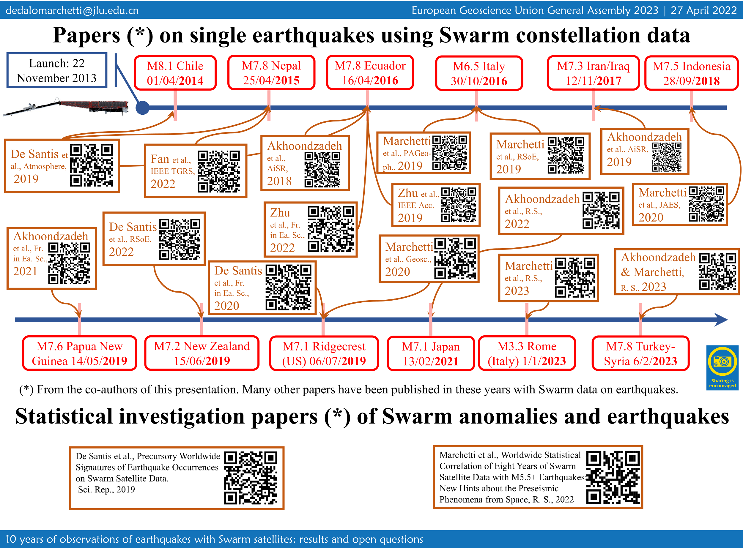
EGU23-5288 | Orals | EMRP2.9

Swarm Electric Field Instruments' Thermal Ion Imagers: A Decade of Discovery 

David Knudsen and Johnathan Burchill

The Swarm mission concept is innovative in its recognition that high-quality measurements of the geomagnetic field from LEO require accurate knowledge of Earth’s plasma environment, and furthermore that combined, precision measurements of fields, plasmas and neutral density from polar orbit provide a new window into ionosphere-thermosphere-magnetosphere (ITM) coupling and science. During the first decade of operations, event-based studies have led to new discoveries such as extreme plasma flows associated with the Birkeland current systems, the electrodynamic structure of multiple auroral arcs, the sub-auroral “STEVE” phenomenon, and the existence of standing Alfvén waves at equatorial latitudes. At the same time, the mission has accumulated an extensive database of measurements at high spatial resolution collected over a wide range of condition covering nearly a full solar cycle; these data have been used in longer-term statistical studies of plasma properties, high-latitude convection and ITM coupling via Poynting flux. As we enter the next decade of operations, the Swarm data are increasingly being used to inform empirical and physics-based models of the ionosphere; these in turn will comprise an important part of the long-term legacy of the Swarm mission. This talk will highlight scientific discoveries from the first decade of EFI operations, centred on observations of ion flows and associated electric fields from the EFI’s Thermal Ion Imagers, and made possible by a large and active community of collaborators. 

How to cite: Knudsen, D. and Burchill, J.: Swarm Electric Field Instruments' Thermal Ion Imagers: A Decade of Discovery, EGU General Assembly 2023, Vienna, Austria, 23–28 Apr 2023, EGU23-5288, https://doi.org/10.5194/egusphere-egu23-5288, 2023.

EGU23-5696 | ECS | Orals | EMRP2.9

On the correlation between electron density and temperature in the topside ionosphere through Swarm satellites data 

Alessio Pignalberi, Fabio Giannattasio, Michael Pezzopane, Igino Coco, and Tommaso Alberti

Electron density (Ne) and electron temperature (Te) observations collected by Langmuir Probes (LPs) on board the European Space Agency’s Swarm satellites are used to characterise the NeTe correlation in the topside ionosphere. The large dataset of Swarm LPs in-situ observations at 2-Hz rate, covering the years 2014−2021, allowed us to investigate the correlation properties of the topside ionospheric plasma for different diurnal and seasonal conditions, with a coverage and a detail never reached before. Spearman correlation coefficients (RSpearman) are calculated on joint probability distributions between Ne and Te for specific conditions. Results are given as maps of RSpearman as a function of the Quasi-Dipole (QD) magnetic latitude and magnetic local time (MLT) coordinates, for different seasons. This study highlights, for the first time, the NeTe correlation at high latitudes, and provides a global description of the corresponding diurnal trend for different seasons. A negative correlation is found at the equatorial morning overshoot, during daytime at mid latitudes, and during night-time at subauroral latitudes (ionospheric trough). Conversely, a positive correlation dominates the night-time sector at mid and low latitudes, and to a minor extent the low latitudes from 09:00 MLT onwards. A seasonal dependence of the correlation is visible only at very high latitudes where the general pattern of anti-correlation is broken around ±75° QD latitude in the summer season.

How to cite: Pignalberi, A., Giannattasio, F., Pezzopane, M., Coco, I., and Alberti, T.: On the correlation between electron density and temperature in the topside ionosphere through Swarm satellites data, EGU General Assembly 2023, Vienna, Austria, 23–28 Apr 2023, EGU23-5696, https://doi.org/10.5194/egusphere-egu23-5696, 2023.

EGU23-5709 | Posters on site | EMRP2.9

Ten years of operation of Swarm's absolute magnetometers, lessons learnt and prospect for the NanoMagSat nanosatellite constellation project 

Gauthier Hulot, Pierdavide Coïsson, Louis Chauvet, Jean-Michel Léger, and Thomas Jager

ESA Swarm satellites carry a magnetometry payload consisting of an absolute scalar magnetometer (ASM), a relative flux gate vector magnetometer (VFM), and a set of star trackers (STR). The primary role of the ASM is to provide precise 1 Hz absolute field intensity measurements, while the VFM and STR provide the additional data needed to accurately reconstruct the vector field. This magnetometry payload has provided a remarkable set of nominal vector data, which has extensively been used for multiple investigations, as illustrated by the many results presented in this session. Each ASM instrument, however, can also produce its own self-calibrated 1 Hz experimental vector data, or, when requested, 250 Hz scalar burst mode. Self-calibrated 1 Hz experimental vector data have routinely been produced ever since launch, and substantial amount of scalar burst mode sessions have now also been run, mostly since 2019, when the decision was made to run such sessions one week per month on both the Alpha and Bravo satellites. In this presentation, we will illustrate the added value both these datasets brought to the Swarm mission, with the self-calibrated 1 Hz experimental vector data contributing to improvement and validation of the nominal dataset, and the burst mode data bringing new science opportunities. We will also discuss the lessons learnt from operating the ASM instruments on Swarm and how these led to the development of an appropriate miniaturized magnetometry payload for the NanoMagSat nanosatellite constellation. This constellation project is currently under development in the context of the ESA Scout program, and aims at a launch in the near future for complementing and enhancing the science return of the Swarm mission.

How to cite: Hulot, G., Coïsson, P., Chauvet, L., Léger, J.-M., and Jager, T.: Ten years of operation of Swarm's absolute magnetometers, lessons learnt and prospect for the NanoMagSat nanosatellite constellation project, EGU General Assembly 2023, Vienna, Austria, 23–28 Apr 2023, EGU23-5709, https://doi.org/10.5194/egusphere-egu23-5709, 2023.

EGU23-6172 | Orals | EMRP2.9

The great potentiality of Swarm three-satellite mission for detecting pre-earthquake ionospheric anomalies 

Gianfranco Cianchini, Angelo De Santis, Massimo Calcara, Saioa A. Campuzano, Serena D'Arcangelo, Mariagrazia De Caro, Domenico Di Mauro, Cristiano Fidani, Adriano Nardi, Martina Orlando, Loredana Perrone, Dario Sabbagh, and Maurizio Soldani

The Swarm three-satellite mission by ESA was initially designed with its original configuration to monitor and study the geomagnetic field and the state of the ionosphere and magnetosphere. For the first time, in 2017, the Swarm satellites detected some pre- and post-earthquake magnetic field anomalies on occasion of the 2015 Nepal M7.8 earthquake. Interestingly, the cumulative number of satellite anomalies and the cumulative number of earthquakes behaved similarly with the so-called S-shape, providing an empirical proof on the lithospheric origin of the satellite anomalies (De Santis et al., 2017; doi:10.1016/j.epsl.2016.12.037). Following the same approach, other promising results were obtained for 12 case studies in the range of 6.1-8.3 earthquake magnitude, in the framework of the SAFE (SwArm For Earthquake study) project funded by ESA (De Santis et al., 2019a; doi:10.3390/atmos10070371). In 2019, almost five years of Swarm magnetic field and electron density data were analysed with a Superposed Epoch and Space approach and correlated with major worldwide M5.5+ earthquakes (De Santis et al. 2019b; doi:10.1038/s41598-019-56599-1). The analysis verified a significant correlation between satellite anomalies and earthquakes above any reasonable doubt, after a statistical comparison with random simulations of anomalies. The work also confirmed the Rikitake (1987) law, initially proposed for ground-based data: the larger the magnitude of the impending earthquake, the longer the precursory time of anomaly occurrence in ionosphere from satellite. A more recent investigation (Marchetti et al. 2022; doi:10.3390/rs1411264) over a longer time series of data, i.e. 8 years, confirmed the same results. Furthermore, we demonstrated in several case studies (e.g., Akhoondzadeh et al. 2019; doi: 10.1016/j.asr.2019.03.020; De Santis et al. 2020; doi:10.3389/feart.2020.540398) that the integration of Swarm satellite data with other kinds of measurements from ground, atmosphere and space (e.g., CSES-01 satellite data) reveals a chain of processes before the mainshocks of many seismic sequences. 

How to cite: Cianchini, G., De Santis, A., Calcara, M., A. Campuzano, S., D'Arcangelo, S., De Caro, M., Di Mauro, D., Fidani, C., Nardi, A., Orlando, M., Perrone, L., Sabbagh, D., and Soldani, M.: The great potentiality of Swarm three-satellite mission for detecting pre-earthquake ionospheric anomalies, EGU General Assembly 2023, Vienna, Austria, 23–28 Apr 2023, EGU23-6172, https://doi.org/10.5194/egusphere-egu23-6172, 2023.

EGU23-6437 | ECS | Orals | EMRP2.9

Ionospheric mid-latitude electron density background definition from CHAMP and Swarm satellite measurements under different solar conditions 

Dario Sabbagh, Alessandro Ippolito, Dedalo Marchetti, Loredana Perrone, Angelo De Santis, Saioa A. Campuzano, Gianfranco Cianchini, and Alessandro Piscini

In this work, a new method to define a background for the topside ionospheric electron density from satellite in-situ measurements is proposed as a useful tool for analysis of plasma density variations at LEO satellites heights. The method is applied to the data acquired by the Langmuir Probes onboard CHAMP satellite during the years 2004 and 2009, and the three Swarm satellites during 2016 and 2017 in the 15°-wide mid-latitudinal belt from 35°N to 50°N, and any longitude. CHAMP/Swarm in-situ measurements have also been used to check and compare such a new defined background with the one computed directly from IRI-2016 electron density output at satellite altitude. A general overestimation of the electron density from IRI during noon hours is highlighted, despite an underestimation of IRI with respect to Swarm-derived background for Swarm 2017 data is found as well, while the two backgrounds result more in agreement during night-time. Finally, the analysis of 2004 plasma data suggests that the IRI-2016 model could be used as a background during periods characterized by high levels of geomagnetic activity under high solar activity conditions.

How to cite: Sabbagh, D., Ippolito, A., Marchetti, D., Perrone, L., De Santis, A., Campuzano, S. A., Cianchini, G., and Piscini, A.: Ionospheric mid-latitude electron density background definition from CHAMP and Swarm satellite measurements under different solar conditions, EGU General Assembly 2023, Vienna, Austria, 23–28 Apr 2023, EGU23-6437, https://doi.org/10.5194/egusphere-egu23-6437, 2023.

EGU23-6558 | Orals | EMRP2.9

Monitoring ionospheric gradients using SWARM satellite data 

M. Mainul Hoque, Norbert Jakowski, Juan Andres Cahuasqui Llerena, Stephan C. Buchert, Martin Kriegel, Paul David, Dmytro Vasylyev, Jens Berdermann, and Klaus Nielsen

The Swarm data products are well-suited to address a number of crucial topics for space weather science and monitoring, such as investigating spatial and temporal characteristics of ionospheric irregularities or improving topside approaches in ionospheric models for monitoring and forecasting the dynamics of the geo-plasma environment. Precision and safety of life applications using trans-ionospheric signals require key information on space weather conditions in particular on the perturbation degree of the ionosphere. Such applications are particularly vulnerable against severe spatial gradients and rapid changes of the electron density (Ne) as well as the total electron content (TEC) measured along different satellite‐receiver links. Here, we propose two new Swarm products 1) the TEC Gradient Ionosphere indeX (TEGIX) and 2) the Ne Gradient Ionosphere indeX (NEGIX). The TEGIX estimates spatial TEC gradients in the topside ionosphere (Swarm up to GNSS orbit) using GNSS Precise Orbit Determination (POD) measurements whereas the NEGIX estimates spatial Ne gradients using Swarm onboard Langmuir probe (LP) measurements (2 Hz sampled).  The approach takes benefit from the coordinated flight of satellites A and C at an orbit height of about 460 km. We will present a first version of both products and will explore their potential impact, utility, and use through case studies.

Acknowledgement:

The work is funded by the MIGRAS (Monitoring of Ionospheric Gradients At SWARM) project under the Swarm DISC Subcontract Doc. no: SW‐CO‐DTU‐GS‐133, Rev: 1.

How to cite: Hoque, M. M., Jakowski, N., Cahuasqui Llerena, J. A., Buchert, S. C., Kriegel, M., David, P., Vasylyev, D., Berdermann, J., and Nielsen, K.: Monitoring ionospheric gradients using SWARM satellite data, EGU General Assembly 2023, Vienna, Austria, 23–28 Apr 2023, EGU23-6558, https://doi.org/10.5194/egusphere-egu23-6558, 2023.

EGU23-6576 | Orals | EMRP2.9

Core surface flow variations derived from observatory and satellite magnetic data 

Vincent Lesur and Guillaume Ropp

A series of models of the Earth magnetic field and core surface flow are presented. The models were derived sequentially from year 1999 to 2022, using magnetic satellite and ground observatory data. A linear Kalman filter approach and prior statistics based on numerical dynamo runs were used. The core field and secular variation models present the same characteristics as the most recent core field models with slightly higher resolution in time. The core surface flow series of models presents large variations at high latitudes and under the western part of the Pacific Ocean. Filtering out the flow variation periods longer than ∼11.5 years leads to a filtered azimuthal flow with ∼7 years periodicities and patterns propagating westward by ∼60o longitude per year. These patterns are present mainly at mid- and equatorial latitudes. They are compatible with a perturbation of the main flow made of small columnar flows with rotation axis intersecting the core-mantle boundary between 10o to 15o latitudes, and flow speed of less than 5km/y. These columnar flows can be identified at all longitudes, but are particularly strong under the Pacific Ocean or under the Atlantic Ocean from 2005 to 2015.

How to cite: Lesur, V. and Ropp, G.: Core surface flow variations derived from observatory and satellite magnetic data, EGU General Assembly 2023, Vienna, Austria, 23–28 Apr 2023, EGU23-6576, https://doi.org/10.5194/egusphere-egu23-6576, 2023.

EGU23-6672 | Posters on site | EMRP2.9

Instruments performance and data quality after 10 years of Swarm in orbit 

Enkelejda Qamili, Roberta Forte, Nicola Comparetti, Lars Tøffner-Clausen, Stephan Buchert, Johnathan Burchill, Christian Siemes, Anna Mizerska, Jonas Bregnhøj Nielsen, Thomas Nilsson, Maria Eugenia Mazzocato, María José Brazal Aragón, Lorenzo Trenchi, Jerome Bouffard, Anja Stromme, Pierre Vogel, and Berta Hoyos Ortega

Launched by the European Space Agency (ESA) in November 2013, the three-satellite Swarm constellation continues to provide very high-quality measurements of the Earth's magnetic field and associated plasma environment. After around 10 years in space the Swarm mission has achieved remarkable scientific results, opening the door for many innovating applications largely beyond its original scope. With this paper, the authors would like to provide a broad overview of the Swarm mission status and Swarm instruments performance. Moreover, the many improvements obtained from the new Swarm data processing baseline together with other innovative Swarm-based data products and services will be presented.

How to cite: Qamili, E., Forte, R., Comparetti, N., Tøffner-Clausen, L., Buchert, S., Burchill, J., Siemes, C., Mizerska, A., Bregnhøj Nielsen, J., Nilsson, T., Mazzocato, M. E., Brazal Aragón, M. J., Trenchi, L., Bouffard, J., Stromme, A., Vogel, P., and Hoyos Ortega, B.: Instruments performance and data quality after 10 years of Swarm in orbit, EGU General Assembly 2023, Vienna, Austria, 23–28 Apr 2023, EGU23-6672, https://doi.org/10.5194/egusphere-egu23-6672, 2023.

EGU23-6799 | Orals | EMRP2.9 | Highlight

Eerie sounds of Earth’s magnetic field 

Klaus Nielsen, Nikolai Linden-Vørnle, Clemens Kloss, and Chris Finlay

In October 2022 an audio installation using Data Sonification methods premiered in Copenhagen. The project was a sonic representation of Earth’s magnetic field played on a 32-channel speaker system dug into the ground of a public square. The project was a massive success – particularly online with close to a million plays on ESA’s SoundCloud and thus proved a great opportunity to showcase the important work in Earth Observation done within the Swarm community.

The audio installation is an artistic representation controlled by magnetic field data through a sonification method called parameter mapping. The output of the 32 speakers was controlled individually by fluctuations in the magnetic field strength at 32 locations on the globe. Data was taken from the GGF100k – a global field model going back 100.000 years – and condensed into a 5-minute sequence composed of 32 different tracks running simultaneously. Six different parameters were mapped to various qualities of the audio playback (volume, pitch, filter, sample playback speed); these included the three components of the magnetic field at the core mantle boundary, the rate of change, and the field average at surface level.

The soundtrack was meant to give the listener an impression of a living planet in constant flux and is build up from recordings of natural sounds in various combinations. This presentation will describe the approach and give a demonstration of the results. In addition, it will briefly discuss data sonification as a method for inclusion and science outreach.

How to cite: Nielsen, K., Linden-Vørnle, N., Kloss, C., and Finlay, C.: Eerie sounds of Earth’s magnetic field, EGU General Assembly 2023, Vienna, Austria, 23–28 Apr 2023, EGU23-6799, https://doi.org/10.5194/egusphere-egu23-6799, 2023.

EGU23-7679 | ECS | Orals | EMRP2.9

Investigating geomagnetic jerks with Swarm: Using the spatial gradient tensor for flow modelling 

Frederik Dahl Madsen, Kathy Whaler, Magnus Hammer, Richard Holme, Will Brown, and Ciarán Beggan

The ESA Swarm mission has, with along- and across-track differences of the magnetic field measurements, made it possible to generate spatial gradients data of the geomagnetic field and its secular variation (SV). Inverting the SV data for core-surface flows allows us to investigate the Earth’s outer core with higher resolution than using vector component data.

We invert for core-surface flow models directly from the spatial gradient tensor SV data, without the use of stochastic or numerical models, imposing flow equatorial symmetry, quasi- or tangential geostrophy, or band-pass filtering. We develop three different types of model, all damped to minimise spatial complexity and minimise acceleration between epochs. The first set is otherwise unconstrained, and different spatial regularisations are used. In the second set, we allow for torsional oscillations by relaxing the temporal damping on certain flow coefficients. The third set has differential damping on the equatorially symmetric and asymmetric flow components, in order to investigate the extent to which asymmetric flow is required to fit the data. We predict the intradecadal variation in length-of-day (LOD) from each model, and find that only the model which allows for torsional oscillations shows a good fit to the LOD data.

The azimuthal acceleration of all three model types shows evidence of fast westward low-latitude waves at the core-surface.  During the 2017 geomagnetic jerk, there is an abrupt westward shift in these wave-features in all our models. Previous literature suggests that geomagnetic jerks may originate from Alfvén wave packets emitted from the inner-outer core boundary, propagating outwards. We suggest that the observed westward shift at the jerk epoch may occur when these wave-packets interfere with the waves at the core surface.

Finally, we consider the use of spatial gradients from the CHAMP mission. Spatial gradients can be derived from along-track differences of the magnetic field from CHAMP, which allows us to compare the quality of core surface flow models from the CHAMP and Swarm missions. Our analysis suggests it is unlikely that CHAMP yields data of sufficient resolution to observe this proposed wave-interaction, showcasing the success of the Swarm mission.

How to cite: Madsen, F. D., Whaler, K., Hammer, M., Holme, R., Brown, W., and Beggan, C.: Investigating geomagnetic jerks with Swarm: Using the spatial gradient tensor for flow modelling, EGU General Assembly 2023, Vienna, Austria, 23–28 Apr 2023, EGU23-7679, https://doi.org/10.5194/egusphere-egu23-7679, 2023.

EGU23-7872 | ECS | Orals | EMRP2.9

Swarm A and C Accelerometer - data analysis and scientific outcome 

Elisabetta Iorfida, Ilias Daras, and Anja Strømme

The ESA Swarm mission was launched in November 2013, and it consists of a constellation of three identical satellites. The main mission objective is to model and analyze the geomagnetic field through the data provided by a vector and a scalar magnetometer on board of each spacecraft (A, B, C).  To fulfill the secondary objectives, the satellites do also carry other instruments, such as an accelerometer expected to measure the non-gravitational forces acting on each satellite. However, the quality of the data retrieved from this instrument was not at the anticipated level and, therefore, the post-processing required to calibrate the signal was significant. Therefore, initially the calibration focused on Swarm C only because it had the best signal-to-noise ratio of the constellation. For this satellite the calibrated accelerometer data are available since the beginning of the mission and they are disseminated bi-monthly. At the end of 2021, the first Swarm A dataset was released and it comprises some months in 2014. Swarm A and C, called the “lower pair”, have flown side-by-side for most of the mission with a separation that spanned from four to ten seconds. Therefore, their measurements are supposed to be nearly identical after calibration.

A recent publication, which is discussed in this talk, demonstrated that a comparison between Swarm A and Swarm C calibrated accelerometer dataset shows the expected correlation. After applying a high-pass filter to both satellites’ dataset, very similar features are visible at the equator and at the poles. The “long time scale” events at the equator show a correlation between the equatorial mass anomaly and the equatorial ionization anomaly. At the poles, the “short time scale” events can be related to the Polar Cap index and to the field-aligned currents, which are measured on board by the Swarm magnetometers. Furthermore, these features agree with previous literature based on CHAMP and GRACE data.

For the first time the Swarm accelerometer data deliver scientific results, in particular in the field of thermosphere and ionosphere coupling.

How to cite: Iorfida, E., Daras, I., and Strømme, A.: Swarm A and C Accelerometer - data analysis and scientific outcome, EGU General Assembly 2023, Vienna, Austria, 23–28 Apr 2023, EGU23-7872, https://doi.org/10.5194/egusphere-egu23-7872, 2023.

EGU23-7914 | ECS | Orals | EMRP2.9

Determining the L-band amplitude scintillation index from Swarm faceplate plasma measurements 

Rayan Imam, Luca Spogli, Lucilla Alfonsi, Claudio Cesaroni, Yaqi Jin, Lasse Clausen, Alan Wood, and Wojciech Miloch

The 16 Hz plasma density measurements provided by the high-resolution faceplate onboard Swarm satellites can be utilized to reconstruct the one-dimensional spectral slope (p) of the power spectrum of the plasma density irregularity. The 16 Hz sampling rate at Swarm orbital features (speed of ~7.5 km/s on quasi-polar orbits) allows modelling spatial scales of about 500 m along the flight trajectory, which are slightly above the first Fresnel zone, the upper limit of the scale sizes of the irregularities causing scintillation on Global Navigation Satellite Systems (GNSS) signals. 

The p-value is a key parameter in estimating the scintillation strength and thus a Swarm ionospheric scintillation (SWIS) proxy is investigated. Such approach, once consolidated, will benefit the scientific community in studying, monitoring and modelling the small-scale irregularities; specially in contexts where ground based GNSS scintillation monitoring is not available, for example over the oceans.

In this work, p-value from Swarm, combined with the reconstruction of the irregularity layer , are ingested to compute the amplitude scintillation index (S4) using Rino’s theory of weak scattering. In this work, the model formulation and sample results of S4 estimation from Swarm are demonstrated. Results of validating SWIS S4 against S4 from ground based GNSS scintillation for selected key ionospheric sectors are also shown. The results demonstrate that the model can capture the amplitude scintillation index inflation both at low and high latitudes, demonstrating the capability of detecting the equatorial and the (rare) polar amplitude scintillation from Swarm measurements. 

How to cite: Imam, R., Spogli, L., Alfonsi, L., Cesaroni, C., Jin, Y., Clausen, L., Wood, A., and Miloch, W.: Determining the L-band amplitude scintillation index from Swarm faceplate plasma measurements, EGU General Assembly 2023, Vienna, Austria, 23–28 Apr 2023, EGU23-7914, https://doi.org/10.5194/egusphere-egu23-7914, 2023.

EGU23-8273 | ECS | Orals | EMRP2.9

Improving Platform Magnetometer Measurements Using Physics-informed Neural Networks 

Kevin Styp-Rekowski, Ingo Michaelis, Monika Korte, Claudia Stolle, and Odej Kao

So-called platform magnetometers, mounted on a variety of non-dedicated satellites in Low-Earth orbit, are promising instruments to increase the spatiotemporal coverage of space-based measurements of the Earth’s magnetic field. However, these instruments often need to be calibrated to ensure a scientific accuracy and usability of the data they collect. To do this, it is important to gather information about the satellite to correct artificial disturbances caused by other payload systems as well as other influencing properties. In the past, we demonstrated that a Machine Learning-based calibration achieves competitive results. By using machine learning techniques, the magnetometer signal can be adapted to account for artificial disturbances and the proposed non-linear regression method can automatically identify relevant features and their crosstalk, enabling the use of a wider range of inputs. This reduces the analytical work required for the calibration of platform magnetometers, resulting in faster, more precise, and easily accessible magnetic datasets from non-dedicated missions. The calibrated datasets are made publicly available.

In this work, we propose an extension for the known approach by incorporating the physical Biot-Savart formula into a neural network, which results in a physics-informed neural network. This improves the modeling and correction of the impact of current-induced artificial magnetic fields on the satellite and its magnetic measurements. In addition, the Average Magnetic field and Polar current System (AMPS) model is combined with the CHAOS-7 model, improving the reference model of the calibration, especially for the polar regions. This extended approach is applied to the GOCE and GRACE-FO satellite missions and their respective measurements. In the future, the underlying software shall be published and applied to a wider variety of satellites to improve the accuracy of their platform magnetometer measurements. By making this tool publicly available, we hope to enable other satellite operators to calibrate their instruments, improve the quality of their data, and make additional data available to the scientific community.

How to cite: Styp-Rekowski, K., Michaelis, I., Korte, M., Stolle, C., and Kao, O.: Improving Platform Magnetometer Measurements Using Physics-informed Neural Networks, EGU General Assembly 2023, Vienna, Austria, 23–28 Apr 2023, EGU23-8273, https://doi.org/10.5194/egusphere-egu23-8273, 2023.

EGU23-8490 | Posters on site | EMRP2.9

A lithospheric magnetic field model to spherical harmonic degree 1300 

Erwan Thebault and Gauthier Hulot

Detailed mapping of the Earth's magnetic field brings key constraints on the composition, dynamics, and history of the crust. Satellite and near-surface measurements detect different length scales and are complementary. However, direct global inversion of a design matrix built with magnetic field measurements locations of near surface and satellite data is numerically intractable at high spatial resolutions.

We apply a procedure developed during the Swarm mission satellite preparation phase to bypass this severe computing issue. We first select the magnetic field measurements during magnetically quiet days of the German CHAMP satellite up to year 2010 and of the ESA Swarm satellites from January 2014 to 31st August 2022. We then build a a complete dataset by combining the selected satellite measurements with the second version of the World Magnetic Anomaly Map; the most globally complete grid of airborne and marine data.

We follow a regional approach for the modelling of the full vector, scalar and gradient dataset. We compute a series of spherical cap harmonic models within 700 overlapping spherical caps tiling the Earth’s sphere. This regional strategy allows us to perform linear inverse problems in parallel using robust procedures, to deal with the Backus effect in equatorial regions, and to assess independently each regional model. The complete procedure is described in Thébault, Erwan, et al. "A Spherical Harmonic Model of Earth's Lithospheric Magnetic Field up to Degree 1050." Geophysical Research Letters 48.21 (2021): e2021GL095147).  We finally transform the series of regional models into a unique set of spherical harmonic (SH) Gauss coefficients. This produces the first global model to SH degree 1300. The new model agrees with previous satellite-based models at large wavelengths and fits the CHAMP and Swarm satellite data down to expected noise levels. Further assessment in the geographical and spectral domains show that the model is stable when downward continued to the Earth's surface.

How to cite: Thebault, E. and Hulot, G.: A lithospheric magnetic field model to spherical harmonic degree 1300, EGU General Assembly 2023, Vienna, Austria, 23–28 Apr 2023, EGU23-8490, https://doi.org/10.5194/egusphere-egu23-8490, 2023.

EGU23-8989 | ECS | Posters on site | EMRP2.9

The polarisation state of transionospheric radio waves detected by RRI on Swarm-E 

Kuldeep Pandey, Robert G. Gillies, E. Ceren Kalafatoglu Eyiguler, Glenn C. Hussey, Donald W. Danskin, and Andrew W. Yau

The Radio Receiver Instrument (RRI) on-board the Swarm-E satellite is used to determine the full polarisation state of transionospheric radio waves. Co-ordinated experiments between ground transmitters and RRI have shown that the detected radio waves can have ellipticity that varies from linearly to circularly polarised when observed poleward of the transmitter at low elevations. Circular polarisation states are expected for waves propagating traverse to the local geometric field; however, these circular states were observed over a much wider range of aspect angles than expected. The present study compares the results of radio transmissions from the Saskatoon SuperDARN radar with a transionospheric radio wave model to estimate the relative strengths of received O- and X-mode waves along the satellite track. At selected low elevations, the X-mode of the radio wave dominates over the O-mode, resulting in a circular ellipticity, although the propagation is not transverse to the magnetic field. This work presents new ways to utilize ellipticity polarisation observations of radio waves to better understand the structure of the ionosphere, complementing Faraday rotation observations which have been extensively used.

How to cite: Pandey, K., Gillies, R. G., Kalafatoglu Eyiguler, E. C., Hussey, G. C., Danskin, D. W., and Yau, A. W.: The polarisation state of transionospheric radio waves detected by RRI on Swarm-E, EGU General Assembly 2023, Vienna, Austria, 23–28 Apr 2023, EGU23-8989, https://doi.org/10.5194/egusphere-egu23-8989, 2023.

EGU23-9101 | ECS | Orals | EMRP2.9

Understanding Ionospheric Conditions using the e-POP on Swarm-E 

E. Ceren Kalafatoglu Eyiguler, Donald W. Danskin, Kuldeep Pandey, Glenn C. Hussey, Robert G. Gillies, and Andrew W. Yau

Swarm-E carries the e-POP payload, which consists of eight scientific instruments. The Radio Receiver Instrument (RRI) on e-POP may be used to detect density structures that modify the characteristics of transionospheric HF radio waves from ground-based transmitters. RRI has a cross-dipole antenna designed to determine the polarisation characteristics of the incident radio waves. Joint experiments with other instruments, IRM (Imaging and Rapid-scanning ion Mass spectrometer) and MGF (Fluxgate Magnetometer), complement RRI for better understanding of the local ionosphere conditions and integrated conditions along the path between a ground-based transmitter and Swarm-E. Under optimum conditions, the RRI determines the full polarisation characteristics. This presentation discusses past and future contributions to ionospheric science of the Swarm constellation.

How to cite: Kalafatoglu Eyiguler, E. C., Danskin, D. W., Pandey, K., Hussey, G. C., Gillies, R. G., and Yau, A. W.: Understanding Ionospheric Conditions using the e-POP on Swarm-E, EGU General Assembly 2023, Vienna, Austria, 23–28 Apr 2023, EGU23-9101, https://doi.org/10.5194/egusphere-egu23-9101, 2023.

EGU23-9113 | Orals | EMRP2.9

Mapping spatio-temporal variations in ionospheric electrodynamics 

Karl Laundal, Jone Reistad, Spencer Hatch, Sara Gasparini, Simon Walker, Michael Madelaire, and Anders Ohma

The Swarm satellites accurately sample electromagnetic fields in-situ along the satellite tracks, but give little direct information about the spatial structures of the field away from the orbit. By making assumptions about temporal variations, in-situ satellite data is nevertheless useful for constructing climatological models that reveal average patterns of electromagnetic fields. Such models help us to understand large-scale average effects of solar wind-magnetosphere-ionosphere-thermosphere coupling, but their information about temporal variations is limited. For specific events, data from single satellites are insufficient for mapping spatio-temporal variations. Here we present a technique for combining Swarm data with measurements of magnetic and electric fields from other satellites, and from ground instruments. The technique, called Local mapping of polar ionospheric electrodynamics (Lompe) relies on the ionospheric Ohm’s law, and knowledge about ionospheric conductance. We discuss the importance of reliable conductance estimates for accurately relating magnetic and electric field observations.

How to cite: Laundal, K., Reistad, J., Hatch, S., Gasparini, S., Walker, S., Madelaire, M., and Ohma, A.: Mapping spatio-temporal variations in ionospheric electrodynamics, EGU General Assembly 2023, Vienna, Austria, 23–28 Apr 2023, EGU23-9113, https://doi.org/10.5194/egusphere-egu23-9113, 2023.

EGU23-9725 | Orals | EMRP2.9

World Digital Magnetic Anomaly Map (WDMAM) v.2.1 and the magnetic signature of geological provinces 

Jerome Dyment, Yujin Choi, Vincent Lesur, Andreina Garcia Reyes, Manuel Catalan, Takemi Ishihara, Tamara Litvinova, and Mohamed Hamoudi

The World Digital Magnetic Anomaly Map is prepared under the auspices of IAGA and the CGMW (Commission for the Geological Map of the World) of UNESCO. A first version was released in 2007 (Korhonen et al., 2007), and a second one in 2015 (Dyment et al., 2015; Lesur et al., 2016) with the mandate to update the version 2.0 using the same methodology when the availability of new data would make it necessary. The present version 2.1, compiled at 5 km interval, at 5 km altitude above the continents and at sea-level over the oceans, includes new datasets: (1) the complete digital aeromagnetic map of Brasil made available by ANP; (2) an improved version of the aeromagnetic map of Russia prepared by V-SEGEI; (3) the second version of the Antarctic Digital Magnetic Anomaly maP (ADMAP; Golynsky et al., 2018) which results from a remarkable international effort during and after the Second International Polar Year; (4) a new map of the Caribbean plate and Gulf of Mexico resulting from the compilation and re-processing of existing marine and aeromagnetic data in the area (Garcia and Dyment, EPSL, 2021, 2022); (5) the updated Magnetic Anomaly Map of Eastern Asia prepared by the CCOP (MAMEA; Ishihara and Uchida, 2021); and (6) a new marine magnetic anomaly data compilation prepared by T. Ishihara and coworkers. The new map will be presented and its improvements over the previous version discussed.

We try to characterize the magnetic signature of the different geological provinces at global scale by comparing WDMAM v.2.1 and the Geological Map of the World (Bouysse et al., 2014, CGMW). The latitudinal and directional dependences of the magnetic anomaly amplitude and shape prevent a direct global comparison. Instead, we examine the distribution of magnetic anomaly amplitudes within the geological provinces continent by continent. We build an histogram of the magnetic anomaly amplitudes for each type of geological province within each studied continent. The histograms resemble normal distributions from which we determine the average amplitude and its standard deviation. The latter reflects how wide is the range of amplitudes in the distribution: a small standard deviation means a narrow distribution and low amplitudes, a large one a wide distribution and high amplitudes. On land, our first investigation suggests that cratons exhibit stronger magnetic anomalies, whereas regions covered by a significant thickness of sediments present weaker anomalies. At sea, large igneous provinces show stronger anomalies, whereas continental platforms and the oceanic crust show similar amplitudes.

How to cite: Dyment, J., Choi, Y., Lesur, V., Garcia Reyes, A., Catalan, M., Ishihara, T., Litvinova, T., and Hamoudi, M.: World Digital Magnetic Anomaly Map (WDMAM) v.2.1 and the magnetic signature of geological provinces, EGU General Assembly 2023, Vienna, Austria, 23–28 Apr 2023, EGU23-9725, https://doi.org/10.5194/egusphere-egu23-9725, 2023.

EGU23-10157 | ECS | Orals | EMRP2.9

Developing the SwarmPAL Python package 

Ashley Smith, Constantinos Papadimitriou, Georgios Balasis, Sebastian Käki, Theresa Hoppe, and Heikki Vanhamäki

SwarmPAL is a new Python package under development with support from Swarm DISC (Data, Innovation, and Science Cluster). This project aims to provide the research community with a suite of tools to rapidly access, analyse, and visualise data from Swarm (and related data sources). By relying on the VirES system [1] for data access and other utilties, this greatly reduces the complexity required within SwarmPAL. By making use of HAPI [2], we can also connect to many other data sources to retrieve data from beyond Swarm. This is part of an overall strategy for integrating with the wider Python (and Jupyter) ecosystem, while being cognisant of the particular scientific landscape occupied by Swarm [3].

SwarmPAL is developed by researchers and research software engineers: this ensures a close fit between the development process and the needs of researchers, as well as fostering software skills within the research community. Through several other DISC activities we bring different research teams together, working on different areas of Swarm science, to collaboratively work on the SwarmPAL system. Namely, these activities currently include the TFA (time frequency analysis), and DSECS (dipolar spherical elementary current systems) toolboxes. These toolboxes provide tools to rapidly and configurably apply analyses to Swarm data, while the SwarmPAL package provides the home for these, together with all the maintenance and documentation that this implies. The development process is made with a strong focus on sustainability and open source [4].

[1] https://vires.services
[2] https://hapi-server.org
[3] https://doi.org/10.3389/fspas.2022.1002697
[4] https://github.com/Swarm-DISC/SwarmPAL

How to cite: Smith, A., Papadimitriou, C., Balasis, G., Käki, S., Hoppe, T., and Vanhamäki, H.: Developing the SwarmPAL Python package, EGU General Assembly 2023, Vienna, Austria, 23–28 Apr 2023, EGU23-10157, https://doi.org/10.5194/egusphere-egu23-10157, 2023.

The project “Characterization of Ionospheric TurbulENce Level by Swarm Constellation (INTENS)”, which was completed in 2021, was a collaboration between two Italian research institutes (INGV and INAF) and the National Observatory of Athens (NOA). It was funded by the European Space and was devoted to the investigation of turbulence and complexity in the ionospheric F2 region using data coming from the Swarm constellation. The obtained results were very intriguing because they provided the first global-scale characterization of the scaling properties of electron density and magnetic field fluctuations at the Swarm altitude as a function of geomagnetic activity and orientations of interplanetary magnetic fields. They also provided the opportunity to quantify changes in the complexity of the magnetosphere-ionosphere coupling system and to comprehend how it reacts to the onset and evolution of intense magnetic storms using entropy measures.

Despite the fact that the INTENS project is no longer active, research continues. The aim of this presentation is to summarize some recent results and to show how turbulence can be one of the most significant processes for the generation of plasma density irregularities which strongly affect the Global Navigation Satellite System. A thorough understanding of turbulent ionospheric fluctuations can be crucial in the future creation of GPS Loss of Lock hazard maps, greatly advancing the effort to minimize the effects of space weather. Any future satellite mission that can accurately measure the magnetic field and electron density at high frequency, as the NanoMagSat mission should be able to, will be necessary to extend the reliability of the results to ever smaller spatio-temporal scales.


How to cite: De Michelis, P.: The project “Characterization of Ionospheric Turbulence Level by Swarm Constellation”: Results and Prospects, EGU General Assembly 2023, Vienna, Austria, 23–28 Apr 2023, EGU23-11583, https://doi.org/10.5194/egusphere-egu23-11583, 2023.

EGU23-12093 | Posters on site | EMRP2.9 | Highlight

Swarm - status after almost 10 years in orbit and the way forward 

Anja Stromme

The three satellite Swarm constellationon is on a mission to unravel our planets invisible shield - the Earths magnetic field, and Swarm is after almost 10 years in orbit still in excellent shape and is still contributing to a wide range of scientific studies  from the core of our planet via the mantle, the lithosphere and out to the ionosphere and the interaction with the Solar wind.


In this talk we will present an update on the status of the Swarm mission, including the health and quality of the spacecrafts , instruments and data products, examples from scientific studies  and outline our plans for the future.

How to cite: Stromme, A.: Swarm - status after almost 10 years in orbit and the way forward, EGU General Assembly 2023, Vienna, Austria, 23–28 Apr 2023, EGU23-12093, https://doi.org/10.5194/egusphere-egu23-12093, 2023.

EGU23-12138 | ECS | Posters on site | EMRP2.9

Convolutional Neural Networks for Automated ULF Wave Classification in Swarm Time Series 

Alexandra Antonopoulou, Georgios Balasis, Constantinos Papadimitriou, Adamantia Zoe Boutsi, Ioannis A. Daglis, and Omiros Giannakis

Ultra-low frequency (ULF) magnetospheric plasma waves play a key role in the dynamics of the Earth’s magnetosphere and, therefore, their importance in Space Weather phenomena is indisputable. Magnetic field measurements from recent multi-satellite missions (e.g., Cluster, THEMIS, Van Allen Probes and Swarm) are currently advancing our knowledge on the physics of ULF waves. In particular, Swarm satellites, one of the most successful missions for the study of the near-Earth electromagnetic environment, have contributed to the expansion of data availability in the topside ionosphere, stimulating much recent progress in this area. Coupled with the new successful developments in artificial intelligence (AI), we are now able to use more robust approaches devoted to automated ULF wave event identification and classification. The goal of this effort is to use a popular machine learning method, widely used in Earth Observation domain for classification of satellite images, to solve a Space Physics classification problem, namely to identify ULF wave events using magnetic field data from Swarm. We construct a Convolutional Neural Network (ConvNet) that takes as input the wavelet spectrum of the Earth’s magnetic field variations per track, as measured by Swarm, and whose building blocks consist of two alternating convolution and pooling layers, and one fully connected layer, aiming to classify ULF wave events within four different possible signal categories: (1) Pc3 wave events (i.e., frequency range 20–100 MHz), (2) background noise, (3) false positives, and (4) plasma instabilities. Our preliminary experiments show promising results, yielding successful identification of more than 97% accuracy. The same methodology can be easily applied to magnetometer data from other satellite missions and ground-based arrays.

How to cite: Antonopoulou, A., Balasis, G., Papadimitriou, C., Boutsi, A. Z., Daglis, I. A., and Giannakis, O.: Convolutional Neural Networks for Automated ULF Wave Classification in Swarm Time Series, EGU General Assembly 2023, Vienna, Austria, 23–28 Apr 2023, EGU23-12138, https://doi.org/10.5194/egusphere-egu23-12138, 2023.

EGU23-12663 | ECS | Orals | EMRP2.9

The High Energy Particle Populations of Earth Mapped by Swarm and MMS 

Christina Toldbo, Matija Herceg, Julia Sushkova, Troelz Denver, Jesper Henneke, Mathias Benn, Peter S. Jørgensen, José M.G. Merayo, Enkelejda Qamili, Berta Hoyos Ortega, Roger Haagmans, Pierre Vogel, Anja Strømme, Seth Shulman, and John L. Jørgensen

The three spacecraft which constitute the Swarm mission are equipped with the Micro Advanced Stellar Compass (μASC) provided by the Technical University of Denmark (DTU) for attitude determination. Each μASC is comprised of three Camera Head Units (CHUs) for a total of nine cameras on the mission. The CCD sensor inside the CHUs are sensitive to energetic particle irradiation which appear as transient bright pixels dubbed ’Energetic Particle Detections’ (EPDs) on the star field images.

For more than five years the μASCs on-board Swarm have transmitted the occurrence of EPDs to ground and thereby effectively added high energy radiation monitoring capabilities to the Swarm mission. The high sensitivity, high sample rate (1-2 Hz), orientation of the camera heads, simultaneous measurements from all three spacecraft and near-polar orbits at an altitude of 450-510 km and allows for continuous and real-time monitoring of the high energy (>65 MeV) proton environment in LEO. This data uncover short and long term changes in particle flux in e.g. the South Atlantic Anomaly (SAA) of relevance for future mission planning.

The same radiation monitoring capability exists on NASA’s Magnetospheric Multiscale Mission (MMS) which, due to its highly elliptical orbit, survey the Van Allen radiation belts and detect enhanced radiation levels in the belts associated with geomagnetic storms. Combining data from the μASCs onboard Swarm and MMS provides unique insight into the injection mechanisms and dynamics of very high energy particles which is currently poorly understood. This work presents observations and results using high energy radiation data obtained from the μASC on board ESA’s Swarm mission, from February 2018 to February 2023, in combination with μASC data from MMS.


How to cite: Toldbo, C., Herceg, M., Sushkova, J., Denver, T., Henneke, J., Benn, M., Jørgensen, P. S., Merayo, J. M. G., Qamili, E., Hoyos Ortega, B., Haagmans, R., Vogel, P., Strømme, A., Shulman, S., and Jørgensen, J. L.: The High Energy Particle Populations of Earth Mapped by Swarm and MMS, EGU General Assembly 2023, Vienna, Austria, 23–28 Apr 2023, EGU23-12663, https://doi.org/10.5194/egusphere-egu23-12663, 2023.

EGU23-14094 | Orals | EMRP2.9

A decade of measurements, which turned Swarm into a lightning hunter 

Ewa Slominska, Marek Strumik, and Jan Slominski

The ESA Swarm mission has been designed to provide high-precision registrations of the Earth's magnetic field. Since its launch, the constellation, consisting of three LEO satellites, measures the magnetic signals coming from Earth's core, mantle, crust, oceans, ionosphere, and magnetosphere. Nearly a decade of Swarm observations, allowed us to expand main goals of the mission and improve our capabilities of detecting magnetic field fluctuations triggered by powerful thunderstorms.

Lightning can generate ultra low frequency fluctuations that leak into the upper ionosphere. This means that some lightning bolts are so powerful that they trigger disturbances in Earth's magnetic field and propagate hundreds of kilometers upwards from the thunderstorm, reaching the altitude of Swarm’s orbit. Thanks to two magnetometers,  the Absolute Scalar Magnetometer ASM and the Vector Fluxgate Magnetometer VFM, Swarm turned into a robust lightning hunter. 

Gathered analysis, utilizing mainly the VFM registrations, show that averaged amplitude of lightning generated fluctuations reaches magnitude of 0.5-1.3 nT (peak-to-peak for the scalar field), while typical time delay between the lightning occurrence and the satellite detection is 0.2-0.5 s and this indicates that Swarm detects rather a direct propagation of lightning-generated disturbance than effects of excitation of the ionospheric Alfvén resonance, which would require a longer time scale.

Since Swarm provides full representations of the magnetic field components, we transform data to the so-called MV frame to extract the maximum amplitude of a given fluctuation regardless of the lightning-satellite mutual orientation and wave polarization. In such a way, Swarm data help to comprehensively characterize  wave properties of detected fluctuations, and this is one of fundamental tasks, especially in the large variety of magnetic field disturbances caused by various types of natural hazard phenomena. 

How to cite: Slominska, E., Strumik, M., and Slominski, J.: A decade of measurements, which turned Swarm into a lightning hunter, EGU General Assembly 2023, Vienna, Austria, 23–28 Apr 2023, EGU23-14094, https://doi.org/10.5194/egusphere-egu23-14094, 2023.

EGU23-14565 | Orals | EMRP2.9

A Swarm-only night-side magnetospheric model to degree and order 3 

Natalia Gomez Perez and Ciaran Beggan
The Swarm mission, launched in November 2013, consists of three identical satellites in near polar orbit dedicated to measuring the Earth's magnetic field to very high accuracy. Two satellites fly at a lower altitude in close orbital proximity while the third flies at a higher altitude producing a steady local time drift. The unique configuration allows a wide set of new models of the various sources of the field to be created from core to magnetosphere. In this study, we separate the magnetic field sources measured at satellite altitude and produce a model of the night-side magnetosphere. This model can be used to study the magnetosphere during storm time to see how it responds to external forcing. Additionally, we observe seasonal variations of the quiet-time configuration. We find good agreement with previous studies during both quiet and storm periods, and we are able to produce these complete models in a timely fashion, making a high-resolution and near real-time characterisation of the magnetosphere configuration possible.

How to cite: Gomez Perez, N. and Beggan, C.: A Swarm-only night-side magnetospheric model to degree and order 3, EGU General Assembly 2023, Vienna, Austria, 23–28 Apr 2023, EGU23-14565, https://doi.org/10.5194/egusphere-egu23-14565, 2023.

EGU23-15082 | Posters on site | EMRP2.9

VirES for Swarm & Virtual Research Environment: Disseminating Swarm data, models, and tools 

Martin Pačes, Daniel Santillan, and Ashley Smith

The VirES service can be described as an ecosystem: the VirES server provides robust API-based access to both data and models derived from Swarm measurements; the VirES web interface provides visual point-and-click access [1]; the viresclient Python package provides the basis for a programmatic workflow and connection to the scientific Python landscape [2]; the Virtual Research Environment (VRE) provides a ready-to-code Jupyter environment to empower researchers to quickly start writing and running code using the latest Python packages [3].

In tandem with the evolution of the Swarm product portfolio, VirES evolves to provide access to and visualisation of new data products as they are published. Beyond this, Swarm activities are shifting away from static data products and toward on-demand processing and tools. We support development and dissemination of such tools in a scientist-led way through the VRE. These take the form of both computational notebooks and of Python packages.

With a growing number of data sources, both Earth-bound and orbital, it is critical to enable easier multi-dataset scientific workflows. At the same time, there is a multiplicity of research software projects, complex to navigate and make use of. We are tackling these issues through adoption of the Heliophysics API specification (HAPI [4, 5]), and coordination with the Python in Heliophysics Community.

[1] https://vires.services
[2] https://viresclient.readthedocs.io
[3] https://notebooks.vires.services
[4] https://hapi-server.org
[5] https://vires.services/hapi

How to cite: Pačes, M., Santillan, D., and Smith, A.: VirES for Swarm & Virtual Research Environment: Disseminating Swarm data, models, and tools, EGU General Assembly 2023, Vienna, Austria, 23–28 Apr 2023, EGU23-15082, https://doi.org/10.5194/egusphere-egu23-15082, 2023.

EGU23-15262 | Posters on site | EMRP2.9

Behaviour of Field Aligned Currents during a geomagnetic storm: Swarm observations 

Lorenzo Trenchi and Nicola Plutino

Field-aligned currents (FACs) flowing from Earth’s outer magnetosphere to the high latitude ionosphere along the geomagnetic field lines, are driven by solar wind and interplanetary magnetic field and allow a direct coupling of Earth’s ionosphere with outer plasma regions. This coupling is strongly enhanced during geomagnetic storms, when the energy transfer from solar wind to inner magnetosphere increases significantly and the ionospheric convection / currents are enhanced as well.

In addition to geomagnetic indexes computed from magnetic perturbations measured from ground-based observatories, also the behaviour of FACs can provide relevant information on energy transfer and coupling mechanisms during geomagnetic storms.

In this work we use data from Swarm satellites, which include very accurate measures of field-aligned currents, to characterize the geomagnetic storm that occurred between the 3rd and the 4th of November 2021.

In particular, we investigated the behaviour of FACs at different spatial scales as a function of solar wind conditions, and in comparison with the main geomagnetic indexes (e.g. the Dst and SYM-H indices). We discuss our findings in the context of main results reported in previous literature.

How to cite: Trenchi, L. and Plutino, N.: Behaviour of Field Aligned Currents during a geomagnetic storm: Swarm observations, EGU General Assembly 2023, Vienna, Austria, 23–28 Apr 2023, EGU23-15262, https://doi.org/10.5194/egusphere-egu23-15262, 2023.

EGU23-15406 | Posters on site | EMRP2.9

Using nine years of Swarm magnetic field observations to estimate ionospheric electric current density through the curl-B technique 

Roberta Tozzi, Tommaso Alberti, Igino Coco, Paola De Michelis, Fabio Giannattasio, Michael Pezzopane, and Alessio Pignalberi

Besides the high resolution of measurements, one feature that distinguishes ESA Swarm mission from previous ones, also aimed at monitoring the Earth's magnetic field at Low Earth Orbit altitudes, is its configuration. We here take advantage of the nine years of geomagnetic field observations from Swarm satellites, to estimate the ionospheric F region current density. Specifically, we estimate the current density between Swarm A and B satellite altitudes, of about 510 and 460 km respectively, by calculating the curl of their Earth's magnetic field components.

This technique was first used in 2015 on a dataset of only seven months of vector magnetic data; because it was not possible to cover the entire local time range at the time, the corresponding mapping of ionospheric current density  was limited to two local nighttime intervals: before and after midnight. Seven years after the first application of this technique, we now use it on a more reliable and larger dataset and map the amplitude of the radial, meridional, and zonal components, as well as the total intensity of the ionospheric current density at all local times.

How to cite: Tozzi, R., Alberti, T., Coco, I., De Michelis, P., Giannattasio, F., Pezzopane, M., and Pignalberi, A.: Using nine years of Swarm magnetic field observations to estimate ionospheric electric current density through the curl-B technique, EGU General Assembly 2023, Vienna, Austria, 23–28 Apr 2023, EGU23-15406, https://doi.org/10.5194/egusphere-egu23-15406, 2023.

EGU23-15810 | Orals | EMRP2.9

Modelling the distribution of intermittent magnetic field fluctuations recorded by the Swarm mission in the polar area 

Peter Kovacs, Balazs Heilig, Zsófia Bebesi, and Andrea Opitz

The almost one decade of operation of ESAs Swarm mission provides an unprecedented opportunity to investigate the appearance of small-scale nonlinear magnetic field irregularities in the topside ionosphere in terms of various climatological and solar-cycle conditions. Within the framework of the EPHEMERIS project supported by ESA we have developed an index for the characterization of the intermittent status of the compressional and tangential (i.e., parallel and perpendicular to the mean background field, respectively) magnetic field fluctuations along the orbits of the Swarm spacecraft triplet. The index is called intermittency index, in short IMI. IMIs are computed for consecutive overlapping segments of Swarm’s magnetic field records by evaluating the deviation of their statistical distribution from the Gaussian distribution. By portraying the global spatial distribution of IMIs, it turns out that the most intensive intermittent fluctuations appear in the polar and equatorial regions, due to auroral field-aligned currents (FAC) and equatorial spread F and plasma bubble phenomena, respectively. Making use of the Adjusted Spherical Cap Harmonic (ASHA) expansion of IMIs, we model the distribution of the intermittent transverse magnetic fluctuations in the polar region in terms of geomagnetic latitude and magnetic local time (MLT), for different geomagnetic activities. We show that the most intermittent fluctuations at high latitudes are distributed about two oval regions that adjoin in the night sector. The ovals expand towards the equator with increasing geomagnetic activity. We argue that the boundaries of the poleward oval coincide with the locations of FACs, while the equatorward oval of intermittent fluctuations (separating from the poleward oval in the noon sector) corresponds to the ionosphere footprint of the plasmasphere boundary, i.e. the plasmapause. These findings are reinforced by independent aurora oval and plasmapause models.

How to cite: Kovacs, P., Heilig, B., Bebesi, Z., and Opitz, A.: Modelling the distribution of intermittent magnetic field fluctuations recorded by the Swarm mission in the polar area, EGU General Assembly 2023, Vienna, Austria, 23–28 Apr 2023, EGU23-15810, https://doi.org/10.5194/egusphere-egu23-15810, 2023.

EGU23-16622 | Posters on site | EMRP2.9

The Swarm Langmuir Probes, Ten Years in Space 

Roberta Forte, Stephan Buchert, Thomas Nilsson, and Enkelejda Qamili

The three-satellite SWARM constellation is a mission by the ESA Earth Observation directorate to provide very high-quality measurements of the
Earth's magnetic field. Also the plasma environment in the topside ionosphere is monitored with Langmuir Probes which together with thermal ion imagers, TIIs, comprise the EFI (electric field instrument). Over ten years the LPs have delivered with near 100 % coverage estimates of ion and electron densities, and electron temperature in the global ionosphere. We present summaries of selected results and scientific achievements, point out some caveats of the data and give an outline of planned enhancements of the LP data products.

How to cite: Forte, R., Buchert, S., Nilsson, T., and Qamili, E.: The Swarm Langmuir Probes, Ten Years in Space, EGU General Assembly 2023, Vienna, Austria, 23–28 Apr 2023, EGU23-16622, https://doi.org/10.5194/egusphere-egu23-16622, 2023.

The ESA Swarm DISC (Data, Innovation, and Science Cluster), a consortium of several research institutions, has been established with a goal of deriving science products by combination of data from the three ESA Swarm spacecraft as well as other spacecraft. Here we present the results of the Comprehensive Inversion (CI) magnetic field modelling by the Swarm DISC team at DTU Space and NASA Goddard. The CI chain takes full advantage of the Swarm constellation by doing a comprehensive co-estimation of the magnetic fields from Earth's core, lithosphere, ionosphere, and magnetosphere together with induced fields from Earth's mantle and oceans using single and dual satellite gradient information from Swarm supplemented by scalar data from the Chinese CSES (China Seismo-Electromagnetic Satellite), the platform magnetometers onboard CryoSat-2, as well as data from ground based magnetic observatories.

How to cite: Tøffner-Clausen, L.: Earth's Magnetic Field Models from Comprehensive Inversion of 9 Years of Swarm, CSES, and CryoSat Data, EGU General Assembly 2023, Vienna, Austria, 23–28 Apr 2023, EGU23-17261, https://doi.org/10.5194/egusphere-egu23-17261, 2023.

EGU23-368 | ECS | PICO | G4.3

Constraining subglacial geology using mutual information inversion of gravity and magnetic data in the Wilkes Subglacial Basin and Transantarctic Mountains of East Antarctica 

Maximilian Lowe, Tom Jordan, Max Moorkamp, Jörg Ebbing, Antonia Ruppel, Nikola Koglin, Chris Green, Mareen Lösing, and Robert Larter

The Wilkes Subglacial Basin hosts potentially the largest unstable sector of the East Antarctica Ice Sheet due to the depth of the ice bed below sea level. Ice covering such basins poses a potentially high, but poorly constrained risk for future sea-level rise, as it is more vulnerable to melting by warming of the surrounding ocean. Such melting could potentially trigger mechanisms of unstable retreat. The neighbouring Transantarctic Mountains are the largest non-contractional mountain range on Earth. Traditionally, the Transantarctic Mountains are viewed as dividing the ancient East Antarctic craton from the younger West Antarctic Rift system. However, petrological samples and previous geophysical mapping suggest that the craton boundary is further west, following the western edge of the Wilkes Subglacial Basin. Subglacial geology influences geothermal heat flow and bed roughness, and therefore to better understand the past, present and possible future behaviour of the East Antarctic Ice Sheet improved understanding of the subglacial geology on which it flows, especially in the Wilkes Subglacial Basin and Transantarctic Mountains region, is important.

We present a new 3D crustal model of the Wilkes Subglacial Basin and the Transantarctic Mountains based on joint inversion of airborne gravity and magnetic data using the mutual information inversion algorithm incorporated in the software JIF3D. Our model shows a large intrusive body located in the interior of the Wilkes Subglacial Basin and suggests a tectonically complex area west of the Basin, which could potentially indicate the transition zone at the margin of the Terre Adélie Craton. Geological units are inferred by clustering of inverted susceptibility and density distribution and are validated against sparse petrological samples from the Transantarctic Mountains region and along the George V Land and Terre Adélie coasts. Our inferred crustal properties model can provide crucial insight into the heterogeneity of subglacial geology in terms of thermal conductivity and crustal heat production, which could influence the geothermal heat flow in this area and therefore make the overlying ice sheet more vulnerable than commonly thought. 

How to cite: Lowe, M., Jordan, T., Moorkamp, M., Ebbing, J., Ruppel, A., Koglin, N., Green, C., Lösing, M., and Larter, R.: Constraining subglacial geology using mutual information inversion of gravity and magnetic data in the Wilkes Subglacial Basin and Transantarctic Mountains of East Antarctica, EGU General Assembly 2023, Vienna, Austria, 23–28 Apr 2023, EGU23-368, https://doi.org/10.5194/egusphere-egu23-368, 2023.

EGU23-684 | ECS | PICO | G4.3

Gravity and magnetic modelling along seismic reflection profiles across the East Shetland Platform (Northern North Sea, UK) 

Mattia De Luca, Paolo Mancinelli, Stefano Patruno, and Vittorio Scisciani

Modelling of potential fields can significantly contribute to the understanding of the subsurface geology, particularly if constrained by field geology, well-data and seismic profiles. This approach becomes crucial to define the subsurface setting when some of such constraints are sparse like in underexplored marine settings. The East Shetland Platform and surrounding basins (i.e. the Dutch Bank Basin, DBB; the East Orkney basin, EOB) are examples of poorly explored areas in the UK Continental Shelf in the northern North Sea. In this area, a laterally discontinuous but locally thick Devonian-to-Tertiary sedimentary succession (up to 7-8 km in thickness) mainly consisting of sandstones, claystones and limestones with locally dolomites and anhydrites, unconformably overlies the Caledonian crystalline basement.

Starting from interpreted seismic profiles, we provide a first-order geophysical characterization through the combined forward modelling of the observed Bouguer gravity and reduced to the pole magnetic anomalies along five regional geological cross-sections. Furthermore, we return an overall tectono-stratigraphic framework of the Devonian-to-Recent sequences and tentatively define the crustal sources for the observed anomalies.

The modelling of the sedimentary sequence was supported by the available few exploration wells data and wireline logging (i.e. lithology, seismic velocity, bulk density) and their geometries were constrained by the time-to-depth conversion of five regional seismic reflection profiles recently acquired and processed.

The first-order contributors to the observed Bouguer gravity anomalies are related to the scattered distribution of the Mesozoic sedimentary sequences. In particular, two gravity lows result from the main Triassic-Jurassic sedimentary successions within the area (i.e. DBB, EOB). On the contrary, the gravity highs are mainly controlled by shallow exposures or structural highs of basement (i.e. Caithness Ridge, Fair Isle Platform) underneath the tertiary cover.

The Caledonian basement and high-susceptibility (up to 0.05 SI units) intrusive bodies are interpreted as the main sources of magnetic anomalies. Such intrusive bodies are modelled both inside the basement and the lower crust. These deeper sources are related with areas of high reflectivity observed in the seismic profiles and could be related to structural paleo-domains connected to the pre-Devonian evolutionary phases of the study area. If confirmed, this interpretation will provide important constraints to the reconstruction of the geodynamic evolution of the area, defining the off-shore extension of the first-order Caledonian and post-Caledonian tectonic lineaments exposed in the Scotland peninsula and surrounding islands.

This integrated forward modelling has proved valuable for the validation of the geometries retrieved after seismic profiles interpretation against the observed gravity and magnetic fields. Furthermore, we provide a more detailed and geologically-consistent reconstruction of the supra-basement sedimentary basins and retrieve location and geometries of the deeper intrusive bodies addressing their nature in the complex geodynamic evolution of the area. Some of such newly defined basins (i.e. the DBB and EOB) could be of interest in the topics of the energy transition and their need further detailed investigations.

How to cite: De Luca, M., Mancinelli, P., Patruno, S., and Scisciani, V.: Gravity and magnetic modelling along seismic reflection profiles across the East Shetland Platform (Northern North Sea, UK), EGU General Assembly 2023, Vienna, Austria, 23–28 Apr 2023, EGU23-684, https://doi.org/10.5194/egusphere-egu23-684, 2023.

EGU23-2629 | PICO | G4.3

Gravimetric network of the Eastern part of the North of Algeria 

yasser bayou, Boualem Bouyahiaoui, Abdeslam Abtout, Mohamed Cherif Berguig, and Rosemary A. Renaut

The northern of Algeria is located between the limit of the African and Eurasian plates. It is known for its geological heterogeneity. This part is experienced with few geophysical data. Among this data, the gravimetric survey can reveal several pieces of information about geological complexity. Although, before any achievement of gravimetric data, it is imperative to perform a gravimetric network. In this work, we present the full steps of implementing the gravimetric network located in the eastern part of the north of Algeria, combined with the processing in detail, using a manual method. The new gravimetric network is situated in the main area of the Guelma basin and its surrounding area (07° 00’; 08° 00 ’E and 36° 00’; 36° 45’N). This network encompasses thirty-nine gravimetric reference stations, linked to the Algerian gravity network. It forms one polygon that is built with 61 triangular loops connected to each other with 99 links. The initiation of the method used, and all stages of the gravity data are described. The average of the gap of gravity values at each station is about 11 µGal. the campaign was carried out using a terrestrial Scintrex CG3 gravimeter. The new gravimetric network of the north eastern part of Algeria is adjusted by means of the ginning method. The principal purpose of the realization of this gravimetric network is to provide a high quality for all future works with respect to the gravimetric studies in the north eastern part of Algeria.

How to cite: bayou, Y., Bouyahiaoui, B., Abtout, A., Berguig, M. C., and A. Renaut, R.: Gravimetric network of the Eastern part of the North of Algeria, EGU General Assembly 2023, Vienna, Austria, 23–28 Apr 2023, EGU23-2629, https://doi.org/10.5194/egusphere-egu23-2629, 2023.

EGU23-4843 | ECS | PICO | G4.3

Apply iTilt-Euler method on the magnetic anomaly at southwest of Penghu. 

Ching Hsu, Shu-Kun Hsu, and Chung-Liang Lo

By checking the magnetic data measured from New Ocean Reacher 3 at 2020/9/21 to 29, we can easily find that there are two anomalies localized south-west of Penghu. In the west, it is located around 119.08°E, 23.46°N and with defect amount 620 nT. The other site is located at 119.34°E, 23.45°N but not as solid as the first one (340 nT).

To understand the magnetic structure below these two sites, this study will use the iTilt-Euler method as the primary method for calculating the depth of these two magnetic anomalies. Before applying iTilt-Euler method, I’ll calculate total horizontal gradient and only use “quality of local maximum” larger than 3 to make sure the input data are around the edge of the source. Following the iTilt-Euler method, we will use the zero-order analytical signal as a constraint to select solutions that are above the structure. Finally, we will use the average of the selected solutions representing the properties of this anomalous site.

After going through the whole process, we discovered that the structure of the western site could be the fault with the top 0.88 km depth and the mean structural index 0.23. And the other site could be the dike, which is 1.8 km depth and has an average structural index of 1.4.

How to cite: Hsu, C., Hsu, S.-K., and Lo, C.-L.: Apply iTilt-Euler method on the magnetic anomaly at southwest of Penghu., EGU General Assembly 2023, Vienna, Austria, 23–28 Apr 2023, EGU23-4843, https://doi.org/10.5194/egusphere-egu23-4843, 2023.

Flexural isostasy is commonly used to understand the relationship between the observed topography, the crustal structure, and the gravity. Compared to local isostasy, flexural models behave like low-pass filters on the crust-mantle interface. Using this methodology different internal structures are revealed showing the geometry of crustal and lithospheric structures. In the current flexure studies it is assumed that the lithosphere has uniform densities. The misfit between this method and the observed gravity data could be used to invert for lateral densities in the lithosphere.  

In this study spectral analysis on the topographic and gravity results from the flexural models is performed to study the effect of lateral variations. For the inversion we use the full tensor of the gravity gradient as they show more sensitivity to the lithosphere structures. The inversion technique is based on spectral kernel models that are able to depict the sensitivity of satellite gravity data. Extensive synthetic analysis is been performed to acquire the best inversion settings and to study the uncertainty of the inversion results with respect to the chosen flexural model. A two-layer lateral density model (crust – upper mantle) is applied to the Sunda Subduction zone to yield more insights into the density structure of the subducting plate.

How to cite: Root, B.: Inversion of the lateral density variations of the lithosphere using the full gravity gradient tensor, EGU General Assembly 2023, Vienna, Austria, 23–28 Apr 2023, EGU23-5562, https://doi.org/10.5194/egusphere-egu23-5562, 2023.

EGU23-6032 | ECS | PICO | G4.3

Modelling 3D subsurface structures using gravity and enhanced gravity gradient method 

Roman Beránek and Jan Mrlina

Keywords: salt structure, gravity inversion, density model

A gravity survey is a good choice to investigate various subsurface structures, including salt domes. We performed numerous gravity survey simulations based on synthetic and analogue geological models, but also on real survey data. We started with forward gravity/density modelling of various shapes of salt diapirs (intrusions), using not only usually measured gravity data, but also gravity gradients. The resulting data mixed with certain levels of noise was then used for the gravity inversion process. We found some limits of sensitivity to selected starting models and extreme significance of the realistic definition of starting models for geologically plausible inversion results.

We applied this experience to real data – we digitized published gravity maps with negative anomalies related to salt structures. Contrary to the publication, we developed a more complex 3D model of the principal salt structure.

Currently, we follow analogue modelling of a simulated salt intrusion process in a laboratory and perform gravity modelling according to the digitized shape of salt (special silicon) intruding homogenous sedimentary (sand) formations.

Besides other methods, we apply 3D deterministic inversion coupled with the estimation of the starting model parameters based on the gravity gradients analysis. These parameters are mainly the dip, depth, and lateral extent. The problem is defined on a discrete rectangular mesh with the possibility of localized refinement to increase or decrease the resolution in certain parts of the model. The results provide a detailed density model of the diapir allowing the estimation of the spatial extent of the salt sheet. The usage of gravity gradients leads to the construction of more reliable starting models of near-surface salt structures for gravity inversion. Our aim is also to achieve a suitable geometrical correlation with magnetotellurics (MT), as such a twin gravity-MT response for various types of salt structures may encourage the application of such twin geophysical methodology.


How to cite: Beránek, R. and Mrlina, J.: Modelling 3D subsurface structures using gravity and enhanced gravity gradient method, EGU General Assembly 2023, Vienna, Austria, 23–28 Apr 2023, EGU23-6032, https://doi.org/10.5194/egusphere-egu23-6032, 2023.

EGU23-6315 | ECS | PICO | G4.3

Sub-surface characteristics of pop-up tectonics through field gravity and magnetic modelling: An example of the Shillong Plateau, NE India 

Suvankar Samantaray, Priyank Pathak, William Kumar Mohanty, and Saibal Gupta

The Shillong Plateau (SP) in NE India is one of the most debatable proterozoic basement in the world due to its complex tectonics. Though it had some collisional histories during the formation of the Gondwanaland associated with the Indo-Australo-Antarctic suture, but the signature of crustal and moho depth models gives a different idea about the modified crust under the SP. Despite its peak elevation at around 2000 m, the moho depth observed from the seismic tomography and satellite gravity data under the SP is not more than 34 km, which is remarkably smaller than the surrounding Bengal basin (⁓44 km) and the Brahmaputra basin (⁓44 km). We have tried to solve the problem related to the moho variation, taking into account the field gravity and magnetic anomaly. The major trends in the gravity anomaly predominant along EW direction conforming to the trends of regional geological structures across most of the SP. As our study area concentrates along an NS profile across two different litho units restricted to the central part of the plateau. The corrected field magnetic anomaly across the study area has a little variation between 0 to -500 nT, although some change in anomaly pattern can be seen along the northern side of the SP reaching towards -3500 nT. Moreover, the southern side of the plateau has very little magnetic anomaly variation. The bouguer gravity anomaly varies from ⁓ -70 mGal at the northern boundary to ⁓ +10 mGal with a steep gradient found across the southern side. The gradual change over to positive anomaly under SP, strong -ve anomaly under the Brahmaputra basin to the north and moderate negative anomaly under the Bengal basin towards the south suggested an uplifted moho under SP, which is demonstrated by the 2D gravity modelling. Closely spaced bouguer anomaly contours along the southern part and EW trending magnetic anomaly along the northern part of the SP, indicating two boundary faults viz. Oldham fault/ Brahmaputra valley fault in the North and Dauki fault in the south, dipping towards each other supported the SP for the formation of the pop-up tectonics.

How to cite: Samantaray, S., Pathak, P., Mohanty, W. K., and Gupta, S.: Sub-surface characteristics of pop-up tectonics through field gravity and magnetic modelling: An example of the Shillong Plateau, NE India, EGU General Assembly 2023, Vienna, Austria, 23–28 Apr 2023, EGU23-6315, https://doi.org/10.5194/egusphere-egu23-6315, 2023.

EGU23-8177 | PICO | G4.3

Density and magnetic architecture of the Gurghiu Mountains volcanoes as inferred from geophysical data 

Lucian Besutiu, Luminita Zlagnean, Anca Isac, and Dragomir Romanescu

The paper is mainly aimed at presenting some results of the geophysical investigations focused on the Gurghiu Mountains volcanism.

The Gurghiu Mountains are located in the central inner (western) part of Eastern Carpathians, Romania. They represents the middle segment of the approx. 160 km long Neogene to Quaternary volcanic chain Călimani-Gurghiu-Harghita (CGH), the southeastern end of the magmatic arc adjoining the Carpathians from Slovakia to Romania. CGH is a typical andesite-dominated calc-alkaline volcanic range. As part of it, Gurghiu Mountains exhibits (with minor exceptions) monotonous volcanic rocks, clearly dominated by andesites and pyroxene andesites.

Several years ago, CGH volcanism was subject to research within a specific project funded by the Romanian National Agency for Scientific Research. During the project, gravity and geomagnetic investigations were conducted in the Gurghiu Mountains areal to help unveiling the composition and structure of the volcanic edifices. Thus, consistent gravity and geomagnetic data sets over the studied area were obtained. Furthermore, various data mining techniques (e.g., Bouguer anomaly for various reference densities, geomagnetic and reduced-to-the-pole geomagnetic anomaly, regional-residual separation through upward/downward continuation and/or polynomial regression, high-order derivatives) were applied in order to create more intuitive images helping in the qualitative interpretation of the geophysics results.

In a second stage, quantitative approaches were employed for unveiling the hidden structure of the shallow part of the crust. Consequently, 2D and 3D models of the density and magnetic structure of the main volcanic forms in the area (e.g., Fâncel-Lăpusna caldera, Seaca-Tătarca, Sumuleu and Ciumani-Fierăstraie crater areas) were inferred from joint inversion of gravity and geomagnetic data.

Finally, based on the inversion results, attempts to construct 3D models of the shallow crust architecture were made by employing the forward modelling approach under constraints provided by rock physics studies and exploration wells.


Key words:  gravity, geomagnetism, density, magnetic susceptibility, inversion, forward modelling, volcanism, Gurghiu Mountains, Eastern Carpathians

How to cite: Besutiu, L., Zlagnean, L., Isac, A., and Romanescu, D.: Density and magnetic architecture of the Gurghiu Mountains volcanoes as inferred from geophysical data, EGU General Assembly 2023, Vienna, Austria, 23–28 Apr 2023, EGU23-8177, https://doi.org/10.5194/egusphere-egu23-8177, 2023.

Lithological interpretation of remote sensing and geophysical data plays a vital role in mineral resource mapping, especially in areas of the limited outcrop. This study applied a Random Forest (RF) classifier to obtain the refined lithological map of the Mundiyawas-Khera mineralized belt of the Alwar basin, India, from remote sensing and potential field data. A total of 540 samples covering the major lithologies were fed to RF for training (80%) and testing (20%), and its performance was evaluated using precision, recall, and accuracy. The degree of uncertainty associated with RF was also computed using the information entropy technique to pinpoint the regions where the refined lithology map is incorrectly classified. The results indicate that RF yields an overall accuracy of 73.15% in classifying all the major lithological units in the region, such as felsic volcanic, carbon phyllite, mica schist, quartzite, and tremolite-bearing dolomite. Among all the five lithologies, RF showed the best precision (84.62%) and recall (90.91%.) for quartzite and M-mica schist respectively and comparable precision/recall values for the felsic volcanic rocks that host Cu mineralization. Whereas other lithologies, dolomite and carbon phyllite, were not accurately predicted by RF, which might be due to the limited number of samples. The results of the class membership probabilities indicate that not all the litho-units predicted by the model are absolute. The study illustrates that RF can be used as a viable alternative in regions with limited outcrops and geochemical information to prepare the new lithology map or refine the existing geological maps. 

Keywords: Machine Learning, Lithology Classification, Gravity and Magnetic Data

How to cite: Singh, B. K. and Rao, G. S.: Random Forest classifier for lithological mapping of the Mundiyawas-Khera mineralized belt of the Alwar basin, India, from remote sensing and potential field data, EGU General Assembly 2023, Vienna, Austria, 23–28 Apr 2023, EGU23-8232, https://doi.org/10.5194/egusphere-egu23-8232, 2023.

In practical problems concerned with an exploration of geological mineral resources, to enhance the resolution for its geological interpretation, downward continuation of the gravity anomaly is usually performed, as downward continuation can highlight local and shallow gravitational sources related to the ore body, which plays a very important role in the following processing and interpretation of gravity data. However, downward continuation is an ill-posed issue and has been a research topic for gravity exploration.

General classical methods for the downward continuation of gravity anomalies mainly include spatial-domain methods, of which, however, their convolution calculations are complicated; frequency-domain methods, the product calculations by Fourier transform from spatial-domain convolution, according to which not only do downward continuation factors have amplification effects, but also errors from the discretization and truncation of the Fourier transform cause oscillations in results. Improved methods, such as regularization filtering methods and generalized inverse methods, according to which although the stabilities of these downward continuations are improved, their downward continuation depths are not significant (generally no more than 5 times the measured interval); the integral iteration method, according to which stable results can be achieved for noise-free data and the depths of its downward continuation are large, but its number of iteration is giant, resulting in the reducing of computational efficiency and the accumulation of noises; Adams-Bashforth methods and Milne methods established by numerical solutions of the mean-value theorem, according to which they are easy to calculate and with greater depth of downward continuation (more than 15 times the measured interval). However, measured vertical derivatives are needed use to improve their accuracy.

As the coverage of measured vertical derivatives is low and their costs are high in real gravity explorations of geological mineral resources, which means it is not always possible to utilize measured vertical derivatives. To widen the real application for downward continuation methods of numerical solutions, instead of the measured vertical derivatives, we use the calculated ones by the ISVD (integrated second vertical derivative) method. At the same time, to improve the accuracy of the result using calculated derivatives, we present two new methods, Adams-Moulton and Milne-Simpson, based on implicit expressions of numerical solutions of the mean-value theorem for gravity anomaly downward continuation. These two methods have mathematical significance for improving the accuracy of numerical solutions. To demonstrate their effectiveness, we compare these four methods for downward continuation in the same degree including an Adams-Bashforth method, a Milne method, an Adams-Moulton method and a Milne-Simpson method by texting on the synthetic and real data of gravity exploration. The results show that the two implicit methods have higher accuracy, which has practical significance for the resolution improvement of gravity anomaly downward continuation in exploration interpretation.

How to cite: Zhang, C., Qin, P., Yan, J., Chen, L., and Wu, L.: Two new methods for gravity anomaly downward continuation based on implicit expressions of numerical solutions of mean-value theorem and their comparison, EGU General Assembly 2023, Vienna, Austria, 23–28 Apr 2023, EGU23-8713, https://doi.org/10.5194/egusphere-egu23-8713, 2023.

EGU23-11094 | PICO | G4.3

Mediterranean Sea Crustal Structure from Potential Fields, Results of XORN Project 

Daniele Sampietro, Martina Capponi, Erwan Thébault, and Lydie Gailler

The Mediterranean Sea crust has been intensely studied both for scientific reasons and for economic activities such as natural resources exploration and exploitation. However, a complete high-resolution numerical model of the crust over the whole region is still missing. In fact, from the one hand, we have global crustal models, which however are usually too coarse to accurately describe this complex area, while on the other hand we have continental scale models, which are obtained by merging different datasets, without an homogeneous analysis.

In the current study we perform a joint inversion of gravity and magnetic field measurements, constrained with seismic profiles, on the whole Mediterranean Sea Area with a spatial resolution of about 15 km in the planar direction and ranging from 200 m to 1200 m in the vertical one, for a total of more than 2-million cells.

The inversion has been carried out within the XORN project (https://xorn-project.eu/) funded by the European Space Agency. The result of the study is a complete three-dimensional (3D) model of the crust beneath the Mediterranean Sea region in terms of density and magnetic susceptibility distributions and geological horizons, completed by an estimate of the predicted accuracy.

Several maps, such as depth of main geological horizons (namely the base of Plio-Quaternary and Messinian sediments, the basement, the Curie isotherm, and the Moho), have been derived, from the 3D model.

The model has been validated through comparisons with local studies, seismic information, heat flow data not used within the inversion.

How to cite: Sampietro, D., Capponi, M., Thébault, E., and Gailler, L.: Mediterranean Sea Crustal Structure from Potential Fields, Results of XORN Project, EGU General Assembly 2023, Vienna, Austria, 23–28 Apr 2023, EGU23-11094, https://doi.org/10.5194/egusphere-egu23-11094, 2023.

EGU23-11137 | PICO | G4.3

New Late Cretaceous and Central Atlantic Magmatic Province magmatic sources off West Iberia revealed by from high-resolution magnetic surveys on the continental shelf 

Pedro Terrinha, Marta Neres, João Noiva, Pedro Brito, Marcos Rosa, Luis Batista, and Carlos Ribeiro

This work investigates the existence and tectonic control of magmatic bodies in the continental shelf of the SW Iberia margin. Magnetic data were densely acquired for a total area of ~4400 km2 and carefully processed. Our new maps reveal a complex magnetic anomaly field, where distinct zones are defined based on the anomaly distribution. A wide number and variety of magmatic bodies are interpreted, from >10 km-scale deeply intruded plutons to small plug-like and dike-like intrusions. Interpretation of magnetic results together with bathymetry and seismic reflection data allows discussing the geometry, extension, and age of the magmatic sources and inferring the faults of fault systems related to their intrusion. The Cabo Raso complex is a densely intruded zone related to the Late Cretaceous alkaline event. The Sines complex comprises the known offshore prolongation of the on-land Sines magmatic rocks but also the newly mapped Côvo and Milfontes anomalies. Côvo is the largest magmatic intrusion recognized in West Iberia. Milfontes intrudes the non-rifted Paleozoic crust and is the first known evidence of a plutonic source of the Central Atlantic Magmatic Province (CAMP) in Iberia. The geographical distribution and geometry of the magmatic bodies are mostly controlled by the crustal tectonic fabric inherited from the Paleozoic Variscan orogeny, which was re-worked during the Mesozoic rifting and the Cenozoic Alpine collision. The magmatic bodies modify the rheological structure of the crust and may affect the strain localization during the Alpine collision and recent tectonics.

This work allowed for mapping not only unknown plutons of Mesozoic age but also to define the eastern limit of the West Iberia Late Cretaceous Alkaline Province (WILCAP), which together with the Madeira-Tore Rise north of the Africa-Eurasia plate boundary cover an area equivalent to a Large Igneous Province (LIP).


This work was funded by the Portuguese Fundação para a Ciência e a Tecnologia (FCT) I.P./MCTES through national funds (PIDDAC) – UIDB/50019/2020- IDL

How to cite: Terrinha, P., Neres, M., Noiva, J., Brito, P., Rosa, M., Batista, L., and Ribeiro, C.: New Late Cretaceous and Central Atlantic Magmatic Province magmatic sources off West Iberia revealed by from high-resolution magnetic surveys on the continental shelf, EGU General Assembly 2023, Vienna, Austria, 23–28 Apr 2023, EGU23-11137, https://doi.org/10.5194/egusphere-egu23-11137, 2023.

EGU23-14551 | ECS | PICO | G4.3

Lithospheric modeling in Iran and the Arabian Peninsula from gravity data including seismic tomographic data: first results. 

Gerardo Maurizio, Carla Braitenberg, Daniele Sampietro, and Martina Capponi

In this presentation we want show our lithosphere density model of a Middle East area encompassing Iran and the Arabian Peninsula, realized through a Bayesian inversion applied to an optimized density model. The starting model used for the inversion was obtained converting seismic velocities interpolated from local and global tomographies and converted in densities using a simplified version of the Brocher’s relation for velocity-to-density conversion, recalculating new coefficients for the relation. This optimization was realized following a Least Squares method, inverting global gravity field data. The model was divided into five parts: water, sediment, crust, mantle, and a separate crustal layer was defined in the Red Sea zone. Specifically, the Moho depth was obtained using the vertical velocity gradient method as presented in Tadiello and Braitenberg (2021), except for the southeastern zone along the Red Sea suture, which had strong velocity anomalies at the surface, and we relied on those to model a faster intrusive body within the crust, while estimation of the density distribution in the mantle was obtained using Perple_X software.  We present the final density model, resulting from the inversion, and discuss it in terms of intra-crustal densification and relation to surface magmatic outcrops, finding that correlations can be identified. These demonstrate the presence of deep-seated crustal density variations which relate to geological provinces identified from surface investigations. A further point to discuss is the rheological properties obtainable from the joint velocity and density model and the relation to the inhomogeneous distribution of seismicity.

How to cite: Maurizio, G., Braitenberg, C., Sampietro, D., and Capponi, M.: Lithospheric modeling in Iran and the Arabian Peninsula from gravity data including seismic tomographic data: first results., EGU General Assembly 2023, Vienna, Austria, 23–28 Apr 2023, EGU23-14551, https://doi.org/10.5194/egusphere-egu23-14551, 2023.

EGU23-15641 | PICO | G4.3

New insights on the ultramafic intrusions surrounding the Kunene Anorthosite Complex (SW Angola) from gravity, magnetic and radiometric data 

Patrícia Represas, Pedro Sousa, Igor Morais, Domingos Cordeiro, João Carvalho, Maria João Batista, Manuel Dito, José Maria Llorente, Fábio Marques, Teodora Mateus, José Feliciano Rodrigues, José Luis Lobón, and Daniel Oliveira

The Kunene Anorthosite Complex (KAC), located in SW Angola, is one of the largest anorthosite structures in the world. Dating from the Mesoproterozoic, its installation process is still not clear. Several mafic and ultramafic outcrops can be found surrounding the KAC. Once considered related with its emplacement, the study of these bodies may help us understand the history of this unique geological feature. While geochronological data show that they are synchronous, or possibly a bit younger, than the embedding granites and migmatites of Paleoproterozoic age, the question arises of whether they are intrusions installed in the host rock or if they are instead recycled remains of older Arch crust. The development of these outcrops in depth provides relevant clues regarding the origin of these bodies and their relationship with the Eburnean (~1.93-2.04 Ga) and Epupa-Namibe (~1.83-1.74 Ga) events. One of these mafic outcrops, designated the Hamutenha outcrop (Huíla Province) exhibits an elongated shape and a NW-SE orientation and is characterized by an internal zonation.  Generally, the innermost part is composed of ultramafic rocks of (mostly harzburgites and dunites), with diorites outcropping in its NW and SE borders. The Hamutenha outcrop was previously identified for potentially bearing Cr, Ni and PGE mineralization.

Therefore, the aim of this study is two-fold. Firstly, it attempts to determine the development at depth of the mafic body to better understand its origin. Secondly, it tries to clarify the emplacement mechanisms responsible for the potential mineralization and to evaluate the likelihood of its economic potential. Aeromagnetic and ground gravimetric data acquired in the framework of project PLANAGEO (National Geology Plan for Angola) of which the National Laboratory of Energy and Geology (Portugal) was one of the partners, was used to create a magnetic vector model and a density contrast model of the Hamutenha body. These 3D models were interpreted in combination with the detailed geological observations and aeroradiometric data also from the PLANAGEO project, providing new insights on the underground lithological differentiation and geometry of this geological structure.

How to cite: Represas, P., Sousa, P., Morais, I., Cordeiro, D., Carvalho, J., Batista, M. J., Dito, M., Llorente, J. M., Marques, F., Mateus, T., Rodrigues, J. F., Lobón, J. L., and Oliveira, D.: New insights on the ultramafic intrusions surrounding the Kunene Anorthosite Complex (SW Angola) from gravity, magnetic and radiometric data, EGU General Assembly 2023, Vienna, Austria, 23–28 Apr 2023, EGU23-15641, https://doi.org/10.5194/egusphere-egu23-15641, 2023.

EGU23-16138 | PICO | G4.3

Accretionary orogen unveiled beneath the Gamburtsev Sublglacial Mountains in East Antarctica 

Guochao Wu, Fausto Ferraccioli, Jinyao Gao, and Gang Tian

The Gamburtsev Subglacial Mountains (GSM) in central East Antarctica are  completely buried beneath the East Antarctic Ice Sheet. The GSM are known to be underlain by anomalously thick crust (~50–60 km) and ~200 km thick Precambrian lithosphere, but their crustal-scale geology remains less well- studied. Little is known about the 3D heterogeneity in crustal architecture beneath the GSM, and how this may relate to larger-scale tectonic processes responsible for Gondwana amalgamation.

Here, we use airborne gravity and aeromagnetic anomalies to explore the crustal architecture of the GSM in unprecedented detail. The gravity and magnetic images show three distinct geophysical domains, and a dense lower crustal root is modelled beneath the northern and central domains. We propose that the root may reflect magmatic underplating, associated with Pan-African age back-arc basin formation and inversion, followed by the collision of Australo-Antarctica and Indo-Antarctica. The high frequency linear magnetic patterns parallel to the Gamburtsev Suture zone, suggest that the upper crustal architecture is dominated by thrust and strike-slip faults, formed within a large-scale transpressional fault system.

We calculated a 2D gravity and magnetic model along a passive seismic profile to investigate the crustal architecture of the GSM, with the aid of depth to magnetic source estimates.   By combining the crustal model with  geological constraints, we propose a new evolutionary model suggesting that the crust of the northern and central GSM domains formed part of a cryptic accretionary orogen, of proposed Pan-African (~650-550 Ma?) age. The inferred accretionary stage was followed by continental collision (~540-520 Ma?) along the Gamburtsev suture, which is linked here to Gondwana amalgamation.

How to cite: Wu, G., Ferraccioli, F., Gao, J., and Tian, G.: Accretionary orogen unveiled beneath the Gamburtsev Sublglacial Mountains in East Antarctica, EGU General Assembly 2023, Vienna, Austria, 23–28 Apr 2023, EGU23-16138, https://doi.org/10.5194/egusphere-egu23-16138, 2023.

The western part of the Anatolian peninsula is defined with an N-S extensional regime and resulting graben systems, referred as the Aegean Extensional Province (AEP). The transition of this extensional regime in the west to E-W compressional regime in the east is bounded by the Isparta Angle, which is a reverse v-shaped major structure developed due to nappe emplacements and related clockwise and counter-clockwise rotations.

The study area is located at the eastern end of the Curuksu Graben and covers the western part of the Acigol Graben. Curuksu Graben is part of the Denizli Horst-Graben system and located between the junction point of three major grabens of the AEP in the west and Acigol Graben in the east. The development of the Graben systems in the AEP, including Curuksu and Acigol grabens, is resulted from two extensional periods interrupted by a compressional phase creating a disconformity between deformed ancient and undeformed neotectonic graben fills in the region. Denizli Horst-Graben System consists of incipient grabens and the modern graben (Curuksu Graben) which is developed with the introduction of the neotectonic regime with the latest Pliocene. This episodic development caused an inward development of normal faults. The compressional regime created many strike-slip and reverse faults in the region while many of the currently active normal faults with strike-slip components are resulted from the present day NNE-SSW extensional phase, including seismically active margin-bounding major faults with seismic hazard potential.

In this study, we have reassessed the data from 300 Magnetotelluric stations which were previously collected by a private contractor for geothermal research purposes. We have investigated the main properties of the data with Phase Tensor analysis and inverted it using ModEM software to reveal 3D subsurface conductivity structure of the area. Our analysis shows that the Phase Tensor ellipses for the highest frequencies indicate rather 1D behavior in compliance with the undeformed, nearly horizontal bedding of the neotectonic graben fills. The strike directions obtained through induction vectors and Phase Tensor ellipses reflects the dominant effect of the major faults and conductive basin fills. The recovered model from the 3D inversion results show the depth of the basin fills and conductivity anomalies due to normal faults controlling the basin development.

How to cite: Karcioglu, G., Turkoglu, E., and Avsar, U.: Resistivity structure of Denizli Çürüksu & Acıgöl Graben connection: Preliminary results from 3D inversion of magnetotelluric data, EGU General Assembly 2023, Vienna, Austria, 23–28 Apr 2023, EGU23-347, https://doi.org/10.5194/egusphere-egu23-347, 2023.

EGU23-1514 | Orals | EMRP2.12

High-performance electromagnetic mapping in the exascale era 

Octavio Castillo Reyes and Pilar Queralt

Electromagnetic imaging has been perfected to investigate the subsurface over the past three decades. Developing numerical schemes, algorithms, and easy access to supercomputers have supported innovation throughout the geo-electromagnetic community. Now, with the Exascale computing era dawning upon us, even more accurate, clearer, and faster data will be within our reach. However, numerical methods, computational strategies, and codes must be reshaped and honed to prepare for the upcoming challenges. Europe is making a huge effort in the strategic global race to Exascale, with large investments in the infrastructure. From the point of view of science and services, this unprecedented infrastructure opens a myriad of possibilities but, at the same time, the transition is challenging and requires a joint effort from (geo)scientists, mathematics, software engineers, and data analysts. Herein, we discuss the symbiotic relationship between numerical methods and computational strategies for EM imaging in the Exascale era. We focus on the need to explore all the alternatives of technologies, applications, and expertise transfer to propel the high-performance electromagnetic mapping landscape forward.

How to cite: Castillo Reyes, O. and Queralt, P.: High-performance electromagnetic mapping in the exascale era, EGU General Assembly 2023, Vienna, Austria, 23–28 Apr 2023, EGU23-1514, https://doi.org/10.5194/egusphere-egu23-1514, 2023.

EGU23-4212 | ECS | Posters on site | EMRP2.12

Enormously large tippers observed in South-West of China. Can realistic 3-D modeling reproduce them? 

Shan Xu, Chaojian Chen, Alexey Kuvshinov, Mikhail Kruglyakov, Rafael Rigaud, and Xiangyun Hu
Vertical magnetic transfer functions (tippers) observed at a global/continental net of geomagnetic observatories can be used to image the electrical conductivity structure of the Earth down to a depth of around 200 km. We estimated tippers at 54 geomagnetic observatories across China, aiming eventually to invert them in terms of subsurface three-dimensional (3-D) conductivity distribution. Strikingly, we obtained enormously large tippers at three inland observatories in southwest China. Large tippers are often observed at coastal observatories due to the high lateral conductivity contrast between resistive continental bedrock and conductive seawater. However, tippers at those mentioned above observatories appeared to be a few times larger than coastal tippers. Moreover, as far as we know, such large tippers (reaching value 3) were never reported in any region of the world. We perform 3-D electromagnetic simulations mimicking the geological setting of the region and demonstrate that the enormously large tippers are feasible and can be attributed to a current channelling.


How to cite: Xu, S., Chen, C., Kuvshinov, A., Kruglyakov, M., Rigaud, R., and Hu, X.: Enormously large tippers observed in South-West of China. Can realistic 3-D modeling reproduce them?, EGU General Assembly 2023, Vienna, Austria, 23–28 Apr 2023, EGU23-4212, https://doi.org/10.5194/egusphere-egu23-4212, 2023.

EGU23-5006 | ECS | Posters on site | EMRP2.12

Counteracting sensitivity accumulation near source and receiver locations in 3D inversion of controlled-source electromagnetic data 

Paula Rulff, Thomas Kalscheuer, and Dominik Zbinden

We present a synthetic inversion study illustrating two approaches which help to deal with heterogeneous sensitivities in 3D frequency-domain controlled-source electromagnetic inverse problems.

Using edge-based vector finite-element approximations on tetrahedral meshes and a preconditioned non-linear conjugate gradient algorithm, we invert for impedance tensor elements generated by a set of two coincident perpendicularly oriented horizontal electric or horizontal magnetic dipole sources. Depending on the number and locations of sources and the choice of impedance tensor components used for inversion, the sensitivity patterns can differ significantly. Measurement setups with a small number of sources, but many receiver stations at the surface covering near-field, transition zone and far-field, are often deployed for land-based controlled-source electromagnetic measurements. Such a setup can result in accumulated sensitivities close to the sources and receivers, which implies strongest model updates in these regions and can mislead the inverse algorithm to a search direction, where no physically meaningful model can be produced nor the data are fitted.
 
In order to mitigate the influence of strong sensitivities near sources and receivers on the inversion process, we apply an efficient preconditioner and customisable weights in the model regularisation matrix. The preconditioner is updated with the Broyden-Fletcher-Goldfarb-Shanno algorithm using the diagonal of the approximate Hessian matrix as start preconditioner. The latter is computationally expensive to obtain, but aims at finding a favourable search direction for the inverse algorithm already in early iterations and distributing the model update more evenly in the domain. To account for the sensitivity loss with depth, we implemented a depth weighting functional in the model regularisation term. The approach is based on counteracting the exponential and geometrical decay of the electromagnetic fields with depth and distance from the sources. In practical, we increase the smoothing in the shallow part of the model close to the source locations, where no structure is expected. We present synthetic examples indicating that this approach is an efficient way of helping the inversion to converge, obtaining a reliable model and resolving structure at depth.

How to cite: Rulff, P., Kalscheuer, T., and Zbinden, D.: Counteracting sensitivity accumulation near source and receiver locations in 3D inversion of controlled-source electromagnetic data, EGU General Assembly 2023, Vienna, Austria, 23–28 Apr 2023, EGU23-5006, https://doi.org/10.5194/egusphere-egu23-5006, 2023.

EGU23-5856 | ECS | Posters on site | EMRP2.12

Magnetotelluric survey in the Kuusamo Schist Belt, Northeastern Finland 

Uula Autio, Jochen Kamm, Tero Niiranen, and Ilkka Lahti

New broadband magnetotelluric (MT) data were acquired within the BATCircle2.0 project (WP1) in the Kuusamo Schist Belt (KuSB), northeastern Finland. The MT measurements aim to outline the regional geological structures of the belt together with potential field and petrophysical data. The new knowledge on the large-scale structures of the KuSB helps to understand its evolution and holds clues to mineralization processes of the area. A 20 km wide and 70 km long window crossing the KuSB in the NW–SE direction was selected as the survey area from which new MT and gravity data were collected. Here, we present the first results from the MT part of the study.

The survey area is located in the KuSB that is a southern extension of the Central Lapland Greenstone Belt (CLGB). The CLGB is one of the largest Proterozoic greenstone belts in the world. It consists of a Palaeoproterozoic (2.5–1.97 Ga) volcanic and sedimentary cover that was deposited on the Archaean (> 2.5 Ga) basement. Rifting, magmatism, deposition of sedimentary sequences occurred 2.44–2.0 Ga. Deformation and metamorphism were related to Svecofennian orogenic events 1.92–1.79 Ga. The KuSB area is particularly prospective for Co-Cu-Au-U-REE deposits and several such mineralizations are known in the area.

The collected MT dataset consists of ca. 150 sites with site spacing of 1–5 km. A profile with denser site spacing (1 km) was supported by sparse (5 km) off-profile sites. From time series processing high quality transfer functions were obtained in the period range 0.003–256 s. Phase tensor analysis shows that the regional electrical dimensionality is mainly 3D. First 3D inversions of the MT data set using the ModEM code (Kelbert et al., 2014) indicate the existence of a crustal conductor at several kilometers depth in the northern part of the study area. 

References:

Kelbert, A., Meqbel, N., Egbert, G., Tandon., K., 2014. ModEM: A modular system for inversion of electromagnetic geophysical data. Computers & Geosciences, Volume 66, May 2014, Pages 40-53


How to cite: Autio, U., Kamm, J., Niiranen, T., and Lahti, I.: Magnetotelluric survey in the Kuusamo Schist Belt, Northeastern Finland, EGU General Assembly 2023, Vienna, Austria, 23–28 Apr 2023, EGU23-5856, https://doi.org/10.5194/egusphere-egu23-5856, 2023.

EGU23-5892 | Posters on site | EMRP2.12

Constraining the crustal and mantle conductivity structures beneath islands by a joint inversion of multi-source magnetic transfer functions 

Chaojian Chen, Alexey Kuvshinov, Mikhail Kruglyakov, Federico Munch, and Rafael Rigaud

In this study, we present a quasi-1D tool to simultaneously invert multi-source magnetic transfer functions (TFs), including tippers, solar global-to-local transfer functions (TFs) originating from the signals due to ionospheric source, and global Q-responses originating from the signals due to magnetospheric source. We jointly invert the aforementioned TFs to constrain the local 1-D conductivity structures beneath three islands in the Atlantic (Tristan da Cunha), Indian (Cocos), and Pacific (Oahu) Oceans. The recovered conductivity profiles appeared to be consistent with the presence of upper mantle plumes beneath the Tristan da Cunha and Oahu Islands. Our results indicate resistive lithosphere of different thicknesses beneath considered three islands, in agreement with the age of the ocean floor. Besides, new conductivity profiles suggest warmer-than-average mantle temperatures and the presence of a small fraction of melt beneath Tristan da Cunha Island. At the same time, the conductivities beneath Cocos Island are in good agreement with estimates expected for ambient mantle conditions.

How to cite: Chen, C., Kuvshinov, A., Kruglyakov, M., Munch, F., and Rigaud, R.: Constraining the crustal and mantle conductivity structures beneath islands by a joint inversion of multi-source magnetic transfer functions, EGU General Assembly 2023, Vienna, Austria, 23–28 Apr 2023, EGU23-5892, https://doi.org/10.5194/egusphere-egu23-5892, 2023.

The tectonic history of southern Africa includes Archean craton formation, multiple episodes of subduction and rifting and some of the world's most significant magmatic events. Lithospheric models based on seismological and magnetotelluric data show highly heterogeneous crustal structure, significant anomalies in the lithospheric mantle and strong variations of the depth to the lithosphere-asthenosphere boundary. While some of the spatial patterns agree between different geophysical methods, there are also significant differences in the geometry and location of many structures. I perform a joint inversion of magnetotelluric and satellite gravity data to reconcile these apparent discrepancies. Resistivity and density are coupled through a newly developed Variation of Information constraint which strives to establish a one-to-one relationship between the two quantities. This allows the resistivity-density relationship to evolve data driven during the inversion. The final combined resistivity-density model shows detailed lithospheric and sub-lithospheric structure below the Kaapvaal Craton and adjacent mobile belts. In addition, the retrieved parameter relationship exhibits several branches indicating strong variations in composition. Compared to results from a similar inversion in the western United States, the inversion indicates significantly less fluid related low resistivity anomalies and a dominance of high-density low-resistivity structures. This corroborates earlier ideas that fluids are difficult to contain within in the Earth over long time scales. I will discuss the implications for the tectonic evolution of the region and for the interpretation of low resistivity anomalies world-wide.

How to cite: Moorkamp, M.: An integrated resistivity-density model of Southern Africa, EGU General Assembly 2023, Vienna, Austria, 23–28 Apr 2023, EGU23-6068, https://doi.org/10.5194/egusphere-egu23-6068, 2023.

EGU23-6874 | ECS | Orals | EMRP2.12

Magnetotelluric image of a hyperextended and serpentinized rift system in the SW Barents Sea 

Romain Corseri, Sverre Planke, Leiv Jacob Gelius, Jan Inge Faleide, and Kim Senger

Magnetotellurics (MT) image the Earth’s electrical resistivity down to the mantle but is rarely used for investigation of offshore rifted margins. In such setting, the stretched lithosphere is altered by distinct tectono-thermal processes such as partial melt, hydration, or chemical alteration. However, lower crustal and upper mantle often display similar seismic velocities, density, and magnetic properties. Integration of resistivity models from MT data can lift this ambiguity in a hyper-extended rift system. In this project, we use an extensive marine MT database consisting of 337 receivers located along seven regional transects, emanating from ~70 000 km2 of 3-D CSEM surveys acquired for hydrocarbon exploration in the SW Barents Sea. 3D inversion of long period, marine MT data (1 – 3000 s) is performed on 104 receivers located along two, ~300 km long transects located over the Bjørnøya Basin, located ~300 km offshore northern Norway. We also apply 1D Bayesian inversion to a selection of receivers as an alternative to the deterministic approach for a more comprehensive exploration of the solution space.

The resolving power of MT data is assessed with synthetic tests in an archetypal rift system where ample crustal thickness variation occurs. The results highlight that our MT data sense the transition from necking to hyper-extended domain where the crust (<~10 km) is not reconstructed by 3D inversion. In the Bjørnøya Basin – the northernmost member of a hyper-extended Cretaceous basin chain in the North Atlantic – seismic interpretation is used to assign a stratigraphic level to two prominent conductors in the resistivity models: (1) 0.1-1 Ω.m within Lower Cretaceous marine shales buried at 10-15 km depth (2) 1-10 Ω.m within the uppermost mantle. The bulk resistivity of a 2-phase, fluid-rock model emphasizes that seawater as a sole pore fluid phase is not conductive enough to explain the magnitude of the two conductors. A 25% serpentinization of mantle rocks can account for a fivefold rise in salinity of the residual fluid and is compatible with density and seismic velocities in the Bjørnøya Basin. Samples from fossil margins in the Alps and Pyrenes shows contamination of post-rift sediments pore fluids by mantle elements, highlighting the mobility of mantle-reacted fluids in hyper-extended systems. High-salinity fluid can ascend and mix with seawater in pore spaces of the sediments, supporting our proposed model of saline fluid circulation in hyper-extended basins.

How to cite: Corseri, R., Planke, S., Gelius, L. J., Faleide, J. I., and Senger, K.: Magnetotelluric image of a hyperextended and serpentinized rift system in the SW Barents Sea, EGU General Assembly 2023, Vienna, Austria, 23–28 Apr 2023, EGU23-6874, https://doi.org/10.5194/egusphere-egu23-6874, 2023.

EGU23-7407 | Posters on site | EMRP2.12

Electromagnetic signatures of deep-sea massive sulfide deposits 

Katrin Schwalenberg, Hendrik Mueller, and Udo Barckhausen

Deep-sea hydrothermal vent fields associated with the formation of seafloor massive sulfides (SMS) may become a future source of high-tech minerals such as Cu, Ni, Pb, Co, and REE, which are all in demand for the energy transition away from hydrocarbon resources. The identification and evaluation of the deposits in the deep ocean is a needle in a haystack problem. They are relatively small (size of a soccer field) and form in complex terrain at mid-ocean ridges, island arcs and back-arc spreading centres. Active hydrothermal vents are often accompanied with black smokers and have an abundant, environmental sensitive fauna and low mineral potential. Inactive and extinct vent sites are generally missing characteristic seafloor expressions and distinct vent fauna, and may be hidden under a thin layer of sediments. Thus, video observations and sampling may not be sufficient to evaluate the size and spatial extent of the SMS deposit. Massive sulfides are known to belong to the group of natural rocks with the highest electrical conductivity due to their electronic surface conduction, which makes them an interesting target for electromagnetic and electrical methods. BGR’s GOLDEN EYE electromagnetic deep-sea profiler has been developed to collect a variety of marine frequency domain CSEM loop data and electric dipole-dipole data in the German license areas for SMS exploration located in the Indian Ocean. The data are analyzed in terms of frequency, thus depth-depending conductivity models, chargeability and self-potential effects. The latter has been also measured with two deep-towed Vulcan E-field receivers. Both systems reveal significant anomalies over visually identified sulfide targets, but also in so far uncovered areas. We present details on instrumentation, data analysis, and preliminary results from resent cruises.

How to cite: Schwalenberg, K., Mueller, H., and Barckhausen, U.: Electromagnetic signatures of deep-sea massive sulfide deposits, EGU General Assembly 2023, Vienna, Austria, 23–28 Apr 2023, EGU23-7407, https://doi.org/10.5194/egusphere-egu23-7407, 2023.

The South China Block (SCB) is located at the junction of the Pacific, Eurasian, and Tethys plates. Their interaction led to large-scale multi-stage mineralization in the SCB during the Mesozoic. Several regional ore-concentration areas, such as the Middle-Lower Yangtze metallogenic belt (MLYMB), the Wuyishan metallogenic belt (WYMB), the Nanling metallogenic belt (NLMB), and the Qinzhou-Hangzhou Metallogenic Belt (QHMB) were formed during this process. However, the mineral types of these metallogenic belts are different. To study the deep mechanisms of the different metallogenic types developed in the same tectonic background at almost the same period, the magnetotelluric sounding (MT) data from 691 sites located mainly within the eastern SCB (Fig.1) are employed to obtain a regional lithospheric 3-D resistivity model.

According to this model, Large-scale low-resistivity bodies extend from the crust to the upper mantle beneath the MLYMB and the QHMB, which are interpreted as channels of upper mantle upwelling. While the upper- to mid-crust beneath the WYMB and the NLMB is characterized by high resistivity with small-scale low-resistivity anomalies, indicating upwelling mantle materials having invaded the crust on a small scale. Large-scale upper mantle low-resistivity anomalies extend along its strike direction beneath the MLYMB and the QHMB. It could be concluded from the resistivity model that deep low-resistivity anomalies and mantle upwelling channels mainly controlled almost all the Mesozoic deposits(Fig.3). However, the scales of low-resistivity anomalies and upper-crust ore-controlling structures are different. Significantly, the upper-mantle low-resistivity anomalies beneath the eastern SCB show a spatial distribution that is gradually shallowing from south to north, probably indicating that the asthenospheric materials are upwelling from south to north, corresponding with the changing progressively of magma and metallogenic activities. We propose that the lithospheric delamination and asthenospheric upwelling caused by the far-field effects of the paleo-Pacific Plate subduction are the source of solid magmatic activities and related metallogeny (Fig.3).

* This work was jointly supported by the China Geological Survey project (DD20160082 and DD20190012) and the SINOPROBE project.

Fig. 1 Distribution of MT stations within the study area. The metallogenic belts after Yan et al. (2021).

Fig.2 Horizontal slices of 3-D resistivity model. Deposit data after Mao et al. (2018).

 Fig.3 A comprehensive 3-D diagram illustrating the possible formation mechanism of the metallogenic belts.

References

Mao, J., Xie, G., Yuan, S., Liu, P., Meng, X., Zhou, Z., & Zheng, W. (2018). Current research progress and future trends of porphyry-skarn copper and granite-related tin polymetallic deposits in the Circum Pacific metallogenic belts. Acta Petrologica Sinica, 34(9), 3-19.

Yan, J., Lü, Q., Luo, F., Cheng, S., Zhang, K., Zhang, Y., et al. (2021). A gravity and magnetic study of lithospheric architecture and structures of South China with implications for the distribution of plutons and mineral systems of the main metallogenic belts. Journal of Asian Earth Sciences, 221, 104938.


How to cite: Dong, J. and Ye*, G.: Relationship between electrical conductivity, metallogeny, and lithospheric structure in South China, EGU General Assembly 2023, Vienna, Austria, 23–28 Apr 2023, EGU23-7983, https://doi.org/10.5194/egusphere-egu23-7983, 2023.

EGU23-8414 | Orals | EMRP2.12

The imaging of the tectonic structure of Isparta Angle by 3D inversion of Magnetotelluric Data 

Ümit Avşar, Gökhan Karcıoğlu, Tülay Kaya Eken, and Turgay İşseven

Anatolia has been the center of civilizations throughout history, as well as a laboratory for geoscientists in terms of its geological history. The eastern Mediterranean region and Anatolia are located at the intersection of different tectonic plates controlled by the African-Eurasian convergence, which continues along the Cyprus and Aegean (Hellenic) arcs in the southwest and resulted in collision in the east. The interrelation between Cyprus and Aegean arcs remains a topic of discussion among scientists. It is thought that the intersection area of ​​the Aegean and Cyprus arcs, located beneath the Western Anatolia and Isparta Angle (IA), is a slab tear that causes asthenospheric upwelling in SW Anatolia and IA. The reflection of this tear on the surface occurs as a STEP fault type and is represented by the Fethiye - Burdur Fault Zone (FBFZ) forming the western border of IA and Akşehir Fault Zone (AFZ) forming the eastern border of the region. Isparta Angle, influenced by the aforementioned tectonic systems, is located between the FBFZ and AFZ as a reverse triangle shape. Therefore, besides the main border fault zones, there are various normal and reverse faults and related graben-horst structures in the region.    

IA is located at where opening and closing of various oceans took place. The main geological basement consists of autochthonous and allocton units. Autochthonous units are called as Beydağları and Anamas - Akseki carbonate platforms. Allocton units were transported and obducted over these carbonate platforms in different geological times and they can be ordered as Lycia nappes, Antalya nappes and Beyşehir-Hoyran-Hadim nappes, respectively. There are various basin formations observed throughout the region, related to nappe emplacements and Cyprus subduction zone back-arc tensional forces before Miocene, and extensional tectonism which became effective after Miocene.

The magnetotelluric (MT) method involves the measurement of the time variations of the orthogonal components of natural electric and magnetic fields, which contain information about the electrical resistivity structure from crustal to upper mantle depths. The superiority of the MT method in determining conductivity differences makes it possible to detect aqueous fluids and magma (partial melting). In active tectonic regions such as IA, where various tectonic systems intersect and an asthenospheric upwelling is proposed where aqueous fluids, partial melting or both could be the reason for high conductivity, magnetotellurics is well suited method to study fault-related structures and tectonic processes.

In this study, magnetotelluric data were collected in 4 profiles at 47 stations and inverted by using ModEM software to reveal 3D subsurface conductivity structure of the area. The most striking feature is a lower crust conductor located mostly in western part of the region and an upper crustal conductive structure which is related to the lower one imaged in the region. This upper-crust conductor structure reaches up to the surface beneath the main fault zones. The basement structures which consist of nappes, carbonate platforms are imaged as resistive zones and their depths are clearly imaged in the recovered resistivity models.

How to cite: Avşar, Ü., Karcıoğlu, G., Kaya Eken, T., and İşseven, T.: The imaging of the tectonic structure of Isparta Angle by 3D inversion of Magnetotelluric Data, EGU General Assembly 2023, Vienna, Austria, 23–28 Apr 2023, EGU23-8414, https://doi.org/10.5194/egusphere-egu23-8414, 2023.

Directional drilling in the oil fields relies particularly on the "on-fly" measurements of the natural magnetic field (measurements while drilling; MWD); the MWD are eventually used to construct the well path. These measurements are the superposition of the signals from the internal (core and crustal),  external (ionospheric and magnetospheric) sources, and the noise from magnetic elements in the borehole assembly. The internal signals are mostly constant in time and accounted for through the Earth's internal field models. The signals of external origin give rise to diurnal and irregular spatiotemporal magnetic field variations observable in the MWD. One of the common ways to mitigate the effects of these variations in the MWD is to correct readings for the data from an adjacent land-based magnetic observatory/site. This method assumes that the land-based signals are similar to those at the seabed drilling site. This study shows that the sea level and seabed horizontal magnetic fields differ significantly in many oceanic regions. We made this inference from the global electromagnetic induction modelling of the magnetic field using realistic models of conducting Earth and time-varying external sources. To perform such modelling, we elaborated a numerical approach to calculate efficiently the spatiotemporal evolution of the magnetic field. Finally, we propose and validate a formalism allowing researchers to obtain trustworthy seabed signals using measurements at the adjacent land-based site and exploiting the modelling results, thus without needing additional measurements at the seabed site.

How to cite: Kuvshinov, A., Kruglyakov, M., and Nair, M.: A Proper Use of the Adjacent Land-Based Magnetic Field Data to Account for the Geomagnetic Disturbances During Offshore Directional Drilling, EGU General Assembly 2023, Vienna, Austria, 23–28 Apr 2023, EGU23-8695, https://doi.org/10.5194/egusphere-egu23-8695, 2023.

EGU23-9485 | ECS | Posters on site | EMRP2.12

Magnetotelluric Data Across Mongolia: Implications for Intracontinental Deformation and Intraplate Volcanism — Report on New Measurements 

Rafael Rigaud, Matthew Joseph Comeau, Michael Becken, Alexey V. Kuvshinov, Shoovdor Tserendug, Erdenechimeg Batmagnai, and Sodnomsambuu Demberel

Intracontinental deformation and intraplate volcanism, which occur far from tectonic plate boundaries, are not fully understood. Their origin and evolution are linked by crust-mantle interactions and mantle convection dynamics. Mongolia is an ideal natural laboratory for studying such processes because it is located far into the continental interior, several thousand kilometres from major tectonic margins.


To the north is the Siberian craton, which is relatively stable, to the northeast is an extensional regime near the Baikal rift zone, which stretches for more than one thousand kilometres, and to the south are the North China and Tarim cratons, which have northward-directed motion creating a compressional regime. Central Mongolia, which contains a high plateau (with indications of vertical motion), is characterized by a shallow lithosphere-asthenosphere boundary that deepens at the edges, notably northwards towards the Siberian Craton. Continental intraplate basaltic volcanism of Cenozoic age exists across central and northern Mongolia, with several large concentrations within the Hangai region.


As part of an ongoing project, we are investigating the lithospheric properties and lithospheric architecture beneath this region with magnetotelluric measurements and three-dimensional models of electrical resistivity. In addition, thermo-mechanical numerical modelling, with geophysically-guided constraints, is being used to provide valuable insight by testing different hypotheses for the temporal evolution and dynamic processes -- such as whether an upwelling asthenosphere and/or lithospheric removal could realistically be a consequence of delamination, edge-driven convection mechanisms from a lithospheric step, or some combination.


Towards these goals, geophysical models that image the transition from thin lithosphere to thick lithosphere (and its geometry), believed to occur beneath northern Mongolia, are beneficial. There exists a wealth of recent geophysical data across central Mongolia, in addition to petrological data. This includes a temporary broadband seismic array that covers the Gobi, Hangai, and Hovsgol regions.


In this presentation, we will report on 79 new magnetotelluric measurements acquired in 2022 in northern Mongolia across the Hovsgol and Darhad regions, as well as 77 new measurements acquired from 2020-2022 in central-east Mongolia (Bulgan, Arvaikheer). The acquired data are very good quality with low noise, a clear benefit of the remote location. Recordings were carried out at each location for approximately 1-5 days. The data typically had reliable periods up to 1,000 - 8,000 s. The new data will, ultimately, be integrated into the previously collected dataset across central Mongolia (Hangai, Bayankhongor, and Gobi-Altai), which consists of 328 measurement locations (thus approximately 500 total), which covers a total area of, currently, approximately 1000 km by 800 km. This is a notably large area, within the realm of several large regional and national magnetotelluric (and seismic) surveys. Furthermore, the data across northern Mongolia fill the last gap in a remarkable transect of existing magnetotelluric data that extends approximately 4,000 km from across the Siberian Craton to across the Tibetan Plateau.

How to cite: Rigaud, R., Joseph Comeau, M., Becken, M., V. Kuvshinov, A., Tserendug, S., Batmagnai, E., and Demberel, S.: Magnetotelluric Data Across Mongolia: Implications for Intracontinental Deformation and Intraplate Volcanism — Report on New Measurements, EGU General Assembly 2023, Vienna, Austria, 23–28 Apr 2023, EGU23-9485, https://doi.org/10.5194/egusphere-egu23-9485, 2023.

Minimum-structure, or Occam’s, style of inversion deals with the fundamental non-uniqueness of the inverse problem by finding the simplest Earth model that reproduces the observations. As an additional consequence of this approach, minimum-structure inversion is also reliable and robust. Because of these reasons, it has been extensively utilized in mineral and petroleum exploration problems, and lithospheric studies. The method has been adapted and extended in many ways to obtain more reliable and realistic models of the Earth’s subsurface. Joint inversion of geophysical data-sets is one of the most important extensions of minimum-structure inversion. This method can reduce the non-uniqueness of the inverse problem by combing two, or more, different geophysical data-sets in a single inverse problem. Different geophysical methods have different sensitivity to different physical properties, hence, it is hoped that the null space for one type of data can be spanned by the other.

Joint inversion algorithms can be divided into two main categories, structural-based and petrophysical-based joint inversion methods, depending on the coupling measure used between the physical property models. We have adopted the fuzzy c-mean (FCM) clustering technique which is a petrophysical-based method to jointly invert MT and gravity data-sets. The optimization of this method is not as challenging as for structural-based approaches. We have also performed constrained FCM clustering for independent MT and gravity inversions to compare the constructed models of this method with the joint inversion, and independent MT and gravity inversions. The FCM clustering method makes effective use of statistical petrophysical data which may exist in complex geological structures, or can be anticipated, to encourage the inverted physical property values to move towards the a priori petrophysical data as target clusters.

The capabilities of the joint and constrained FCM clustering inversion are evaluated on synthetic and real examples. The constructed density and conductivity models from the joint inversion have a more plausible representation of the true model’s geometry and have a reasonable range of the recovered physical property values compared to the independent constrained FCM clustering technique and independent unconstrained MT and gravity inversions.

Keywords: Fuzzy c-mean clustering, Gravity, Joint inverse problem, MT, Unstructured tetrahedral mesh

How to cite: Kangazian, M. and Farquharson, C.: Fuzzy c-mean clustering joint inversion of magnetotelluric (MT) and gravity data-sets using unstructured tetrahedral meshes, EGU General Assembly 2023, Vienna, Austria, 23–28 Apr 2023, EGU23-10193, https://doi.org/10.5194/egusphere-egu23-10193, 2023.

EGU23-10339 | Posters on site | EMRP2.12

Magnetotelluric investigation of the geothermal resources of South-West Ireland: DIG Project 

Tao Ye, Kiyan Duygu, Brian O’Reilly, Patrick Meere, Colin Hogg, Javier Fullea, Christopher Bean, Sergei Lebedev, Emma Chambers, Meysam Rezaeifar, Gaurav Tomar, and Aisling Scully and the DIG team

The DIG (De-risking Ireland’s Geothermal Energy Potential) project aims to better understand Ireland’s low-enthalpy geothermal energy potential by integrating inter-disciplinary and multi-scale datasets (Kiyan et al., 2022; Chambers et al., 2022). One aim of the project is to evaluate the geothermal energy potential of the Upper Devonian Munster Basin within the Variscides of southern Ireland. A more specific objective is to focus on the Mallow warm springs area (MWSA) which is sited along the Killarney-Mallow Fault Zone (KMFZ).

Two parallel magnetotelluric (MT) profiles have been deployed across the east-northeast trending KMFZ in the MWSA since November 2021 to directly image fault conduits and fluid aquifer sources at depth, within a convective/conductive region associated with the known occurrence of warm thermal springs. This will determine the scale of the geothermal anomaly and hence will evaluate the potential for local- and industrial-scale space heating in the local-scale survey locality.

To eliminate the electromagnetic noise from the acquired MT time-series data, we have made efforts to improve the data quality by not only using the new generation Phoenix Geophysics MTU-5C systems but also processing these time-series data with two different processing software; (i.e., FFProc, an improved multivariate robust statistical data processing software (Castro et al., 2021) and EMPower, a commercial remote-reference software from Phoenix Geophysics).

The 2-D inversion of these data reveals a striking vertical fault conductor zone (FCZ) extending to depths of at least 4 km beneath the KMFZ. The corresponding 3-D inversion model for these data along the two profiles further confirms the existence of the FCZ. Based on our preliminary results, we propose that the KMFZ is probably the main fault conduit associated with the Mallow warm springs area and the FCZ delineates the fluid pathways associated with the fault zone.

How to cite: Ye, T., Duygu, K., O’Reilly, B., Meere, P., Hogg, C., Fullea, J., Bean, C., Lebedev, S., Chambers, E., Rezaeifar, M., Tomar, G., and Scully, A. and the DIG team: Magnetotelluric investigation of the geothermal resources of South-West Ireland: DIG Project, EGU General Assembly 2023, Vienna, Austria, 23–28 Apr 2023, EGU23-10339, https://doi.org/10.5194/egusphere-egu23-10339, 2023.

EGU23-11165 | ECS | Posters on site | EMRP2.12

Resistivity imaging of Mendocino Fracture Zone using marine magnetotelluric data 

Shunguo Wang, Steven Constable, Valeria Reyes-ortega, and David T. Sandwell2

Seafloor fracture zones are the inactive extensions of transform faults that represent a discontinuity in seafloor age, temperature, and bathymetry. Their structures and tectonic features provide important information about lithospheric evolution. The age contrast across the fracture zone produces differential subsidence resulting in lithospheric flexure with uplift on the young side and subsidence on the old side. There is still debate on whether a fracture zone is significantly weaker than the surrounding lithosphere.  Some models predict small-scale convection beneath the FZ due to the sharp thermal contrast. A magnetotelluric (MT) survey over the Mendocino fracture zones (MFZ) was carried out 600 km away from the US west coast in 2018. The primary objective is to determine whether changes in the electrical resistivity across the MFZ are caused by temperature variations or other factors at the LAB. There is a strong crust age contrast at different sides of the MFZ. The northern side, younger with a crust age of 6.5 Ma, is formed at the Gorda Ridge with depths of about 3 km. The southern side, older with a crust age of 33 Ma, is part of the Pacific plate with depths of about 4 km. On both sides of MFZ, seamounts are observed in the study region, which indicates off-axis magma upwelling. Two-dimensional (2D) inversion of MT data was done to construct a 2D resistivity model across MFZ. The inversion can fit the data to an RMS of 1.8 with an error floor of 5 % on the MT impedance tensor. The model shows strong resistivity contrasts at the depths of 30-80 km on both sides of MFZ. The resistivity contrast at such depths is likely attributed to partial melt and temperature since composition is most likely similar at both sides of MFZ. Other conductive anomalies are also observed at shallow depths along the profile, which collocates with seamounts at the study region, especially near the southern end of our MT profile. Therefore, the conductive anomalies at the shallow depths likely present partial melts driven by upwelling magma.

How to cite: Wang, S., Constable, S., Reyes-ortega, V., and Sandwell2, D. T.: Resistivity imaging of Mendocino Fracture Zone using marine magnetotelluric data, EGU General Assembly 2023, Vienna, Austria, 23–28 Apr 2023, EGU23-11165, https://doi.org/10.5194/egusphere-egu23-11165, 2023.

EGU23-11254 | Orals | EMRP2.12

Investigation of the influence of faults on geoelectric strikes and dimensionality analysis of MT data in the Sabalan geothermal area 

Younes Ghasemipour, Sayyed Mohammad Abtahi Forooshani, and Hamzeh Sadeghisorkhani

The Sabalan geothermal in northwestern Iran is the most well-known geothermal in the country. Due to the Sabalan caldera's structures and dozens of younger faults, the area consists of highly fractured rocks. Besides, processing the aeromagnetic data in the area revealed some other hidden faults. To investigate the effect of the faults on the geothermal system, we conducted a dimensionality analysis based on magnetotelluric impedance and phase tensors from two magnetotelluric datasets. The datasets were surveyed at different times, one in the dry season of June 1998 and the other in the wet season of November 2007. The dimensionality behavior obtained from the datasets differs significantly. We realized that the discrepancy was due to the time of conducting the magnetotelluric survey. For instance, the polar diagrams computed from the dry season data showed a better correlation with fault strikes in some of the frequencies where the wet season data polar diagrams were less sensitive to the fault orientations. Besides, the strike of a hidden fault extracted from aeromagnetic data was apt to the extension of Zxy's polar diagram. Furthermore, the dimensionality analysis and skew angle in dry season data demonstrate a 2D to 3D media, whereas the wet season data showed a 1D to 2D earth. We deduced that faults have a more significant role in providing resistivity contrast in dry seasons and hence, a better illustration for the geoelectric strike.

How to cite: Ghasemipour, Y., Abtahi Forooshani, S. M., and Sadeghisorkhani, H.: Investigation of the influence of faults on geoelectric strikes and dimensionality analysis of MT data in the Sabalan geothermal area, EGU General Assembly 2023, Vienna, Austria, 23–28 Apr 2023, EGU23-11254, https://doi.org/10.5194/egusphere-egu23-11254, 2023.

The airborne electromagnetic (AEM) method is a modern technique in geophysical surveys with the merits of terrain adaptability and acquisition efficiency, and can image the electrical structure of the Earth’s subsurface down to several hundred meters. AEM survey has been applied extensively in mineral exploration, groundwater monitoring, environment investigation and geological mapping. However, the expansion of survey area and spatial sampling bring about huge volumes of AEM data, which present a serious computational challenge for rapid AEM inversion. Inspired by Google’s neural machine translation system, we develop a fast inversion system guided by deep learning to translate AEM data directly into subsurface resistivity structures. Synthetic tests demonstrate that our proposed inversion system has strong noise robustness and can provide reliable inversion results much more efficiently than the conventional Gauss-Newton algorithm. In the field data application, our system obtains robust inversion results of more than 740,000 AEM soundings acquired by the U.S. Geological Survey from the Leach Lake Basin in California in seconds on a common PC. The inverted images coincide exactly with previous studies of the local geological environment and clearly outline the geometries of the lake, faults and surrounding mountains. Our inversion system can support near real-time underground subsurface imaging for AEM surveys and inject new vigor into resource exploration and tectonic studies.

How to cite: Wu, S., Huang, Q., and Zhao, L.: Near real-time subsurface structure imaging using airborne electromagnetic data based on deep learning, EGU General Assembly 2023, Vienna, Austria, 23–28 Apr 2023, EGU23-11690, https://doi.org/10.5194/egusphere-egu23-11690, 2023.

EGU23-12197 | ECS | Posters on site | EMRP2.12

Tectonic model of the Arabian-Nubian Shield and the Saharan Metacraton, Northeast Africa, derived from magnetotelluric data 

Hossam Marzouk, Tarek Arafa-Hamed, Michael Becken, Mathew Comeau, and Abdallah Ibrahim

Northeast Africa, which today includes the Arabian-Nubian Shield and the Saharan Metacraton, experienced a complex and long history of tectonic events. These include cratonization, which resulted in thickening of the lithosphere and formation of stable cratons, and decratonization, which occurred as a result of the remobilization and reactivation of the tectonic domains through subsequent orogenies, or destruction of the cratonic root during extensional events. One outstanding question is the present-day architecture of the lithosphere across this region, including the location of important tectonic boundaries. Several geophysical investigations have been conducted to study the lithosphere, including density and velocity modeling; however, they have mainly focused on the hydrocarbon-rich areas offshore and onshore close to the western coast of the Gulf of Suez, in addition to some small regional-scale studies.

We present a tectonic model of the Arabian-Nubian Shield and Saharan Metacraton derived, in part, from a 3D electrical resistivity model generated from magnetotelluric measurements acquired along a 700 km long profile across the central part of Egypt. The profile, roughly west-east, consists of 57 measurements, a subset of a larger dataset acquired in the region. The profile crosses the main tectonic boundaries in Egypt: the Arabian Nubian Shield (ANS) in the eastern part, the Nile River in the central part, and the Saharan Metacraton (SMC), in addition to its cratonic remnants (Al-Kufra), in the western part. The profile runs approximately along a line from Dahkla to Kharga, across to Qena, and towards Hurghada on the coast. On average, the measurement spacing is approximately 10 km, although it is denser in some regions (e.g., near ANS) and sparser in others (e.g., near Qena) due to local conditions.

The data were acquired in campaigns carried out in autumn 2019, spring 2020, spring 2021, and spring 2022. The measurements used Metronix data loggers (ADU07e) and Metronix induction coils along with locally developed copper-copper sulphate electrodes to measure the electric field. Most sites were recorded for 2-5 days. The sampling rate used was 512 Hz. Periods up to 1,000 – 5,000 s were recorded. The data are generally considered to be of good quality and had low noise; this is primarily due to the lack of urban electrical noise in most of the survey area.

Dimensionality analyses suggest a 3D character for long-period data, particularly in the ANS area, that requires the use of full 3D inversion to properly describe all aspects of the data. Several sensitivity tests were carried out to validate the robustness of the features in the 3D electrical resistivity model. A comparison of the resistivity model with other geophysical models in this region (including density and velocity models) shows a good correlation for the location of the cratonic boundary, which has a clear resistive electrical signature.         

How to cite: Marzouk, H., Arafa-Hamed, T., Becken, M., Comeau, M., and Ibrahim, A.: Tectonic model of the Arabian-Nubian Shield and the Saharan Metacraton, Northeast Africa, derived from magnetotelluric data, EGU General Assembly 2023, Vienna, Austria, 23–28 Apr 2023, EGU23-12197, https://doi.org/10.5194/egusphere-egu23-12197, 2023.

EGU23-12387 | Orals | EMRP2.12

Magnetotelluric data across Ciomadul volcano and the Perşani Volcanic Field — constrains on the nature and structure of the magma storage system 

Matthew Joseph Comeau, Graham J. Hill, Svetlana Kovacikova, Jochen Kamm, Réka Lukács, Ioan Seghedi, and Harangi Szabolcs

Ciomadul volcano, located at the south-eastern terminus of the Carpathian volcanic arc (Romania), is the youngest volcano in eastern-central Europe, with the last eruption occurring at 32 ka. Petrological and geophysical constraints indicate a melt-bearing silicic crystal mush body beneath Ciomadul, approximately 5–20 km below surface. This suggests that long-dormant or seemingly inactive volcanoes may have potentially active magma storage systems. However, the geometry and size of the magma storage region is unknown. Understanding the nature and structure of the volcanic plumbing system is crucial to understanding the evolution of the system, as well as to assess the hazard potential.

In this presentation, we will report on 41 new magnetotelluric measurements acquired in 2022. The survey design consists of an irregular grid with dimensions of approximately 75 km by 75 km, centered around Ciomadul in the corner of the south-eastern Carpathian Mountains. This makes an array suitable for three-dimensional modelling. A 100 km long NW-SE transect across the array has a measurement spacing of less than 15 km.

The newly acquired data complement previous measurements (recorded in 2010) near Ciomadul and Băile Tuşnad within an area of approximately 5 km by 10 km. The new data extend westward to the Perşani volcanic field (Racoș, Homorod), about 40 km west of Ciomadul, towards the Transylvanian Basin, and to the south-east to the edge of the seismically active Vrancea zone, often attributed to the descent of a slab, more than 50 km south-east of Ciomadul, towards the Focșani Basin. Both regions are targets for future measurement campaigns.

Recordings were carried out at each location for approximately 1–5 days. The data typically had reliable periods of up to 1,000–4,000 s. The data are not homogenous and have characteristics of three-dimensionality. At some locations, cultural electromagnetic noise contaminated the signals and degraded the data; thus choosing appropriate locations for measurement was critical. Estimating local and inter-station transfer functions required special care, such as applying data pre-selection schemes and manual time windows, in addition to standard approaches including using robust statistics and the remote reference method. Overall, the preliminary analysis is encouraging and the results show that it is possible to obtain usable magnetotelluric data in this region.

How to cite: Comeau, M. J., Hill, G. J., Kovacikova, S., Kamm, J., Lukács, R., Seghedi, I., and Szabolcs, H.: Magnetotelluric data across Ciomadul volcano and the Perşani Volcanic Field — constrains on the nature and structure of the magma storage system, EGU General Assembly 2023, Vienna, Austria, 23–28 Apr 2023, EGU23-12387, https://doi.org/10.5194/egusphere-egu23-12387, 2023.

EGU23-12872 | ECS | Orals | EMRP2.12

MT data inversion and dimensionality analysis in Varton geothermal central Iran 

Mohammad Hajheidari, Sayyed Mohammad Abtahi Forooshani, Nader Fathianpour, Keytash Moshtaghian, and Hojatollah Tavakoli Harandi

The Varton geothermal is located circa 70 kilometers northeast of Isfahan, central Iran. The study area consists of highly fractured rocks with argillic alteration zones and some hot springs. Here, we conduct a magnetic and magnetotelluric data survey to study the effect of the fractures on the hydrothermal convection system. The magnetic data processing exposed two parallel main faults with NW-SE strike in the northern and southern borders of the area. Here, we used nine magnetotelluric (MT) stations along a profile perpendicular to the main faults. Dimensionality analysis of MT impedance and phase tensors in the stations indicated a media with two-dimensional structures. However, 1D MT data inversion revealed a three-layered earth beneath most stations, though the layers' thickness and resistivities varied along the profile. Also, 2D MT data inversion results showed that the resistivity between the two main faults was significantly smaller than zones beyond the faults. However, a large zone with low resistivity was close to the southern fault. Besides,  a shallow layer overlain a thin conductive layer with a resistivity of one ohmm or less. In depths more than 500 m, the resistivity noticeably increased gradually to 1000 ohmm. According to the mentioned results, we deduce that the southern fault is the main feeding fault for the geothermal system. Furthermore, the layer with the lowest resistivity correlates with clay alteration and could be the clay cap of the reservoir. Therefore, the deeper resistive rock is the geothermal reservoir.

How to cite: Hajheidari, M., Abtahi Forooshani, S. M., Fathianpour, N., Moshtaghian, K., and Tavakoli Harandi, H.: MT data inversion and dimensionality analysis in Varton geothermal central Iran, EGU General Assembly 2023, Vienna, Austria, 23–28 Apr 2023, EGU23-12872, https://doi.org/10.5194/egusphere-egu23-12872, 2023.

EGU23-16297 | ECS | Posters on site | EMRP2.12

3-D Magnetotelluric Assessment of the Geo-resources Potential of the Irish Crust 

Duygu Kiyan, Colin Hogg, Joan Campanya, Christopher J. Bean, Javier Fullea, Sean P. Blake, John Malone-Leigh, Peter T. Gallagher, Volker Rath, Alan G. Jones, and Ray Scanlon

Quantifying and de-risking the exploration for geo-resources require knowledge of the subsurface. This is true for example for both mineral and geothermal exploration. Often that knowledge is built up by local geophysical studies on areas of interest but the broad deeper context and controls for the system are often missing due to a lack of appropriate deep (e.g., >2 km) geophysical imagery. The primary goal of this project is to develop a deep (range 5-100 km) 3-D electrical conductivity model of Ireland’s crust and uppermost mantle using magnetotelluric (MT) method. Deep probing MT imaging yields information on the structure, composition and temperature of Earth’s crust and upper mantle, and can detect processes associated with mineralisation and areas of high temperature and or permeability related to promising geothermal targets. It will also help better illuminate the deep geology of Ireland, particularly in the context of the mechanisms of the Caledonian and Variscan Orogenies that formed Ireland, the emplacement of its sizable granites, and the intraplate basaltic volcanism that followed the opening of the North Atlantic and created the famous Giant’s Causeway and other features. MT experiments have been conducted in Ireland since 1980s. These include the Irish Magnetotelluric Profile in the late 1980s, and the Irish Magnetotelluric Lithospheric Experiment ISLE-MT in the mid-2000s. In the framework of Space Weather ElectroMagnetic Database for Ireland, long-period MT (LMT) data were acquired at over twenty stations in 2018. Since June 2019, new LMT data have been acquired at twelve stations. The recent project HIbernian Regional GeoElectrical Structure Hi-RES aims to complete an all-island dataset of LMT soundings by acquiring an additional 22 sites across Ireland, expanding on previous MT campaigns. This contribution will present analysis and 3-D modelling results of these datasets. 

How to cite: Kiyan, D., Hogg, C., Campanya, J., Bean, C. J., Fullea, J., Blake, S. P., Malone-Leigh, J., Gallagher, P. T., Rath, V., Jones, A. G., and Scanlon, R.: 3-D Magnetotelluric Assessment of the Geo-resources Potential of the Irish Crust, EGU General Assembly 2023, Vienna, Austria, 23–28 Apr 2023, EGU23-16297, https://doi.org/10.5194/egusphere-egu23-16297, 2023.

EGU23-16326 | Orals | EMRP2.12

Novel Back-Propagation Multilayer Perceptron Approach for 2-D Magnetotelluric Modeling 

Weerachai Sarakorn, Phongphan Mukwachi, and Samak Boonpan

In this study, the novel artificial neural network(ANN) called back-propagation multilayer perceptron (BP-MLP) algorithm with fully connected architecture is proposed to simulate and predict the apparent resistivity and impedance phase of 2-D Magnetotelluric forward modeling. The experiments of this algorithm are made on various benchmark models. The experimental results showed that the proposed neural network is efficient and provides accurate predictions with an average relative error of apparent resistivity and impedance phase less than 1% and 0.5%, respectively. The algorithm's feasibility suggests that the ANN approach provides excellent accuracy results and can be practically used for solving 2-D magnetotelluric modeling.

How to cite: Sarakorn, W., Mukwachi, P., and Boonpan, S.: Novel Back-Propagation Multilayer Perceptron Approach for 2-D Magnetotelluric Modeling, EGU General Assembly 2023, Vienna, Austria, 23–28 Apr 2023, EGU23-16326, https://doi.org/10.5194/egusphere-egu23-16326, 2023.

EGU23-16800 | Orals | EMRP2.12

Revealing Lithospheric structure of Northwestern Anatolia by using 3D inversion of Long Period Magnetotelluric Data collected remotely controlled measurement system: Preliminary results 

M. Emin Candansayar, İsmail Demirci, N. Yıldırım Gündoğdu, M.Doğukan Oskay, and Erhan Erdoğan

We collected long-period magnetotelluric (LMT) data on the 64 stations by using a remotely controlled measurement system in northwestern Anatolia, Türkiye. The data was collected along four nearly parallel 300-km-long lines. In our previous project, we already collected broadband magnetotelluric(MT) data on 358 stations along those four lines. These lines are crossing main tectonic traverses such as North Anatolia Fault Zones, and Intra-Pontid Suture zones.  The remotely controlled MT measurement system provides us to control data quality during measurement and we can change the station location if the data quality is not good in the current stations.  This ensures the good data quality of all MT sites. After the time series analysis and main data processing procedure such as phase tensor decomposition and static shift correction, we interpreted each line's data set by using a two-dimensional inversion algorithm. We also inverted LMT data by using a three-dimensional inversion algorithm. The three-dimensional resistivity model also showed us to main tectonic units as two-dimensional resistivity models. Additionally, crust lithosphere relations were also revealed. We obtained upper and lower crust boundaries by using magnetic data and crust al depth by using gravity data. Those results also validated our resistivity models obtained from MT data inversion. We are going to give preliminary interpretation results of the lithosphere structure of northwest Anatolia in this presentation.

Acknowledgement:  This study is supported by TUBITAK (The Scientific and Technological Research Council of Turkey) Project with Grant Number 119Y197. We thanks TUBITAK.

How to cite: Candansayar, M. E., Demirci, İ., Gündoğdu, N. Y., Oskay, M. D., and Erdoğan, E.: Revealing Lithospheric structure of Northwestern Anatolia by using 3D inversion of Long Period Magnetotelluric Data collected remotely controlled measurement system: Preliminary results, EGU General Assembly 2023, Vienna, Austria, 23–28 Apr 2023, EGU23-16800, https://doi.org/10.5194/egusphere-egu23-16800, 2023.

Frequency domain electromagnetic induction (FDEM) sensors are used regularly to investigate near-surface electrical properties for diverse purposes.  FDEM instruments measure the coupling ratio between the secondary magnetic field induced in the ground and the primary magnetic field of the direct wave propagating from a transmitter through the air to the receiver coil, which is a complex ratio, where the real part is called in-phase part and the real part is called the out-of-phase or quadrature part. Usually, the quadrature  part of the data measurements is used to estimate the electrical conductivity of the shallow subsurface. In this study we show the outcome of the estimation of an electrical conductivity model using both quadrature and in-phase  parts of the coupling ratio. We simulate the full solution measurements (quadrature and in-phase) and used only the quadrature part as data to estimate 1D electrical conductivity models of the subsurface in a lookup table. Then, we compare this estimation with the resulting one using the full solution as data measurement. Our results provide insight on the information that the in-phase part provides about the distribution of electrical conductivity with depth.

How to cite: Carrizo, M., Slob, E., and Werthmüller, D.: Exploiting the full information of the coupling ratio measurements in frequency domain electromagnetic induction instruments, EGU General Assembly 2023, Vienna, Austria, 23–28 Apr 2023, EGU23-17211, https://doi.org/10.5194/egusphere-egu23-17211, 2023.

EGU23-840 | ECS | Posters on site | EMRP2.13

Realistic estimates of the shield wire effect on the Portuguese power grid 

Rute Santos, Maria Alexandra Pais, Fernando Pinheiro, João Cardoso, and Joana Alves Ribeiro

Geomagnetically Induced Currents (GICs) are one of the main hazards of Space Weather for modern society since they may lead to electricity blackouts over large regions. The awareness and comprehension of GICs on power systems are the keys to dipping into a more resilient and robust energy system.

This study aims to understand the real contribution of shield wires (ShW) in GIC simulations. ShW are protective cables against atmospheric discharges for transmission lines and are commonly connected to the ground at substations and, often, at each supporting pylon. Although ShW represent an additional path for GICs, they are in general not considered in simulations. Possible reasons might be the need for more information on ShW parameters from the transmission system operators, as well as the increase in computational time. But another reason has possibly been the conclusions drawn in preliminary studies, showing that the ShW effect on GICs should be small.

By applying the equivalent circuit derived in [1], GIC simulations were obtained for the entire Portuguese power grid using realistic parameters for the grid and a 3D conductivity model. Simulations were carried out using an adaptation of GEOMAGICA [2] by calculating a realistic induced electric field and determining GIC magnitudes in each transformer. Also, more tests were done using the analogue circuit simulator software LTSpice to calculate GIC in the power grid using the induced electric field calculated through GEOMAGICA.

Results for different geomagnetic storms are presented and compared with GIC measurements at the transformer neutral in a particular substation of the Portuguese power network.


[1] Santos, R., Pais, M. A., Ribeiro, J. A., Cardoso, J., Perro, L., & Santos, A. (2022). Effect of shield wires on GICs: Equivalent resistance and induced voltage sources. International Journal of Electrical Power & Energy Systems, 143, 108487.

[2] Bailey, R. L., Halbedl, T. S., Schattauer, I., Römer, A., Achleitner, G., Beggan, C. D., ... & Leonhardt, R. (2017, June). Modelling geomagnetically induced currents in midlatitude Central Europe using a thin-sheet approach. In Annales Geophysicae (Vol. 35, No. 3, pp. 751-761). Copernicus GmbH.

How to cite: Santos, R., Pais, M. A., Pinheiro, F., Cardoso, J., and Alves Ribeiro, J.: Realistic estimates of the shield wire effect on the Portuguese power grid, EGU General Assembly 2023, Vienna, Austria, 23–28 Apr 2023, EGU23-840, https://doi.org/10.5194/egusphere-egu23-840, 2023.

EGU23-1288 | Posters virtual | EMRP2.13

Determination of orientation of marine magnetometers by means of modelled local field variations derived from spherical elementary current systems 

Sebastian Hölz, Magnar Gullikstad Johnsen, Gesa Franz, Fernando Córdoba Ramírez, Graeme Cairns, Mladen Nedimovic, Marion Jegen, Christian Berndt, Judith Elger, and Vittorio Maselli

In the marine environment, active and passive electromagnetic (EM) measurements are used to derive information about the conductivity structure beneath the seafloor. While the conductivity is mostly determined by the conductive seawater contained in the pore space or fractures, anomalies may occur in the presence of more resistive (e.g. hydrocarbons, free gas, gas hydrates, freshened water) or conductive materials (e.g. massive sulfides, brines). For the correct interpretation of EM data it is important to know the measurement geometry, including the orientations of receivers. From an experimental standpoint, this can be challenging because stations are often deployed free falling, thus, ending up in arbitrary orientations on the seafloor. The orientations are frequently derived from electronic compass measurements or magnetometers which record all components of the magnetic field. However, these measurements may be distorted by magnetic parts on stations (e.g. batteries), biased by local inhomogeneities in the local field or difficult to perform if no reliable reference data from a nearby observatory is available.

A possible remedy for such problems may come from space physics. Given a grid of stationary magnetometer stations, surrounding the area of interest but at relatively large distances, the method of spherical elementary current systems (SECS) (Amm & Viljanen, 1999, Earth, Plants and Space) can be used to reconstruct equivalent ionospheric currents and their resulting time variations of the magnetic field at any point within the grid. The method is especially suitable to be applied at northern latitudes, where fairly dense magnetometer networks such as IMAGE and CARISMA exist, and where the magnitude of geomagnetic disturbances from ionospheric currents is significant.

We have successfully applied the method to three marine EM data sets, one offshore Iceland, one in the arctic section of the North Atlantic (Loki's Castle) and one off the Canadian coast (Prince Edward Island). The SECS method qualitatively reproduces the magnetic variation as observed by the seafloor stations. Here we investigate the results from the above mentioned EM data sets, and discuss the applicability, accuracy and constraints of the SECS method for EM data calibrations. Furthermore, we illuminate the possibility for using SECS as an interpolation tool for other applications at remote offshore locations, such as measurement while drilling (MWD) operations.

How to cite: Hölz, S., Johnsen, M. G., Franz, G., Córdoba Ramírez, F., Cairns, G., Nedimovic, M., Jegen, M., Berndt, C., Elger, J., and Maselli, V.: Determination of orientation of marine magnetometers by means of modelled local field variations derived from spherical elementary current systems, EGU General Assembly 2023, Vienna, Austria, 23–28 Apr 2023, EGU23-1288, https://doi.org/10.5194/egusphere-egu23-1288, 2023.

EGU23-3980 | ECS | Posters on site | EMRP2.13

Investigation of the Geomagnetically Induced Current Index levels in the Mediterranean region during the strongest magnetic storms of solar cycle 24 

Adamantia Zoe Boutsi, Georgios Balasis, Stavros Dimitrakoudis, Ioannis A. Daglis, Kanaris Tsinganos, Constantinos Papadimitriou, and Omiros Giannakis

Geomagnetically Induced Currents (GIC) constitute an integral part of space weather research and are a subject of ever-growing attention for countries located in the low and middle latitudes. A series of recent studies highlights the importance of considering GIC risks for the Mediterranean region. Here, we exploit data from the HellENIc GeoMagnetic Array (ENIGMA), which is deployed in Greece, complemented by magnetic observatories in the Mediterranean region (Italy, France, Spain, Algeria and Turkey), to calculate values of the GIC index, i.e., a proxy of the geoelectric field calculated entirely from geomagnetic field variations. We perform our analysis for the most intense magnetic storms (Dst < -150 nT) of solar cycle 24. Our results show that GIC index increases are well correlated with Storm Sudden Commencements (SSCs). However, the GIC indices do not exceed “low” activity levels despite the increases in their values, at all magnetic stations / observatories under study during the selected storm events.

How to cite: Boutsi, A. Z., Balasis, G., Dimitrakoudis, S., Daglis, I. A., Tsinganos, K., Papadimitriou, C., and Giannakis, O.: Investigation of the Geomagnetically Induced Current Index levels in the Mediterranean region during the strongest magnetic storms of solar cycle 24, EGU General Assembly 2023, Vienna, Austria, 23–28 Apr 2023, EGU23-3980, https://doi.org/10.5194/egusphere-egu23-3980, 2023.

EGU23-6191 | ECS | Posters virtual | EMRP2.13

Digitizing the Carrington 1859 storm: magnetogram records from Greenwich and Kew observatories 

Ewelina Florczak, Ciaran Beggan, and Ellen Clarke

Dedicated scientific measurements of the strength and direction of the Earth's field began at Greenwich and Kew observatories in London, UK, in the middle of the 19th century. Using advanced techniques for the time, light-sensitive photographic paper and light-levered reflections from magnetized needles allowed continuous analogue magnetograms to be recorded. By good fortune, both observatories were in full operation during the so-called Carrington storm in late August/early September 1859 providing as complete a record as possible. Based on digital images of the magnetograms and information from the observatory yearbooks and scientific papers scaling the measurements to SI units is possible at minute-mean cadence. However, due to the magnitude of the storm, periods of the greatest magnetic field variation are lost as the traces moved off-page. We present the most complete digitized magnetic records to date of the ten-day period from 25th August to 5th September 1859 encompassing the Carrington storm and its precursor on the 28th August.

How to cite: Florczak, E., Beggan, C., and Clarke, E.: Digitizing the Carrington 1859 storm: magnetogram records from Greenwich and Kew observatories, EGU General Assembly 2023, Vienna, Austria, 23–28 Apr 2023, EGU23-6191, https://doi.org/10.5194/egusphere-egu23-6191, 2023.

EGU23-6199 | ECS | Posters on site | EMRP2.13

Analysis of six years of GIC measurements in the Austrian power grid 

Rachel Bailey, Philipp Schachinger, Dennis Albert, Georg Achleitner, and Roman Leonhardt

Geomagnetically induced currents (GICs) are a consequence of space weather activity that can affect power grid operation and stability worldwide. GICs manifest as quasi-direct currents flowing between the power grids and the conductive earth, and are often measured with a Hall sensor placed at the transformer neutral. Globally, the number of power grid substations with GIC measurements has grown quickly in recent years, but Austria remains one of the few countries with a dataset of long-term GIC observations. GIC measurements in substations in the Austrian power grid have been carried out since 2016, with a maximum of seven concurrent substation measurements, providing a unique opportunity for GIC measurement analysis.

In this study, we present an analysis of the last six years of GIC measurements in Austria. Seven custom-built stand-alone GIC measurement systems have been installed in the 220 and 380 kV transmission levels, measuring currents up to 25 A. We identify recurrent geomagnetic activity in the measurements, and also find man-made sources of low frequency currents using frequency analysis. We focus on two geomagnetic storms from September 2017 and May 2021 to discuss the effects of GICs on a mid-latitude power transmission grid. In conclusion, we find that there is a daily level of noise in the data and that, even during the largest events when 14 A were measured, transformer heating remains unlikely.

How to cite: Bailey, R., Schachinger, P., Albert, D., Achleitner, G., and Leonhardt, R.: Analysis of six years of GIC measurements in the Austrian power grid, EGU General Assembly 2023, Vienna, Austria, 23–28 Apr 2023, EGU23-6199, https://doi.org/10.5194/egusphere-egu23-6199, 2023.

EGU23-9660 | Posters on site | EMRP2.13 | Highlight

Modeling the Impact of Geomagnetically Induced Currents on Electrified Railway Signalling Systems in the United Kingdom 

James Wild, Cameron Patterson, and David Boteler

Studies of space weather impacts on ground-based infrastructure have largely focused on power networks and pipelines, but railway signalling systems are also affected, with misoperations observed in several countries. This paper advances recent theoretical work on geomagnetically induced currents in railway signalling systems by modeling realistic railway lines with parameters from current industrial standards. Focusing on two example lines in the United Kingdom with different locations and orientation, a range of uniform electric fields are simulated along each modelled line. The results show that misoperations could be caused by geomagnetic interference at disturbance levels expected to recur over timescales of several decades. We also demonstrate that the UK estimate for the geoelectric field induced by a 1 in 100-year extreme storm would be strong enough to cause widespread signal misoperations in both lines studied.

How to cite: Wild, J., Patterson, C., and Boteler, D.: Modeling the Impact of Geomagnetically Induced Currents on Electrified Railway Signalling Systems in the United Kingdom, EGU General Assembly 2023, Vienna, Austria, 23–28 Apr 2023, EGU23-9660, https://doi.org/10.5194/egusphere-egu23-9660, 2023.

EGU23-10912 | Posters virtual | EMRP2.13

Analysis of geomagnetically induced currents over the continental United States 

Chigomezyo Ngwira, Robert Arritt, and Charles Perry

Human technology is vulnerable to space weather, a natural hazard. High-voltage electric power transmission grids constitute one of the most critical man-made technological systems vulnerable to space weather driven geomagnetically induced currents (GICs). In this study, we perform an analysis of (1) measured GIC data collected at mid-latitudes by U.S. power utilities during the period from 2010 to 2021, and (2) the corresponding geomagnetic field information for each event. The study includes a statistical analysis of all events and an overview of the top three highest GIC recordings in the data. We show that roughly 80% of the events are associated with the main phase of geomagnetic storms, while about 20% are associated with sudden storm commencement.

How to cite: Ngwira, C., Arritt, R., and Perry, C.: Analysis of geomagnetically induced currents over the continental United States, EGU General Assembly 2023, Vienna, Austria, 23–28 Apr 2023, EGU23-10912, https://doi.org/10.5194/egusphere-egu23-10912, 2023.

EGU23-1524 | Orals | SM1.2

Insights from the spatial variability of (multiple) uncertainties: Earth-ice interactions for East Antarctica  

Anya Reading, Tobias Stål, Ross Turner, Felicity McCormack, Ian Kelly, Jacqueline Halpin, and Niam Askey-Doran

Uncertainty, as applied to geophysical and multivariate initiatives to constrain aspects of Earth-ice interactions for East Antarctica, provides a number of approaches to appraise and interrogate research results.  We discuss a number of use cases: 1) making use of multiple uncertainty metrics; 2) making comparisons between spatially variable maps of inferred properties such as geothermal heat flow; 3) extrapolating crustal structure given the likelihood of tectonic boundaries; and 4) providing research results for interdisciplinary studies in forms that facilitate ensemble approaches.


It proves extremely useful to assess a research finding, such as a mapped geophysical property, through multiple uncertainty metrics (e.g., standard deviation, information entropy, data count).  However, a thoughtful appraisal of multiple metrics could be misleading, i.e., potentially not useful in isolation, in a case where there are significant unquantified uncertainties.  Uncertainties supplied with the mapped geophysical properties can potentially be extended to capture this broader range, but that range in turn could become less helpful as the fine detail in the quantified uncertainty will be lost.


In the case of a property such as geothermal heat flow, indirectly determined for East Antarctica, insights can be drawn by subtracting a forward model map from an empirically determined result (e.g. Aq1) to yield the non-steady state components excluded in the forward model.  In such investigations, including the maximum and minimum possible difference between maps is essential to understand which non-steady state anomalies are real, and which could be artifacts attributable to (quantified) uncertainty.


In further use cases, we show how the few available seismic measurements that constrain the crust and upper mantle structure of East Antarctica can be placed in context, given the likelihood of major tectonic boundaries beneath the ice, and link this to published constraints on the seismic structure (and hence, rheology) of the deeper lithosphere.  In terms of how the solid Earth interacts with the ice sheet above, the impact of fine scale-length variations in spatial uncertainty may be investigated in relation to, for example, ice sheet modelling. For a large region and relatively unexplored region such as East Antarctica, uncertainty yields many and varied insights. 

How to cite: Reading, A., Stål, T., Turner, R., McCormack, F., Kelly, I., Halpin, J., and Askey-Doran, N.: Insights from the spatial variability of (multiple) uncertainties: Earth-ice interactions for East Antarctica , EGU General Assembly 2023, Vienna, Austria, 23–28 Apr 2023, EGU23-1524, https://doi.org/10.5194/egusphere-egu23-1524, 2023.

EGU23-2190 | ECS | Posters on site | SM1.2

Locating earthquake hypocenter using first arrivals and depth phase in 3D model at local and regional distances 

Tianjue Li, Jing Chen, and Ping Tong

Precise determination of earthquake hypocenter (longitude, latitude and depth) and its origin time is of fundamental importance for not only understanding the seismogenic process but also revealing the Earth’s interior structure. Instrumental coverage plays the first-order role in determining earthquake locations. For earthquakes that occurred in the continental interior, it is favorable to have seismic stations with full azimuthal coverage; nonetheless, precise determination of earthquake depth is often challenging due to its tradeoff with earthquake origin time. The situation is even worse for earthquakes that occurred in offshore regions, e.g., Pacific ring of fire, because regional seismic stations are mostly installed on the continent. To deal with those challenges aforementioned, we propose to constrain the earthquake hypocenter by jointly using first arrivals (P and S waves) and depth phase traveltimes. The theoretical travelling times of these phases are precisely and efficiently calculated in 3D velocity model through solving the Eikonal equation. Once the earthquake hypocenter is well constrained, we further improve the accuracy of the origin time. We tested and verified the proposed earthquake location strategy in the Ridgecrest area (southern California), which serves as an end member of continental setting, and central Chile, which serves as another end member of offshore setting. The station coverage is complete in the Ridgecrest area. We have identified and picked first arrivals and sPL phases at local distances. On the contrary, seismic stations are only installed on the continent in central Chile. We have identified and picked first arrivals and sPn phases at regional distances. Determined earthquakes have comparable location accuracy as the regional catalog in the horizontal plane, while the depth uncertainty has been reduced greatly. Our study shows that incorporating depth phases into the earthquake location algorithm together with first arrivals can greatly increase earthquake location accuracy, especially earthquake depth, which will lay the solid foundation for wide-scope topics in earth science studies.

How to cite: Li, T., Chen, J., and Tong, P.: Locating earthquake hypocenter using first arrivals and depth phase in 3D model at local and regional distances, EGU General Assembly 2023, Vienna, Austria, 23–28 Apr 2023, EGU23-2190, https://doi.org/10.5194/egusphere-egu23-2190, 2023.

EGU23-2930 | Orals | SM1.2

Defining spatial uncertainty in main field magnetic models 

Ciaran Beggan and William Brown

Models of the Earth’s main magnetic field, such as the International Geomagnetic Reference Field (IGRF), are described by spherical harmonic (Gauss) coefficients to degree and order 13, which allows the continuous evaluation of the field at any location and time on or above the surface. They are created from satellite and ground-based magnetometer data and describe the large-scale variation (spatial scale of 3000 km) of the magnetic field in space and time under quiet conditions.

In its technical form, the model is a spectral representation and thus its formal uncertainty (as a wavelength) is of limited advantage to the spatial value expected by the average user.  To address this, we estimated the large-scale time-invariant spatial uncertainty of the IGRF based on the globally averaged misfit of the model to ground-based measurements at repeat stations and observatories between 1980 and 2021. As an example, we find the 68.3% confidence interval is 87 nT in the North (X) component, 73 nT in the East (Y) component and 114 nT in vertical (Z) component. These values represent an uncertainty of around 1 part in 500 for the total component which, for the (average) compass user is well below instrumental detectability.

For advanced users, in applications such as directional drilling, higher resolution models (<30 km) are required and the associated uncertainties are thus further divided into random and global as well as correlated and uncorrelated parts. However, the distribution of errors is Laplacian not Gaussian and communicating the subtleties of long-tailed distributions to end-users is often a difficult task. We describe the different types of uncertainties for magnetic field models and how these are used (or not) in industrial applications.

How to cite: Beggan, C. and Brown, W.: Defining spatial uncertainty in main field magnetic models, EGU General Assembly 2023, Vienna, Austria, 23–28 Apr 2023, EGU23-2930, https://doi.org/10.5194/egusphere-egu23-2930, 2023.

EGU23-4074 | Posters on site | SM1.2

Using information entropy to optimise and communicate certainty of continental scale tectonic models 

Tobias Stål, Anya M. Reading, Matthew J. Cracknell, Jörg Ebbing, Jacqueline A. Halpin, Ian D. Kelly, Emma J. MacKie, Mohamed Sobh, Ross J. Turner, and Joanne M. Whittaker

Antarctic subglacial properties impact geothermal heat, subglacial sedimentation, and glacial isostatic adjustment; critical parameters for predicting the ice sheet's response to warming oceans. However, the tectonic architecture of the Antarctic interior is unresolved, with results dependent on datasets or extrapolation used. Most existing deterministic suggestions are derived from qualitative observations and often presented as robust results; however, they hide possible alternative interpretations.


Using information entropy as a measure of certainty, we present a robust tectonic segmentation model generated from similarity analysis of multiple geophysical and geological datasets. The use of information entropy provides us with an unbiased and transparent metric to communicate the ambiguities from the uncertainties of qualitative classifications. Information theory also allows us to test and optimise the methods and data to evaluate how choices impact the distribution of alternative output maps. We further discuss how this metric can quantify the predictive power of parameters as a function of regions with different tectonic settings.

How to cite: Stål, T., Reading, A. M., Cracknell, M. J., Ebbing, J., Halpin, J. A., Kelly, I. D., MacKie, E. J., Sobh, M., Turner, R. J., and Whittaker, J. M.: Using information entropy to optimise and communicate certainty of continental scale tectonic models, EGU General Assembly 2023, Vienna, Austria, 23–28 Apr 2023, EGU23-4074, https://doi.org/10.5194/egusphere-egu23-4074, 2023.

Uncertainties of geological structural geometry constructed based on seismic reflections can stem from data acquisition, processing, analysis, or interpretation. Uncertainties arising from structural interpretations and subsequent estimates of geological slip have been particularly less quantified and discussed. To illustrate the implications of interpretation uncertainties for seismic potential and structural evolution, I use an example of a shear fault-bend fold in the central Himalaya. I apply a simple solution from the kinematic model of shear fault-bend folding to resolve the geological input slip of given structure and then compare the result with a previous study to show how differences in structural interpretations could impact dependent conclusions. The findings show that only a little variance in interpretations owing to subjectivity or an unclear seismic image could yield geological slip rates differing by up to about 10 mm/yr, resulting in significantly different scenarios of seismic potential. To reduce unavoidable subjectivity, this study also suggests that the epistemic uncertainty in raw data should be included in interpretations and conclusions.

How to cite: Hu, W.-L.: How do differences in interpreting seismic images affect estimates of geological slip rates?, EGU General Assembly 2023, Vienna, Austria, 23–28 Apr 2023, EGU23-4591, https://doi.org/10.5194/egusphere-egu23-4591, 2023.

EGU23-5116 | Posters on site | SM1.2

Realistic uncertainties for Surface Wave dispersion curves and their influences on 1D S-wave profiles 

Nicola Piana Agostinetti and Raffaele Bonadio

Surface wave (SW) dispersion curves are widely used to retrieve 1D S-wave profiles of the Earth at different depth-scale, from local to global models. However, such models are generally constructed with a number of assumptions which could bias the final results. One of the most critical issue is the assumption of a diagonal error covariance matrix as representative of the data uncertainties. Such first-order approximation is obviously wrong for any SW practitioner, given the smoothness of dispersion curves, and could lead to overestimate the information content of the dispersion curves themselves.

In this study, we compute realistic errors (i.e. represented by a non-diagonal error covariance matrix) for Surface Wave dispersion curves, computed from earthquakes data. Given the huge amount of data available worldwide, realistic errors can be easily estimated using empirical formulations (i.e. repeated measurements of the same quantity). Such approach leads to the computation of a full-rank empirical covariance matrix which can be used as input in standard Likelihood computation (e.g. to drive a Markov chain Monte Carlo, McMC, sampling of a Posterior Probability Distribution, PPD, in case of a Bayesian workflow).

We apply our approach to field measurements recorded along one decade in the British Islands. We first compute the empirical error covariance matrices for 12 two-stations dispersion curves, under different assumptions, and, then, we invert the curves using a standard trans-dimensional McMC algorithm, to find relevant 1D S-wave profiles for each curve. We perform both an inversion considering the full-rank error covariance matrix, and one inversion using a diagonal version of the same matrix. We compare the retrieved profiles with published results. Our main finding is that 1D profiles obtained using a full-rank error covariance matrix are often similar to profiles obtained with a diagonal matrix and published profiles obtained with different approaches. However, relevant differences occur in a number of cases, which leads to potentially question some details in 1D models. Given the extreme easiness of computing the full-rank error covariance matrix, we strongly suggest to include realistic error computation in SW studies.

How to cite: Piana Agostinetti, N. and Bonadio, R.: Realistic uncertainties for Surface Wave dispersion curves and their influences on 1D S-wave profiles, EGU General Assembly 2023, Vienna, Austria, 23–28 Apr 2023, EGU23-5116, https://doi.org/10.5194/egusphere-egu23-5116, 2023.

EGU23-5661 | ECS | Posters on site | SM1.2

3-D joint inversion of surface wave and receiver functions based on the Markov chain Monte Carlo 

Kuan-Yu Ke, Frederik Tilmann, Trond Ryberg, and Stefan Mroczek

Geophysical inverse problems (seismic tomography) are often significantly underdetermined meaning that a large range of parameter values can explain the observed data well within data uncertainties. Markov chain Monte Carlo (McMC) algorithms based on Voronoi cell parameterizations have been used for quantifying uncertainty in seismic tomography for a number of years. Since surface waves constrain absolute shear velocities and receiver functions (RFs) image discontinuities beneath receiver locations, joint inversion of both data types based on McMC become a popular method to reveal the structure near Earth's surface with uncertainty estimates.


Joint inversion is usually performed in two steps: first invert for 2-D surface wave phase (or group) velocity maps and then invert 1-D surface wave and RFs jointly to construct a 3-D spatial velocity structure. However, in doing so, the valuable information of lateral spatial variations in velocity maps and dipping discontinuities in RFs may not be preserved and lead to biased 3-D velocity structure estimation. Hence, the lateral neighbors in the final 3-D model typically preserve little of the 2-D lateral spatial correlation information in the phase and group velocity maps.


A one-step 3-D direct inversion based on the reversible jump McMC and 3-D Voronoi tessellation is proposed to improve the above issues by inverting for 3-D spatial structure directly from frequency-dependent traveltime measurements and RFs. We take into account the dipping interfaces according to the Voronoi parameterisation, meaning that back azimuth and incidence angle of individual RFs must be taken into account. We present synthetic tests demonstrating the method. Individual inversion of surface wave measurements and RFs show the limitation of inverting the two data sets separately as expected: surface waves are poor at constraining discontinuities while RFs are poor at constraining absolute velocities. The joint solution gives a better estimate of subsurface properties and associated uncertainties. Compared to two-step inversion which may produce bias propagating between two steps and lose valuable lateral structure variations, the direct 3-D direct inversion not only produces more intuitively reasonable results but also provides more interpretable uncertainties.

How to cite: Ke, K.-Y., Tilmann, F., Ryberg, T., and Mroczek, S.: 3-D joint inversion of surface wave and receiver functions based on the Markov chain Monte Carlo, EGU General Assembly 2023, Vienna, Austria, 23–28 Apr 2023, EGU23-5661, https://doi.org/10.5194/egusphere-egu23-5661, 2023.

EGU23-8679 | Posters on site | SM1.2

Is Hamiltonian Monte Carlo (HMC) really worth it? An alternative exploration of hyper-parameter tuning in a time-lapse seismic scenario 

Alison Malcolm, Maria Kotsi, Gregory Ely, and Jean Virieux

Determining if uncertainty quantification is worth it or not is closely related to how that uncertainty is computed and the associated computational cost. For seismic imaging, it is typically done using Markov chain Monte Carlo algorithms (McMC). Solving an inverse problem using McMC means exploring and characterizing the ensemble of all plausible models through more or less point-wise random walk in the data misfit landscape. This is typically done using Bayes’ theorem via the computation of a posterior probability density function. Even though this can sound naively simple, it can come with a significant computational burden given the dimension of the problem to be solved and the expense of the forward solver. This is because as the number of dimensions grow, there are exponentially more possible guesses the algorithm can make, while only a few of these models will be accepted as plausible. More advanced uncertainty quantification methods such as Hamiltonian Monte Carlo (HMC) could be beneficial because they can handle higher dimensions because efficient sampling of the model space through pseudo-mechanical trajectories in the data misfit landscape is expected. In order for an HMC algorithm to efficiently sample the model space of interest and provide meaningful uncertainty estimates, three hyper-parameters need to be tuned for trajectory design: the Leapfrog steps L, the Leapfrog stepsize ε, and the Mass Matrix M. There has been already work showing how one can choose L and ε; however designing the appropriate M is far more challenging. We consider a time-lapse seismic scenario and use a local acoustic solver for fast forward solutions. We then use Singular value decomposition, in the vicinity of the true model, to transform our time-lapse optimal model to a system of normal coordinates and use only a few of the eigenvalues and eigenvectors of the Hessian as oscillators. By doing so, we can efficiently understand the impact of the initial conditions and the choice of M and gain insight on how to design M in the standard system. This gives us an intuitive way to understand the mass matrix, allowing us to determine whether gains from the HMC algorithm are worth the cost of determining the parameters.

How to cite: Malcolm, A., Kotsi, M., Ely, G., and Virieux, J.: Is Hamiltonian Monte Carlo (HMC) really worth it? An alternative exploration of hyper-parameter tuning in a time-lapse seismic scenario, EGU General Assembly 2023, Vienna, Austria, 23–28 Apr 2023, EGU23-8679, https://doi.org/10.5194/egusphere-egu23-8679, 2023.

EGU23-8767 | ECS | Posters on site | SM1.2

Can Normalizing Flows make Uncertainty Quantification Practical for Time-Lapse Seismic Monitoring 

Changxiao Sun, Alison Malcolm, and Rajiv Kumar

Due to the nonlinearity of inversion as well as the noise in the data, seismic inversion results certainly have uncertainties. Whether quantifying these uncertainties is useful depends at least in part on the computational cost of computing them.  Bayesian techniques dominate uncertainty quantification for seismic inversion.  The goal of these methods is to estimate the probability distribution of the model parameters given the observed data. The Markov Chain Monte Carlo algorithm is widely employed for approximating the posterior distribution. However, generating the posterior samples by combining the prior and the likelihood is intractable for large problems and challenging for smaller problems. We apply a machine learning method called normalizing flows, which consists of a series of invertible and differentiable transformations, as an alternative to the sampling-based methods. In our work, the normalizing flows method is combined with full waveform inversion(FWI) using a numerically exact local solver to quantify the uncertainty of time-lapse changes. We integrate uncertainty quantification(UQ) and FWI by estimating UQ on the images generated by FWI making it computationally practical. In this way, a reasonable posterior probability distribution is directly predicted and produced by transforming from a normal distribution, measuring the amount and spread of variation in FWI images by sample mean and standard deviation. In our numerical results, the method for calculating the posterior distribution of the model is verified to be practical and advantageous in terms of effectiveness.

How to cite: Sun, C., Malcolm, A., and Kumar, R.: Can Normalizing Flows make Uncertainty Quantification Practical for Time-Lapse Seismic Monitoring, EGU General Assembly 2023, Vienna, Austria, 23–28 Apr 2023, EGU23-8767, https://doi.org/10.5194/egusphere-egu23-8767, 2023.

EGU23-10003 | ECS | Orals | SM1.2

Variational Experimental Design Methods for Geophysical Applications  

Dominik Strutz and Andrew Curtis

The design of geophysical surveys or experiments (henceforth, the experimental design) significantly influences the uncertainty in scientific results that can be inferred from recorded data. Typical aspects of experimental designs that can be varied are locations of sensors, sensor types, and the modelling or data processing methods to be applied to recorded data. To tighten constraints on the solution to any inverse or inference problem, and thus to rule out as many false possibilities as possible, the design should be optimised such that it is practically achievable within cost and logistical constraints, and such that it maximises expected post-experimental information about the solution. 

Bayesian experimental design refers to a class of methods that use uncertainty estimation methods to quantify the expected gain in information about target parameters provided by an experiment, and to optimise the design of the experiment to maximise that gain. Information gain quantifies the decrease in uncertainty caused by observing data. Expected information gain is an estimate of the gain in information that will be offered by any particular design post-experiment. Bayesian experimental design methods vary the design so as to maximise the expected information gain, subject to practical constraints. 

We introduce variational experimental design methods that are novel to geophysics, and discuss their benefits and limitations in the context of geophysical applications. The family of variational methods relies on functional approximations of probability distributions, and in some cases, of the model-data relationships. They can be used to design experiments that best resolve either all model parameters, or the answer to a specific question about the system studied. Their potential advantage over some other design methods is that finding the functional approximations used by variational methods tends to rely more on optimisation theory than the more common stochastic uncertainty analysis used to approximate Bayesian uncertainties. This allows the wealth of understanding of optimisation methods to be applied to the full Bayesian design problem. 

Variational design methods are demonstrated by optimising the design of an experiment consisting of seismometer locations on the Earth’s surface, so as to best estimate seismic source parameters given arrival time data obtained at seismometers. By designing separate experiments to constrain the hypocentres and epicentres of events, we show that optimal designs may change substantially depending on which questions about the subsurface we wish the experiment to help us to answer. 

By accounting for differing expected uncertainties in travel time picks depending on the picking method used, we demonstrate that the data processing method can be optimised as part of the design process, provided that expected uncertainties are available from each method.

How to cite: Strutz, D. and Curtis, A.: Variational Experimental Design Methods for Geophysical Applications , EGU General Assembly 2023, Vienna, Austria, 23–28 Apr 2023, EGU23-10003, https://doi.org/10.5194/egusphere-egu23-10003, 2023.

EGU23-11807 | Orals | SM1.2

Why probabilistic models are often true, but can be either useful or useless. 

Thomas Mejer Hansen and Rasmus Bødker Madsen

“All models are wrong but some are useful” (most often credited to George Cox) is a commonly used aphorism, probably because it resonates with some truth to many. We argue though, that it would be more correct to say “All deterministic models are wrong but some are useful “. Here, a deterministic model refers to any single, and in some quantitative way ‘optimal’ model, typically the results of minimizing some objective function. A deterministic model may be useful to use as a base for making decisions, but, it may also lead to disastrous results. The real disturbing issue with deterministic models is that we do not know whether it is useful for a specific application, because of a lack of uncertainties.

On the other hand, a probabilistic model, that is described by a probability density, or perhaps by many realizations of a probability density, can represent in principle arbitrarily complex uncertainty. In the simplest case where the probabilistic model is represented by a maximum entropy uncorrelated uniform distribution, one can say that “The simplest probabilistic model is true but not very useful.“.  It is true in the sense that the real Earth model is represented by the probabilistic model, i.e. it is a possible realization from the probabilistic model, but not very useful, as little to no information about the Earth can be inferred.

In an ideal case, a probabilistic model can be set up from a variety of different sources, such that it is both informative (low entropy), and consistent with an actual subsurface model in which case we can say “An informative probabilistic model can be true and also very useful.“. Any uncertainty in the probabilistic model can then be propagated to any other related uncertainty assessment using simple Monte Carlo methods. In such a case clearly, uncertainty is useful.

In practice though, when a probabilistic Earth model has been constructed from different sources (such as structural geology, well logs, and geophysical data) then one will often find that the uncertainty of each source of information will be underestimated, such that the combined model will describe too little uncertainty. This can lead to potentially worse decision-making than when using a deterministic model (that one knows is not correct), as one may take a decision related to a low probability of a risky scenario that may simply be related to the underestimation and/or bias of the uncertainty.

We will show examples of constructing both deterministic and probabilistic Earth models, based on a variety of geo-based information. We hope to convince the audience, that a probabilistic model can be designed such that it is consistent with the actual subsurface, and at the same time provides an optimal base for decision-makers and risk analysis.

In the end, we argue that: Uncertainty is not only useful but essential, to any decision-making, but also that it is of utmost importance that the underlying information is quantified in an unbiased way. If not, a probabilistic model may simply provide a complex base in which to take wrong decisions.

How to cite: Hansen, T. M. and Madsen, R. B.: Why probabilistic models are often true, but can be either useful or useless., EGU General Assembly 2023, Vienna, Austria, 23–28 Apr 2023, EGU23-11807, https://doi.org/10.5194/egusphere-egu23-11807, 2023.

This work discusses the use of full waveform inversion (FWI) with fully nonlinear estimates of uncertainty, to monitor changes in the Earth’s subsurface due to dynamic processes. Typically, FWI is used to produce high resolution 2D and 3D static subsurface images by exploiting information in full acoustic, seismic or electromagnetic waveforms, and has been applied at global, regional and industrial spatial scales. To avoid the over-interpretation of poorly constrained parts of resulting subsurface images or models, it is necessary to know their uncertainty – the range of possible subsurface models that are consistent with recorded data and other pertinent constraints. Almost all estimates of uncertainty on the results of FWI approximate the model-data relationships by linearisation to make the calculation computationally efficient; unfortunately this throws those uncertainty estimates into question, since their raison d’etre is to account for possible model and data variations which are themselves related nonlinearly.

In a related abstract and associated manuscript we use variational inference to achieve the first Bayesian uncertainty analysis for 3D FWI that is fully nonlinear (i.e., involves no linearisation of model-data relationships: https://arxiv.org/abs/2210.03613 ). Variational inference refers to a class of methods that optimize an approximation to the probability distribution that describes post-inversion parameter uncertainties.

Here we extend those methods to perform nonlinear uncertainty analysis for 4D (time-varying 3D) FWI monitoring of the subsurface. Specifically we apply stochastic Stein variational gradient descent (sSVGD) to seismic data generated synthetically for two 3D seismic surveys acquired over a changing 3D subsurface structure based on the 3D overthrust model (Aminzadeh et al., 1997: SEG/EAGE 3-D Modeling Series No. 1). Iterated linearised inversion of each data set fails to image changes (~1%) in the wave speed of the medium, both when each inversion begins independently from the same (good) reference model, or when the best-fit model from inversion of the first survey’s data was used as reference model for the second inversion. Nonlinear inversion of each data set from the same prior distribution also fails to detect these ~1% changes. However, the changes can be imaged and their uncertainty estimated if variational methods applied to invert data from the second survey are initiated from their final state in the inversion of the first survey data. In addition, the methods then converge far more rapidly, compared to running each inversion independently.

We conclude that the probability distributions describing 3D seismic velocity uncertainty are sufficiently complex that the computations of 3D parameter uncertainty for each survey independently have not converged sufficiently to detect small 4D changes. However, the change in these probability distributions between surveys must be sufficiently small that the final solution found from the first survey could evolve robustly into the second survey solution, such that changes are resolved above the uncertainty using variational methods. Nevertheless, this change must be sufficiently complex that linearised methods can not evolve smoothly from one solution to the next, explaining why linearised methods fail, and highlighting why the estimation of nonlinear uncertainties is so important for imaging and monitoring applications.


How to cite: Curtis, A. and Zhang, X.: On Monitoring Changes in the Earth’s Subsurface using 4D Bayesian Variational Full Waveform Inversion, EGU General Assembly 2023, Vienna, Austria, 23–28 Apr 2023, EGU23-14914, https://doi.org/10.5194/egusphere-egu23-14914, 2023.

Determining the thermochemical structure of the mantle is crucial for understanding its evolution and dynamics. Temperature variations have long been known as important driving forces of mantle convection; however compositional differences can also influence dynamics. Additionally, compositional differences can act as indicators left behind by processes operating in the past. Both aspects have played a role in the ongoing discussions on the Large Low Shear Wave Velocity Provinces (LLSVP), the proposed Bridgmanite Enriched Ancient Mantle Structures (BEAMS) and the fate of subducted oceanic crust.

A prerequisite for determining compositional differences in terms of major oxides with geophysical techniques is a joint determination of several geophysical properties. A single geophysical property (density, velocity) could almost always be explained by temperature or composition variations alone – except in pathological edge cases. The geophysical signature of composition lies in the pointwise relation between properties. This pointwise relation can be distorted by spectral filtering or inversion smoothing and damping.

In this contribution, I parametrize the mantle as a collection of discrete spatial anomalies in terms of seismic velocity and density. Surface wave phase speed and satellite gravity data are used to constrain the anomalies. A transdimensional Monte Carlo Markov Chain method is used to generate ensembles of solutions that try to balance model complexity and data fit. An important aspect of this setup is that the two data sets used are complementary: While satellite gravity data are available (nearly) globally with homogeneous quality, coverage of phase speed data depends on the spatial distribution of seismic stations and large earthquakes. Conversely, the gravity field lacks true depth sensitivity, which surface wave data can provide by combining several frequencies.

I will present synthetic investigations that aim at determining how accuracy and coverage affect the simultaneous recoverability of seismic velocity and density.

How to cite: Szwillus, W.: Sensitivity of surface wave and gravity data to velocity and density structure in the mantle – insights from transdimensional inversion, EGU General Assembly 2023, Vienna, Austria, 23–28 Apr 2023, EGU23-15486, https://doi.org/10.5194/egusphere-egu23-15486, 2023.

EGU23-15776 | Orals | SM1.2

Assessing and reducing stratigraphic uncertainty in the subsurface: where are we standing? 

Guillaume Caumon, Julien Herrero, Thomas Bodin, and Paul Baville

Sedimentary strata are essential archives of the past conditions of the earth, and host significant natural resources in the subsurface. However, inferring the features of strata at depth (e.g., geometry, connectivity, physical or geological properties), remains a challenge prone to many uncertainties. Classically, the layers and their geometry are first interpreted from boreholes, geological outcrops and geophysical images, then layer properties can be addressed with geostatistical techniques and inverse methods. Theoretical models considering horizon depth uncertainty have been proposed decades ago, and geostatistical simulation can sample petrophysical uncertainties, but these approaches leave the number of layers fixed and are rely on conformable layering assumptions which are seldom met. We review some recent developments in well correlation in the frame of relative chronostratigraphy, which addresses the problem of locating potential gaps in the stratigraphic record. We also present some first results of the integration of the number of layers in inverse problems using a reversible jump Monte Carlo method. These two elements open interesting perspectives to jointly address topological, geometrical and petrophysical uncertainties at multiple scales in sedimentary basins. Although such uncertainties can have significant impact on quantitative geological and geophysical model forecasts, many computational challenges still lie ahead to appropriately sample uncertainties. Harnessing these challenges should open the way to finding, on a case-by-case basis, the suitable level of detail between detailed stratigraphic architectures and effective medium representations.

How to cite: Caumon, G., Herrero, J., Bodin, T., and Baville, P.: Assessing and reducing stratigraphic uncertainty in the subsurface: where are we standing?, EGU General Assembly 2023, Vienna, Austria, 23–28 Apr 2023, EGU23-15776, https://doi.org/10.5194/egusphere-egu23-15776, 2023.

EGU23-17147 | Orals | SM1.2

Addressing uncertainty in models for improved decision making 

Daniel Straub, Wolfgang Betz, Mara Ruf, Amelie Hoffmann, Daniel Koutas, and Iason Papaioannou

In science and engineering, models are used for making predictions. These predictions are associated with uncertainties, mainly due to limitations in the models and data availability. While these uncertainties might be reduced with further analysis and data collection, that is often not an option because of constrained resources. Whenever the resulting predictions serve as a basis for decision making, it is important to appraise the uncertainty, so that decision makers can understand how much weight to give to the predictions. In addition, performing uncertainty and sensitivity analysis at intermediate stages of a study can help to better focus the model building process on those elements that contribute most to the uncertainty. Decision sensitivity metrics, which are based on the concept of value of information, enable to identify which uncertainties most affect the conclusions drawn from the model outcomes. We have found that such decision sensitivity metrics can be a powerful tool to understand and communicate an acceptable level of uncertainty associated with model predictions.

In this contribution, we will discuss the general principles of decision-oriented sensitivity measures for dealing with uncertainty and will demonstrate them on two real-life cases: (1) the use of geological models for the choice of the nuclear waste deposit site in Switzerland, and (2) the use of flood risk models for decisions on flood protection along the Danube river.


How to cite: Straub, D., Betz, W., Ruf, M., Hoffmann, A., Koutas, D., and Papaioannou, I.: Addressing uncertainty in models for improved decision making, EGU General Assembly 2023, Vienna, Austria, 23–28 Apr 2023, EGU23-17147, https://doi.org/10.5194/egusphere-egu23-17147, 2023.

EGU23-17474 | Posters on site | SM1.2

Inconsistency and violation of causality in Bayesian inversion paradigms 

Klaus Mosegaard

Probabilistic formulations of inverse problems are most often based on Bayes Rule, which is considered a powerful tool for integration of data information and prior information about potential solutions. However, since its introduction it has become apparent that the Bayesian inference paradigm presents a number of difficulties, especially in the phase where the problem is mathematically formulated.


Perhaps the most notable difficulty arises because Bayes Theorem is usually formulated as a relation between probability densities on continuous manifolds. This creates an acute crisis because of a problem described by the French mathematician Joseph Bertrand (1889), and later investigated by Kolmogorov and Borel. According to Kolmogorov's (1933/1956) investigations, conditioning of a probability density is underdetermined: In different parameterizations (reference frames), conditional probability densities express different probability distributions. Surprisingly, this problem is persistently neglected in the scientific literature, not least in applications of Bayesian inversion. We will explore this problem and show that it is a serious threat to the objectivity and quality of Bayesian computations including Bayesian inversion, computation of Bayes Factors, and trans-dimensional inversion.


Another difficulty in Bayesian Inference methods derives from the fact that data uncertainties, and prior information on the unknown parameters, are often unknown or poorly known. Because they are required in the calculations, statisticians have invented

hierarchical methods to compute parameters (known as hyper-parameters) controlling these uncertainties. However, since both the data uncertainties and the prior information on the unknowns are supposed to be known 'a priori', but are calculated 'a posteriori', this creates another crisis, namely a violation of causality. We will take a close look at the consequences of this mixing of 'prior' and 'posterior', and show how it potentially jeopardizes the validity of Bayesian computations.


How to cite: Mosegaard, K.: Inconsistency and violation of causality in Bayesian inversion paradigms, EGU General Assembly 2023, Vienna, Austria, 23–28 Apr 2023, EGU23-17474, https://doi.org/10.5194/egusphere-egu23-17474, 2023.

EGU23-17483 | Orals | SM1.2

Quantifying Uncertainty for Complex Systems 

Lucy Bailey, Mike Poole, Oliver Hall, and Lucia Gray

The ability to quantify uncertainty effectively in complex systems is not only useful, but essential in order to make good decisions or predictions based on incomplete knowledge.  Conversely, failure to quantify uncertainty, and a reliance on making assumptions, prevents a proper understanding of the uncertain system, and leads to poor decision-making. 

In our work to implement a geological disposal facility (GDF) for higher-activity radioactive waste, we need to be very confident in our demonstration of safety of the facility over geological timescales (hundreds of thousands of years). There are inevitably large uncertainties about the evolution of a system over such timescales.  We have developed a strategy for managing and quantifying uncertainty which we believe is more generally applicable to complex systems with large uncertainties.  At the centre of the strategy are three concepts: a top-down, iterative approach to building a model of the ‘total system’; a probabilistic Bayesian mathematical treatment of uncertainty; and a carefully designed methodology for quantifying uncertainty in model parameters by expert judgement that mitigates cognitive biases which usually lead to over-confidence.

Our total system model is a probabilistic model built using a top-down approach. It is run many times as a Monte-Carlo simulation, where in each realisation, parameter values are sampled from a probability density function representing the uncertainty. It is built with the performance measures of interest in mind, starting as simply as possible, then iteratively adding detail for those parts of the model where previous iterations have shown the performance measures to be most sensitive.  It sits well with a similar iterative approach to data gathering, the aim being developing understanding of what parts of the total system really matter. 

In our experience, to be both a tractable and effective strategy, it is essential that the level of detail and complexity in any quantitative analysis, is commensurate with the amount of uncertainty.  There needs to be a recognition that initial consideration of the system in too great a level of detail is futile when the uncertainty is large.  It is through iterative learning, understanding the sensitivities to the total system and refining our analysis and data gathering in areas of significance, that we can handle even complex uncertainty and develop a sound basis for confidence in decision making.

We are now looking to explore new techniques to iterative learning that involve maximising the information that can be gained, even from initially sparse datasets, to aid in confident decision-making.


How to cite: Bailey, L., Poole, M., Hall, O., and Gray, L.: Quantifying Uncertainty for Complex Systems, EGU General Assembly 2023, Vienna, Austria, 23–28 Apr 2023, EGU23-17483, https://doi.org/10.5194/egusphere-egu23-17483, 2023.

EGU23-28 | ECS | Posters virtual | SM5.2

The 2D resistivity measurement eror and its effect on the model accuracy 

Yonatan Garkebo Doyoro and Ping-Yu Chang

We examine the measurement noise of electrical resistivity tomography and assess its effect on the inverted results. The observed and numerically simulated resistivity datasets are analyzed regarding noise distributions. We evaluate and present the contact resistance, reciprocal and repeating errors, potential noise, artificial effect on 2D resistivity measurement, inversion misfit, and model accuracy. The result shows considerable measurement noise variation for dry and wet conditions. This study uses a 3% repeatability error cut-off, and about 3.2% of the dry season and 0.83% of the wet season datasets are above cut-off values.  The result also exhibits an inverse relationship between the precipitation and reciprocal error. The resistivity measurement in dry conditions generally indicates high contact resistance, repeatability error, and reciprocal errors, resulting in significant data discarding. We also reveal the misfit between observed and model-predicted resistivity data; a high discrepancy is exhibited for noisy data, leading to substantial model error. The depth of investigation (DOI) threshold depth decrease with increasing measurement noise. This study will give insight into measurement noise evaluation, allow cut-off value, assess data noise propagation and its effects on the data misfits and inverted models, and reduce model misinterpretation.

How to cite: Doyoro, Y. G. and Chang, P.-Y.: The 2D resistivity measurement eror and its effect on the model accuracy, EGU General Assembly 2023, Vienna, Austria, 23–28 Apr 2023, EGU23-28, https://doi.org/10.5194/egusphere-egu23-28, 2023.

EGU23-313 | ECS | Orals | SM5.2

Identification of Point Diffractor body placed in dipping Vertically Transverse Isotropic medium using Reverse Time Migration 

Saurabh Sharma, Anand Joshi, Jyoti Singh, Mohit Pandey, Richa Rastogi, and Abhishek Srivastava

Numerical modelling has been proved as an incomparable tool to understand the structure of the earth and the processes beneath the earth’s surface. Finite difference method (FDM) plays a dominant role among various numerical methods for the purpose of seismic modelling and exploration. FDM provides a comprehensible solution to the partial difference equations defining the propagations of seismic wave. These partial differential equations consist of derivatives in time and space domain. FDM can be applied by defining the elastic wave-field and model parameters at every position on a discrete mesh. Reverse-time migration (RTM) is based on exploding reflector model and it is better than other migration techniques for the interpretation of various seismic models. The present work shows the forward modelling and reverse time migration of point diffractor body placed in dipping layer of vertically transverse isotropic (VTI) medium. A 12th order space and second order time differentiation RTM scheme have been used to interpret the location and extent of a point diffractor placed in dipping layer of VTI medium. The earth model under study is of the size 1400 m x 600 m. A dipping layer and a diffractor of size 18 m x 18 m has been placed in the VTI model. The FORTRAN code developed for FDM scheme of VTI model performs various requisite studies like stability criteria, numerical dispersion and the boundary conditions within the code. The output from the FDM code are the synthetic records at surface which after processing fed as an input in the FORTRAN code developed for RTM scheme. The position and extent of the diffractor placed in the dipping VTI medium layer has been detected properly using RTM scheme. Another FORTRAN code is developed in which forward and reverse wave propagation snapshots has been cross-correlated using various cross-correlation imaging conditions. A Laplace filter is then designed to efficiently resolve the position and extent of the diffractor in the dipping VTI medium layer.

How to cite: Sharma, S., Joshi, A., Singh, J., Pandey, M., Rastogi, R., and Srivastava, A.: Identification of Point Diffractor body placed in dipping Vertically Transverse Isotropic medium using Reverse Time Migration, EGU General Assembly 2023, Vienna, Austria, 23–28 Apr 2023, EGU23-313, https://doi.org/10.5194/egusphere-egu23-313, 2023.

The Horizontal-to-Vertical Spectral Ratio (HVSR) method and Multi-Channel Analysis of Surface Waves (MASW) method are commonly used as a joint fit technique to retrieve the 1-D shear wave velocity. The Kumaon Himalaya consists of major thrusts like MFT, MBT, SAT, NAT and MCT, from South to North) and other tectonic features. These geological structures are observed in the form of lineaments on the surface. In the present study, 2-D section of shallow shear wave velocity structure has been estimated along the transect crossing South Almora Thrust (SAT) in the Kumaon Himalaya to study the variation of shear wave velocity across the thrust. In the present work, the ambient noise survey and Multi-Channel Analysis of Surface Wave (MASW) survey has been conducted along the road profile crossing the South Almora Thrust (SAT) at equally spaced stations of 3 Km. The 1-D shear wave velocity has been used to prepare the 2-D section of shear wave velocity. The lineaments in this division have been identified by the variation in the two dimensional shear wave velocity section prepared from the so obtained 1-D shear wave velocity in this profile. The study shows that there is a good correlation between variation of shear wave velocity in the region and major tectonic features of the area. The geological sections in this area has been compared with the obtained 2D structure which give a fair amount of idea about dip of SAT in this area.

How to cite: Pandey, M., Joshi, A., Sharma, S., and Singh, J.: Shear wave velocity variation across the South Almora Thrust, Kumaon Himalaya using Joint Inversion of Horizontal-to-Vertical Spectral Ratio (HVSR) and Dispersion curve, EGU General Assembly 2023, Vienna, Austria, 23–28 Apr 2023, EGU23-879, https://doi.org/10.5194/egusphere-egu23-879, 2023.

The Radio-Magnetotelluric (RMT) method is a geophysical near-surface imaging technique with a broad range of possible applications. In 2020, the GFZ Potsdam has acquired a newly developed horizontal magnetic dipole transmitter that allows the application of the RMT method even in regions with an insufficient coverage of radio transmitters which normally serve as source signal. First controlled-source RMT measurements were conducted at three different locations in Chile in 2020. Further measurements were recently conducted in Ireland.  As we are able to store the raw time series, we have full control over the subsequent data processing. The processing tools at GFZ include the modular processing suite EMERALD, which was originally designed for MT processing, but has recently been adapted to process RMT data. One main difference is that in RMT the transmitter data is considered as signal, while in natural source MT this would be regarded as electromagnetic noise that needs to be removed using automated robust statistical approaches. However, processing the entire time series in an automated manner has a large drawback: The different emitted frequencies are transmitted in a sweep implying that only a smaller fraction of the time series contains the required signal for a particular target frequency and leading to an unfavourable signal-to-noise ratio. Since it is technically impossible to have the same time base for the data logger and the transmitter with an accuracy of a few nanoseconds, an automated detection scheme is required to find time segments that contain the transmitter signal. Usually, several Gigabytes of raw time series are collected during field measurements, making manual editing and supervision of the time series virtually impossible. However, a careful selection of appropriate time segments is essential for the success of the data processing. To address the challenge, machine learning algorithms have a high potential to solve both problems. Initial experience was gained with a recurrent neural network approach in order to identify suitable time segments (Patzer & Weckmann, EMTF 2021 – conference contribution and personal communication). However, many questions remained open, e.g. if other machine learning algorithms can result in better performances, which machine learning algorithms are in principle suitable for the characteristics and properties of RMT time series and which parameters should be used as input variables (features) for the algorithms. A large number of machine learning algorithms exist, which can be divided into different groups according to their operating principle and their activity fields. We will test unsupervised methods, especially for clustering the data, to identify a set of suitable input variables. Subsequently, we will use these features to train supervised algorithms as logistic regression, support vector machine and different kinds of neural networks to find the best performing algorithm. We will mainly use the RMT data from Chile within the training process. Furthermore, we will test if the trained algorithm is applicable to other new data sets measured at different locations (e.g. Ireland) and/or with different equipment.

How to cite: Platz, A., Weckmann, U., and Patzer, C.: Smart data selection – Using machine learning for an automated controlled-source Radio-Magnetotelluric data processing, EGU General Assembly 2023, Vienna, Austria, 23–28 Apr 2023, EGU23-917, https://doi.org/10.5194/egusphere-egu23-917, 2023.

EGU23-1953 | Orals | SM5.2

Sesimic Traveltime Tomography Using Deep Learning 

Jun Hyeon Jo and Wansoo Ha

Seismic inversion methods performed by a deep neural network trained in a supervised learning manner have shown successful inversion performance in synthetic data examples that target small areas. These deep-learning-based seismic inversions use time-domain wavefields as input data and subsurface velocity models as output data. Since the time-domain wavefields include both traveltimes and amplitudes of seismograms, the size of the input data is considerably large. Therefore, studies that apply deep-learning-based seismic inversions trained on large amounts of field-scale data have not yet been conducted. In this study, to apply the deep-learning-based seismic inversion technique to field-scale data, the velocity models are predicted using only traveltimes of seismic waves as the input data instead of the full time-domain wavefields. If the traveltime information is used as input data, the resolution of the inversion result is diminished, but the data size is significantly decreased, which can reduce GPU memory usage and speed up network training. We call this approach deep-learning traveltime tomography. The results obtained from this method can also be used as initial velocity models for full-waveform inversion. For network training, a large number of field-scale synthetic velocity models and corresponding first-arrival traveltimes with towed-streamer acquisition are created, and then the network is trained with the synthetic dataset. As a result of performing deep-learning traveltime tomography on an example of synthetic velocity models simulating the seafloor strata, inversion results similar to the labels were obtained. Therefore, it was confirmed that the deep-learning traveltime tomography method can immediately predict a field-scale velocity model, unlike the existing deep-learning-based seismic inversion.

How to cite: Jo, J. H. and Ha, W.: Sesimic Traveltime Tomography Using Deep Learning, EGU General Assembly 2023, Vienna, Austria, 23–28 Apr 2023, EGU23-1953, https://doi.org/10.5194/egusphere-egu23-1953, 2023.

EGU23-2183 | ECS | Posters on site | SM5.2

Seismic random noise attenuation in the Laplace domain using deep learning 

Wansoo Ha, Jun Hyeon Jo, and Lydie Uwibambe

We attenuated random noise in Laplace-domain seismic wavefields using a modified U-net. Laplace-domain wavefields can be obtained by Laplace-transforming time-domain wavefields. Due to the damping in the Laplace transform, small-amplitude noises near the first arrival signal can severely contaminate Laplace-domain wavefields. Therefore, time-domain denoising is not sufficient for seismic data processing in the Laplace domain. We trained a modified U-net in a supervised manner to generate clean wavefields from noisy wavefields. Since Laplace-domain wavefields show exponential decay with respect to offset, we used the logarithmic representation of the wavefields to train the network. Numerical examples show that the deep-learning approach can attenuate random noise better than denoising using singular value decomposition.

How to cite: Ha, W., Jo, J. H., and Uwibambe, L.: Seismic random noise attenuation in the Laplace domain using deep learning, EGU General Assembly 2023, Vienna, Austria, 23–28 Apr 2023, EGU23-2183, https://doi.org/10.5194/egusphere-egu23-2183, 2023.

EGU23-2363 | ECS | Orals | SM5.2

Resolving capabilities of 3D electrode configurations for spectral induced polarization surveys 

Clemens Moser, Adrian Flores Orozco, and Andrew Binley

The induced polarization (IP) method is an extension of the electrical resistivity method that allows the measurement of both the electrical conductive and capacitive properties of the subsurface; it is one of the main methods applied in landfills to characterize the geometry and composition of waste as well as the migration of leachate. Commonly, landfill IP investigations are based on measurements along several 2D lines. Considering the complexity of landfills, we investigate here the resolving capabilities of 2D parallel electrode lines with inline measurements, and 3D electrode configurations (grid array with electrodes set in a quadratic mesh and circular array with electrodes set in four concentric circles) through a numerical study and field measurements. The field surveys were conducted on two landfills with different waste composition, with measurements in the frequency range between 1 and 240 Hz to solve the frequency-dependence of the electrical properties. The results of both the numerical study and the field data show a lack of sensitivity in the case of the 2D configuration leading to the creation of artefacts in the conductivity magnitude and phase imaging result. An underestimation of IP values is also seen for these arrays; such effects are particularly critical in the case of heterogeneously distributed IP anomalies, which are typical in landfills. In contrast, the tested 3D configurations are able to resolve the geometry of the electrical units correctly and anomalies are more sharply defined compared to the results obtained by 2D configurations. Furthermore, our results show that the grid array with crossline measurements and multiple dipole orientations provides better results than the circular array, which lacks in the resolution in the central area. Additional investigations of the frequency-dependence of the field data demonstrate that for the different study areas only 3D configurations provide smooth spectra of the conductivity magnitude and phase, which is essential for an accurate estimation of relaxation (e.g., Cole Cole) parameters.

How to cite: Moser, C., Flores Orozco, A., and Binley, A.: Resolving capabilities of 3D electrode configurations for spectral induced polarization surveys, EGU General Assembly 2023, Vienna, Austria, 23–28 Apr 2023, EGU23-2363, https://doi.org/10.5194/egusphere-egu23-2363, 2023.

EGU23-2475 | Posters on site | SM5.2

Application of the signal processing to a short-offset seismic data in the Hupo basin, offshore Korea 

Woohyun Son, Byoung-Yeop Kim, and Dong‑Geun Yoo

In this study, seismic data were acquired using Tamhae2 R/V to identify the subsurface fault structures in the Hupo basin. The seismic data were generated by the air-gun source (30 cu. in.). The source distance is 12.5 m, and the receiver distance is 6.25 m. The number of channels is 32. The offset range of the seismic data is 50 to 250 m. The data processing for short-offset seismic data is mainly applied with simple processing techniques such as frequency filter, trace editing, and velocity analysis in consideration of cost efficiency. However, these simple data processing techniques cannot accurately image complex subsurface structures because it is difficult to remove severe noise and water-bottom (WB) multiples effectively. Therefore, in order to accurately identify the geological structures, it is necessary to apply high-resolution signal processing techniques that can remove severe random noise and WB multiples included in raw seismic data. Severe noise was removed by applying data processing techniques such as a low-cut filter, trace editing, swell noise attenuation, and random noise attenuation. In addition, predictive deconvolution, SRME, and Radon filter were applied to effectively attenuate WB multiples that cause difficulties in geological interpretation. Finally, pre-stack Kirchhoff time migration was applied to more accurately image the subsurface structures. From the data processing results, we confirmed that the high-resolution signal processing techniques applied in this study greatly improved the signal-to-noise ratio of seismic data and effectively eliminated WB multiples.

How to cite: Son, W., Kim, B.-Y., and Yoo, D.: Application of the signal processing to a short-offset seismic data in the Hupo basin, offshore Korea, EGU General Assembly 2023, Vienna, Austria, 23–28 Apr 2023, EGU23-2475, https://doi.org/10.5194/egusphere-egu23-2475, 2023.

EGU23-2585 | ECS | Orals | SM5.2

Integrated imaging of a landslide as a result of 4 years of observations  – A case study from Outhern Carpathians 

Artur Marciniak, Mariusz Majdański, Sebastian Kowalczyk, Justyna Cader, Adam Nawrot, Bartosz Owoc, Iwona Stan-Kłeczek, Andrzej Górszczyk, Wojciech Gajek, Szymon Oryński, and Rafał Czarny

The problem of landslides is one of the greatest challenges in geohazard research. Due to their unpredictability, and complicated genesis, their detailed and accurate observation is necessary. Despite many studies on the subject, a general scheme for their recognition has still not been developed. An additional, and important fact that has recently been observed is the impact of the current state of the climate, and the human response to it. 

In the presented research results, an example where anthropogenic factors can have a significant impact on the evolution of a creeping landslide is described. As a result of changes in precipitation over years, artificial snowmaking is necessary to extend and even maintain the ski season on ski slopes and results in the unique characteristics of those landslides. In this presentation we shows the results of 4 years of geophysical observations, integrating multiple methods from geophysical imaging and remote sensing to determine the characteristics of the landslide, its changes and potential danger. The methods used, such as passive seismological monitoring, seismic tomography, electrical resistivity tomography, reflection imaging, terrestrial laser scanning and electromagnetic slingram in a time-lapse scheme allowed us to obtain an image of a temporally and spatially variable structure with remarkable accuracy. Additionally, there were also made an AMT profile with deep recognition range. The results obtained and their joint interpretation can serve as a reference in the study of similar landslide cases, where anthropogenic and climatic factors can significantly impact the evolution of such phenomena.

This research was funded by the National Science Centre, Poland (NCN), grant number 2020/37/N/ST10/01486.

How to cite: Marciniak, A., Majdański, M., Kowalczyk, S., Cader, J., Nawrot, A., Owoc, B., Stan-Kłeczek, I., Górszczyk, A., Gajek, W., Oryński, S., and Czarny, R.: Integrated imaging of a landslide as a result of 4 years of observations  – A case study from Outhern Carpathians, EGU General Assembly 2023, Vienna, Austria, 23–28 Apr 2023, EGU23-2585, https://doi.org/10.5194/egusphere-egu23-2585, 2023.

EGU23-3185 | ECS | Posters on site | SM5.2

Prospection of faults in the Southern Erftscholle with Refraction Seismics and Electrical Resistivity Tomography 

Nino Menzel, Norbert Klitzsch, Michael Altenbockum, Lisa Müller, and Florian Michael Wagner

As part of the Lower Rhein Embayment (LRE), the Southern Erft block is characterized by a complex tectonic setting that may influence hydrological and geological conditions on a local as well as regional level. The area presented in this study is located near Euskirchen in the south of North Rhine-Westphalia and traversed by several NW-SE-oriented fault structures. Past studies based on the lithological description of borehole cores and hydrological measurements stated that the present faults affect the local groundwater conditions throughout the targeted area. However, since the tectonic structures were located based on a sparse foundation of geological borehole data, the results include considerable uncertainties. Therefore, it was decided to re-evaluate and refine the assumed fault locations by conducting geophysical measurements.

Seismic Refraction Tomography (SRT) as well as Electrical Resistivity Tomography (ERT) was performed along seven measurement profiles with a length of up to 1.1 km. To allow a sufficient degree of model resolution, the electrode spacing was set to 5 m and halved for areas proximate to assumed fault locations. The geophone spacing was set to 2.5 m for all conducted seismic surveys. A large portion of data processing and inversion was performed with the open-source software package pyGIMLi (Rücker et al., 2017). In addition to compiling individual resistivity and velocity models for all deduced measurements, both ERT and SRT datasets were jointly inverted using the Structurally Coupled Cooperative Inversion (SCCI). This algorithm strengthens structural similarities between velocity and resistivity by adapting the individual regularizations after each model iteration.

This study emphasizes the benefit of multi-method geophysics to detect small-scale tectonic features. The surveys allowed to identify the fault locations throughout the area of interest, provided that the vertical displacements are large enough to be detected by the measurements. Previously assumed locations of the tectonic structures diverge from the new evidence based on ERT and SRT surveys. Especially in the western and eastern parts of the research area, differences between the survey results and formerly assumed locations are in the order of 100 m. Seismic and geoelectric measurements further indicate a fault structure in the southern part of the area, which remained undetected by past studies. The joint inversion provides minor improvements of the geophysical models, as most of the individually inverted datasets already provide results of good quality and resolution. Therefore, the effect of the SCCI algorithm is limited to underlining lithological and hydrological boundaries that are already present in the individually inverted ERT- and SRT-models.


References

Rücker, C., Günther, T., Wagner, F.M. (2017). pyGIMLi: An open-source library for modelling and inversion in geophysics, Computers and Geosciences, 109, 106-123, doi: 10.1016/j.cageo.2017.07.011.

How to cite: Menzel, N., Klitzsch, N., Altenbockum, M., Müller, L., and Wagner, F. M.: Prospection of faults in the Southern Erftscholle with Refraction Seismics and Electrical Resistivity Tomography, EGU General Assembly 2023, Vienna, Austria, 23–28 Apr 2023, EGU23-3185, https://doi.org/10.5194/egusphere-egu23-3185, 2023.

EGU23-3223 | Orals | SM5.2

Joint inversion of Surface-wave Dispersions and Receiver Functions based on Deep Learning 

Feiyi Wang, Xiaodong Song, and Jiangtao Li

Joint inversion of surface-waves and receiver functions has been widely used to image Earth structures to reduce the ambiguity of inversion results. We propose a deep learning method (DL) based on multi-label Convolutional Neural Network (CNN) and Recurrent Neural Network (RNN) with a spatial attention module, named SrfNet, for deriving the Vs models from Rayleigh-wave phase and group velocity dispersions and receiver functions (RFs). We use a spline-based parameterization to generate velocity models instead of directly using the existing models from real data to build the training dataset, which improves the generalization of the method. Unlike the traditional methods, which usually set a fixed Vp/Vs ratio, our new method takes advantage of the powerful data mining ability of CNN to simultaneously constrain the Vp model. A loss function is specially designed that focuses on key features of the model space (such as the Moho and the surface sedimentary layer). Tests using synthetic data demonstrate that our proposed method is accurate and fast. Application to southeast of Tibet shows a consistent result and comparable misfits to observation data with the previous study, indicating the proposed method is reliable and robust.

How to cite: Wang, F., Song, X., and Li, J.: Joint inversion of Surface-wave Dispersions and Receiver Functions based on Deep Learning, EGU General Assembly 2023, Vienna, Austria, 23–28 Apr 2023, EGU23-3223, https://doi.org/10.5194/egusphere-egu23-3223, 2023.

Tunnel advance detection technology is an important method for determining the structure of a complex geological body in front of the tunnel face. Among the tunnel advance detection technologies, the seismic method is one of the most accurate methods with long detection distances. In seismic tunnel advance detection, the cylindrical configuration aggravates the complexity of the wave field in the tunnel space and significantly influences the accuracy of the detection results. Thus, it is crucial to simulate an accurate seismic full-wave field of the tunnel space and to understand the propagation and wave-field characteristics of individual seismic waves for seismic tunnel advance detection. Usually, in 3D Cartesian coordinates, the tunnel wall is approximated with a staircase boundary, but it is not sufficiently accurate in shape and generates numerical dispersion in the simulation, especially in the presence of surface waves. Therefore, we developed a variable staggered-grid finite-difference method in cylindrical coordinates to simulate the elastic full-wave field in a 3D tunnel space. Setting free-surface boundary conditions solves the propagation of surface waves on the tunnel wall and face. The free-surface boundary condition was validated by comparing the simulated seismic records with the finite element method. The interference of the instability and discontinuity of the pole axis in the seismic wave field simulation was eliminated using our method. Using this scheme, we simulated the elastic full-wave field of three geological bodies in front of the tunnel face, including the vertical interface, inclined interface, and karst cave. The results of the three models show that the excitation near the tunnel face is more conducive to the detection of geological bodies. Compared with the simulation results in Cartesian coordinates, the results in cylindrical coordinates show that numerical dispersion is negligible and conclude that a higher signal-to-noise ratio and more accurate seismic wave field can be simulated with cylindrical coordinates in the tunnel space. The new method can also be used as an accurate elastic wave propagator for reverse-time migration and full-waveform inversion under tunnel-observing geometries. Our simulation method provides theoretical and practical guidance for analyzing and interpreting seismic wave fields in tunnel advance detection.

How to cite: Zheng, Y., Cheng, F., and Liu, J.: Elastic full-wave field simulation in 3D tunnel space using a variable staggered-grid finite-difference method in cylindrical coordinates, EGU General Assembly 2023, Vienna, Austria, 23–28 Apr 2023, EGU23-3778, https://doi.org/10.5194/egusphere-egu23-3778, 2023.

EGU23-4987 | ECS | Orals | SM5.2

Ambient seismic noise processing to monitor sea dikes: the case of Noirmoutier, France 

Amin Kahrizi, Maximilien Lehujeur, Odile Abraham, Antoine Lescoat, Loic Michel, Thomas Bardainne, Lilas Vivin, Christopher Boulay, Julien Blanchais, Thibaud Devie, Sérgio Palma Lopes, Olivier Durand, and Gautier Gugole

The use of ambient noise for passive seismic imaging has evolved into a cutting-edge, low-cost, and environmentally acceptable method of exploring the subsurface. This technique dispenses with active seismic sources, alternatively uses ambient seismic noise. Theoretical investigations have approved that an estimate of the empirical Green’s function between receivers could be obtained from the cross-correlation of ambient noise and/or dispersed coda waves. This Green’s function is mostly made up of fundamental Rayleigh waves, propagating between two receivers as if they would be caused at one of them. The applications of ambient noise surface wave tomography, from engineering and urban developments to regional and continental scales, have led to the mapping of the area's velocity model, which chiefly corresponds to the structural/geological units.

Because of numerous devastating catastrophes in recent years, several countries have made flood protection a priority. However, sea-dikes are considered remarkably heterogeneous and may fail due to their construction and/or reinforcing structures; they are potentially subject to stress by sea waves during the tidal cycle and seasonal heat variations, resulting in the water infiltration. Internal abnormalities cannot be recognised in the early stages of erosion, although visual assessments may often be relied on. In this study, we outline a passive seismic survey that was carried out to investigate technical and methodological aspects of passive seismic methods along with their application in a sea dike monitoring perspective. 

The SEEWALL project is a collaborative project, seeking to create innovative methodology to monitor the temporal evolution of sea dikes and detect early deterioration. We deployed 160 permanent 3-component MEMS accelerometers spaced 2 meters apart on top of a dike on the island of Noirmoutier (France), which was exhibiting moderate water infiltrations at its base. Despite the inhomogeneous distribution of the ambient noise sources, exploitable empirical Green's functions can be retrieved mostly from the cross-correlation of vertical component data. We estimate the surface wave phase velocity dispersion curves  using a time-frequency analysis; strictly speaking, after preconditioning the data, the cross-correlation is carried out in the frequency domain by carefully windowing data, from which each  empirical Green's functions is derived; their cross-correlations are stacked linearly by hours. The arrival times of the causal and anti-causal parts are often not fully symmetrical, indicating the diversity of major noise sources. The phase velocities measured on both positive and negative lag-times, as a function of the frequency, are computed using the phase-shift method. Interpretation of the phase velocity dispersion curves is challenging due to the geometry of the dike at the scale of the intended wavelength (a few tens to hundreds meters). But the pattern of the dispersion data appears to be relatively stable over time. It is also consistent with the dispersion curves we have obtained using active seismic hammer-shots, performed along the structure. For monitoring, we suggest using F-K spectra to highlight the variety of energy density over time, in order to advance a deeper understanding of data analysis; this enables us to discover any changes that might not be otherwise obvious.

How to cite: Kahrizi, A., Lehujeur, M., Abraham, O., Lescoat, A., Michel, L., Bardainne, T., Vivin, L., Boulay, C., Blanchais, J., Devie, T., Palma Lopes, S., Durand, O., and Gugole, G.: Ambient seismic noise processing to monitor sea dikes: the case of Noirmoutier, France, EGU General Assembly 2023, Vienna, Austria, 23–28 Apr 2023, EGU23-4987, https://doi.org/10.5194/egusphere-egu23-4987, 2023.

EGU23-5073 | Orals | SM5.2

Mapping sea cliff fracturation using passive seismic and self potential responses : case study of the Socoa flysh cliff (Basque Country, France) 

Jacques Deparis, Ianis Gaudot, Francois Bretaudeau, Jean-Michel Baltassat, and Christophe Garnier

EZPONDA is a FEDER funded project, which aims to study both the mechanichal and chemichal processes related to the erosion of the coastal area in the Basque country, France. In the Socoa flysh cliff, the presence of fractures roughly perpendicular to the shoreline control the nucleation and the growth of underground erosion cavities. The ‘Socoa Semaphore cavity’ is the most striking one, with a propagation of the void up to 30 m inland. Mapping sea cliff fracturation extent around this cavity is a critical aspect to anticipate possible future erosion processes.

Assuming the permeability of the fractured material is higher than the permeability of the nonfractured material, mapping water infiltration in the subsurface may be used as a proxy to map the fracturation extent. In this work, we propose to monitor the sea water infiltration during high tide using passive seismic listening and self potential electrical response to illuminate fractures in the surrounding of the ‘Socoa Semaphore cavity’.

72 vertical component autonomous 5 Hz seismic sensor were deployed at the surface over 5000 m2 with an average interstation distance of 10 m. Continuous records were collected between 19/09/2020 and 22/09/2020 (4 days) during a large tidal event to include 8 high tides with a coefficient higher than 100.  It should be noted that the first two days of measurements were carried out over the weekend. The self-potential signals were recorded at the ground surface using a set of 20 nonpolarizable Pb/Pbcl2 electrodes. Data were recording using a Campbell Scientific CR1000 datalogger, with multiplexer chips used to switch between the pole electrodes. Voltage were measured between the 19/09/2020 11am to 21/09/2020 16pm.

The seismic spectrograms show that between 5-20 Hz, anthropological activities such as trafic and harbour modulate the seismic energy for all sensors. In the 20-40 Hz frequency range, the sea height modulates the seismic energy for all sensors, with a seismic energy decreasing as a function to the distance to the coast.  For a large frequency range between 10-50 Hz, we observe that the relative change in median spectral amplitude during high tides with respect to the median amplitude during the full observation period exhibits highest value over a restricted area (400 m2) located east to the the ‘Socoa Semaphore cavity’, which extends far beyond the known void extent. We argue that this area with a singular geophysical signature may be related to the presence of fracturation. Self potential measurement shows a lower noise during the night (around 4 mV) compare to the day (about 10 mV). In addition the noise is higher on Monday (about 20 mV). Self potential measurement show periodic oscillations with a period of 6.4 hours approximately, corresponding to half the tidal cycle. Amplitude variations of self potential signal is more delicate to be interpreted and need further development. 

How to cite: Deparis, J., Gaudot, I., Bretaudeau, F., Baltassat, J.-M., and Garnier, C.: Mapping sea cliff fracturation using passive seismic and self potential responses : case study of the Socoa flysh cliff (Basque Country, France), EGU General Assembly 2023, Vienna, Austria, 23–28 Apr 2023, EGU23-5073, https://doi.org/10.5194/egusphere-egu23-5073, 2023.

EGU23-5390 | Posters on site | SM5.2

Thickness estimation of CO2 transition layer using a deep learning 

Seonghyung Jang, Donghoon Lee, and Byoung-Yeop Kim

After CO2 injection into a reservoir, the behavior of CO2 depends on permeability, porosity, cap rock, reservoir fluids, CO2 characteristics, pressure gradient, and buoyancy effects. Therefore, the thickness of the reservoir is an essential parameter for CO2 monitoring. In the case of reservoir thickness prediction, it is practical to consider a geological reservoir as a transition zone in which the physical properties linearly change. In the transition zone, the seismic reflections in the stack section are the normal incident reflection coefficient with continuously changing velocity. Since this is composed of a function of the velocity ratio of the upper and lower layers, frequency, and transition zone thickness, the seismic signals apply to predict the thickness of the reservoir layer. In this study, we use the frequency characteristics with time-varying to estimate the thickness of the transition zone. First, we prepare the time-frequency spectrum with various thicknesses and then analyze it through deep learning to determine an optimum reservoir thickness. We use a convolution neural network (CNN) for predicting the transition zone thickness, which has two more hidden layers in the feature extractions. Unlike the fully connected layer, CNN is composed of a convolutional layer and a pooling layer and requires many data to prevent overfitting. Since CNN can efficiently process nonlinear data, it is applied to image classification and argumentation. For the numerical modeling experiment, we prepared a geological model in which the velocity of the shale layer (3000 m/s), cap rock, is greater than the lower sandstone layer (2200 m/s). We verify variation of phase and amplitude according to various transition zone thicknesses. For example, when the thickness is 10 m, it shows the phase changes at 65 Hz, and the amplitude decrease with increasing frequency. For the thickness of 50 m, the phase changes at the cut-off frequency of 13 Hz, and the amplitudes decrease until 25 Hz, increasing and decreasing repeatedly. We suggest that CNN is one of the methods to predict the thicknesses of CO2- injected reservoir using a time-frequency spectrum with various thicknesses.

How to cite: Jang, S., Lee, D., and Kim, B.-Y.: Thickness estimation of CO2 transition layer using a deep learning, EGU General Assembly 2023, Vienna, Austria, 23–28 Apr 2023, EGU23-5390, https://doi.org/10.5194/egusphere-egu23-5390, 2023.

EGU23-6655 | Posters on site | SM5.2

Vs model for Oran city, obtained by joint-inversion of dispersion and HVSR curves 

ahmed saadi, Abdelouahab Issaadi, Fethi Semmane, Abdelkrim Yelles–Chaouche, Juan José Galiana-Merino, Khalissa Layadi, and Redouane Chimouni

Abstract

The city of Oran, which is located in the northwest of Algeria, in the Lower-Cheliff basin, has experienced several earthquakes in the past. Therefore, the characterization of its subsurface is crucial for a better assessment of the seismic hazard. Single-station ambient vibration measurements at 193 sites and array measurements at 15 sites have been analyzed with HVSR and F-K techniques, respectively, for the soil investigation.The HVSR curves showed a variation of the fundamental frequency peak between 0.3 and 7.4 Hz, increasing from east to west, and reaching a maximum amplitude of ~6. Rayleigh wave dispersion curves were obtained by F-K analysis. Joint-inversion of the dispersion and HVSR curves provided a shear wave velocity model and an estimate of the bedrock depth. The models showed 3 layers of sediments overlying the bedrock. The shear-wave velocity (Vs) of the softer sediments varies between 280 and 580 m/s, and at bedrock it varies between 1600 and 2500 m/s. The latter reached a maximum depth of 1050 m northeast of the city. In addition, these results were used to calculate the soil vulnerability factor (Kg), and the Vs30 in the entire area. Finally, a soil classification and a regression law between the fundamental frequency and the depth were proposed for the whole city.

How to cite: saadi, A., Issaadi, A., Semmane, F., Yelles–Chaouche, A., Galiana-Merino, J. J., Layadi, K., and Chimouni, R.: Vs model for Oran city, obtained by joint-inversion of dispersion and HVSR curves, EGU General Assembly 2023, Vienna, Austria, 23–28 Apr 2023, EGU23-6655, https://doi.org/10.5194/egusphere-egu23-6655, 2023.

EGU23-7067 | ECS | Orals | SM5.2

Structurally-constrained FD-EMI data inversion using a Minimum Gradient Support (MGS) regularization 

Tim Klose, Julien Guillemoteau, Giulio Vignoli, Philipp Koyan, Judith Walter, Andreas Herrmann, and Jens Tronicke

In geophysical data inversion, one way to decrease the non-uniqueness of the solutions is to incorporate structural constraints. Such structural constraints are typically derived from collocated geophysical data, which are more sensitive to subsurface structures and parameter contrasts than the to-be-inverted data. When using a smooth regularization operator, a straightforward approach is to reduce the local weight of the smoothness constraints in model regions where we expect an interface. However, when using such an inversion approach, the capability to reconstruct a sharp interface relies only on the structural a priori information; i.e., model areas where no structural a priori information is available are solely controlled by the standard smoothness constraints. Therefore, this approach is not optimal in practice, as the structural a priori information is often not complete.

In this study, we evaluate a structurally-constrained inversion approach based on the Minimum Gradient Support (MGS) regularization, which is capable to promote sharp interfaces also in areas where no structural a priori information is explicitly specified. We test and evaluate this regularization approach for the inversion of frequency-domain electromagnetic induction (FD-EMI) data, where we use a constant-offset 3D GPR data set to derive structural a priori information. Our field data set covers an area of about 120 m x 50 m and has been collected at a field site in Kremmen, Germany, to explore peat deposits. Our results demonstrate that the proposed structurally-constrained inversion approach helps in finding a reliable subsurface structures (e.g., peat thickness) as well as a reliable reconstruction of the subsurface electrical conductivity distribution within the peat formation (e.g., related to varying degrees of peat decomposition) and within the sandy substratum.

How to cite: Klose, T., Guillemoteau, J., Vignoli, G., Koyan, P., Walter, J., Herrmann, A., and Tronicke, J.: Structurally-constrained FD-EMI data inversion using a Minimum Gradient Support (MGS) regularization, EGU General Assembly 2023, Vienna, Austria, 23–28 Apr 2023, EGU23-7067, https://doi.org/10.5194/egusphere-egu23-7067, 2023.

EGU23-8048 | ECS | Posters on site | SM5.2

3D seismic tomography of the Harmaliére landslide (French Alps) by interferometry 

Giuseppe Provenzano, Stéphane Garambois, Jean Virieux, Romain Brossier, and Ludovic Métivier

Harmaliére, in southern France, is among the most active alpine landslides, posing a risk to the neighbouring settlements and infrastructures. A retrogressive slide in March 1981, that displaced a volume in the order of 100 m 3 , was followed in April 2016 by a landslide two order of magnitude larger, followed by minor reactivations in 2017 and 2018. Local bedrock paleo-topography and sedimentary structures within the glacio-lacustrine sediment layer are suspected to have a role in determining the dynamics of this slide, characterized by episodic large displacements as opposed to slow and continuous mass movements registered in neighbouring sites (e.g. Avignonet). However, current state of knowledge of the subsurface is limited to low-resolution volumes and local 1D layered S-wave profiles.

Within the RESOLVE project, in May-June 2021 a dense 3D array of 100 three-component geophones has been deployed to record continuously ambient seismic noise for a one-month period. This was complemented by the acquisition of an active dataset using 100 hammer-strike sources, with offsets ranging from 0 to 900 metres. The vertical component of the the active dataset has been used to obtain a 3D P-wave velocity model by first-arrival traveltime tomography. Particularly challenging field conditions, e.g. thick vegetation and surface water, along with the low-power of the hammer sources, required dedicated processing to enhance the signal-to-noise ratio and allow for confident first-arrival pickings.

Super-virtual interferometry (SVI) has been applied to improve the quality of offsets larger than 400 m, which contain head-waves key for the imaging of the sediment-bedrock interface. SVI enhances critically refracted arrivals by stacking the cross-correlations of traces pairs sharing a stationary-path in common-receiver gathers, and then convolving the resulting station-pair Green’s functions with the appropriate virtual sources in common-source gathers. An azimuth-varying approach has been developed to adapt SVI to the 3D problem, reducing the number of cross-correlations and mitigating artefacts resulting from non-stationary paths contributions. The dataset obtained by constrained automatic picking on the SVI dataset has been used for first-arrival traveltime tomography, yielding an improved-quality tomographic volume at depths larger than 50 m along with lower final data misfit, thanks to the greater number of reliable long-offsets picks compared to the pre-SVI dataset.

The P-wave velocities obtained within the sediment body, as well as the inferred bedrock topography, are sensible and appear to be consistent with independent geophysical data. In order to complete the elastic characterization of the site, a S-wave 3D model will be reconstructed from the empirical Green's functions obtained by interferometry on 1-month long noise recordings, opening the way towards a joint passive-active high-resolution 3D elastic remote characterization of the landslide volume, and thus an improved understanding of its controlling factors.

How to cite: Provenzano, G., Garambois, S., Virieux, J., Brossier, R., and Métivier, L.: 3D seismic tomography of the Harmaliére landslide (French Alps) by interferometry, EGU General Assembly 2023, Vienna, Austria, 23–28 Apr 2023, EGU23-8048, https://doi.org/10.5194/egusphere-egu23-8048, 2023.

Gheith Alfakri Emmanouil Parastatidis1  Stella Pytharouli1

Abstract: Previous studies present evidence that microseismic monitoring could be a favourable potential technology for brownfield land site investigations, e.g. in the identification of buried objects in the shallow subsurface (< 3 m). More specifically, the presence of buried objects change the characteristics (amplitude and frequency) of a mechanical wave that propagates through a medium where this object lies. These changes have to-date only been observed at recordings from stations that are located directly above the buried object. To investigate whether a buried object can be ‘seen’ by more sensors located in the vicinity above the object, we carry out a series of numerical simulations. We examine the propagation of a sine wave emitted by a point source on the surface of a medium and study the frequency, amplitude and emitted energy from that sine wave and how these are affected by local changes in the mechanical properties of the model. For the duration of each simulation, we record the velocity history at a number of points on the free surface of the model. Numerical simulations are carried out in FLAC3D. First, we look on how the distance between the source and the monitoring points changes what we record. We examine two cases : In Case A, the monitoring stations and the buried object are at a distance less than 30 meters from the seismic wave source. In Case B, the monitoring stations and buried object are at a distance more than 30 meters from the seismic wave source. We apply spectral analysis to the resultant seismic velocity time histories as recorded at a number of monitoring stations at the free surface of the model. Our results for Case A show that an object can be detected at a monitoring station located directly above the object to a depth of 1-2 meters. Results for Case B show that an object can be detected at the monitoring station that is deployed directly above the object to a depth of up to 4-5 meters, and it can also be detected at neighbouring stations, at distances approximately equal to the depth of the object. In addition, we study factors having an impact on the amount of energy of the seismic wave emitted, i.e. depth of the object from the surface and its mechanical properties. Our analysis indicates that by increasing the depth of the object, the amount of reflected seismic energy decreases. The changes in the mechanical properties of the materials lead to a change in seismic wave propagation velocity and frequency. Results from our numerical simulations present evidence that microseismics can be used as a complementary, low-cost site investigation tool for applications where very shallow depths are of particular interest such as those at brownfield sites. This can have significant implications on the way site investigations on brownfield sites are carried out, with microseismics providing an alternative to sites where traditional non-intrusive methods such as GPR and/or resistivity tomography are limited due to ground properties.


How to cite: alfakri, G.: Microseismic monitoring of wave propagation through heterogeneous media: a tool for brownfield site investigation?, EGU General Assembly 2023, Vienna, Austria, 23–28 Apr 2023, EGU23-8304, https://doi.org/10.5194/egusphere-egu23-8304, 2023.

EGU23-8469 | ECS | Orals | SM5.2

Geophysical methods of soil fertility mapping for precision agriculture applications in semi-arid regions (Morocco) 

Fatima-Ezzahra Aallem, Anas Charbaoui, Laamrani Ahmed, Azzouz Kchikach, Mohammed Jaffal, and Younes Jnaoui

Experiments on a plot-scale of apparent electrical conductivity (ECa) and resistivity (ERT) variation with correlation of soil properties were studied for soil mapping at the experimental farm of Mohammed VI Polytechnic University of Benguerir (UM6P). The ElectroMagnetic Induction (EMI) technique was applied using a soil sensor EM38-MK2 which provides auxiliary ECa data sets with accuracy. The other method ERT was used to measure the electrical resistivity. The study was supported by soil sampling to ensure the reliability and potential of ECa measurements for soil mapping.  ECa readings in mS/ m ranged from 12 to 26 and 8 to 20 respectively in the vertical (ECa-V) and horizontal mod. ECa and ERT readings correlated best with soil properties such as texture (clay and sand), and upper soil chemical properties (OM, CEC, Ca2+, Fe2+and Mg2+). A modest correlation was found between ECa-V, clay and subsurface water content (r = 0.80), (r = 0.79). The linear relationship found between apparent electrical conductivity and soil clay content explained 80% of the measured variability. The results of the study raised the hope that soil mapping by ECa measurement can fairly represent the spatial variation of soil properties such as texture, chemical fertility and organic matter content. The use of spatial variability in EC as a co-variate in statistical analysis could be a complementary tool in the evaluation of experimental results.

How to cite: Aallem, F.-E., Charbaoui, A., Ahmed, L., Kchikach, A., Jaffal, M., and Jnaoui, Y.: Geophysical methods of soil fertility mapping for precision agriculture applications in semi-arid regions (Morocco), EGU General Assembly 2023, Vienna, Austria, 23–28 Apr 2023, EGU23-8469, https://doi.org/10.5194/egusphere-egu23-8469, 2023.

EGU23-8542 | Orals | SM5.2

A protocol for assessing the effectiveness of electrical resistivity imaging for agricultural dike investigation 

Peter Lelièvre, Elias Vandenberg, Heidi Hebb, Karl Butler, Xushan Lu, and Colin Farquharson

DC electrical resistivity surveying has shown much promise for investigating dikes and other earthen flood barriers. We are interested in the applicability of such data for aiding with maintenance and construction efforts in the Tantramar region of New Brunswick and Nova Scotia, Canada, where agricultural dikes form an important part of critical flood prevention infrastructure. Specifically, our goal is to develop efficient field survey and data processing protocols for detecting possible internal issues in the dikes ahead of further, more detailed geophysical surveying. The field survey protocol must be cost and time effective, given the large lengths of dikes that must be surveyed. The Tantramar dikes are expected to exhibit strong subsurface heterogeneity but accurately characterizing their internal structure may be challenging. Dikes have significant 3D geometry and traditional 2D DC surveying, and subsequent 2D inversion, fails to provide reliable and interpretable results. 3D surveying and inversion may be required but this represents significantly higher field costs. We performed a detailed synthetic inverse modelling study to help design our field surveying protocols. We used a representative model of a dike in the Tantramar region and we worked with the specifics of the surveying equipment available to us. We investigated and compared three possible data acquisition layouts proposed by other authors, we thoroughly compared the results of 2D versus 3D inversion on those layouts, and we performed a detailed investigation to assess best practices for 3D inversion mesh design. We are also incorporating joint interpretation with EM data, collected using mobile survey devices such as the Geonics EM31. Results from synthetic forward and inverse modelling are helping us develop future field data collection, processing and modelling protocols.

How to cite: Lelièvre, P., Vandenberg, E., Hebb, H., Butler, K., Lu, X., and Farquharson, C.: A protocol for assessing the effectiveness of electrical resistivity imaging for agricultural dike investigation, EGU General Assembly 2023, Vienna, Austria, 23–28 Apr 2023, EGU23-8542, https://doi.org/10.5194/egusphere-egu23-8542, 2023.

EGU23-8768 | Posters on site | SM5.2

Multidisciplinary approach to reconstruct the pathways of the CO2 nonvolcaning degassing in the thermal springs of Contursi and Oliveto Citra sector (southern Appennines, Italy) 

Maria Giulia Di Giuseppe, Sabatino Ciarcia, Claudio De Paola, Carmela Fabozzi, Roberto Isaia, Antonio Troiano, and Stefano Vitale

The southern Apennines are a fold-and-thrust belt characterized by the superpositions of different thrust sheets. The orogenic construction defined by thin- and thick-skinned tectonics occurred from the Paleocene to the early Pleistocene. In this orogen, evidence of nonvolcanic degassing is widely reported. The orogenic chain hosts the Mefite d'Ansanto (MdA) vent, the most significant nonvolcanic natural emission of low-temperature CO2 on Earth. Other degassing areas are located in the Sele River Valley, where several vents are aligned along major faults, including the thermal springs of Contursi and Oliveto Citra (COC).

Different investigations on these nonvolcanic emissive structures mark a close relation between degassing phenomena and tectonics, evidencing a likely dominant crustal gas origin for the COC vent. In any case, poor information is available about the characteristics of the CO2 reservoir (including the geometry and depth) and the fluid's rising pathways.

Different surveys have been performed, applying a multidisciplinary approach, including innovative methodologies, aiming to reconstruct the geometry of the shallow degassing pathways and investigate how the different geological and tectonic architecture influences the CO2 seeping and surficial degassing processes. The structures that convey and favour the upward gas migration, seeping and degassing have been imaged using geophysical and structural investigations.

Electrical Resistivity (ERT) and Induced Polarization (IP) tomographies, combined with Self-Potential (SP), Magnetic (Mag), and PH mapping have been performed in correspondence with the most degassing part of the COC area. The joint acquisition of such a multiparametric dataset ended in a better-constrained interpretation of the different detected anomalies. Furthermore, the obtained results allowed us to construct different geophysical maps and geological cross-sections of the investigated area and develop a model of the degassing vents area, highlighting the role of reconstructed lithological and structural settings in the shallow leaking processes.

How to cite: Di Giuseppe, M. G., Ciarcia, S., De Paola, C., Fabozzi, C., Isaia, R., Troiano, A., and Vitale, S.: Multidisciplinary approach to reconstruct the pathways of the CO2 nonvolcaning degassing in the thermal springs of Contursi and Oliveto Citra sector (southern Appennines, Italy), EGU General Assembly 2023, Vienna, Austria, 23–28 Apr 2023, EGU23-8768, https://doi.org/10.5194/egusphere-egu23-8768, 2023.

EGU23-9713 | ECS | Orals | SM5.2

Deep learning diffraction separation for seismic and GPR data 

Alexander Bauer, Benjamin Schwarz, Jan Walda, and Dirk Gajewski

Within the last decade, the diffracted wavefield has gained increasing importance for the processing of both seismic and ground-penetrating radar (GPR) measurements. In both communities, the separation of the diffracted wavefield remains a notorious challenge that has been approached with different deterministic methods, ranging from poststack wavefront attributes to plane-wave destruction and coherent wavefield separation. While each of these deterministic methods has characteristic advantages and drawbacks, all of them require the adaptation of processing parameters for each application, particularly when crossing scales from seismic to GPR measurements. In this study, we propose to train a convolutional autoencoder to separate the reflected and diffracted wavefields in a generalized fashion. For this purpose, we have generated highly variable synthetic seismic data that contain reflections, diffractions and noise using an algorithm that allows to compute each component individually, resulting in an automatized generation of data and labels. In order to account for the complexity of field data, we complemented the synthetic data with a large set of reference seismic and GPR field data results from coherent wavefield separation, a deterministic method, in which the reflected wavefield is modeled and adaptively subtracted from the input data. With this dataset we trained a supervised convolutional autoencoder and applied the trained neural network to seismic and GPR field measurements that were not part of the training data. The results show that the trained autoencoder is able to generalize and successfully separate the reflected and diffracted wavefields even for complex field data, resulting in an on-the-fly diffraction separation that requires no choice of parameters and is likewise applicable to both seismic and GPR data.


How to cite: Bauer, A., Schwarz, B., Walda, J., and Gajewski, D.: Deep learning diffraction separation for seismic and GPR data, EGU General Assembly 2023, Vienna, Austria, 23–28 Apr 2023, EGU23-9713, https://doi.org/10.5194/egusphere-egu23-9713, 2023.

EGU23-11541 | Orals | SM5.2

Ambient noise shear-wave tomography for shallow landslide structural models retrieval from dense 3D seismological arrays. 

Myriam Lajaunie, Joachim Rimpot, Dimitri Zigone, Céleste Broucke, Jean-Philippe Malet, Elise Weiskopf, Clément Hibert, Joshua Ducasse, and Catherine Bertrand

The versatility, cost-efficiency and easy deployment of seismic sensor nodes facilitate geophysical monitoring in environments that were previously inaccessible for instrumentation, and among them landslides and unstable slopes, most of the time located in remote mountains. Using nodes allows for the setup of dense arrays with sensor inter-trace distances that become compatible with the geometries and dimensions of the geological structures to image. This becomes particularly true for landslides which have complex 3D architectures (hummocky bedrocks, layering, multi-dimensional fractures, diverse geotechnical material, deep and perched aquifers and water circulations) and are shallow processes with respect to the classical investigation depths and sensitivity of most geophysical survey techniques.

Here we develop a specific processing workflow to allow the computation of 3D shear-velocity models with Ambient-Noise-based tomography applied to dense arrays of seismic stations. The workflow is applied to a dataset acquired at the Viella shallow landslide (France) developed in altered schists and moraine deposits. We deployed 70 IGU-16HR-3C-5Hz SmartSolo sensors (EOST/PISE service) with inter station distances of 70 m for a period of 25 days.

The processing consists in several steps, all of them being tuned to the specific case of shallow depths of investigation. In areas where only few strong (ML>4) earthquakes are triggered, with a low azimuthal distribution, surface-waves velocity fields are complex to estimate with earthquakes. Ambient noise cross-correlation tomography has the advantage of using the ambient noise to model the surface waves velocities by retrieving the interstation Green’s functions. The main hypothesis for retrieving the Green’s functions is a homogeneous noise-source distribution, which is never achieved in a natural environment. Therefore, data filtering and daily stacking are crucial to reduce the effect of non-uniform noise distributions and lead to consistent velocity models. Due to the noisy environment of Viella (torrential flows, farming activity, anthropogenic noise), several procedures were implemented to optimize the processing (reduction of the coherent noises in the processed data, use of a pseudo-topography to estimate as accurately as possible the inter-station distances and travel times). We then computed the dispersion curve diagrams for the surface waves on which we applied a strict selection to only keep the consistent part of the surface waves dispersion curves. The selection parameters were optimized for the Rayleigh and Love waves. Then, we inverted the inter-station travel times to compute group velocities maps at several frequencies. Finally, we proceed to a Markov-Chain-Monte-Carlo inversion of each of the dispersion curves extracted from the group velocity maps. We finally obtained a 3D shear velocity model, which is further combined with geological and borehole information in order to document the 3D structure.

The objectives are to present the processing workflow developed specifically for shallow imaging and the retrieval of 3D heterogeneities; effects of the processing parameters will be discussed on the Viella dataset. The approach developed for Viella is generic and has been further applied to other geological processes (permafrost at the Chauvet rock glacier, Marie-sur-Tinée mudslide), and the models will be discussed.

How to cite: Lajaunie, M., Rimpot, J., Zigone, D., Broucke, C., Malet, J.-P., Weiskopf, E., Hibert, C., Ducasse, J., and Bertrand, C.: Ambient noise shear-wave tomography for shallow landslide structural models retrieval from dense 3D seismological arrays., EGU General Assembly 2023, Vienna, Austria, 23–28 Apr 2023, EGU23-11541, https://doi.org/10.5194/egusphere-egu23-11541, 2023.

In (time-domain) Electromagnetic Induction (EMI) surveys, an image of the electrical conductivity of the subsurface is obtained non-invasively. An accurate interpretation of the data is computationally expensive as it requires a full (high fidelity) 3D simulation of the induced electric currents embedded within an iterative and ill-posed inverse problem. Therefore, this forward model is usually approximated with a 1D forward model (low fidelity model) which only considers horizontal layers and for which fast analytical forward models exist. Recent work [1] has shown that a multidimensional forward model can be relevant in time-domain Airborne EM inversion. To be more precise, we provided an appraisal tool for quasi/pseudo-2D inversion to indicate that fast forward 3D modelling for time-domain (Airborne) EM data is still worthwhile and, in fact, necessary, in some areas. Surrogate modelling and machine learning may replace 3D forward modelling on a mesh during a 3D inversion.

In this contribution, we first demonstrate the initial steps towards creating an efficient surrogate model for 3D modelling with only 5000 samples in the training dataset. Rather than predicting the high-fidelity or 3D data directly, we predict the relative error between the high and low fidelity data. The idea behind this approach is that predicting the difference with a relatively good low-fidelity model is easier and more robust than trying to find a surrogate for the full data set. The computation of low fidelity data via the 1D approximation is no longer a computational burden, yet it explains most of the variability in the observed data. The residual variability, originating from the non-1D nature of the subsurface, is predicted with a Gaussian process regression model. Combining the low-fidelity model with a trained correction term via Machine Learning saves significant computation times. We show encouraging results, currently limited to two layers, where the trained surrogate model proves to produce a significant ‘learning gain’ in 92,5% of the cases (see Figure 1), meaning that it can significantly reduce the residual multidimensional variability. The cases where the surrogate model makes the prediction of the high-fidelity data worse, occur at the limits of the training data space, indicating that those cases could be resolved by generating more training data in those areas.

Figure 1 – The learning gain on the test dataset by using the trained surrogate model


References

[1] Deleersnyder, W., Dudal, D., & Hermans, T. (2022). Novel Airborne EM Image Appraisal Tool for Imperfect Forward Modeling. Remote Sensing14(22), 5757. https://doi.org/10.3390/rs14225757

How to cite: Deleersnyder, W., Dudal, D., and Hermans, T.: Machine learning assisted fast forward 3D modelling for time-domain electromagnetic induction data – lessons from a simplified case, EGU General Assembly 2023, Vienna, Austria, 23–28 Apr 2023, EGU23-12015, https://doi.org/10.5194/egusphere-egu23-12015, 2023.

EGU23-12063 | ECS | Posters on site | SM5.2

Geophysical quantification of porosity in the soda lakes of the Lake Neusiedl-Seewinkel Basin 

Nathalie Roser, Anna Hettegger, Teresa Müller, Matthias Steiner, Lukas Aigner, Arno Cimadom, and Adrian Flores Orozco

The Lake Neusiedl-Seewinkel Basin is home to a system of unique soda lakes, which harbor a variety of rare and endangered flora and fauna. The existence of these lakes is facilitated by a complex equilibrium between climate and surface-groundwater interactions, where capillary forces pull soda (NaHCO3) and clay from the shallow aquifer to the surface. The accumulation of clay develops an impermeable layer that acts as a hydraulic barrier near the surface allowing rain water to form the eponymous lakes. Assessing lateral and temporal variations in porosity, clay and salt content, in particular within this impermeable layer, is important to understand the surface-groundwater dynamics at site and address the impact of climate change and artificial drainage of groundwater on the lakes leading to their on-going degradation. We investigate here the applicability of seismic methods to quantify near surface variations in porosity, while information on clay content and salinity are resolved through electric methods. In particular, we conduct measurements with the multichannel analysis of surface waves (MASW), the P-wave seismic refraction tomography (SRT) and the induced polarization (IP) methods during dry (summer) and wet (winter) periods in three adjacent soda lakes: one considered active, one degrading, one degraded. Quantitative estimates of porosity and water saturation are inverted from MASW and P-wave SRT data sets based on the Biot-Gassmann fluid substitution theory and an extension of the Hertz-Mindlin contact theory accounting for capillary suction effects taking place in the vadose zone. The complementary IP measurements aid in the identification of the salt-bearing clay rich impermeable layer, associated with higher electrical conductivity values, to sustain the porosity estimation based on the seismic methods and gain information on the clay content and pore fluid salinity at each site. In August 2022, we installed a permanent IP monitoring profile within the active lake to observe temporal changes in electrical conductivity related to variations in soil moisture due to seasonal variations such as precipitation. Our results reveal different geophysical signatures in the three lakes corresponding to their presumed ecological state of degradation. In general, we observe higher P- and S-wave velocity values and lower Poisson’s ratio and electrical conductivity values for the degrading/degraded lake than in case of the intact lake. The impermeable layer of the intact lake is clearly distinguishable from MASW and IP images, whereas it is less well resolved and exhibits a higher porosity in the degraded lake. The joint inversion of SRT and MASW overall improves the subsurface characterization as it solves for shallow porosity variations within the impermeable layer, which were not detectable through the independent inversions, clearly revealing differences in porosity between the three sites.

How to cite: Roser, N., Hettegger, A., Müller, T., Steiner, M., Aigner, L., Cimadom, A., and Flores Orozco, A.: Geophysical quantification of porosity in the soda lakes of the Lake Neusiedl-Seewinkel Basin, EGU General Assembly 2023, Vienna, Austria, 23–28 Apr 2023, EGU23-12063, https://doi.org/10.5194/egusphere-egu23-12063, 2023.

EGU23-12280 | Posters on site | SM5.2

Sensitivity analysis on synthetic 3D Deep ERT data for the example of Plombières, Belgium 

Yannick Forth, Anne-Sophie Mreyen, Andreas Kemna, Joost Hase, Florian Wellman, Nils Chudalla, and Frédéric Nguyen

The E-TEST project (Einstein Telescope EMR Site & Technology) investigates the feasibility of constructing a large Laser Interferometer (Einstein Telescope) in the Euregio Rhine Meuse. The aim of this instrument is to detect gravitational waves. To reach a sufficient noise attenuation the telescope will be built deep underground (more than 200 meters depth). The infrastructure consists of multiple tunnels and caverns spanning several kilometers. As with any large-scale infrastructure, the geological model, especially the existence and orientation of faults, is of large importance for hydrogeophysical and geotechnical characterization. At such depths, few near-surface geophysical methods are able to provide information with enough details. The application of large 3D Deep ERT surveys helps understanding the local geological settings and to identify important geological features but suffers from ambiguous interpretation. However, such imaging requires measuring dipoles independent of the injection system (such as the Fullwaver System by IRIS Instruments) in contrast to conventional ERT Systems, and due to the large covered area, coarsely spaced. This results in a drastic decrease in resolution when compared to classical ERT measurements.

Here, we present a sensitivity analysis on a dataset based on the geologic setting in Plombières, Belgium to identify the impact of geology and survey setup on Deep 3D ERT surveys. The utilized geologic model was created with the Open-Source 3D structural geomodelling software GemPy and used as an input for forward modelling using the Open-Source modelling and inversion library pyGIMLi.

How to cite: Forth, Y., Mreyen, A.-S., Kemna, A., Hase, J., Wellman, F., Chudalla, N., and Nguyen, F.: Sensitivity analysis on synthetic 3D Deep ERT data for the example of Plombières, Belgium, EGU General Assembly 2023, Vienna, Austria, 23–28 Apr 2023, EGU23-12280, https://doi.org/10.5194/egusphere-egu23-12280, 2023.

EGU23-12499 | ECS | Orals | SM5.2

A new approach to quantify the reliability of Electrical Resistivity Tomography (ERT) images 

Maxime Gautier, Stéphanie Gautier, and Rodolphe Cattin

Anthropogenic and natural hazards assessments need a good knowledge of the structures. A classical approach based on geological observations or soil mechanics investigations is often insufficient to characterize both the structures and the nature of subsurface materials. For several decades, near-surface geophysical methods have been integrated into a multidisciplinary strategy to improve the characterization of small-scale features of the subsurface. Electrical Resistivity Tomography (ERT) is a standard approach among these methods. This technique has several advantages, including easy deployment in the field and sensitivity to lithology, fluid contents, or chemistry. With this method, it is possible to detect and characterize the geometry of sliding surfaces on landslides and actives faults. It is also possible to set a permanent survey and obtain time-lapse images to describe temporal changes of resistivity within the subsurface and investigate dynamic processes, such as groundwater flows or soil moisture variations.
The ERT method consists of recording apparent resistivity data and inverting them to map the resistivity distribution at depth and to capture possible time changes. Many softwares, such as  Res2DInv, R2, or PyGimli, are now available to carry out the inversion. However, the quality assessment of the obtained models remains an open and challenging question. Indeed,  the robustness of the ERT results depends on factors such as the acquisition geometry, data error,  the resistivity contrast in the subsurface, the inversion procedure, and its parametrization. 
To overcome these limitations and allow a more accurate interpretation of the ERT models, we propose a new approach for assessing the reliability of ERT images. We propose a new algorithm called PySAM (Python Sensitivity Approach iMprovement) based on the open-source library PyGimli. This new tool provides relative and absolute error assessment on resistivity images from any ERT inversion software. We first illustrate the relevance of this new tool from synthetic tests associated with a well-contrained resisvity model. Next, we revisit the ERT image of the Topographic Frontal Thrust (TFT), a major active fault located in South Central Bhutan, and discuss its geometry which is a crucial parameter to discuss strain accommodation, and improve the seismic hazard assessment in Nepal, Bhutan, and northern India, one of the most densely populated regions.

How to cite: Gautier, M., Gautier, S., and Cattin, R.: A new approach to quantify the reliability of Electrical Resistivity Tomography (ERT) images, EGU General Assembly 2023, Vienna, Austria, 23–28 Apr 2023, EGU23-12499, https://doi.org/10.5194/egusphere-egu23-12499, 2023.

EGU23-12582 | ECS | Posters on site | SM5.2

Geophysical and geological evidence of a previously undetected NW-trending fault crossing the historical centre of Messina (Sicily, south Italy) 

Silvia Scolaro, Paolo Pino, Antonino Torre, Sebastiano D'Amico, Giancarlo Neri, and Debora Presti

Extensive ambient noise measurements have been carried out in the historical centre of Messina (Sicily, South Italy) and the related HVSR results showed a clear variation of the fundamental peak frequency in the range between 0.4 Hz and 1.6 Hz. This frequency variation is detected across a NW-SE segment, and it can be imputed to a strong lateral heterogeneity of the sediment cover going from southwest to northeast of the study area. Moreover, we carried out a detailed geological field survey and analysis of land surface morphology based on topographic maps and DTM data that allowed us to detect the NW-trending fault, never documented in literature, crossing the historical centre of Messina. Geologic observations indicate clearly normal faulting and activity of this fault is documented at least until Middle Pleistocene, with likely prosecution during Upper Pleistocene.

The detected NW-trending fault is roughly perpendicular to the strike of the main structural system of the Straits of Messina framework to which the major earthquake of 1908 (M 7.1) is imputed. Therefore, deeper future investigations for appropriate framing into the local geodynamic context and for evaluation of its eventual prosecution in the offshore area are necessary.

In this preliminary study we identify structural discontinuities and faults which may represent new sources of hazard in a town exposed to very high seismic risk in Italy.

How to cite: Scolaro, S., Pino, P., Torre, A., D'Amico, S., Neri, G., and Presti, D.: Geophysical and geological evidence of a previously undetected NW-trending fault crossing the historical centre of Messina (Sicily, south Italy), EGU General Assembly 2023, Vienna, Austria, 23–28 Apr 2023, EGU23-12582, https://doi.org/10.5194/egusphere-egu23-12582, 2023.

EGU23-12610 | Posters on site | SM5.2

Stratigraphic characterization of the Heunghae Basin, Korea, using horizontal-to-vertical spectral ratio of microtremor records 

Ki Baek Kwon, Byeong Seok Ahn, Dabeen Heo, June Baek, Suhee Park, and Tae-Seob Kang

The Heunghae area of the Cenozoic Pohang Basin, located in the southeastern part of the Korean Peninsula, is a small-scale sub-basin covered with alluvium. The Jurassic granite is overlaid by the Cretaceous sedimentary and volcanic rocks, which form the basement of the basin composed of the Miocene non-marine and marine sediments. Therefore, the vertical distribution of strata in the Heunghae Basin can be summarized as a sequence of Quaternary alluvium, Tertiary and Cretaceous sedimentary layers, and Jurassic granite. Depending on each layer's formation time, a distinct difference in the physical properties of each layer may occur, which mechanically results in the contrast of acoustic impedance of elastic wave energy. The resonant frequency measured from the horizontal-to-vertical spectral ratio (HVSR) curve of microtremor records at a seismograph station is known to be an effective value for determining the depth to the basement with strong contrast in acoustic impedance. Based on the assumption that the boundaries formed by each layer in the Heunghae Basin have a distinct difference in acoustic impedance, we tried to estimate the resonant frequencies corresponding to each boundary from the HVSR. A total of 114 three-component geophones with a natural frequency of 5 Hz were evenly installed to obtain microtremor records over the Heunghae Basin. The distance between geophones is approximately 500 meters. The installation period is from September 24 to November 24, 2021, and the recording time varies from a minimum of 2 hours to a maximum of about 26 hours, depending on the measurement site. The recording was made at a sampling rate of 500 samples per second. The HVSR analysis used two-hour long recordings for all sites. One or more peaks can be identified in the HVSR curve of most sites. Since the resonant frequency that can be confirmed through the HVSR curve is related to the depth of the boundary between the layers where strong impedance contrast occurs under each geophone, the boundary at various depths can be determined from these frequencies of peaks. The range of resonant frequencies was found to be approximately 0.3 – 26 Hz. To compare the resonant frequency with the known geological information, the HVSR curve near the borehole site was compared with the geological logging information. In the case of some measurement sites, it was difficult to specify other peaks because one resonance frequency peak was dominant over the HVSR curve. Multiple resonant frequencies can be assumed to correspond to major layer interfaces. Due to the uncertainty of the velocity structure model, it was difficult to accurately determine the depth to the interface from these resonant frequencies. Nevertheless, the results show that the multiple resonant frequencies of the HVSR curve indicates the layer boundaries with a strong impedance contrast, and thus it can contribute to reveal the sequence stratigraphy of a basin with multiple episodes of deposits.

How to cite: Kwon, K. B., Ahn, B. S., Heo, D., Baek, J., Park, S., and Kang, T.-S.: Stratigraphic characterization of the Heunghae Basin, Korea, using horizontal-to-vertical spectral ratio of microtremor records, EGU General Assembly 2023, Vienna, Austria, 23–28 Apr 2023, EGU23-12610, https://doi.org/10.5194/egusphere-egu23-12610, 2023.

EGU23-12845 | ECS | Orals | SM5.2

Exploring the potential of 3D diffraction imaging for GPR data 

Johanna Klahold, Benjamin Schwarz, Alexander Bauer, and James Irving

Diffraction imaging has become an established tool in exploration seismology thanks to its potential to provide high-resolution information that is complementary to that contained in the corresponding reflected wavefield. In ground-penetrating radar (GPR) research, data processing schemes often neglect the diffracted wavefield, focusing instead on higher-amplitude reflected arrivals. However, these data typically contain a rich diffraction background due to the structural complexity of the near surface environment. Whereas the application of diffraction imaging to 2D GPR data has already been demonstrated, the potential of diffraction imaging for 3D GPR data is still underexplored.

Building on recent studies, we adapt a coherence-based diffraction imaging workflow, originally designed for seismic data, to common-offset GPR data. The first step of the proposed scheme is the separation of diffracted arrivals from the often predominant reflections, i.e. the faint diffracted portion of the data is separated and made accessible for dedicated processing. To this end, we approximate the reflected wavefield in a fully data-driven fashion by means of a coherent stacking scheme, and we subtract it from the data. The remaining diffracted wavefield can then be further enhanced through a second local coherent stacking procedure. Ultimately, wavefield focusing of the diffraction-only data yields an image of the distribution of subsurface scatterers.

The above-described analysis is applied to a range of 3D GPR data sets in an exploratory fashion. The localization of diffracting structures in these data sets provides valuable additional information about small-scale subsurface heterogeneities that can complement standard reflection analyses.

How to cite: Klahold, J., Schwarz, B., Bauer, A., and Irving, J.: Exploring the potential of 3D diffraction imaging for GPR data, EGU General Assembly 2023, Vienna, Austria, 23–28 Apr 2023, EGU23-12845, https://doi.org/10.5194/egusphere-egu23-12845, 2023.

EGU23-13697 | ECS | Posters on site | SM5.2

P- and SH-wave reflection seismics of the reactivated intraplate Osning Thrust in northern Germany 

Sonja Halina Wadas and David Colin Tanner

Neotectonic movements can cause severe hazards and are scientifically and socially relevant, e.g. for seismic hazard assessment, and utilisation of the subsurface. In northern Germany, a presumed aseismic region, little is known about these processes and the associated structures, despite proven neotectonic activity, because many faults are hidden beneath sediments. To improve the knowledge of neotectonic activity, investigations of recently-active fault zones, like the Osning Lineament (OL) in North Rhine-Westphalia, are required.

To better understand the neotectonic evolution of the OL, we use near-surface geophysics, which have not been used at the OL so far. We used a combined approach using high-resolution 2D P- and SH-wave reflection seismics. P-wave seismic alone can often not properly image near-surface impressions of faults due to poor shallow resolution, but this gap can be closed using SH-wave reflection seismics, which offers very high resolution, even at shallow depth. Three P-wave profiles were measured with a hydraulically-driven vibrator vehicle (sweep frequency: 20 to 200 Hz) with a source point spacing of 10 m and plugged vertical geophones at 5 m intervals. Additionally, four SH-wave profiles were surveyed using an electro-dynamic micro-vibrator (sweep frequency: 20 to 160 Hz) with a source point spacing of 2 or 4 m and a landstreamer with horizontal geophones at 1 m intervals.

The seismic profiles show good results with respect to mapping the fault inventory. In the migrated depth sections of the P-wave profiles, several northward-dipping faults in the Cretaceous formations are recognizable, which are interpreted hitherto unknown extensions of the OL. The Quaternary, with a maximum thickness of 20 to 30 m, is only poorly imaged by the P-wave profiles, but there are nevertheless hints that the faults also extend into the Quaternary. The SH-wave profiles support this assumption, due to their higher resolution close to the surface, because of very-low wave velocities between 150 and 500 m/s. In the Quaternary sediments, further faulting and deformation features are recognizable, enabling a more comprehensive interpretation and understanding of the local fault geometry.

In the course of the project, we also carry out a full waveform inversion of the P- and S-wave data to improve the fault imaging. This will be accompanied by testing of different migration methods and seismic attribute analysis.

How to cite: Wadas, S. H. and Tanner, D. C.: P- and SH-wave reflection seismics of the reactivated intraplate Osning Thrust in northern Germany, EGU General Assembly 2023, Vienna, Austria, 23–28 Apr 2023, EGU23-13697, https://doi.org/10.5194/egusphere-egu23-13697, 2023.

EGU23-14363 | Posters virtual | SM5.2

A novel source-free frequency-domain full waveform inversion 

Qingjie Yang, Marcus Engsig, Meixia Geng, and Chaouki Kasmi

Full waveform inversion (FWI) is a challenging data-fitting procedure based on full wavefields to abstract quantitative information from seismograms. During the process, the wave propagation equation is solved for different sources and frequencies. Therefore, an efficient and effective wave propagation engine plays a critical role for FWI. The modelled data, theoretically, can be seen as the composites of Green’s function and source wavelet, convolution in the time domain, or multiplication in the frequency domain. So, the accurate source wavelet is essential for successfully applying full waveform inversion on a real dataset.  Yet, it remains a challenging task for data sets with sparse acquisition and noisy field datasets. In the traditional inversion procedure, the source signal can be estimated from observed seismograms as a part of FWI, which is time consuming and may result in inversion divergence. A source wavelet can also be extracted from the direct arrivals in the streamer dataset. However, the quality of the direct arrivals can be diminished by reflections and near-surface noise for land acquisition, vertical seismic profiling (VSP), and ocean bottom cable (OBC) datasets.

To avoid inaccurate source wavelet estimation, various source-independent methods are applied to FWI. Firstly, the deconvolution-based source-independent algorithm is proposed to mitigate the uncertainty of source wavelet estimation by normalizing the seismic data with a reference trace in the frequency domain. Then, the convolution-based source-independent algorithm is presented in the time domain to eliminate the source wavelet influence by convolving the observed data with a reference trace selected from a modelled wavefield, and the modelled data with a reference trace selected from an observed wavefield. To avoid an arbitrary or manual selection of the reference trace, we present a convolution-based source-free method implemented in the frequency domain. Thus, the convolution process becomes a multiplication in our source-free misfit function, achieving a significantly simpler implementation than in the time domain and requiring no artificial interposition.

How to cite: Yang, Q., Engsig, M., Geng, M., and Kasmi, C.: A novel source-free frequency-domain full waveform inversion, EGU General Assembly 2023, Vienna, Austria, 23–28 Apr 2023, EGU23-14363, https://doi.org/10.5194/egusphere-egu23-14363, 2023.

EGU23-14984 | ECS | Posters virtual | SM5.2

Near-surface ambient-noise seismic tomography of Bucharest, Romania 

Alina Coman and Laura Petrescu

Bucharest is a densely populated urban region affected by strong earthquakes generated in the Vrancea seismogenic area. Studying and understanding its underground structure can help constrain seismic risk and improve estimates of seismic hazard and resilience. To obtain a 3D image of the near - surface structure beneath Bucharest, we analyse ambient noise records from 34 broadband seismic stations that operated throughout the city in 2004 ( the URS – URban Seismology network). We cross - correlate daily vertical component seismograms to obtain virtual Rayleigh waveforms and extract the phase velocity dispersion curves between pairs of stations using an automated Bessel - function analogue algorithm for periods between 2s and 10s. Dispersion curves are then combined in a fast marching seismic tomography (FMST) to estimate the lateral distribution of phase velocities at discrete periods. These are then jointly inverted with horizontal-to-vertical spectral ratios using Simulated Annealing methods under the assumption of a diffuse field to obtain shear wave velocity profiles with depth beneath each station. Preliminary results reveal seismic heterogeneities beneath Bucharest and offer fundamental constraints on the anomalous ground motion amplification and its relationship with complex geological structures from the uppermost crust.

How to cite: Coman, A. and Petrescu, L.: Near-surface ambient-noise seismic tomography of Bucharest, Romania, EGU General Assembly 2023, Vienna, Austria, 23–28 Apr 2023, EGU23-14984, https://doi.org/10.5194/egusphere-egu23-14984, 2023.

EGU23-15261 | ECS | Posters on site | SM5.2

Adjoint-State Traveltime Tomography of Long Valley Caldera in California 

Chun Fei Chey, Tianjue Li, and Ping Tong

Long Valley Caldera is a depression located in eastern California, which is the Earth’s largest caldera. Geological structures beneath Long Valley Caldera are mapped by the novel adjoint-state traveltime tomography method. Adjoint-state traveltime tomography is an Eikonal equation-based seismic imaging method. It is computationally efficient as compared to wave equation-based adjoint tomography methods. Furthermore, the method avoids ray tracing in non-homogeneous media, which may fail using conventional ray tracing techniques. The data used in the method include P- and S-wave arrival times gathered from Northern California Earthquake Data Center (NCEDC). P-wave traveltimes are directly obtained from NCEDC, while high-quality S-wave arrivals are carefully picked on raw seismograms based on waveform similarity. With the abundant seismic traveltime data and adjoint-state traveltime tomography method, we can generate high-resolution P- and S-wave velocity models for the region of Long Valley Caldera. The relationship between velocity heterogeneity and seismic and magmatic activities will be investigated.   

How to cite: Chey, C. F., Li, T., and Tong, P.: Adjoint-State Traveltime Tomography of Long Valley Caldera in California, EGU General Assembly 2023, Vienna, Austria, 23–28 Apr 2023, EGU23-15261, https://doi.org/10.5194/egusphere-egu23-15261, 2023.

EGU23-16673 | ECS | Posters on site | SM5.2

A Novel Transform For Extracting Dispersion Curve From Multiple Components of Ambient Noise Cross-correlation Function 

Gongheng Zhang, Xuping Feng, Xiaofei Chen, Qi Liu, and Lina Gao

Ambient noise tomography has been a widely used method for imaging the structure of the lithosphere. A key step in this method is extracting the dispersion curve from ambient noise cross-correlation. Based on the single force displacement formula of Generalized Reflection and Transmission method, we obtained the type of Bessel function in different components of the cross-correlation function. Borrowing the idea of the S transformation and replacing the exponential function in which with the corresponding Bessel function to different components of cross-correlation function, we define a new transformation, named SJ transformation, to extract Rayleigh wave dispersion curve from ZZ, ZR, RZ, RR component and Love wave dispersion curve from TT component. Using synthetic test, the extracted dispersion curve fits the theoretical dispersion curve well, which’s error rate < 1%, and in field data test, the extracted dispersion curve of the Rayleigh wave from different component matches each other well. Although the SJ spectrum of ZZ component may be distorted by noise, there may be no influence in other components, which provide the possibility to extract Rayleigh wave dispersion curve with a wider frequency band.

How to cite: Zhang, G., Feng, X., Chen, X., Liu, Q., and Gao, L.: A Novel Transform For Extracting Dispersion Curve From Multiple Components of Ambient Noise Cross-correlation Function, EGU General Assembly 2023, Vienna, Austria, 23–28 Apr 2023, EGU23-16673, https://doi.org/10.5194/egusphere-egu23-16673, 2023.

EMRP3 – Paleomagnetism

EGU23-608 | ECS | Posters on site | EMRP3.1

Systematic reorientation of diamagnetic fabrics of Taunus quartzite due to experimental impact cratering 

Sonal Tiwari, Amar Agarwal, Thomas Kenkmann, and Michael H. Poelchau

Systematic reorientation of diamagnetic fabrics of Taunus quartzite due to experimental impact cratering

Sonal Tiwari1, Amar Agarwal1, Thomas Kenkmann2, Michael H. Poelchau2

1Department of Earth Sciences, Indian Institute of Technology-Kanpur, Kanpur – 208016, India.

2Geology, University of Freiburg, 79104 Freiburg, Germany

Corresponding author´s email: sonaljp20@iitk.ac.in

Abstract

Para- and ferromagnetic fabrics are known to provide essential clues for understanding impact cratering processes. However, research on the effects of shock waves on diamagnetic fabrics is lacking. We, therefore, conducted a hypervelocity impact experiment on a block of diamagnetic Taunus quartzite and studied the changes in diamagnetic fabrics. Taunus quartzite was formed by a low-grade Variscan metamorphism that overprinted a 405 Ma old sandstone. It consists of c. 91 vol % quartz and a fine-grained, greenish phyllosilicate-bearing matrix (c. 8 vol %), along with small amounts of rutile, chromite, zircon, monazite, and iron oxides.

The experiment was carried out on a 20 cm Taunus quartzite cube with a two-stage light-gas gun of the Fraunhofer Ernst-Mach Institute for High-Speed Dynamics (EMI) in Freiburg (EMI), Germany. The gun has a 8.5 mm calibre launch tube. The 0.3690 g basalt sphere projectile was accelerated to 5.457 kms-1, with a target chamber pressure of 1.2 mbar. The projectile diameter (dp) was 6.18 mm. Later, 14 mm-diameter nonmagnetic diamond bits were used to drill oriented cylindrical cores from unshocked and shocked Taunus quartzite blocks.  The AMS of the unshocked and shocked specimens was determined at room temperature in KLY-4S Kappabridge (AGICO). Following the AMS measurements, the cylindrical specimens were cut to make thin sections, which were studied under a Leica DM4 scanning optical microscope.

Hypidiomorphic grain texture, serrated grain boundary, grain boundary migration, ataxial veins, Boehm lamellae, and recrystallized quartz represent the natural microscopic features. Impact-induced microstructures include trans- and intragranular microfractures. Our AMS results demonstrate that in the crater subsurface, the reorientation of the diamagnetic fabrics is concentrated in a zone of ~4 projectile diameters (25 mm) width directly below the point of impact. Higher reorientation in this zone indicates the concentration of damage. The damage is concentrated directly below the point of impact. Another important observation is that weak shock waves have caused an increase in the bulk susceptibility. These results, thus, show that the changes in diamagnetic fabrics can be used as a proxy for plastic deformation caused by shock waves at low peak pressures.

Figure. The images show the specimens' position (black dots), the point source (brown dot), the impact crater (brown arc), and the variation in the orientation of k3.

How to cite: Tiwari, S., Agarwal, A., Kenkmann, T., and Poelchau, M. H.: Systematic reorientation of diamagnetic fabrics of Taunus quartzite due to experimental impact cratering, EGU General Assembly 2023, Vienna, Austria, 23–28 Apr 2023, EGU23-608, https://doi.org/10.5194/egusphere-egu23-608, 2023.

EGU23-1000 | ECS | Posters virtual | EMRP3.1

Lava-water interaction and formation of associated facies: a multidisciplinary study of the San Bartolo lava flow of Stromboli 

Rasia Shajahan, Elena Zanella, Andrew J L Harris, Lodovico Drovanti, Claudio Robustelli Test, Sonia Calvari, Lucia Gurioli, Sara Mana, and Benjamin van Wyk de Vries

Detailed rock magnetic, facies and textural analyses were carried out across the San Bartolo lava flow (Stromboli) to understand the flow dynamics of lava channel-fed 'a'a entering the water. Having been emplaced 3 ka, San Bartolo is the most recent lava flow field to have been emplaced beyond the Sciara del Fuoco, and underlies the inhabited area on the north-eastern side of the island. One of the remarkable features of the San Bartolo lava flow is the formation of several lobes due to the interaction with seawater. Field analysis shows three facies: 1. Stalling of flow fronts at the coastal interaction to form a littoral barrier to further flow, 2. Ramping of subsequently emplaced units behind this barrier, and creation of a degassed ponded volume, 3. Creation of tubes through the barrier to feed a seaward bench of pahoehoe. Around 12 lobes were identified. All the lobes show similar facies, but each lobe provides a case-type example of the emplacement history and the associated structures. For example, lobe 1 exhibits tube formation associated through the flow front barrier; while lobe 12 shows the formation of inflated pahoehoe lava. Preliminary AMS results show well-confined flow fabrics with a one-to-one relationship to field structures. The samples collected from ramped flow have vertical flow fabrics, while those from tube structures and inflated pahoehoe have horizontal fabrics. Preliminary palaeomagnetic data have characteristic remanent magnetisation (ChRM) directions for all the sampled lobes, with their a95 overlapping, suggesting rapid emplacement. In addition, the average ChRM direction falls in the geocentric axial dipole (GAD) field for Stromboli.

How to cite: Shajahan, R., Zanella, E., Harris, A. J. L., Drovanti, L., Robustelli Test, C., Calvari, S., Gurioli, L., Mana, S., and van Wyk de Vries, B.: Lava-water interaction and formation of associated facies: a multidisciplinary study of the San Bartolo lava flow of Stromboli, EGU General Assembly 2023, Vienna, Austria, 23–28 Apr 2023, EGU23-1000, https://doi.org/10.5194/egusphere-egu23-1000, 2023.

To better constrain the drift history of the South Qiangtang block and the closure of the Paleo-Tethys Ocean, we report a paleomagnetic result isolated from 25 sites (199 samples) of Late Triassic volcanic rocks from the Xiaoqiebao Formation. The directions of the characteristic remanent magnetization isolated from these rocks pass both fold- and reversal tests, and are likely primary magnetizations. On base of these data, we estimate that the South Qiangtang block occupied a paleolatitude of 30.1°N±4.6 at 222Ma. When combined with existing paleomagnetic constraints, these new results indicate that the South Qiangtang block moved rapidly northward between the middle Permian and Late Triassic, at an average south‐north speed of ~13.4 cm/yr during middle Permian to Late Triassic. Our new data further suggest that the Paleo-Tethys likely closed by ~222Ma, and the north-south width of the Neo- Tethys Ocean was reached ca. 7000 km at this time.

How to cite: Wei, B., Cheng, X., Domeier, M., and Wu, H.: Paleomagnetism of Late Triassic Volcanic Rocks From the Southern Qiangtang Block, Tibet: Constrains on the Closure of the Paleo-Tethys Ocean, EGU General Assembly 2023, Vienna, Austria, 23–28 Apr 2023, EGU23-1701, https://doi.org/10.5194/egusphere-egu23-1701, 2023.

The origin and drift history of the Lhasa block in South Tibet is crucial towards unraveling the evolution of the Neo-Tethys Ocean, which has not yet been well constrained by the paucity of paleomagnetic data, especially for the late Paleozoic. Hence, a systematic paleomagnetic investigation of 50 sandstone samples (6 sites), 166 volcanic samples (21 sites) and 76 limestone samples (9 sites) from the middle Permian (267.8 ± 5.0 Ma) Luobadui Formation was conducted in the Lhunzhub area. The results reveal an Eocene re-magnetization component in the sandstone samples, but stable high temperature (field) components obtained from most volcanic and limestone samples can successfully pass the fold, reversal and paleosecular variation tests, which likely represents primary magnetization. On this basis, the middle Permian paleomagnetic pole position (Plat= 40.9°N, Plong=324.5°E, N=27 sites (dp/dm=3.3/6)) and paleolatitude (~15.9°S) of the Lhasa block are presented. Combined with published paleomagnetic data from other Tethyan continental blocks, this new constraint reveals that the Lhasa block was located in the interior of the Neo-Tethys Ocean at about 268 Ma. In further considering the geological records of the Lhasa block, we propose that the block rifted from the northwestern margin of the Gondwana-Australian plate prior to the middle Permian, and the Neo-Tethys Ocean represented by the Bangong Co-Nujiang and Yarlung-Zangbo Suture Zones coexisted during the middle Permian.

How to cite: Xing, L., Cheng, X., and Wu, H.: Locating the Lhasa Block within the Neo-Tethys Ocean at ~268 Ma: Paleomagnetism and Its Paleogeographic Implications, EGU General Assembly 2023, Vienna, Austria, 23–28 Apr 2023, EGU23-1736, https://doi.org/10.5194/egusphere-egu23-1736, 2023.

EGU23-1885 | ECS | Posters on site | EMRP3.1

Paleomagnetic and micromagnetic measurements of Middle Devonian pillow lavas from Germany 

Rosa de Boer, Annique van der Boon, Peter Königshof, and Lennart de Groot

Paleomagnetic data from the Middle Devonian are typically difficult to interpret. Directions and paleointensities often do not fit with dipolar field behavior or expected paleogeography. The reason why the geomagnetic field cannot be reconstructed with traditional methods has been topic of debate, but no consensus has been reached. We would like to understand what happened to the geomagnetic field during the Middle Devonian and why the configuration of the field was potentially unusual.

We aim to expand the existing paleomagnetic record for the Middle Devonian by sampling a site in Braunfels, Germany. This site consists of relatively unaltered pillow lavas. Petrographic and rockmagnetic analyses indicate the presence of magnetite and minor maghemite in the samples. We obtained paleomagnetic directions using alternating field (AF) and thermal demagnetization experiments. The directions are scattered and do not cluster around paleomagnetic directions that are expected for Germany in the Devonian.

Paleointensity data were acquired using the ZIIZP-Thellier method, resulting in a field intensity of approximately 6 µT, which equals a VADM of 8-15 ZAm2. The latter is in line with very low field intensities generally reported for the Devonian.

Various mechanisms have been suggested to explain the typically scattered and ambiguous Devonian paleomagnetic data, such as significant overprinting, tectonic rotations and a non-dipolar field configuration. Our results confirm an extremely weak magnetic field, but this alone does not explain the scattered directions. To exclude the possibility that the scattered directions are related to (partial) overprinting we use Quantum Diamond Microscope imaging to assess the magnetizations of individual magnetic grains instead of the bulk magnetic signal of the sample. With this method, a distinction can be made between e.g., different generations of magnetizations, revealing information on the Middle Devonian geomagnetic field that was previously inaccessible by considering the magnetic moments of bulk samples alone.

How to cite: de Boer, R., van der Boon, A., Königshof, P., and de Groot, L.: Paleomagnetic and micromagnetic measurements of Middle Devonian pillow lavas from Germany, EGU General Assembly 2023, Vienna, Austria, 23–28 Apr 2023, EGU23-1885, https://doi.org/10.5194/egusphere-egu23-1885, 2023.

Magnetic susceptibility (both in-phase, ipMS, and out-of-phase, opMS, components) and its anisotropy were investigated in artificial specimens with pure synthetic magnetite and in rocks with titanomagnetite with variable Ti-content reaching XUsp = 0.6 of ulvospinel end member. The opMS of pure magnetite is in its absolute values three orders lower than the ipMS. The phase angle is then lower than 0.2° in absolute values, which is mostly lower than the sensitivity of phase angle determination. Consequently, the opMS can be considered effective zero. In low-Ti titanomagnetite (XUsp~0.2), the intensity of the ipMS variation with field is very low, hardly reaching 1% of the initial value. In high-Ti titanomagnetite (XUsp~0.6), the intensity of ipMS variation is relatively strong reaching 50% of the initial value and that of opMS variation is even much stronger reaching multiples of the initial value.

In artificial specimens with magnetite, the opMS is isotropic from the statistical point of view as indicated by the values of the F-statistics and by confidence angles. In titanomagnetite-bearing rocks, the opAMS ellipsoids resemble the ipAMS ellipsoids, the degree of opAMS being significantly higher than that of ipAMS. The principal directions of ipAMS and opAMS are related closely in specimens with high-Ti titanomagnetites and only poorly in specimens with low-Ti titanomagnetites. In specimens with high-Ti titanomagnetites, there is a linear and very strong (R2 = 0.9433) correlation between the degree of ipAMS and root squared degree of opAMS.

The results of the present research are mainly applicable to the rocks whose magnetism is dominantly carried by titanomagnetite and pure magnetite. The opAMS indicates solely the titanomagnetite fabric unaffected by magnetite whose fabric may often originate in different conditions or in different time.

How to cite: Hrouda, F., Jezek, J., and Chadima, M.: Anisotropy of out-of-phase magnetic susceptibility in titanomagnetite-bearing rocks due to weak field hysteresis, EGU General Assembly 2023, Vienna, Austria, 23–28 Apr 2023, EGU23-2234, https://doi.org/10.5194/egusphere-egu23-2234, 2023.

EGU23-4479 | ECS | Orals | EMRP3.1

Full vector inversion of magnetic microscopy data using Euler deconvolution as a priori information 

Gelson Ferreira de Souza Junior, Ricardo Ivan Ferreira da Trindade, Leonardo Uieda, Roger Fu, and Janine Araujo do Carmo

Classically, paleomagnetic data is obtained from bulk samples, where the signal is obtained from the sum of all magnetic moments within the sample volume. This typically includes stable and unstable remanence carriers. With the advance of microscope imaging techniques (e.g., SQUID microscopes, Quantum Diamond Microscopes) it is now possible to spatially isolate the contribution of single grains or clusters of grains. Yet, despite recent advances in the inversion techniques to derive full vector information from the magnetic microscopy data, there is still no inversion protocol capable of obtaining the magnetization directions of each magnetic particle without using a priori information or physically separating the spatial position of each anomaly. Here we present an algorithm capable of automatically identifying the position of each magnetic anomaly source by combining signal processing and tridimensional Euler deconvolution. Subsequently, we recover both the direction and the intensity of the magnetic moment of each magnetic source with no need for any kind of additional information. The method presented here is a potential technique that may help increase the statistical accuracy of data obtained in paleomagnetic studies from magnetic microscopy data, especially in the case of complex characteristic remanent magnetization.

How to cite: Ferreira de Souza Junior, G., Ivan Ferreira da Trindade, R., Uieda, L., Fu, R., and Araujo do Carmo, J.: Full vector inversion of magnetic microscopy data using Euler deconvolution as a priori information, EGU General Assembly 2023, Vienna, Austria, 23–28 Apr 2023, EGU23-4479, https://doi.org/10.5194/egusphere-egu23-4479, 2023.

EGU23-5045 | ECS | Orals | EMRP3.1

Building Physical Models of the Distribution of Iron-oxides in Basalts: ‘How MMT deals with MicroCT resolution limitations’ 

Frenk Out, Rosa de Boer, John Walmsley, and Lennart de Groot

Micromagnetic tomography (MMT) is a new promising paleomagnetic technique that obtains magnetic moments for individual iron-oxides. These magnetic moments are inferred from surface magnetometry data obtained with quantum diamond microscopy (QDM), and iron-oxide positions determined with micro X-Ray computed tomography (MicroCT). Different to classical techniques, MMT does not depend on bulk measurements of samples. This makes it possible to only select the most reliable magnetic recorders. To make this improvement possible, MMT first has to deal with the presence of undetected magnetic carriers in basaltic rock samples used in previous MMT studies. Although particles smaller than 1 µm are good recorders of the magnetic field and may be visible in surface magnetometry, they are not detected by MicroCT. This violates one of the foundations of MMT and may disturb magnetic moments of other detected grains. However, it is currently unknown how many of these small disturbing particles are present in Hawaiian basaltic samples. We know that the smallest disturbing grains have a diameter of around 40 nm, since particles smaller than this threshold become superparamagnetic and cannot store magnetic signals. For this reason we want to obtain a grain-size distribution for iron-oxides from 20 nm to 10 µm to cover the complete range of grains that are capable of storing Earth’s magnetic field. This requires a combination of FIBSEM slice-and-view and MicroCT techniques; FIBSEM detects single and pseudo-single domain grains with sizes between 20 nm and 1 µm and MicroCT detects multi-domain grains with sizes larger than 1 µm. Subsequently, FIBSEM and MicroCT data are combined to obtain the full spectrum of grain sizes. Unfortunately, grains are not uniformly distributed in the samples, so a scaling by volume would not produce a realistic spectrum. Therefore, based on observations that iron-oxides grains cluster on the interfaces of other minerals, we calculated how many times FIBSEM mineral interfaces from FIBSEM data fit the mineral interfaces from MicroCT data. Then, this factor is used to scale the FIBSEM iron-oxides to MicroCT iron-oxides and to obtain a complete distribution of all grain sizes. Interestingly, this distribution shows a clear peak in grain size at 70-80 nm. Furthermore, the smallest grain fraction is fitted a lognormal trend, but the fraction larger than 0.18 µm are fitted an exponential decay trend. With these trendlines in place we have finally acquired a realistic set of boundary conditions for the distribution of iron-oxide particles in basaltic rocks. This enables us to populate models with a realistic distribution of particles, which ultimately may shed light on the disturbing presence of small iron-oxides in MMT results. If we know the effect of these disturbances, we will understand which grains MMT can solve with highest certainty, ultimately leading to paleomagnetic interpretations on grain scale.

How to cite: Out, F., de Boer, R., Walmsley, J., and de Groot, L.: Building Physical Models of the Distribution of Iron-oxides in Basalts: ‘How MMT deals with MicroCT resolution limitations’, EGU General Assembly 2023, Vienna, Austria, 23–28 Apr 2023, EGU23-5045, https://doi.org/10.5194/egusphere-egu23-5045, 2023.

EGU23-6126 | ECS | Posters on site | EMRP3.1

Multi-stage tectonic evolution of the Tatra Mts recorded in the para- and ferromagnetic fabrics 

Dorota Staneczek, Rafał Szaniawski, and Leszek Marynowski

Magnetic fabrics analysis is widely applied in reconstructions of the tectonic evolution of orogenic belts. The main advantage of this method is the ability to trace even weak deformation in rocks. The main goal of this work is to shed new light on the Cretaceous-Neogene tectogenesis of the Tatra Mts by investigating the para- and ferromagnetic fabrics of nappe units and post-thrusting sequences. It is worth mentioning, that this study provides the first magnetic fabric data from the thrust nappe system of the High Tatra Mts (the most elevated part of the Tatra Mts). We focused on Cretaceous marly limestones, the youngest part of the Mesozoic nappe system in the Tatra Mts, and Oligocene post-thrusting shales/siltstones. Petromagnetic methods combined with paleotemperature estimations enabled us to identify the magnetic mineralogy and its origin. The subsequent analysis of para- and ferromagnetic fabrics supported by the previously obtained mineralogical results let us recognize and characterize different stages of the tectonic evolution of the Tatra Mts. Even though the paleotemperatures recorded for Oligocene and Cretaceous rocks are higher in the High Tatra Mts than in the Western Tatra Mts, petromagnetic features of rocks sampled in both areas remain similar. Anisotropy of Magnetic Susceptibility (AMS) fabric of post-thrusting cover is governed by phyllosilicates. A consistent, approximately NE-SW-oriented magnetic lineation of tectonic origin is present in most analyzed sites and documents weak deformation presumably related to the Miocene uplift of Tatra Mts. Mean ferromagnetic mineral in Oligocene clastic sediments is magnetite. Origin of the AARM lineation in this unit is presumably related to the crystallization of the secondary magnetite on a preexisting phyllosilicate matrix and/or the stress field present during magnetite formation. The magnetic fabric of the Cretaceous marly limestones is controlled mainly by the orientation of phyllosilicates and differs significantly among the High and Western Tatra Mts. AMS results from The Western Tatra Mts’ sites document consistently the NW direction of alpine nappe thrusting. On the contrary, the AMS fabric in the High Tatra Mts shows no clear evidence of tectonic deformation. Ferromagnetic mineralogy of the Cretaceous nappe unit is complex and combines magnetite, hematite and maghemite in various proportions, with the usual dominance of magnetite. In the High Tatra Mts, the AARM fabric carried by magnetite is characterized by sub-vertical magnetic lineation, which we interpret as the impact of local transpression-related deformation associated with the Miocene uplift.

How to cite: Staneczek, D., Szaniawski, R., and Marynowski, L.: Multi-stage tectonic evolution of the Tatra Mts recorded in the para- and ferromagnetic fabrics, EGU General Assembly 2023, Vienna, Austria, 23–28 Apr 2023, EGU23-6126, https://doi.org/10.5194/egusphere-egu23-6126, 2023.

EGU23-6247 | ECS | Posters on site | EMRP3.1

Structural analysis by anisotropy of magnetic susceptibility and U-Pb geochronology of the Gamaye pluton (Kédougou-Kéniéba Inlier, West Africa) 

Aliou Dembele, Olivier Bolle, Marc Poujol, Moussa Dabo, and Mamadou Lamine Bouaré

The Gamaye pluton (Kedougou-Kenieba Inlier, West African Craton) is elongated along a N-S direction, over about 20 km, to the east of the sinistral, transcurrent Senegal-Mali Shear Zone (SMSZ). It is assumed to have been emplaced at around 2045±27 Ma (Rb-Sr whole-rock and feldspar age; Bassot & Caen-Vachette, 1984) and, as other granitoids from the Kedougou-Kenieba Inlier, it displays a spatio-temporal relationship with world-class gold mineralization (Lawrence et al., 2013a, b). The pluton is made of a leucocratic, coarse-grained, locally porphyritic granite, associated with a subordinate, mesocratic, fine-grained facies, mostly found in a small (1.5 x 4 km) body along the western border of the pluton. Preliminary apatite LA-ICP-MS U-Pb dating yield ages with quite large uncertainties, which highlight, however, magmatic pulses with distinct emplacement ages: 2294.6±68.3 Ma (western mesocratic body), 2160±34.8Ma (main leucocratic facies) and 1922.7±53.1 Ma (a tiny mesocratic body in the east of the pluton). The western part, particularly the democratic body, and the southern part of the pluton, close to the SMSZ, are mylonitized, displaying a S-C fabric, whereas the northern, central and eastern parts are almost isotropic. However, a study of the microstructures shows that these parts of the Gamaye pluton have also undergone solid-state deformation and dynamic recrystallization. Measurements of the anisotropy of magnetic susceptibility, conducted on about 50 samples, reveal paramagnetic signatures, with bulk susceptibilities lower than 0.5×10⁻³ SI. The shape of the magnetic fabric ranges from oblate to prolate, and the degree of anisotropy increases towards the western limit of the pluton and the SMSZ, together with the rock strain intensity. There is also a deflection of the magnetic foliation and lineation in that direction: in particular, when approaching the western border, the magnetic fabric is dominated by NNW-SSE-trending, steeply-dipping foliations (parallel to the C plane of the S-C fabrics) and gently-plunging lineations (concordant with the strike-slip movement of the SMSZ). It is concluded that the Gamaye pluton has been emplaced along the SMSZ and/or has been deformed by this transcurrent regional discontinuity.

Reference

Bassot, J.P., Caen-Vachette, M., 1984. Données géochronologiques et géochimiques nouvelles sur les granitoïdes de l’Est du Sénégal: implications sur l’histoire géologique du Birimien de cette région. In: Klerkx, J., Michot, J. (Eds.), African Geology, Belgium, Tervuren, pp. 196–209.

Lawrence, D.M., Treloar, P.J., Rankin, A.H., Harbidge, P., Holliday, J., 2013a. The geology and mineralogy of the Loulo mining District, Mali, West Africa: evidence for two distinct styles of orogenic gold mineralization. Econ. Geol. 108, 199–227.

Lawrence, D.M., Treloar, P.J., Rankin, A.H., Boyce, A., Harbidge, P., 2013b. A fluid inclusion and stable isotope study at the Loulo mining District, Mali, West Africa: implications for multifluid sources in the generation of orogenic gold deposits. Econ. Geol. 108, 229–257.


How to cite: Dembele, A., Bolle, O., Poujol, M., Dabo, M., and Bouaré, M. L.: Structural analysis by anisotropy of magnetic susceptibility and U-Pb geochronology of the Gamaye pluton (Kédougou-Kéniéba Inlier, West Africa), EGU General Assembly 2023, Vienna, Austria, 23–28 Apr 2023, EGU23-6247, https://doi.org/10.5194/egusphere-egu23-6247, 2023.

EGU23-6373 | ECS | Posters on site | EMRP3.1

Magnetic analysis of individual iron oxide grains; application of Micromagnetic Tomography to a natural sample. 

Martha Kosters, Rosa de Boer, Frenk Out, David Cortes Ortuno, Michael Volk, and Lennart V. de Groot

The magnetic information stored in volcanic rocks is a valuable archive of the history of the behavior of the Earth’s magnetic field. Micromagnetic Tomography (MMT) allows to determine magnetic moments of individual iron-oxide grains in rocks. Theoretically this enables us to separate contributions from non-ideal recorders and ideal recorders, overcoming the difficulties arising from bulk measurements. Here we present results from two sister specimens from the 1907-flow from Hawaii’s Kilauea volcano to which MMT was applied. One specimen was imaged both by the Quantum Diamond Microscope in Harvard and by the MicroCT scanner Nanoscope–S in Delft, producing magnetic moments of 1,646 individual grains. The sister sample underwent stepwise AF-demagnetization: a step toward classic paleomagnetic analysis, from which we present (preliminary) results. In MMT, individual grains are allocated a magnetization through a least-squares inversion. For the first sample, we produced more than one magnetization for each grain, because each grain was present in multiple unique inversion ‘tiles’ (smaller sub-areas  due to computational constraints). This enabled a statistical analysis of the (robustness of) results, presented here. For the second sample (preliminary) demagnetization results per grain are presented. We also present results of an investigation into a parameter for selecting grains that can be reliably resolved from the statistical analysis. For both samples only relatively large iron-oxide grains (diameter > 1.5 -  2 µm) were resolved, as the resolution of the MicroCT was limited. However, any analysis of magnetism at grain level is a step in understanding how magnetizations are stored in individual grains, and is of importance for those specimens that only contain large iron-oxides.

How to cite: Kosters, M., de Boer, R., Out, F., Cortes Ortuno, D., Volk, M., and de Groot, L. V.: Magnetic analysis of individual iron oxide grains; application of Micromagnetic Tomography to a natural sample., EGU General Assembly 2023, Vienna, Austria, 23–28 Apr 2023, EGU23-6373, https://doi.org/10.5194/egusphere-egu23-6373, 2023.

EGU23-10000 | ECS | Orals | EMRP3.1

Toward finer resolution APWPs 

Leandro Gallo, Mat Domeier, Facundo Sapienza, Nicholas Swanson-Hysell, Bram Vaes, Yiming Zang, Maëlis Arnould, Boris Robert, Tobias Rolf, and Annique van der Boon

Our understanding of paleogeography through Earth history relies heavily on apparent polar wander paths (APWPs), which represent the time-dependent position of Earth’s spin axis relative to a given tectonic plate. However, there are a number of limitations associated with conventional approaches to APWP construction. First, the paleomagnetic record contains significant uncertainty in individual pole positions that is not propagated into APWPs. This traditional approach makes it difficult to incorporate age and positional uncertainty into synthesized paths and assigns equal weight to paleomagnetic poles with vastly different numbers of underlying sites. Second, the effective propagation of site-level uncertainties into the APWP requires a transformation that renders traditional parametric assumptions (i.e., Fisher statistics) on the pole level ineffective. Here, we overcome these limitations with a bottom-up Monte Carlo uncertainty propagation scheme that operates on site-level paleomagnetic data. To demonstrate our methodology, we present a large compilation of site-level Cenozoic paleomagnetic data from North America, which we use to generate a high-resolution APWP. We show that even in the presence of significant noise, polar wandering can be assessed with unprecedented temporal and spatial resolution.

How to cite: Gallo, L., Domeier, M., Sapienza, F., Swanson-Hysell, N., Vaes, B., Zang, Y., Arnould, M., Robert, B., Rolf, T., and van der Boon, A.: Toward finer resolution APWPs, EGU General Assembly 2023, Vienna, Austria, 23–28 Apr 2023, EGU23-10000, https://doi.org/10.5194/egusphere-egu23-10000, 2023.

EGU23-10068 | Orals | EMRP3.1

A (new?) ~50 Kyr geomagnetic event recorded in a stalagmite from the Bat Cave, Portugal 

Eric Font, Elisa M. Sánchez-Moreno, Eduardo Lima, Ana Raquel Brás, Jorge, E. Spangenberg, Larry Edwards, Ricardo Trindade, Luca Dimuccio, Altug Hasözbek, Josep Parés, Fernando Jiménez Barredo, Janine Araujo de Carmo, and Joshua Feinberg

Stalagmites are potential candidates for high-resolution reconstruction of the Earth’s magnetic field and paleoclimatic variations. Here we provided a pristine record of a geomagnetic event recorded in two stalagmites from the Bat Cave, Central Region of Portugal. SQUID microscopy reveals a high concentration of magnetic particles. FORC diagrams and hysteresis parameters point to non-interacting single-domain magnetite as the main magnetic carrier. Carbon and oxygen isotope compositions are interpreted as primary and provide the record of a Greenland interstadial. Paleomagnetic data show a gradual variation of the magnetic declination and inclination from the normal component to an antipodal reverse component. Return to the normal component is abrupt and is not apparently associated with visible hiatus in the precipitation rate of the stalagmite. Preliminary U-Th dating point to an age of ~50-55 Kyr for the geomagnetic event recorded in both stalagmites. However, owing to the speleothem’s high detrital content and low U concentration, alternative techniques are being explored to improve the uncertainty in radiometric dating. This geomagnetic event can possibly correspond to the Laschamp geomagnetic excursion dated at ~41 Kyr or to a newly discovered ~50 kyr short-lived geomagnetic reversal.


Acknowledgments: This work was funded by the Portuguese Fundação para a Ciência e a Tecnologia (FCT) I.P./MCTES through national funds (PIDDAC) – UIDB/50019/2020- IDL, MIT-EXPL/ACC/0023/2021, and PTDC/CTA-GEO/0125/2021).


How to cite: Font, E., M. Sánchez-Moreno, E., Lima, E., Brás, A. R., Spangenberg, J. E., Edwards, L., Trindade, R., Dimuccio, L., Hasözbek, A., Parés, J., Jiménez Barredo, F., Araujo de Carmo, J., and Feinberg, J.: A (new?) ~50 Kyr geomagnetic event recorded in a stalagmite from the Bat Cave, Portugal, EGU General Assembly 2023, Vienna, Austria, 23–28 Apr 2023, EGU23-10068, https://doi.org/10.5194/egusphere-egu23-10068, 2023.

EGU23-10086 | ECS | Orals | EMRP3.1

Micromagnetic Modeling of Thermoremanent Magnetization in Small Natural Pseudo-Single Domain Magnetite Particles 

Annemarieke Beguin, Even Nikolaisen, and Karl Fabian

Earth and planetary rocks record magnetic variations and are crucial recorders to further our understanding of the formation and evolution of the Earth’s magnetic field. The acquisition and stability of remanent magnetization in rocks are controlled by the magnetization state of magnetic particles. Where the thermoremanent magnetization (TRM) of pseudo-single domain (PSD) magnetite particles probably dominates the natural remanence of many igneous rocks. These PSD particles are therefore important carriers of paleomagnetic information. Nevertheless, the extension of Néel's (1955) elegant analytical theory of single domain (SD) particles to larger PSD particles meets with substantial technical challenges. Understanding the unblocking of energy barriers between energetically favorable domain states is important when predicting the TRM behavior of natural particles. While categorizing different magnetization states is manageable for simple SD particles, it will become increasingly difficult with increasing particle size. Mapping the full energy landscape for PSD particles can be challenging and time-consuming. 

Here we present an automated process that can categorize all possible local energy minima (LEM) from micromagnetic modeling results. The automated process determines if magnetic states with approximately equal total energy are in the same reversible region. We incorporate calculations of energy barriers between LEMs for an assemblage of natural magnetite particles obtained by focused-ion-beam (FIB) nano-tomography. The technique was tested for a suite of PSD particles from single-vortex to multi-vortex states, where we systematically studied the energy landscape and relaxation time as a function of temperature. To map the energy landscape, LEM and energy barriers between all possible LEM were calculated for temperatures between room temperature and Curie temperature. Combining these results in a statistical model allows for predicting the TRM acquisition of individual particles and isotropic ensembles of equal particles. The results are discussed in terms of the TRM behavior of natural PSD magnetite, magnetic stability, and the implications for paleomagnetic research.

How to cite: Beguin, A., Nikolaisen, E., and Fabian, K.: Micromagnetic Modeling of Thermoremanent Magnetization in Small Natural Pseudo-Single Domain Magnetite Particles, EGU General Assembly 2023, Vienna, Austria, 23–28 Apr 2023, EGU23-10086, https://doi.org/10.5194/egusphere-egu23-10086, 2023.

The apparent polar wander (APW) path of the Pacific plate during Cenozoic and Late Cretaceous time has important paleogeographic, global tectonic, geodynamic, and paleoclimatic implications. Here we present recent progress on our assessment of Pacific plate APW with a focus on new poles determined from analysis of the skewness of marine magnetic anomalies due to seafloor spreading, which produces high precision paleomagnetic poles.

Our recent and new results include paleomagnetic poles for chron C24r (57–54 Ma; Woodworth et al. 2023), chron 21n (48−46 Ma; Woodworth et al. in preparation), chron 27r (63−62 Ma; Gaastra et al., in preparation), and chron 30n−31n (69−66 Ma; Ritchey et al., in preparation).  The new chron 24r pole extends the northward progression of the 69–58 Ma track in the previously determined Pacific plate apparent polar wander path beyond the southern end of the 46–10 Ma track, which is now extended by our chron 21n pole.  That the two tracks overshoot one another implies either a brief interval during which the Pacific plate moved substantially and rapidly southward relative to a mantle reference frame or to an episode of true polar wander (TPW, the re-orientation of the solid Earth relative to the spin axis).  The reconstructed plate geometry and relative plate motions are inconsistent with ancient plate driving forces having been capable of driving the plate southward.  Considering our results together with drill-core paleomagnetic paleolatitudes, we find that the most likely explanation is a ≈7° episode of TPW between ≈54 Ma and ≈50 Ma.  

The new high precision paleomagnetic poles for the Pacific plate, when compared with continental paleomagnetic results from Torsvik et al. (2012) reconstructed to a common frame of reference, allow an updated test of two plate motion circuits relating the Pacific plate to the circum-Pacific continents. Analysis of the plate-motion circuit through Antarctica (or through Australia) continues to indicate a significant paleomagnetic misfit that increases with age during Cenozoic time up to a maximum of ≈7−8° at ≈50 Ma. Analysis of the fixed hotspot circuit indicates a smaller insignificant misfit of up to ≈5° that also increases with age.

If the plate circuit through Antarctica is flawed, as indicated by the paleomagnetic results, any or all of the following may have contributed to the flaw: (1) intraplate deformation (cf., Kreemer & Gordon, 2014), (2) unrecognized diffuse oceanic plate boundaries (e.g., Gordon & Stein, 1992), (3) motion between East and West Antarctica not localized across mid-ocean ridge segments, and (4) horizontal extension across large expanses of submerged continental area in the south Pacific (e.g., Sutherland et al., 2020).

How to cite: Gordon, R., Woodworth, D., and Gaastra, K.: Cenozoic and Late Cretaceous Apparent Polar Wander of the Pacific Plate: Implications for True Polar Wander and Global Plate Motion Circuits, EGU General Assembly 2023, Vienna, Austria, 23–28 Apr 2023, EGU23-10221, https://doi.org/10.5194/egusphere-egu23-10221, 2023.

EGU23-12219 | ECS | Posters virtual | EMRP3.1

Deciphering the variation of magnetic fabric intensity across the Main Central Thrust in Garhwal Himalayas 

Asha Borgohain, Pradeep Gairola, Sandeep Bhatt, Virendra Rana, and Sayandeep Banerjee

One of the key aspects of understanding the rapid exhumation of Himalayan core, is to understand the variation of deformation intensity occurring along the major tectonic unit i.e., the Main Central Thrust (MCT). Quantification of magnetic fabrics, derived from analysis of anisotropy of magnetic susceptibility (AMS), defines the strain path in the form of an ellipsoid and provides a rich source of information on the structural evolution of rocks throughout the MCT. The approach of this study is to integrate field and AMS parameters, where field foliation from 73 planes has orientation trending NW-SE with a moderate dip of about 600 (best fit great circle) The magnetic foliation is found to be parallel to the field foliation. Variation in orientation direction of magnetic lineation implies the dominance of superposed folding in the study area. The degree of anisotropy (Pj), which quantifies the intensity of preferred orientation of magnetic minerals show values ranging from 1.1 to 1.8. The AMS study reveals that the shape parameter(T) of susceptibility ellipsoid, in most of the samples are positive representing an oblate ellipsoid. To be more precise, this study reflects the inter-relationship between field structures, superposed folding, magnetic fabric parameters to understand the exhumation of Himalayan core.

How to cite: Borgohain, A., Gairola, P., Bhatt, S., Rana, V., and Banerjee, S.: Deciphering the variation of magnetic fabric intensity across the Main Central Thrust in Garhwal Himalayas, EGU General Assembly 2023, Vienna, Austria, 23–28 Apr 2023, EGU23-12219, https://doi.org/10.5194/egusphere-egu23-12219, 2023.

EGU23-14336 | Orals | EMRP3.1

Temporal constraints on Fe mobility in Jack Hills zircon 

Steven Reddy, Richard Taylor, Richard Harrison, David Saxey, William Rickard, Fengzai Tang, Cauê Borlina, Roger Fu, Benjamin Weiss, Paul Bagot, and Helen Williams

Ancient detrital zircon grains containing magnetite inclusions have the potential to record the Earth’s magnetic field as far back as the Hadean. However, this requires magnetite to be either a primary inclusion or to be a secondary inclusion that forms shortly after zircon crystallization. Microstructural and TEM analysis of Jack Hills zircon show that magnetite, the magnetic recorder in these zircon crystals, is secondary in nature and is associated with the mobility of Fe. However, the timing of Fe mobility within Jack Hills zircon is poorly constrained. Here we undertake nanoscale characterization of highly magnetic zones of zircon, identified by quantum diamond microscopy (QDM), using atom probe tomography (APT). The APT data show the presence of Pb-bearing nanoclusters and these record isotopic compositions consistent with formation during two discrete thermal events at 3.4 Ga and < 2 Ga. The older population of clusters contain no detectable Fe. However, the younger population of clusters are Fe-bearing. This result shows that the Fe required to form secondary magnetite was not present in the zircon prior to 3.4 Ga and that remobilization of Pb and Fe, the latter associated with magnetite formation, took place after 2 Ga, during an annealing event that took place more than one billion years after deposition of the Jack Hills sediment at 3 Ga. This use of APT to date Fe mobility provides a novel approach to temporally constrain the formation of intragranular secondary magnetite inclusions in highly magnetic areas of zircon grains.

How to cite: Reddy, S., Taylor, R., Harrison, R., Saxey, D., Rickard, W., Tang, F., Borlina, C., Fu, R., Weiss, B., Bagot, P., and Williams, H.: Temporal constraints on Fe mobility in Jack Hills zircon, EGU General Assembly 2023, Vienna, Austria, 23–28 Apr 2023, EGU23-14336, https://doi.org/10.5194/egusphere-egu23-14336, 2023.

EGU23-14498 | ECS | Posters virtual | EMRP3.1

Deformation model of the Cheka pluton of alkaline granitoids: petromagnetic and geochemical data (Southern Urals) 

Petr Shestakov, Alexander Tevelev, Alexey Kazansky, Natalia Pravikova, Egor Koptev, Ekaterina Volodina, and Alexandra Borisenko

Introduction. This study investigates the Cheka block (pluton) of alkaline granitoids (Southern Urals, Chelyabinsk Oblast). The objective of this study was to further investigate its existing deformation model after previous studies though the methods of fracture analysis, petromagnetic studies and geochemical analysis.

The Cheka pluton is composed of the Cheka Mountain and has a meridional strike and dimensions of 6.5 km long and 1-2 km wide. The pluton is composed of alkaline rocks of three intrusion phases: first – monzodiorites, second – alkaline syenites, third – alkaline granites and granosyenites. The pluton is Triassic and intrudes Carboniferous volcanics. The western contact of the Cheka pluton is limited by a dextral fault. The pluton is situated in the Magnitogorsk zone.

During the formation of the pluton, extension changed to compression. This led to formation of a right-lateral transpression setting with a system of meridional strike-slip and near-slip extension zones. These changes were followed by low-grade metamorphism.

This study can be split into two sections: structural analysis and geochemical/isotopes description. The first part was partially conducted previously and presented in 2022.

Materials and methods. To reconstruct structural evolution of the pluton a combination of petromagnetic studies, magnetic mineralogy and fracture analysis were used as well as supporting aerial and satellite imagery. 62 core samples and over 180 fracture measurements from 7 locations were used for each method respectively. Petromagnetic data was collected by drilling procedures, processed using MFK-1 kappabridge at room temperature and after heating to 470 °C and analyzed in Anisoft 5.1.08 software. Magnetic mineralogy lab analyses were performed with interpretation using Max UnMix software. Fracture analysis was conducted in Stereonet v.11.3.0.

As the second part of the study geochemical analyses were conducted – silicate geochemistry and ICP-MS at 6 locations.

Results and discussion. Petromagetic studies showed the magma flow to have an orientation of 036°. Analysis of tectonic fractures points to the Riedel fracture model with main fracture zone orientation (compression) of 039°. Since the magma flow and compression orientation match a deformation model can be constructed. Also based on the magma flow orientation, types of protectonic fractures were identified (S, Q, L).

Geochemical analyses showed that the elemental signature of the pluton matches the upper crust the best and shows signs of subduction. Silicate geochemistry shows a clear trend in Na2O concentration, while K2O concentrations do not. This pattern is interpreted as a sign of low-grade metamorphism (prehnite-pumpellyite facies).

A full deformation model was created based on two methods with additional supporting data providing strong evidence for the Riedel based deformation model, which corresponds to previous structural and geochemical findings. The model suggests that the Cheka pluton was formed in a general right-lateral transpression setting with following tectonic developments and related low-grade metamorphism.

Financial support. The reported study was funded by RFBR and Czech Science Foundation according to the research project № 19-55-26009. Centre of collective usage ‘Geoportal’, Lomonosov Moscow State University (MSU), provided access to remote sensing data.

How to cite: Shestakov, P., Tevelev, A., Kazansky, A., Pravikova, N., Koptev, E., Volodina, E., and Borisenko, A.: Deformation model of the Cheka pluton of alkaline granitoids: petromagnetic and geochemical data (Southern Urals), EGU General Assembly 2023, Vienna, Austria, 23–28 Apr 2023, EGU23-14498, https://doi.org/10.5194/egusphere-egu23-14498, 2023.

EGU23-15137 | Posters on site | EMRP3.1

An integrated structural and AMS study to define the emplacement of the Arbus pluton (SW Sardinia, Italy) 

Francesca Cifelli, Francesco Secchi, Leonardo Casini, Stefano Naitza, Enrico Carta, and Giacomo Oggiano

The Arbus igneous complex (SW Sardinia, Italy) represents a good example of a short time lived post-collisional composite pluton emplaced at shallow crustal level in the external zone of the Variscan chain. The pluton almost consists of granodiorite and leucogranite rock-suites emplaced at 304 ± 1 Ma within a main NW trending thrust separating the metamorphic wedge from the fold and thrust belt foreland. The pluton emplaced into a dilatational step over connecting two NW–SE dextral shear zones which belongs to a regional network of post-collisional strike-slip structures marking the transition from col- lision to post-collisional extension. The microstructure observed for quartz and K-feldspar confirms the lack of significant post-emplacement deformation, indicating only limited high-temperature sub-solidus recrystallization. Anisotropy of magnetic susceptivity data and field-structural analysis have been carried out to reconstruct the geometry of the pluton and the trajectories of magmatic flow in relation to regional deformation structures. Overall, the magmatic and the magnetic fabrics are broadly discordant with the metamorphic foliation of the country rocks, defining an EW trending elliptical asymmetric sill rooted in the SW quadrant. The reconstructed architecture combined to petrologic observation indicates that accretion of the pluton involved injection of multiple dykes through a sub-vertical feeder zone, combined to lateral flow of the roof controlled by inherited collisional structure. The duration of magmatic activity and the cooling history of the contact metamorphic aureole have been evaluated through a suite of 2D thermal models. All these observations, together with the available geochronological constraints are suggestive of very rapid construction of the pluton. The proposed emplacement model is fully consistent with the regional phase of strike-slip tectonics and widespread magmatism accommodating the large rotation of the Corsica-Sardinia block during the Carboniferous-Permian transition.

How to cite: Cifelli, F., Secchi, F., Casini, L., Naitza, S., Carta, E., and Oggiano, G.: An integrated structural and AMS study to define the emplacement of the Arbus pluton (SW Sardinia, Italy), EGU General Assembly 2023, Vienna, Austria, 23–28 Apr 2023, EGU23-15137, https://doi.org/10.5194/egusphere-egu23-15137, 2023.

The interpretation of magnetic fabric (studied mainly by means of anisotropy of magnetic susceptibility) has become one of the well-established, fast, and reliable rock fabric proxies used in many branches of the Earth science. In the usual case, the magnetic fabric ellipsoid reflects the crystallographic or shape preferred orientation of the grains of the main rock-constituent mineral. If two (or more) sets of mineral grains are present, their combined contribution towards the whole-rock magnetic fabric is proportional to their relative content, their value of bulk susceptibility and their degree of anisotropy. This can be the case of, for example, combined contribution of differently oriented paramagnetic and ferromagnetic sub-fabrics, normal and inverse magnetic fabric, or anisotropic fabric and isotropic matrix. In order to overcome some misconception on how various magnetic fabrics can contribute to the overall rock fabric, we present a simple toolbox for visualizing a combined contribution of two pre-defined end-member magnetic sub-fabrics. These end-member fabrics are defined by their bulk susceptibility, degree of anisotropy, shape of anisotropy ellipsoid and the orientations of its principal directions. The toolbox is part of Anisoft software which enables the instant visualization how magnetic fabric changes as a function of the relative content of the end-member sub-fabrics.

How to cite: Chadima, M.: A simple toolbox for evaluating the combined contributions to the whole-rock magnetic fabric, EGU General Assembly 2023, Vienna, Austria, 23–28 Apr 2023, EGU23-17170, https://doi.org/10.5194/egusphere-egu23-17170, 2023.

The Reykjanes Ridge is located in the North Atlantic Ocean, southwest of Iceland. Here, the oceanic crust is characterized by a series of V-shaped ridges (VSRs) and V-shaped troughs (VSTs), the formation of which has been linked to three alternative hypotheses: i) thermal pulsing, ii) propagating rifts, and iii) buoyant mantle upwelling. During International Ocean Discovery Program Expeditions 384 and 395C, a transect of five sites were drilled eastwards of the modern Mid-Atlantic Ridge (between 20-30°W) at a latitude of ~60°N, to investigate VSTs/VSRs formation.

In this preliminary study, we analyze basalt samples from four sites, two from VSRs and two from VSTs, using rock magnetic and anisotropy of magnetic susceptibility (AMS) techniques, to investigate the differences between VSRs and VSTs. We analyzed the samples at the CIMaN-ALP (Peveragno) and INGV (Rome) Laboratories of paleomagnetism through bulk susceptibility, AMS, stepwise demagnetization of natural remanent magnetization through alternating field and temperature, hysteresis loops and FORC diagrams, and susceptibility vs temperature curves. Rock magnetism was used to determine the rock magnetic properties of each sample and investigate its correlation with the degree of alteration observed in the basalts. The AMS was measured to determine the magnetic fabric as a proxy of the magmatic fabric, where, for instance, lava flow-like fabric would be typical of an unaltered basalt.

Preliminary results suggest that basalts from VSTs are generally characterized by higher susceptibility values, while the AMS shows a mixed behavior (well defined or dispersed) independently from the structural position. Further rock magnetic data, integrated with petrological, structural and geochemical data will be correlated to the pervasiveness of alteration in each site, the age of basalts and their distance from the Mid-Atlantic Ridge to test the three hypotheses.

How to cite: Satolli, S., Di Chiara, A., and Friedman, S.: Preliminary rock magnetic and anisotropy of magnetic susceptibility results from the Reykjanes Ridge basalts, Atlantic Ocean (IODP Expeditions 384 and 395C), EGU General Assembly 2023, Vienna, Austria, 23–28 Apr 2023, EGU23-17243, https://doi.org/10.5194/egusphere-egu23-17243, 2023.

EGU23-216 | ECS | Posters on site | EMRP3.5

Paleomagnetic study on Holocene sediments from Upper Toporowy Lake in Tatra Mts, Poland 

Hakan Ucar, Gunther Kletetschka, Daniel Vondrak, and Eva Svecova

Here we present paleomagnetic investigations on sediments from Upper Toporowy Lake (local name: Toporowy Staw Wyżni), an infilled lake located on the Polish side of the Tatra Mountains. The sampling was done using a peat corer. A total of 49 paleomagnetic samples were acquired in two parallel sediment cores (~50 cm each). Characteristic remanent magnetizations of the samples from the first core have shallower inclinations while the second have values near the expected geocentric axial dipole model. We note correlation of our inclination data with published records from Southern Europe records of an Early Holocene age sediment. Since a Holocene paleomagnetic master curve is absent for Central Europe, the data of this study represent a first step in constructing a master curve that will contribute to global magnetic models and dating of sediments.

Acknowledgments: The research was supported by the Charles University Grant Agency (project no. 265321).

How to cite: Ucar, H., Kletetschka, G., Vondrak, D., and Svecova, E.: Paleomagnetic study on Holocene sediments from Upper Toporowy Lake in Tatra Mts, Poland, EGU General Assembly 2023, Vienna, Austria, 23–28 Apr 2023, EGU23-216, https://doi.org/10.5194/egusphere-egu23-216, 2023.

EGU23-686 | ECS | Orals | EMRP3.5

Rockmagnetic study in cave sediments from Gran Dolina (Sierra de Atapuerca, Burgos, Spain) 

Serena D'Arcangelo, Fátima Martín-Hernández, and Josep M. Parés

Environmental magnetism is based on sedimentary rocks records of environmental changes in the form of magnetic parameters variations, such as composition, concentration and grain size. There is a wealth of literature showing environmental changes that result in measurable variations in magnetic mineral properties in soils, but much less so in cave sediment.

We study the Gran Dolina cave sediments, one of the most complete Quaternary stratigraphic sequences in Spain with a rich archaeo-paleontological record, part of the so-called archaeological site of Sierra de Atapuerca, declared by the UNESCO in 2000 as Outstanding Universal Value. Our initial measurements include thermomagnetic curves, hysteresis loops and coercivity analysis, which reveal the contribution of three magnetic minerals: magnetite, goethite and hematite. In order to determine their relative concentration, we also carried out a particular study based on the application of a saturation magnetization (SIRM) of 5T to the samples followed by alternating field demagnetization at 100 mT to remove the contribution of any ferrimagnetic minerals (e.g., magnetite). Next, thermal demagnetization at 130ºC to remove the goethite contribution.

Finally, we should illustrate two ratios to distinguish the contribution of the magnetite vs goethite-hematite and the contribution of the goethite vs hematite: the first one shows a clear contribution of the magnetite and individuates an interval where its presence decreases; the second one illustrates a more variability of the goethite in the profile.

How to cite: D'Arcangelo, S., Martín-Hernández, F., and M. Parés, J.: Rockmagnetic study in cave sediments from Gran Dolina (Sierra de Atapuerca, Burgos, Spain), EGU General Assembly 2023, Vienna, Austria, 23–28 Apr 2023, EGU23-686, https://doi.org/10.5194/egusphere-egu23-686, 2023.

EGU23-801 | ECS | Orals | EMRP3.5

Preliminary results of paleomagnetism of Late Cretaceous volcanic and sedimentary rocks in the Eastern Pontides 

Bahadırhan Sefa Algur, Sercan Kayın, Abdurrahman Dokuz, Turgay İşseven, and Z. Mümtaz Hisarlı

Geological evolution of Turkey includes several orogenic periods such as Alpine, Pan-African/ Cadomian, Variscan and Cimmerian and the region was formed as a result of the combination of many tectonostratigraphic units with tectonically different geological origins. Turkey is divided into four units as Pontides, Anatolides, Taurides and Flank Folds Belts. Among these tectonic units, the Pontides, which are in the north, are divided into three different regions as "Western Pontides", "Central Pontides" and "Eastern Pontides".

To determine tectonic evolution (rotational and latitudinal movements) of Eastern Pontides during the Late Cretaceous period, oriented paleomagnetic core samples were collected 16 sites from volcanics and 19 sites from sedimentary rocks. A total of 449 oriented paleomagnetic core samples were collected a total of 35 paleomagnetic sites in 5 provinces and districts, including Trabzon, Gümüşhane, Erzincan, Giresun and Bayburt. The preliminary results obtained from this study show that there were latitudinal and rotational movements in the Late Cretaceous, and accordingly, this period may have been tectonically active for the study area.

How to cite: Algur, B. S., Kayın, S., Dokuz, A., İşseven, T., and Hisarlı, Z. M.: Preliminary results of paleomagnetism of Late Cretaceous volcanic and sedimentary rocks in the Eastern Pontides, EGU General Assembly 2023, Vienna, Austria, 23–28 Apr 2023, EGU23-801, https://doi.org/10.5194/egusphere-egu23-801, 2023.

A high-resolution cyclostratigraphic age model was constructed from paleomagnetic and rock magnetic (anhysteretic remanent magnetization, ARM, and magnetic susceptibility, χ) data for 926 cm of section from the Miocene Calvert and Choptank formations exposed at the Calvert Cliffs, Maryland, USA.  The paleomagnetic data are noisy due to a weak depositional remanence plagued by viscous overprinting.  Thermal demagnetization shows that most of the section is reversed polarity, with three normal polarity intervals, one near the base of Shattuck bio-lithozone 11 and two at the base of zone 13.  These data, combined with biostratigraphic constraints, indicate that the normal sections fall in sub-chrons C5C, C5Bn.1n and C5AD.  Time missing in an unconformity at the base of zone 12 spans ~200 kyr, cutting out sub-chron C5Bn.2n and an unconformity below the base of zone 14 spans ~400 kyr based on the missing normal polarity sub-chron C5AC.  Overall, the 11.5 m of section studied spans ~2.5 Myr, with ~0.6 Myr missing in the unconformities, resulting in a mean sediment accumulation rate (SAR) of ~0.6 cm/kyr.  Time series analysis of the ARM and χ time series identifies periodicities that are likely driven by orbitally-forced global climate change. Statistically significant spectral peaks with stratigraphic wavelengths of 230-270 cm, 22-14 cm and 8-10 cm are identified as long eccentricity (405 kyr), obliquity (~40 kyr) and precession (~20 kyr), respectively. Using Acycle software, eCOCO analysis of the χ time series suggests unsteady SARs of ~0.4-1.0 cm/kyr below Shattuck zone 12, an increase to ~0.6 cm/kyr for zone 12 and the base of zone 13, and a decrease to ~0.3-0.4 cm/kyr for the upper part of zone 13, and zones 14 and 15.  These results show that the continental margin subsided slowly, punctuated by long-eccentricity driven eustasy that shifted the locus of silici-clastic deposition. The coarsening- and shallowing-up of the Calvert Formation, particularly above the younger unconformity, indicates that either regional subsidence or terrestrial sediment flux, or possibly both, were unsteady, indicating complex interactions of recent dynamic uplift and climate change across the U.S. Atlantic margin.


How to cite: Kodama, K. and Pazzaglia, F.: Magnetostratigraphy and rock magnetic cyclostratigraphy for a part of the Miocene passive margin deposits at Calvert Cliffs, Maryland, USA, EGU General Assembly 2023, Vienna, Austria, 23–28 Apr 2023, EGU23-2392, https://doi.org/10.5194/egusphere-egu23-2392, 2023.

The South Atlantic Anomaly (SAA) is an ongoing regional minimum of the Earth’s magnetic field, located beneath South America. The field intensity there is substantially weaker than is expected from the current geocentric axial dipole moment. Currently, the SAA is observed to be expanding and gradually moving westwards. Some geomagnetic field models suggest that the SAA developed underneath the Indian Ocean and has been moving westwards since, while others propose that the anomaly originated under Southern Africa. The current field models that track the onset and evolution of the anomaly, however, are hampered by a lack of paleomagnetic data from the Southern Hemisphere.

Here we present new paleomagnetic directions and paleointensity estimates from Piton de la Fournaise, an active shield volcano on Réunion Island. Réunion Island is located in the Western Indian Ocean (21°S, 55°E) and therefore ideally located to assess whether the SAA once moved from the Indian Ocean westwards, or whether it originated underneath the African continent. A recent study reporting data from Réunion Island revealed a low field intensity of around 30µT for a lava flow dated at ~1600CE. This suggests that the SAA has had an influence in the region at that time. Unfortunately, there are very few datapoints between 1400-1600CE. In our study, we sampled an additional 18 lava flows with ages between 573 and 2019CE, of which seven were deposited between 1400-1600CE. Samples are subjected to rock-magnetic analyses, thermal demagnetization and AF demagnetization methods. Obtained paleointensities with the IZZI-Thellier technique illustrate a high geomagnetic field around 1400CE, after which the field rapidly decreased until 1600CE. This behavior deviates significantly from current geomagnetic models. We discuss the implications these preliminary results have for the evolution of the SAA in the South African region.

How to cite: Meyer, R., van Grinsven, L., and de Groot, L.: Paleomagnetic data from recent volcanics of Piton de La Fournaise, Réunion Island: constraints on the evolution of the South Atlantic Anomaly., EGU General Assembly 2023, Vienna, Austria, 23–28 Apr 2023, EGU23-3088, https://doi.org/10.5194/egusphere-egu23-3088, 2023.

EGU23-3262 | ECS | Orals | EMRP3.5

Tephra identification and discrimination in loess-paleosol sequences integrating rock magnetism and mid-infrared spectrometry experiments 

Christian Laag, Yohan Guyodo, France Lagroix, Stoil Chapkanski, Diana Jordanova, and Neli Jordanova

Eastern European loess-paleosol sequences (LPSs) are excellent archives of past climate change. Multi-proxy studies reconstructing past environmental and climate changes have enhanced impacts when associated to robust age models. The dating limits (< 250 ka) of radiometric dating techniques commonly applied to LPSs make achieving maximal impact challenging. The detection of widespread marker horizons such as (crypto)tephra layers is valuable and may provide a means of overcoming geochronological challenges.

Eastern European LPSs are located eastwards of highly explosive volcanic provinces of the western Italian volcanic ridge and of the Aeolian Islands. With dominant westerly winds across the European continent, volcanic emissions carrying particulate matter in the form of volcanic glass shards with source specific mineralogy and elemental composition are very likely to be transported and deposited in Eastern European LPSs for at least the last 1 Ma. Moreover, so far, there has been little attention brought to other volcanic provinces, such as those associated to the Eastern Carpathian mountain range or the Anatolian volcanic field, which may also contribute to ash preserved in Eastern European LPSs under different wind regimes.

The Pleven LPS, located in northern Bulgaria, was the target of a high sampling resolution and multi-disciplinary study integrating magnetic, colorimetric, mid infrared and granulometric data. This sequence covers 27 m of continuous dust accumulation and was sampled at a 2-cm resolution resulting in 1336 sampling depths. Magnetic and colorimetric measurements were performed on all samples. Mid-infrared spectrometry (ATR-FTIR; 719 samples) and granulometric measurements (249 samples) were acquired continuously but at a lower depth resolution. Based on mineralogical and grain-size sensitive magnetic properties and ATR-FTIR derived smectite contents, evidence for several preserved (crypto-) tephra layers, of which only one was observed in the field and, so far, for three glass shards have been observed microscopically. Multiple sampling depths represent all cryptotephras. We argue that for most (crypto)tephra counterparts can be found in other regional well-dated paleoenvironmental archives (Fucino-Basin, Lake Ohrid, Tenaghi Philippon, Sulmona, and ODP 964). The plausibility of the equivalences is confronted with the improved correlative age model constructed for the Pleven LPS, which tunes the frequency dependence of magnetic susceptibility and colorimetrically derived goethite and hematite contents to the Lisiecki & Raymo benthic foraminifera δ18O stack and, in addition for the last glacial cycle, to the NGRIP δ18O ice core record.

The study results in potentially novel (paleo-) and detailed limnic-sea-land correlations based on confidently identified (crypto)tephra layers within the Pleven LPS. The current approach is strictly tephro-stratigraphical since geochemical fingerprinting of extracted volcanic glass shards enabling a robust source tracking has yet to be done. However, with only four tephra layers reported in the literature for Eastern European LPSs, the innovative integration of multi-disciplinary data evidencing cryptotephra layers in the Pleven LPS is a step forward in addressing the geochronological challenges inherent to LPSs and strengthens the potential for regional stratigraphic correlations and regional paleoclimate reconstructions in Eastern Europe.

How to cite: Laag, C., Guyodo, Y., Lagroix, F., Chapkanski, S., Jordanova, D., and Jordanova, N.: Tephra identification and discrimination in loess-paleosol sequences integrating rock magnetism and mid-infrared spectrometry experiments, EGU General Assembly 2023, Vienna, Austria, 23–28 Apr 2023, EGU23-3262, https://doi.org/10.5194/egusphere-egu23-3262, 2023.

EGU23-3371 | ECS | Posters on site | EMRP3.5

Casting synchrotron light on remagnetized carbonates 

Ualisson Bellon, Ricardo Ivan Ferreira da Trindade, Douglas Galante, and Wyn Williams

We revisit the discussion on the geological processes able to remagnetize vast extensions of intracratonic basins. The main hypotheses for these processes involve: (1) external warm fluids, (2) hydrocarbon maturation, or (3) burial diagenesis and clay minerals transformation. Here we combine classical rock magnetic properties, with micro-to-nanoscale imaging/chemical analysis performed at the Brazilian Synchrotron Light Facility (SIRIUS). Highly sensitive X-ray fluorescence (XRF) and X-ray Absorption Near Edge Structure (XANES) were performed on a Coherent X-ray Nanoprobe Beamline, scanning microscopic regions on thin sections of remagnetized Neoproterozoic carbonate rocks of the São Francisco Craton. These rocks rarely yield any primary remanent magnetization. Instead, distinct geological formations separated by hundreds of kilometers bear an undistinguishable single-polarity characteristic direction carried by both monoclinic pyrrhotite and magnetite. Unmixing of susceptibility components of distorted magnetic hysteresis (potbellies and wasp-waisted) suggests two coercivity fractions and show a strong paramagnetic contribution that surpasses both ferromagnetic and diamagnetic (from calcite/dolomite) signatures. SEM-EDS analysis reveals iron oxides/sulfides embedded in a clay mineral matrix, while XRF data shows a strong spatial correlation of these nanometric remanence-bearing minerals (500-1000 nm) within regions enriched in potassium. XANES spectra of 1000 to 1200 nm particles indicate either stoichiometric euhedral magnetite, or spherical grains with a core-shell structure with magnetite rimmed by maghemite. The identification of these remanence-bearing phases within the pseudo-single domain (PSD) size range, systematically associated to clay minerals (responsible for the important paramagnetic contribution in magnetic hysteresis), might suggest that clay transformation, namely smectite to illite, is an important phenomenon controlling remagnetization of these carbonates

How to cite: Bellon, U., Ivan Ferreira da Trindade, R., Galante, D., and Williams, W.: Casting synchrotron light on remagnetized carbonates, EGU General Assembly 2023, Vienna, Austria, 23–28 Apr 2023, EGU23-3371, https://doi.org/10.5194/egusphere-egu23-3371, 2023.

EGU23-3416 | ECS | Orals | EMRP3.5

Using SOLA for investigating regional dynamics of flow at the top of the outer core 

Hannah Rogers, Nicolas Gillet, Magnus Hammer, Chris Finlay, and Mioara Mandea

Investigating the dynamics of liquid iron at the top of the core requires a difficult inversion process from magnetic field measurements, where traditional techniques do not allow for regional investigations or studies of Secular Variation (first time derivative of magnetic field, SV) on short-time periods. Improved data coverage and quality from satellite missions (particularly Swarm) have provided insight into short-period dynamics (such as jerks and waves), and improved understanding of localised features (such as jets near the tangent cylinder). However, there continues to be a need for new techniques for better spatio-temporal models of flow motions at the top of the core, especially for regional investigations.

The aim of this work is to investigate regional dynamics at the core-mantle boundary (CMB) using the SOLA (Subtractive Optimally Localised Averages) methodology. This method allows us to create point estimates of radial field SV at the CMB by considering global satellite measurements. A time window is selected that allows a suitable trade-off between the desired spatial and temporal resolution of the local estimate.  The output is a localised average of radial field SV at a particular location on the CMB, along with an error estimate and a spatial resolution kernel. The SOLA methodology allows for a local estimate at any desired location directly at the CMB, which opens the way to investigations of regional dynamics, waves, and jerks. Producing localised-average estimates at the CMB bypasses many of the problems encountered when using only a subset of magnetic satellite data, downward continuing data, and models based on spherical harmonics.

Finally, we discuss how the SOLA methodology can be incorporated into the PyGeodyn code to produce stochastic core flow models. This approach can provide additional information on wave-like flow motions at the top of the Earth’s core where these are most prominent, and permits new investigations of shorter period phenomenon. We present our on-going work and highlight considerations of the SOLA method for investigating SV and core surface flow modelling.

How to cite: Rogers, H., Gillet, N., Hammer, M., Finlay, C., and Mandea, M.: Using SOLA for investigating regional dynamics of flow at the top of the outer core, EGU General Assembly 2023, Vienna, Austria, 23–28 Apr 2023, EGU23-3416, https://doi.org/10.5194/egusphere-egu23-3416, 2023.

EGU23-4435 | ECS | Posters on site | EMRP3.5

Extracting Magnetic Dipole field variations from cosmogenic 10Be records 

Tatiana Savranskaia, Ramon Egli, Sanja Panovska, and Monika Korte

Sedimentary records of the Earth’s magnetic field often contain unwanted climatic overprints, distorting the reconstruction of paleomagnetic field intensity variations.  In case of field reconstructions based on the cosmogenic isotope 10Be, whose production is modulated by the solar activity and the dipolar component of the geomagnetic field, environmental overprints arise from climatic modulations of the source distribution, transport, and sediment scavenging efficiencies. Although the lithological dependence of the scavenging efficiency is supposed to be removed by normalizing 10Be with the stable isotope 9Be, this normalization can introduce its own environmental effects, caused by changes in source, distribution and transport of two isotopes. These processes lead to inter-sites differences observed between 10Be/9Be and corresponding relative paleointensity records, limiting use for global magnetic field models constructions. Principal component analysis (PCA) and independent component analysis (ICA) of four 10Be/9Be records from West Pacific and North Atlantic Ocean sites, characterized by different environmental settings, allowed us to extract the common pattern controlled by the evolution of the dipole field. These observations are made on records covering the last 380 ka, including seven geomagnetic excursions.While the first component of cosmogenic 10Be records clearly reflects geomagnetic dipole changes, it seems that the second and third components are dominated by 100- and 23-ka periodic oscillations respectively, corresponding to Earth’s orbital forcing. PCA and ICA methods are shown to be a powerful tool for disentangling and assessing different components of cosmogenic beryllium records. The geomagnetic component can serve to better understand the long-term geomagnetic field evolution, thus improving our knowledge of driving mechanisms sustaining the geodynamo.

How to cite: Savranskaia, T., Egli, R., Panovska, S., and Korte, M.: Extracting Magnetic Dipole field variations from cosmogenic 10Be records, EGU General Assembly 2023, Vienna, Austria, 23–28 Apr 2023, EGU23-4435, https://doi.org/10.5194/egusphere-egu23-4435, 2023.

EGU23-4774 | Posters on site | EMRP3.5

New ca.1150 Ma paleomagnetic results of North China Craton (NCC) its paleogeographic and tectonic implications 

Jikai Ding, Shihong Zhang, David Evans, Hanqing Zhao, Haiyan Li, Tianshui Yang, Huaichun Wu, and Meinan Shi

A new paleomagnetic study is carried out on the ca. 1150 Ma mafic dykes from the North China Craton (NCC). After stepwise thermal demagnetization, most samples yielded two components. The low-temperature component directs north and down with intermediate inclination, which is interpreted as a viscous remanent magnetization of the present magnetic field. The high-temperature component (HC) directs east and down with steep inclination. Positive baked-contact tests and a reversal test suggest the HC is primary. Combined with the relevant paleomagnetic data previously published (Hou et al., 2009; Wang et al., 2020), a new pole is calculated from more than thirty high-quality virtual geomagnetic poles. The pole has averaged out the paleo-secular variation and is different from any younger paleomagnetic poles of the NCC. The pole places the NCC in a mid-latitude region. Combined with the reported 1230-780 Ma paleomagnetic poles from NCC and Laurentia, the new results suggest the two continents assembled during ca. 1150–1110 Ma at high-latitude region. They then together moved to low-latitude region and merged with Amazonia, Baltica, Kalahari to become a part of Rodinia.

How to cite: Ding, J., Zhang, S., Evans, D., Zhao, H., Li, H., Yang, T., Wu, H., and Shi, M.: New ca.1150 Ma paleomagnetic results of North China Craton (NCC) its paleogeographic and tectonic implications, EGU General Assembly 2023, Vienna, Austria, 23–28 Apr 2023, EGU23-4774, https://doi.org/10.5194/egusphere-egu23-4774, 2023.

EGU23-5360 | ECS | Orals | EMRP3.5

Signatures and Significance of Lithogenic, Hydrothermal, Biogenic, and Authigenic Mineral Fractions in Ridge Flank Sediments of the East Pacific Rise 

Christina Nadolsky, Adrian Höfken, Tilo von Dobeneck, and Sabine Kasten

The complex mineralogy and dynamic geochemical processes make the sediments of the Clarion-Clipperton Zone in the eastern Pacific an important research target. Although the sediments and depositional conditions in the study area have been investigated recently, there are still unresolved issues due to the heterogeneity of the sediments. By combining rock magnetic properties and elemental composition data of sediment core SO240-69SL (12° 39.855' N, 119° 13.374' W, water depth of 4275 m) with endmember modeling we aim at contributing to a better understanding of the origin and genesis of the sediments.

Based on magnetostratigraphy, the sediments retrieved at this site are backdated to 3.59 Ma and show pronounced changes in sedimentary input through time. The multi-proxy approach reveals four major sediment components: (1) a bottom current-transported lithogenic source derived from weathering of crustal rocks, (2) a low-temperature hydrothermal component of iron-rich clay minerals, (3) a calcareous fraction restricted to the lower part of the core, and (4) authigenic iron-manganese precipitates found at present and past redox boundaries.

The sedimentary input from 3.59 to 2.82 Ma is dominated by the low-temperature hydrothermal component and preservation of biogenic carbonates. Endmember modeling shows that the hydrothermal component decreases upward, which is indicative of an increasing distance of the site from the hydrothermal source. From 2.41 to 1.14 Ma, a pronounced change in sediment color and magnetic properties (ARM, ARM/IRM) as well as geochemical properties (Fe/Ti, Si, Al) marks a pause in sedimentation. Thereafter, the sedimentary environment shifts towards lithogenic-dominated sediments with constant content of biogenic magnetite, accompanied by a decrease in sedimentation rate from 1.02 to 0.25 cm ka-1.

This study demonstrates the potential of using combined rock magnetic and geochemical approaches to reconstruct the complex depositional and early diagenetic history of abyssal sediments. It provides new insights into the sediment formation, mineralogy, and highlights the importance of low-temperature hydrothermal and authigenic minerals, in addition to lithogenic and biogenic sources, on (magnetic) sediment properties. 

How to cite: Nadolsky, C., Höfken, A., von Dobeneck, T., and Kasten, S.: Signatures and Significance of Lithogenic, Hydrothermal, Biogenic, and Authigenic Mineral Fractions in Ridge Flank Sediments of the East Pacific Rise, EGU General Assembly 2023, Vienna, Austria, 23–28 Apr 2023, EGU23-5360, https://doi.org/10.5194/egusphere-egu23-5360, 2023.

EGU23-6238 | Posters on site | EMRP3.5

New paleomagnetic results from the Jingeryu Formation in the North China craton and their implications 

Hanqing Zhao, Shihong Zhang, Jianping Qu, Kunkun Yang, Haiyan Li, Tianshui Yang, and Huaichun Wu

We present new rock magnetic and paleomagnetic results from late Mesoproterozoic carbonate successions of the Jingeryu Formation (Fm) in the northern North China craton (NCC). Rock magnetic experiments, including thermomagnetic susceptibility curves, isothermal remanent magnetization (IRM) and thermal demagnetization of three-axis IRM, carried out for representative samples from the Jingeryu Fm indicate that both hematite and magnetite are abundant in the purplish-red limestone in the lower part of strata and the magnetic carriers of the pale blue limestone in the upper part are magnetite grains. For most samples subjected to stepwise thermal demagnetization, a high-temperature component (HTC) was isolated after removing a low-temperature component of viscous magnetic remanence acquired in recent geomagnetic fields. The HTC is characterized by steep inclinations, whose primary nature is supported by the presence of geomagnetic reversals. The similarities in paleomagnetic results and the correlatable lithologic sequence support that the Jingeryu Fm, the Nanfen Fm in the eastern Liaoning region in northeastern NCC and the Xinxing Fm in the Xuzhou region in southeastern NCC are correlative strata deposited in the polar region. Recently published radiogenic isotopic results constrain the depositional age of the Nanfen and Xinxing formations around ca. 1.1 Ga. Those high-latitude carbonate rocks widely distributed in the NCC predict an extraordinary climate condition around ca. 1.1 Ga.

How to cite: Zhao, H., Zhang, S., Qu, J., Yang, K., Li, H., Yang, T., and Wu, H.: New paleomagnetic results from the Jingeryu Formation in the North China craton and their implications, EGU General Assembly 2023, Vienna, Austria, 23–28 Apr 2023, EGU23-6238, https://doi.org/10.5194/egusphere-egu23-6238, 2023.

EGU23-6523 | Posters on site | EMRP3.5

Rock magnetic signatures reveal the dissociated gas distribution in the gas hydrate reservoir off SW Taiwan 

Yin-Sheng Huang, Chorng-Shern Horng, Chih-Chieh Su, Shu-Kun Hsu, and Jing-Yi Lin

The first shallow hydrate sample off southwest Taiwan has been collected at core site MD18-3542 in cruise MD214. Attractive features are present at ~5.5 m core depth where an unconformity lies, and sediment properties are distinctively different above and below the layer. In the work, we perform rock magnetic analyses to study the core magnetic behavior, including magnetic susceptibility (MS), hysteresis parameters, and X-ray diffraction spectra. Combining the core features and rock magnetic results with the shallow hydrate formation off southwest Taiwan, we consider that variation of the core magnetic property could relate to the pyritization of magnetic minerals caused by the dissociated gas, and summarize the gas distribution at the shallow strata: Abundant methane with hydrogen sulfide trapped below the unconformity could form an anoxic setting and activate the pyritization. Dissociated gas may have also leaked to its above layer, featuring the MS anomaly at ~3.5 m core depth. Magnetite appears in addition to iron sulfides at the depth between ~6.5 and ~10.0 m, indicating a transition layer and implying the insufficiency of the dissociated gas to complete the pyritization. Iron sulfides become dominant again at the core bottom, revealing that the dissociated gas mainly migrates from deep strata.

How to cite: Huang, Y.-S., Horng, C.-S., Su, C.-C., Hsu, S.-K., and Lin, J.-Y.: Rock magnetic signatures reveal the dissociated gas distribution in the gas hydrate reservoir off SW Taiwan, EGU General Assembly 2023, Vienna, Austria, 23–28 Apr 2023, EGU23-6523, https://doi.org/10.5194/egusphere-egu23-6523, 2023.

EGU23-7181 | ECS | Posters on site | EMRP3.5

Detailed full-vector record of a mid-Miocene geomagnetic reversal from lava flows of Gran Canaria 

Liz van Grinsven, Annemarieke Béguin, Klaudia F. Kuiper, and Lennart V. de Groot

Our Earth’s magnetic field reverses its polarity non-periodically. Despite the large number of reversals in the magnetographic record, the geometry of the Earth’s magnetic field and the mechanisms driving reversals still remain obscure. One reason for this is that the majority of reversal datasets are sedimentary, which lack temporal resolution for recording the rapid field changes during reversals. Another reason is that most of the available volcanic reversal datasets -that may have the necessary temporal resolution- describe a reversal in discrete steps and therefore often have insufficient transitional directions to decipher the geometry of the changing field. Leonhardt et al. (2002) and Leonhardt and Soffel (2002) discovered and described a detailed volcanic record of a ~14Ma reversal on Gran Canaria that formed during a highly eruptive shield-building phase of the island. This paleomagnetic record has sufficient temporal resolution to show the dynamic behavior of the field before and after the reversal. It could therefore illustrate the non-dipolar behavior of the Earth’s magnetic field during a reversal. We resampled the section and extended it by 600 m below Leonhardt et al.’s (2002) section to a total of 110 flows. These flows were measured extensively for both paleodirections and paleointensities. A total of 922 paleodirection measurements were performed, 239 thermal and 683 alternating field demagnetization measurements, which resulted in a paleodirection for 109 flows. A total of 994 paleointensity measurements were performed, 307 IZZI-Thellier and 687 pseudo-Thellier measurements. The IZZI-Thellier measurements produced an absolute paleointensity for 29 flows, based on five sets of selection criteria. The Pseudo-Thellier measurements produced a relative paleointensity for 108 flows, based on one set of selection criteria. Absolute paleointensities from pseudo-Thellier measurements were obtained by scaling their results to IZZI-Thellier results. The resulting paleomagnetic record shows new and interesting features. First of all, during this single reversal the declination reverses only once whilst the inclination reverses its polarity at least five times. In addition, the magnetic field intensity appears to pulsate coinciding with the pattern of inclination reversals, which is observed in the IZZI-Thellier results as well as the pseudo-Thellier results. To analyze this behavior we used a simplified spherical harmonic model with stringent boundary conditions. We show that both these observations can be explained by interaction of the higher order poles during this reversal.

How to cite: van Grinsven, L., Béguin, A., Kuiper, K. F., and de Groot, L. V.: Detailed full-vector record of a mid-Miocene geomagnetic reversal from lava flows of Gran Canaria, EGU General Assembly 2023, Vienna, Austria, 23–28 Apr 2023, EGU23-7181, https://doi.org/10.5194/egusphere-egu23-7181, 2023.

EGU23-9558 | ECS | Posters on site | EMRP3.5

Paleoprecipitations recorded by rock magnetic properties of stalagmites from the Gruta da Ceramica, Portugal 

Ana Raquel Brás, Eric Font, Ana Sofia Reboleira, Rui Melo, Jorge E. Spangenberg, and Paulo Fonseca

Speleothems are potential candidates for paleomagnetic and paleoclimatic reconstructions. Recent studies suggest that the abundance of magnetic minerals trapped in the calcite laminae of stalagmites is controlled by paleoclimatic and paleoenvironmental parameters including precipitation, vegetation and soil erosion. Here we test this hypothesis by studying speleothems from the Cerâmica cave in Penela, Portugal. We conducted carbon and oxygen isotopic analysis, together with the measurement of concentration-dependent magnetic proxies, including natural remanent magnetization, anhysteretic remanent magnetization, isothermal remanent magnetization and mass specific magnetic susceptibility. Results show a moderate but significant correlation between carbon and oxygen isotopic composition and the content in magnetite. An increase in magnetite content is correlated to increased precipitation and increased contribution of organic material. These results corroborate previous observations that rock magnetic properties of speleothems can provide useful information for paleoclimate reconstructions.


Acknowledgments: this work was funded by the Foundation of Sciences and Technology of Portugal (refs. PTDC/CTA-GEO/0125/2021; MIT-EXPL/ACC/0023/2021) and IDL (ref. FCT/UIDB/50019/2020).


How to cite: Brás, A. R., Font, E., Reboleira, A. S., Melo, R., E. Spangenberg, J., and Fonseca, P.: Paleoprecipitations recorded by rock magnetic properties of stalagmites from the Gruta da Ceramica, Portugal, EGU General Assembly 2023, Vienna, Austria, 23–28 Apr 2023, EGU23-9558, https://doi.org/10.5194/egusphere-egu23-9558, 2023.

I have had several surprises in preparing my upcoming book, Mineral Magnetism. One is that knowledge of the magnetic properties of the most important solid solution series in rock magnetism, the titanomagnetite series, is so limited. In this presentation, I provide a perspective on the known magnetic properties of the titanomagnetite series and outline briefly what magnetic properties remain unknown. Much work on the titanomagnetites seems to have been driven by the assumption that magnetite and TM60 are the most important members of this series. Even though this assumption is justified, the full range of titanomagnetite compositions is encountered in igneous rocks and sediments derived from them, which makes it important to develop a modern, comprehensive magnetic property framework for the full titanomagnetite series. The future work suggested here is not limited by the ability to produce stoichiometric powder, polycrystalline, or single crystal samples for any part of the titanomagnetite series. Thus, producing an extensive composition- and particle-size-dependent magnetic property framework for the titanomagnetite series using the full range of modern magnetic methods ought not to be as difficult a task as it would be for many other minerals. Such work is much needed to constrain interpretation of the magnetic properties of natural samples.

How to cite: Roberts, A.: A call to a greater understanding of the magnetic properties of the titanomagnetite series, EGU General Assembly 2023, Vienna, Austria, 23–28 Apr 2023, EGU23-10789, https://doi.org/10.5194/egusphere-egu23-10789, 2023.

The vast number of well-dated archaeological sites in the Levant and Mesopotamia, provide a unique opportunity for detailed archaeomagnetic research. In an effort to exploit the full archaeomagnetic potential of this region, we assemble an archaeointensity compilation based on two separate datasets which were constructed independently in different regions using different methods. The Mesopotamian dataset, comprised of 123 groups of samples (fragments) collected from Syria and north-western Iraq was analyzed for the most part using the Triaxe method. The Levantine dataset comprised of more than 150 groups of samples collected from Israel was analyzed using Thellier-IZZI-MagIC method. Together, these partially overlapped datasets compose a continuous record that spans over more than six millennia - from ~6300 BCE to 300 CE. Some intervals in this time span, such as 2000 BCE - 500 BCE and 300 BCE- 300 CE, include at least one context per century with a secure absolute age, which is based on radiocarbon or clear historically-dated events, providing sub-centennial temporal resolution. With these data we construct the second generation of the Levantine Archaeomagnetic Curve (LAC.v.2.0) that enables robust high-resolution analysis of the rates and amplitudes of geomagnetic secular variations. The LAC exhibits four geomagnetic spikes associated with the Levantine Iron Age Anomaly (LIAA), between 1050 and 600 BCE, with virtual axial dipole moment (VADM) reaching values of 155-162 ZAm2 - higher than predicted by currently reconstructed geomagnetic field models. Rates of VADM change associated with the four spikes are ~0.7-1.1 ZAm2/year – at least twice the maximum rate inferred from direct observations, which began ~190 years ago. The increase leading to the first spike from ~1750 BCE to ~1050 BCE depicts the Holocene largest change in field intensity. The highest value in the LAC is more than 3 times greater than the lowest value providing conservative bounds for the local variability of the geomagnetic field. Finally, we present a new compilation of archaeomagnetic directions obtained from 70 structures in Israel which, together with the intensity curve, provide a further step towards a full-vector description of the field.

How to cite: Shaar, R., Gallet, Y., Ben-Yosef, E., Vaknin, Y., Hassul, E., and Bar Sovik, L.: The second generation of the Levantine Archaeomagnetic Curve (LAC.v.2.0) ~6300 BCE - 300 CE: Insight into the evolution of the Iron Age anomaly, geomagnetic spikes and secular variation rates, EGU General Assembly 2023, Vienna, Austria, 23–28 Apr 2023, EGU23-11495, https://doi.org/10.5194/egusphere-egu23-11495, 2023.

EGU23-12025 | Posters on site | EMRP3.5

The effect of early diagenesis on magnetic mineralogy and quality of paleomagnetic recording in marine sediments: case study from the NE Mediterranean shelf 

Yakar Zemach, Ron Shaar, Orit Sivan, Barak Herut, Oded Katz, Orit Hyams-Kaphzan, and Andrew Roberts

Magnetic properties of marine sediments are dictated not only by the detrital mineralogy, but also by diagenetic processes that can start instantaneously after deposition and may proceed for a long time as sediments are buried. Early diagenesis encompass a range of biochemical reactions associated with bacterial respirations. These may include oxidation at the water sediment interface, iron reduction, sulfate reduction, and anaerobic oxidation of methane (AOM) if methane is present. To investigate the link between diagenesis, sedimentary magnetic properties and quality of paleomagnetic recording, we collected eight 6m-long piston-cores from the Holocene Eastern Mediterranean continental shelf in four locations. Two locations are characterized by high concentration of methane and detectable sulfate-methane transition zone (SMTZ) at depth of 1-4 m. In the other two locations, organoclastic sulfate reduction is dominant throughout the entire cores. Sedimentation rates in this region range between 1 - 5 mm/year. In all cores, concentrations of sulfate, methane and ferrous iron were measured from the pore water. The geochemical data were compared to the mineral magnetic profile that include a range of parameters calculated from IRM, ARM, low- and high- field susceptibility, hysteresis, and FORCs. Paleomagnetic time-series of declination and inclination were obtained from demagnetization experiments carried out in 2 cm resolution. Age models were constructed from radiocarbon dating of carefully collected foraminifera. The results show a consistent link between the diagenetic zones and the magnetic mineralogy: Increase of magnetic properties in the shallow ferruginous zone, decay of magnetic parameters in the sulfate reduction zones,  rapid decrease at the SMTZ and stabilization at the methanogenic zone. XHR-SEM analysis show multiple generations of greigite and pyrite framboids at all depths and unaltered detrital titanomagnetites. We find that except a short time interval below the SMTZ of one core, the paleomagnetic directions in these sediments do not represent the expected directions of the geomagnetic field. We conclude that continuous organoclastic sulfate reduction in marine sediments might have a profound effect on the quality of paleomagnetic recording, but AOM at the SMTZ may help stabilize the magnetic phase. 

How to cite: Zemach, Y., Shaar, R., Sivan, O., Herut, B., Katz, O., Hyams-Kaphzan, O., and Roberts, A.: The effect of early diagenesis on magnetic mineralogy and quality of paleomagnetic recording in marine sediments: case study from the NE Mediterranean shelf, EGU General Assembly 2023, Vienna, Austria, 23–28 Apr 2023, EGU23-12025, https://doi.org/10.5194/egusphere-egu23-12025, 2023.

EGU23-12660 | ECS | Posters on site | EMRP3.5

Air quality biomonitoring: application of environmental magnetism to provide air pollution cartographies in a road requalification context 

Margaux Lefèvre, Patrick Nicol, Thierry Poidras, Davia Dosias-Perla, and Pierre Camps

At the moment, air quality is a major concern for human and environmental health. The challenge is to produce a robust air pollution mapping for different metrological contexts. In optical physics, the development of particulate matters counters is in full expansion, but the calibration is time-consuming and is difficult to achieve. To answer this problem, many alternatives have been developed as environmental magnetism applied to dust deposition on accumulative surfaces (plant leaves, barks, paper filters,…). In this context, our study focuses on the characterization of the influence of road traffic on air quality along the western bypass of the city of Montpellier (south of France). This work was requested by the Vinci ASF company, in charge of the requalification. 

We chose to work with a mixed approach to be able to free ourselves from the influence of environmental variables. We used local vegetation by selecting species with a good spatial distribution and a capacity of capture of particulates matter (PM) recognized in the literature. Our choice was Pinus pinea, Pinus halepensis, and Arundo donax. In order to support the measurements obtained from these plants, we also used passive cellulose filters (Cao et al. method, 2015). The idea was to plot the relative concentrations of the pollutants (Letaïef et al. 2020) measured for each type of sensor on a map, and to compare them to each other. These concentrations were obtained with saturation isothermal magnetization (sIRM, 1000 mT). Finally, to complete this field analysis we plan to use low-cost PM counters (Alphasens model, prototyped by Thierry Poidras). The results show that the highest concentrations are most often associated with partitioned areas and heterogeneous traffic (acceleration and braking). Another interesting result shows that vehicles emit more PM at the exit of a roundabout than at the entrance of it. To characterize the source of the pollutants, we are currently doing a series of complementary analyses. These series include mineralogy analyses on SEM images, hysteresis cycles, and KT curves. Finally, as plant leaf characteristics (macro and micromorphology) influence PM sorption, we also plan to compare the uptake efficiency of our selected species through an experiment within our wind tunnel, the ZephyrLAB (Saint-Aunès, south of France).

References

Cao, Liwan, Erwin Appel, Shouyun Hu, et Mingming Ma. 2015. « An Economic Passive Sampling Method to Detect Particulate Pollutants Using Magnetic Measurements ». Environmental Pollution 205 (octobre): 97‑102. https://doi.org/10.1016/j.envpol.2015.05.019.

Letaïef, Sarah, Pierre Camps, Thierry Poidras, Patrick Nicol, Delphine Bosch, et Romane Pradeau. 2020. « Biomagnetic Monitoring vs. CFD Modeling: A Real Case Study of Near-Source Depositions of Traffic-Related Particulate Matter along a Motorway ». Atmosphere 11 (12): 1285. https://doi.org/10.3390/atmos11121285.

How to cite: Lefèvre, M., Nicol, P., Poidras, T., Dosias-Perla, D., and Camps, P.: Air quality biomonitoring: application of environmental magnetism to provide air pollution cartographies in a road requalification context, EGU General Assembly 2023, Vienna, Austria, 23–28 Apr 2023, EGU23-12660, https://doi.org/10.5194/egusphere-egu23-12660, 2023.

EGU23-14480 | Posters on site | EMRP3.5

4D paleomagnetic and rock magnetic properties of the 2021 and 2022 Fagradalsfjall eruption products, Iceland 

Elisa Piispa, Edward Marshall, and Celine Mandon

Understanding how paleomagnetic and rock magnetic properties vary as a function of time and space is important for acquiring reliable information about the past Earth’s magnetic field. In basalts the magnetic properties are controlled by Fe-Ti oxides precipitating from the magma. The fraction, type, and mineral and magnetic grain size and shape are determined by a complicated multiphase process through the history of the lava or tephra. The deep magmatic conditions with melt composition, temperature, pressure, and oxygen fugacity are the starting point influencing the initial magnetic mineralogy and the matrix surrounding it. The final stage of crystallization is controlled also by syn-eruptive and emplacement conditions such as viscosity, cooling rate, incorporation of water, eruption style and atmospheric oxidation. Lastly, regardless of the natural environment the magnetic mineralogy is bound to further suffer from some degree of chemical alteration and low temperature oxidation. Therefore, the magnetic properties vary considerably even within the same cooling unit, and where one samples can affect the successfulness of paleomagnetic or paleointensity study. Historical eruptions like Fagradalsfjall 2021 and 2022 provide ideal locations for case studies since we know exactly not only the direction and strength of the magnetic field, but also the geochemical properties of the lavas due to near real time analysis of the eruption products. Here we present the magnetic properties of the Fagradalsfjall 2021 and 2022 eruption products. We collected samples during the eruptions as a function of time from the fast cooled materials, such as samples from the naturally fast cooled flow tops, manually quenched samples from the molten lava, and tephra. After eruptions seized and it was safe to work on the lava, we drilled over 100 lava samples from various locations and morphologies. These samples were subjected to a battery of measurements possible at University of Iceland Paleomagnetism Laboratory slightly varying depending on the type of sample such as bulk susceptibility, low field susceptibility vs temperature, hysteresis properties, backfield coercivity distribution, First Order Reversal Curves, alternating field, and thermal demagnetization. With our preliminary results we show how the magnetic properties vary a) between different types of volcanic products, b) across the lava fields and their multiple morphologies, c) as a function of depth, and d) as a function of time from the beginning of the eruption for the rapidly quenched materials.

How to cite: Piispa, E., Marshall, E., and Mandon, C.: 4D paleomagnetic and rock magnetic properties of the 2021 and 2022 Fagradalsfjall eruption products, Iceland, EGU General Assembly 2023, Vienna, Austria, 23–28 Apr 2023, EGU23-14480, https://doi.org/10.5194/egusphere-egu23-14480, 2023.

EGU23-15278 | Posters on site | EMRP3.5

Geomagnetic secular variations over the last 23 ka recorded in Lake Chala, eastern equatorial Africa 

Anita Di Chiara, Barbara A. Maher, Vassil Karloukovski, Mark Hounslow, Maarten Blaauw, Maarten Van Daele, and Dirk Verschuren

Documenting the Earth’s magnetic field variations through time is fundamental for several disciplines. However, current geomagnetic models heavily rely on datasets biased towards mid- and high northern latitudes, whereas data from Africa and surrounding oceans are particularly underrepresented. In this study, we present a new record of paleo-secular variations (PSV) in geomagnetic field inclinations during the last 23 ka from Lake Chala, situated at 3° S near Mt Kilimanjaro in eastern equatorial Africa. This deep groundwater-fed crater lake is characterized by a high sedimentation rate (ca. 1 cm/10 years) and a particularly well-constrained age model based on 210Pb and 14C dating; and rock magnetic analyses have demonstrated the magnetic stability of the sediments. The Chala dataset is linked to PSV records from Lake Malawi and Lake Victoria using a sequence slotting technique to generate a composite PSV record for East Africa. The Lake Chala PSV record not only represents an important contribution toward a better understanding of local and global features of the Earth’s magnetic field, but also expands the utility of paleomagnetism as a key tool for dating of, and cross-correlation between, lake-based paleoenvironmental records and archeological sites throughout eastern tropical Africa.

How to cite: Di Chiara, A., Maher, B. A., Karloukovski, V., Hounslow, M., Blaauw, M., Van Daele, M., and Verschuren, D.: Geomagnetic secular variations over the last 23 ka recorded in Lake Chala, eastern equatorial Africa, EGU General Assembly 2023, Vienna, Austria, 23–28 Apr 2023, EGU23-15278, https://doi.org/10.5194/egusphere-egu23-15278, 2023.

EGU23-15328 | Orals | EMRP3.5 | Highlight

Rock magnetism for investigating the firing temperature of ancient ceramic artifacts: The case of the Sada Nishizuka coffin, Japan 

Evdokia Tema, Tadahiro Hatakeyama, Enzo Ferrara, Patrizia Davit, Naoko Matsumoto, and Jun Mitsumoto

The Kofun Period is an important epoch of the Japanese protohistory, spanning from the early 3rd to the early 7th century AD. It takes its name from the large megalithic mound tombs, called kofuns (“ancient graves”), which characterize and define this period. Such monumental burial mounds comprised a central stone funeral chamber, inside which a wood, clay or stone coffin was positioned together with offerings to the dead, such as jewelry, ornaments, weapons and pottery. Kofuns are of great importance for better understanding the Japanese archaeology and the social evolution that took place during the Kofun period in Japan. At the same time, the study of the pottery style and the technology of the baked clay coffins offers information about the ancient ceramic technology and the evolution of the funeral practices over time. In this study, we use rock magnetic analysis to investigate the firing temperatures and production technology of a clay coffin excavated at the Sada Nishizuka archaeological site, in Okayama prefecture, Japan. Thermal demagnetization, magnetic susceptibility, thermomagnetic curves and hysteresis loops performed before and after laboratory heating at increasing temperatures were used to determine the ancient firing temperatures. The results showed that all samples, even if belonging to different fragments coming from different parts of the coffin, experienced important enhancement on their magnetic properties at temperatures around 300-400 oC. Such important changes suggest that the coffin was fired at relative low temperatures, which were not enough to cause complete magnetic mineralogy transformations. The magnetic results were further compared with independent data obtained from X-ray powder diffraction analysis (XRPD). The clay mineral pattern obtained from the XRPD data indicates firing temperatures around 400 °C, based on the presence of kaolinite, while in some samples clay minerals characterized by thermal stability up to higher temperatures were also observed. Such results suggest that the coffin, probably due to its large dimensions, has not experienced homogeneous heating during its production, and thermal equilibrium was reached at relatively low temperatures, much lower than those applied in the pottery production. Nevertheless, such firing was sufficient to harder the coffin and make it suitable for its use. This study aims to highlight the potential of magnetic analyses to investigate ancient baked clays and the importance of multidisciplinary archaeometric analysis to better understand our past.

How to cite: Tema, E., Hatakeyama, T., Ferrara, E., Davit, P., Matsumoto, N., and Mitsumoto, J.: Rock magnetism for investigating the firing temperature of ancient ceramic artifacts: The case of the Sada Nishizuka coffin, Japan, EGU General Assembly 2023, Vienna, Austria, 23–28 Apr 2023, EGU23-15328, https://doi.org/10.5194/egusphere-egu23-15328, 2023.

EGU23-15529 | Posters on site | EMRP3.5

Microscale inversion modelling of Black Hill Norite, South Australia 

suzanne mcenroe, Madeline Lee, Zeudia Pastore, Nathan Church, and Phillip Schmidt

In this work, we conduct inverse modelling of all opaque minerals in a thin section from the Black Hill Norite (BHN), South Australia. The BHN is a mafic intrusion and one of three plutons within the Black Hill Complex. The BHN is important as it has yielded an Early Ordovician paleomagnetic pole position for Australia. Paleomagnetic measurements from the BHN exhibit an intensity and direction different from the local magnetic inclination and declination, indicating a strong and stable NRM.

The total magnetic moment of the thin section was measured in a cryogenic magnetometer at Geological Survey of Norway and yielded D = 171°, I = 3°, and m = 4.5 x 10⁻⁷ Am2. An electron backscatter image was made of the entire thin section using a Phenom XL scanning electron microscope to map and identify the opaque minerals. The opaque minerals were ilmenite and magnetite. The thin section was then scanned using NTNU’s Scanning Magnetic Microscope in a near free field environment, therefore mapping the sample’s remanent anomalies. All opaque mineral grains in the thin section were modelled using a multistep parametric inversion approach. Each grain was modelled in two different 3-D geometries, as a single frustum volume and as a series of smaller tabular array volumes. This bulk and discretized modelling allowed for a multi-scale analysis of each grain. The calculated total moment of the frustum and tabular array modelling was D = 356°, I = 6.2°, m = 2.2x10⁻⁷ Am2, and D = 359°, I = 8.3°, m = 3.3x10⁻⁷ Am2 respectively.

Three modelled remanent magnetization populations were identified in this sample: discrete paramagnetic ilmenite, ilmenite with magnetite reduction-exsolution lamellae, and discrete magnetite with single-phase oxy-exsolved ilmenite. Although discrete ilmenite is paramagnetic, magnetic modelling of this thin section indicates that ilmenite grains without lamellae can be attributed inaccurate modelled magnetizations due to nearby magnetite grains.

How to cite: mcenroe, S., Lee, M., Pastore, Z., Church, N., and Schmidt, P.: Microscale inversion modelling of Black Hill Norite, South Australia, EGU General Assembly 2023, Vienna, Austria, 23–28 Apr 2023, EGU23-15529, https://doi.org/10.5194/egusphere-egu23-15529, 2023.

EGU23-16253 | Orals | EMRP3.5

Speleothem environmental magnetism: some examples from Brazil 

Ricardo Trindade, Plinio Jaqueto, Janine Carmo, Roger Fu, Kimberly Hess, Joshua Feinberg, Nicolas Stríkis, and Francisco Cruz Jr

Speleothems are classically used to reconstruct the Holocene paleoenvironment in the continents through geochemical proxies. In recent years, these cave formations have been also scrutinised for the significance of their environmental magnetism signal. In Brazil, we have been studying a set of caves encompassing different latitudes, climate and vegetation cover. In all these caves, the magnetic mineralogy composition is shown to be fairly homogeneous across the speleothem record, usually comprising magnetite as the main magnetic mineral, but also showing some amount goethite and hematite. Comparison of magnetic data from the speleothem, the soils above the cave, the sediments inside the cave and the bedrock (epikarst), show that the magnetic mineralogy deposited during speleothem precipitation essentially comes from the soil covering the cave, and is similar to that of sediments deposited inside the cave. In spite of its homogeneous composition, there are significant variations in the magnetic mineral content (magnetic enrichment) across the speleothem stratigraphy. Three main hypothesis for the enrichment were put forward in the literature: (i) episodic flooding events, (ii) higher precipitation, (iii) changes in soil and vegetation coverage. Here we describe some case studies from speleothems collected in caves from Brazil, where oxygen and carbon isotopes are compared to the environmental magnetism parameters of speleothems at different sampling resolutions in order to investigate the speleothem magnetic enrichment hypotheses, and discuss the potential of these techniques for paleoenvironmental studies.

How to cite: Trindade, R., Jaqueto, P., Carmo, J., Fu, R., Hess, K., Feinberg, J., Stríkis, N., and Cruz Jr, F.: Speleothem environmental magnetism: some examples from Brazil, EGU General Assembly 2023, Vienna, Austria, 23–28 Apr 2023, EGU23-16253, https://doi.org/10.5194/egusphere-egu23-16253, 2023.

CC BY 4.0