Content:
Presentation type:
G – Geodesy

EGU23-5719 | Orals | MAL30 | Vening Meinesz Medal Lecture

Benefit of Quantum Technology for Geodesy 

Jürgen Müller

Current developments in quantum physics and the application of general relativity open up advanced prospects for satellite geodesy, gravimetric Earth observation and reference systems and thus strongly help to meeting the geodesy challenges in a unique way. As Vening-Meinsz advanced gravimetry 100 years ago with his pendulum apparatus, quantum optics can push it further using atoms today. These novel concepts include the application of atom interferometry for realizing quantum gravimetry and gradiometry, the enhanced use of laser interferometry for inter-satellite tracking and accelerometry at future gravity field missions, and relativistic geodesy with clocks for the determination of gravity potential differences via gravitational redshift measurements.

We briefly illustrate those novel techniques and present in which fields geodesy and geosciences will benefit from them. We show various application areas ranging from the direct determination of physical heights and the monitoring of mass variations using clock networks up to the use of quantum technology for gravimetric Earth observation on ground and in space. Realizing these innovative methods is key to quantify climate change processes (groundwater changes, ice mass loss, seal level rise, etc.) with largely increased precision and resolution.

Finally, we would like to mention the IAG project “Novel Sensors and Quantum Technology for Geodesy (QuGe)” that advances those activities in close collaboration between geodesy and physics, see https://quge.iag-aig.org/  -  see also: Van Camp, M., Pereira dos Santos, F., Murböck, M., Petit, G., Müller, J. (2021): Lasers and Ultracold Atoms for a Changing Earth. EOS, 102, https://doi.org/10.1029/2021EO210673

Acknowledgment: This study has been funded by the Deutsche Forschungsgemeinschaft (DFG, German Research Foundation) under Germany's Excellence Strategy EXC 2123 Quantum Frontiers - Project-ID 90837967 and the SFB 1464 TerraQ - Project-ID 434617780.

How to cite: Müller, J.: Benefit of Quantum Technology for Geodesy, EGU General Assembly 2023, Vienna, Austria, 23–28 Apr 2023, EGU23-5719, https://doi.org/10.5194/egusphere-egu23-5719, 2023.

EGU23-11261 | ECS | Orals | MAL30 | G Division Outstanding Early Career Scientist Award Lecture

Geodesy meets tectonophysics: Advancing our estimates of glacial isostatic adjustment 

Rebekka Steffen

Glacial isostatic adjustment (GIA) describes the response of the solid earth to ice mass changes and corresponding changes in the sea level. This process is visible in various geoscientific observations, with geodetic measurements being crucial to understand and describe the process. For example, the vertical and horizontal motion of the lithosphere is visible in GNSS (Global Navigation Satellite Systems) time series in the currently (Greenland, Antarctica, Svalbard) and formerly glaciated regions (North America, northern Europe). In addition to geodetic observations of GIA, the solid earth deformation is visible in various geological data. The vertical motion of the lithosphere can be seen in relative sea level and lake level data, but for a different epoch then GNSS data. All these observations help to explain GIA as well as infer the structure of the Earth via so-called GIA models. GIA models can be constrained by geodetic and geological observations and in turn can help to predict these observations. An essential component of GIA models is knowledge about the distribution of material parameters of the Earth’s lithosphere and mantle. This can be obtained from various geophysical measurements (e.g., gravity, seismology).

Here, I will show how we can infer the depth of various material layers in the lithosphere from geodetic data exemplary for Greenland and how we can use these in three-dimensional GIA models. I will also discuss the effect of various lithosphere models on the modelled GNSS velocities.

How to cite: Steffen, R.: Geodesy meets tectonophysics: Advancing our estimates of glacial isostatic adjustment, EGU General Assembly 2023, Vienna, Austria, 23–28 Apr 2023, EGU23-11261, https://doi.org/10.5194/egusphere-egu23-11261, 2023.

G1 – Geodetic Theory and Algorithms

The modernized GNSS transmit more signals on various frequencies to suit different application scenarios. However, for a long time, ambiguity resolution has been available to PPP users only on a few signal frequencies specified by the PPP service provider, which prevents other signal frequencies from being used for high-precision positioning applications. Recently, the GNSS Research Center of Wuhan University offered a new version of open-source PRIDE PPP-AR software and a set of “all-frequency” PPP-AR products, that supports PPP users in achieving undifferenced ambiguity resolution on any dual-frequency ionosphere-free combination based on the same satellite phase clocks. The new feature of PRIDE PPP-AR was tested with GPS/Galileo/BDS observations from 200 multi-frequency IGS stations in the first 9 months of 2022. The mean wide-/narrow-lane ambiguity fixing rates can achieve 90% on most of the common dual-frequency combinations, including GPS L1/L2, the combination of Galileo E1 and Galileo E5a/E5/E5b/E6, and BDS-3 B1C/B2a and B1I/B2I. On the other common dual-frequency combinations except for the BDS-2 B1I/B2I, the mean wide-/narrow-lane ambiguity fixing rates can achieve 80%. On all the above dual-frequency combinations, the positioning RMS errors compared with the IGS weekly solutions are about 2 mm in the east and the north directions, and below 7 mm in the high direction. Additionally, the new version of PRIDE PPP-AR enables precise orbit determination for LEO satellites. The TurboEdit algorithm was improved with forward and backward moving window averaging (FBMWA) method to accommodate the need for achieving ambiguity resolution on fast motion objects. A comparison between the computed orbits and JPL’s precise orbits for GRACE-FO in 2019 shows that the 3D RMS difference is within 1.7 cm. The PRIDE PPP-AR was first released in 2019 and dedicated to expanding the scope of PPP-AR in geodetic researches. After several updates, this GNSS analysis tool now supports multi-day continuous processing, processing of very-high-rate GNSS data, and quasi-real-time processing with real-time archived PPP products. With the new features of all-frequency PPP-AR and PPP-AR on LEO satellites, the new version of PRIDE PPP-AR will be able to take full advantage of GNSS modernization to improve high-precision positioning accuracy in more research areas.

How to cite: Geng, J., Lin, J., Zeng, J., Li, W., and Zhang, Q.: PRIDE PPP-AR: an open-source scientific software with all-frequency PPP ambiguity resolution for geodesy, geophysics and photogrammetry applications, EGU General Assembly 2023, Vienna, Austria, 23–28 Apr 2023, EGU23-2162, https://doi.org/10.5194/egusphere-egu23-2162, 2023.

EGU23-2453 | Posters on site | G1.2

A MATLAB/GNU Octave toolbox for computation of velocity and strain rate field from GNSS coordinate time series 

Giordano Teza, Arianna Pesci, and Marco Meschis

A MATLAB toolbox, also compatible with GNU Octave, was developed in order to allow a user not necessarily expert in programming to calculate the strain rate field of an area by means of a procedure with a high level of automation starting from coordinate time series. The results can be used to investigate the crustal tectonic deformations of the studied area. These steps are implemented:

  • time series download from a data repository, e.g. the Nevada Geodetic Laboratory (NGL), or another similar database (the download function can be easily edited to allow the use of input time series having different format);
  • calculation of the station velocities by means of the Maximum Likelihood Estimation (MLE) method, including modeling of offsets, outliers, noise and periodic components. The MLE modeling is carried out by using the external package Hector (Bos et al., 2013. J. Geod., 87, 351-360), automatically called by means of a specifically developed MATLAB function;
  • estimation of Common Mode Error and, if necessary, its removal from time series of some stations and recalculation of the corresponding velocities.
  • calculation of the strain rate field on a regular grid with the modified least squares method, in which a scale factor can be introduced to define the locality of the deformation analysis. Besides the strain rate field, the toolbox provides the corresponding uncertainty estimation and geometric evaluation of the significance of the results;
  • visualization of the results for their interpretation for scientific purposes, including the map of principal strain and the contour plots of change in area (or dilatation), engineering shear normalized to the change in area, second invariant of the strain, prevailing eigenvalue, corresponding uncertainties and geometric significance.

The toolbox, which is available free of charge to any interested user, is characterized by considerable flexibility, and can be easily adapted to different data sources.

The toolbox was recently used in order to refine the rates of active crustal deformation in the upper plate of subduction zones in the specific case of the E-dipping West Crati fault (Calabria) and to evaluate the convergence rate in the Main Thrust Fault (also called Sicilian Basal Thrust) north to Hyblean Plateau (South-Eastern Sicily). 

How to cite: Teza, G., Pesci, A., and Meschis, M.: A MATLAB/GNU Octave toolbox for computation of velocity and strain rate field from GNSS coordinate time series, EGU General Assembly 2023, Vienna, Austria, 23–28 Apr 2023, EGU23-2453, https://doi.org/10.5194/egusphere-egu23-2453, 2023.

EGU23-3364 | ECS | Orals | G1.2

Improving GNSS meteorology by fusing measurements of multi-receiver sites on the observation level 

Rui Wang, Thomas Hobiger, Grzegorz Marut, and Tomasz Hadas

In GNSS analysis, tropospheric modelling is done in the form of Zenith Hydrostatic Delay (ZHD), which can be empirically computed from surface pressure and temperature, and Zenith Wet Delay (ZWD), which is estimated together with the other unknown parameters.  Analysis methods based on undifferenced GNSS code- and carrier-phase observations like Precise Point Positioning (PPP), which can achieve millimeter-accurate positioning results, provide therefore also time-series of ZWD, which can be used for meteorologic applications. However, due to receiver noise and system characteristics like cycle-slips the accuracy as well as the precision of such ZWD estimates is limited. Thus, we propose a novel approach for sites, which have several receivers connected to a single antenna or which are separated horizontally by only a few meters. For such sites, one can simultaneously process multi-frequency GNSS data by fusing observations from several receivers, while estimating a common ZWD parameter.

For this purpose, we have implemented a PPP algorithm based on an Extended Kalman Filter (EKF) approach, which has the advantage that ZWD estimates are available in real-time for meteorologic applications. We demonstrate that those combined ZWD estimates are superior to single receiver estimates in term of precision and accuracy. For the latter measure, we make use of a GNSS hardware simulator and show that the RMS between the simulated and estimated ZWD significantly decreases when having two or more receivers at that site. Based on real-data we show that this concept provides less noisy ZWD estimates which agree better with physical properties of the local wet refractivity field.

Moreover, we demonstrate that fusing data from several receivers by estimating a common ZWD parameter improves also positioning accuracy and precision, in particular in the up-component. In order to properly combine observations from geodetic-grade and low-cost GNSS receivers, we present our adaptive Kalman filter approach, which adjusts the observation noise covariance matrix automatically during processing. The presentation concludes with an outlook on the usage of this approach for larger networks and answers the question how arrays of low-cost GNSS receivers can compete against geodetic-grade GNSS hardware in term of providing ZWD estimates for meteorology.

How to cite: Wang, R., Hobiger, T., Marut, G., and Hadas, T.: Improving GNSS meteorology by fusing measurements of multi-receiver sites on the observation level, EGU General Assembly 2023, Vienna, Austria, 23–28 Apr 2023, EGU23-3364, https://doi.org/10.5194/egusphere-egu23-3364, 2023.

EGU23-3580 | ECS | Orals | G1.2

An integrated hierarchical wide-area augmentation for real-time GNSS positioning 

Bobin Cui, Jungang Wang, Xinyuan Jiang, Pan Li, Maorong Ge, and Harald Schuh

Due to the correlation between coordinates, atmospheric delays, and ambiguities, Precise Point Position with Ambiguity Resolution (PPP-AR) needs a long convergence time (around 20 min) to achieve cm-level accuracy. With the help of precise external atmospheric products, PPP-AR convergence time can be reduced to a few minutes or even instantaneously. However, a stable and continuous data transmission in real-time communication could be challenging in more expansive areas due to the massive amount of correction information from dense networks. In addition, data interruptions and switching reference stations also could cause discontinuity or anomalies in the real-time correction information. By combining both wide-area fitting functions and regional un-modeled corrections, we present an integrated hierarchical augmentation method, which could ensure reliable and precise positioning with less communication burden. The first level of the hierarchical model includes the satellite-wise slant ionospheric delay and tropospheric Zenith Wet Delay (ZWD) wide-area fitting models, which provides an essential correction with few model coefficients covering a larger area. Moreover, the residual unmodeled errors and phase residuals can be provided optionally, according to the communication capability and the user’s requirement. The newly developed augmentation mode extends from the current wide-area low-precision to the hierarchical-precision service, which relieves the communication burden and greatly reduces the dependence on the distribution of reference stations. We evaluate our model in the European region, using 103 EUREF Permanent Network (EPN) stations with 200 km station-spacing as modeling stations and 84 stations as external validation. The precision of the wide-area ionospheric and tropospheric delay models are 4.5 cm and 1.3 cm, respectively. With only the wide-area correction information, an convergence time (to 10 cm) of 2 and 3 minutes can be achieved for the horizontal and vertical components, respectively. Based on the magnitude of wide-area unmodeled errors, the optional unmodeled correction broadcast volume can be saved by 40-50% with respect to the legacy interpolation mode. Moreover, instantaneous ambiguity fixing within one to two epochs (1 min) can be achieved if the unmodeled residuals are exploited. Therefore, the proposed hierarchical augmentation mode satisfies different positioning demands of wide-area with low resource utilization.

How to cite: Cui, B., Wang, J., Jiang, X., Li, P., Ge, M., and Schuh, H.: An integrated hierarchical wide-area augmentation for real-time GNSS positioning, EGU General Assembly 2023, Vienna, Austria, 23–28 Apr 2023, EGU23-3580, https://doi.org/10.5194/egusphere-egu23-3580, 2023.

EGU23-5308 | Posters on site | G1.2

CNES/CLS IGS Analysis Center 2022/2023 Activities 

Sylvain Loyer, Adrien Mezerette, Eléonore Saquet, Adrian Baños-Garcia, Alvaro Santamaria Gomez, Flavien Mercier, and Felix Perosanz

We present in this contribution the main aspects of efforts done at the CNES/CLS Analysis Center in 2022-2023. We recall the main changes associated with the adoption of the IG20/IGS20.atx standards relying on the recently released International Terrestrial Reference Frame (ITRF2020) and following our participation to the third IGS reprocessing campaign (REPRO3).  We also increased our participation to IGS with the delivering of rapid and ultra-rapid products: the quality and specificities of these products (orbit, clocks and erp) are presented together with their availability and some details on the associated processing chain. Finally, we focus on the preliminary results of the processing of the satellites of the Beidou constellation that will be included soon in our products.

How to cite: Loyer, S., Mezerette, A., Saquet, E., Baños-Garcia, A., Santamaria Gomez, A., Mercier, F., and Perosanz, F.: CNES/CLS IGS Analysis Center 2022/2023 Activities, EGU General Assembly 2023, Vienna, Austria, 23–28 Apr 2023, EGU23-5308, https://doi.org/10.5194/egusphere-egu23-5308, 2023.

EGU23-5582 | ECS | Posters on site | G1.2

Exploitation of post-fit residuals in global GNSS network processing 

Patrick Dumitraschkewitz, Torsten Mayer-Gürr, Barbara Suesser-Rechberger, and Felix Öhlinger

Global navigation satellite systems (GNSS) products are integral to a wide array of scientific and commercial applications such as pecise orbit determination of low Earth orbit satellites, earthquake monitoring, GNSS reflectomrety, tropospheric and ionospheric research, surveying and much more. These products consisting of GNSS orbit, clock, phase biases and more are generated by the analysis centres of the International GNSS Service (IGS) by processing observations from a global network of ground stations to one or more GNSS constellations. The processing consists of a combined station position and GNSS satellite orbit determination through a least squares approach donated as global multi-GNSS processing.

Within global multi-GNSS processing it is assumed that the observation noise is elevation-dependent and any spatial and temporal correlations are disregarded. Within numerous studies it has been shown that this assumption is incorrect while several studies additional pointed out that a sophisticated stochastic modelling has a positiv impact on GNSS processing and resulting products. In past reseach we have shown to exploit the post-fit residuals to derive temporal correlations for a sophisticated stochastic modeling. However, there have not been any large-scale investigations regarding the impact of stochastic modelling of observation noise on global GNSS processing products. Furthermore, to guarantee the quality of the GNSS products global multi-GNSS processing requires a sophisticated cycle slip detection and repairing algorithm. Cycle slips are discontinuities in the phase observations and if not corrected can lead to degrading quality of GNSS products.   

We present our advancements in global multi-GNSS processing by exploiting post-fit residuals for stochastic modeling and cycle slip detection. We used several years of observations and a selected IGS network of ground stations to generate GNSS products. Based on this data we analysed the impact our newly integrated approaches have on GNSS products such as orbits, clocks, phase biases and station coordinate time series.  

How to cite: Dumitraschkewitz, P., Mayer-Gürr, T., Suesser-Rechberger, B., and Öhlinger, F.: Exploitation of post-fit residuals in global GNSS network processing, EGU General Assembly 2023, Vienna, Austria, 23–28 Apr 2023, EGU23-5582, https://doi.org/10.5194/egusphere-egu23-5582, 2023.

EGU23-5850 | ECS | Posters on site | G1.2

Performance of Low-cost GNSS/INS Receivers and Smartphone GNSS Positioning in Pedestrian Applications 

Marek Halaj and Michal Kacmarik

In recent years, there has been a significant advancement in the field of Global Navigation Satellite Systems (GNSS). The completion of newly built systems (Galileo, BeiDou) together with the modernisation of long-standing systems (GPS, GLONASS) has brought new signals and also new services to users. A significant technological advance has also been achieved in the development and availability of low-cost devices enabling positioning and navigation based on GNSS alone or a combination of several technologies. The study focuses on testing GNSS receivers in smartphones and low-cost devices combining GNSS and inertial navigation. The aim was to address the current capabilities and the quality of positioning offered by these devices. The analyses were performed on test measurements performed in kinematic mode in an urban environment at walking speed. The aim was to make test measurements that are representative enough to reflect conditions commonly encountered in life. Advanced GNSS techniques were tested in both real-time and post-processing of the raw observations. Low-cost u-blox single and multi-frequency modules combining GNSS and inertial localization, as well as standard Samsung mobile phones were used. Impact of the GNSS (multi-)constellation on the quality of positioning was also evaluated, as some GNSS signals exhibit higher multipath resistance and a higher number of satellites can significantly help with positioning initialization and improve its accuracy.

How to cite: Halaj, M. and Kacmarik, M.: Performance of Low-cost GNSS/INS Receivers and Smartphone GNSS Positioning in Pedestrian Applications, EGU General Assembly 2023, Vienna, Austria, 23–28 Apr 2023, EGU23-5850, https://doi.org/10.5194/egusphere-egu23-5850, 2023.

EGU23-6769 | Orals | G1.2

Validation of GPS III antenna patterns 

Peter Steigenberger, Steffen Thoelert, Rolf Dach, and Oliver Montenbruck

GPS III is the latest generation of modernized satellites of the Global Positioning System. Five GPS III satellites have already been launched between December 2018 and June 2021 and three further GPS III spacecraft are available for launch. Starting in 2019, satellite antenna phase center offsets (PCOs) for the L1, L2, and L5 frequency bands have been published by the manufacturer Lockheed Martin for the individual spacecraft launched so far. These PCOs are included in the igs20.atx antenna phase center model of the International GNSS Service (IGS). They are complemented by nadir-dependent phase center variations (PCVs) estimated by the Center for Orbit Determination in Europe (CODE) and the European Space Operations Center (ESOC). In Fall 2022, manufacturer-calibrated nadir- and azimuth-dependent directivity and phase patterns were, furthermore made available, which provide a more complete description of the antenna characteristics.

This contribution aims at a validation of these satellite antenna metadata. As a reference, satellite antenna PCOs and PCVs are estimated from L1/L2 and L1/L5 ionosphere-free linear combinations of a global network of GNSS tracking stations. These are compared to the ground calibrations of the GPS III transmit antennas obtained in an anechoic chamber. The manufacturer-provided directivity patterns for the main lobe of the GPS III transmit antennas can be validated with observations of a directional high-gain antenna. The 30 m dish antenna of the German Aerospace Center (DLR) located in Weilheim, Germany, was used to obtain equivalent isotropic radiated power (EIRP) measurements of all GPS III spacecraft. Repeated measurements are used to evaluate the measurement precision and elevation-dependent RMS differences allow for an assessment of the consistency of the EIRP measurements and the pre-flight gain calibrations.

How to cite: Steigenberger, P., Thoelert, S., Dach, R., and Montenbruck, O.: Validation of GPS III antenna patterns, EGU General Assembly 2023, Vienna, Austria, 23–28 Apr 2023, EGU23-6769, https://doi.org/10.5194/egusphere-egu23-6769, 2023.

EGU23-7957 | ECS | Posters on site | G1.2

Spatialization and analysis of the GNSS-R measurements around of the Cordouan lighthouse 

Théo Gravalon, Lucia Seoane, Guillaume Ramillien, and José Darrozes

As the Cordouan lighthouse [N45°35'11"; W1°10'24"] is constructed in the Bay of Biscay, GNSS reflectometry-monitored time series of sea level are characterized by important tidal variations for this site. However, these GNSS-R measurements are impacted by submerged sandy banks that appear at low tide and spoil the estimates of pure sea level. We propose the spatialization of the GNSS reflection points to identify the areas with sandy or rocky parts around the lighthouse. For this purpose, the surrounding of the receiving antenna is divided into juxtaposed geographical cells forming a map filled by water heights estimates according to the position of the reflection points. Water heights are determined using the method of periodogram of 1-second Signal-to-Noise-Ratio (SNR) data on a sliding elevation window of several degrees. In particular, correction of the atmospheric delay effects enables to reduce the dispersion of the water heights versus low elevations by a factor around 2. High variability (more than one meter) and higher means of water heights estimated over months in the eastern part are very consistent with the presence of the shoals, while long-term means and dispersions in cells of plain ocean are much smaller. These results are highly emphasized by the distinction between low and high tides.

How to cite: Gravalon, T., Seoane, L., Ramillien, G., and Darrozes, J.: Spatialization and analysis of the GNSS-R measurements around of the Cordouan lighthouse, EGU General Assembly 2023, Vienna, Austria, 23–28 Apr 2023, EGU23-7957, https://doi.org/10.5194/egusphere-egu23-7957, 2023.

EGU23-8828 | Posters on site | G1.2

Methodological improvements for deriving long-term time series of coastal sea level by GNSS-R 

Lucia Seoane, Théo Gravalon, Guillaume Ramillien, and José Darrozes
While sea level variations at coastal sites can be derived from Signal-to-Noise Ratio (SNR) measurements in GNSS-R, the presence of noise, signal interruptions and unmodelled geophysical contributions still corrupt the quality of the estimates. We propose improvements in the treatment of raw SNR records for obtaining much precise sea level. We implement correction of the atmospheric delays, as well as filtering of loading displacements for producing sea level time series over several years. We also propose empirical corrections on a priori fitting parameters to absorb systematic effects from satellite elevation that spoil the sea level time series. Water height adjustment from periodogram of the windowed SNR signal requires parameters that have been fixed so far, e.g. the width of the analyzing window - or equivalently the number of SNR periods used in the adjustment. In particular, tuning of this latter critical parameter is made versus the receiving antenna height.

How to cite: Seoane, L., Gravalon, T., Ramillien, G., and Darrozes, J.: Methodological improvements for deriving long-term time series of coastal sea level by GNSS-R, EGU General Assembly 2023, Vienna, Austria, 23–28 Apr 2023, EGU23-8828, https://doi.org/10.5194/egusphere-egu23-8828, 2023.

EGU23-9248 | ECS | Posters on site | G1.2

Fast Earthquake Magnitude Estimation using HR-GNSS time series: a Deep Learning approach 

Claudia Quinteros-Cartaya, Jonas Köhler, Johannes Faber, Wei Li, and Nishtha Srivastava

Fast magnitude estimation of large earthquakes has been a key task for warning systems. In the last decades, Global Navigation Satellite Systems data with high-rate sampling (≥1 Hz; HR-GNSS) have provided us with useful information from displacement time series for analyzing large earthquakes; especially when the signals of earthquakes recorded in inertial sensors are saturated. Hence, improving algorithms to contribute to the fast analyses of the HR-GNSS data has been a recent challenge.

In this work, we propose a deep-learning-based algorithm for earthquake magnitude estimation, which was trained by thousands of synthetic displacement time series corresponding to Mw > 6.5 earthquake signals. We adapted the model to a variable number of stations and lengths of the time series as input. Thus, it is possible to apply the algorithm without any restriction on the number of stations, and the flexibility in the length of the input time series facilitates the inclusion of data not only from local stations but also from regional stations if required. The influence of attributes such as noise, magnitude, number of stations, epicentral distance, and length of input time series on the model performance was evaluated. We aim to generalize this approach to the magnitude estimation of earthquakes from different tectonic regions. The robustness of the model was tested with both synthetic and real earthquake signals.

How to cite: Quinteros-Cartaya, C., Köhler, J., Faber, J., Li, W., and Srivastava, N.: Fast Earthquake Magnitude Estimation using HR-GNSS time series: a Deep Learning approach, EGU General Assembly 2023, Vienna, Austria, 23–28 Apr 2023, EGU23-9248, https://doi.org/10.5194/egusphere-egu23-9248, 2023.

EGU23-9450 | ECS | Orals | G1.2

Comparison of GIX, SIDX and ROTI ionospheric indices and their relationships with GNSS positioning results 

Grzegorz Nykiel, Juan Andrés Cahuasquí, Mainul Hoque, and Norbert Jakowski

Ionospheric disturbances can negatively impact the accuracy, continuity, availability, and integrity of Global Navigation Satellite Systems (GNSS) based services. Therefore, reliable description and characterization of these disturbances are essential to guarantee an adequate level of safety for GNSS-based systems, susceptible to strong spatial gradients and rapid changes in electron density along the receiver-satellite path (slant total electron content, STEC).

This study aims to compare various indices that describe the current condition and intensity of ionospheric disturbances using GNSS observations from approximately 350 reference stations in Europe. The indices studied include the Gradient Ionospheric Index (GIX), the Sudden Ionospheric Disturbance Index (SIDX), and the Rate Of Tec Index (ROTI). The study focuses on selected geomagnetic storms and compares the results for different latitude zones (30-45°N, 45-60°N, and 60-75°N). The results show that the behaviors of the investigated indices differ in each case and are strongly dependent on the ionospheric storm propagation mechanism and associated with actual space weather and geo-physical conditions. The study also examines the relationships between the analyzed indices and GNSS positioning results using absolute and differential approaches and code pseudorange and carrier phase-based results. In addition, a comparison with vertical protection error (VPE) and vertical protection level (VPL) for selected EGNOS Ranging and Integrity Monitoring Stations is included.

How to cite: Nykiel, G., Cahuasquí, J. A., Hoque, M., and Jakowski, N.: Comparison of GIX, SIDX and ROTI ionospheric indices and their relationships with GNSS positioning results, EGU General Assembly 2023, Vienna, Austria, 23–28 Apr 2023, EGU23-9450, https://doi.org/10.5194/egusphere-egu23-9450, 2023.

EGU23-9866 | Orals | G1.2

Are ship-based GNSS measurements precise enough to detect ionospheric phase scintillation at solar minimum? 

Maximilian Semmling, Jens Berdermann, Hiroatsu Sato, Friederike Fohlmeister, Martin Kriegel, and Mainul Hoque

A GNSS data set was recorded for ionosphere sounding on the German research icebreaker Polarstern during the expedition of MOSAiC (Multidisciplinary Observatory for the Study of the Arctic Climate). The GNSS setup comprised a multi-GNSS high-rate (50 Hz) receiver and a multiband GNSS antenna at right-handed polarization. During the one-year expedition (Sep. 2019 to Oct. 2020) the ship drifted with ice floes over the Arctic Ocean for studying the Arctic climate. In addition, the drift gave an excellent opportunity to collect GNSS data for ionosphere sounding over the central Arctic (at lat. > 85° N). More than five months the ship was drifting in the central part of the Arctic where data from permanent GNSS stations are not available. Nearest stations are all located further south. These measurements aboard Polarstern provide ideal conditions to study scintillations induced by disturbances in the Arctic ionosphere (e.g. by polar patches). The coincidence of the expedition period (2019/20) and solar minimum is a small drawback for the study. It limits the probability of strong scintillations in the observations. So, the question arises whether the precision of GNSS phase measurements on a ship is high enough to detect phase scintillations at solar minimum.

The standard deviation of detrended phase samples (phase scintillation index) is derived with 30 s resolution for each GNSS link to quantify disturbance. The study focuses in a first approach on GPS data and high elevation angles (> 30°) as these rays propagate rather vertically and stay in the central Arctic with ionospheric piercing points (assumed at 350 km) not far from the ship location (roughly: horizontal distance < 600 km). Three categories of disturbance are identified in this elevation range:

  • Phase index baseline of about 0.1 +/- 0.05 rad, that is the lower limit for this ship-based setup
  • Phase index anomalies from 0.15 to 0.4 rad (and more) that are found in constant directions on the ship (constant relative bearing) and can be attributed to disturbance of ship multipath/shadowing (by mast and chimney) affecting the field-of-view in these directions
  • Phase index anomalies between 0.15 and 0.2 rad, that occur around local noon at the given high latitudes and can be identified as weak scintillations due to ionospheric disturbance in the cusp region (at the convergence of geomagnetic field lines)

Compared to a typical ground-based station operating in the Arctic, the ship-based measurements present a rather high baseline index level that is already in the weak scintillation range. The difference between baseline and the cusp-related scintillations is rather small. Parameters (latitude, elevation angle and local time of the observation) are considered to identify the ionospheric scintillations. Furthermore, anomalies induced by ship multipath disturb the scintillation detection and need to be identified and masked out based on relative bearing limits. We conclude that ship-based GNSS is precise enough to detect Arctic phase scintillations even at the minimum of the solar cycle if proper analysis is conducted.

How to cite: Semmling, M., Berdermann, J., Sato, H., Fohlmeister, F., Kriegel, M., and Hoque, M.: Are ship-based GNSS measurements precise enough to detect ionospheric phase scintillation at solar minimum?, EGU General Assembly 2023, Vienna, Austria, 23–28 Apr 2023, EGU23-9866, https://doi.org/10.5194/egusphere-egu23-9866, 2023.

EGU23-10853 | Orals | G1.2

Multi-GNSS trials: a note on software comparison and campaign GNSS measurements 

D. Ugur Sanli, Deniz Cetin, and S Sermet Ogutcu

Determining the accuracy of position and velocity using GNSS is now on the agenda of the research community. Each unique system in the GNSS puts effort to complete its constellation of satellites, with orbits and clocks of ever-increasing quality. In order to interpret the quality of the results, we started the IGS MGEX experiment, where we, as end users, used the network and its data for evaluation. Various software has been developed to evaluate Multi-GNSS products, and researchers evaluate the results of both independent and combined systems within the framework of their experiments and have the opportunity to compare the software with each other. Succeeding JPL's 2019 experiment, we focused on the evaluation of the GIPSY-X, a multi-GNSS software, positioning results and we would like to share our initial findings with you. Unlike other studies, our focus is on the factors influencing position determination and their mathematical modeling. There is also an emphasis in our study on the campaign Multi-GNSS. In the first part of the study, we made inferences about GPS+GLONASS positioning accuracy. We modeled and compared the results of CSRS-PPP and GIPSY-X with each other. In the second part, we examined the GALILEO contribution to the GIPSY-X positioning solutions, and again we present modeling. We still see the effect of the observation session on positioning on all results and modeled it for GPS+GLONASS+GALILEO. We could not see the "geographical latitude dependence" on positioning that we noticed in the GPS-only studies in these first trials. In this presentation, we will try to examine the possible reasons for this.

How to cite: Sanli, D. U., Cetin, D., and Ogutcu, S. S.: Multi-GNSS trials: a note on software comparison and campaign GNSS measurements, EGU General Assembly 2023, Vienna, Austria, 23–28 Apr 2023, EGU23-10853, https://doi.org/10.5194/egusphere-egu23-10853, 2023.

EGU23-11547 | ECS | Orals | G1.2

GNSS-seismology for anthropogenic earthquakes 

Iwona Kudłacik, Jan Kapłon, Marco Fortunato, Kamil Kaźmierski, and Mattia Crespi

The high-rate GNSS has been proven to be an effective tool to describe moderate and strong natural earthquakes, whereas the much less addressed application is monitoring anthropogenic earthquakes, such as mining tremors, where the noise and displacements have similar values. Although the anthropogenic events have small magnitudes (usually below 4.5), they also have much shallower epicentres (depths up to 1-2 km). Therefore, the vibrations they cause are often felt and may have a dangerous impact on the ground, structures and infrastructure nearby.

Here we show that with the high-rate multi-constellation GNSS observations (GPS+Galileo), we can reliably detect the low-magnitude shallow anthropogenic earthquakes and characterise them in terms of displacements and velocities. Our filtering procedure is based on multiresolution analysis and successfully retrieves the small signal of ground vibrations. We analysed five mining tremors with magnitudes of 3.4-4.0 and presented the results from high-rate GNSS position changes calculated parallel with the PPP and variometric approach. The accuracy was very few millimetres for displacements and 1-2 cm/s for velocities. We obtained satisfying correlations with seismological data in correlation, peak values comparison and earthquake first epoch determination. Finally, considering the high-rate GNSS positioning noise level, we demonstrate the capacity to resolve the dynamic displacements from high-rate GNSS at the epicentral distance of about 7-8 km.

How to cite: Kudłacik, I., Kapłon, J., Fortunato, M., Kaźmierski, K., and Crespi, M.: GNSS-seismology for anthropogenic earthquakes, EGU General Assembly 2023, Vienna, Austria, 23–28 Apr 2023, EGU23-11547, https://doi.org/10.5194/egusphere-egu23-11547, 2023.

EGU23-11735 | ECS | Orals | G1.2

Enhancing PPP-AR with satellite attitude data from ORBEX files 

Marcus Franz Glaner and Robert Weber

Over the past decades, Precise Point Positioning (PPP) has become a well-established technique for determining the user's position with the signals of Global Navigation Satellite Systems (GNSS). PPP is characterized by applying precise satellite products (orbits, clocks, and biases) and accurately modeling a wide range of error sources to estimate the user's position. This way, a position accuracy at the centimeter or even millimeter level is accomplished. However, the convergence time until the coordinates have reached this accuracy is well known as the primary concern of PPP. In that regard, PPP with integer ambiguity resolution (PPP-AR) has proven as an effective way to dramatically reduce the convergence time of PPP, especially in the east coordinate component.

Currently, the so-called Orbit Exchange (ORBEX) format is under revision. Its main philosophy is larger flexibility for the description of the satellite state than in different existing formats. Besides other advantages, the ORBEX format can provide information on the satellite orientation in attitude records. Several Analysis Centers have started to provide such data in addition to their satellite orbits, clocks, and biases. Consequently, the PPP user can accurately calculate the satellite orientation instead of relying on the usually adopted IGS convention.

Since the satellites' orientation is essential for accurately modeling several error sources and recovering the integer property of the phase ambiguities, the performance of PPP is usually improved by using accurate satellite attitude information. This contribution illustrates the effect of attitude data on ambiguity fixing, convergence time (time to first fix), and coordinate accuracy in several test cases. Especially, satellite eclipse seasons are investigated. The PPP calculations are performed with our software raPPPid, the PPP module of the Vienna VLBI and Satellite Software (VieVS PPP).

How to cite: Glaner, M. F. and Weber, R.: Enhancing PPP-AR with satellite attitude data from ORBEX files, EGU General Assembly 2023, Vienna, Austria, 23–28 Apr 2023, EGU23-11735, https://doi.org/10.5194/egusphere-egu23-11735, 2023.

EGU23-15009 | ECS | Posters on site | G1.2

Impact of individual antenna phase center models and multi-GNSS observations on tropospheric estimates 

Katarzyna Stępniak, Grzegorz Krzan, and Jacek Paziewski

In this study, we investigate the impact of GNSS antenna calibration models and multi-GNSS observations on the quality of the tropospheric estimates. The accuracy and homogeneity of the Zenith Total Delay (ZTD) time series estimated from ground-based GNSS data strongly depend on the processing strategy. These factors significantly imply the GNSS solution performance; however, their impact on the quality of the derived ZTD series used for climate applications has not been comprehensively investigated.

We analyzed three years of ZTD time series obtained from GNSS data processing and afterward converted integrated water vapor (IWV). Nine different processing strategies distinguished into three groups were employed: the 1st group of solutions was obtained by applying the International GNSS Service (IGS) type mean Phase Center Correction (PCC) models (IGS14); in the 2nd group, PCC models from individual field robot calibration were used; in the 3rd group of solutions, an anechoic chamber calibration was applied. Each group of solutions was processed three times using different GNSS constellations, namely GPS-only, Galileo-only, or combined GPS+Galileo.

The results reveal that the impact of employed GNSS constellations on the accuracy of the ZTD time series is more pronounced than the impact of antenna calibration models. However, the latter factor is also noticeable and thus cannot be neglected. Moreover, validation against climate reanalysis data confirms that all approaches provide high-quality tropospheric delays.

The outcomes also indicate that ZTD estimates obtained with robotic and IGS14 calibrations are closer to that of ERA5 reanalysis than estimates derived when using calibrations in an anechoic chamber. In addition, multi-GNSS-derived tropospheric parameters are more comparable to the benchmark ones from ERA5 than those provided by single-system solutions. The results also depend, among others, on the stations' equipment (receiver and antenna).


How to cite: Stępniak, K., Krzan, G., and Paziewski, J.: Impact of individual antenna phase center models and multi-GNSS observations on tropospheric estimates, EGU General Assembly 2023, Vienna, Austria, 23–28 Apr 2023, EGU23-15009, https://doi.org/10.5194/egusphere-egu23-15009, 2023.

EGU23-15254 | ECS | Orals | G1.2

Comparison of GNSS PPP-AR packages for post-processing seafloor geodetic data. 

Edgar Lenhof, Jean-Yves Royer, Valérie Ballu, Pierre Sakic, Charles Poitou, Mickael Beauverger, Thibault Coulombier, Denis Dausse, Gregor Jamieson, Pierre-Yves Morvan, and Marc-André Gutscher

GNSS/A is a proven method to localize seafloor geodetic stations and, thus, to monitor seafloor tectonic phenomena. This approach combines GNSS positioning of a surface platform with acoustic ranging between this platform and acoustic beacons on the sea bottom, with the objective to localize the beacons in a global frame within a centimeter or so. As part of the FOCUS project, a network of seafloor stations was deployed offshore Sicily in Italy, at about 1900 meters depth. It was surveyed from a small autonomous surface vehicle (ASV) equipped with two GNSS receivers. Here we present the post-processing applied to the GNSS surface navigation data in order to reduce the uncertainty budget of the GNSS/A algorithm. We found significant discrepancies between GNSS receivers in terms of signal degrading effects (multipaths, cycle slips, signal interruptions). We also found that GNSS antennas are less subject to these effects when mounted on an ASV rather than on the main vessel mast. The correlation found between solution accuracy and signal degrading effects potency turned out to be inadequate to predict the former knowing the latter. Then, we compared the accuracy of kinematic solutions from three GNSS PPP-AR post-processing packages to a few/several centimeters level. From our analysis, we find that the best accuracy was reached using the CSRS-PPP service.

How to cite: Lenhof, E., Royer, J.-Y., Ballu, V., Sakic, P., Poitou, C., Beauverger, M., Coulombier, T., Dausse, D., Jamieson, G., Morvan, P.-Y., and Gutscher, M.-A.: Comparison of GNSS PPP-AR packages for post-processing seafloor geodetic data., EGU General Assembly 2023, Vienna, Austria, 23–28 Apr 2023, EGU23-15254, https://doi.org/10.5194/egusphere-egu23-15254, 2023.

EGU23-17041 | Orals | G1.2 | Highlight

Featured Services of BDS-3 with Applications in Geoscience 

Yuanxi Yang, Xia Ren, Tianhe Xu, and Bijiao Sun

BeiDou Global Navigation Satellite System (BDS-3) was formally commissioned to provide satellite navigation services worldwide in 2020. It not only has the normal positioning, navigation and timing (PNT) functions, but also provides several kinds of featured services. The paper  focuses on the featured services of BDS-3 and their applications in various geoscience fields. First, the featured services of BDS-3 and their performances are introduced. Then different application examples are described and analyzed based on the Geostationary Orbit (GEO) satellite-based featured services and Middle Earth Orbit (MEO) satellite-based featured services. Finally, some possible improvements to BDS in the future are discussed.

How to cite: Yang, Y., Ren, X., Xu, T., and Sun, B.: Featured Services of BDS-3 with Applications in Geoscience, EGU General Assembly 2023, Vienna, Austria, 23–28 Apr 2023, EGU23-17041, https://doi.org/10.5194/egusphere-egu23-17041, 2023.

In this study, a method is developed which allows to reduce the leakage effect in GRACE gravity fields The leakage effect means that mass changes are falsely assigned to nearby regions due to the limited resolution of the gravity field. These assignments are partly physically unreasonable.

In our method, we separate the entire Earth’s surface according to their surface type as e.g. sea and land surface. Across these regions, individual basis functions (e.g. Slepian functions) are applied. In a constrained least squares adjustment, a priori surface mass trends are rearranged to the respective regions while the basis functions’ coefficients are constrained differently according to their surface type. Therefore, we assume different variabilities of possible mass change. With the inclusion of a filter matrix, the resulting field of surface mass changes is linked to the a priori distribution which results directly from the input gravity field.

The procedure is tested for unfiltered and DDK-filtered GRACE gravity fields as well as SLR-based gravity fields.  Furthermore, geometric information on the changing sea level is introduced in order to improve the de-leakaging and de-aliasing of the input GRACE distributions of surface mass change. For this purpose, products of ESA’s marine service are applied. In our study, we want to show benefits and applications concerning ice mass estimation.

How to cite: Graf, M., Schlaak, M., and Pail, R.: De-Leakaging and De-Aliasing of GRACE-based Surface Mass Distributions by Regularized Basis Functions and Additional Geometric Information, EGU General Assembly 2023, Vienna, Austria, 23–28 Apr 2023, EGU23-1005, https://doi.org/10.5194/egusphere-egu23-1005, 2023.

EGU23-1475 | ECS | Posters on site | G1.3

Towards an operational CyGNSSnet - automated ocean wind speed prediction 

Harsh Grover, Frauke Albrecht, and Caroline Arnold

The Cyclone Global Navigation Satellite System (CyGNSS) is a constellation of eight microsatellites launched in 2016 with the goal of measuring global ocean wind speed. With four channels on each satellite, it produces up to 32 Delay Doppler maps (DDMs) per second. CyGNSSnet [1] is a machine learning algorithm developed to predict ocean surface wind speed directly from DDMs. Evaluated on an independent test set, CyGNSSnet achieved an RMSE of 1.36 m/s. It is however unknown whether the algorithm’s performance is stable, the further the evaluation date is from the training data range.

New DDMs are provided every day through the NASA EarthData cloud [2]. Here, we present an automatic machine learning pipeline to evaluate CyGNSSnet continuously using Prefect, a Python library for workflow orchestration. This allows us to schedule the pipeline daily and to handle the process smoothly in case of any failures. 

The workflow of the pipeline is as follows: the CyGNSS data and the ERA5 windspeed labels are downloaded and pre-processed. Wind speed predictions are made with the pretrained CyGNSSnet. Metrics of the model, including root mean squared error and bias, as well as visualizations are stored in a MongoDB database. All saved data can be accessed through a website, where users can analyze the current performance of CyGNSSnet and access previous visualizations and results.

The pipeline can be set up system-independent via Docker compose. It can easily be adapted to other remote sensing data sources and machine learning algorithms, provides a valuable software tool to leverage big data in remote sensing, and enables continuous validation of machine learning algorithms. In our contribution, we will demonstrate the performance of CyGNSSnet for the months leading up to the conference.

[1]  Asgarimehr, M., Arnold, C., Weigel, T., Ruf, C., Wickert, J. (2022): GNSS reflectometry global ocean wind speed using deep learning: Development and assessment of CyGNSSnet. - Remote Sensing of Environment, 269, 112801.

[2] CYGNSS. CYGNSS Level 2 Science Data Record Version 3.1. Ver. 3.1. PO.DAAC, CA, USA. accessed 2022/2023 at 10.5067/CYGNS-L2X31

How to cite: Grover, H., Albrecht, F., and Arnold, C.: Towards an operational CyGNSSnet - automated ocean wind speed prediction, EGU General Assembly 2023, Vienna, Austria, 23–28 Apr 2023, EGU23-1475, https://doi.org/10.5194/egusphere-egu23-1475, 2023.

EGU23-3453 | ECS | Orals | G1.3

Forecasting of tropospheric parameters using meteorological data and machine learning 

Laura Crocetti, Matthias Schartner, Konrad Schindler, and Benedikt Soja

Radio signals sent by Global Navigation Satellite System (GNSS) satellites are received by GNSS stations on Earth. The signals get delayed as they propagate through the troposphere, this delay can be measured and thus, tropospheric properties can be estimated.

The total tropospheric delay in zenith direction is split into a zenith hydrostatic delay (ZHD) and a zenith wet delay (ZWD). While the ZHD can be modelled analytically with high accuracy, the ZWD is more difficult to model and is therefore typically estimated empirically. Estimating ZWD with high accuracy is important because it is one of the major error sources for GNSS positioning. Furthermore, the ZWD is highly correlated to the water vapour content along the signal path and thus, interesting for GNSS meteorology. Therefore, many studies have investigated new methods to improve state-of-the-art ZWD models. Recently, also machine learning (ML) approaches have been used to create tropospheric delay models. In addition to modelling ZWD, forecasting of ZWD is of great importance. Due to the relation of ZWD to water vapour, accurate ZWD forecasts would be essential for weather forecasting.

The aim of this work is to develop a global ML-based model capable of forecasting ZWD for the next 24 hours at any point on Earth. It is trained on ZWDs, provided by the Nevada Geodetic Laboratory,  from over 10'000 GNSS stations and evaluated on ZWDs of 2700 test stations. The model utilizes the geographical location of the GNSS station and meteorological data from the ERA5 data set as its input features. To make hourly ZWD forecasts for the next 24 hours, forecasts of the meteorological data are taken from the Integrated Forecasting System of the European Centre for Medium-Range Weather Forecasts (ECMWF). Preliminary results using Extreme Gradient Boosting (XGBoost) show an average root mean squared error of around 1.5 cm over all testing stations for a forecasting horizon of 24 hours per day.

How to cite: Crocetti, L., Schartner, M., Schindler, K., and Soja, B.: Forecasting of tropospheric parameters using meteorological data and machine learning, EGU General Assembly 2023, Vienna, Austria, 23–28 Apr 2023, EGU23-3453, https://doi.org/10.5194/egusphere-egu23-3453, 2023.

EGU23-4303 | ECS | Posters on site | G1.3

A Transformer Model for Ionospheric TEC Prediction Using GNSS Observations 

Maria Kaselimi, Nikolaos Doulamis, Anastasios Doulamis, and Demitris Delikaraoglou

Precise modeling of the ionospheric Total Electron Content (TEC) is critical for reliable and accurate GNSS applications. TEC is the integral of the location-dependent electron density along the signal path and is a crucial parameter that is often used to describe ionospheric variability, as it is strongly affected by solar activity. TEC is highly depended on local time (temporal variability), latitude, longitude (spatial variability), solar and geomagnetic conditions. The propagation of the signals from GNSS (Global Navigation Satellite System) satellites throughout the ionosphere is strongly influenced by temporal changes and ionospheric regular or irregular variations. Here, we leverage transformer as an effective and scalable structure with self-attention mechanisms, for modeling long-range temporal dependencies for ionospheric TEC modelling based on GNSS data. 

The proposed transformer model is capable of learning long-range temporal dependencies. In seq2seq models, learning temporal dependencies is a demanding task, and often the model forgets the first part, once it completes processing the whole sequence input. Our model utilizes attention mechanisms and identifies complex dependencies between input sequence elements throughout the whole sequence.

Our model handles imbalanced datasets. Our work demonstrates that combining the unsupervised pre-training process with downstream task fine-tuning, offers a practical solution for ionospheric TEC modelling. This is a comparative advantage against the existing state-of-the-art works which, in most cases, fail to sufficiently model intense ionospheric variability conditions.

How to cite: Kaselimi, M., Doulamis, N., Doulamis, A., and Delikaraoglou, D.: A Transformer Model for Ionospheric TEC Prediction Using GNSS Observations, EGU General Assembly 2023, Vienna, Austria, 23–28 Apr 2023, EGU23-4303, https://doi.org/10.5194/egusphere-egu23-4303, 2023.

EGU23-5537 | ECS | Posters on site | G1.3

Demystifying long-term changes observed by GNSS: comparison with GRACE observations and hydrological models 

Jan Mikocki, Anna Klos, Ozge Gunes, Artur Lenczuk, and Janusz Bogusz

Hydrogeodesy is an applied scientific field that uses precise geodetic observations to measure or infer hydrological quantities and their changes over time. Recently, modern geodesy supplies hydrology with a very powerful tools based on the Earth’s artificial satellites, notably GRACE (Gravity Recovery and Climate Experiment) and GNSS (Global Navigation Satellite System). The long-term changes of periods higher than 1 year present in the time series of GNSS station displacements may be due to real geophysical effects, but may also be coupled to effects resulting from the superposition of GNSS systematic errors as well as numerical artefacts. As a result, it is often difficult to use the aforementioned changes to study, for example, long-term changes in the hydrosphere for specific GNSS station locations. Consequently, it is impossible to exploit the main advantage of GNSS over other measurement techniques, in the sense of dense spatial distribution in some parts of the world. In this study, we use wavelet analysis to determine long-term changes from GNSS station displacement time series and displacement time series determined from GRACE data and data from GRACE-assimilating high-resolution hydrological model GLWS v2.0 (Global Land Water Storage) provided by the University of Bonn. Global GNSS time series set was processed by the International GNSS Service (IGS) in the form of the latest reprocessing repro3.We correct the GNSS displacement time series for non-hydrospheric effects, such as non-tidal atmospheric effect, non-tidal oceanic effect, draconic period, post-glacial rebound and ground thermal expansion effects. We use a range of statistical analyses, such as correlation coefficient analysis and dynamic time warping (DTW) distance to assess the similarity of long-term changes between the three data sets. On this basis, we identify GNSS stations for which long-term changes can be analyzed in terms of changes in the terrestrial hydrosphere and those for which the long-term nature of the series is not due to changes in the hydrosphere, but to other effects.

How to cite: Mikocki, J., Klos, A., Gunes, O., Lenczuk, A., and Bogusz, J.: Demystifying long-term changes observed by GNSS: comparison with GRACE observations and hydrological models, EGU General Assembly 2023, Vienna, Austria, 23–28 Apr 2023, EGU23-5537, https://doi.org/10.5194/egusphere-egu23-5537, 2023.

EGU23-5560 | ECS | Orals | G1.3

A Deep-Neural-Network-Based Denoising Method For GNSS Displacement Time-Series 

Giacomo Mastella, Jonathan Bedford, Fabio Corbi, and Francesca Funiciello

Recent observations from Global Navigation Satellite Systems (GNSS) displacement time-series have demonstrated that the motion of tectonic plates is ubiquitously not steady-state. GNSS displacement time-series can be described as the sum of expected motions such as long term tectonic interseismic motion or annually and semi-annually seasonal oscillations, and unexpected “transients”, such as slow-slip events or volcanic deformations. Although the number and quality of globally available GNSS time-series have increased dramatically in recent years, detecting and modeling these signals remains challenging, because of their elusive nature, masked by the presence of noise. The most popular approach for filtering such noise is the application of common-mode-filters (CMFs) that use weighted averages of residuals after fitting individual time-series with trajectory models. CMFs exploit the spatial coherence of higher frequency noise in both Precise Point Positioning and network double difference solutions to systematically reduce the noise of each time-series. However, the application of CMFs is limited in the case of sparsely distributed GNSS stations. Additionally, CMFs can potentially map local transients into noise when the original trajectory model fits are made suboptimally.

Here we propose an alternative method to CMFs by exploiting Deep Learning (DL) techniques. Our supervised learning regression method aims to remove the noise present in each GNSS time-series regardless of its geographical location on a station-by-station basis. Our dataset consists of nine thousand time-series: all GNSS time-series available on the Nevada GNSS repository with at least 4 years of contiguous data. Our approach is defined by two subroutines. Firstly, the Greedy Automatic Signal Decomposition (GrAtSiD) algorithm is used to fit each time-series and leave behind a residual. GrAtSiD is a sequential greedy linear algorithm that decomposes the time-series into a minimum number of transient basis functions and some permanent functions. The residual time-series after signal decomposition is defined as noise, without qualifying its nature. Once this noise is identified, a DL model is trained to recognize this noise from the raw time-series, without the need for any trajectory modeling. The supervised learning regression model predicts what the residual to a trajectory model would be. Although GrAtSiD is very effective in isolating the high frequency noise of GNSS time-series, its fitting is dependent on the temporal length of input time-series. Additionally, GrAtSiD needs to set arbitrary thresholds which control the convergence of the inversion routine to avoid under- or over-fitting input data. In this context, our DL approach proposes a generalization of GrAtSiD solutions, by exploiting a weakly supervised training based on millions of examples - essentially, the model generalizes an optimal fit having seen many examples of GrAtSiD trajectory fits. This generalization allows the DL model to preserve apparent transient features of the time-series. A multitude of DL architectures are tested in both sequence-to-single and sequence-to-sequence regression framings. This exploration allows us to identify the best framing, architecture, and related hyperparameters for our method to be successful. With the best performing models, we demonstrate the effects of the DL high frequency noise removal and compare it to the CMF approach. 

How to cite: Mastella, G., Bedford, J., Corbi, F., and Funiciello, F.: A Deep-Neural-Network-Based Denoising Method For GNSS Displacement Time-Series, EGU General Assembly 2023, Vienna, Austria, 23–28 Apr 2023, EGU23-5560, https://doi.org/10.5194/egusphere-egu23-5560, 2023.

EGU23-5571 | ECS | Orals | G1.3

Regional modeling of water storage variations in a Kalman filter framework 

Viviana Woehnke, Annette Eicker, Matthias Weigelt, Andreas Güntner, and Marvin Reich

Water mass changes at and below the surface of the Earth cause changes in the Earth’s gravity field which can be observed by at least three geodetic observation techniques: ground-based point measurements using terrestrial gravimeters, space-borne gravimetric satellite missions (GRACE and GRACE-FO) and geometrical deformations of the Earth’s crust observed by GNSS. Combining these techniques promises the opportunity to compute the most accurate (regional) water mass change time series with the highest possible spatial and temporal resolution, which is the goal of a joint project with the interdisciplinary DFG Collaborative Research Centre (SFB 1464) "TerraQ – Relativistic and Quantum-based Geodesy".

A method well suited for data combination of time-variable quantities is the Kalman filter algorithm, which sequentially updates water storage changes by combining a prediction step with observations from the next time step. As opposed to the standard way of describing gravity field variations by global spherical harmonics, we introduced space-localizing radial basis functions as a more suitable parameterization of high-resolution regional water storage change. A closed-loop simulation environment has been set up to allow the testing of the setup and the tuning of the algorithm. Simulated GRACE and GNSS data together with realistic correlated observation errors will be used in the Kalman filter to sequentially update the parameters of a regional gravity field model. The implementation was designed to flexibly include further observation techniques (terrestrial gravimetry) at a later stage. This presentation will outline the Kalman filter framework and regional parameterization approach, and address challenges related to, e.g., ill-conditioned matrices and the proper choice of the radial basis function parameterization.

How to cite: Woehnke, V., Eicker, A., Weigelt, M., Güntner, A., and Reich, M.: Regional modeling of water storage variations in a Kalman filter framework, EGU General Assembly 2023, Vienna, Austria, 23–28 Apr 2023, EGU23-5571, https://doi.org/10.5194/egusphere-egu23-5571, 2023.

EGU23-7575 | ECS | Posters virtual | G1.3

DORIS NRT data: an independent data source for GNSS-based ionospheric maps validation and combination 

Ningbo Wang, Denise Dettmering, Zishen Li, Ang Liu, and Michael Schmidt

Information on the distribution of free electrons in the Earth's ionosphere is needed for many applications, including the mitigation of single-frequency range delay errors and the monitoring of space weather. Most of the existing ionospheric models are generated using ground-based GNSS measurements, e.g., the Global Ionospheric Maps (GIM) provided by the International GNSS Service (IGS). However, the quality assessment of GIM is presently still an open question. In addition to altimetry Vertical Total Electron Content (VTEC) information over the oceanic regions, limited external data sources are available today to perform a fully independent validation of GNSS-based ionospheric models. The high-quality dual-frequency phase measurements of Doppler Orbitography and Radiopositioning Integrated by Satellite (DORIS) system provide valuable opportunities to examine the Earth’s ionosphere. In this work, we analyzed the feasibility of using DORIS data to estimate the accuracy of GNSS-generated ionospheric models. To this end, the concept of DORIS differential Slant Total Electron Content (dSTEC) assessment is proposed. Using Jason-3 Near-Real-Time (NRT) DORIS data of the International DORIS Service (IDS), the accuracy of different Real-Time Global Ionospheric Maps (RT-GIM) as well as the IGS combined one is evaluated. The consistency between DORIS and GNSS dSTEC assessments in the quality analysis of RT-GIMs is also checked, and the overall Pearson correlation coefficient reaches 0.81 during the one-year test period. The DORIS dSTEC assessment can be used not only to estimate the accuracy of individual GIMs, but also to determine their weighting within a combination strategy. The performance of DORIS-dSTEC and GNSS-dSTEC combined GIMs is assessed by comparison to Jason-3 VTEC from the mission altimeter. The standard deviations are 4.71 TECu and 4.80 TECu for DORIS-dSTEC and GNSS-dSTEC combined GIMs, indicating the slightly better performance of DORIS-dSTEC combined RT-GIM in Jason-3 VTEC assessment. It was shown that NRT DORIS data can be used to independently validate and combine GNSS-derived ionospheric maps. In the future, it is also envisaged that DORIS data can be directly incorporated into ionosphere modeling. To this end, the provision of NRT data from other DORIS missions is planned (e.g., Sentinel-3).

How to cite: Wang, N., Dettmering, D., Li, Z., Liu, A., and Schmidt, M.: DORIS NRT data: an independent data source for GNSS-based ionospheric maps validation and combination, EGU General Assembly 2023, Vienna, Austria, 23–28 Apr 2023, EGU23-7575, https://doi.org/10.5194/egusphere-egu23-7575, 2023.

EGU23-8222 | ECS | Posters on site | G1.3

Land motion in Europe imaged by GNSS 

Laura Hübner, Elmar Brockmann, Laura Crocetti, Konrad Schindler, and Benedikt Soja

The densification of high-quality, permanent GNSS stations in Europe enables a large-scale investigation of deformation processes on the Earth’s surface. This work aims to interpolate the horizontal and vertical GNSS station velocities and thus produce velocity fields showing the land motion for Switzerland, the Alps and Europe. The GNSS station velocities are provided by the EUREF Working Group on European Dense Velocities. The data set contains horizontal (east, north) and vertical velocities for around 8000 stations in Europe. Five interpolation methods are implemented and compared, namely, Inverse Distance Weighting (IDW), Ordinary Kriging, K - Nearest Neighbors (KNN), Random Forest and Multilayer Perceptron (MLP). Latitude and longitude of the station locations are used as input features for the interpolation. Additional input features will be engineered for Random Forest and MLP. Generally, the performance of all five interpolation methods with latitude and longitude as features evaluated on the test data by Root Mean Square Error (RMSE), Mean Absolute Error (MAE) and Mean Bias Error (MBE) is comparable for all velocity components in Switzerland, the Alps and Europe. RMSE and MAE vary among the methods by hundredths of a mm/year. The only exceptions are the horizontal velocity components for the extent of Europe, where MLP and Ordinary Kriging perform slightly worse than the other methods. The key findings of the qualitative analysis are that MLP and Ordinary Kriging produce the smoothest velocity fields, while IDW, KNN and Random Forest produce artifacts due to their mode of operation. All methods interpolate similar velocity fields where the station data is dense and greater differences when it is sparse. Especially for extrapolation areas where no data is available their performance is not verified. The interpolation of the GNSS station velocities in Switzerland, the Alps and Europe for this work shows that it is possible to produce velocity fields with accuracy level below 1 mm/year and the different phenomena of land motion can be clearly identified. 

How to cite: Hübner, L., Brockmann, E., Crocetti, L., Schindler, K., and Soja, B.: Land motion in Europe imaged by GNSS, EGU General Assembly 2023, Vienna, Austria, 23–28 Apr 2023, EGU23-8222, https://doi.org/10.5194/egusphere-egu23-8222, 2023.

EGU23-8538 | ECS | Orals | G1.3

Deep learning based classification of multinational airborne laser scanning data 

Agata Walicka and Norbert Pfeifer

Airborne laser scanning (ALS) point clouds are commonly acquired to describe a 3D shape of terrain and attributes of objects and landforms located on it. They proved to be useful in a variety of applications, including geometrical characterization of both man-made and natural objects and landforms. Usually, the first step of point cloud processing is classification. As a result, its accuracy highly influences the results of subsequent processing. Therefore, reliable and automatic point cloud classification is of key importance in most of the ALS data applications.

Recently, deep learning techniques attracted the attention of the community in the context of point cloud classification. However, the reproducibility of the trained deep learning networks remains unexplored because there is too little accessible and precisely classified 3D training data. Recently many countries have published their national ALS data sets. This initiative leads to promising options for deep learning classification of point clouds as it allows for comprehensive training of deep networks.

In this study we present the investigations that aimed at creation of a universal, deep learning based classifier that will be able to classify point clouds of varying characteristics. The experiments were carried out using selected parts of data sets that have been made available by three European countries: Poland, Austria and Switzerland. The point clouds were classified into four classes: ground and water, vegetation, buildings and bridges, and others. The results of the experiments showed that it is possible to achieve high overall accuracy of the classification for the ground and water (above 98%), vegetation (92-97%, depending on a test site), and building and bridges (92-96%, depending on a test site). A lower overall accuracy was achieved for class others because of a very high variability of geometry of objects that belong to this class. Furthermore, in some cases, adding training data from a different country to the initial training data resulted in improved classification accuracy in selected classes and reduced dataset-specific errors.

As a result, this study proves that it is possible to create a universal, deep learning based classifier that will be able to maintain high classification accuracy while it processes data sets of different characteristics.

How to cite: Walicka, A. and Pfeifer, N.: Deep learning based classification of multinational airborne laser scanning data, EGU General Assembly 2023, Vienna, Austria, 23–28 Apr 2023, EGU23-8538, https://doi.org/10.5194/egusphere-egu23-8538, 2023.

EGU23-9260 | ECS | Orals | G1.3

Machine learning for global modeling of the ionosphere based on multi-GNSS data 

Shuyin Mao, Grzegorz Kłopotek, Mudathir Awadaljeed, and Benedikt Soja

High-precision global ionospheric modeling is important for radio communication, navigation, or studies on space weather. Traditional spatial ionospheric modeling approaches include spherical harmonics and trigonometric B-splines. The Ionospheric Associated Analysis Centers (IAAC) of the International GNSS Service (IGS) use these methods to model vertical total electron content (VTEC) globally, and generate Global Ionospheric Maps (GIMs). Due to the limitations of spatial modeling approaches, conventional GIMs cannot comprehensively describe the spatial feature of the ionosphere. With the capability of capturing complex and non-linear relationships of diverse data, machine learning (ML) has been increasingly applied to ionospheric modeling. Currently, most of the existing ML-related studies focused on temporal prediction of ionospheric states and rarely considered the aspect of the spatial modeling of VTEC. Although some studies predicted global ionosphere maps using machine learning, they used conventional GIMs as inputs, implying that the precision of the ML-based spatial modeling could be limited by traditional methods and quantity of input GNSS observations utilized to generate GIMs.

The goal of this study is the spatial interpolation of VTEC using ML methods for the generation of ML-based GIMs. We first determine VTEC using carrier-to-code levelling through Kalman filter and based on geometry-free multi-GNSS observations from GNSS stations of the IGS network. The derived satellite-specific VTEC time series are then used to train the ML models. Several algorithms, such as extreme gradient boosting and random forest, are applied and their performance is evaluated. Moreover, VTEC from satellite altimetry is used as an additional means to assess the quality of the generated ML models. Finally, we compare the acquired ML-based GIMs with conventional GIMs to investigate the advantage of using the proposed approach for global VTEC modeling.

How to cite: Mao, S., Kłopotek, G., Awadaljeed, M., and Soja, B.: Machine learning for global modeling of the ionosphere based on multi-GNSS data, EGU General Assembly 2023, Vienna, Austria, 23–28 Apr 2023, EGU23-9260, https://doi.org/10.5194/egusphere-egu23-9260, 2023.

EGU23-9408 | ECS | Orals | G1.3

Role of temporal correlations in the uncertainties of the GRACE hydrological trend 

Ozge Gunes and Cuneyt Aydin

This study examines hydrological trend estimations derived from GRACE (Gravity Recovery and Climate Experiment) mascon solutions at the GSFC (Goddard Space Flight Center) in terms of the Equivalent Water Thicknesses (EWT) for the world's major river basins. The estimation of hydrological trends in mascon time series involves two steps: deterministic modeling and stochastic modeling. A deterministic model is characterized as a harmonic regression that incorporates trend and seasonal signals. For stochastic modeling, the EWT observables are typically considered to be equally weighted and uncorrelated, hence the term "white noise-only model". This interpretation, however, is misleading because typical discrete geodetic time series have temporal correlations, which generate colored noise. To explain the role of temporal correlations, we employ two different methodologies. Applying the least squares variance component estimation (LS-VCE) to time series for a combination of colored noise (i.e., flicker noise) and white noise is one of them. The second methodology uses autoregressive noise models to model the time series. Finally, the white noise-only model is compared to stochastic modeling incorporating temporal correlation. The findings show that a white noise-only model in a GRACE time series underestimates the uncertainty of the hydrological trend.

How to cite: Gunes, O. and Aydin, C.: Role of temporal correlations in the uncertainties of the GRACE hydrological trend, EGU General Assembly 2023, Vienna, Austria, 23–28 Apr 2023, EGU23-9408, https://doi.org/10.5194/egusphere-egu23-9408, 2023.

EGU23-9479 | Posters on site | G1.3

Approaches to Modeling Geothermal Heat Flow from Various Datasets 

Christian Gerhards, Magued Al-Aghbary, and Mohamed Sobh

Geothermal heat flow models are currently developed for remote areas like Antarctica and parts of Africa. Due to the sparsity of actual geothermal heat flow measurements, indirect data based on various quantities related, e.g., to gravitational and magnetic information are used for predicting heat flow in such regions and quantifying its uncertainty. Here we present and compare two common approaches, a data driven random forest approach that is trained with several covariates (magnetic and gravitational anomalies, lithospheric thickness, topography, seismic velocities) and a physics based approach relating magnetic anomalies to Curie depth and subsequently to geothermal heat flow (requiring various simplifications and a priori assumptions on the underlying physics). 

How to cite: Gerhards, C., Al-Aghbary, M., and Sobh, M.: Approaches to Modeling Geothermal Heat Flow from Various Datasets, EGU General Assembly 2023, Vienna, Austria, 23–28 Apr 2023, EGU23-9479, https://doi.org/10.5194/egusphere-egu23-9479, 2023.

EGU23-9665 | ECS | Posters virtual | G1.3

The Effects of Meteorological Parameters on GNSS Height Component 

Nihal Tekin Ünlütürk and Uğur Doğan

In this study, when the height components of continuous GNSS stations were examined, it was seen that there were seasonal effects, and it was investigated whether the height components were related to meteorological parameters. Linear regression analysis was performed to obtain how dependent the height components of the continuous GNSS stations were on meteorological parameters. As a result of the analysis, the height components of the continuous GNSS stations are dependent on the meteorological parameters such as temperature, pressure, relative humidity, wind velocity and precipitation. In addition, height component time series analysis of continuous GNSS stations was performed by using Autoregressive Moving Average (ARMA) models from linear time series methods. As a result of the study, the performance of the ARMA modeling results again indicated the dependence of the height component of the continuous GNSS stations on the meteorological parameters.

Moreover, the measurements of Turkish National Permanent GNSS Network-Aktif (TUSAGA-Aktif) stations covering the 2014-2019 date range were used. The daily coordinates of GNSS stations were obtained as a result of GAMIT/GLOBK software solution. The analyzes subject to the study were carried out in Python.

Keywords: GNSS height component, Meteorological parameters, Linear Regression, ARMA Model

How to cite: Tekin Ünlütürk, N. and Doğan, U.: The Effects of Meteorological Parameters on GNSS Height Component, EGU General Assembly 2023, Vienna, Austria, 23–28 Apr 2023, EGU23-9665, https://doi.org/10.5194/egusphere-egu23-9665, 2023.

EGU23-11443 | ECS | Orals | G1.3

Application of machine learning to combine global ionospheric maps from IGS analysis centers 

Mateusz Poniatowski, Grzegorz Nykiel, and Jędrzej Szmytkowski

The International GNSS Service (IGS) global ionospheric maps (GIMs) are one of the primary sources of information on the ionospheric state. They are used in many research and GNSS positioning applications. IGS GIMs are created using the weighted average of the products derived from the selected IAAC. This method allows for efficient mapping of the state of the ionosphere, especially on days without major disruptions. However, ionospheric disturbances could be more problematic to map correctly. To improve GIMs quality, we used a machine learning (ML) approach to combine individual IAAC GIMs into one product. We used total electron content (TEC) data from Jason altimetric satellite with a 5-minute interval as reference. To improve the modeling, we used auxiliary parameters such as solar and geomagnetic indices, e.g., F10.7 index. The training process was performed on the 2005-2020 dataset. 

This study presents some preliminary results of VTEC modeling using the ML approach. We show inter-validation and inter-comparison with IGS GIMs, and Jason-derived VTEC. We also used pseudorange code and carrier phase single-frequency GNSS observations to show positioning accuracy improvement achieved using ML-based GIMs. For this purpose, we used 34 evenly distributed IGS stations for the selected calm period and strong geomagnetic storms. The results showed that for both calm and stormy days, the differences between the coordinates obtained from our model and those using the IGS product were up to a few centimeters for most stations for the northern and eastern components of the topocentric coordinates. Additionally, for altitude, we noticed accuracy improvement for most stations during the storm periods relative to results obtained using the final IGS product.  

How to cite: Poniatowski, M., Nykiel, G., and Szmytkowski, J.: Application of machine learning to combine global ionospheric maps from IGS analysis centers, EGU General Assembly 2023, Vienna, Austria, 23–28 Apr 2023, EGU23-11443, https://doi.org/10.5194/egusphere-egu23-11443, 2023.

EGU23-11697 | ECS | Orals | G1.3

A data-driven framework for estimating GIA from GPS and GRACE data 

Bramha Dutt Vishwakarma, Yann Ziegler, Sam Royston, and Jonathan L. Bamber

GIA from forward models suffer from large uncertainties due to approximations and assumptions on the Earth rheology and ice load history. These uncertainties propagate to uncertainties in ice-sheet mass balance and sea level budget studies. Therefore, GIA estimates from contemporary geodetic datasets are gaining interest. The challenges of obtaining data-driven GIA include solving a geophysical inversion that does not have a unique solution and often requires a-prior information and several approximations. In this work, a novel geophysical framework is developed that uses GPS and GRACE data to estimate GIA signal. The method relies on geophysical relations between geopotential and vertical land movement (VLM) caused by GIA and present-day mass changes. For example, the elastic response of solid Earth to the positive surface mass load results in a negative VLM, while a positive GIA mass leads to a positive VLM. We use these relations to express GPS observed VLM and GRACE observed gravity field anomalies in terms of GIA and present day mass change. The method is first shown to work in a closed-loop synthetic experiment and then applied to the NGL provided GPS velocities and GRACE spherical harmonic coefficients provided by ITG Graz. Our GIA estimates differ significantly from commonly used GIA models (such as ICE-6G) over Alaska and central Greenland. Our GIA rates over Alaska are around 5 mm/yr, which matches with several regional studies over Alaska. Similarly, there is a lot of ambiguity over Greenland ice-load history and our results may provide informative input to the ongoing debate. Our estimates are data-driven and are therefore able to pick them up. We also discuss the uncertainties, caveats and limitations of our method and its implicationsThe published GIA product is made openly available at one degree grid resolution. 

How to cite: Vishwakarma, B. D., Ziegler, Y., Royston, S., and Bamber, J. L.: A data-driven framework for estimating GIA from GPS and GRACE data, EGU General Assembly 2023, Vienna, Austria, 23–28 Apr 2023, EGU23-11697, https://doi.org/10.5194/egusphere-egu23-11697, 2023.

EGU23-12563 | Posters on site | G1.3

Comparisons and possible combinations of time-wise and space-wise approaches for satellite gravity missions data processing 

Alfonso Vitti, Francesca Tesolin, Mirko Reguzzoni, Lorenzo Rossi, Öykü Koç, Khulan Batsukh, Alberta Albertella, and Federica Migliaccio

Dedicated satellite gravity missions, such as GOCE, GRACE and GRACE-FO, have been providing essential data for many geodetic and geophysical studies and applications. In the next future, new missions exploiting technological advances and innovative observation principles will be proposed, thus requiring numerical simulations to assess their performances in recovering information on the Earth gravity field. This is typically done by simulating the satellite orbits and propagating the instrumental noise to the error covariance matrix of the spherical harmonic coefficients. Of course, this propagation also depends on the processing techniques. Among them, approaches based on time-wise strategies are devised to directly map the time series of observations to spherical harmonic coefficients, while the approaches based on space-wise strategies are focused on the location of observations estimating the coefficients by some local analysis. In this work we compare a time-wise approach with a space-wise approach for the data analysis of possible future gradiometry missions, for example those based on quantum technology and based on the satellite tracking concept (pair or double pair of satellites, such as NGGM/MAGIC). The time-wise approach basically works in the Fourier transform domain, thus making the simulation very efficient from the computational point of view at the cost of some simplifications, e.g., in the data regularity and in the orbit repetition period. The time-wise approach permits a formal error propagation of realistic instrumental noise power spectral densities. On the other hand, the space-wise approach is focused on projecting the observed gravity information onto a spherical grid and then solving the boundary value problem to estimate the spherical harmonic coefficients. In estimating the grid values, the space-wise approach directly works in the space domain where a collocation method on local patches of data can be exploited for adapting the estimation to the local/regional characteristics of the gravity field. Differently from the time-wise approach, a formal error propagation from the instrumental noise power spectral densities is not feasible, e.g., for the limitations in modelling the error cross-correlation of grid nodes estimated from different data patches. Therefore, the overall error assessment relies on a Monte Carlo simulation. In this study, several numerical simulations are presented to emphasize the pros and cons of the two methods, as well as possible combination strategies to be exploited in studies of the time-variable models of the Earth gravity field.

How to cite: Vitti, A., Tesolin, F., Reguzzoni, M., Rossi, L., Koç, Ö., Batsukh, K., Albertella, A., and Migliaccio, F.: Comparisons and possible combinations of time-wise and space-wise approaches for satellite gravity missions data processing, EGU General Assembly 2023, Vienna, Austria, 23–28 Apr 2023, EGU23-12563, https://doi.org/10.5194/egusphere-egu23-12563, 2023.

EGU23-14585 | ECS | Orals | G1.3

Correlation Analysis of GNSS Data Quality Indicators and Position Time Series using Machine-Learning Algorithms 

Fikri Bamahry, Juliette Legrand, Carine Bruyninx, Eric Pottiaux, and Andras Fabian

The EUREF Permanent GNSS Network Central Bureau (EPN CB, www.epncb.eu [1]) monitors the quality of the daily GNSS observations of the EPN stations covering the period 1996-today. The associated data quality indicators (the number of observed versus expected observations in dual frequency, the lowest elevation cut-off observed, the number of missing epochs, the number of satellites, the number of maximum observations, and the number of cycle slips) are used to assess EPN stations' performance and as input for outlier detection in the daily position time series of the 400+ GNSS reference stations in Europe. Due to the increasing number of GNSS stations, the development of an automated algorithm to identify coordinate outliers caused by degraded GNSS data quality would allow to reduce the effort of human interpretation of the data quality indicators. We investigate the correlations between daily GNSS data quality metrics and daily position estimates to achieve this.

This study assesses several machine-learning classification algorithms to find a suitable data-driven model based on the correlation between degraded GNSS data quality metrics and quality degradation in position time series. Based on this investigation, the Random Forest algorithm proved to be the most precise algorithm, with an Area Under the Receiver Operating Characteristic Curve (AUC) equal to 0.95, and a correct classification of almost 90% of the test dataset. The GNSS data quality indicators ‘maximum observations‘ and ‘cycle slips’ are also shown as the most important parameters driving this model, which is in accordance with the data quality criteria for GNSS stations that IGS has determined [2]. Our model will be implemented in our EPN CB operation routine to develop a new monitoring system that can detect quality degradation on the GNSS station that will enable to improve the reliability of the EPN reference frame product by detecting position outliers due to degraded GNSS data quality. Here, we will present the current development of this automated algorithm, the challenges we faced, and the preliminary results of this work.

References:

[1] C. Bruyninx, J. Legrand , D. Mesmaker, A. Moyaert, A. Fabian (2022): EUREF Permanent Network Central Bureau (EPN CB) Information System, https://doi.org/10.24414/ROB-EUREF-EPNCB

[2] IGS (2019) Questions about the data quality graphs. https://kb.igs.org/hc/en-us/articles/204229743-Questions-about-the-data-quality-graphs

How to cite: Bamahry, F., Legrand, J., Bruyninx, C., Pottiaux, E., and Fabian, A.: Correlation Analysis of GNSS Data Quality Indicators and Position Time Series using Machine-Learning Algorithms, EGU General Assembly 2023, Vienna, Austria, 23–28 Apr 2023, EGU23-14585, https://doi.org/10.5194/egusphere-egu23-14585, 2023.

EGU23-17204 | ECS | Orals | G1.3

Modeling of the weighted mean temperature based on the random forest machine learning approach 

Qinzheng Li, Johannes Böhm, Linguo Yuan, and Robert Weber

Atmospheric weighted mean temperature, Tm, is an important parameter in the Earth’s atmospheric water vapor sounding with the Global Navigation Satellite System (GNSS) technique. In this study, considering spatial distribution, time-varying characteristics, and the correlation with surface meteorological variables, Tm modeling is realized based on the random forest (RF) machine learning and global atmospheric profiles from radiosonde (RS) data and GPS radio occultations (RO) measurements. Comparisons of modeled results and numerical integrations of atmospheric profiles in 2020 show that the RF-based Tm model with surface meteorological parameters generally obtains a good accuracy with overall RMS errors of 2.8 K in comparison with RS data and 2.6 K in contrast to GPS RO data.

How to cite: Li, Q., Böhm, J., Yuan, L., and Weber, R.: Modeling of the weighted mean temperature based on the random forest machine learning approach, EGU General Assembly 2023, Vienna, Austria, 23–28 Apr 2023, EGU23-17204, https://doi.org/10.5194/egusphere-egu23-17204, 2023.

EGU23-759 | ECS | Posters on site | G1.5

Prospects for the unification of the PL-EVRF2007-NH frame with the International Height Reference System in Poland 

Dorota Marjańska, Janusz Walo, and Tomasz Olszak

In recent years, a significant challenge for geodesy has been the introduction of a global height reference system and the consideration of its regional or national applications. According to the Global Geodetic Observing System (GGOS) recommendations, providing and maintaining accurate and stable reference systems is highly desirable. Positioning of 3D spatial systems with regard to the reference ellipsoid is ensured by stable ITRF realisations and easily transformable local frames (e.g. ETRF). A more demanding task is the unification of vertical datums. The difficulties result from the multitude of height frames, their non-uniformity and usually missing elevation in-time change models. The uniform International Height Reference System aims to achieve an accuracy of 3 mm for heights and 0.3 mm/year for its velocities.

In this study, the authors focused on analysing the possible unification of the Polish national vertical datum (PL-EVRF2007-NH) with the IHRF. For this purpose, various global geopotential models (satellite and high-resolution GGMs) were tested. Their usefulness was checked in the context of the transition from the local system to the system related to the global geoid level recommended in IAG Resolution (No. 1). The impact of direct and indirect use of GGM to determine the normal heights of points in the IHRF frame in the national network was also examined. The first case included testing the possibility of obtaining normal heights based on height anomalies determined directly from the selected geopotential models. The second case involved the unification of systems on a national scale with a determined local ΔW0 value ​​between the level of the PL-EVRF2007-NH and the W0 of IHRS. To obtain reliable results, it was necessary to standardise input data with regard to the assumptions of the IHRS. In addition, a specific variant was tested in which the UELN (United European Leveling Network) points became the basis for a new realisation of the vertical datum in Poland.

The conducted analyses and numerical tests allowed for the formulation of recommendations regarding the methodology of unification of the PL-EVRF2007-NH and IHRF frames in Poland, in particular: evaluating and picking the optimal GGM model, selecting reference points for local height frame, collecting and assessing the quality of normal heights (or geopotential values) data.

How to cite: Marjańska, D., Walo, J., and Olszak, T.: Prospects for the unification of the PL-EVRF2007-NH frame with the International Height Reference System in Poland, EGU General Assembly 2023, Vienna, Austria, 23–28 Apr 2023, EGU23-759, https://doi.org/10.5194/egusphere-egu23-759, 2023.

EGU23-1219 | ECS | Orals | G1.5

Plane curves on the Earth’s triaxial ellipsoid 

Christina Filaretou and Georgios Panou

In several geodetic studies, the triaxiality of the Earth has been proven beyond a reasonable doubt, thus a triaxial ellipsoid is a better approximation and a more natural reference surface. As opposed to geodesics, plane curves on this surface are relatively easy to solve. These curves are produced by the intersection of a central ellipsoid and a plane and it is proved that they are in general ellipses. Therefore, we study the problems of the computation of an arc length of an ellipse and the determination of a point after a given length on an ellipse, using either a numerical or an approximate analytical method. Also, all the required transformations of the coordinates from the plane of the section to 3D space and conversely, are given. Subsequently, five types of planes of the ellipsoidal sections are determined: the central section, two normal sections, and two mean normal sections. Furthermore, the algorithms that solve the direct and inverse problems for these plane curves on a triaxial ellipsoid are described. Extended numerical experiments demonstrate the workability of the presented method which can also be applied to other celestial bodies. All developments in the literature assume the presence of an oblate spheroid and include an iterative scheme to solve the aforementioned problems. Alternatively, in this work, we provide the most general solutions to these problems applicable and for an oblate spheroid and all types of sections, without iterations.

How to cite: Filaretou, C. and Panou, G.: Plane curves on the Earth’s triaxial ellipsoid, EGU General Assembly 2023, Vienna, Austria, 23–28 Apr 2023, EGU23-1219, https://doi.org/10.5194/egusphere-egu23-1219, 2023.

EGU23-1459 | ECS | Posters on site | G1.5

Transformation of Cartesian to geodetic coordinates on a triaxial ellipsoid using approximations 

Anastasios Tsafaras and Georgios Panou

In the last decade, several numerical methods have been presented that transform Cartesian to geodetic coordinates on a triaxial ellipsoid. In this work, a new method for this transformation is presented. The method is based on ellipsoidal coordinates. To begin with, the Cartesian coordinates of a point are transformed to the respective ellipsoidal through closed analytical formulae. Following, the ellipsoidal coordinates referred to the referenced ellipsoid, approximated by those referred to the confocal ellipsoid passed through the given point. Then, the ellipsoidal coordinates are corrected by iterative and non-iterative formulae which are derived and thoroughly analyzed. After the successive approximations, the ellipsoidal coordinates are used for the computation of the foot point and hence of the geodetic coordinates by well-known formulae. The new method is validated by numerical experiments using an extensive set of points for different ellipsoids.

How to cite: Tsafaras, A. and Panou, G.: Transformation of Cartesian to geodetic coordinates on a triaxial ellipsoid using approximations, EGU General Assembly 2023, Vienna, Austria, 23–28 Apr 2023, EGU23-1459, https://doi.org/10.5194/egusphere-egu23-1459, 2023.

EGU23-1813 | Posters on site | G1.5 | Highlight

Experiment of filling the data gaps for better geoid determination: Case Study for Egypt (Africa) 

Hussein Abd-Elmotaal and Norbert Kühtreiber

The coverage of the gravity data plays an important role in the geoid determination process. Still some parts in the world have poor gravity data coverage, with sometimes, large data gaps. Egypt (representing the situation in Africa) has sparse gravity data coverage over relatively large area. This paper tries to answer which type of gravity field signals at which resolution for filling the gaps would give the best geoid determination precision. This outcome is essential for the IAG sub-commission on the gravity and geoid in Africa in order to determine the African geoid with the best possible precision. Different types of gravity field signals have been used. They are gravity, geoid undulation and deflections of the vertical. Different resolutions of these signals are tested. The computed geoid precision for each case has been determined through the least-squares collocation technique (Moritz 1980). The results are shown and comprehensively discussed.

How to cite: Abd-Elmotaal, H. and Kühtreiber, N.: Experiment of filling the data gaps for better geoid determination: Case Study for Egypt (Africa), EGU General Assembly 2023, Vienna, Austria, 23–28 Apr 2023, EGU23-1813, https://doi.org/10.5194/egusphere-egu23-1813, 2023.

In this contribution, we will discuss a problem of regional gravitational field modelling by the spectral combination of spaceborne first-, second- and third-order radial derivatives of the gravitational potential at the mean altitude of 250 km. Some of the mentioned measurements are not observable yet, so we will synthesize them from a global geopotential model over a test area. The main goal of a numerical experiment is to compute the gravitational field in a regional area from spatially restricted higher-order radial derivatives of disturbing potential, and two problems arise. The first is how to estimate local spectral properties, i.e., degree-order variances of local data, and the second is the effect of the omitted distant zone data, i.e., (spatial) truncation error. The spherical harmonic power spectrum from local data will be recovered by 2D-DFT, and the truncation error will be calculated from a global geopotential model. For this purpose, a mathematical model based on the spectral combination method of heterogeneous gravity field data and a global geopotential model is developed. The correctness of derived spectral weights suitable for spectral downward continuation will be verified by a closed-loop test and by direct comparison with the global solution. Moreover, different sizes of a data area (area covered by simulated satellite measurements) to minimize the truncation error and various truncation degrees of a global geopotential model will be tested.

How to cite: Pitoňák, M., Šprlák, M., and Novák, P.: Regional gravitational field modelling by the spectral combination of satellite higher-order radial derivatives of the gravitational potential and a global geopotential model, EGU General Assembly 2023, Vienna, Austria, 23–28 Apr 2023, EGU23-2718, https://doi.org/10.5194/egusphere-egu23-2718, 2023.

EGU23-2895 | Posters on site | G1.5

Technical Improvements on Local Geoid Model Computation 

Xiaopeng Li

Since 2014, the National Geodetic Survey started to release experimental geoid models each year based on the new observations collected in the previous year, which are mainly from the contribution of the GRAV-D project (Gravity for the Redefinition of the Vertical Datum). While incorporating large amount of GRAV-D data into these yearly models, the implementation techniques are also polished from year to year, albeit the main architecture is still based on the Molodensky theory, essentially. This paper summarized these main technical improvements on computing local geoid models based on some hands-on experiences. It includes the update of reference models, the stabilization of airborne gravity downward continuation, the modification of residual terrain modeling, the inclusion of density variation effects, and the use of radial basis functions as well as the generalized Stokes’s integration to avoid the higher order terms. Although most of these steps are not totally independent from each other, numerical comparisons are given at each individual step to highlight their specific effects for interested researchers who may need to know the nitty-gritties. Then, the GSVS data are used to demonstrate the overall effects on the final model. Discussions for further improvements will be given at the end of the presentation.

How to cite: Li, X.: Technical Improvements on Local Geoid Model Computation, EGU General Assembly 2023, Vienna, Austria, 23–28 Apr 2023, EGU23-2895, https://doi.org/10.5194/egusphere-egu23-2895, 2023.

EGU23-3093 | Orals | G1.5

Modeling random isotropic vector fields on the sphere 

Paul Rebischung and Kevin Gobron

Thousands of permanent GNSS stations sample nowadays the 3D deformation of the Earth’s surface. The temporal covariance structure of the field of GNSS station displacements is well characterized and modelled. On the other hand, there lacks a general agreed-upon model of its spatial covariance structure, in part because the theory of random vector fields on the sphere remains hardly developed.

In this contribution, we show how the well-established theory of random isotropic scalar fields on the sphere generalizes to the case of vector fields. We derive in particular a spectral representation of random isotropic vector fields on the sphere in the domain of vector spherical harmonics, from which several properties of their covariance functions follow. We then present several parametric families of covariance functions which could be used to describe and model the covariance structure of vector fields on the sphere, such as GNSS station displacements.

Although this presentation focuses on theoretical aspects, it is given with future practical applications in mind. A realistic spatio-temporal covariance model of GNSS station displacements could indeed benefit different problems such as the estimation of long-term GNSS station velocities, the identification and mitigation of offsets in GNSS station position time series, the filtering of spatial “common modes” to isolate local deformation, or the spatial interpolation of GNSS station displacements into global maps. Applications may also be found in other domains involving vector quantities distributed on a sphere, e.g., winds, ocean currents, magnetic anomalies, etc.

How to cite: Rebischung, P. and Gobron, K.: Modeling random isotropic vector fields on the sphere, EGU General Assembly 2023, Vienna, Austria, 23–28 Apr 2023, EGU23-3093, https://doi.org/10.5194/egusphere-egu23-3093, 2023.

EGU23-3334 | Posters virtual | G1.5 | Highlight

High-precision calculating the normal height as the coordinate line's length 

Viktor Popadyev and Samandar Rakhmonov

In the literature, there are discrepancies about the direction in which the telluroid points should be plotted from the ellipsoid for the subsequent calculation of the segment of normal height.

There are three options: forceline of the normal field back, coordinate line of the spheroidal system, normal to the ellipsoid.

Theoretically, the normal gravity field can be successfully used as an orthogonal coordinate system, since its force lines and level surfaces can serve as natural coordinate lines and coordinate surfaces. However, a normal force line does not have two characteristics that would be constant at each of its points with a change in only the third value, as in a conventional orthogonal coordinate system. The normal to the reference ellipsoid plays an important role in solving geometric problems of geodesy, but is of little use in physical matters. It is more convenient to use a curvilinear coordinate system associated with a family of ellipsoids confocal to the reference one, especially since it contains closed expressions for the normal potential of gravity and all derivative elements. The method used so far for calculating the value of the normal height is based on the expansion of the normal gravity in a series using higher derivatives with respect to the geodetic coordinates at the point on the surface of the reference ellipsoid, the expansion error naturally increases with distance from the ellipsoid. This Yeremeyev's formula is often considered as the definition of the normal height while it is only working formula

For the first time, the question of the need to study and refine the method for calculating the normal height was raised by M. Pick and M. I. Yurkina in 2004. In their joint publication, the normal height is refined with respect to the gradient solution, taking into account the expression of the normal potential in the spheroidal system u, v, w (Niven), but there is no calculation of the length of the normal force line segment.

M. I. Yurkina in 2004 gave a similar expression in the system Heiskanen-Moritz, also indicating an explicit expression for the length of the segment of the coordinate line in the same system, however, the control calculations were not performed, so inaccuracies remained unnoticed in the proposed formulas for the auxiliary quantities, resulting in a low accuracy of the expression for the normal height Hγ.

A detailed way contains three steps:

1. Standard calculation by the above Yeremeyev's formula and the corresponding third spheroidal coordinate w′ or b′. This is the first approximation.

2. Refinement of the third spheroidal coordinates of the points on the telluroid from the Molodensky's condition:

the reduced latitude u could be precised consequently.

3. Evaluation of the curvilinear integral from w = w0 to w:

where

[Here was the inaccuracy in the Yurkina M. I. (2004) To refine the height to fractions of a millimeter, this step is absent in the paper Jurkina M. I., Pick M. (2004) Návrh na zpřesnění výpočtu normálních výšek].

How to cite: Popadyev, V. and Rakhmonov, S.: High-precision calculating the normal height as the coordinate line's length, EGU General Assembly 2023, Vienna, Austria, 23–28 Apr 2023, EGU23-3334, https://doi.org/10.5194/egusphere-egu23-3334, 2023.

EGU23-3363 | Orals | G1.5

Integrating NGS GRAV-D gravity observations into high-resolution global models 

Daniel Roman, Xiaopeng Li, Philipp Zingerle, Martin Willberg, and Roland Pail

Within this contribution we present a method that allows a smooth integration of in-situ ground gravity observations into high-resolution global models up to d/o 5400 (2’ global resolution). The functionality is shown on the example of the airborne GRAV-D gravity dataset which is integrated into a global satellite-topographic spherical harmonic model. Conceptually, the method is divided into three steps: firstly, since the processing is based on residuals, a precursor model needs to be identified which is used for reducing the observations. In the actual example a combination between a satellite-only model (GOCO06s) and topographic model (EARTH2014) is chosen (named SATOP2) to ensure independency to the observations. Secondly, the previously reduced (GRAV-D) observations are gridded onto a regular geographic grid making use of the recently developed partition-enhanced least squares collocation approach (PE-LSC). PE-LSC allows an efficient collocation of virtually arbitrary large datasets using a partitioning technique that is optimized for computational performance and for minimizing fringe effects. As a third and last step, the obtained regular grid gets analyzed and combined with a satellite-only model (GOCO06s) on the normal equation level up to d/o 5400. This can be achieved efficiently by using a so-called kite-normal equation system which emerges when combining dense and block-diagonal normal equation systems (assuming equal accuracies for the ground gravity grid). The herby obtained global gravity field model, named SGDT, is dominated by the satellite information in the lower frequencies (up to d/o 200), by GRAV-D in the mid-frequencies (d/o 200-2000) and by the topographic information in the high frequencies (above d/o 2000). The main purpose of the SGDT model is to validate the method itself and to allow a comparison of GRAV-D observations to pre-existing ground-gravity data by synthesizing SGDT to actual observation sites.

How to cite: Roman, D., Li, X., Zingerle, P., Willberg, M., and Pail, R.: Integrating NGS GRAV-D gravity observations into high-resolution global models, EGU General Assembly 2023, Vienna, Austria, 23–28 Apr 2023, EGU23-3363, https://doi.org/10.5194/egusphere-egu23-3363, 2023.

EGU23-3384 | Posters on site | G1.5

A copula-supported Bayesian framework for spatial downscaling of GRACE-derived terrestrial water storage flux 

Nico Sneeuw, Mohammad Tourian, Peyman Saemian, Vagner Ferreira, Frédéric Frappart, and Fabrice Papa

The GRACE and GRACE-FO satellite missions have established mass variations as a fundamentally new observation type for a broad spectrum of applications in Earth science disciplines, including oceanography, geophysics, hydrology and hydrometeorology. Despite its innovation and success in hydrology, the utility of GRACE-derived Terrestrial Water Storage Anomaly (TWSA) and its time derivative Terrestrial Water Storage Flux (TWSF) have mainly been limited to large catchments due to their coarse spatial resolution. 

Here, we propose a method to downscale TWSF and determine its uncertainty within a Bayesian framework by incorporating fine-scale (non-GRACE) data of TWSF and of Soil Moisture Change (SMC) from different available sources. For the Bayesian ingredients, we take GRACE data as the prior and make use of copula models to obtain non-parametric likelihood functions based on the statistical relationship between GRACE TWSF with fine-scale TWSF data and SMC. We apply our method to the Amazon Basin and assess the performances of our products from various fine-scale input datasets of TWSF and SMC. 

Given the lack of ground truth for TWSF, we validate our results against 2 external information sources: (1) space-based observations of Surface Water Storage Change (SWSC) in the Amazon river system and (2) Vertical Crustal Displacements (VCD) observed by the Global Positioning System (GPS). Overall, the results show that the proposed method is able to estimate a downscaled TWSF, which is informed by GRACE and fine-scale data. Validation shows that our downscaled products are better anticorrelated with VCD (-0.81) than fine-scale TWSF (-0.73) and show a mean relative RMSE of 26% with SWSC versus 70% for fine-scale TWSF. 

The proposed methodology, although developed in a context of hydrology and of GRACE data, is generic to a high degree. Within hydrology it can be used for other datasets, which are crucial for hydrological application at regional and local scales. Moreover, the methodology can easily be extended to other disciplines in which downscaling of coarse scale datasets is relevant.

How to cite: Sneeuw, N., Tourian, M., Saemian, P., Ferreira, V., Frappart, F., and Papa, F.: A copula-supported Bayesian framework for spatial downscaling of GRACE-derived terrestrial water storage flux, EGU General Assembly 2023, Vienna, Austria, 23–28 Apr 2023, EGU23-3384, https://doi.org/10.5194/egusphere-egu23-3384, 2023.

EGU23-3815 | Posters on site | G1.5

New scheme for numerical computation of high degree Legendre polynomials 

Georgios Panou, Jason Koci, and Christos Iossifidis

Spherical harmonics are widely used to represent the gravitational field of the Earth and other celestial bodies. These harmonics include Legendre’s polynomials. However, the numerical computation of these polynomials is a difficult issue, especially to a high degree. In the literature, several algebraic or numerical methods have been proposed to compute Legendre polynomials with acceptable precision within reasonable time, avoiding instabilities due to underflow or overflow problems. These methods have their advantages and disadvantages. For example, cannot be used for parallel computations. In this contribution, we are developing a new scheme for the numerical computation of Legendre polynomials. The problem of underflow/overflow is managed by using trigonometric identities and a technique based on successive ratios. The performance of the proposed scheme is demonstrated by several numerical experiments. In addition, the results are compared with other methods in terms of stability, precision, and speed. Finally, we suggest means for the generalization of the proposed algorithm in the numerical computation of the related Legendre functions for high degrees and orders.

How to cite: Panou, G., Koci, J., and Iossifidis, C.: New scheme for numerical computation of high degree Legendre polynomials, EGU General Assembly 2023, Vienna, Austria, 23–28 Apr 2023, EGU23-3815, https://doi.org/10.5194/egusphere-egu23-3815, 2023.

In recent years, high-order gravitational potential gradients and variable density models are the potential research topics in gravity field modeling. This paper focuses on the variable density model for gravitational curvatures (or gravity curvatures, third-order derivatives of gravitational potential) of a tesseroid and spherical shell in the spatial domain of gravity field modeling. In this contribution, the general formula of the gravitational curvatures of a tesseroid with arbitrary order polynomial density is derived. The general expressions for gravitational effects up to the gravitational curvatures of a spherical shell with arbitrary order polynomial density are derived when the computation point is located above, inside, and below the spherical shell. The influence of the computation point's height and latitude on gravitational curvatures with the polynomial density up to fourth order is numerically investigated using tesseroids to discretize a spherical shell. Numerical results reveal that the near-zone problem exists for the fourth-order polynomial density of the gravitational curvatures, i.e., relative errors in log10 scale of gravitational curvatures are large than 0 below the height of about 50 km by a grid size of 15'x15'. The polar-singularity problem does not occur for the gravitational curvatures with polynomial density up to fourth order because of the Cartesian integral kernels of the tesseroid. The density variation can be revealed in the absolute errors as the superposition effects of Laplace parameters of gravitational curvatures other than the relative errors. The derived expressions are examples of the high-order gravitational potential gradients of the mass body with variable density in the spatial domain, which will provide the theoretical basis for future applications of gravity field modeling in geodesy and geophysics. This study is supported by the Alexander von Humboldt Foundation in Germany.


How to cite: Deng, X.-L.: Gravitational curvatures for a tesseroid and spherical shell with arbitrary order polynomial density, EGU General Assembly 2023, Vienna, Austria, 23–28 Apr 2023, EGU23-3881, https://doi.org/10.5194/egusphere-egu23-3881, 2023.

EGU23-3913 | Orals | G1.5

Evaluation of external spherical harmonic series inside the minimum Brillouin sphere: examples for the lunar gravitational field 

Michal Šprlák, Shin-Chan Han, Martin Pitoňák, and Pavel Novák

Spherical harmonic expansions are routinely used to represent the gravitational potential and its higher-order spatial derivatives in global geodetic, geophysical, and planetary science applications. The convergence domain of external spherical harmonic expansions is the space outside the minimum Brillouin sphere (the smallest sphere containing all masses of the planetary body). Nevertheless, these expansions are commonly employed inside this bounding surface without any corrections. Justification of this procedure has been debated for several decades, but conclusions among scholars are indefinite and even contradictory.

In this contribution, we examine the use of external spherical harmonic expansions for the gravitational field modelling inside the minimum Brillouin sphere. We employ the most recent lunar topographic LOLA (Lunar Orbiter Laser Altimeter) products and the measurements of the lunar gravitational field by the GRAIL (Gravity Recovery and Interior Laboratory) satellite mission. We analyse selected quantities calculated from the most recent GRAIL-derived gravitational field models and forward-modelled (topography-inferred) quantities synthesised by internal/external spherical harmonic expansions. The comparison is performed in the spectral domain (in terms of degree variances depending on the spherical harmonic degree) and in the spatial domain (in terms of spatial maps). To our knowledge, GRAIL is the first gravitational sensor ever, which helped to resolve the long-lasting convergence/divergence problem for the analytical downward continuation of the external spherical harmonic expansions, see (Šprlák and Han, 2021).


References

Šprlák M, Han S-C (2021) On the Use of Spherical Harmonic Series Inside the Minimum Brillouin Sphere: Theoretical Review and Evaluation by GRAIL and LOLA Satellite Data. Earth-Science Reviews, 222, 103739, https://doi.org/10.1016/j.earscirev.2021.103739.

How to cite: Šprlák, M., Han, S.-C., Pitoňák, M., and Novák, P.: Evaluation of external spherical harmonic series inside the minimum Brillouin sphere: examples for the lunar gravitational field, EGU General Assembly 2023, Vienna, Austria, 23–28 Apr 2023, EGU23-3913, https://doi.org/10.5194/egusphere-egu23-3913, 2023.

EGU23-4062 | Orals | G1.5

High-precision GNSS-R Altimetry based on Carrier Phase Measurement Combination 

Tianhe Xu, Yunqiao He, Fan Gao, and Xinyue Meng

Abstract: Global Navigation Satellite System-Reflectometry (GNSS-R) technique has been used to obtain sea surface height (SSH) since the 1990s. Due to the short wavelengths and low power of GNSS signals, the continuously tracked carrier phase measurements of reflected signals are usually unavailable for sea surfaces with big roughness, varying over space and time. Under high sea states, the phase difference cannot be well retrieved from carrier phase measurements, especially for the signals with high elevation angles. To overcome these shortcomings related to temporal incoherence, we propose an improved algorithm to extract the combined interferometric phase difference measurements between direct and reflected signals. We improve the configuration of GNSS-R altimetry software-defined receiver (SDR) by reconstructing ‘clean’ direct signals to compute phase differences between direct and reflected signals. The interferometric phase differences are combined in the complex domain and the resulting interferometric signal is refined through open-loop tracking with 60-s coherent integration before the phase difference measurements are extracted, without tracking their respective carrier phase measurements in advance.  In order to verify our method, a coastal experiment under different sea conditions was conducted. Raw intermediate frequency data of Quasi-Zenith Satellite System were collected and processed by SDR to compute the path delay measurements of L1 and L5. Under high sea states, the phase delay measurements of L1 and L5 were random over time, while phase delay can still be well recovered based on the proposed method even in the case of high elevation angles. The altimetry solutions were compared with the in situ observations from a radar altimeter instrument. The results show that centimeter-level altimetry accuracy can be achieved under high sea states using the proposed method The same SDR and method are applied in the shipborne altimetry experiment, the interferometric phase observations are successfully extracted on both ship motion and statics. Also, the integer ambiguity in the interferometric phase observations is well estimated. The differences in the SSH measurements between different satellites is at centimeter level. The coastal and shipborne experiments demonstrate that the dual-antenna GNSS-R phase altimetry technique can be used for low-cost tide gauges on different platforms to monitor sea levels.

Acknowledgments: This work was supported by Natural Science Foundation of China (42192534) and Key Research and Development Program of Shandong Province (Major Technological Innovation Project, 2021ZDSYS01).

How to cite: Xu, T., He, Y., Gao, F., and Meng, X.: High-precision GNSS-R Altimetry based on Carrier Phase Measurement Combination, EGU General Assembly 2023, Vienna, Austria, 23–28 Apr 2023, EGU23-4062, https://doi.org/10.5194/egusphere-egu23-4062, 2023.

EGU23-4219 | Orals | G1.5

Inverse Absolute Height Weighting in the Highest Order Levelling Networks 

Vasil Cvetkov and Slaveyko Gospodinov

The North American Vertical Datum of 1988 (NAVD88) was established by the minimum-constrain adjustment of geodetic levelling observations in Canada, USA, and Mexico. It held fixed the height of the primary tidal benchmark at Rimouski, Quebec, Canada. The NAVD88 datum was never officially adapted in Canada due its large east-west tilt of 1.5 m from the Atlantic to Pacific coast (Hayden et al., 2012). Also, a large systematic difference (ranging from -20 cm to +130 cm) was found between NAVD88 and the pure geoid gravimetric models. Using Factor Analysis it was discovered that one of the factors, which can explain the tilt of the NAVD88, is the terrain, i.e. small in the flat states but large in the mountainous areas such as in the Rockies and the Appalachians (Li, 2012). A possible reason for the tilt of the NAVD88 might be the weights used into adjustment of the network. In this study the data of two precise national levelling networks are used, e.g. the Second Levelling of Finland and the Third Levelling of Bulgaria, in order to support the above hypothesis. An iterative procedure based on the Inverse Absolute Height Weighting (IAHW) is applied. The core of this procedure is to find this value of the power parameter (p) of the weights w=Hp, where H is the absolute elevation difference of the terminals in the levelling lines, that minimize the mean of the mean squared errors (MSE) of the nodal bench marks (NBM) in both networks. It has been found that p=1 and p=4.3 for the Bulgarian and the Finnish networks, respectively. Also, a similar iterative procedure based on the Inverse Distance Weighting (IDW) is performed and the best decisions for the Finnish and the Bulgarian networks are obtained. It has been found that the weights w=L-5.9 and w=L-1.6, where L is the length of the levelling line, lead to the minimal MSE of the NBM for the Finnish and the Bulgarian networks, respectively. The results of both the IDW and the IAHW procedures are compared. It has been revealed that the IAHW based adjustments lead to significantly less MSE of the NBM than all variants of the IDW. It has also been shown that concerning the Bulgarian and the Finnish analyzed here data, the IAHD approach leads to physically lower adjusted heights than the IDW. In some cases these differences are more than 1.5-2 times greater than the MSE of the corresponding bench marks.

How to cite: Cvetkov, V. and Gospodinov, S.: Inverse Absolute Height Weighting in the Highest Order Levelling Networks, EGU General Assembly 2023, Vienna, Austria, 23–28 Apr 2023, EGU23-4219, https://doi.org/10.5194/egusphere-egu23-4219, 2023.

EGU23-4935 | Orals | G1.5

Numerical experiences on using the RTM method in quasi-geoid modeling 

Miao Lin, Xiaopeng Li, and Meng Yang

In local and regional quasi-geoid modeling, the residual terrain modeling (RTM) method is often used to remove the short-wavelength gravity field signals from the measured gravity both on the ground and up in the air, in order to obtain the regularized and smooth gravity field which is suited for field interpolation and modeling. Accurate computation of RTM corrections requires a set of fine-tuned parameters in terms of the gravity forward modeling technique, digital elevation model (DEM), reference topography, and integration radius for the inner zone and outer zone. To our limited knowledge, this has not been systematically documented, albeit its importance is obvious. This work aims to clearly investigate the impact of these factors on the RTM correction computation and their effects on the quasi-geoid modeling so to provide practical guidelines for real applications. Two gravity forward modeling techniques, i.e., the prismatic approach and the tesseroidal approach, are employed to investigate the following issues existing in the practical use of the RTM method: ① can a combination of a high-resolution DEM and a DEM with a lower resolution replace the use of a single high-resolution DEM for the RTM correction computation without loss of accuracy? ② how to properly choose the integration radius for the inner zone and outer zone while costing less time and keeping the accuracy? ③ what are the performances of using the reference topographies obtained by the direct averaging, the moving averaging, and the spherical harmonic analysis and synthesis on the RTM correction computation and quasi-geoid determination? For obtaining objective findings, two research regions are selected for this investigation. One is the Colorado area (USA) having quite rugged terrains and the other is the Auvergne area (France) with moderate terrains. The numerical results show that, in the computation of RTM corrections to gravity anomaly and height anomaly, the combination of a dense DEM and a coarse DEM can replace the use of a single dense DEM without loss of accuracy. The increasing and decreasing of the integration radius for the inner zone and outer zone do not influence the RTM correction computation much. The recommended values are 10 km for the inner zone and 111 km for the outer zone. The use of different reference topographies changes RTM corrections, however, the final quasi-geoid models are at the similar accuracy level.

How to cite: Lin, M., Li, X., and Yang, M.: Numerical experiences on using the RTM method in quasi-geoid modeling, EGU General Assembly 2023, Vienna, Austria, 23–28 Apr 2023, EGU23-4935, https://doi.org/10.5194/egusphere-egu23-4935, 2023.

EGU23-6147 | ECS | Orals | G1.5 | Highlight

Satellite and terrestrial spherical harmonic coefficients of the external gravitational potential do not match 

Blazej Bucha and Fernando Sanso

In geodesy, the Earth's external gravitational field is often modelled by a single finite set of external spherical harmonic coefficients. The coefficients are usually derived from satellite or terrestrial gravitational data or by a suitable combination of both. It is known, however, from previous theoretical studies that satellite and terrestrial coefficients are conceptually different and, in principle, do not match. On the one hand, both types can describe the external potential with an arbitrary accuracy in the space above the limit sphere encompassing the gravitating body. On the other hand, when it comes to realistic bodies, only terrestrial coefficients can achieve the same in the space that is below the limit sphere but external to the gravitating body. The price paid to achieve the latter is the fact that the terrestrial coefficients no longer match the satellite coefficients, introducing a conceptual coefficients inconsistency. Using a carefully designed simulated yet realistic closed-loop environment, we numerically reveal in this contribution the different nature of the two coefficients sets. Taking the irregularly-shaped asteroid (101955) Bennu as the gravitating body, we show that, unsurprisingly, the satellite coefficients indeed lead to an excellent accuracy outside the limit sphere (relative accuracy of 10^-14 in double precision) but produce grossly invalid results below the limit sphere due to the divergence of spherical harmonics. After this exercise, the real challenge of the study was to reliably compute terrestrial coefficients for as complex body as the asteroid Bennu. After computations that took altogether 90 CPU years, we were able to scrutinize the terrestrial coefficients with the relative accuracy of 10^-6 on the surface of Bennu, that is, below the limit sphere. The results clearly demonstrate the different nature of the two coefficients sets. For instance, it is evident that, from the theoretical point of view, it is rather dangerous to evaluate partial sums from terrestrial coefficients on the Earth's surface. Furthermore, some of the near-surface applications of terrestrial coefficients (e.g., quasigeoid-to-geoid separation or residual terrain modelling) become questionable. As a consolation, the accuracy and the resolution of our Earth's gravitational field models are currently so poor (or excellent, depending on the context) that it will probably take some time for us to encounter these effects with real-world Earth's gravitational data.

How to cite: Bucha, B. and Sanso, F.: Satellite and terrestrial spherical harmonic coefficients of the external gravitational potential do not match, EGU General Assembly 2023, Vienna, Austria, 23–28 Apr 2023, EGU23-6147, https://doi.org/10.5194/egusphere-egu23-6147, 2023.

EGU23-6403 | ECS | Orals | G1.5

Harmonic Correction in Regional Gravity Field Determination 

Meng Yang, Xiaopeng Li, Miao Lin, Wei Feng, and Min Zhong

The “non-harmonicity” problem, as one of the main problems in the residual terrain modelling (RTM) method, would involve more than 200 mGal errors in the gravity field determination over the Himalaya area. To deal with it, there are five main harmonic correction (HC) methods, i.e., the condensation method, regularized downward continuation method with Taylor series expansions (TS), regularized downward continuation method with spherical harmonics (SH), complete HC method, and Kadlec's method, being provided in previous studies. However, their performances in gravity field determination are not studied nor compared directly yet. In this study, all these five HC methods are completely reviewed and evaluated, especially their performances in regional geoid determination. The expressions of HCs under various approximations are derived, and the Kadlec’s method is proved to be equivalent to the condensation method when adopting the same approximation for Bouguer masses. For the continuation methods, the HC associated with the complete method shows large differences compared to the HC associated with TS and SH methods. This is caused by the fact that the continuation process within the complete method is implemented in the situation of the Earth’s masses being changed. To cope with this problem, we promote a new three-step approach for computing the HC which is proved to be equivalent to the HC using the TS method. Then the HCs with various methods are completely considered and evaluated in the Colorado geoid determination using the remove-compute-restore technique. The best performance is achieved when the SH method is adopted for computing the RTM corrections to gravity anomaly in the removal procedure. The accuracy of the calculated geoid height is ~1.62 cm. Involving HCs for geoid height in the restore procedure would slightly improve the results to an accuracy of ~1.56 cm.

How to cite: Yang, M., Li, X., Lin, M., Feng, W., and Zhong, M.: Harmonic Correction in Regional Gravity Field Determination, EGU General Assembly 2023, Vienna, Austria, 23–28 Apr 2023, EGU23-6403, https://doi.org/10.5194/egusphere-egu23-6403, 2023.

EGU23-7431 | Orals | G1.5 | Highlight

The European Alps Geoid (EAlpG) Project – a joint initiative for improved cross-border regional geoid modelling and height transformation 

Tobias Bauer and Joachim Schwabe and the The European Alps Geoid group

The official national height reference systems in use, apply different definitions of the height and the zero levels refer to different tide gauges and epochs. Additionally, the treatment of the permanent tide is not entirely consistent. This causes differences at the decimetre scale, which also vary along the national borders. The "European Alps Geoid Project" (EAlpG) aims to harmonize the basis for height determination in the Alpine region, including the neighbouring lowlands and the computation of a uniform geoid model according to European standards for height and positioning.

The project is based on the experiences and findings of the predecessor "D-A-CH geoid" project, which covered a test area around Lake Constance. It was a joint initiative of the federal and state authorities responsible for land surveying in Germany, Austria and Switzerland.

First steps of the EAlpG project were the conclusion of the Memorandum of Understanding in May 2022 as well as the initiation of the exchange of gravity and height data. The ambitions of the initiative are therefore to intensify the cooperation’s between the partners in regional gravity field modelling and to provide better information on the transformations between the national height systems. The following activities are planned:

1. Improved cross-border regional geoid model of the Alpine area:

  • Revision and harmonization of the base data for the calculation of the geoid models: gravity data, digital elevation models, control points for validation
  • Cross-border gravity measurements, e.g. Austria, France, Germany, Italy, Switzerland
  • Comparative studies on geoid modeling in high mountains

2. Improved height transformation between the Alpine countries:

  • Extensive comparative investigations and validation between the national height reference surfaces (geoid models and other height transformation grids) and the national and European heights along the borders
  • Derivation of consistent height transformation models accurate to a few centimeters
  • Development of a corresponding web application

The outcomes of the project will support (non-)geodetic users in there cross-border height applications, e.g. ground water level investigations, flood protection. Other important applications for cross-border height standardisation are engineering projects such as tunnels, bridges, supply lines, etc.

The results will be embedded in a pan-European geoid initiative within EUREF. Contributing to the upcoming EUREF Working Group “European Height Reference Surface”, the European Alps Geoid will be one of many cornerstones to build an official EVRS height reference surface.

The EAlpG project is a joint initiative of the national authorities and organization responsible for or involved in the integrated geodetic spatial reference of Austria, Czech Republic, France, Germany, Hungary, Italy, Slovakia, Slovenia and Switzerland. The scientific work is supported by various universities in the Alp area.

How to cite: Bauer, T. and Schwabe, J. and the The European Alps Geoid group: The European Alps Geoid (EAlpG) Project – a joint initiative for improved cross-border regional geoid modelling and height transformation, EGU General Assembly 2023, Vienna, Austria, 23–28 Apr 2023, EGU23-7431, https://doi.org/10.5194/egusphere-egu23-7431, 2023.

EGU23-8952 | Orals | G1.5

Physics-Informed neural networks for gravity field modeling incorporating observation, geometry and density constraints 

Leyuan Wu, Longwei Chen, Philip Livermore, Sjoerd de Ridder, and Chong Zhang

The physics-informed neural networks (PINN) are emerging as a new tool for gravity field modeling. In some scenarios, such as near-source gravitational fields representation, PINN may have greater potential than traditional spherical/ellipsoidal harmonics solutions, as the latter suffers from both theoretical and numerical divergence problems for sources with complex geometry. By incorporating observational, geometrical and statistical density information into the neural network, we aim to reduce the non-uniqueness of the solution space, therefore obtaining improved accuracy in representing gravity fields, especially near the source body. By transforming the trained gravitational potential into density distribution through Poisson's equation, we also provide a new perspective to observe the evolution of the neural network for gravity field modeling as "redistribution of equivalent density sources". The influence of multiple parameters of the neural network on the performance of the PINN gravity modeling, including its size and shape, distribution of Laplacian and Poisson collocation points, and balance between loss functions of the multiple constraints applied, are also investigated. Numerical results are illustrated using the EROS asteroid model and a regional DEM model of Colorado Geoid Experiment area.

How to cite: Wu, L., Chen, L., Livermore, P., de Ridder, S., and Zhang, C.: Physics-Informed neural networks for gravity field modeling incorporating observation, geometry and density constraints, EGU General Assembly 2023, Vienna, Austria, 23–28 Apr 2023, EGU23-8952, https://doi.org/10.5194/egusphere-egu23-8952, 2023.

EGU23-9678 | Orals | G1.5 | Highlight

The first Gravity Geoid Model for Israel 

Hezi Sarid, Sagy Dalyot, and Yan-Ming Wang

This research introduces the formation of a Geoid model that is based on terrestrial gravity measurements in Israel and its surroundings, together with shipborne gravity measurements and altimetry data over the Mediterranean Sea, using the EIGEN-6C4 as the reference earth gravity model – the first of a kind effort done in Israel to construct such a model. A challenging aspect for establishing this model for this area - that does not exist elsewhere in the world - is that approximately 20% of Israel's land area is located below sea level, some of which is minus 430 meters, mainly along the Dead Sea Rift. This unique topography requires new and challenging computation theories for gravimetric Geoid determination.

The results yield a standard deviation value of the gravimetric Geoid of 5.7 cm. The model is also successfully calculated in areas with a negative orthometric altitude, which proves for the first time the potential of the developed methodology of obtaining an accurate geoid model. The hybrid Geoid model significantly improves these values, where the standard deviation value is reduced to 2 cm with an error range of 22 cm. The hybrid Geoid model retains the orthometric datum of the control points while relying on gravimetric data to provide better gradient information about the area. The high accuracy of the hybrid Geoid model will allow the integration of the official national Geoid model and the new gravimetric Geoid model to support precise GNSS measurements used for precise infrastructure engineering projects. The gravimetric geoid can recreate a role with other local gravity models developed by countries surrounding Israel.

How to cite: Sarid, H., Dalyot, S., and Wang, Y.-M.: The first Gravity Geoid Model for Israel, EGU General Assembly 2023, Vienna, Austria, 23–28 Apr 2023, EGU23-9678, https://doi.org/10.5194/egusphere-egu23-9678, 2023.

EGU23-10030 | ECS | Posters on site | G1.5

The experimental xDEM2022 and its uses for geoid modelling at NGS 

Jordan Krcmaric and Xiaopeng Li

The U.S. National Geodetic Survey (NGS), an office of the National Oceanic and Atmospheric Administration (NOAA), is preparing for the release of a new vertical datum, the North American-Pacific Geopotential Datum of 2022 (NAPGD2022). This new datum will be based on a high degree spherical harmonic model of the Earth’s gravitational potential, and will yield a geoid undulation model (GEOID2022) to calculate orthometric heights from GNSS-derived ellipsoid heights.

A critical component of this new vertical datum is the terrain model that will be used for the geoid computation. Currently, an experimental version of this terrain model has been developed at NGS, the experimental Digital Elevation Model 2022 (xDEM2022). The xDEM2022 is composed of data from TanDEM-X, MERIT, and USGS 3DEP elevation data sets. Bathymetry and Ice thickness data has also been added to the latest version of the xDEM2022. An overview of the xDEM2022 will be presented with comparisons to other independent elevation datasets. Uses of this terrain model for geoid modelling at NGS will also be shown.

How to cite: Krcmaric, J. and Li, X.: The experimental xDEM2022 and its uses for geoid modelling at NGS, EGU General Assembly 2023, Vienna, Austria, 23–28 Apr 2023, EGU23-10030, https://doi.org/10.5194/egusphere-egu23-10030, 2023.

EGU23-12798 | Posters on site | G1.5

The ACA algorithm implemented into the direct BEM approach to reduce its numerical complexity 

Róbert Čunderlík and Martin Bejdák

The boundary element method (BEM) as a numerical method can be applied for high-resolution gravity field modelling. To obtain numerical solutions of “cm-level” accuracy, it requires very refined level of the disretization which leads to enormous memory requirements. An implementation of the Hierarchical Matrices (H-matrices) can significantly reduce a numerical complexity of the BEM approach. Here we present an implementation of the Adaptive Cross Approximation (ACA) algorithm into the direct BEM formulation applied for the global gravity field modelling. The ACA algorithm is based on a multilevel matrix-partitioning scheme of the rank-revealing LU decomposition, which uses a low rank of the submatrix belonging to two far groups of points. The algorithm performs a series of decompositions, which results in an approximation of the original submatrix using the product of two sparse matrices with low ranks. This approach can significantly reduce enormous memory requirements. Numerical experiments present efficiency of the ACA algorithm that can achieve a memory saving of 98% for the very refined meshes.

How to cite: Čunderlík, R. and Bejdák, M.: The ACA algorithm implemented into the direct BEM approach to reduce its numerical complexity, EGU General Assembly 2023, Vienna, Austria, 23–28 Apr 2023, EGU23-12798, https://doi.org/10.5194/egusphere-egu23-12798, 2023.

EGU23-13000 | Orals | G1.5 | Highlight

A local quasigeoid determination by solving the nonlinear satellite-fixed geodetic boundary value problem 

Marek Macák, Zuzana Minarechová, Róbert Čunderlík, and Karol Mikula

We present an iterative approach for solving the nonlinear satellite-fixed geodetic boundary value problem (NSFGBVP) by the finite element method that is applied for a determination of local quasigeoid in Himalayas and Andes. At first, we formulate the NSFGBVP that consists of the Laplace equation holding in the 3D bounded domain outside the Earth, the nonlinear boundary condition (BC) prescribed on the disretized Earth's surface, and the Dirichlet BC given on a spherical boundary placed approximately at the altitude of chosen satellite mission and additional four side boundaries. Then the iterative approach is based on determining the direction of actual gravity vector together with the value of the disturbing potential. Such a concept leads to the first iteration where the oblique derivative boundary value problem is solved, and the last iteration represents the approximation of the actual disturbing potential and the direction of gravity vector. As a numerical method for our approach, we have implemented the finite element method with triangular prisms. Finally, we present a high-resolution numerical experiment dealing with the local gravity field modelling in Himalayas and Andes.

How to cite: Macák, M., Minarechová, Z., Čunderlík, R., and Mikula, K.: A local quasigeoid determination by solving the nonlinear satellite-fixed geodetic boundary value problem, EGU General Assembly 2023, Vienna, Austria, 23–28 Apr 2023, EGU23-13000, https://doi.org/10.5194/egusphere-egu23-13000, 2023.

EGU23-13423 | Orals | G1.5

A regional gravimetric geoid model in support of the GeoNetGNSS CORS network 

Georgios S. Vergos, Dimitrios A. Natsiopoulos, Eleni A. Tzanou, Elisavet G. Mamagiannou, Anastasia I. Triantafyllou, Ilias N. Tziavos, Dimitrios Ramnalis, and Vassilios Polychronos

Within the GeoNetGNSS project, funded by the European Union and National Funds through the Region of Central Macedonia (RCM), the main goal is to establish a dense network of Continuously Operating Reference Stations (CORS) in Northern Greece. Accuracy, reliability, wide coverage, ease of use and cost effectiveness are among the main advantages of differential positioning supporting mapping, surveying, geodetic, and large infrastructure projects. However, as ellipsoidal heights from GNSS measurements have no physical meaning, they should be transformed to orthometric heights. This transformation requires an accurate gravimetric geoid model to be readily available, in order to carry-out the so-called GNSS/Leveling, i.e., the determination of orthometric heights without the need to carry out levelling. With that in mind, a regional gravimetric geoid was determined based on historical and newly acquired high-accuracy and density gravity data that have been collected through dedicated gravity campaigns. These were focused not only around the CORS stations but also targeted the entire area of RCM. The gravity observations have been carried out with the CG5 gravity meter relative to absolute gravity stations established using the A10 (#027) absolute gravity meter. The development of the geoid was based in the classical Remove-Compute-Restore (RCR) technique and an FFT-evaluation of Stokes’ integral. The long and short wavelengths of the gravity field spectrum were removed from the available input gravity data, then prediction of the residual geoid was carried out and finally the effects removed have been restored to derive the final model. To model the long-wavelength part of the spectrum, XGM2019e has been used as reference while the topographic effects were evaluated based on a spherical harmonics expansion of the Earth’s potential and ultra-high resolution residual terrain correction (RTC) effects from a global model. The prediction of the geoid model was carried out using the classical 1d-FFT spherical Stokes convolution with the Wong-Gore modification for the Stokes kernel and 100% zero-padding in all directions. Various tests against available collocated GNSS/Leveling observations have been performed to find the optimal cut-off degree while the evaluation of the model was carried out over 533 geodetic benchmarks in the entire study area, where accurate static GNSS observations and orthometric heights from the Hellenic Military Geographic Service (HMGS) were available.

How to cite: Vergos, G. S., Natsiopoulos, D. A., Tzanou, E. A., Mamagiannou, E. G., Triantafyllou, A. I., Tziavos, I. N., Ramnalis, D., and Polychronos, V.: A regional gravimetric geoid model in support of the GeoNetGNSS CORS network, EGU General Assembly 2023, Vienna, Austria, 23–28 Apr 2023, EGU23-13423, https://doi.org/10.5194/egusphere-egu23-13423, 2023.

EGU23-17520 | Orals | G1.5 | Highlight

On the correct definition and use of normal heights in geodesy   

Pavel Novak and Fernando Sansò

Geodesy defines a physical height as the shortest distance of a point to a height reference surface in the Riemannian physical space. Two types of physical heights are most commonly used in science and applications, namely orthometric and normal heights. Both heights use the same reference surface (geoid) but differ in metrics associated with either the real (in case of orthometric heights) or model (for normal heights) gravity field. Orthometric heights correspond to the classical concept of physical heights introduced in the 19th century by Gauss, Stokes and Helmert. The main reason for introducing normal heights in the mid-20th century by Vignal and Molodensky, was related to a fact that the metric for orthometric heights (or corresponding gravity corrections to levelled height differences) could be estimated only approximately as they depend on the topographic mass density. Consequentially, normal heights have been introduced in many countries worldwide. However, their concept is sometimes misunderstood as the quasi-geoid is incorrectly referred to as their reference surface. Physical heights and corresponding height systems were discussed at the 10th Hotine-Marussi Symposium held in Milan, June 2022. A motion was proposed and discussed at the symposium that acknowledged reported problems of the quasi-geoid and its improper use as a height reference surface in geodesy. This presentation summarizes main arguments that were used to forge the motion. 

How to cite: Novak, P. and Sansò, F.: On the correct definition and use of normal heights in geodesy  , EGU General Assembly 2023, Vienna, Austria, 23–28 Apr 2023, EGU23-17520, https://doi.org/10.5194/egusphere-egu23-17520, 2023.

G2 – Reference Frames and Geodetic Observing Systems

EGU23-455 | ECS | Orals | G2.1

SLR validation of the IGS Repro3 orbits for ITRF2020 

Radosław Zajdel, Krzysztof Sośnica, Salim Masoumi, Grzegorz Bury, and Dariusz Strugarek

The International GNSS Service (IGS) analysis centers (ACs) for the third time issued the results of the reprocessing campaign (IGS Repro3) of all the GNSS network solutions backward starting from 1994. The Repro3 products provided the IGS contribution to the latest International Terrestrial Reference Frame realization ITRF2020. Unlike the previous reprocessing campaigns, the IGS Repro3 includes for the first time not only GPS and GLONASS but also the Galileo constellation. 

In this study, we show results from the GLONASS and Galileo orbit validation of different IGS ACs, as well as the combined orbits generated by the IGS Analysis Centre Coordinator (IGS ACC) at Geoscience Australia. Individual multi-GNSS orbit solutions were provided by Center for Orbit Determination in Europe (COD), European Space Agency (ESA), GeoForschungsZentrum (GFZ), Centre National d’Études Spatiales (GRG), Graz University of Technology (TUG) and Massachusetts Institute of Technology (MIT). Different IGS ACs use different orbit modeling strategies, e.g., estimating specific empirical orbit parameters and using or not using the a priori box-wing models for the Galileo satellites. The individual IGS Repro3 contributions have been combined by the IGS ACC combination software using a robust algorithm and a satellite-based weighting approach considering different qualities of GNSS orbits provided by different IGS ACs. We summarized the recent progress in GNSS precise orbit determination focusing on the impact of the orbit modeling aspects on the systematic effects in the SLR validation results, e.g., solar radiation pressure modeling and observable types.

For all the defined Galileo and GLONASS satellite subtypes, the combined solutions do not perform worse (to the 1 mm level) than the best individual AC solutions for a specific satellite type. In terms of the standard deviation of SLR residuals, ESA, MIT, and TUG deliver the best Galileo-FOC orbits and ESA provides the best Galileo-IOV orbit solutions. Finally, ESA and TUG provide the best GLONASS products. Searching for patterns in SLR residuals for different satellite-Sun-Earth geometries reveals that some issues in the orbit modeling for the Galileo-FOC and IOV satellites still need to be fully diminished. The pattern dominates in COD, GFZ, and GRG solutions, and is mostly diminished in ESA and TUG solutions. The characteristic pattern is also noticeable in the combined solutions, but with a reduced magnitude. 

How to cite: Zajdel, R., Sośnica, K., Masoumi, S., Bury, G., and Strugarek, D.: SLR validation of the IGS Repro3 orbits for ITRF2020, EGU General Assembly 2023, Vienna, Austria, 23–28 Apr 2023, EGU23-455, https://doi.org/10.5194/egusphere-egu23-455, 2023.

EGU23-1908 | Posters on site | G2.1

FocusPOD, the new POD SW used at CPOD Service 

Carlos Fernández Martín, Javier Berzosa Molina, Luning Bao Cheng, Miguel Ángel Muñoz de la Torre, Marc Fernández Usón, Sonia Lara Espinosa, Eva Terradillos Estévez, Jaime Fernández Sánchez, Heike Peter, Pierre Féménias, and Carolina Nogueira Loddo

The Copernicus Precise Orbit Determination (CPOD) Service is a consortium led by GMV, responsible for providing precise orbital products and auxiliary data files from the Copernicus Sentinel-1, -2, -3, and -6 missions to the corresponding Payload Data Ground Segment (PDGS) processing chains at ESA and EUMETSAT.

Since April 2014, the CPOD Service has been supporting the Copernicus program as soon as the different Sentinel satellites were launched. During the last 8 years, the CPOD Service has been using the ESA/ESOC SW NAPEOS, to compute the precise orbits. During these years, new algorithms and standards were implemented in NAPEOS, to improve the accuracy of the products. Currently, the accuracy of the orbital solutions computed by the CPOD Service is state-of the art, and similar to the solutions computed by other entities including AIUB, CNES, DLR, ESA, GFZ, JPL, TU Delft, and TUM, all of them members of the CPOD Quality Working Group (QWG).

Starting on January 2021, GMV has been developing a new POD SW called FocusPOD, as an internal R&D activity. Following current trends (e.g., GIPSY-X, GODOT), FocusPOD has been written from scratch in C++ & Python, with a completely new design, with the goal of supporting future CPOD Services evolutions, among other projects.

In terms of architecture, the core layers of the FocusPOD SW have been designed as a library, to support a flexible development of applications. For example, constructing multiple distributed programs is possible, as well as building a single binary that decodes the GNSS L0 data, reads the different input files (e.g., GNSS orbits and clocks), pre-processes the observations, propagates the initial state vector, performs the least-square adjustment, fixes ambiguities, and constructs the final product; all with a single execution that allows reducing the processing time and minimizes the usage of HW resources. The functionality of each binary may be constructed as needed.

One of the key differences with respect to the previous SW is the decision to separate data and algorithms in the design of FocusPOD. This has triggered the development of a data model to keep in the processing memory all the data, organized following its physical meaning, and relating different elements. This will allow developing new algorithms independently of the data. Another relevant aspect is the use of advanced mechanisms to keep and search large amounts of data, a key element to exploit the SW in future use cases.

The architecture of FocusPOD will be presented, as well as its performance. In terms of architecture, the benefits of the chosen design will be highlighted together with the lessons learnt from the implementation. In terms of performance, it will be shown that the new SW presents improvements in runtime with respect to the legacy system, reducing the product generation timeliness, while reaching the same levels of accuracy as other state-of-the-art SW packages. The achievable accuracy in LEO POD will be presented by showing the differences against external reference solutions and SLR residuals analysis of the Sentinel satellites.

How to cite: Fernández Martín, C., Berzosa Molina, J., Bao Cheng, L., Muñoz de la Torre, M. Á., Fernández Usón, M., Lara Espinosa, S., Terradillos Estévez, E., Fernández Sánchez, J., Peter, H., Féménias, P., and Nogueira Loddo, C.: FocusPOD, the new POD SW used at CPOD Service, EGU General Assembly 2023, Vienna, Austria, 23–28 Apr 2023, EGU23-1908, https://doi.org/10.5194/egusphere-egu23-1908, 2023.

Low Earth orbit (LEO) satellites are widely used in space missions such as satellite gravimetry, radio occultation, Earth monitoring, and in formation flying. Precise orbit determination (POD), in either absolute or relative modes, is an essential prerequisite for these missions. The onboard collected signals of the global navigation satellite system (GNSS) are used for the POD of LEO satellites. Typically, the Ionosphere-free (IF) combination of these signals is used in the absolute LEO POD, which has some disadvantages. Firstly, the observation information is wasted in constructing IF observation. Secondly, although different IF combinations can be constructed in multi-frequency scenarios, they may be correlated. Thirdly, integer ambiguity resolution (IAR) based on the IF observations can only be achieved with precise external products, which has limited availability in space. Concerning relative POD, the most classical method is the double-differenced (DD) model with IAR, which also has drawbacks. Firstly, strict common-view GNSS satellites are needed, which is not guaranteed in the complex space environment with the high dynamic of the satellites. Secondly, the opportunity to impose dynamic constraints on the eliminated parameters is lost during differencing. Therefore, in this contribution, we focus on the use of undifferenced uncombined (UDUC) observations and propose a new POD model. The UDUC POD model has several advantages. Firstly, the common-view GNSS satellites are only used to form the DD ambiguities for IAR; therefore, there is no need for the external satellite phase bias (SPB) products. Secondly, the model shows flexibility in multi-frequency scenarios. Thirdly, and more importantly, as precise GNSS orbits and clocks products are used, the model can be used for both absolute and relative LEO POD. Based on onboard GPS observations of a formation flying mission, comprising two closely spaced LEO satellites working in a formation, we explored the performance improvement of the proposed model over traditional models. Two conclusions can be drawn. Firstly, the proposed model's performance in absolute POD is improved by more than 20% compared with the classical IF POD method, when computing their differences with reference orbits. Secondly, for relative POD, it is proposed that the consistency between the model and the reference orbit is within 1.5 mm, proving that the method can serve for formation flying missions. The above results show that the proposed UDUC POD method can achieve higher POD accuracy than the traditional methods.

How to cite: El-Mowafy, P. A.: Undifferenced and uncombined GNSS approach for absolute and relative POD of LEO satellites in formation flying, EGU General Assembly 2023, Vienna, Austria, 23–28 Apr 2023, EGU23-2576, https://doi.org/10.5194/egusphere-egu23-2576, 2023.

EGU23-3589 | ECS | Posters on site | G2.1

Improving GNSS data analysis with undifferenced integer ambiguity resolution 

Longjiang Tang, Jungang Wang, Liangwei Nie, Huizhong Zhu, Maorong Ge, and Harald Schuh

Along with other space geodetics, the Global Navigation Satellite Systems (GNSS) technique has a profound impact on the realization of terrestrial reference frames and the provision of geodetic and geophysical parameters such as Earth Rotation Parameters (ERP) and geocenter (GCC) coordinates. In GNSS data processing ambiguity resolution (AR) is critical to achieve high-precision estimates. Due to the uncalibrated phase delay (UPD), currently most International GNSS Service (IGS) Analysis Centers (ACs) adopt the double-differenced (DD) ambiguity resolution strategy, which eliminates UPD by between-satellite and between-station differencing. Undifferenced (UD) ambiguity resolution, which recovers the integer characteristics of the UD ambiguities by directly estimating the UPD, was originally developed for Precise Point Positioning and nowadays is also applied to network processing, for example for Precise Orbit Determination (POD). In this study, we conducted a comparative study on the UD and DD ambiguity resolution for GNSS POD data processing. We demonstrated that the UD strategy significantly improves the solution compared to the DD solutions. The GPS orbit precision is improved by 20%, 12%, and 5% in the along, cross, and radial component, respectively. Moreover, the ERP are significantly improved, and the agreement with the IGS final products is improved by 28% and 23% for the offsets of x-pole and y-pole, respectively, and by 23%, and 17% for the corresponding rates. Additionally, the repeatability of station coordinates and GCC coordinates is also slightly improved. More important, we confirmed that the two strategies are theoretically equivalent and the outperformance of UD strategy could be explained by its strong robustness to wrong-fixings and its capability to fix the most UD ambiguities, while wrong-fixings and missing fixings are hardly avoidable in the DD strategy due to the requirement of forming DD-ambiguities.

How to cite: Tang, L., Wang, J., Nie, L., Zhu, H., Ge, M., and Schuh, H.: Improving GNSS data analysis with undifferenced integer ambiguity resolution, EGU General Assembly 2023, Vienna, Austria, 23–28 Apr 2023, EGU23-3589, https://doi.org/10.5194/egusphere-egu23-3589, 2023.

EGU23-4244 | Orals | G2.1

Enhanced solar radiation pressure modeling for LEO precise orbit determination: result validation and improvement 

Min Li, Youncun Wang, Kecai Jiang, Wenwen Li, Qile Zhao, Rongxin Fang, Na Wei, and Renhai Mu

Precise orbit knowledge is a fundamental requirement for low Earth orbit (LEO) satellites. Accurate non-gravitational force modeling directly improves the overall quality of LEO precise orbit determination (POD). Time-dependent radiation data and modeled physical effects are considered to address the potential approximation errors in solar radiation pressure (SRP) modeling. We develop an advanced thermal reradiation model for satellite solar panels. A set of improved non-gravitational force models is performed for LEO POD, and we discuss the benefits of the enhanced dynamic models on orbit quality and dependence on empirical parameters. The Gravity Recovery and Climate Experiment Follow-On (GRACE-FO), Jason-3, and Haiyang-2B missions are selected for the POD process. Estimated empirical acceleration and scale parameters and independent satellite laser ranging (SLR) are used to validate the final orbit solutions. The magnitude of empirical acceleration estimated in POD is reduced by 19% with the enhanced dynamic modeling, and the estimated scale factor for the SRP converges to stable and reasonable level. Furthermore, the steady-state temperature model used in thermal reradiation can effectively reduce mismodeled effects in the SRP, and the systematic linear dependency revealed by the SLR residuals is significantly reduced for the GRACE-C and Jason-3 satellites, with improvements of approximately 61% and 49%, respectively. With the enhanced non-gravitational force models, the SLR validation shows the best orbit solutions with RMS values of 10.4, 10.1, 12.4, and 13.2 mm for the GRACE-C, GRACE-D, HY-2B, and Jason-3 satellites, respectively. Overall, advances are made in the explicit modeling of non-gravitational forces to pursue superior satellite orbits, suggesting a more dynamic orbit solution.

How to cite: Li, M., Wang, Y., Jiang, K., Li, W., Zhao, Q., Fang, R., Wei, N., and Mu, R.: Enhanced solar radiation pressure modeling for LEO precise orbit determination: result validation and improvement, EGU General Assembly 2023, Vienna, Austria, 23–28 Apr 2023, EGU23-4244, https://doi.org/10.5194/egusphere-egu23-4244, 2023.

EGU23-4881 | ECS | Orals | G2.1

Estimating orbital elements from VLBI observations and GNSS measurements 

Helene Wolf, Johannes Böhm, and Urs Hugentobler

Over the last years, ideas of installing a dedicated Very Long Baseline Interferometry (VLBI) transmitter on board of the second generation of Galileo satellites have been proposed. The mounting of such a transmitter on future satellites raises scientific questions and opens new opportunities of extending the current VLBI research with observations to geodetic satellites. These observations allow combining the satellite and the quasar frame due to the unique opportunity of determining the satellite orbit in the International Celestial Reference Frame (ICRF).

In this contribution, we present the estimation of orbit arcs based on VLBI observations combined with GNSS measurements. For this purpose, schedules including satellite and quasar observations, are created with the scheduling software VieSched++. These schedules are simulated and analyzed with the Vienna VLBI and Satellite Software (VieVS). In the analysis the partial derivatives of the state vector of the satellite with respect to the orbital elements, obtained from the module ORBGEN in Bernese, are used in VieVS for calculating the partial derivatives of the time delay with respect to the orbital elements. This approach allows to estimate the orbital elements from simulated VLBI observations. The quality of the estimated parameters is investigated and assessed based on the mean formal errors and the repeatabilities.
In a further step there is the option to combine the results from VieVS and Bernese at the normal equation (NEQ) level using the ADDNEQ2 and retrieve fully consistent orbital parameters based on VLBI and GNSS observations.

How to cite: Wolf, H., Böhm, J., and Hugentobler, U.: Estimating orbital elements from VLBI observations and GNSS measurements, EGU General Assembly 2023, Vienna, Austria, 23–28 Apr 2023, EGU23-4881, https://doi.org/10.5194/egusphere-egu23-4881, 2023.

EGU23-5244 | ECS | Posters on site | G2.1

Extension of the software toolkit GROOPS by satellite laser ranging 

Barbara Suesser- Rechberger, Torsten Mayer-Guerr, Patrick Dumitraschkewitz, Cornelia Tieber-Hubmann, and Sandro Krauss

The Gravity Recovery Object Oriented Programming System (GROOPS) is meanwhile a highly sophisticated and well accepted tool in the scientific community which enables the user to perform core geodetic tasks. The key features of the software include gravity field recovery from satellite and terrestrial data, the processing of global navigation satellite system (GNSS) constellations and ground station networks and the determination of satellite orbits from GNSS measurements. In the course of the continuous development of GROOPS, we will extend the software by satellite laser ranging (SLR) as an additional feature. Satellite laser ranging offers the possibility to measure distances from low earth orbiting (LEO) satellites with an accuracy in the mm and cm range. A major advantage of this observation technique is that only a passive space technology, called laser retroreflectors are required onboard. Satellite laser ranging can be used as a tool for independent validation of precise determined LEO satellite orbits. Thus, through the extension of GROOPS by SLR we will also be able to perform a validation of our own determined satellite orbits, which we publish regularly. In this work we will give an overview of the integration of the SLR processing, and how corrections regarding the satellites centre of mass, antenna offsets, laser retroreflector offsets and satellite/station specific range biases are handled. Additionally, we will show the orbit validation results of several satellite missions with laser retroreflectors onboard.

How to cite: Suesser- Rechberger, B., Mayer-Guerr, T., Dumitraschkewitz, P., Tieber-Hubmann, C., and Krauss, S.: Extension of the software toolkit GROOPS by satellite laser ranging, EGU General Assembly 2023, Vienna, Austria, 23–28 Apr 2023, EGU23-5244, https://doi.org/10.5194/egusphere-egu23-5244, 2023.

EGU23-5432 | Posters on site | G2.1

Precise science orbits and thermospheric densities for the Swarm mission 

Jose van den IJssel, Christian Siemes, and Pieter Visser

The European Space Agency (ESA) Swarm mission was launched in November 2013 and consists of three identical satellites flying in near-polar low Earth orbits to study the dynamics of the Earth’s magnetic field. In the Swarm Data, Innovation, and Science Cluster framework, precise science orbits (PSO) are computed for the Swarm satellites from onboard GPS observations. These PSO consist of a reduced-dynamic orbit to precisely geotag the magnetic and electric field observations, and a kinematic solution with covariance information, which can be used for determining large-scale time variable changes of Earth’s gravity field. In addition, high-resolution thermospheric densities are computed from onboard accelerometer data. Due to accelerometer instrument issues, these data are currently only available for Swarm-C and the early mission phase of Swarm-A. Therefore, also GPS-derived thermospheric densities are computed, which have a lower temporal resolution but are available for all Swarm satellites during the entire mission. The Swarm density data can be used to study the influence of solar and geomagnetic activity on the thermosphere.

We will present the current status of the processing strategy used to derive the Swarm PSO and thermospheric densities and show recent results. For the PSO, our processing strategy includes a realistic satellite panel model for solar and Earth radiation pressure modelling, integer ambiguity fixing, and a screening procedure to reduce the impact of ionospheric scintillation-induced errors. Validation by independent Satellite Laser Ranging data shows the Swarm PSO have high accuracy, with an RMS of the laser residuals of about 1 cm for the reduced-dynamic orbits, and slightly higher values for the kinematic orbits. For the thermospheric densities, our processing strategy includes a high-fidelity satellite geometry model and the SPARTA gas-dynamics simulator for gas-surface interaction modelling. Comparisons between Swarm densities and NRLMSIS model densities show noticeable scaling differences, indicating the Swarm densities' potential to contribute to thermosphere model improvement. The accuracy of the Swarm densities is dependent on the aerodynamic signal size. For low solar activity, the error in the radiation pressure modelling becomes significant, especially for the higher-flying Swarm-B satellite.

The Swarm precise orbit and thermospheric density products are available for users at the dedicated ESA Swarm website (ftp://swarm-diss.eo.esa.int). The Swarm densities are also available at our thermospheric density database (http://thermosphere.tudelft.nl). This database also includes thermospheric densities for the CHAMP, GRACE, GOCE, and GRACE-FO satellites. For future work, it is planned to further improve the Swarm densities, especially for low solar activity conditions, by including a more sophisticated radiation pressure modelling of the Swarm satellites.

How to cite: van den IJssel, J., Siemes, C., and Visser, P.: Precise science orbits and thermospheric densities for the Swarm mission, EGU General Assembly 2023, Vienna, Austria, 23–28 Apr 2023, EGU23-5432, https://doi.org/10.5194/egusphere-egu23-5432, 2023.

EGU23-5575 | Posters on site | G2.1

Precise orbits for the lunar navigation system: challenges in the modeling of perturbing forces and broadcast orbit representation 

Krzysztof Sośnica, Radosław Zajdel, Grzegorz Bury, Mauro Di Benedetto, Daniele Durante, Andrea Sesta, Agnes Fienga, Nicola Linty, Jacobo Belfi, and Luciano Iess

In the framework of the European Space Agency’s Moonlight program, a satellite navigation system is planned for positioning, navigation, timing, and communication on the Moon.  The constellation will consist of three or four lunar orbiters in eccentric orbits – with periselene above the northern hemisphere and aposelene above the southern hemisphere; the latter is of special interest in terms of future lunar missions. The eccentric orbits introduce a challenge for precise orbit determination, because large gravity perturbations due to the lunar gravity field occur in the periselene passes, whereas the aposelene passes are associated with the smallest gravity gradients and thus the largest errors in orbit determination.

We evaluate the non-gravitational and gravitational perturbing forces acting on lunar orbiters in eccentric orbits. The simulated orbits consider lunar gravity field based on the GRAIL mission, gravity perturbations from the Sun, Earth, and planets considering Earth’s oblateness, tidal deformations, direct solar radiation pressure with lunar and Earth eclipses, albedo, antenna thrust, and relativistic effects. We discuss three methods of proposed representation of the broadcast orbits: based on Keplerian parameters and a set of one-per-revolution corrections (GPS-like or Galileo-like), based on Chebyshev polynomials with a variable number of coefficients and arc-length representation, and based on a series of positions and velocities (GLONASS-like). We discuss the advantages and limitations of all three representations and accuracies provided by different approaches depending on the number of assumed coefficients and arc lengths. Finally, we discuss the impact of inconsistent treatment of the origin, scale, and orientation of the lunar reference frame on the determined positions on the Moon. 

How to cite: Sośnica, K., Zajdel, R., Bury, G., Di Benedetto, M., Durante, D., Sesta, A., Fienga, A., Linty, N., Belfi, J., and Iess, L.: Precise orbits for the lunar navigation system: challenges in the modeling of perturbing forces and broadcast orbit representation, EGU General Assembly 2023, Vienna, Austria, 23–28 Apr 2023, EGU23-5575, https://doi.org/10.5194/egusphere-egu23-5575, 2023.

EGU23-6285 | ECS | Orals | G2.1

Filter-based Real-time GNSS Precise Orbit Determination Applied to Satellites in Maneuver 

Zhiwei Qin, Jungang Wang, Longjiang Tang, Shi Du, Guanwen Huang, Qin Zhang, Maorong Ge, and Schuh Harald

The accuracy and availability of real-time precise orbits are critical for real-time Global Navigation Satellite Systems (GNSS) users. Real-time orbits are estimated by either batch processing using least-squares adjustment at most International GNSS Service (IGS) Analysis Centers (ACs), or filter-processing, for example, at JPL and Wuhan University. The filter-processing has the advantage of high-update rates from 5 min to 5 sec (in the case of real-time clock), which is more suitable to handle satellite maneuvers. Currently, maneuver satellites are labelled as unhealthy in broadcast ephemeris, and not processed by the IGS ACs. However, for the robustness and availability of real-time GNSS users, it is important to provide reliable orbits and clocks for as many satellites as possible, especially for some special scenarios such as poor visibility of low-elevation satellites in canyon or urban areas. Moreover, if the satellite maneuver is not handled in time, it could severely deteriorate the orbit quality of all satellites. In this study, we implement the square root information filter (SRIF) for real-time GNSS orbit determination to achieve an update rate of 30 sec. We propose an automatic method to detect the satellite maneuver and adjust the stochastic constraints of orbital elements. The constraints applied to the epoch-wise orbital elements, which are essential for the SRIF-based POD, are checked based on its post-fit residuals and adjusted accordingly. Using the simulated real-time processing of GPS satellites during six months in 2022, we demonstrate that the satellite maneuver can be successfully detected instantaneously without degrading the accuracy of any satellites. Comparison with the 5 min sampling final orbit products from Center for Orbit Determination in Europe (CODE), there is no loss of accuracy in the along and cross components and the agreements is within 5 cm. In the radial component, the orbit difference is around 5 dm during the first one to two hours after the maneuvering, and the orbit accuracy converges to 5 to 10 cm after 4 hours. Due to the correlation between radial orbit and satellite clock, it is validated by the phase residuals of static precise point positioning (PPP) that such an accuracy causes no degradation to the positioning users. In addition, we evaluate the important contribution of rescued maneuver satellites using kinematic PPP under various simulated observing scenarios.

How to cite: Qin, Z., Wang, J., Tang, L., Du, S., Huang, G., Zhang, Q., Ge, M., and Harald, S.: Filter-based Real-time GNSS Precise Orbit Determination Applied to Satellites in Maneuver, EGU General Assembly 2023, Vienna, Austria, 23–28 Apr 2023, EGU23-6285, https://doi.org/10.5194/egusphere-egu23-6285, 2023.

EGU23-6489 | ECS | Posters on site | G2.1

Sentinel POD based on DORIS, GPS and SLR and subsequent reference frame determination based on DORIS-only 

Patrick Schreiner, Anton Reinhold, Karl Hans Neumayer, and Rolf Koenig

The absolute positional accuracy of altimetry satellites is one key aspect for subsequent analyses in Earth observation. To determine the position of a satellite with highest accuracy, various observation techniques are obtainable. Recent satellites like the Copernicus Sentinel-3A/3B and 6A Michael Freilich (MF) satellites are equipped with multiple observation techniques onboard. We use the techniques Doppler Orbitography and Radiopositioning Integrated by Satellite (DORIS), Global Positioning System (GPS) and Satellite Laser Ranging (SLR) to generate orbits based on DORIS-only, on the combination of DORIS and SLR, and on GPS-only. To examine the accuracy of the orbits, we compare them inter-technique-wise and with an external combined orbit solution, which is assumed to have superior absolute accuracy and minimal residual systematic errors. Subsequently, we strive to generate reference frame realizations for the DORIS technique in order to be able to contribute an additional solution to the International DORIS Service (IDS) in the future. Therefore, we use the DORIS only-orbit solutions, and generate weekly local reference frames for each of the three satellites and in combination. We evaluate these based on the reference frame defining parameters, i.e. origin, scale and orientation.

How to cite: Schreiner, P., Reinhold, A., Neumayer, K. H., and Koenig, R.: Sentinel POD based on DORIS, GPS and SLR and subsequent reference frame determination based on DORIS-only, EGU General Assembly 2023, Vienna, Austria, 23–28 Apr 2023, EGU23-6489, https://doi.org/10.5194/egusphere-egu23-6489, 2023.

EGU23-6533 | ECS | Posters on site | G2.1

Validating radiation pressure force models for GRACE with SLR 

Kristin Vielberg, Anno Löcher, and Jürgen Kusche

Precise non-gravitational force models are crucial for satellite gravimetry, thermospheric neutral density estimation, and precise orbit estimation (POD). Besides the dominating aerodynamic acceleration acting on low Earth orbit satellites, radiation pressure accelerations impact their motion. The acceleration due to the Earth radiation pressure (ERP) decreases with increasing satellite altitude, whereas the effects of the Solar radiation pressure (SRP) and thermal reradiation pressure (TRP) vary mainly with the satellite’s orientation towards the Sun.

In previous investigations, we extended the existing radiation pressure force models with a focus on a GRACE-like satellite. However, validating the non-gravitational force modelling remained difficult. For GRACE and GRACE-FO, a comparison to measured accelerometer data is possible. However, it is obviously difficult to separate residual effects of the necessary accelerometer calibration procedure from errors in the radiation pressure models.

To overcome these disadvantages, here we perform a validation of modelled non-gravitational accelerations using independent satellite laser ranging (SLR) measurements, which do not require such calibration. This approach is twofold. In a first step, a POD is performed, where kinematic GNSS-orbits and modelled non-gravitational accelerations serve as input together with gravitational state-of-the-art background models. Second, the residuals between the SLR measurements and the derived orbit are computed. Since we assume the SLR observations as the truth, small residuals indicate that the modelled non-gravitational accelerations represent reality well. A comparison against GNSS orbit solutions is not performed here, since kinematic orbits are already part of the first step and the comparison would not be independent.

We choose the year 2008 for our experiments, where the radiation pressure signal is at the same order of magnitude as the aerodynamic signal. Our two-fold approach is performed several times, where we vary the parametrization of the radiation pressure force model, e.g., the consideration of the Earth’s radiation data sets or the satellite’s thermal reradiation. The aerodynamic model is kept fixed during these experiments and a scale factor for this force is co-estimated to account for its mismodelling. Our preliminary results indicate that the smallest residuals occur when considering non-instantaneous TRP acceleration with modified material (diffusion) parameters in addition to our extended ERP and SRP force models. In this case, the annual RMS per pass of the residuals is 2.72cm, which is 2.4cm below the results obtained with standard models and still nearly 4mm less than without modifying the TRP parameters.

How to cite: Vielberg, K., Löcher, A., and Kusche, J.: Validating radiation pressure force models for GRACE with SLR, EGU General Assembly 2023, Vienna, Austria, 23–28 Apr 2023, EGU23-6533, https://doi.org/10.5194/egusphere-egu23-6533, 2023.

EGU23-6553 | Orals | G2.1

COST-G models of time-variable gravity for precise orbit determination 

Ulrich Meyer, Heike Peter, Linda Geisser, Emilio Calero, Rolf Dach, and Adrian Jäggi

The Combination Service for Time-variable Gravity fields (COST-G) provides models of the time-variable Earth gravity field that may be used for precise orbit determination (POD). While the monthly snapshot solutions based on GRACE or GRACE-FO GPS and microwave ranging interferometer data are the best available information on the time-variable gravity field, their latency of about 2-3 months prevents their use in operational POD. COST-G also provides a signal model fitted to the monthly GRACE-FO gravity fields that is updated quarterly and allows for the prediction of time-variable gravity, e.g. for use in applications that rely on short latency like operational POD.

We present POD results for LEO and MEO satellites based on the COST-G fitted signal model (FSM), where we put special attention on the impact of the C20 gravity field coefficient, which is poorly defined from the GRACE/GRACE-FO observations, but may be replaced by SLR-only or SLR+GRACE/GRACE-FO combined solutions. We moreover present an extension of the COST-G FSM, also covering the GRACE-period and therefore suited for reprocessing campaigns that rely on a consistent model of time-variable gravity.

How to cite: Meyer, U., Peter, H., Geisser, L., Calero, E., Dach, R., and Jäggi, A.: COST-G models of time-variable gravity for precise orbit determination, EGU General Assembly 2023, Vienna, Austria, 23–28 Apr 2023, EGU23-6553, https://doi.org/10.5194/egusphere-egu23-6553, 2023.

EGU23-6632 | Orals | G2.1

On the opportunities of co-location in space for envisaged space-tie satellite missions 

Susanne Glaser, Patrick Schreiner, Nijat Mammadaliyev, Rolf König, and Harald Schuh

Co-location in space is an alternative combination strategy of the four main space geodetic techniques. All four of them, namely DORIS, GNSS, SLR, and VLBI, currently contributing to the determination of the terrestrial reference frame (TRF) can be combined using a so-called space-tie satellite, ideally equipped with receivers and/or transmitters for all of the techniques. The early GRASP and E-GRASP satellite mission proposals to NASA and ESA had not been recommended for the next phase, but recently, the GENESIS mission got green light from ESA which opens a unique opportunity for geodesy. We perform simulations and subsequent precise orbit determination (POD) of all four space geodetic techniques and solving also for the TRF, and combine them at one satellite using the space tie. Real data analysis including POD to prominent satellite missions like LAGEOS, TOPEX, and Sentinel-6A MF was done for most realistic simulations. In particular, the impact of biased space ties is investigated in terms of 14-parameter Helmert transformations compared to a perfect modeling solution. We will also present first simulation results of the GENESIS mission.

How to cite: Glaser, S., Schreiner, P., Mammadaliyev, N., König, R., and Schuh, H.: On the opportunities of co-location in space for envisaged space-tie satellite missions, EGU General Assembly 2023, Vienna, Austria, 23–28 Apr 2023, EGU23-6632, https://doi.org/10.5194/egusphere-egu23-6632, 2023.

EGU23-7927 | ECS | Posters on site | G2.1

Simulation of GNSS observations for Genesis-1 

Grzegorz Bury, Daniel Arnold, Rolf Dach, and Adrian Jäggi

A global Terrestrial Reference Frame (TRF) is realized today by four space geodetic techniques, i.e., Global Navigation Satellite Systems (GNSS), Satellite Laser Ranging (SLR), Very Long Baseline Interferometry (VLBI), and Doppler Orbitography and Radiopositioning Integrated by Satellite (DORIS). The current goals for the TRF realization are specified with an accuracy of 1 mm and long-term stability of 0.1 mm/year according to the Global Geodetic Observing System requirements.

Differences in the characteristics of each space geodetic technique might introduce systematic effects into TRF realization. Among the crucial systematics, we can distinguish modeling and calibration deficiencies, i.e., direct solar radiation pressure (SRP) modeling for GNSS and DORIS, GNSS antenna calibration uncertainties, South Atlantic Anomaly handling for DORIS, and time and range bias handling for SLR. The current realization of the TRF is based on independent solutions for each of the four contributing space geodetic techniques that are just connected on the ground via local ties and the Earth Rotation Parameters. A new opportunity to challenge the systematic errors is to co-locate space techniques onboard one satellite, as it is planned for the Genesis-1 mission. The Genesis-1 satellite is the first ever satellite co-locating sensors related to GNSS, SLR, DORIS, and VLBI.

In this study, we present preliminary results for orbit reconstruction using simulated GNSS observations for the Genesis-1 satellite. We use the Bernese GNSS Software for different orbital altitudes, including the currently planned altitude of 6000 km. We assess the quality of the orbit reconstruction using simulated GNSS data from observations of the zenith-, nadir-, and both zenith and nadir-looking antennas. Additionally, we assess the visibility from the ground tracking network of VLBI, SLR, and DORIS, for the different satellite altitudes.

How to cite: Bury, G., Arnold, D., Dach, R., and Jäggi, A.: Simulation of GNSS observations for Genesis-1, EGU General Assembly 2023, Vienna, Austria, 23–28 Apr 2023, EGU23-7927, https://doi.org/10.5194/egusphere-egu23-7927, 2023.

EGU23-8840 | ECS | Orals | G2.1

The Galileo for Science project: Precise Orbit Determination and force-modeling for the Galileo FOC satellites 

Feliciana Sapio, David Lucchesi, Massimo Visco, Carlo Lefevre, Marco Cinelli, Alessandro Di Marco, Emiliano Fiorenza, Pasqualino Loffredo, Marco Lucente, Carmelo Magnafico, Roberto Peron, Francesco Santoli, Natalia Gatto, and Francesco Vespe

The Galileo for Science Project (G4S_2.0) is an ongoing project funded by the Italian Space Agency that has several goals in the field of Fundamental Physics by exploiting the Galileo-FOC Constellation and, in particular, GSAT-0201 and GSAT-0202, the two FOC in elliptical orbit. The high eccentricity of their orbits and the accuracy of their atomic clocks allow to measure gravitational redshift and relativistic precessions of the orbits. These results will place new constraints on possible alternative theories of gravitation, both metric and non-metric in their structure. Furthermore, constraints on the presence of Dark Matter in our Galaxy can be placed by analysing data of the satellites’ atomic clocks.

In this framework a fundamental point is obtaining a suitable satellite orbit solution by performing an accurate Precise Orbit Determination (POD). To this purpose modeling, as better as possible, the complex effects of the Non-Gravitational Perturbations (NGPs) is essential. In particular, the direct Solar Radiation Pressure (SRP) represents the main source of error in determining the orbit of any GNSS spacecraft, as it is the largest NGPs perturbation.

Our final goal is to build a refined Finite Element Model (FEM) of the Galileo FOC spacecraft to compute the perturbing accelerations that will be used in the POD procedure.

As an intermediate step a Box-Wing (BW) model, as well as a 3D-CAD of the spacecraft, have been developed. We will present the results for the perturbing accelerations produced by SRP, Earth’s infrared radiation and Earth’s albedo in the case of a BW model built using the ESA Galileo metadata.

Moreover, accounting for multiple reflections and mutual shadowing effects is crucial to improve the POD and the scientific results. To this purpose we apply the so-called Ray Tracing technique to the spacecraft FEM. We will present our ongoing work on this technique by using the software COMSOL and Matlab on the current development we obtained for the FEM.

Finally, by using the residuals in the orbital elements obtained from a POD, we can test our new models and the improvements in the quality of the POD. In order to prove the reliability and robustness of the scientific results that will be obtained within G4S_2.0, we aim to exploit both GEODYN II and the Bernese software for the POD.

How to cite: Sapio, F., Lucchesi, D., Visco, M., Lefevre, C., Cinelli, M., Di Marco, A., Fiorenza, E., Loffredo, P., Lucente, M., Magnafico, C., Peron, R., Santoli, F., Gatto, N., and Vespe, F.: The Galileo for Science project: Precise Orbit Determination and force-modeling for the Galileo FOC satellites, EGU General Assembly 2023, Vienna, Austria, 23–28 Apr 2023, EGU23-8840, https://doi.org/10.5194/egusphere-egu23-8840, 2023.

EGU23-11231 | ECS | Orals | G2.1

Comparison and analysis of the long-term dynamics of GNSS orbits 

Hanane Ait-Lakbir, Alvaro Santamaría-Gómez, Felix Perosanz, and Jim Ray

The precision of the GNSS positioning depends on the accuracy and stability of the GNSS satellite orbits. Indeed, the analysis of the GNSS precise orbits determined by the IGS analysis centers shows different long-term behavior in the eccentricities and inclinations of GPS satellites, compared to GLONASS and Galileo satellites. This contribution focuses on analyzing sources of long-term dynamics in the GNSS orbits, particularly in the GPS orbits, and the influence of the constellation design. We investigate orbital resonances resulting from external accelerations such as lunisolar gravitation by semi-analytical simulations and compare the dynamical response of the four available constellations: GPS, Galileo, GLONASS, and BeiDou. Finally, we assess the impact of this different dynamical behavior on Precise Point Positioning (PPP).

How to cite: Ait-Lakbir, H., Santamaría-Gómez, A., Perosanz, F., and Ray, J.: Comparison and analysis of the long-term dynamics of GNSS orbits, EGU General Assembly 2023, Vienna, Austria, 23–28 Apr 2023, EGU23-11231, https://doi.org/10.5194/egusphere-egu23-11231, 2023.

EGU23-11867 | ECS | Posters on site | G2.1

LEO-to-GNSS Laser Interferometer for Space Geodesy with Laser DORIS and Laser SAR 

Drazen Svehla

In order to increase the accuracy of precise orbit determination for a single satellite or satellites in LEO formation, we propose using a LEO-to-GNSS laser interferometer, what we call a “laser GNSS receiver”, to measure the Doppler shift with a continuous-wave (CW) laser between LEO and GNSS satellites equipped with SLR arrays (Galileo, GPS, GLONASS, Beidou). LEO orbit is above atmosphere (no  atmospheric attenuation and turbulence in laser signal) and this makes the “laser GNSS receiver” very attractive for future LEO missions. At the EGU and AGU conferences, over the last several years, we have presented the link budget, design and feasibility of such a new instrument in space geodesy and discussed applications in: reference frame missions; gravity field missions; laser atmospheric sounding (above the clouds) and combination with microwave GNSS-RO; time/frequency transfer for ground optical clocks at 10-18 frequency uncertainty (TAI, UTC); and Earth-to-Moon laser interferometry using an ILRS telescope. Here we extend this new instrument in space geodesy to laser DORIS and laser SAR.

Laser altimetry is an established technique that uses a pulsed laser to measure a range from LEO orbit to the ground in the nadir direction. In a similar way, interferometric laser tracking could be established on the continuous-wave laser signal transmitted from the LEO orbit in the nadir direction and reflected from the ground. This could be done, e.g., by modulating a microwave-like signal on a CW laser, providing a microwave phase on a laser carrier. The main advantage of the laser SAR/inSAR is that microwave modulation on a laser carrier is not going to be affected very much by the wet delay of the atmosphere and in this way does not require radiometers in LEO to correct atmospheric propagation effects, and instead, they can be corrected a priori using models like those used for the SLR measurements.

Therefore, compared to the microwave SAR/inSAR, laser SAR/inSAR opens up the possibility of using the SAR/inSAR technique along with space geodesy techniques if permanent geodetic stations are equipped with the well-defined laser retro-reflectors on the ground. Compared to the pulsed lasers used by ILRS, a continuous-wave laser is more appropriate for higher laser powers since the lower laser peak power avoids damage to the transmitting optics and allows simplified optics with non-mechanical laser beam steering. We present link budget of such a laser DORIS technique to observe Doppler shift from LEO orbit to the ground laser retro-reflectors and laser SAR/inSAR based on laser signal reflected from the ground surface. The IceSAT-2 mission from NASA indirectly confirmed the link budget with the onboard pulsed laser used for laser altimetry, opening up the possibility of a laser SAR/inSAR technique from LEO.

How to cite: Svehla, D.: LEO-to-GNSS Laser Interferometer for Space Geodesy with Laser DORIS and Laser SAR, EGU General Assembly 2023, Vienna, Austria, 23–28 Apr 2023, EGU23-11867, https://doi.org/10.5194/egusphere-egu23-11867, 2023.

EGU23-12153 | ECS | Posters on site | G2.1

Impact of incorporating SPIRE CubeSat GPS observations in a global GPS network solution 

Cyril Kobel, Daniel Arnold, and Adrian Jäggi

Precise orbit determination (POD) of low earth orbiters (LEO) using data of the Global Positioning System (GPS) and the computation of GPS network solutions are usually performed in separate processes. Typically, orbits and clock corrections of GPS satellites, which have been previously determined as part of a network solution, are introduced as fixed in a LEO POD. However, various studies have shown that the inclusion of GPS observations of LEOs in a global network solution can be advantageous, particularly in terms of the quality of resulting GPS products and certain geodetic parameters, such as the Earth’s center of mass coordinates. Since a few years more and more GPS data from LEO CubeSats are available, such as from the SPIRE satellites which are equipped with dual-frequency GPS receivers and may be used as part of specific scientific investigations. The SPIRE satellite constellation is a group of remote sensing satellites that are used to measure and map the earth's surface and atmosphere.

In the present study, we aim to determine the impact of GPS observation data from specific SPIRE satellites when they are included in the computation of a global network solution. Code and phase observations received by GPS receivers on board of selected SPIRE satellites, along with those from ground stations of the International GNSS Service (IGS), are processed together in a joint least-squares adjustment process to obtain a combined GPS-LEO solution. This determines orbit parameters of the SPIRE satellites together with GPS orbit parameters and geodetic parameters, such as station coordinates, Earth rotation parameters, and the Earth's center of mass coordinates. To assess the influence of the SPIRE LEOs more closely, various solutions are analyzed in which GPS observations from different SPIRE satellites and from scientific LEO missions are included. Given the different orbit characteristics of the selected SPIRE satellites, specifically the orbital inclinations, it is also possible to examine the impact of this on the resulting solution. The global solutions are compared to each other and to a solution using only data from terrestrial GPS stations. Quality characteristics are analyzed to assess the quality of the combined GPS-LEO solution, which are the resulting GPS orbit solutions in terms of orbit overlaps at arc boundaries, the quality of geodetic parameters, and the determined formal errors of the estimated parameters. The resulting SPIRE orbits of the combined solutions are also compared to those of a separate POD.

How to cite: Kobel, C., Arnold, D., and Jäggi, A.: Impact of incorporating SPIRE CubeSat GPS observations in a global GPS network solution, EGU General Assembly 2023, Vienna, Austria, 23–28 Apr 2023, EGU23-12153, https://doi.org/10.5194/egusphere-egu23-12153, 2023.

EGU23-12696 | Posters on site | G2.1

Probabilistic orbit solutions in GNSS 

Heikki Järvinen, Angel Navarro Trastoy, Lauri Tuppi, and Torsten Mayer-Gürr

We discuss a concept of probabilistic orbit. If correctly constructed, an ensemble of equally plausible orbits is a proper representation of the underlying true and unknown probability distribution of orbits. Hence, the probabilistic orbit is determined by the entire sample and its statistical properties rather than any individual ensemble member. We explore the concept by starting from an ensemble of atmospheric state estimates generated at ECMWF (N=51). The ensemble mean closely corresponds to the most likely atmospheric state estimate, and the ensemble spread to its inherent uncertainty. We compute separately a GNSS orbit solution for each unique atmospheric state (N=51). Thus, we essentially sample one uncertain information source the GNSS orbits are known to be sensitive for. Thereby, uncertainty in the atmospheric state estimate is explicitly propagated to the ensemble of orbit solutions. The concept leads to interesting corollaries. Precise point positioning using the probabilistic orbit, for instance, becomes probabilistic, too.

How to cite: Järvinen, H., Navarro Trastoy, A., Tuppi, L., and Mayer-Gürr, T.: Probabilistic orbit solutions in GNSS, EGU General Assembly 2023, Vienna, Austria, 23–28 Apr 2023, EGU23-12696, https://doi.org/10.5194/egusphere-egu23-12696, 2023.

EGU23-13557 | ECS | Posters virtual | G2.1

DORIS-based Precise Orbit Determination and its geodetic applications 

Vikash Kumar, Onkar Dikshit, and Nagarajan Balasubramanian

DORIS (Doppler Orbitography Radio positioning Integrated by Satellite) is a space-based piggyback satellite system that when used as a terrestrial measurement system can provide an accuracy of 10 cm in the absolute position measurement and in the order of sub-cm accuracy in relative measurements. When it rides piggyback on any satellite system can provide an orbital accuracy up to cm level. Precise Orbit Determination (POD) is the process of accurately tracking the position and velocity of a satellite in orbit. DORIS is an excellent satellite tracking system supporting the precise orbit determination of satellites. The accuracy of the POD does not affect only the quality of the estimated orbit ephemerides, but also the quantities derived from a free-network solution, mainly the station coordinates and the Earth rotation parameters (ERP). The precisely determined orbit can be used in many altimetric applications including estimating the mean sea surface, marine geoid, and vertical land motion, to derive vertical deflection and mean dynamic topography. Apart from that, the gravity field variations can also be determined more precisely.  GNSS data observations alone have been used so far in India to study the plate tectonics movements and earthquake predictions in the Indian subcontinent. Since DORIS and GNSS both have homogeneous network distributions and are complementary to each other, the DORIS data observations can be combined with GNSS data observations to study plate tectonics movements and earthquake predictions more effectively. Not only that since in DORIS the signal is transmitted from the ground, but processing DORIS measurement residue helps us to better understand and model what occurs in between the layers of the atmosphere which can be used for precise tropospheric modeling.


This space-based geodetic measurement technique has been used for the past three decades the world over, for precise measurement on the ground as well as on all oceanographic and altimetric satellite missions, it has not been introduced in India so far. Since our Space Research Organization has been launching several satellite missions and DORIS is being used for computation of the precise orbits, this technique has come to stay for a long time. The National Centre for Geodesy was set up by the Department of Science and Technology at the IIT Kanpur has also plans to set up a Geodesy village, where the DORIS station is going to be established and our DORIS data will be used in defining ITRF.


How to cite: Kumar, V., Dikshit, O., and Balasubramanian, N.: DORIS-based Precise Orbit Determination and its geodetic applications, EGU General Assembly 2023, Vienna, Austria, 23–28 Apr 2023, EGU23-13557, https://doi.org/10.5194/egusphere-egu23-13557, 2023.

EGU23-13569 | Posters on site | G2.1

Simple self-shadowing in precise orbit determination of Copernicus Sentinel satellites 

Daniel Arnold, Heike Peter, and Adrian Jäggi

Numerous non-gravitational accelerations (NGAs) – due to radiation or gas-surface interactions – act on a typical satellite in low Earth orbit. The modeling of these accelerations is a key aspect of (reduced-)dynamic satellite precise orbit determination. Opposed to a purely empirical estimation of NGAs, especially orbit solutions with a high dynamical stiffness require an explicit NGA forward modelling. This is most important, e.g., for altimetry satellites which require utmost orbit accuracy especially in radial direction.

For explicit NGA modelling, a commonly employed strategy is to describe the satellite body in terms of a relatively simple macro model, i.e., a geometry composed of a number of elementary shapes like flat plates, spheres or cylinders, each of which with a specific size, orientation and surface property. During orbit integration, for each individual elementary surface NGAs are then computed based on analytical expressions and the sum over all surfaces yields the total NGA of the satellite at integration epoch. Often each of the elementary surface of the satellite macro model is treated fully independent from the other surfaces and interactions, in particular the (partial) occultation or shadowing of one surface by other surfaces is neglected. In case of satellites with significant non-convex shapes (like the altimetry satellite Sentinel-6A) this can lead to a marked degradation of NGA modeling. On the other hand, very detailed satellite geometry models together with techniques like ray tracing can provide highly accurate NGAs, however, at the price of significantly increased processing times.

In this contribution we assess the performance of a relatively simple self-shadowing algorithm for satellites described by a collection of flat convex polygons. Based on the relative plate locations, for each plate we analytically determine the amount of shadow cast by the other plates. We quantify the cost in terms of processing time and the impact on dynamic orbit solutions for the Copernicus Sentinel satellites in terms of empirical orbit parameters, observation residuals as well as other orbit quality metrics. We compare the so-derived NGAs and orbit solutions to results obtained with different other macro models and alternative approaches to take self-shadowing into account.

How to cite: Arnold, D., Peter, H., and Jäggi, A.: Simple self-shadowing in precise orbit determination of Copernicus Sentinel satellites, EGU General Assembly 2023, Vienna, Austria, 23–28 Apr 2023, EGU23-13569, https://doi.org/10.5194/egusphere-egu23-13569, 2023.

EGU23-15862 | Posters on site | G2.1

Impact of Minor Ocean Tides on Surface Deformations and the Earth’s Gravity Field 

Roman Sulzbach, Kyriakos Balidakis, Felix Öhlinger, Torsten Mayer-Gürr, Henryk Dobslaw, and Maik Thomas

Ocean tides are small, periodic disturbances of the ocean state variables with frequencies related to the solar and lunar ephemerides. Most prominently, they are observed at the coasts by tide gauge measurements, where variations of the free sea surface height are visible even to the bare eye. On the other hand, tide gauges are just one geodetic technique that can identify ocean tide signatures. Especially satellite altimetry is considered the critical technology for constructing highly accurate data-constrained ocean tide atlases. However, the number of frequencies available from such atlases is limited by the signal-to-noise ratio of those observations, so not all tidal lines are readily available. To account for unresolved minor ocean tides, linear admittance approaches are utilized. On the other hand, unconstrained hydrodynamic ocean tide modeling with TiME (Sulzbach et al., 2021, 2022) allows us to calculate the oceanic response for any given tidal line explicitly.

Due to the long-wavelength character of ocean tidal loading, its geophysical fingerprint is not restricted to the oceans but extends horizontally (causing deformations of the crust to which instruments are attached) and vertically (causing periodic changes in gravity at orbital heights of in particular low-Earth orbiting satellites). Thus, tidal loading systematically disturbs both satellite orbits and also geodetic observations from ground stations with SLR, GNSS, and DORIS.

In this contribution, we compare tidal predictions from different ocean tide atlases. In addition to available Stokes coefficients of the gravity potential, we calculate vertical and horizontal displacements for 34 partial tide solutions from FES14, 17 from EOT20, and 57 from the data-unconstrained model TiME based on a spherical harmonic decomposition of maximum degree 4999. We focus on the influence of minor ocean tide solutions on the tidal predictions either drawn from the broadband TiME22-catalog or derived with the help of linear admittance from EOT20/FES14 major tides. The results are validated with time series of selected geodetic measurement systems to quantify the influence of the minor tide treatment on their residuals to motivate further efforts to reduce ocean tide residuals in precise orbit determination.

How to cite: Sulzbach, R., Balidakis, K., Öhlinger, F., Mayer-Gürr, T., Dobslaw, H., and Thomas, M.: Impact of Minor Ocean Tides on Surface Deformations and the Earth’s Gravity Field, EGU General Assembly 2023, Vienna, Austria, 23–28 Apr 2023, EGU23-15862, https://doi.org/10.5194/egusphere-egu23-15862, 2023.

EGU23-15932 | ECS | Posters on site | G2.1

Initial Orbit Determination Results from the University of Luxembourg using Spire GNSS Tracking Data 

Parisa Shafiei, Jean Bemtgen, Matthieu Talpe, and Sajad Tabibi

CubeSats constellations using commercial off-the-shelf components have been studied for different applications, such as GNSS Radio Occultation (GNSS-RO). Furthermore, precise orbit determination of Low Earth Orbit (LEO) CubeSats based on multiple GNSS constellations would open new opportunities for scientific applications such as Earth’s gravity field measurements.

In GNSS kinematic orbit determination, which is the common method used for small sats, the derived orbits are affected by noise, data gaps, outliers, measurement errors as well as poor geometry of the observations. Our work seeks to mitigate these issues and we present two areas of research: 1) GNSS network processing of GPS and Galileo constellations and 2) kinematic orbit determination of a set of Spire CubeSats that host a GNSS-RO payload. An initial architecture of kinematic orbit processing for the Spire GNSS-RO CubeSats constellation is obtained and the details on validations and limitations are discussed in more details. In addition, we showcase the agreement between the GNSS orbit products produced at the University of Luxembourg (UL) with those of the Center for Orbit Determination in Europe (CODE). Finally, the Spire kinematic orbits based on the raw observation approach are derived and compared to the L1B Spire orbit products.

How to cite: Shafiei, P., Bemtgen, J., Talpe, M., and Tabibi, S.: Initial Orbit Determination Results from the University of Luxembourg using Spire GNSS Tracking Data, EGU General Assembly 2023, Vienna, Austria, 23–28 Apr 2023, EGU23-15932, https://doi.org/10.5194/egusphere-egu23-15932, 2023.

EGU23-16137 | Posters on site | G2.1

Reprocessing of Copernicus Sentinel POD solutions with COST-G geopotential models 

Javier Berzosa, Carlos Fernández Martín, Marek Matuszak, Marc Fernández Usón, Jaime Fernández Sánchez, Carolina Nogueira Lodd, Pierre Femenias, Heike Peter, and Ulrich Meyer

The Copernicus Precise Orbit Determination (CPOD) Service generates routinely precise orbital products of Sentinel-1, -2, -3 and -6 for its operational use by ESA and EUMETSAT. The accuracy of these products depends on the quality of the inputs used, particularly the gravity field and the GNSS orbits and clocks. This abstract focusses on the impact of the gravity field using the COST-G geopotential models.

Currently, the CPOD Service is using the EIGEN-GRGS-RL04 mean gravity field model, which dates back in 2019. In the framework of COST-G (Combination Service for Time-variable Gravity Fields) a new series of gravity fields is being generated quarterly by AIUB (Astronomical Institute, University of Bern), as a fit to a weighted combination of monthly gravity fields generated by different analysis centres. The monthly gravity fields models are generated based on GRACE-FO data, so they are capable of accurately catching up the recent changes in the gravity field. These models improve the operational orbit results significantly. Since these fitted signal models (FSM) only cover the GRACE-FO period they are not suitable for consistent reprocessing of entire mission times beyond 2018. In order to support such reprocessing activities an additional COST-G FSM has been generated covering the GRACE and GRACE-FO period. 

The use of the COST-G products has been proposed to substitute the current EIGEN-GRGS-RL04 mean gravity field model within the Copernicus Precise Orbit Determination (CPOD) Service. Based on limited reprocessing campaigns (from 2019 onwards) of Sentinel-3 A&B using both geopotentials (EIGEN and COST-G), it has shown that the COST-G FSMs represent improvements on the orbital accuracy and yields smaller dispersion of empirical accelerations.

Thanks to the recent availability of a new full COST-G FSM covering the GRACE and GRACE-FO period, the present work will extend this analysis to the Sentinel-1, -2 and -6 missions as well, including the full mission (e.g., from 2014 in the case of Sentinel-1A), to confirm the potential benefits of COST-G FSMs.

It is worth mentioning that this analysis will be performed with FocusPOD, a new GMV state-of-the-art POD SW.

How to cite: Berzosa, J., Fernández Martín, C., Matuszak, M., Fernández Usón, M., Fernández Sánchez, J., Nogueira Lodd, C., Femenias, P., Peter, H., and Meyer, U.: Reprocessing of Copernicus Sentinel POD solutions with COST-G geopotential models, EGU General Assembly 2023, Vienna, Austria, 23–28 Apr 2023, EGU23-16137, https://doi.org/10.5194/egusphere-egu23-16137, 2023.

EGU23-2117 | Orals | G2.2

JTRF2020: Results and Next Steps 

Richard Gross, Claudio Abbondanza, Mike Chin, Mike Heflin, and Jay Parker

JPL's newly developed software for determining terrestrial reference frames, known as SREF (Square-root Reference frame Estimation Filter), has been used to produce JTRF2020, a combined terrestrial reference frame determined from the input SINEX files submitted by the IVS, IGS, ILRS, and IDS for ITRF2020. SREF, being based on a square-root information filter and smoother, determines the reference frame sequentially from the input station position time series. For JTRF2020, 525 GNSS, 194 DORIS, 116 SLR, and 96 VLBI, or a total of 931, station position time series were used. Incorporating process noise in SREF, determined from geophysical fluid loading models, allows the observed station positions to be smoothed between discontinuities caused by earthquakes and equipment changes. Reference frames determined by SREF, like JTRF2020, are represented by this set of smoothed station position time series. SREF also fits a model to the station's observations and uses the model to fill gaps in the station's observing history, to forecast the position of the station after it stopped observing, and to hindcast its position before it started observing. For JTRF2020, the model consists of a piecewise linear trend, an annual periodic term, and a sum of exponential terms to represent postseismic motion for those stations that experience postseismic motion. The result of using SREF to determine JTRF2020 will be presented.

How to cite: Gross, R., Abbondanza, C., Chin, M., Heflin, M., and Parker, J.: JTRF2020: Results and Next Steps, EGU General Assembly 2023, Vienna, Austria, 23–28 Apr 2023, EGU23-2117, https://doi.org/10.5194/egusphere-egu23-2117, 2023.

EGU23-3212 | Posters on site | G2.2

An Insight on Scale Definition in JTRF2020 

Claudio Abbondanza, Toshio Chin, Richard Gross, Michael Heflin, and Jay Parker

JTRF2020 is the latest TRF solution computed at JPL by assimilating frame input data submitted by the IVS, IGS, ILRS, and IDS for ITRF2020. Determined with SREF (Square-root Reference frame Estimation Filter), a computational code based on a square-root information filter and Dyer-McReynolds smoother algorithm, JTRF2020 adopts a time-series based representation: Its daily time series determined from observations of a multi-technique space-geodetic network of 931 stations describe, through their Cartesian coordinates, the deformation of solid Earth as a function of time. Such coordinates are inherently expressed in Earth’s Center of Mass as sensed by SLR and give access to the quasi-instantaneous scale implied by the underlying frame.  JTRF2020, like its predecessor JTRF2014, traditionally adopts a scale relying on VLBI and SLR observations only. In this presentation, we will guide the readers through the process we adopted to define and construct the scale of JTRF2020, from the determination and analysis of the scale differences between VLBI and SLR to the way in which the time-variable scale bias between VLBI and SLR is handled within the J2020 assimilation.     

How to cite: Abbondanza, C., Chin, T., Gross, R., Heflin, M., and Parker, J.: An Insight on Scale Definition in JTRF2020, EGU General Assembly 2023, Vienna, Austria, 23–28 Apr 2023, EGU23-3212, https://doi.org/10.5194/egusphere-egu23-3212, 2023.

EGU23-3399 | ECS | Orals | G2.2

Toward a realistic spatio-temporal description of GNSS station position time series 

Kevin Gobron, Paul Rebischung, Julien Barnéoud, Kristel Chanard, and Zuheir Altamimi

Today, Global Navigation Satellite Systems (GNSS) are widely used to study the kinematics of the Earth's surface and provide a fundamental contribution to the establishment of terrestrial reference frames. GNSS station position time series are derived by different analysis centres, which have achieved tremendous progress over the years. Nevertheless, GNSS station position time series remain polluted by stochastic variations – often called "noise" – which hinder their geophysical interpretation and contribution to terrestrial reference frames.

Many studies have evidenced that these stochastic variations exhibit both temporal and spatial correlations. On the one hand, temporal correlations have been analyzed in detail and are known to be well approximated by a combination of white noise and flicker noise. The presence of flicker noise, whose origin remains unknown, is a major source of uncertainty in the estimation of long-term station positions and velocities. Consequently, most geodetic studies now routinely take these temporal correlations into account to avoid inferring unrealistically optimistic uncertainties. On the other hand, the stochastic variations in GNSS station position time series are also spatially correlated up to distances reaching a few thousand kilometres. The origins of these large-scale correlations, whether non or poorly-modelled ground deformation, positioning errors, or a combination of both, remain to be understood. Although this spatially correlated noise is known to obscure geophysical signals and affect the estimation of parameters of interest, it is hardly ever modelled or accounted for.

This presentation introduces a realistic spatio-temporal correlation model for the stochastic variations in GNSS station position time series. Based on the analysis of position time series from the IGS repro3 campaign (over 1,300 stations) and the Nevada Geodetic Laboratory analyzes (over 11,000 stations), we first provide a diagnosis of the spatial correlations of the white and flicker noise processes separately. We then introduce three-dimensional spatial correlation models for each process. Finally, we discuss the implications of these spatio-temporal correlations on the uncertainty of long-term station positions and velocities.

How to cite: Gobron, K., Rebischung, P., Barnéoud, J., Chanard, K., and Altamimi, Z.: Toward a realistic spatio-temporal description of GNSS station position time series, EGU General Assembly 2023, Vienna, Austria, 23–28 Apr 2023, EGU23-3399, https://doi.org/10.5194/egusphere-egu23-3399, 2023.

EGU23-3452 | Posters on site | G2.2

IDS evaluation of the DORIS versions of the DGFI and IGN TRF2020 solutions 

Guilhem Moreaux and Hugues Capdeville

In the context of the 2020 realization of the International Terrestrial Reference Frame, the three IERS Production Centers (DGFI, IGN and JPL) delivered three independent solutions from the contributions of the four space geodetic techniques (DORIS, GNSS, SLR and VLBI). Even if these three ITRF2020 realizations are based on the same input, they differ on several points such as the space geodetic techniques weighting, the coordinate time series discontinuities and on the modelling of the station displacements.

In this study, we use the coordinate time series of the two hundred DORIS stations from 1993.0 to 2022.5 as benchmark to investigate the characteristics of the ITRF2020 and DTRF2020 realizations.

After presentation of the overall performance of these two TRF realizations in terms of geocenter, scale and mean velocities, we assess the quality of the weekly restitution of the DORIS station positions by the DTRF2020, and ITRF2020 solutions. Then, we make benefit of the one and a half year since the ending of the ITRF2020 time period to evaluate these two 2020 TRF solutions in terms of prediction of the DORIS station positions. Finally, we will estimate the impact of the DTRF2020 and ITRF2020 solutions on DORIS precise orbit determination.

How to cite: Moreaux, G. and Capdeville, H.: IDS evaluation of the DORIS versions of the DGFI and IGN TRF2020 solutions, EGU General Assembly 2023, Vienna, Austria, 23–28 Apr 2023, EGU23-3452, https://doi.org/10.5194/egusphere-egu23-3452, 2023.

EGU23-3962 | Orals | G2.2

Towards an ITRF2020 plate motion model 

Zuheir Altamimi, Laurent Métivier, Paul Rebischung, Xavier Collilieux, and Kristel Chanard

For various geodetic and geophysical applications, users need to have access to a Plate Motion Model (PMM) that is consistent with the ITRF2020 frame. The aim of this paper is to evaluate different possible approaches for determining a PMM from the horizontal velocities of a subset of the ITRF2020 sites away from plate boundaries, Glacial Isostatic Adjustment regions and other deformation zones. Compared with the ITRF2014-PMM, we assess in particular the performance of a PMM based on ITRF2020 velocity field, which contains more sites in some large tectonic plates, such as North and South Americas, Australia, and to some extent Antarctica. Using a global inversion of all plates all together, with full variance-covariance information, the angular velocities of these plates are expected to be improved in the ITRF2020 plate motion model. We also investigate the impact of subtracting GIA horizontal velocity predictions of different models before adjusting for angular plate velocities. Early results will be presented and discussed.

How to cite: Altamimi, Z., Métivier, L., Rebischung, P., Collilieux, X., and Chanard, K.: Towards an ITRF2020 plate motion model, EGU General Assembly 2023, Vienna, Austria, 23–28 Apr 2023, EGU23-3962, https://doi.org/10.5194/egusphere-egu23-3962, 2023.

EGU23-6235 | ECS | Posters on site | G2.2

Different approaches in determining global geodetic parameters from SLR data - a simulation study 

Joanna Najder, Krzysztof Sośnica, Dariusz Strugarek, and Radosław Zajdel

Satellite laser ranging (SLR) is currently one of the four space geodetic techniques that provide a relevant contribution to the International Terrestrial Reference Frame (ITRF) realization as well as to the determination of global geodetic parameters including the low-degree harmonics of the Earth's gravity potential. ITRF realizations are mostly based on the observations to the two LAGEOS and two Etalon satellites, however, the impact of observations to Etalon satellites is marginal when compared to LAGEOS. Currently under consideration is an extension of the ITRF solution to include the LAser RElativity Satellite (LARES) and LARES-2 developed by the Italian Space Agency ASI and launched on July 13, 2022. The contribution of other satellites with retroreflectors is still being investigated.

This study aims to verify various approaches to estimating geodetic parameters depending on the number of determined empirical once-per-revolution parameters for satellite orbits and different approaches of parametrization for the Earth rotation parameters (ERP), including piecewise linear and piecewise constant parametrization. We analyze six parametrizations, where three of them are proposed in this study and the other three are used by research centers, such as the Center for Space Research (CSR), the International GNSS Service (IGS), and the International Laser Ranging System (ILRS). For IGS and ILRS, these are the approaches used in determining the ERPs based on GNSS and SLR data, respectively. To the constellation of geodetic satellites such as LAGEOS-1/-2, Etalon-1/-2, and LARES-1/-2, we add hypothetical SLR satellites such as LARES-3/-4 and LARES-5/-6 which supplement the current constellation in the simulation study. We check whether satellite parameters, such as satellite altitudes and inclination angles affect individual global geodetic parameters when using different approaches to ERP parameterization and the set of estimated empirical orbit parameters.

The obtained results show that the value of the obtained formal errors may depend not only on the choice of the estimated geodetic parameters but also on the number of satellites or satellite orbit parameters involved in the calculations.

How to cite: Najder, J., Sośnica, K., Strugarek, D., and Zajdel, R.: Different approaches in determining global geodetic parameters from SLR data - a simulation study, EGU General Assembly 2023, Vienna, Austria, 23–28 Apr 2023, EGU23-6235, https://doi.org/10.5194/egusphere-egu23-6235, 2023.

EGU23-8636 | Posters on site | G2.2

VLBI-based assessment of the consistency of the conventional EOP series and the reference frames (terrestrial and celestial) 

Mariana Moreira, Esther Azcue, Maria Karbon, Santiago Belda, Víctor Puente, Robert Heinkelmann, David Gordon, and José Ferrándiz

The Global Geodetic Observing System (GGOS) of the International Association of Geodesy (IAG) envisages stringent goals for the International Terrestrial Reference Frame (ITRF) realization in terms of accuracy (1 mm) and precision (0.1 mm/year). These requirements entail that the Earth Orientation Parameters (EOP) should be estimated with similar accuracy.

The conventional International Terrestrial Reference Frame (ITRF) is based on the combination of solutions from four space geodetic techniques, including observations until the end of 2020, incorporating updated data and models. On the other hand, the Celestial Reference Frame (CRF) is a VLBI-only solution based on data until 2015, provided by one sole VLBI-analysis centre. Additionally, the current conventional EOP series, IERS 14 C04, is also produced in a separate process following a different analysis and combination strategy. It is based on a combination of monthly EOP estimates obtained by the combination centres of each space geodetic technique. These disparate approaches might cause a slow degradation of the consistency among EOP and the reference frames or a misalignment of the current conventional EOP series. The recent release of the ITRF2020 brings an exciting opportunity to investigate this topic.

In this work, we empirically assess the consistency among the conventional terrestrial reference frame (TRF) and celestial reference frame (CRF), and EOP through the analysis of Very Long Baseline Interferometry (VLBI) historical data, taking different TRFs as alternative settings in the analysis: ITRF2020, VTRF2020, ITRF2014, and the terrestrial frame consistent with the newest Celestial Reference Frame (i.e., ICRF3). Additionally, Helmert transformations are computed to evaluate to which extent the behaviour that may be found in the previous point can be attributed to orientation differences of the TRFs themselves. Finally, different CRF realizations (ICRF2 and ICRF3) are tested to study their impact on the EOP, especially in the long term, paying attention to the appearance of biases and trends among the EOP series.


This study allows evaluation if the selection of the TRFs and/or the CRFs has a significant impact on the consistency of the estimated EOP and assesses its agreement with the conventional EOP series.

How to cite: Moreira, M., Azcue, E., Karbon, M., Belda, S., Puente, V., Heinkelmann, R., Gordon, D., and Ferrándiz, J.: VLBI-based assessment of the consistency of the conventional EOP series and the reference frames (terrestrial and celestial), EGU General Assembly 2023, Vienna, Austria, 23–28 Apr 2023, EGU23-8636, https://doi.org/10.5194/egusphere-egu23-8636, 2023.

EGU23-8773 | ECS | Posters on site | G2.2

Optimal geometry for reference frame rotation transformation using VLBI-GNSS space-tie onboard Galileo satellites 

Hakan Sert, Urs Hugentobler, Ozgur Karatekin, and Veronique Dehant

Each space geodetic technique realizes its own technique-specific terrestrial frame. Combining the individual techniques requires the links between those frames such as the local tie vectors. Co-location of different geodetic techniques on Earth orbiting satellites offers the unique opportunity of continuously measure ‘space-ties’ which can have a critical role for achieving the Global Geodetic Observing System (GGOS) goal of 1mm accuracy and 0.1mm/year stability of the Terrestrial Reference Frame (ITRF).

We simulate Very Long Baseline Interferometry (VLBI) observations of a broadband VLBI transmitter (VT) onboard Galileo satellites to evaluate the contribution of such a VT space-tie on the rotation transformation between the VLBI and GNSS frames. We investigate the contribution of a VT as space tie by evaluating the formal precision of orientation parameters between the VLBI and GNSS frames using different ground stations/baselines to find the observation geometry for the rotation transformation.

How to cite: Sert, H., Hugentobler, U., Karatekin, O., and Dehant, V.: Optimal geometry for reference frame rotation transformation using VLBI-GNSS space-tie onboard Galileo satellites, EGU General Assembly 2023, Vienna, Austria, 23–28 Apr 2023, EGU23-8773, https://doi.org/10.5194/egusphere-egu23-8773, 2023.

EGU23-8947 | Posters on site | G2.2

On the systematic differences between various GNSS solutions 

Janusz Bogusz, Paul Rebischung, and Anna Klos

Space geodesy is the branch of science that deals with determining the shape and dimension of the Earth using quasars and artificial satellites. However, the use of space techniques is not limited to geodesy, many recent geodynamical interpretations are based on the velocities determined using GNSS (Global Navigations Satellite System). In this regard, reference frame differences as well as processing strategies - Precise Point Positioning (PPP) or Network Solution (NS) - may induce systematic differences of significant values. A first comparison between NGL (Nevada Geodetic Laboratory) PPP-produced and IGS (International GNSS Service) NS-produced (repro3) products showed systematic differences between both sets of displacement time series. While the discrepancies in the noise parameters are quite understandable and interpretable, the systematic disagreements in the velocities or amplitudes of annual signals are concerning. The repro3 daily combined solutions are aligned in origin and orientation to the IGSR3 reference frame, which inherits its origin and orientation from ITRF2014. So the daily repro3 station positions are expressed with respect to the ITRF2014 origin, which follows CM on the long-term, but reflects CF at sub-secular time scales. NGL time series, just like the IGS ones, are aligned to a linear reference frame, IGS14 in their case. Since both the IGS repro3 and NGL time series are in fact with respect to the ITRF2014 origin, this cannot explain the annual amplitude differences we observe. A difference in scale may contribute though, because the NGL time series are aligned in scale to IGS14, but the repro3 time series are not aligned in scale to any reference frame. They inherit their scale from the radial satellite phase center offsets (z-PCOs) in igsR3.atx, so in general we may expect: (1) an average ~8 mm difference between the vertical positions in both sets of time series at epoch 2010.0, (2) an average ~0.2 mm/yr rate between the vertical positions in both sets of time series, (3) small differences in the vertical seasonal signals due to the network effect occurring when the NGL solutions are aligned in scale to IGS14. But the fact that the NGL solutions are aligned in scale to the reference frame, while the IGS solutions are not, might explain some other systematic differences. To verify that, we compared the aforementioned series to a set of special IGS repro3 time series produced at IGN and aligned not only in origin and orientation, but also in scale to the IGSR3 reference frame. The comparison between the series was made at 607 stations distributed around the world. The Up component was investigated, and the data have been cut to the same ranges in all three solutions (namely, IGS, NGL and IGN) to avoid misinterpretations and have a minimum length of 5 years. Velocities as well as amplitudes of annual and draconitic oscillations have been analyzed revealing very interesting spatial patterns in the differences.

How to cite: Bogusz, J., Rebischung, P., and Klos, A.: On the systematic differences between various GNSS solutions, EGU General Assembly 2023, Vienna, Austria, 23–28 Apr 2023, EGU23-8947, https://doi.org/10.5194/egusphere-egu23-8947, 2023.

Improving and homogenizing time and space reference systems on Earth and, more specifically, realizing the Terrestrial Reference Frame (TRF) with an accuracy of 1 mm and a long-term stability of 0.1 mm/year are crucial  to many scientific and societal endeavors. This is the purpose of the GENESIS mission, proposed as a component of the FutureNAV program of the European Space Agency (ESA) [1].  The knowledge of the TRF is fundamental for Earth and navigation sciences. For instance, quantifying sea level change strongly depends on an accurate determination of the geocenter motion but also of the positions of continental and island reference stations, such as those located at tide gauges, as well as the ground stations of tracking networks. In addition, numerous applications in geophysics require absolute millimeter precision from the reference frame, as, for example, monitoring tectonic motion or crustal deformation, contributing to a better understanding of natural hazards. The target TRF accuracy  is based on the scientific needs of various disciplines in Earth Sciences and is reflected in the consensus of various authorities, including the International Association of Geodesy (IAG). Moreover, the United Nations Resolution 69/266 states that the full societal benefits in developing satellite missions for positioning and Remote Sensing of the Earth are realized only if they are referenced to a common global geodetic reference frame at the national, regional and global levels. Yet, when combining all these techniques for the TRF generation, the process is today affected by the accuracy on which we may determine the differential coordinates between the reference point of each technique and several unmodelled systematic errors. 

The GENESIS platform will be a dynamic space geodetic observatory carrying all the geodetic instruments referenced to one another through carefully calibrated space ties. GENESIS will support the production of a more accurate TRF and enable the generation of an updated global model of Earth rotation, as well as a better-determined geocenter. The GENESIS mission would deliver exemplary science and societal benefits across a multidisciplinary range of Navigation and Earth sciences applications, constituting a global infrastructure that is internationally agreed to be strongly desirable. GENESIS got the green light at the  ESA Ministerials  held in Paris on November 2022. Here we will present the latest updates on the overall mission.

[1] Delva et al., 2023, GENESIS: co‐location of geodetic techniques in space, accepted in Earth, Planets and Space

How to cite: Karatekin, Ö. and the GENESIS Team: ESA’s GENESIS mission: Advancing terrestrial reference systems by co-location of geodetic techniques in space., EGU General Assembly 2023, Vienna, Austria, 23–28 Apr 2023, EGU23-9320, https://doi.org/10.5194/egusphere-egu23-9320, 2023.

EGU23-9417 | Posters virtual | G2.2

Incorporating LARES-2 SLR Data in ILRS Products for ITRF Development 

Erricos C. Pavlis, Magda Kuzmicz-Cieslak, and Keith Evans

Geodetic network infrastructure has evolved with increasing pace the past decade with remarkable additions of modern hardware, replacing aging, ‘80s vintage equipment throughout the globe. SLR needs however more than updating the network to deliver the accuracy required today. New and improved design “targets” must also be used that support the required “1-mm accuracy”. LAGEOS was conceived and built in the early ‘70s with a ~5 mm accuracy in mind [Pearlman et al., 2019]. This limitation forced analysts to develop approaches of data analysis to ensure that even with such data one can reach the required 1-mm accuracy [Luceri et al., 2019]. Along with the network updates a parallel effort was thus initiated to modernize the space segment as well. Initially with the design and launch of LARES in 2012 [Pavlis et al., 2015] and following that, the design of LARES-2 [Ciufolini et al., 2017, Paolozzi et al., 2019], which was successfully launched on July 13, 2022 [https://www.nature.com/articles/d41586-022-02034-x]. The new mm-accurate target was quickly acquired first by the Italian station at Matera, only three days after launch and although very early in the mission, the data were of remarkably high quality and insignificant bias. This prompted a quick evaluation and a test inclusion of this target in the limited list of SLR targets supporting the ITRF development. With an orbit nearly identical to LAGEOS (with supplementary inclination), taking full advantage of all the appropriate models designed and applied to LAGEOS, we achieved 7-day orbital fits of 3-5 mm even without a tuned target signature correction. Using the approach described in [Kuzmicz-Cieslak, M. et al., 2022] and along with data from the other geodetic spheres, we have generated preliminary combination products for the development of the ITRF. We will present an overview of this initial analysis of LARES-2 data focusing on comparing these results to contemporaneously taken data from the standard four geodetic spheres only, (LAGEOS 1 & 2 and Etalon 1 & 2).

Pearlman et al. J Geod 93, 2181–2194 (2019). https://doi.org/10.1007/s00190-019-01228-y

Luceri et al. J Geod 93, 2357–2366 (2019). https://doi.org/10.1007/s00190-019-01319-w

Pavlis et al. EEEIC (2015), pp. 1989-1994. https://doi.org/10.1109/EEEIC.2015.7165479

Paolozzi et al. J Geod 93, 2437–2446 (2019). https://doi.org/10.1007/s00190-019-01316-z

Ciufolini et al. Eur. Phys. J. Plus 132, 336 (2017). https://doi.org/10.1140/epjp/i2017-11635-1

Kuzmicz-Cieslak, M. et al. (2022). https://doi.org/10.22541/essoar.167214343.32185093/v1

How to cite: Pavlis, E. C., Kuzmicz-Cieslak, M., and Evans, K.: Incorporating LARES-2 SLR Data in ILRS Products for ITRF Development, EGU General Assembly 2023, Vienna, Austria, 23–28 Apr 2023, EGU23-9417, https://doi.org/10.5194/egusphere-egu23-9417, 2023.

EGU23-9468 | Posters virtual | G2.2

Updating Terrestrial Reference Frame using Sequential Computation Method 

Toshio Mike Chin, Claudio Abbondanza, Richard Gross, Michael Heflin, and Jay Parker

JTRF2020 is a recent contribution by NASA Jet Propulsion Laboratory to IERS as part of their effort to determine ITRF2020.  JTRF2020 is estimated daily using a sequential computational method (called "SREF") based on the SRIF and DMCS algorithms which are respective variants of the Kalman filter and smoother.  The filtering algorithm allows us to make timely update of the reference frame, as newer geodetic analysis data become available beyond those ingested into JTRF2020.  Benefits of such frame updating are examined using hindcasting experiments, which are presented here.  Also, some of the standard formulas used in terrestrial reference frame realizations are not immediately suitable for sequential formulation required by the algorithms like the Kalman filter.  We thus describe our sequential re-formulation of these formulas, including the intrinsic constraints, week-long EOP arcs, and lack of initial conditions.

How to cite: Chin, T. M., Abbondanza, C., Gross, R., Heflin, M., and Parker, J.: Updating Terrestrial Reference Frame using Sequential Computation Method, EGU General Assembly 2023, Vienna, Austria, 23–28 Apr 2023, EGU23-9468, https://doi.org/10.5194/egusphere-egu23-9468, 2023.

Reducing uncertainties in long-term GNSS is crucial for providing the most stable realization of terrestrial reference frames. Besides the epoch-wise handling of errors in the GNSS processing of the raw observations, this includes the description of linear and non-linear station motions by using functional and stochastic time series models (trajectory models). While the state-of-the-art trajectory models explain common signals (such as station velocity, periodic motions and offsets), a main challenge is to explain the variety of signals that are still present in the residuals (i.e., transients and artifacts).

We take the time series of almost 2000 stations from Europe and the Western U.S., and fit extended trajectory models (ETMs) using the Hector software. We show that correcting the vertical observations by geophysical loadings and common-mode errors (CME) enhances median GNSS sensitivity by a factor of two, which we demonstrate for important parameters of the ETM, for both, linear and non-linear motions. The analysis reveals a median sensitivity of 0.5 mm/year for station velocity, and 0.6 mm for annual seasonal motions. Supported by the comparison with the CME-corrected case, we highlight potential shortcomings of the non-tidal atmospheric and hydrological loading models (related to phase shifts and the presence of transients), and demonstrate biasing effects on uncertainty.

Based on the post-fit residuals of the ETMs and unsupervised learning methods, yet unexplained geophysical transients can be classified and clustered, which is a significant step towards automatic data interpretation and quality control. In view of an optimal GNSS station deployment, this approach also helps to separate stable from unstable regions, for example regions of irregular subsidence.  We conclude, that this algorithmic framework cannot only be successfully used for GNSS data, but also for other geodetic time series data.

How to cite: Hohensinn, R. and Bock, Y.: From noise-to-signal: enhancing the sensitivity of long-term GNSS by explaining non-linear station motions, EGU General Assembly 2023, Vienna, Austria, 23–28 Apr 2023, EGU23-10251, https://doi.org/10.5194/egusphere-egu23-10251, 2023.

EGU23-11531 | ECS | Posters on site | G2.2

Intra-technique VLBI combination by handling software-specific dependencies 

Hendrik Hellmers, Sadegh Modiri, Daniela Thaller, Mathis Bloßfeld, and Manuela Seitz

The IVS Combination Centre, operated by the Federal Agency for Cartography and Geodesy (BKG, Germany) in close cooperation with the Deutsches Geodätisches Forschungsinstitut (DGFI-TUM, Germany), generates and releases the combined products of the International VLBI Service for Geodesy and Astrometry (IVS). These session-wise solutions are achieved by an intra-technique combination utilizing the individual contributions delivered by multiple IVS Analysis Centres (AC). For the IVS contribution to the ITRF2020, the re-processed sessions containing 24 h VLBI observations have been submitted by eleven different ACs, where a total number of seven different software packages are utilized. As a result, the session-wise SINEX files are delivered, including datum-free normal equations containing the station coordinates, the source positions and full sets of the Earth Orientation Parameters (EOP). As the same software packages are used by various ACs (e.g. CalcSolve by five ACs), the combined solution is in danger of being dominated by these contributions. The estimates of EOP and station coordinates are affected then mainly by the software specific modelling.

This work focuses on an optimal weighting strategy to handle dependencies due to identical software packages in the ACs’ contributions. Thereby, software specific sub-combinations are carried out in the first step to employ the strategy. Finally, the ultimate combination consists of the weighted individual contributions of each applied software. In order to assess the quality of the individual components of the combination - especially in comparison to the contributions of the individual ACs – the internal as well as the external comparisons of the estimated EOP are carried out, where the combined solution together with the external time series (e.g., IERS Bulletin A) serve as a reference.

How to cite: Hellmers, H., Modiri, S., Thaller, D., Bloßfeld, M., and Seitz, M.: Intra-technique VLBI combination by handling software-specific dependencies, EGU General Assembly 2023, Vienna, Austria, 23–28 Apr 2023, EGU23-11531, https://doi.org/10.5194/egusphere-egu23-11531, 2023.

EGU23-11703 | Posters on site | G2.2

Impact of SLR long-term mean range biases on the orbits of altimetry and SLR satellites for ITRS2020 realizations 

Sergei Rudenko, Mathis Bloßfeld, Julian Zeitlhöfler, Alexander Kehm, and Denise Dettmering

In 2022-2023, new (2020) realizations of the International Terrestrial Reference System (ITRS) were published, namely ITRF2020, DTRF2020, and JTRF2020. One of the differences for these realizations with respect to the previous (2014) ones is the application of Satellite Laser Ranging (SLR) station-specific long-term mean range biases for the four geodetic satellites LAGEOS-1, -2 and Etalon-1 and -2. These range biases were subtracted at the observation level from the SLR observations used to derive the ITRS2020 realizations. In this context, a question arises if these range biases should be applied in SLR-observation-based precise orbit determination for any satellite to obtain the highest orbit quality possible, when using ITRS2020 realizations as the a priori reference frame. We present results of a study on the application of the SLR long-term mean range biases derived from LAGEOS-1, -2 and Etalon-1 and -2 for precise orbit determination of some altimetry and other spherical SLR satellites using ITRS2020 realizations as the a priori reference frame and make a conclusion on the necessity of application of these biases. Furthermore, we present results of precise orbit determination for altimetry satellites based on long-term mean range biases explicitly determined for the respective satellites.

How to cite: Rudenko, S., Bloßfeld, M., Zeitlhöfler, J., Kehm, A., and Dettmering, D.: Impact of SLR long-term mean range biases on the orbits of altimetry and SLR satellites for ITRS2020 realizations, EGU General Assembly 2023, Vienna, Austria, 23–28 Apr 2023, EGU23-11703, https://doi.org/10.5194/egusphere-egu23-11703, 2023.

EGU23-12029 | Orals | G2.2

DTRF2020: Strategy, Results and Data Set 

Manuela Seitz, Mathis Blossfeld, Matthias Glomsda, Detlef Angermann, Sergei Rudenko, Julian Zeitlhoefler, and Florian Seitz

The DTRF2020 is the ITRS 2020 realization of the ITRS CC at DGFI-TUM.It was published earlier this year. The calculation of the DTRF2020 is based on a two-step approach: First, after a data pre-analysis, one TRF (normal equation system, NEQ) per technique, i.e. VLBI, SLR, GNSS and DORIS, is calculated. Second, the TRF NEQs are combined to the DTRF2020 solution. For the first time, all previously modeled non-tidal loading (NTL) components provided by IERS GGFC, i.e., the atmospheric, hydrological, and oceanic parts, are considered to reduce NTL signals in the station motions from the input NEQ. Post-seismic deformation (PSD) signals in station position time series are approximated by combinations of logarithmic and exponential functions and reduced from the NEQ in the same way as the NTL signals in the first step of our approach.


The published dataset includes the DTRF2020 solution itself, i.e., station positions at the reference epoch 2010.0 and station velocities, as well as the consistently estimated EOP series. In addition, the model-based NTL time series used in the DTRF2020 calculation, the parameters of the PSD approximation functions, and the corresponding time series of the approximation signal considered in DTRF2020 (over the DTRF2020 time period) are provided for the users. Furthermore, residual time series of station positions and SLR translation time series are made available (the latter indicate the deviation of the instantaneous from the mean center of mass realized in DTRF2020).


In this presentation, we discuss the final results of DTRF2020 and give an overview of the DTRF2020 dataset and the features it provides for its application. We also discuss the consistency of DTRF2020 with respect to its predecessor DTRF2014 and the limits of accuracy of reference frames. Further, we address the need for consistency with respect to datasets that will be used in DTRF2020 applications, such as the SLR Data Handling File and GNSS satellite PCV.

How to cite: Seitz, M., Blossfeld, M., Glomsda, M., Angermann, D., Rudenko, S., Zeitlhoefler, J., and Seitz, F.: DTRF2020: Strategy, Results and Data Set, EGU General Assembly 2023, Vienna, Austria, 23–28 Apr 2023, EGU23-12029, https://doi.org/10.5194/egusphere-egu23-12029, 2023.

EGU23-12089 | Posters on site | G2.2

New website of the ITRS CC at DGFI-TUM: dtrf.dgfi.tum.de 

Florian Seitz, Manuela Seitz, Mathis Bloßfeld, Matthias Glomsda, Detlef Angermann, Sergei Rudenko, and Julian Zeitlhöfler

The ITRS CC at the Deutsches Geodätisches Forschungsinstitut of the Technical University of Munich (DGFI-TUM) has created the new DTRF website https://dtrf.dgfi.tum.de. On this site, DGFI-TUM provides background information and data access to the current and all previous DTRF solutions. In particular, the DTRF2020 processing strategy is presented and the results are described and explained. In addition to the actual solution, the DTRF2020 release contains further datasets that are necessary for a highly accurate application of the DTRF2020. The website clearly presents and makes available all datasets, partly map-based. Our poster gives an overview of the new DTRF website and provides examples of its use.

How to cite: Seitz, F., Seitz, M., Bloßfeld, M., Glomsda, M., Angermann, D., Rudenko, S., and Zeitlhöfler, J.: New website of the ITRS CC at DGFI-TUM: dtrf.dgfi.tum.de, EGU General Assembly 2023, Vienna, Austria, 23–28 Apr 2023, EGU23-12089, https://doi.org/10.5194/egusphere-egu23-12089, 2023.

EGU23-12442 | Posters on site | G2.2

The introduction of ITRF2020 in global positioning applications 

Francesco Matonti, Adam Miller, and Joanna Wnuk

With the integration of positioning solutions into mass-production autonomous driving systems, together with the ever-increasing demand for global positioning applications the use of a global reference frame is now a requirement that global correction service providers need to support and deliver, whilst still maintaining support of local (regional) official reference frames. To maintain high precision of the GNSS network we perform a daily solution, which is computed based on precise orbits and following the guidelines of the EPN Analysis Centres. Using the daily solutions, we are estimating the linear velocity of reference stations within GNSS networks and are also considering jumps due to equipment changes. The estimated velocities give the opportunity to monitor the long-term stability of the network as well as the quality of reference station coordinates. The transition between ITRF2014 and ITRF2020 on a large GNSS reference stations worldwide, including the computation of the HxGN SmartNet GNSS network consisting of more than 5300 GNSS reference stations, will be investigated to evaluate the impact that this could have on the users using the correction services.

The daily solution and monitoring of GNSS networks, such as HxGN SmartNet, is executed by the Leica Geosystems solution named Leica CrossCheck, which is based on Bernese GNSS software. Leica CrossCheck is capable to monitor GNSS networks of all scales.

KEYWORDS: GNSS reference station network, Bernese GNSS 5.4, Leica CrossCheck, Leica GNSS Spider, HxGN SmartNet, Leica GeoMoS Now!


References:
Dach, R., S. Lutz, P. Walser, P. Fridez (Eds); 2015: Bernese GNSS Software Version 5.2. User manual, Astronomical Institute, Universtiy of Bern, Bern Open Publishing. DOI: 10.7892/boris.72297; ISBN: 978-3-906813-05-9.

How to cite: Matonti, F., Miller, A., and Wnuk, J.: The introduction of ITRF2020 in global positioning applications, EGU General Assembly 2023, Vienna, Austria, 23–28 Apr 2023, EGU23-12442, https://doi.org/10.5194/egusphere-egu23-12442, 2023.

EGU23-12556 | ECS | Orals | G2.2

Impact of Local Ties in GNSS and VLBI Integrated Solution 

Jungang Wang, Susanne Glaser, Maorong Ge, Kyriakos Balidakis, Robert Heinkelmann, and Harald Schuh

In the multi-technique integrated solution, different space geodetic techniques are combined via common parameters and external observations, such as global ties (Earth Orientation Parameters, EOPs) and local ties (LTs), respectively. Local ties, which directly link the coordinates of co-location stations, are currently used in determining terrestrial reference frames (TRFs). We investigate the impact of global and local ties in Global Navigation Satellite Systems (GNSSs) and Very Long Baseline Interferometry (VLBI) integrated solutions in five VLBI continuous (CONT) campaigns. Compared to a baseline solution where GNSS and VLBI have separate minimal constraints implemented (no-net-rotation and no-net-translation, NNR+NNT), applying additional GTs and LTs improves the VLBI TRF and EOP estimates. As LTs are supposed to transfer the datum information between GNSS and VLBI, we further investigate the scenario where the VLBI datum is linked to GNSS via LT, without NNR+NNT applied to the VLBI network. We demonstrate that in this scenario the VLBI solution is deteriorated, especially the east-west component of station coordinates and UT1-UTC estimates, mainly due to the insufficient accuracy of the currently used LTs. We thus emphasize the importance of improving the accuracy of LT measurements and applying additional ties, for example, space ties and atmospheric ties.

How to cite: Wang, J., Glaser, S., Ge, M., Balidakis, K., Heinkelmann, R., and Schuh, H.: Impact of Local Ties in GNSS and VLBI Integrated Solution, EGU General Assembly 2023, Vienna, Austria, 23–28 Apr 2023, EGU23-12556, https://doi.org/10.5194/egusphere-egu23-12556, 2023.

EGU23-13235 | Orals | G2.2

Exploiting the full potential of ocean tide models for space geodetic techniques 

Torsten Mayer-Guerr, Felix Oehlinger, Roman Sulzbach, and Henryk Dobslaw

The influence of ocean tides plays a major role for geodetic space methods in the modeling of satellite orbits, Earth rotation, and short-period station motions.

Current ocean tide models are published with a large number of individual constituents that are representative for the entire tidal spectrum. The analysis requires interpolation of the constituents onto the spectrum using admittance theory. The application of admittance is non-trivial, as it explicitly and implicitly refers to historical conventions that are hard to retrace for users. Further linear admittance theory is non-unique and requires some insight into the principles of ocean tidal dynamics.

Nonetheless, the error-prone implementation of admittance is mostly left to the user, which can easily induce confusion and errors. For example, the IERS2010 conventions describe only one method for the outdated FES2004 model that does not apply directly to current models. While there is a conventional routine for calculating the ocean loading displacement, it needs to consider recent developments and therefore does not exploit the full potential of current ocean tide models.

In this presentation, a unified approach is presented for discussion to exploit the full potential of current ocean tide models in satellite orbit calculation and for station displacements. This approach aims to set up a framework for tidal correction that is userfriendly, model-independent, and applies to many geophysical observables.

How to cite: Mayer-Guerr, T., Oehlinger, F., Sulzbach, R., and Dobslaw, H.: Exploiting the full potential of ocean tide models for space geodetic techniques, EGU General Assembly 2023, Vienna, Austria, 23–28 Apr 2023, EGU23-13235, https://doi.org/10.5194/egusphere-egu23-13235, 2023.

EGU23-13970 | ECS | Orals | G2.2

Current status and future perspectives of VLBI global solutions 

Lisa Kern, Hana Krasna, Johannes Böhm, and Matthias Madzak

The realization of a terrestrial and celestial reference frame is a fundamental requirement for all ground- and space-based observations, making the interpretation of key global processes on Earth possible and therefore contributing to a better understanding of the Earth system. In this matter, the space-geodetic technique called Very Long Baseline Interferometry (VLBI) provides the perfect link between stations on the Earth's surface and extragalactic sources with a quasi-fixed position. In the process of an intra-technique combination, it is possible to estimate parameters that are common to all VLBI sessions in a common least squares adjustment, resulting in, e.g., catalogs of station and source positions (and station velocities) at a certain reference epoch. 

We present the current status of our new state-of-the-art and stand-alone Python software for the combination of VLBI sessions developed at the VLBI Analysis Center in Vienna. The combination process is based on homogenized, datum-free normal equations from SINEX (solution independent exchange format) files. In the future, we are planning on implementing filter solutions to ensure an optimal state estimation of the dynamical system Earth and further expanding the capabilities of our software by, e.g., allowing a combined analysis of different space-geodetic techniques (inter-technique combination) to further improve the consistency and accuracy of the resulting reference frames and Earth Rotation Parameters (ERPs). 

How to cite: Kern, L., Krasna, H., Böhm, J., and Madzak, M.: Current status and future perspectives of VLBI global solutions, EGU General Assembly 2023, Vienna, Austria, 23–28 Apr 2023, EGU23-13970, https://doi.org/10.5194/egusphere-egu23-13970, 2023.

EGU23-14501 | Orals | G2.2

DORIS based precise orbit and reference frame determination using multiple altimetry satellite missions 

Reinhold Anton, Schreiner Patrick, Neumayer Karl Hans, and König Rolf

The German Research Centre for Geosciences (GFZ) is one of the Associate Analysis Centers (AAC) of the International Doppler Orbitography and Radiopositioning Integrated by Satellite (DORIS) Service (IDS).

In the framework of a future contribution to the DORIS part of the International Terrestrial Reference Frame (ITRF) a repertoire of well-known satellite altimetry missions equipped with DORIS receiver, in particular Topex, Envisat, Jason-1/2, Cryosat-2, Saral, Jason-3, Sentinel-3A/B and Sentinel-6A Michael Freilich, have been processed.

Therefore, Precise Orbit Determination (POD) is performed for these missions, and orbits are generated based on DORIS-only and on the combination of DORIS and Satellite Laser Raging (SLR) observations.

The quality of the orbits is subsequentely analyzed internally and in comparison with external orbit solutions.

For external comparisons, the combined orbit solutions of the Copernicus POD quality working group (CPOD-QWG), which is assumed to have superior absolute accuracy and minimal residual systematic errors, are used for the Sentinel missions, while for the remaining missions orbit products by Centre National D’Etudes Spatiales (CNES) are used.

Eventually, starting from the DORIS only solutions, weekly local terrestrial reference frames (TRFs), are computed for each single satellites, as well as a combined solution for the entire analysis interval with all satellite missions is generated.

The TRF solutions thus generated are evaluated with respect to the reference frame defining parameters, i.e. origin, scale, and orientation, in comparison to the a piori TRF.

How to cite: Anton, R., Patrick, S., Karl Hans, N., and Rolf, K.: DORIS based precise orbit and reference frame determination using multiple altimetry satellite missions, EGU General Assembly 2023, Vienna, Austria, 23–28 Apr 2023, EGU23-14501, https://doi.org/10.5194/egusphere-egu23-14501, 2023.

EGU23-15354 | Orals | G2.2

Implementation of ITRF2020 in the ILRS Operational Products 

Vincenza Luceri, Antonio Basoni, David Sarrocco, Erricos C. Pavlis, Magda Kuzmicz-Cieslak, Keith Evans, Mathis Bloßfeld, and Giuseppe Bianco

The ILRS contributed to the development of ITRF2020 via the combined products submitted to ITRS. The combined products were the result of the combination of individual AC contributions where a new approach in handling systematic errors at the stations was implemented. A set of a priori estimated mean biases was considered for the main period 1993-2020 that includes data from LAGEOS, LAGEOS-2 and the Etalons, whereas an adjusted 15-day average bias at each station for the 1983-1993 period was considered to accommodate systematic and target signature errors, if a priori mean biases were missing. The implementation of ITRF2020/SLRF2020 in SLR operational products required an extended version of the SSEM model, SSEM-X, which led to the finalization of a new DH file. Considering this updated set of long-term mean biases, all ACs produced a solution set based on models used for REPRO2020 and SLRF2020 as input to a combined product intended for the IERS RS/PC at USNO. These EOP series will be used for the calibration of EOP biases prior to the release the final version of the new Bulletin A. The new bias model SSEM-X will be publicly available and maintained current over the coming years.

How to cite: Luceri, V., Basoni, A., Sarrocco, D., Pavlis, E. C., Kuzmicz-Cieslak, M., Evans, K., Bloßfeld, M., and Bianco, G.: Implementation of ITRF2020 in the ILRS Operational Products, EGU General Assembly 2023, Vienna, Austria, 23–28 Apr 2023, EGU23-15354, https://doi.org/10.5194/egusphere-egu23-15354, 2023.

EGU23-1281 | Posters on site | G2.3 | Highlight

GGOS’s Geodetic Information Portal: Linking Geodesy and Society 

Martin Sehnal, Laura Sánchez, Detlef Angermann, Allison Craddock, and Basara Miyahara

The Global Geodetic Observing System (GGOS) of the International Association of Geodesy (IAG) is a collaborative contribution of the global geodesy community to the observation and monitoring of the Earth System. Geodetic observation techniques and analysis infrastructures, as well as the high-quality geodetic products, provide the foundation upon which advances in Earth and planetary system sciences and applications are built.

One main objective of GGOS is to support actions and initiatives to communicate the value of Geodesy to society, as well as help to understand and solve complex issues facing the global geodetic community. Towards this objective, GGOS has completely redesigned its website, www.ggos.org, which serves as a “point of entry to geodesy” to facilitate discoverability and usability of geodetic data and products. This includes explanations about: IAG services, geodetic observations and geodetic products. With this, GGOS engages with diverse user communities to increase awareness of geodesy and the ever-expanding benefits of geodesy in every-day applications.

In addition, GGOS recently produced short videos to explain the applications and importance of geodesy to non-geodesists. The new “Discover GGOS and Geodesy” video is available on YouTube in multiple languages.

How to cite: Sehnal, M., Sánchez, L., Angermann, D., Craddock, A., and Miyahara, B.: GGOS’s Geodetic Information Portal: Linking Geodesy and Society, EGU General Assembly 2023, Vienna, Austria, 23–28 Apr 2023, EGU23-1281, https://doi.org/10.5194/egusphere-egu23-1281, 2023.

EGU23-1539 | Orals | G2.3

Hydrodynamic modeling and the realization of an international height reference system - urgent need and potential contribution 

Cornelis Slobbe, Martin Verlaan, Roland Klees, and Yosra Afrasteh

Water levels from hydrodynamic models typically lack an absolute vertical reference, and can thus not be linked directly to digital elevation models to assess coastal floodrisks. Instead, most workarounds rely on tide gauges that are connected to the land-based vertical reference to establish this link. The lack of an absolute vertical reference also makes it impossible to directly assimilate observed total water levels into models as this requires both observed and modeled water levels to refer to the same vertical datum.

The first consequence underlines the urgency of realizing an international height reference system that is easily accessible to users and which is adopted as the vertical reference in global tide gauge datasets and digital terrain models. Indeed, the lack of such an international height reference frame makes it impossible to accurately determine the impact and risks of sea level rise and changes in extreme water levels due to climate change. Let alone that an agenda for adaptation measures can be drawn up. The second consequence limits the accuracy of modeled water levels as existing workarounds do not exploit the observed long-term mean water level variations. At the same time, the assimilation of total water levels imposes strong requirements to the accuracy of an international height reference frame. Hydrodynamic models are extremely sensitive to slopes in observed water levels. Even small erroneous slopes between tide gauges introduced by errors in the vertical referencing, impose false currents that in turn result in model instabilities.

In turn, hydrodynamic models offer great and unique opportunities to assist in the realization of an international height reference system. The difference between the observation-derived mean water level (MWL) at location B and the sum of the observation-derived MWL at location A and the model-derived mean water level difference between the two locations is a proxy for the datum shift between the height datums used at locations A and B. The asset and uniqueness of the technique referred to as ‘model-based hydrodynamic leveling’ lies in the fact that it allows to transfer a height datum over large water bodies without the need to acquire new measurements. In the Dutch Versatile Hydrodynamics project, we implemented the technique and combined the data with geopotential differences from spirit leveling/gravimetry to compute a new realization of the European Vertical Reference System (EVRS).

This presentation will i) explain and demonstrate the need for an international height reference system from the perspective of hydrodynamic modelers; ii) demonstrate the potential contribution of hydrodynamic models to the realization of such a height system using the results obtained in the Versatile Hydrodynamics project, and iii) outlines ideas for future work.

How to cite: Slobbe, C., Verlaan, M., Klees, R., and Afrasteh, Y.: Hydrodynamic modeling and the realization of an international height reference system - urgent need and potential contribution, EGU General Assembly 2023, Vienna, Austria, 23–28 Apr 2023, EGU23-1539, https://doi.org/10.5194/egusphere-egu23-1539, 2023.

EGU23-2983 | Posters virtual | G2.3

Geodetic measurements and quantitative evaluation for reduced gravitational redshift uncertainty of NICT optical frequency standards 

Ryuichi Ichikawa, Hidekazu Hachisu, Mamoru Sekido, Tetsuya Ido, Yoshifumi Hiraoka, Eiichirou Harima, Shuntaro Fukaya, Masahiro Nakashima, Koji Matsuo, Yuichi Aoyama, Akihisa Hattori, and Yoichi Fukuda

The frequency accuracy of optical atomic clocks has dramatically increased over the past 15 years, improving by more than two orders of magnitude from 16 digits of precision to 18 or even 19 digits of precision. Since around 2015 researchers from around the world began to consider a redefinition of the second that uses optical atomic clocks. Since then, the development of optical atomic clocks has progressed and the recent results demonstrated to detect the frequency change with 18 digits of precision.

The National Institute of Information and Communications Technology (NICT) has developed the Sr optical lattice clock and optical ion clocks employing In+ and Ca+, as well as a Sr optical lattice clock that provides calibration data to BIPM. On the other hand, the centimeter-level uncertainty of site elevation has caused 10-18-level frequency uncertainties of optical frequency standards. Therefore, it is significantly important to understand frequency changes caused by solid-earth tides that often range from 10 to 20 cm in amplitude, by oceanic tidal loading, crustal deformations due to earthquakes, and ground movements with groundwater changes for the stable operation of optical atomic clocks.

NICT, in collaboration with partners including the Geospatial Information Authority of Japan (GSI), has begun observations and data analysis to evaluate how these effects interact with optical atomic clocks. Since early 2021, NICT and GSI have been jointly conducting leveling surveys and relative gravimeter observations at NICT’s headquarters in Koganei. These observations reduce the contribution of gravitational redshift to the total uncertainty of the NICT-Sr1 optical lattice clock has been reduced to the 10-19 level.

With the support of National Institute of Polar Research (NIPR), absolute gravity measurements were performed in the August 2019 and May 2022 to evaluate the effects of  the 2011 March 11 Tohoku megaquake on coseismic vertical crustal movement. The obtained absolute gravity change between the two periods was -43.8 μGal. This matches the trend of GNSS result obtained by GSI, which show a vertical movement of up to 31.5 mm from August 2019 to May 2022, equivalent to about -10 μGal gravity change, even though the values do not agree precisely.

We have introduced a Micro-g LaCoste's gPhoneX gravimeter for continuous gravity measurements near by the optical clocks in the end of 2021. The preliminary results over seven months detects stable gravity change due to solid-earth tide with about 22 μGal precision. In addition, we have started to investigate the temporal variation of the ground water level at Koganei. We are also monitoring vertical crustal movements by geodetic GNSS measurements. We will investigate uncertainties of optical clocks due to vertical movements caused by geodetic phenomena using continuous gravity and GNSS measurements.

How to cite: Ichikawa, R., Hachisu, H., Sekido, M., Ido, T., Hiraoka, Y., Harima, E., Fukaya, S., Nakashima, M., Matsuo, K., Aoyama, Y., Hattori, A., and Fukuda, Y.: Geodetic measurements and quantitative evaluation for reduced gravitational redshift uncertainty of NICT optical frequency standards, EGU General Assembly 2023, Vienna, Austria, 23–28 Apr 2023, EGU23-2983, https://doi.org/10.5194/egusphere-egu23-2983, 2023.

EGU23-3090 | Orals | G2.3

Predicting Effective Angular Momentum Function Forecast Errors 

Robert Dill and Henryk Dobslaw

Time-variations in the orientation of the solid Earth are largely governed by the exchange of angular momentum with the surface geophysical fluids of atmosphere, oceans, and the land surface. Modelled fields of atmospheric winds, atmospheric surface pressure, ocean currents, ocean bottom pressure, and terrestrial water storage allow to calculate effective angular momentum (EAM) functions that provide highly reliable information about the orientation changes of the Earth. EAM forecasts derived from model forecast runs support substantially short-term Earth Orientation Parameters (EOP) Predictions. So far, routinely available EAM forecasts do not include any error information needed for rigorous combination of EAM forecasts with EOP predictions from various geodetic techniques. Based on hindcast experiments, we analysed the EAM forecast error and trained a neural network to predict EAM forecast errors. As expected, EAM forecast errors increase with the prediction horizon but we found also irregular large variation in the EAM forecast error that seem to be well predictable with machine learning methods. 

How to cite: Dill, R. and Dobslaw, H.: Predicting Effective Angular Momentum Function Forecast Errors, EGU General Assembly 2023, Vienna, Austria, 23–28 Apr 2023, EGU23-3090, https://doi.org/10.5194/egusphere-egu23-3090, 2023.

EGU23-3469 | Orals | G2.3

Improving Combined EOP Series by Jointly Determining Them with the Terrestrial Reference Frame 

Richard Gross, Claudio Abbondanza, Mike Chin, Mike Heflin, and Jay Parker

Earth orientation parameters (EOPs) are currently determined from measurements taken by the space-geodetic techniques of SLR, VLBI, GNSS, and DORIS. But each technique has its own unique strengths and weaknesses in this regard. Not only is each technique sensitive to a different subset and/or linear combination of the EOPs, but the averaging time for their determination is different, as is the interval between observations, the precision with which they can be determined, and the duration of the resulting EOP series. By combining the individual series determined by each technique, a series of the Earth's orientation can be obtained that is based upon independent measurements and that spans the greatest possible time interval. Such a combined Earth orientation series is useful for a number of purposes, including a variety of scientific studies and as an a priori series for use in data reduction procedures. However, care must be taken in generating such a combined series in order to account for differences in the underlying reference frames within which each individual series is determined (which can lead to differences in the bias and rate of the Earth orientation series). Traditionally, differences in the underlying reference frames are accounted for by applying a correction to the bias and rate of each individual series being combined with the goal of placing the series within a common reference frame. But there is an uncertainty associated with estimating the bias and rate correction that needs to be applied to each series. In fact, this uncertainty is a major (if not the major) source of error in combined EOP series. However, this source of error can be mitigated by jointly combining the EOP series with the terrestrial reference frame. Recent ITRF and JTRF solutions such as ITRF2020 and JTRF2020 have included EOP series in their determination. In this presentation, the ITRF2020 and JTRF2020 combined polar motion series will be compared to the more traditionally determined IERS Bulletin A and JPL KEOF (Kalman Earth Orientation Filter) combined polar motion series in order to study the improvement attained by jointly determining the combined EOP series with the terrestrial reference frame.

How to cite: Gross, R., Abbondanza, C., Chin, M., Heflin, M., and Parker, J.: Improving Combined EOP Series by Jointly Determining Them with the Terrestrial Reference Frame, EGU General Assembly 2023, Vienna, Austria, 23–28 Apr 2023, EGU23-3469, https://doi.org/10.5194/egusphere-egu23-3469, 2023.

EGU23-4162 | ECS | Orals | G2.3

Improving the accuracy of rapid Earth Orientation Parameters with the "ResLearner" machine learning method 

Mostafa Kiani Shahvandi, Robert Dill, Henryk Dobslaw, Siddhartha Mishra, and Benedikt Soja

Determination of Earth Orientation Parameters (EOP) with utmost accuracy requires the combination of various data sources from different space geodetic techniques, some of which requiring long processing time. This results in a latency of up to several weeks by which the so-called final EOP are released. Since some of the important applications, including satellite navigation and orientation of deep space telescopes, require instantaneous EOP information, the so-called rapid determination and also prediction of EOP are needed. International Earth Rotation and Reference Systems Service (IERS) provides rapid EOP by using the most recent Global Positioning System (GPS) and Very Long Baseline Interferometry (VLBI) 24-hour and intensive sessions data. However, there are some discrepancies between these rapid data and the final, most accurate EOP. In order to reduce these discrepancies and achieve more accurate rapid EOP, we focus on applying machine learning algorithms for polar motion components (xp, yp) and dUT1=UT1-UTC. We focus on a window of 63 days with 31 day predictions to the past and 31 day predictions to the future.

We devise a new algorithm called ResLearner, which is a machine learning method based on multilayer perceptrons trying to learn the differences between rapid and final EOP data. We use informative features such as Effective Angular Momentum (EAM) data (both the observations provided by GFZ and the 14-day forecasts provided by ETH Zurich), tides, Liouville equation for (xp, yp), and a linear relation between dUT1 and the axial components of EAM.
We use ResLearner in the context of Deep Ensembles in order to derive the uncertainty in the estimations. We also address the so-called unmixing and self-calibration problems. The former enables us to unravel the causes behind the discrepancies between rapid and final EOP as provided by IERS, while the latter could help us reduce these erroneous effects. 

We train the algorithms on both the IERS and Jet Propulsion Laboratory (JPL) final EOP data. Our ResLearner method can consistently reduce the discrepancies between rapid and final EOP across all days. The improvement in accuracy is up to 55%. We observe some unexpected behaviour related to day 0 of prediction, in which the accuracy of the IERS is significantly better than the immediately preceding or following values. Our unmixing algorithm shows that this behaviour is probably related to erroneous, non-linear effects of EAM at day 0, and also semi-diurnal, diurnal, long-period retrograde and prograde, and zonal tides. Using our self-calibration algorithm for EAM, we can slightly improve the prediction performance by up to 14%.

Finally, we provide the improved rapid EOP data publicly, operationally, and on a daily basis, on the ETH Zurich prediction center website at https://gpc.ethz.ch/EOP/Rapid/

How to cite: Kiani Shahvandi, M., Dill, R., Dobslaw, H., Mishra, S., and Soja, B.: Improving the accuracy of rapid Earth Orientation Parameters with the "ResLearner" machine learning method, EGU General Assembly 2023, Vienna, Austria, 23–28 Apr 2023, EGU23-4162, https://doi.org/10.5194/egusphere-egu23-4162, 2023.

The use of digital object identifiers (DOI) for scientific data and scientific software is increasingly common practice for more than a decade. As a result of the Coalition on Publishing Data in the Earth and Space Sciences (COPDESS) and other initiatives, DOI-referenced datasets are fully citable in scholarly literature and more and more journals require the availability of data underlying scientific results and their citation. Technical implementations, like Scholix (a framework for Scholarly Link Exchange) enable direct links and between literature and data and support the visibility of research data. Key elements for enabling these links are persistent identifier (PID). These PIDs allow, e.g., to uniquely identify data, scholarly literature and code (via DOIs), persons (via ORCID), institutions and funding agencies (via ROR – the registry of research organizations), via machine-actionable links and should be included in the DOI metadata.

Similar to other scientific disciplines, the use of DOI for geodetic data is increasing in the last years. While this is easy for static data, like for global of regional gravitational models or GNSS campaign data, most geodetic data are large (mainly due to the large number of files and high temporal resolution) and highly dynamic (real time data acquisition) and highly granular. Geodetic services of the International Association for Geodesy (IAG) are international key player for geodetic data provision and distribution and their operating institutions and funding agencies increasingly require the provision of tangible data use and access statistics. Credit through citation was a major reason for the Global Geodetic Observing System (GGOS) to establish a Working Group on using DOI for geodetic data sets (GGOS DOI WG) and for the working group members.

The GGOS DOI WG was established in 2019 and includes international representatives of IAG Services and geodetic data centres and associated members that aims at developing best practices and recommendations for the consistent implementation of DOIs across all IAG Services and in the greater geodetic community. This presentation will give an update on recent group activities and on the status of DOI minting for geodetic datasets across IAG Services.

How to cite: Elger, K. and the GGOS DOI Working Group: The world of DOIs for geodetic data – metadata recommendations and status report of the GGOS DOI Working Group, EGU General Assembly 2023, Vienna, Austria, 23–28 Apr 2023, EGU23-6384, https://doi.org/10.5194/egusphere-egu23-6384, 2023.

EGU23-6737 | ECS | Orals | G2.3

The short-term prediction of Polar Motion using the combination of SSA and the Multivariate Multi-step 1D- Convolutional Neural Networks with Multioutput strategy. 

Sonia Guessoum, Santiago Belda, José Manuel Ferrándiz, Sadegh Modiri, Robert Heinkelmann, Harald Schuh, and Sujata Dhar

Polar Motion is the movement of the Earth's rotational axis relative to its crust, reflecting the influence of the material exchange and mess redistribution of each layer of the Earth on the Earth's rotation axis.
The real-time estimation of Polar Motion (PM) is needed for the navigation of Earth satellites and interplanetary spacecraft. However, it is impossible to have real-time information due to the complexity of the measurement model and data processing.

Various prediction methods have been developed. However, the accuracy of PM prediction is still not satisfactory even for a few days in the future. Therefore, a new technique or a combination of the existing methods needs to be investigated for improving the accuracy of the prediction PM.
In this study, we combine the 1D  Convolutional Neural Network with the Singular Spectrum Analysis (SSA).
 The computational strategy follows multiple steps, first, we model the predominant trend of the PM time series using SSA. Then, the difference between the PM time series and its SSA estimation is modeled using the 1D Convolution Neural Network. However, we developed a Multivariate Multi step 1D-CNN Model with a Multi-output strategy to predict at the same time both components (Xp, Yp)  of the PM.  . We introduce to the  Model: the Ocean Angular Momentum, Atmospheric Angular Momentum, and Hydrological Angular Momentum (OAM+AAM+HAM) to improve the results. Multiple sets of PM predictions which range between 1 and 10 days have been performed based on an IERS 14 C04 time series to assess the capability of our hybrid Model. Our results illustrate that the proposed method can efficiently predict both (Xp, Yp) of PM.

How to cite: Guessoum, S., Belda, S., Ferrándiz, J. M., Modiri, S., Heinkelmann, R., Schuh, H., and Dhar, S.: The short-term prediction of Polar Motion using the combination of SSA and the Multivariate Multi-step 1D- Convolutional Neural Networks with Multioutput strategy., EGU General Assembly 2023, Vienna, Austria, 23–28 Apr 2023, EGU23-6737, https://doi.org/10.5194/egusphere-egu23-6737, 2023.

EGU23-8078 | Orals | G2.3

Well calibrated space sensor systems for GGOS 

Jakob Flury, Igor Koch, and Mathias Duwe

From the investigation of GRACE and GRACE-FO instrument data, we are aware of quite a number of unmodeled effects and deficiencies in the calibration of instruments. We want to use these deficiencies as an example to discuss how for a core GGOS observation technique, such as GRACE / GRACE-FO, all opportunities to assess and improve sensor calibration and to identify and characterize unmodeled effects affecting the measurements should be explored. This may seem obvious, but we will show that a major effort on this field would be very desirable. We deliberately choose the GGOS session for a broader discussion of the topic, and we want to highlight the importance of an overarching approach that combines insight from different satellite missions and space techniques.

How to cite: Flury, J., Koch, I., and Duwe, M.: Well calibrated space sensor systems for GGOS, EGU General Assembly 2023, Vienna, Austria, 23–28 Apr 2023, EGU23-8078, https://doi.org/10.5194/egusphere-egu23-8078, 2023.

EGU23-8821 | Orals | G2.3

On the performance of the corrections to the current precession-nutation models in VLBI data analysis 

José M. Ferrándiz, Maria Karbon, Santiago Belda, and Alberto Escapa

The derivation and subsequent use of suitable corrections to the current IAU2006/IAU2000 precession/nutation models is a main objective of the IAU/IAG Joint Working Group on Improving theories and models of the Earth rotation (JWG ITMER). It has been recognized in the latter IERS/GGOS Unified Analysis Workshops as the fastest way of improving the accuracy of those models at the short-term and thus contributing to the development of the last Resolutions of the IAG and IAU on Earth rotation.

In the last few years, some research groups have proposed different sets of corrections or updates to precession and either the forced or free nutations – including alternative approaches to free core nutation (FCN) models. The derivations of the various sets are related to VLBI solutions or observational data to quite different extents. The purpose of this study is providing a wider view into the performance of such corrections, focusing on features and capabilities more directly related to VLBI data analysis

How to cite: Ferrándiz, J. M., Karbon, M., Belda, S., and Escapa, A.: On the performance of the corrections to the current precession-nutation models in VLBI data analysis, EGU General Assembly 2023, Vienna, Austria, 23–28 Apr 2023, EGU23-8821, https://doi.org/10.5194/egusphere-egu23-8821, 2023.

EGU23-10034 | Posters on site | G2.3

Should we find out new mathematical strategies to model the Free Core Nutation? 

Santiago Belda, Maria Karbon, Alberto Escapa, Víctor Puente, Sadegh Modiri, and José M. Ferrándiz

Consideration of the Free Core Nutation (FCN) is required to improve the modelling of the Celestial Pole Offsets (CPO) since it is the major source of inaccuracy or unexplained time variability with respect to the current IAU2000 nutation theory. The FCN is a free mode related to the non-alignment of the rotation axis of the core and of the mantle. It can only be measured/detected by Very Long Baseline Interferometry (VLBI). IERS Conventions (2010) recommends an empirical FCN model of Lambert (2007). However, other alternative models are available today (e.g. Krásná et al. 2013; Malkin 2013; Belda 2016). All these models are based on the sliding window least-squares fit method, assuming a constant period of about -430 solar days.

In our previous studies, we evidenced that the period of the FCN could vary with time. Due to this FCN period variability, the conventional empirical FCN models would not be completely correct. Therefore, should we find out new mathematical approaches/strategies to model the FCN?

In this study, a new mathematical strategy is examined. We utilized the Whittaker smoother to extract the desired signal from the CPO series obtained from VLBI. This technique tends to behave as highly adaptive and versatile fitting algorithms and can thus replace conventional FCN models. Apart from that, it is extremely fast, gives continuous control over smoothness with only one parameter (lambda), interpolates automatically, and allows fast leave-one-out cross-validation. The preliminary assessment using the observed nutations derived from VLBI analysis demonstrated the potential of Whitaker smoother as an optimum algorithm to successfully reconstruct the FCN signal with more efficient performance to retrieve reliable patterns. This analysis could bring us significantly closer to meeting the accuracy goals pursued by the Global Geodetic Observing System (GGOS).

How to cite: Belda, S., Karbon, M., Escapa, A., Puente, V., Modiri, S., and Ferrándiz, J. M.: Should we find out new mathematical strategies to model the Free Core Nutation?, EGU General Assembly 2023, Vienna, Austria, 23–28 Apr 2023, EGU23-10034, https://doi.org/10.5194/egusphere-egu23-10034, 2023.

EGU23-11203 | Posters virtual | G2.3

Various error factors in GNSS-A seafloor geodetic observation 

Koya Nagae, Tadashi Ishikawa, Shun-ichi Watanabe, Yuto Nakamura, and Yusuke Yokota

Japan Coast Guard (JCG) has been developing seafloor geodetic observation with positioning accuracy at the centimeter level using the Global Navigation Satellite System – Acoustic ranging combination technique (GNSS-A). JCG has deployed a seafloor geodetic observation network called SGO-A along the Japan Trench and the Nankai Trough, where megathrust earthquakes have repeatedly occurred. Up to the present, observations at the SGO-A sites showed the crustal deformation caused by the 2011 Tohoku earthquake (Sato et al., 2011), the subsequent viscoelastic relaxation (Watanabe et al., 2021), the interplate coupling of the Nankai Trough (Yokota et al., 2016) and shallow slow slip events along the Nankai Trough (Yokota & Ishikawa, 2020). Currently, JCG publishes the position time series of the SGO-A sites analyzed by the open-source software GARPOS (Watanabe et al., 2020), based on the empirical Bayesian method.

Recent efforts to improve of the accuracy of GNSS-A seafloor geodetic observation have revealed that there is a wide variety of GNSS-A observation error factors. So far, some error factors have been pointed out, such as the disturbances in the underwater sound speed structure (Yokota et al., 2019) and the influence of the observation plan (Nakamura et al., 2021). In addition, data reanalysis and water tank experiments have clarified that waveform reading errors in acoustic ranging, device characteristics and angle dependence of the acoustic sonar have a great influence on seafloor station positioning analysis. In this presentation, we discuss the error factors in such GNSS-A observations while comparing with the error factors in GNSS observations. For some of the error factors, we introduce our efforts to improve the observation accuracy. 

How to cite: Nagae, K., Ishikawa, T., Watanabe, S., Nakamura, Y., and Yokota, Y.: Various error factors in GNSS-A seafloor geodetic observation, EGU General Assembly 2023, Vienna, Austria, 23–28 Apr 2023, EGU23-11203, https://doi.org/10.5194/egusphere-egu23-11203, 2023.

EGU23-11302 | Orals | G2.3 | Highlight

The Global Geodetic Observing System (GGOS) - infrastructure underpinning Science and Society - 

Basara Miyahara, Laura Sánchez, Martin Sehnal, and Allison Craddock

The Global Geodetic Observing System (GGOS) is a collaborative contribution of the global Geodesy community to the observation and monitoring of the Earth System. Geodesy is the science of determining the shape of the Earth, its gravity field, and its rotation as functions of time. Essential to reach this goal are stable and consistent geodetic reference frames, which provide the fundamental layer for the determination of time-dependent coordinates of points or objects, and for describing the motion of the Earth in space. With modern instrumentation and analytical techniques, Geodesy is capable of detecting time variations ranging from large and secular scales to very small and transient deformations – all with increasing spatial and temporal resolution, high accuracy, and decreasing latency. The geodetic observational and analysis infrastructures as well as the high-quality geodetic products provide the foundation upon which advances in Earth and planetary system sciences and applications are built. In this way, GGOS endeavors to facilitate and enable production and sharing of the Earth observations needed to monitor, map, and understand changes in the Earth’s shape, rotation, and mass distribution. GGOS also advocates the global geodetic frame of reference as the fundamental backbone for measuring and consistently interpreting global change processes as well as the essential geospatial infrastructure to ensure a homogeneous and sustainable development worldwide.

GGOS closely works with its parent organization, the International Association of Geodesy (IAG), to keep these fundamental geodetic contributions sustainable. The IAG Services provide the infrastructure and products on which all contributions of GGOS are based, and the IAG Commissions and IAG Inter-Commission Committees provide expertise and support to address key scientific issues within GGOS. Additionally, GGOS supports the IAG by strengthening external and interdisciplinary relations and contributions to the broader geospatial information community, including relevant United Nations groups, in particular, the UN Committee of Experts on Global Geospatial Information Management (GGIM), its Subcommittee on Geodesy, and the new UN Global Geodetic Centre of Excellence (scheduled to commence operations in 2023). The main contribution of GGOS in this regard is to support actions and initiatives to communicate the value of Geodesy to society as well as to help to understand and solve complex issues facing the global geodesy community. Towards this objective, GGOS have developed a comprehensive Geodesy portal (https://ggos.org/) including detailed descriptions of geodetic observations (https://ggos.org/obs/) and products (https://ggos.org/products/), and various outreach tools such as short videos to explain the roles and importance of Geodesy to non-geodesists.

How to cite: Miyahara, B., Sánchez, L., Sehnal, M., and Craddock, A.: The Global Geodetic Observing System (GGOS) - infrastructure underpinning Science and Society -, EGU General Assembly 2023, Vienna, Austria, 23–28 Apr 2023, EGU23-11302, https://doi.org/10.5194/egusphere-egu23-11302, 2023.

EGU23-11358 | ECS | Posters virtual | G2.3 | Highlight

Japan Coast Guard's GNSS-A seafloor geodetic observation: analysis scheme and development of data format 

Yuto Nakamura, Shun-ichi Watanabe, Tadashi Ishikawa, Koya Nagae, and Yusuke Yokota

The GNSS-Acoustic ranging combination technique (GNSS-A) is a method to precisely measure the absolute position of the seafloor benchmark in the centimeter level by combining GNSS and acoustic ranging. The Hydrographic and Oceanographic Department of the Japan Coast Guard (JCG) has been conducting GNSS-A observation at 27 seafloor sites along the Japan Trench and the Nankai Trough named the Seafloor Geodetic Observation Array (SGO-A), to reveal the geophysical processes related to megathrusts that occur at the subduction zones along the Japanese archipelago. From the observations at the SGO-A sites along the Japan Trench, we have discovered the co- and postseismic processes of the 2011 Tohoku-oki Earthquake (Sato et al. 2011; Watanabe et al. 2021). Heterogeneous interplate coupling (Yokota et al. 2016) and shallow slow slip events (Yokota and Ishikawa 2020) have been revealed by observation along the Nankai Trough.

Currently, JCG conducts routine analysis using the open-source GNSS-A analysis software GARPOS (Watanabe et al. 2020). We are aiming an “open” GNSS-A, and the SGO-A coordinate time series obtained from the routine analysis are published online. In this presentation, we review our observation and analysis methods, and discuss on the latest observation results obtained at the SGO-A sites. Additionally, we also introduce our GNSS-A data format, which we have been discussing in the seafloor geodesy data standardization task force of the Inter-Commission Committee on Marine Geodesy (ICCM) in the International Association of Geodesy.

How to cite: Nakamura, Y., Watanabe, S., Ishikawa, T., Nagae, K., and Yokota, Y.: Japan Coast Guard's GNSS-A seafloor geodetic observation: analysis scheme and development of data format, EGU General Assembly 2023, Vienna, Austria, 23–28 Apr 2023, EGU23-11358, https://doi.org/10.5194/egusphere-egu23-11358, 2023.

EGU23-12049 | Posters on site | G2.3 | Highlight

Advances in the determination of a global unified reference frame for physical heights 

Laura Sanchez, Jianliang Huang, Riccardo Barzaghi, and Georgios S. Vergos

Measuring, studying, and understanding global change effects demand unified geodetic reference frames with (i) an order of accuracy higher than the magnitude of the effects to be observed, (ii) consistency and reliability worldwide, and (iii) long-term stability. The development of the International Terrestrial Reference System (ITRS) and its realisation, the International Terrestrial Reference Frame (ITRF), enable the precise description of the Earth’s geometry by means of geocentric Cartesian coordinates with an accuracy at the cm-level and with global consistency. An equivalent high-precise global height reference system that provides the basis for the consistent determination of gravity field-related coordinates worldwide, in particular geopotential differences or physical heights, is missing. Without a conventional global height system, most countries rely on local height systems, which have been implemented individually, applying in general non-standardised and non-uniform procedures. It is proven that their combination in a global frame presents discrepancies at the metre level. Therefore, a core objective of the international geodetic community is to establish an international standard for the precise determination of physical heights. This standard is known as the International Height Reference System (IHRS). Its realisation has been a main topic of research during the last years. Recent achievements concentrate on (1) compiling detailed standards, conventions, and guidelines for the IHRS realisation, (2) evaluating computational approaches for the consistent determination of potential differences, and (3) designing an operational infrastructure that ensures the maintenance and long-term stability of the IHRS and its realization. This contribution summarises advances and current challenges in the establishment, realization and sustainability of the IHRS.

How to cite: Sanchez, L., Huang, J., Barzaghi, R., and Vergos, G. S.: Advances in the determination of a global unified reference frame for physical heights, EGU General Assembly 2023, Vienna, Austria, 23–28 Apr 2023, EGU23-12049, https://doi.org/10.5194/egusphere-egu23-12049, 2023.

As the unique approach to obtain centimeter-level seafloor positioning information, Global Navigation Satellite System-Acoustic ranging combination technique (GNSS-A) (Spiess, 1985) has drawn increasing attention and plays an important role in ocean engineering and marine geoscience research (Gagnon et al. 2005; Tadokoro et al. 2006; Watanabe et al.2014; Yokota et al. 2016; Yang et al. 2018).

GNSS-A positioning accuracy is significantly restricted by temporal and spatial variation errors related to propagation velocity of acoustic signals, the bridge medium to connect sea-surface platform and seafloor stations. Valuable investigations focusing on sound speed structure (SSS) modelling and inversion have been released and contribute to the GNSS-A performance improvements (Fujita et al. 2006; Ikuta et al. 2008; Honsho et al. 2017; Yokota et al. 2019; Watanabe et al. 2020; Yang et al. 2020; Yokota et al, 2022; Xue et al. 2023, in prep). It’s promising to progressively suppress SSS errors effect on seafloor positioning capability based on the increasingly refined SSS model policy.

Besides concentration on SSS errors modeling and corrections, additional consideration of positional uncertainty of sea-surface platform, one of vital parts of entire GNSS-A observation system, is reasonable for refined seafloor positioning policy. Currently, joint/total adjustment model and parameter estimation of the transducer and seafloor transponder for underwater precise point positioning have been published (Zhao et al. 2021). Furthermore, for seafloor geodetic network scene, numerical tests considering the positional uncertainty of sea-surface transducer were conducted. Further research may be hopeful to evaluate and control error propagation effect on seafloor positioning from sea-surface segment and helpful for usage of more flexible platform.

How to cite: Zhao, S. and Yokota, Y.: Consideration of positional uncertainty of sea-surface platform for GNSS-A seafloor positioning, EGU General Assembly 2023, Vienna, Austria, 23–28 Apr 2023, EGU23-12103, https://doi.org/10.5194/egusphere-egu23-12103, 2023.

EGU23-12366 | Posters on site | G2.3

Comparison between polar motion excitation functions estimated from different models of geophysical fluids 

Małgorzata Wińska, Justyna Śliwińska, and Jolanta Nastula

The motion of the Earth's pole is excited by processes internal to the Earth's system – continually changing mass distribution in the geophysical fluids, i.e., atmosphere, ocean, and land hydrology. The mass redistribution and its movements within the Earth system excite the Earth's rotational changes mainly at seasonal or shorter timescales. The importance of atmospheric and oceanic angular momentum (AAM, and OAM, respectively) signals for polar motion excitation at seasonal and interannual timescales is well known. However, previous studies showed that the AAM, computed from different models of atmospheric pressure changes and winds, slightly differ from each other, especially in ­χ1 component. The discrepancies between various representations of ocean bottom pressure and currents from different OAM models are apparent too.

An essential technique for understanding Earth's rotational changes is comparing the sum of mass and motion terms of AAM and OAM based on different geophysical models.

Up to now, studies of geophysical excitations of polar motion containing AAM, OAM, and hydrological angular momentum (HAM) have not achieved entire agreement between geophysical (sum of AAM, OAM, and HAM obtained from the models) and geodetic (GAM, geodetic angular momentum; obtained from geodetic measurements of polar motion) excitation. There are many geophysical models of the atmosphere, oceans, and land hydrology that can be used to compute polar motion excitation. However, these models are very complex and still suffer from uncertainties in the process descriptions, parametrization, and forcing.

Until now, no studies have shown that selecting one particular combination of AAM+OAM models provides the best correlation with GAM. The choice of AAM and OAM time series is usually entirely arbitrary and the only criterion considered is that the AAM model should be combined with the OAM model in which the forcing data is taken from the  AAM model used. 

This analysis of the most recent AAM and OAM series highlights that hydrological signals in polar motion differ significantly. The main goal of this presentation is to demonstrate that using different combinations of mass and motion terms of both AAM and OAM may have a considerable influence on the geophysical excitation of polar motion and its consistency with GAM. In this study, we extend the present understanding of the problem of inconsistency of mass and especially motion terms of different AAM and OAM models at seasonal and non-seasonal time scales.

How to cite: Wińska, M., Śliwińska, J., and Nastula, J.: Comparison between polar motion excitation functions estimated from different models of geophysical fluids, EGU General Assembly 2023, Vienna, Austria, 23–28 Apr 2023, EGU23-12366, https://doi.org/10.5194/egusphere-egu23-12366, 2023.

EGU23-13073 | Posters on site | G2.3

Improving the temporal regularity and continuity of consistently combined ERP: A closer look at today’s VLBI Intensives. 

Lisa Klemm, Daniela Thaller, Claudia Flohrer, Anastasiia Walenta, Dieter Ullrich, and Hendrik Hellmers

We present BKG´s current activities in the area of combined data processing of different space-geodetic techniques. The primary goal of the combined analyses is the improvement of the consistency between the techniques through common parameters, mainly Earth Rotation Parameters (ERP), and thereby to improve also the resulting ERP. In previous studies, we have investigated different combination approaches using VLBI and GNSS data and generated ERP time series with latencies of about 1-2 or 14 days, depending on the input data we used. In this way, we achieved a significant improvement in accuracy, especially for the dUT1 series, compared to the individual technique-specific solutions. The processing is based on homogenized datum-free normal equations (provided via SINEX files), which allow a rigorous combination on the normal equation level instead of the observation level.

Our main objective is to generate an ERP product that is characterized by a continuous, daily and regular resolution and the shortest possible latency, especially for the highly variable dUT1. The mandatory requirement for achieving these characteristics is the rapid availability of the input data on the daily basis, especially of the VLBI Intensive sessions. The time series of daily SINEX files of the legacy (S/X) VLBI Intensive sessions show some gaps in the past. The reasons for this are manifold and can be found throughout the entire VLBI processing chain, i.e., from the observation, i.e. station ability to participate, to the analysis, i.e. the data quality revision. However, in the last two years, an increasing number of VGOS Intensive campaigns has been conducted in addition to the legacy Intensives. As a result, the Intensive series is nowadays almost without gaps and there are even more than one Intensive sessions (up to 6) available per day. In our recent studies, we compare the VGOS and legacy Intensives data in terms of their latency and the quality of the resulting dUT1 estimates and integrate them into our combination process. We highlight also the challenges of extending the combination with the new VGOS data. Its incorporation will eventually pave the way for establishing an operational ERP product at BKG.

How to cite: Klemm, L., Thaller, D., Flohrer, C., Walenta, A., Ullrich, D., and Hellmers, H.: Improving the temporal regularity and continuity of consistently combined ERP: A closer look at today’s VLBI Intensives., EGU General Assembly 2023, Vienna, Austria, 23–28 Apr 2023, EGU23-13073, https://doi.org/10.5194/egusphere-egu23-13073, 2023.

EGU23-13114 | Posters on site | G2.3

Role and Activities of the GGOS Bureau of Products and Standards 

Detlef Angermann, Thomas Gruber, Michael Gerstl, Robert Heinkelmann, Urs Hugentobler, Laura Sanchez, and Peter Steigenberger

The Bureau of Products and Standards (BPS) is a key component of the Global Geodetic Observing System (GGOS) of the International Association of Geodesy (IAG). It supports GGOS in its goal to provide consistent geodetic products needed to monitor, map, and understand changes in the Earth’s shape, rotation, and gravity field. In its current structure, the Committees “Contributions to Earth System Modeling” and “Definition of Essential Geodetic Variables” as well as the Working Group “Towards a consistent set of parameters for the definition of a new Geodetic Reference System (GRS)” are associated to the BPS.

This poster contribution presents the role of the BPS and it highlights some of the recent activities, which are focused on the updating of the IERS Conventions, mainly related to Chapter 1 "General definitions and numerical standards", the updating of the BPS inventory of standards and conventions used for the generation of IAG products to incorporate the latest developments in the field, the compilation of user-friendly descriptions of geodetic products published at the GGOS website, and the contribution to GGOS films for specific products. The BPS activities also comprise the interaction with IAG and other entities in the field of standards and conventions, such as the IAG Services, the IERS Conventions Center, the Commission A3 “Fundamental Standards” of the International Astronomical Union (IAU), ISO/TC 211 and the Working Group ``Data Sharing and Development of Geodetic Standards” of the UN-GGIM Subcommittee on Geodesy (SCoG).

How to cite: Angermann, D., Gruber, T., Gerstl, M., Heinkelmann, R., Hugentobler, U., Sanchez, L., and Steigenberger, P.: Role and Activities of the GGOS Bureau of Products and Standards, EGU General Assembly 2023, Vienna, Austria, 23–28 Apr 2023, EGU23-13114, https://doi.org/10.5194/egusphere-egu23-13114, 2023.

EGU23-13216 | ECS | Orals | G2.3

Combination strategy for regional geocentric epoch reference frames 

Alexander Kehm, Laura Sánchez, Mathis Bloßfeld, Manuela Seitz, Hermann Drewes, Detlef Angermann, and Florian Seitz

High-resolution regional applications require regional reference frames with dense networks of reference stations. These regional reference frames can be realised in the form of multi-year reference frames (that can be fixed to a specific tectonic plate like EUREF for Europe) or as epoch reference frames to represent non-linear phenomena such as earthquakes or loading effects (like SIRGAS for Latin America). Common to these realisations is that they are based on GNSS networks with a geodetic datum that is realised by alignment to the global reference frame (ITRF or IGS TRF).

In consequence, the origin of these networks reflects the Earth’s centre of figure rather than the Earth’s instantaneous centre of mass. Moreover, the quality of the realised datum decreases over time, as the linearly-parameterised coordinates of the global reference frame have to be extrapolated beyond the observation period. These effects mean a significantly reduced value of station-specific displacement time series for the study of, e.g., local geophysical effects.

This study presents an alternative approach for the realisation of a regional epoch reference frame for Latin America. The approach is based on the common weekly solution of global SLR, VLBI and GNSS networks combined at the normal equation level. Thereby, SLR determines the origin, SLR and VLBI jointly determine the scale, and a homogeneously distributed global GNSS network is used to realise the orientation. This GNSS network is densified by the stations of the regional sub-network, namely the stations of the Latin American SIRGAS network. The approach does not necessarily rely on fiducial points in the region of interest, which means that it is conceptually transferrable to other regional networks.

In order to cope with system-specific deficiencies of SLR and VLBI, namely data gaps, low station performances and frequently changing observational networks deteriorating the realised datum parameters, we propose a strategy to stabilise the realised datum via filtering the input data of these techniques at the normal equation level before combination with GNSS.

We evaluate the realised datum of the epoch-wise weekly solutions by comparison against the ITRF2014 as an independent multi-year realisation of the ITRS and against the JTRF2014 as an independent sub-secular realisation of the ITRS. Moreover, station-specific displacement time series are validated against non-tidal loading displacement time series derived from geophysical fluid models provided by ESMGFZ in order to demonstrate that the displacement time series reflect seasonal geophysical processes in a geocentric frame.

How to cite: Kehm, A., Sánchez, L., Bloßfeld, M., Seitz, M., Drewes, H., Angermann, D., and Seitz, F.: Combination strategy for regional geocentric epoch reference frames, EGU General Assembly 2023, Vienna, Austria, 23–28 Apr 2023, EGU23-13216, https://doi.org/10.5194/egusphere-egu23-13216, 2023.

EGU23-13472 | ECS | Posters on site | G2.3

Impact of the reference series choice in analysis of the Second Earth Orientation Parameters Prediction Comparison Campaign (2nd EOP PCC) results 

Aleksander Partyka, Justyna Śliwińska, Tomasz Kur, Jolanta Nastula, Henryk Dobslaw, and Małgorzata Wińska and the 2nd EOP PCC Participants

Earth Orientation Parameters (EOP) represent the rotational part of the transformation between the current releases of the International Celestial Reference Frame (ICRF) and the International Terrestrial Reference Frame (ITRF). The determination of EOPs requires post-processing of observational data collected from various space geodetic techniques, which causes some delays in the provision of EOP solutions.

In the light of the developments in the field of advanced geodetic data processing, modelling effective angular momentum functions and developing new prediction methods, a re-assessment of the various EOP predictions is currently pursued in the frame of the Second Earth Orientation Parameters Prediction Comparison Campaign (2nd EOP PCC). The campaign started in September 2021 and its main part finished on 28 December 2022. It was run by the Centrum Badań Kosmicznych Polskiej Akademii Nauk in cooperation with GeoForschungsZentrum and under the auspices of the International Earth Rotation and Reference Systems Service (IERS).

In this presentation, we provide initial analysis of the impact of the choice of reference series used on the assessment of predictions submitted to the 2nd EOP PCC. We will compare the single-technique EOP series provided by International Global Navigation Satellite Systems Service (IGS), International Laser Ranging Service (ILRS), International Very Long Baseline Interferometry Service (IVS) as well as selected combined series with reference to official IERS solutions (IERS 14C04) for respective EOPs. We also look closer to the input data exploited by campaign participants to process predictions by dividing them into subclasses. We conduct selected statistical analyses, including forecast horizons, to show variabilities caused by reference series. We also analyse the number of rejected predictions with use of beta parameter considering various references. Finally, we focus on Mean Absolute Error (MAE) computed for 10 days and 30 days of predictions to discuss potential effects triggered by the input data choice. This work concludes with potential impacts of the input EOP data on the accuracy of the received EOP predictions.

How to cite: Partyka, A., Śliwińska, J., Kur, T., Nastula, J., Dobslaw, H., and Wińska, M. and the 2nd EOP PCC Participants: Impact of the reference series choice in analysis of the Second Earth Orientation Parameters Prediction Comparison Campaign (2nd EOP PCC) results, EGU General Assembly 2023, Vienna, Austria, 23–28 Apr 2023, EGU23-13472, https://doi.org/10.5194/egusphere-egu23-13472, 2023.

EGU23-14040 | Posters on site | G2.3

Atmospheric excitation of length of day inferred from 21st century climate model projections 

Sigrid Böhm and David Salstein

The Coupled Model Intercomparison Project Phase 6 (CMIP6) provides, amongst others, the Earth climate response to several different scenarios that simulate possible future anthropogenic drivers of climate change. The scenarios are characterized by different forcings, which are defined from a combination of plausible future societal developments, the Shared Socioeconomic Pathways (SSPs), and the Representative Concentration Pathways (RCPs), identified by the approximate radiative forcing level anticipated for 2100.

In a previous work, we investigated length of day variations induced by multi-model projections of zonal wind fields, stemming from historical simulations and from the four scenarios SSP1-2.6, SSP2-4.5, SSP3-7.0 and SSP5-8.5. In order to cover the same set of five scenarios that are treated in the sixth assessment report of the Intergovernmental Panel on Climate Change, we add another low emission scenario, SSP1-1.9, in this follow-up study. Furthermore, we do not only assess the wind term but complete the analysis with the calculation of the respective atmospheric surface pressure terms. We are especially interested in the long-term variations and trends of length of day predicted for the period from 2015-2100 and the connection with variations and trends of the global surface temperature patterns. Regarding the excitation by zonal winds, preliminary assessments show that higher emission scenarios, which are associated with more intense global warming, would lead to a moderate increase in atmospheric angular momentum and thus to a proportional decrease of the Earth rotation rate.

How to cite: Böhm, S. and Salstein, D.: Atmospheric excitation of length of day inferred from 21st century climate model projections, EGU General Assembly 2023, Vienna, Austria, 23–28 Apr 2023, EGU23-14040, https://doi.org/10.5194/egusphere-egu23-14040, 2023.

EGU23-14052 | ECS | Orals | G2.3

Achievements of the Second Earth Orientation Parameters Prediction Comparison Campaign (2nd EOP PCC) 

Justyna Śliwińska, Tomasz Kur, Jolanta Nastula, Małgorzata Wińska, Henryk Dobslaw, and Aleksander Partyka and the 2nd EOP PCC Participants

The accurate determination of Earth Orientation Parameters (EOP) requires post-processing of observational data collected from various space geodetic techniques, which causes delays in providing EOP solutions. However, receiving instantaneous information about EOP in real time is crucial in precise positioning and navigation. Therefore, EOP prediction (particularly short-term) has become a subject of increased attention within the international geodetic community.

In the light of the developments of advanced geodetic data processing, modelling effective angular momentum functions, and developing new prediction methods, a re-assessment of the various EOP predictions was pursued in the frame of the Second Earth Orientation Parameters Prediction Comparison Campaign (2nd EOP PCC). The campaign was run by Centrum Badań Kosmicznych Polskiej Akademii Nauk (CBK PAN), in cooperation with GeoForschungsZentrum (GFZ) and under the auspices of the International Earth Rotation and Reference Systems Service (IERS). The campaign started on 1st September 2021 and finished on 28th December 2022, giving 7327 submitted predictions within 82 weeks. The campaign was a great success of the geodetic community thanks to international cooperation.

The presentation provides the summary of the 2nd EOP PCC. We focus on the recap of the statistics on the involved participants, i.e., the number of prediction methods and input data. Then we will present the accuracy of EOP predictions based on the mean absolute error computed for IERS 14 C04 solution as a reference. Additionally, we present the quality of predictions in clusters created from the campaign participants (IDs) based on their modern prediction methods combined with input data (EOP observations and data on the Earth’s surficial fluids) We conclude the presentations with plans for the prediction assessment, also in terms of the possible continuation of the campaign involving new release of IERS C04 20.

How to cite: Śliwińska, J., Kur, T., Nastula, J., Wińska, M., Dobslaw, H., and Partyka, A. and the 2nd EOP PCC Participants: Achievements of the Second Earth Orientation Parameters Prediction Comparison Campaign (2nd EOP PCC), EGU General Assembly 2023, Vienna, Austria, 23–28 Apr 2023, EGU23-14052, https://doi.org/10.5194/egusphere-egu23-14052, 2023.

EGU23-14827 | ECS | Orals | G2.3

EOP Prediction with special focus on using EOP products by different space geodetic techniques as input 

Sadegh Modiri, Daniela Thaller, Lisa Klemm, Daniel König, Hendrik Hellmers, Sabine Bachmann, Claudia Flohrer, and Anastasiia Walenta

Variations in Earth orientation parameters (EOP) are related to mass redistribution, gravitational, and geodynamic processes in the Earth system and have gained a great deal of attention in Earth science, astronomy, and climate change studies. In addition, real-time EOP information is needed for many space geodetic applications, including satellite navigation from the ground and low-Earth orbit, like tracking interplanetary spacecraft and forecasting the weather. Currently, the EOP can be estimated at the best possible accuracy with modern high-precision space geodetic techniques like Very Long Baseline Interferometry (VLBI), Global Navigation Satellite Systems (GNSS), and Satellite Laser Ranging (SLR). However, the complex nature of data processing and the time it takes to process it always lead to delays. Consequently, predicting EOP is of great scientific and practical importance. Accordingly, several methods have been developed and applied to EOP prediction. In spite of this, the accuracy of EOP still needs to meet our expectations, even for forecasts of a few days into the future. We will therefore have to face two major challenges in order to provide the best prediction data: which input data to use and which prediction methods are superior to others. In order to answer these two questions, new methods or a combination of existing approaches are investigated to improve the accuracy of the predicted EOP time seires. Such in-depth investigations are currently conducted within the “Second EOP Prediction Comparison Campaign (EOP-PCC)” organized by IAG and IERS. In this study, we investigate a redesigned prediction package (input data and method) to improve the possibility of bridging the existing gap between the observation and the final estimated product.

We will briefly present our contribution to EOP-PCC and illustrate the result of EOP data obtained from single space geodetic techniques provided by the department of geodesy at BKG. Then, we run our prediction algorithm with the official IERS EOP series and our BKG’s single-technique analysis products for VLBI and SLR using the combination of a deterministic and a stochastic method and compare it with different prediction techniques. Finally, we will show the potential of using a combination of VLBI and GNSS techniques to obtain real-time EOP estimates.

How to cite: Modiri, S., Thaller, D., Klemm, L., König, D., Hellmers, H., Bachmann, S., Flohrer, C., and Walenta, A.: EOP Prediction with special focus on using EOP products by different space geodetic techniques as input, EGU General Assembly 2023, Vienna, Austria, 23–28 Apr 2023, EGU23-14827, https://doi.org/10.5194/egusphere-egu23-14827, 2023.

EGU23-15885 | Orals | G2.3

The International DORIS Service: almost 20 years old. 

Laurent Soudarin, Frank Lemoine, and Arnaud Sellé

On 1 July 2023, the International DORIS Service (IDS) will celebrate the 20th anniversary of its creation under the umbrella of the International Association of Geodesy (IAG). The IDS was established to foster scientific research related to the French DORIS tracking system and to deliver scientific products, mostly related to the International Earth rotation and Reference systems Service (IERS). Since its start, the organization has continuously evolved, leading to additional and improved operational products. IDS is now based on a reinforced structure with two Data Centers, six Analysis Centers, four Associated Analysis Center, a Combination Center, and several partner groups.

The DORIS system recorded its first measurement on February 3rd, 1990, from the SPOT-2 remote sensing satellite. 32 years after, the system is at its best. DORIS has proven greatly valuable for geodesy and geophysics applications: measuring tectonic plate motions, determination of the rotation and the gravity parameters of the Earth, contributing to the international reference system, ... Technological and methodological improvements have allowed the improvement in the estimates of the positions of the DORIS tracking ground stations, the Earth rotation parameters and other geodetic variables such as the geocenter and the scale of the ITRF. This year, a 9th satellite joins the current constellation of DORIS satellites. It is SWOT, launched on 16 December 2022. Never before have so many DORIS instruments been in operation simultaneously.

This presentation addresses the recent achievements made by IDS and its components, and the future plans of the service.

How to cite: Soudarin, L., Lemoine, F., and Sellé, A.: The International DORIS Service: almost 20 years old., EGU General Assembly 2023, Vienna, Austria, 23–28 Apr 2023, EGU23-15885, https://doi.org/10.5194/egusphere-egu23-15885, 2023.

G3 – Geodynamics and Earth Fluids

This study investigates the reasons for the decrease in the water level of Beysehir Lake and the shrinkage in the lake's surface area in recent years. For this purpose, the lake water level was determined from multi-mission satellite altimeter data, and the lake area was calculated using high-resolution optical satellite images. Data from Copernicus Global Land Service was used for multi-mission satellite altimeter data, and the lake level trend between 1993-2022 was calculated with the least squares method. European Space Agency's (ESA) Sentinel-2 high-resolution optical images were used to determine the change in the lake surface area between 2015 and 2020. These high-resolution optical images were processed with The Sentinel Application Platform (SNAP) software. The Normalized Difference Water Index (NDWI) and Modified Normalized Difference Water Index (MNDWI) were calculated based on processed optical images, and these indexes reflect the changes in water surface area. From the satellite altimeter data, a decreasing trend of 2.5 ± 0.5 cm/yr in the lake water level in the last ten years and shrinkage of approximately 8 km2 in the last 6 years from the satellite images were determined. The possibility of one of the most important reasons being drought was emphasized, and monthly average air temperature data and monthly average precipitation data were obtained from the Turkish General Directorate of Meteorology. With these data, 3- and 12-month Standardized Precipitation Evapotranspiration Index (SPEI) were calculated. Regarding these calculated drought indexes, moderate, extreme, and severe hydrological drought has been determined in the region. According to the analysis, drought is thought to be the most important reason for the decrease in the lake water level and shrinkage in the lake surface area.

Keywords : Geodesy for Climate, Lake Water Level, Satellite Altimetry, In-situ observation, Sentinel-2

How to cite: Erkoç, M. H.: Examination of Causes for Decrease in the Water Level of Beysehir Lake and Shrinkage in the Lake's Surface Area., EGU General Assembly 2023, Vienna, Austria, 23–28 Apr 2023, EGU23-258, https://doi.org/10.5194/egusphere-egu23-258, 2023.

Gravity Recovery and Climate Experiment (GRACE) and GRACE-FollowOn (GFO) satellites can monitor the global spatio-temporal changes in terrestrial water storage anomalies (TWSA) with monthly temporal and ~300 km spatial resolutions. Since these native resolutions may not be adequate for various studies requiring better localization of TWSA signal both in spatial and temporal domains, in recent years, considerable efforts have been devoted to downscaling TWSA to higher resolutions. However, the majority of these studies have focused on spatial downscaling; only a few studies attempted to improve the temporal resolution. Here, we utilized an in-house developed Deep Learning (DL) based model to downscale the monthly GRACE/GFO Mass Concentration (Mascon) TWSA to daily resolution across the Contiguous United States (CONUS). The simulative performance of the DL algorithm is tested by comparing the simulations to independent (non-GRACE) dataset and the land hydrology models. In addition, we assessed the potential of our daily simulations to detect long- and short-term variations in TWSA. The validation results show that our DL-aided simulations do not overestimate or underestimate GRACE/GFO TWSA and can monitor variations in the water cycle at a higher temporal resolution.

How to cite: Uz, M., Akyılmaz, O., and Shum, C.: Deep Learning-aided Temporal Downscaling of Satellite GravimetryTerrestrial Water Storage Anomalies Across the Contiguous United States (CONUS), EGU General Assembly 2023, Vienna, Austria, 23–28 Apr 2023, EGU23-632, https://doi.org/10.5194/egusphere-egu23-632, 2023.

EGU23-1929 | ECS | Posters on site | G3.1

Hydrospheric mass loading for Europe from GNSS vertical displacement and a hydrological model 

Gael Kermarrec, Anna Klos, Henryk Dobslaw, Janusz Bogusz, and Annette Eicker

The interpretation of hydrospheric changes in the context of climate change can be enhanced using Global Navigation Satellite System (GNSS) displacement time series (DTS) combined with the one of a hydrological model. Our methodology is based on a computationally filtering strategy called the Savitzky-Golay filter and applied to selected stations in Europe. We use the GNSS solutions provided by the International GNSS Service (IGS) and, for the first time, the Nevada Geodetic Laboratory (NGL). The new hybrid dataset shows a high correspondence with DTS derived from the Gravity Recovery and Climate Experiment (GRACE) gravity mission but allows the identification of local and station-specific effects. Prior to this analysis, we eliminate various effects such as non-tidal atmospheric and oceanic loadings, glacial isostatic adjustment, barystatic sea-level changes, or thermoelastic deformation from GNSS DTS.

How to cite: Kermarrec, G., Klos, A., Dobslaw, H., Bogusz, J., and Eicker, A.: Hydrospheric mass loading for Europe from GNSS vertical displacement and a hydrological model, EGU General Assembly 2023, Vienna, Austria, 23–28 Apr 2023, EGU23-1929, https://doi.org/10.5194/egusphere-egu23-1929, 2023.

EGU23-2734 | ECS | Orals | G3.1

Reconstructing a new terrestrial water storage deficit index to detect and quantify drought in the Yangtze River Basin 

Xuewen Wan, Nengfang Chao, Ying Hu, Jiangyuan Wang, Zheng Liu, and Kaihui Zou

With the intensification of global climate change, droughts have occurred frequently in the Yangtze River Basin (YRB), which has caused significant impacts on human production, life, and socio-economic development. To reduce the damage caused by drought in the YRB, the drought characteristics must be comprehensively detected and quantified. Here, the spatial and temporal variability of precipitation, runoff, soil moisture, terrestrial water storage, and groundwater in the YRB from the Gravity Recovery and Climate Experiment (GRACE), hydrological and in situ observations were comprehensively estimated by decomposing them into seasonal, subseasonal, trend, and interannual observations. The new weighted GRACE drought standardisation index (WGDSI) was reconstructed using the component contribution ratio and compared with the standardised soil moisture index (SSI), standardised precipitation index (SPI06), and standardisation runoff index (SRI). Additionally, the drought characteristics identified based on observations of the water storage deficit, severity, peak, duration, and recovery time were also quantified using the WGDSI over the YRB. The results indicated that changes in soil moisture, terrestrial water storage, and groundwater in the YRB increased from 2003 to 2019 and mainly based on seasonal and interannual signals. The correlation coefficients between the WGDSI and the SSI, SPI06, and SRI were 0.92, 0.62, and 0.79, respectively, which represented increases of 9%, 14%, and 21% compared to that with the unweighted GRACE drought standardisation index, respectively. The interannual variability of the hydrologic variables was more consistent with drought events in the YRB, which was beneficial for detecting drought. Two serious droughts occurred in the YRB from 2003 to 2019. In 2006, a continuous 7-month-long drought occurred, with a peak at -28.974 km3, severity of -174.767 km3∙month, average drought recovery rate of 0.83 km3/month, and recovery time of 30 months, while in 2011, a continuous 5-month-long drought occurred, with a peak at -18.384 km3, severity of -78.106 km3/month, average drought recovery rate of 0.40 km3/month and recovery time of 39 months. The above results indicate that the WGDSI can be used to monitor and quantify drought over the YRB. The index proposed in this study can be applied to generate new datasets and methods for detecting and quantifying global drought.

How to cite: Wan, X., Chao, N., Hu, Y., Wang, J., Liu, Z., and Zou, K.: Reconstructing a new terrestrial water storage deficit index to detect and quantify drought in the Yangtze River Basin, EGU General Assembly 2023, Vienna, Austria, 23–28 Apr 2023, EGU23-2734, https://doi.org/10.5194/egusphere-egu23-2734, 2023.

EGU23-4048 | ECS | Posters on site | G3.1

Empirical GNSS-derived terrestrial water storage-streamflow relationship in the Sierra Nevada ranges, California 

Nicholas Lau, Ellen Knappe, and Adrian Borsa

One of the most dynamic components of Earth surface mass variability is the constant global redistribution of terrestrial water storage (TWS) across temporal scales of hours to decades. Mass loading and unloading from TWS changes induce instantaneous elastic deformation of the solid earth, producing predominantly vertical transient displacements that are observable by geodetic methods. The global expansion of Global Navigation Satellite Systems (GNSS) networks during the last decade have provided new opportunities of directly estimating changes in TWS at high spatial and temporal resolutions. While contemporary GNSS studies have demonstrated the ability to map regional-scale water storage variability, incorporating these geodetic TWS estimates with in-situ hydrologic measurements can provide further insights on the physical mechanisms underlying the terrestrial water cycle.


In this study, we investigate the potential of using GNSS-derived TWS estimates to infer individual watershed condition along California’s Sierra Nevada, a major water source for urban and agricultural use. Utilizing the dense GNSS network in the western United States, we invert vertical displacements for TWS change at subbasin scale spatial resolution (USGS HUC-8). Joint analysis of our TWS estimates and stream gauge data shows contrasting seasonal behaviours in the northern and southern Sierra Nevada. The snow-dominated southern section exhibits a significant time lag between maximum storage and maximum baseflow from March to May, indicating wet-season decoupling between surface storage and the subsurface reservoirs that drive baseflow. In contrast, the northern section exhibits little to no lag, indicative of persistent surface-to-subsurface coupling, consistent with the higher rain-to-snow ratio in the north. Furthermore, we demonstrate that GNSS-derived TWS estimates can be used to infer watershed antecedent storage conditions, in which interannual variability in summer storage (dry season) influences streamflow recession behaviours during early precipitation season. Continued development of GNSS-based water storage estimates and future assimilation with hydrologic models should provide additional understanding of the water budget and hillslope hydrology in the Sierra Nevada.

How to cite: Lau, N., Knappe, E., and Borsa, A.: Empirical GNSS-derived terrestrial water storage-streamflow relationship in the Sierra Nevada ranges, California, EGU General Assembly 2023, Vienna, Austria, 23–28 Apr 2023, EGU23-4048, https://doi.org/10.5194/egusphere-egu23-4048, 2023.

EGU23-4288 | ECS | Posters on site | G3.1

Quality assessment of the gridded climate indices estimated from GNSS displacements for the European area 

Artur Lenczuk, Anna Klos, and Janusz Bogusz

For more than 30 years, the Global Navigation Satellite System (GNSS) has successfully detected local crust deformations. These changes in deformation are caused, among other things, by changes in Total Water Storage (TWS), which reflect regular changes in the water system, but are also coupled with changes resulting from unexpected climate change. Current water conflicts caused by climate variability, increased human activity, population growth and food demand are leading to an increased importance of monitoring the abundance of the terrestrial hydrosphere. Such monitoring is increasingly being carried out using GNSS observations, mainly due to the impressive number of permanent stations distributed on Earth. However, the distribution of GNSS stations is irregular, and the displacement time series is often incomplete. Moreover, because of systematic errors, consistency of several parameters estimated for nearby GNSS stations may be very low. To eliminate the impact of these errors, but still capture regular changes in the climate system, we estimated drought severity index (DSI) using GNSS displacement time series over Europe, and interpolated these station-based DSI values over European area in a 1 per 1 degree grid. The quality of interpolated GNSS-DSI values has been assessed using four external datasets: (1) the Gravity Recovery and Climate Experiment (GRACE) and GRACE Follow-On (GRACE-FO) data, (2) combination of GRACE/-FO data with the Satellite Laser Ranging (SLR) data, provided by the University of Bonn, (3) combination of SLR data and high-low Satellite-To-Satellite Tracking (hlSST) data, provided by Leibniz University Hannover, and (4) the self-calibrating Palmer Drought Severity Index (scPDSI). The external datasets have low spatial resolution, when compared to station-dependent GNSS-DSI and the scPDSI index is unable to capture several real water changes. Using GNSS displacements for estimated of DSI reduces these limitations. Our results show that GNSS-based DSI is spatially coherent with indicators derived from other datasets and is able to map dry and wet periods occurring over Europe. GNSS-DSI are also able to capture extreme short events not observed by other datasets. We note that the GRACE-DSI values show the least consistency with GNSS-DSI values. We find also that the DSI values estimated from combined GRACE and SLR indices have largest root-mean-square values for Europe. Our results show that GNSS displacements can be applied to study human and/or climate impact on water changes in small spatial and temporal scales, which may be averaged out in the other datasets; this hold the true especially in regions where GNSS stations are densely distributed.

How to cite: Lenczuk, A., Klos, A., and Bogusz, J.: Quality assessment of the gridded climate indices estimated from GNSS displacements for the European area, EGU General Assembly 2023, Vienna, Austria, 23–28 Apr 2023, EGU23-4288, https://doi.org/10.5194/egusphere-egu23-4288, 2023.

EGU23-4554 | ECS | Orals | G3.1 | Highlight

A Detection of the Sea Level Fingerprint of Greenland Ice Sheet Melt 

Sophie Coulson, Sonke Dangendorf, Jerry X. Mitrovica, Mark Tamisiea, Linda Pan, and David Sandwell

Rapid melting of ice sheets and glaciers drives a unique geometry, or fingerprint, of sea-level change, including a sea-level fall in the vicinity of the ice sheet that is an order of magnitude greater than the associated global mean sea-level rise of the melt event. The detection of individual fingerprints has been challenging due to sparse sea surface height measurements at high latitudes and the difficulty of disentangling ocean dynamic variability from the signal. Efforts to date have analyzed sea level records outside the zone of major sea-level fall, where the gradients and amplitudes of the fingerprint signal are significantly lower. We predict the fingerprint of Greenland Ice Sheet (GrIS) melt using new ice mass loss estimates from radar altimetry data and model reconstructions of nearby glaciers, and compare this prediction to an independent, altimetry-derived sea surface height trend corrected for ocean dynamic variability in the region adjacent to the ice sheet. The two fields show consistent gradients across the region, with the expected strong drawdown of the sea surface toward GrIS. A statistically significant correlation between the two fields (p < 0.001) provides the first unambiguous observational detection of the near-field sea level fingerprint of recent GrIS melting in our warming world. This detection provides a robust map of the impact of ice mass flux on global oceans since the early 1990s, and validates theoretical and numerical developments in the sea level modelling community.

How to cite: Coulson, S., Dangendorf, S., Mitrovica, J. X., Tamisiea, M., Pan, L., and Sandwell, D.: A Detection of the Sea Level Fingerprint of Greenland Ice Sheet Melt, EGU General Assembly 2023, Vienna, Austria, 23–28 Apr 2023, EGU23-4554, https://doi.org/10.5194/egusphere-egu23-4554, 2023.

EGU23-5086 | ECS | Orals | G3.1

The global land water storage data set GLWS 2.0: assimilating GRACE and GRACE-FO into a global hydrological model 

Helena Gerdener, Jürgen Kusche, Kerstin Schulze, Petra Döll, and Anna Klos

The satellite mission Gravity Recovery And Climate Experiment (GRACE) provided and its successor GRACE-FollowOn (GRACE-FO) provides a great opportunity to derive observations of the global water cycle from space. The missions have contributed and largely increased our knowledge about various hydrological processes on Earth, for example the melting of glaciers in Greenland or groundwater depletion in India. Nonetheless, the spatial resolution of about 300 km, missing months in the time series and the multi-month gap between GRACE and GRACE-FO complicate or even impede the usage in some applications. Further, separating single storage information, e.g. groundwater, from the GRACE/-FO derived total water storage anomalies (TWSA) is still difficult.

In recent decades, data assimilation techniques were used to downscale and disaggregate the GRACE/-FO TWSA, however, to our knowledge they focus on hydrological instead of geodetic applications, only a few assimilate GRACE/-FO TWSA on a global scale and open access is rare. Therefore, we provide the new Global Land Water Storage (GLWS2.0) data set that offers total water storage anomalies on a 0.5° monthly grid covering the global land except Greenland and Antarctica for the time period 2003 to 2019 without missing months and the GRACE/GRACE-FO gap and will soon be publicly available. GLWS2.0 is derived by assimilating GRACE and GRACE-FO TWSA into the WaterGAP model using the Ensemble Kalman Filter considering uncertainties.

We contrast the GLWS2.0 data with the GRACE/-FO observations and the model simulations in the spatial domain via linear trends, annual amplitudes and non-seasonal TWSA and in the spectral domain via degree variances, c20 coefficients and other representation of spherical harmonics. Worldwide, 1030 GNSS stations are used to validate GLWS2.0 by analyzing the vertical loading at short-term, seasonal and long-term temporal bands and we find that GLWS2.0 agrees better with GNSS than GRACE/-FO. In addition, a good agreement to another global data assimilation product is found, which assimilates GRACE/-FO TWSA into the Catchment Land Surface Model by NASA’s Goddard Space Flight Center.

How to cite: Gerdener, H., Kusche, J., Schulze, K., Döll, P., and Klos, A.: The global land water storage data set GLWS 2.0: assimilating GRACE and GRACE-FO into a global hydrological model, EGU General Assembly 2023, Vienna, Austria, 23–28 Apr 2023, EGU23-5086, https://doi.org/10.5194/egusphere-egu23-5086, 2023.

The Gravity Recovery and Climate Experiment (GRACE) mission has monitored total water storage anomalies (TWSA) globally with unprecedented resolution and accuracy since 2002. However, many applications require a data-based, multi-decadal extended record of TWSA prior to the GRACE period as well as bridging the eleven-months gap between GRACE and its successor GRACE-FO. Statistical and machine-learning 'reconstruction' approaches have been developed to this end, mostly via identifying relations of GRACE-derived TWSA to climate variables, and some regional or global land data sets are now publicly available.

In this contribution, we  compare the two global reconstructions by HUMPHREY AND GUDMUNDSSON (2019) and LI ET AL. (2021) mutually and against output from the the WaterGAP hydrological model from 1979 onwards, against large-scale mass-change derived from geodetic satellite laser ranging from 1992 onwards, and finally against differing GRACE/-FO solutions from 2002 onwards. 

We find that the reconstructions agree surprisingly well in many regions at seasonal and sub-seasonal timescales, even in the pre-GRACE era. We find larger differences at inter-annual timescales which we speculate are in part due to the way reconstructions are trained and in part on which specific GRACE solution they are trained as well as the climatological characteristic of the region. Our comparisons against independent SLR data reveal that reconstructions (only) partially succeed in representing anomalous TWSA for regions that are influenced by large climate modes such as ENSO.

How to cite: Hacker, C.: How realistic are multi-decadal reconstructions of GRACE-like total water storage anomalies?, EGU General Assembly 2023, Vienna, Austria, 23–28 Apr 2023, EGU23-5486, https://doi.org/10.5194/egusphere-egu23-5486, 2023.

EGU23-5889 | ECS | Orals | G3.1

Influence of GIA uncertainty on climate applications from satellite gravimetry 

Lennart Schawohl, Annette Eicker, Meike Bagge, and Henryk Dobslaw

Global coupled climate models are important for predicting future climate conditions. Due to sometimes large and often systematic model uncertainties, it is crucial to evaluate the outcome of model experiments against independent observations. Changes in the distribution and availability of terrestrial water storage (TWS), which can be measured by the satellite gravimetry missions GRACE and GRACE-FO, represent an important part of the climate system. However, the use of satellite gravity data for the evaluation of coupled climate models has only very recently become feasible. Challenges arise, e.g., from the still rather short time series of satellite data and from signal separation issues related to GRACE/-FO observing all mass change including non-water related variations such as glacial isostatic adjustment. Apart from climate model uncertainties, these challenges might be the reason for a disagreement between the direction of linear water storage trends of models and observations in several regions of the world, one of them located in Eastern Canada.

This presentation will highlight the latest results achieved from our ongoing research on climate model evaluation based on the analysis of an ensemble of models from the Coupled Model Intercomparison Project Phase 6 (CMIP6). We will focus on long-term wetting and drying conditions in TWS. Using an ensemble of 52 GIA models that differ in the applied ice history, solid Earth rheology, and numerical code, this presentation will discuss how GIA modeling uncertainty does influence (i) the determination of water storage trends from GRACE/FO data, and (ii) the (dis-)agreement between drying/wetting trends in satellite gravimetry and CMIP6 climate models. We will show that the apparent disagreement between observations and models in highly GIA-affected regions in North America crucially depend on the particular model chosen for reducing the GIA effect from the GRACE satellite data.

How to cite: Schawohl, L., Eicker, A., Bagge, M., and Dobslaw, H.: Influence of GIA uncertainty on climate applications from satellite gravimetry, EGU General Assembly 2023, Vienna, Austria, 23–28 Apr 2023, EGU23-5889, https://doi.org/10.5194/egusphere-egu23-5889, 2023.

EGU23-6919 | ECS | Orals | G3.1

Combined GNSS Reflectometry/Refractometry for Continuous In Situ Surface Mass Balance Estimation on an Antarctic Ice Shelf 

Ladina Steiner, Holger Schmitthüsen, Jens Wickert, and Olaf Eisen

We developed a methodology for deriving automated and continuous specific surface mass balance time series for fast moving parts of ice sheets and shelves (>10m/a) by an accurate and simultaneous estimation of continuous in-situ snow density, snow water equivalent (SWE), and snow deposition and erosion, averaged over an area of several square meters and independent on weather conditions. Reliable in-situ surface mass balance estimates are scarce due to limited spatial and temporal data availability. While surface accumulation can be obtained in various ways, conversion to mass requires knowledge of the snow density, which is more difficult to obtain.

A combined Global Navigation Satellite Systems reflectometry and refractometry (GNSS-RR) approach based on in-situ refracted and reflected GNSS signals is developed. The individual GNSS-RR methods have already been successfully applied on stationary grounds and seasonal snowpacks and are now combined and transferred to moving surfaces like ice sheets. We installed a combined GNSS-RR system in November 2021 on the fast moving (~150m/d), high latitude Ekström ice shelf in the vicinity of the Neumayer III station in Antarctica. Continuous snow accumulation reference data is provided by a laser distance sensor at the same test site and manual density observations. Refracted and reflected GNSS observations from site are post-processed for SWE, snow accumulation, and snow density estimation with a sub-daily temporal resolution. Preliminary results of the first year of data show a high level of agreement with reference observations, calculated from snow accumulation data collected by the laser distance sensor and linearly interpolated monthly snow density observations of the uppermost layer equivalent to the height of snow above the buried antenna.

The deployed devices are geared towards prototype applications for reliable low-cost applications, which will allow large-scale retrieval of surface mass balance for general cryospheric applications, not only on ice sheets or shelves, but also sea ice. Regional climate models, snow modelling, and extensive remote sensing data products will profit from calibration and validation based on the derived field measurements, once such sensors can be deployed on larger scales.

How to cite: Steiner, L., Schmitthüsen, H., Wickert, J., and Eisen, O.: Combined GNSS Reflectometry/Refractometry for Continuous In Situ Surface Mass Balance Estimation on an Antarctic Ice Shelf, EGU General Assembly 2023, Vienna, Austria, 23–28 Apr 2023, EGU23-6919, https://doi.org/10.5194/egusphere-egu23-6919, 2023.

EGU23-7836 | Orals | G3.1

GNSS-derived Precipitable Water Vapor for Climate Monitoring 

Galina Dick, Florian Zus, Jens Wickert, Benjamin Männel, and Markus Bradke

Global Navigation Satellite System (GNSS) is now an established observing system for atmospheric water vapour with high spatiotemporal resolution. Water vapour is under-sampled in the current climate-observing systems and obtaining and exploiting more high-quality humidity observations is essential for climate monitoring.

The Global Climate Observing System (GCOS), supported by the World Meteorological Organization (WMO), is establishing a reference climate observation network, the GCOS Reference Upper Air Network (GRUAN). Currently, this network comprises 30 reference sites worldwide, designed to detect long-term trends of key climate variables such as temperature and humidity in the upper atmosphere. GRUAN observations are required to be of reference quality, with known biases removed and with an associated uncertainty value, based on thorough characterization of all sources of measurement. In support of these goals, GNSS precipitable water (GNSS-PW) measurement has been included as a priority one measurement of the essential climate variable water vapor. The GNSS-PW program produces a nearly continuous reference measurement of PW and is therefore a substantial part of GRUAN.

GFZ contributes to GRUAN with its expertise in processing of ground-based GNSS network data to generate precise PW products. GFZ hosts a central processing facility for the GNSS data and is responsible for the installation of GNSS hardware, data transfer, processing and archiving, as well as derivation of GNSS-PW products according to GRUAN requirements including PW uncertainty estimation. Currently half of the GRUAN sites are equipped with GNSS receivers. GNSS-PW products for GRUAN and the results of validation studies will be presented.


How to cite: Dick, G., Zus, F., Wickert, J., Männel, B., and Bradke, M.: GNSS-derived Precipitable Water Vapor for Climate Monitoring, EGU General Assembly 2023, Vienna, Austria, 23–28 Apr 2023, EGU23-7836, https://doi.org/10.5194/egusphere-egu23-7836, 2023.

EGU23-8001 | ECS | Posters virtual | G3.1

Revisiting the global mean ocean mass budget over 2005-2020 

Anne Barnoud, Julia Pfeffer, Anny Cazenave, Robin Fraudeau, Victor Rousseau, and Michaël Ablain

We investigate the performances of GRACE and GRACE Follow-On satellite gravimetry missions in assessing the ocean mass budget at global scale over 2005-2020. For that purpose, we focus on the last years of the record (2015-2020) when GRACE and GRACE Follow-On faced instrumental problems. We compare the global mean ocean mass estimates from GRACE and GRACE Follow-On to the sum of its contributions from Greenland, Antarctica, land glaciers, terrestrial water storage and atmospheric water content estimated with independent observations. Significant residuals are observed in the global mean ocean mass budget at interannual time scales. Our analyses suggest that the terrestrial water storage variations based on global hydrological model likely contributes to a large part to the misclosure of the global mean ocean mass budget at interannual time scales. We also compare the GRACE-based global mean ocean mass with the altimetry-based global mean sea level corrected for the Argo-based thermosteric contribution (an equivalent of global mean ocean mass). After correcting for the wet troposphere drift of the radiometer on-board the Jason-3 altimeter satellite, we find that mass budget misclosure is reduced but still significant. However, replacing the Argo-based thermosteric component by the ORAS5 ocean reanlaysis or from CERES top of the atmosphere observations leads to closure of the mass budget over the 2015-2020 time span. We conclude that the two most likely sources of error in the global mean ocean mass budget are the thermosteric component based on Argo and the terrestrial water storage contribution based on global hydrological models. The GRACE and GRACE Follow-On data are unlikely to be responsible on their own for the non-closure of the global mean ocean mass budget.

How to cite: Barnoud, A., Pfeffer, J., Cazenave, A., Fraudeau, R., Rousseau, V., and Ablain, M.: Revisiting the global mean ocean mass budget over 2005-2020, EGU General Assembly 2023, Vienna, Austria, 23–28 Apr 2023, EGU23-8001, https://doi.org/10.5194/egusphere-egu23-8001, 2023.

EGU23-8590 | ECS | Posters on site | G3.1

Multi-decadal Satellite Gravity Mission Simulations Comparing Resolving Capabilities of a Long-term Trend in the Global Ocean Heat Content 

Marius Schlaak, Pail Roland, Alejandro Blazquez, Benoit Meyssignac, and Jean-Michel Lemoine

Satellite gravity missions have been almost continuously observing global mass transports for more than two decades. The resulting data record already improved our understanding of large-scale processes of the water cycle and is reaching a timespan, which has significance concerning climate related mass transport signals such as changes in the essential climate variables terrestrial water storage (TWS) and sea level. The observations of the currently flown GRACE-FO mission will be continued by NASA’s Mass Change (MC) Mission and extended to the Mass change And Geosciences International Constellation (MAGIC) by ESA’s Next Generation Gravity Mission (NGGM), setting anticipation for higher spatial and temporal resolution of satellite gravity observations in the near future.

This contribution presents initial results of multi-decadal closed loop simulations of current and future satellite gravity observations, comparing their capabilities to allow a direct estimation of long-term trends in changes of TWS and ocean mass. The observed climate signal is based on components of the TWS, as well as mass change signals of oceans, ice sheets, and glaciers extracted from CMIP6 climate projection following the shared socio-economic pathway scenario. A special focus here is on the long-term trend over the oceans. By subtracting the observed ocean mass change from the overall sea level change, the global ocean heat content can be computed from the steric component of the sea-level rise. The resulting long-term trends are then compared to initial inputs to the simulation to illustrate the difference in performance between current and future satellite gravity constellations.

How to cite: Schlaak, M., Roland, P., Blazquez, A., Meyssignac, B., and Lemoine, J.-M.: Multi-decadal Satellite Gravity Mission Simulations Comparing Resolving Capabilities of a Long-term Trend in the Global Ocean Heat Content, EGU General Assembly 2023, Vienna, Austria, 23–28 Apr 2023, EGU23-8590, https://doi.org/10.5194/egusphere-egu23-8590, 2023.

EGU23-9933 | Posters on site | G3.1

Water Mass Fluxes and Budgets at Catchment-Scale over Europe in the Collaborative Research Cluster 'DETECT' 

Benjamin D. Gutknecht, Anne Springer, and Jürgen Kusche

Terrestrial Water Storage (TWS) is a measure of the total amount of net-accumulated water in all continental storage compartments. The Global Climate Observing System programme (GCOS) has recently approved TWS Anomalies as an Essential Climate Variable (ECV). With GRACE and GRACE-FO we have the ability to look back on an observable that can be interpreted as monthly TWS change since the year 2002. In the continental water mass budget equation, this change balances the water fluxes from precipitation, evapotranspiration and runoff. 

Within the framework of the new Collaborative Research Cluster 1502 'DETECT', we analyse terrestrial/atmospheric and surface water fluxes and associated budget contributions from model simulations, reanalyses and remote sensing observations for all larger river basins in Europe and combine them with catchment-integrating TWS variability. While, as a first step, we are updating previous budget analyses with latest available data sets, the project's central objective is to quantify to what extent regional changes of land and water use contribute to observed budget changes.

In this presentation, we introduce our central objectives and show first results of the latest continuation of catchment-wide water mass flux time-series analysis over Europe. We discuss our budgeting strategies as well as opportunities and hurdles concerning data availability and uncertainties --- also in view of the recently launched SWOT mission and future GRACE successors.

How to cite: Gutknecht, B. D., Springer, A., and Kusche, J.: Water Mass Fluxes and Budgets at Catchment-Scale over Europe in the Collaborative Research Cluster 'DETECT', EGU General Assembly 2023, Vienna, Austria, 23–28 Apr 2023, EGU23-9933, https://doi.org/10.5194/egusphere-egu23-9933, 2023.

EGU23-10758 | Orals | G3.1

Resolving the discrepancy betweenthe seasonal oscillation of Earth's fluid envelope estimated with SLR and that assumed in GRACE 

Donald Argus, Felix Landerer, David Wiese, and Geoffrey Blewitt

For 25 years, geodesists have inferred that the displacement of the "geocenter" estimated from (SLR) satellite laser ranging represents fluctuation of Earth's fluid envelope relative to solid Earth.  However, SLR determines the displacement of the (CN) center of network of geodetic sites relative to the (CM) center of mass of Earth, consisting of solid Earth, the oceans, the atmosphere, and continental water, snow, and ice. Because solid Earth's surface is deforming in elastic response to the changing load of continental water, atmosphere and oceans, CN only roughly approximates the (CE) center of mass of solid Earth.  In this study, estimate the velocity of CM relative to the (CE) center of mass of Earth by first correcting SLR site displacements (estimated by the International Laser Ranging Service 2020) for their elastic response relative to CE produced by fluctuations of continental water, atmosphere and oceans.  We maintain that by correcting for loading displacements relative to CE, we arrive at an estimate of the displacement of CE.  We find that transforming the SLR series from CN to CE reduces the discrepancy between the seasonal oscillation of Earth's fluid envelope estimated by SLR and that assumed by GRACE (using the technique of Sun et al. 2017) by 40 per cent.  In both SLR and GRACE, a total of 0.5 x 10¹⁶ kg of mass moves between hemispheres from southern oceans in August to snow-covered areas in North America and Europe (in particular in Canada and Siberia).  The primary remaining difference between the two techniques is that mass in the northern hemisphere is maximum on February 5 in SLR, 20 days before it is maximum on Feb 25 in GRACE.  Knowing the total transfer of the mass of between hemispheres places a boundary constraint on global models of circulation of water on land and in the oceans and atmospheres (that may be applied to forecasting extreme events such as flooding and drought).

How to cite: Argus, D., Landerer, F., Wiese, D., and Blewitt, G.: Resolving the discrepancy betweenthe seasonal oscillation of Earth's fluid envelope estimated with SLR and that assumed in GRACE, EGU General Assembly 2023, Vienna, Austria, 23–28 Apr 2023, EGU23-10758, https://doi.org/10.5194/egusphere-egu23-10758, 2023.

EGU23-12155 | ECS | Posters on site | G3.1 | Highlight

Mass change of Antarctica from new GRACE/GRACE-FO releases 

Barbara Jenny, Nicolaj Hansen, Tim Jensen, and René Forsberg

An important application of the NASA/GFZ GRACE and GRACE-FO satellites is the derivation of ice mass changes in the arctic regions from the gravity field changes. Looking at climate change, it is important to know how fast the ice caps are melting for global sea level rise estimation and validation of climate models. We use recently released L2 GRACE/GRACE-FO models, including the latest CSR release 6.1, which show major improvement over earlier models, especially for Antarctica, as well as the latest TU Graz models.  We also compare the GRACE results to a new surface mass balance model, and joint high-resolution inversion with ESA’s Earth Explorer CryoSat altimetry data, highlighting areas of dynamic changes and giving a higher resolution on the main mass change areas. The study is a precursor to a project for demonstrating use of Level-1 laser data for glacial change detection.

How to cite: Jenny, B., Hansen, N., Jensen, T., and Forsberg, R.: Mass change of Antarctica from new GRACE/GRACE-FO releases, EGU General Assembly 2023, Vienna, Austria, 23–28 Apr 2023, EGU23-12155, https://doi.org/10.5194/egusphere-egu23-12155, 2023.

EGU23-12215 | Orals | G3.1

Study on combination approaches for hydrological angular momentum determined from climate data 

Jolanta Nastula, Tomasz Kur, Justyna Śliwińska, Małgorzata Wińska, and Aleksander Partyka

Geophysical interpretation of polar motion (PM) and finding the sources of its excitation is an important but challenging task that takes place on the boundary between geodesy and geophysics. Especially the role of hydrological signals in PM excitation is not yet fully understood, mainly because of the lack of agreement between estimates of hydrological angular momentum (HAM) computed from different data sources (e.g., land surface models, global hydrological models, satellite gravity measurements).

The recently observed climate changes affect the global distribution and transport of continental water mass, which may also influence the HAM. Projections of past and future changes in the physical and chemical properties of the atmosphere, ocean, and hydrosphere caused by climate change are delivered by climate models, which are collected and made available to the public in the frame of the sixth phase of the Coupled Model Intercomparison Project (CMIP6). Such models provide many of variables, including variations in soil moisture and snow water storage, which are necessary for HAM computation. However, CMIP6 models differ in terms of initial conditions, physical properties of atmosphere, oceans, hydrosphere, and climate forcing. Such divergences obviously contribute to the differences between various CMIP6-based HAM series.

In this study, we investigate various groups of models according to providing institute, mean of selected models and more sophisticated combinations determined using different methods like e.g., variance components estimation, three cornered hat method. The obtained series are analyzed and evaluated in several spectral bands. The goal of such study is to check whether grouping or combining the models could improve the consistency between CMIP6-based HAM and hydrological signal in geodetically observed PM excitation. To evaluate the combined CMIP6-based HAM series, we compare them with geodetic residuals (GAO) obtained from geodetic angular momentum reduced by atmospheric and oceanic signals, as well as with HAM computed from data from Gravity Recovery and Climate Experiment (GRACE) mission. Generally, the analyses confirm the results obtained from previous studies (Nastula et al. 2022). It is possible to find grouped CMIP6 models that provide HAM series as or more compliant with GAO than HAM determined from GRACE.

How to cite: Nastula, J., Kur, T., Śliwińska, J., Wińska, M., and Partyka, A.: Study on combination approaches for hydrological angular momentum determined from climate data, EGU General Assembly 2023, Vienna, Austria, 23–28 Apr 2023, EGU23-12215, https://doi.org/10.5194/egusphere-egu23-12215, 2023.

EGU23-12349 | Orals | G3.1 | Highlight

ICESat-2 Ice Sheet Mass balance: Going below the surface 

Nicolaj Hansen, Louise S. Sørensen, Giorgio Spada, Daniele Melini, Rene Forsberg, Ruth Mottram, and Sebastian B. Simonsen

We use the land-ice surface height data product (ATL06 release 5) from NASA’s latest satellite laser altimetry, the Ice, Cloud, and Land Elevation Satellite-2 (ICESat-2) to compute surface elevation changes (SEC) from October 2018 to September 2021 over both Antarctica and Greenland. To convert the SEC to mass change we need to remove the non-ice related SEC processes. To remove the signal from the firn compaction, we use an offline surface energy and firn model. The model is driven by outputs from the atmospheric regional climate model HIRHAM5, forced with reanalysis dataset ERA5, and it simulates the physics of the firn pack. The vertical bedrock movement also creates non-ice related signals, the glacial isostatic adjustment has been computed using the ICE-7G model and SELEN4, and the elastic rebound has been computed using a modified version of the REAR code. 

When the SEC are corrected for signals that are not associated with a change in snow or ice mass, we convert to mass change by multiplying the height change with an appropriate density.  The corrected SEC can result from a change in either melt, snow accumulation, or dynamical behavior, this means that the appropriate density depends on which physical processes are driving the observed SEC. In this study, we have made a new density parametrization to convert the volume change into mass change. The density parametrization determines if one should multiply with snow densities (250-350 kg/m³) or ice density (917 kg/m³) based on a number of criteria; the sign of SEC, ice flow velocity, and the altitude of the area.
With our new density parametrization, we get that the Greenland Ice Sheet has lost 237.5±10.3 Gt/year and the grounded Antarctic Ice Sheet has lost -137.6±27.2 Gt/year in the period. These results are in agreement with other mass balance estimates derived with different methods.

How to cite: Hansen, N., Sørensen, L. S., Spada, G., Melini, D., Forsberg, R., Mottram, R., and Simonsen, S. B.: ICESat-2 Ice Sheet Mass balance: Going below the surface, EGU General Assembly 2023, Vienna, Austria, 23–28 Apr 2023, EGU23-12349, https://doi.org/10.5194/egusphere-egu23-12349, 2023.

EGU23-12485 | ECS | Orals | G3.1

Data-Driven and Scaling Factor methods of GRACE leakage correction: Can they be reconciled? 

Vasaw Tripathi, Bramha Dutt Vishwakarma, and Martin Horwath

Time variable satellite gravimetry, realized with the missions GRACE and GRACE-FO, allows for the only global observation of total water storage (TWS) changes. These observations are inherently smoothed due to the upward continuation of the gravity field at the satellite orbits. Additionally, the correlated errors seen as north-south stripes in global maps require further filtering to separate signal from noise. This causes the signal at any region to be biased by signal at neighboring regions, better known as leakage effect. Various methods have been proposed to mitigate leakage and to spatially assign TWS changes at smaller spatial scales than the satellite data is available by using auxiliary information. Unfortunately, there is a large spatio-temporally variable degree of discrepancy in the agreement or the disagreement within these methods, leaving the non-geodetic users of GRACE TWS changes with the complex question of choosing an appropriate method. The scaling factor approach and the Data-Driven Correction (DDC) approach are the most widely used methods. The scaling factor approach uses a numerical model output of TWS changes, whereas the DDC approach uses only GRACE observations to account for leakage.
Tripathi et al., 2022 (10.5194/hess-26-4515-2022) found for the Indus basin, that a newly proposed variant of the scaling factor method, called Frequency-Dependent scaling, using the WaterGAP (Water Global Assessment and Prognosis) hydrology model (WGHM v2.2d), produced results with a striking agreement against the results from the DDC approach. Therefore, this contribution extends the comparison of Frequency-Dependent scaling using WGHM v2.2d against the DDC method for 189 global hydrological basins. We achieved an agreement between the results from both methods well within the uncertainties of GRACE TWS observations for almost 85-90% of the global hydrological basins. Such an agreement can bring a much-needed consolidation in the treatment of leakage effect across the user community. The disagreement in the rest of the basins varies across time scales, such as long-term trends and periodic signals, and is being further analysed.

How to cite: Tripathi, V., Vishwakarma, B. D., and Horwath, M.: Data-Driven and Scaling Factor methods of GRACE leakage correction: Can they be reconciled?, EGU General Assembly 2023, Vienna, Austria, 23–28 Apr 2023, EGU23-12485, https://doi.org/10.5194/egusphere-egu23-12485, 2023.

EGU23-13048 | ECS | Orals | G3.1

Prospects of Space Geodesy to Monitor Atmospheric Moisture and Atmospheric Net-Water Fluxes 

Kyriakos Balidakis, Henryk Dobslaw, Florian Zus, Annette Eicker, Robert Dill, and Jens Wickert

Accurate representation of the time-variable atmospheric state is achieved by assimilating numerous and disparse observations into numerical weather models (NWM). The four-dimensional atmospheric density distribution, a derivative of essential meteorological variables, affect among else how electromagnetic signals propagate through Earth’s atmosphere and how satellites orbit through Earth’s gravity field. Atmospheric refraction to which microwave signals are subjected as they traverse the electrically neutral atmosphere is quantified e.g., during the GNSS data analysis, and holds valuable information about the water vapor distribution in the vicinity of the ground stations. Satellite gravimetry as realized by the GRACE and GRACE-FO missions is sensitive to mass redistribution within Earth’s fluid envelope, including but not limited to the atmosphere and the terrestrail water storage, and also to high-frequency variations stemming from the time-integrated effect of precipitation and evapotranspiration. In this contribution we employ two state-of-the-art meso-beta scale NWM (ECMWF’s latest reanalysis ERA5 and DWD’s operational model ICON-global) as well as ERA5‘s ensemble members to demonstrate that tropospheric mosture distribution and net atmospheric freshwater fluxes are quite uncertain in modern NWM in comparison to other quantities such as hydrostatic atmospheric mass and that certain space geodetic observing systems such as GNSS and GRACE-FO are appropriate tools to monitor them, thus enhancing the accuracy of weather prediction.

How to cite: Balidakis, K., Dobslaw, H., Zus, F., Eicker, A., Dill, R., and Wickert, J.: Prospects of Space Geodesy to Monitor Atmospheric Moisture and Atmospheric Net-Water Fluxes, EGU General Assembly 2023, Vienna, Austria, 23–28 Apr 2023, EGU23-13048, https://doi.org/10.5194/egusphere-egu23-13048, 2023.

EGU23-13524 | Posters on site | G3.1

Unravelling watershed fluxes to detect emerging changes of the water balance 

Roelof Rietbroek, Sedigheh Karimi, and Amin Shakya

In a warming climate, atmospheric water vapour will increase, intensifying the global water cycle. However, this ”wet-get-wetter” and ”dry-get-drier” paradigm does not hold on regional scales and models seem to contradict observations. Furthermore, it is unknown whether modelled atmospheric moisture fluxes, entering and leaving the watersheds, are mass consistent with river discharge and sinks and sources such as aquifers, soil layers and surface waters. Consequently, observational evidence of the changing water cycle components is crucial for scrutinizing models. It is also essential to assess climatic water cycle trends which have far reaching ecological and socio-economic consequences, through the occurrence of heat waves, flooding, forest fires and water availability.

In this contribution, we introduce a 5 year research project, which was recently funded through the Vidi talent scheme programme of the Dutch Research Council. We will explain how we plan to use satellite gravimetry, radar altimetry, in a joint inversion scheme, to estimate water fluxes in and out of the watersheds of the North Sea region, and those of the Greater Horn of Africa. Furthermore, we’ll show how regional sea level change and vertical land motion will be consistently accounted for in the proposed estimation scheme.

How to cite: Rietbroek, R., Karimi, S., and Shakya, A.: Unravelling watershed fluxes to detect emerging changes of the water balance, EGU General Assembly 2023, Vienna, Austria, 23–28 Apr 2023, EGU23-13524, https://doi.org/10.5194/egusphere-egu23-13524, 2023.

EGU23-15762 | Posters on site | G3.1

Reduced order rainfall-discharge model for hydro-climatic data assimilation: a data-driven approach 

Karim Douch, Peyman Saemian, and Nico Sneeuw

Hydro-climatic variables such as precipitation (P), evapotranspiration (ET), terrestrial water storage (TWS) or river discharge define the terrestrial water cycle at local and global scales. The robust detection and quantification of steady trends in these variables require analysing sufficiently long time series of observations. Yet, historical discharge records may suffer from long data gaps or simply be too short; different reanalyses or data-driven models of P and ET often show large discrepancies and the associated uncertainty is not systematically provided. Finally, TWS has been observed only since the launch of GRACE in 2002 and also suffers from dozens of missing epochs.

Here, we present a 3-step approach to consistently reconstruct the historical time series of TWS and discharge at the catchment scale. In the first step, we use in-situ discharge observations and TWS anomaly derived from GRACE(-FO) observations to identify a reduced-order and mass-conserving rainfall-discharge model of the catchment. In the second step, the model is run with different precipitation and evapotranspiration data sets to select the pair P and ET reproducing most accurately the observed discharge and TWS. If necessary, the resulting net water flux (P-ET) is adjusted with a bias to improve the simulation accuracy. lastly, we apply a Bayesian smoother such as the Rauch–Tung–Striebel smoother to estimate TWS and discharge along with their respective uncertainty over the period covered by the P-ET time series. Critical to the proposed approach is the rainfall-discharge model identification. Here, we assume that the observed monthly-averaged discharge at the outlet is primarily driven by the TWS in the upstream catchment. As a consequence, we first estimate a storage-discharge model in the form of a continuous-time differential equation. This equation is subsequently coupled with the water mass balance equation to form the rainfall-discharge model. Remarkably, this final model is estimated independently of any P and ET models.

Finally, we apply the proposed approach to Amazonian and Siberian catchments for a period spanning from 1980 to 2020. In the first case, linear and time-invariant models capture with reasonable accuracy the observed drainage dynamics. In contrast, non-linear or linear and time-variable models are necessary to take correctly into account the temperature-dependent snow and ice accumulation and thaw in the case of Siberian catchments.

How to cite: Douch, K., Saemian, P., and Sneeuw, N.: Reduced order rainfall-discharge model for hydro-climatic data assimilation: a data-driven approach, EGU General Assembly 2023, Vienna, Austria, 23–28 Apr 2023, EGU23-15762, https://doi.org/10.5194/egusphere-egu23-15762, 2023.

EGU23-16296 | ECS | Orals | G3.1 | Highlight

Sea-level change along the South American Atlantic coastline 

Carolina M.L. Camargo, Theo Gerkema, Yochi Okta Andrawina, and Aimée B.A. Slangen

In comparison with the number of tide gauges measuring in-situ sea-level change along the Northern Hermisphere coastlines, the Southern Hemisphere has a poor spatial distribution of stations. For example, along the South American Atlantic coastline, only 12 tide gauges are registered at the Permanent Service for Mean Sea-level (PSMSL), of which only two have been updated in the last three years. While satellite altimetry can be used to provide data in locations where there is no in-situ data, estimating coastal sea-level change using altimetry data is challenging due to the distortion of the satellite signal close to the land. Consequently, sea-level change along the South American Atlantic coastline is still poorly understood. Here, we fill this gap by using coastal altimetry products together with a new network of tide gauges deployed along the coast of Brazil (by the SIMCosta project). Via a sea-level budget analysis, we look at the regional drivers of sea-level change along the coast.


Recently, a large effort has been put towards developing algorithms that improve the accuracy of standard radar altimetry in coastal regions. Here, we compare both a coastal altimetry product (XTRACT/ALES) and a standard altimetry product (from CMEMS) to the local tide gauges. Previous studies have shown that, for some regions, coastal sea level is driven by open ocean sea-level change ( e.g., Dangendorf et al, 2021). Following this approach, we use clusters of coherent sea-level variability (Camargo et al., 2022), extracted with a network detection algorithm (delta-Maps), that extend to the open ocean, as proxies of the drivers of sea-level change along the coast.  The northern part of the study region, covering the Amazon Plateau, has a good match between the coastal altimetry-observed sea-level change and the sum of the drivers. The sum of the drivers and coastal altimetry trends also match, considering the uncertainty bars, for the most southern part, covering the Patagonian Shelf. For the other regions, we find a large difference between the coastal altimetry-observed sea-level change and the sum of the drivers. Thus, it is possible that these regions cover large-scale features, which are not strongly correlated with coastal sea level.


References

Camargo, C. M. L., Riva, R. E. M., Hermans, T. H. J., Schütt, E. M., Marcos, M., Hernandez-Carrasco, I., and Slangen, A. B. A.: Regionalizing the Sea-level Budget With Machine Learning Techniques, EGUsphere [preprint, accepted], https://doi.org/10.5194/egusphere-2022-876, 2022.

Dangendorf, S., Frederikse, T., Chafik, L., Klinck, J. M., Ezer, T., & Hamlington, B. D.: Data-driven reconstruction reveals large-scale ocean circulation control on coastal sea level. Nature Climate Change, 11, 514-520. https://doi.org/10.1038/s41558-021-01046-1, 2021.

How to cite: M.L. Camargo, C., Gerkema, T., Okta Andrawina, Y., and B.A. Slangen, A.: Sea-level change along the South American Atlantic coastline, EGU General Assembly 2023, Vienna, Austria, 23–28 Apr 2023, EGU23-16296, https://doi.org/10.5194/egusphere-egu23-16296, 2023.

EGU23-16692 | ECS | Orals | G3.1

Geodetic sensing of mass variations due to climatic conditions 

Jagat Dwipendra Ray, Swapnali Patar, and Rebarani Mahata

The Earth Surface undergoes continuous deformation due to surface mass variations. These mass variations are primarily caused by the hydrological cycle, snowfall, ice melt and glacial isostatic adjustment (GIA). Modern geodetic sensing techniques like the Global Navigational Satellite System (GNSS) can sense these mass variations with unprecedented accuracy.  Therefore, the GNSS positioning time series provides a unique opportunity to study these mass variations and their causes.

In this study, we have used the GNSS time series from the region of Africa and Antarctica to analyse the mass variations. Conditions like draught and ice melting characterise these two regions. Therefore this current study will look at the signals of these two physical conditions. The results obtained are discussed and analysed.

How to cite: Ray, J. D., Patar, S., and Mahata, R.: Geodetic sensing of mass variations due to climatic conditions, EGU General Assembly 2023, Vienna, Austria, 23–28 Apr 2023, EGU23-16692, https://doi.org/10.5194/egusphere-egu23-16692, 2023.

EGU23-3351 | ECS | Posters on site | G3.3

Validation of Modelled Uplift Rates with Space Geodetic Data 

Meike Bagge, Eva Boergens, Kyriakos Balidakis, Volker Klemann, and Henryk Dobslaw

Models of glacial isostatic adjustment (GIA) simulate the time-delayed viscoelastic response of the solid Earth to surface loading induced mainly by mass redistribution between ice and ocean during the last glacial cycle considering for rotational feedback, floating ice and moving coastlines. These models predict relative sea level change and surface deformation. The GIA component of present-day uplift is responsible for crustal uplift rates of more than 10 mm/year in areas such as Churchill (Canada) and Angermanland (Sweden). As GIA models have several uncertainties, the model output needs to be validated against observational data. Here, we validate displacements predicted by a GIA model code, VILMA-3D, by using space geodetically observed vertical land motion. We have created a GIA model ensemble using geodynamically constrained 3D Earth structures derived from seismic tomography to consider more realistic lateral variations in the GIA response. To validate the modelled uplift rates, we employ a multi-analysis-centre ensemble of GNSS station and geocentre motion coordinate solutions that have been assimilated into the latest international terrestrial reference frame (ITRF2020). Tectonic and weather signatures were reduced in estimating GNSS-derived velocities, and the trend signal is extracted from these GNSS time series with the STL method (seasonal-trend decomposition based on Loess).  Additionally, uplift rates observed within the ITRF2020 of VLBI, DORIS, and SLR are employed in this study. Because the geodetic stations are unevenly distributed, we employ a weighting scheme that involves the network density and the cross-correlation of the stations’ displacement time series. As measures of agreement for global and regional cases, we employ weighted root mean square error (RMSE) and weighted mean absolute error (MAE). With this validation, we determine the GIA model parameters that are most suitable for modelling present-day uplift rates and identify regions with the best and worst agreement.

The results show an agreement between RMSE and MAE for the global case (all stations are considered) and the majority of regional cases, except for the farfield (away from formerly glaciated regions) and for North America. For the global case and for separate regions covered by the major ice sheets during glaciation (North America, Fennoscandia, Antarctica, Greenland), the best fit is performed by the GIA models with 3D Earth structures which show largest lateral variability in viscosity. For the GIA model with the best global fit, the MAE ranges between 0.03 and 0.98 for the respective regions British Isles, Antarctica, farfield, Fennoscandia and North America. In contrast, for the three regions with the lowest amount of observational data, Patagonia, Alaska and Greenland, the MAE is increased to values between 2.07 and 8.63. In general, the MAE ranges between 0.83 and 0.78 for the different GIA models when all stations are considered. Both the RMSE and the MAE show a larger spread between the regions than between the considered GIA models indicating the relevance of also evaluating regional differences in the model performance.

How to cite: Bagge, M., Boergens, E., Balidakis, K., Klemann, V., and Dobslaw, H.: Validation of Modelled Uplift Rates with Space Geodetic Data, EGU General Assembly 2023, Vienna, Austria, 23–28 Apr 2023, EGU23-3351, https://doi.org/10.5194/egusphere-egu23-3351, 2023.

EGU23-4604 | ECS | Posters virtual | G3.3

The importance of underestimated local vertical land motion component in sea-level projections: A case study from the Oka estuary, northern Spain 

Tanghua Li, Ane García-Artola, Jennifer Walker, Alejandro Cearreta, and Benjamin Horton

Vertical land motion (VLM) is an important component in relative sea-level (RSL) projections, especially at regional to local scales and over the short to medium term. However, VLM is difficult to derive because of a lack of long-term instrumental records (e.g., GPS, tide gauge). Geological data offer an alternative, revealing RSL histories over thousands of years that can be compared with glacial isostatic adjustment (GIA) models to isolate VLM.

Here, we present a case study from the Oka estuary, northern Spain. We apply two GIA models for the Atlantic coast of Europe with different ice model inputs (ICE-6G_C and ANU-ICE) but the same 3D Earth model. Both models fit well with the late Holocene RSL data along the Atlantic coast of Europe, with misfit statistics < 1.5, except the Oka estuary region, where both models show notable misfits with misfit statistics > 4.5. The significant misfits of both models in the Oka estuary region are indicative of local subsidence. The nearby GPS (station SOPU) with 15 years records shows a VLM rate of -0.96 ± 0.57 mm/yr (subsiding) compared to -0.15 ± 0.40 mm/yr to -2.48 ± 0.37 mm/yr elsewhere along the Atlantic coast of Europe. The VLM rate of SOPU accounts for the misfit between the GIA models and late Holocene RSL data, which decreases by ~90% from > 4.5 to ~0.5 after the subsidence correction of the late Holocene RSL data. The VLM rate incorporated in IPCC AR6 projections in Oka estuary is ~0.18 mm/yr (uplifting), which is contradictory in direction. Therefore, the projected sea-level rise rate is underestimated by 19 - 25% by 2030, 14 - 20% by 2050 and 9 - 26% by 2100 under the five Shared Socioeconomic Pathway (SSP) scenarios (SSP1-1.9, SSP1-2.6, SSP2-4.5, SSP3-7.0, SSP5-8.5). Our study indicates the importance of considering local/regional VLM component in sea-level projections.

How to cite: Li, T., García-Artola, A., Walker, J., Cearreta, A., and Horton, B.: The importance of underestimated local vertical land motion component in sea-level projections: A case study from the Oka estuary, northern Spain, EGU General Assembly 2023, Vienna, Austria, 23–28 Apr 2023, EGU23-4604, https://doi.org/10.5194/egusphere-egu23-4604, 2023.

EGU23-6911 | ECS | Posters on site | G3.3

Study of the impact of rheologies on GIA modeling 

alexandre boughanemi and anthony mémin

The Antarctic Ice Sheet (AIS) is the largest ice sheet on Earth that has known important mass changes during the last 26 kyrs. These changes deform the Earth and modify its gravity field, a process known as Glacial Isostatic Adjustment (GIA). GIA is directly influenced by the mechanical properties and internal structure of the Earth and is monitored using Global Navigation Satellite System positioning or gravity measurements. However, GIA in Antarctica remains poorly constrained due to the cumulative effect of past and present ice-mass changes, the unknown history of the past ice-mass change, and the uncertainties of the mechanical properties of the Earth. The viscous deformation due to GIA is usually modeled using a Maxwell rheology. However, other geophysical processes employ the Andrade rheology for tidal deformation or Burgers for post-seismic deformation which could result in a more rapid response of the Earth. We investigate the effect of using these different rheologies to model GIA-induced deformation in Antarctica.
We use the Love number and Green functions formalism to compute the radial surface displacements and the gravity changes induced by the past and present day ice-mass changes. We use the elastic properties and the radial structure of the Preliminary Reference Earth Model (PREM) and the viscosity profile VM5a given by Peltier et al., 2015 and a modified version of it to account for the recent results published regarding the present-day ice-mass changes. Deformations are computed for each rheological laws mentioned above using ICE6g deglaciation model and altimetry data from various satellite missions over the period 2002 to 2017 to represent the past and present changes of the AIS, respectively.
We find that the three rheological laws lead to significant discrepancies in the Earth response. The differences are the largest between Maxwell and Burgers rheologies during the 100 -1000 years following the beginning of the surface-mass change. First using a simple deglaciation model, we find that the deformations rates can be 3 times and 1.5 times greater using the Burgers and Andrade rheologies. However, the ratio between the gravity change rate and the displacement rate are similar for all rheologies (less than 5% difference). Results show that using the Andrade and Burgers rheologies can lead to a 5 and 10m difference in the radial displacement with regards to the Maxwell rheology, on a 200 year period after deglaciation using the ICE6g model. Regarding the response to present changes in Antarctica, the largest discrepancies are obtained in regions with the greatest current melting rates, namely Thwaites and Pine Island Glacier in West Antarctica. Using the Burgers and Andrade rheologies lead to deformations rates respectively 6 times and 2 times greater with respect to Maxwell rheology.

How to cite: boughanemi, A. and mémin, A.: Study of the impact of rheologies on GIA modeling, EGU General Assembly 2023, Vienna, Austria, 23–28 Apr 2023, EGU23-6911, https://doi.org/10.5194/egusphere-egu23-6911, 2023.

EGU23-7921 | ECS | Orals | G3.3

Emulating the influence of laterally variable Earth structure in a model of glacial isostatic adjustment 

Ryan Love, Parviz Ajourlou, Soran Parang, Glenn A. Milne, Lev Tarasov, and Konstantin Latychev

At present, exploring the space of rheological parameters in models of glacial isostatic adjustment (GIA) and relative sea level (RSL) which incorporate laterally variable Earth structure is computationally expensive. A single simulation using the Seakon model (Latychev et al., 2005), using contemporary high-performance computing hardware, requires several wall-days & ≈ 1 core-year for one RSL simulation from late Marine Isotope Stage 3 to present day. However, it is well established that the impact from laterally variable mantle viscosity and lithospheric thickness on RSL and GIA is significant (Whitehouse, 2018). We present initial results from using the Tensorflow (Abadi et al.) framework to construct artificial neural networks that emulate the difference in the rate of change of relative sea level and relative radial displacement between model configurations using spherically symmetric (SS) and laterally variable (LV) Earth structures. Using this emulator we can accurately sample the parameter space (≈ 360 realisations of the background (SS) structure) for a given realization of lateral Earth structure (e.g. viscosity variations derived from shear-wave tomographic models) using ≈ 1/10th the amount of parameter vectors as a training set. Average misfits are O(0.1-1%) of the total RSL signal when using the emulator to adjust SS GIA model output to incorporate the impact from LV. We shall report on two case studies which allow us to examine the influence of lateral Earth structure on inferences of background (i.e. global-mean) viscosity. For these case studies, the emulator, in conjunction with a fast SS GIA/RSL model, is used to determine optimal Earth model parameters (elastic lithosphere thickness, upper and lower mantle viscosities) by calculating the model misfits across the parameter space. The first case study uses the regional RSL database of Vacchi et al. (2018) which spans the Canadian Arctic and East Coast with several hundred sea level index points and limiting points for the early to late Holocene. The second case study uses a global database of several thousand contemporary uplift rates derived from GPS data (Schumacher et al., 2018). For the first case study we find two main features from incorporating LV structures compared to the SS configuration: a decrease in the best scoring misfit and a shift of the misfit distribution in the parameter space to favour a reduced upper mantle viscosity and reduced sensitivity to the lower mantle viscosity.

References
Abadi, M., Agarwal, A., Barham, P., et al.: TensorFlow: Large-Scale Machine Learning on Heterogeneous Systems, https://www.tensorflow. org/.
Latychev, K., Mitrovica, J. X., Tromp, J., et al.: Glacial isostatic adjustment on 3-D Earth models: a finite-volume formulation, GJI, 161, 421–444, https://doi.org/10.1111/j.1365-246x.2005.02536.x, 2005.
Schumacher, M., King, M. A., Rougier, J., et al.: A new global GPS data set for testing and improving modelled GIA uplift rates, GJI, 214, 2164–2176, https://doi.org/10.1093/gji/ggy235, 2018.
Vacchi, M., Engelhart, S. E., Nikitina, D., et al.: Postglacial relative sea-level histories along the eastern Canadian coastline, QSR, 201, 124–146, https://doi.org/10.1016/j.quascirev.2018.09.043, 2018.
Whitehouse, P. L.: Glacial isostatic adjustment modelling: historical perspectives, recent advances, and future directions, Earth Surface Dynamics, 6, 401–429, https://doi.org/10.5194/esurf-6-401-2018, 2018.

How to cite: Love, R., Ajourlou, P., Parang, S., Milne, G. A., Tarasov, L., and Latychev, K.: Emulating the influence of laterally variable Earth structure in a model of glacial isostatic adjustment, EGU General Assembly 2023, Vienna, Austria, 23–28 Apr 2023, EGU23-7921, https://doi.org/10.5194/egusphere-egu23-7921, 2023.

EGU23-9405 | ECS | Orals | G3.3

Quantifying the Impact of Modern Ice Mass Loss on Crustal Strain and Seismicity across Greenland and the European Arctic 

Sophie Coulson, Matthew Hoffman, Kelian Dascher-Cousineau, Brent Delbridge, Roland Bürgmann, and Joshua Carmichael

Ice mass loss from the Greenland Ice Sheet and Arctic glaciers has accelerated over the last three decades due to rapid changes in Arctic climate. This loss of ice from glaciated areas and redistribution of water across the global oceans creates a complex spatio-temporal pattern of crustal deformation due to the load changes on Earth’s surface. We test whether the resulting strain perturbations from this deformation are large enough to influence seismic activity in the Arctic on decade to century timescales.


Using new ice-mass-loss estimates from radar altimetry for the Greenland Ice Sheet and model reconstructions of glaciers across the European Arctic, we predict gravitationally self-consistent sea level changes across the Arctic over the last three decades. These surface loads are then used as input for our deformation model, developed to calculate strain at depth within the crust, using a Love number formulation for a spherically symmetric Earth. Our global model captures both the near-field effects directly beneath ice centers and deformation across the sea floor, allowing us to fully quantify the spatio-temporal perturbations to the regional strain field created by glacial isostatic adjustment (GIA) processes. Using declustered earthquake catalogs of Arctic earthquake activity over the last three decades, we search for correlation between the earthquake record and our modelled strain perturbations. In particular, we focus our search along the Mid Atlantic Ridge and beneath Greenland. In the former, small magnitude GIA-related strains enhance or counteract rapid tectonic background loading, while in the latter intra-plate setting, GIA processes likely dominate the crustal strain field.


While correlations over the last three decades may not be statistically definitive, this framework also allows for prediction of crustal strain patterns for future ice sheet scenarios, as ice mass loss from Greenland accelerates, and therefore predictions of the likelihood and potential geographic variability of climate-change-induced seismicity in the future.

How to cite: Coulson, S., Hoffman, M., Dascher-Cousineau, K., Delbridge, B., Bürgmann, R., and Carmichael, J.: Quantifying the Impact of Modern Ice Mass Loss on Crustal Strain and Seismicity across Greenland and the European Arctic, EGU General Assembly 2023, Vienna, Austria, 23–28 Apr 2023, EGU23-9405, https://doi.org/10.5194/egusphere-egu23-9405, 2023.

EGU23-9697 | ECS | Orals | G3.3

Constraints of Relative Sea Level Change on the Late Pleistocene Deglaciation History 

Kaixuan Kang and Shijie Zhong

In this study, we examine the relationships among mantle viscosity, ice models and RSL data. We analyzed two widely used ice models, the ANU and ICE-6G ice models, and found significant difference between these two models, suggesting that significant uncertainties exist in ice models. For six RSL datasets covered both the near- and far-field from published works [Peltier et al., 2015; Lambeck et al., 2014, 2017; Vacchi et al., 2018; Engelhart et al., 2012, 2015], we performed forward GIA modelling using a 1-D compressible Earth model to seek the preferred upper and lower mantle viscosities that fit each of the six RSL datasets, for each of these two ice models. Our calculations show that viscosity in the lower mantle is significantly larger than the upper mantle for almost all the pairs of RSL datasets and ice models, but the RSL datasets for North America and Fennoscandia by Peltier et al., [2015] can be matched similarly well with a large parameter space of upper and lower mantle viscosities, both relatively uniform mantle viscosity and with large increase with depth. The preferred mantle viscosity using the ANU ice model and Lambeck et al. [2017] RSL data for North America is in a good agreement with that by Lambeck et al. [2017].    By using the GIA model with the preferred viscosity structures, we constructed the spatial and temporal distributions of misfit to different RSL datasets, for both the ICE-6G and ANU ice models. The misfit patterns for the ANU and ICE-6G ice models do not differ significantly in North America, although these two ice models differ greatly in North America. However, due to relatively small ice volume in ICE-6G, it fails to explain the far-field RSL data, reflecting the so-called “missing ice” problem. Guided by the spatial and temporal misfit patterns, we made initial attempts to modify ICE-6G by adding more ice to the ice model to improve the fit to far-field RSL data. The three modified ICE-6G ice models we consider all significantly improve far-field RSL data, while maintaining or even improving misfit for near field RSL data. This shows the promise with our method in improving ice models and fit to RSL data.

How to cite: Kang, K. and Zhong, S.: Constraints of Relative Sea Level Change on the Late Pleistocene Deglaciation History, EGU General Assembly 2023, Vienna, Austria, 23–28 Apr 2023, EGU23-9697, https://doi.org/10.5194/egusphere-egu23-9697, 2023.

EGU23-10493 | Orals | G3.3 | Highlight

New GNSS Observations of Crustal Deformation due to Ice Mass Loss in the Amundsen Sea Region, Antarctica 

Terry Wilson, Demián Gómez, Peter Matheny, Michael Bevis, William J. Durkin, Eric Kendrick, Stephanie Konfal, and David Saddler

Twelve continuous GNSS systems are deployed on bedrock across the Amundsen Embayment region, spanning the Pine Island, Thwaites and Pope-Smith-Kohler (PSK) glacial drainage network of the West Antarctic Ice Sheet.  Continuous daily position time series for these sites range from 4 to 12 years, yielding reliable crustal motion velocity solutions at these fast-moving bedrock sites. Remarkably, multiple stations record sustained uplift of 40-50 mm/yr.  Maximum uplift defined by the current distribution of sites is centered on the Pope-Smith-Kohler glaciers, where rapid thinning and grounding line retreat is well documented. Horizontal bedrock displacements, which are particularly sensitive to the location of changing surface mass loads, show a clear radial pattern with motion outward away from upstream portions of the Pope/Smith glaciers. Several modeling studies suggest there is a viscous deformation response to this decadal mass loss. Our modeling, however, shows that elastic deformation response explains nearly the entire measured signal at the PSK region sites. We will present new modeling results and discuss implications for ongoing cryosphere-solid Earth interactions.

How to cite: Wilson, T., Gómez, D., Matheny, P., Bevis, M., Durkin, W. J., Kendrick, E., Konfal, S., and Saddler, D.: New GNSS Observations of Crustal Deformation due to Ice Mass Loss in the Amundsen Sea Region, Antarctica, EGU General Assembly 2023, Vienna, Austria, 23–28 Apr 2023, EGU23-10493, https://doi.org/10.5194/egusphere-egu23-10493, 2023.

EGU23-10574 | Orals | G3.3

GLAC3: Joint glaciological model and visco-elastic earth model history matching of the last glacial cycle: Greenland and Antarctica components 

Lev Tarasov, Benoit Lecavalier, Greg Balco, Claus-Dieter Hillenbrand, Glenn Milne, Dave Roberts, and Sarah Woodroffe

We present the Antarctic and Greenland components of an extensive
history matching for last glacial cycle evolution and regional earth
rheology from glaciological modelling with fully coupled regional
visco-elastic glacio-isostatic adjustment.  Of further distinction is
the accounting for model structural uncertainty. The product is a high
variance set of joint chronologies and earth model parameter vectors
that are not inconsistent with available constraints given
observational and model uncertainties.

Ensemble parameters are from Markov Chain Monte Carlo sampling with
Bayesian artificial neural network emulators.  The glaciological model
is the Glacial Systems Model with hybrid shallow shelf and shallow ice
physics and a coupled energy balance climate model. It includes a much
larger set of ensemble parameters (34 and 38 respectively for
Greenland and Antarctica) than other paleo ice sheet models to
facilitate more complete assessment of past ice sheet evolution
uncertainty. The history matching is against a large curated set of
relative sealevel, vertical velocity, cosmogenic age, and marine
constraints as well as the present-day physical and thermal
configuration of the ice sheet.

The careful assessment of uncertainties, breadth of modelled
processes, and sampling approach has resulted in NROY (not ruled out
yet) chronologies and rheological inferences that contradict previous
more limited model-based reconstructions.  For instance, in contrast
to most previous inferences for the Antarctic contribution to the last
glacial maximum (LGM) low-stand (with inferred values of about 10 m ice
equivalent sea-level (mESL), our NROY set includes chronologies with
LGM contributions of up to 23 mESL.  This result represents a
potentially significant contribution towards addressing the challenge
of LGM missing ice.

How to cite: Tarasov, L., Lecavalier, B., Balco, G., Hillenbrand, C.-D., Milne, G., Roberts, D., and Woodroffe, S.: GLAC3: Joint glaciological model and visco-elastic earth model history matching of the last glacial cycle: Greenland and Antarctica components, EGU General Assembly 2023, Vienna, Austria, 23–28 Apr 2023, EGU23-10574, https://doi.org/10.5194/egusphere-egu23-10574, 2023.

EGU23-10729 | Orals | G3.3

Observations and modelling of GIA in the Ross Sea region, Antarctica 

Stephanie Konfal, Terry Wilson, Pippa Whitehouse, Grace Nield, Tim Hermans, Wouter van der Wal, Michael Bevis, Demián Gómez, and Eric Kendrick

ANET-POLENET (Antarctic Network of the Polar Earth Observing Network) bedrock GNSS sites in the Ross Sea region of Antarctica surround an LGM load center in the Siple region of the Ross Embayment and record crustal motion due to GIA.  Rather than a radial pattern of horizontal motion away from the former load, we instead observe three primary patterns of deformation; 1) motions are reversed towards the load in the southern region of the Transantarctic Mountains (TAM), 2) motions are radially away from the load in the Marie Byrd Land (MBL) region, and 3) an overall gradient in motion is present, with magnitudes progressively increasing from East to West Antarctica.  We investigate the effects of alternative Earth model and ice loading scenarios, with the goal of understanding these distinct patterns of horizontal bedrock motion and their drivers. Using GIA models with a range of 1D Earth models, alternative ice loading scenarios for the Wilkes Subglacial Basin (LGM time scale) and the Siple Coast (centennial and millennial time scales) are explored.  We find that no 1D model, regardless of the Earth model and ice loading scenario used, reproduces all three distinct patterns of observed motion at the same time.  For select ice loading scenarios we also examine the influence of more complex rheology by invoking a boundary in Earth properties beneath the Transantarctic Mountains.  This approach accounts for the strong lateral gradient in Earth properties across the continent by effectively separating East and West Antarctica into two different Earth model profiles.  Some of our GIA models utilizing 3D Earth structure reproduce predicted motions that match all three observed patterns of deformation, and we find that a multiple order magnitude of change in upper mantle viscosity between East and West Antarctica is required to fit the observations. 

How to cite: Konfal, S., Wilson, T., Whitehouse, P., Nield, G., Hermans, T., van der Wal, W., Bevis, M., Gómez, D., and Kendrick, E.: Observations and modelling of GIA in the Ross Sea region, Antarctica, EGU General Assembly 2023, Vienna, Austria, 23–28 Apr 2023, EGU23-10729, https://doi.org/10.5194/egusphere-egu23-10729, 2023.

EGU23-13583 | ECS | Orals | G3.3

A generalised Fourier collocation for fast computation of glacial isostatic adjustment 

Jan Swierczek-Jereczek, Marisa Montoya, Javier Blasco, Jorge Alvarez-Solas, and Alexander Robinson

Glacial isostatic adjustment (GIA) represents an important negative feedback on ice-sheet dynamics. The magnitude and time scale of GIA primarily depend on the upper mantle viscosity and the lithosphere thickness. These parameters have been found to vary strongly over the Antarctic continent, showing ranges of 1018 - 1023 Pa s for the viscosity and 30 - 250 km for the lithospheric thickness. Recent studies show that coupling ice-sheet models to 3D GIA models capturing these spatial dependencies results in substantial differences in the evolution of the Antarctic Ice Sheet compared to the use of 1D GIA models, where the solid-Earth parameters are assumed to depend on the latitude but not on the longitude and the depth. However, 3D GIA models are computationally expensive and sometimes require an iterative coupling for the ice sheet and the solid-Earth solutions to converge. As a consequence, their use remains limited, potentially leading to errors in the simulated ice-sheet response and associated sea-level rise projections. Here, we propose to tackle this problem by generalising the Fourier collocation method for solving GIA proposed by Lingle and Clark (1985) and implemented by Bueler et al. (2007). The method allows for an explicit accounting of the effects of spatially heterogeneous viscosity and lithospheric thicknesses and is computationally very efficient. Thus, for a continental domain at relatively high spatial resolution (256 x 256 grid points) and a 1-year time step, the model runs with speeds of ca. 200 simulation years per second on a single CPU, while keeping the error low compared to 3D GIA models. As the time step is small enough, the need of an iterative coupling method is avoided, thus making the model easy to couple with ice-sheet models.

How to cite: Swierczek-Jereczek, J., Montoya, M., Blasco, J., Alvarez-Solas, J., and Robinson, A.: A generalised Fourier collocation for fast computation of glacial isostatic adjustment, EGU General Assembly 2023, Vienna, Austria, 23–28 Apr 2023, EGU23-13583, https://doi.org/10.5194/egusphere-egu23-13583, 2023.

EGU23-14958 | Posters virtual | G3.3

Effect of transient deformation in southeast Greenland 

Valentina R. Barletta, Andrea Bordoni, and Shfaqat Abbas Khan

Recent studies have shown that in the area of the Kangerlussuaq glacier, a large GPS velocities residual after removing predicted purely elastic deformations caused by present-day ice loss suggests the possibility of a fast rebound to little ice age (LIA) deglaciation. We previously investigated this area with a Maxwell viscoelastic rheology Earth model and compared the model predictions with GPS residual. We found a match for a rather thick lithospheric thickness and a rather low mantle viscosity structure beneath SE-Greenland. In this study we are going to examine the effect of a Burger model: 1) we compare the results with those from the Maxwell model and 2) we estimate if and where the differences can be discriminated with observational data.
Maxwell models describe a steady state mantle deformation and they are the most commonly model used in post glacial rebound problems. Burgers models, instead, describe a time-varying mantle deformation, which include an initial fast transient components followed by a steady-state phase of mantle deformation. This kind of transient deformation would allow to reconcile the Earth rebound caused by the Pleistocene deglaciation and the faster rebound caused by the recent LIA deglaciation.
We then analyze several scenarios of ice retreat in the last 2000 years in the fiord in front of Kangerlussuaq glacier, in view of the difference between the two rheologies.

How to cite: Barletta, V. R., Bordoni, A., and Khan, S. A.: Effect of transient deformation in southeast Greenland, EGU General Assembly 2023, Vienna, Austria, 23–28 Apr 2023, EGU23-14958, https://doi.org/10.5194/egusphere-egu23-14958, 2023.

EGU23-15597 | ECS | Orals | G3.3

Lateral and radial viscosity variations beneath Fennoscandia inferred from seismic and MT observations 

Florence Ramirez, Kate Selway, Clinton Conrad, Maxim Smirnov, and Valerie Maupin

Fennoscandia is continuously uplifting in response to past deglaciation, a process known as glacial isostatic adjustment or GIA. One of the factors that controls the uplift rates is the viscosity of the upper mantle, which is difficult to constrain. Here, we reconstruct the upper mantle viscosity structure of Fennoscandia by inferring temperature and water content from seismic and magnetotelluric (MT) data. Using a 1-D MT model for Fennoscandian cratons together with a global seismic model, we infer an upper mantle viscosity range of ~1019 - 1024 Pa·s for 1 – 10 mm grain size, which encompasses the GIA-constrained viscosities of 1020 - 1021 Pa·s. The associated viscosity uncertainties of our calculation are attributed to the uncertainties associated with the geophysical data and unknown grain size. We can obtain tighter constraints if we assume that the Fennoscandian upper mantle is either a wet harzburgite (1019.2 - 1023.5 Pa·s) or a dry pyrolite (1020.0 - 1023.6 Pa·s) below 250 km, where pyrolite is ~10 times more viscous than harzburgite. Furthermore, assuming a constant grain size of either 1 mm or 10 mm reduces the viscosity range by approximately 2 orders of magnitude. In northwestern Fennoscandia, where a high-resolution 2-D resistivity model is available, the calculated viscosities are ~10 - 100  times lower than those for the Fennoscandian craton because the mantle has a higher water content, and both pyrolite and harzburgite must be wet. Overall, our calculated viscosities for Fennoscandia that are constrained from seismic and MT observations agree with the mantle viscosities constrained from GIA. This suggests that geophysical observations can usefully constrain upper mantle viscosity, and its lateral variations, for other parts of the world without GIA constraints.

How to cite: Ramirez, F., Selway, K., Conrad, C., Smirnov, M., and Maupin, V.: Lateral and radial viscosity variations beneath Fennoscandia inferred from seismic and MT observations, EGU General Assembly 2023, Vienna, Austria, 23–28 Apr 2023, EGU23-15597, https://doi.org/10.5194/egusphere-egu23-15597, 2023.

EGU23-17095 | Posters on site | G3.3

Glaciations of the East Siberian Sea 

Aleksey Amantov, Marina Amantova, Lawrence Cathles, and Willy Fjeldskaar

The existence and nature of Quaternary glaciations of the eastern part of the Arctic basin is very far from being solved, and many think glaciations there may been absent or very local, even at the Last Glacial Maximum.  It is unlikely under the conditions of permafrost and low precipitation during MIS 2, that the glaciers would have produced significant topographic relief.  However, significant ice loads will produce a significant isostatic response.  In the area of the Novosibirsk Islands, Holocene changes in sea level and transitions from continental to marine sedimentation indicate differences in emergence over the course of the transgression  that suggest the melting of significant grounded ice masses (e.g. Anisimov et al., 2009). Shorelines deviate from those expected from the hydroisostatic component. The best-fit isostatic model suggests significant LGM ice accumulation close to the ocean in the area of the Henrietta and Jeannette islands of the De Long archipelago in the East Siberian Sea. The uplift deviations in the Zhokhov island district are best matched for an effective elastic lithosphere thickness Te ~40 km. The ice accumulations close to the shelf-ocean margin in the last glaciation seem to also have occurred in earlier glaciations of the region.

Anisimov, M.A., Ivanova, V.V., Pushina, Z.V., Pitulko, V.V. 2009. Lagoon deposits of Zhokhov Island: age, conditions of formation and significance for paleogeographic reconstructions of the Novosibirsk Islands region // Izvestiya RAS, Geographical Series. No. 5. pp. 107-119.

How to cite: Amantov, A., Amantova, M., Cathles, L., and Fjeldskaar, W.: Glaciations of the East Siberian Sea, EGU General Assembly 2023, Vienna, Austria, 23–28 Apr 2023, EGU23-17095, https://doi.org/10.5194/egusphere-egu23-17095, 2023.

EGU23-17255 | Posters virtual | G3.3

Sensitivity of Antarctic GIA correction for GRACE data to viscoelastic Earth structure 

Yoshiya Irie and Jun'ichi Okuno

Changes in Antarctic ice mass have been observed as gravity changes by the Gravity Recovery and Climate Experiment (GRACE) satellites. The gravity signal includes both the component of the ice mass change and the component of the solid Earth response to surface mass change (Glacial Isostatic Adjustment, GIA). Therefore, estimates of the ice mass change from GRACE data require subtraction of the gravity rates predicted by the GIA model (GIA correction).

Antarctica is characterized by lateral heterogeneity in seismic velocity structure. West Antarctica shows relatively low seismic velocities, suggesting low viscosity regions in the upper mantle. On the other hand, East Antarctica shows relatively high seismic velocities, suggesting a thick lithosphere. Here we investigate the dependence of the GIA correction on lithospheric thickness and upper mantle viscosity.

The GIA correction for the average viscoelastic structure of West Antarctica is nearly identical to that for the average viscoelastic structure of East Antarctica. There is a trade-off between the lithospheric thickness and the upper mantle viscosity. This trade-off may reduce the effect of the lateral variations in the Earth’s viscoelastic structure beneath Antarctica on estimates of Antarctic ice mass change.

How to cite: Irie, Y. and Okuno, J.: Sensitivity of Antarctic GIA correction for GRACE data to viscoelastic Earth structure, EGU General Assembly 2023, Vienna, Austria, 23–28 Apr 2023, EGU23-17255, https://doi.org/10.5194/egusphere-egu23-17255, 2023.

The GRACE (Gravity Recovery and Climate Experiment) satellites measure the Earth’s geopotential, and we can use this data to monitor spatiotemporal mass load changes in Earth's ice sheets. The geopotential measurements are both resolution-limited by the orbital configurations and subject to the complexities of present-day sea level change; for example, when an ice sheet melts, the accompanying migration of water should lead to a systematic bias in GRACE estimates of ice mass loss (Sterenborg et al., 2013). Indeed, using mascons and an iterative approach, Sutterley et al. (2020) found that variations in regional sea level affect ice sheet mass balance estimates in Greenland and in Antarctica by approximately 5%. Here, we use the sea level equation in our inferences of ice-mass loss both to increase the resolution of those inferences and to include the sea-level response in the analysis of GRACE data. We will test the resolution, implementation, accuracy, and impacts of a constrained least squares inversion of GRACE data. We will then investigate how deformation associated with our estimates of ongoing global surface mass change affects Earth-model inferences from geodetic data and Glacial Isostatic Adjustment modeling, with a focus region of Fennoscandia.

How to cite: Powell, E. and Davis, J.: Using the sea level equation to increase the resolution of GRACE inferences: Implications for studies of Fennoscandian GIA, EGU General Assembly 2023, Vienna, Austria, 23–28 Apr 2023, EGU23-17418, https://doi.org/10.5194/egusphere-egu23-17418, 2023.

EGU23-825 | ECS | Orals | OS4.2

Regularization Approach to Tidal Analysis 

Adam Ciesielski, Thomas Forbriger, Walter Zürn, and Andreas Rietbrock

Since the times of Doodson it has been established that a record of length T is required to resolve tidal harmonics with a frequency separation 1/T. This rule, known as Rayleigh criterion, does not consider the actual resolution provided by the signal-to-noise ratio of the data. Available tidal analysis software, like Eterna, seek gravimetric parameters for a priori defined groups (sums) of harmonics that are assumed otherwise indistinguishable. The residual between the predicted tidal signal for groups and the recording is minimized with simple least squares (LS) fit.

We developed the new software, RATA, that abandons the concept of groups, so each tidal harmonic present in the catalogue receives its set of tidal parameters that are free to vary. The resulting ill-conditioned matrix is stabilized by Tikhonov regularization (ridge regression) in the LS objective function. To validate the results, we used the moving window analysis (MWA) technique for a priori groups, with the resulting local response model as the a priori model. Compared to the standard approach, which used the Wahr-Dehant-Zschau elastic analysis model, we clearly see that bias and beating patterns are significantly smaller or almost vanish. Hence, the local response model can capture the apparent temporal variations by appropriate tidal parameters within the MWA groups.

While the most information in each group is carried by the tidal wave with the largest amplitude, influence of other harmonics must be properly considered in estimated amplitudes and phases. Therefore, if amplification factor or phase from any other large amplitude harmonic in the group is significantly different from the expectation, the grouping parametrization might lead to an inaccurate (biased) estimate of tidal parameters. The trade-off parameter between data residuals and the model difference to the reference model is chosen at the corner of the misfit curve, indicating expected level of noise in the data. The resulting model parameters indicate “data-driven” groups to be inferred from significant harmonics in the inversion. To demonstrate the method and how it may be used to reveal system properties hidden by wave grouping, we analyzed 11.5 years gravity recordings from the superconducting gravimeter SG056 at the BFO (Black Forest Observatory, Schiltach). As a result, we distinguished 61 significant groups of harmonics for the local tidal response model, with no clear evidence that more groups are resolvable. Some of them highly violate Rayleigh criterion.

How to cite: Ciesielski, A., Forbriger, T., Zürn, W., and Rietbrock, A.: Regularization Approach to Tidal Analysis, EGU General Assembly 2023, Vienna, Austria, 23–28 Apr 2023, EGU23-825, https://doi.org/10.5194/egusphere-egu23-825, 2023.

EGU23-1260 | ECS | Posters on site | OS4.2

Towards the optimisation of altimetry corrections for improved ocean tide modelling 

Michael Hart-Davis, Richard Ray, Loreto Bordas Diaz, Christian Schwatke, Denise Dettmering, and Florian Seitz


Ocean tide models are created for a variety of applications ranging from serving as an altimetry correction to being applied as numerical model boundary forcings. DGFI-TUM’s Empirical Ocean Tide (EOT) and NASA's Goddard Ocean Tide (GOT) models are derived based on sea-level anomalies (SLA) from multi-mission satellite altimetry. All SLA measurements are corrected for geophysical effects, which means that the estimations of tides are reliant on the accuracy of these respective correction models. Within these corrections, tidal signals or frequencies that align closely with those of tides may be present which have clear downstream implications on the derivation of ocean tides from along-track satellite altimetry. 

In this study, the two different ocean tide models have been used as they utilise different techniques for tidal estimations but both are dependent on the chosen altimetric corrections. In the global EOT20 model, altimetric corrections played an important role in improving the accuracy of the model in the coastal region. However, these coastal optimised corrections may be influencing the open ocean performance of the model. This has meant that further investigations should take place to describe the best set of altimetry corrections to optimise the accuracy of tide estimations made by the EOT model in all regions. Additionally, several versions of the GOT model have been developed to contrast the influences of the different corrections both for the open ocean and coastal regions. 

In this presentation, the impact of different geophysical corrections (e.g. ionospheric, internal tide and mesoscale) are presented with the aim to conclude on the optimal set-up of these corrections for empirical tide models. Results here are shown in different experiments that include assessing the impacts of ocean tide estimations on both along-track as well as modelled estimations.

How to cite: Hart-Davis, M., Ray, R., Bordas Diaz, L., Schwatke, C., Dettmering, D., and Seitz, F.: Towards the optimisation of altimetry corrections for improved ocean tide modelling, EGU General Assembly 2023, Vienna, Austria, 23–28 Apr 2023, EGU23-1260, https://doi.org/10.5194/egusphere-egu23-1260, 2023.

EGU23-1786 | ECS | Orals | OS4.2

European altimetry-derived tide model for improved tide and water level forecasting along the Dutch Continental Shelf 

Stendert Laan, Michael Hart-Davis, Christian Schwatke, Björn Backeberg, Denise Dettmering, Firmijn Zijl, Martin Verlaan, and Florian Seitz

With the continued rise in global mean sea level, accurate operational predictions of tidal height and total water levels have become crucial for early warning of potential extreme events in the coastal region. Ocean tides play an important role in extreme sea level events, with high oceanic tides increasing the likelihood of coastal flooding. The Dutch Continental Shelf Model in Flexible Mesh (DCSM-FM) is developed at Deltares to operationally estimate the total water levels to help trigger early warning systems to combat these extreme events along the Dutch coastline. At the boundaries of this model, a tidal forcing is applied from global ocean tide models to better incorporate the ocean tidal height estimations within the model.

In this study, a regional Empirical Ocean Tide model for the Northwest European Continental Sea (EOT-NECS) is developed with the aim to apply better tidal forcing along the boundary of the regional DCSM-FM. EOT-NECS is developed at DGFI-TUM by using thirty years of multi-mission along-track satellite altimetry to derive tidal constituents which are estimated both empirically and semi-empirically. Compared to the previous global iteration, EOT20, EOT-NECS showed a reduction in the root-square-sum error for the eight major tidal constituents of 0.525 cm compared to in-situ tide gauges.

Water levels of DCSM-FM are forced from a number of sources. At the open model boundaries, a combination of water levels from multiple global tide models, an estimation of the surge levels through an Inverse Barometer Correction based on the local atmospheric pressure, and the forcing of the density driven mean sea surface height from a global ocean recirculation model is used. A part of the water level signal is generated within the model domain. This is based on tidal potential within the model domain, meteorological forcing and baroclinic processes. In the 2D depth-averaged version of the model, the contribution of the latter is forced through a static water level field from the 3D version of the model, representing the Mean Dynamic Topography.

When applying constituents from EOT-NECS at the boundaries of DCSM-FM, an overall improvement of 0.42 cm was seen in the root-mean-square error of tidal height estimations made by DCSM-FM, with some regions exceeding a 1 cm improvement. The results demonstrate that there is a large importance in using the appropriate tide model(s) as boundary forcings and in this manuscript, the use of EOT-NECS has a clear positive impact on the total water level estimations made in the northwest European continental seas.

How to cite: Laan, S., Hart-Davis, M., Schwatke, C., Backeberg, B., Dettmering, D., Zijl, F., Verlaan, M., and Seitz, F.: European altimetry-derived tide model for improved tide and water level forecasting along the Dutch Continental Shelf, EGU General Assembly 2023, Vienna, Austria, 23–28 Apr 2023, EGU23-1786, https://doi.org/10.5194/egusphere-egu23-1786, 2023.

EGU23-1886 | Posters on site | OS4.2

Towards area-wide operational tide predictions for the German Bight 

Andreas Boesch

The German Federal Maritime and Hydrographic Agency (BSH) operates the Tidal Information Service that is responsible for producing and publishing tidal predictions for German waters. Traditionally, the predictions are produced for tide gauge locations, which are situated almost exclusively at or close to the coastline. Water level observations from the tide gauges are used as input data for the respective tidal analyses. BSH strives to extend these point-wise predictions to an area-wide data set for the German Bight based on simulated water levels. This shall serve the increasing demands in the context of research, shipping and offshore activities. High quality area-wide tidal data might also be usable for the reduction of measurements from satellite altimetry in this region.

We present tidal analyses based on simulated water levels using the hydrodynamic-numerical model HBM. This model runs operationally at BSH. Many grid points that cover the Wadden Sea run dry around low water and require special attention in the analyses. Tidal parameters, such has the mean lunitidal intervals and tidal ranges, are compared with data from tide gauges. One challenge is the harmonisation of tidal predictions based on model data with those based on tide gauge observations, in order to produce consistent products. The results from this work could also help to improve the implementation of tides in HBM in the future.

How to cite: Boesch, A.: Towards area-wide operational tide predictions for the German Bight, EGU General Assembly 2023, Vienna, Austria, 23–28 Apr 2023, EGU23-1886, https://doi.org/10.5194/egusphere-egu23-1886, 2023.

EGU23-3227 | ECS | Posters on site | OS4.2

The tidal proxy database: development, application, and a call for help 

Iael Perez, J. A. Mattias Green, Justyna Bulawa, Amy Ewing, Laura A. M. Fitzgerald, Jennifer M. Hewitt, and Olivia Pampaloni

Recent numerical tidal modelling efforts strongly suggest that present day tides are anomalously large in comparison to the tides over the past 1.5 Gyr. Whilst these results can be qualitatively explained from dynamical principles, there are only a few quantitative validations of deep-time tidal simulations done using tidal proxies. One reason for this is a lack of easily accessible proxies for tides and something we are proposing to rectify here. Through extensive literature searches, we have identified over 600 publications containing potential tidal proxies and processed around 300 of them to date.

From the literature, we have identified proxies for three tidal properties. Under favourable circumstances, the geological record can provide direct estimates of the tidal range. These situations are rare (~10 papers have this information to date), but it is the best proxy for validation purposes. Tidal currents can be constrained by indirect methods. The presence of black shales indicates a poorly ventilated water column, which in turn is a sign of weak tides. By plotting the location of tidal mixing fronts and ensuring that they are located so black shales end on the stratified side of the front, we have a potential proxy for large-scale tidal current speeds. Tidal currents can also be constrained locally by investigating the dimensions of current ripples in the sediments. Finally, day-length, which is directly linked to global tidal dissipation rates, can often be inferred from the variation and cyclicity in layer composition and thickness in tidalites. These are vertically accreted laminated facies of a succession of couplets composed of sand and clay or silt and clay, with thicknesses of millimeters to centimeters, and they are at the heart of our inventory. Further potential proxies involve using paleobiology to track ranges of intertidal species (to obtain tidal ranges) and use microfossil assemblages as another mean of tracking tidal mixing from (and hence constrain current speed). As a proof-of-concept application, we revisit tidal model simulations from five deep-time slices showing that the methods we propose are viable as tidal proxies. The model simulations and proxies usually agree within the uncertainties of both methods.

The database will be made available to the community once the information currently in it has been quality controlled and used in our initial publications. Furthermore, any information that may be of use is welcome and we would love to hear about any potential tidal proxies you may have.

How to cite: Perez, I., Green, J. A. M., Bulawa, J., Ewing, A., Fitzgerald, L. A. M., Hewitt, J. M., and Pampaloni, O.: The tidal proxy database: development, application, and a call for help, EGU General Assembly 2023, Vienna, Austria, 23–28 Apr 2023, EGU23-3227, https://doi.org/10.5194/egusphere-egu23-3227, 2023.

EGU23-4535 | Orals | OS4.2 | Highlight

1.5 Gyr of tides: how inaccurate are deep-time tidal model simulations? 

Mattias Green, Bin Guo, Iael Perez, Hannah Byrne, and David Hadley-Pryce

The ocean tides are a key driver of a range of Earth system processes. Tidal energy drives vertical mixing with consequences for ocean circulation, climate, and biological production, and the tidal stream transport sediments, pollutants, and other matter through the ocean. On long time-scales tidal drag acts to slow down Earth’s spin, which means the Moon must move away from Earth to conserve angular momentum. The problem here is that the age of the moon doesn’t fit today’s recessions rate and it has been suggested that the tides must have been much weaker for prolonged periods of Earth’s history. Numerical modelling efforts over the past decade have shown that the tides today are very large and a poor representation of past tides, and that for the past 1.5 Gyr, tidal dissipation rates have been around 45% of present-day values. Here, we present a new series of high-resolution simulations of Phanerozoic tides and discuss sensitivity to topography, forcing, and ocean stratification. The results confirm previous results about dissipation rates obtained at lower resolution. Furthermore, we apply proxies for tides collated from the geological literature for three selected periods (the Devonian, Jurassic, and Cretaceous) and show that our simulations mostly conform well with the proposed tidal characteristics from the proxies. The simulations also show that the most important controller of tides on long scales is tectonics: the locations of the continents set the size of ocean basins, and basins of the right size can host very large tides due to tidal resonance. Consequently, the supercontinent cycle generates a corresponding supertidal cycle with weak tides during supercontinent stages and a series of tidal maxima during the dispersion and assembly of the supercontinent.

How to cite: Green, M., Guo, B., Perez, I., Byrne, H., and Hadley-Pryce, D.: 1.5 Gyr of tides: how inaccurate are deep-time tidal model simulations?, EGU General Assembly 2023, Vienna, Austria, 23–28 Apr 2023, EGU23-4535, https://doi.org/10.5194/egusphere-egu23-4535, 2023.

Tide gauges remain the fundamental instrument for the determination of the absolute sea level and its variation over time. Following the establishment of the PYTHEAS national tide gauge network, which consists of five tide gauge stations located in strategic positions along the coastline of the government-controlled areas of the Republic of Cyprus, sea level observations were collected and analyzed. The main objective of this research is the determination, for the first time, of the most important tidal datums to support hydrographic surveying activities and promote critical environmental studies, such coastal erosion. Through the analysis of the data the following tidal datums were determined: Mean Sea Level (MSL), Mean Tide Level (MTL), Mean High Water (MHW), Mean Higher High Water (MHHW), Mean Low Water (MLW), Higher High Water (HHW) and Lower Low Water (LLW). These datums were estimated from sea level observations collected over the time span between January 2018 to April 2022. The dataset underwent through a complete quality control procedure, which was designed according to the latest international standards and included, among others, the influence of the tide gauge stability and the barometric pressure on the time series, and the detection and elimination of outliers. Furthermore, a thorough harmonic analysis was carried out, by means of the Harmonic Analysis Method of Least Squares (HAMELS), on the sea level observation dataset to highlight the effect periodic motions of the Earth, Sun and Moon have on local tide. In the context of this research, a total number of 68 tidal constituents were identified. Moreover, by using the Doodson X0 filter, the astronomical impact on the sea level was estimated by separating the astronomical influence component from the meteorological residuals. Data processing and analysis were carried out using custom in-house developed software. Finally, the estimated mathematical values of the tidal constituents, each of which describe a specific cosine curve, were utilized to calculate a tidal prediction up to December 2026.

How to cite: Nikolaidis, M. and Danezis, C.: Determination of Tidal Datums and Tide Characterization and Prediction in Cyprus via the PYTHEAS National Tide Gauge Network, EGU General Assembly 2023, Vienna, Austria, 23–28 Apr 2023, EGU23-5480, https://doi.org/10.5194/egusphere-egu23-5480, 2023.

EGU23-5875 | Orals | OS4.2

The impact of tidal phasing on intertidal heat stresses 

Peter Robins, Sophie Wilmes, Emily Perks, Luis Gimenez, and Shelagh Malham

Sessile intertidal organisms are exposed to extreme variations in conditions during exposure (e.g., solar heating and desiccation) that can affect their health and development – and cause mass mortality events. Exposure is strongly dependent on the tides, which locally and regionally vary in magnitude, character, and phasing. Using the blue mussel Mytilus edulis as an example species, we hypothesise that organisms at locations that experience the lowest low tides during the middle of the day experience stronger heating than organisms at locations where the lowest tides occur during the early morning and early evening. In order to test this hypothesis, biomimetic loggers were calibrated to estimate mussel thermal characteristics and placed at two macro-tidal shores (North and South Wales, UK) dominated by semi-diurnal tides, which have a tidal phase difference of ~4 hours. At both locations, the highest temperatures were recorded when low tides occurred in the middle of the day; however, significantly higher temperatures were found for South Wales where spring low tides occur in the middle of the day and exposure durations are longer, whereas midday low tides in North Wales coincide with neap tides and shorter exposure durations. Our results suggest that heat stress for intertidal organisms may be more severe in intertidal areas where spring low tides occur in the middle of the day when solar radiation and air temperature are greatest. A global outlook will also be presented depicting potential high-risk zones for mussels and other sessile organisms. These results may be of importance for shoreline management and shellfish cultivation, especially with regards to future changing climate.

How to cite: Robins, P., Wilmes, S., Perks, E., Gimenez, L., and Malham, S.: The impact of tidal phasing on intertidal heat stresses, EGU General Assembly 2023, Vienna, Austria, 23–28 Apr 2023, EGU23-5875, https://doi.org/10.5194/egusphere-egu23-5875, 2023.

EGU23-6410 | ECS | Posters on site | OS4.2

Observations of the effect of earth tides on groundwater fluxes variations at the scale of a borehole 

Nataline Simon, Pierre Jamin, Alain Dassargues, Frédéric Nguyen, David Caterina, and Serge Brouyère

For a long time, characterization of aquifers has been mainly based on the monitoring of groundwater heads variations. This approach allowed to demonstrate that pressure changes induced by earth tides have a significant and measurable impact on groundwater heads monitored in confined aquifers. Nowadays efficient methods provide a direct estimation of groundwater fluxes. This is the case of the Finite Volume Point Dilution Method (FVPDM), a single-well tracer experiment that allows continuously monitoring and quantifying groundwater flux variations over time. Yet, the potential effect of earth tides on local groundwater flow has never been investigated. In this context, FVPDM tests have been performed in a confined aquifer in order to monitor groundwater fluxes over several tidal cycles. Results show significant groundwater flux variations over time (around 20% of the flux value), clearly correlated with pressure changes induced by earth tides. Subsurface heterogeneities could explain the fact that earth tides induce groundwater flow variations. Indeed, groundwater heads variations induced by earth tides depend on the local specific storage (in confined conditions) of aquifer. Any spatial variation of this parameter could induce variations of the hydraulic gradient and thus of groundwater fluxes. Therefore, these preliminary observations seem to open new perspectives for subsurface characterization by showing how groundwater flow variations measured in confined aquifer and induced by earth tides can be used as a marker of subsurface heterogeneities.

How to cite: Simon, N., Jamin, P., Dassargues, A., Nguyen, F., Caterina, D., and Brouyère, S.: Observations of the effect of earth tides on groundwater fluxes variations at the scale of a borehole, EGU General Assembly 2023, Vienna, Austria, 23–28 Apr 2023, EGU23-6410, https://doi.org/10.5194/egusphere-egu23-6410, 2023.

EGU23-9008 | Orals | OS4.2

The new FES2022 tidal atlas. 

Tchilibou Michel Lionel, Lyard Florent, Carrere Loren, Cancet Mathilde, Allain Damien, Fouchet Ergane, Dabat Mei-ling, Ferrari Ramiro, Faugere Yannice, Dibarboure Gerald, and Picot Nicolas

    Thanks to its current accuracy and maturity, altimetry is considered as a fully operational observing system dedicated to various applications such as climate studies. Altimeter measurements are corrected from several geophysical parameters in order to isolate the oceanic variability and tide correction is one of the most critical. The accuracy of tidal models has been much improved for the last 25 years leading to centimetric accuracy in the open ocean. The last release of the global tidal model, referenced as FES2014b was distributed in mid-2016.

The underlying unstructured mesh resolution of FES2014b was increased in areas of interest like shallow waters and on the slope of the continental shelves, and the error of the pure hydrodynamic ocean solution has been divided by a factor of 2 compared to the previous version (FES2004). Still, some significant errors remain in some regions, due to the omission of compound tides and bathymetric errors (in shelf/coastal seas), seasonal sea ice effects, and lack of available data for assimilation (in the high latitudes).

To address the reduction of these errors and face the new challenges of the tide correction for HR altimetry, in particular, the forthcoming SWOT mission, a new global tide model FES2022 has been developed, focusing particularly on shallow waters and high latitudes.
This new tidal solution uses higher spatial resolution in coastal areas, extending systematically the model mesh to the narrowest coastal systems (fjords, estuaries, …), and the model bathymetry has been upgraded in many places thanks to an international collaboration effort. The hydrodynamic modeling benefits also from further improvements which allow producing very accurate hydrodynamic simulations. The use of the most recent altimeter standards and high inclination altimeters like Cryosat-2, Saral/AltiKa, and even Sentinel-3, also allowed retrieving some tide observations in the highest latitudes to help improving the polar tides modeling.

    Results show a great improvement in the FES2022 hydrodynamic solution compared to FES2014’s one. The assimilation procedure was conducted, and a specific loading tide solution was produced. The final FES2022 tidal solution was validated in comparison to the FES2014b, EOT20, GOT, and TPXO9v5 models, for the missions Jason 3, Sentinel-3A, and Cryosat-2.  Some validations of the new FES2022 tidal current are also presented here.

How to cite: Michel Lionel, T., Florent, L., Loren, C., Mathilde, C., Damien, A., Ergane, F., Mei-ling, D., Ramiro, F., Yannice, F., Gerald, D., and Nicolas, P.: The new FES2022 tidal atlas., EGU General Assembly 2023, Vienna, Austria, 23–28 Apr 2023, EGU23-9008, https://doi.org/10.5194/egusphere-egu23-9008, 2023.

EGU23-9698 | Posters on site | OS4.2

Evolution of tides and tidal dissipation over the last glacial cycle 

Sophie-Berenice Wilmes, Vivi Kathrine Pedersen, Michael Schindelegger, and Mattias Green

Simulations of the tides from the Last Glacial Maximum (26.5 – 19 kyr BP) to the present show large amplitude and dissipation changes, especially in the semi-diurnal band during the deglacial period. New reconstructions of global ice sheet history and sea levels covering the last glacial cycle allow us to extend the tidal simulations from the last interglacial (~125 kyr BP) to the present. Climate during this period was far from stable with periods of ice sheet advance and lower sea levels interspaced with ice sheet melting and sea level increases. Here, using the sea level and ice history from Gowan et al. (2021; 80 kyr BP to present) and sea level simulations based on the ICE6G_C ice history (Peltier et al., 2015; 122 kyr BP to present), we present simulations of tidal amplitudes and dissipation over the last glacial cycle using the tide model OTIS for the tidal constituents M2, S2, K1 and O1. Our results show large variations in amplitudes and dissipation over this period for the M2 tidal constituent with several tidal maxima, whereas for the other constituents, changes are mainly regional. Due to the lower sea levels and altered bathymetry, open ocean dissipation was enhanced with respect to present day levels for most of the glacial cycle for all constituents. This result is important in the context of historical ocean mixing rates. We further highlight the impacts of the differences in bathymetry and ice sheet reconstructions on global tidal dissipation.

Gowan, E.J., Zhang, X., Khosravi, S., Rovere, A., Stocchi, P., Hughes, A.L., Gyllencreutz, R., Mangerud, J., Svendsen, J.I. and Lohmann, G., (2021), A new global ice sheet reconstruction for the past 80 000 years, Nature Communications, 12(1), 1-9.

Peltier, W. R., Argus, D. F., and Drummond, R. (2015), Space geodesy constrains ice age terminal deglaciation: The global ICE-6G_C (VM5a) model, J. Geophys. Res. Solid Earth, 120, 450– 487, doi:10.1002/2014JB011176.

How to cite: Wilmes, S.-B., Pedersen, V. K., Schindelegger, M., and Green, M.: Evolution of tides and tidal dissipation over the last glacial cycle, EGU General Assembly 2023, Vienna, Austria, 23–28 Apr 2023, EGU23-9698, https://doi.org/10.5194/egusphere-egu23-9698, 2023.

EGU23-11720 | ECS | Orals | OS4.2

Impact of contemporary ocean stratification on the global tides: A preliminary modeling study 

Lana Opel, Michael Schindelegger, and Richard D. Ray

Low-frequency non-astronomical changes of ocean tides of O(1 cm) have been documented in water level measurements around the globe, but their causative mechanisms remain poorly understood in many cases. While anthropogenic developments (e.g., harbor dredging) are certainly a leading factor at individual sites, the spatially coherent tidal variability seen in areas with distributed tide gauge information is revealing of natural processes. Here we use a general circulation model, configured on a 1/12° horizontal grid, to spatially map the influence of ocean stratification changes on the global M2 tide from 1993 to 2019. We partition the problem into separate yearly simulations of short duration (40 days) and relax each forward integration to the year’s “true” stratification, as provided by an eddying ocean reanalysis. The simulations reveal typical stratification-driven M2 amplitude changes of 0.5 cm on interannual time scales, as calculated at positions of 40 coastal tide gauges in three particular regions (New Zealand & Australia, Florida & Gulf of Mexico, Northeast Pacific). Most of the identified fluctuations at the coast are present in the barotropic tidal component, suggesting an origin in changing tidal conversion at remote topography or turbulent energy dissipation in shallow water. In addition, we fit linear rates to the yearly M2 solutions over the 1993–2019 time span and compare the resulting in-phase and quadrature trends to a novel (but still tentative) estimate of M2 trends in the open ocean from TOPEX-Jason satellite altimetry. The two solutions bear gross resemblance to each other and indicate large spatial-scale trends of ~1 cm cy-1 in the barotropic M2 tide in the Indian Ocean, the western and northern Pacific (e.g., in the Gulf of Alaska), and Baffin Bay. Our results highlight that efforts seeking to explain interannual to secular changes of tides at the coast and in the open ocean must consider both sea level rise and contemporary changes in ocean stratification.

How to cite: Opel, L., Schindelegger, M., and Ray, R. D.: Impact of contemporary ocean stratification on the global tides: A preliminary modeling study, EGU General Assembly 2023, Vienna, Austria, 23–28 Apr 2023, EGU23-11720, https://doi.org/10.5194/egusphere-egu23-11720, 2023.

EGU23-13066 | ECS | Orals | OS4.2

Study of Internal Tides characteristics in the Eastern Arabian Sea 

Pragnya Makar, Ambarukhana Devendra Rao, Yadidya Badarvada, and Vimlesh Pant

Internal tides, internal waves of tidal frequency, are generated by the flow of barotropic tidal currents over topography. Arabian Sea is a region of the northwestern Indian Ocean bounded to the east by the Indian peninsula. Though Arabian Sea and Bay of Bengal reside almost at the same latitudinal belt yet there is difference in the tide’s properties at the two basins. Internal tides in the Arabian Sea are complex and recent modeling studies have suggested that the semidiurnal internal tides show the largest seasonal variability among other regions in the world. However, the generation and propagation mechanism of internal tides, as well as their temporal variability, are unknown in this region. Therefore, we used in-situ observations collected at AD09 (8°N, 73°E) from November 2018 to December 2019 in this study. Salinity has a major role in governing the near-surface stratification, whereas temperature fluctuations govern the subsurface stratification at this location. The rectilinear zonal flow dominates the ellipticity of both semidiurnal and diurnal motions, indicating the generation of internal tides at the slopes. The maximum isopycnal displacement is observed during April at 100 m depth. Furthermore, the semidiurnal barotropic tides rotates in the clockwise direction, while the diurnal rotates in a counter-clockwise direction. Moreover, baroclinic semidiurnal tidal currents rotate anticlockwise at all depths, whereas diurnal tidal currents rotate both clockwise and anticlockwise at various depths. The strongest baroclinic currents, based on the magnitude of the semi-major axis for K1 are found near 100 m, dominated by rectilinear flow, whereas for M2, they are found at depths below 125 m. The maximum kinetic energy of the internal wave is observed at 90 m depth, and the analysis shows both diurnal and semidiurnal frequency dominates in the Arabian Sea, as the constituents M2, S2, K1, and O1 forms the most energetic part of the spectrum. In contrast, on the eastern part of the Indian peninsula in the Andaman Sea and Bay of Bengal, semidiurnal frequency dominates. Arabian Sea exhibits remarkable seasonal variability driven by the Indian monsoon system and seasonal variations in stratification influence the properties of internal tides in this basin. Hence, the study provides a major insight into the characteristics of internal tides over eastern Arabian Sea region.

How to cite: Makar, P., Rao, A. D., Badarvada, Y., and Pant, V.: Study of Internal Tides characteristics in the Eastern Arabian Sea, EGU General Assembly 2023, Vienna, Austria, 23–28 Apr 2023, EGU23-13066, https://doi.org/10.5194/egusphere-egu23-13066, 2023.

EGU23-13302 | ECS | Orals | OS4.2

The anisotropy of internal tide generation: Global estimates for the M2 tide and implications for tidally driven mixing parameterizations 

Friederike Pollmann, Jonas Nycander, Carsten Eden, and Dirk Olbers

Energetically consistent parameterizations of small-scale turbulent mixing rely on internal gravity wave energetics. A crucial ingredient is the generation of internal waves by the interaction of the barotropic tide with rough seafloor topography. Owing to the orientation of topographic obstacles and the directionality of barotropic tidal currents, this process is inherently anisotropic, but so far, this dependence on horizontal direction was not taken into account in global estimates of internal tide generation. We present the global application of a new method based on linear theory that resolves the horizontal direction of the internal tide generation, showing the substantial anisotropy of this process. How this in turn affects vertical mixing and the ocean state is evaluated with the aid of the internal gravity wave model IDEMIX, a backbone of energetically consistent parameterizations of wave-induced mixing.

How to cite: Pollmann, F., Nycander, J., Eden, C., and Olbers, D.: The anisotropy of internal tide generation: Global estimates for the M2 tide and implications for tidally driven mixing parameterizations, EGU General Assembly 2023, Vienna, Austria, 23–28 Apr 2023, EGU23-13302, https://doi.org/10.5194/egusphere-egu23-13302, 2023.

EGU23-14664 * | ECS | Orals | OS4.2 | Highlight

The resonant tidal evolution of the Earth-Moon distance 

Mohammad Farhat, Pierre Auclair-Desrotour, Gwenaël Boué, and Jacques Laskar

Ever since the Moon formed close to the Earth, it has been forced by tidal interactions to drift away through orbital angular momentum pumping. Available geological data provide snapshots of the lunar orbital history, the earliest registered to date at ~3.2 Ga. However, a complete theoretical reconstruction of the lunar orbit, which traces its evolution from the present state to a post-impact nosy neighbor at ~4.5 Ga was missing. Namely, previous tidal models attempting this reconstruction are either empirical, or numerically costly, and are always incompatible with the well-constrained lunar age. We undertake a systematic exploration of the time-varying tidal dissipation in the Earth’s oceans and solid interior to provide, for the first time, a history of the lunar orbit that fits the present measurement of its recession and the estimated lunar age. Our work extends a lineage of earlier works on the semi-analytical treatment of fluid tides on varying bounded surfaces, allowing us to mimic the time-varying effect of continentality on Earth. We further couple the oceanic response with solid bodily tidal deformations using an Andrade rheology. The modeled oceanic tidal response is effectively barotropic and is parametrized by only two parameters describing the oceanic thickness and the timescale of dissipation. Our resulting tidal response reconstructs a history of the lunar orbit that is predominantly shepherded by robust resonant excitations in the Earth’s paleo-oceans. This lunar orbital reconstruction is in good agreement with the available geological proxies, which predicates the dominance of long-wavelength flows in controlling the tidal history, instead of the continentality-driven basin modes. The generated tidal resonances caused significant and, relatively, rapid variations in the lunar semi-major axis, the Earth’s length of the day, and the Earth’s obliquity. Consequently, these astronomical features should have driven significant paleo-climatic variations through tidal heating and the changing insolation.


How to cite: Farhat, M., Auclair-Desrotour, P., Boué, G., and Laskar, J.: The resonant tidal evolution of the Earth-Moon distance, EGU General Assembly 2023, Vienna, Austria, 23–28 Apr 2023, EGU23-14664, https://doi.org/10.5194/egusphere-egu23-14664, 2023.

EGU23-17440 | Posters on site | OS4.2

On seasonal to secular M2 variability in the Gulf of Maine 

Michael Schindelegger

The lunar semidiurnal (M2) tide of the Gulf of Maine and Bay of Fundy is remarkable not only for its large amplitude but also for its spatially coherent temporal changes of ∼1–3 cm on secular to seasonal time scales. Previous work suggests a role for ocean stratification in causing the tide's seasonal modulation, while the forcing factors for lower-frequency M2 variability are yet unknown. Here I show, using a regional baroclinic modeling framework, that changes in ocean stratification also matter on interannual time scales and account for ∼40% of the observed M2 changes at tide gauges from 1994 to 2019. Masking experiments and energy diagnoses reveal that the modeled variability is primarily driven by fluctuations in barotropic-to-baroclinic energy conversion on the continental slope south of the gulf's mouth, with a ∼7% (0.30 GW) drop in the area-integrated conversion rate inducing a 1-cm amplitude increase along the Massachusetts coast. Evidence is given for the same process to have caused the near-monotonic M2 amplitude decrease throughout the 1980s, as slope waters warmed due to a northerly shift of the Gulf Stream. I present results from model-based M2 projections for the end of the 21st century and highlight possibly competing roles of stratification changes and sea level rise in driving the tide's response to future climate change.

How to cite: Schindelegger, M.: On seasonal to secular M2 variability in the Gulf of Maine, EGU General Assembly 2023, Vienna, Austria, 23–28 Apr 2023, EGU23-17440, https://doi.org/10.5194/egusphere-egu23-17440, 2023.

Natural processes and anthropogenic activities often generate changes in the stress state of the crust, and, consequently, measurable surface deformation. Volcanic activity produces surface displacements as a result of phenomena including magma recharge/deployment and migration, and fluid flow. The accurate measurement of surface deformation is one of the most relevant parameters to measure tectonic stress accumulation and for studying the seismic cycle. Improved monitoring capabilities also capture surface deformations related to coastal erosion and its connection to climate change, landslides and deep seated gravitational slopes, and other hydrogeological hazards. In addition, anthropogenic activity such as mining and water pumping cause measurable soil displacement.

Ground deformations are measured by space and terrestrial techniques, reaching sub-millimetric accuracy. Synthetic Aperture Radar (SAR) satellites have been quickly developing in the last decades. GNSS data allows to map nearly 3D deformation patterns, but often the network consists of few benchmarks. The joint use of SAR and GNSS data compensate the intrinsic limitations of each technique. Levelling measures the geodetic height of a benchmark. Borehole dilatometers and clinometers provide derivative measurements of the surface displacements.

Theoretical models of deformation sources are commonly employed to investigate the surface displacements observed, for example, in volcanic areas or related to a seismic event. A volcanic source can be represented by a confined part of crust with a certain shape inflating/deflating because of a change in the internal magma/gas pressure. The static seismic source is ideally represented by a tabular discontinuity in the crust undergoing relative movement of both sides. Furthermore, gas reservoir exploitation, water pumping and soil consolidation, can be represented using the same models.

Volcanic and Seismic source Modelling (VSM) is an open-source Python tool to model ground deformation detected by satellite and terrestrial geodetic techniques. It allows the user to choose one or more geometrical sources as forward model among sphere, spheroid, ellipsoid, fault, and sill. It supports geodetic from several techniques: interferometric SAR, GNSS, levelling, Electro-optical Distance Measuring, tiltmeters and strainmeters. Two sampling algorithms are available, one is a global optimization algorithm based on the Voronoi cells and the second follows a probabilistic approach to parameters estimation based on the Bayes theorem. VSM can be executed as Python script, in Jupyter Notebook environments or by its Graphical User Interface. Its broad applications range from high level research to teaching, from single studies to near real-time hazard estimates. Potential users range from early career scientists to experts. It is freely available on GitHub (https://github.com/EliTras/VSM). In this contribution I show the functionalities of VSM and test cases.

How to cite: Trasatti, E.: Volcanic and Seismic source Modelling (VSM) - An open tool for geodetic data modelling, EGU General Assembly 2023, Vienna, Austria, 23–28 Apr 2023, EGU23-2589, https://doi.org/10.5194/egusphere-egu23-2589, 2023.

EGU23-3344 | Orals | GMPV8.1

Late complex tensile fracturing interacts with topography at Cumbre Vieja, La Palma 

Thomas R. Walter, Edgar Zorn, Pablo Gonzalez, Eugenio Sansosti, Valeria Munoz, Alina Shevchenko, Simon Plank, Diego Reale, and Nicole Richter

Volcanic eruptions are often preceded by episodes of inflation and emplacement of magma along tensile fractures. Here we study the 2021 Cumbre Vieja eruption on La Palma, Canary Islands, and present evidence for tensile fractures dissecting the new cone during the terminal stage of the eruption. We use synthetic aperture radar (SAR) observations, together with drone images and time-lapse camera data, to determine the timing, scale and complexities associated with the fracturing event, which is diverging at a topographic ridge. By comparing the field dataset with analogue models, we further explore the details of lens-shaped fractures that are characteristic for faults diverging at topographic highs and converging at topographic lows. The observations made at Cumbre Vieja and in our models are transferrable to other volcanoes and add further evidence that topography is substantially affecting the geometry and complexity of fractures and magma pathways, and the locations of eruptions.

How to cite: Walter, T. R., Zorn, E., Gonzalez, P., Sansosti, E., Munoz, V., Shevchenko, A., Plank, S., Reale, D., and Richter, N.: Late complex tensile fracturing interacts with topography at Cumbre Vieja, La Palma, EGU General Assembly 2023, Vienna, Austria, 23–28 Apr 2023, EGU23-3344, https://doi.org/10.5194/egusphere-egu23-3344, 2023.

EGU23-5046 | Posters on site | GMPV8.1

Volcanism and tectonics unveiled in the Comoros Archipelago between Africa and Madagascar 

Isabelle Thinon, Anne Lemoine, Sylvie Leroy, Fabien Paquet, Carole Berthod, Sébastien Zaragosi, Vincent Famin, Nathalie Feuillet, Pierre Boymond, Charles Masquelet, Anais Rusquet, and Nicolas Mercury and the SISMAORE and COYOTES teams

Geophysical and geological data acquired during the 2020–2021 SISMAORE oceanographic cruise reveal a corridor of recent volcanic and tectonic features 200 km wide and 600 km long within and north of Comoros Archipelago in the North Mozambique Channel. More than 2200 submarine volcanic edifices, comparable to the Fani Maoré volcano, have been identified. Most of them are distributed according to two large submarine tectonic-volcanic fields: the N’Drounde province oriented N160°E north of Grande-Comore Island, and the Mwezi province oriented N130°E north of Anjouan and Mayotte Islands. The presence of popping basaltic rocks sampled in the Mwezi suggests post-Pleistocene volcanic activity. The geometry and distribution of recent structures observed on the seafloor are consistent with a current regional dextral transtensional context. Their orientations change progressively from west to east (∼N160°E, ∼N130°E, ∼EW). In the western part, the volcanism could be influenced by the pre-existing structural fabric of the Mesozoic crust. The wide tectono-volcanic corridor underlines the incipient Somalia–Lwandle dextral lithospheric plate boundary between the East-African Rift System and Madagascar. For details see Thinon et al. (2022;  doi 10.5802/crgeos.159).

How to cite: Thinon, I., Lemoine, A., Leroy, S., Paquet, F., Berthod, C., Zaragosi, S., Famin, V., Feuillet, N., Boymond, P., Masquelet, C., Rusquet, A., and Mercury, N. and the SISMAORE and COYOTES teams: Volcanism and tectonics unveiled in the Comoros Archipelago between Africa and Madagascar, EGU General Assembly 2023, Vienna, Austria, 23–28 Apr 2023, EGU23-5046, https://doi.org/10.5194/egusphere-egu23-5046, 2023.

EGU23-5163 | ECS | Posters on site | GMPV8.1

The long-term evolution at Krafla Volcanic System, Iceland, by time-lapse microgravity. 

Ana Martinez Garcia, Joachim Gottsmann, and Alison Rust

The Krafla Volcanic System (KVS) in the Northern Volcanic Zone (NVZ) in Iceland last erupted between 1975 and 1984, during an eruptive period called “the Krafla Fires”. The KVS is composed of a restless caldera, an array of scoria cones along a fissure swarm and is among the best-studied volcanic systems due to the exploitation of its geothermal potential. In 2009, the Icelandic Deep Drilling Project (IDDP) encountered a shallow rhyolitic magma body at 2.1 km depth beneath the caldera. To date, no geophysical method has been able to image this magma body at Krafla within the top 4 km of the crust.

  Here we present new micro-gravity data collected in June and July 2022 across a 14-station network of benchmarks in the KVS. Micro-gravimetry is a relative method that records changes in gravity between a reference and a series of benchmarks over both space and time to investigate subsurface mass or density changes via time-series analysis and modelling.

  Our 2022 survey highlights negative gravity differences of benchmarks located in the centre of the caldera with respect to a reference located to the south and outside the caldera. The most negative values are found in its eastern part. Positive gravity differences can be found south of the southern caldera wall along a set of past eruptive fissures.

  The next steps in data processing include data reduction for deformation effects to link the new data to previous joint deformation and micro-gravity surveys conducted at the KVS since 1965. This should enable us to quantify the long-term evolution of the KVS over more than 50 years providing unprecedented insights into its inner workings.

How to cite: Martinez Garcia, A., Gottsmann, J., and Rust, A.: The long-term evolution at Krafla Volcanic System, Iceland, by time-lapse microgravity., EGU General Assembly 2023, Vienna, Austria, 23–28 Apr 2023, EGU23-5163, https://doi.org/10.5194/egusphere-egu23-5163, 2023.

EGU23-5317 | Posters on site | GMPV8.1

Forecasting the fate of unrest at basaltic calderas 

Valerio Acocella, Federico Galetto, Andrew Hooper, and Marco Bagnardi

Forecasting eruption is the ultimate challenge for volcanology. While there has been some success in forecasting eruptions hours to days beforehand1, reliable forecasting on a longer timescale remains elusive. Here we show that magma inflow rate, derived from surface deformation, is an indicator of the probability of magma transfer towards the surface, and thus eruption, for basaltic calderas. Inflow rates ≥0.1 km3/year promote magma propagation and eruption within 1 year in all assessed case studies, whereas rates less than 0.01 km3/year do not lead to magma propagation in 89% of cases. We explain these behaviours with a viscoelastic model where the relaxation timescale controls whether the critical overpressure for dike propagation is reached or not. Therefore, while surface deformation alone is a weak precursor of eruption, estimating magma inflow rates at basaltic calderas provides improved forecasting, substantially enhancing our capacity of forecasting weeks to months ahead of a possible eruption.

How to cite: Acocella, V., Galetto, F., Hooper, A., and Bagnardi, M.: Forecasting the fate of unrest at basaltic calderas, EGU General Assembly 2023, Vienna, Austria, 23–28 Apr 2023, EGU23-5317, https://doi.org/10.5194/egusphere-egu23-5317, 2023.

EGU23-5609 | Posters on site | GMPV8.1

Regional-scale ground monitoring of 80 East African Rift volcanoes using Sentinel-1 SAR interferometry 

Fabien Albino, Juliet Biggs, Milan Lazecký, Yasser Maghsoudi, and Samuel McGowan

Countries with low to lower-middle income have limited resources to deploy and maintain ground monitoring networks. In this context, satellite-based techniques such as Radar interferometry (InSAR) is a great solution for detecting volcanic ground deformation at regional-scale. With the launch in 2014 of Sentinel-1 mission, regional monitoring of volcanic unrest becomes easier as SAR data are freely available with a revisit time of 6-12 days. Here, we develop a tuned processing workflow to produce Sentinel-1 InSAR time series and to automatically detect volcanic unrest over 80 volcanic systems located along the East African Rift System (EARS). First, we show that the correction of atmospheric signals for the arid and low-elevation EARS volcanoes is less important than for other volcanic environments. For a 5-year times series (between Jan. 2015 and Dec. 2019), we show that statistically uncertainties in InSAR velocities are around 0.1 cm/yr, whereas uncertainties associated with the choice of reference pixel are typically 0.3–0.6 cm/yr. For the automatic detection, we found that volcanic unrest can be detected with high confidence in the case the cumulative displacements exceed three times the temporal noise (threshold of 3σ). Based on this criterion, our survey reveals ground unrest at 16 volcanic centres among the 38 volcanic centres showing historical evidence of eruptive or unrest activity. A large variety of processes causing deformation occurs in the EARS: (1) subsidence due to contraction of magma bodies at Alu-Dalafilla, Dallol, Paka and Silali; (2) subsidence due to lava flows compaction at Kone and Nabro; (3) subsidence due to fluid migration at Olkaria and Aluto or fault-fluids interactions at Haludebi and Gada Ale; (4) rapid inflation due to magma intrusions at Erta Ale and Fentale; (5) short-lived inflation of shallow reservoirs at Nabro and Suswa; (6) long-lived inflation of large magmatic systems at Corbetti, Tullu Moje and Dabbahu. Except Olkaria and Kone, all these volcanoes were identified as deforming by previous satellites missions (between late 90’s and early 2000), which is an indication of the persistence of activity over long-time scales (>10 years).  Finally, we fit the time series using simple functional forms and classify seven of the volcano time series as linear, six as sigmoidal and three as hybrid, enabling us to discriminate between steady deformation and short-term pulses of deformation. We found that the characteristics of the unrest signals are independent of the expected processes, which means that additional information (structural geology, seismicity, eruptive history and source modelling) will be necessary to characterize the processes causing the unrest. Our final objective will be to improve the transfer of this information to local scientists in Africa, which can be achieved by integrating our tools to an existing monitoring system and by developing web-platform where the InSAR products can be freely available.

How to cite: Albino, F., Biggs, J., Lazecký, M., Maghsoudi, Y., and McGowan, S.: Regional-scale ground monitoring of 80 East African Rift volcanoes using Sentinel-1 SAR interferometry, EGU General Assembly 2023, Vienna, Austria, 23–28 Apr 2023, EGU23-5609, https://doi.org/10.5194/egusphere-egu23-5609, 2023.

Investigation of the dynamic magma movement beneath the volcanos could provide critical information about the mechanism of volcanic eruption and therefore enhance the accuracy of eruption forecast.  Axial Seamount is an active submarine volcano located at the intersection of the Juan de Fuca Ridge and the Cobb hotspot.  Through its submarine surveillance network of Ocean Observatories Initiative (OOI), we observed magmatic activities that occurred before and during its latest eruption on April 24, 2015, as well as the following unrest events from the temporal variations of shear-wave velocity beneath Axial Seamount.


In this study, we applied the Rayleigh-wave admittance method, which uses the frequency-domain transfer function between seismic displacement and water pressure, to invert for shear-wave velocity changes beneath the submarine seismic stations.  The results illustrated that a large magma upwelling event happened beneath the AXEC2 (southeastern caldera of Axial Seamount) several weeks prior to its 2015 eruption, implying the magma movement through a pathway near the southeastern caldera and possibly triggered the subsequent eruption.  However, another magma upwelling event beneath the AXID1 station (southern caldera) between December 2016 and June 2017 occurred without triggering any noticeable eruption event. These magmatic activities demonstrate that the eruption of Axial Seamount is controlled by a complicated magma plumbing system.  The eruption probably depends on not only the magma influx but also the status of the plumbing system and the overlying crustal layer.  With the Rayleigh-wave admittance method and the real-time data from the OOI network, we can continuously monitor the status of Axial Seamount and provide more information for the next eruption.

How to cite: Wang, L. and Ruan, Y.: Dynamic magma movements beneath the Axial Seamount revealed by Rayleigh-wave Admittance Method, EGU General Assembly 2023, Vienna, Austria, 23–28 Apr 2023, EGU23-5843, https://doi.org/10.5194/egusphere-egu23-5843, 2023.

EGU23-5994 | Orals | GMPV8.1

Reworking processes during monogenetic eruptions. The case of the Parícutin volcano 

Xavier Bolós, José Luis Macias, Yam Zul Ocampo-Díaz, and Claudio Tinoco

One of the best-known examples worldwide of monogenetic volcanism is the Parícutin volcano. The eruption began its formation in the middle of a cornfield in February 1943 and lasted until March 1952. Parícutin is the youngest edifice of the Michoacán-Guanajuato Volcanic Field, which was witness initially by local inhabitants, and later by scientists and other observers. Observations of the eruption documented the remobilization of primary ashfall by rainfall and wind. Despite these observations, the resulting reworked deposits have not yet been described in the stratigraphic sequence. The distinction between primary pyroclastic and reworked deposits is critical for the geological understanding of eruptive processes and related hazards because of their different origins, frequencies, and environmental impacts. This categorization is not always obvious and needs a detailed study to characterize the complex interbedding of both types of deposits that coexist in the volcanic sequence. Referenced to these, we conducted new field reconnaissance, coupled with laboratory analyses of the ejecta ash fraction. The detailed composite stratigraphy obtained consists of six widely dispersed fallout deposits interbedded with seven reworked units. These reworked deposits display sedimentary structures produced by tephra remobilization due to lahars and stream flows. In addition, some layers show dunes and ripples generated by duststorms. By using GIS tools, we integrated the existing data with our new composite stratigraphic column and the distribution map of the syn-eruptive reworked deposits. This analysis reveals that more than 70% of the total thicknesses correspond to syn-eruptive reworked deposits. Therefore, previous studies had overestimated the distribution of primary tephra from the Parícutin explosive phases. The lowest and flattest areas with wide rill networks, which are located 4 to 6 km north of the volcano, are composed of up to 90% reworked deposits. In contrast, proximal locations with gentler slopes located at medium altitudes better preserve pyroclastic deposits. To that end, we constructed a new isopach map of the pyroclastic deposits based on the distribution of the reworked deposits. This study brings new light to understanding the sedimentary processes that occur during volcanic eruptions and highlights the importance of recognizing pyroclastic and reworked deposits during monogenetic eruptions.

How to cite: Bolós, X., Macias, J. L., Ocampo-Díaz, Y. Z., and Tinoco, C.: Reworking processes during monogenetic eruptions. The case of the Parícutin volcano, EGU General Assembly 2023, Vienna, Austria, 23–28 Apr 2023, EGU23-5994, https://doi.org/10.5194/egusphere-egu23-5994, 2023.

EGU23-6118 | Orals | GMPV8.1

Variation in Elastic Thickness along the Emperor Seamount Chain 

Paul Wessel, Tony Watts, Chong Xu, Brian Boston, Phillip Cilli, Robert Dunn, and Donna Shilington

The Hawaii-Emperor seamount chain stretches westward from the “Big Island” of Hawaii for over 6000 km until the oldest part of the Emperor chain is subducted at the Kuril and Aleutian trenches. Still regarded as the iconic hotspot-generated seamount chain it has been sampled, mapped, and studied to give insights into numerous oceanic phenomena, such as seamount and volcano formation and associated intraplate magma budgets, the past absolute motions of the Pacific plate and the drift of the Hawaiian plume, and the thermal and mechanical properties of oceanic lithosphere. Much early work on determining the flexural rigidity and equivalent elastic plate thickness that supports the large volcano loads that comprise the chain was focussed on the Hawaiian Ridge, with a major multichannel seismic expedition to the Hawaiian Islands in 1982 providing clear and direct evidence of plate flexure, as well as the indirect effect this deformation has on Earth’s gravity field. Numerous studies have since followed. However, the older part of the chain, beyond the ~50 Ma “bend”, has been much less well studied due to its remoteness, but recent expeditions have provided new marine seismic data to allow an estimation of elastic thickness along the Emperor chain and how they compare to the information we have along the Hawaiian Ridge. Here, we present preliminary work on determining the elastic thickness beneath the Emperor Seamounts. Unlike the Hawaiian Ridge, where the age of the lithosphere at the time of loading (i.e., the difference in age between the underlying seafloor and the formation age of a seamount or oceanic island) is remarkably constant, along the Emperor chain there are major variations in the age of loading, compounded by higher uncertainty due to limited seamount age sampling and the chain’s location within the Cretaceous Quiet Zone. Thus, models with variable elastic thickness as a function of location along the Emperor chain are required. In this presentation, we discuss several models that seek to account for the new seismic imaging of the top and base of flexed oceanic crust (i.e. Moho) at Jimmu guyot while at the same time honouring the characteristic gravimetric signature of the Emperor seamount edifices and their flanking moats. The Optimal Regional Separation (ORS) method is used to isolate the flexural loads, while seismic tomography and different velocity/density relations are explored for assigning suitable load and infill densities that vary spatially, and we search for optimal density and elastic parameters which minimize the misfit to both the residual gravity as well as the seismically observed flexure in the vicinity of Jimmu guyot. The first-order result is a clear thinning of the elastic thickness as we move from south to north: the implications of which we examine here for the tectonic evolution of the northwest Pacific Ocean and the long-term (>106 a) mechanical properties of oceanic lithosphere.

How to cite: Wessel, P., Watts, T., Xu, C., Boston, B., Cilli, P., Dunn, R., and Shilington, D.: Variation in Elastic Thickness along the Emperor Seamount Chain, EGU General Assembly 2023, Vienna, Austria, 23–28 Apr 2023, EGU23-6118, https://doi.org/10.5194/egusphere-egu23-6118, 2023.

EGU23-6230 | ECS | Orals | GMPV8.1

Dyke-sill propagation in glacial-volcanotectonic regimes: The case study of Stardalur laccolith, SW Iceland 

Kyriaki Drymoni, Alessandro Tibaldi, Federico Pasquaré Mariotto, and Fabio Luca Bonali

Dykes (Mode I extension fractures) supply magma from deep reservoirs to the surface and subject to their propagation paths, they can sometimes reach the surface and feed volcanic eruptions. Most of the times they mechanically stall in the heterogeneous crust or deflect through pre-existing fractures forming sills. Although several studies have explored dyking in heterogeneous regimes, the conditions under which dykes propagate in glacial-volcanotectonic regimes remain unclear.

Here, we coupled field observations with FEM numerical modelling using the software COMSOL Multiphysics (v5.6) to explore the mechanical and geometrical conditions that promote (or not), dyke-sill propagation in glacial-tectonic conditions. We used as a field example the Stardalur cone sheet-laccolith system, located in the Esja peninsula proximal to the western rift zone. The laccolith is composed of several vertical dykes that bend into sills and form a unique stacked sill ‘flower structure’. We modelled a heterogeneous crustal segment composed of lavas (top) and hyaloclastites (bottom). We then studied the emplacement of a dyke with varied overpressure values (Po = 1-10 MPa) and regional extension (Fe = 0.5-3 MPa) loading conditions at the lava/hyaloclastite contact. In the second stage, we added an ice cap as a body load to explore dyking subject to unloading due to glacier thickness variations (0-1 km).

Our results have shown that the presence of the ice cap can affect the dyke-sill propagation and the spatial accumulation of tensile and shear stresses below the cap. The observed field structure in non-glacial regimes has been formed either due to the mechanical contrast (Young’s modulus) of the studied contact, a compressional regime due to pre-existing dyking or faulting, or finally, high overpressure values (Po  ≥ 5 MPa). Instead, in a glacial regime, the local extensional stress field below the ice cap encourages the formation of the laccolith when the ice cap becomes thinner (lower vertical loads). Our models can be applied to universal volcanoes related to glacier thickness variation and sill emplacement.

How to cite: Drymoni, K., Tibaldi, A., Pasquaré Mariotto, F., and Bonali, F. L.: Dyke-sill propagation in glacial-volcanotectonic regimes: The case study of Stardalur laccolith, SW Iceland, EGU General Assembly 2023, Vienna, Austria, 23–28 Apr 2023, EGU23-6230, https://doi.org/10.5194/egusphere-egu23-6230, 2023.

EGU23-6552 | ECS | Orals | GMPV8.1

New constraints on Middle-Late Pleistocene large-magnitude eruptions from Campi Flegrei 

Giada Fernandez, Biagio Giaccio, Antonio Costa, Lorenzo Monaco, Paul Albert, Sebastien Nomade, Alison Pereira, Niklas Leicher, Federico Lucchi, Paola Petrosino, Alfonsa Milia, Donatella Insinga, Sabine Wulf, Rebecca Kearney, Daniel Veres, Diana Jordanova, and Gianluca Sottili

Assessing the history, dynamics and magnitude of pre-historic explosive volcanic eruptions relies heavily on the completeness of the stratigraphic records, the spatial distribution, and the sedimentological features of the pyroclastic deposits. Near-vent volcanic successions provide fundamental but often patchy information, both in terms of record completeness (e.g., scarce accessibility to the older deposits) and of the spatial variability of the sedimentological features. Hence, medial to distal sections increasingly represent essential integrative records.

Campi Flegrei (CF) is among the most productive volcanoes of the Mediterranean area, with a volcanic history comprised of well-known caldera-forming eruptions (e.g., Campanian Ignimbrite, CI, ~40 ka; Neapolitan Yellow Tuff, NYT, ~14 ka). Furthermore, recent studies correlated a well-known widespread distal ash layer, the so-called Y-3, with a poorly exposed proximal CF pyroclastic unit (Masseria del Monte Tuff, 29ka), allowing a re-assessment of the magnitude of this eruption, now recognized as a third large-magnitude (VEI 6) eruption at CF. The discovery of this large eruption reduces drastically the recurrence intervals of large-magnitude events at CF and has major implications for volcanic hazard assessment.

While the most powerful Late Pleistocene (e.g., post-NYT and partially post-CI) eruptions at CF have been the subject of extensive investigations, less is known about its earliest activity. Motivated by this knowledge gap, we have reviewed the research on Middle-Late Pleistocene eruptions from the CF (~160-90 ka) in light of new compositional (EMPA + LA-ICP-MS), grain-size distribution (dry/wet sieving and laser) and morphoscopy (SEM) data of tephra layers from proximal and distal settings, including inland and offshore records. Our study provides a long-term overview and cornerstone that will help provide future eruptive scenarios, essential for the quantification of recurrence times of explosive activity and in volcanic hazard assessment in the Neapolitan area. This overview sets the basis for modelling dispersion as well as eruptive dynamics parameters of pre-CI large-magnitude eruptions, needed to better understand the behavior of the CF caldera with a long-term perspective.

How to cite: Fernandez, G., Giaccio, B., Costa, A., Monaco, L., Albert, P., Nomade, S., Pereira, A., Leicher, N., Lucchi, F., Petrosino, P., Milia, A., Insinga, D., Wulf, S., Kearney, R., Veres, D., Jordanova, D., and Sottili, G.: New constraints on Middle-Late Pleistocene large-magnitude eruptions from Campi Flegrei, EGU General Assembly 2023, Vienna, Austria, 23–28 Apr 2023, EGU23-6552, https://doi.org/10.5194/egusphere-egu23-6552, 2023.

EGU23-6906 | Posters on site | GMPV8.1

The Relationship Between Moderate Earthquakes and Ayazakhtarma Mud Volcano Using the InSAR Technique in Azerbaijan 

Fakhraddin Gadirov (Kadirov) and Bahruz Ahadov

In this research, the Interferometric Synthetic Aperture Radar (InSAR) method is used to evaluate the connection between earthquakes and volcano dynamics in Azerbaijan. InSAR provides a robust technique for defining the complexity of earthquakes in spatial dimensions and provides more precise information about the effects of earthquakes than traditional methods. We assessed pre-, co-, and post-seismic scenarios to find the possible triggering relationships between moderate earthquakes and the Ayazakhtarma mud volcano. The Ayazakhtarma volcano is located 46 km from the 2021 Shamakhi and 67 km from the 2019 Basqal earthquakes, respectively. In this study, comprehensive deformation time series and velocities for the volcano using Sentinel 1A/B data between 2014 and 2022 were produced from LiCSAR products using LiCSBAS. At the same time, a radar line-of-sight (LOS) displacement map was generated based on results from the GMT5SAR for pre-, co-, and post-seismic deformation of earthquakes. Based on our observations of the following earthquakes, our results show that moderate earthquakes (Mw≤5) cannot trigger large mud volcano eruptions. In particular, the study of the Ayazakhtarma mud volcano revealed significant LOS changes that were positive and negative in the western half and eastern half of the site, respectively. Our research helps us comprehend how earthquakes impact eruptive processes. In two different situations, the interferograms enable the detection of ground displacement associated with mud volcano activity. At the Ayazakhtarma, faults also play a fairly important role in the deformation pattern. Interestingly, the observed fault system primarily exists in the region that divides sectors with various rates of subsidence. The interferometric data have been studied, providing new information on the deformation patterns of the Ayazakhtarma mud volcano.

How to cite: Gadirov (Kadirov), F. and Ahadov, B.: The Relationship Between Moderate Earthquakes and Ayazakhtarma Mud Volcano Using the InSAR Technique in Azerbaijan, EGU General Assembly 2023, Vienna, Austria, 23–28 Apr 2023, EGU23-6906, https://doi.org/10.5194/egusphere-egu23-6906, 2023.

EGU23-7141 | ECS | Orals | GMPV8.1

Hydroacoustic monitoring of Mayotte underwater volcanic eruption 

Aude Lavayssière, Sara Bazin, Jean-Yves Royer, and Pierre-Yves Raumer

Mooring networks of hydrophones is an effective way to monitor the ocean soundscape and its sources, and it is particularly efficient to better understand underwater volcanic eruptions. In October 2020, four continuous hydrophones were moored in the SOFAR channel around Mayotte Island, in the North Mozambique Channel, to monitor the Fani Maoré 2018-2022 submarine eruption. This eruption created a new underwater seamount at 3500 m below sea level, 50 km east of Mayotte. Since 2020, the MAHY hydrophones record sounds generated by the volcanic activity and the first results have evidenced earthquakes, underwater landslides, and impulsive signals that we related to steam bursts during lava flow emplacement. An automatic detection of these specific impulsive signals is being developed for a better monitoring but also a better understanding of their source. The hydroacoustic catalog obtained characterize the Mayotte lava flow activity and will help quantify the risk for Mayotte population. This detection could be used by Mayotte’s and other volcano observatories to monitor active submarine eruptions in the absence of regular seafloor imaging.

How to cite: Lavayssière, A., Bazin, S., Royer, J.-Y., and Raumer, P.-Y.: Hydroacoustic monitoring of Mayotte underwater volcanic eruption, EGU General Assembly 2023, Vienna, Austria, 23–28 Apr 2023, EGU23-7141, https://doi.org/10.5194/egusphere-egu23-7141, 2023.

EGU23-7166 | Orals | GMPV8.1

Towards monitoring phreatic eruptions using seismic noise 

Corentin Caudron, Társilo Girona, Thomas Lecocq, Alberto Ardid, David Dempsey, and Alexander Yates

Phreatic and hydrothermal eruptions remain among the most difficult to forecast. The frequent absence of clear precursor signals challenges volcanologists' ability to provide timely and accurate hazard advice. They remain poorly understood and have recently caused human fatalities. It is therefore paramount to better investigate such eruptions by integrating new methodologies to fully understand the preparatory processes at play and improve our ability to forecast them.

Among the different approaches to monitor volcanoes, seismology forms the basis, and most active volcanoes are nowadays equipped with at least one seismometer. Seismology is unique amongst the Earth Science disciplines involved in volcano studies, as it provides real-time information; as such, it is the backbone of every monitoring program worldwide. With data storage capabilities expanding over the last decades, new data processing tools have emerged taking advantage of continuous seismic records. Recent advances in volcano monitoring have taken advantage of seismic noise to better understand the time evolution of the subsurface. 

The well-established seismic interferometry has allowed us to detect precursory changes (dv/v or decorrelation) to phreatic eruptions at different volcanoes, thereby providing critical insights into the triggering processes. More recent approaches have provided insights into the genesis of gas-driven eruptions using seismic attenuation (DSAR: Displacement seismic amplitude ratio) and correlation with tidal stresses (LSC). Yet, puzzling observations have been made at different volcanoes requiring the use of numerical models and machine learning-based approaches, as well as complementary dataset to reach a more comprehensive understanding. This presentation will review recent insights gained into precursory processes to phreatic eruptions using seismic noise and how we could possibly forecast them. These tools are freely available to the community and have the potential to serve monitoring and aid decision-making in volcano observatories.

How to cite: Caudron, C., Girona, T., Lecocq, T., Ardid, A., Dempsey, D., and Yates, A.: Towards monitoring phreatic eruptions using seismic noise, EGU General Assembly 2023, Vienna, Austria, 23–28 Apr 2023, EGU23-7166, https://doi.org/10.5194/egusphere-egu23-7166, 2023.

EGU23-7174 | Orals | GMPV8.1

Dealing with hydrothermal unrest in active calderas by jointly exploiting geodetic and seismic measurements: the 2021-22 Vulcano Island (Italy) crisis case study 

Federico Di Traglia, Valentina Bruno, Francesco Casu, Ornella Cocina, Claudio De Luca, Flora Giudicepietro, Riccardo Lanari, Giovanni Macedonio, Mario Mattia, Fernando Monterroso, and Eugenio Privitera

Active calderas are typically characterized by shallow magmatic systems associated with marked geothermal anomalies and significant fluid releases. Ground deformation are generally associated with uplift or subsidence, induced by recharges or emptying/cooling of the magmatic storage system, by expansions or contractions of hydrothermal systems, or by combinations of these factors. The pressure variations in the hydrothermal systems can lead to an increase in the fumarolic and distributed soil degassing activity or in the sudden release of gas, leading to phreatic explosions, even to violent ones.

The Island of Vulcano (Italy), part of the Aeolian archipelago (southern Tyrrhenian Sea), contains an active caldera (La Fossa caldera) showing a widespread degassing and fumarolic activity, mainly localized in the main active volcano (La Fossa cone) and in other emissions zones within the caldera. The La Fossa caldera has shown signs of unrest since September 2021 and to date monitoring parameters have not returned to background levels.

Accordingly, the geophysical measurements obtained through the Vulcano Island monitoring infrastructures, which include geodetic and seismic data, were analysed. GNSS and DInSAR data, the former processed using the GAMIT-GLOBK software to calculate both time series and velocities of every remote station of the 7-stations network in Vulcano and Lipari islands, the latter processed through the P-SBAS technique, were used to identify the source of deformation. The seismic network data were exploited to discriminate the seismicity induced by regional tectonics from that induced by the magmatic or hydrothermal system (VT, VLP, tremor).

The inversion of the ground deformation measurements made possible to investigate the source within the hydrothermal system of the Fossa cone. Moreover. the seismic data analysis reveals the activation of regional crustal structures during the hydrothermal unrest, as well as the flow of hydrothermal fluids within the caldera structures linked to the presence of a pressurized hydrothermal system.

The presented results will provide a general overview of the main findings relevant to the Vulcano Island geodetic and seismic data inversion and analysis.

How to cite: Di Traglia, F., Bruno, V., Casu, F., Cocina, O., De Luca, C., Giudicepietro, F., Lanari, R., Macedonio, G., Mattia, M., Monterroso, F., and Privitera, E.: Dealing with hydrothermal unrest in active calderas by jointly exploiting geodetic and seismic measurements: the 2021-22 Vulcano Island (Italy) crisis case study, EGU General Assembly 2023, Vienna, Austria, 23–28 Apr 2023, EGU23-7174, https://doi.org/10.5194/egusphere-egu23-7174, 2023.

EGU23-7218 | ECS | Orals | GMPV8.1

Dike-arrest vs dike-propagation and associated surface stresses: an example from the Younger Stampar eruption (13th century), Reykjanes Peninsula, SW Iceland 

Noemi Corti, Fabio Luca Bonali, Elena Russo, Federico Pasquarè Mariotto, Agust Gudmundsson, Kyriaki Drymoni, Alessandro Tibaldi, Rosario Esposito, and Alessandro Cavallo

Understanding the factors that affect dike propagation and dike arrest in the shallow crust, and subsequently control the associated dike-induced surface deformation is fundamental for volcanic hazard assessment. In this work, we focus on two dike segments associated with the Younger Stampar eruption (1210-1240 AD) on the Reykjanes Peninsula (SW Iceland). Both segments (spaced 30 m apart horizontally) were emplaced in the same heterogeneous crustal segment composed of lavas and tuffs. Here, the first dike to be emplaced fed a lava flow, while the second dike became arrested 5 m below the free surface without producing any brittle surface deformation. Therefore, this area represents an ideal case study to analyse the conditions that promote dike arrest or, alternatively, dike propagation to the surface. The outcrop also provides further examples of the absence of brittle deformation around a dike arrested just below the surface. 

For this work, we collected structural data from the dikes and the heterogeneous layers as well as from the nearby crater rows associated with the Stampar eruptions. We integrated our field observations with a high-resolution 3D model reconstructed from UAV-collected pictures through Structure-from-Motion photogrammetric techniques. These 3D model data were then used as inputs for Finite Element Method (FEM) numerical models through the COMSOL Multiphysics® software (v5.6). We performed a range of sensitivity tests to investigate the role of dike overpressure (Po= 2 - 4 MPa), the mechanical properties of the host rock (e.g., Young’s modulus), and the layering of the crustal segment subject to horizontal extension and compression boundary conditions.

Our multidisciplinary structural analyses show that the Stampar crater rows is consistent in strike with the orientation of the volcanic system of the Reykjanes Peninsula, as well as the other historic and prehistoric eruptive fissures in the region. Furthermore, our numerical models indicate that the layering and the dissimilar mechanical properties of the host rock contributed to the arrest of non-feeder dike and the associated absence of brittle deformation at and above its tip. In particular, the layering (stiff lava flow on top of soft tuff) magnifies (concentrates) the compressive stress induced by the earlier feeder dike which cuts through an existing lower part of the surface lava flow. The horizontal compressive stress, in turn, is one reason for the very low overpressure of the non-feeder when it approached the tuff-lava contact, hence its arrest at the contact. Our studies can be applied to other dike-fed volcanic areas in Iceland and worldwide.

How to cite: Corti, N., Bonali, F. L., Russo, E., Pasquarè Mariotto, F., Gudmundsson, A., Drymoni, K., Tibaldi, A., Esposito, R., and Cavallo, A.: Dike-arrest vs dike-propagation and associated surface stresses: an example from the Younger Stampar eruption (13th century), Reykjanes Peninsula, SW Iceland, EGU General Assembly 2023, Vienna, Austria, 23–28 Apr 2023, EGU23-7218, https://doi.org/10.5194/egusphere-egu23-7218, 2023.

EGU23-7374 | ECS | Orals | GMPV8.1

Bayesian modeling of velocity break points in GNSS time series and the effect of noise on their estimation: Did velocity anomalies in the Krafla volcanic system, north Iceland, precede the Bárðarbunga-Holuhraun 2014-2015 rifting episode? 

Yilin Yang, Freysteinn Sigmundsson, Halldór Geirsson, Chiara Lanzi, Sigrún Hreinsdóttir, Vincent Drouin, Xiaohui Zhou, and Yifang Ma

Correct estimation of the timing of velocity changes (break points) and associated uncertainties in ground deformation observed with Global Navigation Satellite System (GNSS) coordinate time series is crucial for understanding various Earth processes and how they may couple with each other. To simultaneously estimate break points, velocity changes and their uncertainties, we implement Bayesian modeling with Markov Chain Monte Carlo algorithm for GNSS time series. As the presence of white noise (WN) and time-correlated flicker noise (FLN) in GNSS time series was found to affect velocity estimation, synthetic data experiments are first conducted to investigate their effect on break point estimation. The results indicate that reliable estimates are obtained only when the value of velocity change is larger than FLN amplitude. With the presence of WN and FLN, whose amplitudes are one twentieth and one fourth of the velocity-change value, the estimation bias and uncertainty are <0.5 mm/yr and ~5 mm/yr for velocity change, and <30 d and ~100 d for break point, respectively. In this case the uncertainty is one magnitude larger than that with only the presence of WN. Then the proposed method is applied to model two velocity changes detected manually during 2014-2015 at the Krafla volcanic system, North Volcanic Zone (NVZ), Iceland. Similar accuracy and precision as the synthetic data experiments can be expected in east component of the real data as the velocity-change values are 6.9-16.5 times of the WN amplitudes and 2.5-4.0 times of the FLN amplitudes from preliminary analysis. Considering the uncertainty estimated with 95% confidence interval, the first break point at the three continuous GNSS stations in the Krafla area suggests a change in extension pattern across the NVZ prior to the beginning of a major rifting episode that started on 16 August 2014 at the Bárðarbunga volcanic system, which is ~130 km south of Krafla. The first break point at KRAC station in the Krafla caldera occurs on 2-4 July 2014, with 95% confidence interval being 4 May to 13 August 2014. The first velocity change is about 7.6 to 9.8 mm/yr to the west with its uncertainty ranging from 4.5 to 14.4 mm/yr. The velocities approximately resume to the original level after the second change at the end of 2014 or early 2015, whose chronological relationship with the end of Bárðarbunga-Holuhraun episode cannot be asserted because of uncertainties. The results may indicate coupling of activities between the volcanic systems in the NVZ via processes not well understood. Further work is needed to confirm these results and their significance.

How to cite: Yang, Y., Sigmundsson, F., Geirsson, H., Lanzi, C., Hreinsdóttir, S., Drouin, V., Zhou, X., and Ma, Y.: Bayesian modeling of velocity break points in GNSS time series and the effect of noise on their estimation: Did velocity anomalies in the Krafla volcanic system, north Iceland, precede the Bárðarbunga-Holuhraun 2014-2015 rifting episode?, EGU General Assembly 2023, Vienna, Austria, 23–28 Apr 2023, EGU23-7374, https://doi.org/10.5194/egusphere-egu23-7374, 2023.

EGU23-7530 | ECS | Orals | GMPV8.1

Mechanical controls on caldera slope morphology and failure 

Claire Harnett, Robert Watson, Eoghan Holohan, and Martin Schöpfer

Volcanic calderas are delimited by a ‘caldera wall’ which can be several hundred meters in height. This represents the degraded scarp of a fault that accommodates roof subsidence. Here, we assess the roles of friction and cohesion on caldera wall morphology by: (i) analysing the slope properties of several young natural calderas in the ALOS-3D global digital surface model (DSM), and (ii) comparing those observations to the results of a text-book analytical solution and of new Distinct Element Method (DEM) modelling.

Our analysis of the DSM suggest that caldera wall heights are not as closely linked to slope angle as previously suggested. Slope angles range from 20 – 65° and slope heights range from 99 m - 1085 m. We find that the smaller slope heights are not robustly tied to greater slope angle. When compared to analytical predictions, these slope-height data yield expected rock mass cohesion values of less than 0.25 MPa for all calderas, which is 2-3 orders of magnitude less than typical laboratory-scale values.

The DEM models explicitly simulated the process of progressive caldera collapse, wall formation and destabilisation, enabling exploration of the emergence of slope morphology as a function of increasing subsidence and of mechanical properties. Results confirm that low bulk cohesion values <0.5 MPa are required to reproduce the observed ranges of slope angles and slope heights, and they indicate that friction is the dominant control on slope evolution. Different failure mechanisms resulted as a function of cohesion and friction during early collapse: (1) granular flow with low friction and cohesion, and (2) block toppling at high friction and cohesion. During later collapse, shear failure dominates regardless of cohesion. At higher cohesion and/or friction values, the models resulted in non-linear concave-upward slope profiles that are seen at many natural calderas.

How to cite: Harnett, C., Watson, R., Holohan, E., and Schöpfer, M.: Mechanical controls on caldera slope morphology and failure, EGU General Assembly 2023, Vienna, Austria, 23–28 Apr 2023, EGU23-7530, https://doi.org/10.5194/egusphere-egu23-7530, 2023.

EGU23-7704 | Posters on site | GMPV8.1

Flank collapse and magma dynamics interactions on stratovolcanoes: InSAR and GNSS observations at Mt. Etna (Italy) 

Giuseppe Pezzo, Mimmo Palano, Lisa Beccaro, Cristiano Tolomei, Matteo Albano, Simone Atzori, and Claudio Chiarabba

Spatial-temporal ground deformation patterns of volcanoes is one of the major and more impressive observations of the volcanic dynamic. Cause of his numerous volcanic, seismic, and gravitational phenomena, Mt. Etna is one of the more studied volcanoes worldwide. We processed and analyzed GNSS and InSAR dataset from January 2015 - March 2021 period. In addition to inflation and deflation displacement pattern, we observe a spectacular velocity modulation of the superfast seaward motion of the eastern flank. Rare flank motion reversal indicates that short-term contraction of the volcano occasionally overcomes the gravity-controlled sliding of the eastern flank. On the other hand, fast dike intrusion guided the acceleration of the sliding flank, potentially evolving into sudden collapses, fault creep, and seismic release. These observations can be of relevance for addressing short term scenarios and forecasting of the quantity of magma accumulating within the plumbing system.

How to cite: Pezzo, G., Palano, M., Beccaro, L., Tolomei, C., Albano, M., Atzori, S., and Chiarabba, C.: Flank collapse and magma dynamics interactions on stratovolcanoes: InSAR and GNSS observations at Mt. Etna (Italy), EGU General Assembly 2023, Vienna, Austria, 23–28 Apr 2023, EGU23-7704, https://doi.org/10.5194/egusphere-egu23-7704, 2023.

EGU23-8378 | ECS | Orals | GMPV8.1

Strain Localization at Volcanoes Undergoing Extension: Investigating Long-term Subsidence at Krafla and Askja in North Iceland 

Chiara Lanzi, Freysteinn Sigmundsson, Halldór Geirsson, Michelle Maree Parks, and Vincent Drouin

Localized ground deformation at volcanoes in extensional setting may occur because of strain localization. The magmatic system of a volcano with its liquid magma, magma mush, and hot crust will cause a rheological anomaly, where material properties may be very different from surrounding crust and mantle. Numerical models based on the Finite Element Method (FEM) are used to explore ground deformation at volcanoes in extensional environments, considering realistic volcano models with heterogeneous multi-layered structure, with both elastic and viscoelastic rheology. The effects of localized lateral and vertical variations in terms of geometry and material properties of the crust are explored, in a model domain undergoing stretching applied perpendicular to the lateral domain boundaries of one and two-layers model (at a rate of 17.4 mm/yr applied in our models). A one-layer model displays the same elastic feature throughout the whole domain except for a localized upper volume with lower elastic properties, compared to the surrounding crust, to simulate the shallow magmatic system. In a two-layer model, the top elastic layer overlies a viscoelastic layer that locally reaches shallower levels to symbolize the deep magmatic system beneath the shallow low-rigidity volume previously introduced. A localized surface subsidence signal is a characteristic feature of magmatic system with a large body of localized viscoelastic rheology at shallow depth. The subsidence signal is strongly dependent on the viscosity and volume of the up-doming viscoelastic material. A model with viscosity of 5 × 10¹⁹ Pa s in the up-doming material, and a 7 – 15 km-thick elastic layer, show a small subsidence rate, ~0.1 – 0.4 mm/yr. Our models show an increase of the localized subsidence rate, from 1.9 to 5.5 mm/yr, as the viscosity decreases from 1018 Pa s to 1016 Pa s in the up-doming material. Lower viscosities (<1016 Pa s) show no further change in subsidence rate when compared to the 1016 Pa s solution. We apply three-dimensional FEM models to improve understanding of the subsidence at the Krafla and Askja volcanic systems (1989-2018 and 1983-2018, respectively) in the Northern Volcanic Zone of Iceland. The two subsiding areas (roughly 9 × 10 km each) lie in about 50 km-wide zone which marks the North America-Eurasia divergent plate boundary. The rate of subsidence at Krafla was ~1.3 cm/yr in 1993-2000 and slowed down to 3-5 mm/yr in 2006-2015. The rate of subsidence at Askja decayed more slowly than Krafla. During the 1983-1998 the subsidence rate was ~5 cm/yr; in 2000-2009, geodetic monitoring showed that the subsidence slowed down to ~2.5 cm/yr. Comparison of FEM models to geodetic data in North Iceland suggests that plate divergence processes may account for part of the observed subsidence, dependent on how extensive rheological anomalies in relation to magma are beneath the volcanoes.

How to cite: Lanzi, C., Sigmundsson, F., Geirsson, H., Maree Parks, M., and Drouin, V.: Strain Localization at Volcanoes Undergoing Extension: Investigating Long-term Subsidence at Krafla and Askja in North Iceland, EGU General Assembly 2023, Vienna, Austria, 23–28 Apr 2023, EGU23-8378, https://doi.org/10.5194/egusphere-egu23-8378, 2023.

EGU23-9104 | ECS | Orals | GMPV8.1

Sudden shallow dyke intrusion at São Jorge Island (Azores) after 60 years of repose 

João D'Araújo, Andy Hooper, Milan Lazecky, Freysteinn Sigmundsson, Teresa Ferreira, Rita Silva, João Gaspar, and Rui Marques

Eruptions at long-inactive volcanoes are usually preceded by days to months of unrest as magma migrates gradually to shallower depths. This is built into plans by civil protection agencies for societal response. Here we show that at São Jorge, Azores, after 60 years of repose, magma reached almost the surface in a vertical dike intrusion within a few hours of the seismicity onset with no previous precursory signals. São Jorge lies in a rift zone where extensional stress is expected to be built over time to accommodate magma at depth. Recent eruptions at São Jorge have produced pyroclastic density currents, and the potential for an eruption to occur with little warning poses a significant risk. Deformation associated with the event reached other neighboring islands over a distance of at least 45 km away from São Jorge. Deformation was high on the first day of activity (>50 mm within March 19-20) and significantly decreased afterward. The combined analysis of GNSS and InSAR data allows using a model of segmented rectangular dislocations with multiple patches for data inversion. A maximum opening of 1.7 m at 4-6 km depth is inferred from the modeling. We interpret the cause of the initial vertical shallow injection to be due to host rock failure conditions triggered by deviatoric stresses. We investigate why lateral spreading of the dike occurred soon after the initial injection. Using a FEM simulation, we show how the tension at the tip of a vertical propagating dike is high at the start and decreases with shallower depths, reaching similar levels of tension found at the lateral parts of the dike and increasing the probability of lateral propagation.

How to cite: D'Araújo, J., Hooper, A., Lazecky, M., Sigmundsson, F., Ferreira, T., Silva, R., Gaspar, J., and Marques, R.: Sudden shallow dyke intrusion at São Jorge Island (Azores) after 60 years of repose, EGU General Assembly 2023, Vienna, Austria, 23–28 Apr 2023, EGU23-9104, https://doi.org/10.5194/egusphere-egu23-9104, 2023.

EGU23-10409 | ECS | Posters on site | GMPV8.1

Testing the Sensitivity of Shear Wave Splitting to Volcanic Inflation, A Case Study from Askja, Iceland 

Jamie McCann, Tom Winder, Conor Bacon, and Nicholas Rawlinson

Askja is an active volcano situated in the Northern Volcanic Zone of Iceland that last erupted in 1961. Since then, long-term geodetic studies of Askja’s caldera complex have tracked the deflation at a decaying rate associated with a shallow source. However, in August 2021, a rapid reversal of this trend indicated the onset of re-inflation, which, as of January 2023, has resulted in 45cm of uplift near the centre of the primary caldera. While several techniques have been used to measure the geodetic signal associated with this inflation, including gravity and InSAR data, there has yet to be a detailed examination of the seismic response. We observe a definitive increase in the rate of seismicity associated with the onset of re-inflation in August 2021. In this study we examine the sensitivity of shear wave splitting, a phenomenon arising due to seismic anisotropy in the crust, to the changing stress state of the crust within and surrounding Askja associated with this new phase of inflation. We estimate the fast orientation and delay time, which parameterise the orientation and magnitude of seismic anisotropy respectively, from split shear wave arrivals across our local network of seismometers. We leverage an extensive catalogue of microearthquakes in and around Askja spanning 2007 to 2022 in order to compare the variation in pre- and post-inflation delay times and strength of anisotropy, to better understand the sensitivity of shear wave splitting to stress changes during periods of volcanic inflation. This will give valuable information on whether shear wave splitting can be used as a proxy for stress changes when other geodetic observations cannot be performed in volcanic and other settings, as well as the role shear wave splitting has in combination with these other techniques.

How to cite: McCann, J., Winder, T., Bacon, C., and Rawlinson, N.: Testing the Sensitivity of Shear Wave Splitting to Volcanic Inflation, A Case Study from Askja, Iceland, EGU General Assembly 2023, Vienna, Austria, 23–28 Apr 2023, EGU23-10409, https://doi.org/10.5194/egusphere-egu23-10409, 2023.

EGU23-10489 | ECS | Orals | GMPV8.1

On the 2021 Volcanic Paroxysmal Activity of Mount Etna: a Ground Deformation Analysis Using InSAR 

Alejandra Vásquez Castillo, Francesco Guglielmino, and Giuseppe Puglisi

Measuring how the surface deforms in time and space plays a crucial role, not only for understanding volcanic mechanisms, but also for hazard assessment, risk mitigation and supporting crisis management. Mount Etna, one of the most active volcanoes in the world, with a growing population in its vicinity, has experienced an intense period of activity in recent years, mainly characterized by continuous degassing and recurring lava fountains. Due to this activity, continuous deformation can be observed at Mount Etna.

The summit craters showed brisk activity in the last months of 2020, accompanied by increasing seismicity. A period of paroxysms started in December 2020 and intensified in February 2021, with brief but violent eruptive lava-fountaining episodes, that continued throughout all the year. The focus of this study is to understand the dynamics of the near-surface feeding system by constraining the sources responsible for the observed paroxysms. To localize and describe the time-dependent ground deformation, we examine surface deformation at Mount Etna by means of an Interferometric Synthetic Aperture Radar time series analysis utilizing Sentinel-1 data between the second half of 2020 and the end of 2021. The onset of the paroxysms was preceded by an inflation period and deflation episodes were observed during the paroxysms period, which suggests a link between the volcano activity and the observed deformation. The findings may contribute to the discussion on the distribution and dynamics of magma reservoirs that form Mount Etna's conduit system and its interaction with the local tectonic regime.

How to cite: Vásquez Castillo, A., Guglielmino, F., and Puglisi, G.: On the 2021 Volcanic Paroxysmal Activity of Mount Etna: a Ground Deformation Analysis Using InSAR, EGU General Assembly 2023, Vienna, Austria, 23–28 Apr 2023, EGU23-10489, https://doi.org/10.5194/egusphere-egu23-10489, 2023.

EGU23-10631 | ECS | Orals | GMPV8.1

Microstructure linking external forcing to supereruption 

Boda Liu and Chao Qi

Large rhyolitic eruptions with ejecta of transcontinental scale have catastrophic effects on the environment. Despite its importance in volcanic hazard assessment and potentially influencing climate, the triggering of supervolcanoes remains enigmatic. Many valid mechanisms for mobilizing an eruptible magma reservoir exist, however, the fundamental question of how to initially form the magma reservoir responsible for a supereruption is unknown. Here we show that the deformation microstructure of partially molten rock could accelerate melt extraction and assemble a large eruptible magma reservoir. By modeling observed shape and orientation of melt pockets in deformed samples, we predict that deformation microstructure forms a melt network that enhances melt flux by up to 30 times. Our results suggest that compressing a crystal-rich magmatic mush in volcanic arcs or under glacial loading can assemble a large crystal-poor magma reservoir in a few thousand years, a timescale in consistent with petrological evidence of rapid assembly. Because external stress is common to most magmatic systems, deformation microstructure could be a ubiquitous catalyst for magmatic activities including supereruptions.

How to cite: Liu, B. and Qi, C.: Microstructure linking external forcing to supereruption, EGU General Assembly 2023, Vienna, Austria, 23–28 Apr 2023, EGU23-10631, https://doi.org/10.5194/egusphere-egu23-10631, 2023.

EGU23-12087 | ECS | Posters on site | GMPV8.1

Flank collapse, sediment failure and flow-transition: the multi-stage deposition of a volcanic sector collapse offshore Montserrat, Lesser Antilles 

Michel Kühn, Christian Berndt, Sebastian Krastel, Jens Karstens, Sebastian Watt, Steffen Kutterolf, Katrin Huhn, and Tim Freudenthal

Volcanic sector collapses generated some of the most voluminous mass transport deposits on Earth and triggered devastating tsunamis with numerous casualties. The associated sector collapse deposits occur around many volcanic islands all over the world. The shelf around the volcanic island of Montserrat (Lesser Antilles) and the adjacent Montserrat-Bouillante-Graben host more than ten surficial or buried landslide deposits with most of them classified as volcanic debris avalanche deposits by previous studies. The most intensively studied deposit (Deposit 2) is associated with a landslide that occurred at ~ 130 ka and comprises a volume of 10 km³, including remnants of the volcanic flank and secondarily mobilized seafloor sediments. Here, we present new 2D and 3D seismic data as well as MeBo drill core data from Deposit 2 that reveal multi-phase deposition including an initial blocky volcanic debris avalanche followed by secondary seafloor failure and a late- erosive event. Late-stage erosion is evidenced by a channel-like incision on the hummocky surface of Deposit 2 about 15 km from the source region. Erosional incisions into the top of sector collapse deposit have also been reported from Ritter Island, Papua New Guinea – the only other volcanic landslide deposit that was studied at similarly high resolution. This may imply that late stage erosive turbidites are a common process during volcanic sector collapse. This requires geological and oceanographic processes that can create high flow velocities close to the source of the collapse area leading to a late down-slope acceleration of sediments that were suspended in the water column.

How to cite: Kühn, M., Berndt, C., Krastel, S., Karstens, J., Watt, S., Kutterolf, S., Huhn, K., and Freudenthal, T.: Flank collapse, sediment failure and flow-transition: the multi-stage deposition of a volcanic sector collapse offshore Montserrat, Lesser Antilles, EGU General Assembly 2023, Vienna, Austria, 23–28 Apr 2023, EGU23-12087, https://doi.org/10.5194/egusphere-egu23-12087, 2023.

EGU23-12116 | ECS | Posters on site | GMPV8.1

Major volcanic events from Mohéli, Anjouan and Mayotte Island edification in the Comoros Archipelago at Northern Mozambique Channel inferred by seismic reflection data. 

Charles Masquelet, Sylvie Leroy, Daniel Sauter, Matthias Delescluse, Nicolas Chamot-Rooke, Isabelle Thinon, Louise Watremez, and Anne Lemoine

The timing of volcanic events at the Comoros archipelago (North Mozambique Channel) are currently only known by dating samples from the onshore islands. According to these data, the oldest lavas from the Comoros are 10 Ma and several distinct volcanic periods are inferred (Michon, 2016). However, the onset of the volcanism within the archipelago cannot be constrained by these data. Here we use two different datasets of wide angle, and  high resolution multichannel seismic reflexion profiles to provide insights on the birth and early evolution of the volcanism around the islands of Mohéli, Anjouan and Mayotte, in the Comoros basin (SISMAORE cruise, ANR COYOTES project, (Thinon et al., 2022)).

The seismic interpretation revealed several distinct volcanic horizons within the sedimentary cover, that could be related to the formation of the Jumelles Ridge, Geyser bank, Mohéli, Anjouan and Mayotte volcanic island. We identify the onset of the main volcanic event that led to the formation of Mayotte island. We show that the corresponding seismic volcanic horizon is located at different depths in the north and the south of Mayotte island. This indicates at least two different major volcanic phases of the Mayotte island edification. Seismic profiles also show  the presence of a magmatic feeder complex underneath. Using known regional stratigraphy, we finally propose a chronology of all the volcanic episodes in the regional volcanic context of the construction of the Comoros archipelago.

Michon, L., 2016. The Volcanism of the Comoros Archipelago Integrated at a Regional Scale, in: Bachelery, P., Lenat, J.-F., Di Muro, A., Michon, L. (Eds.), Active Volcanoes of the Southwest Indian Ocean, Active Volcanoes of the World. Springer Berlin Heidelberg, Berlin, Heidelberg, pp. 333–344. https://doi.org/10.1007/978-3-642-31395-0_21

Thinon, I., Lemoine, A., Leroy, S., Paquet, F., Berthod, C., Zaragosi, S., Famin, V., Feuillet, N., Boymond, P., Masquelet, C., Mercury, N., Rusquet, A., Scalabrin, C., Van der Woerd, J., Bernard, J., Bignon, J., Clouard, V., Doubre, C., Jacques, E., Jorry, S.J., Rolandone, F., Chamot-Rooke, N., Delescluse, M., Franke, D., Watremez, L., Bachèlery, P., Michon, L., Sauter, D., Bujan, S., Canva, A., Dassie, E., Roche, V., Ali, S., Sitti Allaouia, A.H., Deplus, C., Rad, S., Sadeski, L., 2022. Volcanism and tectonics unveiled in the Comoros Archipelago between Africa and Madagascar. Comptes Rendus. Géoscience 354, 1–28. https://doi.org/10.5802/crgeos.159

How to cite: Masquelet, C., Leroy, S., Sauter, D., Delescluse, M., Chamot-Rooke, N., Thinon, I., Watremez, L., and Lemoine, A.: Major volcanic events from Mohéli, Anjouan and Mayotte Island edification in the Comoros Archipelago at Northern Mozambique Channel inferred by seismic reflection data., EGU General Assembly 2023, Vienna, Austria, 23–28 Apr 2023, EGU23-12116, https://doi.org/10.5194/egusphere-egu23-12116, 2023.

Unrests at calderas are usually characterized by surface uplift, which is often driven by the pressurization of a sill-like reservoir. If an unrest ends up with an eruption, the location and timing for the opening of the eruptive vent are difficult to predict. In fact, when a reservoir fails, a magmatic dyke nucleates and starts propagating towards the surface, following a direction that results from the interplay between magma pressure, local stress, and regional tectonic. Where and how a sill reservoir will fail is one of the most uncertain factors in such a pre-eruptive scenario. In order to study the transition between an inflating sill and a dyke intrusion, we developed an original analogue model set-up: We shaped the surface of a solidified gelatin block, reproducing a simplified topography of Campi Flegrei caldera (Italy). This provides our model with the local unloading stress due to the presence of the caldera. In addition, we introduced a variable horizontal extension by expanding the gelatin block in one direction, providing a regional extension. We placed a sill-type reservoir below the caldera, scaling its dimensions based on previous deformation studies at Campi Flegrei. In our experiments, the reservoir was progressively pressurized through the injection of air from the bottom of the gelatin block, simulating a process of shallow sill-reservoir activation by a deeper “feeder dyke”. Depending on the ratio between the local unloading stress and the regional extension, we observed two main behaviors for the nucleation of a shallow dyke: I) if the local stress dominates over the regional extension - when the sill overpressure reaches a critical value - we observed the lateral growth of the sill, followed by the progressive re-orientation of the intrusion towards vertical, thus forming a dike which fed a circumferential vent on the rim of the caldera; II) if the extension dominates, the sill-to-dyke nucleation still occurs at the edge of the sill, but with a vertical dyke opening in the direction of the regional extension (on the same plane as the feeder dyke). The intrusion grows towards the surface, leading to a radial fissure located at the edge of the caldera.

Previous estimates for the stress state at Campi Flegrei caldera from Rivalta et al. (2019) would suggest that the most relevant mechanism for Campi Flegrei may be the one dominated by the local stress rather than the regional extension (type I).

How to cite: Maccaferri, F., Gaete Roja, A., and Mantiloni, L.: Sill to dyke transition beneath a caldera: the competition between local stress and regional extension. Insights from analogue experiments applied to Campi Flegrei caldera, Italy., EGU General Assembly 2023, Vienna, Austria, 23–28 Apr 2023, EGU23-12143, https://doi.org/10.5194/egusphere-egu23-12143, 2023.

EGU23-12339 | Orals | GMPV8.1

Pressure drop as a forecasting tool of eruption duration: 2021 La Palma eruption 

Maria Charco, Pablo J. González, Laura Garcia-Cañada, and Carmen del Fresno

One of the main goals of the modern volcanology is produce accurate eruption forecastings. Not only from a scientific point of view, but considering that approximately 30 million people live in the vicinity of active volcanic areas and tens of thousands of people have lost their lives as a result of the direct effects of historical eruptions. Thus, in 2017 "The US National Academies of Sciences, Engineering and Medicine" considered the forecast of eruptions as one of the great challenges of Volcanology. Generally, the focus is on forecasting the eruption onset, however, forecasting the style, size and duration becomes relevant and properly manage long-duration eruption, e.g., during the 2021 La Palma (Canary Islands) eruption, whose main hazards were air pollution, ash fall and lava flows. In particular, the 2021 eruption of La Palma lava flows caused extensive devastation to the surrounding community: more than 2800 buildings and almost 1000 hectares of banana plantations and farmland were destroyed. In this study, we use co-eruptive GNSS series of deformation data to estimate the eruption's end. The forecast was based on the relationship between displacements and pressure changes provided by a purely elastic model of the medium. We also estimated the location of a magma reservoir. A depth of 10-15 km is inferred. This reservoir is consistent with the main seismogenic volume during the eruption. We interpret that the reservoir pressure dropped due the progressive withdrawal of magma that fed the eruption. We assumed that the magmatic plumbing responsible for the eruption was a closed system and that the magma contributions in this zone do not cause detectable deformations. Thus, we used the pressure drop as an indicator of the end of an eruption. With the benefit of the hindsight, we extensively tested our model considering different deformation time series spams in order to evaluate the feasibility of making near-real time predictions of the duration of the eruption, and derive some constraints about the magma system.

How to cite: Charco, M., González, P. J., Garcia-Cañada, L., and del Fresno, C.: Pressure drop as a forecasting tool of eruption duration: 2021 La Palma eruption, EGU General Assembly 2023, Vienna, Austria, 23–28 Apr 2023, EGU23-12339, https://doi.org/10.5194/egusphere-egu23-12339, 2023.

EGU23-12984 | Posters on site | GMPV8.1

Dynamic strain anomalies detection at Stromboli from 2007 eruptive phase using machine learning 

Pierdomenico Romano, Bellina Di Lieto, Agata Sangianantoni, Silvia Scarpetta, Giovanni Messuti, and Roberto Scarpa

The characterization of volcano state is not a simple task due the complexity of physics processes underway. Understanding their evolution prior to and during eruptions is a critical point for identifying transitions in volcanic state. Recent developments in the field of Machine Learning (ML) have proven to be very useful and efficient for automatic discrimination, decision, prediction, clustering and information extraction in many fields, including volcanology. In Romano et al. (2022) the use of ML algorithms led to classify strain VLP families related with changes in volcano dynamics prior of paroxysmal eruptions: algorithms have been able to discriminate little differences in VLPs shape and to find a correspondence among a higher number of families and volcanic phenomenologies. For paroxysmal events occurring outside any long-lasting eruption, the initial success of our approach, although applied only to the few available examples, could permit us to anticipate the time of alert to several days, instead of few minutes, by detecting medium-term strain anomalies: this could be crucial for risk mitigation for inhabitants and tourists. 

The neural network method used in previous analysis has been extended to a wider (2007-2022) period to verify that families found in the previous narrower time interval were still present. We tried, then, to associate families with volcanic activity, confirming the conceptual model previously introduced (Mattia et al., 2021 and   Romano et al., 2022), capable of explaining the changes found. Our innovative analysis of dynamic strain, systematically conducted on several years of available data, may be used to provide an early-warning system also on other open conduit active volcanoes.

Valuable information is embedded in the data used in the current work, which could be used not only for scientific purposes but also by civil protection for monitoring reasons. Such a variety of possible usage needs the setting of principles and legal arrangements to be implemented in order to ensure that data will be properly and ethically managed and in turn can be used and accessed by the scientific community.

How to cite: Romano, P., Di Lieto, B., Sangianantoni, A., Scarpetta, S., Messuti, G., and Scarpa, R.: Dynamic strain anomalies detection at Stromboli from 2007 eruptive phase using machine learning, EGU General Assembly 2023, Vienna, Austria, 23–28 Apr 2023, EGU23-12984, https://doi.org/10.5194/egusphere-egu23-12984, 2023.

EGU23-13107 | Posters on site | GMPV8.1

Modeling of volcanic sources and evolution of stress and strain rate at Campi Flegrei caldera (Italy) from GNSS data (2000-2022) 

Valentina Bruno, Prospero De Martino, Mario Dolce, Mario Mattia, and Emily K. Montgomery-Brown

The Campi Flegrei caldera (southern Italy) is one of the most populated volcanic areas on the Earth. It is characterized by intense uplift episodes followed by subsidence phases. Following the 1982–1984 unrest, there was about 21 years of subsidence,  followed by a new phase of inflation started in 2005 and, with increasing uplift rates over time, is still ongoing. Since 2005, the total vertical ground displacement is about 1 m near the city of Pozzuoli.

We analyze the evolution of the volcanic sources that caused the measured ground deformations since 2000 by modelling the Global Navigation Satellite System (GNSS) data from the permanent monitoring network in the caldera. Based on changes in slope in the GNSS displacement time series, we divide the recent inflation period into different phases. During time periods characterized by a near-linear trend, we can infer that a stationary pressure source is active inside the caldera. Using this inference, we describe the ground deformations of the last two decades through different sub-intervals, as “snapshots” that are the result of the time evolution of the inner volcano-dynamics.

Furthermore, over the investigated period we analyze the evolution of surface stresses from an ellipsoidal source model and the strain rate patterns from the horizontal GNSS velocities. In particular, we compute areal strain rates, shear strain rate magnitudes, associated with a strike-slip component of deformation, and rotation rates, and this helps us to infer surface manifestations of subsurface deformations.

How to cite: Bruno, V., De Martino, P., Dolce, M., Mattia, M., and Montgomery-Brown, E. K.: Modeling of volcanic sources and evolution of stress and strain rate at Campi Flegrei caldera (Italy) from GNSS data (2000-2022), EGU General Assembly 2023, Vienna, Austria, 23–28 Apr 2023, EGU23-13107, https://doi.org/10.5194/egusphere-egu23-13107, 2023.

EGU23-13251 | ECS | Posters on site | GMPV8.1

Volcanic activity of Campi Flegrei Caldera (Italy) during 2013-2020 from surface deformation mapping and modeling 

Ana Astort, Elisa Trasatti, Marco Polcari, Mauro Antonio Di Vito, and Valerio Acocella

The current unrest phase at Campi Flegrei Caldera, Italy from 2000 to present is evidenced by increasing seismicity rates and magnitude, gas emissions and remarkable ground deformation. We consider multi-technique geodetic data to constrain the recent surface deformations and study the possible hazard implications. Time-series from the COSMO-SkyMed satellite mission and GNSS data in the period 2013-2020 show an increasing rate of uplift at the caldera center, reaching a total of about 1 m in the town of Pozzuoli during 2010-2020. Horizontal deformation confirms the inflationary trend. Also, new GNSS seafloor measurements, located in the Gulf of Pozzuoli and available from 2017 to 2020, show a nearly radial pattern. The use of these data in the analysis, in addition to the inland GNSS and InSAR data, helps constraining the 3D pattern of deformation also in the submerged part of the Campi Flegrei caldera.

3D finite element models are developed including the elastic heterogeneous structure of the medium based on the newest seismic tomography of the area of Campi Flegrei. We consider the potential action of a plumbing system composed of a general (without fixing the shape a-priori) “central” source, and a deep tabular layer placed at 7.5 km depth.

The results show that the central source is placed below the caldera floor, at 4.5 km depth, and has a shape of a thick spheroid with axes ratio of about 0.8 and 0.5. The use of the sill-like source, as suggested by several previous studies for the 2011-2013 time window, lead to three-four fold higher misfits. We interpret our solution as a thickened sill for which the vertical dimension is not negligible such as for the sill-like source, but has a finite dimension of about half the horizontal extension.

No significant contributions from the deep tabular layer are evidenced by the inversions,  but the hypothesis of a deep reservoir cannot be fully ruled out, since its activity may be masked by the central shallower source. Also, the implementation of seafloor measurements leads to results compatible with the inland GNSS data alone. 

In order to understand the evolution of the current inflation process, the results are compared to previous models from the beginning of the present unrest phase (2011 - 2013) and also previous unrest phases (1980-1984).


This work is part of the multidisciplinary project LOVE-CF, financed by the Istituto Nazionale di Geofisica e Vulcanologia, to study the dynamics of Campi Flegrei caldera.

How to cite: Astort, A., Trasatti, E., Polcari, M., Di Vito, M. A., and Acocella, V.: Volcanic activity of Campi Flegrei Caldera (Italy) during 2013-2020 from surface deformation mapping and modeling, EGU General Assembly 2023, Vienna, Austria, 23–28 Apr 2023, EGU23-13251, https://doi.org/10.5194/egusphere-egu23-13251, 2023.

Typically surface displacements, as a consequence of magmatic movements, are calculated by implementing either a data inversion model or an analytical model comprising of loosely constrained, generalised rock properties and simplified source geometries. In fact, these analytical models are commonly characterised by a pressurised point source embedded within a homogeneous, isotopic, flat, elastic half space (i.e. the Mogi-McTigue Models). The Mogi model, in particular, provides a quick and relatively accurate estimation of the symmetric, radial displacement patterns from a predefined pressure source. However, limitations arise from the assumptions behind the parameterisation of the model (Masterlark, 2007), namely defining the elastic moduli of the matrix and failing to account for the influence that the topography exerts on the volcanic system. 

This work seeks to address these limitations by employing GALES (GAlerkin LEast Squares), a Multiphysics finite element software (FEM) that was developed by INGV, Sezione di Pisa. GALES consists of various geophysical solvers, including, but not limited to: computational fluid dynamics, computational solid dynamics and fluid solid interaction (Garg & Papale, 2022). The GALES software is tailored towards high performance computing (HPC), on cluster machines, and has been used regularly since its inception; contributing to several significant studies pertaining to magma transport and rock deformation. Thus, GALES is seen as the ideal software platform to introduce geophysical and spatial heterogeneities to these established analytical models - this time with the topography of the volcano at the forefront of its consideration. 

As 3D simulations of this extent are computationally expensive, the open-source softwares MESHER (Marsh et. al., 2018) and GMSH were used to generate a dynamic computational mesh, of variable resolution, for the simulations by deriving a triangulated irregular network (TIN) from the Tinitaly Digital Elevation (~10 m resolution - see Tarquini et. al., 2007) and GEBCO (2022) Bathymetry datasets (~500 m resolution). Significantly, it was also possible to avail of the INGV’s extensive monitoring network by including the positions of the signal receivers stationed across a vast computational domain of 100 km x 100 km x -50 km. The integration of these receiver stations not only allows for a direct and comprehensive comparative analysis of the modelled synthetic deformation signals against the catalogues of empirical data, but also significantly, the extent of its coverage is beneficial as we can obtain deformation patterns from a variety of different source locations, both in the near-field and far-field ranges. 

Therefore, whilst recording volcanic deformation signals and distinguishing its sources at significant depths within the Earth’s crust can prove to be complex, challenging and even elusive, the combination of these numerical models, high-resolution datasets along with continuous monitoring, simulations such as these have the potential to provide new insights into the existence, behaviour and evolution of deep magmatic bodies (Dzurisin, 2003), as well as, constraining the geophysical characteristics of the medium by which they are emplaced. 

How to cite: McCluskey, O., Papale, P., Montagna, C., and Garg, D.: Integrating high-resolution topography data of Mount Etna to produce numerical simulations of surface deformation patterns associated with deep rooted magmatic pressure sources, EGU General Assembly 2023, Vienna, Austria, 23–28 Apr 2023, EGU23-13482, https://doi.org/10.5194/egusphere-egu23-13482, 2023.

In 2018, four deadly (Mw 6.2 to 6.9) earthquakes struck the north coast of Lombok Island, on 28 July, 5August, and 19 August, distributed between the Flores back-arc thrust and the Rinjani-Samalas volcanic complex, causing hundreds of fatalities and extensive damage. We performed a comprehensive analysis of relocated aftershocks, static coulomb stress changes, and co-seismic and post-seismic deformation, to improve our understanding of this earthquake sequence. The fault geometries and slip distributions of the three mainshocks are modelled by inverting the co-seismic deformation imaged using an interferometric analysis of Sentinel-1 synthetic aperture radar (InSAR) measurements, based on rectangular dislocations embedded in a multi-layered elastic half-space. The earthquake sequence aftershocks were analysed using an unsupervised learning method (ST-DBSCAN) to cluster these relocated aftershocks so that we can identify the source of each aftershock. We used a time-series consisting of 658 descending and 370 ascending Sentinal-1 InSAR interferograms to investigate the time-dependent post-seismic deformation in the two years following the Lombok 2018 earthquake sequence, deriving a combined model that simulates the viscoelastic relaxation and afterslip simultaneously. The Coulomb stress change modelling based on the co-seismic and post-seismic rupture models indicates about 1 MPa of extensional stress change at 10 to 20 km of depth and 0.5 Mpa extensional stress change at 15 to 25 km of depth around the Barujari Crater region, respectively, which affects the open of the magma conduct, reflected as caldera-scale deflation and inflation. To quantify the influence of the earthquake sequence on the spatiotemporal deformation pattern of the volcano edifice, we extended our InSAR time-series range forward to the year 2014, just prior to the two eruptions that occurred on 25th October 2015 and 1st August 2016, and perform Principal Component Analysis to investigate the time-dependent inflation and deflation signals. We modelled the volume change and the location of the volcano pressure source for a better understanding of how changes in the magma body and magma movement may have been influenced by the 2018 Lombok earthquake sequence. A double-source compound model is used to invert the parameters of the magma chamber, including a shallow Moji point pressure source centred at 1.3 km north of the Barujari cone, and a deep source centred at 1.5 km northeast of the Rinjani cone, at ~3.9 km and ~3.5 km depth below the sea level respectively. We also used a uniform sill and dike combined model to interpret the co-eruptive signals surrounding the observed eruptive fissures. Our best-fit dike is nearly vertical, reaching a depth of 2 km below sea level with an opening of 8.5 cm, and the sill is at the depth of 3.1 km with a contraction of 40 cm.

How to cite: Zhao, S., McClusky, S., Miller, M., and Cummins, P.: The impact of the 2018 Lombok earthquake sequence, Indonesia on the unrest Rinjani-Samalas volcanic complex inferred from the time-dependent seismic and volcanic source models, EGU General Assembly 2023, Vienna, Austria, 23–28 Apr 2023, EGU23-13534, https://doi.org/10.5194/egusphere-egu23-13534, 2023.

EGU23-13580 | Posters on site | GMPV8.1

Nature of polygenetic to monogenetic transition of volcanism of Gegham volcanic ridge (Armenia) 

Gevorg Navasardyan, Ivan Savov, Edmond Grigoryan, Jean-Philippe Metaxian, Lilit Sargsyan, Elya Sahakyan, Avet Galstyan, and Khachatur Meliksetian

In this contribution we discuss the geological structure, temporal and spatial relationships of Gegham upland between polygenetic and monogenetic volcanic activity as well as transitions from one to another as well as geochemical features of magma generation processes.

Armenia is situated in the NE part of the Anatolian-Armenian-Iranian plateau, an intensely deformed segment of the Alpine-Himalayan belt. The complex geological structure of the region is represented by a mosaic of tectonic blocks comprising fragments of volcanic arcs, continental crust and exhumed oceanic crust of the Mesozoic Tethys ocean basin (Meliksetian, 2013). The Gegham volcanic upland is located in the center part of the Neogene-Quaternary volcanic belt formed within the territory of the Armenian Highland. The duration of volcanism within the Gegham ridge spans from the Late Miocene to the Holocene (Karakhanyan et al. 2003, Karakhanyan et al. 2002). Temporal and spatial relationships between polygenetic and monogenetic volcanic activity as well as transitions from one to another are among fundamental problems in volcanology. Geological evidence such as presence of thick (abouth 500m) Vokhchaberd volcanoclastic suite at foothills of Gegham volcanic ridge suggests presence of stratovolcano (caldera-?) activity in Late Miocene-Pliocene (K-Ar dating data 3.4-6.7Ma; Bagdasaryan and Ghukasyan 1985) in Gegham, that was switched later to monogenetic activity and crater (or caldera) and slopes of former stratovolcano covered by monogenetic vents and their lava flows. After the polygenic volcanism the volcanism of Gegham upland is accompanied by fissure (plateau basalt) and monogenic volcanism.

Plateau basalts of Gegham upland distributed within town Gavar and Kotayk plateau, gorg of Hrazdan river up to village Parakar and age of these are 40Ar/39Ar 2.37±0.03 Ma (Neill et al., 2015). According to K. Karapetyan (1962, 1973) the youngest, Upper Pleistocene-Holocene volcanism of the upland is confined to the watershed part of the upland and the Eratumber plateau. According to Meliksetian (2017), there are data from extended flows from the Gegam upland - Argavand (221.1±5.0 Ka), Gutansar (314.1±16.2 Ka), Garni columnar flow of basaltic trachyandesites (127.7± 2.6 Ka) and lavas overlapping the Garni flow (49.9±9.2 Ka), which show the chronological and stratigraphic position volcanic activity of Gegham upland.

Taking into account the available and new reliable data, it is obvious that the volcanism of the Gegham upland continued from the Late Miocene-Early Pliocene time and up to the Upper Pleistocene and Holocene, and at the turn of the Pliocene-Quaternary period, due to changes in volcano-tectonic conditions, a change occurred in polygenic explosive-effusive volcanism to predominantly effusive areal.

Geochemical typification of the volcanic series of the Gegham upland indicates the predominance of "subduction" related fingerprints in them, however, some transitional to "intraplate" geochemical features are also found. The geochemical features and the petrogenetic model of the evolution of the volcanic series of the Gegham upland suggest a single magma-generating source and similar conditions for the evolution of melts within the entire Gegham upland.


How to cite: Navasardyan, G., Savov, I., Grigoryan, E., Metaxian, J.-P., Sargsyan, L., Sahakyan, E., Galstyan, A., and Meliksetian, K.: Nature of polygenetic to monogenetic transition of volcanism of Gegham volcanic ridge (Armenia), EGU General Assembly 2023, Vienna, Austria, 23–28 Apr 2023, EGU23-13580, https://doi.org/10.5194/egusphere-egu23-13580, 2023.

EGU23-13854 | Orals | GMPV8.1

Using analogue experiments to explore fundamental processes during magma ascent 

Janine Kavanagh and Caitlin Chalk

The propagation mechanics and fluid dynamics of magma-filled fractures, such as dykes and sills, are fundamental to the generation of sub-surface signals which indicate magma is on the move. Dykes play a major role transporting magma from depth to the surface, and modelling the dynamics of dyke growth remains a primary objective to improve the interpretation of a wide range of geophysical, petrological and geochemical evidence of magma ascent. We present results from scaled analogue experiments using Liverpool’s new Medusa Laser Imaging Facility to quantify the fluid flow dynamics and solid deformation during magma ascent in dykes. Our results detail the characteristics of dyke ascent from inception to eruption, with magma flow regimes and host-rock deformation mode dependent on dyke geometry, host-rock properties, density contrasts and magma rheology. Our results pose new conceptual models upon which the signals of magma movement in nature should be interpreted.

How to cite: Kavanagh, J. and Chalk, C.: Using analogue experiments to explore fundamental processes during magma ascent, EGU General Assembly 2023, Vienna, Austria, 23–28 Apr 2023, EGU23-13854, https://doi.org/10.5194/egusphere-egu23-13854, 2023.

EGU23-16329 | Posters on site | GMPV8.1

Unsteady thermo-fluid-dynamics modelling of Timanfaya volcanic area (Lanzarote,Canary Islands) and present-day ground deformation 

Umberto Tammaro, Vittorio Romano, Josè Arnoso, Maite Benavent, Umberto Riccardi, Fuensanta Montesinos, Emilio Velez, and Michele Meo

Lanzarote is the most northeast and together with Fuerteventura is the oldest island of the Canarian Archipelago (Spain), which is located on a transitional zone, a passive margin, between oceanic and continental crust. The last volcanic eruption in Lanzarote was a 7 years voluminous eruptive cycle, occurred during the 18th century. Historical seismicity registered in the region, is customarily attributed to diffuse tectonic activity.

This study is intended to contribute to understanding the surface thermal anomalies and the active tectonics on Lanzarote island, mainly in the Timanfaya volcanic area, which is located to the southwest of the island and covers the land extension generated by the last eruption..

First, we describe the steps taken to implement a thermo-fluid-dynamics model to study the surface thermal anomalies detected at the Timanfaya volcanic area after the volcanic activity that took place between 1730 and 1736. The origin of these anomalies is acknowledged to be due to the intrusion of a magma body and its consequent cooling, but which still might have very high temperature. This hypothesis is based on the fact that the cooling of basaltic magma, which has an initial temperature of 1200 °C, takes about 104 ÷105 years, as indicated by some authors. Our physical model consists of a cooling magma body, with a radius of 300 m, located at a depth of 4 km and with a temperature of 800 degrees (1073,15 K).

The model was developed in three steps: 1) accounting for the energy balance only, 2) both the energy and the momentum balance are accounted for, 3) mass balance is accounted too.

The three thermo-fluid dynamic models are based on a finite element modelling (FEM). The novelty of our model consists in including both the steady and unsteady (transient) phase, not considered in analytical solutions under purely stationary conditions developed in past modelling by other authors.

Second, we describe a detailed geodetic continuous monitoring in Timanfaya volcanic area, where, as mentioned, the most intense geothermal anomalies of Lanzarote are located.

We report on the analysis of about 6 years of CGNSS data collected on a small network consisting in 9 permanent stations, spread over Timanfaya area in Lanzarote Island. The GNSS stations are operated by several owners: the Institute of Geosciences, IGEO, DiSTAR, the Geodesy Research Group of University Complutense of Madrid, the Cartographical Service of the Government of Canary Islands and the National Geographic Institute of Spain.

Finally, we attempt to interpret the thermo-fluid dynamic model and the observed ground deformations in light of the tectonic framework derived from state-of-the-art geophysical studies.

How to cite: Tammaro, U., Romano, V., Arnoso, J., Benavent, M., Riccardi, U., Montesinos, F., Velez, E., and Meo, M.: Unsteady thermo-fluid-dynamics modelling of Timanfaya volcanic area (Lanzarote,Canary Islands) and present-day ground deformation, EGU General Assembly 2023, Vienna, Austria, 23–28 Apr 2023, EGU23-16329, https://doi.org/10.5194/egusphere-egu23-16329, 2023.

EGU23-17100 | Orals | GMPV8.1

Volcano processes at the remote South Sandwich Islands of Zavodovski and Saunders observed from air and space 

Nicole Richter, Francesco Massimetti, Tom Hart, Oliver Cartus, Silvan Leinss, Allan Derrien, Edgar Zorn, Alina Shevchenko, Paul Wintersteller, Martin Meschede, and Thomas Walter

Under polar and subpolar climatic conditions, volcano edifice growth and stability are affected by extreme erosion rates, mass wasting, glacier loading (and unloading), and permafrost soil conditions. Relatively small changes in temperature can lead to very different snow and ice conditions in relation to all of the above. Therefore active, shallow magmatic plumbing systems and magmatic pathways might react sensitively to even minor changes of their surrounding environmental conditions. Almost constant degassing from the summit crater of Mount Curry (Zavodovski Island) and the presence of an active lava lake within the summit crater of Mount Michael (Saunders Island) suggest the existence of shallow magmatic plumbing systems at both volcanoes. They therefore represent exceptional study sites for investigating volcano processes under subpolar climatic conditions. Because of their remoteness, none of these islands are equipped with permanently installed ground-based instruments. We observe and quantify surface displacements related to volcanic activity, fumarolic activity, tectonic activity in the Scotia arc, as well as glacier flow from high-resolution combined TerraSAR-X and PAZ interferometry and amplitude offsets. Multi-temporal topographic data are available through the TanDEM-X SAR satellite mission and photogrammetric surveys conducted in April-Mai 2019 at Saunders Island and in January-February 2023 on Zavodovski Island. Here we introduce the first results of combining and exploring UAV photogrammetry with SAR satellite data. We present a geomorphological and structural analysis of Zavodovski Island and the outer subaerial and shallower submarine flanks of Saunders Island. We also estimate the glacier volume and volume change over time on Saunders as well as surface dynamics at Zavodovski. With this study we highlight the unprecedented detail and the valuable information that can be retrieved from tasked and targeted TerraSAR-X, TanDEM-X, and PAZ satellite acquisitions coupled

How to cite: Richter, N., Massimetti, F., Hart, T., Cartus, O., Leinss, S., Derrien, A., Zorn, E., Shevchenko, A., Wintersteller, P., Meschede, M., and Walter, T.: Volcano processes at the remote South Sandwich Islands of Zavodovski and Saunders observed from air and space, EGU General Assembly 2023, Vienna, Austria, 23–28 Apr 2023, EGU23-17100, https://doi.org/10.5194/egusphere-egu23-17100, 2023.

EGU23-17466 | ECS | Orals | GMPV8.1

GNSS and InSAR study of the ground deformation of the eastern flank of Mount Etna from 2016 to 2019 

Francesco Carnemolla, Alessandro Bonforte, Fabio Brighenti, Pierre Briole, Giorgio De Guidi, Francesco Guglielmino, and Giuseppe Puglisi

The geodynamic framework of Mount Etna volcano (Italy) is characterised by two superimposed tectonic domains: a compressional one, oriented N-S, and an extensional one, oriented approximately WNW-ESE. The combination of these two domains and the volcano activity, has generated a complex system of faults prevalently on the eastern flank of the volcano. The eastern flank is the most active area of the volcano in terms of deformation and seismicity. The velocities there are at least one order of magnitude greater than in the rest of the volcano flanks due to the eastward sliding of the eastern flank.

The monitoring and analysis of the acceleration occurring on the eastern flank of Mount Etna is the keystone to understand the volcano-tectonic dynamics that, apart from the tectonic and magmatic processes, involves the instability of this flank in a densely inhabited area.

In order to monitor the deformation, Istituto Nazionale Geofisica e Vulcanologia – Osservatorio Etneo (INGV-OE) and the GeoDynamic & GeoMatic Laboratory of the University of Catania integrate GNSS and InSAR products with twofold objective: to characterize the dynamics of the area and to analyse the deformation transients, this last in view of a possible use in the framework of an alert system.

Here, we analyse the ground deformation that occurred between 2016 and 2019 across the faults of the south-eastern flank of Mount Etna. On the south-eastern flank the deformation is accommodated by several faults which have different kinematics and behaviours. We discriminate the deformation transient and the activity of the Belpasso-Ognina lineament, Tremestieri, Trecastagni, San Gregorio-Acitrezza, Linera, Nizzeti and Fiandaca faults. The latter generated the 26 December 2018 earthquake, two days after the eruption of 24 December, which induced a clear post seismic deformation, detected by GNSS and InSAR data. In particular, we discriminate the deformation occurred along the San Gregorio-Acitrezza fault, which is accommodated by the Nizzeti fault, and we analyse the post seismic deformation along the Linera fault. We analyse the Slow Slip Events (SSE) that are observed in the GNSS and InSAR time series in the vicinity of the Acitrezza fault and we quantify and discuss the tectonic origin of the Belpasso-Ognina lineament that we interpreted as a tear fault.

How to cite: Carnemolla, F., Bonforte, A., Brighenti, F., Briole, P., De Guidi, G., Guglielmino, F., and Puglisi, G.: GNSS and InSAR study of the ground deformation of the eastern flank of Mount Etna from 2016 to 2019, EGU General Assembly 2023, Vienna, Austria, 23–28 Apr 2023, EGU23-17466, https://doi.org/10.5194/egusphere-egu23-17466, 2023.

EGU23-174 | ECS | Posters on site | TS3.7

A new velocity field for El Salvador derived from combined InSAR and GNSS data 

Juan Portela, Ian J. Hamling, Alejandra Staller, Marta Béjar-Pizarro, Douglas Hernández, Cecilia Polío López, and Manuel Díaz

The country of El Salvador lies on an active tectonic margin, where the Cocos plate is subducting under the Caribbean plate. A crustal fault system, the El Salvador Fault Zone (ESFZ), crosses the country from East to West through the Central American Volcanic Arc, accommodating more than 1 cm/yr of differential deformation between the Chortís block and the volcanic forearc sliver. 

Here we use GNSS and interferometric synthetic aperture radar (InSAR) data to measure interseismic ground deformation across ESFZ. We have processed and updated GNSS data in more than 110 continuous and episodic stations in the region. GNSS results have been useful for determining the broad pattern of the tectonic signal in the area. However, they are scarce and unable to characterise complex behaviour in the intra-fault basins.

SAR data acquired by the ALOS PALSAR L-band satellite (2006-2011), for both the ascending and descending tracks covering El Salvador, were used to form interferograms with a Small Baseline (SBAS) approach. The time series and average velocity were computed. The average coherence obtained for the area is overall good, and the results are coherent with the regional tectonics. 

How to cite: Portela, J., Hamling, I. J., Staller, A., Béjar-Pizarro, M., Hernández, D., Polío López, C., and Díaz, M.: A new velocity field for El Salvador derived from combined InSAR and GNSS data, EGU General Assembly 2023, Vienna, Austria, 23–28 Apr 2023, EGU23-174, https://doi.org/10.5194/egusphere-egu23-174, 2023.

EGU23-552 | ECS | Posters on site | TS3.7

Long-term Earthquake Cycle along the eastern Altyn Tagh Fault, China 

Nicolás Pinzon Matapi, Yann Klinger, Xiwei Xu, Jing Liu, and Paul Tapponnier

Identifying earthquake recurrence times and slip distributions over the span of many seismic cycles is key to understand fault-rupture processes and to better assess the seismic hazard. In this study, we used three paleoseismological excavations along the Aksai segment of the Altyn Tagh Fault (ATF) to document preserved evidence of past earthquakes in the sedimentological record such as vertical offset, fault cracks, and folding. We integrated these findings with previous studies on the Annanba and Xorxoli segments in order to build a larger-scale rupture history of the ATF. We reported nine large paleo-earthquakes and three of these with ground rupture expression along the whole three segments (∼ 400 km). Based on a Bayesian approach we present 95-percentile range ages of 6149 – 5285 BC, 5296 – 4563 BC, 3026 – 2677, 2469 - 2254 BC, 2069 - 1964 BC, 1184 – 709 BC, 270 – 635 AD, 875 – 1325 AD and 1491 - 1741. Furthermore, we used high-resolution satellite imagery to measure horizontal offsets recorded in the morphology, which are associated with potential co-seismic deformation. We find that the mean recurrence time is 1171±425yr with a COV of ∼0.31 suggesting a quasi-periodic behavior with a characteristic slip motion based on the similar distribution of fault offsets. The last event seems to be strongly expressed in Xorxoli segment and also found along the Aksai segment, although we could not identify it along the Annanba bend. Whereas, the penultimate event and the two before this appear to well correlate across the Aksai, Annanba and Xorxoli segments. Thus, being strong candidates for the three largest and successive earthquakes along the ATF (roughly rupture longitude ≥ 350 km). Variations in the COVs along the eastern Altyn Tagh Fault accounts for the important control of local structural complexity and/or slip rate variations on the rupture behavior of major fault systems.

How to cite: Pinzon Matapi, N., Klinger, Y., Xu, X., Liu, J., and Tapponnier, P.: Long-term Earthquake Cycle along the eastern Altyn Tagh Fault, China, EGU General Assembly 2023, Vienna, Austria, 23–28 Apr 2023, EGU23-552, https://doi.org/10.5194/egusphere-egu23-552, 2023.

EGU23-1195 | Posters virtual | TS3.7

Irregular recurrence of surface-faulting paleoearthquakes along the Gowk fault, southeast Iran 

Mohammad Foroutan, Bertrand Meyer, Michel Sébrier, Andrew Murray, Mohammad-Ali Shokri, Shahryar Solaymani Azad, Hamid Nazari, Faezeh Azhandeh, Ailar Sajedi Far, and Mojtaba Bassiri

While long-averaged recurrence times of large earthquakes are documented on many slow-slipping fault zones in intracontinental settings, the variability of the return periods through multiple seismic cycles remains poorly known. Paleoseismic investigations across fault zones with the well-documented instrumental sequence of surface-breaking earthquakes are a way to tackle the problem. In this context, the Gowk fault, a 160-km-long dextral fault in central Iran, that experienced four surface-rupturing earthquakes with magnitudes ranging from Mw 5.8 to 7.0 during a 1981-1998 earthquake sequence offers a case study. The four earthquakes have ruptured a 90-km-stretch of the fault. The most recent one, the 14 March 1998 Fandoqa earthquake of Mw 6.6, produced a 23-km-long surface rupture along the northern part of the Gowk fault with a maximum right-lateral displacement of 3 m. With a Holocene slip-rate between 3.8-5.7 mm yr-1 and several recent seismic events testifying to its high level of seismicity, the Gowk fault is an appropriate target to conduct paleoseismic investigations and address the earthquake behavior of slow-slipping faults activated by a sequence of well-documented instrumental earthquakes. We excavated two neighboring trenches across the 1998 fault breaks and identified at least four Holocene event horizons that preceded the 1981-1998 earthquake sequence. The age of the faulted stratigraphic sequence is constrained by eighteen optically stimulated luminescence samples and one radiocarbon age on charcoal. The ages of the event horizons suggest an irregular seismic behavior of the Gowk fault characterized by significant variability in the return period of surface rupturing earthquakes.

How to cite: Foroutan, M., Meyer, B., Sébrier, M., Murray, A., Shokri, M.-A., Solaymani Azad, S., Nazari, H., Azhandeh, F., Sajedi Far, A., and Bassiri, M.: Irregular recurrence of surface-faulting paleoearthquakes along the Gowk fault, southeast Iran, EGU General Assembly 2023, Vienna, Austria, 23–28 Apr 2023, EGU23-1195, https://doi.org/10.5194/egusphere-egu23-1195, 2023.

EGU23-2262 | Orals | TS3.7

Deformation-dependent aftershocks in laboratory earthquakes sequences 

Axelle Amon, Ambroise Mathey, David Marsan, Jerome Weiss, and Jerome Crassous

We study an experimental model of a fault consisting in a stationary shear band in a compressed granular sample. To obtain those bands, we perform a biaxial compression of a granular sample constituted of glass beads during which we observe the spontaneous formation of shear planes along the Mohr-Coulomb directions in the sample. We study the post-failure regime during which all the deformation occurs along the stationary shear bands. Using an interferometric method of measurement of micro-deformations based on multiple scattering, we obtain full-field measurements of the local incremental deformation in the sample. The deformation measured are typically of $10^{-5}$ with a resolution of about 300 microns (3 bead diameters). Our technics gives access to the strain fluctuations inside the shear band and we show that the macroscopic mean deformation in the bands is the result of the accumulation of local, intermittent, shear events. The size distribution of those shear events follows the Gutenberg-Richter law. We observe clustering of those events following Omori's law and we apply a declustering method to reveal the causal structure underlying our sequences of events (Houdoux et al. 2021). 

In my talk, I will focus on recent experimental results regarding the dependence of the series statistics on the driving velocity. We have studied sequences of aftershocks for different compression velocities and we have shown that surprinsingly the aftershock sequences we observe are deformation-dependent and not time-dependent. We discuss such a deformation memory effect in the framework of an Olami-Feder-Christensen model.

Houdoux et al. Commun Earth Environ 2, 90 (2021)

How to cite: Amon, A., Mathey, A., Marsan, D., Weiss, J., and Crassous, J.: Deformation-dependent aftershocks in laboratory earthquakes sequences, EGU General Assembly 2023, Vienna, Austria, 23–28 Apr 2023, EGU23-2262, https://doi.org/10.5194/egusphere-egu23-2262, 2023.

EGU23-3813 | ECS | Orals | TS3.7

Automated workflow to compute earthquake chronologies on faults from paleoseismic datasets 

Octavi Gómez-Novell, Bruno Pace, and Francesco Visini

A major challenge in seismic hazard research is to quantify the frequency of large earthquakes along active faults, more so when the observational time windows of seismic catalogs are much shorter than the average fault recurrence intervals. In this respect, paleoseismology continues to prove to be an excellent tool to extend the seismic catalogs of faults into prehistorical times. The combination of the ever more advanced trenching surveys and accurate numerical dating techniques allows constraining the timing of paleoearthquakes and, for some datasets, approximating their recurrence models. Despite this, paleoseismic data carries along large uncertainties frequently related to dating technique limitations, poor stratigraphic preservation, and along-strike slip variability that hinder the identification of a complete paleoearthquake record. Subsequently, these issues, among others, challenge the constraint of reliable earthquake chronologies along faults and of the parameters defining their earthquake cycle.

We present an automatic workflow capable to compute and constrain earthquake chronologies along a fault based on the correlation of its available paleoseismic records, including multi-site and poorly constrained datasets. Our inherent premise is that the correlation of paleoseismic data from multiple along-fault locations can help to improve the time constraints and completeness of its paleoearthquake record. Given that paleoseismic records are, by definition, underpopulated, event correlation is not restricted to single occurrences. Instead, an event in a site might be simultaneously correlated with more than one in another if time compatible. Furthermore, to avoid subjectivity biases in event timing estimates and correlation, we exclusively rely on the trench numerical dates limiting each event horizon as the inputs. All earthquake chronologies are modelled probabilistically with a four-step algorithm as we detail. First, all earthquake times in each site are computed as probability density functions (PDFs) using the input numerical dates. The event PDFs from all sites are then integrated to derive a mean curve representing the overall event probabilities for the studied fault in the time span investigated. The probability peaks in this curve, which are assumed as indicative of the event timing at the fault scale, are automatically detected based on peak prominence analysis. A final PDF is then computed for each peak by multiplying all site event PDFs intersecting the peak position. The set of product PDFs constitutes the earthquake chronology of the fault, provided to the user in simple output files that can be externally used to calculate fault parameters for the seismic hazard assessment, and to visualize the modelling.

Preliminary tests on several paleoseismic datasets of the Central Apennines (Italy), the Eastern Betics (Spain), the Dead Sea Fault and the Wasatch Fault (US), have provided good outcomes. The approach significantly reduces the uncertainties in event timing of paleoearthquakes and provides an objective and reliable interpretation of the datasets, especially when these are complex or have wide uncertainties. By extension, the workflow has the potential to reduce the uncertainties in earthquake recurrence estimates and can give insight on the recurrence models that better describe the earthquake cycle in the studied faults.

How to cite: Gómez-Novell, O., Pace, B., and Visini, F.: Automated workflow to compute earthquake chronologies on faults from paleoseismic datasets, EGU General Assembly 2023, Vienna, Austria, 23–28 Apr 2023, EGU23-3813, https://doi.org/10.5194/egusphere-egu23-3813, 2023.

High-resolution geodetic measurements of the accumulated strains along active faults are important for faulting dynamics studies and seismic hazard evaluation. InSAR has been widely applied to measure the interseismic strain along active strike-slip faults. However, phase unwrapping errors, tropospheric delays, along with over-smooth effects in calculating the strain from velocity limit its capability of mapping the highly localized strain along faults. Phase-gradient stacking that sums up the wrapped phase differences of adjacent pixels has been successfully applied to reveal localized deformation across coseismic fractures and slow-moving landslides, yet lacks application to reveal interseismic strain along faults. Here, we conduct phase-gradient stacking on Sentinel-1 SAR interferograms, for the first time, to map the interseismic strain along the North Anatolian Fault with unprecedented resolution. We reveal several segments with extremely high strain rates attributed to shallow creep of the fault. By comparing with historical earthquake ruptures, we find that the creeps are either related to afterslip of recent earthquakes, or related to slip deficits of earthquakes occurred decades ago, challenging the opinion that the NAF has a uniform surface strain rate, particularly along its eastern portion. Our results show that the phase-gradient stacking can not only reduce the computation burden from phase unwrapping and tropospheric correction, but also achieve a much higher spatial resolution strain map than the traditional InSAR method. The proposed method can be applied to other large strikes-slip faults for distinguishing segments with surface creep and strong coupling and therefore better quantify the shallow strain budget and its associated hazards.

How to cite: Liu, Z. and Wang, T.: High-resolution Interseismic Strain Mapping from InSAR Phase-Gradient Stacking: Application to the North Anatolian Fault with Implications to the Non-uniform Strain Distribution Related to Historical Earthquakes, EGU General Assembly 2023, Vienna, Austria, 23–28 Apr 2023, EGU23-3915, https://doi.org/10.5194/egusphere-egu23-3915, 2023.

The propagation of the 2021 Mw7.4 Madoi earthquake rupture from the central Jiangcuo fault (JCF) onto the eastern portion exhibits the most complex geometry with a series of conjugate faults, bends, and stepovers. At the east ~50 km of the 2021 epicenter, the surface rupture along the Jiangcuo eastern branch (JCEB) deviating ~12° anticlockwise from the general strike provides a valuable chance for understanding the particularly complex surface ruptures propagation and the branching behavior of the poorly known JCEB. Using sub-metric orthophotos collected by UAV with a ground resolution of 6 cm, complemented by multiple field investigations, we implemented the surface rupture mapping and coseismic slip distribution of the JCEB in detail associated with this earthquake sequence. Our mapping illuminated the sporadic breaks of the tectonic region in the dune area immediately near the branching point and eastward propagated linear rupture trace. The measurements of the high-resolution coseismic slip along the JCEB show that the slip distribution reveals an approximate dogtail shape to the eastern termination with the maximum left-lateral strike-slip offset of 2.9 m. These data might support the perspective that the rupture propagated with a supershear velocity toward the east. Combined with the accrued displacements along the JCEB, these results indicate that the poorly known divergent branch could accumulate pre-2021 surface breaks as an immature fault and bifurcated in the Madoi quake due to the matched regional stress field. We found linear surface breaks along the NW-strike geologic faults indicating triggered coseismic slip on conjugate faults. In the meantime, the intersections with conjugate faults mark discontinuities in rupture geometry and surface slip on the main fault, suggesting strong fault interaction in the eastern tip zone of the Madoi rupture.

How to cite: Yao, W., Liu-Zeng, J., and Wang, Z.: Rupture Branching and Propagation at the Eastern End of the 2021 Mw 7.4 Madoi Earthquake, North Tibet Plateau, EGU General Assembly 2023, Vienna, Austria, 23–28 Apr 2023, EGU23-4233, https://doi.org/10.5194/egusphere-egu23-4233, 2023.

EGU23-5124 | ECS | Orals | TS3.7

Quantifying the slip over various time scales on active normal faults in the Apennines (Italy):  the Liri fault from paleoearthquakes to long-term slip rate 

Magali Riesner, Lucilla Benedetti, Stéphane Baize, Stefano Pucci, Matthieu Ferry, Stéphanie Gautier, Régis Braucher, Jules Fleury, Hervé Jomard, Stéphane Mazzotti, and Fabio Villani

Long-term fault escarpments are built by the accumulation of individual earthquakes producing incremental surface displacements on the fault releasing crustal tectonic loading. Cumulative escarpment studies have revealed a spatial slip variability along active faults as well as a temporal variability with the alternation of phases of intense seismic activity over a short period of time followed by long periods of quiescence. Understanding this spatial and temporal slip variability on individual faults and over a complex fault system provide a better knowledge of co-seismic rupture extents, essential for estimating past earthquakes magnitude and for seismic hazard assessment.

Up to now, most studies have focused on a timeframe over few seismic cycles, making it difficult to apprehend the rupture barriers persistence and cumulative slip distribution.  Here, we aim at quantifying the slip variability over several timescales ranging from a few months to a few million years on the same fault.

Our study focusses on the ~50 km-long Liri fault, SW of the Fucino basin. The fault is located at the contact between Cretaceous limestone and patches of Quaternary deposits locally convering Mio-Pliocene flysch sediments. Detailed mapping of the fault trace on high-resolution Digital Elevation Model (DEM) from UAV-acquired images, Pleiades images and Lidar together with field observations revealed changes in the morphological expression of the fault north and south of an important wind gap located at Capistrello. To the north, the faut trace is ~16 km-long located on the eastern side of ~2km-wide limestone ridge, reaching ~1300m asl elevation. Two bends in the fault trace, made of ~5km long segments, can be observed with the fault strike varying between N115° and N140°. In this northern section, the fault scarp appears subtle and we did not observe Quaternary deposits on the hanging wall. In the 30 km-long section, south of Capistrello, the cumulative scarp composed of numerous splays is evidenced by a sharp trace, offsetting several morphological surfaces and associated Quaternary sediment packages. Three major bends are observed in this section of the fault, separating 10 to 30 km-long segments striking between N110° and N160°. An alluvial surface offset by ~14 m of cumulative displacement was dated at ~35kyr using 36Cl cosmogenic exposure dating suggesting a minimum slip rate of 0.4 mm/yr.  Other morphological markers that have accumulated displacement between ~10 and 70 m-high have also been sampled for 36Cl cosmogenic exposure dating. Moreover, we excavated two small trenches at the base of the fault scarp within the Quaternary deposits affected by the fault revealing 3 rupture-surfacing earthquakes over the last 2500 yr, the last one occurring after 1226 CE. 

We will present those results and will discuss how the displacement varies along the fault both in time and space.

How to cite: Riesner, M., Benedetti, L., Baize, S., Pucci, S., Ferry, M., Gautier, S., Braucher, R., Fleury, J., Jomard, H., Mazzotti, S., and Villani, F.: Quantifying the slip over various time scales on active normal faults in the Apennines (Italy):  the Liri fault from paleoearthquakes to long-term slip rate, EGU General Assembly 2023, Vienna, Austria, 23–28 Apr 2023, EGU23-5124, https://doi.org/10.5194/egusphere-egu23-5124, 2023.

Earthquakes on faults in the brittle upper crust cause sudden changes in pore fluid pressure as well as postseismic viscoelastic flow in the lower crust. Such transient processes change the velocity field in the crust and cause significant Coulomb stress changes on receiver faults in the vicinity of the source fault, which may trigger or delay next earthquakes. As previous studies focused on natural earthquakes and/or considered poroelastic and viscoelastic processes separately, the combined influence of poroelastic effects and viscoelastic relaxation on postseismic velocity and stress fields has not been systematically studied so far. In a previous study with 2D finite-element models, we showed that postseismic velocity fields contain signals from overlapping poroelastic and viscoelastic effects (Peikert et al., Tectonophysics, 2022). Here, we use 3D finite-element models with arrays of normal and thrust faults, respectively, to analyze the Coulomb stress changes resulting from the interaction between poroelastic effects and viscoelastic relaxation. In different experiments, we vary the permeability of the crust and the viscosity of the lower crust or lithospheric mantle, while keeping the other parameters constant. We also performed experiments with and without pore fluid flow and viscoelastic relaxation, to isolate the effects of fluid flow and viscoelastic relaxation from each other. Our results show that the coseismic (= static) Coulomb stress changes are immediately altered by the signal from poroelastic effects during the first month after the earthquake. In the first postseismic year, Coulomb stress changes arising from poroelastic effects are one order of magnitude stronger than Coulomb stress changes arising from viscoelastic relaxation. In models considering fluid flow, poroelastic effects dominate the stress field in the first two years. Viscoelastic relaxation already occurs in the early postseismic phase, but is overlapped by the strong signal from poroelastic effects and dominates the Coulomb stress change pattern from about the fifth postseismic year onward for several decades.  The Coulomb stress change patterns show a combined signal from poroelastic and viscoelastic effects already during the first postseismic year, if the viscosity is sufficiently low. For sufficiently low permeabilities, Coulomb stress changes induced by poroelastic effects overlap with the signals from viscoelastic relaxation and interseismic stress accumulation for decades. Finally, poroelastic and viscoelastic effects have a strong impact on the magnitudes and patterns of Coulomb stress changes and should therefore be considered together when analyzing Coulomb stress transfer between faults.

How to cite: Peikert, J., Hampel, A., and Bagge, M.: Relative Importance of Poroelastic Effects and Viscoelastic Relaxation for Co- and Postseismic Coulomb Stress Changes on Normal and Thrust faults: Insights from 3D Finite-Element Modeling, EGU General Assembly 2023, Vienna, Austria, 23–28 Apr 2023, EGU23-5555, https://doi.org/10.5194/egusphere-egu23-5555, 2023.

EGU23-5953 | ECS | Posters on site | TS3.7

Paleoseismic Investigation along the straight section of the central Altyn Tagh fault and its constrain on the rupture history 

Longfei Han, Jing Liu-Zeng, Guiming Hu, Yann Klinger, Wenxin Wang, Heng Wang, Jing Xu, Bo Zhang, Yunpeng Gao, Zijun Wang, Xianyang Zeng, and Xiaoli Liu

Paleoseismic records are essential for constraining the earthquake recurrence behavior of active faults and evaluating the rupture history. However, paleoseismic studies on the central Altyn Tagh fault (ATF) are still scarce, and previous studies indicate that this fault section with simple geometry is not periodic. In addition, paleoseismic data from two sites along central ATF reveal different amounts of paleoearthquakes and present discordant in time. Therefore, we conducted paleoseismic studies and documented six reliable paleoseismic events at the LaPeiQuan site along the straight section of the central ATF. The results indicate that the most recent event is a small earthquake with a tiny vertical offset. The data A.D. (1752–1880) yr (event A) is significantly later than the last event along the Xorkoli section. The penultimate event at the LaPeiQuan site is a large earthquake for the ages of this event B is A.D. (667–764) yr (event B), which is consistent with the Xorkoli site and Aksay double bend site, producing at least 140 km rupture. In addition, the large vertical offset measurement from the deformed sediment of event B also supports its large one. The ages of Event D are discordant with the adjacent paleoseismic sites. The ages of Event C, Event E and Event F are still in process. The reason earthquake histories are inconsistent may be that small-scale geometrical complexities can prevent earthquake rupture propagation.

How to cite: Han, L., Liu-Zeng, J., Hu, G., Klinger, Y., Wang, W., Wang, H., Xu, J., Zhang, B., Gao, Y., Wang, Z., Zeng, X., and Liu, X.: Paleoseismic Investigation along the straight section of the central Altyn Tagh fault and its constrain on the rupture history, EGU General Assembly 2023, Vienna, Austria, 23–28 Apr 2023, EGU23-5953, https://doi.org/10.5194/egusphere-egu23-5953, 2023.

EGU23-6332 | ECS | Posters on site | TS3.7

Realistic interseismic strain rate uncertainties from inherently sparse GNSS-networks 

Taco Broerse, Mario D'Acquisto, Rob Govers, Celine Marsman, and Alireza Amiri-Simkooei

Before geodetically derived strain and rotation rates can be robustly compared to geological or seismological observations, we need reliable strain rate uncertainties. Various methods exist to compute strain rates from GNSS-derived interseismic velocities, but a realistic representation of interpolation uncertainties has remained a challenge. The main problem is that commonly used deterministic interpolation methods do not account for uncertainty resulting from the absence of information in between observation sites. We apply stochastic interpolation by means of ordinary kriging to propagate errors both from discontinuous data coverage as well as from observation uncertainties to our strain rate estimates. However, interseismic horizontal surface velocities in tectonically active regions are spatially highly non-stationary, with high spatial variability around active faults and lower velocity variability in tectonically more stable regions. This requires an extension of traditional ordinary kriging approaches. For interpolation uncertainties that reflect the local variability and spatial correlation of the observed surface velocities, we apply a novel method that incorporates the spatially variable statistics of the underlying data. We estimate realistic uncertainties and covariances of the interpolated velocity field. For regions with a high spatial velocity variability, we find a large increase in uncertainty with increasing distance from observation sites, while in areas with little spatial variability, we estimate a small increase in uncertainty with distance. Subsequently, we propagate interpolated velocity covariance to strain rate uncertainties, such that we can assess the statistical significance of the interpolated strain rate field. Applied to a number of actively deforming regions, including the Pacific coast of North America and Japan, we show to what degree we can robustly determine strain rates based on available GNSS-derived velocities. Realistic uncertainties assist the community to better discriminate continuous or localized deformation on active faults from the available geodetic data. 


How to cite: Broerse, T., D'Acquisto, M., Govers, R., Marsman, C., and Amiri-Simkooei, A.: Realistic interseismic strain rate uncertainties from inherently sparse GNSS-networks, EGU General Assembly 2023, Vienna, Austria, 23–28 Apr 2023, EGU23-6332, https://doi.org/10.5194/egusphere-egu23-6332, 2023.

EGU23-6567 | ECS | Orals | TS3.7

Holocene deformation on a transform fault: Insights from paleoseismology on the Húsavík-Flatey Fault in North Iceland 

Rémi Matrau, Yann Klinger, Jonathan Harrington, Thorvaldur Thórdarson, Ármann Höskuldsson, Esther Gudmundsdöttir, Laura Parisi, Margherita Fittipaldi, Ulas Avsar, and Sigurjón Jónsson

Studies of Oceanic Transform Faults (OTFs) usually rely on geophysical data because of the OTF inaccessibility on the seafloor. The Húsavík-Flatey Fault (HFF) in northern Iceland is an OTF connecting the onshore rift in Iceland to an offshore rift segment of the Mid-Atlantic Ridge, accommodating 30% to 50% of the relative plate motion at this latitude between North America and Eurasia. The HFF is unique because its easternmost 25 km-long segment is exposed on land, allowing to study the long-term deformation of the fault. Two historical earthquakes of estimated magnitudes M6.5 - M7 have been reported on the eastern HFF in the last 270 years. However, almost no information exists from prior to the 18th century.

To study the Holocene deformation of the HFF and to build a catalogue of past earthquakes, we excavated 11 paleoseismology trenches at two locations, six on an alluvial fan and five in a pull-apart basin. We also excavated and tracked buried river channels to estimate long-term slip rates and to assess the coseismic displacement of single events. We used radiocarbon dating of birch wood samples together with major element compositions of volcanic ashes (tephras) to constrain the timing of events on the fault.

Trenches at both locations show clear evidence of deformation and surface rupturing events. From offset measurements of glacial morphologies and buried river channels, we calculate a Holocene slip rate of 4 - 6 mm/yr, slightly lower than the estimated present-day geodetic slip rate, suggesting that some of the deformation may be distributed. Based on upward terminations of cracks and faults, we identified eight events in the last ~6000 years, yielding fewer major earthquakes than expected from the 270-year record. We thus suggest that large earthquakes of magnitude ~M7 on the HFF, producing significant surface ruptures, are rare, with a return time of 500 to 600 years. We also propose that the short recurrence times often observed on OTFs may therefore not be representative of the full seismic cycle.

How to cite: Matrau, R., Klinger, Y., Harrington, J., Thórdarson, T., Höskuldsson, Á., Gudmundsdöttir, E., Parisi, L., Fittipaldi, M., Avsar, U., and Jónsson, S.: Holocene deformation on a transform fault: Insights from paleoseismology on the Húsavík-Flatey Fault in North Iceland, EGU General Assembly 2023, Vienna, Austria, 23–28 Apr 2023, EGU23-6567, https://doi.org/10.5194/egusphere-egu23-6567, 2023.

EGU23-7209 | ECS | Orals | TS3.7

Impact of rupture complexity on seismic hazard: Case of the 2018 Mw7.5 Palu earthquake 

Liqing Jiao, Teng Wang, Guangcai Feng, Paul Tapponnier, Andrean V. H. Simanjuntak, and Chung-Han Chan

Rupture complexity results in difficulty in quantifying seismic hazards, such as the probability of an earthquake on multiple fault segments and spatial distribution of fault displacement on the surface. Here we tried to propose a dynamic model to fit the rupture behavior of the 2018 Mw7.5 Palu earthquake, which splays along several sub-fault plans on the surface. The Palu event was initiated on an unknown fault and propagated on a curved plane on the Palu-Koro and Matano faults. According to the Interferometric Synthetic Aperture Radar (InSAR) data, both principal (on-fault) and distributed (off-fault) faulting were identified and spatial displacement on the surface could be evaluated. To model the complex geometry of the coseismic rupture plane and corresponding deformation, we proposed a dynamic model through the Discrete Element Method (DEM). Our model demonstrated rupture along a planar fault at depth and several splay faulting with various deformations on the surface, corresponding to the observations. The simulations represented temporal rupture behavior that covers several earthquake cycles and the probability of superficial fault displacement, which shed light on subsequent seismic hazard assessment and probabilistic fault displacement hazard analysis, respectively.

How to cite: Jiao, L., Wang, T., Feng, G., Tapponnier, P., Simanjuntak, A. V. H., and Chan, C.-H.: Impact of rupture complexity on seismic hazard: Case of the 2018 Mw7.5 Palu earthquake, EGU General Assembly 2023, Vienna, Austria, 23–28 Apr 2023, EGU23-7209, https://doi.org/10.5194/egusphere-egu23-7209, 2023.

EGU23-7301 | Posters on site | TS3.7

Is the Pampean flat-slab responsible for the differences in post-seismic motions between Maule and Illapel earthquakes? 

Emilie Klein, Hugo Boulze, Christophe Vigny, Luce Fleitout, and Jean-Didier Garaud

Ever since the Maule earthquake (Mw8.8, 2010), a quick vertical uplift is measured thanks to GNSS in the Andes, facing the rupture zone (~250 km to the trench). Models built for the Maule earthquake [Klein et al. 2016] have highlighted that a low-viscosity channel is required to explain the post-seismic uplift. This channel is located along the slab between 50 km and 130 km depth and has a viscosity of a few 1017 Pa.s - lower than in the asthenosphere, 1018 Pa.s. 

After the Illapel earthquake (Mw8.3, 2015), simple observations on GNSS time-series show that no uplift occurred in the Andes at an equivalent distance to the trench than in the case of the Maule earthquake. The subduction in the Illapel region is characterized by a flat-slab (called the Pampean flat-slab) in contrast with the normal-dipping subduction in the region of Maule.

Here, we investigate what is the impact of the Pampean flat-slab on the post-seismic deformations of the Illapel earthquake. In particular, we try to understand  whether the presence of the flat-slab inhibits the effect of the low-viscosity channel. For that purpose we compare GNSS vertical displacements with predictions in both regions of Maule and Illapel from a 3D spherical finite-element model that accounts for the slab geometry of the Chilean subduction zone.

How to cite: Klein, E., Boulze, H., Vigny, C., Fleitout, L., and Garaud, J.-D.: Is the Pampean flat-slab responsible for the differences in post-seismic motions between Maule and Illapel earthquakes?, EGU General Assembly 2023, Vienna, Austria, 23–28 Apr 2023, EGU23-7301, https://doi.org/10.5194/egusphere-egu23-7301, 2023.

EGU23-7909 | Orals | TS3.7

The time-dependent stress changes within the seismic gap of the Eastern Marmara Sea (NW Türkiye) through multiple earthquake cycles since 715 AD. 

Murat utkucu, Hatice durmuş, Fatih uzunca, Süleyman nalbant, and Serap kIZILBUĞA

The M7.4 1999 İzmit earthquake apparently advanced the occurrence of possible future event or events along the segments of North Anatolian Fault Zone (NAFZ) beneath the Eastern Marmara Sea due to the positive stress load. This part of the NAFZ did not produce any large earthquake since the May 1766 earthquake, constituting a seismic gap close to the city of Istanbul. In the present study we constructed a Coulomb stress evolution model for the seismic gap that includes the effect of coseismic, time-dependent postseismic viscoelastic relaxation of the substrate beneath the elastic crust and secular stress loadings through the multiple earthquake cycles since 715 AD. The snapshots of stress changes before and after the large and destructive earthquakes of 740, 989, 1343, 1509, May 1766 and 1999 İzmit have been carefully examined. It has been estimated that the total stress changes before 989, 1343, 1509 and May 1766 earthquakes were in the range from 26 to131 bars. Present stress values at the eastern, middle and western sampling points on the faults within the gap are computed as 115, 131 and 85 bars respectively. Considering that the global mean of stress drops for continental strike-slip faults is about 35 bars, it is suggested that the earthquake hazard for the seismic gap critically high.

How to cite: utkucu, M., durmuş, H., uzunca, F., nalbant, S., and kIZILBUĞA, S.: The time-dependent stress changes within the seismic gap of the Eastern Marmara Sea (NW Türkiye) through multiple earthquake cycles since 715 AD., EGU General Assembly 2023, Vienna, Austria, 23–28 Apr 2023, EGU23-7909, https://doi.org/10.5194/egusphere-egu23-7909, 2023.

EGU23-8011 | ECS | Orals | TS3.7

Crustal deformation of southwestern Tianshan orogenic belt based on InSAR and GPS observations 

Xiaohang Wang, Mahdi Motagh, and Caijun Xu

The Tianshan range, one of the most active mountain building belts in central Asia, has complex geological structures and frequent strong earthquakes since the Cenozoic. Due to lack of sufficient high-resolution geodetic survey measurments, little is known about detailed fault slip rates and seismic hazards related to main active faults in Tianshan. However, in recent years, the improvements in space-based geodetic technologies (Global Navigation Satellite System (GNSS) and interferometric synthetic aperture radar (InSAR)) with growing coverage and accuracy provide us an opportunity to image more subtle features in this area. In this study, we assesses inter-seismic deformation for the period 2014-2022 over the southwestern Tianshan based on ascending and descending Sentinel-1 SAR data.  Combined with GNSS data, we then constructed the 3D crustal deformation with high precision and high spatial resolution to study the active structures in southwestern Tianshan. The results indicate that: (1) The Tianshan orogenic belt (TSOB) has intense crustal deformation and the shortening rate is approximately 20 mm/yr. The Keping fold-thrust belt (KFB) is the most intensely deformed areas in TSOB, it’s convergence rate accounts for 1/3 of the entire southwestern Tianshan. (2) The South Tianshan fault (STF) and the Piqiang fault (PQF) have obvious left-lateral strike-slip components and the South Tianshan fault also has thrust characteristic. (3) The folds in both western and eastern KFB play an important role in accommodating regional strain, the shortening rate in KFB is accommodated by the thrust-anticlinal zone at the KFB front.

How to cite: Wang, X., Motagh, M., and Xu, C.: Crustal deformation of southwestern Tianshan orogenic belt based on InSAR and GPS observations, EGU General Assembly 2023, Vienna, Austria, 23–28 Apr 2023, EGU23-8011, https://doi.org/10.5194/egusphere-egu23-8011, 2023.

Constraining the effective rheology of major faults is crucial to improve our understanding of the physics of plate boundary deformation. Laboratory studies have used analog experiments to propose rheological models based on viscoelasticity or friction that match laboratory-observed behavior under stress-controlled conditions. Such models have since been used to fit real-world observations of deformation near plate interfaces (both for co- and postseismic displacement timeseries), yielding a variety of estimates of key rheological parameters.
However, confidently differentiating between models using purely observations of a single earthquake (coseismic and postseismic deformation) is difficult — especially in the presence of coarse spatiotemporal sampling, inherent observational noise, and the simplifications of our forward models. In this study, we present a framework built on numerical probabilistic simulations aimed at using displacement timeseries across multiple earthquake cycles in a subduction zone, which successfully distinguishes between endmember constitutive models and recovers key rheological properties. Using synthetic Global Navigation Satellite System network datasets, we furthermore investigate the sensitivity of (hyper-)parameters to the recovery of the true underlying rheological models, and present progress made towards using real 3D observations of a megathrust.

How to cite: Köhne, T., Mallick, R., and Simons, M.: Description Of A Framework And Associated Sensitivity Analysis For Recovery Of Rheological Models And Their Key Parameters Using Multi-Cycle Fault Slip Models, EGU General Assembly 2023, Vienna, Austria, 23–28 Apr 2023, EGU23-8837, https://doi.org/10.5194/egusphere-egu23-8837, 2023.

EGU23-9213 | Orals | TS3.7

An Adjoint-based Method for Inverting for Heterogeneous Material Properties and Fault Slip From Earthquake Surface Deformation Data 

Thorsten Becker, Simone Puel, Umberto Villa, Omar Ghattas, and Dunyu Liu

Analysis of geodetic and seismological data helps constrain earthquake dynamics and the physics of lithospheric deformation. Here, we discuss a new modeling approach based on an open-source finite-element framework to invert surface deformation data for constitutive laws and their parameters, such as the Poisson’s ratio or shear modulus in the crust and mantle wedge.

These inversions can be realized by using adjoint-based optimization methods which efficiently reduce the misfit between the calculated and observed displacements. To quantify the associated model uncertainties, we extend the inverse approach to a Bayesian inference problem. Since the data are usually informative only in a few directions in parameter space, we use a low-rank Laplace approximation of the posterior distribution to make the inverse problem computationally tractable. The mean and the posterior covariance are approximated by the solution of the inverse problem (MAP point) and the inverse of the Hessian of the negative log posterior evaluated at the MAP point, respectively. We show how smoothly varying parameter fields can be reconstructed satisfactorily from noisy data.

To improve the spatial resolution of the inverse solution we solve a Bayesian optimal experimental design problem to find the best station configuration by maximizing the expected information gain, defined as the Kullback-Leibler divergence between posterior and prior distributions. We show how and why the optimal network improves the material property inference more than evenly spaced stations. Based on our previous work on inverting for fault slip without Green’s function computations, we combine the two inversion schemes to jointly infer both model parameters, the coseismic slip, and material properties distribution. Lastly, we test this numerical forward/inverse framework with an application, the 2011 Tohoku-oki M9 earthquake. Both continuous land-based and six offshore acoustic GNSS stations located around the earthquake epicenter are inverted to jointly estimate the shear modulus and the fault slip during the megathrust event.

Our results demonstrates the potential of our computational framework and the general approach for inferring constitutive laws to evaluate sensitivity to parameters, and define strategies to improve our understanding of relevant parameters for earthquake dynamics. 


How to cite: Becker, T., Puel, S., Villa, U., Ghattas, O., and Liu, D.: An Adjoint-based Method for Inverting for Heterogeneous Material Properties and Fault Slip From Earthquake Surface Deformation Data, EGU General Assembly 2023, Vienna, Austria, 23–28 Apr 2023, EGU23-9213, https://doi.org/10.5194/egusphere-egu23-9213, 2023.

EGU23-9752 | ECS | Posters on site | TS3.7

Interseismic deformation in the Tjörnes Fracture Zone, North Iceland from GNSS measurements 

Alejandra Barreto, Renier Viltres, Rémi Matrau, Benedikt G Ófeigsson, and Sigurjón Jónsson

The Tjörnes Fracture Zone poses significant seismic hazard to the town of Húsavík and other nearby coastal communities in North Iceland as it is capable of generating earthquakes of magnitude ~7. The 120 km long offset connects the offshore Kolbeinsey Ridge to the onshore Northern Volcanic Zone and accommodates approximately 18 mm/yr of transform motion between the North American and Eurasian plates. Most of the deformation is taken up by the two main structures of the fracture zone. The Grímsey Oblique Rift exhibits bookshelf faulting and consists of steeply dipping faults, arranged en-echelon and striking roughly N-S, bounding a series of left-stepping basins. The Húsavík-Flatey Fault is a ~100 km-long right-lateral strike-slip fault. It is mostly offshore, except for its easternmost ~25 km that comes onshore just north of Húsavík. To assess how the deformation is partitioned within the Tjörnes Fracture Zone and to calculate the rate of seismic moment accumulation on the Húsavík-Flatey Fault we use geodetic data from our North Iceland GNSS network. The network covers an area of roughly 200 km by 130 km in size and includes 21 continuous and 92 campaign-style GNSS stations. The continuous data now span up to ~21 years from 2001 to 2022. The first campaign measurements that focused on the HFF were carried out in 1995 and since then we have expanded the campaign-station network to the West towards Tröllaskagi and Skagafjörður and remeasured the network on several occasions. Data from the 2002, 2007, 2009, 2010, 2011, 2013, 2016, 2019, and 2022 campaigns are included in our study. In addition, several stations from the nationwide ISNET reference station network within our study area also included. The GNSS data is used to produce the most up to date velocity field from North Iceland. Relative to the North American plate, our results show a gradual increase of East velocities towards the Northeast across the two main transform structures that reach roughly 18 mm/yr on the Eurasian plate. At the northern tip of the Tjörnes peninsula, between the two transform structures, the velocities are roughly at half the total rate seen at the easternmost stations on the Eurasian plate. Limited deformation is found Southwest of the Húsavík-Flatey Fault in Tröllaskagi, within the so-called Dalvík zone, located on the North American plate.  These results are used to study the present day-kinematics of the Tjörnes Fracture Zone and to further improve the locking depth and slip-rate estimates of the main lineaments.

How to cite: Barreto, A., Viltres, R., Matrau, R., Ófeigsson, B. G., and Jónsson, S.: Interseismic deformation in the Tjörnes Fracture Zone, North Iceland from GNSS measurements, EGU General Assembly 2023, Vienna, Austria, 23–28 Apr 2023, EGU23-9752, https://doi.org/10.5194/egusphere-egu23-9752, 2023.

EGU23-10710 | ECS | Posters on site | TS3.7

The deep subduction earthquake machine: A synoptic view of the Chile Subduction Zone. 

Joaquín Julve, Marcos Moreno, Sylvain Barbot, Andrés Tassara, Rodolfo Araya, and Nicole Catalán

In the last 20 years, the Chile Subduction Zone (CSZ) has hosted two deep-located subduction events, the 2007 Mw 7.7 Tocopilla earthquake at the Mejillones Peninsula, and the 2016 Mw 7.6 Melinka earthquake at the south of the Chiloé Island. Interseismic seismicity at the Northern and Southern segments of the CSZ, show that in both cases, the ruptures initiated at the down-dip limit of the seismogenic zone. Locking degree models suggest that hypocenter location of this kind of megathrust earthquakes is spatially related with the transition from strongly to weakly locked areas. There are major differences in fault geometry, temperature-pressure regime, petrology at the plate interface and forearc structure between the North and South of the CSZ, raising the question about how such different tectonic settings allow a similar style of rupture. By constructing geologically and geophysically constrained dynamic numerical simulations, here we show that moderate-to-large deep nucleated earthquakes are controlled by petrology and pressure-temperature conditions at the plate interface, along with the structure of the forearc wedge. Our results explain the occurrence, recurrence times and coseismic upper crust deformation of both earthquakes, suggesting that blind ruptures are not only generated at specific conditions, but a suitable combination of the aforementioned parameters is needed. Since the Northern Chile subduction zone has no sediments at the megathrust, the frictional behavior is controlled by altered basalt at the seismogenic depth, and seismicity shows a strong temperature-dependence. Once altered basalt no longer behaves as a velocity weakening material, blueschist rocks allow slow-slip events to develop. The Southern Chile subduction zone is filled with Pliocene-to-present sediments feeding a quartz-dominated subduction channel that defines the seismogenic limit. Within this framework, basal accretion structures are overlapped with a fluid concentration zone at the Moho depth, where the Melinka earthquake initiated. These synoptic views of the CSZ manifest a strong interaction between fluid-rock and forearc structures, which explains the occurrence of blind ruptures at the subduction seismic cycle.

How to cite: Julve, J., Moreno, M., Barbot, S., Tassara, A., Araya, R., and Catalán, N.: The deep subduction earthquake machine: A synoptic view of the Chile Subduction Zone., EGU General Assembly 2023, Vienna, Austria, 23–28 Apr 2023, EGU23-10710, https://doi.org/10.5194/egusphere-egu23-10710, 2023.

This study aims to forecast the magnitude of future strong (6.0≤M<7.0) and major (7.0≤M<8.0) earthquakes along the East Anatolian Fault Zone (EAFZ), a major fault zone of Turkey and an active plate boundary that lies between Arabian and Anatolian plates. We first investigated the segmentation of the EAFZ in this context after compiling the earlier research on its structural setting and historical earthquakes. In order to determine the distribution of slip deficit rates, we analyzed GPS slip rates to obtain back-slips. The current slip budgets on each fault segment are calculated using the resulting slip deficit estimates. To elaborate on whether b-values might be used to distinguish between locked and creeping fault segments, we also examined the distribution of b-values along the fault. As a result, we found a reverse correlation between slip deficit rates and b-values. According to our findings, the EAFZ has currently a slip deficit of 1.51 m. While there is a segment such as Hacılar with no slip deficit, there is enough slip deficit accumulation to generate three strong and three major earthquakes on the other fault segments. Presently, these fault segments have the potential to re-generate previous earthquakes, within the magnitude range of 6.8-7.4. The latest strong earthquake on January 24, 2020, the Elazığ earthquake (M 6.8) verified our magnitude forecasts for the Sivrice-Pütürge segment.

How to cite: Uçan, K. A. and Bulut, F.: Forecasting Earthquake Magnitudes along the East Anatolian Fault Zone using Fault Zone Segmentation, Historical Earthquakes, and GPS Slip Rates, EGU General Assembly 2023, Vienna, Austria, 23–28 Apr 2023, EGU23-11401, https://doi.org/10.5194/egusphere-egu23-11401, 2023.

EGU23-11616 | Orals | TS3.7

InSAR observations of syn-seismic slip on faults due to M~6 earthquakes 

Henriette Sudhaus, John Begg, Vasiliki Mouslopoulou, Julia Knüppel, and Tilman May

As well as slip on a primary fault plane, earthquakes can produce slip on neighbouring faults which are not directly linked to the main source. This slip is called syn-seismic. With modern space-borne observation techniques, we observe syn-seismic slip down to a few centimeters on active faults nearby the source. An excellent example is the mapped slip on secondary faults during the 2019 Ridgecrest earthquake sequence in California. The overall spatial pattern of syn-seismic slip with respect to the main fault suggest that these faults respond to local stress changes caused by the main shock.

Data that enable the detection of surface fault slip on such small scale are provided by optical and radar satellites which allow a very high precision with high spatial resolution. In particular, short revisit times of these satellite observations lead to high coherence between images matched in pixel-offset and radar interferometric techniques.

We present further examples of syn-seismic fault slip during ~M6 earthquakes from different regions, such as those recorded in Greece in 2021 (Tyrnavos and Arkalochori) and 2020 in Tibet (W Xizang and near Xegar). We use Sentinel-1 interferometric wide-swath SAR acquisitions, which we process on the highest spatial resolution and apply weak filtering only. Our examples have in common that their syn-seismic fault activation reveals slip of a few centimeters only, persistently along a section of the fault’s length. The slip directions commonly appear to follow the coseismic surface displacement gradients which, in some cases, results in reverse slip on long-term normal faults. The activated faults were either faults previously mapped or concealed faults which were identified due to InSAR.

It is difficult to estimate the depth of syn-seismic fault slip and therefore how much strain has been released due to localized stress changes. We are also uncertain of the extent to which this small slip release contributes to the long-term displacement and displacement rate on faults and whether its contribution should be included in dislocation fault slip models. Our compilation suggests that syn-seismic slip is rather common, despite the rarity of previous observations, and is now detectable only because of improved resolution provided by InSAR data.

How to cite: Sudhaus, H., Begg, J., Mouslopoulou, V., Knüppel, J., and May, T.: InSAR observations of syn-seismic slip on faults due to M~6 earthquakes, EGU General Assembly 2023, Vienna, Austria, 23–28 Apr 2023, EGU23-11616, https://doi.org/10.5194/egusphere-egu23-11616, 2023.

Using GPS measurements, historical earthquake records, and instrumental earthquake data, we investigated GPS slip rates along the rupture zone of the 1668 Great Anatolian Earthquake (M8.1). We found three complete and one incomplete earthquake cycles since 1254 compiling all available historical and paleo-earthquake records in the literature. These records verified that a ~750-kilometer section of the North Anatolian Fault Zone was ruptured in 1668.  To simultaneously estimate segment-based slip rates and locking depths, we combined all available GPS measurements and modeled them using an arctangent approach. Slip rates are used to estimate preliminary inter-seismic slip storages assuming fault segments are fully locked after a mainshock. Large residuals between preliminary slip estimates and co-seismic slips indicate that the fault segments do not store slip for some time after a major earthquake. The creeping and locked stages vary in time and space, as our investigation revealed. Our results show that the slip rates along the NAFZ systematically increase from east to west suggesting that the Aegean extensional regime is the main driving force for the westward movement of the Anatolian Plate. Additionally, the locking depths show an east-to-west decreasing pattern verifying east-to-west thinning of crustal thickness along the Anatolian Plate. The earthquakes over the past three complete cycles and the current incomplete cycle indicate that the failure of the NAFZ begins in the east and moves westward reflecting a decelerating pattern. The failure is typically completed within a time period of 239±3 years.

How to cite: Yıldırım, S. C., Bulut, F., and Garagon, A.: East to West Acceleration of the Slip Rates Along the North Anatolian Fault and Its Implıcations Regarding Plate Tectonics and Earthquake Cycle, EGU General Assembly 2023, Vienna, Austria, 23–28 Apr 2023, EGU23-11854, https://doi.org/10.5194/egusphere-egu23-11854, 2023.

EGU23-12158 | ECS | Orals | TS3.7

Modeling surface deformations during the seismic cycle along the Chilean subduction zone 

Hugo Boulze, Luce Fleitout, Emilie Klein, Christophe Vigny, and Jean-Didier Garaud

Thanks to space geodesy we know with a millimetric precision how the lithosphere deforms at each stage of the seismic cycle. In particular, during the post-seismic phase, it can deform over thousands of kilometers and for decades. These deformations are partly due to viscoelastic relaxation of the asthenosphere.

In a previous work, we have shown that at the temporal and spatial scale of the seismic cycle, the viscoelastic relaxation can be modeled by a linear creep law [Boulze et al. 2022]. Therefore, because of the linearity of the creep law, the superposition principle applies and the present day deformation is simply the sum of the post-seismic deformations induced by past earthquakes. Based on this result, the objective of our work is to determine what slip history is needed on the Chilean subduction interface to reproduce the current deformation of South America, which is well measured by GNSS.

To investigate this challenging problem, we first develop a 3D spherical finite-element model of the Chilean subduction zone. This model covers the entire South American continent and incorporates a slab with a geometry described by Slab2.0 model [Hayes et al. 2018]. Then, we compare different ways to model the seismic cycle using the backslip theory [Savage 1983]. Finally, by comparing GPS time-series with our seismic cycle model prediction, we discuss many ingredients of the model: e.g. the viscosity of the asthenosphere (Maxwell, Burgers), the impact of a flat slab and low viscosity zones, the magnitude and extent of historical earthquakes.

How to cite: Boulze, H., Fleitout, L., Klein, E., Vigny, C., and Garaud, J.-D.: Modeling surface deformations during the seismic cycle along the Chilean subduction zone, EGU General Assembly 2023, Vienna, Austria, 23–28 Apr 2023, EGU23-12158, https://doi.org/10.5194/egusphere-egu23-12158, 2023.

Measuring 36Cl cosmogenic nuclides on exposed bedrock fault scarps has now been used in several places in the Mediterranean to retrieve ages of the fault seismic history (e.g. Mechernich et al. 2022, Iezzi et al. 2021 and Cowie et al. 2017).

In Central Apennines, around the Fucino basin, at least 15 36Cl sampling sites were analyzed in previous studies to interpret the 36Cl data as seismic history or slip-rates. Several codes (e.g., Beck et al. 2018, Shlagenhauf et al. 2010) were used as a basis for solving 36Cl production equations to calculate the 36Cl concentration resulting from bedrock scarp exhumation history. Some codes included an MCMC routine to retrieve the seismic histories the closest to the dataset. The main differences between the various codes lie in: 1-the fault history prior to exhumation, 2-the parameters previous authors decided to inverse (as an example, mean density of the colluvium is inversed in Beck et al. 2018 but not in Tesson et al. 2019) and 3-the a priori distribution of those parameters (for instance, the time between two earthquakes follows an inverse gaussian distribution for Beck et al. 2018 but a uniform distribution for Tesson et al. 2019). I have compared the various codes and run them on the same dataset (one site at Campo Felice, one site at Roccapreturo and one site at Magnola) and found that retrieved seismic histories are similar, although the estimation of uncertainties differs.

Moreover, all previous cited codes run under Matlab or Fortran. Fortran codes have the advantage of fast computing time but could be cumbersomeI here propose a new code, adapted from Tesson et al. 2019, in the more accessible and widely used Python language. The inferred pre-exposure is also inversed and is a function of the height of the fault cumulative escarpment. The parameters considered are the number of events, ages of event, the associated slips, the long term slip rate, the quiescence and the pre-exposure and their optimal evaluation is done with a MCMC algorithm provided by Numpyro (Du Phan et al. 2019).

Using this new code, we have reanalyzed the 15 36Cl sites around the Fucino and, through a gaussian mixture algorithm, checked the hypothesis of common periods of activity throughout all the Fucino basin.


How to cite: Llinares, M., Benedetti, L., Gassier, G., and Viseur, S.: A new python code to invert 36Cl cosmogenic nuclide dataset on normal fault bedrock scarps: comparison with previous published codes and results on the accuracy of the retrieved seismic history of two normal fault systems in Central Apennines, EGU General Assembly 2023, Vienna, Austria, 23–28 Apr 2023, EGU23-12874, https://doi.org/10.5194/egusphere-egu23-12874, 2023.

EGU23-13616 | ECS | Posters on site | TS3.7

Evolution of the Off-Fault Deformation during experimental strike-slip earthquakes 

Sarah Visage, Pauline Souloumiac, Nadaya Cubas, Bertrand Maillot, and Yann Klinger

Large continental strike-slip earthquakes produce spectacular surface deformations. However, ground displacements are only partially measured in comparison with the amount of slip inferred at depth. Relatively few estimates of the proportion of surface deformation accumulated on faults and deformation distributed regionally around faults are available. However, new technological advances such as state-of-the-art space imaging techniques now greatly improve the quality of surface rupture measurements. Their application has revealed that a significant amount of deformation is accommodated as diffuse deformation in an area of several hundred meters around the fault. This distribution is suggested to depend on the fault complexity. It is therefore essential to understand this distribution and its relation with fault segmentation to study the impact of fault complexities in a seismic context, we recently developed an innovative experimental prototype using some granular materials in layers similar to the earth's crust. They consist of a basal layer of rubber powder that stores elastic energy provided by the displacement of a basal plate sliding parallel to a second, fixed plate. The second layer is made of raw, twice broken rice that brings the stick-slip behaviour required for locking the slip between ruptures, and a third layer of sand with the frictional behaviour of cold shallow sediments at the surface. The surface sand layer allows following the evolution of the fault surface trace from the R-shears stage to the anastomosed fault zone composed of a succession of segments separated by zones of complexities. Using image correlation, we analyse the surface displacements. Since the rice layer causes a stick-slip behaviour, the analysis of the surface displacement is done on several seismic cycles: if the surface displacement is lower than the displacement imposed by the motor, it is an inter-seismic period, if the surface displacement is faster than the displacement imposed by the motor then it is a seismic event.

Once this catalog of events is established, the analysis of the gradient of the displacement Ux parallel to the basal enables us to quantify the deformation: localized (On-Fault Deformation) or distributed (Off-Fault Deformation).

At the R-shear stage, we measure [50~80] % of Off-Fault Deformation. Once the strike-slip fault is formed, the percentage of OFD drops between 20 to 30 %. These results are comparable to measurements made by experiments devoid of a stick-slip behaviours (with only of sand). Moreover, if we compare these values to the proportions of OFD estimated for natural earthquakes, we find the same distribution.

These experiments show that the more mature the fault, the more it will rupture seismically, in time as in space.

How to cite: Visage, S., Souloumiac, P., Cubas, N., Maillot, B., and Klinger, Y.: Evolution of the Off-Fault Deformation during experimental strike-slip earthquakes, EGU General Assembly 2023, Vienna, Austria, 23–28 Apr 2023, EGU23-13616, https://doi.org/10.5194/egusphere-egu23-13616, 2023.

EGU23-14568 | Posters on site | TS3.7

Active Tectonics in Southern Haiti and Surface Rupture of the 14 August 2021 Earthquake 

Newdeskarl Saint Fleur, Yann Klinger, Joseph Emmanuel Dessable, Germain Saint-Preux, Nathalie Feuillet, Dominique Boisson, Eric Calais, and Jean-Bernard de Chabalier

The 14 August 2021 earthquake occurred along the southern peninsula of Haiti only 11 years after the 12 January 2010 devastating earthquake. According to seismological and geodetic data, the events are both complex involving more than one fault. The 2021 rupture mainly portrayed reverse motion to the east near L’Asile town and left-lateral strike-slip motion to the west near Camp-Perrin town and Macaya mountain. A few days after the 2021 event, we conducted the first post-seismic field reconnaissance along the left-lateral Enriquillo-Plantain Garden Fault (EPGF) zone from L’Asile to Macaya mountain. We found numerous fresh cracks and landslides along that fault zone. The 111 cracks are mainly E-W-striking, some are oriented WNW-ESE, consistent with fault orientation in the area. In addition, the biggest cracks are mostly located to the west of the rupture zone, some of them may be potential fault surface rupture as revealed by seismological data. Furthermore, our observations along the northern coast of the southern peninsula revealed no significant coseismic coastal uplift as also suggested by InSAR data. Besides that field reconnaissance, we revisited the fault map around the epicentral area using high-resolution LiDAR data, Pléiades imagery and aerial photographs. We identified several left-lateral offsets of tens of meters corresponding to successive slips along the EPGF from L’Asile to Macaya mountain. In addition to the strike-slip deformation, we identified numerous geomorphic features related to long-term tectonic uplift to the north of the EPGF surface trace near the eastern part of the 2021 rupture. Those features are strikingly rare to the south. Such a pattern may indicate that the EPGF is north-dipping in the area. The 14 August 2021 rupture offers a new opportunity to constrain the kinematics and geometry of the EPGF system in southern Haiti.

How to cite: Saint Fleur, N., Klinger, Y., Dessable, J. E., Saint-Preux, G., Feuillet, N., Boisson, D., Calais, E., and de Chabalier, J.-B.: Active Tectonics in Southern Haiti and Surface Rupture of the 14 August 2021 Earthquake, EGU General Assembly 2023, Vienna, Austria, 23–28 Apr 2023, EGU23-14568, https://doi.org/10.5194/egusphere-egu23-14568, 2023.

Foreshocks are commonly observed before the happening of earthquakes in seismic catalogs. They provide critical precursors to reveal the process for the nucleation and rupture of earthquakes. Two mechanisms, pre-slip and cascade triggering, are thought to be the main physical process to explain the foreshock sequences and the mainshock. However, different from the regular micro-magnitude foreshock sequences (e.g. M1.0-3.0), some moderate-size (e.g. ~M6) foreshocks are also found before the mainshock (e.g. the M6.4 foreshock before the 2017 M7.1 Ridgecrest earthquake). How these moderate-size foreshocks affect the happen of mainshocks as well as their possible triggering mechanisms are still ambiguous and less studied.

In this study, fortunately, we obtain geodetic observations of moderate-size (M5.8 and M6.5) foreshocks for the 2020 M6.0 Turkey and 2022 M6.9 Taiwan earthquakes using Sentinel-1 Synthetic Aperture Radar (SAR) images. It is very rare for the geodetic observations of such foreshocks as they are very temporally close to the mainshocks within one day (i.e. ~10 hours and ~17 hours). We then invert for the fault geometries and slip distributions for these two earthquakes together with their moderate foreshocks constrained by these geodetic observations. Coulomb stresses on the fault planes of mainshocks produced by the moderate-size foreshocks are also calculated as well as the static stress drops of the mainshocks. Our study provides a unique opportunity to explore the possible triggering mechanism between moderate-size foreshocks and mainshocks as well as the conditions for the happening of earthquakes.

How to cite: Luo, H. and Wang, T.: Geodetic modeling of moderate-size foreshocks with mainshocks and the implication to earthquake trigger mechanisms, EGU General Assembly 2023, Vienna, Austria, 23–28 Apr 2023, EGU23-15420, https://doi.org/10.5194/egusphere-egu23-15420, 2023.

EGU23-16199 | ECS | Orals | TS3.7

Assessing distribution and pattern of the earthquake-related deformation caused by large continental normal earthquakes using optical image correlation 

Lucia Andreuttiova, James Hollingsworth, Pieter Vermeesch, and Tom Mitchell

Earthquakes on normal faults in the continental setting are relatively uncommon. The scarcity of surface-rupturing events underpins an absence of surface displacement measurements. It is a common practice to use surface offset as a proxy to understand the fault structure at depth. Hence, the lack of comprehensive surface data impedes the subsurface reconstruction of seismogenic normal faults and prohibits the thorough assessment of earthquake hazards. To supplement the available surface displacement measurements and to make statistically significant inferences, we apply optical image correlation (OIC) methods to historical images from three large continental normal earthquakes in the western United States (1954 Dixie Valley (Mw 6.8) - Fairview Peak (Mw 7.1) earthquake sequence, the 1959 Mw 7.2 Hebgen Lake earthquake and the 1983 Mw 6.9 Borah Peak earthquake). The results of this study are displacement maps with three components of deformation from which we extract high-resolution 3-d measurements everywhere along the surface rupture. 


The high-resolution 3-d data are used to quantify the magnitude and direction of the earthquake-related offset, the percentage of off-fault damage as well as the width of the fault zone. These parameters represent the fault maturity, geometric complexity and subsurface structure of the fault. Our observations confirm behaviours previously observed along strike-slip faults (e.g. magnitude of off-fault deformation is proportional to the rupture complexity). In addition, a comparative assessment of the results from the three study areas demonstrates that features such as excess slip detected close to the fault scarp are not unique and can be found along multiple dip-slip faults. Consequently, this study documents the variation of the quantifiable parameters along the normal faults. It suggests that while some parameters are a universal reflection of the fault characteristics, others vary according to the geology or topography in the area and should not be accepted without further investigation.

How to cite: Andreuttiova, L., Hollingsworth, J., Vermeesch, P., and Mitchell, T.: Assessing distribution and pattern of the earthquake-related deformation caused by large continental normal earthquakes using optical image correlation, EGU General Assembly 2023, Vienna, Austria, 23–28 Apr 2023, EGU23-16199, https://doi.org/10.5194/egusphere-egu23-16199, 2023.

EGU23-16845 | ECS | Posters on site | TS3.7

Characterizing the transition from diffuse to localized deformation using optical image correlation: the 2021 Mw7.4 Maduo, Tibet, earthquake 

Solene L Antoine, Zhen Liu, Yann Klinger, Arthur Delorme, and Jing Liu-Zeng

The 2021 Mw7.4 Maduo earthquake generated a ~160 km-long fault rupture within the Eastern Tibetan plateau, at about 100-150 km to the south-west of the Eastern Kunlun fault. Fault slip measured on the field represents only 20% of the displacements from satellite Interferometric Synthetic Aperture Radar (InSAR) measurements, highlighting the primarily diffuse nature of the surface deformation for this earthquake. Most surface deformation associated with this event corresponds to diffuse shear, occurring over widths of a few hundreds of meters to a few kilometers, and sometimes associated with shearing and tensional cracks mapped in the field. In this study, we use sub-pixel correlation of Pleiades (0.5 m) and SPOT-6/7 (1.6 m) optical images to characterize the near-fault displacement patterns associated with the 2021 Maduo event. We also use other optical data to assess the impact of sensor resolution on the measurements. Our results cover three kilometers on both sides of the rupture area with a resolution of 0.5 m. These results show that, despite the large rupture gaps observed in the field, the shear deformation zone at the surface is continuous along the entire length of the 2021 rupture. Even though, we observe variations in the surface deformation patterns, with regions that present more localized deformation whereas others are primarily characterized by diffuse shear. Using the high-resolution displacement maps, we characterize the transitions from the localized to the diffuse shear along the rupture strike, and investigate the relations with the bulk rock properties, and coseismic slip distribution. We also determine the limit at which deformation starts to localize on fractures that are large enough to be visible in the field.

How to cite: Antoine, S. L., Liu, Z., Klinger, Y., Delorme, A., and Liu-Zeng, J.: Characterizing the transition from diffuse to localized deformation using optical image correlation: the 2021 Mw7.4 Maduo, Tibet, earthquake, EGU General Assembly 2023, Vienna, Austria, 23–28 Apr 2023, EGU23-16845, https://doi.org/10.5194/egusphere-egu23-16845, 2023.

EGU23-17189 | ECS | Posters on site | TS3.7

Testing a novel cave-based proxy for palaeo-earthquake shaking on the Alpine Fault, Aotearoa/New Zealand. 

Jeffrey Lang, Joel Baker, Julie Rowland, Adam Hartland, Paul Williams, John Hellstrom, Jamie Howarth, Ingrid Ukstins, Travis Cross, and Christopher Wood

Speleoseismology aims to reconstruct palaeoseismic records by dating pre- and post-damage speleothem calcite. A common approach is to infer palaeo-earthquakes from evidence of coinciding damage features (e.g., rockfall and broken speleothems) at multiple locations, which can be challenging in regions of high tectonic strain where short recurrence intervals of large earthquakes require dating of an impractically large number of damage features. Alternative approaches concerned with dating successive growth changes in individual speleothems (e.g., axis changes and growth hiatuses) are better suited to high-seismicity settings, as closely spaced events are more readily resolved. However, the origins of these growth changes can be ambiguous.

This study tested a novel geochemical proxy for quantifying ground shaking that is amenable to high-resolution speleothem studies, and potentially more diagnostic of earthquake damage. We evaluated the hypothesis that past large earthquakes temporarily elevate Mg/Ca in cave drip waters via incongruent carbonate dissolution following host rock fracturing (ICDC), leading to corresponding Mg enrichments in speleothem calcite. To do this, we examined a well-dated Holocene stalagmite (GT1) from a cave near the Alpine Fault, which is Aotearoa/New Zealand’s longest (>500 km) active onshore fault and a major source of seismic hazard. The locality is 4 km from the Alpine Fault’s northern section, which typically ruptures every 414–470 yr in a major (MW >7) to great (MW >8) earthquake, resulting in shaking intensities of MMI >VIII at the study site (MMI: Modified Mercalli Intensity).

We present a record of Mg/Ca variability in GT1 since ~5 ka, obtained by laser ablation inductively coupled plasma mass spectrometry along the stalagmite growth axis, and constrained temporally by >40 U–Th ages. Preliminary data show high baseline Mg concentrations in GT1 that cannot be explained solely by other mechanisms of drip water Mg/Ca enrichment (i.e., prior calcite precipitation), suggesting an ongoing contribution of Mg to drip waters by ICDC. Anomalous Mg peaks are therefore interpreted as high-intensity shaking events that temporarily elevated drip water Mg/Ca above baseline values. Post-2.5 ka Mg peaks are generally more subtle (30–50% enrichment) than pre-2.5 ka peaks (40–100%). Magnesium peaks are also strongly associated with brown-stained laminae inferred to reflect soil-derived organics. We propose that the high-Mg/high-organics horizons represent large earthquakes that both fractured the host rock and enhanced the mobilisation of organics from overlying soil.

We compared the GT1 record with a proximal and independent 1.4-kyr record of well-dated seismically triggered lacustrine turbidites. Given the subtle nature of Mg peaks in this interval, we consider those associated with physical growth changes (i.e., growth onset/cessation and/or axis change) as more likely to represent earthquakes. Of nine Mg peaks identified, five are associated with major physical growth changes. Of the four largest (MMI >VIII) shaking events in the lake turbidite record, which correspond to northern Alpine Fault surface-rupturing earthquakes, three overlap in age with a GT1 Mg peak and physical growth change. Further, two of the three historic earthquakes that generated MMI ≥VII shaking at the study site also overlap in age with a Mg peak.

How to cite: Lang, J., Baker, J., Rowland, J., Hartland, A., Williams, P., Hellstrom, J., Howarth, J., Ukstins, I., Cross, T., and Wood, C.: Testing a novel cave-based proxy for palaeo-earthquake shaking on the Alpine Fault, Aotearoa/New Zealand., EGU General Assembly 2023, Vienna, Austria, 23–28 Apr 2023, EGU23-17189, https://doi.org/10.5194/egusphere-egu23-17189, 2023.

EGU23-1095 | Orals | NP5.2

Recent offline land data assimilation results and future steps towards coupled DA at Meteo-France 

Jean-Christophe Calvet, Bertrand Bonan, and Yiwen Xu

Land data assimilation aims to monitor the evolution of soil and vegetation variables. These variables are driven by climatic conditions and by anthropogenic factors such as agricultural practices. Monitoring terrestrial surfaces involves a number of variables of the soil-plant system such as land cover, snow, surface albedo, soil water content and leaf area index. These variables can be monitored by integrating satellite observations into models. This process is called data assimilation. Integrating observations into land surface models is particularly important in changing climate conditions because environmental conditions and trends never experienced before are emerging. Because data assimilation is able to weight the information coming from contrasting sources of information and to account for uncertainties, it can produce an analysis of terrestrial variables that is the best possible estimation. In this work, data assimilation is implemented at a global scale by regularly updating the model state variables of the ISBA land surface model within the SURFEX modelling platform: the LDAS-Monde sequential assimilation approach. Model-state variable analysis is done for initializing weather forecast atmospheric models. Weather forecast relies on observations to a large extent because of the chaotic nature of the atmosphere. Land variables are not chaotic per se but rapid and complex processes impacting the land carbon budget such as forest management (thinning, deforestation, ...), forest fires and agricultural practices are not easily predictable with a good temporal precision. They cannot be monitored without integrating observations as soon as they are available. We focus on the assimilation of leaf area index (LAI), using land surface temperature (LST) for verification. We show that (1) analyzing LAI together with root-zone soil moisture is needed to monitor the impact of irrigation and heat waves on the vegetation, (2) LAI can be forecasted after properly initializing ISBA. This paves the way to more interactive assimilation of land variables into numerical weather forecast and seasonal forecast models, as well as in atmospheric chemistry models.


How to cite: Calvet, J.-C., Bonan, B., and Xu, Y.: Recent offline land data assimilation results and future steps towards coupled DA at Meteo-France, EGU General Assembly 2023, Vienna, Austria, 23–28 Apr 2023, EGU23-1095, https://doi.org/10.5194/egusphere-egu23-1095, 2023.

EGU23-1846 | Posters on site | NP5.2 | Highlight

Hybrid covariance super-resolution data assimilation 

Sébastien Barthélémy, Julien Brajard, Laurent Bertino, and François Counillon

This work extends the concept of "Super-resolution data assimilation" (SRDA, Barthélémy et al. 2022)) to the case of mixed-resolution ensembles pursuing two goals: (1) emulate the Ensemble Kalman Filter while (2) benefit from high-resolution observations. The forecast step is performed by two ensembles at two different resolutions, high and low-resolution. Before the assimilation step the low-resolution ensemble is downscaled to the high-resolution space, then both ensembles are updated with high-resolution observations. After the assimilation step, the low-resolution ensemble is upscaled back to its low-resolution grid for the next forecast. The downscaling step before the data assimilation step is performed either with a neural network, or with a simple cubic spline interpolation operator. The background error covariance matrix used for the update of both ensembles is a hybrid matrix between the high and low resolution background error covariance matrices. This flavor of the SRDA is called "Hybrid covariance super-resolution data assimilation" (Hybrid SRDA). We test the method with a quasi-geostrophic model in the context of twin-experiments with the low-resolution model being twice and four times coarser than the high-resolution one. The Hybrid SRDA with neural network performs equally or better than its counterpart with cubic spline interpolation, and drastically reduces the errors of the low-resolution ensemble. At equivalent computational cost, the Hybrid SRDA outperforms both the SRDA (8.4%) and the standard EnKF (14%). Conversely, for a given value of the error, the Hybrid SRDA requires as little as  50% of the computational resources of  the EnKF. Finally, the Hybrid SRDA can be formulated as a low-resolution scheme, in the sense that the assimilation is performed in the low-resolution space, encouraging the application of the scheme with realistic ocean models.

How to cite: Barthélémy, S., Brajard, J., Bertino, L., and Counillon, F.: Hybrid covariance super-resolution data assimilation, EGU General Assembly 2023, Vienna, Austria, 23–28 Apr 2023, EGU23-1846, https://doi.org/10.5194/egusphere-egu23-1846, 2023.

All-sky radiance assimilation often has non-Gaussian observation error distributions, which can be exacerbated by high model spatial resolutions due to better resolved nonlinear physical processes. For ensemble Kalman filters, observation ensemble perturbations can be approximated by linearized observation operator (LinHx) that uses the observation operator Jacobian of ensemble mean rather than full observation operator (FullHx). The impact of observation operator on infrared radiance data assimilation is examined here by assimilating synthetic radiance observations from channel 1025 of GIIRS with increased model spatial resolutions from 7.5 km to 300 m. A tropical cyclone is used, while the findings are expected to be generally applied. Compared to FullHx, LinHx provides larger magnitudes of correlations and stronger corrections around observation locations, especially when all-sky radiances are assimilated at fine model resolutions. For assimilating clear-sky radiances with increasing model resolutions, LinHx has smaller errors and improved vortex intensity and structure than FullHx. But when all-sky radiances are assimilated, FullHx has advantages over LinHx. Thus for regimes with more linearity, LinHx provides stronger correlations and imposes more corrections than FullHx; but for regimes with more nonlinearity, LinHx provides detrimental non-Gaussian prior error distributions in observation space, unrealistic correlations and overestimated corrections, compared to FullHx.

How to cite: Lei, L.: Impacts of Observation Forward Operator on Infrared Radiance Data Assimilation with Fine Model Resolutions, EGU General Assembly 2023, Vienna, Austria, 23–28 Apr 2023, EGU23-3011, https://doi.org/10.5194/egusphere-egu23-3011, 2023.

EGU23-3086 | Posters on site | NP5.2

Comparison of optimization methods for the maximum likelihood ensemble filter 

Takeshi Enomoto and Saori Nakashita

The Newton method, which requires the Hessian matrix, is prohibitively expensive in adjoint-based variational data assimilation (VAR). It may be rather attractive for ensemble-based VAR because the ensemble size is usually several orders of magnitude smaller than that of the state size. In the present paper the Newton method is compared against the conjugate-gradient (CG) method, which is one of the most popular choices in adjoint-based VAR. To make comparisons, the maximum likelihood ensemble filter (MLEF) is used as a framework for data assimilation experiments. The Hessian preconditioning is used with CG as formulated in the original MLEF. Alternatively we propose to use the Hessian in the Newton method. In the exact Newton (EN) method, the Newton equation is solved exactly, i.e. the step size is fixed to unity avoiding a line search. In the 1000-member wind-speed assimilation test, CG is stagnated early in iteration and terminated due to a line search error while EN converges quadratically. This behaviour is consistent with the workings of the EN and CG in the minimization of the Rosenbrock function. In the repetitive cycled experiments using the Korteweg-de Vries-Burgers (KdVB) model with a quadratic observation operator, EN performs competitively in accuracy to CG with significantly enhanced stability. These idealized experiments indicate the benefit of adopting EN for the optimization in MLEF.

How to cite: Enomoto, T. and Nakashita, S.: Comparison of optimization methods for the maximum likelihood ensemble filter, EGU General Assembly 2023, Vienna, Austria, 23–28 Apr 2023, EGU23-3086, https://doi.org/10.5194/egusphere-egu23-3086, 2023.

EGU23-3761 | ECS | Posters on site | NP5.2

Observation space localizations for the maximum likelihood ensemble filter 

Saori Nakashita and Takeshi Enomoto

The maximum likelihood ensemble filter (MLEF) can handle nonlinearity of observation operators more appropriately than conventional ensemble Kalman filters. Here we consider the observation space localization method for MLEF to enable application to large-scale problems in the atmosphere. Optimization of the cost function in MLEF, however, impedes local analysis, suitable for massive parallel computers, in the same manner as the local ensemble transform Kalman filter (LETKF). In this study two approaches to observation space localization for MLEF (LMLEF) are compared. The first method introduces local gradients to minimize the global cost function (Yokota et al. 2016). An alternative approach, proposed here, defines a local cost function for each grid assuming a constant ensemble weight in the local domain to enable embarrassingly parallel analysis. The two approaches are compared to LETKF in cycled data assimilation experiments using the Lorenz-96 and the SPEEDY models. LMLEFs are found to be more accurate and stable than LETKF when nonlinear observations are assimilated into each model. Our proposed method is comparable to Yokota's global optimization method when dense observations are assimilated into the Lorenz-96 model. This result is consistent with the fact that ensemble weights have high spatial correlations with those at neighboring grids. Although our method also yields similar analysis in the SPEEDY experiments with a more realistic observation network, Yokota’s global optimization method shows faster error convergence in the earlier cycles. The error convergence rate seems to be related to the difference between global and local optimization and the validity of the assumption of constant weights, which depends strongly on the observation density.

How to cite: Nakashita, S. and Enomoto, T.: Observation space localizations for the maximum likelihood ensemble filter, EGU General Assembly 2023, Vienna, Austria, 23–28 Apr 2023, EGU23-3761, https://doi.org/10.5194/egusphere-egu23-3761, 2023.

EGU23-4668 | ECS | Posters virtual | NP5.2 | Highlight

A particle filter based target observation method and its application to two types of El Niño events 

Meiyi Hou and Youmin Tang

The optimal observational array for improving the El Niño-Southern Oscillation (ENSO) prediction is investigated by exploring sensitive areas for target observations of two types of El Niño events in the Pacific. A target observation method based on the particle filter and pre-industrial control runs from six coupled model outputs in Coupled Model Intercomparison Project Phase 5 (CMIP5) experiments are used to quantify the relative importance of the initial accuracy of sea surface temperature (SST) in different Pacific areas. The initial accuracy of the tropical Pacific, subtropical Pacific, and extratropical Pacific can influence both types of El Niño predictions. The relative importance of different areas changes along with different lead times of predictions. Tropical Pacific observations are crucial for decreasing the root mean square error of predictions of all lead times. Subtropical and extratropical observations play an important role in reducing the prediction uncertainty, especially when the prediction is made before and throughout the boreal spring. To consider different El Niño types and different start months for predictions, a quantitative frequency method based on frequency distribution is applied to determine the optimal observations of ENSO predictions. The final optimal observational array contains 31 grid points, including 21 grid points in the equatorial Pacific and 10 grid points in the North Pacific, suggesting the importance of the initial SST conditions for ENSO predictions in the tropical Pacific and also in the area outside the tropics. Furthermore, the predictions made by assimilating SST in sensitive areas have better prediction skills in the verification experiment, which can indicate the validity of the optimal observational array designed in this study. This result provided guidance on how to initialize models in predictions of El Niño types. 

How to cite: Hou, M. and Tang, Y.: A particle filter based target observation method and its application to two types of El Niño events, EGU General Assembly 2023, Vienna, Austria, 23–28 Apr 2023, EGU23-4668, https://doi.org/10.5194/egusphere-egu23-4668, 2023.

EGU23-5421 | ECS | Posters on site | NP5.2

Estimation of Spatially and Temporally Varying Biogeochemical Parameters in a Global Ocean Model 

Nabir Mamnun, Christoph Völker, Mihalis Vrekoussis, and Lars Nerger

Ocean biogeochemical (BGC) models are, in addition to measurements, the primary tools for investigating ocean biogeochemistry, marine ecosystem functioning, and the global carbon cycle. These models contain a large number of not precisely known parameters and are highly uncertain regarding those parametrizations.  The values of these parameters depend on the physical and biogeochemical context, but in practice values derived from limited field measurements or laboratory experiments are used in the model keeping them constant in space and time. This study aims to estimate spatially and temporally varying parameters in a global ocean BGC model and to assess the effect of those estimated parameters on model fields and dynamics. Utilizing the BGC model Regulated Ecosystem Model 2 (REcoM2), we estimate ten selected BGC parameters with heterogeneity in parameter values both across space and over time using an ensemble data assimilation technique. We assimilate satellite ocean color and BGC-ARGO data using an ensemble Kalman filter provided by the Parallel Data Assimilation Framework (PDAF) to simultaneously estimate the BGC model states and parameters. We assess the improvement in the model predictions with space and time-dependent parameters in reference to the simulation with globally constant parameters against both assimilative and independent data. We quantify the spatiotemporal uncertainties regarding the parameter estimation and the prediction uncertainties induced by those parameters. We study the effect of estimated parameters on the biogeochemical fields and dynamics to get deeper insights into modeling processes and discuss insights from spatially and temporally varying parameters beyond parameter values.

How to cite: Mamnun, N., Völker, C., Vrekoussis, M., and Nerger, L.: Estimation of Spatially and Temporally Varying Biogeochemical Parameters in a Global Ocean Model, EGU General Assembly 2023, Vienna, Austria, 23–28 Apr 2023, EGU23-5421, https://doi.org/10.5194/egusphere-egu23-5421, 2023.

EGU23-5506 | ECS | Posters on site | NP5.2

Empirical optimal vertical localization derived from large ensembles 

Tobias Necker, Philipp Griewank, Takemasa Miyoshi, and Martin Weissmann

Ensemble-based estimates of error covariances suffer from limited ensemble size due to computational restrictions in data assimilation systems for numerical weather prediction. Localization of error covariances can mitigate sampling errors and is crucial for ensemble-based data assimilation. However, finding optimal localization methods, functions, or scales is challenging. We present a new approach to derive an empirical optimal localization (EOL) from a large ensemble dataset. The EOL allows for a better understanding of localization requirements and can guide toward improved localization.

Our study presents EOL estimates using 40-member subsamples assuming a 1000-member ensemble covariance as truth. The EOL is derived from a 5-day training period. In the presentation, we cover both model and observation space vertical localization and discuss:

  • vertical error correlations and EOL estimates for different variables and settings;

  • the effect of the EOL compared to common localization approaches, such as distance-dependent localization with a Gaspari-Cohn function;

  • and vertical localization of infrared and visible satellite observations in the context of observation space localization.

Proper observation space localization of error covariances between non-local satellite observations and state space is non-trivial and still an open research question. First, we evaluate requirements for optimal localization for different variables and spectral channels. And secondly, we investigate the situation dependence of vertical localization in convection-permitting NWP simulations, which suggests an advantage of using adaptive situation-dependent localization approaches.

How to cite: Necker, T., Griewank, P., Miyoshi, T., and Weissmann, M.: Empirical optimal vertical localization derived from large ensembles, EGU General Assembly 2023, Vienna, Austria, 23–28 Apr 2023, EGU23-5506, https://doi.org/10.5194/egusphere-egu23-5506, 2023.

EGU23-6050 | ECS | Posters on site | NP5.2 | Highlight

Unbalanced emission reductions of different species and sectors in China during COVID-19 lockdown derived by multi-species surface observation assimilation 

Lei Kong, Xiao Tang, Jiang Zhu, Zifa Wang, Yele Sun, Pingqing Fu, Meng Gao, Huangjian Wu, Jie Li, Xiaole Pan, Lin Wu, Hajime Akimoto, and Gregory R. Carmichael

The unprecedented lockdown of human activities during the COVID-19 pandemic have significantly influenced the social life in China. However, understanding of the impact of this unique event on the emissions of different species is still insufficient, prohibiting the proper assessment of the environmental impacts of COVID-19 restrictions. Here we developed a multi-air pollutant inversion system to simultaneously estimate the emissions of NOx, SO2, CO, PM2.5 and PM10 in China during COVID-19 restrictions with high temporal (daily) and horizontal (15km) resolutions. Subsequently, contributions of emission changes versus meteorology variations during COVID-19 lockdown were separated and quantified. The results demonstrated that the inversion system effectively reproduced the actual emission variations of multi-air pollutants in China during different periods of COVID-19 lockdown, which indicate that the lockdown is largely a nationwide road traffic control measurement with NOx emissions decreased substantially by ~40%. However, emissions of other air pollutants were found only decreased by ~10%, both because power generation and heavy industrial processes were not halted during lockdown, and residential activities may actually have increased due to the stay-at-home orders. Consequently, although obvious reductions of PM2.5 concentrations occurred over North China Plain (NCP) during lockdown period, the emission change only accounted for 8.6% of PM2.5 reductions, and even led to substantial increases of O3. The meteorological variation instead dominated the changes in PM2.5 concentrations over NCP, which contributed 90% of the PM2.5 reductions over most parts of NCP region. Meanwhile, our results also suggest that the local stagnant meteorological conditions together with inefficient reductions in PM2.5 emissions were the main drivers of the unexpected COVID-19 haze in Beijing. These results highlighted that traffic control as a separate pollution control measure has limited effects on the coordinated control of O3 and PM2.5 concentrations under current complex air pollution conditions in China. More comprehensive and balanced regulations for multiple precursors from different sectors are required to address O3 and PM2.5 pollution in China.

How to cite: Kong, L., Tang, X., Zhu, J., Wang, Z., Sun, Y., Fu, P., Gao, M., Wu, H., Li, J., Pan, X., Wu, L., Akimoto, H., and Carmichael, G. R.: Unbalanced emission reductions of different species and sectors in China during COVID-19 lockdown derived by multi-species surface observation assimilation, EGU General Assembly 2023, Vienna, Austria, 23–28 Apr 2023, EGU23-6050, https://doi.org/10.5194/egusphere-egu23-6050, 2023.

EGU23-7480 | ECS | Orals | NP5.2 | Highlight

Supermodelling: synchronising models to further improve predictions 

Francine Schevenhoven, Mao-Lin Shen, Noel Keenlyside, Jeffrey B. Weiss, and Gregory S. Duane

Instead of combining data from an ensemble of different models after the simulations are already performed, as in a standard multi-model ensemble, we let the models interact with each other during their simulation. This ensemble of interacting models is called a supermodel. By exchanging information, models can compensate for each other's errors before the errors grow and spread to other regions or variables. Effectively, we create a new dynamical system. The exchange between the models is frequent enough such that the models synchronize, in order to prevent loss of variance when the models are combined. In previous work, we experimented successfully with combining atmospheric models of intermediate complexity in the context of parametric error. Here we will show results of combining two different AGCMs, NorESM1-ATM and CESM1-ATM. The models have different horizontal and vertical resolutions. To combine states from the different grids, we convert the individual model states to a ‘common state space’ with interpolation techniques. The weighted superposition of different model states is called a ‘pseudo-observation’. The pseudo-observations are assimilated back into the individual models, after which the models continue their run. We apply recently developed methods to train the weights determining the superposition of the model states, in order to obtain a supermodel that will outperform the individual models and any weighted average of their outputs.

How to cite: Schevenhoven, F., Shen, M.-L., Keenlyside, N., Weiss, J. B., and Duane, G. S.: Supermodelling: synchronising models to further improve predictions, EGU General Assembly 2023, Vienna, Austria, 23–28 Apr 2023, EGU23-7480, https://doi.org/10.5194/egusphere-egu23-7480, 2023.

EGU23-7719 | ECS | Orals | NP5.2

The role of anchor observations in disentangling observation and model bias corrections in 4DVar 

Devon Francis, Alison Fowler, Amos Lawless, Stefano Migliorini, and John Eyre

Data assimilation theory relies on the assumption that the background, model, and observations are unbiased. However, this is often not the case and, if biases are left uncorrected, this can cause significant systematic errors in the analysis. When bias is only present in the observations, Variational Bias Correction (VarBC) can correct for observation bias, and when bias is only present in the model, Weak-Constraint 4D Variational Assimilation (WC4DVar) can correct for model bias. However, when both observation and model biases are present, it can be very difficult to understand how the different bias correction methods interact, and the role of anchor (unbiased) observations becomes crucial for providing a frame of reference from which the biases may be estimated. This work presents a systematic study of the properties of the network of anchor observations needed to disentangle between model and observation biases when correcting for one or both types of bias in 4DVar.

We extend the theory of VarBC and WC4DVar to include both biased and anchor observations, to find that the precision and timing of the anchor observations are important in reducing the contamination of model/observation bias in the correction of observation/model bias. We show that anchor observations have the biggest impact in reducing the contamination of bias when they are later in the assimilation window than the biased observations, as such, operational systems that rely on anchor observations that are earlier in the window will be more susceptible to the contamination of model and/or observation biases. We also compare the role of anchor observations when VarBC/WC4DVar/both are used in the presence of both observation and model biases. We find that the ability of VarBC to effectively correct for observation bias when model bias is present, is very dependent on precise anchor observations, whereas correcting model bias with WC4DVar or correcting for both biases performs reasonably well regardless of the precision of anchor observations (although more precise anchor observations reduces the bias in the state analysis compared with less precise anchor observations for all three cases). This demonstrates that, when it is not possible to use anchor observations, it may be better to correct for both observation and model biases, rather than relying on only one bias correction technique.

We demonstrate these results in a series of idealised numerical experiments that use the Lorenz 96 model as a simplified model of the atmosphere.

How to cite: Francis, D., Fowler, A., Lawless, A., Migliorini, S., and Eyre, J.: The role of anchor observations in disentangling observation and model bias corrections in 4DVar, EGU General Assembly 2023, Vienna, Austria, 23–28 Apr 2023, EGU23-7719, https://doi.org/10.5194/egusphere-egu23-7719, 2023.

EGU23-8030 | Posters on site | NP5.2

Assessment of short-range forecast atmosphere-ocean cross-covariances from the Met Office coupled NWP system 

Amos Lawless, Maria Valdivieso, Nancy Nichols, Daniel Lea, and Matthew Martin

As part of the design of future coupled forecasting systems, operational centres such as the Met Office are starting to include interactions between the atmosphere and the ocean within the data assimilation system. This requires an improved understanding and representation of the correlations between short-range forecast errors in different variables. To understand the potential benefit of further coupling in the data assimilation scheme it is important to understand the significance of any cross-correlations between atmosphere and ocean short-range forecast errors as well as their temporal and spatial variability. In this work we examine atmosphere-ocean cross-covariances from an ensemble of the Met Office coupled NWP system for December 2019, with particular focus on short-range forecast errors that evolve at lead times up to 6 hours.

We find that significant correlations exist between atmosphere and ocean forecast errors on these timescales, and that these vary diurnally, from day to day, spatially and synoptically. Negative correlations between errors in sea-surface temperature (SST) and 10m wind correlations strengthen as the solar radiation varies from zero at night (local time) to a maximum insolation around midday (local time). In addition, there are significant variations in correlation intensities and structures in response to synoptic-timescale forcing. Significant positive correlations between SST and 10m wind errors appear in the western North Atlantic in early December and are associated with variations in low surface pressures and their associated high wind speeds, that advect cold, dry continental air eastward over the warmer Atlantic ocean. Negative correlations across the Indo-Pacific Warm Pool are instead associated with light wind conditions on these short timescales.

When we consider the spatial extent of cross-correlations, we find that in the Gulf Stream region positive correlations between wind speed and sub-surface ocean temperatures are generally vertically coherent down to a depth of about 100m, consistent with the mixing depth; however, in the tropical Indian and West Pacific oceans, negative correlations break down just below the surface layer. This is likely due to the presence of surface freshwater layers that form from heavy precipitation on the tropical oceans, manifested by the presence of salinity-stratified barrier layers within deeper isothermal layers that can effectively limit turbulent mixing of heat between the ocean surface and the deeper thermocline.

How to cite: Lawless, A., Valdivieso, M., Nichols, N., Lea, D., and Martin, M.: Assessment of short-range forecast atmosphere-ocean cross-covariances from the Met Office coupled NWP system, EGU General Assembly 2023, Vienna, Austria, 23–28 Apr 2023, EGU23-8030, https://doi.org/10.5194/egusphere-egu23-8030, 2023.

EGU23-8640 | Orals | NP5.2

Forecast error growth: A stochastic differential equation model 

Michael Ghil, Eviatar Bach, and Dan Crisan

There is a history of simple error growth models designed to capture the key properties of error growth in operational numerical weather prediction models. We propose here such a scalar model that relies on the previous ones, but captures the effect of small scales on the error growth via additive noise in a nonlinear stochastic differential equation (SDE). We nondimensionalize the equation and study its behavior with respect to the error saturation value, the growth rate of small errors, and the magnitude of noise. We show that the addition of noise can change the curvature of the error growth curve. The SDE model seems to improve substantially the fit to operational error growth curves, compared to the deterministic counterparts.

How to cite: Ghil, M., Bach, E., and Crisan, D.: Forecast error growth: A stochastic differential equation model, EGU General Assembly 2023, Vienna, Austria, 23–28 Apr 2023, EGU23-8640, https://doi.org/10.5194/egusphere-egu23-8640, 2023.

EGU23-9529 | Orals | NP5.2

Nonlinear Data Assimilation for State and Parameter Estimation in Earthquake Simulation 

Femke Vossepoel, Arundhuti Banerjee, Hamed Diab Montero, Meng Li, Celine Marsman, Rob Govers, and Ylona van Dinther

The highly nonlinear dynamics of earthquake sequences and the limited availability of stress observations near subsurface faults make it very difficult, if not impossible, to forecast earthquakes. Ensemble data-assimilation methods provide a means to estimate state variables and parameters of earthquake sequences that may lead to a better understanding of the associated fault-slip process and contribute to the forecastability of earthquakes. We illustrate the challenges of data assimilation in earthquake simulation with an overview of three studies, each with different objectives and experiments.

In the first study, by reconstructing a laboratory experiment with an advanced numerical simulator we perform synthetic twin experiments to test the performance of an ensemble Kalman Filter (EnKF) and its ability to reconstruct fault slip behaviour in 1D and 3D simulations. The data assimilation estimates and forecasts earthquakes, even when having highly uncertain observations of the stress field. In these experiments, we assume the friction parameters to be perfectly known, which is typically not the case in reality.

A bias in a friction parameter can cause a significant change in earthquake dynamics, which will complicate the application of data assimilation in realistic cases. The second study addresses how well state estimation and state-parameter estimation can account for friction-parameter bias. For this, we use a 0D model for earthquake recurrence with a particle filter with sequential importance resampling. This shows that in case of intermediate to large uncertainty in friction parameters, combined state-and-parameter estimation is critical to correctly estimate earthquake sequences. The study also highlights the advantage of a particle filter over an EnKF for this nonlinear system.

The post- and inter-seismic deformations following an earthquake are rather gradual and do not pose the same challenges for data assimilation as the deformation during an earthquake event. To estimate the model parameters of surface displacements during these phases, a third study illustrates the application of the Ensemble Smoother-Multiple Data Assimilation and the particle filter with actual GPS data of the Tohoku 2011 earthquake.

Based on the comparison of the various experiments, we discuss the choice of data-assimilation method and -approach in earthquake simulation and suggest directions for future research.

How to cite: Vossepoel, F., Banerjee, A., Diab Montero, H., Li, M., Marsman, C., Govers, R., and van Dinther, Y.: Nonlinear Data Assimilation for State and Parameter Estimation in Earthquake Simulation, EGU General Assembly 2023, Vienna, Austria, 23–28 Apr 2023, EGU23-9529, https://doi.org/10.5194/egusphere-egu23-9529, 2023.

EGU23-11889 | ECS | Posters on site | NP5.2

Data Assimilation and Subsurface Flow Modeling: Interactions between Groundwater and the Vadose Zone 

Bastian Waldowski, Insa Neuweiler, and Natascha Brandhorst

Reliable estimates of soil water content and groundwater levels are essential in evaluating water availability for plants and as drinking water and thus both subsurface components (vadose zone and groundwater) are commonly monitored. Such measurements can be used for data assimilation in order to improve predictions of numerical subsurface flow models. Within this work, we investigate to what extent measurements from one subsurface component are able to improve predictions in the other one.
For this purpose, we utilize idealized test cases at a subcatchment scale using a Localized Ensemble Kalman Filter to update the water table height and soil moisture at certain depths with measurements taken from a numerical reference model. We do joint, as well as single component updates. We test strongly coupled data assimilation, which implies utilizing correlations between the subsurface components for updating the ensemble and compare it to weakly coupled data assimilation. We also update soil hydraulic parameters and examine the role of their heterogeneity with respect to data assimilation. We run simulations with both a complex 3D model (using TSMP-PDAF) as well as a more simplified and computationally efficient 2.5D model, which consists of multiple 1D vadose-zone columns coupled iteratively with a 2D groundwater-flow model. In idealized settings, such as homogeneous subsurface structures, we find that predictions in one component consistently benefit from updating the other component.

How to cite: Waldowski, B., Neuweiler, I., and Brandhorst, N.: Data Assimilation and Subsurface Flow Modeling: Interactions between Groundwater and the Vadose Zone, EGU General Assembly 2023, Vienna, Austria, 23–28 Apr 2023, EGU23-11889, https://doi.org/10.5194/egusphere-egu23-11889, 2023.

EGU23-12304 | ECS | Posters on site | NP5.2

Analysis of airborne-derived sea ice emissivities up to 340 GHz in preparation for future satellite missions 

Nils Risse, Mario Mech, Catherine Prigent, Gunnar Spreen, and Susanne Crewell

Passive microwave radiometers onboard polar-orbiting satellites provide global information on the atmospheric state. The underlying retrievals require accurate knowledge of the surface radiative properties to distinguish atmospheric from surface contributions to the measured radiance. Polar surfaces such as sea ice contribute up to 400 GHz to the measured radiance due to the high atmospheric transmissivity under cold and dry conditions. Currently, we lack an understanding of sea ice parameters driving the variability in its radiative properties, i.e., its emissivity, at frequencies above 200 GHz due to limited field data and the heterogeneous sea ice structure. This will limit the use of future satellite missions such as the Ice Cloud Imager (ICI) onboard Metop-SG and the Arctic Weather Satellite (AWS) in polar regions.

To better understand sea ice emission, we analyze unique airborne measurements from 89 to 340 GHz obtained during the ACLOUD (summer 2017) and AFLUX (spring 2019) airborne campaigns and co-located satellite observations in the Fram Strait. The Polar 5 aircraft carried the Microwave Radar/radiometer for Arctic Clouds (MiRAC) cloud radar MiRAC-A with an 89 GHz passive channel and MiRAC-P with six double-sideband channels at 183.31 GHz and two window channels at 243 and 340 GHz. We calculate the emissivity with the non-scattering radiative transfer equation from observed upwelling radiation at 25° (MiRAC-A) and 0° (MiRAC-P) and Passive and Active Microwave radiative TRAnsfer (PAMTRA) simulations. The PAMTRA simulations are based on atmospheric profiles from dropsondes and surface temperatures from an infrared radiometer.

The airborne-derived sea ice emissivity (O(0.1km)) varies on small spatial scales (O(1km)), which align with sea ice properties identified by visual imagery. High-resolution airborne-derived emissivities vary more than emissivities from co-located overflights of the GPM constellation due to the smaller footprint size, which resolve sea ice variations. The emissivity of frozen and snow-free leads separates clearly from more compact and snow-covered ice flows at all frequencies. The comparison of summer and spring emissivities reveals an emissivity reduction due to melting. We will also conduct evaluations of emissivity parameterizations (e.g. TELSEM²) and provide insights into observations at ICI and AWS frequencies over Arctic sea ice. Findings based on the field data may be useful for the assimilation of radiances from existing and future microwave radiometers into weather prediction models in polar regions.

How to cite: Risse, N., Mech, M., Prigent, C., Spreen, G., and Crewell, S.: Analysis of airborne-derived sea ice emissivities up to 340 GHz in preparation for future satellite missions, EGU General Assembly 2023, Vienna, Austria, 23–28 Apr 2023, EGU23-12304, https://doi.org/10.5194/egusphere-egu23-12304, 2023.

EGU23-14227 | Orals | NP5.2

Combining sea-ice and ocean data assimilation with nudging atmospheric circulation in the AWI Coupled Prediction System 

Svetlana N. Losa, Longjiang Mu, Marylou Athanase, Jan Streffing, Miguel Andrés-Martínez, Lars Nerger, Tido Semmler, Dmitry Sidorenko, and Helge F. Goessling

Assimilation of sea ice and ocean observational data into coupled sea-ice, ocean and atmosphere models is known as an efficient approach for providing a reliable sea-ice prediction (Mu et al. 2022). However, implementations of the data assimilation in the coupled systems still remain a challenge. This challenge is partly originated from the chaoticity possessed in the atmospheric module, which leads to biases and, therefore, to divergence of predictive characteristics. An additional constrain of the atmosphere is proposed as a tool to tackle the aforementioned problem. To test this approach, we use the recently developed AWI Coupled Prediction System (AWI-CPS). The system is built upon the AWI climate model AWI-CM-3 (Streffing et al. 2022) that includes FESOM2.0 as a sea-ice ocean component and the Integrated Forecasting System (OpenIFS) as an atmospheric component. An Ensemble-type Kalman filter within the Parallel Data Assimilation Framework (PDAF; Nerger and Hiller, 2013) is used to assimilate sea ice concentration, sea ice thickness, sea ice drift, sea surface height, sea surface temperature and salinity, as well as temperature and salinity vertical profiles. The additional constrain of the atmosphere is introduced by relaxing, or “nudging”, the AWI-CPS large-scale atmospheric dynamics to the ERA5 reanalysis data. This nudging of the large scale atmospheric circulation towards reanalysis has allowed to reduce biases in the atmospheric state, and, therefore, to reduce the analysis increments. The most prominent improvement has been achieved for the predicted sea ice drift. Comprehensive analyses will be presented based upon the new system’s performance over the time period 2003 – 2022.

Mu, L., Nerger, L., Streffing, J., Tang, Q., Niraula, B., Zampieri, L., Loza, S. N. and H. F. Goessling, Sea-ice forecasts with an upgraded AWI Coupled Prediction System (Journal of Advances in Modeling Earth Systems, 14, e2022MS003176. doi: 10.1029/2022MS003176.

Nerger, L. and Hiller, W., 2013. Software for ensemble-based data assimilation systems—Implementation strategies and scalability. Computers & Geosciences, 55, pp.110-118.

Streffing, J., Sidorenko, D., Semmler, T., Zampieri, L., Scholz, P., Andrés-Martínez, M., Koldunov, N., Rackow, T., Kjellsson, J., Goessling, H., Athanase, M., Wang, Q., Sein, D., Mu, L., Fladrich, U., Barbi, D., Gierz, P., Danilov, S.,  Juricke, S., Lohmann, G. and Jung, T. (2022) AWI-CM3 coupled climate model: Description and evaluation experiments for a prototype post-CMIP6 model, EGUsphere, 2022, 1—37, doi: 10.5194/egusphere-2022-32

How to cite: Losa, S. N., Mu, L., Athanase, M., Streffing, J., Andrés-Martínez, M., Nerger, L., Semmler, T., Sidorenko, D., and Goessling, H. F.: Combining sea-ice and ocean data assimilation with nudging atmospheric circulation in the AWI Coupled Prediction System, EGU General Assembly 2023, Vienna, Austria, 23–28 Apr 2023, EGU23-14227, https://doi.org/10.5194/egusphere-egu23-14227, 2023.

EGU23-14826 | Posters virtual | NP5.2 | Highlight

Inverse modelling for trace gas surface flux estimation, impact of a non-diagonal B-matrix 

Ross Bannister
One of the most appealing uses of data assimilation is to infer useful information about a dynamical system that is not observed directly. This is the case for the estimation of surface fluxes of trace gases (like methane). Such fluxes are not easy to measure directly on a global scale, but it is possible to measure the trace gas itself as it is transported around the globe. This is the purpose of INVICAT (the inverse modelling system of the chemical transport model TOMCAT), which has been developed here. INVICAT interprets observations of (e.g.) methane over a time window to estimate the initial conditions (ICs) and surface fluxes (SFs) of the TOMCAT model.
This talk will show how INVICAT has been expanded from a diagonal background error covariance matrix (B-matrix, DB) to allow an efficient representation of a non-diagonal B-matrix (NDB). The results of this process are mixed. A NDB-matrix for the SF field improves the analysis against independent data, but a NDB-matrix for the IC field appears to degrade the analysis. This paper presents these results and suggests that a possible reason for the degraded analyses is the presence of a possible bias in the system.

How to cite: Bannister, R.: Inverse modelling for trace gas surface flux estimation, impact of a non-diagonal B-matrix, EGU General Assembly 2023, Vienna, Austria, 23–28 Apr 2023, EGU23-14826, https://doi.org/10.5194/egusphere-egu23-14826, 2023.

EGU23-14985 | ECS | Orals | NP5.2

Reconstructing North Atlantic Ocean Heat Content Using Convolutional Neural Networks 

Simon Lentz, Dr. Sebastian Brune, Dr. Christopher Kadow, and Prof. Dr. Johanna Baehr

Slowly varying ocean heat content is one of the most important variables when describing cli-
mate variability on interannual to decadal time scales. Since observation-based estimates of
ocean heat content require extensive observational coverage, incomplete observations are often
combined with numerical models via data assimilation to simulate the evolution of oceanic heat.
However, incomplete observations, particularly in the subsurface ocean, lead to large uncertain-
ties in the resulting model-based estimate. As an alternative approach, Kadow et al (2020) have
proven that artificial intelligence can successfully be utilized to reconstruct missing climate in-
formation for surface temperatures. In the following, we investigate the possibility to train their
three-dimensional convolutional neural network to reconstruct missing subsurface temperatures
to obtain ocean heat content estimates with a focus on the North Atlantic ocean.
The network is trained and tested to reconstruct a 16 member Ensemble Kalman Filter assimi-
lation ensemble constructed with the Max-Planck Institute Earth System Model for the period
from 1958 to 2020. Specifically, we examine whether the partial convolutional U-net represents
a valid alternative to the Ensemble Kalman Filter assimilation to estimate North Atlantic sub-
polar gyre ocean heat content.
The neural network is capable of reproducing the assimilation reduced to datapoints with ob-
servational coverages within its ensemble spread with a correlation coefficient of 0.93 over the
entire time period and of 0.99 over 2004 – 2020 (the Argo-Era). Additionally, the network is
able to reconstruct the observed ocean heat content directly from observations for 12 additional
months with a correlation of 0.97, essentially replacing the assimilation experiment by an extrap-
olation. When reconstructing the pre-Argo-Era, the network is only trained with assimilations
from the Argo-Era. The lower correlation in the resulting reconstruction indicates higher un-
certainties in the assimilation outside of its ensemble spread at times with low observational
density. These uncertainties are highlighted by inconsistencies in the assimilation’s represen-
tations of the North Atlantic Current at times and grid points without observations detected
by the neural network. Our results demonstrate that a neural network is not only capable of
reproducing the observed ocean heat content over the training period, but also before and after
making the neural network a suitable candidate to step-wise extend or replace data assimilation.

How to cite: Lentz, S., Brune, Dr. S., Kadow, Dr. C., and Baehr, P. Dr. J.: Reconstructing North Atlantic Ocean Heat Content Using Convolutional Neural Networks, EGU General Assembly 2023, Vienna, Austria, 23–28 Apr 2023, EGU23-14985, https://doi.org/10.5194/egusphere-egu23-14985, 2023.

EGU23-15189 | ECS | Orals | NP5.2

A coupled data assimilation framework with an integrated surface and subsurface hydrological model 

Qi Tang, Hugo Delottier, Oliver S. Schilling, Wolfgang Kurtz, and Philip Brunner

We developed an ensemble based data assimilation (DA) system for an integrated hydrological model to facilitate real-time operational simulations of water quantity and quality. The integrated surface and subsurface hydrologic model HydroGeoSphere (HGS) (Brunner & Simmons, 2012) which simulates surface water and variably saturated groundwater flow as well as solute transport, was coupled with the Parallel Data Assimilation Framework (PDAF) (Nerger et al., 2005). The developed DA system allows joint assimilation of multiple types of observations such as piezometric heads, streamflow, and tracer concentrations. By explicitly considering tracer and streamflow data we substantially expand the hydrologic information which can be used to constrain the simulations.    Both the model states and the parameters can be separately or jointly updated by the assimilation algorithm.  

A synthetic alluvial plain model set up by Delottier et al., (2022) was used as an example to test the performance of our DA system.  For flow simulations, piezometric head observations were assimilated, while for transport simulations, noble gas concentrations (222Rn, 37Ar, and 4He) were assimilated. Both model states (e.g., hydraulic head or noble gas concentrations) and parameters (e.g. hydraulic conductivities and porosity) are jointly updated by the DA. Results were evaluated by comparing the estimated model variables with independent observation data between the assimilation runs and the free run where no data assimilation was conducted. In a further evaluation step, a real-world, field scale model featuring realistic forcing functions and material properties was set up for a site in Switzerland and carried out for numerical simulations with the developed DA system. The synthetic and real-world examples demonstrate the significant potential in combing state of the art numerical models, data assimilation and novel tracer observations such as noble gases or Radon.

How to cite: Tang, Q., Delottier, H., Schilling, O. S., Kurtz, W., and Brunner, P.: A coupled data assimilation framework with an integrated surface and subsurface hydrological model, EGU General Assembly 2023, Vienna, Austria, 23–28 Apr 2023, EGU23-15189, https://doi.org/10.5194/egusphere-egu23-15189, 2023.

EGU23-16806 | Orals | NP5.2

Coupled data assimilation for numerical weather prediction at ECMWF 

Patricia de Rosnay, Phil browne, Eric de Boisséson, David Fairbairn, Sébastien Garrigues, Christoph Herbert, Kenta Ochi, Dinand Schepers, Pete Weston, and Hao Zuo

In this presentation we introduce coupled assimilation activities conducted in support of seamless Earth system approach developments for Numerical Weather Prediction and climate reanalysis at the European Centre for Medium-Range Weather Forecasts (ECMWF). For operational applications coupled assimilation requires to have reliable and timely access to observations in all the Earth system components and it relies on consistent acquisition and monitoring approaches across the components. We show recent and future infrastructure developments and implementations to support consistent observations acquisition and monitoring for land and ocean at ECMWF. We discuss challenges of surface sensitive observations assimilation and we show ongoing forward operator and coupling developments to enhance the exploitation of interface observations over land and ocean surfaces. We present plans to use new and future observation types from future observing systems such as the Copernicus Expansion missions.

How to cite: de Rosnay, P., browne, P., de Boisséson, E., Fairbairn, D., Garrigues, S., Herbert, C., Ochi, K., Schepers, D., Weston, P., and Zuo, H.: Coupled data assimilation for numerical weather prediction at ECMWF, EGU General Assembly 2023, Vienna, Austria, 23–28 Apr 2023, EGU23-16806, https://doi.org/10.5194/egusphere-egu23-16806, 2023.

G4 – Satellite Gravimetry, Gravity and Magnetic Field Modeling

EGU23-516 | ECS | Orals | G4.1

Analysis of gap filling techniques for GRACE/GRACE-FO terrestrial water storage anomalies in Canada 

Stephanie Bringeland and Georgia Fotopoulos

Since its launch in early 2002, datasets from the Gravity Recovery and Climate Experiment (GRACE) and its 2018 follow-on mission (GRACE-FO) have become indispensable for monitoring terrestrial water storage. GRACE-derived terrestrial water storage anomalies (TWSA), especially when used in conjunction with other water budget datasets (i.e., precipitation, evapotranspiration, surface runoff), provide insight into groundwater and glacier mass fluctuations. With over 20 years of observations, long-term statistical analysis reveals water storage trends, however, the 11-month gap between the two missions must be filled. The goal of this presentation is to compare four gap filling methods over Canada, namely: extreme gradient boosting, artificial neural networks, an automated machine learning (ML) algorithm (AutoML), and projection onto convex sets (POCS). The GRACE mascon product (RL06M.MSCNv02) released by the Jet Propulsion Laboratory was used, and all data were bounded by GRACE availability (April 2002 - March 2022) at the time of the study. Reconstruction of TWSA data in Canada required consideration of glacier surface mass balance models derived from the GMAO Modern-Era Retrospective Analysis for Research and Applications, Version 2 reanalysis, and the Randolph Glacier Inventory. Nine sets of nation-wide hydrological and climatic parameters were used as predictors for the machine learning models: GRACE average seasonal signal, TWSA from the GLDAS Catchment Land Surface Model, precipitation, air temperature, glacier surface mass balance, ocean tides, the North Atlantic Oscillation, the Multivariate ENSO Index, and sea surface temperature. Results indicate that ML algorithms can fill the gap with mean normalized root mean square errors ranging from 6 – 13% and AutoML performs the best with 2.5 cm equivalent water height (EWH). The purely mathematical signal synthesis POCS method resulted in approximately 4.0 cm EWH for some basins. Filling the gap between missions allows for more comprehensive terrestrial water storage trend analysis, including basin-by-basin analysis, which is ongoing over Canada.

How to cite: Bringeland, S. and Fotopoulos, G.: Analysis of gap filling techniques for GRACE/GRACE-FO terrestrial water storage anomalies in Canada, EGU General Assembly 2023, Vienna, Austria, 23–28 Apr 2023, EGU23-516, https://doi.org/10.5194/egusphere-egu23-516, 2023.

EGU23-3357 | ECS | Orals | G4.1

Evaluation of GRACE-derived Groundwater Signal Accuracy using Developed Statistical Framework 

Mohamed Akl, Brian Thomas, and Peter Clarke

The Gravity Recovery and Climate Experiment (GRACE) satellite has been widely used to monitor changes in terrestrial water storage anomalies (TWSA), which vertically integrate water storage changes from the land surface to the deepest aquifers. Isolation of groundwater storage anomalies (GWA) from TWSA requires information of other water budget components from auxiliary datasets, e.g., Land Surface Model (LSM) output, or in-situ/remotely sensed based data. Using auxiliary datasets to account for water budget components have revealed large biases and uncertainties, especially over regions with complicated hydrological processes, leading to accumulating errors in GRACE-GWA estimates. Comparisons of GRACE-GWA with in-situ observations permit evaluating how accurately we can isolate groundwater storage signals from TWSA. Goodness-of-fit (GOF) indices e.g., Spearman correlation, Nash-Sutcliffe Efficiency (NSE), and the Kling-Gupta Efficiency (KGE), are commonly applied hydrologic fit metrics that express similarity of time series. Such metrics are used in our study to compare GRACE-GWA estimations and in-situ observations. Our results showed that GOF indices failed to capture the different characteristics of GRACE-GWA timeseries. Spearman correlation requires a monotonic relationship, an assumption violated given the seasonal amplitudes of GRACE-GWA. Using a Pearson correlation is ill-advised given serial correlation and non-normality. NSE is biased and influenced by skewness and periodicity, which is given since the data is seasonal in nature. KGE is based on the assumptions of data linearity and data normality. Non-normality in GRACE-GW time series violates the implicit assumptions underlying KGE. The goal of this work is to improve interpretation and use of GOF metrics to validate GRACE-GWA estimates, highlighting the importance of assessing multiple GOF criteria beyond simply correlation often applied in GRACE studies. We show that a rigorous assessment of GOF enhances our ability to interpret GRACE-GWA.
Acknowledgement:
The researcher, Mohamed Akl, is funded by a full PhD scholarship from the Ministry of Higher Education of the Arab Republic of Egypt.

How to cite: Akl, M., Thomas, B., and Clarke, P.: Evaluation of GRACE-derived Groundwater Signal Accuracy using Developed Statistical Framework, EGU General Assembly 2023, Vienna, Austria, 23–28 Apr 2023, EGU23-3357, https://doi.org/10.5194/egusphere-egu23-3357, 2023.

EGU23-3602 | ECS | Orals | G4.1

Gravity Estimation from Satellite-Satellite Tracking using Total Variation Regularization 

Geethu Jacob and Srinivas Bettadpur

The problem of gravity estimation from satellite-satellite tracking measurements is fundamentally ill-posed due to upward continuation, which results in poor observability of the high-frequency components of the potential. Additionally, the ground track orientation and orbital resonance introduce poor observability along certain directions and spectral bands of the solution. Consequently, the gravity estimates obtained by direct inversion exhibit non-physical noise features. Regularization schemes are employed in the solution of ill-posed problems, wherein pseudo-information is added to the optimization cost function to stabilize the inversion. The preferred regularization scheme for spaceborne gravity estimation has been L2-Tikhonov regularization with a heuristic constraint matrix.

Regularization schemes based on the spatial gradient of the solution field, such as H1 and Total Variation (TV), produce a penalty that naturally increases with frequency. Thus, they are effective in countering the ill-posedness due to poor observability of higher frequencies. Additionally, the TV penalty has the unique feature of promoting sharp edges, which could limit signal leakage in the solution. We previously reported results from the application of gradient regularization schemes as post-processing to the GRACE/GRACE-FO problem, as well as preliminary results from the application of these techniques to the full problem.

Here, we present the time series of solutions obtained by the application of gradient regularization methods to the full GRACE/GRACE-FO gravity estimation problem. The edge-preserving nature of the TV penalty facilitates recovery of sharp edges and signal localization in the solution, without the need for explicit spatial constraints. Additionally, we present results from the application of higher order generalizations of the TV penalty (Total Generalized Variation), which allows for recovery of sharp edges while limiting the undesirable peak-flattening effect induced by the TV penalty.

How to cite: Jacob, G. and Bettadpur, S.: Gravity Estimation from Satellite-Satellite Tracking using Total Variation Regularization, EGU General Assembly 2023, Vienna, Austria, 23–28 Apr 2023, EGU23-3602, https://doi.org/10.5194/egusphere-egu23-3602, 2023.

The gravity anomalies over Nigeria range from -47.54 mgals to 70 mgals in the flat region and from 70 mgals to 157.26 mgals in regions of significant topography. In geodesy, combined global gravity field models (GGMs) are used for gravimetric geoid modelling. Due to the multitude of GGMs, evaluation against independent data is very important for the quality description of the different models and to establish their precision for application in those localities. It is pivotal that these gravity datasets be evaluated within the study area before they are used for gravimetric geoid modelling. This study aims to evaluate, for the first time, five combined GGMs (EGM2008, SGG-UGM-2, EIGEN-6C4, XGM2019e_2159 and GECO) over Nigeria using a new set of terrestrial gravity anomalies. There exist few evaluations of gravity anomalies based on state boundaries. However, this gravity dataset has not been used to evaluate the above five combined GGMs over the entire country of Nigeria. Our strategy is to compare GGM-derived gravity anomalies at a spectral resolution of d/o 300 in steps to d/o 2190 with terrestrial (free-air and Bouguer) anomalies in terms of standard deviation (SD) and root mean square (RMS) for determining the best fit global model in the study area. The gravity datasets cover the study area, Nigeria within longitudes 3° to 14° E and latitudes 3° to 14° N. In the computation of the free-air gravity anomaly, the effects of atmospheric corrections, free-air reduction and latitude correction were considered. Since it is important to consider the topographic correction in an area where the topography is large, we considered the topographic corrections based on Shuttle Radar Topography Mission (SRTM 30) data set when computing the Bouguer anomaly. From our comparison, it was observed that XGM2019e_2159 derived gravity anomalies have a best-fit relationship with the terrestrial data than the other four GGMs. While further analysis is needed, the preliminary results show that our method has the potential to effectively evaluate and indicate gravity field models that can be useful for modelling the gravity field of the Earth over the study area.

Keywords: Free-air gravity anomaly, Bouguer gravity anomaly, Global gravity field models.

How to cite: Bako, M. and Kusche, J.: Evaluating the gravity anomalies over Nigeria from global gravity field models and  new terrestrial gravity anomalies, EGU General Assembly 2023, Vienna, Austria, 23–28 Apr 2023, EGU23-3952, https://doi.org/10.5194/egusphere-egu23-3952, 2023.

EGU23-4372 | Orals | G4.1

MAGIC – The value of the second pair 

Roland Pail, Petro Abrykosov, and the MAGIC Science Team

The main objective of the joint ESA/NASA Mass-change And Geoscience International Constellation (MAGIC) is to extend the mass transport time series from previous gravity missions such as GRACE and GRACE-Follow on with significantly enhanced accuracy, spatial and temporal resolutions. The concept is based on a joint ESA/NASA Mission Requirements Document (MRD). The first pair of the MAGIC Constellation will be implemented via a Germany-USA fast-paced cooperation to ensure continuity of observations of GRACE-Follow On, with some potential ESA in-kind contributions. The second pair will be implemented via a Europe-USA cooperation with some potential NASA in-kind contributions. The target launch date will be compatible to maintain at least 4 years of combined operations.

The current baseline scenario consists of a polar pair (P1) at an altitude of 488 km and an inclination of 89° without ground track control, and an inclined pair (P2) at 397 km and 70° inclination with a 5-day repeat sub-cycle, in order to ensure ground track homogeneity and a constant quality of resulting near-real time service products.

In the frame of extensive full-fledged numerical simulations with realistic error assumptions regarding instrument performances and background model errors, the expected performance of the resulting short- to long-term gravity field products is evaluated. In this contribution, the main focus lies on the quantification of the added value of P2 and the relative contributions of P1 and P2 to the combined constellation solution. In particular, the achievable performance for short-term products (daily, 5-day) will be evaluated. In addition, we will analyze and quantify the value of P2 alone over the regions covered by the 70° inclined orbit. From the processing side, using spherical harmonics as base functions, this requires also an adequate treatment of the polar gap areas. Finally, we will match all results against the MRT/MRTD requirements and will evaluate the impact on various fields of science and service applications (continental hydrology, cryosphere, oceans, solid Earth, geodesy).

How to cite: Pail, R., Abrykosov, P., and Science Team, T. M.: MAGIC – The value of the second pair, EGU General Assembly 2023, Vienna, Austria, 23–28 Apr 2023, EGU23-4372, https://doi.org/10.5194/egusphere-egu23-4372, 2023.

EGU23-4631 | ECS | Posters on site | G4.1

A Study on the Role of High-Low Satellite-to-Satellite Tracking (SST) in Combination with Low-Low SST for Gravity Field Estimation 

Niusha Saadat, Srinivas Bettadpur, and Peter Nagel

Satellite gravimetry missions continue to provide data to produce high resolution gravity models of the Earth for over 20 years. The Gravity Recovery and Climate Experiment Follow-On (GRACE-FO) exemplifies the current state-of-the-art mission architecture. GRACE-FO consists of a pair of twin satellites flying in the same orbit with an onboard laser ranging interferometer (LRI) system and GNSS receivers. The LRI is used for accurately tracking low-low satellite range change. The GNSS receivers are used for high-low SST to GNSS satellites, contributing information for satellite positioning, timing, and long-wavelength gravity field information. 

We present results from a numerical simulation study to assess possible variations of the high-low component of the architecture relative to the GRACE-FO configurations. Aspects of the setup such as measurement observables, measurement and bias parameterization, and noise characteristics are evaluated to fully characterize how high-low SST and its errors impact gravity field estimation. We anticipate the results to be useful in the architecture and science data analysis algorithms for future mass change missions. 

How to cite: Saadat, N., Bettadpur, S., and Nagel, P.: A Study on the Role of High-Low Satellite-to-Satellite Tracking (SST) in Combination with Low-Low SST for Gravity Field Estimation, EGU General Assembly 2023, Vienna, Austria, 23–28 Apr 2023, EGU23-4631, https://doi.org/10.5194/egusphere-egu23-4631, 2023.

The growth and sustainability of human development rely on water availability. Proper management of Groundwater as the main source of one-third of freshwater resources is compulsory because of its renewable sources and to safeguard food sanctuary and water security. The steps ahead modeling of GRACE Terrestrial Water Storage (TWS) was employed in this study using the GRACE TWS data from 2007 to 2017 and TWS spherical harmonic solution obtained from the University of Texas (UT) center for space research.  The data was used to create the artificial intelligence-based models viz: Elman neural network (ENN) and Support vector regression (SVR) based on several input variables, including t-12, t-24, t-36, t-48, and TWS as the output variable. The models were evaluated using mean absolute error (MAE), root means square error (RMSE), mean absolute percentage error (MAPE), correlation coefficient (CC), and Nash–Sutcliffe efficiency (NSE). The estimation outcomes depicted that only SVR-M1 (NSE=0.993, MAE0.0346) generated promising results, with ENN-M3 (NSE=0.6586, MAE=0.6895) as the second-best model. All other models’ combinations were within the range of good to marginal accuracies, which are unreliable for decision-making. 

How to cite: Abba, S., Yassin, M., Usman, A., and Aljundi, I.: Step-ahead forecasting of GRACE-derived terrestrial water storage spatial downscaling in Saudi Arabia using Elman recurrent learning and support vector regression, EGU General Assembly 2023, Vienna, Austria, 23–28 Apr 2023, EGU23-4798, https://doi.org/10.5194/egusphere-egu23-4798, 2023.

EGU23-4993 | Posters on site | G4.1

COST-G: release of GRACE-FO RL02 combination 

Adrian Jaeggi, Ulrich Meyer, Martin Lasser, Frank Flechtner, Christoph Dahle, Eva Boergens, Christoph Förste, Torsten Mayer-Gürr, Andreas Kvas, Saniya Behzadpour, Felix Öhlinger, Jean-Michel Lemoine, Stéphane Bourgogne, Igor Koch, and Jakob Flury

The Combination Service for Time-Variable Gravity Fields (COST-G) is providing monthly gravity fields of the dedicated gravity missions GRACE and GRACE-FO, which are combined from the individual time-series of the COST-G associated and partner analysis centers (ACs). Recently, the operational GRACE-FO combination has been switched to the new RL06.1 time-series of the GRACE-FO science data system (SDS) ACs, which are based on JPL’s new accelerometer transplant product, and to AIUB-GRACE-FO-RL03, which makes use of empirical noise modelling techniques. Moreover, the COST-G weighting scheme was adapted according to the recommendation developed in the Horizon 2020 project Global Gravity-based Groundwater Product (G3P). The so-far existing COST-G GRACE-FO time-series has been re-combined and is now available as RL02. We analyse the quality improvement of the COST-G GRACE-FO RL02 wrt the RL01.

How to cite: Jaeggi, A., Meyer, U., Lasser, M., Flechtner, F., Dahle, C., Boergens, E., Förste, C., Mayer-Gürr, T., Kvas, A., Behzadpour, S., Öhlinger, F., Lemoine, J.-M., Bourgogne, S., Koch, I., and Flury, J.: COST-G: release of GRACE-FO RL02 combination, EGU General Assembly 2023, Vienna, Austria, 23–28 Apr 2023, EGU23-4993, https://doi.org/10.5194/egusphere-egu23-4993, 2023.

EGU23-5115 | ECS | Orals | G4.1

Stability of AOD1B RL07 

Linus Shihora, Zhijun Liu, Kyriakos Balidakis, Robert Dill, and Henryk Dobslaw

The Atmosphere and Ocean non-tidal De-aliasing Level-1B (AOD1B) product is widely used in satellite gravimetry to correct for transient effects of atmosphere-ocean mass variability that would otherwise alias into monthly-mean global gravity fields. The most recent release is based on the global ERA5 reanalysis and ECMWF operational data together with simulations from the general ocean circulation model MPIOM consistently forced with fields of the same atmospheric data-set.

To fully utilise the potential of geodetic data for climate applications, addressing long-term stability in background (or observation-reduction) models is critically important. Spurious trends, low-frequency signals or bias jumps in the background model data can be, if unaccounted for, be introduced into the final gravity solutions and erroneously interpreted in geophysical analyses. We here present the recently published new release RL07 of AOD1B, which is produced from 1975 onwards, and analyse its stability both on long time-scales through the study of trends as well as short-scale stability through the analysis of 3 hourly tendencies. Results are compared to other atmospheric reanalyses and the previous version of AOD1B. A special focus is placed on the transition from ERA5 to ECMWF operational atmospheric data and model changes in ECMWFs IFS.

How to cite: Shihora, L., Liu, Z., Balidakis, K., Dill, R., and Dobslaw, H.: Stability of AOD1B RL07, EGU General Assembly 2023, Vienna, Austria, 23–28 Apr 2023, EGU23-5115, https://doi.org/10.5194/egusphere-egu23-5115, 2023.

EGU23-5396 | ECS | Posters on site | G4.1

Crustal thickness estimation and interpretation in Greenland from space gravity data. 

Florent Cambier, Muriel Llubes, Lucia Seoane, and José Darrozes

Uses of recent gravity data, from Gravity Recovery And Climate Experiment (GRACE) and Gravity field and steady-state Ocean Circulation Explorer (GOCE) satellites, are an effective solution to obtain stable data over Greenland. Here, we used the GOCO06s and EGM2008 gravity models, as well as topography and ice thickness data from BedMachine v4, to reverse the complete Bouguer anomaly and obtain the thickness of the Greenlandic crust. Our results indicate an average thickness ranging between 45 and 47 ±4.5 km, with thin zones of 40 to 44 ±4.5 km and thick structures varying from 48 ±4.5 km up to 57 ±4.5 km. Our results are consistent with other studies albeit locally different on the coasts. A geological interpretation of our results has been completed and infer the presence of the Archean craton, the Paleoproterozoic domain, the Caledonian and Ellesmerian orogens, as well as another structure that could correspond to Paleo-Neoproterozoic basins.

How to cite: Cambier, F., Llubes, M., Seoane, L., and Darrozes, J.: Crustal thickness estimation and interpretation in Greenland from space gravity data., EGU General Assembly 2023, Vienna, Austria, 23–28 Apr 2023, EGU23-5396, https://doi.org/10.5194/egusphere-egu23-5396, 2023.

EGU23-5584 | ECS | Orals | G4.1

Improved alternative GRACE-FO accelerometer transplant product computed at TU Graz 

Felix Öhlinger and Torsten Mayer-Gürr

For GRACE-FO gravity field recovery synthetic accelerometer data is required to replace the GRACE-D measurements due to their high noise level. Official transplant products published by the Jet Propulsion Laboratory (JPL) are the calibrated acceleration product (ACT) and the updated hybrid accelerometer transplant (ACX). At TU Graz an alternative in-house transplant product is generated using a remove-restore method. Based on the work from Behzadpur, 2021 the transplant product was further optimized. 

Improvements in the force modeling comprise an adjusted satellite macro model and a self-shadowing model as well as the consideration of thermal re-radiation. To account for the different orientations of the satellites in relative pointing mode, an additional step was introduced in the transplant processing by determining the thermospheric density along the orbit. Investigations were carried out to further improve the accelerometer transplant by incorporating data from the GRACE-D accelerometer.   

How to cite: Öhlinger, F. and Mayer-Gürr, T.: Improved alternative GRACE-FO accelerometer transplant product computed at TU Graz, EGU General Assembly 2023, Vienna, Austria, 23–28 Apr 2023, EGU23-5584, https://doi.org/10.5194/egusphere-egu23-5584, 2023.

EGU23-5798 | Posters on site | G4.1

Nine years of temporal gravity changes observed by the Swarm satellites 

Joao de Teixeira da Encarnacao, Arnold Daniel, Ales Bezdek, Christoph Dahle, Junyi Guo, Jose van den IJssel, Adrian Jaeggi, Jaroslav Klokocnik, Sandro Krauss, Torsten Mayer-Guerr, Ulrich Meyer, Josef Sebera, Ck Shum, Pieter Visser, and Yu Zhang

Although a satellite mission to observe Earth’s magnetic field, the Swarm satellites also collect GPS data with sufficient accuracy to observe Earth’s gravity field with a spatial resolution of roughly 1500 km. These monthly models are available from 2014 to the present and do not rely on any other source of gravimetric data nor any a priori information in, for example, the form of temporal and spatial correlations. This time series covers the gap between the GRACE and GRACE-FO missions, as well as any other short gaps in their time series. Given the healthy state of the Swarm satellites, it is also likely that it will provide gravimetric information during possible gaps in the GRACE-FO data, and future dedicated gravimetric satellite missions.

We are a consortium of international research institutes, composed of the Astronomical Institute of the University of Bern, the Astronomical Institute of the Czech Academy of Sciences, the Delft University of Technology, the Institute of Geodesy of the Graz University of Technology, and the School of Earth Sciences of the Ohio State University. These activities are supported by the European Space Agency and the International Combination Service for Time-variable Gravity Fields (COST-G). We publish the models every 3 months at ESA’s Swarm Data Accessserver (https://swarm-diss.eo.esa.int) as well at the International Centre for Global Earth Models (http://icgem.gfz-potsdam.de/series/02_COST-G/Swarm). Each institute exploits different gravity inversion strategies, thus producing independent solutions, which are combined at the solution level using weights derived with Variance Component Estimation. In this way, we ensure the published models are not biased towards particular strategies or assumptions.

We illustrate the geophysical signal captured by Swarm’s GPS receivers over large hydrological basins, the errors represented by the variability of the models over the oceans and the agreement with GRACE and GRACE-FO. All analyses span the GRACE/GRACE-FO gap, to illustrate the importance of the Swarm satellites to bridge the absence of low-low satellite-to-satellite tracking data.

How to cite: de Teixeira da Encarnacao, J., Daniel, A., Bezdek, A., Dahle, C., Guo, J., van den IJssel, J., Jaeggi, A., Klokocnik, J., Krauss, S., Mayer-Guerr, T., Meyer, U., Sebera, J., Shum, C., Visser, P., and Zhang, Y.: Nine years of temporal gravity changes observed by the Swarm satellites, EGU General Assembly 2023, Vienna, Austria, 23–28 Apr 2023, EGU23-5798, https://doi.org/10.5194/egusphere-egu23-5798, 2023.

EGU23-6551 | Posters on site | G4.1

Reduction of ocean tide aliasing errors in GRACE, GRACE-FO, and future mission gravity field recovery 

Josefine Wilms, Natalia Panafidina, Markus Hauk, Christoph Dahle, Roman Sulzbach, and Frank Flechtner

The GRACE and GRACE-FO missions have been fundamental in establishing a near-continuous time series of global mass transport since 2002. However, monthly gravity field recovery using these mission data includes errors limiting the spatial and temporal resolution of the estimated gravity field solutions. Besides the noise of the accelerometer instruments, the primary error contributions arise from temporal aliasing errors due to undersampling of signals to be recovered (e.g., hydrology), uncertainties in the de-aliasing models (e.g., non-tidal atmosphere and ocean), and imperfect ocean tide models. Especially the latter will also remain one of the most limiting factors in determining high-resolution temporal gravity fields from Next-Generation Gravity Missions (NGGM).

In this context, recent further developments have been made within the research unit, NEROGRAV (New Refined Observations of Climate Change from Spaceborne Gravity Missions), funded by the German Research Foundation (DFG). One of the NEROGRAV projects deals with stochastic modeling of ocean tide background models utilizing covariance information for eight major tidal constituents. The repeatable pattern of the tidal signal enables the extraction of uncertainty information by an ensemble of different ocean tide models. This information can be introduced into the gravity field recovery process as a covariance matrix while expanding the parameter space by additional tidal parameters to be estimated.

This presentation provides an overview of the recovered monthly gravity fields from GRACE/GRACE-FO when applying covariance information of ocean tide errors. In addition, realistic simulations have been performed to assess the pure effect of the covariance information on ocean tide errors and the potential of co-estimating ocean tides over a longer period while considering tidal covariance information is addressed. It is shown that the application of ocean tide covariance information contributes to the reduction of temporal aliasing caused by the mismodeling of ocean tide background models.

How to cite: Wilms, J., Panafidina, N., Hauk, M., Dahle, C., Sulzbach, R., and Flechtner, F.: Reduction of ocean tide aliasing errors in GRACE, GRACE-FO, and future mission gravity field recovery, EGU General Assembly 2023, Vienna, Austria, 23–28 Apr 2023, EGU23-6551, https://doi.org/10.5194/egusphere-egu23-6551, 2023.

EGU23-6940 | ECS | Orals | G4.1

Evaluation of GRACE Follow-On Accelerometer Transplant Based on High-Precision Environment Modelling 

Moritz Huckfeldt, Florian Wöske, Benny Rievers, and Meike List

The Gravity Recovery and Climate Experiment Follow-On (GRACE-FO) satellites are equipped with high-precision three-axis accelerometers to measure all non-gravitational accelerations acting on the satellites. Unfortunately, after only one month in orbit the accelerometer on one of the two satellites produced decreasingly accurate measurements. Due to this, the GRACE-D accelerometer data have to be replaced by artificial data for the use in the Gravity Field Recovery (GFR) process. This artificial GRACE-D Science Data System (SDS) data product is generated by a so called transplant of GRACE-C data.

We are developing a GFR procedure for GRACE-FO that utilizes modelled GRACE-D accelerometer data including our own transplant approach. Here we present the performance evaluation of our modelled data when compared to gravity fields from other processing centres. This includes the comparison of different models for non-gravitational perturbations, the transplant procedure and the influence of varying calibration methods.

This work is part of the Collaborative Research Center 1464 TerraQ and funded by DFG.

How to cite: Huckfeldt, M., Wöske, F., Rievers, B., and List, M.: Evaluation of GRACE Follow-On Accelerometer Transplant Based on High-Precision Environment Modelling, EGU General Assembly 2023, Vienna, Austria, 23–28 Apr 2023, EGU23-6940, https://doi.org/10.5194/egusphere-egu23-6940, 2023.

EGU23-7604 | Orals | G4.1 | Highlight

GRACE-FO: science mission status and plans towards the extended mission phase 

Frank Flechtner, Felix Landerer, Himanshu Save, Christopher Mccullough, Christoph Dahle, Srinivas Bettadpur, Robert Gaston, and Krzysztof Snopek

The GRACE Follow-On mission, a partnership between NASA (US) and GFZ (Germany), will end its nominal mission lifetime in May 2023 of five years and continues the essential climate data record of mass change in the Earth system initiated in 2002 by the GRACE mission. The combined GRACE & GRACE-FO data records now span over 21 years and provide unique observations of monthly to decadal global mass changes and transport in the Earth system derived from temporal variations in the Earth’s gravity field. These observations have become indispensable for climate-related studies that enable process understanding of the evolving global water cycle, including ocean dynamics, polar ice mass changes, and near-surface and global ground water changes.

In this presentation, we will discuss (1) some recent GRACE/GRACE-FO science and applications highlights, (2) key data processing and calibration approaches on GRACE-FO, with a particular focus on the accelerometer data, and also (3) the GRACE-FO mission plan to operate and collect high-quality science data through the intensifying solar cycle 25, aiming for continuity with future mass change missions.


How to cite: Flechtner, F., Landerer, F., Save, H., Mccullough, C., Dahle, C., Bettadpur, S., Gaston, R., and Snopek, K.: GRACE-FO: science mission status and plans towards the extended mission phase, EGU General Assembly 2023, Vienna, Austria, 23–28 Apr 2023, EGU23-7604, https://doi.org/10.5194/egusphere-egu23-7604, 2023.

EGU23-8155 | Posters on site | G4.1

ONERA accelerometers for future gravity mission 

Françoise Liorzou, Vincent Lebat, Bruno Christophe, Damien Boulanger, Manuel Rodrigues, Nassim Zahzam, Yannick Bidel, and Alexandre Bresson

The 2017-2027 Decadal Survey for Earth Science and Applications from Space has identified the Targeted Mass Change Observable as one of 5 Designated Mission. In Europe, ESA has proposed to Ministerial Counsel of November 2019 to begin a Phase A on the Next Generation Gravity Mission.

These missions will continue the observation provided by GRACE and GRACE-FO. In these missions and the future concepts, the accelerometer provides either the gravity signal in a gradiometer configuration (GOCE type mission), or the non-gravitational acceleration to be suppressed to the ranging measurement between two satellites (GRACE-type mission).

ONERA has procured the accelerometer for all the previous gravity missions (GRACE, GOCE, GRACE-FO) and works to improve the scientific return of the instruments for the future missions.

In a frame of a pre-development contract with ESA to increase TRL, Onera is developing its new accelerometer MicroSTAR, a high accuracy accelerometer with 3 sensitive linear acceleration measurements as well as 3 angular acceleration measurements for the attitude control or reconstruction.

In parallel, a miniaturized version of MicroSTAR with low accuracy, CubeSTAR accelerometer, is developed with internal funding. CubeSTAR is adapted for constellation or nanosat.

An other way is to improve the low-frequency noise of the accelerometer, by hybridization of electrostatic accelerometer with cold atom interferometer.

The presentation will detail these developments.

How to cite: Liorzou, F., Lebat, V., Christophe, B., Boulanger, D., Rodrigues, M., Zahzam, N., Bidel, Y., and Bresson, A.: ONERA accelerometers for future gravity mission, EGU General Assembly 2023, Vienna, Austria, 23–28 Apr 2023, EGU23-8155, https://doi.org/10.5194/egusphere-egu23-8155, 2023.

Time-variable gravity field solutions from satellite missions prior to GRACE are of limited applicability in climate studies, due to their low spatial resolution. To overcome this disadvantage, we developed a novel parametrization in which the temporal changes of the gravity field are represented by a finite number of spatial patterns tailored to the expected signal power. These patterns are identified by an EOF analysis applied to the GRACE and GRACE Follow-On solutions. Using such tailored base functions does not break down the limits of the tracking technique, but allows to isolate large-scale mass variations with the full GRACE resolution, while the parameter space is kept extremely tight. 


In a previous publication, this approach has been successfully applied to compute a GRACE-like time series from five SLR satellites going back to 1992. To further enhance this solution, we now turned towards the DORIS constellation from which we processed data from ten satellites at altitudes up to 1000 km. It was found that our parametrization is highly suitable also for the DORIS system and results in a time series that agrees well with that from SLR. Such agreement is found even for the very first years when the DORIS solution is occasionally based on one single satellite. We note that we include the estimation of thermosphere model scaling parameters that can help in understanding neutral density change.


The contribution will provide details of our DORIS processing and present total water storage maps and mass balances for selected regions from DORIS, SLR and from the combination of both techniques. We believe our results will contribute to long-term mass studies concerned with sea-level change, ice mass loss at high latitudes or water storage changes in large river basins. In addition, it will be shown that the presented time series can improve the force models for precise orbit determination at higher altitude. For example, a dynamic reconstruction of Jason-3 orbits from kinematic positions reveals that the SLR/DORIS solution performs competitively in this task when compared to the frequently applied EIGEN-GRGS.RL04 model, with some advantage in the later years when the EIGEN model provides pure predictions. 

How to cite: Kusche, J. and Löcher, A.: High-resolution temporal gravity fields from SLR and DORIS using tailored base functions, EGU General Assembly 2023, Vienna, Austria, 23–28 Apr 2023, EGU23-8735, https://doi.org/10.5194/egusphere-egu23-8735, 2023.

EGU23-8994 | ECS | Posters virtual | G4.1

Predictability of Flood and Landfall Events Using Five-day GRACE/GRACE-FO Mascon Solutions from CSR 

Emad Hasan, Himanshu Save, Alex Sun, Bridget Scanlon, and Ashraf Rateb

This research evaluates the short-term flood and landfall events using a new Five-day GRACE/GRACE-FO mascon solution developed by the Center for Space Research (CSR) at the University of Texas at Austin. The new solutions were developed without exogenous variables and depend solely on native GRACE gravity change measurements. The short-term mode of variability in the high-frequency signals was filtered and coupled with cumulative precipitation estimates from daily GPM products. We tested the predictability and flood detection from the five-day mascons and other standalone hydrologic models, i.e., CLM and ITSG-2018. The association between the five-day mascons, antecedent conditions, and cumulative precipitation indicates good spatial and temporal correspondence to extreme flood events. The five-day solutions open new frontiers for the gravimetry mission to map short-term changes in the terrestrial storages derived from extreme atmospheric events within a sub-monthly timescale.

How to cite: Hasan, E., Save, H., Sun, A., Scanlon, B., and Rateb, A.: Predictability of Flood and Landfall Events Using Five-day GRACE/GRACE-FO Mascon Solutions from CSR, EGU General Assembly 2023, Vienna, Austria, 23–28 Apr 2023, EGU23-8994, https://doi.org/10.5194/egusphere-egu23-8994, 2023.

EGU23-8998 | ECS | Posters on site | G4.1

Spectral analysis of residual GRACE and GRACE-FO range accelerations 

Igor Koch, Mathias Duwe, and Jakob Flury

GRACE and GRACE-FO K-band range-rate post-fit residuals obtained after a common estimation of monthly gravity field coefficients and ancillary satellite parameters represent a complex superposition of different effects. In this contribution, we analyze the component of the residuals that is related to geophysical effects. We low pass filter and differentiate range rate post fit residuals to obtain residual range accelerations. A spectral analysis of globaly gridded residual range accelerations reveals unmodeled signal related to (ocean) tides and hydrology. The time series with approximately 100 millios of data records allows us to identify main periodic contributors in different bands. Diurnal and semi diurnal signal can be resolved on a 5x5 degree grid, while periods of 5 and 3 hours can be resolved on a 7.5x7.5 and 10x10 degree grid.

How to cite: Koch, I., Duwe, M., and Flury, J.: Spectral analysis of residual GRACE and GRACE-FO range accelerations, EGU General Assembly 2023, Vienna, Austria, 23–28 Apr 2023, EGU23-8998, https://doi.org/10.5194/egusphere-egu23-8998, 2023.

EGU23-9131 | ECS | Posters on site | G4.1

Radiation Effects and other features in the Laser Ranging Interferometer Data 

Malte Misfeldt, Pallavi Bekal, Laura Müller, Vitali Müller, and Gerhard Heinzel

The GRACE-FO mission (2018-now) hosts the novel Laser Ranging Interferometer (LRI) that measures the inter-satellite distance with a previously unprecedented precision of better than 200 pm/sqrt(Hz) at Fourier frequencies above 1 Hz. Gravity information of the underlying Earth is retrieved by combining this ranging measurement with orbit information and accelerometer data.

In this talk, we will explore sporadic signals in the measured phase data that might be caused by radiation interfering with electronics and resulting in so-called Single-Event Upsets (SEUs). Radiation effects are known to, e.g., cause reboots of computers in space and affect data stored in memory cells. In the ranging data of the LRI, SEUs manifest as short-lived peaks that can be simulated, modeled, and removed in post-processing. Over four years mission lifetime, we identified 29 such events.

Further, we will also address other events that we call Momentum Transfer Events (MTEs), where the satellites experience short-lived accelerations measured by both, LRI and Accelerometer. The majority of these events are likely caused by tiny particles, micrometeorites, or space-debris, that hit the spacecraft and cause a change in velocity. As these velocity changes are actually physical effects, they might influence the gravity field recovery process on short arcs if they remain unmodeled.

The analysis shown here may help future missions, which will likely base on an improved LRI instrument, to understand and eventually mitigate these kinds of disturbances already in the instrument design phase. For the current mission, the proper removal of unintended features might become beneficial in future gravity field processing with reduced background and modeling noises.

How to cite: Misfeldt, M., Bekal, P., Müller, L., Müller, V., and Heinzel, G.: Radiation Effects and other features in the Laser Ranging Interferometer Data, EGU General Assembly 2023, Vienna, Austria, 23–28 Apr 2023, EGU23-9131, https://doi.org/10.5194/egusphere-egu23-9131, 2023.

EGU23-9787 | Orals | G4.1

Results from five-day GRACE/GRACE-FO mascon solutions from CSR 

Himanshu Save, Mark Tamisiea, Emad Hasan, Alexander Sun, Ashraf Rateb, and Bridget Scanlon

The Gravity Recovery and Climate Experiment (GRACE) and its Follow-On (GRACE-FO) missions have provided valuable insights in the fields of Hydrology, Oceanography, Cryosphere Sciences, Solid Earth etc. and improved our understanding of the changes in the Earth’s water cycle since 2002.

While the temporal resolution of the official GRACE/GRACE-FO products is 30 days, this study aims to push those boundaries. This study focuses on the 5-day global mascon solution produced from GRACE/GRACE-FO satellite tracking data. This paper discusses the techniques used and challenges encountered with production of such a global total water storage and ocean bottom pressure product with high temporal sampling. Analysis is performed over hydrological and ocean basins to validate the higher frequency signals captured in this product. An important goal for the production of this higher temporal resolution GRACE/GRACE-FO product is to be able to use these signals with a latency of a few days for ingestion into automated machine learning algorithms for early flood detection applications.

How to cite: Save, H., Tamisiea, M., Hasan, E., Sun, A., Rateb, A., and Scanlon, B.: Results from five-day GRACE/GRACE-FO mascon solutions from CSR, EGU General Assembly 2023, Vienna, Austria, 23–28 Apr 2023, EGU23-9787, https://doi.org/10.5194/egusphere-egu23-9787, 2023.

EGU23-10422 | ECS | Orals | G4.1

On-orbit Calibration of GRACE and GRACE-FO accelerometers 

Myrto Tzamali and Spiros Pagiatakis

The onboard GRACE and GRACE-FO accelerometers measure the non-gravitational accelerations of the spacecraft that are indispensable for the modelling of the Earth’s gravity field since they are subtracted from the GPS POD total accelerations to isolate the pure gravitational accelerations. The accelerometers, like any other instrument, must be calibrated very accurately to serve their purpose but the calibration cannot be done as per standard metrological methods, in a laboratory environment due to the influence of the gravitational signal which is almost 10 orders of magnitude larger. Many researchers have proposed different approaches for the estimation of the bias and the scale factor of the accelerometers, most of which are based on the physical models of the non-gravitational accelerations The drawback of these methods is the dependency of the calibration on the theoretical models and specifically on the drag models that exhibit the highest uncertainty due to the complexity of the upper atmosphere. An alternative, on-orbit calibration of the accelerometers is proposed that is commensurate with standard metrological methods and thus it is based only on the satellite measurements. The idea behind this method lies in a time-reversal method widely used in radar applications for the detection and measurement of known but distorted pulses hidden in the scattered signal from the reflectors. By analogy to radar applications, the total accelerations estimated from GPS through numerical double POD differentiation, correspond to the ‘transmitted signal’ (calibrated) and the accelerometer measurements (uncalibrated) comprise the ‘return signal’ (scattered signal).  The key to this method is that the penumbra transitions are present in both signals and play the role of the known calibration pulse. Examples of 30 daily scale factors are calculated for different operational periods during lower and higher solar activity of GRACE and GRACE-FO and the accelerometer bias is computed by a daily polynomial fit. The results show a robust estimation of the scale factor and bias of the accelerometers. The thermal sensitivity of the accelerometer and its correlation with the β’ angle is investigated. 

How to cite: Tzamali, M. and Pagiatakis, S.: On-orbit Calibration of GRACE and GRACE-FO accelerometers, EGU General Assembly 2023, Vienna, Austria, 23–28 Apr 2023, EGU23-10422, https://doi.org/10.5194/egusphere-egu23-10422, 2023.

EGU23-10423 | Posters on site | G4.1

A matched filter approach for the calibration of GRACE and GRACE-FO accelerometers. 

Spiros Pagiatakis and Myrto Tzamali

For the accurate determination of the gravity field of the Earth, the accelerometers on board GRACE and GRACE-FO missions need to be calibrated, which is a rather challenging task. In many gravitational field studies, the bias and scale factors are introduced, among others, as unknown parameters in the gravity field recovery process and are estimated concurrently with the gravity field parameters. In other studies, the calibration method makes use of modeled accelerometer data, and the parameters are estimated in a least squares adjustment.  Depending on the calibration process, the scale factors and biases may vary significantly. In this study, an alternative calibration method is followed using the matched filter method. This method is widely used in radar applications for scattered signal detection purposes since it maximizes the signal-to-noise ratio. The idea behind this method is that a known signal is transmitted out and the reflected signal is compared to the known transmitted signal. This allows the proposed method to be based only on the satellite measurements.  In this study, the total accelerations of the satellite derived from the GPS positions, play the role of the transmitted signal that contains both the gravitational and the non-gravitational accelerations. The penumbra transitions, which appear as jumps (offsets) of very short duration in the accelerometer measurements, are used as the known calibration pulses that need to be detected in the transmitted signal. The process of matching (focusing) the penumbra transition pulse on the GPS accelerations is presented step by step and as a result, 30 daily scale factors are calculated for both missions during different periods of solar activity. The biases of the instrument are calculated daily using a second order polynomial fit. The scale factor and the biases appear to be correlated with the β’ angle variations (the angle that indicates when the satellite is in a full sun orbit). The scale factors of the cross-track component in both missions show the largest variations, since the y-axis of the accelerometer is the least sensitive, while the scale factors in the x-axis show the largest sensitivity due to thermal variations in the atmosphere . The performance of the calibration parameters during high and low solar activity is examined and evaluated.  

How to cite: Pagiatakis, S. and Tzamali, M.: A matched filter approach for the calibration of GRACE and GRACE-FO accelerometers., EGU General Assembly 2023, Vienna, Austria, 23–28 Apr 2023, EGU23-10423, https://doi.org/10.5194/egusphere-egu23-10423, 2023.

EGU23-10811 | Orals | G4.1 | Highlight

Quantum gravity gradiometer technology demonstration concept, and the pathway to future mass change science.  

Srinivas Bettadpur, Sheng-wey Chiow, David Wiese, Scott Lutchcke, Bryant Loomis, Frank Flechtner, and Christian Schubert

NASA/JPL and DLR/Airbus are conducting a joint study of a quantum gravity gradiometer (QGG) technology demonstration concept for advancing mass change measurements. The study outcomes also include near- and long-term science and technology roadmaps for this technology. Studies of gravity gradiometer concepts for mass change measurements have been reported in the literature for the past several years. These studies have considered various quantum metrological implementations, in standalone and constellation of satellite missions, as hybridization of the quantum methods with the conventional satellite-to-satellite tracking methods, and the infusion of quantum technologies in configurations other than a gradiometer to advance mass change measurements.

In this paper we report the results of work by the science sub-group of this study team. We report on the technical formulation of a science validation scheme for the tech-demo concept. The scheme includes the validation of the observable measurement model, and validation of its performance characteristics at various time-resolutions and accuracies targeted by the tech-demo. We present these results against a backdrop of the developments in the atomic, molecular and optical physics community that will lead to the desired highest precision measurements.  A discussion of such results is expected to prompt a wider engagement with the scientific community on the long-term planning and deployment of this quantum technology to benefit mass change observations.

How to cite: Bettadpur, S., Chiow, S., Wiese, D., Lutchcke, S., Loomis, B., Flechtner, F., and Schubert, C.: Quantum gravity gradiometer technology demonstration concept, and the pathway to future mass change science. , EGU General Assembly 2023, Vienna, Austria, 23–28 Apr 2023, EGU23-10811, https://doi.org/10.5194/egusphere-egu23-10811, 2023.

EGU23-11820 | ECS | Orals | G4.1

Developing a regionally refined high-resolution and mass-consistent atmosphere-hydrology de‐aliasing data set for GRACE‐FO and Next-Generation Gravity Missions 

Christian Mielke, Anne Springer, Shashi Dixit, Jürgen Kusche, and Petra Friederichs

Temporal aliasing of high-frequency mass variations is, next to instrument noise, the biggest obstacle to improving accuracy and resolution of satellite gravimetry products from the GRACE, GRACE Follow-On and next generation gravity missions. In current GRACE/-FO processing, tidal and sub-monthly non-tidal mass variations in ocean and atmosphere are removed from the level-1 data using the Atmospheric Ocean Dealiasing (AOD) data sets. However, these reanalysis- and forecast-based data sets are not perfect and therefore errors are introduced in derived short- and long-term science results. Hence, to a large extent, the quality of the GRACE/-FO level-2 data relies on the consistency of the AOD data. It is therefore an essential task to improve the background models, especially with regard to next generation gravity mission.

The research group New Refined Observations of Climate Change from Spaceborne Gravity Missions (NEROGRAV), funded by the German Research Foundation (DFG), aims at improving GRACE/-FO data products by developing new analysis methods and modeling approaches. This includes a revision of existing geophysical background models as well as their spatial-temporal parameterization. Within this research group we create a consistent global data set of short-term atmospheric and hydrological mass variations with higher temporal and spatial resolution over Europe. For computing the atmospheric dealiasing fields we apply the 3D integration approach developed by Forootan et al. (2013) that also accounts for more realistic approximations of the Earth’s physical and geometrical shape. We compared sub-monthly as well as long-term signals of global atmospheric fields from ERA-Interim and ERA5 to investigate differences arising from different spatial resolution (0.5° & ~0.1°). The regional non-hydrostatic atmospheric reanalysis COSMO-REA6 provides 3D fields on a grid sized even below 0.1° within the EURO-CORDEX domain. We nested COSMO-REA6 into ERA-Interim to obtain a global consistent atmospheric dealiasing data set, but with higher spatial and temporal resolution over Europe. Short-term hydrological signals are not included in the standard dealiasing products, yet, some studies indicate that removing them might further reduce aliasing errors in the monthly GRACE/-FO fields and might be inevitable for next generation gravity missions. Therefore, we developed a hydrological dealiasing product following the same approach as for our refined atmospheric data set by nesting the water storage changes derived by the regional CLM data set (forced by COSMO-REA6) into the global WGHM data set. In this presentation we show the impact of short-term mass changes over Europe on GRACE observations.

How to cite: Mielke, C., Springer, A., Dixit, S., Kusche, J., and Friederichs, P.: Developing a regionally refined high-resolution and mass-consistent atmosphere-hydrology de‐aliasing data set for GRACE‐FO and Next-Generation Gravity Missions, EGU General Assembly 2023, Vienna, Austria, 23–28 Apr 2023, EGU23-11820, https://doi.org/10.5194/egusphere-egu23-11820, 2023.

EGU23-13168 | Orals | G4.1

Advanced processing strategies for a future GFZ GRACE/GRACE-FO Level-2 data release 

Michael Murböck, Christoph Dahle, Natalia Panafidina, Markus Hauk, Josefine Wilms, Karl-Hans Neumayer, and Frank Flechtner

The central hypothesis of the Research Unit (RU) New Refined Observations of Climate Change from Spaceborne Gravity Missions (NEROGRAV), funded for the second three years phase by the German Research Foundation DFG, reads: only by concurrently improving and better understanding of sensor data, background models, and processing strategies of satellite gravimetry, the resolution, accuracy, and long-term consistency of mass transport series from satellite gravimetry can be significantly increased; and only in that case the potential of future technological sensor developments can be fully exploited.

In continuation of the first RU phase, the individual project Improved Stochastic Modeling in GRACE/GRACE-FO Real Data Processing (ISTORE) 2 works towards the completion of the optimized stochastic modeling for GRACE and GRACE-FO gravity field determination. This includes three main tasks: (1) the extension of the stochastic instrument error models of the first phase including Global Navigation Satellite System (GNSS) observations; (2) the optimization of the combination of the different observations; (3) the inclusion of tidal and temporally changing non-tidal background model error variance-covariance matrices in the adjustment process. Based on recent developments within NEROGRAV we also work on a future GFZ GRACE/GRACE-FO Level-2 data release.

This presentation provides an overview of the main outcomes of the advanced processing strategies. We will discuss details on stochastic modeling of accelerometer, inter-satellite ranging, and GNSS observations, and of ocean tide and non-tidal atmospheric-oceanic background models. We present Level-2 results based on the monthly solutions within the three test years 2007, 2014 and 2019 in the spectral and spatial domain in comparison with the standard GFZ GRACE/GRACE-FO RL06 time series.

How to cite: Murböck, M., Dahle, C., Panafidina, N., Hauk, M., Wilms, J., Neumayer, K.-H., and Flechtner, F.: Advanced processing strategies for a future GFZ GRACE/GRACE-FO Level-2 data release, EGU General Assembly 2023, Vienna, Austria, 23–28 Apr 2023, EGU23-13168, https://doi.org/10.5194/egusphere-egu23-13168, 2023.

EGU23-13535 * | Orals | G4.1 | Highlight

ESA/NASA Mass change And Geosciences International Constellation (MAGIC) mission concept – science and application prospects 

Ilias Daras, Lucia Tsaoussi, Guenther March, Luca Massotti, Bernardo Carnicero Dominguez, and Olivier Carraz

ESA and NASA are currently intensifying their long-term efforts on a collaborative implementation of a next generation mass change and gravity monitoring satellite mission under the umbrella of the NASA-ESA Joint Programme Planning Group sub-group 1. MAss-change and Geosciences International Constellation (MAGIC) is the joint NASA/ESA constellation concept based on NASA’s MCDO and ESA’s NGGM studies. The main objective of MAGIC is to extend the mass transport time series from previous gravity missions such as GRACE and GRACE-Follow on with significantly enhanced accuracy, spatial and temporal resolutions and to demonstrate the operational capabilities of MAGIC. The concept is based on a joint ESA/NASA Mission Requirements Document (MRD) which summarizes the goal requirements of the global scientific community (including requirements from the IGWSG report, IUGG, MCDO, etc.). The first pair of the MAGIC Constellation will be implemented via a NASA/DLR fast-paced cooperation to ensure continuity of observations of GRACE-Follow On, with some potential ESA in-kind contributions for a new generation of accelerometers. The second pair will be implemented by ESA with some potential NASA in-kind contributions for the Laser Tracking Instrument.

This paper will address the novel science and applications enabled by MAGIC for the fields of hydrology, cryosphere, oceanography and solid Earth and demonstrate the significant added value of MAGIC constellation for unravelling and understanding mass transport and mass change processes in the Earth system.

How to cite: Daras, I., Tsaoussi, L., March, G., Massotti, L., Carnicero Dominguez, B., and Carraz, O.: ESA/NASA Mass change And Geosciences International Constellation (MAGIC) mission concept – science and application prospects, EGU General Assembly 2023, Vienna, Austria, 23–28 Apr 2023, EGU23-13535, https://doi.org/10.5194/egusphere-egu23-13535, 2023.

EGU23-13538 | ECS | Posters on site | G4.1

A machine learning approach to recover GRACE-B accelerometer data 

Saniya Behzadpour, Junyang Gou, Mostafa Kiani Shahvandi, Felix Öhlinger, Torsten Mayer-Gürr, and Benedikt Soja

In gravimetry satellite missions GRACE (Gravity Recovery and Climate Experiment) and GRACE-FO (GRACE Follow-On), accelerometer measurements from both satellites are necessary for the gravity field recovery. The accelerometer provides accurate measurements of the non-gravitational forces acting on the spacecraft, such as atmospheric drag, solar radiation pressure and albedo. These measurements are required to separate any non-gravitational effect from the sought-after gravitational perturbations on the spacecraft motion. Therefore, the quality of accelerometer data, denoted as ACC products, significantly affects the quality of gravity field models.

Near the end of the GRACE mission, due to the reduced battery capacity, the on-board accelerometer of the GRACE-B was turned off and its measurements were replaced by synthetic accelerometer data, called transplant data. The transplant data are generated by a series of adjustments to the GRACE-A ACC data. A similar approach was also employed for the GRACE-FO mission, when the GRACE-D ACC data degraded and were required to be replaced with synthetic data as well. Using the transplant data in both missions is one of the main challenges of providing high-quality gravity field models.

We investigate the feasibility of Machine Learning (ML) algorithms for the recovery of GRACE-B ACC based on GRACE-A measurements and orbital data such as shadow factor and β angle. Taking advantage of ~14 years of GRACE-B measurements, this work aims to develop a model which can predict the missing accelerometer data under different orbital conditions. Two different architectures are implemented to forecast GRACE-B accelerometer data: Multilayer Perceptron (MLP) and Long Short-Term Memory (LSTM). The performance is evaluated using the Root Mean Square Error (RMSE) and by comparing the predicted data with the calibrated real data in the evaluated period. Furthermore, the ML-based ACC products will be compared to the transplant products and their impact on the gravity field will be discussed.

How to cite: Behzadpour, S., Gou, J., Kiani Shahvandi, M., Öhlinger, F., Mayer-Gürr, T., and Soja, B.: A machine learning approach to recover GRACE-B accelerometer data, EGU General Assembly 2023, Vienna, Austria, 23–28 Apr 2023, EGU23-13538, https://doi.org/10.5194/egusphere-egu23-13538, 2023.

EGU23-13717 | ECS | Orals | G4.1

On the co-estimation of static and monthly gravity field solutions from GRACE Follow-On data 

Martin Lasser, Ulrich Meyer, Daniel Arnold, and Adrian Jäggi

Temporal gravity field modelling from GRACE Follow-On data is usually performed by computing monthly snapshots of spherical harmonic coefficients representing the state of the Earth’s gravity field. Associated to this, the spherical harmonic series has to be truncated at a certain point, commonly at
degree/order 96. Higher degrees and orders are fixed to the a priori used background gravity field model.
We present an investigation on the influence of the high degrees and orders of different a priori background gravity field models on monthly gravity field model computations from GRACE Follow-On data. Furthermore, we extend the temporal gravity field modelling to additionally co-estimate a static gravity field for the GRACE Follow-On satellite mission along with the monthly snapshots to provide for a consistent handling of correlations between temporal and static gravity field coefficients.
Moreover, we model the stochastic noise of the data with an empirical description of the noise based on the post-fit residuals between the final GRACE Follow-On orbits, that are co-estimated together with the gravity field, and the observations, expressed in position residuals to the kinematic positions and in K-band range-rate residuals, to further study the influence of the high degrees and orders of the a priori background gravity field model on such noise models.
We compare and validate the monthly solutions with the models from the operational GRACE Follow-On processing at AIUB by examining the stochastic behaviour of the respective post-fit residuals, by investigating areas where a low noise is expected and by inspecting the mass trend estimates in certain areas of global interest. Finally, we investigate the influence in a combination of monthly gravity fields based on other approaches as it is done by the Combination Service for Time-variable Gravity fields (COST-G) and make use of noise and signal assessment applying the quality control tools routinely used in the frame of COST-G.

How to cite: Lasser, M., Meyer, U., Arnold, D., and Jäggi, A.: On the co-estimation of static and monthly gravity field solutions from GRACE Follow-On data, EGU General Assembly 2023, Vienna, Austria, 23–28 Apr 2023, EGU23-13717, https://doi.org/10.5194/egusphere-egu23-13717, 2023.

EGU23-13839 | ECS | Posters on site | G4.1

Analysis of the inter-satellite ranging pre-fit residuals and of the impact of an IPU failure in GRACE-FO 

Zitong Zhu, Laura Müller, Changqin Wang, Vitali Müller, Yihao Yan, and Gerhard Heinzel

GRACE and GRACE-FO mapped the monthly time-variable gravity fields with a spatial resolution of ~300km over the past two decades, providing information on mass transport in the Earth system. The twin spacecraft can sense the gravity variability from the low-low inter-satellite ranging system, such as the K-Band ranging (KBR) and the more precise, Laser ranging interferometer (LRI). This poster is divided into two parts, the first part (1) focuses on the features of prefit residuals, and in the second part (2) we analyzed the impact of a complete failure of the Instrument Processing Unit (IPU) in GRACE-FO:

(1) The polar-orbit configuration of GRACE/-FO can lead to uneven sampling of Earth observations, which could be manifested as north-south stripes in scientific data. Here, we use prefit residuals which are along orbit and have more flexibility to detect short-lasting signals. Prefit residuals can be deduced from inter-satellite ranging measurements and integrated orbits, with tailored processing strategy. Then we compare the residuals of GRACE-FO KBR and LRI from 2019 to 2021. According to the comparative analysis in the time, frequency and space domains, the results show that both instruments can capture most of the geophysical signals well whereas LRI prefit residuals have lower noise over the ocean area. Additionally, LRI also shows prefit residuals higher than background noise in areas where large signal trends usually occur, such as Greenland, Gulf of Alaska coast and Antarctica. But it is still difficult to capture this high-frequency variability in gravity field recovery. These results indicate that this novel perspective on GRACE-type mission data may improve our understanding of mass distribution changes at particular locations at shorter periods, especially for LRI observations.

(2) Since satellite GF-2 of GRACE-FO is already using its redundant Instrument Processing Unit, there is an elevated risk that at some point KBR and GPS observations will become unavailable for this satellite, if the redundant unit breaks as well. In order to assess the impact of such loss, we used a SLR orbit data product provided by GFZ Potsdam to replace the GPS observations from GF-2. With the help of the SLR orbit product we were able to compute the LRI light time correction, and finally derive a LRI1B dataset that would be representative for the situation of an unavailable IPU. We used the data to assess the gravity field quality. Here we show some details on the derivation of the LRI1B dataset and provide the gravity field results.

How to cite: Zhu, Z., Müller, L., Wang, C., Müller, V., Yan, Y., and Heinzel, G.: Analysis of the inter-satellite ranging pre-fit residuals and of the impact of an IPU failure in GRACE-FO, EGU General Assembly 2023, Vienna, Austria, 23–28 Apr 2023, EGU23-13839, https://doi.org/10.5194/egusphere-egu23-13839, 2023.

EGU23-14334 | ECS | Orals | G4.1

Comparing LRI Steering Mirror and Star Camera Data at Low Frequencies 

Laura Müller, Vitali Müller, Malte Misfeldt, and Gerhard Heinzel

GRACE Follow On measures the Earth's gravitational field by recording distance variations between two satellites flying behind each other around the planet. The attitude and orbit  control system ensures that nominal attitude variations do not exceed a magnitude of a few 100 urad in yaw and pitch. Star cameras and fibre optic gyroscopes measure the inter-satellite pointing angles and indicate when an attitude correction needs to be performed.

The Laser Ranging Interferometer (LRI), which was designed as a technology demonstrator but will be implemented as the main science instrument in future missions, measures the distance changes in parallel to the microwave system. However, to maximize the interferometric contrast in the LRI, even when the satellite attitude jitters, a precise pointing between transmitted and received laser beam is necessary and achieved by a two-axes Fast Steering Mirror (FSM).  The FSM measurements provide essentially information about the satellite pointing angles pitch and yaw w.r.t. the line-of-sight connecting both satellites. That allows to compare the FSM to the different attitude sensors like star cameras.

We are particularly interested in the characterization of FSM at low-frequencies, i.e. long-term stability of the FSM readout under temperature changes induced for instance by the varying geometry of orbital plane and Sun. We will present recent results on how to model the differences between the star camera and the FSM pointing angles and show analysis results,  which of the instruments might cause the variations in the residuals.

Our results are of relevance for future missions, as these missions might employ the LRI FSM as an attitude sensors in order to control the satellite attitude.

How to cite: Müller, L., Müller, V., Misfeldt, M., and Heinzel, G.: Comparing LRI Steering Mirror and Star Camera Data at Low Frequencies, EGU General Assembly 2023, Vienna, Austria, 23–28 Apr 2023, EGU23-14334, https://doi.org/10.5194/egusphere-egu23-14334, 2023.

EGU23-14482 | Orals | G4.1

Next Generation Gravity Mission design activities within the  MAGIC - MAss Change and Geoscience International - Constellation 

Luca Massotti, Alexandra Bulit, Ilias Daras, Bernardo Carnicero Dominguez, Olivier Carraz, Kevin Hall, Arnaud Heliere, Gunther March, Valentina Marchese, Philippe Martimort, Kyle Palmer, Gonçalo Rodrigues, Pierluigi Silvestrin, and Neil Wallace

The objective of ESA’s Next Generation Gravity Mission (NGGM) is long-term monitoring of the temporal variations of Earth’s gravity field at high temporal (down to 3 days) and spatial (100 km) resolution. Such variations carry information about mass change induced by the water cycle and the related mass exchange among atmosphere, oceans, cryosphere and land, and will complete our picture of Global Change with otherwise unavailable data. The observable is the variation of the distance between two satellites measured by a laser interferometer; ultra-precise accelerometers measure the non-gravitational accelerations to correct the gravity signal in the data processing. The optimal satellite system comprises two pairs of satellites on low (between 396 and 488 km) circular orbits, at 220 km separation, one pair quasi-polar and the other around 65°-70° inclination. The satellite-to-satellite tracking technique for detecting the temporal variations of gravity was established by GRACE (300-400 km spatial resolution at monthly intervals) using tracking in the microwave band. Today, GRACE is being continued by GRACE-Follow-On, with similar objectives, where the laser interferometry has improved the measurement resolution by a factor of 100 (upper MBW). At 150 km spatial resolution, mass change would become observable in 80% of all significant river basins, against 10% achieved with GRACE. High temporal resolution will reveal large-scale sub-weekly mass variations, with applications in water and emergency management. 

NGGM is a candidate Mission of Opportunity for ESA-NASA cooperation in the framework of MAGIC (MAss Change and Geosciences International Constellation). The MAGIC constellation will build upon the heritage from the GOCE, GRACE and GRACE-FO missions, the ESA NGGM Phase 0 System studies and past technology pre-developments on laser ranging interferometry, and other key technologies, developed over the years in preparation for NGGM and for the LISA mission. MAGIC will be composed of two pairs of satellites. The first Pair (P1) is to be implemented via a DE-USA fast-paced cooperation programme to ensure continuity of observations with GRACE-FO, with some potential ESA in-kind contributions. The second pair (P2) is to be implemented via a Europe-USA cooperation programme with some potential NASA in-kind contributions with a target launch date compatible to maintain at least 4 years of combined operations.

The presentation focusses on the on-going Phase A system design, giving an overview of the activities at system and technology level for NGGM, as currently running at the European Space Agency.

How to cite: Massotti, L., Bulit, A., Daras, I., Carnicero Dominguez, B., Carraz, O., Hall, K., Heliere, A., March, G., Marchese, V., Martimort, P., Palmer, K., Rodrigues, G., Silvestrin, P., and Wallace, N.: Next Generation Gravity Mission design activities within the  MAGIC - MAss Change and Geoscience International - Constellation, EGU General Assembly 2023, Vienna, Austria, 23–28 Apr 2023, EGU23-14482, https://doi.org/10.5194/egusphere-egu23-14482, 2023.

EGU23-15011 | Orals | G4.1

Potential of Angular Velocity Sensing for the gravity field recovery in GRACE-like missions 

Yihao Yan, Vitali Müller, Changqing Wang, and Gerhard Heinzel

GRACE-like missions (GRACE, GRACE-FO) are used to map the global time-varying Earth gravity field, which has brought a revolution in geodesy as well as the other subjects of geophysics. Their key payloads are mainly the inter-satellite ranging system: K-Band Ranging system (KBR) for GRACE, KBR and laser ranging interferometer (LRI) for GRACE-FO, of which both measure the distance variations between the twin satellites; the accelerometers to recover the non-gravitational force on the satellites; the satellite attitude measurement components such as star cameras (SCA), Inertial Measurement Unit (IMU) and LRI Fast Steering Mirror (FSM); and GPS receivers for precise orbit determination. Currently, the observation equations used to establish the gravity field recovery are based on observations from inter-satellite range (or range rate) and GPS orbit. However, we will show that the three-dimensional orientation change of the line-of-sight (LOS) connecting both satellites, i.e., the angular velocity vector of the LOS, contains gravity information perpendicular to the LOS. If future missions can measure the angular velocity with sufficient precision, this will increase the resolution of the satellite pair in the East-West direction and decrease the stripe effects in the North-South direction, thus further improving the accuracy of the gravity field solution. We developed observation equations based on the dynamic approach for the angular velocity sensing (AVS) observations and solved them jointly with the observation equations obtained from GPS and KBR/LRI. Our simulation results show that the angular velocity can indeed recover the gravity field in combination with GPS and the results are better than those obtained using only a combination of KBR/LRI and GPS. The optimal results are obtained when the gravity field is solved by combining AVS, KBR/LRI and GPS at the same time. We further analyzed the accuracy requirements of the angular velocity sensing that would allow for improving gravity field solutions in the next generation of gravity missions.

How to cite: Yan, Y., Müller, V., Wang, C., and Heinzel, G.: Potential of Angular Velocity Sensing for the gravity field recovery in GRACE-like missions, EGU General Assembly 2023, Vienna, Austria, 23–28 Apr 2023, EGU23-15011, https://doi.org/10.5194/egusphere-egu23-15011, 2023.

The objective of this work is to infer evidences of geologic and tectonic units in the area of the Greater and Lesser Caucasian belts, located between the Black Sea and the Caspian Sea. Thermochronological data have been used to define cooling episodes along the Amasia-Sevan-Akera Suture, the northern margin of the Neotethys [1]. The cooling has originated from obduction and continental accretion along the northern branch of the Neotethys, which had closed due to the ocean subduction. The oceanic plate subduction is typically accompanied by back arc magmatism, and lower crustal intrusions on the upper plate outboard of the contact between subducting and upper plate, leading to a long-lasting alteration of the crust through densification. The following continental accretion, obduction and uplift that are documented in the Caucasus are expected to bring the dense rocks associated with the subduction arc to the surface or at mid crustal depths, depending on the amount of uplift. The denser crust is visible through the gravity field, which thanks to satellite observations is globally available, and will be improved with the future gravity missions NGGM/MAGIC (e.g. [2]). The gravity field requires several processing steps, in order to be able to invert for the intracrustal masses, which include correction for topography, and crustal thickness, and isostatic considerations. A clear band of dense crust runs parallel to the Amasia-Sevan-Akera Suture and continues northwestward in the region of the Adjara-Trialeti fold-and-thrust belt. Such band of intracrustal dense material broadly defines the Somkheto-Karabakh  magmatic arc (i.e. the product of northward subduction of the northern Neotethys underneath the Eurasian plate southern margin) over a distance of ca. 800 km. Assuming that our interpretation is correct, a second intracrustal dense band parallel to the former, but displaced 100 km southwards, may suggest the presence of either a second subduction zone or a large crustal duplex. Post-subduction exhumation  is documented by low-temperature thermochronologic ages clustering around 19-16 Ma [1]. Arabian subduction beneath Anatolia along the Bitlis Zagros suture zone some 400 km south of the Amasia-Sevan-Akera Suture is not marked by a band of intracrustal high density, in agreement with the absence of a well developed magmatic arc. Our interpretative model is a working hypothesis, which requires field work to be verified, but is a means to guide the locations where the field work is most efficient to allow to verify our hypothesis. The study is embedded in a major project addressing the “Intraplate deformation, magmatism and topographic evolution of a diffuse collisional belt: Insights into the geodynamics of the Arabia-Eurasia collisional zones” financed by the Italian Ministry (PRIN 2017). The interest in the study lies also in applications of future gravity missions, which are expected to result in improved spatial resolution and improved sensitivity to the gravity field [2, 3, 4].

[1] Cavazza et al. (2019) https://doi.org/10.1016/j.gsf.2019.02.007

[2] Pivetta et al. (2022) https://doi.org/10.3390/rs14174278

[3] Pivetta et al. (2021) https://doi.org/10.1007/s00024-021-02774-3

[4] Migliaccio et al. (2023, Surveys in Geophysics, in press)

How to cite: Braitenberg, C., Pivetta, T., Pastorutti, A., and Tesauro, M.: Satellite gravity for defining continuity of hidden crustal scale subduction induced mass only partially visible at the surface- the example of the Caucasian subduction belts. , EGU General Assembly 2023, Vienna, Austria, 23–28 Apr 2023, EGU23-16092, https://doi.org/10.5194/egusphere-egu23-16092, 2023.

EGU23-16183 | ECS | Posters on site | G4.1

A comparison of GRACE/-FO and altimetry derived regional hydrological mass balance: example of the Caspian Sea 

Louis-Marie Gauer, Kristel Chanard, and Luce Fleitout

Monitoring the evolution of freshwater water resources worldwide is challenging yet essential to prevent severe water scarcity. In that regard, the Gravity Recovery and Climate Experiment and Follow-On satellite missions (GRACE/-FO) have successfully proven to complement in-situ hydrological observations by giving access to variations in continental water storage through measurements of the Earth’s gravity field since 2002.However, the measurement noise and errors inherent to the GRACE/-FO missions design and data processing cause estimation bias and spatial leakage that limit applications to large-scale hydrological basins and complicate geophysical interpretation. Moreover, missing observations during and between the missions, and in particular the 11-month gap between missions make if difficult to monitor long-term mass variations. To overcome these issues, we build a procedure, based on a spectral analysis by Multichannel – Singular Spectrum Analysis (M-SSA), that uses spatio-temporal correlations of the GRACE/-FO time series to fill data gaps and reduce a significant portion of the distinctive noise pattern while maintaining the best possible spatial resolution. This processing reveals hydrological signals that are less well or not resolved by other processing strategies.
We seek validation of the GRACE/-FO M-SSA solution by comparison with independent estimates of regional hydrological mass balance. We first develop a new forward modeling approach to derive regional hydrological balance that accounts for potential bias caused by necessary filtering of the GRACE/-FO data. In particular, we account for signal leakage of a known source while estimating regional mass balance.
The Caspian Sea, due to its relative isolation, large size and significant mass variations over the past decades,  offers an interesting example to validate mass balance derived from GRACE/-FO measurements. We compare space-gravity derived hydrological mass balance with independent altimetry data, accounting for thermosteric effects using in-situ data and ground deformation caused by mass redistribution, and show consistent results on the long term variations. However, we also discuss potential causes of a significant discrepancy in seasonal amplitude.

How to cite: Gauer, L.-M., Chanard, K., and Fleitout, L.: A comparison of GRACE/-FO and altimetry derived regional hydrological mass balance: example of the Caspian Sea, EGU General Assembly 2023, Vienna, Austria, 23–28 Apr 2023, EGU23-16183, https://doi.org/10.5194/egusphere-egu23-16183, 2023.

EGU23-16748 | Posters on site | G4.1

A Broadband Catalog of Tidal Gravity Variations of Atmospheric and Oceanic Origin by Data-unconstrained Ocean Tide Modelling 

Henryk Dobslaw, Roman Sulzbach, Kyriakos Balidakis, and Maik Thomas

Tides in the atmosphere and ocean transport mass over large distances and induce strictly-periodic variations of the Earth's gravity potential. Since the most significant fraction of tidal gravity field variance possesses daily and sub-daily periods, sampling by satellite missions with longer repeat orbits results in spatiotemporal aliasing. Aliasing significantly impacts GRACE-(FO) gravity field solutions. It renders an elaborate post-processing (i.e., filtering) approach necessary that ultimately limits the resolution of the obtained gravity field. The best way to mitigate this unwanted effect is to independently estimate the gravimetric impact of tidal mass transport and subtract it before running post-processing algorithms. Furthermore, while other geodynamical (e.g., non-tidal mass transport) or technical (e.g., accelerometer noise) processes that are typically reduced at the observation equation level influence the quality of the gravity solution, tidal aliasing remains one of the most important sources of error.


Satellite altimetry data constrains the most precise ocean tide atlases. They have reached impressive accuracy, especially in the open ocean. The accuracy of these atlases typically depends on the signal-to-noise ratio achieved at tidal frequencies. Thus, it is best for major ocean tides (e.g., M2, K1) and worse for small amplitude tides, which are often estimated with the help of linear admittance theory (LAT). This approach has several disadvantages: (1) The inherent uncertainty of the linear admittance approach itself, especially when estimating partial tides on the edges of the tidal bands (e.g., OO1, 2Q1), and (2) the inaccessibility of several groups of minor tides by linear admittance. For example, LAT cannot predict nonlinear, shallow-water tides (e.g. M4), radiationally-excited tides (e.g. S1, S3), and third-degree ocean tides (e.g. M3). Also, atmospheric tides are inaccessible by LAT.


This contribution presents data-unconstrained ocean tide simulations, including several minor tides from said groups. We employ the shallow-water ocean tide model TiME, capable of considering gravitational forcing, wind stress through periodic surface winds, and barotropic atmospheric pressure forcing. The latter correlates with tidal atmospheric mass anomalies and is provided as individual atmospheric solutions. The ocean model is validated with geodetic techniques (tide gauge data, superconducting gravimeter data), indicating a variance reduction of the data set residuals when our solutions priorly reduce them. Typically the ratio of RMS to signal RMS is on the order of 10-20 %, independent of the signal amplitude. While the discussed partial tides only possess a small amplitude on the cm level, the induced gravimetric will impact satellite orbits.

We provide atmospheric and oceanic tidal mass variations as a set of Stokes coefficients in the in-phase/quadrature notation. In addition, we described a flexible mathematical framework to perform the tidal synthesis for correcting satellite gravimetric time series. Together, this enables much control over tidal gravity correction and can contribute to reducing tidal aliasing in GRACE(-FO) gravity field products.

How to cite: Dobslaw, H., Sulzbach, R., Balidakis, K., and Thomas, M.: A Broadband Catalog of Tidal Gravity Variations of Atmospheric and Oceanic Origin by Data-unconstrained Ocean Tide Modelling, EGU General Assembly 2023, Vienna, Austria, 23–28 Apr 2023, EGU23-16748, https://doi.org/10.5194/egusphere-egu23-16748, 2023.

EGU23-2224 | ECS | Posters on site | G4.2

Evaluation of optical accelerometry for next generation gravimetry missions 

Alexey Kupriyanov, Arthur Reis, Manuel Schilling, Vitali Müller, and Jürgen Müller

Twenty years of gravity observations from the satellite missions GRACE, GOCE, GRACE-FO have provided unique data about mass redistribution processes in the Earth system, such as melting of Greenland’s ice shields, sea level changes, underground water depletion, droughts, floods, etc. Ongoing climate change underlines the urgent need to continue this kind of observations utilizing Next Generation Gravimetry Missions (NGGM) with enhanced instruments. Here, we focus on accelerometers (ACC).

Drifts of the electrostatic accelerometers (EA) are one of the limiting factors in the current space gravimetry missions dominating the error contribution at low frequencies (<10−3 Hz). The focus of this study is on the modelling of enhanced EAs with laser-interferometric readout, so called ‘optical accelerometers’ and evaluating their performance at Low Earth Orbits (LEO). Contrary to GRACE(-FO) or GOCE capacitive accelerometers, optical ones sense the motion of the test mass (TM) in one or more axes by applying laser interferometry. Combination of sensing in multiple directions and of several test masses would lead to enhanced gradiometry which would improve the determination of the static gravity field to a higher spatial resolution and may even enable to observe time-variable gravity changes.

Our research is based on very promising results of the mission LISA-Pathfinder which has demonstrated the benefit of using a drag-free system in combination with optical accelerometry and UV TM discharge which allowed sensing of non-gravitational accelerations several orders of magnitude more accurate than it is realized in current gravity missions like GRACE-FO. This research project is carried out in close collaboration with the IGP and the DLR-SI, to provide - on the long run - a roadmap for improved angular and linear accelerometry for NGGM.

In this presentation, we now introduce a framework for modeling enhanced EA with laser-interferometric readout mainly developed by IGP including major noise sources, like actuation noise, capacitive sensing, stiffness and thermal bias. Also, parametrization of the developed ACC model will be discussed including different TM weights and TM-electrode housing gaps. Finally, improved results of the recovered gravity field will be shown based on various mission scenarios applying optical accelerometry and gradiometry.

This project is funded by: Deutsche Forschungsgemeinschaft (DFG, German Research Foundation) – Project-ID 434617780 – SFB 1464.

How to cite: Kupriyanov, A., Reis, A., Schilling, M., Müller, V., and Müller, J.: Evaluation of optical accelerometry for next generation gravimetry missions, EGU General Assembly 2023, Vienna, Austria, 23–28 Apr 2023, EGU23-2224, https://doi.org/10.5194/egusphere-egu23-2224, 2023.

EGU23-2482 | Posters on site | G4.2 | Highlight

Geodetic measurements of the gravity potential difference to validate a 1000-km scale optical lattice clock comparison in Japan - preliminary result 

Yoshiyuki Tanaka, Hiromu Sakaue, Yoshiaki Tamura, and Yosuke Aoki

Advances in the developments of optical clocks have enabled 10-18-level frequency comparisons between fibre-linked clocks. This leads to chronometric leveling on the Earth’s surface with an uncertainty on the order of 1 cm, based on the observation of the gravitational red shift. Since measurement uncertainty does not deteriorate with increasing fibre length, applications of chronometric leveling in geodesy, particularly unification of height reference systems, have been actively studied. When the uncertainty of chronometric leveling reaches a few cm in height, uncertainties in the verification by geodetic survey must be carefully evaluated. In a previous study, we determined the height difference between two clock sites approximately 100 km apart in the Tokyo area, based on geometric leveling and estimated its uncertainty to be roughly 2 cm. Comparison with chronometric leveling using optical lattice clocks is currently underway. In addition to this, frequency comparison between the clock sites in Tokyo and the Mizusawa VLBI observatory 400 km apart is under preparation. In this study, we will report preliminary results on the geodetic determination of the height difference between the latter two sites. Due to the long distance, we combine so called GNSS-geoid method and local geometric leveling. In this approach, the largest uncertainty comes from the error of the geoid model, precluding a few cm-level verification. Confirmation by geometric leveling over 400 km distance should be considered. Uncertainties in the determination of not only static but also dynamic height difference due to tides etc. are discussed, for future repeated frequency comparison experiments to detect tectonic gravitational potential change due to the postseismic relaxation caused by the M9 Tohoku earthquake in 2011.

How to cite: Tanaka, Y., Sakaue, H., Tamura, Y., and Aoki, Y.: Geodetic measurements of the gravity potential difference to validate a 1000-km scale optical lattice clock comparison in Japan - preliminary result, EGU General Assembly 2023, Vienna, Austria, 23–28 Apr 2023, EGU23-2482, https://doi.org/10.5194/egusphere-egu23-2482, 2023.

EGU23-3079 | ECS | Posters virtual | G4.2

A force-balance MEMS gravimeter with area-changed capacitors for transducing and actuating 

Fangzheng Li, Le Gao, Bingyang Cai, Wenjie Wu, and Liang-Cheng Tu

The measurements of gravity have been widely applied to earthquake monitoring, resource exploration and identification of natural voids. Traditional gravimeters, restricted by the exorbitant price and bulk, are hardly to be utilized in newly developed applications such as AUV-borne gravimetry and the multi-pixels gravimetry. Fortunately, this is changing with the development of portable MEMS gravimeters.

Here, we have already developed a relative MEMS gravimeter with a quasi-zero stiffness spring-mass system and an arrayed area-changed capacitor for displacement transducing and actuating. This quasi-zero stiffness spring-mass system transfers the acceleration variation to the displacement of the proof-mass with high sensitivity. The displacement is then detected by the arrayed area-changed capacitor. The spring-mass system was installed inside a vacuum chamber for reducing the thermal noise and environmental disturbances. However, the response time of the gravimeter was enlarged when operating in open-loop mode dues to the decreased air damping. Therefore, a force-balance system is utilized in a MEMS gravimeter to improve the response time and the measurement range. This paper proposes an area-changed capacitors for transducing the displacement and balancing the inertial force on the proof-mass. As no additional structures are required on the MEMS chip, the design of the force-balance system is beneficial to simplifying the fabricating process and avoiding additional noise sources.

We calibrated our MEMS gravimeter statically in our cave lab. After linear correction of the drift, the output of the MEMS agrees well with the theoretical earth tide with a coefficient of association of 0.92. The self-noise is evaluated to be 1 μGal/√Hz, which is one of the most sensitive MEMS-based gravimeter reported. In addition, the response time of the MEMS gravimeter was calibrated to be 0.2 s in close-loop mode, which is 2000 times faster than that in open-loop mode. This will promote improved accessibility of mobile gravity measurements at an affordable cost.

How to cite: Li, F., Gao, L., Cai, B., Wu, W., and Tu, L.-C.: A force-balance MEMS gravimeter with area-changed capacitors for transducing and actuating, EGU General Assembly 2023, Vienna, Austria, 23–28 Apr 2023, EGU23-3079, https://doi.org/10.5194/egusphere-egu23-3079, 2023.

EGU23-3266 | ECS | Posters on site | G4.2

Planar Electrostatic Gravity Gradiometer GREMLIT 

Nolwenn Portier, Françoise Liorzou, Vincent Lebat, Bruno Christophe, Marine Dalin, and Andreas Gierse

Based on the strong experience acquired through the development of ultra-sensitive electrostatic accelerometers for the GRACE, GOCE and GRACE FOLLOW-ON satellite gravity missions, ONERA is developing a new concept of gravity gradiometer (GREMLIT) for airborne survey. Using a control loop, four proof masses are maintained motionless with respect to the surrounding electrodes. The applied electrostatic forces needed for this control, are linked to the accelerations suffered by each proof mass. Observation of differences in the four proof-mass acceleration outputs inform on the horizontal gravity gradient with an expect accuracy of one Eötvös (10-9 s-2) in laboratory. The adaptation of GREMLIT to airborne conditions requires the cancellation of the acceleration gradiometer common-mode, which is done by integrating GREMLIT on a controlled platform. The operability of GREMLIT in aircraft therefore depends on the stabilizer platform ability to retrieve the parasitic aircraft accelerations, which constitutes a real technical challenge. The presentation will emphasize the conception and development of this stabilizer system and the next steps of the project with hopefully, a first mobile acquisition performed by the end of 2023.

How to cite: Portier, N., Liorzou, F., Lebat, V., Christophe, B., Dalin, M., and Gierse, A.: Planar Electrostatic Gravity Gradiometer GREMLIT, EGU General Assembly 2023, Vienna, Austria, 23–28 Apr 2023, EGU23-3266, https://doi.org/10.5194/egusphere-egu23-3266, 2023.

EGU23-3446 | Posters on site | G4.2

Absolute gravimetry in South Patagonia for geodynamic applications 

André Gebauer, Alfredo Pasquaré, Alexander Lothhammer, Axel Rülke, Mirko Scheinert, Andreas Richter, Thorben Döhne, Eric Marderwald, Abelardo Romero, Claudio Brunini, Mauricio Gende, Reinhard Falk, Gerardo Connon, Sergio Cimbaro, Diego Piñón, and Hernán Guagni

The project “Gravimetric determination of the solid earth reaction due to mass changes in south Patagonia”, funded by the German Research Foundation (DFG), focuses on the viscoelastic characteristics of the upper mantle and its ongoing response to past and present changes in stress caused by the surface loading of the changing ice masses of the Patagonian ice fields. Such in-situ data form an important pre-requisite to constrain the information on present-day ice mass balance obtained by the GRACE and GRACE-Follow On satellite missions.

The GNSS observations carried out by the TU Dresden group in southern Patagonia in the recent decade have shown high uplift rates but at a relatively small spatial scale. These uplift rates are mainly due to glacial mass loss for the time period from the little ice age to present. However, the GNSS data used to determine the surface deformation cannot unambiguously separate elastic and viscoelastic processes. This project seeks to add absolute gravimetry at selected locations which are both situated close to the southern Patagonian ice field and further radiate from the maximum observed uplift. Due to the east-west asymmetry of the observed uplift rates, the measurement range has been extended by stations up to the coast of the Atlantic Ocean. It is well established but little applied in practice, that using GNSS together with absolute gravity time series allows these two processes to be separated. Combining the gravimetric and GNSS observations with seismic measurements and with modelling we hope to improve the observational evidence in this region undergoing rapid viscoelastic deformation. Thus, we aim to yield new insights into the physical properties of the Earth’s interior, especially of the rheology of the mantle, to be later combined with GIA modelling.

We will present the observations covering the working area between the Atlantic coast in the east and the southern Patagonian ice field in the west. In 2020 and 2022 two observation campaigns were performed including absolute gravimetry, relative gravimetry, GNSS, precise leveling and particular water level observations. In this presentation we will focus on the absolute gravity measurements which have been performed at eight locations in southern Patagonia using a micro-g LaCoste FG5 absolute gravimeter. We will discuss the observational setup, the instrumental performance and the results obtained so far together with the uncertainties of the observations.

How to cite: Gebauer, A., Pasquaré, A., Lothhammer, A., Rülke, A., Scheinert, M., Richter, A., Döhne, T., Marderwald, E., Romero, A., Brunini, C., Gende, M., Falk, R., Connon, G., Cimbaro, S., Piñón, D., and Guagni, H.: Absolute gravimetry in South Patagonia for geodynamic applications, EGU General Assembly 2023, Vienna, Austria, 23–28 Apr 2023, EGU23-3446, https://doi.org/10.5194/egusphere-egu23-3446, 2023.

EGU23-3646 | ECS | Posters on site | G4.2 | Highlight

Field optical clocks and sensitivity to mass anomalies for geoscience applications 

Guillaume Lion, Gwendoline Pajot-Métivier, and Michel Diament

350 years ago, the pendulum clock for astronomical observations was diverted to become an instrument for measuring gravity. The measurement of the parallax of Mars by Richer and Cassini from Cayenne and Paris showed that the period of a periodic oscillator depends on the gravity field. A link was thus established between the improvement of time measurement and the knowledge of the phenomena that govern it. Since then, the performance and nature of clocks have evolved considerably. Today, atomic clocks are used in various fields that are essential to modern society, such as the realisation of international atomic time (TAI), satellite navigation (GNSS), geodesy, the traceability of trading events, etc.

In the framework of the french ANR ROYMAGE, we are interested in the contribution of a transportable optical field clock for geoscience applications by using the principle of chronometric geodesy. The idea is based on the gravitational redshift, a relativistic effect that predicts that the beat of a clock depends on the speed at which it is moving and the strength of the surrounding gravitational potential. In practice, this means that if we compare the beat of two clocks, then it is possible to directly measure a difference in gravitational potential (or a change in height) between these two clocks. This type of measurement is original because classical geodetic techniques only allow to determine the potential indirectly from gravimetric and classical levelling data.

In this work, we model the gravitational signature (potential, acceleration and tensor) of a mass anomaly as a function of its geometry, depth, size and density contrast. These synthetic simulations allow us to identify which types of structures can be detected by clock comparison measurements with a relative frequency uncertainty fixed at 10-17-18-19 (i.e. a vertical sensitivity of less than 10 cm - 1 cm - 1 mm respectively). We are also interested in the spatial resolution required for a clock measurement to detect two mass anomalies depending on its orientation. Finally, we show that this new chronometric observable combined with gravimetry and gradiometry data could allow a better separation of the sources by adding an additional constraint thanks to the medium and long wavelength gravitational information it provides.

The authors acknowledge the support of the French Agence Nationale de la Recherche (ANR) under reference ANR-20-CE47-0006.

How to cite: Lion, G., Pajot-Métivier, G., and Diament, M.: Field optical clocks and sensitivity to mass anomalies for geoscience applications, EGU General Assembly 2023, Vienna, Austria, 23–28 Apr 2023, EGU23-3646, https://doi.org/10.5194/egusphere-egu23-3646, 2023.

EGU23-4316 | ECS | Posters on site | G4.2

Unification of height systems using chronometric geodesy – A more realistic scenario 

Asha Vincent, Juergen Mueller, and Akbar Shabanloui

The high accuracy of optical atomic clocks can be well utilized in geodetic applications. When clocks are placed on the ground, their position and mass distribution decide their ticking rates due to the relativistic phenomena of gravitational redshift. Hence, the fractional frequency difference between two terrestrial atomic clocks provides the gravitational potential difference or the corresponding height difference between them. This novel method of relative height measurement can be used in estimating the discrepancies between local and regional height systems to an accuracy of 1 cm with high-performance clocks achieving a fractional frequency uncertainty of about 10-18. In our simulation, more realistic errors in the local height values are assumed by considering different scenarios like systematic tilts that can accumulate with the distance from the tide gauges, effects due to the elevation of the leveling points, the presence of noisy leveling lines, etc. As a test case, a known a priori height system was split into local systems affected by various errors, and the reunification was carried out using simulated clock measurements. External tidal effects at each clock site have also been considered for a more realistic comparison. The accuracy in the estimation of specific height errors in the involved systems highly depends upon the number of clocks and their spatial distribution in each local system and hence, they have to be optimized in each test case. The error accumulation during height measurements over long distances does not play a role for clock measurements, in contrast to classical spirit leveling. Thus, chronometric leveling proved to be a promising technique that can complement and partly replace the traditional methods in geodesy.

How to cite: Vincent, A., Mueller, J., and Shabanloui, A.: Unification of height systems using chronometric geodesy – A more realistic scenario, EGU General Assembly 2023, Vienna, Austria, 23–28 Apr 2023, EGU23-4316, https://doi.org/10.5194/egusphere-egu23-4316, 2023.

EGU23-4459 | Orals | G4.2

A long-term charge/discharge cycle at Mt. Etna volcano revealed through absolute gravity and GPS measurements 

Filippo Greco, Alessandro Bonforte, and Daniele Carbone

We present results of repeated absolute gravity and GPS measurements, carried out at Mt. Etna volcano between 2009 and 2018. Absolute gravity measurements are rarely performed along arrays of stations on active volcanoes and, through our unprecedented dataset, we highlight the possibilities of this method to track underground mass changes over long time-scales.

Analysis of the residual absolute gravity data and ground deformation reveals a cycle of gravity increase and uplift during 2009 to 2011, followed by gravity decrease and subsidence during 2011 to 2014.

Data inversion points to a common mass and pressure source, lying beneath the summit area of the volcano, at depth of ~5 km b.s.l. The bulk volume change inferred by the inversion of the deformation data can account for only a small portion of the mass change needed to explain the correspondent gravity variations. We propose that the observed relationship between gravity and vertical deformation was mostly due to the compressibility of the magma in the inferred reservoir, which, in turn, was enhanced by the presence of exsolved gas.

Overall, the gravity and deformation data we present reveal a cycle of magma recharge (2009 – 2011) and discharge (2011 – 2014) to/from the inferred storage zone. During the recharge phase only degassing occurred from the summit craters of Mt. Etna. During the following phase of discharge, the magma lost from the reservoir at ~5 km b.s.l. fed the exceptional phase of volcanic activity during 2011 to 2014, when tens of lava fountaining episodes took place.

How to cite: Greco, F., Bonforte, A., and Carbone, D.: A long-term charge/discharge cycle at Mt. Etna volcano revealed through absolute gravity and GPS measurements, EGU General Assembly 2023, Vienna, Austria, 23–28 Apr 2023, EGU23-4459, https://doi.org/10.5194/egusphere-egu23-4459, 2023.

EGU23-4856 | Orals | G4.2

Normalising Flows for Bayesian Gravity Inversion 

Henrietta Rakoczi, Giles Hammond, Christopher Messenger, and Abhinav Prasad

This work is concerned with applying machine learning to Bayesian gravity inversion. While various Bayesian frameworks have been explored for this application, these methods are not ideal due to the associated long computation time and can become intractable for a high-dimensional parameter space. For many applications, machine learning can offer a faster approach to obtaining posterior approximations, while not sacrificing accuracy. Normalising flows, which are based on the simple principles of the change of variables formula, recently have become a focus of development for a wide variety of applications. They are a popular alternative to other generative Bayesian frameworks due to their relative ease to train and their simple principles and architecture, making them more transparent and trustworthy for researchers. This work explores how this type of architecture can be applied to the common inverse problem in gravimetry and how it can improve on traditional methods. As a first application, results are shown for the inverse modelling of cuboid underground objects from a variety of gravimetry survey configurations. These simple shapes are not defined by a small number of parameters, rather the model is kept as a 3-dimensional density map defined by a grid of single-density voxels. This decision results in a more difficult problem with a high dimensional posterior space, however, it allows the approach to be more flexible and be directly applicable to the modelling of irregular bodies. Finally, it is discussed how the method performs compared to other traditional and Bayesian inversion methods.

How to cite: Rakoczi, H., Hammond, G., Messenger, C., and Prasad, A.: Normalising Flows for Bayesian Gravity Inversion, EGU General Assembly 2023, Vienna, Austria, 23–28 Apr 2023, EGU23-4856, https://doi.org/10.5194/egusphere-egu23-4856, 2023.

EGU23-5134 | ECS | Posters virtual | G4.2

Measurement of the geopotential difference between two sites at Beijing and Wuhan using two hydrogen clocks via CVSTT technique 

Kuangchao Wu, Wen-Bin Shen, Xiao Sun, Chenghui Cai, and Ziyu Shen

Based on the gravity frequency shift equation, by comparing the frequencies between two precise clocks at two different stations at the 203 Institute Laboratory (in Beijing) and the Luojia Time-Frequency Station (in Wuhan), respectively, the geopotential difference between the two stations is determined. Here, we conduct a clock-transportation experiment for measuring the geopotential difference between the two stations by comparing two remote hydrogen atomic clocks’ frequencies via satellite links. Based on the gravity frequency shift measured between the two remote clocks at Beijing and Wuhan, the geopotential difference between the two stations was determined. Comparisons show that the experimental result deviates from the EGM2008 result by 38.5(45.7) meters in orthometric height. The results are consistent with the frequency stabilities of the hydrogen clocks (at the level of 10−15@day) used in the experiment. With the rapid development of time and frequency science and technology, the approach discussed in this study for measuring the geopotential is prospective and thus, could have broad applications. This study is supported by the National Natural Science Foundations of China (Nos. 42030105, 41721003, 41804012, 41631072, and 41874023), Space Station Project (No.2020-228), and the Natural Science Foundation of Hubei Province of China (No. 2019CFB611).


How to cite: Wu, K., Shen, W.-B., Sun, X., Cai, C., and Shen, Z.: Measurement of the geopotential difference between two sites at Beijing and Wuhan using two hydrogen clocks via CVSTT technique, EGU General Assembly 2023, Vienna, Austria, 23–28 Apr 2023, EGU23-5134, https://doi.org/10.5194/egusphere-egu23-5134, 2023.

EGU23-5171 | ECS | Orals | G4.2

Operational evaluation of an industrial differential quantum gravimeter 

Camille Janvier, Sebastien Merlet, Peter Rosenbusch, Vincent Ménoret, Arnaud Landragin, Franck Pereira dos Santos, and Bruno Desruelle

We report on the recent progress on exail’s Differential Quantum Gravimeter (DQG). Developed by exail quantum sensors (formerly known as muquans). The DQG  measures the acceleration due to gravity and the vertical gravity gradient simultaneously. It is an industry-grade demonstrator that has been operational for three years now and has achieved state-of-the-art sensitivity mainly limited by Quantum Projection Noise down to a noise floor at about 40E/sqrt(tau) and a long-term stability better than 1E [1]. For gravity measurements the performances are on par or better than exail’s AQG with a sensitivity of 600nm/s²/sqrt(tau) and a stability down to 5nm/s². Measuring the acceleration of the Earth gravity g and the gravity gradient simultaneously and at the same location promises enhanced information on the distribution of underground masses, especially at shallow depths [2].

In addition to survey measurements, we report on the DQG evaluation at the the LNE-Trappes characterized gravimetry laboratory near Paris [3]. A comparison to the gravity reference value has shown good agreement. The vertical gravity gradient measurement also compared favorably to the determinations obtained using a spring relative gravimeter both in terms of performance and in terms of ease-of-use.

Finally, we present on-going instrumental developments that will be key to the design of more compact instruments. Such instruments will be the basis for the Horizon Europe project FIQUgS which aims at realizing field compatible commercial gravimeters as well as data processing tools.


[1] C. Janvier, et al., “A compact differential gravimeter at the quantum projection noise limit”, Phys. Rev. A 105, 022801 (2022)

[2] G. Pajot, O. de Viron, M. M. Diament, M. F. Lequentrec-Lalancette, V. Mikhailov, Geo-Physics 73, 123 (2008).

[3] S. Merlet, et al., “Micro-gravity investigations for the LNE watt balance project” Metrologia vol 45 265 (2008)


How to cite: Janvier, C., Merlet, S., Rosenbusch, P., Ménoret, V., Landragin, A., Pereira dos Santos, F., and Desruelle, B.: Operational evaluation of an industrial differential quantum gravimeter, EGU General Assembly 2023, Vienna, Austria, 23–28 Apr 2023, EGU23-5171, https://doi.org/10.5194/egusphere-egu23-5171, 2023.

EGU23-5267 | ECS | Posters on site | G4.2

Recommendations for microgravity campaigns and insight into volcanic subsidence and uplift gained from microgravity data at Askja, Iceland between 1988 - 2022 

Mathijs Koymans, Elske de Zeeuw-van Dalfsen, Läslo Evers, Josefa Sepulveda Araya, Andy Hooper, Ronni Grapenthin, Benedikt Ófeigsson, Freysteinn Sigmundsson, and Yilin Yang

In August 2021, Askja volcano in Iceland experienced  a sudden onset of rapid uplift that followed decades of continuous subsidence. We review the extensive microgravity record from Askja, revisiting data recorded between 1988 and 2017, and presenting new microgravity data from 2021 and 2022 that were collected after the uplift had started. Based on our findings, we provide a comprehensive set of recommendations that should be followed for optimal microgravity data collection and treatment in volcano monitoring. Without such standards, it becomes increasingly challenging to interpret the microgravity results in terms of volcanic processes. At Askja, from 1988 – 2016, exponentially decaying surface subsidence was accompanied by a microgravity decrease, potentially signaling the contraction of its magma chamber, eviction of magma to deeper levels, or other density-decreasing processes. Following this, between 2016 and 2021, a gravity increase occurred in the center of the caldera which effectively annuls the microgravity decrease detected between 1988 and 2016. This increase took place either during subsidence or leading up to and during the uplift, and may potentially be explained by mass accumulation below the caldera. After August 2021, gravity changes follow the free-air gradient, despite continuing deformation with a total uplift of up to 40 cm, suggesting subsurface density decreases as a driving process. Such a process could be envisaged as the previously emplaced intrusion before 2021 that is now undergoing magma vesiculation, is causing a change in the hydrothermal system, or represents the replacement of dense basaltic magma with less dense rhyolitic magma. However, uncertainties for these data are large (50μGal) and small mass intrusions contributing to the uplift may remain undetected. The driving mechanism for the uplift remains enigmatic and future microgravity campaigns will help shed light on its nature.

How to cite: Koymans, M., de Zeeuw-van Dalfsen, E., Evers, L., Sepulveda Araya, J., Hooper, A., Grapenthin, R., Ófeigsson, B., Sigmundsson, F., and Yang, Y.: Recommendations for microgravity campaigns and insight into volcanic subsidence and uplift gained from microgravity data at Askja, Iceland between 1988 - 2022, EGU General Assembly 2023, Vienna, Austria, 23–28 Apr 2023, EGU23-5267, https://doi.org/10.5194/egusphere-egu23-5267, 2023.

EGU23-5312 | ECS | Orals | G4.2

Chronometry: On the redshift and relativistic gravity potential determination in GR 

Dennis Philipp, Eva Hackmann, and Claus Laemmerzahl

We derive exact expressions for the relativistic redshift and timing between observers in various configurations in stationary spacetimes for the purpose of chronometry, i.e., relativistic gravimetry based on clocks. These observers are assumed to be equipped with standard clocks and move along arbitrary worldlines. It is shown how redshift observations can be used to infer the (mass) multipole moments of the underlying spacetime, i.e., a decomposition of the gravito-electric potential. In particular, an Earth-bound observer is considered that is meant to model a standard clock on the Earth's surface (or on the geoid).  Its clock is continuously compared with a clock on a satellite to determine from redshift measurements a relativistic gravity potential in the vicinity of the Earth. Results shown here are in agreement with the Newtonian potential determination from the so-called energy approach. The framework is intended for applications within relativistic geodesy and is exemplified in different exact vacuum spacetimes for illustration.

How to cite: Philipp, D., Hackmann, E., and Laemmerzahl, C.: Chronometry: On the redshift and relativistic gravity potential determination in GR, EGU General Assembly 2023, Vienna, Austria, 23–28 Apr 2023, EGU23-5312, https://doi.org/10.5194/egusphere-egu23-5312, 2023.

EGU23-7997 | Posters on site | G4.2

Benefit of Quantum technology for future earth observation from space – gradiometry case 

Mohsen Romeshkani, Jürgen Müller, Annike Knabe, and Manuel Schilling

A big interest exists in geoscience disciplines to know the mass variations of the Earth with high resolution and accuracy. For monitoring climate change processes at the required level, it is essential to select the appropriate sensor technology and satellite missions. Future satellite missions will strongly depend on the advancement of novel technology and dedicated observation concepts of the Earth's gravitational field.

The first objective of this study is to characterize various quantum and hybrid gradiometer concepts and to describe their respective error properties. As a result of their white noise behavior at low frequencies, Cold Atom Interferometry (CAI) accelerometers and gradiometers are perfectly suited as complementary methods to classical electrostatic concepts. Future gravity satellite missions could greatly benefit from accelerometers and gradiometers applying atom interferometry, alone or in some hybrid constellation. The comparison will demonstrate the differences in the spectral behavior as well as the mutual benefit of CAI-based and classical electrostatic gradiometers (as used in GOCE).

Using simulated atom-interferometric and hybrid gradient measurements along one or more gradiometer axes in GOCE-like orbits, we determine the gravity field in spherical harmonics coefficients for the various cases and discuss the pros and cons of the selected concepts.

We acknowledge the financial support by the DLR project Q-BAGS, ID 50WM2181 and DLR project QUANTGRAV, ID 50EE2220B.

How to cite: Romeshkani, M., Müller, J., Knabe, A., and Schilling, M.: Benefit of Quantum technology for future earth observation from space – gradiometry case, EGU General Assembly 2023, Vienna, Austria, 23–28 Apr 2023, EGU23-7997, https://doi.org/10.5194/egusphere-egu23-7997, 2023.

EGU23-8358 | Orals | G4.2

Modelling mass balance and stress transfer at Krafla and Theistareykir geothermal systems, Iceland 

Beatrice Giuliante, Philippe Jousset, Charlotte Krawczyk, Jacques Hinderer, Umberto Riccardi, Tania Toledo, Florian Forster, and Anette Mortensen

The sustainable exploitation of a geothermal reservoir is usually assessed through continuous field monitoring and structural exploration of the hydrothermal reservoir. However, accurate subsurface mass and fluid displacement as well as energy transfer model of the hydrothermal reservoir is most of the time not resolved enough both in space and time. Since 2017, both at Krafla and Theistareykir powerplants (northern Iceland), we use several multi-parameter stations each equipped with a gravity meter (superconducting or spring relative meter), a broad band seismometer, a GNSS receiver and other meteorological and hydrological sensors. With this set-up, we aim to model mass and stress transfer through the combination of absolute and micro gravity measurements, continuous signals measured at the multi-parameter stations and seismic measurements.

We present results from the 2022 micro gravity and absolute gravity campaigns conducted at Theistareykir geothermal field. Through inversion and interpretation of such results, as well as the analysis of the continuous measurements, and injection and production data, we aim to assess the anthropogenic contribution in the mass and energy transfer models of the investigated area.  Furthermore, we show the first continuous measurements and accurate Earth tide model for the Krafla area. The final goal of this study is to verify the conditions of sustainable exploitation of the reservoirs, and establish reservoir parameters, such as permeability, that regulate the response of the geothermal system to changes in production and injection rates.

How to cite: Giuliante, B., Jousset, P., Krawczyk, C., Hinderer, J., Riccardi, U., Toledo, T., Forster, F., and Mortensen, A.: Modelling mass balance and stress transfer at Krafla and Theistareykir geothermal systems, Iceland, EGU General Assembly 2023, Vienna, Austria, 23–28 Apr 2023, EGU23-8358, https://doi.org/10.5194/egusphere-egu23-8358, 2023.

EGU23-8745 | ECS | Posters on site | G4.2

An Yb transportable clock connected to the REFIMEVE fiber network for chronometric geodesy 

Fatima Rahmouni, Jesús Romero González, Benjamin Pointard, Paul-Eric Pottie, Guillaume Lion, Olivier Jamet, Marie-Francoise Lalancette, William Moreno, Jérôme Lodewyck, and Rodolphe Le Targat

As a direct consequence of the gravitational time dilation predicted by Einstein, atomic clock frequencies depend on the local gravitational potential. Several groups in the world have developed the capacity to control the frequency of a new generation of optical clocks at the 18 digits level, which corresponds to the ability to detect 1 cm height changes. Therefore, it raises the perspective of contributing to a refined definition of the geoid by rivaling traditional geodesy techniques, based either on satellites or on spirit leveling.


Transportable optical clocks have drawn considerable interest in the last years [1-3], as they are the only ground-based instruments able to perform a mapping of geopotential variations [4]. In this context, SYRTE has started the development of a new optical lattice clock based on neutral Ytterbium, on top of 3 stationary optical clocks (neutral strontium or mercury) already operational in the lab. It is designed to be transportable and aims at an uncertainty in the 10-18 range. This new optical frequency standard will exploit the research infrastructure REFIMEVE, a metrological fiber network disseminating throughout the French territory a 1542 nm ultrastable frequency reference [5]. The ~60 outputs spread along the link will allow us to remotely compare it to the ~12 stationary European optical clocks that are already connected to the network.


We will present a description of the clock design, stressing the technological and conceptual choices that we did in prevision for the field conditions outside of a well-controlled lab. We will notably discuss the strategy we follow to reduce the deadtime in order to adapt to the reduced stability of the clock. It allows us to adapt to the spectral degradation of the narrow laser probing the metrological transition due to field conditions (vibrations, temperature gradients …). Thanks to the operational capacity of the REFIMEVE infrastructure to deliver not only a stable but also accurate optical signal, we will have the possibility to generate locally, with a transportable optical frequency comb, an accurate RF signal able to reference all the instruments attached to the transportable clock. We will therefore conclude by showing how the device under development can be operated exclusively by optical referencing to the REFIMEVE signal.

This work has received support from: Agence Nationale de la Recherche (ANR) with project ROYMAGE (ANR-20-CE47-0006), DIM SIRTEQ, and Labex First-TF with project PATHYNAGE.

[1] M. Takamoto et al., "Test of general relativity by a pair of transportable optical lattice clocks", Nature Photonics 14.7, 411-415 (2020)

[2] J. Grotti et al., "Geodesy and metrology with a transportable optical clock", Nature Physics 14.5, 437-441 (2018)

[3] J. Cao et al., "A compact, transportable single-ion optical clock with 7.8×10⁻¹⁷ systematic uncertainty", Applied Physics B 123.4, 1-9 (2017)

[4] G.Lion, I.Panet, P.Wolf, C.Guerlin, S.Bize and P.Delva, "Determination of a high spatial resolution geopotential model using atomic clock comparisons", Journal of Geodesy91(6), 597-611 (2017)

[5] E. Cantin, M. Tønnes, R. Le Targat, A. Amy-Klein, O. Lopez and P.-E. Pottie, “An accurate and robust metrological network for coherent optical frequency dissemination”, New Journal of Physics, vol. 23, p. 053027 (2021)

How to cite: Rahmouni, F., Romero González, J., Pointard, B., Pottie, P.-E., Lion, G., Jamet, O., Lalancette, M.-F., Moreno, W., Lodewyck, J., and Le Targat, R.: An Yb transportable clock connected to the REFIMEVE fiber network for chronometric geodesy, EGU General Assembly 2023, Vienna, Austria, 23–28 Apr 2023, EGU23-8745, https://doi.org/10.5194/egusphere-egu23-8745, 2023.

EGU23-9502 | Posters on site | G4.2 | Highlight

Continuous gravity measurements across the June – July 2021 series of lava fountains at Mt. Etna volcano 

Daniele Carbone, Flavio Cannavò, Chiara Montagna, and Filippo Greco

The gravity time series from two iGrav superconducting gravimeters and an AQG-B absolute quantum gravimeter, installed at Mt. Etna volcano, reveal a marked gravity decrease during early-June to late-July 2021, a period when more than 20 short-lasting and strongly explosive eruptions (the so-called lava fountain events) took place from one of the summit craters of the volcano. GNSS data indicate that this phase of gravity decrease was associated to deflation of the volcano edifice. 
We performed a joint inversion of the gravity data and deformation field to define the parameters of the common mass/pressure source. The optimal source is located beneath the summit crater area of Mt. Etna, at a depth between 2 and 3 km below the sea level. Results of the joint modeling also point to a residual mass change that is largely in excess of the corresponding volume change, for any reasonable density of the material extracted from the source. 
We propose that the observed gravity decrease was mostly driven by a decompression-related density change, i.e., an increase in the proportion of exsolved gas to magma in the source reservoir. This hypothesis is checked through comparing the results of the geophysical data inversion with independent estimates of the change in exsolved gas content due to pressure decrease in the source reservoir.

How to cite: Carbone, D., Cannavò, F., Montagna, C., and Greco, F.: Continuous gravity measurements across the June – July 2021 series of lava fountains at Mt. Etna volcano, EGU General Assembly 2023, Vienna, Austria, 23–28 Apr 2023, EGU23-9502, https://doi.org/10.5194/egusphere-egu23-9502, 2023.

EGU23-10359 | Posters on site | G4.2

New Deep Underground Microgravity Laboratory in South Korea 

John J. Oh, Ik Woo, Hwansun Kim, Edwin J. Son, SeungMi You, Javad Dehghan, and Jeong Woo Kim

We introduce the recent construction and current status of a deep underground microgravity laboratory, YeMiGO (Yemi Micro-Gravity Observatory), in South Korea. On October 2022, YeMiGO was built at the YemiLab in Jeongseon-gun, Gangwon-do Province, eastern mountain region of the Korean Peninsula. YemiLab is the underground experiment laboratory constructed and operated by the Institute of Basic Science (IBS) in South Korea, designed for a dark matter search project. Through a collaboration between the National Institute for Mathematical Sciences (NIMS) of IBS and the University of Calgary in Canada, GWR Instruments Inc.’s superconducting gravimeter, iGravTM (serial #001) was installed in the joint lab, YeMiGO. YeMiGO‘s surface coordinates are (37.190656N, 128.658326E, and 885m above the mean sea level (MSL)), and the gravimeter was installed at about 1,003m and 118m below the surface and MSL, respectively. In this paper, the construction of the lab, installation, and operation of iGravTM, and its current status are presented. Detailed information on calibration, environmental noise characteristics, and its geophysical application will be also presented. 

How to cite: Oh, J. J., Woo, I., Kim, H., Son, E. J., You, S., Dehghan, J., and Kim, J. W.: New Deep Underground Microgravity Laboratory in South Korea, EGU General Assembly 2023, Vienna, Austria, 23–28 Apr 2023, EGU23-10359, https://doi.org/10.5194/egusphere-egu23-10359, 2023.

EGU23-11934 | Orals | G4.2

Measures in Fundamental Physics within the Galileo for Science (G4S_2.0) project using the data of the Galileo Satellite Constellation 

Massimo Visco, Alessando Di Marco, Feliciana Sapio, David Lucchesi, Marco Cinelli, Emiliano Fiorenza, Carlo Lefevre, Pasqualino Loffredo, Marco Lucente, Carmelo Magnafico, Roberto Peron, Francesco Santoli, Natalia Gatto, and francesco vespe

Within the G4S_2.0 (Galileo for Science) project, funded by the Italian Space Agency (ASI), two activities in the field of Fundamental Physics are under investigation and development: a new measure of the Gravitational Red Shift (GRS) and a search for possible Dark Matter (DM) candidates in the form of domain walls. Both researches are based on data from high-accuracy clocks aboard the satellites.

The GRS measurement exploits the two Galileo satellites DORESA and MILENA injected in 2014 into a wrong orbit characterized by a too high eccentricity. The corrected orbit, still has a relatively high eccentricity (about 0.16) suitable for gravitational measurements. Consequently, the clocks frequency of these two satellites is modulated with the changes of the Earth’s gravitational potential at the height of the satellite.

The search for DM matter is done by looking for the expected rapid perturbations in on-board clocks when a structure like a domain wall crosses Earth’s orbit and the Galileo constellation.  If this occurs, on-board clocks would have to change their frequency relative to a reference clock on Earth.

For both targets, a careful knowledge of the satellite’s position is required, to be obtained with a Precise Orbit Determination (POD) in which the main non gravitational perturbations, such as direct solar radiation pressure, are adequately modeled and accounted for. Furthermore, the clock data needs to be cleaned up by removing long-term drift and fast time jumps unrelated to the effects we want to measure.

We will present the preliminary results obtained within these activities.

How to cite: Visco, M., Di Marco, A., Sapio, F., Lucchesi, D., Cinelli, M., Fiorenza, E., Lefevre, C., Loffredo, P., Lucente, M., Magnafico, C., Peron, R., Santoli, F., Gatto, N., and vespe, F.: Measures in Fundamental Physics within the Galileo for Science (G4S_2.0) project using the data of the Galileo Satellite Constellation, EGU General Assembly 2023, Vienna, Austria, 23–28 Apr 2023, EGU23-11934, https://doi.org/10.5194/egusphere-egu23-11934, 2023.

EGU23-11940 | Orals | G4.2

Test of gravitational redshift by combining tri-frequency links between spacecraft and ground station 

Ziyu Shen, Wen-Bin Shen, Tengxu Zhang, Lin He, and Pengfei Zhang

We propose an approach for testing the gravitational redshift based on frequency signals transmitted between a spacecraft and a ground station. The main idea is to integrate one uplink signal from the ground to the spacecraft and two downlink signals from the spacecraft to the ground. Based on the integration and specific correction models, the gravitational shift of the signals between the spacecraft and the ground station can be detected at a high precision level. The gravitational redshift effect can be tested at about E-6 to E-8 levels in different cases for less than one month if the stability of onboard the atomic clock reaches E-17/day. Compared to the scheme of the Gravity Probe-A (GP-A) experiment conducted in 1976, in the new approach, any onboard signal transponder is not required, and the frequency values of the three links can be relatively arbitrary. Since the hardware requirement is decreased, any spacecraft can be a candidate for gravitational redshift experiment if it can emit two different frequency signals and receive a frequency signal from the ground. This study is supported by the National Natural Science Foundation of China (NSFC) (Grant Nos. 42030105, 41721003, 41631072, 41874023, 41804012), Space Station Project (2020)228, and Natural Science Foundation of Hubei Province (Grant No. 2019CFB611).

How to cite: Shen, Z., Shen, W.-B., Zhang, T., He, L., and Zhang, P.: Test of gravitational redshift by combining tri-frequency links between spacecraft and ground station, EGU General Assembly 2023, Vienna, Austria, 23–28 Apr 2023, EGU23-11940, https://doi.org/10.5194/egusphere-egu23-11940, 2023.

EGU23-12432 | ECS | Orals | G4.2

High-resolution hybrid atomic quantum gravimeter with real-time vibration compensation 

Anthony Amorosi, Mayana Teloi, Loïc Amez-Droz, Laura Faure, Vincent Ménoret, Peter Rosenbusch, Brieux Thibaut, and Christophe Collette

Over the past decades, gravimeters based on different working principles have been developed, such as superconducting gravimeters, spring gravimeters or interferometric gravimeters. Their ability to measure local changes in gravitational acceleration with a very high level of sensitivity makes these instruments widely used in fundamental physics, inertial navigation and geophysics. Recently, quantum gravimeters based on cold atom interferometry have demonstrated some of the best resolution and stability. The atomic quantum gravimeter (AQG) from iXblue is a drift-free absolute gravimeter with a sensitivity of 750 nm/s^2 at 1 sec and a long-term stability that reaches 10 nm/s^2, currently standing as a top-class industry-standard instrument [1]. However, due to its cyclic operation principle, the sensor is subject to dead times and concentrates on low-frequency variations (DC – 1 Hz). In addition, ground vibrations often overshoot the atom interferometer dynamic range. These issues have been demonstrated to be overcome by combining the quantum gravimeter with a classical accelerometer that senses ground accelerations and decouples the atom interferometer from them, so creating a hybrid quantum-classical sensor [2]. We present the hybridization of an Atomic Quantum Gravimeter with a custom-made optical accelerometer. The accelerometer has been specifically designed to optimally reject ground vibrations in the sensitivity range of the atom interferometer in real time. It consists of a force-feedback interferometric inertial sensor with a bandwidth from 10 s to 100 Hz and sub-picometer resolution. The accelerometer mechanics features fused-silica flexures, allowing to reach a 2.8 Hz natural frequency and a mQ-product of 1100 kg in a compact, 10x10x10 cm3, design. The hybridization of the quantum gravimeter with the optical accelerometer is expected to push down the noise floor of both sensors, ultimately hitting the quantum projection noise of the Absolute Quantum Gravimeter, being 350 nm/s2 at 1 sec. This improvement would therefore open new perspectives for applications of the quantum gravimeter, such as Newtonian-Noise estimation or seismic isolation.

[1] Ménoret et al, Gravity measurements below 10-9g with a transportable absolute quantum gravimeter, Scientific Reports 8, 12300 (2018)

[2] Merlet et al, Operating an atom interferometer beyond its linear range, Mtrologia 46, 87 (2009)

[3] Lautier et al, Hybridizing matter-wave and classical accelerometers, Applied Physics Letters 105, 144102 (2014)

How to cite: Amorosi, A., Teloi, M., Amez-Droz, L., Faure, L., Ménoret, V., Rosenbusch, P., Thibaut, B., and Collette, C.: High-resolution hybrid atomic quantum gravimeter with real-time vibration compensation, EGU General Assembly 2023, Vienna, Austria, 23–28 Apr 2023, EGU23-12432, https://doi.org/10.5194/egusphere-egu23-12432, 2023.

EGU23-12533 | ECS | Orals | G4.2

Gravity applications enabled by quantum sensors. Perspectives for the FIQUgS project. 

Martina Capponi, Daniele Sampietro, Thomas Jacob, and Camille Janvier

The measurement of gravity acceleration and of its variations are commonly used by geophysicists in many Earth sciences applications. It is quite well known that gravity at the surface of the Earth is influenced by the masses surrounding the instrument, so its measurement can be exploited to characterize subsurface mass density distribution and to investigate many phenomena related to the Earth lithosphere. Gravity measurements also contribute to the exploration of underground resources (mining, hydrology, oil & gas) as well as to civil engineering activities with the detection of voids and cavities. Quantum gravity sensors have already demonstrated interesting competitive advantages with respect to classical gravimeters since they can measure the field with a higher accuracy and they allow to perform absolute measurements. In the framework of FIQUgS project, funded by the European commission in 2022, a new generation of quantum gravity sensors (QGs) is under development to overcome the barriers limiting the first-generation sensors operational usage (e.g. the transportability and robustness not suitable for outdoor operations). Within the project, a new Absolute Quantum Gravimeter (AQGs) and a Differential Quantum Gravimeter (DQGs) are foreseen to allow not only on field absolute gravity measurements but also measures of the vertical derivative.

In the context of the FIQUgS project a wide review of potential use cases for quantum gravity sensors has been performed. Applications, which benefits from the advantages of the next generation QGs, have been identified, within different market sectors. Different scenarios have been considered and by means of specific synthetic simulations the capabilities of this technology have been assessed.

The potential applications for QGs investigated can be divided in two macro-sectors: the first one includes all the static applications that aim at retrieving the density distribution within a certain area to distinguish any kind of target (e.g. geological models for mining exploration, voids and cavities detection, archeological applications…). The second sector includes dynamic, or the so-called time variable applications which are instead focused on analyzing the temporal variability of potential field signals linked to mass changes (e.g. monitoring of CCS, hydrology variations etc.). For each of the identified scenarios a simulation has been set, which means to build a synthetic model of the study area and analyze its effect in terms of gravity supposing different hypothesis and background information.

The results of this analysis will be here presented showing potentialities of quantum sensors and advantages of this next generation of instruments for geophysics applications.

How to cite: Capponi, M., Sampietro, D., Jacob, T., and Janvier, C.: Gravity applications enabled by quantum sensors. Perspectives for the FIQUgS project., EGU General Assembly 2023, Vienna, Austria, 23–28 Apr 2023, EGU23-12533, https://doi.org/10.5194/egusphere-egu23-12533, 2023.

EGU23-12597 | ECS | Orals | G4.2

Mitigating Temporal Aliasing Effects by the Space-Wise Approach for Quantum Gravimetry Missions 

Öykü Koç, Mirko Reguzzoni, Lorenzo Rossi, and Federica Migliaccio

The aliasing problem in gravity field recovery arises from the under-sampling of geophysical signals which have a period less than twice the sampling period of the mission. This temporal aliasing problem matters even more for future gravity missions when assessing the actual improvement provided by using new technologies such as cold atom gradiometers or flying drag-free with a laser interferometer. The level of errors caused by temporal aliasing is significantly higher than these instrument errors. This indicates that to see any sort of improvement in time-variable gravity field recovery from quantum technologies, the aliasing problem must be overcome first.

In this study, we propose a way of mitigating temporal aliasing effects by the space-wise approach. This approach consists of first estimating the very long wavelengths by some global technique (e.g., a least-squares adjustment) and then using this estimation to reduce filtered gravity gradients. A modification considering the short-term variations in the time-variable signal is here introduced into the filtering procedure. Later, the computed residuals are processed by a local collocation gridding procedure with the aim of improving the solution, especially for the shorter wavelengths. The signal covariance function estimation required for the gridding is here modified to account for the time variable signal.


The data analysis based on the newly modified mathematical model is applied for the monthly time-variable gravity field retrieval by performing simulations over half a year time span. This is done along with the static gravity field estimation with the aim of evaluating the possible overall improvement coming from the use of quantum gradiometers.

How to cite: Koç, Ö., Reguzzoni, M., Rossi, L., and Migliaccio, F.: Mitigating Temporal Aliasing Effects by the Space-Wise Approach for Quantum Gravimetry Missions, EGU General Assembly 2023, Vienna, Austria, 23–28 Apr 2023, EGU23-12597, https://doi.org/10.5194/egusphere-egu23-12597, 2023.

EGU23-12725 | Orals | G4.2 | Highlight

Towards Laser Ranging in Future Gravimetric Missions 

Vitali Müller, Malte Misfeldt, Laura Müller, Martin Weberpals, Kai Voss, Kolja Nicklaus, and Gerhard Heinzel

The next generation of gravimetric satellite missions will likely  utilize a single laser-based instrument to track distance variations between the satellites in a pair. These variations are used to derive the monthly average of Earth’s gravity field. Mission studies and technology developments are ongoing at NASA/USA, DLR/Germany and at the European Space Agency (ESA) in order to advance the successful technology demonstrator aboard GRACE-FO, the Laser Ranging Instrument (LRI), to a primary instrument with appropriate redundancy. The new instruments should of course incorporate learned lessons from the development as well as in-orbit operation of the instrument on GRACE-FO.

The new generation of instruments is expected to have similar noise requirements as in GRACE-FO, since laser ranging observations are usually not limiting the monthly gravity field maps. Design changes in the future LRI are carefully assessed in order to ensure that the actual in-flight precision can reach the same level as in the LRI aboard GRACE-FO, which has shown at high frequencies a noise of 200 pm/Hz, i.e. is able to resolve changes in the 200 km distance as small as single atoms over short time scales. Efforts focus in particular on an improved knowledge of the LRI scale factor, i.e. the absolute laser frequency, because the current approach of correlating KBR and LRI range can not be employed in future missions.

In this presentation we address the LRI technology and some of the trade-offs that have been performed in the design of future instruments in the context of the above studies. Moreover, we discuss the limiting performance aspects for tone errors and noise and summarize the learned lessons and their potential relevance for future missions.

How to cite: Müller, V., Misfeldt, M., Müller, L., Weberpals, M., Voss, K., Nicklaus, K., and Heinzel, G.: Towards Laser Ranging in Future Gravimetric Missions, EGU General Assembly 2023, Vienna, Austria, 23–28 Apr 2023, EGU23-12725, https://doi.org/10.5194/egusphere-egu23-12725, 2023.

EGU23-12980 | ECS | Orals | G4.2

Simulation of relativistic and environmental influences on laser signals used for gravity field recovery with spaceborne optical clocks 

Noa Wassermann, Andreas Leipner, Dennis Philipp, Jan Scheumann, Stefanie Bremer, and Meike List

One major objective of Geodesy is the observation of the Earth, its gravity field and climate. To study subtle but impactful changes in the gravitational field, novel paradigms and high-precision measurement schemes are emerging.

According to Einstein’s Theory of General Relativity, the proper time of a clock is the four-dimensional length of its worldline through curved spacetime. Thus, the comparison of clocks always is a comparison of local spacetime geometries. Thereupon, clock comparison could be used as a new method, termed chronometry, for gravity field recovery (GFR) via high-precision timing and redshift measurements. With the fast development of new, better, and smaller time measurement devices, optical clocks are a promising tool for GFR. Such clocks can be compared using, e.g., a light signal propagating in free space. For the determination of all gravitational degrees of freedom, it is necessary to relocate at least one clock around the planet. This can be done via moving clocks on satellites. To interpret these precise measurements correctly, it is essential to consider all influences on the laser signal used.

For this purpose, DLR and ZARM developed a simulation platform called XHPS in the scope of the DFG Collaborative Research Center 1464 TerraQ to model the environmental effects on satellites. It is used to study the influences on the laser signal between a ground station and satellites (or between two satellites). In particular, we want to simulate the signal loss caused by the Earth’s atmosphere, as well as other influences such as the relativistic redshift. It might also be interesting to compare the magnitude of redshift and atmospheric perturbations. This work will present the current state of our research.

How to cite: Wassermann, N., Leipner, A., Philipp, D., Scheumann, J., Bremer, S., and List, M.: Simulation of relativistic and environmental influences on laser signals used for gravity field recovery with spaceborne optical clocks, EGU General Assembly 2023, Vienna, Austria, 23–28 Apr 2023, EGU23-12980, https://doi.org/10.5194/egusphere-egu23-12980, 2023.

EGU23-13152 | ECS | Posters on site | G4.2

Inertial sensing using Very Long Baseline Atom Interferometry 

Vishu Gupta, Dorothee Tell, Ali Lezeik, Mario Montero, Constantin Stojkovic, Jonas Klussmeyer, Klaus Zipfel, Sebastian Bode, Henning Albers, Christian Schubert, Ernst M. Rasel, and Dennis Schlippert

Quantum sensors based on atom interferometry allow the high-precision measurement of fundamental physical properties. The Very Long Baseline Atom Interferometry (VLBAI) facility in the Hannover Institute of Technology is working towards the measurement of inertial effects, which can be used for tests of fundamental physics and metrology. The sensitivity of atom interferometers depends on several factors one of which being the interferometer time and the large base- line of VLBAI facility provides longer interferometer time which leads to higher sensitivity.
Here we present the current status of the 15 m high VLBAI facility which aims for sub nm/s2 gravity measurement sensitivity. It includes a 10 m high magnetically shielded baseline to reach gradients below 1.5nT/m and a seismic attenuation system for inertial referencing which allows for excellent control over external perturbations of the inertial reference mirror. The long baseline at the VLBAI facility uses rubidium and ytterbium BEC source based atom interferometers with possible interferometer time of 2.8s. After the demonstration of small-scale interferometer, the rubidium BEC source is currently being inserted as fountain source on long baseline.

This work is funded by the Deutsche Forschungsgemeinschaft (DFG, German Research Foundation): Project-ID 274200144 - SFB 1227 DQ-mat (projects B07 and B09), Project-ID 434617780 - SFB 1464 TerraQ (project A02), and Germany’s Excellence Strategy - EXC-2123 QuantumFrontiers - Project-ID 390837967.

How to cite: Gupta, V., Tell, D., Lezeik, A., Montero, M., Stojkovic, C., Klussmeyer, J., Zipfel, K., Bode, S., Albers, H., Schubert, C., Rasel, E. M., and Schlippert, D.: Inertial sensing using Very Long Baseline Atom Interferometry, EGU General Assembly 2023, Vienna, Austria, 23–28 Apr 2023, EGU23-13152, https://doi.org/10.5194/egusphere-egu23-13152, 2023.

EGU23-13280 | ECS | Orals | G4.2 | Highlight

Simulating space-borne atom interferometers for Earth Observation and tests of General Relativity 

Christian Struckmann, Ernst M. Rasel, Peter Wolf, and Naceur Gaaloul

Quantum sensors based on the interference of matter waves provide an exceptional performance to test the postulates of General Relativity by comparing the free-fall acceleration of matter waves of different composition. Space-borne quantum tests of the universality of free fall (UFF) promise to exploit the full potential of these sensors due to long free-fall times, and to reach unprecedented sensitivity beyond current limits.

In this contribution, we present a simulator for satellite-based atom interferometry and demonstrate its functionality in designing the STE-QUEST mission scenario, a satellite test of the UFF with ultra-cold atoms to 10^-17 as proposed to the ESA Medium mission frame [https://arxiv.org/abs/2211.15412]. Moreover, we will highlight the possibility of this simulator to design Earth Observation missions going beyond state of the art such as the CARIOQA concept [https://arxiv.org/abs/2211.01215].

This work is supported by DLR funds from the BMWi (50WM2263A-CARIOQA-GE and 50WM2253A-(AI)^2).

How to cite: Struckmann, C., Rasel, E. M., Wolf, P., and Gaaloul, N.: Simulating space-borne atom interferometers for Earth Observation and tests of General Relativity, EGU General Assembly 2023, Vienna, Austria, 23–28 Apr 2023, EGU23-13280, https://doi.org/10.5194/egusphere-egu23-13280, 2023.

EGU23-13573 | Orals | G4.2 | Highlight

The contribution of atomic clocks to the study of spatial-temporal variations of the earth's gravity potential field 

Miltiadis Chatzinikos, Pacôme Delva, and Guillaume Lion

Atomic clocks went through tremendous evolutions and ameliorations since their invention in the middle of the twentieth century. The constant amelioration of their accuracy and stability permitted numerous applications in the field of metrology and fundamental physics. For a long time cold atom Caesium fountain clocks remained unchallenged in terms of accuracy and stability. However, this is no longer true with the recent development of optical clocks. This new generation of atomic clock opens new possibilities for applications in chronometric geodesy.

With this progress in clock technology heading towards a relative clock accuracy of 1018, geodetic applications become feasible, such as determining gravity potential differences over large distances at the level of 0.1 m2 s2. In this context, the effect of temporal gravity field variations on the new observable has to be considered. In addition, the clocks could provide results with a high temporal resolution (e.g. 7 to 1 h or less) for understanding the daily to annual evolution of corresponding phenomena, which makes the clocks unique in their ability to continuously monitor regional variations of the gravity potential field, especially when using a well-distributed clock network.

The goal of this paper is firstly to present an extensive review on the contribution of chronometric geodesy to the study of geodynamic phenomena. The second one is to present and analyze the mathematical framework for the estimation of the spatial-temporal variations of the gravity potential field using temporal networks of clocks. The mathematical background of this analysis was inspired from the 4-dimensional integrated geodesy developed in the last decades of the twentieth century.

How to cite: Chatzinikos, M., Delva, P., and Lion, G.: The contribution of atomic clocks to the study of spatial-temporal variations of the earth's gravity potential field, EGU General Assembly 2023, Vienna, Austria, 23–28 Apr 2023, EGU23-13573, https://doi.org/10.5194/egusphere-egu23-13573, 2023.

EGU23-14115 | ECS | Posters on site | G4.2

Assessing the spatial representativeness of water storage variations from superconducting gravimeter residuals by regional CG-6 surveys 

Marvin Reich, Adam Novak, Heiko Thoss, Viviana Wöhnke, Annette Eicker, Matthias Weigelt, and Andreas Güntner

Regularly updated information about states, trends and dynamics of water storage in different spatio-temporal scales has gained increasing importance, especially with a perspective on hydrological extreme events as well as water management issues. Monitoring these storage dynamics is challenging due to the spatial heterogeneity and the contribution of different storage compartments (e.g., near-surface soil moisture, deep unsaturated zone, groundwater). A promising monitoring technique is gravimetry, well suited for the integral observation of different storage compartments. While satellite gravimetry (GRACE, GRACE-FO) provides information on storage variations at a spatially large scale with low spatial and temporal resolution, the opposite is true for terrestrial gravimetry. Ways to combine both satellite and terrestrial gravimetry are addressed and evaluated within the German Collaborative Research Centre TerraQ. For the terrestrial approach, several gravimeters were deployed for continuous monitoring at different locations within Germany. The work presented here takes as an example a forest site within the TERENO observatory of north-eastern Germany, with continuous observations  of a superconducting gravimeter (iGrav 033) since 2017.
The signal footprint of such a gravimeter typically covers a radius of 0.5 to 2 km, depending on local topography, although most of the signal originates from the direct vicinity of the instrument. Also, the device can sense mass changes beyond this distance, depending on their magnitude (e.g., tides, atmosphere or global hydrological effects). In hydro-gravimetric studies, all non-desired signals are typically removed, resulting in residuals that are representative for the local hydrological effects only. Towards comparing and combining these terrestrial measurements with satellite products, one open question is how representative the terrestrial gravity residuals are in a regional context. With the goal to assess this spatial representativeness, we conducted seasonal relative gravity surveys with 2 CG-6 gravimeters in an extent of roughly 25 by 30 km around the iGrav installation. The survey data were combined with spatial information about topography and land-use. Water storage changes could thus be attributed to each survey point. A joint analysis with the continuous measurements of the superconducting gravimeter at the permanent installation site allowed for mapping the spatial patterns and similarities among all sites.

This study is funded by the Deutsche Forschungsgemeinschaft (DFG, German Research Foundation) – Project-ID 434617780 – SFB 1464

How to cite: Reich, M., Novak, A., Thoss, H., Wöhnke, V., Eicker, A., Weigelt, M., and Güntner, A.: Assessing the spatial representativeness of water storage variations from superconducting gravimeter residuals by regional CG-6 surveys, EGU General Assembly 2023, Vienna, Austria, 23–28 Apr 2023, EGU23-14115, https://doi.org/10.5194/egusphere-egu23-14115, 2023.

EGU23-14264 | ECS | Orals | G4.2 | Highlight

Future satellite gravity field missions – Impact of quantum sensors and extended satellite constellations 

Philipp Zingerle, Roland Pail, Thomas Gruber, and Petro Abrykosov

With the evolution of cold atom interferometry (CAI), an adaptation for spaceborne applications may become possible in the near future. One of the applications which may benefit from such CAI instruments are next-generation satellite gravity field missions (NGGMs), since they rely heavily on the accelerometer performance. Here, either future satellite-to-satellite tracking (SST) missions (such as GRACE/-FO) or satellite gravity gradiometry (SGG) missions (such as GOCE) are feasible. Until now, only electrostatic accelerometers have been used. However, all suffer from an increased long-term instability which affects the accuracy of the long wavelengths of the retrieved gravity field. In this contribution we investigate the impact of CAI sensors on various NGGM mission concepts (either SST or SGG variants) and quantify the instrument-only error separately from the full gravity field retrieval error (which is hampered by temporal aliasing). Knowing that temporal aliasing currently poses one of the main limiting factors, special attention is given to strategies which may help to minimize this error source. Therefore, in addition to investigating future instruments, also extended mission constellations containing several satellites/pairs and alternative satellite configurations are examined with respect to their time-variable gravity field retrieval performance. This work is supported by the ESA QSG4EMT study in collaboration with Politecnico di Milano, Delft University of Technology, HafenCity University Hamburg, University of Bonn and University of Trieste.

How to cite: Zingerle, P., Pail, R., Gruber, T., and Abrykosov, P.: Future satellite gravity field missions – Impact of quantum sensors and extended satellite constellations, EGU General Assembly 2023, Vienna, Austria, 23–28 Apr 2023, EGU23-14264, https://doi.org/10.5194/egusphere-egu23-14264, 2023.

EGU23-14404 | ECS | Orals | G4.2

Atom interferometry in the transportable Quantum Gravimeter QG-1 

Pablo Nuñez von Voigt, Nina Heine, Waldemar Herr, Christian Schubert, Ludger Timmen, Jürgen Müller, and Ernst M. Rasel

The transportable Quantum Gravimeter QG-1 is based on the principle of atom interferometry with collimated Bose-Einstein condensates (BEC) to determine the absolute value of the local gravitational acceleration g, aiming for an unprecedented level of accuracy < 3 nm s−2. The QG-1 uses an atom-chip to produce well-defined magnetic fields, allowing high controllability of the atomic cloud and creating a BEC. After release from the magnetic trap into free fall, using well-controlled laser pulses the BEC is split, each part accumulating phase on its trajectory during free fall, and thereafter recombined, leading to self-interference. From the phase difference of the two parts of the BEC, the local gravitational acceleration g can be determined. Environmental vibrations contribute to the accumulating phase during free fall, leading to a disturbing phase shift of the interfering BEC. By measuring the high-frequency environmental noise with a classical accelerometer, this additional phase shift can be infered and corrected for in the determination of g.
In this contribution tide-resolving results of the latest measurement campaign with implemented classical sensors to correct for high-frequency vibrations with an accelerometer and drifts with a tiltmeter will be presented, rendering an important milestone for the development of our QG-1.
We acknowledge financial funding by the Deutsche Forschungsgemeinschaft (DFG, German Research Foundation) - Project-ID 434617780 - SFB 1464 TerraQ and under Germany’s Excellence Strategy - EXC 2123 QuantumFrontiers, Project-ID 390837967.

How to cite: Nuñez von Voigt, P., Heine, N., Herr, W., Schubert, C., Timmen, L., Müller, J., and Rasel, E. M.: Atom interferometry in the transportable Quantum Gravimeter QG-1, EGU General Assembly 2023, Vienna, Austria, 23–28 Apr 2023, EGU23-14404, https://doi.org/10.5194/egusphere-egu23-14404, 2023.

EGU23-14485 | Orals | G4.2

ESA Activities and Perspectives on Quantum Space Gravimetry 

Olivier Carraz, Aaron Strangfeld, Luca Massotti, Guenther March, Arnaud Heliere, Ilias Daras, and Pierluigi Silvestrin

In the past twenty years, gravimetry missions have demonstrated a unique capability to monitor not only major climate-related changes of the Earth directly from space - quantifying the melt of large glaciers and ice sheets, global sea level rise, continental draught, major flooding events, and also effects of large earthquakes and tsunamis. Adding to fundamental knowledge of the Earth, a quantum gravimetry mission will provide essential climate variables (ECV) of unprecedented quality for ground water, mass balance of ice sheets and glaciers, heat and mass transport,.. as demonstrated – within limits of past technology – by successful missions like GOCE and GRACE (FO). In order to respond to the increasing demand of the user community for sustained mass change observations at higher spatial and temporal resolution, ESA and NASA are at the moment coordinating their activities and are harmonizing their cooperation scenarios in an implementation framework, called MAGIC (MAss change and Geosciences International Constellation). In future post -MAGIC mission, a combination of classical sensors with CAI, or at a later stage a full quantum sensor will bring up the Quantum Missions for Climate to sensitivity that will open to many applications and user needs with respect to water management and hazard prevention among others [1] [2]. Special note must be taken also on the adoption of Quantum Technology (QT) for Earth Observation by the European Commission (COM), notably in the Horizon Europe programme, under the thrust of Commissioner T. Breton, and of the inclusion of QT in ESA Agenda 2025.

COM and ESA are setting up a process that would realize a Pathfinder Mission to demonstrate the scientific and technical maturity of quantum gravimetry in space with a view to implement a ground-breaking Quantum Mission for Climate and other applications in the next decade.

Several studies related to these new sensor concepts were initiated at ESA, mainly focusing on technology development for different instrument configurations (gravity gradiometers and satellite-to-satellite ranging systems) and including validation activities, e.g. two successful airborne surveys with a CAI gravimeter. A new study has been initiated in 2022, the Quantum Space Gravimetry for Earth Mass Transport (QSG4EMT) with the focus on QSG mission architectures that monitor Earth's mass transport processes and development of QSG user requirements.

A technology roadmap will also be outlined for potential implementation of a Quantum Space Gravimetry Pathfinder mission before the end of this decade, aimed at improving state of the art accelerometers in the low frequency band and pave the way to developing a Quantum Mission for Climate in continuity and enhancement of MAGIC.


[1] ESA-EC User Requirements workshop for Space Gravimetry Mission, Nov 2021.

[2] Towards a sustained observing system for mass transport to understand global change and to benefit society, NASA/ESA Interagency Gravity Science Working Group (IGSWG), TUD-IGSWG-2016-01.

How to cite: Carraz, O., Strangfeld, A., Massotti, L., March, G., Heliere, A., Daras, I., and Silvestrin, P.: ESA Activities and Perspectives on Quantum Space Gravimetry, EGU General Assembly 2023, Vienna, Austria, 23–28 Apr 2023, EGU23-14485, https://doi.org/10.5194/egusphere-egu23-14485, 2023.

EGU23-16853 | Orals | G4.2

Optomechanical accelerometers for geodesy 

Felipe Guzman, Adam Hines, Andrea Nelson, Xiangyu Guo, Guillermo Valdes, and Jose Sanjuan

We report on the progress of our novel low-frequency optomechanical accelerometer. This device is designed to be compact and portable, comprised of a monolithically fabricated mechanical resonator and a compact heterodyne laser interferometer. The resonator is made from fused-silica, which is a low-loss material that provides very low mechanical losses near room temperature. The oscillating test mass is read-out with the highly sensitive heterodyne interferometer. With a measured Q of 4.77x10⁵, an mQ-product above 1200 kg, a fundamental mechanical resonance of 4.7 Hz, we can estimated an acceleration noise floor near 1x10-11 m s-2/√Hz, which makes this device a good potential candidate for future applications in gravimetry, geodesy, geophysics, and hydrology.

A prototype packaging has been developed to reduce losses caused by typical mechanical mounts. We have conducted comparison measurements with commercial low-frequency systems to an excellent agreement. Recent measurements taken with the resonator mounted in this packaging atop a vibration isolation platform have indicated that our system is seismically limited above 1 mHz. Noise floors in the order of 82 pico-g/√Hz at 0.4 Hz has been demonstrated in our laboratory.

We will present recent updates on this optomechanical accelerometer, including up to date measurements of the resonator and interferometer sensitivity, as well as that of the combined system.

How to cite: Guzman, F., Hines, A., Nelson, A., Guo, X., Valdes, G., and Sanjuan, J.: Optomechanical accelerometers for geodesy, EGU General Assembly 2023, Vienna, Austria, 23–28 Apr 2023, EGU23-16853, https://doi.org/10.5194/egusphere-egu23-16853, 2023.

EGU23-17126 | ECS | Posters on site | G4.2

Progress on PTB’s transportable Al+ ion clock 

Constantin Nauk, Benjamin Kraus, Jost Hinrichs, Simone Callegari, Stephan Hannig, and Piet Schmidt

Optical atomic clocks achieve fractional systematic and statistical frequency uncertainties on the order of 10−18. This enables novel applications, such as height measurements in relativistic geodesy with ∼ 1 cm resolution for earth monitoring. Towards this goal, we set up a transportable clock based on the 1S03P0 transition in 27Al+. A co-trapped 40Ca+ ion allows state detection and cooling via quantum logic spectroscopy and sympathetic cooling.
We unveil the design and the current status of the transportable apparatus and review the recent development of the laser systems. In particular, we present the clock laser setup emitting at 267.4 nm based on single-pass frequency-quadrupling which allows phase stabilization of the complete path. Furthermore, we show the performance of the fundamental frequency to reach a fractional frequency uncertainty of ~ 10−16 at 1 s.

How to cite: Nauk, C., Kraus, B., Hinrichs, J., Callegari, S., Hannig, S., and Schmidt, P.: Progress on PTB’s transportable Al+ ion clock, EGU General Assembly 2023, Vienna, Austria, 23–28 Apr 2023, EGU23-17126, https://doi.org/10.5194/egusphere-egu23-17126, 2023.

EGU23-368 | ECS | PICO | G4.3

Constraining subglacial geology using mutual information inversion of gravity and magnetic data in the Wilkes Subglacial Basin and Transantarctic Mountains of East Antarctica 

Maximilian Lowe, Tom Jordan, Max Moorkamp, Jörg Ebbing, Antonia Ruppel, Nikola Koglin, Chris Green, Mareen Lösing, and Robert Larter

The Wilkes Subglacial Basin hosts potentially the largest unstable sector of the East Antarctica Ice Sheet due to the depth of the ice bed below sea level. Ice covering such basins poses a potentially high, but poorly constrained risk for future sea-level rise, as it is more vulnerable to melting by warming of the surrounding ocean. Such melting could potentially trigger mechanisms of unstable retreat. The neighbouring Transantarctic Mountains are the largest non-contractional mountain range on Earth. Traditionally, the Transantarctic Mountains are viewed as dividing the ancient East Antarctic craton from the younger West Antarctic Rift system. However, petrological samples and previous geophysical mapping suggest that the craton boundary is further west, following the western edge of the Wilkes Subglacial Basin. Subglacial geology influences geothermal heat flow and bed roughness, and therefore to better understand the past, present and possible future behaviour of the East Antarctic Ice Sheet improved understanding of the subglacial geology on which it flows, especially in the Wilkes Subglacial Basin and Transantarctic Mountains region, is important.

We present a new 3D crustal model of the Wilkes Subglacial Basin and the Transantarctic Mountains based on joint inversion of airborne gravity and magnetic data using the mutual information inversion algorithm incorporated in the software JIF3D. Our model shows a large intrusive body located in the interior of the Wilkes Subglacial Basin and suggests a tectonically complex area west of the Basin, which could potentially indicate the transition zone at the margin of the Terre Adélie Craton. Geological units are inferred by clustering of inverted susceptibility and density distribution and are validated against sparse petrological samples from the Transantarctic Mountains region and along the George V Land and Terre Adélie coasts. Our inferred crustal properties model can provide crucial insight into the heterogeneity of subglacial geology in terms of thermal conductivity and crustal heat production, which could influence the geothermal heat flow in this area and therefore make the overlying ice sheet more vulnerable than commonly thought. 

How to cite: Lowe, M., Jordan, T., Moorkamp, M., Ebbing, J., Ruppel, A., Koglin, N., Green, C., Lösing, M., and Larter, R.: Constraining subglacial geology using mutual information inversion of gravity and magnetic data in the Wilkes Subglacial Basin and Transantarctic Mountains of East Antarctica, EGU General Assembly 2023, Vienna, Austria, 23–28 Apr 2023, EGU23-368, https://doi.org/10.5194/egusphere-egu23-368, 2023.

EGU23-684 | ECS | PICO | G4.3

Gravity and magnetic modelling along seismic reflection profiles across the East Shetland Platform (Northern North Sea, UK) 

Mattia De Luca, Paolo Mancinelli, Stefano Patruno, and Vittorio Scisciani

Modelling of potential fields can significantly contribute to the understanding of the subsurface geology, particularly if constrained by field geology, well-data and seismic profiles. This approach becomes crucial to define the subsurface setting when some of such constraints are sparse like in underexplored marine settings. The East Shetland Platform and surrounding basins (i.e. the Dutch Bank Basin, DBB; the East Orkney basin, EOB) are examples of poorly explored areas in the UK Continental Shelf in the northern North Sea. In this area, a laterally discontinuous but locally thick Devonian-to-Tertiary sedimentary succession (up to 7-8 km in thickness) mainly consisting of sandstones, claystones and limestones with locally dolomites and anhydrites, unconformably overlies the Caledonian crystalline basement.

Starting from interpreted seismic profiles, we provide a first-order geophysical characterization through the combined forward modelling of the observed Bouguer gravity and reduced to the pole magnetic anomalies along five regional geological cross-sections. Furthermore, we return an overall tectono-stratigraphic framework of the Devonian-to-Recent sequences and tentatively define the crustal sources for the observed anomalies.

The modelling of the sedimentary sequence was supported by the available few exploration wells data and wireline logging (i.e. lithology, seismic velocity, bulk density) and their geometries were constrained by the time-to-depth conversion of five regional seismic reflection profiles recently acquired and processed.

The first-order contributors to the observed Bouguer gravity anomalies are related to the scattered distribution of the Mesozoic sedimentary sequences. In particular, two gravity lows result from the main Triassic-Jurassic sedimentary successions within the area (i.e. DBB, EOB). On the contrary, the gravity highs are mainly controlled by shallow exposures or structural highs of basement (i.e. Caithness Ridge, Fair Isle Platform) underneath the tertiary cover.

The Caledonian basement and high-susceptibility (up to 0.05 SI units) intrusive bodies are interpreted as the main sources of magnetic anomalies. Such intrusive bodies are modelled both inside the basement and the lower crust. These deeper sources are related with areas of high reflectivity observed in the seismic profiles and could be related to structural paleo-domains connected to the pre-Devonian evolutionary phases of the study area. If confirmed, this interpretation will provide important constraints to the reconstruction of the geodynamic evolution of the area, defining the off-shore extension of the first-order Caledonian and post-Caledonian tectonic lineaments exposed in the Scotland peninsula and surrounding islands.

This integrated forward modelling has proved valuable for the validation of the geometries retrieved after seismic profiles interpretation against the observed gravity and magnetic fields. Furthermore, we provide a more detailed and geologically-consistent reconstruction of the supra-basement sedimentary basins and retrieve location and geometries of the deeper intrusive bodies addressing their nature in the complex geodynamic evolution of the area. Some of such newly defined basins (i.e. the DBB and EOB) could be of interest in the topics of the energy transition and their need further detailed investigations.

How to cite: De Luca, M., Mancinelli, P., Patruno, S., and Scisciani, V.: Gravity and magnetic modelling along seismic reflection profiles across the East Shetland Platform (Northern North Sea, UK), EGU General Assembly 2023, Vienna, Austria, 23–28 Apr 2023, EGU23-684, https://doi.org/10.5194/egusphere-egu23-684, 2023.

EGU23-2629 | PICO | G4.3

Gravimetric network of the Eastern part of the North of Algeria 

yasser bayou, Boualem Bouyahiaoui, Abdeslam Abtout, Mohamed Cherif Berguig, and Rosemary A. Renaut

The northern of Algeria is located between the limit of the African and Eurasian plates. It is known for its geological heterogeneity. This part is experienced with few geophysical data. Among this data, the gravimetric survey can reveal several pieces of information about geological complexity. Although, before any achievement of gravimetric data, it is imperative to perform a gravimetric network. In this work, we present the full steps of implementing the gravimetric network located in the eastern part of the north of Algeria, combined with the processing in detail, using a manual method. The new gravimetric network is situated in the main area of the Guelma basin and its surrounding area (07° 00’; 08° 00 ’E and 36° 00’; 36° 45’N). This network encompasses thirty-nine gravimetric reference stations, linked to the Algerian gravity network. It forms one polygon that is built with 61 triangular loops connected to each other with 99 links. The initiation of the method used, and all stages of the gravity data are described. The average of the gap of gravity values at each station is about 11 µGal. the campaign was carried out using a terrestrial Scintrex CG3 gravimeter. The new gravimetric network of the north eastern part of Algeria is adjusted by means of the ginning method. The principal purpose of the realization of this gravimetric network is to provide a high quality for all future works with respect to the gravimetric studies in the north eastern part of Algeria.

How to cite: bayou, Y., Bouyahiaoui, B., Abtout, A., Berguig, M. C., and A. Renaut, R.: Gravimetric network of the Eastern part of the North of Algeria, EGU General Assembly 2023, Vienna, Austria, 23–28 Apr 2023, EGU23-2629, https://doi.org/10.5194/egusphere-egu23-2629, 2023.

EGU23-4843 | ECS | PICO | G4.3

Apply iTilt-Euler method on the magnetic anomaly at southwest of Penghu. 

Ching Hsu, Shu-Kun Hsu, and Chung-Liang Lo

By checking the magnetic data measured from New Ocean Reacher 3 at 2020/9/21 to 29, we can easily find that there are two anomalies localized south-west of Penghu. In the west, it is located around 119.08°E, 23.46°N and with defect amount 620 nT. The other site is located at 119.34°E, 23.45°N but not as solid as the first one (340 nT).

To understand the magnetic structure below these two sites, this study will use the iTilt-Euler method as the primary method for calculating the depth of these two magnetic anomalies. Before applying iTilt-Euler method, I’ll calculate total horizontal gradient and only use “quality of local maximum” larger than 3 to make sure the input data are around the edge of the source. Following the iTilt-Euler method, we will use the zero-order analytical signal as a constraint to select solutions that are above the structure. Finally, we will use the average of the selected solutions representing the properties of this anomalous site.

After going through the whole process, we discovered that the structure of the western site could be the fault with the top 0.88 km depth and the mean structural index 0.23. And the other site could be the dike, which is 1.8 km depth and has an average structural index of 1.4.

How to cite: Hsu, C., Hsu, S.-K., and Lo, C.-L.: Apply iTilt-Euler method on the magnetic anomaly at southwest of Penghu., EGU General Assembly 2023, Vienna, Austria, 23–28 Apr 2023, EGU23-4843, https://doi.org/10.5194/egusphere-egu23-4843, 2023.

Flexural isostasy is commonly used to understand the relationship between the observed topography, the crustal structure, and the gravity. Compared to local isostasy, flexural models behave like low-pass filters on the crust-mantle interface. Using this methodology different internal structures are revealed showing the geometry of crustal and lithospheric structures. In the current flexure studies it is assumed that the lithosphere has uniform densities. The misfit between this method and the observed gravity data could be used to invert for lateral densities in the lithosphere.  

In this study spectral analysis on the topographic and gravity results from the flexural models is performed to study the effect of lateral variations. For the inversion we use the full tensor of the gravity gradient as they show more sensitivity to the lithosphere structures. The inversion technique is based on spectral kernel models that are able to depict the sensitivity of satellite gravity data. Extensive synthetic analysis is been performed to acquire the best inversion settings and to study the uncertainty of the inversion results with respect to the chosen flexural model. A two-layer lateral density model (crust – upper mantle) is applied to the Sunda Subduction zone to yield more insights into the density structure of the subducting plate.

How to cite: Root, B.: Inversion of the lateral density variations of the lithosphere using the full gravity gradient tensor, EGU General Assembly 2023, Vienna, Austria, 23–28 Apr 2023, EGU23-5562, https://doi.org/10.5194/egusphere-egu23-5562, 2023.

EGU23-6032 | ECS | PICO | G4.3

Modelling 3D subsurface structures using gravity and enhanced gravity gradient method 

Roman Beránek and Jan Mrlina

Keywords: salt structure, gravity inversion, density model

A gravity survey is a good choice to investigate various subsurface structures, including salt domes. We performed numerous gravity survey simulations based on synthetic and analogue geological models, but also on real survey data. We started with forward gravity/density modelling of various shapes of salt diapirs (intrusions), using not only usually measured gravity data, but also gravity gradients. The resulting data mixed with certain levels of noise was then used for the gravity inversion process. We found some limits of sensitivity to selected starting models and extreme significance of the realistic definition of starting models for geologically plausible inversion results.

We applied this experience to real data – we digitized published gravity maps with negative anomalies related to salt structures. Contrary to the publication, we developed a more complex 3D model of the principal salt structure.

Currently, we follow analogue modelling of a simulated salt intrusion process in a laboratory and perform gravity modelling according to the digitized shape of salt (special silicon) intruding homogenous sedimentary (sand) formations.

Besides other methods, we apply 3D deterministic inversion coupled with the estimation of the starting model parameters based on the gravity gradients analysis. These parameters are mainly the dip, depth, and lateral extent. The problem is defined on a discrete rectangular mesh with the possibility of localized refinement to increase or decrease the resolution in certain parts of the model. The results provide a detailed density model of the diapir allowing the estimation of the spatial extent of the salt sheet. The usage of gravity gradients leads to the construction of more reliable starting models of near-surface salt structures for gravity inversion. Our aim is also to achieve a suitable geometrical correlation with magnetotellurics (MT), as such a twin gravity-MT response for various types of salt structures may encourage the application of such twin geophysical methodology.


How to cite: Beránek, R. and Mrlina, J.: Modelling 3D subsurface structures using gravity and enhanced gravity gradient method, EGU General Assembly 2023, Vienna, Austria, 23–28 Apr 2023, EGU23-6032, https://doi.org/10.5194/egusphere-egu23-6032, 2023.

EGU23-6315 | ECS | PICO | G4.3

Sub-surface characteristics of pop-up tectonics through field gravity and magnetic modelling: An example of the Shillong Plateau, NE India 

Suvankar Samantaray, Priyank Pathak, William Kumar Mohanty, and Saibal Gupta

The Shillong Plateau (SP) in NE India is one of the most debatable proterozoic basement in the world due to its complex tectonics. Though it had some collisional histories during the formation of the Gondwanaland associated with the Indo-Australo-Antarctic suture, but the signature of crustal and moho depth models gives a different idea about the modified crust under the SP. Despite its peak elevation at around 2000 m, the moho depth observed from the seismic tomography and satellite gravity data under the SP is not more than 34 km, which is remarkably smaller than the surrounding Bengal basin (⁓44 km) and the Brahmaputra basin (⁓44 km). We have tried to solve the problem related to the moho variation, taking into account the field gravity and magnetic anomaly. The major trends in the gravity anomaly predominant along EW direction conforming to the trends of regional geological structures across most of the SP. As our study area concentrates along an NS profile across two different litho units restricted to the central part of the plateau. The corrected field magnetic anomaly across the study area has a little variation between 0 to -500 nT, although some change in anomaly pattern can be seen along the northern side of the SP reaching towards -3500 nT. Moreover, the southern side of the plateau has very little magnetic anomaly variation. The bouguer gravity anomaly varies from ⁓ -70 mGal at the northern boundary to ⁓ +10 mGal with a steep gradient found across the southern side. The gradual change over to positive anomaly under SP, strong -ve anomaly under the Brahmaputra basin to the north and moderate negative anomaly under the Bengal basin towards the south suggested an uplifted moho under SP, which is demonstrated by the 2D gravity modelling. Closely spaced bouguer anomaly contours along the southern part and EW trending magnetic anomaly along the northern part of the SP, indicating two boundary faults viz. Oldham fault/ Brahmaputra valley fault in the North and Dauki fault in the south, dipping towards each other supported the SP for the formation of the pop-up tectonics.

How to cite: Samantaray, S., Pathak, P., Mohanty, W. K., and Gupta, S.: Sub-surface characteristics of pop-up tectonics through field gravity and magnetic modelling: An example of the Shillong Plateau, NE India, EGU General Assembly 2023, Vienna, Austria, 23–28 Apr 2023, EGU23-6315, https://doi.org/10.5194/egusphere-egu23-6315, 2023.

EGU23-8177 | PICO | G4.3

Density and magnetic architecture of the Gurghiu Mountains volcanoes as inferred from geophysical data 

Lucian Besutiu, Luminita Zlagnean, Anca Isac, and Dragomir Romanescu

The paper is mainly aimed at presenting some results of the geophysical investigations focused on the Gurghiu Mountains volcanism.

The Gurghiu Mountains are located in the central inner (western) part of Eastern Carpathians, Romania. They represents the middle segment of the approx. 160 km long Neogene to Quaternary volcanic chain Călimani-Gurghiu-Harghita (CGH), the southeastern end of the magmatic arc adjoining the Carpathians from Slovakia to Romania. CGH is a typical andesite-dominated calc-alkaline volcanic range. As part of it, Gurghiu Mountains exhibits (with minor exceptions) monotonous volcanic rocks, clearly dominated by andesites and pyroxene andesites.

Several years ago, CGH volcanism was subject to research within a specific project funded by the Romanian National Agency for Scientific Research. During the project, gravity and geomagnetic investigations were conducted in the Gurghiu Mountains areal to help unveiling the composition and structure of the volcanic edifices. Thus, consistent gravity and geomagnetic data sets over the studied area were obtained. Furthermore, various data mining techniques (e.g., Bouguer anomaly for various reference densities, geomagnetic and reduced-to-the-pole geomagnetic anomaly, regional-residual separation through upward/downward continuation and/or polynomial regression, high-order derivatives) were applied in order to create more intuitive images helping in the qualitative interpretation of the geophysics results.

In a second stage, quantitative approaches were employed for unveiling the hidden structure of the shallow part of the crust. Consequently, 2D and 3D models of the density and magnetic structure of the main volcanic forms in the area (e.g., Fâncel-Lăpusna caldera, Seaca-Tătarca, Sumuleu and Ciumani-Fierăstraie crater areas) were inferred from joint inversion of gravity and geomagnetic data.

Finally, based on the inversion results, attempts to construct 3D models of the shallow crust architecture were made by employing the forward modelling approach under constraints provided by rock physics studies and exploration wells.


Key words:  gravity, geomagnetism, density, magnetic susceptibility, inversion, forward modelling, volcanism, Gurghiu Mountains, Eastern Carpathians

How to cite: Besutiu, L., Zlagnean, L., Isac, A., and Romanescu, D.: Density and magnetic architecture of the Gurghiu Mountains volcanoes as inferred from geophysical data, EGU General Assembly 2023, Vienna, Austria, 23–28 Apr 2023, EGU23-8177, https://doi.org/10.5194/egusphere-egu23-8177, 2023.

Lithological interpretation of remote sensing and geophysical data plays a vital role in mineral resource mapping, especially in areas of the limited outcrop. This study applied a Random Forest (RF) classifier to obtain the refined lithological map of the Mundiyawas-Khera mineralized belt of the Alwar basin, India, from remote sensing and potential field data. A total of 540 samples covering the major lithologies were fed to RF for training (80%) and testing (20%), and its performance was evaluated using precision, recall, and accuracy. The degree of uncertainty associated with RF was also computed using the information entropy technique to pinpoint the regions where the refined lithology map is incorrectly classified. The results indicate that RF yields an overall accuracy of 73.15% in classifying all the major lithological units in the region, such as felsic volcanic, carbon phyllite, mica schist, quartzite, and tremolite-bearing dolomite. Among all the five lithologies, RF showed the best precision (84.62%) and recall (90.91%.) for quartzite and M-mica schist respectively and comparable precision/recall values for the felsic volcanic rocks that host Cu mineralization. Whereas other lithologies, dolomite and carbon phyllite, were not accurately predicted by RF, which might be due to the limited number of samples. The results of the class membership probabilities indicate that not all the litho-units predicted by the model are absolute. The study illustrates that RF can be used as a viable alternative in regions with limited outcrops and geochemical information to prepare the new lithology map or refine the existing geological maps. 

Keywords: Machine Learning, Lithology Classification, Gravity and Magnetic Data

How to cite: Singh, B. K. and Rao, G. S.: Random Forest classifier for lithological mapping of the Mundiyawas-Khera mineralized belt of the Alwar basin, India, from remote sensing and potential field data, EGU General Assembly 2023, Vienna, Austria, 23–28 Apr 2023, EGU23-8232, https://doi.org/10.5194/egusphere-egu23-8232, 2023.

In practical problems concerned with an exploration of geological mineral resources, to enhance the resolution for its geological interpretation, downward continuation of the gravity anomaly is usually performed, as downward continuation can highlight local and shallow gravitational sources related to the ore body, which plays a very important role in the following processing and interpretation of gravity data. However, downward continuation is an ill-posed issue and has been a research topic for gravity exploration.

General classical methods for the downward continuation of gravity anomalies mainly include spatial-domain methods, of which, however, their convolution calculations are complicated; frequency-domain methods, the product calculations by Fourier transform from spatial-domain convolution, according to which not only do downward continuation factors have amplification effects, but also errors from the discretization and truncation of the Fourier transform cause oscillations in results. Improved methods, such as regularization filtering methods and generalized inverse methods, according to which although the stabilities of these downward continuations are improved, their downward continuation depths are not significant (generally no more than 5 times the measured interval); the integral iteration method, according to which stable results can be achieved for noise-free data and the depths of its downward continuation are large, but its number of iteration is giant, resulting in the reducing of computational efficiency and the accumulation of noises; Adams-Bashforth methods and Milne methods established by numerical solutions of the mean-value theorem, according to which they are easy to calculate and with greater depth of downward continuation (more than 15 times the measured interval). However, measured vertical derivatives are needed use to improve their accuracy.

As the coverage of measured vertical derivatives is low and their costs are high in real gravity explorations of geological mineral resources, which means it is not always possible to utilize measured vertical derivatives. To widen the real application for downward continuation methods of numerical solutions, instead of the measured vertical derivatives, we use the calculated ones by the ISVD (integrated second vertical derivative) method. At the same time, to improve the accuracy of the result using calculated derivatives, we present two new methods, Adams-Moulton and Milne-Simpson, based on implicit expressions of numerical solutions of the mean-value theorem for gravity anomaly downward continuation. These two methods have mathematical significance for improving the accuracy of numerical solutions. To demonstrate their effectiveness, we compare these four methods for downward continuation in the same degree including an Adams-Bashforth method, a Milne method, an Adams-Moulton method and a Milne-Simpson method by texting on the synthetic and real data of gravity exploration. The results show that the two implicit methods have higher accuracy, which has practical significance for the resolution improvement of gravity anomaly downward continuation in exploration interpretation.

How to cite: Zhang, C., Qin, P., Yan, J., Chen, L., and Wu, L.: Two new methods for gravity anomaly downward continuation based on implicit expressions of numerical solutions of mean-value theorem and their comparison, EGU General Assembly 2023, Vienna, Austria, 23–28 Apr 2023, EGU23-8713, https://doi.org/10.5194/egusphere-egu23-8713, 2023.

EGU23-11094 | PICO | G4.3

Mediterranean Sea Crustal Structure from Potential Fields, Results of XORN Project 

Daniele Sampietro, Martina Capponi, Erwan Thébault, and Lydie Gailler

The Mediterranean Sea crust has been intensely studied both for scientific reasons and for economic activities such as natural resources exploration and exploitation. However, a complete high-resolution numerical model of the crust over the whole region is still missing. In fact, from the one hand, we have global crustal models, which however are usually too coarse to accurately describe this complex area, while on the other hand we have continental scale models, which are obtained by merging different datasets, without an homogeneous analysis.

In the current study we perform a joint inversion of gravity and magnetic field measurements, constrained with seismic profiles, on the whole Mediterranean Sea Area with a spatial resolution of about 15 km in the planar direction and ranging from 200 m to 1200 m in the vertical one, for a total of more than 2-million cells.

The inversion has been carried out within the XORN project (https://xorn-project.eu/) funded by the European Space Agency. The result of the study is a complete three-dimensional (3D) model of the crust beneath the Mediterranean Sea region in terms of density and magnetic susceptibility distributions and geological horizons, completed by an estimate of the predicted accuracy.

Several maps, such as depth of main geological horizons (namely the base of Plio-Quaternary and Messinian sediments, the basement, the Curie isotherm, and the Moho), have been derived, from the 3D model.

The model has been validated through comparisons with local studies, seismic information, heat flow data not used within the inversion.

How to cite: Sampietro, D., Capponi, M., Thébault, E., and Gailler, L.: Mediterranean Sea Crustal Structure from Potential Fields, Results of XORN Project, EGU General Assembly 2023, Vienna, Austria, 23–28 Apr 2023, EGU23-11094, https://doi.org/10.5194/egusphere-egu23-11094, 2023.

EGU23-11137 | PICO | G4.3

New Late Cretaceous and Central Atlantic Magmatic Province magmatic sources off West Iberia revealed by from high-resolution magnetic surveys on the continental shelf 

Pedro Terrinha, Marta Neres, João Noiva, Pedro Brito, Marcos Rosa, Luis Batista, and Carlos Ribeiro

This work investigates the existence and tectonic control of magmatic bodies in the continental shelf of the SW Iberia margin. Magnetic data were densely acquired for a total area of ~4400 km2 and carefully processed. Our new maps reveal a complex magnetic anomaly field, where distinct zones are defined based on the anomaly distribution. A wide number and variety of magmatic bodies are interpreted, from >10 km-scale deeply intruded plutons to small plug-like and dike-like intrusions. Interpretation of magnetic results together with bathymetry and seismic reflection data allows discussing the geometry, extension, and age of the magmatic sources and inferring the faults of fault systems related to their intrusion. The Cabo Raso complex is a densely intruded zone related to the Late Cretaceous alkaline event. The Sines complex comprises the known offshore prolongation of the on-land Sines magmatic rocks but also the newly mapped Côvo and Milfontes anomalies. Côvo is the largest magmatic intrusion recognized in West Iberia. Milfontes intrudes the non-rifted Paleozoic crust and is the first known evidence of a plutonic source of the Central Atlantic Magmatic Province (CAMP) in Iberia. The geographical distribution and geometry of the magmatic bodies are mostly controlled by the crustal tectonic fabric inherited from the Paleozoic Variscan orogeny, which was re-worked during the Mesozoic rifting and the Cenozoic Alpine collision. The magmatic bodies modify the rheological structure of the crust and may affect the strain localization during the Alpine collision and recent tectonics.

This work allowed for mapping not only unknown plutons of Mesozoic age but also to define the eastern limit of the West Iberia Late Cretaceous Alkaline Province (WILCAP), which together with the Madeira-Tore Rise north of the Africa-Eurasia plate boundary cover an area equivalent to a Large Igneous Province (LIP).


This work was funded by the Portuguese Fundação para a Ciência e a Tecnologia (FCT) I.P./MCTES through national funds (PIDDAC) – UIDB/50019/2020- IDL

How to cite: Terrinha, P., Neres, M., Noiva, J., Brito, P., Rosa, M., Batista, L., and Ribeiro, C.: New Late Cretaceous and Central Atlantic Magmatic Province magmatic sources off West Iberia revealed by from high-resolution magnetic surveys on the continental shelf, EGU General Assembly 2023, Vienna, Austria, 23–28 Apr 2023, EGU23-11137, https://doi.org/10.5194/egusphere-egu23-11137, 2023.

EGU23-14551 | ECS | PICO | G4.3

Lithospheric modeling in Iran and the Arabian Peninsula from gravity data including seismic tomographic data: first results. 

Gerardo Maurizio, Carla Braitenberg, Daniele Sampietro, and Martina Capponi

In this presentation we want show our lithosphere density model of a Middle East area encompassing Iran and the Arabian Peninsula, realized through a Bayesian inversion applied to an optimized density model. The starting model used for the inversion was obtained converting seismic velocities interpolated from local and global tomographies and converted in densities using a simplified version of the Brocher’s relation for velocity-to-density conversion, recalculating new coefficients for the relation. This optimization was realized following a Least Squares method, inverting global gravity field data. The model was divided into five parts: water, sediment, crust, mantle, and a separate crustal layer was defined in the Red Sea zone. Specifically, the Moho depth was obtained using the vertical velocity gradient method as presented in Tadiello and Braitenberg (2021), except for the southeastern zone along the Red Sea suture, which had strong velocity anomalies at the surface, and we relied on those to model a faster intrusive body within the crust, while estimation of the density distribution in the mantle was obtained using Perple_X software.  We present the final density model, resulting from the inversion, and discuss it in terms of intra-crustal densification and relation to surface magmatic outcrops, finding that correlations can be identified. These demonstrate the presence of deep-seated crustal density variations which relate to geological provinces identified from surface investigations. A further point to discuss is the rheological properties obtainable from the joint velocity and density model and the relation to the inhomogeneous distribution of seismicity.

How to cite: Maurizio, G., Braitenberg, C., Sampietro, D., and Capponi, M.: Lithospheric modeling in Iran and the Arabian Peninsula from gravity data including seismic tomographic data: first results., EGU General Assembly 2023, Vienna, Austria, 23–28 Apr 2023, EGU23-14551, https://doi.org/10.5194/egusphere-egu23-14551, 2023.

EGU23-15641 | PICO | G4.3

New insights on the ultramafic intrusions surrounding the Kunene Anorthosite Complex (SW Angola) from gravity, magnetic and radiometric data 

Patrícia Represas, Pedro Sousa, Igor Morais, Domingos Cordeiro, João Carvalho, Maria João Batista, Manuel Dito, José Maria Llorente, Fábio Marques, Teodora Mateus, José Feliciano Rodrigues, José Luis Lobón, and Daniel Oliveira

The Kunene Anorthosite Complex (KAC), located in SW Angola, is one of the largest anorthosite structures in the world. Dating from the Mesoproterozoic, its installation process is still not clear. Several mafic and ultramafic outcrops can be found surrounding the KAC. Once considered related with its emplacement, the study of these bodies may help us understand the history of this unique geological feature. While geochronological data show that they are synchronous, or possibly a bit younger, than the embedding granites and migmatites of Paleoproterozoic age, the question arises of whether they are intrusions installed in the host rock or if they are instead recycled remains of older Arch crust. The development of these outcrops in depth provides relevant clues regarding the origin of these bodies and their relationship with the Eburnean (~1.93-2.04 Ga) and Epupa-Namibe (~1.83-1.74 Ga) events. One of these mafic outcrops, designated the Hamutenha outcrop (Huíla Province) exhibits an elongated shape and a NW-SE orientation and is characterized by an internal zonation.  Generally, the innermost part is composed of ultramafic rocks of (mostly harzburgites and dunites), with diorites outcropping in its NW and SE borders. The Hamutenha outcrop was previously identified for potentially bearing Cr, Ni and PGE mineralization.

Therefore, the aim of this study is two-fold. Firstly, it attempts to determine the development at depth of the mafic body to better understand its origin. Secondly, it tries to clarify the emplacement mechanisms responsible for the potential mineralization and to evaluate the likelihood of its economic potential. Aeromagnetic and ground gravimetric data acquired in the framework of project PLANAGEO (National Geology Plan for Angola) of which the National Laboratory of Energy and Geology (Portugal) was one of the partners, was used to create a magnetic vector model and a density contrast model of the Hamutenha body. These 3D models were interpreted in combination with the detailed geological observations and aeroradiometric data also from the PLANAGEO project, providing new insights on the underground lithological differentiation and geometry of this geological structure.

How to cite: Represas, P., Sousa, P., Morais, I., Cordeiro, D., Carvalho, J., Batista, M. J., Dito, M., Llorente, J. M., Marques, F., Mateus, T., Rodrigues, J. F., Lobón, J. L., and Oliveira, D.: New insights on the ultramafic intrusions surrounding the Kunene Anorthosite Complex (SW Angola) from gravity, magnetic and radiometric data, EGU General Assembly 2023, Vienna, Austria, 23–28 Apr 2023, EGU23-15641, https://doi.org/10.5194/egusphere-egu23-15641, 2023.

EGU23-16138 | PICO | G4.3

Accretionary orogen unveiled beneath the Gamburtsev Sublglacial Mountains in East Antarctica 

Guochao Wu, Fausto Ferraccioli, Jinyao Gao, and Gang Tian

The Gamburtsev Subglacial Mountains (GSM) in central East Antarctica are  completely buried beneath the East Antarctic Ice Sheet. The GSM are known to be underlain by anomalously thick crust (~50–60 km) and ~200 km thick Precambrian lithosphere, but their crustal-scale geology remains less well- studied. Little is known about the 3D heterogeneity in crustal architecture beneath the GSM, and how this may relate to larger-scale tectonic processes responsible for Gondwana amalgamation.

Here, we use airborne gravity and aeromagnetic anomalies to explore the crustal architecture of the GSM in unprecedented detail. The gravity and magnetic images show three distinct geophysical domains, and a dense lower crustal root is modelled beneath the northern and central domains. We propose that the root may reflect magmatic underplating, associated with Pan-African age back-arc basin formation and inversion, followed by the collision of Australo-Antarctica and Indo-Antarctica. The high frequency linear magnetic patterns parallel to the Gamburtsev Suture zone, suggest that the upper crustal architecture is dominated by thrust and strike-slip faults, formed within a large-scale transpressional fault system.

We calculated a 2D gravity and magnetic model along a passive seismic profile to investigate the crustal architecture of the GSM, with the aid of depth to magnetic source estimates.   By combining the crustal model with  geological constraints, we propose a new evolutionary model suggesting that the crust of the northern and central GSM domains formed part of a cryptic accretionary orogen, of proposed Pan-African (~650-550 Ma?) age. The inferred accretionary stage was followed by continental collision (~540-520 Ma?) along the Gamburtsev suture, which is linked here to Gondwana amalgamation.

How to cite: Wu, G., Ferraccioli, F., Gao, J., and Tian, G.: Accretionary orogen unveiled beneath the Gamburtsev Sublglacial Mountains in East Antarctica, EGU General Assembly 2023, Vienna, Austria, 23–28 Apr 2023, EGU23-16138, https://doi.org/10.5194/egusphere-egu23-16138, 2023.

European and North American near-noontime ionosonde observations along with CHAMP and Swarm neutral density measurements were used during a major Arctic SSW in January  2009 and a minor Antarctic SSW in September 2019 to retrieve variations of thermospheric parameters (neutral composition, temperature, winds) related to these SSW events. Neutral density observations were used in the retrieval process as a fitted parameter. The main effect of SSW 2009 event is a strong decrease of the atomic oxygen [O] abundance in the thermosphere which is confirmed by satellite neutral gas density observations. Along with this no thermosphere cooling effects were revealed.

The duration of [O] decrease related to SSW is around 3-5 days in the vicinity of the SSW peak. The decrease of [O] depends on the intensity of SSW. The minor Antarctic SSW event in September 2019 manifested no pronounced thermospheric effects in the Northern Hemisphere.


How to cite: Perrone, L. and Mikhailov, A.: The thermospheric effects of SSWs observed in 2009 and 2019 at mid latitudes of the Northern Hemisphere, EGU General Assembly 2023, Vienna, Austria, 23–28 Apr 2023, EGU23-1889, https://doi.org/10.5194/egusphere-egu23-1889, 2023.

The Enhanced Polar Outflow Probe (e-POP) was launched as part of the Canadian CASSIOPE small satellite into an elliptic polar orbit in September 2013. It then joined the ESA Swarm mision under ESA's Third Party Mission Programme in 2018, as a Fourth Element of the Swarm constellation of satellites, to take advantage of the highly complementary and synergistic instrumentation and orbital coverage between CASSIOPE/e-POP and the three Swarm satellites. This scientific synergy has made possible a new, high-resolution multipoint data set of magnetic field, GPS, and related optical, radio wave, and plasma composition observations, as an addition to the Swarm mission data system and the basis for a number of new scientific investigations. We will review examples of 'scientific success stories' from such investigations. We will also present examples of new investigations in the next chapter of Swarm Echo: these investigations were not planned previously but have become feasible after the recent partial failure of the spacecraft attitude control system, which necessitated a change to a new spacecraft attitude configuration that will serendipitously provide the necessary observing geometry for such innovative investigations

How to cite: Yau, A. and Howarth, A.: CASSIOPE - Swarm Echo as a Fourth Element of the Swarm Constellation: Scientific Synergies and the Next Chapter, EGU General Assembly 2023, Vienna, Austria, 23–28 Apr 2023, EGU23-2172, https://doi.org/10.5194/egusphere-egu23-2172, 2023.

EGU23-3621 | Orals | EMRP2.9

Review of coordinated measurements with Swarm and Cluster : multi-scale magnetospheric and ground currents 

Malcolm Dunlop, Xiangcheng Dong, Xin Tan, Junying Yang, Dong Wei, and Chao Xiong

We review a number of studies, undertaken during the 10 years of Swarm, using distributed, multi-scale measurements arising from the combination with Cluster, MMS and ground based arrays. The scaling, coherence and correlation of field-aligned current sheets (FACs) connecting different regions of the magnetosphere have been explored with associated analysis techniques using these multi-point measurements at both low (LEO) and high altitudes, and in relation to (R1/R2) auroral boundaries. Individual events can map to conjugate current density distributions at the magnetopause and ring current and regions in between; as well as to associated  ground signatures, driven by the external conditions. Large and small-scale (MLT) trends in FAC orientation can be inferred from dual-spacecraft (e.g. the Swarm A&C spacecraft). Conjugate effects seen in ground (dH/dt), ionospheric and magnetospheric magnetic signals show that intense, coherent FA currents can take place in the polar cusp during the main phase of a geomagnetic storm and at near tail local times during substorm activity, at different altitudes. In the former event the mesoscale FACs show vertical scaling and a corresponding geomagnetic disturbance, driven by unsteady magnetic reconnection at the magnetopause. In the latter event, the most intense dH/dt is shown to be associated with FACs driven into the ionosphere by the arrival of bursty bulk flows BBFs at geosynchronous orbit (linked via a modified sub-storm current wedge, SCW). In situ ring current morphology can also be investigated by MMS, THEMIS and Cluster during the Swarm era, and can be compared to distributions of R2-FACs.

How to cite: Dunlop, M., Dong, X., Tan, X., Yang, J., Wei, D., and Xiong, C.: Review of coordinated measurements with Swarm and Cluster : multi-scale magnetospheric and ground currents, EGU General Assembly 2023, Vienna, Austria, 23–28 Apr 2023, EGU23-3621, https://doi.org/10.5194/egusphere-egu23-3621, 2023.

We have performed a statistical analysis of small-scale (sub-decameter) plasma density irregularities in the topside ionosphere (at 325-1500 km altitude) using the high-cadence (1000 samples/sec) sensor surface current data from the Imaging Rapid-scan Ion Mass Spectrometer (IRM) onboard the Swarm-E / Enhanced Polar Outflow Probe (e-POP). The measured current consists of contributions from the ambient and non-ambient electrons and ions, and it is proportional to and serves as a proxy for the local plasma density. The high-cadence current data are averaged over time intervals up to 0.5 s (to facilitate comparison with previous studies) and the analysis is undertaken separately for the case of positive and negative net currents, respectively. We have developed and validated an algorithm to identify small-scale structures of plasma density depletions and enhancements, by finding local minima (depletions) and maxima (enhancements) in the measured current amplitude in each case.  We will compare and contrast the statistical distributions of small-scale plasma density depletion and enhancement structures down to sub-100 m scale, including their altitude, magnetic latitude, magnetic local time distributions and spectral characteristics.

How to cite: Kastyak-Ibrahim, M., Howarth, A., White, A., and Yau, A.: Small-Scale (Sub-decameter) Plasma Density Irregularities in the Topside Ionosphere Using High-cadence Plasma Current Measurements on e-POP (Swarm-E), EGU General Assembly 2023, Vienna, Austria, 23–28 Apr 2023, EGU23-3667, https://doi.org/10.5194/egusphere-egu23-3667, 2023.

EGU23-3991 | Posters on site | EMRP2.9

The Time-Frequency Analysis (TFA) toolbox: a versatile processing tool for the recognition of magnetospheric and ionospheric signals in Swarm time series 

Georgios Balasis, Constantinos Papadimitriou, Adamantia Zoe Boutsi, Georgios Vasalos, Alexandra Antonopoulou, Omiros Giannakis, and Ashley Smith

The ongoing Swarm mission of the European Space Agency (ESA) provides an opportunity for a better knowledge of the near-Earth electromagnetic environment, including investigations of ultra-low frequency (ULF) wave events. The Time-Frequency Analysis (TFA) tool is a processing tool established for deriving Pc1 (0.2–5 Hz) and Pc3 (20–100 mHz) wave indices. The tool includes both a graphical interface as well as a dedicated back-end that can be used to perform wavelet analysis and visualize the results for both Pc1 and Pc3 waves, using both Swarm magnetic Level 1b 50 Hz and 1 Hz data. Following recommendations from the Advisory Board of the Swarm Data, Innovation and Science Cluster (Swarm DISC) the tool has been further developed and generalized so as to accommodate analysis of other types of time series from both satellite and ground station measurements. In particular, the resulting TFA toolbox provides users with the capabilities of studying different wave types (e.g. compressional waves, Alfvén waves, etc.), various magnetic field components (e.g. in Mean Field Aligned – MFA coordinates), and other geophysical measurements (e.g. electric field, plasma parameters). The TFA toolbox is also able to detect external source signals, e.g. due to plasma instabilities, and artificial disturbances (anomalies), e.g. spikes, jumps. It is possible also to use data from ground stations in a consistent format, e.g. 1 Hz magnetic observatory data as available in the virtual research service - VirES for Swarm. Moreover, integration of the TFA toolbox into the VirES platform is currently under development. This presentation aims to demonstrate the unique capabilities of the Swarm DISC TFA toolbox.

How to cite: Balasis, G., Papadimitriou, C., Boutsi, A. Z., Vasalos, G., Antonopoulou, A., Giannakis, O., and Smith, A.: The Time-Frequency Analysis (TFA) toolbox: a versatile processing tool for the recognition of magnetospheric and ionospheric signals in Swarm time series, EGU General Assembly 2023, Vienna, Austria, 23–28 Apr 2023, EGU23-3991, https://doi.org/10.5194/egusphere-egu23-3991, 2023.

The equatorial ionization anomaly (EIA) is one of the most important phenomena at equatorial and low latitudes, which is caused by the daytime eastward electric field via E×B effect. The well-developed EIA at dayside is thought to be a quite large structure with two crests extending to ±15° magnetic latitude, and the plasma density distributes quite smooth along the magnetic fluxtube. However, an additional density peak at poleward of the EIA crests is sometimes observed from the high-resolution plasma density measurements of Swarm. The additional peak is observed at the poleward of EIA crest only in the summer hemisphere, and shows a local time preference between 09:00 and 24:00. From a global view, the additional peak has relatively large occurrence at the norther hemisphere in the pacific longitudes. From the perspective of constellation, the Swarm B can revisit the same longitude of Swarm A/C, though with a certain time day. The delay time gradually increases from a few minutes to a few hours. By comparing the location of the additional peak observed by Swarm B and Swarm A/C, we found the peak keeps at a rather constant latitude irrespective of the delay time between Swarm satellites. Possible drivers for causing such additional peak have been further discussed.

How to cite: Xiong, C. and Huang, Y.: An additional plasma density peak at poleward of the equatorial ionization anomaly crests observed by Swarm, EGU General Assembly 2023, Vienna, Austria, 23–28 Apr 2023, EGU23-4333, https://doi.org/10.5194/egusphere-egu23-4333, 2023.

We deal with the analysis of Swarm vector magnetic data to create a circuit model of electric currents flowing in the Earth’s polar ionosphere and the inner magnetosphere. The model is composed of a system of two-dimensional electric currents representing the magnetic fields of three-dimensional ionospheric polar electrojets (PEJs), the field-aligned currents (FACs), magnetospheric ring currents (MRCs) and magnetospherically induced electric currents inside the Earth (MICs) for each Swarm track. We aim to model PEJ and FAC magnetic fields in terms of electric currents on a track-by-track base, subtract those magnetic fields from along-track Swarm magnetic data and estimate the magnetospheric magnetic field (MMF) in discrete time bins. The final model of MMF, named MMC, is represented by the two-circular loop model. Reliability of the approach is demonstrated by the scatter plots of model MMC showing a significantly better agreement with Swarm magnetic field residuals than the existing MMFs. A novelty of the proposed electric circuit model is that it approximately accommodates the known topology of the electric currents flowing in the polar ionosphere and inner magnetosphere at magnetically disturbed times. The proposed method is primarily intended to apply to Swarm signals recorded during magnetic storms.

How to cite: Martinec, Z. and Velímský, J.: An electric circuit model of the Earth's polar electrojets and field-aligned currents for the estimation of magnetospheric magnetic field from along-track Swarm magnetic data, EGU General Assembly 2023, Vienna, Austria, 23–28 Apr 2023, EGU23-4356, https://doi.org/10.5194/egusphere-egu23-4356, 2023.

The sensitivity of magnetic measurements taken by satellites in elliptical orbits to the lithospheric magnetic field is studied by comparing the formal error variances of the lithospheric Gauss coefficients for various satellite orbital constellations.

We compare the results obtained using a satellite in a near-polar circular orbit at 350 km altitude with those from a satellite in an elliptical orbit with perigee at 140 km (and apogee at 1500 km) and find that the latter leads to Gauss coefficient variances at spherical harmonic degree n = 180 (corresponding to a horizontal wavelength of λ= 220 km) that are 104 times smaller compared to those derived from a similar number of data measured at 350 km altitude. These findings are supported by an analysis of synthetic magnetic data along simulated satellite orbits from which the lithospheric Gauss coefficients are estimated and compared with the original ones used to generate the synthetic data.

The analysis demonstrates that low-altitude magnetic data collected by satellites in low-perigee elliptical orbits - although only available for a fraction of each orbit - enable improved global lithospheric field modelling at spatial wavelengths well beyond what is currently possible with data from satellites in circular orbits that do not reach such low altitudes. We applied the approach to the orbital configuration proposed for the Daedalus satellite mission (140 km perigee); the method will however also help in the preparation for other satellite missions in near-polar low-perigee elliptical orbits like the Macau Science Satellite pair MSS-2A and MSS-2B (perigee of 200 km or lower).

How to cite: Olsen, N.: Modelling Earth's lithospheric magnetic field using satellites in low-perigee elliptical orbits, EGU General Assembly 2023, Vienna, Austria, 23–28 Apr 2023, EGU23-4397, https://doi.org/10.5194/egusphere-egu23-4397, 2023.

EGU23-4523 | ECS | Posters on site | EMRP2.9

Modelling the climatology of low- and mid-latitude F-region ionospheric currents using the Swarm constellation 

Martin Fillion, Gauthier Hulot, Patrick Alken, and Arnaud Chulliat

We present a new empirical model of quiet-time F-region ionospheric currents and associated magnetic fields. This model is designed to accurately represent these currents and fields at low and mid latitudes. It is built by taking advantage of the unprecedented space-time data coverage provided by the Swarm satellite constellation. For each individual Swarm satellite, the preprocessed data is represented as a non-potential toroidal magnetic field using the Mie representation in a thin-shell and spherical harmonic expansions. This approach allows to fully separate spatial and climatological variations as well as to assess the robustness of the model with respect to both measurement errors and data sampling with local time. The obtained model describes the toroidal magnetic fields and the associated radial poloidal electric currents at two distinct altitudes in the ionosphere F region. Clear signatures of low- and mid-latitude interhemispheric field-aligned currents (IHFACs) are identified. The model reproduces well-known characteristics of the climatology of IHFACs and provides new insights, for example on the average daily variations of IHFACs during winter in the northern hemisphere. It also well recovers the variations of IHFACs with longitude. The potential driving mechanisms of these variations, such as longitudinal variations of the main field and modulation by upward propagating atmospheric tides, are discussed. The new model can be used to analyze the relationship between atmospheric tides and IHFACs. It can also be used to investigate the connection between the magnetic fields and electric currents from the ionospheric E and F regions in order to improve the separation of these fields as well as our understanding of the overall ionospheric electric current system.

How to cite: Fillion, M., Hulot, G., Alken, P., and Chulliat, A.: Modelling the climatology of low- and mid-latitude F-region ionospheric currents using the Swarm constellation, EGU General Assembly 2023, Vienna, Austria, 23–28 Apr 2023, EGU23-4523, https://doi.org/10.5194/egusphere-egu23-4523, 2023.

EGU23-4719 | Orals | EMRP2.9

10 years of observations of earthquakes with Swarm satellites: results and open questions 

Kaiguang Zhu, Dedalo Marchetti, Mengxuan Fan, Ting Wang, Yiqun Zhang, Wenqi Chen, Yuqi Cheng, Jiami Wen, Hanshuo Zhang, Donghua Zhang, Xuhui Shen, Zeren Zhima, and Rui Yan

The Swarm mission was successfully launched in November 2013 and it’s still in orbit and providing global continues measurements of Earth’s magnetic field and plasma parameters such as electron density (Ne).

In this presentation, several examples of research of pre-earthquake electromagnetic phenomena in the occasion of medium (M6+) or large (M7.5+) seismic events by using Swarm magnetic and electron density data will be shown. In most cases, an acceleration of the Y-East magnetic component of the anomalies has been detected one week to months in advance with respect to the incoming earthquake.

A recent study, based on the first 8 years of Swarm magnetic field and Ne data, shows statistical proof of the correlation between Swarm anomalies and incoming M5.5+ earthquakes. In particular, it was identified that the anticipation time of the anomalies increases with earthquake magnitude and in addition that earthquakes with an epicentre on the sea tend to show higher frequency (period = 2s-10s) anomalies than land earthquakes (period = 25s-50s). A possible influence of the focal mechanism was also investigated but the results are not statistically significant and further studies are necessary.

On 2nd February 2018, China successfully launched its first satellite completely dedicated to studying earthquakes, called China Seismo-Electromagnetic Satellite (CSES-01) or ZhangHeng-01 (ZH-01). CSES-01 is equipped with several payloads to measure the magnetic and electric fields, ionospheric plasma properties, and two particle detectors with the purpose of understanding the possible ionospheric disturbances induced by earthquakes. This data from CSES-01 allowed us to better understand the ionospheric environment together with the Swarm mission and we will show how the join use of the two missions can highly help to characterize the ionosphere and possible pre-earthquake phenomena. For example, before the occurrence of Mw=7.5 Indonesia 2018, Mw=7.1 Ridgecrest 2019 or Mw=7.7 Jamaica 2020 earthquakes, an enhancement of the electron density has been detected and better described by multi-missions (Swarm and CSES) investigation.

Finally, a test of the quasi-real-time application of Swarm data to monitor earthquakes will be shown. In fact, a very quick investigation of the seismicity that occurred North of Rome, Italy (Guidonia city) on December 2022 and 1st January 2023 (ML=3.3) has been conducted identifying an anomalous Swarm track which is compatible with seismic acceleration that occurred before these events, but further explanations are possible. This test, even if still a manual analysis shows the capability to implement in near future an automatic monitoring system which could get further advantage from the Swarm data produced by the proposed FAST processor by ESA, even though not strictly crucial.


How to cite: Zhu, K., Marchetti, D., Fan, M., Wang, T., Zhang, Y., Chen, W., Cheng, Y., Wen, J., Zhang, H., Zhang, D., Shen, X., Zhima, Z., and Yan, R.: 10 years of observations of earthquakes with Swarm satellites: results and open questions, EGU General Assembly 2023, Vienna, Austria, 23–28 Apr 2023, EGU23-4719, https://doi.org/10.5194/egusphere-egu23-4719, 2023.

The large-scale electrical conductivity structures in the deep Earth's mantle, in the depth range of 670 to 1400 km, can be in principle determined from Swarm-observed induction response to time-variable magnetospheric currents (Velímský & Knopp 2021). However, these efforts have been so far encumbered by limited spatio-temporal description of the magnetospheric field from moving satellite platforms. In particular, the polar electrojets (PEJs) and field-aligned currents (FACs) are sources of a strong bias in the spherical-harmonic analysis of Swarm magnetic data. An electric circuit model of PEJs and FACs (Martinec & Velímský 2022) provides a novel data processing tool to suppress the bias and obtain a reliable model of the large-scale magnetospheric field during magnetically disturbed times. In this contribution we apply the new magnetospheric field model to the 3-D time-domain  forward and inverse modelling of global electromagnetic induction. We determine its impact on the sensitivity and resolution of the inverse problem, and proceed with regularized 1-D and 3-D inversions to update the electrical conductivity model of the deep mantle. 

How to cite: Velímský, J. and Martinec, Z.: Application of a new magnetospheric field model to 3-D inversion of Swarm magnetic data in terms of mantle electrical conductivity, EGU General Assembly 2023, Vienna, Austria, 23–28 Apr 2023, EGU23-5013, https://doi.org/10.5194/egusphere-egu23-5013, 2023.

EGU23-5123 | ECS | Orals | EMRP2.9

The relation between GPS loss of locks and the Interplanetary Magnetic Field orientation: Swarm observations 

Giulia Lovati, Paola De Michelis, Giuseppe Consolini, Michael Pezzopane, Alessio Pignalberi, and Francesco Berrilli

Swarm enabled researchers to investigate the disturbing phenomena that have affected spacecraft transiting in the F-region ionosphere over the last ten years, in addition to the mission's primary scientific goals. Indeed, plasma density irregularities in the ionospheric region traversed by Swarm satellites can affect both the phase and amplitude of electromagnetic waves propagating through it. As a result, the accuracy and reliability of the Global Navigation Satellite System's (GNSS) performance may be compromised. In the worst-case scenario, a GNSS signal interruption could occur while a Loss of Lock (LoL) event is taking place. This type of events appears to be important in the space weather framework, as it is favored by increased solar activity and disturbed geomagnetic conditions. The high-latitude ionospheric region is particularly impacted by these GNSS signal interruptions.

Here, we look into how the orientation of the interplanetary magnetic field affects the growth of the plasma irregularities that give rise to GPS LoL events. We use LoL events recorded between July 15, 2014, and December 31, 2021, onboard two of the three Swarm satellites, and examine how the orientations of the interplanetary magnetic fields affect the GPS LoL events distribution in magnetic local time and magnetic latitude, in both hemispheres. The results show that there is a clear dependence on the IMF orientation in the y-z plane. The effect of the IMF x component on the LoL distribution is found to be linked to the IMF y component, mainly due to the IMF spiral structure. The results are discussed considering the ionospheric convection patterns as reconstructed by SuperDARN radar observations. The capacity provided by Swarm to track these events and study their dependence on solar, interplanetary, and geophysical parameters may pave the way for a further development of LoL hazard maps at high-latitudes, and thus significantly contribute to space weather effect mitigation.

How to cite: Lovati, G., De Michelis, P., Consolini, G., Pezzopane, M., Pignalberi, A., and Berrilli, F.: The relation between GPS loss of locks and the Interplanetary Magnetic Field orientation: Swarm observations, EGU General Assembly 2023, Vienna, Austria, 23–28 Apr 2023, EGU23-5123, https://doi.org/10.5194/egusphere-egu23-5123, 2023.

EGU23-5167 | Orals | EMRP2.9

Swarm Absolute Scalar Magnetometer burst mode: from instrument validation to routine observation of intense lightning activity 

Pierdavide Coïsson, Louis Chauvet, Gauthier Hulot, Martin Jenner, Dalia Buresova, Vladimir Truhlik, Jaroslav Chum, Janusz Mlynarczyk, Jerzy Kubisz, Jean-Michel Léger, and Thomas Jager

Over the past 10 years, the ESA Swarm mission led to many scientific successes sometimes way beyond its primary science targets. One such example is the unanticipated science allowed by the experimental 250 Hz burst mode magnetic scalar data provided by the Absolute Scalar Magnetometers on board the satellites. This burst mode was originally meant to be run briefly for in-orbit calibration and validation activities during the initial months of the Swarm mission. However, and despite the fact that the 250 Hz sampling rate can only access the ELF part of the electromagnetic spectrum, numerous whistler signals could be detected. After carefully assessing the possibility of routinely detecting and characterising such whistlers, it was thus next decided to conduct campaigns of one-week duration every month on Swarm Alpha and Bravo. These started in 2019 and still continue today, the corresponding Burst mode data now being a routine product of the mission.

In this presentation, we will review the main scientific results of these campaigns: geographical and temporal distribution of whistler events as well as the detectability of whistler signals, which we assessed using joint campaigns on the Alpha and Bravo satellites during the recent counter-rotating phase of the Swarm mission. Using ground ionosondes and in-situ electron density measurements we also demonstrated the promising possibility of using whistlers to measure ionosphere plasma density parameters along their path up to the Swarm satellites. Finally, using data from the ground based ELF measurements from WERA, and data from the lightning detection network WWLLN, the originating strikes could also be identified. We found that only the most powerful lightning strikes produce detected whistlers, and that these strikes can sometimes occur several thousands of kilometres away from the satellites.

How to cite: Coïsson, P., Chauvet, L., Hulot, G., Jenner, M., Buresova, D., Truhlik, V., Chum, J., Mlynarczyk, J., Kubisz, J., Léger, J.-M., and Jager, T.: Swarm Absolute Scalar Magnetometer burst mode: from instrument validation to routine observation of intense lightning activity, EGU General Assembly 2023, Vienna, Austria, 23–28 Apr 2023, EGU23-5167, https://doi.org/10.5194/egusphere-egu23-5167, 2023.

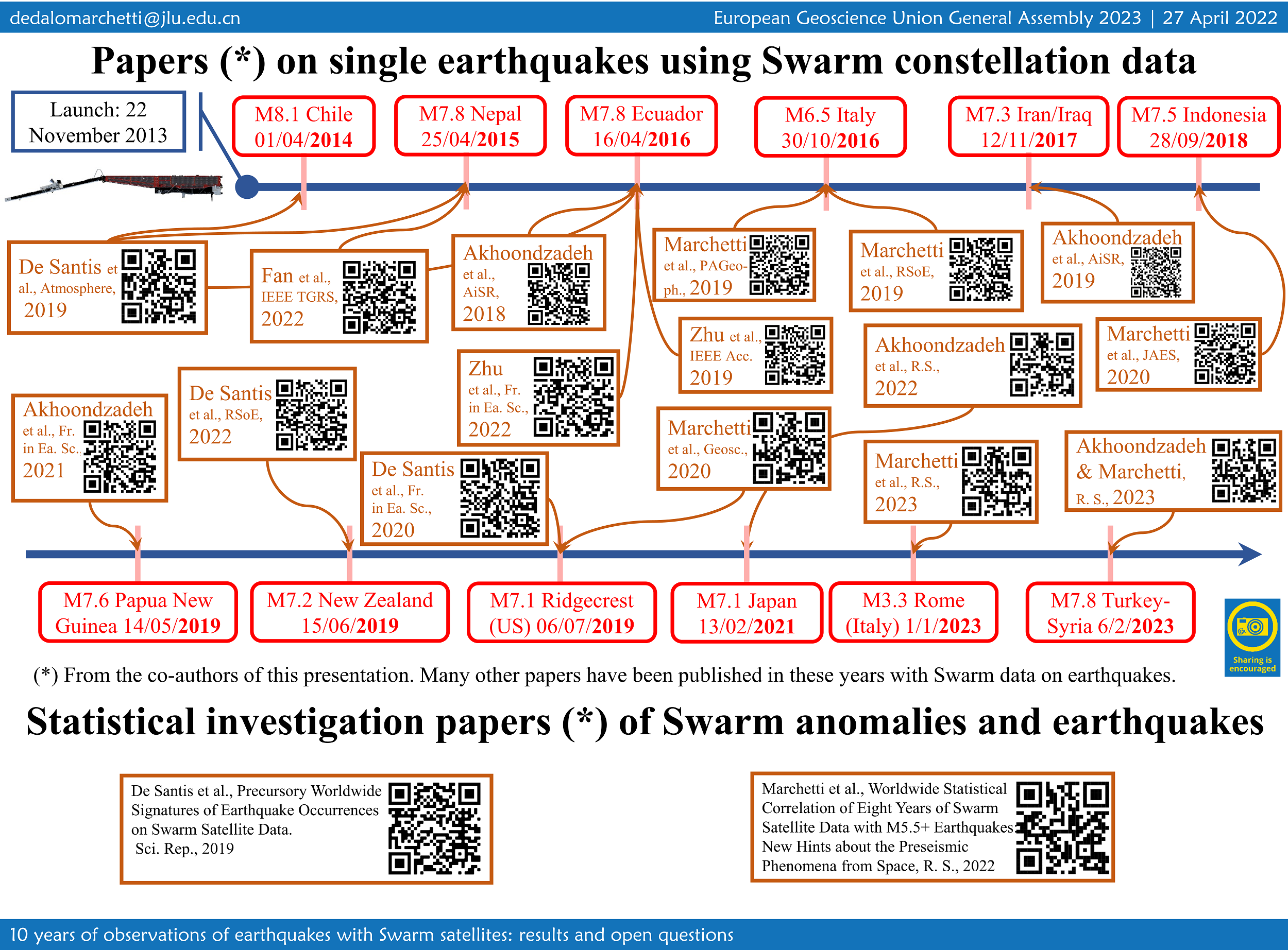
EGU23-5288 | Orals | EMRP2.9

Swarm Electric Field Instruments' Thermal Ion Imagers: A Decade of Discovery 

David Knudsen and Johnathan Burchill

The Swarm mission concept is innovative in its recognition that high-quality measurements of the geomagnetic field from LEO require accurate knowledge of Earth’s plasma environment, and furthermore that combined, precision measurements of fields, plasmas and neutral density from polar orbit provide a new window into ionosphere-thermosphere-magnetosphere (ITM) coupling and science. During the first decade of operations, event-based studies have led to new discoveries such as extreme plasma flows associated with the Birkeland current systems, the electrodynamic structure of multiple auroral arcs, the sub-auroral “STEVE” phenomenon, and the existence of standing Alfvén waves at equatorial latitudes. At the same time, the mission has accumulated an extensive database of measurements at high spatial resolution collected over a wide range of condition covering nearly a full solar cycle; these data have been used in longer-term statistical studies of plasma properties, high-latitude convection and ITM coupling via Poynting flux. As we enter the next decade of operations, the Swarm data are increasingly being used to inform empirical and physics-based models of the ionosphere; these in turn will comprise an important part of the long-term legacy of the Swarm mission. This talk will highlight scientific discoveries from the first decade of EFI operations, centred on observations of ion flows and associated electric fields from the EFI’s Thermal Ion Imagers, and made possible by a large and active community of collaborators. 

How to cite: Knudsen, D. and Burchill, J.: Swarm Electric Field Instruments' Thermal Ion Imagers: A Decade of Discovery, EGU General Assembly 2023, Vienna, Austria, 23–28 Apr 2023, EGU23-5288, https://doi.org/10.5194/egusphere-egu23-5288, 2023.

EGU23-5696 | ECS | Orals | EMRP2.9

On the correlation between electron density and temperature in the topside ionosphere through Swarm satellites data 

Alessio Pignalberi, Fabio Giannattasio, Michael Pezzopane, Igino Coco, and Tommaso Alberti

Electron density (Ne) and electron temperature (Te) observations collected by Langmuir Probes (LPs) on board the European Space Agency’s Swarm satellites are used to characterise the NeTe correlation in the topside ionosphere. The large dataset of Swarm LPs in-situ observations at 2-Hz rate, covering the years 2014−2021, allowed us to investigate the correlation properties of the topside ionospheric plasma for different diurnal and seasonal conditions, with a coverage and a detail never reached before. Spearman correlation coefficients (RSpearman) are calculated on joint probability distributions between Ne and Te for specific conditions. Results are given as maps of RSpearman as a function of the Quasi-Dipole (QD) magnetic latitude and magnetic local time (MLT) coordinates, for different seasons. This study highlights, for the first time, the NeTe correlation at high latitudes, and provides a global description of the corresponding diurnal trend for different seasons. A negative correlation is found at the equatorial morning overshoot, during daytime at mid latitudes, and during night-time at subauroral latitudes (ionospheric trough). Conversely, a positive correlation dominates the night-time sector at mid and low latitudes, and to a minor extent the low latitudes from 09:00 MLT onwards. A seasonal dependence of the correlation is visible only at very high latitudes where the general pattern of anti-correlation is broken around ±75° QD latitude in the summer season.

How to cite: Pignalberi, A., Giannattasio, F., Pezzopane, M., Coco, I., and Alberti, T.: On the correlation between electron density and temperature in the topside ionosphere through Swarm satellites data, EGU General Assembly 2023, Vienna, Austria, 23–28 Apr 2023, EGU23-5696, https://doi.org/10.5194/egusphere-egu23-5696, 2023.

EGU23-5709 | Posters on site | EMRP2.9

Ten years of operation of Swarm's absolute magnetometers, lessons learnt and prospect for the NanoMagSat nanosatellite constellation project 

Gauthier Hulot, Pierdavide Coïsson, Louis Chauvet, Jean-Michel Léger, and Thomas Jager

ESA Swarm satellites carry a magnetometry payload consisting of an absolute scalar magnetometer (ASM), a relative flux gate vector magnetometer (VFM), and a set of star trackers (STR). The primary role of the ASM is to provide precise 1 Hz absolute field intensity measurements, while the VFM and STR provide the additional data needed to accurately reconstruct the vector field. This magnetometry payload has provided a remarkable set of nominal vector data, which has extensively been used for multiple investigations, as illustrated by the many results presented in this session. Each ASM instrument, however, can also produce its own self-calibrated 1 Hz experimental vector data, or, when requested, 250 Hz scalar burst mode. Self-calibrated 1 Hz experimental vector data have routinely been produced ever since launch, and substantial amount of scalar burst mode sessions have now also been run, mostly since 2019, when the decision was made to run such sessions one week per month on both the Alpha and Bravo satellites. In this presentation, we will illustrate the added value both these datasets brought to the Swarm mission, with the self-calibrated 1 Hz experimental vector data contributing to improvement and validation of the nominal dataset, and the burst mode data bringing new science opportunities. We will also discuss the lessons learnt from operating the ASM instruments on Swarm and how these led to the development of an appropriate miniaturized magnetometry payload for the NanoMagSat nanosatellite constellation. This constellation project is currently under development in the context of the ESA Scout program, and aims at a launch in the near future for complementing and enhancing the science return of the Swarm mission.

How to cite: Hulot, G., Coïsson, P., Chauvet, L., Léger, J.-M., and Jager, T.: Ten years of operation of Swarm's absolute magnetometers, lessons learnt and prospect for the NanoMagSat nanosatellite constellation project, EGU General Assembly 2023, Vienna, Austria, 23–28 Apr 2023, EGU23-5709, https://doi.org/10.5194/egusphere-egu23-5709, 2023.

EGU23-6172 | Orals | EMRP2.9

The great potentiality of Swarm three-satellite mission for detecting pre-earthquake ionospheric anomalies 

Gianfranco Cianchini, Angelo De Santis, Massimo Calcara, Saioa A. Campuzano, Serena D'Arcangelo, Mariagrazia De Caro, Domenico Di Mauro, Cristiano Fidani, Adriano Nardi, Martina Orlando, Loredana Perrone, Dario Sabbagh, and Maurizio Soldani

The Swarm three-satellite mission by ESA was initially designed with its original configuration to monitor and study the geomagnetic field and the state of the ionosphere and magnetosphere. For the first time, in 2017, the Swarm satellites detected some pre- and post-earthquake magnetic field anomalies on occasion of the 2015 Nepal M7.8 earthquake. Interestingly, the cumulative number of satellite anomalies and the cumulative number of earthquakes behaved similarly with the so-called S-shape, providing an empirical proof on the lithospheric origin of the satellite anomalies (De Santis et al., 2017; doi:10.1016/j.epsl.2016.12.037). Following the same approach, other promising results were obtained for 12 case studies in the range of 6.1-8.3 earthquake magnitude, in the framework of the SAFE (SwArm For Earthquake study) project funded by ESA (De Santis et al., 2019a; doi:10.3390/atmos10070371). In 2019, almost five years of Swarm magnetic field and electron density data were analysed with a Superposed Epoch and Space approach and correlated with major worldwide M5.5+ earthquakes (De Santis et al. 2019b; doi:10.1038/s41598-019-56599-1). The analysis verified a significant correlation between satellite anomalies and earthquakes above any reasonable doubt, after a statistical comparison with random simulations of anomalies. The work also confirmed the Rikitake (1987) law, initially proposed for ground-based data: the larger the magnitude of the impending earthquake, the longer the precursory time of anomaly occurrence in ionosphere from satellite. A more recent investigation (Marchetti et al. 2022; doi:10.3390/rs1411264) over a longer time series of data, i.e. 8 years, confirmed the same results. Furthermore, we demonstrated in several case studies (e.g., Akhoondzadeh et al. 2019; doi: 10.1016/j.asr.2019.03.020; De Santis et al. 2020; doi:10.3389/feart.2020.540398) that the integration of Swarm satellite data with other kinds of measurements from ground, atmosphere and space (e.g., CSES-01 satellite data) reveals a chain of processes before the mainshocks of many seismic sequences. 

How to cite: Cianchini, G., De Santis, A., Calcara, M., A. Campuzano, S., D'Arcangelo, S., De Caro, M., Di Mauro, D., Fidani, C., Nardi, A., Orlando, M., Perrone, L., Sabbagh, D., and Soldani, M.: The great potentiality of Swarm three-satellite mission for detecting pre-earthquake ionospheric anomalies, EGU General Assembly 2023, Vienna, Austria, 23–28 Apr 2023, EGU23-6172, https://doi.org/10.5194/egusphere-egu23-6172, 2023.

EGU23-6437 | ECS | Orals | EMRP2.9

Ionospheric mid-latitude electron density background definition from CHAMP and Swarm satellite measurements under different solar conditions 

Dario Sabbagh, Alessandro Ippolito, Dedalo Marchetti, Loredana Perrone, Angelo De Santis, Saioa A. Campuzano, Gianfranco Cianchini, and Alessandro Piscini

In this work, a new method to define a background for the topside ionospheric electron density from satellite in-situ measurements is proposed as a useful tool for analysis of plasma density variations at LEO satellites heights. The method is applied to the data acquired by the Langmuir Probes onboard CHAMP satellite during the years 2004 and 2009, and the three Swarm satellites during 2016 and 2017 in the 15°-wide mid-latitudinal belt from 35°N to 50°N, and any longitude. CHAMP/Swarm in-situ measurements have also been used to check and compare such a new defined background with the one computed directly from IRI-2016 electron density output at satellite altitude. A general overestimation of the electron density from IRI during noon hours is highlighted, despite an underestimation of IRI with respect to Swarm-derived background for Swarm 2017 data is found as well, while the two backgrounds result more in agreement during night-time. Finally, the analysis of 2004 plasma data suggests that the IRI-2016 model could be used as a background during periods characterized by high levels of geomagnetic activity under high solar activity conditions.

How to cite: Sabbagh, D., Ippolito, A., Marchetti, D., Perrone, L., De Santis, A., Campuzano, S. A., Cianchini, G., and Piscini, A.: Ionospheric mid-latitude electron density background definition from CHAMP and Swarm satellite measurements under different solar conditions, EGU General Assembly 2023, Vienna, Austria, 23–28 Apr 2023, EGU23-6437, https://doi.org/10.5194/egusphere-egu23-6437, 2023.

EGU23-6558 | Orals | EMRP2.9

Monitoring ionospheric gradients using SWARM satellite data 

M. Mainul Hoque, Norbert Jakowski, Juan Andres Cahuasqui Llerena, Stephan C. Buchert, Martin Kriegel, Paul David, Dmytro Vasylyev, Jens Berdermann, and Klaus Nielsen

The Swarm data products are well-suited to address a number of crucial topics for space weather science and monitoring, such as investigating spatial and temporal characteristics of ionospheric irregularities or improving topside approaches in ionospheric models for monitoring and forecasting the dynamics of the geo-plasma environment. Precision and safety of life applications using trans-ionospheric signals require key information on space weather conditions in particular on the perturbation degree of the ionosphere. Such applications are particularly vulnerable against severe spatial gradients and rapid changes of the electron density (Ne) as well as the total electron content (TEC) measured along different satellite‐receiver links. Here, we propose two new Swarm products 1) the TEC Gradient Ionosphere indeX (TEGIX) and 2) the Ne Gradient Ionosphere indeX (NEGIX). The TEGIX estimates spatial TEC gradients in the topside ionosphere (Swarm up to GNSS orbit) using GNSS Precise Orbit Determination (POD) measurements whereas the NEGIX estimates spatial Ne gradients using Swarm onboard Langmuir probe (LP) measurements (2 Hz sampled).  The approach takes benefit from the coordinated flight of satellites A and C at an orbit height of about 460 km. We will present a first version of both products and will explore their potential impact, utility, and use through case studies.

Acknowledgement:

The work is funded by the MIGRAS (Monitoring of Ionospheric Gradients At SWARM) project under the Swarm DISC Subcontract Doc. no: SW‐CO‐DTU‐GS‐133, Rev: 1.

How to cite: Hoque, M. M., Jakowski, N., Cahuasqui Llerena, J. A., Buchert, S. C., Kriegel, M., David, P., Vasylyev, D., Berdermann, J., and Nielsen, K.: Monitoring ionospheric gradients using SWARM satellite data, EGU General Assembly 2023, Vienna, Austria, 23–28 Apr 2023, EGU23-6558, https://doi.org/10.5194/egusphere-egu23-6558, 2023.

EGU23-6576 | Orals | EMRP2.9

Core surface flow variations derived from observatory and satellite magnetic data 

Vincent Lesur and Guillaume Ropp

A series of models of the Earth magnetic field and core surface flow are presented. The models were derived sequentially from year 1999 to 2022, using magnetic satellite and ground observatory data. A linear Kalman filter approach and prior statistics based on numerical dynamo runs were used. The core field and secular variation models present the same characteristics as the most recent core field models with slightly higher resolution in time. The core surface flow series of models presents large variations at high latitudes and under the western part of the Pacific Ocean. Filtering out the flow variation periods longer than ∼11.5 years leads to a filtered azimuthal flow with ∼7 years periodicities and patterns propagating westward by ∼60o longitude per year. These patterns are present mainly at mid- and equatorial latitudes. They are compatible with a perturbation of the main flow made of small columnar flows with rotation axis intersecting the core-mantle boundary between 10o to 15o latitudes, and flow speed of less than 5km/y. These columnar flows can be identified at all longitudes, but are particularly strong under the Pacific Ocean or under the Atlantic Ocean from 2005 to 2015.

How to cite: Lesur, V. and Ropp, G.: Core surface flow variations derived from observatory and satellite magnetic data, EGU General Assembly 2023, Vienna, Austria, 23–28 Apr 2023, EGU23-6576, https://doi.org/10.5194/egusphere-egu23-6576, 2023.

EGU23-6672 | Posters on site | EMRP2.9

Instruments performance and data quality after 10 years of Swarm in orbit 

Enkelejda Qamili, Roberta Forte, Nicola Comparetti, Lars Tøffner-Clausen, Stephan Buchert, Johnathan Burchill, Christian Siemes, Anna Mizerska, Jonas Bregnhøj Nielsen, Thomas Nilsson, Maria Eugenia Mazzocato, María José Brazal Aragón, Lorenzo Trenchi, Jerome Bouffard, Anja Stromme, Pierre Vogel, and Berta Hoyos Ortega

Launched by the European Space Agency (ESA) in November 2013, the three-satellite Swarm constellation continues to provide very high-quality measurements of the Earth's magnetic field and associated plasma environment. After around 10 years in space the Swarm mission has achieved remarkable scientific results, opening the door for many innovating applications largely beyond its original scope. With this paper, the authors would like to provide a broad overview of the Swarm mission status and Swarm instruments performance. Moreover, the many improvements obtained from the new Swarm data processing baseline together with other innovative Swarm-based data products and services will be presented.

How to cite: Qamili, E., Forte, R., Comparetti, N., Tøffner-Clausen, L., Buchert, S., Burchill, J., Siemes, C., Mizerska, A., Bregnhøj Nielsen, J., Nilsson, T., Mazzocato, M. E., Brazal Aragón, M. J., Trenchi, L., Bouffard, J., Stromme, A., Vogel, P., and Hoyos Ortega, B.: Instruments performance and data quality after 10 years of Swarm in orbit, EGU General Assembly 2023, Vienna, Austria, 23–28 Apr 2023, EGU23-6672, https://doi.org/10.5194/egusphere-egu23-6672, 2023.

EGU23-6799 | Orals | EMRP2.9 | Highlight

Eerie sounds of Earth’s magnetic field 

Klaus Nielsen, Nikolai Linden-Vørnle, Clemens Kloss, and Chris Finlay

In October 2022 an audio installation using Data Sonification methods premiered in Copenhagen. The project was a sonic representation of Earth’s magnetic field played on a 32-channel speaker system dug into the ground of a public square. The project was a massive success – particularly online with close to a million plays on ESA’s SoundCloud and thus proved a great opportunity to showcase the important work in Earth Observation done within the Swarm community.

The audio installation is an artistic representation controlled by magnetic field data through a sonification method called parameter mapping. The output of the 32 speakers was controlled individually by fluctuations in the magnetic field strength at 32 locations on the globe. Data was taken from the GGF100k – a global field model going back 100.000 years – and condensed into a 5-minute sequence composed of 32 different tracks running simultaneously. Six different parameters were mapped to various qualities of the audio playback (volume, pitch, filter, sample playback speed); these included the three components of the magnetic field at the core mantle boundary, the rate of change, and the field average at surface level.

The soundtrack was meant to give the listener an impression of a living planet in constant flux and is build up from recordings of natural sounds in various combinations. This presentation will describe the approach and give a demonstration of the results. In addition, it will briefly discuss data sonification as a method for inclusion and science outreach.

How to cite: Nielsen, K., Linden-Vørnle, N., Kloss, C., and Finlay, C.: Eerie sounds of Earth’s magnetic field, EGU General Assembly 2023, Vienna, Austria, 23–28 Apr 2023, EGU23-6799, https://doi.org/10.5194/egusphere-egu23-6799, 2023.

EGU23-7679 | ECS | Orals | EMRP2.9

Investigating geomagnetic jerks with Swarm: Using the spatial gradient tensor for flow modelling 

Frederik Dahl Madsen, Kathy Whaler, Magnus Hammer, Richard Holme, Will Brown, and Ciarán Beggan

The ESA Swarm mission has, with along- and across-track differences of the magnetic field measurements, made it possible to generate spatial gradients data of the geomagnetic field and its secular variation (SV). Inverting the SV data for core-surface flows allows us to investigate the Earth’s outer core with higher resolution than using vector component data.

We invert for core-surface flow models directly from the spatial gradient tensor SV data, without the use of stochastic or numerical models, imposing flow equatorial symmetry, quasi- or tangential geostrophy, or band-pass filtering. We develop three different types of model, all damped to minimise spatial complexity and minimise acceleration between epochs. The first set is otherwise unconstrained, and different spatial regularisations are used. In the second set, we allow for torsional oscillations by relaxing the temporal damping on certain flow coefficients. The third set has differential damping on the equatorially symmetric and asymmetric flow components, in order to investigate the extent to which asymmetric flow is required to fit the data. We predict the intradecadal variation in length-of-day (LOD) from each model, and find that only the model which allows for torsional oscillations shows a good fit to the LOD data.

The azimuthal acceleration of all three model types shows evidence of fast westward low-latitude waves at the core-surface.  During the 2017 geomagnetic jerk, there is an abrupt westward shift in these wave-features in all our models. Previous literature suggests that geomagnetic jerks may originate from Alfvén wave packets emitted from the inner-outer core boundary, propagating outwards. We suggest that the observed westward shift at the jerk epoch may occur when these wave-packets interfere with the waves at the core surface.

Finally, we consider the use of spatial gradients from the CHAMP mission. Spatial gradients can be derived from along-track differences of the magnetic field from CHAMP, which allows us to compare the quality of core surface flow models from the CHAMP and Swarm missions. Our analysis suggests it is unlikely that CHAMP yields data of sufficient resolution to observe this proposed wave-interaction, showcasing the success of the Swarm mission.

How to cite: Madsen, F. D., Whaler, K., Hammer, M., Holme, R., Brown, W., and Beggan, C.: Investigating geomagnetic jerks with Swarm: Using the spatial gradient tensor for flow modelling, EGU General Assembly 2023, Vienna, Austria, 23–28 Apr 2023, EGU23-7679, https://doi.org/10.5194/egusphere-egu23-7679, 2023.

EGU23-7872 | ECS | Orals | EMRP2.9

Swarm A and C Accelerometer - data analysis and scientific outcome 

Elisabetta Iorfida, Ilias Daras, and Anja Strømme

The ESA Swarm mission was launched in November 2013, and it consists of a constellation of three identical satellites. The main mission objective is to model and analyze the geomagnetic field through the data provided by a vector and a scalar magnetometer on board of each spacecraft (A, B, C).  To fulfill the secondary objectives, the satellites do also carry other instruments, such as an accelerometer expected to measure the non-gravitational forces acting on each satellite. However, the quality of the data retrieved from this instrument was not at the anticipated level and, therefore, the post-processing required to calibrate the signal was significant. Therefore, initially the calibration focused on Swarm C only because it had the best signal-to-noise ratio of the constellation. For this satellite the calibrated accelerometer data are available since the beginning of the mission and they are disseminated bi-monthly. At the end of 2021, the first Swarm A dataset was released and it comprises some months in 2014. Swarm A and C, called the “lower pair”, have flown side-by-side for most of the mission with a separation that spanned from four to ten seconds. Therefore, their measurements are supposed to be nearly identical after calibration.

A recent publication, which is discussed in this talk, demonstrated that a comparison between Swarm A and Swarm C calibrated accelerometer dataset shows the expected correlation. After applying a high-pass filter to both satellites’ dataset, very similar features are visible at the equator and at the poles. The “long time scale” events at the equator show a correlation between the equatorial mass anomaly and the equatorial ionization anomaly. At the poles, the “short time scale” events can be related to the Polar Cap index and to the field-aligned currents, which are measured on board by the Swarm magnetometers. Furthermore, these features agree with previous literature based on CHAMP and GRACE data.

For the first time the Swarm accelerometer data deliver scientific results, in particular in the field of thermosphere and ionosphere coupling.

How to cite: Iorfida, E., Daras, I., and Strømme, A.: Swarm A and C Accelerometer - data analysis and scientific outcome, EGU General Assembly 2023, Vienna, Austria, 23–28 Apr 2023, EGU23-7872, https://doi.org/10.5194/egusphere-egu23-7872, 2023.

EGU23-7914 | ECS | Orals | EMRP2.9

Determining the L-band amplitude scintillation index from Swarm faceplate plasma measurements 

Rayan Imam, Luca Spogli, Lucilla Alfonsi, Claudio Cesaroni, Yaqi Jin, Lasse Clausen, Alan Wood, and Wojciech Miloch

The 16 Hz plasma density measurements provided by the high-resolution faceplate onboard Swarm satellites can be utilized to reconstruct the one-dimensional spectral slope (p) of the power spectrum of the plasma density irregularity. The 16 Hz sampling rate at Swarm orbital features (speed of ~7.5 km/s on quasi-polar orbits) allows modelling spatial scales of about 500 m along the flight trajectory, which are slightly above the first Fresnel zone, the upper limit of the scale sizes of the irregularities causing scintillation on Global Navigation Satellite Systems (GNSS) signals. 

The p-value is a key parameter in estimating the scintillation strength and thus a Swarm ionospheric scintillation (SWIS) proxy is investigated. Such approach, once consolidated, will benefit the scientific community in studying, monitoring and modelling the small-scale irregularities; specially in contexts where ground based GNSS scintillation monitoring is not available, for example over the oceans.

In this work, p-value from Swarm, combined with the reconstruction of the irregularity layer , are ingested to compute the amplitude scintillation index (S4) using Rino’s theory of weak scattering. In this work, the model formulation and sample results of S4 estimation from Swarm are demonstrated. Results of validating SWIS S4 against S4 from ground based GNSS scintillation for selected key ionospheric sectors are also shown. The results demonstrate that the model can capture the amplitude scintillation index inflation both at low and high latitudes, demonstrating the capability of detecting the equatorial and the (rare) polar amplitude scintillation from Swarm measurements. 

How to cite: Imam, R., Spogli, L., Alfonsi, L., Cesaroni, C., Jin, Y., Clausen, L., Wood, A., and Miloch, W.: Determining the L-band amplitude scintillation index from Swarm faceplate plasma measurements, EGU General Assembly 2023, Vienna, Austria, 23–28 Apr 2023, EGU23-7914, https://doi.org/10.5194/egusphere-egu23-7914, 2023.

EGU23-8273 | ECS | Orals | EMRP2.9

Improving Platform Magnetometer Measurements Using Physics-informed Neural Networks 

Kevin Styp-Rekowski, Ingo Michaelis, Monika Korte, Claudia Stolle, and Odej Kao

So-called platform magnetometers, mounted on a variety of non-dedicated satellites in Low-Earth orbit, are promising instruments to increase the spatiotemporal coverage of space-based measurements of the Earth’s magnetic field. However, these instruments often need to be calibrated to ensure a scientific accuracy and usability of the data they collect. To do this, it is important to gather information about the satellite to correct artificial disturbances caused by other payload systems as well as other influencing properties. In the past, we demonstrated that a Machine Learning-based calibration achieves competitive results. By using machine learning techniques, the magnetometer signal can be adapted to account for artificial disturbances and the proposed non-linear regression method can automatically identify relevant features and their crosstalk, enabling the use of a wider range of inputs. This reduces the analytical work required for the calibration of platform magnetometers, resulting in faster, more precise, and easily accessible magnetic datasets from non-dedicated missions. The calibrated datasets are made publicly available.

In this work, we propose an extension for the known approach by incorporating the physical Biot-Savart formula into a neural network, which results in a physics-informed neural network. This improves the modeling and correction of the impact of current-induced artificial magnetic fields on the satellite and its magnetic measurements. In addition, the Average Magnetic field and Polar current System (AMPS) model is combined with the CHAOS-7 model, improving the reference model of the calibration, especially for the polar regions. This extended approach is applied to the GOCE and GRACE-FO satellite missions and their respective measurements. In the future, the underlying software shall be published and applied to a wider variety of satellites to improve the accuracy of their platform magnetometer measurements. By making this tool publicly available, we hope to enable other satellite operators to calibrate their instruments, improve the quality of their data, and make additional data available to the scientific community.

How to cite: Styp-Rekowski, K., Michaelis, I., Korte, M., Stolle, C., and Kao, O.: Improving Platform Magnetometer Measurements Using Physics-informed Neural Networks, EGU General Assembly 2023, Vienna, Austria, 23–28 Apr 2023, EGU23-8273, https://doi.org/10.5194/egusphere-egu23-8273, 2023.

EGU23-8490 | Posters on site | EMRP2.9

A lithospheric magnetic field model to spherical harmonic degree 1300 

Erwan Thebault and Gauthier Hulot

Detailed mapping of the Earth's magnetic field brings key constraints on the composition, dynamics, and history of the crust. Satellite and near-surface measurements detect different length scales and are complementary. However, direct global inversion of a design matrix built with magnetic field measurements locations of near surface and satellite data is numerically intractable at high spatial resolutions.

We apply a procedure developed during the Swarm mission satellite preparation phase to bypass this severe computing issue. We first select the magnetic field measurements during magnetically quiet days of the German CHAMP satellite up to year 2010 and of the ESA Swarm satellites from January 2014 to 31st August 2022. We then build a a complete dataset by combining the selected satellite measurements with the second version of the World Magnetic Anomaly Map; the most globally complete grid of airborne and marine data.

We follow a regional approach for the modelling of the full vector, scalar and gradient dataset. We compute a series of spherical cap harmonic models within 700 overlapping spherical caps tiling the Earth’s sphere. This regional strategy allows us to perform linear inverse problems in parallel using robust procedures, to deal with the Backus effect in equatorial regions, and to assess independently each regional model. The complete procedure is described in Thébault, Erwan, et al. "A Spherical Harmonic Model of Earth's Lithospheric Magnetic Field up to Degree 1050." Geophysical Research Letters 48.21 (2021): e2021GL095147).  We finally transform the series of regional models into a unique set of spherical harmonic (SH) Gauss coefficients. This produces the first global model to SH degree 1300. The new model agrees with previous satellite-based models at large wavelengths and fits the CHAMP and Swarm satellite data down to expected noise levels. Further assessment in the geographical and spectral domains show that the model is stable when downward continued to the Earth's surface.

How to cite: Thebault, E. and Hulot, G.: A lithospheric magnetic field model to spherical harmonic degree 1300, EGU General Assembly 2023, Vienna, Austria, 23–28 Apr 2023, EGU23-8490, https://doi.org/10.5194/egusphere-egu23-8490, 2023.

EGU23-8989 | ECS | Posters on site | EMRP2.9

The polarisation state of transionospheric radio waves detected by RRI on Swarm-E 

Kuldeep Pandey, Robert G. Gillies, E. Ceren Kalafatoglu Eyiguler, Glenn C. Hussey, Donald W. Danskin, and Andrew W. Yau

The Radio Receiver Instrument (RRI) on-board the Swarm-E satellite is used to determine the full polarisation state of transionospheric radio waves. Co-ordinated experiments between ground transmitters and RRI have shown that the detected radio waves can have ellipticity that varies from linearly to circularly polarised when observed poleward of the transmitter at low elevations. Circular polarisation states are expected for waves propagating traverse to the local geometric field; however, these circular states were observed over a much wider range of aspect angles than expected. The present study compares the results of radio transmissions from the Saskatoon SuperDARN radar with a transionospheric radio wave model to estimate the relative strengths of received O- and X-mode waves along the satellite track. At selected low elevations, the X-mode of the radio wave dominates over the O-mode, resulting in a circular ellipticity, although the propagation is not transverse to the magnetic field. This work presents new ways to utilize ellipticity polarisation observations of radio waves to better understand the structure of the ionosphere, complementing Faraday rotation observations which have been extensively used.

How to cite: Pandey, K., Gillies, R. G., Kalafatoglu Eyiguler, E. C., Hussey, G. C., Danskin, D. W., and Yau, A. W.: The polarisation state of transionospheric radio waves detected by RRI on Swarm-E, EGU General Assembly 2023, Vienna, Austria, 23–28 Apr 2023, EGU23-8989, https://doi.org/10.5194/egusphere-egu23-8989, 2023.

EGU23-9101 | ECS | Orals | EMRP2.9

Understanding Ionospheric Conditions using the e-POP on Swarm-E 

E. Ceren Kalafatoglu Eyiguler, Donald W. Danskin, Kuldeep Pandey, Glenn C. Hussey, Robert G. Gillies, and Andrew W. Yau

Swarm-E carries the e-POP payload, which consists of eight scientific instruments. The Radio Receiver Instrument (RRI) on e-POP may be used to detect density structures that modify the characteristics of transionospheric HF radio waves from ground-based transmitters. RRI has a cross-dipole antenna designed to determine the polarisation characteristics of the incident radio waves. Joint experiments with other instruments, IRM (Imaging and Rapid-scanning ion Mass spectrometer) and MGF (Fluxgate Magnetometer), complement RRI for better understanding of the local ionosphere conditions and integrated conditions along the path between a ground-based transmitter and Swarm-E. Under optimum conditions, the RRI determines the full polarisation characteristics. This presentation discusses past and future contributions to ionospheric science of the Swarm constellation.

How to cite: Kalafatoglu Eyiguler, E. C., Danskin, D. W., Pandey, K., Hussey, G. C., Gillies, R. G., and Yau, A. W.: Understanding Ionospheric Conditions using the e-POP on Swarm-E, EGU General Assembly 2023, Vienna, Austria, 23–28 Apr 2023, EGU23-9101, https://doi.org/10.5194/egusphere-egu23-9101, 2023.

EGU23-9113 | Orals | EMRP2.9

Mapping spatio-temporal variations in ionospheric electrodynamics 

Karl Laundal, Jone Reistad, Spencer Hatch, Sara Gasparini, Simon Walker, Michael Madelaire, and Anders Ohma

The Swarm satellites accurately sample electromagnetic fields in-situ along the satellite tracks, but give little direct information about the spatial structures of the field away from the orbit. By making assumptions about temporal variations, in-situ satellite data is nevertheless useful for constructing climatological models that reveal average patterns of electromagnetic fields. Such models help us to understand large-scale average effects of solar wind-magnetosphere-ionosphere-thermosphere coupling, but their information about temporal variations is limited. For specific events, data from single satellites are insufficient for mapping spatio-temporal variations. Here we present a technique for combining Swarm data with measurements of magnetic and electric fields from other satellites, and from ground instruments. The technique, called Local mapping of polar ionospheric electrodynamics (Lompe) relies on the ionospheric Ohm’s law, and knowledge about ionospheric conductance. We discuss the importance of reliable conductance estimates for accurately relating magnetic and electric field observations.

How to cite: Laundal, K., Reistad, J., Hatch, S., Gasparini, S., Walker, S., Madelaire, M., and Ohma, A.: Mapping spatio-temporal variations in ionospheric electrodynamics, EGU General Assembly 2023, Vienna, Austria, 23–28 Apr 2023, EGU23-9113, https://doi.org/10.5194/egusphere-egu23-9113, 2023.

EGU23-9725 | Orals | EMRP2.9

World Digital Magnetic Anomaly Map (WDMAM) v.2.1 and the magnetic signature of geological provinces 

Jerome Dyment, Yujin Choi, Vincent Lesur, Andreina Garcia Reyes, Manuel Catalan, Takemi Ishihara, Tamara Litvinova, and Mohamed Hamoudi

The World Digital Magnetic Anomaly Map is prepared under the auspices of IAGA and the CGMW (Commission for the Geological Map of the World) of UNESCO. A first version was released in 2007 (Korhonen et al., 2007), and a second one in 2015 (Dyment et al., 2015; Lesur et al., 2016) with the mandate to update the version 2.0 using the same methodology when the availability of new data would make it necessary. The present version 2.1, compiled at 5 km interval, at 5 km altitude above the continents and at sea-level over the oceans, includes new datasets: (1) the complete digital aeromagnetic map of Brasil made available by ANP; (2) an improved version of the aeromagnetic map of Russia prepared by V-SEGEI; (3) the second version of the Antarctic Digital Magnetic Anomaly maP (ADMAP; Golynsky et al., 2018) which results from a remarkable international effort during and after the Second International Polar Year; (4) a new map of the Caribbean plate and Gulf of Mexico resulting from the compilation and re-processing of existing marine and aeromagnetic data in the area (Garcia and Dyment, EPSL, 2021, 2022); (5) the updated Magnetic Anomaly Map of Eastern Asia prepared by the CCOP (MAMEA; Ishihara and Uchida, 2021); and (6) a new marine magnetic anomaly data compilation prepared by T. Ishihara and coworkers. The new map will be presented and its improvements over the previous version discussed.

We try to characterize the magnetic signature of the different geological provinces at global scale by comparing WDMAM v.2.1 and the Geological Map of the World (Bouysse et al., 2014, CGMW). The latitudinal and directional dependences of the magnetic anomaly amplitude and shape prevent a direct global comparison. Instead, we examine the distribution of magnetic anomaly amplitudes within the geological provinces continent by continent. We build an histogram of the magnetic anomaly amplitudes for each type of geological province within each studied continent. The histograms resemble normal distributions from which we determine the average amplitude and its standard deviation. The latter reflects how wide is the range of amplitudes in the distribution: a small standard deviation means a narrow distribution and low amplitudes, a large one a wide distribution and high amplitudes. On land, our first investigation suggests that cratons exhibit stronger magnetic anomalies, whereas regions covered by a significant thickness of sediments present weaker anomalies. At sea, large igneous provinces show stronger anomalies, whereas continental platforms and the oceanic crust show similar amplitudes.

How to cite: Dyment, J., Choi, Y., Lesur, V., Garcia Reyes, A., Catalan, M., Ishihara, T., Litvinova, T., and Hamoudi, M.: World Digital Magnetic Anomaly Map (WDMAM) v.2.1 and the magnetic signature of geological provinces, EGU General Assembly 2023, Vienna, Austria, 23–28 Apr 2023, EGU23-9725, https://doi.org/10.5194/egusphere-egu23-9725, 2023.

EGU23-10157 | ECS | Orals | EMRP2.9

Developing the SwarmPAL Python package 

Ashley Smith, Constantinos Papadimitriou, Georgios Balasis, Sebastian Käki, Theresa Hoppe, and Heikki Vanhamäki

SwarmPAL is a new Python package under development with support from Swarm DISC (Data, Innovation, and Science Cluster). This project aims to provide the research community with a suite of tools to rapidly access, analyse, and visualise data from Swarm (and related data sources). By relying on the VirES system [1] for data access and other utilties, this greatly reduces the complexity required within SwarmPAL. By making use of HAPI [2], we can also connect to many other data sources to retrieve data from beyond Swarm. This is part of an overall strategy for integrating with the wider Python (and Jupyter) ecosystem, while being cognisant of the particular scientific landscape occupied by Swarm [3].

SwarmPAL is developed by researchers and research software engineers: this ensures a close fit between the development process and the needs of researchers, as well as fostering software skills within the research community. Through several other DISC activities we bring different research teams together, working on different areas of Swarm science, to collaboratively work on the SwarmPAL system. Namely, these activities currently include the TFA (time frequency analysis), and DSECS (dipolar spherical elementary current systems) toolboxes. These toolboxes provide tools to rapidly and configurably apply analyses to Swarm data, while the SwarmPAL package provides the home for these, together with all the maintenance and documentation that this implies. The development process is made with a strong focus on sustainability and open source [4].

[1] https://vires.services
[2] https://hapi-server.org
[3] https://doi.org/10.3389/fspas.2022.1002697
[4] https://github.com/Swarm-DISC/SwarmPAL

How to cite: Smith, A., Papadimitriou, C., Balasis, G., Käki, S., Hoppe, T., and Vanhamäki, H.: Developing the SwarmPAL Python package, EGU General Assembly 2023, Vienna, Austria, 23–28 Apr 2023, EGU23-10157, https://doi.org/10.5194/egusphere-egu23-10157, 2023.

The project “Characterization of Ionospheric TurbulENce Level by Swarm Constellation (INTENS)”, which was completed in 2021, was a collaboration between two Italian research institutes (INGV and INAF) and the National Observatory of Athens (NOA). It was funded by the European Space and was devoted to the investigation of turbulence and complexity in the ionospheric F2 region using data coming from the Swarm constellation. The obtained results were very intriguing because they provided the first global-scale characterization of the scaling properties of electron density and magnetic field fluctuations at the Swarm altitude as a function of geomagnetic activity and orientations of interplanetary magnetic fields. They also provided the opportunity to quantify changes in the complexity of the magnetosphere-ionosphere coupling system and to comprehend how it reacts to the onset and evolution of intense magnetic storms using entropy measures.

Despite the fact that the INTENS project is no longer active, research continues. The aim of this presentation is to summarize some recent results and to show how turbulence can be one of the most significant processes for the generation of plasma density irregularities which strongly affect the Global Navigation Satellite System. A thorough understanding of turbulent ionospheric fluctuations can be crucial in the future creation of GPS Loss of Lock hazard maps, greatly advancing the effort to minimize the effects of space weather. Any future satellite mission that can accurately measure the magnetic field and electron density at high frequency, as the NanoMagSat mission should be able to, will be necessary to extend the reliability of the results to ever smaller spatio-temporal scales.


How to cite: De Michelis, P.: The project “Characterization of Ionospheric Turbulence Level by Swarm Constellation”: Results and Prospects, EGU General Assembly 2023, Vienna, Austria, 23–28 Apr 2023, EGU23-11583, https://doi.org/10.5194/egusphere-egu23-11583, 2023.

EGU23-12093 | Posters on site | EMRP2.9 | Highlight

Swarm - status after almost 10 years in orbit and the way forward 

Anja Stromme

The three satellite Swarm constellationon is on a mission to unravel our planets invisible shield - the Earths magnetic field, and Swarm is after almost 10 years in orbit still in excellent shape and is still contributing to a wide range of scientific studies  from the core of our planet via the mantle, the lithosphere and out to the ionosphere and the interaction with the Solar wind.


In this talk we will present an update on the status of the Swarm mission, including the health and quality of the spacecrafts , instruments and data products, examples from scientific studies  and outline our plans for the future.

How to cite: Stromme, A.: Swarm - status after almost 10 years in orbit and the way forward, EGU General Assembly 2023, Vienna, Austria, 23–28 Apr 2023, EGU23-12093, https://doi.org/10.5194/egusphere-egu23-12093, 2023.

EGU23-12138 | ECS | Posters on site | EMRP2.9

Convolutional Neural Networks for Automated ULF Wave Classification in Swarm Time Series 

Alexandra Antonopoulou, Georgios Balasis, Constantinos Papadimitriou, Adamantia Zoe Boutsi, Ioannis A. Daglis, and Omiros Giannakis

Ultra-low frequency (ULF) magnetospheric plasma waves play a key role in the dynamics of the Earth’s magnetosphere and, therefore, their importance in Space Weather phenomena is indisputable. Magnetic field measurements from recent multi-satellite missions (e.g., Cluster, THEMIS, Van Allen Probes and Swarm) are currently advancing our knowledge on the physics of ULF waves. In particular, Swarm satellites, one of the most successful missions for the study of the near-Earth electromagnetic environment, have contributed to the expansion of data availability in the topside ionosphere, stimulating much recent progress in this area. Coupled with the new successful developments in artificial intelligence (AI), we are now able to use more robust approaches devoted to automated ULF wave event identification and classification. The goal of this effort is to use a popular machine learning method, widely used in Earth Observation domain for classification of satellite images, to solve a Space Physics classification problem, namely to identify ULF wave events using magnetic field data from Swarm. We construct a Convolutional Neural Network (ConvNet) that takes as input the wavelet spectrum of the Earth’s magnetic field variations per track, as measured by Swarm, and whose building blocks consist of two alternating convolution and pooling layers, and one fully connected layer, aiming to classify ULF wave events within four different possible signal categories: (1) Pc3 wave events (i.e., frequency range 20–100 MHz), (2) background noise, (3) false positives, and (4) plasma instabilities. Our preliminary experiments show promising results, yielding successful identification of more than 97% accuracy. The same methodology can be easily applied to magnetometer data from other satellite missions and ground-based arrays.

How to cite: Antonopoulou, A., Balasis, G., Papadimitriou, C., Boutsi, A. Z., Daglis, I. A., and Giannakis, O.: Convolutional Neural Networks for Automated ULF Wave Classification in Swarm Time Series, EGU General Assembly 2023, Vienna, Austria, 23–28 Apr 2023, EGU23-12138, https://doi.org/10.5194/egusphere-egu23-12138, 2023.

EGU23-12663 | ECS | Orals | EMRP2.9

The High Energy Particle Populations of Earth Mapped by Swarm and MMS 

Christina Toldbo, Matija Herceg, Julia Sushkova, Troelz Denver, Jesper Henneke, Mathias Benn, Peter S. Jørgensen, José M.G. Merayo, Enkelejda Qamili, Berta Hoyos Ortega, Roger Haagmans, Pierre Vogel, Anja Strømme, Seth Shulman, and John L. Jørgensen

The three spacecraft which constitute the Swarm mission are equipped with the Micro Advanced Stellar Compass (μASC) provided by the Technical University of Denmark (DTU) for attitude determination. Each μASC is comprised of three Camera Head Units (CHUs) for a total of nine cameras on the mission. The CCD sensor inside the CHUs are sensitive to energetic particle irradiation which appear as transient bright pixels dubbed ’Energetic Particle Detections’ (EPDs) on the star field images.

For more than five years the μASCs on-board Swarm have transmitted the occurrence of EPDs to ground and thereby effectively added high energy radiation monitoring capabilities to the Swarm mission. The high sensitivity, high sample rate (1-2 Hz), orientation of the camera heads, simultaneous measurements from all three spacecraft and near-polar orbits at an altitude of 450-510 km and allows for continuous and real-time monitoring of the high energy (>65 MeV) proton environment in LEO. This data uncover short and long term changes in particle flux in e.g. the South Atlantic Anomaly (SAA) of relevance for future mission planning.

The same radiation monitoring capability exists on NASA’s Magnetospheric Multiscale Mission (MMS) which, due to its highly elliptical orbit, survey the Van Allen radiation belts and detect enhanced radiation levels in the belts associated with geomagnetic storms. Combining data from the μASCs onboard Swarm and MMS provides unique insight into the injection mechanisms and dynamics of very high energy particles which is currently poorly understood. This work presents observations and results using high energy radiation data obtained from the μASC on board ESA’s Swarm mission, from February 2018 to February 2023, in combination with μASC data from MMS.


How to cite: Toldbo, C., Herceg, M., Sushkova, J., Denver, T., Henneke, J., Benn, M., Jørgensen, P. S., Merayo, J. M. G., Qamili, E., Hoyos Ortega, B., Haagmans, R., Vogel, P., Strømme, A., Shulman, S., and Jørgensen, J. L.: The High Energy Particle Populations of Earth Mapped by Swarm and MMS, EGU General Assembly 2023, Vienna, Austria, 23–28 Apr 2023, EGU23-12663, https://doi.org/10.5194/egusphere-egu23-12663, 2023.

EGU23-14094 | Orals | EMRP2.9

A decade of measurements, which turned Swarm into a lightning hunter 

Ewa Slominska, Marek Strumik, and Jan Slominski

The ESA Swarm mission has been designed to provide high-precision registrations of the Earth's magnetic field. Since its launch, the constellation, consisting of three LEO satellites, measures the magnetic signals coming from Earth's core, mantle, crust, oceans, ionosphere, and magnetosphere. Nearly a decade of Swarm observations, allowed us to expand main goals of the mission and improve our capabilities of detecting magnetic field fluctuations triggered by powerful thunderstorms.

Lightning can generate ultra low frequency fluctuations that leak into the upper ionosphere. This means that some lightning bolts are so powerful that they trigger disturbances in Earth's magnetic field and propagate hundreds of kilometers upwards from the thunderstorm, reaching the altitude of Swarm’s orbit. Thanks to two magnetometers,  the Absolute Scalar Magnetometer ASM and the Vector Fluxgate Magnetometer VFM, Swarm turned into a robust lightning hunter. 

Gathered analysis, utilizing mainly the VFM registrations, show that averaged amplitude of lightning generated fluctuations reaches magnitude of 0.5-1.3 nT (peak-to-peak for the scalar field), while typical time delay between the lightning occurrence and the satellite detection is 0.2-0.5 s and this indicates that Swarm detects rather a direct propagation of lightning-generated disturbance than effects of excitation of the ionospheric Alfvén resonance, which would require a longer time scale.

Since Swarm provides full representations of the magnetic field components, we transform data to the so-called MV frame to extract the maximum amplitude of a given fluctuation regardless of the lightning-satellite mutual orientation and wave polarization. In such a way, Swarm data help to comprehensively characterize  wave properties of detected fluctuations, and this is one of fundamental tasks, especially in the large variety of magnetic field disturbances caused by various types of natural hazard phenomena. 

How to cite: Slominska, E., Strumik, M., and Slominski, J.: A decade of measurements, which turned Swarm into a lightning hunter, EGU General Assembly 2023, Vienna, Austria, 23–28 Apr 2023, EGU23-14094, https://doi.org/10.5194/egusphere-egu23-14094, 2023.

EGU23-14565 | Orals | EMRP2.9

A Swarm-only night-side magnetospheric model to degree and order 3 

Natalia Gomez Perez and Ciaran Beggan
The Swarm mission, launched in November 2013, consists of three identical satellites in near polar orbit dedicated to measuring the Earth's magnetic field to very high accuracy. Two satellites fly at a lower altitude in close orbital proximity while the third flies at a higher altitude producing a steady local time drift. The unique configuration allows a wide set of new models of the various sources of the field to be created from core to magnetosphere. In this study, we separate the magnetic field sources measured at satellite altitude and produce a model of the night-side magnetosphere. This model can be used to study the magnetosphere during storm time to see how it responds to external forcing. Additionally, we observe seasonal variations of the quiet-time configuration. We find good agreement with previous studies during both quiet and storm periods, and we are able to produce these complete models in a timely fashion, making a high-resolution and near real-time characterisation of the magnetosphere configuration possible.

How to cite: Gomez Perez, N. and Beggan, C.: A Swarm-only night-side magnetospheric model to degree and order 3, EGU General Assembly 2023, Vienna, Austria, 23–28 Apr 2023, EGU23-14565, https://doi.org/10.5194/egusphere-egu23-14565, 2023.

EGU23-15082 | Posters on site | EMRP2.9

VirES for Swarm & Virtual Research Environment: Disseminating Swarm data, models, and tools 

Martin Pačes, Daniel Santillan, and Ashley Smith

The VirES service can be described as an ecosystem: the VirES server provides robust API-based access to both data and models derived from Swarm measurements; the VirES web interface provides visual point-and-click access [1]; the viresclient Python package provides the basis for a programmatic workflow and connection to the scientific Python landscape [2]; the Virtual Research Environment (VRE) provides a ready-to-code Jupyter environment to empower researchers to quickly start writing and running code using the latest Python packages [3].

In tandem with the evolution of the Swarm product portfolio, VirES evolves to provide access to and visualisation of new data products as they are published. Beyond this, Swarm activities are shifting away from static data products and toward on-demand processing and tools. We support development and dissemination of such tools in a scientist-led way through the VRE. These take the form of both computational notebooks and of Python packages.

With a growing number of data sources, both Earth-bound and orbital, it is critical to enable easier multi-dataset scientific workflows. At the same time, there is a multiplicity of research software projects, complex to navigate and make use of. We are tackling these issues through adoption of the Heliophysics API specification (HAPI [4, 5]), and coordination with the Python in Heliophysics Community.

[1] https://vires.services
[2] https://viresclient.readthedocs.io
[3] https://notebooks.vires.services
[4] https://hapi-server.org
[5] https://vires.services/hapi

How to cite: Pačes, M., Santillan, D., and Smith, A.: VirES for Swarm & Virtual Research Environment: Disseminating Swarm data, models, and tools, EGU General Assembly 2023, Vienna, Austria, 23–28 Apr 2023, EGU23-15082, https://doi.org/10.5194/egusphere-egu23-15082, 2023.

EGU23-15262 | Posters on site | EMRP2.9

Behaviour of Field Aligned Currents during a geomagnetic storm: Swarm observations 

Lorenzo Trenchi and Nicola Plutino

Field-aligned currents (FACs) flowing from Earth’s outer magnetosphere to the high latitude ionosphere along the geomagnetic field lines, are driven by solar wind and interplanetary magnetic field and allow a direct coupling of Earth’s ionosphere with outer plasma regions. This coupling is strongly enhanced during geomagnetic storms, when the energy transfer from solar wind to inner magnetosphere increases significantly and the ionospheric convection / currents are enhanced as well.

In addition to geomagnetic indexes computed from magnetic perturbations measured from ground-based observatories, also the behaviour of FACs can provide relevant information on energy transfer and coupling mechanisms during geomagnetic storms.

In this work we use data from Swarm satellites, which include very accurate measures of field-aligned currents, to characterize the geomagnetic storm that occurred between the 3rd and the 4th of November 2021.

In particular, we investigated the behaviour of FACs at different spatial scales as a function of solar wind conditions, and in comparison with the main geomagnetic indexes (e.g. the Dst and SYM-H indices). We discuss our findings in the context of main results reported in previous literature.

How to cite: Trenchi, L. and Plutino, N.: Behaviour of Field Aligned Currents during a geomagnetic storm: Swarm observations, EGU General Assembly 2023, Vienna, Austria, 23–28 Apr 2023, EGU23-15262, https://doi.org/10.5194/egusphere-egu23-15262, 2023.

EGU23-15406 | Posters on site | EMRP2.9

Using nine years of Swarm magnetic field observations to estimate ionospheric electric current density through the curl-B technique 

Roberta Tozzi, Tommaso Alberti, Igino Coco, Paola De Michelis, Fabio Giannattasio, Michael Pezzopane, and Alessio Pignalberi

Besides the high resolution of measurements, one feature that distinguishes ESA Swarm mission from previous ones, also aimed at monitoring the Earth's magnetic field at Low Earth Orbit altitudes, is its configuration. We here take advantage of the nine years of geomagnetic field observations from Swarm satellites, to estimate the ionospheric F region current density. Specifically, we estimate the current density between Swarm A and B satellite altitudes, of about 510 and 460 km respectively, by calculating the curl of their Earth's magnetic field components.

This technique was first used in 2015 on a dataset of only seven months of vector magnetic data; because it was not possible to cover the entire local time range at the time, the corresponding mapping of ionospheric current density  was limited to two local nighttime intervals: before and after midnight. Seven years after the first application of this technique, we now use it on a more reliable and larger dataset and map the amplitude of the radial, meridional, and zonal components, as well as the total intensity of the ionospheric current density at all local times.

How to cite: Tozzi, R., Alberti, T., Coco, I., De Michelis, P., Giannattasio, F., Pezzopane, M., and Pignalberi, A.: Using nine years of Swarm magnetic field observations to estimate ionospheric electric current density through the curl-B technique, EGU General Assembly 2023, Vienna, Austria, 23–28 Apr 2023, EGU23-15406, https://doi.org/10.5194/egusphere-egu23-15406, 2023.

EGU23-15810 | Orals | EMRP2.9

Modelling the distribution of intermittent magnetic field fluctuations recorded by the Swarm mission in the polar area 

Peter Kovacs, Balazs Heilig, Zsófia Bebesi, and Andrea Opitz

The almost one decade of operation of ESAs Swarm mission provides an unprecedented opportunity to investigate the appearance of small-scale nonlinear magnetic field irregularities in the topside ionosphere in terms of various climatological and solar-cycle conditions. Within the framework of the EPHEMERIS project supported by ESA we have developed an index for the characterization of the intermittent status of the compressional and tangential (i.e., parallel and perpendicular to the mean background field, respectively) magnetic field fluctuations along the orbits of the Swarm spacecraft triplet. The index is called intermittency index, in short IMI. IMIs are computed for consecutive overlapping segments of Swarm’s magnetic field records by evaluating the deviation of their statistical distribution from the Gaussian distribution. By portraying the global spatial distribution of IMIs, it turns out that the most intensive intermittent fluctuations appear in the polar and equatorial regions, due to auroral field-aligned currents (FAC) and equatorial spread F and plasma bubble phenomena, respectively. Making use of the Adjusted Spherical Cap Harmonic (ASHA) expansion of IMIs, we model the distribution of the intermittent transverse magnetic fluctuations in the polar region in terms of geomagnetic latitude and magnetic local time (MLT), for different geomagnetic activities. We show that the most intermittent fluctuations at high latitudes are distributed about two oval regions that adjoin in the night sector. The ovals expand towards the equator with increasing geomagnetic activity. We argue that the boundaries of the poleward oval coincide with the locations of FACs, while the equatorward oval of intermittent fluctuations (separating from the poleward oval in the noon sector) corresponds to the ionosphere footprint of the plasmasphere boundary, i.e. the plasmapause. These findings are reinforced by independent aurora oval and plasmapause models.

How to cite: Kovacs, P., Heilig, B., Bebesi, Z., and Opitz, A.: Modelling the distribution of intermittent magnetic field fluctuations recorded by the Swarm mission in the polar area, EGU General Assembly 2023, Vienna, Austria, 23–28 Apr 2023, EGU23-15810, https://doi.org/10.5194/egusphere-egu23-15810, 2023.

EGU23-16622 | Posters on site | EMRP2.9

The Swarm Langmuir Probes, Ten Years in Space 

Roberta Forte, Stephan Buchert, Thomas Nilsson, and Enkelejda Qamili

The three-satellite SWARM constellation is a mission by the ESA Earth Observation directorate to provide very high-quality measurements of the
Earth's magnetic field. Also the plasma environment in the topside ionosphere is monitored with Langmuir Probes which together with thermal ion imagers, TIIs, comprise the EFI (electric field instrument). Over ten years the LPs have delivered with near 100 % coverage estimates of ion and electron densities, and electron temperature in the global ionosphere. We present summaries of selected results and scientific achievements, point out some caveats of the data and give an outline of planned enhancements of the LP data products.

How to cite: Forte, R., Buchert, S., Nilsson, T., and Qamili, E.: The Swarm Langmuir Probes, Ten Years in Space, EGU General Assembly 2023, Vienna, Austria, 23–28 Apr 2023, EGU23-16622, https://doi.org/10.5194/egusphere-egu23-16622, 2023.

The ESA Swarm DISC (Data, Innovation, and Science Cluster), a consortium of several research institutions, has been established with a goal of deriving science products by combination of data from the three ESA Swarm spacecraft as well as other spacecraft. Here we present the results of the Comprehensive Inversion (CI) magnetic field modelling by the Swarm DISC team at DTU Space and NASA Goddard. The CI chain takes full advantage of the Swarm constellation by doing a comprehensive co-estimation of the magnetic fields from Earth's core, lithosphere, ionosphere, and magnetosphere together with induced fields from Earth's mantle and oceans using single and dual satellite gradient information from Swarm supplemented by scalar data from the Chinese CSES (China Seismo-Electromagnetic Satellite), the platform magnetometers onboard CryoSat-2, as well as data from ground based magnetic observatories.

How to cite: Tøffner-Clausen, L.: Earth's Magnetic Field Models from Comprehensive Inversion of 9 Years of Swarm, CSES, and CryoSat Data, EGU General Assembly 2023, Vienna, Austria, 23–28 Apr 2023, EGU23-17261, https://doi.org/10.5194/egusphere-egu23-17261, 2023.

G5 – Geodetic Monitoring of the Atmosphere

Low-earth orbits (LEO) satellites have been harnessing the concept of GNSS radio occultation (RO) for several atmospheric applications. With the advent of CubeSat technology, many space companies are now extending the GNSS-RO for ionospheric and space weather studies. This study demonstrates the capabilities of Spire’s constellation of CubeSats in detecting ionospheric scintillations. High rate 50 Hz GNSS measurements received by the STRATOS receivers onboard Spires’s CubeSats are used to detect scintillations over low latitude African sector. Spire’s GNSS-RO atmPhs files are accessed from University Corporation for Atmospheric Research (UCAR) data repository along with COSMIC-2 conPhs files.

The amplitude scintillation index (S4) is computed for each COSMIC-2 and Spire RO profiles. While COSMIC-2 conPhs files are restricted to tangent point altitudes up to ~130 km, the scintillation detection algorithm onboard Spire receivers enable to downlink the associated 50 Hz phase and pseudorange data of the extended RO profiles (up to zenith). Spire’s extended RO profiles enable to detect F-layer amplitude scintillations often occurring in post-sunset hours. The occurrences of scintillations are corroborated by equatorial plasma bubble (EPB) structures observed from NASA’s Globalscale Observations of the Limb and Disk (GOLD) satellite.

This study indicates the potential of Spire GNSS-RO data in augmenting and complementing ionospheric scintillation studies available from COSMIC-2 and other similar RO missions. This capability can provide an important contribution to scintillation monitoring and can further be extended to space weather nowcasts and forecasts

How to cite: Mohanty, S. and Hoque, M. M.: Ionospheric scintillations studies using Spire and COSMIC-2 radio occultation and GOLD satellite data, EGU General Assembly 2023, Vienna, Austria, 23–28 Apr 2023, EGU23-3149, https://doi.org/10.5194/egusphere-egu23-3149, 2023.

    The ionosphere serves as a critical medium for radio signal propagation in outer space. A good morphology of the global TEC distribution is very useful for both ionospheric studies and their relative applications. In this work, a deep learning framework was constructed for better spatial estimation in ionospheric TEC. Both the DCGAN and WGAN-GP were considered, and their performances were evaluated with spatial completion for a regional TEC. The performances were evaluated using the correlation coefficient, RMSE, and MAE. Moreover, the IAAC rapid products were used to make comparisons. The results show that both the DCGAN and WGAN-GP outperformed the IAAC CORG rapid products. The spatial TEC estimation clearly goes well with the solar activity trend. The RMSE differences had a maximum of 0.5035 TECu between the results of 2009 and 2014 for the DCGAN and a maximum of 0.9096 TECu between the results of 2009 and 2014 for the WGAN-GP. Similarly, the MAE differences had a maximum of 0.2606 TECu between the results of 2009 and 2014 for DCGAN and a maximum of 0.3683 TECu between the results of 2009 and 2014 for WGAN-GP. The performances of the CORG, DCGAN, and WGAN-GP were also verified for two selected strong geomagnetic storms in 2014 and 2017. The maximum RMSEs were 1.8354 TECu and 2.2437 TECu for the DCGAN and WGAN-GP in the geomagnetic storm on February 18, 2014, respectively, and the maximum RMSEs were 1.3282 TECu and 1.4814 TECu in the geomagnetic storm on September 7, 2017. The GAN-based framework can extract the detailed features of spatial TEC daily morphologies and the responses during geomagnetic storms. It shows that the GAN-based framework can extract the detailed features of the spatial TEC responses to geomagnetic storms. Further investigation can be conducted to improve the generator and discriminator architecture of the GAN-based framework for better and higher spatial descriptions of TEC morphology.

How to cite: Liu, Y. and Yang, K.: Global Ionospheric Total Electron Content Completion with a GAN-based Deep Learning Framework, EGU General Assembly 2023, Vienna, Austria, 23–28 Apr 2023, EGU23-4087, https://doi.org/10.5194/egusphere-egu23-4087, 2023.

Global Navigation Satellite System (GNSS) is one of the valuable techniques used in researching ionospheric total electron content (TEC). GNSS observations above ground-based stations can be used to obtain high-precision ionospheric TEC with the so-called inverse technique. Subsequently, regional and/or global ionospheric TEC models could be established with some modeling techniques. Ionospheric TEC modeling with GNSS has become a great significance for improving the accuracy of GNSS navigation and positioning, as well as analyzing the ionospheric spatial structure, which is a great motivation to the development of ionospheric TEC modeling. There is no doubt that it is easier to get a satisfactory ionospheric TEC modeling result if the used stations are evenly distributed. However, stations are usually unevenly distributed because of some practical factors. For instance, there are few stations in ocean and Antarctic region. Due to lack of GNSS observations in ocean and Antarctic regions, ionosphere pierce points (IPPs) in these regions are also unevenly distributed or even blank. Consequently, the accuracy of ionospheric modeling is less satisfactory and some negative TEC values without physical meaning even occurred. In order to improve the accuracy of global ionospheric modeling, this work tries to solve this problem by using virtual TEC observations from empirical ionospheric models as constraints in global ionospheric TEC modeling. The spherical harmonic function was employed as the modeling technique, three empirical ionospheric models, Klobuchar, International Reference Ionosphere (IRI) and NeQuick, are used to calculate virtual TEC observations in four regions with no IPP, and GNSS observations above 279 global stations are used to calculate the ionospheric TEC values. Through experimental analysis, this work compares the accuracy improvement in global ionospheric modeling by using additional empirical constraints, and studies performance of the three used empirical ionospheric models in different IPP-blank regions. The results show that additional virtual TEC observations could effectively improve the accuracy of global ionospheric TEC modeling, especially for regions with very few IPPs. The contribution of TEC constraints from empirical models to global ionospheric modeling in different epochs is different. Taking the results in UT11 as an example, three empirical ionospheric models can improve the accuracy of global ionospheric modeling from 11.43 TECU to 3.28, 3.42 and 4.15 TECU, respectively. Generally, improvement performances of the three used empirical ionospheric models in mid-high latitude region and Antarctic are comparably, while Klobuchar model is relatively advantaged in mid-latitude region and IRI model outperforms the others in equator region.

How to cite: Wang, M.: Usage of virtual TEC observations from empirical models for global ionospheric TEC modeling with spherical harmonic function, EGU General Assembly 2023, Vienna, Austria, 23–28 Apr 2023, EGU23-4170, https://doi.org/10.5194/egusphere-egu23-4170, 2023.

EGU23-5054 | ECS | PICO | G5.1

Electron density reconstruction using fleets of LEO satellites 

Lucas Schreiter, Andreas Brack, Benjamin Männel, Daniel Arnold, and Adrian Jäggi

An ever-increasing fleet of low earth orbiting (LEO) satellites equipped with dual-frequency GNSS receivers can provide slant TEC observations of the topside ionosphere. If occultation measurements are included, the observed range is extended well below LEO altitude also covering the peak of the F2 layer. To reconstruct the topside electron density a large number of observations with good coverage across magnetic latitude and local time with a large variety of elevation angles are required.


Apart from scientific missions like Swarm, GRACE-FO, Sentinel-1/2/3, Jason-3, and COSMIC-2 large fleets of LEO satellites operated by new-space companies like Spire Global help to increase the observation density. The Spire Lemur satellites are 3U cubesats, which carry dual-frequency GPS receivers and thus allow to compute slant TEC measurements.


We will discuss the data quality of TEC measurements derived by both, the scientific and new-space cubesat satellite missions and include Spire GPS data into a three-dimensional ionospheric reconstruction together with GPS data from Swarm, GRACE-FO, Sentinel, Jason-3, and COSMIC-2. B-Splines are used to represent the electron density in magnetic latitude, magnetic local time and altitude. Code biases are co-estimated. Since the scientific satellite missions, apart from the low inclination COSMIC-2 satellites, are in polar obits, special emphasis will be put on the improvements in observation geometry provided by the Spire Lemur satellites.

How to cite: Schreiter, L., Brack, A., Männel, B., Arnold, D., and Jäggi, A.: Electron density reconstruction using fleets of LEO satellites, EGU General Assembly 2023, Vienna, Austria, 23–28 Apr 2023, EGU23-5054, https://doi.org/10.5194/egusphere-egu23-5054, 2023.

EGU23-5804 | PICO | G5.1

Assessing a calibration and data assimilation technique for predicting multi-level global thermospheric neutral density fields 

Ehsan Forootan, Saeed Farzaneh, Mona Kosary, Claudia Borries, Timothy Kodikara, Eelco Doornbos, and Maike Schumacher

An accurate estimation of the Thermospheric Neutral Density (TND) is important for predicting the orbit of satellites and objects, for example, those with the altitude of less than 1000 km. Models are often used to simulate TNDs but their accuracy is limited due to uncertainties. Satellite missions such as CHAMP, GRACE, GOCE, Swarm, and GRACE-FO or the Satellite Laser Ranging (SLR) missions can be used to estimate along-track TNDs. However, spatial and temporal coverage of these space borne TNDs is restricted to the mission design. To make the best use of the modelling tools and measurements, we applied these along-track TND measurements within the sequential Calibration and Data Assimilation (C/DA) framework proposed by (Forootan et al., 2022, doi:10.1038/s41598-022-05952-y). The C/DA is used to re-calibrate the NRLMSISE00 model, which is called “C/DA-NRLMSISE00”, whose outputs fit well to the introduced space-borne TNDs. The C/DA-NRLMSISE00 is applicable for forecasting TNDs and individual neutral mass compositions at any predefined vertical level (between ~100 and ~600 km) with user-defined spatial-temporal sampling. Seven periods (between 2003 - 2020) with considerable geomagnetic activity are selected for our investigations because most of the available models lack accuracy to provide reasonable TND simulations. Independent comparisons are performed with the space-borne TNDs that were not used within the C/DA framework, as well as with the outputs of other thermospheric models such as Jacchia-Bowman 2008 (JB2008) and the High Accuracy Satellite Drag Model (HASDM) database. The numerical results indicate that indeed the new model is suitable for producing multi-level global thermospheric neutral density fields.

How to cite: Forootan, E., Farzaneh, S., Kosary, M., Borries, C., Kodikara, T., Doornbos, E., and Schumacher, M.: Assessing a calibration and data assimilation technique for predicting multi-level global thermospheric neutral density fields, EGU General Assembly 2023, Vienna, Austria, 23–28 Apr 2023, EGU23-5804, https://doi.org/10.5194/egusphere-egu23-5804, 2023.

EGU23-8243 | ECS | PICO | G5.1

Performance of global and regional ionospheric maps over a low latitude region 

Gabriel Jerez, Manuel Hernández-Pajares, Andreas Goss, Fabricio Prol, Daniele Alves, João Monico, and Michael Schmidt

Vertical total electron content (VTEC) values are commonly distributed in regular grids by means of the so-called global ionospheric maps (GIMs). Besides the global products, several analysis centers also compute regional ionospheric maps (RIMs) which often incorporate a larger number of GNSS stations, i.e. a denser network, allowing the description of finer structures of the ionosphere. The different global and regional ionospheric products can also present some differences, for instance related to spatial and temporal resolutions. In this work we present a comparison of the performance of seven ionospheric maps: four global, two regional and one hybrid product, which combines regional and global data. The assessment/validation is performed based in ionosonde data and global navigation satellite systems (GNSS) positioning. Data from ionosondes and GNSS stations over the Brazilian region is used during a week with active geomagnetic storm. In general, the performance of RIM products leads to better results considering the ionosonde data approach. The assessment with GNSS positioning leads to larger errors close to the equatorial anomaly; the best performance is obtained with the proposed hybrid product.

How to cite: Jerez, G., Hernández-Pajares, M., Goss, A., Prol, F., Alves, D., Monico, J., and Schmidt, M.: Performance of global and regional ionospheric maps over a low latitude region, EGU General Assembly 2023, Vienna, Austria, 23–28 Apr 2023, EGU23-8243, https://doi.org/10.5194/egusphere-egu23-8243, 2023.

EGU23-10746 | ECS | PICO | G5.1

Ionospheric indices GIX and SIDX for the regional characterization of ionospheric perturbations degree 

Juan Andrés Cahuasquí, Grzegorz Nykiel, Mainul Hoque, and Norbert Jakowski

The total electron content (TEC) measured along different satellite-receiver links is strongly sensitive to severe spatial gradients and rapid changes in the ionosphere. Therefore, key information on space weather conditions and, in particular, on the perturbation degree of the ionosphere is crucial to assure stable and reliable services using Global Navigation Satellite Systems (GNSS) signals. By using dual-frequency GNSS measurements, the German Aerospace Center has developed the Gradient Ionospheric indeX (GIX) and the Sudden Ionospheric Disturbance indeX (SIDX) as proxies capable of estimating spatial and temporal perturbations degree of the ionosphere instantaneously, without the necessity to include historical data in the analysis.

In this talk, we present our advances for characterizing spatial and temporal ionospheric perturbations by utilizing GIX and SIDX in the framework of the Coordinated Ionospheric Study of Scales and Indices (CISSI) initiative, within the scientific activities of the Committee on Space Research (COSPAR). Namely, we report on the outcomes achieved with these approaches when applying them to GNSS datasets acquired over Europe and South America during a stormy and a quiet period of geomagnetic activity in 2015 (Day of Year 75-78 and 142-145, respectively). Moreover, we examine the scientific potential of these ionospheric perturbation indices at different GNSS configurations, latitudinal zones and distance ranges, and discuss their applicability in space weather services.

How to cite: Cahuasquí, J. A., Nykiel, G., Hoque, M., and Jakowski, N.: Ionospheric indices GIX and SIDX for the regional characterization of ionospheric perturbations degree, EGU General Assembly 2023, Vienna, Austria, 23–28 Apr 2023, EGU23-10746, https://doi.org/10.5194/egusphere-egu23-10746, 2023.

EGU23-11784 | ECS | PICO | G5.1

Assimilation of gridded neutral and electron densities into TIE-GCM 

Armin Corbin, Kristin Vielberg, Michael Schmidt, and Jürgen Kusche

Atmospheric drag acceleration is the largest non gravitational acceleration acting on low Earth orbiting satellites. Precise models of the drag acceleration are needed for precise orbit determination of satellites that are not equipped with accelerometers. This applies to many Earth observation satellites such as altimeter satellites. The drag acceleration mainly depends on the density of the atmosphere. Both empirical and physical models of the upper atmosphere often fail to provide sufficient estimates of the density. Therefore, we use an ensemble Kalman filter to improve the density estimation of a physical model (TIE-GCM). In previous experiments, we showed that by assimilating accelerometer derived densities from the CHAMP satellite, using a two-step approach, we were able to significantly improve drag predictions for the GRACE satellites. We first calibrated an empirical model using the accelerometer derived densities, evaluated the calibrated model on a regular global grid and then assimilated the gridded densities. The two-step approach enables us to update the state of the atmosphere globally without relying on a correct representation of long-range correlations in the ensemble. Here, we aim to assimilate electron densities in a similar way. The electron densities are computed from a 4D model based on GNSS and satellite altimetry data as well as radio occultation measurements.

How to cite: Corbin, A., Vielberg, K., Schmidt, M., and Kusche, J.: Assimilation of gridded neutral and electron densities into TIE-GCM, EGU General Assembly 2023, Vienna, Austria, 23–28 Apr 2023, EGU23-11784, https://doi.org/10.5194/egusphere-egu23-11784, 2023.

 The neutral mass density of the upper thermosphere can be determined by orbit and accelerometer data from Low Earth Orbit (LEO) satellites. Especially the accelerometers of geodetic satellites, measuring the non-gravitational accelerations acting on these satellites, are a very useful observation for precise density estimation also on very short time scales. Currently, due to the lac of direct measurements, the most accurate atmospheric density estimates are computed from such data.

The density estimation is mainly based on three separate disciplines, which are: 1. Precise radiative non-gravitational force modeling, 2. Modeling of the interaction between the rarefied atmospheric gases and the satellite, i.e. modeling of drag coefficients, and 3. Calibration of the accelerometer data, usually by dynamic Precise Orbit Determination (POD).

Besides being the most accurate source for thermospheric density data, differences in published datasets are rather high. Depending on the temporal resolution and space weather conditions, differences between those datasets might range between 100% and 25% on very short time scales (tens of seconds) and longer time scales around orbit period (1.5 to 3 hours), respectively. The reason for these differences is often said to be the drag coefficient modeling, which is true for a prominent amount of the differences, but the other two main disciplines, the non-gravitational force modeling and the accelerometer calibration, distinctly add to the error budget, especially for low solar activity.

In this contribution we present our density estimation approach and compare our solution based on GRACE data to other published datasets. We show strengths and weaknesses of the different datasets and try to explain the reasons for the rather big differences. We show how different processing and modeling options influence the final solution. For the three main disciplines of the density estimation we have developed evaluation strategies to get a better insight of the overall error budget.

How to cite: Wöske, F. and Rievers, B.: ZARM thermospheric neutral density solution from GRACE accelerometer data: Approach, validation and comparison, EGU General Assembly 2023, Vienna, Austria, 23–28 Apr 2023, EGU23-12476, https://doi.org/10.5194/egusphere-egu23-12476, 2023.

EGU23-12816 | ECS | PICO | G5.1

Conceptual framework enabling the spatio-temporal analysis of post-sunset equatorial ionospheric irregularities for space weather forecast 

Pasumarthi Babu Sree Harsha, Biagio Forte, and Nirvikar Dashora

The forecast of the occurrence of scintillation for end-use predictions over the Indian region is a challenging task. In the context of this challenge, the understanding of the day-to-day spatial and temporal variability of the post-sunset equatorial F-region ionospheric irregularities represents a very important problem. Notably, the spatial (zonal) variations in the scintillation occurrence depends upon the day-to-day perturbations in the equatorial vertical ExB drift and the zonal movement of scintillation patches follow the zonal ExB drift patterns. A conceptual framework that combines information from scintillation indices (as derived from the GNSS receivers) with modelled background information (as derived from physics based ionospheric models) is proposed. The idea is to understand the dependence of local morphology on the physical mechanisms responsible for the formation of the equatorial F-region ionospheric irregularities in the range of 9o N to 18o N geographical latitudes and 74o E to 82o E geographic longitudes respectively. The Thermosphere Ionosphere Electrodynamics General Circulation Model (TIEGCM) is chosen as a background model to provide several parameters of significance in this context. A day-wise correlation analysis for the year 2014 (high solar activity year) is performed between all the TIEGCM model outputs and observed S4 index variations within the above mentioned pre-defined geographical boundary. The output parameters (e.g., equatorial zonal ExB drift, vertical ExB drift, critical height) show positive correlation with the observed post sunset variations in the S4 index. Moreover, the zonal ExB drift is also ingested with observations from the Communication/Navigation Outage Forecast System (C/NOFS) satellite. A method to infer the zonal and vertical ExB drifts from the combination of TIEGCM outputs, C/NOFS in-situ data, and GNSS S4 observations is introduced on the basis of a two-dimensional image evaluation approach. This framework establishes a basis for the prediction of spatial ionospheric irregularities over the region of interest.

How to cite: Babu Sree Harsha, P., Forte, B., and Dashora, N.: Conceptual framework enabling the spatio-temporal analysis of post-sunset equatorial ionospheric irregularities for space weather forecast, EGU General Assembly 2023, Vienna, Austria, 23–28 Apr 2023, EGU23-12816, https://doi.org/10.5194/egusphere-egu23-12816, 2023.

EGU23-1405 | Posters on site | G5.2

Variability of GNSS PWV in global tropics over different time scales 

Zofia Bałdysz, Grzegorz Nykiel, Dariusz B. Baranowski, and Beata Latos

The variability of water vapour in the global tropics has impacts on global circulation patterns through atmospheric teleconnections. Various timescales of its fluctuations strongly affect weather, including interannual to daily changes. Although traditional techniques of water vapour measurements have always been vital in understanding complex thermodynamic processes, they still face some limitations related to e.g. temporal sampling, non-automatic data collection, or cost efficiency. In light of this, global navigation satellite systems (GNSS) can state for a valuable source of precipitable water vapour (PWV) data. Taking advantage of a long time series of collected by International GNSS Service (IGS) observations, we performed an analysis of the variability of 18-year GNSS PWV over the tropics, from interannual to daily time scales. Results have proved, that the GNSS technique is capable of capturing long-term changes in PWV resulting from climate modes, such as El Nino Southern Oscillations or Indian Ocean Dipole. Additionally, analysis of diurnal GNSS variability, together with satellite-based precipitation and cloudiness data, taken from the Tropical Rainfall Measurement Mission gridded dataset (TRMM 3B42 v7) and the global, merged infrared (IR) dataset, have enabled reliable estimation of changes that are in line with various regimes of tropical deep convection.  In particular, our results show that the diurnal cycle of PWV and TB were almost entirely dominated by mono-modal distributions. The diurnal cycle of precipitation onshore (continental areas or big islands; continental regime) had a single late afternoon peak, and that offshore (small islands; oceanic regime) had both a midday and a nocturnal peak. The daily amplitude phase shift of PWV and precipitation at onshore stations with a continental regime consistently occurred at the same time, while TB maximum peaked about five hours later. Furthermore, results show that the daily mean and the amplitude of the diurnal cycle of PWV, precipitation, and TB appeared smaller on offshore stations, exhibited to an oceanic regime, than on onshore, continental stations.

How to cite: Bałdysz, Z., Nykiel, G., Baranowski, D. B., and Latos, B.: Variability of GNSS PWV in global tropics over different time scales, EGU General Assembly 2023, Vienna, Austria, 23–28 Apr 2023, EGU23-1405, https://doi.org/10.5194/egusphere-egu23-1405, 2023.

Global long-term stable wind fields are valuable information for climate analyses of atmospheric dynamics. Given shortcomings of available observations their monitoring remains a challenging task. One promising option for progress are radio occultation (RO) satellite data, where the winds are estimated using the geostrophic approximation. Hence, in this study we focus on two goals, explored through European Re-Analysis ERA5 and RO datasets, using monthly-mean January and July data over 2007-2020 with 2.5° × 2.5° resolution. First, we compare actual and geostrophic ERA5 wind speeds to evaluate the validity of the geostrophic approximation. Second, we test how well ERA5 and RO geostrophic winds agree. We find the geostrophic approximation to work well within 2 m/s accuracy almost globally (5°-85° latitude), especially over the summer hemisphere; larger differences (up to about 5 m/s) may occur in the winter stratosphere. We noticed the effect of large mountain ranges on the wind flow as a wave-like pattern, also in the difference between RO and ERA5 geostrophic winds, pointing to effects of different geopotential height estimations. Generally, RO and ERA5 geostrophic winds showed very good agreement. In the long-term, systematic differences in decadal trends of higher than 0.5 m/s per decade were found at subtropical latitudes, mainly related to observing system changes in the year 2016 that influenced ERA5. Together with the validity of the geostrophic approximation, this indicates that the long-term stability of RO-derived wind field monitoring can provide added value to reanalysis winds, for the benefit of climate monitoring and analyses.

How to cite: Danzer, J., Nimac, I., and Kirchengast, G.: Validation of the geostrophic approximation and the potential of long-term radio occultation data for wind field monitoring, EGU General Assembly 2023, Vienna, Austria, 23–28 Apr 2023, EGU23-1442, https://doi.org/10.5194/egusphere-egu23-1442, 2023.

EGU23-2615 | Orals | G5.2

Fast observation operator for GNSS tropospheric gradients 

Florian Zus, Rohith Thundathil, Galina Dick, and Jens Wickert

Raw data collected at a single Global Navigation Satellite System (GNSS) station allow the estimation of the Zenith Total Delay (ZTD) and the tropospheric gradient. In order to make use of such data in Numerical Weather Prediction (NWP) the observation operators must be developed. Our current observation operator for tropospheric gradients is based on a linear combination of ray-traced tropospheric delays (Zus et al., 2022). Although this observation operator is tuned for high speed and precision it remains difficult to be implemented into NWP Data Assimilation (DA) systems. In this contribution we introduce a simple and fast observation operator which is based on the closed-form expression depending on the north–south and east–west horizontal gradients of radio refractivity (Davis et al., 1993). We run the Weather Research and Forecasting (WRF) model (horizontal resolution of 10km) and find that for the considered geographical region (central Europe) and time period (summer season) the root-mean-square deviation between the tropospheric gradients calculated by the fast and original approach is about 0.15 mm. In essence, the observation operator error is non negligible but acceptable for assimilation. In a first step we implemented the developed operator in our experimental DA system (Zus et al., 2019) and run a series of experiments to check the usefulness of the new approach. We present results from this assimilation experiments where we utilize both simulated and real observations. In the next step we will implement the fast observation operator in the WRF DA system in support of the research project EGMAP (Exploitation of GNSS tropospheric gradients for severe weather Monitoring And Prediction).

Davis, J., Elgered, G., Niell, A., and Kuehn, K.: Ground-based measurement of gradients in the “wet” radio refractivity of air, Radio Sci., 28, 1003–1018, 1993. 

Zus, F.; Douša, J.; Kačmařík, M.; Václavovic, P.; Dick, G.; Wickert, J. Estimating the Impact of Global Navigation Satellite System Horizontal Delay Gradients in Variational Data Assimilation. Remote Sens. 2019, 11, 41.

Zus, F., Galina, D., and Wickert, J.: Development of a cost efficient observation operator for GNSS tropospheric gradients, EGU General Assembly 2022, Vienna, Austria, 23–27 May 2022, EGU22-1079

How to cite: Zus, F., Thundathil, R., Dick, G., and Wickert, J.: Fast observation operator for GNSS tropospheric gradients, EGU General Assembly 2023, Vienna, Austria, 23–28 Apr 2023, EGU23-2615, https://doi.org/10.5194/egusphere-egu23-2615, 2023.

EGU23-2992 | Posters virtual | G5.2

Multi-source water vapor tomography based on ray-tracing technique 

Ming Shangguan, Meng Dang, and Xu Cheng

GNSS water vapor tomography has proven to be a near-real-time cost-effective method to obtain the three-dimensional distribution of atmospheric water vapor. Many previous studies have used various methods to derive the GNSS water vapor tomography. However, the number and distribution of GNSS signals limit the accuracy and spatial resolution of GNSS water vapor tomography, which could cause an ill-posed inverse problem. This study tries to use multi-source observations (GNSS, MODIS and ERA5) in Hongkong with the help of the ray-tracing technique to increase the number of signals and voxels crossed by rays for the water vapor reconstruction. Water vapor tomography are derived based on multi-source data and validated with the radiosonde data. Experimental results demonstrate that the proposed method is helpful to improve the quality of water vapor tomography.

How to cite: Shangguan, M., Dang, M., and Cheng, X.: Multi-source water vapor tomography based on ray-tracing technique, EGU General Assembly 2023, Vienna, Austria, 23–28 Apr 2023, EGU23-2992, https://doi.org/10.5194/egusphere-egu23-2992, 2023.

Continuously operating reference stations (CORS) are widely used to provide near realtime estimates of zenith tropospheric delays and tropospheric gradients to be assimilated in numerical weather models. Due to the latest evolution of global satellite navigation systems and ground based augmentation services, it became feasible to estimate the 3D distribution of wet refractivities in near realtime.

This paper presents a near realtime tomographic reconstuction algorithm utilizing the zenith tropospheric delays and tropospheric gradients obtained from the processing of several GNSS networks in Hungary (HU), Slovakia (SK), Romania (RO) and Ukraine (UK). The estimated zenith tropospheric delays (ZTDs) and tropospheric gradients are used to restore the slant wet delays (SWD) affecting the observed satellite-receiver range. The SWDs are used as input for a tomographic reconstruction algorithm based on the multiplicative algebraic reconstruction technique. The developed software tool includes a stepwise outlier detection module to select the most reliable slant wet delays for the tomographic reconstruction. It provides the wet refractivities in a pre-defined voxel model on an hourly basis over the HU-SK-RO-UA cross-border region.

The derived refractivity profiles have been validated with radiosonde observations. The results show that our GNSS tomography approach could reconstruct the refractivities with the standard deviation of 5 ppm below 3 km of altitude, while the standard deviation decreased to the level of 0.3 ppm at the altitude of 10 km.

The estimated tropospheric delays as well as the refractivity profiles are made available online to the meteorologists community in Little-R format and can be directly assimilated in the Weather Research & Forecast numerical model.


How to cite: Rozsa, S., Turak, B., and Khaldi, A.: Near realtime tomographic reconstruction of atmospheric water vapour using multi-GNSS observations in Central Europe, EGU General Assembly 2023, Vienna, Austria, 23–28 Apr 2023, EGU23-4465, https://doi.org/10.5194/egusphere-egu23-4465, 2023.

EGU23-5596 | ECS | Posters on site | G5.2

Troposphere Monitoring Based on Crowdsourced Smartphone GNSS Data 

Yuanxin Pan, Grzegorz Kłopotek, Markus Rothacher, Linda See, Rudi Weinacker, Tobias Sturn, Ian McCallum, Vicente Navarro, and Benedikt Soja

Global Navigation Satellite System (GNSS) is an essential tool for troposphere monitoring. Currently, GNSS meteorology depends mainly on the data from geodetic receivers of global or regional networks. However, these geodetic-grade GNSS stations are costly, and thus cannot be densely deployed, especially in less developed regions. Since the release of the Android 7 operating system in 2016, Android smartphones can be used to collect raw GNSS data. Considering that nowadays there are about 3 billion Android smartphones worldwide, a smartphone GNSS data crowdsourcing campaign was launched on March 17th 2022 as a part of the CAMALIOT project. About 5 TB of raw GNSS observations were collected around the world by more than 12 thousand users of the CAMALIOT Android application. In this contribution, we highlight the results related to the dedicated pipeline developed to process the crowdsourced smartphone GNSS data. Firstly, all the collected data were classified by a machine learning-based model to disregard observations of low quality. It was found that only about 2% of the collected data could potentially be used for troposphere delay estimation. The high-quality observations were then processed in the relative-positioning mode by forming baselines with the nearby geodetic stations. Several crowdsourced data sets were used to demonstrate that the zenith wet delays (ZWD) derived from smartphone data could achieve an accuracy of better than 10 mm. However, uncalibrated phase center variations of the smartphone antennas and multipath errors are still the main limitations to further improve the ZWD estimation. Overall, our study indicates that crowdsourced smartphone GNSS data is promising to densify the existing GNSS networks in terms of troposphere monitoring.

How to cite: Pan, Y., Kłopotek, G., Rothacher, M., See, L., Weinacker, R., Sturn, T., McCallum, I., Navarro, V., and Soja, B.: Troposphere Monitoring Based on Crowdsourced Smartphone GNSS Data, EGU General Assembly 2023, Vienna, Austria, 23–28 Apr 2023, EGU23-5596, https://doi.org/10.5194/egusphere-egu23-5596, 2023.

Precipitable water vapor PWV is one of the major greenhouse gases. Monitoring Long-term variations in water vapor concentrations, which have a direct effect as a greenhouse gas and involve amplifying other feedbacks such as albedo and clouds. Monitoring of Precipitable water vapor on a continuous and steady basis has become possible over the recent decades due to the increased ground-based GPS receivers at global scale. However, the High Atlas Mountains remained a data-void zone until recently, when some ground-based GPS receiving stations were deployed to monitor geodynamic movements in the High Atlas belt. This paper investigates seasonal changes in precipitable water vapor, moisture transport, and precipitation over the central High Atlas using data from three ground-based GPS (FSSM, OUCA, and TIOU), Aeronet (AErosol RObotic NETwork) (Saada), GPCP, and NCEP reanalysis II over seven years (2016 to 2022). The ZTD (Zenith Tropospheric Delay) and the PWV results using the GipsyX/RTGx software show significantly better results than the Aeronet PWV measurements based on the acquired data. The reanalysis and observations are in good correlation regarding moisture transport and precipitation. Precipitable water increases in late summer, but precipitation peaks in winter and spring over the central high atlas.

Keywords: Precipitable water vapor, GPS, Zenith total delay, Aeronet, NCEP.

How to cite: Lakhouidsi, K. and Fadil, A.: Seasonal-scale atmospheric water cycle study using ground-based GPS receivers, Aeronet, and NWP models over the central High Atlas Mountains (Morocco), EGU General Assembly 2023, Vienna, Austria, 23–28 Apr 2023, EGU23-6426, https://doi.org/10.5194/egusphere-egu23-6426, 2023.

GNSS interferometric reflectometry is a well-established technique in Ocean Remote Sensing that can be used for the retrieval of sea surface characteristics. In particular, the evaluation of interference patterns in GNSS signal-to-noise ratio (SNR) observations allows for an estimation of the Significant Wave Height (SWH), e.g. by relating the SWH to the attenuation that is typically present in the oscillating interference pattern for increasing elevation angle of the signal-emitting GNSS satellite.

Recently, we developed new machine learning methods for the analysis of GNSS SNR observation data obtained from the research platform FINO 2 in the Baltic Sea. The core element thereof is the extraction of various engineered features from SNR interference patterns  by means of kernel regression and clustering techniques. The various engineered features were used as input for the prediction of the SWH with supervised machine learning models (artificial neural networks, bagged regression trees, linear models). In a case study, these predictions provided a remarkable improvement in accuracy compared to predictions which solely use a common feature stemming from the aforementioned attenuation in the SNR interference pattern.  

However, an optimized extraction of information from the various and partially redundant engineered features for the prediction task is desirable, aiming at the reduction of model complexity without reducing predictive performance. This goal is successfully addressed in the present work by applying a forward selection scheme and a principal component analysis for the set of available  engineered features. The usage of the engineered features can also be optimized by tuning the hyperparameters of complex supervised machine learning models used for the SWH prediction. Such a tuning is performd by means of a grid search for a random forest model applied to the engineered features. This optimization represents an advancement of the application of the bagged regression trees with an improvement in accuracy of the respective SWH predictions.

The improved methods for SWH prediction at FINO2 are outlined and the impact of the involved optimizations concerning the use of the engineered features is evaluated and discussed in detail in a case study.

How to cite: Becker, J. and Roggenbuck, O.: Optimized Use of Engineered Features from GNSS Reflectometry for Prediction of Significant Wave Heights , EGU General Assembly 2023, Vienna, Austria, 23–28 Apr 2023, EGU23-8052, https://doi.org/10.5194/egusphere-egu23-8052, 2023.

EGU23-8800 | ECS | Orals | G5.2

Sensing the tropospheric water vapor from grazing-angle Spaceborne GNSS-R 

Yang Wang and Jade Morton

In this work, we investigate a novel method to estimate the tropospheric wet delay, and further the vertically integrated water vapor (VIWV) and its horizontal gradients, using the coherent-reflection GNSS signals received by a CubeSat in the low-Earth orbit (LEO).  It can complement existing observation approaches over some polar and ocean regions where GNSS signals can be coherently reflected.

The precise altimetry using coherent-reflection GNSS signal carrier phase measurements has gained popularity over the past couple of decades for the observation of ocean, sea ice, lake, and river surfaces.  The troposphere delay error is found to be a major error source for GNSS-R phase altimetry, especially at a low elevation angle.  However, if we can model the reflection surface elevation relatively well, then the estimated residual phase from GNSS-R signal can be dominantly contributed by the mis-modeled tropospheric wet delay, and GNSS-R signal can become a new data source for tropospheric water vapor sensing.  The GNSS-R approach can observe the horizontal gradients of VIWV along the specular point (SP) track, as the SP moves at high speeds of ~5 km/s, and the spatial resolution is 10s of km by ~1 km.

In the presentation, we will provide examples using Spire Global’s grazing-angle GNSS-R data and comparisons with the ECMWF reanalysis VIWV data.  We will also discuss the applicable regions, performance, and error mitigations of the proposed method in estimating tropospheric wet delay and issues to be addressed in the further retrieval of VIWV.

How to cite: Wang, Y. and Morton, J.: Sensing the tropospheric water vapor from grazing-angle Spaceborne GNSS-R, EGU General Assembly 2023, Vienna, Austria, 23–28 Apr 2023, EGU23-8800, https://doi.org/10.5194/egusphere-egu23-8800, 2023.

EGU23-9059 | Posters virtual | G5.2

Water vapour monitoring over France using the low-cost GNSS collaborative network Centipede 

Pierre Bosser, Julien Ancelin, Marianne Métois, Lucie Rolland, and Maurin Vidal

In recent years, the significant growth of positioning applications has come with the development of low-cost dual frequency Global Navigation Satellite Systems (GNSS) receivers. Such receivers allow high precision positioning to be achieved. They are becoming increasingly popular for geosciences as they allow for large numbers of equipment at affordable prices. 

Founded in 2019, the Centipede network is a collaborative permanent GNSS network that aims to offer free real-time centimetric positioning to any user. The network is currently made up of more than 330 low-cost reference stations located mainly in France and has nearly 500 regular users. Since July 2022, the GNSS raw data acquired by the stations forming this network have been archived by the Réseau National GNSS (RENAG) scientific network data centre in order to evaluate their suitability for geosciences applications such as tectonic, sea-level monitoring, troposphere and ionosphere studies. 

In this study, we present a first evaluation of the use of this dataset for the retrieval of integrated water vapour content (IWV) over five months in 2022. Troposphere delays are estimated from a PPP analysis and are converted to IWV using a standard procedure. Then, the IWV are compared with those retrieved for GNSS stations from the “conventional” French permanent GNSS networks, the Réseau GNSS Permanent (RGP) and RENAG. The results of these comparisons are conclusive, with root mean square differences in the range of 0.5-2 kg/m2 and high correlations of the time series registered by nearby low-cost and geodetic-class receivers. 

These results confirm the high potential of low-cost GNSS networks. The development of such network is a real opportunity for geoscience applications, particularly in poorly instrumented areas.  In such areas, their contribution could be especially significant for meteorological or climatological applications for which the monitoring of water vapour by GNSS is widely used. 

How to cite: Bosser, P., Ancelin, J., Métois, M., Rolland, L., and Vidal, M.: Water vapour monitoring over France using the low-cost GNSS collaborative network Centipede, EGU General Assembly 2023, Vienna, Austria, 23–28 Apr 2023, EGU23-9059, https://doi.org/10.5194/egusphere-egu23-9059, 2023.

EGU23-9910 | ECS | Posters on site | G5.2

Tropospheric tomography – integration of ground- and space-based GNSS observations 

Natalia Hanna and Robert Weber

On the way transmitter-receiver, the Global Navigation Satellite Systems (GNSS) signal is attenuated and delayed by the presence of water vapor. This information serves as the input to the GNSS tomography - a robust technique in water vapor estimation concerning its amount and distribution in the troposphere.

GNSS rays pass through the tomographic grid built over a dense network of ground-based GNSS stations. Due to the constant movement of the GNSS satellites influencing their elevation angle and visibility, the measurement geometry varies in time. The model elements are either over or under-determined during the chosen time span within the area of interest; hence, the system of observation equations is mixed-determined.

However, to enhance the tomographic solution, the model can be supplied with additional data, e.g., from the radio occultation (RO). The RO technique provides the space-based signal delay between the low Earth orbit (LEO) and GNSS satellites. Products obtained from the RO measurements consist of bending angles and vertical dry- and wet-atmosphere data.

In this study, we analyze the COSMIC-1 radio occultation events in the tomographic domain located in the Netherlands in February 2018. The observation system in the ATom GNSS software was extended with the space-based wet refractivity profiles (level 2 data). We compare the obtained 3D wet refractivity field to the GNSS ground-based-only tomographic solution and the radiosonde measurements. The drawbacks and potential development of the applied solution are also discussed.

How to cite: Hanna, N. and Weber, R.: Tropospheric tomography – integration of ground- and space-based GNSS observations, EGU General Assembly 2023, Vienna, Austria, 23–28 Apr 2023, EGU23-9910, https://doi.org/10.5194/egusphere-egu23-9910, 2023.

The Global Navigation Satellite System (GNSS) is an all-weather, high-precision space geodetic technique that can solve positioning results while providing high-precision tropospheric products. Abundant studies have demonstrated the positive impact of traditional ground-based GNSS on numerical weather prediction using data assimilation tools. As tropospheric profile information is promisingly to satisfy the increasing data demand for improving short-range forecast accuracy, it is very important to obtain and assimilate high accuracy, high spatial and temporal resolution, and three-dimensional GNSS tropospheric products. Fortunately, the aerial vehicle market is booming and represented by unmanned aerial vehicle, providing convenient platforms for obtaining richer GNSS tropospheric products at different position and heights. However, there are still some key challenges in processing and assimilating GNSS tropospheric products from such highly dynamic platforms. In our study, we firstly improve the accuracy of aerial-based GNSS tropospheric products up to millimeter level by applying a new data processing method which optimizes the stochastic constraint for GNSS zenith wet delay. Thereafter, we evaluate the impact of those high spatial and temporal tropospheric products on meteorological application by assimilating them into numerical weather models. Experiments are conducted to prove the feasibility of aerial-based GNSS meteorology and point out some topics for further investigation.

How to cite: Zhang, Z., Zhang, W., and Lou, Y.: High-precision tropospheric product processing and meteorological application based on GNSS observations from aerial-based highly dynamic platforms, EGU General Assembly 2023, Vienna, Austria, 23–28 Apr 2023, EGU23-10506, https://doi.org/10.5194/egusphere-egu23-10506, 2023.

This study examined the impact of the vertical shapes of water vapour on GNSS atmospheric observations. The standard model used in GNSS measurements to represent the vertical distribution of water vapour is a natural logarithm function based on the water vapour scale height. This model is effective in describing the variation of vertical structure of water vapour below the water vapour scale height (similar to the atmospheric boundary layer). However, in very humid conditions, it is important to measure water vapour above the water vapour scale height to predict whether a heavy rain system will persist. The presentation will discuss the characteristics of the vertical structure and an improved model for these structures.

How to cite: Fujita, M.: Sensitivity of water vapor vertical shape in GNSS atmospheric observation, EGU General Assembly 2023, Vienna, Austria, 23–28 Apr 2023, EGU23-10661, https://doi.org/10.5194/egusphere-egu23-10661, 2023.

EGU23-10991 | Posters virtual | G5.2

Enabling subfield scale soil moisture mapping in near real-time by recycling L-band GNSS signals from drones 

Mehmet Kurum, Mehedi Farhad, Volkan Senyurek, and Ali Gurbuz

Accurate measurement of soil moisture (SM) at high spatiotemporal resolutions is one of the critical challenges of site-specific precision agriculture. Traditionally SM is measured manually or using in-situ SM probes scattered in the field. Although these observations are generally accurate and reliable up to the sensitivity level of the SM probe, it is very time-consuming, costly, and inefficient for large heterogeneous fields to acquire high-resolution SM measurements. Over the last several decades, microwave remote sensing approaches have become popular for measuring spatially distributed SM. Several space-borne missions, such as SMAP and SMOS, have been launched to provide surface SM measurements globally. Although all current satellite missions and their SM products are critical for many large-scale research and studies, their coarse spatial resolution (about 40km) makes it impractical for precision agriculture applications.


To enable subfield scale soil moisture mapping in near real-time, our team has recently developed an unmanned aircraft systems ( UAS) -based multi-sensory system with Global Navigation Satellite System (GNSS) reflectometry (GNSS-R), a multispectral camera, and a LIDAR. A down-facing GNSS antenna with a ground plane blocks the direct GNSS signals, and it collects reflected carrier-to-noise density ratio (C/N0) measurements from multiple specular points on the ground for each visible GNSS satellite. The multispectral camera provides spectral images in blue, green, red, red edge, and near-infrared (NIR) bands. The LIDAR offers a 3D representation of the surface and vegetation. Such a comprehensive dataset has been collected in a field under different management practices for the last three years. The study field was organized with a split-plot arrangement and was planted with corn and cotton as the main crops. We have performed 581 flights over the study field and collected more than 4 TB of data, including visual and multispectral images and LIDAR point clouds. More than 2.5 million L-band reflection samples have been collected over the field. In addition, in-situ SM and intense manual SM observations over the field have been collected as ground truth information.


Observed GNSS-R data is dependent not only on the SM but also on the vegetation, surface roughness, topography, soil texture, GNSS satellites' positions, transmitter characteristics, receiver orientation, and flight parameters through a combination of linear and nonlinear relations. To learn such a relationship, we developed a machine learning (ML) model using multiple sensory input features for high-resolution, low-cost, and easily accessible SM mapping for precision agriculture. In this study, we will present the multi-year field campaigns and the development of the ML framework with convolutional and fully connected neural network layers for SM mapping that can utilize multiple imageries jointly with other physical and microwave data and calculate features relevant to SM. During the model development, site and time-independent cross-validation methods are used for better model generalization and performance evaluation.

How to cite: Kurum, M., Farhad, M., Senyurek, V., and Gurbuz, A.: Enabling subfield scale soil moisture mapping in near real-time by recycling L-band GNSS signals from drones, EGU General Assembly 2023, Vienna, Austria, 23–28 Apr 2023, EGU23-10991, https://doi.org/10.5194/egusphere-egu23-10991, 2023.

EGU23-13749 | ECS | Posters on site | G5.2

3D ground and space-based ray tracing tomography model – methodology and implementation 

Adam Cegla, Witold Rohm, Paweł Hordyniec, Gregor Moeller, Estera Trzcina, and Natalia Hanna

One of the indispensable elements of high-resolution weather forecast systems is the provision of reliable initial conditions using observations. Among the methods for collecting meteorological data, besides the quality of measurements, their time and space variability play a crucial role. Hence, GNSS observations stand out as stable, bias-free alternatives for weather stations, radiosondes, or microwave satellites.

Current studies of GNSS observations in weather forecasting give promising results. However, the observations themselves are subject to errors due to their geometry, mainly caused by insufficient vertical and horizontal resolution. Therefore, applying them in an operational forecasting model is challenging. A possible way to solve this is to integrate space and ground-based observations into one tomography model.

The solution should be able to detect local, extreme weather phenomena with repeatable uncertainty and high numerical stability. Hence, we propose a precise 3D ray tracing solution for effective simulations of the ray path between the GNSS satellite and the GNSS receiver (Low Earth Orbiting LEO satellite), along with the ground receiver. Although, the combination of these results in one computationally efficient and stable model is a complex task.

The following step is the 3D ray tracing simulation integration into a modified TOMO2 operator dedicated to the tomography of 3D wet refractivity fields. The ray tracing module collects information on ray points’ refractivity and distance traversed in models’ voxels along the ray path. Then delivers it to mutual observational matrices for ground- and space-based simulations. 

This study focuses on the methodology of integrated tomography modeling.  Results are compared to the ground-based only GNSS tomography solution and validated with radiosondes profiles. The case studies are based on severe weather events in Poland with RO data delivered by SPIRE company and GNSS ground-based observations produced by UPWr. Numerical Weather Model input comes from European Centre for Medium-Range Weather Forecasts (ECMWF) ERA5.

How to cite: Cegla, A., Rohm, W., Hordyniec, P., Moeller, G., Trzcina, E., and Hanna, N.: 3D ground and space-based ray tracing tomography model – methodology and implementation, EGU General Assembly 2023, Vienna, Austria, 23–28 Apr 2023, EGU23-13749, https://doi.org/10.5194/egusphere-egu23-13749, 2023.

EGU23-14626 | ECS | Orals | G5.2

A generic approach to parameterize the scaling properties of atmospheric delays in InSAR time-series 

Gert Mulder, Freek van Leijen, and Ramon Hanssen

The observed phase in time-series of Interferometric Synthetic Aperture Radar (InSAR) products is a combination of primarily differential topography, line-of-sight displacement and atmospheric delay contributions. These components need to be disentangled to derive accurate atmospherical products from InSAR. However, isolating the atmospheric component from InSAR has been proven difficult as it is spatiotemporally highly dynamic and a superposition of two atmospheric states.

Here we propose an approach to parameterize the stochastic properties of the single-epoch atmospheric delay field as a way to represent the atmospheric signal in InSAR.

We found that the atmospheric signal of a time-series of interferograms can be characterized by structure functions, which can be used to isolate the single-epoch structure functions. Using two isotropic and three anisotropic scaling parameters it is then possible to construct a structure function characterizing the atmospheric signal per SAR acquisition. Especially, the isotropic parameters for the small scale and large scale atmospheric delay variations, can be used to characterize the atmospheric signal. For a test set of 150 Sentinel-1 acquisitions, this results in a difference in signal strength of the InSAR atmospheric signal with a factor of about 10 for small scale and 50 for large scale variations.

Our parametrization demonstrates that the scaling properties of the InSAR atmospheric signal for different SAR acquisitions are very similar and can be described using only five parameters. After parameter estimation we can then provide time-series of the expected atmospheric signal using distance and direction only for any combination of points within the InSAR image.


How to cite: Mulder, G., van Leijen, F., and Hanssen, R.: A generic approach to parameterize the scaling properties of atmospheric delays in InSAR time-series, EGU General Assembly 2023, Vienna, Austria, 23–28 Apr 2023, EGU23-14626, https://doi.org/10.5194/egusphere-egu23-14626, 2023.

EGU23-14654 | ECS | Posters on site | G5.2

Ionospheric Impact on GNSS Reflectometry in the Tropical Region: A Simulation Study with NEDM model 

Mario Moreno, Maximilian Semmling, Mainul Hoque, and Jens Wickert

The ionosphere is a layer of Earth's upper atmosphere that is ionized by solar radiation. It plays a crucial role in the propagation of Global Navigation Satellite System (GNSS) signals, as these signals pass through the ionosphere on their way from the GNSS satellite to the receiver. The irregularities in the ionospheric electron density may have a significant impact on the GNSS signals, causing delays and phase and amplitude scintillations.

GNSS reflectometry (GNSS-R) is a promising technique for atmospheric sounding. Multiple studies have been successfully conducted in the recent decade by using GNSS-R ground-based, airborne and spaceborne data e.g., to estimate ionospheric disturbances from the reflected signals. However, further investigations are needed to precisely characterize ionospheric effects for GNSS-R altimetric applications.

This study presents simulation results of ionospheric delay for reflection events in tropical regions. The first-order ionospheric effects are estimated along the ray paths by deriving the slant total electron content from the Neustrelitz Electron Density Model (NEDM). The geometry of the simulated events refers to reflectometry records of the SPIRE satellite constellation and the satellite navigation system GPS on 2021/03/01.

Initial analysis has shown promising results. As solar activity increases (indicated by solar radio flux F10.7 index), an increase in the total ionospheric phase delay is evident.  Between 0h and 8h local time, there is a delay of 2 to 10 meters. For the time interval from 8h to 16h, the delay is from 14 up to 22 meters, with the maximum at noon. In the sunset period from 16h to 24h, the ionospheric delay reduces from 9 to 3 meters, respectively. The height above the Earth’s surface at which the highest amount of electron content is found along the ray path is ~290 km. This altitude corresponds to the F-region which has the highest concentration of free electrons. The analyzed events correspond to elevation angles from 5 to 30 degrees. The highest ionospheric delay is found at elevation angles between 10 and 20 degrees also depending on the local time.

How to cite: Moreno, M., Semmling, M., Hoque, M., and Wickert, J.: Ionospheric Impact on GNSS Reflectometry in the Tropical Region: A Simulation Study with NEDM model, EGU General Assembly 2023, Vienna, Austria, 23–28 Apr 2023, EGU23-14654, https://doi.org/10.5194/egusphere-egu23-14654, 2023.

EGU23-16054 | Orals | G5.2

Assessment of parameters describing the signal delay in the neutral atmosphere derived from VGOS sessions 

Rüdiger Haas, Periklis-Konstantinos Diamantidis, Gunnar Elgered, Jan Johansson, Tobias Nilsson, and Tong Ning

The VLBI Global Observing System (VGOS) is the next generation VLBI system for geodetic and astrometric VLBI. It has been designed by the International VLBI Service for Geodesy and Astrometry (IVS) to improve the accuracy and precision of the estimated geodetic parameters by one order of magnitude compared to the so-called legacy S/X VLBI system. During the VGOS design phase, small-scale and rapid variations in the signal propagation delay caused by the neutral atmosphere were identified as one of the major limiting error sources in terms of accuracy of geodetic VLBI. Performing as many observations as possible per time unit to cover the local sky at the stations as uniformly as possible, has been developed as a strategy to address this topic. The VGOS idea is to achieve this goal by employing fast-slewing radio telescopes ,of typically 12–13 m diameter, that are equipped with broad-band receiving devices of reasonably high sensitivity and digital backends with high sampling capability. Compared to standard S/X legacy VLBI sessions, at least a factor of two in the number of observations per station is currently achieved within operational VGOS sessions (VO). Dedicated VGOS Research and Development (R&D) sessions (VR) achieve an even larger number of observations through minimizing the scan lengths.

VGOS is still in its build-up phase and by 2022 the VGOS operational network has reached 10 internationally distributed stations. Among those is the Onsala Space Observatory which is operationally active with its VGOS twin telescopes since 2019. We analyse VGOS sessions of both VO- and VR-series and assess the current ability of VGOS to sense small-scale, rapid variations in the signal propagation delay caused by the neutral atmosphere. We compare the VGOS-derived results to corresponding results from simultaneous observation with co-located instrumentation at VGOS sites, i.e. receiving equipment for Global Navigation Satellite System (GNSS) observations. For the Onsala station we compare also to the results derived from the ground-based microwave radiometer.

How to cite: Haas, R., Diamantidis, P.-K., Elgered, G., Johansson, J., Nilsson, T., and Ning, T.: Assessment of parameters describing the signal delay in the neutral atmosphere derived from VGOS sessions, EGU General Assembly 2023, Vienna, Austria, 23–28 Apr 2023, EGU23-16054, https://doi.org/10.5194/egusphere-egu23-16054, 2023.

EGU23-17311 | Orals | G5.2

Assessing long-term ZTD trends for climate 

Marcelo C. Santos, Jordan Rees, Kyriakos Balidakis,, Anna Klos, and Rosa Pacione

In this presentation we showcase results of an ongoing effort to assess long-term ZTD trends for eventual use in climate models, either for assimilation or validation. We have been analyzing the ZTD time series estimated from six REPRO3 IGS Analysis Centers (ACs), namely, COD, ESA, GFZ, GRG, JPL, TUG, to compare their long-term trends. Long-term here means 20 years or longer. About thirty stations have been selected globally for this purpose. The estimated ZTD time series have gone through a process of homogenization using ERA-5 derived ZTDs as reference. The homogenized data is then averaged to daily values to minimize potential influences coming from different estimation strategies used by individual ACs. As mentioned, our interest is with the long-term signal. Similar averaging is applied to the ERA-5 ZTDs. Two combinations, using weighted mean and (a robust) least median of squares, are being generated from the six homogenized ACs. The combinations serve as quality control to each ACs. Analysis of the trends generated from each one of the seven ZTD times series is performed looking at their similarities in both time and frequency domains. Results obviously vary depending on the geographical location. For example, for station ALBH, in Canada, inter-AC scatter is 0.47 mm/decade for the trends, 0.11 mm for the annual amplitudes, and 0.29 degrees for the annual phase. 

How to cite: C. Santos, M., Rees, J., Balidakis,, K., Klos, A., and Pacione, R.: Assessing long-term ZTD trends for climate, EGU General Assembly 2023, Vienna, Austria, 23–28 Apr 2023, EGU23-17311, https://doi.org/10.5194/egusphere-egu23-17311, 2023.

G6 – General Sessions

EGU23-701 | ECS | Orals | G6.1

¿Why should we process Fully-Focused Radar Altimetry data in near real time? Improving the computational efficiency of FF-SAR using Omega-K based algorithm. 

Sergi Hernández, Ferran Gibert, Antoni Broquetas, Albert Garcia-Mondéjar, Marcel Kleinherenbrink, and Mònica Roca

The Copernicus Sentinel-6 mission was planned to keep studying the sea-surface height and ocean state measurements and since April 2022 its first satellite, the Sentinel-6 Michael Freilich (S6MF), has become the current reference altimetry mission.

One of the key design aspects of the S6MF altimeter is the “interleaved” chronogram pattern, which increases the number of received pulses, reducing the ambiguities in the along-track dimension, and increasing the energy obtained from the surface. Thanks to the continuous surface illumination, the echoes from the same target can be coherently integrated making a significant improvement in the along-track resolution leading to more detailed understanding of the ocean, the polar zones and inland and coastal waters dynamics. Measurement parameters such as swell state, lead and iceberg detection or inland water level changes can take advantage of these advances.

Nowadays, unfocused azimuth steering methods, such as Delay Doppler, provide along-track resolutions around 300 meters. However Fully-Focused SAR (FF-SAR) algorithms can improve it to the order of sub-meter.  In 2017, Alejandro Egido and Walter H.F. Smith published the FF-SAR method description, based on the backprojection approach. Compared to the unfocused steering, it requires more computational time, making it difficult to be implemented operationally, keeping the data generation rate in the same order of magnitude as the unfocused chain products. In 2018, Pietro Guccione et. al. published the FF-SAR 2D Frequency Domain algorithm, based on the Omega-K (WK) algorithm from SAR radar. In this paper, it is shown that the two dimensional frequency domain can be used to decrease the number of operations needed to focus the data, under some circumstances that depend on the type of orbit and the emitted signal. FF-SAR WK algorithm achieves similar results in terms of along-track resolution for the CryoSat-2 mission, but notably improving the computational efficiency. Although Omega-K algorithm intrinsic assumptions can impact negatively in the accuracy estimation of parameters such as the sea surface height, there are applications like sea ice related activities that could benefit of faster execution times. In this presentation, an adapted and redesigned Omega-K algorithm for Sentinel-6 is presented. FF-SAR Omega-K and Backprojection have been used to process Sentinel-6 data over the Crete transponder, evidencing that both FF-SAR methods are capable to achieve the expected theoretical along-track resolution. Moreover, open ocean data from Sentinel-6 has been processed for both algorithms and results have been compared.

How to cite: Hernández, S., Gibert, F., Broquetas, A., Garcia-Mondéjar, A., Kleinherenbrink, M., and Roca, M.: ¿Why should we process Fully-Focused Radar Altimetry data in near real time? Improving the computational efficiency of FF-SAR using Omega-K based algorithm., EGU General Assembly 2023, Vienna, Austria, 23–28 Apr 2023, EGU23-701, https://doi.org/10.5194/egusphere-egu23-701, 2023.

EGU23-1965 | Posters virtual | G6.1

Digital zenith camera VESTA and vertical deflection test site measurement results 

Inese Varna, Ansis Zarins, and Augusts Rubans

Digital zenith camera (DZC) VESTA (VErtical by STArs) was developed at the University of Latvia and has achieved an accuracy of 0.1 arcseconds.

Currently, a detailed analysis of optimal measurement conditions and potential error sources of DZC VESTA is performed. This study focuses on:

  • testing various parameters of DZC VESTA measurement session: session length, image binning, exposure time;
  • effect of external conditions: average number of observed stars, temperature, humidity, pressure, wind speed, sky, microseismic;
  • a significant error source is atmospheric anomalous refraction at the zenith - the amplitudes of the observed zenith coordinate fluctuations reach several arcseconds, and the final vertical deflection (VD) values have amplitudes of approximately 0.2-0.5 arcseconds during the overnight session.

For measurement purpose, a test site with 4 points at a 50x50 meter distance was established and measurements there were started in May 2021. Moreover, it is planned to continue measurements at least for 2 years (till May 2023) to obtain vertical deflection time series at all 4 points of the test site, 1.9 years of regular measurements are completed so far. Several overnight measurement sessions were performed with two adjacent DZCs to investigate anomalous refraction. Preliminary analysis results of VD test site measurements will be presented.

This research has been supported by the European Regional Development Fund activity “Post-doctoral Research Aid”, project No.1.1.1.2/VIAA/4/20/666

How to cite: Varna, I., Zarins, A., and Rubans, A.: Digital zenith camera VESTA and vertical deflection test site measurement results, EGU General Assembly 2023, Vienna, Austria, 23–28 Apr 2023, EGU23-1965, https://doi.org/10.5194/egusphere-egu23-1965, 2023.

EGU23-3036 | Posters on site | G6.1

Velocity and displacement of Korean Peninsula after The 2011 Tohoku earthquake 

Hee-Un Kim, Haseong Lee, So-Young Bang, Jimin Lee, and Sun-Cheon Park

On March 11, 2011, a magnitude 9.0 earthquake occurred in the Pacific Ocean off the Tohoku region, which greatly affected the crust of the Korean Peninsula. At the time of the Tohoku earthquake, the crust deformation of the Korean Peninsula moved about 30 mm in the eastward direction. This is the size corresponding to the annual average on the Korean Peninsula, and this displacement occurred in one day due to the earthquake. Therefore, in this study, the degree of impact of crustal movement on the Korean Peninsula before and after the Tohoku earthquake was analyzed using domestic and global GNSS observation data. The analysis was performed in two ways. The first was a time series analysis of the crustal movement on the Korean Peninsula based on the IGS observation station in order to globally observe the change in the crustal movement on the Korean Peninsula before and after the earthquake. Secondly, the movement of the inner crust of the Korean Peninsula was confirmed by analyzing the correlation of movement according to the distance from the epicenter. The analysis period is from January 1, 2005 to December 31, 2021. As a result, stations that moved in the southeast direction before the earthquake on the Korean Peninsula moved eastward after the earthquake. However, over time, it gradually moves in a southeasterly direction. The velocity was higher in the western region before the earthquake. At the time of the earthquake, the stations in the eastern area where closer to the epicenter moved more, but have since returned to a similar velocity to that before the earthquake. It seems to be recovering over time after the earthquake, but to be incompleted which means continuous monitoring is needed.

How to cite: Kim, H.-U., Lee, H., Bang, S.-Y., Lee, J., and Park, S.-C.: Velocity and displacement of Korean Peninsula after The 2011 Tohoku earthquake, EGU General Assembly 2023, Vienna, Austria, 23–28 Apr 2023, EGU23-3036, https://doi.org/10.5194/egusphere-egu23-3036, 2023.

EGU23-3689 | ECS | Orals | G6.1

New approaches to processing radar altimetry waveforms over complex ice sheet topography 

Qi Huang, Malcolm McMillan, Alan Muir, Joe Phillips, and Thomas Slater

Sea level rise is among the most pressing environmental, social and economic challenges facing humanity, and requires timely and reliable information for adaptation and mitigation. The ice sheets of Greenland and Antarctica currently contribute approximately one third of global sea level rise, yet monitoring their coastal regions, which are often populated by numerous, highly dynamic outlet glaciers remains a challenge. One of the principal methods for monitoring ice sheet change is that of satellite radar altimetry, which provides a near continuous 30-year record of surface elevation and volume change. However, this technique can suffer from incomplete measurements and larger uncertainties over rugged coastal topography, where the instrument may fail to track the ice surface, or may record multiple distinct reflections within the illuminated ground footprint. In these situations, current Level 2 processing approaches can be sub-optimal, leading to inaccuracies being introduced into the resulting elevation measurements. Therefore, this study aims to explore new approaches to retrieving elevation measurements, comprising (1) multipeak waveform retracking and (2) a refined slope correction approach over complex regions. The developed approaches offer the potential for multiple elevation retrievals from a single waveform, and in turn the opportunity to increase both the reliability and quantity of elevation measurements.

Within the study, these processing techniques were developed and evaluated across Russell Glacier and the whole Greenland as two typical test cases, based upon Sentinel-3 SAR altimeter acquisitions over ice sheet regions that exhibit complex topography. Laser altimeters including Airborne Topographic Mapper (ATM) and Ice, Cloud, and Land Elevation Satellite-2 (IceSat-2) data were used as independent validation sources. Ice sheet wide analysis showed that the developed approaches were capable of delivering equally high accuracy for multiple elevation retrievals with comparable dispersion (~ 1 m) but much lower bias (~ 0.5 m) and outliers (~ 4%) compared to standard Level-2 products (~ 4 m bias and ~ 20% outliers). The developed approaches have the potential to further extend the capability of satellite radar altimetry over complex glaciological targets, and to improve the accuracy and coverage of altimeter measurements across these regions.

How to cite: Huang, Q., McMillan, M., Muir, A., Phillips, J., and Slater, T.: New approaches to processing radar altimetry waveforms over complex ice sheet topography, EGU General Assembly 2023, Vienna, Austria, 23–28 Apr 2023, EGU23-3689, https://doi.org/10.5194/egusphere-egu23-3689, 2023.

EGU23-6419 | ECS | Orals | G6.1

Active mitigation of spaceborne radio frequency interference for VLBI 

Matthias Schartner and Benedikt Soja

The proliferation of spaceborne radio frequency interference (SRFI) is threatening the operation of Very Long Baseline Interferometry (VLBI). Most SRFI is caused by the excessive number of newly launched satellites, in particular from mega-constellations such as Starlink, OneWeb, or Amazon Kuiper. Some of these satellites will emit signals in the upper-frequency range that is currently observed by the next-generation VLBI system, the VLBI Global Observing System (VGOS). The power of these signals may saturate the amplifiers of VLBI antennas causing nonlinearities within the observations. Besides, some planned InSAR satellites might emit signals strong enough to permanently damage the highly sensitive VLBI hardware.

Within this work, we will investigate an active mitigation approach that modifies the current VLBI observing strategy to avoid observations in the direction of SRFI. However, active avoidance means additional constraints during the observation planning. We will investigate the impact of these constraints w.r.t. the precision of the geodetic parameters using simulations and compare it to a situation without active avoidance, where affected observations are simply removed from the simulations, and to a situation without any SRFI being present. The simulations will be conducted based on current and future VGOS networks and current and future satellite constellation expansion stages. We will demonstrate that active avoidance has the potential to pose a solution to avoid SRFI but also highlight its limitations.


How to cite: Schartner, M. and Soja, B.: Active mitigation of spaceborne radio frequency interference for VLBI, EGU General Assembly 2023, Vienna, Austria, 23–28 Apr 2023, EGU23-6419, https://doi.org/10.5194/egusphere-egu23-6419, 2023.

EGU23-7328 | ECS | Posters virtual | G6.1

Arctic freeboards and snow depths from near-coincident CryoSat-2 and ICESat-2 (CRYO2ICE) observations during the winter 2020-2021: An examination across changing sea ice conditions 

Renée Mie Fredensborg Hansen, Henriette Skourup, Eero Rinne, Knut Vilhelm Høyland, Ioanna Merkouriadi, Jack Christopher Landy, and René Forsberg

The orbit manoeuvre, known as CRYO2ICE, that periodically aligned CryoSat-2 with ICESat-2, allows for unprecedented near-coincident radar and lidar observations targeted the polar regions. This is of particular interest to sea ice thickness studies, since snow on sea ice remains the largest contributor to altimetry-derived sea ice thickness uncertainties. To date, snow depth estimates from space have been acquired from passive microwave radiometers, and by using dual-frequency observations (Ku- and Ka-band, or laser and Ku-band). However, until now, dual-frequency observations have only been based on monthly averaged estimates at basin-scales, and while passive microwave-derived snow estimates are provided daily, they are only reliable over first-year ice. CRYO2ICE presents the possibility of investigating along-track snow depth on sea ice using observations at two different frequencies, along with an opportunity for further investigation of penetration capabilities and footprint-related issues of high interest to the altimetry community.

Some of the most noticeable differences between CryoSat-2 and ICESat-2 are found in their measurement configuration and sampling rates. This difference in measurement configuration between retrieving surface elevation using conventional ways, such as re-tracking of the synthetic aperture radar (SAR) waveform of CryoSat-2 in comparison to re-tracking the surface from high-density photon clouds of ICESat-2, as well as the difference in sampling rates, presents additional challenges. Here, we investigate the challenge of binning these different type of observation strategies into comparable observations and what we can expect from the CRYO2ICE observations over sea ice. We examine near-coincident radar and laser freeboards from CryoSat-2 and ICESat-2 (CRYO2ICE observations) and the resulting snow depth observations in the Arctic. We utilise three CryoSat-2 products (Baseline-D, CCI and LARM) representing a variety of re-trackers used in sea ice altimetry studies, and the ATL10 product from ICESat-2. Our focus is on how the CryoSat-2 and ICESat-2 derived freeboards respond along-track to various ice and snow conditions, and how this affects the possibility to retrieve snow depth.

This study investigates the freeboards and the derived snow depth in relation to changes in surface roughness, sea ice concentration and sea ice lead identifications. Here, we find inconsistencies in the radar freeboard estimates across the changing ice conditions. By comparison with sea ice concentration, identified leads and roughness estimates, the inconsistencies relate to retrieval methodology of CryoSat-2 (re-tracking to a backscattering interface using a threshold-based re-tracker or a physical re-tracker) and binning methodology (posing the question of when CRYO2ICE observations are truly comparable). Other inconsistencies relate to how the condition of the surface impacts the radar signal. We also present comparisons of radar and laser freeboards with daily estimates of snow depth based on passive-microwave observations (AMSR-2) and snow evolution models (SnowModel-LG). Here, large discrepancies are observed: AMSR-2 observations show little variation over first-year ice, compared to both estimates from SnowModel-LG and CRYO2ICE observations. CRYO2ICE snow depths are comparable across the used CryoSat-2 products but shows significantly larger variation compared to SnowModel-LG estimates. Future work includes delving more into the changing ice conditions and their impact on the radar signal.

How to cite: Hansen, R. M. F., Skourup, H., Rinne, E., Høyland, K. V., Merkouriadi, I., Landy, J. C., and Forsberg, R.: Arctic freeboards and snow depths from near-coincident CryoSat-2 and ICESat-2 (CRYO2ICE) observations during the winter 2020-2021: An examination across changing sea ice conditions, EGU General Assembly 2023, Vienna, Austria, 23–28 Apr 2023, EGU23-7328, https://doi.org/10.5194/egusphere-egu23-7328, 2023.

EGU23-7746 | Orals | G6.1

Detections of a 6-year cycle in the Earth system 

Julia Pfeffer, Anny Cazenave, Séverine Rosat, Mioara Mandea, Véronique Dehant, Lorena Moreira, and Anne Barnoud

A cycle of about 6 years has long been observed in the Earth’s magnetic field, length of day, dynamic oblateness, polar motions and surface displacements and attributed to dynamical processes occurring in the core and at the core mantle boundary. Recently, a 6-year cycle has also been detected in the rate of change of the global mean sea level and the ice-mass contributions from Greenland and continental glaciers. In this study, we report new observations of a 6-year cycle in the terrestrial water storage estimates based on the satellite gravity missions GRACE and GRACE-FO, consistent with precipitation and global hydrological models. The causes for such oscillations in the climate system are still unexplained, but raise the question of the respective contributions of the Earth’s deep interior and external surface fluid envelopes to the 6-year cycles reported in many geodetic variables. Indeed, while some of these 6-year fluctuations are convincingly attributed to Earth’s deep interior processes, for some other variables, climate-related processes occurring in the surface fluid envelopes or at the Earth’s surface may be more likely. This issue is exacerbated by an opposition of phase discovered between the angular momentum of the atmosphere and the length of day at around 6 years, suggesting that dynamical processes occurring in the Earth’s core induce a rotation of the solid Earth and the atmosphere as a single system. An overview of the 6-yr cycle observed in different variables of the Earth System may therefore help to better understand potential links between the solid Earth and climate.

How to cite: Pfeffer, J., Cazenave, A., Rosat, S., Mandea, M., Dehant, V., Moreira, L., and Barnoud, A.: Detections of a 6-year cycle in the Earth system, EGU General Assembly 2023, Vienna, Austria, 23–28 Apr 2023, EGU23-7746, https://doi.org/10.5194/egusphere-egu23-7746, 2023.

EGU23-8977 | ECS | Orals | G6.1

The controversial rigidity of southern Africa block: Insights from geodetic results and seismicity 

Raphaël Mukandila Ngalula, Mustapha Meghraoui, Frédéric Masson, and François Tondozi Keto

The southern Africa block (SAB) is one of the 4 blocks of the Africa plate (Mukandila, 2020). Using the east African seismicity as defined by Bird (2002), the Zululand boundary between the Nubia and Somalia plates separates this block into eastern (SABE) and western (SABW) sub-blocks. In addition, the level of seismicity in this region is remarkable (e.g., the 2006 Mozamique Mw 7 and 2017 Botswana Mw 6.5 earthquakes). However, there is no dense geodetic studies that establish correlation between the seismic activity and active deformation in this intraplate tectonic domain. In this study, we use position timeseries (longer than 20 years) from about 65 GNSS stations in southern Africa. The rigorous inversion of the GNSS velocities using the least square method and Newton-Raphson methods. The combined two methods make it possible to minimize the uncertainties in the location coordinates and angular velocities of the Euler poles (0.5e**-5° and 0.5e**-5 °/Ma, respectively). This approach made it possible to determine three Euler poles with the aforementioned precision, namely the pole of the SAB and those of its respective sub-blocks. The relative velocities between the southern and northern sub-blocks of (~0.157) mm/yr. at south and (0.185) mm/yr., respectively, with respect to the Zululand bourdary line describe a predominantly extensional deformation regime that correlates with seismic activity in the region.

How to cite: Mukandila Ngalula, R., Meghraoui, M., Masson, F., and Tondozi Keto, F.: The controversial rigidity of southern Africa block: Insights from geodetic results and seismicity, EGU General Assembly 2023, Vienna, Austria, 23–28 Apr 2023, EGU23-8977, https://doi.org/10.5194/egusphere-egu23-8977, 2023.

EGU23-9321 | ECS | Orals | G6.1

Towards a very High-Resolution Global Gravity Field Model up to degree and order 10800 based on Forward Modelling of the Earth’s Topography 

Elmas Sinem Ince, Christoph Förste, Oleh Abrykosov, and Frank Flechtner

The gravity field plays a crucial role in Earth System Sciences. Access to the entire field on global scale is only possible via mathematical modelling. The heterogeneous gravity field shapes the mean sea level surface and can be used e.g., to determine ocean surface currents, to unify height systems globally, and to map mass distributions that mirror the processes in Earth’s interior, such as plate tectonics, mantle convection, seafloor spreading and volcanic eruption. Currently available static global gravity field models are limited in resolution due to the band-limited spectral content of the input data from satellite observations and gravity measurements on the Earth’s surface. We can complement such models beyond their current limits using high-resolution digital elevation models (DEMs) and laterally varying density estimates. Here we present a study, where we aim to compute a new very high-resolution topographic gravity field model in terms of harmonic coefficients via direct numerical integration of Newton’s law of gravitation using state-of-the-art DEM and density models. This work is a continuation of our previous activities in this field (Ince et al. 2020) and first results of a DFG project GRAV4GEO (GRAVitational field modelling of Earth’s topography For GEOdetic and GEOphysical applications). The outcomes of this project will be reduction of the omission error and enhancement of the spectral and spatial resolution of global gravity field models and delivery of topography/density-based gravity information particularly in hard-to reach areas. A third result will be the improved reduction of the gravity measurements for the topographic effect to investigate the residual signal of deeper Earth layers. This should help in the 3D crustal and lithospheric modelling especially in geologically complex areas, Finally, improvement in the accuracy of gravity modelling is expected from using laterally varying density instead of the commonly used averaged density values. With the high-resolution topographic gravity field model delivered at the end of the project, the spatial resolution of recent global gravity field models shall be increased up to ~2 km Uncertainty estimates, which have not been presented in current topographic gravity field models, will be provided. Our project will lead to an improved global gravity field up to degree/order 10800 which will also deliver a more accurate reference surface for global vertical datum and basis for better geophysical modelling especially in the regions of density discontinuities. In this presentation, we will be conveying the first results of the project which uses a laterally varying density model in the development of topographic gravity field model and its contribution to the state-of-the-art model EIGEN-6C4.


Reference:

Ince ES, Abrykosov O, Förste C, and Flechtner F (2020) Forward Gravity Modelling to Augment High-Resolution Combined Gravity Field Models. Surv. Geop., 1-38. doi:10.1007/s10712-020-09590-9

How to cite: Ince, E. S., Förste, C., Abrykosov, O., and Flechtner, F.: Towards a very High-Resolution Global Gravity Field Model up to degree and order 10800 based on Forward Modelling of the Earth’s Topography, EGU General Assembly 2023, Vienna, Austria, 23–28 Apr 2023, EGU23-9321, https://doi.org/10.5194/egusphere-egu23-9321, 2023.

EGU23-9347 | ECS | Posters on site | G6.1

Assessment of Sentinel-3 Altimeter Performance over Antarctica 

Joe Phillips and Mal McMillan

Although much progress has been made into satellite-based observations of Antarctic ice sheet (AIS) change in recent decades, to further reduce remaining uncertainties in existing methodologies, we need to better understand limitations in source data quality. Whilst a range of techniques exist for remote observation of the cryosphere, our understanding of ice sheet change is largely informed by satellite observations, with the longest continuous record coming from satellite radar altimetry. This technique derives information relating to the topographic and electromagnetic scattering characteristics of the ice surface, by emitting radar pulses and recording the timing and shape of the backscattered echoes. 

Launched in 2016, the Copernicus Sentinel-3 (S3) mission is the most recent in a 25-year long series of satellite altimetry missions, comprised of twin satellites dedicated to water surface topography, temperature and optical radiometry over land and ocean. S3 carries a Ku-band synthetic aperture radar altimeter (SRAL), which utilises delay-doppler processing to generate high-resolution (~300 m) along-track measurements every 27 days, thereby maximising information retrieval over more variable terrain surfaces that are challenging for conventional pulse limited altimeter systems. Whilst S3 provides high accuracy and sub-decimetre precision over oceans and uniform terrain, performance over more complex topography is challenging, with waveforms strongly diverging from their theoretical shape, as well as difficulties in capturing returns and successfully locating the true echoing point within the satellite beam footprint. As these issues significantly complicate the reliable retrieval of surface elevation information, handling them is one of the major challenges associated with processing altimetry data over regions of high-interest, complex topography, such as the Antarctic peninsula, outlet glacier interiors, and coastal ice sheet regions. These concerns are further exacerbated by the fact that S3 has a much smaller range window than other missions (such as Cryosat-2) due its primary use in oceanography.  

Several validation studies have already been performed for S3 in the context of the cryosphere, including cyclical and annual reports by the Sentinel-3 Mission Performance Centre. Whilst these studies predominantly concentrate on measured elevation accuracy and precision, they do not always perform investigations into lower-level performance, and hence a comprehensive understanding of the origin of measurement variability. Here we therefore investigate S3 performance in more depth using REMA (Reference Elevation Model of Antarctica), a widely used, high-resolution digital elevation model that covers almost all of Antarctica.  Specifically, we investigate three components of performance, (1) echo capture within the L1b range window, (2) variations in the assumed echoing point, and (3) waveform correlation along-track. By comparing this information to ice sheet-wide REMA-derived surface slope and roughness statistics, we can assess the impact of ice sheet surface topography on S3 performance, at scale. By doing so, we hope to ultimately improve our understanding of S3 performance over ice sheets and provide insight useful for the design of future missions such as CRISTAL. 

How to cite: Phillips, J. and McMillan, M.: Assessment of Sentinel-3 Altimeter Performance over Antarctica, EGU General Assembly 2023, Vienna, Austria, 23–28 Apr 2023, EGU23-9347, https://doi.org/10.5194/egusphere-egu23-9347, 2023.

EGU23-11155 | ECS | Orals | G6.1

Validating Satellite Radar Altimetry-Derived Greenland Near-Surface Density and Surface Roughness using in situ and Airborne Datasets 

Kirk M. Scanlan, Sebastian B. Simonsen, Anja Rutishauser, and Baptiste Vandecrux

Recent research has demonstrated how Greenland Ice Sheet (GrIS) near-surface density and wavelength-scale surface roughness can be estimated from satellite radar altimetry surface echo powers by way of the Radar Statistical Reconnaissance (RSR) technique, the adoption of a radar backscattering model (i.e., the small perturbation model, SPM) and calibration using in situ density profiles. Patterns in the estimated density results 1) highlight an inter-annual variability that covaries with known climatic drivers (e.g., extremely warm 2012 Greenland summer temperatures) and 2) suggest that density estimates derived from different frequency radar echoes (Ku-band from ESA CryoSat-2 and Ka-band from CNES/ISRO SARAL) correspond to different depths in the near-surface (with Ku-band densities being deeper than those from Ka). When expressed as fractions of their respective signal wavelengths, the CryoSat-2 and SARAL surface roughness estimates 1) exhibit good agreement, 2) recover anticipated surface roughness conditions (i.e., a smooth GrIS interior and rougher margin) and 3) demonstrate minimal temporal variability.

Here we present on-going work directed at validating both the use of the small perturbation model as well as the implied density-depth sensitivity in these new remote sensing observations. First, the suitability of the SPM is evaluated using the in situ density cores as well as airborne radar/laser altimetry measurements acquired along the EGIG line during the 2017 and 2019 ESA CryoVEx campaigns. Second, to quantify the depth range to which the satellite radar altimetry Ku- and Ka-band density estimates apply, we compare them against more than 400 contemporaneous (2011-2019) measured in situ density cores across the GrIS. These validation exercises are crucial to understanding the nature of these new satellite-based observations of the near-surface properties of the GrIS that, in turn, will facilitate more accurate estimations of the current and future GrIS mass balance.

How to cite: Scanlan, K. M., Simonsen, S. B., Rutishauser, A., and Vandecrux, B.: Validating Satellite Radar Altimetry-Derived Greenland Near-Surface Density and Surface Roughness using in situ and Airborne Datasets, EGU General Assembly 2023, Vienna, Austria, 23–28 Apr 2023, EGU23-11155, https://doi.org/10.5194/egusphere-egu23-11155, 2023.

EGU23-11409 | Posters on site | G6.1

Mapping Elevation and Elevation Changes in the German Coastal Zone 

Ludwig Schröder, Gunter Liebsch, Tobias Bauer, Lukas Rüsch, and Ulf Gräwe

The Federal Agency for Cartography and Geodesy (BKG) is the central service provider of topographic data, cartography, and geodetic reference systems for the German government. As the marine sector is constantly gaining importance, e.g. for the transport of goods or energy security, precise geodetic information become more and more important. In this context, BKG uses satellite altimetry to map and monitor the sea surface heights of the North and the Baltic Sea. In order to calibrate and validate the satellite observations, we performed measurements on the offshore research platform FINO2 as well as on two shipborne field campaigns during 2021 and 2022. In order to improve the spatial and temporal resolution of the altimetry data, we combine the altimetry observations with the output of a regional ocean model from Leibniz Institute for Baltic Sea Research (IOW). Here we present the first results of these activities and our strategy of combining satellite altimetry with different other observation techniques of sea level changes and land uplift to map and monitor elevation and elevation changes in the German coastal zone.

How to cite: Schröder, L., Liebsch, G., Bauer, T., Rüsch, L., and Gräwe, U.: Mapping Elevation and Elevation Changes in the German Coastal Zone, EGU General Assembly 2023, Vienna, Austria, 23–28 Apr 2023, EGU23-11409, https://doi.org/10.5194/egusphere-egu23-11409, 2023.

EGU23-11520 | Posters on site | G6.1

Alicante IVS Analysis Center 

Maria Karbon, Santiago Belda, Esther Azcue Infanzon, Alberto Escapa, Juan Antonio Martinez Marin, Mariana Moreira, Victor Puente Garcia, and Jose Manuel Ferrandiz

Very Long Baseline Interferometry (VLBI) is a highly accurate method, used since the 1970s in astrophysics as well as in geodesy. It contributes significantly to the global international terrestrial reference frame (ITRF) and is the only space geodetic technique able to realize the international celestial reference frame (ICRF) as well as to observe the full set of Earth orientation parameters (EOP: polar motion, universal time, precession / nutation). The IVS (International VLBI Service for Geodesy and Astrometry) analysis center in Alicante UAVAC (University of Alicante VLBI) was established as an associate AC in 2018 at the department of Applied Mathematics at the University of Alicante, within the research group of space geodesy and space dynamics. Further, we have a close partnership with the IGN (Instituto Geográfico Nacional) and RAEGE (Red Atlántica de Estaciones Geodinámicas y Espaciales / Rede Atlântica de Estações Geodinâmicas e Espaciais). In the first quarter of 2022 we started with the first steps to become an operational AC, with the final goal to be a full contributor to future ICRF and ITRF realizations, as well as operational products like the IVS combined EOP products. In this report we introduce the community to our group, our technical setups in terms of hard- and soft-ware, as well as our preliminary products. We present the first results based on our reanalysis of the IVS-archives (1979-12.2022) using VieVS 3.2 (one of several software we plan on using), and show the main geodetic products, i.e. EOP, CRF and TRF.


How to cite: Karbon, M., Belda, S., Azcue Infanzon, E., Escapa, A., Martinez Marin, J. A., Moreira, M., Puente Garcia, V., and Ferrandiz, J. M.: Alicante IVS Analysis Center, EGU General Assembly 2023, Vienna, Austria, 23–28 Apr 2023, EGU23-11520, https://doi.org/10.5194/egusphere-egu23-11520, 2023.

EGU23-11956 | Orals | G6.1

High-resolution water surface slope of Polish rivers from two decades of multi-mission satellite altimetry measurements 

Christian Schwatke, Michał Halicki, and Daniel Scherer

Water surface slope (WSS) of rivers is a key parameter in hydrological modelling, which allows for estimation of the transport and erosion capacity of a river, its flow velocity and discharge. On a local scale, WSS can be measured with a GNSS receiver installed on a boat, using remote sensing techniques (e.g. airborne lidar) or from a Digital Elevation Model (DEM). The most accurate method to measure WSS avoiding high-cost field campaigns is based on Water Surface Elevations (WSE) measured at in-situ stations. However, in poorly gauged rivers the neighboring gauges can be up to hundreds of kilometers apart, which inhibits a proper river profile observation. The gap in decreasing number of gauge readings is partially filled with satellite altimetry over rivers. Altimetry based WSE can be used to estimate WSS between neighboring measurements. Here, we present an innovative approach for estimating high-resolution WSS derived from multi-mission satellite altimetry for the largest Polish rivers.

In this study, we used measurements from 9 altimetry missions: CryoSat-2, Envisat, ICESat-2, Jason-2/-3, SARAL, Sentinel-3A/-B, and Sentinel-6A. These observations cover the years from 2002 to 2022. We extracted the river centerlines from the global “SWOT Mission River Database” (SWORD). In order to validate the obtained results, we used WSE from 81 gauges, which are maintained by the Institute of Meteorology and Water Management – National Research Institute (Instytut Meteorologii i Gospodarki Wodnej – Państwowy Instytut Badawczy, IMGW-PIB). These measurements are referenced to the Kronsztadt’86 vertical datum and they range from 01.2016 to 05.2022. Additionally, we used the reach-scale “ICESat-2 River Surface Slope” (IRIS) and the DEM-derived WSS values from SWORD.

To obtain WSS, we first determined WSE at each satellite pass crossing the studied river. Next, we split rivers into sections without dams and reservoirs. The Support Vector Regression (SVR) has been applied to reject outliers. Then, water levels were assigned to a given river kilometer (bin). For each of them a median WSE has been calculated. Finally, WSS were calculated at river sections between bins, excluding those disrupted by hydraulic structures. Finally, we weighted the section-wise WSS inversely proportional to the length of each section and applied a Least Square Adjustment with an additional Laplace condition to obtain bin-wise WSS for each river kilometer.

To assess the accuracy of the proposed approach, we compared the obtained WSS with the slopes between IMGW-PIB gauges. For large rivers (Vistula, Odra, Warta), the multi-mission approach revealed high accuracy with preliminary Root Mean Squared Error (RMSE) below 30 mm/km. For smaller, mountain rivers (San, Dunajec) the preliminary errors were slightly larger (RMSE ~100 mm/km). We also compared our accuracies with those of the slopes based on DEM models, lidar data, ICESat-2 altimetry, and SWORD database. In general, the multi-mission approach revealed the highest accuracy. The research is supported by the National Science Centre, Poland, through the project no. 2020/38/E/ST10/00295.

How to cite: Schwatke, C., Halicki, M., and Scherer, D.: High-resolution water surface slope of Polish rivers from two decades of multi-mission satellite altimetry measurements, EGU General Assembly 2023, Vienna, Austria, 23–28 Apr 2023, EGU23-11956, https://doi.org/10.5194/egusphere-egu23-11956, 2023.

EGU23-12885 | Orals | G6.1

SARin lead dectection algorithm for Cryosat-2 using unsupervised classification 

Tadea Veng and Felix Müller

The sea surface slope can be determined from satellite altimetry and used to determine geostrophic surface currents. If these currents change over time, heat transport in the oceans will change as well, with potential impacts on continental temperatures. In Europe these temperatures are partly
influenced by geostrophic currents in the Arctic Ocean and it is therefore of great interest to know whether these currents have changed in the past 10-20 years. 

One of the primary altimetry missions used for observing the Arctic region is CryoSat-2. Its advantages include a high inclination angle and the use of altimetric interferometry. The CryoSat-2 SARin acquisition mode has the highest spatial resolution and mostly covers coastal areas. 

Altimetric sea surface measurements are sparse in the Arctic, due to the presence of sea ice, reduced data quality near the coast, and limited satellite coverage near the pole. The detection of leads (openings in the sea ice) allows for measurements of the sea surface, even in the presence
of sea ice. Reliably detecting locations of leads is therefore the first step in determining the sea surface slope in the Arctic Ocean. This study aims to increase the number of accurately detected leads, by designing and implementing an unsupervised machine learning algorithm for CryoSat-2 SARin data

Sea ice and leads have different scattering properties, resulting in different altimetry waveform shapes. By defining a set of quantitative features to describe the waveform shape, the waveforms can be clustered based on similarities within this feature space. The features are chosen to provide
a clear distinction between sea ice and leads. A great advantage of the unsupervised classification is that no pre-labelled data are required. When new data are made available, waveforms can be assigned to an existing cluster by the K-nearest-neighbour method. Therefore, the creation of the
clusters has to be done only once. 

In order to validate the algorithm, the classification results are compared with the outputs of lead detection algorithms based on other data sources. Due to the limited number of SARin observations, results from both optical imagery and SAR imagery are used for statistical robustness.

How to cite: Veng, T. and Müller, F.: SARin lead dectection algorithm for Cryosat-2 using unsupervised classification, EGU General Assembly 2023, Vienna, Austria, 23–28 Apr 2023, EGU23-12885, https://doi.org/10.5194/egusphere-egu23-12885, 2023.

EGU23-13545 | ECS | Orals | G6.1

Antarctic firn thickness variations from multi-mission satellite altimetry and firn modelling 

Maria T. Kappelsberger, Martin Horwath, Eric Buchta, Matthias O. Willen, Ludwig Schröder, Sanne B.M. Veldhuijsen, Peter Kuipers Munneke, and Michiel R. van den Broeke

On interannual to decadal timescales, surface mass balance (SMB) exerts an important control over variations in the overall mass balance of the Antarctic Ice Sheet (AIS). A proper characterization of this variability is required to determine statistically significant long-term trends in SMB in a robust manner. To do so, we quantify variations in SMB and firn thickness by combining results from multi-mission satellite altimetry and SMB/firn modelling at grid scale. The objective of this study is twofold: First, we characterise the errors in both the altimetry and firn model in a spatially and temporally highly-resolved way. Second, we introduce a new approach that sets the stage for inferring long-term trends in SMB and firn processes at grid scale by taking into account interannual firn thickness variations. We use observed altimetric elevation changes of the AIS from Schröder et al. (2019; doi: 10.5194/tc-13-427-2019) and Nilsson et al. (2022; doi: 10.5194/essd-14-3573-2022) and modelled elevation changes of the AIS from IMAU-FDM v1.2A over the period 05/1992 to 12/2017. We assume that the firn model is able to capture the timing of variations in SMB and firn processes, but not necessarily the amplitude of these variations. The location-dependent amplitude is adjusted to the altimetry observations. We detect highest absolute differences between modelled and observed amplitudes at lower elevations, near the AIS margins. In a relative sense, the largest mismatch in amplitude is found in the dry interior of the East AIS across wind glazed areas of e.g. megadune fields. About 37 % of the variance in altimetry is captured by the adjusted firn thickness variations while about 64 % cannot be explained and is still included in the residuals. These residuals contain both altimetry errors (time-variable penetration and scattering effects of radar signals, intermode and intermission offsets) and firn model errors, like real SMB and firn processes not captured by the model. We identify that the time series of altimetric residuals are highly correlated and conclude that we need to consider an appropriate noise model for determining long-term trends and their uncertainties.

How to cite: Kappelsberger, M. T., Horwath, M., Buchta, E., Willen, M. O., Schröder, L., Veldhuijsen, S. B. M., Kuipers Munneke, P., and van den Broeke, M. R.: Antarctic firn thickness variations from multi-mission satellite altimetry and firn modelling, EGU General Assembly 2023, Vienna, Austria, 23–28 Apr 2023, EGU23-13545, https://doi.org/10.5194/egusphere-egu23-13545, 2023.

EGU23-14669 | ECS | Posters on site | G6.1

Geodetic instrumentation to validate altimetry sea-level measurements in the Noumea Lagoon – New results from the GEOCEAN-NC 2019 field mission 

Clémence Chupin, Valérie Ballu, Laurent Testut, and Yann-Treden Tranchant

The Lagoon surrounding New Caledonia is a site of high interest for satellite altimetry, both for classical nadir missions and for the new SWOT wide swath mission, with dedicated calibration/validation (Cal/Val) experiments planned in 2023 during its 1-D repeat orbit.

This poster provides updated results from the 3-weeks campaign GEOCEAN-NC 2019, where various geodetic sea-level observing systems were deployed in the Lagoon (e.g. GNSS Buoy, pressure sensor, CalNaGeo GNSS towed carpet). By combining these data, we reconstruct the dynamics of the lagoon at a point of interest where 3 altimetric tracks intersect (i.e. 1 Jason and 2 Sentinel-3a tracks), and then virtually transfer the Noumea tide gauge records at this particular location.  

With this approach, we reconstruct two long sea-level time series (i.e. in-situ and altimetry) in the heart of the Lagoon, enabling us to compute altimetry biases and inter-mission biases comparable to those of historical Cal/Val sites for the whole Jason 1/2/3 period and for Sentinel-3a. This update of our results allows us to extend the comparison with new data from year 2022, and consolidate the vertical reference frame used to link our sensors. It is also an opportunity to try to reconcile sea-level rise trends with vertical land movements of permanent GNSS stations, which remains an issue in this area.

How to cite: Chupin, C., Ballu, V., Testut, L., and Tranchant, Y.-T.: Geodetic instrumentation to validate altimetry sea-level measurements in the Noumea Lagoon – New results from the GEOCEAN-NC 2019 field mission, EGU General Assembly 2023, Vienna, Austria, 23–28 Apr 2023, EGU23-14669, https://doi.org/10.5194/egusphere-egu23-14669, 2023.

EGU23-15280 | Posters on site | G6.1

How can GNSS-R altimetry from the Spire constellation complement institutional altimetry missions? 

Matthieu Talpe, Philip Jales, Vu Nguyen, Jessica Cartwright, Takayuki Yuasa, and Oleguer Nogues-Correig

Spire Global operates a constellation of smallsats equipped with an advanced GNSS receiver designed to collect radio occultation observations and reprogrammed to detect surface reflections. Nguyen et al. [2020] demonstrated the feasibility of phase delay altimetry using coherent reflections, following a number of prior studies (e.g., Martín-Neira [1993], Cardellach et al. [2004]). Since then, Level 2 grazing angle altimetry products have been generated on an operational basis. As of January 2023, over 20 satellites continuously measure GNSS-R grazing angle reflection events in areas of high-coherence, i.e., calm waters and glaciated surfaces, yielding nearly 500,000 kms of altimetry tracks every day. The vertical resolution is on the order of decimeters, as demonstrated by comparisons against reference surface models composed of an MSS and ocean tides. 


A growing number of studies have utilized these datasets to examine ocean surfaces, sea ice, ice caps, and inland water bodies. An overview of these scientific applications enabled by Spire’s products is provided, along with a description of the advantages and current disadvantages of GNSS-R altimetry as observed after nearly three years of operations. 


We will show a comparison between the cryospheric products from ICESat-2 and CryoSat-2 against Spire products with a focus on sea ice. The Spire constellation provides improved temporal and spatial coverage, due GNSS-R's bistatic geometry and the range of receiver orbits. The retrievals show particular sensitivity in the smoother young-ice surfaces. Decimeter-level sea ice signals are routinely detected and validated with SAR imagery. The Spire sea ice product could complement existing cryospheric products, particularly in light of the potential gap in measurements before the launch of CRISTAL. We will also discuss ongoing development to several aspects of the algorithm such as phase unwrapping and systematic, polar-wide sea ice freeboard extraction.


References


Cardellach, E., Ao, C. O., De la Torre Juárez, M., & Hajj, G. A. (2004). Carrier phase delay altimetry with GPS-reflection/occultation interferometry from low Earth orbiters. Geophysical Research Letters, 31(10), L10402.

Martín-Neira, M., (1993), A passive reflectometry and interferometry system (PARIS): Application to ocean altimetry, ESA J., vol. 17, no. 4, pp. 331–355.

Nguyen, V. A., et al. (2020), Initial GNSS Phase Altimetry Measurements From the Spire Satellite Constellation, Geophys. Res. Letters, vol. 47, no. 15.

How to cite: Talpe, M., Jales, P., Nguyen, V., Cartwright, J., Yuasa, T., and Nogues-Correig, O.: How can GNSS-R altimetry from the Spire constellation complement institutional altimetry missions?, EGU General Assembly 2023, Vienna, Austria, 23–28 Apr 2023, EGU23-15280, https://doi.org/10.5194/egusphere-egu23-15280, 2023.

EGU23-15962 | Posters on site | G6.1

A review of traditional and new methods applicable for the calibration of high resolution tilt sensors 

Judit Benedek, Dániel István Csáki, and Gábor Papp

Since the 1960s, the Institute of Earth Physics and Space Science (EPSS) in Sopron has been using different types of tiltmeters with nanoradian sensitivity to observe geodynamic phenomena (e.g. tides). In principle, the high sensitivity and the long term mechanical stability of the recently developed sensors (e.g. Lippmann-type tiltmeters) make it possible to detect rock tilts related to small seismo-tectonic deformations. On this research field the extensive use of networks of these devices is expected in the future. For the correct comparision of tilt values measured by different sensors, the instruments must be calibrated by suitable devices realizing simple and standardized metrological principles. Due to the high sensitivity of Lippmann tiltmeters, traditional comparators (e.g. level balances) can only be used to determine the sensors' characteristics on average over the entire measurement range. In the range below microradian theoretically the Newtonian (gravitational) method can be used to test the capabilities of the tilt sensors. The poster on the one hand shows the Lippmann tiltmeters and level balance joint measurement results. On the other hand the modell computation are discussed, which shows that the off-axis variation of the gravitational vector generated by the vertical movement of the cylindrical ring mass of the Mátyáshegy moving mass calibration device can provide for calibration a sufficiently accurate reference signal having (15±0.02) nrad peak-to-peak amplitude. It is just in the range of tilt induced by earth tide effect, which is a “standard” signal component in the time series recorded in observatory environment. 

How to cite: Benedek, J., Csáki, D. I., and Papp, G.: A review of traditional and new methods applicable for the calibration of high resolution tilt sensors, EGU General Assembly 2023, Vienna, Austria, 23–28 Apr 2023, EGU23-15962, https://doi.org/10.5194/egusphere-egu23-15962, 2023.

EGU23-16764 | Posters on site | G6.1

Comparison of recent multi mission elevation change rates of Greenland and Antarctica 

Veit Helm, Hanna Wenzel, and Angelika Humbert

Mass changes of the polar Ice Sheets and their contribution to global mean sea level is an essential climate variable, critical for adaptation planning and important to understand the earth system in a warming climate. To ensure long term continuation of ice elevation and change records ESA proposed the Copernicus Polar Ice and Snow Topography Altimeter mission (CRISTAL) to be launched in 2027. CRISTAL, for the first time, will carry a dual-frequency altimeter in Ku and Ka Band to monitor changes in the height of ice sheets and glaciers and thickness of and snow on sea ice. Therefore, with the upcoming CRISTAL mission it is absolutely necessary to focus on sensor specific characteristics and its impact on elevation change records beforehand. To tackle these questions, we determine surface elevation change rates with a focus on the last decade of laser and radar altimetry observations using ICESat2, CryoSat-2, Sentinel-3 and SARAL/Altika. We investigate ice sheet wide and regional differences of elevation change rates derived from the four missions in the period from 2019 to 2022 with focus on different sensor characteristics (Laser/Ku/Ka Band), different acquisition/processing strategies ((P)LRM, SAR, SARIn), retracking (TFMRA,ICE1,ICE2) and orbit geometry (81.5°/88°).

Our findings show that trend estimates of individual missions diverge most strongly at the margins and areas of complex topography but also in the flat interior of ice sheets and are highly dependent on the choice of retracker. We show that in order to determine volume changes as consistently as possible across missions, a uniform processing is required that includes backscatter/leading edge correction to suppress the influence of time-varying radar penetration due to changes in volume scattering.

How to cite: Helm, V., Wenzel, H., and Humbert, A.: Comparison of recent multi mission elevation change rates of Greenland and Antarctica, EGU General Assembly 2023, Vienna, Austria, 23–28 Apr 2023, EGU23-16764, https://doi.org/10.5194/egusphere-egu23-16764, 2023.

G7 – Short courses

CC BY 4.0